Embed Size (px)
Citation preview
PROJECT SPECIFIC CONSTRUCTION MANAGEMENT PLAN (CEMP)
SSD 7173 Lot 2171 in DP 1153854,
585-649 Mamre Road, Orchard Hills,
Revision: 2 29th November 2016
Controlled copy
Approved by: __________________________________________ Project Manager Date
PROJECT SPECIFIC CONSTRUCTION ENVIRONMENTAL MANAGEMENT PLAN WAREHOUSE AND LOGISTICS HUB ORCHARD HILLS
NOVEMBER 2016
2 | P a g e
TABLE OF CONTENTS TABLE OF CONTENTS ................................................................................................. 2
1. INTRODUCTION ..................................................................................................... 3
2. PRE-CONSTRUCTION ........................................................................................... 5
3. CONSTRUCTION .................................................................................................... 6
a. Scope of works ...................................................................................................... 6
b. Location ................................................................................................................. 6
c. Project Planning ..................................................................................................... 2
d. Project programme and construction phases ......................................................... 2
e. Management Responsibilities ................................................................................ 3
f. Hours of work ........................................................................................................ 5
g. Prior Approvals ..................................................................................................... 5
h. Legislative Framework .......................................................................................... 5
i. Aboriginal Heritage ............................................................................................... 6
j. Subdivision ............................................................................................................ 7
k. Bulk and detailed earthworks ................................................................................ 7
l. Construction of estate infrastructure ..................................................................... 7
4. ENVIRONMENTAL ................................................................................................ 8
a. Unexpected Finds Protocol (Contamination) ........................................................ 8
b. Flora and Fauna ................................................................................................... 10
c. Sedimentation and erosion control ...................................................................... 10
d. Dust Control Plan (DCP) ..................................................................................... 11
e. Noise Control Measures ...................................................................................... 12
f. Water Management Control Plan ........................................................................ 13
g. Waste Management Control Plan ........................................................................ 13
h. Dilapidation Survey ............................................................................................. 15
5. TRAFFIC ................................................................................................................ 16
APPENDIX A: Preliminary Traffic Management Plan ................................................. 17
APPENDIX B: Aboriginal Salvage Strategy ................................................................. 18
PROJECT SPECIFIC CONSTRUCTION ENVIRONMENTAL MANAGEMENT PLAN WAREHOUSE AND LOGISTICS HUB ORCHARD HILLS
NOVEMBER 2016
3 | P a g e
1. INTRODUCTION
Hansen Yuncken on behalf of ALTIS Property Partners have prepared a final Construction Environmental Management Plan (CEMP) for the infrastructure and earthworks of the site known as 585-649 Mamre Road, Orchard Hills. The site is located in the South East corner of the Mamre West Land Investigation Area fronting Mamre Road and is within the Penrith Local Government Area. The CEMP is provided as requested in Development Consent issued by the Department of Planning & Environment: Construction Environmental Management Plan D1. The Applicant shall prepare a Construction Environmental Management Plan (CEMP) to the satisfaction of the Secretary. The Plan shall:
a) be prepared in consultation with RMS, WaterNSW and Council; b) be approved by the Secretary prior to commencement of construction; c) identify the statutory approvals that apply to the Development; d) outline all environmental management practices and procedures to be followed during
construction works associated with the Development; e) describe all activities to be undertaken on the site during construction of the
Development, including a clear indication of the construction stages; f) span the pre, during and post-construction period, and will include the pre-clearance
and fauna management protocols recommended by the Biodiversity Assessment Report prepared by Ecoplanning, dated 10 March 2016;
g) detail how the environmental performance of the construction works will be monitored, and what actions will be taken to address identified adverse environmental impacts;
h) describe the roles and responsibilities for all relevant employees involved in construction works associated with the Development;
i) detail the measures which would be implemented to manage obstruction or inconvenience within public places; and
j) at a minimum, include all management plans specified under Condition D2 of this consent.
D2. As part of the CEMP for the Development, required under Condition D1 of this consent, the Applicant shall include the following:
a) Construction traffic management plan (See Condition C7); and b) An Aboriginal Salvage Strategy (See Condition C46)
The subject Construction Certificate for the site (and hence this CEMP) is for the subdivision / early works and includes the following:
Subdivision;
Land Clearing;
Bulk earthworks;
Construction of estate infrastructure including stormwater;
Internal Access Roads and Intersections;
Estate landscaping
PROJECT SPECIFIC CONSTRUCTION ENVIRONMENTAL MANAGEMENT PLAN WAREHOUSE AND LOGISTICS HUB ORCHARD HILLS
NOVEMBER 2016
4 | P a g e
The final development within the Stage 1 Development is proposed to be a warehouse and logistics hub with industrial type uses which will form part of a separate Construction Certificate. Other buildings located on the site will require additional planning approvals separate to the subject SSD application (determined by either the Department of Planning & Environment or Penrith City Council).
This CEMP will serve as a reference document for the selected contractor of the infrastructure upgrade works and identifies the impacts of construction works on the public domain are accounted for, particularly impacts on traffic, health, safety, amenity and the environment.
This project specific document addressed site issues and requirements. This CEMP identifies environmental risks that may be encountered on site and control measures that are to be implemented in order to minimise and /or eliminate the environmental
PROJECT SPECIFIC CONSTRUCTION ENVIRONMENTAL MANAGEMENT PLAN WAREHOUSE AND LOGISTICS HUB ORCHARD HILLS
NOVEMBER 2016
5 | P a g e
2. PRE-CONSTRUCTION
In the initial site assessment and in preparation of the planning application for DP&E as a State Significant Development (SSD), extensive reporting has been completed for the proposed Warehouse and Logistics Hub. The following assessments are among those completed for the proposed development:
Environmental Impact Statement
Phase 1 Environmental Site Assessment
Geotechnical Investigation Report
Detailed Site Survey
Architectural Plans and Landscaping Plans
Earthworks and Stormwater Management Plans
Traffic Impact Assessment
Noise and Vibration Assessment
Waste Management Plan
Air and Odour Assessment
Biodiversity Assessment
Aboriginal Cultural Heritage Assessment Report
Non-Aboriginal Heritage Impact Assessment
Bushfire Assessment
Ecologically Sustainable Development Report
Economic Impact Assessment
These reports were considered in the development of the subject CEMP with additional obtained as required.
PROJECT SPECIFIC CONSTRUCTION ENVIRONMENTAL MANAGEMENT PLAN WAREHOUSE AND LOGISTICS HUB ORCHARD HILLS
NOVEMBER 2016
6 | P a g e
3. CONSTRUCTION
a. Scope of works
The State Significant Development Planning Application for the proposed Warehouse and Logistics Hub relate to the following works for proposed development:
Subdivision;
Land Clearing;
Bulk earthworks;
Construction of estate infrastructure including stormwater;
Internal Access Roads and Intersections;
Estate landscaping; and
Built form to lots 7, 8A and 8B The subject CEMP relates to items above excluding the Built Form to lots 7, 8A & 8B (which will form part of a separate Construction Certificate / CEMP). This CEMP addresses the principles and methodologies which will be utilised to control impacts on items such as environmental and traffic aspects which arise as a result of the construction works.
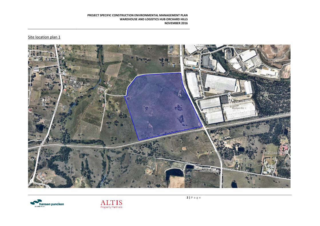
b. Location
The property comprises an area of 48.35 Ha and is bounded by Mamre Road to the east, rural land to the north and west and the WaterNSW Supply Pipeline and rural land to the south. The eastern side of Mamre Road comprises industrial development known as the Erskine Park Employment Area. The site is located within the bounds of Penrith City Council (PCC). Street Address and lot and plan descriptors:
Lot and Plan Number Street Address
Lot 2171 in DP 1153854 585-649 Mamre Road, Orchard Hills, NSW 2748 Australia
PROJECT SPECIFIC CONSTRUCTION ENVIRONMENTAL MANAGEMENT PLAN WAREHOUSE AND LOGISTICS HUB ORCHARD HILLS
NOVEMBER 2016
2 | P a g e
Site location plan 1
PROJECT SPECIFIC CONSTRUCTION ENVIRONMENTAL MANAGEMENT PLAN WAREHOUSE AND LOGISTICS HUB ORCHARD HILLS
NOVEMBER 2016
3 | P a g e
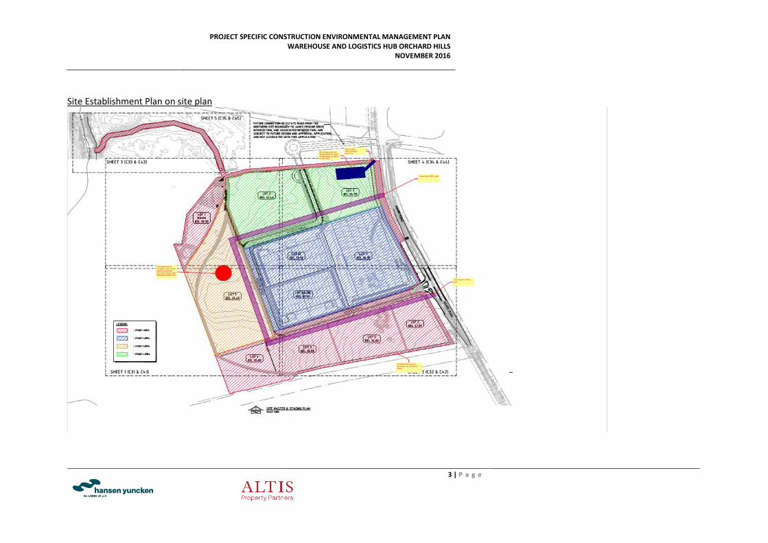
Site Establishment Plan on site plan
PROJECT SPECIFIC CONSTRUCTION ENVIRONMENTAL MANAGEMENT PLAN WAREHOUSE AND LOGISTICS HUB ORCHARD HILLS
NOVEMBER 2016
2 | P a g e
c. Project Planning
System and Procedures:
The Project Manager, is responsible for the development and implementation of all management systems for the project including this project specific CEMP. The Project Manager and his team will review the effectiveness of the system on a weekly basis, all project safety and environmental issues will be reviewed in order to keep the document updated and effective. The Project Manager will review the management plan to accommodate any changes to the project conditions which may have an effect on the effectiveness of the CEMP. Any changes to the project by the client or by virtue of latent conditions, safety considerations or environmental considerations will be reviewed and actioned. When a non-conformance or incident is detected, it shall be addressed according to the Hansen Yuncken Management procedure. The corrective action and methodology of improvement to prevent the reoccurrence of a non-conformance/incident is also covered in the Hansen Yuncken CEMP. Strategy:
The CEMP is to be implemented from site establishment through to demobilisation. The day-to-day onsite management of the CEMP will be by the Hansen Yuncken Site Team, led by the Site Manager. The Site team will be responsible for:
Environmental protection apparatus being correctly installed and or maintained ready for use in case of emergency
Site inductions, environmental & safety meetings
Production, review and approval of work method statements and
Waste Management plans
Monitoring adherence to Waste Management plans as per Head Contract
Monitoring inspection and testing methods and records
Implementing Project Quality, Environmental and Safety plans
Monthly reporting of progress
d. Project programme and construction phases
The following tables detail the construction phases and anticipated durations of each phase. And which phases require environmental management monitoring and reporting (EMMR):
Phase Duration EMM&R
Site Establishment 2 weeks Required throughout the duration of this phase
Import and place fill 27 weeks Required throughout the duration of this phase
Stormwater and drainage works 12 weeks Required throughout the duration of this phase
Internal estate road 10 weeks Required though out the duration of this phase
Internal reticulation works 16 weeks Required throughout the duration of this phase
PROJECT SPECIFIC CONSTRUCTION ENVIRONMENTAL MANAGEMENT PLAN WAREHOUSE AND LOGISTICS HUB ORCHARD HILLS
NOVEMBER 2016
3 | P a g e
EMM&R will be carried out by Hansen Yuncken throughout all phases of construction up to the handover of the estate. After the handover of the estate EMM&R is no longer the responsibility of Hansen Yuncken and the Developer will be responsible for the Operational Environmental Management Plan (OEMP). Inspections:
The importance that Hansen Yuncken places on the environmental aspect of its business is shown by the constant inspection program it puts its sites through. Environmental inspections will occur at least once a week on every site. Three (3) monthly inspections will be conducted by the Environment Manager. At least weekly, the site environmental officer will conduct basic site inspection. This inspection will also be done after intense or prolonged inclement weather (i.e. rain for a longer period than 2 Days or in excess of 20mm rain), during the course of the week. The site manager will be provided with the outcomes and action items arising from the weekly environmental inspections. The site manager will then update the project team of any specific issues at the weekly tool box session and monitor the implementation of action items. Internal Audits:
Internal audits will be conducted on all project activities as well as company nominated activities to provide a further review process for the effective management of this project and the management systems generally. The following project elements will be audited at the times indicated:
Project Safety Plan – (at least twice over the course of the project)
Project Quality Plan – (month 2 and every 3rd month thereafter until end of project)
Project Environmental Plan – (system audits every 3 months). Reports of all audits conducted on the project shall be distributed to the following:
o Hansen Yuncken - Construction Director o Hansen Yuncken Construction - Site Manager o Hansen Yuncken Management Review Meeting
e. Management Responsibilities
Position Descriptions:
Industrial Sector Manager – Jerry Fanos Responsibilities
Overall control of system compliance
Review of system administrators QA/Environmental Manager – Patrick Carrnucio (reports to State Manager) Responsibilities
Inform and instruct company personnel in the application of the Environmental Management System
Ensure all aspects of the Environmental Management System are in place as required and any issues are resolved
PROJECT SPECIFIC CONSTRUCTION ENVIRONMENTAL MANAGEMENT PLAN WAREHOUSE AND LOGISTICS HUB ORCHARD HILLS
NOVEMBER 2016
4 | P a g e
Be available for all personnel to come and confirm procedures or ask questions on any aspect of the Environment Management System
Provide advice on compliance with standards, codes of practice, etc.
Conduct internal audits of the Environmental Management System
Ensure site environmental inspections are conducted weekly and monthly
Disseminate environmental management information to personnel
Identify and assess environmental aspects and impacts and determine action to alleviate or control
Review and evaluate environmental incidents and ensure that incidents are reported and appropriate action taken
Project Manager – Metin Tokcan (Reports to Industrial Sector Manager) Responsibilities
Ensure that all dockets required by EPA guidelines for waste and spoil removal are present before invoices are processed
Ensure that import fill and any waste removed from site monthly reports are received and reviewed.
Control of system compliance
Supervision of head office process control
Oversee site process control
Internal monthly reporting
Sub-contract administration and payment
Review all incident/non-conformance records, accident & incident reports and audit reports
Authorise subcontract tendering and subcontract procedures, and establish an administrative system to monitor the subcontracts and the payment of subcontractors in relation to their environmental responsibilities
Isolate and report any environmental spills/events to site manager and Environmental Manager
Conduct weekly site inspections
Conduct inspections after intense or prolonged inclement weather
Ensure all environmental protection equipment is in place
Advise the Site Manager / Foreman on areas of concern
Quarantine unsafe work areas, materials, plant and equipment Identify and report potential environmental impacts and risks
Assume the role of company Representative for the Environment on site Site Forman – Stavros Stavrokakis (Reports to Industrial Manager) Responsibilities
Implement and ensure adherence to Project Plan and all associated sub-plans
Implement all environmental plans and procedures as required
Co-ordination of all on site activities including trade interface
Organisation of all deliveries and managing materials handling
Establish and maintain site environmental measures
PROJECT SPECIFIC CONSTRUCTION ENVIRONMENTAL MANAGEMENT PLAN WAREHOUSE AND LOGISTICS HUB ORCHARD HILLS
NOVEMBER 2016
5 | P a g e
Review all Subcontractor Management Plans and waste management plans submitted and obtain approval from Project Manager before allowing work to commence on site
Implementation of all inspection and testing requirements
Liaison and co-ordination with testing and inspection authorities
Preparation of check sheets and supervision of remedial works
Liaise with Project Manager to co-ordinate the works and resources required Subcontractors Responsibilities
Ensure compliance with environmental plans and regulations
Ensure all required paperwork is presented on submission of progress claims Emergency Contacts
Name Contact Details
Emergency services including fire brigade, ambulance and police 000
Nearest medical centre – Henry Lawson Medical Centre Pharmacy 142 Bringelly Road, Orchard Hills NSW
02 4736 8422
Nearest hospital – Nepean hospital – Derby Street Kingswood NSW 2747 02 4737 2000
NSW EPA – Pollution line 131 555
Local council – Penrith City Council 02 4732 7777
Site foreman – Stavros Stavrokakis 0419 535 103
Sydney Water emergency line 13 20 90
Energy Australia emergency line 13 13 88
Integral Energy emergency line 13 10 03
AGL emergency line 13 19 09
f. Hours of work
The intended normal work hours for construction activities will be comply with those identified in the Development Consent conditions including:
Monday to Friday 7:00am to 6:00pm
Saturday 8:00am to 1:00pm
Sunday & Public Holidays No work
g. Prior Approvals
The head contractor may seek variations to the above working hours and will obtain approval from the relevant authorities as required. Hansen Yuncken will provide a formal submission demonstrating the need for variation and justification that residents in the vicinity will not be adversely impacted (or due to safety reasons certain specialist works can only be carried out of standard work hours).
h. Legislative Framework
All activities carried out during the development will generally comply with the consent conditions, and the relevant provisions of building codes and legislation, namely Environmental Planning and Assessment Act, the Work Health and Safety Act and the National Construction
PROJECT SPECIFIC CONSTRUCTION ENVIRONMENTAL MANAGEMENT PLAN WAREHOUSE AND LOGISTICS HUB ORCHARD HILLS
NOVEMBER 2016
6 | P a g e
Code (where applicable). All works fall under the required Construction Certificates (as applicable) issued by the Certifying Authority.
i. Aboriginal Heritage
As part of their Aboriginal Cultural Heritage Assessment Report dated 13th January 2016, Biosis recommended that further testing in the form of Salvage Excavation be undertaken within the site referred to as MWP-AD3. As a requirement in the Development Consent – the Department of Planning & Environment imposed the following Conditions: Aboriginal Heritage C45: Prior to the commencement of earthworks, the Applicant shall register the MWP-AD3 site on the OEH’s Aboriginal Heritage Information Management System (AHIMS) Aboriginal Sites Register. The MWP-AD3 Site has been registered on the OEH’s Aboriginal Heritage Information System (AHIMS) Aboriginal Site Register as Site No. 45-4-4720 C46. The Applicant shall prepare an Aboriginal Salvage Strategy for the Development to ensure appropriate salvage of the Mamre West Precinct Archaeological Deposit 3 (MWP-AD3) site. The plan shall form part of the CEMP and shall:
a) Include measures to ensure that Lot 5 of the subdivision is clearly delineated with appropriate fencing/bunding to prevent any impact upon MWP-AD3; and
An Aboriginal Salvage Strategy has been prepared by Biosis (Appendix B) which outlines the methodology of the sub-surface excavations to obtain further information on identified site. Section 2.5 of this Report outlines the specific sampling strategy which is to be undertaken for the Salvage works. Section 2.7 outlines the Reporting requirements to be submitted following the excavation works – which will be submitted to the Registered Aboriginal Parties (RAPs) and the OEH as per the requirements of the report. Hansen Yuncken will clearly delineate the area surrounding MWP-AD3 with bunting to ensure that no workers or machinery enters this area. This will ensure that the site will not be impacted until works within the Aboriginal Salvage Strategy have been completed. The bunting will remain until confirmation is received from Biosis that the final report has been submitted to OEH and the RAPs (see point B below).
b) detail the excavation and salvage strategy in consultation with OEH (Aboriginal Heritage) and all relevant Aboriginal stakeholders prior to construction of any part of the Development.
Following the completion of the sub-surface salvage works (which will be undertaken in consultation with the RAPs) – Biosis will submit a final report to the OEH & RAPs detailing the results of the excavations and post excavation analysis, a discussion on the date and management recommendations if appropriate. No works will commence in the vicinity of MWP-AD3 until this Final Report has been submitted to OEH and it is the responsibility of Hansen Yuncken to ensure the bunting remains in-place until this occurs.
PROJECT SPECIFIC CONSTRUCTION ENVIRONMENTAL MANAGEMENT PLAN WAREHOUSE AND LOGISTICS HUB ORCHARD HILLS
NOVEMBER 2016
7 | P a g e
j. Subdivision
The project team has completed various assessments which impact on the proposed design of the lot layout including earthworks, existing title boundaries, stormwater drainage, geotechnical investigation and others. All factors have been considered in preparation of the layout and a registered surveyor has prepared a draft Plan of subdivision as part of the planning application.
k. Bulk and detailed earthworks
The Construction Certificate Civil Engineering drawings by Costin Roe Consulting indicate import fill material is required including 457,000m³ to bench 9 lots over 10 different reduced levels. The civil works include:
Site set up
Clearing and grubbing
Tree removal
Bulk earthworks
Stormwater drainage
Stormwater drainage/trenching
Road pavements i.e. laying gravels and asphalt
Footpaths i.e. concrete
Street furniture
Landscaping
l. Construction of estate infrastructure
The provision of public utility servicing will be in accordance with the relevant authority design and approval process based on capacities generated by the proposed uses. These works include:
Potable water: Potable water will be supplied to the subject development from Erskine Park Elevated reservoir. An Existing (250mm) water main is available at Mamre Road adjacent to the corner of James Erskine Drive.
Sewer: Waste water reticulation lead in main will be taken from the existing line at the end of James Erskine Drive.
Power: Power will be provided from the electrical feeder adjacent to the site along the eastern side of Mamre Road.
Telecommunications: Telecommunications assets exist along the western side of Mamre Road.
Construction site access will be provided by temporary intersection arrangements at Mamre Road. Trucks will enter into the site and exit out of the site via Mamre Road.
PROJECT SPECIFIC CONSTRUCTION ENVIRONMENTAL MANAGEMENT PLAN WAREHOUSE AND LOGISTICS HUB ORCHARD HILLS
NOVEMBER 2016
8 | P a g e
4. ENVIRONMENTAL
a. Unexpected Finds Protocol (Contamination)
Any contamination encountered is to be contained on site, assessed and dealt with as per authority instruction and relevant legislation. Unexpected finds include: Asbestos
More than 10 m2 of bonded asbestos observed on or below the ground surface (e.g. asbestos piping or conduit)4; and
Suspected friable asbestos on the ground surface. Any bonded asbestos encountered that totals less than 10m2 will still require removal, but will not require the use of licensed bonded asbestos removal contactor. Buried Structures
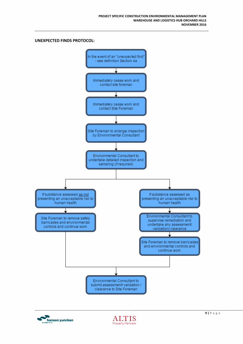
In the unlikely event that buried structures such as Underground Storage Tanks (USTs) are encountered during site works, the structure(s) and any associated pipe-work should be managed / removed in accordance with the Unexpected Finds Protocol figure below. Volatile Contaminants
In the unlikely event that significant quantities of volatile compounds are detected, then appropriate gas mitigation strategies may be required as per ANZECC (1999) Guidelines for the Assessment of On-site Containment of Contaminated Soil. If volatile contaminants are detected, the nature and extent of the impacts of the volatile contaminants should be established as a first step before an appropriate remedial strategy is to be established. If feasible the source material should be removed for off-site disposal. (Refer to the Unexpected Finds Protocol figure below). As a precautionary measure to ensure the protection of site workers and contractors and the site workers and occupants of nearby land, should an unexpected find be encountered (or any other unexpected potentially hazardous substance), the procedure summarised in the below figure is to be followed:
PROJECT SPECIFIC CONSTRUCTION ENVIRONMENTAL MANAGEMENT PLAN WAREHOUSE AND LOGISTICS HUB ORCHARD HILLS
NOVEMBER 2016
9 | P a g e
UNEXPECTED FINDS PROTOCOL:
PROJECT SPECIFIC CONSTRUCTION ENVIRONMENTAL MANAGEMENT PLAN WAREHOUSE AND LOGISTICS HUB ORCHARD HILLS
NOVEMBER 2016
10 | P a g e
b. Flora and Fauna
Flora and Fauna on the site will be managed as per the recommendations in the Biodiversity Assessment Report by Ecoplanning dated 10 March 2016: 5.3.2 Pre-clearance protocols On-site supervision of habitat tree felling and relocation of fauna
An ecologist will be required to be present onsite when felling habitat trees (hollow bearing and/or stag trees). Hollows should be inspected from an elevated work platform or cameras mounted to telescopic poles, prior to felling operations. Any fauna occupying a hollow during felling operations will be relocated (where feasible) to bushland immediately adjacent to the site. The ecologist will need to work closely with the plant operators to identify each hollow and to stop work if an animal is observed and requires rescue. The ecologist will encourage any fauna species that may be present to move from site or if considered necessary capture, store and actively relocate them to another area. All habitat trees should be left over night to give species that are not possible to handle, further opportunity to relocate. Advice on appropriate actions for individuals that continue to utilise habitat of trees should be provided by the onsite ecologist. Any variation to this protocol must be approved by onsite ecologist. The ecologist will ensure that any injured animals receive the appropriate levels of care. The nearest veterinary clinics should be contacted prior to the works beginning to ensure that they have the capabilities to care for injured native animals. Qualified wildlife carer organisations (e.g. WIRES) should also be identified and contacted if required. Soft felling operations
Soft felling of hollow bearing trees is encouraged to avoid unnecessary injuries to undetected fauna. This process involves an excavator or bulldozer softly ‘nudging’ trees before felling, in order to encourage any fauna that may be occupying a hollow or crevice to vacate the tree prior to being felled. Once the tree has been felled, the ecologist will undertake further searches of the tree for any animal that has not fled or is unable to flee. As above, fauna will be relocated to bushland adjacent to the site, or if required, veterinary clinics and/or qualified wildlife carers contacted.
c. Sedimentation and erosion control
Due to the extent of the proposed bulk earthworks at 585-649 Mamre Road, Orchard Hills, the Contractor will be required to manage the volume of sedimentation created as a result of construction-associated works and avoid sedimentation entering the local stormwater system. Sedimentation control will be measured by:
Visual inspection of the sedimentation control measures utilised and the volume of silt trapped.
Regular audits conducted by the Contractor of the sedimentation control procedures and practices.
PROJECT SPECIFIC CONSTRUCTION ENVIRONMENTAL MANAGEMENT PLAN WAREHOUSE AND LOGISTICS HUB ORCHARD HILLS
NOVEMBER 2016
11 | P a g e
To reduce the environmental effects of erosion and sedimentation the following measures will be utilised by the Contractor (or the respective sub-contractor):
Silt fences are to be placed around the perimeter of the work area.
Sand, hay bales or gravel bags require being used to protect inlets and direct flow.
Sediment collected on silt fences or around sandbags will be disposed within site landscaping or in other suitable locations.
Vehicles must enter and leave the site on the access driveway to limit the tracking of mud and/or soil on to public roads.
Muddy or dirty vehicles must go through the site washout bay before leaving site to limit the tracking of mud and/or soil on to public roads.
Preserve as much grassed or vegetated area as possible to filter sedimentation from stormwater runoff.
All soil, sand and cement stockpiles should be placed wholly on the construction site and behind a sediment barrier. These stockpiles should also be covered at the end of each day if rain or excessive wind is likely.
Activities that generate surplus wastewater with sediment (such as masonry cutting) must only be carried out on site. This wastewater should be recycled or discharged into a contained area for drying by soakage.
Should dirt and/or mud traffic onto public roads and footpaths, site staff must sweep rather than hose off the sediment.
Undertake dewatering of trenches, excavations (etc.) when necessary, ensuring that the water is taken away from site and disposed at a location approved by the EPA and/or relevant authorities. This water cannot be deposited into the local stormwater system.
d. Dust Control Plan (DCP)
On site air quality and dust management is the responsibility of Hansen Yuncken site manager. Dust minimisation techniques are to be employed as needed during construction, including the use of water carts as necessary. Air quality is to be managed through the proper maintenance of all machinery on site. In line with section 129 of the PEO Act 1997, odour reporting is encouraged and outlined in the site induction process. The DCP will aim to minimise the amount of dust generated, reduce the nuisance that dust may cause to the community and site personnel and ensure the dust is controlled in accordance with the EPA guidelines so as to minimise the impact on air quality. To ensure that all site personnel adequately control the creation and spread of dust, the Contractor may monitor the site workers by:
Visually viewing site works and utilising digital photos to record and witness dust control procedures during random site inspections.
Undertaking audits on a regular basis to review dust control procedures and practices.
Reporting on a monthly basis to the Project Control Group. Such reports to include: o Relevant Trade Contractor reports for the period. o Other Important information / events that generated dust and how it was
controlled (if not covered by the Trade Contractor reports). o Overall assessment of dust control practices and procedures for the month.
PROJECT SPECIFIC CONSTRUCTION ENVIRONMENTAL MANAGEMENT PLAN WAREHOUSE AND LOGISTICS HUB ORCHARD HILLS
NOVEMBER 2016
12 | P a g e
During dry conditions, on-site construction activities have the potential to generate dust. The following activities are those identified as a specific potential source of dust generation:
Earthmoving activities including clearing of topsoil;
Movement of vehicles and construction machinery;
Stockpiling of materials; and
Build-up of material around erosion and sedimentation controls.
To reduce the environmental nuisance of dust generation, Trade Contractor’s and site staff should implement the following measures:
In the event of dust levels on site becoming a nuisance or unacceptable, introduce controls such as ground watering.
Cover trucks transporting material from the site immediately after loading to prevent wind-blown dust.
Where or whenever necessary, erect appropriate barriers to control dust generated as a result of construction-associated works.
e. Noise Control Measures
Noise impacts from construction are an ongoing concern for all construction projects. Construction noise management will be in accordance with the Development Application and will be the responsibility of the Site Manager to enforce. Noise Controls measures which will be implemented onsite during construction consist of the following:
Construction on the site will only be undertaken between 7am and 6pm Monday to Friday, and 8am and 1pm on Saturdays (as per the Development Consent). No construction will be allowed on site on Sundays or public holidays. The following specific measures are proposed throughout the construction and operation phase:
Prompt response to any community issues of concern;
Refinement of onsite noise mitigation measures and plant operating procedures where practical.
For equipment with enclosures (i.e. compressor rooms) ensure door and seals are well maintained and kept closed when not in use.
Keep plant and equipment well maintained, regular inspection and maintenance of equipment to ensure it is good working order.
Equipment not to be operated until it is maintained or repaired.
Regularly train workers (i.e. toolbox talks) to use equipment in ways to minimise noise.
Operate mobile plant in a quiet, efficient manner.
Switching off vehicles and plant when not in use.
Incorporate clear signage at the site including relevant contact numbers for community enquiries.
The Site is generally located in amongst open fields and rural residential holdings however the Contractor will ensure construction noise impacts from the site are managed so as to minimise the disturbance to surrounding property owners, in accordance with EPA guidelines.
PROJECT SPECIFIC CONSTRUCTION ENVIRONMENTAL MANAGEMENT PLAN WAREHOUSE AND LOGISTICS HUB ORCHARD HILLS
NOVEMBER 2016
13 | P a g e
f. Water Management Control Plan
The Contractor is to implement water-saving practices and technologies to ensure on-site water consumption is minimised. This will be monitored through visual inspection by the Contractor to ensure measures are being actively utilised by sub-contractors. To ensure that all site personnel adequately control the consumption of water, the Contractor will monitor site staff by:
Visually viewing site works and utilising digital photos to record and witness water management procedures during random site inspections.
Undertaking audits on a regular basis to review water control procedures and practices.
Reporting on a monthly basis to the Project Control Group. Such reports to include: o Relevant Trade Contractor reports for the period. o Other Important information / events that reduced water consumption (if not
covered by the Trade Contractor reports). o Overall assessment of water management practices and procedures for the
month.
To increase the environmental benefits of reducing water consumption and recycling water, the following measures should be undertaken by the Contractor and sub-contractors as a minimum during the construction works:
Introduce waterless urinals to the site amenities.
Educate site workers about water consumption and simple measures to save water (e.g. utilise collected rainwater for cleaning equipment, ensure taps are not left running etc.)
g. Waste Management Control Plan
In order to reduce onsite waste during the construction process due to waste water recycling and re-use practices plus to minimise the project’s contribution to landfill, the Contractor implement an assessment strategy which measures the volume of materials recycled, re-used or taken to landfill and carry out inspections to ensure waste management procedures are being implemented by site staff. To ensure that all site personnel adequately control waste, the Contractor will monitor site staff by:
Visually viewing site works and utilising digital photos to record and witness waste management procedures during random site inspections.
Undertaking audits on a regular basis to review waste management procedures and practices.
Reporting on a monthly basis to the Project Control Group.
To increase the environmental benefits of reducing waste, the following measures should be undertaken by the Contractor and site staff:
Separate waste generated during the construction process into the appropriate recycling containers / bins provided.
Return unnecessary and/or unwanted packaging back to the supplier so as they become aware that such packaging is not required.
Promote participation in local and state authority waste reduction policies.
Waste Avoidance Measures:
PROJECT SPECIFIC CONSTRUCTION ENVIRONMENTAL MANAGEMENT PLAN WAREHOUSE AND LOGISTICS HUB ORCHARD HILLS
NOVEMBER 2016
14 | P a g e
The Construction Site Manager will identify opportunities for waste avoidance by:
Minimising site disturbance and eliminating unnecessary excavation;
Stripping topsoil from areas subject to excavation and storing it on site for re-use;
Selecting construction materials taking into consideration to their long lifespan and potential for reuse;
Identifying likely waste amounts generated and incorporating these volumes into a purchasing policy so that the correct quantities are purchased;
Ordering materials to size and ordering pre-cut and prefabricated materials;
Reuse of formwork (where possible);
Planned work staging and delivery arrangements of materials so materials are delivered as needed;
Co-ordination and sequencing of various trades;
Careful on-site storage and source separation;
Ensuring that separated materials are kept uncontaminated to guarantee the highest possible reuse value; and
Subcontractors informed of site waste management procedures.
The following procedures are to be implemented:
Appropriate sorting and segregation of site preparatory and construction wastes to ensure efficient reuse and recycling of wastes;
Concrete, tiles (where applicable) and bricks will be reused or recycled off-site;
Steel will be recycled off-site; all other metals will be recycled where economically viable;
Framing timber will be reused on-site or recycled off-site;
Windows, doors and joinery will be recycled off-site (where possible);
Waste oil will be recycled or disposed of in an appropriate manner;
All used crates will be stored for reuse unless damaged;
All glass that can be economically recycling will be;
All solid waste timber, brick, concrete, rock that cannot be reused or recycled will be taken to an appropriate landfill site and disposed of in an approved manner;
All asbestos, hazardous and/or intractable wastes are to be disposed of in accordance with WorkCover Authority and EPA requirements;
Provision for the collection of batteries and other recyclable resources will be provided on site;
Beverage container and paper/cardboard recycling will be provided on-site for employee use or these items will be sorted recycling at an appropriately licensed facility;
All garbage will be disposed of via a council approved system;
Wash-down of equipment / plant / machinery and concrete delivery trucks will occur within a specified, appropriately bunded bay (or concrete delivery trucks will return to the batching plant before washing out). Liquid waste is often produced from the washing down of plant and apparatus. There may be a local sewer that this waste water can be connected to; alternatively, this could be transferred into a localised waste water treatment facility or plant;
Refuelling activities will be undertaken in designated areas with appropriate spill containment measures to avoid overspill to sensitive areas; and
PROJECT SPECIFIC CONSTRUCTION ENVIRONMENTAL MANAGEMENT PLAN WAREHOUSE AND LOGISTICS HUB ORCHARD HILLS
NOVEMBER 2016
15 | P a g e
Portable, self-contained toilet and washroom facilities will be provided at the site ensuring these units are regularly emptied and serviced by a suitably licensed contractor.
h. Dilapidation Survey
A dilapidation survey of the surrounding roads and road sharing a boundary with the site will be undertaken prior to commencing with construction activities on site in accordance with the Development Consent issued by the Department of Planning and Environment: Protection of Public Infrastructure B19. Prior to the commencement of construction, the Applicant shall:
a) prepare a dilapidation report identifying the condition of all public infrastructure in the vicinity of the site (including roads, gutters and footpaths and the Warragamba to Prospect Water Supply Pipeline); and
b) submit a copy of this report to the Secretary, WaterNSW, Council and the Certifying Authority.
The Dilapidation Report will generally consist of written test and photographs. The proposed management for completion of the dilapidation survey will apply to adjoining properties and are as follows:
Possibly affected areas of other owners adjacent to the work site.
Access areas.
Shared driveway and road.
Existing footpaths and roads immediately adjoining.
PROJECT SPECIFIC CONSTRUCTION ENVIRONMENTAL MANAGEMENT PLAN WAREHOUSE AND LOGISTICS HUB ORCHARD HILLS
NOVEMBER 2016
16 | P a g e
5. TRAFFIC
The Construction Traffic Management Plan is detailed within Appendix A. This report outlines measures which will be implemented to manage obstruction or inconveniences within Public Places (namely Mamre Road and the associated road network).
PROJECT SPECIFIC CONSTRUCTION ENVIRONMENTAL MANAGEMENT PLAN WAREHOUSE AND LOGISTICS HUB ORCHARD HILLS
NOVEMBER 2016
17 | P a g e
APPENDIX A: Preliminary Traffic Management Plan
CONSTRUCTION TRAFFIC
MANAGEMENT PLAN (CTMP)
State Significant Development Application (SSD 7173)
Warehouse & Logistics Hub, Orchard Hills
SUBDIVISION WORKS CONSTRUCTION CERTIFICATE:
- Bulk Earthworks, Infrastructure & Services
- Internal Access Road & Intersection Works
November 2016
WAREHOUSE AND LOGISTICS HUB, ORCHARD HILLS
TRAFFIC MANAGEMENT PLAN (FOR USE)
NOVEMBER 2016
2
CONTENTS 1 INTRODUCTION ......................................................................................................3
2 DEFINITIONS & ABBREVIATIONS .........................................................................4
3 LEGISLATION, STANDARDS AND CODES OF PRACTICE ..................................4
4 SIGNS ......................................................................................................................4 4.1 Workers OHS ...................................................................................................................... 4 4.2 Temporary Sign Placement ................................................................................................. 4 4.3 Existing Signs ...................................................................................................................... 5
5 PEDESTRIAN PATHS .............................................................................................5
6 MAINTENANCE OF EXISTING TRAFFIC FLOW ....................................................5
7 ROAD TEMPORARY SIGNAGE & TRAFFIC CONTROLS .....................................5 7.1 Site Access .......................................................................................................................... 5 7.2 Traffic Management Report................................................................................................. 6
8 SPECIAL DELIVERIES ............................................................................................6
9 IMPORT FILL DELIVERY DETAILS ........................................................................6
10 DRIVER CODE OF CONDUCT ............................................................................6 10.1 General Requirements .................................................................................................... 6 10.2 Vehicle Speed .................................................................................................................. 7 10.3 Heavy Vehicles & Driver Fatigue ..................................................................................... 7 10.4 Heavy Vehicle Compression Braking .............................................................................. 7 10.5 Load Covering ................................................................................................................. 8 10.6 Breakdowns & Incidents .................................................................................................. 8 10.7 Contacts ........................................................................................................................... 8 10.8 Communications .............................................................................................................. 9 10.9 Other Safety Considerations ........................................................................................... 9
WAREHOUSE AND LOGISTICS HUB, ORCHARD HILLS
TRAFFIC MANAGEMENT PLAN (FOR USE)
NOVEMBER 2016
3
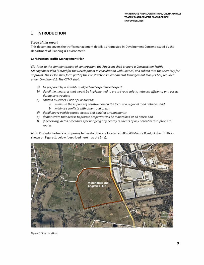
1 INTRODUCTION
Scope of this report
This document covers the traffic management details as requested in Development Consent issued by the
Department of Planning & Environment:
Construction Traffic Management Plan
C7. Prior to the commencement of construction, the Applicant shall prepare a Construction Traffic
Management Plan (CTMP) for the Development in consultation with Council, and submit it to the Secretary for
approval. The CTMP shall form part of the Construction Environmental Management Plan (CEMP) required
under Condition D1. The CTMP shall:
a) be prepared by a suitably qualified and experienced expert;
b) detail the measures that would be implemented to ensure road safety, network efficiency and access
during construction;
c) contain a Drivers’ Code of Conduct to:
a. minimise the impacts of construction on the local and regional road network; and
b. minimise conflicts with other road users;
d) detail heavy vehicle routes, access and parking arrangements;
e) demonstrate that access to private properties will be maintained at all times; and
f) if necessary, detail procedures for notifying any nearby residents of any potential disruptions to
routes.
ALTIS Property Partners is proposing to develop the site located at 585-649 Mamre Road, Orchard Hills as
shown on Figure 1, below (described herein as the Site).
Figure 1 Site Location
WAREHOUSE AND LOGISTICS HUB, ORCHARD HILLS
TRAFFIC MANAGEMENT PLAN (FOR USE)
NOVEMBER 2016
4
2 DEFINITIONS & ABBREVIATIONS
The following definitions and abbreviations have been used in this Traffic Management Plan. Further definitions and abbreviations are provided in referenced procedures and plans.
CORP Hansen Yuncken Corporate
HSE Health, Safety & Environment
HY Hansen Yuncken Pty Ltd
PLN HY Plan
PPE Personal Protective Equipment
PR Procedure
S/C OHS
Subcontract(s) or Subcontractor(s) as the context requires Occupational Health and Safety
3 LEGISLATION, STANDARDS AND CODES OF PRACTICE
Traffic shall be controlled in accordance with either of the following, depending on the contract or site conditions and requirements.
AS 1742.3 Manual for uniform traffic control devices, Part 3 – Traffic control devices for works on roads
SAA HB81.1 to HB81.6 Field guides for traffic control at works on roads. Part 1 to Part 6 cover various examples of work on different roads and under different conditions
4 SIGNS
The purpose of road signing or work site protection is:
to provide a safe work area to work within; and
to safely move traffic through, around and past a work site with minimum inconvenience.
4.1 Workers OHS
Any worker setting up temporary traffic control or modifying permanent traffic controls or directing traffic shall be suitably trained and will be issued with and use suitable PPE.
4.2 Temporary Sign Placement
HY Site Manager is responsible for the placement of temporary signs and their location. The Site Manager shall observe the following guidelines:
be placed at least 1 metre clear of traffic paths wherever possible;
be mounted securely;
be placed in the driver’s line of sight;
not be obscured by parked cars, trees, etc;
WAREHOUSE AND LOGISTICS HUB, ORCHARD HILLS
TRAFFIC MANAGEMENT PLAN (FOR USE)
NOVEMBER 2016
5
not obscure the driver’s view of other signs or other traffic; and
not be a hazard to workers, pedestrians or other road users.
4.3 Existing Signs
Any existing signs that do not apply shall be covered.
5 PEDESTRIAN PATHS
Existing paths shall be safe and at least 1.2 metres wide free of any obstruction to pedestrians.
6 MAINTENANCE OF EXISTING TRAFFIC FLOW
Existing traffic flows shall be maintained and only modified for short periods when other alternatives have been exhausted.
7 ROAD TEMPORARY SIGNAGE & TRAFFIC CONTROLS
The access points into the project will be indicated on a Traffic Control Plan along with Traffic Control Devices which will be put in place for the duration of the project. Temporary Traffic controls will take place from time to time to bring in long or wide loads via Mamre Road entry such as Structural Steel and Roof Sheeting.
7.1 Site Access
The main entrance and exit at the site shall be from Mamre Road, via a temporary drive way formed
to access the site. This access will remain in place until completion of the internal estate road and
intersection works to Mamre Road. The location of this entry and exit will ease any potential
congestion of trucks exiting the site onto public roads.
Warning signs will be placed along Mamre Road in both directions at approximately 150m from the
Mamre Site entry.
An alternative entry includes the modification of the existing median strip to enable a right turn
from Mamre Road into the site. This will be controlled with temporary traffic lights as per the
attached traffic control plan prepared by Altus Traffic. This alternative entry will only be used when
all other entries have been exhausted.
7.1.1 Entering Site
All vehicle drivers/operators are to enter the site compound in a slow and controlled manner. The
drivers/operators are to observe the road regulations and give way to all passing traffic and
pedestrians. Upon visual confirmation that all traffic and pedestrians have passed, the
drivers/operators shall slowly proceed to enter the site. In instances when onsite production is
slowed down, the trucks will enter and safely park on site until it is unloaded.
WAREHOUSE AND LOGISTICS HUB, ORCHARD HILLS
TRAFFIC MANAGEMENT PLAN (FOR USE)
NOVEMBER 2016
6
7.1.2 Exiting Site
All vehicle drivers/operators are to come to a complete stop at the site gate before exiting the site
compound. The drivers/operators are to observe the road regulations and give way to all passing
traffic and pedestrians. Upon visual confirmation that all traffic and pedestrians have passed, the
driver/operator is to slowly proceed on to the roadway.
7.1.3 Truck Routes
The import fill will be transported from various source sites via main roads and arterial roads such
as:
Western Sydney Motorway (M4)
Westlink (M7)
Mamre Road
Erskine Park Road
Elizabeth Drive
7.1.4 Hours of Operation
The proposed hours of onsite operation are:
Monday to Friday 7:00am to 6:00pm
Saturday 8:00am to 1:00pm
Sunday and Public Holidays No work
7.2 Traffic Management Report
Whilst traffic management is in operation, the traffic controller shall complete a Traffic
Management Report daily and provide a copy to the Site Manager.
8 SPECIAL DELIVERIES
Any trucks that contain long or wide loads with additional RMS requirements will have specific
traffic management in place to control traffic on Mamre Road.
9 IMPORT FILL DELIVERY DETAILS
Import fill material will be sourced from a number of local sites to ease traffic congestion. The
deliveries will consist of truck and trailer carting approximately 14M³. Our anticipated delivery
quantity is 40 trucks per hour during the early phase of the import fill activity.
10 DRIVER CODE OF CONDUCT
10.1 General Requirements
Construction vehicle drivers travelling to and from the Site must:
WAREHOUSE AND LOGISTICS HUB, ORCHARD HILLS
TRAFFIC MANAGEMENT PLAN (FOR USE)
NOVEMBER 2016
7
i) Have undertaken a Site Induction carried out by an approved member of Hansen
Yuncken or suitably qualified person under the direction of the HY management;
ii) Hold a valid driver’s licence for the class of vehicle that you operate;
iii) Operate the vehicle in a safe manner within and external to the Site;
iv) Comply with the direction of authorised site personnel when within the site;
10.2 Vehicle Speed
Increased speed means not only an increased risk of crashing but also increased severity if a crash
occurs.
There are two types of speeding:
i) Where a heavy vehicle travels faster than the posted speed limit; and
ii) Where a driver travels within the speed limit but because of road conditions (e.g.
fog or rain) this speed is inappropriate.
Drivers are to observe the posted speed limits, with speed adjusted appropriately to suit the road
environment and prevailing weather conditions, to comply with the Australian Road Rules. The
vehicle speed must be appropriate to ensure the safe movements of the vehicle based on the
vehicle configuration.
10.3 Heavy Vehicles & Driver Fatigue
Fatigue is one of the biggest causes of crashes for heavy vehicle drivers. The Heavy Vehicle Driver
Fatigue Reform was therefore developed by the National Transport Commission (NTC) and
approved by Ministers from all States and Territories in February 2007.
The heavy vehicle driver fatigue law commenced in NSW on 28 September 2008 and applies to
trucks and truck combinations over 12 tonne GVM (however there are Ministerial Exemption
Notices that can apply).
Under the law, industry has the choice of operating under three fatigue management schemes:
i) Standard Hours of Operation
ii) Basic Fatigue Management (BFM)
iii) Advanced Fatigue Management (AFM)
All heavy vehicle drivers operating during construction of the Site are to be aware of their adopted
fatigue management scheme and operate within its requirements.
10.4 Heavy Vehicle Compression Braking
Compression braking by heavy vehicles is a source of irritation to the community generating many
complaints especially at night when many residents are especially sensitive to noise.
WAREHOUSE AND LOGISTICS HUB, ORCHARD HILLS
TRAFFIC MANAGEMENT PLAN (FOR USE)
NOVEMBER 2016
8
In some instances, compression braking is required for safety reasons however when passing
through or adjacent to residential areas or isolated farmsteads a reduction in the speed of the
vehicle is recommended to reduce the instances and severity of compression braking.
No compression braking on Mamre Road between the M4 and James Erskine or directly adjacent
other residential areas or isolated residences unless required for safety reasons. Brakes must be
applied so as not to create excessive noise that could disturb local residents.
10.5 Load Covering
Loose material on the road surface has the potential to cause road crashes and vehicle damage.
All trucks and construction vehicles arriving at or departing from the site whether loaded with
material or not are required to have an effective cover over their load for the duration of the trip.
The load cover may be removed upon arrival at the delivery site.
All care is to be taken to ensure that all loose debris from the vehicle body and wheels is removed
prior to leaving the site and again after unloading.
Drivers must ensure that following tipping that the tailgate is locked before leaving the site.
10.6 Breakdowns & Incidents
In the case of a breakdown, the vehicle must be towed to the nearest breakdown point as soon as
possible. All breakdowns must be reported to Site Management and the vehicle protected in
accordance with the Heavy Vehicle Drivers handbook.
If there is a product spill while loading/unloading or enroute the driver must:
i) Immediately warn persons in the area who may be at risk;
ii) The Site Foreman must be immediately informed so that emergency services can be
contacted and a clean-up initiated;
iii) All spills must be adequately cleaned up and waste disposed of in an acceptable and
environmental manner;
iv) Put out warning triangles where it is safe to do so.
Drivers are to ensure that when passing pedestrians/cyclists a safe separation distance exists
between trucks and pedestrians as well as a reduction in speed if appropriate.
10.7 Contacts
Emergency Services (including Fire Brigade, ambulance & Police) 000
NSW EPA – Pollution Line 131 555
RMS Transport Management Centre 131 700
Penrith City Council 02 4732 777
Hansen Yuncken: Site Foreman (Stavros Stavrokakis) 0419 535 103
Hansen Yuncken: Head Office 02 9770 7600
WAREHOUSE AND LOGISTICS HUB, ORCHARD HILLS
TRAFFIC MANAGEMENT PLAN (FOR USE)
NOVEMBER 2016
9
10.8 Communications
Contractors, Sun-contractors and suppliers are to use the UHF channel nominated by Hansen
Yuncken in their agreement or site personnel mobile phones.
10.9 Other Safety Considerations
Other safety considerations along the haul route:
i) Concealed driveways – Drivers are to drive with caution around any signed
concealed driveways.
ii) Wet weather safety - drivers should adjust their driving speed to suit prevailing wet
weather conditions encountered on the designated haul routes.
Mamre Rd
Mamre Rd
STOPHEREON REDSIGNAL
ROAD WORK AHEAD
PREPARETO
STOP
AHEAD
40
40
ROADWORK
PREPARETO
STOP
80M
80M
80M
80M
80M
80M
80M
80M
40
ROADWORK
PREPARETO
STOP
80M
80M
END
ROAD WORK
80
20m
40mSITE EXIT
TRAFFIC CONTROLLER TO STOPTRAFFIC TO ALLOW SITE VEHICLES
TO EXIT SAFELY MAKING A LEFT HAND TURN
JOINS TCP 1A
Date: 29.09.16 Author: Khaleel Hamdan Project: Hansen Yunken - Glenmore ParkDesign/Audit No: 2943016878Comments:
- This is a long term TCP - All signs and PTL's are to be covered when not in use- Cones to be min 700mm high & installed 500mm from edge and lane lines- Where required adjust sign spacing to account for crests, curves & corners- Cover conflicting signs- One truck to do regular sign/cone maintenance after ensuring
workers are in a safe locations - Traffic control vehicle to be parked behind worker location and move
with workers. -Signs behind concrete/ wire rope barriers are to be installed on adjustable legs
and secured with sand bags. Ensure sign is higher then barrier and visible to vehicles - All staff to have white overalls with reflective strips on nights - All staff to have reflective safety vests- All vehicles to have flashing orange lights- Maintain daily logs of ALL activities - All signs to be Class 1 retro-reflective- This TCP drawn in accordance with AS1742.3 & the RTA's TCAWs Manual
TCP-HY-GMP-001bLong Term Site
Access PlanNOT TO SCALE
N
www.invarion.com
50 50
15M OF MEDIANTO BE REMOVEDAND REINSTATED
UPON COMPLETIONOF THE WORKS
Mamre Rd
James Erskine Dr
Quary Rd
Quary Rd
James Erskine Dr
STOPHEREON REDSIGNAL
ROAD WORK AHEAD
CHANGEDCONDITIONS
AHEAD
80M
80M
80M
40M
RO
AD
WO
RK
A
HE
AD
CH
AN
GE
DC
ON
DIT
ION
SA
HE
AD
END
ROAD WORK
80
20m
40m
SITE ENTRY
TRAFFIC CONTROLLER TO STOPTRAFFIC TO ALLOW SITE VEHICLESTO ENTER SAFELY MAKING A RIGHT
HAND TURN
JOINS TCP 1B
Date: 29.09.16 Author: Khaleel Hamdan Project: Hansen Yunken - Glenmore ParkDesign/Audit No: 2943016878Comments:
- This is a long term TCP - All signs and PTL's are to be covered when not in use- Cones to be min 700mm high & installed 500mm from edge and lane lines- Where required adjust sign spacing to account for crests, curves & corners- Cover conflicting signs- One truck to do regular sign/cone maintenance after ensuring
workers are in a safe locations - Traffic control vehicle to be parked behind worker location and move
with workers. -Signs behind concrete/ wire rope barriers are to be installed on adjustable legs
and secured with sand bags. Ensure sign is higher then barrier and visible to vehicles - All staff to have white overalls with reflective strips on nights - All staff to have reflective safety vests- All vehicles to have flashing orange lights- Maintain daily logs of ALL activities - All signs to be Class 1 retro-reflective- This TCP drawn in accordance with AS1742.3 & the RTA's TCAWs Manual
TCP-HY-GMP-001aLong Term Site
Access PlanNOT TO SCALE
N
www.invarion.com
PROJECT SPECIFIC CONSTRUCTION ENVIRONMENTAL MANAGEMENT PLAN WAREHOUSE AND LOGISTICS HUB ORCHARD HILLS
NOVEMBER 2016
18 | P a g e
APPENDIX B: Aboriginal Salvage Strategy
© Biosis 2012 – Leaders in Ecology and Heritage Consulting 1
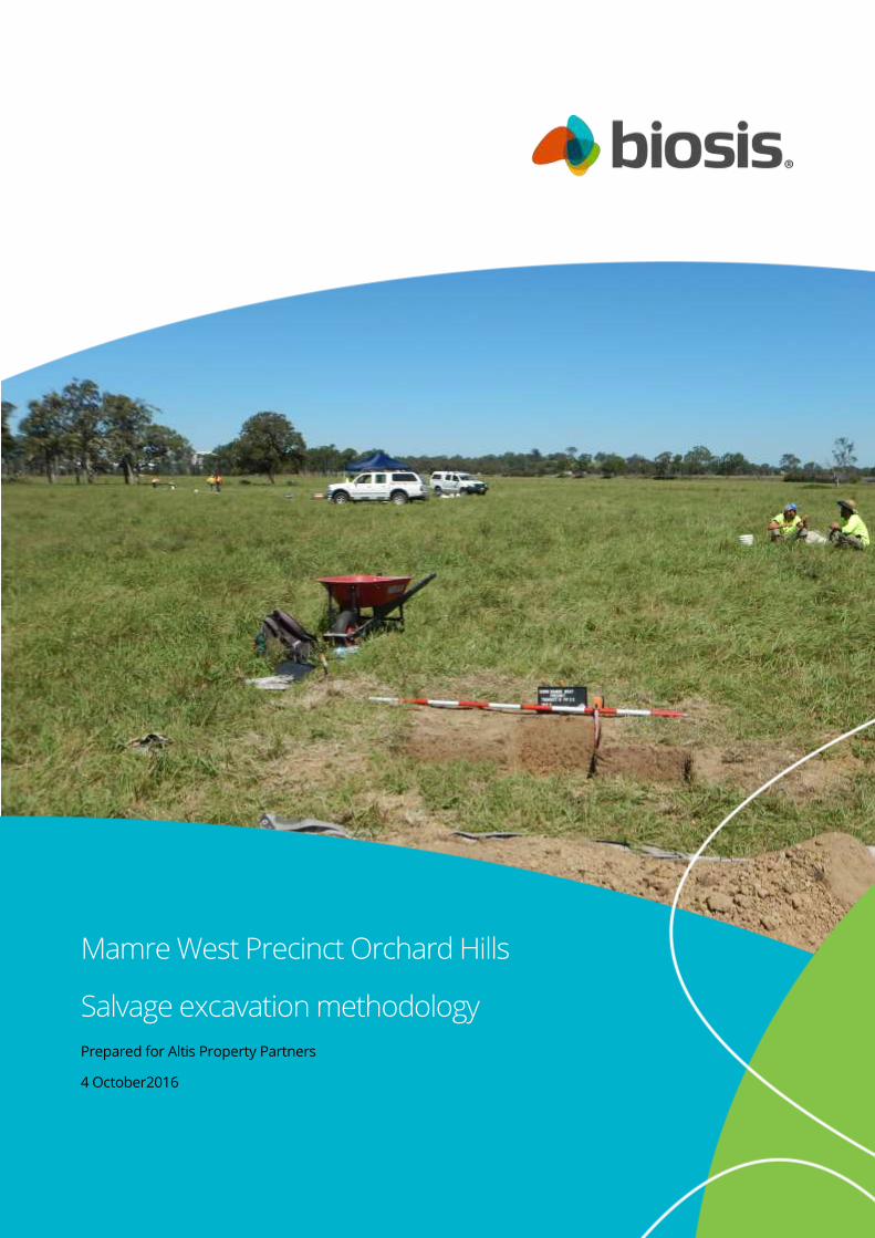
Mamre West Precinct Orchard Hills
Salvage excavation methodology
Prepared for Altis Property Partners
4 October2016
© Biosis 2016 – Leaders in Ecology and Heritage Consulting www.biosis.com.au i
Biosis Pty Ltd
This document is and shall remain the property of Biosis Pty Ltd. The document may only be used
for the purposes for which it was commissioned and in accordance with the Terms of the
Engagement for the commission. Unauthorised use of this document in any form whatsoever is
prohibited.
Disclaimer:
Biosis Pty Ltd has completed this assessment in accordance with the relevant federal, state and
local legislation and current industry best practice. The company accepts no liability for any
damages or loss incurred as a result of reliance placed upon the report content or for any purpose
other than that for which it was intended.
Biosis offices
AUSTRALIAN CAPITAL TERRITORY
Canberra
Floor 1, Unit 3, 38 Essington Street
Mitchell ACT 2911
Phone: (02) 6241 2333
Fax: (03) 9646 9242
Email: [email protected]
NEW SOUTH WALES
Sydney
Unit 14, 17-27 Power Avenue
Alexandria NSW 2015
Phone: (02) 9690 2777
Fax: (02) 9690 2577
Email: [email protected]
Wollongong
8 Tate Street
Wollongong NSW 2500
Phone: (02) 4229 5222
Fax: (02) 4229 5500
Email: [email protected]
Newcastle
39 Platt Street
Waratah NSW 2298
Phone: (02) 4968 4901
Fax: (02) 9696 9242
Email: [email protected]
QUEENSLAND
Brisbane
Suite 4 First Floor, 72 Wickham Street
Fortitude Valley QLD 4006
Phone: (07) 3831 7400
Fax: (07) 3831 7411
Email: [email protected]
VICTORIA
Ballarat
506 Macarthur Street
Ballarat VIC 3350
Phone: (03) 5331 7000
Fax: (03) 5331 7033
Email: [email protected]
Melbourne (Head Office)
38 Bertie Street
Port Melbourne VIC 3207
Phone: (03) 9646 9499
Fax: (03) 9646 9242
Email: [email protected]
Wangaratta
16 Templeton Street
Wangaratta VIC 3677
Phone: (03) 5721 9453
Fax: (03) 5721 9454
Email: [email protected]
Document information
Report to: Altis Property Partners
Prepared by: Nicole Castle
Biosis project no.: 22277
File name:
22277.Mamre.West.Precinct.Salvage.Excavatio
n.Methodology.DFT02.20160504.docx
Citation: Biosis (2016). Mamre West Precinct Orchard
Hills, Salvage Excavation Methodology: Report
to Altis Property Partners. Authors: N Castle,
Biosis Pty Ltd, Office location. Project no.
22277
Document control
Version Internal reviewer Date issued
Draft version 01 Amanda Atkinson 02/05/16
Draft version 02 Nicole Castle 03/05/16
Draft version 03 Amanda Atkinson 04/10/2016
Acknowledgements
Biosis acknowledges the contribution of the following people and
organisations in undertaking this study:
Hansen Yuncken
Altis Property Partners
The following Biosis staff were involved in this project:
Lauren Harley for mapping
© Biosis 2014 – Leaders in Ecology and Heritage Consulting ii
Contents
Abbreviations .......................................................................................................................................................... 3
1 Introduction ................................................................................................................................................. 4
1.1 Project background ...................................................................................................................................................... 4
1.2 Location of the Project Area and SSD Application Area ....................................................................................... 4
1.3 Planning approvals ....................................................................................................................................................... 4
2 Salvage excavation methodology ............................................................................................................. 8
2.1 Background .................................................................................................................................................................... 8
2.2 Justification for excavation ...................................................................................................................................... 10
2.3 Aims of the sub-surface salvage excavations ..................................................................................................... 12
2.4 Research questions ................................................................................................................................................... 12
2.5 Sub surface salvage excavation sampling strategy ........................................................................................... 12
2.6 Objects recovered during excavation ................................................................................................................... 15
2.7 Reporting ..................................................................................................................................................................... 15
3 References .................................................................................................................................................. 16
List of Figures
Figure 1: Location of the Project Area and SSD Application Area ......................................................................... 6
Figure 2: Aerial of the Project Area and SSD Application Area ....................................................................................... 7
Figure 3: Test excavation results MWP-AD3 ....................................................................................................................... 9
© Biosis 2016 – Leaders in Ecology and Heritage Consulting 3
Abbreviations
ACHAR Aboriginal Cultural Heritage Assessment Report
AHIMS Aboriginal Heritage Information Management System
DP Deposited Plan
EIS Environmental Impact Statement
MWP-AD1 Mamre West Precinct Archaeological Deposit 1
MWP-AD2 Mamre West Precinct Archaeological Deposit 2
MWP-AD3 Mamre West Precinct Archaeological Deposit 3
MWP-AD4 Mamre West Precinct Archaeological Deposit 4
MWP AS 1 Mamre West Precinct Artefact Scatter 1
NPW Act National Parks and Wildlife Act 1974
NSW New South Wales
OEH Office of Environment and Heritage
SSD State Significant Development
The Code Code of Practice for Archaeological Investigation of Aboriginal Objects in New South Wales (DECCW
2010)
© Biosis 2016 – Leaders in Ecology and Heritage Consulting 4
1 Introduction
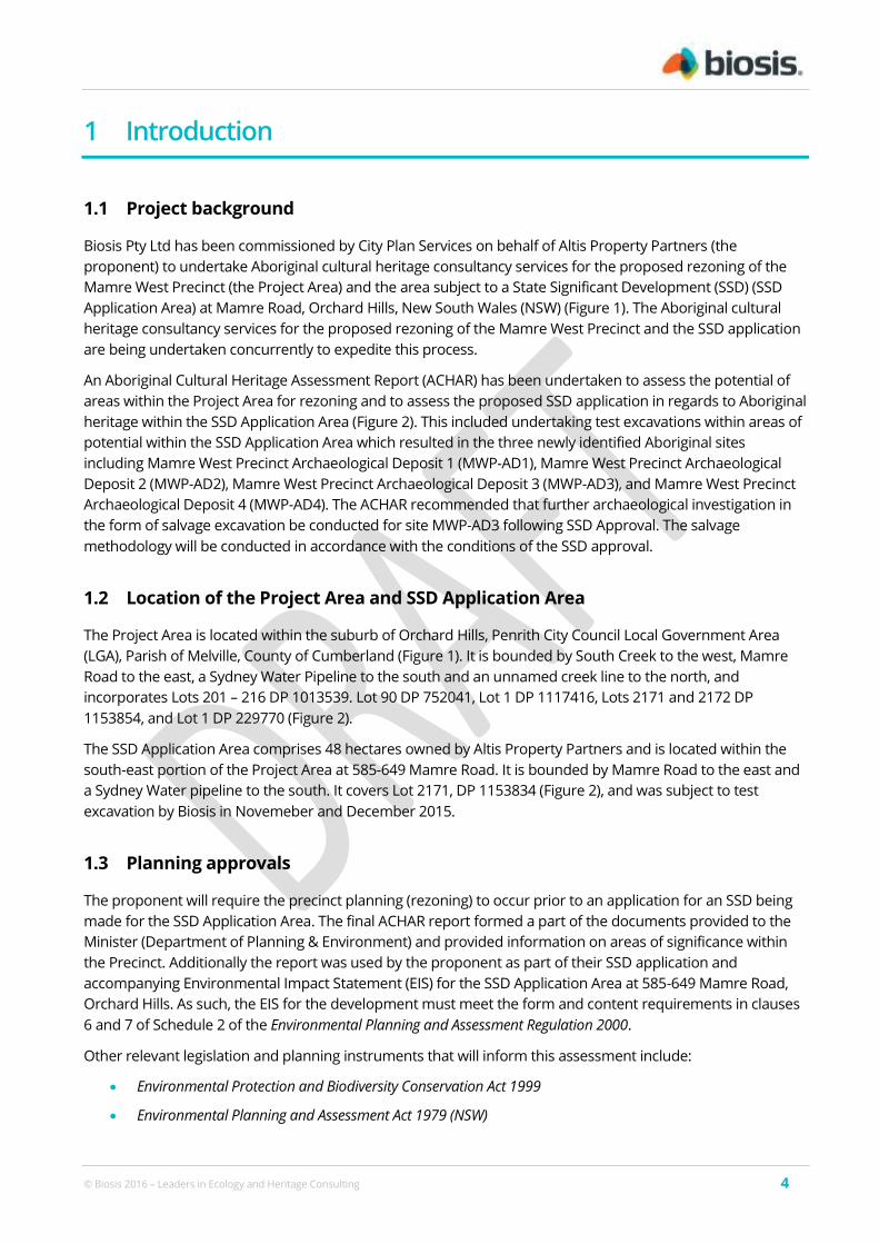
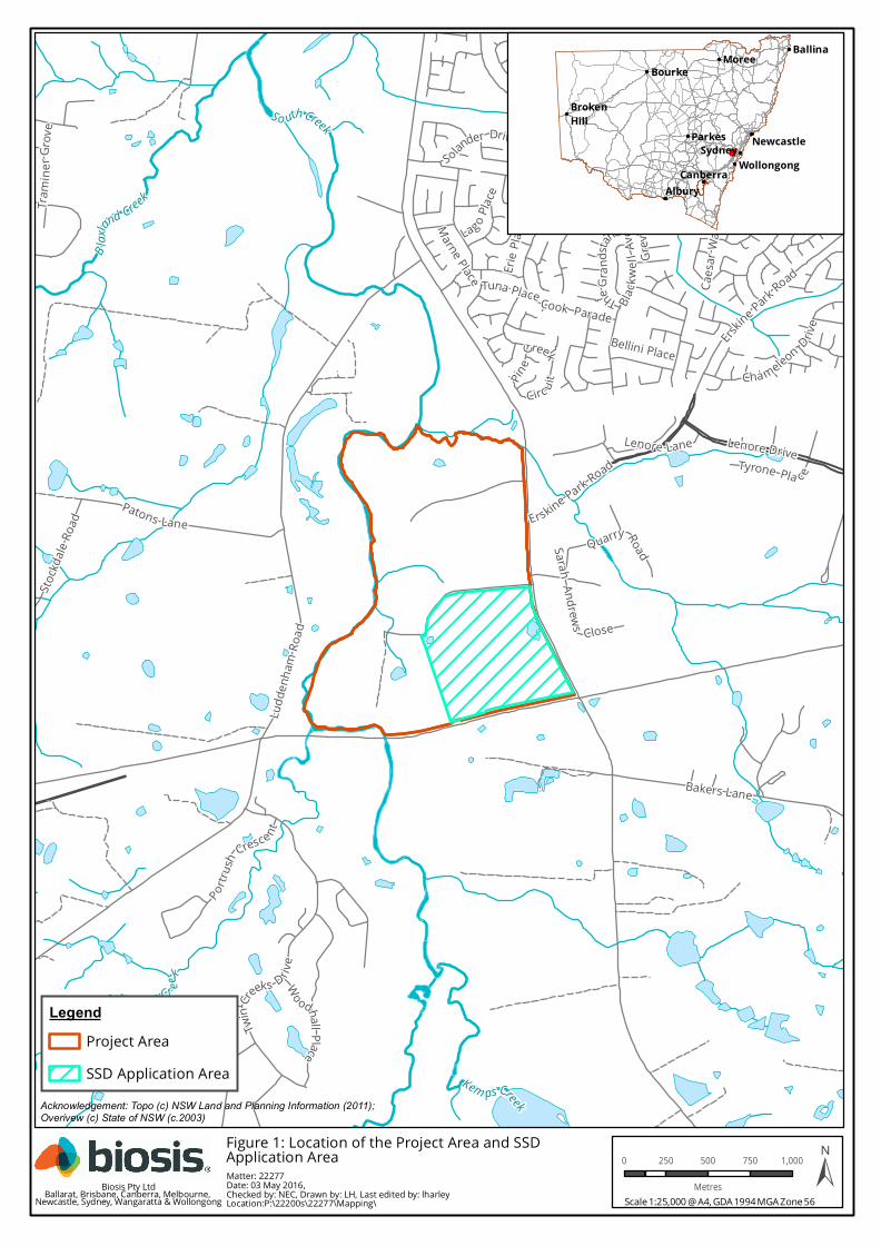
1.1 Project background
Biosis Pty Ltd has been commissioned by City Plan Services on behalf of Altis Property Partners (the
proponent) to undertake Aboriginal cultural heritage consultancy services for the proposed rezoning of the
Mamre West Precinct (the Project Area) and the area subject to a State Significant Development (SSD) (SSD
Application Area) at Mamre Road, Orchard Hills, New South Wales (NSW) (Figure 1). The Aboriginal cultural
heritage consultancy services for the proposed rezoning of the Mamre West Precinct and the SSD application
are being undertaken concurrently to expedite this process.
An Aboriginal Cultural Heritage Assessment Report (ACHAR) has been undertaken to assess the potential of
areas within the Project Area for rezoning and to assess the proposed SSD application in regards to Aboriginal
heritage within the SSD Application Area (Figure 2). This included undertaking test excavations within areas of
potential within the SSD Application Area which resulted in the three newly identified Aboriginal sites
including Mamre West Precinct Archaeological Deposit 1 (MWP-AD1), Mamre West Precinct Archaeological
Deposit 2 (MWP-AD2), Mamre West Precinct Archaeological Deposit 3 (MWP-AD3), and Mamre West Precinct
Archaeological Deposit 4 (MWP-AD4). The ACHAR recommended that further archaeological investigation in
the form of salvage excavation be conducted for site MWP-AD3 following SSD Approval. The salvage
methodology will be conducted in accordance with the conditions of the SSD approval.
1.2 Location of the Project Area and SSD Application Area
The Project Area is located within the suburb of Orchard Hills, Penrith City Council Local Government Area
(LGA), Parish of Melville, County of Cumberland (Figure 1). It is bounded by South Creek to the west, Mamre
Road to the east, a Sydney Water Pipeline to the south and an unnamed creek line to the north, and
incorporates Lots 201 – 216 DP 1013539. Lot 90 DP 752041, Lot 1 DP 1117416, Lots 2171 and 2172 DP
1153854, and Lot 1 DP 229770 (Figure 2).
The SSD Application Area comprises 48 hectares owned by Altis Property Partners and is located within the
south-east portion of the Project Area at 585-649 Mamre Road. It is bounded by Mamre Road to the east and
a Sydney Water pipeline to the south. It covers Lot 2171, DP 1153834 (Figure 2), and was subject to test
excavation by Biosis in Novemeber and December 2015.
1.3 Planning approvals
The proponent will require the precinct planning (rezoning) to occur prior to an application for an SSD being
made for the SSD Application Area. The final ACHAR report formed a part of the documents provided to the
Minister (Department of Planning & Environment) and provided information on areas of significance within
the Precinct. Additionally the report was used by the proponent as part of their SSD application and
accompanying Environmental Impact Statement (EIS) for the SSD Application Area at 585-649 Mamre Road,
Orchard Hills. As such, the EIS for the development must meet the form and content requirements in clauses
6 and 7 of Schedule 2 of the Environmental Planning and Assessment Regulation 2000.
Other relevant legislation and planning instruments that will inform this assessment include:
Environmental Protection and Biodiversity Conservation Act 1999
Environmental Planning and Assessment Act 1979 (NSW)

© Biosis 2016 – Leaders in Ecology and Heritage Consulting 5
National Parks and Wildlife Act 1974 (NSW)
National Parks and Wildlife Amendment Act 2010 (NSW)
Infrastructure SEPP 2007
Western Sydney Employment Area SEPP 2009
Mamre West Land Investigation Area Development Control Plan 2016
Melville Road
TheGran
dstand
Erskine Park Road
Bakers Lane
Caes
ar Wa
y
Patons Lane
Grev
illea D
rive
Cha meleon Drive
Todd Row
Solander Drive
Erie P
laceLag o P
lace
Trami
nerG
rove
Tuna Place
Bellini Place
Marne Place
Lenore LaneTyrone Pla c e
SarahAndrews Close
Erskine Park Road
Stockd
aleRo
ad
Leice
ster W
ay
Timeswee p Drive
Pine
Creek
Circ uit
Merino Circuit
Woodhall Place
Explorers Way
Banks Drive
Bennett Road
Endeavour Avenue
Ludd
enha
m Ro
ad
Portrus
h Cresce nt
Quarry Road
Cook Parade
Cook
Parad
e
Black
w ell
Aven
ue
Twin
Creeks D riv
e
Lenore Drive
B laxl
and Creek
S o uth Creek
Kem ps Creek
Byrnes Creek
Cosgr oves Cr eek
MoreeBourke
Parkes
CanberraSydney
WollongongAlbury
Ballina
BrokenHill
Newcastle
Acknowledgement: Topo (c) NSW Land and Planning Information (2011); Overivew (c) State of NSW (c.2003)
Matter: 22277Date: 03 May 2016,Checked by: NEC, Drawn by: LH, Last edited by: lharleyLocation:P:\22200s\22277\Mapping\
LegendProject AreaSSD Application Area
Scale 1:25,000 @ A4, GDA 1994 MGA Zone 56
0 250 500 750 1,000
Metres ±Biosis Pty LtdBallarat, Brisbane, Canberra, Melbourne, Newcastle, Sydney, Wangaratta & Wollongong
Figure 1: Location of the Project Area and SSDApplication Area
Ludd
enha
m Ro
ad
Mamre Road
Patons Lane
Sarah Andrews Close
Erskine Park Road
Mandalong Close
James Erskine Drive
Quarry Road
SouthC
reek
COSGROVESCREEK
SOUTHCREEK
SOUTHCREEK © Land and Property Information 2015
0 80 160 240 320 400
Metres
LegendProject AreaSSD Application Area
±Matter: 22277, Date: 03 May 2016, Checked by: NEC, Drawn by: LH, Last edited by: lharleyLocation:P:\22200s\22277\Mapping\22277_F2_ProjectArea.mxd
Biosis Pty LtdBallarat, Brisbane, Canberra, Melbourne,
Sydney, Wangaratta & Wollongong
Sydney
Wollongong
Newcastle
Scale: 1:7,000 @ A3
Figure 2: Aerial of theProject Area and SSDApplication Area
Coordinate System: GDA 1994 MGA Zone 56
Acknowledgements: Imagery (c) Nearmap, 2015; Topo (c) NSW Land and Planning Information
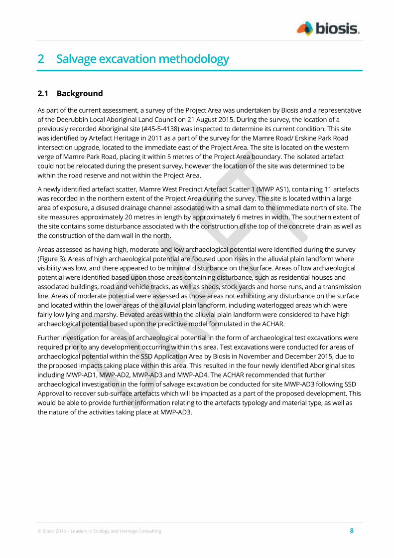
© Biosis 2016 – Leaders in Ecology and Heritage Consulting 8
2 Salvage excavation methodology
2.1 Background
As part of the current assessment, a survey of the Project Area was undertaken by Biosis and a representative
of the Deerubbin Local Aboriginal Land Council on 21 August 2015. During the survey, the location of a
previously recorded Aboriginal site (#45-5-4138) was inspected to determine its current condition. This site
was identified by Artefact Heritage in 2011 as a part of the survey for the Mamre Road/ Erskine Park Road
intersection upgrade, located to the immediate east of the Project Area. The site is located on the western
verge of Mamre Park Road, placing it within 5 metres of the Project Area boundary. The isolated artefact
could not be relocated during the present survey, however the location of the site was determined to be
within the road reserve and not within the Project Area.
A newly identified artefact scatter, Mamre West Precinct Artefact Scatter 1 (MWP AS1), containing 11 artefacts
was recorded in the northern extent of the Project Area during the survey. The site is located within a large
area of exposure, a disused drainage channel associated with a small dam to the immediate north of site. The
site measures approximately 20 metres in length by approximately 6 metres in width. The southern extent of
the site contains some disturbance associated with the construction of the top of the concrete drain as well as
the construction of the dam wall in the north.
Areas assessed as having high, moderate and low archaeological potential were identified during the survey
(Figure 3). Areas of high archaeological potential are focused upon rises in the alluvial plain landform where
visibility was low, and there appeared to be minimal disturbance on the surface. Areas of low archaeological
potential were identified based upon those areas containing disturbance, such as residential houses and
associated buildings, road and vehicle tracks, as well as sheds, stock yards and horse runs, and a transmission
line. Areas of moderate potential were assessed as those areas not exhibiting any disturbance on the surface
and located within the lower areas of the alluvial plain landform, including waterlogged areas which were
fairly low lying and marshy. Elevated areas within the alluvial plain landform were considered to have high
archaeological potential based upon the predictive model formulated in the ACHAR.
Further investigation for areas of archaeological potential in the form of archaeological test excavations were
required prior to any development occurring within this area. Test excavations were conducted for areas of
archaeological potential within the SSD Application Area by Biosis in November and December 2015, due to
the proposed impacts taking place within this area. This resulted in the four newly identified Aboriginal sites
including MWP-AD1, MWP-AD2, MWP-AD3 and MWP-AD4. The ACHAR recommended that further
archaeological investigation in the form of salvage excavation be conducted for site MWP-AD3 following SSD
Approval to recover sub-surface artefacts which will be impacted as a part of the proposed development. This
would be able to provide further information relating to the artefacts typology and material type, as well as
the nature of the activities taking place at MWP-AD3.
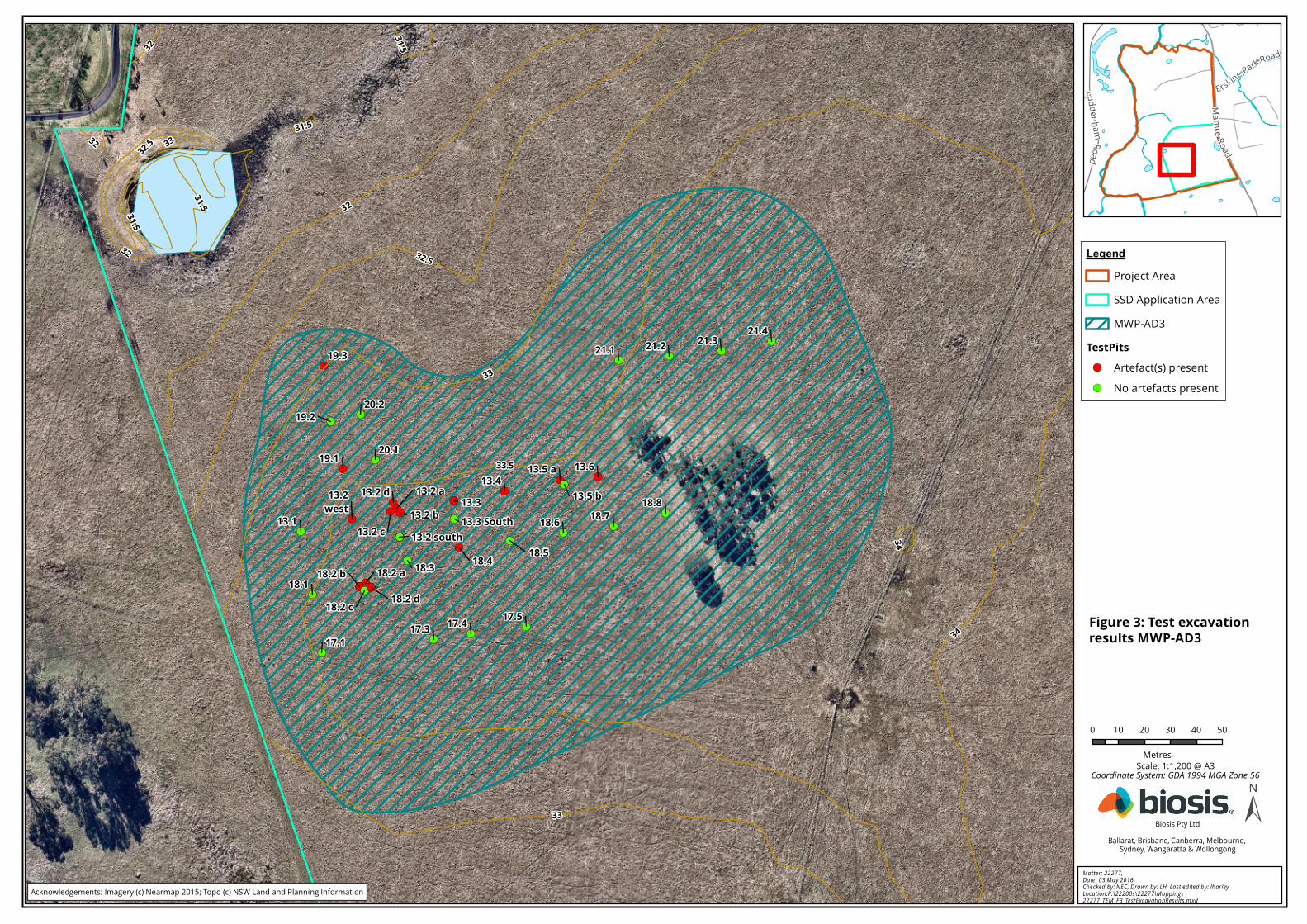
!(
!(!(!(!(
!(
!(!(!(!(!(!(
!(
!(!(!(
!(!(!(!(
!(
!(!(
!(
!(!(!(!(!(!(!(!(!(!(!(!(!(!(
!(
!(!(
!(!(
!(
!(
!(
!(
!(
!(
!( !(!(
!(
13.1
13.2 a13.2 b
13.2 c
13.2 d13.2west
13.2 south13.3 South13.3
13.413.5 a
13.5 b
13.6
17.117.3 17.4 17.5
18.118.2 a18.2 b
18.2 c 18.2 d
18.3 18.4 18.5
18.6 18.718.8
19.1
19.2
19.3
20.1
20.2
21.1 21.2 21.3 21.4
333232
31.5
34
31.5
31.5
32.5
31.5
32
34
32
33
32.5
33
33.5
0 10 20 30 40 50
Metres
LegendProject AreaSSD Application AreaMWP-AD3
TestPits!( Artefact(s) present!( No artefacts present
±Ma tter: 22277, Da te : 03 M a y 2016 , Ch ecked by: N EC , D ra w n by: LH , La st ed ited b y: lh ar leyLocation :P:\22200s\22277\M a pp in g\22277_TEM _F 3_TestExcavatio nR es ults.m xd
Biosis Pty LtdBallarat, Brisbane, Canberra, Melbourne,
Sydney, Wangaratta & Wollongong
Scale: 1:1,200 @ A3
Figure 3: Test excavationresults MWP-AD3
Coordinate System: GDA 1994 MGA Zone 56
Acknowledgements: Imagery (c) Nearmap 2015; Topo (c) NSW Land and Planning Information
Erskine Park Road
LuddenhamRoad
Mamre Road
© Biosis 2016 – Leaders in Ecology and Heritage Consulting 10
2.2 Justification for excavation
It is proposed that sub-surface salvage investigation be conducted for Aboriginal site MWP-AD3 following SSD
Approval in order to recover sub-surface artefacts which will be impacted as a part of the proposed
development (Figure 3). This would be able to provide further information relating to the artefacts typology
and material type, as well as the nature of the activities taking place at MWP-AD3.
The archaeological test excavations conducted by Biosis in November and December 2015 resulted in four
newly identified Aboriginal sites, MWP-AD1, MWP-AD2, MWP-AD3 and MWP-AD4 and a total of 78 artefacts
recovered across these four sites. Following the artefact analysis and comparison with similar sites within the
local area, it was assessed that sites MWP-AD1, MWP-AD2 and MWP-AD4 are common occurrence site types
within the local area. On the other hand, elements of the assemblage recovered from MWP-AD3 were
different to the other three sites, and other sites in the local area.
MWP-AD3 is located within an elevated levee bank south of a small stream channel, within an area
considered to have high archaeological potential. The site covers an area of 7,219 metres squared, contains
no visible previous disturbances and the soils at MWP-AD3 are very deep, sandy deposits that are result of
overbank deposition and artefacts may be in their primary location, buried by the alluvial deposits. The test
excavation of this site yielded 34 artefacts with the average density of 3.7 artefacts per square metre. The
highest density was recorded at the central part of the site (TP 13.2) with one 50 centimetre by 50 centimetre
test unit containing 6 artefacts which is an average of 24 artefacts per square metre, and two adjacent test
units had an average density of 16 artefacts per square metre; test pits 10 metres west and east had average
of 12 artefacts per square metre. In contrast to the other sites where the dominant material type comprised
of silcrete, MWP-AD3 had a majority of the artefacts made of indurated mudstone/tuff (IMT), followed by
silcrete, chert and one quartz; one volcanic flake was also identified, a raw material not known to be present
in the close vicinity.
Site MWP-AD3 indicates a concentrated activity was taking place at one portion of the site where the density
is much higher (24 artefacts per square metre). This site occupation pattern is common in Cumberland Plains
with activities located at dispersed places surrounded by low density background scatters. The assemblages
recovered from the four newly identified sites were compared with the results of the excavations conducted
nearby by McDonald in 2008 on the eastern side of Mamre Road. Here, silicified tuff or IMT was the second
most common raw material in both soil units at EP6&7/1 and 2 (McDonald 2008: 139), a trend that, with the
exception of MWP-AD3 is also confirmed within the SSD Application Area. The highest percentage of tuff
artefacts within MWP-AD3 is not a common occurrence within the local area. Tuff is known to be an
important component of artefact assemblages throughout Western Sydney as it occurs as water worn
pebbles and cobbles in Hawksbury and Nepean River gravel beds (Navin Officer 2005b: 95). Tuff comprised
the majority of artefacts at the Rouse Hill Infrastructure project excavations where the site PAD31 (RH/CC2) by
McDonald (1999) contained stratified deposits containing an earlier silicified tuff and a later, predominantly
silcrete assemblage geared towards backed artefact production. An open site, RSI, located at Mulgoa Road in
Mulgoa, had the predominance of indurated mudstone. A prevalence of tuff material in these two sites are
not surprising as they are located very close to the sources of this material, along the Nepean and Hawksbury
River. However, it is not known for tuff to have the highest representation on any one site in the vicinity of the
SSD Application Area, as it is located approximately 14 kilometres east of Nepean River. Site MWP-AD3 is
unique in this occurrence. An absence of cortex on tuff artefacts indicates that this material was brought to
the area at their later stages of reduction, which conforms to the McDonald's argument that frequencies of
cortical artefacts should decline with increasing distance from lithic sources (2008: 158). Considering a very
small assemblage it is not possible at this point to investigate this variable without further investigations. It is
possible that the site MWP-AD3 represents an earlier site as there are no backed artefacts present, with
different strategies in raw material procurement and use; the site can also be a place where trading would
occur between different groups.
© Biosis 2016 – Leaders in Ecology and Heritage Consulting 11
At the site MWP-AD3 there is also one volcanic artefact identified that had 5 per cent cortex present. Although
several volcanic outcrops occur in the vicinity (McDonald 2008: 142), no artefacts made of volcanic materials
were recorded during previous assessments in the area. Considering there was only one volcanic artefact
identified at Mamre West, it is not possible at this stage to determine its provenance or the fact that it was a
unique find in the vicinity.
Considering a very small assemblage from MWP-AD3 was recovered, it is not possible at this stage to infer
further conclusions. This site showed significant variation to the other sites recorded in the area locally and
could possibly be explored in order to answer further questions regarding different occupation patterns,
technological strategies and raw material procurement within the Cumberland Plain. MWP-AD3 is not typical
of the area and does not conform to the site predictive model regarding the assemblage composition. A lack
of backed artefacts and the high frequency of tuff artefacts that lack cortex indicate a site could be older than
the surrounding sites. It could also be a remnant of a specific activity that is not recorded anywhere else in the
vicinity, such as a location where a trading of raw material occurred. It's location within deeper alluvial sandy
deposits point out that there would be a potential for undisturbed stratified deposits to be present. If
stratified deposits are encountered, the site would also have the potential to yield samples adequate for
radiometric dating. Specifically further assessment of the site could answer the following questions:
Does the site MWP-AD3 have stratified deposits that could be used for dating?
How does the site MWP-AD3 differ from the other sites recorded in the local context?
Does the variation of a cultural deposit at MWP-AD3 from the other sites in the area have a temporal
basis, i.e. is older than the surrounding sites?
Does the site MWP-AD3 represent a place where specific activities took place, such as trading of raw
material?
What technological strategies and raw material procurement can be inferred from a high density
concentration of artefacts within MWP-AD3?
Site MWP-AD3, located within elevated levee bank in yellow earth Sandy Creek soils, showed some variety in
artefact density and raw material that was not recorded in the vicinity previously. One area within the site
revealed high artefact density, as well as the presence of volcanic raw material. Higher proportion of tuff
artefacts indicate specific activity concentrated within one portion of the site. Further excavation of this site
would ensure expanding on site occupation patterns and use of local material for artefact production.
© Biosis 2016 – Leaders in Ecology and Heritage Consulting 12
2.3 Aims of the sub-surface salvage excavations
The principle objective of the sub-surface salvage excavation program is to obtain further information on
occupational patterns, raw material procurement and use of local material for artefact production within the
SSD Application Area.
The aims of the sub-surface salvage program are to:
Obtain a larger sample of artefacts in order to successfully compare the assemblage to others
within the local and regional area.
Conduct dispersed salvage for those areas within MWP-AD3 that recorded high numbers in order
to adequately record and interpret them.
Analyse and interpret any archaeological finds (such as stone artefacts, hearths, knapping floors
etc.) recovered during the salvage program.
Inform current knowledge of Aboriginal occupation, land use models and raw material
procurement within the local area.
2.4 Research questions
Research questions provide a framework for undertaking sub-surface investigations and ensure that the
information collected during the sub-surface salvage program contributes to the knowledge of the sites and
the broader archaeological record. Research questions include:
Does the site MWP-AD3 have stratified deposits that could be used for dating?
How does the site MWP-AD3 differ from the other sites recorded in the local context?
Does the variation of a cultural deposit at MWP-AD3 from the other sites in the area has a temporal
basis, i.e. is older than the surrounding sites?
Does the site MWP-AD3 represent a place where specific activities took place, such as trading of raw
material?
What technological strategies and raw material procurement can be inferred from a high density
concentration of artefacts within MWP-AD3?
2.5 Sub surface salvage excavation sampling strategy
To answer these research questions salvage excavation will be conducted within Aboriginal site MWP-AD3
(Figure 3). The salvage excavation will be conducted by hand and will be laid out on a grid around or adjacent
to high density/sensitivity test pits within site MWP-AD3. Within this grid a series of dispersed 1 metre by 1
metre salvage pits will be excavated within this area to identify a trend for site patterning, relatively high
artefact densities and any features of archaeological interest.
The methodology would then be followed by the implementation of open area salvage:
The salvage program would be undertaken in the following manner:
– 1 metre by 1 metre extent pits excavated at selected locations across a grid.
© Biosis 2016 – Leaders in Ecology and Heritage Consulting 13
– The excavation results of the extent pits will be used to determine the placement of the
remaining salvage pits depending on the artefact densities encountered and avoiding
localised disturbances.
– Based upon the result of these extent pits, the grid will be expanded into the areas with the
highest artefact densities or areas where archaeological features may be present.
– Salvage pits may be expanded into larger open area excavations should low densities be
identified.
– The total area of excavation within each grid is estimated to be a maximum of 10 metres by
10 metres squared.
The expansion of the pits will be undertaken on case by case basis in order to identify and salvage
as larger volume of cultural material as possible. Vertical excavation of deposits will be undertaken
in 5 to 10 centimetre spits dependant on the archaeological deposits encountered and their
spatial integrity.
Pits must be excavated using hand tools only including spades, handle shovels, and trowels.
All material excavated from the excavation units will be wet sieved using 5 millimetre aperture
wire-mesh sieves. All identified cultural material will be bagged individually and allocated a unique
label to ensure its provenience for data analysis.
Pits must be excavated to at least the depth of the Aboriginal object-bearing units identified during
test excavations.
All consolidated in-situ features, including knapping floors and hearths, must be excavated to the
extent of the feature. This may require extending pits.
All cultural material recovered from the pits will be collected and brought to the Biosis office at 8
Tate Street, Wollongong NSW 2500 for lithic analysis.
For each pit that is excavated, the following documentation will be taken:
- Unique pit identification number
- GPS coordinate of each pit
- Munsell soil colour, texture and pH
- Amount and location of cultural material within the deposit
- Nature of disturbance where present
- Stratigraphy
- Archaeological features (if present)
- Photographic records
- Spit records
Pits must be backfilled with gravel as soon as practicable due to safety issues, although where this
is not possible for open area salvage locations, pits will be temporarily fenced with Para webbing
and backfilled on the final day of excavation.
© Biosis 2016 – Leaders in Ecology and Heritage Consulting 14
Any datable material will be collected for the purposes of radiometric or AMS dating. Datable
materials will be collected, bagged and clearly labelled. They will be temporarily stored in the
Biosis office at 8 Tate Street, Wollongong NSW 2500 before being sent to the University of Waikato
Radiocarbon Dating Laboratory.
Following salvage excavation, an AHIMS Aboriginal Site Recording form must be completed and
submitted to the AHIMS Registrar as soon as practicable, for site MWP-AD3.
Standard protocol for the discovery of any human remains is to be followed in the event that
human remains are discovered.
© Biosis 2016 – Leaders in Ecology and Heritage Consulting 15
2.6 Objects recovered during excavation
All cultural material recovered from the pits will be labelled and bagged appropriately, including pit number. It
is proposed to undertake the lithics analysis in the Biosis Wollongong office, following completion of
excavation. However where possible, analysis may be completed on site to reduce costs and timeframes.
Aboriginal objects will be recorded in accordance with Requirements 19 and 20 (where applicable) of The
Code. For the purposes of recording and analysis the artefacts will be temporarily stored in a locked room at
the Biosis Wollongong office. The permanent care of the artefacts will be determined by the proponent and
the Registered Aboriginal Parties.
2.7 Reporting
At the conclusion of the dispersed salvage excavation program a detailed report will be prepared and will
include:
The results of the salvage excavation.
Results of the post excavation analysis.
Clear descriptions and maps showing the locations of all archaeological sites within the SSD
Application Area.
The report will also include:
A discussion placing the recorded data into a local and regional archaeological context.
Ongoing management recommendations for particular sites or Aboriginal archaeological heritage if
appropriate.
This report will be reissued to RAPs as per the conditions of the AHIP.
© Biosis 2016 – Leaders in Ecology and Heritage Consulting 16
3 References
Biosis 2016. Mamre West Precinct Orchard Hills Aboriginal Cultural Heritage Assessment Report. Report for
City Plan Services on behalf of Altis Property Partners. Authors N. Castle, J.Cole, Biosis Pty Ltd Sydney, Project
no. 20151/20995.
DECCW 2010. Code of Practice for Archaeological Investigation of Aboriginal Objects in New South Wales.
Department of Environment, Climate Change and Water, Sydney, NSW.
Jo McDonald Cultural Heritage Management 2008. Austral Land Mamre Road , Erskine Park Archaeological
Salvage Excavations, Report to Macquarie Goodman.
Strahler 1952. "Dynamic basis of geomorphology". Geological Society of America Bulletin 63: 923–938.
Strahler 1972. Planet Earth: its physical systems through geologic time. Harper & Row, New York.
White, B and McDonald, J 2010. Lithic Artefact Distribution in the Rouse Hill Development Area, Cumberland
Plain, New South Wales, Australian Archaeology, no. 70, pp. 29-38.