Embed Size (px)
Citation preview
PROJECT REPORT1999-5
Clifford Hickey
Whitefish Lake First NationLand Use and Occupancy Stud y
For copies of this or other SFM publications contact:
Sustainable Forest Management NetworkG208 Biological Sciences Building
University of Alberta
Edmonton, Alberta, T6G 2E9Ph: (780) 492 6659Fax: (780) 492 8160
http://www.biology.ualberta.ca/sfm/
ISBN 1-55261-019-5
Whitefish Lake First Nation
Land Use and Occupancy Study
SFM Network Project Report: Whitefish Lake First NationLand and Resource Use Study: IncorporatingTraditional Knowledge with GIS Technology
by
Dr. Clifford Hickey
Director, Canadian Circumpolar InstituteUniversity of Alberta, Edmonton, Alberta
June 1999
i
ABSTRACT
In 1994 the Whitefish Lake First Nation and the Province of Alberta entered into anagreement that called for co-operative approaches to land, wildlife, and fisheries management inthe area surrounding the Whitefish Lake reserve (approx. 2,700 sq. km.). In January of 1998 theterms of the WFLFN Co-Operative Management Agreement underwent implementation. Specificgoals of the agreement include economic development initiatives, education and training programsfor Whitefish Lake residents, and the implementation of a cooperative management regime forlocal lands and resources. Through these negotiations, WFLFN was successful in establishing theonly First Nation - Province of Alberta Co-operative Management Agreement to date asrecognized under the terms of a Treaty Entitlement.
Specific to the objectives of the Sustainable Forest Management Network and a primarycomponent of the co-operative management agreement was the undertaking of a land use andoccupancy study of the Whitefish Lake community. It was recognized that any attempt to makeinformed land 'management' decisions required an understanding of community land and resourceuse patterns. Therefore, this study was designed to incorporated the cultural (non-market) valuesof community residents with the economic interests of resource developers operating in the area,thus the textualization of both market and non-market forest values was initiated. The ultimatepurpose of this study is not to restrict future land and resource use per se, nor was it a form ofcultural triage, but rather is to be used as a guide for sound land use initiatives that serve topreserve and protect the cultural values of Whitefish Lake residents.
Through the completed land use study, the Whitefish Lake First Nation (WFLFN) hasbeen successful at visually articulating historical and contemporary land use patterns, as well asthe knowledge base that supports that system of use, in a medium (ArcView) that has facilitatedthe integration of local knowledge into forest management planning (FMP). Forest management inthe S-9 F.M.U. is now being approached cooperatively by the WFLFN, Tolko Forest Products,Zeidler Ltd. and Alberta Lands and Forests in a way that takes into account both the marketvalues of the boreal forest as well as the non-market or cultural values nested within that samegeographical landscape. The completion of this research has also proven instrumental in theimplementation of the Whitefish Lake Co-operative Management Agreement signed between theProvince of Alberta and the WFLFN. By visually authenticating the extent of local land use thisresearch has demonstrated the need for greater local involvement in the management process andwas largely responsible for the province's decision to expand the cooperative management areafrom 27 townships to 30 with future discussions to expand the management area even further.
ii
ACKNOWLEDGMENTS
This research would not have possible without the involvement of a number of individualsand institutions. Funding for this research was provided by the Network Centres of Excellence,Sustainable Forest Management Network and the Canadian Circumpolar Institute. Support fromthese institutions not only enabled this research to be completed but also provided a uniquetraining opportunity for Whitefish Lake residents.
Foremost among the individuals who have contributed to this project has been theWhitefish Lake Elders Advisory Council which served as a steering committee throughout thedevelopment and duration of this project. Specifically, the contributions of Bennett Grey, EuniceGrey, Mabel Grey, Henry Lubicon, Frank Nahachick, Joseph Nahachick, George Tallman, JeanWhitehead, Peter Kesapapa, Henry Thunder, Evelyn Thunder, Mariane Thunder, Griffin Grey,Russell Grey, and Pat Grey made this work possible. The vision and leadership of Chief EddieTallman, along with councilmen Dwayne Thunder, Jessie Grey and Whitefish Lake ProjectCoordinator Jeff Chalifoux all contributed the successful completion and implementation of thisresearch.
I would like to thank Tim Martin from the University of Alberta for GIS assistance as wellas Jerry Kowalyk from the University of Alberta Science and Technology Library for aiding in theacquisition of the topographical datasets for the Whitefish Lake cooperative management unit. Iwould like to thank Dave Knight of Tolko Industries Ltd. for his assistance throughout theproject. The involvement and continued support of Pat Long, Tony Sakora and Jason Cottinghamfrom Alberta Lands and Forests, along with Mark Hechbert of Alberta Fish and Wildlife, provedinvaluable to the successful completion of this project.
1
INTRODUCTION
This project stems from previous research conducted by Dr. Michele Ivanitz as partialfulfillment of her doctoral program in Anthropology while attending the University of Alberta(1996). Dr. Ivanitz's research, funded in part by the Sustainable Forest Management Network,was approached theoretically through applied/development anthropology, social forestry, andchange. Specifically, the focus of her research was to develop an "Implementation Plan" thatwould facilitate the co-operative management of land and resources by the WFLFN and theprovince of Alberta. The development of this plan was to reflect a realistic co-operativemanagement arrangement that would contribute to the reconciliation of scientific, bureaucratic,and traditional (local) ecological epistemologies (Ivanitz 1996).
Our current involvement in this process has existed on two levels. First, we have beeninvolved in the continued development and negotiations of the "Implementation Plan" initiated byDr. Ivanitz. And second, we have been involved in the development of a traditional land use andoccupancy study of the S-9 Forest Management Unit, which constitutes a large portion of theWFLFN's traditional homeland, and serves as a primary component in the cooperativemanagement process.1
Due to the nature of this research, and the partnership approach that has been taken,access to the community of Whitefish Lake has been mutually advantageous. Because the benefitsof the research have been recognized community wide, access to the Whitefish Lake communityhas not been viewed as an intrusion but rather as a partner in the research process. To helpfacilitate the research effort, Whitefish Lake has provided on-reserve housing for the projectresearcher (Natcher) throughout the duration of the research.
PROJECT BACKGROUND
Following the establishment of the Whitefish Lake reserve in 1908, it was recognized thatthe Crown had failed to administer a land base to which the Whitefish Lake band had legally beenentitled. Thus in 1985, a treaty land entitlement claim was submitted to the Government ofCanada. The entitlement claim was validated by the Crown in April 1986, and subsequentnegotiations with the province of Alberta resulted in a Memorandum of Intent in November of1988. In addition to providing a supplementary land base, the Memorandum contained a clauseindicating that the province of Alberta and WFLFN would enter into discussions regarding co-operative approaches to land, wildlife, and fisheries management in the area surrounding theWhitefish Lake reserve (2,700 sq. km.). Through these negotiations, WFLFN was successful inestablishing the only First Nation - Province of Alberta Co-operative Management Agreement asrecognized under the terms of a treaty entitlement claim to date. This agreement is in the form of
1 The S-9 FMU represents the land-base included under the terms of the original Whitefish Lake Co-operativeManagement Agreement.
2
a Memorandum of Understanding (MOU) signed between Alberta Environmental Protection,Alberta Aboriginal Affairs, and the WFLFN. Terms of the MOU include economic developmentinitiatives, education and training programs for Whitefish Lake residents, and the implementationof a cooperative management regime for local lands and resources.
A primary component of the co-operative management agreement was the undertaking ofa land use and occupancy study of the Whitefish Lake community. It was recognized that anyattempt to make informed land 'management' decisions required an understanding of communityland and resource use patterns. As well, this study was designed to incorporate the cultural (non-market) values of community residents. Recognizing that these values would need to bereconciled with the economic interests of resource developers operating in the area, thequantification of both market and non-market values was initiated.
This report represents the initial results of that study. It is not, however, meant torepresent a complete account of Whitefish Lake land and resource use. Rather, this report ismeant to represent an initial account of a dynamic process of land use activities; one thatrecognizes both temporal and spatial shifts in land use. Therefore, the Whitefish Lake Land Useand Occupancy Study should be viewed as an ongoing documentation of community land usepatterns.
The area of use and occupancy identified in this report (S-9 Forest Management Unit)represents the land base recognized under the terms cooperative management agreement. Whilethis area represents a major portion of the Whitefish Lake band's traditional territory, it does notconstitute the extent of their historic land use patterns. Therefore, this report has placed anemphasis on current and recent uses (i.e. c.1930s) that have occurred within the S-9 area basedupon the memory of community elders along with limited supplementary accounts of nineteenthand early twentieth century occupation from a preliminary archival review. Further archival andoral history research regarding historic land use and regional occupation will be forthcoming infuture research reports.
METHODS
Several approaches have been used to document spatial land tenure systems in Canada.The Fort George Resource Use and Subsistence Economy Study (Weinstein 1976) combined landuse data and subsistence harvesting research. The intent of this study was to determine the spatialdistribution of harvesting activities of roughly 1500 community residents covering a geographicalarea of approximately 60,000 sq. km.. The harvest data that were collected were then convertedinto food weights. It was believed that such a process could accurately quantify the economiceffects of the proposed hydro-electric project on local harvesting activities and resourceavailability.
3
Although this approach accurately quantifies the intensity of local land use, a number ofdeficiencies have been recognized. First, the study method failed to take into account variabilityand seasonality of wildlife resources common to the arctic and sub-arctic environment. Second,this method does not account for historical changes in land use and residency patterns of localresidents, suggesting an ahistoric appearance of land and resource use. For instance, it was laterdetermined that the geographic extent of James Bay and Fort George Cree land use was at an alltime low during the early and mid-1970s (Weinstein 1993: 13).
Another approach, pioneered by Freeman (1976), has served as a model for most of therecent land use studies being conducted in North America (Brice-Bennett 1977; Brody 1981;Usher 1990, Hrenchuk 1993). The method uses a 'map biography' in which respondents are askedto locate and map harvesting or related activities during their adult lives (i.e., hunting, fishing,gathering). The community's land use patterns are then aggregated by map categories with outerareas representing boundaries and high density areas representing the spatial intensity ofcommunity land use. Additional areas of coverage included burial sites, travel routes, toponyms,and spiritual locations. Usher et al (1992) have argued that the 'map biography' has becomevirtually the sole method used in Canada owing to its straightforwardness in documentation, thevisual effectiveness of the maps, and the perceived 'scientific' objectivity derived from the surveymethods.
Other approaches that have been used include the recording of oral histories andceremonies to delineate land use and 'ownership' of specific territories, as in the case of theGitksan - Wet'suwet'en and Nisga'a of northwest British Columbia.
For the purpose of this research, however, an additional method was employed.Commonly used since the Berger Inquiry, this approach combines local land use patterns with themapping of proposed or existing industrial activity in order to assess the spatial aspects of conflicton 'traditional' lands (e.g., Brody 1981; Fort McKay First Nation 1994). This approach consistsof: 1) a map biography consistent with the methods developed by Freeman (1976); 2) thedocumentation of the system of land use (i.e., the adaptive strategies of WFLFN residents to thebiological ecology of their 'traditional' lands); and 3) the mapping and analysis of competingresource development and recreational harvesting of wildlife resources (Weinstein 1993: 22). Thismethod, originally developed by the Union of British Columbia Indian Chiefs (UBCIC), hasproven successful in cumulatively assessing the spatial conflicts that exist between subsistenceactivities and competing industrial resource development.
With an emphasis being placed on the use and occupation within a period of livingmemory, a range of local knowledge was sought. The areas addressed in this research consist ofoccupation sites, burial locations, archaeological sites, local place-names, traditional harvestingareas, trapline distribution, traditional and current trails, berry picking areas, and the distributionof commonly used medicinal plants and herbs. Further, information regarding the local furbearer
4
population and the distribution, staging and nesting areas of migratory and non-migratory birdsand waterfowl was sought.
Using this approach it was our intention to show that the knowledge held by communityresidents is based upon experiences that have been passed down from generation to generation. Itis a multidimensional understanding of the landscape that can not be separated nor consideredmutually exclusive from the people who hold it. Viewed in this way, the information presented inthis report should be viewed as:
"... a body of knowledge and beliefs transmitted through oral tradition and first-hand observation. It includes a system of classification, a set of empiricalobservations about the local environment, and a system of self-management thatgoverns resource use. Ecological aspects are closely tied to social and spiritualaspects of the knowledge system. The quantity and quality of TEK varies amongcommunity members, depending on gender, age, social status, intellectualcapability, and profession (hunter, spiritual leader, healer, etc.). With its rootsfirmly in the past, TEK is both cumulative and dynamic, building upon theexperience of earlier generations and adapting to the new technological andsocioeconomic changes of the present." (Dene Cultural Institute 1997)
Initial research began in August of 1996 with the WFLFN Elders Advisory Council toestablish appropriate methods and protocols for the research agenda. This meeting was followedby a number of individual and group mapping sessions with council members in an attempt torefine our methodology further. Recognizing that an essential principle of land use and occupancyresearch is the adjustment of categories to conform to the experience and concepts of communityresidents (Usher 1990: 6), subsequent modifications were expected to arise during these initialsessions. These modification were then incorporated into the interview protocols prior tocommunity wide research. The majority of land use research was conducted from May 15, 1997through August 30, 1998 with subsequent steering committee meetings continuing on a regularbases throughout the duration of this research.
There are obvious challenges in land use research. Very often the information sought is ofa highly personal nature. Because of this, community residents may be hesitant to share suchinformation with an outsider. In other cases base maps may prove inaccurate. With the everchanging sub-arctic environment one would expect that the mental geography of communityresidents would naturally differ from base maps developed by government agencies years earlier.These obstacles can however be overcome. More important is the accurate representation of thecomplex relationship that exists between community residents and the landscape that constitutestheir territorial identity. This approach requires the researcher, as Ingold (1987: 154) argues:
5
... [to] stop thinking about the land in excessively two-dimensionalterms, as surface area. Regarded as a generalized, creativepotential, land may just as well be condensed within particularlocales, or distributed along particular paths. That is to say, itremains embodied in the properties of the landscape.
As noted above the primary method of data collection employed a time horizon of withinliving memory (contemporary or current use). This approach is believed to provide a broad rangeof coverage that relies on informant recall. A complete coverage of those known to have thegreatest knowledge and personal extent of land use were sought (i.e. each of the 26 registeredtrappers in the S-9 area). In this way a close approximation of the maximum extent of use wasestablished by interviewing a relatively finite sample of land users (Usher 2: 1990).
Rather than developing a structured interview questionnaire, the interview format reliedupon open ended questioning which would allow for elaboration as to the importance of the land,as well as the location and description of specific resources. From these interviews, individual mapbiographies were created that represented the respondent's lifetime involvement on the land. Fromthese individual biographies a composite map (summary), showing a collective pattern of land usewas developed. These composite maps, representing each of the categories listed above, representan initial account of the traditional and contemporary land use of the Whitefish Lake community.
PHYSICAL DESCRIPTION OF CO-OPERATIVE MANAGEMENT AREA
The area included under the terms of the cooperative management agreement comprises a2,700 sq. km. area situated in north central Alberta (S-9 Forest Management Unit). The closestregional center is the community of High Prairie, located approximately 76 kilometers to thesouthwest. The management area is trisected in a north - south direction by Route 88 and Route750. The Metis Settlement of Gift Lake represents the southwest boarder of the co-operativemanagement area.
The physical landscape of the management area can be characterized as a gentlyundulating plain consisting of a number of upland areas dissected by two primary river drainages:Sipihk 'The Big River' (Utikuma River) and Atcakasipik 'Mink Creek'. The management areaconsists predominantly of forested crown lands that lie within the Boreal Mixwood Ecoregion.The forest cover is principally made up of aspen, balsam poplar, jackpine, white and black sprucedispersed between a diversity of wetlands, peatlands, lakes and streams.
The management area is known to support a diversity of wildlife species. These includeapproximately 236 species of birds and 43 species of mammals (Westworth and Associates Ltd.1990). The distribution of rivers, lakes and streams within the management area supportimportant domestic, commercial, and recreational fisheries.
6
Principal land use in the study area includes the subsistence pursuits of the Whitefish LakeFirst Nation (i.e., fishing, hunting, trapping, and gathering), oil and gas exploration and extraction,timber harvesting, sport hunting and fishing, and other forms of recreational activities.
SUMMARY OF DATA ANALYSIS
Local Land & Resource Use
Burial Sites BerriesArchaeological and Historic Sites Birds and WaterfowlCabins and Trails Large MammalsLocal Place Names Fur BearersTraplines Herbs and Medicinal Plants
Fisheries
Burial Sites
A number of burial sites have been recorded within the cooperative management area (S-9FMU). These burial sites range from one to sixteen graves. However, in some cases intervieweeswere not sure of the exact number of graves in some of the locations. In these instances acollective estimate from WFL elders was recorded.
All graves are designated on the map with the number of approximated graves at eachlocation. Most of the grave sites correspond with places that individuals or families had onceoccupied. Some of the graves were reported to have had visible markings, such as head stones,wooden crosses, or fenced areas. However, many of these areas remain only in the memories ofWhitefish elders, adding urgency to the documentation of these sites. At this point in the researcha total of 11 burial location, with approximately 40 individual burials have been recorded (Note:legal descriptions of burial locations have been removed from this report as to ensure theprotection of these sites).
Archaeological Sites
Much of the archaeological survey work that has been done in the study area (S-9 F.M.U)has been conducted by Tri Link Resources Ltd. as part of a historical resources impact assessmentprior to the construction of wellsites, pipeline alignments and plant expansions. The followingarchaeological sites are significant for several reasons, including:
Site integrity, or degree to which an archaeological site has been impaired ordisturbed as a result of past land alteration, is an important consideration in
7
evaluating site significance. In this regard, it is important to recognize thatalthough an archaeological site has been disturbed, it may still contain importantscientific information.
Archaeological resources may be of scientific value in two respects. The potentialto yield information which, if properly recovered, will enhance understanding of[Alberta's] archaeological resources is one appropriate measure of scientificsignificance. In this respect, archaeological sites should be evaluated in terms oftheir potential to resolve current archaeological research problems. Scientificsignificance also refers to the potential for relevant contributions to other academicdisciplines or to industry.
Public significance refers to the potential a site has for enhancing the public'sunderstanding and appreciation of the past. In this respect, the interpretive,educational, and recreational potential of a site are valid indications of publicvalue. Public significance criteria such as ease of access, land ownership, or scenicsetting are often external to the site itself. The relevance of archaeological resourcedata to private industry may also be interpreted as a particular kind of publicsignificance.
Historic archaeological sites may relate to individuals or events that made animportant, lasting contribution to the development of a particular locality or theprovince. Historically important sites also reflect or commemorate the historicsocioeconomic character of an area. Normally, sites having high historical valuewill also have high public value (Apland and Kenny 1989: 13).
1. Site Name: Utikamasis Lake NT.'S. Ref.: Atikameg 83 - 0/13Latitude: 55 54' 25"- Longitude: 115 38' 25"UTM Location: 11UNM845962Legal Description: SE 1/4- NE 1/4 of section 4 - Twp.80, R. 11 - West of the 5 MAir Photo Ref. #: AS 1221 Series: Line 15/195Elevation: 1:20,000
Description: * Site is in a grassy field at outlet of Utikameg River on east side of Utikumasis Lake(Hudson's Bay on right).
* Materials found on vehicle track exposure ca. 20 m. from the bank of the river, and 1.5 m. above it. * 1 black chert flake and 1 core (?) of siltstone. * Dating evidence suggests prehistoric based on use of lithic material.
2. Site Name: Gift Lake NT.'S. Ref: Atikameg 83-0/13Latitude: 55 52' 55"- Longitude: 115 45' 40"UTM Location: 11UNM734933Legal Description: NW1/4 - NW 1/4of section 28 -Twp79, R 12 - West of the 5 MAir Photo Ref. #: AS 1221 Series: Line 15/190Elevation: 1:20,000
8
Description: * Site is a flat disturbed area on the left bank of Utikameg River outlet on the eastside of Gift Lake.
* Surface scatter consisting of cultural debris including chert flakes, fire cracked rock, quartzite flakes and scraper. * Dating evidence suggests prehistoric based on use of lithic material.
Historic Site
Hudson Bay Outpost (74516)Location: Two. 79 R. 11 - West of the 5th M.
Located on Utikameg Lake near the mouth of the Utikumasis River.
Historic Significance: Because of the large number of freemen and Cree wintering at UtikamegLake in 1820-1821, HBC's district manager, J.L. Lewis sent Joseph Cardinal (interpreter) and fivemen to establish a post in October 1820. The outpost served mainly as a fishing house.Archaeological Significance: The outpost was closed during the spring of 1821.
Toponyms
The accompanying map represent a mosaic of culturally significant places to the residentsof Whitefish Lake. These places have been named, often with stories attached, therebytransforming the features of the physical landscape into the cultural geographies of communityresidents.
Local place names are numbered consecutively beginning with number 1 on the southwestend of Utikameg (Whitefish Lake), and proceeding clockwise in a northeast direction. Thesenumbers correspond with the site location on the accompanying map. A translation has beenprovided next to the local Cree term. Three types of sites have been recorded during the researchprocess. The first are resource procurement areas. These are areas where specific resources canbe found, such as Wacaskomitsowinkayak (Rat Root Lake) or Wahcaskosamahkan (Rat Lakes).The second are descriptive locals, such as Kihskwaskoakak (As Far As The Mud Is) orWihkwiwasak (Inside Bay). And the third are sites where specific events have occurred, such asBurnt Forest Lake or Koskayowik (New Lake); thus illustrating an important temporal dimensionin local place names.
Traplines
The registration of traplines was officially introduced in the 1930s. The registrationprocess was the province's first attempt at regulating fur production for the commercial markets.The system was further altered when, in the 1960s, the province changed from a lineardistribution of traplines (running the length of creeks and rivers) to a system of trapping areas.
9
These areas are represented on the corresponding map. There are 26 individual traplinesregistered in the co-operative management area. Of these 25 are held by Whitefish Lake bandmembers (names and contact information for individual trappers have been excluded from thisreport).
Cabins and Trails
Fifty cabins were identified by local trappers to exist within the co-operative managementarea. Of these, forty-five were said to be actively used. These sites, however, mark only a fractionof places where community residents may have camped throughout a lifetime of travel. Thesesites represent important focal points for subsistence harvesting, as well as cultural activities forWhitefish Lake residents. The Whitefish Lake community is strongly interested in protecting thesesites along with maintaining the quality of the local environment that surrounds them.
Connecting these sites is an extensive trail system that ranges throughout and beyond themanagement area. These trails, once cut exclusively by hand, have been largely replaced byseismic lines that now zigzag the local landscape. Major travel routes where found to have runeast to west (the Old Wabasca Trail), linking Whitefish Lake to the Big Stone band; and north tosouth, linking Whitefish Lake to the bands of Woodland, Lubicon, and Loon River. The recordingof trials and travel routes represent only major travel corridors. Not represented are the many'minor' trails commonly used by community residents. It would be difficult and perhaps impossibleto record community travel routes in their totality. Any attempts would show that there exists noarea within the management unit that has not been traveled or that is not intimately knownthrough its continued use.
Birds and Waterfowl
The categories of birds mapped in the study area include: Canada goose, ducks, loons,pelicans, swans, eagles, grouse, gulls, and ptarmigan. While there are additional species present inthe study area, reference to them was limited during interview sessions.
The mapping of waterfowl habitat and corresponding harvesting sites illustrates intensiveuse of Utikameg (Whitefish Lake), Atikamegosak Ahihkani (Little Whitefish Lake),Acakasakahkan (Mink Lake), and Kaniswastikwaw (Twin Lakes). Of these, Utikameg serves as aprimary breeding and staging area for a number of waterfowl species, including: Widgeons,Shoveler, Mallards, Gadwells, Lesser Scaup, Redheads and Canvasbacks.
The majority of harvesting on Utikameg occurs along the western portion of the lake.According to local hunters, exposure to prevailing winds directly affects the distribution ofwaterfowl. The western shore offers protection from westerly winds and the resulting wave actionon the lake. Additionally, western sites that are sheltered from winds have a greater abundance ofaquatic vegetation available to staging waterfowl.
10
The study area also contains important sites for colonial nesting birds. During the studyperiod three species were reported to have long occupied both Utikameg and AtikamegosakAhihkani (Little Whitefish Lake), they include; the White Pelican, Double-Crested Cormorant,and the Western Grebe. Whitefish Lake residents noted a recent rise in the White Pelicanpopulation. These observations are significant due to the White Pelican's placement on theAmerican Audoban's Blue List which identifies species whose low numbers have undergone non-cyclical declines.
Few Canada Geese were reported to be present in the study area. This corresponds withcensus data obtained from Alberta Fish and Wildlife representatives who have similarly reportedfew species present in this area. Gull eggs continue to make an important contribution to thecommunity diet. Eggs are harvested from the small islands located in the southern end ofUtikameg, east of Eka Wasahk (Sandy Bay). Gull eggs are also harvested from Kamsak Minstihk(Big Island). It was reported that more gulls have been nesting on Kamsak Minstihk (Big Island)in recent years due to crow ducks forcing gulls from Minstihk Wapshok (Small Rock Island).
Large Mammals
A total of six species were reported to occupy, or to have occupied, the management areawithin living memory. These include: moose, whitetail deer, woodland caribou, bison, black bear,and grizzly bear. Of these, moose represent the primary subsistence resource for communityresidents. Community residents reported a dramatic decline in the overall moose population inrecent years. This decline is believed to be a result of several factors which include increasedhunting pressure from recreational hunters, growing access to remote areas facilitated by roaddevelopment, and an overall decline of productive moose habitat. These changes have forcedmany residents to expand their moose hunting territory to areas well outside the managementarea. However, Whitefish Lake hunters did report that areas that have yet to be opened up todevelopment have maintained healthy moose populations, but acknowledge that these areas arelikely to be lost if the current rate of resource development continues as it has in the recent past.
Whitetail deer have and continue to be well established within the management area. Theirabundance is testimony to their adaptability as characterized by the Whitetail deer populationacross all of north central Alberta. Despite their availability, Whitetail deer represent a secondarysubsistence resource, taken when the opportunity arises, but with little concerted effort. Reportsof Woodland caribou were limited, but the occasional sighting was not considered out of theordinary. Encounters were most often reported on the extreme eastern boundary near the NipisiRiver area. Isolated herds of free roaming bison were reported in the northwest quarter of themanagement area; these herds were reported to roam to and from the Red Earth region. Wildhorses are also said to range throughout this area. Frequent sightings were reported whiletraveling Route 88 to Red Earth and by trappers whose lines are located in the northwest sectionof the management area.
11
Black bear inhabit the entire management area. Their abundance contributes to frequentencounters throughout the summer and late summer months when berries are in full bloom.Grizzly are far less prevalent throughout the management area with occasional sightings occurringin the far northwest quarter of the management area and throughout the eastern quarter,specifically near Sawle Lake and the Nipisi River area. Both of these areas are characterized byhilly terrain with steep ravines, a preferred habitat for the grizzly.
Furbearers
Fifteen fur bearers were noted during interviews with Whitefish Lake trappers. Theyinclude: beaver, muskrat, wolf, coyote, fox, martin, lynx, weasel, rabbit, fisher, mink, otter, skunk,squirrel, and wolverine. Of these, beaver and muskrat were reported to be the most widelydistributed fur bearers in the management area. Fisher and mink populations were also reported tobe high at the time of recording.
Wolves were reported to have long occupied the management area. A collective estimateby Whitefish Lake trappers suggest a pack ranging up thirty animals. This pack was said to roamas far south as High Prairie were they have reportedly become a growing threat to cattle.
Of the fifteen fur bearers illustrated on the corresponding map, wolverines were reportedto be the least abundant. Only a few elders recalled encountering wolverines in the Utikameg area.The location of these encounters generally occurred in the northern most section of themanagement area and no encounters were reported to have occurred in recent years. Theremaining fur bearers were reported to be evenly distributed throughout the management area.There were, however, acknowledged concerns over the future availability and sustainability of thelocal fur bearer population. These concerns included:
1) According to Whitefish Lake trappers, the permit system for property damage has illustrated aclear preference for the interests of industrial developers over the interests of local trappers. In thecourse of road and/or rail expansion entire colonies of beaver have been eliminated with little tono notification of the trapline owner. Trappers argue that they have successfully 'managed' thesecolonies for years only to have them destroyed for the interests of industrial developers.
2)Whitefish residents expressed concern over the amount of roadside and right-of-way spraying,pipeline spillage, and other industrial residues entering the local food chain. These residues arebelieved to affect the health and availability of the local wildlife population directly; thus adverselyaffecting the health of Whitefish Lake residents.
12
Fisheries
Seven species of fish can be found within the management area, including: whitefish,jackfish, pickerel, perch, lingcod, chub, tullibee, grayling and goldeye. Of these, whitefish playsthe most significant role in the diet and harvesting effort of community residents. Pickerel, jackfishand perch also serve as an important part of the local food supply.
A majority of the fish supply is harvested during the spring and fall migration. At thesetimes whitefish can being harvested near the mouths of both the Sipihk 'The Big River' (UtikumaRiver) and Atcakasipik 'Mink Creek'. Additionally, whitefish, jackfish, pickerel, perch, goldeyeand lingcod are caught throughout the open water months by hook and line and set nets, andduring the winter months by net from below the ice.
Most of the fishing effort occurs on Atikameg 'Utikuma Lake' and Atikamegosak Ahihkani'Little Whitefish Lake' along with Acakasakahkan 'Mink Lakes' to a limited extent. Commercialfisheries operate on both Atikameg 'Utikuma Lake' and Wisakimsakahikan 'Cranberry Lake'. Thecommercial harvest includes whitefish, pickerel and jackfish. Currently there is only one familyfrom the Whitefish Lake First Nation participating in the commercial fishery. The limitedinvolvement by community residents, however, does not reflect a lack of interest in the fishery,but rather, reflects the Provincial allocation of fifty percent of the commercial quote to non-Nativecommercial fisherman and the remaining fifty percent to Gift Lake Metis Settlement commercialfisherman. (Note: This issue is currently under review by the Co-operative ManagementImplementation Committee).
Medicinal Plants and Herbs
A variety of plants and herbs have been and continue to be used by community residentsfor medicinal purposes. Among the most commonly referred to were rat root, mint, wintergreen,muskeg moss, sweet grass, balsam root, aspen, alders, mountain ash and balsam fir. These andothers were said to be applied to a number of ailment ranging from sore throats and headaches toheart disease.
In reviewing the medicinal uses of plants and trees distributed throughout the study area itbecame quite apparent that virtually all species of flora contain some measure of medicinal use.However, community elders expressed concern about the future availability of these plants as aresult of increased resource development. The removal of ecological transition zones and micro-environments from the local landscape is creating a homogeneous environment that lacks theecological diversity to support the growth of traditionally used plants and herbs. With a change inenvironmental variables ( i.e., the amount of shade, soil acidity, and erosion) new plants that arebetter suited to that environment are being established, thus reducing the availability oftraditionally used medicinal species. Further, the practice of roadside and corridor spraying of
13
pesticides and herbicides also threatens to the continued use and availability of medicinal plants(specifically mint) and herbs.
Berries
Ten different types of berries were said to be distributed throughout the management area,these include: blueberry, strawberry, saskatoon, rosehip, raspberry, cranberry, bunchberry,chokeberry, pinchberry and kinnickinnick. For the purpose of this study it was decided togeneralize berry type with a common mapping symbol rather than differentiate specific species.
Each of the species listed above serves as an important dietary component for communityresidents. Depending on the characteristics of the berry (i.e., sweet or bitter) they can be cooked,eaten raw, dried, steeped for tea or frozen and stored for later use. By comparing the compositemaps it is evident that the location of berry patches and the seasonal harvesting of berriesgenerally coincide with other land use activities. For instance, September waterfowl hunting in theAcakasakahkan 'Mink Lakes' area also allows hunters and families to gather blueberries which arein abundance in the area at that time of the year. Further, berry patch locales represent importantrecreational sites for families.
COMPETING LAND USE PATTERNS
Within this delineated environment exist a number of competing interests that haveinfluenced the land and resource use of the WFLFN. As a result, each of these interests haveindividually and collectively influenced the land use patterns of the WFLFN. These interestsinclude:
Habitat Protection and Reclamation Areas
Within the co-operative management area exists a number of land use reservations whichlimit and/or influence community land use activities. Classification of these areas include:
1) Surface Material Exploration 7) Research or Sample Plots2) Sand and Gravel Removal 8) Silviculture Plot3) Surface Material Stockpile Site 9) Habitat Management Area4) Surface Material Potential 10) Seed Production Area5) Reclamation Project 11) Waterfowl Production Areas6) Ungulate Habitat Protection Area 12) Lakeshore Recreational Site
Potential
14
Forestry Activity
Timber extraction in the Whitefish Lake area first began in 1970 with the first TimberLicense being awarded to a local contractor. However, it was not until 1988 that serious interestwas given to the area as a primary source of both deciduous and conifer timber. With theencouragement of the Alberta provincial government Yuen Fung Yoo (YFY) Paper Companyfrom Taiwan proposed the first pulp/paper complex to be located in the community of HighPrairie (approximately 76 kilometers southwest of Whitefish Lake). YFY's proposal was wellreceived by provincial land managers enabling YFY to issue debentures in American markets tofinance the facility. However, owing to a number of internal reasons, YFY's proposal failed tomaterialize forcing the province to "advertise" in an attempt to attract another forest productsindustry.
Tolko Industries Ltd. based in Vernon, British Columbia was the successful bidder for theHigh Prairie Timber Development Area (TDA) and was subsequently awarded the deciduousrights to the area in 1994. Construction for the Tolko pulp/paper mill began in 1994 and wascompleted in 1995. Following the mill's completion and successful negotiations with the province,Tolko, in 1997 was awarded a Forest Management Agreement (FMA) covering most of the TDAlands, including lands that represent the traditional territory of the Whitefish Lake First Nation.The annual allowable cut for this area is 160,000 m3 per year.
Oil/Gas Development
The rise of the oil and gas industry in Alberta was initiated through the discovery of oil inthe County of Leduc, just south of Edmonton, in 1947. With this discovery the oil and gasindustry in Alberta (and to a large extent western Canada) sprang to life. Soon after the Leducdiscovery, many of the world's largest petroleum companies began investing in the explorationand development of Alberta's crown lands.
Several Whitefish Lake residents recalled their first encounters with oil workers in themid-1950s. Arriving in "large trucks", workers began clearing exploratory seismic lines on thenorth shore of Utikuma Lake (lines that would soon zigzag the entire Whitefish Lake territory).Because road access to the Whitefish Lake territory was seasonal, and to a large extent quitevariable, barges were used to transport both men and machinery across Utikuma Lake to reach its'north shore. Because of the difficulty in travel, as well as the expense associated with thedevelopment of this still remote area, only a few wells had been established north of UtikumaLake. However, by the 1960s, seismic activity and road access had begun to reach some of themost remote areas of the Whitefish Lake territory.
By the mid-1960s, exploration in the Whitefish Lake territory took a giant leap forward.With the completion of an all-weather road that extended north from the community of SlaveLake (now Rt. 88), a network of industrial access roads soon spread throughout the north and
15
north-east portions of the Whitefish Lake territory. Resulting from the heightened exploration, theNipisi Oil Field was discovered and went into operation in the winter of 1966-67. Located justeast of Utikuma Lake, the Nipisi Field represents one of the most productive fields in north-central Alberta. Housed on the Nipisi Field are several hundred wells supported by approximately600 miles of industrial access roads and an equivalent amount of seismic and pipelines.
Since their first encounters with oil workers in the 1950s, Whitefish Lake residents havewitnessed their landscape transformed to meet the needs of external interests. Within thetraditional territory of the WFLFN now exist approximately 875 petroleum wells, 127 petroleumdepots and a supporting infrastructure of primary and secondary access roads, pipelines, electricalpowerlines and seismic lines. To compound the effects of this developing infrastructure, "NoTrespassing" signs have been posted, warning local residents of these private industrial areas.
'Resource' Competition
A residual effect of the industrialization of the Whitefish Lake territory has been thedevelopment of an extensive infrastructure of primary and secondary access roads, right-of-waycorridors, and seismic lines that have effectively opened up and made accessible even the mostremote areas of the Whitefish Lake territory. As a result of the increased accessibility WhitefishLake residents have experienced increased competition from non-aboriginal hunters over decliningpopulations of 'game' species (i.e., moose, mule and whitetail deer, and black bear).
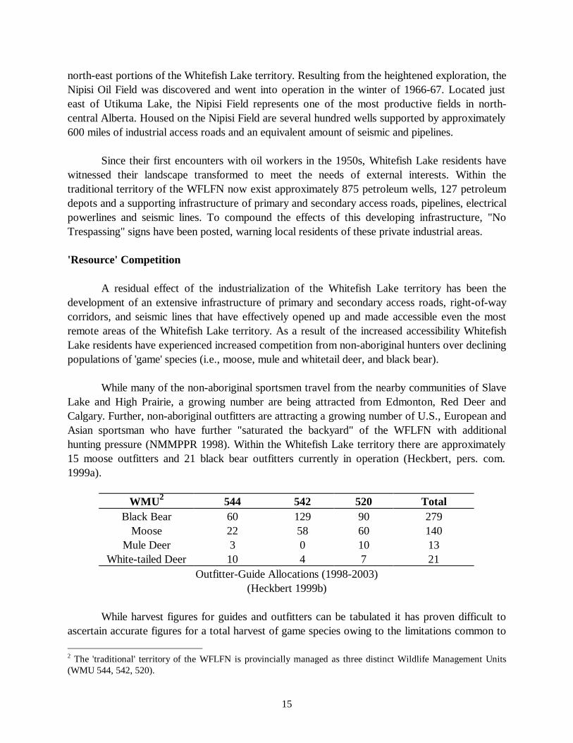
While many of the non-aboriginal sportsmen travel from the nearby communities of SlaveLake and High Prairie, a growing number are being attracted from Edmonton, Red Deer andCalgary. Further, non-aboriginal outfitters are attracting a growing number of U.S., European andAsian sportsman who have further "saturated the backyard" of the WFLFN with additionalhunting pressure (NMMPPR 1998). Within the Whitefish Lake territory there are approximately15 moose outfitters and 21 black bear outfitters currently in operation (Heckbert, pers. com.1999a).
WMU 2 544 542 520 TotalBlack Bear 60 129 90 279
Moose 22 58 60 140Mule Deer 3 0 10 13
White-tailed Deer 10 4 7 21Outfitter-Guide Allocations (1998-2003)
(Heckbert 1999b)
While harvest figures for guides and outfitters can be tabulated it has proven difficult toascertain accurate figures for a total harvest of game species owing to the limitations common to
2 The 'traditional' territory of the WFLFN is provincially managed as three distinct Wildlife Management Units(WMU 544, 542, 520).
16
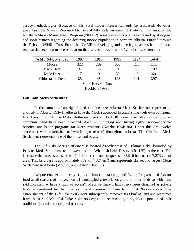
survey methodologies. Because of this, total harvest figures can only be estimated. However,since 1993 the Natural Resource Division of Alberta Environmental Protection has initiated theNorthern Moose Management Program (NMMP) in response to concerns expressed by aboriginaland sport hunters regarding the declining moose population in northern Alberta. Funded throughthe Fish and Wildlife Trust Fund, the NMMP is developing and enacting measures in an effort toreverse the declining moose population that ranges throughout the Whitefish Lake territory.
WMU 544, 542, 520 1997 1996 1995 1994 TotalMoose 322 209 306 280 1117
Black Bear X 16 51 35 102Mule Deer 17 0 28 15 60
White-tailed Deer 85 48 123 141 397Sport Harvest Data(Heckbert 1999b)
Gift Lake Metis Settlement
In the context of aboriginal land conflicts, the Alberta Metis Settlements represent ananomaly in Alberta. Only in Alberta have the Metis succeeded in establishing their own communalland base. Through the Metis Betterment Act of 1938/40 more than 500,000 hectares ofcommunal land have been provided along with hunting and fishing rights, socio-economicbenefits, and health programs for Metis residents (Notzke 1994:186). Under this Act, twelvesettlement were established (of which eight remain) throughout Alberta. The Gift Lake MetisSettlement represents one of the those land bases.
The Gift Lake Metis Settlement is located directly west of Utikuma Lake, bounded byPeavine Metis Settlement to the west and the Whitefish Lake Reserve (R. 155) to the east. Theland base that was established for Gift Lake residents comprises a 83,916 hectare (207,273 acres)area. This land base is approximately 839 km2 (324 mi2) and represents the second largest MetisSettlement in Alberta (McCully and Seaton 1982: 16).
Despite First Nation treaty rights of "hunting, trapping, and fishing for game and fish forfood at all seasons of the year on all unoccupied crown lands and any other lands to which thesaid Indians may have a right of access", Metis settlement lands have been classified as privatelands administered by the province, thereby removing them from First Nation access. Theestablishment of the Gift Lake Settlement subsequently removed 839 km2 of land and resourcesfrom the use of Whitefish Lake residents despite its representing a significant portion of theirtraditionally used and occupied territory.
17
MANAGEMENT APPLICATIONS:CHALLENGES IN LAND USE MAPPING
Despite efforts to quantify accurately traditional and contemporary land use patterns,researchers have been methodologically limited in depicting the cultural significance of the 'land'and the ideological images of these 'places' in the maintenance of Aboriginal culture. One of theprimary challenges in land use research has been in accurately representing the landscape in aculturally appropriate manner that represents both spatial and temporal associations.
The landscape of the WFLFN represents a mosaic of culturally significant 'places', oftenwith names and narratives attached that transform the physical embodiment of the landscape intoa cultural process (Andrews et al 1998). However, the growing interest in aboriginal land use hasoften been grounded in conventional planning and resource management practices that havegenerally represented only the spatial distribution of physical features of the landscape. Becausethe landscape elicits a range of cultural associations - mythographies, passages in one's life -physical features of the landscape take on a functional role that far exceeds their value as aninstrument of reference in land use mapping. The system of knowing that is unique to WhitefishLake residents demonstrates a temporal depth that can not be textualized or mimicked by thefixed parameters of land use maps. Unfortunately, land use research has often been reduced to aprocess of 'cultural triage', where the cultural (holistic) landscape of Aboriginal communities ispresented as a series of fixed coordinates or physical attributes distributed randomly throughout avernacular environment.
Through the objectification of 'memory-scape'1 the cultural significance of the 'land' andthe ideological images of these 'places' have often failed to be accurately represented in a way thatsymbolizes the multidimensional landscape of Aboriginal peoples. As a result, the limitations ofland use mapping have in many cases entrenched an attitude within government/industry that theAboriginal relationship to the landscape is more or less site specific and of little heritage value(Ives 1982). In these cases government and industry planners have often denied aboriginal ties tothe land beyond the existence of these documented sites; sites which from the developer'sperspective might be grudgingly accepted as small pinpoints in an otherwise empty landscape(Lane and Chase 1996: 181). By simply extracting local knowledge and reducing the culturallandscape to a series of static codified sites land use research may actually contribute to alienatingAboriginal peoples from the lands they have long worked to protect.
The De-Contextualization of Land Use Knowledge
An additional concern in land use research is in the removal of local knowledge fromcommunity control. Once removed from the local context, land use information may be easilymisrepresented or inappropriately used by external interests in ways that do not serve local needsand aspirations. By being accessible in a cartographic format, 'western' land managers are able toelicit specific elements of local knowledge (i.e. moose yarding areas) and insert them into the
18
western management model, thereby empirically removing aspects of the local knowledge systemfrom its cultural context as well as eliminating any direct involvement at the local level.
In addition, once removed from local control, land use information may be used byindustry planners to satisfy government requirements of incorporating local knowledge andinvolvement into the planning and assessment process, excluding any actual communityparticipation in the planning process. As Stevenson (1998: 6) has noted, by textualizing ortransforming TK into 'literate' forms (i.e. Geographical Information Systems), the text becomesthe authoritative source rather than the holders of the knowledge, thereby rendering control overaccess, use, and application to external interests.
Moving From Commodity to Process
If the landscape of the WFLFN is to be presented in a culturally appropriate way we haverecognized that research must extend their depiction of the landscape beyond a series of codifiedsites. More important is the establishment of a process that conveys the complex relationshipbetween community residents and the landscape that constitutes their territorial identity. Becauseof this, land use research should be seen as a dynamic process rather than a static representation.Therefore, capacity building at the community level that facilitates dialogue has represented oneof the primary objectives in this land use study.
To have local land use knowledge shared only to collect dust on a shelf; to beincorporated into a Geographical Information System with no local means of access; or to havethe project abandoned when researchers leave the community, not only misrepresents theAboriginal landscape but is in the end a disservice to the holders of that knowledge. If land useresearch is meant to safeguard the cultural landscape of Aboriginal peoples, future researchinitiatives must be seen more as a vehicle for involvement and empowerment than as a salvagingof cultural artifacts. By failing to promote capacity building mechanisms at the community level,land use research may actually hasten the extinguishment policies Aboriginal peoples have longresisted, thereby leaving the traditional territories of Aboriginal peoples as the isolated sites theyare often depicted as. As Kemp and Brook (1995: 27) have noted:
... 'collecting' and 'documenting' indigenous environmentalknowledge is in fact counter-productive. These knowledge systemshave been under serious attack for centuries, and the social systemsthat support them have been seriously undermined.... It is not just aquestion of recovering and recording indigenous knowledge; it isone of respect and revitalization.
To promote this capacity Aboriginal communities must assume 'ownership' of the researchprocess in order to gain an equitable role in the management of their traditionally used lands.Often, Participatory Action Research (PAR) methods have been equated with this type of
19
approach. However, as Berardi (1998: 443) has noted, Aboriginal communities must remaincognizant of the fact that PAR methodology can misrepresent 'participation' for what is stillextractive research. That is, despite the label, unless the process is truly 'owned' by the communityPAR initiatives can easily be co-opted by industry, government, and academic institutions whohave very limited notions of community 'participation'. Used as a catch phrase, 'participatory'research can be superficially applied by researchers holding firmly to traditional researchmethodologies.
However, Whitefish Lake has recognized that when properly exercised, PAR can serve asa capacity building process in itself. By employing collaboratively developed research designs, theviews of community residents can be articulated in a dialogue that recognizes the multi-dimensional landscape. Further, the involvement of local residents has extended beyond merelyadministering questionnaires and surveys to the acquisition of marketable skills that will enhancelocal involvement in the land management process. By establishing a process of 'ownership' localknowledge can be controlled in accordance with community norms and desires, therebyempowering and mobilizing local initiatives in order to further their own self-defineddevelopment.
Because there is a growing reliance on land use research in the planning and assessmentprocess, direct community involvement is required more than ever. It must be recognized that theknowledge presented in land use research is not mutually exclusive from the people who actuallyapply that knowledge system. Therefore, if the cultural landscape of Aboriginal peoples is to berecognized in land use research, a process must be established that recognizes that the textualizedlandscape comes with people and a culture attached.
RESEARCH OBJECTIVES
One of the primary objectives of the Whitefish Lake community was the documentationand preservation of cultural sites that are known to exist throughout the management area. Incooperation with Alberta Community Development (Cultural Facilities and Historic ResourcesDivision) and Alberta Lands and Forests, the cultural 'values' of the WFLFN, which include gravesites, historic sites and archaeological sites have been recorded and placed under ProtectiveNotations through the Historical Resources Act, thereby ensuring the preservation and protectionof these areas from future development. To date a total of 40 individual burial sites have beendocumented and registered that were previously at risk from unknowing development. In mostcases these sites are places that individuals or families had once occupied. While some of thegraves have visible markings, such as headstones, wooden crosses, or fenced areas, many of theseareas remain only in the memories of Whitefish Lake elders, making the documentation andprotection of these sites even more important.
20
Local knowledge regarding fish and wildlife habitat is also being used to safeguard specificlocales. By working with the Alberta Department of Fish and Wildlife, areas such as medicinalplant locations, berry locations, mineral licks, waterfowl nesting and staging areas, and othercritical wildlife areas have been recorded and are being placed under Protective or ConsultativeNotations, again serving to safeguard these areas from future development. When developmentplans are slated for these areas Whitefish Lake representatives, industry representatives andgovernment personnel review the plans, make recommendations and then decide how best toproceed in a cooperative manner.
To help enhance their role in the management process, Whitefish Lake is developing andrendering operational a digital, automated land management system (GIS) to demonstrate theircapabilities of incorporating industrial land management data with their own traditional land andresource knowledge. Through the completed land use research, WFLFN is developing thecapacity to convert traditional land values digitally into a GIS computer based system which canvisually display, edit and analyze the geographically referenced material. This system will enablethe WFLFN to incorporate industrial land management plans with the traditional land andresource component of the project, allowing the WFLFN to identify and then promote, preserveand protect their traditional values and knowledge. This will allow the WFLFN to identify bothmarket and non-market forest values before any activity occurs in the area. In addition toprotecting traditional land values, it will further allow the WFLFN to participate in landmanagement and resource development planning with government and industry partners.
An additional objective of Whitefish Lake was the recording of community held 'place-names' or toponyms for the local landscape (accomplished through the TLUOS). Seen as beingintegral to sound co-operative management, Whitefish Lake has recognized the importance ofestablishing common terms of reference for physical features of the landscape.
While the recording of named-places or toponyms, together with their spatial andepistemological correlates, have long been the subject of anthropological inquiry, the recordingand use of local place-names has received no regard from government/industry land managersoperating within the traditional territory of the Whitefish Lake Cree. In addition, the provincialmaps generally used by industry and government planners refer to landscape feature by names thathave no relevance to local residents and are sometimes represented by only a number and a legaldescription of its location (i.e. NW 1/4-1/4 of section 19: 7-Twp.83, R.13-W.of the 5th). Becauseof the significance of 'place' to Whitefish Lake residence, the establishment of common toponymsis an attempt to illustrate the relationship local residents have with the surrounding landscape. Therecognition of this relationship by industry and government land managers is believed to be vitalto successful co-operative land management.
21
Integrating TEK and Wildlife Research
Failure to incorporate TEK into provincial management decisions stems from a number ofcross-cultural barriers. Foremost among these barriers is the belief among government resourcemanagers that TEK is ill-suited to meet the demands of contemporary environmentalmanagement. However, through the textualization of local landscape knowledge provincialmanagers who are involved in the cooperative management process have begun to recognize thevalue of local knowledge (temporal/spatial) in the development and conducting of wildliferesearch.
This cooperative approach to research is currently being demonstrated by the Alberta Fishand Wildlife Service and Whitefish Lake regarding the location and preservation of 'mineral licks'located throughout the management area.3 Of concern to both parties is the preservation andprotection of these valued habitat areas. Through efforts facilitated by the Whitefish Lake LandUse Study, provincial managers are working with Whitefish Lake hunters and trappers to locateand safeguard these critical habitat areas from unknowing development projects.
To enhance local involvement, Whitefish Lake plans to be actively involved in all wildliferesearch to be conducted within the management area. This will be achieved by cooperativelydesigning and conducting research that is considered to be of importance to the both theWhitefish Lake community and provincial agencies (i.e., land use research, wildlife/habitatresearch and environmental/community health studies).4 This includes conducting, monitoring,and reviewing research results, thereby ensuring community concerns and observation arerecognized by provincial managers and incorporated into the research process. Whitefish Lakeresidents, and specifically the elders, can provide valuable information (both spatial and temporal)regarding the landscape that must be considered before any land management plans can bedeveloped. It is hoped that future research that is of mutual concern to each party can beundertaken in a co-operative manner, thus achieving greater accuracy in results whilestrengthening the co-operative management relationship.
Environmental Health Concerns
There is a growing concern among the Whitefish Lake residents regarding the impact ofindustrial effects on the health of local wildlife and community residents (e.g., industrial residues,roadside/right-of-way herbicide spraying). In response, environmental health research will beconducted to identify specific areas of concern, including the perceived contamination of countryfoods, the identification and location of specific contaminants and the resulting effects onenvironmental health (human/non-human), and the documentation of local perceptions regarding 3 Mineral licks are natural spring areas with high concentrations of sodium which attract moose and otherungulates.4 This has been demonstrated by integrating components of the WFL land use and occupancy study into the 1999Timber Management Plan for the S-9 Forest Management Unit developed cooperatively between the WFLFN,Alberta Lands and Forests, Tolko Forest Product and Zeidler Forest Industries.
22
the functioning ecosystem in relation to temporal and spatial change. Through the Whitefish LakeLand Use Study a vehicle for dialogue has been established that enables the concerns ofcommunity residents to be expressed in a forum which can facilitate co-operative approachesleading to change.
Reclamation of Industrial Activity
Over the past three decades, industrial land disturbance activities such as exploration,pipeline construction, road access, seismic work and sand and gravel extraction have resulted inecologically unbalanced and aesthetically unappealing areas in the Whitefish Lake territory. Underthe 1973 Land Surface Conservation and Reclamation Act,5 these areas are to be returned to acondition which will allow for 'productive' use. However, because of provincial regulatorylimitations (i.e., limited funds and man-power to enforce provincial regulations) these industrialabandoned areas are often left unreclaimed, leaving the landscape scarred by past industrialactivities.
Through the completed land use research Whitefish Lake is establishing a process that willfacilitate their involvement in the reclamation of these industrial areas. By working directly withthe Canadian Forest Service, Alberta Lands and Forests and industry, Whitefish Lake plans toensure that disturbed areas located within their traditional territory are reclaimed in a manner thatincorporates the interests of the WFLFN, be it wildlife habitat recovery, watershed benefits orrecreational opportunities.
As no two disturbance areas are the same, government, industry and the WFLFN willwork cooperatively on a site-by-site basis to determine the most appropriate reclamationapproach. This involvement will also allow Whitefish Lake to be involved in the actual reclaimingprocess, thereby providing an economic benefit to local contractors while facilitating a transfer ofskills that can be applied to other reclamation projects outside the Whitefish Lake territory.
CONCLUSION
In the co-operative management process, the use of local knowledge, presented throughtraditional land use maps, is central to effective land use planning. The textualization of landscapeknowledge provides the basis of information necessary for effective management while providingWhitefish Lake with the tools needed to address land use issues accurately. Land use mapping inthis sense provides government and industry with a textualized account of the historic andcontemporary land use activities occurring within the traditional territory of the WFLFN. Used inthis capacity, land use mapping has provided Whitefish Lake with the means to articulate visuallyarguments that support their point-of-view in the co-operative management process. For the
5 The provincial Land Surface Conservation and Reclamation Act was enacted in 1973. The act is now beingrevised and will be integrated into the Alberta Environmental Protection and Enhancement Act.
23
WFLFN, land use maps have served as a vehicle for dialogue between themselves, governmentand industry. It gives a clear indication of the territory utilized by Whitefish Lake residents andprovides a basis for governmental understanding of the intimate relationship that Whitefish Lakeresidents have with a specific geographical landscape.
In addition to its use in the land management process, land use mapping serves as aneffective tool for political empowerment. Maps have been used to defend territories of land andsea by showing that aboriginal landscapes have long been occupied and sustainably 'managed'.Strategies for mapping the Whitefish Lake landscape have too effectively challenged thejustification of 'state' intrusions (political and industrial) by visually 'authenticating' the traditionalterritory of the WFLFN, thereby contesting government claims that Whitefish Lake lacks a clearlydefined land base. For Whitefish Lake, land use mapping has defined the summation of historicand contemporary uses of the area and is a textualized expression of Whitefish Lake's long-standing involvement with the known landscape. Mapping in this sense is a metaphor that speaksa universal language that all can understand and it is this ability to communicate through mapsthat will help self-empower the WFLFN (Jarvis and Stearman 1995: 61).
Beyond its political component, land use mapping has served as a means of culturalempowerment as well. By visually defining a collective sense of territory, the sense of 'place' hassparked a renewed cultural identity among the Whitefish Lake residents. By bringing both youngand old together to communicate about the land a renewed sense of cultural pride and territorialidentity has arisen - in essence Whitefish Lake has visually said - "this is our home."
REFERENCES CITED
Andrews, Thomas D., John B. Zoe and Aaron Herter 1998. On Yamozhah's Trail: Dogrib SacredSites and the Anthropology of Travel. In Oakes, Jill, Rick Riewe, Kathy Kinew and ElaineMaloney (eds.), Sacred Lands: Claims, Conflicts and Resolutions. Canadian CircumpolarInstitute, University of Alberta. Edmonton, Alberta: 305-320.
Apland, Brian and Ray Kenny (eds.) 1989. British Columbia Archaeological Impact AssessmentGuidelines. Province of British Columbia, Ministry of Municipal Affairs, Recreation, andCulture, Archaeology and Outdoor Recreation Branch, Victoria.
Berardi, Gigi 1998. Application of Participatory Rural Appraisal in Alaska. Human Organization,Vol. 57(4): 438- 446.
Brody, Hugh 1981. Maps and Dreams. Vancouver: Douglas and McIntyre.Dene Cultural Institute 1997. Report on Aboriginal Participation in Mining: Increasing
Knowledge. Eighth Annual Report, July.Fort McKay First Nation 1994. There Is Still Survival Out There: A Traditional Land Use and
Occupancy Study of the Fort McKay First Nation. Alberta, Canada.Freeman, Milton M.R. 1976. Report, Inuit Land Use and Occupancy Project (3 vols.). Ottawa:
Department of Indian Affairs and Northern Development.
24
Heckbert, Mark 1999a. Wildlife Biologist, Alberta Environmental Protection, personalcommunication, March 22.
Heckbert, Mark 1999b. Outfitter-Guide Allocation and Harvest Data: Wildlife Management Units544, 542, 520. Alberta Environmental Protection, Natural Resource Division, HighPrairie, Alberta.
Ingold, Tim 1987. The Appropriation of Nature. Iowa City: University of Iowa Press.Ivanitz, Michele J. 1996. Co-Management of Resources Between Whitefish Lake First Nation and
the Province of Alberta: Social Forestry and Local-Global Articulation. Thesis (Ph.D.)University of Alberta, Department of Anthropology: Edmonton, Alberta.
Ives, John W. 1982. Evaluating the Effectiveness of Site Discovery Techniques in Boreal ForestEnvironments. In Francis, Peter D. and Eric C. Poplin (eds.), Directions in Archaeology:A Question of Goals. Calgary: Archaeological Association, University of Calgary: 95-114.
Kemp, William B. and Lorraine F. Brooke 1995. Toward Information Self-Sufficiency: TheNunavik Inuit Gather Information on Ecology and Land Use. Cultural Survival Quarterly,Winter: 25-28.
Lane, Marcus and Athol Chase 1996. Resource Development on Cape York Peninsula:Marginalisation and Denial of Indigenous Perspectives. In Resources, Nations andIndigenous Peoples. Oxford University Press, Oxford: 172-183.
McCully, Al and Hugh Seaton 1982. Gift Lake Metis Settlement Land Use Planning Inventory.Municipal Planning Section, Planning Branch Alberta Municipal Affairs.
Natcher, David 1999. Co-operative Resource Management as an Adaptive Strategy forAboriginal Communities. Ph.D. Thesis, Department of Anthropology, University ofAlberta. Edmonton, Alberta.
Natural Resources Canada 1996. The State of Canada's Forests: Learning From History.Canadian Forest Service, Ottawa, Canada.
Northern Moose Management Program Progress Report (NMMPPR) 1998. Northern MooseManagement Program Progress Report (NMMPPR). Alberta Environmental Protection,Natural Resource Service. Edmonton, Alberta.
Notzke, Claudia 1994. Aboriginal Peoples and Natural Resources in Canada. York: CaptusUniversity Publications.
Stevenson, Mark 1998. Traditional Knowledge and Environmental Management: Moving FromCommodity to Process. Paper presented to the National Aboriginal Forestry AssociationConference, "Celebrating Partnerships", Prince Albert, Saskatchewan, September 14-18.
Usher, Peter, F.J. Tough, and R.M. Galois 1992. Reclaiming the Land: Aboriginal Title, TreatyRights and Land Claims in Canada. Applied Geography 12: 109-132.
Usher, Peter 1990. Recent and Current Land Use and Occupancy in the Northwest Territories byChipewyan and Dene' Bands. Office of the Prince Albert Tribal Council. Saskatchewan,Canada.
Weinstein, Martin S. 1993. Aboriginal Land Use and Occupancy Studies in Canada. Workshop onSpatial Aspects of Social of Social Forestry Systems. Chiang Mai University, Chiang Mai,Thailand.
25
Weinstein, Martin S. 1976. What the Land Provides: An Examination of the Fort GeorgeSubsistence Economy and the Possible Consequences on it by the James BayHydroelectric Project. Montreal: Grand Council of the Crees (of Quebec).
Westworth, D.A. and Associates Ltd. 1990. Significant Natural Features of the Eastern BorealForest Region of Alberta. Technical Report, Alberta Forestry, Lands and Wildlife.Edmonton, Alberta.