Embed Size (px)
Citation preview
ProjectofStrategicInterestNEXTDATA
WP1.1–High-altitudeClimaticObservationSystemandClimateStationNetwork(WPleader:PaoloCristofanelli)
DeliverableD1.1.A.Implementationofthebackgroundobservationnetwork:identificationofinstrumentationtobeacquired,identificationofreal-timedata
delivery/earlywarningservicesandtheirintegrationwithininternationalprogramme.Identificationofguidelinesfortheharmonizationofmeasurementprotocols,dataanalysis,QA/QCproceduresincludingthereferencetocommoncalibrationscalesandreferencemethodologies(e.g.GAW-WMI,ICOS,ACTRS)
TableofContents
1. Introduction..............................................................................................................................................1
2. Implementationoftheobservationalnetworkformonitoringthebackgroundenvironmental-climaticconditions..........................................................................................................................................................4
2.1Upgradeofmeasurementsystems........................................................................................................4
2.2Identificationofreal-timedatadelivery/earlywarningservicesandintegrationwithininternationalprogramme...................................................................................................................................................7
2.3Dataaccess.............................................................................................................................................8
3....Definitionofguidelinestoharmonizethemeasurementmethodologies,protocols,QA/QCprocedures,includingtheadoptionofcommonreferencecalibrationscales(e.g.GAW-WMO,ICOS,ACTRIS)..................9
3.1Generalapproach.................................................................................................................................10
3.2Reactivegases.......................................................................................................................................11
3.3Greenhousegases.................................................................................................................................12
3.4Aerosolsphysicalproperties................................................................................................................13
3.5TotalozoneandUVradiation..............................................................................................................13
3.5Meteorologicalparametersandsolarradiation(ancillary)................................................................14
D11A–ANNEX1................................................................................................................................................2
1
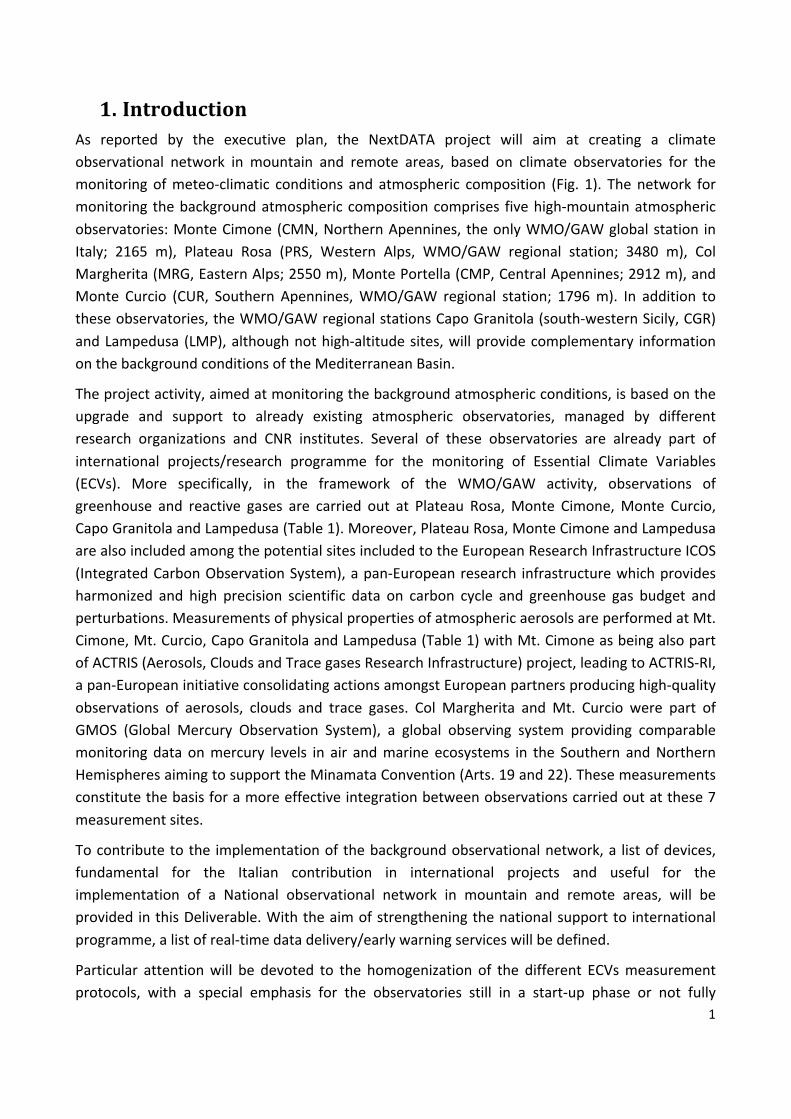
1. IntroductionAs reported by the executive plan, the NextDATA project will aim at creating a climateobservational network in mountain and remote areas, based on climate observatories for themonitoring ofmeteo-climatic conditions and atmospheric composition (Fig. 1). Thenetwork formonitoring thebackgroundatmosphericcompositioncomprises fivehigh-mountainatmosphericobservatories:MonteCimone(CMN,NorthernApennines, theonlyWMO/GAWglobalstation inItaly; 2165 m), Plateau Rosa (PRS, Western Alps, WMO/GAW regional station; 3480 m), ColMargherita(MRG,EasternAlps;2550m),MontePortella(CMP,CentralApennines;2912m),andMonte Curcio (CUR, Southern Apennines,WMO/GAW regional station; 1796m). In addition totheseobservatories,theWMO/GAWregionalstationsCapoGranitola(south-westernSicily,CGR)andLampedusa(LMP),althoughnothigh-altitudesites,willprovidecomplementary informationonthebackgroundconditionsoftheMediterraneanBasin.
Theprojectactivity,aimedatmonitoringthebackgroundatmosphericconditions,isbasedontheupgrade and support to already existing atmospheric observatories, managed by differentresearch organizations and CNR institutes. Several of these observatories are already part ofinternational projects/research programme for the monitoring of Essential Climate Variables(ECVs). More specifically, in the framework of the WMO/GAW activity, observations ofgreenhouse and reactive gases are carried out at Plateau Rosa,Monte Cimone,Monte Curcio,CapoGranitolaandLampedusa(Table1).Moreover,PlateauRosa,MonteCimoneandLampedusaarealsoincludedamongthepotentialsitesincludedtotheEuropeanResearchInfrastructureICOS(IntegratedCarbonObservationSystem),apan-Europeanresearch infrastructurewhichprovidesharmonized and high precision scientific data on carbon cycle and greenhouse gas budget andperturbations.MeasurementsofphysicalpropertiesofatmosphericaerosolsareperformedatMt.Cimone,Mt.Curcio,CapoGranitolaandLampedusa(Table1)withMt.CimoneasbeingalsopartofACTRIS(Aerosols,CloudsandTracegasesResearchInfrastructure)project,leadingtoACTRIS-RI,apan-EuropeaninitiativeconsolidatingactionsamongstEuropeanpartnersproducinghigh-qualityobservations of aerosols, clouds and trace gases. Col Margherita and Mt. Curcio were part ofGMOS (Global Mercury Observation System), a global observing system providing comparablemonitoring data onmercury levels in air andmarine ecosystems in the Southern andNorthernHemispheresaimingtosupporttheMinamataConvention(Arts.19and22).Thesemeasurementsconstitutethebasisforamoreeffectiveintegrationbetweenobservationscarriedoutatthese7measurementsites.
Tocontributetothe implementationofthebackgroundobservationalnetwork,a listofdevices,fundamental for the Italian contribution in international projects and useful for theimplementation of a National observational network in mountain and remote areas, will beprovidedinthisDeliverable.Withtheaimofstrengtheningthenationalsupportto internationalprogramme,alistofreal-timedatadelivery/earlywarningserviceswillbedefined.
Particular attentionwill be devoted to the homogenization of the different ECVsmeasurementprotocols, with a special emphasis for the observatories still in a start-up phase or not fully
2
integrated in internationalprograms.The implementationof internationalharmonizedprotocolsandmethodologieswillincreasethecompetitivenessoftheresearchactivitiescarriedoutattheseobservatories.Moreover, common procedures for data creation and Quality Assurance/QualityCheck (QA/QC) will be implemented; these are useful also for themeasuring activities alreadybelonging to international programs. At present, although well-defined Standard OperationProceduresexistforthedifferentECVs,theQA/QCproceduresateachobservatoryareoften(still)characterizedbya lowlevelofautomationandnotfullystandardized.To integratethedifferentobservatoriesintoapropernetwork,andtoactivatenear-realtimeservicesfordatapublication,thecurrentstandardizationandharmonizationlevelneedtobeimproved,bydefininginauniformwaythemeasurementguidelinesandtheQA/QCprocedures.
Currently, the National research system is lacking a centralization of data recorded at theseatmosphericobservatories,whichthenneedtoberetrieved(oftenonlyinpart)directlyfromthewebsitesof theresearch institutions,or fromthedatabaseofeachmeasuringprogram.Forthisreason,NextDATAaims inprovidingasinglenationalentrypointforthetimeseriesoftheECVsrecordedattheseatmosphericobservatories.
Figure1.GeographicallocationandpicturesofthemonitoringstationsbelongingtotheatmosphericbackgroundobservationalnetworksupportedbytheNextDATAproject.
3
ECV Referenceprogrammes
Monitoringstation
PRS MRG CMN MGR CUR CGR LMP
CO2 WMO/GAW
ICOS-RI
X X X X XCH4 X X X X X
N2O X X
SF6
WMO/GAW
X CFCs X HCFCs X HFCs X CO X X X XO3 X X X X X X XSO2 X X X NO
WMO/GAW
ACTRIS
X X X NO2 X X X Particlescattering
X X
Particleabsorption X X
Particlesizedistribution X X X X
Particleconcentration X X X
Coarseparticlesizedistribution X X
AOD X XTotalO3 WMO/GAW XUVradiation X XMeteorologicalparameters WMO/GAW
X X X X X X
Solarradiation X X X X X XAtmosphericHg GMOS X X
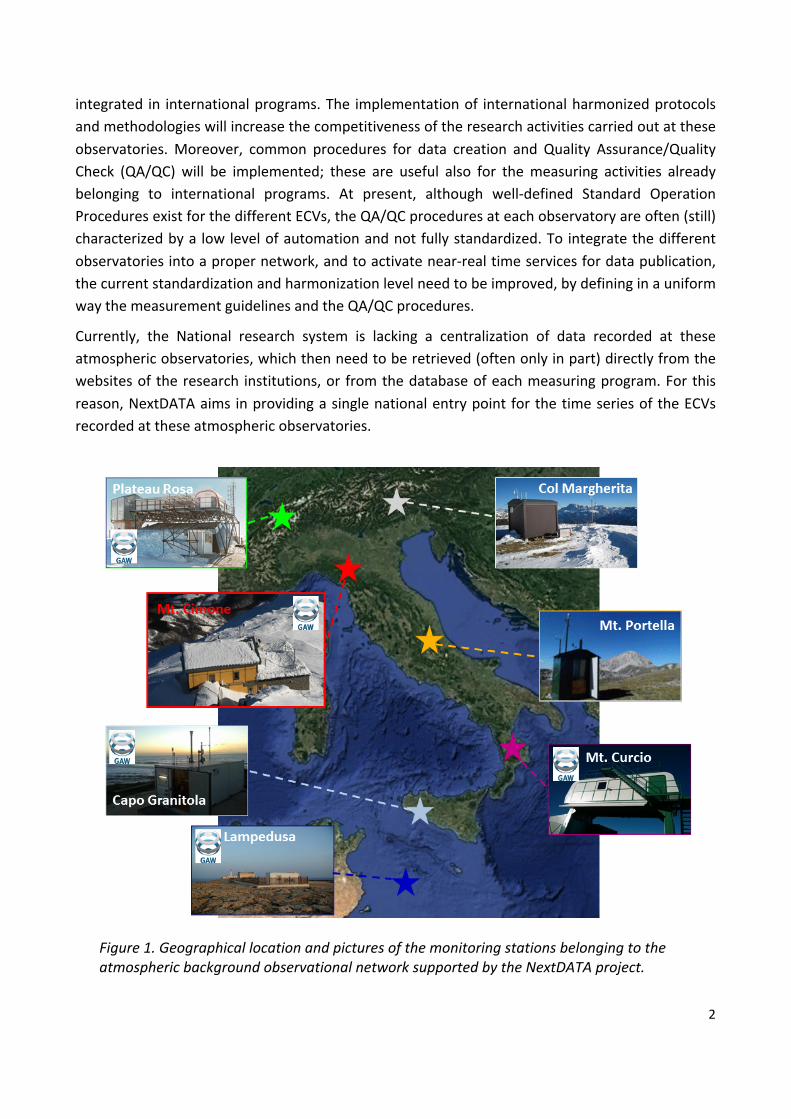
Table1.ListofEssentialClimateVariables(ECVs)collectedattheatmosphericbackgroundmonitoringobservatories(PRS:PlateauRosa;MRG:ColMargherita;CMN:MonteCimone;CMP:MontePortella/CampoImperatore;CUR:MonteCurcio;CGR:CapoGranitola;LMP:
Lampedusa).GreycellsindicatethemeasuringactivitiesthatarealreadypartoftheWMO/GAWprogram.
4
2. Implementationoftheobservationalnetworkformonitoringthebackgroundenvironmental-climaticconditions
Theobservationalnetworkformonitoringthebackgroundenvironmental-climaticconditionsaimsto contribute at international projects and programmes: e.g. GAW-WMO, ACTRISI and ICOS-RI.ThefirstgoaloftheNextDATAProjectistocontribute,duringitsactivityperiod,insupportingtheoperationoftheatmosphericbackgroundstations.Thiswillbeaccomplishedbystrengtheningtheobservation and technical equipment, by sharing and disseminating standardmethodology andSOPs for the observed ECVs, by implementing common automatic systems for the qualityassurance/check(QA/QC)andforthedatareporting.
2.1UpgradeofmeasurementsystemsDuringtheearlyphaseofNextDATA,alistofscientificquestions(SQ)wasprovidedtoaddressthescientificactivitywithintheProject(DeliverableD1.1.1).Amongthese,SQ1andSQ3stressedtheimportance of setting-up an observing system based on remote atmospheric observatories tocontribute in obtaining more accurate operational atmospheric composition monitoring andforecasting by using near-real time data and in understanding the role of short-lived climateforcers(especiallyblackcarbon)inregulatingtheregionalandglobalclimate.Obtainingmoreandmore accurate information about SLCF variability and emissions was recently stressed byWMO/GAW as follow up if the Paris Agreement. In June 2015, the 17thWorldMeteorologicalCongress requested a plan for an IntegratedGlobalGreenhouseGas (GHG) Information System(IG3IS).InDecember2015,theUNFCCCnationsforgedtheParisAgreement,codifyingtheideaofnationally determined contributions (NDCs). Improved scientific understanding of the SLCF and“well-mixed” GHG is a key step to create policy-relevant information regarding climate changemitigation and adaptation at national and international frameworks. For these reasons, theintegrationof theobservational network formonitoring thebackgroundenvironmental-climaticconditionswasbasedonthedoubleconceptofcreatinganationalsystemfortheprevisionofNRTdatainformationaboutSLCFandGHG.Tothisaim,effortsmustbecarriedout(1)toincreasethenumberofmeasurementsites for theECVof interest to (2) to implement technical solution forNRTqualityassessmentanddeliveryofdataattheselectedmeasurementsites.Inthefollowing,wereport,forselectedmeasurementsites,indicationsabouttheinstrumentationtoacquiretostrengththeobservationalcapacityofthestationsasafunctionofintegrationwithininternational programme or within the NextDATA background observational network. Inagreement,withtheexecutiveplan,NextDATAwillsupporttheimplementationofmeasurementprogrammeattheMt.CimoneWMO/GAWGlobalStationaswellastheattheotherbackgroundstationswithinNextDATA.MonteCimone(CMN)ToguaranteeanefficientcontributionofCMNobservationsintheframeworkofWMO/GAW,itisnecessarytoupgradethesystemforthecontinuousobservationsofCOandCH4attheCNR“O.Vittori” Observatory, part of the Mt. Cimone WMO/GAW Global Station. Indeed, the systemscurrentlyinoperation(GC-FID“Agilent6890N”andThermoTei48C-TLNDIR)arenotable,duetotheirageandtechnicallimitations,toguaranteethedataqualityobjective(±2ppbforCOandCH4)
5
and the data coverage requested by WMO/GAW. To optimize the implementation activity, asystembasedonthe“CavityRingDownSpectroscopy-CRDS”hasbeenselectedtobeinstalledatthisstation.Thissystemischaracterizedbyrelativelylowneedofmanpowerandfunctionalcostsin respect to other techniques. This will also optimize the overall management of themeasurementactivityatthisremotestation.Moreover,theuseofaCRDSsystemformultiplegasmeasurements,willalsoallowtoreachthetechnicalrequirementsrequestedintheframeworkofthe ICOS European Research Infrastructure and described in the document “ICOS AtmosphericStationSpecifications”(Laurent,August2017,V2.01).ThiswillpromotetheintegrationoftheMt.Cimone observatory within this pan-European research infrastructure. To reach the high ICOSrequirements also the implementation of a new system for the remote management ofcalibrationsbasedontheuseofa10-waymultivalveisnecessary,togetherwiththeuseofmixturestandards produced by the ICOS calibration laboratory and traced back toWMO/GAW centralcalibration standards (NOAA-GMDL). Moreover, to this aim is also necessary to upgrade themeteorological measurements by using sensors with low uncertainty on the 1-minute timeresolution. Thus, in agreement with ICOS and WMO (Cimo) guidelines, new meteorologicalsensors for the continuous observations of air-temperature, relative humidity and atmosphericpressuremustbeimplementedatMt.Cimone.DuringthefirstimplementationphaseoftheNextDATAProject,anautomatedsystemforsummermeasurementsofAerosolOpticalDepth(AOD)hasbeenimplementedatM.Cimone,followingtheWMO/GAW guidelines (see www.isac.cnr,it/cimone/sunphoto). However, the atmosphericprofilingcomponentisstilllimitedatthisstation.Thus,afurtherimplementationofatmosphericprofilingcapacityatMt.Cimoneisstrategicbothforinterpretationoftheatmosphericprocessesand atmospheric compound variability, and for the consolidation of the participation withininternationalprogramme.ToreinforcethecapabilityoftracegasmonitoringandthecontributiontotheCopernicusAtmosphereMonitoringServiceandtoACTRIS,itisofparamountimportancetoupgrade the DOAS (Differential Optical Absorption Spectroscopy) system already in use atMt.Cimone.Tothisaim,theDOASsysteminuseatMt.Cimonesince1996(developedbyCNR-ISAC),has been substituted with a state-of-art system developed by CNR-ISAC in collaboration withEvoraUniversity(Portugal).Inthecurrentconfiguration(zenith-skymode),thisnewDOASsystemisabletoperformsimultaneousmeasurementoftotalcolumnamountofO3,NO2,BrO,SO2eIO.Toobtain theverticalprofilesof theseECVs, the systemmustbe implementedwitha technicaldeviceforimplementingtheMAXDOAS(Multi-AXisDOAS)methodology.Thankstothecouplingofa camera able to scan the atmosphere andby the treatmentof observeddatawith a radiativetransfermodel,itcanbepossibletoobtainquantitativeinformationofverticaldistributionoftheobserved tracegases.Theultimategoalof thisactivitymustbe the international recognitionofthismeasurementsystemwithininternationalnetworks.Thismustbedonebytheparticipationinintercomparisonexercisesandmeasurementcampaigns,withtheambiguousgoalto includetheMt. Cimone station within NDACC - Network for the Detection of Atmospheric CompositionChange.TostrengththeintegrationofMt.CimonewithinACTRIS, it ismandatorytoupgradethesystemforthecontinuousobservationsofsub-micrometeraerosolsizedistribution,inordertocarryoutrealiablemeasurementinstableconditionsofflows,temperaturesandrelativehumidity.Tothisaim the current DMPS (Differential Mobility Particle Sizer) system must be converted andupgraded to a SMPS (ScanningMobility Particle Sizer)with an automatic adjustmentof aerosoland flows. This will allow Mt. Cimone to be compliant with the most recent WMO/GAW
6
guidelines for the execution of particle size distribution measurements (WMO/GAW AerosolMeasurementprocedures,GuidelinesandRecommendations,2ndEdition,GAWReportNo.227)ColMargherita(MGR)AtColMargherita, locatedat theborderbetweenTrentinoandAltoAdigeregions,not far fromPassoSanPellegrino, since2013 isworkinganatmosphericobservatorymanagedbyCNR-IDPA.This observatorywas installed to perform continuous observation of atmosphericmercury (Hg)andrelateddeposition(wetanddry).Originally,theseobservationswerestartedintheframeworkof the GMOS (Global Mercury Observation System) EU-Project and were co-located withobservationsofmeteorologicalparameters,solarradiationandsnowlevel.Thesite locationandthesamplingsystembywhichthestationiscurrentlyequippedaresuitablefortheexecutionofatmospheric composition observations (especially for reactive gases). The station still presentssomelimitationsrelatedtotherelativelysmallspaceavailablefortheinstrumentationandsomeproblems related to the provision of continuous electrical power and lightning discharge. Thestation isunmannedwithno scientificor technicalpersonnelworking in-situ. It canbe reachedaftera2-hourtripbycarfromtheCNR-IDPAHQsinVenice.Forthesereasons,withthepurposeofupgradetheobservationcapabilityatthisstation,“state-ofart” instrumentation characterized by a low need of manpower and characterized by well-assessedstandardoperationprocedures(SOPs)mustbeconsidered,togetherwithanupgradeofthe electrical system of the station (e.g. UPS and technical solutions to limit black-out andlightning impacts). To integrate the station within the NextDATA background observationalnetworkandsupport the researchprogrammesalreadyon-going, it isnecessary toupgrade thesensors for meteorological parameters and solar radiation. Then, measurement programmesconcerning atmospheric composition variables must be further implemented. In particular,startingcontinuousmeasurementsofshort-livedclimateforcers(akeytopicwithinNextDATA,seeDeliverable1.1.1)likeozoneandblackcarbon,canrepresentsastrategicimplementationforthisstation. These observations are already widely performed among the observatories part ofNextDATA:thisrepresentsastrongpointforasuccessfulimplementationofMRGstation,takinginto account the possible sharing of experience, technical knowledge andmaterials.Moreover,startingSLCFobservationsatMRGwouldeffectivelycontributetoabetter investigationof theirvariabilityandemissionsonNationalandEuropeanscales,inagreementwiththeroadmaptracedfor the Paris Agreement. This would also represent a support for implementation of science-servicebytheprovisionofNRTdatatointernationalinitiatives(e.g.CAMS-Copernicus).MontePortella(CMP)ThestationofMontePortellaissituatedinthelocalityofthesamenameintheNationalParkofAbruzzo.ThestationisownedbyUniversityofChietiwhich,aswellascoordinatingthescientificresearchactivitiesofprojectstowhichthestationisaffiliated,alsodirectlyperformsmostofthemeasurementandmonitoringprogrammesundertakenatthestation.Locatedat2401maltitude,on the crestofMontePortella in theNationalParkofAbruzzo, themeasurement stationhasastrategicroleinthestudyofatmosphericconditionsathighaltitudeintheMediterraneanBasin.
• Variability of greenhouse and reactive gases in the atmosphere due to both natural andanthropogenicfactors.• Variability of physico-chemical properties of aerosol in the atmosphere due to both natural andanthropogenicfactors.
7
Theexperimentalequipmentishostedinsideaninsulatedshelter,providedwithaslopingroofinordertoavoid,inwinter,anexcessiveaccumulationofsnowwhichposeariskofdamagetotheequipment. The shelter houses approximately 3m2 for scientific instrumentation, in good partalreadyoccupiedbytheequipmentinoperationatthestation.Thestationispoweredbya220V3kW electric line that originates from the nearby shelter "Duca degli Abruzzi". The station isequippedwitha systemtoensurecontinuity (UPS)of instruments forabout120min in caseofblackoutandwitha radioconnection toensurean internet link to the station,allowing remoteaccesstosystemsfordataacquisitionandtransfer(alsoinalmostrealtime/NRT).Thelaboratoriesalsohavespecialsamplingheadsforairsamplingaimedtotracegasandaerosolpropertiesmonitoring.Inparticular,aunifiedsamplingsystemhasbeeninstalled,forairsamplestobeusedforthecontinuousanalysisofgreenhousegasandreactivegasvariability.Thesystem,developed under NextDATA, complies with the guidelines of the Global Atmosphere WatchprogramoftheWMO.Inparticular,thesystemconsistsofaPyrexandTeflon©collectionhead,withaflowcapacityofover40l/sguaranteedbyaturbine.Currently,thissamplingsystemisusedforthemeasurementsofsurfaceozonebymeansofaUV-abortpionanalyser(Thermo49i).Themeteorologicalmeasurementshavebeencarriedoutbyanintegratedweatherstationthatiscurrentlynotworking.ThismustbereplacedassoonaspossibletosupporttheinterpretationofatmosphericcompositiondataandQA/QCproceduresfinalizedtothedataflagging.AsfortheColMargheritastation,takingintoaccountthenoteasyaccessibilitytothestation(especiallyduringwinter)andthelimitedpoweravailableforthemeasurementprogrammes,herewesuggesttheimplementationof“state-ofart” instrumentationcharacterizedbya lowneedofmanpowerandcharacterized by robust standard operations. In particular, in the future the implementation ofaerosollight-absorption(equivalentblackcarbon)measurementsbyusingmulti-angleabsorptionphotometer (MAAP) or Aethalomters could be strategic for amore effective integration of thestationwithintheNextDATAbackgroundnetworkandwithininternationalprogrammeorproject.Lampedusa(LMP)TheatmosphericobservatoryontheislandofLampedusahasbeenoperationalsince1997,whenmeasurementsofUVradiationandtotalozonewerestarted.Manyadditional instrumentswereadded since then, and Lampedusa now contributes to different international measurementnetworks(GAW/WMO,ICOS,ACTRIS,EMSO,AERONET,MWRnet,NOAAcooperativeairsamplingnetwork) with continuous observations of many atmospheric parameters. These includegreenhousegases,somereactivegases(COandsurfaceO3),meteorologicalparameters,aerosol,radiation,etc.WithinNextDataweexpecttoimplementnewmeasurementprotocolsandupdatesome instruments to allow the full integration within developingmeasurement networks (e.g.,ICOSandACTRIS).Arelativelylargesetofdata(meteorology,greenhousegases,surfaceO3,,AOD,totalozone,UVradiation)isprovidedtotheNextDATAdatabase.
2.2Identificationofreal-timedatadelivery/earlywarningservicesandintegrationwithininternationalprogrammeSpecific services for thenear-real timedeliveryand repositoryofdatacollectedby someof thebackgroundatmosphericstationshavebeenalreadyactivatedintheframeworkofNextDATAandby other programme (es. GMOS, I-AMICA) devoted to strength the atmospheric observationcapabilityinItaly.IntheframeworkofNextDATA,wealreadyactivated(fromPRSandCMN)NRTdatadeliverytowardsCAMS-Copernicusforreactivegases,towardsGAW-NRT/ACTRISforasubset

8
ofaerosolparametersandtowardsWMOSDS-WASforcoarseparticlenumberconcentration(forCMN). NRT data delivery serviceswere already implemented in the framework of the I-AMICA(fromCURandCGR)andGMOS(fromMRGandCUR)network.OurgoalistofurtherintegrateandextendtheseservicestootherstationsandECVsbeforetheendofNextDATAlifetime.ToincreasetheintegrationofthebackgroundstationwithinaNationalnetwork,forasub-setofECV,wewillimplement automatic services to flag and format the data, in agreementwith theWMO/GAWguidelines.Theseservices,willbeactivatedforMRG(surfaceO3andmeteorologicalparameters),CMN(reactivegases,aerosolproperties,AODandmeteorologicalparameters),CMP(surfaceO3,aerosolsizedistributionandmeteorologicalparameters),CUR(reactivegases,aerosolproperties),CGR (reactive gases, aerosol properties) and LMP (surface O3). These services will create apreliminary quality-assessed data-base also suitable for the activation of near real-time datadelivery/earlywarningtoexternalusers.In particular, we will support and implement the near real-time data delivery/early warningalreadyactivatedintheframeworkofNextDATA.Withthepurposeofon-lineverificationofmodelforecast,wewillextendthenumberofstationsprovidingNRTdeliveryofreactivegases(O3,CO,SO2andNOx)datatoCAMS-Copernicus,withaspecialemphasisonO3andCO.Moreover,wewillimplement for CGR and CUR, the NRT data deliver experimental service concerning aerosolpropertiescurrentlyactivatedforCMNtowardsGAW-NRT/ACTRIS.WewilldefinethecriteriaforimplementinganautomaticsystemfortheNRTdetectionofSharandust transport events based on near-surface observations of aerosol properties (aerosol sizedistribution,absorptionandscatteringcoefficient)atdifferentmeasurementsitesintegratedwiththe outputs from atmospheric model simulation. Moreover, we will implement an operationalversion of the STEFLUX code, already developed in the framework of NextDATA (Putero, D.,Cristofanelli, P., Sprenger, M., Škerlak, B., Tositti, L., and Bonasoni, P.: STEFLUX, a tool forinvestigating stratospheric intrusions: application to two WMO/GAW global stations, Atmos.Chem. Phys., 16, 14203-14217, https://doi.org/10.5194/acp-16-14203-2016, 2016), to routinelyidentify the occurrence of stratospheric intrusion events at the high-altitude stations of thebackgroundnetwork(PlateauRosa,ColMargherita,MonteCimoneandMonteCurcio).
2.3DataaccessAsmentioned in the introduction section, at themomenta singleentrypoint for accessing thedataofECVsrecordedbythebackgroundmeasurementstationsdoesnotexist.Animportantstepfor the integration of the network is to create a system by which data can be discovered,visualised and downloaded by external users. To this aim,we intend to implement the alreadyexisting MOVIDA (MonteCimone On-line VIsualization and Data Analyses) system(http://www.isac.cnr.it/cimone/data-access)tohostandpublishthetimeseriesofECVsrecordedbyallthemeasurementstationspartoftheobservationalnetwork(MOVIDA“Multistat”).MOVIDA isdeveloped inR languagebyusingshinypackage (i.e.https://shiny.rstudio.com/ ) forplottinganddatadownloading.Alinuxvirtualmachinewasdedicatedtothisapplication,whichisinstalledonlinuxmachinewithanpublicIP.The system for the data download is implemented and presented on the GUI (Graphical UserInterface). Itprovidesfiles inCSVformateasytoimport inthemostcommonscientifictechnicalcomputinglanguages(R,Matlab,Octave,Scilab,Julia,Python).MOVIDArepresentsan“easy-to-use”andvery intuitivewebresourcebywhichalsonotexperts(e.g. high-school student or teachers, university student, citizens) can have access to the timeseries of ECVs over the Italian territory. Besides providing access to data time series,MOVIDA

9
representsawebresourcebywhichexternaluserscanrunsomebasicstatisticalanalysesonthetime series for each ECV and over flexible period of interests. Thanks to the packages Shiny(shiny.rstudio.com) and Openair (Carslaw and Ropkins, 2012), it is possible to plot raw data,average(ondifferenttimescales:daily,monthlyandyearly)aswellastoperformsmoothingoftimeseriestoobtaininformationaboutlong-termtendencies.ApreliminaryversionofMOVIDA“Multistat”,iscurrentlyunderdevelopmentanditisavailableinthedevelopmentenvironmentatCNR-ISAC,seehttp://shiny.bo.isac.cnr.it:3838/plot-multistats/).
MOVIDA graphical web interface for the Italian Climate Observatory “O. Vittori”. It is available - with free access to the dataset - at http://www.isac.cnr.it/cimone/data-access.
.
10
3.Definitionofguidelinestoharmonizethemeasurementmethodologies,protocols,QA/QCprocedures,includingtheadoptionofcommonreferencecalibrationscales(e.g.GAW-WMO,ICOS,ACTRIS)
3.1Generalapproach
NexDATAaimstocontributeinfacilitatingandstrengthentheItaliancontributiontointernationalprojectsandprogrammes,e.g.WMO/GAW,ACTRIS-RI,ICOS-RI.To this aim, for the background measurement stations, it is fundamental to implement theguidelines defined by the reference international programs for each observed ECV. In the nextsection,asafunctionofthedifferentECVfocalareas,wewillreportthemostupdateguidelinesforeachreferenceprogramme/project, togetherwiththereferencestothecalibrationscales tobeadopted.The quality assessment system proposed in the framework of NextDATA for the backgroundmeasurementnetworkisbasedontheWMO/GAWapproach:1) Network-wideuseofonlyonereferencestandardorscale;2) Fulltraceabilitytotheprimarystandardofallmeasurements;3) Implementation of data quality objectives (DQOs) defined by the reference
programs/projects;4) Establishment of guidelines on how to meet these quality targets, i.e., harmonized
measurementtechniquesbasedonMeasurementGuidelines (MGs)andStandardOperatingProcedures(SOPs);
5) Executionofround-robinexerciseswithinthenetworkforsomekeyparameters;6) Developmentofcommonproceduresforthedatavalidationtofavourthetimelysubmission
of data submission to the international reference project/programme and to NextDATAarchives.
Inparticular,intheframeworkofWP11,weproposeacommonapproachforthedatavalidation(data flagging) and for the format of data to be submitted to NextDATA archives and to thereference internationalprograms/projects. Indeed,taking intoaccountthe largeamountofdatarecorded by the measurement stations for the continuous monitoring of atmosphericcomposition, it isnot feasible tocarry-onthevalidation/flaggingofdataby theso-called“visualinspection” and by manual manipulation of data files. For these reasons, here we propose todevelop and implement automatic procedures for data verification and formatting. Theimplementationofsuchanautomaticprocedureswillrepresentapowerfulresourcetohelptheresearcher in spendingmore time for the scientific purposes and not for data verification andformatting.Besidesmakingfasterthedatacreationprocessandfavoringatimelydatasubmission,theadoptionofstandardizedvalidationprocedureswillalsoassureamoresubjectiveflaggingofdataaswellasthepossibilitytotracebacktheactionswhichleadedtodatavalidation(i.e.datarevisionswillbeeasier).Basically,therawdata(typicallycollectedwithafrequencyof1minute)producedbyeachsingleinstrument (often recorded with acquisition system not standardized among the differentstations),willbeelaborated–byusingRscientificsoftwarecodes–toharmonizethedataformat,
11
the flags and the data reduction (averaging) requested by the international referenceprogrammes/projects(seenextTables).In addition, such procedures, developed in the framework of NextDATA, will produce daily,monthly,seasonalandannualreportsusefulfortheprincipalinvestigatorsofeachstationsforthedataverificationanddatareporting.Annex1reportssomeexamplesofthesereportspreliminarywhich are currently produced by our pre-operational procedures applied to the surface ozoneobservationscarriedoutattheGlobalStationWMO/GAWofMt.Cimone.Oncefinalized,thedevelopedroutineswillbemadeavailabletowholescientificcommunity.Such routines have to be implemented on general criteria, but at the same time they can beadaptedtoeachmeasurementsamplingsite:o Diagnostic/instrumental checks: the internal instrumental parameters are considered (e.g.
samplingflow,sourcelightintensity,etc)andflaggedonthebasisofplausibilityvalues.Thedata flagwill be also defined according to the different instrumental status (e.g. sampling,zero,span,…).
o Plausibility checks: identification of measurement periods withmeasured values exceedingtheexpectedvariability. SuchvaluesdependbyECV, its typical variabilityand the samplingsitefeature.
o Variabilitychecks:verificationofthevariabilitywithtimeoftheobservedECV.BasingontheconsideredECVanddependingbythesitecharacteristics,arangeforminimumandmaximumECVvariability(i.e.rateofchangebytime)isdefined(typicallyonhourlybasis).
o Comparisonamongparallel/simultaneousobservations:ifavailableatthesamemeasurementsite, the time seriesof the consideredECVwill be compared inorder topointoutpossibleanomalies.
The definition of data flags is based on the flagging system defined in the framework ofWMO/GAW.Especiallyforreactivegases,physicalaerosolpropertiesandAOD,thedataflaggingisdefinedinagreementwithguidelinesprovidedbyEBAS(operatedbyNILU)asWMO/GAWWorldData Center for Aerosol and Reactive Gases. They can be found at http://ebas-submit.nilu.no/Submit-Data/List-of-Data-flags.
For greenhouse gases and carbon monoxide, the data flagging is defined in agreement withguidelinesprovidedbytheWorldDataCenterforGreenhouseGases(operatedbyJMA).Theycanbe foundon “Revisionof theWDCGGData SubmissionandDisseminationGuide” (GAWReportNo. 188),https://www.wmo.int/pages/prog/arep/gaw/documents/GAW_188_web_20100128.pdf.
3.2ReactivegasesSurface ozone, nitrogen oxides (NO and NO2), sulphur dioxide and carbon monoxide are thereactive gases addressed in the NextDATA activites. For each of them, below are reported thereferentguidelines.- Surfaceozone
12
Referenceprogram:WMO/GAW;guidelines:GAWReportNo.209,GuidelinesforContinuousMeasurementsofOzoneintheTroposphere
- NitrogenoxidesReferenceprogram:WMO/GAW;guidelines: WMO/GAWExpertWorkshoponGlobal Long-term Measurements of Nitrogen Oxides and Recommendations for GAW Nitrogen OxidesNetwork, GAW Report No. 209, GAW Report No. 232, Report of the WMO/GAW ExpertMeetingonNitrogenOxidesandInternationalworkshopontheNitrogenCycle
- Sulphurdioxide:Referenceprogram:WMO/GAW;guidelines:lineguidaancoranondefinite
- CarbonmonoxideReference program:WMO/GAWe ICOS-RI (only for ICOS stations),guidelines: GAWReportNo. 192, Guidelines for the Measurement of Atmospheric Carbon Monoxide/ICOSAtmosphericStationSpecification,Version2.01-August2016
Such guidelines identify the standard calibration scales to be implemented to participate within theinternational initiatives. In the tablebelow, the referenceLaboratory for suchstandardcalibrationscalesarereported:
ECV CalibrationCenterOzone NOAA-ESRL/EMPANO NPLSO2 -CO NOAA-ESRL/EMPA
Currently, a Calibration Central Laboratory is not yet defined for SO2 in the framework ofWMO/GAW.Nevertheless, NPL, which provides standard mixtures for other reactive gases, can provide certificatedmixturesforSO2usefulforthemeasurementsinbackgroundconditions.
3.3GreenhousegasesCarbon dioxide (CO2), methane (CH4), nitrous oxide (N2O), sulphur hexafluoride (SF6), halogenatedgreenhousegases(CFCs,HFCs)arethegreenhousegasesaddressedintheNextDATAtasks.
- CarbondioxideReference program:WMO/GAWand ICOS1;guidelines: 17thWMO/IAEAmeetingonCarbonDioxide,othergreenhousegasesandrelatedtracersmeasurementstechniques(GGMT-2013),GAWReportNo.213;ICOSAtmosphericStationSpecification(V02.1–August2016)1
- MethaneReference program:WMO/GAWand ICOS1;guidelines: 17thWMO/IAEAmeetingonCarbonDioxide,othergreenhousegasesandrelatedtracersmeasurementstechniques(GGMT-2013),GAWReportNo.213;ICOSAtmosphericStationSpecification(V02.1–August2016)1
- Nitrousoxide(N2O)andSulphurhexafluoride(SF6)Reference program: WMO/GAW; guidelines:: 17th WMO/IAEA meeting on Carbon Dioxide, othergreenhousegasesandrelatedtracersmeasurementstechniques(GGMT-2013),GAWReportNo.213.
13
Thereportedguidelinesidentifythestandardcalibrationscalestobeimplementedtoparticipatewithintheinternational initiatives. In the tablebelow, the referenceLaboratory for suchstandardcalibrationscalesarereported:
ECV CalibrationCenterCO2 NOAA-ESRL/MPI-Jena1CH4 NOAA-ESRL/MPI-Jena1N2O NOAA-ESRL/MPI-Jena1SF6 NOAA-ESRL
1FortheICOS(PRS,CMN,LMP)measurementsstationonly
3.4Aerosolsphysicalproperties- AerosolLightAbsorption,AerosolLightScattering
Referenceprogram:WMO/GAW;guidelines:WMO/GAWStandardOperationProcedures firin-situ measurements of aerosol mass concentration, light scattering and light absorption,GAWReportNo.200
- ParticlesizedistributionReference program: WMO/GAW; guidelines:WMO/GAW Aerosol Measurement procedures,GuidelinesandRecommendations,2ndEdition,GAWReportNo.227
- ParticlenumberconcentrationReference program: WMO/GAW; guidelines:WMO/GAW Aerosol Measurement procedures,GuidelinesandRecommendations,2ndEdition,GAWReportNo.227
- AerosolOpticalDepth(AOD)Reference program: WMO/GAW; guidelines:WMO/GAW Aerosol Measurement procedures,GuidelinesandRecommendations,2ndEdition,GAWReportNo.227
Thereportedguidelinesidentifythestandardcalibrationscalestobeimplementedtoparticipatewithintheinternational initiatives. In the tablebelow, the referenceLaboratory for suchstandardcalibrationscalesarereported:
ECV CalibrationCenterAerosolsphysicalproperties WCCAP-TROPOS
(ACTRIS/WMO)AOD PMOD/WRC
3.5TotalozoneandUVradiation- Totalozone- Reference program: WMO/GAW, guidelines: WMO/GAW The Tenth Biennial WMO
ConsultationonBrewerOzoneandUVSpectrophotometerOperation,CalibrationandDataReporting,WMO/GAWReportNo.176,2007.

14
- UVradiationReference program: WMO/GAW, guidelines: Standard Operating Procedures (SOPS) forSpectralInstrumentsmeasuringSpectralUltravioletIrradiance,WMO/GAWReportn.212,2014.
ECV CalibrationCenter
Totalozone WMO/EnvironmentCanada
UVradiation PMOD/WRC;NIST
3.6Meteorologicalparametersandsolarradiation(ancillary)- Meteorologicalparameters:
Reference program: WMO; guidelines: WMO guide to meteorological instruments andmethodsofobservation.WMO-No.8(2014edition)
- SolarradiationReference program: WMO; guidelines: WMO guide to meteorological instruments andmethodsofobservation.WMO-No.8(2014edition

1
2
D11A–ANNEX1OperationalQA/QCpre-products
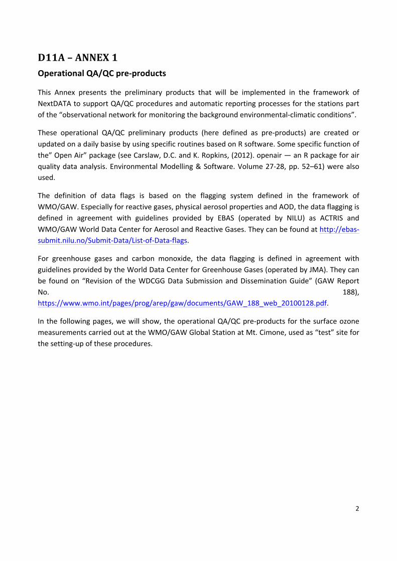
This Annex presents the preliminary products that will be implemented in the framework ofNextDATAtosupportQA/QCproceduresandautomaticreportingprocessesforthestationspartofthe“observationalnetworkformonitoringthebackgroundenvironmental-climaticconditions”.
These operational QA/QC preliminary products (here defined as pre-products) are created orupdatedonadailybasisebyusingspecificroutinesbasedonRsoftware.Somespecificfunctionofthe”OpenAir”package(seeCarslaw,D.C.andK.Ropkins,(2012).openair—anRpackageforairqualitydataanalysis.EnvironmentalModelling&Software.Volume27-28,pp.52–61)werealsoused.
The definition of data flags is based on the flagging system defined in the framework ofWMO/GAW.Especiallyforreactivegases,physicalaerosolpropertiesandAOD,thedataflaggingisdefined in agreement with guidelines provided by EBAS (operated by NILU) as ACTRIS andWMO/GAWWorldDataCenterforAerosolandReactiveGases.Theycanbefoundathttp://ebas-submit.nilu.no/Submit-Data/List-of-Data-flags.
For greenhouse gases and carbon monoxide, the data flagging is defined in agreement withguidelinesprovidedbytheWorldDataCenterforGreenhouseGases(operatedbyJMA).Theycanbe foundon “Revisionof theWDCGGData SubmissionandDisseminationGuide” (GAWReportNo. 188),https://www.wmo.int/pages/prog/arep/gaw/documents/GAW_188_web_20100128.pdf.
Inthefollowingpages,wewillshow,theoperationalQA/QCpre-productsforthesurfaceozonemeasurementscarriedoutattheWMO/GAWGlobalStationatMt.Cimone,usedas“test”siteforthesetting-upoftheseprocedures.
3
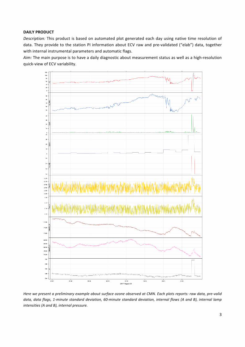
DAILYPRODUCTDescription:Thisproduct isbasedonautomatedplotgeneratedeachdayusingnative timeresolutionofdata.TheyprovidetothestationPI informationaboutECVrawandpre-validated(“elab”)data, togetherwithinternalinstrumentalparametersandautomaticflags.Aim:Themainpurposeistohaveadailydiagnosticaboutmeasurementstatusaswellasahigh-resolutionquick-viewofECVvariability.
HerewepresentapreliminaryexampleaboutsurfaceozoneobservedatCMN.Eachplotsreports:rawdata,pre-validdata,dataflags,1-minutestandarddeviation,60-minutestandarddeviation, internal flows(AandB), internal lampintensities(AandB),internalpressure.
4
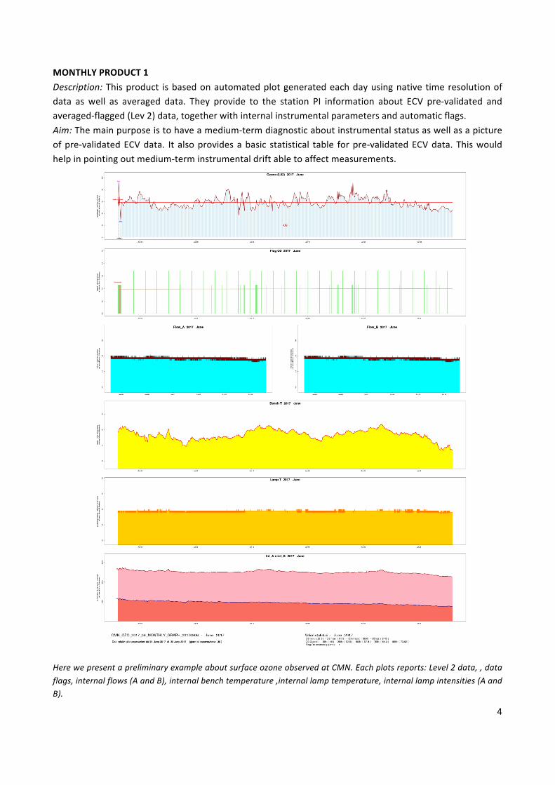
MONTHLYPRODUCT1Description:Thisproduct isbasedonautomatedplotgeneratedeachdayusingnative timeresolutionofdata as well as averaged data. They provide to the station PI information about ECV pre-validated andaveraged-flagged(Lev2)data,togetherwithinternalinstrumentalparametersandautomaticflags.Aim:Themainpurposeistohaveamedium-termdiagnosticaboutinstrumentalstatusaswellasapictureofpre-validatedECVdata. Italsoprovidesabasic statistical table forpre-validatedECVdata.Thiswouldhelpinpointingoutmedium-terminstrumentaldriftabletoaffectmeasurements.
HerewepresentapreliminaryexampleaboutsurfaceozoneobservedatCMN.Eachplotsreports:Level2data,,dataflags,internalflows(AandB),internalbenchtemperature,internallamptemperature,internallampintensities(AandB).
5
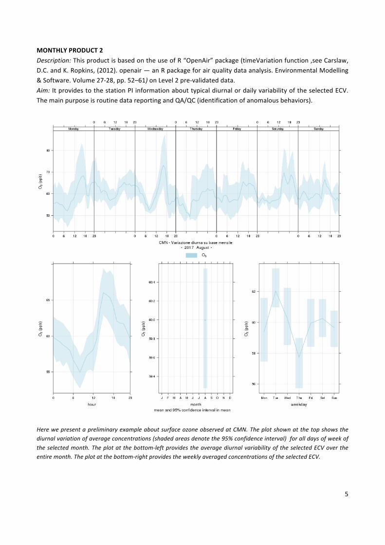
MONTHLYPRODUCT2Description:ThisproductisbasedontheuseofR“OpenAir”package(timeVariationfunction,seeCarslaw,D.C.andK.Ropkins,(2012).openair—anRpackageforairqualitydataanalysis.EnvironmentalModelling&Software.Volume27-28,pp.52–61)onLevel2pre-validateddata.Aim: ItprovidestothestationPIinformationabouttypicaldiurnalordailyvariabilityoftheselectedECV.ThemainpurposeisroutinedatareportingandQA/QC(identificationofanomalousbehaviors).
HerewepresentapreliminaryexampleaboutsurfaceozoneobservedatCMN.Theplotshownatthetopshowsthediurnalvariationofaverageconcentrations(shadedareasdenotethe95%confidenceinterval)foralldaysofweekoftheselectedmonth.Theplotatthebottom-leftprovidestheaveragediurnalvariabilityoftheselectedECVovertheentiremonth.Theplotatthebottom-rightprovidestheweeklyaveragedconcentrationsoftheselectedECV.

6
MONTHLYPRODUCT3Description:Thisproductisbasedonautomatedplotgeneratedmonth-by-monthusingpre-validatedandaverageddata(Level2).Aim:Themainpurpose is tohaveamedium-termdiagnosticaboutpre-validatedECVdataalsouseful todetect theoccurrenceof“special”events.To thisaim, foreachmonth,a linereferencing to theaveragevalueaswellasindicationoftheminimumandthehighestpre-validatedECVvaluesareprovided.
HerewepresentapreliminaryexampleaboutsurfaceozoneobservedatCMN.EachplotsreportLevel-2datatogetherwith mean average value (red lines) and the minimum/maximum value observed during the selected months.
7
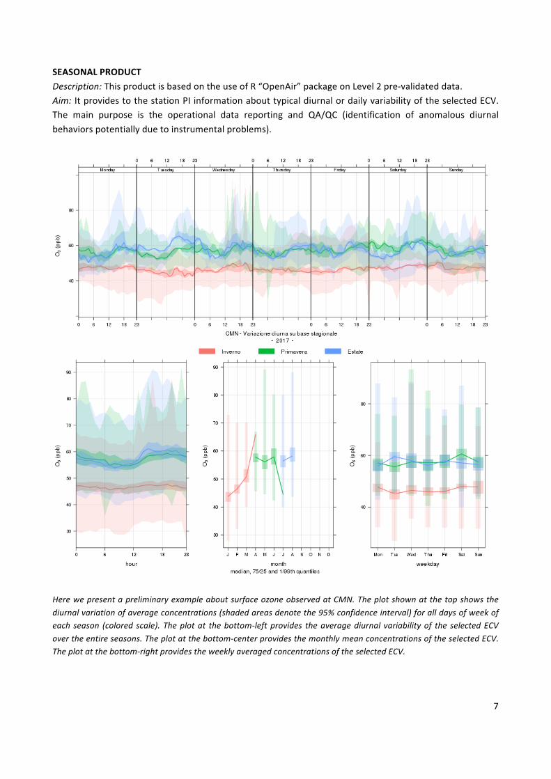
SEASONALPRODUCTDescription:ThisproductisbasedontheuseofR“OpenAir”packageonLevel2pre-validateddata.Aim: ItprovidestothestationPIinformationabouttypicaldiurnalordailyvariabilityoftheselectedECV.The main purpose is the operational data reporting and QA/QC (identification of anomalous diurnalbehaviorspotentiallyduetoinstrumentalproblems).
HerewepresentapreliminaryexampleaboutsurfaceozoneobservedatCMN.Theplotshownatthetopshowsthediurnalvariationofaverageconcentrations(shadedareasdenotethe95%confidenceinterval)foralldaysofweekofeach season (colored scale). Theplotat thebottom-leftprovides theaveragediurnal variabilityof the selectedECVovertheentireseasons.Theplotatthebottom-centerprovidesthemonthlymeanconcentrationsoftheselectedECV.Theplotatthebottom-rightprovidestheweeklyaveragedconcentrationsoftheselectedECV.
8
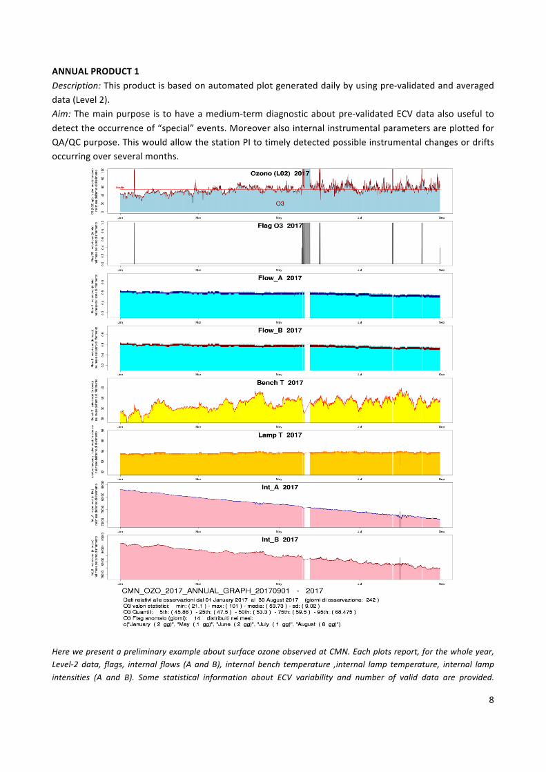
ANNUALPRODUCT1Description:Thisproductisbasedonautomatedplotgenerateddailybyusingpre-validatedandaverageddata(Level2).Aim:Themainpurpose is tohaveamedium-termdiagnosticaboutpre-validatedECVdataalsouseful todetecttheoccurrenceof“special”events.MoreoveralsointernalinstrumentalparametersareplottedforQA/QCpurpose.ThiswouldallowthestationPItotimelydetectedpossibleinstrumentalchangesordriftsoccurringoverseveralmonths.
HerewepresentapreliminaryexampleaboutsurfaceozoneobservedatCMN.Eachplotsreport,forthewholeyear,Level-2 data, flags, internal flows (A and B), internal bench temperature ,internal lamp temperature, internal lampintensities (A and B). Some statistical information about ECV variability and number of valid data are provided.
9
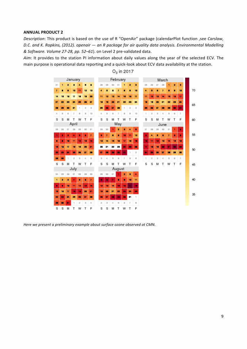
ANNUALPRODUCT2Description:ThisproductisbasedontheuseofR“OpenAir”package(calendarPlotfunction,seeCarslaw,D.C.andK.Ropkins,(2012).openair—anRpackageforairqualitydataanalysis.EnvironmentalModelling&Software.Volume27-28,pp.52–61).onLevel2pre-validateddata.Aim: Itprovides to the stationPI informationaboutdaily valuesalong theyearof the selectedECV.Themainpurposeisoperationaldatareportingandaquick-lookaboutECVdataavailabilityatthestation.
HerewepresentapreliminaryexampleaboutsurfaceozoneobservedatCMN.


![Information Meeting The First Half Ended September 2008 · [+1.1] 31.6 [29.7] 32.4 [28.5] Net interest income [Real net interest income] Y/Y Change Interest on loans 25.4 26.8 +1.4](https://img.pdfslide.us/doc/110x75/6041f83890ff8517385880b4/information-meeting-the-first-half-ended-september-2008-11-316-297-324.jpg)