Embed Size (px)
Citation preview

1 of 11
Project No.: 0535-012-01
November 20, 2020
Mr. Gregg Eckhardt
San Antonio Water Systems
2800 U.S. Hwy. 281 North
San Antonio, Texas 78212
Re: On-site evaluation for federal and state listed species for the Mitchell Lake Wetlands Quality
Treatment Initiatives Project
Dear Mr. Eckhardt,
This letter report provides an assessment of potential effects to federal and state-listed and candidate
threatened and endangered species within the area proposed for the Mitchell Lake Wetlands Quality
Treatment Initiatives Project (Project). It is being submitted to the San Antonio Water System (SAWS) in
support of obtaining authorization (permit) for the Project under Section 404 of the Clean Water Act from
the United States Army Corps of Engineers (USACE). This report includes a description of the Project and
the investigation area; general observations made during an on-site visual assessment; and an evaluation
of potential impacts to federal and state-listed/candidate species. The report concludes that seven (7)
federal or state-listed species may be present within the Project area, but that the Project would not likely
adversely affect the recovery of any federally or state listed threatened, endangered, or proposed species
or their critical habitat. Supplemental information related to the assessment is provided in attachments to
this report.
PROJECT DESCRIPTION
The primary objectives of the Project are two-fold: (1) reducing the discharge of pollutants from Mitchell
Lake to downstream water bodies, and (2) reducing the frequency and duration of uncontrolled discharges
over the Mitchell Lake spillway. These objectives will be met through the coordinated management of
stormwater storage within the lake and controlled releases of stored stormwater to a downstream
constructed wetland. The major components of the Project are as follows:

Mitchell Lake Wetlands Quality Treatment Initiatives
Threatened and Endangered Species Habitat Assessment
2 of 11
• Stabilization and uniform grading of the existing dam to a final crest elevation of 528.0 feet NAD83
(ft).
• Construction of a new auxiliary spillway with its crest at 521.5 ft. The spillway will be a labyrinth
design with a 180 ft by 45 ft footprint and an effective weir length of 840 ft.
• Two new outlet works in the dam that will discharge from Mitchell Lake to two wetland treatment
trains, one on each side of Cottonmouth Creek. The outlet works will be set to maintain the lake at
a normal pool elevation of 518.5 ft.
• Five wetland cells (three on the west side of Cottonmouth Creek and two on the east side of
Cottonmouth Creek) with a combined wetted surface area of approximately 100 acres (ac).
• Conveyance facilities to route flows from the lake, through the wetland cells, and to the receiving
streams (Cottonmouth Creek and Medina River) by gravity.
• Stream bank stabilization along two reaches of the Medina River that are subject to continuing
erosion.
SITE DESCRIPTION
Mitchell Lake is located south of San Antonio in southern Bexar County, Texas. The lake surface covers
approximately 475 acres at a normal pool elevation of 519.5 ft. The lake is an on-channel impoundment
and includes an earthen dam, the main body of the lake, and a “polder complex” located in the upper portion
of the lake. The contributing watershed of the lake is approximately 8.7 square miles, excluding the area of
the lake itself.
For this report, an investigation area (see Figure 1) was identified that encompassed the proposed Project
components, as well as Cottonmouth Creek, two reaches of the Medina River, and the entirety of Mitchell
Lake, exclusive of the polders. The investigation area lies between US Highway 281 to the east and
Pleasanton Road to the west and is bordered on all sides with a mix of unimproved and improved pasture,
and a residential development and golf course to the northeast. The investigation area was evaluated to
determine the potential presence of federal and state listed threatened or endangered species, federal
candidate species, or state rare species. The investigation area consists of multiple tracts totaling
approximately 975 acres.
Mitchell Lake was once part of the City of San Antonio (COSA) wastewater management system and was
created by the construction of a dam and spillway in 1901. It previously collected sewage and partially
treated wastewater for irrigation purposes until 1987, at which time those practices ceased. It currently
receives fully treated effluent to maintain water levels that is supportive of waterfowl habitat. The lake is a
nationally significant water body with unique, diverse ecosystems and avian fauna populations. Located on

Mitchell Lake Wetlands Quality Treatment Initiatives
Threatened and Endangered Species Habitat Assessment
3 of 11
Figure 1. Mitchell Lake Wetlands Quality Treatment Initiatives Project Investigation Area in Bexar County, Texas.
the North American Central Flyway, migrating birds frequently rest and feed at Mitchell Lake. More than
300 migrant bird species, including species federally listed under the Endangered Species Act and 30
species on the Audubon Watch List for declining populations, have been documented at the lake.

Mitchell Lake Wetlands Quality Treatment Initiatives
Threatened and Endangered Species Habitat Assessment
4 of 11
The lake is also an invaluable public resource for environmental education and community stewardship. In
1973, COSA designated it as a Refuge for Shore Birds and Water Fowl. In 2004, SAWS entered into an
operating agreement with the National Audubon Society thus establishing the first Audubon Center in
Texas.
The investigation area is located entirely within the Texas Blackland Prairie III Ecoregion, within the San
Antonio River Basin. Specifically, the area is in the Northern Blackland Prairie IV Ecoregion (32a). It is
bordered by the Southern Post Oak Savanna (33b) to the east and the Northern Nueces Alluvial Plains
(31a) to the west. The Northern Blackland Prairie ecoregion historically comprised of broad tallgrass
prairies consisting of little bluestem, big bluestem, yellow Indiangrass, and tall dropseed, and with sporadic
forests and woodlands. Forests were typically limited to riparian areas and stream bottoms. Bottomland
vegetation included bur oak, Shumard oak, sugar hackberry, elm species, ash species, eastern cottonwood,
and pecan (Griffith, 2007). Little of the original natural habitat remains; most of the ecoregion has been
converted to agricultural, industrial, and urban land uses (Griffith, 2007).
Cottonmouth Creek starts as an intermittent stream with a perennial pool immediately below the discharge
from the Mitchell Lake spillway. The lower reach of Cottonmouth Creek is characterized as an ephemeral
stream that eventually converges with the Medina River near the investigation area’s southernmost
boundary. Three sections of the Medina River intersect with the western boundary of the investigation
area.
The investigation area is located entirely within the hydrologic unit code (HUC) for the Medina River (HUC
12100302). The hydrologic features within the investigation area include a perennial lake (Mitchell Lake),
a perennial river (Medina River), intermittent and ephemeral portions of Cottonmouth Creek and other
ephemeral drainages to Mitchell Lake. In addition, there are emergent fringe wetlands associated with
Mitchell Lake. The primary source of hydrology for the investigation area is from surface runoff from the
watershed following rain events, and floodplain influence from the Medina River, Cottonmouth Creek, and
their associated tributaries. Additionally, Mitchell Lake periodically receives recycled water from the Leon
Creek Water Recycling Center.
GENERAL OBSERVATIONS
The investigation area was visually assessed by biologists from Plummer Associates, Inc. (Plummer) during
site investigations conducted October 5-8, 2020. The visual assessment was used in combination with
desktop analysis and to provide an opinion of the proposed likelihood of a species’ presence or preferred
habitat occurring within the investigative area.

Mitchell Lake Wetlands Quality Treatment Initiatives
Threatened and Endangered Species Habitat Assessment
5 of 11
Based on visual observations, the investigation area contained woody shrubs and herbaceous vegetation
mostly native to the region that are typical of upland regions. Woody shrubs and herbaceous vegetation
were observed adjacent to Cottonmouth Creek and the Medina River. Hydrophytic vegetation was
observed within the riparian zone surrounding Mitchell Lake and in a portion of Cottonmouth Creek
immediately downstream from the Mitchell Lake impoundment.
MITCHELL LAKE
Woody and herbaceous vegetation were observed in the riparian zone surrounding Mitchell Lake.
Hydrophytic herbaceous vegetation included jointed crown grass (Paspalum distichum) and sweetscent
(Pluchea odorata). Other herbaceous hydrophytes observed included softstem bulrush (Schoenoplectus
tabernaemontani), cattails (Typhus sp.), duckweed (Lemna sp.), rattlebrush (Sesbania drummondii), and
spiny chloracantha (Chloracantha spinosa). Woody hydrophytes included black willow, and the non-native
invasive saltcedar (Tamarix ramosissima). Upland areas surrounding Mitchell Lake were dominated by
woody vegetation such as huisache (Vachellia farnesiana), honey mesquite (Prosopis glandulosa), and
sugarberry (Celtis laevigata). Other herbaceous vegetation included malva-de-caballo (Malachra capitata),
sumpweed (Iva annua), Texas frogfruit (Phyla nodiflora), switchgrass (Panicum virgatum), and tievine
(Ipomoea cordatotriloba). Other woody vegetation observed in the riparian zone included paloverde
(Park insonia aculeata) and povertyweed (Baccharis neglecta).
COTTONMOUTH CREEK
Cottonmouth Creek lays in a highly incised stream channel with nearly-vertical slopes up to 20 feet tall.
The creek begins as an intermittent stream immediately downstream of the Mitchell Lake impoundment.
Further downstream it is impounded again by a tree growing in the channel with a downstream flow regime
reduced to one that only conveys stormwater flow in direct response to significant rain events, and thus is
characterized as an ephemeral stream. A shallow perennial pool covered with duckweed (6-12 inches deep)
occupies the upper reach immediately downstream of the Mitchell Lake spillway. Woody vegetation
observed immediately downstream of the pool included black willow, with herbaceous vegetation
dominated by switchgrass. The Cottonmouth Creek channel located downstream between the pool and
the Medina River included different vegetation than observed at the wetland pool. Hydrophytic vegetation
was observed within the upper reach of Cottonmouth Creek, including black willow (Salix nigra) and the
non-native species rivercane (Arundo donax). Woody vegetation adjacent to or on bank slopes immediately
above the drainage zone included ash-leaf maple (Acer negundo), black willow (Salix nigra), and live oak
(Quercus virginiana). Herbaceous vegetation included Bermuda grass (Cynodon dactylon), Indian wood-
oats (Chasmanthium latifolium), and straggler daisy (Calytopcarpus vialis).
Mitchell Lake Wetlands Quality Treatment Initiatives
Threatened and Endangered Species Habitat Assessment
6 of 11
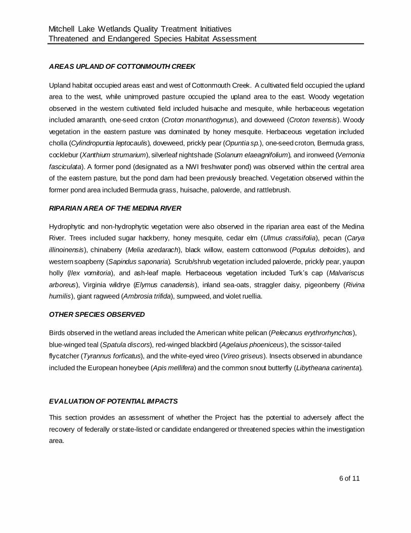
AREAS UPLAND OF COTTONMOUTH CREEK
Upland habitat occupied areas east and west of Cottonmouth Creek. A cultivated field occupied the upland
area to the west, while unimproved pasture occupied the upland area to the east. Woody vegetation
observed in the western cultivated field included huisache and mesquite, while herbaceous vegetation
included amaranth, one-seed croton (Croton monanthogynus), and doveweed (Croton texensis). Woody
vegetation in the eastern pasture was dominated by honey mesquite. Herbaceous vegetation included
cholla (Cylindropuntia leptocaulis), doveweed, prickly pear (Opuntia sp.), one-seed croton, Bermuda grass,
cocklebur (Xanthium strumarium), silverleaf nightshade (Solanum elaeagnifolium), and ironweed (Vernonia
fasciculata). A former pond (designated as a NWI freshwater pond) was observed within the central area
of the eastern pasture, but the pond dam had been previously breached. Vegetation observed within the
former pond area included Bermuda grass, huisache, paloverde, and rattlebrush.
RIPARIAN AREA OF THE MEDINA RIVER
Hydrophytic and non-hydrophytic vegetation were also observed in the riparian area east of the Medina
River. Trees included sugar hackberry, honey mesquite, cedar elm (Ulmus crassifolia), pecan (Carya
illinoinensis), chinaberry (Melia azedarach), black willow, eastern cottonwood (Populus deltoides), and
western soapberry (Sapindus saponaria). Scrub/shrub vegetation included paloverde, prickly pear, yaupon
holly (Ilex vomitoria), and ash-leaf maple. Herbaceous vegetation included Turk’s cap (Malvariscus
arboreus), Virginia wildrye (Elymus canadensis), inland sea-oats, straggler daisy, pigeonberry (Rivina
humilis), giant ragweed (Ambrosia trifida), sumpweed, and violet ruellia.
OTHER SPECIES OBSERVED
Birds observed in the wetland areas included the American white pelican (Pelecanus erythrorhynchos),
blue-winged teal (Spatula discors), red-winged blackbird (Agelaius phoeniceus), the scissor-tailed
flycatcher (Tyrannus forficatus), and the white-eyed vireo (Vireo griseus). Insects observed in abundance
included the European honeybee (Apis mellifera) and the common snout butterfly (Libytheana carinenta).
EVALUATION OF POTENTIAL IMPACTS
This section provides an assessment of whether the Project has the potential to adversely affect the
recovery of federally or state-listed or candidate endangered or threatened species within the investigation
area.

Mitchell Lake Wetlands Quality Treatment Initiatives
Threatened and Endangered Species Habitat Assessment
7 of 11
Table A-1, included in Attachment A, provides a summary of the status and preferred habitats for both the
federally and state listed species for Bexar County. Information on preferred habitats was obtained from
the USFWS (Federal Register) and TPWD resources. Information not obtained from TPWD or USFWS are
cited and listed in the “References” section at the end of this letter.
On October 27, 2020, an official species list was obtained from the U.S. Fish and Wildlife Service
(USFWS) via the Information, Planning, and Conservation System (IPaC) discussing relevant information
specific to federally listed threatened, endangered, and candidate species. The official federal species list
for the approximately 975-acre investigation area is included in the IPaC report found in Attachment B.
There are no critical habitats listed for any of the federally listed protected species within or in the
immediate vicinity of the investigation area.
Several federally listed species including the least tern (Sterna antillarum, endangered), piping plover
(Charadrius melodus, threatened), and red knot (Calidris canutus, threatened) have the potential to occur
within the investigation area during migration; however, per the USFWS IPaC Report these species are
only to be considered for wind related projects. A wind related project is not proposed; therefore, these
species were not considered in the affects analysis.
In addition to the federally listed species, the Texas Parks and Wildlife Department (TPWD) provides an
annotated list of species considered as endangered, threatened, or rare. The TPWD list for Bexar County
included the federally listed species as well as state-listed species. In total, the TPWD list includes 20
state-listed endangered and threatened species in Bexar County. The TPWD species list for Bexar County
is found in Attachment C. Species observations from iNaturalist.org and eBird.org were analyzed and no
additional state or federally listed species were documented within or adjacent to the investigation area.
Based on review of the preferred habitat information for the listed species, the federal and state listed
threatened, endangered, species with a potential to occur within the investigation area include the bald
eagle, the Texas horned lizard, the Texas pimpleback, the white-faced ibis, the whooping crane, the wood
stork, and the zone-tailed hawk. During the on-site investigations, no listed species were observed.
The following paragraphs provide a brief description of the species that could potentially occur within the
investigation area and potential impacts to the species from the proposed Project.
Bald Eagle
Bald Eagles typically breed and winter in forested areas adjacent to large bodies of water. Throughout their
range, they select large, super-canopy roost trees near water that are open and accessible for nesting. A

Mitchell Lake Wetlands Quality Treatment Initiatives
Threatened and Endangered Species Habitat Assessment
8 of 11
scrub-shrub wetland occurs at the northeast shore of Mitchell Lake. It is possible that bald eagles could use
the trees present around the lake as roosting sites, so the possible presence of bald eagles in the vicinity
of the lake should be considered, however, proposed improvements associated with the Project are not
likely to adversely affect the species.
Texas Pimpleback
The Texas pimpleback is currently listed as a “candidate” species by the USFWS. Its historic range covers
the Guadalupe and Colorado River drainage basins. They are typically found in riffle-pool-run complexes
with gravel- to cobble-sized substrates. The species is particularly vulnerable to stream impoundment and
sedimentation, where both activities adversely affect reproduction by reducing water quality. Impoundment
also fragments existing populations by inhibiting mussel movement upstream. The development of the
proposed wetland could potentially benefit the Texas pimpleback by improving the quality of water
discharged into the Medina River. As a result, the Project is not likely to adversely affect the Texas
pimpleback.
Texas Horned Lizard
The Texas horned lizard occurs in open, sparse habitat characterized by grass, cacti, and scrubby or
shrubby woody vegetation. They prefer habitats with sandy or loose soil. The southern investigation area
contains a habitat mosaic that includes areas of sparse vegetation with low woody shrubs with sandy soil.
The field observations identified two fields, sparsely vegetated due to routine disturbance from tilling and
ranching activities, which might provide marginal habitat for the Texas horned lizard. However, no Texas
horned lizards or harvester ant colonies (primary food source) were observed during the field investigation.
The Texas horned lizard is not likely to be present within the proposed Project area and better-quality
habitat occurs within the surrounding areas. Therefore, the Texas horned lizard is not likely to be adversely
affected by the Project.
White-faced Ibis
The white-faced ibis seems to prefer freshwater marshes, where it can find insects, newts, leeches,
earthworms, snails and especially crayfish, frogs, and fish. They roost on low platforms of dead reed stems
or on mud banks. During the nesting season, they are colonial and will construct a deep cup of dead reeds
among beds of bulrushes, on floating mats of dead plants or they may nest in trees. The areas where these
nests are built usually are where water is less than three feet deep. It nests in isolated colonies from Oregon
to Kansas, but its center of greatest abundance seems to be in Utah, Texas and Louisiana. In Texas, they
breed and winter along the Gulf Coast and may occur as migrants in the Panhandle and West Texas.
Mitchell Lake is a relatively shallow water body with substantial areas of the lake less than 2 feet deep. It is

Mitchell Lake Wetlands Quality Treatment Initiatives
Threatened and Endangered Species Habitat Assessment
9 of 11
surrounded by a fringe wetland area dominated by emergent vegetation including cattail and bulrush. As
the wetlands and floodplain within the investigation area appear to have the depth and the vegetation
desired by the white-faced ibis, it is possible that the white-faced ibis would be found within the investigation
area. The Project will reduce the lake level from 519.5 to 518.5 ft. MSL; however, overall foraging habitat
will increase with the migration and expansion of the fringe wetland around the lake perimeter, and the
construction of the treatment wetlands. Accordingly, the Project is not likely to adversely affect the white-
faced ibis.
Whooping Crane
The whooping crane breeds, migrates, winters, and forages in a variety of wetland and other habitats,
including coastal marshes and estuaries, inland marshes, lakes, ponds, wet meadows and rivers, and
agricultural fields. During migration, whooping cranes use a variety of habitats; however, wetland mosaics
appear to be the most suitable. For feeding, whooping cranes primarily use shallow, seasonally and semi-
permanently flooded palustrine wetlands for roosting, and various cropland and emergent wetlands. The
investigation area may qualify as having a variety of habitats useful to migrating populations of whooping
crane, especially due to the emergent wetlands within the fringe of Mitchell Lake. Therefore, it is possible
that the whooping crane could be present periodically within the investigation area during migration.
However, the investigation area would not be suitable as nesting habitat. The Project will reduce the lake
level from 519.5 to 518.5 ft. MSL; however, overall foraging habitat will increase with the migration and
expansion of the fringe wetland around the lake perimeter, and the construction of the treatment wetlands.
The proposed Project would not adversely affect the migrating individuals as it would provide additional
foraging area.
Wood stork
The wood stork roosts, forages, and breeds in a variety of wetland habitats. It typically roosts and forages
in ponds, marshes, and flooded fields where it likely encounters still, shallow water suitable for foraging.
They overwinter in restricted counties along the Texas Gulf Coast, and they potentially migrate through
central and coastal Texas. Because the Project site is within the Central Flyway and the existing habitat
associated with Mitchell Lake, the wood stork could potentially use the site as a stopover for foraging during
migration. The Project will reduce the lake level from 519.5 to 518.5 ft. MSL; however, overall foraging
habitat will increase with the migration and expansion of the fringe wetland around the lake perimeter, and
the construction of the treatment wetlands. The proposed Project is likely to increase the quality and
quantity of foraging habitat available and thus the Project is not likely to adversely impact the species.

Mitchell Lake Wetlands Quality Treatment Initiatives
Threatened and Endangered Species Habitat Assessment
10 of 11
Zone-tailed hawk
The zone-tailed hawk is found near watercourses in a variety of habitats ranging from woodlands to open,
arid country and deserts. It typically breeds and hunts in places of varied topography, such as hillsides and
canyons, and it prefers areas with watercourses. It breeds in south-central and west Texas. There are large
differences in topography from the upland areas at the investigation area to the channels of Cottonmouth
Creek and the Medina River. Additionally, the site is covered by a mosaic of open water, forest, fringe
wetlands, and pastures. Development of the proposed Project components would increase available
wetland habitat, thus enhancing habitat for the zone-tailed hawk; and therefore, is not likely to adversely
affect the species.
CONCLUSIONS
Based on the on-site observations and review of habitat requirements, there is potential for the bald eagle,
the Texas horned lizard, the Texas pimpleback, the white-faced ibis, the whooping crane, the wood stork,
and the zone-tailed hawk to occur at least periodically within the investigation area. Though no individuals
were observed during the field investigation, some suitable habitat was observed for these species. The
remainder of the listed endangered or threatened, or candidate species or their critical habitats are not likely
to be present within the investigation area. The proposed Project components would expand available
habitat and improve quality of the water discharging into the Medina River. As a result, the Project is not
likely to adversely affect the continued recovery of any Federally or state listed threatened, endangered, or
proposed species or their critical habitat. Should you have any questions or comments regarding this
report, please contact Breena Riley at [email protected] or Nathan Saxe at n [email protected].
Sincerely,
PLUMMER ASSOCIATES, INC. Digitally signed by Nathan Saxe DN: cn=Nathan Saxe, o=Plummer, ou, [email protected], c=US
Date: 2020.11.20 14:29:03 -06'00'
Nathan E. Saxe
Senior Environmental Specialist
CC: Mr. Juan Gomez, SAWS
Attachment A – Federal and State Listed Threatened and Endangered Species
Attachment B – USFWS IPaC Official Species List
Attachment C – TPWD Bexar County Rare Species List
Nathan Saxe

Mitchell Lake Wetlands Quality Treatment Initiatives
Threatened and Endangered Species Habitat Assessment
11 of 11
REFERENCES
Chippindale, P.T. (2020). Eurycea neotenes. AmphibiaWeb. University of California, Berkeley, CA, USA.
Accessed 6 Nov 2020. https://amphibiaweb.org/species/4056
Chippindale, P.T. (2020). Eurycea rathbuni. AmphibiaWeb. University of California, Berkeley, CA, USA.
Accessed 6 Nov 2020. https://amphibiaweb.org/species/4217
Chippindale, P.T., and J.N. Fries. (2020). Eurycea nana. AmphibiaWeb. University of California,
Berkeley, CA, USA. Accessed 6 Nov 2020. https://amphibiaweb.org/species/4055
eBird. Hotspots. The Cornell Lab of Ornithology.
Accessed 19 Nov 2020. https://ebird.org/hotspots
Griffith, G., S. Bryce, J. Omernik, J., & A. Rogers. (2007). Ecoregions of Texas. Austin, TX: Texas
Commission on Environmental Quality.
Howells, R. G., Neck, R. W., & Murray, H. D. (1996). Freshwater mussels of Texas. University of Texas
Press.
iNaturalist. Observations, California Academy of Sciences and National Geographic.
Accessed 19 Nov 2020. https://www.inaturalist.org/observations
Malone, J.H. (2020). Smilisca baudinii. AmphibiaWeb. University of California, Berkeley, CA, USA.
Accessed 6 Nov 2020. https://amphibiaweb.org/species/1164
Attachment A
Federal and State Listed
Species

Table A - 1: Federal and State Listed Threatened and Endangered Species Possible Presence on Site
Attachment A Page 1 of 11
Common
Name
Species
Listing Status
Description of Suitable Habitat
Species Possible Presence on
Site
Adversely Affect Recovery
Amphibians
Cascade
Caverns
salamander
Eurycea latitans
State Listed
Threatened
Aquatic; springs, streams and caves with
rocky or cobble beds.
Not likely; no caverns or
springs on-site.
Not likely to adversely
affect
Mexican
Treefrog
Smilisca
baudinii
State Listed
Threatened
Terrestrial and aquatic: Terrestrial habitats used
include forested and brush around water bodies.
Aquatic habitats used can be any body of water,
but preferred breeding sites are small,
ephemeral wetlands. (Malone, 2020)
Not likely; site is outside of
currently-reported range
records.
Not likely to adversely
affect
San Marcos
Salamander
Eurycea nana
Federal Listed
Threatened
Aquatic; springs with cobble and algal mats.
Known from a population restricted to a
spring-fed lake and a section of the San
Marcos River in San Marcos, Hayes County,
Texas. (Chippindale & Fries, 2020)
Not likely; no springs on-site.
Not likely to adversely
affect
Texas Blind
Salamander
Typhlomolge
rathbuni
Federal Listed
Threatened
Aquatic; found in caves associated with the
San Marcos Pool of the Edwards Aquifer.
(Chippindale, 2020b)
Not likely; no caverns on-
site.
Not likely to adversely
affect
Texas
Salamander
Eurycea
neotenes
State Listed
Endangered
Aquatic; apparently restricted to several springs
in Bexar and Kendall Counties, Texas. First
described from a spring in Helotes, Texas.
(Chippindale, 2020a)
Not likely; no springs on-site.
Not likely to adversely
affect
Arachnids
Braken Bat
Cave
Meshweaver
Cicurina venii
Federal Listed
Endangered
Small, eyeless, or essentiall y eyeless spider;
karst features in north and northwest Bexar
County.
Not likely; preferred karst
features not present on-site.
Not likely to adversely
affect
Cokendolpher
Cave
Harvestman
Texella
cokendolpheri
Federal Listed
Endangered
Small, eyeless harvestman; karst features in
north and northwest Bexar County.
Not likely; preferred karst
features not present on-site.
Not likely to adversely
affect

Table A - 1: Federal and State Listed Threatened and Endangered Species Possible Presence on Site
Attachment A Page 2 of 11
Common
Name
Species
Listing Status
Description of Suitable Habitat
Species Possible Presence on
Site
Adversely Affect Recovery
Arachnids
Government
Canyon Bat
Cave
Meshweaver
Cicurina
vespera
Federal Listed
Endangered
Small, eyeless, or essentially eyeless spider;
karst features in north and northwest Bexar
County.
Not likely; preferred karst
features not present on-site.
Not likely to adversely
affect
Government
Canyon Bat
Cave Spider
Neoleptoneta
microps
Federal Listed
Endangered
Small, eyeless, or essentiall y eyeless spider;
karst features in north and northwest Bexar
County.
Not likely; preferred karst
features not present on-site.
Not likely to adversely
affect
Madla Cave
Meshweaver
Cicurina madla
Federal Listed
Endangered
Small, eyeless, or essentiall y eyeless spider;
karst features in north and northwest Bexar
County.
Not likely; preferred karst
features not present on-site.
Not likely to adversely
affect
Robber Baron
Cave
Meshweaver
Cicurina
baronia
Federal Listed
Endangered
Small, eyeless, or essentiall y eyeless spider;
karst features in north and northwest Bexar
County.
Not likely; preferred karst
features not present on-site.
Not likely to adversely
affect
Birds
Bald Eagle
Haliaeetus
leucocephalus
Federally-
protected by the
Bald and Golden
Eagle Protection
Act (1940)
Found primarily near rivers and large lakes;
nests in tall trees or on cliffs near water;
communally roosts, especially in winter;
hunts live prey, scavenges, and pirates food
from other birds.
Yes; confirmed observation
on eBird.org
Not likely to adversely
affect due to the project
improvements around the
lake enhancing the
available habitat.
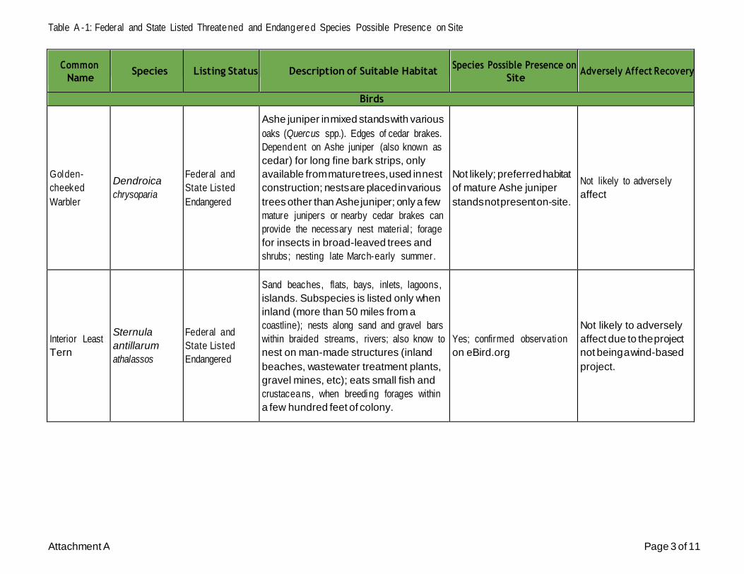
Table A - 1: Federal and State Listed Threatened and Endangered Species Possible Presence on Site
Attachment A Page 3 of 11
Common
Name
Species
Listing Status
Description of Suitable Habitat
Species Possible Presence on
Site
Adversely Affect Recovery
Birds
Golden-
cheeked
Warbler
Dendroica
chrysoparia
Federal and
State Listed
Endangered
Ashe juniper in mixed stands with various
oaks (Quercus spp.). Edges of cedar brakes.
Dependent on Ashe juniper (also known as
cedar) for long fine bark strips, only
available from mature trees, used in nest
construction; nests are placed in various
trees other than Ashe juniper; only a few
mature junipers or nearby cedar brakes can
provide the necessary nest material ; forage
for insects in broad-leaved trees and
shrubs; nesting late March-early summer.
Not likely; preferred habitat
of mature Ashe juniper
stands not present on-site.
Not likely to adversely
affect
Interior Least
Tern
Sternula
antillarum
athalassos
Federal and
State Listed
Endangered
Sand beaches, flats, bays, inlets, lagoons,
islands. Subspecies is listed only when
inland (more than 50 miles from a
coastline); nests along sand and gravel bars
within braided streams, rivers; also know to
nest on man-made structures (inland
beaches, wastewater treatment plants,
gravel mines, etc); eats small fish and
crustaceans, when breeding forages within
a few hundred feet of colony.
Yes; confirmed observation
on eBird.org
Not likely to adversely
affect due to the project
not being a wind-based
project.

Table A - 1: Federal and State Listed Threatened and Endangered Species Possible Presence on Site
Attachment A Page 4 of 11
Common
Name
Species
Listing Status
Description of Suitable Habitat
Species Possible Presence on
Site
Adversely Affect Recovery
Birds
Piping Plover
Charadrius
melodus
Federal and
State Listed
Threatened
Beaches, sandflats, and dunes along Gulf
Coast beaches and adjacent offshore islands
having large, sparsely vegetated areas;
primarily prefers sand flats, and secondarily
prefers algal flats, both with minimal
human disturbance.
Not likely; prefered habitat
not found on-site.
Not likely to adversely
affect
Reddish Egret
Egretta
rufescens
State Listed
Threatened
Resident of the Texas Gulf Coast; brackish
marshes and shallow salt ponds and tidal
flats; nests on ground or in trees or bushes,
on dry coastal islands in brushy thickets of
yucca and prickly pear.
Not likely; preferred brackish
and saline marsh and pond
habitat not present on-site.
Not likely to adversely
affect
Red Knot
Calidris canutus
rufa
Federal Listed
Threatened
Prefers the shoreline of coast and bays and
also uses mudflats during rare inland
encounters; primarily inhabi ts seacoasts on
tidal flats and beaches, herbaceous
wetland, and tidal flat/shore.
Not likely; preferred habitat
not present on-site.
Not likely to adversely
affect
Tropical
parula
Setophaga
pitiayumi
State Listed
Threatened
Semi-tropical evergreen woodland along
rivers and resacas. Texas ebony, anacua and
other trees with epiphytic plants hanging
from them. Dense or open woods,
undergrowth, brush, and trees along edges
of rivers and resacas; breeding April to July.
Not likely; preferred habitat
not found on-site.
Not likely to adversely
affect

Table A - 1: Federal and State Listed Threatened and Endangered Species Possible Presence on Site
Attachment A Page 5 of 11
Common
Name
Species
Listing Status
Description of Suitable Habitat
Species Possible Presence on
Site
Adversely Affect Recovery
Birds
White-faced
Ibis
Plegadis chihi
State Listed
Threatened
Prefers freshwater marshes, sloughs, and
irrigated rice fields, but will attend brackish
and saltwater habitats; currently confined
to near-coastal rookeries in so-called hog-
wallow prairies. Nests in marshes, in low
trees, on the ground in bulrushes or reeds,
or on floating mats.
Yes; confirmed observation
on eBird.org
Not likely to adversely
affect due to
maintainence of the lake
level and water quality
improvements from the
project.
Whooping
Crane
Grus americana
Federal and
State Listed
Endangered
Small ponds, marshes, and flooded grain
fields for both roosting and foraging.
Potential migrant via plains throughout
most of state to coast; winters in coastal
marshes of Aransas, Calhoun, and Refugio
counties.
Yes
Not likely to adversely
affect due to the
additional foraging areas
created from the wetland.
Wood Stork
Mycteria
americana
State Listed
Threatened
Small ponds, marshes, and flooded grain
fields for both roosting and foraging.
Potential migrant via plains throughout
most of state to coast; winters in coastal
marshes of Aransas, Calhoun, and Refugio
counties.
Yes; confirmed observation
on eBird.org
Not likely to adversely
affect due to the
additional foraging areas
created from the wetland.
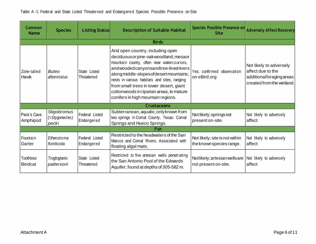
Table A - 1: Federal and State Listed Threatened and Endangered Species Possible Presence on Site
Attachment A Page 6 of 11
Common
Name
Species
Listing Status
Description of Suitable Habitat
Species Possible Presence on
Site
Adversely Affect Recovery
Birds
Zone-tailed
Hawk
Buteo
albonotatus
State Listed
Threatened
Arid open country, including open
deciduous or pine-oak woodland, mesa or
mountain county, often near watercourses,
and wooded canyons and tree-lined rivers
along middle-slopes of desert mountains;
nests in various habitats and sites, ranging
from small trees in lower desert, giant
cottonwoods in riparian areas, to mature
conifers in high mountain regions.
Yes; confirmed observation
on eBird.org
Not likely to adversely
affect due to the
additional foraging areas
created from the wetland.
Crustaceans
Peck’s Cave
Amphipod
Stigobromus
(=Stygonectes)
pecki
Federal Listed
Endangered
Subterranean, aquatic; only known from
two springs in Comal County, Texas: Comal
Springs and Hueco Springs.
Not likely; springs not
present on-site.
Not likely to adversely
affect
Fish
Fountain
Darter
Etheostoma
fonticola
Federal Listed
Endangered
Restricted to the headwaters of the San
Marcos and Comal Rivers. Associated with
floating algal mats.
Not likely; site is not within
the known species range.
Not likely to adversely
affect
Toothless
Bindcat
Trogloglanis
pattersoni
State Listed
Threatened
Restricted to five artesian wells penetrating
the San Antonio Pool of the Edwards
Aquifer; found at depths of 305-582 m.
Not likely; artesian wells are
not present on-site.
Not likely to adversely
affect

Table A - 1: Federal and State Listed Threatened and Endangered Species Possible Presence on Site
Attachment A Page 7 of 11
Common
Name
Species
Listing Status
Description of Suitable Habitat
Species Possible Presence on
Site
Adversely Affect Recovery
Fish
Widemouth
Blindcat
Satan
eurystomus
State Listed
Threatened
Restricted to five artesian wells penetrating
the San Antonio Pool of the Edwards
Aquifer; found at depths of 305-582 m.
Not likely; artesian wells are
not present on-site.
Not likely to adversely
affect
Insects
A ground
beetle
Rhadine exilis
Federal Listed
Endangered
Associated with caverns and adjacent karst
features in northern Bexar County, Texas.
Not likely; preferred karst
features and caverns not
present on-site.
Not likely to adversely
affect
A ground
beetle
Rhadine
infernalis
Federal Listed
Endangered
Associated with caverns and adjacent karst
features in northern Bexar County, Texas.
Not likely; preferred karst
features and caverns not
present on-site.
Not likely to adversely
affect
Comal Springs
Dryopid
Beetle
Stygoparnus
comalensis
Federal Listed
Endangered
Aquatic and subterranean; restricted to
karst springs in Hays County and north
Bexar County, Texas.
Not likely; karst springs not
present on-site.
Not likely to adversely
affect
Comal Springs
Riffle Beetle
Heterelmis
comalensis
Federal Listed
Endangered
Found on gravel-lined riffles and runs at
springs in northern Bexar County.
Not likely; karst springs not
present on-site.
Not likely to adversely
affect
Helotes Mold
Beetle
Batrisodes
venyivi
Federal Listed
Endangered
Small, eyeless mold beetle; karst features in
northwestern Bexar County and
northeastern Medina County.
Not likely; preferred karst
features not present on-site.
Not likely to adversely
affect

Table A - 1: Federal and State Listed Threatened and Endangered Species Possible Presence on Site
Attachment A Page 8 of 11
Common
Name
Species
Listing Status
Description of Suitable Habitat
Species Possible Presence on
Site
Adversely Affect Recovery
Mammals
Black Bear
Ursus
americanus
State Listed
Threatened
Generalist. Historically found throughout
Texas. In Chisos, prefers higher elevations
where pinyon-oaks predominate; also
occasionally sighted in desert scrub of Trans-
Pecos (Black Gap Wildlife Management
Area) and Edwards Plateau in juniper-oak
habitat. For ssp. luteolus, bottomland
hardwoods, floodplain forests, upland
hardwoods with mixed pine; marsh.
Bottomland hardwoods and large tracts of
inaccessible forested areas.
Not likely; preferred habitat
and range of known
populations not present on-
site.
Not likely to adversely
affect
White-nosed
Coati
Nasua narica
State Listed
Threatened
Woodlands, riparian corridors and canyons.
Most individuals in Texas probably
transients from Mexico; diurnal and
crepuscular; very sociable; forages on
ground and in trees; omnivorous; may be
susceptible to hunting, trapping, and pet
trade
Not likely; site is not within
vicinity of Mexican border
where species is known to
occur.
Not likely to adversely
affect
Mollusks
Guadalupe
Orb
Cyclonaias
necki
State Listed
Threatened
Species' distribution is limited to the
Guadalupe River basin. Occurs in both
mainstem and tributary habitats. Often
found in substrates composed of sand,
gravel, and cobble, including mud-sil t or
gravel-filled cracks in bedrock slabs.
Considered intolerant of reservoirs, but are
known to occur in them (Howells 2010m;
Randklev et al. 2017b). [Mussels of Texas
2019]
Not likely; documented as
extirpated from the Medina
River
Not likely to adversely
affect

Table A - 1: Federal and State Listed Threatened and Endangered Species Possible Presence on Site
Attachment A Page 9 of 11
Common
Name
Species
Listing Status
Description of Suitable Habitat
Species Possible Presence on
Site
Adversely Affect Recovery
Mollusks
Texas
Fatmucket
Lampsilis
bracteata
Federal
Candidate
Occurs in medium-sized rivers, where it
burrows in sandy, muddy, or gravelly
substrates; typically found in shallow
streams, having consistently low flow, and
with low slopes that inhibit flashy
conditions that may scour the river bottom.
Not likely; species reported
to be extirpated from the
San Antonio River basin.
Not likely to adversely
affect
Texas
Pimpleback
Quadrula
petrina
Federal
Candidate
Historically found in the Colorado and
Guadalupe River drainage basins; found in
riffle-pool-run complexes with gravel- to
cobble-sized substrates.
Yes
Not likely to adversely
affect due to
improvement of flow and
water quality entering the
Medina River due to
construction of the
treatment wetland.
Plants
Bracted
Twistflower
Streptanthus
bracteatus
Federal
Candidate
Shallow, well-drained gravelly clays and clay
loams over limestone in oak juniper
woodlands and associated openings, on
steep to moderate slopes and in canyon
bottoms; several known soils include
Tarrant, Brackett, or Speck over Edwards,
Glen Rose, and Walnut geologic formations;
populations fluctuate widely from year to
year, depending on winter rainfall;
flowering mid April-late May, fruit matures
and foliage withers by early summer.
Not likely; preferred habitat
not present on-site.
Not likely to adversely
affect

Table A - 1: Federal and State Listed Threatened and Endangered Species Possible Presence on Site
Attachment A Page 10 of 11
Common
Name
Species
Listing Status
Description of Suitable Habitat
Species Possible Presence on
Site
Adversely Affect Recovery
Plants
Texas Wild-
rice
Zizania texana
Federal Listed
Endangered
Only present in 2-mile stretch of the San
Marcos River in Hays County, Texas; grows
in spring-fed waters with fast flow.
Not likely; preferred habitat
and known range not
present on-site.
Not likely to adversely
affect
Reptiles
Cagle's Map
Turtle
Graptemys
caglei
State Listed
Threatened
Aquatic: shallow water with swift to
moderate flow and gravel or cobble
bottom, connected by deeper pools with a
slower flow rate and a silt or mud bottom;
gravel bar riffles and transition areas
between riffles and pools especially
important in providing insect prey items;
nests on gently sloping sand banks within
ca. 30 feet of waters edge.
Not likely; waterbodies with
preferred flow regime not
present on-site.
Not likely to adversely
affect
Texas Horned
Lizard
Phrynosoma
cornutum
State Listed
Threatened
Terrestrial: Open habitats with sparse
vegetation, including grass, prairie, cactus,
scattered brush or scrubby trees; soil may
vary in texture from sandy to rocky;
burrows into soil, enters rodent burrows, or
hides under rock when inactive. Occurs to
6000 feet, but largely limited below the
pinyon-juniper zone on mountains in the
Big Bend area.
Not likely; no harvester ant
colonies were observed on-
site and the existing sparse
vegetated areas are
disturbed agricultural land.
Not likely to adversely
affect

Table A - 1: Federal and State Listed Threatened and Endangered Species Possible Presence on Site
Attachment A Page 11 of 11
Common
Name
Species
Listing Status
Description of Suitable Habitat
Species Possible Presence on
Site
Adversely Affect Recovery
Reptiles
Texas
Tortoise
Gopherus
berlandieri
State Listed
Threatened
Terrestrial: Open scrub woods, arid brush,
lomas, grass-cactus association; often in
areas with sandy well-drained soils. When
inactive occupies shallow depressions dug
at base of bush or cactus; sometimes in
underground burrow or under object. Eggs
are laid in nests dug in soil near or under
bushes.
Not likely; preferred habitat
of brush and cactus not
abundant on-site.
Not likely to adversely
affect
Attachment B
USFWS Resources Information

United States Department of the Interior
FISH AND WILDLIFE SERVICE Austin Ecological Services Field Office
10711 Burnet Road, Suite 200
Austin, TX 78758-4460 Phone: (512) 490-0057 Fax: (512) 490-0974
http://www.fws.gov/southwest/es/AustinTexas/
http://www.fws.gov/southwest/es/EndangeredSpecies/lists/
In Reply Refer To:
Consultation Code: 02ETAU00-2021-SLI-0154
Event Code: 02ETAU00-2021-E-00310
October 27, 2020
Project Name: MITCHELL LAKE WETLANDS WATER QUALITY TREATMENT
INITIATIVES PROJECT
Subject: List of threatened and endangered species that may occur in your proposed project
location, and/or may be affected by your proposed project
To Whom It May Concern:
The enclosed species list identifies threatened, endangered, proposed and candidate species, as
well as proposed and final designated critical habitat, that may occur within the county of your
proposed project and/or may be affected by your proposed project. The species list fulfills the
requirements of the U.S. Fish and Wildlife Service (Service) under section 7(c) of the
Endangered Species Act (Act) of 1973, as amended (16 U.S.C. 1531 et seq.).
Please note that new information based on updated surveys, changes in the abundance and
distribution of species, changed habitat conditions, or other factors could change this list. Feel
free to contact us if you need more current information or assistance regarding the potential
impacts to federally proposed, listed, and candidate species and federally designated and
proposed critical habitat. Also note that under 50 CFR 402.12(e) of the regulations implementing
section 7 of the Act, the accuracy of this species list should be verified after 90 days. This
verification can be completed formally or informally as desired. The Service recommends that
verification be completed by visiting the ECOS-IPaC website at regular intervals during project planning and implementation for updates to species lists and information. An updated list may be
requested through the ECOS-IPaC system by completing the same process used to receive the
enclosed list.
The purpose of the Act is to provide a means whereby threatened and endangered species and the
ecosystems upon which they depend may be conserved. Under sections 7(a)(1) and 7(a)(2) of the
Act and its implementing regulations (50 CFR 402 et seq.), Federal agencies are required to utilize their authorities to carry out programs for the conservation of federally listed as threatened

10/27/2020 Event Code: 02ETAU00-2021-E-00310 2
or endangered species and to determine whether projects may affect these species and/or
designated critical habitat.
A Biological Assessment is required for construction projects (or other undertakings having
similar physical impacts) that are major Federal actions significantly affecting the quality of the
human environment as defined in the National Environmental Policy Act (42 U.S.C. 4332(2)
(c)). For projects other than major construction activities, the Service suggests that a biological
evaluation similar to a Biological Assessment be prepared to determine whether the project may affect listed or proposed species and/or designated or proposed critical habitat. Recommended
contents of a Biological Assessment are described at 50 CFR 402.12.
While a Federal agency may designate a non-Federal representative to conduct informal
consultation or prepare a biological assessment, the Federal Agency must notify the Service in writing of any such designation. The Federal agency shall also independently review and
evaluate the scope and content of a biological assessment prepared by their designated non-
Federal representative before that document is submitted to the Service.
If a Federal agency determines, based on the Biological Assessment or biological evaluation, that
listed species and/or designated critical habitat may be affected by a federally funded, permitted
or authorized activity, the agency is required to consult with the Service pursuant to 50 CFR 402.
The following definitions are provided to assist you in reaching a determination:
▪ No effect - the proposed action will not affect federally listed species or critical habitat. A “no effect” determination does not require section 7 consultation and no coordination or
contact with the Service is necessary. However, if the project changes or additional
information on the distribution of listed or proposed species becomes available, the project
should be reanalyzed for effects not previously considered.
▪ May affect, but is not likely to adversely affect - the project may affect listed species and/or
critical habitat; however, the effects are expected to be discountable, insignificant, or
completely beneficial. Certain avoidance and minimization measures may need to be implemented in order to reach this level of effect. The Federal agency or the designated
non-Federal representative should consult with the Service to seek written concurrence that
adverse effects are not likely. Be sure to include all of the information and documentation
used to reach your decision with your request for concurrence. The Service must have this
documentation before issuing a concurrence.
▪ Is likely to adversely affect - adverse effects to listed species may occur as a direct or
indirect result of the proposed action. For this determination, the effect of the action is
neither discountable nor insignificant. If the overall effect of the proposed action is
beneficial to the listed species but the action is also likely to cause some adverse effects to
individuals of that species, then the proposed action “is likely to adversely affect” the
listed species. The analysis should consider all interrelated and interdependent actions. An “is likely to adversely affect” determination requires the Federal action agency to initiate
formal section 7 consultation with our office.

10/27/2020 Event Code: 02ETAU00-2021-E-00310 3
Regardless of the determination, the Service recommends that the Federal agency maintain a
complete record of the evaluation, including steps leading to the determination of effect, the
qualified personnel conducting the evaluation, habitat conditions, site photographs, and any other
related information. More information on the regulations and procedures for section 7
consultation, including the role of permit or license applicants, can be found in the "Endangered Species Consultation Handbook" at: http://www.fws.gov/endangered/esa-library/pdf/TOC-
GLOS.PDF.
Migratory Birds
For projects that may affect migratory birds, the Migratory Bird Treaty Act (MBTA) implements
various treaties and conventions for the protection of these species. Under the MBTA, taking, killing, or possessing migratory birds is unlawful. Migratory birds may nest in trees, brushy
areas, or other areas of suitable habitat. The Service recommends activities requiring vegetation
removal or disturbance avoid the peak nesting period of March through August to avoid
destruction of individuals, nests, or eggs. If project activities must be conducted during this time,
we recommend surveying for nests prior to conducting work. If a nest is found, and if possible,
the Service recommends a buffer of vegetation remain around the nest until the young have
fledged or the nest is abandoned.
For additional information concerning the MBTA and recommendations to reduce impacts to
migratory birds please contact the U.S. Fish and Wildlife Service Migratory Birds Office, 500
Gold Ave. SW, Albuquerque, NM 87102. A list of migratory birds may be viewed at https://
www.fws.gov/birds/management/managed-species/migratory-bird-treaty-act-protected-
species.php. Guidance for minimizing impacts to migratory birds for projects including
communications towers can be found at: https://www.fws.gov/birds/management/project-
assessment-tools-and-guidance/guidance-documents/communication-towers.php. Additionally,
wind energy projects should follow the wind energy guidelines
https://www.fws.gov/birds/management/project-assessment-tools-and-guidance/guidance-
documents/wind-energy.php ) for minimizing impacts to migratory birds and bats.
Finally, please be aware that bald and golden eagles are protected under the Bald and Golden
Eagle Protection Act (16 U.S.C. 668 et seq.), and projects affecting these species may require
development of an eagle conservation plan https://www.fws.gov/birds/management/project-
assessment-tools-and-guidance/guidance-documents/eagles.php.
We appreciate your concern for threatened and endangered species. The Service encourages
Federal agencies to include conservation of threatened and endangered species into their project
planning to further the purposes of the Act. Please include the Consultation Tracking Number in the header of this letter with any request for consultation or correspondence about your project
that you submit to our office.
Attachment(s):
▪ Official Species List
10/27/2020 Event Code: 02ETAU00-2021-E-00310 1
Official Species List This list is provided pursuant to Section 7 of the Endangered Species Act, and fulfills the
requirement for Federal agencies to "request of the Secretary of the Interior information whether
any species which is listed or proposed to be listed may be present in the area of a proposed action".
This species list is provided by:
Austin Ecological Services Field Office
10711 Burnet Road, Suite 200
Austin, TX 78758-4460
(512) 490-0057

10/27/2020 Event Code: 02ETAU00-2021-E-00310 2
Project Summary
Consultation Code: 02ETAU00-2021-SLI-0154
Event Code: 02ETAU00-2021-E-00310
Project Name: MITCHELL LAKE WETLANDS WATER QUALITY TREATMENT
INITIATIVES PROJECT
Project Type: WATER QUALITY MODIFICATION
Project Description: San Antonio, Bexar County, Texas. Approximately 975 acres.
Project Location:
Approximate location of the project can be viewed in Google Maps: https://
www.google.com/maps/place/29.275211197000154N98.49164771822547W
Counties: Bexar, TX

10/27/2020 Event Code: 02ETAU00-2021-E-00310 3
Endangered Species Act Species
There is a total of 24 threatened, endangered, or candidate species on this species list.
Species on this list should be considered in an effects analysis for your project and could include
species that exist in another geographic area. For example, certain fish may appear on the species
list because a project could affect downstream species. Note that 3 of these species should be considered only under certain conditions.
IPaC does not display listed species or critical habitats under the sole jurisdiction of NOAA Fisheries1, as USFWS does not have the authority to speak on behalf of NOAA and the
Department of Commerce.
See the "Critical habitats" section below for those critical habitats that lie wholly or partially
within your project area under this office's jurisdiction. Please contact the designated FWS office
if you have questions.
1. NOAA Fisheries, also known as the National Marine Fisheries Service (NMFS), is an office of the National Oceanic and Atmospheric Administration within the Department of
Commerce.

10/27/2020 Event Code: 02ETAU00-2021-E-00310 4
Birds
NAME STATUS
Golden-cheeked Warbler (=wood) Dendroica chrysoparia No critical habitat has been designated for this species.
Species profile: https://ecos.fws.gov/ecp/species/33
Endangered
Least Tern Sterna antillarum Population: interior pop.
No critical habitat has been designated for this species.
This species only needs to be considered under the following conditions:
Endangered
▪ Wind Energy Projects
Species profile: https://ecos.fws.gov/ecp/species/8505
Piping Plover Charadrius melodus Population: [Atlantic Coast and Northern Great Plains populations] - Wherever found, except
those areas where listed as endangered.
There is final critical habitat for this species. Your location is outside the critical habitat.
This species only needs to be considered under the following conditions:
Threatened
▪ Wind Energy Projects
Species profile: https://ecos.fws.gov/ecp/species/6039
Red Knot Calidris canutus rufa No critical habitat has been designated for this species.
This species only needs to be considered under the following conditions:
Threatened
▪ Wind Energy Projects
Species profile: https://ecos.fws.gov/ecp/species/1864
Whooping Crane Grus americana Population: Wherever found, except where listed as an experimental population
There is final critical habitat for this species. Your location is outside the critical habitat.
Species profile: https://ecos.fws.gov/ecp/species/758
Endangered
Amphibians
NAME STATUS
San Marcos Salamander Eurycea nana There is final critical habitat for this species. Your location is outside the critical habitat.
Species profile: https://ecos.fws.gov/ecp/species/6374
Threatened
Texas Blind Salamander Typhlomolge rathbuni No critical habitat has been designated for this species.
Species profile: https://ecos.fws.gov/ecp/species/5130
Endangered

10/27/2020 Event Code: 02ETAU00-2021-E-00310 5
Fishes
NAME STATUS
Fountain Darter Etheostoma fonticola There is final critical habitat for this species. Your location is outside the critical habitat.
Species profile: https://ecos.fws.gov/ecp/species/5858
Endangered
Clams
NAME STATUS
Texas Fatmucket Lampsilis bracteata No critical habitat has been designated for this species.
Species profile: https://ecos.fws.gov/ecp/species/9041
Candidate
Texas Pimpleback Quadrula petrina No critical habitat has been designated for this species.
Species profile: https://ecos.fws.gov/ecp/species/8966
Candidate
Insects
NAME STATUS
[no Common Name] Beetle Rhadine exilis There is final critical habitat for this species. Your location is outside the critical habitat.
Species profile: https://ecos.fws.gov/ecp/species/6942
Endangered
[no Common Name] Beetle Rhadine infernalis There is final critical habitat for this species. Your location is outside the critical habitat.
Species profile: https://ecos.fws.gov/ecp/species/3804
Endangered
Comal Springs Dryopid Beetle Stygoparnus comalensis There is final critical habitat for this species. Your location is outside the critical habitat.
Species profile: https://ecos.fws.gov/ecp/species/7175
Endangered
Comal Springs Riffle Beetle Heterelmis comalensis There is final critical habitat for this species. Your location is outside the critical habitat.
Species profile: https://ecos.fws.gov/ecp/species/3403
Endangered
Helotes Mold Beetle Batrisodes venyivi There is final critical habitat for this species. Your location is outside the critical habitat.
Species profile: https://ecos.fws.gov/ecp/species/1149
Endangered

10/27/2020 Event Code: 02ETAU00-2021-E-00310 6
Arachnids
NAME STATUS
Braken Bat Cave Meshweaver Cicurina venii There is final critical habitat for this species. Your location is outside the critical habitat.
Species profile: https://ecos.fws.gov/ecp/species/7900
Endangered
Cokendolpher Cave Harvestman Texella cokendolpheri There is final critical habitat for this species. Your location is outside the critical habitat.
Species profile: https://ecos.fws.gov/ecp/species/676
Endangered
Government Canyon Bat Cave Meshweaver Cicurina vespera There is final critical habitat for this species. Your location is outside the critical habitat.
Species profile: https://ecos.fws.gov/ecp/species/7037
Endangered
Government Canyon Bat Cave Spider Neoleptoneta microps There is final critical habitat for this species. Your location is outside the critical habitat.
Species profile: https://ecos.fws.gov/ecp/species/553
Endangered
Madla Cave Meshweaver Cicurina madla There is final critical habitat for this species. Your location is outside the critical habitat.
Species profile: https://ecos.fws.gov/ecp/species/2467
Endangered
Robber Baron Cave Meshweaver Cicurina baronia There is final critical habitat for this species. Your location is outside the critical habitat.
Species profile: https://ecos.fws.gov/ecp/species/2361
Endangered
Crustaceans
NAME STATUS
Peck's Cave Amphipod Stygobromus (=Stygonectes) pecki There is final critical habitat for this species. Your location is outside the critical habitat.
Species profile: https://ecos.fws.gov/ecp/species/8575
Endangered
Flowering Plants
NAME STATUS
Bracted Twistflower Streptanthus bracteatus No critical habitat has been designated for this species.
Species profile: https://ecos.fws.gov/ecp/species/2856
Candidate
Texas Wild-rice Zizania texana There is final critical habitat for this species. Your location is outside the critical habitat.
Species profile: https://ecos.fws.gov/ecp/species/805
Endangered

10/27/2020 Event Code: 02ETAU00-2021-E-00310 7
Critical habitats
THERE ARE NO CRITICAL HABITATS WITHIN YOUR PROJECT AREA UNDER THIS OFFICE'S JURISDICTION.
Attachment C
TPWD Rare Species Reports

Texas Parks & Wildlife Dept. Annotated County Lists of Rare Species
Page 1 of 20
DISCLAIMER
The information on this web application is provided “as is” without warranty as to the currentness, completeness, or accuracy of any specific data. The data provided are for planning, assessment, and informational purposes. Refer to the Frequently Asked Qu estions (FAQs) on the
application website for further information.
BEXAR COUNTY
Last Update: 8/25/2020
Cascade Caverns salamander Eurycea latitans
AMPHIBIANS
Aquatic; springs, streams and caves with rocky or cobble beds.
Federal Status: State Status: T SGCN: Y
Endemic: Y Global Rank: G3 State Rank: S2
Mexican treefrog Smilisca baudinii
Terrestrial and aquatic: Terrestrial habitas used include forested and brush around water bodies. Aquatic habitast used can any any body of water but preferred breeding sites are small, ephemeral wetlands.
Federal Status: State Status: T SGCN: Y
Endemic: N Global Rank: G5 State Rank: S3
Strecker's chorus frog Pseudacris streckeri
Terrestrial and aquatic: Wooded floodplains and flats, prairies, cultivated fields and marshes. Likes sandy substrates.
Federal Status: State Status: SGCN: Y
Endemic: N Global Rank: G5 State Rank: S3
Texas salamander Eurycea neotenes
Aquatic; springs, streams and caves with rocky or cobble beds.
Federal Status: State Status: T SGCN: Y
Endemic: Y Global Rank: G1G2 State Rank: S1S2
Valdina Farms sinkhole salamander
Eurycea troglodytes
Aquatic; springs, streams and caves with rocky or cobble beds.
Federal Status: State Status: SGCN: N
Endemic: Y Global Rank: G3 State Rank: S3S4
Woodhouse's toad Anaxyrus woodhousii
Terrestrial and aquatic: A wide variety of terrestrial habitats are used by this species, including forests, grasslands, and barrier island sand dunes. Aquatic habitats are equally varied.
Federal Status: State Status: SGCN: Y
Endemic: N Global Rank: G5 State Rank: SU
Braken Bat Cave meshweaver Cicurina venii
ARACHNIDS
Small, eyeless, or essentially eyeless spider; karst features in north and northwest Bexar County
Federal Status: LE State Status: SGCN: Y
Endemic: Y Global Rank: G1 State Rank: S1

Texas Parks & Wildlife Dept. Annotated County Lists of Rare Species
Page 2 of 20
BEXAR COUNTY
ARACHNIDS
DISCLAIMER
The information on this web application is provided “as is” without warranty as to the currentness, completeness, or accuracy of any specific data. The data provided are for planning, assessment, and informational purposes. Refer to the Frequently Asked Qu estions (FAQs) on the
application website for further information.
Cokendolpher Cave harvestman Texella cokendolpheri
Small, eyeless harvestman; karst features in north and northwest Bexar County
Federal Status: LE State Status: SGCN: Y
Endemic: Y Global Rank: G1 State Rank: S1
Government Canyon Bat Cave meshweaver
Cicurina vespera
Small, eyeless, or essentially eyeless spider; karst features in north and northwest Bexar Coun ty
Federal Status: LE State Status: SGCN: Y
Endemic: Y Global Rank: G1 State Rank: S1
Government Canyon Bat Cave spider
Neoleptoneta microps
Small, eyeless, or essentially eyeless spider; karst features in north and northwest Bexar County
Federal Status: LE State Status: SGCN: Y
Endemic: Y Global Rank: G1 State Rank: S1
Madla Cave meshweaver Cicurina madla
Small, eyeless, or essentially eyeless spider; karst features in north and northwest Bexar County
Federal Status: LE State Status: SGCN: Y
Endemic: Y Global Rank: G1 State Rank: S1
No accepted common name Speodesmus reddelli
Habitat description is not available at this time.
Federal Status: State Status: SGCN: Y
Endemic: Global Rank: GNR State Rank: SNR
No accepted common name Tartarocreagris amblyopa
Habitat description is not available at this time.
Federal Status: State Status: SGCN: Y
Endemic: Y Global Rank: G1G2 State Rank: S1
No accepted common name Tartarocreagris reyesi
Habitat description is not available at this time.
Federal Status: State Status: SGCN: Y
Endemic: Y Global Rank: GNR State Rank: S1
Robber Baron Cave meshweaver Cicurina baronia
Small, eyeless, or essentially eyeless spider; karst features in north and northwest Bexar County

Texas Parks & Wildlife Dept. Annotated County Lists of Rare Species
Page 3 of 20
BEXAR COUNTY
ARACHNIDS
DISCLAIMER
The information on this web application is provided “as is” without warranty as to the currentness, completeness, or accuracy of any specific data. The data provided are for planning, assessment, and informational purposes. Refer to the Frequently Asked Qu estions (FAQs) on the
application website for further information.
Federal Status: LE State Status: SGCN: Y
Endemic: Y Global Rank: G1 State Rank: S1
ARTHROPODS
No accepted common name Speodesmus falcatus
Habitat description is not available at this time.
Federal Status: State Status: SGCN: Y
Endemic: Global Rank: GNR State Rank: SNR
No accepted common name Speodesmus ivyi
Habitat description is not available at this time.
Federal Status: State Status: SGCN: Y
Endemic: Global Rank: GNR State Rank: SNR
BIRDS
bald eagle Haliaeetus leucocephalus
Found primarily near rivers and large lakes; nests in tall trees or on cliffs near water; communally roosts, especially in winter; hunts live prey, scavenges, and pirates food from other birds
Federal Status: State Status: SGCN: Y
Endemic: N Global Rank: G5 State Rank: S3B,S3N
black-capped vireo Vireo atricapilla
Oak-juniper woodlands with distinctive patchy, two-layered aspect; shrub and tree layer with open, grassy spaces; requires foliage reaching to ground level for nesting cover; return to same territory, or one nearby, year after year; deciduous and broad-leaved shrubs and trees provide
insects for feeding; species composition less important than presence of adequate broad-leaved shrubs, foliage to ground level, and required structure; nesting season March-late summer
Federal Status: State Status: SGCN: Y
Endemic: N Global Rank: G3 State Rank: S3B
Franklin's gull Leucophaeus pipixcan
This species is only a spring and fall migrant throughout Texas. It does not breed in or near Texas. Winter records are unusual consisting of one or a few individuals at a given site (especially along the Gulf coastline). During migration, these gulls fly during daylight hours but often come
down to wetlands, lake shore, or islands to roost for the night.
Federal Status: State Status: SGCN: Y
Endemic: N Global Rank: G5 State Rank: S2N

Texas Parks & Wildlife Dept. Annotated County Lists of Rare Species
Page 4 of 20
BEXAR COUNTY
BIRDS
DISCLAIMER
The information on this web application is provided “as is” without warranty as to the currentness, completeness, or accuracy of any specific data. The data provided are for planning, assessment, and informational purposes. Refer to the Frequently Asked Qu estions (FAQs) on the
application website for further information.
golden-cheeked warbler Setophaga chrysoparia
Ashe juniper in mixed stands with various oaks (Quercus spp.). Edges of cedar brakes. Dependent on Ashe juniper (also known a s cedar) for long fine bark strips, only available from mature trees, used in nest construction; nests are placed in various trees other than Ashe juniper; only a
few mature junipers or nearby cedar brakes can provide the necessary nest material; forage for insects in broad-leaved trees and shrubs; nesting late March-early summer.
Federal Status: LE State Status: E SGCN: Y
Endemic: N Global Rank: G2 State Rank: S2S3B
interior least tern Sternula antillarum athalassos
Sand beaches, flats, bays, inlets, lagoons, islands. Subspecies is listed only when inland (more than 50 miles from a coastline); nests along sand and gravel bars within braided streams, rivers; also know to nest on man-made structures (inland beaches, wastewater treatment plants, gravel
mines, etc); eats small fish and crustaceans, when breeding forages within a few hundred feet of colony
Federal Status: LE State Status: E SGCN: Y
Endemic: N Global Rank: G4T3Q State Rank: S1B
mountain plover Charadrius montanus
Breeding: nests on high plains or shortgrass prairie, on ground in shallow depression; nonbreeding: shortgrass plains and bar e, dirt (plowed) fields; primarily insectivorous
Federal Status: State Status: SGCN: Y
Endemic: N Global Rank: G3 State Rank: S2
piping plover Charadrius melodus
Beaches, sandflats, and dunes along Gulf Coast beaches and adjacent offshore islands. Also spoil islands in the Intracoastal Waterway. Based on the November 30, 1992 Section 6 Job No. 9.1, Piping Plover and Snowy Plover Winter Habitat Status Survey, algal flats appear to be the highest quality habitat. Some of the most important aspects of algal flats are their relative inaccessibility and their continuous av ailability throughout all
t idal conditions. Sand flats often appear to be preferred over algal flats when both are available, but large portions of sand flats along the Texas coast are available only during low-very low tides and are often completely unavailable during extreme high tides or strong north winds. Beaches
appear to serve as a secondary habitat to the flats associated with the primary bays, lagoons, and inter -island passes. Beaches are rarely used on the southern Texas coast, where bayside habitat is always available, and are abandoned as bayside habitats become available on the central and northern coast. However, beaches are probably a vital habitat along the central and northern coast (i.e. north of Padre Islan d) during periods of
extreme high tides that cover the flats. Optimal site characteristics appear to be large in area, sparsely vegetated, continuously available or in close proximity to secondary habitat, and with limited human disturbance.
Federal Status: LT State Status: T SGCN: Y
Endemic: N Global Rank: G3 State Rank: S2N
reddish egret Egretta rufescens
Resident of the Texas Gulf Coast; brackish marshes and shallow salt ponds and tidal flats; nests on ground or in trees or bushes, on dry coastal islands in brushy thickets of yucca and prickly pear
Federal Status: State Status: T SGCN: Y
Endemic: N Global Rank: G4 State Rank: S2B

Texas Parks & Wildlife Dept. Annotated County Lists of Rare Species
Page 5 of 20
BEXAR COUNTY
BIRDS
DISCLAIMER
The information on this web application is provided “as is” without warranty as to the currentness, completeness, or accuracy of any specific data. The data provided are for planning, assessment, and informational purposes. Refer to the Frequently Asked Qu estions (FAQs) on the
application website for further information.
tropical parula Setophaga pitiayumi
Semi-tropical evergreen woodland along rivers and resacas. Texas ebony, anacua and other trees with epiphytic plants hanging from them. Dense or open woods, undergrowth, brush, and trees along edges of rivers and resacas; breeding April to July.
Federal Status: State Status: T SGCN: Y
Endemic: N Global Rank: G5 State Rank: S3B
western burrowing owl Athene cunicularia hypugaea
Open grasslands, especially prairie, plains, and savanna, sometimes in open areas such as vacant lots near human habitation or airports; ne sts and roosts in abandoned burrows
Federal Status: State Status: SGCN: Y
Endemic: N Global Rank: G4T4 State Rank: S2
white-faced ibis Plegadis chihi
Prefers freshwater marshes, sloughs, and irrigated rice fields, but will attend brackish and saltwater habitats; currently co nfined to near-coastal
rookeries in so-called hog-wallow prairies. Nests in marshes, in low trees, on the ground in bulrushes or reeds, or on floating mats.
Federal Status: State Status: T SGCN: Y
Endemic: N Global Rank: G5 State Rank: S4B
whooping crane Grus americana
Small ponds, marshes, and flooded grain fields for both roosting and foraging. Potential migrant via plains throughout most o f state to coast;
winters in coastal marshes of Aransas, Calhoun, and Refugio counties.
Federal Status: LE State Status: E SGCN: Y
Endemic: N Global Rank: G1 State Rank: S1N
wood stork Mycteria americana
Prefers to nest in large tracts of baldcypress (Taxodium distichum) or red mangrove (Rhizophora mangle); forages in prairie p onds, flooded pastures or fields, ditches, and other shallow standing water, including salt -water; usually roosts communally in tall snags, sometimes in association with other wading birds (i.e. active heronries); breeds in Mexico and birds move into Gulf States in search of mud flats and other
wetlands, even those associated with forested areas; formerly nested in Texas, but no breeding records since 1960
Federal Status: State Status: T SGCN: Y
Endemic: N Global Rank: G4 State Rank: SHB,S2N
zone-tailed hawk Buteo albonotatus
Arid open country, including open deciduous or pine-oak woodland, mesa or mountain county, often near watercourses, and wooded canyons and tree-lined rivers along middle-slopes of desert mountains; nests in various habitats and sites, ranging from small trees in lower desert, giant cottonwoods in riparian areas, to mature conifers in high mountain regions
Federal Status: State Status: T SGCN: Y
Endemic: N Global Rank: G4 State Rank: S3B

Texas Parks & Wildlife Dept. Annotated County Lists of Rare Species
Page 6 of 20
BEXAR COUNTY
DISCLAIMER
The information on this web application is provided “as is” without warranty as to the currentness, completeness, or accuracy of any specific data. The data provided are for planning, assessment, and informational purposes. Refer to the Frequently Asked Qu estions (FAQs) on the
application website for further information.
CRUSTACEANS
a cave obligate isopod Speocirolana hardeni
Habitat description is not available at this time.
Federal Status: State Status: SGCN: Y
Endemic: N Global Rank: G2G3 State Rank: S2
Cascade Cave amphipod Stygobromus dejectus
Subaquatic crustacean; subterranean obligate; in pools
Federal Status: State Status: SGCN: Y
Endemic: Y Global Rank: G1G2 State Rank: S1
Ezell's Cave amphipod
Known only from artesian wells
Federal Status:
Stygobromus flagellatus
State Status:
SGCN: Y
Endemic: Y Global Rank: G2G3 State Rank: S3
No accepted common name Mexiweckelia hardeni
Habitat description is not available at this time.
Federal Status: State Status: SGCN: Y
Endemic: Y Global Rank: G2G3 State Rank: S2
Guadalupe bass Micropterus treculii
FISH
Endemic to the streams of the northern and eastern Edwards Plateau including portions of the Brazos, Colorado, Guadalupe, and San Antonio
basins; species also found outside of the Edwards Plateau streams in decreased abundance, primarily in the lower Colorado Riv er; two introduced populations have been established in the Nueces River system. A pure population was re-established in a portion of the Blanco River in 2014. Species prefers lentic environments but commonly taken in flowing water; numerous smaller fish occur in rapids, many times near
eddies; large individuals found mainly in riffle tail races; usually found in spring-fed streams having clear water and relatively consistent temperatures.
Federal Status: State Status: SGCN: Y
Endemic: Y Global Rank: G3 State Rank: S3
river darter Percina shumardi
In Texas limited to eastern streams including Red southward to the Neches, and a disjunct population in the Guadalupe and San Antonio river systems east of the Balcones Escarpment. Confined to large rivers and lower parts of major tributaries; almost<br />almost invariably found in
deep chutes and riffles where current is swift and bottom composed of coarse gravel or rock.
Federal Status: State Status: SGCN: N
Endemic: Global Rank: G5 State Rank: S4

Texas Parks & Wildlife Dept. Annotated County Lists of Rare Species
Page 7 of 20
BEXAR COUNTY
DISCLAIMER
The information on this web application is provided “as is” without warranty as to the currentness, completeness, or accuracy of any specific data. The data provided are for planning, assessment, and informational purposes. Refer to the Frequently Asked Qu estions (FAQs) on the
application website for further information.
Texas shiner Notropis amabilis
FISH
In Texas, it is found primarily in Edwards Plateau streams from the San Gabriel River in the east to the Pecos River in the west. Typical habitat includes rocky or sandy runs, as well as pools.
Federal Status: State Status: SGCN: Y
Endemic: N Global Rank: G4 State Rank: S4
toothless blindcat Trogloglanis pattersoni
Restricted to five artesian wells penetrating the San Antonio Pool of the Edwards Aquifer; found at depths of 305 -582 m.
Federal Status: State Status: T SGCN: Y
Endemic: Y Global Rank: G1G2 State Rank: S1
widemouth blindcat Satan eurystomus
Restricted to five artesian wells penetrating the San Antonio Pool of the Edwards Aquifer; found at depths of 305 -582 m.
Federal Status: State Status: T SGCN: Y
Endemic: Y Global Rank: G1G2 State Rank: S1
INSECTS
a caddisfly Nectopsyche texana
Riparian, Riverine
Federal Status: State Status: SGCN: Y
Endemic: Global Rank: G1G3 State Rank: S2?
a cave obligate beetle Batrisodes shadeae
This species was recently described from a single cave in Bexar Co., Texas (Chandler et al., 2009).
Federal Status:
Endemic:
a ground beetle
State Status:
Global Rank: G1
Rhadine exilis
SGCN: Y
State Rank: SNR
Small, essentially eyeless ground beetle; karst features in north and northwest Bexar County
Federal Status: LE State Status: SGCN: Y
Endemic: Y Global Rank: G3 State Rank: S1
a ground beetle Rhadine infernalis
Small, essentially eyeless ground beetle; karst features in north and northwest Bexar County
Federal Status: LE State Status: SGCN: Y
Endemic: Y Global Rank: G2G3 State Rank: S1

Texas Parks & Wildlife Dept. Annotated County Lists of Rare Species
Page 8 of 20
BEXAR COUNTY
INSECTS
DISCLAIMER
The information on this web application is provided “as is” without warranty as to the currentness, completeness, or accuracy of any specific data. The data provided are for planning, assessment, and informational purposes. Refer to the Frequently Asked Qu estions (FAQs) on the
application website for further information.
a Katydid Dichopetala catinata
Habitat description is not available at this time.
Federal Status: State Status: SGCN: Y
Endemic: Global Rank: GNR State Rank: SNR
a Katydid Dichopetala seeversi
Habitat description is not available at this time.
Federal Status: State Status: SGCN: Y
Endemic: Global Rank: GNR State Rank: SNR
American bumblebee Bombus pensylvanicus
Habitat description is not available at this time.
Federal Status: State Status: SGCN: Y
Endemic: Global Rank: G3G4 State Rank: SNR
Helotes mold beetle Batrisodes venyivi
Small, eyeless mold beetle; karst features in northwestern Bexar County and northeastern Medina County
Federal Status: LE State Status: SGCN: Y
Endemic: Y Global Rank: G1 State Rank: S1
Manfreda giant-skipper Stallingsia maculosus
Most skippers are small and stout -bodied; name derives from fast, erratic flight; at rest most skippers hold front and hind wings at different angles; skipper larvae are smooth, with the head and neck constricted; skipper larvae usually feed inside a leaf shelter and pupate in a cocoon
made of leaves fastened together with silk
Federal Status: State Status: SGCN: Y
Endemic: N Global Rank: G1 State Rank: S1
No accepted common name Bombus variabilis
Habitat description is not available at this time.
Federal Status: State Status: SGCN: Y
Endemic: Global Rank: G1G2 State Rank: SNR
No accepted common name Cotinis boylei
Habitat description is not available at this time.
Federal Status: State Status: SGCN: Y
Endemic: Global Rank: GNR State Rank: SNR

Texas Parks & Wildlife Dept. Annotated County Lists of Rare Species
Page 9 of 20
BEXAR COUNTY
INSECTS
DISCLAIMER
The information on this web application is provided “as is” without warranty as to the currentness, completeness, or accuracy of any specific data. The data provided are for planning, assessment, and informational purposes. Refer to the Frequently Asked Qu estions (FAQs) on the
application website for further information.
No accepted common name Cotalpa conclamara
Habitat description is not available at this time.
Federal Status: State Status: SGCN: Y
Endemic: Global Rank: GNR State Rank: SNR
No accepted common name Lymantes nadineae
Habitat description is not available at this time.
Federal Status: State Status: SGCN: Y
Endemic: Global Rank: GNR State Rank: SNR
No accepted common name Megachile parksi
Habitat description is not available at this time.
Federal Status: State Status: SGCN: Y
Endemic: Global Rank: GH State Rank: SNR
No accepted common name Rhadine bullis
Habitat description is not available at this time.
Federal Status: State Status: SGCN: Y
Endemic: Global Rank: GNR State Rank: SNR
No accepted common name Pygarctia lorula
Habitat description is not available at this time.
Federal Status: State Status: SGCN: Y
Endemic: Y Global Rank: G2G3 State Rank: S2?
American badger Taxidea taxus
MAMMALS
Generalist . Prefers areas with soft soils that sustain ground squirrels for food. When inactive, occupies underground burrow. Young are born in
underground burrows.
Federal Status: State Status: SGCN: Y
Endemic: N Global Rank: G5 State Rank: S5
big brown bat Eptesicus fuscus
Any wooded areas or woodlands except south Texas. Riparian areas in west Texas.
Federal Status: State Status: SGCN: Y
Endemic: N Global Rank: G5 State Rank: S5

Texas Parks & Wildlife Dept. Annotated County Lists of Rare Species
Page 10 of 20
BEXAR COUNTY
MAMMALS
DISCLAIMER
The information on this web application is provided “as is” without warranty as to the currentness, completeness, or accuracy of any specific data. The data provided are for planning, assessment, and informational purposes. Refer to the Frequently Asked Qu estions (FAQs) on the
application website for further information.
big free-tailed bat Nyctinomops macrotis
Habitat data sparse but records indicate that species prefers to roost in crevices and cracks in high canyon walls, but will use buildings, as well; reproduction data sparse, gives birth to single offspring late June-early July; females gather in nursery colonies; winter habits undetermined, but
may hibernate in the Trans-Pecos; opportunistic insectivore
Federal Status: State Status: SGCN: Y
Endemic: Global Rank: G5 State Rank: S3
black bear Ursus americanus
Generalist . Historically found throughout Texas. In Chisos, prefers higher elevations where pinyon -oaks predominate; also occasionally sighted
in desert scrub of Trans-Pecos (Black Gap Wildlife Management Area) and Edwards Plateau in juniper-oak habitat. For ssp. luteolus, bottomland hardwoods, floodplain forests, upland hardwoods with mixed pine; marsh. Bottomland hardwoods and large tracts of inaccessible forested areas.
family groups
Federal Status: State Status: SGCN: Y
Endemic: N
cave myotis bat
Global Rank: G4
Myotis velifer
State Rank: S3
Colonial and cave-dwelling; also roosts in rock crevices, old buildings, carports, under bridges, and even in abandoned Cliff Swallow (Hirundo pyrrhonota) nests; roosts in clusters of up to thousands of individuals; hibernates in limestone caves of Edwards Plateau and gypsum cave of
Panhandle during winter; opportunistic insectivore.
Federal Status: State Status: SGCN: Y
Endemic: N Global Rank: G4G5 State Rank: S4
eastern red bat Lasiurus borealis
Found in a variety of habitats in Texas. Usually associated with wooded areas. Found in towns especially during migration.
Federal Status: State Status: SGCN: N
Endemic: N Global Rank: G3G4 State Rank: S4
eastern spotted skunk Spilogale putorius
Generalist; open fields prairies, croplands, fence rows, farmyards, forest edges & woodlands. Prefer wooded, brushy areas & tallgrass
prairies. S.p. ssp. interrupta found in wooded areas and tallgrass prairies, preferring rocky canyons and outcrops when such sites are available.
Federal Status: State Status: SGCN: Y
Endemic: N Global Rank: G4 State Rank: S1S3
Federal Status: State Status: T SGCN: Y
Endemic: N Global Rank: G5 State Rank: S3
black-tailed prairie dog Cynomys ludovicianus
Dry, flat, short grasslands with low, relatively sparse vegetation, including areas overgrazed by cattle; live in large

Texas Parks & Wildlife Dept. Annotated County Lists of Rare Species
Page 11 of 20
BEXAR COUNTY
MAMMALS
DISCLAIMER
The information on this web application is provided “as is” without warranty as to the currentness, completeness, or accuracy of any specific data. The data provided are for planning, assessment, and informational purposes. Refer to the Frequently Asked Qu estions (FAQs) on the
application website for further information.
hoary bat Lasiurus cinereus
Known from montane and riparian woodland in Trans-Pecos, forests and woods in east and central Texas.
Federal Status: State Status: SGCN: N
Endemic: N Global Rank: G3G4 State Rank: S4
long-tailed weasel Mustela frenata
Includes brushlands, fence rows, upland woods and bottomland hardwoods, forest edges & rocky desert scrub. Usually live close to water.
Federal Status: State Status: SGCN: Y
Endemic: N Global Rank: G5 State Rank: S5
Mexican free-tailed bat Tadarida brasiliensis
Roosts in buildings in east T exas. Largest maternity roosts are in limestone caves on the Edwards Plateau. Found in all habitats, forest to desert.
Federal Status: State Status: SGCN: Y
Endemic: N Global Rank: G5 State Rank: S5
mink Neovison vison
Intimately associated with water; coastal swamps & marshes, wooded riparian zones, edges of lakes. Prefer floodplains.
Federal Status: State Status: SGCN: Y
Endemic: N Global Rank: G5 State Rank: S4
mountain lion Puma concolor
Generalist; found in a wide range of habitats statewide. Found most frequently in rugged mountains & riparian zones.
Federal Status: State Status: SGCN: Y
Endemic: N Global Rank: G5 State Rank: S2S3
plains spotted skunk Spilogale putorius interrupta
Generalist; open fields, prairies, croplands, fence rows, farmyards, forest edges, and woodlands; prefers wooded, brushy areas and tallgrass prairie
Federal Status: State Status: SGCN: N
Endemic: N Global Rank: G4T4 State Rank: S1S3
swamp rabbit Sylvilagus aquaticus
Primarily found in lowland areas near water including: cypress bogs and marshes, floodplains, creeks and rivers.
Federal Status: State Status: SGCN: Y
Endemic: N Global Rank: G5 State Rank: S5

Texas Parks & Wildlife Dept. Annotated County Lists of Rare Species
Page 12 of 20
BEXAR COUNTY
MAMMALS
DISCLAIMER
The information on this web application is provided “as is” without warranty as to the currentness, completeness, or accuracy of any specific data. The data provided are for planning, assessment, and informational purposes. Refer to the Frequently Asked Qu estions (FAQs) on the
application website for further information.
thirteen-lined ground squirrel Ictidomys tridecemlineatus
Prefers short grass prairies with deep soils for burrowing. Frequently found in grazed ranchland, mowed pastures, and golf co urses.
lit t le is known about the
Federal Status: State Status: SGCN: Y
Endemic: N
western spotted skunk
Global Rank: G4
Spilogale gracilis
State Rank: S4
Brushy canyons, rocky outcrops (rimrock) on hillsides and walls of canyons. In semi-arid brushlands in U.S., in wet tropical forests in Mexico. When inactive or bearing young, occupies den in rocks, burrow, hollow log, brush pile, or under building.
Federal Status: State Status: SGCN: Y
Endemic: N Global Rank: G5 State Rank: S5
white-nosed coati Nasua narica
Woodlands, riparian corridors and canyons.Most individuals in Texas probably transients from Mexico; diurnal and crepuscular; very sociable; forages on ground and in trees; omnivorous; may be susceptible to hunting, trapping, and pet trade
Federal Status: State Status: T SGCN: Y
Endemic: N Global Rank: G5 State Rank: S1
MOLLUSKS
mimic cavesnail Phreatodrobia imitata
Subaquatic; only known from two wells penetrating the Edwards Aquifer
Federal Status: State Status: SGCN: Y
Endemic: Y Global Rank: G1 State Rank: S1
No accepted common name Phreatodrobia conica
Habitat description is not available at this time.
Federal Status: State Status: SGCN: Y
Endemic: Y Global Rank: G1 State Rank: S2
Federal Status: State Status: SGCN: Y
Endemic: N Global Rank: G5 State Rank: S5
tricolored bat Perimyotis subflavus
Forest, woodland and riparian areas are important. Caves are very important to this species.
Federal Status: State Status: SGCN: Y
Endemic: N Global Rank: G2G3 State Rank: S3S4
western hog-nosed skunk Conepatus leuconotus
Habitats include woodlands, grasslands & deserts, to 7200 feet, most common in rugged, rocky canyon country;
habitat of the ssp. telmalestes

Texas Parks & Wildlife Dept. Annotated County Lists of Rare Species
Page 13 of 20
BEXAR COUNTY
REPTILES
DISCLAIMER
The information on this web application is provided “as is” without warranty as to the currentness, completeness, or accuracy of any specific data. The data provided are for planning, assessment, and informational purposes. Refer to the Frequently Asked Qu estions (FAQs) on the
application website for further information.
Cagle's map turtle Graptemys caglei
Aquatic: shallo w water with swift to moderate flow and gravel or cobble bottom, connected by deeper pools with a slower flow rate and a silt or mud bottom; gravel bar riffles and transition areas between riffles and pools especially important in providing insect prey items; nests on gently
sloping sand banks within ca. 30 feet of waters edge.
Federal Status: State Status: T SGCN: Y
Endemic: Y Global Rank: G3 State Rank: S1
eastern box turtle Terrapene carolina
Terrestrial: Eastern box turtles inhabit forests, fields, forest -brush, and forest-field ecotones. In some areas they move seasonally from fields in
spring to forest in summer. They commonly enters pools of shallow water in summer. For shelter, they burrow into loose soil, debris, mud, old stump holes, or under leaf lit ter. They can successfully hibernate in sites that may experience subfreezing temperatures.
Federal Status: State Status: SGCN: Y
Endemic: N Global Rank: G5 State Rank: S3
keeled earless lizard Holbrookia propinqua
Terrestrial: Habitats include coastal dunes, barrier islands, and other sandy areas (Axtell 1983). Although it occurs well in land, this species is most abundant on coastal dunes, were it seeks shelter in the burrows of small mammals or crabs (Bartlett and Bartlett 1999).
Federal Status: State Status: SGCN: Y
Endemic: N Global Rank: G4 State Rank: S3
plateau spot-tailed earless lizard Holbrookia lacerata
Terrestrial: Habitats include moderately open prairie-brushland regions, particularly fairly flat areas free of vegetation or other obstructions (e.g.,
open meadows, old and new fields, graded roadways, cleared and disturbed areas, prairie savanna, and active agriculture including row crops); also, oak-juniper woodlands and mesquite-prickly pear associations (Axtell 1968, Bartlett and Bartlett 1999).
Federal Status: State Status: SGCN: Y
Endemic: Y Global Rank: GNR State Rank: S2
slender glass lizard Ophisaurus attenuatus
Terrestrial: Habitats include open grassland, prairie, woodland edge, open woodland, oak savannas, longleaf pine flatwoods, scrubby areas, fallow fields, and areas near streams and ponds, often in habitats with sandy soil.
Federal Status: State Status: SGCN: Y
Endemic: N Global Rank: G5 State Rank: S3
Tamaulipan spot-tailed earless lizard
Holbrookia subcaudalis
Terrestrial: Habitats include moderately open prairie-brushland regions, particularly fairly flat areas free of vegetation or other obstructions (e.g.,
open meadows, old and new fields, graded roadways, cleared and disturbed areas, prairie savanna, and active agriculture including row crops); also, oak-juniper woodlands and mesquite-prickly pear associations (Axtell 1968, Bartlett and Bartlett 1999).
Federal Status: State Status: SGCN: Y
Endemic:
Texas garter snake
Global Rank: GNR
Thamnophis sirtalis annectens
State Rank: S2

Texas Parks & Wildlife Dept. Annotated County Lists of Rare Species
Page 14 of 20
BEXAR COUNTY
REPTILES
DISCLAIMER
The information on this web application is provided “as is” without warranty as to the currentness, completeness, or accuracy of any specific data. The data provided are for planning, assessment, and informational purposes. Refer to the Frequently Asked Qu estions (FAQs) on the
application website for further information.
Terrestrial and aquatic: Habitats used include the grasslands and modified open areas in the vicinity of aquatic features, such as ponds, streams o marshes. Damp soils and debris for cover are thought to be critical.
Federal Status: State Status: SGCN: Y
Endemic: Y Global Rank: G5T4 State Rank: S1
Texas horned lizard Phrynosoma cornutum
Terrestrial: Open habitats with sparse vegetation, including grass, prairie, cactus, scattered brush or scrubby trees; soil m ay vary in texture from sandy to rocky; burrows into soil, enters rodent burrows, or hides under rock when inactive. Occurs to 6000 feet, but largely limited below the pinyon-juniper zone on mountains in the Big Bend area.
Federal Status: State Status: T SGCN: Y
Endemic: N Global Rank: G4G5 State Rank: S3
Texas indigo snake Drymarchon melanurus erebennus
Terrestrial: Thornbush-chaparral woodland of south Texas, in particular dense riparian corridors.Can do well in suburban and irrigated
croplands. Requires moist microhabitats, such as rodent burrows, for shelter.
Federal Status: State Status: SGCN: Y
Endemic: Global Rank: G5T4 State Rank: S4
Texas tortoise Gopherus berlandieri
Terrestrial: Open scrub woods, arid brush, lomas, grass-cactus association; often in areas with sandy well-drained soils. When inactive occupies shallow depressions dug at base of bush or cactus; sometimes in underground burrow or under object. Eggs are laid in nests dug in soil near or under bushes.
Federal Status: State Status: T SGCN: Y
Endemic: N Global Rank: G4 State Rank: S2
timber (canebrake) rattlesnake Crotalus horridus
Terrestrial: Swamps, floodplains, upland pine and deciduous woodland, riparian zones, abandoned farmland. Limestone bluffs, sandy soil or black clay. Prefers dense ground cover, i.e. grapevines, palmetto.
Federal Status: State Status: SGCN: Y
Endemic: N Global Rank: G4 State Rank: S4
western box turtle Terrapene ornata
Terrestrial: Ornate or western box trutles inhabit prairie grassland, pasture, fields, sandhills, and open woodland. They are essentially terrestrial
but sometimes enter slow, shallow streams and creek pools. For shelter, they burrow into soil (e.g., under plants such as yucca) (Converse et al. 2002) or enter burrows made by other species.
Federal Status: State Status: SGCN: Y
Endemic: N Global Rank: G5 State Rank: S3

Texas Parks & Wildlife Dept. Annotated County Lists of Rare Species
Page 15 of 20
BEXAR COUNTY
REPTILES
DISCLAIMER
The information on this web application is provided “as is” without warranty as to the currentness, completeness, or accuracy of any specific data. The data provided are for planning, assessment, and informational purposes. Refer to the Frequently Asked Qu estions (FAQs) on the
application website for further information.
western hognose snake Heterodon nasicus
Terrestrial: Shortgrass or mixed grass prairie, with gravel or sandy soils. Often found associated with draws, floodplains, a nd more mesic habitats within the arid landscape. Frequently occurs in shrub encroached grasslands.
Federal Status: State Status: SGCN: Y
Endemic: N Global Rank: G5 State Rank: S4
western rattlesnake Crotalus viridis
Terrestrial: Dry desert and prairie grasslands, shrub desert rocky hillsides; edges of arid and semi-arid river breaks.
Federal Status: State Status: SGCN: Y
Endemic: N Global Rank: G5 State Rank: S5
awnless leastdaisy Chaetopappa imberbis
PLANTS
In woodlands on lomas of Carrizo sand (TEX-LL specimens Carr 23875, 12507). Mar- May.
Federal Status: State Status: SGCN: Y
Endemic: Y Global Rank: G3 State Rank: S3
big red sage Salvia pentstemonoides
Moist to seasonally wet, steep limestone outcrops on seeps within canyons or along creek banks; occasionally on clayey to silt y soils of creek banks and terraces, in partial shade to full sun; basal leaves conspicuous for much of the year; flowering June-October
Federal Status: State Status: SGCN: Y
Endemic: Y Global Rank: G1 State Rank: S1
bigflower cornsalad Valerianella stenocarpa
Usually along creekbeds or in vernally moist grassy open areas (Carr 2015).
Federal Status: State Status: SGCN: Y
Endemic: Y Global Rank: G3 State Rank: S3
bracted twistflower Streptanthus bracteatus
Shallow, well-drained gravelly clays and clay loams over limestone in oak juniper woodlands and associated openings, on steep to moderate slopes and in canyon bottoms; several known soils include Tarrant, Brackett, or Speck over Edwards, Glen Rose, and Walnut geo logic
formations; populations fluctuate widely from year to year, depending on winter rainfall; flowering mid April-late May, fruit matures and foliage withers by early summer
Federal Status: C State Status: SGCN: Y
Endemic: Y Global Rank: G1 State Rank: S1

Texas Parks & Wildlife Dept. Annotated County Lists of Rare Species
Page 16 of 20
BEXAR COUNTY
PLANTS
DISCLAIMER
The information on this web application is provided “as is” without warranty as to the currentness, completeness, or acc uracy of any specific data. The data provided are for planning, assessment, and informational purposes. Refer to the Frequently Asked Questions (FAQs) on the
application website for further information.
bristle nailwort Paronychia setacea
Flowering vascular plant endemic to eastern southcentral Texas, occurring in sandy soils
Federal Status: State Status: SGCN: Y
Endemic: Y Global Rank: G3 State Rank: S2
Buckley tridens Tridens buckleyanus
Occurs in juniper-oak woodlands on rocky limestone slopes; Perennial; Flowering/Fruiting April-Nov
Federal Status: State Status: SGCN: Y
Endemic: Y Global Rank: G3G4 State Rank: S3S4
Burridge greenthread Thelesperma burridgeanum
Sandy open areas; Annual; Flowering March-Nov; Fruiting March-June
Federal Status: State Status: SGCN: Y
Endemic: Y Global Rank: G3 State Rank: S3
Correll's false dragon-head Physostegia correllii
Wet, silty clay loams on streamsides, in creek beds, irrigation channels and roadside drainage ditches; or seepy, mucky, sometimes gravelly soils
along riverbanks or small islands in the Rio Grande; or underlain by Austin Chalk limestone along gently flowing spring-fed creek in central Texas; flowering May-September
Federal Status: State Status: SGCN: Y
Endemic: N Global Rank: G2 State Rank: S2
Elmendorf's onion Allium elmendorfii
Grassland openings in oak woodlands on deep, loose, well-drained sands; in Coastal Bend, on Pleistocene barrier island ridges and Holocene San d Sheet that support live oak woodlands; to the north it occurs in post oak -black hickory-live oak woodlands over Queen City and similar
Eocene formations; one anomalous specimen found on Llano Uplift in wet pockets of granitic loam; Perennial; Flowering March -April, May
Federal Status: State Status: SGCN: Y
Endemic: Y Global Rank: G2 State Rank: S2
Glass Mountains coral-root Hexalectris nitida
Apparently rare in mixed woodlands in canyons in the mountains of the Brewster County, but encountered with regularity, albei t in small numbers, under Juniperus ashei in woodlands over limestone on the Edwards Plateau, Callahan Divide and Lampasas Cutplain; Perennial; Flowering June-Sept; Fruiting July-Sept
Federal Status: State Status: SGCN: Y
Endemic: N Global Rank: G3 State Rank: S3
gravelbar brickellbush Brickellia dentata
Essentially restricted to frequently-scoured gravelly alluvial beds in creek and river bottoms; Perennial; Flowering June-Nov; Fruiting June-Oct
Federal Status: State Status: SGCN: Y
Endemic: Y Global Rank: G3G4 State Rank: S3S4

Texas Parks & Wildlife Dept. Annotated County Lists of Rare Species
Page 17 of 20
BEXAR COUNTY
PLANTS
DISCLAIMER
The information on this web application is provided “as is” without warranty as to the currentness, completeness, or acc uracy of any specific data. The data provided are for planning, assessment, and informational purposes. Refer to the Frequently Asked Questions (FAQs) on the
application website for further information.
hairy sycamore-leaf snowbell Styrax platanifolius ssp. stellatus
Rare throughout range, in habitats similar to those of var. platanifolius - usually in oak-juniper woodlands on steep rocky banks and ledges along intermittent or perennial streams, rarely far from some reliable source of moisture; Perennial; Flowering Apr il-Oct; Fruiting May-Sept
Federal Status: State Status: SGCN: Y
Endemic: Y Global Rank: G3T3 State Rank: S3
Heller's marbleseed Onosmodium helleri
Occurs in loamy calcareous soils in oak-juniper woodlands on rocky limestone slopes, often in more mesic por tions of canyons; Perennial; Flowering March-May
Federal Status: State Status: SGCN: Y
Endemic: Y Global Rank: G3 State Rank: S3
Hill Country wild-mercury Argythamnia aphoroides
Mostly in bluestem-grama grasslands associated with plateau live oak woodlands on shallow to moderately deep clays and clay loams over
limestone on rolling uplands, also in partial shade of oak-juniper woodlands in gravelly soils on rocky limestone slopes; Perennial; Flowering April-May with fruit persisting until midsummer
Federal Status: State Status: SGCN: Y
Endemic: Y Global Rank: G2G3 State Rank: S3
low spurge Euphorbia peplidion
Occurs in a variety of vernally-moist situations in a number of natural regions; Annual; Flowering Feb-April; Fruiting March-April
Federal Status: State Status: SGCN: Y
Endemic: Y Global Rank: G3 State Rank: S3
narrowleaf brickellbush Brickellia eupatorioides var. gracillima
Moist to dry gravelly alluvial soils along riverbanks but also on limestone slopes; Perennial; Flowering/Fruiting April -Nov
Federal Status: State Status: SGCN: Y
Endemic: Y Global Rank: G5T3 State Rank: S3
net-leaf bundleflower Desmanthus reticulatus
Mostly on clay prairies of the coastal plain of central and south Texas; Perennial; Flowering April-July; Fruiting April-Oct
Federal Status: State Status: SGCN: Y
Endemic: Y Global Rank: G3 State Rank: S3
O sage Plains false foxglove Agalinis densiflora
Most records are from grasslands on shallow, gravelly, well drained, calcareous soils; Prairies, dry limestone soils; Annual; Flowering Aug-Oct
Federal Status: State Status: SGCN: Y
Endemic: N
Parks' jointweed
Global Rank: G3
Polygonella parksii
State Rank: S2

Texas Parks & Wildlife Dept. Annotated County Lists of Rare Species
Page 18 of 20
BEXAR COUNTY
PLANTS
DISCLAIMER
The information on this web application is provided “as is” without warranty as to the currentness, completeness, or acc uracy of any specific data. The data provided are for planning, assessment, and informational purposes. Refer to the Frequently Asked Questions (FAQs) on the
application website for further information.
Mostly found on deep, loose, whitish sand blowouts (unstable, deep, xeric, sandhill barrens) in Post Oak Savanna landscapes o ver the Carrizo and Sparta formations; also occurs in early successional grasslands, along right -of-ways, and on mechanically disturbed areas; flowering June- late October or September-November
Federal Status: State Status: SGCN: Y
Endemic: Y Global Rank: G2 State Rank: S2
Plateau loosestrife Lythrum ovalifolium
Banks and gravelly beds of perennial (or strong intermittent) streams on the Edwards Plateau, Llano Uplift and Lampasas Cutpl ain; Perennial; Flowering/Fruiting April-Nov
Federal Status: State Status: SGCN: Y
Endemic: N Global Rank: G3G4 State Rank: S3S4
plateau milkvine Matelea edwardsensis
Occurs in various types of juniper-oak and oak-juniper woodlands; Perennial; Flowering March-Oct; Fruiting May-June
Federal Status: State Status: SGCN: Y
Endemic: Y Global Rank: G3 State Rank: S3
sandhill woolywhite Hymenopappus carrizoanus
Disturbed or open areas in grasslands and post oak woodlands on deep sands derived from the Carrizo Sand and similar Eocene f ormations; flowering April-June
Federal Status: State Status: SGCN: Y
Endemic: Y Global Rank: G2 State Rank: S2
Siler's huaco Manfreda sileri
Rare in a variety of grasslands and shrublands on dry sites; Perennial; Flowering April-July; Fruiting June-July
Federal Status: State Status: SGCN: Y
Endemic: N Global Rank: G3 State Rank: S3
South Texas rushpea Caesalpinia phyllanthoides
Tamaulipan thorn shrublands or grasslands on very shallow sandy to clayey soils over calcareous sandstone and caliche; flowering in spring, sometimes later in growing season, perhaps in response to rainfall
Federal Status: State Status: SGCN: Y
Endemic: N Global Rank: G2? State Rank: S1
spreading leastdaisy Chaetopappa effusa
Limestone cliffs, ledges, bluffs, steep hillsides, sometimes in seepy areas, oak-juniper, oak, or mixed deciduous woods, 300-500 m elevation; Perennial; Flowering (May) July-Oct
Federal Status: State Status: SGCN: Y
Endemic: Y
sycamore-leaf snowbell
Global Rank: G3G4
Styrax platanifolius ssp. platanifolius
State Rank: S3S4

Texas Parks & Wildlife Dept. Annotated County Lists of Rare Species
Page 19 of 20
BEXAR COUNTY
PLANTS
DISCLAIMER
The information on this web application is provided “as is” without warranty as to the currentness, completeness, or acc uracy of any specific data. The data provided are for planning, assessment, and informational purposes. Refer to the Frequently Asked Questions (FAQs) on the
application website for further information.
Rare throughout range, usually in oak-juniper woodlands on steep rocky banks and ledges along intermittent or perennial streams, rarely far from some reliable source of moisture; Perennial; Flowering April-May; Fruiting May-Aug.
Federal Status: State Status: SGCN: Y
Endemic: Y Global Rank: G3T3 State Rank: S3
Texas almond Prunus minutiflora
Wide-ranging but scarce, in a variety of grassland and shrubland situations, mostly on calcareous soils underlain by limest one but occasionally in sandier neutral soils underlain by granite; Perennial; Flowering Feb-May and Oct; Fruiting Feb-Sept
Flowering May-June;
Federal Status: State Status: SGCN: Y
Endemic: N
Texas fescue
Global Rank: G3
Festuca versuta
State Rank: S3
Occurs in mesic woodlands on limestone-derived soils on stream terraces and canyon slopes; Perennial; Flowering/Fruiting April-June
Federal Status: State Status: SGCN: Y
Endemic: N Global Rank: G3 State Rank: S3
Texas peachbush Prunus texana
Occurs at scattered sites in various well drained sandy situations; deep sand, plains and sand hills, grasslands, oak woods, 0-200 m elevation;
Perennial; Flowering Feb-Mar; Fruiting Apr-Jun
shaded canyons; Annual;
Federal Status: State Status: SGCN: Y
Endemic: Y Global Rank: G3 State Rank: S3
threeflower penstemon Penstemon triflorus ssp. triflorus
Occurs sparingly on rock outcrops and in grasslands associated with juniper-oak woodlands (Carr 2015).
Federal Status: State Status: SGCN: Y
Endemic: Y Global Rank: G3T3 State Rank: S3
tree dodder Cuscuta exaltata
Federal Status: State Status: SGCN: Y
Endemic: Y Global Rank: G3G4 State Rank: S3S4
Texas amorpha Amorpha roemeriana
Juniper-oak woodlands or shrublands on rocky limestone slopes, sometimes on dry shelves above creeks; Perennial; Fruiting June-Oct
Federal Status: State Status: SGCN: Y
Endemic: Y Global Rank: G3G4 State Rank: S3S4
Texas seymeria Seymeria texana
Found primarily in grassy openings in juniper-oak woodlands on dry rocky slopes but sometimes on rock outcrops in Flowering May-Nov; Fruiting July-Nov

Texas Parks & Wildlife Dept. Annotated County Lists of Rare Species
Page 20 of 20
BEXAR COUNTY
PLANTS
DISCLAIMER
The information on this web application is provided “as is” without warranty as to the currentness, completeness, or acc uracy of any specific data. The data provided are for planning, assessment, and informational purposes. Refer to the Frequently Asked Questions (FAQs) on the
application website for further information.
Parasitic on various Quercus, Juglans, Rhus, Vitis, Ulmus, and Diospyros species as well as Acacia berlandieri and other woody plants; Annual; Flowering May-Oct; Fruiting July-Oct
Federal Status: State Status: SGCN: Y
Endemic: N Global Rank: G3 State Rank: S3
turnip-root scurfpea Pediomelum cyphocalyx
Grasslands and openings in juniper-oak woodlands on limestone substrates on the Edwards Plateau and in north -central Texas (Carr 2015).
Federal Status: State Status: SGCN: Y
Endemic: Y Global Rank: G3G4 State Rank: S2S3
woolly butterfly-weed Gaura villosa ssp. parksii
Flats and hills of red sand of Rio Grande Plains (Raven and Gregory 1972). April-Oct.
Federal Status: State Status: SGCN: Y
Endemic: Y Global Rank: G5T3 State Rank: S3
Wright's milkvetch Astragalus wrightii
On sandy or gravelly soils; April (Diggs et al. 1999).
Federal Status: State Status: SGCN: Y
Endemic: Y Global Rank: G3 State Rank: S3


![FERTIRAM catalogo 2017 - RIMOS [it].pdf · 41037 Mirandola (MO) - Italy Tel. +39 0535 25755 Fax +39 0535 25509 - info@rimos.com COMPANY HISTORY RI.MOS. is located in Mirandola (MO),](https://img.pdfslide.us/doc/110x75/5ea878db4a9069584d379fa4/fertiram-catalogo-2017-rimos-itpdf-41037-mirandola-mo-italy-tel-39.jpg)