Embed Size (px)
Citation preview
Project & Environmental Review
Guidelines – Transportation
December 2015

PORT METRO VANCOUVER | PER Guidelines – Transportation
December 2015 TOC
TABLE OF CONTENTS
1. Introduction ....................................................................................................... 3
2. Overview ........................................................................................................... 3
3. Principles/Objectives ........................................................................................... 4
4. Applicability ....................................................................................................... 4
5. Geographic Scope and Boundaries ........................................................................ 5
6. Guidelines ......................................................................................................... 6
6.1 Road – Traffic Impact Study .......................................................................... 6
6.2 Rail – Rail Impact Study................................................................................ 7
6.3 Road - Temporary Construction Traffic Management Plan ................................. 11
6.4 Risk Assessment ........................................................................................ 11
7. Terms ............................................................................................................. 12
8. Notes/Links to Other Documents ........................................................................ 12
9. Contact Information .......................................................................................... 13
10. Updates .......................................................................................................... 13
11. References ...................................................................................................... 13
Appendix A: Transportation Review Checklist ............................................................. 15 Appendix B: Transportation Analysis and Design References ........................................ 18
B1: Road and Rail Access ..................................................................................... 18
B2: Context Sensitive Considerations in a Road – Traffic Impact Study ....................... 18
B3: Trip Generation Methodology .......................................................................... 19
B4: Traffic Impact Study Terms of Reference .......................................................... 22
B5: Four Step Transportation Impact Analysis Procedure .......................................... 23
B6: Traffic Analysis Programs ............................................................................... 23
B7: Level of Service Traffic Performance Criteria ..................................................... 24
B8: Road Design Criteria ...................................................................................... 25
B9: On-Site Design Criteria .................................................................................. 27
B10: Minimum Corner Clearances .......................................................................... 28
B11: Sight Distance ............................................................................................ 31
B12: Railway Company Contact List ....................................................................... 32
B13: Rail Project and Information Required ............................................................ 33
B14: Rail Design Criteria ...................................................................................... 34
B15: Temporary Construction Traffic Management Plan Categories and Components .... 35

PORT METRO VANCOUVER | PER Guidelines – Transportation
December 2015 Page 3 of 35
1. INTRODUCTION
These guidelines are intended to assist applicants of projects on lands and waters managed by the Vancouver Fraser Port Authority, doing business as Port Metro Vancouver (PMV), in the development of scope, content, and expected standards for Traffic Impact Studies, Rail Impact Studies, and Temporary Construction Traffic Management Plans that may be required as part of PMV’s Project and Environmental Review (PER) process
These guidelines draw upon practices from across North America and in the Lower Mainland to consider transportation impacts at the appropriate level of detail to support informed decisions. These guidelines are to be used by applicants, consultants, and other transportation professionals engaged in projects on lands and water managed by PMV (“PMV Lands”).
2. OVERVIEW
These guidelines inform the content and structure of Traffic Impact Studies, Rail Impact Studies, and Temporary Construction Traffic Management Plans. The general structure of these studies and plans are described within this overview section, with additional details provided throughout these guidelines.
Road – Traffic Impact Study
Guidelines within this document will assist applicants with preparing a Traffic Impact Study that assesses existing and projected traffic volumes, and how project traffic volumes may impact pre-project road conditions. Generally, Traffic Impact Studies will follow key assumptions established in a Traffic Impact Study Terms of Reference submitted by the applicant and reviewed by PMV. Traffic Impact Studies will generally contain the following components:
Traffic Analysis Methodology;
Traffic Analysis Programs;
Traffic Performance Criteria;
Road Design Criteria;
Truck Staging and Reservations;
Safety Analysis.
Rail – Rail Impact Study
Rail Impact Studies, where required, will generally follow background discussions with rail service providers and key assumptions established in a Rail Impact Study Terms of Reference submitted by the applicant and reviewed by PMV. A Rail Impact Study typically contains the following components:

PORT METRO VANCOUVER | PER Guidelines – Transportation
December 2015 Page 4 of 35
Train Length and Estimation of Train Volume;
Train Volume and Network Analysis;
Rail Design Criteria;
Off-Site Rail Considerations;
Rail Safety, Operations, and Maintenance;
Road-Rail Grade Crossing Delays;
Background discussion with Rail Service Providers.
Temporary Construction Traffic Management Plan
Projects that require a Temporary Contruction Traffic Management Plan are to follow the contents outlined within section 6.3. Additional details are provided in Appendix B15.
Appendices
Appendix A includes the Transportation Review Checklist, a tool to assist applicants and their consultants when preparing an impact study and Temporary Construction Traffic Management Plans associated with PMV project permit applications. The intent of the Transportation Review Checklist is to ensure all of the necessary information is submitted by applicants in their complete project permit application, as applicable.
Appendix B includes design standards and referenced best practices.
3. PRINCIPLES/OBJECTIVES
These guidelines have been developed in consideration of the following objectives:
Support the goals, objectives, and policy directions contained within PMV’s Land Use Plan;
Encourage the orderly development of PMV Lands so as to minimize negative impacts and support long term investments in transportation networks;
Reduce disruptions that may arise from changes in traffic volume, road and rail network configuration, or operational measures;
Support PMV’s mission to lead the growth of Canada’s Pacific Gateway in a manner that enhances the well-being of Canadians and inspires national pride;
Facilitate an efficient and effective review of proposed projects and their potential impact on transportation networks.
4. APPLICABILITY
For projects that are within or partially within PMV Lands, PMV may require an applicant to prepare Traffic and/or Rail Impact Studies and a Temporary Construction Traffic Management Plan as part of the Project and Environmental Review process. Proposed projects that are expected to have an impact on the physical or operational characteristics

PORT METRO VANCOUVER | PER Guidelines – Transportation
December 2015 Page 5 of 35
of a transportation network, including road or rail, will likely need to include an impact study with a project permit application, typically part of a PER Category C or D review. Applicants should consult the Project and Environmental Review Application Guide to gauge which Project and Environmental Review Category is likely to be applied to their proposed project, and review the other supporting guidelines that may be applicable to the project. PMV staff will confirm the applicable PER Category during the preliminary project inquiry phase.
A Traffic Impact Study, Rail Impact Study, and a Temporary Construction Traffic Management Plan are to be signed and sealed by a professional engineer (registered in BC), and should take into consideration a proposed project’s site and operations that will generate impacts on road and/or rail transporation networks through one or more of the following project characteristics:
100 new vehicle movements per hour during peak hour;
A permanent physical modification to an existing roadway;
Additional rail car traffic;
A new driveway access in proximity to an existing or proposed rail line;
New vehicular traffic that will affect rail crossings on an existing or proposed rail line;
A physical modification that will affect a rail line;
Temporary disruptions (such as lane closure or access modification) to vehicle traffic related to works and activities;
Works which may have broader transportation impacts for the area (please refer to Appendix B2: context sensitive considerations in an impact study).
The expected content of an impact study and a Temporary Construction Traffic Management Plan is outlined in these guidelines. The general framework for an impact study and a Temporary Construction Traffic Management Plan as described in these guidelines are applicable and intended to be scalable for a range of activities associated with PMV. Applicants should confirm the scope and context of required transportation studies with PMV during the preliminary review phase of the Project and Environmental Review process.As part of the PER process, PMV is likely to seek input from surrounding communities, and stakeholders (e.g. municipalities, industry organizations, port tenants, railways and other agencies) that may be impacted, or have particular interests in a proposed project. Applicants should review PMV’s guidelines on Stakeholder Consultation, Public Consultation, and Aboriginal Consultation. Where a proposed project may impact surrounding communities and transportation networks, mitigation measures should be prepared collaboratively with stakeholders.
5. GEOGRAPHIC SCOPE AND BOUNDARIES
A transportation study (i.e. Traffic Impact Study, Rail Impact Study, or Temporary Construction Traffic Management Plan) is expected to include a clearly defined geographic scope, which is generally comprised of two areas a primary area defined by a facility boundary, and a secondary area that considers the transportation networks that are likely to be affected by the project.

PORT METRO VANCOUVER | PER Guidelines – Transportation
December 2015 Page 6 of 35
A facility boundary should encompass the project’s facility, terminal or leased property. Activities directly adjacent to the leased area of a project that support operations, for example, rail yards, truck staging and marine vessel berthing, should also be included within the facility boundary.
The secondary geographic area that considers transportation networks will be of an appropriate scale to identify mitigation measures that could be applied within the facility boundary, and/or PMV Lands. This area is project-specific, dependent on the transportation modes and project location within PMV Lands, and will be determined in consultation with PMV staff during the PER preliminary project inquiry phase.
Where forecast transportation impacts require off-site mitigation, applicants will be responsible to obtain necessary approvals for off-site mitigation.
6. GUIDELINES 6.1 ROAD – TRAFFIC IMPACT STUDY
Traffic Impact Studies should assess existing and projected (hourly) traffic volumes (hourly projections) and how proposed volume will impact current road conditions, including traffic safety. Traffic volumes should project out over 5 years. A detailed site plan showing vehicular points of ingress and egress be included in a study. Where rail lines are within close proximity of the site, these should also be included in a site plan.
6.1.1 Preparation of a Traffic Impact Study Terms of Reference
Once it has been confirmed that a Traffic Impact Study is required, a Terms of Reference document should be prepared to establish a number of key assumptions as described in Appendix B4. A draft Terms of Reference document should be submitted to PMV for review and comment during the preliminary review phase. Following the submission of a final Terms of Reference, the traffic analysis and Traffic Impact Study preparation may proceed.
6.1.2 Traffic Analysis Methodology
The traffic analysis methodology should follow the four step procedure described in Appendix B5, which is commonly used in conducting transportation impact assessments. Future year background traffic will be developed using one of the methods described in Appendix B5.
6.1.3 Traffic Analysis Programs
Once forecast traffic volumes are compiled, a traffic analysis can be completed to determine operational performance and isolate the impacts of the proposed project on the surrounding road network. Common analysis programs, including their limitations and suitable applications are described in Appendix B6. Default program values will be applied in the use of these programs, unless otherwise justified through field survey or model calibration review.
PORT METRO VANCOUVER | PER Guidelines – Transportation
December 2015 Page 7 of 35
6.1.4 Traffic Performance Criteria
Traffic performance criteria have been developed based on the generally accepted practices of local municipalities and published criteria from the BC MoTI. Level of Service definitions and thresholds are derived from the Highway Capacity Manual (HCM) and are summarized in Appendix B7. Applicants are expected to review these traffic performance criteria and Level of Service definitions to ensure thresholds are not exceeded as a result of a project. If applicable, rail blockages (roadway queuing) should be part of the performance evaluation when additional road/rail conflicts are expected.
6.1.5 Road Design Criteria
Prior to generating mitigation measures and commencing conceptual design, an appropriate set of design criteria must be established to serve as a reference for the standards to be met. The design criteria will be developed with PMV during the preliminary project inquiry phase in consideration of existing and planned roadway volume and function. Road design and on-site circulation criteria elements are listed in Appendix B8, B9, B10, and B11.
6.1.6 Truck Staging and Reservations
Truck queuing / staging or temporary (stopping) parking on off-site roadways is strongly discouraged and in many cases, strictly prohibited. For this reason, activities that require trucks to queue / stage or wait as part of the shipping, receiving, preparation, or inspection processes need to be contained completely within the proposed project’s development site. Where space for these activities is not shown or available on a proposed site plan, an applicant must demonstrate the implementation of a reservation system or similar mitigation measure to reduce the risk of traffic buildup and congestion on associated roadways impeding local street non-commercial parking.
6.1.7 Safety Analysis
Where a traffic safety concern has been identified by the applicant or PMV, a safety analysis (such as road safety audit) will be expected in the Traffic Impact Study. Applicants are also responsible for a safety analysis if any road, rail or vehicle-pedestrian-bicycle conflicts are identified. The focus of this aspect of the study will be on how the proposed project may affect the safety performance of the network and means to mitigate the issues. Potential information sources to validate traffic safety issues include PMV Land Operations, the Insurance Corporation of British Columbia collision claims database and the BC MoTI Collision Information System (CIS) for MoTI roadways.
6.2 RAIL – RAIL IMPACT STUDY
The following components should be included in the preparation of a Rail Impact Study that assess a proposed project’s impact on a rail line.
PORT METRO VANCOUVER | PER Guidelines – Transportation
December 2015 Page 8 of 35
6.2.1 Discussions with Rail Service Providers Prior to Application
Applicants with projects that expect rail service should initiate discussions with rail service providers well in advance of submitting a project permit application to PMV. Assumptions will need to be clearly documented in a Rail Impact Study to assist in the review of the project permit application by PMV.
Applicants are expected to disclose all necessary information that may assist PMV in understanding the current level of service provided by a railway and how the proposed operations would affect rail network capacity. This information may include sharing rail service agreements with PMV. Of particular interest are the design parameters to accommodate expected train lengths and assembly, switching procedures, and crossing delays affecting local roadway(s). Key factors affecting capacity include the following:
Typical and maximum volume of product or commodity to be moved on an annual and daily basis, including peaking factors and rail car capacity factors;
Length of rail available for working, storage, arrival and departure tracks; and
Time required to switch trains, load and unload product, assemble cars, split cars, and sort cars by destination.
All proposals involving changes to train composition and/or and rail configuration should be discussed conceptually with the rail service providers prior to a project permit application. Regular contact should be maintained with the PMV Project Lead assigned to your application during these discussions. Railway companies are the initial point of contact and are listed in Appendix B12.
Should a project require a physical modification to a rail line, approval for such a change must be sought from the railway that provides the service to the property and PMV for the portions of the rail line located on PMV Lands. The first point of contact should be with the railway servicing the property.
Railways typically require that a project be screened through their business development departments prior to proceeding to the design and construction phase. Depending on the extent to which the rail operations are affected by the proposed project, an applicant should be prepared to supply PMV with the information identified in Appendix B13. Applicants should prepare a conceptual operating plan with the details of the plan reflecting the complexity of the proposed project.
The need for further analysis by an applicant will be based on the judgement of PMV staff and take into account prevailing track conditions and the potential impacts to Port customers. Key considerations for further analysis include the following:
Access to a railway mainline, with high sensitivity to additional volumes;
Impacts to railway crossing frequency, timing, and/or duration;
PORT METRO VANCOUVER | PER Guidelines – Transportation
December 2015 Page 9 of 35
Crossings impacting roadways lasting more than 20 minutes in duration require mitigation measures ensuring local roadway traffic movement remains fluid;
Access to a track with significant variability in train volume, necessitating special traffic management measures at peak times; Access to a corridor where a specific and relevant prevailing safety issue has been identified; and
Input from stakeholders (e.g. railways).
6.2.2 Preparation of a Rail Impact Study Terms of Reference
Once PMV and the railways have confirmed that a Rail Impact Study is required, a Terms of Reference document should be prepared to establish the key assumptions and operating procedures which address the factors identified in this document. The draft Terms of Reference document should include proposed analysis scenarios and forecast horizon years, and any special analysis considerations (e.g. safety issues, delays, grade crossings etc.) and be submitted to PMV in the preliminary review phase for review and comment. Following the submission of a final Terms of Reference, the Rail Impact Study preparation may proceed.
6.2.3 Train Length and Estimation of Train Volume
Train lengths generated by a facility can vary greatly depending on a number of factors. To determine train volume generation rates, an estimation from first principles may be undertaken. The first principles would take into consideration total volume of product moved as well as the individual rail car capacity. Site-specific considerations impacting train lengths and volumes coming to a facility may include loops, spiral tracks or stub-end tracks and the availability of storage tracks, run-around tracks and siding.
Train lengths are expressed in either feet of train or in number of cars depending on the context of the discussion. The length of the train in feet is used to determine how a train will fit within the network. The number of cars is useful when discussing the productivity of an operation (i.e. the unloading of a particular number of cars per hour). Critical segments of the Lower Mainland network have some absolute length requirements over which trains can no longer meet and pass.
6.2.4 Train Volume and Network Analysis
The two primary considerations when dealing with train volumes are fit and delay. Rail network modelling and analysis should be carried out by a recognized rail consulting engineer or rail consulting firm that can demonstrate a successful track record in completing this type of assignment. Under certain circumstances PMV may undertake this analysis as part of a network wide study due to proprietary agreements that may be in place with the railway.

PORT METRO VANCOUVER | PER Guidelines – Transportation
December 2015 Page 10 of 35
6.2.5 Rail Design Criteria
For the physical construction of rail infrastructure, establishment of design criteria are a critical initial input to an applicant’s planning process. The criteria listed in Appendix B14 should be developed by a registered professional with specific railway-focused planning and design experience. All rail designs must account for potential engineering or operational impacts to adjacent port or third-party assets such as rail tracks or utilities.
6.2.6 Off-Site Rail Considerations
Forecast rail traffic impacts may require mitigation of off-site issues. For example, the proposed operation may require certain sidings to remain blocked while trains are being cut and hauled or spotted into customer yards or sidings. This requires various agreements and protocols to be entered into. Changes in operations at one facility may have a significant cumulative effect on line capacity or access to upstream facilities. As such, these considerations should include the following:
Avoid staging and storage of train cars off-site on mainlines;
Operational impacts on upstream facilities;
Capacity impacts, including train lengths and volumes which affects upstream network bottlenecks;
Further, noise and vibration arising from large scale changes in rail operations may have a significant impact on adjacent properties. The Railway Association of Canada and the Federation of Canadian Municipalities have produced a useful guide entitled “Guidelines for New Development in Proximity to Railway Operations” to address off-site rail considerations.
6.2.7 Rail Safety, Operations, and Maintenance
The safety of at-grade rail crossings is of primary importance; however, the delays and queuing associated with at-grade rail crossing utilization is also a concern on primary goods movement corridors. For these reasons, the introduction of new road or rail conflicts as part of a project permit application is strongly discouraged. Among the operational features that must be reviewed when undertaking a rail crossing review are the crossing sightlines, road geometry, driveway or intersection spacing, road and rail operating speeds, surface condition, lighting, pavement markings, and warning signage. When determining the warrants for at-grade crossing controls, the cross product or sightline is a key calculation to be performed. The cross product is the product of the daily traffic movements and the daily train movements crossing a particular location. At varying thresholds of cross product or sightline conditions, warrants may be triggered for signs, signs and flashers, and signs, flashers and gates. Design of these systems is undertaken through coordination with the appropriate railway authority. Section 11 includes Acts and regulations that applicants should review when assessing at-grade rail crossing safety.
The introduction of new road/rail crossings as part of a project permit application is highly discouraged by PMV. Where new rail crossings of a roadway are proposed as part of a project, an applicant is responsible for proposing mitigation measures consistent with

PORT METRO VANCOUVER | PER Guidelines – Transportation
December 2015 Page 11 of 35
current federal regulations. Applicants must also ensure that safety elements such as sightlines are maintained throughout the design life of the crossing.
6.2.8 Road-Rail Grade Crossing Delays
Switching and/or loading procedures, and an estimate of at-grade crossing occupancies may be required to determine delays. To provide a full operational assessment of at-grade crossing impacts, the frequency (number of train crossings per day), timing (schedule for crossing) and duration of at-grade crossings must be known. Due to variability in scheduling and peaking factors, the analysis should consider a reasonable worst case expected overlap between road and rail traffic times. For complex rail network operations, the Lower Mainland Rail Network Model using RTC or other comparable models may be referenced to demonstrate anticipated impacts. To visualize and quantify the impacts to traffic operations, a micro-simulation assessment using PARAMICS, VISSIM or other similar tool may be required.
6.3 ROAD - TEMPORARY CONSTRUCTION TRAFFIC MANAGEMENT PLAN
A project may require temporary construction traffic management measures to be applied either on-site or on the adjacent roadway network during construction. Temporary construction traffic management measures can include lane closures, road closures, detours, the use of traffic control personnel and the delineation of work zones and staging areas.
Where a project’s temporary work and activities are anticipated to result in disruption to traffic flow, or raise safety concerns, a Temporary Construction Traffic Management Plan will be submitted to PMV as part of a complete project permit application. The BC MoTI has developed a set of Traffic Management Guidelines for Work on Roadways9, which include a scale from 1 to 5 depending on the relative severity of traffic impacts. Appendix B15 summarizes the Traffic Management Categories used by BC MoTI, as well as the individual elements of a typical Temporary Construction Traffic Management Plan. These Guidelines should be reviewed by applicants whose projects would result in temporary traffic disruptions.
6.4 RISK ASSESSMENT
All projects that rely on development of traffic forecasts possess some element of risk due to uncertainty. Risk is also a key consideration in day-to-day operations where unplanned incidents may cause significant disruptions. Evaluation of risk is required to assess potential sensitivity changes in traffic forecasts (“what if” scenarios) as well as the implications of unplanned incidents. The risk assessment may be summarized in the form of table describing the risk considered, the likelihood of occurrence (low to high), the severity of consequences if it were to occur (low to high), and the recommended mitigation strategy. A risk assessment should be included with any Traffic Impact Study, Rail Impact Study, or Temporary Construction Traffic Management Plan.
PORT METRO VANCOUVER | PER Guidelines – Transportation
December 2015 Page 12 of 35
7. TERMS
APEGBC – Association of Professional Engineers and Geoscientists of British Columbia
BC MoTI – British Columbia Ministry of Transportation and Infrastructure
BCRC – British Columbia Rail Company
BCRP – British Columbia Rail Properties
BNSF – Burlington Northern Santa Fe
CN – Canadian National Railway
CP – Canadian Pacific Railway
Emme – Travel demand model software
HCS – Highway Capacity Software
ITE – Institute of Transportation Engineers
LoS – Level of Service
PARAMICS – Micro-simulation model software
RBRC – Roberts Bank Rail Corridor
RTC – Rail Traffic Controller software
SIDRA – Intersection capacity software that includes roundabout focus
SimTraffic – Intersection operations visualization software
SRY – Southern Railway
Synchro – Intersection capacity and level of service software
TLS – Truck Licensing System
v/c Ratio – Volume to Capacity ratio
VISSIM – Micro-simulation model software
vph – vehicles per hour
95th percentile queue length – length which defines the point at which 95 out of 100 queue observations will be contained
8. NOTES/LINKS TO OTHER DOCUMENTS
These guidelines are to be used in conjunction with PMV’s Project and Environmental Review Application Guide, the Project and Environmental Review Categories document and other applicable PMV guidelines when preparing a project permit application.

PORT METRO VANCOUVER | PER Guidelines – Transportation
December 2015 Page 13 of 35
9. CONTACT INFORMATION
If you require clarification, or assistance with respect to any of these guidelines, please contact PMV Planning and Development.
Phone: 604-655-9047 General Planning and Development Line
Email: [email protected]
10. UPDATES
These guidelines are available for viewing and downloading from our website (www.portmetrovancouver.com). To ensure that you are referring to the most up-to-date document please reference the version date clearly indicated on the front page.
11. REFERENCES
For further information and detailed guidance, applicants are encouraged to review the following documents. Web addresses are provided for online files or ordering information:
1. Planning and Designing Access to Developments Manual, BC MoTI, March 23 2010 http://www.th.gov.bc.ca/permits/SiteImpact/locked/PDAD_Manual_May13.pdf
2. Trip Generation, 9th Edition, ITE, 2012 http://www.ite.org/tripgeneration/trippubs.asp
3. Trip Generation Handbook, 2nd Edition: An ITE Recommended Practice, ITE, 2004 http://www.ite.org/tripgeneration/trippubs.asp
4. Parking Generation, 4th Edition, ITE, 2004 http://www.ite.org/tripgeneration/parking.asp
5. Transportation Association of Canada Geometric Design Guide for Canadian Roads, TAC, 1999 https://smp.gilmore.ca/RunCmd?custId=1947&cmd=ProductDisplayCmd&jobId=0&skuId=272153&lastCmd=CatDisplayCmd&catEntryId=55531&parentId=0
6. BC MoTI Electrical and Traffic Engineering Manual http://www.th.gov.bc.ca/publications/eng_publications/electrical/electrical_and_traffic_eng/Electrical_Signing_Design_Manual/tableofcontents.htm
7. Manual of Standard Signs and Pavement Markings, BC MoTI, 2000 http://www.th.gov.bc.ca/publications/eng_publications/electrical/MoST_PM.pdf
8. BC MoTI Supplement to TAC, BC MoTI, 2007 http://www.th.gov.bc.ca/publications/eng_publications/geomet/TAC/TAC.htm
9. Traffic Management Guidelines For Work on Roadways, BC MoTI, 2001 http://www.th.gov.bc.ca/publications/eng_publications/geomet/traffic_mgmt_guidelines.pdf
10. BC MoTI Traffic Control Manual for Work on Roadways http://www.th.gov.bc.ca/publications/eng_publications/TCM/Traffic_Control_Manual.htm
PORT METRO VANCOUVER | PER Guidelines – Transportation
December 2015 Page 14 of 35
11. Grade Crossings Regulations, Transport Canada, 2014 http://laws-lois.justice.gc.ca/eng/regulations/SOR-2014-275/
12. Grade Crossings Standards, Transport Canada, 2014 http://www.tc.gc.ca/media/documents/railsafety/grade-crossing-standards.pdf
See also Transport Canada Rail Safety for the latest regulatory information http://www.tc.gc.ca/eng/railsafety/menu.htm
13. Quality Management Guidelines – Use of the APEGBC Professional Seal, APEGBC, V 1.2, October 15, 2013 https://www.apeg.bc.ca/getmedia/4acd4afe-a372-43d5-8111b05467647dc3/APEGBC-QMG-Use-of-APEGBC-Seal.pdf.aspx
14. Engineering Specifications for Industrial Track, CN, available on online through https://www.cn.ca/-/media/Files/Customer-Centre/Track-Specifications/Industrial-Track-Spec-en.pdf
15. Guidelines for Private Siding Design and Construction, Canadian Pacific Engineering, this document is available by request from CP.
16. Design Guidelines for Industrial Track Projects, BNSF Railway Company, http://www.bnsf.com/customers/pdf/indytrkstds.pdf
17. Guidelines for New Development in Proximity to Railway Operations, Canadian Federation of Municipalities and Rail Transportation Association of Canada, May 2013 http://www.proximityissues.ca/asset/image/reference/guidelines/2013_05_29_guidelines_newdevelopment_e.pdf
PORT METRO VANCOUVER | PER Guidelines – Transportation
December 2015 Page 15 of 35
APPENDIX A: TRANSPORTATION REVIEW CHECKLIST
TRANSPORTATION REVIEW CHECKLIST
The Transportation Review Checklist is intended as a tool for use in the preparation of Traffic and Rail Impact Studies and Temporary Construction Traffic Management Plans associated with PMV project permit applications. Applicants should complete the Transportation Review Checklist and submit it to PMV with their complete project permit application.
Applicant’s Name and Contact Info:
Date:
Project Name:
Location:
Description
Check (Y-yes, N/A-not
applicable) Date Remarks
Y N/A
Preliminary Project Inquiry Meeting Held?
PER Category Assigned?
Impact Study or Temporary Construction Traffic Management Plan Required?
Terms of Reference Submitted and Reviewed by PMV?
Traffic Impact Study Development
Preliminary Site Plan Submitted?
Port Truck Licensing System (TLS) Drayage Requirements?
Consultation with Railway Documented?
Road Design Criteria Submitted?
Rail Design Criteria Submitted?
PORT METRO VANCOUVER | PER Guidelines – Transportation
December 2015 Page 16 of 35
Methodology Proposed Parking and Road or Rail Traffic Generation Accepted by PMV/Railway/Road Authority?
Study Future Scenarios and Background Traffic Assumptions Documented?
Application of Appropriate Analysis Tools and Methodology?
Satisfaction of Level of Service Thresholds?
Mitigation Measures Recommended?
Rail Transportation On Site Rail Issues Addressed?
Off Site Rail Issues Addressed?
New Rail Crossings Proposed?
Rail Safety, Operations, and Maintenance Issues Addressed?
Rail Crossing Delays Addressed?
Off Site Road Transportation New Road Access Proposed?
Spacing Requirements Met?
Turn Bay Requirements Addressed?
Sight Distance Requirements Addressed?
Illumination Requirements Addressed?
Signage / Signalization Requirements Addressed?
Clear Zone Requirements Addressed?
Safety Analysis Completed?

PORT METRO VANCOUVER | PER Guidelines – Transportation
December 2015 Page 17 of 35
On Site Road Transportation Parking Layout Approved?
Truck Staging Mitigation Approved?
Vehicle Access Controls Sufficient?
Magazine Storage Sufficient?
On Site Circulation Adequate?
Other Temporary Construction Traffic Management Completed?
Risk Assessment Completed?

PORT METRO VANCOUVER | PER Guidelines – Transportation
December 2015 Page 18 of 35
APPENDIX B: TRANSPORTATION ANALYSIS AND DESIGN REFERENCES
B1: ROAD AND RAIL ACCESS
PMV operates and maintains a number of roadway segments that provide access to major terminals and logistics centres on PMV Lands. These include the following:
Stewart Street, Commissioner Street, Centennial Road, and East Waterfront Road on the South Shore;
Portside Road south of Blundell Road in the Fraser Richmond Port Lands;
Timberland Road, Dock Road, Robson Road, Elevator Road, and Alaska Way in the Fraser Surrey Port Lands; and
Roberts Bank Way serving Deltaport west of Deltaport Way on the Causeway.
In addition to managing the above roadway segments, PMV is also responsible for controlling access to Deep Sea terminals at Deltaport, Centerm, Vanterm, and Fraser Surrey Docks through its Truck Licencing System (TLS) and Terminal Reservation System. All container drayage trucks accessing these terminals must be part of the licenced fleet and the drivers must hold a valid licence. As such, due diligence by an applicant is required whenever a development proposal will rely on trucking access to the Deep Sea terminals. In these instances, an applicant must confirm the ability to secure TLS trucks and drivers for its operations as well as to take into account Terminal Reservation System requirements and fees.
Applicants should be familiar with the regional truck routes when planning for new or significantly modified sites.
Rail operating companies within the Lower Mainland include the following:
Canadian National Railway (CN);
Canadian Pacific Railway (CP);
Southern Railway (SRY);
Burlington Northern Santa Fe (BNSF);
British Columbia Railway Company (BCRC).
B2: CONTEXT SENSITIVE CONSIDERATIONS IN A ROAD – TRAFFIC IMPACT STUDY
Context-sensitive considerations for an impact study requirements include:
Access to a high volume corridor, with high sensitivity to peak hour traffic impacts;
If there is a significant proportion of heavy vehicles in the peak site traffic generation – trucks and buses have passenger car equivalents of between 1.5 and 7.0 depending on factors such as length and severity of road grade;
Impacts to railway crossing frequency, timing, and/or duration;

PORT METRO VANCOUVER | PER Guidelines – Transportation
December 2015 Page 19 of 35
Access in close proximity to congested intersections or adjacent driveways;
Access to a corridor with significant variability in traffic volume, necessitating special traffic management measures at peak times; and
Access to a corridor where a specific and relevant prevailing safety issue has been identified.
B3: TRIP GENERATION METHODOLOGY
Alternative trip generation methodologies may include estimations from: published trip generation rates, analogy, and/or first principles.
Estimation using Published Trip Generation Rates
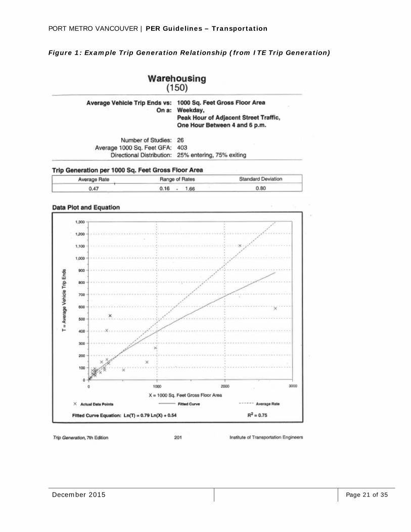
The Institute of Transportation Engineers (ITE) publishes the Trip Generation Manual2 and Handbook3, which contain a comprehensive summary of peak hour and daily trip generation rates for a broad range of Industrial, Residential, Commercial, and Recreational land use types. The rates are developed using empirically observed vehicle trips gathered from sites across North America. For each land use, where available, information on independent variables (number of employees, floor area, etc.), number of studies, inbound/outbound distribution, and time / day variations are provided. The trips may be calculated through application of an average rate or a fitted curve equation, with caution needed for small sample sizes or a limited range of independent variables. A similar document, the Parking Generation Manual4, contains a summary of peak parking utilization rates. An example trip generation table is shown in Figure 1.
Estimation by Analogy
PMV features a number of unique traffic generators within its jurisdiction, and while the Trip Generation Handbook contains a section on general Port and Terminal land uses, these sample studies may not be compatible with local trip generation characteristics. In the absence of reliable trip generation rates from the ITE Handbook, an analogous local site may be studied to determine its peak hour trip generation rates. Confirmation of similar operations and processing capacity, as well as scalability, is required prior to applying analogous trip rates to a new development site.
Estimation from First Principles
In the absence of Trip Generation Handbook or analogous site trip generation rates, an estimation from first principles may be undertaken. The first principles would take into consideration total volume of product moved, vehicle product capacity, temporal peaking factors, employee shift sizes and schedule, and hours of operation among other factors to arrive at a forecast peak hour volume.
Special site-specific considerations may warrant reductions to the applicable trip generation rates. These could include characteristics such as a high degree of automation (reduced employee traffic), high modal split by rail or water (reduced truck traffic), or business /

PORT METRO VANCOUVER | PER Guidelines – Transportation
December 2015 Page 20 of 35
operating considerations that allow for daily volume to be processed with a low peak hour to average hour ratio. These considerations must be documented for review and acceptance by PMV or applicable road authority.
Conversely, a sensitivity analysis may be appropriate where average trip generation rates are proposed. Since 50% of all sites studied would generate traffic at a higher rate than the average rate, a higher rate such as the 85th percentile rate may be more appropriate in situations where significant adverse effects on the existing corridor could occur.
PORT METRO VANCOUVER | PER Guidelines – Transportation
December 2015 Page 21 of 35
Figure 1: Example Trip Generation Relationship (from ITE Trip Generation)
PORT METRO VANCOUVER | PER Guidelines – Transportation
December 2015 Page 22 of 35
B4: TRAFFIC IMPACT STUDY TERMS OF REFERENCE
The following items should be included as part of Traffic Impact Study’s Terms of Reference:
Geographic Analysis – will follow the description provided in section 5 Geographic Scope and Boundaries of the PER Guidelines – Transportation.Projects within 800m of an intersection of a controlled access highway with any other highway will benefit from BC MoTI input.
Time Period Analysis – should include the AM and PM peak hours of major adjacent intersections and driveways, but additional analysis of mid-day or site specific peak hours may also be appropriate. For rail projects, these will include the weekly, monthly and annual peak volumes.
Data sources for existing and forecast traffic volumes – this should include publically available data from the municipality or road authority, supplemental counts collected by a traffic data collection specialist or consultant, outputs from transportation models, and proposed trip generation rates.
Proposed analysis scenarios and forecast horizon years – analysis scenarios should define the network configuration to be assumed, the background traffic growth assumptions to be incorporated, and the corresponding horizon year this level network and traffic volume represents. Typically, an opening day (post development) horizon year will be assessed along with a 5 to 20 year ultimate horizon. Assessment of interim horizon years may be required based on planning horizons, timing of adjacent developments, and timing of any proposed network modifications.
Special Analysis Considerations – should include, safety issues, hotspots, queuing, traffic management needs, etc.
Project Consultation – Applicants should prepare consultation plans as outlined in PMV’s consultation guidelines.
Current and conceptual rail operating plans.

PORT METRO VANCOUVER | PER Guidelines – Transportation
December 2015 Page 23 of 35
B5: FOUR STEP TRANSPORTATION IMPACT ANALYSIS PROCEDURE
A common four step transportation impact analysis procedure is as follows:
Trip Generation – the number of individual trip movements generated in the time period of analysis is estimated for all modes using appropriate references.
Modal Split – proportion of vehicle trips (light and heavy trucks) in the peak hour of analysis is estimated based on the availability of rail, water, and transit modes for goods movement and employee trips.
Trip Distribution – the vehicle trips are distributed to the road network based on primary site traffic origins and destinations, primary arterial roadways and truck routes and the distribution of regional population, employment and industrial land uses.
Trip Assignment – where multiple routes are available between key origins and destinations, assignment to the alternative routes is based on available capacity, travel times and any special considerations influencing relative route attractiveness.
Once the proposed site generated traffic volumes are known, the combined traffic volumes will be developed for each horizon year by overlaying site generated traffic onto future year background traffic.
Future year background traffic will be developed using one of the following methods:
Building up traffic volumes to account for known adjacent developments and land use changes, obtained from other reference studies or by individual supplemental analysis;
Use of the Emme platform based Regional Transportation Model of Metro Vancouver, as mainted by TransLink as a travel demand forecasting model that considers forecast population and employment growth consistent with approved Official Community Plans (OCP);
Extrapolation of documented historic trends.
The forecast traffic volumes for each scenario will be summarized based on the worst case combination of site generated traffic and background traffic. These will be presented in a graphical fashion for ease of review and validation.
B6: TRAFFIC ANALYSIS PROGRAMS
Commonly used traffic analysis programs include the following:
Synchro is a relatively uncomplicated program that may be used for signalized and non-signalized intersection analysis. It requires intersection input geometry, volume by turning movement and operational parameters such as signal timings or other traffic control devices. It produces Level of Service, average vehicle delay, volume to capacity ratios, and queue length information for each movement. Synchro cannot
PORT METRO VANCOUVER | PER Guidelines – Transportation
December 2015 Page 24 of 35
be used for rail crossing analysis or merge, diverge, and weave operations and does not assess detailed vehicle origin – destination patterns between adjacent intersections. SimTraffic is an add-on to the Synchro program and can be used for a visualization of traffic operations.
HCS or Highway Capacity Software is widely accepted for a variety of intersection and corridor analysis applications, as well as freeway operations such as merge, diverge, and weave patterns.
SIDRA is a software platform developed for the analysis of single lane and multi-lane roundabouts. Inputs and outputs are similar to Synchro.
PARAMICS and VISSIM are micro-simulation models capable of replicating detailed vehicle-vehicle interactions and individual driver behavior. The models include flow bundles which capture network origins and destinations. The more detailed model can produce network and point-to-point travel times, reflect vehicle re-routing in response to congestion, and account for specialized incidents such as railway crossing blockages. As the level of effort and professional experience required to code, calibrate and run these models is significant, their use in Port transportation studies will be limited to special cases where the other noted tools are not applicable.
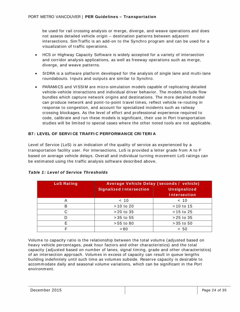
B7: LEVEL OF SERVICE TRAFFIC PERFORMANCE CRITERIA
Level of Service (LoS) is an indication of the quality of service as experienced by a transportation facility user. For intersections, LoS is provided a letter grade from A to F based on average vehicle delays. Overall and individual turning movement LoS ratings can be estimated using the traffic analysis software described above.
Table 1: Level of Service Thresholds
LoS Rating Average Vehicle Delay (seconds / vehicle) Signalized Intersection Unsignalized
Intersection A < 10 < 10 B >10 to 20 >10 to 15 C >20 to 35 >15 to 25 D >35 to 55 >25 to 35 E >55 to 80 >35 to 50 F >80 > 50
Volume to capacity ratio is the relationship between the total volume (adjusted based on heavy vehicle percentages, peak hour factors and other characteristics) and the total capacity (adjusted based on number of lanes, signal timing, grade and other characteristics) of an intersection approach. Volumes in excess of capacity can result in queue lengths building indefinitely until such time as volumes subside. Reserve capacity is desirable to accommodate daily and seasonal volume variations, which can be significant in the Port environment.
PORT METRO VANCOUVER | PER Guidelines – Transportation
December 2015 Page 25 of 35
For signalized intersections, the following minimum performance criteria will be applied:
LoS D or better for the intersection overall;
v/c ratio < 0.90 for individual intersection movements;
Turning bay storage and driveway spacing sufficient to contain the 95th percentile queue lengths during the peak hour.
For non-signalized intersections, the following minimum performance criteria will be applied:
LoS D or better and v/c ratio < 0.90 for individual intersection movements;
Turning bay storage and driveway spacing sufficient to contain the 95th percentile queue lengths during the peak hour.
For all other types of junctions, the LoS D and v/c ratio of 0.90 shall be applied.
B8: ROAD DESIGN CRITERIA
Key road design criteria include:
Functional classification (local, collector, arterial);
Posted Speed;
Design Speed;
Basic Lanes;
Minimum Horizontal Radius;
Minimum Vertical Curve Factors;
Max Grade;
Max Super elevation;
Minimum Stopping Sight Distance;
Lane Width;
Shoulder Width;
Clear Zone;
Median Width;
Design Vehicle (BC MoTI uses the WB-20 design tractor trailer to test turning radii, other standard design vehicles may be considered by PMV);
Auxiliary lane requirements for tractor trailer access and egress;
Pedestrian and Cyclist Considerations;
Traffic safety history; and
Other applicable road design criteria.
PORT METRO VANCOUVER | PER Guidelines – Transportation
December 2015 Page 26 of 35
Access Spacing
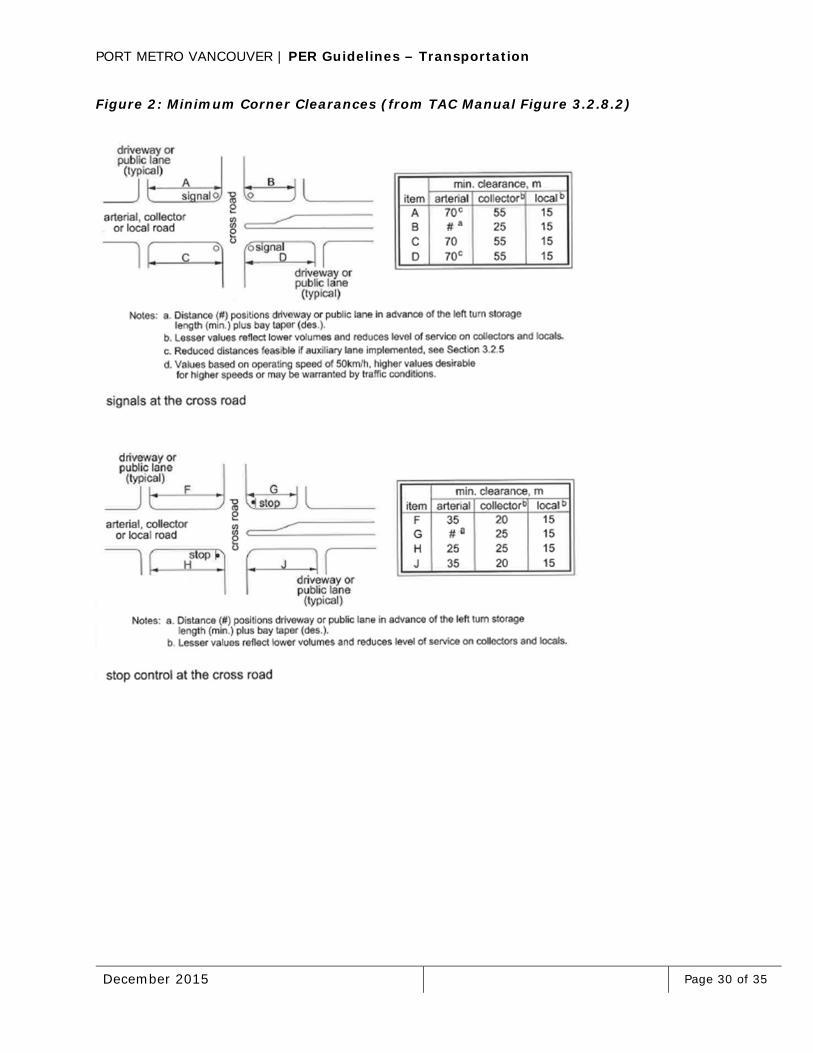
The management of the number and spacing of adjacent access points is an important tool for maintaining good Level of Service, safety and operations. Recommended access spacing is influenced by the roadway functional classification, site physical opportunities and constraints, forecast traffic performance (particularly with respect to queuing), and safety performance. Higher order facilities such as arterials are intended to serve through traffic movement rather than local land use access and minimum spacing distances are higher. At the other end of the spectrum are local streets with lower minimum spacing distances. If a development site is bordered by two roads of different classification, access requirements to the lower classification road is preferred. The Transportation Association of Canada Geometric Design Guide for Canadian Roads 1999 Edition (TAC Manual)5 Figure 3.2.8.2 (shown in Appendix B9) presents minimum suggested corner clearances for driveways in the vicinity of signalized or non-signalized access points.
Additional access spacing considerations are applicable when in proximity to an active railway. Transport Canada Grade Crossing Standards require a minimum 30 m separation between the nearest rail of facilities with an operating speed of more than 25 km/h and the travelled roadway.
Turn Bay Warrants
Separate left or right-turn bays may be warranted to satisfy traffic performance requirements or to provide for safe deceleration space on entering a driveway or intersection. The storage length may be calculated using the 95th percentile queue length or estimating the number of vehicles that could accumulate in a two minute period.
Sight Distance
Safe sight distance triangles are required for stop controlled intersections to allow vehicles to view gaps in conflicting traffic flow, react to the gap, and either clear the intersection or avoiding disrupting through traffic flow. Guidelines are described in the TAC Manual section 2.3.3 and vary depending on the design speed of the roadway and the design vehicle acceleration curve. Care must be taken in the design of site elements such as signage, walls, fencing and landscaping as they can obstruct otherwise clear sightlines. Appendix B10 contains sight triangle guidelines from the TAC Manual.
Illumination Requirements
Note that guidelines for Lighting are provided in a separate PER Guideline document available through PMV. The BC MoTI Electrical and Traffic Engineering Manual Section 3036 also provides helpful guidance on roadway illumination warrants.

PORT METRO VANCOUVER | PER Guidelines – Transportation
December 2015 Page 27 of 35
Signage / Signalization Requirements
For permanent signage, pavement markings and traffic controls at the site’s interface with the adjacent road network, the relevant jurisdictional standards will apply. If no specifications are available, the BC MoTI’s Signing and Pavement Marking Manual7 and Catalogue of Standard Signs may be used.
Traffic signal warrants will be evaluated against the local municipality guidelines. If no specifications are available, the BC MoTI’s Electrical and Traffic Engineering Manual Appendix 400.3 may be applied.
If applicable, rail crossing related signage (per federal regulations) may be required when a rail crossing is nearby.
Clear Zone Requirements
Depending on the prevailing roadway cross section, a clear zone analysis may be required to identify any roadside hazards such as ditches, utility poles or other fixed objects. The BC MoTI Supplement to TAC8 identifies warrants for various types of facilities, as well as potential mitigating measures such as roadside barrier.
Other Users
Applicants are encouraged to support alternative modes of travel to increase transportation choice for port workers. Pedestrian sidewalks should be provided with a minimum clear width of 1.8 m. Bikeway design considerations are discussed in the TAC Manual Chapter 3.4.
Site designs are expected to achieve safe pedestrian movements from a number of areas including adjacent roadways, bus stops, and designated employee parking areas. This may be achieved through raised sidewalks to avoid vehicle encroachment or through signing and pavement markings.
The provision of bicycle parking with change facilities are encouraged as they support alternative modes of travel, increase transportation choices for workers, and facilitate improvements to regional goods movements.
B9: ON-SITE DESIGN CRITERIA
Parking Requirements and Layout
Parking requirements will be established using the ITE Parking Generation Manual. A general rule is that parking should be sufficient to accommodate the maximum number of employees on site at any time, visitors, and service vehicle loading and storage. For larger sites, up to 2% of spaces should be reserved for handicap access. Layouts should be designed to minimize employees crossing the paths of heavy vehicles, with good sightlines to office or work space (to promote security), and with drive aisle lengths minimized to

PORT METRO VANCOUVER | PER Guidelines – Transportation
December 2015 Page 28 of 35
reduce speed build up. Parking spaces should not be directly accessed off of primary circulation aisles.
Access Control Requirements
Vehicle access control requirements includes the operational and physical requirements to securely process inbound and outbound vehicle movements. This can include swipe cards, inspection booths / stations, weigh scales, and other vehicle / employee identification technology. If a vehicle access control system is proposed, the performance of the system must be evaluated against the forecast peak traffic volumes to ensure queues can be contained within the site. This requires an understanding of the expected processing rate per lane, the number of processing lanes, and the storage available per lane.
Magazine Storage
The setback between the main roadway and the first parallel on site circulation roadway is referred to as magazine storage or throat length. This feature can affect operational performance if it is not designed to store the forecast in or outbound queue lengths, or if there is insufficient distance to safely transition from the external site intersection to the internal site intersection.
Internal Circulation Requirements
Other internal circulation requirements that require the impact study’s attention include the turning radii for light and heavy vehicles (including emergency vehicles) to avoid path overlap. The design should promote a uni-directional flow pattern for major heavy vehicle movements as this can reduce excessive pavement width and maneuvering room. Poorly defined circulation areas often result in high speeds and conflicts with other users. Apron space to loading docks should allow for the design vehicle to back in (left side back-in preferable) and pull out in one continuous maneuver.
B10: MINIMUM CORNER CLEARANCES
The objectives of access management and maintaining minimum corner clearances include the following:
Preserve the functional hierarchy of the road network with higher order facilities focusing on mobility and lower order facilities focusing on access;
Reduce and separate the number of conflict points at major intersections, which increase collision risks;
Provide appropriate site distances and sightlines for vehicles to enter / exit adjacent properties;
Reduce speed differentials and conflict between through traffic and turning traffic; and

PORT METRO VANCOUVER | PER Guidelines – Transportation
December 2015 Page 29 of 35
Avoid spillover impacts between adjacent intersection functional areas, such as queue storage requirements, turn bay lengths, signalized intersection coordination, and acceleration / deceleration zones.
Figure 2 below defines minimum requirements, and additional spacing should be considered for higher speeds or where traffic volumes indicate a signal may be warranted in the future. One private access per 400 m is generally desirable on arterials and up to two per 400 m on collectors. The proposed access spacing must be analysed using forecast site traffic volumes to ensure an acceptable level of service and capacity, and that there are no significant impacts on adjacent intersection queuing or functional areas such as acceleration / deceleration lanes or turning bays.
PORT METRO VANCOUVER | PER Guidelines – Transportation
December 2015 Page 30 of 35
Figure 2: Minimum Corner Clearances (from TAC Manual Figure 3.2.8.2)

PORT METRO VANCOUVER | PER Guidelines – Transportation
December 2015 Page 31 of 35
B11: SIGHT DISTANCE
Typical sight distance triangle parameters are illustrated in Figure 3.
Figure 3: Sight Triangles (from TAC Manual Figure 2.3.3.2)

PORT METRO VANCOUVER | PER Guidelines – Transportation
December 2015 Page 32 of 35
B12: RAILWAY COMPANY CONTACT LIST
Railway company contacts are listed in Table 2.
Table 2: Railway Company Contact List
Railway Conceptual Planning Email or Website CN CN Business Development/Real Estate
Group www.cn.ca
CP CP NS- The Canadian Pacific Network Strategy Group
BNSF BNSF ED, Burlington Northern Santa Fe – Economic Development
www.BNSF.com
SRY SRY Director of Business Development www.sryraillink.com BCRC British Columbia Railway Properties www.bcrco.com

PORT METRO VANCOUVER | PER Guidelines – Transportation
December 2015 Page 33 of 35
B13: RAIL PROJECT AND INFORMATION REQUIRED
Rail information that may be required as part of a PMV project permit application include the following:
Conceptual layout of proposed rail changes;
Traffic type
o Existing and proposed commodities being shipped (i.e. grains, bulk liquids, dry goods);
o Rail car types and lengths (i.e. box cars, flatcars, gondolas, center beams, container multipacks);
o Manner in which the cargo will be loaded; and
o Dimensional characteristics of load.
Traffic volumes
o Maximum number of cars (for each type being received) including empties;
o Longest trains that need to be considered (length); and
o Maximum number of cars that will be on the site at one time.
Wheel loads
o This should be expressed for the operating speeds proposed.
Locomotive tractive effort
o Switching engines (sizes);
o Shuttle wagons; and
o Proposed indexers.
On-site rail handling capacities
o Capacity by track for receiving and departure (length, clear length, car spots);
o Number of existing and proposed switches per day and number of cars per switch;
o Proposed operating protocol / plan; and
o On-terminal car handling capabilities
Utility considerations.

PORT METRO VANCOUVER | PER Guidelines – Transportation
December 2015 Page 34 of 35
B14: RAIL DESIGN CRITERIA
Key rail design criteria include:
Yard type (i.e. loop, stub track spiral);
Mainline speed, yard speed (typically <10 MPH);
Commodity proposed;
Subgrade and drainage conditions;
Operation type, unit train or container;
Maximum curvature in degree change per 100 ft;
Maximum grade;
Minimum turn out size;
Right-of-Way and clearance requirements;
Rail weight proposed;
Car type to be used in operations;
Locomotive lengths; and
Other applicable rail design criteria.
When an applicant has established an alignment, the railway will likely require that they create a track table which shows curves, grades, location of turnouts crossing locations and super elevation. PMV will review this information as part of the application review phase to determine that the railway has signed off on the track configuration within an applicant’s site area.
Although the operating railways have similar infrastructure, as all of the railways are members of AREMA and all of them follow AREMA standards, each railway has their own design standards with respect to industrial terminals. Applicants are responsible for determining which particular standards will apply as part of their discussions with the railway.
The following publications should be consulted throughout the process:
CN: “Engineering Specifications for Industrial Track” – available on online through www.cn.com;
Canadian Pacific Engineering: “Guidelines for Private Siding Design and Construction” – this document is available by request from CP;
BNSF Railway Company: “Design Guidelines for Industrial Track Projects”;
BCR Properties generally use CN specifications but have maintained a document entitled “BCRP Design and Construction Brief” – this document may be requested from www.bcrco.com; and
SRY generally uses CN specifications.
PORT METRO VANCOUVER | PER Guidelines – Transportation
December 2015 Page 35 of 35
B15: TEMPORARY CONSTRUCTION TRAFFIC MANAGEMENT PLAN CATEGORIES AND COMPONENTS
The need for temporary construction traffic management measures may arise in several ways. The most common instances would include construction activities. Utility construction work is included in the potential triggers for a temporary construction traffic management planning review. A temporary construction traffic management plan is related specifically to temporary access and control measures during construction.
A Temporary Construction Traffic Management Plan will generally consist of the following sub-plans:
A traffic control plan is a combination of text, drawings, and tables that describe the traffic control measures (signs, barricades, delineation devices, personnel) to be implemented for the duration of the construction phase of the project. The schedule for set-up and take-down is included in the plan. For the most common traffic control configurations, the BC Traffic Control Manual for Work on Roadways contains a variety of standard templates that may be referenced as part of the Temporary Construction Traffic Management Plan. Where unique and/or complex geometry are anticipated, a custom traffic control plan may be required to be developed.
A public information plan is a plan to inform key stakeholders and the travelling public of the planned traffic impacts, work schedule and recommended response (use of alternate route, expect delays, etc.). Applicants are encouraged to consult PMV’s consultation guidelines including: Public Consultation, Stakeholder Consultation, and Aboriginal Consultation – Information for Applicants. Consultation requirements will be confirmed with PMV staff during the preliminary review phase of the PER process.
An incident response plan describes the procedures and protocols to be followed in the event of an unplanned incident affecting traffic flow in the vicinity of the work zone.
An implementation plan identifies the roles and responsibilities for all individuals involved in traffic management over the course of a project’s construction period. This includes a description of their qualifications, duties and reporting structure.
Refer to the BC MoTI Traffic Management Guidelines for Work on Roadways document for a description of recommended components and typical classification considerations.
Applicants are solely responsible for ensuring that adequate sightlines as per Appendix B11 are provided throughout the duration of the temporary works.