Embed Size (px)
Citation preview
United Nations Development Programme
Project Document for nationally executed projects Financed by the GEF LDCF
Project title: Flood hazard and climate risk management to secure lives and assets in Mali.
Country: Republic of Mali Implementing Partner: Environmental Agency for Sustainable Development (AEDD)
Management Arrangements: National Implementation Modality (NIM)
UNDAF/Country Programme Outcome: CPD Outcome 2: By 2019, disadvantaged groups, particularly women and young people, benefit from increased capacities and productive opportunities in a healthy and sustainable environment conducive to poverty reduction.
UNDP Strategic Plan Output: Output 1.4: Scaled up action on climate change adaptation and mitigation cross sectors which is funded and implemented.
UNDP Social and Environmental Screening Category:Low
UNDP Gender Marker: 2
Atlas Proposal/Award ID : 00095070 Atlas output Project ID : 00099106
UNDP-GEF PIMS ID: 5855 GEF ID: 5236
Planned start date: 2016 Planned end date: 2021
FINANCING PLAN
GEF LDCF USD 8,925,000
UNDP TRAC resources USD 800,000
Cash co-financing to be administered by UNDP -
(1) Total Budget administered by UNDP USD 9,725,000
PARALLEL CO-FINANCING
UNDP USD 6,000,000
Government USD 44,946,907
(2) Total co-financing USD 50,946,907
(3) Grand-Total Project Financing (1)+(2) USD 60,671,907
1 | P a g e

Brief project description:
Climate change impacts on Mali have already unfolded with increasing average temperatures (~0.2 to ~0.8 C) and decreasing average rainfall (~20% less precipitations) over the last 50 years. ⁰ These changes in long-term climatic conditions have been compounded by extreme weather events such as droughts, floods, strong winds, sand storms and heat waves. An increase in the intensity and frequency of these climate-related hazards – in particular floods – is expected under the future climate change scenario. Such climatic conditions and the negative effects thereof will undermine the government’s efforts to achieve national socio-economic development goals.
To support the country’s socio-economic development under increased intensity and severity of floods, LDCF resources will be used to strengthen the capacity of national and local government authorities to effectively manage the risks and reduce the negative impacts of floods on local communities and infrastructure in Mali. The objective of the LDCF-financed project will be achieved through the delivery of three complementary outcomes in 51 local communities in the districts of Bamako, Kayes and Mopti. The interventions under Outcome 1 focus on increasing availability of – and access to – climate information including the generation and dissemination of climate forecast information and flood early warnings as well as awareness-raising on climate-related hazards. Under Outcome 2, Disaster Risk Management will be integrated into relevant policies, development plans and budgetary processes. Under Outcome 3, flood risk reduction interventions such as revegetation of riparian areas along wetlands, diversion of surface runoff through a network of canals, construction of permeable dams and stormwater drains will be implemented to improve rainwater management in flood-prone communities.
The interventions mentioned above will be implemented by the Environmental Agency for Sustainable Development (AEDD) and executed by the United Nations Development Programme (UNDP) over a five year period. The LDCF-financed project will contribute to decreasing the vulnerability of local communities to floods through securing their lives and livelihoods as well as protecting infrastructure in Mali.SIGNATURES
Signature: Agreed by Government
Date/Month/Year:
Signature: Agreed by Implementing Partner
Date/Month/Year:
Signature: Agreed by UNDP Date/Month/Year:
Table of Contents
2 | P a g e
I. Development Challenge...................................................................................................................................7II. STRATEGY..........................................................................................................................................................10III. Results and Partnerships................................................................................................................................17IV. Feasibility.......................................................................................................................................................37V. Project Results Framework.............................................................................................................................44VI. Monitoring and Evaluation (M&E) Plan..........................................................................................................50VII. Governance and Management Arrangements...............................................................................................53VIII. Financial Planning and Management..............................................................................................................60IX. Sustainability of Results..................................................................................................................................61X. Legal Context..................................................................................................................................................63XI. Total Budget and Work Plan...........................................................................................................................64XII. Mandatory Annexes.......................................................................................................................................79
Appendix 1 Multi-year workplan...................................................................................................................79Appendix 2 Monitoring plan..........................................................................................................................79Appendix 3 Evaluation plan..........................................................................................................................79Appendix 4 GEF tracking tools at baseline....................................................................................................79Appendix 5 Terms of Reference for Project Board, Project Manager, Chief Technical Advisor and other relevant positions..................................................................................................................................................79Appendix 6 UNDP Social and Environmental and Social Screening Template...............................................79Appendix 7 Co-financing letters....................................................................................................................79Appendix 8 Alignment with policies...............................................................................................................79Appendix 9 Problem tree..............................................................................................................................79Appendix 10 Institutional and policy context...................................................................................................79Appendix 11 Site selection process..................................................................................................................79Appendix 12 Mission report.............................................................................................................................79Appendix 13 Maps............................................................................................................................................79
List of Tables
TABLE 1: NUMBER OF METEOROLOGICAL AND HYDROLOGICAL STATIONS TO BE INSTALLED...............20TABLE 2: RELEVANT STAKEHOLDERS IDENTIFIED FOR ENGAGEMENT BY PROJECT OUTPUT................33TABLE 3: RISK MANAGEMENT TABLE...............................................................................................38TABLE 4: RESULTS FRAMEWORK....................................................................................................41TABLE 5: GEF M&E BUDGET.........................................................................................................48TABLE 6: PLANNED LDCF ACTIVITIES/OUTPUTS WITH CO-FINANCING...............................................56TABLE 7: TOTAL BUDGET AND WORK PLAN......................................................................................60TABLE 8: BUDGET NOTES...............................................................................................................65
List of Figures
FIGURE 1: THEORY OF CHANGE.....................................................................................................15FIGURE 2: ORGANOGRAM OF MANAGEMENT ARRANGEMENTS FOR THE LDCF-FINANCED PROJECT....51
3 | P a g e
List of Acronyms and Abbreviations NOTE to project developer:
ABFN Niger River Basin AgencyAEDD Environmental Agency for Sustainable DevelopmentANICT National Investment Agency for Local CommunitiesAPR/PIR Annual Project Review/Project Implementation ReportsAWP Annual Work PlanAWS Automatic Weather StationCAFO Coordination of Associations and Women’s OrganisationsCCAT Common Framework in Support to the Transition CIGQE Institutional Framework for Environmental Management CNCC National Committee for Climate ChangeCNE National Environment Commission CNSC National Framework Climatological ServicesCPAP Country Programme Action Plan CPD Country Programme DocumentCSCRP Poverty Reduction and Growth Strategy PaperCSI-GDT Strategic Framework for Investments in Sustainable Land Management CSO Civil Society OrganisationsDGCT Directorate General of Territorial CollectivitiesDGPC General Directorate for Civil ProtectionDNA National Directorate of AgricultureDNACPN National Directorate of Sanitation, Pollution and Nuisance ControlDNAT National Directorate of Decentralised AdministrationDNEF National Directorate of Forestry and WaterDNCT National Directorate of Local Authorities DNGR National Directorate of Rural Engineering DNH National Water DirectorateDNPD National Directorate of Planning and Development DNUH National Directorate for Urbanism and HousingDRC National Directorate of CommerceDRM Disaster Risk ManagementDRPIA Regional Directorate of Animal Production and IndustriesDRR Disaster Risk ReductionEIA Environmental Impact Assessment ENI-ABT Abderhame Baba Touré National Education Institution for EngineersERC Evaluation Resource CentreEU European UnionEUMETSAT European Organisation for the Exploitation of Meteorological SatellitesEWS Early Warning SystemFAO Food and Agriculture OrganisationFICAR Risk Identification Form/Sheet FNC First National Communication FRRP Flood Risk Reduction Plans GDP Gross Domestic ProductGEF Global Environment FacilityGIS Geographic Information SystemGoM Government of MaliIFAD International Fund for Agricultural DevelopmentIP Implementing PartnerIWRM Integrated Water Resource ManagementLDC Least Developed CountryLDCF Least Developed Countries Fund
4 | P a g e
M&E Monitoring and EvaluationMASL Metres Above Sea LevelMEADD Ministry of Environment, Sanitation and Sustainable DevelopmentMEF Ministry of Economy and FinanceMoF Minister of FinanceMSIPC Ministry of Internal Security and Civil ProtectionMTR Mid-Term ReviewNAPA National Adaptation Programme of ActionNBA Niger Basin Authority NGO Non-Governmental OrganisationNHMS National Hydrological and Meteorological Services NIM National Implementation ModalityNTFP Non-Timber Forest ProductOCHA Office for the Coordination of Humanitarian AffairsORTM Bureau of Radio and Television of MaliPAC Project Appraisal CommitteePAG Government Programme of Action PAGEDD Support Programme for Environmental Management and the Promotion of
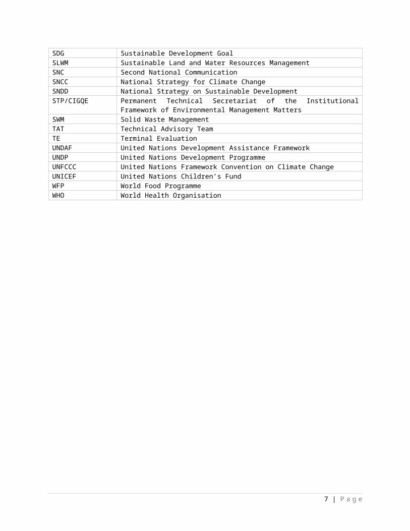
Sustainable DevelopmentPANCC National Action Pan for Climate ChangePANGIRE National Action Plan on the Integrated Management of Water Resources PDESC Economic, Social and Cultural Development Programme PDS Social Development Policy PCU Project Coordinating UnitPNCC National Policy on Climate Change PNMRRC National Plan for Multi Risk Preparation and Emergency Disaster Response PNPE National Policy on the Protection of the EnvironmentPPR Project Progress ReportsPSDDM Strategic Plan for Development in the District of BamakoRTA Regional Technical AdvisorSDG Sustainable Development GoalSLWM Sustainable Land and Water Resources Management SNC Second National Communication SNCC National Strategy for Climate ChangeSNDD National Strategy on Sustainable Development STP/CIGQE Permanent Technical Secretariat of the Institutional Framework of
Environmental Management MattersSWM Solid Waste ManagementTAT Technical Advisory TeamTE Terminal EvaluationUNDAF United Nations Development Assistance Framework UNDP United Nations Development ProgrammeUNFCCC United Nations Framework Convention on Climate ChangeUNICEF United Nations Children’s FundWFP World Food ProgrammeWHO World Health Organisation
5 | P a g e
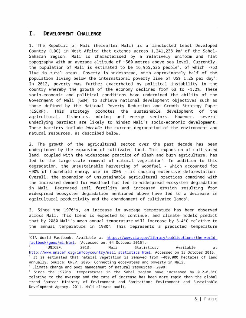
I. DEVELOPMENT CHALLENGE
1. The Republic of Mali (hereafter Mali) is a landlocked Least Developed Country (LDC) in West Africa that extends across 1,241,238 km2 of the Sahel-Saharan region. Mali is characterised by a relatively uniform and flat topography with an average altitude of ~500 metres above sea level. Currently, the population of Mali is estimated to be 16,955,536 people1, of which ~75% live in rural areas. Poverty is widespread, with approximately half of the population living below the international poverty line of US$ 1.25 per day2. In 2012, poverty was further exacerbated by political instability in the country whereby the growth of the economy declined from 6% to -1.2%. These socio-economic and political conditions have undermined the ability of the Government of Mali (GoM) to achieve national development objectives such as those defined by the National Poverty Reduction and Growth Strategy Paper (CSCRP). This strategy promotes the sustainable development of the agricultural, fisheries, mining and energy sectors. However, several underlying barriers are likely to hinder Mali’s socio-economic development. These barriers include inter alia the current degradation of the environment and natural resources, as described below.
2. The growth of the agricultural sector over the past decade has been underpinned by the expansion of cultivated land. This expansion of cultivated land, coupled with the widespread practice of slash and burn agriculture, has led to the large-scale removal of natural vegetation 3. In addition to this degradation, the unsustainable harvesting of woodfuel – which accounted for ~90% of household energy use in 2005 – is causing extensive deforestation. Overall, the expansion of unsustainable agricultural practices combined with the increased demand for woodfuel has led to widespread ecosystem degradation in Mali. Decreased soil fertility and increased erosion resulting from widespread ecosystem degradation mentioned above have led to a decrease in agricultural productivity and the abandonment of cultivated lands4.
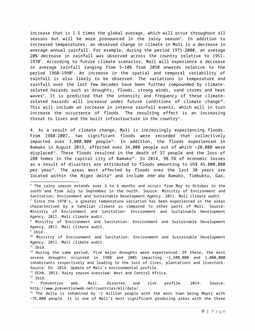
3. Since the 1970’s, an increase in average temperature has been observed across Mali. This trend is expected to continue, and climate models predict that by 2080 Mali’s mean annual temperature will increase by 3-4°C relative to the annual temperature in 19805. This represents a predicted temperature increase that is 1.5 times the global average, which will occur throughout all seasons but will be more pronounced in the rainy season6. In addition to increased temperatures, an observed change in climate in Mali is a decrease in average annual rainfall. For example, during the period 1971-2000, an average 20% decrease in rainfall was observed across the country relative to 1951-1970 7. According to future climate scenarios, Mali will experience a decrease in average rainfall ranging from 5-10% from 2050 onwards relative to the period 1960-19908. An increase in the spatial and temporal variability of rainfall is also likely to be observed. The variations in temperature and rainfall over the last few decades have been further compounded by climate-related hazards such as droughts, floods, strong winds, sand storms and heat waves9. It is predicted that the intensity and frequency of these climate-related hazards will increase
1CIA World Factbook. Available at https://www.cia.gov/library/publications/the-world-factbook/geos/ml.html. [Accessed on: 04 October 2015]. 2 UNICEF. 2013. Mali Statistics. Available at http://www.unicef.org/infobycountry/mali_statistics.html. Accessed on 15 October 2015. 3 It is estimated that natural vegetation is removed from ~400,000 hectares of land annually. Source: UNEP. 2005. Connecting ecosystems and poverty in Mali.4 Climate change and poor management of natural resources. 2008. 5 Since the 1970’s, temperatures in the Sahel region have increased by 0.2-0.8°C relative to the average and the rate of increase has been more rapid than the global trend Source: Ministry of Environment and Sanitation: Environment and Sustainable Development Agency. 2011. Mali climate audit.6 The rainy season extends over 3 to 6 months and occurs from May to October in the south and from July to September in the north. Source: Ministry of Environment and Sanitation: Environment and Sustainable Development Agency. 2011. Mali climate audit.7 Since the 1970’s, a greater temperature variation has been experienced in the areas characterised by a Sahelian climate as compared to other parts of Mali. Source: Ministry of Environment and Sanitation: Environment and Sustainable Development Agency. 2011. Mali climate audit.8 Ministry of Environment and Sanitation: Environment and Sustainable Development Agency. 2011. Mali climate audit.9 Ibid.
6 | P a g e
under future conditions of climate change10. This will include an increase in intense rainfall events, which will in turn increase the occurrence of floods. The resulting effect is an increasing threat to lives and the built infrastructure in the country11.
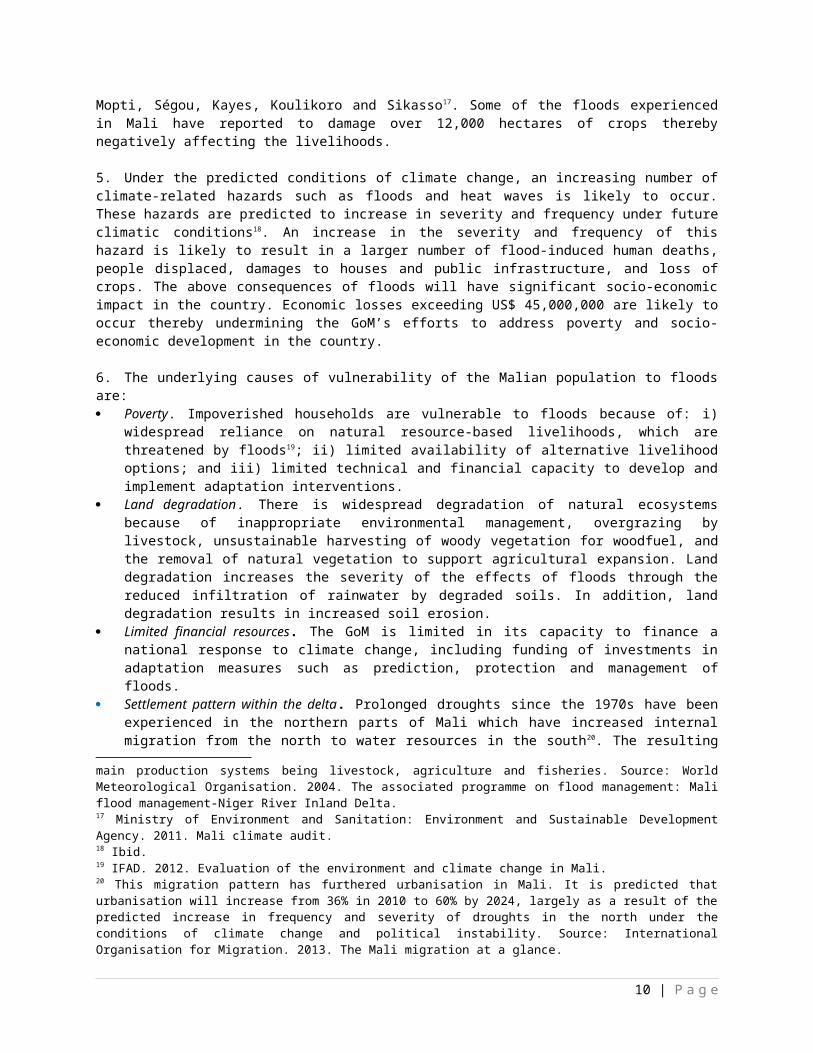
4. As a result of climate change, Mali is increasingly experiencing floods. From 1980-2007, two significant floods were recorded that collectively impacted over 3,000,000 people12. In addition, the floods experienced in Bamako in August 2013, affected over 34,000 people out of which ~20,000 were displaced13. These floods resulted in the death of 37 people and the loss of 280 homes in the capital city of Bamako14. In 2014, 98.5% of economic losses as a result of disasters are attributed to floods amounting to US$ 45,000,000 per year15. The areas most affected by floods over the last 30 years are located within the Niger delta16 and include inter alia Bamako, Timbuktu, Gao, Mopti, Ségou, Kayes, Koulikoro and Sikasso17. Some of the floods experienced in Mali have reported to damage over 12,000 hectares of crops thereby negatively affecting the livelihoods.
5. Under the predicted conditions of climate change, an increasing number of climate-related hazards such as floods and heat waves is likely to occur. These hazards are predicted to increase in severity and frequency under future climatic conditions18. An increase in the severity and frequency of this hazard is likely to result in a larger number of flood-induced human deaths, people displaced, damages to houses and public infrastructure, and loss of crops. The above consequences of floods will have significant socio-economic impact in the country. Economic losses exceeding US$ 45,000,000 are likely to occur thereby undermining the GoM’s efforts to address poverty and socio-economic development in the country.
6. The underlying causes of vulnerability of the Malian population to floods are: Poverty. Impoverished households are vulnerable to floods because of: i) widespread reliance on
natural resource-based livelihoods, which are threatened by floods19; ii) limited availability of alternative livelihood options; and iii) limited technical and financial capacity to develop and implement adaptation interventions.
Land degradation. There is widespread degradation of natural ecosystems because of inappropriate environmental management, overgrazing by livestock, unsustainable harvesting of woody vegetation for woodfuel, and the removal of natural vegetation to support agricultural expansion. Land degradation increases the severity of the effects of floods through the reduced infiltration of rainwater by degraded soils. In addition, land degradation results in increased soil erosion.
Limited financial resources. The GoM is limited in its capacity to finance a national response to climate change, including funding of investments in adaptation measures such as prediction, protection and management of floods.
Settlement pattern within the delta. Prolonged droughts since the 1970s have been experienced in the northern parts of Mali which have increased internal migration from the north to water resources in the south20. The resulting effect of the rapid influx of people to the densely populated south of Mali
10 Ministry of Environment and Sanitation: Environment and Sustainable Development Agency. 2011. Mali climate audit.11 Ibid.12 During the same period, five major droughts were experienced. Of these, the most severe droughts occurred in 1980 and 2005 impacting ~1,500,000 and 1,000,000 inhabitants respectively and leading to the loss of lives, plantations and livestock. Source: EU. 2014. Update of Mali’s environmental profile.13 OCHA. 2013. Rainy season overview: West and Central Africa. 14 Ibid.15 Prevention web. Mali: Disaster and risk profile. 2014. Source: http://www.preventionweb.net/countries/mli/data/.16 The delta is inhabited by ~1 million people with the main town being Mopti with ~75,000 people. It is one of Mali’s most significant producing areas with the three main production systems being livestock, agriculture and fisheries. Source: World Meteorological Organisation. 2004. The associated programme on flood management: Mali flood management-Niger River Inland Delta. 17 Ministry of Environment and Sanitation: Environment and Sustainable Development Agency. 2011. Mali climate audit.18 Ibid. 19 IFAD. 2012. Evaluation of the environment and climate change in Mali.20 This migration pattern has furthered urbanisation in Mali. It is predicted that urbanisation will increase from 36% in 2010 to 60% by 2024, largely as a result of the predicted increase in frequency and severity of droughts in the north
7 | P a g e
is that many houses and infrastructure have been established on floodplains, river beds and basins. People living in these flood-prone areas are highly exposed to floods and are therefore vulnerable. In Mali, floods have resulted in the loss of many lives, livelihoods and houses as well as severe damage to structures.
7. To improve the economy in the face of ongoing socio-political challenges, ecosystem degradation and climate change, the GoM developed several sectoral and cross-sectoral policies, plans and strategies. These include inter alia the CSCRP, the National Policy on the Protection of the Environment (PNPE), the National Strategy on Sustainable Development (SNDD), the National Adaptation Programme of Action (NAPA), and the National Plan for Multi Risk Preparation and Emergency Disaster Response (PNMRRC). However, the implementation of these policies and strategies has been limited. Contributory factors include weak institutional capacity and incoherence between existing policies and strategies. The barriers hindering the GoM’s capacity to address floods in the country are discussed in the next section.
Barriers to increasing Mali’s capacity to reduce and manage floods
8. There are several institutional, technical and financial barriers to effectively reduce and manage the effects of floods in Mali. The Least Developed Countries Fund (LDCF)-financed project will contribute towards overcoming the barriers limiting the implementation of effective flood reduction and management interventions by local government authorities in Mali, as listed below. Limited capacity of national institutions to effectively predict floods and other climate-related risks. At
present, the availability and accessibility of reliable weather data is not sufficient to enable accurate prediction of rainfall and resultant flood risks by Mali-Météo and the DNH21. These institutions therefore have limited capacity to generate weather-related information to disseminate timely early warnings in the event that a flood is predicted. In addition, the national system for issuing flood warnings to the public is currently ineffective, particularly in rural areas. Flood warnings are broadcasted via means and languages that are not accessible to all local communities.
Limited knowledge and application of adaptation measures related to flood management. In Mali, the authorities responsible for the design and application of flood protection measures – including inter alia Mali-Météo, the DNH and the DGPC – do not have sufficient experience developing or implementing effective flood protection measures. This is because over the past 30 years, measures to manage the effects of droughts have been prioritised in the country over flood disaster risk preparedness and recovery.
Limited skills and resources of planning authorities at local level (municipalities and villages) to efficiently carry out responsibilities pertaining to flood risk management. An integrated approach to climate change adaptation is dependent on: i) the availability of data; ii) locally-appropriate methodologies; and iii) technical expertise to assess the potential physical and economic impacts of climate change and associated flooding in the country. The quality and availability of such data and expertise within Mali’s local authorities is insufficient to develop detailed and locally-appropriate climate change adaptation strategies. Furthermore, there is minimal technical and financial support to local authorities to develop and implement flood adaptation interventions. In Mali, the ongoing processes of land use planning and urban planning are generally undertaken with limited consideration of factors related to climate change, including predictions of future vulnerability to climate-related hazards such as floods22. For example, the design of Bamako’s urban drainage systems did not include adequate consideration of the likely volume of annual floodwaters. Consequently, past flood events have been characterised by widespread sanitation problems and damage resulting from floodwaters of up to four metres23.
under the conditions of climate change and political instability. Source: International Organisation for Migration. 2013. The Mali migration at a glance. 21 McSweeny, C., New, M. & Lizcano, G. 2010. UNDP Climate Change Country Profiles: Mali. http://country-profiles.geog.ox.ac.uk. 22 Green Climate Fund Project/Programme Concept Note. 2015.23 Ibid.
8 | P a g e
Limited transmission of information and warning to the relevant local communities. The existing EWS was developed to cater for the Niger delta in Mali24 and warns communities by means of: i) radio; ii) internet25; iii) phone calls to local key stakeholderss to reach villages; and iv) weekly news bulletins. However, such warnings are provided for large seasonal flooding events but exclude flash floods26. Moreover, the majority of the population – particularly the rural population of Mali – are unable to access these warnings.
9. Although no single initiative can address all of the barriers mentioned above, the LDCF-financed project will deliver complementary outcomes to contribute towards overcoming these barriers. The LDCF-financed project will also support furthering the CSCRP, the National Plan for Multi Risk Preparation and Emergency Disaster Response (PNMRRC), the NAPA, and Sustainable Development Goals (SDGs) 3, 5, 6, 9, 11 and 13. Please see Appendix 8 for the alignment of the LDCF-financed project with the national and international priorities contained in these documents.
II. STRATEGY
10. An increasing number of floods has been experienced in the last 30 years in Mali, which have resulted in human deaths and loss of livelihoods. As previously stated in Section I, floods experienced from 1980-2007 have adversely affected over 3,000,000 Malians27 and are predicted to increase in frequency and severity under conditions of climate change. The LDCF-financed project will contribute towards achieving the long-term solution which is to manage and reduce the negative impacts of floods on communities and infrastructure in Mali. The theory of change adopted for this LDCF-financed project comprises addressing the barriers discussed in Section I while contributing to the preferred solution discussed below through the delivery of Outcomes 1, 2 and 3. The theory of change diagram is at the end of this section. The Problem Tree and Solution Tree leading to the development of the theory of change are attached as Appendix 9. The preferred solution pertains to increasing the resilience of local communities to floods in Mali and comprises the following: Increased knowledge of risks associated with flooding to support the development of locally-
appropriate plans and approaches. The preferred solution would include strengthening the capacity of the relevant authorities in Mali – such as Mali-Météo, the DNH and the General Directorate for Civil Protection (DGPC) – to identify which regions are the most vulnerable to flooding under the predicted conditions of climate change. Through strengthening government capacity, the capability for using Geographic Information System (GIS) to map flood risks would be enhanced. In so doing, variables such as population density, land value, asset types and land use would be taken into account. Based on the mapping, locally-appropriate plans would be developed by municipal- and village-level authorities to reduce the risks related to floods. These plans would consider and include: i) modern techniques for flood risk reduction including inter alia the use of geospatial analyses and modelled climate change predictions to identify flood-vulnerable sites; and ii) traditional flood management measures used by communities, such as the construction of levees. In addition, technical staff from national and local government authorities, including inter alia Mali-Météo, DNH, DGPC and municipalities, will receive training on a wide range of approaches to flood protection such as the establishment of dykes and vegetative buffers thereby increasing their technical capacity to use these approaches. Furthermore, the above-mentioned increased availability of information and technical capacity of the government authorities to respond to flood risks would support the adoption of a flexible approach to the management of floods according to the best available evidence at a particular point in time. This approach would be regularly updated in accordance with emerging information.
24 Cools, J. & Innocenti, D. 2014. Input paper prepared for the 2015 global assessment report on disaster risk reduction. The United Nations Office for Disaster Risk Reduction, Geneva.25 http://www.opidin.org/en is an early warning system tool designed for the Inner Niger Delta to predict the level and the timing of the flood peak as well as the maximal flood extent. 26 Cools, J. & Innocenti, D. 2014. Input paper prepared for the 2015 global assessment report on disaster risk reduction. The United Nations Office for Disaster Risk Reduction, Geneva.27 EU. 2014. Update of Mali’s environmental profile.
9 | P a g e
Implementation of flood management measures. The preferred solution would include the identification and establishment of locally-appropriate flood management measures at sites that are identified as being at risk of flooding, both in the short- and the long-term as a result of predicted climate change impacts. Flood management measures would be complemented by the enhanced capacity of authorities – such as the DGPC, MEADD and Environment and Sustainable Development Agency (AEDD) – to integrate considerations related to flood risks into urban planning and infrastructural development. For example, existing building and settlement codes would be updated and revised to ensure that future infrastructural development includes consideration of flood risks in a meaningful manner. The revision of building codes would also incorporate measures to ensure that future drainage systems are designed to take the predicted frequency and severity of future flood risks into account. Such designs would be based on measured historical extremes of flood water levels and projected climate-related flood risks. Furthermore, the revision of building and settlement codes would include measures to ensure that infrastructural development incorporates adequate consideration of future needs and risks related to public sanitation. In so doing, the risks of outbreak of water-borne diseases associated with flooding – in both urban and rural areas – would be reduced. The implementation of these improved codes to include flood risks in infrastructural development would enhance the effectiveness of the physical flood management measures applied.
Increased flood preparedness. The preferred solution would increase capacity at both the national – DGPC, MEADD, AEDD – and municipal level to respond timely to climate-related hazards, particularly floods. National disaster preparedness would be enhanced by establishing reliable early warning and monitoring systems. For hazards such as floods, Early Warning Systems (EWSs) based on modern technologies that are cost effective to maintain would be continuously operational – staffed 24 hours a day – and would allow for the timely and reliable dissemination of warnings to both urban and rural communities using media such as mobile phone platforms. To ensure the availability of sufficient public funds for disaster response measures, actions to increase the national preparedness for climate-related hazards would include the development of financial strategies to increase the allocation of funds to local government authorities within communes and villages to develop locally-appropriate strategies to decrease their vulnerability to floods. These financial strategies will cover: i) an emergency response; ii) the reconstruction of public assets and infrastructure; and iii) targeted financial assistance to those adversely affected by floods.
Increased awareness of floods and associated risks. The preferred solution would incorporate an increased level of awareness of the risks of floods within both urban and rural communities. Capacity-building activities would include the provision of training to both national and local authorities on flood risks and management, as well as potential flood reduction methods – including management and prevention. To educate the public and increase their knowledge on climate change and associated flood risks, various forms of media would be used, including posters and radio broadcasts. In addition, education programmes would be implemented for school children, which would ensure increased long-term public awareness of flood risks and the adoption of appropriate responses during times of crisis.
11. LDCF finances will therefore be used to increase the capacity of the GoM, especially local government structures, to manage the risks of climate-related hazards such as floods. The LDCF-financed project has been designed to respond to Mali’s national priorities and will support the implementation of national policies, strategies and plans. The national priorities targeted by the LDCF-financed project are detailed in Appendix 8. The institutional and policy context of this LDCF-financed project is attached as Appendix 10.
National and local benefits
12. National benefits: At the national level, the adaptation benefits generated by the LDCF-financed project will include building the overall capacity of the GoM to plan for and respond to floods. This will be achieved through training and capacity-building of government officials within Mali-Météo, DNH and DGPC at the national, district and commune levels. Targeted beneficiaries of the project’s capacity-
10 | P a g e
building activities will, at a minimum, include: i) 50 national-level representatives; ii) 50 district-level representatives (in each of three targeted districts); and iii) 100 commune-level representatives (in each of the seven targeted communes).
13 These stakeholders will benefit directly from capacity-building activities to improve the planning, design and implementation of GoM’s activities to respond to climate-related hazards, particularly floods. In addition, the benefits of the LDCF-financed project will include: i) an increase in the total geospatial coverage of the national hydrological and meteorological monitoring (hydromet) network by at least 10%; and ii) the development of an enhanced EWS for monitoring and issuing flood warnings to vulnerable communities in Bamako, Kayes and Mopti. The total size of the population to be reached by the proposed EWS – designed specifically for floods – will include at least 20% of the population.
14. Local benefits: At the local level, the LDCF-financed project activities will deliver targeted adaptation benefits to 51 vulnerable local communities in the districts of Bamako, Kayes and Mopti, resulting in direct benefits for at least 1,200,000 people which amounts to 120,000 households. Within these target intervention sites, the project will introduce multiple measures to reduce vulnerability to flood risks, including both measures to increase resilience as well as decrease exposure to floods. Vulnerable local communities will benefit directly from the establishment of physical measures for flood protection including inter alia permeable rock dams and stormwater drains for water evacuation at priority flood-prone areas. In addition to providing physical flood protection, the project will implement awareness-raising activities on the management of floods to at least 500,000 people within communes I, IV and VI in Bamako, as well as Tomora in Kayes. The project’s awareness-raising activities will also include campaigns to increase the knowledge of municipal and village officials on the management of public risks related to floods.
15. At the local level, the vulnerability of project beneficiaries to floods will be reduced through several measures including inter alia: i) dissemination of early warnings; ii) long-term resilience to floods as a result of the mainstreaming of flood risks in governing document such as the PDESC; and iii) improved capacity of stormwater drainage systems, through maintenance and extension of existing drainage systems in communes I, IV and VI of Bamako (please see Section III for the list of the activities selected to be implemented per site under the LDCF-financed project).
16. Municipal and village authorities in the seven communes that have been selected for LDCF-financed interventions will benefit from capacity-building activities. As a result, the communes’ institutional, technical and financial capacity to develop and implement site-specific adaptation interventions will be strengthened. This will improve the management of flood risks and hazards thereby decreasing the vulnerability of local communities to these disasters. To promote a gender-sensitive approach in the development of the LDCF-financed project, representatives of CAFO28 – an association of women’s NGO groups in Mali – participated in several of the regional and local workshops in Bamako, Kayes and Mopti. The participation of CAFO ensures that a gender-sensitive approach recognising that floods affect men and women differently has been considered in the design of the LDCF-financed project. This project will also consider the effect of floods on other vulnerable groups such as children and the elderly. In so doing, the project will increase the adaptive capacity of the most vulnerable groups of Mali’s society to floods.
Gender considerations
17. In 2014, Mali was ranked as a country with a “very high level of discrimination” in the Social Institutions and Gender Index developed by the Organisation for Economic Co-operation Development Centre29. Although the National Gender Policy of Mali was adopted in 2010, customary practices in the
28 CAFO stands for Coordination of Associations and Women’s Organisations. 29 The following parameters were measured as part of this index: i) discriminatory family code including lower age of marriage, parental authority and inheritance for women (Mali score: very high); ii) restricted physical integrity that assess the legal framework against domestic violence, rape, sexual harassment as well as genital mutilation and reproductive autonomy (Mali score: very high); iii) son bias measuring female infanticide or health conditions (Mali score: high); iv) restricted resources and assets including access to land and non-land assets, and financial services (Mali score: medium); and v) restricted civil liberties comparing access to public place and political voice (Mali score:
11 | P a g e
country support gender inequalities and disparities30. Women in Mali have different access to income-generating activities than men. Indeed, women’s roles are predominantly related to childcare and domestic life including raising children, water collection and wood harvesting31. Furthermore, as a result of unequal access to education and the labour market, women are more vulnerable to climate-related hazards.
18. The LDCF-financed project will take gender consideration into account and encourage as much as possible women participation to and benefits from the project interventions. Therefore, particular attention will be given to addressing the vulnerability and limited adaptive capacity to floods of both men and women. For example, women will be supported to participate to the monitoring and management committees to be established under Output 1.2. As a result of women participation, decision-making processes regarding the implementation of a strategy to decrease community vulnerability to climate-related hazards will take into consideration men and women livelihoods, expectations and priorities. In addition, to support gender-sensitive interventions, the collaboration initiated with CAFO at PPG phase will continue throughout the implementation phase.
19. As women’s domestic life in Mali relate largely to raising children, water collection and wood harvesting, they become relatively more burdened than men in the event of floods. During floods, potable water sources – surface- and groundwater – become susceptible to contamination by microorganisms such as bacteria, sewage, agricultural or industrial waste, chemicals and other substances that can cause serious illnesses. Consequently, women have to walk relatively longer distances to collect water from areas that are not affected by floods to access safe potable water. In addition, water- and vector-borne diseases, such as cholera and malaria32 respectively, spread rapidly after floods which affect children more than other population groups. As it is largely women’s role to raise children, they are further burdened by floods as they have to attend to sick children. In light of the above, this LDCF-financed project has adopted a gender-sensitive approach by reducing and managing the impacts of floods in the country. The LDCF-financed project is therefore intrinsically gender-sensitive and will improve the quality of life of the women in the intervention sites. The needs and priorities of women have therefore been considered and integrated in the design of this project.
20. A gender specialist will be appointed under Activity 1.2.2 to support the use of a gender-sensitive and gender-responsive approach in developing the flood risk communication strategy. The scope of the works of the gender specialist will not be limited to Activity 1.2.2 alone but will undertake an evaluation of the LDCF-financed activities and provide a roadmap for promoting a gender-responsive approach throughout the project. The project team will report to the project board on how these recommendations have been included in the subsequent implementation of the LDCF-financed interventions. The gender specialist will develop additional gender-sensitive indicators for the relevant activities which will be monitored by the appointed M&E specialist in the Project Management Unit (PMU). Based on an assessment of the gender-responsiveness of the LDCF-financed activities, gender equality in accessing project’s resources and the meaningful participation of women in the implementation phase, corrective interventions will be recommended. Moreover, the gender specialist will develop detailed indicators for the activities undertaken under Outputs 1.3 and 2.1 which pertain to flood risk mapping and the development of flood risk reduction plans, respectively. The flood risk mapping exercise will determine the flood risk reduction interventions to be prioritised and implemented by local government authorities. It is therefore crucial that the socio-economic information collected under Output 1.3 is gender-sensitive as it will enable the development of gender-sensitive and gender-responsive flood risk reduction plans to decrease the vulnerability of women to floods in the future.
21. In addition to the flood risk maps and flood risk reduction plans, gender-responsive campaigns to raise awareness on building resilience to floods and adopting adequate solid waste disposal practices under Activities 1.4.2 and 2.1.5 will be undertaken. As their role pertain largely to raising children, women
very high). http://www.oecd.org/dev/development-gender/BrochureSIGI2015-web.pdf30 UNDP. 2012. Gender equality and women’s empowerment in public administration. Mali: Case Study. 31 USAID. 2015. Addendum to the 2012 Gender Assessment. 32 Ministry of Environment and Sanitation: Environment and Sustainable Development Agency. 2011. Mali climate audit.
12 | P a g e
in Mali are likely to instil their increased knowledge on floods – including the underlying causes of floods and adaptation options – to their children. For example, as women adopt the adequate solid waste disposal practices following awareness-raising campaigns, their children – exposed to such practices – are likely to embrace them in the future.
22. Gender-sensitive indicators and targets have been developed to monitor the progress of the LDCF-financed project and will be refined by the baseline study. Gender-disaggregated data will be collected during project implementation to inform and update the project indicators. Furthermore, up to 50% participation of women (to be determined by the baseline study) will be targeted for each training activity as a prerequisite to hold the event. Trainers appointed by this project will be required to have the required skills and experience to plan and facilitate gender-sensitive training. The set of communication tools under Output 1.4 will also be selected in order to reach men and women similarly. Lastly, awareness raising on gender equity in the context of climate change will be incorporated into the training of government officials to encourage the implementation of gender-sensitive initiatives beyond the project lifespan.
Ongoing country interventions
23. Several GEF and non-GEF projects on adapting to climate change and managing climate risks and hazards are currently being implemented in Mali. Previous projects and programmes have largely focused on droughts and food security as a result of their frequency and severity – for example, five major droughts occurred from 1980 to 2007. Despite not being primarily focused on building resilience to floods, the ongoing initiatives in the country provide opportunities for knowledge exchange and synergies with the LDCF-financed project. These ongoing initiatives are described below.
24. An LDCF-financed project entitled “Strengthening the resilience of women’s producer groups and vulnerable communities in Mali” is currently executed by UNDP in the districts of Sikasso, Kayes and Koulikoro. The objective of the project is to build the resilience of women subsistence farmers to the negative effects of climate change by improving access to water, promoting climate-smart agriculture, and diversifying their income. The project activities include inter alia: i) increasing the knowledge of women’s subsistence farming groups on adaptation options; ii) restoring communal forests; iii) demonstrating land and water conservation techniques; and iv) developing and increasing access to agro-meteorological information. The implementation period is 2015–2019 with a budget of US$ 5,460,000. Lessons learned on best-practice adaptation options in the Malian context will inform the awareness-raising campaigns for the public and the training to be provided to government officials on reducing and managing the impacts of floods.
25. Additionally to the aforementioned LDCF-financed project, UNDP is one of the executing partners of the project entitled “Programme for the support of the National Adaptation Strategy to Climate Change in Mali”, financed by Government of Germany and commissioned by the Federal Ministry for the Environment, Nature Conservation, Building and Nuclear Safety (BMUB). The project has a budget of US$ 5,500,000 for the period 2014–2019. The objective of the project is to increase the resilience of vulnerable communities to climate change using an integrated approach to adaptation including ecosystem restoration and strengthening of production chains for ecosystem-based resources. Activities financed by the project include inter alia: i) the mainstreaming of climate change considerations into existing policies as well as planning and monitoring instruments; and ii) the identification of best-practice interventions to effectively manage the negative effects of climate change on local communities in collaboration with municipal authorities. In addition, the project activities include the expansion of the network of weather stations. The LDCF-financed project will build on the work undertaken by the project described above by increasing the network of weather stations to improve the quality and quantity of weather-related information in the country. The lessons learned in the mainstreaming of climate change considerations into existing policies will inform the activities under Component 2 of the LDCF-financed project.
26. The project entitled “Programme support for climate change adaptation in the vulnerable regions of Mopti and Timbuktu” is financed by the Adaptation Fund – to the value of ~$8,500,000 – and
13 | P a g e
implemented by UNDP over the period 2016–2018. The main objective of the project is to increase the resilience of vulnerable communities in Mopti and Timbuktu, and their adaptive capacity to climate change. In particular, Component 3 seeks to strengthen the capacity of local government institutions and communities on adaptation options. The knowledge gathered on the effectiveness of adaptation options implemented in the project described above will be shared with the LDCF project team and presented to government officials to increase their knowledge on climate change and adaptation options. The lessons learned in the awareness-raising campaigns undertaken in 20 local communities in Mopti and Timbuktu will inform the campaigns to be undertaken within the LDCF-financed project.
27. The project entitled “Enhancing adaptive capacity and resilience to climate change in Mali’s agriculture sector” is financed by LDCF and Canada UNDP Climate Change Adaptation Facility. It is implemented by the National Directorate of Agriculture (DNA) and UNDP with a budget of $ 2,340,000 over the period 2010-2014. However, the project is still under implementation. The objective of the project is to enhance the adaptive capacities of vulnerable rural populations to the additional risks posed by climate change on agricultural production and food security in the country. The project targets several municipalities in the districts of Kayes, Koulikoro, Sikasso, Ségou, Mopti and Gao to increase their technical and financial capacity to manage the impacts of climate change on agricultural production and food security. Output 1.3 of the project described above pertains to developing adaptation financing strategies which will inform those to be developed under Output 2.3 of the LDCF-financed project. This exchange of lessons learned with the LDCF-financed project will be valuable in developing effective financial strategies that allow funds to be readily available and accessible by local government authorities to reduce and manage floods impacts in the country.
28. In 2007, the GoM established a fund entitled “National support fund to local authorities” which is managed by the ANICT. The establishment of this fund followed the decision to undertake decentralised governance in Mali in 1992. The fund supports the transfer of technical, institutional and financial capacities from the national government to decentralised authorities such as municipalities. It is used to: i) strengthen the capacities of regional, communal and local government authorities to promote socio-economic development in their respective area of jurisdiction; and ii) promote the development of the environment, education, water and health sectors at the regional, communal, and municipal and village scales. The technical and financial capacity of local government authorities will be further strengthened by the LDCF-financed project.
14 | P a g e
Figure 1: Theory of Change
15 | P a g e
III. RESULTS AND PARTNERSHIPS
29. The objective of the LDCF-financed project is to strengthen the capacity of national and local government authorities to effectively manage and reduce the negative impacts of floods on local communities and infrastructure in Mali. To achieve this objective, the project will support improved planning and decision-making within government authorities to respond to flood risks and hazards. This enhanced capacity of national and local government authorities to plan and implement locally-appropriate flood mitigation strategies will reduce the vulnerability of local communities to the negative effects of floods. The government authorities targeted by the project include inter alia the DNH, AEDD, Mali-Météo, DGPC, Directorate General of Territorial Collectivities (DGCT), National Directorate of Agriculture (DNA), National Directorate of Forestry and Water (DNEF), DNACPN, National Directorate of Planning and Development (DNPD), Bureau of Radio and Television of Mali (ORTM), National Directorate of Rural Engineering (DNGR), DRC, DNAT as well as municipal and village advisors. In total, 51 local communities spread across seven communes in the districts of Bamako, Kayes and Mopti will also benefit directly from LDCF interventions.
30. The objective of the LDCF-financed project will be achieved through the delivery of three complementary outcomes. Outcome 1 will increase the availability of data and information to guide the management of flood risks in municipalities and villages selected for LDCF interventions in the districts of Bamako, Kayes and Mopti. Outcome 2 will integrate flood risk management into relevant development planning policies and budgetary processes, thereby increasing the effectiveness of local DRM, DRR and response plans to flood hazards. Outcome 3 will invest in the demonstration of multiple flood reduction measures, including the establishment of infrastructure for flood protection and flood management, to benefit 51 local communities that are vulnerable to flood risks.
31. The LDCF-financed project will build on baseline projects to maximise benefits to the recipient local communities. Five ongoing baseline projects were identified in the country, namely: i) annual budget of Mali-Météo to cover their operational costs over the course of the implementation phase (co-financing of US$ 24,690,000); ii) Project for stormwater drainage in Bamako (co-financing of US$ 12,327,411); iii) Project for the management of grey water and solid waste (co-financing of US$ 4,929,496); iv) Programme for the support of the National Adaptation Strategy to Climate Change in Mali (co-financing of US$ 6,000,000); and v) Support Programme for Environmental Management and the Promotion of Sustainable Development (PAGEDD, co-financing of US$ 3,000,000). In addition, UNDP will provide a grant in-kind to the value of US$ 800,000 as co-financing for the LDCF-financed project.
32. As a national meteorological agency, Mali-Météo is responsible for the generation of weather-related information to guide decision-making to protect lives and secure assets in the country. Over the last few years, Mali-Météo has implemented several measures to provide accurate weather-related information in the context of climate change and weather forecasting. The GoM has financially supported the strengthening of the meteorological network and the development of accurate weather forecasts to prevent losses from climate-related hazards. The LDCF-financed project will build on the current initiatives undertaken by Mali-Météo and further reinforce its hydro-meteorological network through the addition of 10 hydrological and meteorological stations, and 150 pluviographs under Outcome 1. The above-mentioned equipment measures the intensity of rain and as such they are useful instruments to predict imminent floods. The pluviographs financed by the LDCF will increase the quality and quantity of data produced by Mali-Météo thereby enabling monitoring and predictions of floods. In addition, LDCF resources will be used to develop flood EWSs (a total of three) to disseminate early warnings in the intervention sites of Bamako, Kayes and Mopti. The establishment of these systems will strengthen Mali-Météo’s capacity to deliver early warnings in the event of floods. The LDCF-financed project will deliver interventions to increase the technical capacity of Mali-Météo’s technical staff to monitor weather-related information, analyse and interpret data from climate modelling software to generate accurate downscaled weather forecasts. The annual budget of Mali-Météo to cover their operational costs of the relevant activities of Mali-Météo to the LDCF-financed project amount to US$ 4,938,000 which adds up to US$ 24,690,000 considered as co-financing for the five years of project implementation.
16 | P a g e
33. The Project for stormwater drainage in Bamako funded by the GoM/Federal Government of Germany seeks to reduce flood risks in Bamako. This project is implemented by the MEADD from 2015 to 2020 with the objective of decreasing the vulnerability of local communities living in flood-prone areas in Bamako. To do so, the rehabilitation interventions for Tienkolé wetland in commune I and Ouéouyankou wetland in commune IV are undertaken as part of this project. The rehabilitation of these flood-prone wetlands aim to reduce flood risks thereby decreasing the vulnerability of the adjacent local communities. The LDCF-financed project will complement these flood risk reduction interventions implemented in Communes I and IV with the construction of permeable rock dams in these same communes.
34. The project for the management of grey water and solid waste implemented by the DNACPN/AGETIPE/CIRA and financed by the GoM is undertaking a study on the existing systems in 11 cities in Mali including Kayes and Mopti. This study is aligned with the LDCF-financed objectives because the inappropriate disposal of waste leads to blocked waterways which increases the risk of flooding following intense rainfall. The LDCF-financed project will build on the work undertaken by this project by undertaking awareness-raising campaigns with local communities on adopting appropriate waste disposal practices under Ouput 2.1.
35. The UNDP Programme for the support of the National Adaptation Strategy to Climate Change in Mali focuses on supporting the GoM to adopt an integrated approach to climate change and to support climate change-resilient development in the country – as stipulated in the National Adaptation Strategy to Climate Change in Mali. It is financed by the Federal Government of Germany and commissioned by the German Federal Ministry for the Environment, Nature Conservation, Building and Nuclear Safety (BMU). With a budget of US$ 6,000,000 for the period 2014-2019, this project aims to increase the resilience of vulnerable local communities to climate change using an integrated approach to adaptation including ecosystem restoration and strengthening of production chains for ecosystem-based resources. Activities financed by the project include inter alia: i) the mainstreaming of climate change considerations into existing policies to inform planning; and ii) the identification of best-practice interventions to effectively manage the negative effects of climate change on local communities in collaboration with municipal authorities. In addition, this UNDP project will contribute to the expansion of the weather monitoring network through purchasing weather stations.
36. The LDCF-financed project will build on the interventions discussed above by further increasing the network of weather stations (under Outcome 1) to improve the quality and quantity of weather-related information in the country. In addition, the LDCF-financed project will further the benefits of the Programme for the support of the National Adaptation Strategy to Climate Change in Mali by mainstreaming the consideration of short- to medium-term flood risks into the PDESC to inform flood-resilient development planning in the intervention sites(Under Output 2.1.). The LDCF-financed project will build on the work undertaken by the project financed by the GoM/Federal Government of Germany to implement best-practice soft and hard flood risk reduction interventions. These interventions include rehabilitation of wetlands and the construction of permeable rock dams, respectively.
37. The AEDD is responsible for the coordination and the mainstreaming of environmental and climate change considerations in national – such as the PNPE – and sectoral policies. This agency currently implements the Support Programme for Environmental Management and the Promotion of Sustainable Development (PAGEDD) to promote sustainable development in the country and to incorporate climate change considerations in development programmes and projects. PAGEDD is implemented on a national scale. The LDCF-financed project will build on the work currently undertaken in Kayes and Mopti to increase the adaptive capacity of local communities. In addition, the work undertaken by PAGEDD in Bamako to improve the management of climate change risks will be furthered.
The three complementary outcomes of the LDCF-financed project are discussed below.
17 | P a g e
COMPONENT 1: Strengthened technical capacity of municipal and village authorities to improve flood early warning systems and dissemination of climate-related risk information.
OUTCOME 1: Strengthened technical capacity of municipal and village authorities to improve flood early warning systems and dissemination of climate-related risk information.
Co-financing amounts for Outcome 1: US$ 20,178,763LDCF project grant requested: US$ 3,135,000
Without LDCF Intervention (baseline):
38. Currently, the majority of information and knowledge on the predicted effects of climate change in Mali is generated by regional institutions such as AGRHIMET and ACMAD33, while several national government authorities are responsible for monitoring and forecasting Mali’s climate. These government authorities are also responsible for issuing warnings on climate-related hazards and disasters, such as droughts, floods and locust plagues. The specific duties of these government authorities – including Mali-Météo – are described below.
39. The duties of Mali-Météo include inter alia: i) monitoring short- and long-term variables of Mali’s weather and climate, such as rainfall and temperature; ii) issuing seasonal weather forecasts to assist farmers with planting preparation of crops during the wet season34; and iii) predicting and issuing warnings for climate-related hazards such as droughts. To fulfil its duties, weather data is collected by Mali-Météo from the national meteorological observation network, which comprises 190 synoptic stations, 54 climatological and agro-meteorological stations, as well as 214 rainfall observation systems. The observation network also consists of Meteosat receiver stations – established through the support of WHO35, EUMETSAT36 and AGRHIMET – two cloud-seeding airplanes and eight Automatic Weather Stations (AWS). The duties of Mali-Météo are complemented by those of the DNH, which is responsible for collecting and disseminating Mali’s hydrological data. The DNH also operates and maintains a network of ~90 water-level observation stations on the Niger and Senegal Rivers. The Hydro-Niger project expanded the hydrological network by equipping 24 stations with telemetry systems, which are partially operational.
40. The meteorological and hydrological monitoring networks established by Mali-Météo and the DNH collect data around large settlements and valuable infrastructure, thereby limiting the spatial coverage of these networks. This reduces the capacity of these institutions to develop downscaled weather predictions. In addition, the delay in the transmission of data from hydro-meteorological stations to central offices also constrains the generation of accurate, timely early warnings for floods. As a result of these constraints, detailed spatial analyses of flood risks have not been undertaken, and communities in low-lying areas – including in the districts of Bamako, Kayes and Mopti – do not receive flood early warnings.
41. While Mali has implemented an early warning system for famine37, no flood EWS has been developed at the national scale in Mali. Instead, the GoM’s management approach to reduce the negative effects of floods emphasises community participation in the development and implementation of locally appropriate solutions and strategies. In alignment with this emphasis on community participation, an interdisciplinary working group was developed to collate and disseminate advice and recommendations 33 Ministry of Environment and Sanitation: Environment and Sustainable Development. 2011. Mali climate audit, Bamako. 34 Ibid. 35 WHO stands for World Health Organisation. 36 EUMETSAT stands for European Organisation for the Exploitation of Meteorological Satellites.37 An EWS that issues warnings for famine and food security crises has been developed and implemented by the Ministry of Local Authorities under the authority of the Office for Food Security. The primary function of this EWS is to identify the: i) areas and segments of the population that are vulnerable to food crises; ii) timeframe and extent of the expected food crisis; and iii) estimated needs of the affected community to prevent a food crisis. The EWS issues monthly bulletin reports which are reviewed and adopted by a working group. This information is then published and distributed as a newsletter to international, national and local agencies to inform the adoption of recommended measures and prevent potential food crises.
18 | P a g e
on locally appropriate flood reduction measures for farming communities. This guidance was well received by the communities and the lessons learned by the interdisciplinary group will inform the development of similar projects in the future. Since this initiative demonstrated the value of community participation in climate-risk management, in 2014 the DGPC undertook a risk identification process in all 703 communes in Mali using a Risk Identification Form/Sheet (FICAR). The purpose of this exercise was to develop a database and map climate risks to inform the development of DRM and DRR interventions. However, this information has not been integrated into development planning processes or authorities’ responses to climate-related hazards. Mali’s response to flood risks and hazards therefore remains uncoordinated, ad hoc and without consideration of the predicted effects of climate change.
With LDCF Intervention (adaptation alternative)
42. The LDCF-financed project interventions will strengthen the capacity of GoM to generate and disseminate information on floods. In particular, this Component of the project will focus on increasing the capacity of both Mali-Météo and DNH to collect, analyse and interpret climate-related data from a network of enhanced hydro-meteorological observation stations that will be established with LDCF resources. The interpretation and analysis of the data generated by these stations will supplement existing hazard mapping by providing: i) an updated analysis of the vulnerability of local communities – see Table 1 overleaf for the list of local communities receiving hydro-meteorological stations – to floods under the predicted conditions of climate change in the short- to medium-term; and ii) the location of infrastructure and public assets located within the project’s intervention sites that are at risk of floods. The project will integrate data generated by past initiatives to inform the analyses of localised flood risks. For example, data generated by the DGPC in 2014 through FICAR will be included in the flood risk analyses. Increased availability of quality data and information on site-specific flood risks will inform the development of improved models for predicting vulnerability to floods and for issuing flood early warnings. An EWS for each intervention district – three in total, i.e. Bamako, Kayes and Mopti – will be implemented and will supplement and strengthen existing systems to decrease the vulnerability of local communities to climate-related hazards.
43. Under Outcome 1, the national hydro-meteorological observation network operated by Mali-Météo and the DNH will also be extended through the provision of 10 additional meteorological and hydrological stations as well as 150 pluviographs. The selection of the specific types of monitoring equipment was undertaken in consultation with the National Hydrological and Meteorological Services (NHMS) to identify the most appropriate and cost-effective options for Mali’s context. These hydro-meteorological stations will be established in flood-prone areas of the intervention sites subject to an assessment by a national meteorologist. The increased geospatial coverage of Mali’s hydro-meteorological observation network will support the increased accuracy and timeliness of weather forecasts and flood early warnings.
44. Flood risk mapping of the main assets at risk in each intervention district will be undertaken through the activities of the LDCF-financed project. To determine the impact of floods on built infrastructure, an inventory of flood-vulnerable assets and the likelihood of potential damage during flood events will be developed. The information generated by this flood risk analysis will inform a study of the potential socio-economic costs of damage and losses resulting from floods according to different flood risk scenarios.
Output 1.1.: A sound climate information system comprising devices operating 24 hours a day to monitor and forecast flood risks and hazards is established.
45. Under this output, the LDCF-financed project will increase the capacity of Mali-Météo, the DNH, DGPC, AEDD, as well as municipal and village authorities to monitor climate conditions and issue reliable, accurate and timely flood forecasts. The scientific community of Mali – represented by the Abderhame Baba Touré National Education Institution for Engineers (ENI-ABT) – will also increase their knowledge and expertise on climate monitoring.
46. As part of their ongoing operational practices, Mali-Météo undertakes regular assessment of the status of its existing stations and other weather-related equipment. Based on a recent evaluation, Mali-Météo has determined that 10 meteorological and hydrological stations need to extend its network to
19 | P a g e
accurately forecast floods and hazards. Consequently, the strengthening of Mali’s hydro-meteorological monitoring network will include the use of LDCF resources to procure and install monitoring equipment, including inter alia 10 meteorological and hydrological stations and 150 pluviographs. The meteorological and hydrological stations will measure the increase in water level and rainfall intensity to complement the pluviographs. The information generated by these equipment will determine imminent flood risks in the interventions sites.
47. A national meteorologist will be appointed to determine the appropriate type of meteorological and hydrological stations required to extend Mali-Météo’s network. New meteorological and hydrological stations will be installed in 10 local communities in the districts of Bamako – see Table 1 below. The exact location of these stations will be determined by the appointed national meteorologist. This meteorologist will also train the relevant stakeholders on the operation and maintenance of these stations, as well as the monitoring and forecasting of climate-related risks.
Table 1: Number of meteorological and hydrological stations to be installed.District Circle Commune Number of
meteorological and hydrological stations to be installed
Bamako Bamako Commune I 2Bamako Commune IV 2Bamako Commune VI 2
Kayes Bafoulabe Tomora 1Kita Sebekoro 1
Mopti Bandiagara Pignari Bana 1Mopti Fatoma 1
48. The suppliers of the meteorological equipment discussed above will train the relevant officials from Mali-Météo, the DNH, DGPC, AEDD, ENI-ABT as well as municipal and village authorities on the operation and daily maintenance of the equipment. In addition, the suppliers will compile simple technical guidelines on the operation and daily maintenance of the equipment to promote their sustainability. There are, however, several cultural and attitudinal barriers within Mali-Météo that restricts the use of modern technology in the weather sector. This is a result of the emphasis within Mali-Météo on conventional technologies, which are difficult to maintain by the relevant authorities. These barriers have been partially addressed through the participatory approach adopted in the design of the LDCF-financed project. The involvement of Mali-Météo in the development of the project’s interventions – to ensure that LDCF finances are used to address their needs – promotes their support during implementation phase. In addition, these barriers will be overcome through the delivery of training workshops and technical guidelines to explain the benefits of using such technologies to improve the capacity of Mali-Météo’s to monitor weather. The training of the technical staff from Mali-Météo will provide the necessary information on operating and maintaining the meteorological and hydrological stations, thereby enhancing their technical capacity and reducing the prevailing attitudinal barriers.
49. By installing the monitoring equipment mentioned above within the project intervention sites, the project will increase the total geospatial coverage of the national monitoring network. This equipment will also provide the necessary data to generate flood forecasts. Mali Météo and DNH will be responsible for operating and maintaining the improved hydro-meteorological network within their ongoing line responsibilities. In addition, Mali-Météo will ensure the sustainability of the long-term operation and maintenance of the procured equipment during the project’s lifespan and after its closure. A long-term maintenance plan will be compiled and implemented by the appointed national meteorologist to prevent the degradation of the stations. This long-term maintenance plan will be developed in collaboration with Mali-Météo, the DNH, DGPC, AEDD, ENI-ABT as well as municipal and village authorities.
50. To improve Mali’s geospatial coverage of the national monitoring network, the existing weather stations in Kita (Kayes), Sotuba (Bamako), Douentza (Mopti) and Bandiagara (Mopti) will be repaired.
20 | P a g e
These stations have been identified for repair following a regular evaluation of the status of Mali-Météo’s stations and equipment. The repair of these stations will improve the quality of weather-related information generated in the country and subsequently communicated to the public. The improved weather monitoring network will therefore increase Mali-Météo’s weather monitoring and forecasting capacity.
51. One of the LDCF-financed project’s interventions consists of the purchasing of a climate modelling software that will be used to generate accurate downscaled weather forecasting on a national scale. An assessment of the software currently used by Mali-Météo and the demands from the private and public sectors will be undertaken to determine the climate modelling software required. Officials of Mali-Meteo will be trained on the use of the software, methods for data monitoring and the interpretation of the information to generate weather forecasts for the use of the public. Journalists will also be trained to accurately convey the downscaled weather forecasts generated by Mali-Meteo to the population via the radio and TV broadcasting channels – which will require working agreements between Mali-Météo and radio and TV broadcasters. These agreements will be facilitated by a national communication specialist, who will also be responsible for establishing agreements with potential sponsors.
52. In addition to generating information for the general public, the climate modelling software will allow Mali-Météo to produce tailor-made forecasts for specific sectors as a payed service. The need for tailor-made weather forecasts will be determined by a market analyst to identify the opportunities in the private weather forecasting industry in Mali. The market analysis will determine the likely revenue that can be derived from such a service by Mali-Météo. Based on the findings of the market analysis, the appointed international meteorologists will train the relevant Mali-Météo officials on generating such information. The income stream generated by this service will contribute towards maintaining, repairing and/or purchasing new weather stations to improve the quality and quantity of weather-related information in the country.
Indicative activities under Output 1.1 include:1.1.1. Procure and install 10 meteorological and hydrological stations in the intervention sites – i.e. two
stations in communes I, IV and VI of Bamako (six in total), and one in each selected commune in the districts of Kayes and Mopti (4 in total). Training material and guidelines on the operation and maintenance of the equipment installed will be developed and disseminated to the relevant stakeholders. In addition, a long-term maintenance plan for the meteorological and hydrological stations will be developed and implemented.
1.1.2. Procure and install 150 pluviographs in the intervention sites - 50 pluviographs per district. Training material and technical guidelines on the operation as well as a long-term maintenance plan will be developed and disseminated to all the stakeholders operating the pluviographs.
1.1.3. Undertake an equipment needs assessment of the existing weather stations in Kita, Sotuba, Douentza and Bandiagara and repair equipment as required to improve data monitoring and transmission.
1.1.4. Generate accurate downscaled daily, weekly and seasonal weather forecasts for the public. Undertake a market analysis to determine the needs and opportunities in the private weather forecasting industry in the country for downscaled tailor-made weather forecasts. Train the technical staff of Mali-Météo on generating and communicating such information to the private sector.
Output 1.2.: Early warning and quick-response systems are developed to increase the resilience of vulnerable local communities in the intervention sites.
53. LDCF resources will be used to design and implement site-specific EWSs and quick-response systems at the intervention sites. A total of 32 sensors and audible warning devices will be installed as part of the site-specific flood EWSs. These systems will be carefully designed by an international flood EWS specialist to ensure maximum efficiency and coverage. This EWS specialist will also oversee the implementation of the EWSs in each intervention district. The relevant technical staff from Mali-Météo, DNH, DGPC, DNUH, ENI-ABT, as well as municipal and village authorities, will receive training and technical guidelines on operating and maintaining the EWSs. In addition, a long-term maintenance plan will be developed and implemented by the appointed flood EWS specialist to support the sustainability of
21 | P a g e
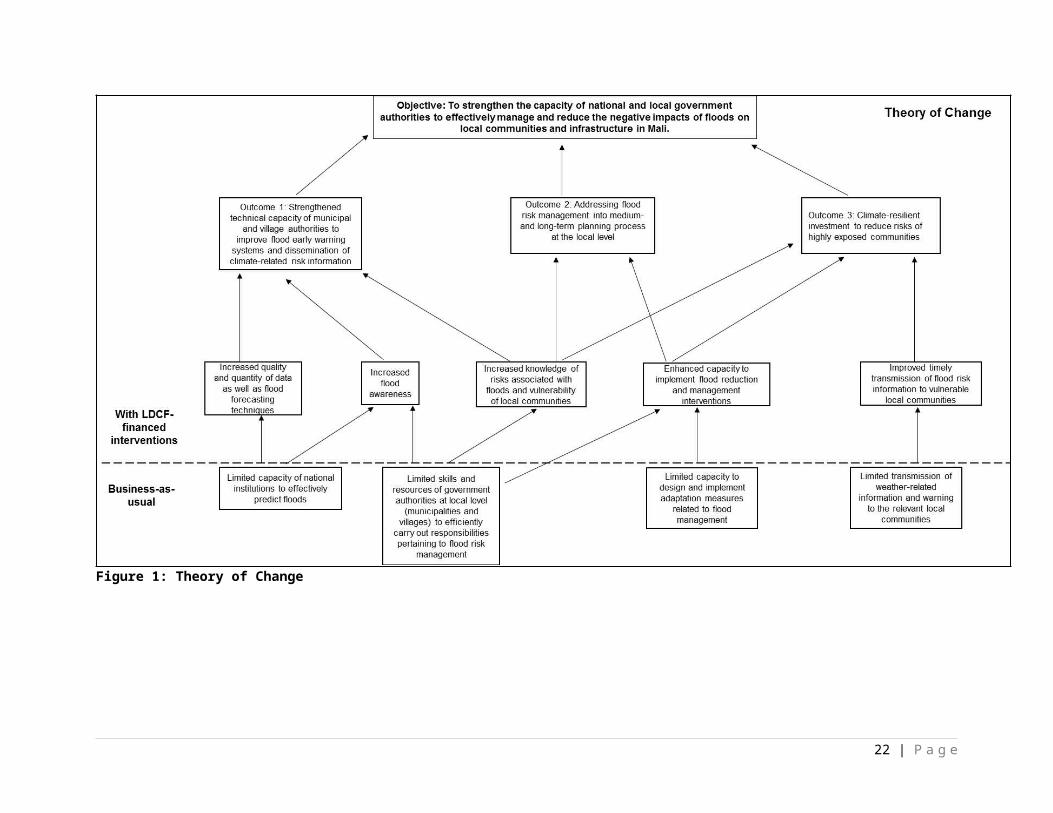
these systems beyond the project's lifespan. Mali-Météo will assume primary responsibility for the operation and maintenance of the EWSs implemented under this output during and after the project’s lifespan. The relevant municipal and village authorities will enter into agreements with Mali-Météo to undertake some of the small-scale maintenance duties on the EWSs.
54. To promote the effectiveness of early warnings, a detailed flood risks and hazards communication strategy will be developed under this output. The design of this communication strategy will involve extensive consultation with local communities to ensure that the early warnings that are generated are in local communities’ preferred language and are standardised across all communication platforms. In addition, to increase the capacity of communities to understand and respond to flood warnings, the LDCF-financed project will undertake awareness-raising activities on the interpretation and response to early warning messages.
55. The design of this project’s interventions will benefit from the experiences of multiple past and ongoing initiatives – particularly the UNDP Africa Climate Information and Early Warning Project. Although the project mentioned above did not address early warning in Mali, it generated climate information and will provide useful experience-based knowledge and lessons learned on the analysis and dissemination of these information. The LDCF-financed project will also build on the approaches used by existing EWSs in the country – such as the seasonal rainfall forecasts issued by the Mali-Météo – while promoting the use of new and innovative methods for communicating early warnings, such as inter alia sirens, SMS, and rural radio broadcasts. To use these channels of communication, MoUs will be developed with radio broadcasters and telecommunication companies. In addition to these communication channels, early warnings will reach rural communities through the monitoring and management committees established under this output – which will target the members of their respective local communities who are outside of reach of the coverage area. Consequently, the use of multiple communication media will support the delivery of warnings to a diverse audience – including local communities located in remote rural areas who might otherwise not receive warnings via conventional media (e.g. newspapers or television broadcasts). Warnings will be adapted based on the level of literacy, education of the target audience, and other variants such as access to technology.
56. The monitoring and management committees established under this output – comprising of representatives of local communities – will work in collaboration with Mali-Météo. These committees will be developed with the appropriate structures and will enter MoUs with Mali-Météo. The primary functions of the monitoring and management committees includes: i) holding regular training workshops with the local communities to increase their understanding of flood risks, their severity and the corresponding response to be adopted, as well as the different categories of warnings according to the flood risks and hazards communication strategy; and ii) disseminating early warnings to members of their respective local communities that are outside of the coverage zone of early warnings. A national communication specialist will be appointed to facilitate the establishment and functioning of the monitoring and management committees and will identify and implement measures – where possible – to make them operational beyond the project's lifespan.
57. Multiple awareness-raising activities and training workshops with representatives of local communities and the media, as well as NGOs and local government authorities will be undertaken. The awareness-raising activities will emphasise the role of the media as an important tool for public education and for disseminating accurate information on the effects of climate change, with a particular emphasis on floods. Training workshops will enhance the capacity of journalists to convey early warnings and other climate-related information in a coherent and accessible approach to the general public.
58. Under this output, a gender specialist will be appointed to support the development of a gender-responsive flood risks and hazards communication strategy. This strategy will be developed in consultation with women from the selected local communities to support: i) the dissemination of early warnings which are readily accessible to women; and ii) the formulation of responses to the different warning categories which are determined by the needs of women. The role of the gender specialist will not be limited to this output alone, but will develop a roadmap for mainstreaming gender considerations into the LDCF-financed activities. This will subsequently support gender equality in the implementation of
22 | P a g e
the project and to promote the participation of women in a meaningful and equitable manner to the project resources. Please refer to Section II for more information.
Indicative activities under Output 1.2 include:1.2.1. Implement flood early warning audio alert systems comprising 32 sensors and audible warning
devices – a total of seven in Bamako, 11 in Kayes and 14 in Mopti – to generate early warnings.1.2.2. Develop a detailed flood risks and hazards communication strategy based on the input of a gender
specialist and in collaboration with the local communities. This strategy will comprise: i) preferred methods of communication of potential flood risks and hazards per commune; ii) the preferred language of warnings; iii) the description of a standardised category of warnings to be used across all means of communication; and iv) commune-specific responses to be implemented by the local authorities and communities for each warning category such as evacuation plans.
1.2.3. Establish monitoring and management committees between the selected communes and Mali Météo to effectively disseminate flood warnings. These committees will also periodically provide training to local communities on the different warning categories and the appropriate responses to be adopted.
Output 1.3.: Risk mapping combining flood risks with socio-economic indicators – including inter alia population-related indices, land value, land uses, assets – is undertaken.
59. A flood risk analysis will be undertaken for each intervention site in Bamako, Kayes and Mopti based on flood risks and exposure – determined under this output. This risk analysis will comprise three datasets, namely: i) flood risks and exposure of local communities within the intervention sites in the short- to medium-term; ii) socio-economic information including inter alia population-related indices and sources of livelihoods; and iii) land use information including inter alia the location of assets such as public infrastructure – e.g. buildings, roads and bridges – and human settlements. By combining the three datasets mentioned above in GIS, maps showing the location of the vulnerable communities in the short- to medium-term will be produced. In addition to these maps, the contributing factors to the vulnerability of local communities will be determined from the GIS datasets created. Furthermore, a flood risk index will be developed to facilitate the identification and prioritisation of the local communities requiring DRM interventions to reduce the impacts of floods in the short to medium term. The flood risk maps in conjunction with the index developed under this output will increase the technical capacity of the local government authorities to plan and implement DRM interventions in the intervention sites and to guide development planning. The technical staff from the DGPC, DNPD, AEDD, Mali-Météo, DNH, ENI-ABT, other line ministries as well as municipal and village authorities will receive training on the: i) collection and analysis of the relevant data; ii) development of the datasets; iii) generation of the flood risk maps; and iv) the use of the flood risk maps as planning tools for DRM interventions and development planning.
60. The detailed geospatial datasets developed through the flood risks and exposure analyses undertaken in the intervention sites will be integrated into the AEDD Information System during the project’s lifespan. This system was established by the SLWM program, which manages online environmental information. By integrating information – such as the predicted short- to medium-term vulnerability of local communities to floods – into the AEDD Information System, this output will support the consideration of climate change adaptation into the ongoing activities of the AEDD Information System, particularly related to management of land and water resources. The information generated under this output and provided to the AEDD will be made available and accessible to the public. Flood risk maps will be displayed in schools, display boards and municipal and village authorities’ offices as part of the awareness-raising campaigns under Activity 1.4.2. These maps will allow members of local communities to enhance their understanding of their vulnerabilities to floods.
61. Under this output, the socio-economic costs of floods will be quantified in the short- to medium-term. Quantifying these costs will inform an assessment of the financial vulnerabilities38 of the local economy to effectively implement DRM interventions within the interventions sites. In addition, by providing a clear understanding of the costs associated with floods – to both local communities and relevant government 38 Financial vulnerability is a function of the distribution of risks and financial capacities to absorb the costs to be incurred as a result of climate-related hazards and natural disasters.
23 | P a g e
authorities – the project’s activities will incentivise DRM-related government structures to reduce the risks, and improve the management, of floods. Alternative adaptation options for flood management within the Malian context will also be developed and assessed in collaboration with academic partners such as local universities or research centres. The results of such an assessment will be communicated to the relevant national and local partners at communication events to be included in future NAP-related activities.
Indicative activities under Output 1.3 include:1.3.1. Determine short- and medium-term flood risks and exposure based on updated and downscaled
climate models. Map the areas that are exposed to floods are at risk in the short to medium term.1.3.2. Collect and analyse socio-economic data based on indicators – including inter alia population-
related indices, settlement patterns, land uses and value, sources of livelihoods and infrastructure – and determine any projected change scenarios in these variables in the short and medium term.
1.3.3. Develop an inventory of flood-vulnerable assets in the communes selected for LDCF interventions to prioritise DRM interventions.
1.3.4. Undertake short- to medium-term risk mapping using GIS to overlay flood risks and exposure data (as determined in Activity 1.3.1), socio-economic information (Activity 1.3.2) and flood-vulnerable assets (Activity 1.3.3.). Develop a flood risk index to facilitate planning of DRM interventions. The flood risk maps will be made accessible to the public.
1.3.5. Quantify the socio-economic costs of floods in the short to medium term based on risks, vulnerability of local communities and potential loss or damage to assets located in flood-prone areas, taking into account possible future development plans. The costs and benefits of alternative adaptation options for flood management will be analysed with the engagement of local universities/research centres. The results of this work will be integrated into the ongoing NAP-related activities.
Output 1.4: An education programme and awareness-raising campaign is undertaken within schools and local communities to build a culture of safety and resilience to floods.
62. The interventions of this output will entail the integration of an education programme on local climate-related hazards, particularly floods, into the curriculum of schools. This integration will be accomplished through i) raising awareness of inspectors, educational advisors and directors of primary schools about flood risks and the need for climate change adaptation; and ii) producing educational booklets on flood risk and climate change, including modules and manuals for teachers and children. In addition, training workshops will be conducted with the public on designing and implementing locally-appropriate interventions to build resilience to floods. The school curriculum and training workshops discussed above will be developed in collaboration with the DGPC, Ministry of Education, municipal and village authorities, NGOs and CSOs.
Indicative activities under Output 1.4 include:1.4.1. Develop and integrate an education programme in the school curriculum and raise awareness on
the prevention of climate risks, in particular floods, to decrease the vulnerability of school children. 1.4.2. Conduct awareness-raising campaigns through training workshops, radio and TV broadcasts,
display boards, skits and SMS on building resilience of local communities to floods.
COMPONENT 2: ADDRESSING FLOOD RISK MANAGEMENT INTO MEDIUM AND LONG TERM PLANNING PROCESS AT THE LOCAL LEVEL
OUTCOME 2: Effective flood risk management mainstreamed into the relevant development planning policies and budgetary processes to increase the resilience of local communities.
Co-financing amounts for Outcome 2: US$ 12,611,727LDCF project grant requested: US$ 1,514,000
Without LDCF interventions (baseline):
Institutional and technical capacity to address disaster risk management
24 | P a g e
63. Existing legislation, such as the Local Governance Regulations of 2012, was drafted to promote a decentralised approach to governance in Mali. Under these regulations, local government authorities are empowered to provide public services and infrastructure and participate in activities such as disaster management, as well as to maintain and improve livelihoods under conditions of climate change 39. In addition, these regulations highlight the potential role that can be played by local government authorities within Mali’s 703 communes as part of the national response to climate change40. However, the potential contribution of local authorities to decentralised governance is undermined by the limited influence of these stakeholders on high-level decision-making, which is traditionally undertaken by national authorities. For example, the national climate planning process in Mali and the associated funds are managed by national authorities. Local authorities therefore have limited input into the planning process and the allocation of funds for climate change adaptation and mitigation within their respective communes. In addition, although the management of natural resources has been entrusted to local government authorities, they are generally managed by national agencies within the MEA 41. This has resulted in a limited transfer of skills from national to local government authorities 42, thereby hindering effective DRM planning and implementation at the local level.
64. In Mali, several government institutions are responsible for developing and implementing DRM activities. These institutions include inter alia DGPC, DNH, ABFN, DNACPN, AEDD and DNGR. The DGPC also facilitates the participation of regional and local authorities – such as governors of circles, municipal staff and village advisors – in decentralised DRM activities. However, many of these local authorities have limited capacity to implement DRM interventions. To address this, both the national government and UNDP have delivered training to selected local government authorities to increase their capacity to develop and implement measures to improve local governance and the safety of communities. The training activities are largely related to: i) improving the core competencies of local government authorities and officials to consolidate local development; ii) strengthening social cohesion; and iii) implementing the necessary measures to enhance community safety.
65. Despite ongoing efforts by the GoM and UNDP to increase the institutional and technical capacity of local government structures such as municipalities and village authorities, these institutions have insufficient institutional resources and technical skills to effectively address the adverse effects of climate change in the country. The limited knowledge on topics such as climate change and climate-related hazards within government authorities has led to the inconsistent and ad hoc planning of DRM. As a result, climate change and climate-related hazards are not meaningfully considered in development planning. Measures to avoid or manage climate-related risks – particularly floods – have also not been integrated into existing building codes in Mali. The resulting effect is the increased vulnerability of communities in Bamako, Kayes and Mopti – particularly in those areas within these districts where rapid urbanisation has resulted in the expansion of settlements into unsuitable low-lying or flood-prone areas. Under the predicted conditions of climate change, an increase in human deaths, the loss of livelihoods and livestock as well as damage to structures and public infrastructure will occur as the frequency and severity of floods increases in Mali43.
66. Mali has limited access to software and tools to support decision-making related to the forecasting of floods. The limited availability of skilled human resources, modern equipment and the up-to-date transfer of data from the observation network has undermined the capacity of the country’s public authorities to accurately forecast climate-related hazards, such as floods at a local scale. This limited capacity to forecast floods reduces the effectiveness of the DRM interventions. Furthermore, restricted availability of downscaled maps detailing site-specific vulnerabilities to hazards such as floods hinders the development of locally-appropriate flood risk reduction interventions, thereby undermining the effectiveness of Mali’s current approach to DRM and climate change adaptation.
39 See National Consultant’s Report attached as Appendix 12.40 Ibid. 41 Ibid. 42 EU. 2014. Update of Mali’s environmental profile.43 Pan African Climate Justice Alliance. 2009. The economic cost of climate change in Africa.
25 | P a g e
Disaster risk management financing mechanism
67. The National Investment Agency for Local Communities (ANICT) was created in 2000 and has invested in a total of 11,792 projects in Mali. Funding from ANICT is used by local government authorities to undertake a suite of interventions to increase access to service delivery in local communities. These interventions, implemented by local government authorities, include improving access to drinking water by constructing wells and boreholes. However, the resources available from ANICT that are prioritised for disaster risk management and emergency relief are limited. In addition, there is currently limited information on the costs associated with the losses and damage caused by floods in the country. As a result, the financial vulnerabilities of the affected communities are not well understood, particularly their: i) exposure to risk; and ii) financial capacity to absorb risks. As a consequence of the knowledge gap on flood-related loss and damage costs in Mali, the Ministry of Finance (MoF) and local financing institutions are insufficiently equipped to use risk financing44 and risk transfer tools45 to decrease the financial vulnerabilities of government authorities, businesses and households. Furthermore, the existing DRM financing mechanism comprises state budget allocations, relief funds from municipalities and reallocations from other state departments following disasters. This financing mechanism is not sufficiently developed to address the current and future needs for the implementation of DRM interventions such as flood protection measures in Bamako, Kayes and Mopti. The existing mechanism is also not flexible enough to mobilise the necessary funds for effective disaster management. The establishment of site-specific financial strategies is therefore required to increase the resilience of the local communities to rapid onset hazards such as floods.
With LDCF interventions (adaptation alternative)
68. Under the predicted conditions of climate change in Mali, there will be an increase in the severity and frequency of climate-related hazards. The LDCF-financed project’s interventions under Outcome 2 are therefore designed to promote effective DRM planning and implementation in Mali. Activities under this Outcome include reforms to existing policies to increase the effectiveness of flood risk management in the country. This policy reform will include the development and implementation of Flood Risk Reduction Plans (FRRPs) in the project’s intervention sites in Bamako, Kayes and Mopti. These plans are fine-scale decision support tools, particular in the context of the municipalities and villages in Bamako, Kayes and Mopti. The FRRPs will include site-specific measures developed in collaboration with local communities to reduce their vulnerability and exposure to floods. This policy reform will support the integration of the FRRPs into local development planning in the districts Bamako, Kayes and Mopti to increase the resilience of the local communities to floods in the short and medium term.
69. Funds from the LDCF will be used to develop financial strategies to facilitate timely access to economic resources by local government authorities to address climate hazards. This increased financial capacity will empower the MoF and local financing institutions to: i) establish a financial mechanism in the country to fund climate-induced DRM interventions including flood protection, response to disasters and reconstruction following climate-related hazards such as floods; and ii) increase the financial resources allocated to climate-induced DRM-related activities in Mali. This will be supported by developing and implementing a suite of complementary interventions as described below.
70. The LDCF-financed project will strengthen the technical capacity of national, regional and local government authorities to develop and implement climate-induced DRM strategies and interventions in response to the current and predicted effects of climate change, particularly floods. Capacity-building will be undertaken within the DGPC and decentralised government authorities in circles and communes. The project’s capacity-building activities targeted at the aforementioned authorities will include increasing the
44 Risk financing is defined as “strategies and instruments used to manage the financial impact of disasters, ensuring adequate capacity to manage and mitigate the costs of disaster risk, thereby reducing the financial burden and economic costs of disasters and enabling rapid recovery in economic activity.” Source: G20/OECD. 2012. Disaster Risk Assessment and Risk Financing: A G20/OECD methodological framework. 45 Risk transfer tools are a means to reduce the potentially crippling financial consequences of disasters and to ensure rapid recovery. Source: G20/OECD. 2012. Disaster Risk Assessment and Risk Financing: A G20/OECD methodological framework.
26 | P a g e
technical understanding of climate change, climate variability and climate-related hazards among staff. Through the enhanced technical capacity supported by the project, decision-making processes relating to DRM will be informed by climate-related risks, the vulnerabilities of communities and their adaptive capacities. The technical capacity of government authorities will improve the planning and implementation of DRM-related activities throughout the country. Consequently, the vulnerability of Malians to floods will decrease.
Output 2.1: Commune-specific Flood Risk Reduction Plans (FRRPs) with locally-appropriate strategies and interventions to decrease the vulnerability of local communities to floods are developed.
71. Under this output, FRRPs will be developed for the LDCF intervention sites in Bamako, Kayes and Mopti, in consultation with local communities. In particular, flood risk reduction strategies that are cost-effective and suitable to the Malian context will be developed. The FRRPs will therefore include a suite of cost-effective soft and hard interventions to decrease the vulnerability of the local communities. These plans will also provide the associated indicative costs of the flood risk reduction interventions. To effectively implement these plans, municipal and village authorities, the DGPC, AEDD, DNPD and the ENI-ABT will be trained. Under this output, simple technical guidelines will also be compiled and disseminated to the municipal and village authorities beyond the interventions sites so that these interventions can be replicated.
72. These plans will provide a framework to coordinate activities related to flood risk reduction and will include detailed descriptions of locally-appropriate interventions to effectively reduce the vulnerability of communities in the interventions sites to floods. These interventions will be based on the underlying causes of the vulnerability of local communities as determined under Activity 1.3.4. The FRRPs will provide detailed strategies to respond to floods – including inter alia the establishment of flood reduction measures such as protective barriers – based on the flood risk maps and index. However no resettlement of vulnerable communities will be supported by this LDCF-financed project. Based on the flood risk maps and index produced, national or local authorities may select to resettle vulnerable communities, however, no LDCF resources will be allocated for such activities.
73. To support the increased effectiveness of DRM planning, the plans under this output will be developed in collaboration with a diverse range of participating stakeholders including: i) local communities at Bamako, Kayes and Mopti; ii) regional and local government authorities; and iii) technical government departments related to hydrology, meteorology, rural development, forestry and civil protection. The participation of local communities will promote the adoption of locally-appropriate measures, including traditional methods for flood protection and flood management, and will facilitate a long-term sense of ownership of the project’s activities by participating communities. Through the process of engaging local communities in the project’s activities, the participation of women will be prioritised wherever possible. This will promote the consideration of gender equality in the design of the FRRPs.
74. The overarching objective of the FRRPs is to promote effective DRM before, during and after floods. To support effective DRM in Bamako, Kayes and Mopti, a clear organisational structure will be established, including the allocation of responsibilities between national, regional and local authorities. The development of the FRRPs will include the consideration of updated weather-related data generated by the hydro-meteorological network, to be strengthened under Component 1 of the LDCF-financed project. Furthermore, the FRRPs will be periodically reviewed and updated – if necessary – to include newly updated information.
75. In addition to the development of FRRPs under this output, LDCF resources will be used to improve the solid waste removal practices in Bamako. Firstly, the existing waste transit depots in Bamako will be reinforced through fencing to prevent the establishment of settlements and the over-spilling of solid waste onto surrounding areas. Secondly, an assessment of the solid waste management and removal practices – including the current operation mode of waste transit depots in Bamako – will be undertaken. The assessment will focus on the practices implemented by local government authorities and by local communities. The findings of this assessment will facilitate the identification of gaps and opportunities in
27 | P a g e
the system. Consequently, a long-term solid waste management plan for the effective removal and processing of solid waste will be developed in collaboration with local government authorities in Bamako. In addition to the local government authorities, the DGPC, AEDD, DNPD and ENI-ABT will be consulted in the development of the long-term solid waste management plan for Bamako. The government authorities mentioned above and the DGCT will be consulted to develop a long-term financing strategy to support the implementation of the solid waste management plan.
Indicative activities under Output 2.1 include:2.1.1. Conduct a technical assessment of the existing stormwater drainage systems in the selected
communes.2.1.2. Develop commune-specific FRRPs in a participatory manner with local communities. These plans
will provide a roadmap to local authorities for the development of best-practice soft and hard adaptation interventions to reduce flood risks.
2.1.3. Improve solid waste management in Bamako by: i) undertaking an assessment of the current waste removal and management systems to identify gaps; ii) reinforcing the fencing around existing waste transit depots; and iii) undertaking awareness-raising campaigns with local communities on adopting appropriate waste disposal practices to reduce flood risks.
2.1.4. Integrate short- to medium-term flood risks into the existing Economic, Social and Cultural Development Programme (PDESC) for the selected communes.
Output 2.2: Design, harmonise and enhance existing building and settlement codes to decrease vulnerability of local communities to floods.
76. The LDCF-financed project will revise and strengthen existing building and settlement codes by including considerations related to the management and avoidance of short- to medium-term flood risks. Building codes provide the regulations for the construction of buildings and other infrastructure, and settlement codes specify the location of human settlements. In Mali, settlement codes determine land-use plans, which act as development planning tools by the DNPD, DNUH as well as municipal and village authorities. The revised settlement code will restrict development in flood-prone areas in the intervention sites.
77. To revise the existing building and settlement codes in Mali, an assessment of these documents will be undertaken to determine entry points for flood considerations. As a result of this assessment, the necessary revisions will be proposed to the existing building and settlement codes and submitted for approval during the project’s lifespan. The land-use plans associated with settlement codes will also be amended and integrated into the PDESC of Bamako, Kayes and Mopti. If deemed necessary by means of the assessment mentioned above, new building and settlement codes will be proposed for the intervention sites. Policy briefs detailing the proposed revisions to the existing building and settlement codes will be compiled and disseminated to the relevant national and local authorities. The DGPC, DNPD, DNUH, AEDD, DGCT, DNAT, as well as municipal and village authorities, will be trained on the proposed revisions made to the codes mentioned above and on their implementation on the ground.
78. The adoption of improved building and settlement codes will support flood-resilient development and reduce the flood-related risk of future loss of lives and damage to infrastructure. The integration of the revised land-use plans into the PDESC will strengthen them as development planning tools. The revisions to building codes – combined with the development of FRRPs under Output 2.1 – will significantly decrease the vulnerability of local communities in Bamako, Kayes and Mopti to current and predicted flood risks.
Indicative activities under Output 2.2 include:2.2.1. Assess and propose revisions to strengthen existing building, and settlement codes and the
associated land-use plans by integrating considerations relating to flood risks into them. 2.2.2. Develop policy briefs to detail the proposed revisions and submit the revised documents for
approval. If necessary, develop new building and settlement codes for the intervention sites. Integrate the revised land-use plans into the existing PDESC.
28 | P a g e
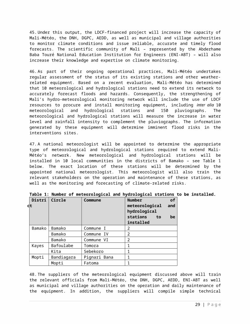
Output 2.3: Financial strategies are developed and implemented to improve the financial capacity of local authorities to respond timely to climate-related hazards, in particular floods.
79. Under this output, an economic impact analysis will be undertaken to assess the financial capacity of local government authorities engaging in risk financing, which will improve their financial resilience to disasters. The analysis will also identify opportunities for comprehensive financial protection strategies for local government authorities and public-private partnerships to undertake risk financing in the Malian context. The results of this analysis will inform improved decision-making in the management of financial resources targeted to addressing climate-related hazards.
80. This output of the LDCF-financed project will also promote the development and implementation of sustainable financial strategies to improve the management of risks related to climate-related hazards, such as floods. These strategies will be developed based on assessment of the current financing mechanism used by local government authorities to fund disaster relief in Mali. The development and implementation of these strategies will increase the capacity of the MoF and other local financing institutions to effectively contribute to DRM planning and implementation, primarily by increasing the availability of funds for emergency relief efforts in the event of disasters. Through the development of these financial strategies – in collaboration with the MoF, DGCP and DGCT – national and local authorities will have increased availability of funds to support immediate responses to climate-related hazards and natural disasters, such as floods. Funds will also be made available for activities such as emergency response, targeted financial assistance for vulnerable communities, as well as the reconstruction of public assets and infrastructure.
81. Local government authorities – including the MoF, DGPC and the DGCT – will be trained on the financial strategies developed and implemented through the LDCF-financed project. In particular, they will be trained on accessing funds in the event of climate-related hazards and natural disasters. In addition, training workshops will be held with the government authorities mentioned above on the effective management of these funds for disaster relief and to support the prioritisation of finances to those affected by climate-related hazards and natural disasters.
Indicative activities under Output 2.3 include:2.3.1. Undertake an economic impact analysis to assess risk financing in the Malian context and the
financial capacity of the local government authorities within the intervention sites. 2.3.2. Develop and implement rapid commune-specific financial strategies to facilitate assistance to local
communities affected by climate-related hazards, in particular floods, and for the reconstruction of public infrastructure.
Output 2.4: The technical capacity of the relevant national and local authorities on climate risk management planning as well as flood prevention and reduction measures is enhanced.
82. Under this output, the technical staff of relevant national government authorities – including inter alia the DGPC, Mali-Météo, DNH, and the AEDD – and decentralised government authorities in circles and communes as well as the ENI-ABT will be provided with training on forecasting and predicting climate-related hazards. The training held under this output of the LDCF-financed project will promote increased accuracy and effectiveness of forecasting climate-related hazards, such as floods, in other outputs of the project. These training activities will be guided by: i) the application of updated climate and weather data information generated by the national hydro-meteorological network, enhanced under Component 1; and ii) information generated by the flood risk mapping under Output 1.3. The training will also focus on increasing the effectiveness of DRM interventions currently implemented by GoM, with a particular focus on flood protection and flood management. Training will include methods to develop and implement effective flood prevention interventions in consideration of the predicted increased frequency and severity of climate--related hazards such as floods. Indicative activity under Output 2.4 include:
29 | P a g e

2.4.1. Provide training to the relevant national and local government officials within the targeted communes on climate risk management, preventing and minimising the negative effects of climate-related hazards, in particular floods, on vulnerable local communities.
COMPONENT 3: CLIMATE-RESILIENT INVESTMENT TO REDUCE RISKS OF HIGHLY EXPOSED COMMUNITIES.
OUTCOME 3: Climate-resilient flood risk management and reduction techniques transferred to local communities within the targeted communes to decrease their vulnerability.
Co-financing amounts for Outcome 3: US$ 17,656,417LDCF project grant requested: US$ 3,851,000
Without LDCF Intervention (baseline):
Limited technical capacity and tools to manage floods
83. Historically, Mali has been affected by droughts and locust invasion hazards, and these events have largely been the focus of DRM interventions in the country. These interventions include inter alia the generation of climate information and EWSs to detect, predict, monitor and assess droughts and locust invasions. To strengthen the capacity of the GoM to develop and implement DRM interventions in the country, several initiatives have been established. For example, PRECARIA – a partnership between the GoM, UNDP and the Danish Cooperation – was initiated in 2009 to enhance the capacity of the government to assess natural disaster risk at the community level. In addition to PRECARIA, a UNDP/GEF project entitled “Enhancing national disaster and emergency preparedness, response, and recovery capacity in Mali through a disaster reduction advisor” was implemented to strengthen the capacity of the government to mainstream climate risks in local development plans targeting rural communities.
84. In 2012, a cross-sectoral capacity assessment of existing systems, policies and programs relating to DRR was undertaken under by UNDP, UN Office for the Coordination of Humanitarian Affairs (UN-OCHA), United Nations Children’s Fund (UNICEF), World Food Programme (WFP) and Food and Agriculture Organisation (FAO). This assessment resulted in the formulation of a plan to address challenges faced by Mali, including inter alia flood risk, food insecurity and locust infestation. Despite the aforementioned initiatives, the DGPC, DNH, and the AEDD have limited technical capacity to manage flood risks and hazards. This is a result of the considerable gaps in flood risk assessment, monitoring and mapping in the country. For example, there is limited understanding of the vulnerability and the level of exposure of local communities and infrastructure to floods, as well as the potential socio-economic damage and losses, in Mali. Consequently, these gaps hamper the capacity of the GoM to effectively plan and implement DRM interventions.
85. The GoM developed a disaster response tool, namely ORSEC, which is a relief plan to be implemented at the national, district, circle and community levels. However, ORSEC primarily addresses drought risks, with limited information provided on long-term flood risk reduction. Consequently, decision-makers within the relevant government institutions, especially at the district, circle and commune levels, have limited information available to effectively plan and implement interventions to reduce flood risks.
86. The traditional flood management measures used in the country include inter alia dykes. There are predominantly three types of dykes used, namely: i) traditional dykes without intake or outtake structure; ii) traditional dykes with intake or outtake structure; and iii) large dykes. Traditional dykes without intake or outtake structure are used to protect low-lying areas and are generally destroyed to evacuate water following recession of flood waters. Dykes with intake and outtake structures are generally used to protect flood plains. Large dykes differ from the other two types as they are used to protect large areas, such as
30 | P a g e
agricultural lands and urban areas46. Beyond these traditional measures, there is no other flood management infrastructure in the country.
Poor stormwater drainage systems in place
87. In Mali, the majority of peri-urban and rural areas do not have stormwater drainage systems in place47. Where there are present, stormwater is managed through a drainage system consisting of canals, open drains and retention ponds. However, inadequate land-use planning and management has led to many areas dedicated to stormwater management becoming inhabited, resulting in stormwater drainage system being used for solid waste, industrial waste and sewage disposal48. These ongoing practices block waterways causing: i) water stagnation, which promotes the breeding of disease vectors such as mosquitoes; ii) degradation of the stormwater drainage system; and iii) floods49. As a result of poor maintenance systems, stormwater drains are usually only maintained just before the beginning of the rainy season, which leads to the degradation of the components of the stormwater drainage system.
With LDCF Intervention (adaptation alternative)
88. LDCF finances will be used to transfer flood-resilient practices to national, sub-national and local communities within the intervention sites. To manage flood risks, these practices will comprise both soft and hard interventions to decrease the exposure of local communities to floods. This will provide the DGPC, DNM, and sub-national authorities with enhanced technical capacity to develop and implement flood risk reduction measures to decrease the vulnerability of local communities to floods. Local communities will also be trained on flood risks, as well as the operation and maintenance of the interventions implemented under this Outcome.
89. Increased migration of Mali’s population from the north to the south of the country has resulted in many people settling in flood plains formed by river beds and basins, especially in Bamako. It is therefore important to strengthen the resilience of the local communities within flood-prone areas to floods. As vulnerability is a factor of exposure to hazards, LDCF interventions will be implemented to reduce flood risks through interventions that aim to increase water infiltration and decrease soil erosion. To reduce flood risks in the interventions sites in the districts of Bamako, Kayes and Mopti, LDCF finances will be used for revegetation of riparian areas using climate-resilient indigenous species to buffer wetland ecosystems against the negative effects of climate change. The interventions of the project will result in the revegetation of at least 10 km of riparian areas in each of the following communes: I, IV, VI, Tomora, Sébékoro, Pignari Bana and Fatoma. In addition, to prevent floods resulting from the overflowing of waterways after intense rainfalls, a wetland in Pignari Bana – located in the district of Mopti – will be rehabilitated to increase its water holding capacity.
90. The interventions mentioned above will be complemented by hard interventions such as the construction of permeable rock dams, as well as extended and rehabilitated stormwater drainage systems. LDCF financed will be used to extend the stormwater drainage system by 5 km in each commune, as well as rehabilitate and maintain existing drains. This improvement of stormwater drains is required particularly in Bamako where intense rainfalls often result in the flooding of low-lying areas. To optimise the stormwater drainage system, a long-term management plan will be developed and implemented within the intervention sites.
46 Diarra, S., Kuper, M. & Mahé, G. 2004. Integrated flood management case study – Mali: Flood management – Niger River inland delta. Associated Programme on Flood Management, World Meteorological Organisation, Global Water Partnership, Geneva.47 Diarra, S., Kuper, M. & Mahé, G. 2004. Integrated flood management case study – Mali: Flood management – Niger River inland delta. Associated Programme on Flood Management, World Meteorological Organisation, Global Water Partnership, Geneva.48 pS-Eau. 2013. Stormwater management in the context of urban areas on developing countries. 49 Ibid.
31 | P a g e
Output 3.1: Flood risk reduction interventions are implemented to increase water infiltration and reduce soil erosion.
91. LDCF finances will be used to decrease flood risks by promoting water infiltration and reducing soil erosion in the intervention sites. To do so, the management of riparian areas of wetlands will be undertaken within the intervention sites. This will largely consist of revegetation of riparian areas, and an assessment will be undertaken to: i) determine the status of vegetation in the riparian areas of wetlands in the intervention sites; ii) determine the extent of revegetation required to effectively reduce flood risks in each intervention site; and iii) identify the appropriate plant species with climate-resilient properties to be used in this initiative. This activity will require the establishment of three plant nurseries – one per intervention district – and will involve the training of members of the local communities to undertake revegetation in the riparian areas of wetlands in their respective communities. Approximately 70 km (at least 10 km per commune) of riparian areas of wetlands in the intervention sites will be managed with LDCF resources. Climate-resilient indigenous plant species will be selected based on their soil binding properties and community-based planting will be undertaken.
92. In addition to the management of riparian areas, the wetland in Pignari Bana (Mopti) will be rehabilitated. Based on consultation with local communities, this wetland was identified as requiring expansion to increase its water holding capacity, thereby reducing flood risks. As a response to the needs of the local community in Pignari Bana (Mopti), LDCF resources will be used to double the water holding capacity of the wetland from ~1,000 m3 to ~2,000 m3 by increasing its depth by one metre. To determine the viability of increasing the capacity of this wetland, a feasibility assessment will be undertaken. Moreover, an Environmental Impact Assessment (EIA) will be undertaken to determine the impact of deepening of the wetland on water quality and aquatic life. The rehabilitation of the wetland will be managed in line with the recommendations of the EIA and corrective actions where required.
93. Commune IV in Bamako is surrounded on its western border by Mount Madingues. Local communities located at the bottom of the Mount are flooded regularly as a result of surface runoff following intense rains. To protect these local communities located in flood-prone areas, a network of canals will be created to divert surface runoff into wetlands in Wowowowanko, Farako and Diafaranako, thereby preventing water runoff from reaching local communities situated at the bottom of the slopes of Mount Madingues in commune IV in Bamako. The network of canals will be designed in collaboration with municipal and village authorities, as well as the DNH, the DGPC and ENI-ABT. A feasibility assessment will be undertaken in collaboration with ENI-ABT to determine the viability of the design of the network of canals and the capacity of the wetlands in Wowowowanko, Farako and Diafaranako to hold additional water runoff. The feasibility assessment will also ensure that the network of canals will be designed to reduce current and future flood risks under the predicted conditions of climate change as determined by the downscaled information generated in Output 1.3. An EIA will also be undertaken to determine; i) any potential impacts of the construction and operation of the network of canals on the environment; and ii) the impact on aquatic life as a result of increased runoff in the wetlands in Wowowowanko, Farako and Diafaranako. If required, the design of the network of canals will be amended to conform to the recommendation of the EIA.
94. A long-term maintenance plan will be developed and implemented to ensure the sustainability of the network beyond the project’s lifespan. Training on the long-term maintenance plan will be provided to: i) government authorities including the DNH, DGPC, and municipal and village authorities; ii) representatives from ENI-ABT; iii) NGOs; and iv) CSOs. This plan will be detail the role of each stakeholder involved in maintaining the network of canals, their respective responsibilities and allocated timeframes to undertake their tasks.
Indicative activities under Output 3.1 include:3.1.1. Rehabilitate the wetland in Pignari Bana to increase its water holding capacity.3.1.2. Rehabilitate at least 10 km of riparian areas of wetlands with climate-resilient indigenous plant
species in each of the seven communes selected for LDCF intervention (70 km in total).3.1.3. Develop a network of canals to channel water runoff from Mount Madingues in commune IV in
Bamako into wetlands located in Wowowowanko, Farako and Diafaranako.
32 | P a g e
Output 3.2: Flood risk reduction interventions are implemented to reduce the vulnerability of human lives and infrastructure.
95. Hard interventions such as permeable rock dams and stormwater drains will be constructed to decrease the vulnerability of local communities to floods, thereby securing their lives, livelihoods and protecting current and future infrastructure. Permeable rock dams are low rock walls spread over a long distance that cause runoff to spread from a waterway. This technique reduces the velocity and the erosive potential of floodwaters while enhancing groundwater recharge within the enclosed area. The spreading of floodwaters causes siltation of fertile deposits which promotes increased crop production after the water has receded. This intervention will require a feasibility assessment to determine the appropriate location of these permeable rock dams to maximise their efficiency in the long-term, thereby decreasing the vulnerability of local communities to floods, in the context of the expected climate change.
96. Technical guidelines will be produced on the purpose of these rock dams and disseminated to other municipal and village authorities. In addition, training of the technical staff of the DNH, DGPC, and municipal and village authorities, as well as members of local communities, will be held on maintaining the network of canals to ensure their effectiveness as per the long-term maintenance plan developed and implemented for the permeable rock dams, financed by the LDCF. This plan will detail the role of each stakeholder involved in maintaining the permeable rock dam, their respective responsibilities and allocated timeframes to undertake their tasks. The development and implementation of this plan will occur during the project’s lifespan.
97. As functioning stormwater systems reduce flood risks, LDCF finances will be used to extend, rehabilitate and maintain the existing systems in the communes I, IV, VI, Sébékoro and Fatoma. The system in each of the above mentioned communes will be extended by 5 km to improve stormwater reticulation, thereby reducing flood risks. A feasibility assessment will be undertaken to determine the best location for the construction of the drains based on the maps generated under Activity 2.1.2. These maps will also be used to determine the priority areas in which drains need to be rehabilitated and maintained for optimum operation. Following the identification of the priority areas, rehabilitation and maintenance of the existing stormwater drainage systems will be undertaken. To ensure the long-term viability of the systems, commune-specific long-term maintenance plans will be developed and implemented. These plans will be developed in collaboration with local communities and sub-national government authorities and will formalise partnerships between the relevant stakeholders. These partnerships will promote the ongoing maintenance of stormwater drainage systems. Similarly to the long-term maintenance plan for the permeable rock dams discussed in this output, this plan will detail the role of each stakeholder involved in maintaining the canals, their respective responsibilities and allocated timeframes to undertake their tasks.
Indicative activities under Output 3.2 include:3.2.1. Undertake a feasibility assessment for the construction of permeable rock dams in the intervention
sites.3.2.2. Undertake a feasibility assessment for the construction of 25 kilometres of stormwater drains. This
activity will be based on Output 2.1. and will include the construction of five kilometres of stormwater drains in communes I, IV, VI, Sébékoro and Fatoma.
3.2.3. Clean and maintain existing stormwater drains in the targeted communes.
Stakeholder involvement plan
98. The implementation strategy for the LDCF-financed project includes extensive stakeholder participation. Details of the stakeholder participation during the PPG phase are provided in Section II. Table 2 below proposes a stakeholder involvement plan for the implementation phase. This will be further developed and validated during the project inception workshop.
Table 2: Relevant stakeholders identified for engagement by project output.Outcome Output Stakeholder Key responsibilities
33 | P a g e
Outcome 1: Strengthened technical capacity of municipal and village authorities to improve flood early warning systems and dissemination of climate-related risk information.
Output 1.1. A sound climate information system comprising devices operating 24 hours a day to monitor and forecast flood risks and hazards is established.
Mali-Météo;DNH;DGPC;AEDD;Municipal and village authorities;and ENI-ABT.
Install new and rehabilitate existing meteorological and hydrological stations. Monitor climate-related information. Develop meteorological services.
Output 1.2. Early warning and quick-response systems are developed to increase the resilience of vulnerable local communities in the intervention sites.
DGPC;Mali-Météo;DNH; Municipal and village authorities;DNUH; andENI-ABT.
Implement a flood EWS in the intervention sites. Develop and disseminate a plan for the communication of flood risks and hazards. Develop commune-specific responses such as evacuation plans.
Output 1.3. Flood risk mapping combining risks with socio-economic indicators – including inter alia population size, land value, land uses, assets – is undertaken.
DGPC; DNPD; DNH;AEDD;Mali-Météo;ENI-ABT; DGCT; Other line ministries; andMunicipal and village authorities.
Use climate models to determine short- to medium-term climate risks, particularly for floods.Collect and analyse socio-economic data in the communities selected for LDCF interventions. Undertake flood risk mapping by combining flood risks and socio-economic data in the intervention sites.
Output 1.4. An awareness-raising campaign is undertaken within local communities and schools to build a culture of safety and resilience to floods.
DGPC;Ministry of Education; andMunicipal and village authorities.
Conduct awareness-raising campaigns in schools on the impact of floods and decreasing climate risks. Provide training workshops to members of local communities on decreasing their vulnerability to floods. Use other means of communication and platforms to raise awareness of local communities to floods.
Outcome 2: Effective flood
Output 2.1. Commune-specific
Municipal and village
Propose the necessary revisions to the Economic,
34 | P a g e
risk management mainstreamed into the relevant development planning policies and budgetary processes to increase the resilience of local communities.
Flood Risk Reduction Plans (FRRP) with locally-appropriate strategies and interventions to decrease the vulnerability of local communities to floods are developed.
authorities; DGPC; AEDD; DNPD;ENI-ABT; andDGCT.
Social and Cultural Development Programme (PDESC) to incorporate short- to medium-term flood risks.Undertake a technical assessment of the existing stormwater drainage system. Conduct awareness-raising campaigns on appropriate waste disposal and sanitation methods. Secure and manage waste transit depots to improve solid waste management in Bamako.
Output 2.2. Design, harmonize and enhance existing building and settlement codes to decrease vulnerability of local communities to floods.
DGPC;DNPD;AEDD;DNUH;Mali-Météo;DGCT;DNAT; andMunicipal and village authorities.
Evaluate the existing building codes in the selected communes.Determine entry points to strengthen the building codes by mainstreaming climate considerations into them.Propose revisions to existing building codes to prevent flood-related damages.
Output 2.3. Financial strategies are developed and implemented to improve the financial capacity
MoF;DGPC;DGCT;ENI-ABT;DGCT; andMunicipal and
Assess the current financing mechanism used for disaster relief.Develop and implement financing strategies.
35 | P a g e
of local authorities to respond timely to climate-related hazards, in particular floods.
village authorities.
Output 2.4. The technical capacity of the relevant national and local authorities on climate risk management planning as well as flood prevention and reduction measures is enhanced.
AEDD;DGPC; ENI-ABT;DGCT;Mali-Météo;DNH; and Municipal and village authorities.
Targeted training on planning, developing and implementing risk reduction measures.
Outcome 3: Climate-resilient flood risk management and reduction techniques transferred to local communities within the targeted communes to decrease their vulnerability.
Output 3.1. Flood risk reduction interventions are implemented to increase water infiltration and reduce soil erosion.
DGPC;DNH;DNACPN;NGOs;ENI-ABT;CSOs; andMunicipal and village authorities.
Rehabilitate and increase the water holding capacity of an existing wetland in Pignari Bana. Revegetation of riparian areas with climate-resilient indigenous species.
Output 3.2. Flood risk reduction interventions are implemented to reduce the vulnerability of human lives and infrastructure.
DGPC;DNH;ENI-ABT;NGOs;CSOs; andMunicipal and village authorities.
Extend the existing stormwater drainage system. Improve the existing stormwater drainage system by cleaning and maintaining the drains.
IV. FEASIBILITY
Cost-effectiveness
99. The activities of LDCF-financed project have been designed to balance considerations of cost-effectiveness and efficient use of LDCF resources against the urgent objectives related to minimising the impacts of floods. Such activities include inter alia: i) the development of an EWS to disseminate early warnings to vulnerable communities; ii) an analysis of flood risks to determine the vulnerability of a particular site based on socio-economic factors, risk of exposure and capacities of local communities; iii) the development of site-specific plans containing locally-appropriate flood reduction interventions to protect communities; and iv) the implementation of flood reduction interventions in pilot sites in Bamako, Kayes and Mopti such as permeable rock dams. In line with LDCF principles of additionality, the project will pursue partnerships with ongoing initiatives in the country, to reduce operational costs and minimise the risk of duplication of activities. The project will prioritise these partnerships and collaborative relationships as opportunities to build on lessons learned and best practices established by past projects.
36 | P a g e
100.LDCF investments in enhanced preparedness and protection against floods are likely to be inherently cost-effective compared to the costs of flood-induced damage. In particular, floods are responsible for 98.3% of disaster-induced mortality and 98.5% of disaster-induced economic losses in the country50. These hazards cause an Average Annual Loss of ~US$ 45,000,00051. In addition, each flood event in the last 30 years has affected between 10,000 and 45,000 people in Mali. For example, the flood events in 2010 resulted in 111 deaths, 6,052 houses destroyed, 12,000 hectares of agricultural land flooded, and the widespread destruction of infrastructure such as bridges and roads52. Measures can be taken to avoid this extensive damage. For example, investing a total of US$ 8,950,000 in climate information, an EWS and flood protection will significantly reduce the vulnerability to floods of infrastructure, assets and livelihoods of 120,000 households.
Cost-effectiveness of flood risk reduction
101. LDCF-financed alternative: The LDCF-financed project will deliver training and capacity-building activities, which are largely focused on disaster preparedness and prevention, rather than disaster response and recovery. This approach will entail the implementation of flood protection interventions in pilot sites in Bamako, Kayes and Mopti. Flood risk management is a widely used approach to minimise damage caused by flood waters that is supported by a well-established evidence base detailing its cost-effectiveness and benefits. For example, a cost-benefit analysis of protection against floods in Europe was conducted in 2013 and suggested that in the absence of additional investments in flood protection, annual damages resulting from floods would increase from ~US$ 6.2 billion per year – present costs – to ~US$ 110 billion per year by 208053. In comparison, an ‘intermediate’ investment scenario found that moderate investments in disaster risk reduction would result in a total saving – including damage prevented as well as benefits generated – of up to ~US$ 60 billion per year by 208054.
102. Other alternative: Resettlement. An effective way of reducing flood risks would be to resettle vulnerable local communities – as identified in the flood risk analysis under Output 1.3. The resettlement of these communities to flood-protected areas would inevitably decrease their vulnerability to this particular climate-related hazard. However, resettlement is a capital-intensive and complicated process with major socio-economic consequences – requiring lengthy GoM’s procedures and relocation sites’ selection processes. In the interim, the vulnerable local communities in the intervention districts of Bamako, Kayes and Mopti would remain exposed to floods.
103. To enable resettlement, the GoM in collaboration with the DGPC, DNUH and DNPD would have to provide houses to the local communities currently located in flood-prone areas. This is a capital-intensive55 process as every single household identified for resettlement would have to be provided with a house of commensurate value in a location that is not prone to floods. Additionally, local communities would be removed from their sources of livelihoods which may lead to immediate impoverishment until alternative livelihoods can be adopted. Increased poverty would raise several risks – including poor health – for the relocated communities. In addition, resettlement is a disruptive practice as it can inter alia break social networks and lead to decreased access to basic services56.
104. The costs of resettlement exceed those associated with implementing flood management and protection interventions. In addition, this disruptive practice could lead to socio-political conflicts. Therefore, resettlement should only be considered after all other prevention and adaptation options have been exhausted.
50 Prevention web. Mali: Disaster and risk profile. 2014. Source: http://www.preventionweb.net/countries/mli/data/.51 Ibid.52 Government of Mali. 2012. Plan National Multi Risques de Préparation et de Réponse aux Catastrophes.53 Rojas, R. et al. 2013. Climate change and river floods in the European Union: Socio-economic consequences and the costs and benefits of adaptation. Global Environmental Change.54 Rojas, R. et al. 2013. Climate change and river floods in the European Union: Socio-economic consequences and the costs and benefits of adaptation. Global Environmental Change.55 Ibrahim, I. et al. 2015. Suitability Analysis of Resettlement Sites for Flood Disaster Victims in Lokoja and Environs. World Environment. 5(3): 101-111.56 Ibid.
37 | P a g e
Cost-effectiveness of climate information and EWS
105.LDCF-financed alternative: The LDCF-financed project will design and implement three EWSs – one in each intervention district – covering ~120,000 households. The guiding principles in the development of the EWSs include: i) affordability; ii) simplicity of technology to reduce maintenance requirements; and iii) sustainability, which relates to the ability of the relevant government authorities to cover the long-term running costs without requiring external support. The cost-effectiveness of investments to improve the effectiveness of an EWS can be challenging to quantify and as result there are relatively few cost-benefit analyses of such investments57. However, a growing body of literature indicates that investments in EWS for disaster prevention are more cost-effective than disaster response58. For example, it is estimated that if the climate information and EWS in developing countries were upgraded to the level equivalent to that of developed countries, the total saving – in avoided loss of assets – would amount to between ~US$ 300 million and US$ 2 billion per year. Furthermore, the total potential global benefits to be realised through investments in improvement of climate information and EWS are estimated at US$ 4 billion to US$ 36 billion per year, which significantly outweighs the cost of investments of US$ 1 billion per year. The benefit-cost ratio for developing countries to invest in climate services and EWS is therefore between 4 and 3659. In addition, there are indirect economic benefits60 from an improved EWS, estimated at between US$ 3 billion and US$ 30 billion per year61. In West Africa, a quantitative comparison between the costs of flood response alone (for 2006 and 2007) and the cost of flood response with Early Warning-Early Action (2008) showed that effective communication of early warnings resulted in ~30% lower cost per beneficiary62.
106.Resettlement alternative: With this alternative, the quality and quantity of weather-related data generated by Mali-Météo and their expertise to interpret these data would not be enhanced. Consequently, the forecast of imminent floods or other climate-related hazards by Mali-Météo would be ad hoc and unreliable. The GoM would therefore have the capacity to implement disaster response over disaster prevention with resettlement – which is a capital-intensive process – remaining as the only option for disaster prevention in Bamako, Kayes and Mopti.
Risk management
Table 3: Risk management table.Project risksDescription Type Impact
& Probability
Mitigation measures Owner Status
Unclear distribution of the roles for the
Operational
P= 3
I= 3
- Simple technical guidelines on operation and maintenance will be compiled by the relevant specialist
AEDD no change
57 Tsirkunov, V. and Rogers, D. 2010. Costs and benefits of early warning systems. Global Assessment report on Disaster Risk Reduction. The World Bank.58Healy, A. and Malhotra, N. 2009. Myopic Voters and Natural Disaster Policy. The American Political Science Review 103(3): 387-406.59 Hallegatte, S. 2012. A cost effective solution to reduce disaster losses in developing countries. Policy Research Working Paper 6058. The World Bank. 60 The indirect economic costs referred to are long-lasting trauma and post-disaster evacuation costs. Source: Balbi, S. et al. 2014. Estimating the Benefits of Early Warning Systems in Reducing Urban Flood Risk to People: A Spatially Explicit Bayesian Model (May 26, 2014). 2014 Proceedings of the 7 th International Congress on Environmental Modelling and Software, San Diego, USA. 61 Hallegatte, S. 2012. A cost effective solution to reduce disaster losses in developing countries. Policy Research Working Paper 6058. The World Bank.62 L. Braman. 2009. Early warning, early action: an evaluation of IFRC West and Central Africa zone flood preparedness and response. International Federation of the Red Cross and Red Crescent Societies (IFRC) Report 56.
38 | P a g e
maintenance of meteorological and hydrological stations, pluviographs, network of canals to divert water, permeable rock dams, and stormwater drains.
and/or supplier. - Training workshops on the operation and maintenance of equipment, stations and systems implemented under the LDCF-financed project.- Long-term maintenance plans including identification of stakeholder roles and funding sources will be developed for meteorological and hydrological stations, pluviographs, network of canals to divert water, permeable rock dams, and stormwater drains implemented under this project to promote their maintenance and/or management by the relevant authorities beyond the project lifespan.
Insufficient support from the beneficiary communities to implement the project successfully as benefits are not apparent immediately and only become evident in the event of floods.
Organisational
P= 2
I= 4
- The LDCF-financed interventions were developed through multiple stakeholder consultations with local communities in November 2015. - Extensive engagement of local communities in decision making will be pursued throughout the implementation phase.- Where possible, local labour will be sourced to increase their support. - Tangible and visible activities that addressed community priorities will be implemented early during the project implementation phase. - The Technical Assistants appointed as part of the Project Management Unit in each site will maintain strong communication link with the project beneficiaries, manage expectations of local communities, and ensure alignment of project results, targets and benefits with communities’ needs.
AEDDDGPC
increasing
Limited coordination among government authorities.
Operational & Strategic
P= 2
I= 4
- The project will be implemented according to management arrangements as described in Section VII of this Project Document. The project management arrangement as currently established promote coordination of government authorities – including inter alia the DGPC, Mali-Météo, DNH, DGCT, and municipal and village authorities – on the Project Board. The chair of the Project Board, the
AEDD Decreasing
39 | P a g e
CNCC, will intervene and implement the remedial actions if limited coordination among government authorities hinder the progress of the LDCF-financed project.
Inadequate coordination between national and local (communal, municipal and village) authorities.
Operational & Strategic
P= 2
I= 3
- Among the roles of the Project Coordinating Unit (see Section VII of this Project Document), it is clearly stated that it is responsible for the coordination between national government departments and decentralised institutions such as communal, municipal and village authorities. - Representatives of national and local authorities will participate in the Project Management Unit meetings which will be used as a platform to ensure sufficient communication between and within institutions.
AEDD Decreasing
Project interventions are not gender-sensitive and gender-responsive.
Strategic P= 1
I= 3
- Ensure that the project team is familiar with the gender mainstreaming manual developed by UNDP. - Promote the inclusion of women groups in the Project Board to support the implementation of the project activities in a gender-sensitive manner. - The inclusion of gender-sensitive indicators in the results framework promotes gender considerations in the development and implementation of LDFC-financed interventions (see Section II of this Project Document).
AEDD Decreasing
Insufficient political and financial support from the GoM.
Political P= 1
I= 3
- The LDCF-financed project is country-driven and was developed based on the consultations of government departments. - Reducing vulnerability to floods to secure lives and assets in Mali is a priority of the GoM.
AEDDMoFDGCT
No change
Interventions in the district of Mopti are delayed by ongoing conflicts.
Political P= 1
I= 3
- Although there have been a few incidents with insurgent groups in Mopti over the last year, the majority of conflicts occur in the northern parts of the country. The Technical Assistant based in Mopti will monitor the local situation and report to the Project Coordinator and the Project Board to determine if LDCF-financed interventions needs to be amended for security reasons.
AEDDDGPC
Increasing
40 | P a g e
Climate hazards delay the implementation of project interventions.
Environmental
P= 2
I= 4
- Project activities that are particularly sensitive to climate conditions such as the construction of hard infrastructure will be carefully scheduled taking into account rainfall partners and forecast. This will include collaboration with Mali-Météo.
Mali-MétéoDNHAEDDDGPC
Increasing
Environmental and social safeguards
107. The UNDP environmental and social safeguards requirements have been followed in the development of this LDCF-financed project. As outlined below, the project is not expected to have any negative environment or social impacts.
108. The project will decrease the vulnerability of the communities to floods through improved management of rainwater. The most vulnerable sites will be selected for the construction of hard interventions and implementation of revegetation interventions through a participatory process. The members of targeted vulnerable communities will therefore benefit equally from these interventions. As a result, no conflicts within the communities are expected as a result of the project interventions. Furthermore, the hard infrastructures built by the project will be design specifically to protect community lives and assets. Last, improved water management will contribute positively to people’s health.
109. The revegetation of wetlands will protect natural resources and livelihoods from the effects of climate change. Solely positive effects on habitat and biodiversity are expected from the revegetation activities. Ecosystem functioning for example will be promoted by the activities as they will focus on soil stabilisation, improve water infiltration and restore natural vegetation. Revegetated land will be less vulnerable to degradation by intense rains. Indigenous species will also be preferred to maximise the positive effects on the environment. Lastly, the increase in biomass resulting from revegetation will contribute to carbon sequestration.
110. Although the project will benefit local communities, it is not expected that this will lead to localised population increases. Rather, it is expected that the interventions such as increased access to climate information will benefit local communities beyond the LDCF intervention sites. Consequently, no population displacement are expected as a direct or indirect result of the project.
111. Gender equality is a focus area of the LDCF-financed project. The project interventions will promote social equity and equality. All social consequences of the project are expected to be positive. Local communities’ approval and support of the interventions will be sought prior to implementation. As the LDCF-financed project is expected to have either no effects or positive effects on the environment and community, it is not necessary to undertake a full environmental and social review. However, Environmental Impact Assessment will be conducted prior to the construction of hard infrastructure according to the national EIA legislation or if any potential social or environment risk is identified based on the feasibility assessment study.
41 | P a g e
V. PROJECT RESULTS FRAMEWORK
Table 4: Results framework.Intended Outcome as stated in the UNDAF/Country Programme Results and Resources Framework: Outcome 2: Disadvantaged groups, particularly women and young people, benefit from increased capacities and productive opportunities in a healthy and sustainable environment conducive to poverty reduction.Outcome indicators as stated in the Country Programme Results and Resources Framework, including baseline and targets:Output 2, Indicator 2: Percentage of vulnerable people pursuing disaster risk and climate-resilient economic activities. Output 3, Indicator 2: Number of disaster risk reduction and sanitation action plans developed at national, regional and local level.Applicable Outputs from the 2014 – 2017 UNDP Strategic Plan: choose one!Output 1.4: Scaled up action on climate change adaptation and mitigation cross sectors which is funded and implemented.
Applicable Output Indicators from the UNDP Strategic Plan Integrated Results and Resources Framework: Output 1.4 indicator 1.4.1: a) Extent to which climate finance is being accessed b) Extent to which there is a system in place to access, deliver, monitor, report on and verify climate finance.Output 1.4 indicator 1.4.2: Extent to which implementation of comprehensive measures – plans, strategies, policies, programmes and budgets – to achieve low-emission and climate-resilient development objectives has improved.
Objective and Outcome Indicators
Baseline63 Mid-term Target3
End of Project Target3
Source of verification Assumptions64
Project Objective:
To strengthen the capacity of national and local government authorities to effectively manage the negative effects of floods on local communities and infrastructure in Mali.
Technical and institutional capacity of municipal and village authorities, Mali-Météo, DNH and DGPC to effectively manage flood risks [adapted from AMAT Indicator 10].
Currently, there is low capacity within national and local government authorities to assess flood risks as well as develop and implement flood risk reduction interventions. Scorecard rating at baseline is estimated at 2.
LDCF-financed interventions are implemented to increase the technical and institutional capacity of municipal and village authorities, Mali-Météo, DNH and DGPC to plan and manage flood risks is increased. Scorecard rating of at least 3.
By the end of the project, municipal and village authorities, Mali-Météo, DNH and DGPC have the technical and institutional capacity to assess flood risks as well as implement risk management and reduction interventions to decrease the vulnerability of local communities at the intervention sites. Scorecard rating of at least 4.
Capacity scorecard assessment of the technical officials within municipal and village authorities, Mali-Météo, DNH and DGPC. The following criteria will be used:
1. Ability to analyse data from weather stations and disseminate flood early warnings to vulnerable communities timely. 2. Capacity to assess flood risks under the predicted conditions of climate change (given the necessary tools such as the flood risk maps). 3. Capacity to develop and effectively implement flood risk management and reduction interventions to decrease the vulnerability of local communities in the intervention sites.
Risk: Insufficient political and financial support from the GoM.Assumption: The GoM has the financial capacity to support the maintenance of the project interventions.
Risk: Limited coordination among government authorities.Assumption: Adequate involvement of and coordination between government authorities will enable the maintenance of a good progress rate for the project implementation and promote sustainability.
63 Baseline, mid-term and end of project levels must be expressed in the same neutral unit of analysis as the corresponding indicator.64 Risks must be outlined in the Feasibility section of this project document.
42 | P a g e
The scorecard rating is as follows:1 = No capacity or very limited capacity at the individual level and within the respective government institution.2 = Partially developed capacity at the individual level. 3 = Partially developed capacity at the individual level and within the respective government institution.4 = Fully developed and demonstrated capacity at the individual level.5 = Fully developed and demonstrated capacity at the individual level and within the respective government institution.
Component 1/ Outcome 1:Strengthened technical capacity of municipal and village authorities to improve flood early warning systems and dissemination of climate-related risk information.
Number of people (% of whom are women) with access to improved flood EWS [adapted from AMAT 8].
Currently, 0 people are covered by the existing EWS system. However, the system is not well developed for rapid-onset events such as floods.
By Mid-Term, at least 600,000 people have access to improved flood EWS in the intervention sites (50% of whom are women).
By the end of the project, 1,200,000 people have access to improved flood EWS (50% of whom are women).
Analysis of maps (at least one per commune) delineating the extent of the flood EWS and the population size covered.
Risk: Inadequate coordination between national and local (communal, municipal and village) authorities.Assumption: Coordination between national and local government will enable successful implementation of the project.
Risk: Insufficient political and financial support from the GoM.Assumption: The GoM has the financial capacity to support the maintenance of the project interventions.
Risk: Unclear distribution of the roles for the maintenance of meteorological and hydrological stations, pluviographs, network of canals to divert water, permeable rock dams, and stormwater drains.Assumption: The development and
43 | P a g e
implementation of long-term maintenance plans will strengthen the technical and financial capacity of the relevant stakeholders to maintain the new equipment.
Number of monitoring and management committees established (composed of at least 50% women).
There is currently no monitoring and management committee in place to act as an intermediary link between local communities and Mali-Météo for the effective dissemination of climate risk and hazard information.
At least five of the monitoring and management committees established and composed of 50% women.
At least seven monitoring and management committees established (1 per commune), composed of at least 50% women, for the effective dissemination of information on climate risk and hazard between Mali-Météo and the relevant communities.
Review of the official list of committee members which is to be included in the MoU with Mali-Météo.
Risk: Project interventions are not gender-sensitive.Assumption: The participation of women’s groups in the design and implementation of the project promotes the distribution of benefits in a gender-sensitive manner.
Component 2/ Outcome 2:Effective flood risk management mainstreamed into the relevant development planning policies and budgetary processes to increase the resilience of local communities.
Number of Economic, Social and Cultural Development Programme (PDESC) revised to include short- to medium-term flood risks [adapted from AMAT 13].
There is currently one PDESC per district and they make little to no mention of flood risks and locally-appropriate reduction measures. At present, there are several incoherent building codes that prescribe different minimum standards for flood-resilient infrastructure.
At least one PDESC revised.
Three PDESC revised (one for each targeted district) to include short- to medium-term flood risks.
Review of the revised PDESC. Risk: Limited coordination among government authorities.Assumption: Adequate involvement of and coordination between government authorities will enable the maintenance of a good progress rate for the project implementation and promote sustainability
Risk: Inadequate coordination between national and local (communal, municipal and village) authorities.Assumption: Coordination between national and local government will enable successful implementation of the project.
Number of commune-specific Flood Risk Reduction Plans
There are currently no commune-specific FRRPs to provide
At least two FRRPs developed.
At least seven FRRPs (one per selected commune) is developed in a
Review of the FRRPs produced. Risk: Project interventions are not gender-sensitive.Assumption: The participation
44 | P a g e
(FRRPs) developed in a participatory manner with local communities [adapted from AMAT 13].
a roadmap to decrease the vulnerability of local communities in the selected communes to floods.
participatory manner. The FRRPs will detail locally-appropriate and cost-effective flood risk reduction interventions to be implemented.
of women’s groups in the design and implementation of the project promotes the distribution of benefits in a gender-sensitive manner.
Component 3/ Outcome 3:Climate-resilient flood risk management and reduction techniques transferred to local communities within the targeted communes to decrease their vulnerability.
Number of km of stormwater drains constructed and rehabilitated to decreased flood risks [adapted from AMAT 2].
Drains in communes I, IV, VI, Sébékoro and Fatoma and/or the inadequate maintenance of existing ones.
By Mid-Term, at least 10 km of stormwater drain is constructed.
Drains constructed in five of the selected communes and at least 20 km of existing stormwater drains within the selected communes cleaned and rehabilitated to improve water drainage.
Interviews with local communities.Measurement of the length of stormwater drains constructed and rehabilitated.Review of the maintenance systems in place. Review of construction and maintenance progress reports to be provided by the contracted company to the Project Management Unit.
Risk: Unclear distribution of the roles for the maintenance of meteorological and hydrological stations, pluviographs, network of canals to divert water, permeable rock dams, and stormwater drains.Assumption: The development and implementation of long-term maintenance plans will strengthen the technical and financial capacity of the relevant stakeholders to maintain the new equipment.
Risk: Insufficient support from the beneficiary communities to implement the project successfully as benefits are not apparent immediately and only become evident in the event of floods.Assumption: Involvement in the design of project interventions and ongoing communication on the expected benefits of the activities for local communities will result in the support of the project by these communities.
Risk: Project interventions are not gender-sensitive.Assumption: The participation of women’s groups in the design and implementation of the project promotes the
45 | P a g e
distribution of benefits in a gender-sensitive manner.
Risk: Interventions in the district of Mopti are delayed by ongoing conflictsAssumption: There is no civil unrest in the intervention sites during the implementation of the project.
Risk: Climate hazards delay the implementation of project interventions.Assumption: Scheduling of activities based on potential climate risks enables climate-induced delays in the implementation of project interventions to be prevented.
Number of km of riparian areas revegetated with climate-resilient species.
Approximately 25 km of riparian areas are revegetated.
By Mid-Term, at least 20 additional km of riparian areas are revegetated with climate-resilient species.
At least 35 additional km of riparian areas revegetated with climate-resilient species to increase water infiltration and reduce soil erosion.
Site visits to verify the extent of riparian area revegetated.Review of progress reports on revegetation interventions.Interviews with the relevant implementing organisations.
Risk: Insufficient support from the beneficiary communities to implement the project successfully as benefits are not apparent immediately and only become evident in the event of floods.Assumption: Involvement in the design of project interventions and ongoing communication on the expected benefits of the activities for local communities will result in the support of the project by these communities.
46 | P a g e
VI. MONITORING AND EVALUATION (M&E) PLAN
111.The project results as outlined in the project results framework will be monitored annually and evaluated periodically during project implementation to ensure the project effectively achieves these results.
112.Project-level monitoring and evaluation will be undertaken in compliance with standard UNDP requirements as outlined in the UNDP POPP and UNDP Evaluation Policy. Though these UNDP requirements are not detailed in this section of the project document, the UNDP Country Office will ensure UNDP M&E requirements are met in a timely fashion and to high quality standards. The additional and mandatory GEF-specific M&E requirements as outlined in this section will be undertaken in accordance with the GEF M&E policy and GEF guidance materials. In addition to these mandatory UNDP and GEF M&E requirements, other M&E activities deemed necessary to support project-level adaptive management, and the exact role of project target groups and other stakeholders in project M&E activities, will be finalised during the Inception Workshop and will be detailed in the Inception Report.
Oversight and monitoring responsibilities:113.The primary responsibility for daily project implementation and regular monitoring rests with the Project Coordinator. The Project Coordinator will develop annual work plans based on the multi-year work plan included in Appendix 1, including annual targets at the output level to ensure the efficient implementation of the project. The Project Coordinator will ensure that the standard UNDP and GEF M&E requirements are fulfilled to the highest quality. This includes, but is not limited to, ensuring the results framework indicators are monitored annually in time for reporting (i.e. GEF PIR), and reporting to the NSC at least twice a year on project progress. The Project Coordinator will inform the NSC and the UNDP Country Office of any delays or difficulties as they arise during implementation, including the implementation of the M&E plan, so that the appropriate support and corrective measures can be adopted. The Project Coordinator will also ensure that all project staff maintain a high level of transparency, responsibility and accountability in monitoring and reporting project results.
114.The UNDP Country Office will support the Project Coordinator as needed, including through annual supervision missions. The UNDP Country Office is responsible for complying with all UNDP project-level M&E requirements as outlined in the UNDP POPP . This includes ensuring the UNDP Quality Assurance Assessment during implementation is undertaken annually; that annual targets at the output level are developed, and monitored and reported using UNDP corporate systems; and, updating the UNDP gender marker on an annual basis based on progress reported in the GEF PIR and UNDP ROAR reporting. Any quality concerns flagged by the process must be addressed by project management. Additional M&E and implementation quality assurance and troubleshooting support will be provided by the UNDP-GEF Regional Technical Advisor and the UNDP-GEF Unit as needed. The project target groups and stakeholders including the GEF Operational Focal Point will be involved as much as possible in project-level M&E.
115.Audit Clause: The project will be audited according to UNDP Financial Regulations and Rules and applicable audit policies.
116.Additional GEF monitoring and reporting requirements:Inception Workshop and Report: A project inception workshop will be held after the project document has been signed by all relevant parties to: i) re-orient project stakeholders to the project strategy and discuss any changes in the overall context that influence project implementation; ii) discuss the roles and responsibilities of the project team, including reporting and communication lines and conflict resolution mechanisms; iii) review the results framework and discuss reporting, monitoring and evaluation roles and responsibilities and finalise the M&E plan; iv) review financial reporting procedures and mandatory requirements, and agree on the arrangements for the annual audit; v) plan and schedule NSC meetings and finalise the first year annual work plan. The Project Coordinator will prepare the inception report no later than two weeks after the inception workshop. The final inception report will be cleared by the UNDP Country Office and the UNDP-GEF Regional Technical Adviser, and will be approved by the NSC.
47 | P a g e
117.GEF Project Implementation Report (PIR ): The Project Coordinator, the UNDP Country Office, and the UNDP-GEF Regional Technical Advisor will provide objective input to the annual GEF PIR covering the reporting period July (previous year) to June (current year) for each year of project implementation. The Project Coordinator will ensure that the indicators included in the project results framework are monitored annually well in advance of the PIR submission deadline and are reported on accordingly in the PIR. The PIR that is submitted to the GEF each year must also be submitted in English and shared with the NSC. The UNDP Country Office will coordinate the input of the GEF Operational Focal Point and other stakeholders to the PIR. The quality rating of the previous year’s PIR will be used to inform the preparation of the subsequent PIR. The project’s terminal PIR along with the terminal evaluation (TE) report and corresponding management response will serve as the final project report package. The final project report package shall be discussed with the NSC during an end-of-project review meeting to discuss lesson learned and opportunities for scaling up.
118.GEF Focal Area Tracking Tools : In line with its objective and the corresponding GEF Focal Areas/ Programs, this project will prepare the following GEF Tracking Tool(s): 2,6,8,10,13, as agreed with the UNDP-GEF RTA. The baseline/CEO Endorsement GEF Focal Area Tracking Tool(s) – submitted in Appendix 4 – will be updated by the Project Coordinator /Team and shared with the mid-term review consultants and terminal evaluation consultants before the required review/evaluation missions take place. The updated GEF Tracking Tool(s) will be submitted to the GEF along with the completed Mid-term Review report and Terminal Evaluation report.
119.Mid-term Review (MTR) : An independent mid-term review process will begin after the second PIR has been submitted to the GEF, and the final MTR report will be submitted to the GEF in the same year as the 3rd PIR. The MTR findings and responses outlined in the management response will be incorporated as recommendations for enhanced implementation during the final half of the project’s duration. The terms of reference, the review process and the final MTR report will follow the standard templates and guidance available on the UNDP Evaluation Resource Center (ERC). Additional quality assurance support is available from the UNDP-GEF Directorate. The final MTR report will be available in English and will be cleared by the UNDP Country Office and the UNDP-GEF Regional Technical Adviser, and approved by the NSC.
120.Terminal Evaluation (TE) : An independent TE will take place before operational closure of the project. The Project Coordinator will remain on contract until the TE report and management response have been finalised. The terms of reference, the evaluation process and the final TE report will follow the standard templates and guidance available on the UNDP Evaluation Resource Center . Additional quality assurance support is available from the UNDP-GEF Directorate. The final TE report will be cleared by the UNDP Country Office and the UNDP-GEF Regional Technical Adviser, and will be approved by the NSC. The TE report will be publically available in English on the UNDP ERC.
121.The UNDP Country Office will include the planned project TE in the UNDP Country Office evaluation plan, and will upload the final TE report in English and the corresponding management response to the UNDP ERC. Once uploaded to the ERC, the UNDP Independent Evaluation Office will undertake a quality assessment and validate the findings and ratings in the TE report, and rate the quality of the TE report. The UNDP IEO assessment report will be sent to the GEF Independent Evaluation Office along with the project TE report.
122. The UNDP Country Office will retain all M&E records for this project for up to seven years after project financial closure in order to support ex-post evaluations undertaken by the UNDP Independent Evaluation Office and/or the GEF Independent Evaluation Office.
48 | P a g e
Mandatory GEF M&E Requirements and M&E Budget:
Table 5: GEF M&E budget.GEF M&E requirements Primary
responsibilityIndicative costs to be charged to the Project
Budget65 (US$)
Time frame
GEF grant Co-financing
Inception Workshop UNDP Country Office
USD 3,000 UNDP Within two months of project document signature
Inception Report Project Manager None None Within two weeks of inception workshop
Standard UNDP monitoring and reporting requirements as outlined in the UNDP POPP
UNDP Country Office
None None Quarterly, annually
Monitoring of indicators in project results framework
Project Manager Per year: USD 4,000
UNDP Annually
GEF Project Implementation Report (PIR)
Project Manager and UNDP Country Office and UNDP-GEF team
None None Annually
NEX Audit as per UNDP audit policies
UNDP Country Office
Per year: USD 3,000
UNDP Annually or other frequency as per UNDP Audit policies
Supervision missions UNDP Country Office
None66 UNDP Annually
Oversight missions UNDP-GEF team None7 UNDP Troubleshooting as needed
GEF Secretariat learning missions/site visits
Project Manager and UNDP-GEF team
None UNDP To be determined.
Mid-term GEF Tracking Tool to be updated by project M&E specialist
Project Manager USD 10,000 UNDP Before mid-term review mission takes place.
Independent Mid-term Review (MTR)
UNDP Country Office and Project team and UNDP-GEF team
USD 35,000 UNDP Between 2nd and 3rd PIR.
Final GEF Tracking Tool to be updated by project M&E specialist
Project Manager USD 10,000 UNDP Before terminal evaluation mission takes place
Independent Terminal UNDP Country USD 35,000 UNDP At least three
65 Excluding project team staff time and UNDP staff time and travel expenses.66 The costs of UNDP Country Office and UNDP-GEF’s participation and time are charged to the GEF Agency Fee.
49 | P a g e
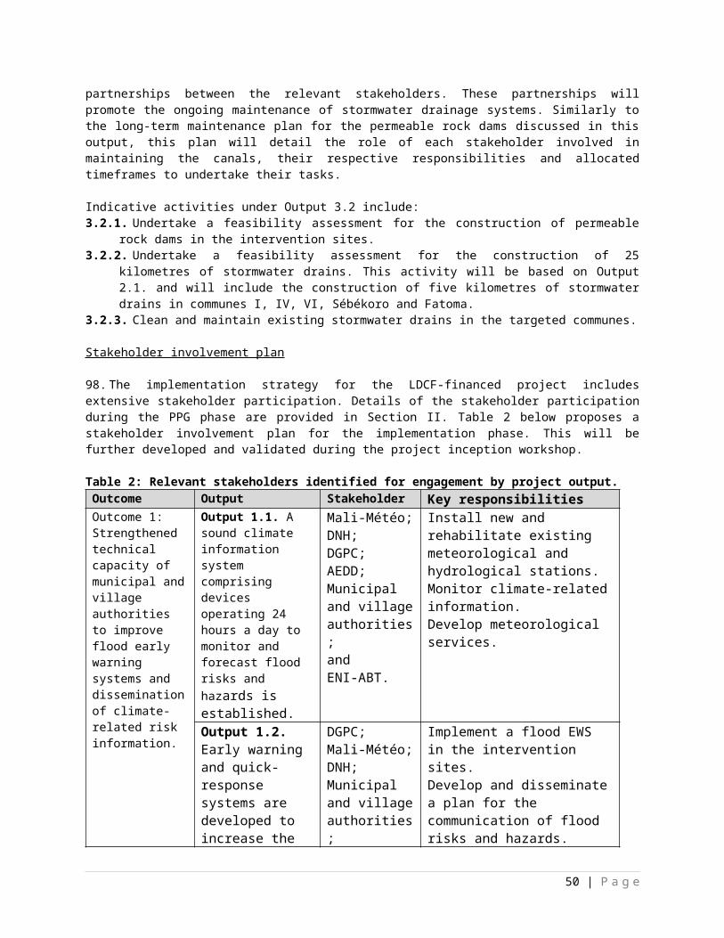
GEF M&E requirements Primary responsibility
Indicative costs to be charged to the Project
Budget (US$)
Time frame
GEF grant Co-financing
Evaluation (TE) included in UNDP evaluation plan
Office and Project team and UNDP-GEF team
months before operational closure
Translation of MTR and TE reports into English
UNDP Country Office
USD 10,000 UNDP As required. GEF will only accept reports in English.
TOTAL indicative COST Excluding project team staff time, and UNDP staff and travel expenses
USD 138,000
VII. GOVERNANCE AND MANAGEMENT ARRANGEMENTS
123.Roles and responsibilities of the project’s governance mechanism: The project will be implemented following UNDP’s National Implementation Modality, according to the Standard Basic Assistance Agreement between UNDP and the GoM, and the Country Program Action Plan (CPAP). The project will be implemented over a period of five years (60 months) by the AEDD which is the Implementing Partner (also known as the Project Executive). The AEDD will be responsible for the planning, coordination and implementation of the LDCF-financed project. As the Implementing Partner, it will also be responsible for reporting to the UNDP Country Office in Mali. The Implementing Partner is responsible and accountable for managing this project, including the monitoring and evaluation of project interventions, achieving project outcomes, and for the effective use of UNDP resources. The AEDD will establish a Project Management Unit in Bamako which will comprise a Project Coordinator, Project Finance and Administration Officer, Monitoring and Evaluation Officer as well as three Technical Assistants (also known as focal points).
124.The Implementing Partner will take overall responsibility for the project implementation, and the timely and verifiable attainment of project objectives and outcomes. It will provide support to, and inputs for, the implementation of all project activities. The highest authority of the Implementing Partner will serve as the National Project Director (NPD) for the project implementation. The NPD will chair the Project Steering Committee (PSC), and be responsible for providing government oversight and guidance to the project implementation The NPD will not be paid from the project funds, but will represent a government in kind contribution to the Project. The NPD will be technically supported by an international Chief Technical Adviser (CTA). The CTA will support the provision of the required technical inputs, reviewing and preparing Terms of Reference and reviewing the outputs of consultants and other sub-contractors. The CTA will be recruited using standard UNDP-CO recruitment procedures and will report directly to the NPD.
125.The National Steering Committee is the group responsible for making by consensus management decisions for a project when guidance is required by the Project Coordinator, including recommendation for UNDP/AEDD approval of project plans and revisions. In order to ensure UNDP’s ultimate accountability, NSC decisions should be made in accordance to standards67 that shall ensure best value 67 UNDP Financial Rules and Regulations: Chapter E, Regulation 16.05: a) The administration by executing entities or, under the harmonized operational modalities, implementing partners, of resources obtained from or through UNDP shall be carried out under their respective financial regulations, rules, practices and procedures only to the extent that they do not contravene the principles of the Financial Regulations and Rules of UNDP. b) Where the financial governance of an executing entity or, under the harmonized operational modalities, implementing partner, does not provide the required guidance to ensure best value for money, fairness, integrity, transparency, and effective international competition that of UNDP shall apply.
50 | P a g e
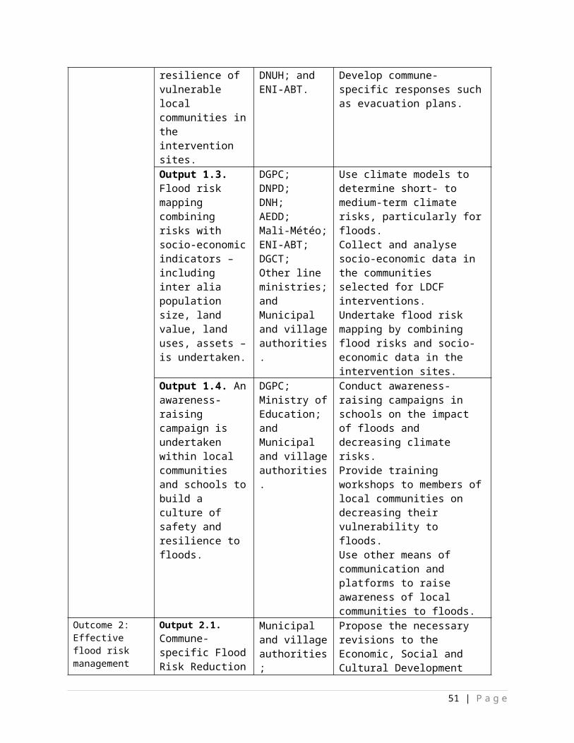
to money, fairness, integrity transparency and effective international competition. In case a consensus cannot be reached, final decision shall rest with the UNDP Programme Manager. Project reviews by this group are made at designated decision points during the running of a project, or as necessary when raised by the Project Coordinator. This group is consulted by the Project Coordinator for decisions when Project Coordinator’s tolerances (normally in terms of time and budget) have been exceeded. The terms of reference for the NSC are contained in Appendix 5. The NSC is comprised of the following individuals:
Composition and organisation: The NSC contains three roles, including: i. An Executive: individual representing the project ownership to chair the group. The Executive is
the AEDD who will report to the NSC twice a year on the progress of the project and the emerging results.
ii. Senior Supplier: individual or group representing the interests of the parties concerned which provide funding and/or technical expertise to the project. The Senior Supplier’s primary function within the NSC is to provide guidance regarding the technical feasibility of the project. The Senior Suppliers include representatives from Mali-Météo, DNH, and DGPC, NGOs, CSOs, municipal and village authorities, and local communities.
iii. Senior Beneficiary: individual or group of individuals representing the interests of those who will ultimately benefit from the project. The Senior Beneficiary’s primary function within the NSC is to ensure the realization of project results from the perspective of project beneficiaries. The Senior Beneficiary group includes representatives of AEDD, Mali-Météo, municipal and village authorities, local communities, NGOs, and CSOs.
126.Based on the approved Annual Work Plan (AWP), the NSC may review and approve project quarterly plans when required and authorises any major deviation from these agreed quarterly plans. It is the authority that signs off the completion of each quarterly plan as well as authorizes the start of the next quarterly plan. It ensures that required resources are committed and arbitrates on any conflicts within the project or negotiates a solution to any problems between the project and external bodies. In addition, it approves the appointment and responsibilities of the Project Coordinator and any delegation of its Project Assurance responsibilities.
127.Potential members of the NSC are reviewed and recommended for approval during the PAC meeting. For example, the Executive role can be held by a representative from the Government Cooperating Agency or UNDP, the Senior Supplier role is held by a representative of the AEDD and/or UNDP, and the Senior Beneficiary role is held by a representative of the government or civil society. Representative of other stakeholders can be included in the NSC as appropriate.
128.The project organisation structure is as follows:
51 | P a g e
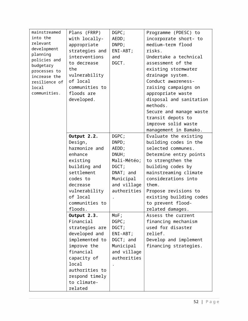
Figure 2: Organogram of management arrangements for the LDCF-financed project.
129.The specific responsibilities of the NSC are as follows:
Defining a project Review and approve the Initiation Plan (if such plan was required and submitted to the PAC).
Initiating a project Agree on Project Coordinator’s responsibilities, as well as the responsibilities of the other
members of the Project Coordinating Unit (PCU). Delegate any Project Assurance function as appropriate. Review the Progress Report for the Initiation Stage (if an Initiation Plan was required). Review and appraise detailed Project Plan and AWP, including Atlas reports covering activity
definition, quality criteria, issue log, updated risk log and the monitoring and communication plan.
Running a project Provide overall guidance and direction to the project, ensuring it remains within any specified
constraints. Address project issues as raised by the Project Coordinator.
52 | P a g e
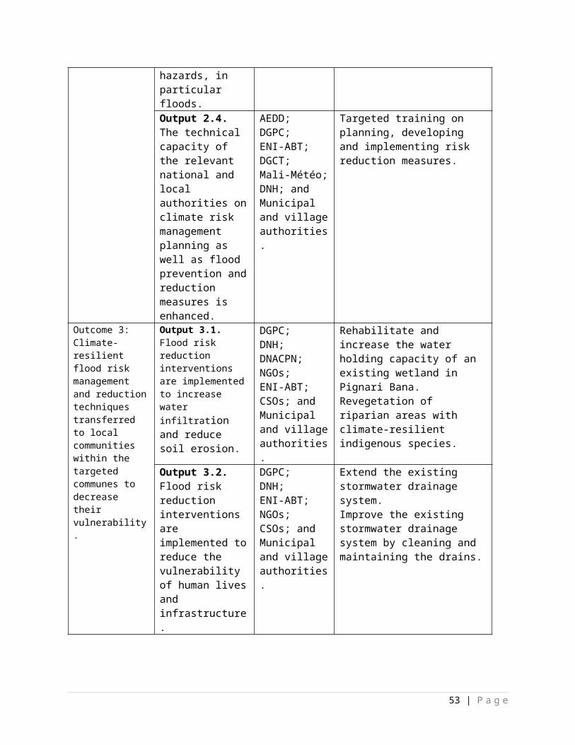
Provide guidance and agree on possible countermeasures/management actions to address specific risks.
Agree on Project Coordinator’s tolerances in the AWP and quarterly plans when required. Conduct regular meetings to review the Project Quarterly Progress Report and provide direction
and recommendations to ensure that the agreed deliverables are produced satisfactorily according to plans.
Review Combined Delivery Reports prior to certification by the Implementing Partner. Appraise the Project Annual Review Report, make recommendations for the next AWP, and
inform the Outcome Board about the results of the review. Review and approve end project report, make recommendations for follow-on actions. Provide ad-hoc direction and advice for exception situations when project Coordinator’s
tolerances are exceeded. Assess and decide on project changes through revisions.
Closing a project Assure that all Project deliverables have been produced satisfactorily. Review and approve the Final Project Review Report, including lessons-learned. Make recommendations for follow-on actions to be submitted to the Outcome Board. Commission project evaluation (only when required by partnership agreement) Notify operational completion of the project to the Outcome Board.
130.ExecutiveThe Executive – AEDD – is ultimately responsible for the project, supported by the Senior Beneficiary and Senior Supplier. The Executive’s role is to ensure that the project is focused throughout its life cycle on achieving its objectives and delivering outputs that will contribute to higher level outcomes. The Executive has to ensure that the project gives value for money, ensuring a cost-conscious approach to the project, balancing the demands of beneficiary and supplier. The specific responsibilities (as part of the above responsibilities for the NSC) are:
Ensure that there is a coherent project organisation structure and logical set of plans Set tolerances in the AWP and other plans as required for the Project Coordinator. Monitor and control the progress of the project at a strategic level. Ensure that risks are being tracked and mitigated as effectively as possible. Brief Outcome Board and relevant stakeholders about project progress. Organise and chair NSC meetings.
131.The Executive is responsible for overall assurance of the project as described under the section entitled “Project assurance”. If the project warrants it, the Executive may delegate some responsibility for the project assurance functions.
132.Senior Beneficiary The Senior Beneficiary is responsible for validating the needs and for monitoring that the solution will meet those needs within the constraints of the project. The role represents the interests of all those who will benefit from the project, or those for whom the deliverables resulting from activities will achieve specific output targets. The Senior Beneficiary role monitors progress against targets and quality criteria. This role may require more than one person to cover all the beneficiary interests. For the sake of effectiveness the role should not be split between too many people. The specific responsibilities of the Senior Beneficiary are (as part of the above responsibilities for the NSC):
Ensure the expected output(s) and related activities of the project are well defined. Make sure that progress towards the outputs required by the beneficiaries remains consistent
from the beneficiary perspective. Promote and maintain focus on the expected project output(s). Prioritise and contribute beneficiaries’ opinions on NSC decisions on whether to implement
recommendations on proposed changes. Resolve priority conflicts.
133.The assurance responsibilities of the Senior Beneficiary are to check that:
53 | P a g e
Specification of the Beneficiary’s needs is accurate, complete and unambiguous. Implementation of activities at all stages is monitored to ensure that they will meet the
beneficiary’s needs and are progressing towards that target. Impact of potential changes is evaluated from the beneficiary point of view. Risks to the beneficiaries are frequently monitored.
134.Where the project’s size, complexity or importance warrants it, the Senior Beneficiary may delegate the responsibility and authority for some of the assurance responsibilities (see the section entitled “Project assurance”)
135.Senior SupplierThe Senior Supplier represents the interests of the parties which provide funding and/or technical expertise to the project (designing, developing, facilitating, procuring, implementing). The Senior Supplier’s primary function within the NSC is to provide guidance regarding the technical feasibility of the project. The Senior Supplier role must have the authority to commit or acquire supplier resources required. If necessary, more than one person may be required for this role. Typically, the implementing partner, UNDP and/or donor(s) would be represented under this role. The specific responsibilities of the Senior Supplier are (as part of the above responsibilities for the NSC):
Make sure that progress towards the outputs remains consistent from the supplier perspective. Promote and maintain focus on the expected project output(s) from the point of view of
supplier management. Ensure that the supplier resources required for the project are made available. Contribute supplier opinions on NSC decisions on whether to implement recommendations on
proposed changes. Arbitrate on, and ensure resolution of, any supplier priority or resource conflicts.
136.The Senior Supplier assurance role responsibilities are to: Advise on the selection of strategy, design and methods to carry out project activities. Ensure that any standards defined for the project are met and used to good effect. Monitor potential changes and their impact on the quality of deliverables from a supplier
perspective. Monitor any risks in the implementation aspects of the project.
137.If warranted, some of this assurance responsibility may be delegated (see the section entitled “Project assurance”).
Project Coordinator138.Overall responsibilities: The Project Coordinator has the authority to run the project on a daily basis on behalf of the NSC within the constraints laid down by the committee. The Project Coordinator is responsible for daily management and decision-making for the project. The Project Coordinator’s prime responsibility is to ensure that the project produces the results specified in the project document, to the required standard of quality and within the specified constraints of time and cost.
139.The Implementing Partner, the AEDD, appoints the Project Manager, who should be different from the Implementing Partner’s representative in the Outcome Board. Prior to the approval of the project, the Project Developer role is the UNDP staff member responsible for project management functions during formulation until the Project Coordinator from the Implementing Partner is in place. The specific responsibilities would include:
Overall project management: Manage the realization of project outputs through activities. Provide direction and guidance to project team(s)/ responsible party/ies. Liaise with the NSC or its appointed Project Assurance roles to assure the overall direction and
integrity of the project. Identify and obtain any support and advice required for the management, planning and control of
the project.
54 | P a g e
Responsible for project administration. Liaise with any suppliers. May also perform Team Manager and Project Support roles.
Running a project Plan the activities of the project and monitor progress against the initial quality criteria. Mobilize goods and services to initiative activities, including drafting TORs and work
specifications. Monitor events as determined in the Monitoring & Communication Plan, and update the plan as
required. Manage requests for the provision of financial resources by UNDP, using advance of funds, direct
payments, or reimbursement using the FACE (Fund Authorization and Certificate of Expenditures).
Monitor financial resources and accounting to ensure accuracy and reliability of financial reports. Manage and monitor the project risks as initially identified in the Project Brief appraised by the
PAC, submit new risks to the NSC for consideration and decision on possible actions if required; update the status of these risks by maintaining the Project Risks Log.
Be responsible for managing issues and requests for change by maintaining an Issues Log. Prepare the Project Quarterly Progress Report (progress against planned activities, update on
Risks and Issues, expenditures) and submit the report to the NSC and Project Assurance. Prepare the Annual review Report, and submit the report to the NSC and the Outcome Board. Based on the review, prepare the AWP for the following year, as well as Quarterly Plans if
required.
Closing a Project Prepare Final Project Review Reports to be submitted to the NSC and the Outcome Board. Identify follow-on actions and submit them for consideration to the NSC. Manage the transfer of project deliverables, documents, files, equipment and materials to national
beneficiaries. Prepare final CDR/FACE for signature by UNDP and the Implementing Partner.
140.The Project Coordinator’s function will end when the final project TE report, and other documentation required by the GEF and UNDP, have been completed and submitted to UNDP (including operational closure of the project).
Project Assurance141.Overall responsibility: Project Assurance is the responsibility of each NSC member, however the role can be delegated. The Project Assurance role supports the NSC by carrying out objective and independent project oversight and monitoring functions. This role ensures appropriate project management milestones are managed and completed.
142.Project Assurance has to be independent of the Project Coordinator; therefore the NSC cannot delegate any of its assurance responsibilities to the Project Coordinator. A UNDP Programme Officer typically holds the Project Assurance role.
143.The implementation of the assurance responsibilities needs to answer the question “What is to be assured?”. The following list includes the key suggested aspects that need to be checked by the Project Assurance throughout the project as part of ensuring that it remains relevant, follows the approved plans and continues to meet the planned targets with quality.
Maintenance of thorough liaison throughout the project between the members of the NSC. Beneficiary needs and expectations are being met or managed. Risks are being controlled. Adherence to the Project Justification (Business Case). Projects fit with the overall Country Programme. The right people are being involved. An acceptable solution is being developed.
55 | P a g e
The project remains viable. The scope of the project is not “creeping upwards” unnoticed. Internal and external communications are working. Applicable UNDP rules and regulations are being observed. Any legislative constraints are being observed. Adherence to RMG monitoring and reporting requirements and standards. Quality management procedures are properly followed. NSC’s decisions are followed and revisions are managed in line with the required procedures.
144.Specific responsibilities would include: Initiating a project. Ensure that project outputs definitions and activity definition including description and quality
criteria have been properly recorded in the Atlas Project Management module to facilitate monitoring and reporting.
Ensure that people concerned are fully informed about the project. Ensure that all preparatory activities, including training for project staff, logistic supports are
timely carried out.
Running a project Ensure that funds are made available to the project. Ensure that risks and issues are properly managed, and that the logs in Atlas are regularly
updated. Ensure that critical project information is monitored and updated in Atlas, using the Activity
Quality log in particular. Ensure that Project Quarterly Progress Reports are prepared and submitted on time, and
according to standards in terms of format and content quality. Ensure that CDRs and FACE are prepared and submitted to the NSC and Outcome Board. Perform oversight activities, such as periodic monitoring visits and “spot checks”. Ensure that the Project Data Quality Dashboard remains “green”.
Closing a project Ensure that the project is operationally closed in Atlas. Ensure that all financial transactions are in Atlas based on final accounting of expenditures. Ensure that project accounts are closed and status set in Atlas accordingly.
Project Support145.Overall responsibilities: The Project Support role provides project administration, management and technical support to the Project Coordinator as required by the needs of the individual project or Project Coordinator. The provision of any Project Support on a formal basis is optional. It is necessary to keep Project Support and Project Assurance roles separate in order to maintain the independence of Project Assurance.
Specific responsibilities: Some specific tasks of the Project Support would include:
Provision of administrative services: Set up and maintain project files. Collect project related information data. Update plans. Administer the quality review process. Administer NSC meetings.
Project documentation management: Administer project revision control. Establish document control procedures. Compile, copy and distribute all project reports.
56 | P a g e
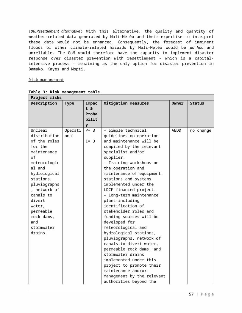
Financial Management, Monitoring and reporting Assist in the financial management tasks under the responsibility of the Project Manager. Provide support in the use of Atlas for monitoring and reporting.
Provision of technical support services Provide technical advices. Review technical reports. Monitor technical activities carried out by responsible parties.
146.Agreement on intellectual property rights and use of logo on the project’s deliverables : In order to accord proper acknowledgement to the GEF for providing funding, the GEF logo will appear together with the UNDP logo on all promotional materials, other written materials like publications developed by the project, and project hardware. Any citation on publications regarding projects funded by the GEF will also accord proper acknowledgement to the GEF.
VIII. FINANCIAL PLANNING AND MANAGEMENT
147.The total cost of the project is US$ 8,925,000. This is financed through a GEF/ LDCF grant of US$ 8,925,000, USD 800,000 in cash co-financing to be administered by UNDP and US$ 50,946,907 in parallel co-financing. UNDP, as the GEF Implementing Agency, is responsible for the execution of the GEF resources and the cash co-financing transferred to UNDP bank account only.
Parallel co-financing:
Table 6: Planned LDCF activities/outputs with co-financing.Co-financing source Co-financing
typeCo-financing
amountPlanned Activities/Outputs
Government Grant, 44,446,907 Expansion of Mali-Météo’s hydro-meteorological network;Infrastructure development; andCapacity-building.
UNDP Grant 6,000,000 Expansion of Mali-Météo’s hydro-meteorological network;Infrastructure development; andBuilding institutional capacity.
UNDP Cash 800,000 Offices;Equipment;Stationery; andTravel costs.
Government Cash 500,000 Offices;Equipment;Stationery; andTravel costs.
148.The actual realization of project co-financing will be monitored during the mid-term review and terminal evaluation process and will be reported to the GEF.
149.Budget Revision and Tolerance : As per the UNDP requirements outlined in the UNDP POPP, the NSC can agree on a budget tolerance level for each plan under the overall annual work plan allowing the project manager to expend up to the tolerance level beyond the approved project budget amount for the year without requiring a revision from the NSC. Should the following deviations occur, the Project Manager and UNDP Country Office will seek the approval of the UNDP-GEF team as these are considered major amendments by the GEF: a) budget re-allocations among components in the project
57 | P a g e
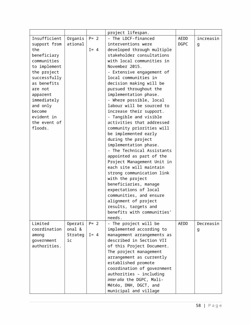
with amounts involving 10% of the total project grant or more; b) introduction of new budget items/or components that exceed 5% of original GEF allocation.
150.Project Closure : Project closure will be conducted as per the UNDP requirements outlined in the UNDP POPP (see (https://info.undp.org/global/popp/ppm/Pages/Closing-a-Project.aspx). On an exception basis only, a no-cost extension beyond the initial duration of the project will be sought from in-country UNDP colleagues and then the UNDP-GEF Executive Coordinator.
151.Operational completion: The project will be operationally completed when the last UNDP-financed inputs have been provided and the related activities have been completed including the final clearance of the Terminal Evaluation Report that must be available in English, and after the final NSC meeting. The Implementing Partner through a NSC decision, will notify the UNDP Country Office when the operational closure has been completed. The relevant parties will then agree on the disposal of any equipment that is still the property of UNDP.
152. Financial completion: The project will be financially closed when the following conditions have been met: a) the project is operationally completed or has been cancelled; b) the implementing partner has reported all financial transactions to UNDP; c) UNDP has closed the accounts for the project; d) UNDP and the implementing partner have certified a final Combined Delivery Report (which serves as final budget revision).
153.The project will be financially completed within 12 months of operational closure or after the date of cancellation. Between operational and financial closure, the implementing partner will identify and settle all financial obligations and prepare a final expenditure report. The UNDP Country Office will send the final signed closure documents including confirmation of final cumulative expenditure and unspent balance to the UNDP-GEF Unit for confirmation before the project will be financially closed in Atlas by the Country Office.
154.Refund to Donor: should a refund of unspent funds to the GEF be necessary, this will be managed directly by the UNDP-GEF Unit in New York.
IX. SUSTAINABILITY OF RESULTS
155.The concept of sustainability has been a central tenet in the design and development of this LDCF-financed project. The following paragraphs describe how the sustainability of the project interventions has been promoted during their design:
156.The project interventions were developed through extensive consultation with various government stakeholders at the national level including the DGPC, DNH, Mali-Météo, DGCT, DNPD and the AEDD. As a result, development priorities of the relevant sectors have been considered in the design of the project. In addition to the consultation of central government stakeholders, the following groups were involved in the development of this project including: i) sub-national institutions such as communal, municipal and village authorities; ii) members of the local communities from each intervention site; iii) NGOs, in particular women’s groups; iv) CSOs; and v) tertiary education institutions (see Appendix 12 for mission reports). Stakeholder consultations that were undertaken during the PPG phase and will continue during project implementation support country ownership of the project thereby promoting the maintenance of the project outputs beyond the duration of the project.
157.The focus on improved DRM planning and implementation in this LDCF-financed project will strengthen the capacity of national and local government authorities to plan and implement climate-risk reduction measures in the short, medium and long term. Planning tools such as flood risk maps and FRRPs developed in this LDCF-financed project will improve decision-making capacity of government authorities by enabling them to prioritise DRM interventions in the most vulnerable communities.
58 | P a g e
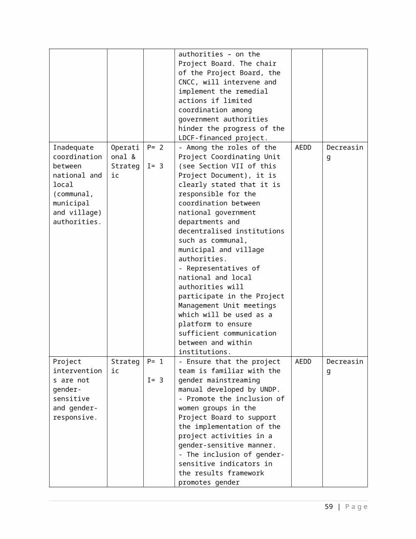
158.As there is limited technical capacity to address flood risks within national and local government authorities, this LDCF-financed project emphasises training of government officials in several activities. Under Component 1, the technical staff from Mali-Météo, DNM, DGPC, AEDD, DNPD as well as communal, municipal and village authorities will receive training on monitoring and forecasting climate-related risks. Similarly, under Component 2, the relevant government officials will receive training on developing and interpreting flood risk maps as a flood risk planning tool to secure lives and livelihoods as well as protect existing infrastructure. Component 3 will deliver several training activities to government officials on developing and implementing on-the-ground flood risk reduction interventions to increase the resilience of local communities. The three components of the LDCF-financed project will collectively increase the technical capacity of national and local government authorities to address flood risks effectively.
159.The sustainability of LDCF-financed interventions pertaining to new equipment – for example the meteorological and hydrological stations under Component 1, and hard infrastructures built under Components 2 and 3 – is promoted through delivering training activities, the dissemination of simple technical guidelines as well as long-term maintenance plans. To promote sustainability of the interventions implemented, these plans will be developed in a participatory manner with the relevant stakeholders to increase their support for the long-term maintenance of the equipment installed. The long-term maintenance plans will detail the Terms of Reference (ToRs) along with the relevant timelines for each stakeholder involved in maintaining the equipment – both at the technical and the financial levels – financed by the LDCF. These plans will be implemented during the project’s lifespan. Moreover, support will be provided to the stakeholders involved in maintaining the equipment through the implementation of training activities. The training activities, technical guidelines and participatory development of the long-term maintenance plans will be targeted at the government or non-government stakeholders.
160.Ownership of the project by the beneficiaries will be promoted by embedding local communities into decision-making throughout the project implementation phase. This intense participation process will ensure that on-the-ground project interventions directly address community needs. Additionally, an education programme and an awareness-raising campaign will be implemented under the project. The education programme will target 1 to 2 schools in each commune where multiple and varied activities will be implemented. The awareness-raising campaign will use several communication tools and streams such as pamphlets, advertising sign, creative workshops, radio and TV. These interventions will raise the support of local communities within and outside of the intervention sites thereby promoting the sustainability of – and supporting the upscaling of – the LDCF-financed project interventions.
161.This country-driven LDCF-financed project addresses major national priorities. It is therefore assumed that national and local government authorities will be willing to replicate best DRM practices in other vulnerable sites. To enable and facilitate the replication of the relevant project interventions, government officials from several ministries – including inter alia the environment, civil protection, forestry, water, decentralisation and planning – will receive extensive training (~US$ 400,000 of LDCF funds allocated to training and capacity-building) on the approach in the project to reduce vulnerability of local communities to floods in the intervention sites. For example, training workshops will be complemented by the dissemination of informative material such as technical guidelines on the construction and maintenance of permeable rock dams to widen stakeholders’ coverage of such information and extend the benefits of training activities. Along the same line, training activities on monitoring and forecasting of climate-related hazards, flood risk mapping as well as the development and implementation of flood risk reduction interventions will support the implementation of flood-resilient development planning in other vulnerable sites in Mali. Additionally, it is expected that the strengthening of institutional and financial capacity among main government stakeholders will promote the mainstreaming of flood risks into cross-sectoral and sectoral policies, and into sectoral planning and decision-making in the long term. This increased capacity is likely to promote the implementation of flood risk reduction interventions on the ground.
162.Under Component 2 of the LDCF-financed project, commune-specific financial strategies will be developed to expedite disaster relief and for the reconstruction of public infrastructure. The increased financial capacity of the local government authorities within the intervention sites will increase their access
59 | P a g e
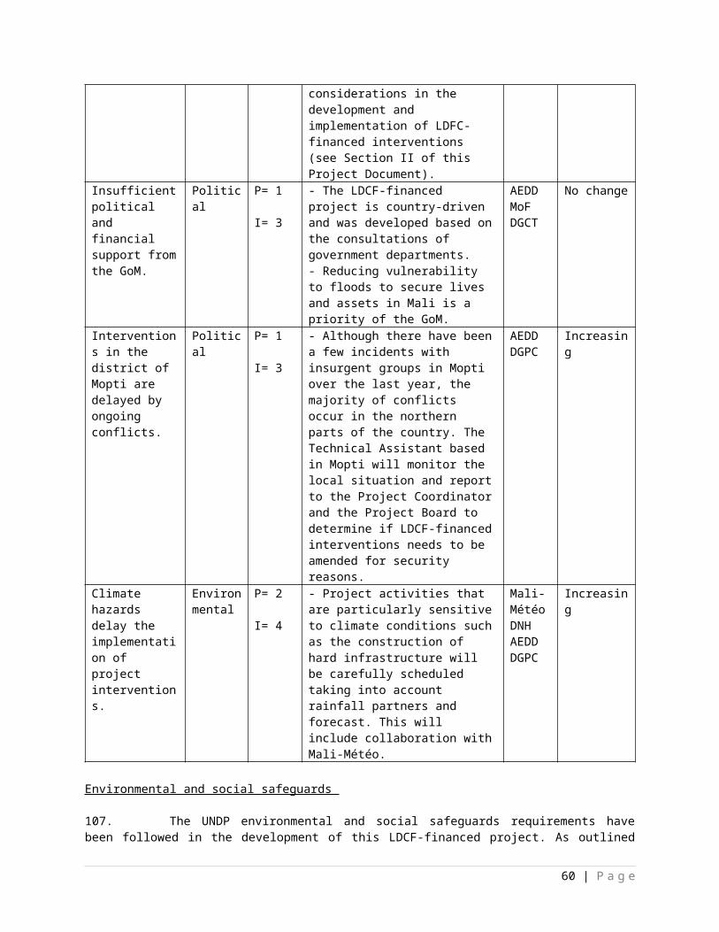
to funds to effectively manage the effects of climate-related hazards and natural disasters. This will support the timely response to climate-related hazards and natural disasters. The replication of such financial strategies to other local government authorities in the country will significantly strengthen Mali’s response to climate-related hazards and natural disasters. Timely disaster relief has several benefits including the prevention of the spreading of diseases and the rapid reconstruction of public infrastructure to enable the undertaking of economic activities.
X. LEGAL CONTEXT
163.This document together with the CPAP signed by the Government and UNDP which is incorporated by reference constitute together a Project Document as referred to in the SBAA [or other appropriate governing agreement] and all CPAP provisions apply to this document.
164.Consistent with the Article III of the Standard Basic Assistance Agreement, the responsibility for the safety and security of the implementing partner and its personnel and property, and of UNDP’s property in the implementing partner’s custody, rests with the implementing partner.
165.The implementing partner shall: Put in place an appropriate security plan and maintain the security plan, taking into account the
security situation in the country where the project is being carried; and Assume all risks and liabilities related to the implementing partner’s security, and the full
implementation of the security plan.
166.UNDP reserves the right to verify whether such a plan is in place, and to suggest modifications to the plan when necessary. Failure to maintain and implement an appropriate security plan as required hereunder shall be deemed a breach of this agreement.
167.The implementing partner agrees to undertake all reasonable efforts to ensure that none of the UNDP funds received pursuant to the Project Document are used to provide support to individuals or entities associated with terrorism and that the recipients of any amounts provided by UNDP hereunder do not appear on the list maintained by the Security Council Committee established pursuant to resolution 1267 (1999). The list can be accessed via http://www.un.org/Docs/sc/committees/1267/1267ListEng.htm. This provision must be included in all sub-contracts or sub-agreements entered into under this Project Document.
168.Any designations on maps or other references employed in this project document do not imply the expression of any opinion whatsoever on the part of UNDP concerning the legal status of any country, territory, city or area or its authorities, or concerning the delimitation of its frontiers or boundaries.
60 | P a g e
XI. TOTAL BUDGET AND WORK PLAN
Table 7: Total budget and work plan.Atlas68 Proposal or Award ID: 00095070 Atlas output Project ID : 00099106Atlas Proposal or Award Title: Flood hazard and climate risk management to secure lives and assets in Mali.Atlas Business Unit MLI10Atlas Primary Output Project Title Gestion des risques climatiques et d’inondations au Mali en vue de préserver des vies et des biens
UNDP-GEF PIMS No. 5236Implementing Partner AEDD
GEF Component/ Atlas Activity
Responsible Party/ (Atlas Implementing Agent)
Fund ID
Donor Name
Atlas Budgetary Account Code
ATLAS Budget Description
Amount Year 1 (USD)
Amount Year 2 (USD)
Amount Year 3 (USD)
Amount Year 4 (USD)
Amount Year 5 (USD)
Total (USD)
See Budget Note
Component 1
Outcome 1: Strengthened technical capacity of municipal and village authorities to improve flood early warning systems and dissemination of climate-related risk information.
AEDD 62160 LDCF
71200 International Consultants
44,000
129,000
81,000
36,000
23,000
313,000
1.1.4.a1.2.1.a1.3.4.a1.3.4.e1.3.5.a1.4.1.a1.4.2.a
71300 Local Consultants
46,000
99,000
99,000
- - 244,000
1.1.1.a1.1.2.a1.1.3.a1.1.4.c1.2.2.a1.2.2.e1.2.3.a1.3.2.a1.3.2.b1.3.3.a1.3.3.b
68 See separate guidance on how to enter the TBWP into Atlas
61 | P a g e
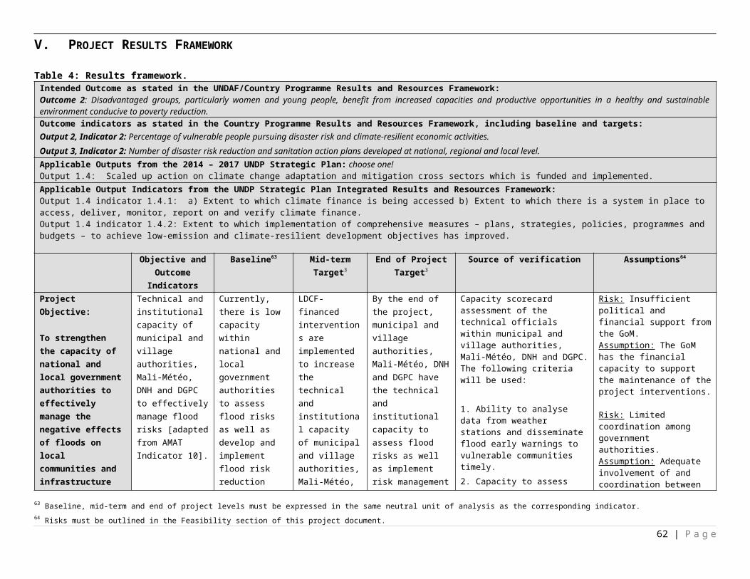
1.3.4.b1.4.1.b1.4.2.b
72100Contractual Services - Companies
- 96,000
87,000 - - 183,0
00
1.1.1.c1.1.2.b1.1.3.c1.2.1.c1.3.1.a
75700
Training workshop and conferences
- 150,200
130,000
9,000
5,000
294,200
1.1.1.d1.1.2.e1.1.3.d1.1.4.d1.2.1.d1.2.2.b1.2.3.b1.3.4.d1.3.5.b1.4.1.d1.4.2.d
72800Information technology equipment
- 70,000 - - - 70,0
00
1.1.4.b
74200
Audio Visual & Print production costs
- 94,800
82,000
37,000 - 213,8
00
1.1.1.e1.1.2.d1.1.4.e1.2.1.e1.2.2.c1.2.2.d1.3.4.c1.4.1.c1.4.2.c
72300 Materials and Goods - 931,0
00 886,0
00 - - 1,817,000
1.1.1.b1.1.2.c1.1.3.b1.2.1.b
62 | P a g e
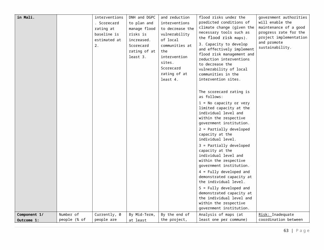
Total Outcome 1
90,000
1,570,000
1,365,000
82,000
28,000
3,135,000
Component 2
Outcome 2. Effective flood risk management mainstreamed into the relevant development planning policies and budgetary processes to increase the resilience of local communities
AEDD 62160 LDCF
71200 International Consultants
50,000
64,000
70,960
50,000
21,000
255,960
2.1.1.d2.1.2.a2.2.1.a2.3.2.a2.4.1.a
71300 Local Consultants
70,000
58,000
24,000
30,000 - 182,0
00
2.1.1.a2.1.1.b2.1.3.a2.1.3.e2.1.3.f
2.1.4.a2.2.2.a2.3.1.a2.3.2.b2.4.1.b
72100Contractual Services - Companies
- - 348,000
400,000
188,000
936,000
2.1.3.d
75700
Training workshop and conferences
2,000
3,000
17,040
47,000
25,000
94,040
2.1.2.c2.1.3.c2.1.3.g2.1.4.c2.2.2.c2.3.1.b2.3.2.d2.4.1.d
74200 Audio Visual & Print production costs
- 2,000
17,000
9,000
18,000
46,000
2.1.1.c2.1.2.b2.1.3.b2.1.3.h2.1.4.b2.2.2.b2.3.1.c2.3.2.c
63 | P a g e
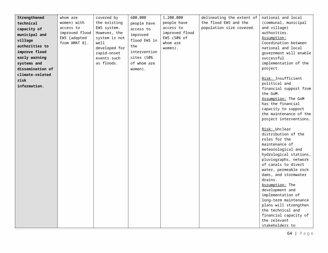
2.4.1.c
Total Outcome 2
122,000
127,000
477,000
536,000
252,000
1,514,000
Component 3
Outcome 3. Climate-resilient flood risk management and reduction techniques transferred to local communities within the targeted communes to decrease their vulnerability.
AEDD 62160 LDCF
71200 International Consultants
22,000
9,000
20,000
8,000
18,000
77,000
3.2.3.c3.2.3.d
74100 Professional Services 3,000 3,000 3,000 3,000 3,000 15,000 3.2.3.e
71300 Local Consultants
45,000
98,000
92,000
47,500
30,500
313,000
3.1.1.a3.1.1.b3.1.2.a3.1.3.a3.1.3.b3.2.1.a3.2.2.a3.2.2.b3.2.3.a
72100Contractual Services - Companies
- 400,000
947,500
1,351,000
480,000
3,178,500
3.1.1.c3.1.3.c3.2.1.b3.2.2.c3.2.3.b
75700
Training workshop and conferences
- 7,000
1,000 - 2,5
00 10,5
00
3.1.2.d3.1.3.d3.2.1.d3.2.2.d
74200
Audio Visual & Print production costs
- 3,000
4,000 - - 7,00
0
3.1.2.c3.2.1.c
72300 Materials and Goods - 120,0
00 80,0
00 30,0
00 20,0
00 250,0
00 3.1.2.b
Total Outcome 3
70,000
640,000
1,147,500
1,439,500
554,000
3,851,000
64 | P a g e
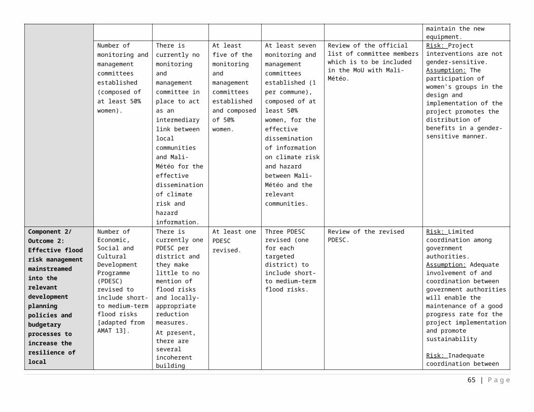
Project Management UnitAEDD
62160 LDCF
72300 Materials and Goods
44,800
4,600
4,600
4,600
5,400
64,000
4.1.3.a
72500 Supplies 8,500
1,500
1,000
1,000
1,000
13,000
4.1.2.a
71300 Local Consultants
69,600
69,600
69,600
69,600
69,600
348,000
4.1.1.a
Sub Total LDCF PMU
122,900
75,700
75,200
75,200
76,000
425,000
04000 TRAC
72200 Equipment and furniture 100,000 50,000 50,000 50,000 50,000 300,000
4.1.4.a
71300 Local consultant 50,000 50,000 50,000 50,000 50,000 250,000
4.1.5.a
72300 Materials and goods 100,000 50,000 50,000 25,000 25,000 250,000
4.1.6.a
Sub Total TRAC PMU 250,000 150,000 150,000 125,000 125,000 800,000
Total PMU372,900 225,700 225,200 200,200 201,000 1,225,000
Total LDCF 404,900
2,412,700
3,064,700
2,132,700
910,000
8,925,000
Total TRAC 250,000
150,000
150,000
125,000
125,000
800,000
Summary of Funds: 69
Source of Fund Total
69 Summary table should include all financing of all kinds: GEF financing, co-financing, cash, in-kind, etc...
65 | P a g e
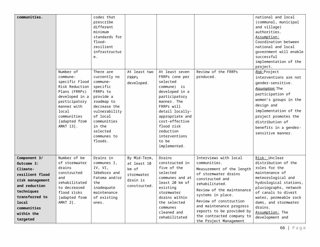
GEF $8,925,000UNDP $6,800,000AEDD $3,000,000
Mali Météo $24,690,000DNACPN $17,256,907TOTAL $60,671,907
Table 8: Budget notes.
Budget note Description of cost item
1.1.1.a
National meteorologist to: i) determine which type of meteorological and hydrological stations are required and where to install them; ii) train the relevant stakeholders operating the stations on the operation and maintenance of these stations as well as the monitoring and forecasting of climate-related risks; and iii) develop and implement a long-term maintenance plan for the equipment in a participatory manner with relevant national and local institutions. (50 days @ $200/day)
1.1.1.b Procure the meteorological and hydrological stations.10 AWS stations @ $77,500 each and import duties.
1.1.1.c Contractual services for the supplier of the weather stations to: i) install them; ii) compile simple technical guidelines on their operation; and iii) provide training to the relevant stakeholders on the operation of the equipment.
1.1.1.dTraining workshops for the relevant stakeholders by the national meteorologist and supplier. (50 people over the course of 5 days) Printing of training material
1.1.1.e Dissemination of simple technical guidelines on the operation of the stations and the maintenance of the equipment to the relevant stakeholders.
1.1.2.a
National meteorologist to: i) determine the type of pluviographs required and where to install them; ii) identify potential suppliers; iii) develop a long-term maintenance plan for the equipment in a participatory manner with relevant local and national institutions; and iv) train the relevant stakeholders on the long-term maintenance of the pluviogpraphs as per the plan developed. (40 days @ $200/day)
1.1.2.b Contractual services for the supplier of the pluviographs to: i) install them; ii) compile simple technical guidelines on their operation; and iii) provide training to the relevant stakeholders on the operation of the equipment.
1.1.2.c Procurement of 150 pluviographs @ $800 each.
1.1.2.d Dissemination of; i) simple technical guidelines on the operation; and ii) long-term maintenance plans.
66 | P a g e
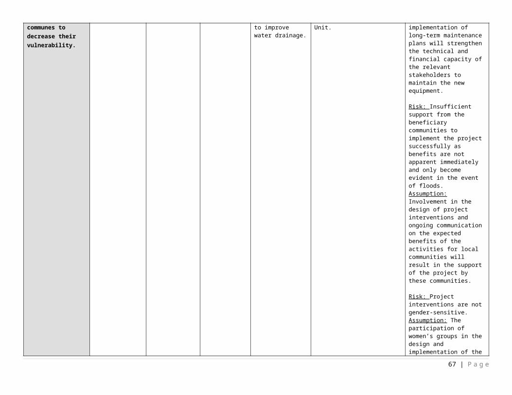
1.1.2.e.Training of the relevant stakeholders by the national meteorologist and supplier of the pluviographs. (1 day training workshop with 50 people).Printing of training material
1.1.3.a National meteorologist to undertake an equipment needs assessment of the existing stations; ii) propose the list of equipment to be purchased; iii) identify potential suppliers; and iv) develop a long-term maintenance plan for the existing and new equipment. (40 days @ $200/day)
1.1.3.b Procurement of the equipment required for the rehabilitation of the existing weather stations.
1.1.3.c Contractual services for the supplier to: i) install the new equipment; ii) compile technical guidelines on the operation of the equipment; and iii) train the relevant people on the operation of the rehabilitated weather stations.
1.1.3.d
Training of the officials who currently operate the weather stations. (1 training workshop with 15 people over the course of two days). Approximately 3-4 people per weather station will be invited to attend the training workshop. Printing of training material
1.1.4.a
International meteorologist to: i) determine the climate modelling software to be purchased based on demands from several economic sectors and the public sector as well as an assessment of the software currently used; ii) compile training material and technical guidelines on monitoring, interpreting data and generating accurate and downscaled weather forecasts; and iii) train officials of Mali-Meteo on the use of the software, data monitoring and the interpretation of the information to generate weather forecasts for the general public as well to produce tailor-made information for specific sectors (paying service). (40 days @ $500/day with 15 days in-country; 1 flight @ $2000/flight)
1.1.4.b Purchase the necessary climate modelling software and any equipment (if required) for accurate downscaled weather forecasting.
1.1.4.c
National communication specialist to: i) train journalists to accurately convey the downscaled weather forecasts generated by Mali-Meteo to the general public; ii) develop working agreements with radio and TV broadcasting channels for the dissemination of weather forecasts; and iii) establish agreements with potential sponsors. (50 days @ $200/day).
1.1.4.dTraining of the technical staff of Mali-Meteo by the appointed international meteorologist on monitoring, interpreting the data generated by the climate modelling software as well as the forecasts for the private sector (paying service). Training of journalists by the appointed national communication specialist to accurately convey weather-related information to the general public. (Two day training workshop with 60 journalists).
1.1.4.e Dissemination of the technical guidelines compiled by the appointed international meteorologist on monitoring, interpreting data and generating accurate and downscaled weather forecasts to the relevant stakeholders within Mali-Meteo.
1.2.1.a
International Flood EWS Specialist to: i) design the system to be implemented; ii) identify potential suppliers; iii) oversee the implementation of the system; iv) compile simple technical guidelines on the maintenance and operation of the system; v) compile and implement a long-term maintenance plan to ensure the sustainability of the system beyond the project's lifespan; and vi) train the relevant local stakeholders on operating and maintaining the system. (50 days @ $500/day with 30 days in-country and 1 flight at $2000/flight).
1.2.1.b Procurement of the equipment for the flood EWS. 1.2.1.c Contractual services for the installation of the systems in the intervention sites.
1.2.1.dTraining of the technical staff from Mali-Météo, DNH, DGPC, DNUH as well as municipal and village authorities by the international flood EWS specialist on the operation and maintenance of the system.Printing of training material
1.2.1.e Dissemination of the technical guidelines to all municipal and village authorities covered by the flood EWS.
67 | P a g e
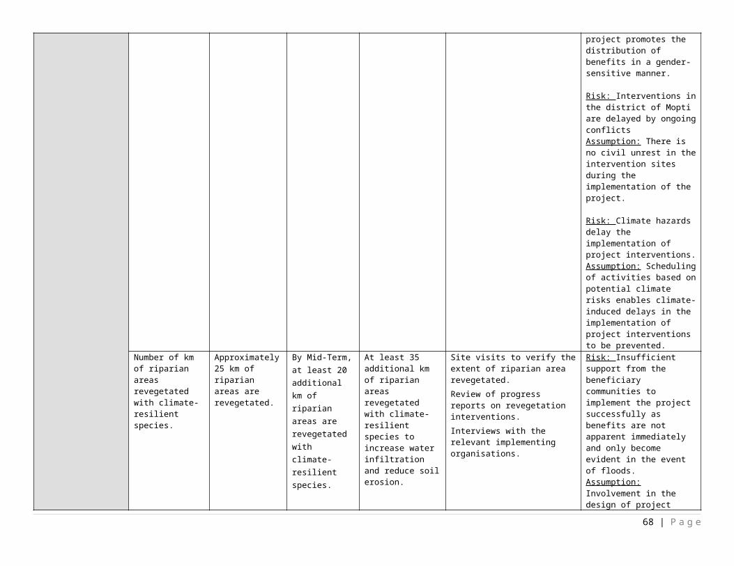
1.2.2.a
National communication specialist to: i) hold focus groups in the interventions sites to determine their preferred means of communication and language for early warnings; ii) consider traditional practices for predicting floods and issuing warnings; iii) devise a standardised category of warnings to be endorsed by local communities; iv) elaborate on commune-specific responses to be implemented by the local authorities and local communities for each warning category such as evacuation plans; v) engage with national and local authorities to determine the responses to be put in place for each warning category; vi) train local authorities on efficiently communicating early warnings to specific local communities; vii) train the relevant members of local communities on the meaning of these warning categories and how to respond to them; viii) develop MoUs with rural radio companies, TV broadcasting channels and telecommunication companies (for dissemination of early warnings via SMS); and ix) engage with potential sponsors and develop working agreements with them. (125 days @ $200/day).
1.2.2.b
1. Focus groups (one in each commune) to be held by the appointed national communication specialist in the selected communes (with representatives including NGOs, CSOs, members of local communities from each of the 51 selected village/town, and officials from municipal/village authorities) to determine their preferred means of communication and language for early warnings and to devise a standardised category of warnings to be endorsed by local communities. Through these focus groups, commune-specific responses for each warning category will be developed.2. Training workshops held by the appointed national communication specialist with municipal and village authorities from each commune as well as the relevant staff members from the AEDD and DGPC on efficiently communicating early warnings to local communities according to the communication strategy developed. These workshops will also be used to develop the measures that need to be implemented for each commune for each warning category. 3. Training of members of the local communities in each selected commune (with representative from each 51 villages/towns) by the appointed national communication specialist on the significance of each warning category and how to respond to them.
1.2.2.c Dissemination of the communication strategic plan to the municipal and village authorities in each intervention site.
1.2.2.d Awareness-raising of local communities through the distribution of pamphlets and the erection of sign boards detailing the EWS put in place as well as the categories of the early warnings, their significance, and how to respond to each warning.
1.2.2.eNational gender specialist to mainstream gender considerations in the flood risks and hazards communication strategy. The appointed specialist will assess the other interventions financed by the LDCF to adopt a gender-responsive approach in the implementation of the project. (45 days @ $200/day)
1.2.3.a
National communication specialist (appointed under Activity 1.2.2.) to: i) undertake selection workshops in each commune to ensure a fair representation of each community within the commune, vulnerable groups, women, youth ; ii) establish monitoring and management communities by appointing members for specific roles for which ToRs will be developed, and developing the structure of the committees (in collaboration with the appointed members); iii) develop MoUs between the monitoring and management committees and Mali-Météo; iv) undertake training workshop with the members of the committees on their role and responsibility collectively as a group and to increase their knowledge of the EWS, flood risks and hazards communication strategy and also on how to reach people efficiently; v) assist the monitoring and management committees in holding one training workshops (per commune) with the local communities to update their knowledge on the EWS and the flood risks and hazards communication strategy; and vi) identify and implement measures to make the monitoring and management committees operational beyond the project's lifespan. (125 days @ $200/day).
68 | P a g e
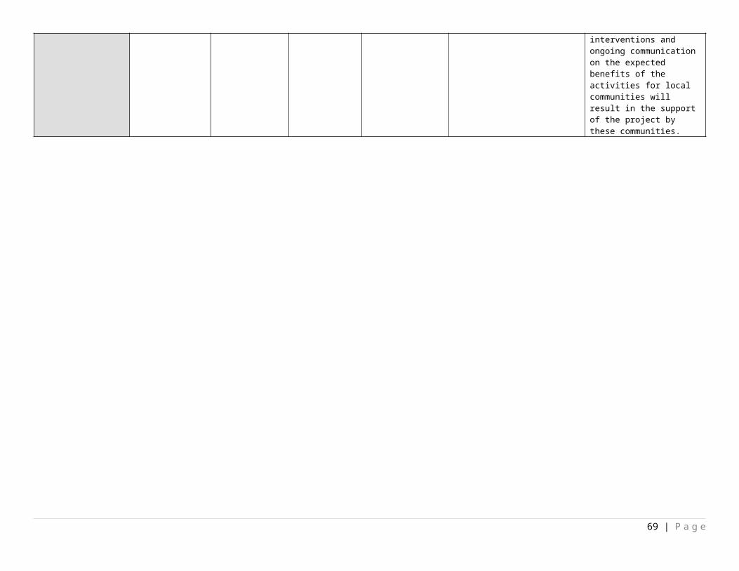
1.2.3.b
1. Selection workshops to select the representatives of the monitoring and management committees and establish a structure for the committee. A total of 100 people will be invited to attend the selection workshops. 7 training workshops (1 in each commune) in each of the seven communes selected to assist every monitoring and management committees in their first workshop/event to train local communities on the EWS and the flood risks and hazards communication strategy developed under Activity 1.2.2. (1 day training workshop with 10 people from each monitoring and management committee). 3. Operational budget to warn local communities against imminent climate-related hazards and subsequent training workshop/event (refresher course, skits, video screenings or community activities) to be held by the monitoring and management committees twice a year (within the last 2 years of the project lifespan) with members of their respective communities. Total operational budget is $35,000.
1.3.1.aSub-contract climate modelling study to: i) update existing climate models; ii) determine the predicted short- to medium-term change in climatic conditions and associated flood risks for the intervention sites; iii) determine which areas are at risk of climate-related hazards in the short to medium term.
1.3.2.a
National socio-economic specialist to: i) determine the indicators to be used in collecting data for vulnerability mapping in the intervention sites; ii) validate the indicators with the Project Board; iii) undertake the survey to collect the relevant data from the selected communes; iv) analyse the data collected; v) determine the projected changes in the indicators in the short and medium term; and vi) produce GIS layers of the information collected.(125 days @ $200/day)
1.3.2.bNational GIS specialist to produce GIS layers of the data collected by the appointed national socio-economic specialist. These GIS layers will be used in the vulnerability mapping in Activity 1.3.4.(40 days @ $200/day)
1.3.3.aNational consultant to map the infrastructure located within the flood-prone areas as identified under Activity 1.3.1. The mapping exercise can be based on land use maps and ground truthed by site visits. (100 days @ $200/day)
1.3.3.bNational GIS specialist (same as the one appointed under Activity 1.3.1.) to produce GIS layers showing the assets located within flood-prone areas. These GIS layers will inform the vulnerability mapping to be undertaken in Activity 1.3.4.(40 days @ $200/day)
1.3.4.a
International GIS specialist to: i) incorporate the information developed in Activities 1.3.1, 1.3.2 and 1.3.3 and compile short- to medium-term vulnerability maps for the selected communes; ii) train the relevant municipal, village and national authorities to interpret the vulnerability maps, use them as a planning tool to prioritise their interventions and increase resilience to floods. (60 days @ $500/day with 10 days in-country; flight @ $2000/flight).
1.3.4.b
National consultant to collect the existing relevant flood-related information (to be determined in collaboration with the appointed international GIS specialist) from Mali-Météo and the DNH. The national consultant will also be responsible for providing the full geospatial datasets to be included in the AEDD information system (during the project's lifespan) which is available to the public. (40 days@ $200/day)
1.3.4.c Dissemination of maps and GIS layers to the relevant national, regional, communal and local authorities and to the public.
69 | P a g e
1.3.4.d
Training of the technical staff from the relevant national, regional, communal and local authorities on the: i) generation of these maps; ii) interpretation of the maps generated; and iii) efficient use of the maps as planning tools for future development and to prioritise DRM interventions. (3 day training workshop with 50 people). Printing of training material.The training costs total $4,000. Additional funds have been allocated for venue hire and miscellaneous costs.
1.3.4.e International Chief Technical Advisor (212 days @ $500/day; 8 flights @ $2500/flight; 80 days in-country @ $166/day) (costs split between the three components).
1.3.5.aInternational socio-economic expert to: i) quantify the predicted costs of floods in the short to medium term; ii) hold communication events to present the findings of the socio-economic study on the predicted costs of floods. (80 days @ $500/day with 10 days in-country; 1 flight @ $2000/flight)
1.3.5.b
Communication events to present the predicted cost of floods and how these were determined. 1 day event in each intervention district (3 in total and they will be held by the appointed international socio-economic expert). (50 people per communication event).Printing of training material.
1.4.1.a
International flood specialist to : i) design (in collaboration with the appointed national education specialist) an education programme for schools on local climate-related hazards, in particular floods; ii) oversee its integration in the school curriculum; and iii) develop an awareness-raising campaign targeted at children to increase their knowledge of flood risks and hazards. (50 days @ $500/day with 25 days in-country; and 2 flights @ $2,000/flight).
1.4.1.b
National education specialist to: i) undertake a transparent selection process to choose the schools that will benefit from the education programme designed in collaboration with the international flood specialist (1-2 schools per commune); ii) liaise with schools for permission to undertake activities/events related to the education programme; iii) develop the necessary material for the education programme; iv) oversee the implementation of the programme in the selected schools in the intervention sites. (200 days @ $200/day).
National education specialist to: i) undertake a transparent selection process to choose the schools that will benefit from the awareness-raising campaign designed in collaboration with the international flood specialist (1-2 schools per commune); ii) liaise with schools for permission to undertake awareness-raising activities/events; iii) develop the necessary material for the education programme; iv) oversee the implementation of the education programme and the awareness-raising campaigns in the selected schools in the intervention sites. (200 days @ $200/day).
1.4.1.c Development and dissemination of education and awareness-raising material for the relevant schools.
1.4.1.d
1. Training of educators by the national education specialist on the education programme developed. (at least 2 educators from each school selected).
2. Training workshops (using creative and innovative approaches) undertaken in the schools selected raise awareness through activities/events on climate change, climate risks, in particular floods, and the DRR interventions to be implemented to strengthen their resilience.
1.4.2.aInternational flood specialist to; i) design training workshops on implementing locally-appropriate interventions to build resilience to floods; and ii) oversee the implementation of the awareness-raising campaigns in local communities. 50 days @ $500/day with 25 days in-country; and 2 flights @ $2,000/flight.
70 | P a g e
1.4.2.b
National communication specialist to: i) contribute to the design of the awareness-campaigns based on local knowledge; ii) determine the appropriate means of communication to reach the largest share of the population in the selected communes; iii) develop the training material; iv) liaise with radio and TV broadcasts; and v) ensure that the undertaking of the awareness-raising campaigns are undertaken in the language that is appropriate to particular areas. (200 days @ $200/day)
1.4.2.c Compilation and dissemination of awareness-raising material within the local communities in the selected communes.
1.4.2.d Training activities/events (using creative and innovative approaches) with local communities on climate change, climate risks, in particular floods, and the DRR interventions to be implemented to strengthen their resilience.
2.1.1.a National GIS expert to map the extent of the existing stormwater drainage system in all seven communes. (75 days @ $200/day).
2.1.1.b
National stormwater specialist to assess the current drainage system (based on the mapping of the extent of the system, existing documentation, site visits). The assessment will point out which portions of the system need rehabilitation, maintenance or extension and the degree to which these works are required. (80 days @ $200/day)
2.1.1.c Dissemination of the technical assessment of the stormwater drainage system to local government authorities within the selected communes to consider in their respective budget for infrastructure planning.
2.1.1.d International Chief Technical Advisor (212 days @ $500/day; 8 flights @ $2500/flight; 80 days in-country @ $166/day) (costs split between the three components).
2.1.2.a
International flood DRM specialist to: i) assess flood risks on local communities; ii) engage with local communities to determine locally-appropriate flood risk reduction strategies that are cost-effective; iii) develop a suite of cost-effective soft and hard infrastructure to decrease the vulnerability of local communities; iv) prioritise the interventions developed (per commune) in terms of the needs of the local communities; v) provide a breakdown of the costs of realising these interventions; vi) compile the required training material and simple technical guidelines on the effectiveness of the soft and hard interventions proposed; and vii) training of the relevant technical staff from national, regional, communal and local government authorities on these cost-effective soft and hard interventions to reduce the vulnerability of local communities in interventions sites to floods. (60 days @ $500/day with 15 days in-country and 2 flights @ $2,000/flight).
2.1.2.b Dissemination of FRRPs and the associated simple technical guidelines to the local government authorities in the selected communes.
2.1.2.cTraining of local government officials in the selected communes by the appointed international flood DRM specialist on the development, implementation and effectiveness of the soft and hard interventions. (2 day training workshop with 50 people)
2.1.3.a
National solid waste management specialist to assess: i) waste removal practices implemented by local government authorities; ii) management of solid waste before and after removal; iii) waste disposal practices adopted by local communities; and iv) current operation mode of waste transit depots. Based on the assessment described above, a long-term solid waste management plan for the effective removal and processing of solid waste will be developed in collaboration with local government authorities in Bamako. In addition, the specialist will work in close collaboration with local authorities to develop a long-term financing strategy to support the implementation of the solid waste management plan. The appointed specialist will also train the relevant technical staff from the communal and municipal authorities in Bamako on the implementation of the solid waste management plan. (250 days @ $200/day).
2.1.3.b Dissemination of the solid waste management plan for Bamako to the relevant technical staff within the communal and municipal authorities.
71 | P a g e
2.1.3.c
1. Training of the relevant technical staff within the communal and municipal authorities by the appointed national solid waste management specialist on the implementation of the solid waste management plan. 2. Hold a communication event to present the solid waste management plan to a wide range of stakeholders and describe the benefits in terms of reduced flood risks.
2.1.3.d Contractual services for securing existing waste transit depots and reinforcing the fencing around these structures in Bamako to prevent the establishment of settlements as a result of rapid urbanisation and the over spilling of solid waste onto surrounding areas.
2.1.3.eNational solid waste management specialist to provide input to an awareness-raising campaign on appropriate waste disposal and sanitation measures to reduce flood risks in Bamako. This will be partly based on the assessment undertaken in Activity 2.1.4. (40 days @ $200/day)
2.1.3.f
National awareness-raising specialist to; i) design a campaign based on the input of the appointed national solid waste management; ii) undertake a campaign to raise awareness of local communities in Bamako on the importance of appropriate solid waste disposal to prevent blocked waterways which lead to the increased likelihood of floods; iii) conduct community activities to clean up blocked waterways. (120 days @ $200/day).
2.1.3.gTrain local community members through awareness-raising activities to; i) demonstrate appropriate solid waste disposal methods; ii) conduct community activities to clean up blocked waterways; iii) describe the consequences of a poorly maintained solid waste management system through skits, media broadcasts, screenings.
2.1.3.h Dissemination of pamphlets explaining the importance of adopting appropriate waste disposal practices to prevent flood risks.
2.1.4.a
National policy expert to; i) assess the Economic, Social and Cultural Development Programme (PDESC); ii) determine entry points of flood risks (developed under Activity 1.3.1.) into existing PDESC; ii) propose revisions to the existing PDESCs to incorporate short- and medium-term flood risks (determined under Activity 1.3.1) into these documents; iii) submit for validation during the project's lifespan; iv) develop a brief detailing the revisions made to the PDESC and the implications thereof; v) train the relevant officials involved on flood risk planning and the mainstreaming into long-term development plans to ensure the sustainability of investments in infrastructure. (100 days @ $200/day)
2.1.4.b Dissemination of: i) policy brief detailing the proposed changes to the existing PDESC to local government authorities in the selected communes, DGPC, DGCT, DNPD.
2.1.4.c Training of local government authorities, DGPC, DGCT, DNPD on flood risk planning and the integration of flood risks in governing documents such as PDESC to support the sustainability of investments in the long term.
2.2.1.a
International DRM policy expert to: i) assess the existing building and settlement codes in terms of flood risks and hazards; ii) identify entry points to increase flood risks in these codes; iii) propose revisions to the building codes to support flood resilient development and coherence among codes and other relevant governing documents; and iv) determine the need for new building codes and if deemed necessary develop accordingly. (100 days @ $500/day with 30 days in-country; 2 flights @ $2,000/flight).
2.2.2.a
National consultant to: i) liaise with the international DRM policy expert to coordinate the policy assessment; ii) submit the proposed revisions to the building codes for validation; iii) compile policy brief on the proposed revisions and if applicable develop simple technical guidelines on the new codes; and iv) train the relevant authorities on implementing the revised and new codes on the ground (50 days @ $200/day}.
2.2.2.b Dissemination of the policy brief and if applicable technical guidelines on the new building codes to the relevant stakeholders including inter alia DGCT, DNPD, DGPC, municipal and village authorities.
2.2.2.c Training of the relevant authorities including inter alia DGCT, DNPD, DGPC, municipal and village authorities on the: i) proposed revisions to the
72 | P a g e
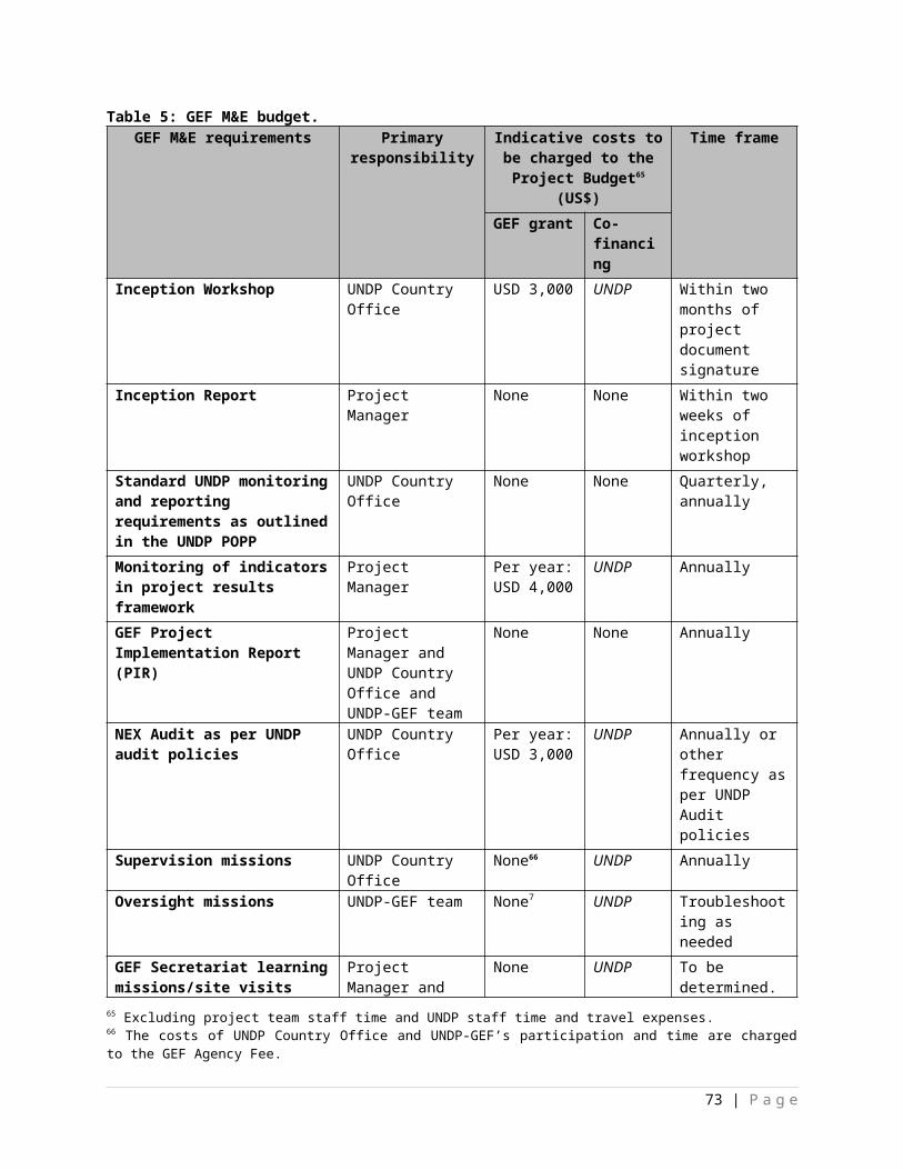
building codes and if applicable, new ones: ii) the anticipated benefits of the proposed revisions or if applicable, new building codes in terms of reducing food risks and decreasing the vulnerability of local communities; and iii) the implications of the proposed revisions to the existing building codes or the development of new ones on future development planning. Printing of training material. The training costs total $3,000. Additional funds have been allocated for venue hire etc
2.3.1.a A national finance specialist to undertake an economic impact analysis will be undertaken to assess the financial capacity of local government authorities engaging in risk financing, which will improve their financial resilience to disasters.
2.3.1.b National finance specialist to hold a communication events to present the findings of the assessment to the relevant stakeholders. 2.3.1.c Dissemination of findings of the assessment to national and local government authorities.
2.3.2.a
International finance specialist to: i) assess the current financing mechanism used for disaster relief in Mali; ii) develop flexible and rapid financial strategies (in a participatory manner with the MoF, DGCT, DGPC as well as municipal and village authorities) per commune selected for LDCF interventions by establishing different financing strategies for climate-related hazards and natural disasters; iii) implementation of the rapid financing strategies; and iv) provide input to the training material compiled. (60 days @ $500/day with 20 days in-country and 2 flights @ $2,000/flight).
2.3.2.b
National finance expert to: i) facilitate in-country negotiations with MoF and line ministries, and local government authorities; ii) submit the financial strategies for validation by the MoF, DGCT, DGPC as well as municipal and village authorities; iii) hold communication event to present the financial strategy in each commune; iv) compile training material and guidelines on the raid financial strategies; and v) train the relevant government officials on the sources of the funds, how to access funds and how to use funds effectively once granted. (80 days @ $200/day)
2.3.2.c Dissemination of guidelines on the rapid financial strategies to all relevant national, regional and local government authorities.
2.3.2.d
1. Communication events to present the rapid financial strategies in each commune to the relevant local (communal, municipal and village) authorities.2. Training workshops held by the national finance specialist with the relevant government officials on how the rapid financing strategy functions and access to emergency relief funds.
2.4.1.a
International DRM flood specialist to: i) identify the climate risks faced by Mali in the short, medium and long term; ii) identify context-specific interventions that can be developed and implemented by the GoM to effectively prevent or reduce the climate risks, particularly floods, identified; iii) provide input to the training material to be developed. (40 days @ $500/day with 12 days in-country and 1 flight @ $2,000).
2.4.1.b
National DRM specialist to develop the training material and simple guidelines in collaboration with the appointed International DRM flood specialist. The specialist will hold training workshops to train the relevant national and local government officials on the : i) forecast of the likelihood and potential impact of climate-related hazards; ii) planning, development and implementation of DRM and risk reduction measures, in particular floods, in the Malian context; iii) associated costs; iv) long-term monitoring of the effectiveness of the interventions implemented. (80 days @ $200/day).
2.4.1.c Dissemination of simple guidelines on the planning, development and implementation of DRM and risk reduction measures, in particular floods, associated costs, and the monitoring of the effectiveness of the interventions implemented.
2.4.1.d
Training workshops held by the appointed national DRM specialist to increase the technical capacity of national and local government authorities on climate risk management planning. 1. A 2 day kick-off training workshop event with national and local government authorities. (150 people over the course of 2 days).2. 2 day training workshop with the relevant technical staff in each commune selected for LDCF interventions. (30 people over the course of 2 days
73 | P a g e
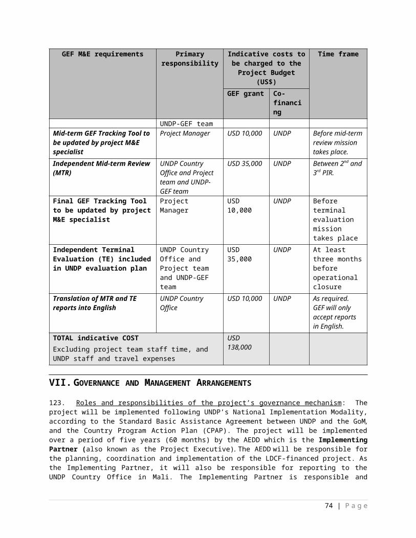
for each commune). Grand total of $20,000 but additional funds have been allocated for miscellaneous costs.
3.1.1.a National consultant to undertake an Environmental Impact Assessment with to determine the impact of the deepening of the pond. (200 days @ $200/day).
3.1.1.bNational civil engineer to undertake a feasibility assessment to: i) determine the viability and technicalities of increasing the capacity of the pond in Pignari Bana; and ii) oversee the rehabilitation. (150 days @ $200/day).
3.1.1.c Contractual services to rehabilitate the pond which will consist of: i) excavating and deepening the pond; transport and disposal of the material excavated; undertaking any other rehabilitation works specified in the EIA such as revegetating the river banks or reshaping the river banks.
3.1.2.a
National botanist to: i) determine the appropriate plant species with climate-resilient properties to be used; ii) determine the status of the vegetation in riparian areas along the wetlands in the communes selected for LDCF intervention and prioritise them; iii) determine the location of the nurseries based on access to water, quality of soil, proximity to transport routes and availability of labour; iv) compile planting protocols; v) train members of the local communities on establishing a nursery to produce seedlings and planting; and vi) supervise the establishment of 3 nurseries (one per district) and planting exercises on the ground. (80 days @ $200/day).
3.1.2.bMaterial, equipment and labour for the establishment of 3 nurseries and planting of climate-resilient indigenous species. For example, bush or grass knives, wheelbarrows, spades, shovels, polybags, tape measure, alignment wire, marker pegs, hose, watering cans are required for the establishment of plant nurseries.
3.1.2.c Dissemination of planting protocols to the relevant local municipal and village authorities and the DNH.
3.1.2.d Training of members of the local communities by the appointed national botanist on the: i) establishment and operation of the nurseries; ii) planting protocols. The appointed national botanist will demonstrate how planting should be undertaken as per the protocols.
3.1.3.a
National engineer to undertake a feasibility study to: i) design a network of canals (in collaboration with communal, municipal and village authorities as well as the DNH and DGPC) so as to minimise water runoff from reaching local communities situated at the bottom of the slopes of Mount Madingues in commune IV in Bamako; ii) determine whether the wetlands located in Wowowowanko, Farako and Diafaranako have the capacity to hold additional water runoff; iii) amend the design of the network of canals based on the outcome of the EIA undertaken; iv) oversee the construction works; v) develop a long-term maintenance plan to be implemented by local government authorities and the local communities located in commune IV; and vi) train local government authorities and communities on the maintenance of the canals. (300 days @ $200/day)
3.1.3.bNational consultant to undertake an EIA to determine the potential environmental impacts of diverting water runoff into the ponds in Wowowowanko, Farako and Diafaranako. (150 days @ $200/day)
3.1.3.c Contractual services for the construction of the network of canals.
3.1.3.dTraining of communal, municipal and village authorities, DNH and DGPC as well as members of local communities on maintaining the network of canals to ensure its effectiveness in the long term. (2 day training workshop with 45 people)
74 | P a g e
3.2.1.a
National DRM specialist to undertake a feasibility assessment to determine: i) the location of the permeable rock dams; ii) the material to be used; iii) compile technical guidelines on the purpose of these rock dams; iv) develop a long-term maintenance plan describing the roles and responsibilities of local government authorities and local communities selected for LDCF interventions; v) develop MoUs between the local communities and government authorities for the maintenance of the permeable rock dams constructed; vi) oversee construction activities. (75 days @ $200/day).
3.2.1.b
Contractual services to: i) source and purchase the material for the permeable rock dams; ii) load and offload the construction material; iii) acquire the required machinery; iv) rent trucks for the transport of construction material; and v) construction of the permeable rock dams (largely using locally sourced labour). 1. Purchase of the construction material.2. Transport of material (truck rental).3. Labour to load and offload construction material.4. Construction of rock dams.
3.2.1.c Dissemination of technical guidelines to all other communal, municipal and village authorities in flood-prone areas to replicate and/or upscale the use of permeable rock dams to prevent or reduce floods risks.
3.2.1.dTraining of the relevant municipal and village authorities as well as local authorities by the appointed DRM specialist on the: i) maintenance plan for the permeable rock dams; and ii) the different roles and responsibilities of the government authorities and local communities in maintaining these structures to ensure their long-term sustainability.
3.2.2.a
National stormwater specialist to: i) undertake a feasibility assessment for the construction of drains: ii) determine where drains would be best located; iii) oversee the construction of drains; iv) develop commune-specific long-term management plan through extensive consultation with communal, municipal and village authorities to ensure that the stormwater drains are maintained on a regular basis for optimum operation; and v) provide training to the technical staff from municipal and village authorities on the implementation of the commune-specific long-term maintenance plan. (120 days @ $200/day).
3.2.2.b National civil engineer to: i) collaborate with the appointed national stormwater specialist to design the stormwater drains; ii) oversee the construction of the drains; and iii) provide input to the development of a long-term maintenance management plan. (240 days @ $200/day).
3.2.2.c Contractual services for the purchase of the material required and the construction of 25 km of stormwater drains.
3.2.2.dTraining workshop by the appointed national stormwater specialist with technical staff from communal, municipal and village authorities, DNH, and the DGPC on the maintenance of stormwater drains. (2 day training workshop with 45 people)
3.2.3.a
National stormwater specialist (appointed under Activity 3.2.2.) to: i) determine the sections of the existing stormwater drainage system that require strengthening, maintenance or clean-up (based on assessment undertaken in Activity 2.1.2 and consultation with the relevant stakeholders); ii) ensure that the maintenance works are in alignment with the long-term maintenance plan developed under Activity 3.2.2.; iii) supervise the maintenance works. (250 days @ $200/day).
3.2.3.b Contractual services for the maintenance works (wherever possible, local labour should be sourced).
3.2.3.c International Chief Technical Advisor (212 days @ $500/day; 8 flights @ $2500/flight; 80 days in-country @ $166/day) (costs split between the three components).
3.2.3.d International consultants for Initiation workshop ($3,000), Baseline Assessment ($25,000), Mid-term evaluation ($35,000) and Terminal Evaluation ($35,000) (costs split between the three components)
75 | P a g e
3.2.3.e Service contracts for annual project audits as per UNDP financial rules and regulations
4.1.1.a Project coordinator’s salary ($1,800/month)
4.1.1.b 3 Technical Assistants salary ($700/month each)
4.1.1.c Admin and Finance officer salary ($1,000/month)
4.1.1.d M&E Consultant ($900/month)
4.1.2.a Office rental; Office supplies; 4 laptops ($1,500 each)4.1.3.a 1 car (@$35,000), 2 motorbikes (@ $3,000 each), Gasoline, 4 cell phones (@ $50 each), Airtime4.1.4.a Equipment et furniture for project office in kayes an Koulikoro4.1.5.a Local field consultants 4.1.6.a 2 cars (@$35,000 each) for Mopti and Koulikoro, Gasoline, maintenance
76 | P a g e
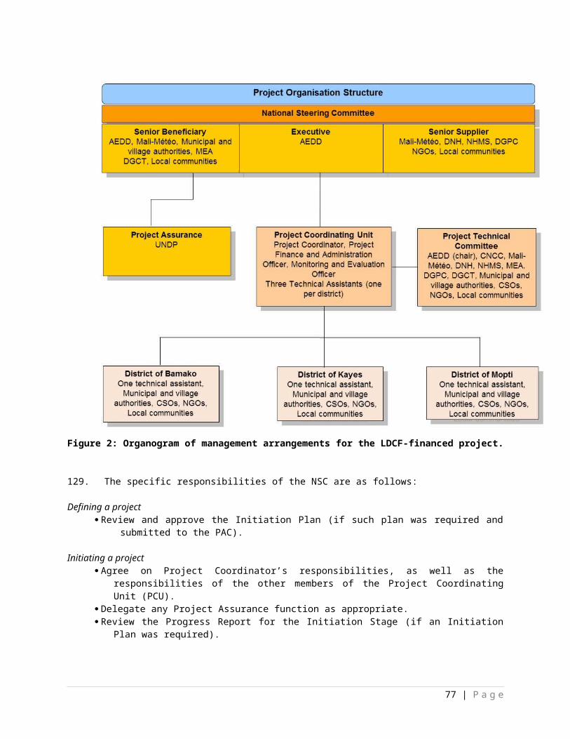
XII. MANDATORY ANNEXES
Appendix 1 Multi-year workplan Appendix 2 Monitoring planAppendix 3 Evaluation plan Appendix 4 GEF tracking tools at baselineAppendix 5 Terms of Reference for Project Board, Project Manager, Chief Technical Advisor and
other relevant positionsAppendix 6 UNDP Social and Environmental and Social Screening Template Appendix 7 Co-financing lettersAppendix 8 Alignment with policiesAppendix 9 Problem treeAppendix 10 Institutional and policy contextAppendix 11 Site selection processAppendix 12 Mission reportAppendix 13 Maps
77 | P a g e


![UNITED STATES DISTRICT COURT NORTHERN …media.mlive.com/business_impact/other/Aspen Dental...3:12-CV-1565[DNH/ATB] Case 3:12-cv-01565-DNH-ATB Document 1 Filed 10/18/12 Page 1 of 70](https://img.pdfslide.us/doc/110x75/5fe1f53bccdab9259d721e46/united-states-district-court-northern-mediamlivecombusinessimpactotheraspen.jpg)