Embed Size (px)
Citation preview
E n g i n e e r i n g a n d U r b a n D e s i g n
S e r v i c e s R e l a t i v e t o t h e R e c o n s t r u c t i o n
o f D u d l e y S q u a r e
Dudley Station is a transportation hub when 16
major bus lines converge.
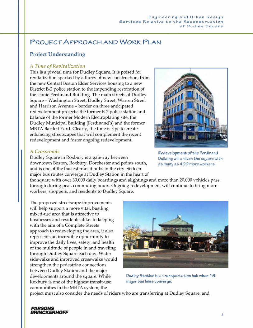
PROJECT APPROACH AND WORK PLAN Project Understanding A Time of Revitalization This is a pivotal time for Dudley Square. It is poised for revitalization sparked by a flurry of new construction, from the new Central Boston Elder Services housing to a new District B-2 police station to the impending restoration of the iconic Ferdinand Building. The main streets of Dudley Square – Washington Street, Dudley Street, Warren Street and Harrison Avenue – border on three anticipated redevelopment projects: the former B-2 police station and balance of the former Modern Electroplating site, the Dudley Municipal Building (Ferdinand’s) and the former MBTA Bartlett Yard. Clearly, the time is ripe to create enhancing streetscapes that will complement the recent redevelopment and foster ongoing redevelopment. A Crossroads Dudley Square in Roxbury is a gateway between downtown Boston, Roxbury, Dorchester and points south, and is one of the busiest transit hubs in the city. Sixteen major bus routes converge at Dudley Station in the heart of the square with over 30,000 daily boardings and alightings and more than 20,000 vehicles pass through during peak commuting hours. Ongoing redevelopment will continue to bring more workers, shoppers, and residents to Dudley Square. The proposed streetscape improvements will help support a more vital, bustling mixed-use area that is attractive to businesses and residents alike. In keeping with the aim of a Complete Streets approach to redeveloping the area, it also represents an incredible opportunity to improve the daily lives, safety, and health of the multitude of people in and traveling through Dudley Square each day. Wider sidewalks and improved crosswalks would strengthen the pedestrian connections between Dudley Station and the major developments around the square. While Roxbury is one of the highest transit-use communities in the MBTA system, the project must also consider the needs of riders who are transferring at Dudley Square, and
Redevelopment of the Ferdinand
Building will enliven the square with
as many as 400 more workers.
2
E n g i n e e r i n g a n d U r b a n D e s i g n
S e r v i c e s R e l a t i v e t o t h e R e c o n s t r u c t i o n
o f D u d l e y S q u a r e
enhance bus operations in the square for all users. Air quality is a concern not only in the square, but in the entire Roxbury community. A plan that is designed with pedestrians, bicyclists, and transit in mind will encourage these “better ways to commute” to the new job opportunities in the square. Planning and Designing with the Community The only road to a successful project is one in partnership with the community. Now, over 10 years since the initiation of the Roxbury Strategic Action Plan, the community has invested a tremendous amount of time and thought in developing plans to shape and anticipate development. Two studies specifically are focused on transportation: the Dudley Square Transportation and Air Quality Study, and most recently, the Dudley Square Transportation Action Plan. Some of the recommendations of these plans have already been implemented. The design and reconstruction of Dudley, Washington, Harrison and Warren Streets - the heart of Dudley Square – provides the opportunity to complete the execution of recommendations that complete the vision of the study area and garner community support. Our public outreach plan will put strong emphasis during Tasks 1 through 3 on public and stakeholder meetings that review these and other community visions, goals and recommendations, so that any plan we develop has strong roots in—and is respectful of—a process that has been ongoing for over a decade. The project is also the opportunity to integrate city-wide guidelines and goals established in the more recent Complete Streets program and Climate Action Plan. Our approach will be to integrate the discussion of these guidelines and goals with the discussion of the community’s vision and goals, particularly during Tasks 1 and 2. Overview of Approach Our Principal Focus: A Design That is “of the Community” As we reviewed the scope in the RFP, two
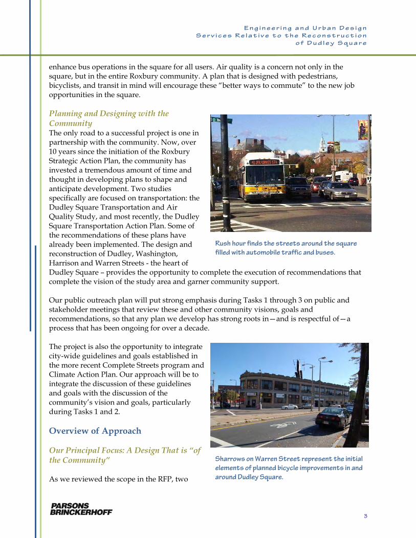
Rush hour finds the streets around the square
filled with automobile traffic and buses.
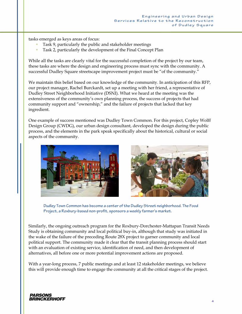
Sharrows on Warren Street represent the initial
elements of planned bicycle improvements in and
around Dudley Square.
3
E n g i n e e r i n g a n d U r b a n D e s i g n
S e r v i c e s R e l a t i v e t o t h e R e c o n s t r u c t i o n
o f D u d l e y S q u a r e
tasks emerged as keys areas of focus: Task 9, particularly the public and stakeholder meetings Task 2, particularly the development of the Final Concept Plan
While all the tasks are clearly vital for the successful completion of the project by our team, these tasks are where the design and engineering process must sync with the community. A successful Dudley Square streetscape improvement project must be “of the community.” We maintain this belief based on our knowledge of the community. In anticipation of this RFP, our project manager, Rachel Burckardt, set up a meeting with her friend, a representative of Dudley Street Neighborhood Initiative (DSNI). What we heard at the meeting was the extensiveness of the community’s own planning process, the success of projects that had community support and “ownership,” and the failure of projects that lacked that key ingredient. One example of success mentioned was Dudley Town Common. For this project, Copley Wolff Design Group (CWDG), our urban design consultant, developed the design during the public process, and the elements in the park speak specifically about the historical, cultural or social aspects of the community.
Similarly, the ongoing outreach program for the Roxbury-Dorchester-Mattapan Transit Needs Study is obtaining community and local political buy-in, although that study was initiated in the wake of the failure of the preceding Route 28X project to garner community and local political support. The community made it clear that the transit planning process should start with an evaluation of existing service, identification of need, and then development of alternatives, all before one or more potential improvement actions are proposed. With a year-long process, 7 public meetings and at least 12 stakeholder meetings, we believe this will provide enough time to engage the community at all the critical stages of the project.
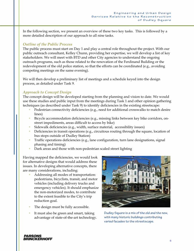
Dudley Town Common has become a center of the Dudley Street neighborhood. The Food
Project, a Roxbury-based non-profit, sponsors a weekly farmer’s market.
4
E n g i n e e r i n g a n d U r b a n D e s i g n
S e r v i c e s R e l a t i v e t o t h e R e c o n s t r u c t i o n
o f D u d l e y S q u a r e
In the following section, we present an overview of these two key tasks. This is followed by a more detailed description of our approach to all nine tasks. Outline of the Public Process The public process must start on Day 1 and play a central role throughout the project. With our public outreach consultant, Kelley Chunn, providing her expertise, we will develop a list of key stakeholders. We will meet with BTD and other City agencies to understand the ongoing outreach programs, such as those related to the renovation of the Ferdinand Building or the redevelopment of the old police station, so that the efforts can be coordinated (e.g., avoiding competing meetings on the same evening). We will then develop a preliminary list of meetings and a schedule keyed into the design process, as detailed under Task 9. Approach to Concept Design The concept design will be developed starting from the planning and vision to date. We would use these studies and public input from the meetings during Task 1 and other opinion gathering techniques (as described under Task 9) to identify deficiencies in the existing streetscape: Pedestrian connectivity deficiencies (e.g., need for additional crosswalks to match desire
lines) Bicycle accommodation deficiencies (e.g., missing links between key bike corridors, on-
street impediments, areas difficult to access by bike) Sidewalk deficiencies (e.g., width, surface material, accessibility issues) Deficiencies in transit operations (e.g., circuitous routing through the square, location of
bus stops outside of Dudley Station) Traffic operations deficiencies (e.g., lane configuration, turn lane designations, signal
phasing and timing) Dark areas and those with non-pedestrian scaled street lighting
Having mapped the deficiencies, we would look for alternative designs that would address these issues. In developing alternative concepts, there are many considerations, including: Addressing all modes of transportation:
pedestrians, bicyclists, transit, and motor vehicles (including delivery trucks and emergency vehicles). It should emphasize the non-motorized modes, to contribute to the extent feasible to the City’s trip reduction goal.
The design must be fully accessible.
It must also be green and smart, taking advantage of state-of-the-art technology.
Dudley Square is a mix of the old and the new,
with many historic buildings contributing
varied facades to the streetscape.
5
E n g i n e e r i n g a n d U r b a n D e s i g n
S e r v i c e s R e l a t i v e t o t h e R e c o n s t r u c t i o n
o f D u d l e y S q u a r e
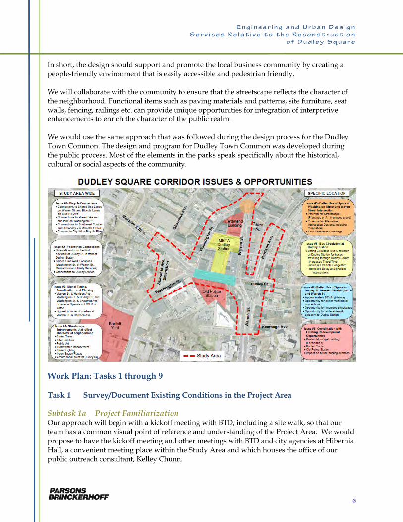
In short, the design should support and promote the local business community by creating a people-friendly environment that is easily accessible and pedestrian friendly. We will collaborate with the community to ensure that the streetscape reflects the character of the neighborhood. Functional items such as paving materials and patterns, site furniture, seat walls, fencing, railings etc. can provide unique opportunities for integration of interpretive enhancements to enrich the character of the public realm. We would use the same approach that was followed during the design process for the Dudley Town Common. The design and program for Dudley Town Common was developed during the public process. Most of the elements in the parks speak specifically about the historical, cultural or social aspects of the community.
Work Plan: Tasks 1 through 9 Task 1 Survey/Document Existing Conditions in the Project Area Subtask 1a Project Familiarization Our approach will begin with a kickoff meeting with BTD, including a site walk, so that our team has a common visual point of reference and understanding of the Project Area. We would propose to have the kickoff meeting and other meetings with BTD and city agencies at Hibernia Hall, a convenient meeting place within the Study Area and which houses the office of our public outreach consultant, Kelley Chunn.
6
E n g i n e e r i n g a n d U r b a n D e s i g n
S e r v i c e s R e l a t i v e t o t h e R e c o n s t r u c t i o n
o f D u d l e y S q u a r e
The Knowledge We Bring to the Project Our next step would be the compilation and review of the studies that precede this project. The PB team brings knowledge of the major planning studies and nearby projects, giving us a solid understanding of the history of transportation in the area, recent enhancements, and future planning efforts. Through the recent work of PB and Kelley Chunn on the Roxbury-Dorchester-Mattapan (RDM) Transit Study, we has reviewed and summarized the transportation improvements that have been developed from the following planning studies in the past 10 years: Dudley Square Transportation & Air
Quality Study (2001) Roxbury Strategic Master Plan (2004) Dudley Square Transportation Action
Plan (2009) MBTA Key Bus Routes Improvement
Project (2009-2011) MBTA Dudley Square Improvements (2011)
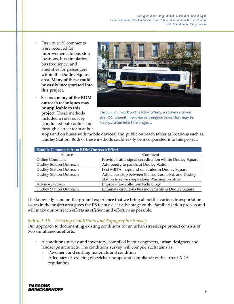
We specifically included Toole Design Group (TDG) on the PB team for their unsurpassed experience with bicycle and pedestrian planning and projects, including: Citywide bike facility project Development of Boston’s Complete
Streets Guidelines Melnea Cass Boulevard
Improvement Project South Bay Harbor Trail Other planned bicycle
improvements in the area In addition to our knowledge of the predecessor studies and adjacent projects, we also have collected ideas and recommendations on transit improvements during the RDM Study. Nearly 1,500 responses were compiled using a combination of an on-line survey, a street team collecting comments with hand-held devices at bus stops, and public outreach tables at locations including Dudley Station. This is significant for this project for two reasons:
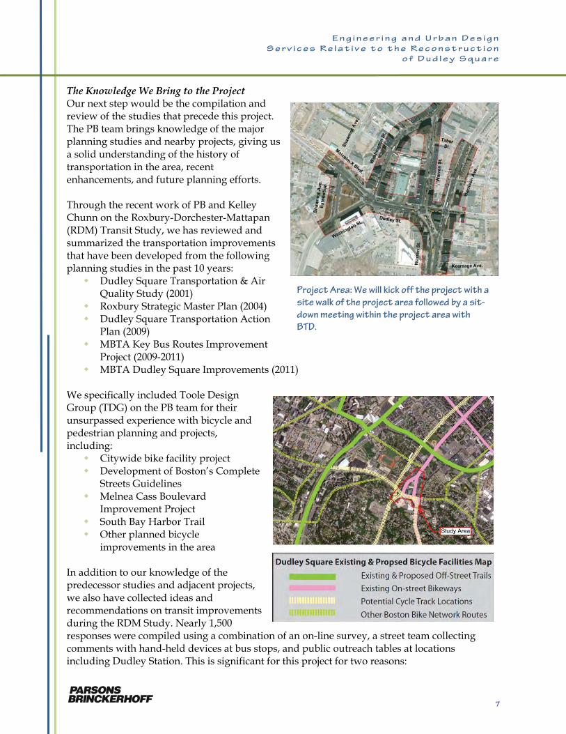
Project Area: We will kick off the project with a
site walk of the project area followed by a sit-
down meeting within the project area with
BTD.
7
E n g i n e e r i n g a n d U r b a n D e s i g n
S e r v i c e s R e l a t i v e t o t h e R e c o n s t r u c t i o n
o f D u d l e y S q u a r e
First, over 30 comments
were received for improvements to bus stop locations, bus circulation, bus frequency, and amenities for passengers within the Dudley Square area. Many of these could be easily incorporated into this project.
Second, many of the RDM outreach techniques may be applicable to this project. These methods included a rider survey (conducted both online and through a street team at bus stops and on buses with mobile devices) and public outreach tables at locations such as Dudley Station. Both of these methods could easily be incorporated into this project.
Sample Comments from RDM Outreach Effort Source Comment
Online Comment Provide traffic signal coordination within Dudley Square Dudley Station Outreach Add poetry to panels at Dudley Station Dudley Station Outreach Post MBTA maps and schedules in Dudley Square Dudley Station Outreach Add a bus stop between Melnea Cass Blvd. and Dudley
Station to serve shops along Washington Street Advisory Group Improve fare collection technology Dudley Station Outreach Eliminate circuitous bus movements in Dudley Square
The knowledge and on-the-ground experience that we bring about the various transportation issues in the project area gives the PB team a clear advantage on the familiarization process and will make our outreach efforts as efficient and effective as possible. Subtask 1b Existing Conditions and Topographic Survey Our approach to documenting existing conditions for an urban streetscape project consists of two simultaneous efforts: A conditions survey and inventory, compiled by our engineers, urban designers and
landscape architects. The conditions survey will compile such items as: - Pavement and curbing materials and condition - Adequacy of existing wheelchair ramps and compliance with current ADA
regulations
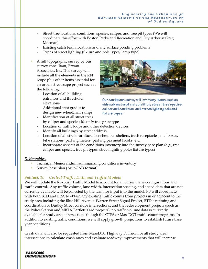
Through our work on the RDM Study, we have received
over 30 transit improvement suggestions that may be
incorporated into this project.
8
E n g i n e e r i n g a n d U r b a n D e s i g n
S e r v i c e s R e l a t i v e t o t h e R e c o n s t r u c t i o n
o f D u d l e y S q u a r e
- Street tree locations, conditions, species, caliper, and tree pit types (We will coordinate this effort with Boston Parks and Recreation and City Arborist Greg Mosman)
- Existing catch basin locations and any surface ponding problems - Types of street lighting (fixture and pole types, lamp type)
A full topographic survey by our
survey consultant, Bryant Associates, Inc. This survey will include all the elements in the RFP scope plus other items essential for an urban streetscape project such as the following: - Location of all building
entrances and threshold elevations
- Additional spot grades to design new wheelchair ramps
- Identification of all street trees by caliper and species; identify tree grate type
- Location of traffic loops and other detection devices - Identify all buildings by street address. - Location of all street furniture: benches, bus shelters, trash receptacles, mailboxes,
bike stations, parking meters, parking payment kiosks, etc. - Incorporate aspects of the conditions inventory into the survey base plan (e.g., tree
caliper and species, tree pit types, street lighting pole/fixture types) Deliverables: Technical Memorandum summarizing conditions inventory Survey base plan (AutoCAD format)
Subtask 1c Collect Traffic Data and Traffic Models We will update the Roxbury Traffic Model to account for all current lane configurations and traffic control. Any traffic volume, lane width, intersection spacing, and speed data that are not currently available will be collected by the team for input into the model. PB will coordinate with both BTD and BRA to obtain any existing traffic counts from projects in or adjacent to the study area including the Blue Hill Avenue-Warren Street Signal Project, BTD’s retiming and coordination of Dudley Street corridor intersections, and the redevelopment projects (such as the Police Station and MBTA Bartlett Yard projects); no traffic volume data is currently available for study area intersections though the CTPS or MassDOT traffic count programs. In addition to existing traffic conditions, we will apply growth projections to establish future base year conditions. Crash data will also be requested from MassDOT Highway Division for all study area intersections to calculate crash rates and evaluate roadway improvements that will increase
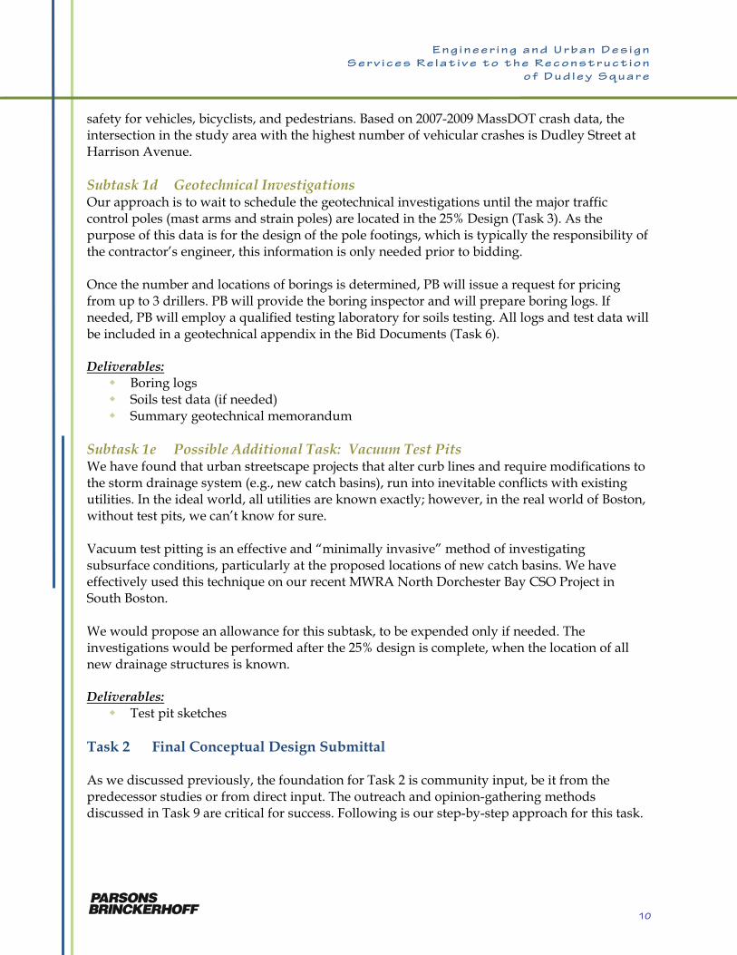
Our conditions survey will inventory items such as
sidewalk material and condition; street tree species,
caliper and condition; and street lighting pole and
fixture types.
9
E n g i n e e r i n g a n d U r b a n D e s i g n
S e r v i c e s R e l a t i v e t o t h e R e c o n s t r u c t i o n
o f D u d l e y S q u a r e
safety for vehicles, bicyclists, and pedestrians. Based on 2007-2009 MassDOT crash data, the intersection in the study area with the highest number of vehicular crashes is Dudley Street at Harrison Avenue. Subtask 1d Geotechnical Investigations Our approach is to wait to schedule the geotechnical investigations until the major traffic control poles (mast arms and strain poles) are located in the 25% Design (Task 3). As the purpose of this data is for the design of the pole footings, which is typically the responsibility of the contractor’s engineer, this information is only needed prior to bidding. Once the number and locations of borings is determined, PB will issue a request for pricing from up to 3 drillers. PB will provide the boring inspector and will prepare boring logs. If needed, PB will employ a qualified testing laboratory for soils testing. All logs and test data will be included in a geotechnical appendix in the Bid Documents (Task 6). Deliverables: Boring logs Soils test data (if needed) Summary geotechnical memorandum
Subtask 1e Possible Additional Task: Vacuum Test Pits We have found that urban streetscape projects that alter curb lines and require modifications to the storm drainage system (e.g., new catch basins), run into inevitable conflicts with existing utilities. In the ideal world, all utilities are known exactly; however, in the real world of Boston, without test pits, we can’t know for sure. Vacuum test pitting is an effective and “minimally invasive” method of investigating subsurface conditions, particularly at the proposed locations of new catch basins. We have effectively used this technique on our recent MWRA North Dorchester Bay CSO Project in South Boston. We would propose an allowance for this subtask, to be expended only if needed. The investigations would be performed after the 25% design is complete, when the location of all new drainage structures is known. Deliverables: Test pit sketches
Task 2 Final Conceptual Design Submittal As we discussed previously, the foundation for Task 2 is community input, be it from the predecessor studies or from direct input. The outreach and opinion-gathering methods discussed in Task 9 are critical for success. Following is our step-by-step approach for this task.
10
E n g i n e e r i n g a n d U r b a n D e s i g n
S e r v i c e s R e l a t i v e t o t h e R e c o n s t r u c t i o n
o f D u d l e y S q u a r e
Subtask 2a Review of Existing Documents and Studies Our team will review the documents and studies compiled under Task 1, so that all key members will have a firm understanding of the basis for this project. The studies and projects include: Dudley Square Transportation & Air Quality Study (2001) Roxbury Strategic Master Plan (2004) Dudley Square Transportation Action Plan (2009) Dudley Square Air Quality Study MBTA Key Bus Routes Improvement Project (2009-2011) MassDOT RDM Transit Needs Study (2010-2011) MBTA Dudley Square Improvements (2011) Warren-Blue Hill Signal Project (ongoing) Boston Municipal Building (Ferdinand’s - ongoing) Redevelopment of former B-2 Police station site Redevelopment of Bartlett Yards
Subtask 2b Coordination and Review with BTD The RFP indicates this subtask as coordinating with BTD regarding two adjacent projects. However, we have expanded this subtask to include other ongoing projects. We believe it is critical that the team coordinates with ongoing transportation and other projects in the study area to understand the connections between projects and the synergistic benefits that may be possible. Furthermore, we will compile a schedule that integrates the design and implementation phases of this project with other ongoing projects, including the following: MBTA Key Bus Routes Study: The MBTA is ready to begin the Key Routes analysis for
routes 15, 22, and 28; both the 15 and 28 service Dudley Station and these studies could recommend enhancements to the station or traffic flow in the study area
Melnea Cass Boulevard Project: Melnea Cass Boulevard is less than ¼ mile from the study area at the Washington Street/Warren Street intersection, so improvements to this corridor will impact traffic flow and potential bicycle and pedestrian connections to the study area.
Warren-Blue Hill Signal Project: This project will update traffic signal control equipment and connect signals to the BTD traffic control center at 24 intersections, including Warren Street at Kearsarge Street and Warren Street at Dudley Street. which are within the study area limits.
Boston Municipal Building (Ferdinand’s): This renovation project will overlap the design and construction phases
B-2 police station
Bartlett Yard
11
E n g i n e e r i n g a n d U r b a n D e s i g n
S e r v i c e s R e l a t i v e t o t h e R e c o n s t r u c t i o n
o f D u d l e y S q u a r e
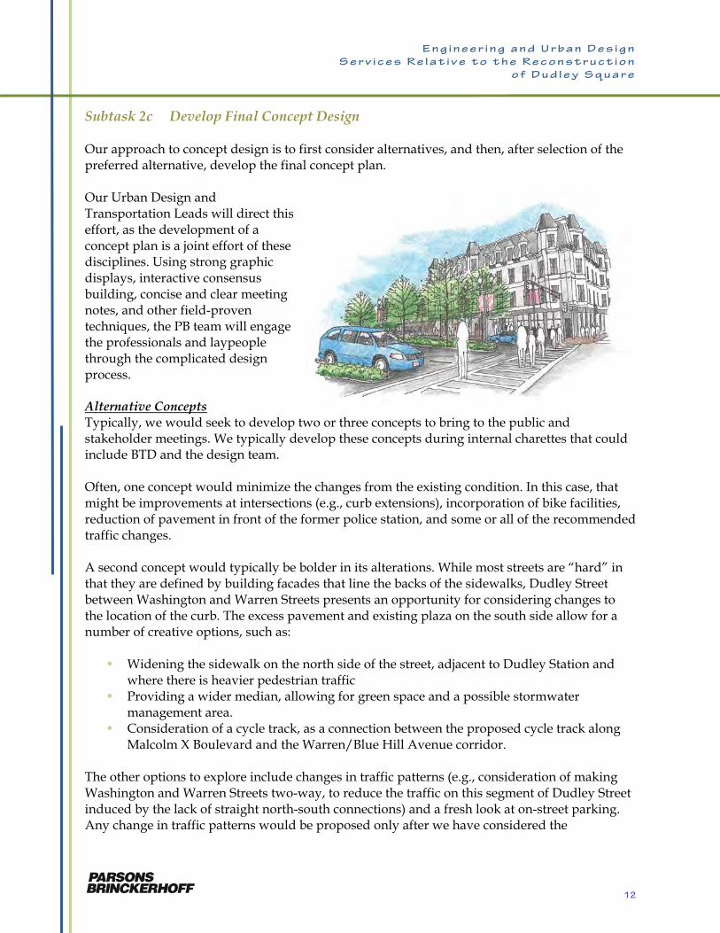
Subtask 2c Develop Final Concept Design Our approach to concept design is to first consider alternatives, and then, after selection of the preferred alternative, develop the final concept plan. Our Urban Design and Transportation Leads will direct this effort, as the development of a concept plan is a joint effort of these disciplines. Using strong graphic displays, interactive consensus building, concise and clear meeting notes, and other field-proven techniques, the PB team will engage the professionals and laypeople through the complicated design process. Alternative Concepts Typically, we would seek to develop two or three concepts to bring to the public and stakeholder meetings. We typically develop these concepts during internal charettes that could include BTD and the design team. Often, one concept would minimize the changes from the existing condition. In this case, that might be improvements at intersections (e.g., curb extensions), incorporation of bike facilities, reduction of pavement in front of the former police station, and some or all of the recommended traffic changes. A second concept would typically be bolder in its alterations. While most streets are “hard” in that they are defined by building facades that line the backs of the sidewalks, Dudley Street between Washington and Warren Streets presents an opportunity for considering changes to the location of the curb. The excess pavement and existing plaza on the south side allow for a number of creative options, such as: Widening the sidewalk on the north side of the street, adjacent to Dudley Station and
where there is heavier pedestrian traffic Providing a wider median, allowing for green space and a possible stormwater
management area. Consideration of a cycle track, as a connection between the proposed cycle track along
Malcolm X Boulevard and the Warren/Blue Hill Avenue corridor. The other options to explore include changes in traffic patterns (e.g., consideration of making Washington and Warren Streets two-way, to reduce the traffic on this segment of Dudley Street induced by the lack of straight north-south connections) and a fresh look at on-street parking. Any change in traffic patterns would be proposed only after we have considered the
12
E n g i n e e r i n g a n d U r b a n D e s i g n
S e r v i c e s R e l a t i v e t o t h e R e c o n s t r u c t i o n
o f D u d l e y S q u a r e
implications to traffic conditions, as assessed through use of the study traffic modeling, in balance with other objectives. A parking study must recognize the importance of on-street parking to local businesses, but all should focus on where this is essential and where nearby off-street lots would suffice. Still, shifting some on-street parking provides opportunities for enhanced pedestrian and bicycle accommodation and streetscape improvements. Besides the major layout alternatives, we will explore alternative methods of incorporating: Bicycle facilities (e.g., on-street lanes, cycle track, bike racks and posts) Stormwater management facilities (e.g., rain gardens, bio-filtration) Bus priority features (e.g., signal priority, queue jumps)
All conceptual designs will follow a Complete Streets approach, balancing the needs of all modes of transportation throughout the ROW. The designs may include on-street bicycle facilities or off-street bicycle facilities and will include seamless connections from adjacent facilities. Design considerations include bicycle jug handles to assist in left hand movements, raised crosswalks, green materials and signal design, timing, phasing, and coordination modifications. Initially, we will review the alternatives with BTD. With the concurrence of BTD, we will develop up to three concepts for the initial public meeting during Task 2. With public input, we will take the preferred alternative (or some combination of alternatives) and advance it to be the Final Concept Plan. Deliverables: Final Concept Plan (drawings and rendering)
Task 3 25% Design Development and Submission The 25% Design takes the Final Concept Design and integrates the input of all disciplines. Whereas Urban Design and Transportation lead the Concept Design effort, the 25% Design marks the point where the Project Engineer takes the lead, and civil design is the lead discipline. Our approach is for the civil/roadway engineers to establish the curb lines based on the Final Concept Design, taking into consideration: Desired sidewalk widths Travel lane widths, including bike lanes Intersection geometry Crosswalk and pedestrian ramp locations
With the curb lines established, the other elements of the streetscape design will be incorporated:
13
E n g i n e e r i n g a n d U r b a n D e s i g n
S e r v i c e s R e l a t i v e t o t h e R e c o n s t r u c t i o n
o f D u d l e y S q u a r e
Sidewalk finishes Street trees and other plantings Street furniture Street lighting layout
In developing the 25% design, various elements of the design must be considered. Accessible Design We will also work with the accessibility community in the development of the design to create an inclusive environment. CWDG brings a focused understanding of the current thinking on this topic from numerous meeting with the City of Boston Disability Commission and Institute for Human Centered Design to discuss paving materials and sections, related to their work at Spaulding Rehabilitation Hospital. In related discussions with staff and patients at the hospital, CWDG staff has come to understand that when it comes to street furniture, consideration must be given to height, materials and design in order to create inclusive environment. Complete Streets A Complete Streets strategy to redesigning the street and sidewalk infrastructure will: Improve the safety of all users Make it more comfortable and convenient for pedestrians, bicyclists, transit vehicles so
that new growth can be accommodated without substantially increasing traffic volumes through the square or parking demand
Use techniques for storm water management and air quality abatement that can also provide a buffer on the sidewalk from heavy bus and general traffic
Provide connections and amenities to ground-floor businesses and adjacent open spaces to support the existing and future businesses
Unify the public sidewalks and spaces with a single design palette that reinforces the sense of pride and place in Dudley Square
Our approach will work from the City’s guidelines for complete streets and apply the concepts in ways that are appropriate for the square and that have community support. Street Trees One of the surprising observations of an aerial image of the square is the amount of tree canopy cover in the project area. Still a number of street trees are stressed and there are opportunities for increasing the canopy. Our approach will be as follows: In consultation with BPRD and City Arborist Greg Mosman, we will develop a list of
street tree species for use on this project. Species will be native and drought tolerant. We will consider structural soil and tree ways to increase canopy size and visibility,
under drains and root aeration for enhanced tree health in urban environments. To the extent possible, mature healthy trees will be incorporated into the design.
14
E n g i n e e r i n g a n d U r b a n D e s i g n
S e r v i c e s R e l a t i v e t o t h e R e c o n s t r u c t i o n
o f D u d l e y S q u a r e
Site Furniture The project will include considerable street furniture, such as benches, planters, kiosk, bicycle racks and litter receptacles. Our approach to selection and placement of these items will consider the following: Site furniture must tolerate the rigor of the urban environment. Site furniture must be low maintenance Site furniture must be located so as not to obstruct pedestrian desire lines, nor to impede
accessibility. Our approach will be to propose a variety of street furniture alternatives for review with the City and the community. Public Art We will consider ways to integrate art into the public realm through: Paving patterns Murals Mosaics Wall insets Interpretive elements based on local history or culture Public art
Stormwater Management Options In this dense urban environment, storm water management facilities must be selected with due concern for sustainability, namely the ability to provide for ongoing maintenance so that the water quality benefits will be obtained. Options include the following: Rain gardens Storm water planters Passive irrigation Xeriscape Porous/permeable pavement
As the City agencies are working out roles and responsibilities for new facilities, particularly biofiltration devices, we will explore a number of options to ensure sustainability. These may include a partnership with a community group (e.g., Dudley Main Streets) or a non-profit or university that may take on both maintenance and research on the effectiveness of such items in an urban business district. Finally, there is also the option of contracting out the services of a firm that specializes in the maintenance of stormwater facilities. Street Lighting Presently, there is a variety of light pole and fixture types in Dudley Square. This project is an opportunity to implement a consistent style and to use state-of-the-art lighting fixtures. Our approach will be based on the following: Fixtures will be selected in consultation with the Street Lighting Division. LED and other energy-efficient fixtures will be considered. Pedestrian-scale lighting will be incorporated into the design.
15
E n g i n e e r i n g a n d U r b a n D e s i g n
S e r v i c e s R e l a t i v e t o t h e R e c o n s t r u c t i o n
o f D u d l e y S q u a r e
Deliverables: 25% drawings Presentation plans for public meetings List of necessary federal, state, and local permits Maintenance cost and agreement plan Initial plan submissions to utilities
Task 4 75% Design Submission This task is primarily a design production task overseen by the Project Engineer, who will coordinate the efforts of the various disciplines and firms as they produce the various types of plans, sections and details required. An important part of this task is the coordination with utilities. Inevitably, there will be existing utilities impacted by elements of the design. Our approach is to strive to minimize relocations, as these often add time to the construction schedule when private utilities must work in the congested square. We will distribute plans to all utilities and meet with those whose facilities are impacted. This is also the important time for coordination with the Public Improvement Commission (PIC). Typically, we would meet with the PIC’s engineer to go over the scope of the project and extent of the improvements. Once the 75% design is submitted, we would prepare the special PIC plans. Again, we would meet informally and get initial comments before we formally submit the plans. We will attend the PIC hearings. At the 75% level, we will know if there are any right-of-way impacts (e.g., takings). Other than at the site of the former police station, we do not expect many takings, as the building lines define the street layouts through most of the project area. Finally, the 75% level represents the first point in the process where a detailed bid item-based construction cost estimate can be developed. Deliverables: Response to comments on 25% design 75% drawings, specifications and construction cost estimate Traffic signal design submission Final ROW plans PIC plan submission Permit application for federal, state, and local permits Plan submissions to utilities Presentation plans for public meetings
16
E n g i n e e r i n g a n d U r b a n D e s i g n
S e r v i c e s R e l a t i v e t o t h e R e c o n s t r u c t i o n
o f D u d l e y S q u a r e
Task 5 100% Design The Project Manager will direct the compilation of the Special Provisions and will submit the approved the 100% design to BTD. The Project Engineer will submit updated plans to BWSC and the utilities, so that each entity will have the latest version of the plans. Deliverables: Response to comments on 75% design 100% drawings, specifications and construction cost estimate Final ROW plans Presentation plans for public meetings
Task 6 Bid Documents and Support PB will assemble the final bid documents from the approved PS&E package, incorporating standard City of Boston provisions and other requirements of funding agencies (e.g., MassDOT). The Bid Documents should include a set-aside percentage for workforce participation by City residents, with emphasis on residents of Roxbury and surrounding neighborhoods. Our bid phase support will be coordinated by our Project Manager, who will attend the pre-bid conference and bid opening. All bidder questions will be reviewed and, when necessary, referred to the relevant discipline for response. All responses will be by Addenda and Responses to Questions distributed to all registered bidders. After the bids are received, we will develop a spreadsheet comparing all bids and the Engineer’s Estimate. We will review for the reasonableness of the unit bid prices and look for any indication of a possibly unbalanced bid. Based on this review, we will make a written award recommendation to the BTD. Conformed drawings and specifications will indicate all changes by Addenda by clouds in the drawings and underline/strike-through in the specifications. Copies will be available to the Department, the Contactor and the design team. Deliverables: Meeting notes from pre-bid conference Addenda and responses to bidders’ questions Bid evaluation and recommendation for award Conformed drawings and specifications
Task 7 Construction Phase Services During construction, our usual approach is to designate a dedicated Construction Phase Engineer (CPE) to act as the point person for all correspondence and documents as well as a liaison between the BTD, the resident engineer and the Contractor. For this project, the CPE will
17
E n g i n e e r i n g a n d U r b a n D e s i g n
S e r v i c e s R e l a t i v e t o t h e R e c o n s t r u c t i o n
o f D u d l e y S q u a r e
be our Assistant Project Engineer, Lisa Valerio, who will be working under the direct supervision of the Project Engineer. Having one dedicated individual handling all correspondence allows for ease of communication, as all involved parties know whom to go to for answers. On many of our recent projects, we handle most of the document correspondence paper-free. Initial submission of shop drawings and RFIs will be by e-mail to Lisa, who will log them in and distribute them to the appropriate persons. For the finalized documents (e.g., approved shop drawings, completed RFIs, progress meeting notes, field reports, and field changes), PB will set up a dedicated, password-protected site using our ProjectSolve software. All parties (BTD, Contractor, Resident Engineer and inspectors, Consultant team, and if necessary, other agencies) will have access. As she has done with our Wickford Junction project, Lisa will manage the content and ensure that only the latest version of any document is posted. Updated logs of shop drawings and RFIs will also be posted at this site. Note that if BTD does not wish to use a project website for the posting of record documents, the process can be handled with paper files and transmission either by paper or PDF. We have used all methods, depending on the preferences of our clients. The CPE will also handle all construction progress meeting minutes, sending out for review by all parties prior to official record acceptance. Deliverables: Approved shop drawings and submittals Responses to contractor RFIs Review of value engineering change proposals Construction observation reports Punch list at substantial completion
Task 8 Public Improvement Commission and Other Agency Submissions Under this task, we will prepare preliminary plans for discussion with the PIC’s engineer. Once we reach about 75% design and we have addressed the PIC’s comments on the preliminary plans, we will submit the final PIC plans in both black and white and the full color versions. After PIC review, the plans will be modified, if needed, and resubmitted prior to the hearings. In a similar matter, we will submit plans to other agencies. We anticipate BWSC will require the most coordination, as inevitably the project will include modifications to the storm drainage and water systems, at a minimum. Typically, at the 75% and 100% submission levels, we would submit plans to BWSC and other agencies for their review and comments.
18
E n g i n e e r i n g a n d U r b a n D e s i g n
S e r v i c e s R e l a t i v e t o t h e R e c o n s t r u c t i o n
o f D u d l e y S q u a r e
Task 9 Public Process and Agency Coordination As described in RFP, Task 9 has two important components: Public outreach, a critical process as we described in our Project Understanding. This
effort will have our public outreach consultant, Kelley Chunn, providing a major advisory role, supported by key staff from all firms and disciplines.
Necessary coordination with City departments, other public agencies, and utilities. This effort will be coordinated by the Project Engineer, Nick Torello.
Subtask 9a Public Outreach The PB team’s approach to this project centers on the public outreach and stakeholder coordination process. This process, managed by the City, will serve to define both the vision for Dudley Square and the details of the improvement plan. Develop Public Outreach Program The RFP envisions three components of the outreach program: Public meetings Meetings with stakeholders and individuals Project information on the City website
These will be the core elements of the outreach program. To supplement and possibly enhance these elements, we would propose the following: Community Workshops: We would propose to frame at least two of the seven
community meetings as interactive community workshops that take place early in design development. These workshops would allow our team to work more interactively with the community to develop and refine the conceptual design, and would also provide an opportunity to apply Team Better Block’s unique and innovative approach to community outreach, potentially involving efforts to implement temporary “pop-up” tests of streetscape improvements. We would also propose to have active transportation and public health expert Mark Fenton participate in the first workshop, to bring his experience working to increase physical activity and improve health outcomes through proactive changes to our transportation infrastructure. Mark’s unique and infectious enthusiasm for these issues will help to energize the community about the prospect of redesigning Dudley Square as a healthier and more active community.
Community Advisory Committee: The scope in the RFP assumes a minimum of twelve meetings with abutters and stakeholders. We would suggest the idea of converting some of those stakeholder meetings into a Community Advisory Committee that would be meet regularly (perhaps every other month) throughout the design effort. This CAC would be made up of key stakeholders and community members and would provide a longitudinal opportunity to work with the community on planning and design issues. Our team’s experience has shown that this structure provides better continuity in
19
E n g i n e e r i n g a n d U r b a n D e s i g n
S e r v i c e s R e l a t i v e t o t h e R e c o n s t r u c t i o n
o f D u d l e y S q u a r e
discussing the project and allows the stakeholders to develop productive relationships with the project team, resulting in more effective outreach and better functional outcomes.
Involvement of Team Better Block (TBB), which would bring their innovative approach to outreach and project design, to involve the community, both in non-traditional ways and involving non-traditional stakeholders. TBB will seek to engage with teenagers, young adults, working families, bus riders, and other stakeholders who might not otherwise pay attention to this type of outreach, but whose daily lives will undoubtedly be affected by the changes that are proposed. TBB’s approach involves reaching out to a wide range of stakeholders and engaging them very directly in the design process, up to and including challenging the community to help design and implement temporary improvements that help test and explain future improvements.
Opinion Gathering Techniques: In the RDM Study, we have witnessed the effectiveness of various methods of obtaining opinions and suggestions from a wide range of the community. The principal method was a survey/questionnaire available in multiple formats: on-line survey; paper copy distributed to community groups and churches as well as distributed at bus stops; oral version assisted by the “street team” using hand-held devices at bus stops; and setting up a table at community events or at public locations (e.g., Dudley Station) where project staff would converse with passers-by and compile opinions and suggestions. We believe these methods can be effective in obtaining viewpoints beyond those who might be able to attend the public meetings.
Additional Outreach Methods during Construction: In addition to the public website and public meetings during the construction phase (Task 7), we would propose other methods to communicate to the public about the upcoming work, expected impacts, and where to go with complaints and other issues. These could include: - Informational flyers by mail or distributed by hand - Setting up a project information center at a central location (e.g., library, Elder
Services, Hibernia Hall). This could include a project display, information flyers, or even a person who could answer questions and pass on comments and complaints. If the location were at Hibernia Hall, Kelley Chunn and her staff could provide the “live person” at designated hours.
- Project updates in community papers (e.g., Bay State Banner) - Public service announcements on community TV and local radio stations
We believe these are all cost-effective methods and do not add significantly to the design fee. We have included these in our cost proposal. Meeting Schedule and Coordination with Design While BTD and the City of Boston will manage the process, we would propose a schedule for the public and outreach meetings to coordinate them with our design schedule. Our team will work to proactively manage our schedule within the context of the outreach process. We will align our project schedule with the outreach schedule, such that we are making decision in consultation with the community at the time when those decisions need to be integrated into
20
E n g i n e e r i n g a n d U r b a n D e s i g n
S e r v i c e s R e l a t i v e t o t h e R e c o n s t r u c t i o n
o f D u d l e y S q u a r e
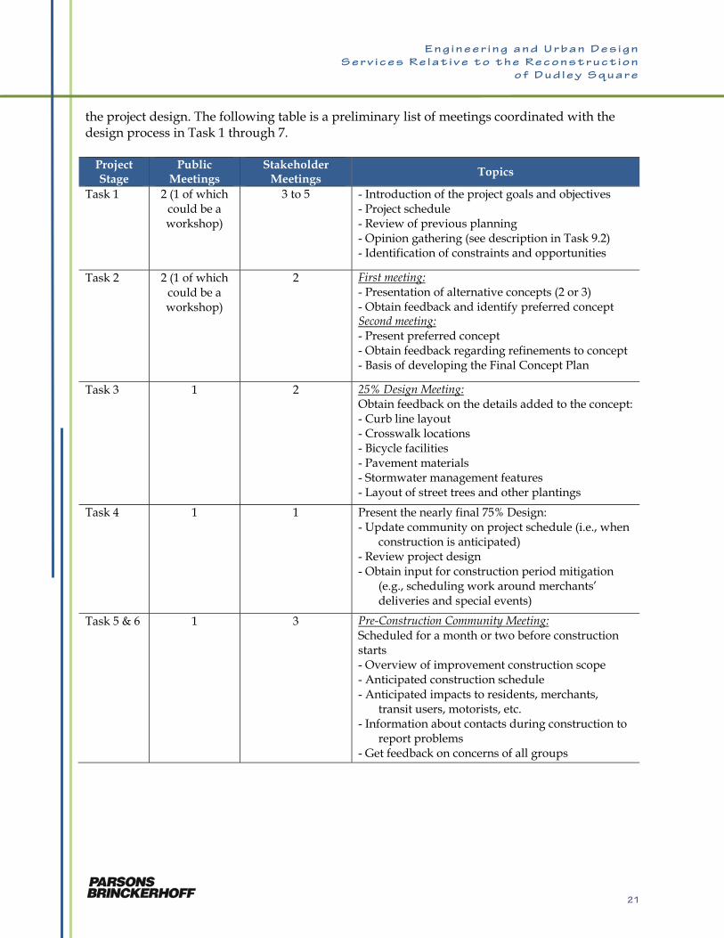
the project design. The following table is a preliminary list of meetings coordinated with the design process in Task 1 through 7.
Project Stage
Public Meetings
Stakeholder Meetings Topics
Task 1 2 (1 of which could be a workshop)
3 to 5 - Introduction of the project goals and objectives - Project schedule - Review of previous planning - Opinion gathering (see description in Task 9.2) - Identification of constraints and opportunities
Task 2 2 (1 of which could be a workshop)
2 First meeting: - Presentation of alternative concepts (2 or 3) - Obtain feedback and identify preferred concept Second meeting: - Present preferred concept - Obtain feedback regarding refinements to concept - Basis of developing the Final Concept Plan
Task 3 1 2 25% Design Meeting: Obtain feedback on the details added to the concept: - Curb line layout - Crosswalk locations - Bicycle facilities - Pavement materials - Stormwater management features - Layout of street trees and other plantings
Task 4 1 1 Present the nearly final 75% Design: - Update community on project schedule (i.e., when
construction is anticipated) - Review project design - Obtain input for construction period mitigation
(e.g., scheduling work around merchants’ deliveries and special events)
Task 5 & 6 1 3 Pre-Construction Community Meeting: Scheduled for a month or two before construction starts - Overview of improvement construction scope - Anticipated construction schedule - Anticipated impacts to residents, merchants,
transit users, motorists, etc. - Information about contacts during construction to
report problems - Get feedback on concerns of all groups
21
E n g i n e e r i n g a n d U r b a n D e s i g n
S e r v i c e s R e l a t i v e t o t h e R e c o n s t r u c t i o n
o f D u d l e y S q u a r e
Project Stage
Public Meetings
Stakeholder Meetings
Topics
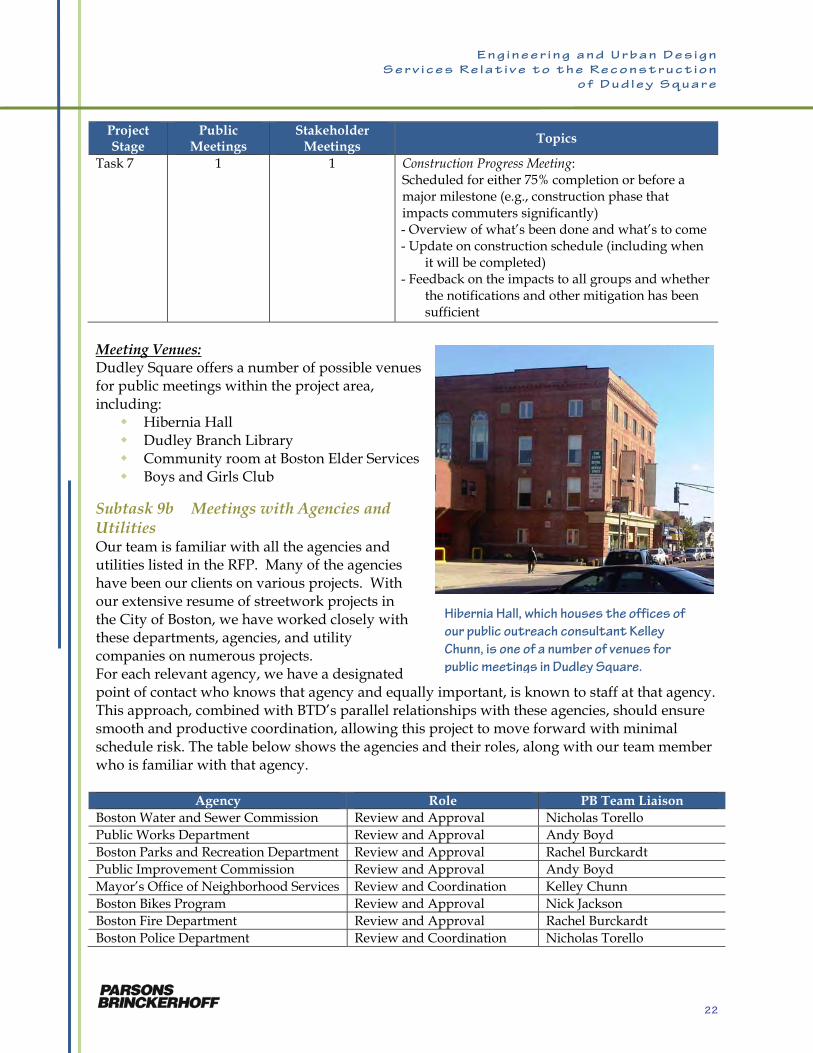
Task 7 1 1 Construction Progress Meeting: Scheduled for either 75% completion or before a major milestone (e.g., construction phase that impacts commuters significantly) - Overview of what’s been done and what’s to come - Update on construction schedule (including when
it will be completed) - Feedback on the impacts to all groups and whether
the notifications and other mitigation has been sufficient
Meeting Venues: Dudley Square offers a number of possible venues for public meetings within the project area, including: Hibernia Hall Dudley Branch Library Community room at Boston Elder Services Boys and Girls Club
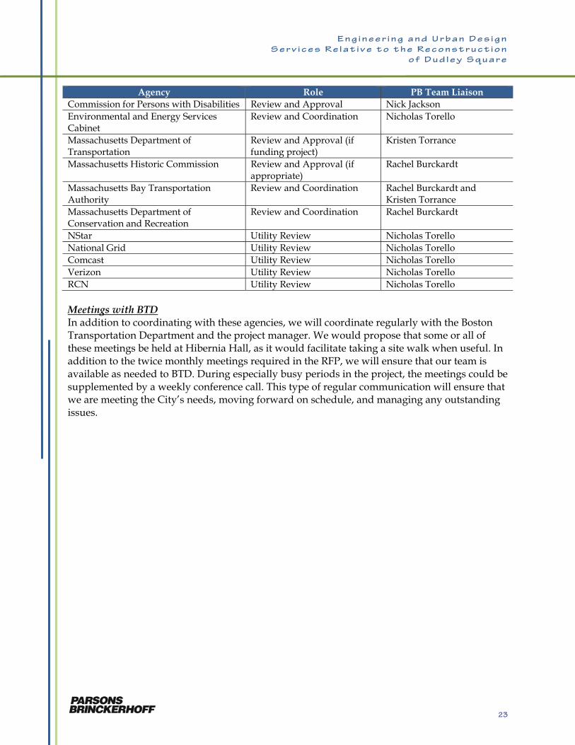
Subtask 9b Meetings with Agencies and Utilities Our team is familiar with all the agencies and utilities listed in the RFP. Many of the agencies have been our clients on various projects. With our extensive resume of streetwork projects in the City of Boston, we have worked closely with these departments, agencies, and utility companies on numerous projects. For each relevant agency, we have a designated point of contact who knows that agency and equally important, is known to staff at that agency. This approach, combined with BTD’s parallel relationships with these agencies, should ensure smooth and productive coordination, allowing this project to move forward with minimal schedule risk. The table below shows the agencies and their roles, along with our team member who is familiar with that agency.
Agency Role PB Team Liaison Boston Water and Sewer Commission Review and Approval Nicholas Torello Public Works Department Review and Approval Andy Boyd Boston Parks and Recreation Department Review and Approval Rachel Burckardt Public Improvement Commission Review and Approval Andy Boyd Mayor’s Office of Neighborhood Services Review and Coordination Kelley Chunn Boston Bikes Program Review and Approval Nick Jackson Boston Fire Department Review and Approval Rachel Burckardt Boston Police Department Review and Coordination Nicholas Torello
Hibernia Hall, which houses the offices of
our public outreach consultant Kelley
Chunn, is one of a number of venues for
public meetings in Dudley Square.
22
E n g i n e e r i n g a n d U r b a n D e s i g n
S e r v i c e s R e l a t i v e t o t h e R e c o n s t r u c t i o n
o f D u d l e y S q u a r e
Agency Role PB Team Liaison Commission for Persons with Disabilities Review and Approval Nick Jackson Environmental and Energy Services Cabinet
Review and Coordination Nicholas Torello
Massachusetts Department of Transportation
Review and Approval (if funding project)
Kristen Torrance
Massachusetts Historic Commission Review and Approval (if appropriate)
Rachel Burckardt
Massachusetts Bay Transportation Authority
Review and Coordination Rachel Burckardt and Kristen Torrance
Massachusetts Department of Conservation and Recreation
Review and Coordination Rachel Burckardt
NStar Utility Review Nicholas Torello National Grid Utility Review Nicholas Torello Comcast Utility Review Nicholas Torello Verizon Utility Review Nicholas Torello RCN Utility Review Nicholas Torello Meetings with BTD In addition to coordinating with these agencies, we will coordinate regularly with the Boston Transportation Department and the project manager. We would propose that some or all of these meetings be held at Hibernia Hall, as it would facilitate taking a site walk when useful. In addition to the twice monthly meetings required in the RFP, we will ensure that our team is available as needed to BTD. During especially busy periods in the project, the meetings could be supplemented by a weekly conference call. This type of regular communication will ensure that we are meeting the City’s needs, moving forward on schedule, and managing any outstanding issues.
23
E n g i n e e r i n g a n d U r b a n D e s i g n
S e r v i c e s R e l a t i v e t o t h e R e c o n s t r u c t i o n
o f D u d l e y S q u a r e
PERSONNEL, EXPERIENCE, AND ORGANIZATION CHART
Rachel J. Burckardt, PE – Project Manager We selected Rachel J. Burckardt, PE, to be Project Manager for her unique combination of relevant technical experience related to all aspects of this project and familiarity with the project area and community concerns. Her familiarity includes a current role as PB’s project manager for the MassDOT Roxbury Dorchester Mattapan Transit Needs Study (RDM). A participant in the Walk for Dudley in recent years, she has seen first-hand many examples of community-sponsored revitalization efforts along Dudley Street, indicative of the vital role of community groups and the public in any successful project. Examples of managing interdisciplinary transportation projects include her current roles as Design Manager for the $24M Wickford Junction commuter rail station and garage and Project Manager for the Revere Beach Boulevard Improvement Project, an example of a context-sensitive streetscape design, which greatly enhanced pedestrian accommodations, all within the historic setting of America’s first public beach. The table below is provided to correlate Rachel’s experience with the requirements for the project manager as presented in the RFP.
Project Role
Man
agin
g M
ult
i-D
isci
pli
nar
y T
eam
s
Com
ple
x T
ran
spor
tati
on
Pro
ject
s
Str
eets
cap
e R
econ
stru
ctio
n
Pro
ject
s
Con
text
Sen
siti
ve
Des
ign
His
tori
c S
etti
ngs
Bes
t Pra
ctic
es a
nd
S
tate
of
the
Art
T
ech
nol
ogie
s
Des
ign
-Dri
ven
P
roje
cts
Com
ple
x U
rban
E
nvi
ron
men
t
Maj
or U
tili
ty W
ork
Inte
nsi
ve P
ub
lic
Inte
rest
an
d
Com
mu
nit
y P
arti
cip
atio
n
RDM PM √ √ √ √ Revere Beach Blvd PM √ √ √ √ √ √ √ √ √
Wickford Jct. Design
Manager √ √ √ √ √
Boynton Yards PM √ √ √ √ Winthrop Shores PM √ √ √ √ √ √ √ Brunswick Layover Facility
Proj. Engineer √ √
Savin Hill Sewer PM √ √ √ √ Green Line Extension
Proj. Engineer √ √ √ √
North Dorchester Bay CSO
Proj. Engineer √ √ √ √ √ √ √
Devens Roadways PM √ √ √ √ √ Muddy River Restoration Project
Client PM √ √ √ √
Wethersfield Cove PM √ √ √ √ √
24
E n g i n e e r i n g a n d U r b a n D e s i g n
S e r v i c e s R e l a t i v e t o t h e R e c o n s t r u c t i o n
o f D u d l e y S q u a r e
Project Role
Man
agin
g M
ult
i-D
isci
pli
nar
y T
eam
s
Com
ple
x T
ran
spor
tati
on
Pro
ject
s
Str
eets
cap
e R
econ
stru
ctio
n
Pro
ject
s
Con
text
Sen
siti
ve
Des
ign
His
tori
c S
etti
ngs
Bes
t Pra
ctic
es a
nd
S
tate
of
the
Art
T
ech
nol
ogie
s
Des
ign
-Dri
ven
P
roje
cts
Com
ple
x U
rban
E
nvi
ron
men
t
Maj
or U
tili
ty W
ork
Inte
nsi
ve P
ub
lic
Inte
rest
an
d
Com
mu
nit
y P
arti
cip
atio
n
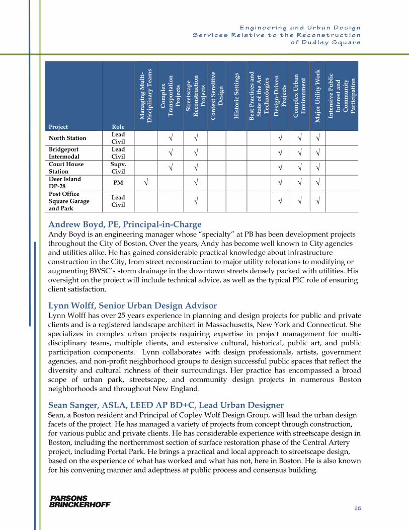
North Station Lead Civil √ √ √ √ √
Bridgeport Intermodal
Lead Civil √ √ √ √ √
Court House Station
Supv. Civil √ √ √ √ √
Deer Island DP-28
PM √ √ √ √ √ Post Office Square Garage and Park
Lead Civil √
√ √ √
Andrew Boyd, PE, Principal-in-Charge Andy Boyd is an engineering manager whose “specialty” at PB has been development projects throughout the City of Boston. Over the years, Andy has become well known to City agencies and utilities alike. He has gained considerable practical knowledge about infrastructure construction in the City, from street reconstruction to major utility relocations to modifying or augmenting BWSC’s storm drainage in the downtown streets densely packed with utilities. His oversight on the project will include technical advice, as well as the typical PIC role of ensuring client satisfaction.
Lynn Wolff, Senior Urban Design Advisor Lynn Wolff has over 25 years experience in planning and design projects for public and private clients and is a registered landscape architect in Massachusetts, New York and Connecticut. She specializes in complex urban projects requiring expertise in project management for multi-disciplinary teams, multiple clients, and extensive cultural, historical, public art, and public participation components. Lynn collaborates with design professionals, artists, government agencies, and non-profit neighborhood groups to design successful public spaces that reflect the diversity and cultural richness of their surroundings. Her practice has encompassed a broad scope of urban park, streetscape, and community design projects in numerous Boston neighborhoods and throughout New England.
Sean Sanger, ASLA, LEED AP BD+C, Lead Urban Designer Sean, a Boston resident and Principal of Copley Wolf Design Group, will lead the urban design facets of the project. He has managed a variety of projects from concept through construction, for various public and private clients. He has considerable experience with streetscape design in Boston, including the northernmost section of surface restoration phase of the Central Artery project, including Portal Park. He brings a practical and local approach to streetscape design, based on the experience of what has worked and what has not, here in Boston. He is also known for his convening manner and adeptness at public process and consensus building.
25
E n g i n e e r i n g a n d U r b a n D e s i g n
S e r v i c e s R e l a t i v e t o t h e R e c o n s t r u c t i o n
o f D u d l e y S q u a r e
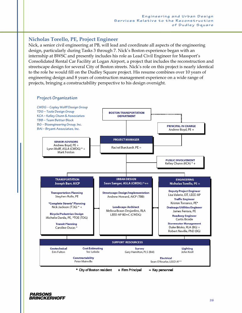
Nicholas Torello, PE, Project Engineer Nick, a senior civil engineering at PB, will lead and coordinate all aspects of the engineering design, particularly during Tasks 3 through 7. Nick’s Boston experience began with an internship at BWSC and presently includes his role as Lead Civil Engineer for Massport’s Consolidated Rental Car Facility at Logan Airport, a project that includes the reconstruction and streetscape design for several City of Boston streets. Nick’s role on this project is nearly identical to the role he would fill on the Dudley Square project. His resume combines over 10 years of engineering design and 8 years of construction management experience on a wide range of projects, bringing a constructability perspective to his design oversight.
Project Organization
CWDG – Copley Wolff Design Group
TDG – Toole Design Group
KCA – Kelley Chunn & Associates
TBB – Team Better Block
BG – Bioengineering Group, Inc.
BAI – Bryant Associates, Inc.
26
E n g i n e e r i n g a n d U r b a n D e s i g n
S e r v i c e s R e l a t i v e t o t h e R e c o n s t r u c t i o n
o f D u d l e y S q u a r e
Joseph Barr, Lead Transportation Planner Joe, a senior transportation planner at PB, will lead the transportation disciplines, particularly during the development of the Final Concept Plan in Task 2. This concept plan will be an interdisciplinary product of urban/streetscape design and transportation design, which includes traffic engineering, bicycle and pedestrian accommodations (“complete streets”), and transit operations. Joe’s experience is focused on transit and roadway planning in complex urban environments. Currently, he is assisting Rachel with the RDM Transit Needs Study, which includes this project area. He also brings a strong understanding of bus operations, which is important in a square that also serves as a major hub of MBTA bus routes. He has been involved in all aspects of the development and implementation of a number of significant bus service improvements, including the EZRide shuttle service in Cambridge and Boston. He recently served as Director of Transit Development with the New York City DOT, where he was responsible for all aspects of New York City’s BRT and bus mobility programs, including the successful launch of both of the city’s current BRT services.
Kelley Chunn, Public Outreach Kelley Chunn has been a media and public information consultant for 25 years, including 20 years as a principal of her own award-winning firm. Kelley will lead the public outreach effort, from her office located at Hibernia Hall in the heart of Dudley Square. From knowing the local stakeholders, knowing the issues and challenges of Dudley Square, to having personal relationships with local residents and media outlets along with skills in planning and executing effective, targeted campaigns, and understanding first-hand what it is like to run a business in Dudley Square, Kelley is unmatched in what she brings in local perspective.
Lisa A. Valerio, EIT, Deputy Project Engineer Lisa will serve as deputy project engineer, and will assist Nick is the coordination of the design effort, and to manage the construction phase services. Lisa is highly qualified for these roles, performing them for Rachel on multiple projects, most notably Wickford Junction Station. As Assistant Project Manager, she is managing document control for the entire design/build team, and as such is responsible for all design documents, shop drawings, requests for information, field memos and project controls. She has been the coordinator between the design team and the contractor on this D/B project and has coordinated all approvals between the Rhode Island Department of Transportation (RIDOT), the developer, the contractor and the design team. For the Dudley Square project, Lisa will perform the same tasks, as well as assisting with the civil design work.
Nick Jackson, “Complete Streets” Nick Jackson’s more than 12 years of managing multi-modal planning and design projects in the City of Boston have provided him the opportunity to work closely with transportation professionals, elected officials and members of the public on a wide range of non-motorized transportation initiatives. He has worked for state agencies including MassDOT, MassDCR, and the MBTA. He is project manager for TDG’s project to assist the City of Boston in developing a new set of guidelines for city streets and sidewalks that embody “Complete Streets” principles. He is also leading TDG’s work for the reconstruction of Melnea Cass Boulevard. In addition to
27

E n g i n e e r i n g a n d U r b a n D e s i g n
S e r v i c e s R e l a t i v e t o t h e R e c o n s t r u c t i o n
o f D u d l e y S q u a r e
his project activities, Nick stays abreast of the state of the practice through his membership on the Transportation Research Board’s Bicycle Research Committee.
Kristen Torrance, PE, Traffic Engineer A resident of the Back Bay, Kristen brings a broad background of traffic engineering and transportation planning skills. As assistant project manager and lead transportation planner for the RDM Transit Needs Study, Kristen is familiar with bus operations and traffic issues at Dudley Station, which is the major transit node in the RDM study area. Kristen has been heavily involved in the public outreach associated with the RDM study, and is known by a number of transit advocates in the Roxbury. Kristen’s skills that will be utilized on this project include traffic modeling, roadway and intersection designs, traffic signal design, pedestrian and bicycle evaluations, and traffic signage/striping design. Resumes for all staff shown on the Project Organization chart immediately follow.
28
E n g i n e e r i n g a n d U r b a n D e s i g n
S e r v i c e s R e l a t i v e t o t h e R e c o n s t r u c t i o n
o f D u d l e y S q u a r e
RACHEL J. BURCKARDT, PE Project Manager YEARS OF EXPERIENCE 34 EDUCATION Northeastern University: MS, Civil Engineering, 1986; BS, Civil Engineering, 1977 PROFESSIONAL REGISTRATIONS Professional Engineer: Massachusetts, 1984 (31880); Connecticut, 1985 (13593); Maine, 1985 (5267); New Hampshire, 1985 (6191); Rhode Island, 1999 (6984); Vermont, 2009 (6228) PROFESSIONAL AFFILIATIONS American Society of Civil Engineers
PROFILE Rachel Burckardt is a senior supervising engineer and a project manager with over 30 years of diverse experience in all phases o infrastructure projects, from conceptualization through planning, design, and construction. She has managed a variety of transportation projects and is also very experienced in project permitting and public outreach.
RELEVANT EXPERIENCE
Roxbury-Dorchester-Mattapan Transit Improvement Study, Boston, MA: project manager for PB’s role as subconsultant in a study identifying transit needs for this area that is distant from the city’s rapid transit system. The initial tasks included compiling the existing operations of the 20 bus routes in the study area, including meetings with MBTA bus operations. Through an extensive program of public engagement, including public meetings, an advisory group, and a website, a menu of over 150 alternatives was compiled and is being screened. After screening, the study will advance a set of short-, medium-, and long-term recommendations for implementation.
Revere Beach Boulevard Improvements, Revere, MA: project manager for the design for the upgrade and historic restoration of the northern portion of Revere Beach Boulevard. The project includes reconstruction of roadways, new historic street light fixtures, new storm drainage system incorporating best management practices (BMPs), a new municipal water main, new amenities for (benches, covered sitting areas), landscaping, parking improvements, and permitting and construction phase services.
Wickford Junction Station Design/Build Project, North Kingstown, RI: Rachel serves as design manager for the Manafort/PB D/B team which prepared the final design and is now completing the construction of this new commuter rail station and garage for RIDOT. This multi-modal project includes a new station on the MBTA Providence Line with a single-side platform, a new siding track (installed by Amtrak), and a 1,100-car parking garage, along with a drop-off/pick-up area for cars and buses, bicycle parking, storm-water treatment facilities, and new landscaping. Rachel oversaw the entire design process involving PB and three other firms, and she currently serves as PB’s project manager.
29
E n g i n e e r i n g a n d U r b a n D e s i g n
S e r v i c e s R e l a t i v e t o t h e R e c o n s t r u c t i o n
o f D u d l e y S q u a r e
Boynton Yard Transportation and Utility Study, Somerville, MA: project manager for study of transportation and utility infrastructure needs to support redevelopment of this 40-acre district. The completion of the Green Line extension to Union Square in Somerville is expected to spur transit-oriented developments to transform the present, mostly industrial area. The study includes a consideration of existing “hard” and “soft” developments, possible New Start grids and the potential to reassemble existing lots to support the anticipated mix of future land uses.
Winthrop Shores Reservation Restoration, Winthrop and Revere, MA: Project manager for a series of coastal and roadway improvements at Winthrop, Short and Rocky Beaches. The work at Short Beach is in construction and involves reconstruction of Winthrop Parkway, including new, widened sidewalks and improved crosswalks to facilitate pedestrian access to the beach, and a new jughandle intersection to improve safety for motorists. The project also included a new storm drainage system incorporating best management practices (BMPs). Repairs to the seawall caps and beach access structures, new beach amenities, new street lighting, an off-street parking lot, a trail to Belle Isle Marsh comprising a 140-ft-long footbridge, and landscaping were also included. The now-completed work at Rocky Beach included a new traffic signal and other improvements at a complex 6-legged intersection, all to improve traffic control in this previously chaotic intersection and to facilitate public access to the beach. Ongoing work includes the design of the reconstruction of Winthrop Shore Drive, which will include widened sidewalks, curb extension, and improved crosswalks.
Downeaster Layover and Maintenance Facility, Brunswick, ME: project engineer for the Northern New England Passenger Rail Authority (NNEPRA) project that includes the design of an indoor train storage facility for the extension of the Amtrak-operated Downeaster service from Portland to Brunswick, Maine. The project included a public meeting process in which an alternative analysis for the site selection was reviewed. The facility will include a new building with three inside storage tracks, offices, support facilities and storage. The sitework includes an access road, utilities, parking, stormwater management system, and security fencing. The project will be procured by the design/build method and PB will serve as the owner’s engineer during the final design and construction phases.
Savin Hill Sewer Replacement Project, Boston, MA: project manager for the design of the replacement of a Boston Water & Sewer Commission (BWSC) 24-inch sewer under I-93 Southeast Expressway and five transit and commuter rail tracks. Replacement was achieved by jacking a 60-inch lining under the highway and tracks. Two new water mains were included in the sleeve along with the replacement sewer.
Green Line Extension Project (GLX), Cambridge, Somerville, and Medford, MA: project engineer with various roles during the planning and pre-preliminary engineering phases. Developed layouts for light rail vehicle storage and maintenance facility for environmental impact analysis phase of this MassDOT project. Performed trip time estimates for proposed service plan. Also, developed preliminary alignment for a multi-use pathway, known as the Somerville Community Path, which would be built by the City of Somerville on an alignment parallel to the proposed Green Line.
North Dorchester Bay Combined Sewer Overflow Storage Tunnel: lead civil engineer for the permitting, preparation of project specifications, design of utility relocations, and design of site restoration related to construction of a new 2-mile long CSO storage tunnel with connections to
30
E n g i n e e r i n g a n d U r b a n D e s i g n
S e r v i c e s R e l a t i v e t o t h e R e c o n s t r u c t i o n
o f D u d l e y S q u a r e
local storm drainage and CSO piping. Site restoration work including regrading and irrigation of two recreations fields, restoration of two ball fields, and coordination with the municipal and state parks agencies. Work included engineering support for federal, state and local permits required for construction.
Devens Roadways, Devens, MA: project manager for delivery-order contracts for the design of local roadways and utility infrastructure for MassDevelopment’s redevelopment of the former Fort Devens. Roadway design has included alignments, grading, layout, drainage, utilities, traffic striping and signage, landscaping and traffic management. The 1.5-mile long Barnum Road Improvements Project was delivered on an expedited 5-month schedule. The Patton Road Golf Cart Tunnel was delivered in an expedited schedule of less than a month.
Muddy River Restoration Project, Boston and Brookline, MA: project manager acting as extension of staff for co-proponents, Boston Parks & Recreation Department and Town of Brookline, for the flood control, water quality, and historic landscape restoration work for the Muddy River within the historic Olmstead-designed Emerald Necklace parks. The work included oversight of the design consultant; cost and schedule monitoring; grant and funding administration; and construction oversight. The restoration work included dredging of the river and ponds; construction of additional culvert capacity; daylighting of culverted sections of the river; planning and implementation of BMPs; and landscape restoration work.
Wethersfield Cove Combined Sewer Overflow (CSO) Abatement Project, Hartford, CT: project manager for the implementation phase, which included construction of separated sewers and storm drains, mostly in major thoroughfares of Hartford’s South End. The work included street restoration and traffic control plans.
North Station Improvement Project, Boston, MA: lead civil engineer for a new combined Green Line/Orange Line subway station. Civil work included extensive utility relocations; reconstruction of Causeway, Canal and Haverhill Streets, as well as Valenti Way, all to City of Boston standards; and maintenance of rail, pedestrian, and motor vehicle traffic during construction.
Bridgeport Intermodal Station, Bridgeport, Connecticut: lead civil engineer for two phases of this project upgrading the existing intermodal facility which serves intercity rail, commuter rail, local and intercity bus, ferry service, and parking facilities. The first phase involved a new above-grade garage adjoining Bridgeport’s rail stations and a new sports arena. Work included utility relocations, new utility services, grading and drainage, and coordination with site design of the adjacent sports arena. The second phase included a new bus station with related sitework, including grading, drainage and utilities.
Courthouse Station, Boston, MA: supervising civil engineer for the MBTA’s Silver Line station serving the waterfront in South Boston. Civil design included the reconstruction of Seaport Boulevard and side streets to City of Boston standards, new drainage and utility systems, as well as traffic signage and striping.
Deer Island Secondary Treatment Facilities, Design Package No. 28, Boston, MA: project manager for structural and civil/site work design for the MWRA’s Boston Harbor wastewater treatment plant. Site work included over 3 miles of roadways, major utility construction, storm drainage, 1.5 miles of shoreline revetment, security fencing, and the main guard house.
31
E n g i n e e r i n g a n d U r b a n D e s i g n
S e r v i c e s R e l a t i v e t o t h e R e c o n s t r u c t i o n
o f D u d l e y S q u a r e
Post Office Square Garage and Park, Boston, MA: lead civil engineer and design coordinator for a 1,400-car underground garage with a 1.5-acre urban park at street level. Designed utility relocations in congested streets involving electric, telephone, fire alarm, steam and storm drains. Also designed new utility systems (water, sanitary, sewer, storm drainage, street lighting) for the garage and park; participated in street and building layouts; and coordinated design efforts of architectural and engineering subconsultants. Utility relocation included Boston Edison 115-kV transmission lines and a 13.8-kV local distribution line.
Urban Ring, Boston, MA: lead engineer for PB’s role as alignment designer for stations, tunnels, and bridges for this MBTA Major Investment Study (MIS) of transit options for a radial corridor around downtown Boston. The work included conceptual alignments for new rail and bus rapid transit tunnels and viaducts; conceptual designs for new transit and commuter rail stations; and conceptual design for interline rail connections. One alternative included a new radial subway route from Sullivan Square, passing through Cambridge and the Longwood Medical Area, and terminating at Dudley Square.
Cambridge Bicycle Advisory Committee: as a volunteer member of this committee for 12 years, advised the Cambridge Traffic and Community Development Departments regarding all projects involving new bicycle facilities. Also was the task leader for a study into the feasibility of developing a multi-purpose path (bike, pedestrian) along the active Grand Junction railroad right-of-way, and prepared a detailed report that includes existing conditions, property ownerships, railroad operations, design criteria, conceptual design, implementation strategies, and coordination with adjacent projects such as the MBTA Urban Ring and the DCR Charles River Basin master plan. Based on this report, the City of Cambridge appropriated funding for a more detailed feasibility study.
32