Embed Size (px)
Citation preview

Flood Management in Selected River Basins Sector Project (RRP INO 35182)
Project Number: 35182 Loan Number: L3340
September 2016
Republic of Indonesia: Flood Management in Selected River Basins Sector Project
Project Administration Manual
Contents ABBREVIATIONS
I. PROJECT DESCRIPTION 1
A. Rationale 1 B. Impact and Outcome 3 C. Outputs 3
II. IMPLEMENTATION PLANS 5
A. Project Readiness Activities 5 B. Overall Project Implementation Plan 6
III. PROJECT MANAGEMENT ARRANGEMENTS 13
A. Project Implementation Organizations–Roles and Responsibilities 13 B. Key Persons Involved in Implementation 20 C. Project Organization Structure 24 D. Implementation Procedures 26
IV. COSTS AND FINANCING 29
A. Detailed Cost Estimates by Expenditure Category 30 B. Allocation and Withdrawal of Loan Proceeds 30 C. Detailed Cost Estimates by Financier 31 D. Detailed Cost Estimates by Outputs/Components 32 E. Detailed Cost Estimates by Year 33 F. Contract and Disbursement S-curve 34 G. Fund Flow Mechanisms 35
V. FINANCIAL MANAGEMENT 40
A. Financial Management Assessment 40 B. Fund Flow/Disbursement Arrangements 41 C. Accounting Policies and Procedures 43 D. Reporting, Auditing and Public Disclosure 43
VI. PROCUREMENT AND CONSULTING SERVICES 45
A. Advance Procurement 45 B. Procurement of Goods, Works and Consulting Services 45 C. Procurement Plan 48
VII. SAFEGUARDS 58
A. Environmental Safeguards 58 B. Social Safeguards 59 C. Indigenous People 65 D. Prohibited Investment 65
VIII. GENDER AND SOCIAL DIMENSIONS 66
IX. PERFORMANCE MONITORING, EVALUATION, REPORTING AND COMMUNICATION 68
A. Project Design and Monitoring Framework 68 B. Monitoring 71 C. Evaluation 72 D. Reporting 72
E. Stakeholder Communication Strategy 72
X. ANTICORRUPTION POLICY 80
XI. ACCOUNTABILITY MECHANISM 81
XII. RECORD OF PAM CHANGES 82
APPENDICES: 1. Components Profiles and Logical Frameworks 2. Detailed Project Implementation Plan 3. Flood Risk Management Planning and Implementation Process 4. List of Candidate Structural Subprojects 5. Subproject Summary Report Template 6. Community Contracting Mechanisms 7. Terms of Reference for Consulting Services 8. Standard Operating Procedures for Environmental Safeguard 9. Internal Monitoring Indicators and Report Template for Involuntary Resettlement 10. Quarterly Progress Report Template
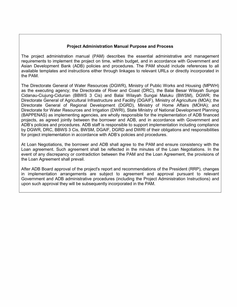
Project Administration Manual Purpose and Process
1. The project administration manual (PAM) describes the essential administrative and management requirements to implement the project on time, within budget, and in accordance with Government and Asian Development Bank (ADB) policies and procedures. The PAM should include references to all available templates and instructions either through linkages to relevant URLs or directly incorporated in the PAM. The Directorate General of Water Resources (DGWR), Ministry of Public Works and Housing (MPWH) as the executing agency; the Directorate of River and Coast (DRC), the Balai Besar Wilayah Sungai Cidanau-Ciujung-Cidurian (BBWS 3 Cis) and Balai Wilayah Sungai Maluku (BWSM), DGWR; the Directorate General of Agricultural Infrastructure and Facility (DGAIF), Ministry of Agriculture (MOA); the Directorate General of Regional Development (DGRD), Ministry of Home Affairs (MOHA); and Directorate for Water Resources and Irrigation (DWRI), State Ministry of National Development Planning (BAPPENAS) as implementing agencies, are wholly responsible for the implementation of ADB financed projects, as agreed jointly between the borrower and ADB, and in accordance with Government and ADB’s policies and procedures. ADB staff is responsible to support implementation including compliance by DGWR, DRC, BBWS 3 Cis, BWSM, DGAIF, DGRD and DWRI of their obligations and responsibilities for project implementation in accordance with ADB’s policies and procedures.
2. At Loan Negotiations, the borrower and ADB shall agree to the PAM and ensure consistency with the Loan agreement. Such agreement shall be reflected in the minutes of the Loan Negotiations. In the event of any discrepancy or contradiction between the PAM and the Loan Agreement, the provisions of the Loan Agreement shall prevail.
3. After ADB Board approval of the project's report and recommendations of the President (RRP), changes
in implementation arrangements are subject to agreement and approval pursuant to relevant Government and ADB administrative procedures (including the Project Administration Instructions) and upon such approval they will be subsequently incorporated in the PAM.
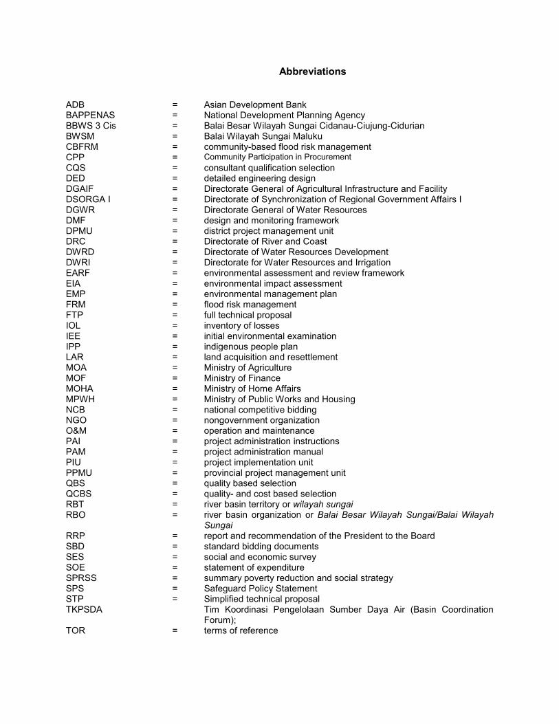
Abbreviations
ADB = Asian Development Bank BAPPENAS = National Development Planning Agency BBWS 3 Cis = Balai Besar Wilayah Sungai Cidanau-Ciujung-Cidurian BWSM = Balai Wilayah Sungai Maluku CBFRM = community-based flood risk management CPP = Community Participation in Procurement CQS = consultant qualification selection DED = detailed engineering design DGAIF = Directorate General of Agricultural Infrastructure and Facility DSORGA I = Directorate of Synchronization of Regional Government Affairs I DGWR = Directorate General of Water Resources DMF = design and monitoring framework DPMU = district project management unit DRC DWRD
= =
Directorate of River and Coast Directorate of Water Resources Development
DWRI = Directorate for Water Resources and Irrigation EARF = environmental assessment and review framework EIA = environmental impact assessment EMP = environmental management plan FRM = flood risk management FTP = full technical proposal IOL = inventory of losses IEE = initial environmental examination IPP = indigenous people plan LAR = land acquisition and resettlement MOA = Ministry of Agriculture MOF = Ministry of Finance MOHA = Ministry of Home Affairs MPWH = Ministry of Public Works and Housing NCB = national competitive bidding NGO = nongovernment organization O&M = operation and maintenance PAI = project administration instructions PAM = project administration manual PIU = project implementation unit PPMU = provincial project management unit QBS = quality based selection QCBS = quality- and cost based selection RBT = river basin territory or wilayah sungai RBO = river basin organization or Balai Besar Wilayah Sungai/Balai Wilayah
Sungai RRP = report and recommendation of the President to the Board SBD SES
= =
standard bidding documents social and economic survey
SOE = statement of expenditure SPRSS = summary poverty reduction and social strategy SPS = Safeguard Policy Statement STP = Simplified technical proposal TKPSDA Tim Koordinasi Pengelolaan Sumber Daya Air (Basin Coordination
Forum); TOR = terms of reference

I. PROJECT DESCRIPTION
A. Rationale
1. Indonesia is highly prone to flooding due to its climate and topography.1 Flooding, which occurs annually in most of the country, has been increasing in frequency, causing as much as $430 million in economic losses per year.2 During 2003–2015 average annual flood impacts have included: 1.58 million people per year affected; 223,000 homes completely or partially damaged; and 168,000 hectares (ha) of crops inundated.3 The floods sever vital transport arteries and often disrupt access to ports and airports, restricting the transfer of goods and services. In 2013, Ciujung river flooding affected 19,674 households, displaced 50,527 people, and disrupted traffic along the Jakarta–Merak toll road that connects Java to Sumatra island.4 Despite its location in a drier region, in 2013 Ambon suffered from flash floods resulting in: the destruction of 59 homes, and damage to 45 others; and 10 deaths, 5 missing persons, and 7,212 displaced people (footnote 4). 2. Flood impacts have worsened since 1980. Deforestation and inappropriate agricultural practices—which result in erosion and increased sediment loads in waterways5— are reducing the capacity of rivers to accommodate higher peak flows caused by intense rainfall. Expanding population combined with inadequate spatial planning and land management has led to substantial development in flood-prone areas, escalating flood damage to life and property. Urbanization, and particularly associated road construction and surfacing, reduces the vegetated area that would normally absorb rainwater, resulting in greater peak flood flows.6 The government agencies ability to optimize flood management capacity and effectiveness is limited by weak hydrological data acquisition and management, and flood forecasting and climate risk modeling; and the lack of coordinated decision-making among government agencies. Insufficient investment in and neglected operation and maintenance (O&M) of flood protection infrastructure accentuate the adverse impacts of floods.7 In the absence of appropriate awareness and preparedness, communities remain highly vulnerable to and at greater risk of loss of life and assets from more frequent and intense floods. 3. Climate change impacts include the increasing frequency of intense rainfall and rising sea levels, and are expected to further exacerbate flood risk.8 The impacts of intense and frequent flood events combined with the lack of economic and social capital to manage and
1 Indonesia experiences two main types of flooding. Long-lasting river floods, which are often influenced by tides,
generally occur in large islands with large river basins that have steep slopes and long, flat, and low floodplains (e.g., Irian, Java, Kalimantan, or Sumatra). Flash floods typically inundate small islands in eastern Indonesia that have small and steep mountainous river basins.
2 Centre for Research on the Epidemiology of Disasters - CRED. EM-DAT: The International Disaster Database. http://www.emdat.be (accessed April 2016).
3 Indonesian Disaster Data and Information Database. Disaster Data. http://dibi.bnpb.go.id/data-bencana (accessed April 2016)
4 National Disaster Management Authority. Geospasial. http://geospasial.bnpb.go.id/ (accessed March 2016). 5 ADB. 2016. Indonesia Country Water Assessment. Manila. About 78 million ha in Indonesia are degraded. 6 Deltares et al. 2012. Java Water Resources Strategic Study. Report submitted to the World Bank. http://citarum.org
/citarum-knowledge/arsip-dokumen/dokumen-perencanaan/540-java-water-resources-strategy-study/file.html. The study estimates that, at current trends, the urbanized area in Java will double within 30 years.
7 Requirements to finance flood protection infrastructure for 2015–2019 are estimated at $74.6 million in the Cidanau–Ciujung–Cidurian RBT and $102.7 million in the Ambon–Seram RBT. During 2010–2014, only 60% of the planned investment was realized.
8 Climate change is also expected to produce stronger and more frequent El Niño and La Niña events and will exacerbate floods and droughts, thereby leading to increased food and water insecurity.
2
respond to flood risks further limit the ability of many river based communities to escape poverty. 4. Water security is a central pillar of the RPJMN, which promotes FRM to reduce flood damage.9 Indonesia adopted the integrated water resource management (IWRM) approach, which is being promoted through (i) the establishment of river basin management organizations (RBOs),10 and (ii) the formulation of strategic basin plans as a prerequisite to basin development plans (Rencanas). The Rencanas form the basis for the public investment in water resource management with a horizon of 20 years, including flood management. Implementation of IWRM and participatory river basin management is still hampered by inadequate planning, investment, capacity, and coordination. The RBTs targeted by the project are not an exception. There is a growing need to integrate structural and nonstructural measures to create a holistic response to the flood challenge. 5. The project will support implementation of part of the SPWR calling for a $3.06 billion investment in flood management.11 The Cidanau–Ciujung–Cidurian RBT (which is affected by river floods) and the Ambon–Seram RBT (which experiences flash floods)12 have been initially selected to demonstrate FRM in implementing the RPJMN. The investment will help the government accelerate implementation of Rencanas in selected RBTs, and provides (i) a long-term partnership between the Asian Development Bank (ADB) and the government for policy dialogue and capacity development, and (ii) the design of a future programmatic and systems based approach to flood risk management in Indonesia. The project’s outputs and sector targets are clearly linked, and the criteria for the sector modality are met.13 6. The project builds on lessons from flood management assistance by ADB and development partners. The project design incorporates key recommendations based on these lessons, including: (i) intensive consultations need to be conducted with local stakeholders during project preparation to address all problems and issues, (ii) the government should routinely collect and analyze flood-damage data, (iii) support is needed to design and develop sustainable long-term flood management concepts, and (iv) watershed management programs should be implemented to enhance the impact and sustainability of flood control works.14 7. The project is consistent with (i) the strategic priorities for the Midterm Review of 9 FRM embraces a range of measures that address three key components: (i) managing flood hazard, (ii) minimizing
exposure to flood hazard, and (iii) reducing the vulnerability of people and property exposed. Managing flood hazard involves physical modifications to water flow, such as river infrastructure works, and catchment management measures such as controls over forestry and agricultural practices. Managing exposure to floods involves property acquisition, land use zoning, building codes, planning development controls, and elevated building. Managing flood vulnerability involves nonstructural measures such as community awareness, flood forecasting and warning, preparedness, emergency response, and post-flood early recovery strategies. The FRM process allows these measures to be weighed against physical, social, and economic conditions; and addresses specific issues that characterize each RBT.
10 The central government is responsible for 63 RBTs, provincial agencies for 53, and district agencies for 15. 11 The SPWR calls for an overall investment of $24.68 billion nationwide for water resources management. 12 The Cidanau–Ciujung–Cidurian RBT covers an area of 4,125 square kilometers and lies mainly within Banten
province, the westernmost province of Java. The Ambon–Seram RBT is located on the islands of Ambon and Seram in eastern Indonesia’s Maluku province, and has an area of 18,625 square kilometers.
13 The required preconditions for the use of the sector lending modality—sector development plan, institutional capacity, and appropriate policy to implement the sector development plan—are all in place. The MPWH, as the executing agency, has the capacity to implement the sector development plan in terms of identification, selection, design, and implementation of subprojects. The sector development plan identified sector indicators that can be monitored and verified, including targets for cross-cutting and safeguard concerns.
14 ADB. 2007. Completion Report: South Java Flood Control Sector Project in Indonesia. Manila; and ADB. 2006. Completion Report: North Java Flood Control Sector Project in Indonesia. Manila.
3
Strategy 2020;15 and (ii) ADB’s interim country partnership strategy, 2015 for Indonesia, which has two strategic pillars: inclusive growth and environmental sustainability with climate change adaptation and mitigation.16 Agriculture and natural resources (including flood management) is a sector focus of the partnership strategy. The project is aligned with the ADB water operational plan, which identifies flood mitigation (as part of disaster risk management) as one of the two urgent challenges to be addressed in the IWRM approach.17 The project is also aligned with the ADB plan for integrated disaster risk management as it will support the government and local communities to identify and better manage risks from natural hazards.18 B. Impact and Outcome
8. The impact will be economic and social losses from flood events in selected river basins reduced. The outcome will be flood risks in selected river basins, including those in the Cidanau–Ciujung–Cidurian and Ambon–Seram RBTs, reduced through FRM. C. Outputs
9. To achieve its expected outcome, the project will have the following outputs:
(i) Planning for flood risk management enhanced. The project will support the RBOs to (a) improve hydrometeorological data management; (b) develop flood models as the basis for the preparation of flood risk management plans (FRMPs); (c) develop flood forecasting, early warning system and mapping of hazards, exposure, vulnerability, risk, and emergency response; and (d) establish communication procedures. This will be complemented by institutional strengthening, planning, and coordination in those provinces and districts that will use FRMPs in updating provincial, district and/or city government spatial, midterm, and annual plans.19
(ii) Land management improved and flood infrastructure upgraded. The project will support RBOs to prepare detailed engineering designs (DEDs); meet environmental and social safeguards; conduct tendering and O&M planning; and implement infrastructure subprojects that are technically, socially, environmentally, and economically justified. The infrastructure subprojects comprise the (a) rehabilitation and upgrading of existing flood control structures; and (b) construction of new structures such as river dikes, spillways, coastal protection, retention basins, and check dams. Through the project, communities in middle catchments will improve selected degraded land areas by implementing soil and water conservation measures to reduce soil erosion.20 The project will also (a) empower farmers groups in the Cidanau–Ciujung–Cidurian RBT to adopt sustainable agriculture practices, including terracing and development of
15 ADB. 2014. Midterm Review of Strategy 2020: Meeting the Challenges of a Transforming Asia and Pacific. Manila. 16 ADB. 2015. Interim Country Partnership Strategy: Indonesia, 2015. Manila. 17 ADB. 2011. Water Operational Plan, 2011–2020. Manila. 18 ADB. 2014. Operational Plan for Integrated Disaster Risk Management, 2014–2020. Manila. 19 The FRMPs will be periodically revised to take into account asset and economic growth, updated
hydrometeorological data, and changes in land use and policy. The FRMPs will also be used as a basis to update spatial, midterm, and annual plans by the local government; and issue related regulations (addressing land use, river corridors, solid waste management, spatial planning, and building).
20 The project will empower farmers groups in the Cidanau–Ciujung–Cidurian RBT to adopt sustainable agriculture practices, including terracing and development of retention ponds. The project will also implement measures to mitigate landslides and associated reductions in the sediment yields in both RBTs.
4
retention ponds; and (b) implement measures to stop landslides and thus reduce sediment yields in both RBTs.
(iii) Capacity for community-based flood risk management enhanced. To complement structural measures and improve flood resilience, community-based flood risk management (CBFRM) groups in the flood plains that benefit from the early warning system will be established, strengthened, and engaged in (a) identifying flood risks at the local level; (b) prioritizing community-based measures to reduce flood risk; (c) implementing priority measures to reduce flood risks, such as solid waste management and construction and repair of small water infrastructure; and (d) improving disaster preparedness by preparing an emergency response plan and developing corresponding standard operating procedures.
(iv) Policy, coordination, and capacity at national level improved. To ensure effective policy and planning coordination, the project will support independent monitoring, evaluation, and strategic coordination under the National Steering Committee for Water Resources. A national strategy and a set of guidelines will be prepared to institutionalize the FRM approach. The project will support the executing and implementing agencies to undertake project supervision and strengthen the planning, implementation, and management capacities of the implementing agencies.
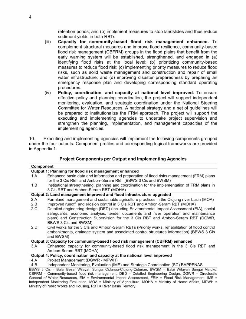
10. Executing and implementing agencies will implement the following components grouped under the four outputs. Component profiles and corresponding logical frameworks are provided in Appendix 1.
Project Components per Output and Implementing Agencies Component Output 1: Planning for flood risk management enhanced 1.A Enhanced basin data and information and preparation of flood risks management (FRM) plans
for the 3 Cis RBT and Ambon–Seram RBT (BBWS 3 Cis and BWSM) 1.B Institutional strengthening, planning and coordination for the implementation of FRM plans in
3 Cis RBT and Ambon-Seram RBT (MOHA) Output 2: Land management improved and flood infrastructure upgraded 2.A Farmland management and sustainable agriculture practices in the Ciujung river basin (MOA) 2.B Improved runoff and erosion control in 3 Cis RBT and Ambon-Seram RBT (MOHA) 2.C Detailed engineering design (DED) (including Environmental Impact Assessment (EIA), social
safeguards, economic analysis, tender documents and river operation and maintenance plans) and Construction Supervision for the 3 Cis RBT and Ambon-Seram RBT (DGWR, BBWS 3 Cis and BWSM)
2.D Civil works for the 3 CIs and Ambon-Seram RBTs (Priority works, rehabilitation of flood control embankments, drainage system and associated control structures information) (BBWS 3 Cis and BWSM)
Output 3: Capacity for community-based flood risk management (CBFRM) enhanced 3.A Enhanced capacity for community-based flood risk management in the 3 Cis RBT and
Ambon-Seram RBT (MOHA) Output 4: Policy, coordination and capacity at the national level improved 4.A 4.B
Project Management (DGWR - MPWH) Independent Monitoring, Evaluation (IME) and Strategic Coordination (SC) BAPPENAS
BBWS 3 Cis = Balai Besar Wilayah Sungai Cidanau-Ciujung-Cidurian, BWSM = Balai Wilayah Sungai Maluku, CBFRM = Community-based flood risk management, DED = Detailed Engineering Design, DGWR = Directorate General of Water Resources, EIA = Environmental Impact Assessment, FRM = Flood Risk Management, IME = Independent Monitoring Evaluation, MOA = Ministry of Agriculture, MOHA = Ministry of Home Affairs, MPWH = Ministry of Public Works and Housing, RBT = River Basin Territory.

5
II. IMPLEMENTATION PLANS
A. Project Readiness Activities
2015 2016 Main Activities 10 11 12 1 2 3 4 5 6 7 8 9 10 11 12 Responsibility
Establish CPMU and CPIUs X X X X X X X MPWH, MOA,
MOHA, BAPPENAS
Government budget inclusion X X
MPWH, MOA, MOHA,
BAPPENAS, MOF
Loan Negotiations X ADB, MOF ADB Board Approval X ADB Loan signing X ADB, MOF Government legal opinion X MOLHR Loan effectiveness X ADB, MOF Opening of imprest account X ADB, MOF Initial advance to imprest account X ADB, MOF
Preparation for advance contracting (master bidding documents, request for proposal)
X X X
ADB, MPWH, MOA, MOHA, BAPPENAS
Advance contracting actions X X X X X X X X X ADB, MPWH,
MOA, MOHA, BAPPENAS
ADB = Asian Development Bank; BAPPENAS = Badan Perencanaan Pembangunan Nasional (National Development Planning Agency); CPIU = central project implementation unit; CPMU = central project management unit; MOA = Ministry of Agriculture; MOF = Ministry of Finance; MOHA = Ministry of Home Affairs; MOLHR = Ministry of Law and Human Rights; MPWH = Ministry of Public Works and Housing. Source: ADB Staff estimates.

6
B. Overall Project Implementation Plan
11. The detailed project implementation plan is provided in Appendix 2.
Activities 2016 2017 2018 2019 2020 2021 2022
Q1 Q2 Q3 Q4 Q1 Q2 Q3 Q4 Q1 Q2 Q3 Q4 Q1 Q2 Q3 Q4 Q1 Q2 Q3 Q4 Q1 Q2 Q3 Q4 Q1 Q2 Q3 Q4
Preparatory Actions ● ● ●
● ● ● ● ● ● ● ● ● ●
Output 1 - Planning for flood risk management enhanced ● ● ● ● ● ● ● ● ● ● ● ● ● ● ● ● ● ● ● ● ● ● ● ● ●
Component 1 - A: Enhanced basin data and information ● ● ● ● ● ● ● ● ● ● ● ● ● ● ● ● ● ● ● ● ● ● ● ● (BBWS 3 Cis/BWSM)
Main Activity 1: Detailed planning and design for improved hydrological monitoring
●
●
●
● ● ● ● ● ● ● ● ● ● ● ● ● ● ● ● ● ● ● ●
Main Activity 2: Improvement of hydro-meteorological data management and modeling
● ● ● ● ● ● ● ● ● ● ● ● ●
Sub Activity 1: Tendering hydro-meteorological station equipment
● ● ● ●
Sub-Activity 2: Installation of Hydro-meteorological observation stations
● ● ● ●
Sub Activity 3: Data management and data processing. Integrated into DGWR existing system
● ● ● ● ● ●
Sub Activity 4: Development of locally fit advanced hydrological model. Introduce satellite based rainfall based flood forecast as a back-up system
● ● ● ● ● ● ● ● ●
Sub Activity 5: Technical capacity/Skill building in data management, flood warning system and hydrological modeling
● ● ● ● ● ●
Main Activity 3: Hazard, vulnerability, risk and emergency
● ● ● ● ● ● ●

7
Activities 2016 2017 2018 2019 2020 2021 2022
Q1 Q2 Q3 Q4 Q1 Q2 Q3 Q4 Q1 Q2 Q3 Q4 Q1 Q2 Q3 Q4 Q1 Q2 Q3 Q4 Q1 Q2 Q3 Q4 Q1 Q2 Q3 Q4
response mapping
Main Activity 4: Preparation of flood risk management plans
● ● ● ● ● ● ● ● ● ● ● ● ● ● ● ● ● ●
Component 1 - B: Enhanced basin information dissemination, planning and coordination (MOHA)
● ● ● ● ● ● ● ● ● ● ● ● ● ● ● ● ● ● ● ● ● ●
Main Activity 1. Establishment of flood communication procedures ● ● ● ● ● ● ● ● ● ● ● ● ● ● ● ● ● ● ● ●
Main Activity 2. Institutional strengthening and technical capacity building
● ● ● ● ● ● ● ● ● ● ● ● ● ● ● ● ● ● ● ● ● ● ● ●
Output 2 - Land management improved and flood Infrastructure upgraded
● ● ● ● ● ● ● ● ● ● ● ● ● ● ● ● ● ● ● ● ● ● ● ●
Component 2A: Upper farmland management including agro-forestry, slope stabilization and sustainable agriculture practices (MOA)
● ● ● ● ● ● ● ● ● ● ● ● ● ● ● ● ● ● ● ● ● ● ●
Main Activity 1: Detailed planning and design of Interventions
● ● ● ● ● ●
Main Activity 2: Implementation of land and water conservation activities
● ● ● ● ● ● ● ● ● ● ● ● ● ● ● ● ● ● ● ● ● ● ●
Component 2B: Improved runoff and erosion control in 3 Cis RBT and Ambon-Seram RBT (MOHA)
● ● ● ● ● ● ● ● ● ● ● ● ● ● ● ● ● ● ● ● ● ● ● ●
Main Activity 1: Implementation of project activities (Landslide protection)
● ● ● ● ● ● ● ● ● ● ● ● ● ● ● ● ● ●
Component 2C: Detailed engineering design and construction supervision for the 3 Cis and Ambon Seram RBTs
● ● ● ● ● ● ● ● ● ● ● ● ● ● ● ● ● ● ● ● ● ● ● ●
8
Activities 2016 2017 2018 2019 2020 2021 2022
Q1 Q2 Q3 Q4 Q1 Q2 Q3 Q4 Q1 Q2 Q3 Q4 Q1 Q2 Q3 Q4 Q1 Q2 Q3 Q4 Q1 Q2 Q3 Q4 Q1 Q2 Q3 Q4
Main Activity 1: Sub project identification, feasibility study and appraisal
● ● ● ● ● ● ● ●
Main Activity 2. DED for Additional Civil Works (sub- projects)
● ● ● ● ● ● ●
Main Activity 3: Environment Initial Examination (EIE)-Env. Monitoring, Planning & Management (UKL/UPL) and/or AMDAL
● ● ● ● ● ● -
Main Activity 4: Social safeguard preparation and implementation ● ● ● ● ● ● ● ● ● ● ●
Main Activity 5: Construction Supervision ● ● ● ● ● ● ● ● ● ● ● ● ● ● ● ● ● ● ● ● ● ● ●
Component 2D: Construction of flood control measures ● ● ● ● ● ● ● ● ● ● ● ● ● ● ● ● ● ● ● ● ● ● ● ● ● ● ● ●
Sub Component D.1: Construction of flood control embankments, drainage system and associated control structures (BBWS 3 Cs)
● ● ● ● ● ● ● ● ● ● ● ● ● ● ● ● ●
Main Activity 1. Urgent work for upgrading of the Ciujung embankment system (11 km) ● ● ● ● ● ● ● ● ● ● ● ● ● ● ● ●
Establishment of the Preparatory Committee for LA ●
Determination of Location Process for LA ● ● ●
Implementation of resettlement plan ● ● ● ● ● ●
Construction Works ● ● ● ● ● ● ● ● ● ● ● ● ●
Main Activity 2: Construction/ Rehabilitation of flood control embankments, drainage and other structures in the 3Cis RBTs (sub-projects to be confirmed)
● ● ● ● ● ● ● ● ● ● ● ● ● ● ● ● ● ● ● ● ●

9
Activities 2016 2017 2018 2019 2020 2021 2022
Q1 Q2 Q3 Q4 Q1 Q2 Q3 Q4 Q1 Q2 Q3 Q4 Q1 Q2 Q3 Q4 Q1 Q2 Q3 Q4 Q1 Q2 Q3 Q4 Q1 Q2 Q3 Q4
Establishment of the Preparatory Committee for LA ●
Determination of Location Process for LA
● ●
Implementation of resettlement plan
● ● ● ● ● ● ● ● ●
Construction Works ● ● ● ● ● ● ● ● ● ● ● ● ● ● ● ● ● ● Main Activity 3: Construction of 8 check dams. Subprojects to be confirmed
● ● ● ● ● ● ● ● ● ● ● ● ●
Establishment of the Preparatory Committee for LA
●
Determination of Location Process for LA
● ●
Implementation of resettlement plan
● ● ● ●
Construction Works ● ● ● ● ● ● ● ●
Sub Component D. 2: Construction of flood control embankments, drainage system and associated control structures in Ambon (BWSM)
● ● ● ● ● ● ● ● ● ● ● ● ● ● ● ● ● ● ● ● ● ● ● ●
Main Activity 1: Construction of check dams, and small retention ponds in Batu Merah and Way Ruhu river basins
● ● ● ● ● ● ● ● ●
Establishment of the Preparatory Committee for LA ●
Determination of Location Process for LA ● ●
Implementation of resettlement plan ● ● ●
Construction Works ● ● ● ● ● ● ● ● ● ● ● ●
Main Activity 2: River normalization in Batu Merah and Way Ruhu (Sub-project to be confirmed)
● ● ● ● ● ● ● ● ● ● ● ● ●
Establishment of the Preparatory ●
10
Activities 2016 2017 2018 2019 2020 2021 2022
Q1 Q2 Q3 Q4 Q1 Q2 Q3 Q4 Q1 Q2 Q3 Q4 Q1 Q2 Q3 Q4 Q1 Q2 Q3 Q4 Q1 Q2 Q3 Q4 Q1 Q2 Q3 Q4
Committee for LA
Determination of Location Process for LA & Resettlement
● ●
Implementation of resettlement plan
● ● ● ● ● ●
Construction Works ● ● ● ● ● ● ● ● ● ● ● ● ● ● ● ● Main Activity 3: Construction of check dams, and small retention ponds in 3 other river basins in Ambon (TBC)
● ● ● ● ● ● ● ● ● ● ●
Establishment of the Preparatory Committee for LA ●
Determination of Location Process for LA & Resettlement ● ●
Implementation of resettlement plan ● ● ●
Construction Works ● ● ● ● ● ● ● ● ● ● ● ● ● ●
Main Activity 4: River normalization in 3 other river basins in Ambon (subprojects to be confirmed)
● ● ● ● ● ● ● ● ● ● ● ● ● ● ● ● ● ●
Establishment of the Preparatory Committee for LA ●
Determination of Location Process for LA & Resettlement ● ●
Implementation of resettlement plan ● ● ●
Construction Works ● ● ● ● ● ● ● ● ● ● ● ● Main Activity 5: Flood control works in other river basins in Ambon-Seram RBT (subprojects to be confirmed)
● ● ● ● ● ● ● ● ● ● ● ● ● ● ● ● ● ●
Establishment of the Preparatory Committee for LA ●

11
Activities 2016 2017 2018 2019 2020 2021 2022
Q1 Q2 Q3 Q4 Q1 Q2 Q3 Q4 Q1 Q2 Q3 Q4 Q1 Q2 Q3 Q4 Q1 Q2 Q3 Q4 Q1 Q2 Q3 Q4 Q1 Q2 Q3 Q4
Determination of Location Process for LA & Resettlement ● ●
Implementation of resettlement plan ● ● ●
Construction Works ● ● ● ● ● ● ● ● ● ● ● ● Output 3. Capacity for community-based flood risk management (CBFRM) enhanced
● ● ● ● ● ● ● ● ● ● ● ● ● ● ● ● ● ● ● ● ● ● ● ●
Component 3A: Enhanced capacity for community in flood risk management-CBFRM (MOHA)
● ● ● ● ● ● ● ● ● ● ● ● ● ● ● ● ● ● ● ● ● ● ●
Main Activity 1: Awareness Raising and Public Preparedness
● ● ● ● ● ● ● ● ●
Main Activity 2. CBFRM Community Mobilization
● ● ● ● ● ● ● ● ● ● ● ● ● ● ● ● ● ● ● ● ● ● ● ● Main Activity 3. Preparation of contingency plans (emergency response plan)
● ● ● ● ● ● ● ● ● ● ● ●
Main Activity 4. Community participation in project planning, design and implementation
● ● ● ● ● ● ● ● ● ● ● ● ● ● ● ● ● ● ● ● ●
Main Activity 5 : Safeguards Implementation ● ● ● ●
Output 4. Policy, coordination and capacity at national level improved
● ● ● ● ● ● ● ● ● ● ● ● ● ● ● ● ● ● ● ● ● ● ● ●
Component 4A: Project Management (DGWR)
● ● ● ● ● ● ● ● ● ● ● ● ● ● ● ● ● ● ● ● ● ● ● ● Main Activity 1: Overall project management
● ● ● ● ● ● ● ● ● ● ● ● ● ● ● ● ● ● ● ● ●
Main Activity 2: Sub Project Preparation
● ● ● ● ● ● ● ● ● ● ● ● ● ● ● ● ● ● ●
Main Activity 3: Coordination ● ● ● ● ● ● ● ● ● ● ● ● ● ● ● ● ● ● ● ● ● ● ● ● Main Activity 4: Monitoring and Evaluation
● ● ● ● ● ● ● ● ● ● ● ● ● ● ● ● ● ● ● ● ● ● ● ●

12
Activities 2016 2017 2018 2019 2020 2021 2022
Q1 Q2 Q3 Q4 Q1 Q2 Q3 Q4 Q1 Q2 Q3 Q4 Q1 Q2 Q3 Q4 Q1 Q2 Q3 Q4 Q1 Q2 Q3 Q4 Q1 Q2 Q3 Q4
Component 4B: Independent Monitoring, Evaluation and Strategic Coordination (DWRI)
● ● ● ● ● ● ● ● ● ● ● ● ● ● ● ● ● ● ● ●
Main Activity 1: Establishing a RPMS for the overall Roadmap investments
● ●
Main Activity 2 : Monitor the Roadmap’s social, environmt, and economic impacts, incl. establishment of benchmark
● ● ●
Main Activity 3 : Develop a mechanism for making necessary adjustments in the FMSRB design
● ●
Main Activity 4 : Monitor and evaluate efficiency in achieving outcomes and recommend adjustment in flood management policy and strategy
● ● ● ● ● ● ● ● ● ● ● ● ● ● ● ● ● ● ● ● ● ●
AMDAL = Analisis Mengenai Dampak Lingkungan (Environmental Impact Assessment); BBWS = Balai Besar Wilayah Sungai; BWSM = Balai Wilayah Sungai Maluku; CBFRM = community-based flood risk management; DGWR = Directorate General of Water Resources; IOL = Inventory of Losses; MOA = Ministry of Agriculture; MOF = Ministry of Finance; MOHA = Ministry of Home Affairs; MOLHR = Ministry of Law and Human Rights; MPWH = Ministry of Public Works and Housing; NGO = nongovernment organization; NWRC = National Water Resources Council; PCM = Public Consultation Meeting; PPIU = Provincial Project Implementation Unit; PPMS = Project Performance Monitoring System; PPMU = Provincial Project Management Unit; PRA = Participatory Rural Appraisal; PUSAIR = Puslitbang Sumber Daya Air (Research & Development Center For Water Resources); SES = Social Economic Survey; SOP = Standard Operational Procedure; TKPSDA = Tim Koordinasi Pengelolaan Sumber Daya Air (Basin Coordination Forum);UKL = Upaya Pengelolaan Lingkungan Hidup (Environmental Management Effort); UPL = Upaya Pemantauan Lingkungan Hidup (Environmental Monitoring Plan)

13
III. PROJECT MANAGEMENT ARRANGEMENTS
A. Project Implementation Organizations–Roles and Responsibilities
12. Stakeholders role and responsibility in the FRM framework are presented in Appendix 3.
Project implementation organizations
Management Roles and Responsibilities
Ministry of Finance Establishment and administration of imprest account Allocation and timely release of counterpart funds Facilitate disbursement and withdrawal application Communicate with ADB for any amendments in the
reallocation of the loan amount
Directorate General of Water Resources (DGWR), Ministry of Public Works and Housing (MPWH) (CPMU)
Executing agency for the project, represented by the CPMU. The CPMU will be headed by Director of Directorate of Water Resources Development (DWRD) and includes a full time Manager and staff as follow: (i) a Secretary, (ii) Finance Officer, (iii) Procurement Officer, (iv) Project Coordinator, and (v) M&E Officer.
Overall implementation, administration and monitoring of the project
Support and provide guidance on the preparation and implementation of the relevant project components
Verification for on-granting payments requested by PPIUs/DPIUs
Consolidate and manage supporting documents, submit any reporting requirements, including the annual report and financial statements
Central Project Implementation Unit (CPIU) – DRC DGWR
The CPIU will be headed also by Director of Directorate of River and Coast (DRC) and includes a full time Manager and staff as follows: (i) a Secretary, (ii) Finance Officer, (iii) Procurement Officer, (iv) Project Coordinator, (v) technical counterparts, (vi) a Social Officer, and (vii) an Environment Officer.
Provision of technical guidance to the RBOs, the Balai Besar Wilayah Sungai (BBWS) 3 Cis and the Balai Besar Wilayah (BWS) Maluku
Responsible to select and appraise the structural subprojects
Preparation of a national FRM strategy and guidelines
Project Implementation Units (PIUs) for BBWS 3 Cis and BWSM – DGWR
The PIUs will be under the responsibility of Head of the B/BWSs and will include a full time manager and staff: (i) Secretary, (ii) Finance Officer, (iii) Procurement Officer, (iv) Project Coordinator/Civil Engineer, (v) M&E Officer, (vi) Hydrologist, (vii) Social Officer, (viii) Environment Officer, and (ix) Database/GIS Specialist.
Implementing agency for (a) civil works, (b)

14
Project implementation organizations
Management Roles and Responsibilities
hydrological monitoring network improvement and flood forecasting, (c) preparation of flood risk management plans (FRMP), (d) detailed engineering design (DED) and associated activities, (e) land acquisition and resettlement, (f) support the basin coordination forum/council for technical, licensing and institutional issues, (g) technical inputs to and coordination with the provincial and local government in the implementation of FRM
Responsible for the preparation and implementation of the resettlement plans and environmental impact assessment for the physical subprojects, as respectively defined in the resettlement framework and environmental assessment review framework (EARF)
Supervise the construction of civil works and ensure both technical quality and quantity and compliance with social and environmental safeguards
Prepare and conduct procurement of goods and works to support project implementation
Monitor the project implementation and prepare quarterly and annual project reports
Central Project Implementation Units (CPIU) – DGAIF/MOA
National implementing agency for farmland and water conservation and management including slope stabilization and sustainable agriculture practice in the Ciujung river basin
The CPIU in DGAIF will be headed by the Director of Land Expansion andProtection and by one project manager; both personnel represent two directorates (Directorate of Agriculture Irrigation and Directorate of Land Expansion and Protection). The project manager will report day to day activities to the Directors. Staff will include: (i) project planning officer, (ii) a financial and administrative officer, (iii) a M&E officer, and (iv) technical counterparts. The project manager will be responsible for day to day implementation including: (i) planning and scheduling of project activities; (ii) administration of contracting activities for national activities; (iii) bookkeeping and maintenance of Project accounts and preparation and consolidation of liquidation reports; (iv) supervision and monitoring of the work program of the MOA components and preparation of consolidated monitoring reports covering technical, financial, social and environmental safeguards, and gender aspects; (v) coordination of field activities; (vi) collection, consolidation and safekeeping of all Project progress reports, site reports, technical and financial reports and their
15
Project implementation organizations
Management Roles and Responsibilities
submission to ADB through directors; (vii) preparation of quarterly progress reports; midterm project evaluation report and the overall project completion report for the component; and (viii) liaison with CPMU and ADB.
Coordinate with related provincial and district agencies and communities
Prepare and conduct procurement of goods and services to support project implementation
Directorate of), Synchronisation of Regional Government Affiars I (SORGA I), CPIU - DGRD - MOHA
National implementing agency for (a) policy facilitation and regulation formulation for preparation of spatial plans and related regulations as per FRMPs, facilitate the land acquisition and resettlement, support provincial and local governments to develop, legalize and implement land-use regulations, river corridor land regulations, coordinate adoption of building code standards for flood plain zones; (b) institutional strengthening of provincial and local agencies involved in FRM; (c) enhance public preparedness through community-based flood risk management; (d) coordination, cooperation and integration among agencies at provincial and district levels, including: planning, implementation, monitoring and evaluation as well as cooperation on inter-district flood risk management;
The CPIU will be headed by Director of SORGA I, and includes a full time Manager and staff as follows: (i) a Secretary, (ii) Finance Officer, (iii) Procurement Officer, (iv) Project Coordinator, (v) M&E Officer, (vi) technical counterparts, (vii) a Social Officer, and (viii) an Environment Officer. The CPIU tasks include:
Facilitate P/DPMU and P/DPIU in program management including: (a) 5-year and annual planning and budgeting; (b) provision of training of trainers; (c) monitoring and evaluation; and (d) reporting
Prepare and conduct procurement of goods and services to support project implementation
Facilitate coordination with provincial and district agencies to support the land acquisition and resettlement activities
Develop a monitoring and evaluation procedures and conduct routine field evaluation
Prepare quarterly and annual reports Conduct bid evaluation and contract signing for
selected packages
16
Project implementation organizations
Management Roles and Responsibilities
Central Project Implementation Units (CPIU) – DWRI/BAPPENAS
National implementing agency The CPIU will be headed by Director of DWRI,
includes a full time Manager and staff as follows: (i) a Secretary, (ii) Finance Officer, (iii) Procurement Officer, (iv) Project Coordinator, and (v) technical counterparts.
Act as the secretariat of the NSCWR Facilitate and support the executing agency and
implementing agencies in any issues related to the project implementation
Review and approve Annual Work Plans prepared by the project executing and implementing agencies
Conduct annual review of progress and direction of project activities to harmonize with national priorities
Conduct bid evaluation and contract signing for selected packages
Conduct strategic coordination among executing and implementing agencies and other related organizations
Conduct independent monitoring and evaluation
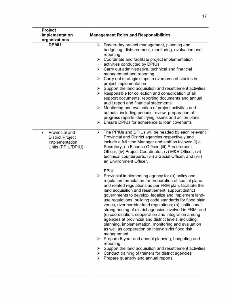
Provincial and District Project Management Units (PPMU/DPMU)
The PPMUs and DPMUs will be headed by corresponding BAPPEDA Heads and include a full time Manager and staff as follows: (i) a Secretary, (ii) Project Coordinator, (iii) M&E Officer, (iv) technical counterparts, (v) a Social Officer, and (vi) an Environment Officer.
PPMU Day-to-day project management, planning and
budgeting, disbursement, monitoring, evaluation and reporting
Coordinate and facilitate project implementation activities conducted by PPIUs
Carry out administrative, technical and financial management and reporting
Carry out strategic steps to overcome obstacles in project implementation
Responsible for collection and consolidation of all support documents, reporting documents and annual audit report and financial statements
Coordinate with provincial and district agencies to support the land acquisition and resettlement activities
Monitoring and evaluation of project activities and outputs, including periodic review, preparation of progress reports identifying issues and action plans
Ensure PPIUs for adherence to loan covenants
17
Project implementation organizations
Management Roles and Responsibilities
DPMU Day-to-day project management, planning and budgeting, disbursement, monitoring, evaluation and reporting
Coordinate and facilitate project implementation activities conducted by DPIUs
Carry out administrative, technical and financial management and reporting
Carry out strategic steps to overcome obstacles in project implementation
Support the land acquisition and resettlement activities Responsible for collection and consolidation of all
support documents, reporting documents and annual audit report and financial statements
Monitoring and evaluation of project activities and outputs, including periodic review, preparation of progress reports identifying issues and action plans
Ensure DPIUs for adherence to loan covenants
Provincial and District Project Implementation Units (PPIU/DPIU)
The PPIUs and DPIUs will be headed by each relevant Provincial and District agencies respectively and include a full time Manager and staff as follows: (i) a Secretary, (ii) Finance Officer, (iii) Procurement Officer, (iv) Project Coordinator, (v) M&E Officer, (vi) technical counterparts, (vii) a Social Officer, and (viii) an Environment Officer. PPIU
Provincial implementing agency for (a) policy and regulation formulation for preparation of spatial plans and related regulations as per FRM plan, facilitate the land acquisition and resettlement, support district governments to develop, legalize and implement land-use regulations, building code standards for flood plain zones, river corridor land regulations; (b) institutional strengthening of district agencies involved in FRM; and (c) coordination, cooperation and integration among agencies at provincial and district levels, including: planning, implementation, monitoring and evaluation as well as cooperation on inter-district flood risk management
Prepare 5-year and annual planning, budgeting and reporting
Support the land acquisition and resettlement activities Conduct training of trainers for district agencies Prepare quarterly and annual reports
18
Project implementation organizations
Management Roles and Responsibilities
DPIU District implementing agency for (a) policy and regulation formulation for preparation of spatial plans and related regulations as per FRM plan, facilitate the land acquisition and resettlement, prepare, legalize and implement land-use regulations, building code standards for flood plain zones, river corridor land regulations; (b) institutional strengthening of district agencies involved in FRM; and (c) coordination, cooperation and integration among agencies at district levels, including: planning, implementation, monitoring and evaluation
Prepare 5-year and annual planning, budgeting and reporting
Local community empowerment including: (a) establishment of local community group; (b) community group strengthening; and (c) counterpart (facilitator) program Conduct training for local community group
Support the land acquisition and resettlement activities Prepare quarterly and annual reports
National Steering
Committee Water Resources (NSCWR)21
Chaired by the Deputy of Infrastructure Affairs, BAPPENAS (National Development Planning Agency), with (i) the Director General of Water Resources, MPWH as deputy chairman, (ii) the Director of Water Resources and Irrigation, BAPPENAS as Secretary, (iii) the Director of Water Resources Development, DGWR as Deputy Secretary, (iv) Echelon I officials of BAPPENAS, Ministry of Public Works and Housing, Ministry of Agriculture, and Ministry of Home Affairs as members.
Provide policy and strategic directions, and program coordination
Coordinate different agency activities for complex national issues, cross-sectoral coordination, and formulate solutions to impediments during project implementation
Monitor and evaluate the overall project performance and outcomes
Review and endorse annual work plans
National Water Resources Council
Provide policy and strategic directions Endorse the national flood management strategy and
any other regulations
21 Established under the BAPPENAS Decree No. KEP 18/M.PPN/HK/01/2009.
19
Project implementation organizations
Management Roles and Responsibilities
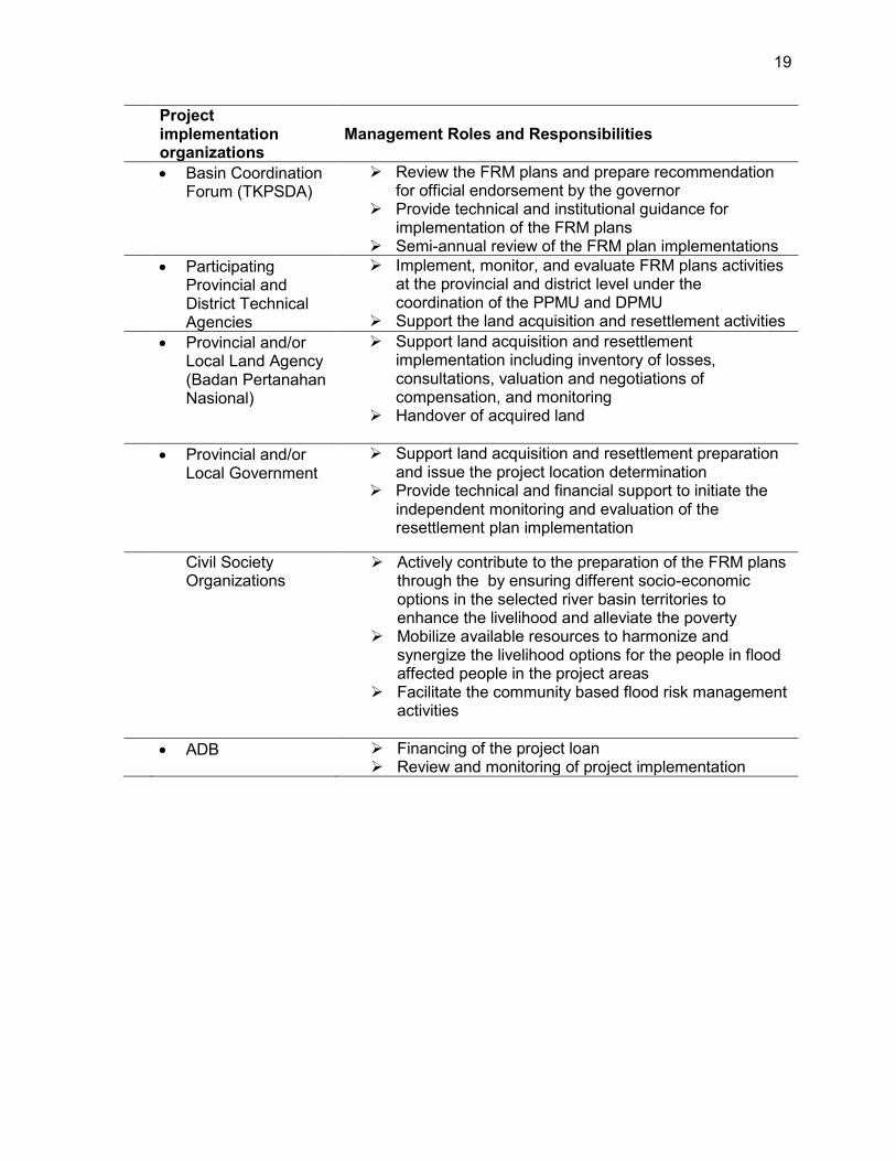
Basin Coordination Forum (TKPSDA)
Review the FRM plans and prepare recommendation for official endorsement by the governor
Provide technical and institutional guidance for implementation of the FRM plans
Semi-annual review of the FRM plan implementations Participating
Provincial and District Technical Agencies
Implement, monitor, and evaluate FRM plans activities at the provincial and district level under the coordination of the PPMU and DPMU
Support the land acquisition and resettlement activities Provincial and/or
Local Land Agency (Badan Pertanahan Nasional)
Support land acquisition and resettlement implementation including inventory of losses, consultations, valuation and negotiations of compensation, and monitoring
Handover of acquired land
Provincial and/or Local Government
Support land acquisition and resettlement preparation and issue the project location determination
Provide technical and financial support to initiate the independent monitoring and evaluation of the resettlement plan implementation
Civil Society
Organizations Actively contribute to the preparation of the FRM plans
through the by ensuring different socio-economic options in the selected river basin territories to enhance the livelihood and alleviate the poverty
Mobilize available resources to harmonize and synergize the livelihood options for the people in flood affected people in the project areas
Facilitate the community based flood risk management activities
ADB Financing of the project loan Review and monitoring of project implementation
20
B. Key Persons Involved in Implementation
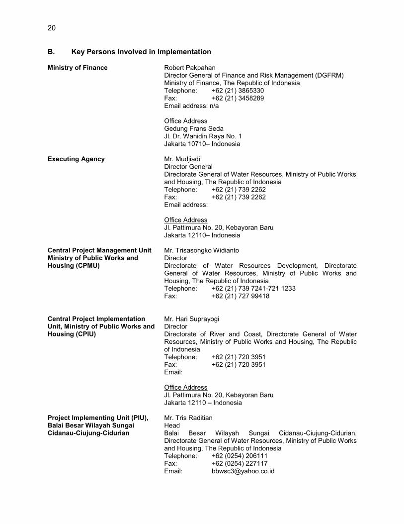
Ministry of Finance Robert Pakpahan Director General of Finance and Risk Management (DGFRM) Ministry of Finance, The Republic of Indonesia Telephone: +62 (21) 3865330 Fax: +62 (21) 3458289 Email address: n/a Office Address Gedung Frans Seda Jl. Dr. Wahidin Raya No. 1 Jakarta 10710– Indonesia
Executing Agency Central Project Management Unit Ministry of Public Works and Housing (CPMU)
Mr. Mudjiadi Director General Directorate General of Water Resources, Ministry of Public Works and Housing, The Republic of Indonesia Telephone: +62 (21) 739 2262 Fax: +62 (21) 739 2262 Email address: Office Address Jl. Pattimura No. 20, Kebayoran Baru Jakarta 12110– Indonesia Mr. Trisasongko Widianto Director Directorate of Water Resources Development, Directorate General of Water Resources, Ministry of Public Works and Housing, The Republic of Indonesia Telephone: +62 (21) 739 7241-721 1233 Fax: +62 (21) 727 99418
Central Project Implementation Unit, Ministry of Public Works and Housing (CPIU)
Mr. Hari Suprayogi Director Directorate of River and Coast, Directorate General of Water Resources, Ministry of Public Works and Housing, The Republic of Indonesia Telephone: +62 (21) 720 3951 Fax: +62 (21) 720 3951 Email: Office Address Jl. Pattimura No. 20, Kebayoran Baru Jakarta 12110 – Indonesia
Project Implementing Unit (PIU), Balai Besar Wilayah Sungai Cidanau-Ciujung-Cidurian
Mr. Tris Raditian Head Balai Besar Wilayah Sungai Cidanau-Ciujung-Cidurian, Directorate General of Water Resources, Ministry of Public Works and Housing, The Republic of Indonesia Telephone: +62 (0254) 206111 Fax: +62 (0254) 227117 Email: [email protected]
21
Office Address Jalan Ustadz Uzair Yachya No. 1, Serang Banten, Indonesia Email : [email protected]
Project Implementing Unit (PIU), Balai Wilayah Sungai Maluku
Mr. Hariyono Utomo Head Balai Wilayah Sungai Maluku, Directorate General of Water Resources, Ministry of Public Works and Housing, The Republic of Indonesia Telephone: +62 (911) 382 5019 Fax: +62 (911) 382 5022 Email: [email protected] Office Address Jl. C.H.R. Soplanit No. 4 Rumahtiga - Ambon Maluku, Indonesia
Central Project Implementing Unit (CPIU), Ministry of Agriculture
Mr. Prasetyo Nuchsin Director Directorate of Land Expansion and Protection Directorate General of Agricultural Infrastructure and Facilitiy, Ministry of Agriculture, The Republic of Indonesia Telephone: +62 (021) 7805552 Fax: +62 (021) 7805552 Email: Office Address Jl. Taman Margasatwa No. 3, Ragunan Jakarta Selatan, DKI Jakarta 12550 Indonesia Mr. Tunggul Iman Panudju Director Directorate of Agriculture Irrigation Directorate General of Agricultural Infrastructure and Facility, Ministry of Agriculture, The Republic of Indonesia Telephone: +62 (21) 782 3975 Fax: +62 (21) 782 3975 Email: [email protected] Office Address Jl. Taman Margasatwa No. 3, Ragunan, Jakarta Selatan, DKI Jakarta 12550, Indonesia
Central Project Implementing Unit (CPIU), Ministry of Home Affairs
Mr. Nyoto Suwignyo Acting Director Directorate of Synchronization of Regional Government Affairs I (DSORGA I), Directorate General of Regional Development, Ministry of Home Affairs, The Republic of Indonesia Telephone: +62 (21) 794 2645 Fax: +62 (21) 794 2645 Office Address Jl. Taman Makam Pahlawan No. 20 Kalibata, Jakarta Selatan Indonesia
22
Central Project Implementing Unit (CPIU), BAPPENAS
Mr. M. Donny Azdan Director Directorate of Water Resources and Irrigation (DWRI) Deputy for Infrastructure Affairs, National Planning Agency, The Republic of Indonesia Telephone: +62 (21) 3926186 Fax: +62 (21) Office Address Jl. Taman Suropati, Jakarta, Indonesia
Provincial Project Management Unit (PPMU) in Banten Province
Mr. Hudaya Latuconsina Bappeda Head, Banten Province Telephone: +62 (54) 267 053 Fax: +62 (54) 267 053 Email: Office Address Capitol Building, KP3B Jl. Syech Nawawi Al Bantani Curug Palima, Serang, Banten, Indonesia – Indonesia
Provincial Project Implementation Unit (PPIU) in Banten Province
Mr. Agus Santoso Bappeda Telephone: +62 (81586189169) Fax: +62 ( Email: Office Address Capitol Building, KP3B Jl. Syech Nawawi Al Bantani Curug Palima, Serang, Banten, Indonesia – Indonesia
Mr Agus M Tauchid Head of Banten Provincial Agriculture and Husbandry Services
Office Address: KP3B, Jl. Syech Nawawi Al Bantani, Curug Palima, Serang, Banten - Indonesia
District Project Implementation Unit (DPIU) in Banten Province
Mrs. Hj. Yani Herdiani Head of Serang District Agriculture, Forestry, Plantation and Husbandry Services Office Address: Jl. Yusuf Martadilaga No. 54, Benggala, Serang Mr. Wowon Dirman Head of Pandeglang District Agriculture and Husbandry Services Office Address: Jl. Mayor Widagdo No. 10, Pandeglang Mr. Dede Supriatna Head of Lebak District Agriculture Service Office Address: Jl. Jenderal Sudirman No. 29, Rangkasbitung, Kabupaten Lebak
23
Provincial Project Management Unit (PPMU) in Maluku Province
Mr. Antonius Sihaloho Bappeda Head Telephone: +62 (81247247321) Fax: +62 ( Email: Office Address Jl. Dr J.B. Sitanala no 9, Ambon– Indonesia
Provincial Project Implementation Unit (PPIU) in Maluku Province
Mr. Abu Telephone: +62 (85244421541) Fax: Email: Office Address Jl. Dr J.B. Sitanala no 9, Ambon – Indonesia
ADB Environment, Natural Resources and Agriculture Division, Southeast Asia Department
Jiangfeng Zhang Director Telephone: +63 2 632 6234 Fax: +63 2 636 2231 Email address: [email protected] Office Address: 6 ADB Avenue Mandaluyong City 1550 Metro Manila Philippines
Mission Leader Eric Quincieu Water Resources Specialist Telephone No.: +62 21 2512721 Fax: +62 21 2512749 Email address: [email protected] Office Address: Gedung BRI II, 7th Floor Jl. Jend. Sudirman Kav. 44-46 Jakarta 10210, Indonesia
24
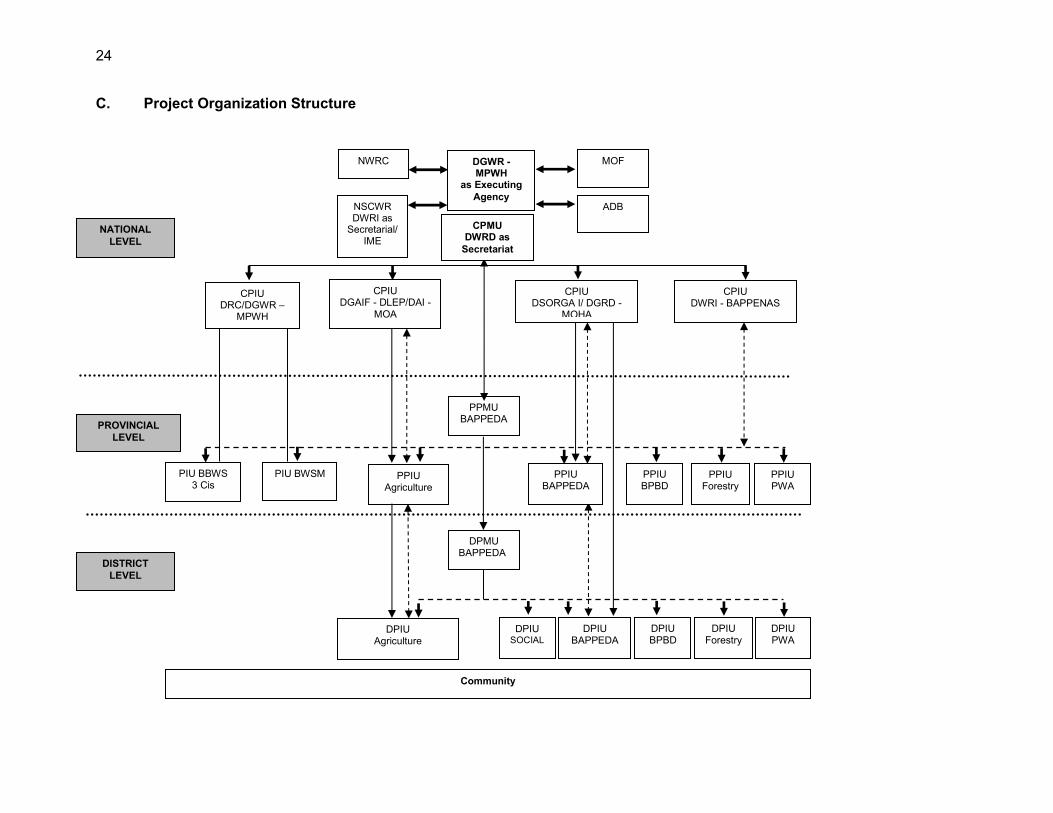
C. Project Organization Structure
NATIONAL LEVEL
PROVINCIAL LEVEL
DISTRICT LEVEL
NSCWR DWRI as
Secretarial/ IME
CPIU DRC/DGWR –
MPWH
CPIU DGAIF - DLEP/DAI -
MOA
CPIU DSORGA I/ DGRD -
MOHA
PPMU BAPPEDA
PPIU BAPPEDA
DPMU BAPPEDA
DPIU Agriculture
DPIU BAPPEDA
PIU BBWS 3 Cis
PPIU Agriculture
PIU BWSM
ADB
MOF
PPIU BPBD
PPIU Forestry
PPIU PWA
Community
NWRC
DPIU BPBD
DPIU Forestry
DPIU PWA
DPIU SOCIAL
CPIU DWRI - BAPPENAS
DGWR - MPWH
as Executing Agency
CPMU DWRD as
Secretariat

25
ADB = Asian Development Bank, BAPPEDA = Regional Planning Agency, BAPPENAS = National Development Planning Agency, BBWS 3 Cis = Balai Besar Wilayah Sungai Cidanau-Ciujung-Cidurian, BPBD = Badan Penanggulangan Bencana Daerah (Disaster Management Agency), BWSM = Balai Wilayah Sungai Maluku, CPIU = Central Project Implementation Unit, CPMU-EA = Central Project Management Unit-Executing Agency, DAI = Directorate of Agriculture Irrigation, DGAIF = Directorate General of Agricultural Infrastructure Facility, DGRD = Directorate General of Regional Development, DGWR = Directorate General of Water Resources, DLEP = Directorate of Land Extension and Protection, DPIU = District Project Implementation Unit, DPMU = District Project Management Unit, DRC = Directorate of River and Coast, DSORGA I= Directorate of Directorate of Synchronization of Regional Government Affairs I (SORGA I), DWRD = Directorate of Water Resources Development, DWRI = Directorate of Water Resources and Irrigation, IME = Independent Monitoring Evaluation, MOA = Ministry of Agriculture, MOF = Ministry of Finance, MOHA = Ministry of Home Affairs, MPWH = Ministry of Public Works and Housing, NSCWR = National Steering Committee on Water Resources, NWRC= National Water Resources Council, PPIU = Provincial Project Implementation Unit, PPMU = Provincial Project Management Unit, PWA = Public Works Agency.
26
D. Implementation Procedures
1. Subproject Selection, Preparation and Approval
13. The executing agency (DGWR, MPWH), through the CPIU established in DRC, with the support of the project management consultants (PMC) and the project implementation units (PIUs)—established in both the BBWS 3 Cis and BWSM—will have the main responsibility for preparing and appraising subprojects. 14. Subproject Selection and appraisal process. Infrastructure investments are packaged as “subprojects”. In the context of this Project, a subproject is defined as an integrated package of investments and activities in a given river basin territory. A tentative list of candidate sub-projects both the 3 Cis and Ambon-Seram RBTs is provided in Appendix 4. This list of candidate subproject is based on the official river basin planning documents, Pola and Rencana for both RBT,22 consultation with BBWS 3 Cis and BWSM and basin stakeholders, past studies, and analysis conducted during the project preparatory technical assistance (PPTA).23 During the Project implementation, subprojects will further be identified, prioritized, formulated, appraised, approved in accordance with technical, financial, economic, social and environmental appraisal criteria, mutually agreed between ADB and the Government as described below. ADB will review the subprojects on a selective basis with reference to the agreed criteria. The subproject scope should comply with the overall impact, outcome and management effectiveness outputs of the Project and contribute to the sector/sub-sector target of the Government, and geographic scope of the Project. DGWR will submit to ADB the environmental, social safeguard assessment reports and environment management plan (EMP), and resettlement plan for each subproject as required. Works contracts can be awarded however contract implementation is subject to approval of resettlement plan, if required.
Step 1: Screen and select candidate subprojects from the sector development plan (RBT plans - Pola and Rencana), consultation with the Basin Coordination Forum (TKPSDAs) and submit the selection to ADB for approval.
Step 2: Prepare the subproject appraisal report covering technical, economic,24 social, environment and financial aspects; hold required consultations; revise and submit to the CPMU for appraisal and approval as per template presented in Appendix 5.
Step 3: Submit the subproject appraisal report to ADB for review and approval. Step 4: Prepare the detailed engineering design (DED) and social and environmental
safeguards documents considering climate change aspects. Step 5: Submit the social and environmental safeguards documents for ADB
approval. Step 6: Implement activities including tendering, land acquisition and resettlement
(LAR), and other activities. 15. Selection criteria. To be eligible for financing through the project, each subproject feasibility study report will include a flood-risk and situation assessment, technical analysis and description, subproject rationale, scope and components, cost estimates and financing plan,
22 POLA for 3 Cis RBT was endorsed by Ministry of Public Works and Housing on 14 February 2012 and for Ambon
Seram RBT on 28 November 2012. 23 PPTA 7364 INO Phase 2 Final Report, Volume 1 Main Report. 24 The ecomomic analysis has to be prepared according to ADB’s Guidelines on the Economic Analysis of
Projects.
27
implementation arrangements, financial and economic analysis, and environmental, social and poverty impact assessment (see Appendix 5 for the Subproject Summary Report Template). Based on the feasibility study, subprojects must be selected according to the following criteria:
(i) The subproject is in line with the sector development plan and the RBT plans – (Pola and Rencana).
(ii) The subproject flood-risk analysis is based on technical requirements for hydrological and hydraulic survey data for estimating flood flow and impact, and structural designs meet national technical requirements.
(iii) The subproject is designed to maximize the benefit to cost ratio with a combination of structural and nonstructural measures for optimal flood management.
(iv) The subproject's social and poverty impact assessment assesses that the proposed flood protection measures will have a net positive impact, will reduce poverty, and can be monitored.
(v) The subproject is designed to minimize social impacts and ensure that people adversely affected by civil works under the project are compensated in compliance with the principles set in the resettlement framework.
(vi) The subproject initial environmental examination assesses that the environmental impact during construction can be minimized, in line with principles set in the environmental assessment review framework (EARF); and the subproject is designed to minimize detrimental environmental impact.
(vii) The subproject's implementation timeframe is reasonable, and surveys and design can be prepared, reviewed, and safeguard processes and procedures followed, and implemented within the project period.
(viii) The local government provides commitment to the investment to facilitate the LAR process (as required), including implementation of the social action plan in accordance with the principles set out in the resettlement framework.
(ix) The subproject has no negative and/or positive impacts to indigenous people, and screening process of each future sub-projects will be done to ensure that indigenous people safeguards are not triggered (only category C).
(x) Local communities and beneficiaries demonstrate commitment to the investment through willingness to contribute, in cash or in kind, to the cost of development as appropriate.
(xi) Subproject economic internal rate of return exceeds 12%. 16. These civil works are complemented by the following activities: (i) improvement of hydrological information systems and preparation of FRMPs, (ii) institutional strengthening for implementation of FRMPs, (iii) rehabilitation and management of watershed, (iv) governance (building code, local regulations, land use zoning, etc.), (v) detailed engineering design and construction supervision for flood control infrastructure, and (vi) community-based flood risk management.25 17. Participatory planning approach and stakeholder involvement. Subproject design and development will follow a participatory planning and demand-driven approach in the identification of a package of investments and activities. The basin coordinating committee will be consulted for the preparation of the sub projects in conjunction with the FRM planning.
25 Based on above criteria, one core subproject was identified and appraised during project preparation in the Ciujung
river basin consisting of the construction of new dikes (11 km), spillways and retention basin along the Ciujung main stream.
28
2. Technical Considerations for Structural Activities
18. After the feasibility study and project selection as described above, the structural subproject implementation will include the following steps:
(i) Preparation of DED that will take into account climate change, future land use changes and eco-hydrology dimensions;
(ii) Preparation of O&M plan; (iii) Review/approval of DED; (iv) Tendering for civil works; (v) Complete implementation of resettlement plans and provision of required
compensation to project affected people before issuing instruction to proceed to contractors;
(vi) Construction, including technical and safeguard supervision and monitoring; (vii) Commissioning, training and handover; and (viii) Operation, maintenance and monitoring.
19. The CPMU will recruit safeguards consultants as part of the PMC team. The consultants shall support the BBWS 3 Cis and BWSM to prepare the resettlement plans in consultation with provincial and district land agencies, and project affected people. This will ensure that appropriate measures are taken to mitigate any negative social impacts including special measures for land acquisition, compensation, and to ensure full implementation to improve the participation of women and other disadvantaged groups as beneficiaries as set in the resettlement framework. The consultants will also prepare the indigenous people screening. The safeguards specialists and the CPMU will work closely with gender specialist to ensure the gender action plan is fully implemented and gender consideration for resettlement plan is addressed. The guidelines for community contracting under the MOA and MOHA components are presented in Appendix 6.
29
IV. COSTS AND FINANCING
20. The government has requested a loan of $108.7 million from ADB’s ordinary capital resources to help finance the Project. The loan will have an 17-year term, including a grace period of 8 years, straight line, an annual interest rate determined in accordance with ADB’s London interbank offered rate (LIBOR)-based lending facility, a commitment charge of 0.15% per year (the interest and other charges during construction to be paid by the government, not capitalized in the loan), and such other terms and conditions set forth in the draft loan agreement.26 Based on this, the average loan maturity is 12.75 years and there is no maturity premium payable to ADB. The project total cost is $161.57 million of which $141.68 million constitutes base costs, $16.83 million for contingencies and $3.06 million financial charges during implementation (including interest rate and commitment charges). The loan proceeds will be utilized for the construction of selected civil works, community driven activities, vehicles, equipment, consulting services, workshops, and training socialization. 21. The government will fund the remaining project cost estimated at $52.87 million (inclusive of $13.08 million in taxes and duties, $16.83 million for contingencies, $17.74 million for land acquisition and resettlement, $2.40 million for incremental and administrative costs and $3.06 million interest and commitment charges during implementation).
26 Loan Agreement (accessible from the list of linked documents in Appendix 2).

30 30
A. Detailed Cost Estimates by Expenditure Category
$ Million % Total
1 Works and Equipment 70.48 43.62 2 Consulting Services, Training and
Project Management 23.95 14.83
3 Community Driven Development 25.14 15.56 4 Land Acquisition and Resettlement 19.71 12.20 5 Incremental Admin. Cost 2.40 1.48
Total Base Costs 141.68 87.69
Contingencies 16.83 10.42 Interest During Implementation 2.66 1.65 Commitment charges 0.40 0.25
Total Project Cost 161.57 100.00 Source: Asian Development Bank staff estimates. B. Allocation and Withdrawal of Loan Proceeds
Category ADB Financing
($ Million) Percentage and Basis for Withdrawal from the Loan Account
1 Works and Equipment 64.07 100% of total expenditure claimed* 2 Consulting Services, Training and
Project Management 21.78 100% of total expenditure claimed*
3 Community Driven Development 22.85 100% of total expenditure claimed* Total ADB Loan 108.70 *Exclusive of local taxes and duties within the territory of the borrower. Source: Asian Development Bank staff estimates.
31
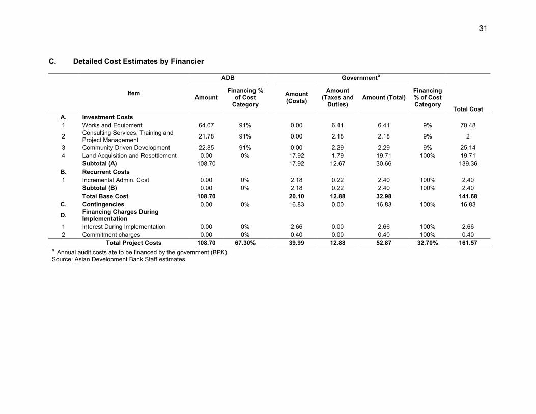
C. Detailed Cost Estimates by Financier
Item
ADB Governmenta
Total Cost
Amount Financing %
of Cost Category
Amount (Costs)
Amount (Taxes and
Duties) Amount (Total)
Financing % of Cost Category
A. Investment Costs 1 Works and Equipment 64.07 91% 0.00 6.41 6.41 9% 70.48
2 Consulting Services, Training and Project Management 21.78 91% 0.00 2.18 2.18 9% 2
3 Community Driven Development 22.85 91% 0.00 2.29 2.29 9% 25.14 4 Land Acquisition and Resettlement 0.00 0% 17.92 1.79 19.71 100% 19.71
Subtotal (A) 108.70 17.92 12.67 30.66 139.36 B. Recurrent Costs 1 Incremental Admin. Cost 0.00 0% 2.18 0.22 2.40 100% 2.40 Subtotal (B) 0.00 0% 2.18 0.22 2.40 100% 2.40 Total Base Cost 108.70 20.10 12.88 32.98 141.68
C. Contingencies 0.00 0% 16.83 0.00 16.83 100% 16.83
D. Financing Charges During Implementation
1 Interest During Implementation 0.00 0% 2.66 0.00 2.66 100% 2.66 2 Commitment charges 0.00 0% 0.40 0.00 0.40 100% 0.40
Total Project Costs 108.70 67.30% 39.99 12.88 52.87 32.70% 161.57 a Annual audit costs ate to be financed by the government (BPK). Source: Asian Development Bank Staff estimates.
32
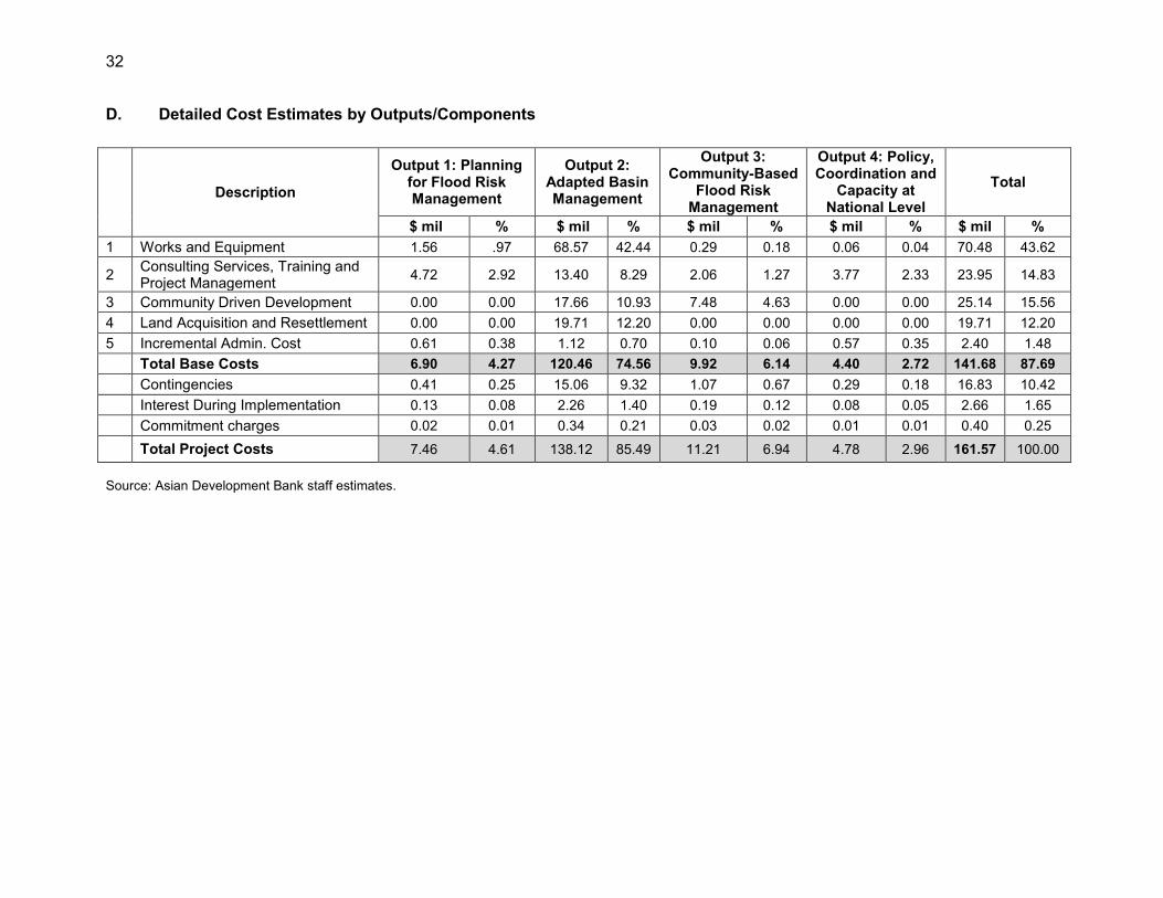
D. Detailed Cost Estimates by Outputs/Components
Description
Output 1: Planning for Flood Risk Management
Output 2: Adapted Basin Management
Output 3: Community-Based
Flood Risk Management
Output 4: Policy, Coordination and
Capacity at National Level
Total
$ mil % $ mil % $ mil % $ mil % $ mil % 1 Works and Equipment 1.56 .97 68.57 42.44 0.29 0.18 0.06 0.04 70.48 43.62
2 Consulting Services, Training and Project Management 4.72 2.92 13.40 8.29 2.06 1.27 3.77 2.33 23.95 14.83
3 Community Driven Development 0.00 0.00 17.66 10.93 7.48 4.63 0.00 0.00 25.14 15.56 4 Land Acquisition and Resettlement 0.00 0.00 19.71 12.20 0.00 0.00 0.00 0.00 19.71 12.20 5 Incremental Admin. Cost 0.61 0.38 1.12 0.70 0.10 0.06 0.57 0.35 2.40 1.48 Total Base Costs 6.90 4.27 120.46 74.56 9.92 6.14 4.40 2.72 141.68 87.69 Contingencies 0.41 0.25 15.06 9.32 1.07 0.67 0.29 0.18 16.83 10.42 Interest During Implementation 0.13 0.08 2.26 1.40 0.19 0.12 0.08 0.05 2.66 1.65 Commitment charges 0.02 0.01 0.34 0.21 0.03 0.02 0.01 0.01 0.40 0.25
Total Project Costs 7.46 4.61 138.12 85.49 11.21 6.94 4.78 2.96 161.57 100.00 Source: Asian Development Bank staff estimates.
33
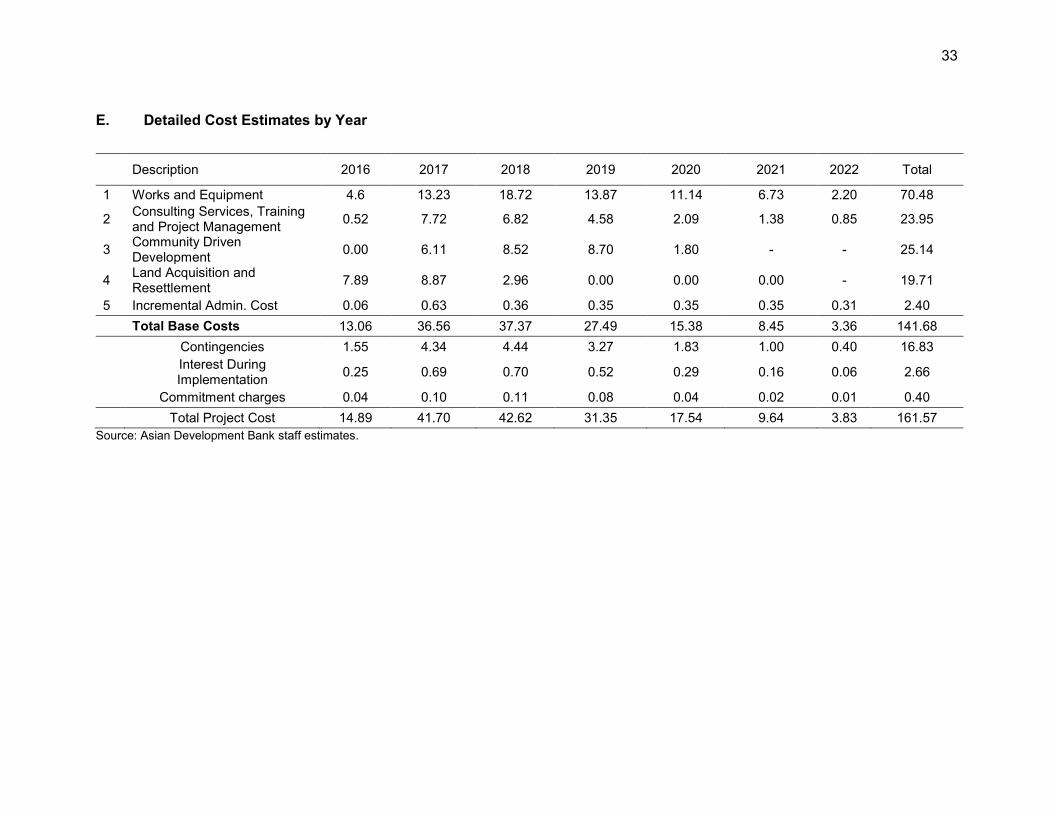
E. Detailed Cost Estimates by Year
Description 2016 2017 2018 2019 2020 2021 2022 Total
1 Works and Equipment 4.6 13.23 18.72 13.87 11.14 6.73 2.20 70.48
2 Consulting Services, Training and Project Management 0.52 7.72 6.82 4.58 2.09 1.38 0.85 23.95
3 Community Driven Development 0.00 6.11 8.52 8.70 1.80 - - 25.14
4 Land Acquisition and Resettlement 7.89 8.87 2.96 0.00 0.00 0.00 - 19.71
5 Incremental Admin. Cost 0.06 0.63 0.36 0.35 0.35 0.35 0.31 2.40
Total Base Costs 13.06 36.56 37.37 27.49 15.38 8.45 3.36 141.68
Contingencies 1.55 4.34 4.44 3.27 1.83 1.00 0.40 16.83
Interest During Implementation 0.25 0.69 0.70 0.52 0.29 0.16 0.06 2.66
Commitment charges 0.04 0.10 0.11 0.08 0.04 0.02 0.01 0.40
Total Project Cost 14.89 41.70 42.62 31.35 17.54 9.64 3.83 161.57 Source: Asian Development Bank staff estimates.
34
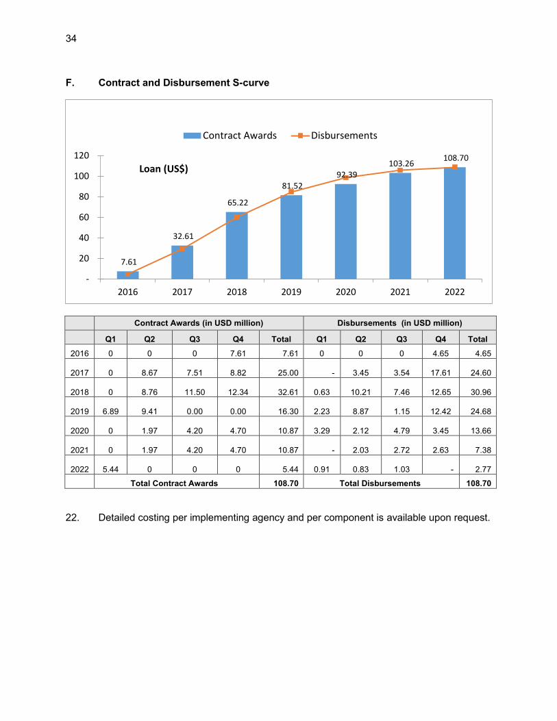
F. Contract and Disbursement S-curve
Contract Awards (in USD million) Disbursements (in USD million)
Q1 Q2 Q3 Q4 Total Q1 Q2 Q3 Q4 Total
2016 0 0 0 7.61 7.61 0 0 0 4.65 4.65
2017 0 8.67 7.51 8.82 25.00 -
3.45
3.54
17.61 24.60
2018 0 8.76 11.50 12.34 32.61
0.63
10.21
7.46
12.65 30.96
2019 6.89 9.41 0.00 0.00 16.30
2.23
8.87
1.15
12.42 24.68
2020 0 1.97 4.20 4.70 10.87
3.29
2.12
4.79
3.45 13.66
2021 0 1.97 4.20 4.70 10.87 -
2.03
2.72
2.63 7.38
2022 5.44 0 0 0 5.44
0.91
0.83
1.03 - 2.77
Total Contract Awards 108.70 Total Disbursements 108.70 22. Detailed costing per implementing agency and per component is available upon request.
7.61
32.61
65.22
81.52 92.39
103.26 108.70
-
20
40
60
80
100
120
2016 2017 2018 2019 2020 2021 2022
Loan (US$)
Contract Awards Disbursements

35
G. Fund Flow Mechanisms
Figure A: General Fund Flow Diagram
Ministry of Finance - Imprest Account
Central Project Management Unit (CPMU)
Government of Indonesia
(Counterpart fund)
Implementing Agency
Project Implementing Unit
Asian Development Bank (Loan)
Executing Agency Ministry of Public Works and Housing
Directorate General of Water Resources
Provincial and District Project Implementation Unit
Funds Flow Document Flow
Contractors, Consultants, Suppliers, Service Providers
36
Figure B: Disbursement Flow Chart for Direct Payment
Cash Flow
Documents Flow
Vendor Supplier/Consultant/
Contractor
Vendor Bank
Account
1
5a ADB
Special Treasury Office- KPPN Pijaman dan
Hibah ADB
Depository Domestic Bank-Jakarta
ADB Overseas Depository
Bank
Vendor Overseas Depository
Bank
2
3 4
4a
5b
5c
PIU BBWS- 3 Cis
SATKER
PIU (BWS-Maluku
CPMU (EA) CPIU
SATKER
CPIU (MOHA)
SATKER
CPIU (MOA)
ADB = Asian Development Bank, BBWS 3 Cis = Balai Besar Wilayah Sungai Cidanau-Ciujung-Cidurian, CPIU = Central Project Implementation Unit, CPMU =Central Project Management Unit, KPPN = Kantor Pelayanan Perbendaharaan Negara (Office of State Treasury Office), MOA = Ministry of Agriculture, MOHA = Ministry of Home Affairs, PIU = Project Implementation Unit
37
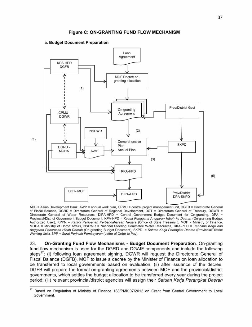
Figure C: ON-GRANTING FUND FLOW MECHANISM
a. Budget Document Preparation
ADB = Asian Development Bank, AWP = annual work plan, CPMU = central project management unit, DGFB = Directorate General of Fiscal Balance, DGRD = Directorate General of Regional Development, DGT = Directorate General of Treasury, DGWR = Directorate General of Water Resources, DIPA-HPD = Central Government Budget Document for On-granting, DPA = Provincial/District Government Budget Document, KPA-HPD = Kuasa Pengguna Anggaran Hibah ke Daerah (On-granting Budget Authorized User), KPPN = Kantor Pelayanan Perbendaharaan Negara (Office of State Treasury ), MOF = Ministry of Finance, MOHA = Ministry of Home Affairs, NSCWR = National Steering Committee Water Resources, RKA-PHD = Rencana Kerja dan Anggaran Penerusan Hibah Daerah (On-granting Budget Document), SKPD = Satuan Kerja Perangkat Daerah (Provincial/District Working Unit), SPP = Surat Perintah Pembayaran (Letter of Order to Pay), 23. On-Granting Fund Flow Mechanisms - Budget Document Preparation. On-granting fund flow mechanism is used for the DGRD and DGAIF components and include the following steps27: (i) following loan agreement signing, DGWR will request the Directorate General of Fiscal Balance (DGFB), MOF to issue a decree by the Minister of Finance on loan allocation to be transferred to local governments based on evaluation, (ii) after issuance of the decree, DGFB will prepare the formal on-granting agreements between MOF and the provincial/district governments, which settles the budget allocation to be transferred every year during the project period; (iii) relevant provincial/district agencies will assign their Satuan Kerja Perangkat Daerah
27 Based on Regulation of Ministry of Finance 188/PMK.07/2012 on Grant from Central Government to Local
Government.
On-granting Agreement
KPA-HPD DGFB
Prov/District Govt
SKPD DGRD -MOHA
- Comprehensive Plan
- Annual Plan
CPMU -DGWR
RKA-HPD
AWP
NSCWR
Prov/District DPA-SKPD
Loan Agreement
MOF Decree on-granting allocation
DIPA-HPD DGT- MOF
(1)
(2)
(3)
(5)
(4)
38
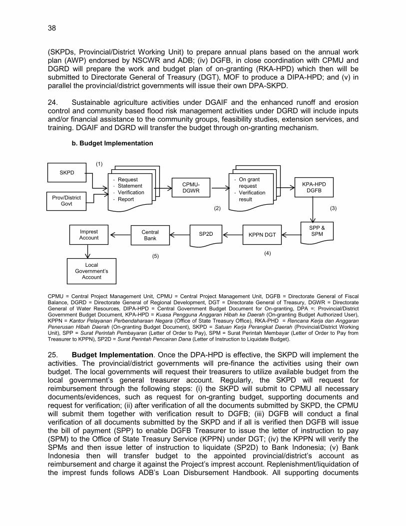
(SKPDs, Provincial/District Working Unit) to prepare annual plans based on the annual work plan (AWP) endorsed by NSCWR and ADB; (iv) DGFB, in close coordination with CPMU and DGRD will prepare the work and budget plan of on-granting (RKA-HPD) which then will be submitted to Directorate General of Treasury (DGT), MOF to produce a DIPA-HPD; and (v) in parallel the provincial/district governments will issue their own DPA-SKPD. 24. Sustainable agriculture activities under DGAIF and the enhanced runoff and erosion control and community based flood risk management activities under DGRD will include inputs and/or financial assistance to the community groups, feasibility studies, extension services, and training. DGAIF and DGRD will transfer the budget through on-granting mechanism. b. Budget Implementation
CPMU = Central Project Management Unit, CPMU = Central Project Management Unit, DGFB = Directorate General of Fiscal Balance, DGRD = Directorate General of Regional Development, DGT = Directorate General of Treasury, DGWR = Directorate General of Water Resources, DIPA-HPD = Central Government Budget Document for On-granting, DPA =: Provincial/District Government Budget Document, KPA-HPD = Kuasa Pengguna Anggaran Hibah ke Daerah (On-granting Budget Authorized User), KPPN = Kantor Pelayanan Perbendaharaan Negara (Office of State Treasury Office), RKA-PHD = Rencana Kerja dan Anggaran Penerusan Hibah Daerah (On-granting Budget Document), SKPD = Satuan Kerja Perangkat Daerah (Provincial/District Working Unit), SPP = Surat Perintah Pembayaran (Letter of Order to Pay), SPM = Surat Perintah Membayar (Letter of Order to Pay from Treasurer to KPPN), SP2D = Surat Perintah Pencairan Dana (Letter of Instruction to Liquidate Budget). 25. Budget Implementation. Once the DPA-HPD is effective, the SKPD will implement the activities. The provincial/district governments will pre-finance the activities using their own budget. The local governments will request their treasurers to utilize available budget from the local government’s general treasurer account. Regularly, the SKPD will request for reimbursement through the following steps: (i) the SKPD will submit to CPMU all necessary documents/evidences, such as request for on-granting budget, supporting documents and request for verification; (ii) after verification of all the documents submitted by SKPD, the CPMU will submit them together with verification result to DGFB; (iii) DGFB will conduct a final verification of all documents submitted by the SKPD and if all is verified then DGFB will issue the bill of payment (SPP) to enable DGFB Treasurer to issue the letter of instruction to pay (SPM) to the Office of State Treasury Service (KPPN) under DGT; (iv) the KPPN will verify the SPMs and then issue letter of instruction to liquidate (SP2D) to Bank Indonesia; (v) Bank Indonesia then will transfer budget to the appointed provincial/district’s account as reimbursement and charge it against the Project’s imprest account. Replenishment/liquidation of the imprest funds follows ADB’s Loan Disbursement Handbook. All supporting documents
SKPD
Prov/District Govt
- Request - Statement - Verification - Report
CPMU-DGWR
- On grant request
- Verification result
KPA-HPD DGFB
SPP & SPM KPPN DGT SP2D Central
Bank Imprest Account
Local Government’s
Account
(1)
(2) (3)
(4) (5)
39
should be maintained at provincial/district level and CPMU, for the purpose of audit and statement of expenditures (SOE) verification. 26. Direct Payment. The procedure for direct payment will follow the Guideline of Director General of Treasury, MOF through the following steps: (i). Payment request from contractors or consultants or vendors will be reviewed and processed by the related satker. (ii). Once it is accepted then Satker will issue letter of instruction to pay to the Office of State Treasury Service (KPPN) under DGT. (iii). The KPPN will verify the SPMs and then issue letter of instruction to liquidate (SP2D) and transfer the budget to contractor/consultant/vendor’s bank account. All supporting documents should be maintained at satker office, for the purpose of audit and statement of expenditures (SOE) verification.
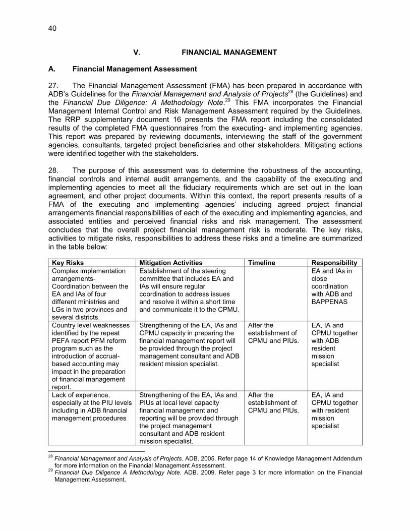
40
V. FINANCIAL MANAGEMENT
A. Financial Management Assessment
27. The Financial Management Assessment (FMA) has been prepared in accordance with ADB’s Guidelines for the Financial Management and Analysis of Projects28 (the Guidelines) and the Financial Due Diligence: A Methodology Note.29 This FMA incorporates the Financial Management Internal Control and Risk Management Assessment required by the Guidelines. The RRP supplementary document 16 presents the FMA report including the consolidated results of the completed FMA questionnaires from the executing- and implementing agencies. This report was prepared by reviewing documents, interviewing the staff of the government agencies, consultants, targeted project beneficiaries and other stakeholders. Mitigating actions were identified together with the stakeholders. 28. The purpose of this assessment was to determine the robustness of the accounting, financial controls and internal audit arrangements, and the capability of the executing and implementing agencies to meet all the fiduciary requirements which are set out in the loan agreement, and other project documents. Within this context, the report presents results of a FMA of the executing and implementing agencies’ including agreed project financial arrangements financial responsibilities of each of the executing and implementing agencies, and associated entities and perceived financial risks and risk management. The assessment concludes that the overall project financial management risk is moderate. The key risks, activities to mitigate risks, responsibilities to address these risks and a timeline are summarized in the table below: Key Risks Mitigation Activities Timeline Responsibility Complex implementation arrangements- Coordination between the EA and IAs of four different ministries and LGs in two provinces and several districts.
Establishment of the steering committee that includes EA and IAs will ensure regular coordination to address issues and resolve it within a short time and communicate it to the CPMU.
EA and IAs in close coordination with ADB and BAPPENAS
Country level weaknesses identified by the repeat PEFA report PFM reform program such as the introduction of accrual-based accounting may impact in the preparation of financial management report.
Strengthening of the EA, IAs and CPMU capacity in preparing the financial management report will be provided through the project management consultant and ADB resident mission specialist.
After the establishment of CPMU and PIUs.
EA, IA and CPMU together with ADB resident mission specialist
Lack of experience, especially at the PIU levels including in ADB financial management procedures
Strengthening of the EA, IAs and PIUs at local level capacity financial management and reporting will be provided through the project management consultant and ADB resident mission specialist.
After the establishment of CPMU and PIUs.
EA, IA and CPMU together with resident mission specialist
28 Financial Management and Analysis of Projects. ADB. 2005. Refer page 14 of Knowledge Management Addendum
for more information on the Financial Management Assessment. 29 Financial Due Diligence A Methodology Note. ADB. 2009. Refer page 3 for more information on the Financial
Management Assessment.
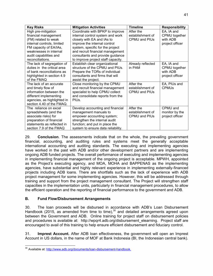
41
Key Risks Mitigation Activities Timeline Responsibility High pre-mitigation financial management (FM) related to weak internal controls, limited FM capacity of EA/IAs, weaknesses in internal audit capabilities and reconciliations.
Coordinate with BPKP to improve internal control system and work closely with EA and IAs to improve the internal control system, specific for the project and recruit financial management consultants and provide guidance to improve project staff capacity.
After the establishment of CPMU and PIUs
EA, IA and CPMU together with ADB project officer
The lack of segregation of duties in the critical area of bank reconciliations as highlighted in section 4.9 of the FMAQ
Establish clear organizational structure of the CPMU and PIUs. Prepare the TORs of individual consultants and firms that will assist the project.
Already reflected in PAM
EA, IA and CPMU together with ADB project officer
The lack of an accurate and timely flow of information between the different implementing agencies, as highlighted in section 4.40 of the FMAQ.
Close monitoring by the CPMU and recruit financial management specialist to help CPMU collect and consolidate reports from the PIUs.
After the establishment of CPMU and PIUs
EA, PIUs and CPMUs
The reliance on excel spreadsheets (and the associate risks) for preparation of financial statements as reflected in section 7.9 of the FMAQ
Develop accounting and financial management manuals to empower accounting system; strengthen the internal audit function; and put in place the system to ensure data reliability.
After the establishment of CPMU and PIUs
CPMU and monitor by the project officer
29. Conclusion. The assessments indicate that on the whole, the prevailing government financial, accounting, and auditing rules and systems meet the generally acceptable international accounting and auditing standards. The executing and implementing agencies have worked in the past with ADB and/or other development partners and are implementing ongoing ADB funded projects. The overall performance of executing and implementing agencies in implementing financial management of the ongoing project is acceptable. MPWH, appointed as the Project’s executing agency, and MOA, MOHA and BAPPENAS as the implementing agencies, have substantial and highly relevant experience in implementing externally-financed projects including ADB loans. There are shortfalls such as the lack of experience with ADB project management for some implementing agencies. However, this will be addressed through training and support from the project management consultant. The Project will strengthen staff capacities in the implementation units, particularly in financial management procedures, to allow the efficient operation and the reporting of financial performance to the government and ADB. B. Fund Flow/Disbursement Arrangements
30. The loan proceeds will be disbursed in accordance with ADB’s Loan Disbursement Handbook (2015, as amended from time to time),30 and detailed arrangements agreed upon between the Government and ADB. Online training for project staff on disbursement policies and procedures is available at: http://wpqr4.adb.org/disbursement_elearning. Project staff are encouraged to avail of this training to help ensure efficient disbursement and fiduciary control. 31. Imprest Account. After ADB loan effectiveness, the government will open an Imprest Account in US dollars, in the name of MOF at Bank Indonesia (BI, the Indonesian central bank).
30 Available at: http://www.adb.org/documents/loan-disbursement-handbook.
42
The imprest account will be administered by MOF. The government who established the imprest account in its name is accountable and responsible for proper use of advances to the imprest account. 32. At central level, the project will have six budget users: DGRW, BBWS 3 Cis, BWSM, DGAIF, DGRD, and DWRI. Each budget holder will establish a working unit for implementation, which is headed by a commitment officer (PPK).31 The PPK is responsible for monitoring procurement and managing the payments for procured works, goods or services. The payments are made by the state treasury office (KPPN - Kantor Pelayanan Perbendaharaan Negara) at the request of PPK and following the approval by the budget holders. The CPMU will submit liquidation and replenishment request to the MOF in the form of withdrawal applications (WAs) in accordance with ADB’s Loan Disbursement Handbook (2015, as amended from time to time). The imprest account will be replenished to ensure liquidity of funds. 33. The imprest account will be established, managed, replenished, and liquidated in accordance with ADB’s Loan Disbursement Handbook (February 2015, as amended from time to time). The total outstanding advance to the imprest account should not exceed the estimate of ADB’s share of expenditures to be paid through the imprest account for the forthcoming 6 months. The government may request for initial and additional advances to the imprest account based on an Estimate of Expenditure Sheet32 setting out the estimated expenditures to be financed through the accounts for the forthcoming six (6) months. Supporting documents should be submitted to ADB or retained by the borrower in accordance with ADB’s Loan Disbursement Handbook (2015, as amended from time to time) when liquidating or replenishing the imprest account. 34. Before the submission of the first withdrawal application, the borrower will submit to ADB sufficient evidence of the authority of the person(s) who will sign the withdrawal applications on behalf of the borrower, together with the authenticated specimen signatures of each authorized person. The minimum value per withdrawal application is US$100,000 equivalent. Individual payments below this amount should be paid by the EA/IA and subsequently claimed from ADB (i) through reimbursement; or (ii) from the imprest account, unless otherwise accepted by ADB. 35. The CPMU will be responsible for preparing the annual contract awards and disbursement projections; requesting budgetary allocations for counterpart funds, preparing of withdrawal applications, and sending the withdrawal applications to ADB. CPMU and the PIUs are responsible in collecting supporting documents for the project expenditures they have incurred. 36. Statement of Expenditures (SOE). The SOE procedure may be used for reimbursement of eligible expenditure and liquidation and replenishment of advances to the imprest account. SOE records should be maintained and made readily available for review by ADB’s disbursement and review mission or upon ADB’s request for submission of supporting documents on a sampling basis. 37. Sample forms for withdrawal of loan proceeds, replenishment and liquidation of imprest account, and SOE can be downloaded from the ADB website.33 CPMU will be responsible for ensuring that SOEs are operated in accordance with ADB's requirement.
31 PPK = pejabat pembuat komitment = commitment officer 32 ADB. 2015. Loan Disbursement Handbook. 10B. 33 Available at: http://www.adb.org/documents/loan-disbursement-handbook
43
C. Accounting Policies and Procedures 38. DGWR will maintain, or cause to be maintained, separate books and records by funding source for all expenditures incurred on the Project. DGWR will prepare consolidated project financial statements in accordance with the government's accounting laws and regulations which are consistent with international accounting principles and practices. D. Reporting, Auditing and Public Disclosure 39. Auditing Requirements. DGWR will cause the detailed consolidated project financial statements to be audited in accordance with International Standards on Auditing and with the Government's audit regulations, by an independent auditor acceptable to ADB. The audited project financial statements will be submitted in the English language to ADB within six months of the end of the fiscal year by DGWR. 40. The executing agency will engage the Badan Pengawas Keuangan (BPK), the Indonesian Supreme Audit Institution (SAI), to audit the consolidated project financial statements annually. BPK will allocate adequate budget to properly audit the project. The draft terms of reference (TOR) of BPK was discussed between ADB and BPK, and has been approved by BPK, MOF, and ADB dated 18 July 2014. The Project will follow the approved TOR of BPK, which is given in the financial management assessment. 41. As in the TOR, BPK will prepare the annual audit report for the project accounts, which will include an audit management letter and audit opinions which cover (i) whether the project financial statements present a true and fair view or are presented fairly, in all material respects, in accordance with the applicable financial reporting framework; (ii) whether loan and grant proceeds were used only for the purposes of the project or not; (iii) the level of compliance for each financial covenant contained in the legal agreements for the project; and (iv) use of the imprest fund procedure. 42. Compliance with financial reporting and auditing requirements will be monitored by review missions and during normal program supervision, and followed up regularly with all concerned, including the external auditor. 43. The government, DGWR and implementing agencies have been made aware of ADB’s policy on delayed submission, and the requirements for satisfactory and acceptable quality of the audited project financial statements.34 ADB reserves the right to require a change in the
34 ADB Policy on delayed submission of audited project financial statements:
When audited project financial statements are not received by the due date, ADB will write to the executing agency advising that (i) the audit documents are overdue; and (ii) if they are not received within the next six months, requests for new contract awards and disbursement such as new replenishment of imprest accounts, processing of new reimbursement, and issuance of new commitment letters will not be processed.
When audited project financial statements have not been received within 6 months after the due date, ADB will withhold processing of requests for new contract awards and disbursement such as new replenishment of imprest accounts, processing of new reimbursement, and issuance of new commitment letters. ADB will (i) inform the executing agency of ADB’s actions; and (ii) advise that the loan may be suspended if the audit documents are not received within the next six months.
When audited project financial statements have not been received within 12 months after the due date, ADB may suspend the loan.
44
auditor (in a manner consistent with the constitution of the borrower), or for additional support to be provided to the auditor, if the audits required are not conducted in a manner satisfactory to ADB, or if the audits are substantially delayed. ADB reserves the right to verify the project's financial accounts to confirm that the share of ADB’s financing is used in accordance with ADB’s policies and procedures. 44. Public disclosure of the project financial statements, including the audit report on the project financial statements, will be guided by ADB’s Public Communications Policy (2011).35 After review, ADB will disclose the project financial statements for the project and the opinion of the auditors on the financial statements within 30 days of the date of their receipt by posting them on ADB’s website. The Audit Management Letter will not be disclosed.
35 Available from http://www.adb.org/documents/pcp-2011?ref=site/disclosure/publications

45
VI. PROCUREMENT AND CONSULTING SERVICES
A. Advance Procurement
45. All advance contracting will be undertaken in conformity with ADB’s Procurement Guidelines (April 2015, as amended from time to time)36 and ADB’s Guidelines on the Use of Consultants (March 2013, as amended from time to time).37 The issuance of invitations to bid under advance contracting will be subject to ADB approval. The borrower and DGWR, BBWS 3 Cis, BWSM, DGAIF, DGRD, and DWRI have been advised that approval of advance contracting does not commit ADB to finance the Project. ADB financing is subject to the government’s compliance of the relevant provisions of the loan agreement and ADB guidelines. The Government was also advised that ADB will not finance expenditures incurred by the government prior to loan effectiveness, even if advance contracting is approved by ADB. 46. The following steps for the recruitment of consultants can be concluded in advance: (i) submission to ADB for review and approval of the term of reference, cost estimates and shortlisting evaluation criteria, (ii) advertisement, (iii) shortlisting of consulting firms, (iv) issuance of the request for proposals, (v) evaluation of technical proposals, and (vi) evaluation of financial proposals and final ranking. DGWR, DGAIF, DGRD, and DWRI will advertise all consulting opportunities in Consulting Services Recruitment Notice (CSRN) at www.adb.org. 47. The following steps for the procurement of vehicles and office equipment, and civil works can be undertaken in advance: (i) submission to ADB for review and approval of the draft bidding document, (ii) advertisement, (iii) issuance of bid documents, (iv) bid opening, and (v) evaluation of bids. 48. To facilitate rapid start-up, the government and ADB agreed that advance action could be undertaken for the (i) engagement of consultants under DGWR, BAPPENAS, DGAIF and DGRD, and (ii) urgent civil works packages under the BBWS 3 Cis core subproject. This is necessary to ensure (i) consultants are available to support the early stages of project implementation, and (ii) urgent civil works can start at early stage of the project. B. Procurement of Goods, Works and Consulting Services
49. All procurement of goods and works will be undertaken in accordance with ADB’s Procurement Guidelines (2015, as amended from time to time). Under the project, civil works will be procured through national competitive bidding (NCB) procedures acceptable to ADB for packages up to or equal to $25,000,000 equivalent. Goods will be procured through NCB procedures acceptable to ADB for packages up to or equal to $3,000,000 equivalent. For packages of $100,000 equivalent or less, shopping method may be used. Small-scale works and good contracts with average value of $30,000 equivalent may be awarded to community groups following procurement procedures for community participation in procurement as contained in ADB's Procurement Guidelines. The use of the e-procurement system is allowed for national competitive bidding (NCB) packages for MPWH, Bappenas, MOA and MOHA. For Quality- and Cost-Based Selection (QCBS) all consulting services recruitment notice (CSRN) must be posted in the ADB consultant management system (CMS), MPWH’ e- procurement system (SPSE), and local English newspaper. The executing and implementing agencies must ensure that all experession of interest are mandatory to be submitted through MPWH’ SPSE, in
36 Available at: http://www.adb.org/Documents/Guidelines/Procurement/Guidelines-Procurement.pdf 37 Available at: http://www.adb.org/Documents/Guidelines/Consulting/Guidelines-Consultants.pdf

46
addition to expression of interest (EOI) received via CMS and evaluated accordingly. Hence executing and implementing agencies will provide assurance that the use of MPWH electronic procurement system to engage the consulting firms will not hamper the advertisement of the CSRN in CMS nor the receipt of all EOI and corresponding evaluation of EOI. 50. For procurement within MPWH, all bidders have to apply in both ADB CSRN and Government’s SPSE systems, otherwise will not be processed. If there is any discrepancy/difference in data or information submitted between the systems, the data or information in SPSE system will only be considered valid 51. A Procurement Sector Risk Assessment for the water sector, has been completed by ADB. The assessment suggested that the overall procurement risk in the sector is Medium with notes to give attention to (i) the sufficiency of the number of procurement committee members and (ii) the current procurement performance in the sector which resulted in limited number of qualified bidders despite significant larger number of firms which bidded. 52. A Project Procurement Risk Assessment was prepared in accordance with ADB’s “Guide on Assessing Procurement Risks and Determining Project Procurement Classification.”38 The overall procurement classification for the Project is assessed as Medium Risk (Category Medium) and recommended the following to improve procurement capacity:
Procurement Risk Description
Indicators Description 1. Legislative and Regulatory Framework - The procurement strictly follows the national
regulations. However, the ministry classifies contractors based on their qualification (expertise) and classification (size). A particular contractor may only participate in the procurement packages according to their qualification and classification.
- Complaint handling mechanism system exists but sanction system needs improvement.
- Standard Bidding Documents are used, however, the one for large contracts requiring international competition may need further improvements to attract more bidders
2. Institutional Framework and Management Capacity
- Advance procurement is practiced in the end of each year to anticipate the new fiscal year, with strict stipulation that bid winner will be determined when the budget document (DIPA) is effective.
- Procurement planning may require further enhancement to anticipate widespread scattered contracts based on the current extensive demands for water resources management sector development.
- Procurement Service Unit is a permanent function unit. - Each procurement working group members is
procurement certified. 3. Procurement Operation and Market Practices - For large contract procurement, the number of
competitive private sector is rather limited. - Advertisement of a procurement opportunity is
adequately made in transparent manner. However, there may be an inadequate comprehensive public
38 ADB. 2014. Guide on Assessing Procurement Risks and Determining Project Procurement Classification. Manila
47
Procurement Risk Description
Indicators Description awareness program to show the general advantages for the private sector in participating in large value government contracts.
- The sector has a long experience in procuring large water resources development projects financed by various loans.
- Under the current regulations the cost estimate is based on market assessment. However, no further guidance/manual is provided on how to conduct such market assessment, and there is no proper supervision either on the application of the market survey.
- Implementing unit is used to refer to unit price list endorsed by each local government
- e-catalogue for some items of goods is available 4. Integrity and Transparency of the Public
Procurement System - Procedures and requirements on conducting
procurement audit is still missing, so far which has been implemented nationally is financial audit which includes the review of the application of procurement procedures.
- Many improvements made in fighting against corruption and collusion however it needs to be addressed in a more institutional and sustainable way.
Overall Rating Medium
53. An 18-month procurement plan indicating threshold and review procedures, goods, works, and consulting service contract packages and national competitive bidding guidelines are in Section C below (Procurement Plan). 54. All consultants will be recruited according to ADB’s Guidelines on the Use of Consultants.39 A total of 2,579 person months of consulting services will be financed by the loan, comprising 2,499 person-months national and 80 person months of international. DGWR consultants, comprising 1,477 person months of national and 40 person months of international consultants will provide support to project management, project administration support, sub project preparation (covering technical, economic and safeguards aspects) and technical support to the BBWS 3 Cis and BWSM for DED and construction supervision. DGWR will also recruit an independent social monitoring agency and the BBWS 3 Cis and BWSM will both recruit an independent environmental monitoring agency. 208 person-months of national and 6 person-months of international consultants will be recruited to assist DWRI in monitoring and evaluating the implementation of the project. A total of 220 person-months of National consultants will provide technical support to DGAIF for implementation of sustainable agriculture practices in the Ciujung river basin. 594 person-months national and 34 person months of international consultants will be recruited to support DGRD for the integration of the FRMPs into annual and 5 years provincial and district plans, institutional works, watershed rehabilitation and CBFRM activities. The selection of consultants will be in accordance with ADB’s quality-and-cost-based selection method using a quality-cost ratio of 80:20 Consultants’ Qualification Selection method, least cost selection method, quality based selection method, and individual
39 Checklists for actions required to contract consultants by method available in e-Handbook on Project
Implementation at: http://www.adb.org/documents/handbooks/project-impleMarchmentation/
48
consultant selection method. The terms of reference for all consulting services are in Appendix 7. C. Procurement Plan
Basic Data
Project Name: Flood Management in Selected River Basins Sector Project Project Number: 35182-043 Approval Number: Country: Indonesia Executing Agency: Directorate General of
Water Resources, MPWH
Project Procurement Classification: Category B Implementing Agencies: Directorate General of Agricultural Infrastructure & Facilities, MOA Directorate General of Regional Development, MOHA Directorate General of Water Resources, MPWH Office of the Deputy of Infrastructure Affairs, BAPPENAS
Project Procurement Risk: Moderate
Project Financing Amount: US$ 161,570,000 ADB Financing: US$ 108,700,000 Cofinancing (ADB Administered): Non-ADB Financing: US$ 52,870,000
Loan Closing Date: 30 June 2023
Date of First Procurement Plan: 30 May 2016 Date of this Procurement Plan: 30 May 2016
A. Methods, Thresholds, Review and 18-Month Procurement Plan
1. Procurement and Consulting Methods and Thresholds Except as the Asian Development Bank (ADB) may otherwise agree, the following process thresholds shall apply to procurement of goods and works. Procurement of Goods and Works Method Threshold Comments National Competitive Bidding for Goods
Between US$ 100,001 and US$ 3,000,000
First package subject to prior review. Succeeding packages subject to post review
Shopping for Goods Up to US$ 100,000 Post review. Community Participation in Procurement for Goods
Up to US$ 30,000 Post review.
National Competitive Bidding for Works
Between US$ 100,001 and US$ 25,000,000
First package irregardless of contract value is subject to prior review. For succeeding packages: (i) each work contract with contract amount less than $10,000,000 is subject to post review; and (ii) each work contract with contract amount of $10,000,000 and above are still subject to prior review.
Shopping for Works Up to US$ 100,000 Post review. Community Participation in Procurement for Works
Up to US$ 30,000 Post review.
Consulting Services Method Comments Consultant's Qualification Selection for Consulting Firm For small contracts (maximum $200,000) with highly
specialized organizations for time critical assignment. Least-Cost Selection for Consulting Firm For very small contracts (maximum $100,000) of standard
or routine nature for time critical assignment. Quality- and Cost-Based Selection for Consulting Firm Default method, for consulting team contracts that do not

49
Consulting Services Method Comments
meet the criteria of other selection methods. Quality-Based Selection for Consulting Firm For engagement of NGOs and similar entities or complex
assignment requiring high specialization. Others for Consulting Firm For specialized inputs.
2. Goods and Works Contracts Estimated to Cost $1 Million or More The following table lists goods and works contracts for which the procurement activity is either ongoing or expected to commence within the next 18 months.
Package Number
General Description
Estimated Value
Procurement Method
Review (Prior/ Post)
Bidding Procedure
Advertisement Date
(quarter/year) Comments
Civil Works 1 Ciujung priority civil works package 1 (right side dike)
9,146,000.00 NCB Prior 1S1E Q3 / 2016 Prequalification of Bidders: N Domestic Preference Applicable: N Comments: To be procured by BBWS 3Cis. Construction implementation will be phased in line with land acquisition and resettlement (LAR) activities.
Civil Works 2 Ciujung priority civil works package 2 (left side dike)
10,044,000.00
NCB Prior 1S1E Q3 / 2016 Prequalification of Bidders: N Domestic Preference Applicable: N Comments: To be procured by BBWS 3Cis. Construction implementation will be phased in line with LAR activities.
Civil Works 3 Check Dams
2,200,000.00
NCB Post 1S1E Q2 / 2017 Prequalification of Bidders: N Domestic Preference Applicable: N Comments: To be procured by BWSM.
Goods 1 Telemetric rainfall,
1,070,000.00 NCB Prior 1S1E Q2 / 2017 Prequalification of
Bidders: N
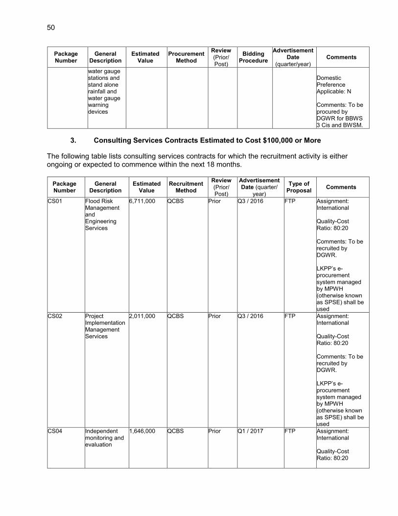
50
Package Number
General Description
Estimated Value
Procurement Method
Review (Prior/ Post)
Bidding Procedure
Advertisement Date
(quarter/year) Comments
water gauge stations and stand alone rainfall and water gauge warning devices
Domestic Preference Applicable: N Comments: To be procured by DGWR for BBWS 3 Cis and BWSM.
3. Consulting Services Contracts Estimated to Cost $100,000 or More
The following table lists consulting services contracts for which the recruitment activity is either ongoing or expected to commence within the next 18 months.
Package Number
General Description
Estimated Value
Recruitment Method
Review (Prior/ Post)
Advertisement Date (quarter/
year)
Type of Proposal Comments
CS01 Flood Risk Management and Engineering Services
6,711,000 QCBS Prior Q3 / 2016 FTP
Assignment: International Quality-Cost Ratio: 80:20 Comments: To be recruited by DGWR. LKPP’s e-procurement system managed by MPWH (otherwise known as SPSE) shall be used
CS02 Project Implementation Management Services
2,011,000 QCBS Prior Q3 / 2016 FTP
Assignment: International Quality-Cost Ratio: 80:20 Comments: To be recruited by DGWR. LKPP’s e-procurement system managed by MPWH (otherwise known as SPSE) shall be used
CS04 Independent monitoring and evaluation
1,646,000 QCBS Prior Q1 / 2017 FTP
Assignment: International Quality-Cost Ratio: 80:20

51
Package Number
General Description
Estimated Value
Recruitment Method
Review (Prior/ Post)
Advertisement Date (quarter/
year)
Type of Proposal Comments
Comments: To be procured by DWRI
CS05 Farmland Management and Sustainable Agriculture Practices
1,513,000 QCBS Prior Q4 / 2016 STP
Assignment: National Quality-Cost Ratio: 80:20 Comments: To be procured by MOA.
CS06 Institutional Development for Community-Based Flood Risk Management
4,573,000.00 QCBS Prior Q3 / 2016 FTP
Assignment: International Quality-Cost Ratio: 80:20 Comments: To be procured by MOHA.
4. Goods and Works Contracts Estimated to Cost Less than $1 Million and
Consulting Services Contracts Less than $100,000 (Smaller Value Contracts) The following table lists smaller-value goods, works and consulting services contracts for which the activity is either ongoing or expected to commence within the next 18 months.
Goods and Works
Package Number
General Description
Estimated Value
Number of Contracts
Procurement Method
Review (Prior/ Post)
Bidding Procedure
Advertisement Date
(quarter/year) Comments
G02 Server, computers and software for hydrological
60,000.00 1 SHOPPING Post Q2/ 2017 Comments: To be procured by DGWR for BBWS 3 Cis and BWSM
G03 Warning devices for community-based flood warning system
25,000.00 1 SHOPPING Post Q2 / 2017 Comments:To be procured by DGWR for BBWS 3 Cis and BWSM
G04 Furniture and equipment for DGWR
20,000.00 1 SHOPPING Post Q4 / 2016 Comments:To be procured by DGWR
G05 Furniture and equipment for BBWS 3 Cis
20,000.00 1 SHOPPING Post Q4 / 2016 Comments:To be procured by BBWS 3 Cis
G06 Furniture and equipment for BWSM
20,000.00 1 SHOPPING Post Q4 / 2016 Comments:To be procured by BWSM

52
Goods and Works
Package Number
General Description
Estimated Value
Number of Contracts
Procurement Method
Review (Prior/ Post)
Bidding Procedure
Advertisement Date
(quarter/year) Comments
G07 Furniture and equipment for DGAIF
60,000.00 1 SHOPPING Post Q4 / 2016 To be procured by DGAIF for DGAIF provincial and district agriculture agencies
G08 Furniture and equipment for DGRD
40,600.00 1 SHOPPING Post Q4 / 2016 Comments:To be procured by DGRD for DGRD, provincial and district BAPPENAS
G09 Vehicle - motorbike for BBWS 3 Cis
12,000.00 1 SHOPPING Post Q4 / 2016 Comments:5 units - to be procured by BBWS 3 Cis
G10 Vehicle - motorbike for BWSM
12,000.00 1 SHOPPING Post Q4 / 2016 Comments:5 units - to be procured by BWSM
G11 Vehicle - motorbike for DGAIF
30,000.00 1 SHOPPING Post Q4 / 2016 Comments:24 units - to be procured by DGAIF for DGAIF, provincial and district agriculture agencies
G12 Land conservation through agroforestry including terracing
1,082,000.00 58 CPP Post Q3 / 2017 Comments:To be procured by DGAIF and contracted to community groups
G13 Land optimization including terracing
436,000.00 22 CPP Post Q3 / 2017 Comments:To be procured by DGAIF and contracted to community groups
G14 Water conservation including small retention ponds and irrigation practices
396,000.00 24 CPP Post Q3 / 2017 Comments:To be procured by DGAIF and contracted to community groups

53
Goods and Works
Package Number
General Description
Estimated Value
Number of Contracts
Procurement Method
Review (Prior/ Post)
Bidding Procedure
Advertisement Date
(quarter/year) Comments
G15 Land slide protection
1,275,000.00 43 CPP Post Q3 / 2017 To be procured by DGRD and contracted to community group
G16 Community grass-root fund to support community participation in local construction
2,400,000.00 80 CPP Post Q3 / 2017 Comments:To be procured by DGRD and contracted to community groups
G17 Drainage system improvement in Ambon City and in Banten
2,000,000.00 67 CPP Post Q3 / 2017 Comments:To be procured by DGRD and contracted to community groups
Consulting Services
Package Number
General Description
Estimated Value
Number of Contracts
Recruitment Method
Review (Prior/ Post)
Advertisement Date
(quarter/ year)
Type of Proposal Comments
CS08 External social safeguard monitoring
199,999.00 2 CQS Prior Q1/ 2017 STP
Assignment: National Comments: To be procured by DGWR
CS09 Social surveys (inventory of losses, social economic surveys)
599,999.00 6 CQS Prior Q1 / 2017 STP
Assignment: National Comments: To be procured by DGWR
CS10 AMDAL 599,999.00 6 CQS Prior Q2 / 2017 BTP
Assignment: National Comments: To be procured by DGWR
CS11 CBFRM support and facilitation (4 packages)
222,999.00 4 CQS Prior Q1 / 2018 STP
Assignment: National Comments: To be procured by MOHA
CS13 External environment safeguard
99,999.00 1 CQS Prior Q1 / 2017 BTP
Assignment: National
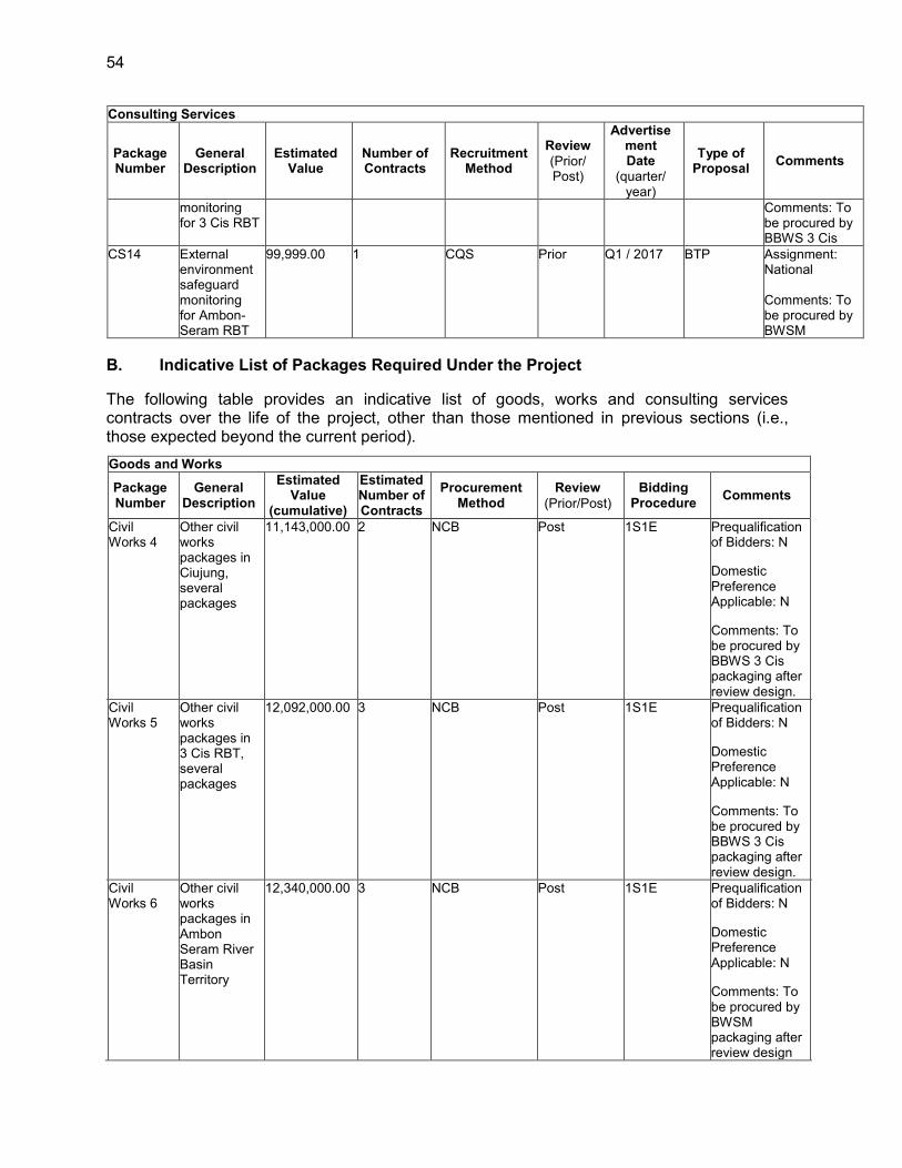
54
Consulting Services
Package Number
General Description
Estimated Value
Number of Contracts
Recruitment Method
Review (Prior/ Post)
Advertisement Date
(quarter/ year)
Type of Proposal Comments
monitoring for 3 Cis RBT
Comments: To be procured by BBWS 3 Cis
CS14 External environment safeguard monitoring for Ambon-Seram RBT
99,999.00 1 CQS Prior Q1 / 2017 BTP
Assignment: National Comments: To be procured by BWSM
B. Indicative List of Packages Required Under the Project The following table provides an indicative list of goods, works and consulting services contracts over the life of the project, other than those mentioned in previous sections (i.e., those expected beyond the current period).
Goods and Works Package
Number General
Description
Estimated Value
(cumulative)
Estimated Number of Contracts
Procurement Method
Review (Prior/Post)
Bidding Procedure Comments
Civil Works 4
Other civil works packages in Ciujung, several packages
11,143,000.00 2 NCB Post 1S1E Prequalification of Bidders: N Domestic Preference Applicable: N Comments: To be procured by BBWS 3 Cis packaging after review design.
Civil Works 5
Other civil works packages in 3 Cis RBT, several packages
12,092,000.00 3 NCB Post 1S1E Prequalification of Bidders: N Domestic Preference Applicable: N Comments: To be procured by BBWS 3 Cis packaging after review design.
Civil Works 6
Other civil works packages in Ambon Seram River Basin Territory
12,340,000.00 3 NCB Post 1S1E Prequalification of Bidders: N Domestic Preference Applicable: N Comments: To be procured by BWSM packaging after review design
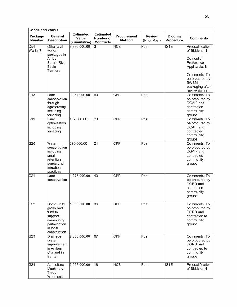
55
Goods and Works Package
Number General
Description
Estimated Value
(cumulative)
Estimated Number of Contracts
Procurement Method
Review (Prior/Post)
Bidding Procedure Comments
Civil Works 7
Other civil works packages in Ambon Seram River Basin Territory
9,890,000.00 3 NCB Post 1S1E Prequalification of Bidders: N Domestic Preference Applicable: N Comments: To be procured by BWSM packaging after review design
G18 Land conservation through agroforestry including terracing
1,081,000.00 60 CPP Post Comments: To be procured by DGAIF and contracted community groups
G19 Land optimization including terracing
437,000.00 23 CPP Post Comments: To be procured by DGAIF and contracted community groups
G20 Water conservation including small retention ponds and irrigation practices
396,000.00 24 CPP Post Comments: To be procured by DGAIF and contracted community groups
G21 Land conservation
1,275,000.00 43 CPP Post Comments: To be procured by DGRD and contracted community groups
G22 Community grass-root fund to support community participation in local construction
1,080,000.00 36 CPP Post Comments: To be procured by DGRD and contracted to community groups
G23 Drainage system improvement in Ambon City and in Banten
2,000,000.00 67 CPP Post Comments: To be procured by DGRD and contracted to community groups
G24 Agriculture Machinery, Three Wheelers,
5,593,000.00 18 NCB Post 1S1E Prequalification of Bidders: N
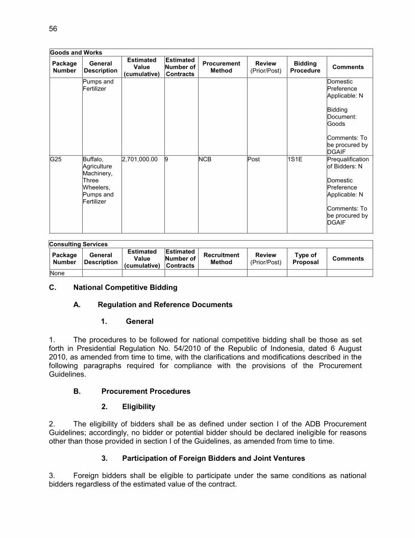
56
Goods and Works Package
Number General
Description
Estimated Value
(cumulative)
Estimated Number of Contracts
Procurement Method
Review (Prior/Post)
Bidding Procedure Comments
Pumps and Fertilizer
Domestic Preference Applicable: N Bidding Document: Goods Comments: To be procured by DGAIF
G25 Buffalo, Agriculture Machinery, Three Wheelers, Pumps and Fertilizer
2,701,000.00 9 NCB Post 1S1E Prequalification of Bidders: N Domestic Preference Applicable: N Comments: To be procured by DGAIF
Consulting Services Package
Number General
Description
Estimated Value
(cumulative)
Estimated Number of Contracts
Recruitment Method
Review (Prior/Post)
Type of Proposal Comments
None
C. National Competitive Bidding
A. Regulation and Reference Documents
1. General
1. The procedures to be followed for national competitive bidding shall be those as set forth in Presidential Regulation No. 54/2010 of the Republic of Indonesia, dated 6 August 2010, as amended from time to time, with the clarifications and modifications described in the following paragraphs required for compliance with the provisions of the Procurement Guidelines.
B. Procurement Procedures
2. Eligibility
2. The eligibility of bidders shall be as defined under section I of the ADB Procurement Guidelines; accordingly, no bidder or potential bidder should be declared ineligible for reasons other than those provided in section I of the Guidelines, as amended from time to time.
3. Participation of Foreign Bidders and Joint Ventures
3. Foreign bidders shall be eligible to participate under the same conditions as national bidders regardless of the estimated value of the contract.
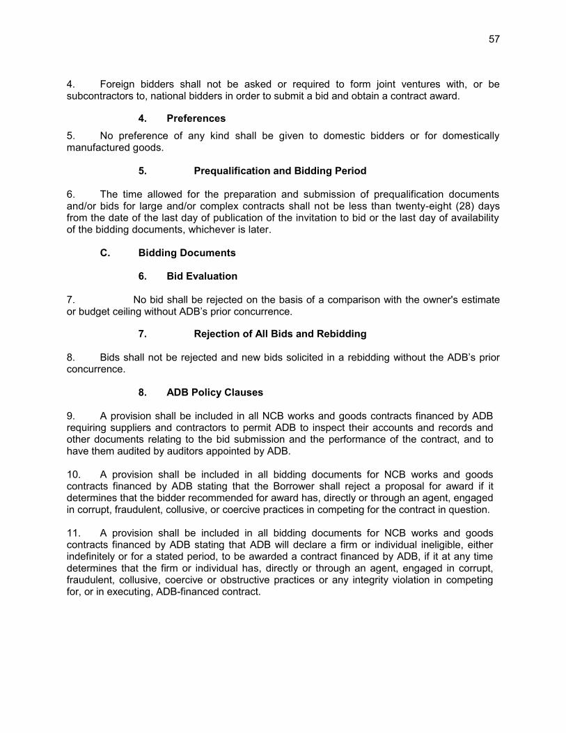
57
4. Foreign bidders shall not be asked or required to form joint ventures with, or be subcontractors to, national bidders in order to submit a bid and obtain a contract award.
4. Preferences 5. No preference of any kind shall be given to domestic bidders or for domestically manufactured goods.
5. Prequalification and Bidding Period
6. The time allowed for the preparation and submission of prequalification documents and/or bids for large and/or complex contracts shall not be less than twenty-eight (28) days from the date of the last day of publication of the invitation to bid or the last day of availability of the bidding documents, whichever is later.
C. Bidding Documents
6. Bid Evaluation
7. No bid shall be rejected on the basis of a comparison with the owner's estimate or budget ceiling without ADB’s prior concurrence.
7. Rejection of All Bids and Rebidding
8. Bids shall not be rejected and new bids solicited in a rebidding without the ADB’s prior concurrence.
8. ADB Policy Clauses
9. A provision shall be included in all NCB works and goods contracts financed by ADB requiring suppliers and contractors to permit ADB to inspect their accounts and records and other documents relating to the bid submission and the performance of the contract, and to have them audited by auditors appointed by ADB. 10. A provision shall be included in all bidding documents for NCB works and goods contracts financed by ADB stating that the Borrower shall reject a proposal for award if it determines that the bidder recommended for award has, directly or through an agent, engaged in corrupt, fraudulent, collusive, or coercive practices in competing for the contract in question. 11. A provision shall be included in all bidding documents for NCB works and goods contracts financed by ADB stating that ADB will declare a firm or individual ineligible, either indefinitely or for a stated period, to be awarded a contract financed by ADB, if it at any time determines that the firm or individual has, directly or through an agent, engaged in corrupt, fraudulent, collusive, coercive or obstructive practices or any integrity violation in competing for, or in executing, ADB-financed contract.
58
VII. SAFEGUARDS A. Environmental Safeguards 55. The Project is categorized as environment category B in accordance with ADB‘s SPS 2009. Details about the procedures to ensure that potential environmental impacts are avoided, reduced and mitigated in accordance with ADB SPS 2009 and regulations from the Government of Indonesia can be found in the Environmental Assessment and Review Framework (EARF) (RRP Linked document 11). An initial environmental examination (IEE) report including an Environmental Management and Environmental Monitoring Plan (EMP) was prepared for the Ciujung core subproject. The EMP outlines the anticipated environmental adverse impacts of the subproject, proposed mitigation and monitoring measures, and roles and responsibilities of the executing and implementing agencies, consultants, and contractors for each measure. Based on the screening for potential environmental impacts and risks, the IEE concluded that the proposed core subproject can be implemented in an environmentally acceptable manner with the corresponding EMP. In addition, an Environmental Impact Assessment (Analisa Mengenai Dampak Lingkungan or AMDAL in Bahasa Indonesia) for the Ciujung core subproject has been approved in accordance with government regulations to supplement the IEE. The environmental management and monitoring plan of the approved AMDAL is presented in the IEE. 56. For future subprojects, the AMDAL will be accepted by ADB as an IEE or Environmental Impact Assessment (EIA)40 and the UKL/UPL (environmental management/monitoring measures) reports will be accepted by ADB as an IEE on the condition that the English version of the full AMDAL and/or UKL/UPL is reviewed and considered to be consistent with SPS 2009 requirements. The full AMDAL or UKL/UPL reports—depending on categorization—will be prepared and finalized in consultation with ADB before government approval. Upon incorporation of ADB’s comments to ensure that the AMDAL or UKL/UPL meet SPS 2009 requirements, the English version of government approved AMDAL will be submitted to ADB for disclosure. Disbursements for the subproject investment can only proceed upon ADB and government approval of the relevant AMDAL studies and/or UKL/UPL. The operational steps for environmental mitigation measures for major activities are included in the standard operating procedures (SOP) for environmental safeguard presented in Appendix 8. 57. During implementation, the CPMU, with assistance from the national environmental safeguard specialist of the consultant team, shall be responsible for the following activities related to environmental safeguards: (i) screen all subprojects for categorization in accordance with ADB SPS 2009 and Government of Indonesia and submit to ADB for approval; (ii) contract an accredited agency to prepare UKL/UPL or AMDAL study (in Bahasa Indonesia and English) as required based on the categorization; (iii) ensure the UKL/UPL or AMDAL meet ADB SPS 2009 requirements as described in the EARF; (iv) ensure that the UKL/UPL or AMDAL has been approved by the respective environment agency; (v) consolidate semi-annual environmental monitoring reports; (vi) ensure timely disclosure of final AMDAL and updated EMP in locations and form accessible to the public; and (vii) address, record, and report on any grievances brought about through the Grievance Redress Mechanism in a timely manner.
40 If a category A subproject be identified, an EIA will be required. If a subproject is identified as category A for
environment, the categorization of the overall Project will be changed to category A as well, subject to approval by the Government and ADB.

59
58. The PIUs, with assistance from the environmental officers will: (i) confirm that EMP is included in the bidding documents and civil works contracts; (ii) ensure contractor’s EMPs are prepared by contractors prior to actual construction; (iii) supervise the implementation of environmental mitigating measures required for the construction activities; (iv) review, monitor and evaluate the effectiveness of the implemented contractor’s EMPs, and recommend necessary corrective actions; (v) prepare monthly and quarterly environmental monitoring reports and submit quarterly environmental monitoring report to the CPMU during construction phase; (vi) prepare and submit semi-annual environmental monitoring report to the CPMU during the operational phase of the subproject; (vii) contract an independent safeguard monitoring entity to conduct water quality monitoring as specified in the IEEs and AMDAL environmental monitoring plans; and (viii) address, record, and report on any grievances brought about through the Grievance Redress Mechanism in a timely manner. 59. The BBWS 3 Cis and BWSM PIUs will each assign an environment officer to ensure EMP implementation. The TOR of the PIU environment officer can be found in Appendix 7 of the EARF. 60. An independent safeguard monitoring entity will be engaged by each PIU to conduct water quality monitoring for the subprojects as specified in the environmental monitoring plan under the IEEs and the AMDAL. They will provide quarterly environmental safeguard monitoring reports to the PIU. A draft TOR of the safeguard monitoring entity is provided in Appendix 7 to the EARF. B. Social Safeguards 61. In accordance with ADB’s SPS 2009, the project is classified as Category A for Involuntary Resettlement as 200 or more persons experience major impacts, which are defined as (i) being physically displaced from housing, and/or (ii) losing 10% or more of their productive (income generating) assets. The resettlement framework prepared for the Project is in line with the Land Acquisition Law No. 2/2012 and its related regulations, and with ADB SPS 2009. The resettlement framework will guide the preparation and implementation of resettlement plans for candidate structural subprojects. The resettlement framework also includes provisions on voluntary land donation/contribution and negotiated land principles. When negotiated settlement is used to acquire land, there will be an agreement with ADB on the consultation process, and principle of negotiated land acquisition (willing buyer – willing seller approach with market price), third-party validation, and record requirements. The resettlement framework has been concurred by the government and approved by ADB. The resettlement plan for the Ciujung core subproject has been prepared, concurred by the government and approved by ADB. The resettlement plan summary for the core subproject has been disclosed to the affected persons and other stakeholders and uploaded on ADB’s website. For future subprojects, resettlement plans will be prepared and/or updated following completion of DED and Detailed Measuring Survey (DMS). resettlement plans wil then be concurred by the Government and approved by ADB prior to implementation as per principles set in the resettlement framework. 62. For subprojects for which land acquisition and resettlement (LAR) has been undertaken or is being undertaken prior to loan effectiveness, a due diligence or a social compliance audit need to be carried out (i) to identify past or present concerns related to impacts on social safeguards and (ii) to ensure that land acquisition actions were carried out in accordance with the approved resettlement framework. If any outstanding compliance issue is identified, a corrective action plan (CAP) mutually agreed between ADB and the Executing Agency and/or Implementing Agency will be prepared. The plan will define necessary remedial actions, the

60
budget for such actions, and the time frame for resolution of noncompliance. The due diligence report (including CAP, if any) will be made available to the public in accordance with the information disclosure requirements set in the resettlement framework. To minimize the corrective actions, the Executing/Implementing Agency will ensure that LAR for potential sub projects is undertaken in accordance with the agreed resettlement framework. 63. The government enhanced its country system in order to address land acquisition issues for public interest development project purposes. The Land Acquisition Law No. 2/2012 places people at the center of development. Affected people rights for their land and property are fully respected when their land is needed to build infrastructure for public interest. ADB SPS 2009 looks at projects assisted by ADB as development opportunities for affected persons to improve their living standards. The Land Acquisition Law and its implementing rules and regulations approximate harmonization with SPS 2009. The law grants that affected person with no legal title over the land they occupy are entitled only to compensation for improvements of business losses, moving cost, etc. but not for the land itself. The executing agency is required to prepare a comprehensive land acquisition planning document and project plan. Its location should be consulted with and agreed by eligible party and stakeholders prior to government issuance of a project location determination. People affected by land acquisition, are meaningfully consulted and grievance mechanisms are in place during the planning and implementation of land acquisition. A social action plan (SAP) is to be prepared for livelihood restoration which includes provision of capacity and activities for skills development. 64. The Project through DGWR has to follow the provisions of the Land Acquisition Law No. 2/2012 and all other relevant laws while harmonizing those with SPS 2009. The BBWS 3 Cis and BWSM will carry out project activities, including resettlement plan preparation and implementation. DGWR will carry out sub project screening. If a subproject triggers land acquisition and/or involuntary resettlement, the implementing agency will prepare a screening and resettlement plan as outlined in the Table below.
Screening of Land Acquisition and Resettlement (Resettlement Plan) for Future Subprojects
Screening Question No Yes Mitigation Action
Is there any land acquisition and/or restricted access to assets or livelihood?
if yes, prepare a resettlement plan (see resettlement framework and resettlement plan for core sub project)
Is there any small scale of land (< 5 hectares) to be acquired through negotiated land acquisition (willing seller-willing buyer approach?
if yes, prepare a resettlement plan with policy related to negotiated land acquisition (see resettlement framework)
65. The detailed steps for LAR activities, responsible agencies, and time frame are outlined in the Table below.
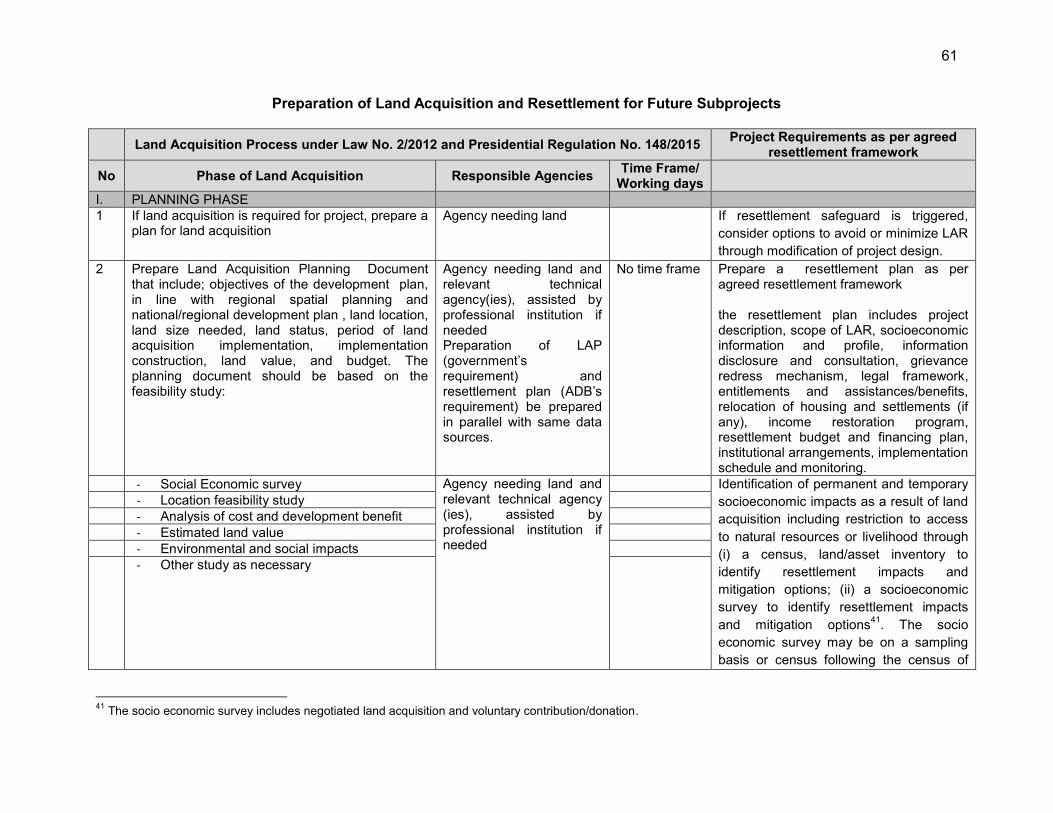
61
Preparation of Land Acquisition and Resettlement for Future Subprojects
Land Acquisition Process under Law No. 2/2012 and Presidential Regulation No. 148/2015 Project Requirements as per agreed resettlement framework
No Phase of Land Acquisition Responsible Agencies Time Frame/ Working days
I. PLANNING PHASE 1 If land acquisition is required for project, prepare a
plan for land acquisition Agency needing land If resettlement safeguard is triggered,
consider options to avoid or minimize LAR through modification of project design.
2 Prepare Land Acquisition Planning Document that include; objectives of the development plan, in line with regional spatial planning and national/regional development plan , land location, land size needed, land status, period of land acquisition implementation, implementation construction, land value, and budget. The planning document should be based on the feasibility study:
Agency needing land and relevant technical agency(ies), assisted by professional institution if needed Preparation of LAP (government’s requirement) and resettlement plan (ADB’s requirement) be prepared in parallel with same data sources.
No time frame Prepare a resettlement plan as per agreed resettlement framework the resettlement plan includes project description, scope of LAR, socioeconomic information and profile, information disclosure and consultation, grievance redress mechanism, legal framework, entitlements and assistances/benefits, relocation of housing and settlements (if any), income restoration program, resettlement budget and financing plan, institutional arrangements, implementation schedule and monitoring.
- Social Economic survey Agency needing land and relevant technical agency (ies), assisted by professional institution if needed
Identification of permanent and temporary socioeconomic impacts as a result of land acquisition including restriction to access to natural resources or livelihood through (i) a census, land/asset inventory to identify resettlement impacts and mitigation options; (ii) a socioeconomic survey to identify resettlement impacts and mitigation options41. The socio economic survey may be on a sampling basis or census following the census of
- Location feasibility study - Analysis of cost and development benefit - Estimated land value - Environmental and social impacts - Other study as necessary
41 The socio economic survey includes negotiated land acquisition and voluntary contribution/donation.

62
Land Acquisition Process under Law No. 2/2012 and Presidential Regulation No. 148/2015 Project Requirements as per agreed resettlement framework
No Phase of Land Acquisition Responsible Agencies Time Frame/ Working days
affected assets/land acquisition objects. . Consultations with the affected persons and stakeholders Cost replacement and details of the valuation methodology.
3 Certify the Land Acquisition Planning Document Agency needing the land 4 Submission of the planning document to the
provincial government Agency needing the land Submit the draft resettlement plan to adb
and its concurrence disclose the resettlement plan to the affected persons and stakeholders through leaflet and/or posting of the resettlement plan’s summary in strategic places accessible to the affected persons. adb upload the approved resettlement plan on its website after review and revisions if needed
II PREPARATION PHASE 108 – 152 days
1 Establishment of preparatory team Governor/Bupati/Mayor 2 Resettlement plan implementation. Internal Monitoring External monitoring
2 Delegation of authority to Bupato/Mayor and establishment of Preparatory Team by Bupati/Mayor
Governor/Bupati/Mayor 10
3 Notice on development plan Provincial Preparatory Team (PPT)/District Preparatory Team (DDR)
3
4 Preliminary identification PPT/DPT 30 5 Public consultation, if any rejection PPT/DPT 60 6 Re-Public Consultation if any disagreement or
complaints on location of development plan PPT/DPT 30
7 Grievance/Complaint handling by Governor Governor 3 8 Issuance on project location determination
(Location determination is valid for 2 years and 1 year for extension)
Governor/Bupati/Mayor 7
9 Announcement of project location determination Governor/Bupati/Mayor 7

63
Land Acquisition Process under Law No. 2/2012 and Presidential Regulation No. 148/2015 Project Requirements as per agreed resettlement framework
No Phase of Land Acquisition Responsible Agencies Time Frame/ Working days
(2 days after issuance of location determination) and agency needing the land
- Project located in more than 1 districts/cities - Project located in a district/city
- Provincial Preparatory Team (PPT) established by the Governor - District/City preparatory team (DPT) established by the Bupati/Mayor
III IMPLEMENTATION PHASE 152-236 1 Establishment of land acquisition implementation
team (LAIT) Provincial BPN 2
2 Delegation of author of land acquisition implementation from provincial BPN to Land Office (District/City level)
Head of Provincial BPN 2
3 Preparation of land acquisition implementation led by head of provincial BPN/ led of land Office
Head of Provincial BPN/Head of Land Office at district
2
4 Establishment of task force for land acquisition implementation
Provincial LAIT/District LAIT- Task team for IOL
2
5 Inventory of losses (IOL) and legal assessment of affected assets
Provincial LAIT/District LAIT- Task team for IOL
30 resettlement plan update submission of the updated resettlement plan to adb and its concurrence disclose the updated resettlement plan to the affected persons and on ADB’s website
6 Announcement of the IOL Provincial LAIT/District LAIT
7 Data verification, if any complaint on IOL Provincial LAIT/District LAIT
14
8 Mobilization of appraiser /public appraiser Institution needing the land 30 9 Appraisal/valuation of losses Independent appraiser 30 10 Invitation for deliberation of compensation Provincial LAIT/District
LAIT 2 Updated resettlement plan
implementation. 11 Deliberation of forms of compensation Provincial LAIT/District
LAIT 30
12 Validation of compensation by LAIT Provincial LAIT/District LAIT
3 Internal monitoring External monitoring
13 Delivery of compensation in cash Compensation in the form of land
replacement: 6 months Compensation in the form of resettlement: 1
Agency needing the land with witness of Provincial LAIT/District LAIT
7
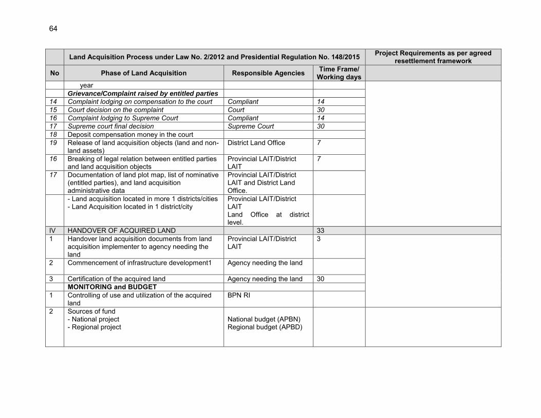
64
Land Acquisition Process under Law No. 2/2012 and Presidential Regulation No. 148/2015 Project Requirements as per agreed resettlement framework
No Phase of Land Acquisition Responsible Agencies Time Frame/ Working days
year Grievance/Complaint raised by entitled parties 14 Complaint lodging on compensation to the court Compliant 14 15 Court decision on the complaint Court 30 16 Complaint lodging to Supreme Court Compliant 14 17 Supreme court final decision Supreme Court 30 18 Deposit compensation money in the court 19 Release of land acquisition objects (land and non-
land assets) District Land Office 7
16 Breaking of legal relation between entitled parties and land acquisition objects
Provincial LAIT/District LAIT
7
17 Documentation of land plot map, list of nominative (entitled parties), and land acquisition administrative data
Provincial LAIT/District LAIT and District Land Office.
- Land acquisition located in more 1 districts/cities - Land Acquisition located in 1 district/city
Provincial LAIT/District LAIT Land Office at district level.
IV HANDOVER OF ACQUIRED LAND 33 1 Handover land acquisition documents from land
acquisition implementer to agency needing the land
Provincial LAIT/District LAIT
3
2 Commencement of infrastructure development1
Agency needing the land
3 Certification of the acquired land Agency needing the land 30 MONITORING and BUDGET 1 Controlling of use and utilization of the acquired
land BPN RI
2 Sources of fund - National project - Regional project
National budget (APBN) Regional budget (APBD)
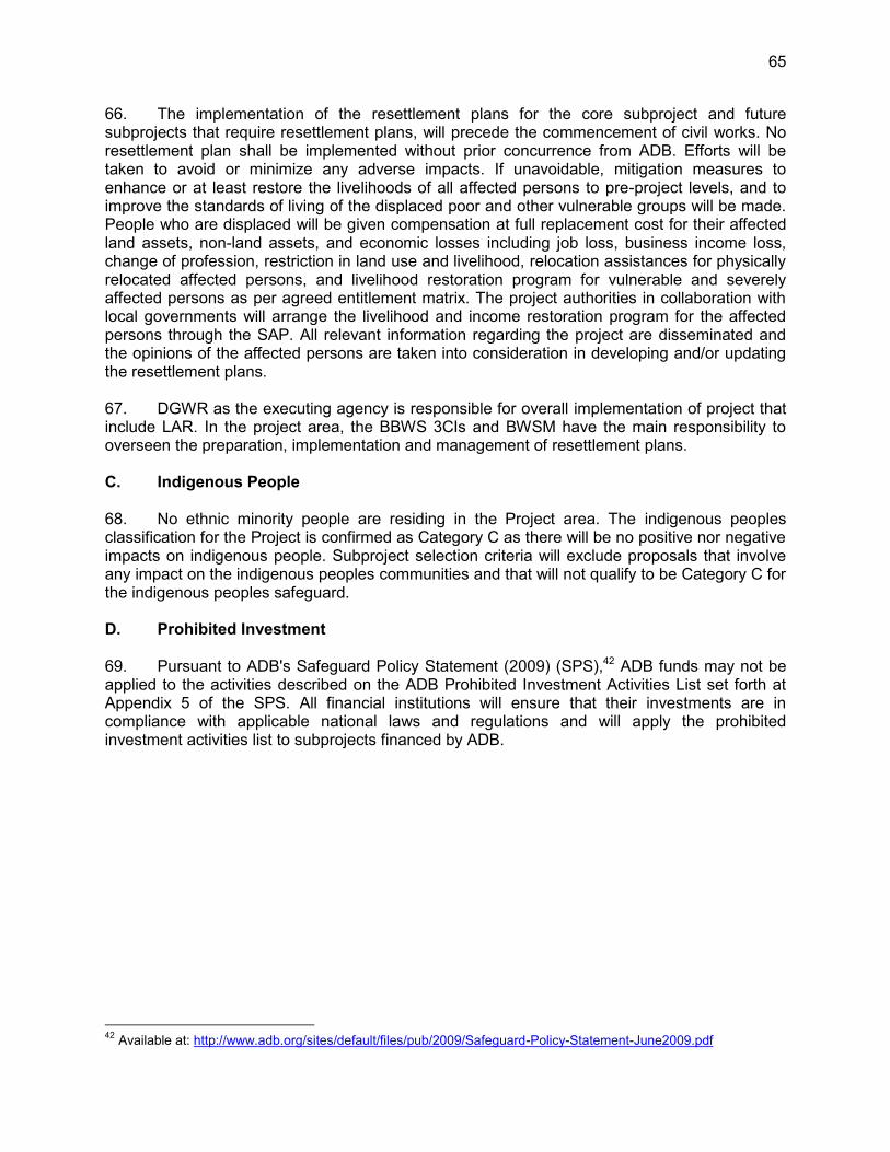
65
66. The implementation of the resettlement plans for the core subproject and future subprojects that require resettlement plans, will precede the commencement of civil works. No resettlement plan shall be implemented without prior concurrence from ADB. Efforts will be taken to avoid or minimize any adverse impacts. If unavoidable, mitigation measures to enhance or at least restore the livelihoods of all affected persons to pre-project levels, and to improve the standards of living of the displaced poor and other vulnerable groups will be made. People who are displaced will be given compensation at full replacement cost for their affected land assets, non-land assets, and economic losses including job loss, business income loss, change of profession, restriction in land use and livelihood, relocation assistances for physically relocated affected persons, and livelihood restoration program for vulnerable and severely affected persons as per agreed entitlement matrix. The project authorities in collaboration with local governments will arrange the livelihood and income restoration program for the affected persons through the SAP. All relevant information regarding the project are disseminated and the opinions of the affected persons are taken into consideration in developing and/or updating the resettlement plans. 67. DGWR as the executing agency is responsible for overall implementation of project that include LAR. In the project area, the BBWS 3CIs and BWSM have the main responsibility to overseen the preparation, implementation and management of resettlement plans. C. Indigenous People 68. No ethnic minority people are residing in the Project area. The indigenous peoples classification for the Project is confirmed as Category C as there will be no positive nor negative impacts on indigenous people. Subproject selection criteria will exclude proposals that involve any impact on the indigenous peoples communities and that will not qualify to be Category C for the indigenous peoples safeguard. D. Prohibited Investment 69. Pursuant to ADB's Safeguard Policy Statement (2009) (SPS),42 ADB funds may not be applied to the activities described on the ADB Prohibited Investment Activities List set forth at Appendix 5 of the SPS. All financial institutions will ensure that their investments are in compliance with applicable national laws and regulations and will apply the prohibited investment activities list to subprojects financed by ADB.
42 Available at: http://www.adb.org/sites/default/files/pub/2009/Safeguard-Policy-Statement-June2009.pdf

66
VIII. GENDER AND SOCIAL DIMENSIONS
70. The Summary Poverty Reduction and Social Strategy (SPRSS), identifies the implementation of a Gender Action Plan (GAP), a Stakeholders Communication Strategy and measures to address identified social risks. 71. The project's gender classification is "Effective Gender Mainstreaming" (EGM) which means that at least two of the project outputs are targeted to support women active participation, access to projects information and benefits and empowered through various potential skills development, leadership and support for livelihood activities. 72. The CPMU will recruit a National Gender Specialist to oversee and assist in the GAP implementation, monitoring and reporting for each river basin organization in coordination with gender focal person and gender working group. The Project will ensure setting up of a Gender Working Group amongst the agencies. Adequate budget has been allocated for GAP implementation, monitoring and reporting. DGWR in coordination with BBWS 3 Cis and BWSM, MOA, MOHA and BAPPENAS will have the overall responsibility to implement the GAP. A national gender specialist will be hired to support GAP implementation. Gender focal persons will be assigned in each B/BWS, PIU in MOA, MOHA and BAPPENAS to ensure gender coordination and linkage across the various activities and to coordinate the introduction, implementation, monitoring and reporting of the GAP. The quarterly project progress report will include monitoring of the GAP. Outputs Gender Design Features/Activities 1. Planning for flood
risk management enhanced
Around 20% female trainees in all training on flood risk assessment and analysis
Data on hazard, vulnerability, risk and emergency response mapping is sex-disaggregated.
Around 30% women’s representation in consultation meetings on (i) hazard analysis, risk awareness and assessment and vulnerability/capacity analysis; (ii) developing the risk and hazard maps; and (iii) identification of indicators for assessing gender specific aspects of risk and vulnerability
Gender sensitive and culturally appropriate flood management related information and publication materials will be prepared, and distributed for all stakeholders and communities. This includes information on flood forecasts and flood management and preparedness such food storage, securing the safety of livestock, ensuring food availability, etc.
Information on flood forecasts and flood management and preparedness will target both women and men farmers in terms of crop diversification, food storage, securing the safety of livestock, ensuring food availability, etc.
Gender-sensitive flood hazard vulnerability, risk and emergency response mapped and hazard categories zoned in main flood risk areas of the 3 Cis RBT and the Ambon-Seram RBT
2. Land management improved and flood infrastructure upgraded
10% members of the community groups for water and soil conservation are women.
Farmland management and sustainable agriculture practices in the Ciujung river basin is targeted to at least 40% of women farmers.
Training for watershed rehabilitation and management will target at least 40% of women in each subproject areas.
Gender concerns and aspect are incorporated in farmer training, water catchment management and conservation material and distributed within

67
Outputs Gender Design Features/Activities local community.
All trainings will be held at times and locations convenient for women farmers.
30% women’s representation in consultation meetings on the design of dikes, drainage, and other small community infrastructure to take into account the needs and concerns of women.
3. Capacity for community-based flood risk management enhanced
Provision and arrangement are made to ensure that 40% women are involved in (i) community-based flood risk management procedures and activities for flood preparedness and response/contingency plans; (ii) the development of action plans for post flood recovery; (iii) the dissemination of information to the communities; (iv) all capacity development activities; and (iv) flood monitoring/warning activities.
At least 30% of women are involved in the identification, prioritization and design of community-level infrastructure (such as small embankments, drainage, flood barriers, and shelters); and subsequent regular operations and maintenance.
Facilities, e.g. evacuation shelters and emergency housing facilities, water and sanitation and health facilities are accessible to both women and men, and especially friendly to women and children.
At least 30% of women are involved in the committee dealing with evacuation shelter, housing and housing facilities and are trained on CBFRM in each subproject area.
Information dissemination regarding community based small scale civil works activities will be accessible for employment for both women and men, and at least 30% of local works will be targeted for women employment.
Contingency plans emergency response planning, standard operation procedure, evacuation provision are gender responsive.
Gender focal person is selected for CBFRM in each subproject area. Women specific vulnerability and needs should be included in the flood
warning and monitoring activities. 4. Policy, coordination
anc capacity at national level improved
Ensure quarterly project monitoring reports include progress on GAP implementation with gender indicators and sex-disaggregated data
Training on gender concerns is provided to government staff in charge of the project
Recruitment of female technical and other specialist in CPMU and PIUs
CPMU, PIU staff will participate in gender mainstreaming for structural and non structural flood management project interventions
Integration of gender related activities into work plans and budget allocations to ensure that adequate funds are allocated for GAP implementation
CBFRM = community-based flood risk management; CPMU = central project management unit; GAP = gender action plan; PIU = project implementation unit. Source: Asian Development Bank.
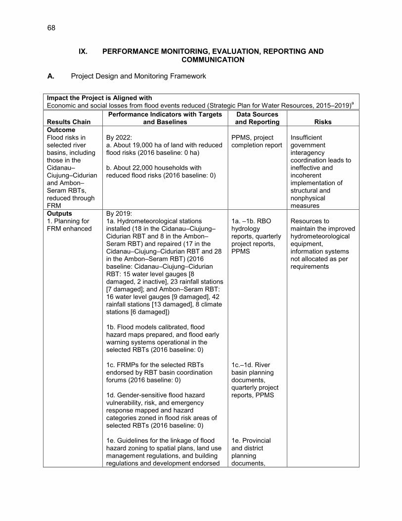
68
IX. PERFORMANCE MONITORING, EVALUATION, REPORTING AND COMMUNICATION
A. Project Design and Monitoring Framework
Impact the Project is Aligned with Economic and social losses from flood events reduced (Strategic Plan for Water Resources, 2015–2019)a
Results Chain Performance Indicators with Targets
and Baselines Data Sources and Reporting Risks
Outcome Flood risks in selected river basins, including those in the Cidanau–Ciujung–Cidurian and Ambon–Seram RBTs, reduced through FRM
By 2022: a. About 19,000 ha of land with reduced flood risks (2016 baseline: 0 ha) b. About 22,000 households with reduced flood risks (2016 baseline: 0)
PPMS, project completion report
Insufficient government interagency coordination leads to ineffective and incoherent implementation of structural and nonphysical measures
Outputs By 2019: 1. Planning for FRM enhanced
1a. Hydrometeorological stations installed (18 in the Cidanau–Ciujung–Cidurian RBT and 8 in the Ambon–Seram RBT) and repaired (17 in the Cidanau–Ciujung–Cidurian RBT and 28 in the Ambon–Seram RBT) (2016 baseline: Cidanau–Ciujung–Cidurian RBT: 15 water level gauges [8 damaged, 2 inactive], 23 rainfall stations [7 damaged]; and Ambon–Seram RBT: 16 water level gauges [9 damaged], 42 rainfall stations [13 damaged], 8 climate stations [6 damaged]) 1b. Flood models calibrated, flood hazard maps prepared, and flood early warning systems operational in the selected RBTs (2016 baseline: 0) 1c. FRMPs for the selected RBTs endorsed by RBT basin coordination forums (2016 baseline: 0) 1d. Gender-sensitive flood hazard vulnerability, risk, and emergency response mapped and hazard categories zoned in flood risk areas of selected RBTs (2016 baseline: 0) 1e. Guidelines for the linkage of flood hazard zoning to spatial plans, land use management regulations, and building regulations and development endorsed
1a. –1b. RBO hydrology reports, quarterly project reports, PPMS 1c.–1d. River basin planning documents, quarterly project reports, PPMS 1e. Provincial and district planning documents,
Resources to maintain the improved hydrometeorological equipment, information systems not allocated as per requirements
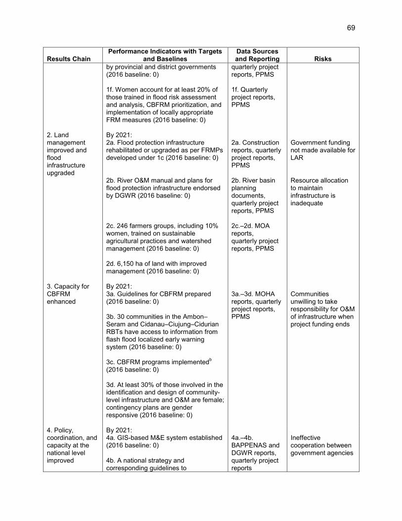
69
Results Chain Performance Indicators with Targets
and Baselines Data Sources and Reporting Risks
by provincial and district governments (2016 baseline: 0) 1f. Women account for at least 20% of those trained in flood risk assessment and analysis, CBFRM prioritization, and implementation of locally appropriate FRM measures (2016 baseline: 0)
quarterly project reports, PPMS 1f. Quarterly project reports, PPMS
2. Land management improved and flood infrastructure upgraded
By 2021: 2a. Flood protection infrastructure rehabilitated or upgraded as per FRMPs developed under 1c (2016 baseline: 0) 2b. River O&M manual and plans for flood protection infrastructure endorsed by DGWR (2016 baseline: 0) 2c. 246 farmers groups, including 10% women, trained on sustainable agricultural practices and watershed management (2016 baseline: 0) 2d. 6,150 ha of land with improved management (2016 baseline: 0)
2a. Construction reports, quarterly project reports, PPMS 2b. River basin planning documents, quarterly project reports, PPMS 2c.–2d. MOA reports, quarterly project reports, PPMS
Government funding not made available for LAR Resource allocation to maintain infrastructure is inadequate
3. Capacity for CBFRM enhanced
By 2021: 3a. Guidelines for CBFRM prepared (2016 baseline: 0) 3b. 30 communities in the Ambon–Seram and Cidanau–Ciujung–Cidurian RBTs have access to information from flash flood localized early warning system (2016 baseline: 0) 3c. CBFRM programs implementedb (2016 baseline: 0) 3d. At least 30% of those involved in the identification and design of community-level infrastructure and O&M are female; contingency plans are gender responsive (2016 baseline: 0)
3a.–3d. MOHA reports, quarterly project reports, PPMS
Communities unwilling to take responsibility for O&M of infrastructure when project funding ends
4. Policy, coordination, and capacity at the national level improved
By 2021: 4a. GIS-based M&E system established (2016 baseline: 0) 4b. A national strategy and corresponding guidelines to
4a.–4b. BAPPENAS and DGWR reports, quarterly project reports
Ineffective cooperation between government agencies

70
Results Chain Performance Indicators with Targets
and Baselines Data Sources and Reporting Risks
institutionalize the FRM approach approved by the NSCWR and National Water Council (2016 baseline: 0)
Key Activities with Milestones 1. Planning for flood risk management enhanced 1.1. Improve hydrometeorological observations, data management, and processing (Q2 2017) [KNS] 1.2. Develop and calibrate hydrological and flood models, and prepare flood maps (Q2 2017) [GCD] 1.3. Prepare FRMPs for selected river basins (Q3 2017) [GCD, KNS] 1.4. Prepare flood information bulletins, news, and activities jointly with BNPB (Q3 2017) [GEM] 1.5. Establish localized flood early warning system, and communication system (Q4 2017) [GCD, KNS] 1.6. Support institutional strengthening, planning, and coordination of provincial and district local disaster
management, meteorology, public works, land, social, and forestry agencies (Q3 2019) [GCD, GEM] 2. Land management improved and flood infrastructure upgraded 2.1. Select, appraise, and prepare subproject summary reports for candidate subprojects (Q4 2017) [GCD] 2.2. Prepare DEDs for the selected subprojects, including environment and social safeguards documents
and tender documents (Q1 2018) [KNS] 2.3. Implement LAR and civil works for candidate subprojects (Q3 2021) [GCD] 2.4. Construct check dams and small retention ponds (Q1 2021) 2.5. Prepare river O&M manual and plans (Q4 2017) [GCD] 2.6. Prepare programs for soil and water conservation in village and agricultural lands (Q4 2017) [GCD,
GEM] 2.7. Implement watershed rehabilitation activities (Q2 2020) [GEM] 3. Capacity for CBFRM enhanced
3.1. Prepare CBFRM guidelines (Q2 2017) [GCD, GEM] 3.2. Identify and establish CBRFM groups and provide capacity development (Q3 2017) [GCD, GEM] 3.3. Formulate community-based measures to reduce flood risk (Q3 2017) [GEM] 3.4. Prepare contingency plans and standard operation procedures (Q4 2017) [GEM] 3.5. Support community participation in the design of community-based infrastructure (Q1 2018) [GEM] 3.6. Supervise the construction of community-based infrastructure and prepare O&M plans (Q3 2021)
[GEM] 4. Policy, coordination, and capacity at the national level improved
4.1. Prepare the M&E framework (Q1 2017) [GCD] 4.2. Develop the GIS-based M&E system (Q2 2017) [GCD] 4.3. Prepare the national strategy and guidelines to institutionalize the FRM approach (Q1 2018) [GCD] 4.4. Provide technical capacity building for relevant agencies [GCD, GEM] 4.5. Ensure coordination among project stakeholders [GEM] Inputs Asian Development Bank: $108.7 million (ordinary capital resources) Government: $52.87 million Assumptions for Partner Financing Not applicable. BAPPENAS = Badan Perencanaan dan Pembangunan Nasional (National Development Planning Agency), BNPB = Badan Nasional Penanggulangan Bencana (National Disaster Management Agency), CBFRM = community-based flood risk management, DED = detailed engineering design, DGWR = Directorate General of Water Resources, FRM = flood risk management, FRMP = flood risk management plan, GCD = governance and capacity development, GEM = gender equity and mainstreaming, GIS = geographic information system, ha = hectare, KNS = knowledge solutions, LAR = land acquisition and resettlement, M&E = monitoring and evaluation, MOA = Ministry of Agriculture, MOHA = Ministry of Home Affairs, NSCWR = National Steering Committee for Water Resources, O&M = operation and maintenance, PPMS = project performance management system, Q = quarter, RBO = river basin organization, RBT = river basin territory. a Government of Indonesia, Ministry of Public Works and Housing. 2015. Rencana Strategis Sumber Daya Air,
2015–2019. Jakarta. b Farmers groups will be formed based on geographic and activity type, and legally established through decrees.
Source: Asian Development Bank.
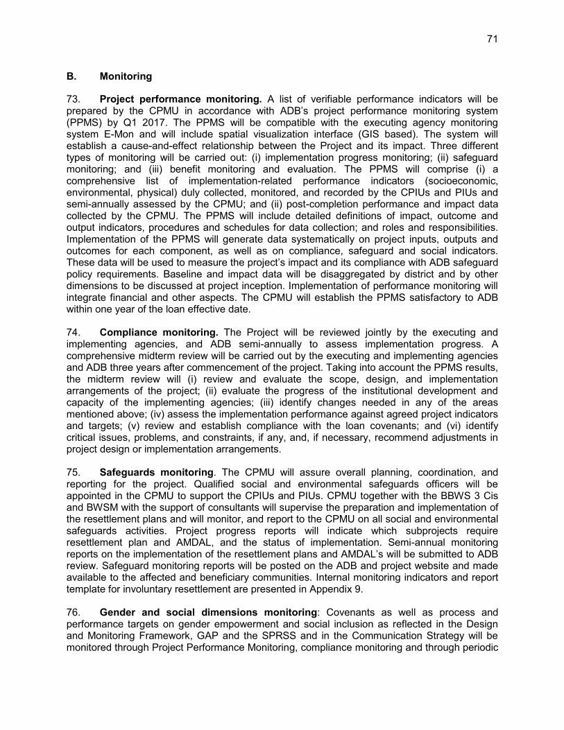
71
B. Monitoring
73. Project performance monitoring. A list of verifiable performance indicators will be prepared by the CPMU in accordance with ADB’s project performance monitoring system (PPMS) by Q1 2017. The PPMS will be compatible with the executing agency monitoring system E-Mon and will include spatial visualization interface (GIS based). The system will establish a cause-and-effect relationship between the Project and its impact. Three different types of monitoring will be carried out: (i) implementation progress monitoring; (ii) safeguard monitoring; and (iii) benefit monitoring and evaluation. The PPMS will comprise (i) a comprehensive list of implementation-related performance indicators (socioeconomic, environmental, physical) duly collected, monitored, and recorded by the CPIUs and PIUs and semi-annually assessed by the CPMU; and (ii) post-completion performance and impact data collected by the CPMU. The PPMS will include detailed definitions of impact, outcome and output indicators, procedures and schedules for data collection; and roles and responsibilities. Implementation of the PPMS will generate data systematically on project inputs, outputs and outcomes for each component, as well as on compliance, safeguard and social indicators. These data will be used to measure the project’s impact and its compliance with ADB safeguard policy requirements. Baseline and impact data will be disaggregated by district and by other dimensions to be discussed at project inception. Implementation of performance monitoring will integrate financial and other aspects. The CPMU will establish the PPMS satisfactory to ADB within one year of the loan effective date. 74. Compliance monitoring. The Project will be reviewed jointly by the executing and implementing agencies, and ADB semi-annually to assess implementation progress. A comprehensive midterm review will be carried out by the executing and implementing agencies and ADB three years after commencement of the project. Taking into account the PPMS results, the midterm review will (i) review and evaluate the scope, design, and implementation arrangements of the project; (ii) evaluate the progress of the institutional development and capacity of the implementing agencies; (iii) identify changes needed in any of the areas mentioned above; (iv) assess the implementation performance against agreed project indicators and targets; (v) review and establish compliance with the loan covenants; and (vi) identify critical issues, problems, and constraints, if any, and, if necessary, recommend adjustments in project design or implementation arrangements. 75. Safeguards monitoring. The CPMU will assure overall planning, coordination, and reporting for the project. Qualified social and environmental safeguards officers will be appointed in the CPMU to support the CPIUs and PIUs. CPMU together with the BBWS 3 Cis and BWSM with the support of consultants will supervise the preparation and implementation of the resettlement plans and will monitor, and report to the CPMU on all social and environmental safeguards activities. Project progress reports will indicate which subprojects require resettlement plan and AMDAL, and the status of implementation. Semi-annual monitoring reports on the implementation of the resettlement plans and AMDAL’s will be submitted to ADB review. Safeguard monitoring reports will be posted on the ADB and project website and made available to the affected and beneficiary communities. Internal monitoring indicators and report template for involuntary resettlement are presented in Appendix 9. 76. Gender and social dimensions monitoring: Covenants as well as process and performance targets on gender empowerment and social inclusion as reflected in the Design and Monitoring Framework, GAP and the SPRSS and in the Communication Strategy will be monitored through Project Performance Monitoring, compliance monitoring and through periodic

72
evaluations and reviews. The BBWS 3 Cis and BWSM, PIUs in MOA, MOHA and BAPPENAS will also ensure that contractors comply with social safeguards in the SPRSS to address potential risks relative to the core labor standards and to health and environmental conditions at worker camps. 77. Gender-specific indicators to monitor project outcomes and impacts will be established by the CPMU in coordination with the Gender and Social Development Specialist and in accordance with ADB’s PPMS. Critical gender and social issues, problems, and constraints are identified and course adjustments are recommended, as necessary.
C. Evaluation
78. The CPMU, CPIUs, PIUs, PPMUs and DPMUs will quarterly review and evaluate project performance, while the CPMU and ADB will jointly assess project implementation at least once every year. The government, CPMU, and ADB will conduct a comprehensive midterm review three years after the Project starts. The review will (i) cover the scope, design, and implementation arrangements of the Project; (ii) identify changes needed since the time of project appraisal; (iii) assess implementation performance against project indicators; (iv) establish compliance with loan covenants; and (v) identify problems, constraints, and, if necessary, recommend changes in the design or implementation arrangements. Within 6 months of physical completion of the Project, DGWR will submit a project completion report to ADB.43
D. Reporting
79. DGWR will provide ADB with (i) quarterly progress reports in a format consistent with ADB's project performance reporting system; (ii) consolidated annual reports including: (a) progress achieved by output as measured through the indicator's performance targets, (b) key implementation issues and solutions, (c) updated procurement plan, and (d) updated implementation plan for next 12 months; and (iii) a project completion report within 6 months of physical completion of the Project. To ensure that the Project continues to be both viable and sustainable, the Project’s accounts and the executing agency audited financial statements together with the associated auditor's report should be adequately reviewed. The template for the quarterly progress report is presented in Appendix 10. E. Stakeholder Communication Strategy
80. To ensure effective communication with stakeholders during project implementation, and to enhance project outcomes, the Project will adopt a four-pronged communication strategy:
(i) Deliver relevant project information to stakeholders in a culturally appropriate, gender-sensitive, and timely manner;
(ii) Obtain accurate and timely feedback from stakeholders; (iii) Enable an efficient and regular two-way flow of information between project
implementers and stakeholders; and (iv) Support key communication components of the project, including community
awareness raising for flood risk management; community participation in needs
43 Project completion report format is available at: http://www.adb.org/Consulting/consultants-toolkits/PCR-Public-
Sector-Landscape.rar
73
identification; outreach for integrated flood management; and public awareness on spatial plans and land use management.
81. Stakeholders include but are not limited to project affected persons, women and vulnerable groups, other interested groups including users of the rivers, those affected by flooding, executing and implementing agencies, relevant village, sub-district, district and provincial government staff and entities, interested community based organizations, and interested private sector entities. 82. The CPMU will be responsible for implementing and monitoring information dissemination and disclosure, and will identify a focal point that will be designated for regular contact with affected people and other interested stakeholders. 83. Delivering information. Information about the project as a whole, including information about project plans, projected impacts, and implementation timelines, will be delivered through a public information booklet (PIB) that describes the project’s objectives, components, and activities. Written in Bahasa Indonesia, the PIB will use pictures and simplify concepts to make the project comprehensible to a wide range of stakeholder groups including the poor, women, and users of the river systems such as cattle growers and households. The PIB will highlight all key aspects of the project, including features that will directly benefit stakeholders such as staircases for easy access to women and children to wash and bathe. The PIB may be complemented with community meetings and puppet shows, which have been found to be stakeholders’ preferred means of information-sharing based on experience with other projects in Indonesia. Information will also be shared through other culturally appropriate communication channels, and key information materials may be developed for distinct stakeholder groups. Pursuant to ADB’s Public Communications Policy, all requisite project documents will be posted on the ADB website. 84. For some project activities, specific means of delivering information to stakeholders are required. For civil works, clear signage will be put up in strategic areas not just to provide summary information about the project and its construction, but also to ensure public safety. For community-based flood risk management, leaflets specifically designed for this component will be distributed in villages. This may be supplemented with community events to role play or otherwise demonstrate what are expected from stakeholders. For farmland management and sustainable agriculture, and watershed rehabilitation and management, leaflets will also be distributed and meetings held. As much as possible, each stakeholder group will be met with separately, as they have different interests. 85. Obtaining Feedback. The PIB will indicate where stakeholders can get in touch with project implementers. Community meetings will ensure that accurate and sufficient feedback will be received from stakeholder groups. 86. Ensuring Efficient, Two-Way Flow of Information. Establishing a project desk in key districts and/or strengthening of existing structure will be explored to ensure that more substantive information will be available to stakeholders whenever they need it, and that a competent person is available to receive feedback from stakeholders. 87. Supporting Key Communications Components of Project. The project contains a number of components requiring communication activities, including the establishment of flood communication procedures (preparation of communication and outreach strategy, public awareness on revised special and land use management plans), awareness raising for flood

74
risk management, and the identification of community needs. Appropriate plans will be put in place to ensure the successful implementation of these communication activities. 88. A Stakeholder Communication Strategy is set forth in Table below.
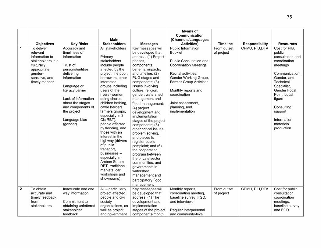
75
Objectives Key Risks
Main Stakeholders Messages
Means of Communication
(Channels/Languages Activities) Timeline Responsibility Resources
1 To deliver relevant information to stakeholders in a culturally appropriate, gender-sensitive, and timely manner
Accuracy and timeliness of information Trust of persons/entities delivering information Language or literacy barrier Lack of information about the stages and components of the project Language bias (gender)
All stakeholders Primary stakeholders include people affected by the project, the poor, borrowers, other interested groups including users of the rivers (women doing chores, children bathing, cattle herders, farmers groups, especially in 3 Cis RBT), people affected by flooding, and those with an interest in the highway (drivers of public transport, businesses – especially in Ambon Seram RBT, traditional markets, car workshops and showrooms)
Key messages will be developed that address: (1) Project phases, components, benefits, impacts, and timeline; (2) PUG stages and components; (3) issues involving culture, religion, gender, watershed management and flood management; (4) project development and implementation stages of the project components; (5) other critical issues, problem solving, and places to register public complaint; and (6) the cooperation program between the private sector, communities, and governments in watershed management and participatory flood management
Public Information Booklet Public Consultation and Coordination Meetings Recital activities, Gender Working Group, Farmer Group Activities Monthly reports and coordination Joint assessment, planning, and implementation
From outset of project
CPMU, PIU,DTA Cost for PIB, public consultation and coordination meetings Communication, Gender, and Technical Specialist, Gender Focal Point, Local figure Consulting support Information materials production
2 To obtain accurate and timely feedback from stakeholders
Inaccurate and one way information Commitment to obtaining unfettered stakeholder feedback
All – particularly project affected people and civil society organizations, as well as project and government
Key messages will be developed that address: (1) The development and implementation stages of the project components(monthl
Monthly reports, coordination meeting, baseline survey, FGD, and interviews Regular interpersonal and community-level
From outset of project
CPMU, PIU,DTA Cost for public consultation, coordination meetings, baseline survey, and FGD
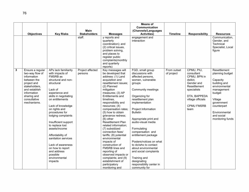
76
Objectives Key Risks
Main Stakeholders Messages
Means of Communication
(Channels/Languages Activities) Timeline Responsibility Resources
staff. y reports and quarterly coordination); and (2) critical issues, problem solving, and places to register public complaints(monthly and quarterly reports)
engagement and interaction
Communication, Gender, and Technical Specialist, Local figure
3 Ensure a regular two-way flow of information between the project and stakeholders, and establish information sharing and consultative mechanisms.
APs lack familiarity with impacts of FMSRB as structural and non-structural Lack of experience and skills in negotiating on entitlements Lack of knowledge on rights and procedures for lodging complaints Insufficient support to replace lost assets/income Affordability of sanitation services Lack of awareness on how to report and address possible environmental impacts
Project affected persons
Key messages will be developed that address: (1) Land acquisition and resettlement issues; (2) Planned mitigation measures; (3) AP Entitlements and timelines, responsibility and resources; (4) compensation rates; (5) how to obtain grievance redress; (6) other Resettlement Plan related information; (7) subsidized connection fees/ tariffs; (8) potential environmental impacts of construction of FMSRB lines and reporting of observed impacts or complaints; and (9) establishment of participatory monitoring and
FGD, small group discussions with affected persons, women, vulnerable groups Community meetings Organizing for resettlement plan implementation Project Information Bulletin Appropriate print and audio-visual media Formulating compensation and entitlement package Posters/notices on what to do/who to contact about environmental and social complaints Training and designating responsibility center in community for
From outset of project
CPMU, PIU, consultant CPMU, BPN in dsitict, Gender and Resettlement specialists DTA, BAPPEDA village officials CPMU FMSRB team
Resettlement planning budget Capacity building and environmental management budget Village government counterpart Environmental and social monitoring funds
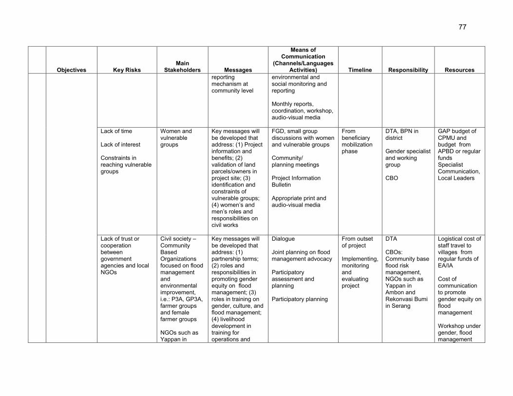
77
Objectives Key Risks
Main Stakeholders Messages
Means of Communication
(Channels/Languages Activities) Timeline Responsibility Resources
reporting mechanism at community level
environmental and social monitoring and reporting Monthly reports, coordination, workshop, audio-visual media
Lack of time Lack of interest Constraints in reaching vulnerable groups
Women and vulnerable groups
Key messages will be developed that address: (1) Project information and benefits; (2) validation of land parcels/owners in project site; (3) identification and constraints of vulnerable groups; (4) women’s and men’s roles and responsibilities on civil works
FGD, small group discussions with women and vulnerable groups Community/ planning meetings Project Information Bulletin Appropriate print and audio-visual media
From beneficiary mobilization phase
DTA, BPN in district Gender specialist and working group CBO
GAP budget of CPMU and budget from APBD or regular funds Specialist Communication, Local Leaders
Lack of trust or cooperation between government agencies and local NGOs
Civil society –Community Based Organizations focused on flood management and environmental improvement, i.e.: P3A, GP3A, farmer groups and female farmer groups NGOs such as Yappan in
Key messages will be developed that address: (1) partnership terms; (2) roles and responsibilities in promoting gender equity on flood management; (3) roles in training on gender, culture, and flood management; (4) livelihood development in training for operations and
Dialogue Joint planning on flood management advocacy Participatory assessment and planning Participatory planning
From outset of project Implementing, monitoring and evaluating project
DTA CBOs: Community base flood risk management, NGOs such as Yappan in Ambon and Rekonvasi Bumi in Serang
Logistical cost of staff travel to villages from regular funds of EA/IA Cost of communication to promote gender equity on flood management Workshop under gender, flood management
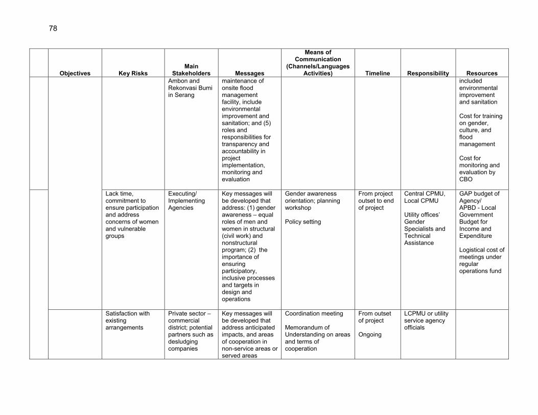
78
Objectives Key Risks
Main Stakeholders Messages
Means of Communication
(Channels/Languages Activities) Timeline Responsibility Resources
Ambon and Rekonvasi Bumi in Serang
maintenance of onsite flood management facility, include environmental improvement and sanitation; and (5) roles and responsibilities for transparency and accountability in project implementation, monitoring and evaluation
included environmental improvement and sanitation Cost for training on gender, culture, and flood management Cost for monitoring and evaluation by CBO
Lack time, commitment to ensure participation and address concerns of women and vulnerable groups
Executing/ Implementing Agencies
Key messages will be developed that address: (1) gender awareness – equal roles of men and women in structural (civil work) and nonstructural program; (2) the importance of ensuring participatory, inclusive processes and targets in design and operations
Gender awareness orientation; planning workshop Policy setting
From project outset to end of project
Central CPMU, Local CPMU Utility offices’ Gender Specialists and Technical Assistance
GAP budget of Agency/ APBD - Local Government Budget for Income and Expenditure Logistical cost of meetings under regular operations fund
Satisfaction with existing arrangements
Private sector – commercial district; potential partners such as desludging companies
Key messages will be developed that address anticipated impacts, and areas of cooperation in non-service areas or served areas
Coordination meeting Memorandum of Understanding on areas and terms of cooperation
From outset of project Ongoing
LCPMU or utility service agency officials
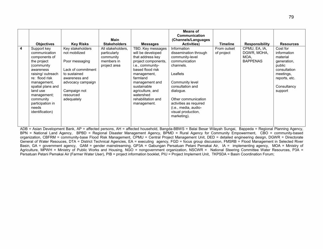
79
Objectives Key Risks
Main Stakeholders Messages
Means of Communication
(Channels/Languages Activities) Timeline Responsibility Resources
4 Support key communication components of the project (community awareness raising/ outreach re: flood risk management, spatial plans and land use management; community participation in needs identification)
Key stakeholders not mobilized Poor messaging Lack of commitment to sustained awareness and advocacy campaign Campaign not resourced adequately
All stakeholders, particularly community members in project area
TBD. Key messages will be developed that address key project components, i.e., community-based flood risk management, farmland management and sustainable agriculture, and watershed rehabilitation and management.
Information dissemination through community-level communication channels. Leaflets Community level consultation and dialogue. Other communication activities as required (i.e., media, audio-visual production, marketing).
From outset of project
CPMU, EA, IA, DGWR, MOHA, MOA, BAPPENAS
Cost for information material generation, public consultation meetings, reports, etc. Consultancy support
ADB = Asian Development Bank, AP = affected persons, AH = affected household, Bangda-BBWS = Balai Besar Wilayah Sungai, Bappeda = Regional Planning Agency, BPN = National Land Agency, BPBD = Regional Disaster Management Agency, BPMD = Rural Agency for Community Empowerment, CBO = community-based organization, CBFRM = community-base Flood Risk Management, CPMU = Central Project Management Unit, DED = detailed engineering design, DGWR = Directorate General of Water Resouces, DTA = District Technical Agencies, EA = executing agency, FGD = focus group discussion, FMSRB = Flood Management in Selected River Basin, GA = government agency, GAM = gender mainstreaming, GP3A = Gabungan Persatuan Petani Pemakai Air, IA = implementing agency, MOA = Ministry of Agriculture, MPWH = Ministry of Public Works and Housing, NGO = nongovernment organization, NSCWR = National Steering Committee Water Resources, P3A = Persatuan Petani Pemakai Air (Farmer Water User), PIB = project information booklet, PIU = Project Implement Unit, TKPSDA = Basin Coordination Forum;

80
X. ANTICORRUPTION POLICY
89. ADB reserves the right to investigate, directly or through its agents, any violations of the Anticorruption Policy relating to the Project.44 All contracts financed by ADB shall include provisions specifying the right of ADB to audit and examine the records and accounts of the executing agency and all project contractors, suppliers, consultants and other service providers. Individuals/entities on ADB’s anticorruption debarment list are ineligible to participate in ADB-financed activity and may not be awarded any contracts under the Project.45 90. To support these efforts, relevant provisions are included in the loan agreement/regulations and the bidding documents for the Project.
44 Available at: http://www.adb.org/Documents/Policies/Anticorruption-Integrity/Policies-Strategies.pdf 45 ADB's Integrity Office web site is available at: http://www.adb.org/integrity/unit.asp
81
XI. ACCOUNTABILITY MECHANISM
91. People who are, or may in the future be, adversely affected by the Project may submit complaints to ADB’s Accountability Mechanism. The Accountability Mechanism provides an independent forum and process whereby people adversely affected by ADB-assisted projects can voice, and seek a resolution of their problems, as well as report alleged violations of ADB’s operational policies and procedures. Before submitting a complaint to the Accountability Mechanism, affected people should make a good faith effort to solve their problems by working with the concerned ADB operations department. Only after doing that, and if they are still dissatisfied, should they approach the Accountability Mechanism.46
46 For further information see: http://www.adb.org/Accountability-Mechanism/default.asp.

82
XII. RECORD OF PAM CHANGES
92. All revisions/updates during course of implementation should retain in this Section to provide a chronological history of changes to implemented arrangements recorded in the PAM.

Appendix 1 83
APPENDIX 1: COMPONENTS PROFILES AND LOGICAL FRAMEWORKS
PROFILE: COMPONENT 1A Name 1.A - Enhanced basin data and information and preparation of flood risks
management (FRM) plans for the 3 Cis and Ambon – Seram RBTs (BBWS 3 Cis and BWS Maluku)
Area Banten and Maluku Provinces Duration 36 months Implementing Agencies Balai Besar Wilayah Sungai Cidurian- Ciujung- Cidanau (BBWS 3 Cis),
Balai Wilayah Sungai Maluku (BWS M), Directorate General of Water Resources (DGWR), Ministry of Public Works and Housing (MPWH)
RATIONALE IMPLEMENTATION ARRANGEMENTS Landslides, riverbank erosion and floods have become annual phenomenon in the Cidurian- Ciujung- Cidanau (3 Cis) and Ambon-Seram river basin territories (RBTs). These hazards occur annually between November and January in 3 Cis RBT and May to August in Ambon-Seram RBT, which are the rainy seasons in the respective river basins. The lack of effective flood and landslide forecasting and early warning is considered one of the causes behind increased losses and damages. The current practice of flood alerts relies on the meteorological forecast by Agency for Meteorology, Climatology and Geophysics (Badan Meteorologi, Klimatologi dan Geofisika – BMKG) forecast. The National Research Center for Water Resources (NRCWR – PusAir) has also developed a public rainfall data server system that has been used in some cases for flood alerts, but not yet in the 3 CIs and Ambon – Seram RBTs. This hydrological database system is complemented by a suite of numerical modeling for basin hydrology and 2 dimensional (2D) flood simulation as part of the national program supported by the Joint Cooperation.1 In selected RBTs, lack of historical/real-time hydro-meteorological data, appropriate flood forecast model, trained operational staff, inadequate maintenance of observation stations, and the limited financial resources have made the flood forecasting and early warning systems (FFEWS) ineffective and incompatible with institutional arrangements. FFEWS needs to be further developed with understanding of danger to life and human response under emergency conditions. Importantly, a decision support framework (DSF) both for short and long-term flood mitigation is lacking both at central and local levels. The Ciujung river basin has had some conventional approaches of flood warning mainly for the downstream communities based on the real-time observation of water level in Pamarayan weir.
The Directorate General of Water Resources is the Executing Agency (EA). The agency will have a central project management unit (CPMU) with a core project consulting team. The CPMU will be based in the Directorate of River and Coastalt, DGWR. The Directorate of River and Coastal, DGWR is also as a Central Project Implementing Unit (CPIU) will provide technical guidance while project implementing units (PIUs) will be established in the BBWS 3 Cis and BWS M. The PIUs will have overall responsibility for ensuring satisfactory implementation of the project component and in close cooperation with provincial and district BAPPEDAs and TKPSDA will also be responsible for providing technical guidance and implementing the project. The NRCWR will provide technical inputs to the project with close coordination with BMKG. OBJECTIVES The general objective of this component is to enhance basin data and information system for improved preparedness and planning of FRM. It will help develop the hydro-meteorological database and information management system that has implication in FFEWS in the selected RBTs. The specific objectives are to (i) improve the quality and quantity of hydro-meteorological data, (ii) develop 2D flood modeling and map the hazards, (iii) develop basin scale flood management plans which then will be integrated into water resources management plans and other development activities in the basin, (iv) develop comprehensive and location-specific landslide and FFEW systems for the river basins, (v) map the flood risk (hazard and exposure) to provide the basis for decision making, (vi) develop the capacity of RBOs in operation and maintenance of databases as well as FFEW systems and, (vii) develop decision support systems for short and long term FRM including danger to life, damage to
1 Joint Cooperation Program (JCP) 2010 – 2015 supported by the Government of Netherlands.
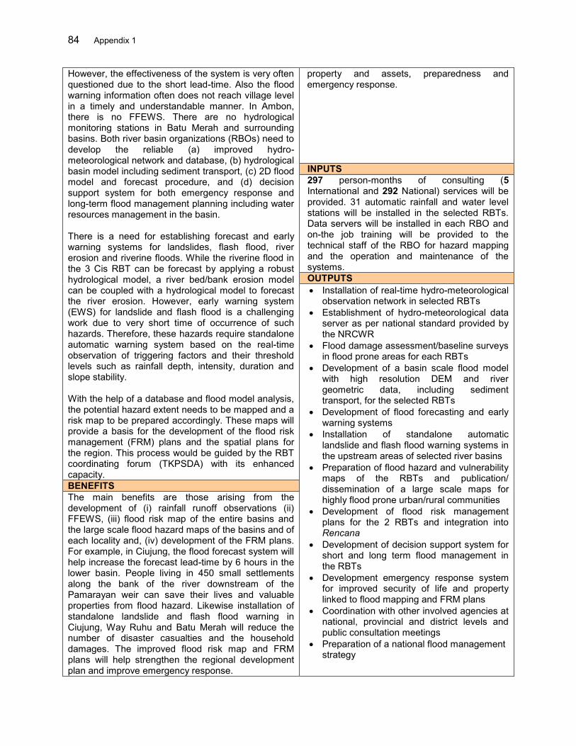
84 Appendix 1
However, the effectiveness of the system is very often questioned due to the short lead-time. Also the flood warning information often does not reach village level in a timely and understandable manner. In Ambon, there is no FFEWS. There are no hydrological monitoring stations in Batu Merah and surrounding basins. Both river basin organizations (RBOs) need to develop the reliable (a) improved hydro-meteorological network and database, (b) hydrological basin model including sediment transport, (c) 2D flood model and forecast procedure, and (d) decision support system for both emergency response and long-term flood management planning including water resources management in the basin. There is a need for establishing forecast and early warning systems for landslides, flash flood, river erosion and riverine floods. While the riverine flood in the 3 Cis RBT can be forecast by applying a robust hydrological model, a river bed/bank erosion model can be coupled with a hydrological model to forecast the river erosion. However, early warning system (EWS) for landslide and flash flood is a challenging work due to very short time of occurrence of such hazards. Therefore, these hazards require standalone automatic warning system based on the real-time observation of triggering factors and their threshold levels such as rainfall depth, intensity, duration and slope stability. With the help of a database and flood model analysis, the potential hazard extent needs to be mapped and a risk map to be prepared accordingly. These maps will provide a basis for the development of the flood risk management (FRM) plans and the spatial plans for the region. This process would be guided by the RBT coordinating forum (TKPSDA) with its enhanced capacity.
property and assets, preparedness and emergency response.
INPUTS 297 person-months of consulting (5 International and 292 National) services will be provided. 31 automatic rainfall and water level stations will be installed in the selected RBTs. Data servers will be installed in each RBO and on-the job training will be provided to the technical staff of the RBO for hazard mapping and the operation and maintenance of the systems. OUTPUTS Installation of real-time hydro-meteorological
observation network in selected RBTs Establishment of hydro-meteorological data
server as per national standard provided by the NRCWR
Flood damage assessment/baseline surveys in flood prone areas for each RBTs
Development of a basin scale flood model with high resolution DEM and river geometric data, including sediment transport, for the selected RBTs
Development of flood forecasting and early warning systems
Installation of standalone automatic landslide and flash flood warning systems in the upstream areas of selected river basins
Preparation of flood hazard and vulnerability maps of the RBTs and publication/ dissemination of a large scale maps for highly flood prone urban/rural communities
Development of flood risk management plans for the 2 RBTs and integration into Rencana
Development of decision support system for short and long term flood management in the RBTs
Development emergency response system for improved security of life and property linked to flood mapping and FRM plans
Coordination with other involved agencies at national, provincial and district levels and public consultation meetings
Preparation of a national flood management strategy
BENEFITS The main benefits are those arising from the development of (i) rainfall runoff observations (ii) FFEWS, (iii) flood risk map of the entire basins and the large scale flood hazard maps of the basins and of each locality and, (iv) development of the FRM plans. For example, in Ciujung, the flood forecast system will help increase the forecast lead-time by 6 hours in the lower basin. People living in 450 small settlements along the bank of the river downstream of the Pamarayan weir can save their lives and valuable properties from flood hazard. Likewise installation of standalone landslide and flash flood warning in Ciujung, Way Ruhu and Batu Merah will reduce the number of disaster casualties and the household damages. The improved flood risk map and FRM plans will help strengthen the regional development plan and improve emergency response.
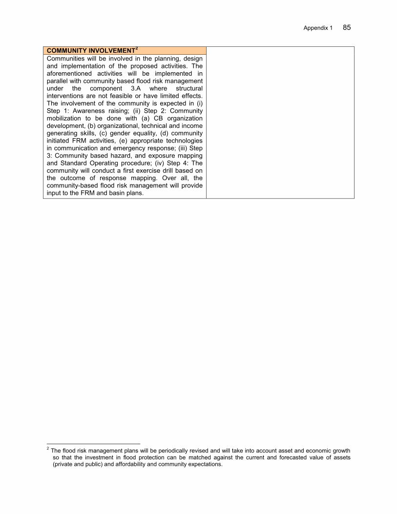
Appendix 1 85
COMMUNITY INVOLVEMENT2 Communities will be involved in the planning, design and implementation of the proposed activities. The aforementioned activities will be implemented in parallel with community based flood risk management under the component 3.A where structural interventions are not feasible or have limited effects. The involvement of the community is expected in (i) Step 1: Awareness raising; (ii) Step 2: Community mobilization to be done with (a) CB organization development, (b) organizational, technical and income generating skills, (c) gender equality, (d) community initiated FRM activities, (e) appropriate technologies in communication and emergency response; (iii) Step 3: Community based hazard, and exposure mapping and Standard Operating procedure; (iv) Step 4: The community will conduct a first exercise drill based on the outcome of response mapping. Over all, the community-based flood risk management will provide input to the FRM and basin plans.
2 The flood risk management plans will be periodically revised and will take into account asset and economic growth
so that the investment in flood protection can be matched against the current and forecasted value of assets (private and public) and affordability and community expectations.
86 Appendix 1
PROFILE COMPONENT-1B Name 1.B - Institutional strengthening, planning and coordination for
implementation of flood risk management plans in 3 Cis and Ambon-Seram River Basin Territories (RBTs)
Area Banten Province (Serang, Lebak and Pandeglang Districts) and Maluku Province (Ambon City)
Duration 36 months Implementing Agency Directorate of Synchronisation of Regional Government Affairs I (SORGA
I), Directorate General of Regional Development (DGRD), Ministry of Home Affairs (MOHA)
RATIONALE IMPLEMENTATION ARRANGEMENTS Landslides, riverbank erosion and floods have become annual phenomenon in the Cidurian- Ciujung- Cidanau (3 Cis) and Ambon-Seram river basin territories (RBTs). These hazards occur annually between November and January in 3 Cis RBT and May to August in Ambon-Seram RBT, which are the rainy seasons in the respective river basins. Diagnostic assessment of the legal, institutional and policy framework identified needs for greater awareness of flood risk (hazard, exposure and vulnerability) in government organizations and alignment of regional development and spatial plans reflecting integration among agencies involved in Flood Risk Management (FRM) such as the Directorate General of Water Resources (DGWR) under the Ministry of Public Works and Housing, national disaster management agency (BNPB) and local government agencies. Improved institutional and governance are required together with capacity building of agencies to initiate and implement effective and integrated flood management measures. Formal coordination mechanisms are required to transform recognition of the needs into practical coordination between government organizations. There is also a need for building technical and administrative capacity in all government stakeholder institutions and for provision of adequate and sustained funding to support FRM. Several processes and approaches are recommended to achieve the goal, including raising awareness of communities and government officials, specialized training for specific roles, training to support introduction of new technology or new procedures, and knowledge sharing on flood risk management. These activities can be enhanced through the use of flood risk mapping for the purposes of both planning and emergency response. Coordination committees for FRM planning and response should be established at provincial and district levels to promote mainstreaming and integration of FRM in all relevant development sectors. Basin scale FRM plans, to be implemented
The Ministry of Home Affairs (MOHA) will be the implementing agency for this component and activities will be closely coordinated with the provincial and district planning and development agencies (BAPPEDAs). A Central Project Implementation Unit (CPIU) will be established in Directorate General of Regional Development (DGRD) under the MOHA, which will oversee the overall implementation of the component. The CPIU will be led by the Directorate of Synchronization of Regional Government Affairs I (SORGA I) under DGRD. To implement the project at the local levels, Provincial Project Management Units (PPMU) and District Project Management Units (DPMU) will be formed under the BAPPEDA province and district respectively. Local departments of agriculture, water resources, disaster management and meteorology will contribute to implementation of the FRM plans. OBJECTIVES The general objective of this component is to strengthen the institutional capacity of local government to initiate, plan, design and implement FRM plans in the river basins. The specific objectives are (i) strengthening of local government officers’ capacity to address FRM, (ii) development of FRM knowledge and introduction of replicable best practices, (iii) flood risk mapping based on the assessment of prevailing vulnerability and provided hazard as exposure maps, (iv) formulation of district FRM plans for the river basins with balanced structural and non-structural measures, (v) use of FRM plans to update regional development and spatial plans, (vi) development of river corridor management regulation, monitoring and evaluation mechanisms and, (vii) coordination of central, provincial and district level authorities for implementation of integrated FRM measures. This component will also support coordination for land acquisition and resettlement activities for structural investment. INPUTS
Appendix 1 87
under the project, should be used as the basis to update regional development plans, annual sectoral plans and spatial plans. A set of regulatory tools should complement the planning process, covering land use, river corridor management, building code and so on.
351 person-months of consulting (12 International and 339 National) services will be provided. OUTPUTS Vulnerability and risk maps are prepared, for
which the results of hazard and exposure mapping will be used provided under the component 1A.
Hazard and risk maps are disseminated and explained to communities and agencies concerned.
FRM elements are mainstreamed in regional development
FRM plans are developed and used as basis for updating regional development plans
Flood bulletins are distributed to agencies and communities concerned on a regular basis
FRM activities reflected in annual work plans and budgets of provincial and district governments
Capacity building/training programs targeting MOHA, provincial and district agencies are carried out
Land-use plan amended and new rules on river corridor management are endorsed by the local government.
MOU between the Ministry of Forestry or BPDAS and local government signed for rehabilitation of upper watershed, for activies in forestry areas
BENEFITS The main benefits are those arising from coordinated implementation of FRM activities through the various sectors involved at different levels, in addition to enhanced institutional governance and capacity development for FRM. This includes improved land use, synchronized investment and community preparedness. COMMUNITY INVOLVEMENT3 Communities are in the forefront to face the disaster therefore their involvement in the planning, design and implementation of proposed activities is essential. The aforementioned activities will be implemented in parallel with community-based flood risk management. The involvement of the community is expected in (i) Step 1: Awareness raising; (ii) Step 2: Community mobilization that is to be done with (a) CB organization development, (b) development of organizational, technical and income generating skills, (c) gender equality, (d) community, initiated FRM activities, (e) appropriate technologies in communication and emergency response; (iii) Step 3: Community-based flood risk mapping and standard operating procedure; (iv) Step 4: Communities will conduct a first evacuation drill based on the emergency response planning and the flood risk map. The fully aware and empowered communities will provide input to the development of FRM and spatial plans effectively.
3 Further details of the Implementation Procedures, Selection Criteria and Role of the Community shall be provided
by the PIU in a detailed Sub Project Administration Memorandum (PAM).The PAM shall be submitted to ADB for approval together with first years annual work plans.
88 Appendix 1
PROFILE COMPONENT-2A
Name 2.A - Farmland Management and Sustainable Agriculture Practices in the Ciujung River Basin (MOA)
Area Banten Province (Serang, Lebak and Pandeglang Districts) Duration 36 months Implementing Agency Directorate General of Agricultural Infrastructure and Facility (DGAIF),
Ministry of Agriculture (MOA) RATIONALE IMPLEMENTATION ARRANGEMENTS Landslides, riverbank erosion and floods have become annual phenomena in the Cidanau-Ciujung-Cidurian (3 Cis) river basin territory (RBT). One of the most serious contributing factors to the hazard situation in the RBT is degraded watersheds due to poor farm management and deforestation. This resulted in increased sediment yield and the peak of runoff during intense rain fall event. Sediment deposition in the main river channels leads to channel instability and bank erosion and has reduced the conveyance capacity of the Ciujung river, increasing the flood hazard over time. Sustainable farming practices as well as afforestation should be implemented as a part of integrated flood risk management. Watershed management, particularly soil and water conservation activities, if implemented in proper coordination among different sectors/ line agencies and beneficiaries will significantly reduce the soil erosion and mitigate flood runoff. At the same time, if implemented appropriately, the activities can enhance the livelihoods of farmers through introduction of alternative income generation options and various agro-forestry related enterprises. Poor agricultural practices and increasing amount of critical land are a major cause of the increased runoff in the Ciujung river basin, and are yet to be improved in such a way that the agricultural/livelihood benefits are maximized while reducing soil erosion and runoff. Under this component, the Directorate of Expansion and Land Management under the DGAIF will implement agro-forestry related activities aiming at soil and water conservation. Terracing practices will be promoted in the same areas. The Project will also support livelihood options to the famers that include provision for cattle (source of organic fertilizer), farm equipment, seeds and seedlings of a variety of high yield crops, etc. to ensure sustainability of the terracing investment. In addition, the Directorate of Irrigation and Water Management under the DGAIF will support the aforementioned activities by constructing small water storage ponds to improve storage and infiltration, to be complemented by irrigation facilities to (i) maximize the benefits, (ii) improve farmers’ livelihood and (iii) ensure
The Ministry of Agriculture (MOA) will be the implementing agency for this component and activities will be closely coordinated with the provincial and district agriculture line agencies. The Directorate General of Agricultural Infrastructure and Facility (DGAIF) will serve as the Central Project Implementation Unit (CPIU). This unit will be established in MOA represented by two directorates (i) Directorate of Expansion and Land Management, and, (ii) Directorate of Irrigation and Water Management both under DGAIF. The CPIU will work in close coordination with a Provincial Project Implementation Unit (PPIU) and District Project Implementation Units (DPIU). In addition, CPIU will cooperate with CPMU for the delivery of project results. OBJECTIVES The general objective of this component is to improve conditions of farm lands in the upper Ciujung river basin to better control erosion through improved land management, reduce runoff through water conservation and enhance the income of the farmers from the watershed management/agro-forestry initiatives. The specific objectives are to (i) develop terracing, introduce improved farming practices, plantation of multi-purpose trees on upper slopes, forming vegetated waterways and other water and soil conservation measures, and (ii) improve the livelihoods of farmers by increasing incomes through improved farming practices and based on the lessons learned from previous MOA experiences that are documented in the guidelines on: (i) upper watershed conservation, 2009, (ii) development of integrated farming for land conservation, 2009, and (iii) development of water conservation in anticipation to climate anomaly, 2012. INPUTS 220 person-months of consulting (National) services will be provided.
Goods required for critical land conversions including seedlings
Livelihood supports OUTPUTS

Appendix 1 89
sustainability of the small water storage ponds. Agriculture extension activities including trainings programs for the farmers and the local government officials on the farming practices will be organized.
Conversion of critical land (existing degraded farm land) in 4,450 Ha implemented by 178 farmer groups in 3 Districts (25 ha x 28 groups in Serang + 25 ha x 90 groups in Lebak + 25 ha x 60 groups in Pandeglang).
Land optimization (existing farm land) in 1,700 ha implemented by 68 farmer groups in 3 Districts (25 ha x 6 group in Serang + 25 ha x 42 groups in Lebak + 25 ha x 20 groups in Pandeglang).
1,045,500 multi-purpose trees planted in the selected critical lands (Land Conservation -170 trees x 25 ha x 178 groups + Land Optimization – 170 trees x 25 ha x 68 groups)
21 small water collection ponds, 36 micro/field level check dams, 36 pumping units, 20 infiltration tanks, 2 pipe irrigation systems built and 240 village irrigation systems rehabilitated through community participation
246 income generating and agro-forestry related training courses conducted for communities
Effective procedures implemented for operation and maintenance/ rehabilitation of facilities and systems
BENEFITS The main benefits of the project are those arising from (i) improved land management, (ii) improved farming practices and (iii) involvement of local farmers in all activities to enhance their income. Soil erosion will be reduced while productivity of the land will be improved. The introduction of improved farming practices include soil and water conservation measures that will also support reduction of flood peaks and volumes downstream. The productivity of the land will be improved through the uses of organic fertilizers and advance farming practices. In the upstream areas, farmers are directly involved in farming/cultivation and will take ownership of the project development. The activities will help alleviate poverty through better livelihood options. COMMUNITY INVOLVEMENT4 The individual farmers and communities will take a leadership role in implementing project activities at the farm level. The farmers groups will be created for effective implementation of the project activities. In the change of land use and farming practices in degraded parts of the watershed where appropriate, local farmers and/or water user associations will be strengthen through different capacity development activities.
4 Further details of the Implementation Procedures, Selection Criteria and Role of the Community shall be provided
by the PIU in a detailed Sub Project Administration Memorandum (PAM).The PAM shall be submitted to ADB for approval together with first year Annual Work Plan.

90 Appendix 1
PROFILE COMPONENT-2B Name 2.B - Improved runoff and erosion control in the 3 Cis and Ambon-Seram
river basin territories (RBTs) Area Banten Province (Serang, Lebak and Pandeglang Districts) and Maluku
Province (Ambon City) Duration 36 months Implementing Agency Directorate of Synchronisation of Regional Government Affairs I (SORGA
I), Directorate General of Regional Development (DGRD), Ministry of Home Affairs (MOHA)
RATIONALE IMPLEMENTATION ARRANGEMENTS Landslides, riverbank erosion and floods have become annual phenomena in the (i) Cidanau – Ciujung - Cidurian (3 Cis) RBT, Banten Province, and (ii) Ambon - Seram RBT, Maluku Province. The flood risk condition in selected RBTs is worsening due to both natural and human induced factors. One of the serious aspects is the large number of landslides scattered all over the river basins, which are producing a huge amount of sediment yield annually. This has caused river bed aggradation and increased flood peaks during intense rainfall events. Sediment deposition in the main river channels further leads to channel instability, bank erosion and has reduced the discharge capacity of the rivers, increasing the flood hazard over time. Poor soil and water conservation, not only in the farm, but also at the settlements and unused lands, has had exacerbated the runoff situations in both selected river basins territories. Ideally both structural and non-structural measures particularly to control the sediment yield from the shallow landslide areas, which involve the drainage and reinforcement of the existing and potential landslide areas are prime important and urgent need in selected RBTs. The watershed management through water conservation at household level as well as in public land should be implemented as a part of integrated flood risk management in both RBTs. Watershed management activities should be implemented with appropriate coordination of activities among different line agencies’ and with better understanding of upstream-downstream interaction. The main objective is to reduce the soil dilution and mobilization from the landslide areas and to mitigate the soil erosion and reduce the runoff through several temporary rainfall interception measures in the upstream areas. These measures include but are not limited to rainfall harvesting, small water retention ponds and their utilization in farm/household. Communities participation in watershed conservation will add benefits particularly for the sustainability of the adopted systems.
The Ministry of Home Affairs (MOHA) will be the implementing agency for this component and activities will be closely coordinated with the provincial and district planning and development agencies (BAPPEDAs). A Central Project Implementation Unit (CPIU) will be established in Directorate General of Regional Development (DGRD) under the MOHA, which will oversee the overall implementation of the component. The CPIU will be led by the Directorate of Synchronization of Regional Government Affairs I (SORGA I) under DGRD. To implement the project at the local levels, Provincial Project Management Units (PPMU) and District Project Management Units (DPMU) will be formed under the BAPPEDA province and district respectively. Local agencies for Forestry will contribute to implementation of the activities related to this component. OBJECTIVES The general objective of this component is to improve conditions of the critical land in upper river basins to reduce soil erosion through improved land management and to reduce runoff through rainfall runoff interception. The specific objectives are to (i) stabilize the existing landslides by structural and bio-engineering works, (ii) identify and control the possible occurrence of landslide in highly landslide prone areas, (iii) construct small ponds to serve dual purposes of on-farm water supply and/or household consumption (CBFRM), (iv) regulate the land use through issuance of regulations endorsed and supervised by the local government, (v) improve livelihoods of farmers improving skills to control natural hazard, implement rainfall harvesting technologies and, (vi) promote community participation and integrated action plans for the sustainability of the adopted systems.
INPUTS 207 person-months of consulting (12 International and 195 National) services will be
Appendix 1 91
provided. Goods required for rainfall and water harvest,
critical land conversions including seeds and seedlings
OUTPUTS Identified existing and potential landslide
hazard prone areas in the entire selected RBTs and mapped them on different scales..
Stabilized 30 high sediment yield landslide zones by gabion and bio-engineering measures.
Stabilized 30 potential landslide prone areas and protected 500 households from destruction (pilot).
30 small water collection ponds are built through community participation.
Rainfall harvesting system adopted in 100 households.
Land-use regulation document disseminated and explained to the communities
Skill development training courses on hazard and risk management conducted for communities and local officials.
Effective procedures for operation and maintenance and rehabilitation of facilities and systems implemented
BENEFITS The main benefits of the project are those arising from the development of (i) conversion of critical public lands to productive farm land; (ii) involvement of local communities in those activities to enhance their income and reduce poverty; and (iii) mitigation of flood runoff and soil erosion. The conversion of land will be done in a way that soil erosion is reduced while improving the productivity of the land. Communities are directly involved in farming/cultivation and will take ownership of it. The community based construction of small works such as check dams, ponds, and rain water harvesting will not only provide immediate benefits to the local communities but also to the downstream community by reducing flood peak flows and flood hazard. COMMUNITY INVOLVEMENT The aforementioned activities will be implemented in parallel with community based flood risk management. The communities will be actively engaged in the improvement of degraded upper watershed areas utilizing, strengthening and, where necessary organizing, local communities and/or water user associations.

92 Appendix 1
PROFILE FOR COMPONENTS-2C AND 2D Name 2.C Detailed engineering design (DED) (including Environmental Impact Assessment
(EIA), social safeguards, economic analysis, tender documents and river operation and maintenance plans) and Construction Supervision for the 3 CIs and Ambon-Seram RBTs 2.D Civil works in the 3 Cis and Ambon-Seram RBTs (Priority works, rehabilitation of flood control embankments, drainage system and associated control structures information)
Area Banten and Maluku Provinces Duration 72 months Implementing Agency
Balai Besar Wilayah Sungai Cidanau- Ciujung- Cidurian (BBWS 3 Cis), Balai Wilayah Sungai Maluku (BWSM), Directorate General of Water Resource (DGWR), Ministry of Public Works and Housing (MPWH)
RATIONALE IMPLEMENTATION ARRANGEMENTS Floods have become annual phenomenon in the Cidurian- Ciujung- Cidanau (3 Cis) and Ambon-Seram river basin territories (RBTs). These hazards occur annually between November and January in 3 Cis RBT and May to August in Ambon-Seram RBT.
Lack of and poor condition of flood infrastructure is one of the reasons for the escalating damage by flood. The impact extends not only to damage to residential areas and agriculture farms but includes widespread damage and interruption of public services including transportation, power supply, communication etc. The flood in the Ciujung river in 2012 caused a week long interruption of an important national highway, while livelihoods were at a standstill for about a month in the entire region. In 2013, massive physical damage in the residential and commercial areas of Ambon city was caused by flash floods from five adjoining small rivers and particularly from the Batu Merah and Way Ruhu rivers. Improvement of flood control infrastructure is an urgent need to safeguard the social and economic development in all selected river basins particularly in the areas where rapid urbanization has been taking place.
In the flood plain area of the Ciujung river basin, the 11 km river reach downstream of Pamarayan weir remains unprotected, while the remaining reaches downstream of the weir is protected by dikes designed only for 5 years return period of flood. This has been the main cause of flooding in the highway and residential areas in the surrounding area. The project will construct 11 km of dikes on both banks considering the 25 years return period of peak discharge in the river. Based on the priorities identified in the flood risk management (FRM) plans to be developed for each RBT, the project will select, appraise and prepare additional structural subprojects including possibility to upgrade the existing dike. Those civil works will be designed in line with best practices that are taking into account
The Directorate General of Water Resources is the Executing Agency (EA). The agency will have a central project management unit (CPMU) with a core project consulting team. The CPMU will be based in the Directorate of River and Coastal, DGWR. The Directorate of River and Coastal, DGWR is also as a Central Project Implementing Unit (CPIU) will provide technical guidance while project implementing units (PIUs) will be established in the BBWS 3 Cis and BWSM. The BBWS 3 Cis and BWSM will select, appraise, prepare and implement structural subprojects with the support of the consultants.
OBJECTIVES The specific objectives are to (i) carry out the detail engineering design of civil works, including environmental and social safeguards and (ii) construct urgent civil works (including construction supervision).
INPUTS 810 person-months of consulting (29 International and 781 National) services will be provided.
OUTPUTS Component 2.C Review of the existing DEDs of river
normalization activities including river dredging, widening, straightening, dikes, check dams in lower Batu Merah and Way Ruhu rivers in Ambon.
Preparation of DED (including social-safeguard, EIA and tender documentation) of the newly proposed structural interventions in 3 Cis and Ambon Seram RBTs including multi-purpose reservoirs in Way Ruhu and Batu Merah rivers in Ambon.
Appendix 1 93
natural river regimes, geomorphological variations and climate change potential effects. In Ambon, local government is developing a water-front city plan. The DEDs of potential flood control measures are designed in line with the objectives of the water-front city plan. The review of the existing DEDs and the preparation of new DEDs for possible measures will be considered during the project implementation. Check dams, which are found to be effective to control the sediment and flood peaks, will be given priority for implementation in the Ambon-Seram RBT. The existing DEDs for river normalization including dikes and river corridor development and management activities will be reviewed and implemented, if found feasible. Social and environmental safeguards provisions will be assessed and met for the inclusion of measures to be funded under the project. The environmental study, land acquisition and resettlement plans in all selected river basins will be prepared as described in the project administration manual.
Prepare DED for feasible sub-projects Tendering main packages Safeguards Implementation Construction supervision, quality check,
monitoring and evaluation
Component 2.D Construction of 11 km dikes on both banks of
Ciujung River (core subproject). Construction of check dams in Way Ruhu
and Batu Merah in Ambon-Seram RBT. Construction of other sub-projects to be
designed under the project in 3 Cis and Ambon-Seram RBT
BENEFITS The main benefits of the project are those arising from the river training works. In Ciujung, the construction of 11 km dikes will protect the national highway and the communities in the vicinity from flood (25 years return period of peak discharge). This approach developed for the implementation of the core subproject will guide the preparation of the next subprojects in the 3 Cis and Ambon-Seram RBTs. COMMUNITY INVOLVEMENT The aforementioned activities will be implemented in parallel with community-based flood risk management and watershed management activities. Through public consultation, the communities will provide inputs to the BBWS 3 Cis and BWSM for the planning and design of the flood mitigation measures. Communities will also be consulted during the preparation of the environmental and social safeguards activities.
94 Appendix 1
PROFILE COMPONENT-3A
Name 3.A Enhanced capacity for community-based flood risk management in the 3 Cis and Ambon-Seram river basin territories (RBTs)
Area Banten Province (Serang, Lebak and Pandeglang Districts) and Maluku Province (Ambon City)
Duration 36 months Implementing Agency Directorate of Synchronisation of Regional Government Affairs I (SORGA
I), Directorate General of Regional Development (DGRD), Ministry of Home Affairs (MOHA)
RATIONALE IMPLEMENTATION ARRANGEMENTS Landslides, riverbank erosion and floods have become annual phenomena in the (i) Cidanau– Ciujung-Cidurian (3 Cis) RBT, Banten Province, and (ii) Ambon - Seram RBT, Maluku Province. The flood risk condition in the river basins is worsening due to both natural and human induced factors.
High population density and rapid urbanization accompanied with land use changes in the upstream Ciujung river basin (e.g. forest cover changed from 58% in 2000 to 22% in 2009, and at the same time urban area increased from 22% in 2000 to 58% in 2009), has contributed to an increased peak flood flows by nearly 4 times since 1996. This situation is similar in Ambon city in Maluku.
In Ciujung, the recent worst flood event was recorded in the first week of January 2012, which caused significant loss and damage in Lebak, Serang and Pandeglang districts. The fatal flood also occurred in Ambon city in July 2012 and 2013. The lack of flood forecasting and early warning system has been considered to be one of the causes behind increased losses due to the floods and landslides. Although the early warning information was issued in Ciujung mainly to the area downstream of the Pamarayan weir, there was a poor community response as communities were not well aware and prepared for evacuation on time.
Losses due to flooding continue increasing each year. This is particularly because there is a lack of local communities’ awareness, participation and ownership in the development process. In Ambon, poor drainage network and solid waste management has had exacerbated the flood risk situation. The community’s participation in the planning, design, implementation and management of community’s water infrastructure is therefore essential.
Where structural interventions are not feasible or have limited effects, communities will be engaged in preparation of emergency response planning, procedures, and evacuation provisions. Non-structural measures can demonstrate significant cost-benefit ratios, especially when implemented alongside
The Ministry of Home Affairs (MOHA) will be the implementing agency for this component and activities will be closely coordinated with the provincial and district planning and development agencies (BAPPEDAs). A Central Project Implementation Unit (CPIU) will be established in Directorate General of Regional Development (DGRD) in MOHA, which will oversee the overall implementation of the component. The CPIU will be led by the Directorate of Synchronization of Regional Government Affairs I (SORGA I) under DGRD. To implement the project at the local levels, Provincial Project Management Units (PPMU) and District Project Management Units (DPMU) will be formed under the BAPPEDA province and district respectively. Local departments of agriculture, water resources, disaster management and meteorology will contribute to implementation of the FRM plans. The activities under community mobilization will be facilitated by locally recruited NGOs specialized in flood risk management.
OBJECTIVES There is a need to mobilize communities where structural interventions are not feasible or have limited effects, to enable them to build effective public-, mutual- and self-help capacities. Communities will be organized in teams; will develop their capacity in different stages of FRM and at the same time work to improve the livelihoods thereby alleviate poverty. Communities will be an active actor in flood early warning systems as well as in the implementation of flood proofing/defense related activities. CBFRM activities to be implemented in selected communities will address these basic needs. The specific objectives are to (i) conduct awareness campaigns, (ii) develop community organizations, (iii) develop communities’ capacity, (iv) promote gender equity, (v) expose communities to the best practices and promote their active participation, and (vi) encourage
Appendix 1 95
structural measures and the Project would catalyst this effort.
The project will enhance the capacity of selected communities in selected RBTs through the establishment of Community based Flood Risk Management (CBFRM). Both software (non-structural including administrative capacity, response capacity, organizational setup etc.) and hardware (flood proofing, flood defense including community drainage network, etc.) components will be promoted under the community mobilization packages.
communities to implement different initiatives at their own to mitigate the risk by various structural and non-structural measures including drainage network and solid waste management. INPUTS 70 person-months of consulting (10 International and 60 National) services will be provided. NGO service will be mobilized for community mobilization including facilitation in the preparation of annual work plan and implementation of the projects. OUTPUTS 150 Community organizations are formed
(30 communities each will have 5 organizations).
108 skill development and income generating training courses are organized for the community members.
Volunteers and local NGOs enhanced their capacity on FRM through training courses.
Community will implement solid waste management, community drainage system, small dikes etc., and conduct activities to increase income.
At least 40% local women represented in community organizations and played active roles in decision making process.
Community annual action plans are prepared and implemented and monitored and supported by the local governments.
Local NGOs played an active role in the project facilitation, and prepare knowledge base so the knowhow will be disseminated in other areas.
Evacuation drills in communities will be conducted annually over 5 years.
Drainage networks are constructed under the management of community in Ambon and Ciujung.
Numbers of flood defense systems are built in the communities through active community’s participation.
BENEFITS The main benefits of the project are those arising from the (i) development of community organizations and enhanced decision making systems at the grass root level, (ii) skills development of community members in different FRM and income generation activities, (iii) gender equity and the empowerment of women, children and differently able persons in FRM, (iv) community participation in project implementation including risk mapping and basin development plan preparation and implementation (solid waste management, community drainage system, small dikes, etc.), (v) effective community based flood early warning system.
COMMUNITY INVOLVEMENT The activities will be implemented in parallel with community-based flood risk management. The involvement of the community is expected in (i) Step 1: Awareness rising; (ii) Step 2: Community mobilization that to be done with (a) CB organization development, (b) organizational, technical and income generating skills, (c) gender equality, (d) community initiated FRM activities, (e) appropriate technologies in communication and emergency response; (iii) Step 3: Community-based risk mapping and Standard Operating procedure; (iv) Step 4: The community will conduct a first exercise drill based on the outcome of flood risk mapping. Over all, mature community-based flood risk management will provide valuable inputs to the effective FRM and to realize river basin management plans.
96 Appendix 1
PROFILE: COMPONENT 4A Name 4.A – Project Management Area Banten and Maluku Provinces Duration 72 months Implementing Agency Directorate of River and Coastal (DRC) , Directorate General of Water
Resource (DGWR), Ministry of Public Works and Housing (MPWH)
RATIONALE IMPLEMENTATION ARRANGEMENTS The Flood Management in Selected River Basins Sector Project (the Project) will support the government and communities to manage and mitigate flood risks better. The project aims to shift the paradigm from project-oriented flood control centered around structural measures, to process-oriented integrated flood risk management (FRM) that provides a well-balanced mix of non-structural interventions, institutional and capacity building, and structural works to mitigate the negative impacts of floods. Project interventions will: (i) enhance data, information, knowledge base and institutional coordination for management of floods, (ii) upgrade or develop flood management infrastructure, (iii) reduce erosion and improve watershed condition, and (iv) prepare communities to manage flood risk. The main beneficiaries will be floodplain communities in selected river basins located in the following river basin territories (RBTs): (i) Cidurian–Cidanau–Ciujung (3 Cis) RBT in Banten Province, and (ii) Ambon-Seram RBT, Maluku Province. There are 9 components under four outputs with 4 sector agencies (IAs) namely Ministry of Public Works and Housing (MPWH), Ministry of Agriculture (MOA), Ministry of Home Affairs (MOHA) and State Ministry of National Development Planning (BAPPENAS). Effective project management and coordination are required to ensure that implementation will be timely and efficient. This includes preparation and monitoring of the physical activities, social and environment safeguards and institutional activities.
The Directorate General of Water Resources is the Executing Agency (EA). The agency will have a central project management unit (CPMU) with a core project consulting team. The CPMU will be responsible for the entire FMSRB project management. It will be based in the Directorate of River and Coastal , DGWR. CPMU will closely coordinate with all IAs and respective project implementation units including regional and local project management and implementation units to ensure the effective project management. The Directorate of River and Coastal, DGWR as a Central Project Implementing Unit (CPIU) will provide technical guidance while project implementing units (PIUs) will be established in the BBWS 3 Cis and BWSM. CPIUs will also be established in DGAIF under the Ministry of Agriculture, DGRD under the Ministry of Home Affairs and DWRI under the State Ministry of National Development Planning. Further Project Management Units (PMUs) will be established in provincial and district planning agencies (BAPPEDAs) to ensure coordination with related agencies involved in FRM implementation. The CPMU will have overall responsibility for ensuring satisfactory implementation of the project. CPMU will cooperate on independent monitoring and evaluation to be carried out by PIU in DWRI of BAPPENAS. OBJECTIVES The key objective of program management is the effective implementation of the project.
INPUTS 410 person-months of consulting (6 International and 404 National) services will be provided. OUTPUTS Day-to-day project implementation, planning
and budgeting, procurement, disbursement, monitoring, reporting
Establish a financial management system and submit to Ministry of Finance details required for timely withdrawal applications to
BENEFITS The component benefit will be improved and efficient preparation, implementation and reporting of the components, in a synchronized way.
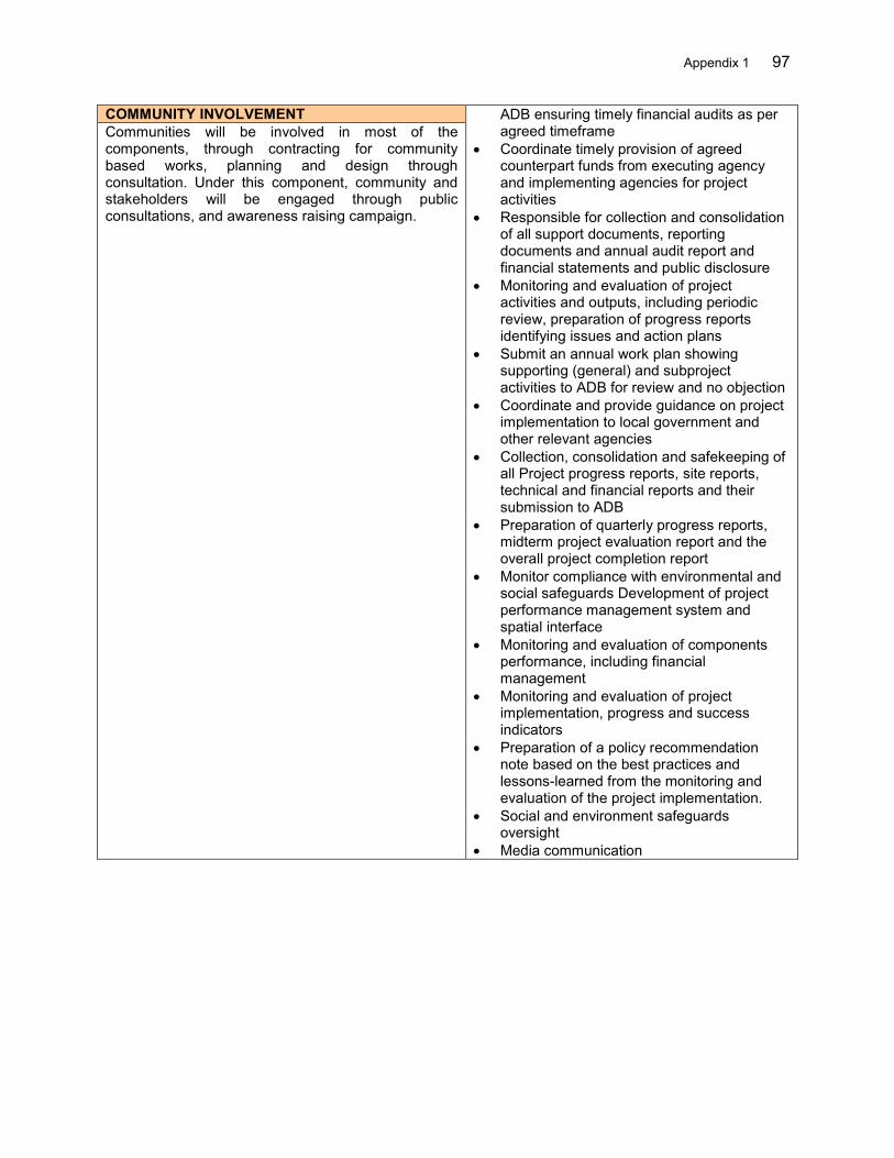
Appendix 1 97
COMMUNITY INVOLVEMENT ADB ensuring timely financial audits as per agreed timeframe
Coordinate timely provision of agreed counterpart funds from executing agency and implementing agencies for project activities
Responsible for collection and consolidation of all support documents, reporting documents and annual audit report and financial statements and public disclosure
Monitoring and evaluation of project activities and outputs, including periodic review, preparation of progress reports identifying issues and action plans
Submit an annual work plan showing supporting (general) and subproject activities to ADB for review and no objection
Coordinate and provide guidance on project implementation to local government and other relevant agencies
Collection, consolidation and safekeeping of all Project progress reports, site reports, technical and financial reports and their submission to ADB
Preparation of quarterly progress reports, midterm project evaluation report and the overall project completion report
Monitor compliance with environmental and social safeguards Development of project performance management system and spatial interface
Monitoring and evaluation of components performance, including financial management
Monitoring and evaluation of project implementation, progress and success indicators
Preparation of a policy recommendation note based on the best practices and lessons-learned from the monitoring and evaluation of the project implementation.
Social and environment safeguards oversight
Media communication
Communities will be involved in most of the components, through contracting for community based works, planning and design through consultation. Under this component, community and stakeholders will be engaged through public consultations, and awareness raising campaign.
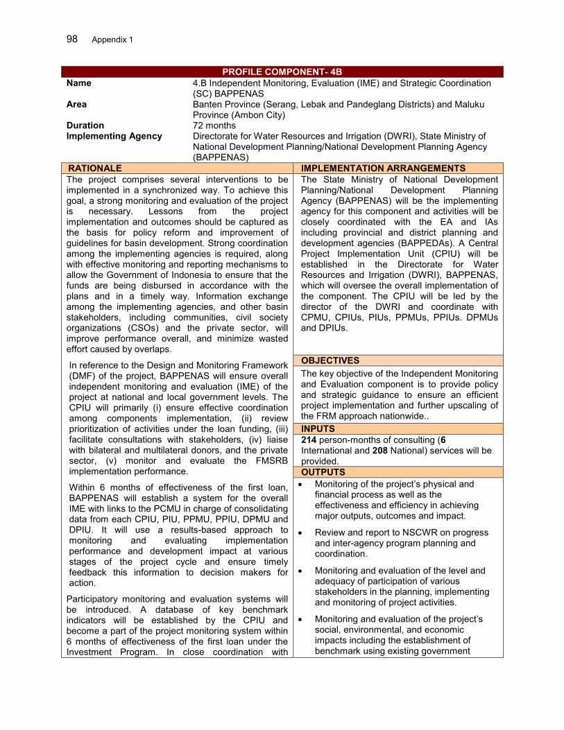
98 Appendix 1
PROFILE COMPONENT- 4B Name 4.B Independent Monitoring, Evaluation (IME) and Strategic Coordination
(SC) BAPPENAS Area Banten Province (Serang, Lebak and Pandeglang Districts) and Maluku
Province (Ambon City) Duration 72 months Implementing Agency Directorate for Water Resources and Irrigation (DWRI), State Ministry of
National Development Planning/National Development Planning Agency (BAPPENAS)
RATIONALE IMPLEMENTATION ARRANGEMENTS The project comprises several interventions to be implemented in a synchronized way. To achieve this goal, a strong monitoring and evaluation of the project is necessary. Lessons from the project implementation and outcomes should be captured as the basis for policy reform and improvement of guidelines for basin development. Strong coordination among the implementing agencies is required, along with effective monitoring and reporting mechanisms to allow the Government of Indonesia to ensure that the funds are being disbursed in accordance with the plans and in a timely way. Information exchange among the implementing agencies, and other basin stakeholders, including communities, civil society organizations (CSOs) and the private sector, will improve performance overall, and minimize wasted effort caused by overlaps.
In reference to the Design and Monitoring Framework (DMF) of the project, BAPPENAS will ensure overall independent monitoring and evaluation (IME) of the project at national and local government levels. The CPIU will primarily (i) ensure effective coordination among components implementation, (ii) review prioritization of activities under the loan funding, (iii) facilitate consultations with stakeholders, (iv) liaise with bilateral and multilateral donors, and the private sector, (v) monitor and evaluate the FMSRB implementation performance.
Within 6 months of effectiveness of the first loan, BAPPENAS will establish a system for the overall IME with links to the PCMU in charge of consolidating data from each CPIU, PIU, PPMU, PPIU, DPMU and DPIU. It will use a results-based approach to monitoring and evaluating implementation performance and development impact at various stages of the project cycle and ensure timely feedback this information to decision makers for action.
Participatory monitoring and evaluation systems will be introduced. A database of key benchmark indicators will be established by the CPIU and become a part of the project monitoring system within 6 months of effectiveness of the first loan under the Investment Program. In close coordination with
The State Ministry of National Development Planning/National Development Planning Agency (BAPPENAS) will be the implementing agency for this component and activities will be closely coordinated with the EA and IAs including provincial and district planning and development agencies (BAPPEDAs). A Central Project Implementation Unit (CPIU) will be established in the Directorate for Water Resources and Irrigation (DWRI), BAPPENAS, which will oversee the overall implementation of the component. The CPIU will be led by the director of the DWRI and coordinate with CPMU, CPIUs, PIUs, PPMUs, PPIUs. DPMUs and DPIUs.
OBJECTIVES The key objective of the Independent Monitoring and Evaluation component is to provide policy and strategic guidance to ensure an efficient project implementation and further upscaling of the FRM approach nationwide.. INPUTS 214 person-months of consulting (6 International and 208 National) services will be provided. OUTPUTS Monitoring of the project’s physical and
financial process as well as the effectiveness and efficiency in achieving major outputs, outcomes and impact.
Review and report to NSCWR on progress and inter-agency program planning and coordination.
Monitoring and evaluation of the level and adequacy of participation of various stakeholders in the planning, implementing and monitoring of project activities.
Monitoring and evaluation of the project’s social, environmental, and economic impacts including the establishment of benchmark using existing government
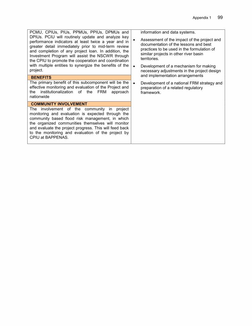
Appendix 1 99
PCMU, CPIUs, PIUs, PPMUs, PPIUs, DPMUs and DPIUs. PCIU will routinely update and analyze key performance indicators at least twice a year and in greater detail immediately prior to mid-term review and completion of any project loan. In addition, the Investment Program will assist the NSCWR through the CPIU to promote the cooperation and coordination with multiple entities to synergize the benefits of the project.
information and data systems.
Assessment of the impact of the project and documentation of the lessons and best practices to be used in the formulation of similar projects in other river basin territories.
Development of a mechanism for making necessary adjustments in the project design and implementation arrangements
Development of a national FRM strategy and preparation of a related regulatory framework.
BENEFITS The primary benefit of this subcomponent will be the effective monitoring and evaluation of the Project and the institutionalization of the FRM approach nationwide
COMMUNITY INVOLVEMENT The involvement of the community in project monitoring and evaluation is expected through the community based flood risk management, in which the organized communities themselves will monitor and evaluate the project progress. This will feed back to the monitoring and evaluation of the project by CPIU at BAPPENAS.
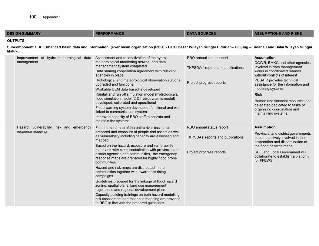
100 Appendix 1
DESIGN SUMMARY PERFORMANCE DATA SOURCES ASSUMPTIONS AND RISKS
OUTPUTS
Subcomponent 1. A: Enhanced basin data and information (river basin organization (RBO) - Balai Besar Wilayah Sungai Cidurian– Ciujung – Cidanau and Balai Wilayah Sungai Maluku
Improvement of hydro-meteorological data management
Assessment and rationalization of the hydro meteorological monitoring network and data management system completed Data sharing cooperation agreement with relevant agencies in place Hydrological and meteorological observation stations upgraded and functional Workable DEM data based is developed Rainfall and run off simulation model (hydrological), flood simulation model (2 D hydrodynamic model) developed, calibrated and operational Flood warning system developed, functional and well linked to communication system Improved capacity of RBO staff to operate and maintain the systems
RBO annual status report TKPSDAs’ reports and publications Project progress reports
Assumption DGWR, BMKG and other agencies involved in data management works in coordinated manner without conflicts of interest PUSAIR provides technical assistance for the information and modeling systems
Risk
Human and financial resources not delegated/dedicated to tasks of organizing coordination and maintaining systems
Hazard, vulnerability, risk and emergency response mapping
Flood hazard map of the entire river basin are prepared and exposure of people and assets as well as vulnerability including capacity are assessed and mapped Based on the hazard, exposure and vulnerability maps and with close consultation with provincial and district agencies and communities, the emergency response maps are prepared for highly flood prone communities Hazard and risk maps are distributed in the communities together with awareness rising campaigns Guidelines prepared for the linkage of flood hazard zoning, spatial plans, land use management regulations and regional development plans. Capacity building trainings on both hazard modelling, risk assessment and response mapping are provided to RBO in line with the prepared guidelines
RBO annual status report TKPSDAs’ reports and publications Project progress reports
Assumption
Provincial and district governments become actively involved in the preparation and dissemination of the flood hazards maps
RBO and Local Government will collaborate to establish a platform for FFEWS
Appendix 1 101
Preparation of flood risk management plans Basin scale flood risk management plans for the Ciujung river in 3Cis RBT and Batu Merah and Way Ruhu rivers in Ambon-Seram RBT are prepared Planning and implementation of the plans coordinated through the TKPSDAs
RBO annual status report TKPSDAs’ reports and publications Project progress reports
Assumption TKPSDA pro actively coordinate the preparation of the FRMPs among stakeholders
Flood forecasting and early warning system establishment including communication system
Rainfall-runoff and inundation models developed and operated by BWSs Flood early warning equipments including sirens and other communications systems are installed Established multiple channels for warning information dissemination at the community level BBWS and BBPD have established a good working modality to translate forecast to warning information and its dissemination to the public
RBO annual report Local government’s regular publication News articles
Assumption Central and Local Government provide strong support to best utilize the flood forecast information and play active role in the dissemination of warning information Local Government and RBO work together to develop a warning mechanism
Development of the capacity of Balai in operation and maintenance of database as well as FFEW system
5 B/BWS staff are trained in hydrological modelling and flood forecasting 10 B/BWS staff are trained in hydrological observation system and operation and maintenance of telemetric observation system Separate O&M section with dedicated number of B/BWS staff are assigned for operation of data observation and FFEWS system.
RBO annual report Local government’s regular publication News articles
Assumption RBO have sufficient number and skilful Engineers. RBO allocate budget for Data observation, FF and O&M regularly.
Risk
Trained staff moved to another department or office in a short time due to staff rotational system
Development of decision support system for short and long term flood management in the basin
Catchment scale hydrological and hydraulic models are developed and that are compatible with watershed modelling, climate change scenario modelling and other catchment processes simulations
RBO annual report News articles
Assumption RBO has fundamental data to start up the development of catchment models. RBO have sufficient number and skilful Engineers. RBO allocate budget for Data observation, FF and O&M regularly.
102 Appendix 1
Main Activities: Procurement of consultants Assessment and rationalization of the hydro meteorological monitoring network and data management system Coordination with BMKG, MOA and relevant agencies for data sharing (cooperation agreement, procedures) Installation of Hydro-meteorological observation stations both stand-alone (flash flood) and grid-based (riverine flood). This includes
manufacturing, transportation and installation of equipment Data management and data processing (back-up e.g. Water4Tec like system). Capacity building in system development. Development of
database for water resources management in general. Development of locally fit advanced hydrological model. Introduce satellite based rainfall based flood forecast as a back-up system Technical capacity/skill building for RBO in data management, hydrological modelling, flood forecasting and early warning system and Hazard, vulnerability, risk and emergency response mapping Preparation of flood risk management plans Coordination and institutional strengthening of the TKPSDA for inclusion into the RENCANA and implementation Flood forecasting and early warning system establishment including communication system Logicalize/area focused flood forecasting and early warning system development including communication system (RBO base approach) Stand-alone flash flood warning system with automatic rainfall and water level station, with provision of giving Sirines or sending automatic
warning/alert message to the community
Financing 3.68 Million USD Consulting Services International: 5 person-months National: 292 person-months
Appendix 1 103
N DESIGN SUMMARY PERFORMANCE DATA SOURCES ASSUMPTIONS AND RISKS
OUTPUTS Subcomponent 1.B: Institutional strengthening, planning and coordination for the implementation of FRM plans in 3Cis RBT and Ambon-Seram RBT (MOHA)
1 Detailed planning and design of Interventions Flood Risk Management Plans (FRMPs) are prepared and endorsed by districts . FRMPs are used as the basis to updayed provincial and district development and annual plans. Hazard, vulnerability, risk and emergency response mapping at district/city and community levels are produced and reflected in spatial planning. Road map is prepared for the short and long-term flood risk management in the basin. Land-use plan amended and new rules on river corridor management are proposed by the local government. Inter-sectoral infrastructure policies and regulations for FRM are issued.
MOHA reports Provincial and local governments development and spatial plans Provincial and local governments regulations Local news papers
Assumption DGWR, BNPB and MOHA works in coordinated manner without conflicts of interest
Risk Human resources not delegated/dedicated to tasks of organizing coordination
2 Establishment of flood communication procedures Flood hazard/risk maps are distributed to communities and agencies concerned. FRM mainstreamed in regional development. Risk communication procedures established and implemented. Emergency response maps of each town/village published are distributed among communities and line agencies.
MOHA reports Local Government’s reports and publications
Assumption DGWR, PNPB and MOHA works in coordinated manner without any conflicts of interest
104 Appendix 1
3 Institutional strengthening and technical capacity building Institutional and governance capacity assessed. Detailed plan and design of all activities related to institutional and technical capacity endorsed. Capacity development programs are delivered. Strong coordination among sectors at national, provincial and local levels
MOHA reports Annual work plans Project completion report(s)
Assumption Provincial and district governments become actively involved and have the human resources Governments are then willing to coordinate required inputs for structural and non-structural projects and programs
Main Activities: Procurement of consultants Detailed planning and design of Interventions Hazard, vulnerability, risk and emergency response mapping at district/city and community levels Preparation of district flood risk management plans (FRMPs) Support the preparation of inter-sectoral infrastructure policies, urban development and spatial plan Preparation of an communication and outreach strategy for integrated flood management Publication, enactment and distribution of basin flood hazard, exposure, vulnerability and risk map Flood information system at local government (for public: information, tips and tools, update activities etc.) jointly prepared by RBO and
disaster management agency (BPBD) to raise awareness in normal time Regular meeting of coordination body and consultations with public and line-agencies Support to prepare district annual work plan to mainstream FRMPs Technical capacity building for relevant agencies mainly BPBD, and Provincial/District Water Resources agency in overall FRM Institutional development, technical capacity and good Governance in MOHA Provincial and local governments. in FRM (involvement of River
Basin Coordination Forum-)
Financing US$ 3.22 million Consulting Services International: 12 person-months National: 339 person-months
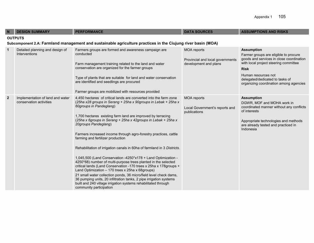
Appendix 1 105
N DESIGN SUMMARY PERFORMANCE DATA SOURCES ASSUMPTIONS AND RISKS
OUTPUTS Subcomponent 2.A: Farmland management and sustainable agriculture practices in the Ciujung river basin (MOA)
1 Detailed planning and design of Interventions
Farmers groups are formed and awareness campaign are conducted Farm management training related to the land and water conservation are organized for the farmer groups Type of plants that are suitable for land and water conservation are identified and seedlings are procured Farmer groups are mobilized with resources provided
MOA reports Provincial and local governments development and plans
Assumption Farmer groups are eligible to procure goods and services in close coordination with local project steering committee
Risk
Human resources not delegated/dedicated to tasks of organizing coordination among agencies
2 Implementation of land and water conservation activities
4,450 hectares of critical lands are converted into the farm zone (25ha x28 groups in Serang + 25ha x 90groups in Lebak + 25ha x 60groups in Pandeglang) 1,700 hectares existing farm land are improved by terracing (25ha x 6groups in Serang + 25ha x 42groups in Lebak + 25ha x 20groups Pandeglang) Farmers increased income through agro-forestry practices, cattle farming and fertilizer production Rehabilitation of irrigation canals in 60ha of farmland in 3 Districts. 1,045,500 (Land Conservation -4250*x178 + Land Optimization - 4250*68) number of multi-purpose trees planted in the selected critical lands (Land Conservation -170 trees x 25ha x 178groups + Land Optimization – 170 trees x 25ha x 68groups) 21 small water collection ponds, 36 micro/field level check dams, 36 pumping units, 20 infiltration tanks, 2 pipe irrigation systems built and 240 village irrigation systems rehabilitated through community participation
MOA reports Local Government’s reports and publications
Assumption DGWR, MOF and MOHA work in coordinated manner without any conflicts of interests Appropriate technologies and methods are already tested and practiced in Indonesia
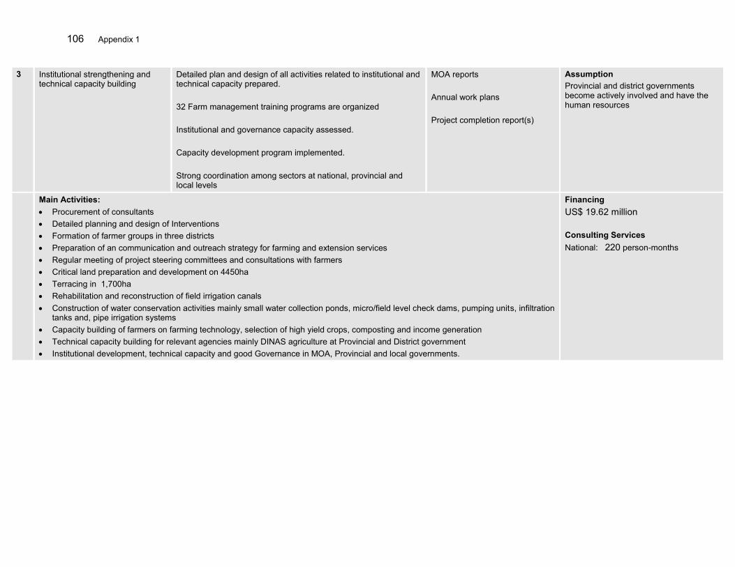
106 Appendix 1
3 Institutional strengthening and technical capacity building
Detailed plan and design of all activities related to institutional and technical capacity prepared. 32 Farm management training programs are organized Institutional and governance capacity assessed. Capacity development program implemented. Strong coordination among sectors at national, provincial and local levels
MOA reports Annual work plans Project completion report(s)
Assumption Provincial and district governments become actively involved and have the human resources
Main Activities: Procurement of consultants Detailed planning and design of Interventions Formation of farmer groups in three districts Preparation of an communication and outreach strategy for farming and extension services Regular meeting of project steering committees and consultations with farmers Critical land preparation and development on 4450ha Terracing in 1,700ha Rehabilitation and reconstruction of field irrigation canals Construction of water conservation activities mainly small water collection ponds, micro/field level check dams, pumping units, infiltration
tanks and, pipe irrigation systems Capacity building of farmers on farming technology, selection of high yield crops, composting and income generation Technical capacity building for relevant agencies mainly DINAS agriculture at Provincial and District government Institutional development, technical capacity and good Governance in MOA, Provincial and local governments.
Financing US$ 19.62 million Consulting Services National: 220 person-months
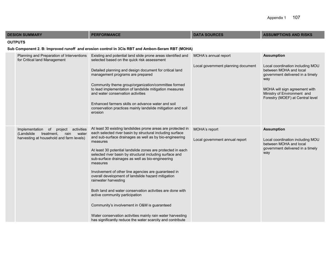
Appendix 1 107
DESIGN SUMMARY PERFORMANCE DATA SOURCES ASSUMPTIONS AND RISKS
OUTPUTS
Sub Component 2. B: Improved runoff and erosion control in 3Cis RBT and Ambon-Seram RBT (MOHA)
Planning and Preparation of Interventions for Critical land Management
Existing and potential land slide prone areas identified and selected based on the quick risk assessment Detailed planning and design document for critical land management programs are prepared Community theme group/organization/committee formed to lead implementation of landslide mitigation measures and water conservation activities Enhanced farmers skills on advance water and soil conservation practices mainly landslide mitigation and soil erosion
MOHA’s annual report Local government planning document
Assumption Local coordination including MOU between MOHA and local government delivered in a timely way MOHA will sign agreement with Ministry of Environment and Forestry (MOEF) at Central level
Implementation of project activities (Landslide treatment, rain water harvesting at household and farm levels)
At least 30 existing landslides prone areas are protected in each selected river basin by structural including surface and sub-surface drainages as well as by bio-engineering measures At least 30 potential landslide zones are protected in each selected river basin by structural including surface and sub-surface drainages as well as bio-engineering measures Involvement of other line agencies are guaranteed in overall development of landslide hazard mitigation rainwater harvesting Both land and water conservation activities are done with active community participation Community’s involvement in O&M is guaranteed Water conservation activities mainly rain water harvesting has significantly reduce the water scarcity and contribute
MOHA’s report Local government annual report
Assumption Local coordination including MOU between MOHA and local government delivered in a timely way
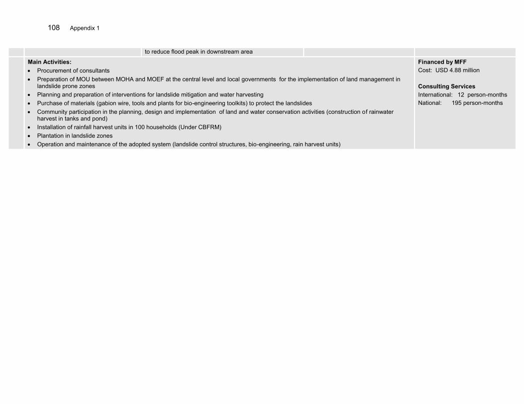
108 Appendix 1
to reduce flood peak in downstream area
Main Activities: Procurement of consultants Preparation of MOU between MOHA and MOEF at the central level and local governments for the implementation of land management in
landslide prone zones Planning and preparation of interventions for landslide mitigation and water harvesting Purchase of materials (gabion wire, tools and plants for bio-engineering toolkits) to protect the landslides Community participation in the planning, design and implementation of land and water conservation activities (construction of rainwater
harvest in tanks and pond) Installation of rainfall harvest units in 100 households (Under CBFRM) Plantation in landslide zones Operation and maintenance of the adopted system (landslide control structures, bio-engineering, rain harvest units)
Financed by MFF Cost: USD 4.88 million Consulting Services International: 12 person-months National: 195 person-months

Appendix 1 109
DESIGN SUMMARY PERFORMANCE DATA SOURCES ASSUMPTIONS AND RISKS
OUTPUTS
Subcomponent 2C-2D: Detailed Engineering Design (DED) and construction supervision under the river basin organization (RBO - Balai Besar Wilayah Sungai Cidurian– Ciujung – Cidanau and Balai Wilayah Sungai Maluku)
Structural subproject selection, appraisal, preparation and implementation
Sub-projects are selected, appraised and their feasibility studies are completed
DED of selected sub-project civil works completed: A. 3 Cis RBT: Rehabilitation/Upgrading of existing dikes, retaining walls for landslides, river normalization, check dams, Pamarayan reservoir rehabilitation B. Maluku-Seram RBT: construction of dikes, rehabilitation of existing dikes and parapets, reservoirs, check dams in five river basins within Ambon city
Social safe guard documentation prepared
EIA prepared and approved for selected subprojects
RBO annual report Project document
Assumptions Strong coordination with local
government for preparation of land acquisition and resettlement
Civil Works Construction 11 km long dykes on both river banks constructed in Ciujung river basin
8 check dams are constructed in Batu Merah and Way Ruhu river basins in Ambon in consideration of 25 years return period of maximum river discharge
Other civil works in the 3 cis and Ambon Seram RBTs
RBO annual status report Local Government’s reports and
publications
Assumptions RBO and Local Government will
collaborate particularly in LAR RBO has resources allocated
for O&M
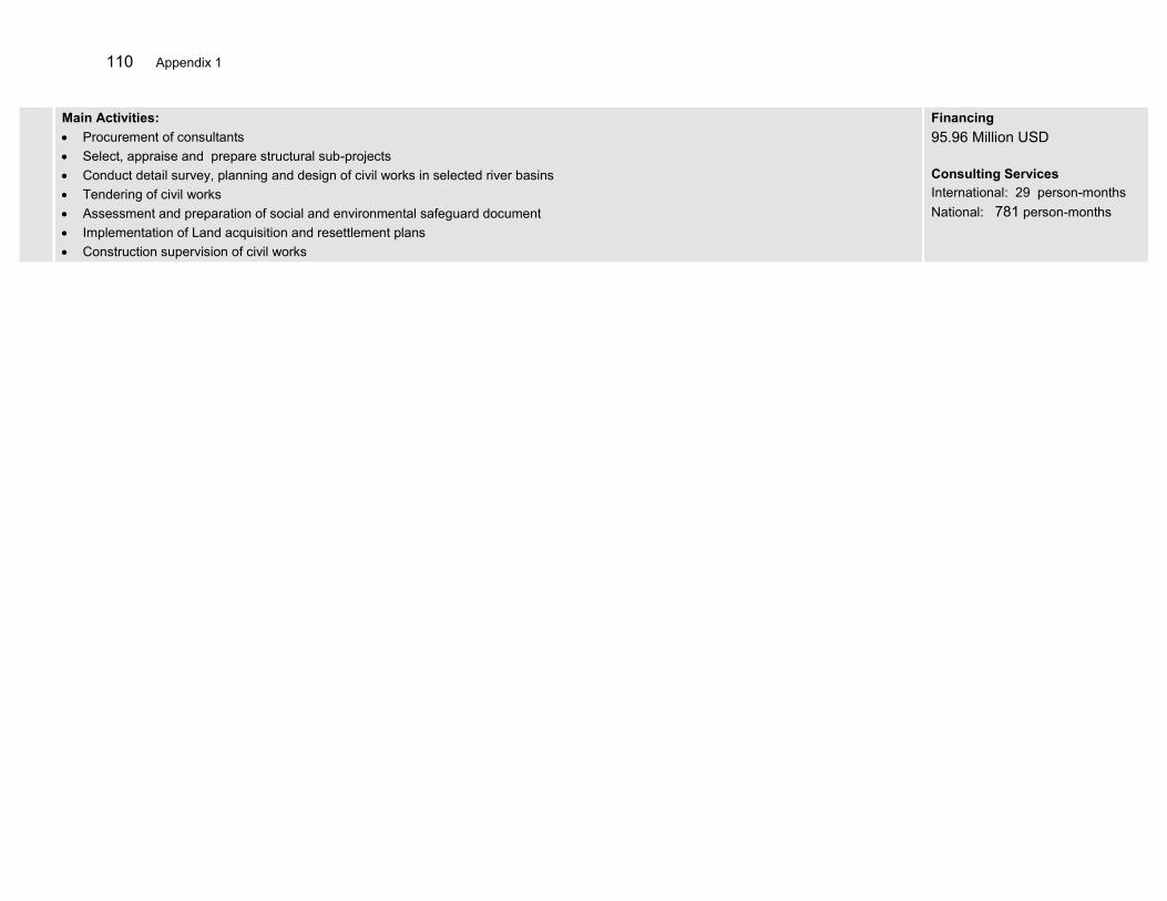
110 Appendix 1
Main Activities: Procurement of consultants Select, appraise and prepare structural sub-projects Conduct detail survey, planning and design of civil works in selected river basins Tendering of civil works Assessment and preparation of social and environmental safeguard document Implementation of Land acquisition and resettlement plans Construction supervision of civil works
Financing 95.96 Million USD Consulting Services International: 29 person-months National: 781 person-months
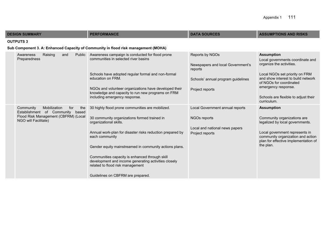
Appendix 1 111
DESIGN SUMMARY PERFORMANCE DATA SOURCES ASSUMPTIONS AND RISKS
OUTPUTS 3
Sub Component 3. A: Enhanced Capacity of Community in flood risk management (MOHA)
Awareness Raising and Public Preparedness
Awareness campaign is conducted for flood prone communities in selected river basins Schools have adopted regular formal and non-formal education on FRM. NGOs and volunteer organizations have developed their knowledge and capacity to run new programs on FRM including emergency response.
Reports by NGOs Newspapers and local Government’s reports Schools’ annual program guidelines Project reports
Assumption Local governments coordinate and organize the activities. Local NGOs set priority on FRM and show interest to build network of NGOs for coordinated emergency response. Schools are flexible to adjust their curriculum.
Community Mobilization for the Establishment of Community based Flood Risk Management (CBFRM) (Local NGO will Facilitate)
30 highly flood prone communities are mobilized. 30 community organizations formed trained in organizational skills. Annual work-plan for disaster risks reduction prepared by each community Gender equity mainstreamed in community actions plans. Communities capacity is enhanced through skill development and income generating activities closely related to flood risk management Guidelines on CBFRM are prepared.
Local Government annual reports NGOs reports Local and national news papers Project reports
Assumption Community organizations are legalized by local governments. Local government represents in community organization and action plan for effective implementation of the plan.

112 Appendix 1
Preparation of contingency plans (emergency response planning)
Each community prepare their own social, hazard, vulnerability and response maps Standard Operating Prorcedures on FRM have been prepared. Evacuation centers and routes are assigned and reflected on the emergency response maps. Community and BPBD are equipped with basic emergency gears to support emergency response.
Local Government’s annual reports Local and national news papers Maps/information boards are erected in public places in the communities Project reports
Assumption Community mobilization is matured and community takes active part in preparations. Local government supports the communities throughout the processes.
Community participation in project planning, design and implementation
Pola/Rencana updates proposed in line with community FRM plans. Community members are trained in operation and maintenance of the implemented systems including early warning system. Urban drainage infrastructure is improved to bypass the storm water directly to the bay of Ambon in Maluku. 8 erosion control and flood control check dams are constructed in upstream communities in both RBTs. Communities will install rain water harvest system at least in 100 households with water scarcity region (implementation in coordination with component 2.B activities). Communities provided inputs/labors to the construction of proposed embankments and raising platform for housing.
Local Government’s annual reports Local and national news papers Project reports
Assumption Community mobilization is matured and communities take active role in development activities.
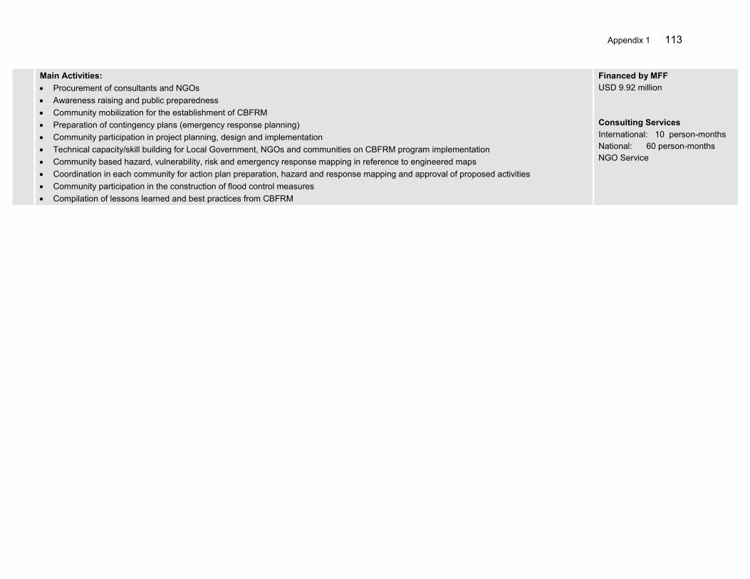
Appendix 1 113
Main Activities: Procurement of consultants and NGOs Awareness raising and public preparedness Community mobilization for the establishment of CBFRM Preparation of contingency plans (emergency response planning) Community participation in project planning, design and implementation Technical capacity/skill building for Local Government, NGOs and communities on CBFRM program implementation Community based hazard, vulnerability, risk and emergency response mapping in reference to engineered maps Coordination in each community for action plan preparation, hazard and response mapping and approval of proposed activities Community participation in the construction of flood control measures Compilation of lessons learned and best practices from CBFRM
Financed by MFF USD 9.92 million Consulting Services International: 10 person-months National: 60 person-months NGO Service

114 Appendix 1
DESIGN SUMMARY PERFORMANCE DATA SOURCES ASSUMPTIONS AND RISKS
OUTPUTS
Subcomponent 4. A: Program Management (MPWH)
Coordination and planning Well-coordinated project implementation, with opportunities for information exchange maximized, and conflicts, overlapping and duplication among projects minimized
Program status reports Minutes of periodical coordination
workshops
There is a willingness by those involved in each project sub-components under this project to cooperate and share information
Monitoring and reporting of project performance, including financial management
All monitoring and reporting undertaken in accordance with agreed procedures
Reports produced Monitoring and reporting procedures are agreed in advance and adhered to the PAM
Project Management Project implementation and progress are as scheduled and follow a critical flow chart
Technical database of the project is developed and being regularly updated
Program status reports
Social and environment safeguards oversight Social disruption for those living in project areas minimized
Environmental impacts minimized, and
in particular through proper disposal of dredged material and standard construction procedures
Post-completion survey of local communities
Social safeguards are adequate and appropriate to local communities
All necessary environmental safeguards are identified and implemented
Policy recommendation Lessons learned and best practices are compiled
Policy recommendation notes are prepared based on the lessons learned from the project implementation
Project progress report
There is a willingness by those involved in each project sub-components under this project to cooperate and share information
Monitoring and reporting procedures are agreed in advance and adhered to the PAM
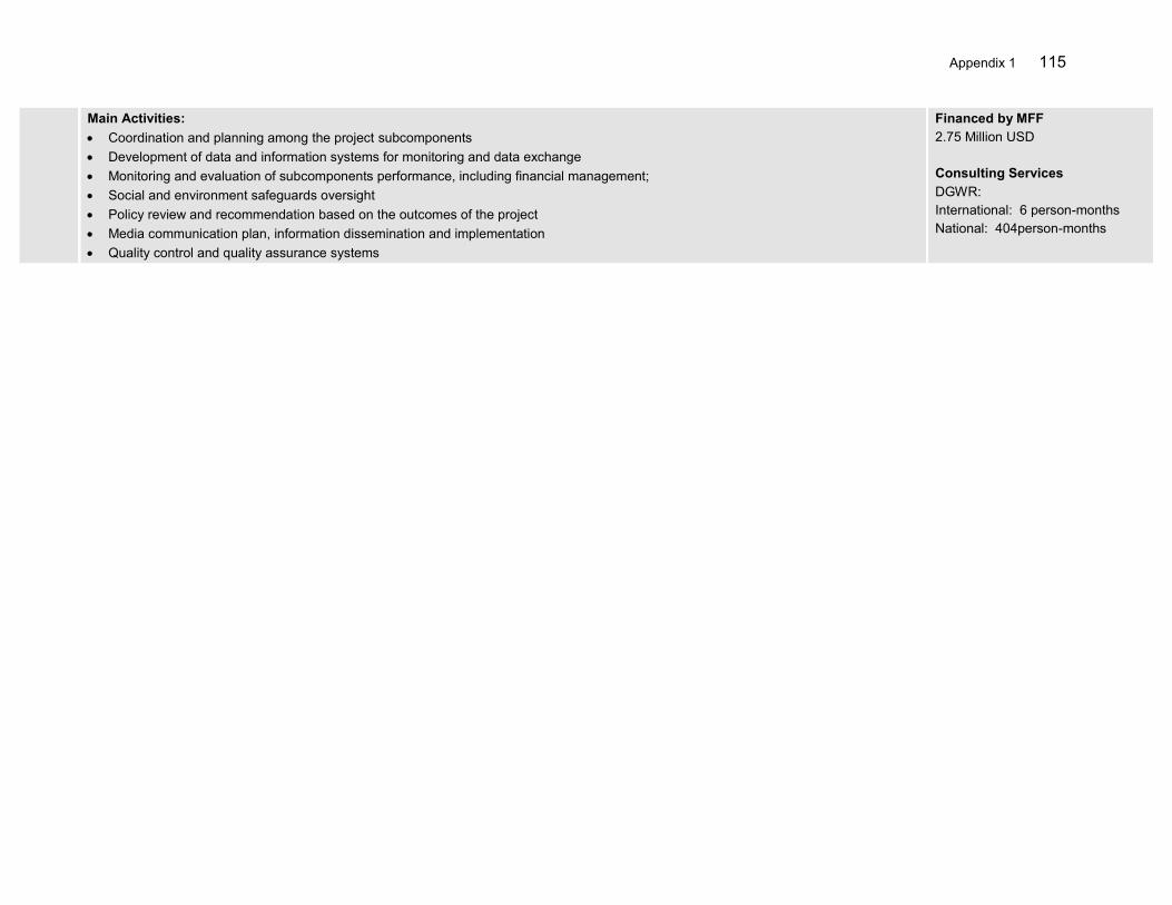
Appendix 1 115
Main Activities: Coordination and planning among the project subcomponents Development of data and information systems for monitoring and data exchange Monitoring and evaluation of subcomponents performance, including financial management; Social and environment safeguards oversight Policy review and recommendation based on the outcomes of the project Media communication plan, information dissemination and implementation Quality control and quality assurance systems
Financed by MFF 2.75 Million USD Consulting Services DGWR: International: 6 person-months National: 404person-months

116 Appendix 1
DESIGN SUMMARY PERFORMANCE DATA SOURCES ASSUMPTIONS AND RISKS
OUTPUTS 4
Sub Component 4. B: Independent Monitoring, Evaluation and Strategic Coordination BAPPENAS (IME)
A Project Performance Management System (PPMS) for the overall Roadmap investments
Project Performance Management System designed and implemented by end of month 6
Project records There is willingness by those involved in each of the project under this sector loan to cooperate and share information.
Monitoring and reporting procedures are agreed in advance and adhered to.
Consultants, local counterparts and GOI officials work together effective to prepare the documentation.
ADB and GOI requirements are made clear and do not change.
Quarterly Progress Reports giving physical and financial progress, summary of field visits, consultant’s staffing and administration details, issues of project implementation requiring immediate resolutions
Quarterly Progress Reports submitted on time and to required standard
Project records
Semi-annual Consolidated Project Report. This report will summarize: (i). the CPIU progress; field and program issues requiring resolution; (iii). detailed team work program for the next half year
Semi-annual Consolidated Project Reports submitted on time and to required standard
Project records
A mid-term review report that would summarize achievements, unresolved issues and, possibly a revised work program
Mid-term review report submitted by the end of month18 and to required standard
Project records
Completion report Completion report submitted 2 months prior to project closure and to required standard
Project records
Main Activities: Conduct Monitoring and evaluation of the project related physical and financial processes as well as the effectiveness and efficiency in
achieving major outputs, outcomes and impact Review and reporting of project progress to NSCWR, and inter-agency program planning and coordination Establish a Project Performance Management System for the overall investments Monitor the level and adequacy of participation of various stakeholders in the planning, implementing and monitoring of project activities Monitor the project’s social, environmental, and economic impacts, including the establishment of benchmark using existing government
information and data systems Developing a mechanism for making necessary adjustments in the project design and implementation arrangements Compile the lessons learned and best practice examples from the experience of project implementation
Prepare a national flood risk management strategy and policy framework for nationwide implementation
Financing USD 1.65 million Consulting Services International: 6 person-months National: 208 person-months
Appendix 1 117
DESIGN SUMMARY PERFORMANCE DATA SOURCES ASSUMPTIONS AND RISKS
OUTPUTS
Subcomponent 1. A: Enhanced basin data and information (river basin organization (RBO) - Balai Besar Wilayah Sungai Cidurian– Ciujung – Cidanau and Balai Wilayah Sungai Maluku
Improvement of hydro-meteorological data management
Assessment and rationalization of the hydro meteorological monitoring network and data management system completed Data sharing cooperation agreement with relevant agencies in place Hydrological and meteorological observation stations upgraded and functional Workable DEM data based is developed Rainfall and run off simulation model (hydrological), flood simulation model (2 D hydrodynamic model) developed, calibrated and operational Flood warning system developed, functional and well linked to communication system Improved capacity of RBO staff to operate and maintain the systems
RBO annual status report s’ reports and publications Project progress reports
Assumption DGWR, BMKG and other agencies involved in data management works in coordinated manner without conflicts of interest PUSAIR provides technical assistance for the information and modeling systems
Risk
Human and financial resources not delegated/dedicated to tasks of organizing coordination and maintaining systems
Hazard, vulnerability, risk and emergency response mapping
Flood hazard map of the entire river basin are prepared and exposure of people and assets as well as vulnerability including capacity are assessed and mapped Based on the hazard, exposure and vulnerability maps and with close consultation with provincial and district agencies and communities, the emergency response maps are prepared for highly flood prone communities Hazard and risk maps are distributed in the communities together with awareness rising campaigns Guidelines prepared for the linkage of flood hazard zoning, spatial plans, land use management regulations and regional development plans. Capacity building trainings on both hazard modelling, risk assessment and response mapping are provided to RBO in line with the prepared guidelines
RBO annual status report s’ reports and publications Project progress reports
Assumption
Provincial and district governments become actively involved in the preparation and dissemination of the flood hazards maps
RBO and Local Government will collaborate to establish a platform for FFEWS
118 Appendix 1
Preparation of flood risk management plans Basin scale flood risk management plans for the Ciujung river in 3Cis RBT and Batu Merah and Way Ruhu rivers in Ambon-Seram RBT are prepared Planning and implementation of the plans coordinated through the s
RBO annual status report s’ reports and publications Project progress reports
Assumption pro actively coordinate the preparation of the FRMPs among stakeholders
Flood forecasting and early warning system establishment including communication system
Rainfall-runoff and inundation models developed and operated by BWSs Flood early warning equipments including sirens and other communications systems are installed Established multiple channels for warning information dissemination at the community level BBWS and BBPD have established a good working modality to translate forecast to warning information and its dissemination to the public
RBO annual report Local government’s regular publication News articles
Assumption Central and Local Government provide strong support to best utilize the flood forecast information and play active role in the dissemination of warning information Local Government and RBO work together to develop a warning mechanism
Development of the capacity of Balai in operation and maintenance of database as well as FFEW system
5 B/BWS staff are trained in hydrological modelling and flood forecasting 10 B/BWS staff are trained in hydrological observation system and operation and maintenance of telemetric observation system Separate O&M section with dedicated number of B/BWS staff are assigned for operation of data observation and FFEWS system.
RBO annual report Local government’s regular publication News articles
Assumption RBO have sufficient number and skilful Engineers. RBO allocate budget for Data observation, FF and O&M regularly.
Risk
Trained staff moved to another department or office in a short time due to staff rotational system
Development of decision support system for short and long term flood management in the basin
Catchment scale hydrological and hydraulic models are developed and that are compatible with watershed modelling, climate change scenario modelling and other catchment processes simulations
RBO annual report News articles
Assumption RBO has fundamental data to start up the development of catchment models. RBO have sufficient number and skilful Engineers. RBO allocate budget for Data observation, FF and O&M regularly.

Appendix 1 119
Main Activities: Procurement of consultants Assessment and rationalization of the hydro meteorological monitoring network and data management system Coordination with BMKG, MOA and relevant agencies for data sharing (cooperation agreement, procedures) Installation of Hydro-meteorological observation stations both stand-alone (flash flood) and grid-based (riverine flood). This includes
manufacturing, transportation and installation of equipment Data management and data processing (back-up e.g. Water4Tec like system). Capacity building in system development. Development of
database for water resources management in general. Development of locally fit advanced hydrological model. Introduce satellite based rainfall based flood forecast as a back-up system Technical capacity/skill building for RBO in data management, hydrological modelling, flood forecasting and early warning system and Hazard, vulnerability, risk and emergency response mapping Preparation of flood risk management plans Coordination and institutional strengthening of the for inclusion into the RENCANA and implementation Flood forecasting and early warning system establishment including communication system Logicalize/area focused flood forecasting and early warning system development including communication system (RBO base approach) Stand-alone flash flood warning system with automatic rainfall and water level station, with provision of giving Sirines or sending automatic
warning/alert message to the community
Financing 3.39 Million USD Consulting Services International: 20 person-months National: 235 person-months
120 Appendix 1
N DESIGN SUMMARY PERFORMANCE DATA SOURCES ASSUMPTIONS AND RISKS
OUTPUTS Subcomponent 1.B: Institutional strengthening, planning and coordination for the implementation of FRM plans in 3Cis RBT and Ambon-Seram RBT (MOHA)
1 Detailed planning and design of Interventions Flood Risk Management Plans (FRMPs) are prepared and endorsed by districts . FRMPs are incorporated in provincial and district development and annual plans. Hazard, vulnerability, risk and emergency response mapping at district/city and community levels are produced and reflected in spatial planning. Road map is prepared for the short and long-term flood risk management in the basin. Land-use plan amended and new rules on river corridor management are proposed by the local government. Inter-sectoral infrastructure policies and regulations for FRM are issued.
MOHA reports Provincial and local governments development and spatial plans Provincial and local governments regulations Local news papers
Assumption DGWR, BNPB and MOHA works in coordinated manner without conflicts of interest
Risk Human resources not delegated/dedicated to tasks of organizing coordination
2 Establishment of flood communication procedures Flood hazard/risk maps are distributed to communities and agencies concerned. FRM mainstreamed in regional development. Risk communication procedures established and implemented. Emergency response maps of each town/village published are distributed among communities and line agencies.
MOHA reports Local Government’s reports and publications
Assumption DGWR, PNPB and MOHA works in coordinated manner without any conflicts of interest

Appendix 1 121
3 Institutional strengthening and technical capacity building Institutional and governance capacity assessed. Detailed plan and design of all activities related to institutional and technical capacity endorsed. Capacity development programs are delivered. Strong coordination among sectors at national, provincial and local levels
MOHA reports Annual work plans Project completion report(s)
Assumption Provincial and district governments become actively involved and have the human resources Governments are then willing to coordinate required inputs for structural and non-structural projects and programs
Main Activities: Procurement of consultants Detailed planning and design of Interventions Hazard, vulnerability, risk and emergency response mapping at district/city and community levels Preparation of district flood risk management plans (FRMPs) Support the preparation of inter-sectoral infrastructure policies, urban development and spatial plan Preparation of an communication and outreach strategy for integrated flood management Publication, enactment and distribution of basin flood hazard, exposure, vulnerability and risk map Flood information system at local government (for public: information, tips and tools, update activities etc.) jointly prepared by RBO and
disaster management agency (BPBD) to raise awareness in normal time Regular meeting of coordination body and consultations with public and line-agencies Support to prepare district annual work plan to mainstream FRMPs Technical capacity building for relevant agencies mainly BPBD, and Provincial/District Water Resources agency in overall FRM Institutional development, technical capacity and good Governance in MOHA Provincial and local governments. in FRM (involvement of River
Basin Coordination Council-)
Financing US$ 3.59 million Consulting Services International: 12 person-months National: 339 person-months
122 Appendix 1
N DESIGN SUMMARY PERFORMANCE DATA SOURCES ASSUMPTIONS AND RISKS
OUTPUTS Subcomponent 2.A: Farmland management and sustainable agriculture practices in the Ciujung river basin (MOA)
1 Detailed planning and design of Interventions
Farmers groups are formed and awareness campaign are conducted Farm management training related to the land and water conservation are organized for the farmer groups Type of plants that are suitable for land and water conservation are identified and seedlings are procured Farmer groups are mobilized with resources provided
MOA reports Provincial and local governments development and plans
Assumption Farmer groups are eligible to procure goods and services in close coordination with local project steering committee
Risk
Human resources not delegated/dedicated to tasks of organizing coordination among agencies
2 Implementation of land and water conservation activities
4,450 hectares of critical lands are converted into the farm zone (25ha x28 groups in Serang + 25ha x 90groups in Lebak + 25ha x 60groups in Pandeglang) 1,700 hectares existing farm land are improved by terracing (25ha x 6groups in Serang + 25ha x 42groups in Lebak + 25ha x 20groups Pandeglang) Farmers increased income through agro-forestry practices, cattle farming and fertilizer production Rehabilitation of irrigation canals in 60ha of farmland in 3 Districts. 1,045,500 (Land Conservation -4250*x178 + Land Optimization - 4250*68) number of multi-purpose trees planted in the selected critical lands (Land Conservation -170 trees x 25ha x 178groups + Land Optimization – 170 trees x 25ha x 68groups) 21 small water collection ponds, 36 micro/field level check dams, 36 pumping units, 20 infiltration tanks, 2 pipe irrigation systems built and 240 village irrigation systems rehabilitated through community participation
MOA reports Local Government’s reports and publications
Assumption DGWR, MOF and MOHA work in coordinated manner without any conflicts of interests Appropriate technologies and methods are already tested and practiced in Indonesia

Appendix 1 123
3 Institutional strengthening and technical capacity building
Detailed plan and design of all activities related to institutional and technical capacity prepared. 32 Farm management training programs are organized Institutional and governance capacity assessed. Capacity development program implemented. Strong coordination among sectors at national, provincial and local levels
MOA reports Annual work plans Project completion report(s)
Assumption Provincial and district governments become actively involved and have the human resources
Main Activities: Procurement of consultants Detailed planning and design of Interventions Formation of farmer groups in three districts Preparation of an communication and outreach strategy for farming and extension services Regular meeting of project steering committees and consultations with farmers Critical land preparation and development on 4450ha Terracing in 1,700ha Rehabilitation and reconstruction of field irrigation canals Construction of water conservation activities mainly small water collection ponds, micro/field level check dams, pumping units, infiltration
tanks and, pipe irrigation systems Capacity building of farmers on farming technology, selection of high yield crops, composting and income generation Technical capacity building for relevant agencies mainly DINAS agriculture at Provincial and District government Institutional development, technical capacity and good Governance in MOA, Provincial and local governments.
Financing US$ 19.62 million Consulting Services National: 220 person-months
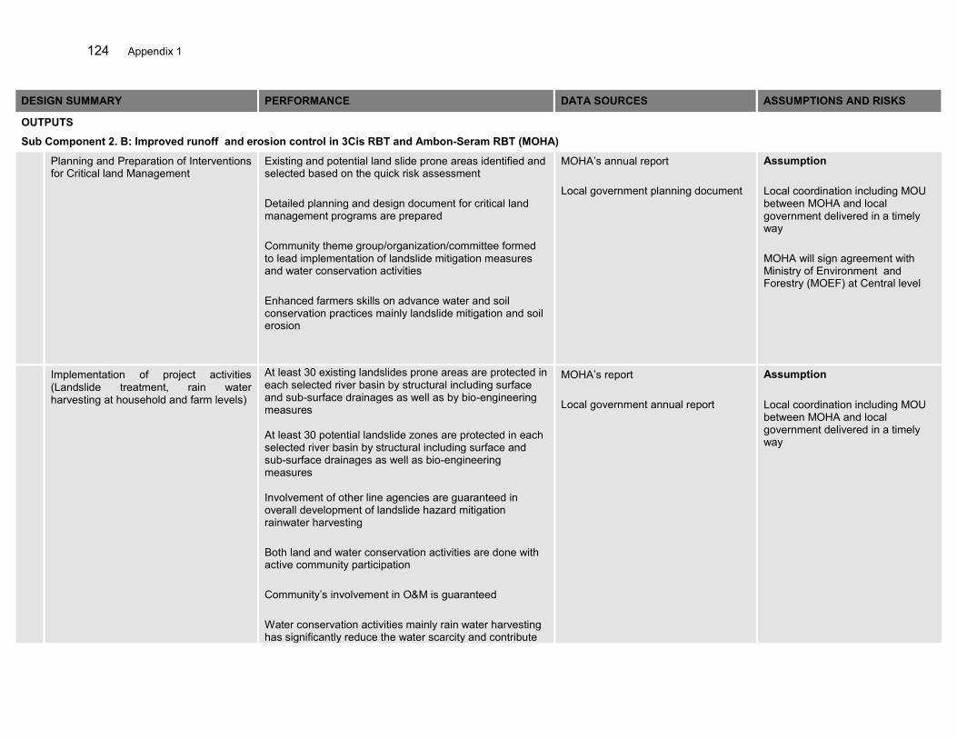
124 Appendix 1
DESIGN SUMMARY PERFORMANCE DATA SOURCES ASSUMPTIONS AND RISKS
OUTPUTS
Sub Component 2. B: Improved runoff and erosion control in 3Cis RBT and Ambon-Seram RBT (MOHA)
Planning and Preparation of Interventions for Critical land Management
Existing and potential land slide prone areas identified and selected based on the quick risk assessment Detailed planning and design document for critical land management programs are prepared Community theme group/organization/committee formed to lead implementation of landslide mitigation measures and water conservation activities Enhanced farmers skills on advance water and soil conservation practices mainly landslide mitigation and soil erosion
MOHA’s annual report Local government planning document
Assumption Local coordination including MOU between MOHA and local government delivered in a timely way MOHA will sign agreement with Ministry of Environment and Forestry (MOEF) at Central level
Implementation of project activities (Landslide treatment, rain water harvesting at household and farm levels)
At least 30 existing landslides prone areas are protected in each selected river basin by structural including surface and sub-surface drainages as well as by bio-engineering measures At least 30 potential landslide zones are protected in each selected river basin by structural including surface and sub-surface drainages as well as bio-engineering measures Involvement of other line agencies are guaranteed in overall development of landslide hazard mitigation rainwater harvesting Both land and water conservation activities are done with active community participation Community’s involvement in O&M is guaranteed Water conservation activities mainly rain water harvesting has significantly reduce the water scarcity and contribute
MOHA’s report Local government annual report
Assumption Local coordination including MOU between MOHA and local government delivered in a timely way
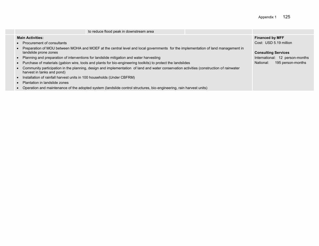
Appendix 1 125
to reduce flood peak in downstream area
Main Activities: Procurement of consultants Preparation of MOU between MOHA and MOEF at the central level and local governments for the implementation of land management in
landslide prone zones Planning and preparation of interventions for landslide mitigation and water harvesting Purchase of materials (gabion wire, tools and plants for bio-engineering toolkits) to protect the landslides Community participation in the planning, design and implementation of land and water conservation activities (construction of rainwater
harvest in tanks and pond) Installation of rainfall harvest units in 100 households (Under CBFRM) Plantation in landslide zones Operation and maintenance of the adopted system (landslide control structures, bio-engineering, rain harvest units)
Financed by MFF Cost: USD 5.19 million Consulting Services International: 12 person-months National: 195 person-months
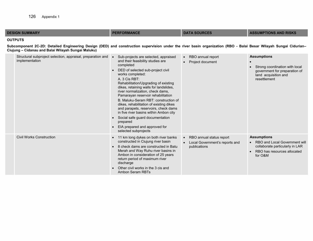
126 Appendix 1
DESIGN SUMMARY PERFORMANCE DATA SOURCES ASSUMPTIONS AND RISKS
OUTPUTS
Subcomponent 2C-2D: Detailed Engineering Design (DED) and construction supervision under the river basin organization (RBO - Balai Besar Wilayah Sungai Cidurian– Ciujung – Cidanau and Balai Wilayah Sungai Maluku)
Structural subproject selection, appraisal, preparation and implementation
Sub-projects are selected, appraised and their feasibility studies are completed
DED of selected sub-project civil works completed: A. 3 Cis RBT: Rehabilitation/Upgrading of existing dikes, retaining walls for landslides, river normalization, check dams, Pamarayan reservoir rehabilitation B. Maluku-Seram RBT: construction of dikes, rehabilitation of existing dikes and parapets, reservoirs, check dams in five river basins within Ambon city
Social safe guard documentation prepared
EIA prepared and approved for selected subprojects
RBO annual report Project document
Assumptions Strong coordination with local
government for preparation of land acquisition and resettlement
Civil Works Construction 11 km long dykes on both river banks constructed in Ciujung river basin
8 check dams are constructed in Batu Merah and Way Ruhu river basins in Ambon in consideration of 25 years return period of maximum river discharge
Other civil works in the 3 cis and Ambon Seram RBTs
RBO annual status report Local Government’s reports and
publications
Assumptions RBO and Local Government will
collaborate particularly in LAR RBO has resources allocated
for O&M

Appendix 1 127
Main Activities: Procurement of consultants Select, appraise and prepare structural sub-projects Conduct detail survey, planning and design of civil works in selected river basins Tendering of civil works Assessment and preparation of social and environmental safeguard document Implementation of Land acquisition and resettlement plans Construction supervision of civil works
Financing 99.19 Million USD Consulting Services International: 81 person-months National: 711 person-months

128 Appendix 1
DESIGN SUMMARY PERFORMANCE DATA SOURCES ASSUMPTIONS AND RISKS
OUTPUTS 3
Sub Component 3. A: Enhanced Capacity of Community in flood risk management (MOHA)
Awareness Raising and Public Preparedness
Awareness campaign is conducted for flood prone communities in selected river basins Schools have adopted regular formal and non-formal education on FRM. NGOs and volunteer organizations have developed their knowledge and capacity to run new programs on FRM including emergency response.
Reports by NGOs Newspapers and local Government’s reports Schools’ annual program guidelines Project reports
Assumption Local governments coordinate and organize the activities. Local NGOs set priority on FRM and show interest to build network of NGOs for coordinated emergency response. Schools are flexible to adjust their curriculum.
Community Mobilization for the Establishment of Community based Flood Risk Management (CBFRM) (Local NGO will Facilitate)
30 highly flood prone communities are mobilized. 30 community organizations formed trained in organizational skills. Annual work-plan for disaster risks reduction prepared by each community Gender equity mainstreamed in community actions plans. Communities capacity is enhanced through skill development and income generating activities closely related to flood risk management Guidelines on CBFRM are prepared.
Local Government annual reports NGOs reports Local and national news papers Project reports
Assumption Community organizations are legalized by local governments. Local government represents in community organization and action plan for effective implementation of the plan.
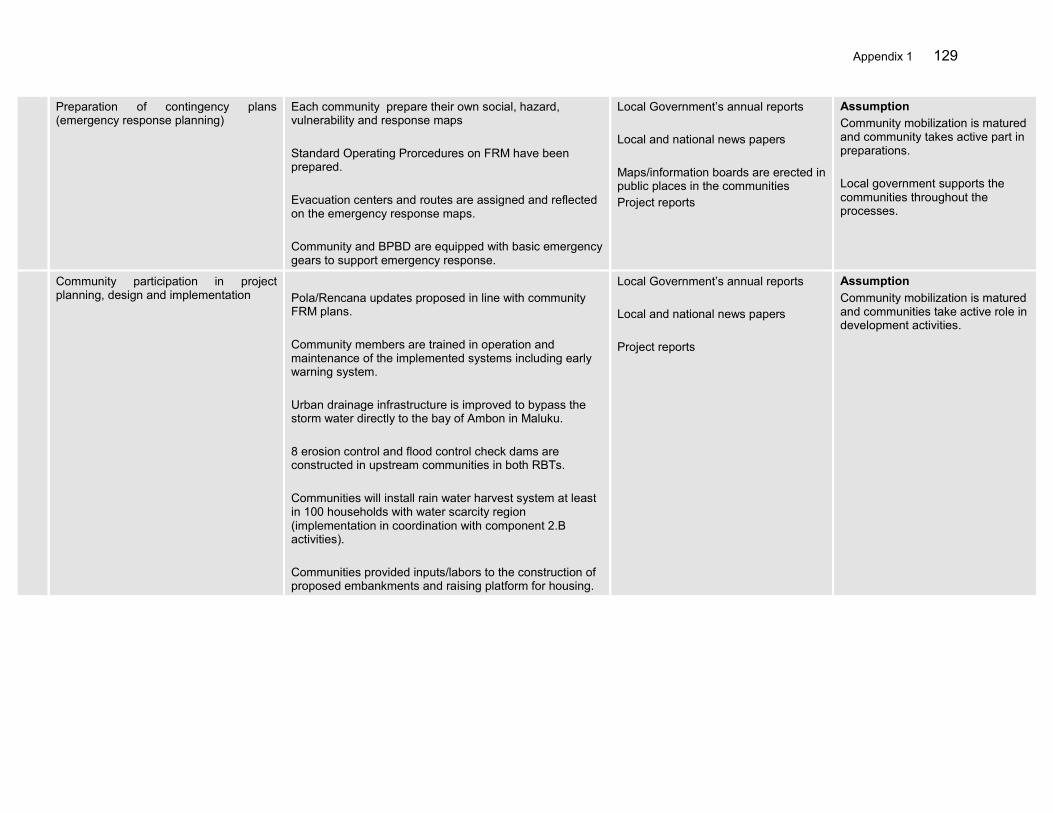
Appendix 1 129
Preparation of contingency plans (emergency response planning)
Each community prepare their own social, hazard, vulnerability and response maps Standard Operating Prorcedures on FRM have been prepared. Evacuation centers and routes are assigned and reflected on the emergency response maps. Community and BPBD are equipped with basic emergency gears to support emergency response.
Local Government’s annual reports Local and national news papers Maps/information boards are erected in public places in the communities Project reports
Assumption Community mobilization is matured and community takes active part in preparations. Local government supports the communities throughout the processes.
Community participation in project planning, design and implementation
Pola/Rencana updates proposed in line with community FRM plans. Community members are trained in operation and maintenance of the implemented systems including early warning system. Urban drainage infrastructure is improved to bypass the storm water directly to the bay of Ambon in Maluku. 8 erosion control and flood control check dams are constructed in upstream communities in both RBTs. Communities will install rain water harvest system at least in 100 households with water scarcity region (implementation in coordination with component 2.B activities). Communities provided inputs/labors to the construction of proposed embankments and raising platform for housing.
Local Government’s annual reports Local and national news papers Project reports
Assumption Community mobilization is matured and communities take active role in development activities.

130 Appendix 1
Main Activities: Procurement of consultants and NGOs Awareness raising and public preparedness Community mobilization for the establishment of CBFRM Preparation of contingency plans (emergency response planning) Community participation in project planning, design and implementation Technical capacity/skill building for Local Government, NGOs and communities on CBFRM program implementation Community based hazard, vulnerability, risk and emergency response mapping in reference to engineered maps Coordination in each community for action plan preparation, hazard and response mapping and approval of proposed activities Community participation in the construction of flood control measures Compilation of lessons learned and best practices from CBFRM
Financed by MFF USD 10.46 million Consulting Services International: 10 person-months National: 60 person-months NGO Service
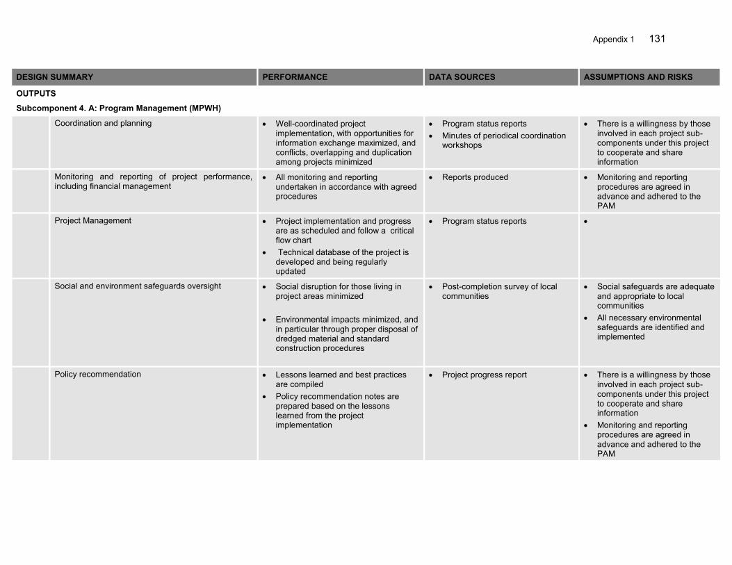
Appendix 1 131
DESIGN SUMMARY PERFORMANCE DATA SOURCES ASSUMPTIONS AND RISKS
OUTPUTS
Subcomponent 4. A: Program Management (MPWH)
Coordination and planning Well-coordinated project implementation, with opportunities for information exchange maximized, and conflicts, overlapping and duplication among projects minimized
Program status reports Minutes of periodical coordination
workshops
There is a willingness by those involved in each project sub-components under this project to cooperate and share information
Monitoring and reporting of project performance, including financial management
All monitoring and reporting undertaken in accordance with agreed procedures
Reports produced Monitoring and reporting procedures are agreed in advance and adhered to the PAM
Project Management Project implementation and progress are as scheduled and follow a critical flow chart
Technical database of the project is developed and being regularly updated
Program status reports
Social and environment safeguards oversight Social disruption for those living in project areas minimized
Environmental impacts minimized, and
in particular through proper disposal of dredged material and standard construction procedures
Post-completion survey of local communities
Social safeguards are adequate and appropriate to local communities
All necessary environmental safeguards are identified and implemented
Policy recommendation Lessons learned and best practices are compiled
Policy recommendation notes are prepared based on the lessons learned from the project implementation
Project progress report
There is a willingness by those involved in each project sub-components under this project to cooperate and share information
Monitoring and reporting procedures are agreed in advance and adhered to the PAM

132 Appendix 1
Main Activities: Coordination and planning among the project subcomponents Development of data and information systems for monitoring and data exchange Monitoring and evaluation of subcomponents performance, including financial management; Social and environment safeguards oversight Policy review and recommendation based on the outcomes of the project Media communication plan, information dissemination and implementation Quality control and quality assurance systems
Financed by MFF 3.45 Million USD Consulting Services DGWR: International: 6 person-months National: 282 person-months

Appendix 1 133
DESIGN SUMMARY PERFORMANCE DATA SOURCES ASSUMPTIONS AND RISKS
OUTPUTS 4
Sub Component 4. B: Independent Monitoring, Evaluation and Strategic Coordination BAPPENAS (IME)
A Project Performance Management System (PPMS) for the overall Roadmap investments
Project Performance Management System designed and implemented by end of month 6
Project records There is willingness by those involved in each of the project under this sector loan to cooperate and share information.
Monitoring and reporting procedures are agreed in advance and adhered to.
Consultants, local counterparts and GOI officials work together effective to prepare the documentation.
ADB and GOI requirements are made clear and do not change.
Quarterly Progress Reports giving physical and financial progress, summary of field visits, consultant’s staffing and administration details, issues of project implementation requiring immediate resolutions
Quarterly Progress Reports submitted on time and to required standard
Project records
Semi-annual Consolidated Project Report. This report will summarize: (i). the CPIU progress; field and program issues requiring resolution; (iii). detailed team work program for the next half year
Semi-annual Consolidated Project Reports submitted on time and to required standard
Project records
A mid-term review report that would summarize achievements, unresolved issues and, possibly a revised work program
Mid-term review report submitted by the end of month18 and to required standard
Project records
Completion report Completion report submitted 2 months prior to project closure and to required standard
Project records
Main Activities: Conduct Monitoring and evaluation of the project related physical and financial processes as well as the effectiveness and efficiency in
achieving major outputs, outcomes and impact Review and reporting of project progress to NSCWR, and inter-agency program planning and coordination Establish a Project Performance Management System for the overall investments Monitor the level and adequacy of participation of various stakeholders in the planning, implementing and monitoring of project activities Monitor the project’s social, environmental, and economic impacts, including the establishment of benchmark using existing government
information and data systems Developing a mechanism for making necessary adjustments in the project design and implementation arrangements Compile the lessons learned and best practice examples from the experience of project implementation
Prepare a national flood risk management strategy and policy framework for nationwide implementation
Financing USD 1.65 million Consulting Services International: 6 person-months National: 208 person-months
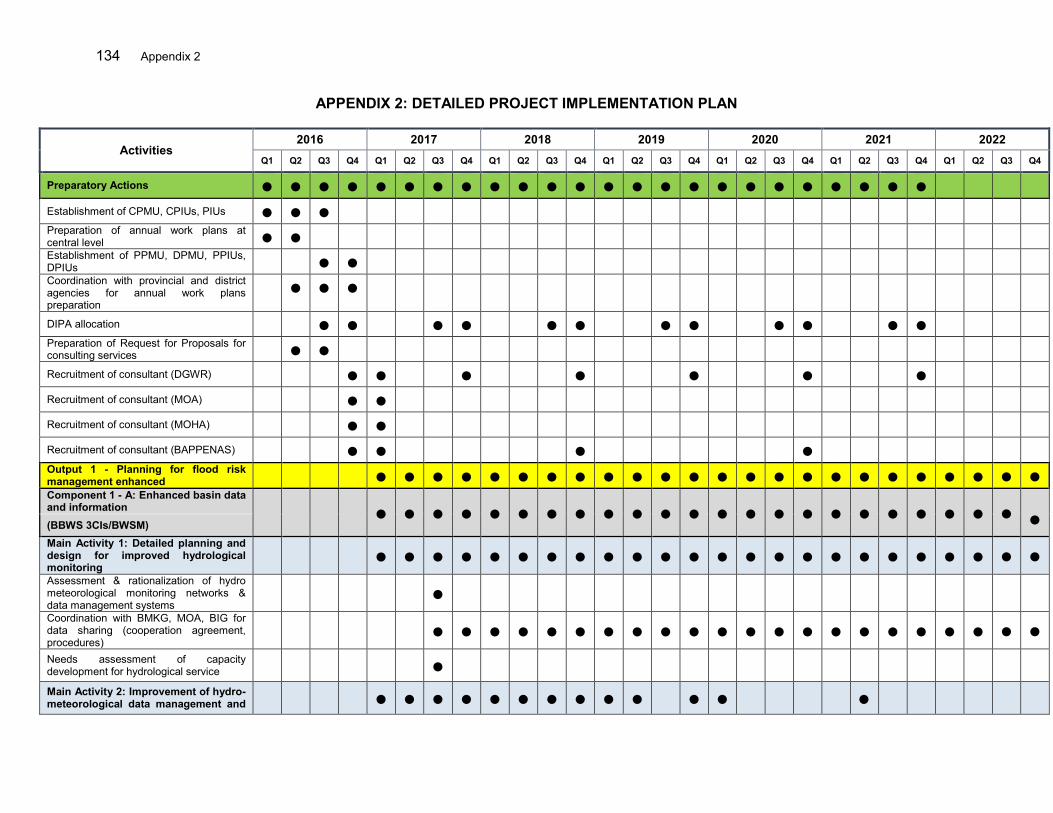
134 Appendix 2
APPENDIX 2: DETAILED PROJECT IMPLEMENTATION PLAN
Activities 2016 2017 2018 2019 2020 2021 2022
Q1 Q2 Q3 Q4 Q1 Q2 Q3 Q4 Q1 Q2 Q3 Q4 Q1 Q2 Q3 Q4 Q1 Q2 Q3 Q4 Q1 Q2 Q3 Q4 Q1 Q2 Q3 Q4
Preparatory Actions ● ● ● ● ● ● ● ● ● ● ● ● ● ● ● ● ● ● ● ● ● ● ● ●
Establishment of CPMU, CPIUs, PIUs ● ● ●
Preparation of annual work plans at central level ● ●
Establishment of PPMU, DPMU, PPIUs, DPIUs ● ●
Coordination with provincial and district agencies for annual work plans preparation
● ● ●
DIPA allocation ● ● ● ● ● ● ● ● ● ● ● ●
Preparation of Request for Proposals for consulting services ● ●
Recruitment of consultant (DGWR) ● ● ● ● ● ● ●
Recruitment of consultant (MOA) ● ●
Recruitment of consultant (MOHA) ● ●
Recruitment of consultant (BAPPENAS) ● ● ● ●
Output 1 - Planning for flood risk management enhanced ● ● ● ● ● ● ● ● ● ● ● ● ● ● ● ● ● ● ● ● ● ● ● ● Component 1 - A: Enhanced basin data and information ● ● ● ● ● ● ● ● ● ● ● ● ● ● ● ● ● ● ● ● ● ● ●
● (BBWS 3CIs/BWSM) Main Activity 1: Detailed planning and design for improved hydrological monitoring
● ● ● ● ● ● ● ● ● ● ● ● ● ● ● ● ● ● ● ● ● ● ● ●
Assessment & rationalization of hydro meteorological monitoring networks & data management systems
●
Coordination with BMKG, MOA, BIG for data sharing (cooperation agreement, procedures)
● ● ● ● ● ● ● ● ● ● ● ● ● ● ● ● ● ● ● ● ● ●
Needs assessment of capacity development for hydrological service ●
Main Activity 2: Improvement of hydro-meteorological data management and ● ● ● ● ● ● ● ● ● ● ● ● ●
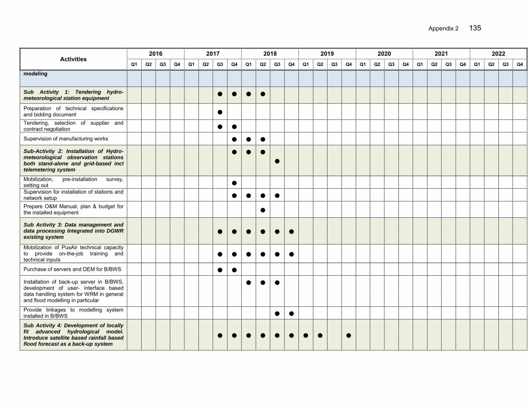
Appendix 2 135
Activities 2016 2017 2018 2019 2020 2021 2022
Q1 Q2 Q3 Q4 Q1 Q2 Q3 Q4 Q1 Q2 Q3 Q4 Q1 Q2 Q3 Q4 Q1 Q2 Q3 Q4 Q1 Q2 Q3 Q4 Q1 Q2 Q3 Q4
modeling
Sub Activity 1: Tendering hydro-meteorological station equipment
● ● ● ●
Preparation of technical specifications and bidding document ●
Tendering, selection of supplier and contract negotiation ● ●
Supervision of manufacturing works ● ● ●
Sub-Activity 2: Installation of Hydro-meteorological observation stations both stand-alone and grid-based incl telemetering system
● ● ●
●
Mobilization, pre-installation survey, setting out ●
Supervision for installation of stations and network setup ● ● ● ●
Prepare O&M Manual, plan & budget for the installed equipment ●
Sub Activity 3: Data management and data processing Integrated into DGWR existing system
● ● ● ● ● ●
Mobilization of PusAir technical capacity to provide on-the-job training and technical inputs
● ● ● ● ● ●
Purchase of servers and DEM for B/BWS ● ●
Installation of back-up server in B/BWS, development of user- interface based data handling system for WRM in general and flood modelling in particular
● ● ●
Provide linkages to modelling system installed in B/BWS ● ●
Sub Activity 4: Development of locally fit advanced hydrological model. Introduce satellite based rainfall based flood forecast as a back-up system
● ● ● ● ● ● ● ● ●
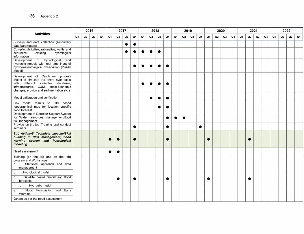
136 Appendix 2
Activities 2016 2017 2018 2019 2020 2021 2022
Q1 Q2 Q3 Q4 Q1 Q2 Q3 Q4 Q1 Q2 Q3 Q4 Q1 Q2 Q3 Q4 Q1 Q2 Q3 Q4 Q1 Q2 Q3 Q4 Q1 Q2 Q3 Q4
Surveys and data collection (secondary data/parameters) ● ●
Compile, digitalize, rationalize, verify and centralize existing hydrological information
● ● ● ● ●
Development of hydrological and hydraulic models with real time input of hydro-meteorological observation (PusAir Model)
● ● ● ● ●
Development of Catchment process Model to simulate the entire river basin with different variables (land-use, infrastructures, O&M, socio-economic changes, erosion and sedimentation etc.)
● ● ● ●
Model calibration and verification ● ● ●
Link model results to GIS based topographical map for location specific flood forecast
● ●
Development of Decision Support System for Water resources management/flood risk management
● ● ●
Provide on-the-job Training and conduct seminars ● ● ●
Sub Activity5: Technical capacity/Skill building in data management, flood warning system and hydrological modeling
● ● ● ● ● ●
Need assessment ● ●
Training (on the job and off the job) program and Workshops
● ● ● ● ●
a. Statistical approach and data management
b. Hydrological model c. Satellite based rainfall and flood
forecasts d. Hydraulic model
e. Flood Forecasting and Early Warning
Others as per the need assessment
Appendix 2 137
Activities 2016 2017 2018 2019 2020 2021 2022
Q1 Q2 Q3 Q4 Q1 Q2 Q3 Q4 Q1 Q2 Q3 Q4 Q1 Q2 Q3 Q4 Q1 Q2 Q3 Q4 Q1 Q2 Q3 Q4 Q1 Q2 Q3 Q4
Main Activity 3: Hazard, vulnerability, risk and emergency response mapping.
● ● ● ● ● ● ●
Surveys and data collection on hazard, exposure, vulnerability and local capacity ● ● ●
Methodology (Indexing) and risk assessment framework development ● ●
Develop GIS based maps (Hazard) for the entire river basin and large scale maps for areas of interest in close collaboration with MOHA for Exposure, Vulnerability and Risk mapping (Numerical modelling, GIS, historical and community based)
● ● ● ● ●
Map production and dissemination among agencies and community concerned ● ● ●
Trainings and seminar (FR mapping and status) ● ●
Main Activity 4: Preparation of flood risk management plans ● ● ● ● ● ● ● ● ● ● ● ● ● ● ● ● ● ● ● ● ● ●
Stakeholder consultations (PCM) including with the basin coordination council/forum
● ● ● ● ● ● ● ● ● ● ● ● ● ● ● ● ● ● ● ● ● ●
Prepare an flood risk management plan for the entire river basin (jointly with MOHA) including social, environmental, technical and economic baseline surveys
● ● ● ●
Prepare recommendation for spatial plan improvement, financing and required regulations including in two additional basins
● ● ● ●
Coordination and institutional strengthening of the basin coordination forum for inclusion into the RENCANA and implementation
● ● ● ● ● ● ● ● ● ● ● ● ● ● ● ● ● ● ● ● ● ●
Local government endorsement/regulation on spatial plan including riparian zone regulation
● ●
Integration of FRM plans into regional development plan ● ● ● ●
Reflect these changes in the annual action plans of the local government ● ● ● ●
138 Appendix 2
Activities 2016 2017 2018 2019 2020 2021 2022
Q1 Q2 Q3 Q4 Q1 Q2 Q3 Q4 Q1 Q2 Q3 Q4 Q1 Q2 Q3 Q4 Q1 Q2 Q3 Q4 Q1 Q2 Q3 Q4 Q1 Q2 Q3 Q4
Reporting *Emergency action plan and training. ● ● ● ●
Replication of know how of FRM planning from 3Cis and Ambon-Seram ton two additional/potential reiver basins to be selected during project implementation
● ● ● ● ● ● ● ● ● ● ● ● ● ●
Component 1 - B: Enhanced basin information dissemination, planning and coordination (MOHA)
● ● ● ● ● ● ● ● ● ● ● ● ● ● ● ● ● ● ● ● ● ● ● ●
Main Activity 1. Establishment of flood communication procedures ● ● ● ● ● ● ● ● ● ● ● ● ● ● ● ● ● ● ● ● ● ●
Preparation of communication and outreach strategy for flood risk management
● ● ● ● ● ●
Dissemination of hazard maps for public use and disaster management procedures
● ● ● ●
Announcement/dissemination/public awareness on revised spatial plan/regional development and land use management
● ● ●
Flood information system at local government (for public: information, tips and tools, update activities etc.) jointly by BWS and BPBD to raise awareness in normal time
● ● ● ● ● ● ● ● ● ● ● ● ● ● ● ● ● ● ● ● ● ●
Strengthening the disaster management communication system within line agencies/effective implementation of SOP, if any exist
● ● ● ● ● ● ● ● ● ● ● ● ● ● ● ● ● ● ● ●
Main Activity 2. Institutional strengthening and technical capacity building.
● ● ● ● ● ● ● ● ● ● ● ● ● ● ● ● ● ● ● ● ● ● ● ●
Establishment of coordination teams ● ●
Regular meeting of coordination body and consultations with public and line-agencies
● ● ● ● ● ● ● ● ● ● ● ● ● ● ● ● ●
Support to prepare district annual work plan to mainstream FRMP ● ● ● ● ● ● ●
Exposure activities (best practice examples) ● ● ●
Training of Trainers (MOHA/Provincial and local governments) ● ● ●
Appendix 2 139
Activities 2016 2017 2018 2019 2020 2021 2022
Q1 Q2 Q3 Q4 Q1 Q2 Q3 Q4 Q1 Q2 Q3 Q4 Q1 Q2 Q3 Q4 Q1 Q2 Q3 Q4 Q1 Q2 Q3 Q4 Q1 Q2 Q3 Q4
Technical capacity building for relevant agencies mainly BPBD, and Provincial/District Water Resources agency in overall FRM.
● ● ● ● ● ● ● ● ● ● ● ● ● ● ● ● ● ● ● ● ● ● ●
Institutional development, technical capacity and good Governance in MOHA Provincial and local governments. in FRM (involve River Basin Coordination Council/forum-)
● ● ● ● ● ● ● ● ● ● ● ● ● ● ● ● ● ● ● ● ● ● ●
Support coordination of LAR activities with provincial and district agencies (BAPPEDA, social, human settlement and housing)
● ● ● ● ● ● ● ● ● ● ● ● ● ● ● ● ● ● ● ● ● ●
Compilation of existing provincial and district development plans and flood related regulations
● ●
Hazard, vulnerability, risk and emergency response mapping at district/city and community levels (with support from B/BWS)
● ●
Preparation of district flood risk management plans (FRMPs) through participatory process
● ● ●
Legalization/integration of FRM plans and recommendations ●
Support the preparation of inter-sectoral infrastructure policies, urban development and spatial plan
● ● ●
Legalization of amended spatial plan document with inclusion of FRMP ● ●
Preparation of building codes for flood prone areas, River corridor and Land use regulation
● ●
Reflect these changes in the annual action plans of the local governments ● ● ● ●
Reporting ● ● ● ● ● ● ●
Output 2 - Land management improved and flood Infrastructure upgraded ● ● ● ● ● ● ● ● ● ● ● ● ● ● ● ● ● ● ● ● ● ● ● ●
Component 2A: Upper farmland management including agro-forestry, slope stabilization and sustainable agriculture practices (MOA)
● ● ● ● ● ● ● ● ● ● ● ● ● ● ● ● ● ● ● ● ● ● ●
140 Appendix 2
Activities 2016 2017 2018 2019 2020 2021 2022
Q1 Q2 Q3 Q4 Q1 Q2 Q3 Q4 Q1 Q2 Q3 Q4 Q1 Q2 Q3 Q4 Q1 Q2 Q3 Q4 Q1 Q2 Q3 Q4 Q1 Q2 Q3 Q4
Main Activity 1: Detailed planning and design of Interventions ● ● ● ● ● ●
Conduct PRA for the identification of farmer groups to be supported by project ●
Socialization in local communities and formation of farmers groups ● ●
Farmers trainings on soil/ water conservation/sustainable agriculture practices
● ●
Identification and Provision of suitable and local plants for vegetation activities and equipment
● ● ● ●
Preparation of the monitoring and evaluation system based on GIS system ● ● ●
Prepare a study on erosion and soil conservation in the Ciujung river basin ● ● ●
Main Activity 2: Implementation of land and water conservation activities ● ● ● ● ● ● ● ● ● ● ● ● ● ● ● ● ● ● ● ● ● ● ●
Integrated Land Conservation Conversion of land/preparation for agriculture (terracing) ● ● ● ●
Purchasing and cultivation of plants (Multi-purpose Trees) and fertilizers ● ● ● ● ● ● ● ● ● ● ● ● ● ●
Construction of buffalo sheds and compost structures ● ●
Purchasing of and uffalos and farm equipment/tractors ● ● ●
Construction of farm ponds and erosion control structures ● ● ● ● ● ● ●
Rehabilitation of farm irrigation canals and construction of infiltration wells ● ● ● ● ● ● ●
Provision of postharvest processing equipment for the 3 pilots ● ● ● ●
Exposure activities (best practice examples) ● ●
Construction of the field training centers ● ● ●
Training of Trainers (MOA/Provincial and local governments) ● ● ●

Appendix 2 141
Activities 2016 2017 2018 2019 2020 2021 2022
Q1 Q2 Q3 Q4 Q1 Q2 Q3 Q4 Q1 Q2 Q3 Q4 Q1 Q2 Q3 Q4 Q1 Q2 Q3 Q4 Q1 Q2 Q3 Q4 Q1 Q2 Q3 Q4
Technical capacity building for relevant agencies mainly DINAS- Agriculture (province/district)
● ● ● ● ● ● ● ● ● ● ● ● ●
Institutional development, technical capacity and good Governance in MOA Provincial and local governments. in FRM
● ● ● ● ● ● ● ● ● ● ● ● ●
Rehabilitation, Operation and maintenance of Agro-forestry activities and farms
● ● ● ● ● ● ● ● ● ● ● ● ● ● ● ● ● ● ● ● ● ● ●
Reporting ● ● ● ● ● ● ● ● Component 2B: Improved runoff and erosion control in 3Cis RBT and Ambon-Seram RBT (MOHA)
● ● ● ● ● ● ● ● ● ● ● ● ● ● ● ● ● ● ● ● ● ● ● ●
Main Activity 1. Implementation of project activities (Landslide treatment, rain water harvesting at farm)
● ● ● ● ● ● ● ● ● ● ● ● ● ● ● ● ● ● ● ● ● ●
Revitalization/formation of community group ● ● ● ● ● ●
Land clearance at landslide areas ● ● ● ● ● ● ● ● ●
Purchasing of gabion wires and masonry ● ● ● ● ● ● ● ●
Bio-engineering (Purchasing the seedlings and plantation) ● ● ● ● ● ● ● ● ● ● ● ● ● ● ● ● ●
Construction of hill-slope drainages ● ● ● ● ● ● ● ● ●
Construction of multi-purpose flood retention ponds ● ● ● ● ● ●
Main Activity 2. Institutional strengthening and technical capacity building.
● ● ● ● ● ● ● ● ● ● ● ● ● ● ● ● ● ● ● ● ● ● ● ●
Establishment of coordination team ● ●
Regular meeting of coordination body and consultations with public and line-agencies
● ● ● ● ● ● ● ● ● ● ● ● ● ● ● ● ● ● ● ● ● ● ●
Exposure activities (best practice examples) ● ● ●
Training of Trainers (MOHA/Provincial and local governments) ● ● ●
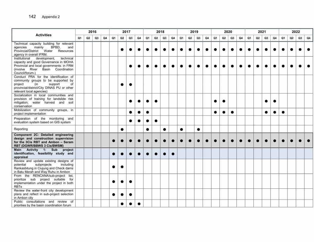
142 Appendix 2
Activities 2016 2017 2018 2019 2020 2021 2022
Q1 Q2 Q3 Q4 Q1 Q2 Q3 Q4 Q1 Q2 Q3 Q4 Q1 Q2 Q3 Q4 Q1 Q2 Q3 Q4 Q1 Q2 Q3 Q4 Q1 Q2 Q3 Q4
Technical capacity building for relevant agencies mainly BPBD, and Provincial/District Water Resources agency in overall IFRM.
● ● ● ● ● ● ● ● ● ● ● ● ● ● ● ● ● ● ● ● ● ● ●
Institutional development, technical capacity and good Governance in MOHA Provincial and local governments. in FRM (involve River Basin Coordination Council/forum-)
● ● ● ● ● ● ● ● ● ● ● ● ● ● ● ● ● ● ● ● ● ●
Conduct PRA for the identification of community groups to be supported by project (in support of provincial/district/City DINAS PU or other relevant local agencies)
● ●
Socialization in local communities and provision of training for landslide risk mitigation, water harvest and soil conservation
● ● ● ● ● ● ● ●
Mobilization of community groups, in project implementation ● ● ● ● ● ● ● ● ●
Preparation of the monitoring and evaluation system based on GIS system ● ● ● ●
Reporting ● ● ● ● ●
Component 2C: Detailed engineering design and construction supervision for the 3Cis RBT and Ambon – Seram RBT (DGWR/BBWS 3 Cis/BWSM)
● ● ● ● ● ● ● ● ● ● ● ● ● ● ● ● ● ● ● ● ● ● ● ●
Main Activity 1: Sub project identification, feasibility study and appraisal
● ● ● ● ● ● ● ●
Review and update existing designs of potential subprojects including Rankasbitung in Ciujung and Check dams in Batu Merah and Way Ruhu in Ambon
● ●
From the RENCANA/sub-project list, prioritize sub project suitable for implementation under the project in both RBTs
● ● ●
Review the water-front city development plans and reflect in sub-project selection in Ambon city
● ● ●
Public consultations and review of priorities by the basin coordination forum ● ● ●
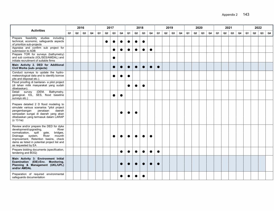
Appendix 2 143
Activities 2016 2017 2018 2019 2020 2021 2022
Q1 Q2 Q3 Q4 Q1 Q2 Q3 Q4 Q1 Q2 Q3 Q4 Q1 Q2 Q3 Q4 Q1 Q2 Q3 Q4 Q1 Q2 Q3 Q4 Q1 Q2 Q3 Q4
Prepare feasibility studies including technical, economic, safeguards aspects of prioritize sub-projects
● ● ● ● ● ●
Appraise and confirm sub project for submission to ADB ● ● ● ● ● ●
Prepare TOR for surveys (bathymetry) and sub contracts (IOL/SES/AMDAL) and initiate recruitment of suitable firms
●
Main Activity 2. DED for Additional Civil Works (sub- projects) ● ● ● ● ● ● ●
Conduct surveys to update the hydro-meteorological data and to identify borrow pits and disposal etc.).
● ● ●
Flood proofing di bantaran- a pilot project (di lahan milik masyarakat yang sudah dibebaskan).
● ● ●
Detail survey (DEM, Bathymetry, geological, IOL, SES, flood baseline surveys etc.)
● ●
Prepare detailed 2 D flood modeling to simulate various scenarios *pilot project pengembangan penataan daerah sempadan sungai di daerah yang akan dibebaskan yang termasuk dalam LARAP (± 13 ha)
● ● ●
Review and/or prepare the DED for dyke development/upgrading, River normalization, spill gate, bridges, Drainage system, River mounth improvement, Retention basins, check dams as listed in potential project list and as requested by EA
● ● ● ● ● ●
Prepare bidding documents (specification, tendering and BOQ) ● ● ● ● ● ●
Main Activity 3: Environment Initial Examination (EIE)-Env. Monitoring, Planning & Management (UKL/UPL) and/or AMDAL
● ● ● ● ● ●
Preparation of required environmental safeguards documentation ● ● ● ●

144 Appendix 2
Activities 2016 2017 2018 2019 2020 2021 2022
Q1 Q2 Q3 Q4 Q1 Q2 Q3 Q4 Q1 Q2 Q3 Q4 Q1 Q2 Q3 Q4 Q1 Q2 Q3 Q4 Q1 Q2 Q3 Q4 Q1 Q2 Q3 Q4
Consultation and approval by related environment agency ● ● ● ●
Submission to ADB ● ● ● ●
Main Activity 4: Social safeguard preparation and implementation ● ● ● ● ● ● ● ● ● ● ●
Data processing of IOL/SES survey ● ● ● ● ● ●
Preparation of RESETTLEMENT PLAN as per RESETTLEMENT FRAMEWORK and submission to ADB for approval
● ● ● ● ● ● ●
Support the IA to coordinate with related provincial and district agencies to implement the RESETTLEMENT PLAN
● ● ● ● ● ● ● ●
Main Activity 5: Construction Supervision ● ● ● ● ● ● ● ● ● ● ● ● ● ● ● ● ● ● ● ● ● ● ● Construction supervision of core project works in Ciujung ● ● ● ● ● ● ● ● ● ● ●
Construction supervision of check dams in Ambon ● ● ● ● ● ● ● ● ● ● ● ● ● ● ● ● ● ● ● ● Supervision of other work to be implemented (Sub-projects) ● ● ● ● ● ● ● ● ● ● ● ● ● ● ● ●
Reporting ● ● ● ● ●
Component 2D: Construction of flood control measures ● ● ● ● ● ● ● ● ● ● ● ● ● ● ● ● ● ● ● ● ● ● ● ●
Sub Component D.1: Construction of flood control embankments, drainage system and associated control structures (BBWS 3CIs)
● ● ● ● ● ● ● ● ● ● ● ● ● ● ● ● ● ● ● ● ● ● ● ●
Main Activity 1. Urgent work for upgrading of the Ciujung embankment system (11km)
● ● ● ● ● ● ● ● ● ● ● ●
Implementation of the AMDAL ● ●
Land acquisition: RESETTLEMENT FRAMEWORK - RESETTLEMENT PLAN Approval by GOI
●
Establishment of the Preparatory Committee for LA ●
Determination of Location Process for LA ● ● ●
Implementation of RESETTLEMENT PLAN ● ● ● ● ● ●
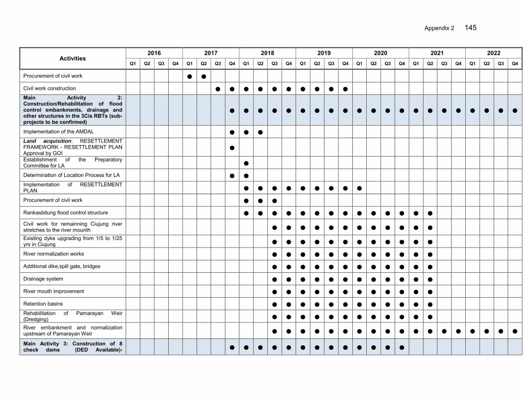
Appendix 2 145
Activities 2016 2017 2018 2019 2020 2021 2022
Q1 Q2 Q3 Q4 Q1 Q2 Q3 Q4 Q1 Q2 Q3 Q4 Q1 Q2 Q3 Q4 Q1 Q2 Q3 Q4 Q1 Q2 Q3 Q4 Q1 Q2 Q3 Q4
Procurement of civil work ● ●
Civil work construction ● ● ● ● ● ● ● ● ● ●
Main Activity 2: Construction/Rehabilitation of flood control embankments, drainage and other structures in the 3Cis RBTs (sub-projects to be confirmed)
● ● ● ● ● ● ● ● ● ● ● ● ● ● ● ● ● ● ● ● ●
Implementation of the AMDAL ● ● ●
Land acquisition: RESETTLEMENT FRAMEWORK - RESETTLEMENT PLAN Approval by GOI
●
Establishment of the Preparatory Committee for LA ●
Determination of Location Process for LA ● ●
Implementation of RESETTLEMENT PLAN ● ● ● ● ● ● ● ● ●
Procurement of civil work ● ● ●
Rankasbitung flood control structure ● ● ● ● ● ● ● ● ● ● ● ● ● ●
Civil work for remainning Ciujung river stretches to the river mounth ● ● ● ● ● ● ● ● ● ● ● ●
Existing dyke upgrading from 1/5 to 1/25 yrs in Ciujung ● ● ● ● ● ● ● ● ● ● ● ●
River normalization works ● ● ● ● ● ● ● ● ● ● ● ●
Additional dike,spill gate, bridges ● ● ● ● ● ● ● ● ● ● ● ●
Drainage system ● ● ● ● ● ● ● ● ● ● ● ●
River mouth improvement ● ● ● ● ● ● ● ● ● ● ● ●
Retention basins ● ● ● ● ● ● ● ● ● ● ● ●
Rehabilitation of Pamarayan Weir (Dredging) ● ● ● ● ● ● ● ● ● ● ● ●
River embankment and normalization upstream of Pamarayan Weir ● ● ● ● ● ● ● ● ● ● ● ● ● ● ● ● ● ●
Main Activity 3: Construction of 8 check dams (DED Available)- ● ● ● ● ● ● ● ● ● ● ● ● ●

146 Appendix 2
Activities 2016 2017 2018 2019 2020 2021 2022
Q1 Q2 Q3 Q4 Q1 Q2 Q3 Q4 Q1 Q2 Q3 Q4 Q1 Q2 Q3 Q4 Q1 Q2 Q3 Q4 Q1 Q2 Q3 Q4 Q1 Q2 Q3 Q4
Subprojects to be confirmed
Preparation and approval of the AMDAL ● ● ●
Land acquisition: RESETTLEMENT FRAMEWORK - RESETTLEMENT PLAN Approval by GOI
●
Establishment of the Preparatory Committee for LA ●
Determination of Location Process for LA ● ●
Implementation of RESETTLEMENT PLAN ● ● ● ●
Procurement of civil work ● ● ●
Construction of 5 check dams in Ciujung's tributaries 0 ● ● ● ● ● ● ●
Sub Component D. 2: Construction of flood control embankments, drainage system and associated control structures in Ambon (BWSM)
● ● ● ● ● ● ● ● ● ● ● ● ● ● ● ● ● ● ● ● ● ● ● ●
Main Activity 1: Construction of check dams, and small retention ponds in Batu Merah and Way Ruhu river basins ● ● ● ● ● ● ● ● ●
Preparation and approval of the AMDAL ● ● ● ● ● ●
Preparation and implementation of LARAP ● ● ● ●
Land acquisition: RESETTLEMENT FRAMEWORK - RESETTLEMENT PLAN Approval by GOI
●
Establishment of the Preparatory Committee for LA ●
Determination of Location Process for LA ● ●
Implementation of RESETTLEMENT PLAN ● ● ●
Procurement of civil work ● ●
Construction 4x2=8 check dams and rehabilitation existing check dams (Batu Merah and Way Ruhu River Basins)
● ● ● ● ● ●
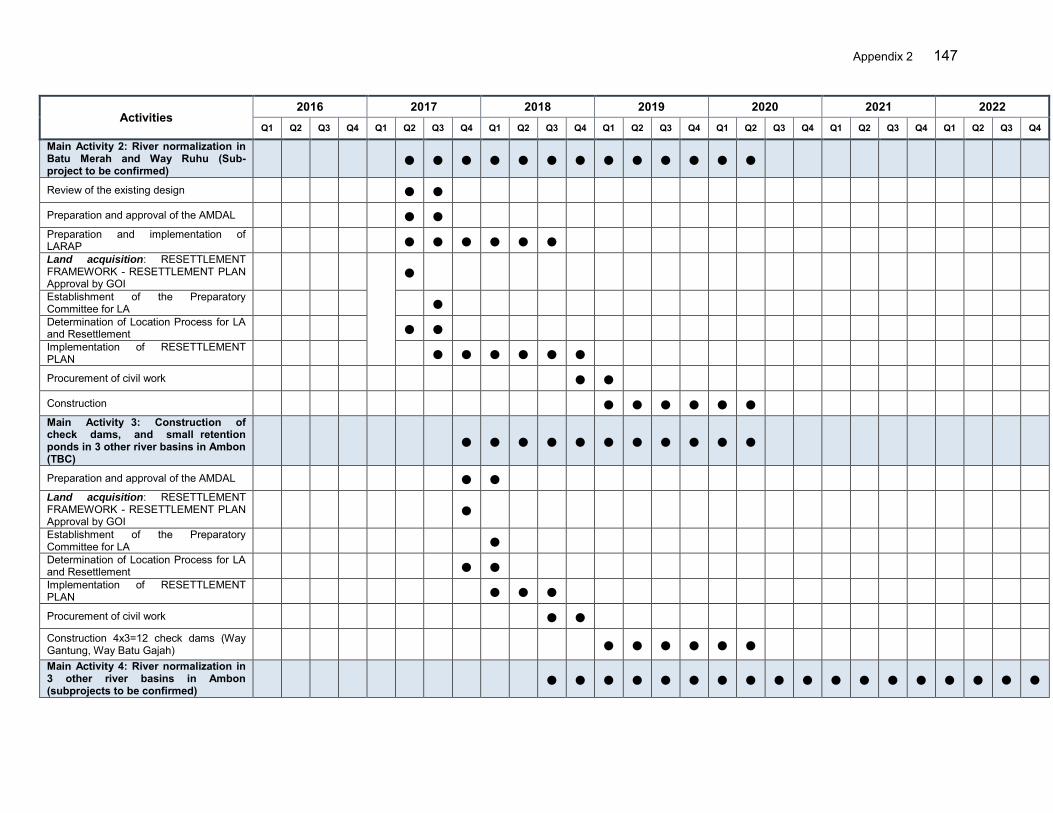
Appendix 2 147
Activities 2016 2017 2018 2019 2020 2021 2022
Q1 Q2 Q3 Q4 Q1 Q2 Q3 Q4 Q1 Q2 Q3 Q4 Q1 Q2 Q3 Q4 Q1 Q2 Q3 Q4 Q1 Q2 Q3 Q4 Q1 Q2 Q3 Q4
Main Activity 2: River normalization in Batu Merah and Way Ruhu (Sub-project to be confirmed)
● ● ● ● ● ● ● ● ● ● ● ● ●
Review of the existing design ● ●
Preparation and approval of the AMDAL ● ●
Preparation and implementation of LARAP ● ● ● ● ● ●
Land acquisition: RESETTLEMENT FRAMEWORK - RESETTLEMENT PLAN Approval by GOI
●
Establishment of the Preparatory Committee for LA ●
Determination of Location Process for LA and Resettlement ● ●
Implementation of RESETTLEMENT PLAN ● ● ● ● ● ●
Procurement of civil work ● ●
Construction ● ● ● ● ● ●
Main Activity 3: Construction of check dams, and small retention ponds in 3 other river basins in Ambon (TBC)
● ● ● ● ● ● ● ● ● ● ●
Preparation and approval of the AMDAL ● ●
Land acquisition: RESETTLEMENT FRAMEWORK - RESETTLEMENT PLAN Approval by GOI
●
Establishment of the Preparatory Committee for LA ●
Determination of Location Process for LA and Resettlement ● ●
Implementation of RESETTLEMENT PLAN ● ● ●
Procurement of civil work ● ●
Construction 4x3=12 check dams (Way Gantung, Way Batu Gajah) ● ● ● ● ● ●
Main Activity 4: River normalization in 3 other river basins in Ambon (subprojects to be confirmed)
● ● ● ● ● ● ● ● ● ● ● ● ● ● ● ● ● ●
148 Appendix 2
Activities 2016 2017 2018 2019 2020 2021 2022
Q1 Q2 Q3 Q4 Q1 Q2 Q3 Q4 Q1 Q2 Q3 Q4 Q1 Q2 Q3 Q4 Q1 Q2 Q3 Q4 Q1 Q2 Q3 Q4 Q1 Q2 Q3 Q4
Review OR prepare the detailed engineering design ● ● ● ●
Preparation and approval of the AMDAL ● ● ●
Preparation and implementation of LARAP ● ● ● ● ● ● ●
Land acquisition: RESETTLEMENT FRAMEWORK - RESETTLEMENT PLAN Approval by GOI
●
Establishment of the Preparatory Committee for LA ●
Determination of Location Process for LA and Resettlement ● ●
Implementation of RESETTLEMENT PLAN ● ● ● ● ● ●
Procurement of civil work ● ● ● ●
Construction ● ● ● ● ● ● ● ● ● Main Activity 5: Flood control works in other river basins in Ambon-Seram RBT (subprojects to be confirmed)
● ● ● ● ● ● ● ● ● ● ● ● ● ● ● ● ● ●
Review or prepare the detailed engineering design ● ● ● ●
Preparation and approval of the AMDAL ● ● ●
Land acquisition: RESETTLEMENT FRAMEWORK - RESETTLEMENT PLAN Approval by GOI
●
Establishment of the Preparatory Committee for LA ●
Determination of Location Process for LA and Resettlement ● ●
Implementation of RESETTLEMENT PLAN ● ● ● ● ●
Procurement of civil work ● ● ● ●
Construction ● ● ● ● ● ● ● ● ● Output 3. Capacity for community-based flood risk management (CBFRM) enhanced
● ● ● ● ● ● ● ● ● ● ● ● ● ● ● ● ● ● ● ● ● ● ● ●
Component 3A: Enhanced capacity for community in flood risk management-CBFRM (MOHA)
● ● ● ● ● ● ● ● ● ● ● ● ● ● ● ● ● ● ● ● ● ● ●
Appendix 2 149
Activities 2016 2017 2018 2019 2020 2021 2022
Q1 Q2 Q3 Q4 Q1 Q2 Q3 Q4 Q1 Q2 Q3 Q4 Q1 Q2 Q3 Q4 Q1 Q2 Q3 Q4 Q1 Q2 Q3 Q4 Q1 Q2 Q3 Q4
Main Activity 1: Awareness Raising and Public Preparedness ● ● ● ● ● ● ● ● ●
Trainings of trainers for NGOs and Volunteers ● ● ● ●
Non-formal education on FRM for public (Camp.) ● ● ● ● ●
Main Activity 2. CBFRM Community Mobilization ● ● ● ● ● ● ● ● ● ● ● ● ● ● ● ● ● ● ● ● ● ● ● ●
Procurement of NGO services ●
Mobilization of facilitators ●
Identification of areas to be targeted by the CBFRM program ●
Community Mobilization:
Community awareness campaign ● ● ● ● ●
Community Organizations/regular meetings ● ● ● ● ● ● ● ● ● ● ● ● ● ● ● ● ● ● ●
Skill development trainings for communities ● ● ● ● ● ● ●
Gender mainstreaming ● ● ● ● ● ● ● ● ● ● ● ● ● ● ● ● ● ● ●
CBFRM activities (drainage, preparedness, risk mapping etc.) ● ● ● ● ● ● ● ● ● ● ● ● ● ● ● ● ●
Preparation of CBFRM guidelines ● ●
Community annual action plan preparation ● ● ● ● ●
Main Activity 3. Preparation of contingency plans (emergency response planning)
● ● ● ● ● ● ● ● ● ● ● ●
Identification of areas to be targeted by the CBFRM program ●
Community based social, hazard, response maps ● ●
SOP preparation by community ● ●
Allocation and improvement of evacuation centers ● ● ●
Establishment of CBEW and Evacuation provisions ● ● ● ●
Formulation of contingency plan and amendments ● ● ● ●

150 Appendix 2
Activities 2016 2017 2018 2019 2020 2021 2022
Q1 Q2 Q3 Q4 Q1 Q2 Q3 Q4 Q1 Q2 Q3 Q4 Q1 Q2 Q3 Q4 Q1 Q2 Q3 Q4 Q1 Q2 Q3 Q4 Q1 Q2 Q3 Q4
Emergency drills ● ● ● ● ●
Purchasing of emergency gears for comm./local gvt ● ●
Main Activity 4. Community participation in project planning, design and implementation
● ● ● ● ● ● ● ● ● ● ● ● ● ● ● ● ● ● ● ●
●
Discussion on FRMPs and identification of community needs (solid waste management, small drainage system etc,)
● ● ● ● ● ●
Planning of small structural interventions ● ● ● ● ● ●
Community participation in project implementation ● ● ● ● ● ● ● ● ● ● ● ● ● ● ● ● ● ● ●
Participate in project M&E ● ●
Main Activity 5 : Safeguards Implementation ● ● ● ●
Prepare UKL / UPL for installation works ● ●
Environmental Management Plan Implementation ● ●
Main Activity 6 : Reporting ● ● ● ● ●
Output 4. Policy, coordination and capacity at national level improved ● ● ● ● ● ● ● ● ● ● ● ● ● ● ● ● ● ● ● ● ● ● ● ●
Component 4A: Project Management (DGWR) ● ● ● ● ● ● ● ● ● ● ● ● ● ● ● ● ● ● ● ● ● ● ● ● Main Activity 1: Overall project management ● ● ● ● ● ● ● ● ● ● ● ● ● ● ● ● ● ● ● ● ● ● ● ●
Oversee the progress of all components ● ● ● ● ● ● ● ● ● ● ● ● ● ● ● ● ● ● ● ● ● ● ● ● Prepare supporting documents, submit any reporting requirements, including the annual report and financial statements, and establish and maintain the imprest account
● ● ● ● ● ● ● ● ● ● ● ● ● ● ● ● ● ● ● ● ● ● ● ●
Day-to-day project implementation, planning and budgeting, procurement, disbursement, monitoring, reporting
● ● ● ● ● ● ● ● ● ● ● ● ● ● ● ● ● ● ● ● ● ● ● ●
Prepare withdrawal application and ensure compliance with loan covenants ● ● ● ● ● ● ● ● ● ● ● ● ● ● ● ● ● ● ● ● ● ● ● ●
Appendix 2 151
Activities 2016 2017 2018 2019 2020 2021 2022
Q1 Q2 Q3 Q4 Q1 Q2 Q3 Q4 Q1 Q2 Q3 Q4 Q1 Q2 Q3 Q4 Q1 Q2 Q3 Q4 Q1 Q2 Q3 Q4 Q1 Q2 Q3 Q4
Main Activity 2: Sub Project Preparation ● ● ● ● ● ● ● ● ● ● ● ● ● ● ● ● ● ● ●
Supervise sub project preparation and appraisal ● ● ● ● ● ● ● ● ● ●
Review and approve the DED prepared under the project 0 ● ● ● ● ● ● ●
Supervise all environmental and social safeguard monitoring and compliance and gender action plan
0 0 0 ● ● ● ● ● ● ● ● ● ● ● ● ● ● ● ● 0 0
Main Activity 3: Coordination ● ● ● ● ● ● ● ● ● ● ● ● ● ● ● ● ● ● ● ● ● ● ● ● Facilitate and coordinate the implementation activities carried out by the Central PIUs
● ● ● ● ● ● ● ● ● ● ● ● ● ● ● ● ● ● ● ● ● ● ● ●
Maintain a financial management system and submit to Ministry of Finance details required for timely withdrawal applications to ADB ensuring timely financial audits as per agreed timeframe
● ● ● ● ● ● ● ● ● ● ● ● ● ● ● ● ● ● ● ● ● ● ● ●
Coordinate timely provision of agreed counterpart funds from executing agency and implementing agencies for project activities
● ● ● ● ● ● ● ● ● ● ● ● ● ● ● ● ● ● ● ● ● ● ● ●
Collection and consolidation of all support documents, reporting documents and annual audit report and financial statements and public disclosure
● ● ● ● ● ● ● ● ● ● ● ● ● ● ● ● ● ● ● ● ● ● ● ●
Main Activity 4: Monitoring and Evaluation ● ● ● ● ● ● ● ● ● ● ● ● ● ● ● ● ● ● ● ● ● ● ● ● Develop and maintain the PPMS (GIS based) ● ● ● ● ● ●
Conduct quarterly coordination meetings ● ● ● ● ● ● ● ● ● ● ● ● ● Prepare quarterly progress report covering technical, financial, economic and safeguards aspects
● ● ● ● ● ● ● ● ● ● ● ● ●
Monitoring and evaluation of project activities and outputs, including periodic review, preparation of progress reports identifying issues and action plans
● ● ● ● ● ● ● ● ● ● ● ● ● ● ● ● ● ● ● ● ● ● ● ●
Monitor compliance with environmental and social safeguards ● ● ● ● ● ● ● ● ● ● ● ● ● ● ● ● ● ● ● ● ● ● ● ●
Liaise with ADB and support review mission ● ● ● ● ● ● ● ● ● ● ● ● ● ● ● ● ● ● ● ● ● ● ● ●
152 Appendix 2
Activities 2016 2017 2018 2019 2020 2021 2022
Q1 Q2 Q3 Q4 Q1 Q2 Q3 Q4 Q1 Q2 Q3 Q4 Q1 Q2 Q3 Q4 Q1 Q2 Q3 Q4 Q1 Q2 Q3 Q4 Q1 Q2 Q3 Q4
Component 4B: Independent Monitoring, Evaluation and Strategic Coordination (DWRI)
● ● ● ● ● ● ● ● ● ● ● ● ● ● ● ● ● ● ● ● ● ● ● ●
Procurement of Consultants ● ● ● ● ● ● ●
Advance procurement of consultants ● ● ●
Main Activity 1: Establishing a RPMS for the overall Roadmap investments ● ●
Review of the existing PPMS from each PIUs ●
Define the monitoring and evaluation performance benchmark and indicators ●
Design the RPMS in line with available PPMS and performance indicators ●
Develop the RPMS software and manual ●
Provide training to CPIUs staff and socialize it with related agencies ●
Main Activity 2 : Monitor the Roadmap’s social, environmental, and economic impacts, including the establishment of benchmark using existing
● ● ●
Collect existing government information and data systems social, environmental, and economic
●
Establish social, environmental, and economic impacts benchmarks ●
Standardize benchmarking indicators and socialize it to related CPIUs, PIUs, PPMU
● ●
Main Activity 3 : Develop a mechanism for making necessary adjustments in the FMSRB design
● ●
Identify problems and constraints which affect the implementation of all project components financed
●
Prepare a mechanism guideline for making adjustments on the roadmap design and
● ●

Appendix 2 153
Activities 2016 2017 2018 2019 2020 2021 2022
Q1 Q2 Q3 Q4 Q1 Q2 Q3 Q4 Q1 Q2 Q3 Q4 Q1 Q2 Q3 Q4 Q1 Q2 Q3 Q4 Q1 Q2 Q3 Q4 Q1 Q2 Q3 Q4
Socialize the guideline to related CPIUs, PIUs, PPMUs and users ●
Main Activity 4 : Monitor the FMSRB’s physical and financial processes as well as the effectiveness and efficiency in achieving the outcomes
● ● ● ● ● ● ● ● ● ● ● ● ● ● ● ● ● ● ● ● ● ●
Monitor the financial and physical progress related to agreed implementation targets (quarterly)
● ● ● ● ● ● ● ● ● ● ● ● ● ● ● ● ● ● ● ● ● ●
Identify problems and constraints which affect the implementation of all FMSRB project components financed under the sector loan and feedback, hold dialogue and enhance implementation based on lessons
● ● ● ● ● ● ● ● ● ● ● ● ● ● ● ● ● ● ● ● ● ●
Prepare relevant progress reports for submission to the GOI ● ● ● ● ● ● ● ● ● ● ● ● ● ● ● ● ● ● ● ● ● ● Monitoring and report disbursement status of the funds in closed coordination with the MOF and the concerned IAs to assist in solving the backlog of the funds proceeds
● ● ● ● ● ● ● ● ● ● ● ● ● ● ● ● ● ● ● ● ● ●
Report for each components for coordination among implementing agencies
● ● ● ● ● ● ● ● ● ● ● ● ● ● ● ● ● ● ● ● ● ●
154 Appendix 3
APPENDIX 3: FLOOD RISK MANAGEMENT PLANNING AND IMPLEMENTATION PROCESS
1. Introduction 1. The shift from flood control to flood management is in process in Indonesia and has yet to be progressed. Coordination of planning for flood management between the multiple agencies with a role in flood risk management needs to be strengthened. This document lays out the overall flood risk management (FRM) approach, steps to be undertaken and important features to be considered to obtain full benefits. 2. Institutional, Legal and Policy Framework 2. The roles of key agencies are:
Ministry/Agency Role and Function Local Agencies Under the Local Governments
National Agency for Disaster Management (BNPB)
Management of disasters, including flooding, pre, during and post event
Provincial BPBD, District BPBD
Water Resources/ Public works
Prepare the river basin development strategies and plans, implement the flood control measures and, provide the flood forecasting information
Balai (Besar) Wilayah Sungai (B/BWS), Bulk Water Suppliers (PJT), Provincial Water Agencies, District Water Agencies, Coordinating bodies: National Water Resources Council, River Basin Coordination ForumTKPSDA), Provincial water resources coordination forum
Forestry Watershed conservation in forest land Provincial and District Forestry Services,
Agriculture Watershed conservation in privately-owned agricultural land
Provincial and District Agricultural Services
Bappenas Development planning and spatial planning, program funding
Home Affairs Regional development, local government administration and coordination,
Regional Development Planning Agency
3. Under the Project, the Directorate General of Water Resources (DGWR) of Ministry of Public Works and Housing (MPWH), the Directorate General of Agricultural Infrastructure and Facility (DGAIF), Ministry of Agriculture (MOA); the Directorate General of Regional Development (DGRD), Ministry of Home Affairs (MOHA); and Directorate for Water Resources and Irrigation (DWRI), State Ministry of National Development Planning/National Development Planning Agency (Bappenas) are actively involved and these ministries will coordinate with the Ministry of Environment and Forestry and the disaster agencies (BPB) at national, provincial and district levels to plan and design their activities. Since the project is expected to be the showcase for effective FRM, the government will expand the know-how with participation of more agencies in the future. The Project will serve as model for the government to learn the lessons and to develop the long-term flood management plan country wide. 4. In order to provide an enabling environment to these ministries and agencies to work on FRM, there is considerable work to translate the FRM principles in legislation into practical
Appendix 3 155
guidelines and models for flood management. This requires (i) technical guidelines suited to local government needs and staff, and (ii) training for local government and others, that goes beyond routine socialization work of the Government (sosialisasi). The Project will contribute toward these objectives. 5. Coordination of activities is critical in flood management. The involved ministries and local governments will work together in areas such as (i) communication of rainfall data and quantitative precipitation forecast (QPF) for flood forecasting and early warning, (ii) operation of civil works, (iii) development of flood risk management strategies and plans and the public consultation that should accompany that process, (iv) cooperation on upland watershed conservation programs, and (v) incorporation of flood information into spatial, sectoral midterm and annual plans. Disseminating the information and preparing communities will require considerable resources and excellent communications. 6. The development of technical capacity of government agencies should be proposed in different forms, including developing and running the hydrological and flood models. The Research and Development Agency for Water Resources (PUSAIR) need to be mobilized to bring in the technical expertise into the river basin authorities. The aforementioned concerns and issues have been reflected in the Project design. 3. Needs Assessment for Flood Management 7. There is a need for rigorous flood risk assessments to identify current issues, challenges, needs and prioritize the areas and project interventions. An expanded flood problem tree is shown in Figure 1. In doing so, the assessment considers future needs in the context of the adopted strategic framework of flood risk management. The framework recommended and adopted for the Project is illustrated in Figure 2. The strategic framework defines flood risk as the product of three essential elements of risk: hazard, exposure and vulnerability. Each of these elements of flood risk can be treated or managed.
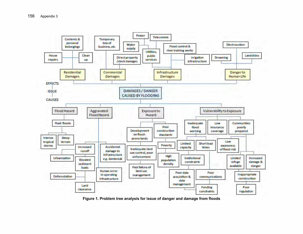
156 Appendix 3
Figure 1. Problem tree analysis for issue of danger and damage from floods
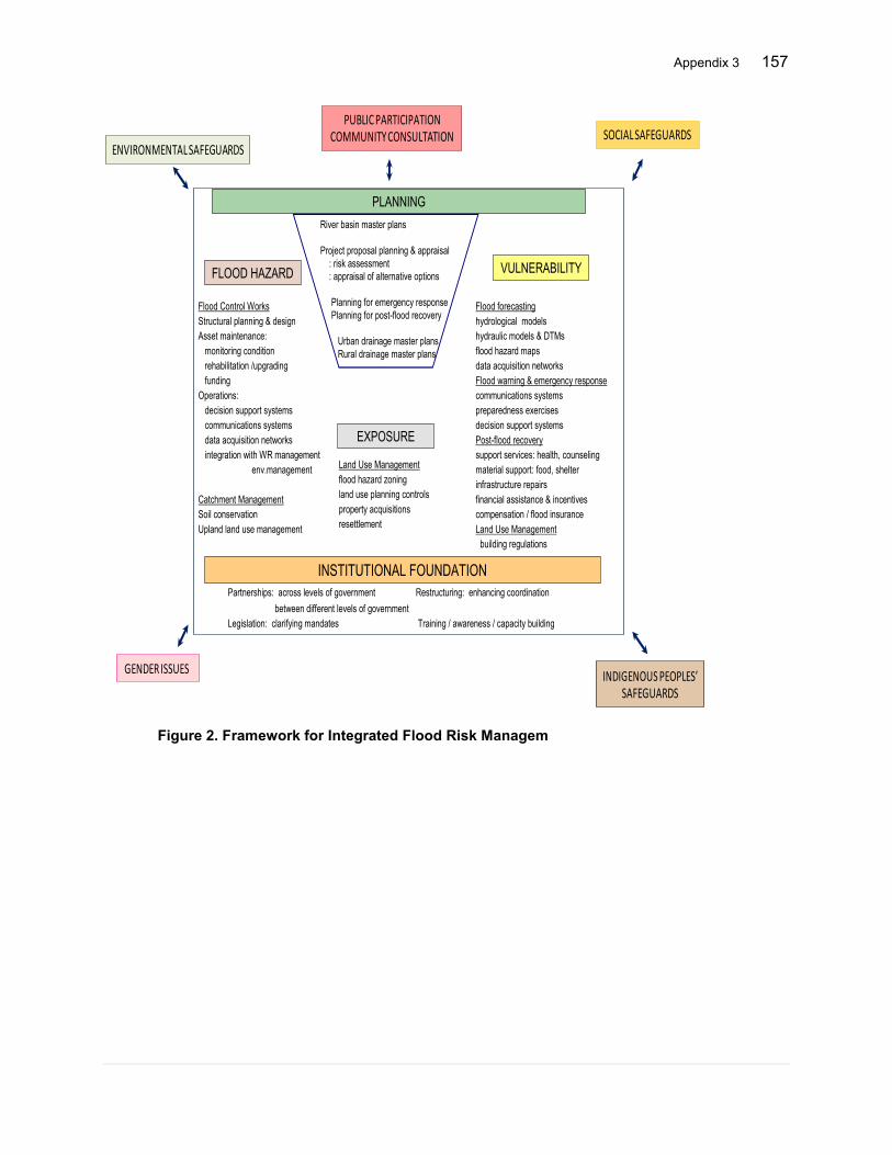
Appendix 3 157
Figure 2. Framework for Integrated Flood Risk Managem
INSTITUTIONAL FOUNDATION
PLANNING
FLOOD HAZARD
EXPOSURE
VULNERABILITY
Flood Control WorksStructural planning & design Asset maintenance:
monitoring conditionrehabilitation /upgradingfunding
Operations:decision support systemscommunications systemsdata acquisition networksintegration with WR management
env.management
Catchment ManagementSoil conservationUpland land use management
Land Use Managementflood hazard zoningland use planning controlsproperty acquisitionsresettlement
Flood forecastinghydrological modelshydraulic models & DTMsflood hazard mapsdata acquisition networksFlood warning & emergency responsecommunications systemspreparedness exercisesdecision support systemsPost-flood recoverysupport services: health, counselingmaterial support: food, shelterinfrastructure repairsfinancial assistance & incentivescompensation / flood insuranceLand Use Management
building regulations
River basin master plans
Project proposal planning & appraisal: risk assessment: appraisal of alternative options
Planning for emergency responsePlanning for post-flood recovery
Urban drainage master plansRural drainage master plans
Partnerships: across levels of government Restructuring: enhancing coordinationbetween different levels of government
Legislation: clarifying mandates Training / awareness / capacity building
PUBLIC PARTICIPATIONCOMMUNITY CONSULTATION SOCIAL SAFEGUARDS
ENVIRONMENTAL SAFEGUARDS
INDIGENOUS PEOPLES’ SAFEGUARDS
GENDER ISSUES
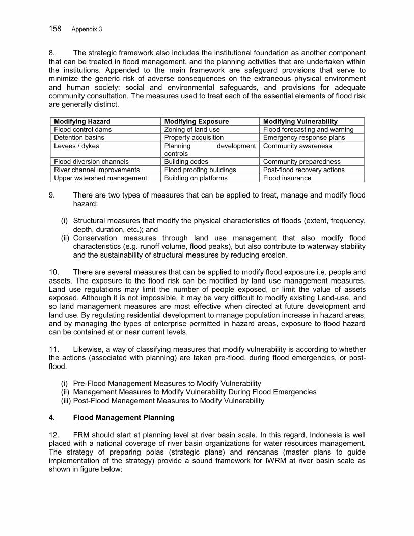
158 Appendix 3
8. The strategic framework also includes the institutional foundation as another component that can be treated in flood management, and the planning activities that are undertaken within the institutions. Appended to the main framework are safeguard provisions that serve to minimize the generic risk of adverse consequences on the extraneous physical environment and human society: social and environmental safeguards, and provisions for adequate community consultation. The measures used to treat each of the essential elements of flood risk are generally distinct.
Modifying Hazard Modifying Exposure Modifying Vulnerability Flood control dams Zoning of land use Flood forecasting and warning Detention basins Property acquisition Emergency response plans Levees / dykes Planning development
controls Community awareness
Flood diversion channels Building codes Community preparedness River channel improvements Flood proofing buildings Post-flood recovery actions Upper watershed management Building on platforms Flood insurance
9. There are two types of measures that can be applied to treat, manage and modify flood
hazard:
(i) Structural measures that modify the physical characteristics of floods (extent, frequency, depth, duration, etc.); and
(ii) Conservation measures through land use management that also modify flood characteristics (e.g. runoff volume, flood peaks), but also contribute to waterway stability and the sustainability of structural measures by reducing erosion.
10. There are several measures that can be applied to modify flood exposure i.e. people and assets. The exposure to the flood risk can be modified by land use management measures. Land use regulations may limit the number of people exposed, or limit the value of assets exposed. Although it is not impossible, it may be very difficult to modify existing Land-use, and so land management measures are most effective when directed at future development and land use. By regulating residential development to manage population increase in hazard areas, and by managing the types of enterprise permitted in hazard areas, exposure to flood hazard can be contained at or near current levels. 11. Likewise, a way of classifying measures that modify vulnerability is according to whether the actions (associated with planning) are taken pre-flood, during flood emergencies, or post-flood.
(i) Pre-Flood Management Measures to Modify Vulnerability (ii) Management Measures to Modify Vulnerability During Flood Emergencies (iii) Post-Flood Management Measures to Modify Vulnerability
4. Flood Management Planning 12. FRM should start at planning level at river basin scale. In this regard, Indonesia is well placed with a national coverage of river basin organizations for water resources management. The strategy of preparing polas (strategic plans) and rencanas (master plans to guide implementation of the strategy) provide a sound framework for IWRM at river basin scale as shown in figure below:
Appendix 3 159
Figure 3. WRM planning process
160 Appendix 3
13. These plans address IWRM in general, including the management of water damaging potentials. However there is a need to further detail the Rencanas for effective implementation of FRM. The development of river basin flood risks management plans (FRMPs) is central in the process to integrate the flood management in spatial plans, adhering to the structured or systematic planning procedure. Beginning of the FRMP process is the acquisition of detailed topographic data of flood risk land and river cross-sections for flood modelling purposes. Acquisition of detailed topographic data of flood risk land will also be a valuable resource for future spatial planning and development planning. FRMPs will further detail and complement the established planning framework of polas and rencanas. The more detailed provisions of the FRMP should then be reflected into future revisions of the rencana. Preparation of a FMRP takes place under the guidance of the consultative bodies established for the pola/rencana planning process (e.g. basin and/or provincial water resources coordination forum) to ensure linkage. Appropriate milestones would be near the beginning and end of the process: first to advise on the FRMP process and receive feedback; and later to review the preferred FMP option before its finalization and approval by the Balais, and the provincial Governor. By these means the preparation of the FRMP would complement the current planning process for IWRM. These aspects are well reflected in the Project design illustrated in Figure 4.

Appendix 3 161
Figure 4. FRM planning process
Review of ProjectsSector AssessmentHistorical Data
Target RBTs Selection
Flood Hazard Mapping
Sector Policy
Consultations
Target Priority Projects Identification
Modelling
Diff. RTN Period
Climate Change
Historical Flood
Pola / Rencana
Best Practices
Urgent Works
Roles & Responsibility Identification (agencies)
Flood Risk Mapping/Identify IFRM options
Detailing Nonstructural Measures
DED of Structural Measures
Social and Environmental Safeguards
Readiness Check/ Compliance
Inclusion of Project in National Planning Document
Project Preparation
Project Approval
Implementation M&E Performance and Results of Actions
Hydro-met. Data
Topo. Data
Land Cover
River Profiles
Spatial/Regional Development Plan
Stak
eho
lder
Par
tici
pat
ion
Feasibility Study of Nonstructural Measures
Feasibility Study of structural Measures
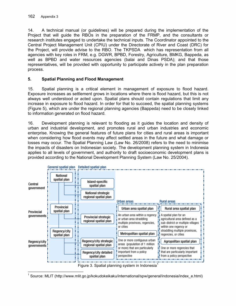
162 Appendix 3
14. A technical manual (or guidelines) will be prepared during the implementation of the Project that will guide the RBOs in the preparation of the FRMP, and the consultants or research institutes engaged to undertake the technical inputs. The Coordinator appointed to the Central Project Management Unit (CPIU) under the Directorate of River and Coast (DRC) for the Project, will provide advise to the RBO. The TKPSDA which has representation from all agencies with key roles in FRM, e.g. DGWR, BPBD, Forestry, Agriculture, BMKG, Bappeda, as well as BPBD and water resources agencies (balai and Dinas PSDA); and that those representatives, will be provided with opportunity to participate actively in the plan preparation process. 5. Spatial Planning and Flood Management 15. Spatial planning is a critical element in management of exposure to flood hazard. Exposure increases as settlement grows in locations where there is flood hazard, but this is not always well understood or acted upon. Spatial plans should contain regulations that limit any increase in exposure to flood hazard. In order for that to succeed, the spatial planning systems (Figure 5), which are under the regional planning agencies (Bappeda) need to be closely linked to information generated on flood hazard.
16. Development planning is relevant to flooding as it guides the location and density of urban and industrial development, and promotes rural and urban industries and economic enterprise. Knowing the general features of future plans for cities and rural areas is important when considering how flood events may affect settled areas in the future and what damage or losses may occur. The Spatial Planning Law (Law No. 26/2008) refers to the need to minimise the impacts of disasters on Indonesian society. The development planning system in Indonesia applies to all levels of government, and authority to draft socioeconomic development plans is provided according to the National Development Planning System (Law No. 25/2004).
Figure 3. Spatial planning system in Indonesia1
1 Source: MLIT (http://www.mlit.go.jp/kokudokeikaku/international/spw/general/indonesia/index_e.html)

Appendix 3 163
17. The spatial planning system also operates at all levels of government. The national spatial plan is necessarily general, but should take into account flood risk as a key issue. The current national spatial plan was enacted with Law No. 26/2008 on Spatial Planning. It covers a 20-year period, but is to be reviewed every five years. The first round of detailed spatial plans under the new Spatial Planning Law has been accomplished and approved, and will govern development throughout Indonesia. An important feature of the spatial plans and the legislation is to criminalize divergence from the plan. Thus, where any infrastructure or building is constructed outside the zonings identified in the spatial plan it will be considered illegal and public infrastructure that is not compliant with a spatial plan may not be funded by the Ministry of Finance. 18. It is important to incorporate flood risk information into the district/city detailed spatial plans, which identify land at plot or parcel level. If the information is available, flood hazard map information should be overlaid on the spatial plan to identify flood hazard characteristics (e.g. frequency, depth, etc.), indicating the level of flood hazard (flood hazard zones). Only in this way is it likely that the plans will have some effect on the location and features of development, when people become aware that there is a real flood risk in that area. 19. A second spatial planning issue is the identification of “floodways‟, or tracts of land that should be kept open for floodwaters to pass and flow away as rapidly as possible. Such land would be restricted to low density development and it is clear that public consultation would be important when delineating such zones. The design of floodways (meaning land kept clear of development that would impede the flow of water) is one possible element in a FRMP. If such a strategy is adopted in a FRMP, there needs to be a direct connection between the data and strategies in the FRMP and the relevant spatial plans. 20. There are some matters included in flood emergency response plans that should be considered in spatial plans. Flood emergency response plans are the responsibility of BPBD (under the umbrella of BNPB) and a directive on these has been issued. Some elements in an emergency response plan are relevant to spatial plans, such as identifying and maintaining evacuation routes, maintaining access to infrastructure for flood fighting and evacuation, and locating facilities such as refuge shelters. Therefore BPBD also needs to have input to the spatial planning process. The public consultation on strategies, and at the stage where detailed zonings and regulations are being designed or updated, will include both the flood management and the spatial planning agencies working together. The spatial plans require the flood risk criteria in order to incorporate flood risk into decisions about land use. 21. The Project will support the local Governments to upgrade the spatial plans based on the comprehensive flood risk assessment. To do this, flood hazard, exposure and vulnerability assessment and mapping will be carried out in the selected RBTs. The building codes and the guidelines will be compiled to help facilitate the development and implementation of the FMRP and the spatial plans. The participatory approach of formulating the spatial plan will be promoted by involving all stakeholders including local communities. 6. Integration of Flood Management Plan 22. There are several types of plan that have a bearing on the management of flood risk and several agencies are involved in those plans. There is a need to strengthen the planning framework and to ensure that it is well coordinated to produce the best end results. The current plans fall into three general categories:
164 Appendix 3
(i) Water resources or river basin plans (pola and rencana) (ii) Disaster management plans, including components plans for preparation, emergency
response and post-disaster, (iii) Spatial plans, and (iv) Mid term and annual sectoral plans at national, provincial and district levels.
23. Thematic plans are legislated for their particular functions as follows:
Type of plan Current progress in Indonesia River basin pola Most national river basins now completed to draft final stage and
some formally approved River basin rencana In preparation one or two of the late draft stage, but not approved Disaster management plans Not yet developed Emergency response plans Being prepared Strategic spatial plans Revised plans developed or being drafted Detailed spatial plans Revised plans in various stages of development with a few
approved and most in the revised draft stage. Catchment (watershed) management plans (Forestry)
Guidelines produced in regulation
Flood risk management plans Yet to be developed 24. FRMP shares some features with plans listed above. The relationship between the various plans is shown in the following Figure 6.
Figure 4. Relationship between plans for flood risk management
River basin strategic plan (pola)
River basin master plan (rencana)
Flood risk management plan
Strategic spatial plan
Detailed spatial plan (province/District)
Flood emergency plan
Disaster management plan (flood)
Hydrological study, mapping, detailed
master plan for hazard risk reduction
Results of hydrological study, mapping into
detailed plan
Identify water issues and develop strategies
Investment programs and measures to
accomplish strategies
Identify flood risk strategies and measures
Water Resources
Bappeda Resources
BNPB
Multi-Agency
Watershed management plans
Measures and programs in priority areas
Forestry Agriculture
Appendix 3 165
25. The river basin plan (rencana) does not cover flooding in the same detail as a FRMP should. The rencana would deal with many different water management issues in the river basin and flood management could only be indicative, while FRMP should be a detail document. It would be based on a study of the river basin (or a part of a basin) and identify in detail the flood risk in the river basin and accurately map flood hazard areas. On the basis of the technical investigations and mapping, the FMP would identify appropriate flood management measures and responses. 26. Information from the FRMP and its supporting study should be incorporated in the relevant spatial plans. The FRMP would also have some elements in common with a disaster management plan, as stipulated in the Disaster Management Law. These could include measures for preparedness, risk reduction and evacuation /emergency response. The FRMP process should be conducted in cooperation with the agencies responsible for the other related plans, and the TKPSDA is the platform for this process. 27. A FRMP should be a multi-agency responsibility. Flood management relies on the coordinated participation of multiple agencies. Moving from a flood control and flood response paradigm to a flood risk management paradigm means that agencies that used to operate independently should now plan together and sometimes develop joint programs, or at least coordinate plans and programs. This philosophy is clearly stated in the Disaster Management Law, and the institutional structure for disaster management is intended to coordinate inputs from multiple agencies. Coordination is a vital element in successful flood risk management too. The plan should be coordinated through and endorsed by the TKPSDA . In that respect, TKPSDA ’s role should be enhanced beyond its current mandates to have just two meetings – one to discuss the issues, and the second to discuss the draft. Therefore the TKPSDA should be strengthened in its role and functions. 7. Stakeholder Consultation 28. The purpose of a stakeholder consultation plan is to ensure that implementation of flood risk management measures proceeds with stakeholders commitment and meets the real needs of beneficiaries, including communities at risk from flooding. Programs to raise awareness of communities at risk are also an effective approach to flood risk management. Community preparedness reduces vulnerability to the adverse impacts of floods. 29. Stakeholder Workshops. To capture broader participation, stakeholder workshops and community consultations are important, particularly at provincial and river basin district levels. Workshops should draw representation from multiple agencies with roles in integrated flood management, but more from those involved at provincial and river basin scales, and with representatives from selected district and selected water user and farmer associations. 30. Community Consultation. Community consultation should commence soon after commencement of the planning process immediately following initial steps of definition of management objectives and understanding of the planning context. Community group meetings should be organized at appropriate intervals during the planning procedure, and should be attended by representatives from the relevant RBO and district and provincial agency. Community consultation should continue into the implementation phase, particularly during feasibility and design of structural flood management measures. The key areas for community consultation will be with communities at risk from flooding – typically in lower river basins – and with selected communities in middle and upper river basins where watershed conservation sub-
166 Appendix 3
programs are proposed in upland agricultural and forestry areas. Separate consultations will be necessary at more localized scale where resettlement will occur. 31. Plan Preparation Working Groups: Preparation of FRMPs should be driven by a multi-agency committee or working group that adequately represents the partnership entailed for well integrated flood risk management. Because FRMPs will be prepared at river basin scale, there should be one working group for each river basin selected – a Plan Preparation Working Group (PPWG). Their role, under the leadership of the RBO, would be to organize and review terms of reference for the inputs required to undertake FRMP preparation, facilitate the collection of data inputs, review the work performed, advise on selection of flood management options, and approve or recommend revisions to the preferred flood management option before the FRMP is finalized. 32. The main inputs to preparation of a FRMP will be supported by consultants responsible for all technical inputs, e.g.: topographic survey; engineering, technical and economic /financial analysis; community consultation and social impact analysis; environmental impact analysis. A Coordinator from the Project Management Consultant (PMC) or a CPMU manager could advise the PPWG on inputs and terms of reference required for plan preparation, especially in the initial phases. 33. There are already coordinating forums (TKPSDA s) in river basin districts which have a role in the preparation and review of Polas and Rencanas, but their role is different to that required here, so it is proposed that the PPWG should be a separate group. Membership of the PPWG would include provincial, balai, and District representatives, and possibly representatives of farmer associations; and it is proposed that the PPWG be chaired by the relevant balai WS (national, or provincial), although this could vary from river basin to river basin. Proposed membership would include representatives from provincial Dinas Pengairan, BMKG, Bappeda, BPBD, Home Affairs and Agriculture at either or both provincial or District levels, and – if farmer representatives are included – from selected farmer or water user associations in areas exposed to flood risk, and from upland areas where watershed conservation programs are proposed. Although the intervals may vary at different stages of FRMP preparation, PPWGs should expect to meet at approximately 1½ month intervals throughout plan preparation, which is typically likely to last about 12 months. 8. Mainstreaming Climate Change 34. IPCC projections for global climate change in most of the Indonesian archipelago – including the provinces of Banten and Maluku – predict only small increases in precipitation by the late 21st century, generally less than in most other parts of Asia. Seasonally, there may be a greater distinction between wet and dry seasons, with a higher percentage of annual rainfall in the wet season. More significantly, the intensity of heavy rainfall during storms is likely to increase – by as much as 5% per ºC. These changes are likely to cause some increase in flood peak discharges and flood frequency, but in the absence of more detailed studies these changes are difficult to quantify. The projections of global climate change are more definite that sea levels will rise with increasing global temperatures. This will affect the flat coastal plain and estuary of the selected river basins. 35. The Project addresses adaptation to climate change in several respects. Firstly, flood management measures reduce the risk of danger and damages from flood regardless of climate change, but the benefits are increased if the adverse impacts of climate change occur. In general, they are therefore win-win measures. Secondly, the project follows a comprehensive
Appendix 3 167
risk management approach, and will prepare FRMPs that embrace a combination of structural and non-structural measures. Non-structural measures function to manage the residual risk that is not or cannot be managed by structural measures, and will be implemented to manage increased residual risk if the standard of protection provided by structural measures declines due to the impacts of future climate change. Thirdly, the land use management, soil and water conservation measures included in the project will counter the negative effects of climate change within the river basins. Fourthly, an extra margin of freeboard will be included in the dikes and embankments to accommodate likely increased flood frequency deriving from climate change over the design life of the structures. 36. During preparation of the FRM plan the impacts of projected sea level rise on the coastal plain, estuary and dependent livelihoods will be considered, and appropriate mitigation or adaptation measures formulated. For both Banten Province and the region of Ambon in Maluku Province, the locations of the selected river basin territories, studies are proposed to use available data on climate change and analyze regional changes in precipitation and flood response to those changes. The study findings will be used in the design of structures identified in the development of FRM plans.
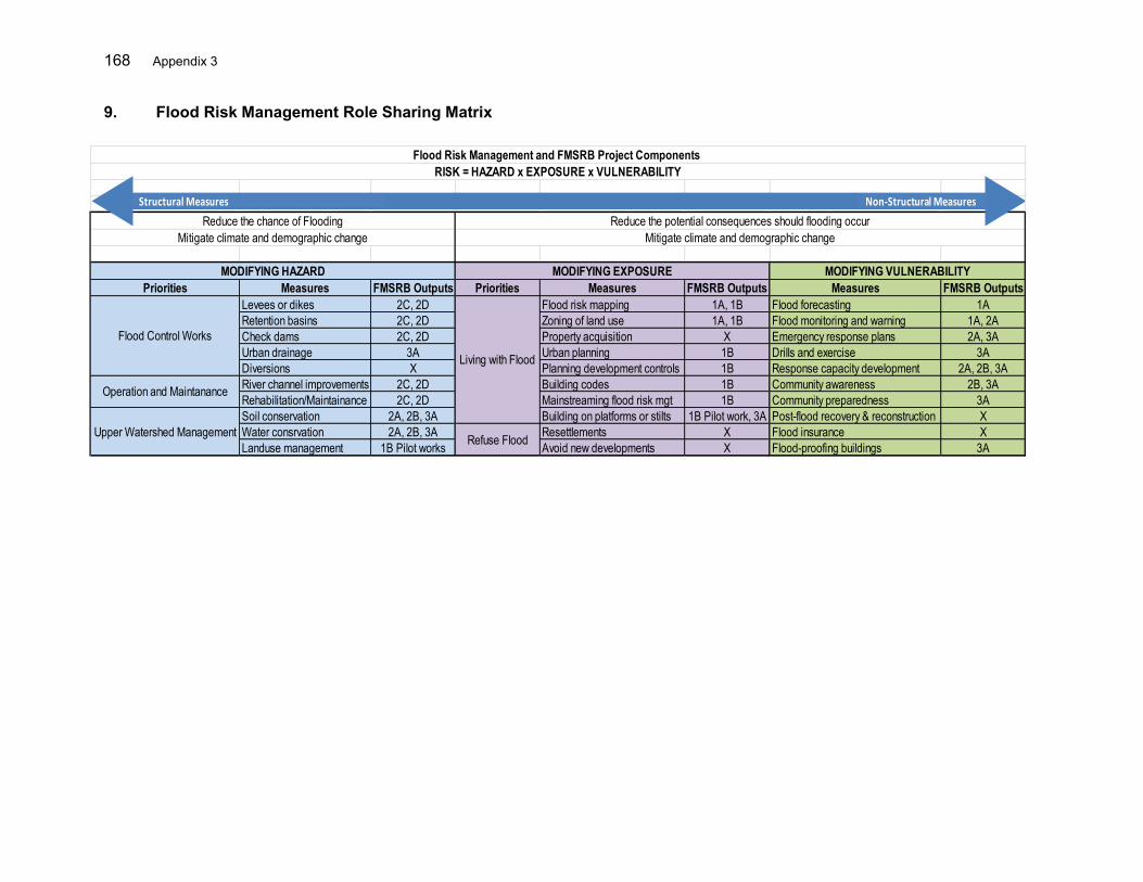
168 Appendix 3
9. Flood Risk Management Role Sharing Matrix
Priorities Measures FMSRB Outputs Priorities Measures FMSRB Outputs Measures FMSRB OutputsLevees or dikes 2C, 2D Flood risk mapping 1A, 1B Flood forecasting 1ARetention basins 2C, 2D Zoning of land use 1A, 1B Flood monitoring and warning 1A, 2ACheck dams 2C, 2D Property acquisition X Emergency response plans 2A, 3AUrban drainage 3A Urban planning 1B Drills and exercise 3ADiversions X Planning development controls 1B Response capacity development 2A, 2B, 3ARiver channel improvements 2C, 2D Building codes 1B Community awareness 2B, 3ARehabilitation/Maintainance 2C, 2D Mainstreaming flood risk mgt 1B Community preparedness 3ASoil conservation 2A, 2B, 3A Building on platforms or stilts 1B Pilot work, 3A Post-flood recovery & reconstruction XWater consrvation 2A, 2B, 3A Resettlements X Flood insurance XLanduse management 1B Pilot works Avoid new developments X Flood-proofing buildings 3A
Flood Risk Management and FMSRB Project Components RISK = HAZARD x EXPOSURE x VULNERABILITY
MODIFYING EXPOSUREMODIFYING HAZARD MODIFYING VULNERABILITY
Reduce the chance of FloodingMitigate climate and demographic change
Reduce the potential consequences should flooding occurMitigate climate and demographic change
Upper Watershed Management Refuse Flood
Flood Control Works
Operation and Maintanance
Living with Flood
Structural Measures Non-Structural Measures
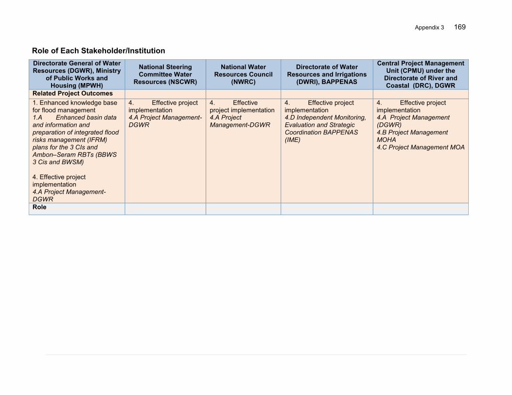
Appendix 3 169
Role of Each Stakeholder/Institution Directorate General of Water Resources (DGWR), Ministry
of Public Works and Housing (MPWH)
National Steering Committee Water
Resources (NSCWR)
National Water Resources Council
(NWRC)
Directorate of Water Resources and Irrigations
(DWRI), BAPPENAS
Central Project Management Unit (CPMU) under the
Directorate of River and Coastal (DRC), DGWR
Related Project Outcomes 1. Enhanced knowledge base for flood management 1.A Enhanced basin data and information and preparation of integrated flood risks management (IFRM) plans for the 3 CIs and Ambon–Seram RBTs (BBWS 3 Cis and BWSM) 4. Effective project implementation 4.A Project Management-DGWR
4. Effective project implementation 4.A Project Management-DGWR
4. Effective project implementation 4.A Project Management-DGWR
4. Effective project implementation 4.D Independent Monitoring, Evaluation and Strategic Coordination BAPPENAS (IME)
4. Effective project implementation 4.A Project Management (DGWR) 4.B Project Management MOHA 4.C Project Management MOA
Role
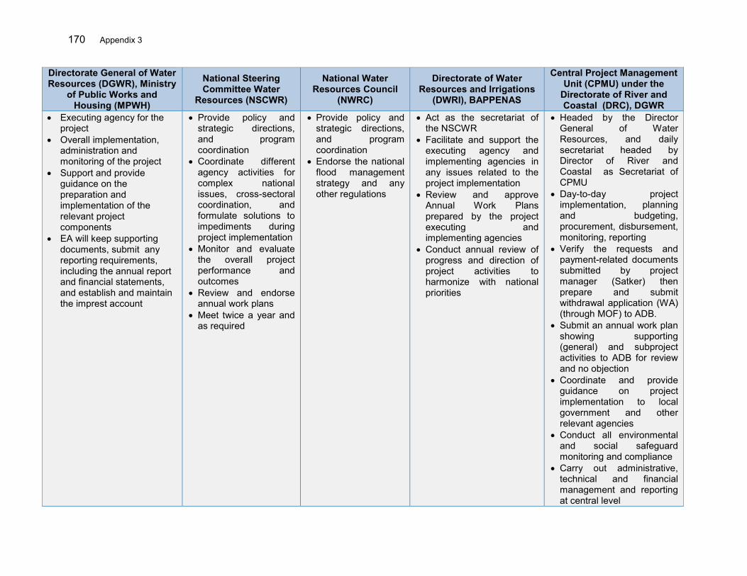
170 Appendix 3
Directorate General of Water Resources (DGWR), Ministry
of Public Works and Housing (MPWH)
National Steering Committee Water
Resources (NSCWR)
National Water Resources Council
(NWRC)
Directorate of Water Resources and Irrigations
(DWRI), BAPPENAS
Central Project Management Unit (CPMU) under the
Directorate of River and Coastal (DRC), DGWR
Executing agency for the project
Overall implementation, administration and monitoring of the project
Support and provide guidance on the preparation and implementation of the relevant project components
EA will keep supporting documents, submit any reporting requirements, including the annual report and financial statements, and establish and maintain the imprest account
Provide policy and strategic directions, and program coordination
Coordinate different agency activities for complex national issues, cross-sectoral coordination, and formulate solutions to impediments during project implementation
Monitor and evaluate the overall project performance and outcomes
Review and endorse annual work plans
Meet twice a year and as required
Provide policy and strategic directions, and program coordination
Endorse the national flood management strategy and any other regulations
Act as the secretariat of the NSCWR
Facilitate and support the executing agency and implementing agencies in any issues related to the project implementation
Review and approve Annual Work Plans prepared by the project executing and implementing agencies
Conduct annual review of progress and direction of project activities to harmonize with national priorities
Headed by the Director General of Water Resources, and daily secretariat headed by Director of River and Coastal as Secretariat of CPMU
Day-to-day project implementation, planning and budgeting, procurement, disbursement, monitoring, reporting
Verify the requests and payment-related documents submitted by project manager (Satker) then prepare and submit withdrawal application (WA) (through MOF) to ADB.
Submit an annual work plan showing supporting (general) and subproject activities to ADB for review and no objection
Coordinate and provide guidance on project implementation to local government and other relevant agencies
Conduct all environmental and social safeguard monitoring and compliance
Carry out administrative, technical and financial management and reporting at central level
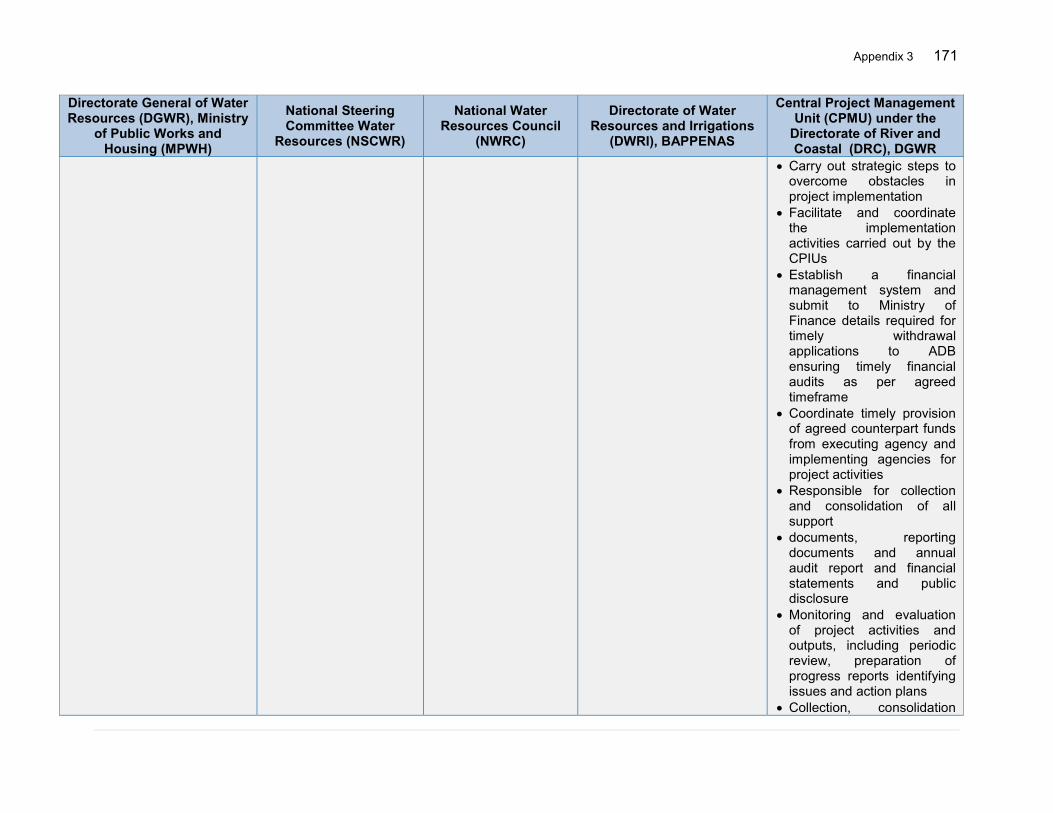
Appendix 3 171
Directorate General of Water Resources (DGWR), Ministry
of Public Works and Housing (MPWH)
National Steering Committee Water
Resources (NSCWR)
National Water Resources Council
(NWRC)
Directorate of Water Resources and Irrigations
(DWRI), BAPPENAS
Central Project Management Unit (CPMU) under the
Directorate of River and Coastal (DRC), DGWR
Carry out strategic steps to overcome obstacles in project implementation
Facilitate and coordinate the implementation activities carried out by the CPIUs
Establish a financial management system and submit to Ministry of Finance details required for timely withdrawal applications to ADB ensuring timely financial audits as per agreed timeframe
Coordinate timely provision of agreed counterpart funds from executing agency and implementing agencies for project activities
Responsible for collection and consolidation of all support
documents, reporting documents and annual audit report and financial statements and public disclosure
Monitoring and evaluation of project activities and outputs, including periodic review, preparation of progress reports identifying issues and action plans
Collection, consolidation
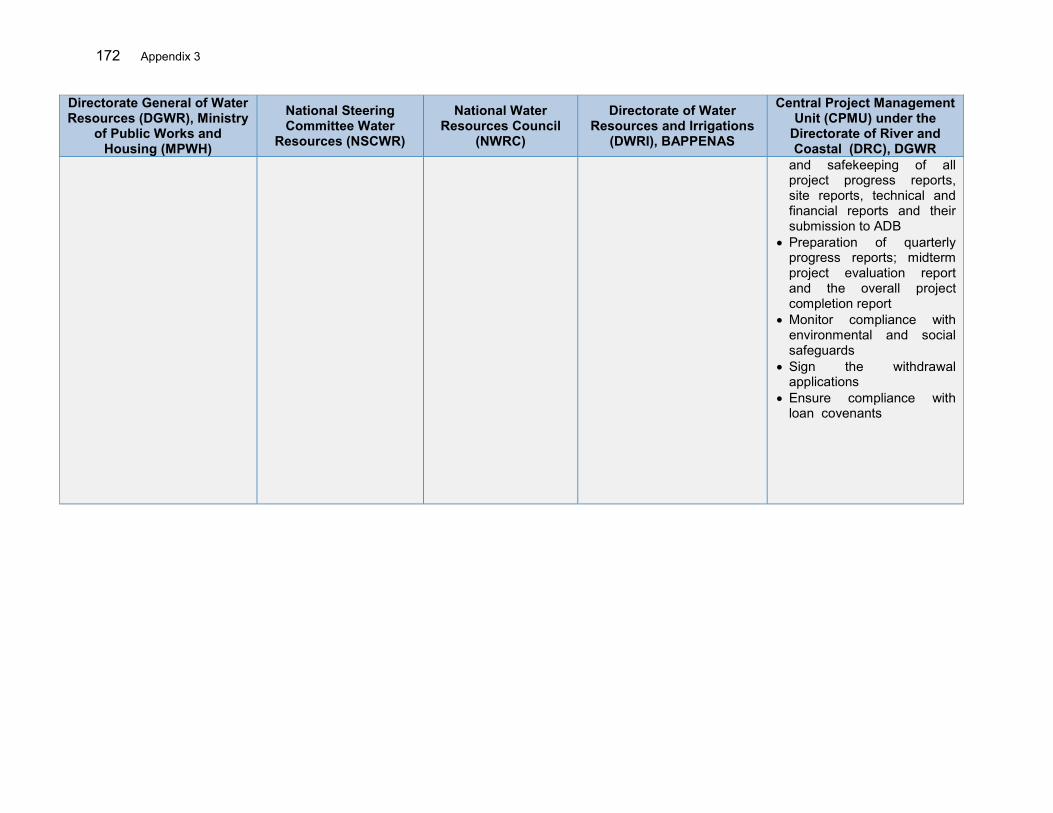
172 Appendix 3
Directorate General of Water Resources (DGWR), Ministry
of Public Works and Housing (MPWH)
National Steering Committee Water
Resources (NSCWR)
National Water Resources Council
(NWRC)
Directorate of Water Resources and Irrigations
(DWRI), BAPPENAS
Central Project Management Unit (CPMU) under the
Directorate of River and Coastal (DRC), DGWR
and safekeeping of all project progress reports, site reports, technical and financial reports and their submission to ADB
Preparation of quarterly progress reports; midterm project evaluation report and the overall project completion report
Monitor compliance with environmental and social safeguards
Sign the withdrawal applications
Ensure compliance with loan covenants
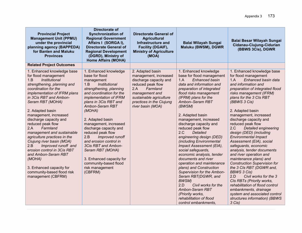
Appendix 3 173
Provincial Project Management Unit (PPMU)
under the provincial planning agency (BAPPEDA)
for Banten and Maluku Provinces
Directorate of Synchronization of
Regional Government Affairs I (SORGA I),
Directorate General of Regional Development
(DGRD), Ministry of Home Affairs (MOHA)
Directorate General of Agricultural
Infrastructure and Facility (DGAIF),
Ministry of Agriculture (MOA)
Balai Wilayah Sungai Maluku (BWSM), DGWR
Balai Besar Wilayah Sungai Cidanau-Ciujung-Cidurian
(BBWS 3Cis), DGWR
Related Project Outcomes 1. Enhanced knowledge base for flood management 1.B Institutional strengthening, planning and coordination for the implementation of IFRM plans in 3Cis RBT and Ambon-Seram RBT (MOHA) 2. Adapted basin management, increased discharge capacity and reduced peak flow 2.A Farmland management and sustainable agriculture practices in the Ciujung river basin (MOA) 2.B Improved runoff and erosion control in 3Cis RBT and Ambon-Seram RBT (MOHA) 3. Enhanced capacity for community-based flood risk management (CBFRM)
1. Enhanced knowledge base for flood management 1.B Institutional strengthening, planning and coordination for the implementation of IFRM plans in 3Cis RBT and Ambon-Seram RBT (MOHA) 2. Adapted basin management, increased discharge capacity and reduced peak flow 2.B Improved runoff and erosion control in 3Cis RBT and Ambon-Seram RBT (MOHA) 3. Enhanced capacity for community-based flood risk management (CBFRM)
2. Adapted basin management, increased discharge capacity and reduced peak flow 2.A Farmland management and sustainable agriculture practices in the Ciujung river basin (MOA)
1. Enhanced knowledge base for flood management 1.A Enhanced basin data and information and preparation of integrated flood risks management (IFRM) plans for the Ambon–Seram RBT (BWSM) 2. Adapted basin management, increased discharge capacity and reduced peak flow 2.C Detailed engineering design (DED) (including Environmental Impact Assessment (EIA), social safeguards, economic analysis, tender documents and river operation and maintenance plans) and Construction Supervision for the Ambon-Seram RBT(DGWR, and BWSM) 2.D Civil works for the Ambon-Seram RBT (Priority works, rehabilitation of flood control embankments,
1. Enhanced knowledge base for flood management 1.A Enhanced basin data and information and preparation of integrated flood risks management (IFRM) plans for the 3 CIs RBT (BBWS 3 Cis) 2. Adapted basin management, increased discharge capacity and reduced peak flow 2.C Detailed engineering design (DED) (including Environmental Impact Assessment (EIA), social safeguards, economic analysis, tender documents and river operation and maintenance plans) and Construction Supervision for the 3 CIs RBT (DGWR and, BBWS 3 Cis) 2.D Civil works for the 3 CIs RBTs (Priority works, rehabilitation of flood control embankments, drainage system and associated control structures information) (BBWS 3 Cis)
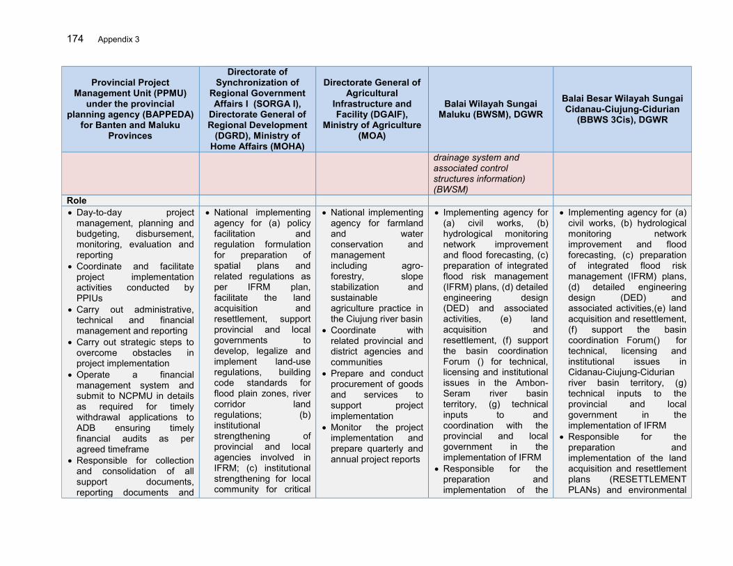
174 Appendix 3
Provincial Project Management Unit (PPMU)
under the provincial planning agency (BAPPEDA)
for Banten and Maluku Provinces
Directorate of Synchronization of
Regional Government Affairs I (SORGA I),
Directorate General of Regional Development
(DGRD), Ministry of Home Affairs (MOHA)
Directorate General of Agricultural
Infrastructure and Facility (DGAIF),
Ministry of Agriculture (MOA)
Balai Wilayah Sungai Maluku (BWSM), DGWR
Balai Besar Wilayah Sungai Cidanau-Ciujung-Cidurian
(BBWS 3Cis), DGWR
drainage system and associated control structures information) (BWSM)
Role Day-to-day project
management, planning and budgeting, disbursement, monitoring, evaluation and reporting
Coordinate and facilitate project implementation activities conducted by PPIUs
Carry out administrative, technical and financial management and reporting
Carry out strategic steps to overcome obstacles in project implementation
Operate a financial management system and submit to NCPMU in details as required for timely withdrawal applications to ADB ensuring timely financial audits as per agreed timeframe
Responsible for collection and consolidation of all support documents, reporting documents and
National implementing agency for (a) policy facilitation and regulation formulation for preparation of spatial plans and related regulations as per IFRM plan, facilitate the land acquisition and resettlement, support provincial and local governments to develop, legalize and implement land-use regulations, building code standards for flood plain zones, river corridor land regulations; (b) institutional strengthening of provincial and local agencies involved in IFRM; (c) institutional strengthening for local community for critical
National implementing agency for farmland and water conservation and management including agro-forestry, slope stabilization and sustainable agriculture practice in the Ciujung river basin
Coordinate with related provincial and district agencies and communities
Prepare and conduct procurement of goods and services to support project implementation
Monitor the project implementation and prepare quarterly and annual project reports
Implementing agency for (a) civil works, (b) hydrological monitoring network improvement and flood forecasting, (c) preparation of integrated flood risk management (IFRM) plans, (d) detailed engineering design (DED) and associated activities, (e) land acquisition and resettlement, (f) support the basin coordination Forum () for technical, licensing and institutional issues in the Ambon-Seram river basin territory, (g) technical inputs to and coordination with the provincial and local government in the implementation of IFRM
Responsible for the preparation and implementation of the
Implementing agency for (a) civil works, (b) hydrological monitoring network improvement and flood forecasting, (c) preparation of integrated flood risk management (IFRM) plans, (d) detailed engineering design (DED) and associated activities,(e) land acquisition and resettlement, (f) support the basin coordination Forum() for technical, licensing and institutional issues in Cidanau-Ciujung-Cidurian river basin territory, (g) technical inputs to the provincial and local government in the implementation of IFRM
Responsible for the preparation and implementation of the land acquisition and resettlement plans (RESETTLEMENT PLANs) and environmental
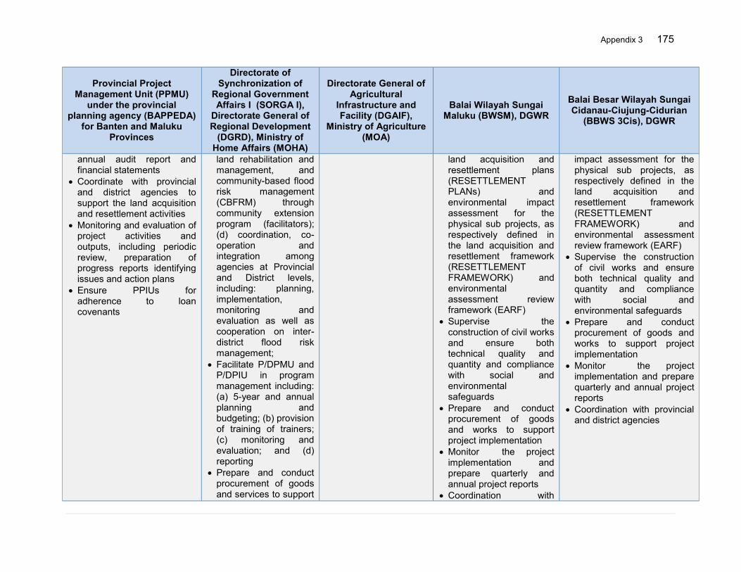
Appendix 3 175
Provincial Project Management Unit (PPMU)
under the provincial planning agency (BAPPEDA)
for Banten and Maluku Provinces
Directorate of Synchronization of
Regional Government Affairs I (SORGA I),
Directorate General of Regional Development
(DGRD), Ministry of Home Affairs (MOHA)
Directorate General of Agricultural
Infrastructure and Facility (DGAIF),
Ministry of Agriculture (MOA)
Balai Wilayah Sungai Maluku (BWSM), DGWR
Balai Besar Wilayah Sungai Cidanau-Ciujung-Cidurian
(BBWS 3Cis), DGWR
annual audit report and financial statements
Coordinate with provincial and district agencies to support the land acquisition and resettlement activities
Monitoring and evaluation of project activities and outputs, including periodic review, preparation of progress reports identifying issues and action plans
Ensure PPIUs for adherence to loan covenants
land rehabilitation and management, and community-based flood risk management (CBFRM) through community extension program (facilitators); (d) coordination, co-operation and integration among agencies at Provincial and District levels, including: planning, implementation, monitoring and evaluation as well as cooperation on inter-district flood risk management;
Facilitate P/DPMU and P/DPIU in program management including: (a) 5-year and annual planning and budgeting; (b) provision of training of trainers; (c) monitoring and evaluation; and (d) reporting
Prepare and conduct procurement of goods and services to support
land acquisition and resettlement plans (RESETTLEMENT PLANs) and environmental impact assessment for the physical sub projects, as respectively defined in the land acquisition and resettlement framework (RESETTLEMENT FRAMEWORK) and environmental assessment review framework (EARF)
Supervise the construction of civil works and ensure both technical quality and quantity and compliance with social and environmental safeguards
Prepare and conduct procurement of goods and works to support project implementation
Monitor the project implementation and prepare quarterly and annual project reports
Coordination with
impact assessment for the physical sub projects, as respectively defined in the land acquisition and resettlement framework (RESETTLEMENT FRAMEWORK) and environmental assessment review framework (EARF)
Supervise the construction of civil works and ensure both technical quality and quantity and compliance with social and environmental safeguards
Prepare and conduct procurement of goods and works to support project implementation
Monitor the project implementation and prepare quarterly and annual project reports
Coordination with provincial and district agencies
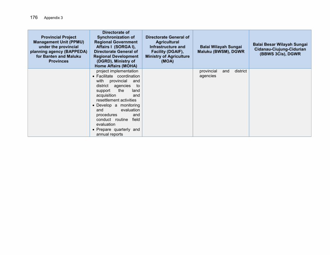
176 Appendix 3
Provincial Project Management Unit (PPMU)
under the provincial planning agency (BAPPEDA)
for Banten and Maluku Provinces
Directorate of Synchronization of
Regional Government Affairs I (SORGA I),
Directorate General of Regional Development
(DGRD), Ministry of Home Affairs (MOHA)
Directorate General of Agricultural
Infrastructure and Facility (DGAIF),
Ministry of Agriculture (MOA)
Balai Wilayah Sungai Maluku (BWSM), DGWR
Balai Besar Wilayah Sungai Cidanau-Ciujung-Cidurian
(BBWS 3Cis), DGWR
project implementation Facilitate coordination
with provincial and district agencies to support the land acquisition and resettlement activities
Develop a monitoring and evaluation procedures and conduct routine field evaluation
Prepare quarterly and annual reports
provincial and district agencies
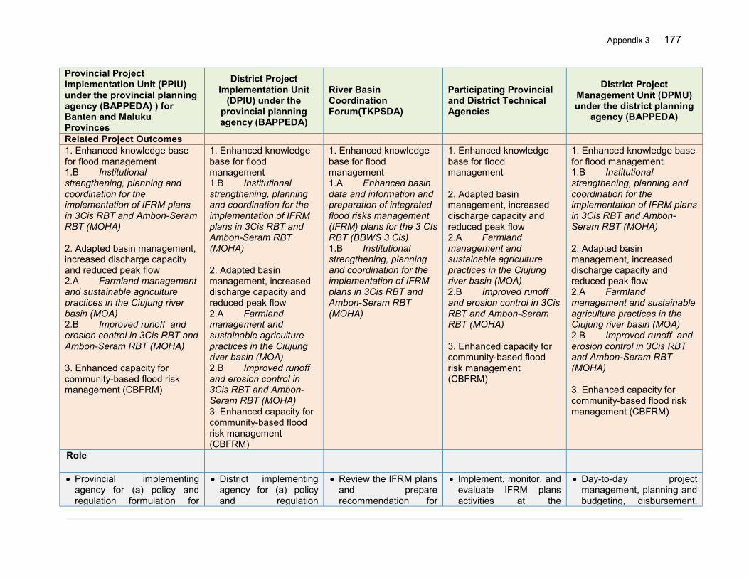
Appendix 3 177
Provincial Project Implementation Unit (PPIU) under the provincial planning agency (BAPPEDA) ) for Banten and Maluku Provinces
District Project Implementation Unit
(DPIU) under the provincial planning agency (BAPPEDA)
River Basin Coordination Forum(TKPSDA)
Participating Provincial and District Technical Agencies
District Project Management Unit (DPMU) under the district planning
agency (BAPPEDA)
Related Project Outcomes 1. Enhanced knowledge base for flood management 1.B Institutional strengthening, planning and coordination for the implementation of IFRM plans in 3Cis RBT and Ambon-Seram RBT (MOHA) 2. Adapted basin management, increased discharge capacity and reduced peak flow 2.A Farmland management and sustainable agriculture practices in the Ciujung river basin (MOA) 2.B Improved runoff and erosion control in 3Cis RBT and Ambon-Seram RBT (MOHA) 3. Enhanced capacity for community-based flood risk management (CBFRM)
1. Enhanced knowledge base for flood management 1.B Institutional strengthening, planning and coordination for the implementation of IFRM plans in 3Cis RBT and Ambon-Seram RBT (MOHA) 2. Adapted basin management, increased discharge capacity and reduced peak flow 2.A Farmland management and sustainable agriculture practices in the Ciujung river basin (MOA) 2.B Improved runoff and erosion control in 3Cis RBT and Ambon-Seram RBT (MOHA) 3. Enhanced capacity for community-based flood risk management (CBFRM)
1. Enhanced knowledge base for flood management 1.A Enhanced basin data and information and preparation of integrated flood risks management (IFRM) plans for the 3 CIs RBT (BBWS 3 Cis) 1.B Institutional strengthening, planning and coordination for the implementation of IFRM plans in 3Cis RBT and Ambon-Seram RBT (MOHA)
1. Enhanced knowledge base for flood management 2. Adapted basin management, increased discharge capacity and reduced peak flow 2.A Farmland management and sustainable agriculture practices in the Ciujung river basin (MOA) 2.B Improved runoff and erosion control in 3Cis RBT and Ambon-Seram RBT (MOHA) 3. Enhanced capacity for community-based flood risk management (CBFRM)
1. Enhanced knowledge base for flood management 1.B Institutional strengthening, planning and coordination for the implementation of IFRM plans in 3Cis RBT and Ambon-Seram RBT (MOHA) 2. Adapted basin management, increased discharge capacity and reduced peak flow 2.A Farmland management and sustainable agriculture practices in the Ciujung river basin (MOA) 2.B Improved runoff and erosion control in 3Cis RBT and Ambon-Seram RBT (MOHA) 3. Enhanced capacity for community-based flood risk management (CBFRM)
Role
Provincial implementing agency for (a) policy and regulation formulation for
District implementing agency for (a) policy and regulation
Review the IFRM plans and prepare recommendation for
Implement, monitor, and evaluate IFRM plans activities at the
Day-to-day project management, planning and budgeting, disbursement,
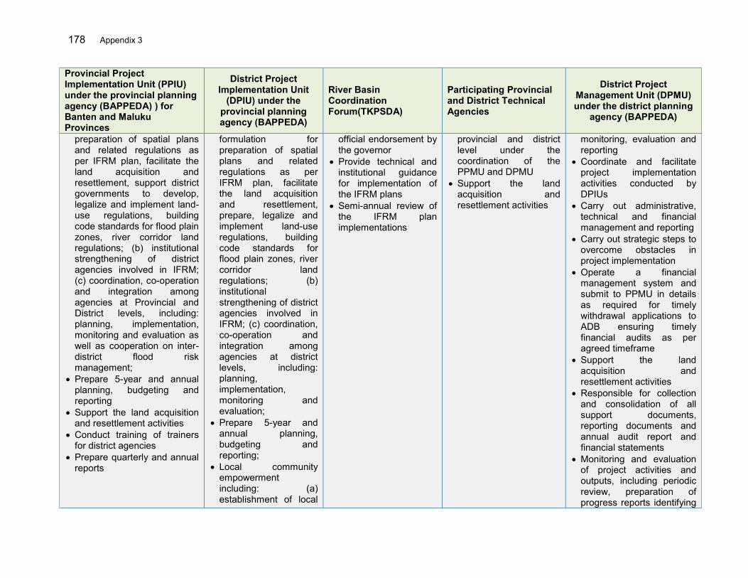
178 Appendix 3
Provincial Project Implementation Unit (PPIU) under the provincial planning agency (BAPPEDA) ) for Banten and Maluku Provinces
District Project Implementation Unit
(DPIU) under the provincial planning agency (BAPPEDA)
River Basin Coordination Forum(TKPSDA)
Participating Provincial and District Technical Agencies
District Project Management Unit (DPMU) under the district planning
agency (BAPPEDA)
preparation of spatial plans and related regulations as per IFRM plan, facilitate the land acquisition and resettlement, support district governments to develop, legalize and implement land-use regulations, building code standards for flood plain zones, river corridor land regulations; (b) institutional strengthening of district agencies involved in IFRM; (c) coordination, co-operation and integration among agencies at Provincial and District levels, including: planning, implementation, monitoring and evaluation as well as cooperation on inter-district flood risk management;
Prepare 5-year and annual planning, budgeting and reporting
Support the land acquisition and resettlement activities
Conduct training of trainers for district agencies
Prepare quarterly and annual reports
formulation for preparation of spatial plans and related regulations as per IFRM plan, facilitate the land acquisition and resettlement, prepare, legalize and implement land-use regulations, building code standards for flood plain zones, river corridor land regulations; (b) institutional strengthening of district agencies involved in IFRM; (c) coordination, co-operation and integration among agencies at district levels, including: planning, implementation, monitoring and evaluation;
Prepare 5-year and annual planning, budgeting and reporting;
Local community empowerment including: (a) establishment of local
official endorsement by the governor
Provide technical and institutional guidance for implementation of the IFRM plans
Semi-annual review of the IFRM plan implementations
provincial and district level under the coordination of the PPMU and DPMU
Support the land acquisition and resettlement activities
monitoring, evaluation and reporting
Coordinate and facilitate project implementation activities conducted by DPIUs
Carry out administrative, technical and financial management and reporting
Carry out strategic steps to overcome obstacles in project implementation
Operate a financial management system and submit to PPMU in details as required for timely withdrawal applications to ADB ensuring timely financial audits as per agreed timeframe
Support the land acquisition and resettlement activities
Responsible for collection and consolidation of all support documents, reporting documents and annual audit report and financial statements
Monitoring and evaluation of project activities and outputs, including periodic review, preparation of progress reports identifying
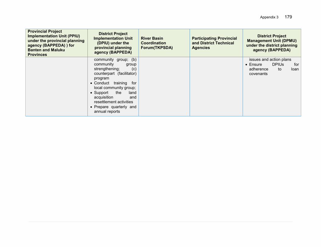
Appendix 3 179
Provincial Project Implementation Unit (PPIU) under the provincial planning agency (BAPPEDA) ) for Banten and Maluku Provinces
District Project Implementation Unit
(DPIU) under the provincial planning agency (BAPPEDA)
River Basin Coordination Forum(TKPSDA)
Participating Provincial and District Technical Agencies
District Project Management Unit (DPMU) under the district planning
agency (BAPPEDA)
community group; (b) community group strengthening; (c) counterpart (facilitator) program
Conduct training for local community group;
Support the land acquisition and resettlement activities
Prepare quarterly and annual reports
issues and action plans Ensure DPIUs for
adherence to loan covenants
180 Appendix 3
Provincial and/or Local Land Agency (Badan Pertanahan Nasional)
Provincial and/or Local government
Civil Society Organizations
Ministry of Finance ADB
Related Project Outcomes 1. Enhanced knowledge base for flood management 2. Adapted basin management, increased discharge capacity and reduced peak flow 2.C Detailed engineering design (DED) (including Environmental Impact Assessment (EIA), social safeguards, economic analysis, tender documents and river operation and maintenance plans) and Construction Supervision for the 3 CIs RBT (DGWR and, BBWS 3 Cis)
1. Enhanced knowledge base for flood management 1.B Institutional strengthening, planning and coordination for the implementation of IFRM plans in 3Cis RBT and Ambon-Seram RBT (MOHA) 2. Adapted basin management, increased discharge capacity and reduced peak flow 2.B Improved runoff and erosion control in 3Cis RBT and Ambon-Seram RBT (MOHA) 2.C Detailed engineering design (DED) (including Environmental Impact Assessment (EIA), social safeguards, economic analysis, tender documents and river operation and maintenance plans) and Construction Supervision for the 3 CIs RBT (DGWR and, BBWS 3 Cis) 3. Enhanced capacity for community-based flood risk management (CBFRM)
1. Enhanced knowledge base for flood management 1.B Institutional strengthening, planning and coordination for the implementation of IFRM plans in 3Cis RBT and Ambon-Seram RBT (MOHA) 3. Enhanced capacity for community-based flood risk management (CBFRM)
4. Effective project implementation 4.A Project Management (DGWR) 4.B Project Management MOHA 4.C Project Management MOA
4. Effective project implementation 4.A Project Management (DGWR) 4.B Project Management MOHA 4.C Project Management MOA 4.D Independent Monitoring, Evaluation and Strategic Coordination BAPPENAS (IME)
Role
Support land acquisition and resettlement implementation including inventory of losses,
Support land acquisition and resettlement preparation and issue the
Actively contribute to the preparation of the IFRM plans through the
Establishment of imprest account
Allocation and timely
Financing of the project loan Review and monitoring of
project implementation
Appendix 3 181
Provincial and/or Local Land Agency (Badan Pertanahan Nasional)
Provincial and/or Local government
Civil Society Organizations
Ministry of Finance ADB
consultations, valuation and negotiations of compensation, and monitoring
Handover of acquired land
project location determination
Provide technical and financial support to initiate the independent monitoring and evaluation of LARAP implementation
TKPSDAs by ensuring different socio-economic options in the selected river basin territories to enhance the livelihood and alleviate the poverty
Mobilize available resources to harmonize and synergize the livelihood options for the people in flood affected people in the project areas
Facilitate the community based flood risk management activities
release of counterpart funds
Facilitate disbursement and withdrawal application
Communicate with ADB for any amendments in the reallocation of the loan amount
182 Appendix 3
STAKEHOLDER ROLE IN FRM Central Administration River Basin Organizations Provincial Administration District/ Local Administration Household/Community Develop national
strategy and policies Create legal
framework Create financial
mechanisms
Long-term planning taking into account basin-wide conditions, development, and climate change scenarios
Develop basin or area specific master plan
Create hazard/risk maps Create, maintain and make
available the basin data Forecasting and
dissemination of warnings Develop a multi-hazard
scenario in the basins Promote IFRM and IWRM
processes Maintain proper operation,
regulation and maintenance of the bed and banks of the river
Planning at provincial level Implementing mitigation
measures at provincial level Linkage between national,
district and local (basin and catchment) levels
Monitoring and evaluation of developments including flood risk management conditions
prepare and maintain a strategy for local flood risk management, coordinate the views and activities with other local bodies and communities through public consultation and scrutiny, and delivery planning
Formation of community based flood management organization
Coordination with community based organizations and helping the community to prepare flood management action plans
Promote self-, mutual- and public-help situations
Post flood reconstruction Play a lead role in emergency
planning and recovery after a flood event
Local level early warning system
Implement robust storm drainage system in cities
Monitor the local developments in relation to the flood risk management
Active participation in community based FRM
Secure a personal, family and community defense system
Cooperate with agencies
Secure household and assets from flooding
Prepare life-saving measures at home and update those with available flood risk information
Prepare family for evacuation and ensure where to and how to information
Updated with real-time flood information including forecast and early warning during emergencies
Professionals/Scientists BMKG TKPSDA Private Sector BNP/BPBD
Localize international know how and best practices
Develop innovative planning and design of flood risk
Provide reliable meteorological forecast to pre-run the hydrological model (for flood forecasting)
Create meteorological data base
Knowledge transfer Advisories Capacity building Dialogue on basin
development issues
Prepare action plan for damage minimization
Ensure safety of their assets including equipment and structures
Promote risk insurance
Promote flood preparedness in normal time
Prepare contingency plan and help conduct drill and exercise in
Appendix 3 183
management measure through sound research and practice based
Support central administration in planning and strategy building
Prepare guidelines and practical solutions
Advice to government and academia
Capacity building at policy level
Contribute to the development of early warning and dissemination system
Research and development
Public awareness Cooperation facilitation
Implementation of financial mechanisms
Provide quality services and focus on innovation
the communities regularly
Coordinate and facilitate for establishing reliable warning systems
Identify vulnerable groups and their needs
Planning response mechanisms
Rescue and recovery Post-flood
rehabilitation activities
Spatial planners Academia NGOs Mass Media Sectoral line agencies at central, provincial and district levels
Integrate flood risk assessment results and flood risk management plans into the spatial plan
Create/update spatial plan to adjust the FRM plans
Land zoning/land use planning
Prepare building codes to reflect the flood risk management plan
Support formulation of regulations
Support preparation and implementation of river corridor management
Flood risk related education including provision for curriculum development
Research support Advice to the government Establish training centers
including specialized higher degree program in FRM.
Awareness raising Capacity building Pressurize higher level for
actions Carry out community
mobilization and promote CBDRM
Post-event support including moral supports
Mobilize available resources to harmonize and synergize the livelihood options for the people in flood affected people in the project areas
Facilitate the community based flood risk management activities
Form volunteer groups and train them on emergency response
Awareness raising in normal and emergency time
Exert pressure at different levels to bring focus and mobilize resources towards FRM
Disseminate early warning information and participate in the establishment of end-to-end flood forecasting and early warning system
Post-event support and information dissemination
Make sure their systems have the appropriate level of resilience to flooding, and maintain essential services during emergencies
Maintain and manage their water supply and sewerage systems to manage the impact and reduce the risk of flooding and pollution to the environment
Provide advice to LLFAs on how water and sewerage company assets impact on local flood risk
Work with developers, landowners and
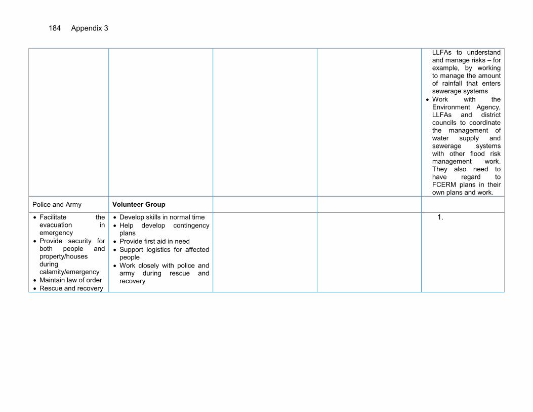
184 Appendix 3
LLFAs to understand and manage risks – for example, by working to manage the amount of rainfall that enters sewerage systems
Work with the Environment Agency, LLFAs and district councils to coordinate the management of water supply and sewerage systems with other flood risk management work. They also need to have regard to FCERM plans in their own plans and work.
Police and Army Volunteer Group
Facilitate the evacuation in emergency
Provide security for both people and property/houses during calamity/emergency
Maintain law of order Rescue and recovery
Develop skills in normal time Help develop contingency
plans Provide first aid in need Support logistics for affected
people Work closely with police and
army during rescue and recovery
1.
Appendix 4 185
APPENDIX 4: LIST OF CANDIDATE STRUCTURAL SUBPROJECTS
A. Cidanau-Ciujung-Cidurian (3 Cis) River Basin Territory1
ID Physical Intervention Description Estimated
Cost ($) FS/DED Potential Environmental Impact
Potential Social Impact Readiness Remark
1 Upstream and downstream of Pamarayan weir (Ciujung)
River Dredging, Dyke, Emergency Spill Way
10,000,000 To be Prepared
No significant impact, B
Requires land acquisition for dumping site, B
AMDAL and LARAP to be prepared
Estimated LAR2 cost $ 2,000,000
2 Rangkasbitung (Ciujung)
11.15 Km of new dykes located upstream of Pamarayan weir
5,000,000 Completed (2009) Requires review
No significant impact, B
Requires land acquisition Private land, B
AMDAL approved in December 20143, LARAP Study is prepared in 2015
Estimated LAR cost $ 1,000,000
3 Ciujung river mouth
Dredging of river 3-4 km up to the mouth
5,250,000 Completed (2012)
No significant impact, B
No significant impact, B
AMDAL to be prepared
Estimated cost
4 Check Dams (upper Ciujung)
At different Locations 8 as per rencana and 4 additional
870,000 Completed (2009 and 2010)
TBC To Be Confirmed
AMDAL to be prepared
5 Retention basins along the 11km dyke (additional)
49 Ha TBC Identified and investigated during TA
No significant impact B
Requires land acquisition B
AMDAL approved in December 2014
To be associated with side spillways
7 Downstream rivers upgrading (Cidurian 30 km and Ciujung 25 km)
Upgrade the capacity of the main streams, for Q25 flow by dredging and normalization
3,200,000 To be Prepared
B A or B AMDAL to be prepared
Only critical stretches could be selected Included in BBWS 3 Cis Rencana
1 Ministry of Public Works, Rancangan Rencana Pengelolaan Sumber Daya Air Wilayah Sungai Cidanau-Ciujung-Cidurian - 2012 2 LAR = Land Acquisition and Resettlement, TBC = To Be Confirmed, Ha = Hectare 3 Approval for Environment Feasibility no 660/KEP.526/BLH/2014, 23 Dec 2014 by BLHD District Lebak and Environment Permit no 660/KEP.527/BLH/2014, 23
Dec 2014 approved by Bupati Lebak
186 Appendix 4
ID Physical Intervention Description Estimated
Cost ($) FS/DED Potential Environmental Impact
Potential Social Impact Readiness Remark
1 Upstream and downstream of Pamarayan weir (Ciujung)
River Dredging, Dyke, Emergency Spill Way
10,000,000 To be Prepared
No significant impact, B
Requires land acquisition for dumping site, B
AMDAL and LARAP to be prepared
Estimated LAR2 cost $ 2,000,000
2 Rangkasbitung (Ciujung)
11.15 Km of new dykes located upstream of Pamarayan weir
5,000,000 Completed (2009) Requires review
No significant impact, B
Requires land acquisition Private land, B
AMDAL approved in December 20143, LARAP Study is prepared in 2015
Estimated LAR cost $ 1,000,000
3 Ciujung river mouth
Dredging of river 3-4 km up to the mouth
5,250,000 Completed (2012)
No significant impact, B
No significant impact, B
AMDAL to be prepared
Estimated cost
4 Check Dams (upper Ciujung)
At different Locations 8 as per rencana and 4 additional
870,000 Completed (2009 and 2010)
TBC To Be Confirmed
AMDAL to be prepared
5 Retention basins along the 11km dyke (additional)
49 Ha TBC Identified and investigated during TA
No significant impact B
Requires land acquisition B
AMDAL approved in December 2014
To be associated with side spillways
8 Ciujung Dyke Rehabilitation and Improvement
Carry out dyke rehabilitation and improvement 60 km, to increase the capacity of the main stream, Q25 flow
30,800,000 To be Prepared
B A or B TBD Only critical stretches could be selected Included in BBWS 3 Cis Rencana
9 Ciujung Retention Area at Kragilan including internal drainage system
Develop Ciujung retention area 400 ha including internal drainage system
3,200,000 To be Prepared
B A or B TBD Included in BBWS 3 Cis Rencana
10 Cidurian Dyke Rehabilitation and Improvement
Carry out dyke rehabilitation and improvement 30 km, to increase the capacity of
8,400,000 To be Prepared
B A or B TBD Only critical stretches could be selected Included in BBWS 3
Appendix 4 187
ID Physical Intervention Description Estimated
Cost ($) FS/DED Potential Environmental Impact
Potential Social Impact Readiness Remark
1 Upstream and downstream of Pamarayan weir (Ciujung)
River Dredging, Dyke, Emergency Spill Way
10,000,000 To be Prepared
No significant impact, B
Requires land acquisition for dumping site, B
AMDAL and LARAP to be prepared
Estimated LAR2 cost $ 2,000,000
2 Rangkasbitung (Ciujung)
11.15 Km of new dykes located upstream of Pamarayan weir
5,000,000 Completed (2009) Requires review
No significant impact, B
Requires land acquisition Private land, B
AMDAL approved in December 20143, LARAP Study is prepared in 2015
Estimated LAR cost $ 1,000,000
3 Ciujung river mouth
Dredging of river 3-4 km up to the mouth
5,250,000 Completed (2012)
No significant impact, B
No significant impact, B
AMDAL to be prepared
Estimated cost
4 Check Dams (upper Ciujung)
At different Locations 8 as per rencana and 4 additional
870,000 Completed (2009 and 2010)
TBC To Be Confirmed
AMDAL to be prepared
5 Retention basins along the 11km dyke (additional)
49 Ha TBC Identified and investigated during TA
No significant impact B
Requires land acquisition B
AMDAL approved in December 2014
To be associated with side spillways
the main stream, Q25 flow
Cis Rencana
11 Cidurian sediment control
Construction of 8 check dams to reduce the sediment yield and reduce the runoff
640,000 Completed AMDAL to be prepared
TBD TBD DEDs are prepared for a few and are some under way
12 Pasirkopo Dam, District Lebak
Development of Pasir Kopo Dam
54,303,500 Feasibility Study 2014
TBD TBD LARAP Study is prepared in 2015
Included in BBWS 3 Cis Rencana
13 Cidanau Dam, Serang District
Development of Cidanau Dam
119,600,000 DED is prepared in 2015
TBD TBD LARAP Study is prepared in 2015
Included in BBWS 3 Cis Rencana
14 Implementation of the retention basins
Long storage development in Ciujung Lama, and WTP
9,000,000 Available TBD TBD TBD

188 Appendix 4
ID Physical Intervention Description Estimated
Cost ($) FS/DED Potential Environmental Impact
Potential Social Impact Readiness Remark
1 Upstream and downstream of Pamarayan weir (Ciujung)
River Dredging, Dyke, Emergency Spill Way
10,000,000 To be Prepared
No significant impact, B
Requires land acquisition for dumping site, B
AMDAL and LARAP to be prepared
Estimated LAR2 cost $ 2,000,000
2 Rangkasbitung (Ciujung)
11.15 Km of new dykes located upstream of Pamarayan weir
5,000,000 Completed (2009) Requires review
No significant impact, B
Requires land acquisition Private land, B
AMDAL approved in December 20143, LARAP Study is prepared in 2015
Estimated LAR cost $ 1,000,000
3 Ciujung river mouth
Dredging of river 3-4 km up to the mouth
5,250,000 Completed (2012)
No significant impact, B
No significant impact, B
AMDAL to be prepared
Estimated cost
4 Check Dams (upper Ciujung)
At different Locations 8 as per rencana and 4 additional
870,000 Completed (2009 and 2010)
TBC To Be Confirmed
AMDAL to be prepared
5 Retention basins along the 11km dyke (additional)
49 Ha TBC Identified and investigated during TA
No significant impact B
Requires land acquisition B
AMDAL approved in December 2014
To be associated with side spillways
15 Construction of the new drainage network and rehabilitation of existing drainage system in Serang, Lebak, Pandeglang and Tangerang
Rearranging and building a micro urban drainage systems and industries that are connected to the drainage system macro
30,000,000 To be prepared
No significant impacts, C
No significant impacts
TBD For urban areas To be implemented by Human Settlement agencies
Total 280,300,000
LAR = Land Acquisition and Resettlement, TBC = To Be Confirmed, Ha = hectare

Appendix 4 189
B. Ambon – Seram River Basin Territory4 Priority Given by BWS Maluku
ID Physical Intervention Description Estimated Cost ($) FS/DED
Potential Environment
al Impact Potential
Social Impact Readiness Remark
1 Check Dam Systems 4 No in each of 5 rivers 6,000,000 Partially/To be revised
To be confirmed No LA/Minimal To be
prepared
Flood and Sediment Control Batu Merah, Way Ruhu, Way Tomu, Batu Gajah and Batu Gantung
2 River normalization and Dyke construction 7,170,000 To be
Prepared To be confirmed
Requires land acquisition
To be prepared Batu Merah
3 River normalization and Dyke construction 8,139,535 To be
Prepared To be confirmed
Requires land acquisition
LARAP Preparation in 2015
Way Ruhu
4 River normalization and Dyke construction 4,000,000 To be
Prepared To be confirmed
Requires land acquisition
To be prepared Other river
5 River dredging in Way Ruhu
2.5 km from the river mouth 3,000,000 Completed AMDAL No LA
DED completed, AMDAL Completed
DED includes dyke/ APBN
6 River dredging in Batu Merah
1.6 km from the river mouth 1,000,000 Completed AMDAL No LA
DED completed, AMDAL Completed
DED includes dyke by APBN
7
Improve the drainage system surrounding
Batu Merah and Way Ruhu
To discharge the flood or storm water to the see directly via artificial drainage
10,000,000 To be prepared B B TBD
For urbanized areas only. Implemented by Dinas Districts with involvement of DG of Human Settlement (Cipta Karya)
4 POLA PENGELOLAAN SDA, Balai Wilayah Sungai Ambon-Seram - 2009
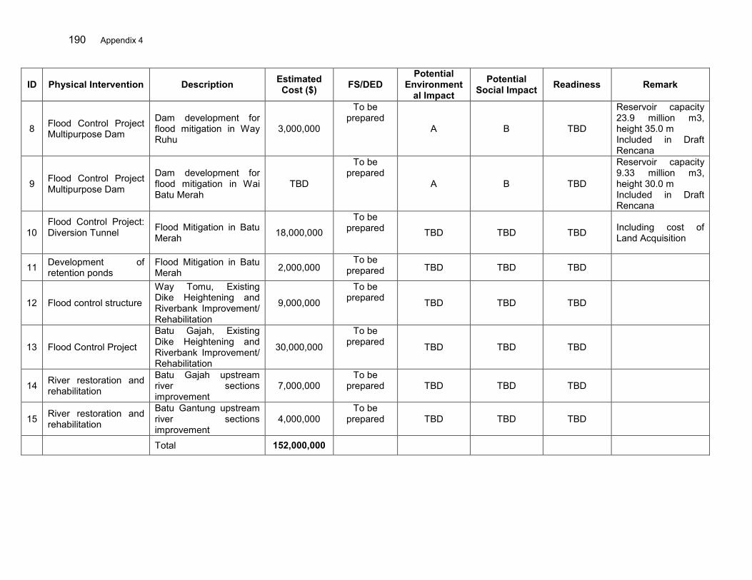
190 Appendix 4
ID Physical Intervention Description Estimated Cost ($) FS/DED
Potential Environment
al Impact Potential
Social Impact Readiness Remark
8 Flood Control Project Multipurpose Dam
Dam development for flood mitigation in Way Ruhu
3,000,000
To be prepared
A B TBD
Reservoir capacity 23.9 million m3, height 35.0 m Included in Draft Rencana
9 Flood Control Project Multipurpose Dam
Dam development for flood mitigation in Wai Batu Merah
TBD
To be prepared
A B TBD
Reservoir capacity 9.33 million m3, height 30.0 m Included in Draft Rencana
10 Flood Control Project: Diversion Tunnel
Flood Mitigation in Batu Merah 18,000,000
To be prepared TBD TBD TBD Including cost of
Land Acquisition
11 Development of retention ponds
Flood Mitigation in Batu Merah 2,000,000
To be prepared TBD TBD TBD
12 Flood control structure
Way Tomu, Existing Dike Heightening and Riverbank Improvement/ Rehabilitation
9,000,000
To be prepared TBD TBD TBD
13 Flood Control Project
Batu Gajah, Existing Dike Heightening and Riverbank Improvement/ Rehabilitation
30,000,000
To be prepared TBD TBD TBD
14 River restoration and rehabilitation
Batu Gajah upstream river sections improvement
7,000,000 To be
prepared TBD TBD TBD
15 River restoration and rehabilitation
Batu Gantung upstream river sections improvement
4,000,000 To be
prepared TBD TBD TBD
Total 152,000,000
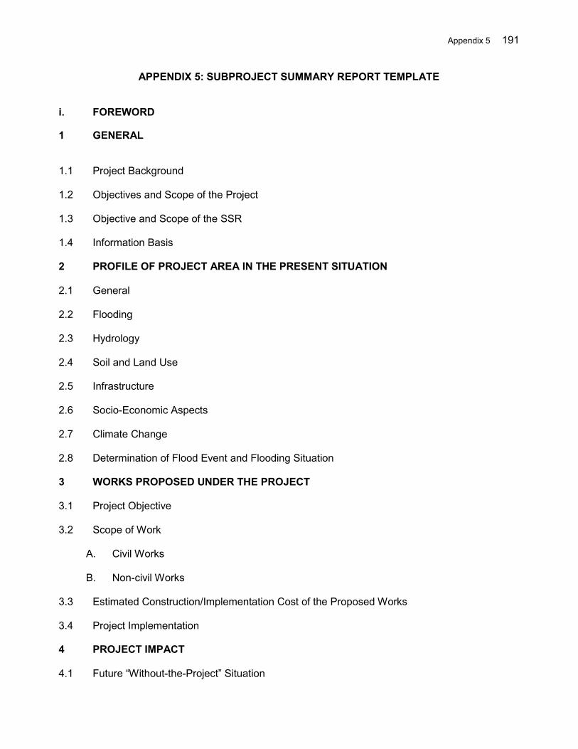
Appendix 5 191
APPENDIX 5: SUBPROJECT SUMMARY REPORT TEMPLATE
i. FOREWORD
1 GENERAL
1.1 Project Background 1.2 Objectives and Scope of the Project 1.3 Objective and Scope of the SSR 1.4 Information Basis 2 PROFILE OF PROJECT AREA IN THE PRESENT SITUATION 2.1 General 2.2 Flooding 2.3 Hydrology 2.4 Soil and Land Use 2.5 Infrastructure 2.6 Socio-Economic Aspects 2.7 Climate Change 2.8 Determination of Flood Event and Flooding Situation 3 WORKS PROPOSED UNDER THE PROJECT 3.1 Project Objective 3.2 Scope of Work
A. Civil Works B. Non-civil Works
3.3 Estimated Construction/Implementation Cost of the Proposed Works 3.4 Project Implementation 4 PROJECT IMPACT 4.1 Future “Without-the-Project” Situation
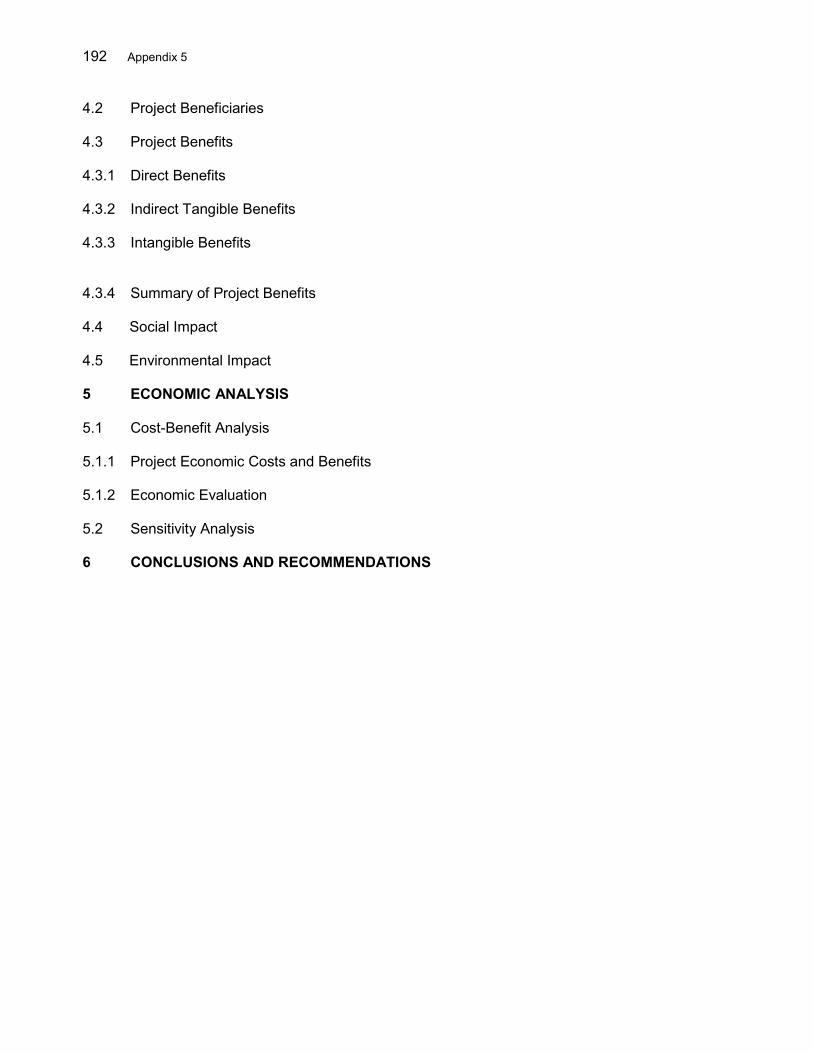
192 Appendix 5
4.2 Project Beneficiaries 4.3 Project Benefits 4.3.1 Direct Benefits 4.3.2 Indirect Tangible Benefits 4.3.3 Intangible Benefits 4.3.4 Summary of Project Benefits 4.4 Social Impact
4.5 Environmental Impact 5 ECONOMIC ANALYSIS 5.1 Cost-Benefit Analysis 5.1.1 Project Economic Costs and Benefits 5.1.2 Economic Evaluation 5.2 Sensitivity Analysis 6 CONCLUSIONS AND RECOMMENDATIONS

Appendix 6 193
APPENDIX 6: COMMUNITY CONTRACTING MECHANISMS
Community Contracting Mechanisms for Community Based Flood Risk Management (Ministry of Home Affairs)
1. Community Action Plan (CAP) Development
1. The process of the Project activities will commence with the establishment of a long list of villages with communities showing interest to participate in flood risk management (FRM).1 The long list of villages will be confirmed at early stage of the project in line with flood and erosion prone areas. The next process will include an awareness campaign, community mobilization, and capacity building for the communities. A Road Show presenting information about the Project and criteria for village participation will be organized in each district to inform and register the interested village communities. Based on village participation criteria, a short list of participating villages will be established. 2. Supported by Community Facilitators Team (CFT), a given village community will form and legalize a Community Implementation Team (CIT), which will elect a representative committee comprising five members to represent their interests. The committee will include at least one female and one member from a minority group, if any present in the village. As a legalized village institution, the CIT will open a bank account to receive the fund for project implementation. The CIT will develop a Community Action Plan (CAP) for FRM, to be approved by the District Project Management Unit (DPMU). The action plan will include development of small check dams, land-slide protection works, drainage system, shelters, early warning system, solid waste management land slide mitigation measures and other activities in line with the flood risk management plan (FRMP) developed for the district. With the help of CFT, the CIT will be assisted in planning and designing the priority infrastructures. The design of community-selected infrastructure will be in accordance with the detailed guidelines for such infrastructure from public works agency. Besides development of physical works and its costs, in the CAP, reservations will be made for non-physical activities such as CIT operational costs (travel, tools, office materials, etc.) and in-kind community contributions (labor, materials, construction site, etc.). 3. The communities will be facilitated in developing and establishing operating and maintenance mechanisms. The CIT will be trained in operation and maintenance of the infrastructures, and a user fee mechanism.
2. Village Eligibility and Selection Criteria 4. The village participation criteria are described below: Village Participation Criteria (i) Community commitment through Letter of Intent, confirming:
(a) no other similar FRM projects ongoing or planned for the village; (b) formation of a community implementation team (CIT); (c) willingness to prepare a community action plan (CAP); (d) willingness to contribute 16% of subproject construction costs in-kind; (e) willingness to contribute 4% in cash; (f) willingness to conduct and finance required operation and maintenance on
1 Where structural interventions are not feasible or have limited effects, communities will be engaged in preparation of
emergency response planning, procedures, and evacuation provisions.

194 Appendix 6
the system; and (g) willingness to conduct behavioral change program.
(ii) Geographic requisite: villages located in flood prone area
5. Following confirmation of village participation, villages will prepare a CAP to overcome flood management, drainage, solid waste and landslide problems at an appropriate level of technology and reasonable budget level. The CAP will be endorsed by all members of community’s 5 member representative committee and approved by the DPMU. Selection of the infrastructure will be subject to technical feasibility, cost effectiveness, financial feasibility, and screening for social and environmental safeguards. A village walk-through demonstrating the nature, location, and impacts on at least 50% of the village community will be prepared and recorded. The CIT will prepare an operating and maintenance plan, and a user fee mechanism, if needed, to maintain the works.
3. Women Participation
6. Proportional representation of women in Community Facilitator Teams should be achieved. Women’s active participation in community decision making processes, representation in Community Implementation Teams and adequate reflection of women’s interests in the CAPs are mandatory and are to be monitored by the Consultant’s team at central level.
4. Implementation 7. Once the CAP has been approved, implementation can start. The first step is signing of a Community Contract between the District Commitment Officer and the Community Implementation Team for a community-selected infrastructure construction. At contract signing, a first installment of 40% of the contract value less 4% of community cash contribution, will be transferred to the CIT Bank Account as an advance payment. The second (40%) and third (20%) installments will be disbursed subject to certification of progress at 60% and 100% completion point, respectively. It is the Project’s policy that the third installment will only be paid after the community group have received training in operation and maintenance, and user fee collection, if any. 8. Completion of construction works is to be verified by the District Consultant Engineer and the District Commitment Officer and confirmed in the Report on Finalization of Works (Laporan Penyelesaian Pelaksanaan Pekerjaan, LP3). Completion of civil works will be certified through a Statement of Completion of Works (SP4, Surat Pernyataan Penyelesaian Pelaksanaan Pekerjaan) signed by the CIT Chairperson, the District Commitment Officer and the District Consultant.
5. Sustainability 9. The definition for sustainability in the context of the Project is that the systems constructed through the Project, will keep on operating and may even expand after the Project has closed. This means that: (i) O&M are organized and implemented properly by community members; (ii) repairs are being done; and (iii) that sufficient funds are available to cover all necessary expenditures to keep on running.
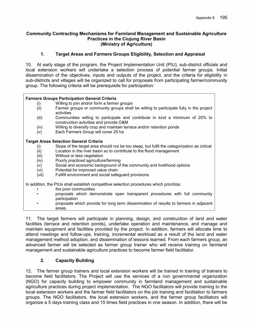
Appendix 6 195
Community Contracting Mechanisms for Farmland Management and Sustainable Agriculture Practices in the Ciujung River Basin
(Ministry of Agriculture)
1. Target Areas and Farmers Groups Eligibility, Selection and Appraisal 10. At early stage of the program, the Project Implementation Unit (PIU), sub-district officials and local extension workers will undertake a selection process of potential farmer groups. Initial dissemination of the objectives, inputs and outputs of the project, and the criteria for eligibility in sub-districts and villages will be organized to call for proposals from participating farmer/community group. The following criteria will be prerequisite for participation: Farmers Groups Participation General Criteria
(i) Willing to join and/or form a farmer groups (ii) Farmer groups or community groups shall be willing to participate fully in the project
activities (iii) Communities willing to participate and contribute in kind a minimum of 20% to
construction activities and provide O&M (iv) Willing to diversify crop and maintain terrace and/or retention ponds (v) Each Farmers Group will cover 25 ha
Target Areas Selection General Criteria
(i) Slope of the target area should not be too steep, but fulfil the categorization as cirtical (ii) Location in the river basin so to contribute to the flood management (iii) Without or less vegetation (iv) Poorly practiced agriculture/farming (v) Social and economic background of the community and livelihood options (vi) Potential for improved value chain (vii) Fullfill environment and social safeguard provisions
In addition, the PIUs shall establish competitive selection procedures which prioritize:
• the poor communities • proposals which demonstrate open transparent procedures with full community
participation • proposals which provide for long term dissemination of results to farmers in adjacent
areas. 11. The target farmers will participate in planning, design, and construction of land and water facilities (terrace and retention ponds), undertake operation and maintenance, and manage and maintain equipment and facilities provided by the project. In addition, farmers will allocate time to attend meetings and follow-ups, training, incremental workload as a result of the land and water management method adoption, and dissemination of lessons learned. From each farmers group, an advanced farmer will be selected as farmer group trainer who will receive training on farmland management and sustainable agriculture practices to become farmer field facilitator.
2. Capacity Building 12. The farmer group trainers and local extension workers will be trained in training of trainers to become field facilitators. The Project will use the services of a non governmental organization (NGO) for capacity building to empower community in farmland management and sustainable agriculture practices during project implementation. The NGO facilitators will provide training to the local extension workers and the farmer field facilitators on the job training and facilitation to farmers groups. The NGO facilitators, the local extension workers, and the farmer group facilitators will organize a 5 days training class and 15 times field practices in one season. In addition, there will be
196 Appendix 6
focus group discussions (FGDs) in order to empower Farmer Groups (FGs) in preparing the community group action plans (CGAPs) (Penyusunan Rencana Usulan Kegiatan Kelompok/RUKK).
3. Implementation 13. The project activities will include dissemination of the Project, selection criteria to obtain participating farmer groups, identification of community group candidates and location, formation and legalization of farmer groups, establishment of the farmer group’s bank account, development of community group action plans, implementation of the construction works through community contracting with local government agency, hand over of constructed assets from the government to the farmer groups, and preparation of final statement of expenditures and reporting. Local farmer groups and/or community-based groups will participate fully in the planning, design and construction and O&M of all physical works (terraces and retention ponds) under the project. A. Farmland Management and Agriculture Sustainable Agriculture Practices Social grant will be provided to participating farmer groups to implement the farmland management and agriculture sustainable practices. The fund transfer procedure for social grant covers the fund release mechanisms to the chairman of the targeted community groups based on the community group action plan. A.1. Targeted Community Group Guidelines
(i) The selection of the community group will be based on the farmer groups participation criteria. The targeted community groups will be selected to minimize social risk of unemployment, deficiency of food, and poverty
(ii) The provision of social grant to farmer groups should allow them to increase soil productivity, farm land extension and yield, job opportunity and farmer’s income
(iii) Targeted Community groups should be legalized and reported to the Head of the District agriculture agency
(iv) During implementation, the targeted community group activities should be guided and facilitated jointly by NGO facilitators, the local extension workers and the farmer group facilitators
A.2. Establishment of the community group bank account The community group bank account will be established for the social grant program by the community group chairman. . Any disbursements should be based on request from the Chairman of the targeted community group and counter signed by the community facilitator. The bank account number should be reported to the Authorized budget utilization/Chief of commitment authority (PPK). A.3. Community group action plan preparation (Penyusunan Rencana Usulan Kegiatan
Kelompok/RUKK)
The community group action plan will be prepared using a participatory process through group discussions facilitated by the NGO facilitators, the local extension workers and the farmer group facilitators, and covering:
- drawings/sketches of works to be implemented - detailed location of the works (dusun, desa, kecamatan etc) - Detailed requirement for material, scope of works, required resources - Unit costs of material and works including transportation cost and other related costs
A.4. Agreement between the community group and the authorized budget utilization.
The targeted community group should be engaged through an agreement in order to use funds and implement activities. This agreement is a legal document to protect the government on budget utilization by the society or community, and is signed by the chairman of the community group, the Chief of commitment authority (PPK) and authorized by the Head of the District agricultural agency as

Appendix 6 197
the Authorized budget utilization (KPA). A.5. Request for released fund The Chairman of the targeted community group should submit a request to the Chief of commitment authority (KPA/PPK) to release funds, following the procedure below:
(i) The chairman of the targeted community group submits a request to the Chief of Commitment authority (KPA/PPK) to release funds through the facilitators, with the Community group action plan (RUKK) attached. The proposal document includes:
- the name of location of the works (dusun, desa, kecamatan) - The name of the targeted group - The name of the chairman of the community group and members - The community bank account number - The name of the bank or post office - The Amount of social grant fund to be transferred and the receipt signed by the
Community Chairman - Other information related to fund utilization mechanism and field activities
(ii) The facilitators should verify the request documentation to release fund, the
community group action plan and convey it to the Chief of commitment authority (PPK) to be endorsed.
A.6. Issuance of the Letter of Payment Request (SPP) and Letter of Payment Instruction (SPM). The issuance of the Letter of Payment Request (Surat Permintaan Pembayaran/SPP) and the Letter of Payment Instruction (Surat Perintah Membayar/SPM) shall be based on the Circulation Letter Number: PER-66/PB/2005 (dated December 28, 2005) from the Director General of Treasury (Ministry of Finance) and the subsequent revisions, described below:
(i) The authorized budget utilization (KPA) should sign the Letter of Payment Request (Surat Permintaan Pembayaran/SPP), and conveys it to the Chief of commitment authority (PPK)
(ii) The Chief of commitment authority (PPK) should sign the Letter of Payment Instruction (Surat Perintah Membayar/SPM) and submits it to the Treasury Office (KPPN) for further approval.
A.7.Issuance of the Authorization Letter for Fund Release (Surat Perintah Pencairan
Dana/SP2D) The Treasury Office should issue the Authorization Letter to Release Fund (SP2D) following this procedure:
(i) The Treasury Office (KPPN) officials will verify the Letter of Payment Instruction (Surat Perintah Membayar/SPM) and issue the Authorization Letter to Release Fund (Surat Perintah Pencairan Dana /SP2D)
(ii) The Authorization Letter to Release Fund (Surat Perintah Pencairan Dana/SP2D) is then used to release and transfer social grant fund to the Chairman of the targeted community group account.
A.8.Fund disbursement. Social grant fund disbursement to the chairman of the targeted community group should follow:
(i) Disbursement of the Social grant to the targeted community group should be disbursed by installment payment based on field progress: 40% of contract value as an advance payment at contract signing, 40% at progress of 60%, and 20% at 100%
198 Appendix 6
completion (ii) The chairman of the community group shall give attention to the efficiency and
security aspects in fund disbursement.
A.9. Utilization and expenditure of the social grant fund.
Utilization and expenditure of the social grant include:
(i) The disbursed social grant fund should be utilized as soon as possible and appropriate with its allocation.
(ii) The chairman of the community group will utilize the social grant fund transparently, efficiently and effectively based on the community group action plan.
(iii) The chairman of the community group should prepare Statement of expenditure of social grant fund utilization, and provide receipts, a bookkeeping and archive of SOE.
A.10. Physical works implementation. Physical work implementation of the social grant includes the following steps:
(i) The implementation of the physical works should follow the Technical Guidelines, (ii) The community group action plan (RUKK) is the reference of the social grant
utilization carried out by targeted community group, (iii) Any changes of the physical works implementation should be approved by the
Authorized budget utilization (KPA).
A.11. Handover of the assets The social grant implementation will be considered finished when the physical works are completed according to the community group action plan (RUKK). Then the completed physical works should be handed over to the community with the related documentation. A.12. Accountability. To ensure technical and administration accountability of the social grant activities, the Chairman of the community group should prepare:
(i) The legalization letter of the targeted Social Grant Community group by the Head of the District agriculture agency
(ii) The community group action plan (RUKK) (iii) The agreement between the Chairman of the Community group and the Chief of
commitment authority (PPK) (iv) The request letter to release social grant fund to the Chief of commitment authority
(PPK) (v) The community bank account records showing the disbursement (vi) The statement of expenditure (vii) The evidence of the physical works activities (documents and photos) (viii) The hand over of the assets documentation
Those documents will be submitted to the authorized budget utilization (KPA) through the facilitators and the chairman of the community group should file a copy of the document. 14. The Chief of Commitment authority from the district agriculture agency will release the fund to each farmer group at the start of the design/construction process for walkthroughs, engineering design and technical assistance, and initial construction. Final joint walkthroughs will be made as part of system commissioning and transfer of facilities. Equipment, facilities and livestock will be provided to the farmer groups for communal ownership and for the benefit of the group, with systems established to ensure a fair and equitable access.
Appendix 6 199
B. Goods Transfer Procedure
Transfer of goods to the targeted community group should be based on the community needs and agreed plan, in order to avoid any social risk in the society. Authorized budget utilization/Chief of commitment authority (PPK) shall procure goods/services then handed over to the community. Procurement procedure will be carried out in line with agreed Procurement Guidelines. After hand-over of the goods to the community groups, final statement of expenditure will be prepared and reported.
4. Monitoring and Evaluation
15. The PIU supported by the consultants will establish a monitoring and evaluation system based on a geographic information system, provide progress reports, report to Central Project Management Unit on a quarterly basis and attend regular coordination meetings. The PIU will disseminate and share these results with other agencies in Banten for the provision of terraces and retention ponds. Using community facilitators for quality control and monitoring, the PIU through district agriculture agency will ensure that such procedures are established in a participatory manner with the entire community prior to any handover of facilities.
200 Appendix 7
APPENDIX 7: TERMS OF REFERENCE FOR CONSULTING SERVICES
I. Directorate General of Water Resources Packages
A. Program Implementation and Integrated Flood Risk Management 1. Background. Indonesia is highly prone to flood hazards due to its climate and topography.1 Flooding is a growing annual occurrence throughout most of the country imposing as much as $430 million per year in economic losses.2 From 2003 to 2015, the country’s average annual flood impact included: (i) 1.58 million affected persons; (ii) 350 casualties and 13,640 injured; (iii) 223,000 homes fully or partially damaged; and (iv) 168,000 hectares (ha) of crops inundated.3 The floods sever vital transport arteries and often disrupt access to ports and airports, restricting the transfer of goods and services. In 2013, the Ciujung river flooding affected 19,674 households, displaced 50,527 people, and disrupted the traffic along the Jakarta-Merak toll road that connect Java to Sumatra island.4 Despite its location in a drier region, in 2013, Ambon suffered from flash floods resulting in 59 destroyed and 45 damaged houses, 10 dead and 5 missing persons and 7,212 displaced people.5 2. In Government’s 2015-2019 National Medium Term Development Plan (RPJMN), water security is a central pillar and promotes Flood Risk Management (FRM) to reduce flood damages. FRM embraces a range of measures that address the following three key components: (i) managing flood hazard, (ii) minimizing exposure to flood hazard, and (iii) reducing vulnerability of people and property exposed. Managing flood hazard involves physical modification of water flow such as river infrastructure works, and catchment management measures such as controls over forestry and agricultural practices. Managing exposure to floods involves property acquisition, land use zoning, building codes, planning development controls, and elevated building. Managing flood vulnerability involves non-structural measures such as community awareness, flood forecasting and warning, preparedness, emergency response, post-flood early recovery strategies, and flood insurance. 3. The Project will support the Government of Indonesia (the Government) and communities to better manage and mitigate flood risks.6 The Project has been designed as a sector loan to support the implementation of the 2015-2019 Strategic Plan for Water Resources (SPWR) of the Ministry of Public Works and Housing (MPWH).7 The SPWR includes policy measures and priority investments in 63 river basin territories (RBTs) in Indonesia. The Project will finance subprojects in (i) two of these RBTs namely the Cidanau-Ciujung-Cidurian (3 Cis) in Banten Province, and (ii) the Ambon-Seram in Maluku Province. Project interventions will (i) 1 Indonesia is prone to two main type of flooding: (i) long-lasting riverine floods in large river basins having steep
slopes in upper part and long, flat and low floodplains (often influenced by tides) - these are characteristic of the large islands such as Java, Sumatra, Kalimantan or Iran Jaya; and (ii) flash floods, of short duration and high intensity, which occur in small and steep mountainous river basins, such as in small islands of Eastern Indonesia.
2 Centre for Research on the Epidemiology of Disasters (CRED). EM-DAT: The OFDA/CRED International Disaster Database. www.emdat.be. (accessed April 2014).
3 National Disaster Management Agency (BNPB). Indonesian Disaster Information and Data (DIBI). http://dibi.bnpb.go.id/DesInventar/dashboard.jsp (accessed April 2014).
4 2015. National Agency for Disaster Management (BNPB). www.geospasial.bnpb.go.id (accessed March 2015). 5 2015. National Agency for Disaster Management (BNPB). www.geospasial.bnpb.go.id (accessed March 2015). 6 The Asian Development Bank (ADB) provided project preparatory technical assistance. ADB. 2009. Technical
Assistance to the Republic of Indonesia for Flood Management in Selected River Basins (Phase II). Manila. (TA 7364-INO, approved on 12 October 2009, for $1,000,000 financed from the Japan Special Fund and additional $500,000 financed from the Water Financing Partnership Facility).
7 Ministry of Public Works and Housing, 2015. Rencana Strategis Direktorat Jenderal Sumber Daya Air 2015 – 2019. The plan calls for a reduction by 200,000 ha of the flooded area nationwide by 2019.
Appendix 7 201
enhance hydro meteorological data and analysis, management and institutional coordination for managing flood risks; (ii) upgrade and develop flood protection infrastructure; (iii) improve watershed conditions to moderate runoff peaks and soil erosion; and (iv) prepare communities to manage floods. The Project will promote effective flood risk management (FRM) by coupling infrastructure investment with supporting software measures. It will contribute to achievement of the 2015-2019 Government’s RPJMN sector target to reduce the magnitude of economic and social damages due to floods. 4. The Project will support the implementation of an area slice of the sector development plan, the SPWR.8 The 3 Cis and Ambon-Seram RBTs9 —respectively affected by the two main type of floods, the riverine and flash floods—have been selected to demonstrate the FRM approach as part of the operationalization of the 2015–2019 RPJMN. The investment will help the Government to accelerate the implementation of the Rencanas in those RBTs. It provides for a long-term partnership between the Asian Development Bank (ADB) and the Government for policy dialogue and capacity development, and ensures continuity in combining investments in infrastructure with non-structural components. There is a clear link between this project’s outputs and sector targets, and the criteria for the sector modality are met.10 5. The Project builds on lessons from past and ongoing ADB and other development partners’ assistance in flood management. The Project design incorporates the key recommendations based on the lessons learned including: (i) intensive consultation with local stakeholders need to be conducted during project preparation to ensure that the project addresses the full range of problems and issues; (ii) the Government should routinely collect and analyze flood damage data; (iii) support is needed for designing, developing sustainable long-term flood management concepts; and (iv) watershed management programs should be implemented to enhance the impact and sustainability of flood control works.11
6. The lack of flood infrastructure is also one major reason for the escalating damage by floods in the selected river basins in recent years. The impact extends not only to the damage to the residential areas, but includes widespread damage and interruption of public services including transportation, power supply, communication, etc. The overbank flood in the Ciujung river in 2013 caused a week long interruption of an important national highway, while livelihood was at a standstill for about a month in the entire region. In 2013, massive physical damage in the residential and commercial areas in Ambon City was caused by flash floods from adjoining five small rivers and particularly from the Batu Merah and Way Ruhu rivers. Flood control infrastructure is an urgent need to safeguard the social and economic development in all selected RBTs particularly in the areas where rapid urbanization has been taken place.
8 The 2015 – 2019 SPWR calls for an overall investment of $24.35 billion nationwide including $3.05 billion for flood
management. 9 The 3 Cis RBT covers an area of 4,125 km2 and lies mainly within the Banten Province, the most westerly province
of Java. The Ambon–Seram RBT is located on the islands of Ambon and Seram, in Maluku Province in eastern Indonesia with an area of 18,625 km2.
10 The required preconditions for the use of the sector lending modality — a sector development plan, institutional capacity and appropriate policy to implement the sector development plan — are all in place. The MPWH, as the executing agency, has the capacity to implement the sector development plan in terms of identification, selection, design and implementation of subprojects. The sector development plan has monitorable, verifiable sector indicators identified, including targets for cross cutting and safeguard concerns. There is a clear link between this project’s outputs and sector targets.
11 ADB. 2007. Completion Report: South Java Flood Control Sector Project in Indonesia. Manila. (Loan 1479-INO). ADB. 2006. Completion Report: North Java Flood Control Sector Project in Indonesia. Manila. (Loans 1425-INO and 1426-INO[SF])
202 Appendix 7
7. In the downstream area of the Ciujung river basin, the 11 km river reach downstream of the Pamarayan weir remains unprotected, while the other reach downstream of the highway is protected by dike structures designed for 5 years return period of flood. This has been the main cause of flooding in the highway and surrounding residential areas. In some locations, river conveyance capacity needs to be increased to mitigate the flooding. This can be done through river dredging and channel excavation, but also through controlling sources of sediment yields from upper catchment. 8. In Ambon, local government is planning to develop the city as a water-front city with emphasize on allocation, formation, sizing, and harmonizing space (land) in a way that helps promote the economic growth including the mitigation of flood hazard, exposure and vulnerability. Therefore, all flood management activities should be consistent with local government plans. 9. Scope of the Project. In the Project, there are 8 components under the four targeted outputs12 with 3 sector agencies namely Ministry of Public Works and Housing (MPWH), Ministry of Agriculture (MOA) and Ministry of Home Affairs (MOHA) and the State Ministry of National Development Planning/National Development Planning Agency (Bappenas). Directorate General of Water Resources (DGWR) packages cover four components.
10. Scope of the Works for Package 1. Key activities of the Package 1 cover Output 1A and 2C as follows:
1.A: Enhanced basin data and information and preparation of flood risks management (FRM) plans for the 3 Cis RBT and Ambon–Seram RBT (BBWS 3 Cis and BWSM). The proposed interventions in the selected basins are development of hydro-meteorological data management system, development of flood forecast model, capacity development of relevant agencies and, improvement of the hydrological observation.
The project will establish flood early warning systems (EWSs) in the 3 Cis and Ambon-Seram RBTs, involving stakeholders with designated roles and responsibilities. Both RBOs in Ambon - Seram and the 3 Cis will be empowered to implement the measures. In the 3 Cis RBT, the localized flood models will be developed to help forecast the flood with considerable lead time and enable flood risk mapping. The model will be coupled with river bed/bank erosion model and validated through ground observation, historical flood hazard maps and community based flood hazard mapping. In Ambon, standalone flash flood forecast and early warning systems will be installed considering local conditions. The forecast and early warning system can be developed based on the real-time observation of rainfall depth, intensity and, duration that to be communicated with local residents either by radio or cell phone networks.
With the help of a database and flood model analysis, the potential hazard extent needs to be mapped and a risk map to be prepared accordingly. These maps will provide a basis for the development of the flood risk management (FRM) plans and the spatial plans for the region. In addition to 3Cis and Ambon-Seram RBTs, two other RBTs will be selected and their FRMPs will be prepared for future investments. This process would be guided by the RBT coordinating council () in each selected RBT with its enhanced capacity.
12 Project components are (i) enhanced knowledge base for flood risk management, (ii) improved land management
and upgraded flood infrastructure, (iii) enhanced capacity for community-based flood risk management (CBFRM) and, (iv) effective project implementation.
Appendix 7 203
2.C Detailed engineering design (DED) [including Environmental Impact Assessment (EIA), social safeguards, economic analysis, tender documents and river operation and maintenance plans] and Construction Supervision for the 3 Cis RBT and Ambon-Seram RBT (DGWR, BBWS 3 Cis and BWSM). Structural subprojects will be identified, prioritized, formulated, appraised, and approved in accordance with technical, financial, and economic appraisal criteria, including social and environmental criteria, mutually agreed upon between ADB and the government.
In the downstream area of the Ciujung river basin, the project will construct 11 km earthen dikes (core project) on both banks downstream of Pamayaran weir to 25 years return period of peak river discharge standard. The construction consists of spillways, gated structures, bridges, culverts and, retention area. The list of potential subprojects has been prepared and their feasibility study, readiness and implementation will be considered under the project. The existing dike in the remaining river sections, which is designed for 5 years return period will be upgraded to 25-year standard after the feasibility study and DED are completed. The DEDs for upgrading work and other structural interventions in the 3 Cis RBT including dikes in Rangkasbitung, river normalization, check dams are included in the project activities scheduled in 2017.
In Ambon, the DED of flood control measures will be designed in consistent with the local government’s water front city plan. The list of potential subprojects has been prepared and their feasibility study, readiness and implementation will be considered under the project. The construction of the 4 check dams in Batu Merah as well as in Way Ruhu river basins will be given priority. The project will assess the feasibility of other structural subprojets in the 3 Cis and Ambon-Seram RBTs as per procedures set in the project administration manual.
The design capacities of flood control infrastructure will be based on national standards, robust hydrological and hydraulic analyses, and hydrographic and topographical surveys of the project area, and will take into account future climate variations.
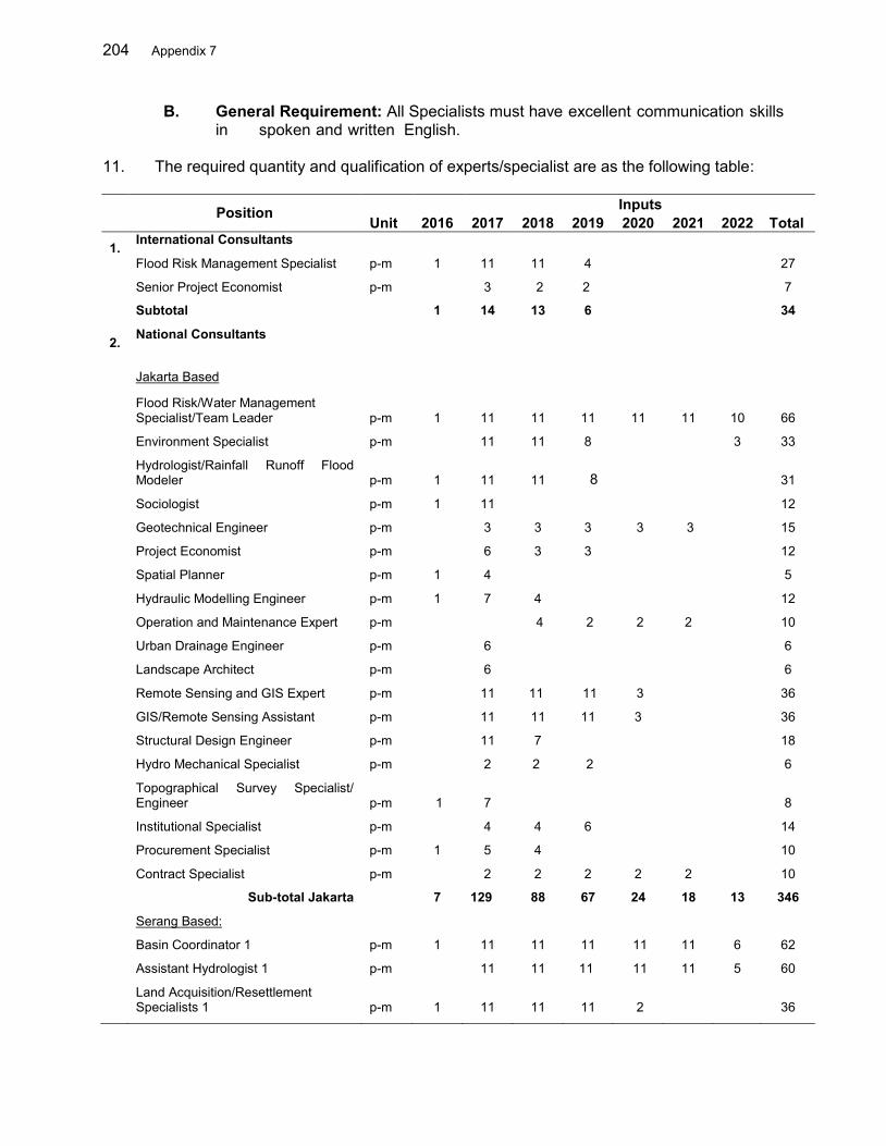
204 Appendix 7
B. General Requirement: All Specialists must have excellent communication skills in spoken and written English.
11. The required quantity and qualification of experts/specialist are as the following table: Position Inputs Unit 2016 2017 2018 2019 2020 2021 2022 Total 1. International Consultants
Flood Risk Management Specialist p-m 1 11 11 4
27
Senior Project Economist p-m 3 2 2 7
Subtotal 1 14 13 6 34
2. National Consultants
Jakarta Based
Flood Risk/Water Management Specialist/Team Leader p-m 1 11 11 11 11 11 10 66
Environment Specialist p-m
11 11 8 3 33
Hydrologist/Rainfall Runoff Flood Modeler p-m 1 11 11 8
31
Sociologist p-m 1 11
12
Geotechnical Engineer p-m 3 3 3 3 3 15
Project Economist p-m 6 3 3 12
Spatial Planner p-m 1 4 5
Hydraulic Modelling Engineer p-m 1 7 4 12
Operation and Maintenance Expert p-m
4 2 2 2 10
Urban Drainage Engineer p-m 6 6
Landscape Architect p-m 6 6
Remote Sensing and GIS Expert p-m
11 11 11 3 36
GIS/Remote Sensing Assistant p-m 11 11 11 3 36
Structural Design Engineer p-m
11 7 18
Hydro Mechanical Specialist p-m
2 2 2 6
Topographical Survey Specialist/ Engineer p-m 1 7
8
Institutional Specialist p-m
4 4 6 14
Procurement Specialist p-m 1 5 4
10
Contract Specialist p-m 2 2 2 2 2 10
Sub-total Jakarta 7 129 88 67 24 18 13 346
Serang Based:
Basin Coordinator 1 p-m 1 11 11 11 11 11 6 62
Assistant Hydrologist 1 p-m 11 11 11 11 11 5 60
Land Acquisition/Resettlement Specialists 1 p-m 1 11 11 11 2
36
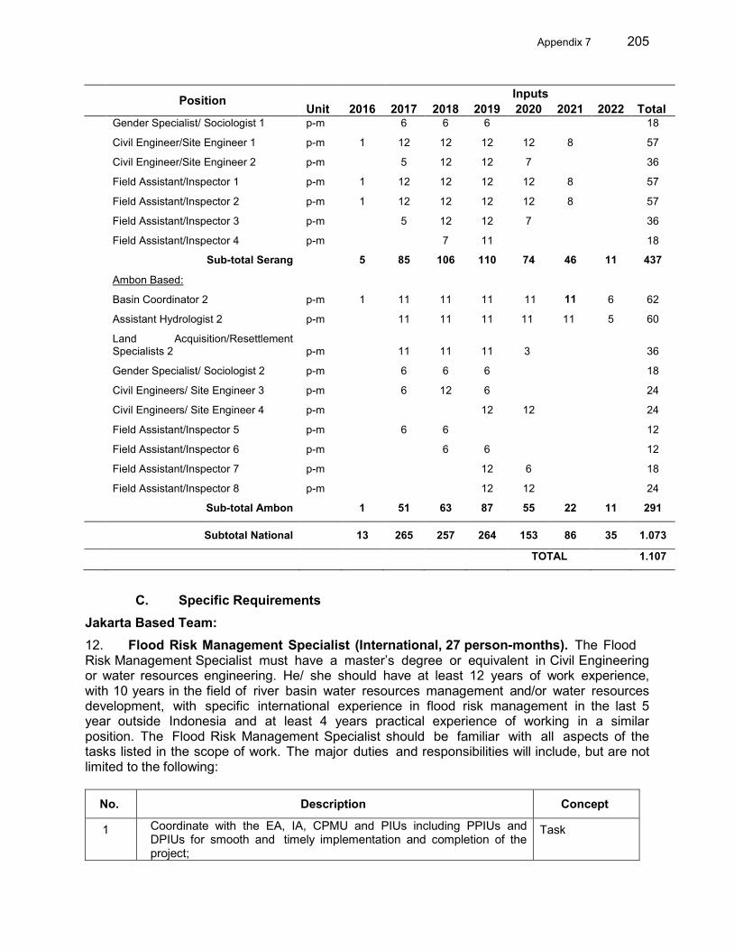
Appendix 7 205
Position Inputs Unit 2016 2017 2018 2019 2020 2021 2022 Total Gender Specialist/ Sociologist 1 p-m
6 6 6
18
Civil Engineer/Site Engineer 1 p-m 1 12 12 12 12 8 57
Civil Engineer/Site Engineer 2 p-m 5 12 12 7 36
Field Assistant/Inspector 1 p-m 1 12 12 12 12 8 57
Field Assistant/Inspector 2 p-m 1 12 12 12 12 8 57
Field Assistant/Inspector 3 p-m 5 12 12 7 36
Field Assistant/Inspector 4 p-m 7 11 18
Sub-total Serang 5 85 106 110 74 46 11 437
Ambon Based:
Basin Coordinator 2 p-m 1 11 11 11 11 11
6 62
Assistant Hydrologist 2 p-m 11 11 11 11 11 5 60
Land Acquisition/Resettlement Specialists 2 p-m
11 11 11 3
36
Gender Specialist/ Sociologist 2 p-m
6 6 6
18
Civil Engineers/ Site Engineer 3 p-m
6 12 6 24
Civil Engineers/ Site Engineer 4 p-m 12 12 24
Field Assistant/Inspector 5 p-m
6 6
12
Field Assistant/Inspector 6 p-m 6 6 12
Field Assistant/Inspector 7 p-m 12 6 18
Field Assistant/Inspector 8 p-m 12 12 24
Sub-total Ambon 1 51 63 87 55 22 11 291
Subtotal National 13 265 257 264 153 86 35 1.073
TOTAL 1.107
C. Specific Requirements
Jakarta Based Team: 12. Flood Risk Management Specialist (International, 27 person-months). The Flood Risk Management Specialist must have a master’s degree or equivalent in Civil Engineering or water resources engineering. He/ she should have at least 12 years of work experience, with 10 years in the field of river basin water resources management and/or water resources development, with specific international experience in flood risk management in the last 5 year outside Indonesia and at least 4 years practical experience of working in a similar position. The Flood Risk Management Specialist should be familiar with all aspects of the tasks listed in the scope of work. The major duties and responsibilities will include, but are not limited to the following:
No. Description Concept
1 Coordinate with the EA, IA, CPMU and PIUs including PPIUs and DPIUs for smooth and timely implementation and completion of the project;
Task
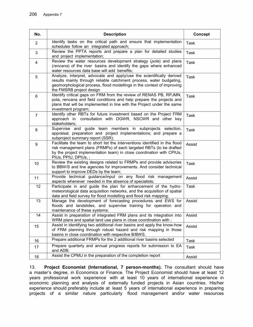
206 Appendix 7
No. Description Concept
2 Identify tasks on the critical path and ensure that implementation schedules follow an integrated approach;
Task
3 Review the PPTA reports and prepare a plan for detailed studies and project implementation;
Task
4 Review the water resources development strategy (pola) and plans (rencana) of the river basins and identify the gaps where enhanced water resources data base will add benefits;
Task
5 Analyze, interpret, advocate and apply/use the scientifically derived results mainly through reliable catchment process, water budgeting, geomorphological process, flood modellings in the context of improving the FMSRB project design
Task
6 Identify critical gaps on FRM from the review of RENAS PB, RPJMN, pola, rencana and field conditions and help prepare the projects and plans that will be implemented in line with the Project under the same investment program;
Task
7 Identify other RBTs for future investment based on the Project FRM approach in consultation with DGWR, NSCWR and other key stakeholders;
Task
8 Supervise and guide team members in subprojects selection, appraisal, preparation and project implementations; and prepare a subproject summary report (SSR);
Task
9 Facilitate the team to short list the interventions identified in the flood risk management plans (FRMPs) of each targeted RBTs (to be drafted by the project implementation team) in close coordination with CPIUs, PIUs, PPIU, DPIUs, ;
Assist
10 Review the existing designs related to FRMPs and provide advisories to BBW/S and line agencies for improvements. And consider technical support to improve DEDs by the team;
Task
11 Provide technical guidance/input on any flood risk management aspects whenever needed in the absence of specialists;
Assist
12 Participate in and guide the plan for enhancement of the hydro-meteorological data acquisition networks, and the acquisition of spatial data and field survey for flood modelling and flood risk mapping;
Task
13 Manage the development of forecasting procedures and EWS for floods and landslides, and supervise training for operation and maintenance of these systems;
Assist
14 Assist in preparation of integrated FRM plans and its integration into WRM plans and spatial land use plans in close coordination with ;
Assist
15 Assist in identifying two additional river basins and apply the know-how of FRM planning through robust hazard and risk mapping in those basins in close coordination with respective B/BWS.
Assist
16 Prepare additional FRMPs for the 2 additional river basins selected Task 17 Prepare quarterly and annual progress reports for submission to EA
and ADB; Task
18 Assist the CPMU in the preparation of the completion report Assist 13. Project Economist (International, 7 person-months). The consultant should have a master’s degree, in Economics or Finance. The Project Economist should have at least 12 years professional work experience with at least 10 years of international experience in economic planning and analysis of externally funded projects in Asian countries. His/her experience should preferably include at least 5 years of international experience in preparing projects of a similar nature particularly flood management and/or water resources
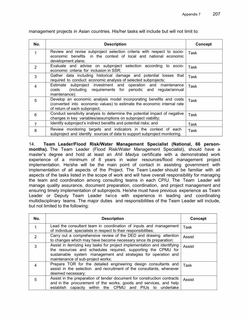
Appendix 7 207
management projects in Asian countries. His/her tasks will include but will not limit to:
No. Description Concept
1 Review and revise subproject selection criteria with respect to socio-economic benefits in the context of local and national economic development plans;
Task
2 Evaluate and advise on subproject selection according to socio-economic criteria for inclusion in SSR;
Task
3 Gather data including historical damage and potential losses that required to conduct economic analysis of selected subprojects;
Task
4 Estimate subproject investment and operation and maintenance costs (including requirements for periodic and regular/annual maintenance);
Task
5 Develop an economic analysis model incorporating benefits and costs (converted into economic values) to estimate the economic internal rate of return of each subproject;
Task
6 Conduct sensitivity analysis to determine the potential impact of negative changes in key variables/assumptions on subproject viability;
Task
7 Identify subproject’s indirect benefits and potential risks; and Task 8 Review monitoring targets and indicators in the context of each
subproject and identify sources of data to support subproject monitoring. Task
14. Team Leader/Flood Risk/Water Management Specialist (National, 66 person-months). The Team Leader (Flood Risk/Water Management Specialist), should have a master’s degree and hold at least an Ahli Madya certificate with a demonstrated work experience of a minimum of 8 years in water resources/flood management project implementation. He/she will be the main point of contact in assisting government with implementation of all aspects of the Project. The Team Leader should be familiar with all aspects of the tasks listed in the scope of work and will have overall responsibility for managing the team and coordination among consulting teams in each CPIU. The Team Leader will manage quality assurance, document preparation, coordination, and project management and ensuring timely implementation of subprojects. He/she must have previous experience as Team Leader or Deputy Team Leader twice with experience in leading and coordinating multidisciplinary teams. The major duties and responsibilities of the Team Leader will include, but not limited to the following:
No. Description Concept
1 Lead the consultant team in coordination of inputs and management of individual specialists in respect to their responsibilities;
Task
2 Carry out a comprehensive review of the DED and drawing attention to changes which may have become necessary since its preparation;
Assist
3 Assist in itemizing key tasks for project implementation and identifying the resources and schedules required, supporting the CPMU for sustainable system management and strategies for operation and maintenance of sub-project works;
Assist
4 Prepare TOR for the detailed engineering design consultants and assist in the selection and recruitment of the consultants, whenever deemed necessary;
Task
5 Assist in the preparation of tender document for construction contracts and in the procurement of the works, goods and services, and help establish capacity within the CPMU and PIUs to undertake
Assist

208 Appendix 7
No. Description Concept
procurement using local, and international, competitive bidding procedures;
6 Collect relevant plans and information from different entities, help identify critical gaps on FRM from the review of pola, rencana and field conditions and assist in the preparation of the projects and plans that will be implemented in line with the Project under the same investment program;
Task
7 Ensure timely delivery of specified reports in a format acceptable to government and the ADB; and
Assist
8 Assist in identifying two additional river basins and facilitate and coordinate the FRM planning activities in additional two river basins;
Assist
9 Prepare additional FRMPs for the 2 additional river basins selected Task 15. Hydrologist/Rainfall Runoff Flood Modeler (National, 31 person-months for 1A and 2C). The hydrologist should have a degree in Civil or Water Resources Engineering and/or a related field and hold at least an Ahli Madya certificate with at least 8 years experience in hydrological studies, hydrological modelling and development of early warning systems. He/she should be familiar with computerized data processing and retrieval, GIS systems and advanced computer analysis techniques (synthetic river basin water balance, rainfall-runoff simulations, storm analysis and flood management). He/she will have also extensive work experience in a related field, good knowledge and understanding of preferably considerable work experience in early warning system development. The candidate will have demonstrated ability to work in a multidisciplinary team and will possess excellent communication (written and oral) skills. The major duties and responsibilities will include, but are not limited to the following: No. Description Concept
1
Carry out a review of the project preparation documents with regard to hydrological analysis and draw attention to changes which may have become necessary since their preparation including climate change considerations;
Task
2 Review flood hydrology and flood behavior in targeted RBTs; assess the need for non-structural flood risk management measures including flood forecasting and early warning and integrate them into the Project;
Task
3 Assess the suitability and reliability of hydrological data required for improved flood management and propose measures;
Task
4 Support the establishment of public rainfall data server and facilitate the flood forecasting and early warning system (FFEWS) development in close coordination with PUSAIR;
Assist
5 Prepare plans for the installation of new hydrological stations, ensure the quality of installation of hydrological stations, calibrate and validate the functionality of all installed stations;
Task
6 Develop end to end EWS for riverine flood and localized automated rainfall based early warning systems for landslides and flash floods in the communities residing in the hilly areas in project targeted river basins;
Task
7 Collect and verify historical flood damage data, prepare inundation maps, and carry out detailed damage assessment for building, crops, fisheries and other critical infrastructures with their detailed exposure and vulnerability assessments for different scenarios;
Task
8 Develop damage vs depth, duration and velocity relationships for each critical asset and estimate the potential damage for different scenarios (return periods of maximum river discharge and projected socio-economic
Task

Appendix 7 209
development); 9 Assist in the installation of hydrological models, forecasting procedures and
EWS at BBWS-3Cis and BWS-Maluku, prepare appropriate operational manual and train the B/BWS staff on operations;13
Assist
10 Assist the TL and GIS specialist(s) in development of decision support frameworks;
Assist
11 Assist the TL in development of IFRM plans and SSRs; and Assist 12 Conduct hydrological modelling involving all rainfall runoff related parameters
necessary for the simulation of floods in the 3 Cis and Ambon–Seram RBTs and their influence on flood in the downstream areas;
Task
13 Consider possible reservoirs, retarding basins, check dams options and their contributions to the flood control in the selected RBTs;
Task
14 Conduct a localized hydrological modelling/down scaling to reflect the effects of urbanization on the local hydrologic system and provide inputs to the planning and design of urban drainage system as well as other infrastructure to be planned and designed under the project particularly in Ambon and Serang cities;
Task
15 Assist with the preparation of the TOR for detailed design consultant for hydrological and survey requirements of the subprojects;
Assist
16 Report on the findings of the hydrological study and their implications on the subprojects;
Assis
17 Review the existing detail engineering designs related to FRMPs and assist the TL in providing advisories to BBW/S and line agencies for improvements. And consider technical support to improve DEDs;
Task
18 Support the Hydraulic Modeling Engineer in river modelling by providing hydrological information and design parameters;
Assist
19 Assist the Team Leader in the timely preparation of reports. Assist 16. Institutional Specialist (National, 14 person-months). The Institutional Specialist should have a degree in Administration or Social Science or related field and a minimum of 6 years of work experience in analyzing and diagnosing institutional strengthening preferably in water resources/flood management/drainage sectors. He/she will be the main point of contact in assisting GOI together with Team Leader. He/she will support the Team Leader and PIUs in the main task of establishing the institution of flood forecasting and early warning system. As Institutions Specialist he/she will ensure that the B/BWS is fully engaged with stakeholders and relevant institutions. He/she will:
No. Description Concept
1 Undertake sector water resources institutional sector analysis following diagnostic analysis approach including establishing the institutional and program context for this project and its linkages with other National and State level initiatives;
Task
2 Recommend: (a) appropriate institutional structure of Project implementation for flood management particularly the early warning system; and (b) project design and arrangements to strengthen B/BWS and BPBD including resource requirements and task list;
Assist
3 Propose and promote through dialogue with stakeholders the legal strengthening measures that would support the flood early warning;
Assist
4 Review the institutional structure and arrangements governing the Task 13 The official hydrological data management, flood modeling and early warning system suite developed by the
Research and Development Center for Water Resources, MPWH in the framework of the Joint Cooperation Program, will be adopted.
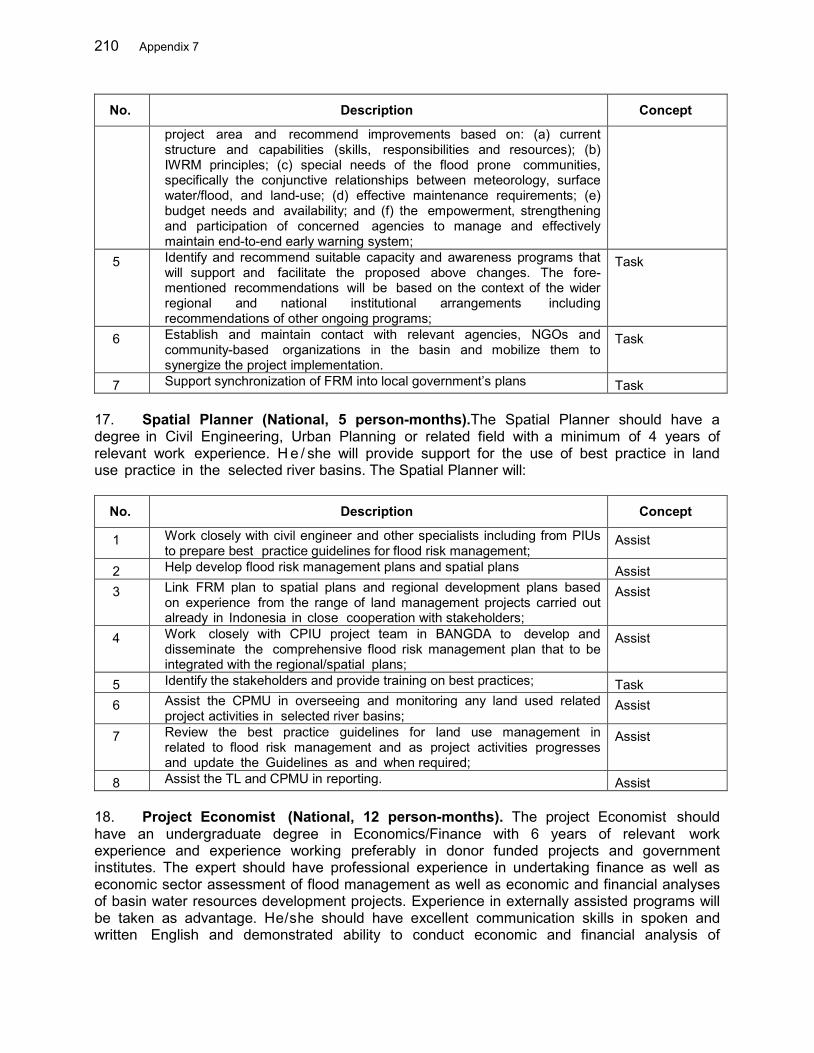
210 Appendix 7
No. Description Concept
project area and recommend improvements based on: (a) current structure and capabilities (skills, responsibilities and resources); (b) IWRM principles; (c) special needs of the flood prone communities, specifically the conjunctive relationships between meteorology, surface water/flood, and land-use; (d) effective maintenance requirements; (e) budget needs and availability; and (f) the empowerment, strengthening and participation of concerned agencies to manage and effectively maintain end-to-end early warning system;
5 Identify and recommend suitable capacity and awareness programs that will support and facilitate the proposed above changes. The fore-mentioned recommendations will be based on the context of the wider regional and national institutional arrangements including recommendations of other ongoing programs;
Task
6 Establish and maintain contact with relevant agencies, NGOs and community-based organizations in the basin and mobilize them to synergize the project implementation.
Task
7 Support synchronization of FRM into local government’s plans Task 17. Spatial Planner (National, 5 person-months).The Spatial Planner should have a degree in Civil Engineering, Urban Planning or related field with a minimum of 4 years of relevant work experience. H e / she will provide support for the use of best practice in land use practice in the selected river basins. The Spatial Planner will: No. Description Concept
1 Work closely with civil engineer and other specialists including from PIUs to prepare best practice guidelines for flood risk management;
Assist
2 Help develop flood risk management plans and spatial plans Assist 3 Link FRM plan to spatial plans and regional development plans based
on experience from the range of land management projects carried out already in Indonesia in close cooperation with stakeholders;
Assist
4 Work closely with CPIU project team in BANGDA to develop and disseminate the comprehensive flood risk management plan that to be integrated with the regional/spatial plans;
Assist
5 Identify the stakeholders and provide training on best practices; Task 6 Assist the CPMU in overseeing and monitoring any land used related
project activities in selected river basins; Assist
7 Review the best practice guidelines for land use management in related to flood risk management and as project activities progresses and update the Guidelines as and when required;
Assist
8 Assist the TL and CPMU in reporting. Assist 18. Project Economist (National, 12 person-months). The project Economist should have an undergraduate degree in Economics/Finance with 6 years of relevant work experience and experience working preferably in donor funded projects and government institutes. The expert should have professional experience in undertaking finance as well as economic sector assessment of flood management as well as economic and financial analyses of basin water resources development projects. Experience in externally assisted programs will be taken as advantage. He/she should have excellent communication skills in spoken and written English and demonstrated ability to conduct economic and financial analysis of
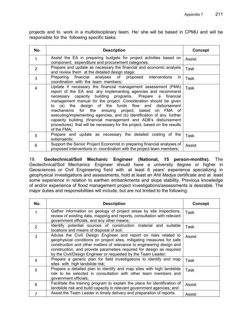
Appendix 7 211
projects and to work in a multidisciplinary team. He/ she will be based in CPMU and will be responsible for the following specific tasks:
No. Description Concept
1 Assist the EA in preparing budgets for project activities based on component, expenditure and procurement categories;
Assist
2 Prepare and update as necessary the financial and economic analysis and review them at the detailed design stage;
Task
3 Preparing financial analyses of proposed interventions in coordination with the team members;
Task
4 Update if necessary the financial management assessment (FMA) report of the EA and any implementing agencies and recommend necessary capacity building programs. Prepare a financial management manual for the project. Consideration should be given to (a) the design of the funds flow and disbursement mechanisms for the ensuing project, based on FMA of executing/implementing agencies, and (b) identification of any further capacity building (financial management and ADB’s disbursement procedures) that will be necessary for the project, based on the results of the FMA;
Task
5 Prepare and update as necessary the detailed costing of the subprojects;
Task
6 Support the Senior Project Economist in preparing financial analyses of proposed interventions in coordination with the project team members;
Assist
19. Geotechnical/Soil Mechanic Engineer (National, 15 person-months). The Geotechnical/Soil Mechanics Engineer should have a university degree or higher in Geosciences or Civil Engineering field with at least 6 years’ experience specializing in geophysical investigations and assessments, hold at least an Ahli Madya certificate and at least some experience in relation to earthen embankments and slope stability. Previous knowledge of and/or experience of flood management project investigations/assessments is desirable. The major duties and responsibilities will include, but are not limited to the following:
No. Description Concept
1 Gather information on geology of project areas by site inspections, review of existing data, mapping and reports, consultation with relevant government officials, and any other means;
Task
2 Identify potential sources of construction material and suitable locations and means of disposal of soil;
Task
3 Advise the Civil/ Design Engineer and report on risks related to geophysical conditions on project sites, mitigating measures for safe construction and other matters of relevance to engineering design and construction, and provide parameters required for design as required by the Civil/Design Engineer or requested by the Team Leader;
Assist
4 Prepare a generic plan for field investigations to identify and map sites with high landslide risk;
Task
5 Prepare a detailed plan to identify and map sites with high landslide risk to be selected in consultation with other team members and government officials;
Task
6 Facilitate the training program to explain the plans for identification of landslide risk and build capacity in relevant government agencies; and
Assist
7 Assist the Team Leader in timely delivery and preparation of reports. Assist
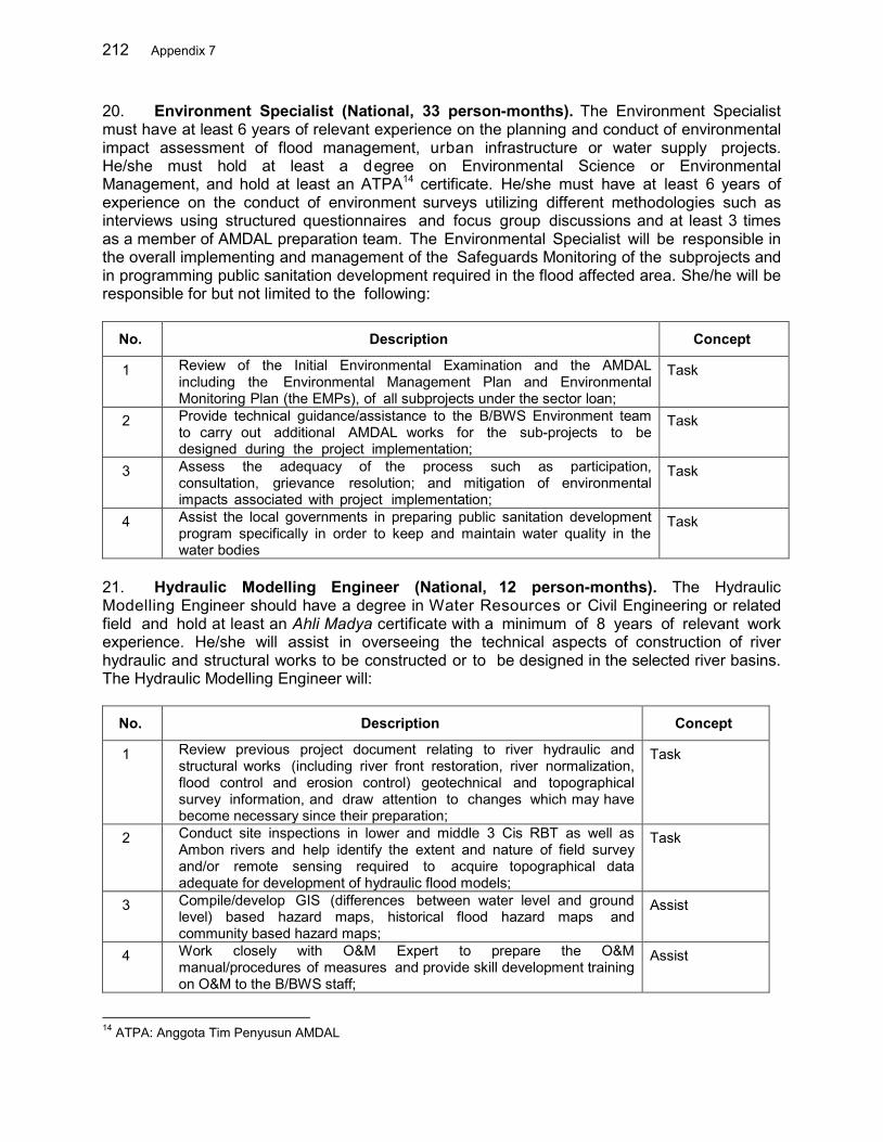
212 Appendix 7
20. Environment Specialist (National, 33 person-months). The Environment Specialist must have at least 6 years of relevant experience on the planning and conduct of environmental impact assessment of flood management, urban infrastructure or water supply projects. He/she must hold at least a degree on Environmental Science or Environmental Management, and hold at least an ATPA14 certificate. He/she must have at least 6 years of experience on the conduct of environment surveys utilizing different methodologies such as interviews using structured questionnaires and focus group discussions and at least 3 times as a member of AMDAL preparation team. The Environmental Specialist will be responsible in the overall implementing and management of the Safeguards Monitoring of the subprojects and in programming public sanitation development required in the flood affected area. She/he will be responsible for but not limited to the following:
No. Description Concept
1 Review of the Initial Environmental Examination and the AMDAL including the Environmental Management Plan and Environmental Monitoring Plan (the EMPs), of all subprojects under the sector loan;
Task
2 Provide technical guidance/assistance to the B/BWS Environment team to carry out additional AMDAL works for the sub-projects to be designed during the project implementation;
Task
3 Assess the adequacy of the process such as participation, consultation, grievance resolution; and mitigation of environmental impacts associated with project implementation;
Task
4 Assist the local governments in preparing public sanitation development program specifically in order to keep and maintain water quality in the water bodies
Task
21. Hydraulic Modelling Engineer (National, 12 person-months). The Hydraulic Modelling Engineer should have a degree in Water Resources or Civil Engineering or related field and hold at least an Ahli Madya certificate with a minimum of 8 years of relevant work experience. He/she will assist in overseeing the technical aspects of construction of river hydraulic and structural works to be constructed or to be designed in the selected river basins. The Hydraulic Modelling Engineer will:
No. Description Concept
1 Review previous project document relating to river hydraulic and structural works (including river front restoration, river normalization, flood control and erosion control) geotechnical and topographical survey information, and draw attention to changes which may have become necessary since their preparation;
Task
2 Conduct site inspections in lower and middle 3 Cis RBT as well as Ambon rivers and help identify the extent and nature of field survey and/or remote sensing required to acquire topographical data adequate for development of hydraulic flood models;
Task
3 Compile/develop GIS (differences between water level and ground level) based hazard maps, historical flood hazard maps and community based hazard maps;
Assist
4 Work closely with O&M Expert to prepare the O&M manual/procedures of measures and provide skill development training on O&M to the B/BWS staff;
Assist
14 ATPA: Anggota Tim Penyusun AMDAL
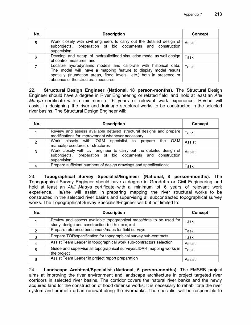
Appendix 7 213
No. Description Concept
5 Work closely with civil engineers to carry out the detailed design of subprojects, preparation of bid documents and construction supervision;
Assist
6 Develop and setup of hydraulic/flood simulation model as well design of control measures; and
Task
7 Localize hydrodynamic models and calibrate with historical data. The model will have a mapping feature to display model results spatially (inundation areas, flood levels, etc.) both in presence or absence of the structural measures.
Task
22. Structural Design Engineer (National, 18 person-months). The Structural Design Engineer should have a degree in River Engineering or related field and hold at least an Ahli Madya certificate with a minimum of 6 years of relevant work experience. He/she will assist in designing the river and drainage structural works to be constructed in the selected river basins. The Structural Design Engineer will:
No. Description Concept
1 Review and assess available detailed structural designs and prepare modifications for improvement whenever necessary
Task
2 Work closely with O&M specialist to prepare the O&M manual/procedures of structures
Assist
3 Work closely with civil engineer to carry out the detailed design of subprojects, preparation of bid documents and construction supervision;
Assist
4 Prepare sufficient numbers of design drawings and specifications; Task 23. Topographical Survey Specialist/Engineer (National, 8 person-months). The Topographical Survey Engineer should have a degree in Geodetic or Civil Engineering and hold at least an Ahli Madya certificate with a minimum of 6 years of relevant work experience. He/she will assist in preparing mapping the river structural works to be constructed in the selected river basins and supervising all subcontracted topographical survey works. The Topographical Survey Specialist/Engineer will but not limited to:
No. Description Concept
1 Review and assess available topographical maps/data to be used for study, design and construction in the project
Task
2 Prepare reference benchmark/maps for field surveys Task 3 Prepare TOR/specification for topographical survey sub-contracts Task 4 Assist Team Leader in topographical work sub-contractors selection Assist 5 Guide and supervise all topographical surveys/LIDAR mapping works in
the project Task
6 Assist Team Leader in project report preparation Assist
24. Landscape Architect/Specialist (National, 6 person-months). The FMSRB project aims at improving the river environment and landscape architecture in project targeted river corridors in selected river basins. The corridor covers the natural river banks and the newly acquired land for the construction of flood defense works. It is necessary to rehabilitate the river system and promote urban renewal along the riverbanks. The specialist will be responsible to
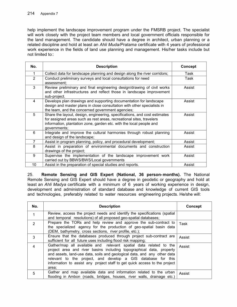
214 Appendix 7
help implement the landscape improvement program under the FMSRB project. The specialist will work closely with the project team members and local government officials responsible for the land management. The candidate should have a degree in architect, urban planning or a related discipline and hold at least an Ahli Muda/Pratama certificate with 4 years of professional work experience in the fields of land use planning and management. His/her tasks include but not limited to::
No. Description Concept
1 Collect data for landscape planning and design along the river corridors; Task 2 Conduct preliminary surveys and local consultations for need
assessment; Task
3 Review preliminary and final engineering design/drawing of civil works and other infrastructures and reflect those in landscape improvement sub-project.
Assist
4 Develops plan drawings and supporting documentation for landscape design and master plans in close consultation with other specialists in the team, and the concerned government agencies;
Assist
5 Share the layout, design, engineering, specifications, and cost estimates for assigned areas such as rest areas, recreational sites, travelers information, plantation zone, garden etc. with the local people and governments;
Assist
6 Integrate and improve the cultural harmonies through robust planning and design of the landscape;
Assist
7 Assist in program planning, policy, and procedural development; Assist 8 Assist in preparation of environmental documents and construction
drawings of the project; Assist
9 Supervise the implementation of the landscape improvement work carried out by BBWS/BWS/Local governments
Assist
10 Assist in the preparation of special studies and reports. Assist 25. Remote Sensing and GIS Expert (National, 36 person-months). The National Remote Sensing and GIS Expert should have a degree in geodetic or geography and hold at least an Ahli Madya certificate with a minimum of 6 years of working experience in design, development and administration of standard database and knowledge of current GIS tools and technologies, preferably related to water resources engineering projects. He/she will:
No. Description Concept
1 Review, access the project needs and identify the specifications (spatial and temporal resolutions) of all proposed geo-spatial databases;
2 Prepare the TORs and help review and approve the sub-contract to the specialized agency for the production of geo-spatial basin data (DEM, bathymetry, cross sections, river profile, etc.);
Task
3 Ensure that the databases produced through project sub-contract are sufficient for all future uses including flood risk mapping;
Assist
4 Gather/map all available and relevant spatial data related to the project area and river basins including topographical data, property and assets, land-use data, soils and geological data, and any other data relevant to the project, and develop a GIS database for this information to assist any project staff to get quick access to the project area;
Assist
5 Gather and map available data and information related to the urban flooding in Ambon (roads, bridges, houses, river walls, drainage etc.)
Assist
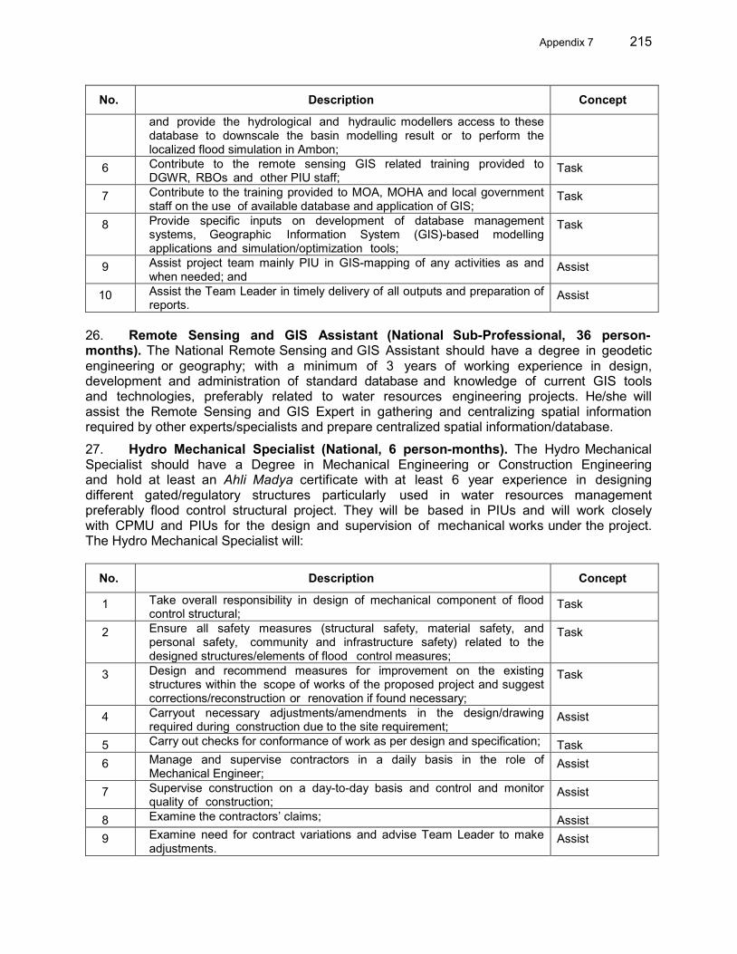
Appendix 7 215
No. Description Concept
and provide the hydrological and hydraulic modellers access to these database to downscale the basin modelling result or to perform the localized flood simulation in Ambon;
6 Contribute to the remote sensing GIS related training provided to DGWR, RBOs and other PIU staff;
Task
7 Contribute to the training provided to MOA, MOHA and local government staff on the use of available database and application of GIS;
Task
8 Provide specific inputs on development of database management systems, Geographic Information System (GIS)-based modelling applications and simulation/optimization tools;
Task
9 Assist project team mainly PIU in GIS-mapping of any activities as and when needed; and
Assist
10 Assist the Team Leader in timely delivery of all outputs and preparation of reports.
Assist
26. Remote Sensing and GIS Assistant (National Sub-Professional, 36 person-months). The National Remote Sensing and GIS Assistant should have a degree in geodetic engineering or geography; with a minimum of 3 years of working experience in design, development and administration of standard database and knowledge of current GIS tools and technologies, preferably related to water resources engineering projects. He/she will assist the Remote Sensing and GIS Expert in gathering and centralizing spatial information required by other experts/specialists and prepare centralized spatial information/database.
27. Hydro Mechanical Specialist (National, 6 person-months). The Hydro Mechanical Specialist should have a Degree in Mechanical Engineering or Construction Engineering and hold at least an Ahli Madya certificate with at least 6 year experience in designing different gated/regulatory structures particularly used in water resources management preferably flood control structural project. They will be based in PIUs and will work closely with CPMU and PIUs for the design and supervision of mechanical works under the project. The Hydro Mechanical Specialist will:
No. Description Concept
1 Take overall responsibility in design of mechanical component of flood control structural;
Task
2 Ensure all safety measures (structural safety, material safety, and personal safety, community and infrastructure safety) related to the designed structures/elements of flood control measures;
Task
3 Design and recommend measures for improvement on the existing structures within the scope of works of the proposed project and suggest corrections/reconstruction or renovation if found necessary;
Task
4 Carryout necessary adjustments/amendments in the design/drawing required during construction due to the site requirement;
Assist
5 Carry out checks for conformance of work as per design and specification; Task 6 Manage and supervise contractors in a daily basis in the role of
Mechanical Engineer; Assist
7 Supervise construction on a day-to-day basis and control and monitor quality of construction;
Assist
8 Examine the contractors’ claims; Assist 9 Examine need for contract variations and advise Team Leader to make
adjustments. Assist

216 Appendix 7
28. Operation and Maintenance (O&M) Expert (National, 10 person-months). The national O&M Expert should have a degree in Civil Engineering or related field with a minimum of 6 years of working experience in O&M of small to large projects of water resources engineering or flood management and hold at least an Ahli Madya certificate. She/he will:
No. Description Concept
1 Review the design relating to river hydraulic and structural works under the design & build contract (including river front restoration, river normalization and flood control, erosion control) and propose O&M plans for each and every proposed measures;
Task
2 Estimate the O&M cost for a short and long term and advise the PIUs to allocate respective resources to ensure that O&M provisions are made for the projects;
Task
3 Guide and train project staff including PIUs staff in O&M of respective measures implemented under the project;
Assis
4 Identify and take into consideration any technical, environment or social safeguard issues according to international best practices that should be addressed in O&M of the system;
Task
5 Supervise the O&M works within the project scope and coverage; Task 6 Prepare O&M of River and Flood Management Infrastructures Manuals Task 7 Provide technical inputs to the civil engineer and TL as and when needed; and Assist 8 Prepare reports with sufficient numbers of design drawings and specifications
in it. Assist
29. Urban Drainage Engineer (National, 6 person-months). The national Urban Drainage Engineer should have a degree in Civil Engineering or related field and hold at least an Ahli Madya certificate with a minimum of 6 years of working experience in designing and implementing urban drainage works preferably in relation with flood management projects. She/he will:
No. Description Concept
1 Review the available designs of drainage works for each river basin to integrate them with the flood management works
Task
2 Give advice to BBWS/BWS and related provincial/district dinas on drainage system required to integrate with the flood management works if required
Assist
3 Prepare design criteria for drainage system works in the project river basins Task 4 Prepare design of drainage system works for lower reach of Batu Merah, Wai
Ruhu and Ciujung Task
5 Review the current drainage works within the project scope and coverage; Assist 6 Provide technical inputs on drainage systems to the civil engineer and Team
Leader as and when needed; and Assist
7 Assist Team Leader in preparing reports relating to drainage works Assist 30. Procurement Specialist (National, 10 person-months). The Procurement Specialist should have graduate qualifications in Civil Engineering or Water Resources Engineering and at least 8 year experience in procurement and preparation of tender, evaluation of bids of ADB projects in Indonesia and hold at least an certificate of Medium Procurement Specialist

Appendix 7 217
(Keahlian Pengadaan Barang/Jasa Tingkat Menengah) by LKPP15. He/she should have demonstrated ability to work in a multidisciplinary team and excellent communication skills. He/she will be based in CPMU and will be responsible for but not limited to the following scope of work:
No. Description Concept
1 Assist the CPMU and PIU to prepare standard bidding documents for consulting services and construction contracts, call for proposals, evaluation of bids and contract negotiations following the agreed procurement procedures as described in the PAM;
Task
2 Assist in procurement of the works, goods and services, and establish capacity within the CPMU and PIU to undertake procurement using local, and international, competitive bidding procedures;
Assist
3 Assist in preparing documents and reporting to ADB and EA./IAs; Assist 4 Preparation and implementation of capacity development modules for IAs
staff on preparation of standard bidding documents and evaluation of bids;
Task
5 Undertake procurement assessment of the EA, including the existing procurement systems. Assess if there are any capacity, procedural and organizational constraints that may affect effective Project implementation, and recommend an action plan with the EA to address these constraints.
Task
6 Assess the procurement risk and put in place appropriate review and supervision processes and thresholds to mitigate those risks.
Task
7 Prepare procurement plan for the sub-projects, and assist and advise on the preparation process of the procurement documents and materials in line with the requirement of the State and for ADB financing.
Assist
31. Contract Specialist (National, 10 person-months). The Contract Specialist should have degree from Faculty of Law and at least 8 year experience in preparation of contract documents and contracts managements of ADB projects in Indonesia. He/she should have demonstrated ability to work in a multidisciplinary team and excellent communication skills. He/she will be based in CPMU and will be responsible for but not limited to the following scope of work:
No. Description Concept
1 Assist the CPMU and PIU to prepare standard contract documents for consulting services, goods and construction contracts, as described in the PAM;
Task
2 Assist in preparing contract variations or amendments Assist 3 Assist in preparing documents and reporting to ADB and EA./IAs; Assist 4 Preparation and implementation of capacity development modules for
IAs staff on preparation of standard contract documents Task
32. CAD Operators (National Sub-Professional, 8 persons, 240 person-months). The CAD Operators should have a D3 diploma or a degree in Civil Engineering with at least 5 years ( or 3 years for D3 diploma) of experience in preparing maps and design drawing of infrastructure projects in Indonesia. He/she will assist the specialists/engineers in preparing 15 LKPP: Lembaga Kebijakan Pengadaan Barang/Jasa Pemerintah (government procurement policy agency)
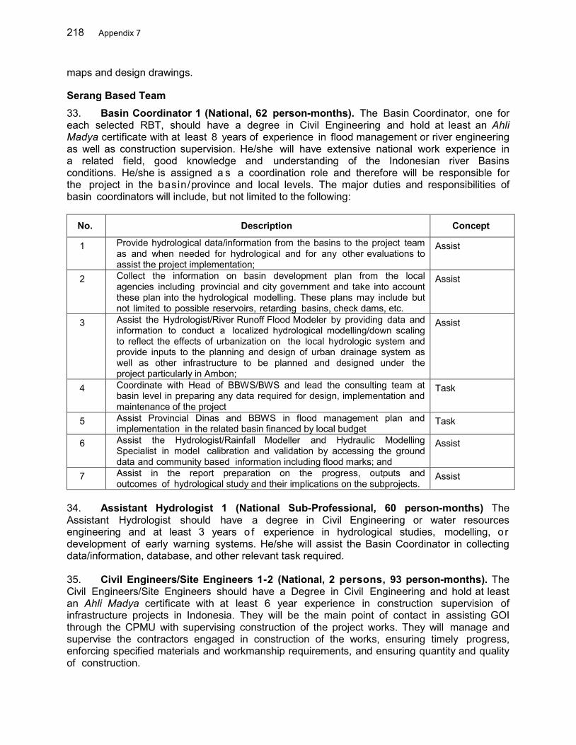
218 Appendix 7
maps and design drawings.
Serang Based Team 33. Basin Coordinator 1 (National, 62 person-months). The Basin Coordinator, one for each selected RBT, should have a degree in Civil Engineering and hold at least an Ahli Madya certificate with at least 8 years of experience in flood management or river engineering as well as construction supervision. He/she will have extensive national work experience in a related field, good knowledge and understanding of the Indonesian river Basins conditions. He/she is assigned a s a coordination role and therefore will be responsible for the project in the basin/province and local levels. The major duties and responsibilities of basin coordinators will include, but not limited to the following:
No. Description Concept
1 Provide hydrological data/information from the basins to the project team as and when needed for hydrological and for any other evaluations to assist the project implementation;
Assist
2 Collect the information on basin development plan from the local agencies including provincial and city government and take into account these plan into the hydrological modelling. These plans may include but not limited to possible reservoirs, retarding basins, check dams, etc.
Assist
3 Assist the Hydrologist/River Runoff Flood Modeler by providing data and information to conduct a localized hydrological modelling/down scaling to reflect the effects of urbanization on the local hydrologic system and provide inputs to the planning and design of urban drainage system as well as other infrastructure to be planned and designed under the project particularly in Ambon;
Assist
4 Coordinate with Head of BBWS/BWS and lead the consulting team at basin level in preparing any data required for design, implementation and maintenance of the project
Task
5 Assist Provincial Dinas and BBWS in flood management plan and implementation in the related basin financed by local budget
Task
6 Assist the Hydrologist/Rainfall Modeller and Hydraulic Modelling Specialist in model calibration and validation by accessing the ground data and community based information including flood marks; and
Assist
7 Assist in the report preparation on the progress, outputs and outcomes of hydrological study and their implications on the subprojects.
Assist
34. Assistant Hydrologist 1 (National Sub-Professional, 60 person-months) The Assistant Hydrologist should have a degree in Civil Engineering or water resources engineering and at least 3 years o f experience in hydrological studies, modelling, o r development of early warning systems. He/she will assist the Basin Coordinator in collecting data/information, database, and other relevant task required. 35. Civil Engineers/Site Engineers 1-2 (National, 2 persons, 93 person-months). The Civil Engineers/Site Engineers should have a Degree in Civil Engineering and hold at least an Ahli Madya certificate with at least 6 year experience in construction supervision of infrastructure projects in Indonesia. They will be the main point of contact in assisting GOI through the CPMU with supervising construction of the project works. They will manage and supervise the contractors engaged in construction of the works, ensuring timely progress, enforcing specified materials and workmanship requirements, and ensuring quantity and quality of construction.
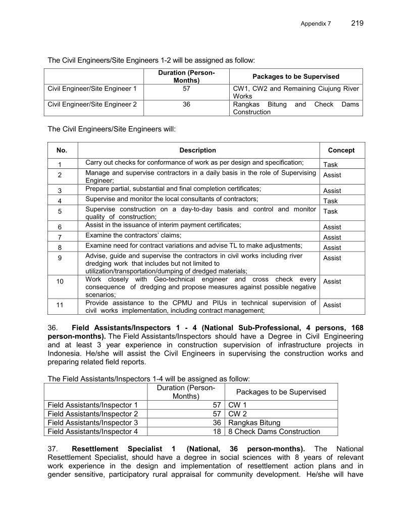
Appendix 7 219
The Civil Engineers/Site Engineers 1-2 will be assigned as follow:
Duration (Person-Months) Packages to be Supervised
Civil Engineer/Site Engineer 1 57 CW1, CW2 and Remaining Ciujung River Works
Civil Engineer/Site Engineer 2 36 Rangkas Bitung and Check Dams Construction
The Civil Engineers/Site Engineers will:
No. Description Concept
1 Carry out checks for conformance of work as per design and specification; Task 2 Manage and supervise contractors in a daily basis in the role of Supervising
Engineer; Assist
3 Prepare partial, substantial and final completion certificates; Assist 4 Supervise and monitor the local consultants of contractors; Task 5 Supervise construction on a day-to-day basis and control and monitor
quality of construction; Task
6 Assist in the issuance of interim payment certificates; Assist 7 Examine the contractors’ claims; Assist 8 Examine need for contract variations and advise TL to make adjustments; Assist 9 Advise, guide and supervise the contractors in civil works including river
dredging work that includes but not limited to utilization/transportation/dumping of dredged materials;
Assist
10 Work closely with Geo-technical engineer and cross check every consequence of dredging and propose measures against possible negative scenarios;
Assist
11 Provide assistance to the CPMU and PIUs in technical supervision of civil works implementation, including contract management;
Assist
36. Field Assistants/Inspectors 1 - 4 (National Sub-Professional, 4 persons, 168 person-months). The Field Assistants/Inspectors should have a Degree in Civil Engineering and at least 3 year experience in construction supervision of infrastructure projects in Indonesia. He/she will assist the Civil Engineers in supervising the construction works and preparing related field reports. The Field Assistants/Inspectors 1-4 will be assigned as follow:
Duration (Person-Months) Packages to be Supervised
Field Assistants/Inspector 1 57 CW 1 Field Assistants/Inspector 2 57 CW 2 Field Assistants/Inspector 3 36 Rangkas Bitung Field Assistants/Inspector 4 18 8 Check Dams Construction 37. Resettlement Specialist 1 (National, 36 person-months). The National Resettlement Specialist, should have a degree in social sciences with 8 years of relevant work experience in the design and implementation of resettlement action plans and in gender sensitive, participatory rural appraisal for community development. He/she will have
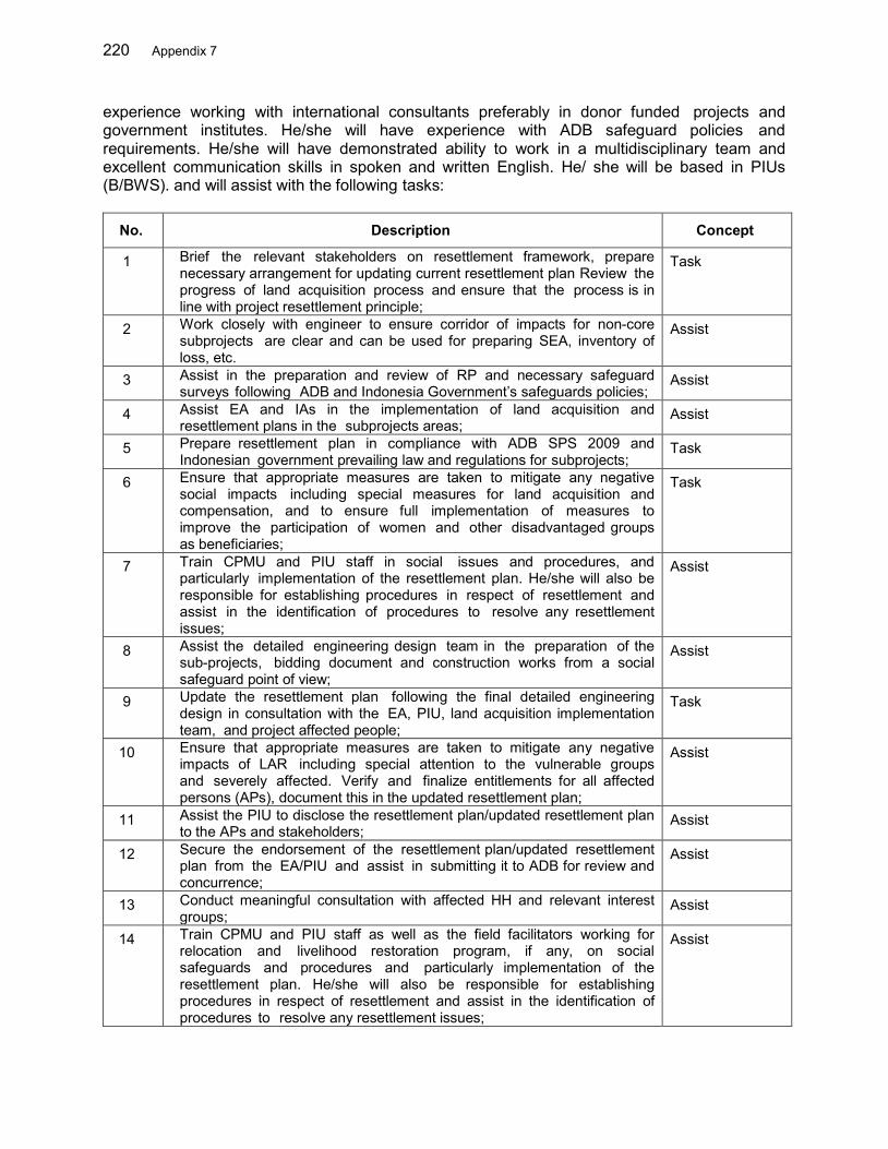
220 Appendix 7
experience working with international consultants preferably in donor funded projects and government institutes. He/she will have experience with ADB safeguard policies and requirements. He/she will have demonstrated ability to work in a multidisciplinary team and excellent communication skills in spoken and written English. He/ she will be based in PIUs (B/BWS). and will assist with the following tasks:
No. Description Concept
1 Brief the relevant stakeholders on resettlement framework, prepare necessary arrangement for updating current resettlement plan Review the progress of land acquisition process and ensure that the process is in line with project resettlement principle;
Task
2 Work closely with engineer to ensure corridor of impacts for non-core subprojects are clear and can be used for preparing SEA, inventory of loss, etc.
Assist
3 Assist in the preparation and review of RP and necessary safeguard surveys following ADB and Indonesia Government’s safeguards policies;
Assist
4 Assist EA and IAs in the implementation of land acquisition and resettlement plans in the subprojects areas;
Assist
5 Prepare resettlement plan in compliance with ADB SPS 2009 and Indonesian government prevailing law and regulations for subprojects;
Task
6 Ensure that appropriate measures are taken to mitigate any negative social impacts including special measures for land acquisition and compensation, and to ensure full implementation of measures to improve the participation of women and other disadvantaged groups as beneficiaries;
Task
7 Train CPMU and PIU staff in social issues and procedures, and particularly implementation of the resettlement plan. He/she will also be responsible for establishing procedures in respect of resettlement and assist in the identification of procedures to resolve any resettlement issues;
Assist
8 Assist the detailed engineering design team in the preparation of the sub-projects, bidding document and construction works from a social safeguard point of view;
Assist
9 Update the resettlement plan following the final detailed engineering design in consultation with the EA, PIU, land acquisition implementation team, and project affected people;
Task
10 Ensure that appropriate measures are taken to mitigate any negative impacts of LAR including special attention to the vulnerable groups and severely affected. Verify and finalize entitlements for all affected persons (APs), document this in the updated resettlement plan;
Assist
11 Assist the PIU to disclose the resettlement plan/updated resettlement plan to the APs and stakeholders;
Assist
12 Secure the endorsement of the resettlement plan/updated resettlement plan from the EA/PIU and assist in submitting it to ADB for review and concurrence;
Assist
13 Conduct meaningful consultation with affected HH and relevant interest groups;
Assist
14 Train CPMU and PIU staff as well as the field facilitators working for relocation and livelihood restoration program, if any, on social safeguards and procedures and particularly implementation of the resettlement plan. He/she will also be responsible for establishing procedures in respect of resettlement and assist in the identification of procedures to resolve any resettlement issues;
Assist
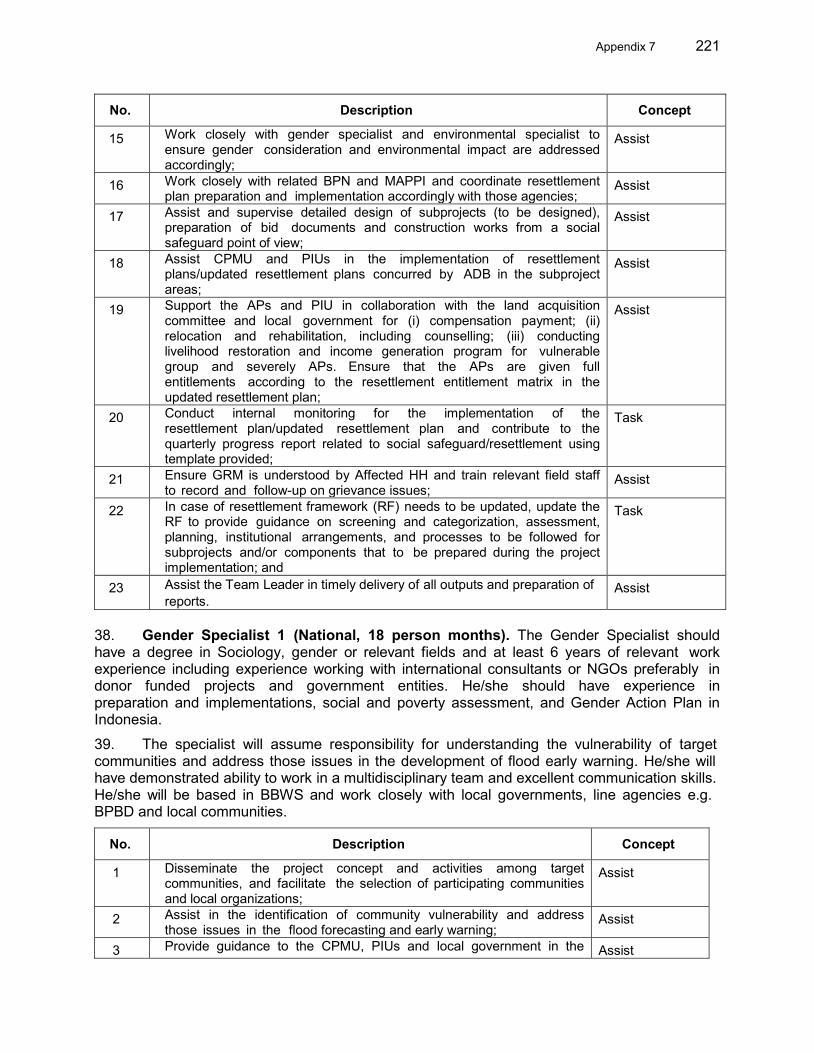
Appendix 7 221
No. Description Concept
15 Work closely with gender specialist and environmental specialist to ensure gender consideration and environmental impact are addressed accordingly;
Assist
16 Work closely with related BPN and MAPPI and coordinate resettlement plan preparation and implementation accordingly with those agencies;
Assist
17 Assist and supervise detailed design of subprojects (to be designed), preparation of bid documents and construction works from a social safeguard point of view;
Assist
18 Assist CPMU and PIUs in the implementation of resettlement plans/updated resettlement plans concurred by ADB in the subproject areas;
Assist
19 Support the APs and PIU in collaboration with the land acquisition committee and local government for (i) compensation payment; (ii) relocation and rehabilitation, including counselling; (iii) conducting livelihood restoration and income generation program for vulnerable group and severely APs. Ensure that the APs are given full entitlements according to the resettlement entitlement matrix in the updated resettlement plan;
Assist
20 Conduct internal monitoring for the implementation of the resettlement plan/updated resettlement plan and contribute to the quarterly progress report related to social safeguard/resettlement using template provided;
Task
21 Ensure GRM is understood by Affected HH and train relevant field staff to record and follow-up on grievance issues;
Assist
22 In case of resettlement framework (RF) needs to be updated, update the RF to provide guidance on screening and categorization, assessment, planning, institutional arrangements, and processes to be followed for subprojects and/or components that to be prepared during the project implementation; and
Task
23 Assist the Team Leader in timely delivery of all outputs and preparation of reports.
Assist
38. Gender Specialist 1 (National, 18 person months). The Gender Specialist should have a degree in Sociology, gender or relevant fields and at least 6 years of relevant work experience including experience working with international consultants or NGOs preferably in donor funded projects and government entities. He/she should have experience in preparation and implementations, social and poverty assessment, and Gender Action Plan in Indonesia.
39. The specialist will assume responsibility for understanding the vulnerability of target communities and address those issues in the development of flood early warning. He/she will have demonstrated ability to work in a multidisciplinary team and excellent communication skills. He/she will be based in BBWS and work closely with local governments, line agencies e.g. BPBD and local communities.
No. Description Concept
1 Disseminate the project concept and activities among target communities, and facilitate the selection of participating communities and local organizations;
Assist
2 Assist in the identification of community vulnerability and address those issues in the flood forecasting and early warning;
Assist
3 Provide guidance to the CPMU, PIUs and local government in the Assist
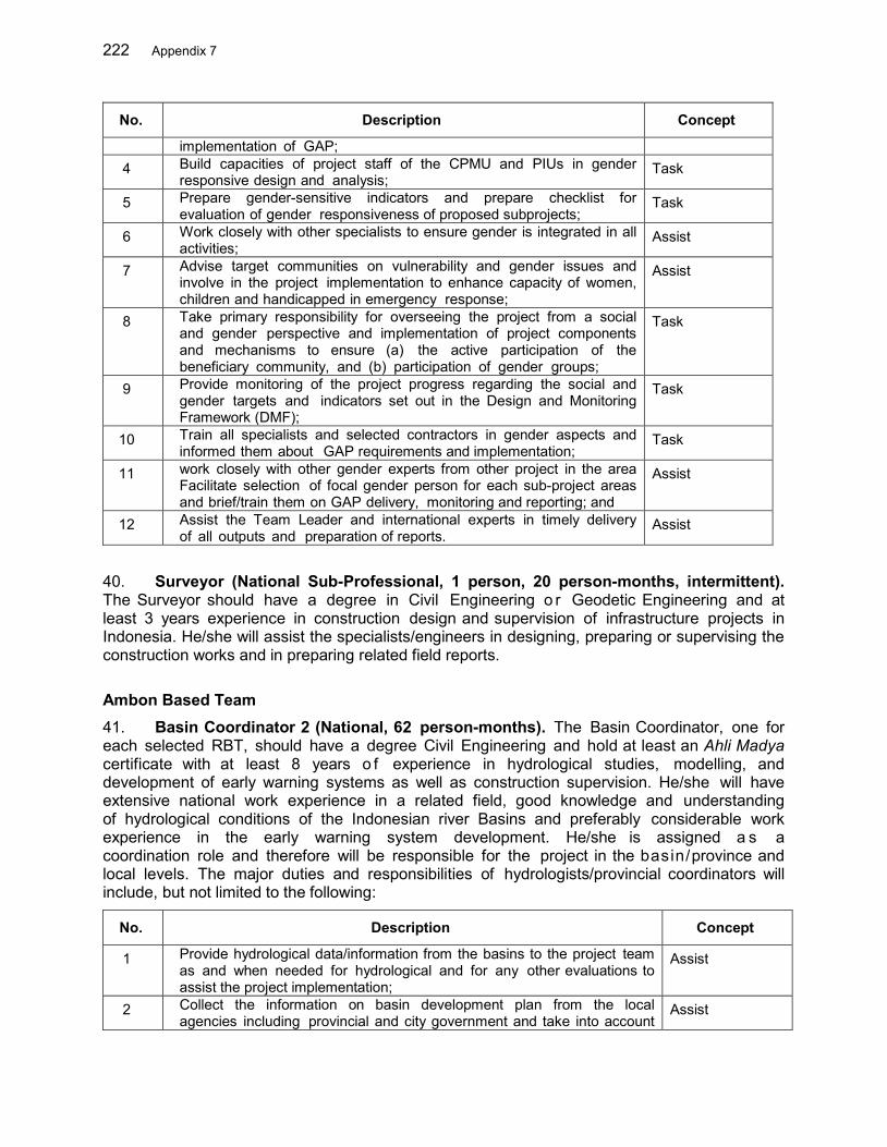
222 Appendix 7
No. Description Concept
implementation of GAP; 4 Build capacities of project staff of the CPMU and PIUs in gender
responsive design and analysis; Task
5 Prepare gender-sensitive indicators and prepare checklist for evaluation of gender responsiveness of proposed subprojects;
Task
6 Work closely with other specialists to ensure gender is integrated in all activities;
Assist
7 Advise target communities on vulnerability and gender issues and involve in the project implementation to enhance capacity of women, children and handicapped in emergency response;
Assist
8 Take primary responsibility for overseeing the project from a social and gender perspective and implementation of project components and mechanisms to ensure (a) the active participation of the beneficiary community, and (b) participation of gender groups;
Task
9 Provide monitoring of the project progress regarding the social and gender targets and indicators set out in the Design and Monitoring Framework (DMF);
Task
10 Train all specialists and selected contractors in gender aspects and informed them about GAP requirements and implementation;
Task
11 work closely with other gender experts from other project in the area Facilitate selection of focal gender person for each sub-project areas and brief/train them on GAP delivery, monitoring and reporting; and
Assist
12 Assist the Team Leader and international experts in timely delivery of all outputs and preparation of reports.
Assist
40. Surveyor (National Sub-Professional, 1 person, 20 person-months, intermittent). The Surveyor should have a degree in Civil Engineering o r Geodetic Engineering and at least 3 years experience in construction design and supervision of infrastructure projects in Indonesia. He/she will assist the specialists/engineers in designing, preparing or supervising the construction works and in preparing related field reports.
Ambon Based Team 41. Basin Coordinator 2 (National, 62 person-months). The Basin Coordinator, one for each selected RBT, should have a degree Civil Engineering and hold at least an Ahli Madya certificate with at least 8 years o f experience in hydrological studies, modelling, and development of early warning systems as well as construction supervision. He/she will have extensive national work experience in a related field, good knowledge and understanding of hydrological conditions of the Indonesian river Basins and preferably considerable work experience in the early warning system development. He/she is assigned a s a coordination role and therefore will be responsible for the project in the basin/province and local levels. The major duties and responsibilities of hydrologists/provincial coordinators will include, but not limited to the following:
No. Description Concept
1 Provide hydrological data/information from the basins to the project team as and when needed for hydrological and for any other evaluations to assist the project implementation;
Assist
2 Collect the information on basin development plan from the local agencies including provincial and city government and take into account
Assist
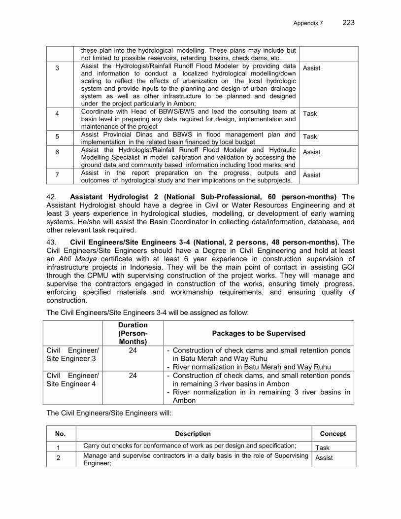
Appendix 7 223
these plan into the hydrological modelling. These plans may include but not limited to possible reservoirs, retarding basins, check dams, etc.
3 Assist the Hydrologist/Rainfall Runoff Flood Modeler by providing data and information to conduct a localized hydrological modelling/down scaling to reflect the effects of urbanization on the local hydrologic system and provide inputs to the planning and design of urban drainage system as well as other infrastructure to be planned and designed under the project particularly in Ambon;
Assist
4 Coordinate with Head of BBWS/BWS and lead the consulting team at basin level in preparing any data required for design, implementation and maintenance of the project
Task
5 Assist Provincial Dinas and BBWS in flood management plan and implementation in the related basin financed by local budget
Task
6 Assist the Hydrologist/Rainfall Runoff Flood Modeler and Hydraulic Modelling Specialist in model calibration and validation by accessing the ground data and community based information including flood marks; and
Assist
7 Assist in the report preparation on the progress, outputs and outcomes of hydrological study and their implications on the subprojects.
Assist
42. Assistant Hydrologist 2 (National Sub-Professional, 60 person-months) The Assistant Hydrologist should have a degree in Civil or Water Resources Engineering and at least 3 years experience in hydrological studies, modelling, or development of early warning systems. He/she will assist the Basin Coordinator in collecting data/information, database, and other relevant task required. 43. Civil Engineers/Site Engineers 3-4 (National, 2 persons, 48 person-months). The Civil Engineers/Site Engineers should have a Degree in Civil Engineering and hold at least an Ahli Madya certificate with at least 6 year experience in construction supervision of infrastructure projects in Indonesia. They will be the main point of contact in assisting GOI through the CPMU with supervising construction of the project works. They will manage and supervise the contractors engaged in construction of the works, ensuring timely progress, enforcing specified materials and workmanship requirements, and ensuring quality of construction.
The Civil Engineers/Site Engineers 3-4 will be assigned as follow:
Duration (Person-Months)
Packages to be Supervised
Civil Engineer/ Site Engineer 3
24 - Construction of check dams and small retention ponds in Batu Merah and Way Ruhu
- River normalization in Batu Merah and Way Ruhu Civil Engineer/ Site Engineer 4
24 - Construction of check dams, and small retention ponds in remaining 3 river basins in Ambon
- River normalization in in remaining 3 river basins in Ambon
The Civil Engineers/Site Engineers will:
No. Description Concept
1 Carry out checks for conformance of work as per design and specification; Task 2 Manage and supervise contractors in a daily basis in the role of Supervising
Engineer; Assist
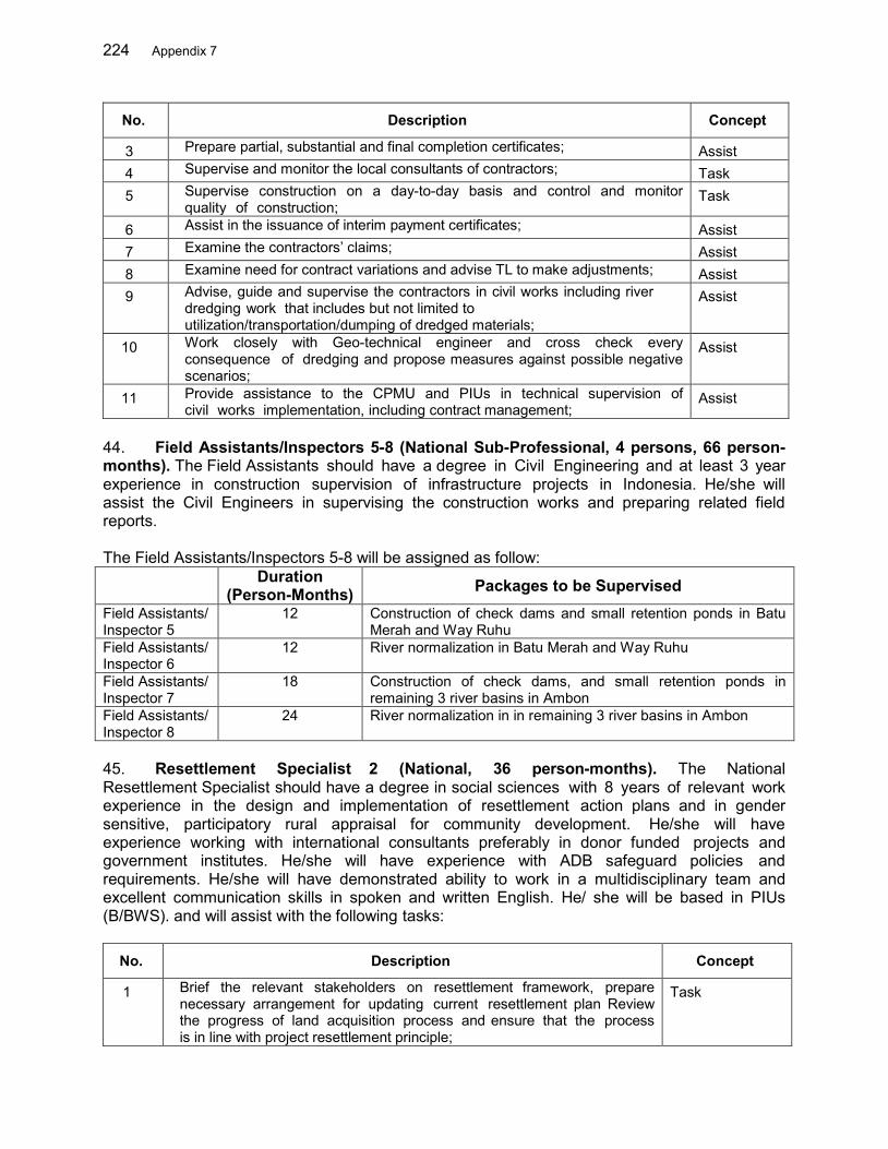
224 Appendix 7
No. Description Concept
3 Prepare partial, substantial and final completion certificates; Assist 4 Supervise and monitor the local consultants of contractors; Task 5 Supervise construction on a day-to-day basis and control and monitor
quality of construction; Task
6 Assist in the issuance of interim payment certificates; Assist 7 Examine the contractors’ claims; Assist 8 Examine need for contract variations and advise TL to make adjustments; Assist 9 Advise, guide and supervise the contractors in civil works including river
dredging work that includes but not limited to utilization/transportation/dumping of dredged materials;
Assist
10 Work closely with Geo-technical engineer and cross check every consequence of dredging and propose measures against possible negative scenarios;
Assist
11 Provide assistance to the CPMU and PIUs in technical supervision of civil works implementation, including contract management;
Assist
44. Field Assistants/Inspectors 5-8 (National Sub-Professional, 4 persons, 66 person-months). The Field Assistants should have a degree in Civil Engineering and at least 3 year experience in construction supervision of infrastructure projects in Indonesia. He/she will assist the Civil Engineers in supervising the construction works and preparing related field reports. The Field Assistants/Inspectors 5-8 will be assigned as follow:
Duration (Person-Months) Packages to be Supervised
Field Assistants/ Inspector 5
12 Construction of check dams and small retention ponds in Batu Merah and Way Ruhu
Field Assistants/ Inspector 6
12 River normalization in Batu Merah and Way Ruhu
Field Assistants/ Inspector 7
18 Construction of check dams, and small retention ponds in remaining 3 river basins in Ambon
Field Assistants/ Inspector 8
24 River normalization in in remaining 3 river basins in Ambon
45. Resettlement Specialist 2 (National, 36 person-months). The National Resettlement Specialist should have a degree in social sciences with 8 years of relevant work experience in the design and implementation of resettlement action plans and in gender sensitive, participatory rural appraisal for community development. He/she will have experience working with international consultants preferably in donor funded projects and government institutes. He/she will have experience with ADB safeguard policies and requirements. He/she will have demonstrated ability to work in a multidisciplinary team and excellent communication skills in spoken and written English. He/ she will be based in PIUs (B/BWS). and will assist with the following tasks:
No. Description Concept
1 Brief the relevant stakeholders on resettlement framework, prepare necessary arrangement for updating current resettlement plan Review the progress of land acquisition process and ensure that the process is in line with project resettlement principle;
Task
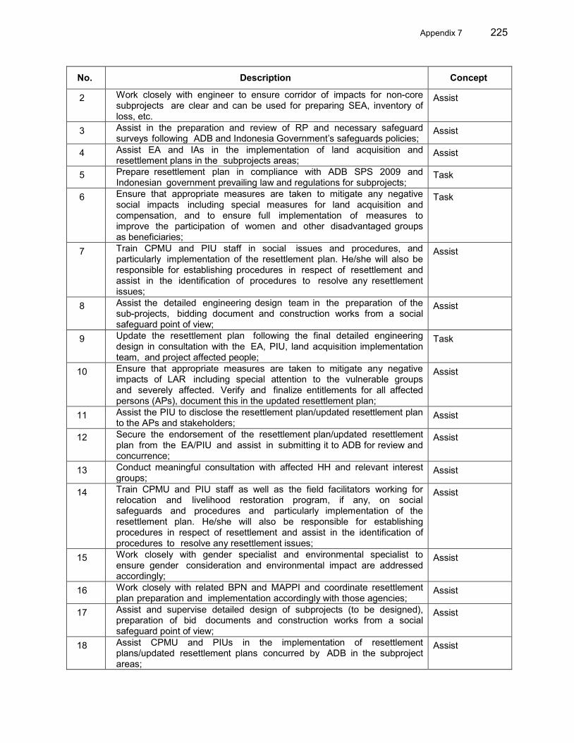
Appendix 7 225
No. Description Concept
2 Work closely with engineer to ensure corridor of impacts for non-core subprojects are clear and can be used for preparing SEA, inventory of loss, etc.
Assist
3 Assist in the preparation and review of RP and necessary safeguard surveys following ADB and Indonesia Government’s safeguards policies;
Assist
4 Assist EA and IAs in the implementation of land acquisition and resettlement plans in the subprojects areas;
Assist
5 Prepare resettlement plan in compliance with ADB SPS 2009 and Indonesian government prevailing law and regulations for subprojects;
Task
6 Ensure that appropriate measures are taken to mitigate any negative social impacts including special measures for land acquisition and compensation, and to ensure full implementation of measures to improve the participation of women and other disadvantaged groups as beneficiaries;
Task
7 Train CPMU and PIU staff in social issues and procedures, and particularly implementation of the resettlement plan. He/she will also be responsible for establishing procedures in respect of resettlement and assist in the identification of procedures to resolve any resettlement issues;
Assist
8 Assist the detailed engineering design team in the preparation of the sub-projects, bidding document and construction works from a social safeguard point of view;
Assist
9 Update the resettlement plan following the final detailed engineering design in consultation with the EA, PIU, land acquisition implementation team, and project affected people;
Task
10 Ensure that appropriate measures are taken to mitigate any negative impacts of LAR including special attention to the vulnerable groups and severely affected. Verify and finalize entitlements for all affected persons (APs), document this in the updated resettlement plan;
Assist
11 Assist the PIU to disclose the resettlement plan/updated resettlement plan to the APs and stakeholders;
Assist
12 Secure the endorsement of the resettlement plan/updated resettlement plan from the EA/PIU and assist in submitting it to ADB for review and concurrence;
Assist
13 Conduct meaningful consultation with affected HH and relevant interest groups;
Assist
14 Train CPMU and PIU staff as well as the field facilitators working for relocation and livelihood restoration program, if any, on social safeguards and procedures and particularly implementation of the resettlement plan. He/she will also be responsible for establishing procedures in respect of resettlement and assist in the identification of procedures to resolve any resettlement issues;
Assist
15 Work closely with gender specialist and environmental specialist to ensure gender consideration and environmental impact are addressed accordingly;
Assist
16 Work closely with related BPN and MAPPI and coordinate resettlement plan preparation and implementation accordingly with those agencies;
Assist
17 Assist and supervise detailed design of subprojects (to be designed), preparation of bid documents and construction works from a social safeguard point of view;
Assist
18 Assist CPMU and PIUs in the implementation of resettlement plans/updated resettlement plans concurred by ADB in the subproject areas;
Assist
226 Appendix 7
No. Description Concept
19 Support the APs and PIU in collaboration with the land acquisition committee and local government for (i) compensation payment; (ii) relocation and rehabilitation, including counselling; (iii) conducting livelihood restoration and income generation program for vulnerable group and severely APs. Ensure that the APs are given full entitlements according to the resettlement entitlement matrix in the updated resettlement plan;
Assist
20 Conduct internal monitoring for the implementation of the resettlement plan/updated resettlement plan and contribute to the quarterly progress report related to social safeguard/resettlement using template provided;
Task
21 Ensure GRM is understood by Affected HH and train relevant field staff to record and follow-up on grievance issues;
Assist
22 In case of resettlement framework (RF) needs to be updated, update the RF to provide guidance on screening and categorization, assessment, planning, institutional arrangements, and processes to be followed for subprojects and/or components that to be prepared during the project implementation; and
Task
23 Assist the Team Leader in timely delivery of all outputs and preparation of reports.
Assist
46. Gender Specialist 2 (National, 18 person months). The Gender Specialist should have a degree in Sociology, gender or relevant fields and at least 6 years of relevant work experience including experience working with international consultants or NGOs preferably in donor funded projects and government entities. He/she should have experience in preparation and implementations, social and poverty assessment, and GAP in Indonesia.
47. The specialist will assume responsibility for understanding the vulnerability of target communities and address those issues in the development of flood early warning. He/she will have demonstrated ability to work in a multidisciplinary team and excellent communication skills. He/she will be based in BBWS and work closely with local governments, line agencies e.g. BPBD and local communities.
No. Description Concept
1 Disseminate the project concept and activities among target communities, and facilitate the selection of participating communities and local organizations;
Assist
2 Assist in the identification of community vulnerability and address those issues in the flood forecasting and early warning;
Assist
3 Provide guidance to the CPMU, PIUs and local government in the implementation of GAP;
Assist
4 Build capacities of project staff of the CPMU and PIUs in gender responsive design and analysis;
Task
5 Prepare gender-sensitive indicators and prepare checklist for evaluation of gender responsiveness of proposed subprojects;
Task
6 Work closely with other specialists to ensure gender is integrated in all activities;
Assist
7 Advise target communities on vulnerability and gender issues and involve in the project implementation to enhance capacity of women, children and handicapped in emergency response;
Assist
8 Take primary responsibility for overseeing the project from a social and Task

Appendix 7 227
No. Description Concept
gender perspective and implementation of project components and mechanisms to ensure (a) the active participation of the beneficiary community, and (b) participation of gender groups;
9 Provide monitoring of the project progress regarding the social and gender targets and indicators set out in the Design and Monitoring Framework (DMF);
Task
10 Train all specialists and selected contractors in gender aspects and informed them about GAP requirements and implementation;
Task
11 Work closely with other gender experts from other project in the area Facilitate selection of focal gender person for each sub-project areas and brief/train them on GAP delivery, monitoring and reporting; and
Assist
12 Assist the Team Leader and other experts in timely delivery of all outputs and preparation of reports.
Assist
48. Surveyor (National Sub-Professional, 1 person, 20 person-months, intermittent). The Surveyor should have a degree in Civil Engineering or Geodetic Engineering and at least 3 year experience in construction design and supervision of infrastructure projects in Indonesia. He/she will assist the specialists/engineers in designing, preparing or supervising the construction works and in preparing related field reports. 49. Purchase of Equipment: The consulting service contract includes purchase of equipment and they become the State’s property under management by the project. Therefore the equipment shall be registered by the project before being borrowed by the contracted consultant.
50. Deliverables. Key expected deliverables are as follows:
1.A Enhanced basin data and information for 3 Cis and Ambon Seram RBTs (BBWS 3 Cis and BWS Maluku)
Output Responsible Specialist Schedule (Month, Year)
Technical report on the survey and collected data base
Flood Risk/Water Management Specialist/Team Leader
6, 2017 User guide on the decision support system (Flood Forecasting/ Early Warning and WRM in general) 6, 2019
Training and follow-up reports 1, 2020 Regular progress reports Monthly Quarterly Progress Report including safeguards, gender, participatory aspects Quarterly
Hazard, vulnerability, risk and emergency response maps and user guide
Flood Risk Management Specialist (International)
1, 2018
Review report on national legal framework, role sharing and institutional set up for flood risk management 1, 2018
Flood risk management plans for selected RBTs16 12, 2018 Report on national flood risk management strategy including consultations 6, 2018
16 The FMRPs will be periodically revised to take into account asset and economic growth, updated hydro-
meteorological data and changes in land-use and policy
228 Appendix 7
Output Responsible Specialist Schedule (Month, Year)
Report on Review the water resources development strategy (Pola) and plans (Rencana) of the river basins 6, 2017
Report on Review the (a) National Disaster Management Plan (RENAS PB) (b) National Medium Term Development Plan (RPJMN) 2015-2019 9, 2017
Report on Flood Risk Management Plans for 2 additional river basins 9, 2018 Flood Risk Management Plans for 2 additional river basins 12, 2018 Report on the assessment and rationalization of the hydro meteorological monitoring network and data management systems
Hydrologist/Rainfall Runoff Flood Modeler
4, 2017
Report on the needs assessment of capacity development of hydrological units 3, 2017
Technical specifications for the hydro-meteorological observation stations and servers 1, 2017
O&M plan and budget for the installed hydro-meteorological equipment 3, 2017 Materials for the training programs on hydrological and hydraulic modelling and user guide 1, 2018
Report on the recommendation for spatial plan improvement, budgeting and required regulations Spatial Planner 3, 2017
Review the institutional structure and arrangement Institutional Specialist 6, 2017
2.C Detailed engineering design (DED and Construction Supervision (for the 3 Cis and Ambon Seram RBTs) (DGWR, BBWS 3 Cis and BWS Maluku)
Output Responsible Specialist Schedule (Month, Year)
DED reports including drawings, bidding document of the selected subprojects in 3 Cis and Ambon-Seram RBTs.
Flood Risk/Water Management Specialist/Team Leader 1, 2019
List of revised potential sub-projects and list of other RBTs for future investment using the FRM approach
Flood Risk Management Specialist 12, 2018
Subproject Feasibility Reports (SSR)
Project Economist (International) 4, 2017
Project Economic Analysis Report 4, 2017 Financial Management Assessment Report (Updated)
Project Economist 1, 2018
Project Financial Management Report 6, 2019 Project Geological Report
Geotechnical/Soil Mechanic Engineer
3, 2017 Report on Potential Quarry and Disposal Dumping Site 3, 2018 Report on Identification of High Risk Landslide 1, 2019 Sub-contract documents including TORs for Additional Survey including LiDar, Bathymetry, River Cross Sections
Topographical Survey Specialist/ Engineer 1, 2017
GIS Maps and Data Remote Sensing and GIS 6, 2018
Appendix 7 229
Output Responsible Specialist Schedule (Month, Year)
Expert O&M of River and Flood Management Infrastructures Manuals O&M Expert 3, 2021 Design Drawings and Specifications Structural Design Engineer 16, 2018 Report on Landscape Development of Acquired Land (Sempadan) Landscape Architect/Specialist 4, 2017 Rivers Hydraulic Modeling Report Hydraulic Modelling Engineer 4, 2019 Urban Drainage Management Report Urban Drainage Engineer 6, 2017 Document on Social Safeguards Sociologist 1, 2018
Documents on Environmental Environment Specialist 6, 2017; 6, 2018; 6, 2019
LARAP Documents and Reports Land Acquisition/Resettlement Specialists 1 & 2
6, 2017; 6, 2018; 6, 2019
Progress Reports of Construction Works Civil Engineers 1-4 Monthly Capacity development modules for IAs staff on preparation of standard bidding documents and evaluation of bids;
Procurement Specialist
6, 2017
Procurement Assessment Report 1, 2018 Procurement Risk Assessment Report 1, 2018 Procurement Plan Report 1, 2018 Basins Flood Management Report Basin Coordinator 1 & 2 12, 2020
Package 2: Project Implementation Management Services 51. Background. Indonesia is highly prone to flood hazards due to its climate and topography.17 Flooding is a growing annual occurrence throughout most of the country imposing as much as $430 million per year in economic losses.18 From 2003 to 2013, the country’s average annual flood impact included: (i) 1.58 million affected persons; (ii) 350 casualties and 13,640 injured; (iii) 223,000 homes fully or partially damaged; and (iv) 168,000 hectares (ha) of crops inundated.19 The floods sever vital transport arteries and often disrupt access to ports and airports, restricting the transfer of goods and services. In 2013, the Ciujung river flooding
17 Indonesia is prone to two main type of flooding: (i) long-lasting riverine floods in large river basins having steep
slopes in upper part and long, flat and low floodplains (often influenced by tides) - these are characteristic of the large islands such as Java, Sumatra, Kalimantan or Iran Jaya; and (ii) flash floods, of short duration and high intensity, which occur in small and steep mountainous river basins, such as in small islands of Eastern Indonesia.
18 Centre for Research on the Epidemiology of Disasters (CRED). EM-DAT: The OFDA/CRED International Disaster Database. www.emdat.be. (accessed April 2014).
19 National Disaster Management Agency (BNPB). Indonesian Disaster Information and Data (DIBI). http://dibi.bnpb.go.id/DesInventar/dashboard.jsp (accessed April 2014).
230 Appendix 7
affected 19,674 households, displaced 50,527 people, and disrupted the traffic along the Jakarta-Merak toll road that connect Java to Sumatra island.20 Despite its location in a drier region, in 2013, Ambon suffered from flash floods resulting in 59 destroyed and 45 damaged houses, 10 dead and 5 missing persons and 7,212 displaced people.21 52. In Government’s 2015-2019 National Medium Term Development Plan (RPJMN), water security is a central pillar and promotes Flood Management Risk (FRM) to reduce flood damages. FRM embraces a range of measures that address the following three key components: (i) managing flood hazard, (ii) minimizing exposure to flood hazard, and (iii) reducing vulnerability of people and property exposed. Managing flood hazard involves physical modification of water flow such as river infrastructure works, and catchment management measures such as controls over forestry and agricultural practices. Managing exposure to floods involves property acquisition, land use zoning, building codes, planning development controls, and elevated building. Managing flood vulnerability involves non-structural measures such as community awareness, flood forecasting and warning, preparedness, emergency response, post-flood early recovery strategies, and flood insurance. 53. The Project will support the Government of Indonesia (the Government) and communities to better manage and mitigate flood risks.22 The Project has been designed as a sector loan to support the implementation of the 2015-2019 Strategic Plan for Water Resources (SPWR) of the Ministry of Public Works and Housing (MPWH).23 The SPWR includes policy measures and priority investments in 63 river basin territories (RBTs) in Indonesia. The Project will finance subprojects in (i) two of these RBTs namely the Cidanau-Ciujung-Cidurian (3 Cis) in Banten Province, and (ii) the Ambon-Seram in Maluku Province. Project interventions will (i) enhance hydro meteorological data and analysis, management and institutional coordination for managing flood risks; (ii) upgrade and develop flood protection infrastructure; (iii) improve watershed conditions to moderate runoff peaks and soil erosion; and (iv) prepare communities to manage floods. The Project will promote effective flood risk management (FRM) by coupling infrastructure investment with supporting software measures. It will contribute to achievement of the 2015-2019 Government’s RPJMN sector target to reduce the magnitude of economic and social damages due to floods. 54. The Project will support the implementation of an area slice of the sector development plan, the SPWR.24 The 3 Cis and Ambon-Seram RBTs25 —respectively affected by the two main type of floods, the riverine and flash floods—have been selected to demonstrate the FRM approach as part of the operationalization of the 2015–2019 RPJMN. The investment will help the Government to accelerate the implementation of the Rencanas in those RBTs. It provides for a long-term partnership between the Asian Development Bank (ADB) and the Government for policy dialogue and capacity development, and ensures continuity in combining investments in
20 2015. National Agency for Disaster Management (BNPB). www.geospasial.bnpb.go.id (accessed March 2015). 21 2015. National Agency for Disaster Management (BNPB). www.geospasial.bnpb.go.id (accessed March 2015). 22 The Asian Development Bank (ADB) provided project preparatory technical assistance. ADB. 2009. Technical
Assistance to the Republic of Indonesia for Flood Management in Selected River Basins (Phase II). Manila. (TA 7364-INO, approved on 12 October 2009, for $1,000,000 financed from the Japan Special Fund and additional $500,000 financed from the Water Financing Partnership Facility).
23 Ministry of Public Works and Housing, 2015. Draft Rencana Strategis Direktorat Jenderal Sumber Daya Air 2015 – 2019. The plan calls for a reduction by 200,000 ha of the flooded area nationwide by 2019.
24 The 2015 – 2019 SPWR calls for an overall investment of $24.35 billion nationwide including $3.05 billion for flood management.
25 The 3 Cis RBT covers an area of 4,125 km2 and lies mainly within the Banten Province, the most westerly province of Java. The Ambon–Seram RBT is located on the islands of Ambon and Seram, in Maluku Province in eastern Indonesia with an area of 18,625 km2.
Appendix 7 231
infrastructure with non-structural components. There is a clear link between this project’s outputs and sector targets, and the criteria for the sector modality are met.26 55. The Project builds on lessons from past and ongoing ADB and other development partners’ assistance in flood management. The Project design incorporates the key recommendations based on the lessons learned including: (i) intensive consultation with local stakeholders need to be conducted during project preparation to ensure that the project addresses the full range of problems and issues; (ii) the Government should routinely collect and analyze flood damage data; (iii) support is needed for designing, developing sustainable long-term flood management concepts; and (iv) watershed management programs should be implemented to enhance the impact and sustainability of flood control works.27 56. The lack of flood infrastructure is also one major reason for the escalating damage by floods in the selected river basins in recent years. The impact extends not only to the damage to the residential areas, but includes widespread damage and interruption of public services including transportation, power supply, communication, etc. The overbank flood in the Ciujung river in 2013 caused a week long interruption of an important national highway, while livelihood was at a standstill for about a month in the entire region. In 2013, massive physical damage in the residential and commercial areas in Ambon City was caused by flash floods from adjoining five small rivers and particularly from the Batu Merah and Way Ruhu rivers. Flood control infrastructure is an urgent need to safeguard the social and economic development in all selected RBTs particularly in the areas where rapid urbanization has been taken place. 57. In the downstream area of the Ciujung river basin, the 11 km river reach downstream of the Pamarayan weir remains unprotected, while the other reach downstream of the highway is protected by dike structures designed for 5 years return period of flood. This has been the main cause of flooding in the highway and surrounding residential areas. In some locations, river conveyance capacity needs to be increased to mitigate the flooding. This can be done through river dredging and channel excavation, but also through controlling sources of sediment yields from upper catchment. 58. In Ambon, local government is planning to develop the city as a water-front city with emphasize on allocation, formation, sizing, and harmonizing space (land) in a way that helps promote the economic growth including the mitigation of flood hazard, exposure and vulnerability. Therefore, all flood management activities should be consistent with local government plans. 59. Scope of the Project. In the Project, there are 8 components under the four targeted outputs28 with 3 sector agencies namely Ministry of Public Works and Housing (MPWH),
26 The required preconditions for the use of the sector lending modality — a sector development plan, institutional
capacity and appropriate policy to implement the sector development plan — are all in place. The MPWH, as the executing agency, has the capacity to implement the sector development plan in terms of identification, selection, design and implementation of subprojects. The sector development plan has monitorable, verifiable sector indicators identified, including targets for cross cutting and safeguard concerns. There is a clear link between this project’s outputs and sector targets.
27 ADB. 2007. Completion Report: South Java Flood Control Sector Project in Indonesia. Manila. (Loan 1479-INO). ADB. 2006. Completion Report: North Java Flood Control Sector Project in Indonesia. Manila. (Loans 1425-INO and 1426-INO[SF])
28 Project components are (i) enhanced knowledge base for flood risk management, (ii) improved land management and upgraded flood infrastructure, (iii) enhanced capacity for community-based flood risk management (CBFRM) and, (iv) effective project implementation.
232 Appendix 7
Ministry of Agriculture (MOA) and Ministry of Home Affairs (MOHA) and the State Ministry of National Development Planning/National Development Planning Agency (Bappenas). Directorate General of Water Resources (DGWR) packages cover four components.
60. Scope of the Works for Package 2. Key activities of the Package 2 cover Output 4.A as follows:
4. A Project Management (DGWR-MPWH). DGWR will be an implementing agency for the aforementioned activities and also lead the overall project implementation in the capacity of the project executing agency. A mechanism will be developed and applied to ensure that the approved recommendations of the project are well implemented, along with effective monitoring and reporting mechanisms, so that government and ADB can ensure that funds are being disbursed in accordance with the plans and in a timely manner, and so information is exchanged among the component projects to improve overall performance, and minimize wasted effort caused by overlaps. This provision will also help facilitate CPMU and accelerate the project performance at all levels.
61. The indicative project plans initially approved may be modified to some extent in the light of changing circumstances and needs. Also, the project stakeholders are many and varied, from both the public and private sectors, and there is an emphasis on community-driven activities. Therefore meaningful liaison with these stakeholders and willingness to adapt to their advice and expectations will be essential for Project success.
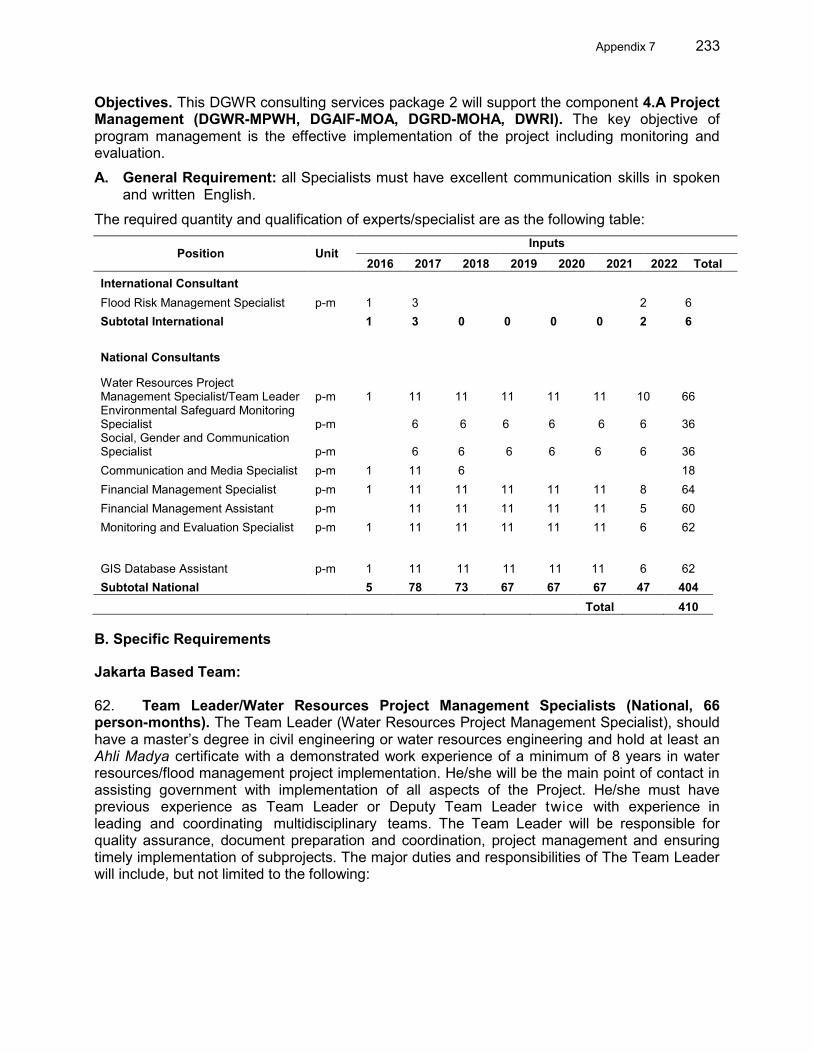
Appendix 7 233
Objectives. This DGWR consulting services package 2 will support the component 4.A Project Management (DGWR-MPWH, DGAIF-MOA, DGRD-MOHA, DWRI). The key objective of program management is the effective implementation of the project including monitoring and evaluation.
A. General Requirement: all Specialists must have excellent communication skills in spoken and written English.
The required quantity and qualification of experts/specialist are as the following table:
Position Unit Inputs
2016 2017 2018 2019 2020 2021 2022 Total International Consultant Flood Risk Management Specialist p-m 1 3
2 6
Subtotal International 1 3 0 0 0 0 2 6 National Consultants
Water Resources Project Management Specialist/Team Leader p-m 1 11 11 11 11 11 10 66 Environmental Safeguard Monitoring Specialist p-m 6 6 6 6 6
6 36
Social, Gender and Communication Specialist p-m 6 6 6 6 6
6 36
Communication and Media Specialist p-m 1 11 6 18 Financial Management Specialist p-m 1 11 11 11 11 11 8 64 Financial Management Assistant p-m 11 11 11 11 11 5 60 Monitoring and Evaluation Specialist p-m 1 11 11 11 11 11 6 62
GIS Database Assistant p-m 1 11 11 11 11 11
6 62 Subtotal National 5 78 73 67 67 67 47 404
Total 410
B. Specific Requirements
Jakarta Based Team: 62. Team Leader/Water Resources Project Management Specialists (National, 66 person-months). The Team Leader (Water Resources Project Management Specialist), should have a master’s degree in civil engineering or water resources engineering and hold at least an Ahli Madya certificate with a demonstrated work experience of a minimum of 8 years in water resources/flood management project implementation. He/she will be the main point of contact in assisting government with implementation of all aspects of the Project. He/she must have previous experience as Team Leader or Deputy Team Leader twice with experience in leading and coordinating multidisciplinary teams. The Team Leader will be responsible for quality assurance, document preparation and coordination, project management and ensuring timely implementation of subprojects. The major duties and responsibilities of The Team Leader will include, but not limited to the following:
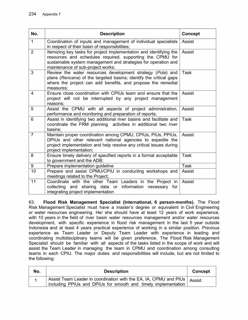
234 Appendix 7
No. Description Concept
1 Coordination of inputs and management of individual specialists in respect of their basin of responsibilities;
Assist
2 Itemizing key tasks for project implementation and identifying the resources and schedules required, supporting the CPMU for sustainable system management and strategies for operation and maintenance of sub-project works;
Assist
3 Review the water resources development strategy (Pola) and plans (Rencana) of the targeted basins; identify the critical gaps where the project can add benefits, and propose the remedial measures;
Task
4 Ensure close coordination with CPIUs team and ensure that the project will not be interrupted by any project management reasons;
Assist
5 Assist the CPMU with all aspects of project administration, performance and monitoring and preparation of reports;
Assist
6 Assist in identifying two additional river basins and facilitate and coordinate the FRM planning activities in additional two river basins;
Task
7 Maintain proper coordination among CPMU, CPIUs, PIUs, PPIUs, DPIUs and other relevant national agencies to expedite the project implementation and help resolve any critical issues during project implementation;
Assist
8 Ensure timely delivery of specified reports in a format acceptable to government and the ADB;
Task
9 Prepare implementation guideline Task 10 Prepare and assist CPMU/CPIU in conducting workshops and
meetings related to the Project; Assist
11 Coordinate with the other Team Leaders in the Project in collecting and sharing data or information necessary for integrating project implementation
Assist
63. Flood Risk Management Specialist (International, 6 person-months). The Flood Risk Management Specialist must have a master’s degree or equivalent in Civil Engineering or water resources engineering. He/ she should have at least 12 years of work experience, with 10 years in the field of river basin water resources management and/or water resources development, with specific experience in flood risk management in the last 5 year outside Indonesia and at least 4 years practical experience of working in a similar position. Previous experience as Team Leader or Deputy Team Leader with experience in leading and coordinating multidisciplinary teams will be given preference. The Flood Risk Management Specialist should be familiar with all aspects of the tasks listed in the scope of work and will assist the Team Leader in managing the team in CPMU and coordination among consulting teams in each CPIU. The major duties and responsibilities will include, but are not limited to the following:
No. Description Concept
1 Assist Team Leader in coordination with the EA, IA, CPMU and PIUs including PPIUs and DPIUs for smooth and timely implementation
Assist
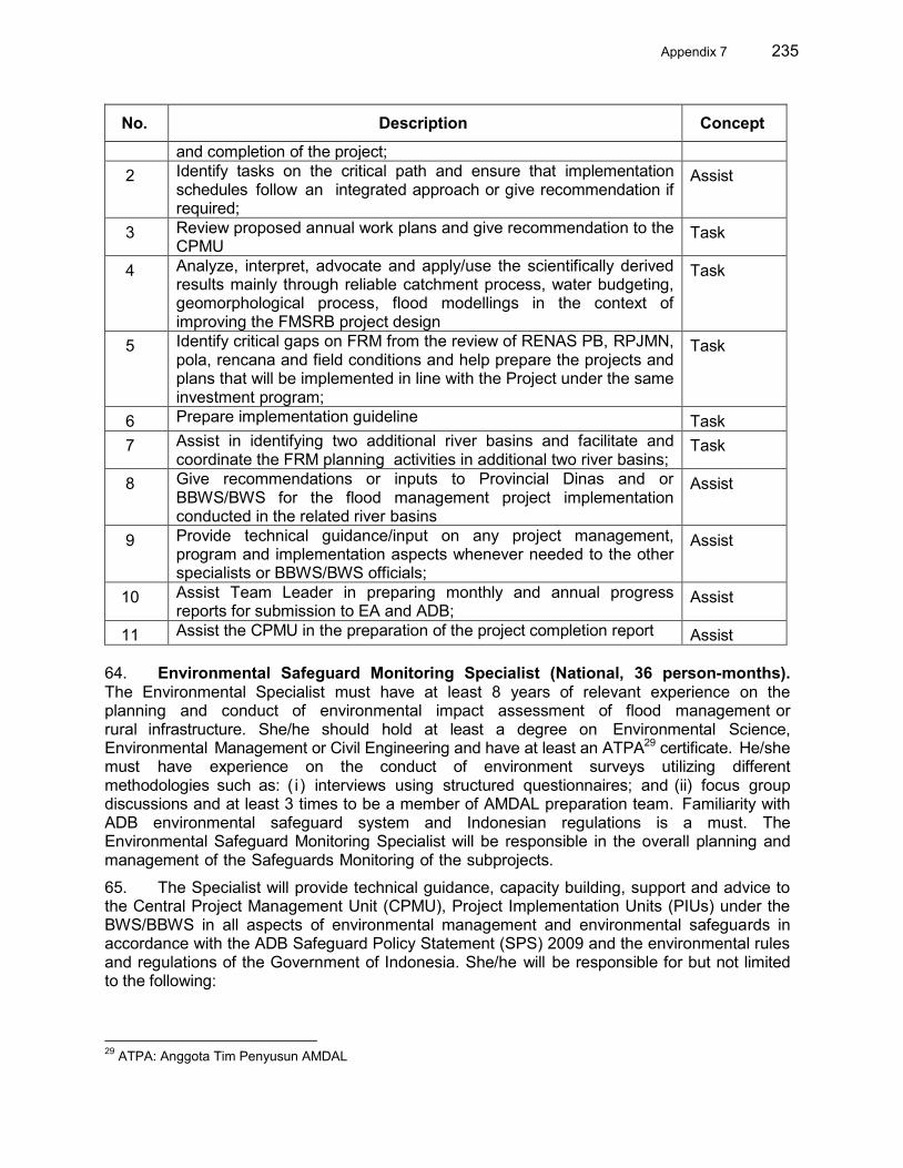
Appendix 7 235
No. Description Concept
and completion of the project; 2 Identify tasks on the critical path and ensure that implementation
schedules follow an integrated approach or give recommendation if required;
Assist
3 Review proposed annual work plans and give recommendation to the CPMU
Task
4 Analyze, interpret, advocate and apply/use the scientifically derived results mainly through reliable catchment process, water budgeting, geomorphological process, flood modellings in the context of improving the FMSRB project design
Task
5 Identify critical gaps on FRM from the review of RENAS PB, RPJMN, pola, rencana and field conditions and help prepare the projects and plans that will be implemented in line with the Project under the same investment program;
Task
6 Prepare implementation guideline Task 7 Assist in identifying two additional river basins and facilitate and
coordinate the FRM planning activities in additional two river basins; Task
8 Give recommendations or inputs to Provincial Dinas and or BBWS/BWS for the flood management project implementation conducted in the related river basins
Assist
9 Provide technical guidance/input on any project management, program and implementation aspects whenever needed to the other specialists or BBWS/BWS officials;
Assist
10 Assist Team Leader in preparing monthly and annual progress reports for submission to EA and ADB;
Assist
11 Assist the CPMU in the preparation of the project completion report Assist 64. Environmental Safeguard Monitoring Specialist (National, 36 person-months). The Environmental Specialist must have at least 8 years of relevant experience on the planning and conduct of environmental impact assessment of flood management or rural infrastructure. She/he should hold at least a degree on Environmental Science, Environmental Management or Civil Engineering and have at least an ATPA29 certificate. He/she must have experience on the conduct of environment surveys utilizing different methodologies such as: ( i ) interviews using structured questionnaires; and (ii) focus group discussions and at least 3 times to be a member of AMDAL preparation team. Familiarity with ADB environmental safeguard system and Indonesian regulations is a must. The Environmental Safeguard Monitoring Specialist will be responsible in the overall planning and management of the Safeguards Monitoring of the subprojects.
65. The Specialist will provide technical guidance, capacity building, support and advice to the Central Project Management Unit (CPMU), Project Implementation Units (PIUs) under the BWS/BBWS in all aspects of environmental management and environmental safeguards in accordance with the ADB Safeguard Policy Statement (SPS) 2009 and the environmental rules and regulations of the Government of Indonesia. She/he will be responsible for but not limited to the following:
29 ATPA: Anggota Tim Penyusun AMDAL
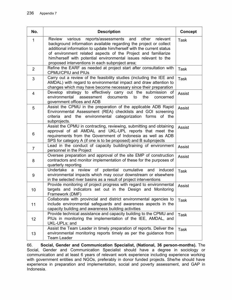
236 Appendix 7
No. Description Concept
1 Review various reports/assessments and other relevant background information available regarding the project or collect additional information to update him/herself with the current status of environment related aspects of the Project and familiarize him/herself with potential environmental issues relevant to the proposed interventions in each subproject area;
Task
2 Refine the EARF as needed at project start after consultation with CPMU/CPIU and PIUs
Task
3 Carry out a review of the feasibility studies (including the IEE and AMDAL) with regard to environmental impact and draw attention to changes which may have become necessary since their preparation
Task
4 Develop strategy to effectively carry out the submission of environmental assessment documents to the concerned government offices and ADB
Assist
5 Assist the CPMU in the preparation of the applicable ADB Rapid Environmental Assessment (REA) checklists and GOI screening criteria and the environmental categorization forms of the subprojects.
Assist
6
Assist the CPMU in contracting, reviewing, submitting and obtaining approval of all AMDAL and UKL-UPL reports that meet the requirements from the Government of Indonesia as well as ADB SPS for category A (if one is to be proposed) and B subprojects
Assist
7 Lead in the conduct of capacity building/training of environment personnel in the Project
Assist
8 Oversee preparation and approval of the site EMP of construction contractors and monitor implementation of these for the purposes of quarterly reporting
Assist
9 Undertake a review of potential cumulative and induced environmental impacts which may occur downstream or elsewhere in the selected river basins as a result of project interventions
Task
10 Provide monitoring of project progress with regard to environmental targets and indicators set out in the Design and Monitoring Framework (DMF)
Assist
11 Collaborate with provincial and district environmental agencies to include environmental safeguards and awareness aspects in the capacity building and awareness building activities
Task
12 Provide technical assistance and capacity building to the CPMU and PIUs in monitoring the implementation of the IEE, AMDAL, and UKL-UPLs; and
Task
13 Assist the Team Leader in timely preparation of reports. Deliver the environmental monitoring reports timely as per the guidance from Team Leader
Task
66. Social, Gender and Communication Specialist, (National, 36 person-months). The Social, Gender and Communication Specialist should have a degree in sociology or communication and at least 6 years of relevant work experience including experience working with government entities and NGOs, preferably in donor funded projects. She/he should have experience in preparation and implementation, social and poverty assessment, and GAP in Indonesia.
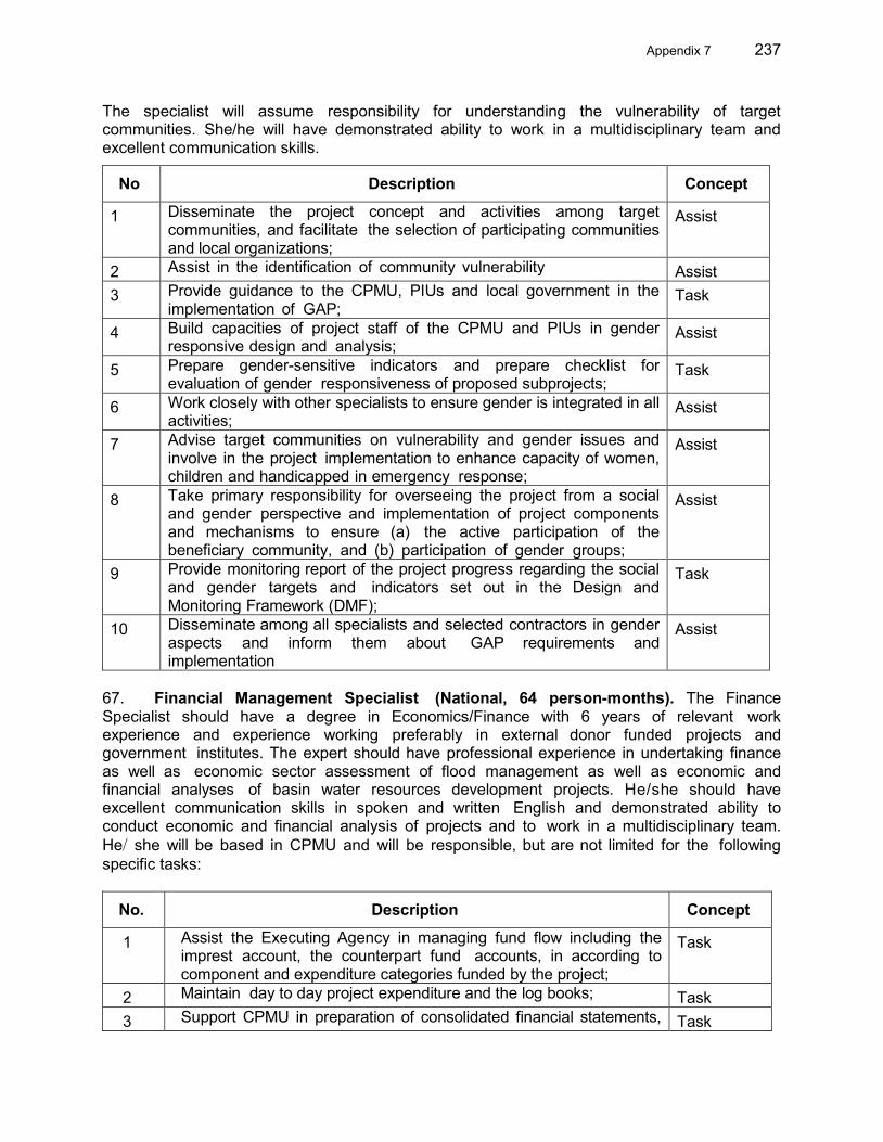
Appendix 7 237
The specialist will assume responsibility for understanding the vulnerability of target communities. She/he will have demonstrated ability to work in a multidisciplinary team and excellent communication skills.
No Description Concept
1 Disseminate the project concept and activities among target communities, and facilitate the selection of participating communities and local organizations;
Assist
2 Assist in the identification of community vulnerability Assist 3 Provide guidance to the CPMU, PIUs and local government in the
implementation of GAP; Task
4 Build capacities of project staff of the CPMU and PIUs in gender responsive design and analysis;
Assist
5 Prepare gender-sensitive indicators and prepare checklist for evaluation of gender responsiveness of proposed subprojects;
Task
6 Work closely with other specialists to ensure gender is integrated in all activities;
Assist
7 Advise target communities on vulnerability and gender issues and involve in the project implementation to enhance capacity of women, children and handicapped in emergency response;
Assist
8 Take primary responsibility for overseeing the project from a social and gender perspective and implementation of project components and mechanisms to ensure (a) the active participation of the beneficiary community, and (b) participation of gender groups;
Assist
9 Provide monitoring report of the project progress regarding the social and gender targets and indicators set out in the Design and Monitoring Framework (DMF);
Task
10 Disseminate among all specialists and selected contractors in gender aspects and inform them about GAP requirements and implementation
Assist
67. Financial Management Specialist (National, 64 person-months). The Finance Specialist should have a degree in Economics/Finance with 6 years of relevant work experience and experience working preferably in external donor funded projects and government institutes. The expert should have professional experience in undertaking finance as well as economic sector assessment of flood management as well as economic and financial analyses of basin water resources development projects. He/she should have excellent communication skills in spoken and written English and demonstrated ability to conduct economic and financial analysis of projects and to work in a multidisciplinary team. He/ she will be based in CPMU and will be responsible, but are not limited for the following specific tasks:
No. Description Concept
1 Assist the Executing Agency in managing fund flow including the imprest account, the counterpart fund accounts, in according to component and expenditure categories funded by the project;
Task
2 Maintain day to day project expenditure and the log books; Task 3 Support CPMU in preparation of consolidated financial statements, Task
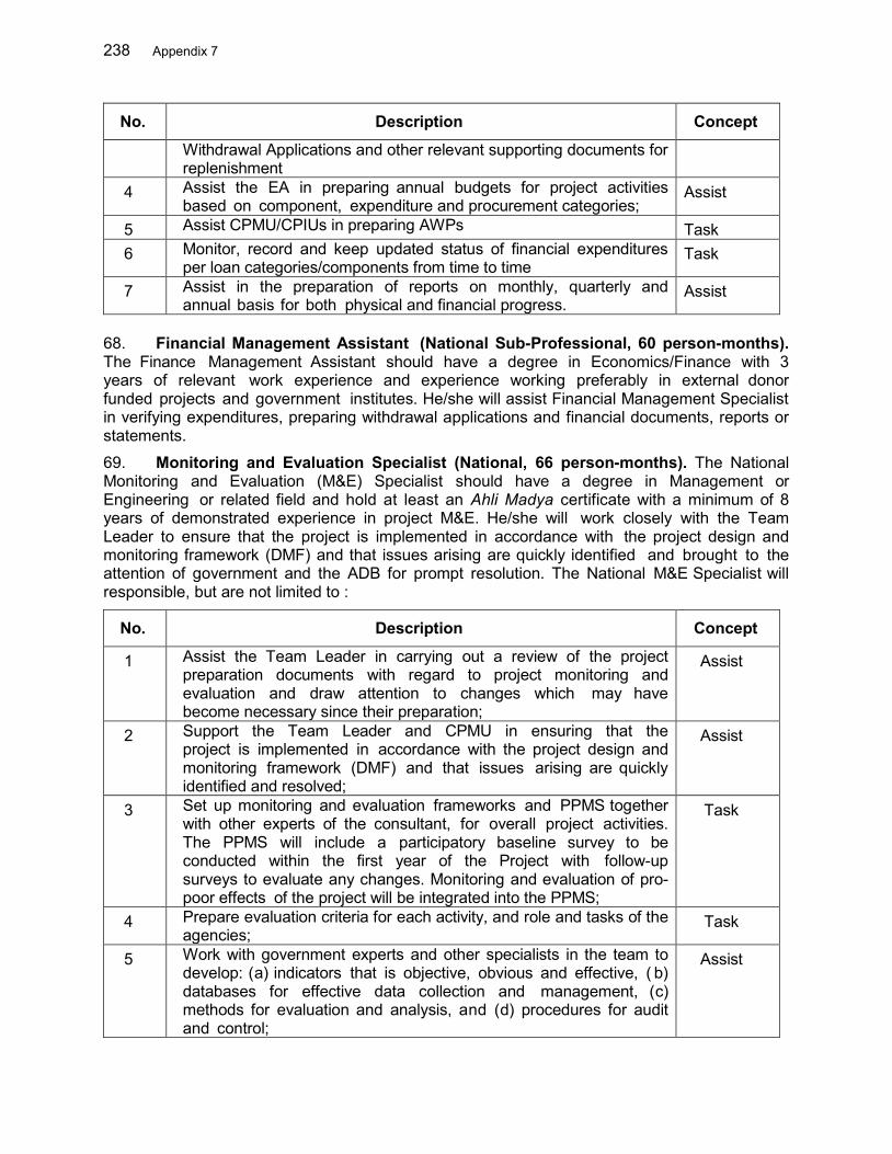
238 Appendix 7
No. Description Concept
Withdrawal Applications and other relevant supporting documents for replenishment
4 Assist the EA in preparing annual budgets for project activities based on component, expenditure and procurement categories;
Assist
5 Assist CPMU/CPIUs in preparing AWPs Task 6 Monitor, record and keep updated status of financial expenditures
per loan categories/components from time to time Task
7 Assist in the preparation of reports on monthly, quarterly and annual basis for both physical and financial progress.
Assist
68. Financial Management Assistant (National Sub-Professional, 60 person-months). The Finance Management Assistant should have a degree in Economics/Finance with 3 years of relevant work experience and experience working preferably in external donor funded projects and government institutes. He/she will assist Financial Management Specialist in verifying expenditures, preparing withdrawal applications and financial documents, reports or statements.
69. Monitoring and Evaluation Specialist (National, 66 person-months). The National Monitoring and Evaluation (M&E) Specialist should have a degree in Management or Engineering or related field and hold at least an Ahli Madya certificate with a minimum of 8 years of demonstrated experience in project M&E. He/she will work closely with the Team Leader to ensure that the project is implemented in accordance with the project design and monitoring framework (DMF) and that issues arising are quickly identified and brought to the attention of government and the ADB for prompt resolution. The National M&E Specialist will responsible, but are not limited to :
No. Description Concept
1 Assist the Team Leader in carrying out a review of the project preparation documents with regard to project monitoring and evaluation and draw attention to changes which may have become necessary since their preparation;
Assist
2 Support the Team Leader and CPMU in ensuring that the project is implemented in accordance with the project design and monitoring framework (DMF) and that issues arising are quickly identified and resolved;
Assist
3 Set up monitoring and evaluation frameworks and PPMS together with other experts of the consultant, for overall project activities. The PPMS will include a participatory baseline survey to be conducted within the first year of the Project with follow-up surveys to evaluate any changes. Monitoring and evaluation of pro-poor effects of the project will be integrated into the PPMS;
Task
4 Prepare evaluation criteria for each activity, and role and tasks of the agencies;
Task
5 Work with government experts and other specialists in the team to develop: (a) indicators that is objective, obvious and effective, ( b) databases for effective data collection and management, (c) methods for evaluation and analysis, and (d) procedures for audit and control;
Assist
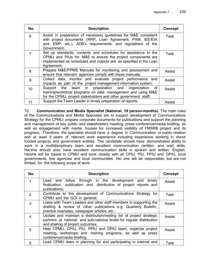
Appendix 7 239
No. Description Concept
6 Assist in preparation of necessary guidelines for M&E consistent with project documents (RRP, Loan Agreement, PAM, IEE/EIA and EMP, etc.), ADB’s requirements, and regulations of the Government;
Task
7 Set up standards, contents and schedules for assistance to the CPMU and PIUs for M&E to ensure the project components are implemented as scheduled and outputs are as specified in the Loan Agreement;
Task
8 Prepare M&E/PPMS Manuals for monitoring and assessment and ensure that relevant agencies comply with these manuals;
Assist
9 Collect data, monitor and evaluate project performance and impacts as part of the project management information system;
Assist
10 Support the team in preparation and organization of training/workshop programs on data management and using M&E for the CPMU, project stakeholders and other government staff;
Assist
11 Support the Team Leader in timely preparation of reports. Assist 70. Communication and Media Specialist (National, 18 person-months). The main roles of the Communications and Media Specialist are to support development of Communications Strategy for the CPMU; prepare corporate documents for publications and support the planning and management of key public and stakeholders meeting, press conference/media briefing; as well as engagement with media houses for increased visibility of FMSRB project and its progress,. Therefore, the specialist should have a degree in Communication or public relation and at least 6 years of relevant work experience including experience working in donor funded projects and government entities. The candidate should have demonstrated ability to work in a multidisciplinary team and excellent communication (written and oral) skills. He/she should also have excellent communication skills in spoken and written English. He/she will be based in CPMU and work closely with all CPIU, PIU, PPIU and DPIU, local governments, line agencies and local communities. He/ she will be responsible, but are not limited, for the following scope of work:
No. Description Concept
1 Lead and follow through in the development and timely finalization, publication and distribution of project reports and publications;
Assist
2 Contribute to the development of Communications Strategy for CPMU and the GOI in general;
Task
3 Liaise with Team Leaders and other staff members in supporting the drafting & review of other publications e.g. Quarterly Bulletin, practice examples, newspaper articles, etc.;
Assist
4 Update and maintain a distribution/mailing list of project strategic partners at national and sub-national levels for regular distribution and sharing of project outcomes;
Assist
5 Help CPMU, CPIU, PIU, PPIU and DPIU team, organize project meeting, workshops and training programs, as well as press conference/media briefing;
Assist
6 Lead CPMU team in planning for and participating in internal and Task
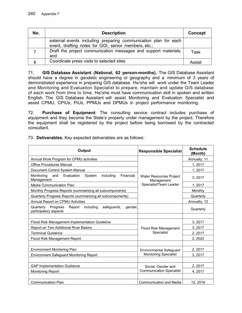
240 Appendix 7
No. Description Concept
external events including preparing communication plan for each event, drafting notes for GOI, senior members, etc.;
7 Draft the project communication messages and support materials; and
Task
8 Coordinate press visits to selected sites Assist 71. GIS Database Assistant (National, 62 person-months). The GIS Database Assistant should have a degree in geodetic engineering or geography and a minimum of 3 years of demonstrated experience in preparing GIS database. He/she will work under the Team Leader and Monitoring and Evaluation Specialist to prepare, maintain and update GIS database of each work from time to time. He/she must have communication skill in spoken and written English. The GIS Database Assistant will assist Monitoring and Evaluation Specialist and assist CPMU, CPIUs, PIUs, PPMUs and DPMUs in project performance monitoring. 72. Purchase of Equipment: The consulting service contract includes purchase of equipment and they become the State’s property under management by the project. Therefore the equipment shall be registered by the project before being borrowed by the contracted consultant. 73. Deliverables. Key expected deliverables are as follows:
Output Responsible Specialist Schedule (Month)
Annual Work Program for CPMU activities
Water Resources Project Management
Specialist/Team Leader
Annually, 11 Office Procedures Manual 1, 2017 Document Control System Manual 1, 2017 Monitoring and Evaluation System including Financial Management 3, 2017
Media Communication Plan 1, 2017 Monthly Progress Reports (summarizing all subcomponents) Monthly Quarterly Progress Reports (summarizing all subcomponents) Quarterly Annual Report on CPMU Activities Annually, 12 Quarterly Progress Report including safeguards, gender, participatory aspects Quarterly
Flood Risk Management Implementation Guideline
Flood Risk Management Specialist
3, 2017 Report on Two Additional River Basins 3, 2017 Technical Guidance 2, 2017 Flood Risk Management Report 2, 2022 Environment Monitoring Plan Environmental Safeguard
Monitoring Specialist 2, 2017
Environment Safeguard Monitoring Report 3, 2017 GAP Implementation Guidance Social, Gender and
Communication Specialist 2, 2017
Monitoring Report 4, 2017 Communication Plan Communication and Media 12, 2016
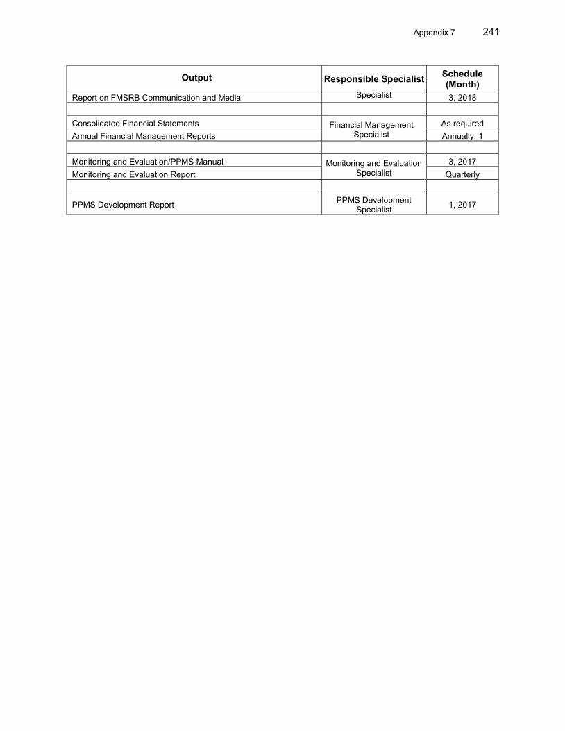
Appendix 7 241
Output Responsible Specialist Schedule (Month)
Report on FMSRB Communication and Media Specialist 3, 2018 Consolidated Financial Statements Financial Management
Specialist As required
Annual Financial Management Reports Annually, 1 Monitoring and Evaluation/PPMS Manual Monitoring and Evaluation
Specialist 3, 2017
Monitoring and Evaluation Report Quarterly
PPMS Development Report PPMS Development Specialist 1, 2017
242 Appendix 7
B.Terms of Reference EXTERNAL MONITORING AND POST-EVALUATION
PROJECT TITLE 74. Project Background. Provide background consistent with the RP30 and PAM information. It should include, but not be limited to:
a. Project components and locations (based on the loan agreement)
b. Project components with resettlement impacts
c. Categories of resettlement impact and estimates
75. Objectives. The Project requires the services of external monitoring and evaluation experts31/qualified NGOs to conduct an external assessment of the extent to which resettlement and rehabilitation objectives are being met. Specifically, the objectives of the monitoring program are
(i) To verify ongoing internal monitoring information
(ii) To verify whether the overall project and resettlement objectives are being met in accordance with the Resettlement Plan (RP), and if not to suggest corrective measures;
(iii) To assess the extent to which implementation of the resettlement plan32 complies with ADB’s Safeguards Policy Statement (SPS):
(iv) To identify problems or potential problems; and
(v) To identify methods of responding immediately to mitigate problems and advise the [name of the borrower or client] accordingly.
(vi) To verify if the livelihoods and the standard of living of affected persons (APs), including those of the non-titled displaced persons, are restored or improved.
76. Tasks: The external experts will address specific issues such as the following: (i) Verify the DMS database generated by the PMU, identify differences in IOL
and/or DMS recorded in the RP, and document changes to the database;
(ii) Confirm that all APs are eligible for compensation, resettlement and rehabilitation assistance, irrespective of tenure status, social or economic standing, and any such factors that may discriminate against achieving the project objectives; Payment of compensation, allowances and other assistance are as per approved RP;
(iii) Confirm timing of disbursement of payment; and assess that the level of compensation is sufficient to replace their losses.
(iv) Public consultation and awareness of key information in the resettlement plan33;
30 Relevant RP at the time of the writing of the TOR – Please check. 31 External experts mean experts not involved in day-to-day project implementation or supervision. 32 Including updating of the RP.
Appendix 7 243
(v) Coordination of resettlement activities with construction schedule;
(vi) Land acquisition and transfer procedures;
(vii) Construction/rebuilding of replacement houses and structures on residual land, relocation sites (outside the residual land), and self-selected land;
(viii) Implementation of gender and/or indigenous peoples measures as indicated in the RP;
(ix) Level of satisfaction of APs with the provisions and implementation of the RP;
(x) Effectiveness of grievance redress mechanism (accessibility, documentation, process, resolution);
(xi) Effectiveness, sufficiency, impact and sustainability of entitlements and income restoration programs and the need for further improvement and corrective measures, if any;
(xii) Relocation site development (civic infrastructure and community services as required), identification and selection of sites in consultation with APs and host communities, equivalent or enhanced access to livelihood opportunities; process and timeliness of providing land titles/certificates;
(xiii) Capacity of APs to restore/re-establish livelihoods and living standards. Special attention will be given to severely affected APs and vulnerable APs;
(xiv) Involuntary resettlement impacts caused during construction activities; (xv) Participation of APs in RP implementation; and,
(xvi) Adequacy of budget and human resources34 at executing agency/implementing agency level for resettlement activities, including internal monitoring.
77. Methodology: The methods for external monitoring activities include
a) Review of detailed measurement survey (DMS) process to be able to establish a baseline for monitoring and evaluating project benefits. The EMO to check on a random basis35 the DMS process with APs, from identification to agreement on DMS results. The EMO will also evaluate the DMS process to determine and assess if DMS activities are being carried out/was carried out in a participatory and transparent manner.
b) Resettlement audit conducted during monitoring. The EMO will carry out random checks of payments36 disbursed to APs during monitoring. The EMO will submit a resettlement audit report upon completion of compensation payment to APs.
c) Review of socioeconomic data37 prepared during the Project Preparatory Technical Assistance (PPTA). With this review, the DMS data, and additional data compiled, the EMO will provide the baseline data to be used in comparison to the post-resettlement survey. A post resettlement survey will be carried out one year
33 Scope of Land Acquisition and Resettlement Impacts, Entitlement Matrix, Grievance Redress Mechanism 34 Assessment of human resources is in terms of both number of staff assigned, as well as capacity 35 Depending on number of affected households (AHs) 36 Depending on number of affected households (AHs) 37 Possible data sources include: census, inventory of loss-socioeconomic survey (IOL-SES), village
records/documents
244 Appendix 7
following completion of all resettlement activities, including livelihood restoration activities. Sampling will include at least 20% of severely affected and vulnerable households, as well as at least 10% of all other APs. Special attention will be paid to the inclusion of women, ethnic groups, the very poor, the landless and other vulnerable groups, with set questions for women and other target groups. The database will disaggregate information by gender, vulnerability and ethnicity.
d) Participatory Rapid Appraisal (PRA), which will involve obtaining information, identifying existing or potential problems, and finding specific time-bound solutions through participatory means including: a) key informant interviews including representatives of civil society, community groups, and non-governmental organizations; b) focus group discussions (FGDs) on specific topics such as compensation payment, income restoration and relocation38; c) community public meetings to discuss community losses, integration of resettled households in host communities or construction work employment; d) direct field observations, for example, of resettlement site development; e) formal and informal interviews with affected households, women, ethnic minorities, and other vulnerable groups to monitor and assess the progress the APs are making to restore their living standards, APs’ perceived need for additional assistance (and type of assistance), and their individual satisfaction with current economic activities; and, f) in-depth case studies of problems identified by internal or external monitoring that required special efforts to resolve. The PRA will also focus on good practices in land acquisition and involuntary resettlement objectives, approaches, and implementation strategies.
e) Review the results of internal monitoring.
78. Timing & Team Composition (read and delete non-relevant sections)
a. Standard large-scale infrastructure project. External monitoring activities will be carried out for a period of __ year(s) on a semi-annual basis39 starting from the conduct of DMS until the completion of livelihood/income restoration activities. For project components where payment of compensation/allowances has been substantially completed, the external expert will also conduct a resettlement audit to verify completion of payment of compensation/allowances and hand-over of plots and recommend issuance of NOL for commencement of civil works.
b. Projects with several sub-projects. The external experts will conduct six monitoring missions to be carried out on a semi-annual basis40 starting from the completion of DMS for the first batch of subprojects until the completion of livelihood/income restoration activities in all subprojects. For subprojects where payment of compensation/allowances has been substantially completed, the external experts will also conduct resettlement audit mission to validate status of compensation and hand-over of plots and recommend issuance of NOL for the commencement of civil works.
38 Groups that may be targeted for involvement in FGDs include AHs in general, and vulnerable AHs such as women-
headed households, the poor, and ethnic minorities 39 As per ADB SPS (2009). For projects deemed by ADB as highly complex and sensitive, ADB requires quarterly
monitoring reports - refer to ADB. 2010. Safeguard Policy Statement. Operations Manual. OM Section F1/OP, Para 27. Manila (issued on 4 March 2010).
40 See above footnote.

Appendix 7 245
The external monitoring and evaluation experts41 / qualified NGOs will be composed of one team leader with extensive experience in monitoring and evaluation of resettlement activities in the country with strong ability in preparing resettlement reports. He/she should demonstrate good communication skills and have at least a bachelor degree in a relevant field. The team leader will be assisted by at least __ specialist(s) with similar experience and background. All reports will be submitted in English (and in local language, if required) to the government and ADB simultaneously.
79. Deliverables: Inception report, including findings of review of baseline data, monitoring methodology and detailed work plan (in terms of sampling, timing, budget, other required resources) Semi-annual monitoring report42, including (a) methods used by the EMO during the monitoring period; (b) progress of RP implementation, including any deviations from the provisions of the RP; (c) identification of problem issues and recommended corrective actions to inform implementing agencies and resolve issues in a timely manner (refer to sample table below); (d) identification of specific gender and ethnic minorities issues, as relevant; (e) report on progress of the follow-up of issues and problems identified in the previous reports; (f) lessons learned that might be useful for future activities; and, (g) Resettlement audit report. Sample CAP summary table
No. Survey code
Project Component Village
Name of head of Affected
Household/ Name of AP
Name or use of
affected structure
Status of structure
s Corrective
Action Budget (USD)
Schedule of implementation
of corrective action
By (date)
Total
Include Monitoring and Evaluation indicators (commonly a table in the RP). A set of suggested indicators are in the table below43, to be replaced with RP table as required:
41 External experts mean experts not involved in day-to-day project implementation or supervision 42 Monitoring reports will be disclosed semiannually/quarterly, upon receipt from borrower. 43 Source: ADB. 2012. Involuntary Resettlement Safeguards: A Planning and Implementation Good Practice
Sourcebook – Draft Working Document. Manila.

246 Appendix 7
C. TERMS OF REFERENCE FOR THE SERVICES FOR ENVIRONMENTAL SAFEGUARDS MONITORING
I. Background
80. The proposed Flood Management in Selected River Basins Project (the Project) will support the Government of Indonesia (GoI) and communities to better manage and mitigate flood risks. The Project aims to shift from project-oriented flood control centered around structural measures, to process-oriented integrated flood management (IFM) that provides a well-balanced mix of non-structural interventions, institutional and capacity building, and structural works to mitigate the negative impacts of floods. It is proposed that the Project be financed by the Asian Development Bank (ADB) through a sector loan with a period of six years. The government designed the Ciujung (Banten Province) and Batu Merah and Way Ruhu (Ambon City, Maluku Province) as priority river basins. These basins were selected as they represent a range of different flooding regimes common throughout Indonesia. They address the multiple and inter-related concerns of flood and watershed management in the river basins. Inadequate institutional arrangements, deteriorating infrastructure, competing water and land resource, and rapid urban and industrial growth have led to flood risk and unhealthy environmental conditions throughout the basin. 81. The overall Project has four components. Project Component 2 is "Adapted basin management, increased discharge capacity and reduced peak flow". Within Project Component 2, (i) sub-component 1 - watershed management – is to be implemented by BANGDA / Ministry of Home Affairs in both Ambon and in Ciujung, and by Ministry of Agriculture working only in Ciujung; and (ii) sub-component 2 focuses on major structural / civil methods of flood control, to be implemented by the Major/National River Basin Organization (Balai Besar Wilayah Sungai) of Cidanau-Ciujung-Cidurian rivers (hereinafter BBWS 3Cis), and the Provincial River Basin Organization (Balai Wilayah Sungai or BWS) of Maluku river. One core priority subproject has been identified under sub-component 2: construction of a 11 km dike in Ciujung river. Other major structural / civil flood control sub-projects under this sector Project will be identified and fully investigated during implementation, following the procedures established in the environmental assessment and review framework (EARF – linked document LD10). II. Required Safeguards Monitoring Entities (SMEs) and its Services
82. In addition to the internal monitoring, the Project Administration Manual (PAM) requires independent monitoring on the safeguards to ensure that all recommendations and mitigation measures under the IEEs and the AMDAL (environmental impact assessment in the Indonesian system) of the core subproject, as well as the AMDAL of all future subprojects are being implemented.
83. One SME will be required in each of the two Project provinces, Banten and Maluku. The required SME will be recruited by the relevant PIU following ADB Consultants’ Qualifications Selection (CQS) procedure. Interested entities such as local NGOs, or domestic universities and institutions must provide amplified Expressions of Interest (EOI) which includes the information showing that they are qualified to perform the services, giving the entity general experience for similar assignments and CVs of Key personnel with academic background, experience in similar assignments, knowledge of local conditions, etc. The completed EOI form can be found in CSRN of the ABD website. CVs must be submitted using the format in Attachment-1.
Appendix 7 247
III. Overall Schedule of Safeguards Monitoring
84. Independent environmental monitoring will be undertaken during the project implementation period from 2016 to 2022. The SME will provide the services for all the subprojects within the province under the sector loan. Procedures for environmental safeguards in the sector loan can be found in the Environmental Assessment and Review Framework (Linked document 10). For the core subproject that has been identified, the environmental monitoring will follow the Environmental Management and Monitoring Plans (EMPs) that have been prepared and included in the Initial Environmental Examinations (IEEs – Linked document 11) and the Environmental Impact Assessment (AMDAL). For future subprojects for which an AMDAL is required, environmental monitoring will be undertaken following the EMP under the AMDAL. List of candidate structural subprojects under the Project can be found in the following Table.
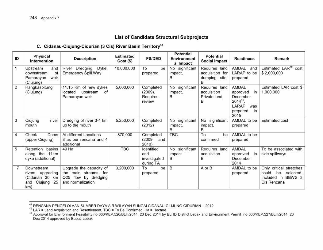
248 Appendix 7
List of Candidate Structural Subprojects
C. Cidanau-Ciujung-Cidurian (3 Cis) River Basin Territory44
ID Physical Intervention Description Estimated
Cost ($) FS/DED Potential
Environmental Impact
Potential Social Impact Readiness Remark
1 Upstream and downstream of Pamarayan weir (Ciujung)
River Dredging, Dyke, Emergency Spill Way
10,000,000 To be prepared
No significant impact, B
Requires land acquisition for dumping site, B
AMDAL and LARAP to be prepared
Estimated LAR45 cost $ 2,000,000
2 Rangkasbitung (Ciujung)
11.15 Km of new dykes located upstream of Pamarayan weir
5,000,000 Completed (2009). Requires review
No significant impact, B
Requires land acquisition Private land, B
AMDAL approved in December 201446, LARAP was prepared in 2015
Estimated LAR cost $ 1,000,000
3 Ciujung river mouth
Dredging of river 3-4 km up to the mouth
5,250,000 Completed (2012)
No significant impact, B
No significant impact, B
AMDAL to be prepared
Estimated cost
4 Check Dams (upper Ciujung)
At different Locations 8 as per rencana and 4 additional
870,000 Completed (2009 and 2010)
TBC To be confirmed
AMDAL to be prepared
5 Retention basins along the 11km dyke (additional)
49 Ha TBC Identified and investigated during TA
No significant impact B
Requires land acquisition B
AMDAL approved in December 2014
To be associated with side spillways
7 Downstream rivers upgrading (Cidurian 30 km and Ciujung 25 km)
Upgrade the capacity of the main streams, for Q25 flow by dredging and normalization
3,200,000 To be prepared
B A or B AMDAL to be prepared
Only critical stretches could be selected. Included in BBWS 3 Cis Rencana
44 RENCANA PENGELOLAAN SUMBER DAYA AIR WILAYAH SUNGAI CIDANAU-CIUJUNG-CIDURIAN - 2012 45 LAR = Land Acquisition and Resettlement, TBC = To Be Confirmed, Ha = Hectare 46 Approval for Environment Feasibility no 660/KEP.526/BLH/2014, 23 Dec 2014 by BLHD District Lebak and Environment Permit no 660/KEP.527/BLH/2014, 23
Dec 2014 approved by Bupati Lebak

Appendix 7 249
ID Physical Intervention Description Estimated
Cost ($) FS/DED Potential
Environmental Impact
Potential Social Impact Readiness Remark
1 Upstream and downstream of Pamarayan weir (Ciujung)
River Dredging, Dyke, Emergency Spill Way
10,000,000 To be prepared
No significant impact, B
Requires land acquisition for dumping site, B
AMDAL and LARAP to be prepared
Estimated LAR45 cost $ 2,000,000
2 Rangkasbitung (Ciujung)
11.15 Km of new dykes located upstream of Pamarayan weir
5,000,000 Completed (2009). Requires review
No significant impact, B
Requires land acquisition Private land, B
AMDAL approved in December 201446, LARAP was prepared in 2015
Estimated LAR cost $ 1,000,000
3 Ciujung river mouth
Dredging of river 3-4 km up to the mouth
5,250,000 Completed (2012)
No significant impact, B
No significant impact, B
AMDAL to be prepared
Estimated cost
4 Check Dams (upper Ciujung)
At different Locations 8 as per rencana and 4 additional
870,000 Completed (2009 and 2010)
TBC To be confirmed
AMDAL to be prepared
5 Retention basins along the 11km dyke (additional)
49 Ha TBC Identified and investigated during TA
No significant impact B
Requires land acquisition B
AMDAL approved in December 2014
To be associated with side spillways
8 Ciujung Dyke Rehabilitation and Improvement
Carry out dyke rehabilitation and improvement 60 km, to increase the capacity of the main stream, Q25 flow
30,800,000 To be prepared
B A or B TBD Only critical stretches could be selected. Included in BBWS 3 Cis Rencana
9 Ciujung Retention Area at Kragilan including internal drainage system
Develop Ciujung retention area 400 ha including internal drainage system
3,200,000 To be prepared
B A or B TBD Included in BBWS 3 Cis Rencana
10 Cidurian Dyke Rehabilitation and Improvement
Carry out dyke rehabilitation and improvement 30 km, to increase the capacity of the main stream, Q25 flow
8,400,000 To be prepared
B A or B TBD Only critical stretches could be selected Included in BBWS 3 Cis Rencana

250 Appendix 7
ID Physical Intervention Description Estimated
Cost ($) FS/DED Potential
Environmental Impact
Potential Social Impact Readiness Remark
1 Upstream and downstream of Pamarayan weir (Ciujung)
River Dredging, Dyke, Emergency Spill Way
10,000,000 To be prepared
No significant impact, B
Requires land acquisition for dumping site, B
AMDAL and LARAP to be prepared
Estimated LAR45 cost $ 2,000,000
2 Rangkasbitung (Ciujung)
11.15 Km of new dykes located upstream of Pamarayan weir
5,000,000 Completed (2009). Requires review
No significant impact, B
Requires land acquisition Private land, B
AMDAL approved in December 201446, LARAP was prepared in 2015
Estimated LAR cost $ 1,000,000
3 Ciujung river mouth
Dredging of river 3-4 km up to the mouth
5,250,000 Completed (2012)
No significant impact, B
No significant impact, B
AMDAL to be prepared
Estimated cost
4 Check Dams (upper Ciujung)
At different Locations 8 as per rencana and 4 additional
870,000 Completed (2009 and 2010)
TBC To be confirmed
AMDAL to be prepared
5 Retention basins along the 11km dyke (additional)
49 Ha TBC Identified and investigated during TA
No significant impact B
Requires land acquisition B
AMDAL approved in December 2014
To be associated with side spillways
11 Cidurian sediment control
Construction of 8 check dams to reduce the sediment yield and reduce the runoff
640,000 Completed AMDAL to be prepared
TBD TBD DEDs are prepared for a few and are some under way
12 Pasirkopo Dam, District Lebak
Development of Pasir Kopo Dam
54,303,500 Feasibility Study 2014
TBD TBD LARAP Study is prepared in 2015
Included in BBWS 3 Cis Rencana
13 Cidanau Dam, Serang District
Development of Cidanau Dam
119,600,000 DED is prepared in 2015
TBD TBD LARAP Study is prepared in 2015
Included in BBWS 3 Cis Rencana
14 Implementation of the retention basins
Long storage development in Ciujung Lama, and WTP
9,000,000 Available TBD TBD TBD
15 Construction of the new drainage network and
Rearranging and building a micro urban drainage systems and
30,000,000 To be prepared
No significant impacts, C
No significant impacts
TBD For urban areas To be implemented by Human Settlement
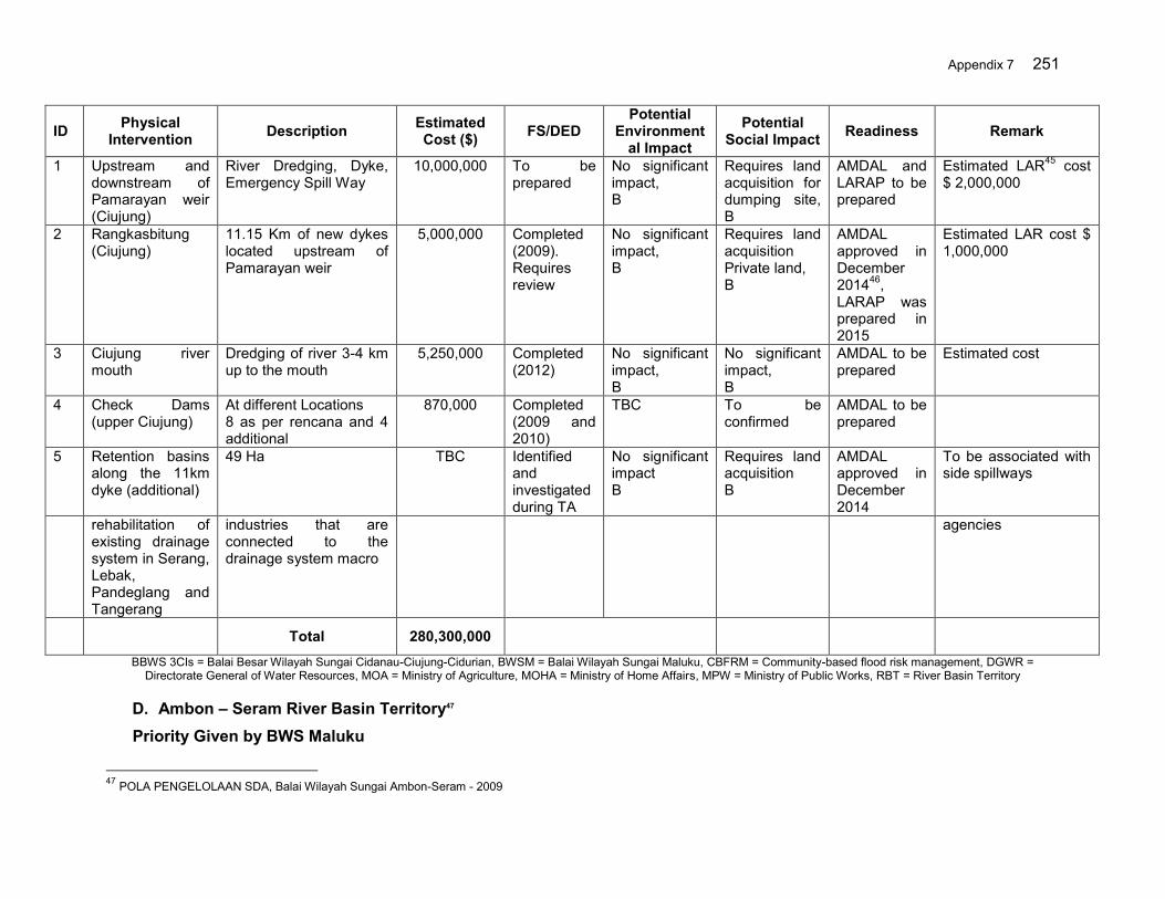
Appendix 7 251
ID Physical Intervention Description Estimated
Cost ($) FS/DED Potential
Environmental Impact
Potential Social Impact Readiness Remark
1 Upstream and downstream of Pamarayan weir (Ciujung)
River Dredging, Dyke, Emergency Spill Way
10,000,000 To be prepared
No significant impact, B
Requires land acquisition for dumping site, B
AMDAL and LARAP to be prepared
Estimated LAR45 cost $ 2,000,000
2 Rangkasbitung (Ciujung)
11.15 Km of new dykes located upstream of Pamarayan weir
5,000,000 Completed (2009). Requires review
No significant impact, B
Requires land acquisition Private land, B
AMDAL approved in December 201446, LARAP was prepared in 2015
Estimated LAR cost $ 1,000,000
3 Ciujung river mouth
Dredging of river 3-4 km up to the mouth
5,250,000 Completed (2012)
No significant impact, B
No significant impact, B
AMDAL to be prepared
Estimated cost
4 Check Dams (upper Ciujung)
At different Locations 8 as per rencana and 4 additional
870,000 Completed (2009 and 2010)
TBC To be confirmed
AMDAL to be prepared
5 Retention basins along the 11km dyke (additional)
49 Ha TBC Identified and investigated during TA
No significant impact B
Requires land acquisition B
AMDAL approved in December 2014
To be associated with side spillways
rehabilitation of existing drainage system in Serang, Lebak, Pandeglang and Tangerang
industries that are connected to the drainage system macro
agencies
Total 280,300,000
BBWS 3CIs = Balai Besar Wilayah Sungai Cidanau-Ciujung-Cidurian, BWSM = Balai Wilayah Sungai Maluku, CBFRM = Community-based flood risk management, DGWR = Directorate General of Water Resources, MOA = Ministry of Agriculture, MOHA = Ministry of Home Affairs, MPW = Ministry of Public Works, RBT = River Basin Territory
D. Ambon – Seram River Basin Territory47
Priority Given by BWS Maluku
47 POLA PENGELOLAAN SDA, Balai Wilayah Sungai Ambon-Seram - 2009
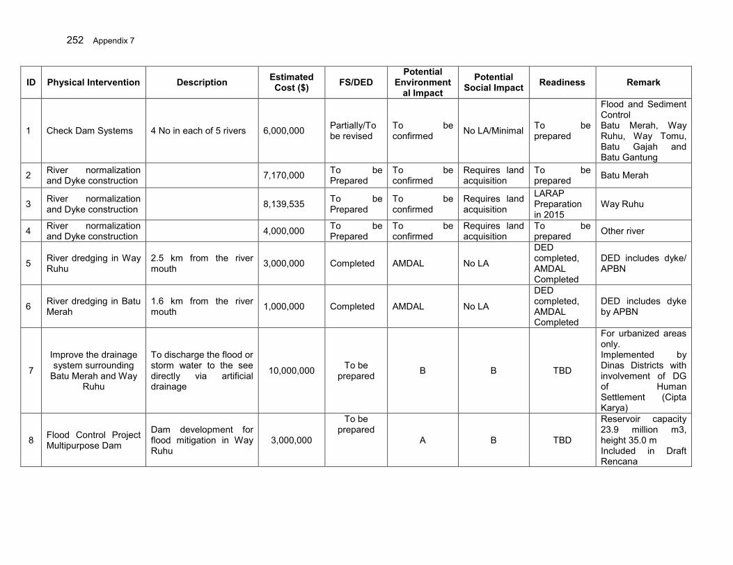
252 Appendix 7
ID Physical Intervention Description Estimated Cost ($) FS/DED
Potential Environment
al Impact Potential
Social Impact Readiness Remark
1 Check Dam Systems 4 No in each of 5 rivers 6,000,000 Partially/To be revised
To be confirmed No LA/Minimal To be
prepared
Flood and Sediment Control Batu Merah, Way Ruhu, Way Tomu, Batu Gajah and Batu Gantung
2 River normalization and Dyke construction 7,170,000 To be
Prepared To be confirmed
Requires land acquisition
To be prepared Batu Merah
3 River normalization and Dyke construction 8,139,535 To be
Prepared To be confirmed
Requires land acquisition
LARAP Preparation in 2015
Way Ruhu
4 River normalization and Dyke construction 4,000,000 To be
Prepared To be confirmed
Requires land acquisition
To be prepared Other river
5 River dredging in Way Ruhu
2.5 km from the river mouth 3,000,000 Completed AMDAL No LA
DED completed, AMDAL Completed
DED includes dyke/ APBN
6 River dredging in Batu Merah
1.6 km from the river mouth 1,000,000 Completed AMDAL No LA
DED completed, AMDAL Completed
DED includes dyke by APBN
7
Improve the drainage system surrounding
Batu Merah and Way Ruhu
To discharge the flood or storm water to the see directly via artificial drainage
10,000,000 To be prepared B B TBD
For urbanized areas only. Implemented by Dinas Districts with involvement of DG of Human Settlement (Cipta Karya)
8 Flood Control Project Multipurpose Dam
Dam development for flood mitigation in Way Ruhu
3,000,000
To be prepared
A B TBD
Reservoir capacity 23.9 million m3, height 35.0 m Included in Draft Rencana
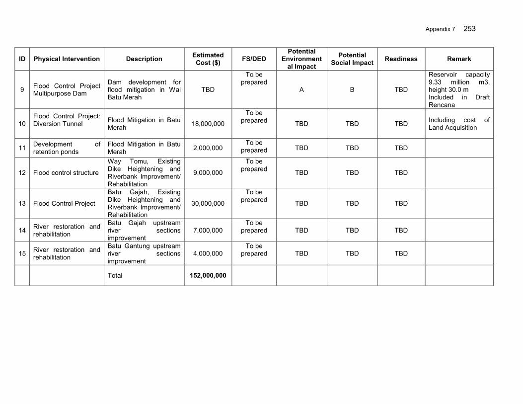
Appendix 7 253
ID Physical Intervention Description Estimated Cost ($) FS/DED
Potential Environment
al Impact Potential
Social Impact Readiness Remark
9 Flood Control Project Multipurpose Dam
Dam development for flood mitigation in Wai Batu Merah
TBD
To be prepared
A B TBD
Reservoir capacity 9.33 million m3, height 30.0 m Included in Draft Rencana
10 Flood Control Project: Diversion Tunnel
Flood Mitigation in Batu Merah 18,000,000
To be prepared TBD TBD TBD Including cost of
Land Acquisition
11 Development of retention ponds
Flood Mitigation in Batu Merah 2,000,000
To be prepared TBD TBD TBD
12 Flood control structure
Way Tomu, Existing Dike Heightening and Riverbank Improvement/ Rehabilitation
9,000,000
To be prepared TBD TBD TBD
13 Flood Control Project
Batu Gajah, Existing Dike Heightening and Riverbank Improvement/ Rehabilitation
30,000,000
To be prepared TBD TBD TBD
14 River restoration and rehabilitation
Batu Gajah upstream river sections improvement
7,000,000 To be
prepared TBD TBD TBD
15 River restoration and rehabilitation
Batu Gantung upstream river sections improvement
4,000,000 To be
prepared TBD TBD TBD
Total 152,000,000
254 Appendix 7
IV. Scope of Works
1. Scope of Works
85. The Safeguards Monitoring Entity will focus on assessing progress and compliance with the Environmental Monitoring Plans (EMPs) under the IEEs and the AMDAL of the relevant subprojects, identifying constraints and developing remedial actions to effectively address theses. 86. Key responsibilities of the SME include:
(i) To review the IEEs and AMDAL reports, including the EMPs of the relevant core subprojects (one in Ciujung and two in Ambon) for familiarization of environmental monitoring requirements
(ii) To review the AMDAL reports (which will be accepted as an IEE or an
Environmental Impact Assessment by ADB) of all relevant future subprojects under the Loan for familiarization of environmental monitoring requirements.
(iii) To develop a monitoring and assessment plan, including plan for baseline
establishment where baseline data do not exist. Based on the IEEs and AMDALs, the SME will develop a monitoring and assessment plan responding to the scope of works outlined in these terms of reference, including the detailed field survey plan where necessary.
(iv) To conduct water quality monitoring. The SME will establish baseline for water
quality at the subprojects and monitor the common parameters48 as set out in the EMP under the IEEs and/or the AMDAL.
2. Deliverables
(i) A monitoring and assessment plan responding to the scope of works outlined in
these terms of reference including the detailed field survey plan for each mission. Four missions per year will be conducted for subprojects under construction and two missions per year will be conducted for subprojects under operation (post construction).
(ii) Baseline data of common water quality parameters for each subproject (primary
data to be collected or secondary data if available); (iii) Draft quarterly monitoring report submitted to the relevant PIU. Hard copies of
the reports must be accompanied with soft copies. (iv) Final quarterly monitoring report based on the PIU comments. Hard copies of the
reports must be accompanied with soft copies.
3. Requirements for the SME
a. Team Composition and Required Inputs 48 As referred to in GOI Regulation Nr. 82/2001 on Water Quality Management and Water Pollution Control.
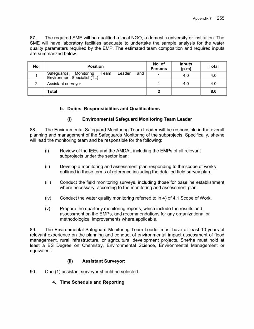
Appendix 7 255
87. The required SME will be qualified a local NGO, a domestic university or institution. The SME will have laboratory facilities adequate to undertake the sample analysis for the water quality parameters required by the EMP. The estimated team composition and required inputs are summarized below.
No. Position No. of Persons
Inputs (p-m) Total
1 Safeguards Monitoring Team Leader and Environment Specialist (TL) 1 4.0 4.0
2 Assistant surveyor 1 4.0 4.0
Total 2 8.0
b. Duties, Responsibilities and Qualifications
(i) Environmental Safeguard Monitoring Team Leader
88. The Environmental Safeguard Monitoring Team Leader will be responsible in the overall planning and management of the Safeguards Monitoring of the subprojects. Specifically, she/he will lead the monitoring team and be responsible for the following:
(i) Review of the IEEs and the AMDAL including the EMPs of all relevant
subprojects under the sector loan;
(ii) Develop a monitoring and assessment plan responding to the scope of works outlined in these terms of reference including the detailed field survey plan.
(iii) Conduct the field monitoring surveys, including those for baseline establishment
where necessary, according to the monitoring and assessment plan.
(iv) Conduct the water quality monitoring referred to in 4) of 4.1 Scope of Work.
(v) Prepare the quarterly monitoring reports, which include the results and assessment on the EMPs, and recommendations for any organizational or methodological improvements where applicable.
89. The Environmental Safeguard Monitoring Team Leader must have at least 10 years of relevant experience on the planning and conduct of environmental impact assessment of flood management, rural infrastructure, or agricultural development projects. She/he must hold at least a BS Degree on Chemistry, Environmental Science, Environmental Management or equivalent.
(ii) Assistant Surveyor:
90. One (1) assistant surveyor should be selected.
4. Time Schedule and Reporting

256 Appendix 7
91. Four (4) missions of environmental safeguard monitoring per year to each subproject that is under construction, and two (2) missions of environmental safeguard monitoring per year to each subproject that is under operation. A monitoring baseline (primary data or secondary data if available) will be established before the start of any subproject. Quarterly environmental monitoring reports will be submitted covering all subprojects. The duration of the services will coincide with the Project implementation period.
5. Estimated Budget
92. The estimated budget for this package is approximately US$ 30,000 for each province. This budget may vary depending on the number and nature of subprojects in the province.

Appendix 7 257
Attachment-1 to TOR: CV Format CURRICULUM VITAE (CV) FOR PROPOSED INTERNATIONAL OR NATIONAL
EXPERTS
1. Proposed Position:
2. Name of Firm [Insert name of firm proposing the expert, if applicable]:
3. Name of Expert [Insert full name]: 4. Current Residential Address: ______________________________________________ Telephone No.: __________________________________________________________ Fax No.: ________________________________________________________________ E-Mail Address: _________________________________________________________
5. Date of Birth: Citizenship: 6. Education [Indicate college/university and other specialized education of expert, giving
names of institutions, degrees obtained, and dates of obtainment]: 7. Membership in Professional Associations: 8. Other Trainings [Indicate significant training since degrees under 5 - Education were obtained]: 9. Countries of Work Experience: [List countries where expert has worked in the last ten
years]:
10. Languages [For each language indicate proficiency: good, fair, or poor in speaking,
reading, and writing]: 11. Employment Record [Starting with present position, list in reverse order every employment held
by expert since graduation, giving for each employment (see format here below): dates of employment, name of employing organization, positions held.]:
From [Year]: To [Year]: Employer: Positions held: NOTE: Maximum of 5 pages.
258 Appendix 7
12. Detailed Tasks Assigned [List all tasks to be performed under this assignment]
13. Work Undertaken that Best Illustrates Capability to Handle the Tasks Assigned [Among the assignments in which the expert has been involved, indicate the following information for those assignments that best illustrate the expert’s capability to handle the tasks listed in line 11.] Name of assignment or project:
Year:
Location:
Client:
Main project features:
Positions held:
Activities performed:
13. Certification: I, the undersigned, certify to the best of my knowledge and belief− Yes No (i) this CV correctly describes my qualifications and my experience (ii) I am employed by the Executing or the Implementing Agency (iii) I am a close relative of a current ADB staff member (iv) I am the spouse of a current ADB staff member (v) I am former ADB staff member.
If yes, I retired from ADB over 12 months ago (vi) I am part of the team who wrote the terms of reference for this consulting services assignment. (vii) I am sanctioned (not eligible for engagement) by ADB. I understand that any willful misstatement described herein may lead to my disqualification or dismissal, if engaged. Date: Signature of expert (Day/Month/Year)
Appendix 7 259
II. MOA Package: Farmland Management and Sustainable Agriculture Practices 93. Background. Landslides, riverbank erosion and floods have become annual phenomena in the 3 Cis river basin territory (RBT), which usually occur between November and January every year. The flood risk condition in the basin is worsening due to both natural and human induced factors. One of the most serious aspects is degrading watershed associated with poor farm management and deforestation. This has increased sediment yield and of runoff volumes and peaks during intense rainfall events. Sediment deposition in the main river channels downstream has reduced the conveyance capacity of the rivers, increased channel instability and bank erosion, and generally increased flood hazard. 94. In order to mitigate the flood risk, proactive measures are necessary, which have not been given much priority to date in regional development planning. Ideally non-structural measures particularly watershed management from the view point of sustainable faming and irrigation practices as well as afforestation should be done as a part of integrated flood risk management. 95. Watershed management, particularly soil and water conservation activities, if implemented in proper coordination among different sectors/ line agencies with better understanding of upstream-downstream consequences, will significantly reduce soil erosion and mitigate floods downstream. At the same time, if implemented appropriately the activities can enhance the livelihoods of farmers through different income generation opportunities and various agro-forestry related enterprises. 96. Objectives. The general objective of this component is to develop critical lands in the upper Ciujung river basin to control erosion through better land management, to reduce runoff through water conservation and enhance the income of the farmers by involving and benefiting them from the watershed management/agro-forestry initiatives.49 The specific objectives are to (i) develop the critical land by terracing, improved farming practices, plantation of multi-purpose trees on upper slopes, better hill irrigation, forming vegetated waterways and other soil and water conservation measures, and (ii) improve the livelihoods of farmers by increasing incomes through better land and water conservation practices 97. Scope of Works. Poor agricultural practices and the large and increasing amount of critical land are a major cause of the increased runoff in the Ciujung river basin, and are yet to be improved in such a way that agricultural/livelihood benefits are maximized, while reducing soil erosion and runoff. Under this component, Directorate of Land Conservation of MOA will implement the agro-forestry in [25 ha x (28 groups in Serang + 90 groups in Lebak + 60 groups in Pandeglang)] hectares of land in three Districts. Terracing practices under the scope of land optimization that helps reduce the peak flow and help conserve the water and nutrients increase the productivity, will be promoted in the same districts [25 ha x (6 groups in Serang + 42 groups in Lebak + 20 groups in Pandeglang)]. As a part of livelihood support and support to the conservation activities, farmers in targeted areas will also be provided with agro-machinery and other farm toolkits. MOA through the Directorate General of Agricultural Infrastructure and Facility (DGAIF) will be responsible for the implementation of the sustainable agriculture practices in the 3 Cis RBT in cooperation with provincial and district
49 Based on Ministry of Agriculture guidelines: (i) 2009, Pedoman Teknis Konservasi Das Hulu, (ii) 2009, Pedoman
Teknis Pengembangan Usahatani Konservasi Lahan Terpadu, (iii) 2012, Pedoman Teknis Pengembangan Konservasi Air/Antisipasi Anomali Iklim
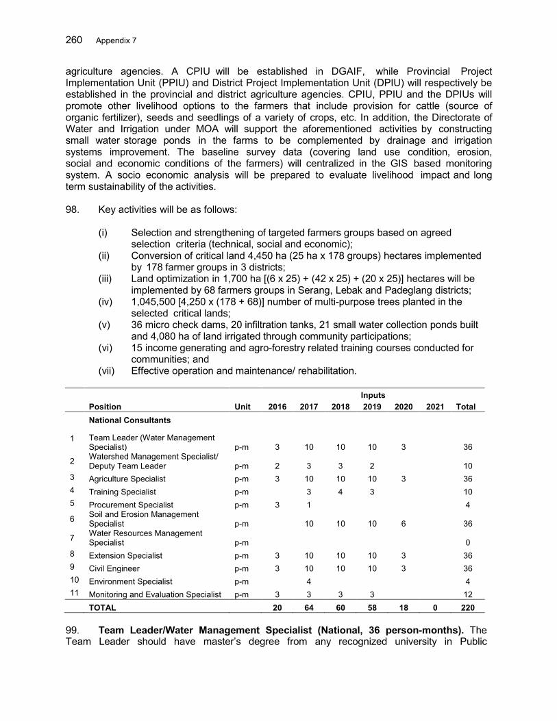
260 Appendix 7
agriculture agencies. A CPIU will be established in DGAIF, while Provincial Project Implementation Unit (PPIU) and District Project Implementation Unit (DPIU) will respectively be established in the provincial and district agriculture agencies. CPIU, PPIU and the DPIUs will promote other livelihood options to the farmers that include provision for cattle (source of organic fertilizer), seeds and seedlings of a variety of crops, etc. In addition, the Directorate of Water and Irrigation under MOA will support the aforementioned activities by constructing small water storage ponds in the farms to be complemented by drainage and irrigation systems improvement. The baseline survey data (covering land use condition, erosion, social and economic conditions of the farmers) will centralized in the GIS based monitoring system. A socio economic analysis will be prepared to evaluate livelihood impact and long term sustainability of the activities. 98. Key activities will be as follows:
(i) Selection and strengthening of targeted farmers groups based on agreed selection criteria (technical, social and economic);
(ii) Conversion of critical land 4,450 ha (25 ha x 178 groups) hectares implemented by 178 farmer groups in 3 districts;
(iii) Land optimization in 1,700 ha [(6 x 25) + (42 x 25) + (20 x 25)] hectares will be implemented by 68 farmers groups in Serang, Lebak and Padeglang districts;
(iv) 1,045,500 [4,250 x (178 + 68)] number of multi-purpose trees planted in the selected critical lands;
(v) 36 micro check dams, 20 infiltration tanks, 21 small water collection ponds built and 4,080 ha of land irrigated through community participations;
(vi) 15 income generating and agro-forestry related training courses conducted for communities; and
(vii) Effective operation and maintenance/ rehabilitation. Inputs Position Unit 2016 2017 2018 2019 2020 2021 Total National Consultants
1 Team Leader (Water Management Specialist) p-m 3 10 10 10 3 36
2 Watershed Management Specialist/ Deputy Team Leader p-m 2 3 3 2 10
3 Agriculture Specialist p-m 3 10 10 10 3 36 4 Training Specialist p-m 3 4 3 10 5 Procurement Specialist p-m 3 1 4
6 Soil and Erosion Management Specialist p-m 10 10 10 6 36
7 Water Resources Management Specialist p-m 0
8 Extension Specialist p-m 3 10 10 10 3 36 9 Civil Engineer p-m 3 10 10 10 3 36 10 Environment Specialist p-m 4 4 11 Monitoring and Evaluation Specialist p-m 3 3 3 3 12 TOTAL 20 64 60 58 18 0 220
99. Team Leader/Water Management Specialist (National, 36 person-months). The Team Leader should have master’s degree from any recognized university in Public
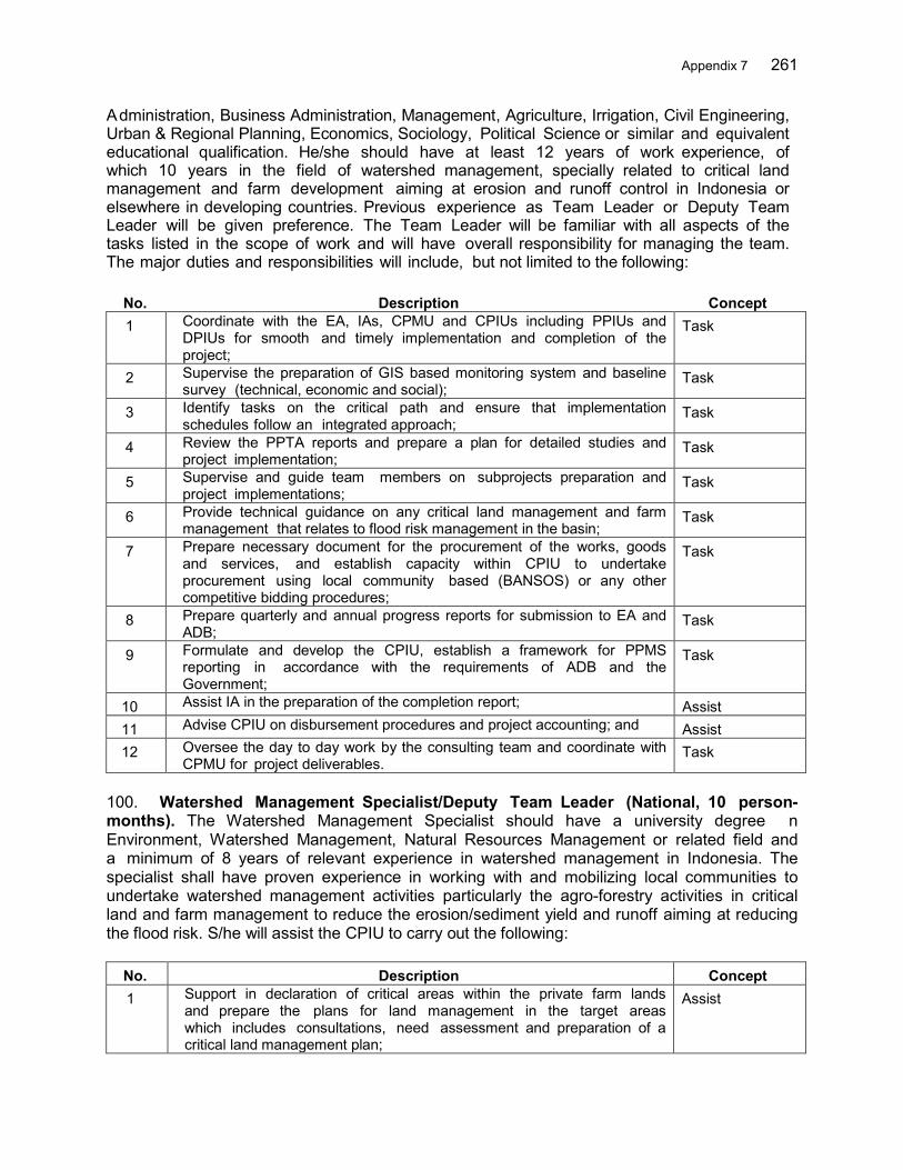
Appendix 7 261
Administration, Business Administration, Management, Agriculture, Irrigation, Civil Engineering, Urban & Regional Planning, Economics, Sociology, Political Science or similar and equivalent educational qualification. He/she should have at least 12 years of work experience, of which 10 years in the field of watershed management, specially related to critical land management and farm development aiming at erosion and runoff control in Indonesia or elsewhere in developing countries. Previous experience as Team Leader or Deputy Team Leader will be given preference. The Team Leader will be familiar with all aspects of the tasks listed in the scope of work and will have overall responsibility for managing the team. The major duties and responsibilities will include, but not limited to the following:
No. Description Concept 1 Coordinate with the EA, IAs, CPMU and CPIUs including PPIUs and
DPIUs for smooth and timely implementation and completion of the project;
Task
2 Supervise the preparation of GIS based monitoring system and baseline survey (technical, economic and social);
Task
3 Identify tasks on the critical path and ensure that implementation schedules follow an integrated approach;
Task
4 Review the PPTA reports and prepare a plan for detailed studies and project implementation;
Task
5 Supervise and guide team members on subprojects preparation and project implementations;
Task
6 Provide technical guidance on any critical land management and farm management that relates to flood risk management in the basin;
Task
7 Prepare necessary document for the procurement of the works, goods and services, and establish capacity within CPIU to undertake procurement using local community based (BANSOS) or any other competitive bidding procedures;
Task
8 Prepare quarterly and annual progress reports for submission to EA and ADB;
Task
9 Formulate and develop the CPIU, establish a framework for PPMS reporting in accordance with the requirements of ADB and the Government;
Task
10 Assist IA in the preparation of the completion report; Assist 11 Advise CPIU on disbursement procedures and project accounting; and Assist 12 Oversee the day to day work by the consulting team and coordinate with
CPMU for project deliverables. Task
100. Watershed Management Specialist/Deputy Team Leader (National, 10 person- months). The Watershed Management Specialist should have a university degree n Environment, Watershed Management, Natural Resources Management or related field and a minimum of 8 years of relevant experience in watershed management in Indonesia. The specialist shall have proven experience in working with and mobilizing local communities to undertake watershed management activities particularly the agro-forestry activities in critical land and farm management to reduce the erosion/sediment yield and runoff aiming at reducing the flood risk. S/he will assist the CPIU to carry out the following:
No. Description Concept 1 Support in declaration of critical areas within the private farm lands
and prepare the plans for land management in the target areas which includes consultations, need assessment and preparation of a critical land management plan;
Assist

262 Appendix 7
No. Description Concept 2 Facilitate the work of communities done under the project to maintain
the quality and targeted outputs; Assist
3 Support to form various committees (user groups/farmer groups and management committees involving local government) and strengthening these farmer/community based institutions for good governance, conducive environment for project implementation;
Assist
4 Conduct training and demonstration/awareness programs to educate the stakeholders farmer groups, local people, local government staff etc. regarding the consequences of watershed degradation and benefits of well-managed farm/critical lands and agro- forestry from different prospective including flood risk management for both upstream and downstream communities;
Task
5 Conduct training programs and demonstration activities particularly alternative income generation activities in line with agro-forestry activities and other project interventions;
Assist
6 Implement slope stabilization activities through community afforestation with monitoring of proper distribution of fruit and other plan seedlings to the targeted households in targeted critical land areas;
Task
7 Prepare lessons learned and compile best practices; Assist 8 Coordinate and work with other specialists in the team including specialist
from CPMU to carry out activities and training/demonstration organic farming, terracing practices and solid waste management; and
Assist
9 Any other activity required to enhance critical land management. Assist 101. Agriculture Specialist (National, 36 person-months). The Agriculture Specialist should have a university degree in agriculture or relevant field and a minimum of 8 years of experience in promoting and implementing advance farming in critical lands. The specialist should have proven experience in working with local communities/farmers. The expert should have professional experience in planning and implementing irrigated agriculture development programs, including field based technology demonstration and dissemination, value chain development including market linkage development and action-oriented researches for new technologies. The specialist will undertake the following tasks.
No. Description Concept 1 Provide on the job training as a trainer to the local authorities and
farmer groups as needed and requested by the training specialist; Task
2 Supervise all farming related activities under the project to be carried out by the farmer groups;
Task
3 Assist local committee to select and procure goods to be used in farming on critical lands and monitor and evaluate the farmers activities closely;
Assist
4 Lead the awareness campaign on different farm based tools and technology to enhance the livelihood of the farmers;
Task
5 Develop an appropriate model to quantitatively assess the feasibility and benefits of proposed plantation and terracing interventions;
Task
6 Establish benchmarks on cropping intensity and productivity and also with identifying current seasonal cropping and agro-forestry related practices in the project area;
Task
7 Recommend efficient initiatives for farming through conjunctive use of surface water supply and irrigation needs and propose trials areas and monitoring and evaluation systems;
Task
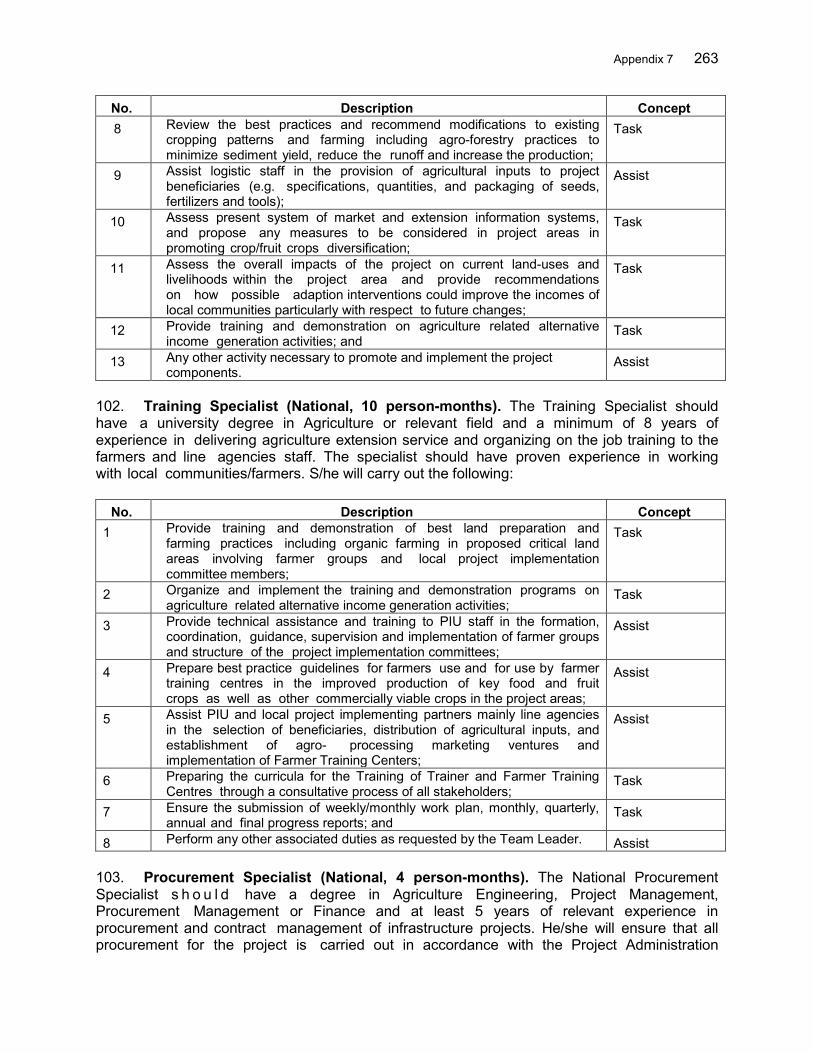
Appendix 7 263
No. Description Concept 8 Review the best practices and recommend modifications to existing
cropping patterns and farming including agro-forestry practices to minimize sediment yield, reduce the runoff and increase the production;
Task
9 Assist logistic staff in the provision of agricultural inputs to project beneficiaries (e.g. specifications, quantities, and packaging of seeds, fertilizers and tools);
Assist
10 Assess present system of market and extension information systems, and propose any measures to be considered in project areas in promoting crop/fruit crops diversification;
Task
11 Assess the overall impacts of the project on current land-uses and livelihoods within the project area and provide recommendations on how possible adaption interventions could improve the incomes of local communities particularly with respect to future changes;
Task
12 Provide training and demonstration on agriculture related alternative income generation activities; and
Task
13 Any other activity necessary to promote and implement the project components.
Assist
102. Training Specialist (National, 10 person-months). The Training Specialist should have a university degree in Agriculture or relevant field and a minimum of 8 years of experience in delivering agriculture extension service and organizing on the job training to the farmers and line agencies staff. The specialist should have proven experience in working with local communities/farmers. S/he will carry out the following:
No. Description Concept 1 Provide training and demonstration of best land preparation and
farming practices including organic farming in proposed critical land areas involving farmer groups and local project implementation committee members;
Task
2 Organize and implement the training and demonstration programs on agriculture related alternative income generation activities;
Task
3 Provide technical assistance and training to PIU staff in the formation, coordination, guidance, supervision and implementation of farmer groups and structure of the project implementation committees;
Assist
4 Prepare best practice guidelines for farmers use and for use by farmer training centres in the improved production of key food and fruit crops as well as other commercially viable crops in the project areas;
Assist
5 Assist PIU and local project implementing partners mainly line agencies in the selection of beneficiaries, distribution of agricultural inputs, and establishment of agro- processing marketing ventures and implementation of Farmer Training Centers;
Assist
6 Preparing the curricula for the Training of Trainer and Farmer Training Centres through a consultative process of all stakeholders;
Task
7 Ensure the submission of weekly/monthly work plan, monthly, quarterly, annual and final progress reports; and
Task
8 Perform any other associated duties as requested by the Team Leader. Assist 103. Procurement Specialist (National, 4 person-months). The National Procurement Specialist s h o u l d have a degree in Agriculture Engineering, Project Management, Procurement Management or Finance and at least 5 years of relevant experience in procurement and contract management of infrastructure projects. He/she will ensure that all procurement for the project is carried out in accordance with the Project Administration

264 Appendix 7
Manual (PAM) and that issues arising are quickly identified and brought to the attention of government and the ADB for prompt resolution. The major duties and responsibilities of the National Procurement Specialist will include, but not limited to the following:
No. Description Concept 1 Carry out a review of the Project Procurement Plan and contract
packages in the Project Administration Manual and draw attention to changes which may have become necessary since their preparation;
Task
2 Assess requirements under the Public Procurement Act of Indonesia and ADB Procurement Guidelines and ensure that all project procurements are done in accordance with these guidelines;
Task
3 Review the PMA developed through PPTA and further assess procurement capacity of IA and recommend improvements as and when necessary;
Task
4 Assist PIU in the preparation of bidding documents; Assist 5 Assist PIU in advance procurement whenever necessary; Assist 6 Review the project preparation documents with regard to procurement
and financial management and draw attention to changes which may have become necessary since their preparation;
Task
7 Ensuring that the project is implemented in accordance with the Project Administration Manual (PAM) and ensure that management and operation mechanisms will be effective, obvious and sustainable, and that issues arising are quickly identified and resolved;
Assist
8 Prepare, update and adjust the detailed procurement plan every year, including content, schedule, resources, contract awards and disbursement;
Task
9 Assist Procurement specialist at CPMU in preparation of a handbook for procurement in accordance with ADB procurement policies and guidelines and GOI regulations;
Assist
10 Guide, support and monitor the PPMU and other relevant agencies from central to local levels in procurement and financial management in accordance with the above handbook;
Assist
11 Assist the CPIU with reviewing contents of packages and the procurement plan and updating as necessary of documents in accordance with ADB policy and government regulations (including forms of payment, audit procedures, disbursement and preparation of reports related to financing activities);
Assist
12 Support CPIU in procurement activities for national competitive bidding (NCB), or Community Purchase (BANSOS) or shopping according to the ADB’s guidance and the Government’s regulations;
Assist
13 Assist CPIU with contract negotiations, preparation of contracts and contract awards if needed;
Assist
14 Provide advice to the CPIU on claims, if any, related to the procurement and contracts;
Assist
15 Coordinate with the TL and M&E Specialist in setting up a monitoring system on procurement and contracts for the whole project from central to local level in a unified framework in accordance with the monitoring framework and project design;
Assist
16 Assist the project implementation staff of the CPMU and CPIU in preparing and delivering (on-the-job) training programs related to procurement, contracts, financial management and disbursements as and when necessary;
Assist
17 Update, monitor and evaluate the payment and disbursement of all relevant packages in the project and identify the causes to the existing
Assist

Appendix 7 265
No. Description Concept problems, delays and propose the measures;
18 Assist the CPIU in preparing monthly reports for procurement preparation, contract awards, contract management and performance for each contract package; and
Assist
19 Assist the Team Leader and Deputy Team Leader in timely preparation of reports.
Assist
104. Soil and Erosion Management Specialist (National, 36 person-months). The Soil and Erosion Management Specialist should have a university degree in Watershed Management, Natural Resources Management or related field and a minimum of 5 years of relevant experience in watershed management in Indonesia. The specialist should have proven experience in working with and mobilizing local communities to undertake watershed management activities particularly the agro-forestry activities in critical land and farm management to reduce the erosion/sediment yield and runoff aiming at reducing the flood risk. He/she should work closely with the Watershed Management Specialist but focus his role to implement soil and erosion management. S/he will assist the CPIU to carry out the following:
No. Description Concept 1 Assist in declaration of critical areas within the private farm lands and
prepare the plans for land management in the target areas which includes consultations, needs assessment and preparation of a critical land management plan;
Assist
2 Advise farmer group and implement appropriate tools and technology for soil and water conservation activities;
Task
3 Supervise the implementation of soil and water conservation activities mostly done through farmer group;
Task
4 Support to form various committees (user groups/farmer groups and management committees involving local government) and strengthening these farmer/community based institutions for good governance, conducive environment for soil and water conservation activities;
Task
5 Supervise the implementation of slope stabilization activities through community afforestation with monitoring of proper distribution of fruit and other plant seedlings to the targeted households in targeted critical land areas;
Assist
6 Coordinate and work with other specialists in the team and mainstream soil and water conservation practices in each and every intervention under the project and beyond; and
Assist
7 Any other activity required to enhance critical land management. Assist 105. Extension Specialist (National, 36 person-months). The Extension Specialist should have a university degree in Agriculture, Natural Resources Management or related field and a minimum of 8 years of relevant experience in agriculture development sector in Indonesia. The specialist should have proven experience in working with and mobilizing local communities to undertake farm management activities particularly the cropping, agro-forestry and similar activities in critical land to reduce the erosion/sediment yield and runoff aiming at reducing the flood risk. S/he will work closely with training specialist but focus his/her role on farmer groups and their farming activities. S/he will assist the PIU to carry out the following:
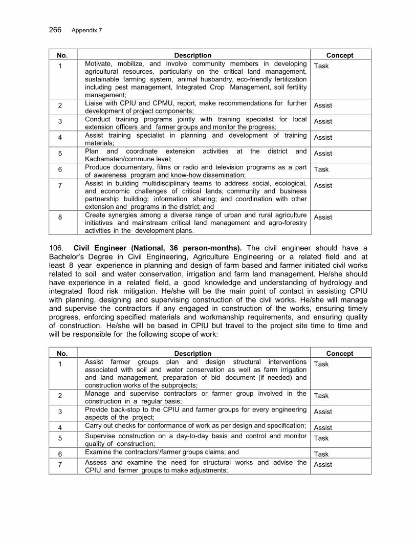
266 Appendix 7
No. Description Concept 1 Motivate, mobilize, and involve community members in developing
agricultural resources, particularly on the critical land management, sustainable farming system, animal husbandry, eco-friendly fertilization including pest management, Integrated Crop Management, soil fertility management;
Task
2 Liaise with CPIU and CPMU, report, make recommendations for further development of project components;
Assist
3 Conduct training programs jointly with training specialist for local extension officers and farmer groups and monitor the progress;
Assist
4 Assist training specialist in planning and development of training materials;
Assist
5 Plan and coordinate extension activities at the district and Kachamaten/commune level;
Assist
6 Produce documentary, films or radio and television programs as a part of awareness program and know-how dissemination;
Task
7 Assist in building multidisciplinary teams to address social, ecological, and economic challenges of critical lands; community and business partnership building; information sharing; and coordination with other extension and programs in the district; and
Assist
8 Create synergies among a diverse range of urban and rural agriculture initiatives and mainstream critical land management and agro-forestry activities in the development plans.
Assist
106. Civil Engineer (National, 36 person-months). The civil engineer should have a Bachelor’s Degree in Civil Engineering, Agriculture Engineering or a related field and at least 8 year experience in planning and design of farm based and farmer initiated civil works related to soil and water conservation, irrigation and farm land management. He/she should have experience in a related field, a good knowledge and understanding of hydrology and integrated flood risk mitigation. He/she will be the main point of contact in assisting CPIU with planning, designing and supervising construction of the civil works. He/she will manage and supervise the contractors if any engaged in construction of the works, ensuring timely progress, enforcing specified materials and workmanship requirements, and ensuring quality of construction. He/she will be based in CPIU but travel to the project site time to time and will be responsible for the following scope of work:
No. Description Concept 1 Assist farmer groups plan and design structural interventions
associated with soil and water conservation as well as farm irrigation and land management, preparation of bid document (if needed) and construction works of the subprojects;
Task
2 Manage and supervise contractors or farmer group involved in the construction in a regular basis;
Task
3 Provide back-stop to the CPIU and farmer groups for every engineering aspects of the project;
Assist
4 Carry out checks for conformance of work as per design and specification; Assist 5 Supervise construction on a day-to-day basis and control and monitor
quality of construction; Task
6 Examine the contractors’/farmer groups claims; and Task 7 Assess and examine the need for structural works and advise the
CPIU and farmer groups to make adjustments; Assist

Appendix 7 267
107. Environment Specialist (National, 4 person-months). The National Environment Specialist will have a degree in Environmental Science or Engineering or related field and a minimum of 8 years of work experience in overseeing environmental management plans of infrastructure including farming projects. S/he is expected to be familiar with the GOI and ADB's environmental safeguard requirements. He/she will ensure that the project is implemented in accordance with the environmental laws of Indonesia and the ADB environmental safeguard policy by overseeing implementation of Environmental Management Plans (EMP/AMDAL) and assisting the CPMU to monitor impacts. The National Environmental Specialist will:
No. Description Concept 1 Carry out a review of the feasibility studies (including safeguard
documents, IEE and EIA) with regard to environmental impact and draw attention to changes which may have become necessary since their preparation;
Task
2 Carry out a review of the Environmental Management Plans (EMP/AMDAL) and monitoring mechanisms and recommend any updating which may be required;
Task
3 Assist the CPMU with implementation and coordination of EMP/AMDALs and with identification and subsequent implementation of corrective management actions;
Assist
4 Oversee preparation and approval of the site EMP/AMDALs of construction contractors and monitor implementation of these for the purposes of quarterly reporting;
Task
5 Undertake a review of potential cumulative and induced environmental impacts which may occur downstream or elsewhere in the selected river basins as a result of project interventions;
Task
6 Provide monitoring of project progress with regard to environmental targets and indicators set out in the Design and Monitoring Framework (DMF); and
Assist
7 Assist the Team Leader and Deputy Team Leader in timely preparation of reports. Deliver the environmental monitoring reports timely as per the guidance from t h e Team Leader and Deputy Team Leader;
Assist
108. Monitoring and Evaluation Specialist (National, 12 person-months). The National Monitoring and Evaluation (M&E) Specialist should have a degree in Management or agriculture or related field and a minimum of 5 years of demonstrated experience in project M&E. He/she will work closely with the Team leader to ensure that the project is implemented in accordance with the project design and monitoring framework (DMF) and that issues arising are quickly identified and brought to the attention of government and the ADB for prompt resolution. The National M&E Specialist will:
No. Description Concept 1 Assist the Team Leader in carrying out a review of the project
preparation documents with regard to project monitoring and evaluation and draw attention to changes which may have become necessary since their preparation;
Assist
2 Support the Team Leader in ensuring that the project is implemented in accordance with the project design and monitoring framework (DMF) and that issues arising are quickly identified and resolved;
Assist
3 Set up monitoring and evaluation frameworks and PPMS for overall project activities. The PPMS will include a participatory baseline survey
Task

268 Appendix 7
No. Description Concept to be conducted within the first year of the Project with follow-up surveys to evaluate any changes. Monitoring and evaluation of pro-poor effects of the project will be integrated into the GIS Based PPMS;
4 Prepare evaluation criteria for each activity, and role and tasks of the agencies;
Task
5 Work with government experts and other specialists in the team to develop: a. indicators that is objective, obvious and effective, b. databases for effective data collection and management, c. methods for evaluation and analysis, d. procedures for audit and control;
Assist
6 Assist in preparation of necessary guidelines for M&E consistent with project documents (RRP, the Loan Agreement, PAM, IEE/EIA and EMP, RF and RPs, IPPP or EMDP, SPRSS, GAP, etc.), ADB’s requirements, and regulations of the Government;
Assist
7 Set up standards, contents and schedules for assistance to the CPIUs for M&E to ensure the project components are implemented as scheduled and outputs are as specified in the Loan Agreement;
Task
8 Prepare M&E/PPMS Manuals for monitoring and assessment and ensure that relevant agencies comply with these manuals;
Task
9 Collect data, monitor and evaluate project performance and impacts as part of the project management information system;
Task
10 Assist in development of a community participation process in monitoring and evaluation for M&E systems;
Assist
11 Support the team in preparation and organization of training/workshop programs on data management and using M&E for the CPIU, project stakeholders and other government staff; and
Assist
12 Assist the Team Leader and Deputy Team Leader in timely preparation of reports.
Assist
109. Deliverables. Key expected deliverables are as follows:
(i) 2.A Upper farmland management and sustainable agriculture practices in the Ciujung river basin (MOA)
Output By end of month
Annual Work Program for CPIU activities November (annually) Monitoring and evaluation system including financial management 6 Geographic database containing relevant data to be used for land use management 9 Metadata base for all integrated data 12 Web based system for data dissemination 19 Media communication plan 3 Report on the PRA for the identification of farmer groups and their annual plans Q1 2017 Baseline survey report (socio economic, land use, erosion) Q1 2017 Training manuals/materials and outcomes of the farmers training on soil/ water conservation/sustainable agriculture practices Q4 2017
Study report on erosion and soil conservation in Ciujung river basin Q4 2017 Assessment of overall impacts of the project on current land-uses and livelihoods within the project area Q4 2017
Report on annual O&M plan and budget for the farm activities Q1 2018 Training and follow-up reports Quarterly

Appendix 7 269
Output By end of month
Regular progress reports Quarterly Project final report Q4 2020 Reports on follow-up activities Quarterly
270 Appendix 7
III. MOHA Package: Institutional Development for Community- Based Flood Risk Management 110. Background. Landslides, riverbank erosion and floods have become annual phenomena in 3 Cis and Ambon-Seram river basin territories (RBTs), which usually occur between November and January in 3 Cis RBT and May and August in Ambon every year. The flood risk condition in the river basins is worsening due to both natural and human induced factors. 111. In order to mitigate the flood risk, proactive measures are necessary, which has not been given much priority to date in regional development planning. Diagnostic assessment of the legal, institutional and policy framework identified needs for greater awareness of flood risk (and elements of flood risk: hazard, exposure and vulnerability) in government organizations, and greater focus on flood management as a core responsibility in the Directorate General of Water Resources (DGWR) under the Ministry of Public Works and Housing, within the disaster management agency (BNPB) and in local government agencies with more recognition of flood management planning at river-basin scale. Institutional and governance reforms are necessary together with capacity building of agencies to initiate and implement effective flood management measures. Formal coordination mechanisms are required to transform recognition of the needs into practical coordination between government organizations. There is also great need for building technical and administrative capacity in all government stakeholder institutions, and for provision of adequate and sustained funding. 112. Despite the efforts made by local governments to improve the situation, flood losses continue worsening each year. This is particularly because there is a lack of local communities’ awareness and ownership in the development and management process, while the risk is increasing both on spatial and temporal scales. The capacity of local communities in all flood prone areas is yet to be mobilized so that they can prepare better in normal times and respond better in the case of emergency. Both mutual support and self-support conditions need to be improved. Community mobilization and community based approach of flood risk management is essential in all flood prone communities in the basin. In addition, the effort given by central and local government alone to mitigate the risk will not be sufficient as the risk is dynamic and changes markedly in time and space throughout the river basins. Community engagement and participation in FRM activities is very important. 113. Objective: This consulting services package will support the following components:
(i) 1.B: Institutional strengthening, planning and coordination for implementation of FRM plans in the 3 Cis and Ambon-Seram RBTs. The general objective of this sub-component is to develop the institutional capacity of local government to initiate, plan, design and implement flood risk management (FRM) plans in the river basins. The specific objectives are (i) strengthening of local government officers capacity to address FRM, (ii) development of FRM knowledge and introduction of replicable best practices, (iii) formulation of district FRM plans for the basins with balanced structural and non- structural measures, (iv) integration of FRM plans in regional development and spatial land use plans, (v) development of river corridor management and building code with proper regulation, monitoring and evaluation mechanisms and, (vi) coordination of central, provincial and district level authorities for implementation of integrated FRM measures.
Appendix 7 271
(ii) 2.B Improved runoff and erosion control in 3Cis RBT and Ambon-Seram RBT. The general objective of this component is to improve conditions of the critical land in upper river basins to control soil erosion through better land management and to reduce runoff through rainfall runoff interception. The specific objectives are to (i) stabilize the exiting landslides by structural and bio-engineering works, (ii) identify and control the possible occurrence of landslide in highly landslide prone areas, (iii) install rainfall harvesting facilities at individual household level, (iv) construct small ponds to serve dual purposes of on-farm water supply and/or household consumption, (iv) regulate the land-use by rules and regulations endorsed and supervised by the local government, (v) improve livelihoods of farmers by providing skills and experience of controlling natural hazard, rainfall harvesting technologies and their end uses, and (vi) promote community participation and joint action for the sustainability of the adopted systems.
(iii) 3.A Enhanced capacity for community-based flood risk management in the 3 Cis and Ambon-Seram RBTs. There is a need to mobilize communities by organizing each community to enable them to build effective mutual and self-help capacity. Communities will be organized in teams; they will develop their capacity in different stages of FRM and at the same time work to alleviate poverty, which has much to do with the vulnerability to flood risk. Communities will be an active part in flood early warning systems as well. CBFRM activities are proposed to achieve these goals. The specific objectives are to (i) conduct awareness campaigns, (ii) develop community organizations, (iii) develop communities’ capacity and implement community based FRM activities, (iv) promote gender equity, (v) expose communities to best practices and support their active participation and (vi) encourage communities to initiate their own activities to mitigate their risk by various means.
114. Scope of Works. Key activities will be as follows:
(i) 1.B: Institutional strengthening, planning and coordination for implementation of IFRM plans in the 3 Cis and Ambon - Seram RBTs. Several approaches to achieve this are recommended, including raising awareness of government officials, specialized training for specific roles, training to support introduction of new technology or new procedures, and knowledge sharing on flood management. These activities will be supported by the use of flood risk mapping for both planning and emergency response. Coordination committees for FRM planning and response should be created at provincial and district levels and to support mainstreaming of FRM in relevant development sectors. Key activities will be as follows:
Flood hazard/risk maps are disseminated and explained to communities and
agencies concerned. FRM mainstreamed in regional development. FRM plan are developed and integrated into regional development plans. Flood bulletins are distributed to agencies and communities concerned on a
regular basis. FRM activities reflected in annual work plans through coordination between
national, provincial and district governments. Capacity building/training programs targeting MOHA, provincial and district
272 Appendix 7
agencies are carried out. Land-use plan amended and new rules on river corridor management and land use are endorsed by the local government. MOU between the Ministry of Forestry and MOHA has been signed.
(ii) 2.B Improved runoff and erosion control in 3Cis RBT and Ambon-Seram
RBT Identify the existing and potential landslide hazard prone areas in the entire
selected RBTs. Stabilize the 30 existing landslide zones by gabion and bio-engineering
measures. Stabilize the 30 potential landslide prone areas and protected at least 200
households from destruction. 50 small water collection ponds are built through community participation Install small water collection units in selected households through community
participation. Land-use regulation document disseminated among the communities with
training sessions. Income generating and agro-forestry related training courses conducted for
communities
(iii) 3.A Enhanced capacity for community-based flood risk management in the Ciujung, Batu Merah and Way Ruhu river basins
Community organizations are formed. Skill development and income generating training courses will be given to
communities. Volunteers and local NGOs will enhance their capacity through training
courses on FRM. Community members are involved in constructions and provide opportunities
to increase income. At least 40% of women representation in the community organizations and
active role played in decision making process. Community annual action plans are prepared and implemented and monitored
by local governments. Local NGOs will take active parts in implementing the activities, so it will
enhance their capacity to initiate similar programs in other areas. Annual evacuation drills in selected communities will be conducted over 5
years.
115. Under the overall guidance and responsibility of the Central Project Implementation Unit (CPIU) under the Directorate General of Regional Development (DGRD), Ministry of Home Affairs (MOHA), provincial and district planning agencies (BAPPEDAs) will ensure institutional strengthening, planning and coordination of provincial and district local disaster management, public works, land, social and forestry agencies. Provincial Project Implementation Unit (PPIU) and District Project Implementation Unit (DPIU) will be established in each of the provincial and district agencies involved in CBFRM activities. The BAPPEDAs will ensure that FRMPs are accordingly reflected into spatial, mid-term and annual plans of the various involved sectors.
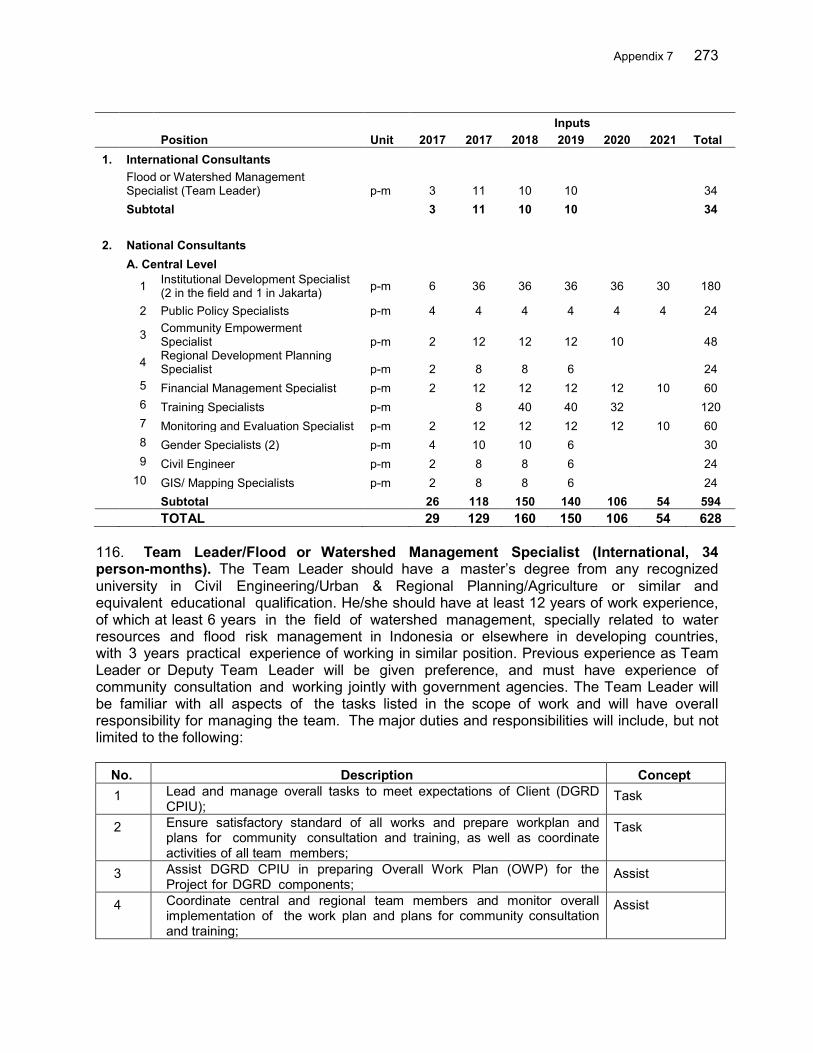
Appendix 7 273
Inputs Position Unit 2017 2017 2018 2019 2020 2021 Total 1. International Consultants
Flood or Watershed Management Specialist (Team Leader) p-m 3 11 10 10 34
Subtotal 3 11 10 10 34 2. National Consultants A. Central Level
1 Institutional Development Specialist (2 in the field and 1 in Jakarta) p-m 6 36 36 36 36 30 180
2 Public Policy Specialists p-m 4 4 4 4 4 4 24
3 Community Empowerment Specialist p-m 2 12 12 12 10 48
4 Regional Development Planning Specialist p-m 2 8 8 6 24
5 Financial Management Specialist p-m 2 12 12 12 12 10 60 6 Training Specialists p-m 8 40 40 32 120 7 Monitoring and Evaluation Specialist p-m 2 12 12 12 12 10 60 8 Gender Specialists (2) p-m 4 10 10 6 30 9 Civil Engineer p-m 2 8 8 6 24 10 GIS/ Mapping Specialists p-m 2 8 8 6 24 Subtotal 26 118 150 140 106 54 594 TOTAL 29 129 160 150 106 54 628
116. Team Leader/Flood or Watershed Management Specialist (International, 34 person-months). The Team Leader should have a master’s degree from any recognized university in Civil Engineering/Urban & Regional Planning/Agriculture or similar and equivalent educational qualification. He/she should have at least 12 years of work experience, of which at least 6 years in the field of watershed management, specially related to water resources and flood risk management in Indonesia or elsewhere in developing countries, with 3 years practical experience of working in similar position. Previous experience as Team Leader or Deputy Team Leader will be given preference, and must have experience of community consultation and working jointly with government agencies. The Team Leader will be familiar with all aspects of the tasks listed in the scope of work and will have overall responsibility for managing the team. The major duties and responsibilities will include, but not limited to the following:
No. Description Concept 1 Lead and manage overall tasks to meet expectations of Client (DGRD
CPIU); Task
2 Ensure satisfactory standard of all works and prepare workplan and plans for community consultation and training, as well as coordinate activities of all team members;
Task
3 Assist DGRD CPIU in preparing Overall Work Plan (OWP) for the Project for DGRD components;
Assist
4 Coordinate central and regional team members and monitor overall implementation of the work plan and plans for community consultation and training;
Assist
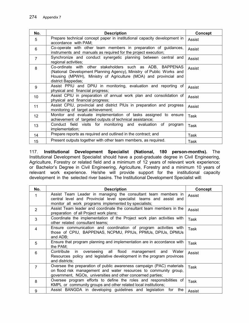
274 Appendix 7
No. Description Concept 5 Prepare technical concept paper in institutional capacity development in
accordance with PAM; Assist
6 Co-operate with other team members in preparation of guidances, instruments and manuals as required for the project execution;
Assist
7 Synchronize and conduct synergetic planning between central and regional activities;
Assist
8 Co-ordinate with other stakeholders such as ADB, BAPPENAS (National Development Planning Agency), Ministry of Public Works and Housing (MPWH), Ministry of Agriculture (MOA) and provincial and district Bappedas;
Assist
9 Assist PPIU and DPIU in monitoring, evaluation and reporting of physical and financial progress;
Assist
10 Assist CPIU in preparation of annual work plan and consolidation of physical and financial progress;
Assist
11 Assist CPIU, provincial and district PIUs in preparation and progress monitoring of target achievement;
Assist
12 Monitor and evaluate implementation of tasks assigned to ensure achievement of targeted outputs of technical assistance;
Task
13 Conduct field visits for monitoring and evaluation of program implementation;
Task
14 Prepare reports as required and outlined in the contract; and Task 15 Present outputs together with other team members, as required. Task
117. Institutional Development Specialist (National, 180 person-months). The Institutional Development Specialist should have a post-graduate degree in Civil Engineering, Agriculture, Forestry or related field and a minimum of 12 years of relevant work experience; or Bachelor’s Degree in Civil Engineering, Agriculture, Forestry and a minimum 10 years of relevant work experience. He/she will provide support for the institutional capacity development in the selected river basins. The Institutional Development Specialist will:
No. Description Concept 1 Assist Team Leader in managing the consultant team members in
central level and Provincial level specialist teams and assist and monitor all work programs implemented by specialists;
Assist
2 Assist Team leader and coordinate the consultant team members in the preparation of all Project work plans;
Assist
3 Coordinate the implementation of the Project work plan activities with other related consultant teams;
Task
4 Ensure communication and coordination of program activities with those of CPIU, BAPPENAS, NCPMU, PPIUs, PPMUs, DPIUs, DPMUs and ADB;
Task
5 Ensure that program planning and implementation are in accordance with the PAM;
Task
6 Contribute in overseeing all flood management and Water Resources policy and legislative development in the program provinces and districts;
Assist
7 Oversee the preparation of public awareness campaign (PAC) materials on flood risk management and water resources to community group, government, NGOs, universities and other concerned parties;
Task
8 Oversee program efforts to define the roles and responsibilities of KMPL or community groups and other related local institutions;
Task
9 Assist BANGDA in developing guidelines and legislation for the Assist
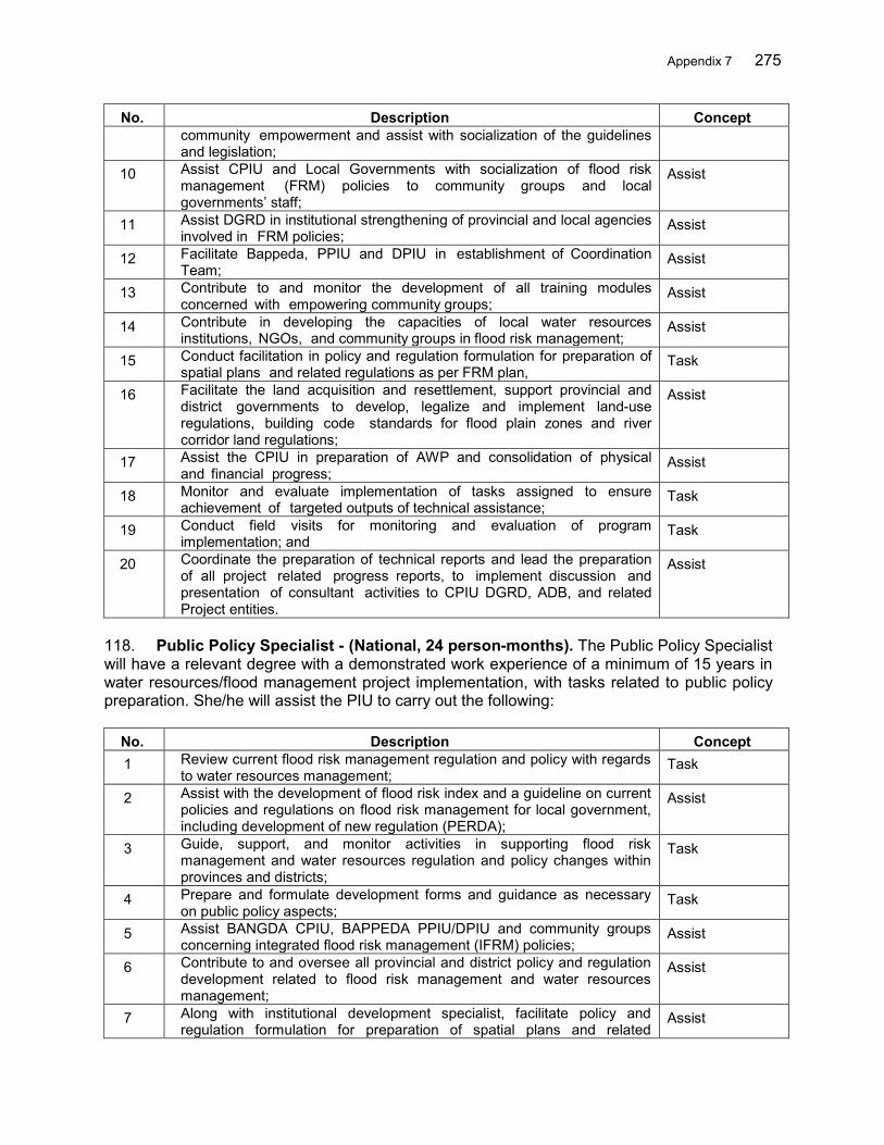
Appendix 7 275
No. Description Concept community empowerment and assist with socialization of the guidelines and legislation;
10 Assist CPIU and Local Governments with socialization of flood risk management (FRM) policies to community groups and local governments’ staff;
Assist
11 Assist DGRD in institutional strengthening of provincial and local agencies involved in FRM policies;
Assist
12 Facilitate Bappeda, PPIU and DPIU in establishment of Coordination Team;
Assist
13 Contribute to and monitor the development of all training modules concerned with empowering community groups;
Assist
14 Contribute in developing the capacities of local water resources institutions, NGOs, and community groups in flood risk management;
Assist
15 Conduct facilitation in policy and regulation formulation for preparation of spatial plans and related regulations as per FRM plan,
Task
16 Facilitate the land acquisition and resettlement, support provincial and district governments to develop, legalize and implement land-use regulations, building code standards for flood plain zones and river corridor land regulations;
Assist
17 Assist the CPIU in preparation of AWP and consolidation of physical and financial progress;
Assist
18 Monitor and evaluate implementation of tasks assigned to ensure achievement of targeted outputs of technical assistance;
Task
19 Conduct field visits for monitoring and evaluation of program implementation; and
Task
20 Coordinate the preparation of technical reports and lead the preparation of all project related progress reports, to implement discussion and presentation of consultant activities to CPIU DGRD, ADB, and related Project entities.
Assist
118. Public Policy Specialist - (National, 24 person-months). The Public Policy Specialist will have a relevant degree with a demonstrated work experience of a minimum of 15 years in water resources/flood management project implementation, with tasks related to public policy preparation. She/he will assist the PIU to carry out the following:
No. Description Concept 1 Review current flood risk management regulation and policy with regards
to water resources management; Task
2 Assist with the development of flood risk index and a guideline on current policies and regulations on flood risk management for local government, including development of new regulation (PERDA);
Assist
3 Guide, support, and monitor activities in supporting flood risk management and water resources regulation and policy changes within provinces and districts;
Task
4 Prepare and formulate development forms and guidance as necessary on public policy aspects;
Task
5 Assist BANGDA CPIU, BAPPEDA PPIU/DPIU and community groups concerning integrated flood risk management (IFRM) policies;
Assist
6 Contribute to and oversee all provincial and district policy and regulation development related to flood risk management and water resources management;
Assist
7 Along with institutional development specialist, facilitate policy and regulation formulation for preparation of spatial plans and related
Assist
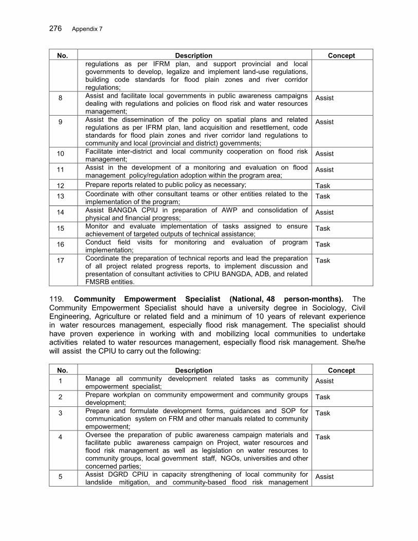
276 Appendix 7
No. Description Concept regulations as per IFRM plan, and support provincial and local governments to develop, legalize and implement land-use regulations, building code standards for flood plain zones and river corridor regulations;
8 Assist and facilitate local governments in public awareness campaigns dealing with regulations and policies on flood risk and water resources management;
Assist
9 Assist the dissemination of the policy on spatial plans and related regulations as per IFRM plan, land acquisition and resettlement, code standards for flood plain zones and river corridor land regulations to community and local (provincial and district) governments;
Assist
10 Facilitate inter-district and local community cooperation on flood risk management;
Assist
11 Assist in the development of a monitoring and evaluation on flood management policy/regulation adoption within the program area;
Assist
12 Prepare reports related to public policy as necessary; Task 13 Coordinate with other consultant teams or other entities related to the
implementation of the program; Task
14 Assist BANGDA CPIU in preparation of AWP and consolidation of physical and financial progress;
Assist
15 Monitor and evaluate implementation of tasks assigned to ensure achievement of targeted outputs of technical assistance;
Task
16 Conduct field visits for monitoring and evaluation of program implementation;
Task
17 Coordinate the preparation of technical reports and lead the preparation of all project related progress reports, to implement discussion and presentation of consultant activities to CPIU BANGDA, ADB, and related FMSRB entities.
Task
119. Community Empowerment Specialist (National, 48 person-months). The Community Empowerment Specialist should have a university degree in Sociology, Civil Engineering, Agriculture or related field and a minimum of 10 years of relevant experience in water resources management, especially flood risk management. The specialist should have proven experience in working with and mobilizing local communities to undertake activities related to water resources management, especially flood risk management. She/he will assist the CPIU to carry out the following:
No. Description Concept 1 Manage all community development related tasks as community
empowerment specialist; Assist
2 Prepare workplan on community empowerment and community groups development;
Task
3 Prepare and formulate development forms, guidances and SOP for communication system on FRM and other manuals related to community empowerment;
Task
4 Oversee the preparation of public awareness campaign materials and facilitate public awareness campaign on Project, water resources and flood risk management as well as legislation on water resources to community groups, local government staff, NGOs, universities and other concerned parties;
Task
5 Assist DGRD CPIU in capacity strengthening of local community for landslide mitigation, and community-based flood risk management
Assist
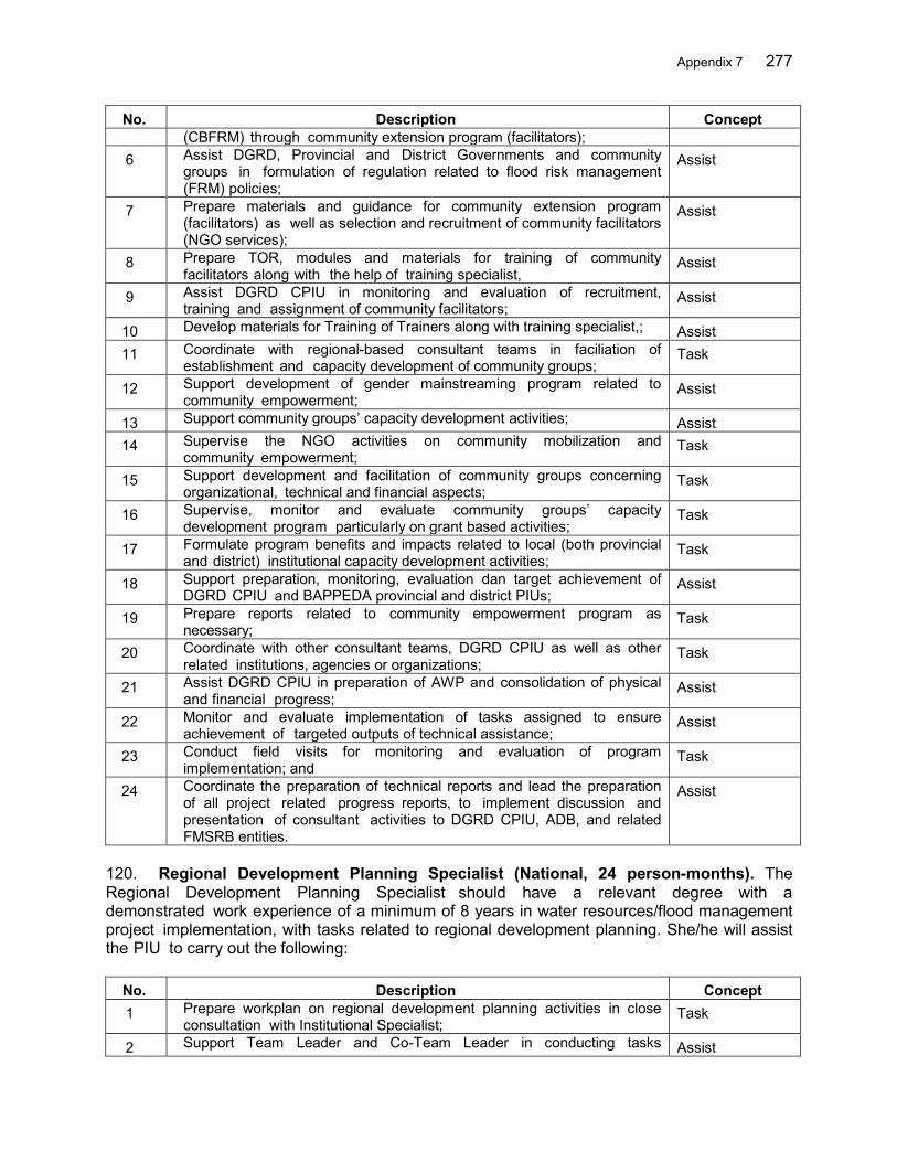
Appendix 7 277
No. Description Concept (CBFRM) through community extension program (facilitators);
6 Assist DGRD, Provincial and District Governments and community groups in formulation of regulation related to flood risk management (FRM) policies;
Assist
7 Prepare materials and guidance for community extension program (facilitators) as well as selection and recruitment of community facilitators (NGO services);
Assist
8 Prepare TOR, modules and materials for training of community facilitators along with the help of training specialist,
Assist
9 Assist DGRD CPIU in monitoring and evaluation of recruitment, training and assignment of community facilitators;
Assist
10 Develop materials for Training of Trainers along with training specialist,; Assist 11 Coordinate with regional-based consultant teams in faciliation of
establishment and capacity development of community groups; Task
12 Support development of gender mainstreaming program related to community empowerment;
Assist
13 Support community groups’ capacity development activities; Assist 14 Supervise the NGO activities on community mobilization and
community empowerment; Task
15 Support development and facilitation of community groups concerning organizational, technical and financial aspects;
Task
16 Supervise, monitor and evaluate community groups’ capacity development program particularly on grant based activities;
Task
17 Formulate program benefits and impacts related to local (both provincial and district) institutional capacity development activities;
Task
18 Support preparation, monitoring, evaluation dan target achievement of DGRD CPIU and BAPPEDA provincial and district PIUs;
Assist
19 Prepare reports related to community empowerment program as necessary;
Task
20 Coordinate with other consultant teams, DGRD CPIU as well as other related institutions, agencies or organizations;
Task
21 Assist DGRD CPIU in preparation of AWP and consolidation of physical and financial progress;
Assist
22 Monitor and evaluate implementation of tasks assigned to ensure achievement of targeted outputs of technical assistance;
Assist
23 Conduct field visits for monitoring and evaluation of program implementation; and
Task
24 Coordinate the preparation of technical reports and lead the preparation of all project related progress reports, to implement discussion and presentation of consultant activities to DGRD CPIU, ADB, and related FMSRB entities.
Assist
120. Regional Development Planning Specialist (National, 24 person-months). The Regional Development Planning Specialist should have a relevant degree with a demonstrated work experience of a minimum of 8 years in water resources/flood management project implementation, with tasks related to regional development planning. She/he will assist the PIU to carry out the following:
No. Description Concept 1 Prepare workplan on regional development planning activities in close
consultation with Institutional Specialist; Task
2 Support Team Leader and Co-Team Leader in conducting tasks Assist

278 Appendix 7
No. Description Concept related to regional development;
3 Prepare and formulate regional development planning forms, instruments and guidances as necessary;
Assist
4 Identify problems and review policy and regulations related to regional development planning, water disaster and water resources;
Task
5 Facilitate coordination, cooperation and integration of regional development plans related to flood risk management among provincial and district agencies;
Assist
6 Provide technical inputs on regional development planning approach and river basin management;
Assist
7 Conduct policy facilitation and regulation formulation for preparation of spatial plans and related regulations as per FRM plan,
Task
8 Facilitate the land acquisition and resettlement, support provincial and district governments to develop, legalize and implement land-use regulations, building code standards for flood plain zones and river corridor regulations;
Assist
9 Assist DGRD CPIU and local governments in preparation of spatial planning and integration of flood risk management activities, building code standards for flood plain zones and other regional planning related to flood risk management;
Assist
10 Assist BAPPEDA PPIU/DPIU in preparation and enactment of river basin flood risk management master plan;
Assist
11 Assist BAPPEDA PPIU/DPIU in integration of flood risk management activities to river basin water resources development plan (Rancangan Pola Pengelolaan Sumber Daya Air Wilayah Sungai) as inputs for long-term and medium-term regional development planning (RPJPD and RPJMD);
Assist
12 Facilitate preparation of Critical Land Management Planning based on spatial data as well as conduct spatial analysis;
Assist
13 Coordinate with central and local governments, especially in confirming local water resources management programs for program synchronization;
Assist
14 Assist DGRD CPIU and BAPPEDA PPIU/DPIU in preparation, monitoring, evaluation and target achievements;
Assist
15 Prepare reports related to regional development planning as necessary; Assist 16 Coordinate with other consultant teams or other entities related to the
implementation of the program; Assist
17 Assist DGRD CPIU in preparation of AWP and consolidation of physical and financial progress;
Assist
18 Monitor and evaluate the implementation and conduct field visits for monitoring and evaluation of program implementation; and
Assist
19 Coordinate the preparation of technical reports and lead the preparation of all project related progress reports, to implement discussion and presentation of consultant activities to CPIU DGRD, ADB, and related FMSRB entities.
Assist
121. Financial Management Specialist (National, 60 person-months). The Financial Management Specialist should have a relevant degree with a demonstrated work experience of a minimum of 8 years in water resources/flood management project implementation, with tasks related to public finance management.She/he will assist the PIU to carry out the following:

Appendix 7 279
No. Description Concept 1 Prepare reports on financial aspects of the program; Assist 2 Assist the Team Leader in preparation of guidance for annual work
plan (AWP) in financial aspects, budget revision and finalization of budgeting work-sheet (RKA-KL);
Assist
3 Facilitate BAPPEDA PPIU/DPIU in preparation of program management including 5-year and annual planning and budgeting;
Assist
4 Prepare consolidation of annual work plan and budgetting; Assist 5 Assist CPIU in monitoring and evaluation of
funddisbursement, including consolidation of disbursement documents (SPM and SP2D);
Assist
6 Analyze physical and financial progress of activities conducted by DGRD CPIU and BAPPEDA PPIU/DPIU;
Task
7 Assist DGRD CPIU in budget management; Assist 8 Guide, support and monitor region-based consultant teams (in provinces
and districts) in development of financial framing; Assist
9 Identify and analyze budget needs for local revenue (APBD)-financed activites;
Task
10 Assist in reviewing local government budgetting structures as counterpart funds, especially fund allocation for operation and maintenance;
Assist
11 Assist in development of financial monitoring system and evaluation of fund distribution;
Assist
12 Assist CPMU in preparation of consolidated financial reports; Assist 13 Cooperate and coordinate with CPMU in preparation of problem solving
on program budgetting for activities under DGRD CPIU and BAPPEDA PPIU/DPIU;
Assist
14 Prepare financial and asset management reports; Task 15 Provide financial data as necessary; Task 16 Coordinate with other consultant teams or other entities related to the
implementation of the program; Assist
17 Assist DGRD CPIU in preparation of AWP and consolidation of physical and financial progress;
Assist
18 Monitor and evaluate the implementation of assigned tasks and conduct field visits for monitoring and evaluation purposes; and
Assist
19 Coordinate the preparation of technical reports and lead the preparation of all project related progress reports.
Assist
122. Training Specialist (National, 120 person-months). The Training Specialist should have a relevant degree with a demonstrated work experience of a minimum of 8 years in water resources/flood management project implementation, with tasks related to training aspects. He/she will assist the CPIU to carry out the following:
No. Description Concept 1 Guide, support and monitor for the implementation of the Project
related training component; Assist
2 Assist in planning and preparation of public awareness information materials on the Project aiming at the public, government, NGOs, universities and other concerned parties and those will be publish through newspapers, bulletins, radio, TV, or other types of media;
Assist
3 Review previous training/workshop modules to develop local institutional capacity in FRM;
Task
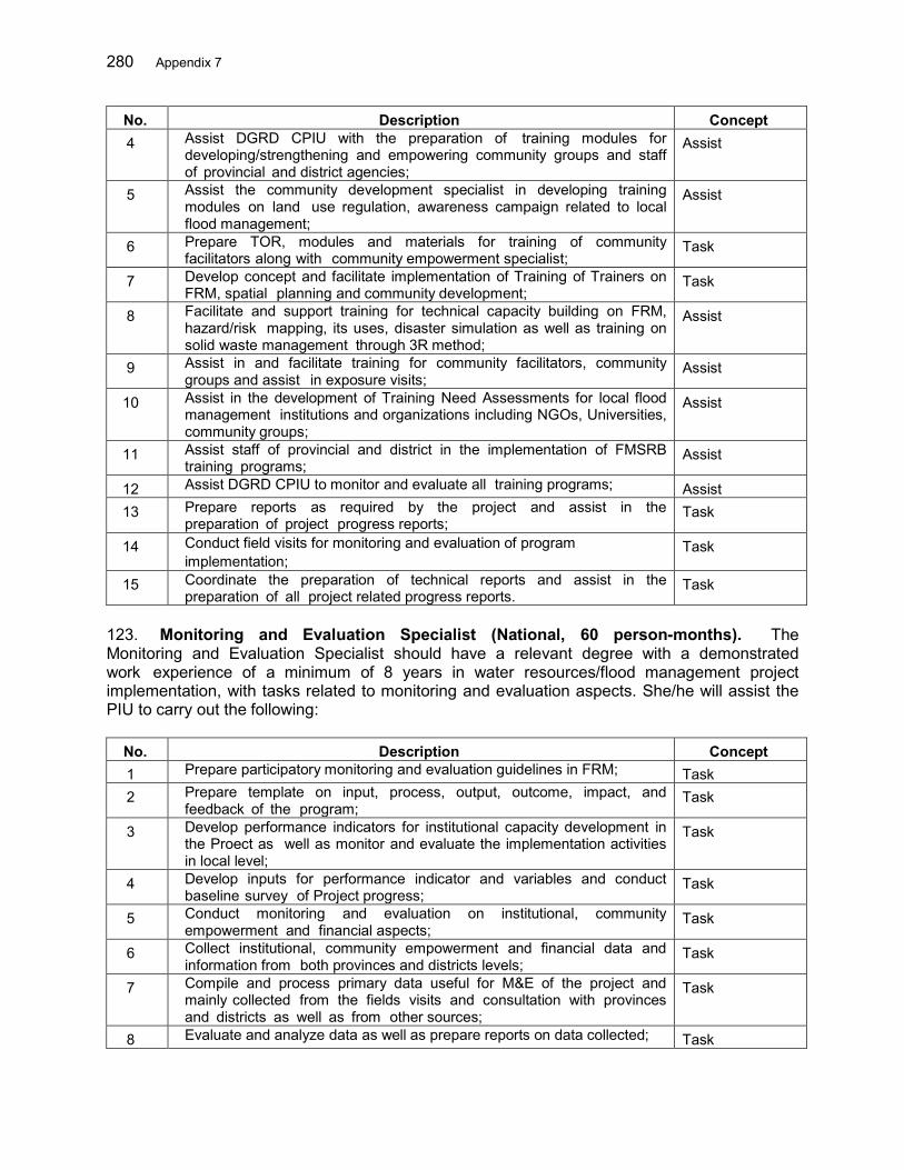
280 Appendix 7
No. Description Concept 4 Assist DGRD CPIU with the preparation of training modules for
developing/strengthening and empowering community groups and staff of provincial and district agencies;
Assist
5 Assist the community development specialist in developing training modules on land use regulation, awareness campaign related to local flood management;
Assist
6 Prepare TOR, modules and materials for training of community facilitators along with community empowerment specialist;
Task
7 Develop concept and facilitate implementation of Training of Trainers on FRM, spatial planning and community development;
Task
8 Facilitate and support training for technical capacity building on FRM, hazard/risk mapping, its uses, disaster simulation as well as training on solid waste management through 3R method;
Assist
9 Assist in and facilitate training for community facilitators, community groups and assist in exposure visits;
Assist
10 Assist in the development of Training Need Assessments for local flood management institutions and organizations including NGOs, Universities, community groups;
Assist
11 Assist staff of provincial and district in the implementation of FMSRB training programs;
Assist
12 Assist DGRD CPIU to monitor and evaluate all training programs; Assist 13 Prepare reports as required by the project and assist in the
preparation of project progress reports; Task
14 Conduct field visits for monitoring and evaluation of program implementation;
Task
15 Coordinate the preparation of technical reports and assist in the preparation of all project related progress reports.
Task
123. Monitoring and Evaluation Specialist (National, 60 person-months). The Monitoring and Evaluation Specialist should have a relevant degree with a demonstrated work experience of a minimum of 8 years in water resources/flood management project implementation, with tasks related to monitoring and evaluation aspects. She/he will assist the PIU to carry out the following:
No. Description Concept 1 Prepare participatory monitoring and evaluation guidelines in FRM; Task 2 Prepare template on input, process, output, outcome, impact, and
feedback of the program; Task
3 Develop performance indicators for institutional capacity development in the Proect as well as monitor and evaluate the implementation activities in local level;
Task
4 Develop inputs for performance indicator and variables and conduct baseline survey of Project progress;
Task
5 Conduct monitoring and evaluation on institutional, community empowerment and financial aspects;
Task
6 Collect institutional, community empowerment and financial data and information from both provinces and districts levels;
Task
7 Compile and process primary data useful for M&E of the project and mainly collected from the fields visits and consultation with provinces and districts as well as from other sources;
Task
8 Evaluate and analyze data as well as prepare reports on data collected; Task
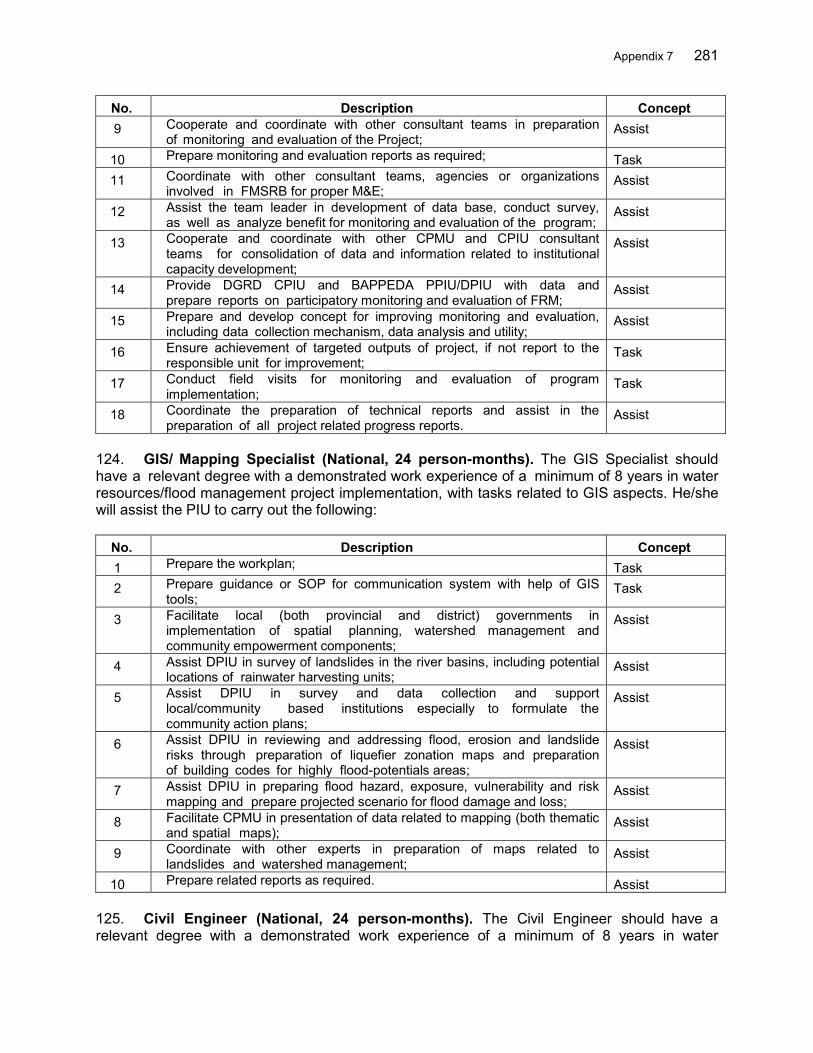
Appendix 7 281
No. Description Concept 9 Cooperate and coordinate with other consultant teams in preparation
of monitoring and evaluation of the Project; Assist
10 Prepare monitoring and evaluation reports as required; Task 11 Coordinate with other consultant teams, agencies or organizations
involved in FMSRB for proper M&E; Assist
12 Assist the team leader in development of data base, conduct survey, as well as analyze benefit for monitoring and evaluation of the program;
Assist
13 Cooperate and coordinate with other CPMU and CPIU consultant teams for consolidation of data and information related to institutional capacity development;
Assist
14 Provide DGRD CPIU and BAPPEDA PPIU/DPIU with data and prepare reports on participatory monitoring and evaluation of FRM;
Assist
15 Prepare and develop concept for improving monitoring and evaluation, including data collection mechanism, data analysis and utility;
Assist
16 Ensure achievement of targeted outputs of project, if not report to the responsible unit for improvement;
Task
17 Conduct field visits for monitoring and evaluation of program implementation;
Task
18 Coordinate the preparation of technical reports and assist in the preparation of all project related progress reports.
Assist
124. GIS/ Mapping Specialist (National, 24 person-months). The GIS Specialist should have a relevant degree with a demonstrated work experience of a minimum of 8 years in water resources/flood management project implementation, with tasks related to GIS aspects. He/she will assist the PIU to carry out the following:
No. Description Concept 1 Prepare the workplan; Task 2 Prepare guidance or SOP for communication system with help of GIS
tools; Task
3 Facilitate local (both provincial and district) governments in implementation of spatial planning, watershed management and community empowerment components;
Assist
4 Assist DPIU in survey of landslides in the river basins, including potential locations of rainwater harvesting units;
Assist
5 Assist DPIU in survey and data collection and support local/community based institutions especially to formulate the community action plans;
Assist
6 Assist DPIU in reviewing and addressing flood, erosion and landslide risks through preparation of liquefier zonation maps and preparation of building codes for highly flood-potentials areas;
Assist
7 Assist DPIU in preparing flood hazard, exposure, vulnerability and risk mapping and prepare projected scenario for flood damage and loss;
Assist
8 Facilitate CPMU in presentation of data related to mapping (both thematic and spatial maps);
Assist
9 Coordinate with other experts in preparation of maps related to landslides and watershed management;
Assist
10 Prepare related reports as required. Assist 125. Civil Engineer (National, 24 person-months). The Civil Engineer should have a relevant degree with a demonstrated work experience of a minimum of 8 years in water
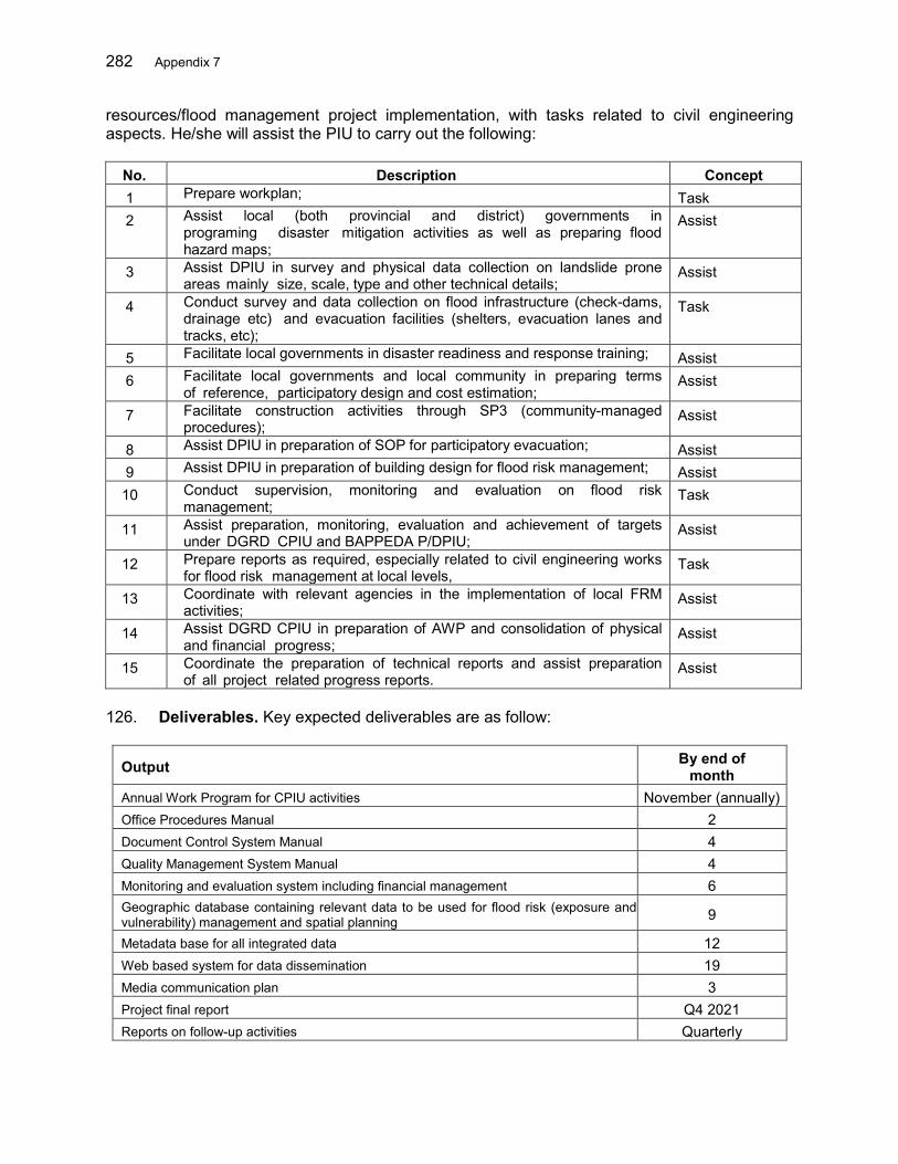
282 Appendix 7
resources/flood management project implementation, with tasks related to civil engineering aspects. He/she will assist the PIU to carry out the following:
No. Description Concept 1 Prepare workplan; Task 2 Assist local (both provincial and district) governments in
programing disaster mitigation activities as well as preparing flood hazard maps;
Assist
3 Assist DPIU in survey and physical data collection on landslide prone areas mainly size, scale, type and other technical details;
Assist
4 Conduct survey and data collection on flood infrastructure (check-dams, drainage etc) and evacuation facilities (shelters, evacuation lanes and tracks, etc);
Task
5 Facilitate local governments in disaster readiness and response training; Assist 6 Facilitate local governments and local community in preparing terms
of reference, participatory design and cost estimation; Assist
7 Facilitate construction activities through SP3 (community-managed procedures);
Assist
8 Assist DPIU in preparation of SOP for participatory evacuation; Assist 9 Assist DPIU in preparation of building design for flood risk management; Assist 10 Conduct supervision, monitoring and evaluation on flood risk
management; Task
11 Assist preparation, monitoring, evaluation and achievement of targets under DGRD CPIU and BAPPEDA P/DPIU;
Assist
12 Prepare reports as required, especially related to civil engineering works for flood risk management at local levels,
Task
13 Coordinate with relevant agencies in the implementation of local FRM activities;
Assist
14 Assist DGRD CPIU in preparation of AWP and consolidation of physical and financial progress;
Assist
15 Coordinate the preparation of technical reports and assist preparation of all project related progress reports.
Assist
126. Deliverables. Key expected deliverables are as follow:
Output By end of month
Annual Work Program for CPIU activities November (annually) Office Procedures Manual 2 Document Control System Manual 4 Quality Management System Manual 4 Monitoring and evaluation system including financial management 6 Geographic database containing relevant data to be used for flood risk (exposure and vulnerability) management and spatial planning 9
Metadata base for all integrated data 12 Web based system for data dissemination 19 Media communication plan 3 Project final report Q4 2021 Reports on follow-up activities Quarterly
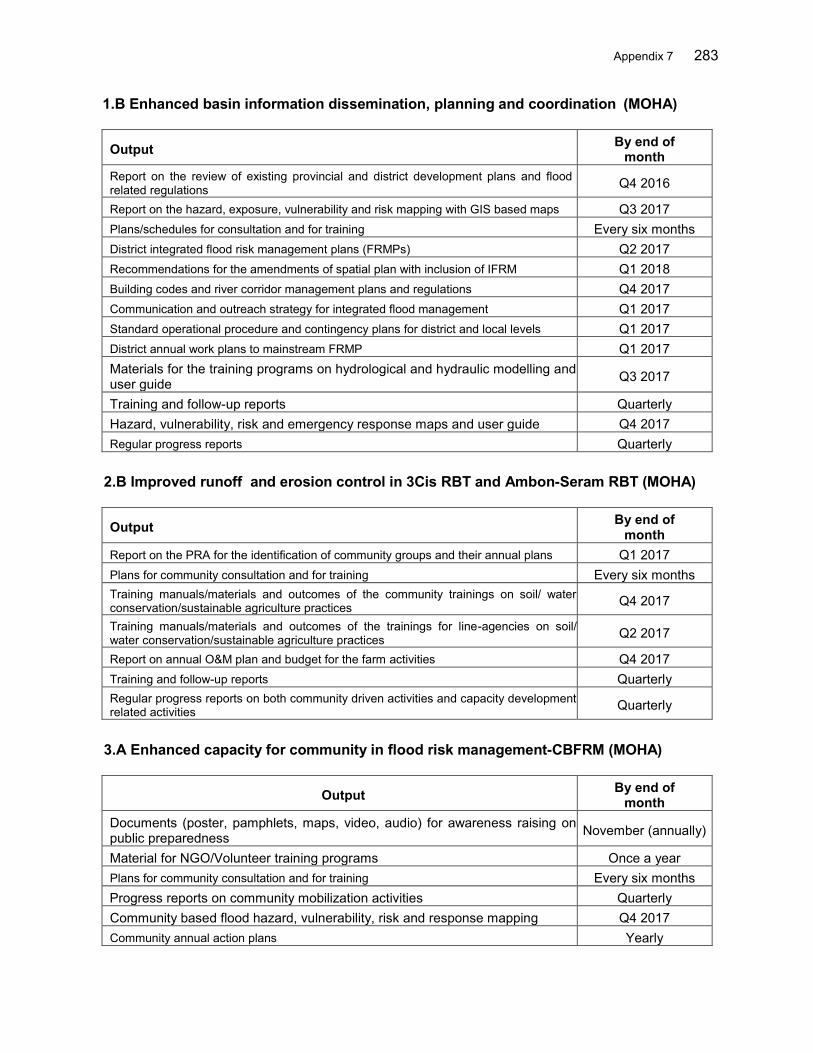
Appendix 7 283
1.B Enhanced basin information dissemination, planning and coordination (MOHA)
Output By end of month
Report on the review of existing provincial and district development plans and flood related regulations Q4 2016
Report on the hazard, exposure, vulnerability and risk mapping with GIS based maps Q3 2017 Plans/schedules for consultation and for training Every six months District integrated flood risk management plans (FRMPs) Q2 2017 Recommendations for the amendments of spatial plan with inclusion of IFRM Q1 2018 Building codes and river corridor management plans and regulations Q4 2017 Communication and outreach strategy for integrated flood management Q1 2017 Standard operational procedure and contingency plans for district and local levels Q1 2017 District annual work plans to mainstream FRMP Q1 2017 Materials for the training programs on hydrological and hydraulic modelling and user guide Q3 2017
Training and follow-up reports Quarterly Hazard, vulnerability, risk and emergency response maps and user guide Q4 2017 Regular progress reports Quarterly
2.B Improved runoff and erosion control in 3Cis RBT and Ambon-Seram RBT (MOHA)
Output By end of month
Report on the PRA for the identification of community groups and their annual plans Q1 2017 Plans for community consultation and for training Every six months Training manuals/materials and outcomes of the community trainings on soil/ water conservation/sustainable agriculture practices Q4 2017
Training manuals/materials and outcomes of the trainings for line-agencies on soil/ water conservation/sustainable agriculture practices Q2 2017
Report on annual O&M plan and budget for the farm activities Q4 2017 Training and follow-up reports Quarterly Regular progress reports on both community driven activities and capacity development related activities Quarterly
3.A Enhanced capacity for community in flood risk management-CBFRM (MOHA)
Output By end of month
Documents (poster, pamphlets, maps, video, audio) for awareness raising on public preparedness November (annually)
Material for NGO/Volunteer training programs Once a year Plans for community consultation and for training Every six months
Progress reports on community mobilization activities Quarterly Community based flood hazard, vulnerability, risk and response mapping Q4 2017 Community annual action plans Yearly
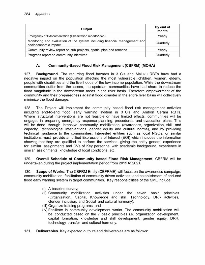
284 Appendix 7
Output By end of month
Emergency drill documentation (Observation report/Video) Yearly Monitoring and evaluation of the system including financial management and socioeconomic impact Quarterly
Community review report on sub-projects, spatial plan and rencana Yearly Progress report on community initiatives Quarterly
A. Community-Based Flood Risk Management (CBFRM) (MOHA)
127. Background. The recurring flood hazards in 3 Cis and Maluku RBTs have had a negative impact on the population affecting the most vulnerable: children, women, elderly, people with disabilities and the livelihoods of the low income population. While the downstream communities suffer from the losses, the upstream communities have had share to reduce the flood magnitude in the downstream areas in the river basin. Therefore empowerment of the community and their preparedness against flood disaster in the entire river basin will collectively minimize the flood damage. 128. The Project will implement the community based flood risk management activities including end-to-end flood early warning system in 3 Cis and Ambon Seram RBTs. Where structural interventions are not feasible or have limited effects, communities will be engaged in preparing emergency response planning, procedures, and evacuation plans. This will be done through intensive community mobilization (awareness, organization, skill and capacity, technological interventions, gender equity and cultural norms), and by providing technical guidance to the communities. Interested entities such as local NGOs, or similar institutions must provide amplified Expressions of Interest (EOI) which includes the information showing that they are qualified to perform the services, giving the entity general experience for similar assignments and CVs of Key personnel with academic background, experience in similar assignments, knowledge of local conditions, etc. 129. Overall Schedule of Community based Flood Risk Management. CBFRM will be undertaken during the project implementation period from 2015 to 2021. 130. Scope of Works. The CBFRM Entity (CBFRME) will focus on the awareness campaign, community mobilization, facilitation of community driven activities, and establishment of end-end flood early warning system in target communities. Key responsibilities of the SME include:
(i) A baseline survey; (ii) Community mobilization activities under the seven basic principles
(Organization, Capital, Knowledge and skill, Technology, DRR activities, Gender inclusion, and Social and cultural harmony);
(iii) Organize training programs; and (iv) Facilitate in community development works. The community mobilization will
be conducted based on the 7 basic principles i.e. organization development, capital formation, knowledge and skill development, gender equity, DRR, technology transfer and cultural harmony.
131. Deliverables. Key expected outputs and deliverables are as follows:

Appendix 7 285
(i) A CBFRM plan responding to the scope of works outlined in these terms of reference including the detailed field survey/action plan for each mission;
(ii) Baseline data of communities and the exposure, vulnerability and capacity related data and information;
(iii) Draft quarterly monitoring and progress report submitted to the relevant PPIU and DPIU. Hard copies of the reports must be accompanied with soft copies;
(iv) Success stories and lessons learned document; and (v) Final quarterly progress report based on the comments given by the
supervising authorities. Hard copies of the reports must be accompanied with soft copies.
132. Team Composition and Required Inputs. The required CBFRME will be qualified a local NGO or similar entity. The NGO team comprises CBFRM team leader, natural resources management specialist, social development specialists and community mobilizers with sound knowledge and experience in DRR for each basin. 3 Cis RBT
No Position No. of Persons
Inputs (p-m) Total
1 CBFRM Team Leader (TL) 1 34.0 34.0 2 Natural Resources Management Specialist 2 24.0 48.0 3 Community Mobilizers/Sociologists 10 36.0 360.0 Total 14 444.0
Ambon Seram RBT
No Position No. of Persons
Inputs (p-m) Total
1 CBFRMCBFRM Team Leader (TL) 1 36.0 36.0 2 Natural resources management specialist 1 12.0 12.0 4 Community Mobilizers/Sociologists 2 36.0 72.0 Total 14 120.0
133. CBFRM Team Leader. The CBFRMCBFRM Team Leader must have at least 10 years of relevant experience on the planning and conduct of CBFRM, rural infrastructure, or agricultural development projects. She/he must hold at least a BS Degree on Social Study or Management or equivalent and have experience of conducting training, awareness campaign, evacuation drill and other planned activities stated under the community mobilization package to be finalized by the consulting team. The Team Leader will be responsible in the overall planning and management of the CBFRM in all target communities in the selected RBTs. Specifically, she/he will lead the CBFRM team and be responsible for the following: No. Description Concept 1 Compile and review reports of relevant community based activities; Task 2 Prepare profiles of affected communities with respect to poverty and
vulnerability to a range of hazards; Task
3 Monitor the progress in community mobilization and implementation of flood risk measures;
Task
4 Set targets and goals for each stage of community mobilization; Task

286 Appendix 7
No. Description Concept 5 Develop the CBFRM operation strategy; Task 6 Prepare a menu of appropriate interventions; Task 7 Conduct participatory workshops and focus group discussions; Task 8 Organize training programs for community leaders, whenever necessary;
and Task
9 Write short success stories on CBFRM as they happen; Task 10 Prepare and ensure the timely submission of the reports as per the TORs;
and Task
11 Work under the overall guidance from international and national consultants of the project.
Task
134. Natural Resources Management Specialist. The Natural Resources Management Specialist should have a university degree in Environment, Watershed Management, Natural Resources Management or related field and a minimum of 8 years of relevant experience in watershed management in Indonesia. The specialist should have proven experience in working with and mobilizing local communities to undertake watershed management activities particularly erosion control and flood control activities. S/he will assist the CBFRME to carry out the following: No. Description Concept 1 Facilitate the communities to prepare annual action plans for flood
risk management through farm and community based water and land management in the target communities;
Task
2 Facilitate the work of communities done under the project to maintain the quality and targeted outputs (supervision);
Task
3 Support to form various committees (user groups/farmer groups and management committees involving local government) and strengthening these farmer/community based institutions for good governance, conducive environment for project implementation;
Task
4 Conduct training and demonstration/awareness programs to educate the community groups, local people, local government staff etc. regarding the consequences of community based interventions
Task
5 Bring dialogs between upstream and downstream communities and help develop the partnership with goals of mitigating flood impact;
Task
6 Conduct training closely with project team and demonstration activities particularly alternative income generation activities in line with agro-forestry activities and other project interventions; and
Task
7 Supervise the work of communities and provide technical guidance whenever required and report on progress and success stories. Any other activity required to enhance critical land management.
Task
135. Community Mobilizers/Sociologists. The Community Mobilizers/Sociologist should have a university degree in Sociology and a minimum of 5 years of relevant experience in facilitating community activities preferably in water resources management. The Mobilizer should have proven experience in working with and mobilizing local communities to undertake activities related to water resources management, especially flood risk management. He/she will assist the CBFRME to carry out the following:
No. Description Concept
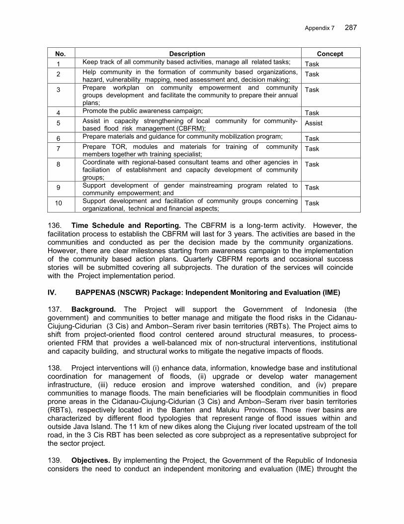
Appendix 7 287
No. Description Concept 1 Keep track of all community based activities, manage all related tasks; Task 2 Help community in the formation of community based organizations,
hazard, vulnerability mapping, need assessment and, decision making; Task
3 Prepare workplan on community empowerment and community groups development and facilitate the community to prepare their annual plans;
Task
4 Promote the public awareness campaign; Task 5 Assist in capacity strengthening of local community for community-
based flood risk management (CBFRM); Assist
6 Prepare materials and guidance for community mobilization program; Task 7 Prepare TOR, modules and materials for training of community
members together wth training specialist; Task
8 Coordinate with regional-based consultant teams and other agencies in faciliation of establishment and capacity development of community groups;
Task
9 Support development of gender mainstreaming program related to community empowerment; and
Task
10 Support development and facilitation of community groups concerning organizational, technical and financial aspects;
Task
136. Time Schedule and Reporting. The CBFRM is a long-term activity. However, the facilitation process to establish the CBFRM will last for 3 years. The activities are based in the communities and conducted as per the decision made by the community organizations. However, there are clear milestones starting from awareness campaign to the implementation of the community based action plans. Quarterly CBFRM reports and occasional success stories will be submitted covering all subprojects. The duration of the services will coincide with the Project implementation period. IV. BAPPENAS (NSCWR) Package: Independent Monitoring and Evaluation (IME) 137. Background. The Project will support the Government of Indonesia (the government) and communities to better manage and mitigate the flood risks in the Cidanau-Ciujung-Cidurian (3 Cis) and Ambon–Seram river basin territories (RBTs). The Project aims to shift from project-oriented flood control centered around structural measures, to process-oriented FRM that provides a well-balanced mix of non-structural interventions, institutional and capacity building, and structural works to mitigate the negative impacts of floods. 138. Project interventions will (i) enhance data, information, knowledge base and institutional coordination for management of floods, (ii) upgrade or develop water management infrastructure, (iii) reduce erosion and improve watershed condition, and (iv) prepare communities to manage floods. The main beneficiaries will be floodplain communities in flood prone areas in the Cidanau-Ciujung-Cidurian (3 Cis) and Ambon–Seram river basin territories (RBTs), respectively located in the Banten and Maluku Provinces. Those river basins are characterized by different flood typologies that represent range of flood issues within and outside Java Island. The 11 km of new dikes along the Ciujung river located upstream of the toll road, in the 3 Cis RBT has been selected as core subproject as a representative subproject for the sector project. 139. Objectives. By implementing the Project, the Government of the Republic of Indonesia considers the need to conduct an independent monitoring and evaluation (IME) throught the

288 Appendix 7
National Steering Committee on Water Resources (NSCWR) in order to secure better means for policy, planning coordination and to enhance project performance, output, and outcome. 140. By conducting an independent monitoring and evaluation (IME) at National Steering Committee on Water Resources (NSCWR) will provide better means for flood management policy development, policy & planning coordination improve project programming, planning coordination, and enhance project performance, output, and outcome.
Developing monitoring and evaluation tool for flood management program, specifically for Flood Management for Selected River Basin project;
Assessing stakeholders’ perception about the project through effective and transparent representation mechanisms;
Monitoring of the level and adequacy of participation of various stakeholders in planning and implementing project activities, and performance of Central Project Management Unit, Central Project Implementation Units (CPIUs) and Balai/BalaiBesar as implementing agency in terms of project implementation planning and implementation reflecting beneficiaries needs;
Assessing the prospects and potential outcomes of the project and its relevance to the overall project including the impact on flood management;
Preparing recommendations for making necessary adjustments in the project design and implementation arrangements during the implementation period in light of project benefit on beneficiaries;
Strengthening public watch, control over, and monitoring of project performance through access to information;
Conducting special studies for specific issues arise in the field; and Preparing recommendation for flood management policy and guidelines in Indonesia
141. Scope of Works. The Consultant shall be responsible to and be guided by BAPPENAS in performance of the Services. The Consultant shall exercise all reasonable skill, care, diligence and efficiency as an independent professional in the discharge of his duties. The Consultant shall conform to accepted professional standards, utilizing sound technical, administrative and financial practices appropriate to the respective discipline utilized in the Services. The Consultant shall always work in the best interests of BAPPENAS and the Government of Indonesia. The Consultant and his personnel shall safeguard the interests of BAPPENAS by keeping all information, data, maps, design papers and reports strictly confidential. 142. More specifically, the Independent Monitoring and Evaluation (IME) will answer the following questions:
(i) Effectiveness and efficiency of project implementation Was project implementation according to the agreed work plans and of high
quality? Were the actions and activities to achieve the outputs and outcomes effective
and efficient? Was project implementation effective and efficient in terms of quality and
timeliness of inputs delivered by ADB and GoI? Were the implementations arrangements appropriate for the project? (e.g.
structure, reporting lines, and staffing levels) Were roles and responsibilities clearly defined amongst and between
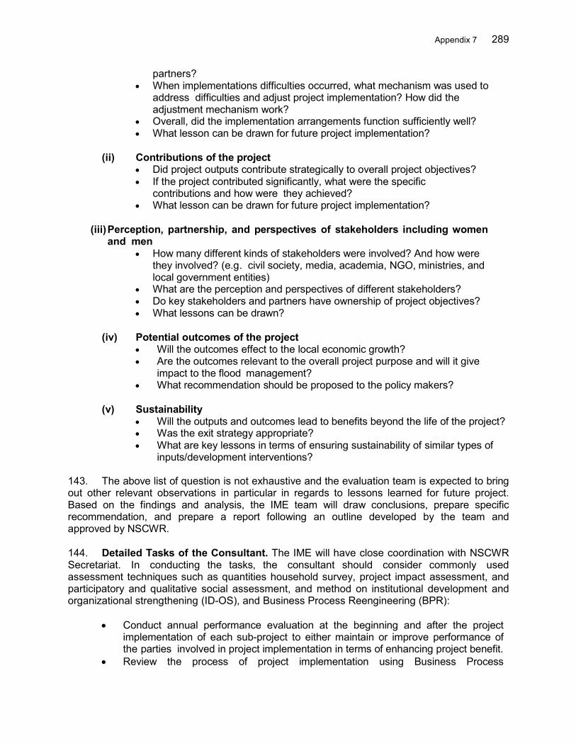
Appendix 7 289
partners? When implementations difficulties occurred, what mechanism was used to
address difficulties and adjust project implementation? How did the adjustment mechanism work?
Overall, did the implementation arrangements function sufficiently well? What lesson can be drawn for future project implementation?
(ii) Contributions of the project
Did project outputs contribute strategically to overall project objectives? If the project contributed significantly, what were the specific
contributions and how were they achieved? What lesson can be drawn for future project implementation?
(iii) Perception, partnership, and perspectives of stakeholders including women and men
How many different kinds of stakeholders were involved? And how were they involved? (e.g. civil society, media, academia, NGO, ministries, and local government entities)
What are the perception and perspectives of different stakeholders? Do key stakeholders and partners have ownership of project objectives? What lessons can be drawn?
(iv) Potential outcomes of the project
Will the outcomes effect to the local economic growth? Are the outcomes relevant to the overall project purpose and will it give
impact to the flood management? What recommendation should be proposed to the policy makers?
(v) Sustainability Will the outputs and outcomes lead to benefits beyond the life of the project? Was the exit strategy appropriate? What are key lessons in terms of ensuring sustainability of similar types of
inputs/development interventions?
143. The above list of question is not exhaustive and the evaluation team is expected to bring out other relevant observations in particular in regards to lessons learned for future project. Based on the findings and analysis, the IME team will draw conclusions, prepare specific recommendation, and prepare a report following an outline developed by the team and approved by NSCWR. 144. Detailed Tasks of the Consultant. The IME will have close coordination with NSCWR Secretariat. In conducting the tasks, the consultant should consider commonly used assessment techniques such as quantities household survey, project impact assessment, and participatory and qualitative social assessment, and method on institutional development and organizational strengthening (ID-OS), and Business Process Reengineering (BPR):
Conduct annual performance evaluation at the beginning and after the project implementation of each sub-project to either maintain or improve performance of the parties involved in project implementation in terms of enhancing project benefit.
Review the process of project implementation using Business Process

290 Appendix 7
Reengineering (BPR), to identify strengthen and weakness in terms of efficient but effective project implementation for ensuring project output and outcome, and to prepare the recommendation on improvement action on project implementation.
Conduct annual qualitative social assessment at the beginning and after the project implementation of each sub-project, with assistance of Balai/Balai Besar, so as to grasp Bangda Pertanian qualitative impact of project on coverage population and regional development.
Mobilize special expert as required to conduct special studies to propose recommendation to NSCWR if there are crucial problems in the project implementation.
145. Consultant General Reporting Requirement. The IME Consultant shall prepare and submit reports to the NSCWR through the NSCWR Secretariat with copies to the Central Project Management Unit (CPMU), Balai/Balai Besar, and ADBADB. All major reports will be in English with Indonesian summary unless specified otherwise below. The consultant will be required to produce the following reports in hard and electronic copies:
(i) Inception Report covers work program describing team activities in 25 copies; (ii) A Semi Annual Progress Report each quarter in 25 copies; (iii) Quarterly report; (iv) An Annual Consolidated Progress Report in 25 copies on December 15th each year; (v) A Mid-term Review Report (25 copies) at the end of the month 24 after
commencement of services. (vi) A Final Report in 25 copies submitted 2 months prior to project closure. The
completion report would deal comprehensively with achievement of project objectives, post-review of its approach and design, physical progress and discussion of problems and issues, their possible solutions, lessons learned an economic analysis and recommendations for future irrigation project.
(vii) Special study reports; and (viii) Other reports including survey result reports, notes, and discussion papers as
necessary for information and discussion.
146. In the case of a difference of opinion between BAPPENAS and the Consultant on any important matters involving professional judgment that might affect the proper evaluation or execution of the project, BAPPENAS shall allow the Consultant to submit promptly to BAPPENAS a written report and, simultaneously, to submit a copy to ADB. BAPPENAS shall forward the report to ADB with its comments in time to allow ADB to study it and communicate with BAPPENAS before any irreversible steps are taken in the matter. In cases of urgency, theConsultant has the right to request BAPPENAS and/or ADB that the matter be discussed immediately between BAPPENAS and the ADB. 147. Key Personnel & Duties. The IME at NSCWR will be conducted in 4 years and will be executed by a consultant team, led by a team leader. Recruitment will be in the form of consulting firm. The following is the personnel qualifications and duties of the IME team:
(i) Project Monitoring and Evaluation Expert (International 6 person-months) The Expert specializes in monitoring and evaluation of project implementation for civil works and feasibility study related to water resources, at a minimum an POSTpost-graduate with at least 12 year experience in developing countries.
Appendix 7 291
(ii) Team Leader - Project Monitoring and Evaluation Expert (National 38 person-months). The Expert specializes in project monitoring and evaluation, project management, and institutional assessment related to water resources, preferably post graduate with at least 10 year experience in related field.
(iii) Economists/Public Policy Expert (National person-months). The Expert specializes in analyzing project economic benefit and public policy, well informed on economic development of urban areas in Indonesia, preferably post-graduate with at least 7 year experience in related field.
(iv) Sociologist/Disaster Risk Management Expert (National 14 person-months intermittent). The Expert specializes in project evaluation of various stakeholders’ perceptions particularly in disaster risk management of urban areas in Indonesia, preferably post-graduate with at least 7 years in related field.
(v) Flood Management Expert (National 14 person-months intermittent). The Expert specializes in urban development related to flood management, preferably an post-graduate with at least 7 years in related field.
(vi) Junior Project Monitoring and Evaluation Expert (38 person-months). His or her duties are to assist the Project Monitoring and Evaluation Expert, must be a S1-graduate with Civil Engineering discipline or other related discipline with at least 3 year experience.
(vii) Junior Economist (38 person-months). His or Her duties are to assist the Economist/Public Policy Expert, must be an S1 graduate with related discipline, with at least 3 year experience preferably in economic analysis.
(viii) Junior Sociologist (14 person-months intermittent). His or her duties are to assist the Sociologist/Disaster Risk Management Expert, must be S1 graduate with related discipline with at least 3 year experience.
(ix) Surveyor/Statistician (14 person-months intermittent). His or her duties are to assist the experts in collecting and analyzing data and information from each subproject, must be S1 graduate with related discipline.
(x) Environment Safeguard Monitoring Specialist (14 person-months intermittent). The Environmental Safeguard Monitoring Specialist must have at least 7 years of relevant experience on the planning and conduct of environmental impact assessment particularly AMDALand UKL/UPL related to flood management, rural infrastructure, or agricultural development projects. He/She must be a graduate of Environmental Science or related study.
(xi) Water Resources Management Expert (14 person-months intermittent). The Water Resources Management Specialist must have at least 7 years of relevant experience on the water resources management project including construction supervision. He/She must be a graduate of Civil Engineering or Hydrology or related study.

292 Appendix 7
(xii) GIS Specialist (14 person-months intermittent). The GIS Specialist will have a degree in geography or relevant degree with a demonstrated work experience of a minimum of 7 years in project inputs and outcomes mapping.
Appendix 8 293
Standard Operating Procedure Environmental Safeguard Implementation March 2016
Indonesia: Flood Management in Selected River Basins Sector Project
Prepared by Ministry of Public Works and Housing of the Republic of Indonesia for the Asian Development Bank.
294 Appendix 8
CURRENCY EQUIVALENTS (as of March 2016)
Currency unit – rupiah (Rp)
Rp1.00 = $1.00 =
ABBREVIATIONS
3 Ci – Cidanau-Ciujung-Cidurian ADB – Asian Development Bank AMDAL – Environmental Impacts Assessment, EIA Bappeda – Local Development Planning Agency Bappenas – National Development Planning Agency BBWS – Major River Basin Organization BLH – District Environmental Management, established in
DistrictSerang BPBD – Local Disaster Mitigation Agency BPDAS – Watershed Management Organization, under Ministry of
Forestry BPLH – Local Provincial Environmental Agency, established in
Banten Province BWS – River Basin Organization CPMU – Central Project Management Unit DED – detailed engineering design DGWR – Directorate General of Water Resources EA – executing agency EARF – Environmental Assessment and Review Framework EIA – Environmental Impact Assessment EMP – Environmental Management Plan FIDIC – International Federation of Consulting Engineers FMSRB – Flood Management in Selected River Basins GOI – Government of Indonesia GR – government regulation IA – Implementing Agency IEE – Initial Environmental Examination IUCN – International Union for Conservation of Nature IWRM – Integrated Water Resource Management JICA – Japan International Cooperation Agency LARAP – Land Acquisition and Resettlements Action Plan LG – Local Government MOA – Ministry of Agriculture MOE – Ministry of Environment MOF – Ministry of Forestry MOHA – Ministry of Home Affairs MPWH – Ministry of Public Works and Housing NGO – nongovernment organization O&M – operation and maintenance PIU – project implementation unit PMU – project management unit POLA – Indonesian full name then “Water Resource Strategic Plan”) PP – Government Regulation

Appendix 8 295
PPTA – Project preparatory technical assistance PU – public works REA – Rapid Environmental Assessment Rencana – Indonesian full name then “Water Resource Detail Plan”) RKL/RPL – Environmental Management & Monitoring Plan,
complementary of AMDAL report RTRW – Regional Spatial Plan SKKLH – Decree on Environmental Feasibility SOP – standard operating procedure SPPL – Commitment Letter for Environmental Management and
Monitoring SPS – Safeguard Policy Statement – Coordination Team for Water Resource Management TOR – terms of reference TOT – training of trainers UKL/UPL – Environmental Management & Monitoring Measure,
substitute of AMDAL for moderate scale of projects UNESCO – United Nations Education, Scientific, and Cultural
Organization
NOTE In this report, "$" refers to US dollars.
In preparing any country program or strategy, financing any project, or by making any designation of or reference to a particular territory or geographic area in this document, the Asian Development Bank does not intend to make any judgments as to the legal or other status of any territory or area.

296 Appendix 8
TABLE OF CONTENTS
I. INTRODUCTION ................................................................................................... 297
A. Understanding the Safeguard Issues ............................................................... 297
B. Compatability and Review ................................................................................ 297
C. Objective .......................................................................................................... 298
D. Users ............................................................................................................... 298
II. GENERAL CONDITIONS ...................................................................................... 298
A. Basic Principles of Environmental Safeguard ................................................... 298
B. General Criteria ................................................................................................ 300
C. Avoidance of Protected Areas .......................................................................... 301
D. Impacts and Mitigation Measures ..................................................................... 302
III. SAFEGUARD IMPLEMENTATION ....................................................................... 306
A. Procedures of Environmental Safeguard .......................................................... 306
B. Role of Institutions and Parties ......................................................................... 309
APPENDIXES
Appendix 1:Rapid Environmental Assessment (REA) Checklist .................................... 314
Appendix 2: ADB Environment Categorization Sheet .................................................... 322
Appendix 3: AMDAL Screening Criteria For Non-Listed Activities ................................. 323
Appendix 4: AMDAL Criteria For Listed Activities (Selected Relevant Sectors) ............. 325
Appendix 5: Flowchart For AMDAL Screening .............................................................. 330
Appendix 6: List of Twenty (20) Protected Areas ........................................................... 332
Appendix 7: Environmental Management and Monitoring Plan (EMP) .......................... 333
Appendix 8 297
I. INTRODUCTION
1. As part of Project Administration Manual (PAM) and Memorandum of Understanding (MOU) between Government of Indonesia and Asian Development Bank (ADB) related to Flood Management in Selected River Basin Sector (FMSRB) Project (the Project), the Government of Indonesia (the Government) is obliged to apply environmental safeguards in the project implementation in accordance with ADB’s and the Government’s policy and regulations. In line with the agreement, the environmental safeguards have been stipulated in PAM and reflected in the Environmental Assessment and Review Framework (EARF) of the Project. In that respect, application of environmental safeguard policy is inherent in the planning, design and implementation of the FMSRB from the beginning. 2. This technical guideline on environmental safeguards namely standard operating procedure (SOP) on Environmental Safeguards is prepared as guidance for contractors and stakeholders in implementing measures to avoid, minimize, and/or mitigate the negative environmental impacts of the project activities, from the planning to implementation as well as post implementation (operation and maintenance) stages. Some of the technical guidelines on environmental safeguards were already discussed and provided in the EARF. Similar framework for social safeguards is separately prepared. 3. It is expected that all preventive and mitigating measures will be taken in design and implementation of the project to ensure the environmental soundness and sustainability of projects and to support the integration of environmental considerations into the project decision-making process. A. Understanding the Safeguard Issues
4. In this SOP, safeguards is interpreted as environmental “protection measures”. The protection measures cover prevention and mitigation techniques and tools as well as the solutions of any anticipated problems resulting from adverse negative impacts of the project. The SOP is to ensure that the safeguard measures are carried out systematically and integrated during the planning, implementation and operation and maintenance. In this context, the goal of the safeguards is to promote the sustainability of project outcomes by protecting people and the environment from potential adverse impact of the project and by enhancing the benefits from the project. 5. In transforming the safeguard commitment, ADB and its borrowers/clients take shared but differentiated responsibilities and actions. As stipulated in EARF, ADB has responsibility for explaining policy requirements to borrowers/clients, and helping borrowers/clients meet these requirements during project processing and implementation through due diligence, review, supervision, and capacity-building programs. Borrowers/clients are required to undertake environmental assessments, engage affected people and communities through information disclosure and consultations, prepare and implement safeguard plans, monitor the implementation of these plans, and prepare and submit monitoring reports. This SOP is mainly prepared to support the borrowers/clients to meet the requirements. B. Compatability and Review
298 Appendix 8
6. The Indonesia AMDAL system generally conforms in intent to ADB’s environmental management guidelines. There is corresponding relationship between the ADB and Indonesia’s regulations/policies. 7. The full AMDAL or UKL/UPL reports—depending on categorization—will be prepared and finalized in consultation with ADB. The Government approved environmental documents (AMDAL or UKL/UPL) which have incorporated ADB’s comments to ensure that the AMDAL or UKL/UPL meet ADB Safeguard Policy Statement (SPS) 2009 requirements is the only documentation required to process the potential sub-projects. To ensure compliance of the document with ADB SPS 2009, periodical support1 will be provided by the Environmental Safeguard Specialist, who will be employed under the project implementation team. C. Objective 8. This SOP does not seek to be definitive and exhaustive reference; rather it helps implement the environmental safeguard measures for FMSRB. Reference materials published by multilateral development banks such as ADB, World Bank Group, and others can provide useful information on environmental assessment and safeguards in general. 9. In general, the SOP is aimed to guide the implementation of safeguard measures for FMSRB project and mainly helps:
(i) Minimize adverse environmental impacts resulting from the implementation and operation and maintenance of the subprojects under FMSRB;
(ii) Ensure that proposed subprojects do not interfere protected areas (negative list) as attached in Appendix 6;
(iii) Mitigate the negative environmental impacts through safeguard procedure; (iv) Monitor the process of environmental safeguard implementation; and (v) Ensure compliance with ADB 2009.
D. Users
10. In particular, the SOP of environmental safeguards is aimed at supporting consultants, contractors and stakeholders to implement the safeguard measures under FMSRB. Therefore, the SOP is intended to be used by Central Project Management Unit (CPMU), project implementation units (PIUs) and parties engaged by CPMU/PIUs (Consultants and Contractors) involved in planning, implementation and maintaining of FMSRB project.
II. GENERAL CONDITIONS
A. Basic Principles of Environmental Safeguard
11. Referring to ADB 2009, the basic principles to be applied in this project shall meet the safeguard requirements as elaborated below:
1 National Environmental Safeguard Specialist will review and report periodically to ADB on compliance of SPS 2009,
including requirement for updating of categorization, EMP and RKL/RPL as applicable
Appendix 8 299
(i) Use a screening process for each proposed project, as early as possible, to determine the appropriate extent and type of environmental assessment so that appropriate studies are undertaken commensurate with the significance of potential impacts and risks.
(ii) Conduct an environmental assessment for each proposed subproject to identify potential direct, indirect, cumulative, and induced impacts and risks to physical, biological, socioeconomic (including impacts on livelihood through environmental media, health and safety, vulnerable groups, and gender issues), and physical cultural resources in the context of the project’s area of influence. Assess potential trans-boundary and global impacts, including climate change. Use strategic environmental assessment where appropriate.
(iii) Examine alternatives to the project’s location, design, technology, and components and their potential environmental and social impacts and document the rationale for selecting the particular alternative proposed. Also consider the no project alternative.
(iv) Avoid, and where avoidance is not possible, minimize, mitigate, and/or offset adverse impacts and enhance positive impacts by means of environmental planning and management. Prepare an environmental management plan (EMP) that includes the proposed mitigation measures, environmental monitoring and reporting requirements, related institutional or organizational arrangements, capacity development and training measures, implementation schedule, cost estimates, and performance indicators. Key considerations for EMP preparation include mitigation of potential adverse impacts to the level of no significant harm to third parties, and the polluter pays principle.
(v) Carry out meaningful consultation with affected people and facilitate their informed participation. Ensure women’s participation in consultation. Involve stakeholders, including affected people and concerned nongovernment organizations, early in the project preparation process and ensure that their views and concerns are made known to and understood by decision makers and taken into account. Continue consultations with stakeholders throughout project implementation as necessary to address issues related to environmental assessment. Establish a grievance redress mechanism to receive and facilitate resolution of the affected people’s concerns and grievances regarding the project’s environmental performance.
(vi) Disclose a draft environmental assessment (including the EMP) in a timely manner, before project appraisal, in an accessible place and in a form and language(s) understandable to affected people and other stakeholders. Disclose the final environmental assessment, and its updates if any, to affected people and other stakeholders.
(vii) Implement the EMP and monitor its effectiveness. Document monitoring results, including the development and implementation of corrective actions, and disclose monitoring reports.
300 Appendix 8
(viii) Do not implement project activities in areas of critical habitats, unless (i) there are no measurable adverse impacts on the critical habitat that could impair its ability to function, (ii) there is no reduction in the population of any recognized endangered or critically endangered species, and (iii) any lesser impacts are mitigated. If a project is located within a legally protected area, implement additional programs to promote and enhance the conservation aims of the protected area. In an area of natural habitats, there must be no significant conversion or degradation, unless (i) alternatives are not available, (ii) the overall benefits from the project substantially outweigh the environmental costs, and (iii) any conversion or degradation is appropriately mitigated. Use a precautionary approach to the use, development, and management of renewable natural resources.
(ix) Apply pollution prevention and control technologies and practices consistent with international good practices as reflected in internationally recognized standards such as the World Bank Group’s Environmental, Health and Safety Guidelines. Adopt cleaner production processes and good energy efficiency practices. Avoid pollution, or, when avoidance is not possible, minimize or control the intensity or load of pollutant emissions and discharges, including direct and indirect greenhouse gases emissions, waste generation, and release of hazardous materials from their production, transportation, handling, and storage. Avoid the use of hazardous materials subject to international bans or phase-outs. Purchase, use, and manage pesticides based on integrated pest management approaches and reduce reliance on synthetic chemical pesticides.
(x) Provide workers with safe and healthy working conditions and prevent accidents, injuries, and disease. Establish preventive and emergency preparedness and response measures to avoid, and where avoidance is not possible, to minimize, adverse impacts and risks to the health and safety of local communities.
(xi) Conserve physical cultural resources and avoid destroying or damaging them by using field-based surveys that employ qualified and experienced experts during environmental assessment. Provide for the use of “chance find” procedures that include a pre-approved management and conservation approach for materials that may be discovered during project implementation.
B. General Criteria 12. In general the criteria to be met for selection of the subprojects under the Project are as follows:
(i) The subprojects shall only be selected from the list of projects prioritized by the Government (such as in short and/or medium term plan);
(ii) The subprojects shall only involve activities that follow all the government regulations;
(iii) The subprojects are not types of projects listed in ADB SPS‘s Appendix 5 (ADB

Appendix 8 301
Prohibited Investment Activities List) that do not qualify for ADB‘s financing2; and (iv) The subprojects shall meet environmental requirements. They are subject to
mandatory environmental assessment, especially those that may have considerable adverse impacts to the environment or are located in environmentally sensitive areas.
13. Any subproject, which does not meet the general criteria listed above, would be unacceptable to ADB and the Government. C. Avoidance of Protected Areas
14. Consistent with Basic Principles of Environmental Safeguard (Point 8), project activities will not be allowed in areas of critical habitats. Annex III of the Decree of the Minister of Environment No. 05/2012 on Type of Business and/or Activities Requiring Environmental Impact Assessment, identifies 20 (twenty) classifications of protected areas (by regulation under Ministry of Forestry, Ministry of Public Works and Housing, etc). The following areas should be avoided for project sitting:
(i) Protected forest area; (ii) Peat area; (iii) Watershed (catchment) area. (iv) Coast demarcation (corridor); (v) River demarcation (corridor); (vi) Area around lake or reservoir; (vii) Flora sanctuary and marine sanctuary; (viii) Natural reserve and marine reserve; (ix) Mangrove forested coast area; (x) National park and national marine park; (xi) Forest park; (xii) Natural tourism park and marine tourism park; (xiii) Cultural and knowledge heritage area; (xiv) Natural geology reserve area; (xv) Groundwater recharge area; (xvi) Spring demarcation; (xvii) Genetic protection area; (xviii) Fauna refugee area; (xix) Coral reef; and (xx) Corridor area for protected flora or marine biota.
15. For these areas, any use beyond the purpose of the original function and/or protection should be avoided. These areas are normally identified in Spatial Planning documents. 16. This sitting criterion also corresponds with ADB Environmental Safeguard – Good Practices Working Source Book (2012 Draft), which prevents siting of projects on critical habitat. According to this sourcebook, critical habitat is defined as an area that has high biodiversity value and may include sites that are legally protected or officially proposed for protection such 2 ADB uses a list of ineligible items to prohibit the purchase of specific goods and services under program loans.
This list includes such goods as alcohol beverages, tobacco, jewellery, nuclear reactors and radioactive materials, military supplies, and hazardous substances.
302 Appendix 8
as areas that meet International Union for Conservation of Nature (IUCN) classification criteria, Ramsar List of Wetlands of International Importance, and United Nations Educational, Scientific, and Cultural Organization (UNESCO) world natural heritage sites. D. Impacts and Mitigation Measures
17. Potential environmental impacts associated with the proposed project are classified as: (i) impacts during design and construction phase; and (ii) impacts during operation and maintenance (post construction) phase. The impacts and mitigation measures are described below. E. Mitigation Measures Related to design (Pre-Construction) and Construction Phase
1. Excavation/Borrow Area and Land Use Change
18. For the proposed structural construction, substantial quantity of excavation will be required in the borrow pit areas. The impacts of the excavation are among others dust, soil spillage, transport related disturbance, aesthetics, change of natural landscape and landslide and increasing run-off and flood. 19. The impacts will be minimized by applying good practice of engineering (including Indonesian National Standard/SNI and government guidelines) as controlled through standard bidding documents, among others:
(i) site clearance; (ii) minimizing run-off; (iii) isolation of works area; (iv) de-watering of isolated area; (v) treatment/disposal of contaminated water; (vi) temporary river crossings; (vii) reinstatement of bed/banks.
20. The closed borrow pit areas can be used to build settlements, farms and others use as suggested in the design (special requirement of owners).
2. Quarry and Land use Change 21. A structural project would require a significant amount of construction particularly the earthen material. It will be a condition of Construction Contracts that all materials required for the construction of embankment and roads shall be procured from quarries approved by the government and with necessary formal environmental approvals. 22. The environmental aspects and control of pollution due to quarrying operation of approved quarries are controlled and monitored by the third party operators (contractors). Thus, adverse impacts as a result of quarrying operations are not envisaged in the proposed project. 23. During the construction there will be some debris/excavated soil from demolition of existing old structures, which shall be temporarily disposed/collected at land near the work site, before permanently disposed to other disposal location and/or taken for earth filling elsewhere.
Appendix 8 303
For that reason, some portion of (appropriate) land at work site need to be earmarked for the dumping (of construction waste). The land at work site shall also be free from any social issue.
3. Noise and Vibration 24. During construction phase, noise will be generated from various activities such as site clearing, excavation, erection, finishing, etc. The general noise levels during construction phase due to the operation of heavy earth moving equipment and machineries installation can potentially go up to 100 dB(A) at the work sites. It is also to be noted that significant amount of manual labor will be involved during construction of embankments. 25. However, the increase in noise levels will be localized, temporary in nature and mostly will be during working hours only. This impact is one of issues to be discussed with communities during public consultation. 26. Various noise control measures can be adopted such as:
(i) Site Controls: Where possibly placing equipment away from sensitive receptors and where not possible using temporary noise barriers.
(ii) Scheduling of Project Activities: Operations will be scheduled to when people would be least likely to be affected. For example, construction activities could be restricted between 10 P.M. and 6 A.M. near residential areas if specifically required by local communities.
(iii) Protection devices (ear plugs or ear muffs) will be provided to the workers operating in the vicinity of high noise generating machines.
(iv) Construction equipment and machinery shall be fitted with silencers (if applicable) and maintained properly.
27. In line with contracting practice for this project, the contractor will be responsible for properly maintaining the noise generating machines. Rather than the contract specifying what actual methods the Contractor must adopt, the Contractor will produce the operational Environmental Management Plans (including methods to control noise) together with normal Work Plans for approval by the Supervising Engineer. The Supervising Engineer will be responsible for immediate monitoring of compliance of environmental conditions and ensure that the Contract Conditions will enable enforcement of immediate remedial actions. 4. Air Pollution
28. During the construction phase, there will be two main sources of air emissions, i.e., mobile sources and stationary sources. Mobile sources are mostly vehicles involved in construction activities, whereas emissions from stationary sources include construction equipment & machinery, diesel generator sets, excavation/ grading activities etc. It would not be possible to distinguish between the emissions from project construction vehicles and equipment and emissions from non-project vehicles. 29. Construction-related airborne dust can arise from both vehicular traffic generating fugitive dust on paved and unpaved roads (and especially where there are spillages of soil from construction transport vehicles to the public roads and soil/aggregate material handling and processing). As for noise control, the requirement shall be set up in tender and contract documents that the Contractor is obliged to prepare Contractor’s EMP as part of their Work

304 Appendix 8
Plan, which shall specify methods to control dust. The compliance monitoring on the requirement will be carried out by the Supervising Engineer.
5. Water Pollution
30. The requirements in the Construction contract will include specific measures for:
(i) proper collection and disposal of all wastewater, whether from workers on the construction area itself or from temporary labor camps;
(ii) preventing oils and similar escaping from refueling. servicing or storage operations;
(iii) minimizing the amount of “in-stream” operations by heavy construction equipment;
(iv) preventing the dumping of any solid or sludge material into the river or on the banks from where storm rain could wash it into the river; and
(v) As for other aspects, it is required for the Contractor to nominate specific methods to be adopted in accordance with Contractor’s Work Plan, and with suggestions from the Supervising Engineer to ensure compliance.
31. Notwithstanding these controls, it will not be possible to prevent (as currently occurs) high suspended solids levels in the flood flows during high rain events. Some mitigation shall be proposed to solve the problem, among others minimizing extent of disturbed area, especially steep areas such as embankments (and especially during rain season) and provision of temporary silt traps. 32. Discharge of untreated domestic sewage to the river or to any natural waters will not be permitted. No debris shall be dumped in the water bodies. 33. Typical method for large temporary land disturbance activities such as for dike construction is use of silt fence, a temporary barrier designed to retain sediment on the construction site. It consists of a geo-textile attached to supporting posts that are trenched into the ground. The fence retains sediment primarily by retarding flow and promoting deposition on the uphill side of the fence. Runoff is also filtered as it passes through the geo-textile.
6. People Access (during construction) 34. The disturbance may occur from vehicular movement along the road near the settlement. The mobilization of material and personnel from and to the project site during the construction phase generates heavy traffic, which otherwise carefully managed, will cause congestion and disturbance to people daily access to the area. Since the direct project construction has very limited effect on the river itself, except for some minor cross river bridges, there should be almost no disturbance to boat use on the river. If it occurs, it only affects cross-river ferries, small boats and to sand excavation mid-river and transporting to shore-based loading onto trucks. 35. To mitigate and compensate the social impacts related to land acquisition and resettlement, a Resettlement Plan following the requirements of the Government and in compliance with ADB the social impacts3 has been prepared in consultation with the central, provincial, and district governments. 3 ADB. 1998. Handbook on Resettlement: A Guide to Good Practice. Manila
Appendix 8 305
7. Occupational Health and Safety 36. The risks associated with the proposed project are minimal. However, with roads being narrow, efforts shall be made so that no hazardous traffic conditions are created due to construction vehicle movement. Local people may potentially encroach to construction area and get hurt. 37. This can be mitigated by adequate lighting and fluorescent signage shall be provided at the construction sites. Signage shall be made in local language. The workers shall be provided with necessary Personal Protective Equipment and a First Aid kit. In case of emergency the victims will be referred to the nearest hospitals or clinics. Contractors will be recommended to use the World Bank Group’s Occupation Health and Safety Guidelines.4 Standard contract conditions have specific requirements related to worker and public safety.
8. Mitigation Measures Related to Operational and Maintenance (Post Construction) Phase
a. People Access
38. The structural project will also build inspection road along the right and left banks of the river, providing access for people as well as supporting river inspection and maintenance. Crossing bridges are also provided to serve people to move from one side of the river to another easily and safely. The design of bridges considers height of flood level at peak flow from the upstream. For that reason, generally impact of the river normalization to the people access during post construction is positive.
9. Changes in Water Level
39. The proposed works will have a significant effect on flood levels in the river floodplain. The embankments will confine all flows to estimated Q25 within the river cross section that includes (for peak flows) access roads, thereby reducing the amount of flooding in the areas adjacent to the new works.
10. River Morphology and Drainage Change 40. The new structures (such as dikes) will not be changing the river’s low and medium flow morphology. At high flows the difference will be that the flows up to Q25 will in future remain within the river cross section, albeit the peak flows on the access roads, rather than at present spreading out though residential areas. 41. Provision shall be made not to obstruct the natural drainage from discharging into the river. The strengthening and widening of the existing embankment structure and provision of necessary cross-drainage facilities like sluice gates, and bank protection works will improve the drainage system in both inland and in the river reaches.5
4 http://www.ifc.org/wps/wcm/connect/9aef2880488559a983acd36a6515bb18/2%2BOccupational%2BHealth%
2Band%2BSafety.pdf?MOD=AJPERES 5 Refer to DED of Ciujung Dike Construction (11 km stretch).
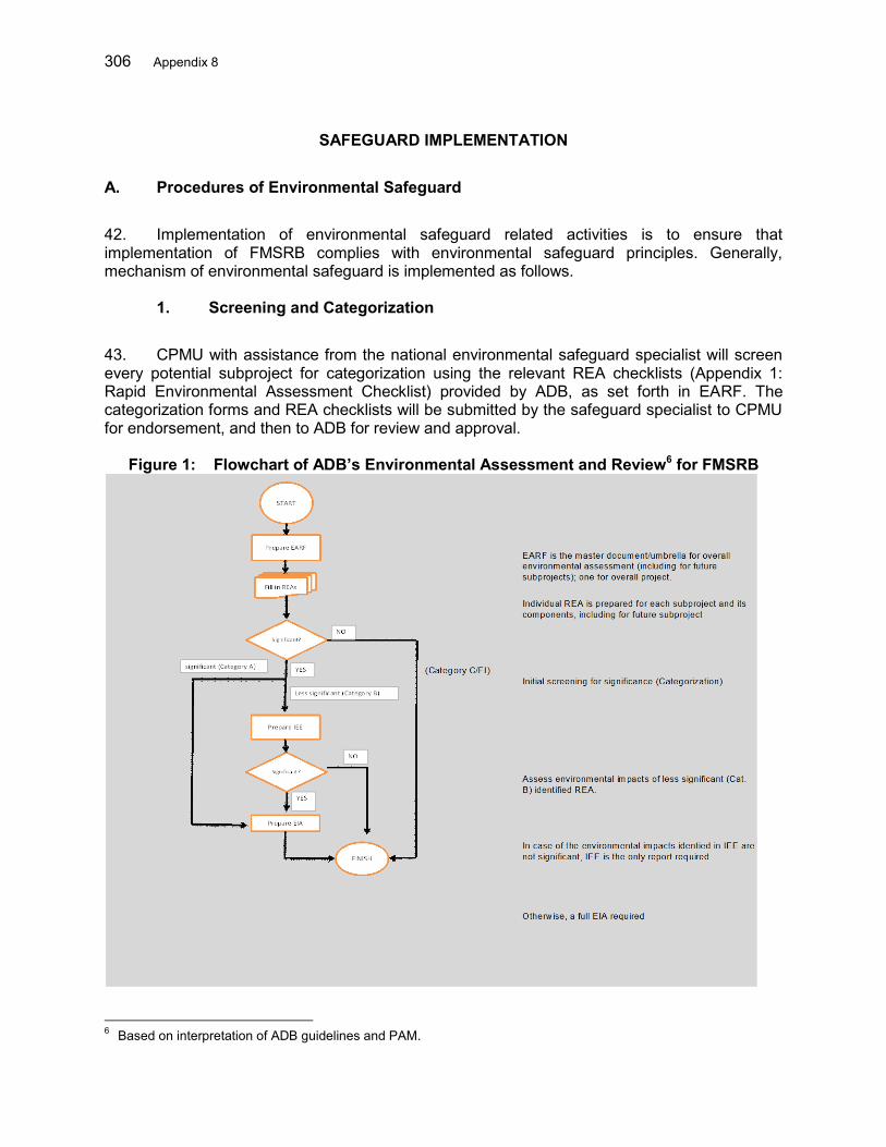
306 Appendix 8
SAFEGUARD IMPLEMENTATION
A. Procedures of Environmental Safeguard
42. Implementation of environmental safeguard related activities is to ensure that implementation of FMSRB complies with environmental safeguard principles. Generally, mechanism of environmental safeguard is implemented as follows.
1. Screening and Categorization
43. CPMU with assistance from the national environmental safeguard specialist will screen every potential subproject for categorization using the relevant REA checklists (Appendix 1: Rapid Environmental Assessment Checklist) provided by ADB, as set forth in EARF. The categorization forms and REA checklists will be submitted by the safeguard specialist to CPMU for endorsement, and then to ADB for review and approval.
Figure 1: Flowchart of ADB’s Environmental Assessment and Review6 for FMSRB
6 Based on interpretation of ADB guidelines and PAM.
Appendix 8 307
44. If a category A subproject is proposed, the categorization of the entire Project will be changed to category A. The categorization and REA checklist of the first category A subproject will be submitted to ADB by the executing agency, upon which an internal process in ADB will start to review and consider approval for the re-categorization of the entire project to category A. No further action will be taken by the executing agency until ADB has approved the new categorization (see Categorization Sheet in Appendix 2). 45. Upon ADB’s approval of the categorization, CPMU with assistance from the national environmental safeguard specialist will screen the subprojects with the AMDAL criteria (Appendix 3: GOI AMDAL Criteria) according to GOI regulation. For the activities listed in the criteria, the screening conducted directly by checking the magnitude and/or scale of activities with regulation set forth. Meanwhile, for other activities not listed in the regulation, the screening conducted is provided in Appendix 4. 46. Subprojects with potential for significant adverse environmental impacts, require an environmental impact assessment (AMDAL). Projects judged to have some adverse environmental impacts, but of lower degree and/or less significant require an Environmental Management and Monitoring Measure (UKL/UPL). Subprojects that do not require AMDAL or UKL-UPL are obliged to submit a “statement of management and environmental monitoring ability” or SPPL. The AMDAL process for each category of requirement is presented in Figure 2.
Preparation of Environmental Impact Assessment (AMDAL)
47. The AMDAL or UKL/UPL for future subprojects will be prepared through sub contracts under the main consulting services DGWR package. The CPMU will contract an accredited agency to undertake the study in accordance with prevailing regulation. Simple competitive bidding or other suitable methods are recommended. CPMU with support of Environmental Safeguard Specialist should ensure the agency meet all the technical and administrative requirements for the study.
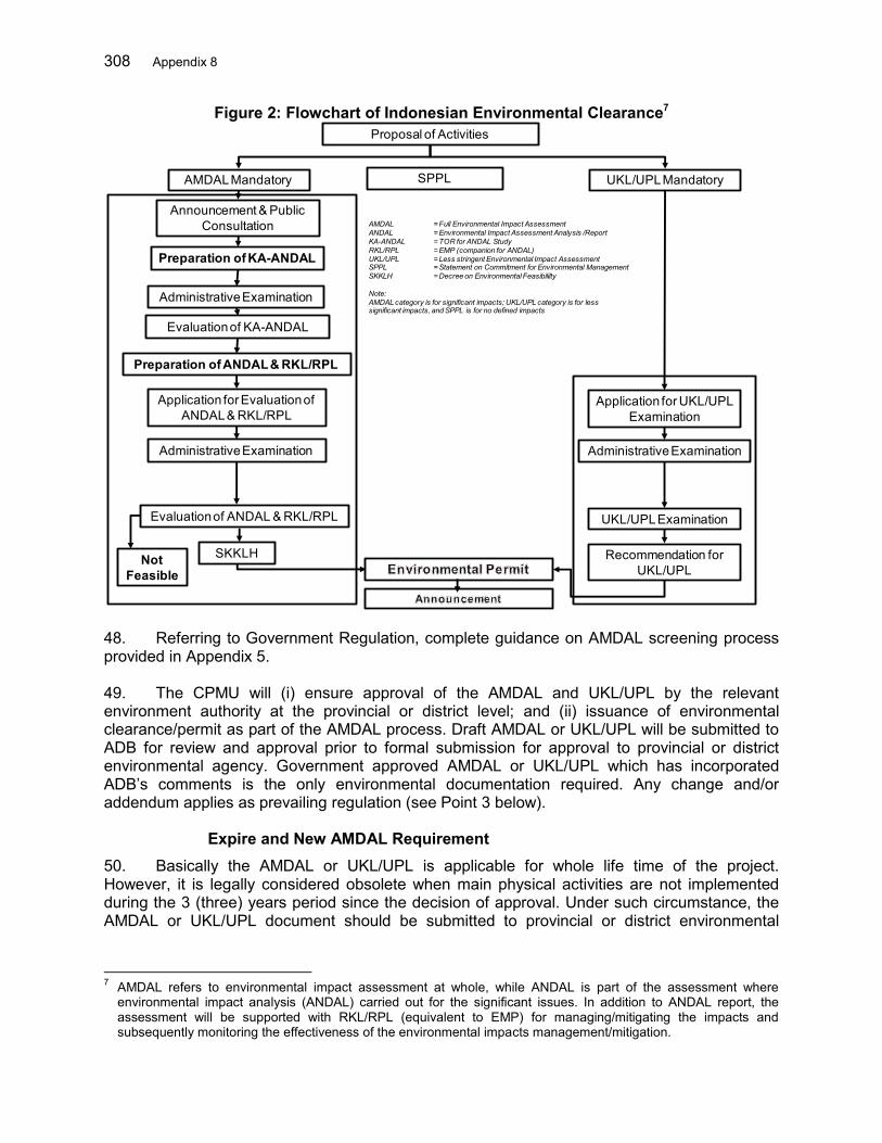
308 Appendix 8
Figure 2: Flowchart of Indonesian Environmental Clearance7
48. Referring to Government Regulation, complete guidance on AMDAL screening process provided in Appendix 5. 49. The CPMU will (i) ensure approval of the AMDAL and UKL/UPL by the relevant environment authority at the provincial or district level; and (ii) issuance of environmental clearance/permit as part of the AMDAL process. Draft AMDAL or UKL/UPL will be submitted to ADB for review and approval prior to formal submission for approval to provincial or district environmental agency. Government approved AMDAL or UKL/UPL which has incorporated ADB’s comments is the only environmental documentation required. Any change and/or addendum applies as prevailing regulation (see Point 3 below).
Expire and New AMDAL Requirement 50. Basically the AMDAL or UKL/UPL is applicable for whole life time of the project. However, it is legally considered obsolete when main physical activities are not implemented during the 3 (three) years period since the decision of approval. Under such circumstance, the AMDAL or UKL/UPL document should be submitted to provincial or district environmental
7 AMDAL refers to environmental impact assessment at whole, while ANDAL is part of the assessment where
environmental impact analysis (ANDAL) carried out for the significant issues. In addition to ANDAL report, the assessment will be supported with RKL/RPL (equivalent to EMP) for managing/mitigating the impacts and subsequently monitoring the effectiveness of the environmental impacts management/mitigation.
Proposal of Activities
AMDALMandatory UKL/UPLMandatory
Announcement & Public Consultation
Evaluation of KA-ANDAL
Preparation of KA-ANDAL
Preparation of ANDAL & RKL/RPL
Not Feasible
Administrative Examination
Administrative Examination
Administrative Examination
Application for Evaluation of ANDAL & RKL/RPL
Evaluation of ANDAL & RKL/RPL
SKKLH
Application for UKL/UPLExamination
UKL/UPLExamination
Recommendation for UKL/UPL
SPPL
AMDAL = Full Environmental Impact Assessment ANDAL = Environmental Impact Assessment Analysis /ReportKA-ANDAL = TOR for ANDAL StudyRKL/RPL = EMP (companion for ANDAL)UKL/UPL = Less stringent Environmental Impact AssessmentSPPL = Statement on Commitment for Environmental Management SKKLH = Decree on Environmental Feasibililty
Note:AMDAL category is for significant impacts; UKL/UPL category is for less significant impacts, and SPPL is for no defined impacts
Appendix 8 309
agency for review. The decision may be in favor of a new AMDAL or the old one, which is still considered valid. 51. The review of AMDAL or UKL/UPL is also applicable in case of change of location, design, process, capacity, raw material or significant environmental change occurs due to natural event or other causes before the implementation of the activities. Under such circumstance, a new AMDAL or UKL/UPL may be required.
Implementation of EMP 52. As described in the AMDAL and UKL/UPL, implementation of mitigation measures in EMP (RKL/RPL) will be the responsibility of the PIUs based on contracts with the contractor/developer, with assistance from the national environmental safeguard specialist, under the supervision of the CPMU. 53. The respective AMDAL or UKL/UPL requirements will be incorporated into the works bidding documents and contracts. This ensures that the civil works contractors will have primary responsibility for the implementation of the required environmental safeguards measures. Contractors are required to have specific staff with responsibility for environmental and social management. Bidders are required as part of their bid to submit contractor’s Environmental Management Plan, including a Traffic Management Plan (TMP), conforming to the requirements of the various environmental documents. These will be developed into detailed plans by the winning contractor. 54. Each PIU will assign an environment officer to ensure EMP implementation. The officers will work on behalf of the PIUs for the entire project duration to implement the project EMP. The officers will report directly to the PIUs. The duties of PIU’s Environment Officer are explained in Section B.2. below.
Safeguard Monitoring 55. In addition to the internal monitoring, the Project Administration Manual (PAM) requires independent monitoring on the safeguards to ensure that all recommendations and mitigation measures under the IEE and the AMDAL (environmental impact assessment in the Indonesian system) of the core subproject in Ciujung, as well as the AMDAL of all potential subprojects are being implemented. 56. An independent safeguard monitoring entity will be engaged by each PIU to conduct monitoring for the subprojects as specified in the environmental monitoring plan under the IEEs and the AMDAL. They will provide quarterly environmental safeguard monitoring reports to the PIU. Role of Institutions and Parties
1. CPMU, CPIU and PIUs
57. The Ministry of Public Works and Housing (MPWH) through the Directorate General of Water Resources (DGWR) will be the executing agency. A Central Project Management Unit (CPMU) will be established in the Directorate of River and Coast (DRC), DGWR. A Central Project Implementation Unit (CPIU) will also be established under DRC, DGWR for the provision of technical guidance to the River Basin Organizations (RBOs), the Balai Besar Wilayah Sungai (National River Basin Organization) of Cidanau-Ciujung-Cidurian (BBWS 3 Cis), and the Balai
310 Appendix 8
Besar Wilayah (BWS) of Maluku as implementing agencies. The CPMU will assure overall planning, coordination, and reporting for the project. The DRC NPIU will be responsible to select, appraise and prepare the structural subprojects in accordance with the criteria detailed in the project administration manual. 58. The Ministry of Agriculture (MOA) through the Directorate General of Agricultural Infrastructure and Facility (DGAIF) will be responsible for the implementation of the sustainable agriculture practices in the 3 Cis RBT in cooperation with provincial and district agriculture agencies. A CPIU will be established in DGAIF, while Provincial Project Implementation Unit (PPIU) and District Project Implementation Unit (DPIU) will respectively be established in the provincial and district agriculture agencies. 59. Under the overall guidance and responsibility of the CPIU under the Directorate General of Regional Development (DGRD), Ministry of Home Affairs (MOHA), provincial and district planning agencies (BAPPEDAs) will ensure institutional strengthening, planning and coordination of provincial and local disaster management, public works, social and forestry agencies. PPIUs and DPIUs will be established in each of the provincial and district agencies involved in community-based flood risk management (CBFRM) activities. The BAPPEDAs will ensure that FRMPs are accordingly reflected into spatial, mid-term and annual plans of the various involved sectors.
Environmental Officers 60. Each PIU under the BBWS3 CIs and BWSM will assign a counterpart staff as an environment officer to oversee the implementation of the environmental management plan, act as a focal point for the grievance redress mechanism, and facilitate the AMDAL development and approval process. This will be reflected in PIU decrees. 61. Qualified environmental officers will be appointed to support the CPIUs and PIUs. CPMU together with the BBWS 3 Cis and BWSM with the support of consultants will supervise the preparation and implementation of the AMDAL requirements and will monitor, and report to the CPMU on all environmental safeguard activities. Project progress reports will indicate which subprojects require AMDAL, and the status of implementation. Semi-annual monitoring reports on the implementation of the AMDAL’s will be submitted to ADB review. 62. As specified in TOR proposed in EARF and PAM, Environmental Officers support PIUs for the following duties:
(i) Assess whether the EMP requires updating due to any changes in project design which may have occurred after the EMP was prepared;
(ii) Distribute the Bahasa language version of the EMP to all relevant agencies, including the implementing agencies, provincial and municipal agencies for environment protection, forestry, water resources, and/or land planning, contractors, and construction supervision companies. This should occur at least three months before construction begins;
(iii) Assist in procurement of services from an environmental monitoring entity for environmental safeguards monitoring as specified in the EMP under the IEEs and AMDAL;
(iv) Conduct meetings with agencies as necessary to ensure they understand their specific responsibilities described in the EMP;

Appendix 8 311
(v) Ensure that relevant mitigation, monitoring and reporting measures in the EMP are included in the bidding documents and contracts;
(vi) Confirm that the agencies responsible for the internal environment monitoring described in the EMP understand their tasks and will implement the monitoring in a timely fashion;
(vii) At least two months before construction begins, establish and implement the project Grievance Redress Mechanism (GRM) described in the EARF. This will include: (a) prepare a simple table and budget identifying the type, number and cost of materials needed to inform local communities about the GRM and starting dates and scope of construction; (b) design, prepare and distribute these materials, and plan and conduct the community meetings; (c) prepare a form to record any public complaints; (d) prepare a summary table to record all complaints, including dates, issues, and how they were resolved; and (e) ensure that all relevant agencies, including contractors, understand their role in the GRM;
(viii) Prior to construction, ensure that contractors and construction supervision companies have informed their personnel, including all construction workers, of the EMP requirements. This will include all mitigation measures relating to impacts to air, water, noise, soil, sensitive sites, ecological values, cultural values, worker and community health and safety, respectful behavior when communicating with local communities, and responding to and reporting any complaints;
(ix) During project construction, make regular site visits to assess progress, meet with contractors and/or local communities, and assess compliance with the EARF;
(x) Ensure that all relevant agencies submit required progress reports and information, including environmental monitoring and reports of any issues or grievances;
(xi) Compile, review, and store environmental progress reports from the contractors and internal monitoring agencies, records of any grievances, and any other relevant issues. Maintain digital copies of all information. When necessary, enter data into summary tables in digital format (e.g. to transfer records of grievances from hard copy forms). Ensure that all information is stored in the PIU filing system, backed up, and can be easily retrieved;
(xii) With assistance from the national environmental safeguard specialist, prepare monthly and quarterly environmental monitoring reports during construction phase of the subprojects; and prepare semi-annual environmental monitoring reports during the operational phase of the subprojects; and
(xiii) Work closely with the PIU, contractors, project management consultants, and other agencies and personnel as necessary to conduct these tasks.
National Environmental Safeguard Specialist
63. The National Environmental Safeguard Specialist will provide technical guidance, capacity building, support and advice to the Central Project Management Unit (CPMU), Project Implementation Units (PIUs) under the BWS/BBWS in all aspects of environmental management and environmental safeguards in accordance with the ADB Safeguard Policy
312 Appendix 8
Statement (SPS) 2009 and the environmental rules and regulations of the Government of Indonesia. 64. As specified in TOR proposed in EARF and PAM, National Environmental Safeguard supports CPMU for the following duties:
(i) Review various reports/assessments and other relevant background information available regarding the project or collect additional information to update him/herself with the current status of environment related aspects of the Project and familiarize him/herself with potential environmental issues relevant to the proposed interventions in each subproject area;
(ii) Refine the EARF as needed at project start after consultation with CPMU and PIUs;
(iii) Carry out a review of the feasibility studies (including the IEE and AMDAL) with regard to environmental impact and draw attention to changes which may have become necessary since their preparation;
(iv) Develop strategy to effectively carry out the submission of environmental assessment documents to the concerned government offices and ADB;
(v) Assist the CPMU in the preparation of the applicable ADB Rapid Environmental Assessment (REA) checklists and GOI screening criteria and the environmental categorization forms of the subprojects;
(vi) Assist the CPMU in contracting, reviewing, submitting and obtaining approval of all AMDAL and UKL-UPL reports that meet the requirements from the Government of Indonesia as well as ADB SPS for category A (if one is to be proposed) and B subprojects;
(vii) Lead in the conduct of capacity building/training of environment personnel in the Project;
(viii) Oversee preparation and approval of the site EMP of construction contractors and monitor implementation of these for the purposes of quarterly reporting;
(ix) Undertake a review of potential cumulative and induced environmental impacts which may occur downstream or elsewhere in the selected river basins as a result of project interventions;
(x) Provide monitoring of project progress with regard to environmental targets and indicators set out in the Design and Monitoring Framework (DMF);
(xi) Collaborate with provincial and district environmental agencies to include environmental safeguards and awareness aspects in the capacity building and awareness building activities;
(xii) Provide technical assistance and capacity building to the CPMU and PIUs in monitoring the implementation of the IEE, AMDAL, and UKL-UPLs; and
(xiii) Assist the Team Leader and Deputy Team Leader in timely preparation of reports. Deliver the environmental monitoring reports timely as per the guidance from TL and DTL.
Appendix 8 313
Safeguard Monitoring Entity 65. The Safeguards Monitoring Entity will focus on assessing progress and compliance with the Environmental Monitoring Plans (EMPs) under the IEEs and the AMDAL of the relevant subprojects, identifying constraints and developing remedial actions to effectively address the issues. 66. As specified in TOR proposed in EARF and PAM, Safeguard Monitoring Entity will be responsible for the following duties:
(v) Review the IEE and AMDAL reports, including the EMP of the core subproject in Ciujung for familiarization of environmental monitoring requirements;
(vi) Review the AMDAL reports (which will be accepted as an IEE or an Environmental Impact Assessment by ADB) of all relevant future subprojects under the Loan for familiarization of environmental monitoring requirements;
(vii) Develop a monitoring and assessment plan, including plan for baseline establishment where baseline data do not exist. Based on the IEEs and AMDALs, the SME will develop a monitoring and assessment plan responding to the scope of works outlined in these terms of reference, including the detailed field survey plan where necessary; and
(viii) Conduct water quality monitoring. The SME will establish baseline for water quality at the subprojects and monitor the common parameters8 as set out in the EMP under the IEEs and/or the AMDAL.
8 As referred to in GOI Regulation Nr. 82/2001 on Water Quality Management and Water Pollution Control.
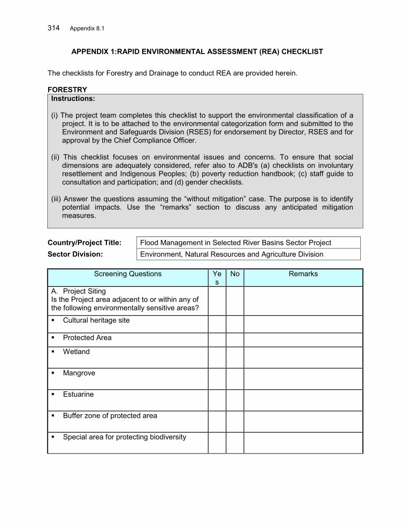
314 Appendix 8.1
APPENDIX 1:RAPID ENVIRONMENTAL ASSESSMENT (REA) CHECKLIST The checklists for Forestry and Drainage to conduct REA are provided herein.
FORESTRY Instructions: (i) The project team completes this checklist to support the environmental classification of a
project. It is to be attached to the environmental categorization form and submitted to the Environment and Safeguards Division (RSES) for endorsement by Director, RSES and for approval by the Chief Compliance Officer.
(ii) This checklist focuses on environmental issues and concerns. To ensure that social
dimensions are adequately considered, refer also to ADB's (a) checklists on involuntary resettlement and Indigenous Peoples; (b) poverty reduction handbook; (c) staff guide to consultation and participation; and (d) gender checklists.
(iii) Answer the questions assuming the “without mitigation” case. The purpose is to identify
potential impacts. Use the “remarks” section to discuss any anticipated mitigation measures.
Country/Project Title: Flood Management in Selected River Basins Sector Project Sector Division: Environment, Natural Resources and Agriculture Division
Screening Questions Yes
No Remarks
A. Project Siting Is the Project area adjacent to or within any of the following environmentally sensitive areas?
Cultural heritage site
Protected Area
Wetland
Mangrove
Estuarine
Buffer zone of protected area
Special area for protecting biodiversity
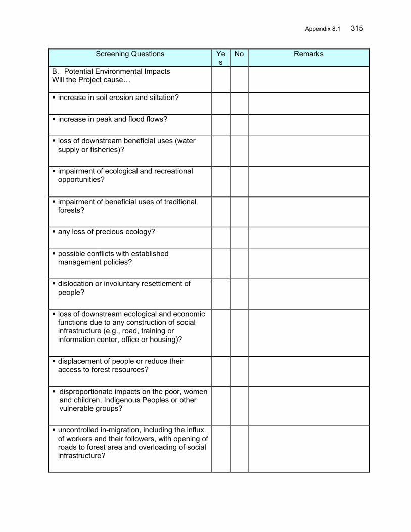
Appendix 8.1 315
Screening Questions Yes
No Remarks
B. Potential Environmental Impacts Will the Project cause…
increase in soil erosion and siltation?
increase in peak and flood flows?
loss of downstream beneficial uses (water supply or fisheries)?
impairment of ecological and recreational opportunities?
impairment of beneficial uses of traditional forests?
any loss of precious ecology?
possible conflicts with established management policies?
dislocation or involuntary resettlement of people?
loss of downstream ecological and economic functions due to any construction of social infrastructure (e.g., road, training or information center, office or housing)?
displacement of people or reduce their access to forest resources?
disproportionate impacts on the poor, women and children, Indigenous Peoples or other vulnerable groups?
uncontrolled in-migration, including the influx of workers and their followers, with opening of roads to forest area and overloading of social infrastructure?
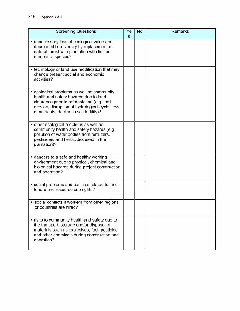
316 Appendix 8.1
Screening Questions Yes
No Remarks
unnecessary loss of ecological value and decreased biodiversity by replacement of natural forest with plantation with limited number of species?
technology or land use modification that may change present social and economic activities?
ecological problems as well as community health and safety hazards due to land clearance prior to reforestation (e.g., soil erosion, disruption of hydrological cycle, loss of nutrients, decline in soil fertility)?
other ecological problems as well as community health and safety hazards (e.g., pollution of water bodies from fertilizers, pesticides, and herbicides used in the plantation)?
dangers to a safe and healthy working environment due to physical, chemical and biological hazards during project construction and operation?
social problems and conflicts related to land tenure and resource use rights?
social conflicts if workers from other regions or countries are hired?
risks to community health and safety due to the transport, storage and/or disposal of materials such as explosives, fuel, pesticide and other chemicals during construction and operation?
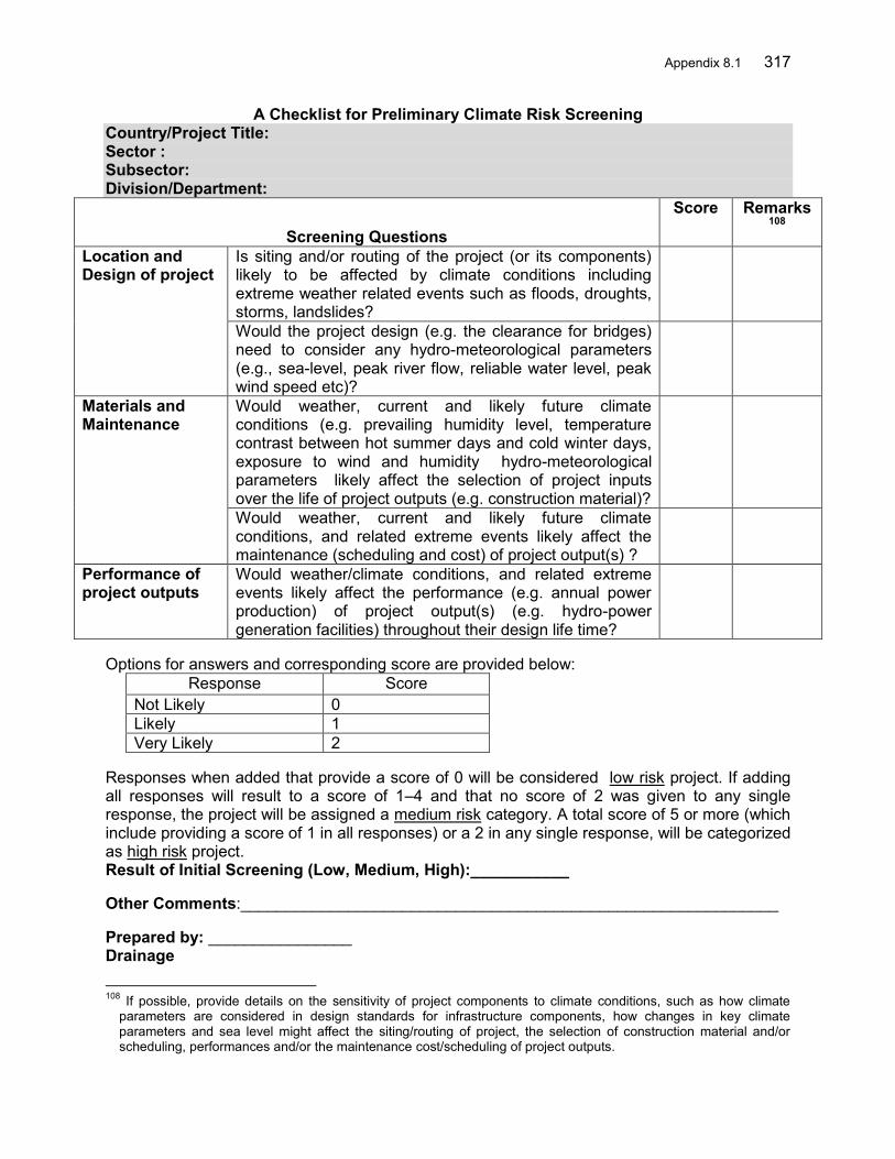
Appendix 8.1 317
A Checklist for Preliminary Climate Risk Screening Country/Project Title: Sector : Subsector: Division/Department:
Screening Questions
Score Remarks108
Location and Design of project
Is siting and/or routing of the project (or its components) likely to be affected by climate conditions including extreme weather related events such as floods, droughts, storms, landslides?
Would the project design (e.g. the clearance for bridges) need to consider any hydro-meteorological parameters (e.g., sea-level, peak river flow, reliable water level, peak wind speed etc)?
Materials and Maintenance
Would weather, current and likely future climate conditions (e.g. prevailing humidity level, temperature contrast between hot summer days and cold winter days, exposure to wind and humidity hydro-meteorological parameters likely affect the selection of project inputs over the life of project outputs (e.g. construction material)?
Would weather, current and likely future climate conditions, and related extreme events likely affect the maintenance (scheduling and cost) of project output(s) ?
Performance of project outputs
Would weather/climate conditions, and related extreme events likely affect the performance (e.g. annual power production) of project output(s) (e.g. hydro-power generation facilities) throughout their design life time?
Options for answers and corresponding score are provided below:
Response Score Not Likely 0 Likely 1 Very Likely 2
Responses when added that provide a score of 0 will be considered low risk project. If adding all responses will result to a score of 1–4 and that no score of 2 was given to any single response, the project will be assigned a medium risk category. A total score of 5 or more (which include providing a score of 1 in all responses) or a 2 in any single response, will be categorized as high risk project. Result of Initial Screening (Low, Medium, High):___________
Other Comments:____________________________________________________________
Prepared by: ________________ Drainage
108 If possible, provide details on the sensitivity of project components to climate conditions, such as how climate
parameters are considered in design standards for infrastructure components, how changes in key climate parameters and sea level might affect the siting/routing of project, the selection of construction material and/or scheduling, performances and/or the maintenance cost/scheduling of project outputs.

318 Appendix 8.1
Instructions: (i) The project team completes this checklist to support the environmental classification of a
project. It is to be attached to the environmental categorization form and submitted to the Environment and Safeguards Division (RSES) for endorsement by the Director, RSES and for approval by the Chief Compliance Officer.
(ii) This checklist focuses on environmental issues and concerns. To ensure that social
dimensions are adequately considered, refer also to ADB's (a) checklists on involuntary resettlement and Indigenous Peoples; (b) poverty reduction handbook; (c) staff guide to consultation and participation; and (d) gender checklists.
(iii) Answer the questions assuming the “without mitigation” case. The purpose is to identify
potential impacts. Use the “remarks” section to discuss any anticipated mitigation measures.
Country/Project Title: Flood Management in Selected River BasinsSector Project Sector Division: Environment, Natural Resources and Agriculture Division
Screening Questions Yes No Remarks A. Project Siting Is the Project area adjacent to or within any of the following environmentally sensitive areas?
Cultural heritage site
Protected Area
Wetland
Mangrove
Estuarine
Buffer zone of protected area
Special area for protecting biodiversity
B. Potential Environmental Impacts Will the Project cause…
increase in soil erosion and siltation?
increase in peak and flood flows?

Appendix 8.1 319
Screening Questions Yes No Remarks loss of downstream beneficial uses (water
supply or fisheries)?
impairment of ecological and recreational opportunities?
impairment of beneficial uses of traditional forests?
any loss of precious ecology?
possible conflicts with established management policies?
dislocation or involuntary resettlement of people?
loss of downstream ecological and economic functions due to any construction of social infrastructure (e.g., road, training or information center, office or housing)?
displacement of people or reduce their access to forest resources?
disproportionate impacts on the poor, women and children, Indigenous Peoples or other vulnerable groups?
uncontrolled in-migration, including the influx of workers and their followers, with opening of roads to forest area and overloading of social infrastructure?
unnecessary loss of ecological value and decreased biodiversity by replacement of natural forest with plantation with limited number of species?
technology or land use modification that may change present social and economic activities?
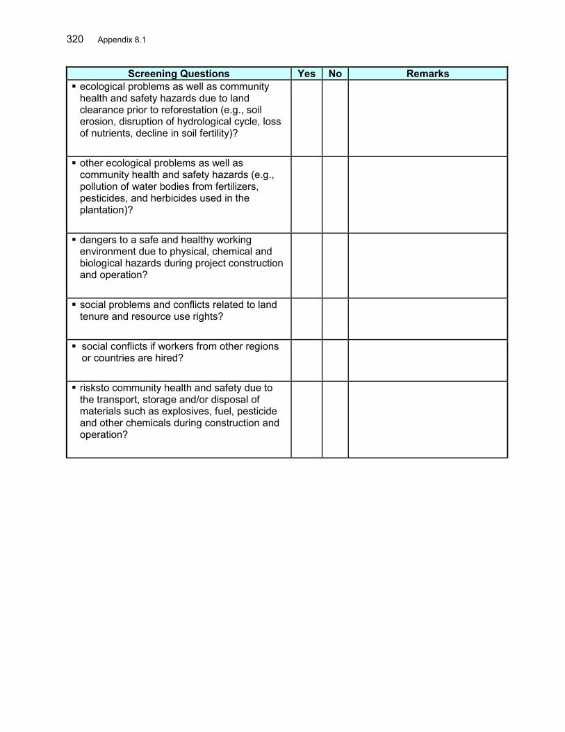
320 Appendix 8.1
Screening Questions Yes No Remarks ecological problems as well as community
health and safety hazards due to land clearance prior to reforestation (e.g., soil erosion, disruption of hydrological cycle, loss of nutrients, decline in soil fertility)?
other ecological problems as well as community health and safety hazards (e.g., pollution of water bodies from fertilizers, pesticides, and herbicides used in the plantation)?
dangers to a safe and healthy working environment due to physical, chemical and biological hazards during project construction and operation?
social problems and conflicts related to land tenure and resource use rights?
social conflicts if workers from other regions or countries are hired?
risksto community health and safety due to the transport, storage and/or disposal of materials such as explosives, fuel, pesticide and other chemicals during construction and operation?
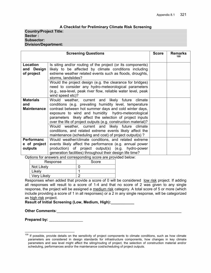
Appendix 8.1 321
A Checklist for Preliminary Climate Risk Screening Country/Project Title: Sector : Subsector: Division/Department:
Screening Questions Score Remarks109
Location and Design of project
Is siting and/or routing of the project (or its components) likely to be affected by climate conditions including extreme weather related events such as floods, droughts, storms, landslides?
Would the project design (e.g. the clearance for bridges) need to consider any hydro-meteorological parameters (e.g., sea-level, peak river flow, reliable water level, peak wind speed etc)?
Materials and Maintenance
Would weather, current and likely future climate conditions (e.g. prevailing humidity level, temperature contrast between hot summer days and cold winter days, exposure to wind and humidity hydro-meteorological parameters likely affect the selection of project inputs over the life of project outputs (e.g. construction material)?
Would weather, current and likely future climate conditions, and related extreme events likely affect the maintenance (scheduling and cost) of project output(s) ?
Performance of project outputs
Would weather/climate conditions, and related extreme events likely affect the performance (e.g. annual power production) of project output(s) (e.g. hydro-power generation facilities) throughout their design life time?
Options for answers and corresponding score are provided below: Response Score
Not Likely 0 Likely 1 Very Likely 2
Responses when added that provide a score of 0 will be considered low risk project. If adding all responses will result to a score of 1-4 and that no score of 2 was given to any single response, the project will be assigned a medium risk category. A total score of 5 or more (which include providing a score of 1 in all responses) or a 2 in any single response, will be categorized as high risk project. Result of Initial Screening (Low, Medium, High):___________
Other Comments:___________________________________________________________ Prepared by: ________________
109 If possible, provide details on the sensitivity of project components to climate conditions, such as how climate
parameters are considered in design standards for infrastructure components, how changes in key climate parameters and sea level might affect the siting/routing of project, the selection of construction material and/or scheduling, performances and/or the maintenance cost/scheduling of project outputs.

322 Appendix 8.2
APPENDIX 2: ADB ENVIRONMENT CATEGORIZATION SHEET Date: _________________
A. Instructions (i) The project team completes and submits the form to the Environment and Safeguards Division (RSES) for endorsement by RSES Director, and for approval by the Chief Compliance Officer (CCO). (ii) The classification of a project is a continuing process. If there is a change in the project components or/and site that may result in category change, the Sector Division submits a new form and requests for recategorization, and endorsement by RSES Director and by the CCO. The old form is attached for reference. (iii) In addition, the project team may propose in the comments section that the project is highly complex and sensitive (HCS), for approval by the CCO. HCS projects are a subset of category A projects that ADB deems to be highly risky or contentious or involve serious and multidimensional and generally interrelated potential social and/or environmental impacts. B. Project Data
Country/Project No./Project Title : Department/ Division :
Processing Stage : Modality :
[ ] Project Loan [ ] Program Loan [ ] Financial Intermediary [ ] General Corporate Finance [ ] Sector Loan [ ] MFF [ ] Emergency Assistance [ ] Grant [ ] Other financing modalities:
C. Environment Category
[ ] New [ ] Recategorization ― Previous Category [ ]
Category A
Category B
Category C
Category FI D. Basis for Categorization/ Recategorization (pls. attach documents): [ ] REA Checklist [ ] Project and/or Site Description
[ ] Other: __________________________
E. Comments Project Team Comments
RSES Comments
F. Approval Proposed by: Endorsed by:
Project Team Leader, {Department/Division} Director, RSES Date: Date Approved by: Endorsed by:
Highly Complex and Sensitive Project Director, {Division} Chief Compliance Officer
Date: Date
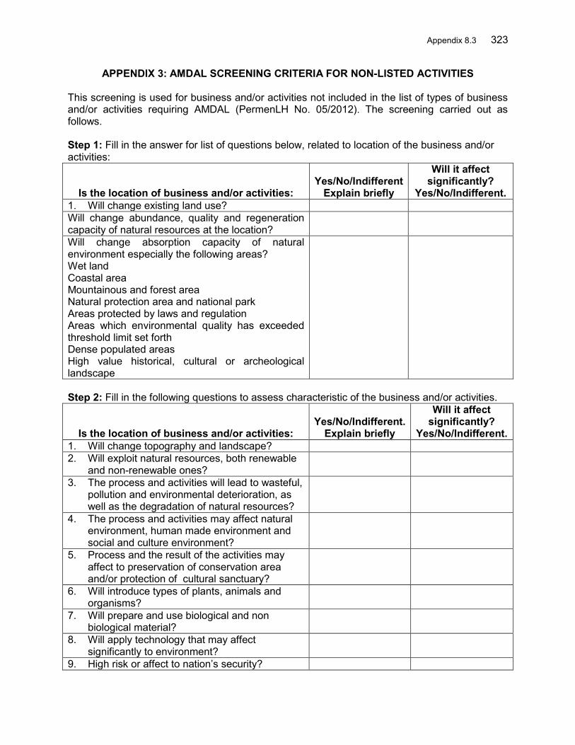
Appendix 8.3 323
APPENDIX 3: AMDAL SCREENING CRITERIA FOR NON-LISTED ACTIVITIES
This screening is used for business and/or activities not included in the list of types of business and/or activities requiring AMDAL (PermenLH No. 05/2012). The screening carried out as follows. Step 1: Fill in the answer for list of questions below, related to location of the business and/or activities:
Is the location of business and/or activities: Yes/No/Indifferent
Explain briefly
Will it affect significantly?
Yes/No/Indifferent. 1. Will change existing land use? Will change abundance, quality and regeneration capacity of natural resources at the location?
Will change absorption capacity of natural environment especially the following areas? Wet land Coastal area Mountainous and forest area Natural protection area and national park Areas protected by laws and regulation Areas which environmental quality has exceeded threshold limit set forth Dense populated areas High value historical, cultural or archeological landscape
Step 2: Fill in the following questions to assess characteristic of the business and/or activities.
Is the location of business and/or activities: Yes/No/Indifferent.
Explain briefly
Will it affect significantly?
Yes/No/Indifferent. 1. Will change topography and landscape? 2. Will exploit natural resources, both renewable
and non-renewable ones?
3. The process and activities will lead to wasteful, pollution and environmental deterioration, as well as the degradation of natural resources?
4. The process and activities may affect natural environment, human made environment and social and culture environment?
5. Process and the result of the activities may affect to preservation of conservation area and/or protection of cultural sanctuary?
6. Will introduce types of plants, animals and organisms?
7. Will prepare and use biological and non biological material?
8. Will apply technology that may affect significantly to environment?
9. High risk or affect to nation’s security?
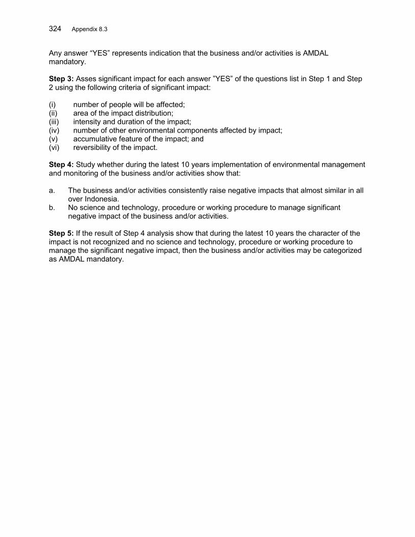
324 Appendix 8.3
Any answer “YES” represents indication that the business and/or activities is AMDAL mandatory. Step 3: Asses significant impact for each answer ”YES” of the questions list in Step 1 and Step 2 using the following criteria of significant impact: (i) number of people will be affected; (ii) area of the impact distribution; (iii) intensity and duration of the impact; (iv) number of other environmental components affected by impact; (v) accumulative feature of the impact; and (vi) reversibility of the impact. Step 4: Study whether during the latest 10 years implementation of environmental management and monitoring of the business and/or activities show that: a. The business and/or activities consistently raise negative impacts that almost similar in all
over Indonesia. b. No science and technology, procedure or working procedure to manage significant
negative impact of the business and/or activities. Step 5: If the result of Step 4 analysis show that during the latest 10 years the character of the impact is not recognized and no science and technology, procedure or working procedure to manage the significant negative impact, then the business and/or activities may be categorized as AMDAL mandatory.
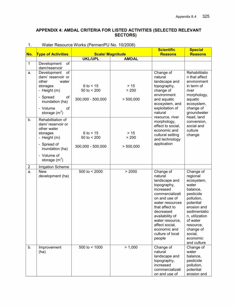
Appendix 8.4 325
APPENDIX 4: AMDAL CRITERIA FOR LISTED ACTIVITIES (SELECTED RELEVANT SECTORS)
1. Water Resource Works (PermenPU No. 10/2008)
No. Type of Activities Scale/ Magnitude Scientific
Reasons Special Reasons
UKL/UPL AMDAL 1 Development of
dam/reservoir
a. Development of dam/ reservoir or other water storages - Height (m)
- Spread of inundation (ha)
- Volume of storage (m3)
6 to < 15 50 to < 200
300,000 - 500,000
> 15 > 200
> 500,000
Change of natural landscape and topography, change of environment and aquatic ecosystem, and exploitation of natural resource, river morphology, effect to social, economic and cultural setting and technology application
Rehabilitation that affect environment in term of river morphology, aquatic ecosystem, change of groundwater head, land conversion, social and culture change
b. Rehabilitation of dam/ reservoir or other water storages - Height (m)
- Spread of inundation (ha)
- Volume of storage (m3)
6 to < 15 50 to < 200
300,000 - 500,000
> 15 > 200
> 500,000
2 Irrigation Scheme a. New
development (ha) 500 to < 2000 > 2000 Change of
natural landscape and topography, increased commercialization and use of water resources that affect to decreased availability of water resource, affect social, economic and culture of local people
Change of regional ecosystem, water balance, pesticide pollution, potential erosion and sedimentation, utilization of water resource, change of social, economic and culture
b. Improvement (ha)
500 to < 1000 > 1,000 Change of natural landscape and topography, increased commercialization and use of
Change of water balance, pesticide pollution, potential erosion and
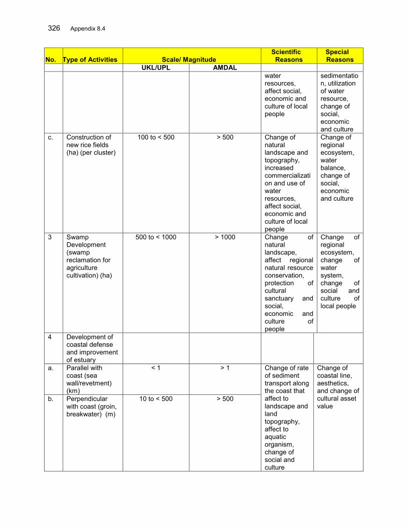
326 Appendix 8.4
No. Type of Activities Scale/ Magnitude Scientific
Reasons Special Reasons
UKL/UPL AMDAL water resources, affect social, economic and culture of local people
sedimentation, utilization of water resource, change of social, economic and culture
c. Construction of new rice fields (ha) (per cluster)
100 to < 500 > 500 Change of natural landscape and topography, increased commercialization and use of water resources, affect social, economic and culture of local people
Change of regional ecosystem, water balance, change of social, economic and culture
3 Swamp Development (swamp reclamation for agriculture cultivation) (ha)
500 to < 1000 > 1000 Change of natural landscape, affect regional natural resource conservation, protection of cultural sanctuary and social, economic and culture of people
Change of regional ecosystem, change of water system, change of social and culture of local people
4 Development of coastal defense and improvement of estuary
a. Parallel with coast (sea wall/revetment) (km)
< 1 > 1 Change of rate of sediment transport along the coast that affect to landscape and land topography, affect to aquatic organism, change of social and culture
Change of coastal line, aesthetics, and change of cultural asset value
b. Perpendicular with coast (groin, breakwater) (m)
10 to < 500 > 500

Appendix 8.4 327
No. Type of Activities Scale/ Magnitude Scientific
Reasons Special Reasons
UKL/UPL AMDAL 5 River Dike
Construction (including diversion) and construction of flood canal
a. In metropolitan/ large city - Length (km)
OR
- Volume of dredging (m3)
1 to < 5 50,000 to < 500000
> 5 > 500,000
Change of natural landscape, topography, change of river ecosystem, change of river morphology, and effect to social, economic and culture of local people
Change of river path, bed, and wall in achieving new balance, increased water pollution, traffic disturbance, and nuisance to aesthetics
b. In medium city - Length (km)
OR
- Volume of dredging (m3)
3 to < 10
100000 to < 500000
> 10
> 500000
c. In rural areas - Length (km)
OR
- Volume of dredging (m3)
5 to < 15
150000 to < 500000
> 15
> 500000
2. Other Related Multi Sectors (PermenLH No. 5/2012) Below provided AMDAL criteria for other sectors (multi-sector) that may be involved in FMSRB.
No. Type of Activities Scale/Magnitude Special Scientific
Reasons 1. Reclamation of Coastal Areas and
Isles Potentially to generate
impacts, among others: Hydro-oceanography, covering tidal, current, wave and sea bed sediment Hydrology, covering rainfall, groundwater, river or stream flow, and run-off Bathymetry, covering depth contour of water bottom Topography, covering contour of terrestrial surface Geomorphology, covering shape and typology of coast Geotechnical, covering physical and mechanical features of soil surface
A Width of the reclamation area (ha) ≥ 25 B Volume of fill material (m3) ≥ 500,000 C Length of the reclamation (m) ≥ 50 (perpendicular
toward sea from coastline)
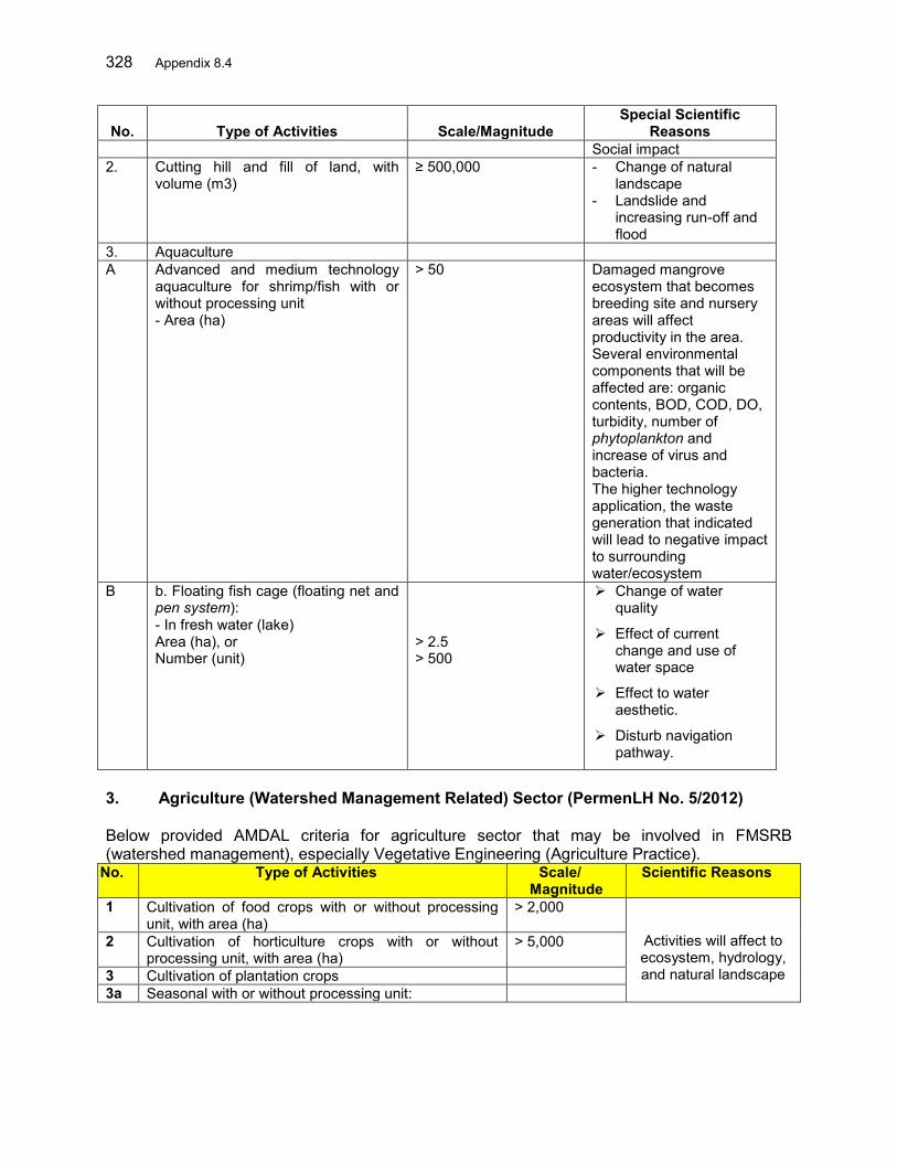
328 Appendix 8.4
No. Type of Activities Scale/Magnitude Special Scientific
Reasons Social impact
2. Cutting hill and fill of land, with volume (m3)
≥ 500,000 - Change of natural landscape
- Landslide and increasing run-off and flood
3. Aquaculture A Advanced and medium technology
aquaculture for shrimp/fish with or without processing unit - Area (ha)
> 50
Damaged mangrove ecosystem that becomes breeding site and nursery areas will affect productivity in the area. Several environmental components that will be affected are: organic contents, BOD, COD, DO, turbidity, number of phytoplankton and increase of virus and bacteria. The higher technology application, the waste generation that indicated will lead to negative impact to surrounding water/ecosystem
B b. Floating fish cage (floating net and pen system): - In fresh water (lake) Area (ha), or Number (unit)
> 2.5 > 500
Change of water quality
Effect of current change and use of water space
Effect to water aesthetic.
Disturb navigation pathway.
3. Agriculture (Watershed Management Related) Sector (PermenLH No. 5/2012) Below provided AMDAL criteria for agriculture sector that may be involved in FMSRB (watershed management), especially Vegetative Engineering (Agriculture Practice).
No. Type of Activities Scale/ Magnitude
Scientific Reasons
1 Cultivation of food crops with or without processing unit, with area (ha)
> 2,000
Activities will affect to ecosystem, hydrology, and natural landscape
2 Cultivation of horticulture crops with or without processing unit, with area (ha)
> 5,000
3 Cultivation of plantation crops 3a Seasonal with or without processing unit:

Appendix 8.4 329
C. 1) Within non-forestry cultivation area, area (ha) > 2,000
D. 2) Within convertible production forest area (HPK), area (ha)
> 2,000
3b Perennial with or without processing unit: E. 1) Within non-forestry cultivation area, area (ha) > 3,000
F. 2) Within convertible production forest area (HPK), area (ha)
> 3,000
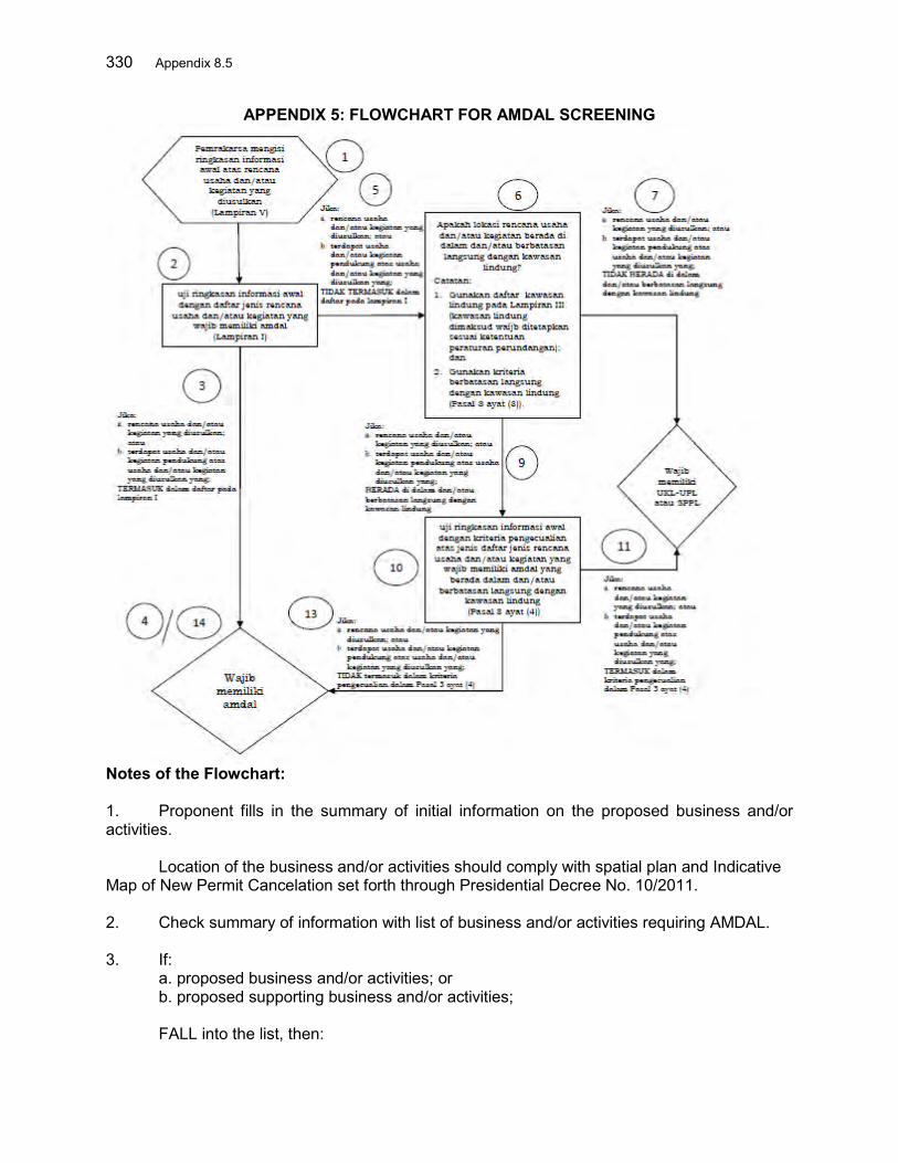
330 Appendix 8.5
APPENDIX 5: FLOWCHART FOR AMDAL SCREENING
Notes of the Flowchart: 1. Proponent fills in the summary of initial information on the proposed business and/or activities. Location of the business and/or activities should comply with spatial plan and Indicative Map of New Permit Cancelation set forth through Presidential Decree No. 10/2011. 2. Check summary of information with list of business and/or activities requiring AMDAL. 3. If:
a. proposed business and/or activities; or b. proposed supporting business and/or activities;
FALL into the list, then:

Appendix 8.5 331
The proposed business and/or activities is concluded AMDAL mandatory. 5. If:
a. proposed business and/or activities; or b. proposed supporting business and/or activities;
NOT FALL into the list, then: 6. Check location of the business and/or activities whether the location in and/or direct boundary with protected area? Note: a. Use list of protected areas in Appendix 6; and b. Use criteria of direct boundary with protected areas (Article 3 Clause (3)). 7. If:
a. proposed business and/or activities; or b. proposed supporting business and/or activities;
NOT LOCATED in and/or direct boundary with protected areas, then: 8. The proposed business and/or activities is concluded UKL/UPL or SPPL mandatory. 9. If:
a. proposed business and/or activities; or b. proposed supporting business and/or activities;
LOCATED in and/or direct boundary protected areas, then: 10. Check summary of information with exemption criteria on list of business and/or activities requiring AMDAL in and/or direct boundary with protected areas (Article 3 Clause (4)). 11. If: a. proposed business and/or activities; or b. proposed supporting business and/or activities; FALL into the exemption criteria in Article 3 Clause (4), then: 12. The proposed business and/or activities is concluded as UKL/UPL or SPPL mandatory. 13. If: a. proposed business and/or activities; or b. proposed supporting business and/or activities; NOT FALL into the exemption criteria in Article 3 Clause (4), then: 14. The proposed business and/or activities is concluded AMDAL mandatory.
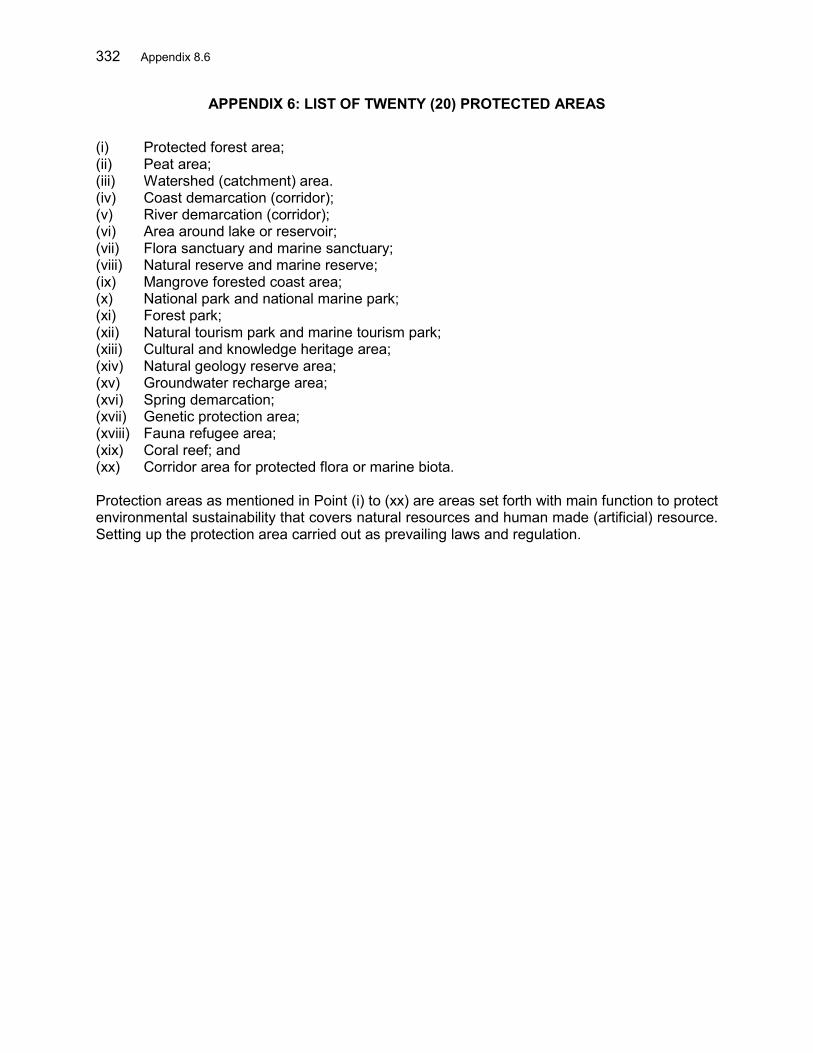
332 Appendix 8.6
APPENDIX 6: LIST OF TWENTY (20) PROTECTED AREAS (i) Protected forest area; (ii) Peat area; (iii) Watershed (catchment) area. (iv) Coast demarcation (corridor); (v) River demarcation (corridor); (vi) Area around lake or reservoir; (vii) Flora sanctuary and marine sanctuary; (viii) Natural reserve and marine reserve; (ix) Mangrove forested coast area; (x) National park and national marine park; (xi) Forest park; (xii) Natural tourism park and marine tourism park; (xiii) Cultural and knowledge heritage area; (xiv) Natural geology reserve area; (xv) Groundwater recharge area; (xvi) Spring demarcation; (xvii) Genetic protection area; (xviii) Fauna refugee area; (xix) Coral reef; and (xx) Corridor area for protected flora or marine biota.
Protection areas as mentioned in Point (i) to (xx) are areas set forth with main function to protect environmental sustainability that covers natural resources and human made (artificial) resource. Setting up the protection area carried out as prevailing laws and regulation.
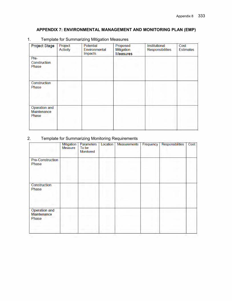
Appendix 8 333
APPENDIX 7: ENVIRONMENTAL MANAGEMENT AND MONITORING PLAN (EMP)
1. Template for Summarizing Mitigation Measures
2. Template for Summarizing Monitoring Requirements

334 Appendix 9
APPENDIX 9: INTERNAL MONITORING INDICATORS AND REPORT TEMPLATE FOR INVOLUNTARY RESETTLEMENT
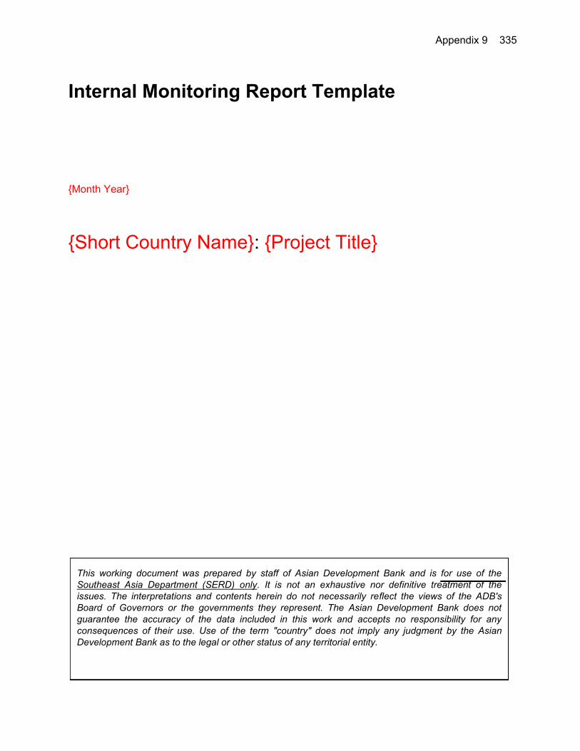
Appendix 9 335
Internal Monitoring Report Template {Month Year}
{Short Country Name}: {Project Title} This working document was prepared by staff of Asian Development Bank and is for use of the Southeast Asia Department (SERD) only. It is not an exhaustive nor definitive treatment of the issues. The interpretations and contents herein do not necessarily reflect the views of the ADB's Board of Governors or the governments they represent. The Asian Development Bank does not guarantee the accuracy of the data included in this work and accepts no responsibility for any consequences of their use. Use of the term "country" does not imply any judgment by the Asian Development Bank as to the legal or other status of any territorial entity.
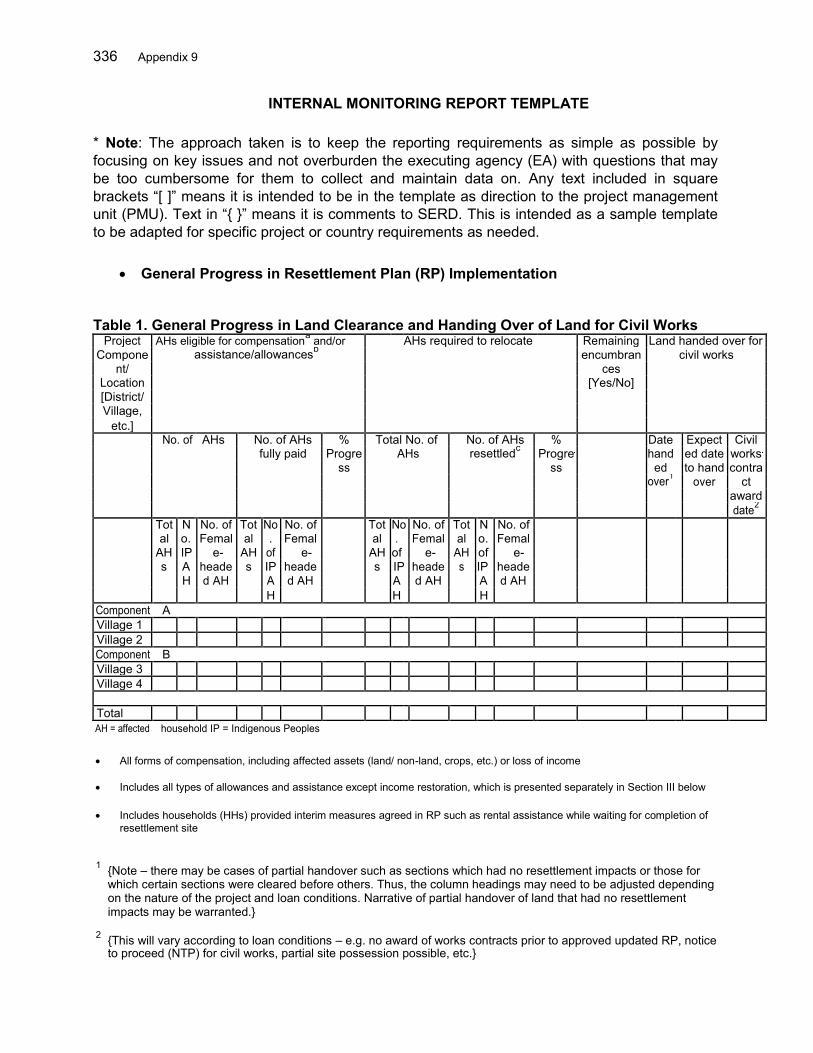
336 Appendix 9
INTERNAL MONITORING REPORT TEMPLATE * Note: The approach taken is to keep the reporting requirements as simple as possible by focusing on key issues and not overburden the executing agency (EA) with questions that may be too cumbersome for them to collect and maintain data on. Any text included in square brackets “[ ]” means it is intended to be in the template as direction to the project management unit (PMU). Text in “{ }” means it is comments to SERD. This is intended as a sample template to be adapted for specific project or country requirements as needed.
General Progress in Resettlement Plan (RP) Implementation
Table 1. General Progress in Land Clearance and Handing Over of Land for Civil Works
Project AHs eligible for compensationa and/or AHs required to relocate Remaining Land handed over for Compone assistance/allowancesb encumbran civil works
nt/ ces Location [Yes/No] [District/ Village,
etc.] No. of AHs No. of AHs % Total No. of No. of AHs % Date Expect Civil fully paid Progre AHs resettledc Progre hand ed date works ss ss ed to hand contra over1 over ct award date2 Tot N No. of Tot No No. of Tot No No. of Tot N No. of al o. Femal al . Femal al . Femal al o. Femal AH IP e- AH of e- AH of e- AH of e- s A heade s IP heade s IP heade s IP heade H d AH A d AH A d AH A d AH H H H Component A Village 1 Village 2 Component B Village 3 Village 4 Total AH = affected household IP = Indigenous Peoples All forms of compensation, including affected assets (land/ non-land, crops, etc.) or loss of income
Includes all types of allowances and assistance except income restoration, which is presented separately in Section III below Includes households (HHs) provided interim measures agreed in RP such as rental assistance while waiting for completion of
resettlement site
1 {Note – there may be cases of partial handover such as sections which had no resettlement impacts or those for
which certain sections were cleared before others. Thus, the column headings may need to be adjusted depending on the nature of the project and loan conditions. Narrative of partial handover of land that had no resettlement impacts may be warranted.}
2 {This will vary according to loan conditions – e.g. no award of works contracts prior to approved updated RP, notice
to proceed (NTP) for civil works, partial site possession possible, etc.}

Appendix 9 337
Table 2. Disbursement and Use of Funds Locati LAR Budget Source Allocatio Funds Specific Timeliness of Fund Cumulative
on Requiremen of n Status Disbursed Resettlement Disbursement Funds t Funding3 this activities funded Disbursement Reporting this Reporting Period Period4 Delay in targets Reasons for fund for delay disbursement? (Y/N) LAR = land acquisition and resettlement {Funds disbursement means from EA, Government, etc. to the agency responsible for payment to affected persons (APs) or otherwise implementing the RP.} Issues Affecting Timely Land Handover [Describe issues affecting timely land clearance or handover of land for civil works such as grievances (including non-agreement to compensation), unresolved encumbrances, funding constraints, other.] II. Resettlement
{The reiteration of actual impacts on houses is important because often there can be a lot of changes from what was estimated in the RP compared to actual impacts – either increase or decrease. Also the numbers of actual physically displaced persons can affect the safeguards categorization so there is a need to be on top of this.} Table 3: Updated Resettlement Impacts Location AHs with AHs with Fully Affected Houses Partially Change in Number of AHs with Affected Affected AHs Fully Affected Houses Houses Compared to Updated RP Total House Built on Land Of which Eligible for Vulnerable5 Compensation {It is important to confirm actual numbers of those relocating and how because information in the updated RP with respect to resettlement impacts can be subject to change. This may affect the safeguards categorization of the project.} 3 E.g. Central Government, Province, Loan Funds, etc. 4 E.g. Number of resettlement sites developed, number and type of community facilities constructed, number of AHs fully compensated, livelihood restoration activities implemented 5 E.g. Number of female-headed with dependents; number of poor; number of IPs, etc.

338 Appendix 9
Table 4: Confirmed Resettlement Preferences for Households with Fully Affected Houses Locati # of AHs with Fully # of AHs # of AHs Opting for # of AHs Opting for # of AHs that Can
on Affected Houses Required to Replacement Land Self Relocation (HHs) Rebuild on Remaining Relocate Land Table 5: Resettlement Solutions Implemented for Vulnerable Households Indigenous Landless Poor Female Other [add People (HHs) (HHs) (HHs) Headed as needed] Households Rebuilt on remaining land Rebuilt on another plot of land already owned Rebuilt (e.g. moved back) out of COI but on public land Rebuilt on other person’s land (e.g. relative) Purchased replacement land elsewhere themselves Provided with plot at resettlement site Provided with replacement residential plot (non- resettlement site) Solution Pending COI = corridor of impact Table 6: Status of Resettlement Sites Resettlement Actual Scheduled Current No. of No. of No. of # AHs # AHs # AHs
Site*/ completion completion status plots AHs to be plots issued rebuilt living in Location date date (briefly allocated allocated handed title houses relocation
describe for project plots over to site as of status of AHs reporting completion of period infrastructure , etc.) * Include also separate residential plots to be provided to AHs even if these are not included in resettlement sites. Other Remarks on Resettlement [Describe issues identified along with planned and completed remedial actions. Also provide additional information regarding delays in completing resettlement sites, if any, including actions to be taken.] III. Income Restoration Program
{Income Restoration Program approaches may vary significantly from RP to RP, and the types of questions asked and data requirements may vary considerably depending on the RP. As such, below is intended as a very general guide.}
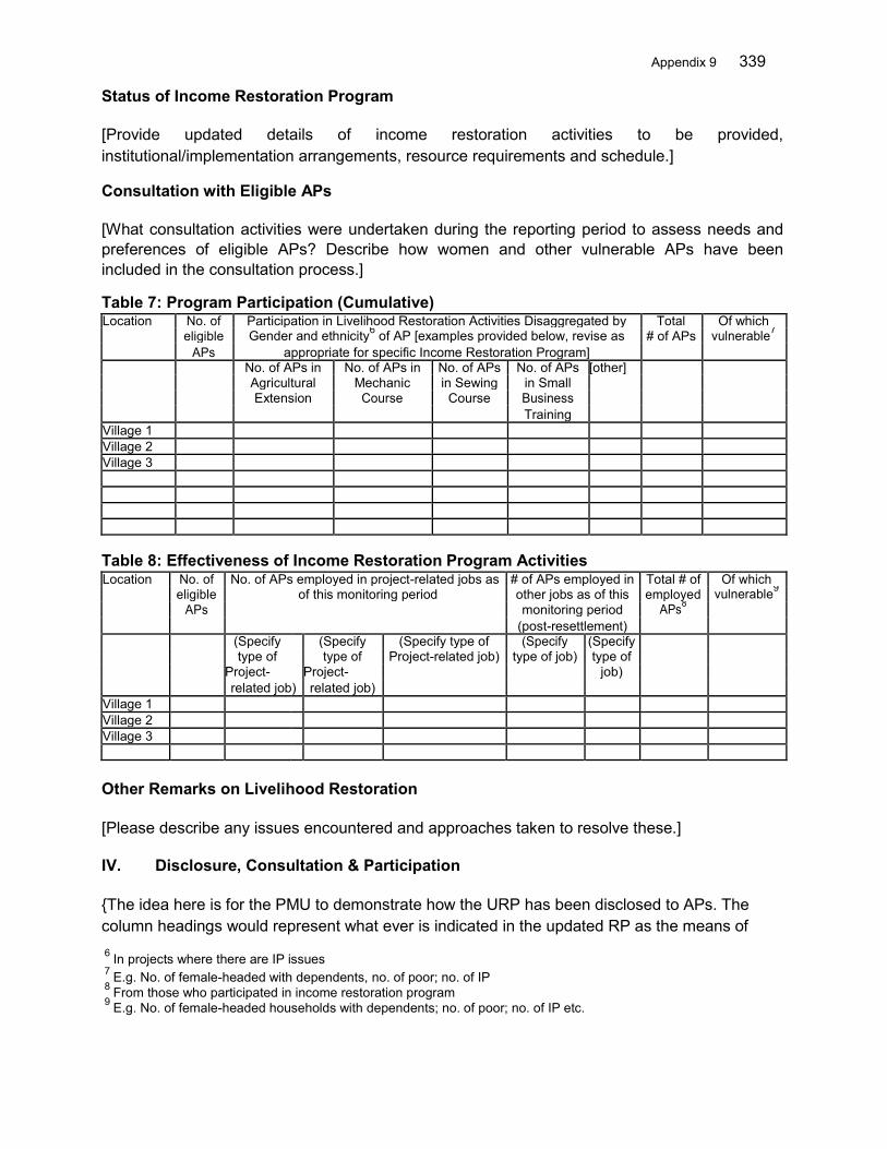
Appendix 9 339
Status of Income Restoration Program [Provide updated details of income restoration activities to be provided, institutional/implementation arrangements, resource requirements and schedule.] Consultation with Eligible APs [What consultation activities were undertaken during the reporting period to assess needs and preferences of eligible APs? Describe how women and other vulnerable APs have been included in the consultation process.] Table 7: Program Participation (Cumulative) Location No. of Participation in Livelihood Restoration Activities Disaggregated by Total Of which eligible Gender and ethnicity6 of AP [examples provided below, revise as # of APs vulnerable7 APs appropriate for specific Income Restoration Program] No. of APs in No. of APs in No. of APs No. of APs [other] Agricultural Mechanic in Sewing in Small Extension Course Course Business Training Village 1 Village 2 Village 3 Table 8: Effectiveness of Income Restoration Program Activities Location No. of No. of APs employed in project-related jobs as # of APs employed in Total # of Of which eligible of this monitoring period other jobs as of this employed vulnerable9 APs monitoring period APs8 (post-resettlement) (Specify (Specify (Specify type of (Specify (Specify type of type of Project-related job) type of job) type of Project- Project- job) related job) related job) Village 1 Village 2 Village 3 Other Remarks on Livelihood Restoration [Please describe any issues encountered and approaches taken to resolve these.] IV. Disclosure, Consultation & Participation {The idea here is for the PMU to demonstrate how the URP has been disclosed to APs. The column headings would represent what ever is indicated in the updated RP as the means of 6 In projects where there are IP issues 7 E.g. No. of female-headed with dependents, no. of poor; no. of IP 8 From those who participated in income restoration program 9 E.g. No. of female-headed households with dependents; no. of poor; no. of IP etc.

340 Appendix 9
disclosure.} Table 9: Means of Disclosure of URP by Location Location [Village] Translated approved PIB disseminated PIB posted in Public meeting Target date to URP disseminated to to AHs (date/ public place? to present complete village office? method*) (yes/no) approved URP disclosure (yes/no) (date) (date) Village 1 Village 2 * Dissemination method such as handed out in public meeting, distributed house-to-house, etc. Consultations Table 10: Consultation/Information Dissemination Meetings Conducted During Reporting Period Date Venue Participants Consultation content Meeting Minutes with [Disaggregated by PMU gender]
V. Operation of Grievance Redress Mechanism (GRM)
Table 11: Summary of Grievance Cases by Level of GRM {Subject to EA’s confirmation that they would like to use such a table} Location No. of pending No. of new grievance Total no. of No. of cases No. of cases grievance from cases for reporting cases resolved progressed to next previous period received level reporting period Level 1 Level 2 Level 3 Narrative Summary of Grievances [Provide a narrative summary of grievance cases by type of issue and location, for example…] [Where resolution of grievance resulted in any cases of land/assets compulsorily acquired, provide details along with information regarding relevant court or administrative decision and confirmation whether funds due from compensation and assistance have been placed in escrow account or provided to AP.] VI. Other Issues Resolution of Issues [Provide information on status and/or resolution of issues raised in previous internal monitoring report; ADB monitoring; external monitoring report, etc.]
Appendix 9 341
New Issues [Provide information on other newly identified issues impacting the implementation of RP. These may include resource constraints, changes in scope of impacts, etc.] Institutional Matters and Capacity Training [Report on the following as applicable]
(i) Deployment of safeguards-related staff within PMUs. Key activities conducted by PMU safeguards staff during reporting period.
(ii) Capacity development training provided: type and number of trainings, number
of staff/officers trained (disaggregated by gender).
(iii) Activities of community based organizations (CBOs)/mass organizations (as applicable)
(iv) Adequacy of resources for PMU staff and consultants
(v) Issues in undertaking roles/responsibilities of different agencies
Temporary Impacts during Civil Works [Describe temporary impacts during implementation, including quantities of impacts, #AHs, location, types, etc. and status of restoring temporarily affected assets as appropriate and the responsible agency.]

342 Appendix 9
Internal Monitoring Indicators for Involuntary Resettlement {Month Year}
{Short Country Name}: {Project Title} This working document was prepared by staff of Asian Development Bank and is for use of the Southeast Asia Department (SERD) only. It is not an exhaustive nor definitive treatment of the issues. The interpretations and contents herein do not necessarily reflect the views of the ADB's Board of Governors or the governments they represent. The Asian Development Bank does not guarantee the accuracy of the data included in this work and accepts no responsibility for any consequences of their use. Use of the term "country" does not imply any judgment by the Asian Development Bank as to the legal or other status of any territorial entity.

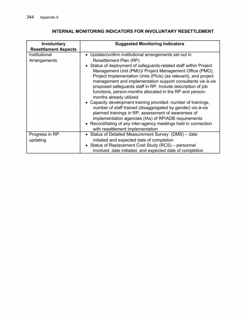
344 Appendix 9
INTERNAL MONITORING INDICATORS FOR INVOLUNTARY RESETTLEMENT
Involuntary Suggested Monitoring Indicators Resettlement Aspects Institutional Update/confirm institutional arrangements set out in Arrangements Resettlement Plan (RP)
Status of deployment of safeguards-related staff within Project Management Unit (PMU)/ Project Management Office (PMO), Project Implementation Units (PIUs) (as relevant), and project management and implementation support consultants vis-à-vis proposed safeguards staff in RP. Include description of job functions, person-months allocated in the RP and person- months already utilized Capacity development training provided: number of trainings, number of staff trained (disaggregated by gender) vis-à-vis planned trainings in RP, assessment of awareness of implementation agencies (IAs) of RP/ADB requirements Record/listing of any inter-agency meetings held in connection with resettlement implementation Progress in RP Status of Detailed Measurement Survey (DMS) – date updating initiated and expected date of completion
Status of Replacement Cost Study (RCS) – personnel involved, date initiated, and expected date of completion
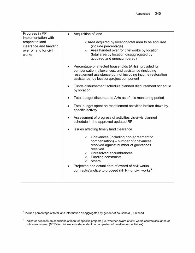
Appendix 9 345
Progress in RP implementation with respect to land clearance and handing over of land for civil works
Acquisition of land
o Area acquired by location/total area to be acquired (include percentage)
o Area handed over for civil works by location (total area by location disaggregated by acquired and unencumbered)
Percentage of affected households (AHs)1 provided full compensation, allowances, and assistance (including resettlement assistance but not including income restoration assistance) by location/project component
Funds disbursement schedule/planned disbursement schedule
by location Total budget disbursed to AHs as of this monitoring period Total budget spent on resettlement activities broken down by
specific activity Assessment of progress of activities vis-à-vis planned
schedule in the approved updated RP Issues affecting timely land clearance
o Grievances (including non-agreement to compensation) – number of grievances resolved against number of grievances received
o Unresolved encumbrances o Funding constraints o others
Projected and actual date of award of civil works contract(s)/notice to proceed (NTP) for civil works2
1 Include percentage of total, and information disaggregated by gender of household (HH) head
2 Indicator depends on conditions of loan for specific projects (i.e. whether award of civil works contract/issuance of notice-to-proceed (NTP) for civil works is dependent on completion of resettlement activities)

346 Appendix 9
Monitoring of Actual Acquisition of land
Resettlement Impacts o Area of productive land acquired
(indicate source of o Area of residential land acquired
information) o Area of [other types] land acquired
{not for inclusion in Acquisition of structures
o Number, type, and size of private houses/structures
regular internal
acquired
monitoring reports}
o Number, type, and size of community buildings
acquired
o Number, type, and size of government assets
affected
o Number, type, and size of secondary structures
affected/acquired
Acquisition of trees and crops
o Number and type of private trees acquired
o Number and type of government/community trees
acquired
o Number and type of crops acquired
o Crops destroyed by area, type, and number of
owners
Restrictions in land use
Economic losses – number of affected businesses and
salaried personnel (as applicable)
Disclosure, Consultation Disclosure of updated RP
& Participation o Dissemination and posting of translated updated RP
by location and date;
o Project Information Booklets (PIBs) disseminated by
location and date;
Consultation activities
o Public consultation meetings/location/date, with
number of participants disaggregated by sex and
ethnic group (not including project staff)
o Documentation of issues raised by participants and
how these have been/will be addressed by the
project team
o Public consultation minutes maintained by PMU
o Quantification and disaggregation (by sex and
ethnicity of affected person (AP) of participation
Stakeholder participation (iteration, roles of community-based
organizations (CBOs) and mass organizations)

Appendix 9 347
Resettlement Number of AHs with houses fully affected by location (include Assistance information disaggregated by sex of HH head)
Number of AHs that can rebuild on remaining land vs. number and percentage of AHs requiring relocation Number of opting for self-relocation vs. number of AHs opting for replacement land or other relocation assistance from the Project Number of land titles, land certificates, and land survey certificates issued Status of resettlement sites o Resettlement sites completed – community infrastructure complete (water, electricity, drainage, roads, etc.) by location and date o Resettlement sites pending – community infrastructure complete (water, electricity, drainage, roads, etc.) by location and date o Number of plots acquired by location (where dedicated resettlement site is not provided) Hand over of resettlement plots o Plots occupied and plots available o Number of plots handed over against total AHs opting for replacement land by location/date o Number of AHs rebuilding in resettlement site or replacement land Issues identified with proposed and completed remedial measures Number of AHs still living in the site and total AHs who relocated to resettlement sites (include percentages) 3 Include percentage of total, and information disaggregated sex of HH head and ethnic group
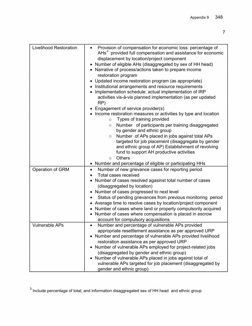
Appendix 9 348
7
Livelihood Restoration Provision of compensation for economic loss: percentage of
AHs3 provided full compensation and assistance for economic
displacement by location/project component
Number of eligible AHs (disaggregated by sex of HH head)
Narrative of process/actions taken to prepare income
restoration program
Updated income restoration program (as appropriate)
Institutional arrangements and resource requirements
Implementation schedule: actual implementation of IRP
activities vis-à-vis planned implementation (as per updated
RP)
Engagement of service provider(s)
Income restoration measures or activities by type and location
o Types of training provided
o Number of participants per training disaggregated
o
by gender and ethnic group
Number of APs placed in jobs against total APs
targeted for job placement (disaggregate by gender
and ethnic group of AP) Establishment of revolving
o
fund to support AH productive activities
Others
Number and percentage of eligible or participating HHs
Operation of GRM Number of new grievance cases for reporting period
Total cases received
Number of cases resolved agasinst total number of cases
(disaggregated by location)
Number of cases progressed to next level
Status of pending grievances from previous monitoring period
Average time to resolve cases by location/project component
Number of cases where land or property compulsorily acquired
Number of cases where compensation is placed in escrow
account for compulsory acquisitions
Vulnerable APs Number and percentage of vulnerable APs provided
appropriate resettlement assistance as per approved URP
Number and percentage of vulnerable APs provided livelihood
restoration assistance as per approved URP
Number of vulnerable APs employed for project-related jobs
(disaggregated by gender and ethnic group)
Number of vulnerable APs placed in jobs against total of
vulnerable APs targeted for job placement (disaggregated by
gender and ethnic group)
3 Include percentage of total, and information disaggregated sex of HH head and ethnic group

Appendix10 349
APPENDIX 10 QUARTERLY PROGRESS REPORT TEMPLATE
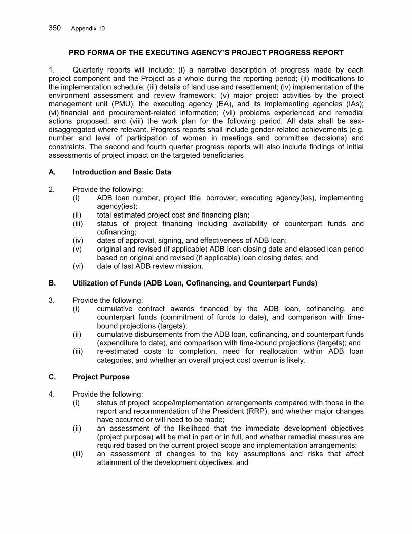
350 Appendix 10
PRO FORMA OF THE EXECUTING AGENCY’S PROJECT PROGRESS REPORT 1. Quarterly reports will include: (i) a narrative description of progress made by each project component and the Project as a whole during the reporting period; (ii) modifications to the implementation schedule; (iii) details of land use and resettlement; (iv) implementation of the environment assessment and review framework; (v) major project activities by the project management unit (PMU), the executing agency (EA), and its implementing agencies (IAs); (vi) financial and procurement-related information; (vii) problems experienced and remedial actions proposed; and (viii) the work plan for the following period. All data shall be sex-disaggregated where relevant. Progress reports shall include gender-related achievements (e.g. number and level of participation of women in meetings and committee decisions) and constraints. The second and fourth quarter progress reports will also include findings of initial assessments of project impact on the targeted beneficiaries A. Introduction and Basic Data 2. Provide the following:
(i) ADB loan number, project title, borrower, executing agency(ies), implementing agency(ies);
(ii) total estimated project cost and financing plan; (iii) status of project financing including availability of counterpart funds and
cofinancing; (iv) dates of approval, signing, and effectiveness of ADB loan; (v) original and revised (if applicable) ADB loan closing date and elapsed loan period
based on original and revised (if applicable) loan closing dates; and (vi) date of last ADB review mission.
B. Utilization of Funds (ADB Loan, Cofinancing, and Counterpart Funds) 3. Provide the following:
(i) cumulative contract awards financed by the ADB loan, cofinancing, and counterpart funds (commitment of funds to date), and comparison with time-bound projections (targets);
(ii) cumulative disbursements from the ADB loan, cofinancing, and counterpart funds (expenditure to date), and comparison with time-bound projections (targets); and
(iii) re-estimated costs to completion, need for reallocation within ADB loan categories, and whether an overall project cost overrun is likely.
C. Project Purpose 4. Provide the following:
(i) status of project scope/implementation arrangements compared with those in the report and recommendation of the President (RRP), and whether major changes have occurred or will need to be made;
(ii) an assessment of the likelihood that the immediate development objectives (project purpose) will be met in part or in full, and whether remedial measures are required based on the current project scope and implementation arrangements;
(iii) an assessment of changes to the key assumptions and risks that affect attainment of the development objectives; and
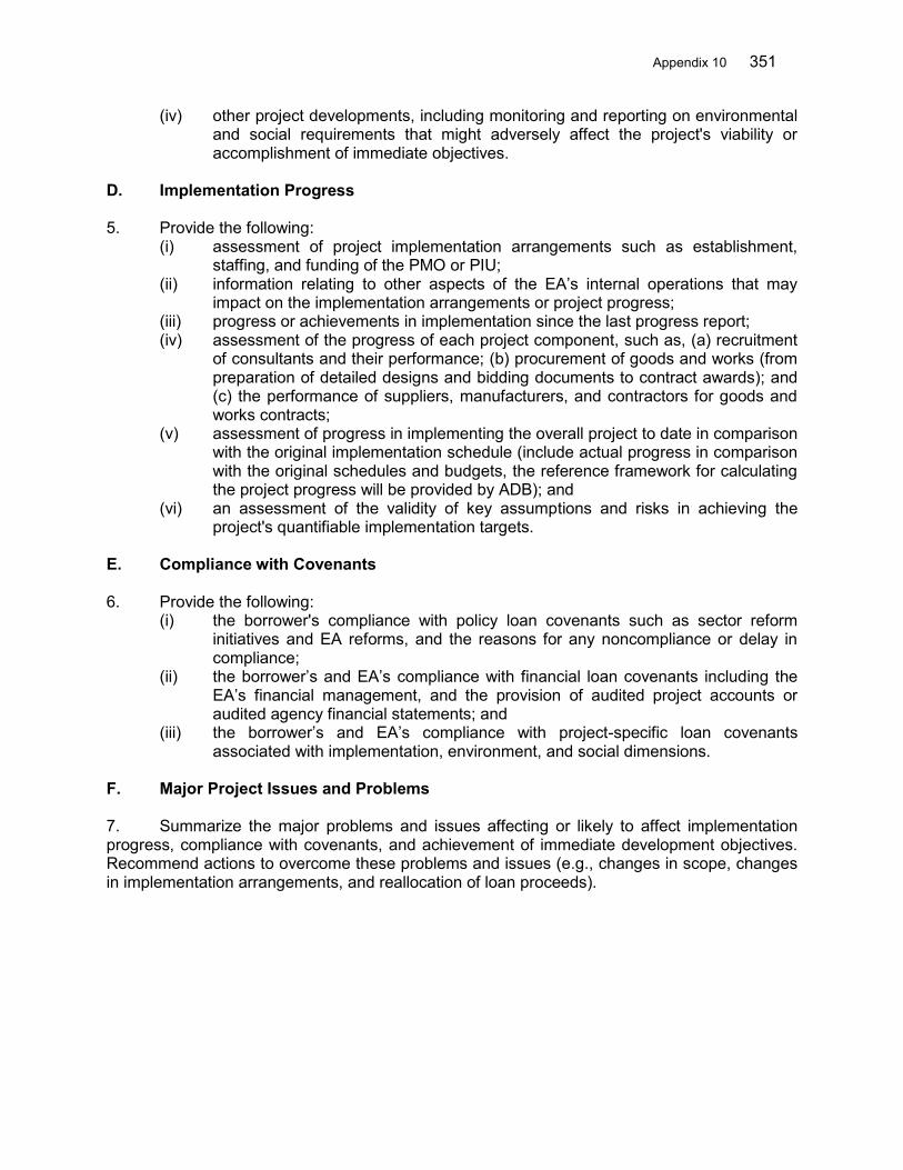
Appendix 10 351
(iv) other project developments, including monitoring and reporting on environmental and social requirements that might adversely affect the project's viability or accomplishment of immediate objectives.
D. Implementation Progress 5. Provide the following:
(i) assessment of project implementation arrangements such as establishment, staffing, and funding of the PMO or PIU;
(ii) information relating to other aspects of the EA’s internal operations that may impact on the implementation arrangements or project progress;
(iii) progress or achievements in implementation since the last progress report; (iv) assessment of the progress of each project component, such as, (a) recruitment
of consultants and their performance; (b) procurement of goods and works (from preparation of detailed designs and bidding documents to contract awards); and (c) the performance of suppliers, manufacturers, and contractors for goods and works contracts;
(v) assessment of progress in implementing the overall project to date in comparison with the original implementation schedule (include actual progress in comparison with the original schedules and budgets, the reference framework for calculating the project progress will be provided by ADB); and
(vi) an assessment of the validity of key assumptions and risks in achieving the project's quantifiable implementation targets.
E. Compliance with Covenants 6. Provide the following:
(i) the borrower's compliance with policy loan covenants such as sector reform initiatives and EA reforms, and the reasons for any noncompliance or delay in compliance;
(ii) the borrower’s and EA’s compliance with financial loan covenants including the EA’s financial management, and the provision of audited project accounts or audited agency financial statements; and
(iii) the borrower’s and EA’s compliance with project-specific loan covenants associated with implementation, environment, and social dimensions.
F. Major Project Issues and Problems 7. Summarize the major problems and issues affecting or likely to affect implementation progress, compliance with covenants, and achievement of immediate development objectives. Recommend actions to overcome these problems and issues (e.g., changes in scope, changes in implementation arrangements, and reallocation of loan proceeds).