Embed Size (px)
Citation preview

PROJECT: ACCRA URBAN TRANSPORT PROJECT PHASE 1
COUNTRY: GHANA
SUMMARY OF THE ENVIRONMENTAL AND SOCIAL IMPACT ASSESSMENT
(ESIA)
Appraisal Team
Team Leader: M. T. Wadda-Senghore, Principal Transport Engineer,
GHFO/OITC1
Team Members: S. E Akyea, Senior Transport Engineer, GHFO/OITC1
M. Kinane, Principal Environmentalist, ONEC3
J. D. Tonato, Chief Urban Development Officer, OITC0
F.K. Koroma, Financial Mgt Specialist, GHFO/ORPF2
D. Osei-Boakye, Procurement Officer, GHFO/ORPF1,
Mrs. Efua Amissah-Arthur, Social Development
Specialist, GHFO
Mr Jeff Turner, Gender Specialist Consultant, SEOG
Mr. Peter Ofori-Asumadu, Transport Economist,
Consultant, OITC.
Sector Director: A. Oumarou
Regional Director (ORWA): A. Bernoussi, (Acting)
Sector Manager (OITC1): J. K. Kabanguka
Country Manager (Ghana): M. Akin-Olugbade

Project Title: Accra Urban Transport Project phase 1 SAP Code: P-GH-DB0-017
Country: Ghana Department: OITC
Division: OITC
1. INTRODUCTION
This ESIA summary is prepared in accordance with the African Development Bank’s (AfDB)
Integrated Safeguard System (ISS) and Environmental Assessment Procedures (ESAP). It also
complies with applicable national requirements. It fulfils the ISS requirements for category 1
projects. It provides information on project activities; anticipated impacts of the project
activities; measures to be put in place to mitigate identified adverse impacts; and institutional
arrangements to facilitate implementation and monitoring of the Environmental and Social
Management Plan (ESMP).
2. POLICY, LEGAL AND ADMINISTRATIVE FRAMEWORK
The ESIA has been prepared in line with the Ghanaian Environmental Law, Environmental and
social policies and procedures of the AfDB. Below are the key requirements applicable to the
project.
2.1 National requirements
2.1.1 Main applicable policies
The main policies applicable to this project are: (i) Ghana’s Environmental Policy which
aims at managing the environment to sustain society at large; (ii) Environmental Assessment
Regulations LI 1652, 1999 - To provide guidance for Environmental Impact Assessments in
Ghana; (iii) Environmental Protection Agency Act (Act 490) of 1994 establishes the
Environmental Protection Agency with functions to inter alia issue environmental permits and
pollution abatement notices for controlling the volume, types, constituents and effects of
pollutants and of substances which are hazardous or potentially dangerous to the quality of the
environment or a segment of the environment; (iv) Water Resources Commission Act 522
(1996) - provides for the preparation of comprehensive plans for the regulation, utilization,
conservation, development and improvement of water resources and develops policy
framework for water resources management in the country; (vi) the Lands Statutory Way
Leaves Act 186, 1963- This Land Statutory Way Leaves Instrument is the most relevant Act
with regard to Land acquisition for road construction.
2.2 Main International requirements
2.2.1 African Development Bank
AfDB’s ISS with its five operational safeguards as indicated in table 1 below, as well as other
applicable policies.
Table 1: Operational Safeguards applicable to the project Operational Safeguards (OSs) Triggered Reasons
OS1. Environmental and Social
Assessment
Yes This OS is triggered through the mandatory E&S
Screening Process through which the project was assigned
a Category 1
OS2. Involuntary resettlement Yes This OS is triggered because the project involves
resettlement
OS3. Biodiversity and Ecosystem
Services
Yes This OS is triggered because of potential impacts or risks
on the Guako Forest which requires specific assessment
OS4. Pollution prevention and control,
hazardous materials and resource
efficiency
Yes This OS is triggered because the project involves the use
of various hazardous materials
OS5. Labour conditions, health and
safety
Yes This OS is triggered because the project involves the
establishment of temporary workforce during the works.

Source: Adapted from the ESAP (2015)
2.2.2 Other international requirements
Other international requirements include those of the following conventions which have been
ratified by Ghana: (i) African Convention on the Conservation of Nature and Natural
Resources 1969 Its objectives are "to encourage individual and joint action for the
conservation, utilization and development of soil, water, flora and fauna for the present and
future welfare of mankind, from an economic, nutritional, scientific, educational, cultural and
aesthetic point of view."; (ii) ILO applicable standards on Occupational safety and health
in particular the Occupational Health Services Recommendation, 1985 (No. 171), the hours of
work and rest in the transport sector, Using the ILO Code of Practice on HIV/AIDS and the
world of work - Guidelines for the transport sector.
2.3 Emission Limit Values
The following national and international emissions values are applicable to the Project.
2.3.1 Ambient Air Quality
The Ghanaian Ambient Air Quality Standards are provided in Table 2. It should be noted that
the Ghanaian Standards are applicable at defined locations, classified as ‘industrial’ or
‘residential’.
Table 2: Ambient Air Quality Standards
Pollutant
Standards & Guidelines
EPA WHO
Averaging Time Location Time Weighted
Average (TWA) Guideline
Sulphur Dioxide
(SO2)
10 minute - - 500ug/m3
1hr Industrial 900
- Residential 700
24hrs Industrial 150
20ug/m3 Residential 100
Annual Industrial 80
- Residential 50
Nitrogen dioxide
1hr Industrial 400
200ug/m3 Residential -
24hrs Industrial 150
- Residential 60
Annual - - 40ug/m3
Total Suspended
Particulate (TSP)
24hrs Industrial 230
- Residential 150
Annual Industrial 75
Residential 60
Particulate Matter
(PM10)
24hrs - 70 50ug/m3
Annual - - 20ug/m3
Particulate Matter
(PM2.5)
24hrs - 70 25ug/m3
Annual - - 10ug/m3
Carbon Monoxide
15 min - 100
30 min - 60
1 hr - 30
8 hr - 10
Source: ESIA report, September 2015 version

2.3.2 Noise
The Ghana EPA provides national guidance on maximum permissible noise levels for
prescribed areas(Table 3). The IFC requires that noise impacts should achieve either the levels
given below in Table 3 or a maximum increase of 3 dB at the nearest receptor location offsite.
Table 3: EPA Noise Limits
Zone Description of Area of Noise Reception
Permissible Noise Level dB(A)
Day
(0600 – 2200)
Night
(2200 – 0600)
A Residential areas with negligible or infrequent transportation 55 48
B1 Educational (School), and health (Hospital, clinic) facilities. 55 50
B2 Areas with some commercial or light industry. 60 55
C1 Areas with some light industry, public assembly, churches and mosques, etc. 65 60
C2 Predominantly commercial areas. 75 65
D Light industrial areas. 70 60
E Predominantly heavy industrial areas. 70 70
Source: ESIA report, July 2015
2.3.3 Water Quality
The National standard (GS 175-1) which is the same as WHO guidelines for drinking water are
presented in Table 4.
Table 4: Ghanaian Water Quality Discharge Standards
Source: ESIA report, July 2015
2.4 Institutional Framework The entities below are the key institutions that will be involved in preparing and approving the
ESIA for this project as well as in implementing, monitoring and auditing the ESMP as
required:
Characteristics Parameter Unit
*Standard
Physical
Turbidity NTU 5
Colour (apparent) Hz 15
Tot. Dis. Solids(TDS) mg/l 1000
Acidity (PH) pH
units
6.5-8.5
Chemical
Potassium mg/l 30
Sodium mg/l 200
Calcium mg/l 200
Magnesium mg/l 150
Chloride mg/l 250
Ammonia (NH4-N) mg/l 0.00-1.5
Total Iron mg/l 0.3
Sulphate (SO4) mg/l 250
Manganese mg/l 0.4
Nitrate (NO3-N) mg/l 10
Nitrite (NO2 -N) mg/l 1.0
Biological
*Faecal Coliform cfu/100ml 0
*Total Coliform cfu/100ml 0
* E.coli cfu/100ml 0
Total Hetero. Bacteria cfu/100ml 500
Ministry of Roads and Highways (MRH): The MRH has the specific task of coordinating
and guiding the activities of the three main executing agencies in the road sector under the
Ministry; The Ghana Highway Authority, and Department of Urban and Feeder Roads The
other related organisations namely under the ministry include the and Road Fund
Secretariat (RFS). The MRH has a Deputy Director in charge of Road Safety and
Environment (RSE);
Department of Urban Roads (DUR): DUR, is responsible for the provision of roads other
than trunk roads in the metropolitan areas. The DUR oversees the overall impact
implications on the other road networks, the Right-Of-Way and alignment issues including
utility co-ordination works and the interface between the north-west roads project.
Ghana Highway Authority (GHA): The GHA is a semi-autonomous body with a
responsibility for the provision and management of trunk roads. Since the GHA Act 540 of
December 1997, its role has been limited to the planning administration, control,
development and maintenance of trunk roads and related facilities subject to the policies of
the MRH.
Environmental Protection Agency (EPA): The EPA has the mandate to decide on project
screening, guide the conduct of any Environmental Assessment (EA) studies and to grant
environmental approval for road sector projects to commence. Its mandate also covers
monitoring of implementation phase of road projects to ensure compliance with approval
conditions, mitigation measures, and other environmental commitments and quality
standards;
Resource Management Institutions: The Water Resources Commission (WRC) and the
Forest Services Division (FSD) of the Forestry Commission (FC) are the water and forest
resources management institutions respectively. These institutions become relevant
whenever such resources under their management are likely to be impacted on or implicated
in a proposed road project;
Utility Service Providing Institutions: The Electricity Company of Ghana (ECG), Ghana
Grid Company(GRIDCo) Ghana Water Company Limited (GWCL) and Telecom
Companies are public /private institutions that provide and/ manage utility services
including electricity, water, telecommunication and petroleum transmission and storage
infrastructure ;
District Assemblies: The Municipal Assemblies involved will play a significant role in the
implementation of resettlement schemes and also serve as media for public education and
community consultations. The Assembly members also act as witnesses during payment of
Supplemental Assistance to PAPs
Traditional Authorities: The Pokuase Traditional Authority which consists of the chief
and his council of elders is the custodian of the Gua Forest. It is their responsibility to
enforce measures aimed at protecting the Gua from degradation. They also advise on the
nature of the measures to ensure that they are in line with traditional believes and culture.
3 PROJECT DESCRIPTION AND JUSTIFICATION
3.1 Location
The Proposed Interchange will be located at Pokuase-ACP in the Ga West Municipality. The
interchange will be designed on the intersection of the Accra-Nsawam-Kumasi Highway and
the Pokuase ACP- Kwabenya road. The first tier links Accra to Nsawam on the Accra-
Nsawam-Kumasi Highway (figure 1 below).

Figure 1: project’s layout including local roads
Source: ESIA report, July 2015
3.2 Project description
This project focuses on improving urban mobility in the Greater Accra Region and entails
construction of an interchange at Pokuase connecting with the Bank financed Awoshie-
Pokuase road; with planned community works, specially providing institutional and technical
responses that will help inclusive urban development, and sustainable improvement of living
conditions of the people impacted by the project. The purpose of this intervention is also to
promote better management at the levels of national and local governments, both in terms of
strategic planning, internal organization in the areas of programming, implementation and
maintenance of local public investments. The Project components are presented in the table 5
below. The total project cost is 69 million USD, which will be funded by the GoG and the
Bank.
Table 5: Project Components
Project Description
A) Upgrade urban mobility and planning tools for Greater Accra Region: (i) Construction of an
interchange at Pokuase; (ii) construction of 10 km local roads; (iii) Environmental and Social mitigation
measures
B) Improvement of urban public services delivery for the Local Community: (i) Provision of IT
equipment to all the 14 schools (3 new and 13 already constructed under the Awoshie-Pokuase Project) as
well as IT training programme for girls in primary to junior high school; (viii) Support to the local
women’s groups to enhance & boost their activities
C)
Institutional Support: this component focuses on supporting and enhancing the performance of the
Executing Agency (the Department of Urban Roads - DUR), Project Coordination Unit (PCU) and the
Local Assembly (Ga West Municipal Assembly)
D) Project Management: to ensure good management and monitoring of implementation: (i)Supervision
services for the urban transport main civil works described above; (ii) Development of an Urban
Development Master Plan for the Greater Accra region; (iii) Monitoring and Evaluation of project’s
socioeconomic impact; (iv) Road Safety: Audit, Monitoring and Sensitisation; (v) Documentary Video of
Bank funded Transport projects in Ghana; (vi) Technical Audit; (vii) Financial Audit.
Source: PCN, September 2015
The proposed project seeks to provide integrated solutions to urban development in Accra, one of the
main challenges of Ghana’s Transportation Sector. This objective is influenced by the Sector Medium-
Term Development Plan (SMTDP) 2014-2017 for the two Transport sector Ministries and the Ghana
Shared Growth and Development Agenda (GSGDA). The vision for these national policy documents
for the transport sector of Ghana is to provide “An integrated, efficient, cost-effective and sustainable

transportation system responsive to the needs of society, supporting growth and poverty reduction and
capable of establishing and maintaining Ghana as a transportation hub of West Africa”.
3.3 Project inputs Within the GWMA area and the adjoining municipalities, there are both new and existing borrow and
quarry pits that can be sourced for the construction materials for this project.
3.3.1 Borrow Pits
The location and approximate quantities of borrow pits are presented in Table 6.
Table 6: Location of Borrow Pits SAMPLE APPROXIMATE QUANTITY
Location (m3)
Pokuase Pit (5°35'51.8"N 0°15'59.3"W) 250,000.00
Agyen Kotoku Pit (5°44'19.88"N 0°22'22.5"W) 60,000.00
Ablekuma/Agape Pit (5°35'51.8"N 0°19'40.7"W) 450,000.00
Papase Kotoku (5°45'35.54"N 0°23'12.5"W) 89,250 m3
Katapor 300,000 m3
Source: ESIA report, July 2015
3.3.2 Quarry Materials
Resources from three existing quarries in the Nsawam area of Ghana have been proposed for
consideration in the acquisition of crushed rock aggregates for the various construction activities such
as asphaltic concrete works, surface dressing, base course, concrete works and stone pitched works
likely. Their haulage distances are presented in table 7 below.
Table 7: Haulage distance of Quarry Pits
Source: ESIA report, July 2015
3.3.3 Sand
The proposal here is that suitable natural sand would have to be sourced from specifically the Bator and
Akuse areas, since it is extremely difficult to come by such materials in good quality and quantity
within the immediate project environs.
Table 8: Location and Quantity of Sand LOCATION APPROXIMATE VOLUME (m3)
Akuse 307,800
Bator 9,425
Source: ESIA report, July 2015
3.3.4 Construction Water
There are several water abstraction points or water tanker services in Pokuase and Kwabenya area
where water for the project will be sourced from. It is expected that upon project commencement, the
Contractor will prepare project activities schedule to share with the Client including necessary
authorizations for water abstraction.
Quarry Distance from ACP Junction (Km)
ABKA Quarry Limited (5°48'37"N 0°23'14.8"W) 20.2
Maso Quarry Limited (5°48'49.1"N 0°18'27.7"W) 24.0
Nendor Quarry Limited (5°48'54.8"N 0°24'30.1"W)
21.8

3.3.5 Construction Camp Establishment and labor
Appropriate land for construction camp sites will be sought for by the Contractor(s) to house the
following: (i) Main Camp Sites (Consultants’ offices, Contractors’ offices, Fuel farms, Truck parking
yards); (ii) Materials Holding and Batching plants; (iii) Pre-cast yards.
3.4 Project activities
The key project activities include site preparation, Earthworks, Materials Sourcing and
Extraction, Road Surface Materials, Project Implementation Schedule, etc.
The Community Development activities include:
Construction of about 15.54 km1 of local roads within the project area, etc;
The provision of IT equipment to 16 schools (3 new and 13 already constructed under the
Awoshie-Pokuase Project). It will also include the provision of IT training programme for
girls in primary to junior high school.
Support to the Kpobiman Women’s Sanitary Service Company through the provision of
water tanks and boreholes to ensure greater water supply to enhance and boost their
activities.
4 DESCRIPTION OF THE ENVIRONMENT OF THE PROJECT
4.1 Overview of Methodological approach
Project Area of Influence: The project will be located in the Ga West Municipality. The
specific project location is at Pokuase ACP Junction, on the intersection of the Awoshie-
Pokuase road; the Accra-Nsawam-Kumasi Highway and the Pokuase -Kwabenya road. The
study is limited to the three main communities that surround the proposed project area;
Pokuase, Kwabenya and Ayawaso with Pokuase being the direct area of interest and the other
two extended areas of interest.
Environmental Monitoring Methodology: Particulate matter and noise levels were monitored
at the proposed project location for twenty-four (24) hours. The proposed project site was
being use as a taxi rank and a parking place for water tankers. There were also food vendors
various temporary structures for different activities.
Air Quality: Particulate matter was sampled using MiniVol samplers set to a flow rate of 5
L/min. Samplers were placed at a minimum height of 5 meters above ground level to prevent
the collection of ground level dust temporarily made airborne by gusting winds. Sulphur
dioxide, Nitrogen dioxide and Carbon monoxide were sampled using the detector tube method.
The detector tubes (dragger tubes) contain chemical agents that change color in the presence of
the pollutant gas of interest. The dragger tubes were opened at both ends and hanged for a
period of 24 hours to allow the diffusion of ambient air through the chemical resins in the tube
(passive method).
Noise: A decibel (dB) is the unit for the measurement of noise. The zero on a decibel scale is at
the threshold of hearing, the lowest sound pressure that can be heard on the scale according to
smith: 20 dB is whisper, 40 dB the noise in a quiet office, 60 dB is normal conversation, 80 dB
is the level at which sound becomes physically painful.
1 The ESIA covers all the local roads proposed by DUR and the GWMA (15 km). However, the final length to be
financed will be a maximum of 10 km.
4.2 Physical environment
4.2.1 Climate The climatic condition of the project area is characterized to a large extent by temporal and
spatial variation in rainfall. This is principally due to the movement of the inter-tropical
convergence zone (ITCZ). Annual rainfall in the project catchment ranges from 300mm to
1600mm with a mean annual rainfall of 1000mm. The mean monthly temperature ranges from
23°C to 33°C. The lowest monthly temperatures recorded for the project area occurs during
July and August due to cloud cover and December as a result of cool northeast trade winds.
4.2.2 Topography The general topography of the project area is a type that can best be described as undulating
with heights ranging from 70 m up to 210m above mean sea level. There are however, some
few small, sharp undulating as well as flat areas. The west of Accra is generally underlain by
rocks of the Togo - Akwapim Range which is now internationally accepted in terminology as
the Togo Series. From a source in the sea around Nyanyano in the Central Region, the Series
trends in a northeast direction towards the western part of Accra and continues in the same
direction to the Volta River between Kpong and Anum and further to the Ghana – Togo border
near Kpalime and from there in a northeastern direction where it passes into the Republic of
Togo. The basic soil type within the catchment area is largely silty- clay with some sections
dominated with gravel type soil. Permeability of this type of soil is moderately low resulting in
fairly high surface run-off rates.
4.2.3 Air quality
Table 11 shows ambient Particulate matter (PM) and Total Suspended Particles (TSP) in
comparison to the EPA levels. The PM10 and TSP levels measured at the ACP junction were
both lower than EPA standards.
Table 1: The PM and TSP levels at ACP Junction were measured
LOCATION PM10 (µg/m3) TSP (µg/m3)
ACP Junction 62 116
Permissible EPA Guidelines
level (µg/m3)
70 230
Table 7 shows the measured CO, SO2 and NO2 in comparison to the EPA levels measured parameters at
the project area were below than EPA standards.
Table 7 Nitrogen Dioxide, Sulphur Dioxide and Carbon Monoxide levels measured on 24th
October, 2015
LOCATION CO (mg/m3) NO2 (µg/m3) SO2 (µg/m3)
ACP Taxi rank 9.5 42 57
Rail way 1.5 ND 5
Permissible EPA
Guidelines level
10 150 150
4.2.4 Noise levels Noise measurements/recordings were taken with a High Precision 3M Sound Level Meter, Model Type
1. The sound level meter has an inbuilt calibrator, and was calibrated before measurement/recordings
were taken. The noise meter was calibrated at 114 dB (A) prior to the measurement. Ambient noise
levels recorded were above the EPA standards (Day) which is consistent with the high commercial
activities and traffic situation observed at the area.

Table 8: Ambient Noise levels (dBA) recorded at ACP Junction February 21, 2015
LOCATION LEQ L10 L50 L90 LMAX EPA STANDARDS (Commercial
or light industrial areas)
ACP
JUNCTION
68.3 68.5 67.9 67.7 84.2 60
4.2.2 Water quality A tributary of the Nsakyi River locally called Sunkwa Stream traverses the project site. The stream
takes its source from the Guako sacred grove. It flows south westwards across the Accra-Kumasi
highway through the project site to join the Nsakyi River near the railway crossing at Akyiato. The
Nsakyi River then flows into the Densu River and ultimately empties into the Gulf Guinea. Water
tankers draw water from this river to be sold for construction and some domestic purposes. As the only
water body within the immediate project zone the physical, chemical and biological parameter of the
Sunkwa Stream was analyzed. Table 10 shows the results for the water samples taken from the side
closest the Grove (Side A) and the other side of the road (Side B). Based on the results, it is concluded
that the Sunkwa stream is unsuitable as a drinking water source.
Table 7: Water quality of Sunkwa Stream
4.2 Biological environment
4.2.1 Guako Sacred Grove
The Guako Sacred Grove, which currently covers an area of about 14ha, is located at Pokuase
in the Ga West Municipal Assembly of Ghana. The grove derives its name from the Guako god
introduced into the forest several decades ago. The current grove is a remnant of a once
floristically rich and diverse natural forest. It is made up of a partly degraded forest which
serves as the source of the Sunkwa stream. The land on which the forest is found belongs to the
Characteristics Parameter
Unit of
Measurement Side A Side B *Standard
Physical
Turbidity NTU 5.00 8.94 5
Colour(apparent) Hz 2.50 2.50 -15
Tot. Sus. Sol (SS) mg/l <1.00 <1.00 -
Tot. Dis. Solids(TDS) mg/l 407 365 1000
Conductivity µS/cm 740 664 -
Acidity (PH) pH units 7.29 7.54 6.5-8.5
Chemical
Potassium mg/l 5.20 4.90 30
Sodium mg/l 48.3 33.6 200
Calcium mg/l 41.7 41.6 200
Magnesium mg/l 22.2 13.3 150
Chloride mg/l 97.3 97.3 250
Ammonia(NH4-N) mg/l <0.001 <0.001 0.00-1.5
Total Iron mg/l 3.54 0.147 0.3
Sulphate (SO4) mg/l 11.3 16.3 250
Manganese mg/l 0.154 0.352 0.4
Phosphate (PO4-P) mg/l 0.091 0.139 -
Nitrate (NO3-N) mg/l 0.046 0.039 10
Nitrite (NO2 -N) mg/l 0.066 0.061 1.0
Biological
*Faecal Coliform cfu/100ml 186 465 0
*Total Coliform cfu/100ml 930 1488 0
* E.coli cfu/100ml 93 372 0
Total Hetero. Bacteria cfu/100ml 312 1872 500
Source: Laboratory Analyses of collected samples at Water Research Institute, Accra on 04/03/2015 *WHO Limits Standards are actually Ghana Standard (GS175-1)

people of Pokuase and all cultural and religious rituals for the Guako forest is performed by the
chief priest of Pokuase. The Pokuase Traditional Authority is the traditional custodian of the
grove however the forest is under the jurisdiction of the Ga West Municipal Assembly
(GWMA) who passed a resolution that seeks to protect the forest from further degradation
(attached in annex).
4.2.2 Flora
The area has emergent broken canopy with very thick undergrowth of climbers, `twine and
ropes. The notable vegetation in the grove consists mainly of Onyina (Ceiba pentandra),
Mahogany (Khaya senegalensis), Odum (Melicia eselsa) and Wawa (Triplociton scleroxylum),
Lucina (Leucaena leucocephala), Cassias (Cassia sp), and Teak (Tectona grandis). Natural
regeneration occurs in the forest but at a low rate. The areas close to and along the Sunkwa
stream are predominantly marshy with species such as oil palm (Elaeis guineensis) and ferns.
Poles of Celtis spp also occur within the grove.
4.2.3 Fauna
The grove serves as feeding, breeding and roosting grounds for birds of different species which
make up the majority of the wildlife currently occurring in the area. The forest which once
served as home for several species of animal now supports only a small fraction of the previous
animals that existed in the past(Table 15). Both the species diversity and abundance of wildlife
in the area is therefore very low. Although the forest in the grove presented a suitable habitat
for the hinged tortoise (Kinixys sp) and the marsh terrapin (Polemedusa subrufa), none of these
species were seen during the field surveys. There was no presence of UICN-red listed species
and the Guako sacred groove is not considered a critical habitat.
Table 2: Wildlife Species encountered in the sacred groove during field surveys
Common Name Scientific Name Mode of Identification
S H C
Mammals
Giant Gambian Rat Cricetomys gambianus +
Ground Squirrel Euxerus erythropus +
Avifauna
Cattle egret Babulcus ibis +
Black kite Milvus migrans +
Blue-billed malimbe Malimbus nitens +
Little Green Woodpecker Campethera maculosa +
Pied Crow Corvus albus +
Senegal Coucal Cebtropus senegalensis + +
Northern Black Flycatcher Malaenornis edolioides +
Village weaver Ploceus cucullatus +
Velvet-mantled drongo Dicrurus modestus +
Reptiles
Agama lizard Agama agama +
Invertebrates
Praying Mantis Mantis religiosa +
Dragonfly Unidentified +
(S-Sighted/ Seen; H- Hole made by animal for refuge; C- Calls heard from bird)

Significance/values of the forest
Cultural: The Sacred Grove houses the Guako deity which is known to be the protector of the
people of Pokuase. He is a blacksmith who provides the people with farming and hunting tools
when they request for such. He is celebrated every year, one week after Easter. During this
time the chief priests and people perform rituals to worship the god and ask for favours.
Socio-Economic: The socio-economic importance obtained from the sacred grove come in
many and diverse forms. The reservoir from which the tankers siphon water for sale in Pokuase
and its environs is fed by the Sunkwa stream which takes its source from and meanders
through the sacred grove.
Threats to the Grove: The Guako sacred grove currently faces threat of elimination primarily
emanating from anthropogenic activities. The rapid growth of population and its associated
demand for settlement poses the greatest threat to the existence of the forest.
Figure 1: Map Showing Degraded Portion of Forest
The forest is currently surrounded by several infrastructures which gradually cause the
degradation and shrinkage of the forest through gradual encroachment. Majority of the local
people in Pokuase now are not very concerned with the management of the forest and this
could be attributed to factors such as: (i) The infiltration of foreigners (non Pokuase indigenes)
who have no regards for the Guako shrine; (ii) The rise of western religion (e.g. Christianity,
Islam) which threatens the traditional beliefs and practices, and (iii) The lack of education on
the history and cultural importance of the Forest.
Consequently it brings about the usurping of the powers of the traditional authorities and
selling of land to private developers. However, there are some Pokuase locals who still worship
the Guako god and so have a religious interest in the conservation of the sacred grove. Noise
was also very audible within the forest mainly from vehicular movement on the Accra -
Pokuase road. Noise in the area was a source of disturbance to most of the animals in the forest
and could have contributed to the low numbers and diversity of wildlife observed in the area.

4.3 Socioeconomic environment
Population
The population of the Ga West Municipality is estimated around 262,742 with 49 % being
male and 51% female. Table 3: Population of Ga West Municipality
Sex Ga West
Number %
Male 128,727 49.0
Female 134,015 51.0
Total 262,742 100
(Source: GSS, 2010 PHC)
The population of the three main communities that surrounds the proposed project area is
captured in the table above. The Pokuase community had the highest populace with 14,223
people followed by Kwabenya with 5,827 people. The community with the lowest population,
Ayawaso had an estimated population of 5,527 people.
Table 4: Population size of the studied communities Communities Population Size
Pokuase 14,223
Ayawaso 5,527
Kwabenya 5,827
(Source: GSS, 2010 PHC)
Settlement: There are a number of settlements located along the project road. The
communities within the project sphere of influence are predominantly urban and peri-urban.
These are located within the north western/western corridor of Accra. Residential densities in
these communities range between medium to high. Their populations are those to experience
the various impacts as a result of the project; e.g. loss of farms and properties, dust pollution,
accidents, etc.
Land Use: The land use pattern identified in the project sphere is commercial and residential.
The commercial and services area is characterised by shops, market, micro financial
institutions and fuel stations.
Economic Activities: The Ga West municipality has three major economic sectors consisting
of agriculture, industry and commerce. In the Agriculture sector, farming is the major
economic activity for about 55% of the economically active population. About 70% of the rural
population depends on agriculture as their main source of livelihood with about 95% of them
being small holders. The main agricultural activities include cassava production (supported by
the government’s Roots and Tubers Improvement Programme), fishing and pineapple
production. The main challenges to agriculture production are inadequate market opportunities
for farmers to sell their produce, continuous loss of existing farmlands to sand winners, estate
development and private housing projects. The industrial sector covers varied activities such
as the production of mineral water, aluminium products and also mining and quarrying of large
deposits of sandstone, clay and laterite materials are carried out for the construction industry.
In addition, telecommunication, banking facilities and other infrastructure facilities exist to
serve as catalyst for the rapid development of the Municipality. The construction sector (estate
development) is also fast growing. With commerce, the municipality is most characterized by
petty trading which involves sale of food stuffs, provisions, clothing etc.

Gender: The project design has been done in line with the Ghana National Gender and
Children Policy as well as AfDB Gender Policy. The Ghana National Household Transport
Survey of 2012 highlights that whereas 7.9 percent of men and 3.4 per cent of women drive to
work in private cars, 36.3% of men and 59.4% of women in urban Ghana walk to work. In
order to address gender equality within the transport sector in Ghana there is a need to focus on
pedestrian journeys as well as motorised transport.
Details about socioeconomic characteristics of project affected people can be found in the
summary of the resettlement action plan attached in annex.
Railway line: A Railway line is located on the face of the hill on the left hand side of the
Accra-Kumasi Road, which also serves as the approach for the Awoshie-Pokuase Road. It is
also close to the Accra-Kumasi Road with the farthest section being only about 150m from the
road.
Public Utilities: There are some power transmission, water and telecommunication lines that
are found within the project area. There may be the need to relocate these high tension lines via
realignment to enable the interchange to be located at the proposed location.
5 PROJECT ALTERNATIVES AND RESULTS OF THE COMPARISON
No Project Development Option
This alternative implies that the proposed interchange will not be created and that the traffic
situation will be left to become worse over time. After the construction of the new Awoshie-
Pokuase a tremendous influx of vehicles is expected. If the project is not implemented,
however, it is anticipated that traffic volumes will continue to grow at a rate of 7 percent for
the first fifteen years (2018-2032) and then stabilize at 5 percent for the next ten years (2033-
2042). This will affect the smooth movement of vehicles to and from the affected area. Travel
on these roads will continue to be slow and commutation times will increase drastically with
the no option alternative. The topography is such that the Accra-Kumasi Road is in a valley,
bordered on both sides by steep hills. The steepest is the ACP Estate approach (approximately
9%). Vehicular accidents occurring as a result of the steepness of the ACP Kwabenya road will
persist and possibly increase. Police reports state that a total of 163 accidents have occured on
the Accra Pokuase road from August, 2014 to July, 2015 of which 37 have been fatal.
Pedestrian accidents will occur due to the lack of road safety measures. The health of the
people will be affected because vehicular emissions and noise levels are expected to increase
due to anticipated traffic congestion.
Engineering Intervention Option
In a bid to solve the problems presented in section 6.2, DUR has engaged a Consultant to provide
a consolidated and harmonized design under the Accra Urban Transport Project (AUTP) Phase 1.
The Consultant, proposed Seven (7) number Interchange schemes (Table 17) to be considered
by the Client and all stakeholders at the feasibility stage of the project. The Client, Department
of Urban roads in consultation with key stakeholders and based on technical, economic,
environmental and social factors, opted for the 3-Tier Signalised interchange.

Table 5: Description of Intersection/Interchange Schemes
No. Proposed Scheme Features
1 At-Grade Signalized Segregated left and right turning lanes, semi-actuated
signal control, with concurrent pedestrian phase
2 3-Tier Interchange with Rotary intersection Rotary intersection at Tier 2 to facilitate left-turn
movements from all approaches
3 3-Tier Interchange with Signalized
intersection
Signalized intersection at Tier 2 to facilitate left-turn
movements from all approaches
4 Partial Cloverleaf
Loop ramps for left-turning traffic from Awoshie and
Kwabenya approaches. Left-turning traffic from Accra and
Nsawam approaches to utilize existing U-turns on
Nsawam Road
5 Full Cloverleaf Loop ramps for left-turning traffic from all approaches
6 Directional (3 levels)
Direct ramps for left-turning traffic from Awoshie and
Kwabenya approaches. Left-turning traffic from Accra and
Nsawam approaches to utilize existing U-turns on
Nsawam Road
7 Semi-Directional
(3 levels)
Direct ramps for left-turning traffic from Accra and
Nsawam approaches. Loop ramps for left-turning traffic
from Awoshie and Kwabenya approaches
All the project schemes/options were found economically feasible. An Incremental benefit-cost
analysis was then performed to compute the Incremental benefit-cost ratio, (IBCR), to assess
the most feasible project scheme/option. Based on the results, the Consultants recommended the following interchange options for consideration based on the results of the Economic evaluation: (i) 3-Tier Rotary interchange; (ii) 3-Tier Signalised interchange, and (iii) Full Clover Leaf interchange.
3-Tier Modified Semi-Directional Layout 2-Tier Parclo Layout
3-Tier Rotary Layout Pokuase Semi Directional Layout
Figure 2: Interchange Alternative Designs Considered

Environmentally and Socially, The Full Clover leaf option was not selected due to the
following major reasons: (i) One of the loops would occupy the Sacred Grove, which
accommodates the Guako and therefore could not be touched; (ii) The Clover leaf requires
much more space than the 3-Tier Signalised interchange and needs a lot of appropriation of
properties.
The Preferred Alternative
The advantages to be derived from the road improvement alternative outweigh the
disadvantages of the “No Project Development Option”. Although there are environmental
implications associated with the improvement alternative, appropriate mitigation measures
would be implemented to control them, thus justifying the case for implementing the project.
The most important benefits that can be derived from the construction of the interchange
include the following among others: (i) Anticipated traffic volumes will be reduced
considerably; (ii) Vehicular accidents will be minimized; (iii) Safety of pedestrians will be
enhanced due to the creation of pedestrian walkways; (iv) Increased comfort and convenience;
(v) Health of residents is enhanced.
Technically, a comparison of performance for the schemes was done in order to access their
level of service. The results reveal that the 3-Tier Signalized scheme would perform better than
the 3-Tier Rotary scheme from the fifth year of operation (2023). The 3-Tier Rotary scheme
will deteriorate to LOS F by the seventh year of operation (2025), while the 3-Tier Signalized
scheme will deteriorate to LOS F five years after (2030). This indicates that the 3-Tier
Signalized scheme would perform at acceptable Level of Service for a relatively longer period.
6 POTENTIAL IMPACTS
6.1 No Project Development Option
This alternative implies that the proposed interchange will not be created and that the traffic
situation will be left to become worse over time. After the construction of the new Awoshie-
Pokuase a tremendous influx of vehicles is expected. If the project is not implemented,
however, it is anticipated that traffic volumes will continue to grow at a rate of 7 percent for
the first fifteen years (2018-2032) and then stabilize at 5 percent for the next ten years (2033-
2042). This will affect the smooth movement of vehicles to and from the affected area. Travel
on these roads will continue to be slow and commutation times will increase drastically with
the no option alternative. The topography is such that the Accra-Kumasi Road is in a valley,
bordered on both sides by steep hills. The steepest is the ACP Estate approach (approximately
9%). Vehicular accidents occurring as a result of the steepness of the ACP Kwabenya road will
persist and possibly increase. Police reports state that a total of 163 accidents have occured on
the Accra Pokuase road from August, 2014 to July, 2015 of which 37 have been fatal.
Pedestrian accidents will occur due to the lack of road safety measures. The health of the
people will be affected because vehicular emissions and noise levels are expected to increase
due to anticipated traffic congestion.
6.2 Potential environmental and social impacts of the selected option
From baseline information gathered at the fieldwork phase and issues that transpired during the
consultation with stakeholders, the impacts of the project particularly during the construction
phase are assessed.

6.2.1 Potential Positive Impacts during construction Phase
Employment and Income: The project is expected to create opportunities for both skilled and
unskilled labour. These may include engineers, masons, block layers, carpenters, food vendors,
etc. Security persons will be needed to safeguard contractor’s equipment, construction
materials, and supplies. Other activities such as surveying, road marking, and traffic regulation
will also create jobs. Labourers may be hired from the project environs and will be beneficial
to the communities. The presence of a labour force will also increase economic and
employment opportunities for residents through the sale of goods (such as food/drink, crafts,
wood etc.) and other services.
Enhance skills for Local Artisans The local artisans like the carpenters, masons, welders, will
have the opportunity to be trained by the contractor. This training will enhance their skills on
the job and push them to a higher level in their field or career.
Increase revenue for the Municipal Assembly: During the construction phase trucks carting
materials to the site will be required to pay toll which will bring some revenue to the assembly.
Revenue can also be generated by the Ga West Municipal assembly from traders who sell or
trade around the project site to workers through ticketing.
6.2.2 Potential Positive Impacts during Operational Phase
Improved Regional Economy: The project would lead to an overall upgrading of the
socioeconomic setting of the area. It is expected that the rehabilitation of the road will provide
socio-economic benefits to the project area since, apart from the Greater Accra region; the
project road forms a major link to Ashanti and Eastern Regions. The project would thus impact
positively on the regional economy, as accessibility and commercial activities would be
enhanced thereby facilitating regional economic integration. Although construction activities
will cause temporary delays in public and private transport, access to services and facilities
should be improved in the long-term through greater reliability and, possibly increased
availability of public transport. Public and private transport opportunities should improve
because of faster travel speeds, reduced frequency of breakdown, and lower maintenance costs.
The interchange also has a potential to enhance appreciation of land and property values in the
road section and the immediate neighborhoods. Among the appreciation will include value
addition to commercial and economic investments, potential for institutional development and
attraction for residential housing development.
Road Safety, Accidents and Comfort: In view of the high volume of pedestrians in the
vicinity of the proposed interchange, the issue of facilities for pedestrians has been included in
the design to cater for their needs. These facilities include provision of walkways parallel to the
various roads and Pedestrian crossings. Also considered are bicycle lanes which will be
contiguous with the Awoshie-Pokuase road as well as ramps. These will ease safe movement
and usage of the road by a majority of the residents, especially school children, the elderly,
women and the disabled people. The design also seeks to eliminate the steepness or poor
vertical alignment that is experienced at The ACP junction, thereby reducing the occurrence of
vehicular accidents at that point.
Vehicle Operating and Transportation Costs: The project has potential to benefit road users
through reduced vehicle maintenance costs and delays. Fuel savings will be realised as moving
from Awoshie through Pokuase towards Accra or Kumasi after the interchange has been
constructed will be much easier. The effect on overall vehicle operational costs is positive and
significant for the local and regional users in the operation phase. The road will provide an

alternative route for vehicular traffic currently using the Pokuase-Achimota route to access the
western parts of Accra and beyond, and vice versa. This will make tremendous savings on
general fuel consumption and reduction in vehicular emission pollution, by avoiding the
traffic-congested Pokuase-Achimota-La Paz route. It will also improve the transportation
system between the two nodal towns (of Pokuase and Awoshie) and adjoining settlements, by
opening the area up.
Improvement in Traffic Congestion: The development of the interchange is expected to
deal with the potential bottleneck on the Accra- Kumasi Highway that will arise from the
construction of the Awoshie-Pokuase road. If the interchange is not constructed, traffic
congestion and delays will increase at the intersection of the Awoshie-Pokuase and Accra
Kumasi road. An interchange will ensure uninterrupted flow of traffic on the Accra-Kumasi
road as well as between Pokuase ACP and Awoshie.
6.2.3 Potential Negative Impacts during Construction Phase
Water Resources: The largest impact on water quality is expected to be on the Sunkwa
Stream. Construction activities generate spills and other waste which when improperly
disposed may pollute the stream. Surface run-off from construction sites and camps may
include but not necessarily be limited to hydrocarbons such as waste oil and lubricants. In
addition, discharge of wastewater from construction camps will also contribute to polluting the
stream.
Soil Erosion and Sedimentation: Road construction will intensify the effects of natural soil
erosion due to vegetation removal, soil disturbance, and exposure of bare soil surface. If
appropriate measures are not taken, the increased erosion loss could be significant over the
construction period.
Air Quality: The major sources of air pollutants are the emissions from construction
machinery and dust from moving vehicles not only in the working area but also along roads to
borrow pits, sand pits as well as disposal sites for spoils and waste. Major air pollutants (dust,
gaseous emissions and particulate matter) produce air pollution and impact adversely on
human health, flora and fauna and on the built environment. These impacts are considered
negative and significant, especially to residential and commercial establishments located close
to project during the construction phase mitigation measures are required to reduce the impacts
on air quality within the project area. Dust pollution from construction activities will however
cease in the operation phase.
Noise and Vibration: Uninterrupted movement of heavy and light vehicles may cause
increase in ambient noise levels on the project road. It may have negative environmental
impacts on the sensitive receptors close to the project road especially residences. During the
construction phase of the road, the major sources of noise pollution are vehicles transporting
the construction material to the construction yard and the noise generating activities at the yard
itself. Mixing, casting and material movement are primary noise generating activities in the
yard and will be uniformly distributed over the entire construction period. Construction
activities are anticipated to produce noise levels in the range of 80 - 95 dB (A). The
construction equipment will have high noise levels, which can affect the personnel operating
the machines. The noise likely to be generated during excavation, loading and transportation
of material will be in the range of 90 to 105 dB (A) and this will occur only when all the
equipment operate together and simultaneously. This however is a remote possibility. The
workers in general are likely to be exposed to an equivalent noise level of 80 to 90 dB (A) in
an 8-hour shift.

Landscape Modification: Excavations quarry and borrow materials stockpiling as well as the
parking of construction equipment are also expected to take place during the construction
phase. The impact of such on the aesthetic and visual quality and value of the landscape is thus
considered negative. However, the interchange itself will add some aesthetic value to the area.
Traffic Congestion: Travellers and commuters may experience possible inconvenience on the
road diversions during the construction period. The traffic diversion could result in traffic
blocks, increased periods of waiting and traffic accidents. There could also be dangerous
driving conditions where construction vehicles interfere with local traffic on existing roads. The
impact on road users would be significant and negative.
Construction Camps Temporary construction camps will be required for storing construction
vehicles, equipment, fuel and road-building materials. Establishing new construction camps
may involve the bulldozing and levelling of a piece of ground, and erection of temporary
housing units. This could destroy an area, leading to obvious consequences on soil erosion and
water quality, if the camp is poorly sited and or constructed. Indiscriminate dumping of engine
oils, fuel, lubricants or other solvents can contaminate soil and leach into subsoil water.
Construction workers are not expected to live on site therefore it would not be necessary to
provide them with housing facilities. They will most like commute from their own homes.
Construction Wastes: Non hazardous solid wastes (excavated materials, domestic solid
waste), and liquid wastes would be generated whilst rehabilitating the road. Poor sanitation
and solid waste disposal in construction camps and work sites are likely to have negative
impacts on human health. The improper handling and disposal of construction wastes would
have a negative impact on the environment.
Public Utilities: Public utilities along the project road include water pipelines,
telecommunication lines and electricity cables. Overhead high tension lines run along the road
at sections of the project area. Construction of the interchange is likely to result in the
temporary disruption in utility supply to areas along the project road as well as others serviced
by these lines. The impact on provision of service from the public utilities in the construction
phase is negative.
Disturbance to Guako Sacred Grove: The project zone is located close to the Guako Sacred
Grove. The project will encroach on about 0.096 ha of the forest land. This encroachment
would however not cause much problem as most of the road structures will be constructed
above the forest. Construction activities often lead to the influx of people who will be
employed in various sectors of the construction. This might lead to a profanation of the shrine
by workers who have no regard for the shrine. Local people of Pokuase may take advantage of
the intense activity surrounding the forest to illegally harvest wood for fuel.
Land Acquisitions and Relocations : Within the ROW, a total of three hundred and twenty
three (323) Project Affected Persons (PAPs) were identified for both the 10km Local Roads
Upgrade and the Pokuase Interchange Project. This was made up of 144 PAPs identified on the
Pokuase Interchange Project and 179 PAPs on the 10 Km Local Roads Upgrade. The affected
assets are: (i) 100 sandcrete structure single storey container/shed/wooden structure or
multistorey; (ii) 101 containers; (iii) 13 walls; (iv) 24 kiosks; (v) 41 sheds; (vi) 27 wooden
structures. Those structures are used as residences, shops, multi-use, etc. Two main transport
unions made up of 41 taxi drivers and 40 water tanker drivers who are likely to be affected by
the project. It was agreed with the unions that the taxi drivers and water tankers will be treated
as a group. The solution will not be individualized as for the other PAPs but will be for the
registered members at the time of the survey.

Vehicular-Pedestrian Conflicts: Conflicts will occur between the pedestrian traffic and the
activities at the working area. Such conflict will be most pronounced in the settlements. The
safety of vehicular road users and pedestrians may be endangered by an increased risk of
accidents resulting from collisions with road-building equipment or unsafe road conditions.
The impacts are considered to be significant and negative in the construction phase. Mitigation
measures are therefore required in the construction phase.
Public Health: Stagnant water in excavated places near the road is a health hazard to nearby
residents since they serve as breeding sites for vectors of disease such as mosquitoes which
transmit malaria. An influx of construction workers into the area could increase the risk of
spreading sexually transmitted infections (STIs) and AIDS to inhabitants.
There is no area of cultural and historical importance near the project that can be affected by its
activities.
6.2.4 Potential Negative Impacts during Operation Phase
Drainage: The project is in a low lying area which is usually inundated when it rains. The
project will include large sections of paved surfaces which inhibit drainage and will further
increase the risk of flooding.
Land Use Changes: During the operational phase, several land use changes may occur which
may lead to the loss the main objectives of easing traffic flow. Among the effects include: (i)
Potential unplanned developments along the corridors attracted by easy transportation; (ii)
Increased demand for residential, schools, recreation facilities and health facilities effects on
public resources; (iii) Potential increase in traffic flow and categories into the areas.
Health, Safety and Security: The construction of the interchange will allow higher traffic
speed which may have subsequent impacts such as: (i) Elevated noise levels to the residential,
commercial and institutional facilities; (ii) Potential increased road accidents as the road users
adapt to new road use trends; (iii) Potential immigration of business, institutions and residential
facilities; (iv) Potential increased demand on available sanitation and hygiene facilities along
the corridors; (v) Increased chances of higher infections and spread of HIV/AIDS and other
communicable diseases.
Air quality: Gaseous emissions, especially the nitrogen oxides NO, NO2, amount to 10
kg/year per vehicle. Annually, unburnt hydrocarbons represent 38 kg per vehicle. On the one
hand, the improved condition of the road will generate more traffic, implying a parallel
increase in sources of emissions, namely vehicles. On the other hand, construction of the
interchange and local roads will lead to an increase in average vehicle speeds resulting in more
fluid traffic and emission ratios which are generally lower than those of the scenario without
the project speeds (air emission ratios are generally inversely proportional to vehicle speeds up
to an optimal of 70-80 km/h).
Interchange may be used as event poster wall / board Churches, schools, politicians and
other event organizers for the past years had used foot bridges and interchanges in the country
as event poster boards where events such as crusade, convention, political rally, obituary and
other programs are pasted to the public. These posters gets stuck to the walls and become very

difficult to remove and hence rescinds the beauty of the footbridge. The proposed Pokuase
interchange may not differ from such situation if appropriate measures are not taken.
Gender: As indicated above, the project design has been done in line with the Ghana National
Gender and Children Policy as well as AfDB Gender Policy. In order to address gender
equality within the transport sector in Ghana there is a need to focus on pedestrian journeys as
well as motorised transport. As a result, gender considerations have been taken into account at
the preparation and appraisal phases across four levels: (i) providing pedestrian infrastructure
both within the design of the Interchange at Pokuase and within the design of the local roads
(ii) supporting the development of a National Non-motorised Transport Policy as part of a
wider re-development of the Ghana National Transport Policy (iii) enhancing girls and
women’s employment and community management skills across the increasing urban
neighbourhood of Pokuase by improving access to IT widening the awareness of skills in IT
for girls for future employment, community engagement in women’s groups and the
maintenance of community infrastructure. The I.T support for girls and support to local
women’s group who support the economic empowerment of women in the local area will
contribute to ensure: (i) a wider distribution of benefits and enhancement of project’s positive
impacts on vulnerable groups; (ii) improve the quality of lives of the local community
particularly women and girls.
Cumulative impacts
The overall objective of the project is to enhance urban mobility, promote efficient, affordable
transport services along the project area , improve livelihoods of people in the project area of
influence and to ease traffic congestion from Accra to Kumasi and vice versa. Other transport
related interventions in the same region include the Awoshie-Pokuase road and the Bus Rapid
Transit (BRT). These interventions are complementary to the project and may enhance the
positive impacts. Some positive cumulative impacts are stated below:
An improvement in travel will be observed as travel time will be reduced. This will
especially be beneficial in terms of enhancement of accessibility and commercial
activities thereby facilitating regional economic integration
Efficient vehicular movement arising from an improvement in travel may also lead to a
reduction in emissions, especially CO2. Cumulatively, this will contribute to Climate
Change mitigation,
Safety of the road users also stands to be improved. With the provision of NMT facilities,
additional routes, enhanced signage and information, cases of road accidents will be
significantly reduced;
The interchange also has a potential to enhance appreciation of land and property
values in the road section and the immediate neighbourhoods. Among the appreciation
will include value addition to commercial and economic investments, potential for
institutional development and attraction for residential housing development.
The ongoing project will have some negative cumulative impacts as well:
Running projects may pose increased social risks with respect to among others
HIV/AIDS and other social challenges unless strategic and appropriate mitigation
strategies are formulated to guide all the projects.
The above are indicators of cumulative impacts associated with the ongoing transportation
related projects in the area. Those associated with future developments can’t be determined
because the Municipality assembly lacks an Urban Development Master plan.

7 MITIGATION/ENHANCEMENT MEASURES AND COMPLEMENTARY
INITIATIVES
The following mitigation measures have been considered as the most suitable to reduce the
negative impacts that the project may result in.
7.1 Pre-construction requirements
Selection and recruitment of contractors: environmental and social clauses will be
included in the bidding documents (BDs). A rating system will also be defined in the BDs
to give preference to firms with the necessary resources and approach to management
environmental and social impacts during the works.
Fair, equitable and prior compensation of persons affected by the project for property
identified in the Full Resettlement Action Plan (RAP). The estimated budget for the
implementation of the RAP is GH¢3,547,247. This amount shall be paid by the
Government of Ghana prior to start-up of the works.
Contractor’s undertaking: the works contractor shall prepare a Contractor’s
Environmental and Social Management Plan, including environmental compliance
clauses, that it undertakes to comply with. It will be recommended that each contractor
submit for approval by the supervising engineer’s environmentalist a Site-Specific
Environmental Protection and Management Plan (SEPP) no later than 60 days after
contract notification. These documents shall contain as a minimum: (i) the organization
chart of personnel assigned to environmental and social management, indicating the
project’s environmental and social officer; (ii) a description of the biophysical and socio-
economic environmental impact mitigation methods; (iii) the management and restoration
plan for borrow areas and where applicable quarries, including the necessary
authorizations for existing queries and pits; (iv) the water resources management plan; (v)
erosion, drainage and sedimentation management plan; (vi) location of storage and
equipment areas; (vii) liquid and solid waste management plan; (vii) all the site
protection measures and implementation programme; (vi) the general site and location
plan drawn to scale; (vii) a description of methods for the prevention and reduction of
pollution, fires and road-related accidents; (viii) an emergency response plan including
health facilities and access to them in emergency situations; (ix) site regulation regarding
environmental protection and security; (x) environmental and social protection measures
for the Guako Sacred Grove during the works; and (xi) the interim site rehabilitation plan
upon completion of the works and handing over of equipment, where applicable to local
authorities and communities; (xii) diversion and traffic management plan; (xii)
communication and consultation strategy with local community and road users.
Capacity building of the key actors: in light of the project’s scope, training sessions on
the environmental and social management of the project will be organized for the main
local stakeholders prior to works start-up. In particular, this will entail 3-days training
sessions for the administration’s staff (Experts from the PCU at DUR, GWMA, etc ) to
better understand AfDB safeguard procedures, their roles and responsibilities prior and
during the works, etc.

7.2 Mitigation Measures during construction phase
Water Quality: The contractor must ensure that waste chemical substances that can
potentially contaminate the Sunkwa stream are disposed of properly and away from the stream.
It should be collected by authorized entities in the city. Fuel trucks servicing equipment and
vehicles on site will be obliged to carry at all times, anti-spill trays and a supply of suitable
material, such as sawdust, for absorption of minor spills. Where possible, buffer zones of
vegetation should be provided between work sites and water bodies. As indicated above the
contractor will submit a water management plan to protect water resources.
Soil Erosion and Sedimentation: Earthworks should be planned and executed with due
diligence to prevent soil erosion. The provision and streamlining of appropriate drains and their
associated outfalls will go into reducing erosion.
Air Quality: Dust generated during construction can be reduced by periodic watering of
exposed surfaces, and/or by enforcing lower speed limits within the work zone. Trucks
carrying and transporting sand and other construction materials must be well covered. The
contractor must also make sure that the equipment and vehicles used are in good condition to
ensure minimal emissions. Regular monitoring of PM, TSP, COx, NOx, etc. should be done
during construction.
Noise and Vibration: The project implementation agency, the Department of Urban Roads
must educate and ensure that the contractor controls pollution and maintain construction
equipment regularly in accordance with the manufacturer’s specifications with particular
regard to control of noise. The contractor is expected to plan and execute the works so that it
does not become a nuisance to the general public where possible. Mixing plants would be
located at least 500m from any community along the project roads. Contractor will be
prevented from working in settlement areas after the hours of darkness. Construction workers
should be provided with relevant safety gear including ear plugs at all times while at work and
enforces application.
Landscape Modification: The contractor must endeavour to avoid cutting down of trees
where possible. The interchange will be landscaped to add some aesthetic value to the areas
around it. Some shrubs and grass will be planted in the median whilst trees are planted along
the sides of the road. The cost of these is estimated at GH¢ 383,320.00 (detailed budget in
annex). The Parks and Gardens department will be in charge of this horticultural work and will
be contracted to maintain it for 6 months. After this time, DUR will be in charge of the
maintenance.
Traffic Congestion: In order not to disrupt movement of people unduly as a result of the
contractor’s activities, the contractor should inform the public and road users about the road
works and any access problems through meetings, road signs, the media and any other means.
In addition, a construction traffic diversion plan has been developed by the consultant as
presented below.
Traffic Diversion during Construction: Motorized and non-motorized traffic within the
project zone is very significant and as such managing their movement through the construction
zone is critical. A detailed traffic management plan will be prepared by the Contractor based
on their construction work programme and sequence of activities to be reviewed by the
Consultant. The Consultant will ensure that traffic management is done jointly with the
relevant road agencies, the local authorities and the Contractor with a view to keeping
inevitable traffic disturbances and safety hazards to a limited extent. Recommendations for

staging of construction works and the likely traffic diversion routes are presented in the
following sections.
Standards and Specifications for Traffic Management
All traffic management and safety measures will comply with applicable standards and
specifications.
Staging of Construction Works and Traffic Diversion: In order to minimize interruptions to
the flow of motorized and non-motorized traffic within the project zone, the Consultant
proposes that construction works be staged as presented in Table 25.
Traffic Control during Construction: The Consultant will recommend on-Site, off-Site and
miscellaneous traffic management strategies to control traffic during construction. Off-site
strategies would be used where construction will significantly impact the traffic flow away
from the work
On-Site and Off-Site Traffic Management Strategies
Both on-site and off-site strategies would involve the application of the following: (i)
Changeable Message Signs; (ii) Additional Information Panel Signs; (iii) Manual Traffic
Control; (iv) Temporary Work Zone Speed Limits; (v) Arrow Boards.
Table 6: Staging of Construction Works and Traffic Diversion STAGE CONSTRUCTION WORKS PROPOSED TRAFFIC DIVERSION ROUTES
Stage 1 Ramp 1 and Ramp 2 – piers and decks
Tier 1 approaches on Awoshie Road and
Kwabenya Road – piers and decks
No diversion of traffic on Accra-Kumasi Road
Clear routes for Ramp 3 and Ramp 4 and divert traffic to
and from Kwabenya onto these routes
Stage 2 Awoshie-Pokuase Road extension
Tier 3 piers and bridge deck
Tier 2 columns and bridge deck
Earthworks for Tier 1
Pedestrian underpass
Clear routes for Ramp 5, Ramp 6, Ramp 7 and Ramp 8
(along Accra-Kumasi Road) to divert traffic around
bridges work zone
Cordon off bridges work zone
Divert pedestrian crossing away from work zone
Stage 3 Awoshie-Pokuase Road extension
Ramp 3, Ramp 5, Ramp 6, Ramp 7 and Ramp
8 – piers and decks
Retaining walls and earthworks for
approaches to ramps
Re-divert traffic back onto main Accra-Kumasi Road
Re-direct traffic to and from Kwabenya Road along Ramp
4 route
Stage 4 Awoshie-Pokuase Road extension
Retaining walls and earthworks for Accra-
Kumasi Road (northbound)
Connection between Tier 2 bridge deck with
Ramp 3 and Ramp 4 – piers and decks
Widening on main Kwabenya Road
Divert northbound traffic on Accra-Kumasi road onto
southbound lane
Divert traffic to Kwabenya onto Ramp 3 and Ramp 5.
Divert traffic from Kwabenya along Ramp 4 and onto the
Old Pokuase Road through to join the Accra-Kumasi
Road at the Pokuase junction
Re-direct non-motorized traffic under pedestrian
underpass
Stage 5 Awoshie-Pokuase Road extension
Retaining walls and earthworks for Accra-
Kumasi Road (southbound) and Widening on
main Kwabenya Road
Divert southbound traffic on Accra-Kumasi road onto
northbound lane
Divert traffic to and from Kwabenya onto Ramp 5, Ramp
3, Ramp 4 and Ramp 7
The construction site will affect the capacity of the existing roads. The extent the roadway is occupied
for work and safety purposes will determine the number of strategies required to compensate for the
loss of capacity. The following, however, include on-site capacity strategies that would be
recommended: (i) Temporary parking restrictions; (ii) Restriction of trucks; (iii) Turn restrictions.
For off-site capacity improvements, additional improvements on the potential alternative route(s) may
be necessary for capacity reasons to accommodate the expected diversion of traffic. These may be
achieved through additional pavement width, removal of parking, turn restrictions, and truck
restrictions.

Miscellaneous (On-Site) Traffic Management Strategies
In addition to the above, the following miscellaneous on-site strategies would be recommended
during project execution: (i) Incident Management – Consideration would be given to the use
of on-site tow trucks for work zones with limited or no shoulders available. They would also be
considered where a crash or break-down will seriously impact the roadway and cause
significant backups and delays. Consideration would also be given to the provision of
Turnarounds for access through temporary concrete barrier and for tow trucks and the Police to
park; (ii) Police Patrols for Speed Control - Police patrols in work zones may be required to
ensure vehicular speeds are at or below the posted speed or for other safety reasons. This
typically will require coordination with the MTU of the Police Department; (iii) Pedestrians –
The project area is characterized by medium to high level of pedestrian activity. Pedestrian
access would also be provided during construction. This will require providing temporary
crossing points, sidewalks, protection from drop-offs, etc.
Construction Camps: Sites for camps shall be done in consultation with the local authority and
local community; this will help to deal with social upheavals. The camp sites should be located
away from residential areas. The contractor shall provide adequate office accommodation for
his own staff and those of the Engineer’s representative, workshops for his own use and those
of his workers. Facilities to be provided should be maintained up to adequate standards.
Construction Wastes The contractor must ensure that construction wastes are disposed off in an
appropriate manner and location. The construction site must also be served with waste disposal
facilities for domestic solid waste and toilet facilities should be provided on site for use by
workers. Public Utilities Affected utility providers will be consulted to plan and realign
displaced utility services, as well as discuss possible means of providing services in the interim
to reduce inconveniences as much as possible. Public notices will be issued in advance to
inform the general public about possible disruptions. This report does not cover the relocation
of the public utilities. The assessment of possible relocation zones and relocation of utilities
will be undertaken by the following:
UTILITY ORGANIZATION RESPONSIBLE
High Tension Lines GRIDCO
Water Lines Ghana Water Company Limited(GWCL)
Telecommunication Lines Telecommunication companies
Disturbance to Guako Sacred Grove To prevent profanation of the grove, the Contractor is
expected to sensitize his workers on the presence of the shrine and importance of the grove. It
is expected that the grove will be fenced and trees replanted in the degraded portions of the
forest to protect the grove from intruders as well as to restore it. The replanting of the degraded
portion is estimated at GH¢42,824.00. Two alternatives for the fencing were considered; wire
mesh and cement blocks. The cost of the fencing is estimated at GH¢ 67,960.00 (wire mesh) or
GH¢ 126,440.00 (cement blocks). Based on discussions with the Pokuase Traditional
Authority and Amasaman Forestry Commission it is highly recommended that the cement
block option be chosen.
Alternatives for taxi and tanker drivers: During construction water tanker drivers will be
able to access the Sunkwa stream at a discharge point 100m from where they currently abstract
water from. The water which will be pumped through HDPE pipes will be collected from two
risers. For the taxi drivers, the Assembly has agreed to facilitate the acquisition of and
relocation to a land less than 2km from their current location.

Vehicular-Pedestrian Conflicts: The contractor shall establish traffic and safety barriers,
proper makers and signage where required. Appropriate speed limits should be put up as
visibly as possible to allow for drivers to slow down especially when approaching the
construction site.
Public and Occupational Health and Safety: Pools of stagnant water around the construction
site must be filled to prevent mosquitoes from breeding in them. DUR will be responsible for
organising AIDS and STI’s awareness campaign at construction camp and settlements along
the road corridor. Injuries resulting from falling from heights and falling objects, as well as
from the (mis) use of equipment and tools, cuts from stepping on sharp objects such as nails
and other metal off-cuts and injuries resulting from clashes between vehicles and the workers
as they both operate within the same space are likely to occur during the implementation of the
project. This impact is considered significant since it affects human lives and would therefore
require adequate mitigation measures. The Contractor must also implement a comprehensive
Occupational Health and Safety (OHS) policy.
7.3 Mitigation measures – Operational Phase
Drainage The project design will include an engineered line storm drain of 3.0 m x 2.0m to
convey all run-offs to an appropriate outfall. In order to reduce the peak at the outfall section,
an engineered earth storage receptacle has been designed to receive the peak discharge near the
receiving outfall culvert. This storage can also be used by the tanker services.
Land Use Changes: The successful mitigation of this impact rests greatly on the GWMA.
They should enforce land use zoning regulations in the municipality.
Health, Safety and Security : The following health and safety measures will be implemented:
(i) Road safety awareness campaigns should be organized to sensitize people on road safety
and protection of the road signage and information; (ii) Ensure improvement and protection of
signage, guard rails and other features that contribute to road safety; (iii) Strict monitoring
compliance with traffic use and speed limits; (iv) Enhanced Information and awareness of
HIV/AIDS
Interchange may be used as event poster wall / board: GWMA must make sure that they
call to order the perpetuators of such acts by fining them. They could also provide adequate ii)
Gender: The project design will be done in line with the Ghana National Gender and Children
Policy as well as AfDB Gender Policy. In addition, the Ghana National Household Travel
Survey of 2012 highlights that whereas 7.9 percent of men and 3.4 per cent of women drive to
work in private cars, 36.3 per cent and 59.4 per cent of women in urban Ghana walk to work.
In order to address gender equality within the transport sector in Ghana there is a need to focus
on pedestrian journeys as well as motorised transport. As a result, gender considerations have
been taken into account at the preparation phase across four levels: (i) providing pedestrian
infrastructure both within the design of the Interchange at Pokuase and within the design of the
local roads (ii) supporting the development of a National Non-motorised Transport Policy as
part of a wider re-development of the Ghana National Transport Policy (iiiiiiiii) wider
distribution of benefits and enhancement of project’s positive impacts on vulnerable groups;
(ii) enhancing girls and women’s employment and community management skills across the
increasing urban neighbourhood of Pokuase by improving access to IT and widening the
awareness of and skills in IT for girls for future employment and for community engagement in
women’s groups and the maintenance of community infrastructure. In order to ensure a wider
distribution of benefits and enhancement of project’s positive impacts on vulnerable groups, a
strong community development component has been included with specific activities targeting

women and girls. In line with the Ghana Gender and Children Policy the project is considering
financing actions aiming at improving the quality of lives of women and children: (i) I.T
support for girls and (ii) support to xx local women’s group who support the economic
empowerment of women in the local area.
Furthermore, building on data from the Ghana Education Service for the local area that shows
that boys are doing better at the compulsory ICT examinations at JHS then girls, as well as
providing school infrastructure to increase access to children including girls, the project will
promote the development of employment and income generation skills for girls and women
through the financing of IT equipment and training for girls in primary to junior high school.
The skilling of girls will be linked to the development of the xx local women’s group so as to
spread the awareness of IT across the community and will also be linked to the monitoring of
community and transport infrastructure by supporting girls to use their IT skills to report on
transport infrastructure needing Consultations with the women’s groups involved personnel of
the Kofi Annan ICT Centre to reflect effective interventions that will empower both the
women and girls in the community.event poster boards at vantage point or places for such
activities at a moderate fee.
8 EXPECTED RESIDUAL EFFECTS AND ENVIRONMENTAL HAZARD
MANAGEMENT
With the implementation and strict adherence to mitigation measures it is expected that
residual impacts will be of low significance.
Environmental hazard management: The failure of environmental mitigation can result in
serious impacts such as erosion, increased road accidents and disruption of the community
lifestyles. Construction of a road also involves occupational health and safety risks to road
workers, primarily in the areas of storage and handling of materials, and operation of heavy
machinery. The anticipated risks in this project include: (i) Exposure to excessive dust particles
or toxic fumes from bitumen and other chemicals used in road works; (ii) Potential collapse of
trenches; (iii) Risk of accidents involving passing traffic; (vi) Risk of rock falls during blasting;
(vii) Risk of fuel spills and therefore contaminating water bodies.
The risks can be mitigated to a large extent through: (i) Strengthening staff skills and training
in environmental management; (ii) Monitoring environmental actions and responsibilities and
making provision for remedial actions; (iii) Planning for remedial measures in case initial
planned actions are not successful; (iv) Limiting time of exposure to dust particles, chemicals
and noise; (v) Provision of Personal Protective Equipment (PPE); (vi) Establishing safety and
inspection procedures in materials handling, operating heavy equipment and constructing
trenches; and (vii) Safe handling of chemicals and explosives.
Environmental Emergency Response Plan: An emergency response plan should be put in
place to deal with environmental /public health emergencies associated with accidents. An area
will be designated as assembly point in the event of emergencies where all activities will be
halted and workers move to the assembly points in an orderly manner. Whiles the emergency
services are contacted. Where first aid must be administered, a trained first aider will carry it
out whilst arrangements are made with the health facility for the injured to be taken to. The
best way to avert any emergency is through prevention. However there are emergencies which
are beyond prevention such as natural disasters. All workers will be given environmental and
safety inductions to enable go about their respective duties in a safe and environmental sound
manner. Appropriate PPEs must be provided to assist in dealing with environmental, health and
safety issues. Individual responsibilities will call for everyone to be alert when going their

duties. Further training will be given to workers working for instance at a height. Personnel
from fire service will be contacted to give some fire drills, rescue and containment. Specialist
first aider will be contacted to train foremen on administering first aid in the event of
emergencies. All incidents will be recorded and investigated for corrective actions to be put in
place to avert/ prevent future occurrence. When accidents occurs the person who caused it or
finds it will take the following environmental, Health & Safety Incident Recording Procedure
will be followed. The emergency phone numbers are provided below.
EMERGENCY PHONE NUMBERS
Environmental Protection Agency 0302 664697/8
Ghana Police Service 191
Ghana National Fire Service 192
9 MONITORING PROGRAM
Environmental monitoring ensures that the impacts have been accurately predicted and that mitigation
measures are being implemented as planned and has the assumed effects. The monitoring exercise will
ensure that the remedial actions recommended in the assessment are incorporated in the project and
maintained throughout the operation life where appropriate. It will also identify additional remedial
measures and corrective measures or redesign remedial measures if they are not sufficiently effective.
9.1 Surveillance and Monitoring Responsabilities
All major stakeholders in the project have a monitoring responsibility of some kind. However, only the
Supervising Engineer, the Department of Urban Roads Environmental Unit. The EPA, the Department
Forestry and the Contractor are allocated specific and formal monitoring obligations. Traffic Police,
Health Authorities and other public authorities will automatically monitor some of the effects of the
project during their daily work. Periodic interviews with the beneficiaries of the projects will also be
undertaken to assess their opinions about the effect of the implementation of the project.
Table 7: Summary of Monitoring Responsibilities and Output Party
Responsible
Parameters to be Monitored Output
EPA Overall Environmental Performance of the Project Regular monitoring to ensure
compliance. Instructions to Contractor
and the Engineer
Department
of Forestry
Impact on Guako Sacred Grove Instructions to Contractor and the
Engineer
DUR
(Environment
Unit)
Overall Environmental Performance of the Project
Community relations
Payment of appropriate compensation
Quarterly Environmental reports
The Engineer Construction methods and materials
Environmental management of construction sites
Implementation of mitigation measures for air, water,
soil, traffic, Occupational Health and Safety, etc.
Environmental management of construction camps
Contractors waste management/Staged rehabilitation of
impact areas
Community relations
Accidents (traffic, spills etc.)
Environmental performance of mitigation measures
Monthly Environmental reports.
Incident Reports as and when required
(spills, accidents and the like)
The
Contractor
Environmental performance of equipment and plants
Implementation interim/permanent mitigation measures
Occupational Health and Safety measures
Base Camp Management
Waste Management Plans
Maintenance records
Accident Reports
Mitigating actions e.g. sprinkling of

Party
Responsible
Parameters to be Monitored Output
Air and Water quality
Accidents of any kind
water, traffic signs, safety barriers
Traffic Police Traffic nuisances
Traffic safety measures
Traffic accidents
Police reports and instructions to
Contractor
GWMA Specific duties for various sectors of GWMA Reports to Contractor/DUR
Health
Authorities
Change of frequency of diseases
Occurrence of new diseases in the area
Health reports.
Local
Communities Negative environmental impacts
Social disturbance
Complaints to Contractor and
Supervising Engineer
9.2 ESMP cost estimates
The ESMP cost is estimated to 6.217 million Ghana cedi broken down as follow: (i) 995,000
for measures recommended as part of the works; (ii) 4,597,247 for the implementation of the
RAP; (iii) 75,000 training for DUR; (iv) 300,000 for air quality monitoring equipment to EPA;
(v) 250,000 for the monitoring of the ESMP (table 16).
In addition to the above mention cost, gender-mainstreaming activities have been included with
a provision of 1,369,000 Ghana cedi.
Table 16: ESMP cost estimates
RECOMMENDED MEASURES Amount (GHS)
Construction Traffic Diversion Plan Item for clauses in contract documents
Establishment of camps, signage, etc Item for clauses in contract documents
Waste Management Plan Item for clauses in contract documents
Occupational Health & Safety Plan Item for clauses in contract documents
Erosion and drainage management plan Item for clauses in contract documents
Alternative for water tankers: Construction of a new water abstraction point
for the water tankers (100 m HDPE pipe with a pump) Item for clauses in contract documents
Landscaping 385,000
Restoration of the degraded part of the Guako Forest 75,000
Protection of the Guako Forest 350,000
Compensation in line with Resettlement Action Plan (RAP) including
monitoring 4,597,247
Sensitization on road safety and HIV/AIDS 185,000
Related and Improvement Works
10 km Local roads Included in the works
ICT 1,295,000
Support to women’s group 74,000
Institutional Support
Training (DUR) 75,000
Air quality Monitoring Equipment to EPA 300,000
Monitoring ESMP implementation (DUR and EPA) 250,000
GRAND TOTAL 6,217,247

10. PUBLIC CONSULTATIONS AND DISCLOSURE
Public consultation shall be held prior to the approval of the ESIA for a proposed project in
line with the EPA and AfDB’s requirements. According to AfDB’s ISS, the borrower or client
is responsible for conducting and providing evidence of meaningful consultation (i.e.,
consultation that is free, prior and informed) with communities likely to be affected by
environmental and social impacts, and with local stakeholders, and also for ensuring broad
community support especially for Category 1 projects.
10.1 Stakeholders consultation as part of the ESIA preparation and approval
10.1.1 Stakeholders consultation as part of the initial ESIA
As part of the preparation of the ESIA, discussions were held in 2013 with the relevant departments of
the Ga West Municipal Assembly. The purpose was to collect and collate the opinions of stakeholders
as part of the public/community participation process. The discussions centred on issues such as: (i)
Impact of the proposed interchange project works on the livelihood of household; (ii) within mechanics
on site; (iii) Land take; (iv) Safety issues; and (v) Compensation issues.
10.1.2 Stakeholders consultation as part of the current ESIA
The initial stakeholder consultations involved meetings with concerned individuals. The
objective was to inform them of the project as well as discuss the environmental and social
issues of the proposed interchange as well as the mitigation measures that would be necessary.
The individual meetings took place in February and March 2015 with the following
institutions: (i) Ga West Municipal Assembly; (ii) Forestry Commission Amasaman Branch;
(iii) Pokuase Traditional Palace; (iv) Pokuase Water Abstraction Point; (v) Pokuase Kwabenya
Taxi Rank and Department of Urban Roads.
In order to come up with a comprehensive design, a number of stakeholders were consulted during the
feasibility stage in order to obtain their views and comments on the selected interchange option.. A
general stakeholder presentation was organised on the 30th of March, 2015 and some of the
stakeholders that attended included representatives from the Ga West Municipal assembly,
Pokuase/Ayawaso, Taxi Branch, A.C.P. Water Tankers Ayawaso Asere Stool Chief, Ga Central
Municipal Assembly, Pokuase-Ayawaso Taxi Union, Forestry Commission, Pokuase Hairdresser’s
Association, Manchie Women’s Group, Kpobiman Women’s Association, National Road Safety
Commission, Land Valuation Department, Environmental Protection Agency and others. Several
presentations were also made to DUR, MRH, MoF and the Bank on the technical options considered
and inputs were made by all these stakeholders.
In April 8, 2015, additional meetings were held with relevant stakeholders such as the Forestry
Commission Amasaman Branch (District and Assistant District Managers), the Parks and Gardens
(Director), Environmental Health Department(Municipal Environmental Health Officer, Town and
Country Planning Department (Municipal Director).
As much as stakeholders appreciate the project, they also had concerns which are listed below: (i)
Disruption of livelihood; (ii) Prompt payment of adequate compensation; (iii) Alternative provisions
for Taxi and Tanker Drivers; (iv) Employment opportunities for the locals should be ensured; (v)
Increased dust and noise pollution during the construction phase of the project; (vi) Protection of water
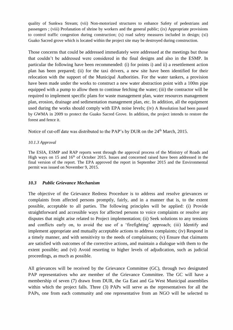
quality of Sunkwa Stream; (vii) Non-motorized structures to enhance Safety of pedestrians and
passengers ; (viii) Profanation of shrine by workers and the general public; (ix) Appropriate provisions
to control traffic congestion during construction; (x) road safety measures included in design; (xi)
Guako Sacred grove which is located within the project site may be destroyed during construction.
Those concerns that could be addressed immediately were addressed at the meetings but those
that couldn’t be addressed were considered in the final designs and also in the ESMP. In
particular the following have been recommended: (i) for points i) and ii) a resettlement action
plan has been prepared; (ii) for the taxi drivers, a new site have been identified for their
relocation with the support of the Municipal Authorities. For the water tankers, a provision
have been made under the works to construct a new water abstraction point with a 100m pipe
equipped with a pump to allow them to continue fetching the water; (iii) the contractor will be
required to implement specific plans for waste management plan, water resources management
plan, erosion, drainage and sedimentation management plan, etc. In addition, all the equipment
used during the works should comply with EPA noise levels; (iv) A Resolution had been passed
by GWMA in 2009 to protect the Guako Sacred Grove. In addition, the project intends to restore the
forest and fence it.
Notice of cut-off date was distributed to the PAP’s by DUR on the 24th March, 2015.
10.1.3 Approval
The ESIA, ESMP and RAP reports went through the approval process of the Ministry of Roads and
High ways on 15 and 16th of October 2015. Issues and concerned raised have been addressed in the
final version of the report. The EPA approved the report in September 2015 and the Environmental
permit was issued on November 9, 2015.
10.3 Public Grievance Mechanism
The objective of the Grievance Redress Procedure is to address and resolve grievances or
complaints from affected persons promptly, fairly, and in a manner that is, to the extent
possible, acceptable to all parties. The following principles will be applied: (i) Provide
straightforward and accessible ways for affected persons to voice complaints or resolve any
disputes that might arise related to Project implementation; (ii) Seek solutions to any tensions
and conflicts early on, to avoid the use of a ‘firefighting’ approach; (iii) Identify and
implement appropriate and mutually acceptable actions to address complaints; (iv) Respond in
a timely manner, and with sensitivity to the needs of complainants; (v) Ensure that claimants
are satisfied with outcomes of the corrective actions, and maintain a dialogue with them to the
extent possible; and (vi) Avoid resorting to higher levels of adjudication, such as judicial
proceedings, as much as possible.
All grievances will be received by the Grievance Committee (GC), through two designated
PAP representatives who are member of the Grievance Committee. The GC will have a
membership of seven (7) drawn from DUR, the Ga East and Ga West Municipal assemblies
within which the project falls. Three (3) PAPs will serve as the representatives for all the
PAPs, one from each community and one representative from an NGO will be selected to

complete the GC team. The GC will respond to any grievances that the PAPs may have during
the RAP implementation.
There will be two contact people from the GC to attend to all complaints as the first step by
recording all complaints. The record will include name and contact of complainant, issue of
complaint, date and time and receiving officer. The complainant will verify that the complaint
lodged has been appropriately captured on the complaints sheet (to be designed and provided
by DUR Environmental Unit).
The grievances most likely to occur during the implementation of the RAP may include the
following: (i) Disagreement over compensation amount assigned; (ii) Delays in receiving
compensation; (iii) Disagreement over asset ownership; (iv) Disagreement over proportionate
sharing of assets with joint ownership; (v) How PAPs with lost identity documents can receive
their compensations.
The Committee will meet fortnightly to consider all lodged complaints and propose measures
to address them. It is expected that all grievances would be addressed amicably at the
committee level. However, in the unlikely case that a particular issue proves difficult to
address, the complainant has the option of seeking redress at a higher level i.e. court of law and
the committee members will co-operate.
Grievance Procedures
The details of each grievance will be recorded on a Grievance Form, along with name and
address of the applicant, the application date, type of application, and the name of the officer
receiving the grievance. A database of recording grievances along the lines described above
will also be developed. In receiving the grievances of vulnerable affected persons (e.g.,
women, those above 65, the illiterate, or the physically challenged), the DUR Environmental
Unit shall pay particular attention to any special needs, difficulties or concerns that they may
have. The steps for grievance redress are described in the RAP summary which is an annex to
the ESIA summary.
The Committee has a maximum of 30 days following the application within which to resolve
any grievances properly lodged with it. The applicant will then be informed by the designated
officer and the corrective actions recorded in the Grievance Closeout Form.
With regards to the resettlement, the main function of the Grievance redress Committee is to
provide a forum for PAPs and other stakeholders to voice their concerns and dissatisfaction
arising from the compensation or implementation process of the project. If the matter cannot be
addressed to the satisfaction of the complainant within the prescribed period, the complainant
then may have recourse to the Resettlement Committee. Failure to be satisfied, the complainant
reserves the right to seek redress from the Court of law that is lengthy and costly in most cases.
10.4 futures consultations
The initial consultations during the design phase and ESIA study should be followed by more
consultations during the construction and operation phases. At contractor’s level, consultation
will be made with relevant stakeholders prior to the beginning of the works. As indicated under
the RAP implementation schedule the RAP will be implemented using a participatory process
under the lead of DUR and the Municipal Assembly. During the works, the contractor will
inform surrounding communities as needed to minimize the inconveniences.
11 CLIMATE CHANGE
Vulnerability analysis: The project is rated in category 2 according to the Bank Climate
Screening System for the following reasons: (i) the annual mean rainfall in the project area is
1000 mm; (ii) the proposed interchange is relatively closer to a tributary of the Nsaki river
called Sunkwa stream which takes it source from the Guako forest; (iii) some sections of the
project may be vulnerable to climate risk, mainly floods. Thus, practical risk management and
adaptation options should be integrated into the project design and implementation plans.
Adaptation: As part of the hydrologic and drainage investigation, the Consultant collected relevant
data needed for analysis and design of flood mitigation measures for the proposed project. The data
included the following: (i) Rainfall Intensity, Duration, Frequencies for Accra; (ii) Temperature
(minimum, maximum, monthly average); (iii) Topographic map of the project area; (iv) Drainage
Design Manual for GHA and Department of Urban Roads; (v) Hydrologic Soil groups of Ghana, (vii)
Previous design report and drawings, (viii) Proposed geometric design of the Interchange. These data
among others were studied to derive the hydrologic design input in addition to data collected from the
field study.
The hydraulic analysis of both the storm and roadside drains were carried out by modelling all
the propose hydraulic structures together as one entity in order to observe the conveyance
behaviour among the structures as they convey the peak discharges. To achieve this objective,
Autodesk civil 3D-Storm and Sanitary analysis software was used. This is an advance,
powerful and comprehensive modelling package for analysing and designing urban drainage
systems, storm-water sewers among others and has one great advantage than other softwares
by modelling all the drainage systems as one hydraulic unit and automatically creates plan,
profile drawings and reports.
After conducting the hydrologic and hydraulic studies and analysis of the drainage structures
on the project roads, the following recommendations are made : (i) include new culverts on the
Accra to Kumasi and Awoshie to Pokuasi sections (pipe and box types); (ii) all U-drains
designed to convey run-off from the main carriageway and the service roads are recommended
to be slab with run-off inlet provided at design intervals of 5m; (iii) open drains to intercept
run-off from the environs unto the propose road corridor and also at the wide median; (vi)
sloping surface to be grassed for all high embankment to reduce erosion of the embankment
material and stone-pitching and lean concrete to fill slopes near bridge.
Mitigation: Traffic congestion increases fuel consumption and as a result, increases of CO2
emissions. In general driving at a steady-state velocity (with the project) results in much lower
emissions and fuel consumption compared to a stop-and-go driving pattern (without the
project). Due to lack of data, the approach used to quantify the CO2 and to estimate the trend in
terms of net effect consisted in: (i) analyzing traffic data (per type of vehicle) under the project
and without the project scenarios; (ii) analyzing time/delay saved under both scenario; (iii)
considering that small vehicles running on petrol emit between 130g and 265g of CO2 per km
while heavy vehicles running on diesel emit up to between 242g and 295g CO2 per km. The
calculation was done based on the traffic data collected for the economical analysis.
Table 17: CO2 emission estimates per road sections

Vehicule group
Nsawam section (2.2 km) ACP section (0.5km) New Awoshie section (5 km)
Daily
average traffic
Min CO2
emission (kg)
Max CO2
emission (kg)
Daily
average traffic
Min CO2
emission
(kg)
Max CO2
emission (kg)
Daily
average traffic
Min CO2
emission (kg)
Max CO2
emission (kg)
Light 29,492 8,435 17194 11,482 746 3,043 3,942 2562 5223
Medium 2,053 1,093 1332 671 81.191 197.945 232 281 342
Heavy 2,230 540 1447 444 53.724 130.98 113 137 167
Daily
Total
33,774 10,067 19974 12,597 881 3,372 4,286 2,980 5,732
Annual
Total
12,327,510 3,674,597 7,290,329 4,597,905 321,654 1,230,654 1,564,390 1,087,609 2,092,189
The project will contribute to reducing annually the following quantities of CO2 as compared
to the situation without the project: (i) between 551 to 1,093 t for the Nsawam section; (ii)
between 48 and 184 t for the ACP section; (iii) between 163 and 313 t for New Awoshie. It is
worth mentioning that this reduction will be insignificant towards year 10 of operation if no
improvements or other transport projects are not implemented in the project area. This is
mainly due to the fact that traffic growth (7%) will lead to smaller gains over time.
12 INSTITUTIONAL CAPACITIES AND STRENGTHENING PLAN
This chapter details the capacity strengthening plans that will be needed to improve or aid the
ability of some key agencies with regard to the implementation of the ESMP.
DUR: The overall implementation, project supervision and monitoring falls under the purview
of the Environmental Unit of the DUR. It will be in charge of overseeing the implementation of
the ESMP. In order for this to be done successfully, it is necessary that their capacity be
strengthened to improve their function with regards to environmental and social management.
An overall cost of GH¢75,000.00 has been estimated for this purpose. This includes mainly
trainings and support in Environment and Social Monitoring.
GWMA: The Town and Country Planning department under GWMA will mostly be consulted
for this project. To adequately provide services and perform their duties an amount of GH¢
453,000.00 is needed to enable them properly undertake their responsibilities. This includes
training of people in the preparation of Master Plan for GWMA, training on Geographic
Information System (GIS) training, acquisition of base maps, equipment, etc.
EPA: EPA will play a key role in the monitoring of project compliance. To adequately perform
its duties, they request that an amount of GH¢ 279723 be given to aid them.
13. CONCLUSION
The ESIA has evaluated the potential environmental impacts during establishment and
management of the project. The assessment indicates that no significant environmental impacts
will occur as a result of the project and, when taken together, the overall environmental and
social impact will not be significant. The ESIA reports and relevant annexes have been
submitted to EPA Ghana for approval and issuance of the environmental license.
14. REFERENCES AND CONTACTS
List of documents consulted
Environmental and Social Impact Assessment (ESIA) report, 2015
Social Impact Assessment report, 2015

Environmental and Social Management Plan (ESMP) report, 2015
Resettlement Action Plan report, 2015
For the African Development Bank
Mam Tut Wadda-Senghor, Principal Transport Engineer,
AfDB Ghana Office, E-mail: [email protected]
Modeste Kinane, Principal Environmental Specialist,
AfDB Headquarters, Cote d’Ivoire, E-mail: [email protected]