Embed Size (px)
Citation preview
Mandlburger et al. 159
Progress in LiDAR Sensor Technology – Chance and Challenge for DTM Generation and Data Administration
GOTTFRIED MANDLBURGER, CHRISTIAN BRIESE, NORBERT PFEIFER, Vienna
ABSTRACT Airborne laser scanning (ALS, also referred to as LIDAR (light detection and ranging)) became a standard method for the acquisition of topographic data. However, since the first commercial flights in 1994 a significant development in the sensor technology can be observed. These developments lead to a high increase in data volume due to a significant higher number of determined echoes as well as due to an increased number of information stored per echo. Next to a short presentation of the current sensor developments this paper focuses on the current challenges in management of ALS data (including the storage of additional information provided by full-waveform ALS sensors). Furthermore, advanced procedures for DTM generation integrating geometric criteria with these additional attributes per echo are discussed.
1. INTRODUCTION
Airborne laser scanning (ALS, also referred to as LIDAR (light detection and ranging)) became the standard method for acquisition of topographic data, especially for the reconstruction of digital terrain models (DTM) (Kraus and Otepka, 2005). For terrain determination so-called filtering algorithms were developed that perform an automatic classification of the acquired point cloud into terrain and off-terrain points (Sithole and Vosselman, 2004). However, for high quality requirements a certain amount of human control is still necessary, i.e. manually correcting classification errors of the automatic procedures. In any case, the DTM from ALS is a standard product, offering higher quality than other methods. This holds especially, but not only, in forested terrain due to the vegetation penetration capability of laser ranging. This property also builds the base for the successful application of ALS in forestry (Hyyppä et al., 2004). Next to terrain reconstruction, topographic applications as building or city model reconstruction from airborne laser scanning are a major topic of research but did not mature to the state of DTM extraction yet. Since the first commercial flights worldwide in 1994 (personal communication with J. Lindenberger and P. Friess) the development of the sensor technology was tremendous (e.g. increase in point density, etc., cf. section 2). These developments, but also the acceptance of the measurement method by surveying authorities and users, e.g. hydraulic engineers, lead to an increase in data volume. In the beginning point clouds were provided in ASCII (list of xyz-triples) on CDs, now the binary exchange via hard disks (capacity e.g. 200GB) is common. Additionally to the increase in the number of points, also the attributes of data delivered has changed. The new data are: intensity resp. amplitude measures, GPS-time stamps per emitted pulse, trajectory information (after Kalman filtering for combined GPS and IMU processing), and the full-waveform information of the backscatter. At least some of the mentioned parameters are contained in the binary LAS file format (LAS, 2007) released by the ASPRS, which is gradually becoming a standard for LIDAR data exchange. This is now available to photogrammetric researchers. However, with the development of processing algorithms this information can also be used beneficially for applications. Filtering algorithms for terrain reconstruction may use, e.g. the full-waveform information in order to increase accuracy and reliability in the filtering process (cf. section 5). Also, trajectory information supports strip adjustment of laser scanning data with extended ground control for increasing the accuracy of the point cloud product (Kager, 2004, Csanyi and Toth, 2007). It is expected that in this
Photogrammetric Week '07 Dieter Fritsch (Ed.) Wichmann Verlag, Heidelberg, 2007

160 Mandlburger et al.
way precision well below the decimetre will be reached for the single point, if the backscattering object surface is defined appropriately. While some of the chances offered by the sensor development are becoming apparent, the challenges are much clearer. The entire data, including point attributes, flight path information, ground control, and meta data has to be managed. As project data with 1 Tera-Byte, e.g., 1010 points, are not uncommon, quick data access requires high-performance spatial indexing. There is no standard for full-waveform data, and it should be discussed, if a) the entire digitized waveform shall be stored, or b) echo width and amplitude, which are a result of a more advanced echo analysis approach, or c) the cross section (m2) of each echo which can be obtained with a very limited set of assumptions (Wagner et al., 2006), or d) ground reflectance (Höfle and Pfeifer, 2007), which require assumptions on target, i.e., ground surface, shall be used. Maintaining the information (on echoes, the flight path, etc.) throughout the entire workflow of airborne laser scanning data processing can be seen as good practice, but is subject to discussion as well. The most important challenge is verifying that the full-waveform and the other attributes listed above carry indeed information (and not only data), and developing methods for exploiting it automatically in a reliable way. This paper is structured as follows. Section 2 gives more details on the sensor development and the current state of the technology. This builds the basis for Section 3, where the first steps in exploiting the attribute information, namely echo decomposition and strip adjustment, are presented shortly. In Section 4 are proposal for management of airborne laser scanning data, under consideration of the previous sections, is made. Section 5 presents developments on DTM extraction exploiting the new possibilities. Finally, the paper is summarised and an outlook into future research for advanced DTM generation from ALS data is provided.
2. SENSOR DEVELOPMENT
As already mentioned in the introduction, a significant progress in the ALS sensor development took place in the last years. ALS systems still use almost solely the round trip time measurement principle for ranging (one exception is the research system ScaLARS, which applies the phase difference measurement principle (Hug and Wehr, 1997)), but in the last years, the frequency of range measurements developed from a few kHz to about 200kHz. This progress lead to a significant increase in the data volume and allows nowadays a much more efficient and detailed acquisition of the topography. Likewise the range spectrum increased. The maximum flying height increased from 1km to 5km. Furthermore, while the first systems either allowed to store the range to the first or last echo, current systems allow the simultaneous storage of both echoes. More advanced systems even allow to determine intermediate echoes. Next to the range, intensity recording, characterising the reflectance behaviour, was introduced. This development expanded to the full-waveform digitisation (Wagner et al., 2006). We can nowadays distinguish between two different types of commercial ALS sensor systems: discrete echo and full-waveform scanners. While discrete echo scanners detect a representative trigger signal for multiple echoes in real time using analogue detectors, full-waveform ALS systems digitise the entire analogue echo waveform, i.e. the time-dependent variation of received signal power, for each emitted laser beam (typically with an interval of 1 ns). In contrast to the “classical” discrete echo systems, the full-waveform ALS systems allow an echo determination in post-processing adapted to the individual needs based on the stored waveforms. Additionally, in order to increase the data coverage rate by an increase in the flying height, pulse repetition rate and maximum range, the so-called multipulse technology was introduced. While standard ALS systems just allow a consecutive pulse emission and detection, this technique allows
Mandlburger et al. 161
to detect the echoes of multi laser pulses travelling through the atmosphere simultaneously. Moreover, some data providers provide multiple scanners on one airborne platform, e.g. for increased side-looking or for forward and backward looking. Finally, also the hardware developments of the other systems components, such as GPS and IMU (inertial measurement unit) as well as advanced software solutions for direct georeferencing and subsequent fine-georefencing (cf. section 3.2) have to be mentioned. While one could recognise an increase in accuracy and measurement frequency (e.g. kHz IMU frequency) of the position and orientation sensors, advanced software solutions help to determine accurate trajectory information. Moreover, calibration procedures (e.g. for the determination of the relative position of the sensors on the moving platform) were improved in a way that current ALS point clouds have an absolute accuracy in plane of about ±20-40cm and in height of about ±10-15cm.
3. PREPROCESSING AND GEOREFERENCING
This section focuses on the determination of the echos and their additional parameters as well as on the georeferencing of the data. While the echo and attribute (typically just an intensity value) determination of discrete echo ALS systems is performed in real time during data acquisition this procedure, which is discussed in the following subsection, has to be done in a separate processing phase in the case of full-waveform ALS. Independent of the final application of the ALS data, the trajectory of the laser scanner has to be determined based on the position and orientation information (typically GPS and IMU observations) in order to georeference the ALS observations. Subsequently, with the resulting trajectory the position of the synchronised echoes can be determined in one coordinate frame. Then, the georeferencing of the data may be checked by an analysis of the height differences between overlapping strips and/or to external reference data. In the case of higher accuracy requirements a fine-georeferencing process has to follow (cf. section 3.2). Finally, the georeferenced ALS echoes can be stored together with their attributes (echo ID, GPS-time, intensity, echo width, etc.) in a topographic database, which can be accessed for further processing (cf. section 4).
3.1. Determination of echo parameters
This subsection describes the determination of the echoes and their additional parameters in the preprocessing step of full-waveform ALS data. The digitized full-waveform signal per emitted pulse is the result of a convolution of the emitted laser pulse with the illuminated object surface (vgl. Wagner et al., 2006). Usually it is assumed that the emitted pulse can be well approximated by a Gaussian bell curve and that the resulting waveform can be well modelled by the summation of Gauss curves that represent the backscattered energy (Hofton et al., 2000, Wagner et al., 2006, c.f. fig. 1). In this modelling phase of the waveform, the first step is typically the determination of the number of echoes and their approximate position and amplitude by searching all local maxima in the recorded signal. Based on these approximate values a model of the waveform can be fitted by minimising the residuals to the recorded waveform information. In the case of a Gaussian decomposition the individual Gaussian curves describe the backscattered signal per echo (dotted curves in fig. 1).

162
Based on tAi and thebackscatterall small suwidth of thecho, whilBased on electromagdetermined
3.2. Geore
For the transystem thementioned the laser scposition ancomponentdeterminedthe groundduring flig(Burman, 2 Based on coordinate georeferenoverlappintechniquescalibration(Crombagh(coordinatemodels. Dunext sectio
Fig. 1: Mfunctions, Bl
like the
the individue echo widtring properturface elemhe emitted le a small ethese attri
gnetic energd (cf. Wagn
eferencing
nsformatione time depe
in the introcanner the Pnd orientatiots (GPS antd. To some d, but a numght within a2002), (Filinthe mountframe by
ncing of theng ALS sts are necessn (Burman, hs et al., es of all ecue to the ty
on).
Modelling of thlack dotted lin
e amplitude Ai
ual curves fh EWi, canties of the il
ments that copulse) indicecho width butes the s
gy interceptner et al., 20
n of the ALendent positoduction thiPOS forms on of the sctenna, IMU,extent thes
mber of paraa calibrationn, 2003), aning calibrat
direct geoe point cloutrips). Thesary in orde
2002, Ka2000, Kra
choes and typical high
he recorded wanes: individuai and the echo
further charn be determlluminated ontributed tcates that suindicates a
so-called bted and rera06).
LS data (rangtion and oriis requires aa multiple s
canner the r, and laser sse parameteameters, e.g.n procedurend (Kager, 2tion the coooreferencingud can be refore, forer to fine-gager, 2004)aus and Pftheir attribuamount of
aveform (blacal Gaussian funo width EWi, w
racteristic atmined for ea
surface, theto that echourface elema rather flatbackscatter adiated by o
ge and anglientation ofa Position asensor systerelative oriescanner) aners can be d. the IMU o. Approache2004). ordinates og. Howevefound (e.g
r advancedgeoreference), or by apfeifer, 200utes) is thedata an ade
ck dots) by Ganctions per ec
which characte
ttributes, likach echo. We echo width. Therefore
ments at a dt (in respeccross secti
objects back
le observatif the laser sand Orientatem. In orderentation, i.e.d time lags
determined orientation oes for the c
of the echoeer, in pract. when ana
d accuracy e the ALS pplying co1). The re
e basis for equate data
aussian decomcho; Next to therise the indiv
ke the maxiWhile the amh describes , a big echo
different ranct to the beion, which kwards towa
ons) into onscanner hastion systemr to determi. shifts and in the syncby total sta
or time lagscalibration h
es can be dtice often alysing strip
requiremedata. This
orrections tesulting finthe determmanageme
mposition; Redhe Distance Rvidual echoes,
Mandlb
imum amplmplitude dethe range v
o width (in nge contribueam directio
is a measards the sen
ne commons to be dete
m (POS). Toine the timerotations, b
chronizationation measu, are better
have been p
determined deficits of p differenceents strip can be donto the poinne-georefere
mination of ent is essent
d: Sum of all Gi further echo can be determ
burger et al.
litude valueescribes thevariations ofrelation theuted to thaton) surface.sure of thensor, can be
n coordinatermined. Asgether with
e dependentbetween then have to beurements on
determinedpresented in
within onef the directes betweenadjustment
ne either bynts directlyenced datasubsequent
tial (see the
Gaussian parameters, mined.
e e f e t . e e
e s h t e e n d n
e t n t y y a t e

Mandlburger et al. 163
4. ALS DATA MANAGEMENT IN TOPDM
It has been pointed out in the previous sections that modern ALS sensors provide data for a more dense and detailed description of the earth’s surface at the price of an increased data volume. Even small projects of several dozens or hundreds of square kilometres require nowadays an efficient and flexible system for data handling. For administration of huge amounts of elevation data, the program system TopDM (Topographic Data Management) was developed at the Institute of Photogrammetry and Remote Sensing (I.P.F.) in Vienna. Initially designed for storage of countrywide elevation data from photogrammetry and other traditional surveying techniques, TopDM has proved to be well suited for management of ALS data over the last years.
4.1. General concept and current state
TopDM (Hochstöger, 1996, Warriner and Mandlburger, 2005) is basically a database management system (DBMS) founded on a geo-relational database like TOPDB (Loitsch, Molnar, 1991) or other, commercially available systems (e.g. Oracle Spatial). The communication between TopDM and the DB is realized via an abstract database interface utilizing the database language TOPSQL - a query language based on standard ANSI-SQL with extensions regarding geometric/topological types and operators. Using TOPSQL geometric and attribute related conditions can be combined in a single SQL statement. The main goal of TopDM is an efficient long-term storage and archiving of primary topographic data (original data) and derived products (e.g. DTM). Apart from geometry (coordinates) and coding (geometric type and meaning) this requires also storage of information about other data properties (accuracy, compilation method, creator of data, etc.) to allow detailed data selection. Additional important aspects are flexible support of data formats for data import and export as well as rigorous geo-coding of the administrated data. The latter includes also transformations between different coordinate systems and geodetic dates, which gain special importance for ALS data as they are originally captured in a geocentric reference system (e.g. WGS84) and normally to be processed in the national coordinate system. In this sense TopDM mainly focuses on regional or national surveying authorities and is e.g. used by the Federal Office of Metrology and Surveying (A), swisstopo (CH), Ordnance Survey (GB) and several surveying authorities in Germany. Above that, with the increasing amount of topographic data as provided by modern ALS sensors TopDM becomes a basic component of today’s large DTM projects (e.g. ALS DTM of Tyrol, Lower Austria, Vienna, Neusiedlersee (Attwenger and Chlaupek, 2006)). Within a sophisticated DTM production system, TopDM first serves as data source of the original point cloud. From here data are passed to applications for filtering and DTM modelling. The end products (e.g. DSM, DTM, classified points, hill shadings) are finally returned to the TopDM database for storage and delivery to customers.
4.2. New development
The general concept as described above is based on the administration of the xyz-coordinates only. As pointed out in previous sections (and as it will be shown in the next section), additional point-related attributes like scan angle, echo width, amplitude and the more can be used to improve the derived DTM. Therefore, an extension of the existing TopDM table system was designed and finally implemented allowing storage of additional attributes per point (=per echo). According to the available sensor data different table types may be applied to preserve e.g. information provided by LAS data files (LAS, 2007) or data from full-waveform laser scanners. Examples of table definitions are shown in Tab. 1.
164 Mandlburger et al.
a) b)
Tab. 1: Excerpt from the TopDM table definitions for administration of topographic data containing informatation from LAS files (a) or full-waveform laserscanners (b)
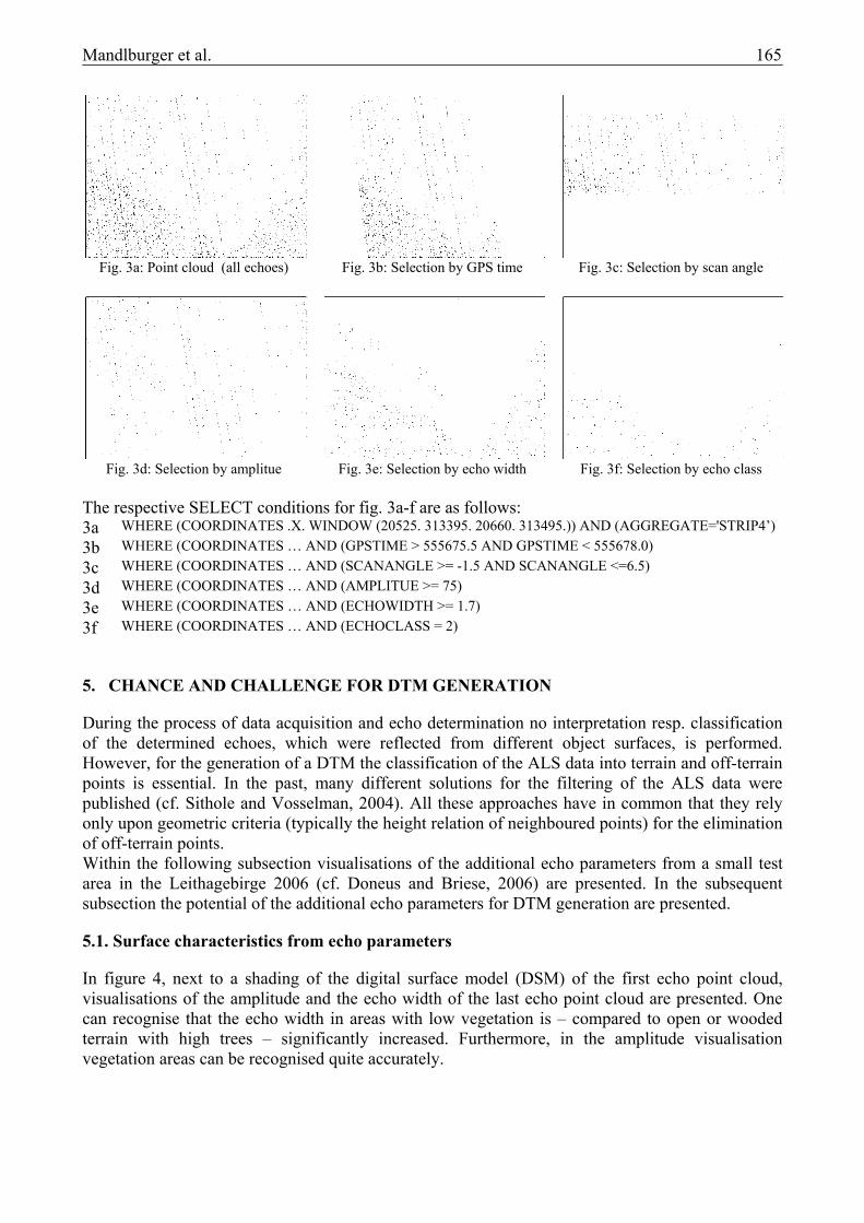
One of the most important additional point-related attributes is the GPS time of the emitted pulse. This time stamp can serve a) as a unique identifier for all laser pulses and allows b) to find and bring together multiple echoes descended from the same pulse, c) to order echoes chronologically which may speed up subsequent data processing remarkably, and d) to line up echoes and trajectory information allowing to assign specific echoes to a certain flight line and to locate the scanner position and orientation corresponding to a certain echo. The latter may be used to reconstruct flight-line separated point clouds from patch-wise delivered data e.g. for strip adjustment. Finally, fig. 3a-f show the resulting point clouds when applying selection criterions using different additional point-related attributes as they can be derived directly from the TopDM database.
Fig. 2: DSM hill shading of flight strip 4, Leithagebirge 2007
The fig. 3a-f show terrain with different surface characteristics. There is wooden area in the southern part delimited by a V-shaped horizontal street, a steep slope running from northwest to southeast, a medium slope running from northeast to southwest and finally a bare level area in the north. As a reference fig. 3a shows all available echoes. The selection of a certain GPS time range (fig. 3b) results in a segment of point data along the flight axis, whereas a reduction of the available scan angle (fig 3c) narrows the width of the flight strip. Fig 3d and 3e show all points with amplitudes greater than 75 DN (digital numbers) and echo widths greater than 1.7ns respectively. The resulting point sets are highly (inverse) correlated. Since the echo width describes the height variation within the reflected signal, high values can be observed in the wooden area and at steep slopes whereas low values appear in bare and flat areas. The situation is more or less reversed for the amplitude, where bare and level areas (e.g. street) are characterized by high values. The last example in fig. 3f shows all points related to echo class 2, which means that the points are the first echoes of pulses containing multiple echoes. This is normally the case in areas covered by vegetation, which clearly comes out in fig. 3f.
C C Definition for Table of Type: TDFWFTAB C ====================================== C ( IDOBJ INTEGER UNIQUE INDEX NOT NULL SYSNUM IDENTIFIER COORDINATES LINE INDEX NOT NULL RESOLUTION(2,2,2) GPSTIME NUMBER(12.3) INDEX NOT NULL ARRAY AMPLITUDE NUMBER(12.3) INDEX NOT NULL ARRAY ECHOWIDTH NUMBER(12.3) INDEX NOT NULL ARRAY RANGE NUMBER(12.3) INDEX NOT NULL ARRAY SCANANGLE NUMBER(12.3) INDEX NOT NULL ARRAY PULSEID INTEGER INDEX NOT NULL ARRAY ECHOCLASS INTEGER INDEX NOT NULL ARRAY .... )
C C Definition for Table of Type: TDLASTAB C ====================================== C ( IDOBJ INTEGER UNIQUE INDEX NOT NULL SYSNUM IDENTIFIER COORDINATES LINE INDEX NOT NULL RESOLUTION(2,2,2) GPSTIME NUMBER(15.6) NO INDEX NOT NULL ARRAY INTENSITY INTEGER NO INDEX NOT NULL ARRAY RETURNNUMBER INTEGER NO INDEX NOT NULL ARRAY RETURNCOUNT INTEGER NO INDEX NOT NULL ARRAY SCANDIR BOOLEAN NO INDEX NOT NULL ARRAY SCANEDGE BOOLEAN NO INDEX NOT NULL ARRAY ECHOCLASS INTEGER NO INDEX NOT NULL ARRAY SCANANGLE INTEGER NO INDEX NOT NULL ARRAY USERDATA INTEGER NO INDEX NOT NULL ARRAY POINTSRCID INTEGER NO INDEX NOT NULL ARRAY .... )
Detail fig. 3a-f
Mandlburger et al. 165
Fig. 3a: Point cloud (all echoes) Fig. 3b: Selection by GPS time Fig. 3c: Selection by scan angle
Fig. 3d: Selection by amplitue Fig. 3e: Selection by echo width Fig. 3f: Selection by echo class
The respective SELECT conditions for fig. 3a-f are as follows: 3a WHERE (COORDINATES .X. WINDOW (20525. 313395. 20660. 313495.)) AND (AGGREGATE='STRIP4’) 3b WHERE (COORDINATES … AND (GPSTIME > 555675.5 AND GPSTIME < 555678.0) 3c WHERE (COORDINATES … AND (SCANANGLE >= -1.5 AND SCANANGLE <=6.5) 3d WHERE (COORDINATES … AND (AMPLITUE >= 75) 3e WHERE (COORDINATES … AND (ECHOWIDTH >= 1.7) 3f WHERE (COORDINATES … AND (ECHOCLASS = 2)
5. CHANCE AND CHALLENGE FOR DTM GENERATION
During the process of data acquisition and echo determination no interpretation resp. classification of the determined echoes, which were reflected from different object surfaces, is performed. However, for the generation of a DTM the classification of the ALS data into terrain and off-terrain points is essential. In the past, many different solutions for the filtering of the ALS data were published (cf. Sithole and Vosselman, 2004). All these approaches have in common that they rely only upon geometric criteria (typically the height relation of neighboured points) for the elimination of off-terrain points. Within the following subsection visualisations of the additional echo parameters from a small test area in the Leithagebirge 2006 (cf. Doneus and Briese, 2006) are presented. In the subsequent subsection the potential of the additional echo parameters for DTM generation are presented.
5.1. Surface characteristics from echo parameters
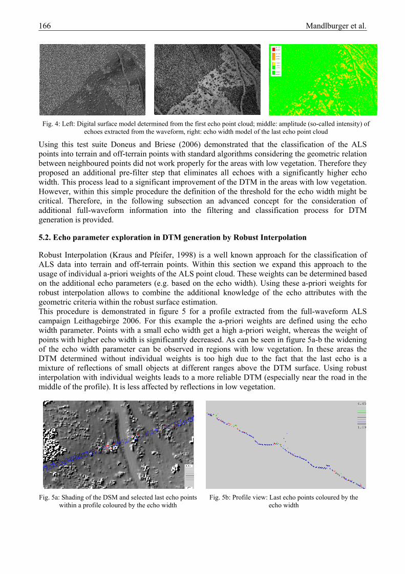
In figure 4, next to a shading of the digital surface model (DSM) of the first echo point cloud, visualisations of the amplitude and the echo width of the last echo point cloud are presented. One can recognise that the echo width in areas with low vegetation is – compared to open or wooded terrain with high trees – significantly increased. Furthermore, in the amplitude visualisation vegetation areas can be recognised quite accurately.
166 Mandlburger et al.
Using this test suite Doneus and Briese (2006) demonstrated that the classification of the ALS points into terrain and off-terrain points with standard algorithms considering the geometric relation between neighboured points did not work properly for the areas with low vegetation. Therefore they proposed an additional pre-filter step that eliminates all echoes with a significantly higher echo width. This process lead to a significant improvement of the DTM in the areas with low vegetation. However, within this simple procedure the definition of the threshold for the echo width might be critical. Therefore, in the following subsection an advanced concept for the consideration of additional full-waveform information into the filtering and classification process for DTM generation is provided.
5.2. Echo parameter exploration in DTM generation by Robust Interpolation
Robust Interpolation (Kraus and Pfeifer, 1998) is a well known approach for the classification of ALS data into terrain and off-terrain points. Within this section we expand this approach to the usage of individual a-priori weights of the ALS point cloud. These weights can be determined based on the additional echo parameters (e.g. based on the echo width). Using these a-priori weights for robust interpolation allows to combine the additional knowledge of the echo attributes with the geometric criteria within the robust surface estimation. This procedure is demonstrated in figure 5 for a profile extracted from the full-waveform ALS campaign Leithagebirge 2006. For this example the a-priori weights are defined using the echo width parameter. Points with a small echo width get a high a-priori weight, whereas the weight of points with higher echo width is significantly decreased. As can be seen in figure 5a-b the widening of the echo width parameter can be observed in regions with low vegetation. In these areas the DTM determined without individual weights is too high due to the fact that the last echo is a mixture of reflections of small objects at different ranges above the DTM surface. Using robust interpolation with individual weights leads to a more reliable DTM (especially near the road in the middle of the profile). It is less affected by reflections in low vegetation.
Fig. 4: Left: Digital surface model determined from the first echo point cloud; middle: amplitude (so-called intensity) of echoes extracted from the waveform, right: echo width model of the last echo point cloud
Fig. 5a: Shading of the DSM and selected last echo points within a profile coloured by the echo width
Fig. 5b: Profile view: Last echo points coloured by the echo width

Mandlburger et al. 167
6. CONCLUSION
The paper presents some of the current chances and challenges for DTM generation and data management. It especially focuses on the additional echo attributes that can be determined from full-waveform ALS data. Within the area of data administration the paper presents a concept that allows to store and access further information of the ALS flight mission as well as for each individual ALS echo. In this way it allows to link each echo with all stored attribute data, which is the basis for tracing the echo information within all the subsequent processing steps. Next to advanced consideration in data management some thoughts for the improvement of DTM generation based on these additional attributes are presented. However, we have just presented some preliminary ideas and concepts which have to be extended and prove in the future. Still there is a need to study the additional parameters provided by the full-waveform sensors in much more detail. However, the presented results show that the provided information can be useful for DTM determination and other modelling tasks. In the future, additional attributes per echo might be additionally provided by other sensors (e.g. passive image data). Therefore, algorithms which allow to integrate geometric information provided by the ALS point cloud with additional information from active and passive sensors will be important for the future.
7. REFERENCES
Attwenger, M., Chlaupek, A. (2006): Erstellung eines grenzüberschreitenden digitalen Geländemodells im Nationalpark Neusiedler See-Seewinkel/Fertö Hanság aus Laserscanner-Daten. Angewandte Geoinformatik 2006, Beiträge zum 18. AGIT-Symposium", J. Strobl, T. Blaschke, G. Griesebner (ed.), ISBN3-87907-437-2, pp. 16-23.
Burman, H. (2002): Laser Strip Adjustment for Data Calibration and Verification. International
Archives of Photogrammetry and Remote Sensing, Vol. 34/3, Graz, Austria. Csanyi, N., Toth, C. (2007): Improvement of Lidar data accuracy using lidar-specific ground
targets. Photogrammetric Engineering & Remote Sensing 73(4), pp. 385-296.
Fig. 5c: DTM generation by robust estimation with a-priori weights determined from the echo attributes (in this case just using the echo width) demonstrated on a profile; Black dots: Last echo point cloud, Red surface: DTM without
considering individual weights. Green surface: Improved DTM by robust interpolation with individual weights.

168 Mandlburger et al.
Crombaghs, M., Brügelmann, R., de Min, E. (2000): On the adjustment of overlapping strips of laseraltimeter height data. In: International Archives of Photogrammetry and Remote Sensing, Vol. XXXIII, 3A, Amsterdam, Netherlands, pp. 230-237.
Doneus, M., Briese, C. (2006): Digital terrain modelling for archaeological interpretation within
forested areas using full-waveform laserscanning. In: M. Ioannides, D. Arnold, F. Niccolucci and K. Mania (Editors), The 7th International Symposium on Virtual Reality, Archaeology and Cultural Heritage VAST.
Filin, S. (2003): Recovery of systematic biases in laser altimetry data using natural surfaces.
Photogrammetric Engineering & Remote Sensing, 69. Hochstöger, F. (1996): Software for Managing Country-Wide Digital Elevation Data. In:
International Archives for Photogrammetry and Remote Sensing, Vol. XXXI, Part B2, Vienna, Austria, 1996, pp. 160-163
Hofton, M.A., Minster, J.B., Blair, J.B. (2000): Decomposition of Laser Altimeter Waveforms.
IEEE Transactions on Geoscience and Remote Sensing, 38: pp. 1989-1996. Höfle, B., Pfeifer, N. (2007): Correction of laser scanning intensity data: Data and model-driven
approaches. ISPRS Journal of Photogrammetry and Remote Sensing. Accepted for publication. Hug, C., Wehr, A. (1997): Detecting and identifying topographic objects in imaging laser altimetry
data. In: International Archives of Photogrammetry and Remote Sensing, Vol. XXXII/3-4W2, pp. 16-29.
Hyyppä, J., Hyyppä, H., Litkey, P., Yu X., Haggrén, H., Rönnholm, P., Pyysalo, U., Pitkänen, J.,
Maltamo, M. (2004): Algorithms and Methods of Airborne Laser-Scanning for Forest Measurements. International Archives of Photogrammetry, Remote Sensing and Spatial Information Sciences, Vol. XXXVI, Part 8/W2 (ISSN 1682-1750). Freiburg, Germany.
Kager, H. (2004): Discrepancies Between Overlapping Laser Scanning Strips - Simultaneous
Fitting of Aerial Laser Scanner Strips. International Archives of Photogrammetry and Remote Sensing, Vol. XXXV, B1. Istanbul, pp. 555-560.
Kraus, K., Otepka, J. (2005): DTM Modeling and Visualization - The SCOP Approach.
Photogrammetric Week '05, D. Fritsch (ed.). Herbert Wichmann Verlag, Heidelberg, pp. 241-252.
Kraus, K., Pfeifer, N. (1998): Determination of terrain models in wooded areas with airborne laser
scanner data. ISPRS Journal of Photogrammetry and Remote Sensing 53, pp. 193-203. Kraus, K., Pfeifer, N. (2001): Advanced DTM generation from LIDAR data. In: International
Archives of Photogrammetry and Remote Sensing, Vol. XXXIV, 3/W4, Annapolis, MD, USA, pp. 23-30.
Loitsch J., Molnar L., (1991): A Relational Database Management System with Topological
Elements and Topological Operators. In: Proceedings of Spatial Data 2000, Department of Photogrammetry and Surveying, University College London, 1991, pp. 260-269

Mandlburger et al. 169
Sithole, G., Vosselman, G. (2004): Experimental comparison of filter algorithms for bare-Earth extraction from airborne laser scanning point clouds. ISPRS Journal of Photogrammetry and Remote Sensing, 59. (1-2), pp. 85-101.
Wagner, W., Ulrich, A., Ducic, V., Melzer, T., Studnicka, N. (2006): Gaussian Decomposition and
Calibration of a Novel Small-Footprint Full-Waveform Digitising Airborne Laser Scanner. ISPRS Journal of Photogrammetry and Remote Sensing, 60 (2), pp. 100-112.
Warriner, T., Mandlburger, G. (2005): Generating a New High Resolution DTM Product from
various Data Sources. Proceedings of the 50th Photogrammetric Week, D. Fritsch (ed.). Herbert Wichmann Verlag, Heidelberg. 3-87907-421-6; pp. 197-206.
www: LAS (2007): LAS file format specification, http://www.lasformat.org