Embed Size (px)
Citation preview
2
Criteria for Permitting Projects under a Programmatic Determination of Not Likely to Adversely Affect for Selected Listed Species in California. This document was developed and included with the February 14, 2007 programmatic consultation completed by NMFS with USACE and U.S. Fish and Wildlife Service pursuant to section 7(a)(2) of the Endangered Species Act (ESA) of 1973, as amended (16 U.S.C. 1531 et seq.) The programmatic ESA consultation is referred to as the “NLAA Programmatic.” The NLAA Programmatic expired on February 14, 2012, but is expected to be renewed in 2013. This programmatic EFH consultation applies to permit applications (i.e., standard individual permits, letters of permission, nationwide permits, general permits, or any combination of those types of authorization) for activities, with certain limits and restrictions, located within the San Francisco District (SPN) and Sacramento District (SPK) regulatory programs. Permit applications for activities under the Los Angeles District (SPL) are not included in this programmatic during the first year of implementation. Program activities described below must be adhered to in order for a project to be part of this programmatic EFH consultation. Projects that deviate from activities described below or fail to implement appropriate EFH Conservation Recommendations included herein require individual EFH consultation if they may adversely affect EFH. This programmatic determination was written to encompass all three USACE districts, but at the time of issuance, at the request of USACE, is effective for only one activity in the SPK and not effective for any activity in the SPL. As such, statewide location restriction maps included herein cover all districts, despite limited use by SPK and SPL. This programmatic may be renewed for a total of 5 years upon acceptance of the required annual reports by NMFS. During the 5-year implementation period, USACE may request that the programmatic determination become effective for SPL or become effective for additional activities described herein for the SPK. If revisions to the programmatic are required after the first year of implementation USACE and NMFS will complete the revisions within 3 months. Reporting Requirements. For each project covered under this programmatic consultation, USACE will provide NMFS project-specific information six weeks prior to project implementation for review, including:
project location (latitude, longitude, and datum); county; waterbody name; USACE file number; project type; habitat type; EFH Conservation Recommendations implemented and; USACE’s determination as to how the project meets the program activities described
below.
USACE will assume NMFS concurrence if they do not receive written or e-mail comments regarding their decision within 15 days of receipt of notification. USACE and NMFS will meet on an annual basis, and as needed, for the following purposes: (1) to discuss the annual tracking
3
report of covered projects, (2) to evaluate and discuss the continued effectiveness of the programmatic consultation, (3) to ensure that activities authorized by the programmatic consultation continue to minimize adverse effects to EFH, and (4) to update procedures and project criteria, if necessary. At any time, NMFS or USACE may revoke or revise this programmatic consultation if it is not being implemented as intended. Annual reporting requirements. Each year, after the concurrence date, USACE will provide a table to NMFS identifying the following in regard to projects USACE permitted under this programmatic determination:
project type; description of action; USACE file number; location coordinates (latitude, longitude, and datum); permittee; waterway; county; listed species in the action area; status of construction (i.e., not constructed, under construction, or completed); USACE’s determination and rationale for how each project met the “may affect, will not
affect” criteria; identify the date of project implementation and duration of each project; and identify the status of projects that were not implemented that year.
Action Area The proposed activities occur in areas identified as EFH for various life stages of fish species managed with the Pacific Coast Groundfish Fishery Management Plan (FMP), the Coastal Pelagic Species FMP, and the Pacific Coast Salmon FMP. The scope of this programmatic consultation includes marine, estuarine, and riverine areas within and offshore of the State of California, including the Northern California Coast, the Central California Coast, San Francisco Bay, the Southern California Coast, and the Central Valley. Boundaries for these geographic areas are as follows:
Northern California coast: Oregon border south to the Humboldt-Mendocino County line; inland watersheds that drain to the Pacific Ocean. Central California coast: Humboldt-Mendocino County line south to Monterey-San Luis Obispo County line; inland watersheds that drain to the Pacific Ocean. San Francisco Bay: Tributaries and marshes from Chipps Island west to the Pacific Ocean, including San Pablo Bay, the Carquinez Strait, Grizzly Bay, and Susiun Bay. River mouths within the Bay (except for the Sacramento-San Joaquin Delta) are included up to the extent of tidal influence (i.e., contains at least some salt or brackish water at some times). The western extent of the Bay ends at the Golden Gate Bridge.
4
Southern California coast: Monterey-San Luis Obispo County line south to the California-Mexico border; inland watersheds that drain to the Pacific Ocean. Central Valley: Interior California watersheds that drain to the Sacramento and San Joaquin Rivers, the mainstem Sacramento and San Joaquin Rivers, the legal Sacramento-San Joaquin Delta, the lower mainstem Sacramento River to Chipps Island.
Sub-areas within these jurisdictions are also listed below, these are:
Estuary: Any partially enclosed (by natural land formation) body of water that has one or more rivers flowing into it. The upstream extent of an estuary is the area of a river mouth influenced by tidal flows (i.e., contains at least some salt or brackish water at some times). Bay: A body of water partially enclosed by land. Only bays named on standard USGS topographic maps are considered bays under the 2013 NLAA Program. Delta: The Sacramento-San Joaquin Delta as defined by the California Water Code, Section 12220.
Description of Proposed Activities and Associated Adverse Effects to EFH The following sections contain a map showing location restrictions, a general description and specific criteria for each activity, and adverse effects resulting from each activity are described. For projects affecting marine mammal species (in the water or at haul-out sites), work windows and other requirements are species-specific. These projects may require on-site monitors and Marine Mammal Protection Act authorizations or permits. Please contact NMFS Southwest Region Marine Mammal Team (562) 980-3232 for further information. USACE has proposed that the following conservation measures apply to all projects that may affect EFH:
1. No large woody debris (LWD) removal in active (watered) channels. Limit tree removal to areas along points of ingress and egress. If trees need to be removed from other portions of project site, do not remove willows over 3 inches diameter breast height (dbh) or reduce canopy cover provided by hardwoods or conifer. Replant any trees removed to achieve 1:1 successful revegetation. For instance: a) Trees removed can be replanted at 3:1, or b) site can be monitored for 2 years and replanted until 1:1 success is achieved.
2. Limit new access routes to no more than two requiring tree removal and grading. Access
routes should not be along the top of the stream bank but relatively perpendicular (45 to 90 degrees is acceptable) to bank.
3. Where available, use existing ingress or egress points, or perform work from the top of
the stream banks.
5
4. Check heavy equipment daily for leaks. Do not use equipment until any leaks are fixed.
5. Refuel outside of active stream channel or above ordinary high water (OHW) at designated sites.
6. A Spill Prevention and Control Plan shall be created, and the Plan and all materials
necessary to implement shall be accessible on site.
7. No work in active stream channels or above high water during wet weather or where saturated ground conditions exist; if a 60% chance of a one half inch of rain or more within a 24-hour period is predicted, then operations will cease until 24 hours after rain has ceased.
8. Petroleum products, chemicals, fresh cement, or water contaminated by the
aforementioned shall not be allowed to enter flowing waters.
9. Projects will not contribute sand and smaller particles or sediment-water slurry to stream channel.
10. Any disturbed ground must receive appropriate erosion control treatment (mulching,
seeding, planting, etc.) prior to the end of the construction season, prior to a cease of operations due to forecasted wet weather, OR within seven days of Project completion, whichever comes first.
11. Remove work pads, falsework, and other construction items from the 100 year flood
plain by the end of the construction window.
12. In other areas expected or predicted to get rainfall during the construction season, effective erosion control measures shall be in place at all times during construction activities. Construction within the 5-year floodplain does not begin until all temporary erosion controls (e.g., straw bales, silt fences that are effectively keyed in) are in place, downslope of project activities within the riparian area. Erosion control structures shall be maintained throughout, and possibly after, construction activities. Sediment shall be removed from sediment controls once it has reached one-third of the exposed height of the control. Whenever straw bales are used, they shall be staked and dug into the ground 12centimeters (cm). Catch basins shall be maintained so that no more than 15 cm of sediment depth accumulates within traps or sumps.
13. No projects in freshwater streams may occur during the same year within 1,000 linear feet of each other.
The conservation measures described here and in the consultation initiation package as parts of the proposed action are intended to reduce or avoid adverse effects to EFH. NMFS regards these conservation measures as integral components of the proposed action and expects that all proposed activities will be completed consistent with those measures. Any deviation from these conservation measures will be beyond the scope of this programmatic EFH consultation and may
6
require separate, individual consultation to determine what effect the modified action is likely to have on EFH. Based on information provided in the project description and developed during consultation, NMFS evaluated potential adverse effects to EFH pursuant to section 305(b)(2) of the MSA as discussed below for the following activities: (1) bank stabilization, (2) boat dock construction, (3) bridge repairs, (4) culvert replacements, (5) navigational dredging, (6) levee maintenance, (7) devices to facilitate mooring, and (8) pipeline repairs.
7
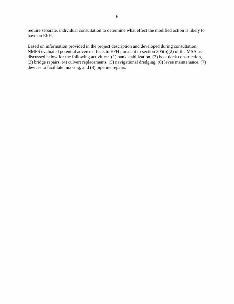
(1) BANK STABILIZATION – SPN: Northern and Central California Coast ONLY DURING FIRST YEAR OF IMPLEMENTATION
8
Description: For maintenance of existing bank stabilization, activity is limited to 500 feet in length for a specific episode. New bank stabilization projects shall not exceed 300 linear feet of stream bank or 1,000 square feet in area. For new bank stabilization projects, only bioengineering techniques designed to begin the process of naturally restoring the bank plant and animal community may be used. Design should emphasize the use of natural and local building materials, e.g., stone, gravel, sand, soil, wood, and native plants. Rock rip rap may be used in limited and discrete areas such as fill in a toe trench at the base of the bank and further up the bank where shear stress during high flow events is greatest. Any rock used should have the smallest diameter possible, be used sparingly, and be capped with sediment and native vegetation as part of the design. New bank stabilization projects that rely solely on rock rip rap for bank protection are not covered under this programmatic EFH consultation. The use of gabions, concrete mats, tires, and rubble is not covered under this programmatic EFH consultation for new bank stabilization projects or for maintenance of existing bank stabilization projects. In general, riverine streambank within the work area and access routes must be outside of flowing or standing water. With prior NMFS approval, projects may occur in flowing or standing water if the project area can be isolated by placing silt fences and sand bags between the work area and live stream in order to prevent sediment input to the stream. Operations shall cease if flows rise above the silt fence levels. Dewatering shall not be used to obtain dry conditions. Except for the project footprint and access routes, the bed and banks shall be undisturbed. This programmatic EFH consultation does not cover new bank stabilization projects on the Sacramento River upstream of Hamilton City or areas on the San Joaquin River upstream of the Merced River confluence. In addition, within the Southern California Coast, this programmatic EFH consultation only applies to bank stabilization projects that occur below mean high water; those Southern California Coast projects that occur landward of mean high water will continue to be covered under the existing EFH Programmatic Consultation between NMFS and USACE LAD. Adverse Effects: Activities covered under this programmatic EFH consultation normally would occur along estuarine and riverine shorelines, affecting intertidal and subtidal estuarine banks, and riparian vegetation along riverine banks. Bank stabilization projects, both individually and cumulatively, can adversely effect EFH through temporary impacts to the water column and permanent conversion of shorelines to uniform, artificial hard substrates, resulting in a loss of intertidal estuarine mudflats, subtidal estuarine soft bottom habitat, and/or riverine riparian cover. Shoreline armoring also causes increased energy seaward of the armoring, beach steepening, change in sediment storage capacity, and loss of organic debris (Williams and Thom 2001). Bank stabilization projects will adversely affect EFH both temporarily and permanently along rivers and estuaries. Project size limitations help decrease adverse effects.
9
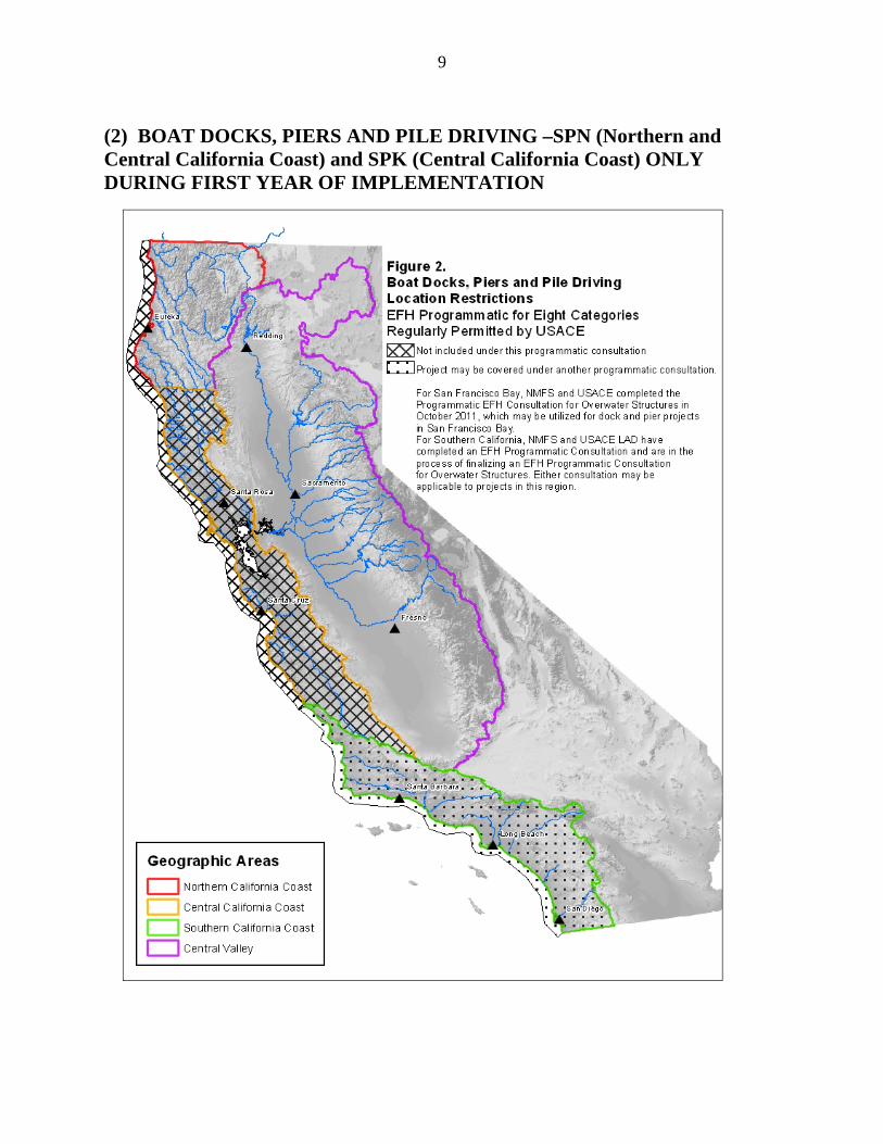
(2) BOAT DOCKS, PIERS AND PILE DRIVING –SPN (Northern and Central California Coast) and SPK (Central California Coast) ONLY DURING FIRST YEAR OF IMPLEMENTATION
10
Description: Activities covered under this programmatic EFH consultation are limited to reconfiguration of existing structures within an authorized marina area and construction of a single, new privately used boat dock for up to two boats. Boat dock and pier maintenance under this programmatic is limited. New pier and floating dock projects are restricted to the legal Delta. Projects outside the legal Delta, the mainstem Sacramento, San Joaquin, Mokelumne, and Calaveras Rivers and their tributaries are not included in this programmatic EFH consultation. NMFS and USACE SPN completed the Programmatic EFH Consultation for Overwater Structures in San Francisco Bay in October 2011, which may be utilized for applicable boat dock projects in San Francisco Bay. In addition, within the Southern California Coast, these activities are covered under the existing EFH Programmatic Consultation between NMFS and USACE SPL and/or the EFH Programmatic Consultation for Overwater Structures between NMFS and USACE SPL South Coast Branch, which NMFS submitted to the Corps SPL South Coast Branch on September 28, 2012. Any chemically treated wood material (e.g., pilings, decking, etc.) must be coated with an impact-resistant, biologically inert substance. Decking may be constructed of plastic or non-reactive (e.g., epoxy wood) products. Floating docks or other floatation devices will be constructed of materials that will not disintegrate, including concrete, steel, plastic or closed cell foam encapsulated in sun-resistant polyethylene. For reconfiguration in existing marinas, no dredging, additional slips, dock spaces, or expansion of any kind is authorized. Existing creosote piles in the project area that are affected by project activities must be completely removed or cut/broken at least three feet below mudline. There must be no increase in footprint for existing boat docks. Projects with multiple docks cannot be separated to meet the requirements of this programmatic consultation. No rip rap bank stabilization, excavation, creation of embayments, or removal of woody debris from the bank or channel is allowed. Light transmitting materials:
For construction of a single, new privately used boat dock, with total project area of no more than 400 square feet of surface area and total slip space less than 80 feet in length, light transmitting materials incorporated into the deck surface is not required.
For construction of a single, new privately used boat docks with total project area greater than 400 square feet but no more than 1,000 square feet, light transmitting materials shall be used in at least 40 percent of the project deck surface (pier, ramp/gangway, float/dock).
Projects greater than 1,000 square feet are not allowed under this programmatic. Pile driving and removal done as part of other categories of actions listed in this programmatic EFH consultation must meet the criteria listed below. Pile driving to build structures or facilities not otherwise covered by this programmatic EFH consultation is not included.
11
A vibratory hammer may be used to install and/or remove any number and size of steel, wood, or concrete piles. An impact hammer may be used to install piles for projects using only one hammer, where less than 20 piles are installed per day, and where the following size requirements are met:
wood piles – any size; concrete piles – piles must be 18 inches or less in diameter; and steel piles – piles must be 12 inches or less in diameter and hammer must be 3000
pounds or smaller and must use wood or nylon (plastic) cushion between the hammer and the piles.
Adverse Effects: Dock reconfiguration can degrade EFH through shading, replacement of soft bottom habitat with placement of piers and other supporting structures, modifying water circulation by temporarily affecting water column habitat during construction activities, and disturbance via activities associated with the use and operation of the facilities (Nightingale and Simenstad 2001). The shadow cast by an overwater structure affects both the plant and animal communities below the structure by limiting light for photosynthesizers, such as diatoms and benthic algae, eelgrass, and other macrophytes (Kahler et al. 2000, Haas et al. 2002), and by increasing predation by providing cover and perching platforms for piscivores (Helfman 1981). Wave energy and water transport alterations can impact the nearshore, detrital foodweb by altering the size, distribution, and abundance of substrate and detrital materials. The measures included in the project description, including limiting the activity to reconfiguration of existing structures within a marina, allowing for no increase in dock footprint, removal of creosote piles, and limiting size of new private docks will minimize adverse effects of this activity to EFH. Pile driving can generate underwater sound pressure waves that may adversely affect the ecological function of EFH by modifying the water column such that managed fish and prey species are killed, harmed, or injured (CalTrans 2001, Longmuir and Lively 2001, Stotz and Colby 2001, Abbott and Bing-Sawyer 2002). The type and intensity of the sounds produced during pile driving depend on a variety of factors, including but not limited to, the type and size of the pile, the firmness of the substrate into which the pile is being driven, the depth of the water, and the type and size of the pile-driving hammer. Wood and concrete piles appear to produce lower sound pressures than hollow steel piles of similar size. Vibratory hammers produce lower intensity sounds than impacts hammers. Limitation on hammer type and size and type of pile included in the project description should minimize adverse effects to EFH. The primary adverse effect of removing piles is the suspension of sediments, which may result in harmful levels of turbidity and release of contaminants contained in those sediments. Vibratory pile removal tends to cause the sediments to slough off at the mud line, resulting in relatively low levels of suspended sediments and contaminants. Vibratory removal of piles is gaining popularity because it can be used on all types of piles, if they are structurally sound. Breaking or cutting the pile below the mud line may suspend only small amounts of sediment, if the stub is left in place and little digging is required to access the pile. Direct pull or use of a clamshell to
12
remove broken piles, however, may suspend large amounts sediment and contaminants. When the piling is pulled from the substrate using these two methods, sediments clinging to the piling will slough off as it is raised through the water column, producing a potentially harmful plume of turbidity and/or contaminants. The use of a clamshell may suspend additional sediment if it penetrates the substrate while grabbing the piling. While there is a potential to adversely affect EFH during the removal of piles, many of those removed are old creosote-treated timber piles. In some cases, the long-term benefits to EFH obtained by removing a consistent source of contamination may outweigh the temporary adverse effect of turbidity.
13
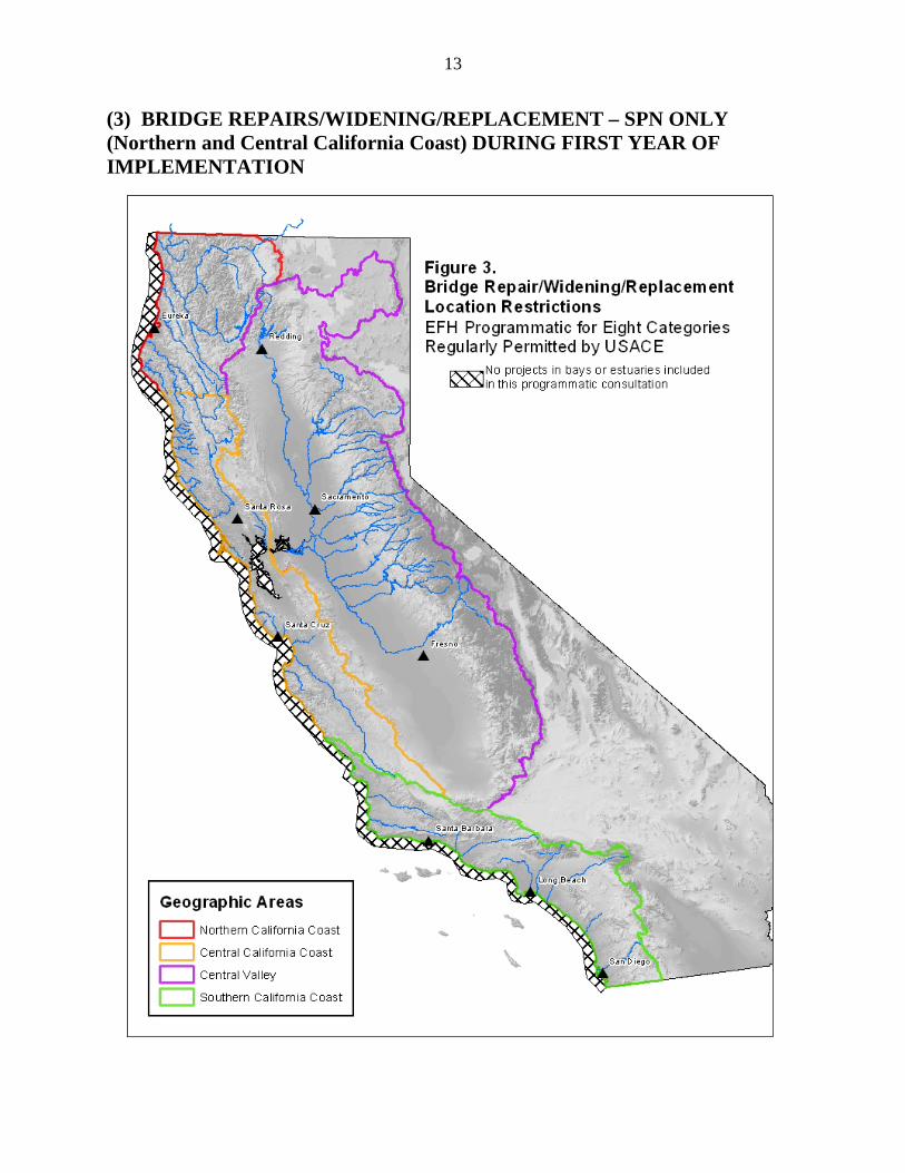
(3) BRIDGE REPAIRS/WIDENING/REPLACEMENT – SPN ONLY (Northern and Central California Coast) DURING FIRST YEAR OF IMPLEMENTATION
14
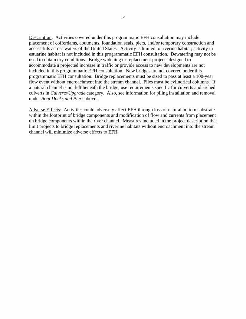
Description: Activities covered under this programmatic EFH consultation may include placement of cofferdams, abutments, foundation seals, piers, and/or temporary construction and access fills across waters of the United States. Activity is limited to riverine habitat; activity in estuarine habitat is not included in this programmatic EFH consultation. Dewatering may not be used to obtain dry conditions. Bridge widening or replacement projects designed to accommodate a projected increase in traffic or provide access to new developments are not included in this programmatic EFH consultation. New bridges are not covered under this programmatic EFH consultation. Bridge replacements must be sized to pass at least a 100-year flow event without encroachment into the stream channel. Piles must be cylindrical columns. If a natural channel is not left beneath the bridge, use requirements specific for culverts and arched culverts in Culverts/Upgrade category. Also, see information for piling installation and removal under Boat Docks and Piers above. Adverse Effects: Activities could adversely affect EFH through loss of natural bottom substrate within the footprint of bridge components and modification of flow and currents from placement on bridge components within the river channel. Measures included in the project description that limit projects to bridge replacements and riverine habitats without encroachment into the stream channel will minimize adverse effects to EFH.
15
(4) CULVERT REPLACEMENT/UPGRADE – SPN (Northern and Central California Coast) ONLY DURING FIRST YEAR OF IMPLEMENTATION
16
Description: Activities covered under this programmatic EFH consultation include repair, rehabilitation or replacement of any previously authorized, currently serviceable structure, removal of sediment and debris in the vicinity of existing structures, and placement of rip rap to protect existing structures. The removal of sediment and debris and the placement of rip rap are limited to the minimum necessary to restore the waterway or ensure safety of the structure. Culverts must meet NMFS Fish Passage Guidelines (http://swr.nmfs.noaa.gov/hcd/ NMFSSCG.PDF) and can be no longer than 100 feet. Replaced or upgraded culverts must be “in kind” or go up in order of preference set out in NMFS Fish Passage Guidelines. Culverts shall be sized to accommodate a 100-year flow event and associated debris and sediment. Fine sediment will be removed to an upland location where it cannot enter stream networks or road drainages hydrologically connected to streams. Southern California Coast and Central Valley area projects are not included in this programmatic EFH consultation. Adverse Effects: The majority of culvert replacement projects likely will be limited to riverine habitats, but could be located in tidally influenced areas near the mouths of creeks and/or rivers. Adverse effects of these activities include temporary disturbance of the water column and substrate during activities, permanent conversion of natural embankments and substrate with artificial, hard substrate, and potential scouring of soft bottom sediments from flow directly through the culvert. Measures in the project description limiting activities to replacement of existing structures, and limiting placement of rip rap will minimize adverse effects to EFH.
17
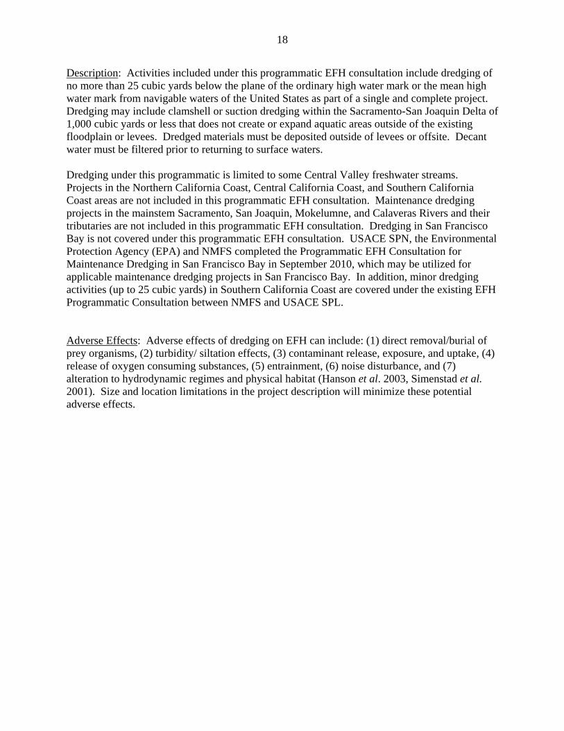
(5) NAVIGATIONAL DREDGING – SPN (Northern and Central California Coast) ONLY DURING FIRST YEAR OF IMPLEMENTATION
18
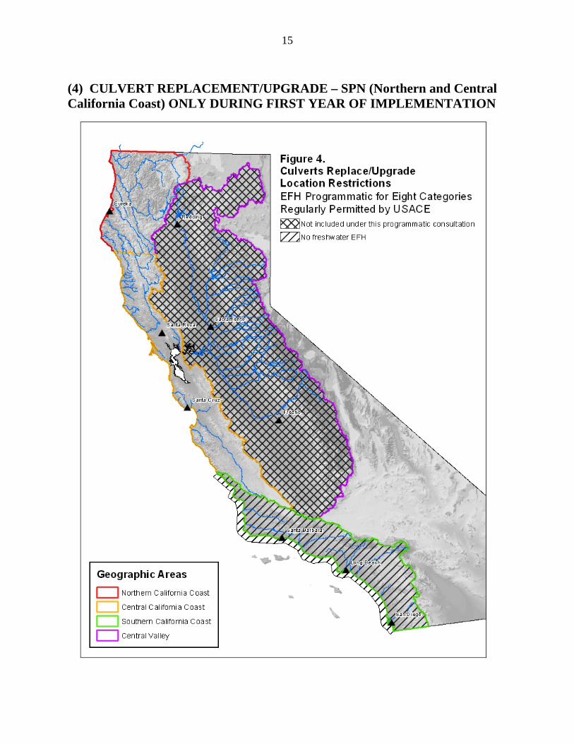
Description: Activities included under this programmatic EFH consultation include dredging of no more than 25 cubic yards below the plane of the ordinary high water mark or the mean high water mark from navigable waters of the United States as part of a single and complete project. Dredging may include clamshell or suction dredging within the Sacramento-San Joaquin Delta of 1,000 cubic yards or less that does not create or expand aquatic areas outside of the existing floodplain or levees. Dredged materials must be deposited outside of levees or offsite. Decant water must be filtered prior to returning to surface waters. Dredging under this programmatic is limited to some Central Valley freshwater streams. Projects in the Northern California Coast, Central California Coast, and Southern California Coast areas are not included in this programmatic EFH consultation. Maintenance dredging projects in the mainstem Sacramento, San Joaquin, Mokelumne, and Calaveras Rivers and their tributaries are not included in this programmatic EFH consultation. Dredging in San Francisco Bay is not covered under this programmatic EFH consultation. USACE SPN, the Environmental Protection Agency (EPA) and NMFS completed the Programmatic EFH Consultation for Maintenance Dredging in San Francisco Bay in September 2010, which may be utilized for applicable maintenance dredging projects in San Francisco Bay. In addition, minor dredging activities (up to 25 cubic yards) in Southern California Coast are covered under the existing EFH Programmatic Consultation between NMFS and USACE SPL. Adverse Effects: Adverse effects of dredging on EFH can include: (1) direct removal/burial of prey organisms, (2) turbidity/ siltation effects, (3) contaminant release, exposure, and uptake, (4) release of oxygen consuming substances, (5) entrainment, (6) noise disturbance, and (7) alteration to hydrodynamic regimes and physical habitat (Hanson et al. 2003, Simenstad et al. 2001). Size and location limitations in the project description will minimize these potential adverse effects.
19
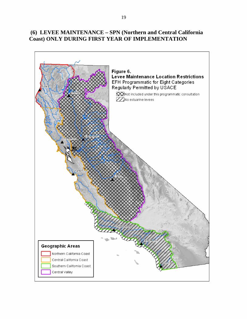
(6) LEVEE MAINTENANCE – SPN (Northern and Central California Coast) ONLY DURING FIRST YEAR OF IMPLEMENTATION
20
Description: Activities covered under this programmatic EFH consultation include placement of previously authorized material onto previously authorized, currently serviceable structure or fill without changing the character, scope, or size of the original fill. This activity does not include dredging from tidal areas for levee maintenance material. Projects must be no more than 300 feet in length. Projects in Southern California Coast and Central Valley areas are not included in this programmatic consultation. In the Northern California coast and Central California Coast areas, the streambed within the work area and access routes must be outside of flowing or standing water. With prior NMFS approval, projects that are proposed to occur in flowing or standing water in streams where salmonids are likely to be absent during the construction period may proceed if the project area can be isolated by placing silt fences and sand bags between the repair and live stream in order to prevent sediment input to the stream. Operations shall cease if flows rise above the silt fence levels. Adverse Effects: Activities could occur in riverine or estuarine habitats. Adverse effects from levee maintenance include temporary increases in suspended sediment from fallback of sediment or maneuvering construction equipment into the work area, and loss of overhanging vegetation that may have established along the outboard slope of the levee. Limiting the activity to the footprint of a previously established levee and use of previously authorized material will avoid increasing the adverse effects of levee placement.
21
(7) DEVICES TO FACILITATE MOORING – SPN (Northern and Central California Coast) ONLY DURING FIRST YEAR OF IMPLEMENTATION
22
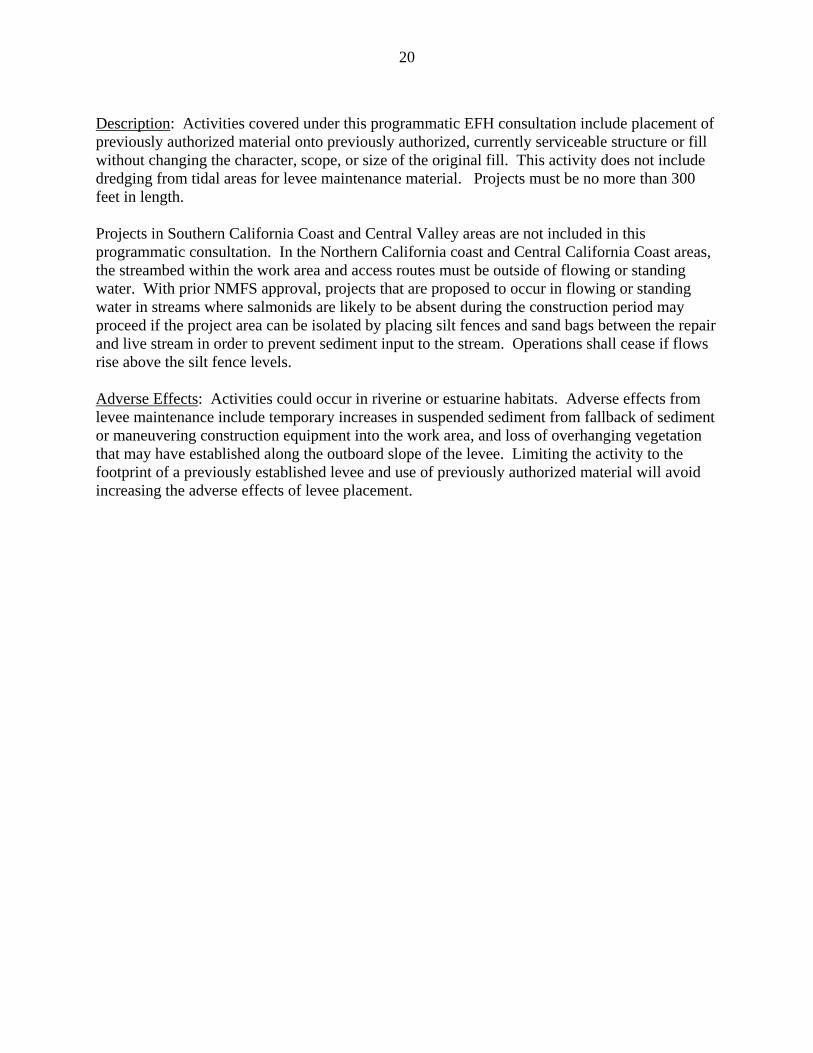
Description: Activities covered under this programmatic EFH consultation include projects such as buoys, floats, and other devices placed within anchorage or fleeting areas to facilitate moorage of vessels where the U.S. Coast Guard has established such areas for that purpose and non-commercial, single-boat, mooring buoys are included. Sheet pile walls are not included. Floating breakwaters are not allowed. Proposed activities that exceed the limits and purpose of USACE Nationwide Permits (NWP) #9 and #10 are not included. For mooring anchors and persistently moored vessels, the project proponent should strive to implement avoidance measures to the extent feasible. When avoidance measure are not feasible, minimization measures should be implemented. Avoidance and minimization measures are included in the Conservation Recommendations. This programmatic EFH consultation does not cover devices to facilitate mooring in Southern California Coast area since those projects will continue to be covered under the existing EFH Programmatic Consultation between NMFS and USACE SPL. Adverse Effects: Mooring buoys are a common method for anchoring boats; however, their chains can drag across the seafloor tearing up vegetation. In addition to uprooting seagrass, mooring chains can alter sediment composition ultimately impacting the benthic biota (Ostendorp et al. 2008). Walker et al. (1989) investigated the impacts of mooring buoys in Western Australia and found the 5.4 hectares of seagrass had been lost to mooring. The location of the damage within the bed may influence the extent of damage with more significant impacts associated with mooring in the center of the bed versus along the edge. The trend of seagrass loss from boat moorings is increasing. This correlates with increased vessel use (Hastings et al.1995). Examples of mooring chain damages are evident throughout the world Jackson et al.2002, Hiscock et al. 2005, Otero 2008). Williams and Bechter (1996) examined the effects of 5 different mooring systems on marine vegetation. Their study concluded that mid-line float systems and all-rope lines had the least impact on substrate and aquatic vegetation. Disturbance impact of the remaining mooring types (e.g., swinging chain moorings) ranged from 86 percent to 100 percent disturbance.
23
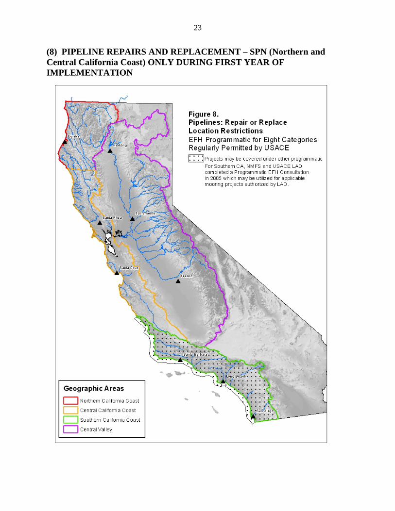
(8) PIPELINE REPAIRS AND REPLACEMENT – SPN (Northern and Central California Coast) ONLY DURING FIRST YEAR OF IMPLEMENTATION
24
Description: Activities included under this programmatic EFH consultation include construction, maintenance or repair of utility lines, including outfall and intake structures. This programmatic EFH consultation does not apply to new pipeline projects. Work may include trenching or boring. Replacement pipeline must be the same capacity as old pipeline. Pipelines must be relatively perpendicular (45-90 degrees) to stream banks and cannot run along stream banks. Replaced pipelines do not need to be in the same location as long as old pipeline is removed from stream bed and banks. Dewatering shall not be used to obtain dry conditions. Streamside woody vegetation will not be disturbed. Banks will be re-seeded with native vegetation to stabilize disturbed banks. Channels will be restored to pre-project contours and characteristics (i.e., no loss of pools, riffles, or cover) prior to natural rewatering of work area. In the Central Valley area, this programmatic EFH consultation only applies to project pipelines four feet in diameter or less in dry stream channels less than 300 feet in elevation. For freshwater areas outside of the Central Valley, the streambed within the work area must be dry throughout the construction period with no flowing or ponded water. If work includes boring, the applicant should perform a geologic analysis and there must be a low likelihood that a frac-out will occur. The geotechnical survey should be provided to NMFS prior to construction. A NMFS-approved contingency plan must be prepared and ready for implementation, and an emergency response team and equipment must be maintained on site at all stream crossings. The appropriate NMFS field office will be contacted immediately in the case of a frac-out. Construction equipment and personnel shall operate outside the stream channel and bank or levees so that no in-channel impacts occur. Pipeline projects in the Central Valley area must be buried at least 30 feet below the substrate. This programmatic EFH consultation does not cover pipeline repairs and replacement in Southern California Coast area since those projects will continue to be covered under the existing EFH Programmatic Consultation between NMFS and USACE SPL. Adverse Effects: Adverse effects to EFH from pipeline installation can occur through destruction of organisms and habitat during construction, increases in turbidity, resuspension of contaminants, and changes in hydrology (Hanson et al. 2003). Limitations for working in flowing water included in the project description should minimize adverse effects of pipeline repair projects in freshwater habitats. Adverse effects of activities in estuarine habitats where working in dry conditions is not possible will occur. Conclusions As described in the above effects analysis, NMFS determines that the proposed actions would adversely affect EFH for various federally managed fish species within the Pacific Coast Groundfish, Pacific Coast Salmon, and Coastal Pelagic Species FMPs. The proposed actions contain measures to avoid, minimize, mitigate, or otherwise offset the majority of adverse effects to EFH. However, some adverse effects may be unavoidable.
25
EFH Conservation Recommendations The following EFH Conservation Recommendations are provided to avoid, minimize, and/or mitigate impacts to EFH. NMFS advises USACE that these recommendations be incorporated into any project using this programmatic EFH consultation. Project Tracking 1. For the purpose of annual tracking and determining cumulative effects, USACE will
provide an annual summary of the activities undertaken and will provide geographical coordinates (i.e., latitude/longitude coordinates) for each action. This information will include the number of each action, the amount of acres of habitat adversely affected, the type of habitat adversely affected, and the relevant EFH Conservation Recommendations implemented. USACE will make this information available to NMFS and the public on an annual basis. Information may be made available to the public through postings on the USACE website.
Sensitive Habitats 2. USACE should ensure that projects avoid impacts to sensitive habitat resources, including
rock habitat (e.g., bedrock, boulders, cobble, gravel), submerged aquatic vegetation, kelp, and intertidal mudflats. For avoiding direct and indirect impacts, activities should be located at an appropriate distance from sensitive habitat (depending on geographic location, sediment type, and water circulation).
3. When impacts to sensitive habitat resources, including rock habitat (e.g., bedrock, boulders,
cobble, gravel), submerged aquatic vegetation, and/or kelp are unavoidable USACE should: (1) notify NMFS of potential impacts; (2) ensure a biological survey is conducted to map the coverage of the sensitive resources; and (3) ensure a mitigation plan is developed to compensate for biological resource losses. The results of the biological survey and the mitigation plan should be submitted to USACE and NMFS for review and approval. Methodology for conducting biological surveys should be appropriate for the geographic area, location, water clarity and depth of project. For example, in areas where there is low visibility, acoustic surveys are preferred. EFH coordination requirements should not be considered complete until USACE and NMFS concur on the adequacy of the proposed mitigation plan. If concurrence is not reached between the agencies, the proposed action is not eligible to be covered by this programmatic EFH consultation, and an individual EFH consultation should be completed for the proposed action.
4. USACE should ensure tree removal is limited to points of ingress and egress during
proposed construction activities. If trees must be removed from other portions of project sites, no willows over 3 inches in diameter at breast height (dbh) should be removed and the canopy cover provided by hardwoods should not be reduced. Any trees removed should be replanted to achieve 1:1 successful revegetation.

26
5. USACE should implement the Southern California Eelgrass Mitigation Policy for all projects within Southern California, especially those projects that result in benthic disturbance (e.g., piling installation, dredging, etc.). This policy addresses, among other issues, the mitigation site, mitigation ratio, mitigation techniques, timing and monitoring for Southern California. In most cases, this information should also be used for Central and Northern California. The policy can be accessed at: http://swr.nmfs.noaa.gov/hcd/policies/EELPOLrev11_final.pdf.
6. USACE SPL should implement the Southern California Caulerpa Control Protocol. The
protocol is designed to minimize the spread and introduction of this species and other potentially invasive species of this genus to California nearshore, coastal, and enclosed bays, estuaries, and harbors from Morro Bay to the U.S./Mexican border. The protocol can be accessed at: http://swr.nmfs.noaa.gov/hcd/caulerpa/ccp.pdf.
Bank Stabilization 7. Wherever possible, soft approaches (e.g., beach nourishment, vegetative plantings, and
placement of large woody debris) to shoreline modifications should be utilized. 8. Wherever possible, bank stabilization projects along estuarine and marine shorelines should
incorporate natural habitats (e.g., living shorelines). Boat Docks, Piers, and Pile Driving and Removal 9. Docks should be located in sufficiently deep waters to avoid intertidal and shade impacts,
to minimize or preclude dredging, to minimize groundings, and to avoid displacement of submerged aquatic vegetation.
10. Measures that increase the ambient light transmission under piers and docks should be
incorporated into project design. These measures include, but are not limited to, maximizing the height of the structure and minimizing the width of the structure to decrease shade footprint, grated decking material, using solar tubes or glass blocks to direct sunlight under structure.
11. All pilings and navigational aids, such as moorings and channel markers, should be fit with
devices to prevent perching by piscivorous bird species. 12. In areas of strong current, piles should be installed when the current is reduced (i.e.,
centered around slack current) to minimize the volume of water exposed to sound pressure waves.
13. Overwater structures should use the fewest number of piles as practicable for necessary
support of the structure to minimize pile shading, substrate impacts, and impacts to water circulation. Pilings should be spaced a minimum of 10 feet apart on center.
14. Remove piles completely rather than cutting or breaking off if the pile is structurally sound.
27
15. Minimize the suspension of sediments and disturbance of the substrate when removing
piles. Measures to accomplish this include, but are not limited to, the following:
a) When practicable, remove piles with a vibratory hammer, rather than the direct pull or clamshell method.
b) Remove the pile slowly to allow sediment to slough off at, or near, the mud line.
c) The operator should first hit or vibrate the pile to break the bond between the
sediment and pile to minimize the potential for the pile to break, as well as reduce the amount of sediment sloughing off the pile during removal.
d) Place a ring of clean sand around the base of the pile. This ring will contain some
of the sediment substrate. 16. Complete each pass of the clamshell to minimize suspension of sediment if pile stubs are
removed with a clamshell. 17. Fill all holes left by the piles with clean, native sediments if possible. 18. Place piles on a barge equipped with a basin to contain all attached sediment and runoff
water after removal. Creosote-treated timber piles should be cut into short lengths to prevent reuse, and all debris, including attached, contaminated sediments, should be disposed of in an approved upland facility.
19. Drive broken/cut stubs using a pile driver, sufficiently below the mud line to prevent
release of contaminants into the water column as an alternative to their removal. Dredging 20. New dredging should be avoided to the maximum extent practicable. Activities that likely
would require dredging (such as placement of piers, docks, marinas, etc.) should be sited in deep water areas or designed to alleviate the need for maintenance dredging.
21. Bankward slopes of the dredged area should be slanted to acceptable side slopes (e.g., 3:1)
to ensure that sloughing does not occur. Levee Maintenance 22. Whenever feasible, alternative levee maintenance methods (e.g., brush boxes, vegetative
plantings) and softening techniques (e.g., backfill rip rap with sediment and plantings) should be incorporated into project design.
28
Devices to Facilitate Mooring 23. Avoidance and Minimization Measures: Avoidance:
1. All new anchored moorings and persistently moored vessels should be placed in areas in which submerged aquatic vegetation (SAV) habitat is absent. This will prevent adverse shading impacts to SAV.
2. Persistently moored vessels should be placed in waters deep enough so that the bottom of the vessel remains a minimum of 18 inches off the substrate during extreme low tide events. This will prevent adverse grounding impacts to benthic habitat.
Minimization: 1. Mooring anchors placed within SAV or habitat suitable for SAV should be of the
type which use midline floats to prevent chain scour to the substrate. This will prevent adverse impacts to SAV and other benthic habitat.
2. Persistently moored vessels that are moored over SAV or rocky reef habitats with less than 18 inches between the bottom of the vessel and the substrate at low tides should utilize float stops. This will prevent adverse grounding impacts to benthic habitat.
Pipeline Repairs 24. Pipeline routes should be aligned along the least environmentally damaging route, avoiding
sensitive habitats such as rock habitat, submerged aquatic vegetation, native oyster beds, emergent marsh, and intertidal sand and mudflats.
25. Horizontal direction drilling should be used through intertidal and tidal marsh areas. 26. Pipelines and submerged cables should be buried where possible. 27. Bentonite and other environmentally deleterious lubricants and fluids should not be used
below ordinary high water. 28. Inactive pipelines and submerged cables should be removed unless they are located in
sensitive areas. If allowed to remain in place, pipelines should be properly pigged, purged, filled with water, and capped prior to abandonment in place.
29. Silt curtains or other type barriers should be used to reduce turbidity and sedimentation if
submerged aquatic vegetation or native oyster beds occur at or near the project site. NMFS developed a flowchart for a stepwise decision making process as guidance for action agencies to determine when to implement best management practices for minimizing turbidity from dredging actions as part of the programmatic EFH consultation in San Francisco Bay. This document is posted on the Southwest Region website (http://swr.nmfs.noaa.gov/hcd/HCD_webContent/nocal/kmls.htm) and may be used to evaluate avoidance and minimization measures for any project that generates turbidity.
30
Literature Cited
Abbott, R., and E. Bing-Sawyer. 2002. Assessment of pile driving impacts on the Sacramento blackfish (Othodon microlepidotus). Draft report prepared for Caltrans District 4.
California Department of Transportation (CalTrans). 2001. Fisheries Impact Assessment, Pile Installation Demonstration Project for the San Francisco – Oakland Bay Bridge, East Span Seismic Safety Project. 59 p.
Haas, M.A., C.A. Simenstad, Jr., J.R. Cordell, D.A. Beauchamp, and B.S. Miller. 2002. Effects
of large overwater structures on epibenthic juvenile salmon prey assemblages in Puget Sound, Washington. Prepared for the Washington State Transportation Commission, Washington State Department of Transportation, U.S. Department of Transportation, and Federal Highway Administration. Final research report No. WA-RD 550.1. 114 p.
Hanson, J., M. Helvey, and R. Strach (editors). 2003. Non-fishing impacts to essential fish
habitat and recommended conservation measures. National Marine Fisheries Service (NNMFS), version 1. Southwest Region, Long Beach, CA.
Hastings, K., P. Hesp, and G.A. Kendrick. 1995. Seagrass loss associated with boat moorings at
Rottnest Island, Western Australia. Ocean & Coastal Management 26 (3): 225-246. Helfman, G.S. 1981. The advantage to fish of hovering in shade. Copeia (2):392-400. Hiscock, K., J. Sewell, and J. Oakley. 2005. Marine health check 2005. A report to gauge the
health of the UK’s sea-life. Godalming, WWF-UK. 79 p. Jackson, E.L., A.A. Rowden, M.J. Attrill, S.F. Bossy, and M. B. Jones. 2002. Comparison of
fish and mobile macroinvertebrates associated with seagrass and adjacent sand at St. Catherine Bay, jersey (English Channel): Emphasis on commercial species. Bulletin of Marine Science 71 (3): 1333-1341.
Kahler, T., M. Grassley, and D. Beauchamp. 2000. A summary of the effects of bulkheads, piers, and
other artificial structures and shorezone development on ESA-listed salmonids in lakes. City of Bellevue.
Longmuir, C., and T. Lively. 2001. Bubble curtain systems for use during marine pile driving.
Report by Fraser River Pile and Dredge Ltd. New Westminister, British Columbia. 9 p. Ostenthorp, W., T. Gretler, M. Mainberger, M. Peintinger, and K. Schmieder. 2008. Effects of
mooring management on submerged vegetation, sediments and macro-invertebrates in lake Constance, Germany. Wetlands Ecology and Management 17(5): 525-541.
Otero, E. 2008. Characterization of mechanical damage to seagrass beds in La Cordillera Reefs
natural Reserve. Conservation and management of Puerto Rico’s Coral Reefs, Task CRI-10. 57 p.
31
Nightingale, B., and C.A. Simenstad, Jr. 2001. Dredging activities: Marine issues, Seattle, WA 98105: Washington State Transportation Center, University of Seattle (http://depts.washington.edu/trac/reports/reports.html).
Simenstad, C.A, Jr., C.D. Tanner, F. Weinmann, and M. Rylko. 1991. The estuarine habitat
assessment protocol. Puget Sound Notes No. 25. Stotz, T., and J. Colby. 2001. January 2001 dive report for Mukilteo wingwall replacement
project. Washington State Ferries Memorandum. 5 p. + appendices. Walker D.I., R.J. Lukatelich, G. Bastyan, and A.J. Mccomb. 1989. Effect of boat moorings on
seagrass beds near Perth, Western Australia. Aquatic Botany 36: 69-77. Williams, B., and C. Bechter. 1996. Impact of mooring buoy installations on eelgrass and
macroalgae, Washington Department of Fish and Wildlife. Williams, G.D., and R.M. Thom. 2001. Marine and estuarine shoreline modification issues.
White paper submitted to Washington Department of Fish and Wildlife, Washington Department of Ecology, and Washington Department of Transportation. 99 p.