Embed Size (px)
Citation preview


PROFILE: MANGAUNG METRO
2
PROFILE: MANGAUNG METRO 3
CONTENT
1. Executive Summary ............................................................................................. 5
2. Brief Overview ...................................................................................................... 7 2.1. Historical Perspective .............................................................................................. 7 2.2. Location .................................................................................................................. 7 2.3. Spatial Pattern ......................................................................................................... 9
3. Social Development Profile ............................................................................... 10 3.1. Key Demographics ................................................................................................ 10 3.1.1. Population .......................................................................................................... 10 3.1.2. Gender, Age and Race ....................................................................................... 10 3.1.3. Households ........................................................................................................ 12 3.2. Health Profile ......................................................................................................... 13 3.3. Covid-19 ................................................................................................................ 14 3.4. Poverty Dimensions .............................................................................................. 16 3.4.1. Distribution ......................................................................................................... 16 3.4.2. Inequality ............................................................................................................ 16 3.4.3. Employment/Unemployment............................................................................... 18 3.4.4. Crime ................................................................................................................. 19 3.5. Education and Skills Profile ................................................................................... 19
4. Drivers of the Economy ..................................................................................... 23 4.1. Structure of the Economy ...................................................................................... 23 4.2. Primary Sector ...................................................................................................... 24 4.3. Secondary Sector .................................................................................................. 24 4.4. Tertiary Sector ....................................................................................................... 25 4.5. Tourism ................................................................................................................. 26
5. Service Delivery.................................................................................................. 26 5.1. Water and Sanitation ............................................................................................. 26 5.2. Human Settlements ............................................................................................... 27 5.3. Electricity ............................................................................................................... 28 5.4. Waste Management .............................................................................................. 28 5.5. Transport ............................................................................................................... 29 5.6. Community Facilities ............................................................................................. 29
6. Governance and Management .......................................................................... 30 6.1. Municipal performance .......................................................................................... 30 6.2. Municipal Capacity ................................................................................................ 30
7. Projects to Diversify and Grow the Economy .................................................. 31 7.1. Spatial Development ............................................................................................. 31 7.2. Ecological Potential and Biodiversity ..................................................................... 32 7.3. Economic Projects................................................................................................. 33 7.3.1. Mangaung Airport Node ..................................................................................... 33 7.3.2. Thaba Nchu Agri-Hub ......................................................................................... 34
8. Key Recommendations ...................................................................................... 35
PROFILE: MANGAUNG METRO
4

PROFILE: MANGAUNG METRO 5
CO
VID
-19 V
uln
era
bility
Index
Ma
ngaung
Sourc
e: C
SIR
/NC
DM
`

PROFILE: MANGAUNG METRO
6
1. Executive Summary Mangaung, is one of the eight metros in South Africa and easily
accessible via National infrastructure including the N1, N6, N8 and
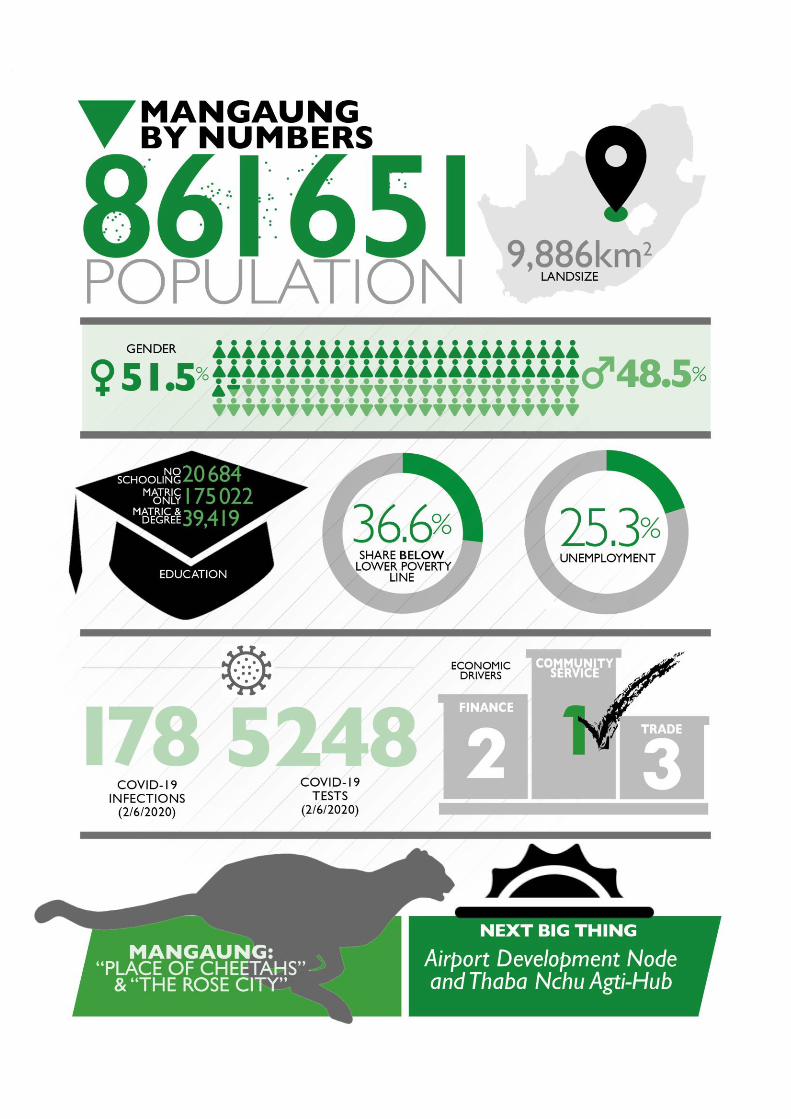
Bram Fischer International Airport. There are currently 861 651 people
living in Mangaung comprising of 276 905 households. Using the
lower bound poverty line 36.6% of the population lives in poverty. The
Metro’s Gini Coefficient is 0,62 , making this municipality the most
unequal. This is a reflection of its large rural area. The unemployment
rate in Mangaung is 25.3%% is lower than the provincial and national
average.
Mangaung is the epicentre of COVID-19 in Free State. As at 02 June 2020, 5 248
COVID-19 tests have been conducted in Mangaung, recording 178 confirmed cases,
7 deaths and 134 recoveries. Botshabelo recorded 2 confirmed cases, Bloemfontein
174 and Thaba Nchu 2 confirmed cases. There are 12 quarantine sites in
Mangaung, 11 of the quarantine sites are located in Bloemfontein. 1 405 public and
private beds have been made available to the Metro. As at 29 May 2020, seven of
the quarantine sites have been activated.
The main economic sector in Mangaung is the tertiary sector with a share of 83.2%
in 2017 and is mainly driven by community services (33%). The community service
sector is comprised of the provincial government headquarters, the three tertiary
institutions, healthcare and other facilities. The tertiary sector is the largest employer
in the Metro with community services (32.4%) being the highest, followed by trade at
16.2% and finance at 15.1%.
Mangaung’s audit outcomes show that it regressed from an unqualified audit opinion
in 2015/16 financial year to a disclaimer in 2016/17. Some of the challenges
identified include the poor monitoring of internal controls. The high vacancies in the
Engineering Services at 1 094 and social services at 742 has an impact on the
delivery and provision of services.
The Built Environment Performance Plan (BEPP) has identified catalytic projects
which are deemed to have potential to make a significant impact on the built
environment and ensuring economic growth. The Thaba Nchu Agri-Hub is one of the
most important catalytic projects that will impact positively on the Metropolitan area
and beyond. The potential linkages between agriculture and manufacturing through
agro-processing have been identified.

PROFILE: MANGAUNG METRO 7
2. Brief Overview
2.1. Historical Perspective
The name Mangaung is a Sesotho name meaning ‘place of Cheetahs’.
It was previously known by the name of its Central Business District,
Bloemfontein, which is Dutch for ‘fountain of flowers’. Bloemfontein
was established as a British Fort in 1846 and is currently the judicial
capital of South Africa. Because of its central location and abundance
of water it has served as the capital of several peoples including, the
Boer, the Griqua (a sub-group of the Khoe-speaking nations) as well
as the Barolong who are of Tswana descent.
The Metro is also the birth city of Africa’s oldest liberation movement the African
National Congress, which was formed in 1912 at the Wesleyan Church. Two years
later, in 1914, the National Party was founded in Bloemfontein.
Mangaung, is one of the eight Metros in South Africa. It was founded as a Metro in
2011, prior to that it was a local municipality under the Motheo District Municipality.
In 2016, the Metro was merged with Naledi local municipality to form the current
municipal boundaries.
2.2. Location
Mangaung Metropolitan Municipality is centrally located within the
Free State province, the central interior of South Africa. Mangaung
shares its boundaries with the Districts of Lejweleputswa to its north,
Thabo Mofutsanyane to its north east and Xhariep to its south. To its
south east, Mangaung shares a border with Lesotho.
The Metro is accessible via National infrastructure including the N1 (which links
Bloemfontein to Gauteng to the north and Western Cape to the southwest), the N6
(which links Bloemfontein to the Eastern Cape), and the N8 (which links to Lesotho
in the east and with the Northern Cape to the west).
“THE METRO IS ALSO THE BIRTH CITY OF AFRICA’S
OLDEST LIBERATION MOVEMENT THE AFRICAN
NATIONAL CONGRESS, WHICH WAS FORMED IN
1912 AT THE WESLEYAN CHURCH.”

PROFILE: MANGAUNG METRO
8
There are seven main administrative regions in the city:
• Bloemfontein is highly accessible with well-developed infrastructure and transport
networks, including three national roads, a railway link between Gauteng and the
Western Cape, as well as an international airport (Bram Fisher Airport).
• Botshabelo located 55km to the east of Bloemfontein, Botshabelo is a township
that was established in the early 1980s as a labour reservoir for Bloemfontein. With
an unemployment rate of 32.9% the town greatly depends on Bloemfontein for
employment.
• Thaba Nchu is a “tribal area” located 12 km to the east of Botshabelo. The town
used to form part of the Bophuthatswana “Bantustan” homeland. Thaba Nchu
comprises of the main town surrounded by about 37 rural villages located on trust
land under traditional leadership.
• Dewetsdorp is located 75km south-east of Bloemfontein on the R702 and is part of
the Battlefields Route. The Town also comprises two urban settlements (Dewetsdorp
and Morojaneng), and is surrounded by land with a medium to high agricultural
potential.
• Wepener was established as a municipality in 1880, the town was established on
the banks of Jammersbergspruit, a tributary of the Caledon River. Together with
Dewetsdorp, the towns were merged into Mangaung Metro when Naledi Local

PROFILE: MANGAUNG METRO 9
Municipality was disestablished on 03 August 2016. The town serves as one of the
gateways into Lesotho, given its proximity to the Van Rooyen’s border post. The
Second Anglo Boer War took place in Dewetsdorp and Wepener.
• Van Stadensrus is located 30km from Wepener on the R702 and is another
frontier town on the border of South Africa and Lesotho.
• Soutpan is a small town located 38km to the north-west of Bloemfontein. The town
was established due to the salt mining activities in the area and produces a vast
amount of salt. The area is also known for the Florisbad anthropological area and the
Soetdoring Nature Reserve.
2.3. Spatial Pattern
Mangaung covers an area of 9 886 km² and has three urban centres (Bloemfontein,
Botshabelo and Thaba Nchu) and a surrounding rural area with small towns namely,
Dewetsdorp, Wepener, Van Stadensrus and Soutpan/Ikgomotseng. The rural area
makes up the largest percentage (97.17%) of the entire municipal area and is
characterised by extensive commercial farming in the west, mainly mixed crop
production and cattle farming. The Metro is characterised by three different land use
types including formalised stands in urban areas, small holdings and farms.
Mangaung Spatial Pattern Source: Mangaung Draft SDF2020

PROFILE: MANGAUNG METRO
10
The Barolong Tribal Authority oversees 37 villages dispersed across the tribal area.
21 villages are located to the north and 16 villages are located to the south of the
tribal area. The rural areas in between the villages are characterized by large
stretches of communal grazing land and utilized for cattle. Ownership of the land has
been a contentious issue for years and it is expected that the land will be transferred
to the Traditional Council. Local residents have expressed a need to obtain
ownership of the small plots on which they reside.
3. Social Development Profile
3.1. Key Demographics
3.1.1. Population
In 2019 Mangaung Metropolitan Municipality’s population has risen to
861 651 from 853 141 in 2018. The growth rate has been declining
from 1.6% in 2011 to 1.0% in 2019. Over half of the population is
concentrated in Bloemfontein (63%), followed by Botshabelo (24%),
Thaba Nchu (9%), Dewetsdorp and Wepener (1.5%), Soutpan (0.8%)
and Van Stadensrus at (0.2%) (StatsSA, 2016).
3.1.2. Gender, Age and Race
In Mangaung, the median age is 25 and is similar to South Africa’s median age of 25
years. The largest share of population is within the young working age (25-44 years)

PROFILE: MANGAUNG METRO 11
age category with a total number of 274 400 (31.8%) of the total population. The age
category with the second largest number of people is the young children (0-14 years)
age category with a total share of 25.6%, followed by the older working age (45-64
years) age category with 156 038 (18.1%) people. The age category with the least
number of people is the retired / old age group (65 years and older) with only 64 378
(7.4%) people.
Mangaung's population consisted of 86% African, 11% White and 4% Coloured. With
the African population group representing a majority of Mangaung’s total population,
the overall population pyramid for the region will mostly reflect that of the African
population group.
6,0% 4,0% 2,0% 0,0% 2,0% 4,0% 6,0%
00-04
05-09
10-14
15-19
20-24
25-29
30-34
35-39
40-44
45-49
50-54
55-59
60-64
65-69
70-74
75+
Population structure, Total, 2019MAN Mangaung vs. National
MAN
Mangaung
Male Female
Source: IHS Markit Regional eXplorer version 1946

PROFILE: MANGAUNG METRO
12
440 060 (51.07%) of the population are females and 421 591 (48.9%) of the
population are males. The Mangaung metropolitan municipality has similar males
(48.9%) relative to South Africa (48.96%), and this is typically seen in a stable
population.
3.1.3. Households
There are 276 905 households in Mangaung. This is an increase from 265 560
households in 2016 and 231 921 households in 2011. There are 74% of households
who reside in a house. 11.7% of the households reside in informal shacks, which is
slightly higher than the provincial average of 13.99%. 6.5% in a flat in a backyard.
Approximately 70.1% of the households within the Metro live in fully paid off
properties or properties that are in the process of being ‘fully paid off’, this is a
increase from 62,3% in 2011. About 14% of the households live in properties rented
from private individuals and 8% of households are renting from the state, including
the municipality and social housing schemes subsidised by the government. The
average household size is 3.1 persons per household, which is lower than the South
Africa average of 3,3.
41.1% of the households are headed by women. This is a marginal increase from the
40,8% registered in 2011 and is similar to the national average of 41%. Mangaung
Metro has 1 418 child headed households that are headed by children under the age
of 18. 47% are headed by the girl child.

PROFILE: MANGAUNG METRO 13
3.2. Health Profile
There are 129 198 HIV positive people in the metro. HIV/AIDS is the leading cause
of death for the 5-14 (10.8%), 15-24 (16.6%) and 25-64 (18.1%) age categories.
Cerebrovascular disease, such as strokes (15.4%), followed by Ischaemic heart
disease (10.1%) and Lower respiratory infections (8.4%) are the leading causes of
death for those above 65. Lower respiratory infections feature amongst the top 10
causes of death for all age categories in Mangaung. For children below the age of 5
age, preterm birth complications (13.8%), lower respiratory infections (13.3%) and
diarrhoeal diseases (11.7%) are the leading causes of death.
In terms of maternal conditions, indirect maternal conditions (42.8%), other maternal
(25.7%) and hypertension in pregnancy (19.2%) were the top three leading causes
of death amongst women in the 15-49 age category.
In 2017/18 the teenage pregnancy rate was 9%. The maternal mortality ratio (per
100 000 live births) in the district stands at 128,6. The immunization rate in
Mangaung Metro is at 72,1%.
Mangaung metropolitan municipality is comprised of four health subdistricts namely,
Bloemfontein, Botshabelo, Naledi and Thaba Nchu. The Metro has 313 clinics and
122 mobile clinics. Many of these are located in in Bloemfontein, Thaba Nchu and
Botshabelo. Smaller towns have around 1-3 clinics each. There are 36 state-owned
hospitals and 26 private hospitals, all hospitals are located in Bloemfontein besides
three that are in Thaba Nchu and Botshabelo.
PROFILE: MANGAUNG METRO
14
3.3. Covid-19
The first case of Covid-19, case Zero, was discovered in South Africa on the 5th of
March 2020, in KwaZulu-Natal. In the early stages of the Covid-19 pandemic in
South Africa, Mangaung Metropolitan Municipality was a hotspot following a church
gathering where 300 worshippers came into contact with five tourists who had tested
positive for Covid-19. Massive contact tracing, and testing of members who had
attended the church gathering was undertaken. An 85-year-old male, who attended
the religious gathering, became the third South African to die from Covid-19 related
complications at the Pelenomi Hospital in Bloemfontein. With lower respiratory
infections featuring amongst the top 10 cause of death for all age categories in the
Mangaung, extra precaution must be taken especially since symptoms of Covid-19
include mild to severe respiratory illness.
As at 02 June 2020, 5 248 tests have been conducted in Mangaung, recording 178
confirmed cases, 7 deaths and 134 recoveries. Botshabelo recorded 2 confirmed
cases, Bloemfontein 174 and Thaba Nchu 2 confirmed cases. Mangaung remains
the epicentre of Covid-19 in the Free State, followed by Xhariep District with 50
cases and Fezile Dabi with 33 cases.
The Council for Scientific and Industrial Research (CSIR) in collaboration with Albert
Luthuli Centre for Responsible leadership have developed a set of COVID-19
Vulnerability Indicators using available data and knowledge. It identifies
vulnerabilities present in communities and identifying areas in need of targeted
coordinated interventions and early response. The purpose of the indicators is
intended to support the early prevention/mitigation and preparedness phase of the
disaster management cycle and informing disaster management decision making. It
is not based on epidemiological modelling but a response to highlighting intervention
areas due to underlying situation. The composition of the index follows two main
factors, namely: transmission potential and health susceptibility.
Transmission potential areas identify areas that prevent social distancing to be
practiced and where limitations of practicing good basic hygiene. The health
susceptibility index denotes areas where large number of people are potential more
susceptible to being adversely affected by COVID-10 due to factors such as age and
underlying health conditions. The Mangaung vulnerability profile is presented below.

PROFILE: MANGAUNG METRO 15
The map shows low vulnerability areas (blue dotted areas) versus areas with higher
vulnerability (red dotted areas)
WITH LOWER RESPIRATORY INFECTIONS
FEATURING AMONGST THE TOP 10 CAUSE OF
DEATH FOR ALL AGE CATEGORIES IN THE MANGAUNG,
EXTRA PRECAUTION MUST BE TAKEN ESPECIALLY SINCE
SYMPTOMS OF COVID-19 INCLUDE MILD TO SEVERE
RESPIRATORY ILLNESS.
The area shows greater vulnerability in densely populated areas, where there is also
relatively higher economic activity. Thus the outskirts of Bloemfontein (the township
area) and Botshabelo show higher vulnerability. Area specific live GIS vunerability
maps are available curtosy of CSIR at:
https://pta-gis-2-web1.csir.co.za/portal2/apps/opsdashboard/#/390a74fb10844c7a85396e60555a866d

PROFILE: MANGAUNG METRO
16
There are 12 quarantine sites in Mangaung, 11 of the quarantine sites are located in
Bloemfontein. 1 405 public and private beds have been made available to the Metro.
As at 29 May 2020, seven of the quarantine sites have been activated.
TOWN POTENTIAL SITE/BUILDING
NAME
STATE-OWNED
OR PRIVATE
NO OF BEDS
AVAILABLE
ACTIVATED
SITE
Bloemfontein Philip Sanders Resort State-Owned 151 Activated
Thaba Chweu NU Maria Moroka NR and Resort State-Owned 24 Pending
Bloemfontein Transnet Private 348 Pending
Bloemfontein Tuscany House Private 30 Activated
Bloemfontein Monte Bello Estate Private 57 Activated
Bloemfontein The Royal Fischer Hotel Private 5 Activated
Bloemfontein The FarmHouse Private 70 Activated
Bloemfontein President Hotel Bloemfontein Private 226 Pending
Bloemfontein Southern Sun Bloemfontein Private 219 Pending
Bloemfontein Mangaung Sun T/A Windmill
Casino
Private 100 Pending
Bloemfontein Aha Bloemfontein Hotel Private 60 Pending
Bloemfontein Bon Hotel Bloemfontein
Central
Private 115 Pending
3.4. Poverty Dimensions
3.4.1. Distribution
Poverty remains high in Mangaung. Using the lower poverty line definition, a total of
315 427 (36.6%) of people living in poverty. This is lower than the Free State
average at 44.0%. The intensity, extent of the standard of living of the poor under the
poverty line, also decreased from 44.3% to 42.2% for 2001 and 2011 period. In
2016, Mangaung had 50 156 (18,9%) households who ran out of money to buy food
in the last 12 months. Lejweleputswa District Municipality had the highest number of
households (28%) who ran out of food in the Free State (StatsSA, 2016).
3.4.2. Inequality
The Human Development Index (HDI) measures life expectancy at birth, education
using average years of schooling and gross national income per capita. HDI varies
between zero and one, with zero being the lowest level of development and one the
highest level. Mangaung Metropolitan Municipality’s HDI status indicates an index of
0.67. According to the South African Cities Network, State of the Cities Report 2016,
Mangaung had the lowest life expectancy of all the cities. This is a reflection of its
large rural areas.

PROFILE: MANGAUNG METRO 17
The gini-coefficient reflects the level of inequality in a specific area. If the gini-
coefficient is equal to zero, income distribution denotes equal income distribution.
The nearer to one it is, the more unequal the population of an area. Of all the
districts in the Free State, Mangaung Metropolitan Municipality had the highest gini-
coefficient, with an index value of 0.62, making this municipality the most unequal.
INDICATOR MANGAUNG METRO SOUTH AFRICA
Gini-coefficient 0.62 0.65
Human development Index 0.67 0.705
According to Census 2011, the average annual household income is R29 400, about
50% of households live below this average.12% of the population indicated that they
do not have any income.
“OF ALL THE DISTRICTS IN THE FREE STATE, MANGAUNG METROPOLITAN MUNICIPALITY HAD
THE HIGHEST GINI-COEFFICIENT”
In relation to household goods, 92% of households have access to a cell phone and
87% to a television. Only about 31% of households have access to a car. According
to the 2018 General Household Survey 43.1% of the households and 28.5% of
individuals receive some sought of social grant. This is third highest of all Metros
following Buffalo City (30.6% individuals and 47.9 households) and Nelson Mandela
Bay (28.6 individuals and 45.4 households).

PROFILE: MANGAUNG METRO
18
3.4.3. Employment/Unemployment
In 2019, there are 280 389 employed people which is 35.21% of the total
employment in Free State Province (779 000), and 1.67% of the total employment in
South Africa (16.4 million). Employment within Mangaung increased annually at an
average rate of 1.78% from 2009 to 2019. In Mangaung Metropolitan Municipality
the economic sector that recorded the largest number of jobs in 2019 was the
community services sector with a total of 82 000 employed people of total
employment in the metropolitan municipality. The tertiary sector is the largest
employer in the Metro with community services (32.4%) being the highest, followed
by trade at 16.2% and finance at 15.1%.
The electricity and mining sector, at 1.2% and 1.6% respectively, employs the least
number of people in Mangaung.
The number of formally employed people in Mangaung Metropolitan Municipality
counted 234 338 in 2019, which is about 83.5% of total employment, while the
number of people employed in the informal sector counted 46 051 or 16.4% of the
total employment. Trade at 45.1% is the largest employer in the informal sector while
manufacturing employs the least at 6.5%.
In 2019, there were a total number of 93 400 people unemployed in Mangaung,
which is an increase of 24 200 from 69 200 in 2009. The unemployment rate in
Mangaung sits at 25.3%, which is lower than the provincial average of 34.4%. The
national unemployment rate is at 28.2%. The total number of unemployed people
within Mangaung constitutes 22.63% of the total number of unemployed people in
Free State Province.
“THE MUNICIPALITY FEATURED IN THE
TOP 3 IN THE NATIONAL TOP 30 POLICE STATIONS
WHERE THE MOST CRIME WAS REPORTED
FOR BURGLARY AT RESIDENTIAL AND
NON-RESIDENTIAL PREMISES.”

PROFILE: MANGAUNG METRO 19
3.4.4. Crime
The Mangaung municipal area has 19 police stations within in its boundaries, most
of which are clustered around Bloemfontein. The rural part of the municipality, Thaba
Nchu and Botshabelo have 2 police stations each, whereas the smaller towns,
except for Van Stadensrus, have 1 police station each.
For the 2018/2019 financial year a total of 11 942 contact crimes were recorded.
Many of these were crimes such a murder with 294 incidents, 1 012 sexual offences,
224 attempted murder cases, 4 243 common assault occurrences, 1044 common
robbery cases, and 1 852 robbery with aggravating circumstances. For property
related crimes, 8 476 cases were reported in the 2018/2019 financial year in
Mangaung a -1.7% decrease from the previous financial year.
The Municipality featured in the top 3 in the national top 30 police stations where the
most crime was reported for burglary at residential and non-residential premises.
There were 35 cases of arson, 1 989 malicious damage to property, 1 195 burglary
at non- residential premises and 4 113 burglary at residential premises. The number
of theft of motor vehicle was 414 and stock theft recorded 409 cases. The police
station in Thaba Nchu, is in the national top 30 list of crimes reported for stock theft.
A total of 1 359 shoplifting cases occurred in the 2018/2019 financial year. In
addition, there were 1 999 commercial crime incidents. Under the category of serious
crimes reported by the community, there were 17 subcrimes such as carjacking
(109), robbery at residential premises (182), robbery at non-residential premises
(198), TRIO Crimes (489), truck jacking (3), robbery of cash-intransit (3), illegal
possession of firearms and ammunition (124), and drug related crimes at (2 341).
There were also other serious crimes such as driving under the influence of alcohol
or drugs with 718 cases reported and sexual offences detected as a result of police
action. Mangaung features in the national top 30 list of police stations for the sexual
assault, attempted sexual offences and contact sexual offences crimes.
3.5. Education and Skills Profile
3.6% (20 684) of the population in Mangaung aged 20 years and older had no
education. The number of people without any schooling decreased from 2009 to
2019 with an average annual rate of -1.65%, while the number of people within the
'matric only' category, increased from 136 000 to 172 055, which is a share of

PROFILE: MANGAUNG METRO
20
31.83% of the province's total number of people that has obtained a matric. The
school pass rate in Mangaung for 2019 was 87.8%.
The number of people with 'matric and a certificate/diploma' (37 965) is at 6.63%,
while the number of people with a 'matric and a Bachelor's' degree (39 419) is at
6.89%. The number of people with a ‘matric and a Postgrad degree’ was 15 948
(2.78%) and constitutes 48.33% of the province and 2.23% of the national total.
Overall, the improvement in the level of education is visible with an increase in the
number of people with 'matric' or higher education.
Mangaung Metropolitan Municipality's functional literacy rate of 86.7% in 2019 is
higher than that of Free State at 83.7%. When comparing to National Total as whole,
which has a functional literacy rate of 85.4%, which is lower than that of the
Mangaung Metropolitan Municipality.
The Education Management Information System (EMIS) reflects that there are
198 195 learners in 311 schools, 287 schools are public whilst 24 are
private/independent schools. The number of learners enrolled in ECDs in 2016 was
48 775.
Mangaung has two universities, namely University of the Free State (UFS) and
Central University of Technology (CUT), and one further education and training
facility, Motheo TVET College. Motheo TVET college, runs in seven campuses
namely,

PROFILE: MANGAUNG METRO 21
• Bloemfontein Campus: National Certificate (Vocational) in Marketing,
Management, Transport and Logistics, Hospitality, Tourism, Educare, Business
Management and Human Resources Management.
• Hillside View: National Certificate (Vocational) in Electrical Infrastructure
Construction, Engineering & Related Design, Civil Engineering Construction, and
Information Technology & Computer Science.
• Thaba Nchu: Business and Utility Studies.
• Koffiefontein Satellite: N4 - N6 Programmes, Business Management, Human
Resources Management, Electrical.
• Zastron Satellite: N4 - N6 Programmes in Business Management, Human
Resources Management, Marketing Management and Educare.
• Botshabelo Satellite: National Certificate (Vocational) in Management, Office
Administration and Marketing Management.
• Plot 32: Offers agricultural training focusing on Piggery Husbandry, Farm planning
and Layout, Poultry management and Tree Pruning.
In addition to this, Mangaung has two agricultural related training facilities, namely
the Glen Agricultural College (located to the north of Bloemfontein and administered
by the DAFF), as well as the Lengau experimental farm (located to the south of
Bloemfontein and administered by the UFS).

PROFILE: MANGAUNG METRO
22
PROFILE: MANGAUNG METRO 23
4. Drivers of the Economy
4.1. Structure of the Economy
Mangaung’s economy is the largest contributor to the GDP of the Free
State Province R98.1 billion (1.8%) and is also one of the most
diversified. Between 2008 and 2017, Mangaung Metropolitan
Municipality had an average of 2.3% economic growth rate. This
growth rate can be primarily be credited to the performance of the
tertiary sector and in particular, the community services sector.
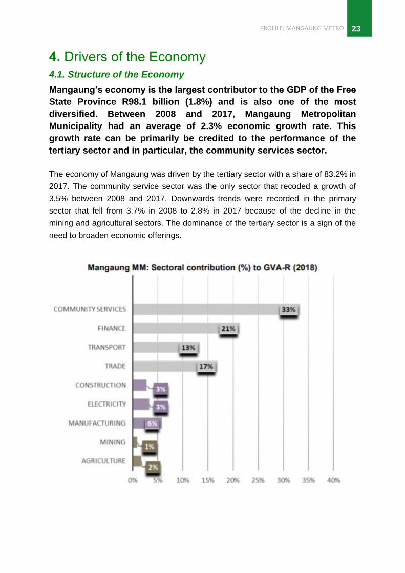
The economy of Mangaung was driven by the tertiary sector with a share of 83.2% in
2017. The community service sector was the only sector that recoded a growth of
3.5% between 2008 and 2017. Downwards trends were recorded in the primary
sector that fell from 3.7% in 2008 to 2.8% in 2017 because of the decline in the
mining and agricultural sectors. The dominance of the tertiary sector is a sign of the
need to broaden economic offerings.

PROFILE: MANGAUNG METRO
24
4.2. Primary Sector
The Free State’s economy relies mostly on the agricultural sector which is
characterised by large-scale and small-scale commercial agriculture as well as
subsistence agriculture. The agriculture sector only contributes 1.7% to the GVA of
the metro. Livestock production (game, cattle, sheep, goats, pigs) and poultry are the
prominent agricultural activity. The largest concentration of dairy cattle is situated in
the metro. Poultry farming is prominent in the Botshabelo area (namely Supreme
Chicken). The agricultural sector is not without its downside. The police station in
Thaba Nchu, features in the national top 30 list of crimes reported for stock theft.
Mining has played a small role in the economy of Mangaung (1.0% contribution to
GVA) and the only form of activities includes the mining of sand, gravel, clay, and
salt. Several mining operations are well established with operations centred around
the urban settlement areas and have a relatively small impact on rural development.
Mining opportunities in the Metropolitan Municipality include minerals value addition,
production of fuel from shale gas, salt repackaging, salt lakes and salt bars. The
town of Soutpan has high concentrations of natural salt, and has a number of salt
producing activities taking place.
“THE POLICE STATION IN THABA NCHU, FEATURES IN THE NATIONAL TOP 30 LIST OF
CRIMES REPORTED FOR STOCK THEFT”
4.3. Secondary Sector
Mangaung does not have a strong industrial sector. The manufacturing sector
contributes about 6.0% to the GVA. The industries are light manufacturing or service
orientated industries focusing on assembling or wholesale of imported products.
Manufacturing in Mangaung is largely geared towards local needs, with growing
dominance of food, beverages and tobacco products.

PROFILE: MANGAUNG METRO 25
Source: IDP 2018/19
Several attempts have been made in the past to support industrial development in
Thaba Nchu and Botshabelo, but those were heavily subsidised. Most of the
industries susceptible to this type of artificial stimulation were textile enterprises, and
eastern countries, in particular, benefited from this. As the subsidies dried up, the
industries also disappeared over time.
The main industrial areas in the Metro include the industrial park located in
Botshabelo together with East End, Bloemdustria and Hamilton industrial areas.
Some industrial sites which exhibit great potential and an excellent locality in relation
to the N8 Corridor are vacant and neglected.
4.4. Tertiary Sector
The community services sector is the key sector within the Free State Province,
accounting for R43 billion (25.3%) of the total GVA in the province's economy. The
sector contributes 33.2% to the Metro’s GVA. The community service sector in
Mangaung was the only sector that recoded a growth of 3.5% between 2008 and
2017. The composition of this sector included the provincial government
headquarters, the three tertiary institutions, and many healthcare and other facilities.
Activities are concentrated in Bloemfontein and offers a wide range of community
services including business, service industries, educational facilities, primary
PROFILE: MANGAUNG METRO
26
healthcare, judicial services. There is a high level of dependence between the
regional centre and the rural areas, specifically between Bloemfontein and the other
secondary urban centres and smaller rural towns/ villages.
4.5. Tourism
The National Tourism Sector Strategy 2017, indicates that domestic holiday trips
have declined. In quarter 2 of 2019, the Free State had the second least number of
day trips travellers at 4,0% after the Northern Cape which had 2,9%. Gauteng,
Limpopo and Western Cape were the most popular destinations for day travellers.
The recent outbreak of the COVID-19 pandemic illustrates the vulnerability of travel
and tourism to the effects of public health emergencies.
Mangaung’s tourism competitive advantage is centred around four components,
namely cultural-historic tourism, events tourism, leisure tourism and agri-tourism.
The tourism market Mangaung is mainly a domestic market with an emphasis on
cultural and events tourism such as Macufe festival, Bloemfontein Rose festival,
sporting events (soccer, rugby and cricket games) and leisure tourism such as visits
to Phillip Sanders, Maselspoort resort, and Naval Hill nature reserve.
5. Service Delivery
5.1. Water and Sanitation
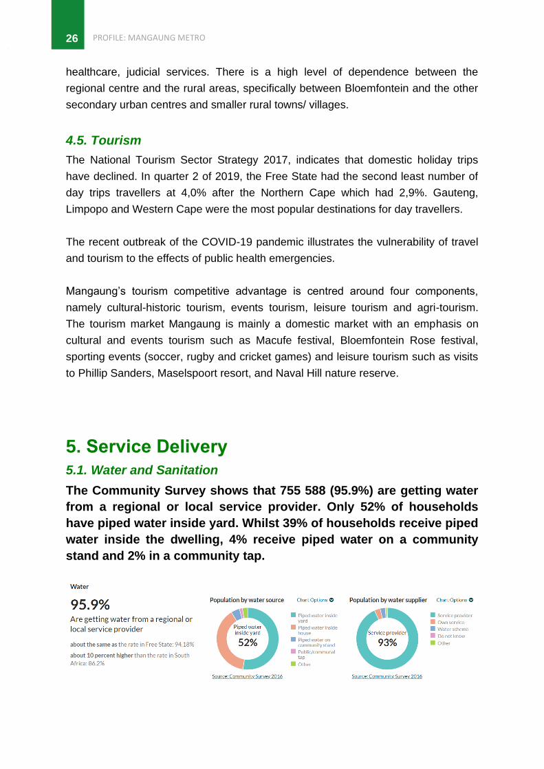
The Community Survey shows that 755 588 (95.9%) are getting water
from a regional or local service provider. Only 52% of households
have piped water inside yard. Whilst 39% of households receive piped
water inside the dwelling, 4% receive piped water on a community
stand and 2% in a community tap.

PROFILE: MANGAUNG METRO 27
The current water backlog is 17 555 stands (10%) with 10 505 located in
Bloemfontein, 3783 in Thaba Nchu, 3783 in Botshabelo, 300 Dewersdorp, 230 Van
Stadensrus and 94 in Soutpan. The Metro is facing a challenge of aging
infrastructure which has not been maintained over a long period of time. This is due
to the prioritization of new infrastructure over the maintenance of existing
infrastructure.
There is also the non-payment of water services that continues to put significant
pressure on the ability of the municipality to provide water to residents.
According to the Mangaung IDP (2017 - 2022) the municipality provides sewer
services to 193 558 households and has a backlog of 71 856 (27%) households
without proper sanitation. 71.9% of the population have access to flush or chemical
toilets, while 22% have to rely on a pit toilet. Access to a flush or chemical is lower
than the rate in Free State (74%) and 10 percent higher than the rate in South Africa
(63.5%). 1.4% households have no access to any toilets, which is about three-fifths
of the rate in South Africa (2.39%).
5.2. Human Settlements
With 265 560 households, 47% reside in a house, 11.7% of the households reside in
an informal dwellings (shacks) and 6.5% in a flat in backyard. There are 53 informal
settlement in the Mangaung area, accommodating between about 28,737
households in informal dwellings and backyard shacks. 27 of the informal
settlements are located in and around Bloemfontein, whilst 13 informal settlements
are located in Botshabelo and 8 in Thaba Nchu.
A total of 24 informal settlements are in a process of being formalised and upgraded
with services, while 10 settlements involving approximately 850 households need to
be relocated (IDP, 2017 – 2022).

PROFILE: MANGAUNG METRO
28
The City of Mangaung has a huge housing backlog compared to other municipalities
in the Free State. The housing backlog stands at 31 149 houses, the bulk of which
are residing in the Mangaung Township.
5.3. Electricity
The Metro is providing electricity services to 254 525 households leaving and has a
backlog of only 10 889 (4%) households without electricity. 88% have in-house
prepaid meter, 8% have in-house conventional meter and 1% rely on other sources.
Although the majority of the area does have access to electricity, paraffin and
candles are still in use.
5.4. Waste Management
In Mangaung, 249 735 households receive formal refuse removal thus leaving a
shortfall of 15 515 (60%) households which are not being serviced. 82.4% of
households are getting refuse disposal from a local authority, private company or
community members, 10% rely on their own communal dump whilst 3% make use of
a communal dump.

PROFILE: MANGAUNG METRO 29
5.5. Transport
Mangaung Metro has vast road networks that includes national roads namely the N1,
N6 and N8, which are upgraded and maintained by SANRAL. The area is also
serviced by a number of provincial primary, secondary and tertiary roads, which are
being maintained by the provincial government. Due to the extensiveness of these
types of roads in the rural area, a large number of roads are in a poor condition and
prevent service delivery by government. Urban roads are maintained by the
municipality.
Bloemfontein has a national airport, Bram Fischer International Airport that connects
with major cities. The Tempe Military airport, west of Bloemfontein, also provides
flight services. There is also a passenger railway network that connects Mangaung
with Johannesburg, Port Elizabeth, East London, Durban and Maseru (Lesotho).
Freight railway network links with Johannesburg, East London. Transnet has a major
inland freight terminal in Bloemfontein.
The dispersed nature of the metro, means there is frequent travel and high
transportation costs involved to access services. An estimated 195,000 work related
trips are being generated daily in the Mangaung with a majority (47%) being
generated in the Mangaung township area; 23% in Bloemfontein; 14% in Botshabelo
and 8% in Thaba Nchu. About 33% of these trips are made by taxis; 11% by bus and
17% by foot.
There are 13 000 commuters that commute on a daily basis a distance of over 50km
between Botshabelo and Bloemfontein. Approximately R200 million is annually spent
on transport subsidies for bus transport in the municipal area of which the larger part
is for bus transport between Botshabelo, Thaba Nchu and Bloemfontein.
5.6. Community Facilities
In terms of community facilities, a bulk of the community facilities are located in the
urban areas in Mangaung. Mangaung has 14 libraries, with 9 located in
Bloemfontein, 2 in Botshabelo and 1 for each of the areas of Thaba Nchu,
Dewetsdorp and Soutpan. The 10 community halls in Mangaung Metro are only
situated in Bloemfontein (7), Thaba Nchu (2) and Botshabelo (1). There area of Van
Stadensrus has no community facilities. Sport and recreational facilities are
restricted to urban areas, except for informal soccer fields, which is a common
phenomenon in rural regions.

PROFILE: MANGAUNG METRO
30
6. Governance and Management
6.1. Municipal performance
Mangaung’s audit outcomes show that it regressed from an
unqualified audit opinion in 2015/16 financial year to a disclaimer in
2016/17. Among some of the challenges identified by the Auditor-
General was the failure of the municipality leadership to continuously
strengthen the foundation and monitoring of internal controls.
Audit Outcomes
2015/16 2016/17 2017/18 Movement
Unqualified Disclaimer AFS Outstanding Regression
Audit Outcomes Source: Department of Cooperative Governance, Free State, 2019
The capital budget for the 2019/2020 financial year is R1 266 billion. The budget will
be reduced by (R 120 million) as compared to the 2018/2019 adjustment budget of
R1386 billion. The capital budget for the two outer years of the MTREF period is
R1 255 billion and R1301 billion, respectively. The capital budget injection over the
MTREF period will therefore be R3 868 billion. The capital budget per component
within Mangaung Metropolitan Municipality indicates a significant portion of the
budget has been allocated to engineering, followed by water, electricity, and waste
and fleet management given the challenges the municipality faces.
6.2. Municipal Capacity
In terms of vacancies in the municipality, Engineering Services had the highest
vacancy rates at 1 094 followed by social services (742) and waste and fleet
management services at 479 vacancies. The high vacancies in the Engineering
Services has an impact on the delivery and provision of services.
Description Employees No Vacancies No
Corporate Services 419 185
Economic and Rural Development 27 37
Engineering Services 767 1 094
Finance 285 202
Human Settlements 157 154
Office of the City Manager 389 184
Planning 90 174
Social Services 812 742
Strategic Programmes and Service Delivery Monitoring
64 66
Waste and Fleet Management 615 479
Municipal Police Services 1 7
Total 3 626 3 324
Vacancy Rates Source: Department of Cooperative Governance, Free State, 2019

PROFILE: MANGAUNG METRO 31
7. Projects to Diversify and Grow the Economy
7.1. Spatial Development
The Draft National Spatial Development Framework, has identified
Mangaung as one of the national urban nodes and part of the agri-
enterprise and small-scale farming regions.
This is to ensure the productive use of high value agricultural land to support national
food security and improve rural-to-rural connections, market accessibility and key
agricultural production infrastructure.
Like many South Africa’s cities, Mangaung is burdened with the legacy of spatial and
economic inequality. The Metro consists of several former black areas including
Botshabelo and Thaba Nchu which are spatially dislocated from Bloemfontein, the
economic hub, and have higher concentrations of poverty and unemployment.
The rural settlements that exist to the north and south of Thaba Nchu and many of
those in municipalities bordering Mangaung are significantly dependant on
Bloemfontein to provide social, infrastructure and economic support services to the
inhabitants of these areas. The dispersed nature of the Metro, means there is
frequent travel and high transportation costs involved to access services.
PROFILE: MANGAUNG METRO
32
The Mangaung Metropolitan Integrated Public Transport Network (IPTN), seeks to
integrate Botshabelo and Thaba Nchu through several development initiatives. This
will restrict further development of Thaba Nchu to the east and encourage
development of Thaba Nchu to the west. As part of a major intervention to stimulate
economic development in the eastern parts of Bloemfontein, the proposed Airport
Development Node has been identified as a key secondary node to be developed.
7.2. Ecological Potential and Biodiversity
The topography of Mangaung Metropolitan Municipality is relatively flat with altitudes
varying between 1220m to 2120m above sea level. Mangaung is located partly in the
Nama Karoo and the Grasslands Biome. The Nama Karoo biome is more to the west
with less rainfall compared to grassland biome towards the east. This area is
characterised by lime soil with most of the land suitable for grazing.
The eastern part is dominated by Grasslands Biome. Here, frost, fire and grazing
maintain the grass dominance and inhibit the establishment of trees. Two types of
grass plants are common here: sweet grasses and sour grasses. Sweet grasses
have lower fibre content; maintain nutrients in the leaves during winter, and as a
result palatable to stock. Sour grasses are the opposite of the sweet grasses and
have higher fibre content, withdraw nutrients during winter and become unpalatable
to stock.
The Grassland Biome is good for dairy, beef and wool production. Grass plants
tolerate grazing, fire and mowing. Overgrazing increases creeping grasses. Maize
crop thrives in Grassland Biome. Sorghum, wheat and sunflowers are farmed on a
smaller scale.
The Metro has a semi-arid climate with most precipitation occurring during summer,
while snow sometimes occurs on the mountains in the east. Frost is also common
during cold winter nights. According to the SA Weather Service, the average
temperatures during summer range between 13°C and 31°C, and during winter
between -3°C and 18°C.
In terms of annual rainfall, Mangaung receives between 500 – 600 mm of rainfall
annually with the highest recorded annual rainfall ranging from 600 – 650 mm
annually. The western parts of the Metro are the driest receiving 450 – 500 mm of

PROFILE: MANGAUNG METRO 33
rainfall annually, whilst the eastern parts having access to higher yields at 600 – 650
mm annually. The western parts of the Metro are areas of high drought risk, given
they receive 450 – 500 mm of rainfall annually.
According to the Mangaung Rural Development Plan, the area is relatively water
scarce and Mangaung is increasingly experiencing bulk water shortages. Access to
boreholes is a crucial factor when considering agricultural activities taking place. The
yield from boreholes in the west ranges between 360 – 2 000 litres/hour, whilst the
eastern part deliver higher yields ranging between 7 200 – 18 000 litres/hour.
7.3. Economic Projects
The Built Environment Performance Plan (BEPP) has identified catalytic projects
which are deemed to have potential to make a significant impact on the built
environment and ensuring real economic growth, not only in the City, but also in the
surrounding towns and rural areas. These include:
• Airport Development Node;
• Vista Park Mixed Development (ext. 2 & 3);
• Cecilia Park Mixed Development;
• Hillside View Mixed Development;
• Estoire Mixed Development; and
• Caleb Motshabi Informal Settlement Upgrading
7.3.1. Mangaung Airport Node
Mangaung Airport Node is centred around the airport and corridor seeks to provide
the local and larger Bloemfontein area with new residential housing opportunities of
low, medium and high density, townhouses, tertiary school hostels and hotel rooms
housing opportunities. The project is estimated to cost R 3,9 billion, providing 5 800
potential job opportunities and 33 000 housing opportunities have been identified.
The project further intends to provide a mix use of land which includes offices,
general business, retail, showrooms, conference facilities, a hospital and clinics,
places of worship, crèches, primary, secondary, and tertiary facilities, government
buildings, open green and protected green space. The development will also
rehabilitate the surrounding environment which is currently in a very environmental
deteriorating state.

PROFILE: MANGAUNG METRO
34
A MASTER AGRI-PARK
BUSINESS PLAN FOR THABA NCHU
HAS ALREADY BEEN CONDUCTED
AND SOME COMPONENTS ARE
ALREADY FUNCTIONING.
7.3.2. Thaba Nchu Agri-Hub
There are potential linkages between agriculture and manufacturing through agro-
processing that have been identified. Opportunities are now being created in the
agro-industrial sector. The Thaba Nchu Agri-Hub is one of the most important
catalytic projects that will impact positively on the Metropolitan area and beyond. A
Master Agri-Park Business Plan for Thaba Nchu has already been conducted during
2016 and some components of the Agri-Hub are already functioning. The agri-park
site is located within the Thaba Nchu industrial area which has the availability of
infrastructure and warehouses. The site was also chosen due to its proximity to the
N8, for access to markets and suppliers. The warehouses are severely degraded
and underused, although it is envisaged that upgrading these facilities will ignite the
re-use of the industrial sector within Thaba Nchu, while also reducing building costs
for the agri-businesses envisaged for the Agri-Hub.
The area is also close to rural communities that will ultimately need to benefit from
the Agri-Hub initiative. The Agri-Parks initiative is part of the DRDLR’s strategic
objective to establish Agri-Parks in all of South Africa’s District Municipalities that will
kick start the Rural Economic Transformation for these rural regions. The DRDLR
committed R2 billion for 2015/16 financial year to be utilised in all 44 District
Municipalities to support Agri Parks rollout.

PROFILE: MANGAUNG METRO 35
8. Key Recommendations • It is recommended that previously disadvantaged areas including areas under
traditional leadership, rural areas and informal settlements be integrated into
the spatial, economic, social and environmental objectives of the Metro.
• Through the IPTN, provide alternative and affordable public transportation to
the citizens in Mangaung and address trends in demand (time, distance, cost,
reliability, safety) for the different transport services.
• Agrarian Transformation in the subsistence farming areas under traditional
leadership around Thaba Nchu is very important. The establishment of the
Mangaung Agri-Park is an important initiative towards achieving agrarian
transformation in this area.
• Tertiary education and skills training should be aligned with the priority
economic sectors within Mangaung to optimally utilise local opportunities in
these sectors. Specialised skills can be utilised to support and revitalise
industrial development in Thaba Nchu and Botshabelo.
• The IDP has identified salt mining around Soutpan as one of the drivers of
economic change that will impact positively on the rural economy. Positive
investment in salt mining will generate a secure and stable income for the
Soutpan area and assist in alleviating poverty. Issues around mining rights
and mining operatorations need to be addressed to ensure minerals are
mined optimally and enhance access to the required markets.
• The conflicts between biodiversity conservation and consumptive agricultural
practices need to be addressed. Existing and potential agricultural landscapes
should be consolidated and protected; and sustainable agricultural
development and food security should be facilitated. The ecosystems must be
stabilised and managed to restore their ecological functionality.
• Mangaung has aging infrastructure, which has not been religiously maintained
over a long period of time. Ensure the prioritization of the maintenance of
existing infrastructure over new infrastructure.
• There is a need to commit adequate financial and human resources to
maintain the municipal planning function, with particular emphasis on
engineering services and social services. Issues raised by the Auditor
General require urgent attention to ensure effective financial management.

PROFILE: MANGAUNG METRO
36