Embed Size (px)
Citation preview
ESA Climate Change Initiative Phase II - Soil Moisture
Product Specification Document (PSD) D1.2.1 Version 1.9
14 February 2017
Prepared by
Earth Observation Data Centre for Water Resources Monitoring (EODC) GmbH
in cooperation with
Product Specification Document Version 1.9
Date 14 February 2017
i
This document forms the deliverable D1.2.1 Product Specification Document (PSD) and was
compiled for the ESA Climate Change Initiative Phase 2 Soil Moisture Project (ESRIN Contract
No: 4000112226/14/I-NB). For more information on the CCI programme of the European
Space Agency (ESA) see http://www.esa-cci.org/.
Number of pages: 63
Authors: D. Chung, , W. Dorigo, R. De Jeu, R. Kidd, W. Wagner
Circulation (Internal): Project consortium and science partners
External: ESA CCI Soil Moisture data users, ESA
Issue Date Details Editor
0.1 30-06-14 Document updated to new product version 02.0 D. Chung
1.1 02-07-14 Document edited W. Dorigo
1.2 07-07-14 Information on ancillary data added D. Chung / W. Dorigo
1.3 03-12-14 Revision of document D. Chung
1.4 17-03-15 Revision and update D. Chung
1.5 31-07-15 Updated D. Chung
1.6 04-12-15 Revised to match ESA CCI SM v02.2 release, updated applicable and related docs
D. Chung, R Kidd
1.7 25-04-16 Revised to match ESA CCI SM v03.0 internal release to project partners
Reflects ESA CCI SM v03.0 dataset (SMOS LPRM and SNR blending scheme)
New value coding for flagging variables: flag, dnflag, freqbandID, mode, sensor
SNR Blending Maps and corresponding blending time periods added in the description; blending maps delivered as ancillary data files
D. Chung
1.8 02-11-2016 As 1.7, but rivised to match ESA CCI SM v03.1 D. Chung, W.Dorigo
1.9 10-01-2017 Revised to match ESA CCI SM v03.2 D. Chung, A. Gruber
Document Change Record: For any clarifications please contact Wouter Dorigo.

Product Specification Document Version 1.9
Date 14 February 2017
ii
Project Partners
Prime Contractor
Scientific Lead
EODC, Earth Observation Data Centre for Water Resources Monitoring (Austria)
Project Management GeoVille, GeoVille Information Systems GmbH (Austria)
System Engineering Partners AWST, Angewandte Wissenschaft Software und Technologie GmbH (Austria)
Earth Observation Partners TU Wien, Vienna University of Technology (Austria)
TMS, Transmissivity,(The Netherlands)
FMI, Finnish Meteorological Institute, (Finland)
UCC, University College Cork, (Ireland)
Climate Research Partners ETH, Institute for Atmospheric and Climate Science, (Switzerland)
NILU,Norsk institutt for luftforskning (Norway)
Product Specification Document Version 1.9
Date 14 February 2017
iii
Table of Content
LIST OF FIGURES ....................................................................................................................................................... V
LIST OF TABLES ....................................................................................................................................................... VI
DEFINITIONS, ACRONYMS AND ABBREVIATIONS ............................................................................................................ VII
PROCESSING LEVELS ................................................................................................................................................. IX
1 INTRODUCTION .................................................................................................................................... 1
1.1 PURPOSE OF THE DOCUMENT ........................................................................................................................... 1
1.2 TARGETED AUDIENCE ...................................................................................................................................... 2
2 DOCUMENTS ........................................................................................................................................ 2
2.1 APPLICABLE DOCUMENTS ................................................................................................................................ 2
2.2 REFERENCE DOCUMENTS ................................................................................................................................. 2
2.3 BIBLIOGRAPHY .............................................................................................................................................. 3
3 SPECIFICATION OF THE PRODUCTS ........................................................................................................ 3
3.1 GEOPHYSICAL PARAMETERS ............................................................................................................................. 3
3.2 PRODUCT DATA VOLUME ................................................................................................................................ 4
3.3 STRUCTURE AND FORMAT OF THE PRODUCT ........................................................................................................ 4
3.3.1 Data file format and file naming ..................................................................................................... 4
3.3.2 NetCDF file structure ....................................................................................................................... 6
3.4 DESCRIPTION OF DATA SET VARIABLES? ............................................................................................................ 21
3.4.1 sm .................................................................................................................................................. 21
3.4.2 sm_uncertainty ............................................................................................................................. 21
3.4.3 dnflag ............................................................................................................................................ 22
3.4.4 flag ................................................................................................................................................ 22
3.4.5 freqbandID .................................................................................................................................... 22
3.4.6 mode ............................................................................................................................................. 23
3.4.7 sensor ............................................................................................................................................ 23
3.4.8 t0 ................................................................................................................................................... 23
3.4.9 time ............................................................................................................................................... 23
3.5 PRODUCT GRID AND PROJECTION ................................................................................................................... 24
3.6 ANCILLARY DATA USED .................................................................................................................................. 25
3.6.1 Global Land Data Assimilation System (GLDAS) ............................................................................ 25
3.6.2 ASCAT Advisory Flag ...................................................................................................................... 25
3.7 ANCILLARY DATA PROVIDED ALONG WITH THE ESA CCI SM V03.2 PRODUCTS ......................................................... 26
3.7.1 Land and Tropical forest Mask ...................................................................................................... 26
3.7.2 Average Vegetation Optical Depth from AMSR-E ......................................................................... 27
3.7.3 Soil Porosity ................................................................................................................................... 29
3.7.4 Topographic Complexity ................................................................................................................ 30
Product Specification Document Version 1.9
Date 14 February 2017
iv
3.7.5 Wetland fraction ........................................................................................................................... 31
3.8 BLENDING TIME PERIODS AND USED SENSORS .................................................................................................... 32
3.8.1 ACTIVE Product .............................................................................................................................. 32
3.8.2 PASSIVE Product ............................................................................................................................ 32
3.8.3 COMBINED Product ....................................................................................................................... 33
4 EXAMPLE NETCDF FILE ........................................................................................................................ 34
5 DATA USAGE AND LIMITATIONS ......................................................................................................... 36
5.1 FREE USE ................................................................................................................................................... 36
5.2 NO ONWARD DISTRIBUTION ........................................................................................................................... 36
6 DATA CITATION .................................................................................................................................. 36
7 BIBLIOGRAPHY ................................................................................................................................... 37
Product Specification Document Version 1.9
Date 14 February 2017
v
List of Figures
Figure 1: Land mask used for the merged product. The 0.25° grid starts indexing from “lower
left” to the “upper right”. Note that not every grid points are available for all sensors, e.g.
ASCAT retrievals are available between Latitude degrees 80° and –60°. ................................ 24
Figure 2 Land Mask used for the ESA CCI SM v03.1 products and ancillary data, where 1
(brown) represents land points. ............................................................................................... 26
Figure 3 Tropical forest Mask used applied to the ESA CCI SM v03.1 data. 1 (green)
represents rainforest regions. .................................................................................................. 27
Figure 4: AMSR-E average vegetation optical depth from 2002 to 2011 showing vegetation
density. ..................................................................................................................................... 28
Figure 5: Top soil porosity derived from the Harmonized World Soil Database. ................... 29
Figure 6: Topographic complexity from the USGS 30-second Global Elevation Data
(GTOPO30). ............................................................................................................................... 30
Figure 7: Wetland fraction derived from the Global Lakes and Wetlands Database (GLWD). 31
Figure 8 NetCDF Global Attributes for an example ESA CCI SM file ........................................ 34
Figure 9 Visualisation of the NetCDF data variable “sm” for day 2010-07-07 from the
COMBINED product with Panoply ............................................................................................ 35
Product Specification Document Version 1.9
Date 14 February 2017
vi
List of Tables
Table 1 Processing Level Codes for Remotely Sensed Data Sets .............................................. ix
Table 2 Temporal coverage and volume size of the products. .................................................. 4
Table 3 Global NetCDF Attributes for the ACTIVE product ........................................................ 6
Table 4 Global NetCDF Attributes for the PASSIVE product ...................................................... 8
Table 5 Global NetCDF Attributes for the COMBINED product ............................................... 11
Table 6 Attribute Table for Variable lon ................................................................................... 14
Table 7 Attribute Table for Variable Lat ................................................................................... 14
Table 8 Attribute Table for Variable time (reference time). The type of this variable is double.
.................................................................................................................................................. 14
Table 9 Attribute Table for Variable sm for the ACTIVE product ............................................. 15
Table 10 Attribute Table for Variable sm for the PASSIVE and COMBINED products ............. 15
Table 11 Attribute Table for Variable sm_noise ...................................................................... 15
Table 12 Attribute Table for Variable sm_uncertainty for the PASSIVE and COMBINED
products ................................................................................................................................... 16
Table 13 Attribute Table for Variable dnflag............................................................................ 16
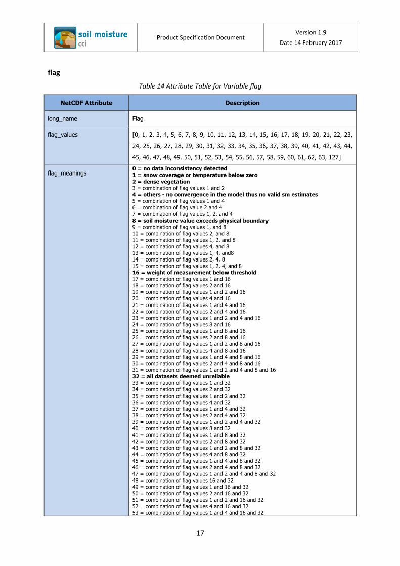
Table 14 Attribute Table for Variable flag ................................................................................ 17
Table 15 Attribute Table for Variable freqbandID ................................................................... 19
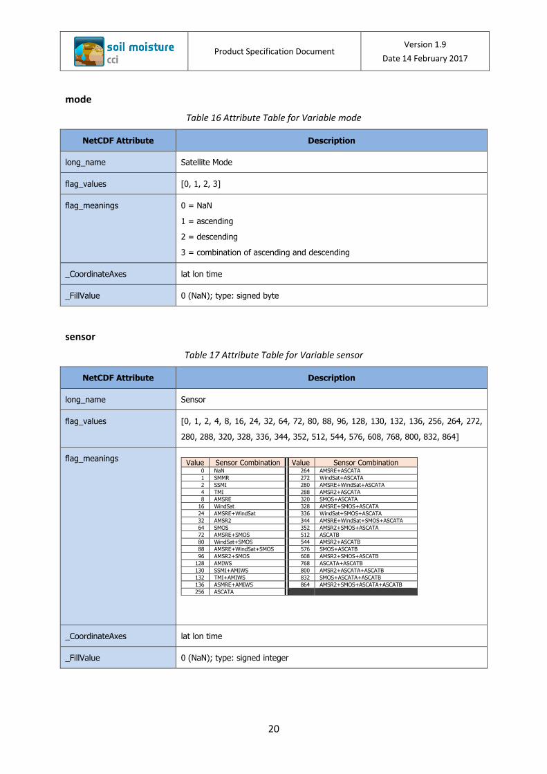
Table 16 Attribute Table for Variable mode ............................................................................ 20
Table 17 Attribute Table for Variable sensor ........................................................................... 20
Table 18 Attribute Table for Variable t0 .................................................................................. 21
Table 19 sm_uncertainty data provided in the ESA CCI SM Products ..................................... 22
Table 20 SNR blending period for the ACTIVE Product ............................................................ 32
Table 21 SNR blending period for the PASSIVE Product. *The [SSM/I, TMI, SSM/I] period is
latiduinally divided into [90S, 37S] and [90N, 37N] for SSM/I, and the region inbetween for
TMI. .......................................................................................................................................... 32
Table 22 SNR blending period for the PASSIVE Product. *The [SSM/I, TMI, SSM/I] period is
latiduinally divided into [90S, 37S] and [90N, 37N] for SSM/I, and the region inbetween for
TMI. .......................................................................................................................................... 33
Product Specification Document Version 1.9
Date 14 February 2017
vii
Definitions, acronyms and abbreviations
AMI-WS Active Microwave Instrument – Windscat (ERS 1 and ERS 2)
AMSR2 Advanced Microwave Scanning Radiometer 2
AMSR-E Advanced Microwave Scanning Radiometer-Earth Observing System
ASCAT Advanced Scatterometer (Metop)
ATBD Algorithm Theoretical Basis Document
CCI Climate Change Initiative
CDF Cumulative Distribution Function
CECR Comprehensive Error Characterization Report
CF Climate Forecast
DGG Discrete Global Grid
ECMWF European Centre for Medium Range Weather Forecasting
ECV Essential Climate Variable
ERA-40 ECMWF ReAnalysis 40 data set
ESA European Space Agency
FAO Food and Agriculture Organization of the United Nations
GCMD Global Change Master Directory (NASA)
GLDAS Global Land Data Assimilation System
GLWD Global Lages and Wetlands Database
GRIB Grided Binary format
GSFC Goddard Space Flight Center (NASA)
HDF Hierarchical Data Format
IIASA Interational Institute for Applied Systems Analysis
ISSCAS Chinese Academy of Sciences
ISRIC International Soil Reference and Information Centre (World Soil Information)
JRC Joint Research Centre of the European Commission
LPRM Land Parameter Retrieval model
NaN Not A Number
NASA National Aeronautics and Space Administration
NetCDF Network Common Data Form
PSD Product Specification Document
PVP Product Validation Plan
SM Soil Moisture
SSMV Surface Soil Moisture Volumetric
SMMR Scanning Multichannel Microwave Radiometer
SMOS Soil Moisture and Ocean Salinity
Product Specification Document Version 1.9
Date 14 February 2017
viii
SNR Signal to noise ratio
SSM/I Special Sensor Microwave Imager
TC Triple Collocation
TMI TRMM Microwave Imager
USGS United States Geological Survey
UTC Coordinated Universal Time
VOD Vegetation Optical Depth
VUA Vrije Universiteit Amsterdam
WACMOS Water Cycle Multimission Observation Strategy
WARP soil Water Retrieval Package
WindSat WindSat Spaceborne Polarimetric Microwave Radiometer

Product Specification Document Version 1.9
Date 14 February 2017
ix
Processing Levels1
Table 1 Processing Level Codes for Remotely Sensed Data Sets
Level <ProcessingLevel>
Code
Description Based on Source
Level 0 L0 Unprocessed instrument and payload data at full resolution.
GHRSST
Level 1A L1A Reconstructed unprocessed instrument data at full resolution, time referenced, and annotated with ancillary information, including radiometric and geometric calibration coefficients and georeferencing parameters, computed and appended, but not applied, to L0 data.
GHRSST
Level 1B L1B Level 1A data that have been processed to sensor units.
GHRSST
Level 1C L1C Level 1B data that have been further processed, e.g. by correcting radiances or by mapping onto a spatial grid, prior to deriving geophysical variables from the data.
SMOS data products definition
Level 2 L2 Retrieved environmental variables at the same resolution and location as the Level 1 source.
CEOS handbook2
Level 2Pre-processed
L2P Geophysical variables derived from Level 1 source data at the same resolution and location as the Level 1 data, typically in a satellite projection with geographic information.These data form the fundamental basis for higher‐level CCI products.
GHRSST
Level 3 L3 Level 2 variables mapped on a defined grid with reduced requirements for ancillary data. Three types of L3 products are defined:
GHRSST
L3U Uncollated (L3U): L2 data granules remapped to a space grid without combining any observations from overlapping orbits.
L3C Collated (L3C): Observations combined from a single instrument into a space-time grid.
L3S Super-collated(L3S): observations combined from multiple instruments into a space-time grid.
Level 4 L4 Data sets created from the analysis of lower level data that result in gridded, gap-free products.
GHRSST
1 Extracted from [RD-4] 2 http://wiki.ieee-earth.org/@api/deki/files/7/=Handbook_0802.pdf
Product Specification Document Version 1.9
Date 14 February 2017
1
1 Introduction
The document provides technical support to the ESA CCI Soil Moisture dataset (product
version 03.2). The document provides the technical specifications relating to the formating
and content of the soil moisture product data files. The ESA CCI SM v03.2 product consists of
three surface soil moisture data sets: The “ACTIVE Product” and the “PASSIVE Product” were
created by fusing scatterometer and radiometer soil moisture products, respectively; The
“COMBINED Product” is a blended product based on the former two data sets. Data files are
provided as NetCDF-4 classic format and comprise global merged surface soil moisture
datasets at daily temporal resolution. The data set spans over 37 years covering the period
from November 1978 to December 2015.
The theorectical and algorithmic base of the product is described in [RD-1], and reported by
Wagner et al. (2012). The SNR (signal-to-noise-ratio) merging algorithm introduced for the
first time in this version is described in Gruber et al. (in prep.). An overview of all known
errors of the soil moisture datasets is provided in [RD-2] and in (Dorigo et al. in review).
Further documentation relating to the product, and reference documents are provided in
Section 2.2 and can be found on the CCI Soil Moisture project web site (http://www.esa-
soilmoisture-cci.org).
The location and full access details to the product are provided to users after completion
and verification of a user registration form. Users can register to access the product from the
User Registration form on the CCI Soil Moisture Web3, as noted in Section 5.1.
The product is provided in a format that currently complies with the minimum standard
format requirements as detailed by the CCI data standards working group (DSWG) [RD-4].
For this reason ESA CCI SM v03.2 is provided in NetCDF-4 classic format and is also compliant
with the NetCDF Climate and Forecasting group best practice4 [RD-5].
1.1 Purpose of the document
This Product Specification Document (PSD) relates to the ESA CCI Surface Soil Moisture (SM)
product version 03.2.
The document provides the specific definition of the following:
geophysical parameters provided
structure and format of the product
annotation data sets
3http://www.esa-soilmoisture-cci.org/dataregistration 4http://cf-pcmdi.llnl.gov/documents/cf-conventions/latest-cf-conventions-document-1
Product Specification Document Version 1.9
Date 14 February 2017
2
quality flags / indicators
product grid and projection
ancillary data used
The document further clarifies data usage restrictions, and provides full data citation to be
used in all reporting on product usage.
The product specifications provided in this document will be the base specification for all
future ESA CCI SM product versions, noting the product specification will be expected to
evolve following the best practices resulting from the CCI data standards working group
(DSWG).
1.2 Targeted audience
This document targets the following audience
Users of the ESA CCI SM data product
System Engineers for the ESA CCI SM product
Other CCI ECV projects
2 Documents
2.1 Applicable documents
The documents outlined here detail the scope and focus for the work that is reported in this
document.
[AD-1] Phase 2 of the ESA Climate Change Initiative Soil- Moisture- cci. ESRIN Contract
No: 4000112226/14/I-NB
[AD-2] ESA Climate Change Initiative Phase 2, Statement of Work, European Space
Agency, CCI-PRGM-EOPS-SW-12-0012.
[AD-3] Technical Proposal (Part 3) in response to ESA Climate Change Initiative Phase 2
RFQ/3-14173/14/I-NB, Vienna University of Technology.
2.2 Reference documents
This section provides a list of references documents upon which this document is either
based, or are required to be referenced by the reader in order to obtain the full information
intended by the authors.
Product Specification Document Version 1.9
Date 14 February 2017
3
[RD-1] ATBD, Algorithm Theoretical Baseline Document, Version 2.0, Release 0.3, 16th
October 2014, ESA Climate Change Initiative Phase 1 Soil Moisture Project,
http://www.esa-soilmoisture-
cci.org/sites/default/files/documents/public/Deliverables/CCI%20Soil%20Moistur
e%20Executive%20Summary%20ATBD2.5.pdf
[RD-2] CECR, Comprehensive Error Characterisation Report, Version 0.5, 21 April 2015,
ESA Climate Change Initiative Phase 2 Soil Moisture Project, http://www.esa-
soilmoisture-
cci.org/sites/default/files/documents/public/Deliverables/CCI2_Soil_Moisture_D
2.2.0_CECR_v0.6.pdf
[RD-3] PVP, Product Validation Plan, Version 1.1, 30th August 2012, ESA Climate Change
Initiative Phase 1 Soil Moisture Project, http://www.esa-soilmoisture-
cci.org/sites/default/files/documents/public/Deliverables/20120830_CCI_Soil_M
oisture_D2.1_PVP_v.1.1.pdf
[RD-4] ESA, Guidelines for Data Producers - Climate Change Initiative Phase 1, CCI-
PRGM-EOPS-TN-13-0009, Issue 1, Revision 1, Victoria Bennett and Sarah James,
24/05/2013
[RD-5] NetCDF Climate and Forecast (CF) Metadata Conventions: Version 1.6, 5
December, 2011, Brian Eaton, Jonathan Gregory, Bob Drach, Karl Taylor, and
Steve Hankin
2.3 Bibliography
A complete bibliographic list, detailing scientific text or publications that support arguments
or statements made within the current document is provided in Section 7
3 Specification of the products
3.1 Geophysical Parameters
The ACTIVE product is the output of merging scatterometer-based soil moisture data, which
were derived from AMI-WS and ASCAT (Metop-A and Metop-B). The PASSIVE product
merges data from SMMR, SSM/I, TMI, AMSR-E, WindSat, AMSR2, and SMOS. The COMBINED
product merges the ACTIVE and the PASSIVE products. The merging algorithm of the here
described product version v03.2 is an evolution of the algorithm described in (Dorigo et al. in
review; Liu et al. 2012; Liu et al. 2011; Wagner 2012), which was used in all previous product
versions. The newly introduced algorithm will be described in detail (Gruber et al. in
prep.).The homogenized and merged products present surface soil moisture with a global
Product Specification Document Version 1.9
Date 14 February 2017
4
coverage and a spatial resolution of 0.25°, and a temporal resolution of 1 day with a
reference time at 0:00 UTC. The soil moisture data for the PASSIVE and the COMBINED
product are provided in volumetric units [m3m-3], while the ACTIVE soil moisture data are
expressed in percent of saturation [%].
3.2 Product Data Volume
The ESA CCI SM product version 03.2 is provided as global daily images, in NetCDF-4 classic
file format and covers the period (yyyy-mm-dd) 1978-11-01 to 2015-12-31 for the PASSIVE
and COMBINED products. The ACTIVE product covers the period from 1991-08-05 to 2015-
12-31. Table 2 gives an overview of all three products.
Table 2 Temporal coverage and volume size of the products.
Product Coverage dates Number of files (days) Volume size
ACTIVE 19910805 – 20151231 8915 5.82 GB
PASSIVE 19781101 – 20151231 13575 8.4 GB
COMBINED 19781101 – 20151231 13575 10.6 GB
Total N/A 36065 24.82 GB
3.3 Structure and format of the product
3.3.1 Data file format and file naming
The file format used for storing the data is NetCDF-4 classic. All (NetCDF) files follow the
NetCDF Climate and Forecast (CF) Metadata Conventions version 1.6. The NetCDF soil
moisture data files are stored in folders for each year with one file per day. The following file
naming convention, based on available CCI ECV standards [RD-4], form 2, is applied:
ESACCI-<CCI Project>-<Processing Level>-<Data Type>-<Product String>[-<Additional
Segregator>]-<Indicative Date>[<Indicative Time>]-fv<File version>.nc
<CCI Project>
Following the filenameing convention of CCI data standards working group (DSWG) [RD-4]
the name of this project is SOILMOISTURE.
Product Specification Document Version 1.9
Date 14 February 2017
5
<Processing Level>
The processing level for the ESA CCI SM products is “L3S” (super-collated), where
observations from multiple instruments are combined into a space-time grid.
<Data Type>
The data type for the ACTIVE product is “SSMS” (surface soil moisture degree of saturation
absolute), and for the PASSIVE and COMBINED product it is “SSMV” (surface soil moisture
volumetric absolute).
<Product String>
The product string for the ACTIVE product is defined as “ACTIVE”, for the PASSIVE product it
is “PASSIVE”, and “COMBINED” for the COMBINED product.
<Additional Segregator>
Additional segregator not used and not defined.
<Indicative date and time>
This field indicates the date and time for soil moisture data that are stored in the NetCDF
file. The format is YYYYMMDDHHmmSS, where YYYY is the four digit year, MM is the two
digit month form 01 to 12, DD is the two digit day of the month from 01 to 31, HH the two
digit hour from 00 to 23, mm the two digit minute from 00 to 59, and SS the two digit second
from 00 to 59. All times relate to UTC.
fv<file version>
The file version number in form xy.z provides information relating the version of the file
format that has been used to provide the product. In the global NetCDF header of each data
file the product version number specifies the version of the current product. Since product
version 02.1 the file version and the product version number are the same.
Product Specification Document Version 1.9
Date 14 February 2017
6
3.3.2 NetCDF file structure
3.3.2.1 Global NetCDF Attributes
The Global NetCDF attributes are described in Table 3 for the ACTIVE, Table 4 for the
PASSIVE, and Table 5 for the COMBINED product. The Global Attributes are provided for two
reasons. The attributes “title” and “product version” provide the minimum usage
information about the data, whilst the remaining attributes starting with the “summary”
attribute provide product discovery metadata for harvesting into catalogues and data
federations. Because the global NetCDF attributes slightly differ between each of the three
products in some points, we present the complete list of attributes.
In general, the Global Attributes will be static and not vary between files for the same file
version containing the same product version, with the exception of those attributes whose
content is noted by a variable; denoted as <variable>. Explicitly the following attributes will
vary for every file within a product: “history” (updating creation date), “tracking id”,
“filename” and “date created”, and between the three products, in addition to the latter,
“title” (product title), “source”, “time_coverage_start”, “time_coverage_duration”,
“platform”, and “sensor.”
Table 3 Global NetCDF Attributes for the ACTIVE product
Global Attribute Name Content
title ESA CCI Surface Soil Moisture merged ACTIVE Product
institution Technische Universität Wien (AUT), Transmissivity B.V. / VanderSat B.V.
Noordwijk (NL)
contact [email protected]
source WARP 5.5R1.1/AMI-WS/ERS12 Level 2 Soil Moisture;
WARP 5.4R1.0/AMI-WS/ERS2 Level 2 Soil Moisture;
WARP 5.6.2/H109/ASCAT/MetOp-A DR2016 SSM time series 12.5 km sampling;
WARP 5.6.2/H109/ASCAT/MetOp-B DR2016 SSM time series 12.5 km sampling
history 2017-02-06 00:00:00 - product produced
references http://www.esa-soilmoisture-cci.org;
Liu, Y.Y., Dorigo, W.A., Parinussa, R.M., de Jeu, R.A.M. , Wagner, W., McCabe,
M.F., Evans, J.P., van Dijk, A.I.J.M. (2012). Trend-preserving blending of passive
and active microwave soil moisture retrievals, Remote Sensing of Environment,
123, 280-297, doi: 10.1016/j.rse.2012.03.014;
Liu, Y.Y., Parinussa, R.M., Dorigo, W.A., De Jeu, R.A.M., Wagner, W., van Dijk,
Product Specification Document Version 1.9
Date 14 February 2017
7
Global Attribute Name Content
A.I.J.M., McCabe, M.F., & Evans, J.P. (2011): Developing an improved soil
moisture dataset by blending passive and active microwave satellite based
retrievals. Hydrology and Earth System Sciences, 15, 425-436;
Wagner, W., W. Dorigo, R. de Jeu, D. Fernandez, J. Benveniste, E. Haas, M. Ertl
(2012): Fusion of active and passive microwave observations to create an
Essential Climate Variable data record on soil moisture. ISPRS Annals of the
Photogrammetry, Remote Sensing and Spatial Information Sciences, Volume I-7,
2012. XXII ISPRS Congress, 25 August – 01 September 2012, Melbourne,
Australia.
Dorigo, W.A., Gruber, A., De Jeu, R.A.M., Wagner, W., Stacke, T., Loew, A.,
Albergel, C., Brocca, L., Chung, D., Parinussa, R.M., Kidd, R. (2015). Evaluation of
the ESA CCI soil moisture product using ground-based observations. Remote
Sensing of Environment; 162, 380-395, doi: 10.1016/j.rse.2014.07.023
tracking_id <xxxxxxxx-yyyy-zzzz-nnnn-mmmmmmmmmmmm> a UUID (Universal Unique
Identifier) value
conventions CF-1.6
product_version 03.2
summary The data set was produced with funding of the ESA CCI Soil Moisture and FP7-
Earth2Observe projects.
keywords Soil Moisture/Water Content
id <filename>
naming_authority TU Wien
keywords_vocabulary NASA Global Change Master Directory (GCMD) Science Keywords
cdm_data_type Grid
comment These data were produced as part of the ESA CCI Soil Moisture and FP7-
Earth2Observe projects. Contract No. 4000112226/14/I-NB and GA No. 603608.
date_created <file creation date>
creator_name Department of Geodesy and Geoinformation, Technische Universität Wien (TU
Wien)
creator_url http://rs.geo.tuwien.ac.at
creator_email [email protected]
Product Specification Document Version 1.9
Date 14 February 2017
8
Global Attribute Name Content
project Climate Change Initiative – European Space Agency
geospatial_lat_min -90.0
geospatial_lat_max 90.0
geospatial_lon_min -180.0
geospatial_lon_max 180.0
geospatial_vertical_min 0.0
geospatial_vertical_max 0.0
time_coverage_start 19910805T000000Z
time_coverage_ed 20151231T000000Z
time_coverage_duration P24Y
time_coverage_resolution P1D
standard_name_vocabulary NetCDF Climate and Forecast (CF) Metadata Convention
license data use is free and open for all registered users
platform ERS-1, ERS-2, METOP-A, Metop-B
sensor AMI-WS, ASCAT-A, ASCAT-B
spatial_resolution 25km
geospatial_lat_units degrees_north
geospatial_lon_units degrees_east
geospatial_lon_resolution 0.25 degree
geospatial_lat_resolution 0.25 degree
Table 4 Global NetCDF Attributes for the PASSIVE product
Global Attribute Name Content
Title ESA CCI Surface Soil Moisture merged PASSIVE Product
institution Technische Universität Wien (AUT), Transmissivity B.V. / VanderSat B.V.
Noordwijk (NL)
contact [email protected]
source LPRMv05/DMSP/SMMR L3 Surface Soil Moisture, Ancillary Params, and quality
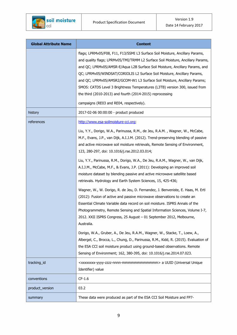
Product Specification Document Version 1.9
Date 14 February 2017
9
Global Attribute Name Content
flags; LPRMv05/F08, F11, F13/SSMI L3 Surface Soil Moisture, Ancillary Params,
and quality flags; LPRMv05/TMI/TRMM L2 Surface Soil Moisture, Ancillary Params,
and QC; LPRMv05/AMSR-E/Aqua L2B Surface Soil Moisture, Ancillary Params, and
QC; LPRMv05/WINDSAT/CORIOLIS L2 Surface Soil Moisture, Ancillary Params,
and QC; LPRMv05/AMSR2/GCOM-W1 L3 Surface Soil Moisture, Ancillary Params;
SMOS: CATDS Level 3 Brightness Temperatures (L3TB) version 300, issued from
the third (2010-2013) and fourth (2014-2015) reprocessing
campaigns (RE03 and RE04, respectively).
history 2017-02-06 00:00:00 - product produced
references http://www.esa-soilmoisture-cci.org;
Liu, Y.Y., Dorigo, W.A., Parinussa, R.M., de Jeu, R.A.M. , Wagner, W., McCabe,
M.F., Evans, J.P., van Dijk, A.I.J.M. (2012). Trend-preserving blending of passive
and active microwave soil moisture retrievals, Remote Sensing of Environment,
123, 280-297, doi: 10.1016/j.rse.2012.03.014;
Liu, Y.Y., Parinussa, R.M., Dorigo, W.A., De Jeu, R.A.M., Wagner, W., van Dijk,
A.I.J.M., McCabe, M.F., & Evans, J.P. (2011): Developing an improved soil
moisture dataset by blending passive and active microwave satellite based
retrievals. Hydrology and Earth System Sciences, 15, 425-436;
Wagner, W., W. Dorigo, R. de Jeu, D. Fernandez, J. Benveniste, E. Haas, M. Ertl
(2012): Fusion of active and passive microwave observations to create an
Essential Climate Variable data record on soil moisture. ISPRS Annals of the
Photogrammetry, Remote Sensing and Spatial Information Sciences, Volume I-7,
2012. XXII ISPRS Congress, 25 August – 01 September 2012, Melbourne,
Australia.
Dorigo, W.A., Gruber, A., De Jeu, R.A.M., Wagner, W., Stacke, T., Loew, A.,
Albergel, C., Brocca, L., Chung, D., Parinussa, R.M., Kidd, R. (2015). Evaluation of
the ESA CCI soil moisture product using ground-based observations. Remote
Sensing of Environment; 162, 380-395, doi: 10.1016/j.rse.2014.07.023.
tracking_id <xxxxxxxx-yyyy-zzzz-nnnn-mmmmmmmmmmmm> a UUID (Universal Unique
Identifier) value
conventions CF-1.6
product_version 03.2
summary These data were produced as part of the ESA CCI Soil Moisture and FP7-
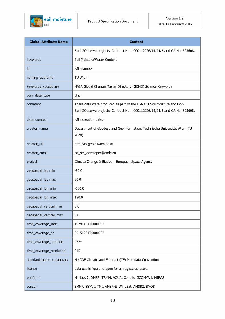
Product Specification Document Version 1.9
Date 14 February 2017
10
Global Attribute Name Content
Earth2Observe projects. Contract No. 4000112226/14/I-NB and GA No. 603608.
keywords Soil Moisture/Water Content
id <filename>
naming_authority TU Wien
keywords_vocabulary NASA Global Change Master Directory (GCMD) Science Keywords
cdm_data_type Grid
comment These data were produced as part of the ESA CCI Soil Moisture and FP7-
Earth2Observe projects. Contract No. 4000112226/14/I-NB and GA No. 603608.
date_created <file creation date>
creator_name Department of Geodesy and Geoinformation, Technische Universität Wien (TU
Wien)
creator_url http://rs.geo.tuwien.ac.at
creator_email [email protected]
project Climate Change Initiative – European Space Agency
geospatial_lat_min -90.0
geospatial_lat_max 90.0
geospatial_lon_min -180.0
geospatial_lon_max 180.0
geospatial_vertical_min 0.0
geospatial_vertical_max 0.0
time_coverage_start 19781101T000000Z
time_coverage_ed 20151231T000000Z
time_coverage_duration P37Y
time_coverage_resolution P1D
standard_name_vocabulary NetCDF Climate and Forecast (CF) Metadata Convention
license data use is free and open for all registered users
platform Nimbus 7, DMSP, TRMM, AQUA, Coriolis, GCOM-W1, MIRAS
sensor SMMR, SSM/I, TMI, AMSR-E, WindSat, AMSR2, SMOS
Product Specification Document Version 1.9
Date 14 February 2017
11
Global Attribute Name Content
spatial_resolution 25km
geospatial_lat_units degrees_north
geospatial_lon_units degrees_east
geospatial_lon_resolution 0.25 degree
geospatial_lat_resolution 0.25 degree
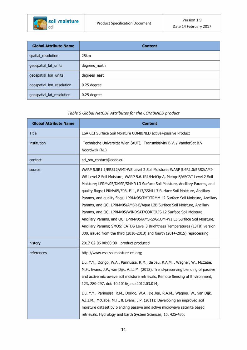
Table 5 Global NetCDF Attributes for the COMBINED product
Global Attribute Name Content
Title ESA CCI Surface Soil Moisture COMBINED active+passive Product
institution Technische Universität Wien (AUT), Transmissivity B.V. / VanderSat B.V.
Noordwijk (NL)
contact [email protected]
source WARP 5.5R1.1/ERS12/AMI-WS Level 2 Soil Moisture; WARP 5.4R1.0/ERS2/AMI-
WS Level 2 Soil Moisture; WARP 5.6.1R1/MetOp-A, Metop-B/ASCAT Level 2 Soil
Moisture; LPRMv05/DMSP/SMMR L3 Surface Soil Moisture, Ancillary Params, and
quality flags; LPRMv05/F08, F11, F13/SSMI L3 Surface Soil Moisture, Ancillary
Params, and quality flags; LPRMv05/TMI/TRMM L2 Surface Soil Moisture, Ancillary
Params, and QC; LPRMv05/AMSR-E/Aqua L2B Surface Soil Moisture, Ancillary
Params, and QC; LPRMv05/WINDSAT/CORIOLIS L2 Surface Soil Moisture,
Ancillary Params, and QC; LPRMv05/AMSR2/GCOM-W1 L3 Surface Soil Moisture,
Ancillary Params; SMOS: CATDS Level 3 Brightness Temperatures (L3TB) version
300, issued from the third (2010-2013) and fourth (2014-2015) reprocessing
history 2017-02-06 00:00:00 - product produced
references http://www.esa-soilmoisture-cci.org;
Liu, Y.Y., Dorigo, W.A., Parinussa, R.M., de Jeu, R.A.M. , Wagner, W., McCabe,
M.F., Evans, J.P., van Dijk, A.I.J.M. (2012). Trend-preserving blending of passive
and active microwave soil moisture retrievals, Remote Sensing of Environment,
123, 280-297, doi: 10.1016/j.rse.2012.03.014;
Liu, Y.Y., Parinussa, R.M., Dorigo, W.A., De Jeu, R.A.M., Wagner, W., van Dijk,
A.I.J.M., McCabe, M.F., & Evans, J.P. (2011): Developing an improved soil
moisture dataset by blending passive and active microwave satellite based
retrievals. Hydrology and Earth System Sciences, 15, 425-436;
Product Specification Document Version 1.9
Date 14 February 2017
12
Global Attribute Name Content
Wagner, W., W. Dorigo, R. de Jeu, D. Fernandez, J. Benveniste, E. Haas, M. Ertl
(2012): Fusion of active and passive microwave observations to create an
Essential Climate Variable data record on soil moisture. ISPRS Annals of the
Photogrammetry, Remote Sensing and Spatial Information Sciences, Volume I-7,
2012. XXII ISPRS Congress, 25 August – 01 September 2012, Melbourne,
Australia.
Dorigo, W.A., Gruber, A., De Jeu, R.A.M., Wagner, W., Stacke, T., Loew, A.,
Albergel, C., Brocca, L., Chung, D., Parinussa, R.M., Kidd, R. (2015). Evaluation of
the ESA CCI soil moisture product using ground-based observations. Remote
Sensing of Environment; 162, 380-395, doi: 10.1016/j.rse.2014.07.023.
tracking_id <xxxxxxxx-yyyy-zzzz-nnnn-mmmmmmmmmmmm> a UUID (Universal Unique
Identifier) value
conventions CF-1.6
product_version 03.2
summary These data were produced as part of the ESA CCI Soil Moisture and FP7-
Earth2Observe projects. Contract No. 4000112226/14/I-NB and GA No. 603608.
keywords Soil Moisture/Water Content
id <filename>
naming_authority TU Wien
keywords_vocabulary NASA Global Change Master Directory (GCMD) Science Keywords
cdm_data_type Grid
comment These data were produced as part of the ESA CCI Soil Moisture and FP7-
Earth2Observe projects. Contract No. 4000112226/14/I-NB and GA No. 603608.
date_created <file creation date>
creator_name Department of Geodesy and Geoinformation Technische Universität Wien (TU
Wien)
creator_url http://rs.geo.tuwien.ac.at
creator_email [email protected]
project Climate Change Initiative – European Space Agency
geospatial_lat_min -90.0
Product Specification Document Version 1.9
Date 14 February 2017
13
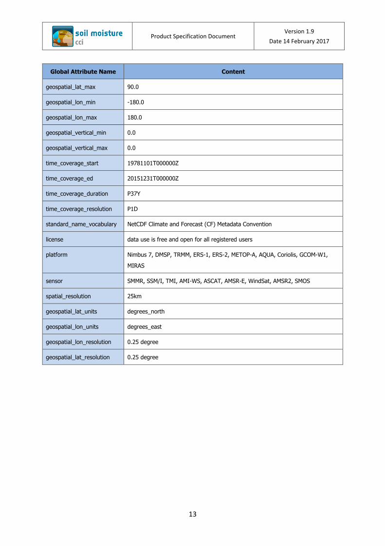
Global Attribute Name Content
geospatial_lat_max 90.0
geospatial_lon_min -180.0
geospatial_lon_max 180.0
geospatial_vertical_min 0.0
geospatial_vertical_max 0.0
time_coverage_start 19781101T000000Z
time_coverage_ed 20151231T000000Z
time_coverage_duration P37Y
time_coverage_resolution P1D
standard_name_vocabulary NetCDF Climate and Forecast (CF) Metadata Convention
license data use is free and open for all registered users
platform Nimbus 7, DMSP, TRMM, ERS-1, ERS-2, METOP-A, AQUA, Coriolis, GCOM-W1,
MIRAS
sensor SMMR, SSM/I, TMI, AMI-WS, ASCAT, AMSR-E, WindSat, AMSR2, SMOS
spatial_resolution 25km
geospatial_lat_units degrees_north
geospatial_lon_units degrees_east
geospatial_lon_resolution 0.25 degree
geospatial_lat_resolution 0.25 degree
Product Specification Document Version 1.9
Date 14 February 2017
14
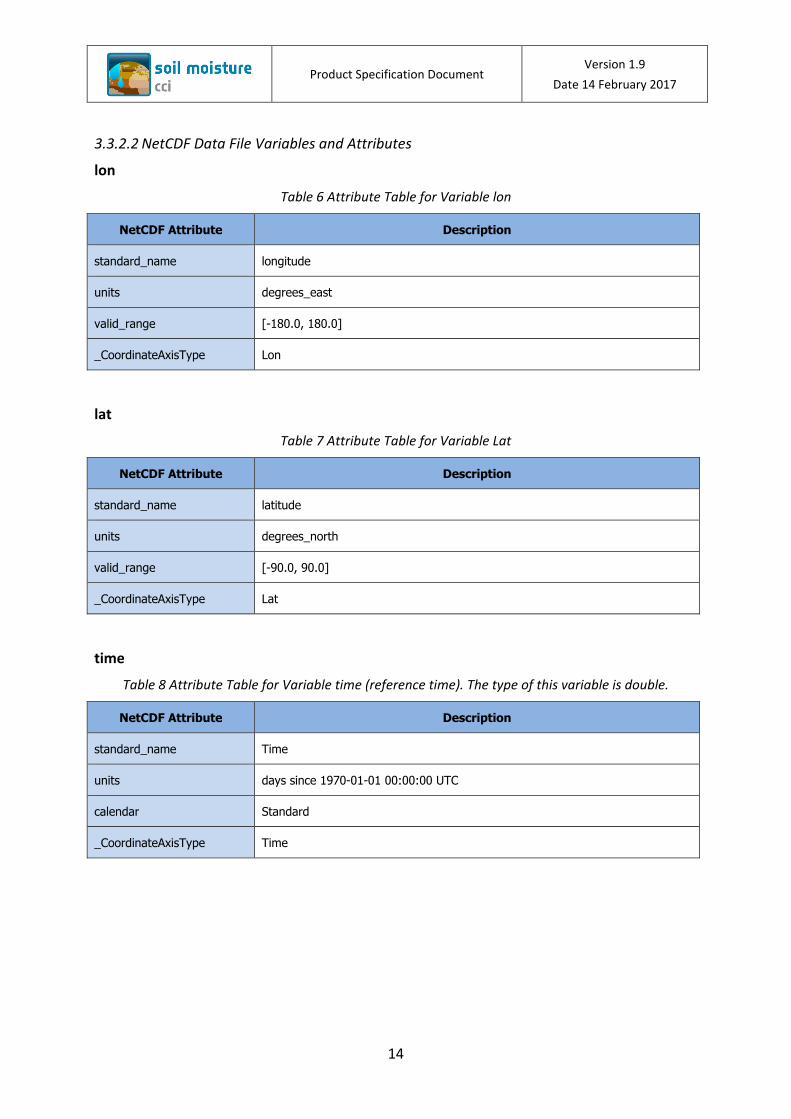
3.3.2.2 NetCDF Data File Variables and Attributes
lon
Table 6 Attribute Table for Variable lon
NetCDF Attribute Description
standard_name longitude
units degrees_east
valid_range [-180.0, 180.0]
_CoordinateAxisType Lon
lat
Table 7 Attribute Table for Variable Lat
NetCDF Attribute Description
standard_name latitude
units degrees_north
valid_range [-90.0, 90.0]
_CoordinateAxisType Lat
time
Table 8 Attribute Table for Variable time (reference time). The type of this variable is double.
NetCDF Attribute Description
standard_name Time
units days since 1970-01-01 00:00:00 UTC
calendar Standard
_CoordinateAxisType Time
Product Specification Document Version 1.9
Date 14 February 2017
15
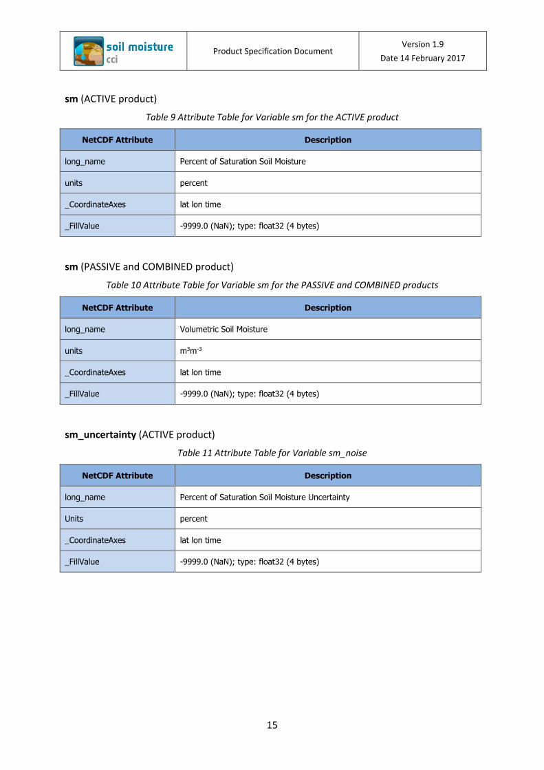
sm (ACTIVE product)
Table 9 Attribute Table for Variable sm for the ACTIVE product
NetCDF Attribute Description
long_name Percent of Saturation Soil Moisture
units percent
_CoordinateAxes lat lon time
_FillValue -9999.0 (NaN); type: float32 (4 bytes)
sm (PASSIVE and COMBINED product)
Table 10 Attribute Table for Variable sm for the PASSIVE and COMBINED products
NetCDF Attribute Description
long_name Volumetric Soil Moisture
units m3m-3
_CoordinateAxes lat lon time
_FillValue -9999.0 (NaN); type: float32 (4 bytes)
sm_uncertainty (ACTIVE product)
Table 11 Attribute Table for Variable sm_noise
NetCDF Attribute Description
long_name Percent of Saturation Soil Moisture Uncertainty
Units percent
_CoordinateAxes lat lon time
_FillValue -9999.0 (NaN); type: float32 (4 bytes)
Product Specification Document Version 1.9
Date 14 February 2017
16
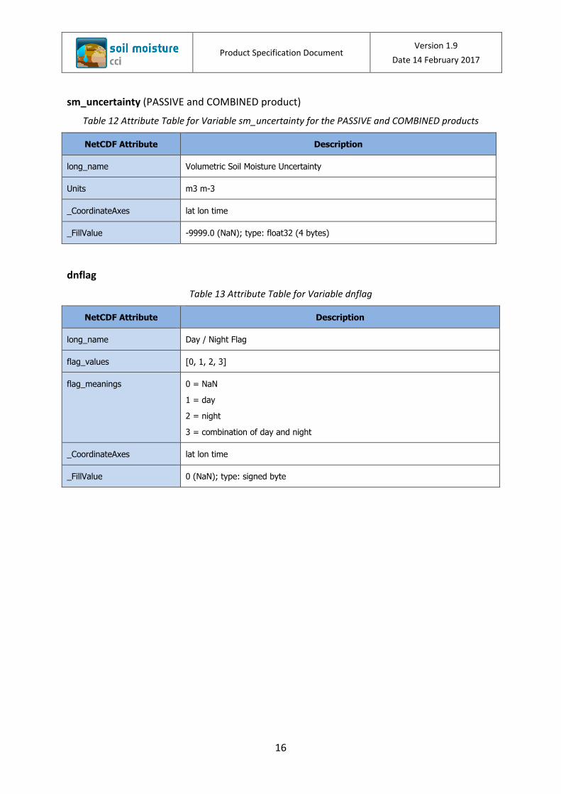
sm_uncertainty (PASSIVE and COMBINED product)
Table 12 Attribute Table for Variable sm_uncertainty for the PASSIVE and COMBINED products
NetCDF Attribute Description
long_name Volumetric Soil Moisture Uncertainty
Units m3 m-3
_CoordinateAxes lat lon time
_FillValue -9999.0 (NaN); type: float32 (4 bytes)
dnflag
Table 13 Attribute Table for Variable dnflag
NetCDF Attribute Description
long_name Day / Night Flag
flag_values [0, 1, 2, 3]
flag_meanings 0 = NaN
1 = day
2 = night
3 = combination of day and night
_CoordinateAxes lat lon time
_FillValue 0 (NaN); type: signed byte
Product Specification Document Version 1.9
Date 14 February 2017
17
flag
Table 14 Attribute Table for Variable flag
NetCDF Attribute Description
long_name Flag
flag_values [0, 1, 2, 3, 4, 5, 6, 7, 8, 9, 10, 11, 12, 13, 14, 15, 16, 17, 18, 19, 20, 21, 22, 23,
24, 25, 26, 27, 28, 29, 30, 31, 32, 33, 34, 35, 36, 37, 38, 39, 40, 41, 42, 43, 44,
45, 46, 47, 48, 49. 50, 51, 52, 53, 54, 55, 56, 57, 58, 59, 60, 61, 62, 63, 127]
flag_meanings 0 = no data inconsistency detected 1 = snow coverage or temperature below zero 2 = dense vegetation 3 = combination of flag values 1 and 2 4 = others - no convergence in the model thus no valid sm estimates 5 = combination of flag values 1 and 4 6 = combination of flag value 2 and 4 7 = combination of flag values 1, 2, and 4 8 = soil moisture value exceeds physical boundary 9 = combination of flag values 1, and 8 10 = combination of flag values 2, and 8 11 = combination of flag values 1, 2, and 8 12 = combination of flag values 4, and 8 13 = combination of flag values 1, 4, and8 14 = combination of flag values 2, 4, 8 15 = combination of flag values 1, 2, 4, and 8 16 = weight of measurement below threshold 17 = combination of flag values 1 and 16 18 = combination of flag values 2 and 16 19 = combination of flag values 1 and 2 and 16 20 = combination of flag values 4 and 16 21 = combination of flag values 1 and 4 and 16 22 = combination of flag values 2 and 4 and 16 23 = combination of flag values 1 and 2 and 4 and 16 24 = combination of flag values 8 and 16 25 = combination of flag values 1 and 8 and 16 26 = combination of flag values 2 and 8 and 16 27 = combination of flag values 1 and 2 and 8 and 16 28 = combination of flag values 4 and 8 and 16 29 = combination of flag values 1 and 4 and 8 and 16 30 = combination of flag values 2 and 4 and 8 and 16 31 = combination of flag values 1 and 2 and 4 and 8 and 16 32 = all datasets deemed unreliable 33 = combination of flag values 1 and 32 34 = combination of flag values 2 and 32 35 = combination of flag values 1 and 2 and 32 36 = combination of flag values 4 and 32 37 = combination of flag values 1 and 4 and 32 38 = combination of flag values 2 and 4 and 32 39 = combination of flag values 1 and 2 and 4 and 32 40 = combination of flag values 8 and 32 41 = combination of flag values 1 and 8 and 32 42 = combination of flag values 2 and 8 and 32 43 = combination of flag values 1 and 2 and 8 and 32 44 = combination of flag values 4 and 8 and 32 45 = combination of flag values 1 and 4 and 8 and 32 46 = combination of flag values 2 and 4 and 8 and 32 47 = combination of flag values 1 and 2 and 4 and 8 and 32 48 = combination of flag values 16 and 32 49 = combination of flag values 1 and 16 and 32 50 = combination of flag values 2 and 16 and 32 51 = combination of flag values 1 and 2 and 16 and 32 52 = combination of flag values 4 and 16 and 32 53 = combination of flag values 1 and 4 and 16 and 32
Product Specification Document Version 1.9
Date 14 February 2017
18
54 = combination of flag values 2 and 4 and 16 and 32 55 = combination of flag values 1 and 2 and 4 and 16 and 32 56 = combination of flag values 8 and 16 and 32 57 = combination of flag values 1 and 8 and 16 and 32 58 = combination of flag values 2 and 8 and 16 and 32 59 = combination of flag values 1 and 2 and 8 and 16 and 32 60 = combination of flag values 4 and 8 and 16 and 32 61 = combination of flag values 1 and 4 and 8 and 16 and 32 62 = combination of flag values 2 and 4 and 8 and 16 and 32 63 = combination of flag values 1 and 2 and 4 and 8 and 16 and 32
_CoordinateAxes lat lon time
_FillValue 127 (NaN); type: signed byte
Product Specification Document Version 1.9
Date 14 February 2017
19
freqbandID
Table 15 Attribute Table for Variable freqbandID
NetCDF Attribute Description
long_name Frequency Band Identification
flag_values [0, 1, 2, 3, 4, 8, 9, 10, 11, 16, 17, 18, 19, 24, 25, 26, 27, 32, 33, 34, 35, 64, 65,
66, 67, 72, 73, 74, 75, 80, 81, 82, 83, 128, 130]
flag_meanings Flag values and their meaning
Value Meaning Value Meaning Value Meaning 0 NaN 19 L14+C53+C69 67 L14+C53+X107
1 L14 24 C68+C69 72 C68+X107
2 C53 25 L14+C68+C69 73 L14+C68+X107
3 L14+C53 26 C53+C68+C69 74 C53+C68+X107
4 C66 27 L14+C53+C68+C69 75 L14+C53+C68+X107
8 C68 32 C73 80 C69+X107
9 L14+C68 33 L14+C73 81 L14+C69+X107
10 C53+C68 34 C53+C73 82 C53+C69+X107
11 L14+C53+C68 35 L14+C53+C73 83 L14+C53+C69+X107
16 C69 64 X107 128 K194
17 L14+C69 65 L14+X107 130 C53+K194
18 C53+C69 66 C53+X107
List of major codes and the corresponding frequency bands
Binary Decimal Frequency [GHz] BandID 00000000 0 NaN N/A
00000001 1 1.4 L14
00000010 2 5.3 / 5.255 C53
00000100 4 6.6 C66
00001000 8 6.8 C68
00010000 16 6.9 / 6.93 C69
00100000 32 7.3 C73
01000000 64 10.65 / 10.7 X10⁷
10000000 128 19.35 / 19.4 K194
Sensors and their operating frequencies:
Sensor Operating Frequency [GHz] SMMR 6.6 / 10.7
SSM/I 19.35
TMI 10.65
AMSR-E 6.93 / 10.65
AMSR2 6.93 / 7.3 / 10.65
WindSat 6.8 / 10.7
SMOS 1.4
AMI-WS 5.3
ASCAT-A/B 5.255
_CoordinateAxes lat lon time
_FillValue 0 (NaN); type: signed integer
Product Specification Document Version 1.9
Date 14 February 2017
20
mode
Table 16 Attribute Table for Variable mode
NetCDF Attribute Description
long_name Satellite Mode
flag_values [0, 1, 2, 3]
flag_meanings 0 = NaN
1 = ascending
2 = descending
3 = combination of ascending and descending
_CoordinateAxes lat lon time
_FillValue 0 (NaN); type: signed byte
sensor
Table 17 Attribute Table for Variable sensor
NetCDF Attribute Description
long_name Sensor
flag_values [0, 1, 2, 4, 8, 16, 24, 32, 64, 72, 80, 88, 96, 128, 130, 132, 136, 256, 264, 272,
280, 288, 320, 328, 336, 344, 352, 512, 544, 576, 608, 768, 800, 832, 864]
flag_meanings
Value Sensor Combination Value Sensor Combination 0 NaN 264 AMSRE+ASCATA
1 SMMR 272 WindSat+ASCATA
2 SSMI 280 AMSRE+WindSat+ASCATA
4 TMI 288 AMSR2+ASCATA
8 AMSRE 320 SMOS+ASCATA
16 WindSat 328 AMSRE+SMOS+ASCATA
24 AMSRE+WindSat 336 WindSat+SMOS+ASCATA
32 AMSR2 344 AMSRE+WindSat+SMOS+ASCATA
64 SMOS 352 AMSR2+SMOS+ASCATA
72 AMSRE+SMOS 512 ASCATB
80 WindSat+SMOS 544 AMSR2+ASCATB
88 AMSRE+WindSat+SMOS 576 SMOS+ASCATB
96 AMSR2+SMOS 608 AMSR2+SMOS+ASCATB
128 AMIWS 768 ASCATA+ASCATB
130 SSMI+AMIWS 800 AMSR2+ASCATA+ASCATB
132 TMI+AMIWS 832 SMOS+ASCATA+ASCATB
136 ASMRE+AMIWS 864 AMSR2+SMOS+ASCATA+ASCATB
256 ASCATA
_CoordinateAxes lat lon time
_FillValue 0 (NaN); type: signed integer

Product Specification Document Version 1.9
Date 14 February 2017
21
t0
Table 18 Attribute Table for Variable t0
NetCDF Attribute Description
long_name Observation Time Stamp
units days since 1970-01-01 00:00:00 UTC
valid_range <individual decimal numbers depending on observation timestamp>
_CoordinateAxes lat lon time
_FillValue -9999.0; type: double
3.4 Description of data set variables?
3.4.1 sm
The “sm” parameter holds the surface soil moisture estimates are generated by blending
passive and active microwave soil moisture retrievalsin a weighted average fashion with the
weights being proportional to the signal-to-noise ratio (SNR) of the data sets. SNRs are
estimated using triple collocation (TC) analysis. The data are provided in percentage of
saturation [%] units for the ACTIVE product, and volumetric [m3m-3] units for the PASSIVE
and COMBINED products.
3.4.2 sm_uncertainty
The merging of soil moisture data from different sensors requires a harmonization of the
data. The data need to be brought into a common climatology by running them through
several scaling procedures performing the cumulative distribution function (CDF-) matching
technique. The provided “sm_uncertainty” parameter represents the error standard
deviation of the data sets (in the respective climatology of the dataset), estimated through
triple collocation (TC) analysis, which are used to calculate the relative weighting of the data
sets. In periods where TC cannot be applied, or in cases where the TC-based error standard
deviation estimates do not converge, sm_uncertainty is set to NaN. The unit of
sm_uncertainty for the ACTIVE product is percentage of saturation [%]. For the PASSIVE and
the COMBINED product the unit is volumetric soil moisture [m3m-3].. On days where only
measurements of one single data set are available, sm_uncertainty represents their error
standard deviation as obtained from TC analysis. On days where two or more data sets are
merged, sm_uncertainties represents the estimated error standard deviation of the merged
soil moisture measurements, obtained by propagating the TC-based error standard deviation
Product Specification Document Version 1.9
Date 14 February 2017
22
estimates of the contributing data sets through the merging algorithm using a standard error
propagation scheme. sm_uncertainty values exceeding the maximum value of 100 (ACTIVE)
or 1 (PASSIVE and COMBINED) are set to the maximum value respectively. Table 19 lists the
availability of the soil moisture uncertainty information for each product.
Table 19 sm_uncertainty data provided in the ESA CCI SM Products
Product Time Period
ACTIVE 1991-08-05 to 2015-12-31
PASSIVE 1987-07-09 to 2015-12-31
COMBINED 1987-07-09 to 2015-12-31
3.4.3 dnflag
The Day or Night Flag gives information, whether the observation(s) occurred at local day (1)
or night (2) time. A value of 3 indicates that the data is a result of merging satellite
microwave data observed during day as well as during night time. In cases where the
information cannot be determined the value is set to 0 (zero).
3.4.4 flag
Flag values are stored as signed bytes, and the default value (NaN) is 127. By reading the flag
for the surface soil moisture data, the user gets information for that grid point. A “0” (zero)
informs that the sm value for that grid point has been checked, but there was no
inconsistency found. A flag value of “1” denotes, that the soil for that location is covered
with snow or the temperature is below zero;“2” indicates that the observed location is
covered by dense vegetation, ; “4” stands for undefined other cases, e.g. no convergence in
the model, thus no valid soil moisture estimates; “8” denotes days that are masked because
not all data sets have valid observations and those which do are deemed unreliable when
used alone; and “16” denotes locations where all data sets are deemed unreliable. Please
see Table 14 for the meaning of all other flag values.
3.4.5 freqbandID
The surface soil moisture data has its sources from multiple and different satellite sensors,
which operate in various frequencies. The freqbandID values are representing the operating
Product Specification Document Version 1.9
Date 14 February 2017
23
frequencies and comprise the combination of different frequency bands. Table 15 lists these
combinations.
3.4.6 mode
The NetCDF variable mode stores the information of the sensor’s orbit direction. Ascending
direction are denoted as 1, and descending orbit as 2. In cases where the orbit direction
cannot be determined, the NaN value 0 (zero) is used. A value of 3 means that the merged
data comprises both ascending and decending satellite modes (Table 16).
3.4.7 sensor
The values for sensor are stored as signed integer, with NaN as 0 (zero). These values
indicate the satellite sensors that have been used for a specific grid point. Valid values range
from 1 to 864. Table 17 lists all available sensor combinations.
3.4.8 t0
The original observation timestamp is stored within the NetCDF variable t0 (t-naught). Time
values coming from two different sensors are averaged. Values of -9999.0 are used as NaN
values. t0 data values are stored as number of “days since 1970-01-01 00:00:00 UTC” (Table
18).
3.4.9 time
The reference timestamp of the day is saved in the “time” variable. The data values for the
reference time are stored as number of “days since 1970-01-01 00:00:00 UTC” (Table 8).
Product Specification Document Version 1.9
Date 14 February 2017
24
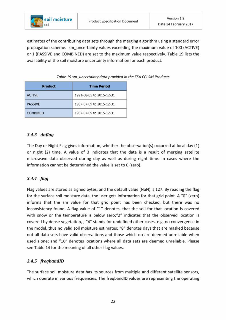
3.5 Product Grid and Projection
The grid is a 0.25° x 0.25° longitude-latitude global array of points, based on the World
Geodetic System 1984 (WGS 84) reference system. Its dimension is 1440 x 720, where the
first dimension, X (longitude) is incrementing most rapidly West (-180°) to East (180°), and
the second dimension, Y (latitude) is incrementing South (-90°) to North (90°). Grid edges are
at multiple of quarter-degree values (e.g. 90, 89.75, 89.5, 89.25, …), and the grid centers are
exactly between two grid edges:
First point center = (–89.875°S, –179.875°W) = Grid Point Index = 0
Second point center = (–89.875°S, –179.625°W) = Grid Point Index = 1
1441st point center = (–89.625°S, –179.875°W) = Grid Point Index = 1440
Last point center = (89.875°N, 179.875°E) = Grid Point Index = 1036799
In total, there are 1440 x 720 = 1036800 grid points, where 244243 points are land points.
Figure 1 shows the land points that are used for the merged product.
Figure 1: Land mask used for the merged product. The 0.25° grid starts indexing from “lower left” to the “upper right”. Note that not every grid points are available for all sensors, e.g. ASCAT retrievals are available between Latitude degrees 80° and –60°.

Product Specification Document Version 1.9
Date 14 February 2017
25
3.6 Ancillary data used
In the creation of the product a number of ancillary datasets have been used and are
described in the following subsections.
3.6.1 Global Land Data Assimilation System (GLDAS)
The PASSIVE and ACTIVE products represent volumetric soil moisture (m3m-3) and degree of
saturation (%), respectively. To combine these data, both products need to be adjusted to a
common reference. The reference dataset requires global coverage with a spatial resolution
and temporal interval that are comparable to both microwave products (i.e., approximately
25 km resolution and daily interval), a long time record, and reasonable surface soil moisture
estimates for all land cover types (i.e., representative soil layer is not deeper than 10 cm).
The GLDAS-1-Noah Land Surface Model L4 3 Hourly 0.25 x 0.25 degree soil moisture model
data satisfies these requirements and is employed as the reference dataset. Both, the
PASSIVE and ACTIVE, products were rescaled against the GLDAS-1-Noah data using the CDF
matching technique. Furthermore, soil porosity data has been taken from the GLDAS-Noah
dataset, and can be used in the conversion to volumetric soil moisture measurements.
According to the author (Rodell et al. 2004) of the GLDAS-Noah data, this soil parameter has
been derived from the 5’ resolution global soils dataset of Reynolds et al. (2000) by
horizontally resampling to the 0.25° GLDAS grid and by linearly interpolating “to 0–2-, 2–150-
, and 150–350-cm depths from the original 0–30- and 30–100-cm depths.”The methodolgy
behind the use of both data sets is provided in [RD-1]
3.6.2 ASCAT Advisory Flag
The following two ASCAT advisory flags (Scipal 2005) were used to mask out regions of
frozen soils, or snow covered soils:
Probability of snow covered land
Derived from historic analysis of SSM/I (Special Sensor Microwave/Imager) snow cover
data (averaged over the 9 years 1996-2004) and gives the probability for the occurrence
of snow for any day of the year.
Probability of frozen land
Derived from historic analysis of modelled climate data (7 years 1995-2001 of ECMWF
ERA-40 soil temperature) and gives the probability for the frozen soil/canopy conditions
for each day of the year.
Product Specification Document Version 1.9
Date 14 February 2017
26
3.7 Ancillary data provided along with the ESA CCI SM v03.2 products
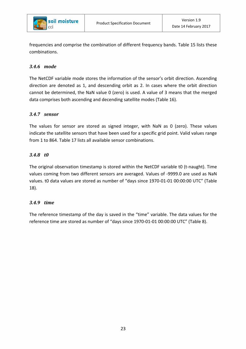
3.7.1 Land and Tropical forest Mask
A common land mask is used for all ESA CCI SM v03.1 products and ancillary data. The land
mask has been derived from the Global Self-consistent, Hierarchical, High-resolution
Geography Database (GSHHG v2.2.2), (Wessel and Smith 1996). Lakes and rivers with areas
less than 600 km2 were not considered in the calculation of the land points (Figure 2). See
section 0 for more detailed information on the used grid.
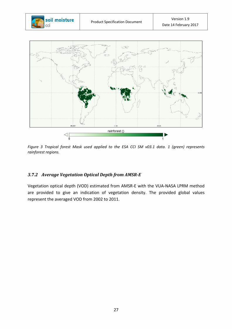
The Tropical forest mask (Figure 3) has been applied to all three ESA CCI SM products. The
soil moisture and the soil moisture uncertainty values are set to NaN in these rainforest
regions.
Figure 2 Land Mask used for the ESA CCI SM v03.1 products and ancillary data, where 1 (brown) represents land points.
Product Specification Document Version 1.9
Date 14 February 2017
27
Figure 3 Tropical forest Mask used applied to the ESA CCI SM v03.1 data. 1 (green) represents rainforest regions.
3.7.2 Average Vegetation Optical Depth from AMSR-E
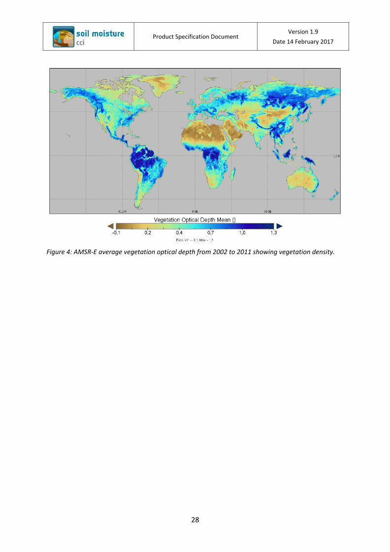
Vegetation optical depth (VOD) estimated from AMSR-E with the VUA-NASA LPRM method
are provided to give an indication of vegetation density. The provided global values
represent the averaged VOD from 2002 to 2011.
Product Specification Document Version 1.9
Date 14 February 2017
28
Figure 4: AMSR-E average vegetation optical depth from 2002 to 2011 showing vegetation density.
Product Specification Document Version 1.9
Date 14 February 2017
29
3.7.3 Soil Porosity
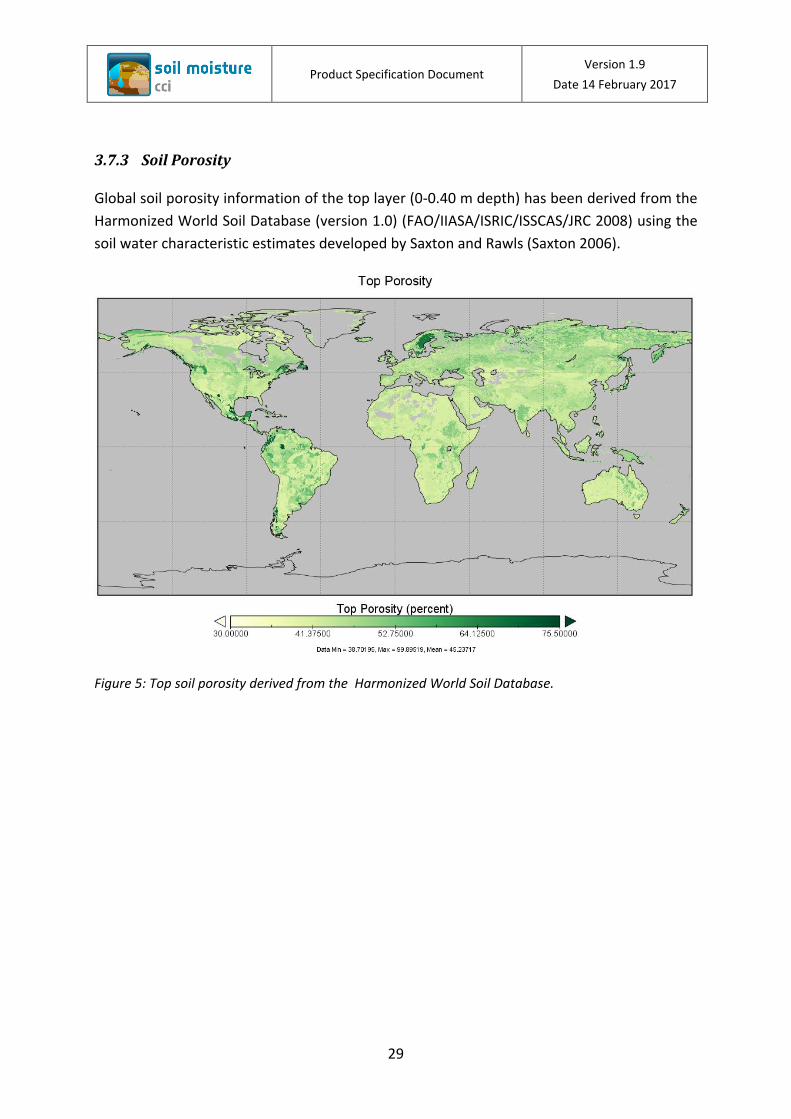
Global soil porosity information of the top layer (0-0.40 m depth) has been derived from the
Harmonized World Soil Database (version 1.0) (FAO/IIASA/ISRIC/ISSCAS/JRC 2008) using the
soil water characteristic estimates developed by Saxton and Rawls (Saxton 2006).
Figure 5: Top soil porosity derived from the Harmonized World Soil Database.
Product Specification Document Version 1.9
Date 14 February 2017
30
3.7.4 Topographic Complexity
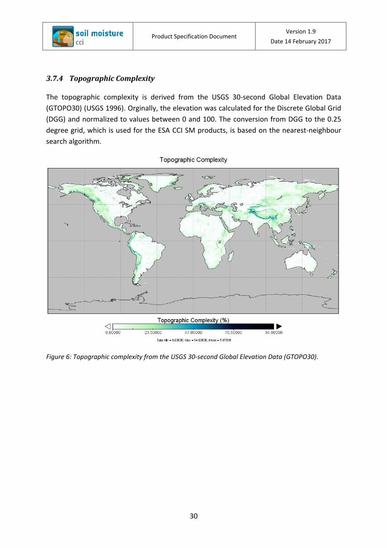
The topographic complexity is derived from the USGS 30-second Global Elevation Data
(GTOPO30) (USGS 1996). Orginally, the elevation was calculated for the Discrete Global Grid
(DGG) and normalized to values between 0 and 100. The conversion from DGG to the 0.25
degree grid, which is used for the ESA CCI SM products, is based on the nearest-neighbour
search algorithm.
Figure 6: Topographic complexity from the USGS 30-second Global Elevation Data (GTOPO30).
Product Specification Document Version 1.9
Date 14 February 2017
31
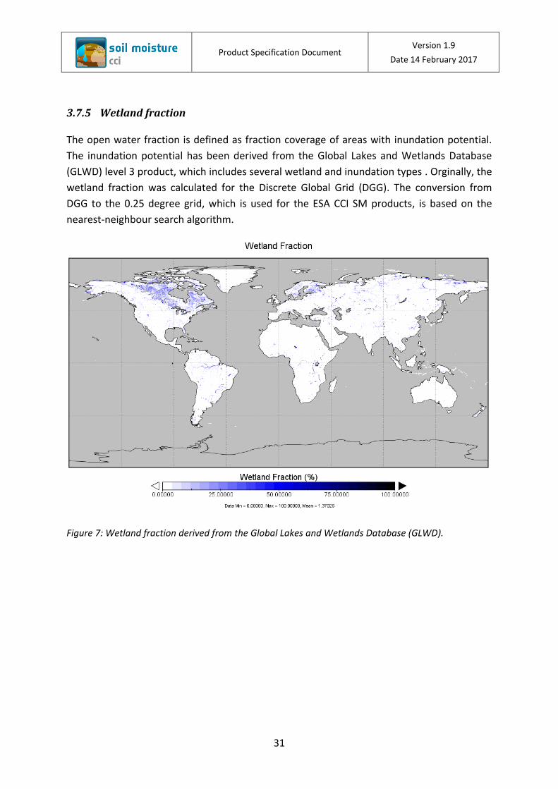
3.7.5 Wetland fraction
The open water fraction is defined as fraction coverage of areas with inundation potential.
The inundation potential has been derived from the Global Lakes and Wetlands Database
(GLWD) level 3 product, which includes several wetland and inundation types . Orginally, the
wetland fraction was calculated for the Discrete Global Grid (DGG). The conversion from
DGG to the 0.25 degree grid, which is used for the ESA CCI SM products, is based on the
nearest-neighbour search algorithm.
Figure 7: Wetland fraction derived from the Global Lakes and Wetlands Database (GLWD).
Product Specification Document Version 1.9
Date 14 February 2017
32
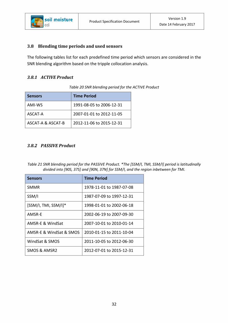
3.8 Blending time periods and used sensors
The following tables list for each predefined time period which sensors are considered in the
SNR blending algorithm based on the tripple collocation analysis.
3.8.1 ACTIVE Product
Table 20 SNR blending period for the ACTIVE Product
Sensors Time Period
AMI-WS 1991-08-05 to 2006-12-31
ASCAT-A 2007-01-01 to 2012-11-05
ASCAT-A & ASCAT-B 2012-11-06 to 2015-12-31
3.8.2 PASSIVE Product
Table 21 SNR blending period for the PASSIVE Product. *The [SSM/I, TMI, SSM/I] period is latitudinally divided into [90S, 37S] and [90N, 37N] for SSM/I, and the region inbetween for TMI.
Sensors Time Period
SMMR 1978-11-01 to 1987-07-08
SSM/I 1987-07-09 to 1997-12-31
[SSM/I, TMI, SSM/I]* 1998-01-01 to 2002-06-18
AMSR-E 2002-06-19 to 2007-09-30
AMSR-E & WindSat 2007-10-01 to 2010-01-14
AMSR-E & WindSat & SMOS 2010-01-15 to 2011-10-04
WindSat & SMOS 2011-10-05 to 2012-06-30
SMOS & AMSR2 2012-07-01 to 2015-12-31
Product Specification Document Version 1.9
Date 14 February 2017
33
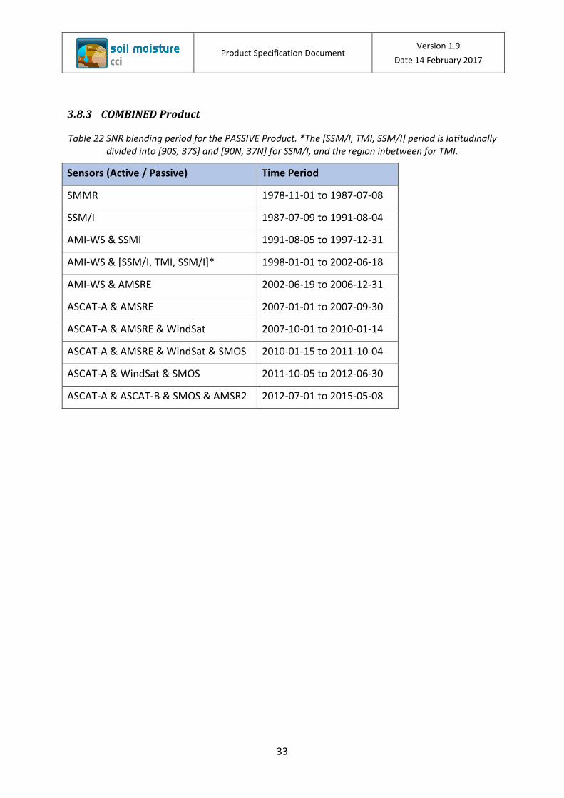
3.8.3 COMBINED Product
Table 22 SNR blending period for the PASSIVE Product. *The [SSM/I, TMI, SSM/I] period is latitudinally divided into [90S, 37S] and [90N, 37N] for SSM/I, and the region inbetween for TMI.
Sensors (Active / Passive) Time Period
SMMR 1978-11-01 to 1987-07-08
SSM/I 1987-07-09 to 1991-08-04
AMI-WS & SSMI 1991-08-05 to 1997-12-31
AMI-WS & [SSM/I, TMI, SSM/I]* 1998-01-01 to 2002-06-18
AMI-WS & AMSRE 2002-06-19 to 2006-12-31
ASCAT-A & AMSRE 2007-01-01 to 2007-09-30
ASCAT-A & AMSRE & WindSat 2007-10-01 to 2010-01-14
ASCAT-A & AMSRE & WindSat & SMOS 2010-01-15 to 2011-10-04
ASCAT-A & WindSat & SMOS 2011-10-05 to 2012-06-30
ASCAT-A & ASCAT-B & SMOS & AMSR2 2012-07-01 to 2015-05-08
Product Specification Document Version 1.9
Date 14 February 2017
34
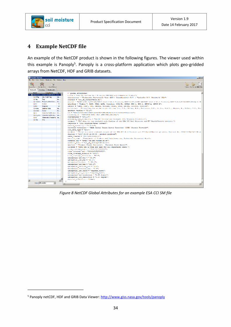
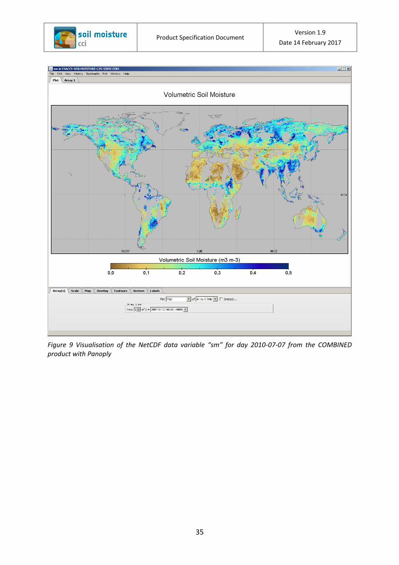
4 Example NetCDF file
An example of the NetCDF product is shown in the following figures. The viewer used within
this example is Panoply5. Panoply is a cross-platform application which plots geo-gridded
arrays from NetCDF, HDF and GRIB datasets.
Figure 8 NetCDF Global Attributes for an example ESA CCI SM file
5 Panoply netCDF, HDF and GRIB Data Viewer: http://www.giss.nasa.gov/tools/panoply
Product Specification Document Version 1.9
Date 14 February 2017
35
Figure 9 Visualisation of the NetCDF data variable “sm” for day 2010-07-07 from the COMBINED product with Panoply
Product Specification Document Version 1.9
Date 14 February 2017
36
5 Data Usage and Limitations
5.1 Free Use
The ACTIVE, PASSIVE, and the COMBINED products are freely available after completion of a
simple registration form. The use of the product is free and open for all registered users.
User Registration can be found at http://www.esa-soilmoisture-cci.org/dataregistration.
5.2 No onward distribution
The use of the downloaded data is restricted to the user and the associated organisation, no
onward distribution is permitted. This is in the best interest of both the individual data
providers and the potential users as unrestricted copying of the original data by multiple,
independent users may lead to errors in the data.
Full data citation must be adhered to for all data usage.
6 Data Citation
The data set should be cited using the complete three references as follows:
1. Liu, Y. Y., W. A. Dorigo, et al. (2012). "Trend-preserving blending of passive and active microwave soil moisture retrievals." Remote Sensing of Environment 123: 280-297.
2. Liu, Y. Y., Parinussa, R. M., Dorigo, W. A., De Jeu, R. A. M., Wagner, W., van Dijk, A. I. J. M., McCabe, M. F., Evans, J. P. (2011). Developing an improved soil moisture dataset by blending passive and active microwave satellite-based retrievals. Hydrology and Earth System Sciences, 15, 425-436
3. Wagner, W., W. Dorigo, R. de Jeu, D. Fernandez, J. Benveniste, E. Haas, M. Ertl (2012). Fusion of active and passive microwave observations to create an Essential Climate Variable data record on soil moisture. ISPRS Annals of the Photogrammetry, Remote Sensing and Spatial Information Sciences (ISPRS Annals), Volume I-7, XXII ISPRS Congress, Melbourne, Australia, 25 August-1 September 2012, 315-321
Product Specification Document Version 1.9
Date 14 February 2017
37
7 Bibliography
Dorigo, W., Wagner, W., Albergel, C., Albrecht, F., Balsamo, G., Brocca, L., Chung, D., Ertl, M., Forkel, M., Gruber, A., Haas, E., Hamer, P., Hirschi, M., Ikonen, J., Jeu, R.d., Kidd, R., Lahoz, W., Liu, Y.Y., Miralles, D., Mistelbauer, T., Nicolai-Shaw, N., Parinussa, R., Pratola, C., Reimer, C., Schalie, R.v.d., Seneviratne, S.I., Smolander, T., & Lecomte, P. (in review). ESA CCI Soil Moisture for improved Earth system understanding: state-of-the art and future directions. Remote Sensing of Environemnt
FAO/IIASA/ISRIC/ISSCAS/JRC (2008). Harmonized World Soil Database (version 1.0). International Institute for Applied Systems Analysis (IIASA), Laxenburg (Austria)
Gruber, A., Dorigo, W., van der Schalie, R., de Jeu, R., & Wagner, W. (in prep.). Improved blending of multi-satellite products into the ESA CCI soil moisture climate data record
Liu, Y.Y., Dorigo, W.A., Parinussa, R.M., De Jeu, R.A.M., Wagner, W., McCabe, M.F., Evans, J.P., & Van Dijk, A.I.J.M. (2012). Trend-preserving blending of passive and active microwave soil moisture retrievals. Remote Sensing of Environment, 123, 280-297
Liu, Y.Y., Parinussa, R.M., Dorigo, W.A., de Jeu, R.A.M., Wagner, W., van Dijk, A., McCabe, F.M., & Evans, J.P. (2011). Developing an improved soil moisture dataset by blending passive and active microwave satellite-based retrievals. Hydrology and Earth System Sciences, 15, 425-436
Reynolds, C.A., Jackson, T.J., & Rawls, W.J. (2000). Estimating soil water-holding capacities by linking the Food and Agriculture Organization soil map of the world with global pedon databases and continuous pedotransfer functions. Water Resources Research, 36, 3653-3662
Rodell, M., Houser, P.R., Jambor, U., Gottschalck, J., Mitchell, K., Meng, C.J., Arsenault, K., Cosgrove, B., Radakovich, J., Bosilovich, M., Entin, J.K., Walker, J.P., Lohmann, D., & Toll, D. (2004). The Global Land Data Assimilation System. Bulletin of the American Meteorological Society, 85, 381-394
Saxton, K.E., Rawls, W. J. (2006). Soil Water Characteristic Estimates by Texture and Organic Matter for Hydrologic Solutions. Soil Sci. Soc. Am. J., 10
Scipal, K., Naeimi, V., Hasenauer, S. (2005). Definition of Quality Flags. In, ASCAT Soil Moisture Report Series. Vienna: Vienna University of Technology
USGS (1996). Global 30-Arc-Second Elevation Data Set (GTOPO30). U.S. Geological Survey
Wagner, W., W. Dorigo, R. de Jeu, D. Fernandez-Prieto, J. Benveniste, E. Haas, & Ertl, M. (2012). Fusion of active and passive microwave observations to create an Essential Climate Variable data record on soil moisture. In, XXII ISPRS Congress. Melbourne,Australia
Product Specification Document Version 1.9
Date 14 February 2017
38
Wagner, W., W. Dorigo, R. de Jeu, D. Fernandez, J. Benveniste, E. Haas, M. Ertl (2012). Fusion of active and passive microwave observations to create an Essential Climate Variable data record on soil moisture. In, XXII ISPRS Congress. Melbourne,Australia
Wessel, P., & Smith, W.H.F. (1996). A Global Self-consistent, Hierarchical, High-resolution Shoreline Database. J. Geophys. Res., 101, 3
![Introduction to Robotics - uni-hamburg.de€¦ · MINFaculty DepartmentofInformatics IntroductiontoRobotics Lecture1 JianweiZhang,LasseEinig [zhang,einig]@informatik.uni-hamburg.de](https://img.pdfslide.us/doc/110x75/5f0318287e708231d40781af/introduction-to-robotics-uni-minfaculty-departmentofinformatics-introductiontorobotics.jpg)