Embed Size (px)
Citation preview
Proceedings of the Geologists’ Association xxx (2013) xxx–xxx
G Model
PGEOLA-291; No. of Pages 17
Review paper
The Phuket-Slate Belt terrane: tectonic evolution and strike-slip emplacement of amajor terrane on the Sundaland margin of Thailand and Myanmar
Michael F. Ridd a,*, Ian Watkinson b
a 43 Prospect Quay, Point Pleasant, London SW18 1PR, UKb Southeast Asia Research Group, Department of Earth Sciences, Royal Holloway University of London, Egham, Surrey TW20 0EX, UK
Contents
1. Introduction . . . . . . . . . . . . . . . . . . . . . . . . . . . . . . . . . . . . . . . . . . . . . . . . . . . . . . . . . . . . . . . . . . . . . . . . . . . . . . . . . . . . . . . . . . . . . . . . . . . . . 000
2. Thailand segment of the Phuket-Slate Belt terrane . . . . . . . . . . . . . . . . . . . . . . . . . . . . . . . . . . . . . . . . . . . . . . . . . . . . . . . . . . . . . . . . . . . . . . 000
3. Myanmar segment of the Phuket-Slate Belt terrane . . . . . . . . . . . . . . . . . . . . . . . . . . . . . . . . . . . . . . . . . . . . . . . . . . . . . . . . . . . . . . . . . . . . . 000
3.1. Paunglaung Mawchi Zone . . . . . . . . . . . . . . . . . . . . . . . . . . . . . . . . . . . . . . . . . . . . . . . . . . . . . . . . . . . . . . . . . . . . . . . . . . . . . . . . . . . . 000
3.2. Relations of the Slate Belt with the Mogok Metamorphic Belt . . . . . . . . . . . . . . . . . . . . . . . . . . . . . . . . . . . . . . . . . . . . . . . . . . . . . . . . 000
4. Western Granite Province . . . . . . . . . . . . . . . . . . . . . . . . . . . . . . . . . . . . . . . . . . . . . . . . . . . . . . . . . . . . . . . . . . . . . . . . . . . . . . . . . . . . . . . . . . 000
5. History of the Phuket-Slate Belt terrane. . . . . . . . . . . . . . . . . . . . . . . . . . . . . . . . . . . . . . . . . . . . . . . . . . . . . . . . . . . . . . . . . . . . . . . . . . . . . . . 000
5.1. Emplacement of the Phuket-Slate Belt terrane . . . . . . . . . . . . . . . . . . . . . . . . . . . . . . . . . . . . . . . . . . . . . . . . . . . . . . . . . . . . . . . . . . . . 000
5.2. Postulated cross-cutting displacement of the Phuket-Slate Belt terrane . . . . . . . . . . . . . . . . . . . . . . . . . . . . . . . . . . . . . . . . . . . . . . . . 000
6. Speculations on the southern extension of the Phuket-Slate Belt terrane . . . . . . . . . . . . . . . . . . . . . . . . . . . . . . . . . . . . . . . . . . . . . . . . . . . . 000
7. Conclusions . . . . . . . . . . . . . . . . . . . . . . . . . . . . . . . . . . . . . . . . . . . . . . . . . . . . . . . . . . . . . . . . . . . . . . . . . . . . . . . . . . . . . . . . . . . . . . . . . . . . . 000
Acknowledgements . . . . . . . . . . . . . . . . . . . . . . . . . . . . . . . . . . . . . . . . . . . . . . . . . . . . . . . . . . . . . . . . . . . . . . . . . . . . . . . . . . . . . . . . . . . . . . . 000
References . . . . . . . . . . . . . . . . . . . . . . . . . . . . . . . . . . . . . . . . . . . . . . . . . . . . . . . . . . . . . . . . . . . . . . . . . . . . . . . . . . . . . . . . . . . . . . . . . . . . . . 000
A R T I C L E I N F O
Article history:
Received 26 November 2012
Received in revised form 30 January 2013
Accepted 31 January 2013
Available online xxx
Keywords:
Phuket Terrane
Slate Belt
Phuket-Slate Belt terrane
Western Granite Province
Mogok
Strike-slip faults
Khlong Marui Fault
Three Pagodas Fault
India–Australia transform
A B S T R A C T
The Phuket-Slate Belt terrane can be traced for 1700 km from Phuket to Mandalay, and has a distinct
stratigraphy and tectonic history. It is characterized by a very thick Carboniferous-Lower Permian
succession which includes diamictites interpreted as glacio-marine rift-infill deposited when the
Sibumasu block separated from Gondwana. It was emplaced in the Late Cretaceous-Palaeogene by
dextral strike-slip movement on a fault system which includes the Khlong Marui and Panlaung Faults.
Southwards the Khlong Marui bounding-fault and its close associate, the Ranong Fault, are postulated to
extend to Sumatra where they align with the restored proto-Indian Ocean location of the India–Australia
transform at the time that both were undergoing dextral displacement and Greater India was moving
toward its collision with Eurasia. It is suggested that emplacement of the Phuket-Slate Belt terrane was
the result of its coupling with the north-going India plate, resulting in up to about 450 km of dextral shift
on the terrane’s bounding fault system. Post-emplacement sinistral movement on the cross-cutting Mae
Ping and Three Pagodas Faults offset the terrane boundary resulting in its present outline.
� 2013 The Geologists’ Association. Published by Elsevier Ltd. All rights reserved.
Contents lists available at SciVerse ScienceDirect
Proceedings of the Geologists’ Association
jo ur n al ho m ep ag e: www .e ls evier . c om / lo cat e/p g eo la
1. Introduction
Since the discovery of major strike-slip faults in Thailand overfour decades ago, important advances have been made in
* Corresponding author. Tel.: +44 020 8877 9717.
E-mail address: [email protected] (M.F. Ridd).
Please cite this article in press as: Ridd, M.F., Watkinson, I., Theemplacement of a major terrane on the Sundaland margin of Thai10.1016/j.pgeola.2013.01.007
0016-7878/$ – see front matter � 2013 The Geologists’ Association. Published by Else
http://dx.doi.org/10.1016/j.pgeola.2013.01.007
understanding their role in the tectonic history of mainland SEAsia. Garson and Mitchell (1970) described the Khlong Marui Faultbelt which coincides with the prominent bend of the ThaiPeninsula and separates the upper- from the lower Peninsula,while Ridd (1971a) identified the NW–SE-trending Mae Ping andThree Pagodas Faults which extend from western Thailand intoMyanmar. Since then the broader network of faults into which theyfit has emerged (Fig. 1), and studies of the mineralogy and internal
Phuket-Slate Belt terrane: tectonic evolution and strike-slipland and Myanmar. Proc. Geol. Assoc. (2013), http://dx.doi.org/
vier Ltd. All rights reserved.

Fig. 1. Simplified map showing the principal strike-slip faults identified in Thailand
and part of Eastern Myanmar. Also shown is the eastern limit of Sibumasu, the
Gondwana-derived composite block which includes the Phuket Terrane and Slate
Belt (combined under the name Phuket-Slate Belt terrane). Sundaland was created
by the Triassic collision of Sibumasu with the combined Sukhothai zone and
Indochina block.
M.F. Ridd, I. Watkinson / Proceedings of the Geologists’ Association xxx (2013) xxx–xxx2
G Model
PGEOLA-291; No. of Pages 17
fabric of the main fault zones, together with radiometric dating,have thrown light on the timing and the sense of movement onthem (e.g. Lacassin et al., 1993, 1997; Watkinson et al., 2008, 2011;Watkinson, 2012; Nantasin et al., 2012; Kanjanapayont et al.,2012).
Few of those earlier studies considered the fault-boundedblocks themselves, and differences between adjacent blocks whichmight exist. The present study concentrates on just one: the blockbounded on its east by the Khlong Marui Fault in Thailand, forwhich Ridd (2009) adopted the name Phuket Terrane. (This andmany of the other named faults in Southeast Asia are fault beltswith multiple strands, but for convenience are described here as if
Please cite this article in press as: Ridd, M.F., Watkinson, I., Theemplacement of a major terrane on the Sundaland margin of Thai10.1016/j.pgeola.2013.01.007
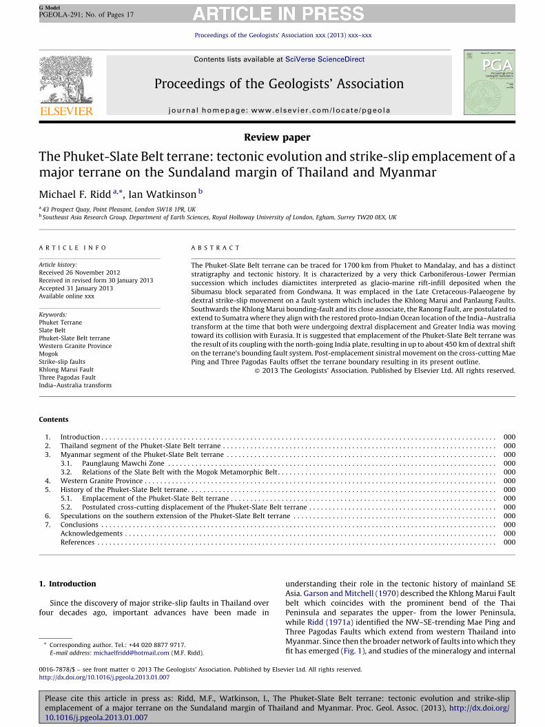
they were single strands.) He showed that whereas the upperCarboniferous-Lower Permian succession west of the KhlongMarui Fault (i.e. in the upper Peninsula) is characterized by verythick intervals of diamictite (named by Mitchell et al., 1970 thePhuket Group), such intervals are thin or absent east of the fault, inthe lower Peninsula. And moreover, whereas east of the fault theCarboniferous-Lower Permian succession is underlain by Devonianand Lower Palaeozoic rocks, pre-Carboniferous rocks have notbeen seen anywhere on the west side of the fault as the base of thePhuket Group does not reach the ground surface (Fig. 2).
Northwards and westwards the Phuket Terrane passes intoMyanmar where its approximate continuation was called theKaren–Tenasserim Unit by Bender (1983), although the Slate Belt(Mitchell et al., 2002, 2004, 2007) is more clearly the continuationof the Phuket Terrane and is the name adopted here. The namePhuket-Slate Belt terrane is used here for the combined entity,while also retaining the component names as appropriate.
A feature of this terrane is that it hosts the Western GraniteProvince of SE Asia (Mitchell, 1977; Cobbing et al., 1992; Charusiriet al., 1993; Putthapiban, 2002). Insofar as those granite (sensu lato)intrusions are largely confined to the Phuket-Slate Belt terrane itraises the question: is that because the terrane in some wayfavoured the intrusion of those plutons, or were they intruded overa wider area and then isolated in the terrane by strike-slip faultingwhich displaced both terrane and intrusions?
The aim of this paper is to demonstrate the existence of thePhuket-Slate Belt terrane northward from Thailand into Myanmar,to comment on its relations with the Western Granite Province ofSE Asia, and to suggest how the terrane was emplaced in its presentposition. It is tentatively suggested that dextral strike-slipmovement on its eastern boundary-fault occurred in the LateCretaceous–Palaeogene when the terrane became coupled withthe north-going India plate, ceasing only after India itself hadcollided with Eurasia. It is suggested, furthermore, that a laterphase of cross-cutting sinistral strike-slip faulting resulted in theoutline of the terrane we see today.
2. Thailand segment of the Phuket-Slate Belt terrane
That the Phuket Terrane is a terrane in the full sense of that termwas argued by Ridd (2009): (i) it has a different and distinctivestratigraphy, geological and magmatic history from that ofadjacent blocks (Figs. 2 and 3), (ii) it is linear and extensive(800 km in Thailand alone), and (iii) it is bounded by one of themajor fault systems in Thailand, the Khlong Marui and ThreePagodas Faults.
As shown in Fig. 3 the Kaeng Krachan Group is the stratigraphicunit which shows the pronounced difference between the PhuketTerrane and the adjacent block. In the Phuket Terrane severalattempts have been made to subdivide it into componentformations (Piyasin, 1975; Raksaskulwong and Wongwanich,1993; Chaodumrong et al., 2007). But beneath the top fewhundred metres the succession lacks fossils and marker beds arenot persistent, and therefore stratigraphic units cannot becorrelated over any distance and so are unmappable. Mitchellet al. (1970) and Garson et al. (1975), who adopted the namePhuket Group for the entire succession beneath the RatburiLimestone in upper Peninsular Thailand, found that they coulddivide the succession into only two mappable units which theynamed informally the ‘Upper Formation’ up to 200 m thickcomprising mudstones, thick-bedded sandstones and shales witha bryozoa-rich shelly fauna in its lower part, and the ‘LowerFormation’ of unknown thickness which is essentially barren offossils. (The name Phuket Group has been dropped amonggeologists in Thailand, but is retained here as it highlights thedifferent successions in the upper and lower Peninsula). The
Phuket-Slate Belt terrane: tectonic evolution and strike-slipland and Myanmar. Proc. Geol. Assoc. (2013), http://dx.doi.org/
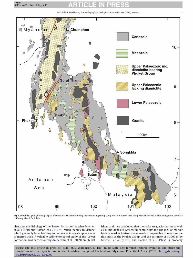
Fig. 2. Simplified geological map of part of Peninsular Thailand showing the contrasting stratigraphy west and east of the Khlong Marui Fault belt. RF is Ranong Fault, and KMF
is Khlong Marui Fault belt.
M.F. Ridd, I. Watkinson / Proceedings of the Geologists’ Association xxx (2013) xxx–xxx 3
G Model
PGEOLA-291; No. of Pages 17
characteristic lithology of the ‘Lower Formation’ is what Mitchellet al. (1970) and Garson et al. (1975) called ‘pebbly mudstone’which generally lacks bedding and occurs as intervals up to scoresof metres thick. A valuable sedimentological study of the ‘LowerFormation’ was carried out by Ampaiwan et al. (2009) on Phuket
Please cite this article in press as: Ridd, M.F., Watkinson, I., Theemplacement of a major terrane on the Sundaland margin of Thai10.1016/j.pgeola.2013.01.007
Island and they concluded that the rocks are glacio-marine as wellas slump deposits. Structural complexity and the lack of markerbeds or marker horizons have made it impossible to measure thethickness of the Phuket Group, and the estimate of >3000 m byMitchell et al. (1970) and Garson et al. (1975) is probably
Phuket-Slate Belt terrane: tectonic evolution and strike-slipland and Myanmar. Proc. Geol. Assoc. (2013), http://dx.doi.org/
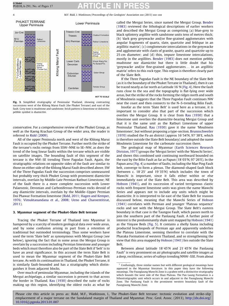
Fig. 3. Simplified stratigraphy of Peninsular Thailand, showing contrasting
successions west of the Khlong Marui Fault (the Phuket Terrane) and east of the
fault. Grey tone is mudstone and sandstone; brick pattern is limestone or dolomite;
pebble symbol is diamictite.
1 Confusingly, three similar names but with different geological meanings have
appeared in the Myanmar literature. In this paper they have the following
meanings. The Paunglaung Mawchi Zone is a graben with a distinctive stratigraphy
which bounds the west side of the Shan Plateau. The Pan Laung Formation is a
lithostratigraphic unit which occurs in and adjacent to the Paunglaung Mawchi
Zone. The Panlaung Fault is the prominent western boundary fault of the
Paunglaung Mawchi Zone.
M.F. Ridd, I. Watkinson / Proceedings of the Geologists’ Association xxx (2013) xxx–xxx4
G Model
PGEOLA-291; No. of Pages 17
conservative. For a comprehensive review of the Phuket Group, aswell as the Kaeng Krachan Group of the wider area, the reader isreferred to Ridd (2009).
All of the upper Peninsula north and west of the Khlong MaruiFault is occupied by the Phuket Terrane. Further north the strike ofthe terrane’s rocks swings from SSW–NNE to SE–NW, as does thetrend of the long linear faults within the terrane which are visibleon satellite images. The bounding fault of this segment of theterrane is the NW–SE trending Three Pagodas Fault. Again, thestratigraphic relations on opposite sides of the fault are similar tothose on either side of the Khlong Marui Fault described above. SWof the Three Pagodas Fault the succession comprises unmeasuredbut probably very thick Phuket Group with prominent diamictiteintervals, overlain by Middle-Late Permian Ratburi Limestone; NEof the fault there is a more complete succession with LowerPalaeozoic, Devonian and Carboniferous-Permian rocks devoid ofany diamictite intervals, overlain by the Middle–Upper PermianDoi Phawar Formation limestone (Ridd, 2011; Hagen and Kemper,1976; Vimuktanandana et al., 2008; Ueno and Charoentitirat,2011).
3. Myanmar segment of the Phuket-Slate Belt terrane
Tracing the Phuket Terrane of Thailand into Myanmar ishampered by a scarcity of modern geological data over wide areas,and by some confusion arising in part from a retention oftraditional but outmoded terminology. Thus some workers haveused the term ‘Slate belt’ as synonymous with Mergui Group (seebelow), ignoring the fact that in some areas the Mergui Group isoverlain by a succession including Permian limestone and youngerbeds which must therefore also be part of the Slate Belt if ‘belt’ is tohave an areal significance. In this account the term Slate Belt isused to mean the Myanmar segment of the Phuket-Slate Beltterrane. As with its continuation in Thailand, the Phuket Terrane, itis similarly fault-bounded and has a stratigraphy which distin-guishes it from adjacent blocks.
Over much of peninsular Myanmar, including the islands of theMergui archipelago, a similar succession is present to that acrossthe border in Thailand. Rau (1930) described the suite of rocksmaking up this region, identifying the oldest rocks as what he
Please cite this article in press as: Ridd, M.F., Watkinson, I., Theemplacement of a major terrane on the Sundaland margin of Thai10.1016/j.pgeola.2013.01.007
called the Mergui Series, since named the Mergui Group. Bender(1983) reviewed the lithological descriptions of earlier workersand described the Mergui Group as comprising (a) blue-grey toblack splintery argillite with sandstone units tens of metres thick;(b) ‘dark grey greywacke and/or fine-grained agglomerates withangular fragments of quartz, slate, quartzite and feldspar in anargillitic matrix’; (c) conglomerate intercalations in the greywackeand agglomerate with clasts of granite, quartz and quartzite up to25 cm diameter; and (d) thin, impure limestone intercalations,mostly in the argillites. Bender (1983) does not mention pebblymudstone nor diamictite but there is little doubt that his‘greywacke and/or fine-grained agglomerates. . . in an argilliticmatrix’ refers to this rock type. This region is therefore clearly partof the Slate Belt.
If the Three Pagodas Fault is the NE boundary of the Slate Belt(as it is the boundary of the Phuket Terrane in Thailand), then it canbe traced nearly as far north as Latitude 168N (Fig. 4). Here the faultruns close to the sea and the topography is flat-lying over wideareas, but the strike of the rocks forming the ridges north and southof Moulmein suggests that the Three Pagodas Fault continues NWnear the coast and then connects to the N–S-trending Bilin Fault.
Insofar as the term ‘Slate Belt’ is used here as a terrane, it isimportant to consider also that part of the succession whichoverlies the Mergui Group. It is clear from Rau (1930) that alimestone unit overlies the diamictite-bearing Mergui Group andthat it is the same unit as the Ratburi Limestone of upperPeninsular Thailand. Rau (1930) gave it the name ‘Moulmeinlimestones’, but without proposing a type-section. Brunnschweiler(1970) studied the Pa-an district (approx 168540N, 978380E, whichis therefore outside the Slate Belt boundary) and adopted the nameMoulmein Limestone for the carbonate succession there.
The geological map of Myanmar (Earth Sciences ResearchDivision, 1977) groups the ‘Mergui Series’ with the ‘Mawchi Series’,and shows this combined unit continuing northward bounded onthe east by the Bilin Fault as far as Papun (188030N, 978260E). In thePapun area (Fig. 4) a number of faults, including the Mae Ping Faultbelt, converge to form a plexus. The diamond-shaped fault block(between c. 188250 and 198350N) which includes the town ofMawchi is important, since it falls either within or elseimmediately east of the Slate Belt. This area was described byHobson (1941), and its succession of varied terrigenous clasticrocks with frequent limestone units was given the name MawchiSeries and appears not to include any units which might bediamictite. It is interpreted to lie east of the Slate Belt for reasonsdiscussed below, meaning that the Mawchi Series of Hobson(1941) correlates with Permian and younger ‘Plateau sequence’rocks and not with the Mergui Group. The Slate Belt’s easternboundary in that case is the Taungoo Fault, which passes north tojoin the southern part of the Panlaung Fault. A further point ofinterest is the predominantly shale unit mapped by Hobson (1941)as the Yinyaw Beds (Fig. 5). It contains a shelly fauna includingproductid brachiopods of Permian age and apparently underliesthe Plateau Limestone, seeming therefore to correlate with thePharaka Formation of western Thailand, and so strengthening theview that this area mapped by Hobson (1941) lies outside the SlateBelt.
Between about latitude 188450N and 218450N the PanlaungFault1 is very prominent on air photographs and satellite images asa deep, rectilinear, series of valleys trending NNW–SSE. From about
Phuket-Slate Belt terrane: tectonic evolution and strike-slipland and Myanmar. Proc. Geol. Assoc. (2013), http://dx.doi.org/
Fig. 4. Part of Eastern Myanmar, showing the most prominent faults identified as linear topographic depressions from Google Earth terrain maps and satellite imagery.
Stippled area is the Slate Belt. The inset map shows additionally the strike of bedding, interpreted from linear topographic ridges; the swing of these lineations east of the Bilin
Fault suggests dextral strike-slip movement.
M.F. Ridd, I. Watkinson / Proceedings of the Geologists’ Association xxx (2013) xxx–xxx 5
G Model
PGEOLA-291; No. of Pages 17
latitude 198300N northwards the Panlaung Fault marks the westernboundary of the Shan Plateau (Garson et al., 1976; Mitchell et al.,2004, 2007, 2012). A number of approximately NW–SE-trendingfaults also splay on to the adjacent blocks (Fig. 5), forming a region
Please cite this article in press as: Ridd, M.F., Watkinson, I., Theemplacement of a major terrane on the Sundaland margin of Thai10.1016/j.pgeola.2013.01.007
of mostly uplifted rhomboidal slivers between the Panlaung Faultand the Kyauk Kyan Fault further east. The geometry of many ofthese splays and displacement of rock fabrics suggests that theymay have originated as synthetic strands of a sinistral system that
Phuket-Slate Belt terrane: tectonic evolution and strike-slipland and Myanmar. Proc. Geol. Assoc. (2013), http://dx.doi.org/
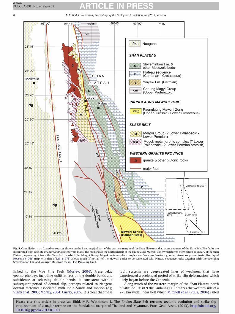
Fig. 5. Compilation map (based on sources shown on the inset map) of part of the western margin of the Shan Plateau and adjacent segment of the Slate Belt. The faults are
interpreted from satellite imagery and Google terrain maps. The map shows the northern part of the Paunglaung Mawchi Zone which forms the western boundary of the Shan
Plateau, separating it from the Slate Belt in which the Mergui Group, Mogok metamorphic complex and Western Province granite intrusions predominate. Overlap of
Hobson’s (1941) map with that of Lain (1973) allows much (if not all) of the Mawchi Series to be correlated with Plateau-sequence rocks together with the overlying
Shweminbon Fm. and younger Mesozoic rocks. PF is Panlaung Fault.
M.F. Ridd, I. Watkinson / Proceedings of the Geologists’ Association xxx (2013) xxx–xxx6
G Model
PGEOLA-291; No. of Pages 17
linked to the Mae Ping Fault (Morley, 2004). Present-daygeomorphology, including uplift at restraining double bends andsubsidence at releasing double bends, is consistent with asubsequent period of dextral slip, perhaps related to Neogenedextral tectonics associated with India–Sundaland motion (e.g.Vigny et al., 2003; Morley, 2004; Curray, 2005). It is clear that these
Please cite this article in press as: Ridd, M.F., Watkinson, I., Theemplacement of a major terrane on the Sundaland margin of Thai10.1016/j.pgeola.2013.01.007
fault systems are deep-seated lines of weakness that haveexperienced a prolonged period of strike-slip deformation, whichlikely began before the Cenozoic.
Along much of the western margin of the Shan Plateau northof latitude 198300N the Panlaung Fault marks the western side of a2–5 km wide linear belt which Mitchell et al. (2002, 2004) called
Phuket-Slate Belt terrane: tectonic evolution and strike-slipland and Myanmar. Proc. Geol. Assoc. (2013), http://dx.doi.org/
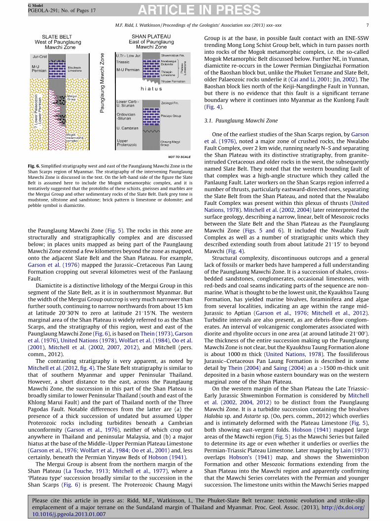
Fig. 6. Simplified stratigraphy west and east of the Paunglaung Mawchi Zone in the
Shan Scarps region of Myanmar. The stratigraphy of the intervening Paunglaung
Mawchi Zone is discussed in the text. On the left-hand side of the figure the Slate
Belt is assumed here to include the Mogok metamorphic complex, and it is
tentatively suggested that the protoliths of these schists, gneisses and marbles are
the Mergui Group and other sedimentary rocks of the Slate Belt. Dark grey tone is
mudstone, siltstone and sandstone; brick pattern is limestone or dolomite; and
pebble symbol is diamictite.
M.F. Ridd, I. Watkinson / Proceedings of the Geologists’ Association xxx (2013) xxx–xxx 7
G Model
PGEOLA-291; No. of Pages 17
the Paunglaung Mawchi Zone (Fig. 5). The rocks in this zone arestructurally and stratigraphically complex and are discussedbelow; in places units mapped as being part of the PaunglaungMawchi Zone extend a few kilometres beyond the zone as mapped,onto the adjacent Slate Belt and the Shan Plateau. For example,Garson et al. (1976) mapped the Jurassic–Cretaceous Pan LaungFormation cropping out several kilometres west of the PanlaungFault.
Diamictite is a distinctive lithology of the Mergui Group in thissegment of the Slate Belt, as it is in southernmost Myanmar. Butthe width of the Mergui Group outcrop is very much narrower thanfurther south, continuing to narrow northwards from about 15 kmat latitude 208300N to zero at latitude 218150N. The westernmarginal area of the Shan Plateau is widely referred to as the ShanScarps, and the stratigraphy of this region, west and east of thePaunglaung Mawchi Zone (Fig. 6), is based on Thein (1973), Garsonet al. (1976), United Nations (1978), Wolfart et al. (1984), Oo et al.(2001), Mitchell et al. (2002, 2007, 2012), and Mitchell (pers.comm., 2012).
The contrasting stratigraphy is very apparent, as noted byMitchell et al. (2012, fig. 4). The Slate Belt stratigraphy is similar tothat of southern Myanmar and upper Peninsular Thailand.However, a short distance to the east, across the PaunglaungMawchi Zone, the succession in this part of the Shan Plateau isbroadly similar to lower Peninsular Thailand (south and east of theKhlong Marui Fault) and the part of Thailand north of the ThreePagodas Fault. Notable differences from the latter are (a) thepresence of a thick succession of undated but assumed UpperProterozoic rocks including turbidites beneath a Cambrianunconformity (Garson et al., 1976), neither of which crop outanywhere in Thailand and peninsular Malaysia, and (b) a majorhiatus at the base of the Middle–Upper Permian Plateau Limestone(Garson et al., 1976; Wolfart et al., 1984; Oo et al., 2001) and, lesscertainly, beneath the Permian Yinyaw Beds of Hobson (1941).
The Mergui Group is absent from the northern margin of theShan Plateau (La Touche, 1913; Mitchell et al., 1977), where a‘Plateau type’ succession broadly similar to the succession in theShan Scarps (Fig. 6) is present. The Proterozoic Chaung Magyi
Please cite this article in press as: Ridd, M.F., Watkinson, I., Theemplacement of a major terrane on the Sundaland margin of Thai10.1016/j.pgeola.2013.01.007
Group is at the base, in possible fault contact with an ENE-SSWtrending Mong Long Schist Group belt, which in turn passes northinto rocks of the Mogok metamorphic complex, i.e. the so-calledMogok Metamorphic Belt discussed below. Further NE, in Yunnan,diamictite re-occurs in the Lower Permian Dingjiazhai Formationof the Baoshan block but, unlike the Phuket Terrane and Slate Belt,older Palaeozoic rocks underlie it (Cai and Li, 2001; Jin, 2002). TheBaoshan block lies north of the Keiji-Nangdinghe Fault in Yunnan,but there is no evidence that this fault is a significant terraneboundary where it continues into Myanmar as the Kunlong Fault(Fig. 4).
3.1. Paunglaung Mawchi Zone
One of the earliest studies of the Shan Scarps region, by Garsonet al. (1976), noted a major zone of crushed rocks, the NwalaboFault Complex, over 2 km wide, running nearly N–S and separatingthe Shan Plateau with its distinctive stratigraphy, from granite-intruded Cretaceous and older rocks in the west, the subsequentlynamed Slate Belt. They noted that the western bounding fault ofthat complex was a high-angle structure which they called thePanlaung Fault. Later workers on the Shan Scarps region inferred anumber of thrusts, particularly eastward-directed ones, separatingthe Slate Belt from the Shan Plateau, and noted that the NwalaboFault Complex was present within this plexus of thrusts (UnitedNations, 1978). Mitchell et al. (2002, 2004) later reinterpreted thesurface geology, describing a narrow, linear, belt of Mesozoic rocksbetween the Slate Belt and the Shan Plateau as the PaunglaungMawchi Zone (Figs. 5 and 6). It included the Nwalabo FaultComplex as well as a number of stratigraphic units which theydescribed extending south from about latitude 218150 to beyondMawchi (Fig. 4).
Structural complexity, discontinuous outcrops and a generallack of fossils or marker beds have hampered a full understandingof the Paunglaung Mawchi Zone. It is a succession of shales, cross-bedded sandstones, conglomerates, occasional limestones, withred-beds and coal seams indicating parts of the sequence are non-marine. What is thought to be the lowest unit, the Kyaukhsu TaungFormation, has yielded marine bivalves, foraminifera and algaefrom several localities, indicating an age within the range mid-Jurassic to Aptian (Garson et al., 1976; Mitchell et al., 2012).Turbidite intervals are also present, as are debris-flow conglom-erates. An interval of volcanigenic conglomerates associated withdiorite and rhyolite occurs in one area (at around latitude 218000).The thickness of the entire succession making up the PaunglaungMawchi Zone is not clear, but the Kyaukhsu Taung Formation aloneis about 1000 m thick (United Nations, 1978). The fossiliferousJurassic–Cretaceous Pan Laung Formation is described in somedetail by Thein (2004) and Saing (2004) as a >1500 m-thick unitdeposited in a basin whose eastern boundary was on the westernmarginal zone of the Shan Plateau.
On the western margin of the Shan Plateau the Late Triassic-Early Jurassic Shweminbon Formation is considered by Mitchellet al. (2002, 2004, 2012) to be distinct from the PaunglaungMawchi Zone. It is a turbidite succession containing the bivalvesHalobia sp. and Astarte sp. (Oo, pers. comm., 2012) which overliesand is intimately deformed with the Plateau Limestone (Fig. 5),both showing east-vergent folds. Hobson (1941) mapped largeareas of the Mawchi region (Fig. 5) as the Mawchi Series but failedto determine its age or even whether it underlies or overlies thePermian-Triassic Plateau Limestone. Later mapping by Lain (1973)overlaps Hobson’s (1941) map, and shows the ShweminbonFormation and other Mesozoic formations extending from theShan Plateau into the Mawchi region and apparently confirmingthat the Mawchi Series correlates with the Permian and youngersuccession. The limestone units within the Mawchi Series mapped
Phuket-Slate Belt terrane: tectonic evolution and strike-slipland and Myanmar. Proc. Geol. Assoc. (2013), http://dx.doi.org/
M.F. Ridd, I. Watkinson / Proceedings of the Geologists’ Association xxx (2013) xxx–xxx8
G Model
PGEOLA-291; No. of Pages 17
by Hobson (1941) in that case are probably tightly folded andfaulted outcrop slivers of Plateau Limestone.
The rocks of the Paunglaung Mawchi Zone are interpreted hereto have been deposited in a linear basin or basins which developedalong a mobile belt. Initially this belt may have been a zone ofsagging as a back-arc basin developed, but with time a line ofrupturing developed with pull-apart basins in which non-marinedeposition was periodically interrupted by marine incursions.Seeking an analogue for the Paunglaung Mawchi Zone, the�1000 km-long Median Tectonic Line of Japan has obvioussimilarities (Taira et al., 1989; Taira, 2001; Tanimoto, 2005;Isozaki et al., 2010). The marine and non-marine Upper Cretaceoussediments of the latter were deposited while sinistral strike-slipdisplacement on the Median Tectonic Line was active along thenorthwestward-subducting eastern margin of the Eurasia plate. Atleast 1500 km of sinistral shift is interpreted to have taken place.The analogy cannot be taken too far, however, as the MedianTectonic Line has a forearc-basin setting whereas the Phuket-SlateBelt terrane bounding-fault is suggested to have developed on thesite of a back-arc basin. What it does highlight is the important roleof shifting ribbon-terranes along the margin of Eurasia in atranspressional setting.
3.2. Relations of the Slate Belt with the Mogok Metamorphic Belt
Gneisses, schists and marbles of upper amphibolite and locallygranulite facies extend in an irregular outcrop belt from aboutlatitude 198150N (Hobson, 1941) northwards through the Manda-lay area before swinging to a NE trend towards Yunnan, and thencontinuing northwards to the eastern Himalayan syntaxis (Mitch-ell, 1993; Mitchell et al., 2007). (For present purposes the rocksthemselves are referred to here informally as the Mogokmetamorphic complex, since the term ‘belt’ can be confused withthe Slate Belt, of which the rocks of the Mogok metamorphiccomplex are here considered to be a part.) Recent work on thisgroup, including radiometric dating, has concentrated on thesouthern part, i.e. south of the latitude of the gemstone-miningtown of Mogok (Fig. 4). South of Mandalay the rocks of the Mogokmetamorphic complex have a close spatial relationship with theMergui Group (and possibly also with the ‘Moulmein Limestone’overlying the Mergui Group). Their contact is mostly obscured byalluvium but in places a fault has been inferred (e.g. the SakhanyaTaung Fault; Mitchell et al., 2007, fig. 8) and elsewhere graniteintrusions intervene (Fig. 5).
In the Mandalay area the eastern boundary of the Mogokmetamorphic complex is unclear. Here the Mergui Group rocksincluding its characteristic diamictite intervals are not present,having wedged out further south, and the rocks of the westernmostpart of the Shan Plateau are themselves partly metamorphosed tophyllite, quartzite and marble (Mitchell et al., 2007, fig. 4). Thepicture is complicated further by uncertainty over whether anyfossiliferous Permian limestone observed in the field is the PlateauLimestone of the Shan Plateau province or the MoulmeinLimestone of the Slate Belt.
The age of metamorphism of the Mogok metamorphic complexis controversial and the history of earlier studies has been outlinedby Mitchell et al. (2012). Mitchell et al. (2007) reported on therelationships of the metamorphic rocks and associated intrusiverocks, concluding that there were at least two metamorphic events,one before and one after the intrusion of late Jurassic to earlyCretaceous calc-alkaline igneous rocks. The first sensitive-high-resolution-ion-microprobe (SHRIMP) U–Pb studies on the Mogokmetamorphic complex were reported by Barley et al. (2003) whodetermined zircon ages of Jurassic, mid-Cretaceous and Eocene,and concluded that an Andean-type southern margin of Eurasiawas present throughout that period. Those findings were followed
Please cite this article in press as: Ridd, M.F., Watkinson, I., Theemplacement of a major terrane on the Sundaland margin of Thai10.1016/j.pgeola.2013.01.007
by Searle et al. (2007) who carried out U–Pb (isotope-dilution-thermal-ionization-mass-spectrometry) and U–Th–Pb (laser-abla-tion-multicollector-inductively-coupled-plasma-mass-spectrom-etry) analyses on the Mogok metamorphic complex cropping outbetween �218300N and �228100N North. They interpreted theirresults as indicating two Tertiary metamorphic events, eachculminating in granite intrusions, the first in the Palaeocene andthe second spanning the Late Eocene to Oligocene boundary. Morerecently Mitchell et al. (2012) described U–Pb zircon analyses on18 intrusive and metamorphic rock samples between 228210N and168370N, interpreting the results as showing protolith ages up to491 Ma and an earliest Cretaceous minimum age for the regionalmetamorphism. The implications of the different authors’ findingsare discussed below.
Relict fossils in the Mogok metamorphic complex have beenmentioned by several writers but details of them and their preciselocations are uncertain. According to Mitchell (pers. comm., 2012)at least some of them were found in the metamorphosedPalaeozoic rocks of the western fringe of the Shan Plateau in theMandalay area mentioned above, and so throw no light on theMogok metamorphic complex itself. At several localities in theSlate Belt the Mergui Group has acquired a schistosity (Mitchellet al., 2007; Mitchell, 2012) and it is considered here that theMergui Group diamictite and slates, as well as such olderPalaeozoic rocks as may be concealed beneath the Mergui Groupincluding the Lower Palaeozoic, are the protoliths of the Mogokmetamorphic complex. An orthogneiss from Sedawgyi, north ofMandalay, yielded a protolith U–Pb age of 491 � 4 Ma (Cambrian)which lends weight to this interpretation (Mitchell et al., 2012).
The western boundary of the Slate Belt including the Mogokmetamorphic complex, is concealed beneath an alluvial and locallya Neogene cover, but most writers on the subject (e.g. Barley et al.,2003; Bertrand and Rangin, 2003; Searle et al., 2007; Mitchell et al.,2004, 2007, 2012) assume that it extends west to the still-activeSagaing Fault (Fig. 1). That same fault has in the past been calledthe Shan Boundary Fault but insofar as it bounds the Slate Belt andnot the Shan Plateau, that name is considered inappropriate.
4. Western Granite Province
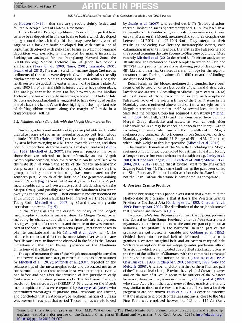
At the beginning of this paper it was stated that a feature of thePhuket-Slate Belt terrane is that it hosts the Western GraniteProvince of Southeast Asia (Cobbing et al., 1992; Charusiri et al.,1993; Putthapiban, 2002). The distribution of the major plutons ofthat province are shown in Fig. 7.
To place the Western Province in context, the adjacent province(the Central or Main Range Province) extends from easternmostMyanmar and northern Thailand to the southern part of peninsularMalaysia. The plutons in the northern Thailand part of thisprovince are petrologically variable and Cobbing et al. (1992)divided them into a central belt of deformed and migmatiticgranites, a western marginal belt, and an eastern marginal belt.With rare exceptions they are S-type granites predominantly ofTriassic age which were intruded as so-called stitching plutons atthe time of the collision of Sibumasu with the combined terrane ofthe Sukhothai block and Indochina block (Cobbing et al., 1992;Charusiri et al., 1993; Putthapiban, 2002; Metcalfe, 1999; Sone andMetcalfe, 2008). A number of plutons in the northern Thailand partof the Central or Main Range Province have yielded Cretaceous agesand on the face of it would seem to be outliers of the WesternProvince. However, they were examined by Cobbing et al. (1992)who state ‘Apart from their age, none of these granites are in anyway similar to those of the Western Province.’ The criteria for theirjudgement are not known. Palin et al. (2013) describe evidencethat the magmatic protolith of the Lansang Gneiss close to the MaePing Fault was emplaced between c. 123 and 114 Ma (Early
Phuket-Slate Belt terrane: tectonic evolution and strike-slipland and Myanmar. Proc. Geol. Assoc. (2013), http://dx.doi.org/

Fig. 7. The Western Granite Province of Thailand and Myanmar (plutons shown in
colour), and the Central Granite Province (plutons shown black). Granite plutons in
Myanmar are from Earth Sciences Research Division (1977), and those in Thailand
are based on Department of Mineral Resources (1999) and Cobbing et al. (1992). The
assignment of plutons to one or other province is based on Cobbing et al. (1992),
although note that they studied many fewer plutons than are shown on this map,
and the boundary faults were not recognized by them at that time; the faulted
boundary shown here between the two provinces is nevertheless consistent with
the boundary of Cobbing et al. (1992). (For interpretation of the references to colour
in this figure legend, the reader is referred to the web version of the article.)
M.F. Ridd, I. Watkinson / Proceedings of the Geologists’ Association xxx (2013) xxx–xxx 9
G Model
PGEOLA-291; No. of Pages 17
Please cite this article in press as: Ridd, M.F., Watkinson, I., Theemplacement of a major terrane on the Sundaland margin of Thai10.1016/j.pgeola.2013.01.007
Cretaceous), although whether that would also be considered byCobbing et al. to be different from the granites of the WesternProvince is not known. Another apparent anomaly is the KhaoPhanom Bencha pluton east of the Khlong Marui Fault and north ofKrabi (88150N, 988560E) (Fig. 2). This is a hornblende adamellitewhich gave a K–Ar age of 55 Ma, although Garson et al. (1975) whocollected the sample concluded that this age indicates a heatingevent after the rock was intruded; Cobbing (2011) subsequentlyreferred to it as an I-type granite.
The granites which make up the Western Province are of S- andI-type, and although they were thought all to be of Cretaceous agethat age bracket has now been expanded, in part because manypreviously determined ages (e.g. Charusiri et al., 1993) were basedon mica Ar–Ar cooling spectra. U–Pb zircon ages of 212 � 2 Ma and214 � 2 Ma (both Late Triassic) have been obtained from an I-typegranite from Phuket in Thailand, albeit with zircon rims showing aLate Cretaceous thermal overprint of 81.2 � 1.2 and 85–75 Ma (Searleet al., 2012). And associated with the Mogok metamorphic complex inMyanmar there are numerous examples of granite-emplacement agesextending up to the Eocene (Searle and Morley, 2011; Mitchell et al.,2012).
Whereas the granite plutons of the Central Province are spreadover a broad region straddling the suture at the eastern boundaryof Sibumasu (Fig. 1), those of the Western Province are confined tothe Phuket-Slate Belt terrane, and are bounded on the east by thefaults described above, pace Cobbing (2011) who speculates thatthe Khao Phanom Bencha pluton may be an outlier of the WesternProvince (Fig. 7). The northwards extension of the WesternProvince through northern Myanmar is uncertain, althoughCobbing et al. (1992) conjectured that it continues northeastwardbeyond Mogok. Southwards, beyond Phuket, any extension mustlie beneath the waters of the Malacca Strait, although one smallpluton in Sumatra, the Hatapang Granite SE of Lake Toba (c. 28150N,998300E) is considered by Cobbing (2005, p. 61) to be possibly thesole representative of the Western Province in Sumatra.
The question arises: is confinement of the Western GraniteProvince to this long fault-bounded terrane because in some way itfavoured intrusion of the granites, or were they emplaced (perhapsin a broader belt than we now see) and then displaced from theiroriginal location by strike-slip shift on the bounding fault system?For the latter explanation to be plausible a strike-slip displacementof many hundreds of kilometres would be required, and this paperis unable to demonstrate displacement over such a distance. Theanswer to the question therefore remains unresolved for the timebeing.
5. History of the Phuket-Slate Belt terrane
There is a wealth of stratigraphic and fossil evidence that theSibumasu plate (including the diamictite-bearing terrane which isthe subject of this paper) was formerly part of Gondwana fromwhich it rifted in the Late Carboniferous-Early Permian and beganto drift northwards (see reviews by Metcalfe, 1999, 2011; Uenoand Charoentitirat, 2011; Barber et al., 2011). The evidence for thatrifting in Thailand was examined by Ridd (2009) who concludedthat the diamictites were the product of Gondwana glaciersdropping their load at the western margin (in present-dayorientation) of the Phuket Terrane from where it was re-depositedby mass-flow in the rapidly subsiding marine rift basin. While herecognized that the bounding fault system of the Phuket Terrane(the Khlong Marui and Three Pagodas Faults) probably followedreactivated ancient rift-boundary faults, he did not consider thepossibility that there was later, major, strike-slip displacementalong those faults. That possibility is discussed here, and Fig. 8 is acartoon illustrating the inferred history of the Phuket-Slate Beltterrane and the Western Granite Province of which that terrane is
Phuket-Slate Belt terrane: tectonic evolution and strike-slipland and Myanmar. Proc. Geol. Assoc. (2013), http://dx.doi.org/
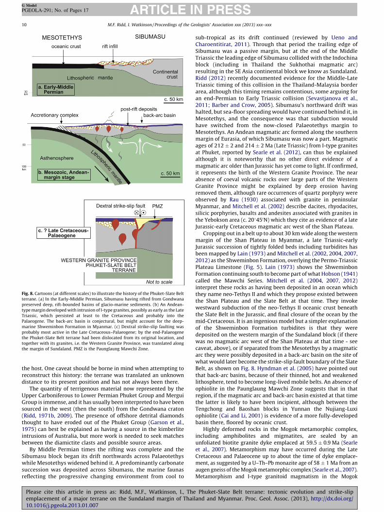
Fig. 8. Cartoons (at different scales) to illustrate the history of the Phuket-Slate Belt
terrane. (a) In the Early-Middle Permian, Sibumasu having rifted from Gondwana
preserved deep, rift-bounded basins of glacio-marine sediments. (b) An Andean-
type margin developed with intrusion of I-type granites, possibly as early as the Late
Triassic, which persisted at least to the Cretaceous and probably into the
Palaeogene. The back-arc basin is conjectural, but might account for the deep-
marine Shweminbon Formation in Myanmar. (c) Dextral strike-slip faulting was
probably most active in the Late Cretaceous–Palaeogene; by the end-Palaeogene
the Phuket-Slate Belt terrane had been dislocated from its original location, and
together with its granites, i.e. the Western Granite Province, was translated along
the margin of Sundaland. PMZ is the Paunglaung Mawchi Zone.
M.F. Ridd, I. Watkinson / Proceedings of the Geologists’ Association xxx (2013) xxx–xxx10
G Model
PGEOLA-291; No. of Pages 17
the host. One caveat should be borne in mind when attempting toreconstruct this history: the terrane was translated an unknowndistance to its present position and has not always been there.
The quantity of terrigenous material now represented by theUpper Carboniferous to Lower Permian Phuket Group and MerguiGroup is immense, and it has usually been interpreted to have beensourced in the west (then the south) from the Gondwana craton(Ridd, 1971b, 2009). The presence of offshore detrital diamondsthought to have eroded out of the Phuket Group (Garson et al.,1975) can best be explained as having a source in the kimberliteintrusions of Australia, but more work is needed to seek matchesbetween the diamictite clasts and possible source areas.
By Middle Permian times the rifting was complete and theSibumasu block began its drift northwards across Palaeotethyswhile Mesotethys widened behind it. A predominantly carbonatesuccession was deposited across Sibumasu, the marine faunasreflecting the progressive changing environment from cool to
Please cite this article in press as: Ridd, M.F., Watkinson, I., Theemplacement of a major terrane on the Sundaland margin of Thai10.1016/j.pgeola.2013.01.007
sub-tropical as its drift continued (reviewed by Ueno andCharoentitirat, 2011). Through that period the trailing edge ofSibumasu was a passive margin, but at the end of the MiddleTriassic the leading edge of Sibumasu collided with the Indochinablock (including in Thailand the Sukhothai magmatic arc)resulting in the SE Asia continental block we know as Sundaland.Ridd (2012) recently documented evidence for the Middle-LateTriassic timing of this collision in the Thailand-Malaysia borderarea, although this timing remains contentious, some arguing foran end-Permian to Early Triassic collision (Sevastjanova et al.,2011; Barber and Crow, 2005). Sibumasu’s northward drift washalted, but sea-floor spreading would have continued behind it, inMesotethys, and the consequence was that subduction wouldhave switched from the now-closed Palaeotethys margin toMesotethys. An Andean magmatic arc formed along the southernmargin of Eurasia, of which Sibumasu was now a part. Magmaticages of 212 � 2 and 214 � 2 Ma (Late Triassic) from I-type granitesat Phuket, reported by Searle et al. (2012), can thus be explainedalthough it is noteworthy that no other direct evidence of amagmatic arc older than Jurassic has yet come to light. If confirmed,it represents the birth of the Western Granite Province. The nearabsence of coeval volcanic rocks over large parts of the WesternGranite Province might be explained by deep erosion havingremoved them, although rare occurrences of quartz porphyry wereobserved by Rau (1930) associated with granite in peninsularMyanmar, and Mitchell et al. (2002) describe dacites, rhyodacites,silicic porphyries, basalts and andesites associated with granites inthe Yebokson area (c. 208450N) which they cite as evidence of a lateJurassic-early Cretaceous magmatic arc west of the Shan Plateau.
Cropping out in a belt up to about 30 km wide along the westernmargin of the Shan Plateau in Myanmar, a late Triassic-earlyJurassic succession of tightly folded beds including turbidites hasbeen mapped by Lain (1973) and Mitchell et al. (2002, 2004, 2007,2012) as the Shweminbon Formation, overlying the Permo-TriassicPlateau Limestone (Fig. 5). Lain (1973) shows the ShweminbonFormation continuing south to become part of what Hobson (1941)called the Mawchi Series. Mitchell et al. (2004, 2007, 2012)interpret these rocks as having been deposited in an ocean whichthey name neo-Tethys II and which they propose existed betweenthe Shan Plateau and the Slate Belt at that time. They invokewestward subduction of the neo-Tethys II oceanic crust beneaththe Slate Belt in the Jurassic, and final closure of the ocean by themid-Cretaceous. It is an ingenious model but a simpler explanationof the Shweminbon Formation turbidites is that they weredeposited on the western margin of the Sundaland block (if therewas no magmatic arc west of the Shan Plateau at that time - seecaveat, above), or if separated from the Mesotethys by a magmaticarc they were possibly deposited in a back-arc basin on the site ofwhat would later become the strike-slip fault boundary of the SlateBelt, as shown on Fig. 8. Hyndman et al. (2005) have pointed outthat back-arc basins, because of their thinned, hot and weakenedlithosphere, tend to become long-lived mobile belts. An absence ofophiolite in the Paunglaung Mawchi Zone suggests that in thatregion, if the magmatic arc and back-arc basin existed at that timethe latter is likely to have been incipient, although between theTengchong and Baoshan blocks in Yunnan the Nujiang-Luxiophiolite (Cai and Li, 2001) is evidence of a more fully-developedbasin there, floored by oceanic crust.
Highly deformed rocks in the Mogok metamorphic complex,including amphibolites and migmatites, are sealed by anunfoliated biotite granite dyke emplaced at 59.5 � 0.9 Ma (Searleet al., 2007). Metamorphism may have occurred during the LateCretaceous and Palaeocene up to about the time of dyke emplace-ment, as suggested by a U–Th–Pb monazite age of 58 � 1 Ma from anaugen gneiss of the Mogok metamorphic complex (Searle et al., 2007).Metamorphism and I-type granitoid magmatism in the Mogok
Phuket-Slate Belt terrane: tectonic evolution and strike-slipland and Myanmar. Proc. Geol. Assoc. (2013), http://dx.doi.org/
M.F. Ridd, I. Watkinson / Proceedings of the Geologists’ Association xxx (2013) xxx–xxx 11
G Model
PGEOLA-291; No. of Pages 17
metamorphic complex indicate that crustal thickening along theAndean margin of Sibumasu persisted into the Palaeogene (Barleyet al., 2003; Searle et al., 2007; Searle and Morley, 2011). The presencealso of S-type granites in the Phuket Terrane-Slate Belt was explainedby Morley (2004) as the result of the Late Cretaceous–Palaeogenecollision of the West Burma block (i.e. west of the Sagaing Fault) withSibumasu, an interpretation he later withdrew (Morley, pers. comm.,2012).
5.1. Emplacement of the Phuket-Slate Belt terrane
Evidence which points towards fault emplacement of thePhuket-Slate Belt terrane includes:
1. Its linearity and essential stratigraphic uniformity over adistance of at least 1700 km, from Phuket to Mandalay.
2. The presence of great thicknesses of diamictite only in thisterrane, distinguishing it from adjacent terrane(s) to the eastwhere diamictite is absent, or if present is thin (c.f. SingaFormation at Langkawi, NW Malaysia, Stauffer and Lee, 1986).
3. The apparent coincidence of this terrane with the WesternGranite Province.
4. Presence of a major, deep-seated, bounding fault or fault systemalong its eastern side.
5. Presence in Myanmar of the Paunglaung Mawchi Zone, a long,narrow, structurally complex basin preserving a mixed marineand non-marine late Mesozoic succession interpreted to overliea mobile belt which was to become the locus of strike-slipfaulting.
6. Long, steeply dipping, wide and complex fault systemsbounding uplifted and subsided rhomboidal slivers, which arestrong indicators that the terrane-bounding faults are strike-slip. Close to the intersection between the Mae Ping and ThreePagodas Faults at Papun, the rotated strike of bedding (Fig. 4,inset map) is a strong indicator of dextral strike-slip movement.
7. Further south, detailed structural and geochronological studieson the Khlong Marui and Ranong Faults which show a prolongedhistory of dextral strike-slip movement, much of which pre-dates the India–Asia collision (Watkinson et al., 2008, 2011;Watkinson, 2012; Kanjanapayont et al., 2012).
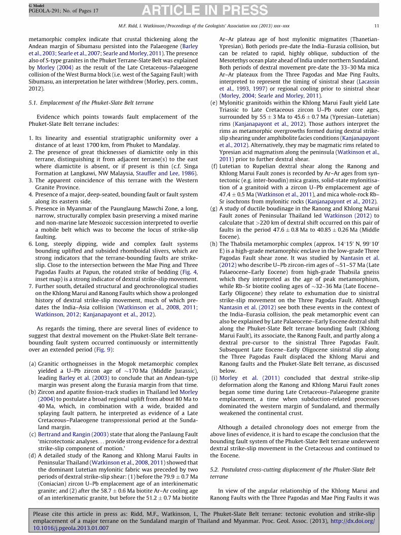
As regards the timing, there are several lines of evidence tosuggest that dextral movement on the Phuket-Slate Belt terrane-bounding fault system occurred continuously or intermittentlyover an extended period (Fig. 9):
(a) Granitic orthogneisses in the Mogok metamorphic complexyielded a U–Pb zircon age of �170 Ma (Middle Jurassic),leading Barley et al. (2003) to conclude that an Andean-typemargin was present along the Eurasia margin from that time.
(b) Zircon and apatite fission-track studies in Thailand led Morley(2004) to postulate a broad regional uplift from about 80 Ma to40 Ma, which, in combination with a wide, braided andsplaying fault pattern, he interpreted as evidence of a LateCretaceous–Palaeogene transpressional period at the Sunda-land margin.
(c) Bertrand and Rangin (2003) state that along the Panlaung Fault‘microtectonic analyses. . . provide strong evidence for a dextralstrike-slip component of motion.’
(d) A detailed study of the Ranong and Khlong Marui Faults inPeninsular Thailand (Watkinson et al., 2008, 2011) showed thatthe dominant Lutetian mylonitic fabric was preceded by twoperiods of dextral strike-slip shear: (1) before the 79.9 � 0.7 Ma(Coniacian) zircon U–Pb emplacement age of an interkinematicgranite; and (2) after the 58.7 � 0.6 Ma biotite Ar–Ar cooling ageof an interkinematic granite, but before the 51.2 � 0.7 Ma biotite
Please cite this article in press as: Ridd, M.F., Watkinson, I., Theemplacement of a major terrane on the Sundaland margin of Thai10.1016/j.pgeola.2013.01.007
Ar–Ar plateau age of host mylonitic migmatites (Thanetian-Ypresian). Both periods pre-date the India–Eurasia collision, butcan be related to rapid, highly oblique, subduction of theMesotethys ocean plate ahead of India under northern Sundaland.Both periods of dextral movement pre-date the 33–30 Ma micaAr–Ar plateaux from the Three Pagodas and Mae Ping Faults,interpreted to represent the timing of sinistral shear (Lacassinet al., 1993, 1997) or regional cooling prior to sinistral shear(Morley, 2004; Searle and Morley, 2011).
(e) Mylonitic granitoids within the Khlong Marui Fault yield LateTriassic to Late Cretaceous zircon U–Pb outer core ages,surrounded by 55 � 3 Ma to 45.6 � 0.7 Ma (Ypresian–Lutetian)rims (Kanjanapayont et al., 2012). Those authors interpret therims as metamorphic overgrowths formed during dextral strike-slip shearing under amphibolite facies conditions (Kanjanapayontet al., 2012). Alternatively, they may be magmatic rims related toYpresian acid magmatism along the peninsula (Watkinson et al.,2011) prior to further dextral shear.
(f) Lutetian to Rupelian dextral shear along the Ranong andKhlong Marui Fault zones is recorded by Ar–Ar ages from syn-tectonic (e.g. inter-boudin) mica grains, solid-state mylonitisa-tion of a granitoid with a zircon U–Pb emplacement age of47.4 � 0.5 Ma (Watkinson et al., 2011), and mica whole-rock Rb–Sr isochrons from mylonitic rocks (Kanjanapayont et al., 2012).
(g) A study of ductile boudinage in the Ranong and Khlong MaruiFault zones of Peninsular Thailand led Watkinson (2012) tocalculate that >220 km of dextral shift occurred on this pair offaults in the period 47.6 � 0.8 Ma to 40.85 � 0.26 Ma (MiddleEocene).
(h) The Thabsila metamorphic complex (approx. 148150 N, 998100
E) is a high-grade metamorphic enclave in the low-grade ThreePagodas Fault shear zone. It was studied by Nantasin et al.(2012) who describe U–Pb zircon-rim ages of �51–57 Ma (LatePalaeocene–Early Eocene) from high-grade Thabsila gneisswhich they interpreted as the age of peak metamorphism,while Rb–Sr biotite cooling ages of �32–36 Ma (Late Eocene–Early Oligocene) they relate to exhumation due to sinistralstrike-slip movement on the Three Pagodas Fault. AlthoughNantasin et al. (2012) see both these events in the context ofthe India–Eurasia collision, the peak metamorphic event canalso be explained by Late Palaeocene–Early Eocene dextral shiftalong the Phuket-Slate Belt terrane bounding fault (KhlongMarui Fault), its associate, the Ranong Fault, and partly along adextral pre-cursor to the sinistral Three Pagodas Fault.Subsequent Late Eocene–Early Oligocene sinistral slip alongthe Three Pagodas Fault displaced the Khlong Marui andRanong faults and the Phuket-Slate Belt terrane, as discussedbelow.
(i) Morley et al. (2011) concluded that dextral strike-slipdeformation along the Ranong and Khlong Marui Fault zonesbegan some time during Late Cretaceous–Palaeogene graniteemplacement, a time when subduction-related processesdominated the western margin of Sundaland, and thermallyweakened the continental crust.
Although a detailed chronology does not emerge from theabove lines of evidence, it is hard to escape the conclusion that thebounding fault system of the Phuket-Slate Belt terrane underwentdextral strike-slip movement in the Cretaceous and continued tothe Eocene.
5.2. Postulated cross-cutting displacement of the Phuket-Slate Belt
terrane
In view of the angular relationship of the Khlong Marui andRanong Faults with the Three Pagodas and Mae Ping Faults it was
Phuket-Slate Belt terrane: tectonic evolution and strike-slipland and Myanmar. Proc. Geol. Assoc. (2013), http://dx.doi.org/
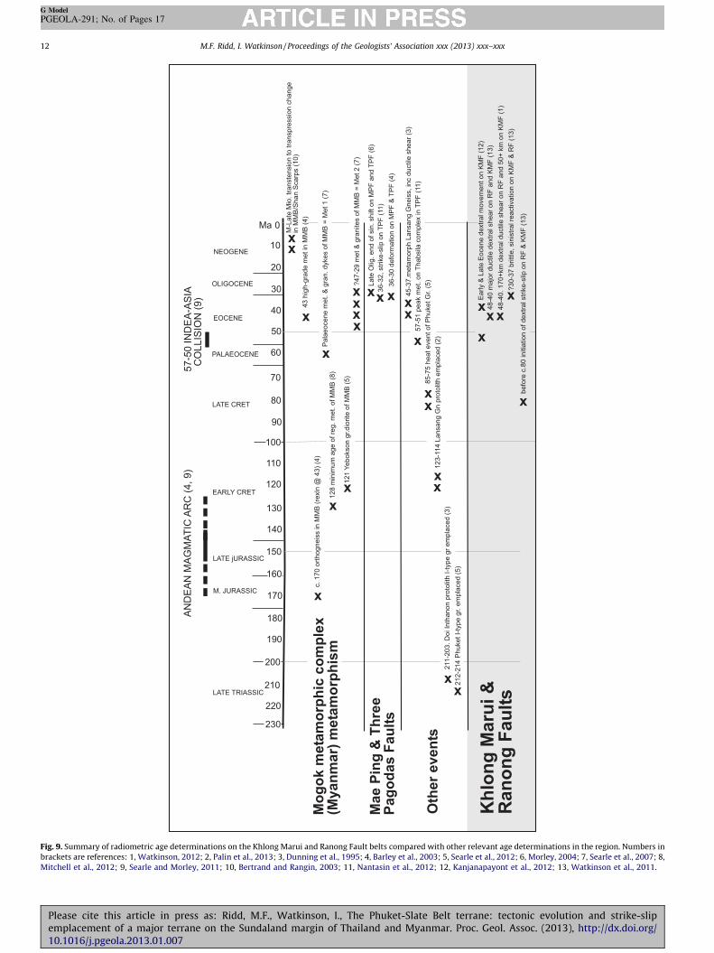
Fig. 9. Summary of radiometric age determinations on the Khlong Marui and Ranong Fault belts compared with other relevant age determinations in the region. Numbers in
brackets are references: 1, Watkinson, 2012; 2, Palin et al., 2013; 3, Dunning et al., 1995; 4, Barley et al., 2003; 5, Searle et al., 2012; 6, Morley, 2004; 7, Searle et al., 2007; 8,
Mitchell et al., 2012; 9, Searle and Morley, 2011; 10, Bertrand and Rangin, 2003; 11, Nantasin et al., 2012; 12, Kanjanapayont et al., 2012; 13, Watkinson et al., 2011.
M.F. Ridd, I. Watkinson / Proceedings of the Geologists’ Association xxx (2013) xxx–xxx12
G Model
PGEOLA-291; No. of Pages 17
Please cite this article in press as: Ridd, M.F., Watkinson, I., The Phuket-Slate Belt terrane: tectonic evolution and strike-slipemplacement of a major terrane on the Sundaland margin of Thailand and Myanmar. Proc. Geol. Assoc. (2013), http://dx.doi.org/10.1016/j.pgeola.2013.01.007
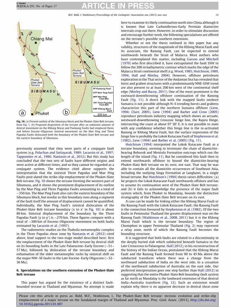
Fig. 10. (a) Present outline of the Sibumasu block and the Phuket-Slate Belt terrane,
from Fig. 1. (b) Proposed disposition of the terrane after an unknown amount of
dextral movement on the Khlong Marui and Panlaung Faults had emplaced them,
and before Eocene–Oligocene sinistral movement on the Mae Ping and Three
Pagodas Faults dislocated both the boundary of the Phuket-Slate Belt terrane and
the eastern boundary of Sibumasu.
M.F. Ridd, I. Watkinson / Proceedings of the Geologists’ Association xxx (2013) xxx–xxx 13
G Model
PGEOLA-291; No. of Pages 17
previously assumed that they were parts of a conjugate faultsystem (e.g. Polachan and Sattayarak, 1989; Lacassin et al., 1997;Tapponnier et al., 1986; Nantasin et al., 2012). But this study hasconcluded that the two sets of faults have different origins andwere active at different times, and so they cannot be regarded as aconjugate system. The evidence cited above supports theinterpretation that the sinistral Three Pagodas and Mae PingFaults post-dated the strike-slip emplacement of the Phuket-SlateBelt terrane. Fig. 10 shows the terrane forming the western part ofSibumasu, and it shows the prominent displacement of its outlineby the Mae Ping and Three Pagodas Faults amounting to a total of�350 km. The Mae Ping Fault also cuts the eastern boundary of theSibumasu block, but insofar as this boundary runs along a segmentof the fault itself the amount of displacement cannot be quantified.Individually, the Mae Ping Fault’s sinistral dislocation of thePhuket-Slate Belt terrane boundary (x to x0 in Fig. 10) is about80 km. Sinistral displacement of the boundary by the ThreePagodas Fault (y to y0) is �270 km. These figures compare with atotal of �300 km of Eocene–Oligocene movement on both faultsestimated by Lacassin et al. (1997).
The radiometric studies on the Thabsila metamorphic complexin the Three Pagodas shear zone by Nantasin et al. (2012) citedabove, lend support to the two-stage model described here: firstthe emplacement of the Phuket-Slate Belt terrane by dextral shifton its bounding faults in the Late Palaeocene–Early Eocene (�51–57 Ma), followed by dislocation of the terrane boundary andexhumation of the older metamorphic rocks by sinistral shift onthe major NW–SE faults in the Late Eocene–Early Oligocene (�32–36 Ma).
6. Speculations on the southern extension of the Phuket-SlateBelt terrane
This paper has argued for the existence of a distinct fault-bounded terrane in Thailand and Myanmar. No attempt is made
Please cite this article in press as: Ridd, M.F., Watkinson, I., Theemplacement of a major terrane on the Sundaland margin of Thai10.1016/j.pgeola.2013.01.007
here to examine its likely continuation north into China although itis known that Late Carboniferous-Early Permian diamictiteintervals crop out there. However, in order to stimulate discussionand encourage further work, the following speculations are offeredon the terrane’s possible southern extension.
Whether or not the thesis outlined in this paper has anyvalidity, structures of the magnitude of the Khlong Marui Fault andits associate, the Ranong Fault, can be expected to extendsouthwards beneath the Strait of Malacca. Most authors whohave contemplated this matter, including Garson and Mitchell(1970) who first described it, have extrapolated the fault SSW tofollow the 200 m bathymetric contour which marks the edge of theMalacca Strait continental shelf (e.g. Wood, 1985; Hutchison, 1989,1994; Hall and Morley, 2004). However, offshore petroleumexploration in the Thai sector of the Andaman Sea has revealed thathorst and graben structures with a predominantly NNE-SSW trendare also present to at least 200 km west of the continental shelfedge (Morley and Racey, 2011). One of the most prominent is theeastward-downthrowing offshore continuation of the RanongFault (Fig. 11). A direct link with the mapped faults onshoreSumatra is not possible although N–S trending horsts and grabenscharacterize this part of the northern Sumatra offshore (Liew,1994; Clure, 2005). Liew (1994) and Barber and Crow (2005)reproduce petroleum industry mapping which shows an arcuate,westward-downthrowing Cenozoic hinge line, the Rayeu Hinge,intersecting the coast at about 978300 E. It is not possible to statewith any confidence whether this hinge line is the re-activatedRanong or Khlong Marui Fault, but the surface expression of thehinge line is probably the Lokok Kutacane Fault of Stephenson et al.(1982), Liew (1994) and Barber et al. (2005) (Fig. 11).
Hutchison (1994) interpreted the Lokok Kutacane Fault as aterrane boundary, seeming to terminate the chain of diamictite-bearing Bohorok and Mentulu Formation outcrops which run thelength of the island (Fig. 11). But he considered this fault then toextend northwards offshore to bound the diamictite-bearingPhuket-Slate Belt terrane on its west, not east. That way he wasable to contain all the diamictite occurrences of Southeast Asia,including the outlying Singa Formation at Langkawi, in a singlebroad terrane. But Hutchison’s (1994) thesis raises difficulties: (a)he projects the Lokok Kutacane Fault northwards offshore and hasto assume its continuation west of the Phuket-Slate Belt terrane;and (b) it fails to acknowledge the presence of the major faultsystem which, from Phuket to Mandalay, bounds the distinctivestratigraphy of the Phuket-Slate Belt terrane on its east.
A case can be made for linking either the Khlong Marui Fault orthe Ranong Fault with the Lokok Kutacane Fault; the Ranong Faultis the connection favoured by Stephenson et al. (1982). Of the twofaults in Peninsular Thailand the greater displacement was on theRanong Fault (Watkinson et al., 2008, 2011) but it is the KhlongMarui Fault which is the terrane boundary. The region ofChumphon in upper Peninsular Thailand (Fig. 2) may representa relay zone, north of which the Ranong Fault becomes thebounding structure.
It is suggested that both faults are related to a discontinuity inthe deeply buried slab which subducted beneath Sumatra in theLate Cretaceous to Palaeogene. Hall (2012), in his reconstruction ofthe history of the Indian Ocean, postulated that the Khlong MaruiFault and the Ranong Fault formed from 90 to 45 Ma above thesubducted transform where there was a change from thenorthward subduction of India on the west side, to a cessationof the northward subduction of Australia on the east side. Ourpreferred interpretation goes one step further than Hall (2012) insuggesting that the entire Phuket-Slate Belt bounding-fault systemas far north as Mandalay is the landward extension of that dextralIndia–Australia transform (Fig. 12). Such an extension wouldexplain why there is no apparent decrease in dextral shear-zone
Phuket-Slate Belt terrane: tectonic evolution and strike-slipland and Myanmar. Proc. Geol. Assoc. (2013), http://dx.doi.org/
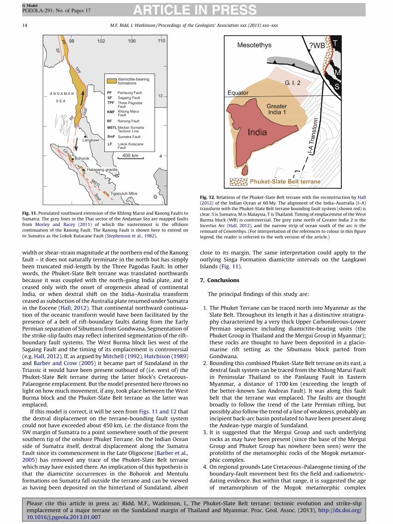
Fig. 12. Relations of the Phuket-Slate Belt terrane with the reconstruction by Hall
(2012) of the Indian Ocean at 60 My. The alignment of the India–Australia (I–A)
transform with the Phuket-Slate Belt terrane bounding fault system (shown red) is
clear. S is Sumatra, M is Malaysia, T is Thailand. Timing of emplacement of the West
Burma block (WB) is controversial. The grey zone north of Greater India 2 is the
Incertus Arc (Hall, 2012), and the narrow strip of ocean south of the arc is the
remnant of Cenotethys. (For interpretation of the references to colour in this figure
legend, the reader is referred to the web version of the article.)
Fig. 11. Postulated southward extension of the Khlong Marui and Ranong Faults to
Sumatra. The grey lines in the Thai sector of the Andaman Sea are mapped faults
from Morley and Racey (2011) of which the easternmost is the offshore
continuation of the Ranong Fault. The Ranong Fault is shown here to extend on
to Sumatra as the Lokok Kutacane Fault (Stephenson et al., 1982).
M.F. Ridd, I. Watkinson / Proceedings of the Geologists’ Association xxx (2013) xxx–xxx14
G Model
PGEOLA-291; No. of Pages 17
width or shear-strain magnitude at the northern end of the Ranongfault – it does not naturally terminate in the north but has simplybeen truncated mid-length by the Three Pagodas Fault. In otherwords, the Phuket-Slate Belt terrane was translated northwardsbecause it was coupled with the north-going India plate, and itceased only with the onset of orogenesis ahead of continentalIndia, or when dextral shift on the India–Australia transformceased as subduction of the Australia plate resumed under Sumatrain the Eocene (Hall, 2012). That continental northward continua-tion of the oceanic transform would have been facilitated by thepresence of a belt of rift-boundary faults dating from the EarlyPermian separation of Sibumasu from Gondwana. Segmentation ofthe strike-slip faults may reflect inherited segmentation of the rift-boundary fault systems. The West Burma block lies west of theSagaing Fault and the timing of its emplacement is controversial(e.g. Hall, 2012). If, as argued by Mitchell (1992), Hutchison (1989)and Barber and Crow (2005) it became part of Sundaland in theTriassic it would have been present outboard of (i.e. west of) thePhuket-Slate Belt terrane during the latter block’s Cretaceous-Palaeogene emplacement. But the model presented here throws nolight on how much movement, if any, took place between the WestBurma block and the Phuket-Slate Belt terrane as the latter wasemplaced.
If this model is correct, it will be seen from Figs. 11 and 12 thatthe dextral displacement on the terrane-bounding fault systemcould not have exceeded about 450 km, i.e. the distance from theSW margin of Sumatra to a point somewhere south of the presentsouthern tip of the onshore Phuket Terrane. On the Indian Oceanside of Sumatra itself, dextral displacement along the SumatraFault since its commencement in the Late Oligocene (Barber et al.,2005) has removed any trace of the Phuket-Slate Belt terranewhich may have existed there. An implication of this hypothesis isthat the diamictite occurrences in the Bohorok and Mentuluformations on Sumatra fall outside the terrane and can be viewedas having been deposited on the hinterland of Sundaland, albeit
Please cite this article in press as: Ridd, M.F., Watkinson, I., Theemplacement of a major terrane on the Sundaland margin of Thai10.1016/j.pgeola.2013.01.007
close to its margin. The same interpretation could apply to theoutlying Singa Formation diamictite intervals on the LangkawiIslands (Fig. 11).
7. Conclusions
The principal findings of this study are:
1. The Phuket Terrane can be traced north into Myanmar as theSlate Belt. Throughout its length it has a distinctive stratigra-phy characterized by a very thick Upper Carboniferous-LowerPermian sequence including diamictite-bearing units (thePhuket Group in Thailand and the Mergui Group in Myanmar);these rocks are thought to have been deposited in a glacio-marine rift setting as the Sibumasu block parted fromGondwana.
2. Bounding this combined Phuket-Slate Belt terrane on its east, adextral fault system can be traced from the Khlong Marui Faultin Peninsular Thailand to the Panlaung Fault in EasternMyanmar, a distance of 1700 km (exceeding the length ofthe better-known San Andreas Fault). It was along this faultbelt that the terrane was emplaced. The faults are thoughtbroadly to follow the trend of the Late Permian rifting, butpossibly also follow the trend of a line of weakness, probably anincipient back-arc basin postulated to have been present alongthe Andean-type margin of Sundaland.
3. It is suggested that the Mergui Group and such underlyingrocks as may have been present (since the base of the MerguiGroup and Phuket Group has nowhere been seen) were theprotoliths of the metamorphic rocks of the Mogok metamor-phic complex.
4. On regional grounds Late Cretaceous–Palaeogene timing of theboundary-fault movement best fits the field and radiometric-dating evidence. But within that range, it is suggested the ageof metamorphism of the Mogok metamorphic complex
Phuket-Slate Belt terrane: tectonic evolution and strike-slipland and Myanmar. Proc. Geol. Assoc. (2013), http://dx.doi.org/
M.F. Ridd, I. Watkinson / Proceedings of the Geologists’ Association xxx (2013) xxx–xxx 15
G Model
PGEOLA-291; No. of Pages 17
provides a more specific timing. Although Mitchell et al. (2012)controversially propose a minimum age of metamorphism of128 Ma, Searle et al. (2007) proposed two Tertiary events(�59 Ma, and 47–29 Ma) The older of the ages of Searle et al.(2007), i.e. �59 Ma, is close to the �51–57 Ma age ofmetamorphism described by Nantasin et al. (2012) from theThabsila schist and gneiss enclave in the Three Pagodas Faultbelt, and it is suggested here that this metamorphic event wascaused by dextral transpression and associated crustalthickening as the Phuket-Slate Belt terrane was emplaced.The 55 Ma re-heating event of the Khao Phanom Benchagranite (Fig. 7) reported by Garson et al. (1975) might also beexplained by this event.
5. The Shweminbon Formation turbidites of possible LateTriassic-Early Jurassic age cropping out along the west flankof the Shan Plateau had been thought to indicate the presenceat that time of a closing ocean between the Shan Plateau andSlate Belt (Mitchell et al., 2007, 2012). That is now thoughtunlikely, although the palaeogeography of the western ShanPlateau at the time the Shweminbon Formation was depositedis a conundrum.
6. New evidence has emerged from Phuket that some of thegranites of the Western Granite Province of Southeast Asiawere intruded as early as the Late Triassic (Searle et al., 2012);it had been known for some time that most of the granites ofthat province were intruded in the Cretaceous and Palaeogene.That finding is consistent with the model of a long-livedAndean-type margin described here.
7. The granites of the Western Province were intruded into thePhuket-Slate Belt terrane before displacement on the boundingfault system. Rare granite plutons attributable to the WesternProvince include the Hatapang Granite of NE Sumatra andpossibly the Khao Phanom Bencha granite near Krabi inThailand (Fig. 7). These, together with outlying occurrences ofdiamictite-bearing formations at Langkawi (Singa Formation)and on Sumatra (Bohorok and Mentulu Formations) were onthe autochthonous hinterland when the Phuket-Slate Beltterrane shifted north (Figs. 11 and 12).
8. The Khlong Marui and Ranong Faults are postulated to crossthe Malacca Strait to Sumatra where their presence is markedin the younger blanketing rocks by N–S structural trendsincluding the Lokok Kutacane Fault.
9. Dextral shear along the terrane-bounding fault systemsoccurred prior to the Coniacian, intermittently during muchof the Paleocene and Eocene, and possibly into the Oligocene.
10. It is tentatively postulated that dextral shift on the entirePhuket-Slate Belt terrane-bounding fault system may berelated to the India–Australia transform between 90 and45 Ma (Hall, 2012). In effect it is the northward, continental,continuation of the transform, resulting from the terrane beingcoupled with the north-going India plate. Displacement on thebounding fault system would not have exceeded about 450 km.
11. The present outline of the Phuket-Slate Belt terrane is the resultof it having been displaced by sinistral movement on the MaePing and Three Pagodas Faults in the Eocene–Oligocene,following resumption of subduction along the entire westernSundaland margin (Hall, 2012) and indentation of India intoEurasia.
Further studies which could throw light on the tectonic modelpresented here include:
i. Provenance studies on clasts within the Phuket Group andMergui Group diamictite, together with sedimentologicalstudies of correlatives of the Phuket Group east of the terrane,
Please cite this article in press as: Ridd, M.F., Watkinson, I., Theemplacement of a major terrane on the Sundaland margin of Thai10.1016/j.pgeola.2013.01.007
particularly the Kaeng Krachan Group of Thailand’s lowerPeninsula, the better to understand the palaeogeography.
ii. Insofar as the Middle–Upper Permian carbonate sequence ofthe Phuket-Slate Belt terrane is interpreted as having beendeposited perhaps as much as several hundred kilometresdistant from the equivalent limestone east of the terranebounding fault, a search may reveal stratigraphic differencesbetween them.
iii. An integrated study of the Late Triassic-Early Jurassic Shwe-minbon Formation in Myanmar could achieve a betterunderstanding of the palaeogeography at that time.
iv. Rigorous testing of the postulation that the terrane boundingfault system is related to the India–Australia transform isrecommended.
v. A search for worldwide analogues of this 1700 km-long terrane.
Acknowledgements
We are most grateful to Dr. Andrew Mitchell for the informationon Myanmar he has freely provided. He along with Dr. Tony Barberand Dr. Mike Crow gave helpful comments on an early draft. Thepaper was reviewed by Dr. Chris Morley and Professor Robert Hallwhose comments have led to further improvements.
References
Ampaiwan, T., Hisada, K., Charusiri, P., 2009. Lower Permian glacially-influenceddeposits in Phuket and adjacent islands, peninsular Thailand. Island Arc 18, 52–68.
Barber, A.J., Crow, M.J., 2005. Structure and structural history. In: Barber, A.J., Crow,M.J., Milsom, J.S. (Eds.), Sumatra, Geology, Resources, Tectonic Evolution,Geological Society of London Memoir No. 31, pp. 175–233 (Chapter 13).
Barber, A.J., Crow, M.J., Milsom, J.S., 2005. Sumatra, Geology, Resources and TectonicEvolution, Geological Society of London Memoir No. 31, p. 290.
Barber, A.J., Ridd, M.F., Crow, M.J., 2011. The origin, movement and assembly of thepre-Tertiary tectonic units of Thailand. In: Ridd, M.F., Barber, A.J., Crow, M.J.(Eds.), The Geology of Thailand. Geological Society, London, pp. 507–537.
Barley, M.E., Pickard, A.L., Khin Zaw, Rak, P., Doyle, M.G., 2003. Jurassic to Miocenemagmatism and metamorphism in the Mogok metamorphic belt and the India–Eurasia collision in Myanmar. Tectonics 22, 1019, http://dx.doi.org/10.1029/2002TC001398.
Bender, F., 1983. Geology of Burma. Gebruder Borntraeger, Berlin and Stuttgart p.293.
Bertrand, G., Rangin, C., 2003. Tectonics of the western margin of the Shan Plateau(central Burma): implications for the India–Indochina oblique convergencesince the Oligocene. Journal of Asian Earth Sciences 21, 1139–1157.
Brunnschweiler, R.O., 1970. Contribution to the post-Silurian geology of Burma(Northern Shan States and Karen State). Journal of the Geological Society ofAustralia 17, 59–79.
Cai, L., Li, X., 2001. Geology of Yunnan province. In: MA, L. (Ed.), Geology Atlas ofChina. Beijing, pp. 293–300.
Chaodumrong, P., Wang, X.D., Shen, S.Z., 2007. Permian lithostratigraphy of theShan–Thai Terrane in Thailand: revision of the Kaeng Krachan and Ratburigroups. In: GEOTHAI’07 International Conference on Geology of Thailand:Towards Sustainable Development and Sufficiency Economy, Bangkok, 21–22November, pp. 229–236.
Charusiri, P., Clark, A.H., Farrar, A.H., Farrar, E., Archibald, D., Charusiri, B., 1993.Granite belts in Thailand: evidence from the 40Ar/39Ar geochronological andgeological syntheses. Journal of Southeast Asian Earth Sciences 8, 127–136.
Clure, J., 2005. Fuel resources: oil and gas. In: Barber, A.J., Crow, M.J., Milsom, J.S.(Eds.), Sumatra, Geology, Resources and Tectonic Evolution, Geological Societyof London Memoir No. 31, pp. 131–141.
Cobbing, E.J., 2005. Granites. In: Barber, A.J., Crow, M.J., Milsom, J.S. (Eds.), Sumatra,Geology, Resources and Tectonic Evolution, Geological Society of London Mem-oir No. 31, pp. 54–62.
Cobbing, E.J., 2011. Granitic rocks. In: Ridd, M.F., Barber, A.J., Crow, M.J. (Eds.), TheGeology of Thailand. Geological Society, London, pp. 441–457.
Cobbing, E.J., Pitfield, P.E.J., Darbyshire, D.P.F., Mallick, D.I.J., 1992. The granites ofthe South-East Asian tin belt. Overseas Memoir of the British Geological Survey10. HMSO, London.
Curray, J.R., 2005. Tectonics and history of the Andaman Sea region. Journal of AsianEarth Sciences 25, 187–232.
Department of Mineral Resources, 1999. Geological Map of Thailand, Scale 1:1 mil-lion. Department of Mineral Resources, Bangkok, Thailand.
Dunning, G.R., Macdonald, A.S., Barr, S.M., 1995. Zircon and monazite U-Pb dating ofthe Doi Inthanon core complex, northern Thailand: implications for extensionwithin the Indosinian Orogen. Tectonophysics 251, 197–213.
Phuket-Slate Belt terrane: tectonic evolution and strike-slipland and Myanmar. Proc. Geol. Assoc. (2013), http://dx.doi.org/
M.F. Ridd, I. Watkinson / Proceedings of the Geologists’ Association xxx (2013) xxx–xxx16
G Model
PGEOLA-291; No. of Pages 17
Earth Sciences Research Division, 1977. Geological Map of the Socialist Republic ofthe Union of Burma, scale 1:1 million. Rangoon.
Garson, M.S., Mitchell, A.H.G., 1970. Transform faulting in the Thai Peninsula.Nature 228, 45–47.
Garson, M.S., Young, B., Mitchell, A.H.G., Tait, B.A.R., 1975. The Geology of the TinBelt in Peninsular Thailand around Phuket, Phangnga and Takua Pa. Institute ofGeological Sciences Overseas Memoir No. 1, HMSO, London p. 112.
Garson, M.S., Amos, B.J., Mitchell, A.H.G., 1976. The geology of the area aroundNeyaungga and Ye-ngan, Southern Shan States, Burma. Institute of GeologicalSciences, Overseas Memoir 2, HMSO, London p. 69.
Hagen, D., Kemper, E., 1976. Geology of the Thong Pha Phum area (Kanchanaburiprovince, western Thailand). Geologisches Jahrbuch B21, 53–91.
Hall, R., 2012. Late Jurassic–Cenozoic reconstructions of the Indonesian region andthe Indian Ocean. Tectonophysics 570–571, 1–41.
Hall, R., Morley, C.K., 2004. Sundaland basins. Continent–Ocean Interactions withinEast Asian Marginal Seas, 149. American Geophysical Union GeophysicalMonograph Series, pp. 55–85.
Hobson, G.V., 1941. A geological survey in parts of Karenni and the Southern ShanStates. Memoirs of the Geological Survey of India 74 (2), 103–156.
Hutchison, C.S., 1989. Geological Evolution of South-east Asia. Clarendon Press,Oxford p. 368.
Hutchison, C.S., 1994. Gondwana and Cathaysian blocks. Palaeotethys sutures andCenozoic tectonics in South-East Asia. Geologische Rundschau 82, 388–405.
Hyndman, R.D., Currie, C.A., Mazzotti, S.P., 2005. Subduction zone backarcs, mobilebelts, and orogenic heat. GSA Today 15 (2), 4–10, doi:10:1130/10525173(2005)015?4SZBMBA>2.0.CO.2.
Isozaki, Y., Aoki, K., Nakama, T., Yanai, S., 2010. New insight into a subduction-related orogen: a reappraisal of the geotectonic framework and evolution of theJapanese Islands. Gondwana Research 18, 82–105.
Jin, X., 2002. Permo-Carboniferous sequences of Gondwana affinity in southwestChina and their paleogeographic implications. Journal of Asian Earth Sciences20, 633–646.
Kanjanapayont, P., Klotzli, U., Thoni, M., Grasemann, B., Edwards, M.A., 2012. Rb–Sr,Sm–Nd, and U–Pb geochronology of the rocks within the Khlong Marui shearzone, southern Thailand. Journal of Asian Earth Sciences 56, 263–275.
Lacassin, R., Leloup, P.H., Tapponnier, P., 1993. Bounds on strain in large Tertiaryshear zones of SE Asia from boudinage restoration. Journal of Structural Geology15, 677–692.
Lacassin, R., Hinthong, C.K., et al., 1997. Tertiary diachronic extrusion and defor-mation of western Indochina: structure and 40Ar/39Ar evidence from NWThailand. Journal of Geophysical Research 102 (B5), 10013–10037.
Lain, F., 1973. Geological map of the western Shan Plateau between Latitudes198300N and 218150N, scale �1:660,000. Unpublished and untitled geologicalmap. Yangon, Myanmar.
La Touche, T.H.D., 1913. Geology of the Northern Shan States. Geological Survey ofIndia Memoirs 39, 1–379.
Liew, K.K., 1994. Structural patterns within the Tertiary basement of the Strait ofMalacca. Geological Society of Malaysia Bulletin 38, 109–126.
Metcalfe, I., 1999. Gondwana dispersion and Asian accretion: an overview. In:Metcalfe, I. (Ed.), Gondwana Dispersion and Asian Accretion, Final ResultsVolume for IGCP 312. A.A. Balkema, Rotterdam, pp. 9–28.
Metcalfe, I., 2011. Palaeozoic-Mesozoic history of SE Asia. In: Hall, R., Cottam,M.A., Wilson, M.E.J. (Eds.), The SE Asian Gateway, History and Tectonics ofthe Australia-Asia Collision, vol. 355. Geological Society Special Publication,pp. 7–35.
Mitchell, A.H.G., 1977. Tectonic setting for emplacement of Southeast Asian tingranites. Geological Society of Malaysia Bulletin 9, 123–140.
Mitchell, A.H.G., 1992. Late Permian–Mesozoic events and the Mergui group Nappein Myanmar and Thailand. Journal of SE Asian Earth Sciences 7, 165–178.
Mitchell, A.H.G., 1993. Cretaceous-Cenozoic tectonic events in the western Myan-mar (Burma) – Assam region. Journal of the Geological Society 150, 1089–1102.
Mitchell, A.H.G., Young, B., Jantaranipa, W., 1970. The Phuket Group, PeninsularThailand: a Palaeozoic? Geosynclinal deposit. Geological Magazine 107, 411–428.
Mitchell, A.H.G., Marshall, T.R., Skinner, A.C., Baker, M.D., Amos, B.J., Bateson, J.H.,1977. Geology and Exploration Geochemistry of the Yadangtheingi andKyaukme–Longtawkno areas, Northern Shan States, Burma. Overseas Geologyand Mineral Resources Report Number 51, Institute of Geological Sciences,HMSO, London.
Mitchell, A.H.G., Hlaing, T., Htay, N., 2002. Mesozoic orogenies along the Mandalay–Yangon margin of the Shan Plateau. In: Montajit, N. (Ed.), Symposium on theGeology of Thailand, 26–31 August 2002, Bangkok. pp. 136–149.
Mitchell, A.H.G., Ausa, C.A., Deiparine, L., Hlaing, T., Htay, N., Khine, A., 2004. TheModi Taung – Nankwe gold district, Slate belt, central Myanmar: mesothermalveins in a Mesozoic orogen. Journal of Asian Earth Sciences 23, 321–341.
Mitchell, A.H.G, Htay, M.T., Htun, K.M., Win, M.N., Oo, T., Hlaing, T., 2007. Rockrelationships in the Mogok metamorphic belt, Tatkon to Mandalay, centralMyanmar. Journal of Asian Earth Sciences 29, 891–910.
Mitchell, A.H.G., Chung, S.-L., Oo, T., Lin, T.H., Hung, C.-H., 2012. Zircon U–Pb ages inMyanmar: magmatic-metamorphic events and the closure of a neo-Tethysocean? Journal of Asian Earth Sciences 56, 1–23.
Morley, C.K., 2004. Nested strike-slip duplexes, and other evidence for Late Creta-ceous–Palaeogene transpressional tectonics before and during India–Eurasiacollision in Thailand, Myanmar and Malaysia. Journal of the Geological Society161, 799–812.
Please cite this article in press as: Ridd, M.F., Watkinson, I., Theemplacement of a major terrane on the Sundaland margin of Thai10.1016/j.pgeola.2013.01.007
Morley, C.K., Racey, A., 2011. Tertiary stratigraphy. In: Ridd, M.F., Barber, A.J., Crow,M.J. (Eds.), The Geology of Thailand. Geological Society, London, pp. 223–271.
Morley, C.K., Charusiri, P., Watkinson, I.M., 2011. Structural geology of Thailandduring the Cenozoic. In: Ridd, M.F., Barber, A.J., Crow, M.J. (Eds.), The Geology ofThailand. Geological Society, London, pp. 273–334.
Nantasin, P., Hauzenberger, C., Liu, X., Krenn, K., Dong, Y., Thoni, M., Wathanakul, P.,2012. Occurrence of the high grade Thabsila metamorphic complex within thelow grade Three Pagodas shear zone, Kanchanaburi Province, western Thailand:petrology and geochronology. Journal of Asian Earth Sciences 60, 68–87.
Oo, T., Hlaing, T., Htay, N., 2001. Permian of Myanmar. Journal of Asian EarthSciences 20, 683–689.
Palin, R.M., Searle, M.P., Morley, C.K., Charusiri, P., Horstwood, M.S.A., Roberts,N.M.W., 2013. Timing of metamorphism of the Lansang gneiss and implicationsfor left-lateral motion along the Mae Ping (Wang Chao) strike-slip fault,Thailand. Journal of Asian Earth Sciences, http://dx.doi.org/10.1016/j.jseaes.2013.01.021.
Piyasin, S., 1975. Stratigraphy and sedimentology of the Kaeng Krachan Group(Carboniferous). In: Stokes, R.B., Tantisukrit, C. (Eds.), Proceedings of theConference on the Geology of Thailand, Chiang Mai, December 1973, vol. 2.Department of Geological Sciences, Chiang Mai University, Special PublicationNo. 1, pp. 25–35.
Polachan, S., Sattayarak, N., 1989. Strike-slip tectonics and the development ofTertiary Basins in Thailand. In: International Symposium on IntermontaneBasins: Geology and Resources, 30 January–2 February 1989, Chiang Mai,Thailand.
Putthapiban, P., 2002. Geology and geochronology of the igneous rocks of Thailand.In: Montajit, N. (Ed.), Symposium on the Geology of Thailand, 26–31 August2002, Bangkok. pp. 261–283.
Raksaskulwong, L., Wongwanich, T., 1993. Stratigraphy of the Kaeng Krachan Groupin Peninsular and Western Thailand. Geological Survey Division, Department ofMineral Resources, Bangkok (in Thai).
Rau, R.B.S.T.R., 1930. The Geology of the Mergui District. Memoirs of the GeologicalSurvey of India, 55. Government of India Central Publication Branch, Calcuttapp. 1–62.
Ridd, M.F., 1971a. Faults in Southeast Asia, and the Andaman rhombochasm. Nature229 (2), 51–52.
Ridd, M.F., 1971b. The Phuket Group of Peninsular Thailand. Geological Magazine108, 445–446.
Ridd, M.F., 2009. The Phuket Terrane: a Late Palaeozoic rift at the margin ofSibumasu. Journal of Asian Earth Sciences 36, 238–251.
Ridd, M.F., 2011. Lower Palaeozoic. In: Ridd, M.F., Barber, A.J., Crow, M.J. (Eds.), TheGeology of Thailand. Geological Society, London, pp. 33–51.
Ridd, M.F., 2012. A Middle Permian–Middle Triassic accretionary complex and aLate Triassic foredeep basin: forerunners of an Indosinian (Late Triassic) thrustcomplex in the Thailand–Malaysia border area. Journal of Asian Earth Sciences,http://dx.doi.org/10.1016/j.jseaes.2012.09.030.
Saing, C., 2004. Cretaceous events in Myanmar with special reference to foraminif-eral evidence. Journal of the Geological Society of Thailand No. 1 115–125.
Searle, M.P., Morley, C.K., 2011. Tectonic and thermal evolution of Thailand in theregional context of SE Asia. In: Ridd, M.F., Barber, A.J., Crow, M.J. (Eds.), TheGeology of Thailand. Geological Society, pp. 539–571.
Searle, M.P., Noble, S.R., Cottle, J.M., Waters, D.J., Mitchell, A.H.G., Hlaing, T., Horst-wood, M.S.A., 2007. Tectonic evolution of the Mogok metamorphic belt, Burma(Myanmar) constrained by U–Th–Pb dating of metamorphic and magmaticrocks. Tectonics 26 , http://dx.doi.org/10.1029/2006TC002083.2007.
Searle, M.P., Whitehouse, M.J., Robb, L.J., Ghani, A.A., Hutchison, C.S., Sone, M., Ng,S.W.P., Roselee, M.H., Chung, S.L., Oliver, J.H., 2012. Tectonic evolution of theSibumasu–Indochina terrane collision zone in Thailand and Malaysia: con-straints from new U–Pb zircon chronology of SE Asian tin granitoids. Journal ofthe Geological Society 169, 489–500.
Sevastjanova, I., Clements, B., Hall, R., Belousova, E.A., Griffin, W.L., Pearson, N.,2011. Granitic magmatism, basement ages, and provenance indicators in theMalay Peninsula: insights from detrital zircon U–Pb and Hf-isotope data.Gondwana Research 19, 1024–1039.
Sone, M., Metcalfe, I., 2008. Parallel Tethyan sutures in mainland Southeast Asia:new insights for Palaeo-Tethys closure and implications for the IndosinianOrogeny. Comptes Rendu Geoscience 340, 166–179.
Stauffer, P.H., Lee, C.P., 1986. Late Paleozoic glacial marine facies in Southeast Asiaand its implications. In: Proceedings of GEOSEA V, vol. II. Geological Society ofMalaysia Bulletin, vol. 20. pp. 363–397.
Stephenson, B., Ghazali, S.A., Hariwidjaja, 1982. Geochemical Atlas of NorthernSumatra. Regional Geochemical Atlas Series of Indonesia No. 1. Directorate ofMineral Resources, Bandung, Indonesia and British Geological Survey, Key-worth, United Kingdom.
Taira, A., 2001. Tectonic evolution of the Japanese island arc system. AnnualReviews of Earth and Planetary Science 29, 109–134.
Taira, A., Tokuyama, H., Soh, W., 1989. Accretion tectonics and evolution of Japan. In:Ben-Avrham, Z. (Ed.), The Evolution of the Pacific Ocean Margins. OxfordMonographs of Geology and Geophysics 8, Oxford, UK, pp. 100–123.
Tanimoto, M., 2005. Mosasaur remains from the Upper Cretaceous Izumi Group ofsouthwest Japan. Netherlands Journal of Geosciences, Geologie en Mijnbouw 84(3), 373–378.
Tapponnier, P., Peltzer, G., Armijo, R., 1986. On the mechanism of the collisionbetween India and Asia. In: Coward, M.P., Ries, A.C. (Eds.), Collision Tectonics,vol. 19. Geological Society Special Publication, pp. 115–157.
Phuket-Slate Belt terrane: tectonic evolution and strike-slipland and Myanmar. Proc. Geol. Assoc. (2013), http://dx.doi.org/

M.F. Ridd, I. Watkinson / Proceedings of the Geologists’ Association xxx (2013) xxx–xxx 17
G Model
PGEOLA-291; No. of Pages 17
Thein, M.L., 1973. The Lower Palaeozoic stratigraphy of western part of the SouthernShan State, Burma. Geological Society of Malaysia Bulletin 6, 143–163.
Thein, M.L., 2004. Paleocurrents, petrography and environments of the Jurassic–Cretaceous Pan Laung Formation in the Kinda-Kyaukse area, Central Myanmar.Journal of the Geological Society of Thailand No. 1 85–95.
Ueno, K., Charoentitirat, T., 2011. Carboniferous and Permian. In: Ridd, M.F., Barber,A.J., Crow, M.J. (Eds.), The Geology of Thailand. Geological Society, London, pp.71–136.
United Nations, 1978. Geology and exploration geochemistry of the ShanScarps area, east of Kyaukse, Thazi and Tatkon, central Burma. TechnicalReport UN/BUR/72/002, No. 3, United Nations Development Programme,New York.
Vigny, C., Socquet, A., Rangin, C., Chamot-Rooke, N., Pubellier, M., Bouin, M.-N.,Bertrand, G., Becker, M., 2003. Present-day crustal deformation around SagaingFault, Myanmar. Journal of Geophysical Research 108 , http://dx.doi.org/10.1029/2002JB001999.
Please cite this article in press as: Ridd, M.F., Watkinson, I., Theemplacement of a major terrane on the Sundaland margin of Thai10.1016/j.pgeola.2013.01.007
Vimuktanandana, S., Boonnop, N., Imsamut, S., 2008. Geological Map of ChangwatKanchanaburi, Scale 1:250 000. Department of Mineral Resources, Bangkok,Thailand.
Watkinson, I., Elders, C., Hall, R., 2008. The kinematic history of the Khlong Marui andRanong Faults, Southern Thailand. Journal of Structural Geology 30, 1554–1571.
Watkinson, I., Elders, C., Batt, G., Jourdan, F., Hall, R., McNaughton, N.J., 2011. Thetiming of strike-slip shear along the Ranong and Khlong Marui faults, Thailand.Journal of Geophysical Research 116 , http://dx.doi.org/10.1029/2011JB008379.
Watkinson, I., 2012. Ductile boudinage in the major strike-slip shear zones of theThai-Myanmar Peninsula. In: First International Conference on Myanmar Ge-ology (GeoMyanmar 2012). 1–2 March 2012, Yangon, Myanmar (abstract andPowerpoint presentation material).
Wolfart, R., Win, M., Boiteau, S., Wai, M., Cung, P.U., Lwin, T., 1984. Stratigraphy ofthe Western Shan Massif, Burma. Geologishe Jahrbuch B57, 3–92.
Wood, B.G.M., 1985. The mechanics of progressive deformation in crustal Plates – aworking model for Southeast Asia.Geological Society of Malaysia Bulletin 18, 55–99.
Phuket-Slate Belt terrane: tectonic evolution and strike-slipland and Myanmar. Proc. Geol. Assoc. (2013), http://dx.doi.org/