Embed Size (px)
Citation preview

Designation: D2488 − 09a
Standard Practice forDescription and Identification of Soils (Visual-ManualProcedure)1
This standard is issued under the fixed designation D2488; the number immediately following the designation indicates the year oforiginal adoption or, in the case of revision, the year of last revision. A number in parentheses indicates the year of last reapproval. Asuperscript epsilon (´) indicates an editorial change since the last revision or reapproval.
This standard has been approved for use by agencies of the U.S. Department of Defense.
1. Scope*
1.1 This practice covers procedures for the description ofsoils for engineering purposes.
1.2 This practice also describes a procedure for identifyingsoils, at the option of the user, based on the classificationsystem described in Test Method D2487. The identification isbased on visual examination and manual tests. It must beclearly stated in reporting an identification that it is based onvisual-manual procedures.
1.2.1 When precise classification of soils for engineeringpurposes is required, the procedures prescribed in Test MethodD2487 shall be used.
1.2.2 In this practice, the identification portion assigning agroup symbol and name is limited to soil particles smaller than3 in. (75 mm).
1.2.3 The identification portion of this practice is limited tonaturally occurring soils (either intact or disturbed).
NOTE 1—This practice may be used as a descriptive system applied tosuch materials as shale, claystone, shells, crushed rock, etc. (see AppendixX2).
1.3 The descriptive information in this practice may be usedwith other soil classification systems or for materials other thannaturally occurring soils.
1.4 The values stated in inch-pound units are to be regardedas standard. The values given in parentheses are mathematicalconversions to SI units that are provided for information onlyand are not considered standard.
1.5 This standard does not purport to address all of thesafety problems, if any, associated with its use. It is theresponsibility of the user of this standard to establish appro-priate safety and health practices and determine the applica-bility of regulatory limitations prior to use. For specificprecautionary statements see Section 8.
1.6 This practice offers a set of instructions for performingone or more specific operations. This document cannot replaceeducation or experience and should be used in conjunctionwith professional judgment. Not all aspects of this practice maybe applicable in all circumstances. This ASTM standard is notintended to represent or replace the standard of care by whichthe adequacy of a given professional service must be judged,nor should this document be applied without consideration ofa project’s many unique aspects. The word “Standard” in thetitle of this document means only that the document has beenapproved through the ASTM consensus process.
2. Referenced Documents
2.1 ASTM Standards:2
D653 Terminology Relating to Soil, Rock, and ContainedFluids
D1452 Practice for Soil Exploration and Sampling by AugerBorings
D1586 Test Method for Penetration Test (SPT) and Split-Barrel Sampling of Soils
D1587 Practice for Thin-Walled Tube Sampling of Soils forGeotechnical Purposes
D2113 Practice for Rock Core Drilling and Sampling ofRock for Site Investigation
D2487 Practice for Classification of Soils for EngineeringPurposes (Unified Soil Classification System)
D3740 Practice for Minimum Requirements for AgenciesEngaged in Testing and/or Inspection of Soil and Rock asUsed in Engineering Design and Construction
D4083 Practice for Description of Frozen Soils (Visual-Manual Procedure)
3. Terminology
3.1 Definitions:3.1.1 Except as listed below, all definitions are in accor-
dance with Terminology D653.1 This practice is under the jurisdiction of ASTM Committee D18 on Soil and
Rock and is the direct responsibility of Subcommittee D18.07 on Identification andClassification of Soils.
Current edition approved June 15, 2009. Published July 2009. Originallyapproved in 1966. Last previous edition approved in 2009 as D2488 – 09. DOI:10.1520/D2488-09A.
2 For referenced ASTM standards, visit the ASTM website, www.astm.org, orcontact ASTM Customer Service at [email protected]. For Annual Book of ASTMStandards volume information, refer to the standard’s Document Summary page onthe ASTM website.
*A Summary of Changes section appears at the end of this standard
Copyright © ASTM International, 100 Barr Harbor Drive, PO Box C700, West Conshohocken, PA 19428-2959. United States
1
Copyright by ASTM Int'l (all rights reserved); Fri Sep 30 13:07:21 EDT 2016Downloaded/printed byUSDA - Natural Resources Conservation Service (USDA - Natural Resources Conservation Service) pursuant to License Agreement. No further reproductions authorized.
NOTE 2—For particles retained on a 3-in. (75-mm) US standard sieve,the following definitions are suggested:Cobbles—particles of rock that will pass a 12-in. (300-mm) squareopening and be retained on a 3-in. (75-mm) sieve, andBoulders—particles of rock that will not pass a 12-in. (300-mm) squareopening.
3.1.2 clay—soil passing a No. 200 (75-µm) sieve that can bemade to exhibit plasticity (putty-like properties) within a rangeof water contents, and that exhibits considerable strength whenair-dry. For classification, a clay is a fine-grained soil, or thefine-grained portion of a soil, with a plasticity index equal to orgreater than 4, and the plot of plasticity index versus liquidlimit falls on or above the “A” line (see Fig. 3 of Test MethodD2487).
3.1.3 gravel—particles of rock that will pass a 3-in. (75-mm) sieve and be retained on a No. 4 (4.75-mm) sieve with thefollowing subdivisions:
coarse—passes a 3-in. (75-mm) sieve and is retained on a3⁄4-in. (19-mm) sieve.
fine—passes a 3⁄4-in. (19-mm) sieve and is retained on a No.4 (4.75-mm) sieve.
3.1.4 organic clay—a clay with sufficient organic content toinfluence the soil properties. For classification, an organic clayis a soil that would be classified as a clay, except that its liquidlimit value after oven drying is less than 75 % of its liquid limitvalue before oven drying.
3.1.5 organic silt—a silt with sufficient organic content toinfluence the soil properties. For classification, an organic siltis a soil that would be classified as a silt except that its liquidlimit value after oven drying is less than 75 % of its liquid limitvalue before oven drying.
3.1.6 peat—a soil composed primarily of vegetable tissue invarious stages of decomposition usually with an organic odor,a dark brown to black color, a spongy consistency, and atexture ranging from fibrous to amorphous.
3.1.7 sand—particles of rock that will pass a No. 4 (4.75-mm) sieve and be retained on a No. 200 (75-µm) sieve with thefollowing subdivisions:
coarse—passes a No. 4 (4.75-mm) sieve and is retained ona No. 10 (2.00-mm) sieve.
medium—passes a No. 10 (2.00-mm) sieve and is retainedon a No. 40 (425-µm) sieve.
fine—passes a No. 40 (425-µm) sieve and is retained on aNo. 200 (75-µm) sieve.
3.1.8 silt—soil passing a No. 200 (75-µm) sieve that isnonplastic or very slightly plastic and that exhibits little or nostrength when air dry. For classification, a silt is a fine-grainedsoil, or the fine-grained portion of a soil, with a plasticity indexless than 4, or the plot of plasticity index versus liquid limitfalls below the “A” line (see Fig. 3 of Test Method D2487).
4. Summary of Practice
4.1 Using visual examination and simple manual tests, thispractice gives standardized criteria and procedures for describ-ing and identifying soils.
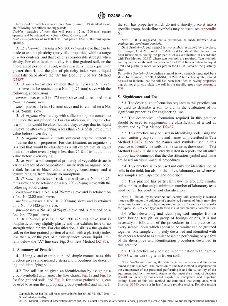
4.2 The soil can be given an identification by assigning agroup symbol(s) and name. The flow charts, Fig. 1a and Fig. 1bfor fine-grained soils, and Fig. 2, for coarse-grained soils, canbe used to assign the appropriate group symbol(s) and name. If
the soil has properties which do not distinctly place it into aspecific group, borderline symbols may be used, see AppendixX3.
NOTE 3—It is suggested that a distinction be made between dualsymbols and borderline symbols.
Dual Symbol—A dual symbol is two symbols separated by a hyphen,for example, GP-GM, SW-SC, CL-ML used to indicate that the soil hasbeen identified as having the properties of a classification in accordancewith Test Method D2487 where two symbols are required. Two symbolsare required when the soil has between 5 and 12 % fines or when the liquidlimit and plasticity index values plot in the CL-ML area of the plasticitychart.Borderline Symbol—A borderline symbol is two symbols separated by aslash, for example, CL/CH, GM/SM, CL/ML. A borderline symbol shouldbe used to indicate that the soil has been identified as having propertiesthat do not distinctly place the soil into a specific group (see AppendixX3).
5. Significance and Use
5.1 The descriptive information required in this practice canbe used to describe a soil to aid in the evaluation of itssignificant properties for engineering use.
5.2 The descriptive information required in this practiceshould be used to supplement the classification of a soil asdetermined by Test Method D2487.
5.3 This practice may be used in identifying soils using theclassification group symbols and names as prescribed in TestMethod D2487. Since the names and symbols used in thispractice to identify the soils are the same as those used in TestMethod D2487, it shall be clearly stated in reports and all otherappropriate documents, that the classification symbol and nameare based on visual-manual procedures.
5.4 This practice is to be used not only for identification ofsoils in the field, but also in the office, laboratory, or whereversoil samples are inspected and described.
5.5 This practice has particular value in grouping similarsoil samples so that only a minimum number of laboratory testsneed be run for positive soil classification.
NOTE 4—The ability to describe and identify soils correctly is learnedmore readily under the guidance of experienced personnel, but it may alsobe acquired systematically by comparing numerical laboratory test resultsfor typical soils of each type with their visual and manual characteristics.
5.6 When describing and identifying soil samples from agiven boring, test pit, or group of borings or pits, it is notnecessary to follow all of the procedures in this practice forevery sample. Soils which appear to be similar can be groupedtogether; one sample completely described and identified withthe others referred to as similar based on performing only a fewof the descriptive and identification procedures described inthis practice.
5.7 This practice may be used in combination with PracticeD4083 when working with frozen soils.
NOTE 5—Notwithstanding the statements on precision and bias con-tained in this standard: The precision of this test method is dependent onthe competence of the personnel performing it and the suitability of theequipment and facilities used. Agencies that meet the criteria of PracticeD3740 are generally considered capable of competent and objectivetesting. Users of this test method are cautioned that compliance withPractice D3740 does not in itself assure reliable testing. Reliable testing
D2488 − 09a
2
Copyright by ASTM Int'l (all rights reserved); Fri Sep 30 13:07:21 EDT 2016Downloaded/printed byUSDA - Natural Resources Conservation Service (USDA - Natural Resources Conservation Service) pursuant to License Agreement. No further reproductions authorized.
depends on several factors; Practice D3740 provides a means forevaluating some of those factors.
6. Apparatus
6.1 Required Apparatus:6.1.1 Pocket Knife or Small Spatula.
6.2 Useful Auxiliary Apparatus:6.2.1 Test Tube and Stopper (or jar with a lid).6.2.2 Hand Lens.
7. Reagents
7.1 Purity of Water—Unless otherwise indicated, referencesto water shall be understood to mean water from a city watersupply or natural source, including non-potable water.
7.2 Hydrochloric Acid—A small bottle of dilute hydrochlo-ric acid, HCl, one part HCl (10 N) to three parts water (Thisreagent is optional for use with this practice). See Section 8.
NOTE 1—Percentages are based on estimating amounts of fines, sand, and gravel to the nearest 5 %.FIG. 1a Flow Chart for Identifying Inorganic Fine-Grained Soil (50 % or more fines)
NOTE 1—Percentages are based on estimating amounts of fines, sand, and gravel to the nearest 5 %.
FIG. 1 b Flow Chart for Identifying Organic Fine-Grained Soil (50 % or more fines)
D2488 − 09a
3
Copyright by ASTM Int'l (all rights reserved); Fri Sep 30 13:07:21 EDT 2016Downloaded/printed byUSDA - Natural Resources Conservation Service (USDA - Natural Resources Conservation Service) pursuant to License Agreement. No further reproductions authorized.
8. Safety Precautions
8.1 When preparing the dilute HCl solution of one partconcentrated hydrochloric acid (10 N) to three parts of distilledwater, slowly add acid into water following necessary safetyprecautions. Handle with caution and store safely. If solutioncomes into contact with the skin, rinse thoroughly with water.
8.2 Caution—Do not add water to acid.
9. Sampling
9.1 The sample shall be considered to be representative ofthe stratum from which it was obtained by an appropriate,accepted, or standard procedure.
NOTE 6—Preferably, the sampling procedure should be identified ashaving been conducted in accordance with Practices D1452, D1587, orD2113, or Test Method D1586.
9.2 The sample shall be carefully identified as to origin.
NOTE 7—Remarks as to the origin may take the form of a boringnumber and sample number in conjunction with a job number, a geologicstratum, a pedologic horizon or a location description with respect to apermanent monument, a grid system or a station number and offset withrespect to a stated centerline and a depth or elevation.
9.3 For accurate description and identification, the mini-mum amount of the specimen to be examined shall be inaccordance with the following schedule:
Maximum Particle Size,Sieve Opening
Minimum Specimen Size,Dry Weight
4.75 mm (No. 4) 100 g (0.25 lb)9.5 mm (3⁄8 in.) 200 g (0.5 lb)19.0 mm (3⁄4 in.) 1.0 kg (2.2 lb)38.1 mm (11⁄2 in.) 8.0 kg (18 lb)75.0 mm (3 in.) 60.0 kg (132 lb)
NOTE 8—If random isolated particles are encountered that are signifi-cantly larger than the particles in the soil matrix, the soil matrix can beaccurately described and identified in accordance with the preceedingschedule.
9.4 If the field sample or specimen being examined issmaller than the minimum recommended amount, the reportshall include an appropriate remark.
10. Descriptive Information for Soils
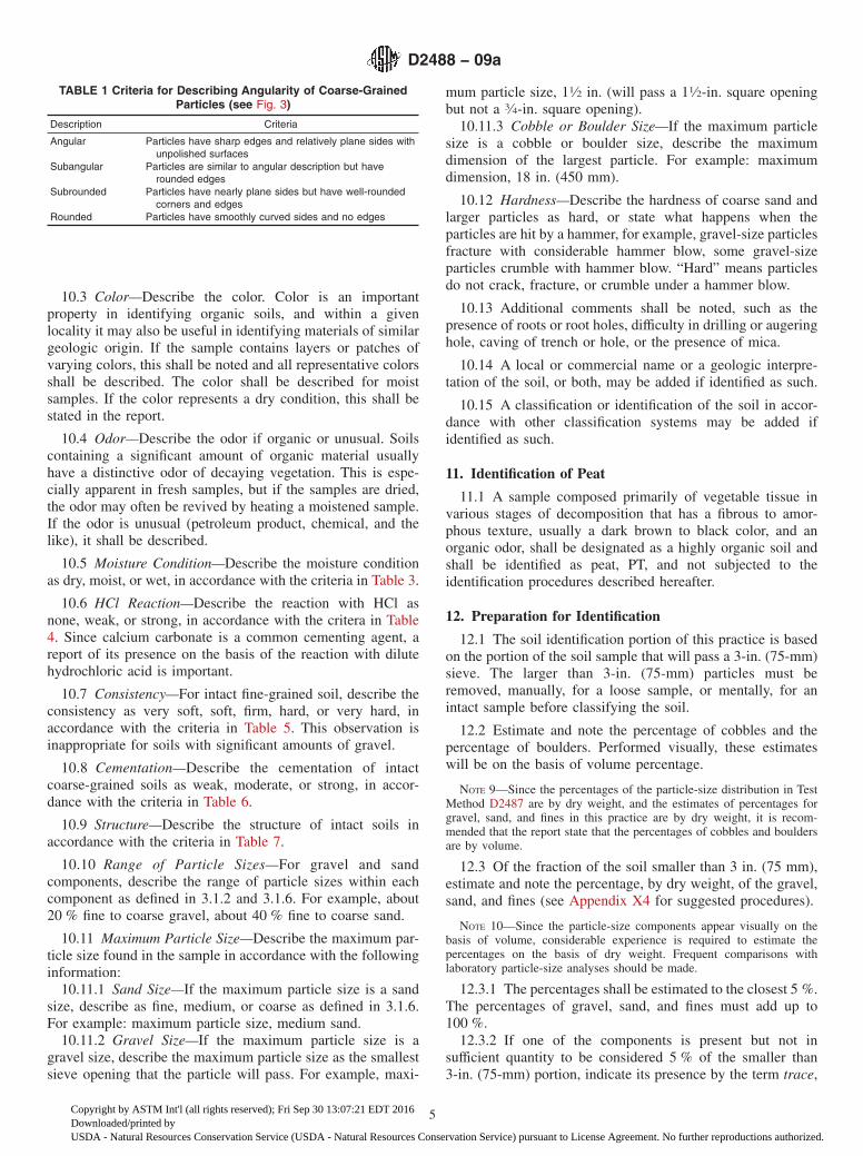
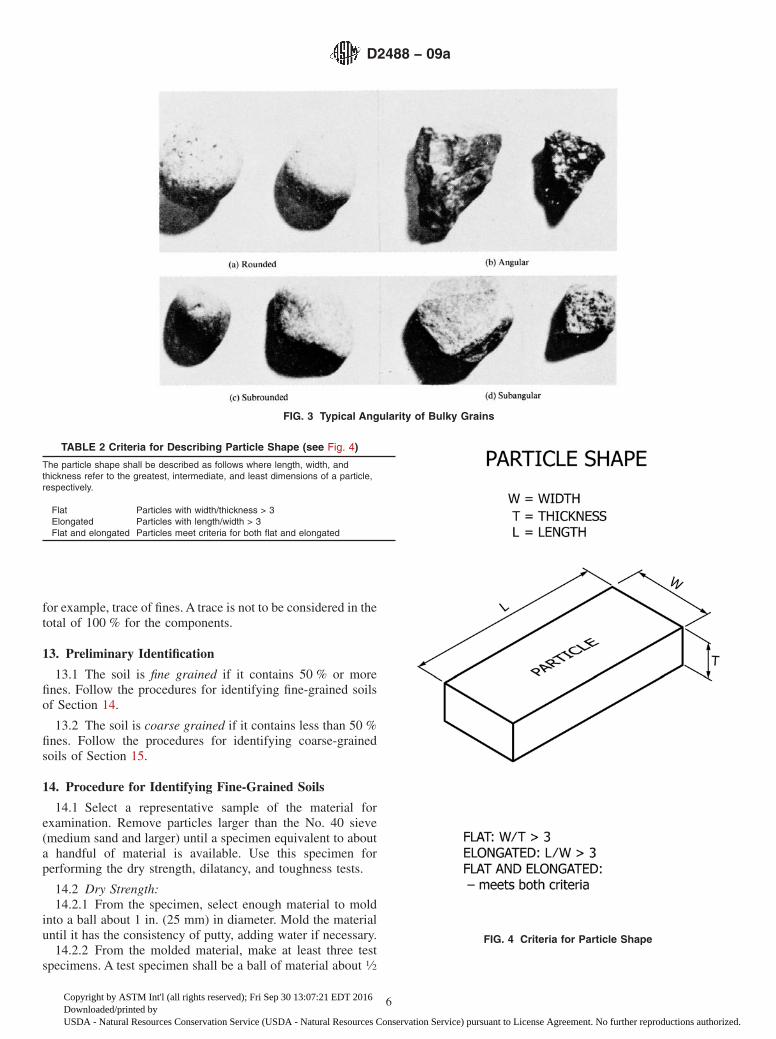
10.1 Angularity—Describe the angularity of the sand(coarse sizes only), gravel, cobbles, and boulders, as angular,subangular, subrounded, or rounded in accordance with thecriteria in Table 1 and Fig. 3. A range of angularity may bestated, such as: subrounded to rounded.
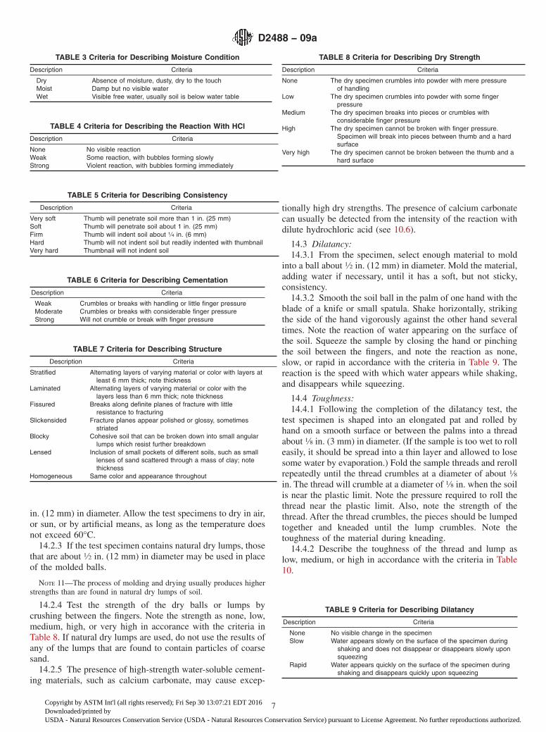
10.2 Shape—Describe the shape of the gravel, cobbles, andboulders as flat, elongated, or flat and elongated if they meetthe criteria in Table 2 and Fig. 4. Otherwise, do not mention theshape. Indicate the fraction of the particles that have the shape,such as: one-third of the gravel particles are flat.
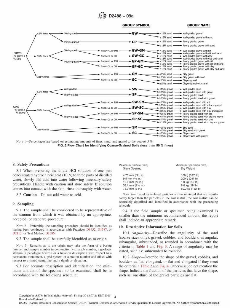
NOTE 1—Percentages are based on estimating amounts of fines, sand, and gravel to the nearest 5 %.FIG. 2 Flow Chart for Identifying Coarse-Grained Soils (less than 50 % fines)
D2488 − 09a
4
Copyright by ASTM Int'l (all rights reserved); Fri Sep 30 13:07:21 EDT 2016Downloaded/printed byUSDA - Natural Resources Conservation Service (USDA - Natural Resources Conservation Service) pursuant to License Agreement. No further reproductions authorized.
10.3 Color—Describe the color. Color is an importantproperty in identifying organic soils, and within a givenlocality it may also be useful in identifying materials of similargeologic origin. If the sample contains layers or patches ofvarying colors, this shall be noted and all representative colorsshall be described. The color shall be described for moistsamples. If the color represents a dry condition, this shall bestated in the report.
10.4 Odor—Describe the odor if organic or unusual. Soilscontaining a significant amount of organic material usuallyhave a distinctive odor of decaying vegetation. This is espe-cially apparent in fresh samples, but if the samples are dried,the odor may often be revived by heating a moistened sample.If the odor is unusual (petroleum product, chemical, and thelike), it shall be described.
10.5 Moisture Condition—Describe the moisture conditionas dry, moist, or wet, in accordance with the criteria in Table 3.
10.6 HCl Reaction—Describe the reaction with HCl asnone, weak, or strong, in accordance with the critera in Table4. Since calcium carbonate is a common cementing agent, areport of its presence on the basis of the reaction with dilutehydrochloric acid is important.
10.7 Consistency—For intact fine-grained soil, describe theconsistency as very soft, soft, firm, hard, or very hard, inaccordance with the criteria in Table 5. This observation isinappropriate for soils with significant amounts of gravel.
10.8 Cementation—Describe the cementation of intactcoarse-grained soils as weak, moderate, or strong, in accor-dance with the criteria in Table 6.
10.9 Structure—Describe the structure of intact soils inaccordance with the criteria in Table 7.
10.10 Range of Particle Sizes—For gravel and sandcomponents, describe the range of particle sizes within eachcomponent as defined in 3.1.2 and 3.1.6. For example, about20 % fine to coarse gravel, about 40 % fine to coarse sand.
10.11 Maximum Particle Size—Describe the maximum par-ticle size found in the sample in accordance with the followinginformation:
10.11.1 Sand Size—If the maximum particle size is a sandsize, describe as fine, medium, or coarse as defined in 3.1.6.For example: maximum particle size, medium sand.
10.11.2 Gravel Size—If the maximum particle size is agravel size, describe the maximum particle size as the smallestsieve opening that the particle will pass. For example, maxi-
mum particle size, 11⁄2 in. (will pass a 11⁄2-in. square openingbut not a 3⁄4-in. square opening).
10.11.3 Cobble or Boulder Size—If the maximum particlesize is a cobble or boulder size, describe the maximumdimension of the largest particle. For example: maximumdimension, 18 in. (450 mm).
10.12 Hardness—Describe the hardness of coarse sand andlarger particles as hard, or state what happens when theparticles are hit by a hammer, for example, gravel-size particlesfracture with considerable hammer blow, some gravel-sizeparticles crumble with hammer blow. “Hard” means particlesdo not crack, fracture, or crumble under a hammer blow.
10.13 Additional comments shall be noted, such as thepresence of roots or root holes, difficulty in drilling or augeringhole, caving of trench or hole, or the presence of mica.
10.14 A local or commercial name or a geologic interpre-tation of the soil, or both, may be added if identified as such.
10.15 A classification or identification of the soil in accor-dance with other classification systems may be added ifidentified as such.
11. Identification of Peat
11.1 A sample composed primarily of vegetable tissue invarious stages of decomposition that has a fibrous to amor-phous texture, usually a dark brown to black color, and anorganic odor, shall be designated as a highly organic soil andshall be identified as peat, PT, and not subjected to theidentification procedures described hereafter.
12. Preparation for Identification
12.1 The soil identification portion of this practice is basedon the portion of the soil sample that will pass a 3-in. (75-mm)sieve. The larger than 3-in. (75-mm) particles must beremoved, manually, for a loose sample, or mentally, for anintact sample before classifying the soil.
12.2 Estimate and note the percentage of cobbles and thepercentage of boulders. Performed visually, these estimateswill be on the basis of volume percentage.
NOTE 9—Since the percentages of the particle-size distribution in TestMethod D2487 are by dry weight, and the estimates of percentages forgravel, sand, and fines in this practice are by dry weight, it is recom-mended that the report state that the percentages of cobbles and bouldersare by volume.
12.3 Of the fraction of the soil smaller than 3 in. (75 mm),estimate and note the percentage, by dry weight, of the gravel,sand, and fines (see Appendix X4 for suggested procedures).
NOTE 10—Since the particle-size components appear visually on thebasis of volume, considerable experience is required to estimate thepercentages on the basis of dry weight. Frequent comparisons withlaboratory particle-size analyses should be made.
12.3.1 The percentages shall be estimated to the closest 5 %.The percentages of gravel, sand, and fines must add up to100 %.
12.3.2 If one of the components is present but not insufficient quantity to be considered 5 % of the smaller than3-in. (75-mm) portion, indicate its presence by the term trace,
TABLE 1 Criteria for Describing Angularity of Coarse-GrainedParticles (see Fig. 3)
Description Criteria
Angular Particles have sharp edges and relatively plane sides withunpolished surfaces
Subangular Particles are similar to angular description but haverounded edges
Subrounded Particles have nearly plane sides but have well-roundedcorners and edges
Rounded Particles have smoothly curved sides and no edges
D2488 − 09a
5
Copyright by ASTM Int'l (all rights reserved); Fri Sep 30 13:07:21 EDT 2016Downloaded/printed byUSDA - Natural Resources Conservation Service (USDA - Natural Resources Conservation Service) pursuant to License Agreement. No further reproductions authorized.
for example, trace of fines. A trace is not to be considered in thetotal of 100 % for the components.
13. Preliminary Identification
13.1 The soil is fine grained if it contains 50 % or morefines. Follow the procedures for identifying fine-grained soilsof Section 14.
13.2 The soil is coarse grained if it contains less than 50 %fines. Follow the procedures for identifying coarse-grainedsoils of Section 15.
14. Procedure for Identifying Fine-Grained Soils
14.1 Select a representative sample of the material forexamination. Remove particles larger than the No. 40 sieve(medium sand and larger) until a specimen equivalent to abouta handful of material is available. Use this specimen forperforming the dry strength, dilatancy, and toughness tests.
14.2 Dry Strength:14.2.1 From the specimen, select enough material to mold
into a ball about 1 in. (25 mm) in diameter. Mold the materialuntil it has the consistency of putty, adding water if necessary.
14.2.2 From the molded material, make at least three testspecimens. A test specimen shall be a ball of material about 1⁄2
FIG. 3 Typical Angularity of Bulky Grains
TABLE 2 Criteria for Describing Particle Shape (see Fig. 4)
The particle shape shall be described as follows where length, width, andthickness refer to the greatest, intermediate, and least dimensions of a particle,respectively.
Flat Particles with width/thickness > 3Elongated Particles with length/width > 3Flat and elongated Particles meet criteria for both flat and elongated
FIG. 4 Criteria for Particle Shape
D2488 − 09a
6
Copyright by ASTM Int'l (all rights reserved); Fri Sep 30 13:07:21 EDT 2016Downloaded/printed byUSDA - Natural Resources Conservation Service (USDA - Natural Resources Conservation Service) pursuant to License Agreement. No further reproductions authorized.
in. (12 mm) in diameter. Allow the test specimens to dry in air,or sun, or by artificial means, as long as the temperature doesnot exceed 60°C.
14.2.3 If the test specimen contains natural dry lumps, thosethat are about 1⁄2 in. (12 mm) in diameter may be used in placeof the molded balls.
NOTE 11—The process of molding and drying usually produces higherstrengths than are found in natural dry lumps of soil.
14.2.4 Test the strength of the dry balls or lumps bycrushing between the fingers. Note the strength as none, low,medium, high, or very high in accorance with the criteria inTable 8. If natural dry lumps are used, do not use the results ofany of the lumps that are found to contain particles of coarsesand.
14.2.5 The presence of high-strength water-soluble cement-ing materials, such as calcium carbonate, may cause excep-
tionally high dry strengths. The presence of calcium carbonatecan usually be detected from the intensity of the reaction withdilute hydrochloric acid (see 10.6).
14.3 Dilatancy:14.3.1 From the specimen, select enough material to mold
into a ball about 1⁄2 in. (12 mm) in diameter. Mold the material,adding water if necessary, until it has a soft, but not sticky,consistency.
14.3.2 Smooth the soil ball in the palm of one hand with theblade of a knife or small spatula. Shake horizontally, strikingthe side of the hand vigorously against the other hand severaltimes. Note the reaction of water appearing on the surface ofthe soil. Squeeze the sample by closing the hand or pinchingthe soil between the fingers, and note the reaction as none,slow, or rapid in accordance with the criteria in Table 9. Thereaction is the speed with which water appears while shaking,and disappears while squeezing.
14.4 Toughness:14.4.1 Following the completion of the dilatancy test, the
test specimen is shaped into an elongated pat and rolled byhand on a smooth surface or between the palms into a threadabout 1⁄8 in. (3 mm) in diameter. (If the sample is too wet to rolleasily, it should be spread into a thin layer and allowed to losesome water by evaporation.) Fold the sample threads and rerollrepeatedly until the thread crumbles at a diameter of about 1⁄8in. The thread will crumble at a diameter of 1⁄8 in. when the soilis near the plastic limit. Note the pressure required to roll thethread near the plastic limit. Also, note the strength of thethread. After the thread crumbles, the pieces should be lumpedtogether and kneaded until the lump crumbles. Note thetoughness of the material during kneading.
14.4.2 Describe the toughness of the thread and lump aslow, medium, or high in accordance with the criteria in Table10.
TABLE 3 Criteria for Describing Moisture Condition
Description Criteria
Dry Absence of moisture, dusty, dry to the touchMoist Damp but no visible waterWet Visible free water, usually soil is below water table
TABLE 4 Criteria for Describing the Reaction With HCl
Description Criteria
None No visible reactionWeak Some reaction, with bubbles forming slowlyStrong Violent reaction, with bubbles forming immediately
TABLE 5 Criteria for Describing Consistency
Description Criteria
Very soft Thumb will penetrate soil more than 1 in. (25 mm)Soft Thumb will penetrate soil about 1 in. (25 mm)Firm Thumb will indent soil about 1⁄4 in. (6 mm)Hard Thumb will not indent soil but readily indented with thumbnailVery hard Thumbnail will not indent soil
TABLE 6 Criteria for Describing Cementation
Description Criteria
Weak Crumbles or breaks with handling or little finger pressureModerate Crumbles or breaks with considerable finger pressureStrong Will not crumble or break with finger pressure
TABLE 7 Criteria for Describing Structure
Description Criteria
Stratified Alternating layers of varying material or color with layers atleast 6 mm thick; note thickness
Laminated Alternating layers of varying material or color with thelayers less than 6 mm thick; note thickness
Fissured Breaks along definite planes of fracture with littleresistance to fracturing
Slickensided Fracture planes appear polished or glossy, sometimesstriated
Blocky Cohesive soil that can be broken down into small angularlumps which resist further breakdown
Lensed Inclusion of small pockets of different soils, such as smalllenses of sand scattered through a mass of clay; notethickness
Homogeneous Same color and appearance throughout
TABLE 8 Criteria for Describing Dry Strength
Description Criteria
None The dry specimen crumbles into powder with mere pressureof handling
Low The dry specimen crumbles into powder with some fingerpressure
Medium The dry specimen breaks into pieces or crumbles withconsiderable finger pressure
High The dry specimen cannot be broken with finger pressure.Specimen will break into pieces between thumb and a hardsurface
Very high The dry specimen cannot be broken between the thumb and ahard surface
TABLE 9 Criteria for Describing Dilatancy
Description Criteria
None No visible change in the specimenSlow Water appears slowly on the surface of the specimen during
shaking and does not disappear or disappears slowly uponsqueezing
Rapid Water appears quickly on the surface of the specimen duringshaking and disappears quickly upon squeezing
D2488 − 09a
7
Copyright by ASTM Int'l (all rights reserved); Fri Sep 30 13:07:21 EDT 2016Downloaded/printed byUSDA - Natural Resources Conservation Service (USDA - Natural Resources Conservation Service) pursuant to License Agreement. No further reproductions authorized.

14.5 Plasticity—On the basis of observations made duringthe toughness test, describe the plasticity of the material inaccordance with the criteria given in Table 11.
14.6 Decide whether the soil is an inorganic or an organicfine-grained soil (see 14.8). If inorganic, follow the steps givenin 14.7.
14.7 Identification of Inorganic Fine-Grained Soils:14.7.1 Identify the soil as a lean clay, CL, if the soil has
medium to high dry strength, no or slow dilatancy, and mediumtoughness and plasticity (see Table 12).
14.7.2 Identify the soil as a fat clay, CH, if the soil has highto very high dry strength, no dilatancy, and high toughness andplasticity (see Table 12).
14.7.3 Identify the soil as a silt, ML, if the soil has no to lowdry strength, slow to rapid dilatancy, and low toughness andplasticity, or is nonplastic (see Table 12).
14.7.4 Identify the soil as an elastic silt, MH, if the soil haslow to medium dry strength, no to slow dilatancy, and low tomedium toughness and plasticity (see Table 12).
NOTE 12—These properties are similar to those for a lean clay.However, the silt will dry quickly on the hand and have a smooth, silkyfeel when dry. Some soils that would classify as MH in accordance withthe criteria in Test Method D2487 are visually difficult to distinguish fromlean clays, CL. It may be necessary to perform laboratory testing forproper identification.
14.8 Identification of Organic Fine-Grained Soils:14.8.1 Identify the soil as an organic soil, OL/OH, if the soil
contains enough organic particles to influence the soil proper-ties. Organic soils usually have a dark brown to black color andmay have an organic odor. Often, organic soils will changecolor, for example, black to brown, when exposed to the air.Some organic soils will lighten in color significantly when airdried. Organic soils normally will not have a high toughness orplasticity. The thread for the toughness test will be spongy.
NOTE 13—In some cases, through practice and experience, it may bepossible to further identify the organic soils as organic silts or organic
clays, OL or OH. Correlations between the dilatancy, dry strength,toughness tests, and laboratory tests can be made to identify organic soilsin certain deposits of similar materials of known geologic origin.
14.9 If the soil is estimated to have 15 to 25 % sand orgravel, or both, the words “with sand” or “with gravel”(whichever is more predominant) shall be added to the groupname. For example: “lean clay with sand, CL” or “silt withgravel, ML” (see Fig. 1a and Fig. 1b). If the percentage of sandis equal to the percentage of gravel, use “with sand.”
14.10 If the soil is estimated to have 30 % or more sand orgravel, or both, the words “sandy” or “gravelly” shall be addedto the group name. Add the word “sandy” if there appears to bemore sand than gravel. Add the word “gravelly” if thereappears to be more gravel than sand. For example: “sandy leanclay, CL”, “gravelly fat clay, CH”, or “sandy silt, ML” (see Fig.1a and Fig. 1b). If the percentage of sand is equal to the percentof gravel, use “sandy.”
15. Procedure for Identifying Coarse-Grained Soils(Contains less than 50 % fines)
15.1 The soil is a gravel if the percentage of gravel isestimated to be more than the percentage of sand.
15.2 The soil is a sand if the percentage of gravel isestimated to be equal to or less than the percentage of sand.
15.3 The soil is a clean gravel or clean sand if thepercentage of fines is estimated to be 5 % or less.
15.3.1 Identify the soil as a well-graded gravel, GW, or as awell-graded sand, SW, if it has a wide range of particle sizesand substantial amounts of the intermediate particle sizes.
15.3.2 Identify the soil as a poorly graded gravel, GP, or asa poorly graded sand, SP, if it consists predominantly of onesize (uniformly graded), or it has a wide range of sizes withsome intermediate sizes obviously missing (gap or skipgraded).
15.4 The soil is either a gravel with fines or a sand with finesif the percentage of fines is estimated to be 15 % or more.
15.4.1 Identify the soil as a clayey gravel, GC, or a clayeysand, SC, if the fines are clayey as determined by theprocedures in Section 14.
15.4.2 Identify the soil as a silty gravel, GM, or a silty sand,SM, if the fines are silty as determined by the procedures inSection 14.
15.5 If the soil is estimated to contain 10 % fines, give thesoil a dual identification using two group symbols.
15.5.1 The first group symbol shall correspond to a cleangravel or sand (GW, GP, SW, SP) and the second symbol shallcorrespond to a gravel or sand with fines (GC, GM, SC, SM).
TABLE 10 Criteria for Describing Toughness
Description Criteria
Low Only slight pressure is required to roll the thread near theplastic limit. The thread and the lump are weak and soft
Medium Medium pressure is required to roll the thread to near theplastic limit. The thread and the lump have medium stiffness
High Considerable pressure is required to roll the thread to near theplastic limit. The thread and the lump have very highstiffness
TABLE 11 Criteria for Describing Plasticity
Description Criteria
Nonplastic A 1⁄8-in. (3-mm) thread cannot be rolled at any water contentLow The thread can barely be rolled and the lump cannot be
formed when drier than the plastic limitMedium The thread is easy to roll and not much time is required to
reach the plastic limit. The thread cannot be rerolled afterreaching the plastic limit. The lump crumbles when drierthan the plastic limit
High It takes considerable time rolling and kneading to reach theplastic limit. The thread can be rerolled several times afterreaching the plastic limit. The lump can be formed withoutcrumbling when drier than the plastic limit
TABLE 12 Identification of Inorganic Fine-Grained Soils fromManual Tests
SoilSymbol
Dry Strength DilatancyToughness
and Plasticity
ML None to low Slow to rapid Low or threadcannot be formed
CL Medium to high None to slow MediumMH Low to medium None to slow Low to mediumCH High to very high None High
D2488 − 09a
8
Copyright by ASTM Int'l (all rights reserved); Fri Sep 30 13:07:21 EDT 2016Downloaded/printed byUSDA - Natural Resources Conservation Service (USDA - Natural Resources Conservation Service) pursuant to License Agreement. No further reproductions authorized.
15.5.2 The group name shall correspond to the first groupsymbol plus the words “with clay” or “with silt” to indicate theplasticity characteristics of the fines. For example: “well-graded gravel with clay, GW-GC” or “poorly graded sand withsilt, SP-SM” (see Fig. 2).
15.6 If the specimen is predominantly sand or gravel butcontains an estimated 15 % or more of the other coarse-grainedconstituent, the words “with gravel” or “with sand” shall beadded to the group name. For example: “poorly graded gravelwith sand, GP” or “clayey sand with gravel, SC” (see Fig. 2).
15.7 If the field sample contains any cobbles or boulders, orboth, the words “with cobbles” or “with cobbles and boulders”shall be added to the group name. For example: “silty gravelwith cobbles, GM.”
16. Report
16.1 The report shall include the information as to origin,and the items indicated in Table 13.
NOTE 14—Example: Clayey Gravel with Sand and Cobbles, GC—About 50 % fine to coarse, subrounded to subangular gravel; about 30 %fine to coarse, subrounded sand; about 20 % fines with medium plasticity,high dry strength, no dilatancy, medium toughness; weak reaction withHCl; original field sample had about 5 % (by volume) subroundedcobbles, maximum dimension, 150 mm.
In-Place Conditions—Firm, homogeneous, dry, brownGeologic Interpretation—Alluvial fanNOTE 15—Other examples of soil descriptions and identification are
given in Appendix X1 and Appendix X2.NOTE 16—If desired, the percentages of gravel, sand, and fines may be
stated in terms indicating a range of percentages, as follows:Trace—Particles are present but estimated to be less than 5 %Few—5 to 10 %Little—15 to 25 %Some—30 to 45 %Mostly—50 to 100 %
16.2 If, in the soil description, the soil is identified using aclassification group symbol and name as described in Test
Method D2487, it must be distinctly and clearly stated in logforms, summary tables, reports, and the like, that the symboland name are based on visual-manual procedures.
17. Precision and Bias
17.1 This practice provides qualitative information only,therefore, a precision and bias statement is not applicable.
18. Keywords
18.1 classification; clay; gravel; organic soils; sand; silt; soilclassification; soil description; visual classification
APPENDIXES
(Nonmandatory Information)
X1. EXAMPLES OF VISUAL SOIL DESCRIPTIONS
X1.1 The following examples show how the informationrequired in 16.1 can be reported. The information that isincluded in descriptions should be based on individual circum-stances and need.
X1.1.1 Well-Graded Gravel with Sand (GW)—About 75 %fine to coarse, hard, subangular gravel; about 25 % fine tocoarse, hard, subangular sand; trace of fines; maximum size, 75mm, brown, dry; no reaction with HCl.
X1.1.2 Silty Sand with Gravel (SM)—About 60 % predomi-nantly fine sand; about 25 % silty fines with low plasticity, lowdry strength, rapid dilatancy, and low toughness; about 15 %fine, hard, subrounded gravel, a few gravel-size particles
fractured with hammer blow; maximum size, 25 mm; noreaction with HCl (Note—Field sample size smaller thanrecommended).
In-Place Conditions—Firm, stratified and contains lenses ofsilt 1 to 2 in. (25 to 50 mm) thick, moist, brown to gray;in-place density 106 lb/ft3; in-place moisture 9 %.
X1.1.3 Organic Soil (OL/OH)—About 100 % fines with lowplasticity, slow dilatancy, low dry strength, and low toughness;wet, dark brown, organic odor; weak reaction with HCl.
X1.1.4 Silty Sand with Organic Fines (SM)—About 75 %fine to coarse, hard, subangular reddish sand; about 25 %organic and silty dark brown nonplastic fines with no dry
TABLE 13 Checklist for Description of Soils
1. Group name2. Group symbol3. Percent of cobbles or boulders, or both (by volume)4. Percent of gravel, sand, or fines, or all three (by dry weight)5. Particle-size range:
Gravel—fine, coarseSand—fine, medium, coarse
6. Particle angularity: angular, subangular, subrounded, rounded7. Particle shape: (if appropriate) flat, elongated, flat and elongated8. Maximum particle size or dimension9. Hardness of coarse sand and larger particles
10. Plasticity of fines: nonplastic, low, medium, high11. Dry strength: none, low, medium, high, very high12. Dilatancy: none, slow, rapid13. Toughness: low, medium, high14. Color (in moist condition)15. Odor (mention only if organic or unusual)16. Moisture: dry, moist, wet17. Reaction with HCl: none, weak, strongFor intact samples:18. Consistency (fine-grained soils only): very soft, soft, firm, hard, very hard19. Structure: stratified, laminated, fissured, slickensided, lensed, homo-
geneous20. Cementation: weak, moderate, strong21. Local name22. Geologic interpretation23. Additional comments: presence of roots or root holes, presence of mica,
gypsum, etc., surface coatings on coarse-grained particles, caving orsloughing of auger hole or trench sides, difficulty in augering or excavating,etc.
D2488 − 09a
9
Copyright by ASTM Int'l (all rights reserved); Fri Sep 30 13:07:21 EDT 2016Downloaded/printed byUSDA - Natural Resources Conservation Service (USDA - Natural Resources Conservation Service) pursuant to License Agreement. No further reproductions authorized.
strength and slow dilatancy; wet; maximum size, coarse sand;weak reaction with HCl.
X1.1.5 Poorly Graded Gravel with Silt, Sand, Cobbles andBoulders (GP-GM)—About 75 % fine to coarse, hard, sub-rounded to subangular gravel; about 15 % fine, hard, sub-
rounded to subangular sand; about 10 % silty nonplastic fines;moist, brown; no reaction with HCl; original field sample hadabout 5 % (by volume) hard, subrounded cobbles and a trace ofhard, subrounded boulders, with a maximum dimension of 18in. (450 mm).
X2. USING THE IDENTIFICATION PROCEDURE AS A DESCRIPTIVE SYSTEM FOR SHALE, CLAYSTONE,SHELLS, SLAG, CRUSHED ROCK, AND THE LIKE
X2.1 The identification procedure may be used as a descrip-tive system applied to materials that exist in-situ as shale,claystone, sandstone, siltstone, mudstone, etc., but convert tosoils after field or laboratory processing (crushing, slaking, andthe like).
X2.2 Materials such as shells, crushed rock, slag, and thelike, should be identified as such. However, the proceduresused in this practice for describing the particle size andplasticity characteristics may be used in the description of thematerial. If desired, an identification using a group name andsymbol according to this practice may be assigned to aid indescribing the material.
X2.3 The group symbol(s) and group names should beplaced in quotation marks or noted with some type of distin-guishing symbol. See examples.
X2.4 Examples of how group names and symbols can beincororated into a descriptive system for materials that are notnaturally occurring soils are as follows:
X2.4.1 Shale Chunks—Retrieved as 2 to 4-in. (50 to 100-mm) pieces of shale from power auger hole, dry, brown, noreaction with HCl. After slaking in water for 24 h, materialidentified as “Sandy Lean Clay (CL)”; about 60 % fines withmedium plasticity, high dry strength, no dilatancy, and mediumtoughness; about 35 % fine to medium, hard sand; about 5 %gravel-size pieces of shale.
X2.4.2 Crushed Sandstone—Product of commercial crush-ing operation; “Poorly Graded Sand with Silt (SP-SM)”; about90 % fine to medium sand; about 10 % nonplastic fines; dry,reddish-brown.
X2.4.3 Broken Shells—About 60 % uniformly gradedgravel-size broken shells; about 30 % sand and sand-size shellpieces; about 10 % nonplastic fines; “Poorly Graded Gravelwith Silt and Sand (GP-GM).”
X2.4.4 Crushed Rock—Processed from gravel and cobblesin Pit No. 7; “Poorly Graded Gravel (GP)”; about 90 % fine,hard, angular gravel-size particles; about 10 % coarse, hard,angular sand-size particles; dry, tan; no reaction with HCl.
X3. SUGGESTED PROCEDURE FOR USING A BORDERLINE SYMBOL FOR SOILS WITH TWO POSSIBLE IDENTIFICA-TIONS.
X3.1 Since this practice is based on estimates of particlesize distribution and plasticity characteristics, it may be diffi-cult to clearly identify the soil as belonging to one category. Toindicate that the soil may fall into one of two possible basicgroups, a borderline symbol may be used with the two symbolsseparated by a slash. For example: SC/CL or CL/CH.
X3.1.1 A borderline symbol may be used when the percent-age of fines is estimated to be between 45 and 55 %. Onesymbol should be for a coarse-grained soil with fines and theother for a fine-grained soil. For example: GM/ML or CL/SC.
X3.1.2 A borderline symbol may be used when the percent-age of sand and the percentage of gravel are estimated to beabout the same. For example: GP/SP, SC/GC, GM/SM. It ispractically impossible to have a soil that would have aborderline symbol of GW/SW.
X3.1.3 A borderline symbol may be used when the soilcould be either well graded or poorly graded. For example:GW/GP, SW/SP.
X3.1.4 A borderline symbol may be used when the soilcould either be a silt or a clay. For example: CL/ML, CH/MH,SC/SM.
X3.1.5 A borderline symbol may be used when a fine-grained soil has properties that indicate that it is at theboundary between a soil of low compressibility and a soil ofhigh compressibility. For example: CL/CH, MH/ML.
X3.2 The order of the borderline symbols should reflectsimilarity to surrounding or adjacent soils. For example: soilsin a borrow area have been identified as CH. One sample isconsidered to have a borderline symbol of CL and CH. Toshow similarity, the borderline symbol should be CH/CL.
X3.3 The group name for a soil with a borderline symbolshould be the group name for the first symbol, except for:
CL/CH lean to fat clay
ML/CL clayey silt
CL/ML silty clay
X3.4 The use of a borderline symbol should not be usedindiscriminately. Every effort shall be made to first place thesoil into a single group.
D2488 − 09a
10
Copyright by ASTM Int'l (all rights reserved); Fri Sep 30 13:07:21 EDT 2016Downloaded/printed byUSDA - Natural Resources Conservation Service (USDA - Natural Resources Conservation Service) pursuant to License Agreement. No further reproductions authorized.
X4. SUGGESTED PROCEDURES FOR ESTIMATING THE PERCENTAGES OF GRAVEL, SAND,AND FINES IN A SOIL SAMPLE
X4.1 Jar Method—The relative percentage of coarse- andfine-grained material may be estimated by thoroughly shakinga mixture of soil and water in a test tube or jar, and thenallowing the mixture to settle. The coarse particles will fall tothe bottom and successively finer particles will be depositedwith increasing time; the sand sizes will fall out of suspensionin 20 to 30 s. The relative proportions can be estimated fromthe relative volume of each size separate. This method shouldbe correlated to particle-size laboratory determinations.
X4.2 Visual Method—Mentally visualize the gravel sizeparticles placed in a sack (or other container) or sacks. Then,do the same with the sand size particles and the fines. Then,mentally compare the number of sacks to estimate the percent-age of plus No. 4 sieve size and minus No. 4 sieve size present.
The percentages of sand and fines in the minus sieve size No.4 material can then be estimated from the wash test (X4.3).
X4.3 Wash Test (for relative percentages of sand andfines)—Select and moisten enough minus No. 4 sieve sizematerial to form a 1-in (25-mm) cube of soil. Cut the cube inhalf, set one-half to the side, and place the other half in a smalldish. Wash and decant the fines out of the material in the dishuntil the wash water is clear and then compare the two samplesand estimate the percentage of sand and fines. Remember thatthe percentage is based on weight, not volume. However, thevolume comparison will provide a reasonable indication ofgrain size percentages.
X4.3.1 While washing, it may be necessary to break downlumps of fines with the finger to get the correct percentages.
X5. ABBREVIATED SOIL CLASSIFICATION SYMBOLS
X5.1 In some cases, because of lack of space, an abbrevi-ated system may be useful to indicate the soil classificationsymbol and name. Examples of such cases would be graphicallogs, databases, tables, etc.
X5.2 This abbreviated system is not a substitute for the fullname and descriptive information but can be used in supple-mentary presentations when the complete description is refer-enced.
X5.3 The abbreviated system should consist of the soilclassification symbol based on this standard with appropriatelower case letter prefixes and suffixes as:
Prefix: Suffix:
s = sandy s = with sandg = gravelly g = with gravel
c = with cobblesb = with boulders
X5.4 The soil classification symbol is to be enclosed inparenthesis. Some examples would be:
Group Symbol and Full Name Abbreviated
CL, Sandy lean clay s(CL)SP-SM, Poorly graded sand with silt and gravel (SP-SM)gGP, poorly graded gravel with sand, cobbles, andboulders
(GP)scb
ML, gravelly silt with sand and cobbles g(ML)sc
SUMMARY OF CHANGES
Committee D18 has identified the location of selected changes to this standard since the last issue(D2488 – 09) that may impact the use of this standard. (Approved June 15, 2009.)
(1) Revised Section 1.2.3.
D2488 − 09a
11
Copyright by ASTM Int'l (all rights reserved); Fri Sep 30 13:07:21 EDT 2016Downloaded/printed byUSDA - Natural Resources Conservation Service (USDA - Natural Resources Conservation Service) pursuant to License Agreement. No further reproductions authorized.

ASTM International takes no position respecting the validity of any patent rights asserted in connection with any item mentionedin this standard. Users of this standard are expressly advised that determination of the validity of any such patent rights, and the riskof infringement of such rights, are entirely their own responsibility.
This standard is subject to revision at any time by the responsible technical committee and must be reviewed every five years andif not revised, either reapproved or withdrawn. Your comments are invited either for revision of this standard or for additional standardsand should be addressed to ASTM International Headquarters. Your comments will receive careful consideration at a meeting of theresponsible technical committee, which you may attend. If you feel that your comments have not received a fair hearing you shouldmake your views known to the ASTM Committee on Standards, at the address shown below.
This standard is copyrighted by ASTM International, 100 Barr Harbor Drive, PO Box C700, West Conshohocken, PA 19428-2959,United States. Individual reprints (single or multiple copies) of this standard may be obtained by contacting ASTM at the aboveaddress or at 610-832-9585 (phone), 610-832-9555 (fax), or [email protected] (e-mail); or through the ASTM website(www.astm.org). Permission rights to photocopy the standard may also be secured from the Copyright Clearance Center, 222Rosewood Drive, Danvers, MA 01923, Tel: (978) 646-2600; http://www.copyright.com/
D2488 − 09a
12
Copyright by ASTM Int'l (all rights reserved); Fri Sep 30 13:07:21 EDT 2016Downloaded/printed byUSDA - Natural Resources Conservation Service (USDA - Natural Resources Conservation Service) pursuant to License Agreement. No further reproductions authorized.