Embed Size (px)
Citation preview

Probabilistic Risk Assessment Studies in Yemen

The catastrophic risk analysis quantifies the risks of hazard, exposure, vulnerability, and loss, thus providing the decision maker with the
necessary information to make optimum decisions on risk reduction.
Tropical storm 3B hit Yemen Oct. 23-25 2008

| 1
Probabilistic risk assessment studies in Yemen
What are the studies about? three probabilistic natural hazard risk assessment studies are being conducted in Yemen:
Flood and landslide risk assessment for sana’a city1. Flood and landslide risk assessment in Hadramout and al mahra governorates2. earthquake, flash flood, flood (coastal storm surge and tsunami), volcano, and landslide risk 3.
assessment for the whole country
Why were the studies initiated? Yemen is prone to various types of disasters caused by earthquakes, flash floods, floods (coastal storm surge and tsunami), landslides/rockslides, and volcanoes. at least one disaster strikes the country every year with estimated annual economic losses averaging us$70 million. in october 2008, tropical storm 03b caused floods, which seriously affected eastern Yemen, the governorates of Hadramout and al mahra. Following these floods, the World bank with support from the Global Facility for disaster reduction and recovery (GFdrr) leveraged resources to conduct detailed probabilistic risk assessment studies.
Post-disaster response in Yemen is still in its infancy, and decision makers presently lack the information necessary to evaluate risk and to support risk mitigation. the goal of the studies is to provide a basis that supports the design of comprehensive risk management strategies at the national, provincial, and local levels, enabling long-term disaster risk reduction planning and mitigation measures. in addition, the data sets and software developed as part of these studies to support response and mitigation planning could be extended by research institutes in Yemen to model future disaster events. the study outcomes could also help to generate risk awareness.
Who are the partners? the key Yemeni technical counterpart in the national Probabilistic risk assessment and the Hadramout and al mahra Governorates study is the Yemen Geological survey and mineral resources board (YGsmrb), ministry of oil and minerals. For the sana’a Flood and landslide risk assessment study, the saylah implementation unit of the municipality of sana’a is the technical counterpart.
2 | Probabilistic Risk Assessment Studies in Yemen
Sana’a STudY1.1
the municipality of sana’a is currently preparing a long-term city development strategy (cds) for sustainable development. the following are key components of the cds:
urban upgrading strategy (addresses the growing amount of urban squatters and informal ■■
settlements);
update of land-use plans;■■
capital investment plan; and ■■
time-bound prioritized action plan.■■
to help support this strategy, the study is conducting flood and landslide risk evaluations.
Methodology identification of flood and landslide hazards in sana’a is the first step in developing a probabilistic risk assessment. For flood risk assessment, a review of historical data analysis was undertaken, and for landslides, a simplified scenario-based analysis was undertaken.
different Tasks and Key Outputs of Sana’a Study
Task Key Output
task 1: Historical Hazard identification and Probabilistic analysis
sana’a Probabilistic Hazard analysis reports, software, and manuals, including the historical hazard review and analysis, probabilistic hazard analysis event characterization, probabilistic hazard modeling software subsystem, and data sets and maps in Geographic information system (Gis) format with metadata files
task 2: inventory of exposure and Vulnerability
sana’a inventory of exposure and Vulnerability report and manuals, including the development and compilation of the inventory of assets, their classification and valuation
task 3: Probabilistic loss modeling and analysis and city-level analysis
sana’a Probabilistic loss modeling and analysis, including the validation of loss exceedance curves (lecs) and eventual adjustment to loss modeling process, risk analysis, applications of catastrophic risk modeling within the context of the sana’a cds and urban master Plan, institutional strengthening for disaster risk management (drm), probabilistic loss modeling software subsystem, and data sets and maps in Gis format with metadata files
task 4: sana’a natural Hazard risk map and risk analysis software development
sana’a integrated storm Water management (isWm), including comprehensive analysis of hydrology and hydraulics, peak flow capacity in the saylah system, feasibility study and capital investment plan for isWms, proposal of Flood early Warning system (FeWs), operation and maintenance of isWmm, printed high-quality and full-color citywide map with components of isWms, and data sets and maps in Gis format with metadata files

Probabilistic risk assessment studies in Yemen | 3
Current statusthe expected completion date of the study is may 2010.
Brief Summarythe catastrophic risk analysis quantifies the risks of hazard, exposure, vulnerability, and loss, thus providing the decision maker with the necessary information to make optimum decisions on risk reduction. risk assessment for sana’a was carried out in an integrated manner, identifying all the possible water-related hazards and including how they are likely to develop in the future as a consequence of urbanization or other development activities is described in a tool for integrated Flood management (2008). For proper urban land-use planning, risk assessment was carried out within a multi-hazard concept. the hydrology and hydraulic analysis was conducted for the sana’a basin to identify the basin and sub-basin characteristics and to determine flow in each sub-basin given a rainfall amount. these analyses provided information about the probability of a hazard’s occurrence and its respective potential for loss. a number of different probabilistic events were modeled to quantify the risk to buildings by their occupancy types: residential, commercial, industrial, and squatters. the results of this model are risk maps that provide information about the expected flood frequencies and magnitudes (extent, depth, duration, and flow velocities).
under task 2 of the study, software called Hazsana’a was designed and developed to perform probabilistic hazard analysis and deterministic scenario analysis based on flood and landslide hazard maps. the Hazsana’a software provides users with data capture utilities to process probabilistic, deterministic, or user-supplied flood and landslide hazard data into the required format.
risk maps are products of risk assessments generated though Hazsana’a software, enabling the users to clearly identify the most endangered areas and neighborhoods (Figures 1, 2, 4, and 5). in addition to the identification of risk areas, the advantage of Hazsana’a comprehensive risk assessments is the ability to compare the components of risk in quantitative terms (Figure 3 and table 1). Hazsana’a is a user-friendly software tool that can rapidly generate many sensitivity analyses to weigh the pros and cons of different approaches to risk reduction, while comparing the cost of corrective action to the reduction in risk.

4 | Probabilistic Risk Assessment Studies in Yemen
Some Results
Figure 1: Flood Hazard map for sana’a

Probabilistic Risk Assessment Studies in Yemen | 5
Figure 2: close-up View of Flood Hazard map depicting 100-year Flood event affecting sana’a buildings
100
90
80
70
60
50
40
30
20
10
0
Flood depth damage curve for sana’a
——— class c building structure
——— class c building contents
0.5 1.0 1.5 2.0 2.5 3.0 3.5 4.0Flood depth (m)
Figure 3: Flood Vulnerability curve for typical class c buildings in sana’a

6 | Probabilistic Risk Assessment Studies in Yemen
Table 1: return Periods and corresponding losses for buildings (in riyals)
Building Losses in Million Riyals
Return Period Occupancy Structure Loss Content Loss Total Loss
10
residential 114.505 95.676 210.18
commercial 26.426 66.056 92.48
industrial 4.123 76.192 80.31
squatters 2.892 5.012 7.9
Total 147.946 242.936 390.88
25
residential 537.086 370.351 907.44
commercial 152.308 350.326 502.63
industrial 14.994 275.483 290.48
squatters 20.732 29.677 50.41
Total 725.119 1,025.84 1,750.96
50
residential 2,255.06 1,571.61 3,826.67
commercial 495.401 1,171.94 1,667.34
industrial 52.463 896.084 948.55
squatters 55.02 81.061 136.08
Total 2,857.94 3,720.70 6,578.64
100
residential 3,677.57 2,423.03 6,100.60
commercial 838.014 1,831.25 2,669.26
industrial 93.957 1,439.09 1,533.05
squatters 106.167 142.197 248.36
Total 4,715.71 5,835.56 10,551.27
Figure 4: example of assessing Flood risk to buildings through Hazsana’a

Probabilistic Risk Assessment Studies in Yemen | 7
Figure 5: Flood risk Zone for 10 and 25 Year return Periods over buildings Footprints
8 | Probabilistic Risk Assessment Studies in Yemen
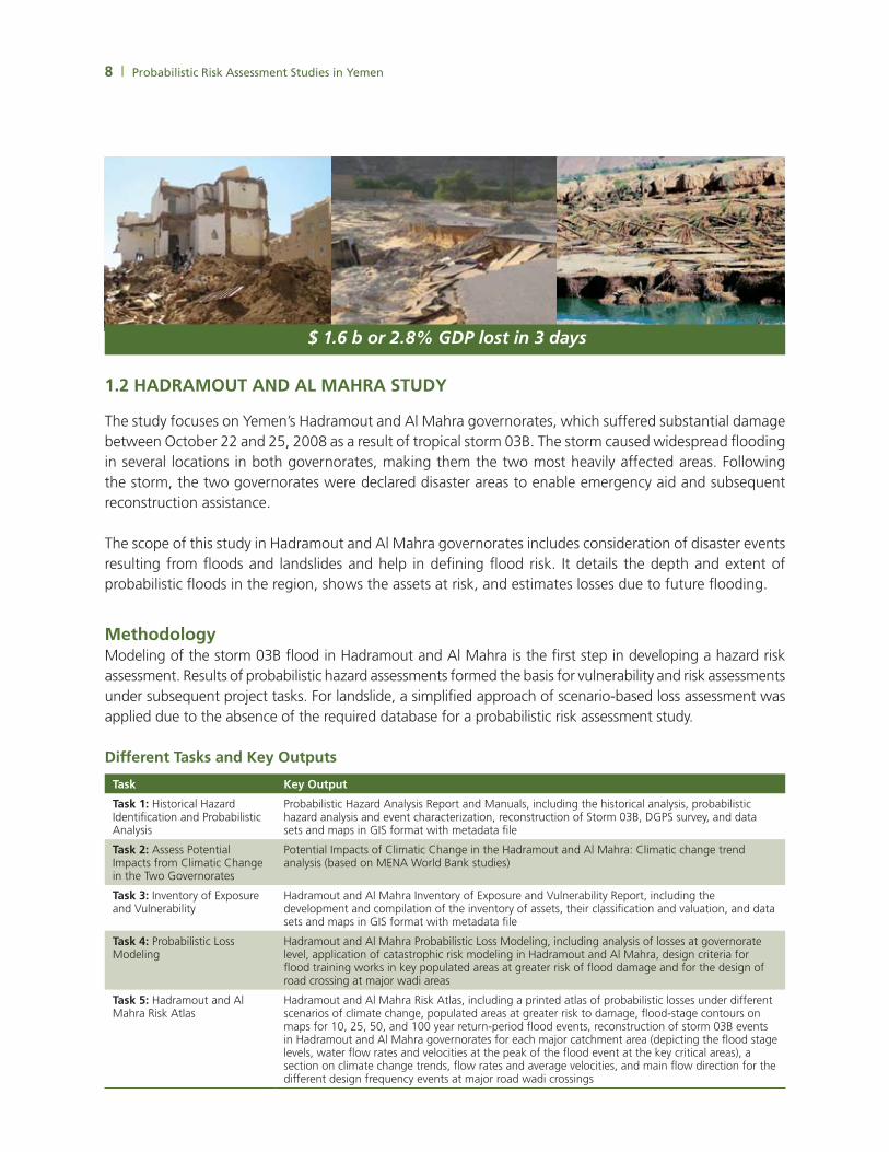
HadRaMOuT and aL MaHRa STudY1.2
the study focuses on Yemen’s Hadramout and al mahra governorates, which suffered substantial damage between october 22 and 25, 2008 as a result of tropical storm 03b. the storm caused widespread flooding in several locations in both governorates, making them the two most heavily affected areas. Following the storm, the two governorates were declared disaster areas to enable emergency aid and subsequent reconstruction assistance.
the scope of this study in Hadramout and al mahra governorates includes consideration of disaster events resulting from floods and landslides and help in defining flood risk. it details the depth and extent of probabilistic floods in the region, shows the assets at risk, and estimates losses due to future flooding.
Methodology modeling of the storm 03b flood in Hadramout and al mahra is the first step in developing a hazard risk assessment. results of probabilistic hazard assessments formed the basis for vulnerability and risk assessments under subsequent project tasks. For landslide, a simplified approach of scenario-based loss assessment was applied due to the absence of the required database for a probabilistic risk assessment study.
different Tasks and Key Outputs
Task Key Output
Task 1: Historical Hazard identification and Probabilistic analysis
Probabilistic Hazard analysis report and manuals, including the historical analysis, probabilistic hazard analysis and event characterization, reconstruction of storm 03b, dGPs survey, and data sets and maps in Gis format with metadata file
Task 2: assess Potential impacts from climatic change in the two Governorates
Potential impacts of climatic change in the Hadramout and al mahra: climatic change trend analysis (based on mena World bank studies)
Task 3: inventory of exposure and Vulnerability
Hadramout and al mahra inventory of exposure and Vulnerability report, including the development and compilation of the inventory of assets, their classification and valuation, and data sets and maps in Gis format with metadata file
Task 4: Probabilistic loss modeling
Hadramout and al mahra Probabilistic loss modeling, including analysis of losses at governorate level, application of catastrophic risk modeling in Hadramout and al mahra, design criteria for flood training works in key populated areas at greater risk of flood damage and for the design of road crossing at major wadi areas
Task 5: Hadramout and al mahra risk atlas
Hadramout and al mahra risk atlas, including a printed atlas of probabilistic losses under different scenarios of climate change, populated areas at greater risk to damage, flood-stage contours on maps for 10, 25, 50, and 100 year return-period flood events, reconstruction of storm 03b events in Hadramout and al mahra governorates for each major catchment area (depicting the flood stage levels, water flow rates and velocities at the peak of the flood event at the key critical areas), a section on climate change trends, flow rates and average velocities, and main flow direction for the different design frequency events at major road wadi crossings
$ 1.6 b or 2.8% GDP lost in 3 days

Probabilistic Risk Assessment Studies in Yemen | 9
Figure 7: 2008 Flood loss map for al mahra and Hadramout Governorates
Current statusthe expected completion date of the study is June 2010.
Brief Summarystorm 03b was reconstructed to see the impacts of 2008 floods (Figures 6-10). digital elevation model (dem) survey and topographic analysis were also undertaken. Probabilistic risk assessment modeling with climate change assessment is being performed to visualize future flood risk in the governorates.
Figure 6: 2008 Flood depth and extent map for al mahra and Hadramout Governorates

10 | Probabilistic Risk Assessment Studies in Yemen
Figure 8: estimated dwellings in al mahra and Hadramout Governorates to develop exposure maps
Figure 9: residential building exposure Values

Probabilistic Risk Assessment Studies in Yemen | 11
Figure 10: average annual loss in al mahra and Hadramout Governorates
YeMen naTiOnaL RiSK aSSeSSMenT STudY1.3
this study is expected to develop (a) an analysis of the applications of catastrophic risk modeling for hazard risk management in Yemen and (b) a natural Hazard risk atlas for Yemen. the goal of this study is to provide a basis for supporting the design of comprehensive risk management strategies at the national and provincial level. the study is being implemented in close collaboration with YGsmrb.
sana’a and al mahra & Hadramout studies will feed into the national study. ultimately the results of the study will be used to assist the Government of Yemen with estimating both the impact of a disaster on its accounts and operations and the resource and liquidity gaps that can be expected to arise following a disaster.

12 | Probabilistic Risk Assessment Studies in Yemen
different tasks and key outputsTask Key Output
task 1: Historical Hazard identification and Probabilistic analysis
Yemen Probabilistic Hazard analysis report and manuals, including historical hazard data review and analysis, data quality assessment, probabilistic hazard analysis and event characterization, probabilistic hazard assessment modeling software subsystem, and data sets and maps in Gis format with metadata file
task 2: inventory of exposure and Vulnerability
Yemen inventory of exposure and Vulnerability report and manuals, including the development and compilation of the inventory of assets, their classification and valuation, damage functions selection and description, damage function modeling software subsystem, and data sets and maps in Gis format with metadata file
task 3: Yemen: Probabilistic loss modeling and analysis
Yemen Probabilistic loss modeling and country-level analysis, including validation of the lecs and eventual adjustments to the loss modeling process, country-level risk analysis and treatment of comments, applications of catastrophic risk modeling, probabilistic loss modeling software subsystem, and data sets and maps in Gis format with metadata file
task 4: Yemen natural Hazard and risk atlas
Yemen natural Hazard risk atlas: a high quality, full color publication
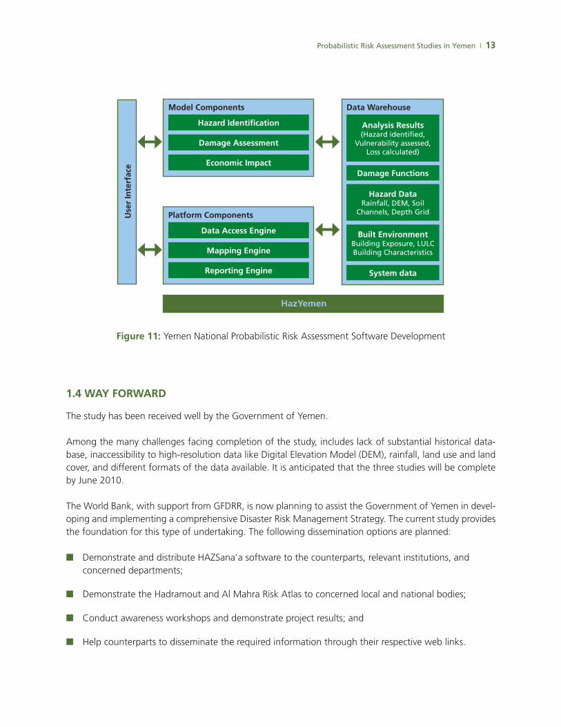
Brief Summarythis catastrophic risk modeling application is being developed to provide public decision makers (Government of Yemen) and private decision makers (insurance companies) with the capacity to estimate in advance the impact of a disaster on national accounts and operations, as well as the resource and liquidity gaps expected to arise following a disaster. the application (Figure 11) will help in pre- and post-disaster response planning, such as emergency response planning, cost benefit analysis of risk mitigation investments, fiscal impact of natural disasters on the government budget, and insurance decisions (i.e., insurance portfolio risk analysis, pooling benefits).
Study Statusthe expected completion date of the study is June 2010.
Some Results
Probabilistic Risk Assessment Studies in Yemen | 13
Figure 11: Yemen national Probabilistic risk assessment software development
WaY FORWaRd1.4
the study has been received well by the Government of Yemen.
among the many challenges facing completion of the study, includes lack of substantial historical data-base, inaccessibility to high-resolution data like digital elevation model (dem), rainfall, land use and land cover, and different formats of the data available. it is anticipated that the three studies will be complete by June 2010.
the World bank, with support from GFdrr, is now planning to assist the Government of Yemen in devel-oping and implementing a comprehensive disaster risk management strategy. the current study provides the foundation for this type of undertaking. the following dissemination options are planned:
demonstrate and distribute HaZsana’a software to the counterparts, relevant institutions, and ■■
concerned departments;
demonstrate the Hadramout and al mahra risk atlas to concerned local and national bodies;■■
conduct awareness workshops and demonstrate project results; and■■
Help counterparts to disseminate the required information through their respective web links.■■
Hazard identification
damage assessment
economic impact
Model Components
HazYemen
analysis Results(Hazard identified,
Vulnerability assessed, Loss calculated)
Hazard dataRainfall, DEM, Soil
Channels, Depth Grid
Built environmentBuilding Exposure, LULCBuilding Characteristics
damage Functions
System data
data Warehouse
data access engine
Mapping engine
Reporting engine
Platform Componentsuse
r in
terf
ace
NORWAY SPAIN SWEDEN SWITZERLAND TURKEY UNITED KINGDOM
AUSTRALIA BELGIUM BRAZIL CANADA DENMARK FINLAND FRANCE
UNITED STATES
GERMANY INDIA IRELAND ITALY JAPAN LUXEMBOURG THE NETHERLANDS