Embed Size (px)
Citation preview
Privatization, Drought, and FireExclusion in the Tuul River
Watershed, Mongolia
Thomas Saladyga,1* Amy Hessl,2 Baatarbileg Nachin,3 and Neil Pederson4
1Department of Geography, Concord University, P.O. Box 1000, Athens, West Virginia 24712-1000, USA; 2Department of Geology and
Geography, West Virginia University, P.O. Box 6300, Morgantown, West Virginia 26506-6300, USA; 3Department of Forest Sciences,
National University of Mongolia, Ulaanbaatar, Mongolia; 4Lamont-Doherty Earth Observatory, Columbia University, P.O. Box 1000,Palisades, New York 10964-8000, USA
ABSTRACT
Global wildfire frequency and extent are expected
to increase under projected climate change in the
twenty-first century, yet little is known about how
human activities might affect this trend. In central
Mongolia, there has been a 2.5�C rise in spring and
summer temperatures during the last 40 years and
a decrease in moisture availability during the latter
half of the twentieth century. Concurrently,
Mongolia has experienced multiple shifts in socio-
economic systems during the twentieth century,
most notably the establishment of a Soviet-backed
communist economy in the 1920s and a rapid
transition to privatization in the 1990s. Observed
records of fire in the late twentieth century sug-
gested that fire activity had increased, but no long-
term data existed to place these trends in a histor-
ical context. Our objective was to identify spatial
and temporal patterns in fire occurrence in the
forest-steppe ecotone of the Tuul River watershed
in the context of changing climatic and social
conditions since 1875. We used fire-scarred trees to
reconstruct past fire occurrence during the period
1875–2009. Our results indicate a significant asso-
ciation between human activity and fire occur-
rence independent of climatic variables. The
greatest evidence for an anthropogenic fire regime
exists following the transition to a free market
economy during the early 1990s when land-use
intensification near the capital city of Ulaanbaatar
resulted in fire exclusion. We emphasize the
importance of including socio-political variables in
global models of wildfire potential, particularly
where fuels limit fire activity.
Key words: Mongolia; wildfire; drought; den-
drochronology; land use; privatization.
INTRODUCTION
Sustainable use and management of forest
resources will be integral to preventing landscape
degradation as rapid changes in climate (for
example, temperature and precipitation) are
expected to alter historic fire regimes during the
coming century (Overpeck and others 1990; Dale
and others 2000; Sivakumar and others 2005). This
is especially critical in regions of the world where
lands with low productivity are vulnerable to
abrupt changes in climate and land-use pressure.
Received 30 November 2012; accepted 25 March 2013;
published online 3 July 2013
Electronic supplementary material: The online version of this article
(doi:10.1007/s10021-013-9673-0) contains supplementary material,
which is available to authorized users.
Author Contributions: Thomas Saladyga was responsible for the con-
ception and design of the study. Saladyga also performed background
research, analyzed data, developed tables and figures, and wrote the paper.
As the first author’s Ph.D. advisor, Amy Hessl provided guidance in the
conception and design of the study. Hessl also contributed to writing and
editing the manuscript. Baatarbileg Nachin participated in the design of the
study and provided comments throughout the writing process. Neil
Pederson contributed to research and participated in editing the manuscript.
*Corresponding author; e-mail: [email protected]
Ecosystems (2013) 16: 1139–1151DOI: 10.1007/s10021-013-9673-0
� 2013 Springer Science+Business Media New York
1139
The earliest and most extreme increases in tem-
perature are expected to occur at high latitudes,
whereas many arid and semi-arid regions will
experience increased drought incidence (IPCC
2007). Changes in hydroclimatic regimes are ex-
pected to have profound effects on fire occurrence
such as increased fire frequency and a longer fire
season (Wotton and Flannigan 1993; Stocks and
others 1998; McKenzie and others 2004; Wester-
ling and others 2006; Kilpelainen and others 2010;
Yang and others 2011). Despite increasing tem-
peratures, however, fire activity in northern forests
might not be as severe as globally predicted
(Flannigan and others 1998) and changes in igni-
tion sources and forest fuels might limit future fire
regimes, particularly in semi-arid systems (Hessl
2011). Changes in hydroclimatic conditions and
fire occurrence will have substantial influence on
the livelihoods of those dependent upon local
environments and may have important implica-
tions for feedbacks to the atmosphere stemming
from altered rates of carbon sequestration and
evapotranspiration (Field and others 2007; Chapin
and others 2008b).
Pastoralist societies in central Asia have a long
history of sustainable range and forest manage-
ment across the expansive steppe and forest-steppe
ecosystems of the region. In Mongolia, herders
have historically managed livestock in a manner
that makes efficient use of spatially and temporally
heterogeneous resources (Fernandez-Gimenez
1999). However, shifts in social and economic
conditions, most notably during the twentieth
century, have impacted pastoralist mobility, access
to resources, and land tenure (Fernandez-Gimenez
2006; Johnson and others 2006). The region has
experienced warming temperatures (Jacoby and
others 1996; D’Arrigo and others 2000, 2001) and a
sudden decrease in moisture availability in the
1990s (Li and others 2008), which followed three
strong pluvials during the twentieth century (Davi
and others 2013; Pederson and others 2013).
Consistent with these findings, Mongolia has
experienced a recent increase in frequency and
intensity of droughts, with a drought from 1999 to
2002 affecting approximately 70% of the country’s
grasslands and killing about 12 million livestock
(Batima and others 2005). Drought in 2009, fol-
lowed by a harsh winter in 2010, resulted in the
death of more than 7.8 million livestock (FAO
United Nations 2010).
Climate change in the twentieth and twenty-first
centuries in Mongolia has occurred alongside major
social and economic transitions that have directly
affected land use. The history of changes in land-
use patterns, land-use regulation, and land tenure
in Mongolia during this period can be divided into
four eras: Manchu rule and autonomy (pre-1911);
early communism (1924–1959); collective (1960–
1990); and privatization (1992–present) (Fernan-
dez-Gimenez 1999). During Manchu rule and
autonomy, pastoralist movements were frequent,
covered long distances and utilized multiple eco-
logical zones. This mobility decreased during the
early communism era when some lands experi-
enced year-round grazing. Although some herders
maintained seasonal rotation of pasture during
the collective era (1960–1990), their mobility was
reduced even further, limiting access to the full
variety of ecological zones and forage resources
used traditionally. The transition from a centrally
planned economy to a market economy, including
the privatization of livestock (early 1990s), marked
a further decrease in pastoral mobility, as seen in
an increase in the number of inexperienced herd-
ers, increased trespassing on leased pastureland, a
concentration of livestock near towns and roads,
and reduced frequency and distance of moves
(Fernandez-Gimenez 2006). Mongolia’s livestock
population remained relatively stable during the
communist era, but increased sharply (especially
goats for Kashmir textiles) after privatization in the
1990s and has experienced multiple crashes during
the twenty-first century (Sankey and others 2006).
Despite these crashes, decreased pastoralist mobil-
ity and a general trend of increasing livestock
numbers in the late twentieth and twenty-first
centuries led to a spatially heterogeneous landscape
of fine fuels due to overgrazing in some areas
(Sneath 1998).
Where human land use and increasing aridity
combine to reduce fuel volume, forests might not
experience increases in fire occurrence that are
expected under projected climate change (Honig
and Fule 2012). Reduced moisture availability,
rising temperatures, and intensifying land-use
pressure are known to contribute to changes in fire
frequency and extent at least in some regions
(Donnegan and others 2001; Grissino-Mayer and
others 2004; Westerling and others 2006). Grazing
in particular has had strong impacts on forest age
structure, fine fuel volume and continuity, and fire
regimes in other semi-arid regions (Savage and
Swetnam 1990; Grissino-Mayer and others 1995;
Swetnam and Betancourt 1998). Similar controls
may act on wildfires in Mongolia’s forest-steppe
ecotone. The observed frequency and aerial extent
of forest and grassland fires in Mongolia markedly
increased during the period 1963–1997 (Goldammer
2002) coincident with both rising temperatures and
1140 T. Saladyga and others
changes in land use. The purpose of this study was
to assess human and climatic influences on fire
occurrence during the period 1875–2009 in the
Upper Tuul River watershed (UTRW) in central
Mongolia. We expect that an intensification of
human activities (that is, grazing and logging) fol-
lowing the transition to a market economy in the
early 1990s marked a significant change in fire
occurrence and location. Specifically, we hypoth-
esize that (1) forest fuels are reduced by human
presence via grazing, logging, and fuelwood col-
lection and (2) novel fire regimes have resulted,
independent of climatic influence, from changes in
land-use patterns, land-use regulation, and land
tenure, most notably following the shift to a market
economy in the early 1990s.
METHODS
Study Area
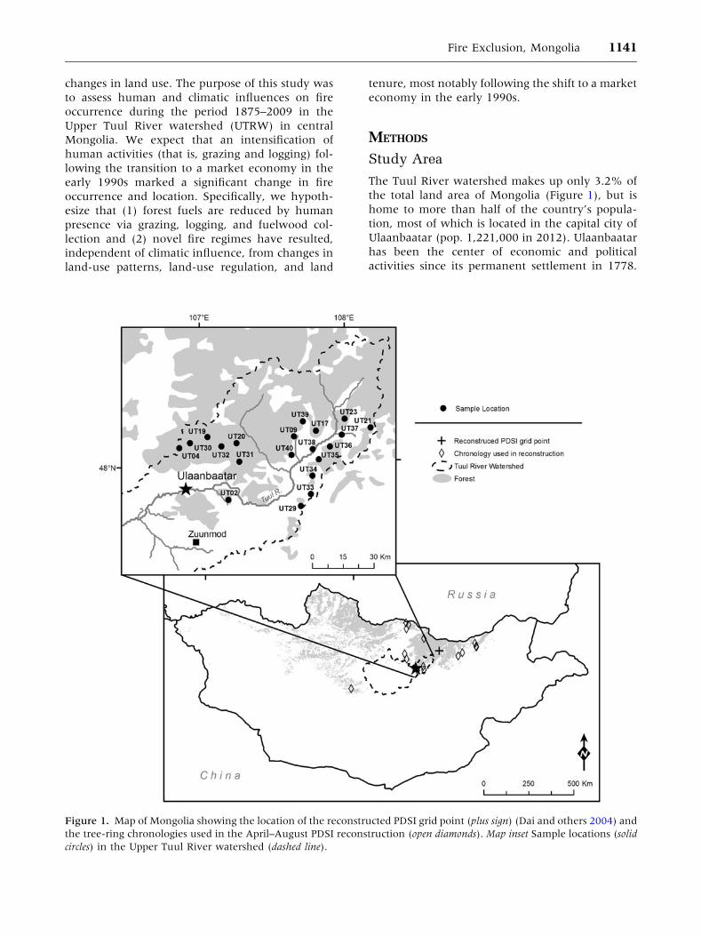
The Tuul River watershed makes up only 3.2% of
the total land area of Mongolia (Figure 1), but is
home to more than half of the country’s popula-
tion, most of which is located in the capital city of
Ulaanbaatar (pop. 1,221,000 in 2012). Ulaanbaatar
has been the center of economic and political
activities since its permanent settlement in 1778.
Figure 1. Map of Mongolia showing the location of the reconstructed PDSI grid point (plus sign) (Dai and others 2004) and
the tree-ring chronologies used in the April–August PDSI reconstruction (open diamonds). Map inset Sample locations (solid
circles) in the Upper Tuul River watershed (dashed line).
Fire Exclusion, Mongolia 1141
Population in the industrial capital increased sig-
nificantly following Mongolia’s transition to a
privatized economy in the early 1990s, but has
doubled between 2009 and 2012. The UTRW
includes the upper reaches of the Tuul River and its
tributaries, including a drainage area of 8,735 km2
and a boundary that extends approximately 180 km
from southwest of Bogd Khan Uul (mountain) to
the northeast into the higher elevation Khan
Khentii Mountains (Figure 1 inset). Land and
resources of the UTRW currently contribute income
and marketed products worth around Tug 28 billion
(�22 million USD) per year in tourism, herding,
and forest-based sectors (Emerton and others
2009). Therefore, in representing the most extreme
range of urban to rural development in Mongolia,
the UTRW is an ideal case study for exploring
human impacts on wildfire in semi-arid Asia.
Mongolia is characterized by an extreme conti-
nental climate. Average temperatures in central
Mongolia range from approximately -18�C in
winter to approximately 16�C in summer, though
winter temperatures have been rising since the
1940s (Davagdorj and Mijidorg 1996; Jacoby and
others 1996). Total annual precipitation is low
(252 mm) and peaks in summer when approxi-
mately 72% of precipitation falls (Davagdorj and
Mijidorg 1996). Between 1940 and 2001, spring
precipitation declined 17% (Batima and others
2005). No single synoptic system appears to
strongly influence Mongolian climate except per-
haps the winter Siberian High, centered over
Mongolia from winter through late spring (Samel
and others 1999; D’Arrigo and others 2005) and
interactions between El Nino and Indian Ocean
Dipole Events (Ummenhofer and others 2013).
Forested area in the UTRW totals 3,876 km2 with
55% dominated by Larix sibirica, 42% by Pinus spp.,
and the remaining 3% by Betula spp., Abies sibirica,
and Picea obovata (Ministry of Nature and Envi-
ronment 2009). Elevation in the UTRW ranges
from 1,187 m just southwest of Ulaanbaatar to
2,795 m (Asralt Khairkhan Uul) in the Khentii
Mountains. The mountains are situated at the
interface between the western Siberian dark taiga
(Picea obovata, A. sibirica, Pinus sibirica, and L. sibi-
rica), the eastern Siberian light taiga (Betula platy-
phylla, L. sibirica, and Pinus sylvestris), and the
Mongolian forest-steppe zone (Ermakov and others
2002). This region is particularly species rich, rela-
tive to the rest of central Asia, due to the inter-
section of boreal, temperate, and steppe vegetation.
Three conservation areas exist with the Khentii
region including the Strictly Protected Area of
Khan Khentii (12,300 km2; est. 1992), Gorkhi-Terelj
National Park (2,900 km2; est. 1993), and Onon-
Balj National Park (4,200 km2; est. 2000). The two
National Parks have been developed for tourism,
but within the Khan Khentii Strictly Protected
Area, tourism is tightly managed and hunting and
mining are prohibited. However, use of resources
by local residents, including grazing, fuelwood
collection, and logging is difficult to manage in all
conservation areas due to a lack of funding.
Based on data for the period 1963–1997, the fire
season in Mongolia has two peaks with 80% of fires
occurring between March and mid-June, and
5–8% occurring during a short period in September
and October (Valendik and others 1998). Fires are
rare during the summer months when precipita-
tion is greatest. Annually, 50–60 forest fires occur
in Mongolia, of which 95% are thought to be
human caused (Goldammer and others 2004).
Unlike other pastoralists, Mongolian herders are
not known to deliberately use fire to clear land or
encourage grassland productivity (personal com-
munication with forestry officer), suggesting that
the majority of these ignitions are unintentional.
Sample Design
To evaluate spatial and temporal changes in fire
occurrence and land use, we randomly located 20,
4 ha (200 m 9 200 m) sample sites within the
forest-steppe ecotone of the UTRW in July/August
2010. We developed a GIS-based index of human
impact to stratify our samples across a land-use
intensity gradient (Saladyga 2011). The index was
based on distance to the nearest urban center and
urban population, distance to the nearest road and
road type (paved/dirt track), and elevation. We
used this index to locate sample locations along a
gradient of potential human disturbance. All sites
fall into the very high, high, or medium classes of
natural fire danger established by Arkhipov and
others (2000) and are composed of pure stands of
L. sibirica or mixed Larix/Pinus stands dominated by
L. sibirica. Our sample design targeted an elevation
range of 1,500–2,000 m and includes an area of
2,620 km2 (of a total forested area of 3,876 km2
within the UTRW).
Qualitative Site Assessment
We used a rapid (15 min per site), qualitative on-
site assessment to identify the magnitude of pres-
ent-day human impacts at each site. We looked for
evidence of fire, grazing, and logging, and scored
each variable (0–3) based on the presence and area
of impacts (ocular estimations). Evidence of fire
included charcoal on soil, charred woody debris, cat
1142 T. Saladyga and others
faces (cambial damage), scorch height, and heat-
killed snags (max score = 15). Grazing indicators
included the presence of dung, hoof prints, live-
stock remains and trails (max score = 12). Indica-
tors of logging disturbance included the presence of
stumps, slash, machinery tracks, and other altered
microtopography (max score = 12).
Fuel Inventory
Four, 15-m long planar transects were established
at random bearings within each 4 ha site to assess
fuel loads since last fire in the UTRW. Litter depths,
fine woody debris (FWD, <7.62 cm diameter), and
coarse woody debris (CWD, >7.62 cm) were
measured following methods described by Brown
(1974) and Passovoy and Fule (2006). FWD was
inventoried in three size classes (0–0.64, 0.65–2.54,
and 2.55–7.62 cm), which correspond to 1-, 10-,
and 100-h moisture time-lag classes, whereas CWD
(down wood >7.62 cm diameter) corresponds to
the 1000-h moisture time-lag class (Brown 1974).
Fire Chronology
We sampled all fire-scarred trees (stumps, snags,
and living trees) within the 4 ha search area, col-
lecting on average seven samples per site (min = 1,
max = 13), depending on site history. Sites with a
frequent history of burning typically had ample fire
scar evidence; however, several sites had little to no
evidence of recent fire. Fire-scarred trees were
sampled by identifying trees with evidence of
cambial damage (that is, ‘‘cat face’’), from which
partial cross sections were removed with a chain-
saw (Arno and Sneck 1977). We surfaced all fire-
scar samples with progressively finer grit sandpaper
until cells were clearly visible under magnification
according to established tree-ring procedures (for
example, Stokes and Smiley 1968). We then
crossdated samples using an already established
tree-ring chronology (Jacoby and others 2009,
International Tree-Ring Data Bank, Manzhir Hiid)
to provide absolute dates for all tree rings and fire
scar injuries. If possible, we assigned the season of
occurrence to each fire scar based on its position
within a ring (Baisan and Swetnam 1990). Because
80% of all fires in the modern record occur from
March to mid-June, we assumed that fires with
unknown season most likely occurred during this
period (Nyamjav and others 2007). Consequently,
we assigned fire scars that fell within the dormant
season to the subsequent year. Site-level fire his-
tories were compiled into a watershed composite of
the percentage of sites recording fire (for example,
Guyette and others 2002; Brown and others 2008).
We used unfiltered fire scar data to maximize
sample size for all analyses except fire–climate
relationships, for which a two-scar per site filter
was applied.
Correlation and Cluster Analysis
Pearson correlation coefficients were calculated to
assess basic relationships between qualitative dis-
turbance evidence, years since last fire, and fuels
data. To further understand drivers of recent fire
activity, we used principal components analysis
(PCA) to convert these variables into component
scores. Principal components (PCs) with eigen-
values greater than 1.0 were extracted to explain
model variance and an agglomeration schedule was
used to pre-select the appropriate number of clus-
ters for further analysis. We then used these PCA
scores in k-means cluster analysis, which partitions
observations into groups based on Euclidean dis-
tance from mean cluster centers, to identify clusters
of sites characterized by similar disturbance, fuels,
and fire activity.
Political/Economic Eras and Fire Activity
We used the non-parametric Kruskal–Wallis test to
assess differences between political/economic eras
in the percentage of sites recording fire. The per-
centage of fire years for each site was calculated for
each political/economic era and tested for spatial
autocorrelation (Moran’s I) to examine changes in
the spatial distribution of fire occurrence. Political/
economic eras were modified slightly from Fern-
andez-Gimenez (1999). These classifications in-
clude (1) Manchu rule and autonomy, including
Chinese occupation and independence, 1875–
1923; (2) early communism, 1924–1959; (3) col-
lective, 1960–1990; and (4) privatization, 1991–
2009.
Climate–Fire Relationships
We used superposed epoch analysis (SEA) (for
example, Grissino-Mayer and Swetnam 2000;
Taylor and Beaty 2005) to test our hypothesis
about the overriding impacts of land use on fire
occurrence. We expected that drought would not
be associated with fire activity, particularly when
and where human impacts were strong. To com-
pare fire events with climate, we developed an
independent tree-ring reconstruction of April–August
Fire Exclusion, Mongolia 1143
PDSI (Palmer Drought Severity Index) near the
study area using existing tree-ring chronologies
and instrumental data from Dai and others (2004)
(grid point 48.75 N, 108.75�E; Figure 1). Fifteen
tree-ring chronologies (see Appendix 1 in Supple-
mentary material) and 20 of the 30 possible pre-
dictors from all chronologies (t and t + 1) were
significantly correlated (a = 0.05) with April–
August PDSI during the common period (1815–
1994). We used PCA and forward and backward
nesting procedures to extend the reconstruction
from the year 1675 to 2000 (Meko 1997; Cook and
others 2002; Saladyga 2011). The final recon-
struction accounts for 60% of the variance in
average April–August instrumental PDSI for the
period 1945–1993.
We used SEA to compare our reconstructed
average annual April–August PDSI values to our
site and watershed-level fire chronologies for the
six preceding and 4 years following an event. We
applied a two-scar per site filter to eliminate local,
spot fires in our fire chronology. SEA uses Monte
Carlo simulations (1,000 runs) to compare average
climatic conditions prior to, during, and following
event years to conditions present over the entire
fire chronology. Significant departures in PDSI
were identified as those exceeding the 95% confi-
dence interval (Grissino-Mayer 2001).
RESULTS
Fire History
Fire history analyses were limited to the period
1875–2009 due to a substantial decrease in sample
size prior to the late nineteenth century. We
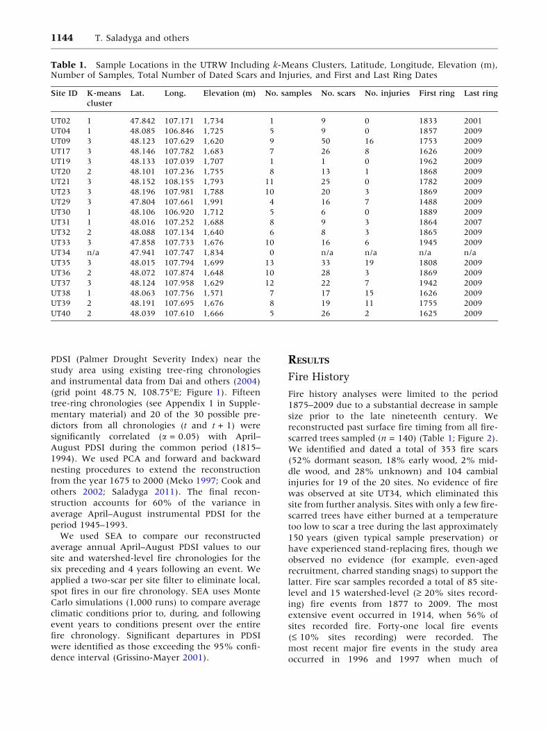
reconstructed past surface fire timing from all fire-
scarred trees sampled (n = 140) (Table 1; Figure 2).
We identified and dated a total of 353 fire scars
(52% dormant season, 18% early wood, 2% mid-
dle wood, and 28% unknown) and 104 cambial
injuries for 19 of the 20 sites. No evidence of fire
was observed at site UT34, which eliminated this
site from further analysis. Sites with only a few fire-
scarred trees have either burned at a temperature
too low to scar a tree during the last approximately
150 years (given typical sample preservation) or
have experienced stand-replacing fires, though we
observed no evidence (for example, even-aged
recruitment, charred standing snags) to support the
latter. Fire scar samples recorded a total of 85 site-
level and 15 watershed-level (‡ 20% sites record-
ing) fire events from 1877 to 2009. The most
extensive event occurred in 1914, when 56% of
sites recorded fire. Forty-one local fire events
(£ 10% sites recording) were recorded. The
most recent major fire events in the study area
occurred in 1996 and 1997 when much of
Table 1. Sample Locations in the UTRW Including k-Means Clusters, Latitude, Longitude, Elevation (m),Number of Samples, Total Number of Dated Scars and Injuries, and First and Last Ring Dates
Site ID K-means
cluster
Lat. Long. Elevation (m) No. samples No. scars No. injuries First ring Last ring
UT02 1 47.842 107.171 1,734 1 9 0 1833 2001
UT04 1 48.085 106.846 1,725 5 9 0 1857 2009
UT09 3 48.123 107.629 1,620 9 50 16 1753 2009
UT17 3 48.146 107.782 1,683 7 26 8 1626 2009
UT19 3 48.133 107.039 1,707 1 1 0 1962 2009
UT20 2 48.101 107.236 1,755 8 13 1 1868 2009
UT21 3 48.152 108.155 1,793 11 25 0 1782 2009
UT23 3 48.196 107.981 1,788 10 20 3 1869 2009
UT29 3 47.804 107.661 1,991 4 16 7 1488 2009
UT30 1 48.106 106.920 1,712 5 6 0 1889 2009
UT31 1 48.016 107.252 1,688 8 9 3 1864 2007
UT32 2 48.088 107.134 1,640 6 8 3 1865 2009
UT33 3 47.858 107.733 1,676 10 16 6 1945 2009
UT34 n/a 47.941 107.747 1,834 0 n/a n/a n/a n/a
UT35 3 48.015 107.794 1,699 13 33 19 1808 2009
UT36 2 48.072 107.874 1,648 10 28 3 1869 2009
UT37 3 48.124 107.958 1,629 12 22 7 1942 2009
UT38 1 48.063 107.756 1,571 7 17 15 1626 2009
UT39 2 48.191 107.695 1,676 8 19 11 1755 2009
UT40 2 48.039 107.610 1,666 5 26 2 1625 2009
1144 T. Saladyga and others
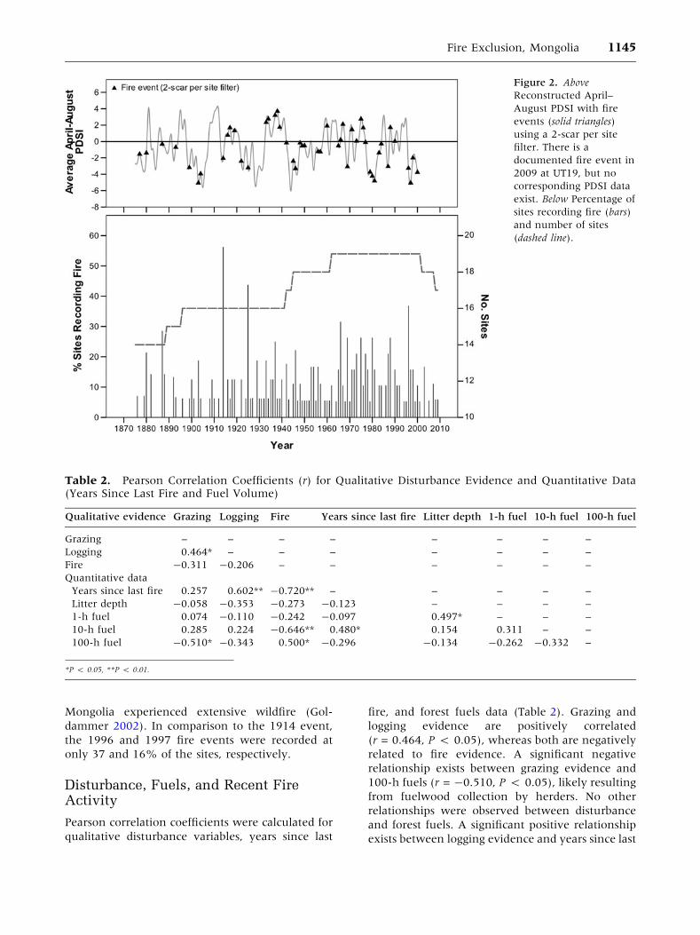
Mongolia experienced extensive wildfire (Gol-
dammer 2002). In comparison to the 1914 event,
the 1996 and 1997 fire events were recorded at
only 37 and 16% of the sites, respectively.
Disturbance, Fuels, and Recent FireActivity
Pearson correlation coefficients were calculated for
qualitative disturbance variables, years since last
fire, and forest fuels data (Table 2). Grazing and
logging evidence are positively correlated
(r = 0.464, P < 0.05), whereas both are negatively
related to fire evidence. A significant negative
relationship exists between grazing evidence and
100-h fuels (r = -0.510, P < 0.05), likely resulting
from fuelwood collection by herders. No other
relationships were observed between disturbance
and forest fuels. A significant positive relationship
exists between logging evidence and years since last
Table 2. Pearson Correlation Coefficients (r) for Qualitative Disturbance Evidence and Quantitative Data(Years Since Last Fire and Fuel Volume)
Qualitative evidence Grazing Logging Fire Years since last fire Litter depth 1-h fuel 10-h fuel 100-h fuel
Grazing – – – – – – – –
Logging 0.464* – – – – – – –
Fire -0.311 -0.206 – – – – – –
Quantitative data
Years since last fire 0.257 0.602** -0.720** – – – – –
Litter depth -0.058 -0.353 -0.273 -0.123 – – – –
1-h fuel 0.074 -0.110 -0.242 -0.097 0.497* – – –
10-h fuel 0.285 0.224 -0.646** 0.480* 0.154 0.311 – –
100-h fuel -0.510* -0.343 0.500* -0.296 -0.134 -0.262 -0.332 –
*P < 0.05, **P < 0.01.
Figure 2. Above
Reconstructed April–
August PDSI with fire
events (solid triangles)
using a 2-scar per site
filter. There is a
documented fire event in
2009 at UT19, but no
corresponding PDSI data
exist. Below Percentage of
sites recording fire (bars)
and number of sites
(dashed line).
Fire Exclusion, Mongolia 1145
fire (r = 0.602, P < 0.01). In total, these results
suggest that human presence and land-use activi-
ties such as grazing and logging are associated with
reduced fuels and reduced fire occurrence.
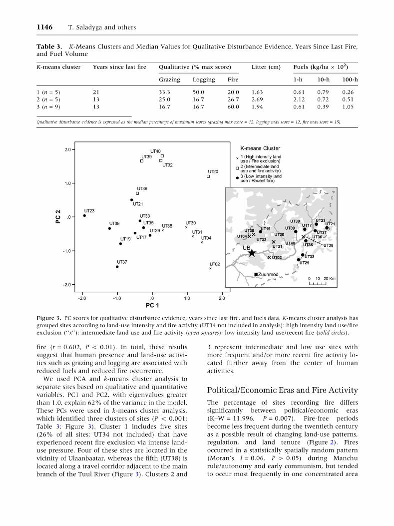
We used PCA and k-means cluster analysis to
separate sites based on qualitative and quantitative
variables. PC1 and PC2, with eigenvalues greater
than 1.0, explain 62% of the variance in the model.
These PCs were used in k-means cluster analysis,
which identified three clusters of sites (P < 0.001;
Table 3; Figure 3). Cluster 1 includes five sites
(26% of all sites; UT34 not included) that have
experienced recent fire exclusion via intense land-
use pressure. Four of these sites are located in the
vicinity of Ulaanbaatar, whereas the fifth (UT38) is
located along a travel corridor adjacent to the main
branch of the Tuul River (Figure 3). Clusters 2 and
3 represent intermediate and low use sites with
more frequent and/or more recent fire activity lo-
cated further away from the center of human
activities.
Political/Economic Eras and Fire Activity
The percentage of sites recording fire differs
significantly between political/economic eras
(K–W = 11.996, P = 0.007). Fire-free periods
become less frequent during the twentieth century
as a possible result of changing land-use patterns,
regulation, and land tenure (Figure 2). Fires
occurred in a statistically spatially random pattern
(Moran’s I = 0.06, P > 0.05) during Manchu
rule/autonomy and early communism, but tended
to occur most frequently in one concentrated area
Table 3. K-Means Clusters and Median Values for Qualitative Disturbance Evidence, Years Since Last Fire,and Fuel Volume
K-means cluster Years since last fire Qualitative (% max score) Litter (cm) Fuels (kg/ha 9 102)
Grazing Logging Fire 1-h 10-h 100-h
1 (n = 5) 21 33.3 50.0 20.0 1.63 0.61 0.79 0.26
2 (n = 5) 13 25.0 16.7 26.7 2.69 2.12 0.72 0.51
3 (n = 9) 13 16.7 16.7 60.0 1.94 0.61 0.39 1.05
Qualitative disturbance evidence is expressed as the median percentage of maximum scores (grazing max score = 12, logging max score = 12, fire max score = 15).
Figure 3. PC scores for qualitative disturbance evidence, years since last fire, and fuels data. K-means cluster analysis has
grouped sites according to land-use intensity and fire activity (UT34 not included in analysis): high intensity land use/fire
exclusion (‘‘x’’); intermediate land use and fire activity (open squares); low intensity land use/recent fire (solid circles).
1146 T. Saladyga and others
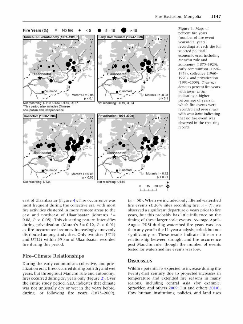
east of Ulaanbaatar (Figure 4). Fire occurrence was
most frequent during the collective era, with most
fire activities clustered in more remote areas to the
east and northeast of Ulaanbaatar (Moran’s I =
0.08, P < 0.05). This clustering pattern intensifies
during privatization (Moran’s I = 0.12, P < 0.01)
as fire occurrence becomes increasingly unevenly
distributed among study sites. Only two sites (UT19
and UT32) within 35 km of Ulaanbaatar recorded
fire during this period.
Fire–Climate Relationships
During the early communism, collective, and priv-
atization eras, fires occurred during both dry and wet
years, but throughout Manchu rule and autonomy,
fires occurred during dry years only (Figure 2). Over
the entire study period, SEA indicates that climate
was not unusually dry or wet in the years before,
during, or following fire years (1875–2009),
(n = 50). When we included only filtered watershed
fire events (‡ 20% sites recording fire; n = 7), we
observed a significant departure 6 years prior to fire
years, but this probably has little influence on the
timing of these larger scale events. Average April–
August PDSI during watershed fire years was less
than any year in the 11-year analysis period, but not
significantly so. These results indicate little or no
relationship between drought and fire occurrence
post Manchu rule, though the number of events
tested for watershed fire events was low.
DISCUSSION
Wildfire potential is expected to increase during the
twenty-first century due to projected increases in
temperature and extended fire seasons in many
regions, including central Asia (for example,
Spracklen and others 2009; Liu and others 2010).
How human institutions, policies, and land uses
Figure 4. Maps of
percent fire years
(number of fire event
years/total years
recording) at each site for
selected political/
economic eras, including
Manchu rule and
autonomy (1875–1923),
early communism (1924–
1959), collective (1960–
1990), and privatization
(1991–2009). Circle size
denotes percent fire years,
with larger circles
indicating a higher
percentage of years in
which fire events were
recorded and open circles
with cross-hairs indicating
that no fire event was
observed in the tree-ring
record.
Fire Exclusion, Mongolia 1147
might interact with changing climate to affect fire
has received less attention. Our results indicate that
changing social and economic policies in Mongolia
during the twentieth century affected fuel volumes
resulting in changes in fire activity in time and
space. Our results further indicate that these land-
use changes may have overwhelmed the effects of
climate variability on fire typically observed in
semi-arid forests in other regions of the world.
Contrary to model projections of fire based on
climate change (Westerling and others 2006;
Running 2006; Chapin and others 2008a; Fried and
others 2008; Girardin and Mudelsee 2008; Kas-
ischke and others 2010) and results from recent
studies based on instrumental data (Goldammer
and others 2004), fire occurrence in the Tuul River
watershed of central Mongolia does not appear to
be increasing, at least over the last 140 years
(Figure 2). The most widespread events occurred in
the early twentieth century (1914 and 1925) dur-
ing drought years following multi-year pluvial
events. Though fires during 1996 and 1997 were
quite widespread, they do not appear to be beyond
the range of variability of the recent past and can-
not be directly attributed to warmer temperatures.
Fire occurrence was most common and widespread
during the collective era when climate conditions
in Mongolia were unusually wet (Davi and others
2013; Pederson and others 2013), suggesting that
changing socioeconomic conditions, rather than
drought, may have played a role in the temporal
pattern of fire occurrence we observed here.
Changing social conditions during the 1990s,
including high rates of unemployment, forced
many people in Mongolia to depend on forest re-
sources (for example, fuelwood, logging, haymak-
ing, and hunting) for livelihood and/or survival
(United Nations Economic and Social Council
2002). During this period, nomads concentrated
livestock near urban areas and further reduced the
frequency and distance of their moves, locally
reducing fine fuels (Fernandez-Gimenez 1999;
Sankey and others 2006). Not only have these
social and economic conditions affected fire
occurrence through time, but they likely affected
fire occurrence in space as well. As policies changed
from collectivization to privatization, fire activity
became increasingly unevenly distributed. Sites
near Ulaanbaatar (k-means cluster group 1) expe-
rienced near total fire exclusion whereas sites more
distant to the city (k-means cluster groups 2 and 3)
experienced some limited fire activity in the last
few decades. This modern pattern of fire activity is
essentially the mirror image of the pattern during
Manchu rule, when sites proximal to the city
experienced more fire than those farthest away
(Figure 4). Although less is known about land use
in the Tuul River watershed during Manchu rule,
we speculate that land-use management practices
implemented by Monasteries (that is, frequent,
long-distant pastoralist movements) resulted in
infrequent, but spatially extensive fire years (Fig-
ure 2).
Fire activity in semi-arid coniferous forests in
other regions of the world is tightly coupled with
drought (Kitzberger and Veblen 1997; Grissino-
Mayer and Swetnam 2000; Hessl and others 2004;
Trouet and others 2010). Here we observed no
clear relationship between drought and fire either
during the year of the fire or in the years leading up
to the fire year, except for during Manchu rule
when pastoralist land use may have been less
intensive. As stated above, we also observe no clear
positive trend in fire activity associated with the
near 2.5�C warming that has occurred in Mongolia
since the 1940s (Batima and others 2005). We
propose that human modifications of fuel volume
and continuity via grazing, logging, and fuelwood
collection have overwhelmed the effect of climatic
variability on fire occurrence in this semi-arid,
highly impacted watershed. Human disturbances
have influenced fire regimes in many parts of the
world by altering forest structure and fuel volume
(Veblen and others 1999; Guyette and others 2002;
Hellberg and others 2003; Keeley and Lubin 2003).
At nearby Bogd Mountain, fire events are absent in
the tree-ring record beginning in the 1760s fol-
lowing the permanent settlement of adjacent Ula-
anbaatar and in the absence of any clear climatic
changes (Hessl and others 2012). Similar patterns
resulting from intensive grazing specifically have
been observed in Spain (Rozas 2003), the Colorado
Front Range (Mast and others 1998), and south-
eastern Arizona (Grissino-Mayer and others 1995).
In central Mongolia, widespread fires might occur
during the initial years of drought conditions (that
is, 1914 and 1996/1997), but our results suggest
that the spatial and temporal patterns of fire
activity in areas with intensive grazing and logging
may largely be a function of human land use.
Our results support the idea that socioeconomic
variables and changes in land-use intensity need to
be included in global and regional models of wild-
fire, particularly in areas where fuel volume and
continuity limit fire (Hessl 2011) and where
human land uses reduce fuel. Predicted increases in
fire occurrence due to rising temperatures and
increasing aridity may be buffered by the effects of
land-use intensification and its uneven distribution
when long-running, highly regulated land-use
1148 T. Saladyga and others
policies are dismantled. As grazing becomes more
concentrated, regions with long histories of fre-
quent fire activity may experience fire exclusion,
whereas other less impacted areas maintain some
fire activity. Separating the interacting drivers of
wildfire is crucial to understanding how climate
change and human systems may interact to affect
fire activity, forest resilience, and feedbacks to the
atmosphere in future decades.
CONCLUSION
Recent land-use intensification has resulted in fire
exclusion in the Siberian larch-dominated forests
surrounding the capital city of Ulaanbaatar. Cluster
analysis disentangled the complex interactions
between land use and fire occurrence under
changing climatic conditions. Our results indicate
that land-use pressures are capable of overriding
rapid changes in climate, particularly following the
transition from highly regulated land-use policies
to minimal regulation via privatization. The
methods and findings described here can be applied
to other semi-arid ecosystems where reduced reg-
ulation and increasing land-use pressures have the
potential to reduce the risk of wildfires. Equally
relevant is the trend toward urbanization, reduced
pastoral activities, and increased fire activity
observed in other regions of the world (Pausus 2004).
Future research will need to address the critical role
of land-use policy in affecting fire regimes both
globally and locally. Global models of wildfire
potential should include social, economic, and policy
factors, which could have a significant impact on fire
occurrence, particularly where fuel volume and
continuity limit fire frequency and extent.
ACKNOWLEDGMENTS
This manuscript was completed with the help of
numerous individuals. Cari Leland, Byambagerel
Suran, Uyanga Ariya, and Soronzonbold Bayrbaa-
tar assisted in the field. Elizabeth Flynn provided
assistance in the laboratory, and Peter Brown pro-
vided comments on an earlier draft. Financial
support was provided by the National Science
Foundation (award # 0816700) and the Explorers
Club Washington Group.
REFERENCES
Arkhipov V, Moukanov BM, Khaidarov K, Goldammer JG.
2000. Overview on Forest Fires in Kazakhstan. Int For Fire
News 22:40–8.
Arno SF, Sneck KM. 1977. A method for determining fire history
in coniferous forests of the mountain west. USDA Forest
Service GTR. INT-42. Intermountain Forest and Range
Experiment Station, Ogden, UT.
Baisan CH, Swetnam TW. 1990. Fire history on a desert
mountain range: Rincon Mountain Wilderness, Arizona, USA.
Can J For Res 20:1559–69.
Batima P, Natsagdorj L, Gombluudev P, Erdenetsetseg P. 2005.
Observed climate change in Mongolia. Assessments and
Adaptations to Climate Change (AIACC). Working Paper No.
12. www.aiaccproject.org.
Brown JK. 1974. Handbook for Inventorying Downed Woody
Material. USDA Forest Service GTR. INT-16. Ogden, UT:
Intermountain Forest and Range Experiment Station.
Brown PM, Heyerdahl EK, Kitchen ST, Weber MH. 2008. Cli-
mate effects on historical fires (1630–1900) in Utah. Int J
Wildland Fire 17:28–39.
Chapin FS, Randerson JT, McGuire AD, Foley JA, Field CB.
2008a. Changing feedbacks in the climate–biosphere system.
Front Ecol Environ 6:313–20.
Chapin FS, Trainor SF, Huntington O, Lovecraft AL, Zavaleta E,
Natcher DC, McGuire AD, Nelson JL, Ray L, Calef M, Fresco
N, Huntington H, Rupp TS, DeWilde L, Naylor RL. 2008b.
Increasing wildfire in Alaska’s boreal forest: pathways to po-
tential solutions of a wicked problem. BioScience 58:531–40.
Cook ER, D’Arrigo R, Mann M. 2002. A well-verified, multi-
proxy reconstruction of the winter North Atlantic Oscillation
index since AD 1400. J Clim 15:1754–64.
D’Arrigo RD, Jacoby GC, Pederson N, Frank D, Buckley B,
Nachin B, Mijiddorj R, Dugarjav C. 2000. Mongolian tree-
rings, temperature sensitivity and reconstructions of Northern
Hemisphere temperature. Holocene 10:669–72.
Dai A, Trenberth E, Qian T. 2004. A global dataset of Palmer
Drought Severity Index for 1870–2002: relationship with soil
moisture and effects of surface warming. Am Meteorol Soc
5:1117–30.
Dale VH, Joyce LA, McNulty S, Neilson RP. 2000. The interplay
between climate change, forests, and disturbances. Sci Total
Environ 262:201–4.
D’Arrigo RD, Jacoby GC, Frank D, Pederson N, Cook ER,
Buckley B, Nachin B, Mijiddorj R, Dugarjav C. 2001.
1738 years of Mongolian temperature variability inferred
from a tree-ring width chronology of Siberian pine. Geophys
Res Lett 28:543–6.
D’Arrigo RD, Jacoby GC, Wilson R, Panagiotopoulos F. 2005. A
reconstructed Siberian High index since A.D. 1599 from
Eurasian and North American tree rings. Geophys Res Lett
32:L05705. doi:10.1029/2004GL022271.
Davagdorj D, Mijidorg R. 1996. Climate change issues in Mon-
golia. In: D. Davagdorj and L. Natsagdorj, Eds. Hydrometeo-
rological issues in mongolia. Papers in hydrometeorology.
Ulaanbaatar: Mongolian Institute of Meteorology and
Hydrology. 230 pp, pp. 79–88.
Davi N, Pederson N, Leland C, Nachin B, Suran B, Jacoby G.
2013. Is eastern Mongolia drying? A long-term perspective of
a multi-decadal trend. Water Resour Res. doi:10.1029/
2012WR011834.
Donnegan JA, Veblen TT, Sibold JS. 2001. Climatic and human
influences on fire history in Pike National Forest, Central
Colorado. Can J For Res 31:1526–39.
Emerton L, Erdenesaikhan N, De Veen B, Tsogoo D, Janchivdorj
L, Suvd P, Enkhtsetseg B, Gandolgor G, Dorisuren C,
Fire Exclusion, Mongolia 1149
Sainbayar D, Enkhbaatar A. 2009. The Economic Value of the
Upper Tuul Ecosystem. Mongolia Discussion Papers. East Asia
and Pacific Sustainable Development Department. Washing-
ton, D.C.: World Bank.
Ermakov N, Cherosov M, Gogoleva P. 2002. Classification of
ultracontinental boreal forests in central Yakutia. Folia Geobot
37:419–40.
Fernandez-Gimenez ME. 1999. Sustaining the steppes: a geo-
graphical history of pastoral land use in Mongolia. Geogr Rev
89:315–42.
Fernandez-Gimenez ME. 2006. Land use and land tenure in
Mongolia: a brief history and current issues. In: Bedunah, DJ,
McArthur ED, Fernandez-Gimenez ME, Eds. Rangelands of
Central Asia: proceedings of the conference on transforma-
tions, issues, and future challenges, Proceeding RMRS-P-39,
2004 January 27, Salt Lake City, UT. Fort Collins, CO: U.S.
Department of Agriculture, Forest Service, Rocky Mountain
Research Station.
Field CB, Lobell DB, Peters HA, Chiariello NR. 2007. Feedbacks
of terrestrial ecosystems to climate change. Annu Rev Environ
Resour 32:1–29.
Flannigan M, Bergeron Y, Engelmark O, Wotton B. 1998. Future
wildfire in circumboreal forests in relation to global warming.
J Veg Sci 9:469–76.
Food and Agriculture Organization (FAO) of the United Nations.
2010. Mongolian dzud appeal 2010. http://www.fao.org/
emergencies/tce-appfund/tce-appeals/appeals/emergency-de-
tail0/en/item/42611/icode/?uidf=17866, accessed May 2011.
Fried JS, Gilles JK, Riley WJ, Moody TJ, de Blas CS, Hayhoe K,
Moritz M, Stephens S, Torn M. 2008. Predicting the effect of
climate change on wildfire behavior and initial attack success.
Clim Change 87:251–64.
Girardin MP, Mudelsee M. 2008. Past and future changes in
Canadian boreal wildfire activity. Ecol Appl 18:391–406.
Goldammer JC. 2002. Fire situation in Mongolia. Int For Fire
News 26:75–83.
Goldammer JC, Davidenko EP, Kondrashov LG, Ezhov NI. 2004.
Recent trends of forest fires in Central Asia and opportunities
for regional cooperation in forest fire management. Regional
Forest Congress Forest Policy: Problems and Solutions 25–27
November 2004, Bishkek, Kyrgyzstan.
Grissino-Mayer HD. 2001. FHX2—software for analyzing tem-
poral and spatial patterns in fire regimes from tree rings. Tree-
Ring Res 57:115–24.
Grissino-Mayer HD, Swetnam TW. 2000. Century scale climate
forcing of fire regimes in the American Southwest. Holocene
10:213–20.
Grissino-Mayer HD, Baisan CH, Swetnam TW. 1995. Fire history
in the Pinaleno Mountains of southern Arizona: effects of
human-related disturbances. In: DeBano LF, Gottfried GJ,
Hamre RH, Edminster CB, Folliott PF, Ortega-Rubio A, Eds.
Biodiversity and management of the Madrean archipelago:
the Sky Islands of southwestern United States and north-
western Mexico. USDA Forest Service General Technical Re-
port RM-GTR-264. p. 399–407.
Grissino-Mayer HD, Romme WH, Floyd L, Hanna D. 2004. Cli-
mate and human influences on fire regimes of the southern
San Juan Mountains, Colorado, USA. Ecology 85:1708–24.
Guyette RP, Muzika RM, Dey DC. 2002. Dynamics of an
anthropogenic fire regime. Ecosystems 5:472–86.
Hellberg E, Hornberg G, Ostlund L. 2003. Vegetation dynamics
and disturbance history in three deciduous forests in boreal
Sweden. J Veg Sci 14:267–76.
Hessl AE. 2011. Pathways for climate change effects on fire:
Models, data, and uncertainties. Prog Phys Geogr 35:393–407.
Hessl AE, McKenzie D, Schellhaas R. 2004. Drought and Pacific
decadal oscillation linked to fire occurrence in the inland
Pacific Northwest. Ecol Appl 14:425–42.
Hessl AE, Ariya U, Brown P, Byambasuren O, Green T, Jacoby G,
Sutherland EK, Nachin B, Maxwell RS, Pederson N, De
Grandpre L, Saladyga T, Tardif JC. 2012. Reconstructing fire
history in central Mongolia from tree-rings. Int J Wildland
Fire 21:86–92.
Honig KA, Fule PZ. 2012. Simulating effects of climate change
and ecological restoration on fire behaviour in a south-wes-
tern USA ponderosa pine forest. Int J Wildland Fire 21:731–
42.
IPCC (Intergovernmental Panel on Climate Change). 2007. Cli-
mate Change 2007—The Physical Science Basis. Working
Group I Contribution to the Fourth Assessment Report of the
IPCC. Cambridge: Cambridge University Press.
Jacoby GC, D’Arrigo RD, Davaajamts T. 1996. Mongolian tree
rings and 20th century warming. Science 273:771–3.
Jacoby GC, D’Arrigo RD, Buckley B, Pederson N. 2009. Manshiir
Hiid, ITRDB MONG002. World Data Center for Paleoclima-
tology Data. NOAA/NCDC Paleoclimatology Program, Boul-
der, CO.
Johnson DA, Sheehy DP, Miller D, Damiran D. 2006. Mongolian
rangelands in transition. Secheresse 17(1/2):133.
Kasischke ES, Verbyla DL, Rupp TS, McGuire AD, Murphy KA,
Jandt R, Barnes JL, Hoy EE, Duffy PA, Calef M, Turetsky MR.
2010. Alaska’s changing fire regime—implications for the
vulnerability of its boreal forests. Can J For Res 40:1313–24.
Keeley JE, Lubin D. 2003. Fire and grazing impacts on plant
diversity and alien plant invasions in the southern Sierra
Nevada. Ecol Appl 13:1355–74.
Kilpelainen A, Kellomaki S, Strandman H, Venalainen A. 2010.
Climate change impacts on forest fire potential in boreal
conditions in Finland. Clim Change 103:383–98.
Kitzberger T, Veblen TT. 1997. Influences of humans and ENSO
on fire history of Austrocedrus Chilensis woodlands in Northern
Patagonia, Argentina. Ecoscience 4:508–20.
Li J, Cook ER, D’Arrigo RD, Chen F, Gou X. 2008. Moisture
variability across China and Mongolia: 1951–2005. Clim Dyn
32:1–14.
Liu Y, Stanturf J, Goodrick S. 2010. Trends in global wildfire
potential in a changing climate. For Ecol Manag 259:685–97.
Mast JN, Veblen T, Linhart YB. 1998. Disturbance and climatic
influences on a structure of ponderosa pine at the pine/
grassland ecotone, Colorado Front Range. J Biogeogr 25:743–
55.
McKenzie D, Gedalof Z, Peterson DL, Mote P. 2004. Climate
change, wildfire, and conservation. Conserv Biol 18:890–902.
Meko DM. 1997. Dendroclimatic reconstruction with time
varying predictor subsets of tree indices. J Clim 10:687–96.
Ministry of Nature and Environment, Mongolia. 2009. National
Forest Cover maps.
Nyamjav B, Goldammer JG, Uibrig H. 2007. The forest fire sit-
uation in Mongolia. Int For Fire News 36:46–66.
1150 T. Saladyga and others
Overpeck JT, Rind D, Goldberg R. 1990. Climate induced
changes in forest disturbance and vegetation. Nature 343:51–
3.
Passovoy DM, Fule PZ. 2006. Snag and woody debris dynamics
following sever wildfires in northern Arizona ponderosa pine
forests. For Ecol Manag 223:237–46.
Pausas JG. 2004. Changes in fire and climate in the eastern
Iberian Peninsula (Mediterranean basin). Clim Change
63:337–50.
Pederson N, Leland C, Nachin B, Hessl AE, Bell AR, Martin-
Benito D, Saladyga T, Suran B, Brown PM, Davi NM. 2013.
Three centuries of shifting hydroclimatic regimes across the
Mongolian breadbasket. Agric For Meteorol. Accessed Febru-
ary 11, 2013. doi:10.1016/j.agrformet.2012.07.003.
Rozas V. 2003. Regeneration patterns, dendroecology, and for-
est-use history in an old-growth beech-oak lowland forest in
Northern Spain. For Ecol Manag 182:175–94.
Running SW. 2006. Is global warming causing more, larger
wildfires? Science 13:927–8.
Saladyga T. 2011. Land use and climate impacts on fire regimes
and forest regeneration in the Upper Tuul River Watershed,
Mongolia. Doctoral Dissertation, West Virginia University,
Morgantown, WV.
Samel AN, Wang WC, Liang XZ. 1999. The monsoon rainband
over China and relationships with the Eurasian circulation. J
Clim 12:115–31.
Sankey TT, Montagne C, Graumlich LJ, Lawrence R, Nielsen J.
2006. Lower forest-grassland ecotones and 20th century
livestock herbivory effects in northern Mongolia. For Ecol
Manag 233:36–44.
Savage M, Swetnam TW. 1990. Early 19th-century fire decline
following sheep pasturing in a Navajo ponderosa pine forest.
Ecology 71:2374–8.
Sivakumar MVK, Das HP, Brunini O. 2005. Impacts of present
and future climate variability and change on agriculture and
forestry in the arid and semi-arid tropics. Clim Change 70:31–
72.
Sneath D. 1998. State policy and pasture degradation in inner
Asia. Science 281:1147–8.
Spracklen DV, Mickley LJ, Logan JA, Hudman RC, Yevich R,
Flannnigan MD, Westerling AL. 2009. Impacts of climate
change from 2000 to 2050 on wildfire activity and carbona-
ceous aerosol concentrations in the western United States. J
Geophys Res 114:1–17.
Stocks BJ, Fosberg MA, Lynham TJ, Mearns L, Wotton BM,
Yang Q, Jin J-Z, Lawrence K, Hartley GR, Mason JA,
McKenney DW. 1998. Climate change and forest fire potential
in Russian and Canadian boreal forests. Clim Change 38:1–13.
Stokes MA, Smiley TL. 1968. An introduction to tree-ring dating.
Chicago: University of Chicago Press. 73 pp.
Swetnam TW, Betancourt JL. 1998. Mesoscale disturbance and
ecological response to decadal climatic variability in the
American Southwest. J Clim 11:3128–47.
Taylor AH, Beaty RM. 2005. Climatic influences on fire regimes
in the northern Sierra Nevada Mountains, Lake Tahoe Basin,
Nevada, USA. J Biogeogr 32:425–38.
Trouet V, Taylor AH, Wahl ER, Skinner CN, Stephens SL. 2010.
Fire–climate interactions in the American West Since 1400
CE. Geophys Res Lett 37:L04702.
Ummenhofer CC, D’Arrigo RD, Anchukaitis KJ, Buckley BM,
Cook ER. 2013. Links between Indo-Pacific climate variability
and drought in the Monsoon Asia Drought Atlas. Clim Dyn
40:1319–34.
United Nations Economic and Social Council. 2002. Poverty
statistics in Mongolia. Economic and Social Commission for
Asia and the Pacific, Committee on Statistics. Thirteenth
Session, 27–29 November 2002. Bangkok, Thailand.
Valendik EN, Ivanova GA, Chuluunbator ZO, Goldammer JG.
1998. Fire in forest ecosystems of Mongolia. Int For Fire News
19:58–63.
Veblen T, Kitzberger T, Villalba R, Donnegan J. 1999. Fire his-
tory in northern Patagonia: the roles of humans and climatic
variation. Ecol Monogr 69:47–67.
Westerling AL, Hidalgo HG, Cayan DR, Swetnam TW. 2006.
Warming and earlier spring increase western U.S. forest
wildfire activity. Science 313:940–3.
Wotton BM, Flannigan MD. 1993. Length of fire season in a
changing climate. For Chronicle 69:187–92.
Yang G, Di X, Guo Q, Shu Z, Zeng T, Yu H, Wang C. 2011. The
impact of climate change on forest fire danger rating in Chi-
na’s boreal forest. J For Res 22:249–57.
Fire Exclusion, Mongolia 1151