Embed Size (px)
Citation preview
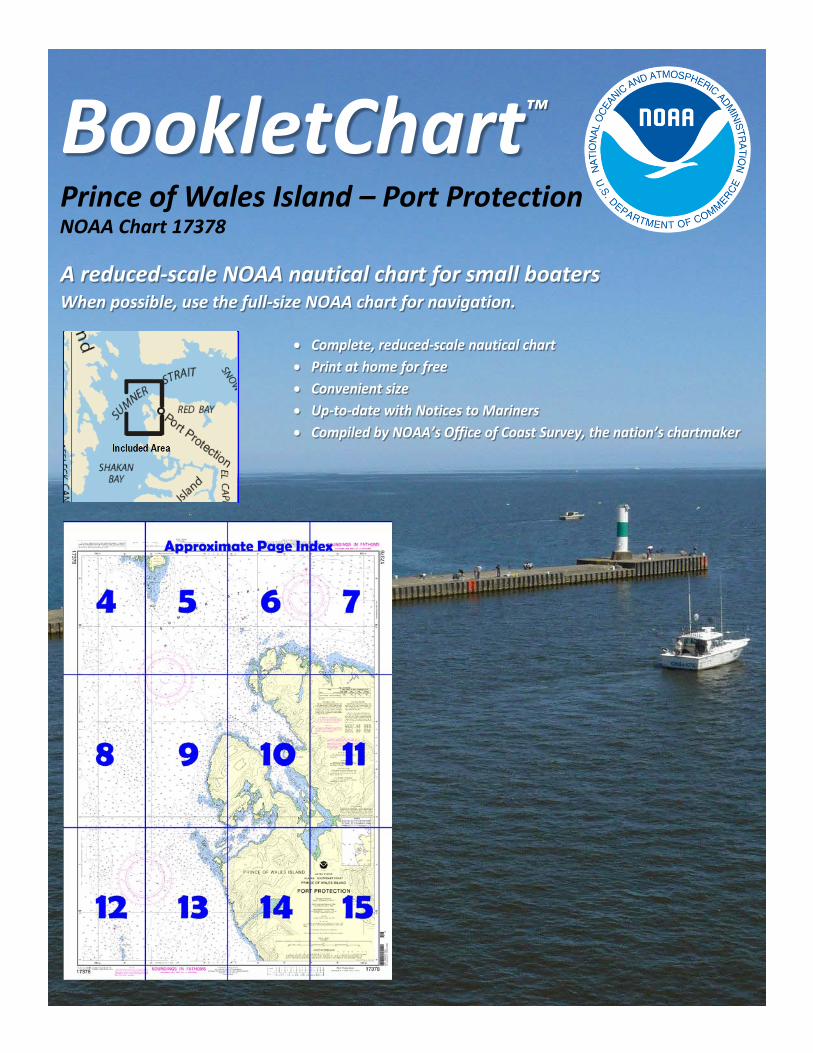
BookletChart™ Prince of Wales Island – Port Protection NOAA Chart 17378
A reduced-scale NOAA nautical chart for small boaters When possible, use the full-size NOAA chart for navigation.
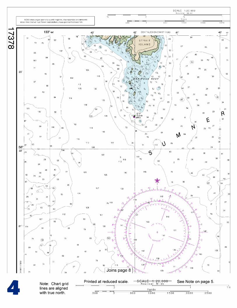
2
Published by the National Oceanic and Atmospheric Administration
National Ocean Service Office of Coast Survey
www.NauticalCharts.NOAA.gov 888-990-NOAA
What are Nautical Charts?
Nautical charts are a fundamental tool of marine navigation. They show water depths, obstructions, buoys, other aids to navigation, and much more. The information is shown in a way that promotes safe and efficient navigation. Chart carriage is mandatory on the commercial ships that carry America’s commerce. They are also used on every Navy and Coast Guard ship, fishing and passenger vessels, and are widely carried by recreational boaters.
What is a BookletChart?
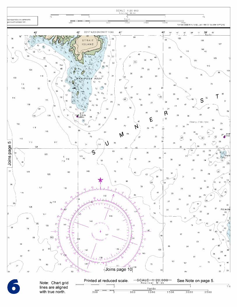
This BookletChart is made to help recreational boaters locate themselves on the water. It has been reduced in scale for convenience, but otherwise contains all the information of the full-scale nautical chart. The bar scales have also been reduced, and are accurate when used to measure distances in this BookletChart. See the Note at the bottom of page 5 for the reduction in scale applied to this chart.
Whenever possible, use the official, full scale NOAA nautical chart for navigation. Nautical chart sales agents are listed on the Internet at http://www.NauticalCharts.NOAA.gov.
This BookletChart does NOT fulfill chart carriage requirements for regulated commercial vessels under Titles 33 and 44 of the Code of Federal Regulations.
Notice to Mariners Correction Status
This BookletChart has been updated for chart corrections published in the U.S. Coast Guard Local Notice to Mariners, the National Geospatial Intelligence Agency Weekly Notice to Mariners, and, where applicable, the Canadian Coast Guard Notice to Mariners. Additional chart corrections have been made by NOAA in advance of their publication in a Notice to Mariners. The last Notices to Mariners applied to this chart are listed in the Note at the bottom of page 7. Coast Pilot excerpts are not being corrected.
For latest Coast Pilot excerpt visit the Office of Coast Survey website at http://www.nauticalcharts.noaa.gov/nsd/searchbychart.php?chart=17378.
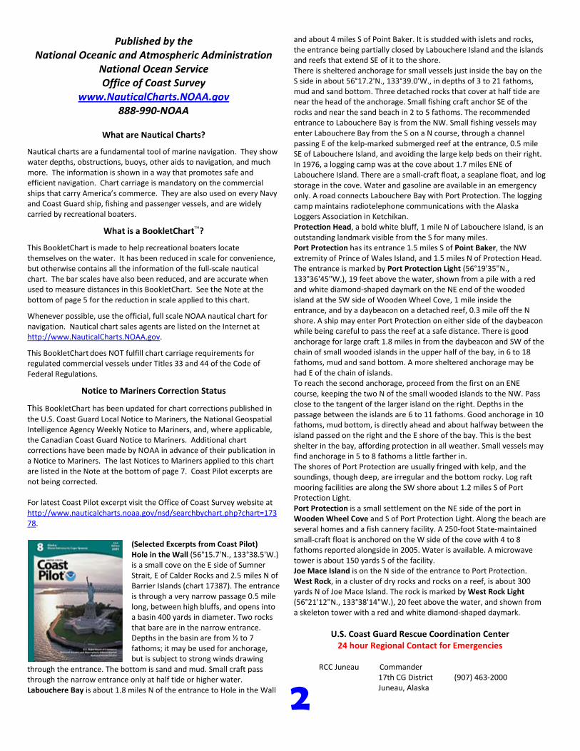
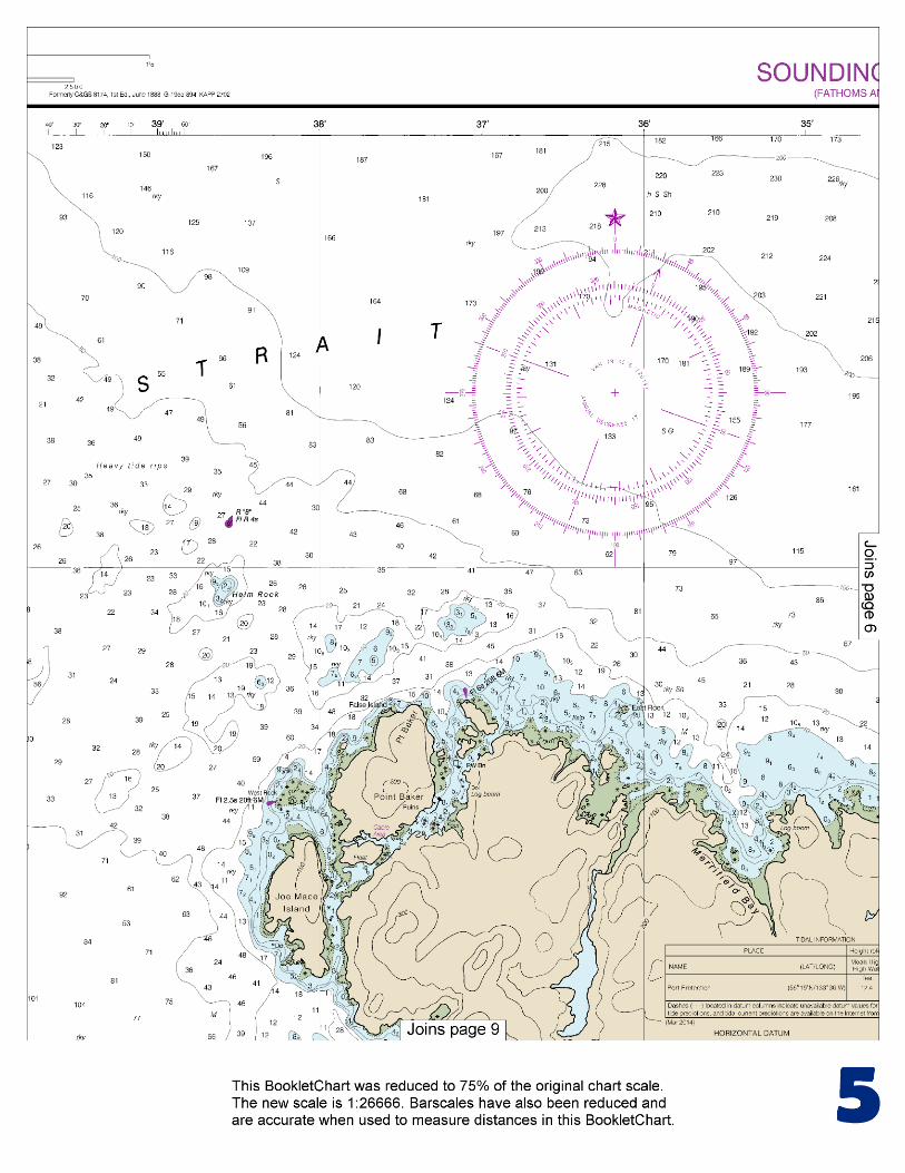
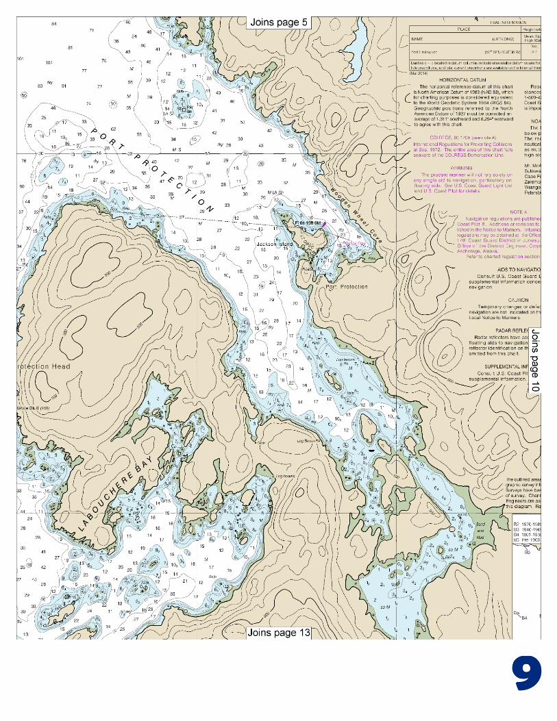
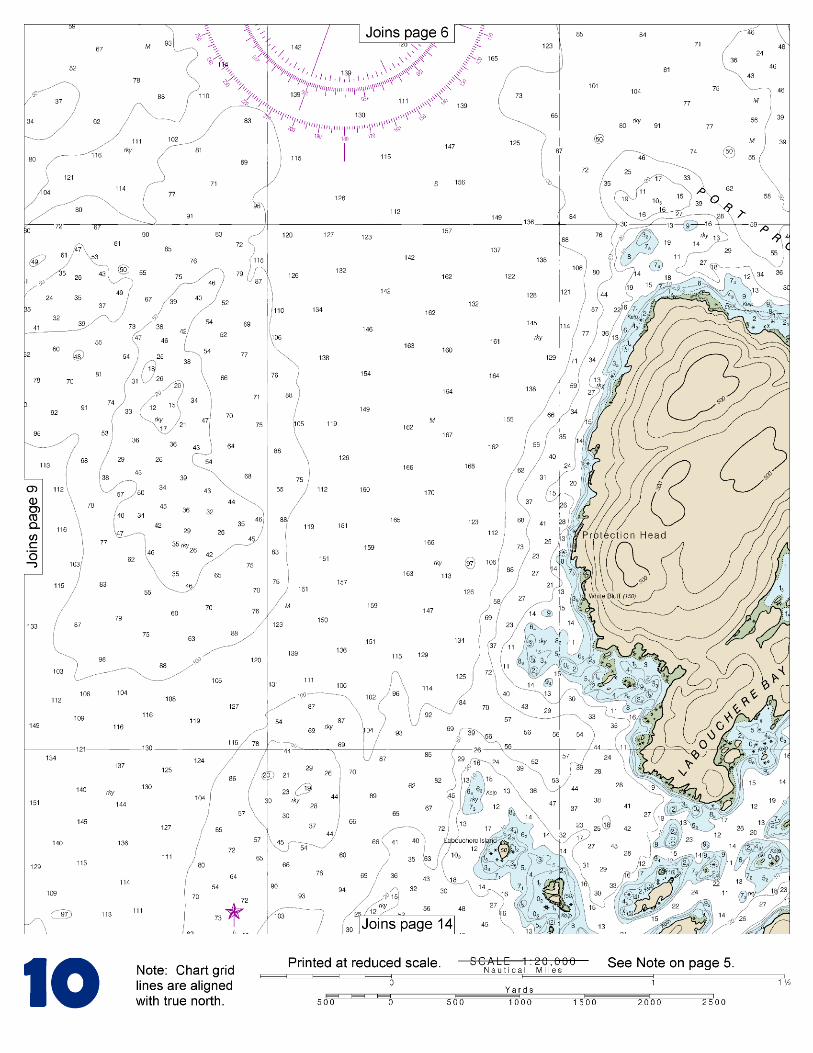
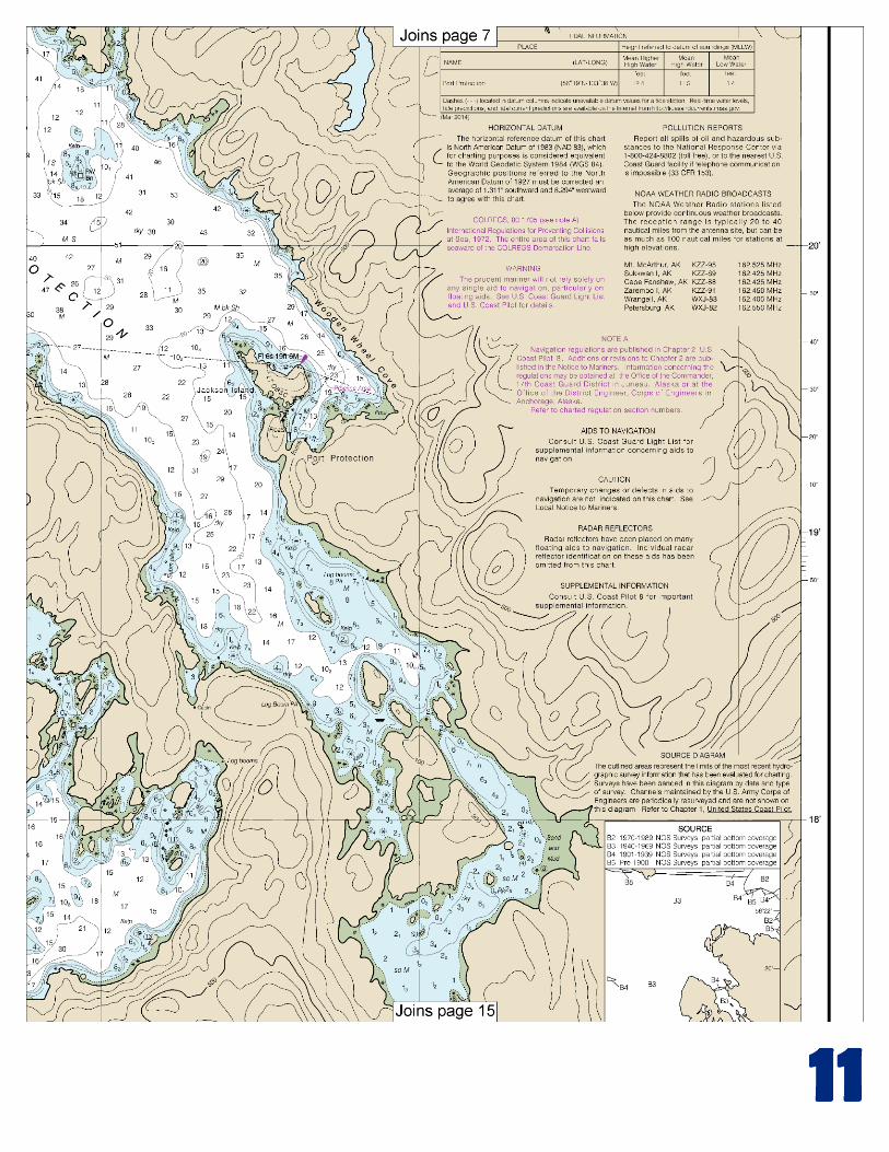
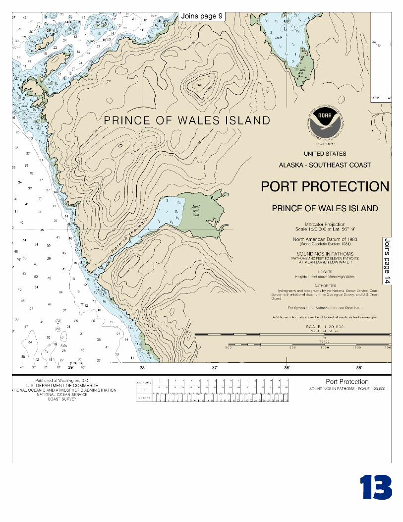
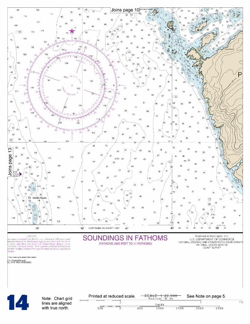
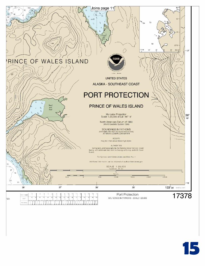
(Selected Excerpts from Coast Pilot) Hole in the Wall (56°15.7'N., 133°38.5'W.) is a small cove on the E side of Sumner Strait, E of Calder Rocks and 2.5 miles N of Barrier Islands (chart 17387). The entrance is through a very narrow passage 0.5 mile long, between high bluffs, and opens into a basin 400 yards in diameter. Two rocks that bare are in the narrow entrance. Depths in the basin are from ½ to 7 fathoms; it may be used for anchorage, but is subject to strong winds drawing
through the entrance. The bottom is sand and mud. Small craft pass through the narrow entrance only at half tide or higher water. Labouchere Bay is about 1.8 miles N of the entrance to Hole in the Wall
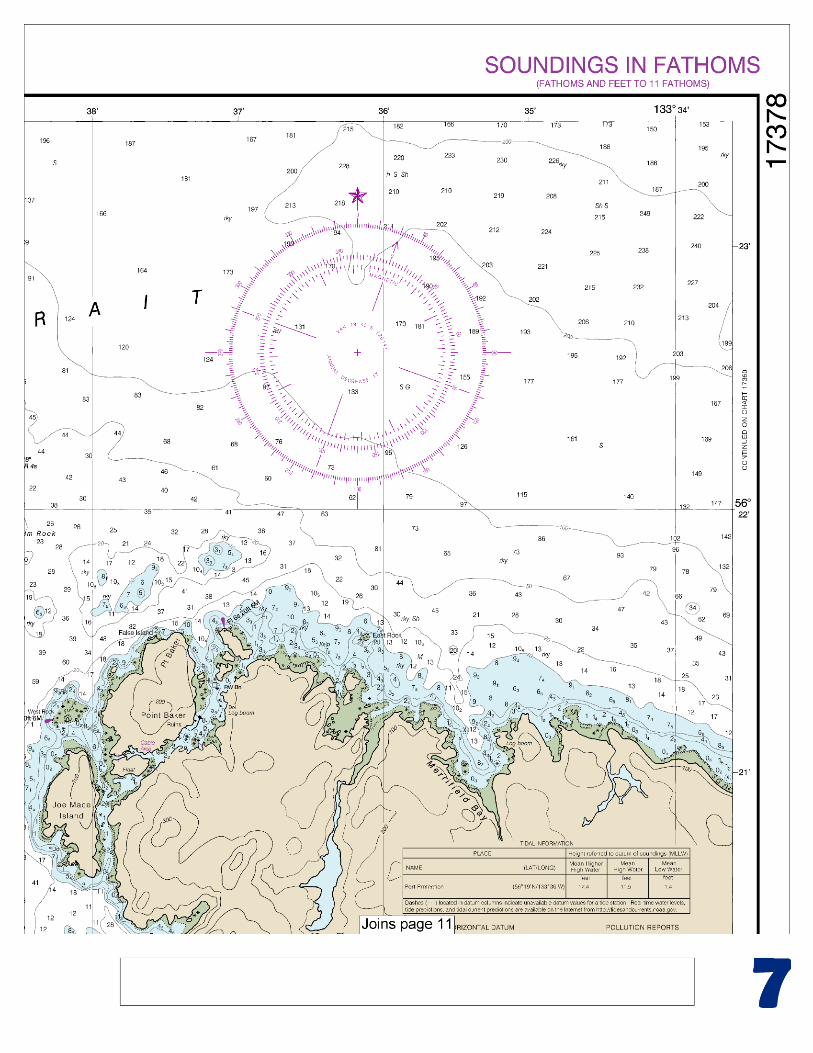
and about 4 miles S of Point Baker. It is studded with islets and rocks, the entrance being partially closed by Labouchere Island and the islands and reefs that extend SE of it to the shore. There is sheltered anchorage for small vessels just inside the bay on the S side in about 56°17.2'N., 133°39.0'W., in depths of 3 to 21 fathoms, mud and sand bottom. Three detached rocks that cover at half tide are near the head of the anchorage. Small fishing craft anchor SE of the rocks and near the sand beach in 2 to 5 fathoms. The recommended entrance to Labouchere Bay is from the NW. Small fishing vessels may enter Labouchere Bay from the S on a N course, through a channel passing E of the kelp-marked submerged reef at the entrance, 0.5 mile SE of Labouchere Island, and avoiding the large kelp beds on their right. In 1976, a logging camp was at the cove about 1.7 miles ENE of Labouchere Island. There are a small-craft float, a seaplane float, and log storage in the cove. Water and gasoline are available in an emergency only. A road connects Labouchere Bay with Port Protection. The logging camp maintains radiotelephone communications with the Alaska Loggers Association in Ketchikan. Protection Head, a bold white bluff, 1 mile N of Labouchere Island, is an outstanding landmark visible from the S for many miles. Port Protection has its entrance 1.5 miles S of Point Baker, the NW extremity of Prince of Wales Island, and 1.5 miles N of Protection Head. The entrance is marked by Port Protection Light (56°19'35"N., 133°36'45"W.), 19 feet above the water, shown from a pile with a red and white diamond-shaped daymark on the NE end of the wooded island at the SW side of Wooden Wheel Cove, 1 mile inside the entrance, and by a daybeacon on a detached reef, 0.3 mile off the N shore. A ship may enter Port Protection on either side of the daybeacon while being careful to pass the reef at a safe distance. There is good anchorage for large craft 1.8 miles in from the daybeacon and SW of the chain of small wooded islands in the upper half of the bay, in 6 to 18 fathoms, mud and sand bottom. A more sheltered anchorage may be had E of the chain of islands. To reach the second anchorage, proceed from the first on an ENE course, keeping the two N of the small wooded islands to the NW. Pass close to the tangent of the larger island on the right. Depths in the passage between the islands are 6 to 11 fathoms. Good anchorage in 10 fathoms, mud bottom, is directly ahead and about halfway between the island passed on the right and the E shore of the bay. This is the best shelter in the bay, affording protection in all weather. Small vessels may find anchorage in 5 to 8 fathoms a little farther in. The shores of Port Protection are usually fringed with kelp, and the soundings, though deep, are irregular and the bottom rocky. Log raft mooring facilities are along the SW shore about 1.2 miles S of Port Protection Light. Port Protection is a small settlement on the NE side of the port in Wooden Wheel Cove and S of Port Protection Light. Along the beach are several homes and a fish cannery facility. A 250-foot State-maintained small-craft float is anchored on the W side of the cove with 4 to 8 fathoms reported alongside in 2005. Water is available. A microwave tower is about 150 yards S of the facility. Joe Mace Island is on the N side of the entrance to Port Protection. West Rock, in a cluster of dry rocks and rocks on a reef, is about 300 yards N of Joe Mace Island. The rock is marked by West Rock Light (56°21'12"N., 133°38'14"W.), 20 feet above the water, and shown from a skeleton tower with a red and white diamond-shaped daymark.
U.S. Coast Guard Rescue Coordination Center 24 hour Regional Contact for Emergencies
RCC Juneau Commander
17th CG District (907) 463-2000 Juneau, Alaska
G
NOAA’s navigation managers serve as ambassadors to the maritime community. They help identify navigational challenges facing professional and recreational mariners, and provide NOAA resources and information for safe navigation. For additional information, please visit nauticalcharts.noaa.gov/service/navmanagers
To make suggestions or ask questions online, go to nauticalcharts.noaa.gov/inquiry. To report a chart discrepancy, please use ocsdata.ncd.noaa.gov/idrs/discrepancy.aspx.
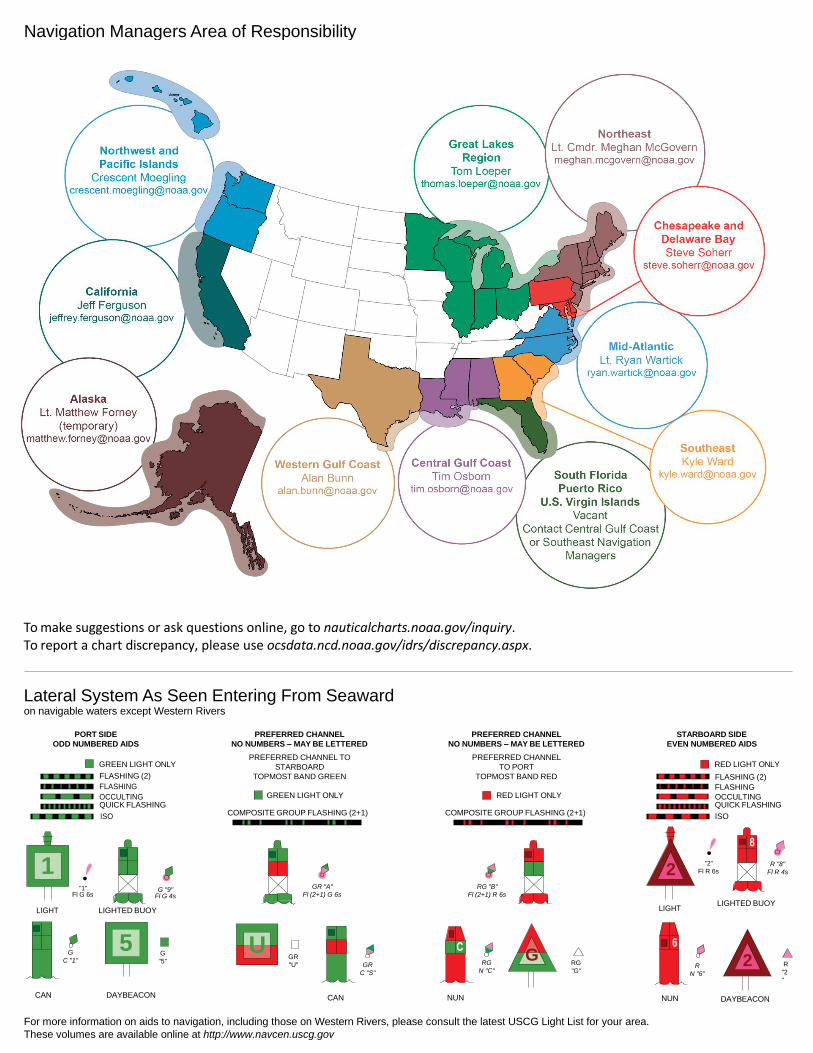
Lateral System As Seen Entering From Seaward on navigable waters except Western Rivers
PORT SIDE
ODD NUMBERED AIDS
GREEN LIGHT ONLY
FLASHING (2)
PREFERRED CHANNEL
NO NUMBERS – MAY BE LETTERED
PREFERRED CHANNEL TO
STARBOARD
TOPMOST BAND GREEN
PREFERRED CHANNEL
NO NUMBERS – MAY BE LETTERED
PREFERRED CHANNEL
TO PORT
TOPMOST BAND RED
STARBOARD SIDE
EVEN NUMBERED AIDS
RED LIGHT ONLY
FLASHING (2)
FLASHING FLASHING
OCCULTING GREEN LIGHT ONLY RED LIGHT ONLY OCCULTING QUICK FLASHING QUICK FLASHING
ISO COMPOSITE GROUP FLASHING (2+1) COMPOSITE GROUP FLASHING (2+1) ISO
"1"
Fl G 6s
G "9"
Fl G 4s
GR "A"
Fl (2+1) G 6s
RG "B"
Fl (2+1) R 6s
"2"
Fl R 6s
8
R "8"
Fl R 4s
LIGHT
G
C "1"
LIGHTED BUOY
G
"5"
GR
"U"
GR
C "S"
RG
N "C"
RG
"G"
LIGHT
6
R
N "6"
LIGHTED BUOY
R
"2
"
CAN DAYBEACON
CAN NUN NUN
DAYBEACON
For more information on aids to navigation, including those on Western Rivers, please consult the latest USCG Light List for your area.
These volumes are available online at http://www.navcen.uscg.gov
Navigation Managers Area of Responsibility
Northeast
Lt. Meghan McGovern
Northwest and
Pacific Islands
Crescent Moegling
Great Lakes Region
Tom Loeper
Chesapeake and
Delaware Bay
Steve Soherr
California
Jeff Ferguson
[email protected] Mid-Atlantic
Lt. Ryan Wartick
Alaska
Lt. Timothy M. Smith
Western Gulf Coast
Alan Bunn
Central Gulf Coast
Tim Osborn
[email protected] South Florida
Puerto Rico
U.S. Virgin Islands
Michael Henderson
Southeast
Kyle Ward
2
2 C U 5
1
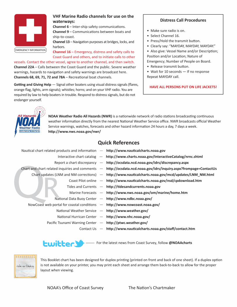
VHF Marine Radio channels for use on the waterways:Channel 6 – Inter-ship safety communications.Channel 9 – Communications between boats and ship-to-coast.Channel 13 – Navigation purposes at bridges, locks, and harbors.Channel 16 – Emergency, distress and safety calls to Coast Guard and others, and to initiate calls to other
vessels. Contact the other vessel, agree to another channel, and then switch.Channel 22A – Calls between the Coast Guard and the public. Severe weather warnings, hazards to navigation and safety warnings are broadcast here.Channels 68, 69, 71, 72 and 78A – Recreational boat channels.
Getting and Giving Help — Signal other boaters using visual distress signals (flares, orange flag, lights, arm signals); whistles; horns; and on your VHF radio. You are required by law to help boaters in trouble. Respond to distress signals, but do not endanger yourself.
EMERGENCY INFORMATION
Distress Call Procedures
• Make sure radio is on.• Select Channel 16.• Press/Hold the transmit button.• Clearly say: “MAYDAY, MAYDAY, MAYDAY.”• Also give: Vessel Name and/or Description;Position and/or Location; Nature of Emergency; Number of People on Board.• Release transmit button.• Wait for 10 seconds — If no responseRepeat MAYDAY call.
HAVE ALL PERSONS PUT ON LIFE JACKETS!
This Booklet chart has been designed for duplex printing (printed on front and back of one sheet). If a duplex option is not available on your printer, you may print each sheet and arrange them back-to-back to allow for the proper layout when viewing.
QR
Quick ReferencesNautical chart related products and information - http://www.nauticalcharts.noaa.gov
Interactive chart catalog - http://www.charts.noaa.gov/InteractiveCatalog/nrnc.shtmlReport a chart discrepancy - http://ocsdata.ncd.noaa.gov/idrs/discrepancy.aspx
Chart and chart related inquiries and comments - http://ocsdata.ncd.noaa.gov/idrs/inquiry.aspx?frompage=ContactUs
Chart updates (LNM and NM corrections) - http://www.nauticalcharts.noaa.gov/mcd/updates/LNM_NM.html
Coast Pilot online - http://www.nauticalcharts.noaa.gov/nsd/cpdownload.htm
Tides and Currents - http://tidesandcurrents.noaa.gov
Marine Forecasts - http://www.nws.noaa.gov/om/marine/home.htm
National Data Buoy Center - http://www.ndbc.noaa.gov/
NowCoast web portal for coastal conditions - http://www.nowcoast.noaa.gov/
National Weather Service - http://www.weather.gov/
National Hurrican Center - http://www.nhc.noaa.gov/
Pacific Tsunami Warning Center - http://ptwc.weather.gov/
Contact Us - http://www.nauticalcharts.noaa.gov/staff/contact.htm
NOAA’s Office of Coast Survey The Nation’s Chartmaker
For the latest news from Coast Survey, follow @NOAAcharts
NOAA Weather Radio All Hazards (NWR) is a nationwide network of radio stations broadcasting continuous weather information directly from the nearest National Weather Service office. NWR broadcasts official Weather Service warnings, watches, forecasts and other hazard information 24 hours a day, 7 days a week. http://www.nws.noaa.gov/nwr/