Embed Size (px)
Citation preview
LEWISTON
Brook
")9
LEW
ISTO
NSA
BAT
TUS
§̈¦95
Littl
eR
iv
er
Pinkham
Brook
")196
LEWISTO
N
LEW
ISTO
NLI
SBO
N
LEWISTONDURHAM
")136
")136
AU
BUR
N
LISB
ON
D
UR
HA
M
Mea
dow
Brook
")9
River
Sabattus
River
Barker
Brook
LISBON
LISBONFALLS
RunaroundPond
Ger
rish
B
rook
Dyer
Brook
Meadow
Brook
DURHAM
BRUNSWIC
K
Brook
Newell
Newell Brook
LISBON
TOPSHAM
TOPSHAMDURHAM
")125
")125
")196
N oName Brook
Potter
BOW
DO
IN
LISBO
N
")9
")9
")126
")125
")9
Androscoggin
Androscoggin
River
")136
AUBURNDURHAM
Simps
onBr
ook
TOPSHAMBRUNSWICK
HouseBrook
")196
Sa lmon
Brook
Moo
dy
Brook
SutherlandPond
LoonPond
CurtisBog
Fish
er
Stre
am
PuringtonBr ook
Gill
espi
eBro
ok
SAB
ATTU
SBO
WD
OIN
Saba
ttus
Rive
r
Maxwell
Bro
o k
SABATTUSLISBON
")126
GarcelonBog
Rare AnimalEndangered Species
Bald EagleSpecies of Special Concern
Bald EagleSpecies of Special Concern
Bald EagleSpecies of Special Concern
CreeperSpecies of Special Concern
CreeperSpecies of Special Concern
CreeperSpecies of Special Concern
Narrow-leaf ArrowheadSpecies of Special Concern
Dry Land SedgeSpecies of Special Concern
Dry Land SedgeSpecies of Special Concern
Dry Land SedgeSpecies of Special Concern
500
400
500
500
300
400
400
300
300
200
200
300
300
200
300
400
200
300 300400
200
300
400
300 200
200
300
300
200
300
400
200
200
400
300
200
200
200
100
300
300
300
200
200
300
200
200
600
600
600
400
400 500
500
400
500
500
500
500
400
500
500
400
300
300
400
300
300
300
300
400
400
300
400
400
300
400
300 400
300
400
300
400
400
400
400
400
400
400
200
200
300
200
200
200
200
200
200
200
300
300
300
200
300
300
300
200
300
300
300
300
300
300
200
300
300
200
200
300
300
300
300
300
300
300
200
300
200
300
300
300
300
300
300
300
200
300
300
300
300
300 300
100
100
100
100
100
200
200
200
200
200
100200
200
200
100
200
200
200
200
100
100
200
200
100
100
200
200
200
200
200
200
200
200
200
200
200
200
200
100
200
200
200
200
100
200
500
500
400400
400
400
300
300
300
300 300
300
300
300
300
300
300
300
200
200
200
200
200
200
200
200
200
200
200
200
200
200
200
200
200
200
200
200
200
200
200
200
200
200
200
200
200
200
100
Kilometers1,000 0500
Meters10.5
5,000 02,500Feet Miles
10.5
Projection: UTM 19N Datum: NAD 1983
1:24,000 Scale
¶
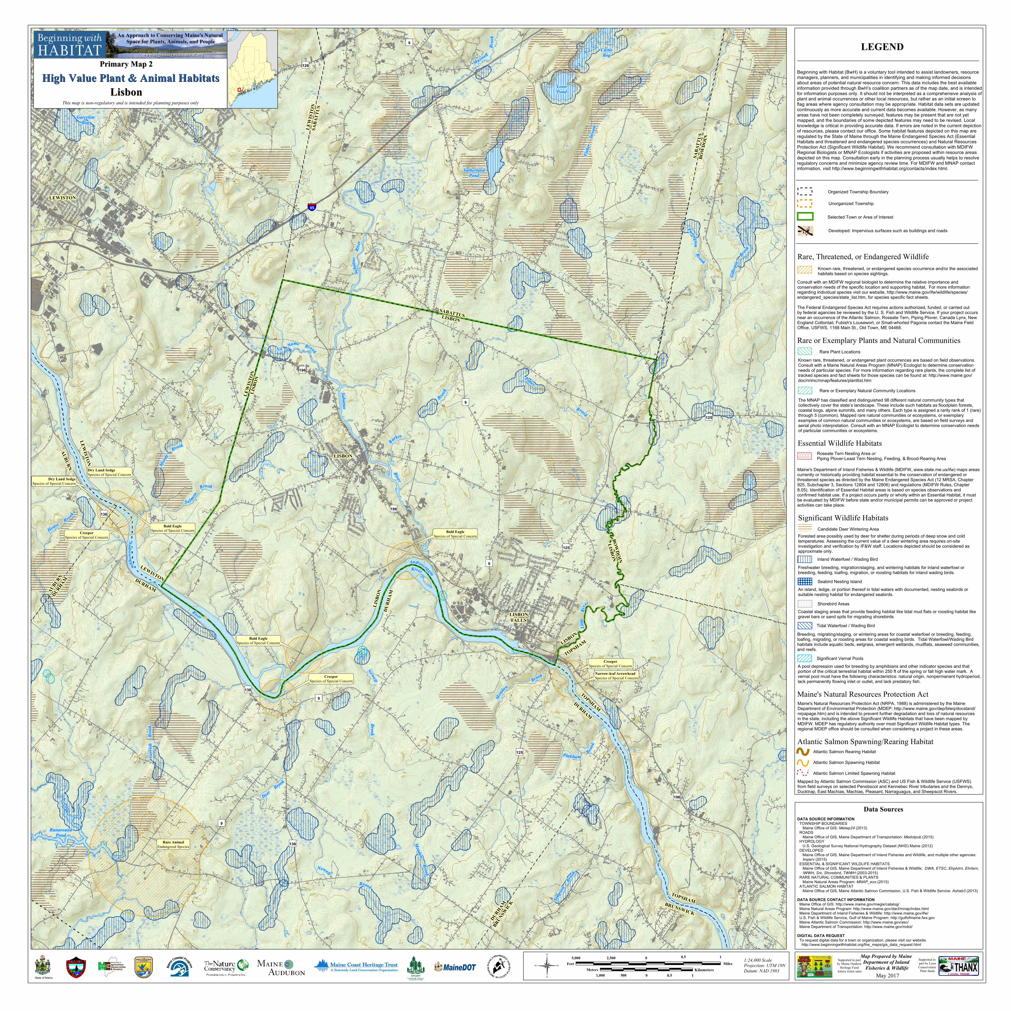
LEGEND
Beginning with Habitat (BwH) is a voluntary tool intended to assist landowners, resource managers, planners, and municipalities in identifying and making informed decisions about areas of potential natural resource concern. This data includes the best available information provided through BwH’s coalition partners as of the map date, and is intended for information purposes only. It should not be interpreted as a comprehensive analysis of plant and animal occurrences or other local resources, but rather as an initial screen to flag areas where agency consultation may be appropriate. Habitat data sets are updated continuously as more accurate and current data becomes available. However, as many areas have not been completely surveyed, features may be present that are not yet mapped, and the boundaries of some depicted features may need to be revised. Local knowledge is critical in providing accurate data. If errors are noted in the current depiction of resources, please contact our office. Some habitat features depicted on this map are regulated by the State of Maine through the Maine Endangered Species Act (Essential Habitats and threatened and endangered species occurrences) and Natural Resources Protection Act (Significant Wildlife Habitat). We recommend consultation with MDIFW Regional Biologists or MNAP Ecologists if activities are proposed within resource areas depicted on this map. Consultation early in the planning process usually helps to resolve regulatory concerns and minimize agency review time. For MDIFW and MNAP contact information, visit http://www.beginningwithhabitat.org/contacts/index.html.
Rare or Exemplary Plants and Natural Communities
Known rare, threatened, or endangered plant occurrences are based on field observations. Consult with a Maine Natural Areas Program (MNAP) Ecologist to determine conservation needs of particular species. For more information regarding rare plants, the complete list of tracked species and fact sheets for those species can be found at: http://www.maine.gov/doc/nrimc/mnap/features/plantlist.htm
Rare Plant Locations
The MNAP has classified and distinguished 98 different natural community types that collectively cover the state’s landscape. These include such habitats as floodplain forests, coastal bogs, alpine summits, and many others. Each type is assigned a rarity rank of 1 (rare) through 5 (common). Mapped rare natural communities or ecosystems, or exemplary examples of common natural communities or ecosystems, are based on field surveys and aerial photo interpretation. Consult with an MNAP Ecologist to determine conservation needsof particular communities or ecosystems.
Rare or Exemplary Natural Community Locations
Essential Wildlife Habitats
Maine's Department of Inland Fisheries & Wildlife (MDIFW, www.state.me.us/ifw) maps areas currently or historically providing habitat essential to the conservation of endangered or threatened species as directed by the Maine Endangered Species Act (12 MRSA, Chapter 925, Subchapter 3, Sections 12804 and 12806) and regulations (MDIFW Rules, Chapter 8.05). Identification of Essential Habitat areas is based on species observations and confirmed habitat use. If a project occurs partly or wholly within an Essential Habitat, it must be evaluated by MDIFW before state and/or municipal permits can be approved or project activities can take place.
WWWWWWWWWWWWWWWWWWWWW Roseate Tern Nesting Area or
Piping Plover-Least Tern Nesting, Feeding, & Brood-Rearing Area
Significant Wildlife Habitats
A pool depression used for breeding by amphibians and other indicator species and that portion of the critical terrestrial habitat within 250 ft of the spring or fall high water mark. A vernal pool must have the following characteristics: natural origin, nonpermanent hydroperiod, lack permanently flowing inlet or outlet, and lack predatory fish.
Significant Vernal Pools
Breeding, migrating/staging, or wintering areas for coastal waterfowl or breeding, feeding, loafing, migrating, or roosting areas for coastal wading birds. Tidal Waterfowl/Wading Bird habitats include aquatic beds, eelgrass, emergent wetlands, mudflats, seaweed communities, and reefs.
Tidal Waterfowl / Wading Bird
Coastal staging areas that provide feeding habitat like tidal mud flats or roosting habitat like gravel bars or sand spits for migrating shorebirds(((((((((((((((((((((((((((((((((((
Shorebird Areas
An island, ledge, or portion thereof in tidal waters with documented, nesting seabirds or suitable nesting habitat for endangered seabirds.
" " " " " " " "" " " " " " " "" " " " " " " "" " " " " " " "" " " " " " " "
Seabird Nesting Island
Freshwater breeding, migration/staging, and wintering habitats for inland waterfowl or breeding, feeding, loafing, migration, or roosting habitats for inland wading birds.
Inland Waterfowl / Wading Bird
Forested area possibly used by deer for shelter during periods of deep snow and cold temperatures. Assessing the current value of a deer wintering area requires on-site investigation and verification by IF&W staff. Locations depicted should be considered as approximate only.
Candidate Deer Wintering Area
Maine's Natural Resources Protection Act (NRPA, 1988) is administered by the Maine Department of Environmental Protection (MDEP; http://www.maine.gov/dep/blwq/docstand/nrpapage.htm) and is intended to prevent further degradation and loss of natural resources in the state, including the above Significant Wildlife Habitats that have been mapped by MDIFW. MDEP has regulatory authority over most Significant Wildlife Habitat types. The regional MDEP office should be consulted when considering a project in these areas.
Maine's Natural Resources Protection Act
Rare, Threatened, or Endangered Wildlife
Consult with an MDIFW regional biologist to determine the relative importance and conservation needs of the specific location and supporting habitat. For more information regarding individual species visit our website, http://www.maine.gov/ifw/wildlife/species/endangered_species/state_list.htm, for species specific fact sheets.
The Federal Endangered Species Act requires actions authorized, funded, or carried out by federal agancies be reviewed by the U. S. Fish and Wildlife Service. If your project occurs near an occurrence of the Atlantic Salmon, Roseate Tern, Piping Plover, Canada Lynx, New England Cottontail, Fubish's Lousewort, or Small-whorled Pagonia contact the Maine Field Office, USFWS, 1168 Main St., Old Town, ME 04468.
Known rare, threatened, or endangered species occurrence and/or the associated habitats based on species sightings.
Atlantic Salmon Spawning/Rearing Habitat
Mapped by Atlantic Salmon Commission (ASC) and US Fish & Wildlife Service (USFWS) from field surveys on selected Penobscot and Kennebec River tributaries and the Dennys, Ducktrap, East Machias, Machias, Pleasant, Narraguagus, and Sheepscot Rivers.
Atlantic Salmon Limited Spawning Habitat
Atlantic Salmon Rearing Habitat
Atlantic Salmon Spawning Habitat
Organized Township Boundary
Unorganized Township
Developed: Impervious surfaces such as buildings and roads
Selected Town or Area of Interest
Data SourcesDATA SOURCE INFORMATION TOWNSHIP BOUNDARIES Maine Office of GIS: Metwp24 (2013) ROADS Maine Office of GIS, Maine Department of Transportation: Medotpub (2015) HYDROLOGY U.S. Geological Survey National Hydrography Dataset (NHD) Maine (2012) DEVELOPED Maine Office of GIS, Maine Department of Inland Fisheries and Wildlife, and multiple other agencies: Imperv (2015) ESSENTIAL & SIGNIFICANT WILDLIFE HABITATS Maine Office of GIS, Maine Department of Inland Fisheries & Wildlife; DWA, ETSC, Ehplvtrn, Ehrtern, IWWH, Sni, Shorebird, TWWH (2003-2015) RARE NATURAL COMMUNITIES & PLANTS Maine Natural Areas Program: MNAP_eos (2015) ATLANTIC SALMON HABITAT Maine Office of GIS, Maine Atlantic Salmon Commission, U.S. Fish & Wildlife Service: Ashab3 (2013)
DATA SOURCE CONTACT INFORMATION Maine Office of GIS: http://www.maine.gov/megis/catalog/ Maine Natural Areas Program: http://www.maine.gov/dacf/mnap/index.html Maine Department of Inland Fisheries & Wildlife: http://www.maine.gov/ifw/ U.S. Fish & Wildlife Service, Gulf of Maine Program: http://gulfofmaine.fws.gov Maine Atlantic Salmon Commission: http://www.maine.gov/asc/ Maine Department of Transportation: http://www.maine.gov/mdot/
DIGITAL DATA REQUEST To request digital data for a town or organization, please visit our website. http://www.beginningwithhabitat.org/the_maps/gis_data_request.html
Supported in part by LoonConservation
Plate funds
Supported in part by Maine Outdoor
Heritage Fund lottery ticket sales
Map Prepared by Maine Department of Inland Fisheries & Wildlife
May 2017State of Maine
www.beginningwithhabitat.orgwww.beginningwithhabitat.org
An Approach to Conserving Maine's Natural Space for Plants, Animals, and People
Primary Map 2Primary Map 2
High Value Plant & Animal HabitatsHigh Value Plant & Animal Habitats
This map is non-regulatory and is intended for planning purposes only
LisbonLisbon