Embed Size (px)
Citation preview
Victory Drive Corridor Study
Previous Studies Assessment Summary Memorandum
November 25, 2014
VICTORY DRIVE CORRIDOR STUDY Chatham County Savannah MPC
November 25, 2014
Previous Studies Assessment
Brief Summary Memorandum Page 1 of 38
INTRODUCTION This memorandum provides a brief summary of previous studies that were reviewed as a starting point for the Victory Drive Corridor Study. The purpose of this overview assessment is to identify and summarize key recommendations, analysis and planning insights from prior studies which may impact the Victory Drive Corridor Study. The following previous studies have been summarized:
1. Cuyler-Brownsville Overlay Planned Neighborhood Conservation District 2. Mid-City District 3. Waters Avenue Revitalization Plan 4. Journey of a Road: Victory Drive Between Bee Road And Skidaway Road – By Jessica Archer 5. National Register Nomination Review – By Josh Ward 6. Tybee Island Comprehensive Plan 7. Tybee Island Pedestrian and Traffic Study 8. Chatham County - Savannah Tricentennial Plan 9. 2040 Core MPO Total Mobility Plan (Draft) 10. 2035 Core Connections Framework Mobility Plan 11. 2030 Long Range Transportation Plan 12. Core MPO Transportation Improvement Program 13. Core MPO 2009 Congestion Management Process Update 14. Core MPO 2004 Congestion Management Process 15. Wave Ecology and the Highway 80 Challenge 16. US 80 Bridges Replacement Study 17. Context Sensitive Design Manual, Chatham County – Savannah Metropolitan Planning
Commission (2007) 18. Ongoing GDOT Projects 19. Core MPO Non-Motorized Transportation Plan (Draft) 20. Chatham Area Transit – Transit Development Plan (TDP) 21. Victory Drive Past Improvements and Information 22. Martin Luther King / Montgomery Street Revitalization Plan 23. Gateway to Coastal Georgia: Connecting the Coast 24. Thunderbolt Comprehensive Plan 25. Amenities Plan and Supporting Resolutions
VICTORY DRIVE CORRIDOR STUDY Chatham County Savannah MPC
November 25, 2014
Previous Studies Assessment
Brief Summary Memorandum Page 2 of 38
1. CUYLER-BROWNSVILLE OVERLAY PLANNED NEIGHBORHOOD CONSERVATION DISTRICT
• District established in 1997, with revisions through May of 2004 • All structures within the district were listed on the National Register February 13, 1998 • Purpose of the district is “to promote its general welfare through its conservation, rehabilitation
and redevelopment that is compatible in terms of land use and visual appearance, the provision of affordable infill housing, and the preservation of the historical and architectural character”
Transportation Curb cut allotments within the district shall relate to the historic architectural/urban design forms allowed. The district seeks to insure that historic patterns of ingress/egress to the district off Victory Drive is preserved. Therefore, the neighborhood itself should not affect movement within the Victory Drive corridor. Landscape Landscape was not addressed specifically in the district; however, from the public right-of-way (ROW), visual compatibility of the neighborhood is assured through the use of development standards that address architectural style and lot setbacks. Existing front-yard setbacks and curb-cut allotments stay the same as they historically have been. The narrow center median in Victory Drive is not affected by the standards. Urban Design The entirety of the district is north of Victory Drive. Three of the thirteen wards lie directly adjacent to Victory Drive. They begin at the intersection of Victory Drive with Ogeechee Road and extend to the intersection of Martin Luther King, Jr. (MLK) Boulevard and Victory Drive. Historic architectural form in the district, including those structures that directly face Victory Drive, may not be altered outside of the architectural standards. This assures architectural consistency on the north side of Victory from Ogeechee Rd. to MLK Boulevard, a length of approximately .83 miles. Signage regulations are the same as standards associated with the Victorian Planned Neighborhood Conservation District (PNC). Other Projects receiving federal money shall comply with the Secretary of the Interior’s Standards for Rehabilitation. These standards shall take precedence over similar guidelines in this section.
VICTORY DRIVE CORRIDOR STUDY Chatham County Savannah MPC
November 25, 2014
Previous Studies Assessment
Brief Summary Memorandum Page 3 of 38
2. MID-CITY DISTRICT
• District established in 2005, with amendments through April 2013 • Overlaps portions of the Thomas Square, Metropolitan and Baldwin Park Neighborhoods • Purpose of the district is “to ensure the vibrancy of historic mixed-use neighborhoods with
traditional development patterns characteristic of Savannah from 1890-1930 during the street car and early automobile era.”
Transportation Curb cut allotments shall relate to the historic architectural forms allowed. This insures that historic patterns of ingress/egress are preserved between the district and Victory Drive. More specifically, a general development standard reads: “On Bull Street and Victory Drive, new curb cuts shall be limited to one cut per 100 ft. of street frontage.” Landscape Landscape is not addressed specifically in the district; however, from the public ROW, visual compatibility of the neighborhood is assured through the use of development standards that address architectural style and lot setbacks. Existing front-yard setbacks and curb-cut allotments shall stay the same as they historically have been. The landscape framework within the Victory Drive ROW is in part protected through the design standards. The district approval process includes completion of a Certificate of Appropriateness for any proposed changes to contributing properties within the district. Urban Design The entirety of the district is north of Victory Drive. The south edge of the district fronts on Victory Drive for a distance of approximately .56 miles. The district boundary runs from a point just east of the Victory Drive/Montgomery Street intersection to a point just west of the Victory Drive/Price Street intersection. Historic architectural form in the district, including those structures that directly face the public street may not be altered outside of the architectural standards. This assures architectural consistency along Victory Drive.
VICTORY DRIVE CORRIDOR STUDY Chatham County Savannah MPC
November 25, 2014
Previous Studies Assessment
Brief Summary Memorandum Page 4 of 38
3. WATERS AVENUE REVITALIZATION PLAN Urban Design Based on language in the Request for Proposals (RFP) issued by the City of Savannah in 2013, the plan includes a physical and economic revitalization of the 1.2 mile corridor between Wheaton Street on the north end and Victory Drive on the south. The RFP directly addressed the physical re-design of the streetscape. The project scope area includes the public right of way (ROW) on Waters Avenue, but does not include the Victory Drive intersection. EMC Engineering was ultimately hired as the design consultant. The Victory Drive Corridor Study team spoke with EMC Engineering’s Dan Fisher on October 2, 2014 for a progress update. Dan informed the team that EMC was essentially complete with streetscape design concepts but had not yet received formal approval of the concept design. However, EMC had received direction from the City to proceed with preliminary construction documents. Dan also confirmed that their design work ended at the Victory Drive ROW and will not impact the Waters Avenue/ Victory Drive intersection.
VICTORY DRIVE CORRIDOR STUDY Chatham County Savannah MPC
November 25, 2014
Previous Studies Assessment
Brief Summary Memorandum Page 5 of 38
4. “JOURNEY OF A ROAD - VICTORY DRIVE BETWEEN BEE ROAD AND SKIDAWAY ROAD” By Jessica
Archer
• MPC student intern paper completed September, 2013 • The paper has not been published • Includes extensive references to commercialization of the corridor, landscape history
Transportation The paper notes that Highway 80 initially ran from Tybee Island to San Diego. The “Ocean to Ocean Highway” is now fragmented in numerous places (e.g. the west side of Dallas, Texas has been “decommissioned” and many parts are “closed off completely, giving way to faster, smoother Interstates”). There is a reference to 1955, where Victory Drive had a 25mph speed limit inside the Savannah city limits. At that time, Thunderbolt had just raised the speed limit to 35mph, mostly where it is today, with some areas going to 45 mph. The paper names modern pavement as a contributing factor to traffic volumes. It references GDOT being involved in a “reassessment of the on and off ramps to Victory Drive from Truman Parkway.” Landscape There are many references that document landscape design intent well before World War I (WWI). In 1895, the City of Savannah Park and Tree Department selected live oaks, cabbage palms, azaleas and magnolias as the palette to “appear in every vantage point.” In 1910, there was an agreement to plant an “avenue of palms from Bull Street to Thunderbolt to give Estill and Dale Avenues” (soon to become Victory Drive) a “picturesque advantage.” 460 palms were planted along Estill and Atlantic Avenues. Although some believe the palmettos along Victory Drive were to stand for each of the fallen soldiers of WWI, it appears that the trees and landscape were planned before the war itself. It is noted that the Whole Foods shopping center development, completed in 2013, “brought back part of Victory Drive once lost to commercialization.” Unfortunately, the arrangement of the palms does not accurately represent the historic arrangement of palms. A reference from former Park and Tree Director Don Gardner states that, once renamed, the boulevard “was designed as 110 feet wide with a center grass plat” that continued the same landscape design as the previous scheme along Estill Ave. “After the completion of the memorial drive in 1923, the palmettos lined Victory Drive from Ogeechee Road to Tybee Island, making it one of the nation’s longest palmetto lined roads.”
VICTORY DRIVE CORRIDOR STUDY Chatham County Savannah MPC
November 25, 2014
Previous Studies Assessment
Brief Summary Memorandum Page 6 of 38
Urban Design The historic development of residential wards and the prevalence of the automobile created opportunities for citizens to get out and recreate. The paper contains many references to the commercialization of Victory Drive, especially between Bee Road and Skidaway Road.

VICTORY DRIVE CORRIDOR STUDY Chatham County Savannah MPC
November 25, 2014
Previous Studies Assessment
Brief Summary Memorandum Page 7 of 38
5. NATIONAL REGISTER NOMINATION REVIEW – by SCAD student Josh Ward Landscape/Urban Design This National Register Nomination Form was prepared by Joshua L. Ward, a SCAD student at the time, in May of 2000. There is no record that this nomination was ever submitted to the Department of Interior for review. The nomination narrative describes the Victory Drive corridor as being 19 miles long; starting at Ogeechee Road and running to Tybee Island. The nomination provides a brief overview of the corridor’s history. In 2014, the jB+a Corridor Study team requested a review of this nomination form by Reed Engle, a retired Landscape Architect with the National Park Service and member of the Historic Review Board of Savannah. Reed’s comments – “There are specific theme studies for historic roads and designed landscapes. This does not reference them. Also, I question the inclusion of 19 miles (yes, Thunderbolt to Tybee) in the memorial as the section from Thunderbolt to Tybee wasn’t even completed as far as I know when the memorial was dedicated in 1922.”
VICTORY DRIVE CORRIDOR STUDY Chatham County Savannah MPC
November 25, 2014
Previous Studies Assessment
Brief Summary Memorandum Page 8 of 38
6. TYBEE ISLAND COMPREHENSIVE PLAN
• Follows Department of Community Affairs (DCA) guidelines for Comprehensive Plans • Plan submitted in 2008 • Establishes “Vision for the Future” – stewards of resources, build four-season economy • Hwy 80 corridor identified as the area with most potential for infill and redeveloped commercial
development. Utilize existing infrastructure and minimize any impacts to undeveloped land. Transportation Improve coordination with GDOT to preserve marshlands adjacent to transportation projects. In 2000, over 90% of Tybee workforce commuted to work off-island. Hwy 80 is the only access route to the island. Encourage alternative transportation routes on gridded side streets off of Hwy 80. City has begun acquiring land for path along north side of Hwy 80 – connection to McQueen’s Island Trail – a 17 mile improvement to connect River St. in Savannah to Tybee. Major issues during tourism season include traffic congestion and a lack of parking. Fast moving traffic along Hwy 80 is not safe for pedestrians. Landscape Strategies for the protection of natural resources include restricting development into marshlands, creating conservation easements, requiring natural vegetative buffers for any development adjacent to natural areas and minimizing and restricting billboards adjacent to marshlands. Urban Design Preserve large lots between Butler (US 80) and the beach. Develop wayfinding signage themes and standards. Introduce gateway signage and associated beautification along US 80 as one enters and leaves the island. Protect and promote views to cultural resources along US 80 including views to the Cockspur Lighthouse.
VICTORY DRIVE CORRIDOR STUDY Chatham County Savannah MPC
November 25, 2014
Previous Studies Assessment
Brief Summary Memorandum Page 9 of 38
7. TYBEE ISLAND PEDESTRIAN AND TRAFFIC STUDY
• The purpose of the study is to identify and address pedestrian issues along US 80 in the City of Tybee Island
• Two focus intersections include Butler Avenue at McKenzie Street and Butler Avenue at Tybrisa Street
• Includes traffic and parking data Transportation Short term solutions include:
• Remove Inlet Avenue access and add an all-way stop • Insert medians and bump-outs
Long-term solutions include:
• Road diet - removal of outside lanes - creates additional parking spaces and eases pedestrian crossing
• For all solutions, needs include advanced warning signage, curb extensions at corner, detectable warning surfaces and curb ramps from the sidewalk to crosswalks
VICTORY DRIVE CORRIDOR STUDY Chatham County Savannah MPC
November 25, 2014
Previous Studies Assessment
Brief Summary Memorandum Page 10 of 38
8. CHATHAM COUNTY-SAVANNAH TRICENTENNIAL PLAN
• Documents reviewed include Community Assessment Chapters 8, 9, and 10 as well as the Community Agenda.
• The Community Agenda was revised December 2012; the Community Assessment was published in 2006.
Transportation The Community Assessment highlights conditions in 2006, referencing the 2030 Long Range Transportation Plan (LRTP) as a significant source of information. The bridge inventory highlights US 80 as the only link between Tybee Island and the mainland. It is also a designated evacuation route along with I-16, SR 21, and SR 204. Roadway Amenities are included in the Tricentennial Plan. Chatham County has many roadway corridors that feature unique amenities that should be preserved for future generations and constrained from redevelopment that would jeopardize their unique qualities. There are six types of amenity corridors in Chatham County:
• Canopy roadways and roadways with replanting opportunities • Palm lined causeways • Historic road segments • Community gateways • Scenic corridors and vistas • Landscaping and enhancement of new and recently completed roads
Victory Drive is identified as a constrained corridor and referenced as such in the Congestion Management System Plan and the 2030 LRTP. Mapped segments show that US 80 is designated a Palm Lined Causeway from Islands Expressway to Tybee Island. It is named as a Canopy Road from Ogeechee Road east to Thunderbolt. It is a Community Gateway at Ogeechee Road, from Truman Parkway to Thunderbolt, as well as entering Tybee Island. It is labeled for Scenic Vistas to the preserved areas along most of the corridor from Thunderbolt to Tybee Island. “As a result of this designation, improvements to these existing amenity corridors, if congested, will be limited to management strategies such as signal retiming, signal coordination, access management, turn lanes, intersection geometry improvements, and the like. Strategies which would be destructive to the tree canopy or other historic resources, such as road widening, will be avoided.” The Existing and Planned Bikeway Corridors map shows existing and planned bikeways on US 80 including the Tybee/Island Bikeway and the McQueen’s Island Trail, which actually parallels the road.
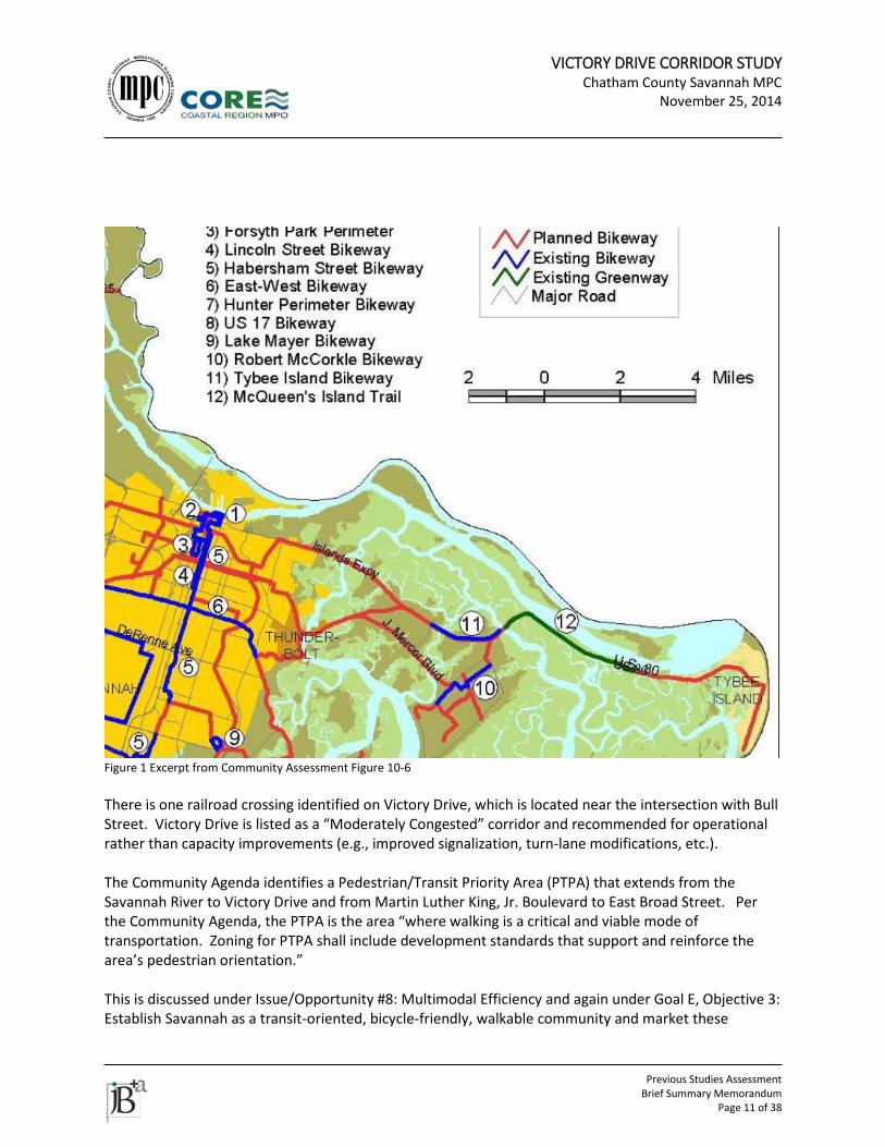
VICTORY DRIVE CORRIDOR STUDY Chatham County Savannah MPC
November 25, 2014
Previous Studies Assessment
Brief Summary Memorandum Page 11 of 38
Figure 1 Excerpt from Community Assessment Figure 10-6 There is one railroad crossing identified on Victory Drive, which is located near the intersection with Bull Street. Victory Drive is listed as a “Moderately Congested” corridor and recommended for operational rather than capacity improvements (e.g., improved signalization, turn-lane modifications, etc.). The Community Agenda identifies a Pedestrian/Transit Priority Area (PTPA) that extends from the Savannah River to Victory Drive and from Martin Luther King, Jr. Boulevard to East Broad Street. Per the Community Agenda, the PTPA is the area “where walking is a critical and viable mode of transportation. Zoning for PTPA shall include development standards that support and reinforce the area’s pedestrian orientation.” This is discussed under Issue/Opportunity #8: Multimodal Efficiency and again under Goal E, Objective 3: Establish Savannah as a transit-oriented, bicycle-friendly, walkable community and market these
VICTORY DRIVE CORRIDOR STUDY Chatham County Savannah MPC
November 25, 2014
Previous Studies Assessment
Brief Summary Memorandum Page 12 of 38
attributes to attract new businesses, residents, and visitors. Goal E is to “Establish a transportation system that anticipates and facilitates economic activity.” Goal C of the Community Agenda is to “Develop a road system that maintains and preserves unique characteristics of neighborhoods and of the coastal area.” The objectives and strategies for Goal C include the following:
• Objective 1. Tailor road building activities to the characteristics of the area where the road is located.
o Strategy A. Require that all private and public road designs include a tree protection and restoration plan, a landscape plan, an accessible pedestrian plan, a bicycle plan, and an accessible public transportation plan.
o Strategy B. Consider traffic calming as a major component in the design of new functional class collectors and local roads and provide procedures for retrofitting existing neighborhoods with traffic calming measures.
o Strategy C. Establish a procedure for identifying and constructing traffic calming measures in existing neighborhoods.
o Strategy D. Develop urban design guidelines that relate to sidewalk width and materials, lighting, signage, landscaping, way finding, crosswalks, curb ramps, refuge islands, corner radii, and signals.
• Objective 2. Consider the impacts of transportation systems on the physical and economic health of residents, specifically related to rising energy costs.
o Strategy A. Design an off-street comprehensive multi-use trail system within a ¼ to ½ mile of all residential areas that connects to commercial, recreational, and industrial areas.
o Strategy B. Identify and consider utility and canal right-of-ways as transportation corridors.
• Objective 3. Consider the impact of sea-level rise (SLR) on proposed transportation systems, particularly relating to improvements of existing roads and bridges.
o Strategy A. Consider SLR using the most current, scientifically sound, existing and new data and analysis in development of the Long Range Transportation Plan. This will ensure that proposed transportation projects will not be threatened by SLR.
Goal D is “Work toward a regional public transportation system that provides all residents, regardless of their age, income, or special needs access to employment centers, institutions, commercial areas, recreational facilities, and other destinations.” Goals and strategies associated with this goal include the following:
• Objective 1. Provide convenient pedestrian and bicycle access from public transportation termini to employment centers, institutions, commercial areas, schools, and recreational facilities.
o Strategy A. Identify employment centers, institutions, commercial areas, schools, and recreational facilities as well as all bus stops and evaluate the level of service of public transportation systems to the areas and the level of pedestrian and bicycle access from the drop-off point to the entrance to the facilities.
o Strategy B. Identify costs and potential funding sources to improve pedestrian and bicycle access to and within the sites.
VICTORY DRIVE CORRIDOR STUDY Chatham County Savannah MPC
November 25, 2014
Previous Studies Assessment
Brief Summary Memorandum Page 13 of 38
o Strategy c. Encourage company-sponsored van service to and from public transportation termini.
• Objective 2. Wherever pedestrians are permitted on the public right-of-way, also provide space for the disabled to travel.
o Strategy A. Provide crosswalks with visible and audible signals. o Strategy B. Identify sources of funds to improve accessibility to and within the sites.
Landscape The Community Assessment Roadway Amenities section highlights historic and unique landscape features as assets to be preserved. In addition to protecting existing amenity corridors, Chatham Urban Transportation Study (CUTS) [now the Coastal Region Metropolitan Planning Organization or CORE MPO] recently instituted an amenities funding plan. With the adoption of the 2030 Long Range Transportation Plan in 2004, CUTS enacted a new planning policy to fund transportation amenities for all road construction projects. One percent of the anticipated road construction funds identified in the 2030 Long Range Transportation Plan have been set aside to fund transportation amenities. It is now the policy of the MPO that all road projects contain transportation amenities equal to or greater than one percent of the roadway construction cost. Transportation Amenities Plans will be prepared during the design phase of road widening, reconstruction, and new location projects, and will contain treatments appropriate to the community, the facility type, and the anticipated travel. The US 80 palm lined drive is identified as a historic resource in the Community Assessment. Goal A of the Community Agenda is to “Preserve culturally and historically significant buildings, landscapes, and sites (hereinafter resources) throughout Chatham County.” Urban Design Victory Drive is highlighted in the Transportation and Land Use Connection section of Chapter 10 of the Community Assessment: Victory Drive in Savannah is often used as an example of the positive impact that road design can have on an area. Victory Drive’s extensive tree canopy and wide, landscaped medians help to make it one of the signature streets in Savannah. Victory Drive is proof that a road can be both beautiful and functional; it can carry large amounts of traffic while simultaneously contributing to the aesthetic appeal of the surrounding neighborhood. In the discussion of Quality Community Objectives, the mixed-use land use pattern of neighborhoods north of Victory Drive is noted as a prime example of walkable land use strategies to encourage alternatives to the private automobile. South of the corridor, development occurred in a less dense and less mixed use manner. Chapter 8 of the Community Assessment states that Victory Drive and other major boulevards follow the former divisions between historic farm lots. One historic structure is identified on Victory Drive: the residence at 1650 E Victory Dr. The 4.5-mile palm lined drive circa the 1920s and the 8-mile segment of Tybee Railroad right-of-way circa 1890 are identified as historic resources on US 80.
VICTORY DRIVE CORRIDOR STUDY Chatham County Savannah MPC
November 25, 2014
Previous Studies Assessment
Brief Summary Memorandum Page 14 of 38
Goal C of the Community Agenda is to “Develop a road system that maintains and preserves unique characteristics of neighborhoods and of the coastal area.” Other Chapter 9 of the Community Assessment identifies the largest groundwater recharge area in the County under the Abercorn and White Bluff corridors extending south from Victory Drive. There are not any policies in place (as of 2006) to manage or protect the recharge areas from contamination or reduced recharge due to human activity. The document states that development plans must identify how the development will occur while not negatively impacting the function of recharge areas.
VICTORY DRIVE CORRIDOR STUDY Chatham County Savannah MPC
November 25, 2014
Previous Studies Assessment
Brief Summary Memorandum Page 15 of 38
9. 2040 CORE MPO TOTAL MOBILITY PLAN
(ONGOING – SUMMARY FROM AUGUST 2014 OVERVIEW DOCUMENT) Transportation Victory Drive is classified under the thoroughfare classifications as both a major arterial suburban and a major arterial urban. LRTP Projects
• US 80 bridges at Bull River and at Lazaretto Creek – PE* 2015-2020 CST* 2021-2030 • US 80/Victory Drive improvements/ Congestion Mitigation – at the Home Depot/Target
shopping center – PE/RW*/CST 2031-2040 • US 80/SR 26/Ogeechee Rd widening to four lanes [PI 521855] RW/CST 2015-2020 • Add bike lanes on Montgomery Street from Victory Drive to W 61st Street - in Vision Plan • Add paths on Skidaway Road from DeRenne Avenue to Victory Drive - in Vision Plan • Add sidewalks, bike lanes, or path on Sunset Blvd from Victory Drive to Whatley Avenue – in
Vision Plan • Add sidewalks and stripe paved shoulders on Wallin Street from Victory Drive to 38th Street– in
Vision Plan • Note that projects in the Vision Plan are not funded in the LRTP
* PE – Preliminary Engineering; RW – Right-of-Way Acquisition; CST - Construction Transit Mobility Vision Plan US 80 is identified as one of the congested corridors, which “represent potential opportunities for efficiencies in transportation by providing transit service options.” Corridor and Service Opportunities include US 80 from SR 30/US 280 to Savannah and Tybee Island.
VICTORY DRIVE CORRIDOR STUDY Chatham County Savannah MPC
November 25, 2014
Previous Studies Assessment
Brief Summary Memorandum Page 16 of 38
10. 2035 CORE CONNECTIONS FRAMEWORK MOBILITY PLAN LRTP adopted in 2009 includes an operational improvement project for the Victory Drive/ Truman Parkway interchange area. The general project location is shown between Target and Home Depot, crossing the Truman Pkwy.
VICTORY DRIVE CORRIDOR STUDY Chatham County Savannah MPC
November 25, 2014
Previous Studies Assessment
Brief Summary Memorandum Page 17 of 38
11. 2030 LONG RANGE TRANSPORTATION PLAN Transportation Recommendations
• Projects included in the approved plan for Victory Drive/US 80: o Widen US 80 from Bull River to Lazaretto Creek from 2 to 4 lanes (Priority 1B – project
programmed for preliminary engineering and right-of-way only) o Truman Parkway interchange lighting at various locations (Priority 1C – project
programmed for preliminary engineering only) o SR 26/US 80 operations at Johnny Mercer Boulevard (Priority 2 – unfunded mid-range
project) • Priority 1 bicycle corridors include:
o US 80 from Bull River to Lazaretto Creek o Truman Linear Park Greenway/Multiuse Trails
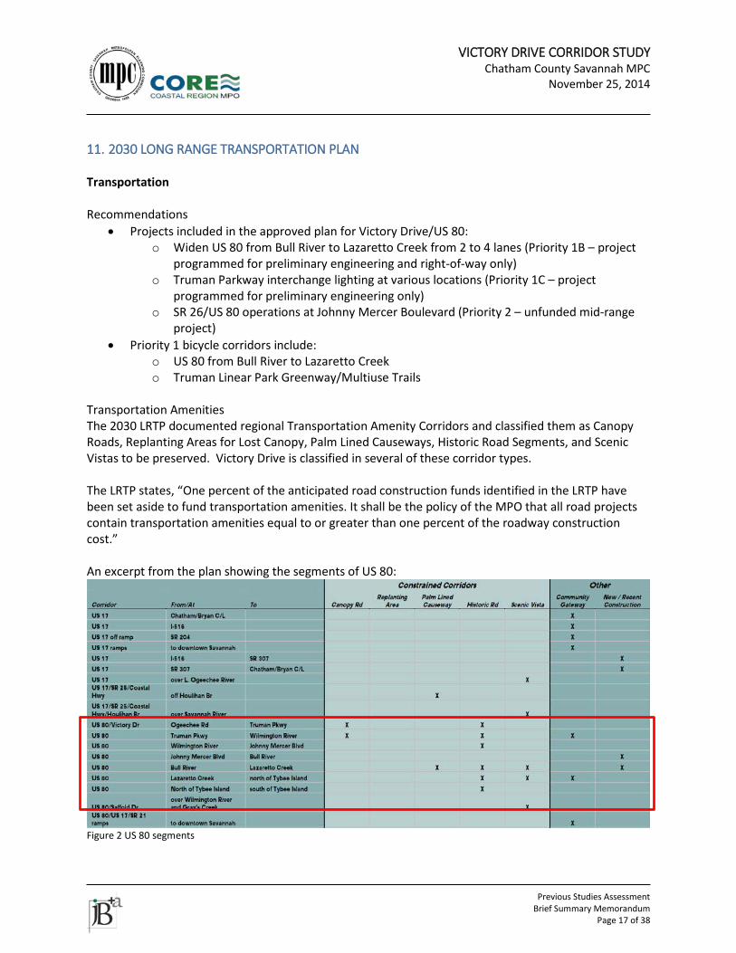
Transportation Amenities The 2030 LRTP documented regional Transportation Amenity Corridors and classified them as Canopy Roads, Replanting Areas for Lost Canopy, Palm Lined Causeways, Historic Road Segments, and Scenic Vistas to be preserved. Victory Drive is classified in several of these corridor types. The LRTP states, “One percent of the anticipated road construction funds identified in the LRTP have been set aside to fund transportation amenities. It shall be the policy of the MPO that all road projects contain transportation amenities equal to or greater than one percent of the roadway construction cost.” An excerpt from the plan showing the segments of US 80:
Figure 2 US 80 segments
VICTORY DRIVE CORRIDOR STUDY Chatham County Savannah MPC
November 25, 2014
Previous Studies Assessment
Brief Summary Memorandum Page 18 of 38
12. CORE MPO TRANSPORTATION IMPROVEMENT PROGRAM (TIP) The 2015-2018 TIP includes roadway, transit, lump sum, and other projects funded through the MPO. Projects within the vicinity of the US 80 study area include:
• SR 26 FROM I-516 TO CS 188/VICTORY DRIVE: widening from two to four lanes at western terminus of study area. (PI # 521855) ”Approximately 1400 feet of Victory Drive would also be reconstructed to tie the proposed widening of SR 26/US 80/Ogeechee Road into the existing Victory Drive roadway. The existing two-lane roadway would be widened to provide four twelve-foot wide travel lanes, with two four-foot wide bicycle lanes, one in each direction, and a twenty-foot wide raised median.” Construction is long range.
• SR 26/US 80 @ BULL RIVER & @ LAZARETTO CREEK: US 80 Bridge Replacements at Bull River and
Lazaretto Creek and roadway safety improvements between the bridges. (PI # 0010560); Preliminary engineering is funded. GDOT is the project sponsor. Construction and right of way are long range.
Projects removed from the TIP include:
• Skidaway Road improvements from Rowland Avenue to Ferguson Avenue (PI# 571060) “The project was a 1st priority highway project in previous TIPs, but it has been moved to the Vision Plan which is not a part of the fiscally constrained MTP. However, Chatham County has changed the project to intersection improvements and will finance the project with local SPLOST funds.”
VICTORY DRIVE CORRIDOR STUDY Chatham County Savannah MPC
November 25, 2014
Previous Studies Assessment
Brief Summary Memorandum Page 19 of 38
13. MPO 2009 CONGESTION MANAGEMENT PROCESS (CMP) UPDATE
• In 2004 the MPO established the CMP. • In 2009, the CMP was updated as part of Framework Mobility Plan; a segment of Victory Drive
was a case study “Hot Spot Analysis.” Transportation The 2009 Congestion Management Process (CMP) analyzed the area immediately surrounding the Home Depot/Target/Staples shopping center, including the Truman Parkway interchange. Transportation issues documented include:
• Existing congestion • Poor operations • Vehicle and pedestrian safety • Transit service (Victory Drive is an existing fixed bus route) • Evacuation route • Lack of east-west alternative • Traffic mix includes commuters, local, and “signature route” (tourists traveling to Tybee Island) • Truman Trail is an opportunity for bicycle and pedestrian travel
The CMP update recommended four short term improvements:
• Implement a dual left turn lane configuration for the westbound traffic exiting the shopping center at the Victory Drive intersection with Wallin Street.
• Reconfigure Rowland Avenue at Skidaway Road to align with the entrance into the shopping center.
• Install a signal at the new Rowland Avenue shopping center entrance intersection identified in Recommendation #2 above. Four of eight signal warrants were met in 2007.
• Work with the shopping center property owners to close off the northern-most entrance bay in the parking lot by the Wallin Street entrance. This is required to allow enough vehicle storage in the dual left turn-lane bays.
There was one long term improvement recommended:
• Implement a frontage road system on the south side of Victory Drive. Several alternatives were explored and eliminated from consideration due to a lack of improvement to traffic flow. These included:
• Adjust traffic signal timing at Wallin Street and Victory Drive. Various phasing options were reviewed.
• Add a dual left turn lane for the northbound approach exiting the shopping center at the intersection of Wallin Street and Victory Drive.
• Prohibit the northbound left-turn movement at Wallin Street and relocate to the Aaron’s Rental Center driveway; add traffic control and a median opening at this location. This option had sight distance issues in addition to impacts on historic oaks and palm trees. Addition of a new
VICTORY DRIVE CORRIDOR STUDY Chatham County Savannah MPC
November 25, 2014
Previous Studies Assessment
Brief Summary Memorandum Page 20 of 38
signalized intersection would violate signal spacing standards. This alternative was found infeasible.
• Implement a slip ramp from the northbound exit ramp to Truman Parkway directly into the shopping center. Also, possibly extend the ramp connection west of Truman Parkway.
Landscape Drainage issues noted. Need to coordinate any proposed improvements in this constrained corridor to maintain adequate drainage, historic plantings, and community gateway. Urban Design Noted issues include a lack of controls on driveway spacing, median openings, site design, parking layout and general access management. Building placement not addressed explicitly, but contributes to the suburban character of the corridor. The Victory Drive corridor in this area is also constrained as it is classified as a “transportation amenity corridor” because it is a memorial to veterans of World War I, a canopy road and also a community gateway. Related documented issues include:
• Corridor lacks vision • Lack of design standards along historic corridors • Suburban strip development • Truman interchange is out of context • Lack of future land use plan
Other Coordination between GDOT, MPC, City of Savannah, Chatham County, and the development community regarding transportation improvements and development approvals, especially site plan review, is an implied issue that was discussed at length with staff.
VICTORY DRIVE CORRIDOR STUDY Chatham County Savannah MPC
November 25, 2014
Previous Studies Assessment
Brief Summary Memorandum Page 21 of 38
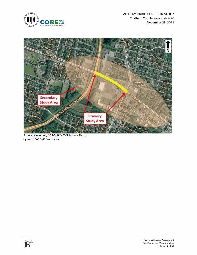
Figure 3 2009 CMP Study Area
VICTORY DRIVE CORRIDOR STUDY Chatham County Savannah MPC
November 25, 2014
Previous Studies Assessment
Brief Summary Memorandum Page 22 of 38
14. CORE MPO 2004 CONGESTION MANAGEMENT PROCESS Transportation Victory Drive is identified as a constrained corridor due to its canopy of large, old trees, yet this is an area of active commercial redevelopment.
VICTORY DRIVE CORRIDOR STUDY Chatham County Savannah MPC
November 25, 2014
Previous Studies Assessment
Brief Summary Memorandum Page 23 of 38
15. WAVE ECOLOGY AND THE HWY 80 CHALLENGE Transportation January – July, 2010 traffic counts exceeded capacity mainly on Friday, Saturday, and Sunday. Hourly traffic counts for Labor Day weekend did not exceed capacity. Committee Topic Data Summaries:
• Issue 1: Traffic congestion/ lack of access/ mobility issues during special events and peak tourism season on the Highway 80 Corridor - “Viewing data holistically revealed the potential for unique public/ private partnerships to build new infrastructure and market existing infrastructure crucial in diversifying the tourist product from private automobile use.”
• Issue 2 and 3: Incident/ accident (stalled vehicles on Highway 80) and narrow bridges, lack of shoulders and public safety - “Data revealed during the Wave Ecology Study exposed the missing link of interagency coordination and long term planning for emergency management along the Highway 80 corridor.” Per the report, the main crash area is Highway 80 at Johnny Mercer Boulevard.
• Issue 4: Lack of parking space during special events - this occurs primarily on the strand. • Issue 5: Emergency situation and evacuation - “Data revealed … no existing emergency
evacuation plan.” There are various solutions proposed by Committee members. Solutions are general in nature, but include the following recommendations: shuttle service, parking plan, CAT special event buses, carpool/vanpool service, ferry boat service, way-finding and signage, signal timing and transportation system management, toll feasibility study and emergency services agreements. Nine major festivals happen each year: New Year’s Eve and Day, Mardi Gras Weekend, Irish Heritage Celebration, Orange Crush, Beach Bum, Memorial Day, July 4th, Labor Day, and Pirate Fest. Other Availability of fire services approaching Tybee Island may be an issue; dispatch zone unclear as of report writing.
VICTORY DRIVE CORRIDOR STUDY Chatham County Savannah MPC
November 25, 2014
Previous Studies Assessment
Brief Summary Memorandum Page 24 of 38
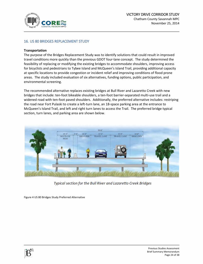
16. US 80 BRIDGES REPLACEMENT STUDY Transportation The purpose of the Bridges Replacement Study was to identify solutions that could result in improved travel conditions more quickly than the previous GDOT four-lane concept. The study determined the feasibility of replacing or modifying the existing bridges to accommodate shoulders, improving access for bicyclists and pedestrians to Tybee Island and McQueen’s Island Trail, providing additional capacity at specific locations to provide congestion or incident relief and improving conditions of flood prone areas. The study included evaluation of six alternatives, funding options, public participation, and environmental screening. The recommended alternative replaces existing bridges at Bull River and Lazaretto Creek with new bridges that include: ten-foot bikeable shoulders, a ten-foot barrier-separated multi-use trail and a widened road with ten-foot paved shoulders. Additionally, the preferred alternative includes: restriping the road near Fort Pulaski to create a left-turn lane, an 18-space parking area at the entrance to McQueen’s Island Trail, and left and right turn lanes to access the Trail. The preferred bridge typical section, turn lanes, and parking area are shown below.
Figure 4 US 80 Bridges Study Preferred Alternative
VICTORY DRIVE CORRIDOR STUDY Chatham County Savannah MPC
November 25, 2014
Previous Studies Assessment
Brief Summary Memorandum Page 25 of 38
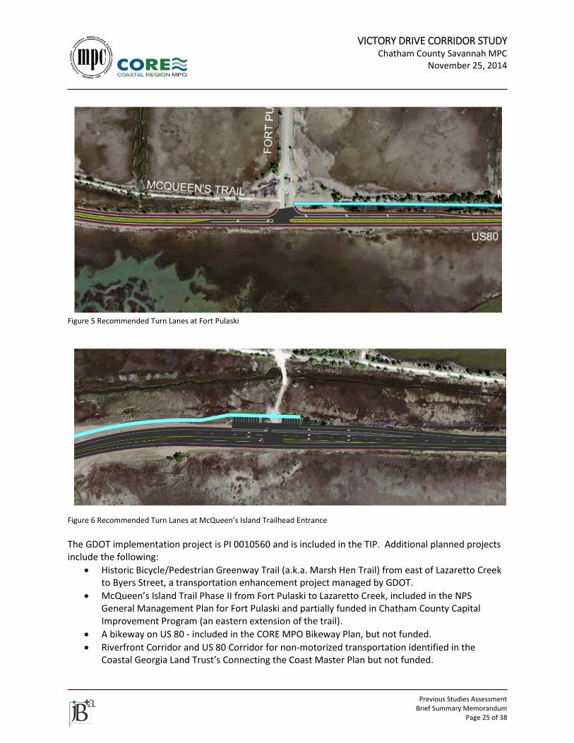
Figure 5 Recommended Turn Lanes at Fort Pulaski
Figure 6 Recommended Turn Lanes at McQueen’s Island Trailhead Entrance The GDOT implementation project is PI 0010560 and is included in the TIP. Additional planned projects include the following:
• Historic Bicycle/Pedestrian Greenway Trail (a.k.a. Marsh Hen Trail) from east of Lazaretto Creek to Byers Street, a transportation enhancement project managed by GDOT.
• McQueen’s Island Trail Phase II from Fort Pulaski to Lazaretto Creek, included in the NPS General Management Plan for Fort Pulaski and partially funded in Chatham County Capital Improvement Program (an eastern extension of the trail).
• A bikeway on US 80 - included in the CORE MPO Bikeway Plan, but not funded. • Riverfront Corridor and US 80 Corridor for non-motorized transportation identified in the
Coastal Georgia Land Trust’s Connecting the Coast Master Plan but not funded.
VICTORY DRIVE CORRIDOR STUDY Chatham County Savannah MPC
November 25, 2014
Previous Studies Assessment
Brief Summary Memorandum Page 26 of 38
• US 80 widening project PI 522490 from west of Bull River to east of Lazaretto Creek; not funded. (This project was apparently superseded by PI 0010560.)
A review of area plans, visions, goals, and objectives is included in the report. The assessment of existing and future conditions found the following:
• All of the study corridor will operate at Level of Service (LOS) C into 2035. • Peak tourist traffic (on holiday weekends in the summer) doubles typical volumes, but a LOS D is
maintained. • US 80 operates well below capacity for most of the year. • Bicycle and pedestrian generators include the McQueen’s Island Trail, Fort Pulaski and Tybee
Island. • Bicycle lanes exist on US 80 east of Lazaretto Creek. • The City of Tybee Island has been designated a Bicycle Friendly Community by the League of
American Bicyclists. • Crash rates on US 80 are consistently higher than statewide averages for similar roads. • Emergency evacuation is a primary safety concern for the roadway. • The roadway’s low elevation may be cause for concern during hurricane/storm event
evacuation. • On average, it would take a storm surge of 2.3 feet to flood the roadway. • “Data collected from National Oceanic and Atmospheric Administration monitoring station
located at Fort Pulaski indicates that, in certain sections, lanes in both directions are submerged an average of three times a year and the east-bound lane is submerged an additional two times a year. The flooding is about one to three hours in length per occurrence depending on the elevation of the tide. It is possible that the roadway could flood twice a day depending on the tidal cycle and tide elevation.”
• “The existing roadway between the Bull River Bridge and Lazaretto Creek Bridge contains hazards within the suggested clear zone. These hazards are predominately trees located immediately outside the edge of the paved shoulder.” However, per the Amenities Plan, the palm-lined causeway should be preserved.
• “The roadway between Bull River and Lazaretto Creek has paved shoulders that are zero to four feet wide and total shoulder width that is less than the minimum ten-foot width. The bridges over Bull River and over Lazaretto Creek have minimal shoulders that are much less than the eight-foot minimum recommended by current bridge design guidance.”
Landscape The preferred alternative includes preservation of the palm-lined causeway included in the Amenities Plan.
VICTORY DRIVE CORRIDOR STUDY Chatham County Savannah MPC
November 25, 2014
Previous Studies Assessment
Brief Summary Memorandum Page 27 of 38
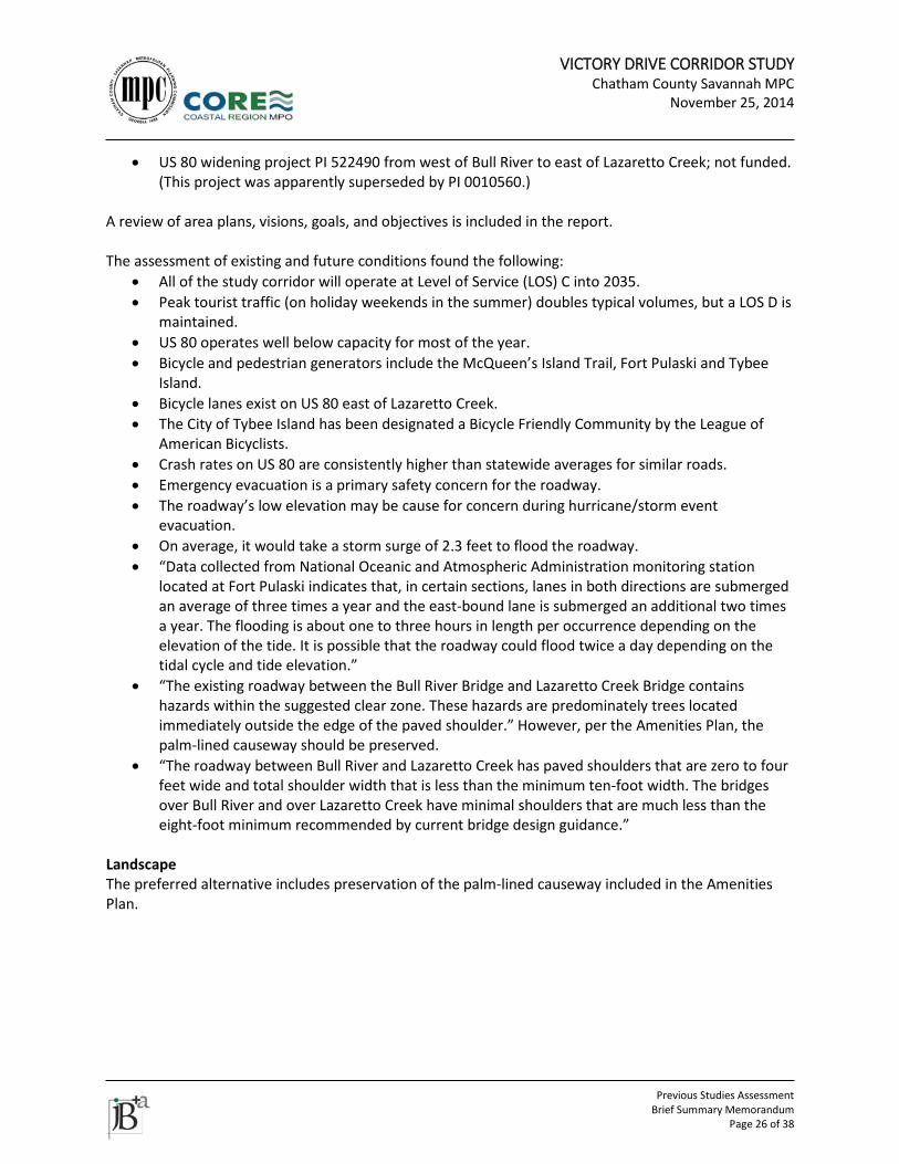
Figure 7 US 80 Bridges Study, study area
VICTORY DRIVE CORRIDOR STUDY Chatham County Savannah MPC
November 25, 2014
Previous Studies Assessment
Brief Summary Memorandum Page 28 of 38
17. CONTEXT SENSITIVE DESIGN MANUAL, CHATHAM COUNTY –SAVANNAH METROPOLITAN
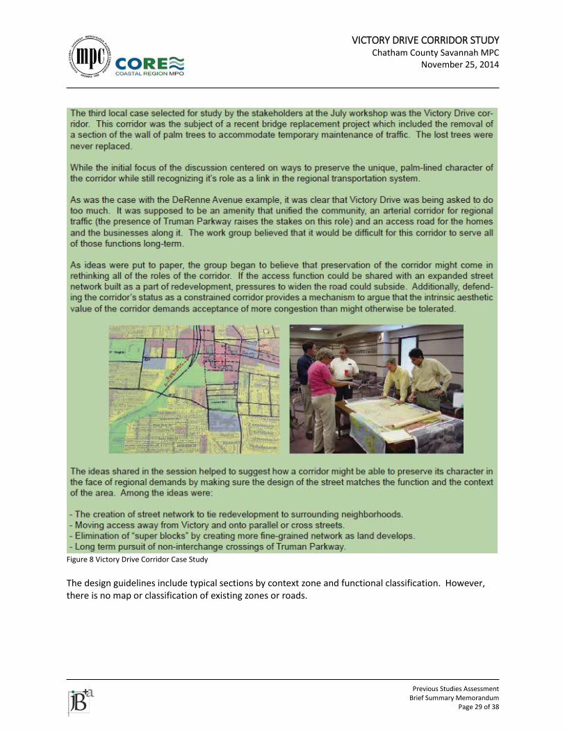
PLANNING COMMISSION (2007) The Context Sensitive Design (CSD) Manual includes sections on Context Types, Roadway Functional Classification, Design Guidelines, the Process for Context Sensitive Solutions, Interim Amenity Solutions, and several appendices. It is the Victory Drive Planning Team’s understanding is that the Thoroughfare Plan supersedes this document. There are no documented cases of implementing or applying the recommendations in the CSD as of 2014. The CSD manual is a result of “a planning effort to develop a context sensitive design process for roadways known as the Transportation Amenities Program.” The identification of Amenities in the 2030 LRTP and Tricentennial Plan was Phase 1 of the effort. As stated in the CSD Manual, it is the second phase. Phase Two of the program, which is the subject of this manual, involves the development of design guidelines and a design process that will incorporate desired transportation amenities into road construction projects. Toward that end, this design manual addresses many areas that might seem peripheral to CUTS stated goals (roadway network, land use, etc.), but which in fact relate to how the pieces of a community fit together. Taken as a whole, the processes and guidelines can have the effect of pushing future projects closer to a balanced, livable system. Victory Drive is a case study in the CSD Manual. Issues cited include the removal of palm trees during a reconstruction project, conflicting roles of the road, and the need to preserve the corridor. Potential strategies include an expanded supporting local road network, providing access from parallel or cross streets, creating a finer-grained road network within the corridor, maintaining Victory Drive’s status as a constrained corridor and a need for additional access across the Truman Parkway.
VICTORY DRIVE CORRIDOR STUDY Chatham County Savannah MPC
November 25, 2014
Previous Studies Assessment
Brief Summary Memorandum Page 29 of 38
Figure 8 Victory Drive Corridor Case Study The design guidelines include typical sections by context zone and functional classification. However, there is no map or classification of existing zones or roads.
VICTORY DRIVE CORRIDOR STUDY Chatham County Savannah MPC
November 25, 2014
Previous Studies Assessment
Brief Summary Memorandum Page 30 of 38
18. ONGOING GDOT PROJECTS The following projects are listed in GDOT’s Construction Work Program. Titles and descriptions may not match GDOT’s language exactly as they have been refined for local understanding.
• 521855 – Ogeechee Rd., from I-516 to Victory Dr. Concept is being updated. This is the old widening project; PI 0010560 will replace this project.
• 0009915 – Fort Pulaski Entrance Rd. Bridge Rehabilitation. • 0010560 – US 80 at Bull River and @ Lazaretto Creek. Bridge replacements and road
reconstruction on causeway for shoulders and turn lanes, if GDOT’s concept ends up agreeing with CORE MPO US 80 Bridges Study. Concept is under development.
• 0010582 – Marsh Hen Trail, Phase 1, from Battery Dr. to Byers St. Path located along north side of US 80, using part of the old Marsh Hen railroad bed. The approved concept report includes an 8-foot wide walkway along the northern side of US 80 on the railroad bed. Segments include a compacted granite surface from the entrance of Battery Park subdivision to Old US Highway 80, approximately 2,720 linear feet; 135 foot long boardwalk over the marsh; asphalt walkway for 670 linear feet along the roadway; and widening of an existing concrete sidewalk.
• 0013271 – Marsh Hen Trail, Phase 2, from East of Old US 80 to Battery Dr. Path extension, also on old railroad bed. This will bring the path close to the terminus of a future Lazaretto Creek bridge replacement project, which is recommended to have a barrier-separated path on north side.
• 0011832 – Rapid Flashing Beacons at 15 intersections on US 80 in Tybee Island. Lump sum project.
• M004573 – Victory Dr. at Skidaway Rd. Extend left turn lane. “Quick Response” project. Approved fiscal year (FY) 2013
• M004574 – Bridge work – Replace fender system at Bull River. Construction approved FY 2014. • M004634 – Resurfacing & Maintenance from Gray’s Creek to Bull River (5.23 mi.). Lump sum, no
fiscal year listed, no schedule provided.
VICTORY DRIVE CORRIDOR STUDY Chatham County Savannah MPC
November 25, 2014
Previous Studies Assessment
Brief Summary Memorandum Page 31 of 38
19. CORE MPO NON-MOTORIZED TRANSPORTATION PLAN (NMTP)
(DRAFT AS OF SEPTEMBER 2014) Transportation Other than specific project recommendations, Victory Drive/ US 80 is not highlighted. Project recommendations are described under the TIP and LRTP summaries. NMTP recommendations are shown in the Total Mobility Plan Vision Plan; however, all of the recommendations were unfunded in the 2040 LRTP. The 2015-2018 TIP includes some NMTP projects, as well. Funding sources for bicycle and pedestrian projects are listed and discussed. This may be a useful reference. Design guidance is also discussed. The best practices will be referenced in the Corridor Study recommendations.
VICTORY DRIVE CORRIDOR STUDY Chatham County Savannah MPC
November 25, 2014
Previous Studies Assessment
Brief Summary Memorandum Page 32 of 38
20. CHATHAM AREA TRANSIT - TRANSIT DEVELOPMENT PLAN (TDP) Transportation Additional east-west connections recommended. The Victory Drive fixed route is included in possible Quality of Service improvements. The TDP recommends 2016 as the starting date for Victory Drive service. Additional small vehicle zonal services (route or point deviation) recommended including southwest Victory Drive at Montgomery Street.
VICTORY DRIVE CORRIDOR STUDY Chatham County Savannah MPC
November 25, 2014
Previous Studies Assessment
Brief Summary Memorandum Page 33 of 38
21. VICTORY DRIVE PAST IMPROVEMENTS AND INFORMATION Transportation The City of Savannah worked with GDOT in 2011 to lengthen the left-turn lane from US 80 eastbound onto Wallin Street northbound. An improvement project should address the drainage inlet located near the current end of the turn lane. GDOT completed a project (in 2010) to add a second right-turn lane from northbound Truman Parkway onto Victory Drive. The City of Savannah also improved signal timing in 2010 with the goal of reducing congestion related to the Truman Parkway. Chatham County has a long-standing SPLOST project to improve Skidaway Road, which includes realigning Rowland Avenue at the Target shopping center entrance, relocating a traffic signal there, and extending 52nd Street east to connect to Sunset Boulevard. The Skidaway Road project was at the concept level as of summer 2011 and will need future public involvement efforts as part of the final design, according to the county. Per the 2040 LRTP, this project scope has been reduced to intersection improvements that will be funded through SPLOST. As of 2011, according to the City of Savannah Traffic Engineer, traffic signals on the Victory Drive/ US 80 corridor from Bee Road to east of Skidaway Road are coordinated based on time of day. Signals on Skidaway Road north of Victory Drive are also coordinated by time of day.
VICTORY DRIVE CORRIDOR STUDY Chatham County Savannah MPC
November 25, 2014
Previous Studies Assessment
Brief Summary Memorandum Page 34 of 38
22. MARTIN LUTHER KING, JR. BOULEVARD/ MONTGOMERY STREET REVITALIZATION PLAN Urban Design The plan was prepared in 1998 by LDR for the Savannah Development and Renewal Authority. The plan study area was focused on the area between the Savannah River and Gwinnett Street. It did not extend as far south as Victory Drive. The purpose of the plan “is to identify physical development scenarios for the Martin Luther King, Jr. Boulevard/ Montgomery Street Corridor, a distressed urban area on the west side of Savannah’s National Historic Landmark District.” The focus of the plan was on a 5 to 10 year time frame with a somewhat longer horizon projected for certain major projects.
VICTORY DRIVE CORRIDOR STUDY Chatham County Savannah MPC
November 25, 2014
Previous Studies Assessment
Brief Summary Memorandum Page 35 of 38
23. GATEWAY TO COASTAL GEORGIA: CONNECTING THE COAST
• The Coastal Georgia Land Trust sponsored a Master Plan for a non-motorized trail system along coastal Georgia in 1996. The plan was funded through an ISTEA grant.
• Authored by: EDAW, in association with The PATH Foundation, Edenfield & Spencer Landscape Architects (Sea Island) and Clemmons Engineers (Savannah)
Transportation As the master plan relates to Victory Drive, five sections of “Alternate Trail” totaling 20.4 miles were planned as part of on-road bike facilities along Victory Drive/ US 80. These sections begin at the intersection of Bull Street and Victory Drive and run eastward on US 80 to the south end of Tybee Island. One spur totaling .9 miles intersects the trail at the entrance to Fort Pulaski and connects the on-road trail to the Historic National Park Service administrated facility. At the time, no part of the statewide trail system was a part of the five sections noted above. Landscape Each of the six counties in the coastal system had a themed label for their individual network of trails. The Chatham County network was labeled the “Canopy and Cordgrass Trail” which “reflects both the Live Oak tree cover of Savannah’s boulevards, the Wormsloe entry drive and the vistas of open marshlands between Tybee and Wilmington Islands.” Urban Design From the Performance Standards Section of the plan: on-road bike facilities on county roads should follow the following design criteria:
• Available 12’ travel width minimum/ vehicular travel speed/ traffic volumes/ minimal on-street parking/ low volume of bus and truck traffic.
• With a 12 foot travel lane on roads < 35 mph the painted bike lane would be a minimum of 4’ width. For road sections with posted speed at or greater than 35mph the lane should be a minimum of 5’ in width, preferably with a rumble strip 4’ in width between the automobile and bike lanes.
“In limited situations, sidewalks can provide beneficial alternate facilities. Wherever a trail must provide for both cyclists and pedestrians, signs should be installed which alert both users of the need to share the path and speed limit signs should be posted if deemed necessary.”
VICTORY DRIVE CORRIDOR STUDY Chatham County Savannah MPC
November 25, 2014
Previous Studies Assessment
Brief Summary Memorandum Page 36 of 38
24. THUNDERBOLT COMPREHENSIVE PLAN Wetland areas exist between the east side of the Wilmington River and town limits – both north and south of US 80. Potential infill areas include: Thunderbolt Regency Estates Mobile Home Park, which is located west of the Placentia Canal and north of US Highway 80; a second potential infill area is identified to the west of Placentia Canal and south of US Highway 80, running along Shell Road. The Riverfront was identified as the area from Victory Drive south along River Drive, and north of River Drive to the marsh. The Riverfront is experiencing intense growth pressure, particularly with multi-family residential development. The Town has identified US Highway 80 (Victory Drive) beginning at the western town limit through Thunderbolt to the eastern town limit as the community’s gateway. Transportation The Town needs to consider the increase in traffic congestion and the potential loss of scenic view-sheds as new developments are proposed along the riverfront area. Thunderbolt currently has access to public transit provided by Chatham Area Transit (CAT). The Town should improve efforts to provide a good network of sidewalks that will allow people to conveniently and safely walk to a variety of destinations. Current ordinances require developers to install new sidewalks or connect to existing sidewalks when proposing a new commercial development or a residential development having more than three residences. A master sidewalk plan includes both sides of Victory Drive from the base of the bridge westward to Shuptrine Avenue on the south side and to Downing Street on the north side. The potential exists for a future bicycle/ pedestrian trail to run contiguous to the Placentia Canal. According to an archaeological study conducted in 1984, which surveyed a two-hundred-foot-wide corridor along the existing 2.5-mile-long canal right-of-way, no significant archeological sites were identified. Landscape The Town does not have a tree preservation ordinance although they do require that proper permits are secured before trees are cut. Urban Design Traditional neighborhood development patterns are encouraged including the use of more human scale development, compact development mixing of uses within easy walking distance of one another and facilitating pedestrian activity.
VICTORY DRIVE CORRIDOR STUDY Chatham County Savannah MPC
November 25, 2014
Previous Studies Assessment
Brief Summary Memorandum Page 37 of 38
The plan recommends maximizing the use of existing infrastructure and minimizing the conversion of undeveloped land at the urban periphery by encouraging development or redevelopment of sites closer to the downtown or traditional urban core of the community.
VICTORY DRIVE CORRIDOR STUDY Chatham County Savannah MPC
November 25, 2014
Previous Studies Assessment
Brief Summary Memorandum Page 38 of 38
25. AMENITIES PLAN AND SUPPORTING RESOLUTIONS Landscape As part of Chatham Urban Transportation Study (CUTS), projects require inclusion of conservation of trees and determination of tree planting opportunities. CUTS to work with GDOT to determine amenities guidelines to include bicycle facilities, pedestrian facilities, sidewalks, landscaping and tree preservation on a per corridor recommendation basis.