Embed Size (px)
DESCRIPTION
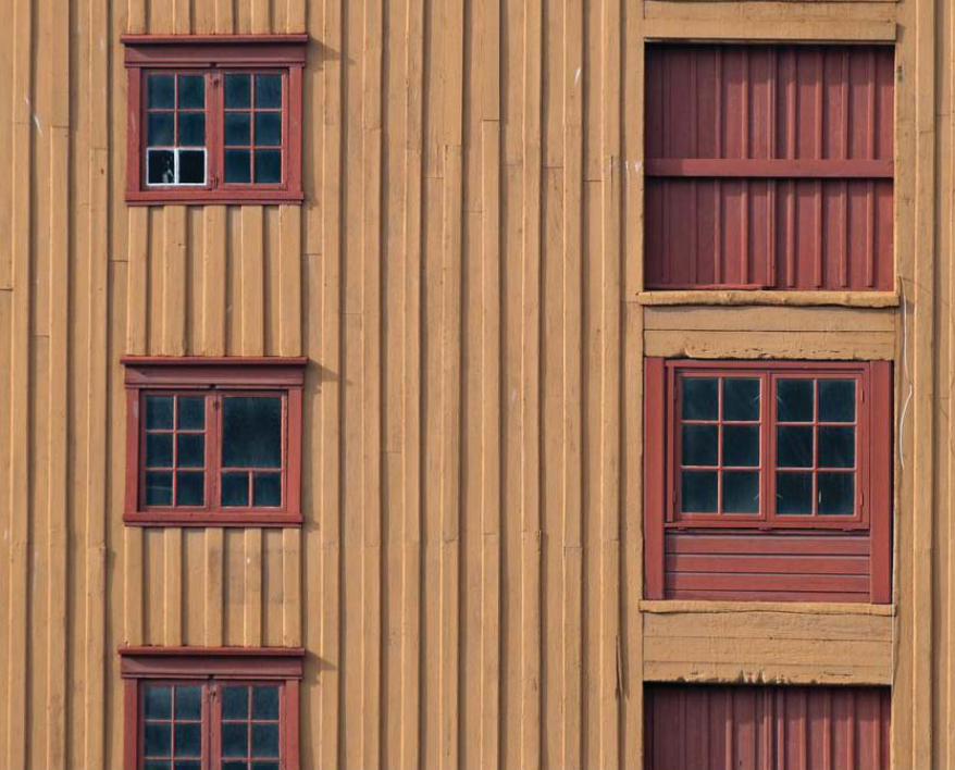
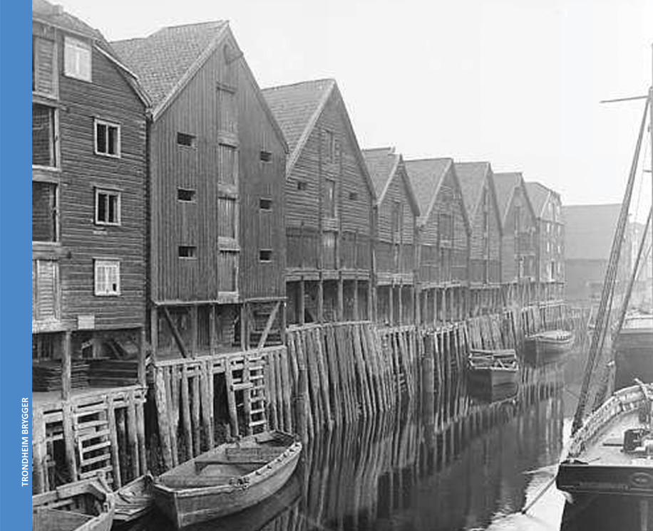
The most photographed scene in Trondheim (Norway) are the old wooden warehouses along the river in the old city center. Although everyone falls in love with these brightly colored buildings, the warehouses and the surroundings are in decay. This project consists of a research on the reusability of these warehouses, divided into three themes; past, present and future. It tells about the history of these warehouses, the conditions nowadays, the conservation debate and it gives a vision on how to improve the area and reuse the warehouses.
Citation preview
TRO
NDH
EIM
BRY
GGER
27
Part A - PAST
PAST - HISTORIC BACKGROUND
Besides being a known and beloved cityscape, the brygger in Trondheim have an interes ng historical and structural background, related to the trading ac vi es.
The oldest of the wharves along the River Nidelva date back to the 18th century; nevertheless, they s ll give the impression of the waterfront as it was long before then. The wharves remind us of the importance of Trondheim as a merchant city.
This part of the research is divided in four topics. A disastrous fi re in 1681 is an important mark in the history of the bryggen, therefore the fi rst topic is The bryggen from before 1681 followed by Kjøpmannsgata a er 1681 and The brygger a er 1681. The last topic Typology of the brygger goes more into detail about the construc on and design of the buildings.
28
TRO
NDH
EIM
BRY
GGER
1. THE BRYGGEN BEFORE 1681
None of the exis ng brygge are from the period before the big city fi re of 1681, but much of what happened in that period is of great signifi cance for how the brygger were built a er the fi re.(1)
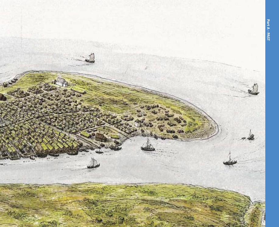
The Oldest storiesThe Sagas tell us how King Olav Tryggvason of Viking fame founded the city by the mouth of the River Nidelva in 997. The site was based on account of its topographical and geographic posi on. Nidelva was the only sheltered and rela vely fl ood-free estuary on the Trondheim ord. A fer le stretch of hinterland that was among the best corn-growing districts in the country, abundant fi sh by the coast, as well as large forests; all these provided resources for the commercial ac vi es. A medieval city was primarily a trading center, but also a loading point, i.e. a place where one could build a stock of goods one traded.
As the city grew, and increasingly became more important, the ci zens got connec ons in other parts of the country, par cularly north, and the city became a sort of hub for trade between the northern regions and the southern, and even foreign countries. The city’s merchants had to, except housing, have warehouses, like the cra smen had to have workshops. We fi nd these warehouses along almost the en re Norwegian coast, located at trading places both in ci es and towns and one by one linked to a (farm)house. At least in northern Norway the term “brygger” is used for these storage buildings associated with mari me trade and fi shing.
The brygger in Trondheim along the westside of the river Nidelva can be traced back to the city’s oldest history. The good river port and the central loca on in the ord were the basis for the site’s posi on as a marketplace. We can assume that it is certain that the brygger were
1. For this chapter the main source has been Kjell Andresen (Bryggene i Kjop-mannsgata - 1978), unless
otherwise indicated.
29
Part A - PAST
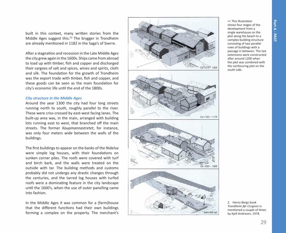
built in this context, many wri en stories from the Middle Ages suggest this.(2) The brygger in Trondheim are already men oned in 1182 in the Saga’s of Sverre.
A er a stagna on and recession in the Late Middle Ages the city grew again in the 1600s. Ships came from abroad to load up with mber, fi sh and copper and discharged their cargoes of salt and spices, wines and spirits, cloth and silk. The founda on for the growth of Trondheim was the export trade with mber, fi sh and copper, and these goods can be seen as the main founda on for city’s economic life un l the end of the 1800s.
City structure in the Middle AgesAround the year 1300 the city had four long streets running north to south, roughly parallel to the river. These were criss-crossed by east-west facing lanes. The built-up area was, in the main, arranged with building lots running east to west, that branched off the main streets. The former Kaupmannastretet, for instance, was only four meters wide between the walls of the buildings.
The fi rst buildings to appear on the banks of the Nidelva were simple log houses, with their founda ons on sunken corner piles. The roofs were covered with turf and birch bark, and the walls were treated on the outside with tar. The building methods and customs probably did not undergo any dras c changes through the centuries, and the tarred log houses with turfed roofs were a domina ng feature in the city landscape un l the 1600’s, when the use of outer panelling came into fashion.
In the Middle Ages it was common for a (farm)house that the diff erent func ons had their own buildings forming a complex on the property. The merchant’s
2. Henry Bergs book Trondheim før Cicignon is men oned a couple of mes by Kjell Andresen, 1978.
<< This illustra on shows four stages of the development from a single warehouse on the plot along the beach to a complex building structure consis ng of two parallel rows of buildings with a passage in between. The last extensions were constructed a er around 1200 when the plot was combined with the neirbouring plot on the south side.
30
TRO
NDH
EIM
BRY
GGER
31
Part A - PAST
32
TRO
NDH
EIM
BRY
GGER
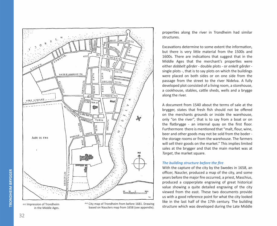
^^ City map of Trondheim from before 1681. Drawing based on Nauclers map from 1658 (see appendix).
proper es along the river in Trondheim had similar structures.
Excava ons determine to some extent the informa on, but there is very li le material from the 1500s and 1600s. There are indica ons that suggest that in the Middle Ages that the merchant’s proper es were either dobbelt gårder - double plots - or enkelt gårder - single plots -, that is to say plots on which the buildings were placed on both sides or on one side from the passage from the street to the river Nidelva. A fully developed plot consisted of a living room, a storehouse, a cookhouse, stables, ca le sheds, wells and a brygge along the river.
A document from 1540 about the terms of sale at the brygger, states that fresh fi sh should not be off ered on the merchants grounds or inside the warehouse, only “on the river”, that is to say from a boat or on the fl atbrygge - an internal quay on the fi rst fl oor. Furthermore there is men oned that “malt, fl our, wine, beer and other goods may not be sold from the boder - the storage rooms or from the warehouse. The farmers will sell their goods on the market.” This implies limited sales at the brygger and that the main market was at Torget, the market square.
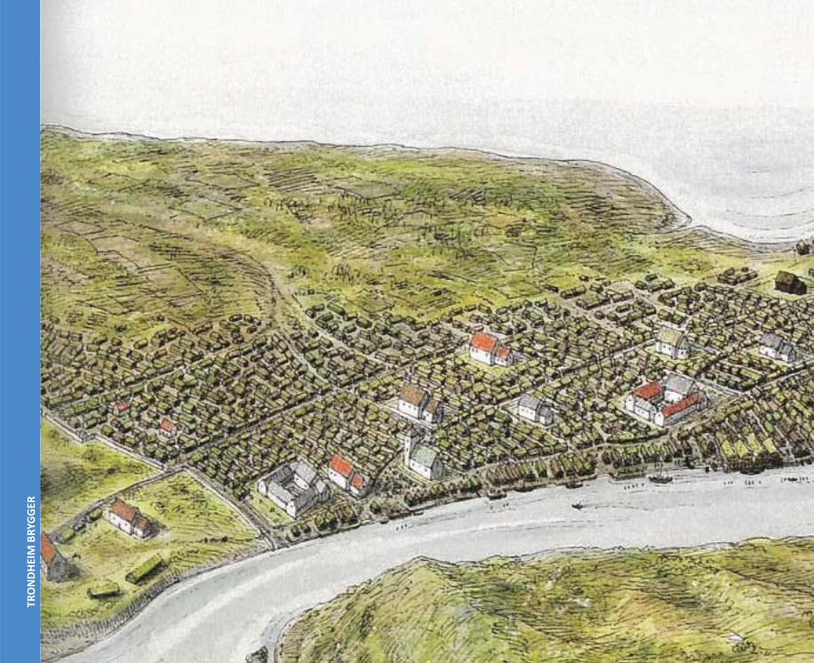
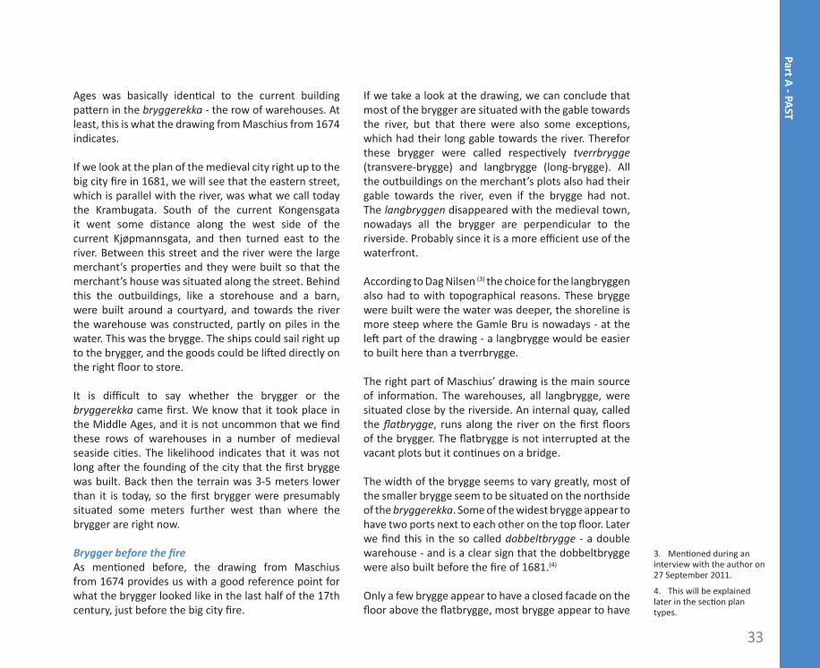
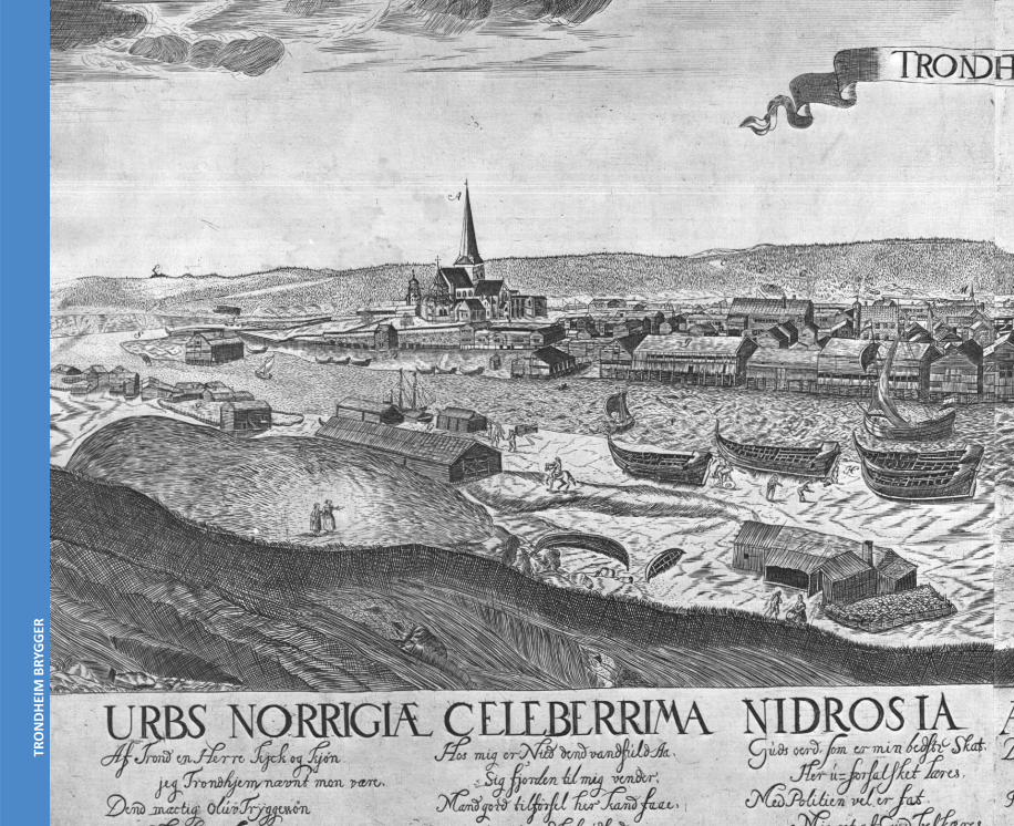
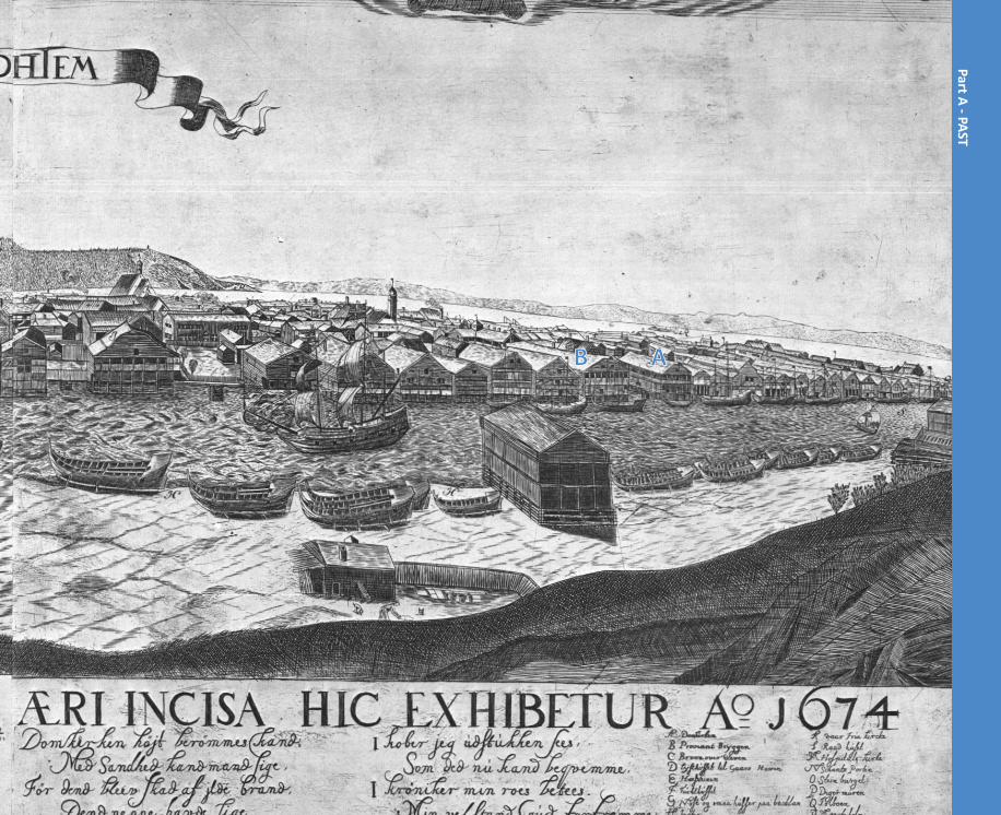
The building structure before the fi re With the capture of the city by the Swedes in 1658, an offi cer, Naucler, produced a map of the city, and some years before the major fi re occurred, a priest, Maschius, produced a copperplate engraving of great historical value showing a quite detailed engraving of the city viewed from the east. These two documents provide us with a good reference point for what the city looked like in the last half of the 17th century. The building structure which was developed during the Late Middle << Impression of Trondheim
in the Middle Ages.
33
Part A - PAST
Ages was basically iden cal to the current building pa ern in the bryggerekka - the row of warehouses. At least, this is what the drawing from Maschius from 1674 indicates.
If we look at the plan of the medieval city right up to the big city fi re in 1681, we will see that the eastern street, which is parallel with the river, was what we call today the Krambugata. South of the current Kongensgata it went some distance along the west side of the current Kjøpmannsgata, and then turned east to the river. Between this street and the river were the large merchant’s proper es and they were built so that the merchant’s house was situated along the street. Behind this the outbuildings, like a storehouse and a barn, were built around a courtyard, and towards the river the warehouse was constructed, partly on piles in the water. This was the brygge. The ships could sail right up to the brygger, and the goods could be li ed directly on the right fl oor to store.
It is diffi cult to say whether the brygger or the bryggerekka came fi rst. We know that it took place in the Middle Ages, and it is not uncommon that we fi nd these rows of warehouses in a number of medieval seaside ci es. The likelihood indicates that it was not long a er the founding of the city that the fi rst brygge was built. Back then the terrain was 3-5 meters lower than it is today, so the fi rst brygger were presumably situated some meters further west than where the brygger are right now.
Brygger before the fi reAs men oned before, the drawing from Maschius from 1674 provides us with a good reference point for what the brygger looked like in the last half of the 17th century, just before the big city fi re.
If we take a look at the drawing, we can conclude that most of the brygger are situated with the gable towards the river, but that there were also some excep ons, which had their long gable towards the river. Therefor these brygger were called respec vely tverrbrygge (transvere-brygge) and langbrygge (long-brygge). All the outbuildings on the merchant’s plots also had their gable towards the river, even if the brygge had not. The langbryggen disappeared with the medieval town, nowadays all the brygger are perpendicular to the riverside. Probably since it is a more effi cient use of the waterfront.
According to Dag Nilsen (3) the choice for the langbryggen also had to with topographical reasons. These brygge were built were the water was deeper, the shoreline is more steep where the Gamle Bru is nowadays - at the le part of the drawing - a langbrygge would be easier to built here than a tverrbrygge.
The right part of Maschius’ drawing is the main source of informa on. The warehouses, all langbrygge, were situated close by the riverside. An internal quay, called the fl atbrygge, runs along the river on the fi rst fl oors of the brygger. The fl atbrygge is not interrupted at the vacant plots but it con nues on a bridge.
The width of the brygge seems to vary greatly, most of the smaller brygge seem to be situated on the northside of the bryggerekka. Some of the widest brygge appear to have two ports next to each other on the top fl oor. Later we fi nd this in the so called dobbeltbrygge - a double warehouse - and is a clear sign that the dobbeltbrygge were also built before the fi re of 1681.(4)
Only a few brygge appear to have a closed facade on the fl oor above the fl atbrygge, most brygge appear to have
3. Men oned during an interview with the author on 27 September 2011.
4. This will be explained later in the sec on plan types.
34
TRO
NDH
EIM
BRY
GGER
35
Part A - PAST
AAB
36
TRO
NDH
EIM
BRY
GGER
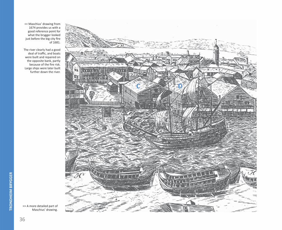
>> A more detailed part of Maschius’ drawing.
<< Maschius’ drawing from 1674 provides us with a
good reference point for what the brygger looked
just before the big city fi re of 1681.
The river clearly had a good deal of traffi c, and boats
were built and repaired on the opposite bank, partly
because of the fi re risk. Large ships were later built
further down the river.
CC D
37
Part A - PASTa sval-wall - solid poles with par al fi lling between the poles. A brygge situated next to the allmenning - the public square between the bryggen - has an addi onal sval-wall on the south side both on the ground fl oor and the fi rst fl oor. This building is indicated with an A on the drawing.
The common building method concerning the bryggen was a la -construc on - a solid wooden wall of stacked logs. On the brygge indicated with a C there are lines marked on the long wall, which probably indicate the heads of the transverse walls. In this case the transverse walls have not been built on top of each other on the ground fl oor and fi rst fl oor, something we also fi nd in the brygger built a er 1681.
On some warehouses we fi nd an extension of the ridge (see le er B), this is probably to protect the jib against the weather, as we fi nd on many warehouses in Trøndelag.
Besides the drawing of Maschius there are also some wri en sources (5) which give detailled informa on about the brygger before the fi re. One building is described as “the brygge with downstairs three boder on both sides, upstairs on the south side a bedroom containing a stone stove and a lo above it”. This informa on is very interes ng, the building is described as a langbrygge along the river. More informa on about warehouses being used for dwelling as well is not found, but on Maschius’ drawing we can see the named langbrygge and many other brygger with an indica on of a chimney (for example the one indicated with a D).
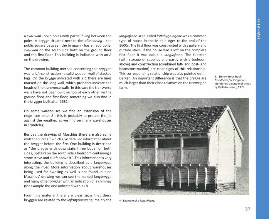
From this material there are clear signs that these bryggen are related to the lo sbygningene, mainly the
langlo ene. A so-called lo sbygningene was a common type of house in the MIddle Ages to the end of the 1600s. The fi rst fl oor was constructed with a gallery and outside stairs. If the house had a lo on the complete fi rst fl oor it was called a langlo ene. The func on (with storage of supplies and partly with a bedroom above) and construc on (combined la - and post- and beamconstruc on) are clear signs of this rela onship. This corresponding rela onship was also pointed out in Bergen. An important diff erence is that the brygge are much larger than their close rela ves on the Norwegian farm.
5. Henry Bergs book Trondheim før Cicignon is men oned a couple of mes by Kjell Andresen, 1978.
^^ Example of a langlo ene.
38
TRO
NDH
EIM
BRY
GGER
2. KJØPMANNSGATA AFTER 1681
Generally speaking the medieval age lasted in Trondheim un l the city fi re of 1681. When the city rose again from the ashes its appearance had altered drama cally. The rest of this thesis is focused on the Kjopmannsgata and the bryggen a er the fi re of 1681.(6)
The fi re of 1681In the night of 19 April 1681 fi re breaks out in the brygge of Henrich Hornemann.(7) The fi re must have spread very quickly in the dry, tarred wooden houses. In a part of the warehouses gunpowder was stored, and there was enough for the fi re to literally explode. The city was hopelessly lost in the course of twelve hours. Ninety procent of the buildings were lost, nothing remained except ashes. And in addi on to that, everything that had been stored in the quayside warehouses, corn and seed grain and fi shing equipment, stockfi sh, hides and skins, was lost in one night.
Cicignons regula on King Chris an V sent a few thousand barrels of rye and despatched two generals to Trondheim. The rye was to be distributed to the needy, whilst the two generals, Cicignon and Coucheron, set about surveying the city and making proposals for a city development plan that would aim at preven ng any more major fi res from happening in the city. At the same me, they were to put forward a proposal of improving the for fi ca ons of the city – it was a er all thirty years ago when it had been captured by the Swedes without any resistance. The new plan did not prevent major fi res as eff ec vely as had been hoped, but it gave the city a new appearance and turned it into a fortress city.
The street network was formed in accordance with the then ideals in Europe, the baroque city with broad, straight streets in rigid and or rectangular shapes.
6. For this chapter the main sources has been Kjell
Andresen, 1978, and Last Fas ng , 1997, unless other-
wise men oned.
7. Therefore people also refer to the fi re of 1681 as
the Hornemanns fi re.
39
Part A - PAST
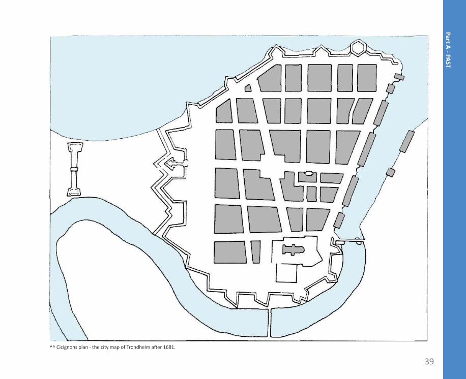
^^ Cicignons plan - the city map of Trondheim a er 1681.
40
TRO
NDH
EIM
BRY
GGER
There was one main axis in the new city: Kongens gate. The other main street, Munkegata, was arranged on the south-north axis from the cathedral to Munkholmen. At the junc on of the streets a new square was formed, a rectangular area spanning about 100 metres. Along the river, between the quays and the built-up area, Kjøpmannsgata was laid down in two sec ons, with a steep slope down to the row of quays. These three streets were about 40 metres wide, but the other streets – in a grid system parallel to the Kongens gate, were to have a width of about 23 metres.
Cicignon’s development plan had a major disadvantage – it provided no guidelines for how the large urban quarters should be developed to allow all the inhabitants access to their proper es. This resulted in many of the old streets and alleys being unaff ected by the new development plan. The medieval patchwork of
streets weaves itself into the rigid network of streets of Cicignon’s plan, thereby crea ng fl air and contrast in the urban landscape. New streetprofi le KjøpmannsgataA er the fi re Cicignon placed the Kjøpmannsgata straight through the former brygge building block, so that the bryggen were separated from the other buildings.
Just behind the brygger, where there had been deep and narrow proper es with dense rows running up the buildings, the impressive two-level Kjøpmannsgata was constructed. The construc on of the new street led to a complete reorganisa on of the building tradi ons when it comes to the merchants proper es. As before the merchants house was situated at the street, but now with the façade to the east, and the brygge was built
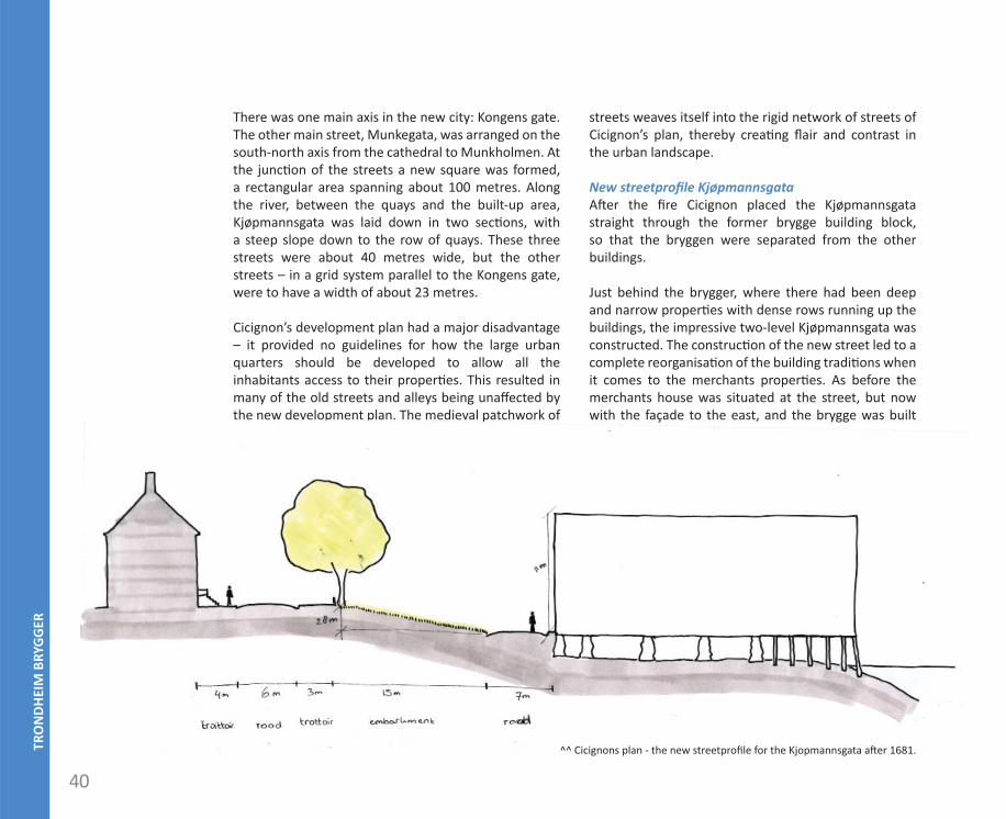
^^ Cicignons plan - the new streetprofi le for the Kjopmannsgata a er 1681.
41
Part A - PAST
on the low plateau down by the river, partly on piles out in the river. All the bryggen were now constructed with the gables towards the river and the street. This way the bryggen can now serve on the streetside in the same way as on the river side, but now with wagon and horses under the hois ng beam.
In this way the Kjøpmannsgata consisted of two streets: one, the so-called bryggegate (brygge-street), on the lower plateau along the brygger, and the actual main street on the higher plateau, which later unoffi cially became Søgaden.
Func ons of the streetWith the construc on of the Kjøpmannsgata Cicignon must have had in mind that the new road would serve many diff erent func ons.
• Ci es for fi ca on with east Cicignon did fi ll up and smooth out the riverbank so that is formed a low plateau along the river, and from there the terrain rose steep up to the new street, which in reality was a bas on that could easily be supplied with barricades and guns. In case of danger of a siege or assault, the bryggerekka could be demolished or burned and the embankment behind could serve as for fi ca on with control over the River. The burning brygge plots could serve as an even more eff ec ve protec on than the embankment could. There was of course the risk that with a unfavorable wind there was the possibility for a new town fi re.
• Fire separa on between the city and the BryggerPrevious fi res clearly showed the inhabitants of the city how catastrophic it was to lose both the buildings and all the stocks. To avoid repe on, the new street became 60 alen (ca. 36 metres) wide. Furthermore
rows of trees were planted on the embarkment to catch sparks in case of a fi re and thus avoid fi res from spreading between the city and the bryggerekka or the other way around.
• The need for a main streetWith the reconstruc on of the city a er the big fi re one’s opinion was that the city was in need of main streets. The Kjøpmannsgata became one of the most important streets of the city and also one of the widest. A large part of the city´s fi ner buildings were situated along the street and the richest merchants had their proper es here.
• Harbour needs control from the streetAlthough the riverside will for a long me s ll be the true front of the bryggen, the harbour needed an easier access than from the bryggen. At that me there was no place to access the water with
the bryggen and for fi ca on all around the city. Therefore the allmenninger - open squares between the bryggen - were used. These squares would also serve as the city´s public port.
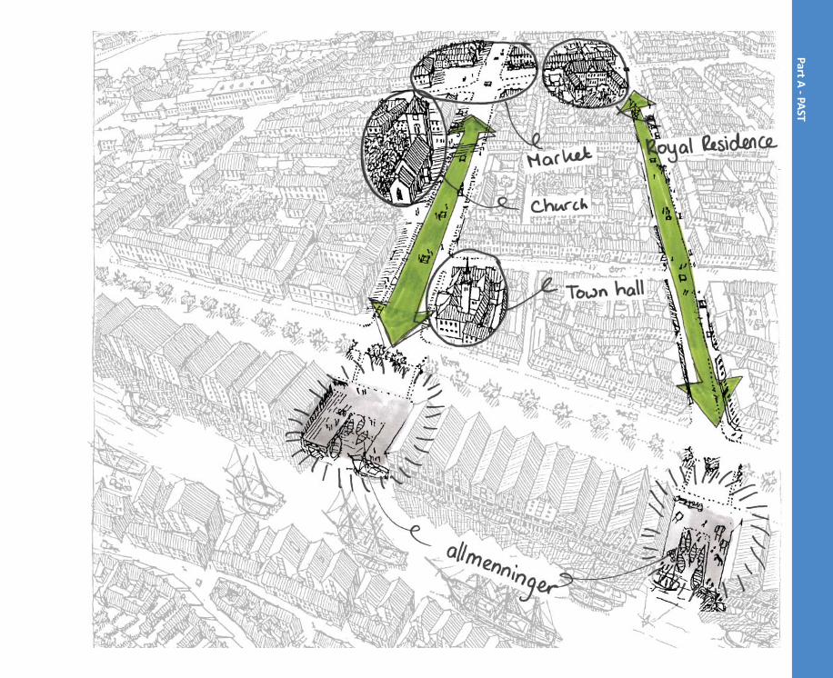
Allmeninger (public places)The brygger along the river were constructed in a denser and more voluminous way than before the fi re. From now on all the brygger were built with the gable towards the river and side by side along the complete west side of elvehavnen, only interrupted by the open allmeninger. These allmenninger also served to protect the bryggen from another fi re catastrophe. The bryggerekka was divided into three large and two small blocks with the allmenningen situated at the end of the new east-west orientated main axis: Rådstuealmenningen (at the end of Kongens gate), Hagerupalmenningen (at the end of Dronningens gate), Mustalmenningen (at the end of
42
TRO
NDH
EIM
BRY
GGER
Olav Tryggvasons gate) and Bra øra. Along the main axis important buildings were situated, such as the Town Hall, the Royal Residence, a church and the big Market. The allmenningen have all been kept as open, vacant spaces at the riverside right up to today with the excep on of Mustalmenningen, which was par ally used for the construc on of the bridge Bakke Bru in 1887.
The allmenningen played an important role as the place where most people had access to the river, since everywhere else was occupied by private brygger or by the for fi ca ons (which can be seen on Cicignons map). The birdeye perspec ve from Dag Nilsen from 1976 gives an impression of the bryggerekka on a summerday in 1859. As seen on the drawing the allmenningen were used for smaller boats, presumably from the ci zens. Dag Nilsen also men oned that from these small boats, farmers tried to sell some small goods.(8)
Larger vesselsBased on the map it looks like the bryggen from before the Hornemanss fi re were not that far into the river as the current bryggen. It is likely that the development of lager trading vessels in the years before the fi re were the
cause of this. Larger ships require deeper water because of a greater depth, and because this was a problem before the fi re, it was logical to build the bryggene further into the river during the reconstruc on.
New fi re regula onsWith the big fi re fresh in their memory new fi re regula ons for the city were made. Combus ble goods were to be stored at Bakklandet, on the riverside opposite of the bryggerekka along the Kjøpmannsgata. And the use of naked fl ame was prohibited in or near the quayside buildings. But not only infl ammable items were restricted, also goods with a bigger fi re load than wood had to be stored outside of the brygger and the city.
The people working in the brygge had to move almost blindly through the dark warehouses, since they were not allowed to use any oil lamps. But it was even more diffi cult for sailors to live on their vessels while they were moored in the harbour, with these strict regula ons they could not prepare or even warm up their food. The guesthouse-owners could thank the magistrate for a signifi cant contribu on in guests.8. Men oned during an
interview with the author on 27 September 2011.
>> This illustra on shows the important main axis with
the allmenningen at the ends. Original drawing can be found in the Appendix.
Part A - PAST