Embed Size (px)
Citation preview

OFFICE,) Philadelphia,< New York,
ffmffiHBnmmi'' 1
T1-
ft-Jrt?''>• .AS
INCORPORATED BY SPECIAL ACT OF THE LEGISLATURE
OF THE STATE OF PENNSYLVANIA,
March 16th, 1864.
Brammx
yWlV?S3;iY OF ILLilOiS
AT URSANA -CHAMPAIGN
HM
CAPITAL, $3,000,000.
PHILADELPHIA:V
.-
(. .
;
'
G & BAIRD, PRINTERS, 607 SANSOM STREET.
.1 8 6 4.
mSsfssS
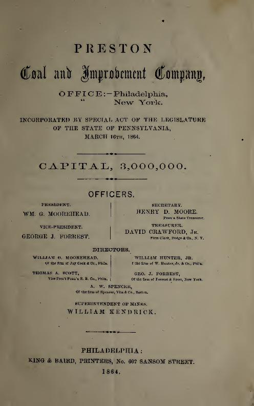
PRESTON
«
<£#al anb Jraprokmcnf (ffompitj,
OFFICE:- Philadelphia,“ New York.
INCORPORATED BY SPECIAL ACT OF THE LEGISLATUREOF THE STATE OF PENNSYLVANIA,
MARCH 16th, 1864.
CAPITAL, 3,000,000.
OFFICERS.PRESIDENT.
WM. G. MOOREHEAD.
VICE-PRESIDENT.
GEORGE J. FORREST.
SECRETARY.
HENRY D. MOORE.Penn’a State Treasurer.
TREASURER.
DAVID CRAWFORD, Jr.Firm Clark, Dodge & Co., N. Y.
DIRECTORS.WILLIAM G. MOOREHEAD.
Of the firm of Jay Cook & Co., Phila.
THOMAS A. SCOTT,Vice Pres’t Penn’a R. R. Co., Phila.
WILLIAM HUNTER, JR.f the firm of W. Hunter, Jr. & Co., Phila.
GEO. J. FORREST,Of the firm of Forrest & Frost, New York.
A. W. SPENCER,Of the firm of Spencer, Vila & Co., Boston.
SUPERINTENDENT OF MINES.
WILLIAM KENDRICK.
PHILADELPHIA :
KING & BAIRD, PRINTERS, No. 607 SANSOM STREET.
1864.

/ in i ii i
s 4
f > •
«
4
;
;
-. : i
‘
•* f i ' *
: . ; M'. 0 *
'
'
vLhr>wf
.i h >. t'*
.
'
-
i
,
•• . \
*’•.
‘ '
'
.•it '’
.1-J>'•<*•••<
.'
T •»'« : )
* J• 't '
. .0 ._f K V
.T ' ‘ 5
;
.
. i r X
.i»a 1• ; -
,•
,* *< -
>
*n,i if‘ >
-
' >r
.
t H'f-
. . >
i-
. !i- << f *
/
Ii.fi i ! KlA.liH'l
T .KT--v ' ' '’*/• -• : ,Q>^* AtJ
J •; i
« .

£ 22,33
PREFACE.
Upon the following pages will be found a
description of the Lands, Collieries, &c., of the
Preston Coal and Improvement Company,
located in Schuylkill County, Pennsylvania. Also
the Reports of P. W. Sheafer, Esq., and J. P.
Lesley, Esq., Geologists and Engineers of Mines,
formerly attached to the State Geological Survey,
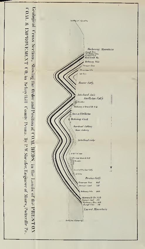
together with a Cross Section of the Coal Beds,
and a Map of the Property.

r
i r> / ’! :-r:
:
5 *>'i
5 K- I
-_
Itw •WV iOli >
i , (t >, .
.• io
-
. ..
• ;'
i-
1
t
•
‘1
'
\
• r i" % -v ‘
. k
,
c; ,
T,
'';
• - r ft;
-
1
..
• 1
! •
N' )
U <'.
<
.
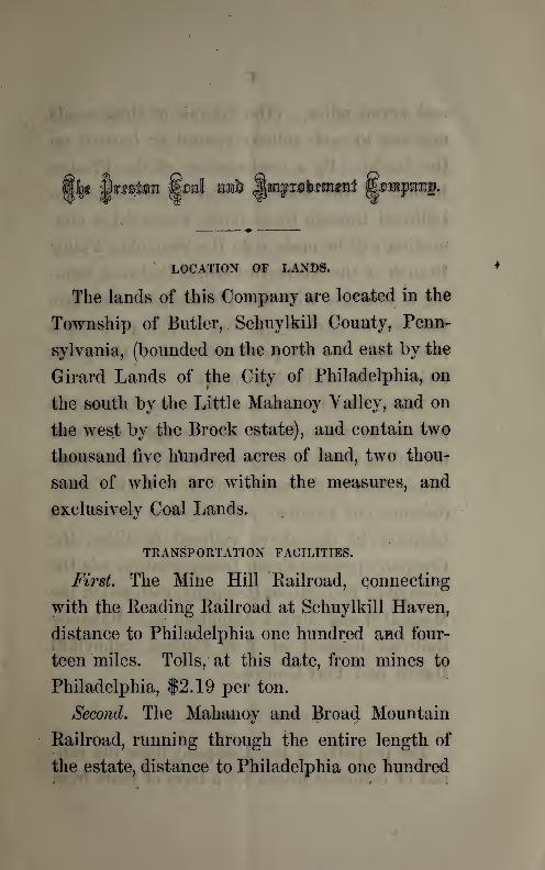
LOCATION OF LANDS.
The lands of this Company are located in the
Township of Butler, Schuylkill County, Penn-
sylvania, (bounded on the north and east by the
Girard Lands of the City of Philadelphia, on
the south by the Little Mahanoy Talley, and on
the west by the Brock estate), and contain two
thousand five hundred acres of land, two thou-
sand of which are within the measures, and
exclusively Coal Lands.
TRANSPORTATION FACILITIES.
First
.
The Mine Hill Railroad, connecting
with the Reading Railroad at Schuylkill Haven,
distance to Philadelphia one hundred and four-
teen miles. Tolls, at this date, from mines to
Philadelphia, $2.19 per ton.
Second. The Mahanoy and Broad Mountain
Railroad, running through the entire length of
the estate, distance to Philadelphia one hundred

6
and seven miles. (The laterals of these roads
now run to each colliery opened or located on
the lands). By a continuation of the Preston
.Branch of the Mahanoy and Broad Mountain
Railroad through these lands westward, a con-
nection will be made with the Shamokin Yalley
Branch of the Northern Central Railroad, form-
ing a junction with the Philadelphia and Erie
Railroad at Sunbury, giving to this property a
new outlet for its production, viz. : the great
cities of the entire Northwest.
Third. The Lehigh and Mahanoy Railroad is
located to these lands, and completed within
flve miles, furnishing a continuous railroad com-
munication to the waters of New York City—distance one hundred and fifty-four miles. In
addition to the above railroad facilities, the
Company possess cheap transportation via the
Schuylkill Navigation Company, with which the
Mine Hill and Broad Mountain and Mahanoy
Railroad connect at Port Carbon, Schuylkill
Haven and Port Clinton.
PROPERTY OWNED.
The property of this Company does not con-
sist of collieries leased for a term of years from

i
other owners of land, as is the case with other
companies now before the public, as they own
the entire body of lands in fee, with not a dollar
of debt of any kind against the Company. In
addition to the large and valuable body of lands
and collieries, the Company own all the usual
and necessary real and personal property con-
sisting in part of No. 1 first class breakers,
machinery, a large number of miner’s houses,
offices, mine cars, horses, mules, &c., &c.
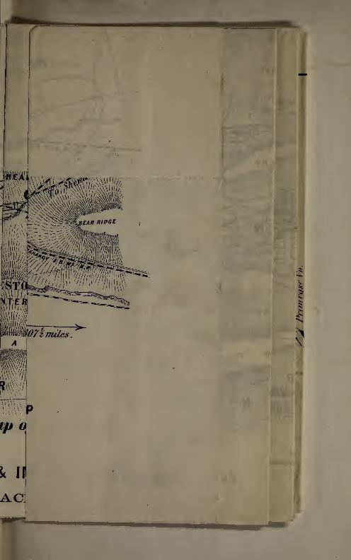
By reference to the accompanying map, it
will be seen that a part of the Company’s lands
lie contiguous to the town of Ashland, (on the
southwest and southeast), now containing a
population of some five thousand inhabitants.
From the sale of lots in Ashland it is said the
owners of the adjoining property (Brock estate)
have realized some two hundred thousand dol-
lars. The town of Foulketon is located in the
Valley of the Mahanoy and on the Company’s
lands, between Ashland and Mahanoy City.
Being surrounded by ten large collieries, with no
town near them, Foulketon must necessarily
draw a large population within its limits, which
will be a large and important source of revenue

to the Company. Over ten thousand dollars of
lots have already been disposed of.
CAPACITY OP MINES.
By reference to the report of Mr. Sheafer, and
more particularly to that of Mr. Lesley, it will
be seen it is demonstrated by actual measure-
ment that the lands of the Company contain an
inexhaustible supply of Coal, amounting in
tons to between two hundred and fifty and
three hundred millions. Of this amount it is
their opinion that at least one-fourth, or between
sixty and seventy million tons are above water
level, (which can be seen upon referring to the
cross section), offering a vast body of Coal
capable of the cheapest production.
COST OF MINING.
The fact of the Company possessing so large
a body of Coal above water level enables them
to dispense with the use of any expensive
machinery for hoisting, pumping, &c., and to
mine their Coals at a cost not exceeding one
dollar and five cents per ton, at the present rate
of wages, delivered at Port Carbon, the head of
the Reading Railroad. To cover all contingen-
9
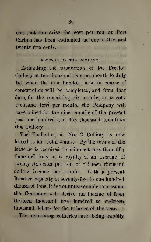
eies that can arise, the cost per ton at Port
Carbon has been estimated at one dollar and
twenty-five cents.
REVENUE OF THE COMPANY.
Estimating the production of the Preston
Colliery at ten thousand tons per month to July
1st, when the new Breaker, now in course of
construction will be completed, and from that
date, for the remaining six months, at twenty
thousand tons per month, the Company will
have mined for the nine months of the present
year one hundred and fifty thousand tons from
this Colliery.
The* Foulketon, or No. 2 Colliery is now
leased to Mr. John Jones. By the terms of the
lease he is required to mine not less than fifty
thousand tons, at a royalty of an average of
twenty-six cents per ton, or thirteen thousand
dollars income per annum. With a present
Breaker capacity of seventy-five to one hundred
thousand tons, it is not unreasonable to presume
the Company will derive an income of from
thirteen thousand five hundred to eighteen
thousand dollars for the balance of the year.
The remaining collieries are being rapidly.

10
developed, for which purpose an ample con'
struction fund has been provided, although it
is the opinion of their Mining Engineer that a
sufficient quantity of Coal will be thus obtained
to more than meet this expense.
Coal is now selling, for month of April, at
Port Carbon, at $4.50 and $4.75 per ton for
prepared sizes, or an average of say $4 for all
sizes.
Estimated production for balance of year, as
above, one hundred and fifty thousand tons.
Cost of mining 150,000 tons
at $1.25 per ton, . . $187,500
150,000 tons at $4 per ton, 600,000
$412,500
Add royalty, being minimum amount
for nine months, 9,750
Total revenue for remaining nine
months, . $422,250
ESTIMATE FOR 1865.
In making their estimates for 1865 and suc-
ceeding years, the Company are necessarily
governed by the reports of Messrs. Lesley and
Sheafer as to the capacity of their mines, to-
gether with such other evidence as they have
11
been enabled to bring to bear upon this impor-
tant subject. With this information before
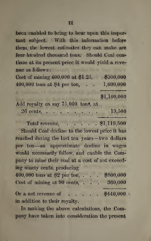
them, the lowest estimates they can make are
four hundred thousand tons. Should Coal con-
tinue at its present price it would yield a reve-
nue as follows
:
Cost of mining 400,000 at $1.25, $500,000
400,000 tons at $4 per ton, . . 1,600,00ft
$1,100,000
Add royalty oh say 75,000 tons, at
26 cents, ........ 19,500
Total revenue, $1,119,500
Should Coal decline to the lowest price it has
reached during the last ten years—two dollars
per ton—an approximate decline in wages
would necessarily follow, and enable the Com-
pany to mine their coal at a cost of not exceed-
ing ninety cents, producing
400,000 tons at $2 per ton, . . . $800,000
Cost of mining at 90 cents, . , . 360,000
Or a net revenue of $440,000
in addition to their royalty.
In making the above calculations, the Com-
pany have taken into consideration the present
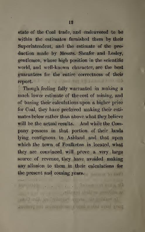
12
state of the Coal trade, and endeavored to be
within the estimates furnished them by their
Superintendent, and the estimate of the pro-
duction made by Messrs. Sheafer and Lesley,
gentlemen, whose high position in the scientific
world, and well-known character, are the best
guarantees for the entire correctness of their
report. »'
Though feeling fully warranted in making a
much lower estimate of the cost of mining, and
of basing their calculations upon a higher price
for Coal, they have preferred making their esti-
mates below rather than above what they believe
will be the actual results. And while the Com-
pany possess in that portion of their lands
lying contiguous to Ashland and that upon
which the town of Foulketon is . located, what
they are convinced will prove a very large
source of revenue, they have avoided making
any allusion to them in their calculations for
the present and coming years.

REPORT UPON THE LANDSOF THE
IN SCHUYLKILL COUNTY, PA.
By P. W. Sheafer, Engineer of Mines, formerly of the State Geological
Surrey of Pennsylvania.
3a the. S&tekideni and QLuectais.
of: the. SPteJdan $aaL and ^fmjiloucniciLl: $a.
:
Gentlemen :—The body of lands embraced
within the charter of your company is located
mainly in Butler Township, Schuylkill County,
Pennsylvania, and extends from Girardville on
the east to Big Run on the west, covering an
area of about two thousand five hundred acres,
the main body of which is within the great
Mahanoy coal basin of the middle anthracite
coal field of Pennsylvania. Since the year
1848, my professional duties have required me
to continue my attention, not only to the ques-
tion of location, but also especially to the
geological structure and mining capabilities
14
of the above mentioned parcel of land; the
accompanying map exhibits at once the form,
topographical features, connection with neigh-
boring lands, and railroad outlets of the parcel
under consideration.
Your estate lies about midway of the cele-
brated coal field just west of the junction of its
two main valleys or troughs of coal, the
northern being well and favorably known as
the Shenandoah basin, and the southern or the
more widely known as the Mahanoy basin;
both of these extend through your estate, the
Shenandoah for about a distance of one mile,
and the Mahanoy for a distance of nearly two
miles, at the eastern end it covering the whole
width of both valleys, the intervening ridges,
and the north and south slopes of Locust and
Mahanoy mountains, a distance of nearly two
miles, while at the west end your land covers
the main Mahanoy valley, the Mahanoy moun-
tain on the south, and the Locust Ridge on the
north. The entire area between the summits
of the Mahanoy and Locust Mountain is good
coal area, including the Bear Ridge and Locust
Ridge, Anticlinal Axes, together with the inter-
vening valleys or basins of coal.
15
Coal beds undulating, as shown in the
accompanying cross section, not only add
materially to the quantity, but as well to the
advantages of mining coal, than if in a hori-
zontal position or in a single basin of great
depth. The mountain summits rise to a heighth
of over six hundred feet above the level of the
valley, and the coals on either side approach
the mountain, crests and again descend beneath
the surface a yet greater depth.
This body of land is bounded by the Girard
lands of the City of Philadelphia on the east
and north, on the south by the Little Mahanoy
Valley, and by the Brock estate and other
lands on the west. It lies precisely in range
with all the large and very productive collieries
both east and west and on both sides- of the'
valley of this rich coal district. We have,
besides, developed, by shaftings and actual
workings upon your property, the main and
reliable coals of the region.
The following series of coal beds, with the
average thickness of each, is made up from
actual proving on this estate
:

1«
8 feet Coal Bed.
10 feet Coal Bed, Shenandcah or Primrose Coal.
3 feet Coal Bed, Furnace Coal.
10 feet Coal Bed, Malranoy Bed.
25 feet Coal Bed, Mammoth Coal.
3 feet Coal Bed, Furnace Coal.
oK5
15 feet Coal Bed, Skidmore Coal.
2 feet Coal Bed, Bough Coal.
71 feet.
11 feet small Coal beds deducted.
00 feet, or twenty yards of Coal in lour large
4

17
workable veins, which are the main productive
coals of the anthracite .coal fields. It can
fairly be said that in no other district are the
coals found better or more reliable.
I am reluctant to make an estimate of the
quantity of tons of coal which such a body of
lands as yours is believed to contain. The
figures swell to a size which persons not
familiar with the subject must, at first view,
regard as an exaggeration, but an approxima-
tion to the gross tonnage of coal in your estate
can be had by multiplying three square miles
of territory by the aggregate thickness of your
four main coal beds, twenty yards in thickness,
when you will have an amount so great, in
millions of tons, as to satisfy all doubts as to
future supplies for many years to come.
If you will note the water level line of the
Mahanoy Creek, on the cross section, you will
perceive how large an amount of coal can be
mined by drifts and tunnels, before resorting to
the more expensive method of deep mining by
slopes or shafts, with all their complications
of expensive engines, pumps, &c., &c.
It is designed to subdivide the coal area into
2

18
five distinct portions, each one to form a sepa-
rate colliery, as shown upon the map.
No. 1, or the Preston Colliery, covers all the
south dipping coals of the south slope of
Locust Mountain.
No. 2, or the Foulketon Colliery, embraces the
three dips of the Mahanoy Mountain coals and
of the Anticlinal Ridge, next north of it, at the
east end.
No. 3, or the Moore Colliery, will embrace the
same coal beds, at the west end.
No. 4, or the Mooreliead Colliery, will cover the
coals of the Locust Ridge, at the west end, and
north of the Mahanoy Creek.
No. 5, the Hunter Colliery, covers the same
coals, at the east end, and lies between col-
lieries Nos. 1 and 2.
The Preston Colliery, No. 1, is a new and first
class colliery, now in actual operation, having
shipped its first coal in January, 1863, and it
is now prepared with a coal capacity to double
or even triple the amount of coal mined during
that year. This colliery is located in a ravine
in the south slope of Locust Mountain, whence
three drifts are driven westward on the ends of
three coal beds, all above water level, inclining
at an angle of forty degrees south, with an

19
average breast of one hundred yards on each
i coal, the thickness of which are as follows
:
the Mammoth twenty-live feet thick;the Skid-
more fifteen feet, and the Mahanoy bed ten
feet; in all forty feet of coal. To those familiar
with the large developement of the coals in
this immediate vicinity, these thicknesses may
appear excessive, and I therefore quote from
the inspector’s measurements made in October,
1863, and again on the 22d of this month.“ In Breast No. 4, coal thirty feet thick
;good
and strong.” “No. 5 Breast is up one hundred
and eleven feet, thirty-three feet wide and thirty
feet thick; excellent coal all the way up.”
“Nos. 6, 7, 8 Breasts, coal in all thirty feet
thick.” “In the turnout the coal is very good,
from thirty to forty feet thick.” The above
refers to the Mammoth coal bed. Of the Ma-
hanoy or Primrose, he says :“ In Breast 2, coal
is eight feet thick; in No. 3, fourteen feet, of
fair coal. No. 4 is fifteen feet thick; good
coal. Nos. 5, 6 and 7, very good coal, eighteen
feet thick.” He remarks respecting the Skid-
more :“ It is really excellent coal, and not less
than twenty feet thick.
The other intermediate and overlaying coals
20
we have not opened for mining, having more
than enough of coal to supply < the present
capacity for its preparation for market. It is
not uncommon for our large collieries to ship
one hundred thousand tons, and more, per
annum, from the Mammoth bed alone, and that,
too,^mostly from below water level, where they
require immense machinery for hoisting coal
and pumping water, as in the cases of the
following colliery, which is on the same south
slope of Locust Mountain with your Preston
Colliery, and on the Mammoth coal bed, viz.
:
George S. Repplier, who mined and shipped
in the year 1863, 144,457 tons.
In your case, you have three coal beds, equal
to two Mammoths, and all above water level, so
that no pumping or hoisting is required, but to
haul the coal from the mines to the top of the
breaker. Is it not fair to presume that, with
two breakers, to furnish abundant means for
preparing the coal, you should do a business at
this colliery equal to two slopes, or even more
than two hundred and fifty thousand tons per
annum ? Exhausting coals at this rate, we must
sink slopes eventually, but in no case, referring
to the five above named collieries, for some
21
years to come. A tunnel can be so driven, at
the Preston Colliery, as to develop an additional
large amount of coal above water level, and
thus continue this cheaper method of producing
coal. I question if there is any other colliery
in the anthracite coal fields that can exhibit a
larger display of better coal, or where it can be
mined more economically, than at your Preston
Colliery.
No. 2, or Foulketon Colliery, is also in opera-
tion and located on the southeastern portion
of your estate, and includes the same set
of coal beds we have just described in the
Preston Colliery, but perhaps not so fully
developed. They are contained in the north
slope of Mahanoy Mountain and in the An-
ticlinal Ridge, which forms a wide bench
on its northern front, south of the Mahanoy
Creek. This colliery is now in process of
development;a drift having been driven around
the axis westward, has demonstrated three dips
of the Mammoth coal bed;a breaker, with all
its fixtures, prepared for a business of from
seventy-five thousand to one hundred thousand
tons per annum, is erected, and now in opera-
tion;a slope has been sunk on the Mammoth

22
coal bed to a low water level, to which point a
tunnel is being driven, which is to serve the
purpose of a water drain for the large body of
coals above its level. In the meanwhile, a
good engine and pump are now employed,
pumping water and hoisting coal, to continue
the shipment of coal until the completion of
the tunnel, when the process of pumping will
be obviated.
Nearly one mile in length of land is assigned
to this colliery;but, in consequence of an anti-
clinal axis, which triplicates the coal beds, the
length of run is duplicated, and, of course, the
amount of coal contained within the above
named limits is greatly enlarged. Thus
:
MDMORE.
The amount of coal in the No. 2 colliery is
even greater than in No. 1, and is equal in
character. These two collieries are now in
active operation, with all their appurtenances,
23
including breakers, engines, screens, railroad
cars, teams, tools, miners’ houses, &c., &c.
The 3d, or Hunter Colliery, now ready to open,\ t
lies immediately west and adjoining No. 2. In
this we have the north dipping coals of the
Mahanoy Mountain proved and the Mammoth
bed traced through the whole length of the
land. Its quality is very good, and height of
breast, above water level, greater than on any
part of the estate, being over live hundred feet
above Mahanoy Creek. The Skidmore is yet
higher;the Primrose less. In this colliery we
have also opened certain south dipping coal
beds, all of which can be opened by a long
tunnel, and thus display an immense area of
coal above water level. This colliery can be
prepared so as to ship over one hundred thous-
and tons of coal in 1865. I recommend this
colliery to your immediate attention, as a
grand source for coal for a very long period of
years.
The No. 4. or Moorehead Colliery, is located in the
northwestern portion of your estate, north of
Mahanoy Creek, and covering the south slopes
of Locust Ridge, extending from Big Mine Run,
on the west, midway of your land eastward.
24
In driving a tunnel from the level of the Main
Valley of the Mahanoy, we expect to cut the
main coals of the region, and thus have them
above water level to yield a large supply.
The No. 5, or Moore Colliery, will be worked and
developed after the same manner the same sett
of Coals, as No. 4, but further eastward, lying
between the No. 1 Colliery on the north and
No. 2 on the south.
The Coal beds of this operation are a con-
tinuation of Locust Ridge eastward, giving, in
the two places, a continuous run of nearly two
miles, and, if deemed advisable, they can be
merged into one working, thus requiring but
one tunnel to develop both, and from which
gangways can be turned east and west. In
this case but one Breaker will be required.
Thus, with four tirst-class Collieries, each
with a Coal capacity ranging from one hundred
thousand to two hundred thousand tons per
annum, an enormous tonnage can be mined.
The modes of transport to market are varied,
and compare favorably with any other set of
mines in the Mahanoy Valley.
1st. The Mine Hill Branch of Beading Railroad passes
through the western borders of your lands, from

25
whence your distance to Philadelphia is one
hundred and fourteen miles.
2d. The Mahanoy and Broad Mountain Railroad, (main
line) runs the whole length of your estate, and
now carrying Coal, affording an outlet from the
No. 2, or Foulketon Colliery, in . 107 miles.
No. 3, or Hunter Colliery, in . . 107| miles.
The Moorehead and Moore, or Nos. 4 and 5
Collieries, in the same valley, on the north side
of the Creek, will have about the same distance
to market.
The No. 1, or Preston Colliery, has an outlet
via the Preston Branch of Mahanoy and Broad
Mountain Railroad, to Philadelphia, one hun-
dred and eight miles. The average of fourteen
of the most convenient Collieries in the Maha-
noy to market by this, the nearest outlet, is one
hundred and nine miles.
By a continuation of the above Preston
Branch through your lands westward, you form
a connection with the Shamokin Yalley Branch
of the Northern Central Railroad, and thus form
a junction with the Philadelphia and Erie Rail-
road at Sunbury, thirty-eight miles distant from
your mines.
The Lehigh and Mahanoy Railroad located to your

26
mines, and in process of construction, will give
you a continuous railroad line to the waters of
New York harbor, a distance of one hundred
and fifty-four miles.
We must arrive at these conclusions
—
1st. You have immense resources for Coal
supply;
2d. Of superior quality.
3d. Favorably located for production and
transportation, with all the above essential ele-
ments in your favor, you only now require good
management in the development and prepara-
tion of your mines to insure your success.
I am, very respectfully,
Your obedient servant,
P. W. SHEAFER,' Engineer of Mines.
Pottsville, Pa., March 29, 1864.
It may be of sufficient importance to note
that the town of Foulketon, now laid out in lots
and streets, and built upon along the Valley of
the Mahanoy, on your lands, is the only availa-
ble ground where lots can be bought for several
miles to the north, south and east. Surrounded
as it will soon be by ten or more large Collieries,
27
there must concentrate here a large mining and
other population, the importance of which must
accrue to the advantage of your estate.
South Ashland, just adjacent to the Borough
of Ashland and the Collieries and railroads of
the surrounding district, afford suitable lots at
cheap rates to the great number of operatives
there employed.
REPORT ON THE LANDS
OF THE
IN SCHUYLKILL COUNTY, PA.
By J. P. Lesley, Topographical Geologist, and Professor of Mining in
the University of Pennsylvania.
J5a the. &£e.6ide.nt and QLilectatk
°f SPlelitan $oat and JP/n/zlaiiement :
Gentlemen :—You ask for my opinion of the
coal property, lately known as the Foulke and
Preston Retreat Tracts. It gives me great
pleasure to report upon so superb an estate.

X
28
Of the twenty-five hundred acres comprised
within its limits, three-fourths lie within the
Mahanoy Coal Basin, and of these alone it
is necessary for me to speak.
There are three square miles of land, lying
in L form across the valley;one square mile
occupying the north side of the valley and
rising to top of the Locust Mountain;
the
other two square miles occupying the south
side of the valley and rising to the top of the
Mahanoy Mountain. Each square mile contains
between eighty and a hundred million tons of
coal, making in all between two hundred and
fifty and three hundred million tons under the
whole estate.
Of this amount, at least one-fourth is above
water level;and one-half, contained in the
three principal white and gray ash beds.
The points which interest you most nearly
are
1. Whether this immense wealth is readily
accessible
;
2. Whether, when mined out, it is in market-
able condition
;
3. Whether it can be got to market at a pay-
ing price.

29
1. The lay of the coal. Each square mile
can sustain a first class colliery, yielding be-
tween one hundred thousand and one hundred
and fifty thousand tons per annum.
There already exist two in operation, one
on the north side of the valley, the Preston;
the other opposite to it. on the south side, the
Foulketon colliery. They are both now in good
working order.
The third square mile, towards Ashland,
(and also on the south side of the valley), is
admirably adapted for a heavy operation
;
having all the beds in good posture, and, in
large proportion, above water level.
There still remains the middle of the valley,
to consider. At the eastern side the structure
will need careful study. Further west a regular
anticlinal lifts the coal beds, which otherwise
would have been to seek at an immense depths,
most obligingly to water level;so that a fourth
eolliery will be required to take out the central
mass.m
There is no reason to believe that less than
four hundred thousand (400,000) tons of coal
will be sent off annually, when the three prin-
cipal collieries are in the best condition.

30i
To make this clear, I will go a little more
into detail respecting the structure.
The lower series of Coal Beds occupy the
Mahanoy Basin;the grey and white ash beds at
the bottom of the series, and the red ash veins
in the upper part. The beds descend on one
side of the Valley under the Creek, and ascend
upon the other side;cropping out, one above
the other, up the mountain side, with the edges
of conglomerate strata, between them, forming
terraces and jagged cliffs at the ravines. It is
in these ravines that the edges of the Coal Beds
are first attacked, so that the mines may drain
themselves. The two first collieries on your
estate are situated in two such ravines.
The Preston Colliery has two principal beds
at its command, thus : See opposite page.
When the above section is drawn to the same
scale, vertical and horizontal alike, it appears
that there are about a hundred’ yards of Coal, in
slanting height (that is, along the dip of forty
degrees south) above the gangways of the
several beds.
The Mammoth Bed frequently yields ten yards
solid thickness of Coal, in which case, as its
breasts are ten yards wide and a hundred yards
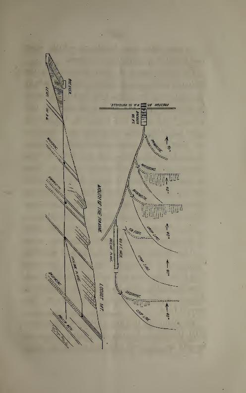
VVJO
SS
7JXJ?

’
!*
\
' /
'
'
.
'
.
1
.
>
'
.
.
•
>
:
-r
%
.
•
.
'
'
1
"•
*
.
•

33
long, each of its breasts sends forth ten thou-
sand tons of Coal. As a pillar (or “long wall”)
of seven yards in thickness is left between each
pair of breasts, and the gangway has a run of
nearly a mile before it enters the next property,
(viz. : one thousand six hundred and fifty yards),
the number of breasts will be, in all, about a
hundred; and the total winning, above the
present head-of-breaker-level, one million of
tons, of which, say, seventy thousand have been
taken out in the process of heading the gang-
way well forward (seven hundred yards,) and in
putting up the first breasts to be ready for ex-
tensive work hereafter. The mine is therefore
in excellent order. The above amount of Coal
leaves, also, out of account the robbing of the
pillars afterwards. The following illustration
will show how the work in the Mammoth Bed is
done : The bed has three members or divisions,
being divided by from four to ten inches of slate,
six feet from the floor, and again as far from the
roof. The lowest bench or bed of Coal, six feet
thick, carries the gangway.
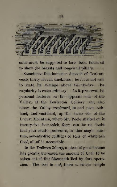
The regularity of the whole mass permits the
carrying up of the breasts in the manner shown
in the drawing, where the top covering of the3
34
i
' ' ",
' *
mine must be supposed to have been taken off
to show the breasts and long-wall pillars.
Sometimes this immense deposit of Coal ex-
ceeds thirty feet in thickness;but it is not safe
to state its average above twenty-five. Its
regularity is extraordinary. As it preserves its
personal features on the opposite side of the
Yalley, at the Foulketon Colliery, and also
along the Yalley, westward, to and past Ash-
land, and eastward, up the same side of the
Locust Mountain, where Mr. Poole shafted on it
twenty-five feet thick, there can be no doubt
that your estate possesses, in this single stra-
tum, seventy-five millions of tons of white ash
Coal, all of it accessible.
In the Poulketon Colliery, a piece of good fortune
has greatly increased the amount of Coal to be
taken out of this Mammoth Bed by that opera-
tion. The bed is not, there, a single simple
35
slab or plane of Coal, standing up in the side
of the Mahanoy Mountain, at an angle of forty
degrees, as in other cases. The bed, in fact,
rises in that manner, from the centre and bot-
tom of the Valley, far above water level, so as
to give not only height for a high breaker, but
also height above that again for breasting.
But, having done this, it turns over and descends
steeply and squarely into the heart of the
mountain, and afterwards turns again and rises,
as before, until it comes out to the surface, high
up towards the summit of the mountain. There
is thus formed, back of the first workings on
the north dip, a complete basin, with a south
dip and a north dip of its own;thus trebling
the amount of Coal in the colliery as it stands,
and at the same time effectually preventing the
bed from taking a plunge so profound into and
under the centre of the Valley as to practically
bury out of reach one half of its contents.
This sub-basin, or south-trough, deepens
westward. The anticlinal axis, which produces
it, sinks in the same direction. The ravine in
which the colliery stands, is a shallow, bowl-
shaped hollow, cut out of the top and north side
of the axis. In the edge of the bed, on the

36
west side of this hollow, the main gangway
enters, travelling west.* But it soon begins to
* As in the accompanying plan
:
FOULKFm COLUFF
Y
MAHANOY CR
turn southward, around the west end of the
anticlinal, and, having got behind the anticli-
Note.—The above plan exhibits the condition of the
Colliery after several years’ production of Coal shall have
been taken out of it. It shows, also, only the Mammoth
Bed. Each of the other beds, below and above it, would be
represented in a similar manner.
V
37
nal, comes running back, eastward, to the east
end of the south trough. Here it turns south-
ward and then westward as at first, and so will
continue to Ashland: An immense run of
gangway is the consequence, and a vast increase
of breast Coal, even at the upper level. The
new slope descends to take a still deeper hold
upon the bed, and will be drained by a short
tunnel. Its gangway will follow the same ser-
pentine course with the one above it, and its
breasting of Coal will be increased in the same
proportion. Few collieries in the world can
make a show like these. In quantity of Coal,
at command under the most favorable condi-
tions, they cannot be excelled.
For, besides the Mammoth Bed, there lies be-
hind and under it, another bed of first-class
size, the Skidmore; and above it, at least one
other first-class bed, the Mahanoy. Both these
beds can be worked at these collieries on all
three dips with very little trouble.
To examine the beds last mentioned, in de-
tail, we must return, across the Valley, to the
Preston Colliery. Here the Skidmore has been
approached by an incline plane rising from the
railroad which feeds the Breaker, the same rail-

38
road which passes the mouth of the Mammoth
and the other gangways. The Skidmore gang-,
way is therefore eighty-two feet higher up the
hill than the other gangways, but its outcrop
rises, also, that much higher on the mountain
side, and therefore, even at that great elevation,
its length of breasts is as great as that of the
Mammoth Bed, say a hundred yards.
The Skidmore Bed is, as found by Mr. Poole,
on the Girard lands, half a mile further east, to
be nineteen and a-half feet thick. The Preston
gangway has been driven in upon it a hundred
yards, and has found the bed to average at least
fifteen feet, reaching sometimes twenty. It has
no regular slate partings, and is worthy itself
of the name of the Mammoth Bed, for which it
has, no doubt, sometimes been mistaken. It
will furnish half a million of tons from its
present gangway, and two hundred thousand
tons more, afterwards, to an opening on the
level of the other gangways. There will still
remain an equal quantity to be won from it
between that and the actual water level of the
run.
Neglecting mention of a “Rough Vein,” so-
called, below the Skidmore, and of a “Ten-foot
*
39
Bed,” so-called, between the Skidmore and the
Mammoth, the next bed to notice lies above the
Mammoth, and is called the Primrose; but it
ought to be called the Mahanoy Bed. It, also,
has no regular slate parting, but is accounted
by the miners one solid stratum, from twelve to
fifteen feet thick. Its outcrop is lower down
the side of the mountain, and its breasting is
therefore not so high. A gangway has been
driven into it several hundred yards, and it is
in a condition to yield its quota to the amount
to be produced by this fine colliery.
At the rear of the head of the Breaker ap-
pears the olitcrop of the true Primrose Bed, a
still higher member of the series, a seven-foot
bed on the Girard Estate.
All these beds descend beneath Wild Cat
Run, and beneath the hill which runs through
the centre of the Yalley. They rise up under
the centre or south flank of this hill, and then,
making a little basin, descend beneath the
Mahanoy.
This structure, as exhibited on the east line
of the property, will be better understood by
the annexed diagram. Further west, that is,
more to the centre of the property, Locust

r
'
•.
;
. . Ati.in W
-:
’
i i i
.
•
-'
’ V, .
. •>fq .
/•. , , J J -I * wMt
Ml ;•
1 ,
'
.
. . . . ft < v
i
, • i. / < tii
• 1 i *i ft
:
m ' •’ »'l ‘i- t‘: *1 f «)
••
.
>M,u.
v if s
• ;/ir,
v>;* ;
'
117
i' • •, HM ^
:
.
v >ii . . - i
fll. • • !«» lit i :* : / r
‘ t h i 1 I?
y ! 1 f
i r :
'
• •' 1 *'». •*, ,if?
*.
i
. . / . 4 it . t*
:
' r J
•
,V'
1•ii j b-
i . ill aril
fli ) i * i ’!-’


, ,"
.* !
// ;
/
.5,
v*
.
.
-
\
’
‘
.
-
:
.
• ''f .
%
> . \.
'
/
'* •' si ?
\\ .
,
’ '
v\ ' i rli
V » * ('
’
• . I.'
v#fi4 ii *(i- •:t’
S’ iilW Hti0
•»-
.
.

43
Ridge, seems to hold a simple anticlinal. This
anticlinal is probably the one which keeps up
through the Shenandoah Yalley, eastward. The
Foulketon Anticlinal is, no doubt, the dying
axis of Bear Ridge.
2. The Quality and Condition of the Coal.—There is
nothing left to be desired about the Mammoth
White Ash Coal. It is hard and bright and
clean. The regularity of the bed is a guarantee
against slips and faults. It must bfe expected
that the original denudation of the coal, (before
it was covered by the sand, which now makes
its top rock,) will occasionally take off its top
bench and perhaps cut into its middle mass,
but this scarcely affects the value of the bed.
The Skidmore coal, where I happened to find
the heading, was slightly slipped, but bright
and good coal. A little way back, it was hard
and firm, and seemed to be so everywhere else
in the gangway. Its bottom coal yields a pink
ash, which is characteristic of the same bed in
the Beaver Meadow Mountains.
There is, in a word, no reason to fear that
the quality of the coal from the beds at these
collieries will fall short of its quality at the
collieries around Ashland, or upon the flanks of

44
Mine Hill. The beds have the same appear-
ance also, and have undergone no hard usage,
such as they have suffered in the central dis-
trict of the Shamokin region, and along the
south side of the Pottsville basin, and else-
where.
3. When I first began the study of the An-
thracite region, in 1839, and for many years
afterwards, this great basin of the Mahanoy
waters, rich as we know it to be, seemed to us
hopelessly shut out from market, by the
grand barrier of the Broad Mountain. Several
attempts were made to reach and open it from
the eastern heads of its basins, by connect-
ing it with the Lehigh roads, and then with
the Little Schuylkill roads. Girard’s gallant
attempt to carry a connection over the Broad
Mountain failed. Now, however, it is com-
pletely opened to market by two routes, and it
will not be long before a third is finished. Its
coals can pass down by Ashland, and then over
the Mine Hill road to Schuylkill Haven;or up
the valley and over the Broad Mountain and
Mahanoy extension of the Reading road, and
down Mill Greek to Pottsville. The distance
by this latter road is but twelve miles, and the
45
extra distance (over the St. Clair Mammoth
bed coals) to market is but seven miles. This
puts an additional eight or ten cents upon the
freight, which is saved, twice over, by the fact
that the Preston Collieries will work, for years,
above water level.
I remain, gentlemen,
very respectfully,
your obedient servant,
J. PETER LESLEY.
Hall of the American Philosophical Society,
106 South Fifth Street,
Philadelphia,
March 80th, 1864.

•
'
’
" •’; 1
>: J i-‘-»
’
•
-
i •
—
_
Jxnrn
rose
In.

’
•
..
••i ; . i
*
’
Vr
l1 \
.
,
‘fft 1 ' mV/;
vi ( i .’jjfe,
*< •
I m" v
'
i IT /:
, |U,, /
'
- 1?


Geological
(
ross
Section,
Showing
Ilie
Order
and
Position
of
COAL
BEDS,
in
Ihe
Lauds
of
the
PRESTON
(
OAli
&
IMPRON
EMEX
TCO.
in
SchuvLkiU
Couuly
Penua.
By
P.AV.Sheafer,
Engineer
of
Mines,
Pottsville
Pa