Embed Size (px)
Citation preview

International Workshop on SocioInternational Workshop on Socio--Economic Benefits of Hydrological & Meteorological Economic Benefits of Hydrological & Meteorological ServicesServices
2121--28 September 200928 September 2009
Presentation onPresentation on
HYDROLOGICAL & METEOROLOGICAL HYDROLOGICAL & METEOROLOGICAL SERVICE OF NEPALSERVICE OF NEPAL
byby Suresh MaskeySuresh Maskey
HydrologistHydrologist Department of Hydrology & MeteorologyDepartment of Hydrology & Meteorology
Kathmandu, NepalKathmandu, Nepal

• General Features of Nepal• Hydrological & Meteorological Scenario • Activities of DHM :
1. Hydrology Service2. Meteorology Service3. Weather Forecasting4. Flood Forecasting5. Snow & Glacier Hydrology
PRSENTATION TOPICSPRSENTATION TOPICS

• Nepal: in the central part of the Hindu- Kush Himalayan region,
• - Area 147,181 sq km• L = 885 km• Avg. W = 193 km• -Rugged topography, • very high relief, • variable climatic conditions and
complex geological structures with active tectonic processes
- 60m to 8848m A.M.S.L

CLIMATE Tropical to Alpine
+40 to –50 C
Wet to Dry 250 to 6000 mm
80% Precipitation during Summer Monsoon
Major River Basin of Nepal
Major River
Yearly Ave (cu.m\sec)
Max.(cu.m\sec)
Min (cu.m\sec)
Karnali 1380 16000 173
Narayani 1150 14000 160
Kosi 1620 9880 200
Bagmati 130 7550 5.10
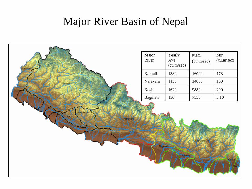
• 6,000 Rivers & Rivulets
Drainage Area = 194,000• Three classes of Rivers
– Snowfed– Rainfed– Seasonal
HYDROLOGYHYDROLOGY


HYDROPOWER
• 83,000 MW potential
• 43,000 MW feasible
• 527 MW exploited
• Meets only 2005 demand
• Access to 40% population

Type of land use Area (sq. km) %Forest 55334 37.6Agriculture 26533 18.0Snow 22463 15.3Pasture 19785 13.4 Water 4000 2.7 Settlements and Roads 1033 0.7 Others (waste land, etc)18033 12.3
Total 147,181 100
Land use of Nepal

Ministry of Environment
Department of Hydrology and Meteorology
Babar Mahal

Division
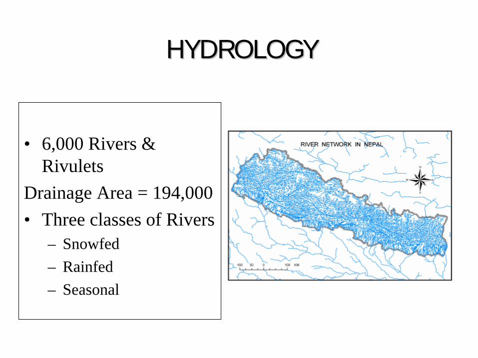
* Hydrology Division
* Meteorology Division
* Weather Forecasting Division
Total staff: 237
Collection, processing and publication of meteorological dataClimate change studySolar and Wind StudyAgro-meteorological study
Activities
* Meteorology Division

• PRECIPITATION -337• CLIMATOLOGY - 68• AGROMETEOROLOGY - 22• SYNOPTIC - 9• AEROSYNOPTIC - 6• AWS - 18
Meteorological Stations
Total
460460

DATA PROCESSING

PublicationsPublicationsPublicationsMeteorology and HydrologyMeteorology and HydrologyMeteorology and Hydrology


REVENUE
Revenue from Data book & Digital data
0
50000
100000
150000
200000
250000
300000
2056/57 2057/58 2058/59 2059/60 2060/61 2061/62
Fiscal year
Amou
nt in
Rs.
Met. Data book
Met.Digi. Data
Hydro.Data Book

DATA USERS
• STUDENTS/RESEARCHERS: 74 %• CONSULTANT: 12 %• INSURANCE : 4 %• OTHERS: 10 %
• STUDENTS/RESEARCHERS: 74 %• CONSULTANT: 12 %• INSURANCE : 4 %• OTHERS: 10 %

Weather Forecasting Division
Weather Forecasting DivisionAirport, Kathmandu

Synoptic StationAirport, Kathmandu
• 15 Synoptic Stations
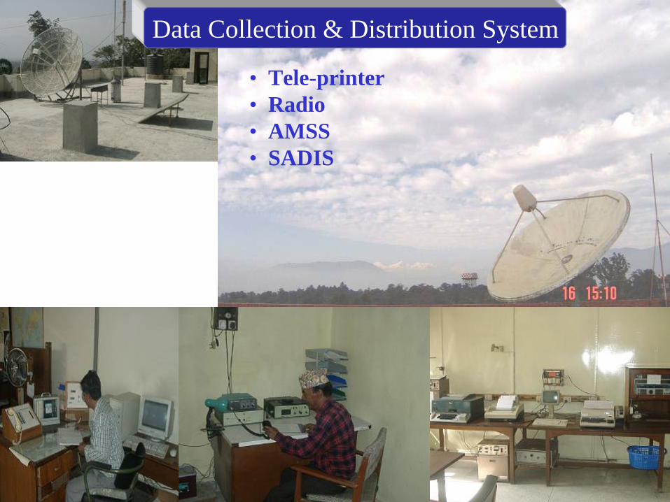
Data Collection & Distribution System
• Tele-printer• Radio • AMSS• SADIS

6 Surface chartsEvery 3 hours interval
2 upper air chartsOver 8 vertical levels Every 12 hours interval
Plotting & Analysis

Tools• Synoptic Charts• Satellite Images• NWP Guidance
Weather ForecastingWeather forecasting process• Collection of weather data from various
parts with the country• Collection of weather data from
neighboring countries as well as from different parts of world.
Weather forecasting tools:• Weather data from various parts of world• Satellite imaginary• SADIS • Numerical weather prediction outputs from India and other
countries• Weather information from different parts of world

ServicesServices
•Twice daily through media
• Daily update in home page
• Weather bulletins • Briefing to journalists
• METAR (every half hour)• TAF (every six hours)• En-route Forecast• Weather Briefing to pilots
Mountaineering Forecast
• Daily Special Forecast formountaineers
Aviation Sector
Forecast to General Public

Hydrology Division
– River Hydrology– Flood Forecasting– Snow and Glacier Hydrology– Water Quality & Sediment
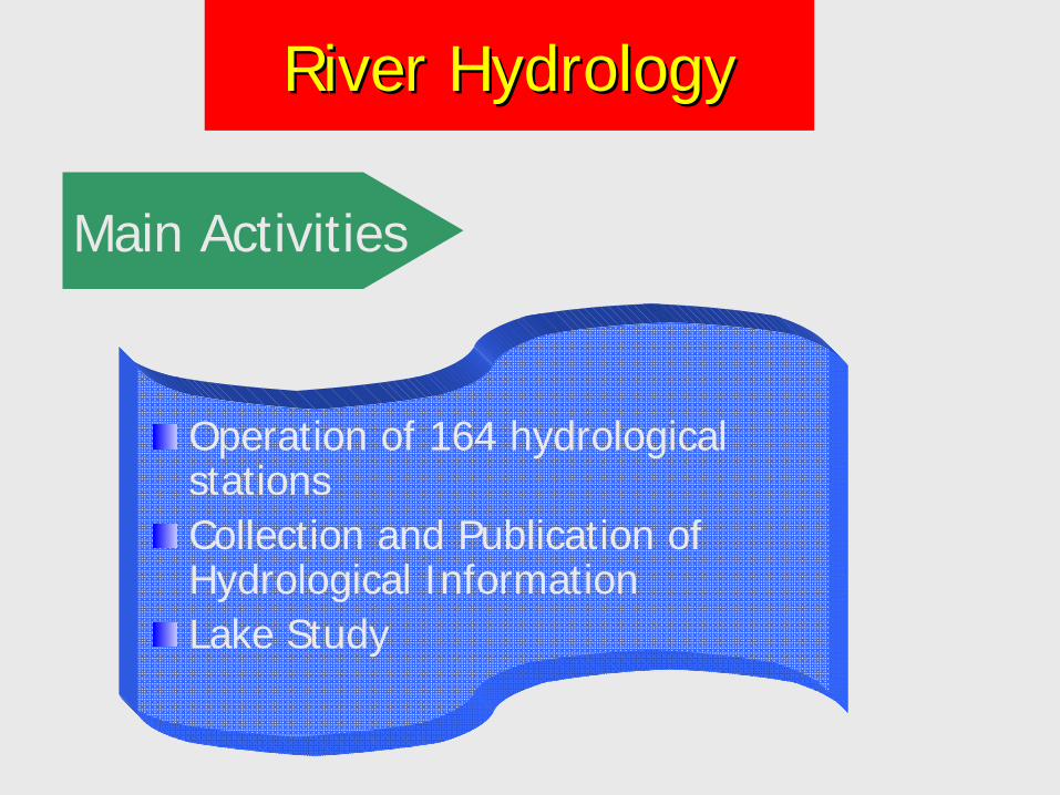
Operation of 164 hydrological stationsCollection and Publication of Hydrological InformationLake Study
Main Activities
River HydrologyRiver Hydrology


Staff Gauge &
Gauge House
Discharge Measurement by wading
Staff GaugeGauging Station of
Manahari Khola
Discharge measurement from cable car

Cable way site at Melamchi at Helambu

Lake StudyTilicho Lake
Rara Lake
Dhanus and Ganga Sagar
Water Quality of Rivers & Lakes Monitoring 52 StationsKathmandu and Pokhara

Activities
Operation of 20 hydrological and 16 rainfall stationsCollection and Publication of dataFlood Risk MappingModel development for Flood forecastingFlood Forecasting in major rivers of Nepal
Flood Forecasting

Flood Forecasting Station NetworkFlood Forecasting Station Network
Flood Forecasting Project has now a network of 43 stations in operation:
•15 hydrometric stations (Water level + Rainfall)
•27 meteorological stations
• One hydrometric station (Portaha- Bandipur): Rainfall only

Flood Forecasting Process
OfficeOffice
Station DataStation Data
SirenSirenNew Papers News PapersNew Papers News PapersNew Papers News PapersNew Papers News PapersNew Papers News PapersNew Papers News PapersNew Papers News PapersNew Papers News PapersNew Papers News PapersNew Papers News Papers
News MediaNews Media
NewsNewsPaperPaper

Communication Systems

Real Time Data Real Time Data Acquisition SystemAcquisition System
• Existing HF Transceiver system isn’t adequate • Less reliable in bad weather conditions • Recently, DHM has installed 10 rainfall and 3 water
level data loggers in Narayani River basin with Code Division Multiple Access (CDMA) wireless communication system for high speed data transfer.
• It uses M2M communication technology with CDMA wireless modem to transmit data from sensors placed at different parts over the internet to a database server.
• The data have been posted on the following website: http://www.hydrology.gov.np

Transmitted DataTransmitted Data
http://www.hydrology.gov.np

Near Sundari Ghat, Bagmati

Flood Risk Map of Khando Khola (Saptari)
##################
#######
###
###################
######
#######
#
############
###############
####
##
###########
########
##########
##### #### ####
## ###
#############
#####
########
########
#####
#############
######## ##
#####
#########
######
#########
######
#######################
#
#######
######
###
#########################
##
###
#########
##########
#################
###################
############# ####
###########################
#######
#####
####
###############
#####
######
##########
####
############
##############
######
#
#######
##
Watersed BuondaryLow Risk ZoneMedium Risk ZoneHigh Risk ZoneRoad
# SettlementsRiver
N
EW
S
Applica
tion of
GIS

Activities
Operation of 6 hydrometeorogical stationsCollection and Publication of dataGlacier and glacier lake studiesModel development for snow and glacier melt runoff
Snow and Glacier Hydrology

Hydrological and meteorological data collection from high HimalaHydrological and meteorological data collection from high Himalayas yas (Elevation 2700 (Elevation 2700 -- 4300 m)4300 m)
ActivitiesActivities
(i) Temperature(ii) Relative Humidity(iii) Precipitation(iv) Solar radiation(v) Wind speed/ direction(vi) River stage/discharge(vii) Water equivalent of
snow
Parameters
Snow and Glacier HydrologySnow and Glacier Hydrology
Station Elevation River
• Langtang – 3800 m. Langtang
•Khumbu – 4335 m Imja
•Annapurna – 3470 m Modi
•Makalu – 3980 m Barun
•Kanjiroba – 3770 m Sanu Bheri
•Humla – 3800 m Panchamukhi
Khola
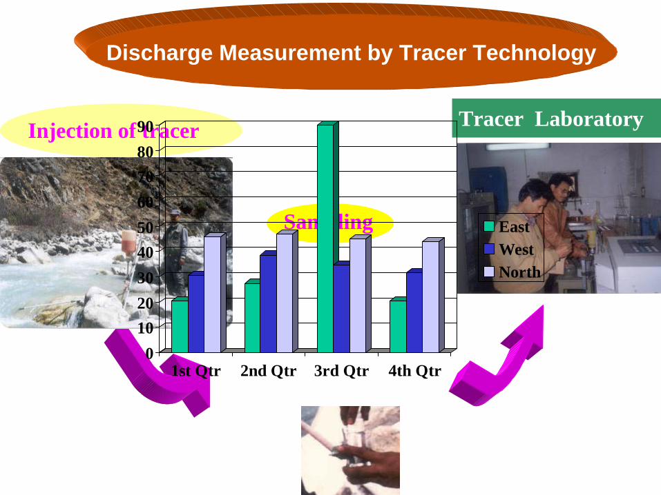
Discharge Measurement by Tracer Technology
Tracer LaboratoryInjection of tracer
Sampling
0102030405060708090
1st Qtr 2nd Qtr 3rd Qtr 4th Qtr
EastWestNorth

Snow survey for determination of water equivalent
of snow
Snow pitSnow pit
Snow samplerSnow sampler

Snow cover Database ManagementSnow cover Database Management

SOURCE: GEN/DHM RESEARCH
1974
1994
200 m
Glacier Retreat in the Nepal Himalayas
Rika Samba Glacier, Hidden Valley, Dhaulagiri
Glaciers in Nepal are in general condition of retreatdue to climate change
200 m

Map of Glaciers and Glacier Lakes Distribution
ICIMOD/UNEP (2000)

Glaciers of NepalGlaciers of NepalMajor Basin Glacier number Area,km
²Lake number Area,km
²Ice Reserve,km3
Koshi 779 1409.8 1054 24.8 152.1
Gandaki 1025 2030.1 338 12.3 191.4
Karnali 1361 1740.2 907 37.7 127.7
Mahakali 87 143.2 16 0.4 10.1
Total 3252 5323.3 2315 75.2 481.3

Bedload sampling
Suspended sampler
TrainingTrainingButwal
TinauTinau Khola
Khola

Air Pollution(Babarmahal): WHO Normal:150-230µg/m3 NEPAL Normal: 150 µg/m3 Max.: 727 µg/m3 in May 1995 Min.: 31 µg/m3 in July 1996 Annual Normal: 206 µg/m3
after 24 hrsInitial

ConclusionConclusion• Extension of Hydrological &
Meteorological station as user demand• Upgrade Manual Station to Automatic• Real Time Data transmission System