Embed Size (px)
Citation preview

Presentation
On
GIS
Tarun Batra – HoG-GIS
Dhruba Banerjee - Team lead (Technical)

2
What is GIS?
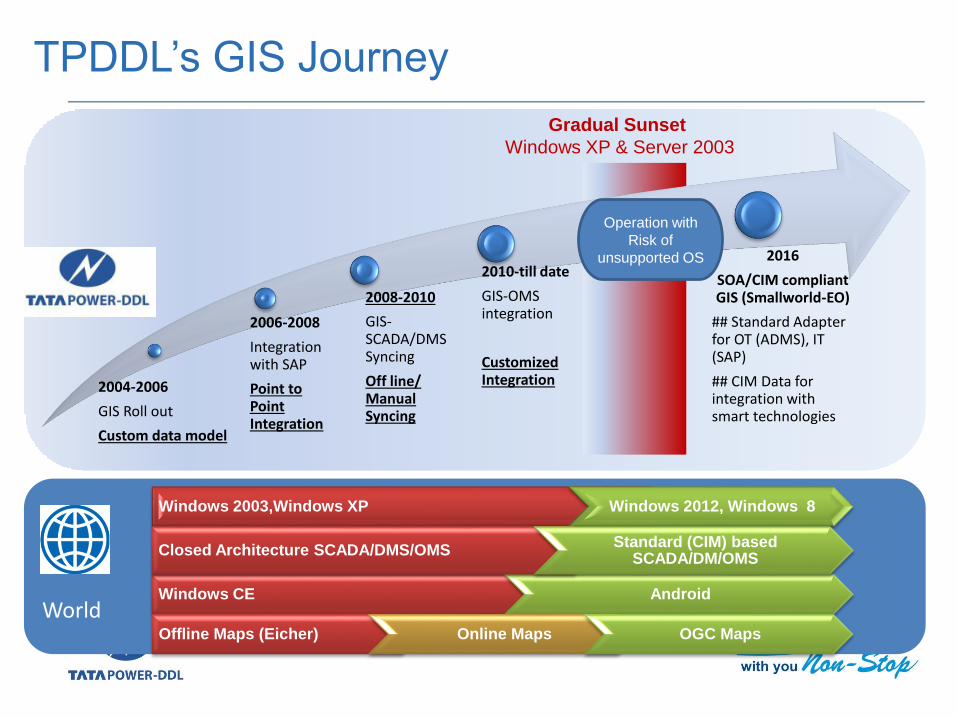
TPDDL’s GIS Journey
Component of GIS
Project Phase of GIS
GIS Applications
GIS Landscape
Product Bouquet
Features of GIS
Integration Architecture
GIS Team Structure
Presentation Outline

What is GIS?
3
• GIS is Geographical Information
System which gives information on
geography on your Laptop/ tablet/
mobile even when you are not
physically present in that area.
World
TPDDL’s GIS Journey
2004-2006
GIS Roll out
Custom data model
2006-2008
Integration with SAP
Point to Point Integration
2008-2010
GIS-SCADA/DMS Syncing
Off line/ Manual Syncing
2010-till date
GIS-OMS integration
Customized Integration
2016
SOA/CIM compliant GIS (Smallworld-EO)
## Standard Adapter for OT (ADMS), IT (SAP)
## CIM Data for integration with smart technologies
Windows 2003,Windows XP Windows 2012, Windows 8
Windows CE Android
Gradual Sunset
Windows XP & Server 2003
Offline Maps (Eicher) Online Maps OGC Maps
Closed Architecture SCADA/DMS/OMSStandard (CIM) based
SCADA/DM/OMS
Operation with
Risk of
unsupported OS

5
Sub
-Tran
smissio
n1
1K
V D
ISTIBU
TION
0.4KV
Network Hierarchy Network terminology Technology
SCADA
OMS
66 or 33KV
11KV
0.4KV
Distribution Network…Monitoring & Control
DMS/DA
Geo
graph
ic Info
rmatio
n System
Communication Network

Components of GIS
Land base Land base of Licensed areas is developed using
satellite image, total station and field survey.This includes road network, built up & Non-built up Consumers and NDPL buildings, parks,footpath, road center line, water area etc.
Electrical Network Entire EHV, HT and LT Network from grid station
to consumer feed points is developed. Electrical equipments are mapped across
geography with reference to X, Y coordinates.
Consumers Customer are mapped in their respectivebuilding and its connectivity with Poles/FP/SP.

Snapshot of Created Landbase- Road, building, Park

Snapshot of Created Network – Substations, Network, service
Line and Consumers

Snapshot of Landbase, Network and consumers
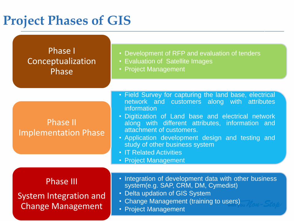
• Development of RFP and evaluation of tenders
• Evaluation of Satellite Images
• Project Management
Phase I Conceptualization
Phase
• Field Survey for capturing the land base, electricalnetwork and customers along with attributesinformation
• Digitization of Land base and electrical networkalong with different attributes, information andattachment of customers.
• Application development design and testing andstudy of other business system
• IT Related Activities
• Project Management
Phase II Implementation Phase
• Integration of development data with other businesssystem(e.g. SAP, CRM, DM, Cymedist)
• Delta updation of GIS System
• Change Management (training to users)
• Project Management
Phase III
System Integration and Change Management 10
Project Phases of GIS

GIS Applications -Consumer Management
Input
• Pole No. from MMG (New Connections)
• Pole No. from Zone (Left out cases)
Processing in GIS
• Consumer Mapping through Pole No.
• Connectivity of consumer with
• LT Feeder
• Transformer
• HT Feeder
• ST Feeder
Output
• Integration with
• Energy auditing
• Revenue Protection
• Integration with OMS
• List of affected consumers
• Location of affected consumers
• Crew management
• Ref. - GIS-P-01 – Process for updation of Consumers in GIS

GIS-Applications -Network Management
Input
• Network changes due to -
• Load Balancing
• Network Extension
• Network Augmentation
• New Electrification
• Network Shifting
Processing in GIS
• Geo-referenced digitization of -
• Revised network route from zone/project
• Revised network connectivity
Output
• Integration with
• Asset Mgmt.
• Clearance for Technical completion of scheme
• Integration with OMS -
• Planned Outage
• Complaint Management
• Ref. - GIS-P-04 – Process for LT assets Updation in GIS

GIS-Applications - Asset Management
Input
• Notification for -
• Network changes (ST/HT)
• New Installation / Augmentation
• Movement
• Retirement
• Scheme clearance requests
Processing in GIS
• Geo-referenced mapping of Assets
• Tagging of Scheme
Output
• Integration with
• Asset Mgmt.
• Clearance for Technical completion of scheme
• Integration with OMS -
• Planned Outage
• Complaint Management
• Ref. - GIS-P-03 – Process for Asset Management

GIS Landscape
As-Built update
(User-GIS Team)Proposed Design
(User- NEG Team)
Intranet /
InternetEO -Web
Network
SAN
Land base
SAP
CYME
OMS
SBI Integrator
(SOA)
JDBC
Cyme Adapter
Customized OMS
Integrator
Interface
Server
Application
ServerJob Server
Web Server
CIM Adapter ADMS
Maps, Reports, Redlining
(User- Everyone)
Mobile Clients
GIS data capture
(User – GIS team)
EO- Core EO- DM
Cloud based 3rd Party
Maps
SmallWorld- Electric Office (EO)

Product Bouquet
Product Smallworld Electric Office Product Suite
Base Version 4.3.4
OEM GE
Implementation Partner CYIENT
License Summary Number
EO Core Desktop for Data Update
45
EO Design Manager for Network Design
EO Web for map view, reports & Redlining (sketching)
Enterprise
(200 concurrent)
Geo Spatial Analytics 5

What is New/Improvement in EO
16
• Single window for Predictive Search on various attributes
of Asset, Consumer like Consumer’s CA No/ Phone No./
S/s Name etc.
• Search on address attributes by embedding 3rd party
maps like Landmark, Locality etc.
• Export of GIS data/ report to Excel and CSV format.
• Templates for digitizing RMUs, DTs, ACBs etc. for faster
data updation.
• Workflow based Production process with system driven
QC
• Geo Spatial Analysis (GSA) tool to correlate varied &
distributed spatial & non-spatial data.
General Features

Contd.. What is New/Improvement in EO
17
• Out of Box Data model for Electric Utility.
• Separation of Asset and Network model
• Specification based Asset definition
• Association of Phase relation between Asset &
Network – Future readiness
• Ready-made Network topology relation as well as
reports
Network and
Operation Perspective

18
• History Tracking of Asset Movement
• Association of WBS-ID & Notification on each
movement
• Automatic Scheme listing in GIS (Design
Manger) from SAP
• Visualization of Proposed Network & Asset
placement
• Existing Asset Serial No. check during Asset
placement
Capitalization and Asset
Management Perspective
Contd.. What is New/Improvement in EO

Contd.. What is New/Improvement in EO
19
• SOA compliant interface with SAP for consumer
mapping
• Geospatial Analytics & Thematic Maps-
• Cluster Maps like High Loss DTs, defaulters
consumers, solar consumers existing as well as
potential.
• Consumer Segment distribution
Commercial
Perspective

Contd.. What is New/Improvement in EO
20
• CIM based integration
• Out-of-Box adapter for integration with CYME
• Right Of Way and Overlapping scheme
identification.
• Network and Asset proposed design in GIS
• GIS design based generation of Bill of Quantity
using Design Manager.
Network Planning
and Analysis

EO Integration Architecture
21
•CYME•OMS
• Suraksha
•Energy Audit
• SAP-ISU
•Website
•ADMS
•3rd Party Maps
• FFA
•AMI
CIM, OGC
SOA (SBI/GSS)
AdapterCustom
GIS
• Nearest CC center
• Technical Feasibility
• KCG Area redlining
• Neighboring Consumers
• Asset Equalization
• Prediction
• Dispatch
• Hierarchy
• Location
• Hierarchy
• Load Flow
• Route
• Business Continuity (Till ADMS Rollout
• Unsafe Poles

22C
ore
Clie
nt
Digitizer 1
Digitizer 2
Digitizer 3
Digitizers 4
Digitizers 5
Digitizers 6
Digitizers 7Thin
Clie
nt
(web
Se
rver
)/St
agin
g A
rea
GIS group
New Consumer Mapping
Zonal Coordinator for
Network
Asset Management
Landbase Development
Data Analysis of GIS
Training to users
Zone
Projects
MMG
GIS Team Structure
Surveyor Team

New Features in EO
Predictive consumer Search
Customer Search on Mobile No
Customer Search on Installation No

New Features in EO
Predictive Asset Search
DT Search on DT NO
Substation Search on Name

BACK

New Features in EO
Export in Excel,CSV format

BACK

New Features in EO
Templates in Redlining for RMUs,DTs etc.

BACK

Geo Spatial Analysis Tool
Band Wise DT Loss Analysis

BACK

New Features in EO
Existing Asset Serial No. Check during Asset placement
Existing Transformer with Serial No:3852
Error for New Transformer with Same Serial No:3852

BACK

New Features in EO
Association of WBS-ID & Notification on each movement
Existing In-service Transformer Moving to In store
Requirement of WBS-ID & Notification No
BACK

New Features in EO
Search on address attributes by embedding 3rd party maps like Landmark, Locality etc.
GIS MAP

Open Street MapOpen Street MAP
New Features in EO
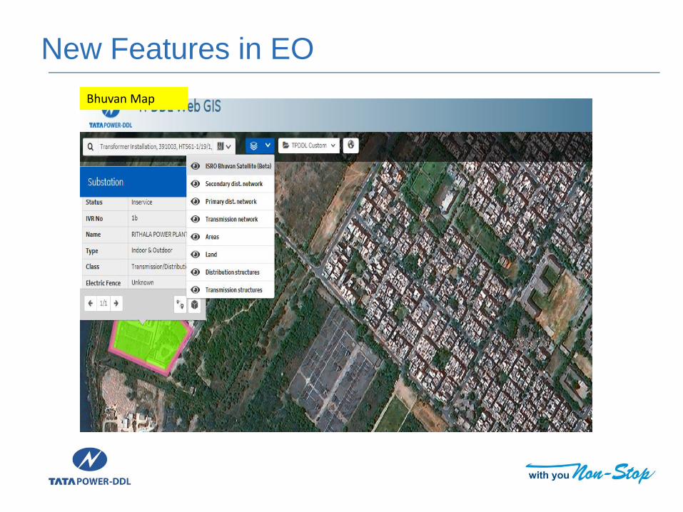
Bhuvan Map
New Features in EO

BACK

New Features in EO
Separation of Asset and Network Model
Asset can be moved, without
affecting the physical connectivity
(Installation)
• No impact on downstream /
upstream hierarchy
• No impact on Operations

BACK

New Features in EO
Ready-made Network topology relation as well as reports
Ready-made Zonal MIS
Reports are available at a
single click

BACK

New Features in EO
Geospatial Analytics & Thematic Maps-
Thematic Map of cable
operator network on Poles

BACK

Design Work Flow
Notification for Network changes
received
Identify and Mark area in
GIS
Insert/Delete/ update changes
in GIS
New-Design In-Design
24- Quality routine checks
Qu
ality Ch
eck
12- Network Connectivity
tools
IVR Update tool
Circuit BuildVisible to all Users Data Updates
Scheduler will post data automatically
based on FIFO
Validate overlapping of
other In-Design
projects

BACK