Embed Size (px)
Citation preview

Presentation
LOCAL GOVERNMENT PERSPECTIVE
John Hennessy, MAV

PBS ACCESS FOR LOCAL ROADS1. WHAT IS PBS RAT ?
PBS vehicles = fewer trucks, more productivity #1 impediment for PBS: first-last KM access on local
roads PBS Route Assessment Tool for Victorian Local Govt ARRB - MAV Project Development of LG guidelines and Online software
tool

HOW THE TOOL HELPS
Push for HPV access to local roads, National Regulator means a change in responsibilities for LG
Goal is to achieve consistency in route classification (access) by using a tool that is: Suitable for local government Easy to use, quick or detailed: can get ‘first cut’ in 60 minutes Support for both near-zero and rich data inputs
Simplifies PBS guidelines for local road infrastructure Exists to make life easier and support local managers Repeatable and traceable workflow and record for
access decisions in local area

SUPPLEMENTING EXISTING ACCESS PROCESSES
Tool supplements, not replaces existing process PBS RAT provides a practical technical classification More detailed classification possible using Guidelines Ultimate decision is still Local Road Manager System Publishes completed routes to 3rd parties
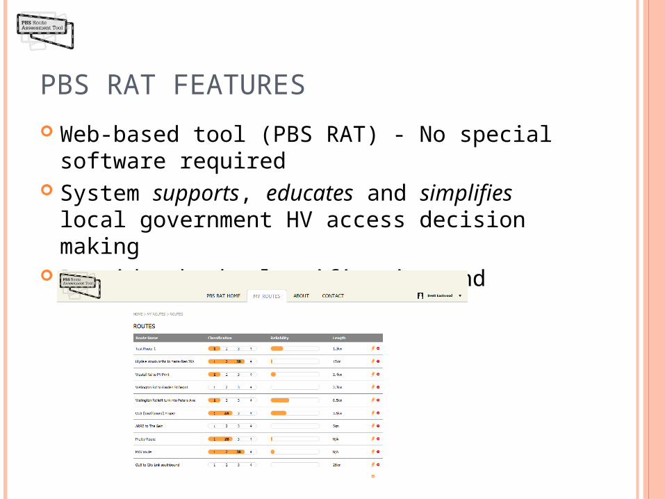
PBS RAT FEATURES
Web-based tool (PBS RAT) - No special software required System supports, educates and simplifies local
government HV access decision making Provides both classification and indication of
classification reliability

OPERATION OVERVIEW

PINCH POINTS Assumes highest level of access, but lowest reliability
Considers routes in terms of its restrictive limitations (pinch points)
Allows for progressive classification of routes with “quick and dirty” followed by adding more detail
Signal Timing (2A)
Storage Lane Length (2B)
Lane Width (2B)
Swept Path (3A)
Actual route classification (2A) is the lowest access level granted by these restrictive features

BUILDING ROUTES
You can check how the routes look as a strip map in PBS Expert
Next step: Add a map

SYSTEM OUTPUTS PBS Classification Score (PBS level 1-4 a/b) Detailed classification reports, including pinch point(s) Flags assessment of bridges & pavement if needed (OOS) Consolidated “published” route reporting area Mapping outputs - route and location Data export linkages through road ID’s etc Additional linkages to be considered in national context
PBS RAT
SRO’s
NHVR
National Route Maps
Research

PROGRESS AND NEXT STEPS
PBS RAT developed by ARRB in partnership with LG Funded by Victorian and Federal Government
agencies (including PoM) All Victorian Councils now trained how to use PBS
RAT Some have already classified many B-double routes NHVR was to start operations January 1, 2013
(2014?) All other States and Territories now trialling PBS RAT
in conjunction with NHVR

Project Methodology Form Regional Groups with at least one representative from each
Council and a representative from VicRoads Each Council in region to identify their existing approved B-Double
routes on Council roads within their own municipality Regional Group to identify and list Level 2A access roads across the
Region Prepare a combined list of sites where the road network has
impediments to achieving Level 2A access Regional Group to discuss agreed and proposed Level 2A access
routes across their Region Share this information with all Councils in the Region.
2. LOCAL ROADS STRATEGIC FREIGHT ROUTES

LG – ARTERIAL ROADS

LOCAL ROADS – PRIORITY HV ROUTES

LOCAL ROADS – PROPOSED LEVEL 2A ACCESS

LOCAL ROADS – FREIGHT ROUTES - UPGRADES

CORANGAMITERoad
No Road NameLength
(m) From To
Upgrades Required
Point Location
Upgrades Required
Road Length
Cost of Upgrade
Importance (1 - High, 2,
3 - Low) Why is this a priority freight route?
Proposed Strategic Freight Routes
4620BRUMBYS ROAD 1640
Curdievale Port Campbell Road Gas Plant Nil Nil $0 Used for B-Double access to gas plants.
3022OLD GEELONG ROAD 4570Darlington Road
Camperdown Lismore Road Nil Nil $0
Alternative for northbound B-Doubles from the west on Princes Highway from travelling through Camperdown townshipPart of major transport east-west route servicing Warrnambool and South Australia
3002
CAMPERDOWN DERRINALLUM ROAD 7930
Camperdown Lismore Road
Hamilton Highway Nil Nil $0
Part of main route from Camperdown to Derrinallum.
B Double route for grain and fodder cartage. Proposed Strategic Freight Routes - Subject to Upgrade
5151SANDYS LANE Princes Highway
Castle Carey Road
Existing Unsealed Pavement upgrade to seal Pavement
2,000,000 2
B-Double route for cartage of grain, fodder and stock
Supply route to 2 no. feed mills in Cobden
Part of link from Hamilton Highway to southern end of Corangamite Shire
3419
TIMBOON PETERBOROUGH ROAD
Timboon Port Campbell Road
Great Ocean Road
Widening of 5.0 km of road
1,000,000 2 B-Double route for milk cartage
3026VITE VITE SKIPTON ROAD
Vite Vite Road Shire Boundary
Widening of 17.7 km of road
3,500,000 2
B-double route for grain and fodder cartage
Link from Glenelg Highway to service the southern part of Corangamite Shire
3027VITE VITE ROAD Hamilton Highway Shire Boundary
Widening of 12.3 km of road
2,500,000 2 B-Double route for grain and fodder cartage

3. MAV HUME PLANNING FOR FREIGHT PILOT:REGIONAL FREIGHT STRATEGY

TASKS
Review of relevant reports and strategies Capture freight issues from the 12 councils and regional
agencies Document the freight network Current and future freight task and network capacity Strategies to address local and cross-municipal freight issues Create templates and process guidance for local government Hume Freight Improvements
18

GAPS & REVISIONS I Definition of the Hume region – food bowl out then in Heavy vehicle volumes on routes, including the Hume Freeway, Midland
Highway, Murray Valley Highway require updating. Update reflecting 2011 Census data is relevant, particularly indications of
the growth of new residential areas. Drought recovery and the improvement in agricultural product volumes
requiring freight movements since 2010 Structural changes to manufacturing that have persisted since 2009 Implications of the two-speed economy and how this has impacted the
region Growth area planning has advanced and this will inform freight movement
through and within Murrindindi and Mitchell The impact of bushfires and floods on assets and local economies Progress on VicRoads management studies conducted in 2004 on the
Murray Valley, Goulburn Valley and Midland Highways.19

GAPS & REVISIONS III Role of Albury and Mangalore airports in freight for the region Food Bowl branding and linkages for some initiatives Supply chain requirements for mining in the region Lack of information about the freight task, including
warehousing, cross-docking, packaging, distribution, cool chain management
Need to work through which routes to which sites will articulate with HPV routes.
Land use planning specifically to manage economic growth and associated freight task
Strategies around how to communicate regarding freight to the community
Acknowledgement of the excellence of the region in skilling people for T&L 20

GAPS & REVISIONS III Role of Albury and Mangalore airports in freight for the region Food Bowl branding and linkages for some initiatives Supply chain requirements for mining in the region Lack of information about the freight task, including
warehousing, cross-docking, packaging, distribution, cool chain management
Need to work through which routes to which sites will articulate with HPV routes.
Land use planning specifically to manage economic growth and associated freight task
Strategies around how to communicate regarding freight to the community
Acknowledgement of the excellence of the region in skilling people for T&L 21

LOCAL FREIGHT ISSUES II
Lack of engagement with T&L industry Scope to expand HV facilities at highway service centres Freight deliveries to commercial precincts – new design templates Freight not an intrinsic part of planning process TIRES under-funded Need for similar model for Livestock, Dairy, Quarries and Water Extraction
industries – consideration of SA commodity routes model? Inclusion of freight requirements in Infrastructure Design Manual Regional cities planning an opportunity to integrate freight management
strategies and design As of right land uses that are increasing transport activity – effective
management solutions and strategic intent Industry investment in strategic routes – need for a model that works NHVR guidance and support for local government taking on HV access
decisions
22

NEXT STEPS
Mapping the network Identifying PBS heavy vehicle access Gathering data on the freight task (generator and carrier
surveys) Investigating strategic responses/options
Expand to include all Victorian regions
23

MAJOR PBS ISSUES
Ten years of frustration for LG: still no access guidelines NHVR behind the curve re timing IA has the National Freight Strategy as #2 national
infrastructure priority but only funds $100m+ projects: freight industry reports that first and last kilometre issues are #1 priority.
Result: the system doesn’t work!