Embed Size (px)
Citation preview
1
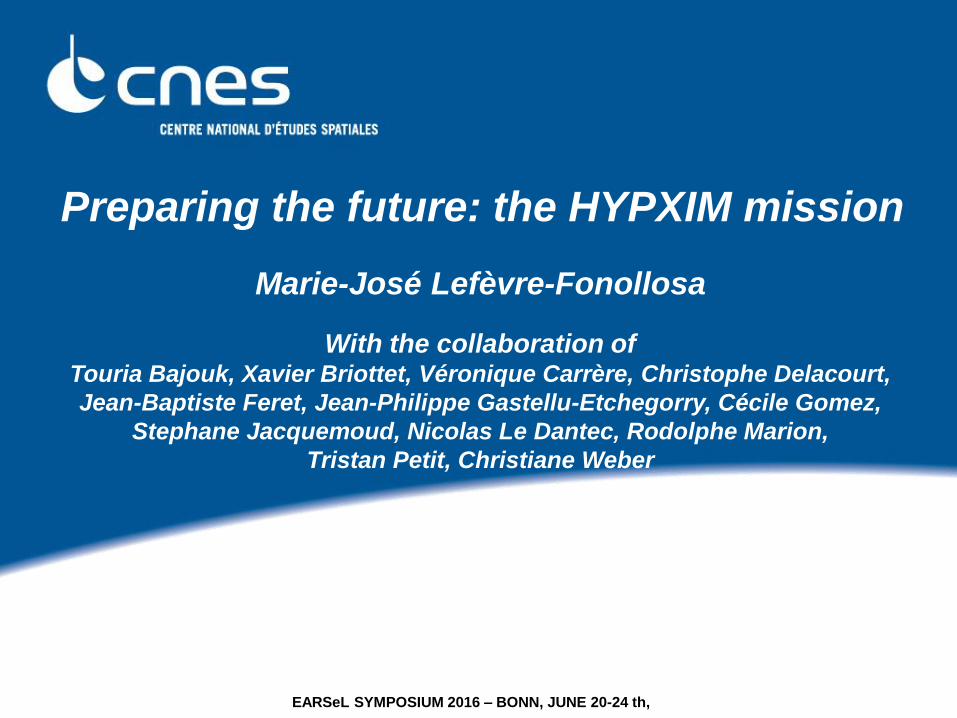
Marie-José Lefèvre-Fonollosa
With the collaboration of Touria Bajouk, Xavier Briottet, Véronique Carrère, Christophe Delacourt,
Jean-Baptiste Feret, Jean-Philippe Gastellu-Etchegorry, Cécile Gomez,
Stephane Jacquemoud, Nicolas Le Dantec, Rodolphe Marion,
Tristan Petit, Christiane Weber
Preparing the future: the HYPXIM mission
EARSeL SYMPOSIUM 2016 – BONN, JUNE 20-24 th,
2
HYPXIM MISSION & EVOLUTION
1. SATELLITE MISSION HYPXIM CURRENT STATUS
2. PREPARING THE USES OF HYPXIM DATA /TOSCA PROGRAM
3. AN ENLARGED EUROPEAN TEAM CONSOLIDATE THE MISSION REQUIREMENTS
4. ESA CALL “EE9”: AN OPPORTUNITY FOR HYPEX-2,
A DEMONSTRATOR DERIVED FROM HYPXIM
HYPXIM
EARSeL SYMPOSIUM 2016 – BONN, JUNE 20-24 th,
3
HYPXIM MISSION & EVOLUTION
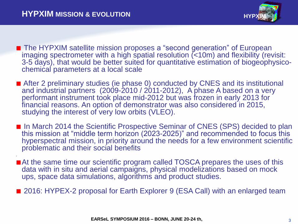
■ The HYPXIM satellite mission proposes a “second generation” of European imaging spectrometer with a high spatial resolution (<10m) and flexibility (revisit: 3-5 days), that would be better suited for quantitative estimation of biogeophysico-chemical parameters at a local scale
■ After 2 preliminary studies (ie phase 0) conducted by CNES and its institutional and industrial partners (2009-2010 / 2011-2012), A phase A based on a very performant instrument took place mid-2012 but was frozen in early 2013 for financial reasons. An option of demonstrator was also considered in 2015, studying the interest of very low orbits (VLEO).
■ In March 2014 the Scientific Prospective Seminar of CNES (SPS) decided to plan this mission at “middle term horizon (2023-2025)” and recommended to focus this hyperspectral mission, in priority around the needs for a few environment scientific problematic and their social benefits
.
■At the same time our scientific program called TOSCA prepares the uses of this data with in situ and aerial campaigns, physical modelizations based on mock ups, space data simulations, algorithms and product studies.
■ 2016: HYPEX-2 proposal for Earth Explorer 9 (ESA Call) with an enlarged team
HYPXIM
EARSeL SYMPOSIUM 2016 – BONN, JUNE 20-24 th,
4
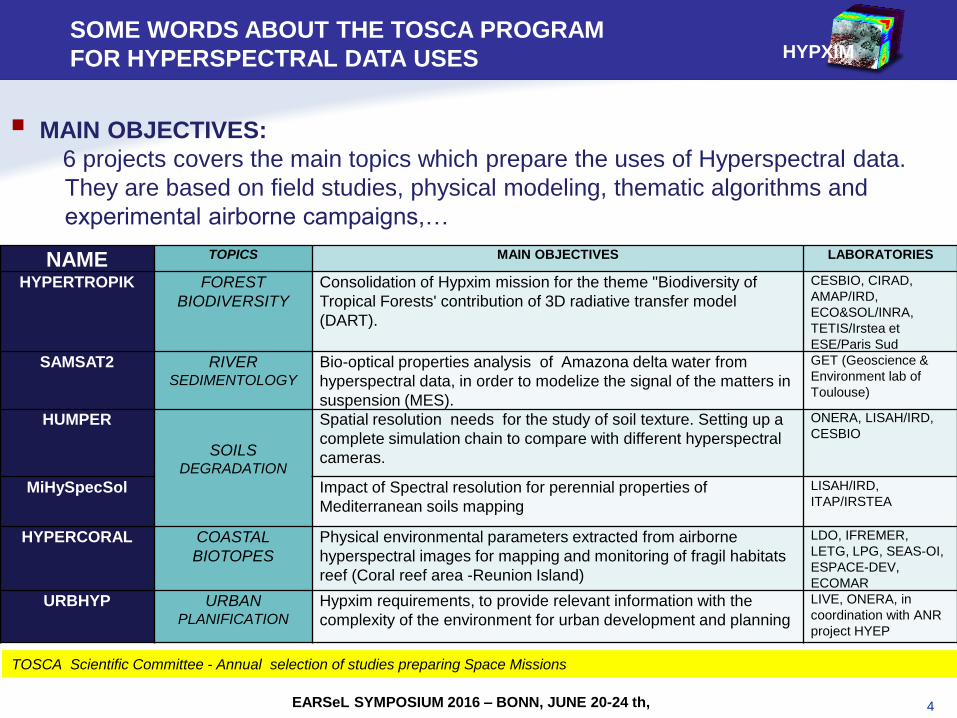
TOSCA Scientific Committee - Annual selection of studies preparing Space Missions
NAME TOPICS MAIN OBJECTIVES LABORATORIES
HYPERTROPIK FOREST
BIODIVERSITY
Consolidation of Hypxim mission for the theme "Biodiversity of
Tropical Forests' contribution of 3D radiative transfer model
(DART).
CESBIO, CIRAD,
AMAP/IRD,
ECO&SOL/INRA,
TETIS/Irstea et
ESE/Paris Sud
SAMSAT2 RIVER SEDIMENTOLOGY
Bio-optical properties analysis of Amazona delta water from
hyperspectral data, in order to modelize the signal of the matters in
suspension (MES).
GET (Geoscience &
Environment lab of
Toulouse)
HUMPER
SOILS
DEGRADATION
Spatial resolution needs for the study of soil texture. Setting up a
complete simulation chain to compare with different hyperspectral
cameras.
ONERA, LISAH/IRD,
CESBIO
MiHySpecSol Impact of Spectral resolution for perennial properties of
Mediterranean soils mapping
LISAH/IRD,
ITAP/IRSTEA
HYPERCORAL COASTAL
BIOTOPES
Physical environmental parameters extracted from airborne
hyperspectral images for mapping and monitoring of fragil habitats
reef (Coral reef area -Reunion Island)
LDO, IFREMER,
LETG, LPG, SEAS-OI,
ESPACE-DEV,
ECOMAR
URBHYP URBAN PLANIFICATION
Hypxim requirements, to provide relevant information with the
complexity of the environment for urban development and planning
LIVE, ONERA, in
coordination with ANR
project HYEP
MAIN OBJECTIVES:
6 projects covers the main topics which prepare the uses of Hyperspectral data.
They are based on field studies, physical modeling, thematic algorithms and
experimental airborne campaigns,…
EARSeL SYMPOSIUM 2016 – BONN, JUNE 20-24 th,
SOME WORDS ABOUT THE TOSCA PROGRAM
FOR HYPERSPECTRAL DATA USES HYPXIM
5
TROPICAL FOREST BIODIVERSITY: A CHALLENGE FOR HYPXIM (1/3)
SO
IL S
TU
DIE
S
UR
BA
N
CO
AS
T
BIO
DIV
ER
SIT
Y
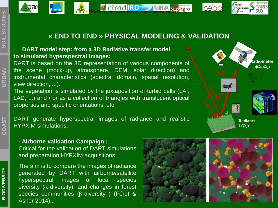
- DART model step: from a 3D Radiative transfer model
to simulated hyperspectral images:
DART is based on the 3D representation of various components of
the scene (mock-up, atmosphere, DEM, solar direction) and
instrumental characteristics (spectral domain, spatial resolution,
view direction, ...).
The vegetation is simulated by the juxtaposition of turbid cells (LAI,
LAD, ...) and / or as a collection of triangles with translucent optical
properties and specific orientations, etc.
DART generate hyperspectral images of radiance and realistic
HYPXIM simulations.
- Airborne validation Campaign :
Critical for the validation of DART simulations
and preparation HYPXIM acquisitions.
The aim is to compare the images of radiance
generated by DART with airborne/satellite
hyperspectral images of local species
diversity (-diversity), and changes in forest
species communities (-diversity ) (Féret &
Asner 2014)..
« END TO END » PHYSICAL MODELING & VALIDATION
Radiance
L(v)
Radiometer
(s,v)
EARSeL SYMPOSIUM 2016 – BONN, JUNE 20-24 th,
6
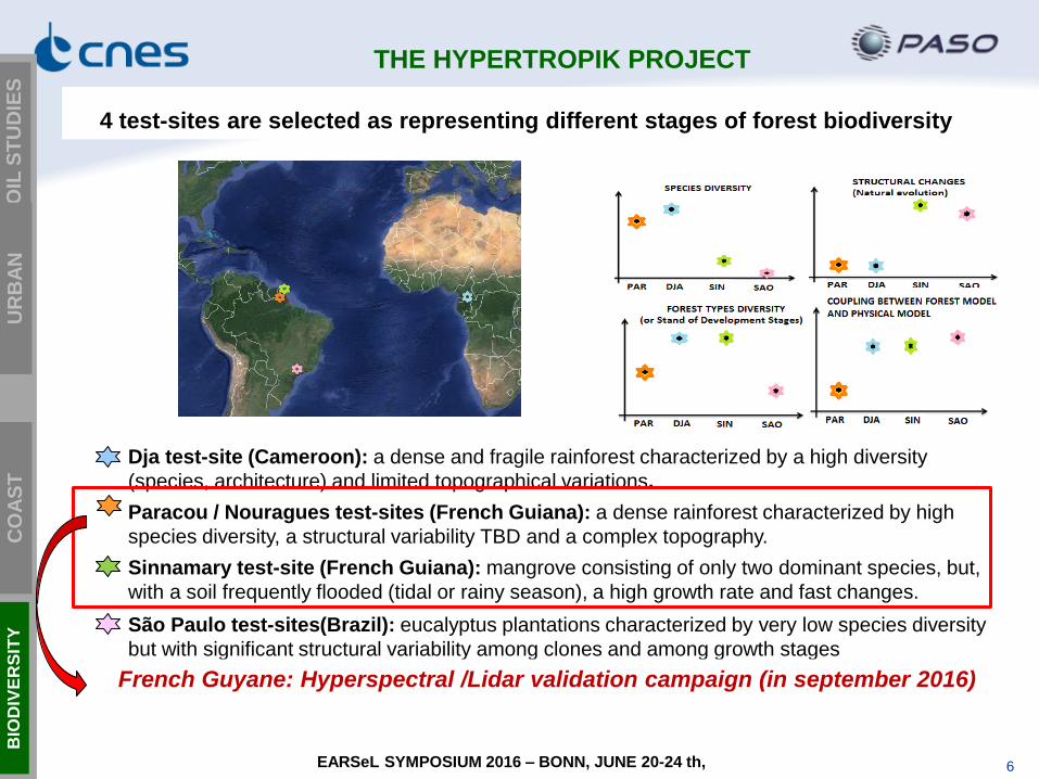
Dja test-site (Cameroon): a dense and fragile rainforest characterized by a high diversity
(species, architecture) and limited topographical variations.
Paracou / Nouragues test-sites (French Guiana): a dense rainforest characterized by high
species diversity, a structural variability TBD and a complex topography.
Sinnamary test-site (French Guiana): mangrove consisting of only two dominant species, but,
with a soil frequently flooded (tidal or rainy season), a high growth rate and fast changes.
São Paulo test-sites(Brazil): eucalyptus plantations characterized by very low species diversity
but with significant structural variability among clones and among growth stages
French Guyane: Hyperspectral /Lidar validation campaign (in september 2016)
4 test-sites are selected as representing different stages of forest biodiversity
SO
IL S
TU
DIE
S
UR
BA
N
CO
AS
T
BIO
DIV
ER
SIT
Y
THE HYPERTROPIK PROJECT
EARSeL SYMPOSIUM 2016 – BONN, JUNE 20-24 th,
7
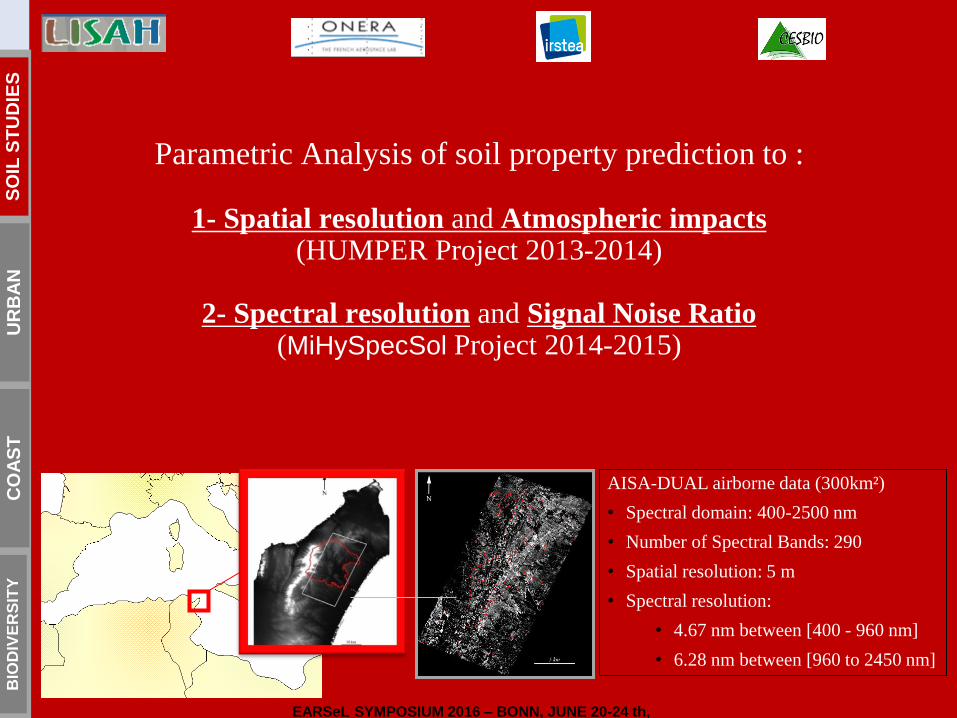
Parametric Analysis of soil property prediction to :
1- Spatial resolution and Atmospheric impacts (HUMPER Project 2013-2014)
2- Spectral resolution and Signal Noise Ratio
(MiHySpecSol Project 2014-2015)
AISA-DUAL airborne data (300km²)
• Spectral domain: 400-2500 nm
• Number of Spectral Bands: 290
• Spatial resolution: 5 m
• Spectral resolution:
• 4.67 nm between [400 - 960 nm]
• 6.28 nm between [960 to 2450 nm]
SO
IL S
TU
DIE
S
UR
BA
N
CO
AS
T
BIO
DIV
ER
SIT
Y
EARSeL SYMPOSIUM 2016 – BONN, JUNE 20-24 th,
8
Sensitivity to spatial resolution
Clay Content (g/kg)
5 m
30 m
10 m
1 km
R2cal
5 m Airborne
5 m 10 m
15 m
20 m
30 m
60 m
HY
PX
IM
SH
AL
OM
PR
ISM
A &
EN
MA
P
Hy
spIR
I
Satellite Simulations
Hyper satellite simulations Multispectral satellite simulations
Gomez et al., 2015
RESULTS
SO
IL S
TU
DIE
S
UR
BA
N
CO
AS
T
BIO
DIV
ER
SIT
Y
EARSeL SYMPOSIUM 2016 – BONN, JUNE 20-24 th,
Sensitivity to spectral resolution Adeline et al., in revision
R2cal
HY
PX
IM
Airborne
=> No significant changes
between the 2 maps
10 nm
Clay Content (g/kg)
5 nm
=> HYPXIM is very close to
Airborne data
9
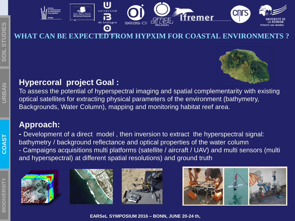
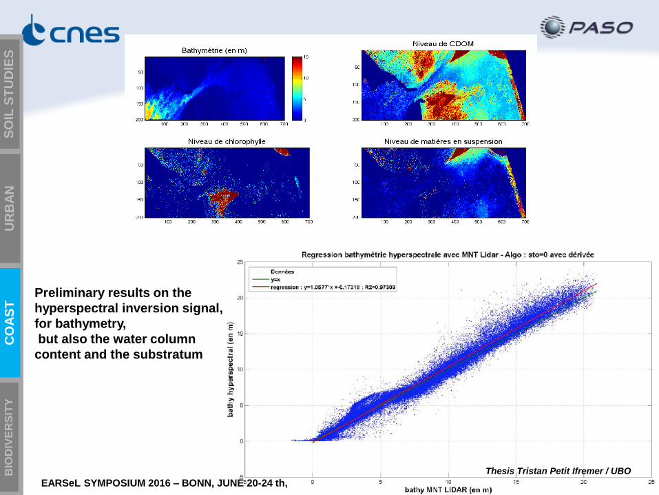
Hypercoral project Goal : To assess the potential of hyperspectral imaging and spatial complementarity with existing
optical satellites for extracting physical parameters of the environment (bathymetry,
Backgrounds, Water Column), mapping and monitoring habitat reef area.
Approach: - Development of a direct model , then inversion to extract the hyperspectral signal:
bathymetry / background reflectance and optical properties of the water column
- Campaigns acquisitions multi platforms (satellite / aircraft / UAV) and multi sensors (multi
and hyperspectral) at different spatial resolutions) and ground truth
SO
IL S
TU
DIE
S
UR
BA
N
CO
AS
T
BIO
DIV
ER
SIT
Y
WHAT CAN BE EXPECTED FROM HYPXIM FOR COASTAL ENVIRONMENTS ?
EARSeL SYMPOSIUM 2016 – BONN, JUNE 20-24 th,
10 10
Preliminary results on the
hyperspectral inversion signal,
for bathymetry,
but also the water column
content and the substratum
Thesis Tristan Petit Ifremer / UBO
SO
IL S
TU
DIE
S
UR
BA
N
CO
AS
T
BIO
DIV
ER
SIT
Y
EARSeL SYMPOSIUM 2016 – BONN, JUNE 20-24 th,

11 GeoHyper, 1-2 october 2015
SO
IL S
TU
DIE
S
UR
BA
N
CO
AS
T
BIO
DIV
ER
SIT
Y
■ Atmosphere compensation in shadows
=> Different atmosphere correction tools are
compared as a function of the spatial resolution
URBAN AREAS: MODELIZATION & ALGOS
EARSeL SYMPOSIUM 2016 – BONN, JUNE 20-24 th,
■ Parametric study on the Impact of spatial
resolution vs spectral domain
=> Classification performances comparison of
existing sensors (Pleiades, Sentinel-2 and
HYPXIM) in radiance unit
■ Fusion algorithm
=> HYPXIM : PAN/Hyperspectral products Authors:
■ Rosa Oltra-Carrio (ONERA)
■ Guillaume Roussel (LIVE, ONERA)
■ Briottet Xavier (ONERA)
■ Laetitia Loncan (ONERA, GIPSA-Lab)
12
SO
IL S
TU
DIE
S
UR
BA
N
CO
AS
TA
L
BIO
DIV
ER
SIT
Y
SO
IL S
TU
DIE
S
UR
BA
N
CO
AS
T
BIO
DIV
ER
SIT
Y
EARSeL SYMPOSIUM 2016 – BONN, JUNE 20-24 th,
13
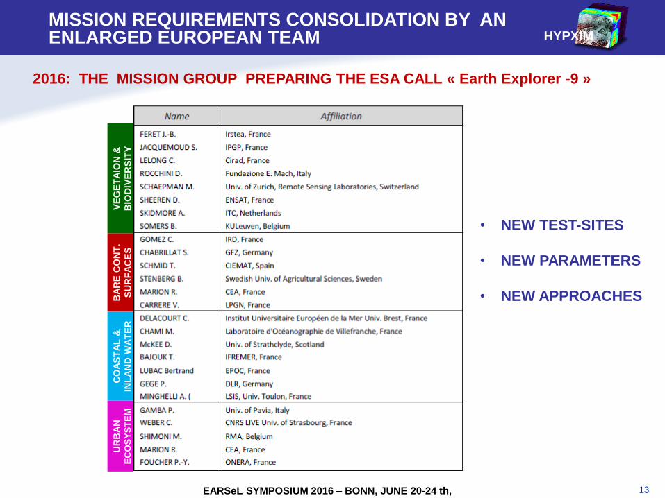
HYPXIM
2016: THE MISSION GROUP PREPARING THE ESA CALL « Earth Explorer -9 »
BA
RE
CO
NT
.
SU
RF
AC
ES
UR
BA
N
EC
OS
YS
TE
M
CO
AS
TA
L &
INL
AN
D W
AT
ER
VE
GE
TA
ION
&
BIO
DIV
ER
SIT
Y
MISSION REQUIREMENTS CONSOLIDATION BY AN ENLARGED EUROPEAN TEAM
• NEW TEST-SITES
• NEW PARAMETERS
• NEW APPROACHES
EARSeL SYMPOSIUM 2016 – BONN, JUNE 20-24 th,
14
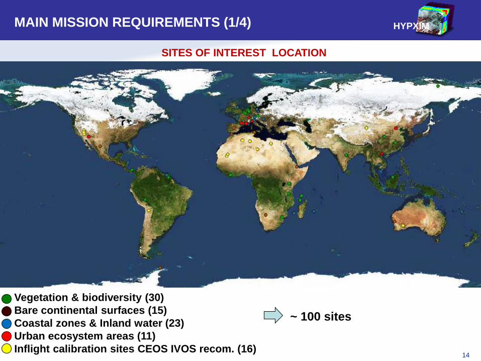
MAIN MISSION REQUIREMENTS (1/4) HYPXIM
~ 100 sites
SITES OF INTEREST LOCATION
Vegetation & biodiversity (30)
Bare continental surfaces (15)
Coastal zones & Inland water (23)
Urban ecosystem areas (11)
Inflight calibration sites CEOS IVOS recom. (16)
15
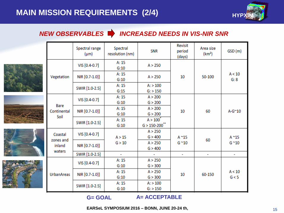
NEW OBSERVABLES INCREASED NEEDS IN VIS-NIR SNR
HYPXIM
EARSeL SYMPOSIUM 2016 – BONN, JUNE 20-24 th,
MAIN MISSION REQUIREMENTS (2/4)
G= GOAL A= ACCEPTABLE
16
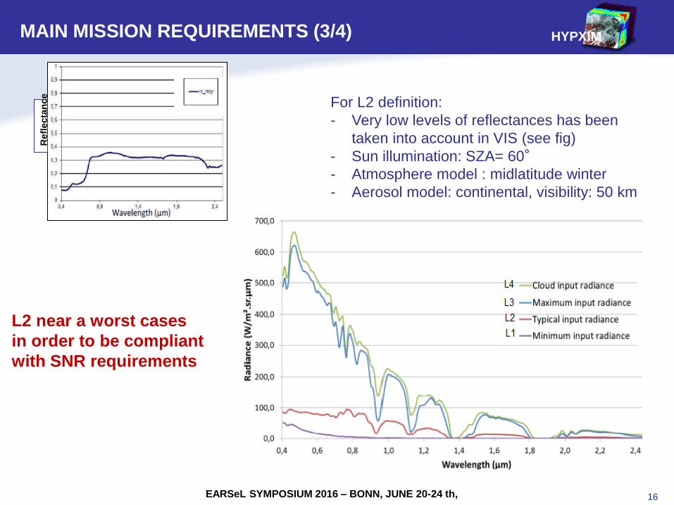
For L2 definition:
- Very low levels of reflectances has been
taken into account in VIS (see fig)
- Sun illumination: SZA= 60°
- Atmosphere model : midlatitude winter
- Aerosol model: continental, visibility: 50 km
HYPXIM
EARSeL SYMPOSIUM 2016 – BONN, JUNE 20-24 th,
MAIN MISSION REQUIREMENTS (3/4) R
efl
ecta
nce
L2 near a worst cases
in order to be compliant
with SNR requirements
17
HYPXIM
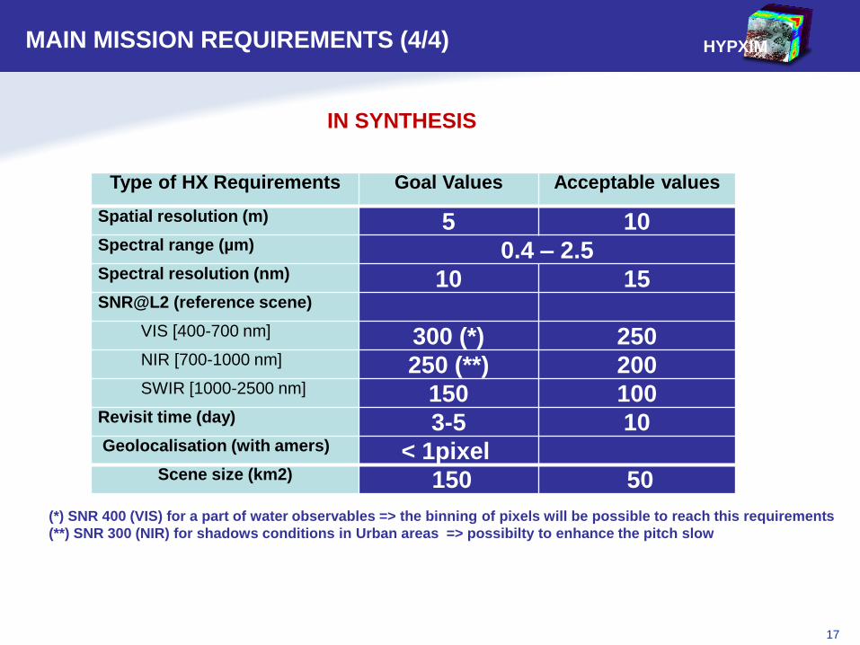
Type of HX Requirements Goal Values Acceptable values
Spatial resolution (m) 5 10 Spectral range (µm) 0.4 – 2.5 Spectral resolution (nm) 10 15 SNR@L2 (reference scene)
VIS [400-700 nm] 300 (*) 250 NIR [700-1000 nm] 250 (**) 200 SWIR [1000-2500 nm] 150 100
Revisit time (day) 3-5 10 Geolocalisation (with amers) < 1pixel
Scene size (km2) 150 50
MAIN MISSION REQUIREMENTS (4/4)
IN SYNTHESIS
(*) SNR 400 (VIS) for a part of water observables => the binning of pixels will be possible to reach this requirements
(**) SNR 300 (NIR) for shadows conditions in Urban areas => possibilty to enhance the pitch slow
18
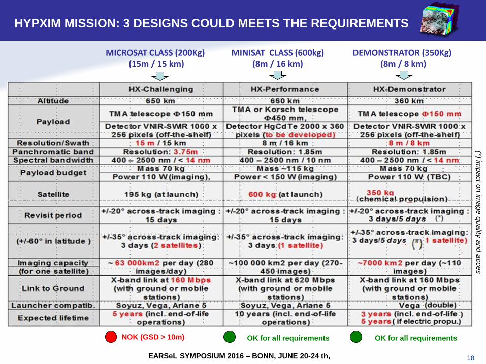
HYPXIM SYSTEM: 3 OPTIONS
HYPXIM MISSION: 3 DESIGNS COULD MEETS THE REQUIREMENTS
EARSeL SYMPOSIUM 2016 – BONN, JUNE 20-24 th,
(*) imp
act o
n im
age
qua
lity a
nd
acces
MICROSAT CLASS (200Kg) (15m / 15 km)
MINISAT CLASS (600kg) (8m / 16 km)
DEMONSTRATOR (350Kg) (8m / 8 km)
NOK (GSD > 10m) OK for all requirements OK for all requirements
19
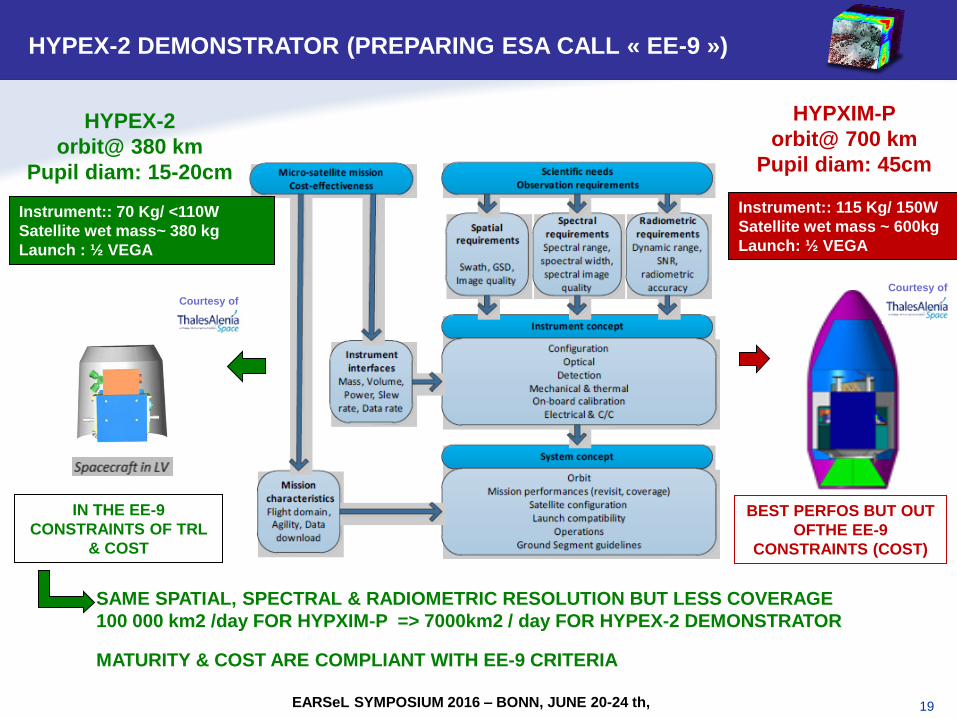
HYPXIM SYSTEM: 3 OPTIONS
HYPEX-2 DEMONSTRATOR (PREPARING ESA CALL « EE-9 »)
EARSeL SYMPOSIUM 2016 – BONN, JUNE 20-24 th,
Instrument:: 115 Kg/ 150W
Satellite wet mass ~ 600kg
Launch: ½ VEGA
Instrument:: 70 Kg/ <110W
Satellite wet mass~ 380 kg
Launch : ½ VEGA
HYPXIM-P
orbit@ 700 km
Pupil diam: 45cm
HYPEX-2
orbit@ 380 km
Pupil diam: 15-20cm
SAME SPATIAL, SPECTRAL & RADIOMETRIC RESOLUTION BUT LESS COVERAGE
100 000 km2 /day FOR HYPXIM-P => 7000km2 / day FOR HYPEX-2 DEMONSTRATOR
MATURITY & COST ARE COMPLIANT WITH EE-9 CRITERIA
BEST PERFOS BUT OUT
OFTHE EE-9
CONSTRAINTS (COST)
IN THE EE-9
CONSTRAINTS OF TRL
& COST
Courtesy of
Courtesy of
20
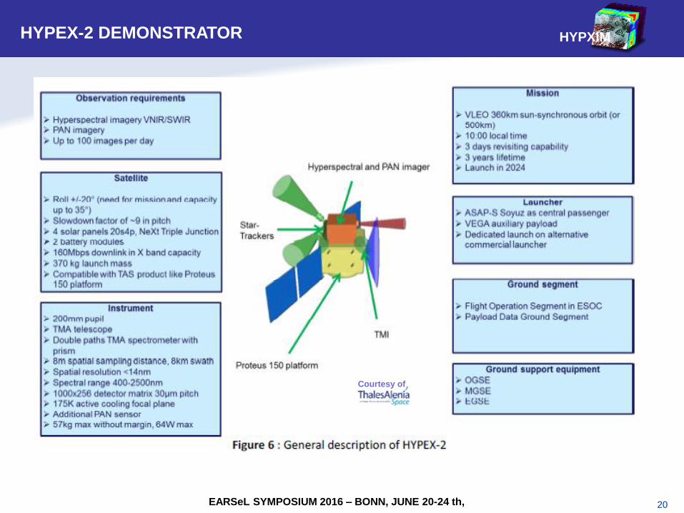
HYPXIM SYSTEM: 3 OPTIONS
HYPEX-2 DEMONSTRATOR
HYPXIM
EARSeL SYMPOSIUM 2016 – BONN, JUNE 20-24 th,
Courtesy of
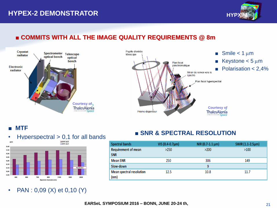
21
■ Smile < 1 mm
■ Keystone < 5 mm
■ Polarisation < 2,4%
■ MTF
• Hyperspectral > 0,1 for all bands
• PAN : 0,09 (X) et 0,10 (Y)
HYPXIM
EARSeL SYMPOSIUM 2016 – BONN, JUNE 20-24 th,
■ SNR & SPECTRAL RESOLUTION
■ COMMITS WITH ALL THE IMAGE QUALITY REQUIREMENTS @ 8m
HYPEX-2 DEMONSTRATOR
Courtesy of Courtesy of
22
HYPXIM SYSTEM: 3 OPTIONS
HYPEX-2 DEMONSTRATOR
HYPXIM
EARSeL SYMPOSIUM 2016 – BONN, JUNE 20-24 th,
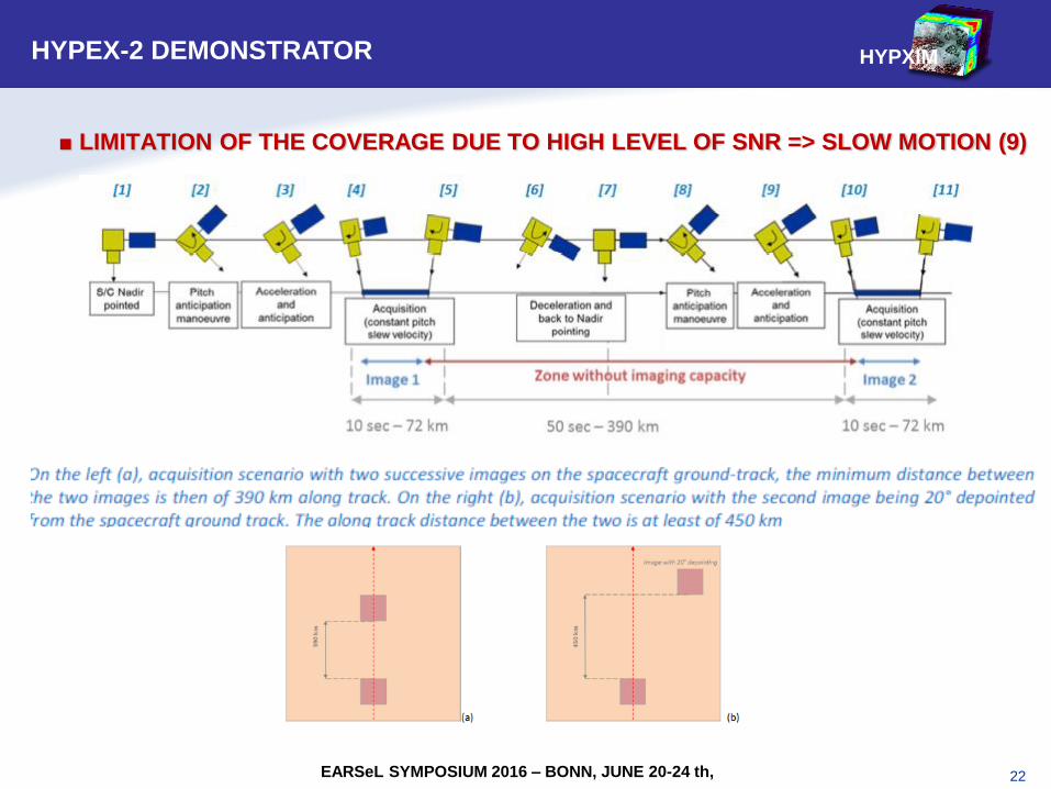
■ LIMITATION OF THE COVERAGE DUE TO HIGH LEVEL OF SNR => SLOW MOTION (9)
23
HYPXIM SYSTEM: 3 OPTIONS
HYPEX-2 DEMONSTRATOR
HYPXIM
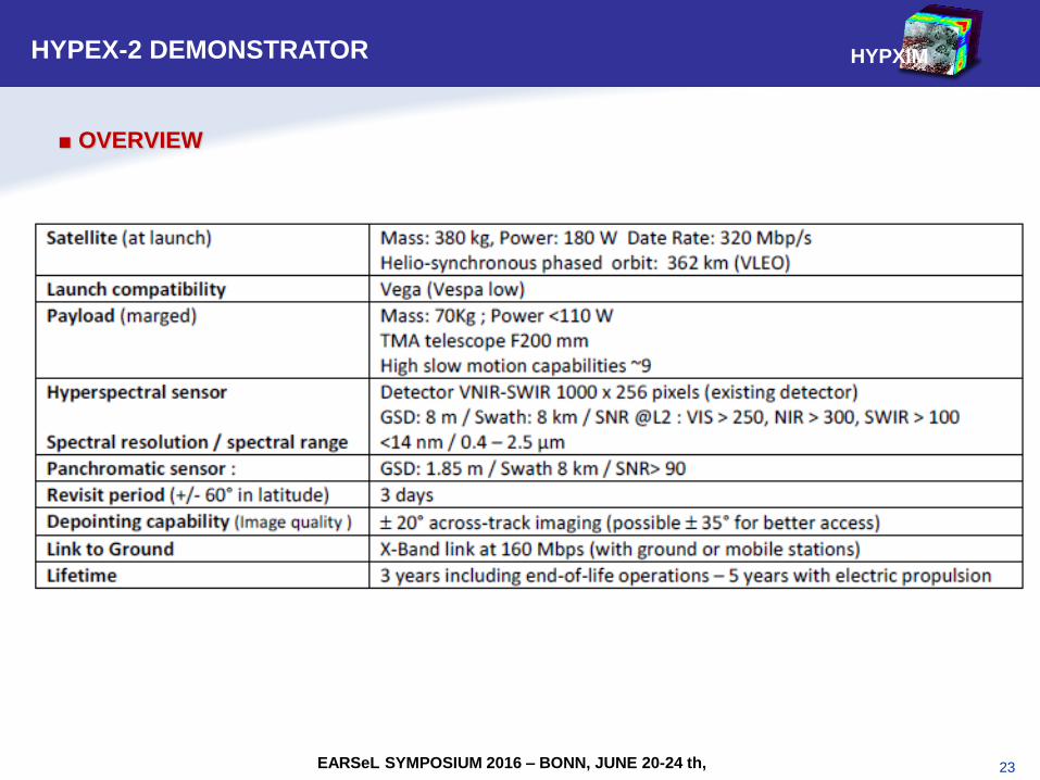
EARSeL SYMPOSIUM 2016 – BONN, JUNE 20-24 th,
■ OVERVIEW
24
HYPXIM SYSTEM: 3 OPTIONS
HYPEX-2 DEMONSTRATOR
HYPXIM
EARSeL SYMPOSIUM 2016 – BONN, JUNE 20-24 th,
25
SYNTHESIS & PERSPECTIVES
1. THEMATIC PRIORITIES ARE CURRENTLY STUDIED WITH EXPERIMENTAL
APPROACHES AND DEMONSTRATIONS
2. AN IMPORTANT EFFORT IS ALSO GIVEN TO THE SIGNAL MODELIZATION
AND TO ALGORITHM VALIDATIONS, IN ORDER TO PREPARE THE
SCIENTISTS & USERS COMMUNITY FOR THE USE OF NEW HIGH
SPECTRAL & HIGH SPATIAL RESOLUTION SATELLITE DATA
3. THE HYPXIM REQUIREMENTS (RESOLUTION, SNR, BANDWITH, ..) ARE
BEING CONSOLIDATED, FOCUSING ON A “JUST NEED” BASIS
4. A LOW COST MICROSAT DEMONSTRAT, HYPEX-2 IS PROPOSED TO THE
EARTH EXPLORER 9 CALL WITH A LAUNCH IN 2024
THE PREPARATION OF THE INNOVATIVE HYPERSPECTRAL DUAL MISSION
HYPXIM CONTINUES IN THE FOLLOWING DIRECTIONS:
HYPXIM
EARSeL SYMPOSIUM 2016 – BONN, JUNE 20-24 th,
26
Thanks for your attention


![by Touria PRAYAG Freedom “I · 2010-10-29 · An architectural jewel in the heart of Port louis > pp. 42-43 by Touria PRAYAG Editorial ] “I pray that all enlightened persons condemn](https://img.pdfslide.us/doc/110x75/5fa1c7b9c934f75d2e3d72a4/by-touria-prayag-freedom-aoei-2010-10-29-an-architectural-jewel-in-the-heart-of.jpg)