Embed Size (px)
Citation preview
0
Prepared For:
Department of Planning and Growth Management
Maryland Airport Land Use Study Draft September 23, 2015 200 Harry S. Truman Parkway, Suite 400 Annapolis, MD 21401
www.erm.com
1
Contents
I. Introduction ................................................................................................................................. 1 A. Study Purpose and Objectives .................................................................................................................... 2 B. Study Area................................................................................................................................................. 2 C. Study Process and Approach ...................................................................................................................... 4
II. Maryland Airport ................................................................................................................................ 5 A. History ...................................................................................................................................................... 5 B. Airport Master Plan ................................................................................................................................... 5 C. Existing Land and Facilities ....................................................................................................................... 7 D. Operations and Activity Levels .................................................................................................................. 9 E. Airport Impacts ........................................................................................................................................ 12
III. Land Use and Zoning ....................................................................................................................... 20 A. Overview of Study Area ........................................................................................................................... 20 B. Current Zoning and Land Use .................................................................................................................. 21 C. Employment Zoning Districts .................................................................................................................. 25 D. Historic Sites ........................................................................................................................................... 26 E. Comprehensive Plan ................................................................................................................................ 27
IV. Environmental Features ............................................................................................................. 29 A. Overview ................................................................................................................................................. 29 B. Mattawoman Creek .................................................................................................................................. 29 C. Maryland Department of Natural Resources Properties ............................................................................. 31 D. Environmental Designations .................................................................................................................... 31
V. Public Facilities ......................................................................................................................... 33 A. Sewer Service .......................................................................................................................................... 33 B. Water Service .......................................................................................................................................... 36 C. Transportation............................................................................................................................................. 37 D. Bicycle and Pedestrian Trails ...................................................................................................................... 37
VI. Economic and market Assessment .................................................................................................. 39 A. Existing Conditions.................................................................................................................................. 39 B. Assessment .............................................................................................................................................. 42
VII. Conclusions and Recommendations ........................................................................................... 53 A. Provide land-use standards that address safety hazards and noise .............................................................. 53 B. Prevent encroachment of incompatible land uses around Maryland Airport ............................................... 55 C. Ensure growth of aviation-compatible economic development near Maryland Airport. .............................. 55 D. Assess future development with respect to the Mattawoman Creek watershed. .......................................... 57 E. Explore potential return on investment for sewer line extension ................................................................ 58 F. Develop a marketing strategy to promote the airport and nearby commercial/employment development .... 58
Appendix 1. Zoning requirements for general aviation airports .............................................................. 60 Appendix 2. Summary of Permitted Uses in BP, PEP and IG ................................................................. 62
1
I. INTRODUCTION
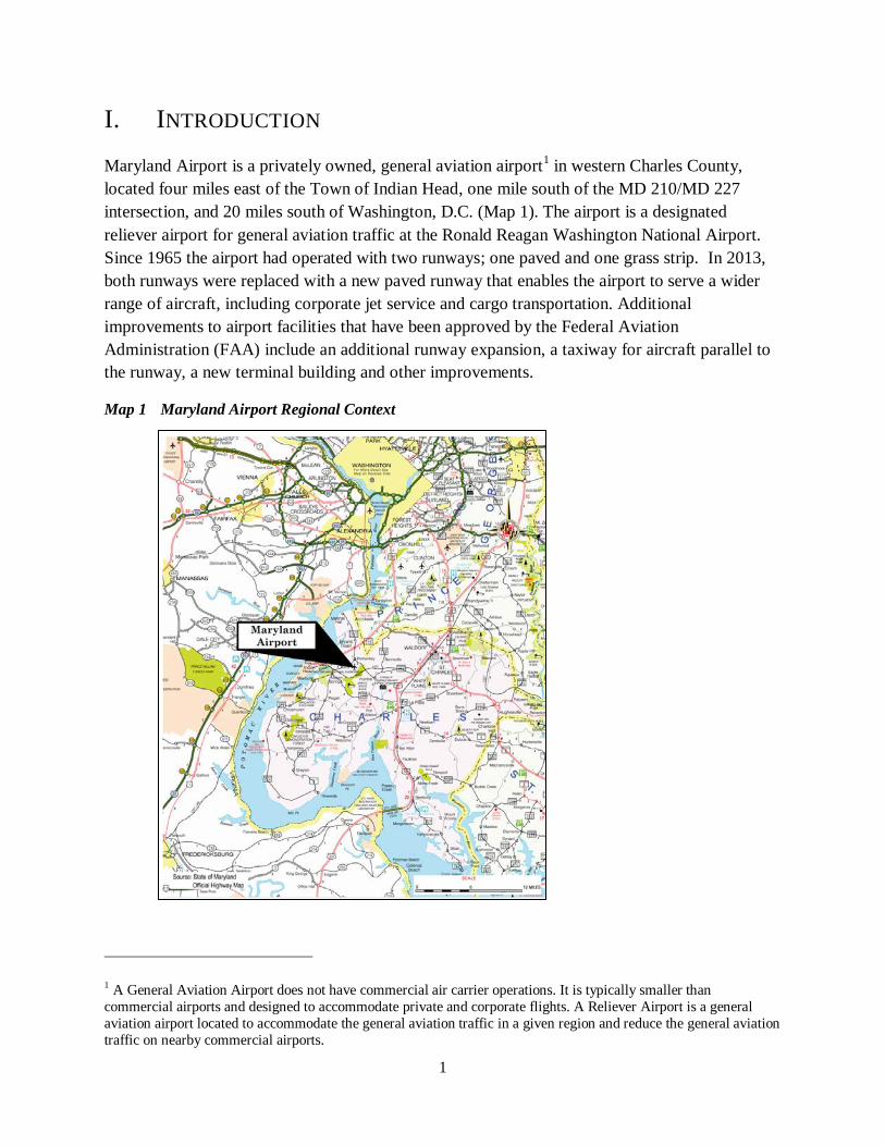
Maryland Airport is a privately owned, general aviation airport1 in western Charles County, located four miles east of the Town of Indian Head, one mile south of the MD 210/MD 227 intersection, and 20 miles south of Washington, D.C. (Map 1). The airport is a designated reliever airport for general aviation traffic at the Ronald Reagan Washington National Airport. Since 1965 the airport had operated with two runways; one paved and one grass strip. In 2013, both runways were replaced with a new paved runway that enables the airport to serve a wider range of aircraft, including corporate jet service and cargo transportation. Additional improvements to airport facilities that have been approved by the Federal Aviation Administration (FAA) include an additional runway expansion, a taxiway for aircraft parallel to the runway, a new terminal building and other improvements.
Map 1 Maryland Airport Regional Context
1 A General Aviation Airport does not have commercial air carrier operations. It is typically smaller than commercial airports and designed to accommodate private and corporate flights. A Reliever Airport is a general aviation airport located to accommodate the general aviation traffic in a given region and reduce the general aviation traffic on nearby commercial airports.
2
A. STUDY PURPOSE AND OBJECTIVES The primary purpose of the Maryland Airport Land Use Study (Study) is to evaluate land uses around the Maryland Airport for the need and potential to add additional employment land that would take into account demand created by the airport’s expansion and improvement. The study also evaluates the need for measures to address the airport impacts on nearby affected areas and population.
This Study examines land use, zoning, environmental resources and public infrastructure in the vicinity of the airport in the context of Charles County’s planning policies. The Study evaluates land uses in terms of six more specific objectives:
1. Propose land-use standards that minimize the public’s exposure to safety hazards and excessive noise from the airport.
2. Prevent the encroachment of incompatible land uses around the airport in order to preserve the future utility of the airport.
3. Ensure the growth of aviation compatible economic development activity within the areas surrounding the airport.
4. Assess future growth and development with respect to environmental conditions related to the Mattawoman Creek Watershed.
5. Explore the potential for return on investment to extend sewer lines to the area, including the Indian Head Science and Technology Park.
6. Develop a marketing strategy to promote the airport as well as potential commercial development and employment opportunities in the surrounding area.
The Study provides recommendations to Charles County. When the Study is complete, the County will decide which recommendations to act on.
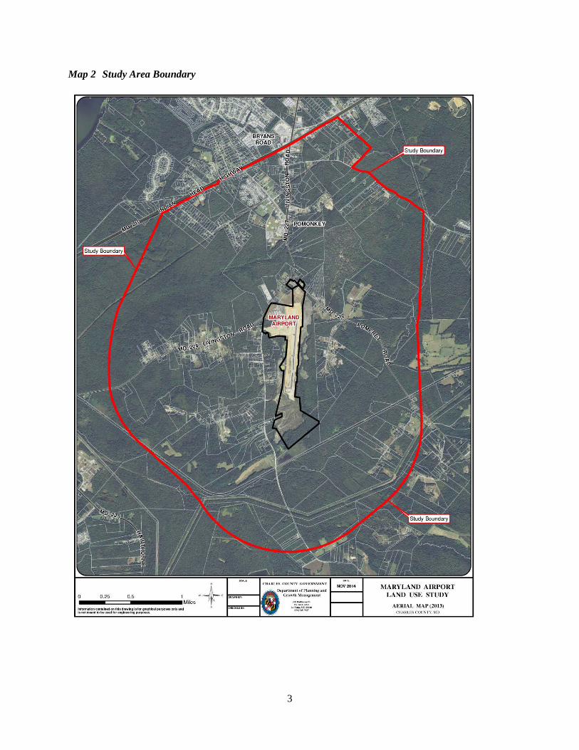
B. STUDY AREA The study area encompasses the area within a radius of approximately one mile from the airport boundaries (approximately 6,000 acres). The one-mile radius was selected because it is the approximate distance that pilots learning to fly use to take off, circle the airport, and land. The one-mile radius was extended to follow certain physical features, including Billingsley Road, MD 210, and a tributary of the Mattawoman Creek. (Map 2.)
3
Map 2 Study Area Boundary
4
C. STUDY PROCESS AND APPROACH The Maryland Airport Land Use Study was completed by a consultant team with expertise in land use planning, zoning, market analysis and airport design:
• Environmental Resources Management (lead consultant), land use planning and zoning • RKG Associates, economics and marketing • Talbert and Bright, Engineering; this firm prepared the 1999 Maryland Airport Master Plan and
subsequent engineering drawings and environmental assessments.
Members of the team reviewed County plans and documents and interviewed numerous stakeholders, including County officials, members of the business community, representatives of community and environmental groups, and officials from State and federal agencies as follows:
The team also reviewed market information, land use data, sample zoning standards, and airport plans.
After compiling key information and preliminary findings, the consultant team made a presentation to the community at a public meeting on January 5, 2015. The consultant team reviewed the feedback received from the public at the public meeting and comments sent to the Charles County Planning Department subsequent to the meeting.
The consultant team developed a draft report in April 2015. The Planning Commission held a public meeting on July 13, 2015, accepting public comment, and conducted a worksession on September 14, 2015
This report presents the background information and recommendations of the consultant team. The recommendations address land use and zoning in the vicinity of the airport and correspond closely to the objectives for the Study. The recommendations incorporate those made by the Planning Commission on September 14, 2015.
• Charles County Administrator
• Charles County Commissioners
• Chairman of the Planning Commission
• Charles County Department of Economic Development
• Maryland Aviation Administration
• Maryland Department of Natural Resources
• Maryland Department of Business and Economic Development
• U.S. Fish and Wildlife Service, Chesapeake Field Office
• Naval Surface Warfare Center Indian Head
• Chamber of Commerce • Western Charles County Business Alliance
• Charles County Smart Growth Alliance
• Mattawoman Watershed Society
• Conservancy of Charles County
• Mason Springs Conservancy
• Chapman Forest Foundation
5
II. MARYLAND AIRPORT
A. HISTORY The property now known as Maryland Airport was owned in the 1930s by Charles Bauserman and his wife and used for lumbering activities. In 1939, Mr. Bauserman used land that had been cleared as a grass strip for his own airplane. At the end of World War II an additional runway was graded by German prisoners-of-war2. Shortly after World War II, a terminal building with an attached maintenance hangar was built and is still in use today. Additional improvements followed: underground storage tanks for fuel in the early 1950s; t-hangers3 for airplane storage in 1960; a paved runway, apron, taxiways and parking lot in 1965. A second, grass runway continued in use as well. In 1988, a second set of t-hangars were built and a flight school started. In 1990, the underground aircraft fuel storage tanks were removed and replaced with above ground storage tanks.
In the 1990s, the airport was identified by the Federal Aviation Administration (FAA) as a General Aviation Reliever Airport to Washington D.C.’s Reagan National Airport. Given its reliever status, the airport became eligible for federal funding for improvements to enhance user safety and expand capacity. Following this FAA designation, the Airport Master Plan (described below) was developed.
The airport is owned and operated by Bauserman Services with Gilbert “Gil” Bauserman (son of Charles Bauserman) as President.
B. AIRPORT MASTER PLAN An Airport Master Plan for the Maryland Airport was approved by the FAA and Maryland Aviation Administration (MAA) in 1999. It has served as a blueprint for improvements completed since 1999 and will continue to govern future airport improvements. The Master Plan consists of an Airport Layout Plan (ALP), airport inventory, forecasts of future operations and the number of aircraft expected to be based at the airport, and airport facility requirements.
The key improvement shown on the Airport Layout Plan is a 4,300-foot x 75-foot asphalt runway to replace both the 1965 paved runway and the older turf runway that were in use prior to 2013. The runway was partially constructed, to a length of 3,740 feet, in 2013. Completion of the remaining length must await approval by the FAA of the 2014 Supplemental Environmental Assessment to allow tree trimming and removal, as explained below.
Planned airport improvements include the following, with the anticipated year of completion in parentheses:
• Land and easement acquisition of land to the north and south of the new runway (ongoing) • A full-parallel taxiway system, which will enhance airport safety by eliminating the need for
aircraft to taxi along the runway before takeoff and after landing (2014-15)
2 Source: Cultural Resources Survey in Environmental Assessment and Finding of No Significant Impact (EA/FONSI) for Airport Capital Development at Maryland Airport (2002) 3 T-Hangars are nested hangars located under one roof. These hangars are “T” shaped and are designed to accommodate small aircraft individually.
6
• Navigational aids (localizer antenna4, airport lighting, etc.) (2016-2020) • A new 4,250 square foot terminal building (2017) • 22,500 square yards of additional apron space for aircraft parking and movement (2015 to 2020) • Additional hangars and ancillary airport facilities (fencing, auto parking, etc.) (2017) • New automobile access road from Bumpy Oak Road providing access to the new terminal
building and future hangar development sites (2016).
2002 ENVIRONMENTAL ASSESSMENT The improvements proposed in the 1999 Airport Master Plan were evaluated in an Environmental Assessment (EA) in 20025. The EA evaluated potential environmental impacts and any mitigation necessary for development of the new runway and associated airport facilities. The EA was coordinated with the Maryland Department of the Environment (MDE), Maryland Historical Trust (MHT), Maryland Department of Natural Resources (DNR), U.S. Army Corps of Engineers (USACE), and U.S. Fish & Wildlife Service. As part of the EA, site surveys and evaluations were conducted and data gathered to assess the conditions and locations of sensitive environmental areas in relation to the Maryland Airport.
The EA determined that there were no environmental impacts which could not be mitigated. In 2003 the FAA issued a Finding of No Significant Impact (FONSI) for the realignment and expansion of the runway and associated taxiway and hangar development at the Maryland Airport. The EA was followed by a separate permitting and mitigation project for the wetland and forest impacts identified in the EA. The construction of the new runway in 2013 required a tributary of the Mattawoman Creek to be routed through a drainage culvert under the midpoint of the runway. The design for this culvert was closely coordinated with MDE and USACE. Off-site mitigation was provided for the wetland disturbance.
Coordination with Charles County and the mitigation of wetland and stream impacts associated with the runway construction allowed the runway realignment and expansion to move to the design phase.
2011 AIRPORT LAYOUT PLAN UPDATE As plans were created for construction of the new runway, the airport engineers and plan reviewers found that between the 1999 ALP and the 2007 construction plans, trees on neighboring properties to the north had grown to a height that presented a hazard to navigation. As a result, the new runway was constructed to a length of only 3,740 feet, with the full 4,300 feet approved in the ALP to be built following removal of the height obstructions.
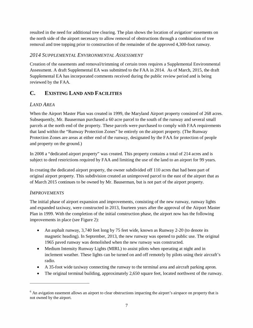
The 1999 Airport Layout Plan (ALP) was revised in 2011 to reflect the facilities for which construction plans were being finalized at that time (see Figure 1). The new runway (3,740-foot) and connector taxiway to the apron area are depicted as existing facilities on the 2011 ALP. Construction was completed on these in 2013. The revised 2011 ALP also includes the new tree obstruction data that
4 The localizer antenna is a navigational aid which transmits a radio signal to aircraft approaching the Airport. It assists pilots in aligning with the runway centerline. 5 An EA is a federal level review under the National Environmental Policy Act (NEPA), and required because Maryland Airport is part of the federal airport system.
7
resulted in the need for additional tree clearing. The plan shows the location of avigation6 easements on the north side of the airport necessary to allow removal of obstructions through a combination of tree removal and tree topping prior to construction of the remainder of the approved 4,300-foot runway.
2014 SUPPLEMENTAL ENVIRONMENTAL ASSESSMENT Creation of the easements and removal/trimming of certain trees requires a Supplemental Environmental Assessment. A draft Supplemental EA was submitted to the FAA in 2014. As of March, 2015, the draft Supplemental EA has incorporated comments received during the public review period and is being reviewed by the FAA.
C. EXISTING LAND AND FACILITIES
LAND AREA When the Airport Master Plan was created in 1999, the Maryland Airport property consisted of 268 acres. Subsequently, Mr. Bauserman purchased a 60 acre parcel to the south of the runway and several small parcels at the north end of the property. These parcels were purchased to comply with FAA requirements that land within the “Runway Protection Zones” be entirely on the airport property. (The Runway Protection Zones are areas at either end of the runway, designated by the FAA for protection of people and property on the ground.)
In 2008 a “dedicated airport property” was created. This property contains a total of 214 acres and is subject to deed restrictions required by FAA and limiting the use of the land to an airport for 99 years.
In creating the dedicated airport property, the owner subdivided off 110 acres that had been part of original airport property. This subdivision created an unimproved parcel to the east of the airport that as of March 2015 continues to be owned by Mr. Bauserman, but is not part of the airport property.
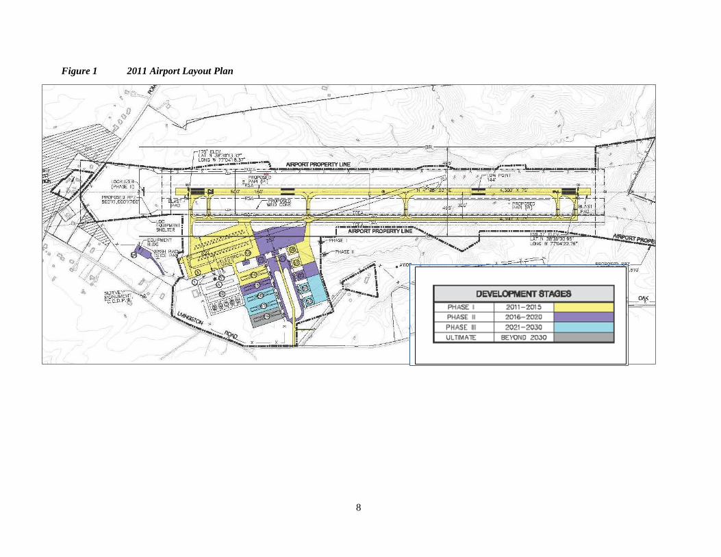
IMPROVEMENTS The initial phase of airport expansion and improvements, consisting of the new runway, runway lights and expanded taxiway, were constructed in 2013, fourteen years after the approval of the Airport Master Plan in 1999. With the completion of the initial construction phase, the airport now has the following improvements in place (see Figure 2):
• An asphalt runway, 3,740 feet long by 75 feet wide, known as Runway 2-20 (to denote its magnetic heading). In September, 2013, the new runway was opened to public use. The original 1965 paved runway was demolished when the new runway was constructed.
• Medium Intensity Runway Lights (MIRL) to assist pilots when operating at night and in inclement weather. These lights can be turned on and off remotely by pilots using their aircraft’s radio.
• A 35-foot wide taxiway connecting the runway to the terminal area and aircraft parking apron. • The original terminal building, approximately 2,650 square feet, located northwest of the runway.
6 An avigation easement allows an airport to clear obstructions impacting the airport’s airspace on property that is not owned by the airport.
8
Figure 1 2011 Airport Layout Plan
9
• An access road connecting the airport automobile parking lot with Livingston Road. • A 50-foot by 50-foot maintenance hangar located adjacent to the terminal building. • Two sets of t-hangars, one 10-unit and one 14-unit building, located immediately west of the
airport terminal. • Five individual “Quonset Hut” style hangars west of the t-hangars. • Outdoor tie-down areas along Livingston Road for aircraft based at Maryland Airport.
Impervious surfaces at the Maryland Airport total 14 acres as of 2014. The completion of the parallel taxiway will increase impervious surfaces to a total of 17 acres. Ultimate build-out of proposed Airport facilities shown on the 1999 Airport Layout Plan would increase the impervious surface area to approximately 40 acres (19% of the site). Two stormwater management basins were constructed in 2012 at the Airport to accommodate this ultimate airport development.
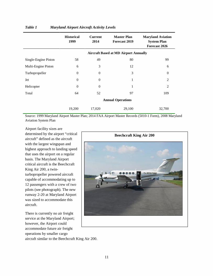
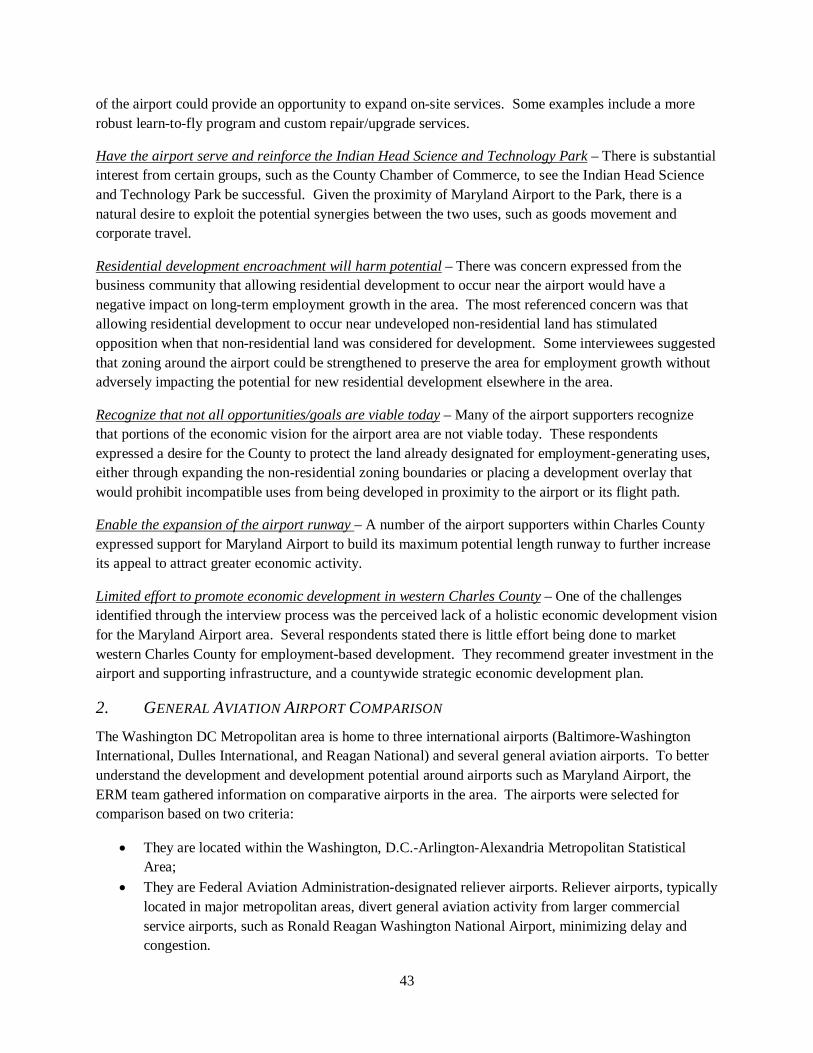
D. OPERATIONS AND ACTIVITY LEVELS As of 2014 Maryland Airport has approximately 17,000 annual aircraft operations (takeoffs or landings) and 52 aircraft are based at the airport (Table 1).
The number of airport-based aircraft has declined since 1999 due to the temporary closure of the airport during construction of the new runway (in 2013) and the downturn in general aviation flying as a result of the 2007 to 2009 economic recession. The 1999 Maryland Airport Master Plan projects aircraft based at Maryland Airport to increase to 97 by 2019 with the addition of turbopropeller7 aircraft, one jet, and one helicopter.
Annual operations are projected to increase to 29,100 by 2019 according to the 1999 Airport Master Plan, as a result of the projected increase in airport-based aircraft. Operations by aircraft not based at Maryland Airport (transient operations) are also projected to increase. In 2008 the Maryland Aviation Administration updated its forecasts for all airports in Maryland. The forecasts for Maryland Airport are for based aircraft to grow to 109 and annual operations to increase to 32,700 by 2026 (Table 1).
During the master plan process, the approach from the south was planned to be the preferred approach because there is less development south of the airport. The preferred approach from the south has been implemented with an instrument approach, a longer approach surface and larger runway protection zone (explained in the following sections). An instrument approach is typically preferred by pilots, especially at night and during inclement weather, as it helps to align the aircraft with the runway.
For take-offs, the wind coverage is fairly balanced when comparing a north or south take-off, so a pilot would likely favor a take-off to the south for convenience (less fuel burned due to no taxiing to the south end).
Keeping a visual- only approach from the north limits the size of the runway protection zone and therefore limits the land impacts.
7 A turbopropeller aircraft is powered by a jet engine connected to a propeller for propulsion. An example of this type of aircraft is the Beechcraft King Air.
10
Figure 2. Maryland Airport Property Boundaries and Improvements, July 2014
11
Table 1 Maryland Airport Aircraft Activity Levels
Historical 1999
Current 2014
Master Plan Forecast 2019
Maryland Aviation System Plan
Forecast 2026
Aircraft Based at MD Airport Annually
Single-Engine Piston 58 49 80 99
Multi-Engine Piston 6 3 12 6
Turbopropeller 0 0 3 0
Jet 0 0 1 2
Helicopter 0 0 1 2
Total 64 52 97 109
Annual Operations
19,200 17,020 29,100 32,700
Source: 1999 Maryland Airport Master Plan; 2014 FAA Airport Master Records (5010-1 Form), 2008 Maryland Aviation System Plan
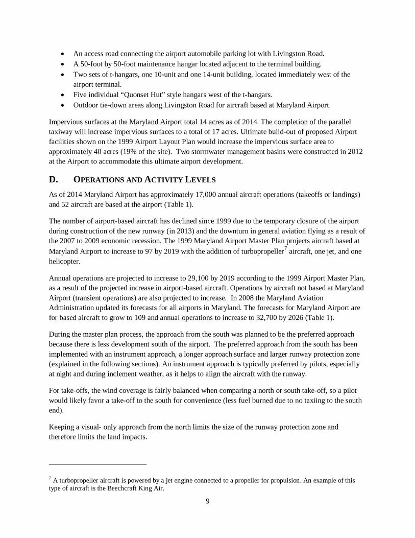
Airport facility sizes are determined by the airport “critical aircraft” defined as the aircraft with the largest wingspan and highest approach to landing speed that uses the airport on a regular basis. The Maryland Airport critical aircraft is the Beechcraft King Air 200, a twin-turbopropeller powered aircraft capable of accommodating up to 12 passengers with a crew of two pilots (see photograph). The new runway 2-20 at Maryland Airport was sized to accommodate this aircraft.
There is currently no air freight service at the Maryland Airport; however, the Airport could accommodate future air freight operations by smaller cargo aircraft similar to the Beechcraft King Air 200.
Beechcraft King Air 200
12
E. AIRPORT IMPACTS
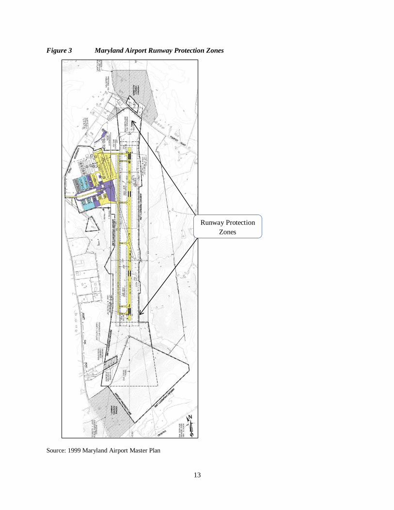
GROUND SAFETY AND RUNWAY PROTECTION ZONES The FAA requires Runway Protection Zones (RPZs) at the ends of runways to protect people and property on the ground. The airport owner must have sufficient property interest in the RPZ to clear these areas of incompatible objects and activities. The geometrics of the RPZ vary depending on the visibility minimums for the runway approach and on the aircraft utilizing the airport.
The RPZ dimensions for the Maryland Airport are depicted in Table 2 and Figure 3. The Maryland Airport owner owns all land within the RPZs except a small area in the northeast corner of the northern RPZ; an unimproved portion of a parcel. (The parcel has a dwelling in the area outside the RPZ.) The airport owner is pursuing purchase of avigation easements for the portion of the parcel within the RPZ.
The southern RPZ is larger because the approach from the south has been served since July, 2014 by a RNAV (GPS) approach, an instrument approach. The future localizer antenna will provide more precise guidance for instrument approach to the airport and make the airport more accessible during inclement weather. The approach from the north will continue to be visual only (no instrument approach), and will continue to require a smaller RPZ.
Table 2 Runway Protection Zone (RPZ) Dimensions and Design Standards
Length Inner Width
Outer Width
RPZ Acres
RPZ at north end of runway
1,000' 500' 700' 14
RPZ at south end of runway
1,700' 1,000' 1,510' 49
Source: 1999 Maryland Airport Master Plan
Since 1983, there have been nine aircraft accidents/incidents at the Maryland Airport. These incidents have all occurred in the immediate vicinity of the runway and did not result in any fatalities. These incidents also occurred prior to the construction of the new runway in 2013.
13
Figure 3 Maryland Airport Runway Protection Zones
Source: 1999 Maryland Airport Master Plan
Runway Protection Zones
14
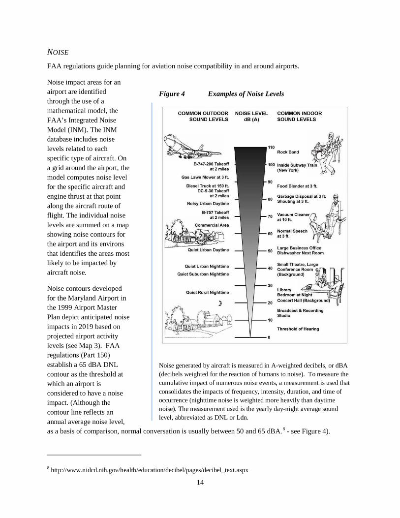
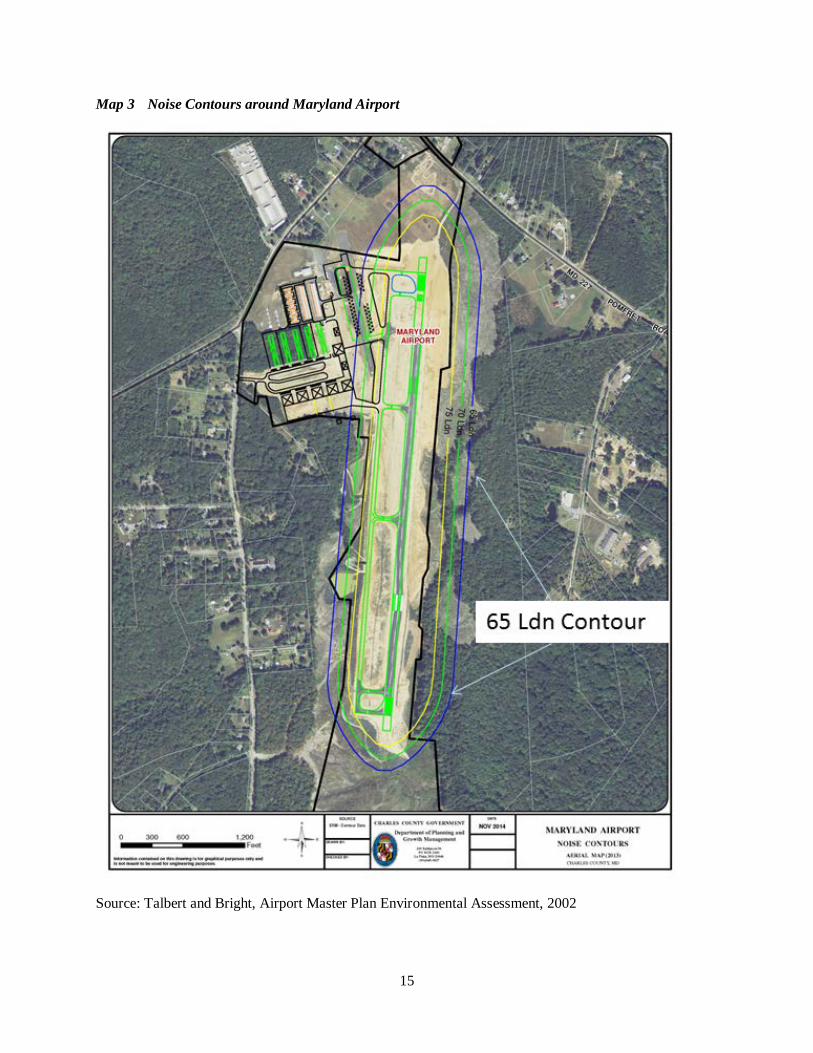
NOISE FAA regulations guide planning for aviation noise compatibility in and around airports.
Noise impact areas for an airport are identified through the use of a mathematical model, the FAA’s Integrated Noise Model (INM). The INM database includes noise levels related to each specific type of aircraft. On a grid around the airport, the model computes noise level for the specific aircraft and engine thrust at that point along the aircraft route of flight. The individual noise levels are summed on a map showing noise contours for the airport and its environs that identifies the areas most likely to be impacted by aircraft noise.
Noise contours developed for the Maryland Airport in the 1999 Airport Master Plan depict anticipated noise impacts in 2019 based on projected airport activity levels (see Map 3). FAA regulations (Part 150) establish a 65 dBA DNL contour as the threshold at which an airport is considered to have a noise impact. (Although the contour line reflects an annual average noise level, as a basis of comparison, normal conversation is usually between 50 and 65 dBA.8 - see Figure 4).
8 http://www.nidcd.nih.gov/health/education/decibel/pages/decibel_text.aspx
Figure 4 Examples of Noise Levels
Noise generated by aircraft is measured in A-weighted decibels, or dBA (decibels weighted for the reaction of humans to noise). To measure the cumulative impact of numerous noise events, a measurement is used that consolidates the impacts of frequency, intensity, duration, and time of occurrence (nighttime noise is weighted more heavily than daytime noise). The measurement used is the yearly day-night average sound level, abbreviated as DNL or Ldn.
15
Map 3 Noise Contours around Maryland Airport
Source: Talbert and Bright, Airport Master Plan Environmental Assessment, 2002
16
The FAA also defines which land uses can be appropriately located within the 65 dBA DNL noise contour. For example, residences and schools are not appropriate land uses within this noise contour. Churches, hospitals, nursing homes, auditoriums and concert halls are appropriate only if soundproofing is used to reduce interior noise levels. Employment uses are considered appropriate.
For Maryland Airport, the 65-decibel contour is contained primarily within the airport property, but also extends onto land to the east and west of the airport property. As of March 2015, the land within the 65 dBA contour is all zoned IG (General Industrial), undeveloped, and owned by the airport owner.
IMAGINARY SURFACES AND HEIGHT RESTRICTIONS The FAA defines imaginary surfaces in the airspace around an airport to prevent objects (manmade or natural) from extending upward into navigable airspace. There are several different surfaces:
• The horizontal surface is an imaginary surface 150 feet above the airport. • The primary surface extends 200 feet from either end of the runway; essentially nothing can be
placed on the ground in this area. • The approach surface extends upward from each end of the primary surface. • The transitional surface extends up from the sides of the runway • The conical surface extends outward and upward from the periphery of the horizontal surface at a
slope of 20:1 for a horizontal distance of 4,000 feet.
According to Maryland regulations (COMAR 11.05.03), the horizontal surface extends 5,000 feet out from airports with no instrument approach and 10,000 feet out from airports such as Maryland Airport, that have an instrument approach. For Maryland Airport, objects taller than 150 feet above the highest runway elevation and within 10,000 feet of the airport are considered intrusions on airspace.
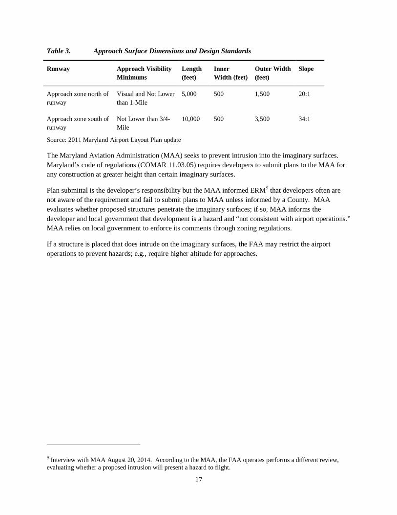
The approach surfaces restrict heights at either end of the runway. They are trapezoidal and rise at a slope of either 20 to 1 or 34 to 1, i.e., for a slope of 20 to 1, the approach surface rises 1 foot for every 20 feet of horizontal distance from the end of the runway (Table 3). As indicated in the table, the approach surface south of the Maryland Airport runway is greater due to the instrument approaches on that end.
The Maryland Airport owns the majority of the RPZs and the Airport is in the process of acquiring avigation easements (easements that control height) for property beyond the RPZ. The easements will allow the airport to clear any trees which may grow into the approach surface.
The height restrictions will not impact buildings based on the current height limits of Charles County’s zoning regulations. Telecommunication towers and similar structures could be impacted.
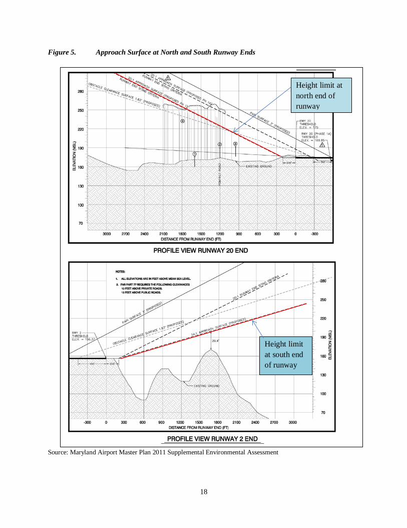
The approach surfaces are shown on Figure 5.
17
Table 3. Approach Surface Dimensions and Design Standards
Runway Approach Visibility Minimums
Length (feet)
Inner Width (feet)
Outer Width (feet)
Slope
Approach zone north of runway
Visual and Not Lower than 1-Mile
5,000 500 1,500 20:1
Approach zone south of runway
Not Lower than 3/4-Mile
10,000 500 3,500 34:1
Source: 2011 Maryland Airport Layout Plan update
The Maryland Aviation Administration (MAA) seeks to prevent intrusion into the imaginary surfaces. Maryland’s code of regulations (COMAR 11.03.05) requires developers to submit plans to the MAA for any construction at greater height than certain imaginary surfaces.
Plan submittal is the developer’s responsibility but the MAA informed ERM9 that developers often are not aware of the requirement and fail to submit plans to MAA unless informed by a County. MAA evaluates whether proposed structures penetrate the imaginary surfaces; if so, MAA informs the developer and local government that development is a hazard and “not consistent with airport operations.” MAA relies on local government to enforce its comments through zoning regulations.
If a structure is placed that does intrude on the imaginary surfaces, the FAA may restrict the airport operations to prevent hazards; e.g., require higher altitude for approaches.
9 Interview with MAA August 20, 2014. According to the MAA, the FAA operates performs a different review, evaluating whether a proposed intrusion will present a hazard to flight.
18
Figure 5. Approach Surface at North and South Runway Ends
Source: Maryland Airport Master Plan 2011 Supplemental Environmental Assessment
Height limit at north end of runway
Height limit at south end of runway
19
WILDLIFE MANAGEMENT Maryland Airport is not required to have a federally approved Wildlife Management Plan as the airport has no commercial flight service. The Maryland Airport has not had trouble with wildlife or bird strikes impacting aircraft operations. During design of the new runway, the design standards from the FAA’s Advisory Circular “Hazardous Wildlife Attractants On or Near Airports” were followed. Maryland Airport coordinated with USDA Animal and Plant Health Inspection Service (APHIS) Wildlife Services to determine the likelihood of migratory bird attraction to the two stormwater management basins. As a result of this coordination, bird deterrent overhead wire grid systems were installed atop each stormwater management basin. Further wildlife consideration was given in selection of the grass seeds for seeding and stabilization during runway construction. A mixture of millet grass was used per FAA recommendation, as it is less likely to attract wildlife.
NOTIFICATION REQUIREMENTS There are no current requirements for notification of the airport’s proximity to persons purchasing land or homes near the Maryland Airport. Having no notification requirement is common for smaller general aviation airports; however, many Maryland counties, including Washington, Montgomery, Wicomico, and Talbot Counties, and the city of Salisbury, do require notification either through statements on plats and site plans, or through the real estate transaction process.
20
III. LAND USE AND ZONING A. OVERVIEW OF STUDY AREA Maryland Airport has frontage on MD 224 (Livingston Road); MD 227 (Pomfret Road) and Bumpy Oak Road. The major land uses in the study area are rural residential development and forested land owned by the Maryland Department of Natural Resources (DNR).
The airport is the largest parcel developed for non-residential land use in the study area. Approximately 1,000 acres including and surrounding Maryland Airport are zoned for industrial and business park use; most of this land is currently undeveloped.
MD 227, MD 224, and Bumpy Oak Road are lined with a mix of residences, undeveloped properties, and a few small retail or restaurant uses and civic uses such as fraternal lodges. Industrial and employment land uses in the immediate vicinity of the airport include a self-storage facility across MD 224 from the airport, and contractor storage facilities and a manufacturer of stone countertops and other products on Ray Road, east of the airport.
The northwest portion of the study area is Chapman State Forest. Much of this 2,175 acre property is outside the study area, extending from the Bryans Road community towards the town of Indian Head and from the Potomac River south almost to Mattawoman Creek. In the 1990s a major mixed-use development had been proposed for the property. The state purchased the property and created Chapman State Forest in 1998.
The Mattawoman Creek valley forms the study area’s southern boundary. Portions of the stream valley within the study area are in the Myrtle Grove Wildlife Management Area and the Mattawoman Natural Environmental Area, both owned by MD DNR. Privately owned parcels within the stream valley are primarily forested. Traversing the southern portion of the study area is the Indian Head Rail Trail, a 13-mile paved trail completed by Charles County in 2009, extending from the Town of Indian Head to White Plains. The Rail Trail is located within a 100-foot wide preserved right-of-way and is popular for bicycling, hiking, running and wildlife viewing.
Ray Road to the west of the airport ends at a 24 acre forested tract, privately owned and unimproved, that is preserved by a conservation easement held by the Maryland Environmental Trust and the Conservancy for Charles County.
The JC Parks Elementary School and Matthew Henson Middle School are approximately one-half mile north of the airport along MD 227. The schools are close to the community of Pomonkey. Established as the Village of Bumpy Oak, in the19th century this small community was a commercial and social focal point because of its location on important travel routes.
Suburban residential development extends from historic Pomonkey north to MD 210. Retail and service businesses and a fire station are clustered close to the intersection of MD 227 and MD 210, which is the main intersection for the Bryans Road community.
21
To the northeast across MD 224 from the airport and extending north to MD 210 is a forested, 266-acre tract known as the Indian Head Science and Technology Park, currently undeveloped. A preliminary development plan was approved in 2012 for over one million square feet of office space on this site, but the development did not move forward. The County bought the tract in 2014 and commissioned a study of the current real estate market to evaluate potential uses of the site; see discussion in Section VI of this study (Economic and Market Assessment).
B. CURRENT ZONING AND LAND USE
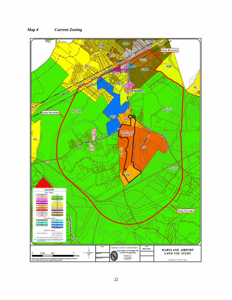
DEVELOPED/UNDEVELOPED LAND BY ZONING DISTRICT The study area encompasses approximately 5,942 acres, of which approximately 70 percent is zoned RC(D) and 18 percent, a total of 1,048 acres, is divided among three employment zones: IG (Light Industrial), PEP (Planned Employment Park) and BP (Business Park). See Map 4, Zoning.
The remaining 12 percent, about 700 acres, is divided among ten residential, mixed use and commercial zoning districts. Except for a few small parcels of commercial land along MD 224, this acreage is located in the Bryans Road community on the north side of the study area.
RC (D), or Rural Conservation-Deferred, has the lowest development density among zoning districts in the Charles County Zoning Ordinance, allowing subdivision into lots with a minimum lot size of ten acres.
Approximately 40 percent of the study area, a total of 2,358 acres, is permanently protected natural resource land. Most of this land is state-owned property within Chapman State Park, Myrtle Grove Wildlife Management Area and the Mattawoman Natural Environmental Area. Protected lands also include a 24-acre Conservancy for Charles County easement and land within the Resource Protection Zoning District (RPZ), a district overlaying stream valleys and associated floodplains, wetlands, steep slopes, and stream buffer areas.
The high percentage of protected land in the study area is due to the presence of the Mattawoman Creek and associated stream valley, steep slopes, wetlands, tributaries and forests. As discussed in more detail below under “Environmental Features,” the study area contains environmental resources that have been given high priority for preservation by the Maryland Departments of the Environment and Natural Resources.
22
Map 4 Current Zoning
23
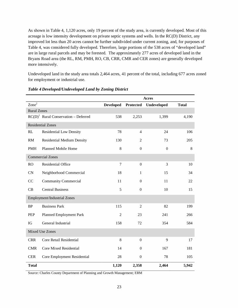
As shown in Table 4, 1,120 acres, only 19 percent of the study area, is currently developed. Most of this acreage is low intensity development on private septic systems and wells. In the RC(D) District, any improved lot less than 20 acres cannot be further subdivided under current zoning, and, for purposes of Table 4, was considered fully developed. Therefore, large portions of the 538 acres of “developed land” are in large rural parcels and may be forested. The approximately 277 acres of developed land in the Bryans Road area (the RL, RM, PMH, RO, CB, CRR, CMR and CER zones) are generally developed more intensively.
Undeveloped land in the study area totals 2,464 acres, 41 percent of the total, including 677 acres zoned for employment or industrial use.
Table 4 Developed/Undeveloped Land by Zoning District
Acres
Zone2 Developed Protected Undeveloped Total Rural Zones RC(D)1 Rural Conservation – Deferred 538 2,253 1,399 4,190
Residential Zones
RL Residential Low Density 78 4 24 106
RM Residential Medium Density 130 2 73 205
PMH Planned Mobile Home 8 0 0 8
Commercial Zones
RO Residential Office 7 0 3 10
CN Neighborhood Commercial 18 1 15 34
CC Community Commercial 11 0 11 22
CB Central Business 5 0 10 15
Employment/Industrial Zones
BP Business Park 115 2 82 199
PEP Planned Employment Park 2 23 241 266
IG General Industrial 158 72 354 584
Mixed Use Zones
CRR Core Retail Residential 8 0 9 17
CMR Core Mixed Residential 14 0 167 181
CER Core Employment Residential 28 0 78 105
Total 1,120 2,358 2,464 5,942
Source: Charles County Department of Planning and Growth Management; ERM
24
Notes to Table 4: 1RC(D) parcels of less than 20 acres and improved by a dwelling: entire acreage was counted as developed. RC(D) parcels of 20 or more acres and improved by a dwelling: 10 acres were counted as developed; remaining acreage was counted as undeveloped. 2In all zoning districts other than RC(D) represented in this table:
• A parcel of 3 acres or smaller that is improved (by a dwelling or business) was counted as developed. • Parcels larger than three acres and improved by a dwelling: one acre was counted as developed and the remaining
acreage was counted as undeveloped. • Parcels larger than three acres and improved by a business or institutional use: three acres were counted as developed
and the remaining acreage was counted as undeveloped.
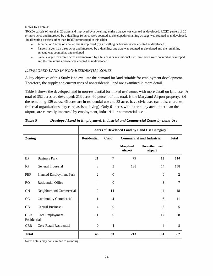
DEVELOPED LAND IN NON-RESIDENTIAL ZONES A key objective of this Study is to evaluate the demand for land suitable for employment development. Therefore, the supply and current uses of nonresidential land are examined in more detail.
Table 5 shows the developed land in non-residential (or mixed use) zones with more detail on land use. A total of 352 acres are developed; 213 acres, 60 percent of this total, is the Maryland Airport property. Of the remaining 139 acres, 46 acres are in residential use and 33 acres have civic uses (schools, churches, fraternal organizations, day care, assisted living). Only 61 acres within the study area, other than the airport, are currently improved by employment, industrial or commercial uses.
Table 5 Developed Land in Employment, Industrial and Commercial Zones by Land Use
Acres of Developed Land by Land Use Category
Zoning Residential Civic Commercial and Industrial Total
Maryland Airport
Uses other than airport
BP Business Park 21 7 75 11 114
IG General Industrial 3 3 138 14 158
PEP Planned Employment Park 2 0 0 2
RO Residential Office 4 0 3 7
CN Neighborhood Commercial 0 14 4 18
CC Community Commercial 1 4 6 11
CB Central Business 4 0 2 5
CER Core Employment Residential
11 0 17 28
CRR Core Retail Residential 0 4 4 8
Total 46 33 213 61 352
Note: Totals may not sum due to rounding
25
C. EMPLOYMENT ZONING DISTRICTS The three employment zones within the study area, IG, BP and PEP, have distinctly different purposes, development standards, and permitted uses.
IG (GENERAL INDUSTRIAL) ZONE:
• The IG Zone includes most of the airport property as well as 446 acres to the west and east of the airport, extending from the airport to MD 227 to the east and Bumpy Oak Road to the west. Most of the IG-zoned land is between the airport and MD 227, with frontage on MD 227 or Ray Road. Ray Road, labeled on Map 4, extends south from MD 227 east of the Airport. The IG-zoned parcels along Ray Road are improved by residences, a day care center, assisted living, contractor storage yards, and a stone manufacturing business.
• The purpose of the IG zone (Zoning Ordinance Section 297-92.A) is to provide “appropriate locations for industrial uses of moderate scale and intensity.”
BP (BUSINESS PARK) ZONE: Land in the BP zone includes:
• The southern and northern portions of the airport property. • Properties along MD 224 north of the airport. These are improved with dwellings, except for one
parcel which has a self-storage facility. • Several parcels on the east side of Bumpy Oak Road; current land uses are residences and a
church. • A small area, about five parcels, abutting the south end of the airport, also on the east side of
Bumpy Oak Road.
The purpose of the BP Zone (Section 297-291.A of the Zoning Ordinance) is to: “concentrate business and light industrial uses in a park-like setting”
Regulations for the BP zone were revised in 2008 to add, as an accessory use, “Ancillary equipment, facilities, and utilities necessary to support a general aviation airport.”
PEP (PLANNED EMPLOYMENT CENTER) ZONE: The Indian Head Science and Technology Park property is zoned PEP. The zone is intended for “planned developments of light and medium industrial uses along with related commercial uses” and should “provide a more flexible approach to the comprehensive development of large tracts of land in terms of land use, intensity and design.” (Section 297-107).
ANALYSIS OF EMPLOYMENT ZONES The airport property itself is zoned IG and BP. A small area of RC(D) zoning across MD 227 from the airport has also been purchased by and made part of the airport property for runway protection; no airport-related improvements are planned on this land.
General aviation airports are permitted only within the IG zone. The current and most of the planned airport improvements are on the IG-zoned portion, but some equipment and paved area will be on the BP-
26
zoned land north of the runway. Most of the BP-zoned land south of the runway is dedicated airport property that must remain under airport ownership due to FAA requirements. Most of this land is within the Runway Protection Zone and cannot be built upon (See Figure 3). There is land not owned by the airport along Bumpy Oak Road that is zoned BP and could potentially be developed. The land is steeply sloped and forested.
The requirements for general aviation airports in the IG zone are provided in Appendix 1.
Stakeholders suggested that the following uses would be supportive of a general aviation airport:
• Aircraft repair, servicing and parts sales: a use not currently listed in the zoning ordinance
• Motor vehicle rental (for incoming aircraft passengers): permitted in the PEP zone; not permitted in BP and IG. However, the provisions for general aviation airports in the IG zone specify that rental car services may be available within the terminal.
• Offices to accommodate businesses that use corporate aircraft. Offices are permitted in IG, BP and PEP.
• Restaurant: permitted in the IG zone and specifically permitted within a terminal of a general aviation airport. Permitted in BP only if internal to a business park.
Uses that are considered inappropriate or in need of soundproofing within the 65 dBA noise contour include churches, permitted in all three zones; schools and hospitals, permitted in BP and PEP; intermediate care and nursing homes, permitted in PEP; theaters, permitted in PEP. Only the IG zone has land within the 65 dbA noise contour and outside of the airport property.
Single-family detached dwellings are permitted conditional uses in the IG District. The dwelling must be for the owner of the property, or for a child or grandchild of the owner; no more than five such lots can be created; and the lot cannot be transferred to a third party unless it is converted to a permitted commercial or industrial use. Dwellings are not appropriate within the 65 dBA noise contour.
All of the single-family detached dwellings in the employment districts around the airport are nonconforming uses (unless any of the dwellings in the IG zone were built under the conditional use provision cited above).
Appendix 2 lists uses permitted in the three zoning districts.
D. HISTORIC SITES Several sites listed on the Maryland Inventory of Historic Properties are close to Maryland Airport (Map 5).
One historic site is adjacent to the airport property. St. John’s Chapel, c.1824, (CH-251 on the Maryland Inventory of Historic Properties) is on the east side of MD 224 just north of the intersection with Bumpy Oak Road and adjacent to Maryland Airport in the area where the parking and terminal are located. The Chapel is in the BP zoning district and will not be impacted by proposed airport improvements.
Three other historic sites are close to the airport. St. John’s Chapel cemetery (CH-250) and the c.1800 Jameson House (CH-70) are across Bumpy Oak Road from the airport property. Site CH-524, the
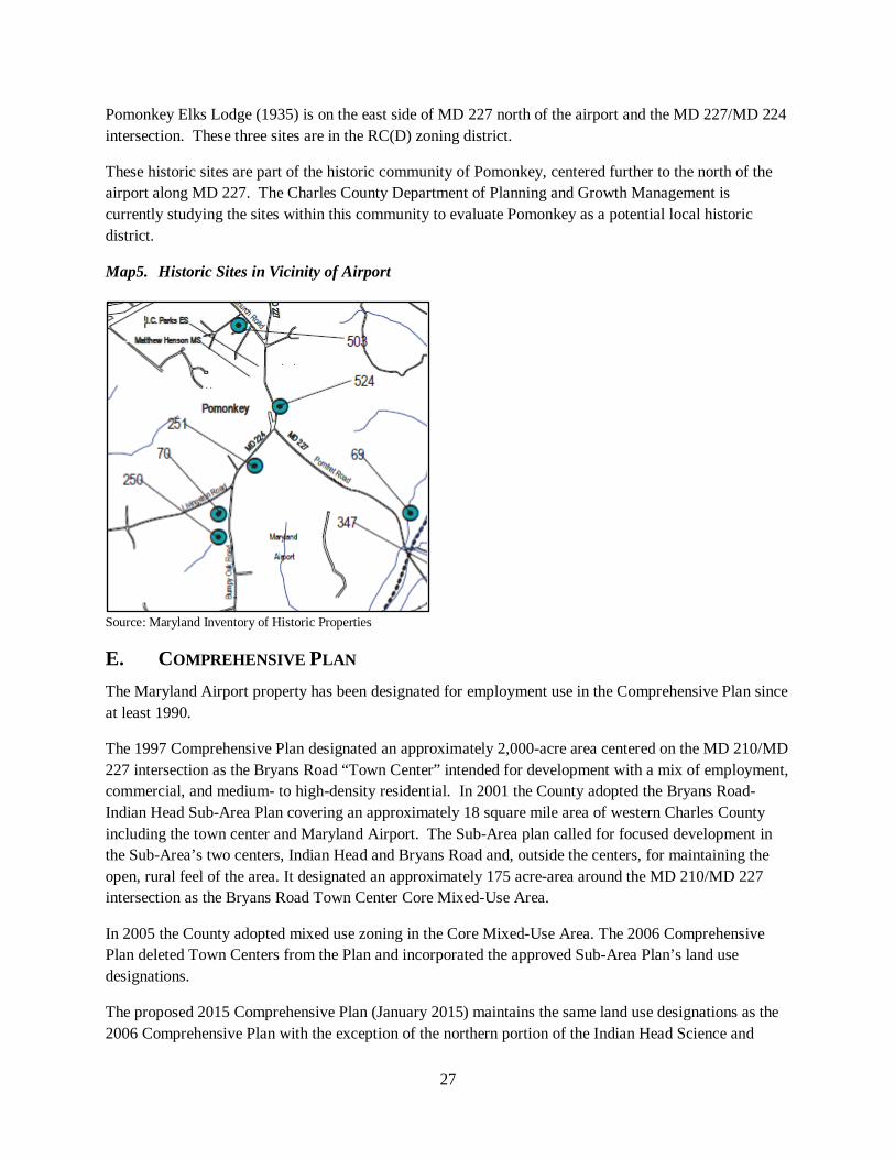
27
Pomonkey Elks Lodge (1935) is on the east side of MD 227 north of the airport and the MD 227/MD 224 intersection. These three sites are in the RC(D) zoning district.
These historic sites are part of the historic community of Pomonkey, centered further to the north of the airport along MD 227. The Charles County Department of Planning and Growth Management is currently studying the sites within this community to evaluate Pomonkey as a potential local historic district.
Map5. Historic Sites in Vicinity of Airport
Source: Maryland Inventory of Historic Properties
E. COMPREHENSIVE PLAN The Maryland Airport property has been designated for employment use in the Comprehensive Plan since at least 1990.
The 1997 Comprehensive Plan designated an approximately 2,000-acre area centered on the MD 210/MD 227 intersection as the Bryans Road “Town Center” intended for development with a mix of employment, commercial, and medium- to high-density residential. In 2001 the County adopted the Bryans Road-Indian Head Sub-Area Plan covering an approximately 18 square mile area of western Charles County including the town center and Maryland Airport. The Sub-Area plan called for focused development in the Sub-Area’s two centers, Indian Head and Bryans Road and, outside the centers, for maintaining the open, rural feel of the area. It designated an approximately 175 acre-area around the MD 210/MD 227 intersection as the Bryans Road Town Center Core Mixed-Use Area.
In 2005 the County adopted mixed use zoning in the Core Mixed-Use Area. The 2006 Comprehensive Plan deleted Town Centers from the Plan and incorporated the approved Sub-Area Plan’s land use designations.
The proposed 2015 Comprehensive Plan (January 2015) maintains the same land use designations as the 2006 Comprehensive Plan with the exception of the northern portion of the Indian Head Science and
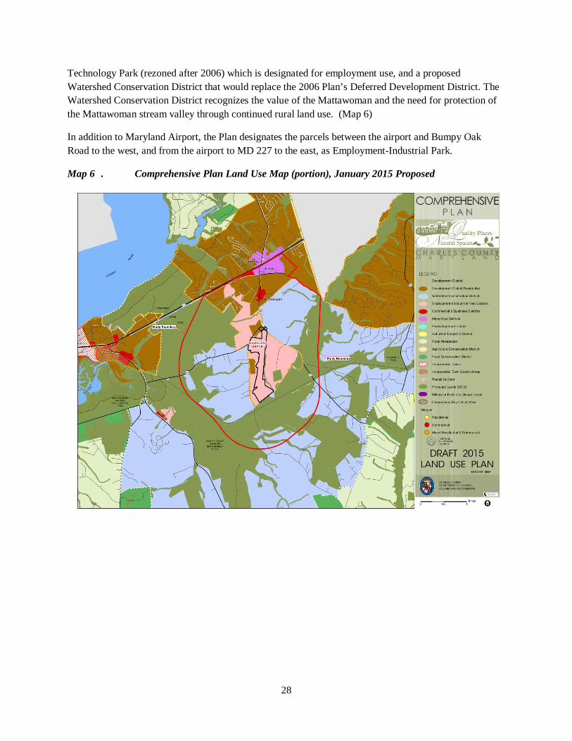
28
Technology Park (rezoned after 2006) which is designated for employment use, and a proposed Watershed Conservation District that would replace the 2006 Plan’s Deferred Development District. The Watershed Conservation District recognizes the value of the Mattawoman and the need for protection of the Mattawoman stream valley through continued rural land use. (Map 6)
In addition to Maryland Airport, the Plan designates the parcels between the airport and Bumpy Oak Road to the west, and from the airport to MD 227 to the east, as Employment-Industrial Park.
Map 6 . Comprehensive Plan Land Use Map (portion), January 2015 Proposed
29
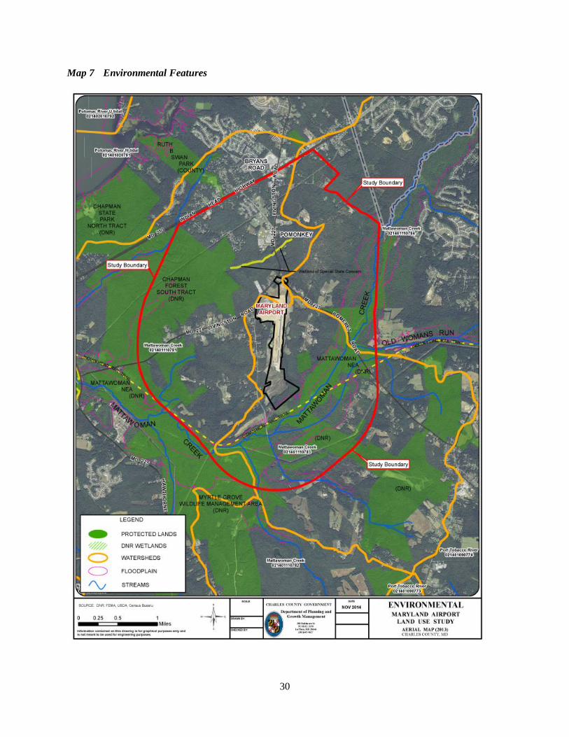
IV. ENVIRONMENTAL FEATURES A. OVERVIEW The study area is rich in natural resources – see Map 7. Key points include:
• The main branch of the Mattawoman Creek runs parallel to the study area’s southern and southeastern boundaries.
• Of the study area’s approximately 6,000 acres, about 79 percent are in tree cover (based on 2011 aerial photographs).
• Only two percent of the study area, a total of 143 acres, is impervious (also from the 2011 aerial photographs).
• Approximately 40 percent of the study area is protected lands. • Most of the study area is within the stream valley of the Mattawoman Creek and its tributaries.
B. MATTAWOMAN CREEK The Mattawoman Creek is a 27- mile long stream extending from its headwaters near Brandywine to the Potomac River. Mattawoman Creek in western Charles County is a slow moving stream with extensive associated tidal and non-tidal wetlands, steep slopes and forests. Its stream valley to top of slope was mapped in 2007 by DNR (Map 8).
According to a report published in 2011 by the Interstate Commission on the Potomac River Basin for MDE and the United States EPA10, the Mattawoman Creek was long recognized as one of the healthiest watersheds in Maryland. In recent years, data has begun to indicate that the system is stressed. In March 2012, a report on the Mattawoman was completed by a multi-agency task force led by Maryland DNR and transmitted to Charles County to provide recommendations and input into the county's comprehensive plan update11.
The report explains that Mattawoman Creek and its tributaries are among the State’s highest conservation priorities for estuarine systems. Signs of stress include loss of anadromous fish spawning sites and declines in the tidal fish community since the late 1990s-early 2000s. The report recommends protection of the watershed that would be implemented through a variety of means including zoning districts, stream buffers, forest conservation, stormwater and sediment control, enforcement procedures and other means.
10 “Integrating Priorities and Achieving a Sustainable Watershed Using the Watershed Resources Registry in the Mattawoman Watershed,“ published by August, 2011 by the Interstate Commission on the Potomac River Basin, p. 24 11 "The Case for Protection of the Watershed Resources or Mattawoman Creek: Recommendations and Management Initiatives to Protect the Mattawoman Ecosystem,” March 2012, DNR.
30
Map 7 Environmental Features
31
C. MARYLAND DEPARTMENT OF NATURAL RESOURCES PROPERTIES Portions of three MD DNR properties are within the study area. The location of these properties is shown on Map 7. Table 6 shows total acreage (including area outside the study area) and characteristics of these areas.
Table 6. MD DNR Land within the Study Area12
Area Name Acres Characteristics
Myrtle Grove Wildlife Management Area
1,722 Oldest State-managed public hunting land in southern Maryland. Wood duck habitat.
Mattawoman Natural Environmental Area
2,509 Contains 25 species of plants that are rare, threatened or endangered in Maryland. Portion of park is in the Maryland Wildlands Preservation System.
Chapman State Park 2,180 Variety of wetlands habitat. Contains a wet meadow that is a Wetland of Special State Concern.
D. ENVIRONMENTAL DESIGNATIONS Land within or on the borders of the study area is recognized with several designations that reflect the area’s environmental quality and importance. These designations include:
Targeted Ecological Area. Most of the study area is Targeted Ecological Area; lands identified by MD DNR as conservation priorities. These ecologically valuable areas are targeted for protection through Program Open Space and other funding sources
Stronghold Watershed. DNR defines “Stronghold Watersheds” as “watersheds in the state that are most important for the protection of Maryland’s aquatic biodiversity.” The 12-digit watershed that covers roughly the western half of the study area (Watershed #021401110781) is a Stronghold Watershed.
Mattawoman Wildland. A large area of state-owned land within the study area was designated in 2014 as part of the “Mattawoman Wildland.” Wildlands are areas of state-owned land or water that have retained their wilderness character or contain rare or vanishing species of plant or animal life or similar features worthy of preservation
Wetland of Significant State Concern. A tributary of Mattawoman Creek passes through the Indian Head Science and Technology Park site. The tributary is referred to as Pomonkey School Stream and is designated a Non-Tidal Wetland of Special State Concern by the Maryland code (COMAR 26.23.06.01.H(7). This is shown in yellow on Map 7 (flowing east-west just north of the Airport).
12 “Integrating Priorities and Achieving a Sustainable Watershed Using the Watershed Resources Registry in the Mattawoman Watershed,“ published by August, 2011 by the Interstate Commission on the Potomac River Basin, p. 24
32
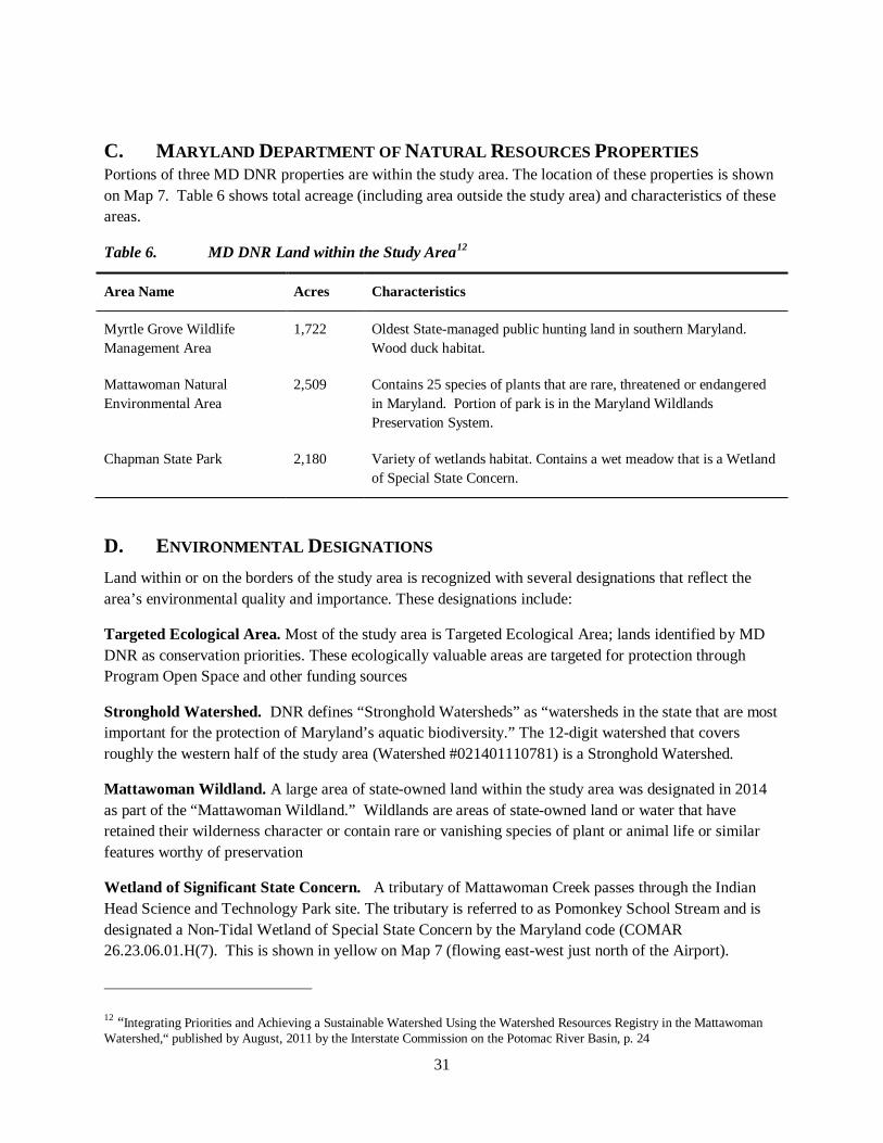
Chesapeake Rivers National Refuge Complex. The Mattawoman Creek is one “unit” within the Chesapeake Rivers National Refuge Complex, approved in 2014 and intended to protect land along tributaries entering the Chesapeake Bay.
Map 8 Mattawoman Creek Stream Valley in Vicinity of Study Area
Source: MD DNR, 2007
Maryland Airport
33
V. PUBLIC FACILITIES
A. SEWER SERVICE The study area is located within Charles County’s Development District as shown on the 2006 and prior Comprehensive Plans, indicating that the area is ultimately planned to be served by public water and sewer.
The proposed Comprehensive Plan (draft January 2015) reflects a shift in policy for the rural portions of the study area; the areas currently zoned RC (D). The Maryland Sustainable Growth and Agricultural Preservation Act of 2012 required the county to divide land into four tiers of land use categories to identify the type of subdivision permitted and where public sewerage will be available. Charles County adopted its Tiers Map on April 29, 2014. The Comprehensive Plan is required by Maryland law to be consistent with the Tiers Map. The study area includes lands in Tiers 1, 2 and 4:
• Tier 1 areas are served by public sewerage systems and mapped as growth areas. Lands near the MD 210/MD 227 intersection are in Tier 1. These properties have public sewer available and include residences, commercial uses and undeveloped land.
• Tier 2 areas are planned to be served by public sewerage systems. Tier 2 includes the Maryland Airport, surrounding lands in the BP and IG zoning districts, and the unimproved Indian Head Science and Technology Park (zoned PEP).
• Tier 4 areas are not planned for public sewerage; planned for agricultural, resource or land preservation; and dominated by agricultural lands, forest lands or other natural areas. Only minor subdivisions can occur in Tier 4 areas. The remaining land in the study area, to the northeast, south and west of the employment-zoned land around the Maryland Airport, is in Tier 4. In the proposed Comprehensive Plan, this land is designated Watershed Conservation.
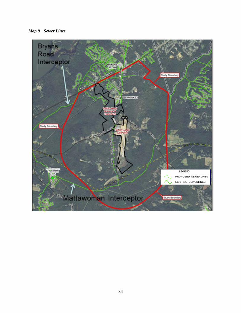
The Mattawoman Interceptor, Charles County’s major sewer line, crosses the study area, following Mattawoman Creek to the Mattawoman wastewater treatment plant located on MD 225 west of the study area. The Bryans Road interceptor crosses the study area close to its northern boundary, serving parts of the Bryans Road Town Center (near the MD 210/MD 227 intersection) and connecting to the Mattawoman Interceptor near Indian Head (Map 9).
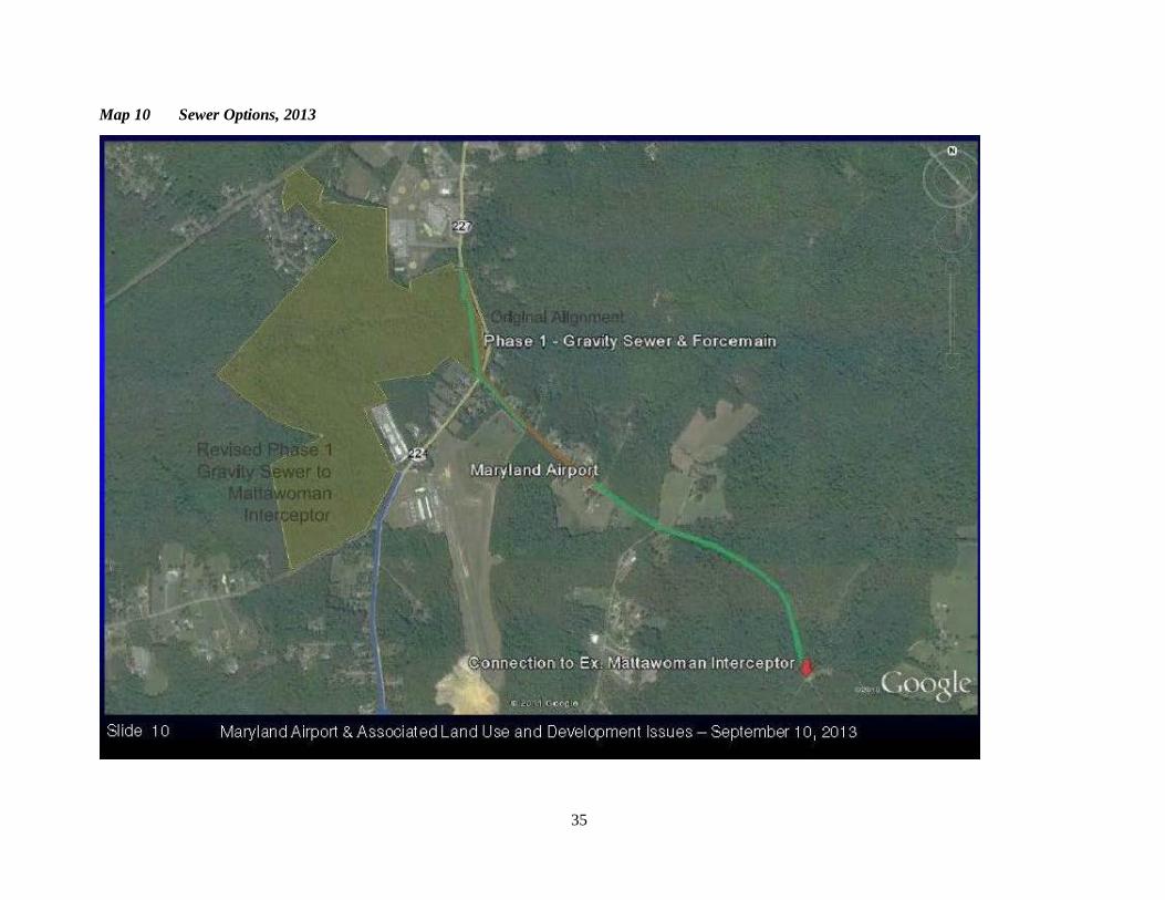
A new sewer line to provide sewer service for the Indian Head Science and Technology Park, which would also provide sewer service for the Maryland Airport, is in the design stage. Cost estimates have varied based on alternative designs. In 2013 two alternative alignments were provided (Map 10). The first, with estimated costs of approximately $3.3 million – brown and green lines on Map 10, would serve a larger area via: gravity sewer beginning on MD Route 227 at approximately 1,400 linear feet southeast of Route 224 proceeding towards the existing Pomonkey pump station (2,500+ linear feet); a new 1.7 MGD Pump Station; force main from new pump station to a gravity sewer along MD 227 (3,900+ linear feet); a gravity sewer from the end of the force main along MD 227 to the Mattawoman Interceptor (4,700+ linear feet). The second alternative, estimated, at $0.99 million, would provide sewer service for a smaller area of the IHSTP and adjacent properties via a gravity sewer traveling south along MD 224 to the Mattawoman Interceptor sewer. This line is shown on Map 9 as a proposed sewer line and on Map 10 in blue.
34
Map 9 Sewer Lines
35
Map 10 Sewer Options, 2013
36
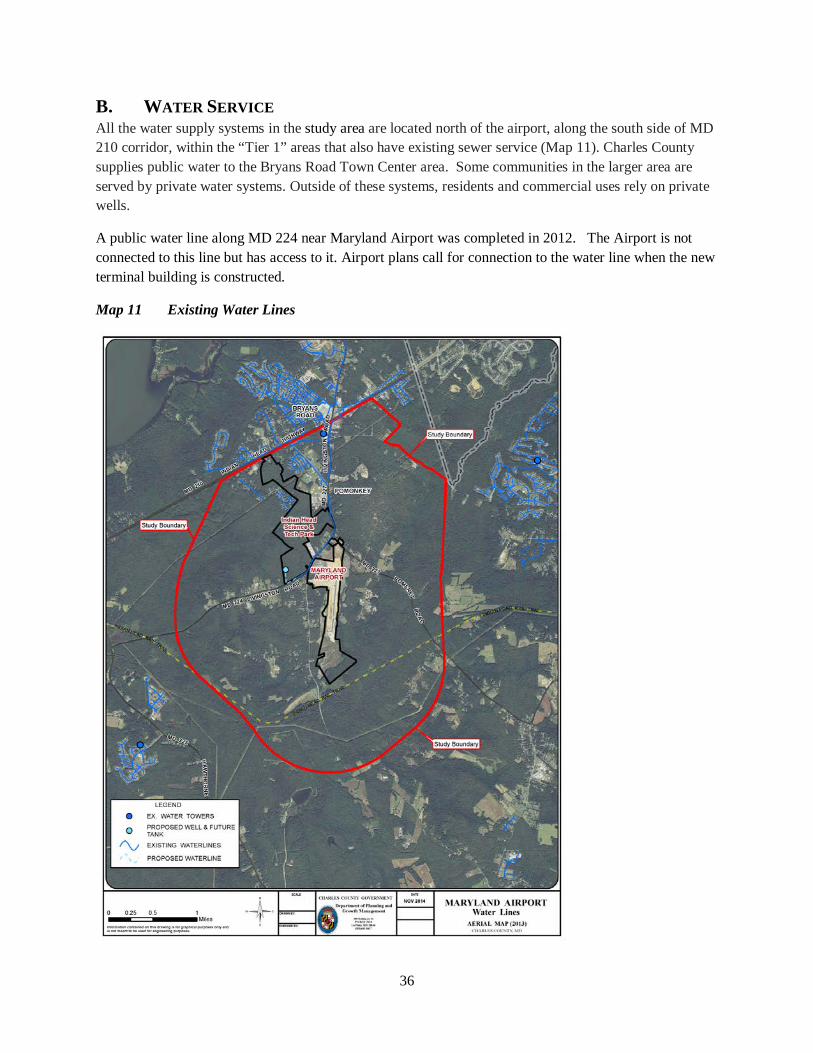
B. WATER SERVICE All the water supply systems in the study area are located north of the airport, along the south side of MD 210 corridor, within the “Tier 1” areas that also have existing sewer service (Map 11). Charles County supplies public water to the Bryans Road Town Center area. Some communities in the larger area are served by private water systems. Outside of these systems, residents and commercial uses rely on private wells.
A public water line along MD 224 near Maryland Airport was completed in 2012. The Airport is not connected to this line but has access to it. Airport plans call for connection to the water line when the new terminal building is constructed.
Map 11 Existing Water Lines
37
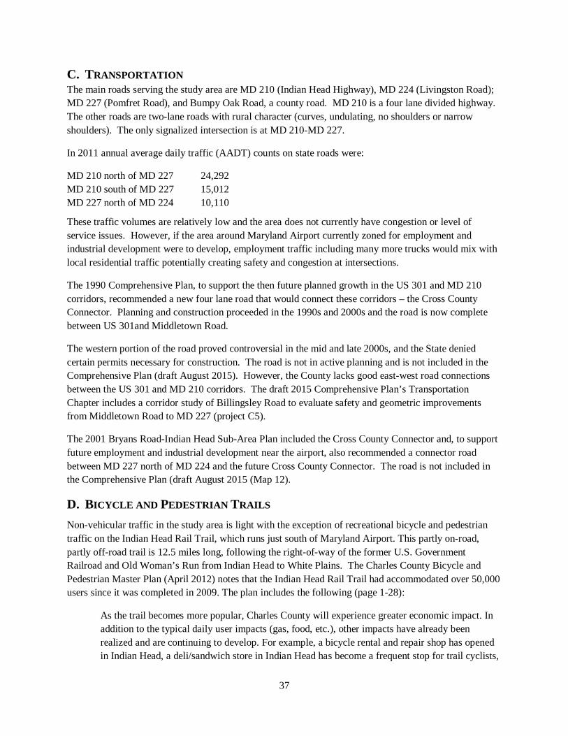
C. TRANSPORTATION The main roads serving the study area are MD 210 (Indian Head Highway), MD 224 (Livingston Road); MD 227 (Pomfret Road), and Bumpy Oak Road, a county road. MD 210 is a four lane divided highway. The other roads are two-lane roads with rural character (curves, undulating, no shoulders or narrow shoulders). The only signalized intersection is at MD 210-MD 227.
In 2011 annual average daily traffic (AADT) counts on state roads were:
MD 210 north of MD 227 24,292 MD 210 south of MD 227 15,012 MD 227 north of MD 224 10,110
These traffic volumes are relatively low and the area does not currently have congestion or level of service issues. However, if the area around Maryland Airport currently zoned for employment and industrial development were to develop, employment traffic including many more trucks would mix with local residential traffic potentially creating safety and congestion at intersections.
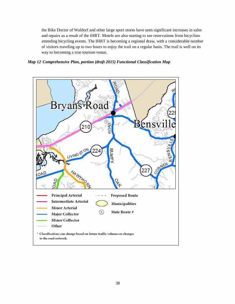
The 1990 Comprehensive Plan, to support the then future planned growth in the US 301 and MD 210 corridors, recommended a new four lane road that would connect these corridors – the Cross County Connector. Planning and construction proceeded in the 1990s and 2000s and the road is now complete between US 301and Middletown Road.
The western portion of the road proved controversial in the mid and late 2000s, and the State denied certain permits necessary for construction. The road is not in active planning and is not included in the Comprehensive Plan (draft August 2015). However, the County lacks good east-west road connections between the US 301 and MD 210 corridors. The draft 2015 Comprehensive Plan’s Transportation Chapter includes a corridor study of Billingsley Road to evaluate safety and geometric improvements from Middletown Road to MD 227 (project C5).
The 2001 Bryans Road-Indian Head Sub-Area Plan included the Cross County Connector and, to support future employment and industrial development near the airport, also recommended a connector road between MD 227 north of MD 224 and the future Cross County Connector. The road is not included in the Comprehensive Plan (draft August 2015 (Map 12).
D. BICYCLE AND PEDESTRIAN TRAILS Non-vehicular traffic in the study area is light with the exception of recreational bicycle and pedestrian traffic on the Indian Head Rail Trail, which runs just south of Maryland Airport. This partly on-road, partly off-road trail is 12.5 miles long, following the right-of-way of the former U.S. Government Railroad and Old Woman’s Run from Indian Head to White Plains. The Charles County Bicycle and Pedestrian Master Plan (April 2012) notes that the Indian Head Rail Trail had accommodated over 50,000 users since it was completed in 2009. The plan includes the following (page 1-28):
As the trail becomes more popular, Charles County will experience greater economic impact. In addition to the typical daily user impacts (gas, food, etc.), other impacts have already been realized and are continuing to develop. For example, a bicycle rental and repair shop has opened in Indian Head, a deli/sandwich store in Indian Head has become a frequent stop for trail cyclists,
38
the Bike Doctor of Waldorf and other large sport stores have seen significant increases in sales and repairs as a result of the IHRT. Motels are also starting to see reservations from bicyclists attending bicycling events. The IHRT is becoming a regional draw, with a considerable number of visitors traveling up to two hours to enjoy the trail on a regular basis. The trail is well on its way to becoming a true tourism venue.
Map 12 Comprehensive Plan, portion (draft 2015) Functional Classification Map
39
VI. ECONOMIC AND MARKET ASSESSMENT
A. EXISTING CONDITIONS Maryland Airport generated approximately 16 direct jobs related to “inside the fence”13 operations in 2012 prior to the runway construction. Ten of these jobs were with MedStar Transport, a component of the MedStar healthcare system14. During the expansion construction in 2013, Maryland Airport had 125 direct jobs (122 on-site) and created almost $9.3M in revenue ($9.0 for on-site activity). The direct activity accounted for an estimated 95 additional indirect and induced jobs. In total, the construction at the Airport is credited with generating more than $15.8 million in personal income, $2.4 million in local purchases, and $1.6 million in state and local taxes15.
Once the expansion project is completed, employment levels are expected to return to approximate pre-construction numbers.
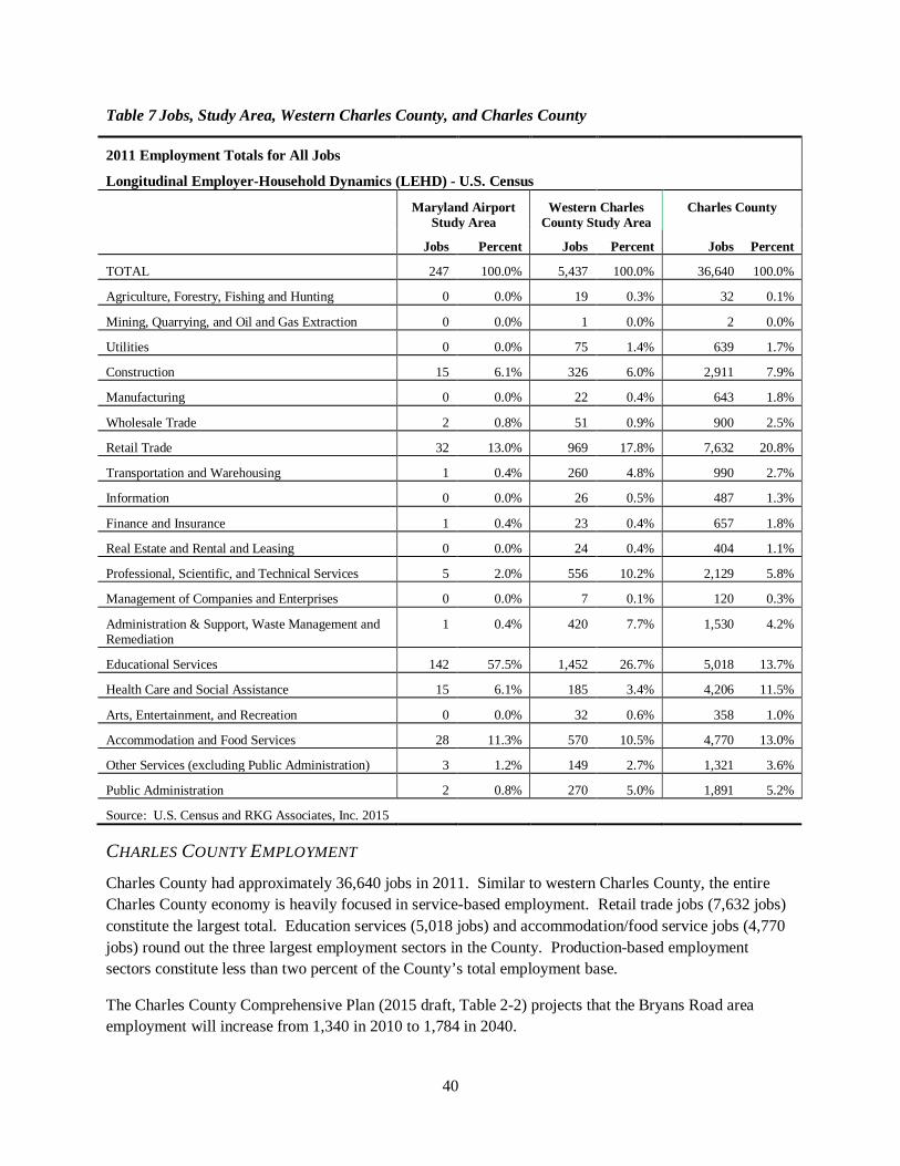
MARYLAND AIRPORT STUDY AREA EMPLOYMENT In 2011, the Maryland Airport study area had approximately 250 permanent jobs (not including the 106 temporary construction jobs at Maryland Airport)16. The majority of these jobs (142 jobs) are education related, due to the presence of JC Parks Elementary School and Matthew Henson Middle School north of Maryland Airport along MD 227. Retail trade and food service jobs account for the next highest amount (60 jobs) because of the retail uses on the south side of MD 210 in Bryans Road (e.g., the CVS Pharmacy). Maryland Airport’s 16 jobs are classified as transportation, other services, and health care (due to MedStar) . See Table 7.
WESTERN CHARLES COUNTY EMPLOYMENT The Census employment (LEHD) data indicate western Charles County had a total of 5,437 jobs in 201117. Education services (1,452 jobs), retail trade (969 jobs), and accommodation/food services (570 jobs) account for the largest shares of jobs. However, these sectors account for a smaller percentage (55%) of all jobs than they do in the Maryland Airport study area (82%). This is primarily due to the greater size and diversity of western Charles County, which includes other employment centers such as Naval Support Facility Indian Head. Production based employment sectors (agriculture, mining, and manufacturing) only account for 44 of the 5,427 jobs in Western Charles County, or less than one percent of the total.
13 Number provided by the airport owner. “Inside the Fence” refers to any economic activity or employment directly related to operations at the airport. Examples include aviation fueling, airplane storage, airplane maintenance & repair, and administration of the airport. 14 Medstar left Maryland Airport in 2013, and now operates out of Washington Executive/Hyde Field in Prince Georges County. 15 Maryland Aviation Administration Economic, Impact of Airports, Final Report 2013
16 U.S. Census data collected from the Longitudinal Employer-Household Dynamics (LEHD) Origin-Destination Employment Statistics database. 17 For the purposes of this analysis, western Charles County is defined as the area west of a one-mile buffer from US 301. This boundary was used to exclude the commercial activity on the western frontage of US 301.
40
Table 7 Jobs, Study Area, Western Charles County, and Charles County
2011 Employment Totals for All Jobs
Longitudinal Employer-Household Dynamics (LEHD) - U.S. Census
Maryland Airport Study Area
Western Charles County Study Area
Charles County
Jobs Percent Jobs Percent Jobs Percent
TOTAL 247 100.0% 5,437 100.0% 36,640 100.0%
Agriculture, Forestry, Fishing and Hunting 0 0.0% 19 0.3% 32 0.1%
Mining, Quarrying, and Oil and Gas Extraction 0 0.0% 1 0.0% 2 0.0%
Utilities 0 0.0% 75 1.4% 639 1.7%
Construction 15 6.1% 326 6.0% 2,911 7.9%
Manufacturing 0 0.0% 22 0.4% 643 1.8%
Wholesale Trade 2 0.8% 51 0.9% 900 2.5%
Retail Trade 32 13.0% 969 17.8% 7,632 20.8%
Transportation and Warehousing 1 0.4% 260 4.8% 990 2.7%
Information 0 0.0% 26 0.5% 487 1.3%
Finance and Insurance 1 0.4% 23 0.4% 657 1.8%
Real Estate and Rental and Leasing 0 0.0% 24 0.4% 404 1.1%
Professional, Scientific, and Technical Services 5 2.0% 556 10.2% 2,129 5.8%
Management of Companies and Enterprises 0 0.0% 7 0.1% 120 0.3%
Administration & Support, Waste Management and Remediation
1 0.4% 420 7.7% 1,530 4.2%
Educational Services 142 57.5% 1,452 26.7% 5,018 13.7%
Health Care and Social Assistance 15 6.1% 185 3.4% 4,206 11.5%
Arts, Entertainment, and Recreation 0 0.0% 32 0.6% 358 1.0%
Accommodation and Food Services 28 11.3% 570 10.5% 4,770 13.0%
Other Services (excluding Public Administration) 3 1.2% 149 2.7% 1,321 3.6%
Public Administration 2 0.8% 270 5.0% 1,891 5.2%
Source: U.S. Census and RKG Associates, Inc. 2015
CHARLES COUNTY EMPLOYMENT Charles County had approximately 36,640 jobs in 2011. Similar to western Charles County, the entire Charles County economy is heavily focused in service-based employment. Retail trade jobs (7,632 jobs) constitute the largest total. Education services (5,018 jobs) and accommodation/food service jobs (4,770 jobs) round out the three largest employment sectors in the County. Production-based employment sectors constitute less than two percent of the County’s total employment base.
The Charles County Comprehensive Plan (2015 draft, Table 2-2) projects that the Bryans Road area employment will increase from 1,340 in 2010 to 1,784 in 2040.
41
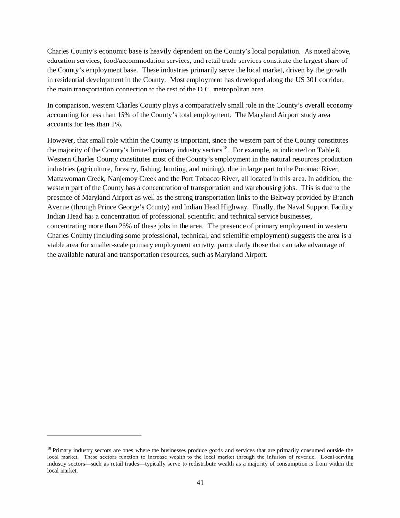
Charles County’s economic base is heavily dependent on the County’s local population. As noted above, education services, food/accommodation services, and retail trade services constitute the largest share of the County’s employment base. These industries primarily serve the local market, driven by the growth in residential development in the County. Most employment has developed along the US 301 corridor, the main transportation connection to the rest of the D.C. metropolitan area.
In comparison, western Charles County plays a comparatively small role in the County’s overall economy accounting for less than 15% of the County’s total employment. The Maryland Airport study area accounts for less than 1%.
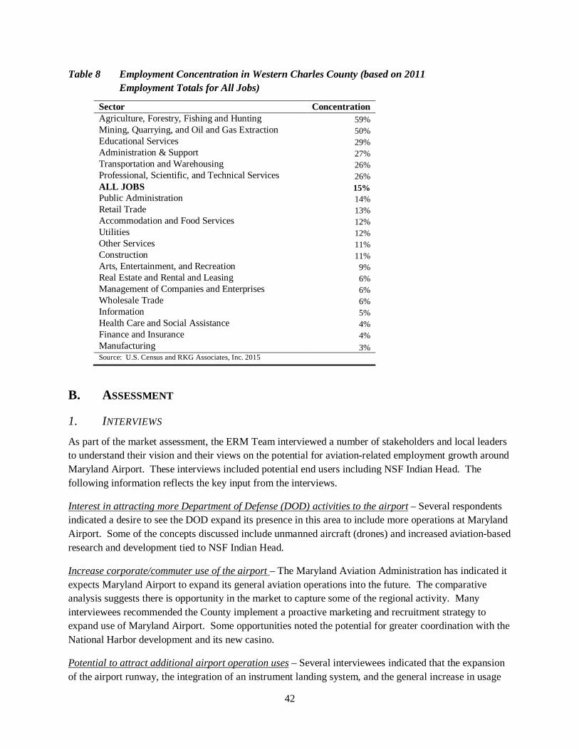
However, that small role within the County is important, since the western part of the County constitutes the majority of the County’s limited primary industry sectors18. For example, as indicated on Table 8, Western Charles County constitutes most of the County’s employment in the natural resources production industries (agriculture, forestry, fishing, hunting, and mining), due in large part to the Potomac River, Mattawoman Creek, Nanjemoy Creek and the Port Tobacco River, all located in this area. In addition, the western part of the County has a concentration of transportation and warehousing jobs. This is due to the presence of Maryland Airport as well as the strong transportation links to the Beltway provided by Branch Avenue (through Prince George’s County) and Indian Head Highway. Finally, the Naval Support Facility Indian Head has a concentration of professional, scientific, and technical service businesses, concentrating more than 26% of these jobs in the area. The presence of primary employment in western Charles County (including some professional, technical, and scientific employment) suggests the area is a viable area for smaller-scale primary employment activity, particularly those that can take advantage of the available natural and transportation resources, such as Maryland Airport.
18 Primary industry sectors are ones where the businesses produce goods and services that are primarily consumed outside the local market. These sectors function to increase wealth to the local market through the infusion of revenue. Local-serving industry sectors—such as retail trades—typically serve to redistribute wealth as a majority of consumption is from within the local market.
42
Table 8 Employment Concentration in Western Charles County (based on 2011 Employment Totals for All Jobs)
Sector Concentration Agriculture, Forestry, Fishing and Hunting 59% Mining, Quarrying, and Oil and Gas Extraction 50% Educational Services 29% Administration & Support 27% Transportation and Warehousing 26% Professional, Scientific, and Technical Services 26% ALL JOBS 15% Public Administration 14% Retail Trade 13% Accommodation and Food Services 12% Utilities 12% Other Services 11% Construction 11% Arts, Entertainment, and Recreation 9% Real Estate and Rental and Leasing 6% Management of Companies and Enterprises 6% Wholesale Trade 6% Information 5% Health Care and Social Assistance 4% Finance and Insurance 4% Manufacturing 3% Source: U.S. Census and RKG Associates, Inc. 2015
B. ASSESSMENT
1. INTERVIEWS As part of the market assessment, the ERM Team interviewed a number of stakeholders and local leaders to understand their vision and their views on the potential for aviation-related employment growth around Maryland Airport. These interviews included potential end users including NSF Indian Head. The following information reflects the key input from the interviews.
Interest in attracting more Department of Defense (DOD) activities to the airport – Several respondents indicated a desire to see the DOD expand its presence in this area to include more operations at Maryland Airport. Some of the concepts discussed include unmanned aircraft (drones) and increased aviation-based research and development tied to NSF Indian Head.
Increase corporate/commuter use of the airport – The Maryland Aviation Administration has indicated it expects Maryland Airport to expand its general aviation operations into the future. The comparative analysis suggests there is opportunity in the market to capture some of the regional activity. Many interviewees recommended the County implement a proactive marketing and recruitment strategy to expand use of Maryland Airport. Some opportunities noted the potential for greater coordination with the National Harbor development and its new casino.
Potential to attract additional airport operation uses – Several interviewees indicated that the expansion of the airport runway, the integration of an instrument landing system, and the general increase in usage
43
of the airport could provide an opportunity to expand on-site services. Some examples include a more robust learn-to-fly program and custom repair/upgrade services.
Have the airport serve and reinforce the Indian Head Science and Technology Park – There is substantial interest from certain groups, such as the County Chamber of Commerce, to see the Indian Head Science and Technology Park be successful. Given the proximity of Maryland Airport to the Park, there is a natural desire to exploit the potential synergies between the two uses, such as goods movement and corporate travel.
Residential development encroachment will harm potential – There was concern expressed from the business community that allowing residential development to occur near the airport would have a negative impact on long-term employment growth in the area. The most referenced concern was that allowing residential development to occur near undeveloped non-residential land has stimulated opposition when that non-residential land was considered for development. Some interviewees suggested that zoning around the airport could be strengthened to preserve the area for employment growth without adversely impacting the potential for new residential development elsewhere in the area.
Recognize that not all opportunities/goals are viable today – Many of the airport supporters recognize that portions of the economic vision for the airport area are not viable today. These respondents expressed a desire for the County to protect the land already designated for employment-generating uses, either through expanding the non-residential zoning boundaries or placing a development overlay that would prohibit incompatible uses from being developed in proximity to the airport or its flight path.
Enable the expansion of the airport runway – A number of the airport supporters within Charles County expressed support for Maryland Airport to build its maximum potential length runway to further increase its appeal to attract greater economic activity.
Limited effort to promote economic development in western Charles County – One of the challenges identified through the interview process was the perceived lack of a holistic economic development vision for the Maryland Airport area. Several respondents stated there is little effort being done to market western Charles County for employment-based development. They recommend greater investment in the airport and supporting infrastructure, and a countywide strategic economic development plan.
2. GENERAL AVIATION AIRPORT COMPARISON The Washington DC Metropolitan area is home to three international airports (Baltimore-Washington International, Dulles International, and Reagan National) and several general aviation airports. To better understand the development and development potential around airports such as Maryland Airport, the ERM team gathered information on comparative airports in the area. The airports were selected for comparison based on two criteria:
• They are located within the Washington, D.C.-Arlington-Alexandria Metropolitan Statistical Area;
• They are Federal Aviation Administration-designated reliever airports. Reliever airports, typically located in major metropolitan areas, divert general aviation activity from larger commercial service airports, such as Ronald Reagan Washington National Airport, minimizing delay and congestion.
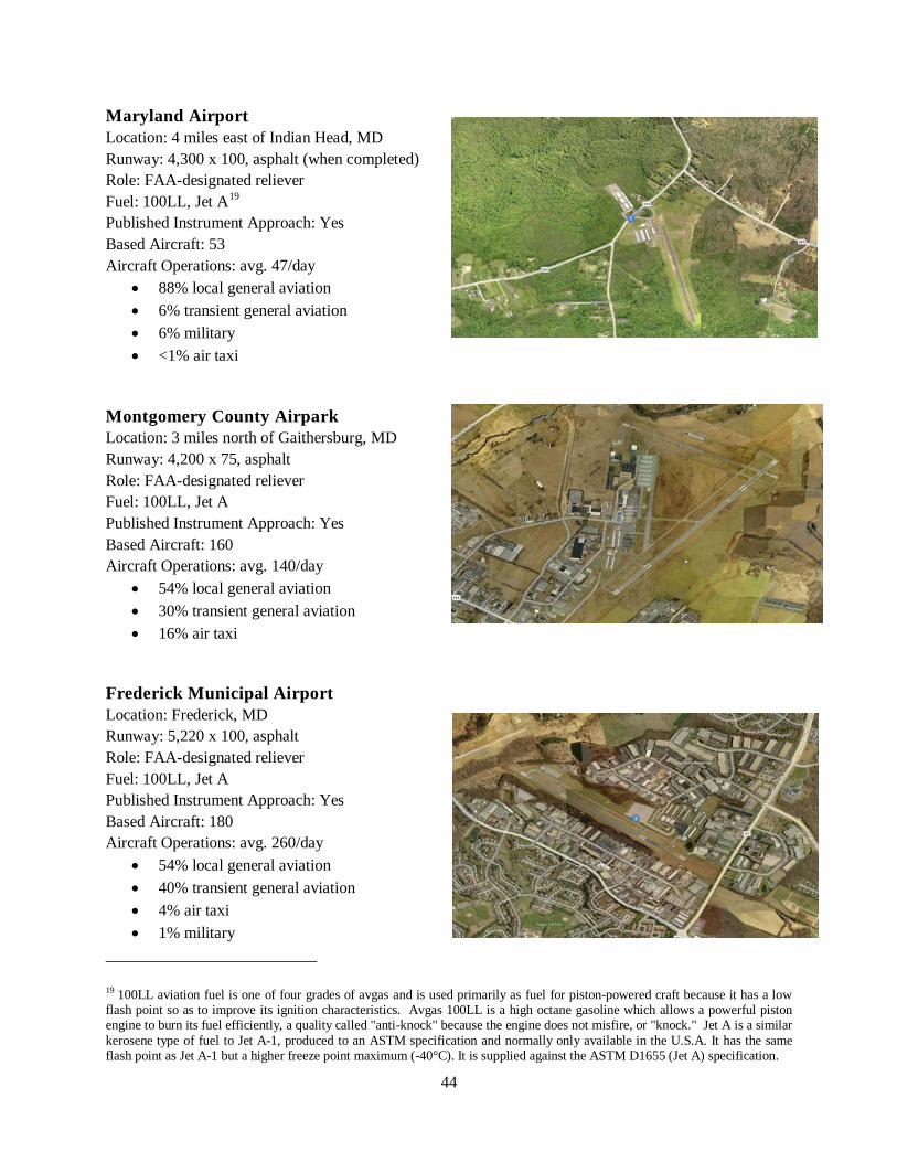
44
Maryland Airport Location: 4 miles east of Indian Head, MD Runway: 4,300 x 100, asphalt (when completed) Role: FAA-designated reliever Fuel: 100LL, Jet A19 Published Instrument Approach: Yes Based Aircraft: 53 Aircraft Operations: avg. 47/day
• 88% local general aviation • 6% transient general aviation • 6% military • <1% air taxi
Montgomery County Airpark Location: 3 miles north of Gaithersburg, MD Runway: 4,200 x 75, asphalt Role: FAA-designated reliever Fuel: 100LL, Jet A Published Instrument Approach: Yes Based Aircraft: 160 Aircraft Operations: avg. 140/day
• 54% local general aviation • 30% transient general aviation • 16% air taxi
Frederick Municipal Airport Location: Frederick, MD Runway: 5,220 x 100, asphalt Role: FAA-designated reliever Fuel: 100LL, Jet A Published Instrument Approach: Yes Based Aircraft: 180 Aircraft Operations: avg. 260/day
• 54% local general aviation • 40% transient general aviation • 4% air taxi • 1% military
19 100LL aviation fuel is one of four grades of avgas and is used primarily as fuel for piston-powered craft because it has a low flash point so as to improve its ignition characteristics. Avgas 100LL is a high octane gasoline which allows a powerful piston engine to burn its fuel efficiently, a quality called "anti-knock" because the engine does not misfire, or "knock." Jet A is a similar kerosene type of fuel to Jet A-1, produced to an ASTM specification and normally only available in the U.S.A. It has the same flash point as Jet A-1 but a higher freeze point maximum (-40°C). It is supplied against the ASTM D1655 (Jet A) specification.
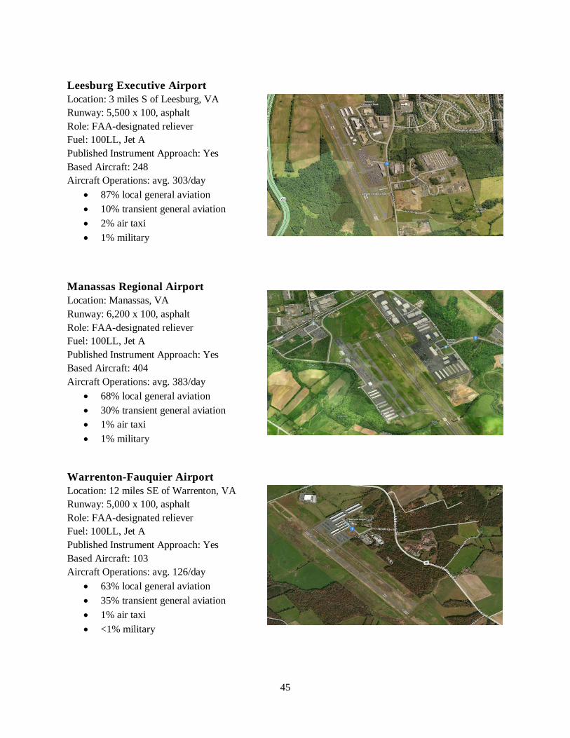
45
Leesburg Executive Airport Location: 3 miles S of Leesburg, VA Runway: 5,500 x 100, asphalt Role: FAA-designated reliever Fuel: 100LL, Jet A Published Instrument Approach: Yes Based Aircraft: 248 Aircraft Operations: avg. 303/day
• 87% local general aviation • 10% transient general aviation • 2% air taxi • 1% military
Manassas Regional Airport Location: Manassas, VA Runway: 6,200 x 100, asphalt Role: FAA-designated reliever Fuel: 100LL, Jet A Published Instrument Approach: Yes Based Aircraft: 404 Aircraft Operations: avg. 383/day
• 68% local general aviation • 30% transient general aviation • 1% air taxi • 1% military
Warrenton-Fauquier Airport Location: 12 miles SE of Warrenton, VA Runway: 5,000 x 100, asphalt Role: FAA-designated reliever Fuel: 100LL, Jet A Published Instrument Approach: Yes Based Aircraft: 103 Aircraft Operations: avg. 126/day
• 63% local general aviation • 35% transient general aviation • 1% air taxi • <1% military
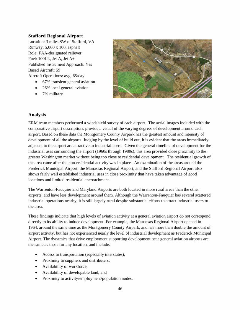
46
Stafford Regional Airport Location: 3 miles SW of Stafford, VA Runway: 5,000 x 100, asphalt Role: FAA-designated reliever Fuel: 100LL, Jet A, Jet A+ Published Instrument Approach: Yes Based Aircraft: 59 Aircraft Operations: avg. 65/day
• 67% transient general aviation • 26% local general aviation • 7% military
Analysis
ERM team members performed a windshield survey of each airport. The aerial images included with the comparative airport descriptions provide a visual of the varying degrees of development around each airport. Based on these data the Montgomery County Airpark has the greatest amount and intensity of development of all the airports. Judging by the level of build out, it is evident that the areas immediately adjacent to the airport are attractive to industrial users. Given the general timeline of development for the industrial uses surrounding the airport (1960s through 1980s), this area provided close proximity to the greater Washington market without being too close to residential development. The residential growth of the area came after the non-residential activity was in place. An examination of the areas around the Frederick Municipal Airport, the Manassas Regional Airport, and the Stafford Regional Airport also shows fairly well established industrial uses in close proximity that have taken advantage of good locations and limited residential encroachment.
The Warrenton-Fauquier and Maryland Airports are both located in more rural areas than the other airports, and have less development around them. Although the Warrenton-Fauquier has several scattered industrial operations nearby, it is still largely rural despite substantial efforts to attract industrial users to the area.
These findings indicate that high levels of aviation activity at a general aviation airport do not correspond directly to its ability to induce development. For example, the Manassas Regional Airport opened in 1964, around the same time as the Montgomery County Airpark, and has more than double the amount of airport activity, but has not experienced nearly the level of industrial development as Frederick Municipal Airport. The dynamics that drive employment supporting development near general aviation airports are the same as those for any location, and include:
• Access to transportation (especially interstates); • Proximity to suppliers and distributers; • Availability of workforce; • Availability of developable land; and • Proximity to activity/employment/population nodes.
47
The Frederick Municipal Airport is located within a large industrial district that is conveniently served by I-70. In contrast, the Montgomery County Airpark is several miles from the I-270 business corridor and surrounded by residential development. However, location and development activity also influence the success of non-residential development around a general aviation airport. In Montgomery County Airpark’s case, the development dynamics in Gaithersburg have been heavily impacted by the rapid growth that has characterized Montgomery County over the past several decades. This substantial development activity created demand for industrial services to meet the needs of the growing area. As a result, almost all of the “outside the fence” industrial activity at Montgomery County Airpark is community serving (such as business-to-business services, automotive repair, and childcare) that have little or no connection to the Airport. To this point, the Montgomery County Airpark stands as a prime example of a general aviation airport industrial park that has benefitted from a convenient location rather than access to an airport.
3. COMPETITIVE ANALYSIS The ERM Team combined the findings from analyses above with other input including a market analysis for the Indian Head Science and Technology Park (IHSTP) that Charles County completed in Fall 201420. That analysis included an absorption analysis for office and industrial uses for a 15-mile radius driving distance market area around the IHSTP. Based on this and on public input during the outreach process, we identify the strengths, weaknesses, opportunities and threats for employment development in the study area.
STRENGTHS • Proximity to major markets – The Maryland Airport study area is within a 20-30 mile drive of
most of Washington DC’s major employment centers, including downtown Washington DC, Prince George’s County, and Fairfax County. The study area is adjacent to Indian Head Highway (MD 210), which provides a direct connection (albeit with a number of traffic signals) to National Harbor and the Capital Beltway. This proximity contributes to the marketability of Maryland Airport as a convenient alternative to other general aviation facilities in the greater Washington DC metropolitan market.
• Expanded runway and instrument landing capabilities – The new 4,300 foot runway expands the type of aircraft that can use Maryland Airport. Having an instrument landing system is an asset not shared by all regional general aviation facilities. Not only does it make landing more convenient for pilots and the airport operator, it expands the potential operation period since the control tower does not need to be manned for instrument landings.
• Available, developable land nearby – The County has more than 1,250 acres in the study area zoned for employment/commercial and mixed use development. Of this total, more than 800 acres remain undeveloped. Of these, approximately 675 acres are zoned for employment or industrial use including the 265-acre Indian Head Science and Technology Park. While some of this land includes environmentally sensitive resources that need to be protected, the study area can accommodate a substantial amount of new employment-based development.
20 Market Analysis and Due Diligence Services for the Indian Head Science and Technology Park, Jones Lang LaSalle Americas, Inc., October 2, 2014.
48
• Limited encroachment from residential – Currently, there is limited encroachment on Maryland Airport from residential development. While there are some residential units within immediate proximity of the airport, the predominance of land in the study area is not developed as housing. The study’s public engagement process revealed the challenges of incompatibility of residential and airport uses, as some residents within the study area expressed opposition to expanding the use and potential of Maryland Airport.
• Federal Aviation Administration (FAA) investments at Maryland Airport – Approximately $20 million of federal money is being invested in Maryland Airport as part of the ongoing improvements. FAA funding is very competitive, and receiving such an investment proves sustainability/function of Maryland Airport within the regional market in the eyes of the federal government.
• Statewide commitment to manufacturing expansion – Based on feedback from the Maryland Office of Military Affairs of the Department of Business and Economic Development (DBED), the strong national initiative to ‘Manufacture in America’ and the state initiative to manufacture in Maryland and bring jobs to Maryland provide ample opportunity to attract investment to the Maryland Airport Study Area. The DBED also believes Maryland Airport benefits from offers an abundant technical talent pool both working and living in the area as well as proximity to Washington DC.
WEAKNESSES
• Located within the Washington DC Special Flight Rules Area (SFRA) – While the FAA sees Maryland Airport as a vital asset, it must work within the SFRA rules. The SFRA substantially restricts operational uses including unmanned aircraft, flight training, skydiving, and model aircraft. Furthermore, entities that wish to fly into the SFRA are required to provide substantial background checks on staff. To these points, the current rules in place limit the potential of some of the desired opportunities, such as expanding skydiving or learn-to-fly. The County and Maryland Airport will need to work closely with FAA officials to overcome some of these obstacles. Efforts will likely also require assistance from the MAA, and the Maryland Department of Business and Economic Development (DBED).
• Little land on airport to accommodate future growth – While there is a large amount of land available for employment growth in the study area, the airport proper has little undeveloped and useable land for additional activity “inside the fence.” This limitation will require airport leadership to be more efficient in the use of the airport’s real estate, and likely will limit how much on-site activity can occur from an employment generation perspective.
• Separation from “outside the fence” employment land – Most of the approximately 675 acres of undeveloped employment-zoned land is separated from Maryland Airport by natural and man-made barriers. On the east side of the airport, there is a substantial grade difference, making direct connections for aircraft difficult. On the north and west sides, the Airport is separated from
49
assets such as IHSTP by MD 224, severely limiting the potential development of aviation-based businesses in the Park21.
• Access challenges – Access to the study area is limited to north-south connectivity (MD 210). The lack of connectivity to Fairfax County across the Potomac River limits the ease of use of the airport due to the frequent traffic congestion issues of I-495 and the Woodrow Wilson Bridge. Additionally, the predominance of activity in Charles County is concentrated along US 301. East-west connectivity to US 301 exists, but it is not convenient or direct.
• Environmental challenges – The Maryland Airport study area is located within the Mattawoman Creek watershed. The area has a number of environmental sensitivities that must be considered/mitigated for development to occur. For example, there is a Wetland of Special State Concern that bisects the Indian Head Science and Technology Park that reduces the overall development footprint in the park.
• Military/federal government well served for DC-based operations – Based on interviews with NSF Indian Head and Maryland Department of Business and Economic Development Office of Military Affairs representatives with knowledge of the region’s military operations, there are limited existing opportunities to expand government/military presence in the Maryland Airport study area. The military facilities at Patuxent River Naval Air Station, Joint Base Andrews, and Dahlgren are currently meeting the DOD’s needs and have capacity to expand operations if necessary. The NSF Indian Head does not currently have an aviation-based need and has capacity to accommodate non-aviation operations on the facility.
Long-term opportunities are uncertain. The DOD has been implementing realignment measures for military operations since 1995. Charles County has successfully supported NSF Indian Head in the past, but future Base Realignment and Closure (BRAC) initiatives could result in changes.
THREATS • Residential encroachment could undermine future opportunities – Proximal residential
development and airport operations are incompatible. The realities and perceptions of safety and comfort for residents may extend to airport-dependent employment and create nuisance challenges. Residential encroachment is such a concern, that the Federal Aviation Administration’s (FAA) Southern Region Airports Division convened a Task Force to develop specific regulation recommendations for jurisdictions to implement to reduce incompatibility issues. The results of this initiative has led to a number of FAA programs aimed at ensuring compatibility of development around airports.
• Economic development is competitive – As observed by interview respondents, there is not a well-defined economic vision for western Charles County or of the Maryland Airport area and this creates uncertainty for investment.
• Expansion to 5,000 foot runway costly – An expansion of the runway to 5,000 feet would increase the range of aircraft that can use Maryland Airport, but would be very costly given the topographic and environmental mitigation that would need to occur. Further, the expansion of the
21 Aviation businesses prefer direct connection with hangar and runway assets. It would be very challenging—both physically and financially—to create a “crossover” from IHSTP to the Airport.
50
runway to 4,300 is not yet complete, making further expansion a long-term vision. However, the potential to fit a 5,000 foot runway on the airport property appears possible.
• Funding not yet identified for full Master Plan build out– Funding for complete implementation of the 1999 Airport Master Plan improvements is not secure. The current airport ownership has indicated it does not have the resources to implement 100% of the proposed improvements. Most notably, the terminal building improvements are a critical component of the potential increase in use of Maryland Airport but do not have an identified funding source to complete them. The building’s current aesthetic condition and lack of amenities likely will limit the potential expansion of aviation operations at Maryland Airport. Therefore, looking into cost sharing options and partnerships with developers could potentially be beneficial.
OPPORTUNITIES The most immediate opportunity for Maryland Airport is focused on “inside the fence” activities. Once the current expansion plan is complete, the Airport will have more high-quality facilities and amenities (e.g., instrument landing) that will attract more operations. From an “outside the fence” perspective, the current expansion program for Maryland Airport does not create enough uniqueness in the metropolitan Washington D.C. market that would generate substantial demand based solely on the Airport operations. That said, Maryland Airport is a strategic asset that should be incorporated as part of a larger economic development marketing and recruitment effort. The IHSTP market analysis notes that Maryland Airport is one of the features that sets the IHSTP apart from some regional competitors. To this point, “outside the fence” opportunities could manifest through a stronger economic development marketing campaign.
• Expanded aviation operations – The MAA projects that Maryland Airport will experience a 70 percent increase in operations (to 80 operations daily) by 2019 due to the airport expansion as well as natural growth of demand in the market. This increased “inside the fence” activity will create demand for greater fuel purchases, airplane storage, and aircraft maintenance. Specific opportunities include strategic partnerships with National Harbor and MGM in accommodating small craft activity related to the proposed casino, taking advantage of airport expansion plans that include expanded hangar, tie down, and operation accommodations.
• Destination dining facility – There are a number of airport-located dining venues throughout the U.S. that are successful at serving both airport patrons/employees as well as the community at large. The current airport operator owns land adjacent to the Airport property with good views of the newly expanded runway. This site is well situated to accommodate a destination dining venue. Such a destination concept would have a greater chance of success if operated by a regionally renowned chef/restauranteur due to the site’s location away from a highly trafficked area.
4. POTENTIAL ABSORPTION The IHSTP market analysis found that demand from employment-based uses has been steady, but modest, within its defined market area (15-mile driving distance). The market analysis included a future development absorption analysis. While focused on the IHSTP, its analysis is relevant for the Airport study area, given the proximity of the two sites and regional nature of business recruitment and
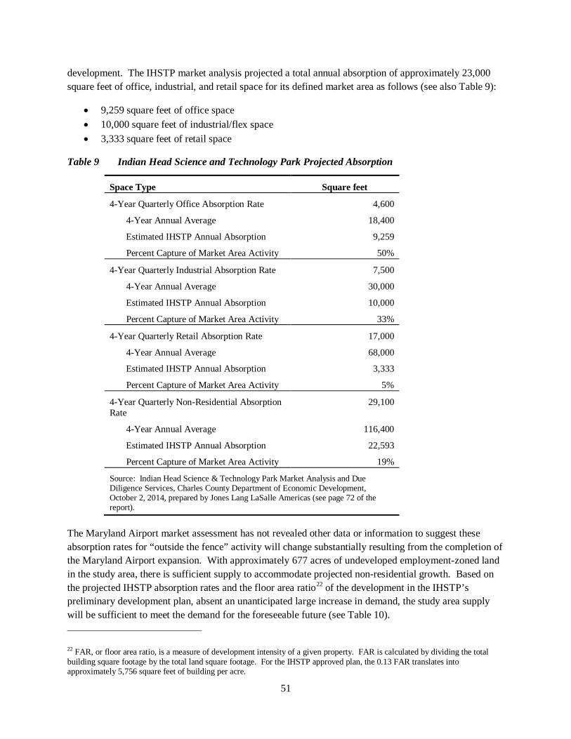
51
development. The IHSTP market analysis projected a total annual absorption of approximately 23,000 square feet of office, industrial, and retail space for its defined market area as follows (see also Table 9):
• 9,259 square feet of office space • 10,000 square feet of industrial/flex space • 3,333 square feet of retail space
Table 9 Indian Head Science and Technology Park Projected Absorption
Space Type Square feet
4-Year Quarterly Office Absorption Rate 4,600
4-Year Annual Average 18,400
Estimated IHSTP Annual Absorption 9,259
Percent Capture of Market Area Activity 50%
4-Year Quarterly Industrial Absorption Rate 7,500
4-Year Annual Average 30,000
Estimated IHSTP Annual Absorption 10,000
Percent Capture of Market Area Activity 33%
4-Year Quarterly Retail Absorption Rate 17,000
4-Year Annual Average 68,000
Estimated IHSTP Annual Absorption 3,333
Percent Capture of Market Area Activity 5%
4-Year Quarterly Non-Residential Absorption Rate
29,100
4-Year Annual Average 116,400
Estimated IHSTP Annual Absorption 22,593
Percent Capture of Market Area Activity 19%
Source: Indian Head Science & Technology Park Market Analysis and Due Diligence Services, Charles County Department of Economic Development, October 2, 2014, prepared by Jones Lang LaSalle Americas (see page 72 of the report).
The Maryland Airport market assessment has not revealed other data or information to suggest these absorption rates for “outside the fence” activity will change substantially resulting from the completion of the Maryland Airport expansion. With approximately 677 acres of undeveloped employment-zoned land in the study area, there is sufficient supply to accommodate projected non-residential growth. Based on the projected IHSTP absorption rates and the floor area ratio22 of the development in the IHSTP’s preliminary development plan, absent an unanticipated large increase in demand, the study area supply will be sufficient to meet the demand for the foreseeable future (see Table 10).
22 FAR, or floor area ratio, is a measure of development intensity of a given property. FAR is calculated by dividing the total building square footage by the total land square footage. For the IHSTP approved plan, the 0.13 FAR translates into approximately 5,756 square feet of building per acre.
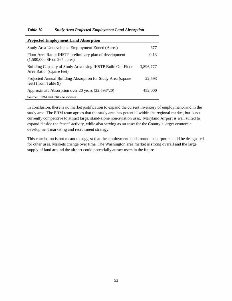
52
Table 10 Study Area Projected Employment Land Absorption
Projected Employment Land Absorption
Study Area Undeveloped Employment-Zoned (Acres) 677
Floor Area Ratio: IHSTP preliminary plan of development (1,500,000 SF on 265 acres)
0.13
Building Capacity of Study Area using IHSTP Build Out Floor Area Ratio (square feet)
3,896,777
Projected Annual Building Absorption for Study Area (square feet) (from Table 9)
22,593
Approximate Absorption over 20 years (22,593*20) 452,000 Source: ERM and RKG Associates
In conclusion, there is no market justification to expand the current inventory of employment-land in the study area. The ERM team agrees that the study area has potential within the regional market, but is not currently competitive to attract large, stand-alone non-aviation uses. Maryland Airport is well suited to expand “inside the fence” activity, while also serving as an asset for the County’s larger economic development marketing and recruitment strategy.
This conclusion is not meant to suggest that the employment land around the airport should be designated for other uses. Markets change over time. The Washington area market is strong overall and the large supply of land around the airport could potentially attract users in the future.
53
VII. CONCLUSIONS AND RECOMMENDATIONS The conclusions and recommendations provided in this section are based on the information, analysis and assessments in preceding sections of this report and are framed to meet the County’s objectives in undertaking this Study (see Introduction).
A. PROVIDE LAND-USE STANDARDS THAT ADDRESS SAFETY HAZARDS AND NOISE
CONCLUSIONS
Safety Safety around airports is addressed through the Runway Protection Zones, which must be under airport control, and through height limits that prevent obstructions to air space.
The Maryland Aviation Administration recommends that zoning requirements be adopted complying with COMAR 11.03.05, Obstructions to Air Navigation. This section of COMAR identifies two types of obstructions:
• Objects greater than 200 feet above ground level and within 3 nautical miles of the established reference point of any public-use airport licensed by the Administration; or
• Objects that penetrate any imaginary surface for a particular airport. These imaginary surfaces are too complex for the height limitations to be placed in a Zoning Ordinance; in the areas where the height limitation could conceivably impact a building of normal height, the ground is owned by Maryland Airport or the airport holds an “avigation easement” that allows it to control height.
Although buildings at the heights permitted by Charles County will not present an obstruction to air traffic around Maryland Airport, there is a possibility that utility structures such as communication towers or water towers could be affected.
Noise The FAA establishes the 65 Ldn decibel level to define a regulatory “noise impact” for an airport. Around Maryland Airport this noise level occurs, appropriately, within industrial or employment zoning districts – see Map 3 above. However, noise from aircraft will be heard outside of this contour line and may be perceived as intrusive by some people. In local regulations, this impact is addressed by some jurisdictions through notification requirements, to ensure that potential purchasers of property are made aware that they will be near an airport.
An issue raised by several people commenting on the noise from Maryland Airport noted the presence of an elementary and middle school approximately 0.5 miles from the airport, and the potential impact of aircraft noise on outside classes and activities. While there is no formal regulatory means of addressing this issue, and the two land uses (airport and schools) are established in their current locations, communication with the airport manager would be the best means of addressing any conflicts that do occur. Airports are able to change flight paths during certain hours to address particular noise conflicts.
54
The following is a summary of the requirements of several other jurisdictions in Maryland.
Sample Overlay Zoning Requirements in Maryland Talbot County, MD: Airport Overlay Zone extends two miles from runway centerline. Notification required on plats and site plans. All structures must be reviewed by airport manager; County must consider the comments of the manager of the Easton Airport and place conditions on structures; County must provide the applicant with Federal Aviation Administration Form “Notice of Proposed Construction or Alteration” or the equivalent FAA form.
Salisbury, MD: Within the Airport District: Notification required on plats and site plans. No structure or tree allowed that violates height restrictions: 1. Airport Approach Zones: heights permitted in the official master plan for the airport and illustrated on profiles contained in the plan for the airport 2. Airport Turning Zone. Not in excess of one hundred fifty (150) feet above ground level. This restriction applies within the seven-thousand-foot radius established as the turning zone for the Salisbury-Wicomico County Airport at the time of enactment of this title and shall apply within any future radius established thereafter that may extend within the corporate limits of Salisbury.
Montgomery County, MD: Requires disclosure of location of airport within five-mile radius of property when selling real property. The height of any structure must provide a clear glide path from the end of the usable landing strip. The glide path is established in the airport's conditional use approval.
RECOMMENDATIONS 1. Adopt and map an Airport Overlay Zone with boundaries extending three miles from the
runway centerline. Within this zone:
o Within two miles of the airport, all proposed structures taller than 100 feet must be referred to MAA and receive a “favorable airspace determination.”
o Between two and three miles of the airport, all proposed structures taller than 200 feet must be referred to MAA and receive a “favorable airspace determination.”
o Authorize the County to deny a building permit for a structure that the MAA determines would intrude on the airport imaginary surfaces.
o Within three miles of the airport, provide a public notification requirement consisting of notification on final plats and site plans that the property is close to a general aviation airport. If the County wishes to provide more stringent notification requirements, add a requirement to Section 265 of the County Code requiring notice as part of all real estate transactions. The requirement would be similar to current Section 265-4, which states:
"Buyer is advised that the property is located near a military installation that conducts flight operations, munitions testing, and military operations that may result in high noise levels."
2. Assist in establishing lines of communication between the schools and the airport manager that provide the schools with a means of working with the airport manager to resolve any specific conflicts between airport noise and outdoor school activities.
55
B. PREVENT ENCROACHMENT OF INCOMPATIBLE LAND USES AROUND MARYLAND AIRPORT
CONCLUSIONS The mix of employment and rural zoning in the vicinity of the airport is an appropriate combination of land uses to limit incompatible land uses. Although airports operate in many types of environs, it is desirable where possible to limit residential land uses, which are the most susceptible to annoyance from noise. An appropriate amount of employment land provides for businesses supportive of, or attracted by, the airport services.
Although the rural lands in the study area are currently mostly zoned RC(Deferred), the proposed Comprehensive Plan (draft January 2015) would change the status of these lands to a Watershed Conservation land use, indicating long term low-density, rural development.
The residential land uses established through county plans and current zoning for the Bryans Road community are at least 0.5 miles from the airport. Although there is no standard distance recommended between urban or suburban residential development and general aviation airports, the County as a matter of policy should prevent residential growth areas from being established closer to the airport than permitted by the existing zoning pattern.
RECOMMENDATIONS 3. Implement the land use policies indicated by the proposed Comprehensive Plan through
adoption of a Watershed Conservation zoning district with density no greater than one dwelling unit per ten acres.
4. Revise the proposed Comprehensive Plan land use map to designate several properties near the airport for Employment use rather than Development District Residential use.
These properties, on the east side of Bumpy Oak Road and at the intersection of MD 227/MD 224/Bumpy Oak Road, are in the Development District Residential land use category on the current (2006) and proposed (2015) Comprehensive Plan land use map. In spite of the residential designation on the plan, they are in the BP (Business Park) zoning district. The properties are currently improved by homes and churches. The residences are nonconforming uses in the BP zone and can remain in residential use. However, if redevelopment occurs, business uses would be more appropriate than residential in such close proximity to the airport.
C. ENSURE GROWTH OF AVIATION-COMPATIBLE ECONOMIC DEVELOPMENT NEAR MARYLAND AIRPORT.
CONCLUSIONS
Land Use Patterns and Land Inventory
The land inventory and current zoning within the study area provides extensive opportunity for airport-related development. Office development that would take advantage of potential corporate jet traffic is permitted in the IG, BP and PEP zones. A large inventory (approximately
56
675 acres) of undeveloped, employment-zoned land, relatively free of environmentally sensitive areas, is located around the airport. Additional undeveloped land with mixed use zoning is in Bryans Road.
The employment land with the best regional road access is located along MD 210, including the Indian Head Science and Technology Park and the mixed use, employment-focused land within the Bryans Road Community (the CER, Core Employment Residential zone). The IG and BP-zoned land adjacent to the airport is accessed via two-lane, rural roads that would require improvement to handle any significant increase in employment use.
The market analysis performed for this Study (see Section VI) indicates a large supply of employment land in the vicinity of the airport. Therefore, this Study does not recommend that any additional land be designated for employment use at this time. However, in the long term, the inventory of available employment land, with the ready access provided by MD 210 and potential for service with public water and sewer, is an asset that should not be quickly discarded. The County should consider retaining the Indian Head Science and Technology Park in its current PEP zoning designation as a long term economic development asset. Should demand for employment land increase faster than this Study projects, consideration should be given to designating land northeast of the Airport, north of the intersection of MD 227 and Ray Road. However, no additional land should be designated without roads adequate to handle the traffic.
If the County does opt to rezone the IHSTP for more rapid development, the portion south of the existing suburban residential development, west of Pomonkey, (i.e., the area close to the airport) should be placed in Watershed Conservation zoning.
Revision to Zoning Regulations
Although there is an ample supply of employment-zoned land in the airport vicinity, the opportunity for services directly related to airport operations is limited. Revisions to the zoning regulations are recommended to address the potential need for aircraft servicing businesses and automobile rental. Restaurants, which the market assessment identified as a potential airport-related business, are permitted in the IG zone.
The BP zone serves a valuable purpose for land around the airport, potentially allowing office uses and uses supportive of the airport, while providing a buffer between the more intensive IG zone and the rural/resource protection areas. However, the BP parcels are isolated and cannot meet the intent of the zone, which refers to the development of planned office parks. The County may wish to reconsider the purposes of this zone, or create an office zone without the planned development purpose, to provide for the parcels around the airport without the conflict between the purpose of the zone and the way it is used in the study area.
57
RECOMMENDATIONS
Land Use
5. Do not designate additional land for employment use at this time.
6. Retain the Indian Head Science and Technology Park in its current PEP zoning designation as a long term economic development asset. If the County opts to change the designation for other development, designate the southern portion of the site as watershed conservation.
Zoning
7. Allow aircraft repair, servicing and supplies within the IG zone, only on land that is adjacent to a general aviation airport, within an airport overlay zone.
8. Allow vehicle rental businesses in the BP and IG zones, only on land adjacent to a general aviation airport.
9. Consider creation of a zoning district with uses and standards similar to the BP zone, but not focused on development of a unified office park. Include site design standards to ensure landscaping along road frontages, landscaped buffers for adjacent rural or residential zones, and environmental standards where a zoning district includes or abuts streams, wetlands or floodplains.
D. ASSESS FUTURE DEVELOPMENT WITH RESPECT TO THE MATTAWOMAN CREEK WATERSHED.
CONCLUSIONS The objective of protecting the airport from encroachment of residential land use is accomplished by the County’s designation of surrounding land in the Tier 4 category and designating it “Watershed Conservation” for protection of the Mattawoman Creek stream valley. This land use policy, when implemented through zoning, will protect the airport while also protecting the stream valleys from impacts of suburban or urban development.
The IG zoning along Ray Road to the east of the airport presents concerns about potential impacts on Mattawoman Creek. Portions of these sites are at a relatively high elevation above the stream valley. However, the rear of the sites on the south side of Ray Road consist of forested slopes that descend steeply to the Mattawoman floodplain. Only the floodplain area is protected by the County’s Resource Protection Overlay zoning district. The land uses permitted in the IG zone, and the contractor storage yard uses that have located on at least two of the parcels on Ray Road, raise concerns about potential contaminants in stormwater run-off from these sites.
The means of addressing this issue would have County-wide implications and are beyond the scope of this Study. The recommendation below is for the county’s consideration in coordination with county-wide updates to zoning ordinance and forest conservation or stormwater programs.
58
RECOMMENDATIONS 10. Adopt environmental buffer standards specific to industrial zoning districts where
industrial zoning includes or abuts streams, wetlands or floodplains.
E. EXPLORE POTENTIAL RETURN ON INVESTMENT FOR SEWER LINE EXTENSION
CONCLUSIONS A sewer line extension is in design. As of 2013, estimates ranged from approximately $0.99 million to $3.3 million depending on the features and area served.
The return on investment is potentially large, especially based on the lower cost alternative. For example, one employment-zoned improved property in the study area currently pays approximately $30,000 per year in property taxes. Property with sewer tends to have a higher assessed value which would increase taxes.
From an economic development perspective, public sewer is very important. The preliminary plan for the IHSTP was predicated on availability of sewer. Without sewer the study area will be much less attractive to employment development.
Sewer is also safer for the environment since wastewater will be treated at a wastewater treatment plant rather than by infiltration.
RECOMMENDATIONS 11. If the County opts to retain the Indian Head Science and Technology Park as a long term
economic development asset, make public sewer available to the property.
F. DEVELOP A MARKETING STRATEGY TO PROMOTE THE AIRPORT AND NEARBY COMMERCIAL/EMPLOYMENT DEVELOPMENT
CONCLUSIONS Most of the economic activity that will occur due to the airport expansion will manifest in increased air traffic at the airport. This increased traffic likely will increase fuel sales, drive demand for additional plane storage, and increase maintenance demand. Short term demand for commercial/employment development in land surrounding the airport is small.
RECOMMENDATIONS 12. Explore the creation of a public/private partnership to fund terminal
improvement/expansion. The existing facility lacks many of the amenities corporate travelers seek. An improved terminal facility will increase the potential for corporate travel.
One possible partnership arrangement would be a joint investment between the County and the airport operator. However, a partnership between the airport operator, the County, and a third
59
party vendor is possible. This latter approach would require a revenue sharing model that incents the third party vendor to invest/manage the terminal facility (such as a destination restaurant).
13. Explore proactive marketing and outreach efforts. The effort would increase awareness of the Airport and its new assets. Targets would include Washington D.C. metropolitan corporations including National Harbor and MGM executives. Direct efforts (e.g., targeted mailings) and indirect efforts (such as print advertising) should be considered. Partners could include the Airport itself, Charles County Chamber of Commerce, and the Western Charles County Business Association.
14. Explore the potential to modify or seek exceptions to Special Flight Rules Area (SFRA) rules. The modifications sought would range from allowing model aircraft on site to allowing unmanned aircraft operations. Maryland Airport, Charles County and the MAA would need to work with the FAA to pursue this.
60
APPENDIX 1. ZONING REQUIREMENTS FOR GENERAL AVIATION
AIRPORTS Charles County Zoning Ordinance
4.05.220 General aviation airport. [Added 11-7-1995 by Ord. No. 95-97]
This use is permitted with conditions in the IG Zone subject to the following:
A. Minimum area: 200 acres.
B. The site is located on property which is on or adjacent to an existing general aviation airport that currently services 20 or more aircraft.
C. An aircraft landing area must meet the standards established by the Maryland Aviation Administration and, at a minimum, the standards set forth in the Federal Aviation Advisory Circular AC 150/√15300, Airport Design, as may be amended.
D. A site plan shall be submitted for approval by the Zoning Officer. In addition to the requirements set forth in Appendix A, the plan must show the following:
(1) Setback areas, including screening and fencing.
(2) Portion of tract being used.
(3) Existing and proposed structures and major mechanical equipment.
(4) Existing and proposed access roads.
(5) Any noise control measures provided.
(6) Points of access to the site which may be potentially hazardous and provisions to control unauthorized entry to the site shall be addressed.
(7) Environmental features, including steep slopes, hydric and erodible soils, wetlands, one-hundred- year floodplain, and forested areas.
(8) Historic and archeological resources, including sites not previously identified, shall be identified and described as to how these resources will be preserved.
(9) All operations on site, including outdoor storage of machinery and equipment, may be required to be buffered from any adjoining land or public street. The applicant shall submit plans showing the location and type of any proposed buffering material.
E. All operations shall be conducted in a safe manner with respect to hazard to persons, physical or environmental damage to lands and improvements.
F. The decibel reading does not exceed 70 dB(A) at the property line. The method of measurement shall be governed by § 297-32, Noise, of the Zoning Ordinance.
61
G. Appropriate airport accessory uses such as restaurants, snackbars, automobile rental agencies, airline business offices and service facilities, but not manufacturing uses, may be permitted within the terminal building.
H. The Zoning Officer shall refer the application for site plan approval to the Federal Aviation Agency or the appropriate regional planning bodies to determine:
(1) If the airport is an integral part of, or will interfere with, the general plan of airports for the Maryland Washington Regional District; and
(2) If the take-off and landing pattern of a new, reoriented or lengthened runway will interfere with the flight pattern of a nearby airport.
I. Public hearing; process.
(1) The County Commissioners shall conduct a public hearing prior to the approval of a site plan or the issuance of a zoning permit which:
(a) Establishes a new general aviation airport; or
(b) Will result in:
[1] The lengthening of an airport runway; or
[2] The expansion or intensification of an existing general aviation airport use that would allow a larger category of aircraft to use the airport.
(2) The hearing process and procedures must follow the standards and requirements set forth in § 297-448K through U for local map amendments. The County Commissioners shall make findings as to the compatibility with the surrounding area and any detrimental impacts on the surrounding area. The site plan and zoning permit approval will be based on the findings of the County Commissioners.
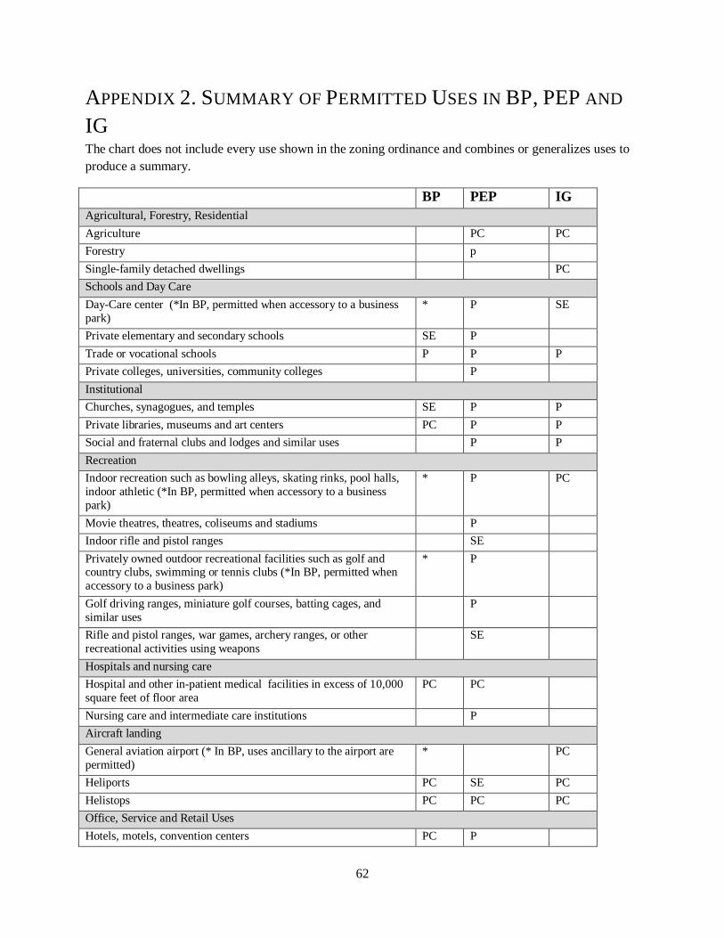
62
APPENDIX 2. SUMMARY OF PERMITTED USES IN BP, PEP AND
IG The chart does not include every use shown in the zoning ordinance and combines or generalizes uses to produce a summary.
BP PEP IG Agricultural, Forestry, Residential Agriculture PC PC Forestry p Single-family detached dwellings PC Schools and Day Care Day-Care center (*In BP, permitted when accessory to a business park)
* P SE
Private elementary and secondary schools SE P Trade or vocational schools P P P Private colleges, universities, community colleges P Institutional Churches, synagogues, and temples SE P P Private libraries, museums and art centers PC P P Social and fraternal clubs and lodges and similar uses P P Recreation Indoor recreation such as bowling alleys, skating rinks, pool halls, indoor athletic (*In BP, permitted when accessory to a business park)
* P PC
Movie theatres, theatres, coliseums and stadiums P Indoor rifle and pistol ranges SE Privately owned outdoor recreational facilities such as golf and country clubs, swimming or tennis clubs (*In BP, permitted when accessory to a business park)
* P
Golf driving ranges, miniature golf courses, batting cages, and similar uses
P
Rifle and pistol ranges, war games, archery ranges, or other recreational activities using weapons
SE
Hospitals and nursing care Hospital and other in-patient medical facilities in excess of 10,000 square feet of floor area
PC PC
Nursing care and intermediate care institutions P Aircraft landing General aviation airport (* In BP, uses ancillary to the airport are permitted)
* PC
Heliports PC SE PC Helistops PC PC PC Office, Service and Retail Uses Hotels, motels, convention centers PC P
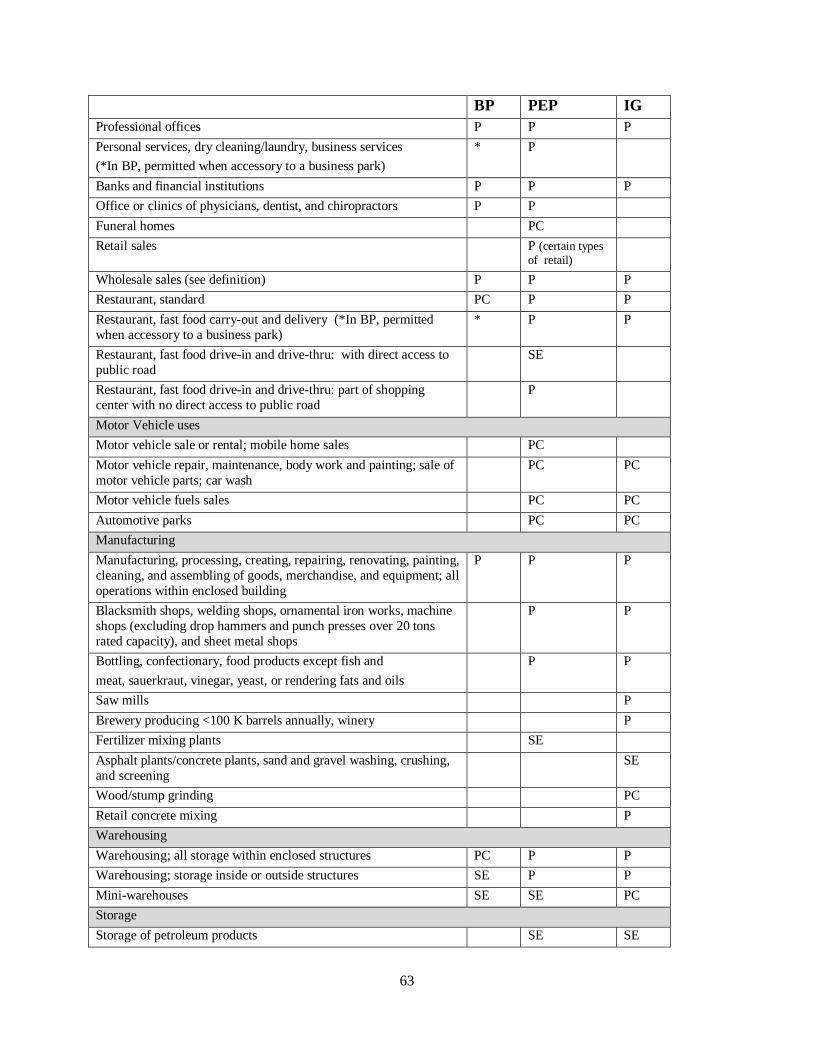
63
BP PEP IG Professional offices P P P Personal services, dry cleaning/laundry, business services (*In BP, permitted when accessory to a business park)
* P
Banks and financial institutions P P P Office or clinics of physicians, dentist, and chiropractors P P Funeral homes PC Retail sales P (certain types
of retail)
Wholesale sales (see definition) P P P Restaurant, standard PC P P Restaurant, fast food carry-out and delivery (*In BP, permitted when accessory to a business park)
* P P
Restaurant, fast food drive-in and drive-thru: with direct access to public road
SE
Restaurant, fast food drive-in and drive-thru: part of shopping center with no direct access to public road
P
Motor Vehicle uses Motor vehicle sale or rental; mobile home sales PC Motor vehicle repair, maintenance, body work and painting; sale of motor vehicle parts; car wash
PC PC
Motor vehicle fuels sales PC PC Automotive parks PC PC Manufacturing Manufacturing, processing, creating, repairing, renovating, painting, cleaning, and assembling of goods, merchandise, and equipment; all operations within enclosed building
P P P
Blacksmith shops, welding shops, ornamental iron works, machine shops (excluding drop hammers and punch presses over 20 tons rated capacity), and sheet metal shops
P P
Bottling, confectionary, food products except fish and meat, sauerkraut, vinegar, yeast, or rendering fats and oils
P P
Saw mills P Brewery producing <100 K barrels annually, winery P Fertilizer mixing plants SE Asphalt plants/concrete plants, sand and gravel washing, crushing, and screening
SE
Wood/stump grinding PC Retail concrete mixing P Warehousing Warehousing; all storage within enclosed structures PC P P Warehousing; storage inside or outside structures SE P P Mini-warehouses SE SE PC Storage Storage of petroleum products SE SE
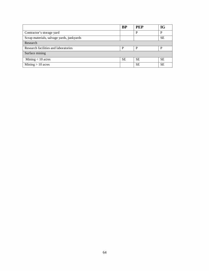
64
BP PEP IG Contractor’s storage yard P P Scrap materials, salvage yards, junkyards SE Research Research facilities and laboratories P P P Surface mining
Mining < 10 acres SE SE SE Mining > 10 acres SE SE