Embed Size (px)
Citation preview
Preparatory Study for
Tourism Development Project in the Northern Part of the Republic of Peru
Final Report
February 2012
Japan International Cooperation Agency
KRI International Corp. Nippon Koei Co., Ltd.
Nippon Koei Latin America- Caribbean Co., Ltd.
LACCR(3) 11-006
Preparatory Study for
Tourism Development Project in the Northern Part of the Republic of Peru
Final Report
February 2012
Japan International Cooperation Agency
KRI International Corp. Nippon Koei Co., Ltd.
Nippon Koei Latin America- Caribbean Co., Ltd.
LACCR(3) 11-006
Preparatory Study for Toursim D
evelopment Project in the N
orthern Part of the Republic of Peru
February 2012
LAC
CR (3)
12 - 006
Final Report
コーエイ498523_h_ペルー_英M_JICA.indd 1 2012/02/08 13:05:14
Preparatory Study for
Tourism Development Project in the Northern Part of the Republic of Peru
Final Report
February 2012
Japan International Cooperation Agency
KRI International Corp. Nippon Koei Co., Ltd.
Nippon Koei Latin America- Caribbean Co., Ltd.
LACCR(3) 11-006
Preparatory Study for
Tourism Development Project in the Northern Part of the Republic of Peru
Final Report
February 2012
Japan International Cooperation Agency
KRI International Corp. Nippon Koei Co., Ltd.
Nippon Koei Latin America- Caribbean Co., Ltd.
LACCR(3) 11-006
Preparatory Study for Toursim D
evelopment Project in the N
orthern Part of the Republic of Peru
February 2012
コーエイ498523_h_ペルー_英M_JICA.indd 1 2012/02/08 13:05:14
Preparatory Study for Tourism Development Project in the North Part of the Republic of Peru Final Report
i
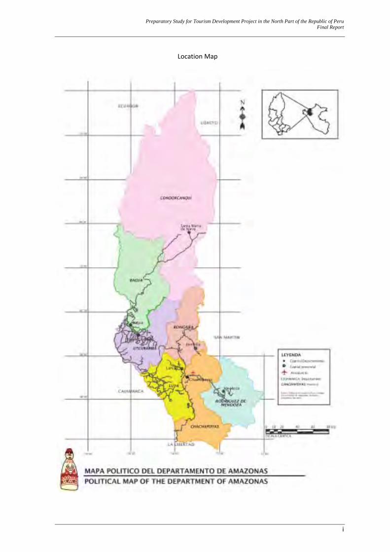
Location Map
Preparatory Study for Tourism Development Project in the North Part of the Republic of Peru Final Report
ii
Meaning of Chachapoya(s): Aymara: “The people of the clouds”: chacha = people / phuyas = clouds
Quechua: “Trees in the clouds”: sacha = tree / puyas = clouds Inca Garcilazo de la Vega (a Colonial Peruvian historian): “dwelling of strong men”
Father Millán de Aguirre (a Roman Catholic priest): Chachapoyas = “Mountain of clouds” Pether Lerche (an anthropologist): "the people of the cloud forest”,
“The cloud dwellers” Or "The warriors from the clouds"
…whatever the actual meaning, their legacy is impressive…
Preparatory Study for Tourism Development Project in the North Part of the Republic of Peru Final Report
iii
Contents
WHY SHOULD THE STATE INVEST ON THIS INVESTMENT PROGRAM? ................... 1 EXECUTIVE SUMMARY .............................................................................................................. 3
A. Name of the Public Investment Program ............................................................ 3 B. The Program’s Objective .................................................................................... 3 C. Description of the Public Investment Projects and the Program Activity .......... 3 D. Investment, Operation, and Maintenance Costs ................................................. 6 E. Benefits ............................................................................................................... 7 F. Results of Social or Economic Evaluation.......................................................... 9 G. Sustainability ...................................................................................................... 9 H. Organization and Management ......................................................................... 10 I. Environmental Impact and Risk Analysis......................................................... 10 J. Conclusions and Recommendations ................................................................. 11 K. Logframe Matrix ............................................................................................... 12
CHAPTER I GENERAL ............................................................................................................ 14 1.0 GENERAL .......................................................................................................................... 15
1.1 Name of the Investment Program ................................................................................... 15 1.2 Formulating and Implementation Units .......................................................................... 15
1.2.1 Formulating Unit .............................................................................................. 15 1.2.2 Recommended Implementation Unit ................................................................ 15
1.3 Study Area ...................................................................................................................... 16 1.4 Participation of involved entities and beneficiaries ........................................................ 17
1.4.1 Scopes of identification of involved entities ..................................................... 17 1.4.2 Problems, interests, and agreements made by the involved actors. .................. 20
1.5 Reference Framework ..................................................................................................... 23 1.5.1 Main Project Background ................................................................................. 23 1.5.2 Public Policy Alignments ................................................................................. 23
A. The Political Constitution of Peru .................................................................... 24 B. Regional Government Organic Act, Law Nº 27867.......................................... 24 C. General Tourism Act, Law No. 29408 .............................................................. 26 D. General Tourism Act Regulation, Supreme Decree N° 003-2010-MINCETUR
.......................................................................................................................... 26 E. General National Cultural Heritage Act, Law No. 28296 ................................. 27 F. 2008 – 2018 National Tourism Strategic Plan (PENTUR) ............................... 28 G. 2008 – 2021 Regional Concerted Development Plan ....................................... 30 H. 2009- 2015 Regional Strategic Tourism Plan: PERTUR Amazonas ................ 31
1.5.3 Project Priority .................................................................................................. 32 A. Ministry of Foreign Commerce and Tourism (MINCETUR) ........................... 32 B. Regional Government of Amazonas (GRA) ..................................................... 33 C. Tourist Destination of the Utcubamba Corridor Tourist Circuit (CTCU) and its
connection to the Northeastern Tourist Circuit (CTN) ..................................... 33
CHAPTER II IDENTIFICATION ............................................................................................ 35 2.0 IDENTIFICATION ............................................................................................................ 36
2.1 What Knowledge about the Current Situation is needed to Sell a Tourist Product in Peru? ............................................................................................................................... 36
2.2 Diagnostics of the CTCU destination’s current situation ................................................ 38 2.2.1 General .............................................................................................................. 38 2.2.2 Diagnostics – Population and Society .............................................................. 38
Preparatory Study for Tourism Development Project in the North Part of the Republic of Peru Final Report
iv
A. Geopolitics and Territory – Amazonas .......................................................... 38 B. Geopolitics and Territory – CTCU Destination ............................................... 40 C. Population – Amazonas. ................................................................................... 42 D. Population – CTCU Destination ...................................................................... 44 E. History and Socio Cultural Patterns .................................................................. 46 F. Territory and Environment ............................................................................... 49 G. Productive Economy – Amazonas .................................................................... 52 H. Economic Corridors – CTCU Destination ........................................................ 54 I. Electricity .......................................................................................................... 55 J. Transportation Infrastructure ............................................................................ 55 K. Solid Waste Management ................................................................................. 62 L. Communications ............................................................................................... 63 M. Public Transportation of People, both around and out of the Province ............ 64 N. Security/Safety .................................................................................................. 66
2.2.3 Diagnostics – Tourism Facilities ....................................................................... 67 A. Public Facilities and Services ........................................................................... 67 B. Museums ........................................................................................................... 67 C. Lodging Facilities, Restaurants, and other Similar Facilities ........................... 68 D. Travel and Tourism Agencies. .......................................................................... 69 E. The Population’s Views .................................................................................... 70
2.2.4 Diagnostics – Tourism’s Current Situation ....................................................... 71 A. Identity and Tourist Awareness ....................................................................... 71 B. Amazonas Icons: Kuelap and Gocta. ................................................................ 73 C. Tourist Resources along the CTCU .................................................................. 73 D. Current Positioning and Tourist Promotion. ..................................................... 74 E. Current Supply by the Local Tourist Operators ................................................ 80 F. Current Supply by the Regional Tourist Operators ........................................... 83 G. Tourist Flow’s Behavior ................................................................................... 84 H. CTCU Tourist Visitor’s Profile - Personal Characteristics ............................... 91 I. CTCU Tourist Visitor’s Traveling Characteristics ........................................... 95 J. CTCU Tourist Visitor’s Views .......................................................................... 98
2.2.5 Diagnostics – Institutions and Institutionality ................................................. 98 A. Public Institutions – National Level ................................................................ 99 B. Public Institutions – Regional Level ............................................................. 100 C. Public Institutions – Local Level ................................................................... 102 D. Private Organizations. ..................................................................................... 104 E. Social Organizations. ...................................................................................... 107
2.3 Defining the Problem and its Causes ............................................................................ 108 2.3.1 Core Problem .................................................................................................. 108 2.3.2 Cause Analyses ............................................................................................... 108 2.3.3 Effect Analyses ............................................................................................... 108
2.4 The Program’s Objective .............................................................................................. 110 2.4.1 Definition of the Core Objective .................................................................... 110 2.4.2 Means to meet the Core Objective .................................................................. 110 2.4.3 Ends of the Core Objective ............................................................................. 110
2.5 Solution Alternatives .................................................................................................... 112 2.6 The Alternative’s Technical Approach ......................................................................... 112
A. Background – Proposal at Profile Level ......................................................... 112 B. General Proposal ............................................................................................. 113 C. Areas that will not be under this Program’s Intervention ............................... 113
CHAPTER III FORMULATION ............................................................................................. 114 3.0 FORMULATION ............................................................................................................. 115
3.1 What Knowledge is needed to Develop the Intervention Proposal? ............................. 115
Preparatory Study for Tourism Development Project in the North Part of the Republic of Peru Final Report
v
3.2 Delimitation of the Destination ..................................................................................... 115 3.2.1 Destination, Tourist Corridor, and Basin Route .............................................. 115 3.2.2 Tourist Zones ................................................................................................. 118 3.2.3 Prioritized Tourist Resources along the Identified Tourist Zones ................... 122
3.3 Demand and Supply Characteristics ............................................................................. 123 3.3.1 Service ............................................................................................................ 123 3.3.2 Knowing the Client Wishes and Behavior – International .............................. 124
A. The International Tourist Market Characteristics ........................................... 124 B. General Characteristics of Tourists Visiting Peru – Receptive ...................... 127 C. Characteristics – International Tourist – Cultural ........................................... 129 D. Characteristics – International Tourist – Nature ............................................. 132 E. Characteristics – – International Tourist – Extreme. ...................................... 133 F. Characteristics – International Tourist – Rural Community ........................... 136 G. Characteristics – International Tourist – By Place of Origin .......................... 136
3.3.3 Knowing the Client Wishes and Behavior – Domestic ................................... 140 A. The Domestic Vacationer’s Profile ................................................................. 140 B. Priority Emitters – Domestic .......................................................................... 142
3.3.4 The Tourist Product for Sale – Knowing the Basics for Supply .................... 142 A. The Basic Model ............................................................................................. 142 B. What prevents or stops Tourist Development along the CTCU? – Obstacles 143 C. What can encourage Tourist Development along the CTCU – Potentialities . 144 D. The Suggested Tourist Routes ........................................................................ 144 E. The Population Views ..................................................................................... 154
3.4 Approach to Improve the Tourist Product’s Sales Capability ....................................... 154 3.4.1 Modeling the Prospect Tourist Product s for Sale ........................................... 154
A. Tourist Product Proposal 1: Based on the Circuito de Aguas (Water Circuit) Route ............................................................................................................... 154
B. Tourist Product Proposal 2: Based on the Karajia Route ............................... 156 C. Tourist Product Proposal 3: Based on the Canyon Tourist Route .................. 156 D. Tourist Product Proposal 4: Based on the Qhapac Ñan Route ........................ 157 E. Tourist Product Proposal 5: Based on the Kuelap Route ................................ 158 F. Tourist Product Proposal 6: Based on the Cultura Viva (Living Culture) Route
........................................................................................................................ 159 G. Tourist Product Proposal 7: Based on the Mummies Route ........................... 160 H. Summary of the Tourist Product Proposals ..................................................... 162
3.4.2 What is Needed? ............................................................................................. 162 3.4.3 What is Missing? ............................................................................................ 163
A. Utilities at the Support Centers ....................................................................... 163 B. Access and Suitable Road Network along the CTCU .................................... 165 C. Identity ............................................................................................................ 166 D. Prioritized Tourist Resource Enhancements ................................................... 166 E. A Tourist Facility with the Suitable Quality that Matches the Target Tourist
Profile ............................................................................................................. 168 F. Positioning and Tourist Promotion ................................................................. 170 G. Institutionality in the Public Sector ................................................................ 170 H. Tourist Development Strategy by Consensus (PENTUR upgrading) ............. 171
3.4.4 Selection of Interventions ............................................................................... 171 A. Utilities ........................................................................................................... 171 B. Access and Suitable Road Network along the CTCU .................................... 172 C. Identity ............................................................................................................ 173 D. Prioritized Tourist Resource Enhancements ................................................... 173 E. Tourist Facilities with the Suitable Quality that Match the Target Tourist Profile
........................................................................................................................ 174 F. Positioning and Tourist Promotion ................................................................. 174 G. Institutionality in the Public Sector ................................................................ 174
Preparatory Study for Tourism Development Project in the North Part of the Republic of Peru Final Report
vi
H. Tourist Development Strategy by Consensus (PENTUR upgrading) ............. 175 I. New Interventions ........................................................................................... 175
3.4.5 How do Interventions Supplement – Synergy ................................................ 175 A. The Dependence Chain ................................................................................... 175 B. Synergy ........................................................................................................... 176 C. Modeling and Reality – Other Synergies ........................................................ 176
3.4.6 The Intervention Proposal ............................................................................... 177 A. General ............................................................................................................ 177 B. Program Structure ........................................................................................... 177
3.4.7 PIP Actions Detailed Description .................................................................. 178 3.4.8 Activity: PERTUR Amazonas Upgrating ...................................................... 181 3.4.9 Activity: Commercialization Plan and Support to Commercialization in CTVU. 182
CHAPTER IV EVALUATION ................................................................................................. 200 4.0 EVALUATION ................................................................................................................ 201
4.1 Social Benefits .............................................................................................................. 201 4.1.1 Identification of Benefits ................................................................................ 201 4.1.2 Measurement of Benefits ................................................................................ 202
A. Benefits from PIP (Public Investment Projects) ............................................. 202 B. Benefits from Tourism – Expenditure per Day/Tourist ................................... 202
4.1.3 Program Benefits ............................................................................................ 204 4.2 Costs at Social or Economic Prices .............................................................................. 205 4.3 Social or Economic Evaluation ..................................................................................... 207
4.3.1 Social or Economic NPV Calculation ............................................................. 207 4.3.2 Sensitivity Analysis ........................................................................................ 207
A. Critical Variables ............................................................................................ 207 B. Evaluation Results .......................................................................................... 207
4.4 Sustainability Analysis ................................................................................................. 207 4.4.1 The Foreseen Institutional Arrangements ....................................................... 207 4.4.2 Legal Framework needed for Project Execution and Operation ..................... 208 4.4.3 Operation and Maintenance (O&M) Cost Funding ........................................ 208 4.4.4 The Beneficiaries’ Participation ...................................................................... 208
4.5 Environmental Impact and Risk Analysis ..................................................................... 208 4.6 Organization and Management ..................................................................................... 208
4.6.1 The Program’s Implementation Unit .............................................................. 208 A. The Establishment of the Management Unit .................................................. 208 B. The MU Structure ........................................................................................... 209 C. Functions ......................................................................................................... 209 D. Operative Consultants: Specialists .................................................................. 213 E. Staff and Costs ................................................................................................ 214
4.6.2 Implementation Plan ....................................................................................... 214 A. Implementation Alignment ............................................................................. 214 B. Projects with Buildings and Infrastructure and Institutional Strengthening
Projects ........................................................................................................... 214 C. Archaeological Enhancement Projects ........................................................... 215
4.7 Funding Structure ......................................................................................................... 215 4.8 Logframe Matrix ........................................................................................................... 216
CHAPTER V CONCLUSIONS ............................................................................................... 218 5.0 CONCLUSIONS .............................................................................................................. 219
NOTE: Attachments to the Study are found in Volume II.
Preparatory Study for Tourism Development Project in the North Part of the Republic of Peru Final Report
vii
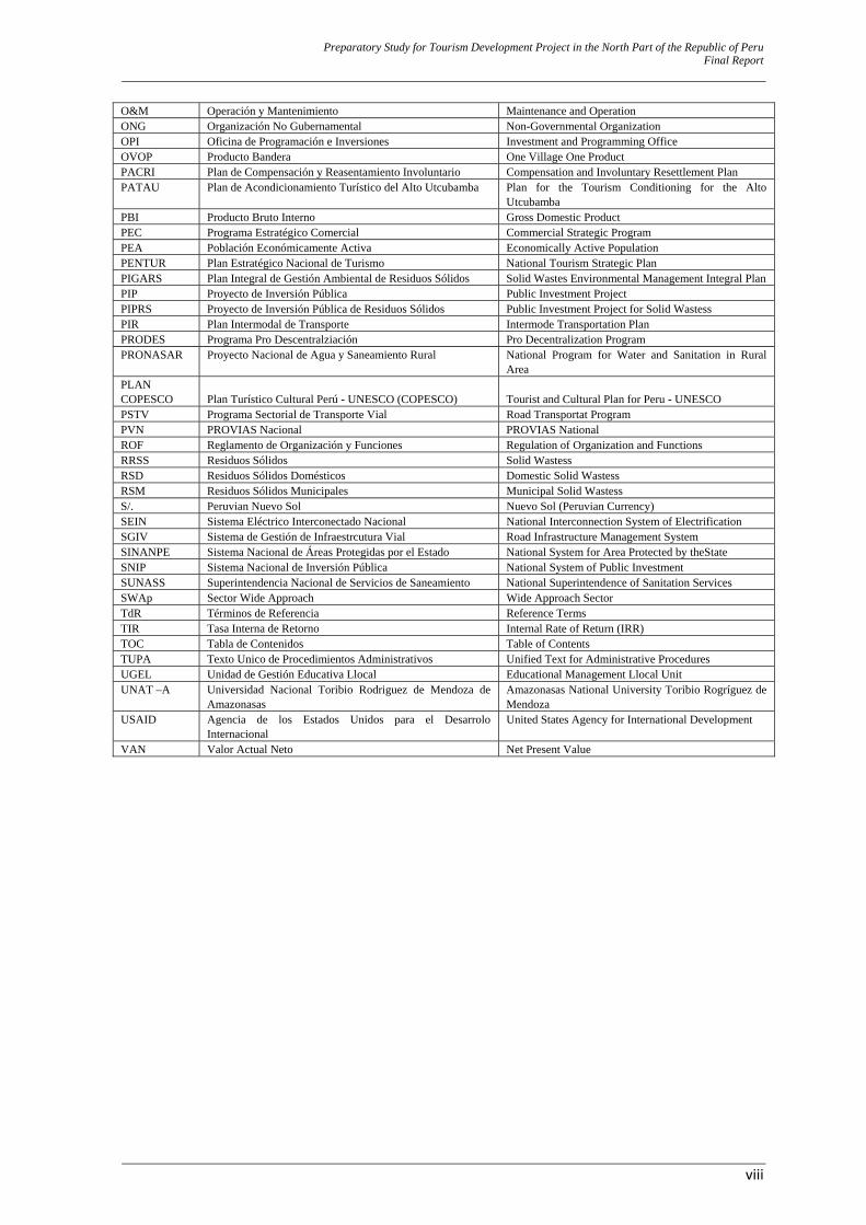
Acronym or Abbreviation Spanish English
ADOTUR Asociación de Operadores Turísticos Tour Operators Association APCI Agencia Peruana de Cooperación Internacional Peruvian Agency of International Cooperation APP Asociación Público Privado Public Private Association BID Banco Interamericano de Desarrolo Inter-American Development Bank BIRF Banco Internacional de Reconstrucción y Fomento International Bank for Reconstruction and
Development (IBRD) CAF Comisión Ambiental Municipal Municipal Environmental Commission CAR Comisión Ambiental Regional Regional Environmental Commission CARETUR Cámara Regional de Turismo de Amazonasas Amazonasas Regional Chamber of Tourism CEPIS Centro Panamericano de Ingeniería Sanitaria y Ambiental CMRRD Comisión Multisectorial de Reducción de riesgos en el
Desarrolo Multisectorial Commission for Risk Reduction in Development
COFOPRI Organismo de la Formalización de la Propiedad Informal Governmental Body to legalize informal businesses CONATA Consejo Nacional de Tasaciones National Counsil of Valuations COSUDE Agencia Suiza para el Desarrolo y la Cooperación Swiss Agency for Development and Cooperation DESA Dirección Ejecutiva de Salud Ambiental Executive Management of Environmental Health DIGESA Dirección General de Salud Ambiental Environmental Health General Management DGASA Dirección General de Asuntos Socio Ambientales General Management of Social and Environmental
Affaires DGPM Dirección General de Programación Multianual Multiannual Programming General Management DIA Declaración de Impacto Ambiental Environmental Impact Declaration DIRCETUR Dirección Regional de Comercio Exterior y Turismo (es) Regional Office of Foreign Trade and Tourism DIGESA Dirección General de Salud Ambiental Directorate for Environmental Health EAE Evalaución Ambiental Estratégica Strategic Environmental Evaluation EAR Evaluación Ambiental Regional Regional Environmental Evaluation EC-RS Empresa Comercializadora de Residuos Sólidos Solid Wastess Trading Company EIA Evaluación de Impacto Ambiental Environmental Impact Assessment EIA-d Evaluación de Impacto Ambiental Detallado Detailed Environmental Impact Assessment EIA-sd Evaluación de Impacto Ambiental Semi-Detallado Semi-Detailed Environmental Impact Assessment EPS-RS Empresa Prestadora de Servicios de Residuos Sólidos Enterprise rendering Solid Wastess Services F/S Estudio de Factibilidad Feasibility Study FODA Fortaleza, debilidad, oportunidad y amenaza Strength, weakness, opportunity and threat FONCODES Fondo de Cooperación para el Desarrolo Social (es) Cooperation Fund for Social Development FONCOMUN Fondo de Compensación Municipal Municipal Compensation Fund FODA Fortalezas, Oportunidades, Debilidades y Amenazas SWOT = Strengths, Weaknesses, Opportunities and
Threats GORE Gobierno Regional Regional Government GPC Generación Per Cápita Income Per Cápita GPDIP Guía para la Participación y Divulgación de Información de
Proyectos Guide for the Participation and Disclosure of Information of Projects
GRA Gobierno Regional de Amazonasas Amazonasas Regional Government IANP Intendencia de Áreas Naturales Protegidas Adminstration Division for Natural Protected Areas IE Insitutciones Educativas Educational Institutions IGN Instituto Geográfico Nacional National Geographic Institute IIRSA Infraestructura de Integración de la Región Sudamericana /
Iniciativa de Integración Regional Sur Americana Integration of Infrastructure for the South American Region
INC Instituto Nacional de Cultura National Cultural Institute INEI Instituto Nacional de Estadística e Informática National Institute of Statistics and Information INICAM Instituto de Investigación y
Capacitación Municipal Institute of Municipal Research and Municipal Training
INRENA Instituto Nacional de Recursos Naturales National Institute for Natural Resources JBIC Banco de Cooperación Internacional del Japón Japan Bank for International Cooperation JICA Agencia de Cooperación Internacional del Japón Japan International Cooperation Agency MEF Ministerio de Economía y Finanzas Ministry of Economy and Finance MEM Ministerio de Energía y Minas Ministry of Energy and Mining MINAM Ministerio del Ambiente Ministry of Environment MINCETUR Ministerio de Comercio Exterior y Turismo Ministry of Foreign Trade and Tourism MINEDU Ministerio de Educación Ministry of Education MINSA Ministerio de Salud Ministry of Health MOF Manual de Organización y Funciones Manual of Organization and Functions MTC Ministerio de Transportes y Comunicaciones Ministry of Transportation and Communication MVCS Ministerio de Vivienda, Construcción y Saneamiento Ministry of Housing, Construction and Sanitation OGTL Oficina de Gestión de Turismo Llocal Llocal Tourism Management Office OIT Organización Internacional del Trabajo International Labor Organization
Preparatory Study for Tourism Development Project in the North Part of the Republic of Peru Final Report
viii
O&M Operación y Mantenimiento Maintenance and Operation ONG Organización No Gubernamental Non-Governmental Organization OPI Oficina de Programación e Inversiones Investment and Programming Office OVOP Producto Bandera One Village One Product PACRI Plan de Compensación y Reasentamiento Involuntario Compensation and Involuntary Resettlement Plan PATAU Plan de Acondicionamiento Turístico del Alto Utcubamba Plan for the Tourism Conditioning for the Alto
Utcubamba PBI Producto Bruto Interno Gross Domestic Product PEC Programa Estratégico Comercial Commercial Strategic Program PEA Población Económicamente Activa Economically Active Population PENTUR Plan Estratégico Nacional de Turismo National Tourism Strategic Plan PIGARS Plan Integral de Gestión Ambiental de Residuos Sólidos Solid Wastes Environmental Management Integral PlanPIP Proyecto de Inversión Pública Public Investment Project PIPRS Proyecto de Inversión Pública de Residuos Sólidos Public Investment Project for Solid Wastess PIR Plan Intermodal de Transporte Intermode Transportation Plan PRODES Programa Pro Descentralziación Pro Decentralization Program PRONASAR Proyecto Nacional de Agua y Saneamiento Rural National Program for Water and Sanitation in Rural
Area PLAN COPESCO
Plan Turístico Cultural Perú - UNESCO (COPESCO)
Tourist and Cultural Plan for Peru - UNESCO
PSTV Programa Sectorial de Transporte Vial Road Transportat Program PVN PROVIAS Nacional PROVIAS National ROF Reglamento de Organización y Funciones Regulation of Organization and Functions RRSS Residuos Sólidos Solid Wastess RSD Residuos Sólidos Domésticos Domestic Solid Wastess RSM Residuos Sólidos Municipales Municipal Solid Wastess S/. Peruvian Nuevo Sol Nuevo Sol (Peruvian Currency) SEIN Sistema Eléctrico Interconectado Nacional National Interconnection System of Electrification SGIV Sistema de Gestión de Infraestrcutura Vial Road Infrastructure Management System SINANPE Sistema Nacional de Áreas Protegidas por el Estado National System for Area Protected by theState SNIP Sistema Nacional de Inversión Pública National System of Public Investment SUNASS Superintendencia Nacional de Servicios de Saneamiento National Superintendence of Sanitation Services SWAp Sector Wide Approach Wide Approach Sector TdR Términos de Referencia Reference Terms TIR Tasa Interna de Retorno Internal Rate of Return (IRR) TOC Tabla de Contenidos Table of Contents TUPA Texto Unico de Procedimientos Administrativos Unified Text for Administrative Procedures UGEL Unidad de Gestión Educativa Llocal Educational Management Llocal Unit UNAT –A Universidad Nacional Toribio Rodriguez de Mendoza de
Amazonasas Amazonasas National University Toribio Rogríguez de Mendoza
USAID Agencia de los Estados Unidos para el Desarrolo Internacional
United States Agency for International Development
VAN Valor Actual Neto Net Present Value
Preparatory Study for Tourism Development Project in the North Part of the Republic of Peru Final Report
1
WHY SHOULD THE STATE INVEST ON THIS INVESTMENT PROGRAM? “When you think of tourism, you think of everything.” This quote is 100 % true to anybody who has even tried to start thinking about planning tourist development for a destination. In order to sell a tourist destination, you first need to meet a tourist’s basic needs (a tourist is, ultimately, a human being), and in addition, make him / her enjoy an unforgettable experience; that’s the reason why you need to think of “everything.” A tourist destination is a product that is promoted and sold as any other product, but its planning is particularly attractive for those who want to collaborate towards the development of the communities located on, or populations living around, such destination. In order to make this particular destination more attractive than any other destination - namely, the competition -, it must offer something the other destinations lack. If we take this idea literally, planning would be extremely easy, as there are wonderful sites, such as Kuelap or Karajia, that only belong to Amazonas and its people; therefore, we would only enhance these resources. However, fortunately, the level of competition with other destinations in Peru, and around the world, as well as the regulations in the Peruvian Political Constitution, require more from us. As a tourist destination is, ultimately, a product, we must think of the necessary production factors to “manufacture” it, and sell it. A planner with a short vision could summarize the production factors as follows: a good hotel, a good restaurant, and an enhanced tourist resource. However, tourism sells an experience, and the Peruvian understanding is that this experience goes beyond placing a tourist in a fish bowl that will keep him/her from “seeing anything else.” I think that, as part of their relaxing experience, only very few people in the world (if any) would like to come and visit an archaeological site like Kuelap, and find it covered with weed and about to collapse. Photographs would look rather green and not historical. At the same time, as they experience a breathtaking scenery, tourists would not like to find these sites and their surrounding towns or villages filled up with garbage or stinking because of wastewaters, or suffering the neglect of a developing economy, as they lack basic infrastructure and public services. Neither is it a good thing that you are alert against thieves all day long when you have planned a relaxing trip. Tourists don’t come just to visit our resources, they experience the Destination as a whole. Tourism promoted in Peru is not the “fish bowl – type tourism”, in which tourists know they are in another country because the hotel staff speak a different language. Our tourist development planning involves a people’s development vision. Whenever we think of development, we think of quality basic services (water and sanitation, electrification, wastes gathering) that the local population will “share” with tourists; we think of infrastructure for both the population and the local trade (roads, means of access) that will be also “used” by tourists; we think of the necessary resources to offer both physical and moral security/safety to the citizens, and these resources will also “look after” tourists; we think of a cultural and natural heritage that should be preserved for Peruvian national identity to be strengthened, and tourists will be gladly “invited” to enjoy them. If we meet our goal, with regard to the number of days of sojourn per tourist along the Investment Program period, this means that the tourists’ use of services and infrastructure will represent less than 1 % of local population’s use of them. You should then wonder why it is a good idea to develop a Tourism Investment Program that is related to all of these interventions, i n terms of services for the population. “Why not just execute services and infrastructure projects?” The answer to this is “Because tourism has proven to be an economic activity that requires services from almost all other economic sectors, and requires production factors and inputs that can be supplied by small and medium – sized enterprises. Therefore, we are establishing a multiplier effect that aims at all social levels, and generates sustainable employment (jobs).
Preparatory Study for Tourism Development Project in the North Part of the Republic of Peru Final Report
2
Given this context, the State should intervene in Amazonas, by correcting those market flaws that restrain and even hamper Amazonas’ tourist development. Although many of these flaws are related to a lacking or deficient basic services supply – and the State’s intervention here should be apparent – there are still some other flaws that are caused by a lack of appropriability of the results, and the State should intervene here as well. Private agents do not tend to invest on activities that would render profitable to all, such as enhancing a tourist site and promoting tourism. These actions will impact the tourist flows, in terms of tourist sojourns and how much tourists are willing to expend, and will have a beneficiary effect on all the people of Amazonas, not just on one particular investor. As tourism has been promoted and encouraged, farmers, cattle and other animal breeders, craftspeople, manufacturers, business people, and hotel / hostel owners will experience a greater local demand for their products and services. We expect this demand to be at least consistent, if not growing, and, as this is a local demand, it will strengthen the local suppliers’ bargaining or negotiating position. In addition, it will generate jobs for non – traditional service operators, as local asset usages and population productivity will increase. Guided tours, outings, lodgings will be mainly provided by the local people, as they use their property and assets. We should also take into account the fact that the department of Amazonas’ tourist resources and 40 % of its population are located away from the towns, and that one of its major appeals is that it is one of the least “overcrowded” department of Peru – with a population density of less than 10 people per km2 –. Therefore, it will be a natural consequence that rural tourism that calls for major and direct participation of the population with the least resources will be mostly boosted and prevalent throughout tourist development in Amazonas. In addition, we must keep in mind that rural tourism is a prioritized development target that both the National and Regional Governments are eagerly aiming at. Finally, I must say that one of the good things about trying to improve tourism in our country is that, even if any financial crisis would generate decreased tourist flows, all of the investment will be used up by the intervened populations, as a foundation to any other economic activity for further development purposes. Amazonas has a huge tourist potential; however, it’s still nothing further but potential.
Preparatory Study for Tourism Development Project in the North Part of the Republic of Peru Final Report
3
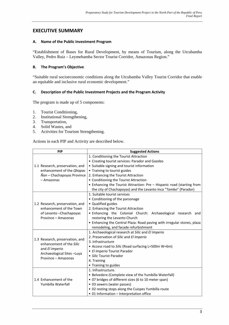
EXECUTIVE SUMMARY A. Name of the Public Investment Program “Establishment of Bases for Rural Development, by means of Tourism, along the Utcubamba Valley, Pedro Ruiz – Leymebamba Sector Tourist Corridor, Amazonas Region.” B. The Program’s Objective “Suitable rural socioeconomic conditions along the Utcubamba Valley Tourist Corridor that enable an equitable and inclusive rural economic development.” C. Description of the Public Investment Projects and the Program Activity The program is made up of 5 components: 1. Tourist Conditioning, 2. Institutional Strengthening, 3. Transportation, 4. Solid Wastes, and 5. Activities for Tourism Strengthening. Actions in each PIP and Activity are described below.
PIP Suggested Actions
1.1 Research, preservation, and enhancement of the Qhapac Ñan – Chachapoyas Province – Amazonas
1. Conditioning the Tourist Attraction• Creating tourist services: Parador and Gazebo • Suitable signing and tourist information • Training to tourist guides 2. Enhancing the Tourist Attraction • Conditioning the Tourist Attraction • Enhancing the Tourist Attraction: Pre – Hispanic road (starting from the city of Chachapoyas) and the Levanto Inca “Tambo” (Parador)
1.2 Research, preservation, and enhancement of the Town of Levanto –Chachapoyas Province – Amazonas
1. Suitable tourist services• Conditioning of the parsonage • Qualified guides 2. Enhancing the Tourist Attraction • Enhancing the Colonial Church: Archaeological research and restoring the Levanto Church
• Enhancing the Central Plaza: Road paving with irregular stones, plaza remodeling, and facade refurbishment
1.3 Research, preservation, and enhancement of the Silic and El Imperio Archaeological Sites –Luya Province – Amazonas
1. Archaeological research at Silic and El Imperio 2. Preservation of Silic and El Imperio 3. Infrastructure • Access road to Silic (Road surfacing L=500m W=6m) • El Imperio Tourist Parador • Silic Tourist Parador 4. Training • Training to guides
1.4 Enhancement of the Yumbilla Waterfall
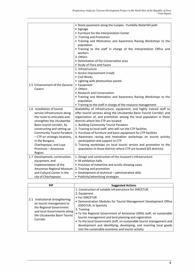
1. Infrastructure.• Belvedere (Complete view of the Yumbilla Waterfall) • 07 bridges of different sizes (6 to 10 meter span) • 03 sewers (water passes) • 02 resting stops along the Cuispes Yumbilla route • 01 Information – Interpretation office
Preparatory Study for Tourism Development Project in the North Part of the Republic of Peru Final Report
4
• Stone pavement along the Cuispes –Yumbilla Waterfall path • Signage • Furniture for the Interpretation Center 2. Training and Promotion • Training and Motivation and Awareness Raising Workshops to the population
• Training to the staff in charge of the Interpretation Office and workers
3. Others • Delimitation of the Conservation area • Study of Flora and Fauna
1.5 Enhancement of the Quiocta Cavern
1. Infrastructure• Access improvement (road) • Civil Works • Lighting with photovoltaic panels • Equipment 2. Others • Research and Conservation • Training and Motivation and Awareness Raising Workshops to the population
• Training to the staff in charge of the resource management 1.6 Installation of tourist
service infrastructure along the route to articulate and strengthen the Utcubamba Basin tourist corridor, by constructing and setting up Community Tourist Paradors – CTP on strategic locations, in the Bongará, Chachapoyas, and Luya Provinces – Amazonas Region
Availability of infrastructure, equipment, and highly trained staff to offer tourist services along the Utcubamba Basin Tourist Corridor; and organization of, and promotion among the local population in those districts where the CTP are located 1. Building Community Tourist Paradors 2. Training to local staff, who will run the CTP facilities 3. Purchase of furniture and basic equipment for CTP facilities 4. Awareness raising and motivation workshops on tourist activity participation and support to CTP
5. Training workshops on local tourist service and promotion to the population in those districts where CTP are located (03 districts)
1.7 Development, construction, equipment, and implementation of the Amazonas Regional Museum and Cultural Center in the city of Chachapoyas
1. Design and construction of the museum’s infrastructure • 04 exhibition halls • Provision of melamine and acrylic showing cases 2. Training and promotion • Development of technical – administrative skills • Publicity/advertising strategies
PIP Suggested Actions
2.1 Institutional strengthening on tourist management to the Regional Government and local Governments along the Utcubamba Basin Tourist Corridor
1. Construction of suitable infrastructure for DIRCETUR 2. Equipment • For DIRCETUR • Demonstration Modules for Tourist Management Development Office (ODGTUR, in Spanish)
3. Training • To the Regional Government of Amazonas (GRA) staff, on sustainable tourist management and land planning and registration
• To the local Government staff, on sustainable tourist management and development and identifying, developing, and inserting local goods into the sustainable economic and tourist activity
Preparatory Study for Tourism Development Project in the North Part of the Republic of Peru Final Report
5
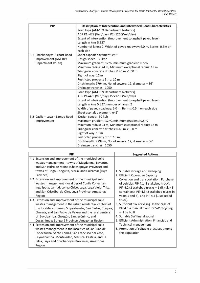
PIP Description of Intervention and Intervened Road Characteristics
3.1 Chachapoyas‐Airport Road Improvement (AM 109 Department Route)
Road type (AM‐109 Department Network)ADR P1=479 (Veh/day), P2=1260(Veh/day) Extent of intervention (Improvement to asphalt paved level) Length in kms 5.327 Number of lanes: 2, Width of paved roadway: 6.0 m, Berms: 0.5m on each side Sheet asphalt pavement: e=2" Design speed: 30 kph Maximum gradient: 12 %, minimum gradient: 0.5 % Minimum radius: 24 m, Minimum exceptional radius: 18 m Triangular concrete ditches: 0.40 m x1.00 m Right of way: 16 m Restricted property Strip: 10 m Ditch length: 9794 m, No. of sewers: 12, diameter = 36" Drainage trenches: 1050
3.2 Caclic – Luya – Lamud Road Improvement
Road type (AM‐109 Department Network)ADR P1=479 (Veh/day), P2=1260(Veh/day) Extent of intervention (Improvement to asphalt paved level) Length in kms 5.327, number of lanes: 2 Width of paved roadway: 6.0 m, Berms: 0.5m on each side Sheet asphalt pavement: e=2" Design speed: 30 kph Maximum gradient: 12 %, minimum gradient: 0.5 % Minimum radius: 24 m, Minimum exceptional radius: 18 m Triangular concrete ditches: 0.40 m x1.00 m Right of way: 16 m Restricted property Strip: 10 m Ditch length: 9794 m, No. of sewers: 12, diameter = 36" Drainage trenches: 1050
PIP Suggested Actions
4.1 Extension and improvement of the municipal solid wastes management ‐ towns of Magdalena, Levanto, and San Isidro de Maino (Chachapoyas Province) and towns of Tingo, Longuita, María, and Colcamar (Luya Province)
1. Suitable storage and sweeping 2. Efficient Operative Capacity Collection and transportation: Purchase
of vehicles PIP 4.1 (1 stakebed truck), PIP 4.2 (2 stakebed trucks + 1 tik tuk + 3 containers), PIP 4.3 (2 stakebed trucks in years 1 and 6), and PIP 4.4 (1 stakebed truck).
3. Sufficient SW recycling. In the case of PIP 4.1 a manual plant for SW recycling will be built
4. Suitable SW final disposal 5. Efficient Administration, Financial, and
Technical management 6. Promotion of suitable practices among
the population
4.2 Extension and improvement of the municipal solid wastes management ‐ localities of Conila Cohechán, Inguilpata, Lamud, Lonya Chico, Luya, Luya Viejo, Trita, and San Cristóbal de Olto, Luya Province, Amazonas Region
4.3 Extension and improvement of the municipal solid wastes management in the urban residential centers of the localities of Jazán, Shipasbamba, San Carlos, Cuispes, Churuja, and San Pablo de Valera and the rural centers of Suyobamba, Chosgón, San Jerónimo, and Cocachimba; Bongará Province, Amazonas Region
4.4 Extension and improvement of the municipal solid wastes management in the localities of San Juan de Lopecancha, Santo Tomás, San Francisco del Yeso, Leymebamba, Montevideo, Mariscal Castilla, and La Jalca; Luya and Chachapoyas Provinces, Amazonas Region
Preparatory Study for Tourism Development Project in the North Part of the Republic of Peru Final Report
6
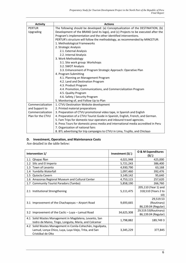
Activity ActionsPERTUR Upgrading
The following should be developed: (a) Conceptualization of the DESTINATION, (b) Development of the BRAND (and its logo), and (c) Projects to be executed after the Program’s implementation and the other identified interventions. PERTUR’s structure will follow the methodology, as recommended by MINCETUR: 1. Methodological Frameworks 2. Strategic Analysis
2.1. External Analysis 2.2. Internal Analysis
3. Work Methodology 3.1. Site work group: Workshops 3.2. SWOT Analysis 3.3. Enhancement of Program Strategic Approach: Operative Plan
4. Program Submitting 4.1. Planning an Management Program 4.2. Land and Destination Program 4.3. Product Program 4.4. Promotion, Communications, and Commercialization Program 4.5. Quality Program 4.6. Safety / Security Program
5. Monitoring of, and Follow Up to Plan Commercialization and Support to Commercialization Plan for the CTVU
1. CTVU Destination Website development2. Printed material preparations 3. Preparation of CTVU promotional video tape, in Spanish and English 4. Preparation of a CTVU Tourist Guide in Spanish, English, French, and German. 5. Fam Trips for domestic tour operators and inbound travel agencies. 6. Press Tours for domestic press media and international media accredited in Peru 7. Organization of national fairs 8. BTL advertising for trip campaigns to CTVU in Lima, Trujillo, and Chiclayo
D. Investment, Operation, and Maintenance Costs Are detailed in the table below:
Intervention 1/ Investment (S/.) O & M Expenditures (S/.)
1.1 Qhapac Ñan 4,021,948 425,0001.2 Silic and El Imperio 5,721,243 386,4001.3 Town of Levanto 4,930,790 63,1681.4 Yumbilla Waterfall 1,097,460 392,4761.5 Quiocta Cavern 3,149,142 95,6401.6 Amazonas Regional Museum and Cultural Center 4,753,115 257,6201.7 Community Tourist Paradors (Tambo) 5,858,190 266,760
2.1 Institutional Strengthening 5,111,475 205,110 (Year 1) and 318,510 (Years 2 to
10)
3.1 Improvement of the Chachapoyas – Airport Road 9,693,665 29,519.53
(Routinary)86,139.04 (Regular)
3.2 Improvement of the Caclic – Luya – Lamud Road 34,625,308 29,519.53(Routinary)86,139.04 (Regular)
4.1 Solid Wastes Management in Magdalena, Levanto, San Isidro de Maino, Tingo, Longuita, María, and Colcamar 1,798,882 189,749 3
4.2 Solid Wastes Management in Conila‐Cohechán, Inguilpata, Lamud, Lonya Chico, Luya, Luya Viejo, Trita, and San Cristóbal de Olto
3,345,229 377,845
Preparatory Study for Tourism Development Project in the North Part of the Republic of Peru Final Report
7
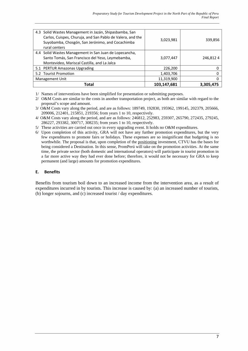
4.3 Solid Wastes Management in Jazán, Shipasbamba, San Carlos, Cuispes, Churuja, and San Pablo de Valera, and the Suyobamba, Chosgón, San Jerónimo, and Cocachimba rural centers
3,023,981 339,856
4.4 Solid Wastes Management in San Juan de Lopecancha, Santo Tomás, San Francisco del Yeso, Leymebamba, Montevideo, Mariscal Castilla, and La Jalca
3,077,447 246,812 4
5.1 PERTUR Amazonas Upgrading 226,200 05.2 Tourist Promotion 1,403,706 0Management Unit 11,319,900 0
Total 103,147,681 3,305,475 1/ Names of interventions have been simplified for presentation or submitting purposes. 2/ O&M Costs are similar to the costs in another transportation project, as both are similar with regard to the
proposal’s scope and amount. 3/ O&M Costs vary along the period, and are as follows: 189749, 192830, 195962, 199145, 202379, 205666,
209006, 212401, 215851, 219356; from years 1 to 10, respectively. 4/ O&M Costs vary along the period, and are as follows: 246812, 252983, 259307, 265790, 272435, 279245,
286227, 293382, 300717, 308235; from years 1 to 10, respectively. 5/ These activities are carried out once in every upgrading event. It holds no O&M expenditures. 6/ Upon completion of this activity, GRA will not have any further promotion expenditures, but the very
few expenditures to promote fairs or holidays. These expenses are so insignificant that budgeting is no worthwhile. The proposal is that, upon completion of the positioning investment, CTVU has the bases for being considered a Destination. In this sense, PromPerú will take on the promotion activities. At the same time, the private sector (both domestic and international operators) will participate in tourist promotion in a far more active way they had ever done before; therefore, it would not be necessary for GRA to keep permanent (and large) amounts for promotion expenditures.
E. Benefits Benefits from tourism boil down to an increased income from the intervention area, as a result of expenditures incurred in by tourists. This increase is caused by: (a) an increased number of tourists, (b) longer sojourns, and (c) increased tourist / day expenditures.
Preparation Study for Tourism D
evelopment Project in the N
orth Part of the Republic of PeruFinal Repor t
8
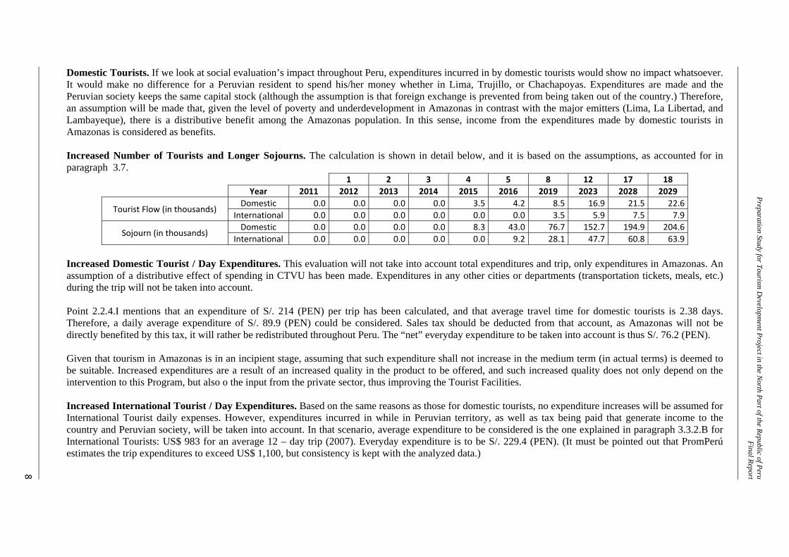
Domestic Tourists. If we look at social evaluation’s impact throughout Peru, expenditures incurred in by domestic tourists would show no impact whatsoever. It would make no difference for a Peruvian resident to spend his/her money whether in Lima, Trujillo, or Chachapoyas. Expenditures are made and the Peruvian society keeps the same capital stock (although the assumption is that foreign exchange is prevented from being taken out of the country.) Therefore, an assumption will be made that, given the level of poverty and underdevelopment in Amazonas in contrast with the major emitters (Lima, La Libertad, and Lambayeque), there is a distributive benefit among the Amazonas population. In this sense, income from the expenditures made by domestic tourists in Amazonas is considered as benefits. Increased Number of Tourists and Longer Sojourns. The calculation is shown in detail below, and it is based on the assumptions, as accounted for in paragraph 3.7.
1 2 3 4 5 8 12 17 18 Year 2011 2012 2013 2014 2015 2016 2019 2023 2028 2029
Tourist Flow (in thousands) Domestic 0.0 0.0 0.0 0.0 3.5 4.2 8.5 16.9 21.5 22.6
International 0.0 0.0 0.0 0.0 0.0 0.0 3.5 5.9 7.5 7.9
Sojourn (in thousands) Domestic 0.0 0.0 0.0 0.0 8.3 43.0 76.7 152.7 194.9 204.6
International 0.0 0.0 0.0 0.0 0.0 9.2 28.1 47.7 60.8 63.9 Increased Domestic Tourist / Day Expenditures. This evaluation will not take into account total expenditures and trip, only expenditures in Amazonas. An assumption of a distributive effect of spending in CTVU has been made. Expenditures in any other cities or departments (transportation tickets, meals, etc.) during the trip will not be taken into account. Point 2.2.4.I mentions that an expenditure of S/. 214 (PEN) per trip has been calculated, and that average travel time for domestic tourists is 2.38 days. Therefore, a daily average expenditure of S/. 89.9 (PEN) could be considered. Sales tax should be deducted from that account, as Amazonas will not be directly benefited by this tax, it will rather be redistributed throughout Peru. The “net” everyday expenditure to be taken into account is thus S/. 76.2 (PEN). Given that tourism in Amazonas is in an incipient stage, assuming that such expenditure shall not increase in the medium term (in actual terms) is deemed to be suitable. Increased expenditures are a result of an increased quality in the product to be offered, and such increased quality does not only depend on the intervention to this Program, but also o the input from the private sector, thus improving the Tourist Facilities. Increased International Tourist / Day Expenditures. Based on the same reasons as those for domestic tourists, no expenditure increases will be assumed for International Tourist daily expenses. However, expenditures incurred in while in Peruvian territory, as well as tax being paid that generate income to the country and Peruvian society, will be taken into account. In that scenario, average expenditure to be considered is the one explained in paragraph 3.3.2.B for International Tourists: US$ 983 for an average 12 – day trip (2007). Everyday expenditure is to be S/. 229.4 (PEN). (It must be pointed out that PromPerú estimates the trip expenditures to exceed US$ 1,100, but consistency is kept with the analyzed data.)
Preparation Study for Tourism D
evelopment Project in the N
orth Part of the Republic of PeruFinal Repor t
9
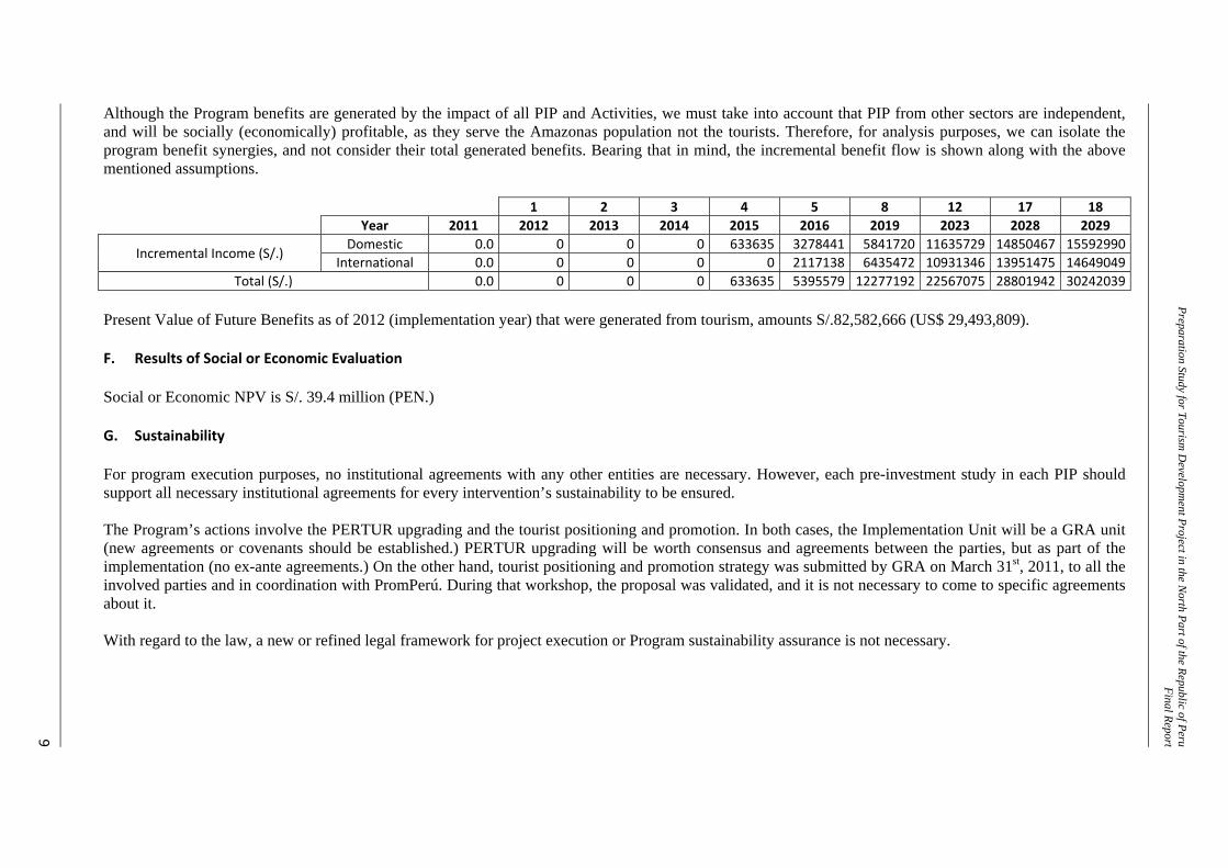
Although the Program benefits are generated by the impact of all PIP and Activities, we must take into account that PIP from other sectors are independent, and will be socially (economically) profitable, as they serve the Amazonas population not the tourists. Therefore, for analysis purposes, we can isolate the program benefit synergies, and not consider their total generated benefits. Bearing that in mind, the incremental benefit flow is shown along with the above mentioned assumptions.
1 2 3 4 5 8 12 17 18 Year 2011 2012 2013 2014 2015 2016 2019 2023 2028 2029
Incremental Income (S/.) Domestic 0.0 0 0 0 633635 3278441 5841720 11635729 14850467 15592990
International 0.0 0 0 0 0 2117138 6435472 10931346 13951475 14649049 Total (S/.) 0.0 0 0 0 633635 5395579 12277192 22567075 28801942 30242039
Present Value of Future Benefits as of 2012 (implementation year) that were generated from tourism, amounts S/.82,582,666 (US$ 29,493,809). F. Results of Social or Economic Evaluation Social or Economic NPV is S/. 39.4 million (PEN.) G. Sustainability For program execution purposes, no institutional agreements with any other entities are necessary. However, each pre-investment study in each PIP should support all necessary institutional agreements for every intervention’s sustainability to be ensured. The Program’s actions involve the PERTUR upgrading and the tourist positioning and promotion. In both cases, the Implementation Unit will be a GRA unit (new agreements or covenants should be established.) PERTUR upgrading will be worth consensus and agreements between the parties, but as part of the implementation (no ex-ante agreements.) On the other hand, tourist positioning and promotion strategy was submitted by GRA on March 31st, 2011, to all the involved parties and in coordination with PromPerú. During that workshop, the proposal was validated, and it is not necessary to come to specific agreements about it. With regard to the law, a new or refined legal framework for project execution or Program sustainability assurance is not necessary.
Preparatory Study for Tourism Development Project in the North Part of the Republic of Peru Final Report
10
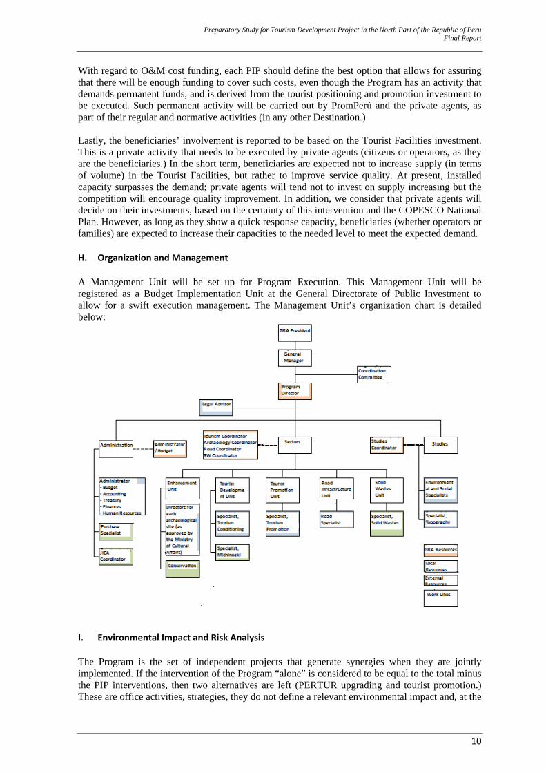
With regard to O&M cost funding, each PIP should define the best option that allows for assuring that there will be enough funding to cover such costs, even though the Program has an activity that demands permanent funds, and is derived from the tourist positioning and promotion investment to be executed. Such permanent activity will be carried out by PromPerú and the private agents, as part of their regular and normative activities (in any other Destination.) Lastly, the beneficiaries’ involvement is reported to be based on the Tourist Facilities investment. This is a private activity that needs to be executed by private agents (citizens or operators, as they are the beneficiaries.) In the short term, beneficiaries are expected not to increase supply (in terms of volume) in the Tourist Facilities, but rather to improve service quality. At present, installed capacity surpasses the demand; private agents will tend not to invest on supply increasing but the competition will encourage quality improvement. In addition, we consider that private agents will decide on their investments, based on the certainty of this intervention and the COPESCO National Plan. However, as long as they show a quick response capacity, beneficiaries (whether operators or families) are expected to increase their capacities to the needed level to meet the expected demand. H. Organization and Management A Management Unit will be set up for Program Execution. This Management Unit will be registered as a Budget Implementation Unit at the General Directorate of Public Investment to allow for a swift execution management. The Management Unit’s organization chart is detailed below:
I. Environmental Impact and Risk Analysis The Program is the set of independent projects that generate synergies when they are jointly implemented. If the intervention of the Program “alone” is considered to be equal to the total minus the PIP interventions, then two alternatives are left (PERTUR upgrading and tourist promotion.) These are office activities, strategies, they do not define a relevant environmental impact and, at the
Preparatory Study for Tourism Development Project in the North Part of the Republic of Peru Final Report
11
same time, once they are activated, their execution won’t be affected by any probable hazards. On the other hand, each PIP should carry out environmental impact analyses, due to the intervention and service being rendered. In addition, it should know about all hazards and vulnerabilities on those vulnerable components or factors that allow for the service rendering, and on the population being benefited with such service. J. Conclusions and Recommendations ‐ Based on the detailed analysis to the Program’s pre-feasibility study, the Program is
considered to bear the characteristics that make it viable.
‐ Total Program investment amounts S/. 103 million (PEN), and the Program’s social or economic evaluation estimates a positive Net Present Value of S/. 11,476,237 (PEN.)
‐ The Program is designed for impacts caused by different projects that generate synergies and
encourage sustainably increasing tourist flows in the future, when the Program is combined with tourist promotion
‐ Tourism is a business with large and small capitals. Amazonas’ demographic and geographic
characteristics, and the type of tourism intended for sale along the CTVU (“for connoisseurs” and “multiple theme”) are expected to encourage small capitals and populations in the rural areas to actively participate, and generate sustainable income that will benefit the families.
Preparation Study for Tourism D
evelopment Project in the N
orth Part of the Republic of PeruFinal Report
12
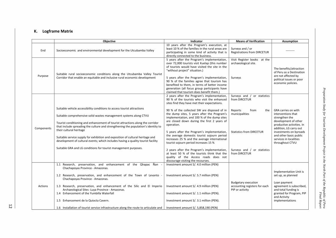
K. Logframe Matrix
Objective Indicator Means of Verification Assumption
End Socioeconomic and environmental development for the Utcubamba Valley
10 years after the Program’s execution, at least 10 % of the families in the rural areas are participating in some kind of activity that is directly connected to the business.
Surveys and / or Registrations from DIRCETUR ‐‐‐‐‐‐‐‐‐
Purpose Suitable rural socioeconomic conditions along the Utcubamba Valley Tourist Corridor that enable an equitable and inclusive rural economic development
5 years after the Program’s implementation, over 72,000 tourists visit Kuelap (this number of tourists would have visited the site in the “without project” situation.) 5 years after the Program’s implementation, 90 % of the families agree that tourism has benefited to them, in terms of better income generation (all focus group participants have claimed that tourism does benefit them.)
Visit Register books at the archaeological site. Surveys
The benefits/attraction of Peru as a Destination are not affected by political issues or poor economic policies.
Components
Suitable vehicle accessibility conditions to access tourist attractions Suitable comprehensive solid wastes management systems along CTVU Tourist conditioning and enhancement of tourist attractions along the corridor that include spreading the culture and strengthening the population’s identity to their cultural heritage Suitable service supply for exhibition and exposition of cultural heritage and development of cultural events; which includes having a quality tourist facility Suitable GRA and LG conditions for tourist management purposes.
2 years after the Program’s implementation, 90 % of the tourists who visit the enhanced sites find they have met their expectations. 90 % of the collected SW are disposed of in the dump sites, 5 years after the Program’s implementation, and 100 % of the dump sites are closed down during the first 2 years of operation. 5 years after the Program’s implementation, the average domestic tourist sojourn period increases 25 % and the average international tourist sojourn period increases 15 % 2 years after the Program’s implementation, at least 50 % of the tourists think that the quality of the Access roads does not discourage visiting the recourses.
Surveys and / or statistics from DIRCETUR Reports from the municipalities Statistics from DIRCETUR Surveys and / or statistics from DIRCETUR
GRA carries on with interventions that strengthen the development of other productive activities. In addition, LG carry out investments on byroads and other basic public services in localities throughout CTVU
Actions
1.1 Research, preservation, and enhancement of the Qhapac Ñan ‐Chachapoyas Province ‐ Amazonas.
1.2 Research, preservation, and enhancement of the Town of Levanto ‐
Chachapoyas Province ‐ Amazonas. 1.3 Research, preservation, and enhancement of the Silic and El Imperio
Archaeological Sites ‐Luya Province ‐ Amazonas. 1.4 Enhancement of the Yumbilla Waterfall 1.5 Enhancement de la Quiocta Cavern. 1.6 Installation of tourist service infrastructure along the route to articulate and
Investment amount S/. 4.0 million (PEN) Investment amount S/. 5.7 million (PEN) Investment amount S/. 4.9 million (PEN) Investment amount S/. 1.1 million (PEN). Investment amount S/. 3.1 million (PEN). Investment amount S/. 5,858,190 (PEN)
Budgetary execution accounting registers for each PIP or activity
Implementation Unit is set up, as planned Loan payment agreement is subscribed, and total funding is granted for Program, PIP and Activity implementations
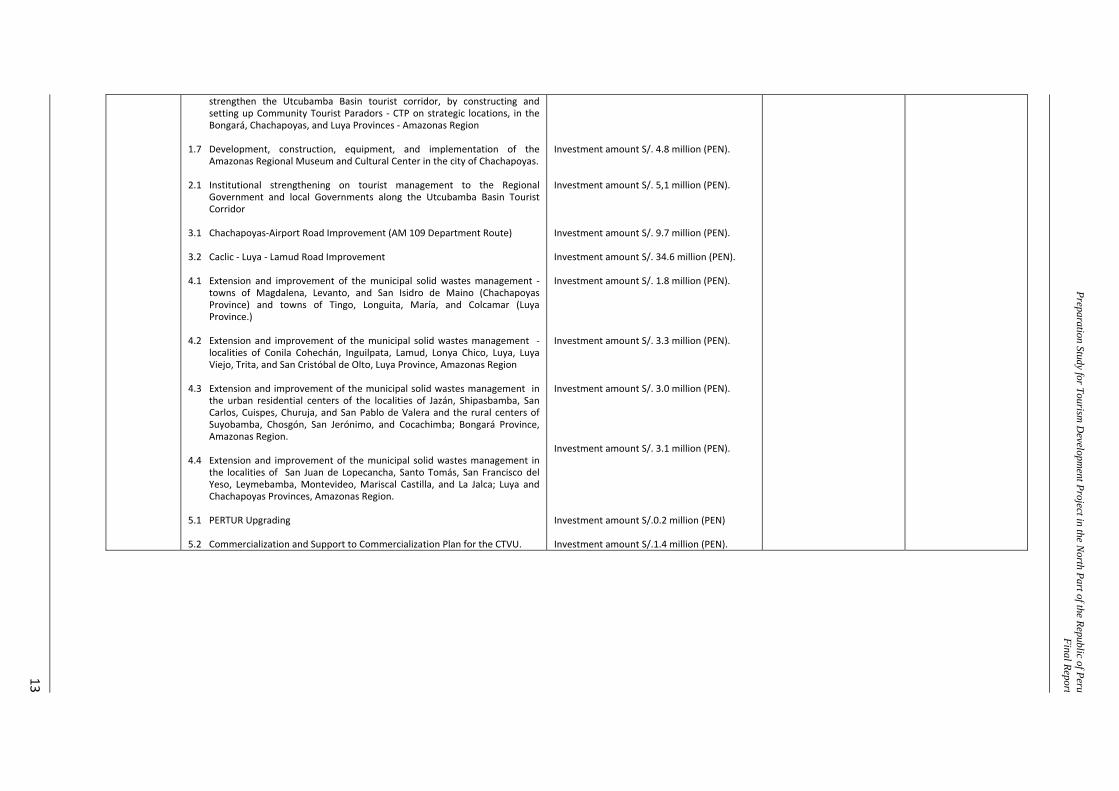
Preparation Study for Tourism D
evelopment Project in the N
orth Part of the Republic of PeruFinal Report
13
strengthen the Utcubamba Basin tourist corridor, by constructing and setting up Community Tourist Paradors ‐ CTP on strategic locations, in the Bongará, Chachapoyas, and Luya Provinces ‐ Amazonas Region
1.7 Development, construction, equipment, and implementation of the
Amazonas Regional Museum and Cultural Center in the city of Chachapoyas. 2.1 Institutional strengthening on tourist management to the Regional
Government and local Governments along the Utcubamba Basin Tourist Corridor
3.1 Chachapoyas‐Airport Road Improvement (AM 109 Department Route) 3.2 Caclic ‐ Luya ‐ Lamud Road Improvement 4.1 Extension and improvement of the municipal solid wastes management ‐
towns of Magdalena, Levanto, and San Isidro de Maino (Chachapoyas Province) and towns of Tingo, Longuita, María, and Colcamar (Luya Province.)
4.2 Extension and improvement of the municipal solid wastes management ‐
localities of Conila Cohechán, Inguilpata, Lamud, Lonya Chico, Luya, Luya Viejo, Trita, and San Cristóbal de Olto, Luya Province, Amazonas Region
4.3 Extension and improvement of the municipal solid wastes management in
the urban residential centers of the localities of Jazán, Shipasbamba, San Carlos, Cuispes, Churuja, and San Pablo de Valera and the rural centers of Suyobamba, Chosgón, San Jerónimo, and Cocachimba; Bongará Province, Amazonas Region.
4.4 Extension and improvement of the municipal solid wastes management in
the localities of San Juan de Lopecancha, Santo Tomás, San Francisco del Yeso, Leymebamba, Montevideo, Mariscal Castilla, and La Jalca; Luya and Chachapoyas Provinces, Amazonas Region.
5.1 PERTUR Upgrading 5.2 Commercialization and Support to Commercialization Plan for the CTVU.
Investment amount S/. 4.8 million (PEN). Investment amount S/. 5,1 million (PEN). Investment amount S/. 9.7 million (PEN). Investment amount S/. 34.6 million (PEN). Investment amount S/. 1.8 million (PEN). Investment amount S/. 3.3 million (PEN). Investment amount S/. 3.0 million (PEN). Investment amount S/. 3.1 million (PEN). Investment amount S/.0.2 million (PEN) Investment amount S/.1.4 million (PEN).

Preparatory Study for Tourism Development Project in the North Part of the Republic of Peru Final Report
14
CHAPTER I GENERAL
Preparatory Study for Tourism Development Project in the North Part of the Republic of Peru Final Report
15
1.0 GENERAL 1.1 Name of the Investment Program “ESTABLISHMENT OF BASES FOR RURAL DEVELOPMENT, BY MEANS OF TOURISM, ALONG THE UTCUBAMBA VALLEY, PEDRO RUIZ – LEYMEBAMBA SECTOR TOURIST CORRIDOR, AMAZONAS REGION”, with SNIP Code No: PROG – 078 – 2009 – SNIP
This is the registered name in the SNIP Project Bank for the Investment Program (Program) when the profile (Perfil) level study was submitted. Therefore, the use of the term “valley” that basically leads to “agriculture” criteria needs to be extended to a concept of “Basin”, and so, these terms will be used indistinctly. Without affecting this, the term “valley” is found to be more commercial as a tourist product, as it could be associated to another already positioned resource, namely, the Inca Valley. 1.2 Formulating and Implementation Units 1.2.1 Formulating Unit1 Institution : Regional Government of Amazonas (GRA) Formulating Unit : Regional Economic Development Management2 Person in Charge : Leonardo Rojas Sánchez Address : Jr. Triunfo 1064, Chachapoyas, Amazonas Telephone No. : 041-477157 1.2.2 Recommended Implementation Unit Institution : Regional Government of Amazonas Implementation Unit : To be established. For Program execution purposes, a Budgetary
Implementation Unit attached to the Regional Economic Development Management will be set up. The scope of this Budgetary Implementation Unit’s work will be strictly the execution of the projects and activities involved in the Program. 3
Implementation Unit for Registration: 001 - Regional Government of Amazonas Seat Sector : Regional Governments Person in Charge : General Program Coordinator Address : Jr. Triunfo 1064, Chachapoyas, Amazonas Telephone No. : 041-477157 Although the Budgetary Executing Unit will be set up for the purposes of the Program’s execution, some Public Investment Projects (PIP) that were formulated and executed by Amazonas Regional Government for the Tourist Sector are described in detail below:
Regional Government of Amazonas : Formulated and Executed PIP
1 JICA has entrusted the preparation of this Pre - Investment Study for the Regional Government of Amazonas to KRI
International Corp., Nippon Koei Co, Ltd. and Nippon Koei LAC CO., LTD. 2 Article 29-A of the Organic Law for Regional Governments, Law No. 27867, establishes functions of Regional
Managements. In that sense, it establishes the following: “1. The Economic Development Management.- Its duty is to carry out specific functions in the…tourism, craft making…sectors.” In the case of GRA, this Management has 4 Sectoral Directorates, including the Regional Directorate of Foreign Commerce and Tourism (DIRCETUR). This specific Directorate’s functions include “Promoting tourist development, by means of making the best use of the regional potentialities.”
3 Ditto.
Preparatory Study for Tourism Development Project in the North Part of the Republic of Peru Final Report
16
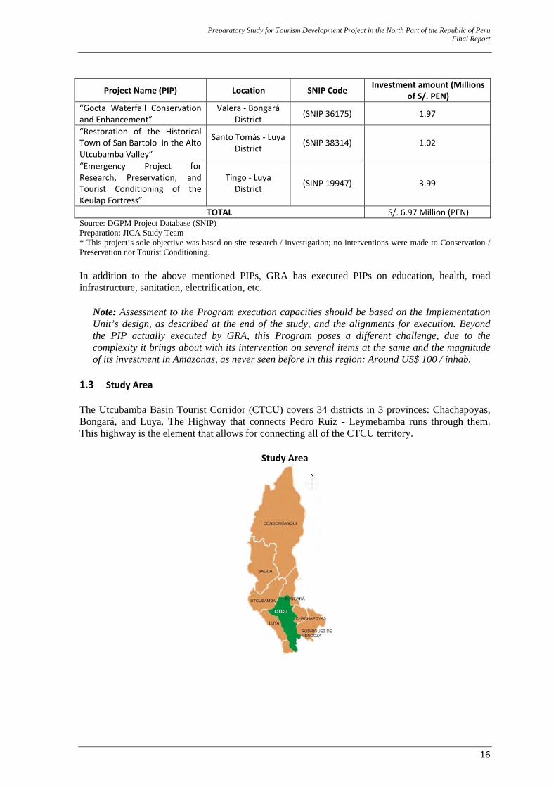
Project Name (PIP) Location SNIP Code Investment amount (Millions of S/. PEN)
“Gocta Waterfall Conservation and Enhancement”
Valera ‐ Bongará District (SNIP 36175) 1.97
“Restoration of the Historical Town of San Bartolo in the Alto Utcubamba Valley”
Santo Tomás ‐ Luya District (SNIP 38314) 1.02
“Emergency Project for Research, Preservation, and Tourist Conditioning of the Keulap Fortress”
Tingo ‐ Luya District (SINP 19947) 3.99
TOTAL S/. 6.97 Million (PEN)Source: DGPM Project Database (SNIP) Preparation: JICA Study Team * This project’s sole objective was based on site research / investigation; no interventions were made to Conservation / Preservation nor Tourist Conditioning. In addition to the above mentioned PIPs, GRA has executed PIPs on education, health, road infrastructure, sanitation, electrification, etc.
Note: Assessment to the Program execution capacities should be based on the Implementation Unit’s design, as described at the end of the study, and the alignments for execution. Beyond the PIP actually executed by GRA, this Program poses a different challenge, due to the complexity it brings about with its intervention on several items at the same and the magnitude of its investment in Amazonas, as never seen before in this region: Around US$ 100 / inhab.
1.3 Study Area The Utcubamba Basin Tourist Corridor (CTCU) covers 34 districts in 3 provinces: Chachapoyas, Bongará, and Luya. The Highway that connects Pedro Ruiz - Leymebamba runs through them. This highway is the element that allows for connecting all of the CTCU territory.
Study Area
Preparation Study for Tourism D
evelopment Project in the N
orth Part of the Republic of PeruFinal Report
17
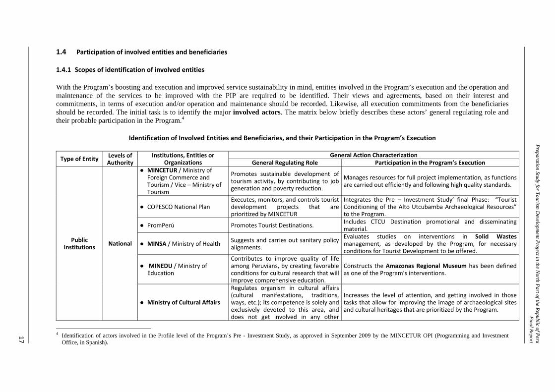
1.4 Participation of involved entities and beneficiaries
1.4.1 Scopes of identification of involved entities With the Program’s boosting and execution and improved service sustainability in mind, entities involved in the Program’s execution and the operation and maintenance of the services to be improved with the PIP are required to be identified. Their views and agreements, based on their interest and commitments, in terms of execution and/or operation and maintenance should be recorded. Likewise, all execution commitments from the beneficiaries should be recorded. The initial task is to identify the major involved actors. The matrix below briefly describes these actors’ general regulating role and their probable participation in the Program.4
Identification of Involved Entities and Beneficiaries, and their Participation in the Program’s Execution
Type of Entity Levels of Authority
Institutions, Entities or Organizations
General Action Characterization General Regulating Role Participation in the Program’s Execution
Public Institutions National
● MINCETUR / Ministry of Foreign Commerce and Tourism / Vice – Ministry of Tourism
Promotes sustainable development of tourism activity, by contributing to job generation and poverty reduction.
Manages resources for full project implementation, as functions are carried out efficiently and following high quality standards.
● COPESCO National Plan Executes, monitors, and controls tourist development projects that are prioritized by MINCETUR
Integrates the Pre – Investment Study’ final Phase: “Tourist Conditioning of the Alto Utcubamba Archaeological Resources” to the Program.
● PromPerú Promotes Tourist Destinations. Includes CTCU Destination promotional and disseminating material.
● MINSA / Ministry of Health Suggests and carries out sanitary policy alignments.
Evaluates studies on interventions in Solid Wastes management, as developed by the Program, for necessary conditions for Tourist Development to be offered.
● MINEDU / Ministry of Education
Contributes to improve quality of life among Peruvians, by creating favorable conditions for cultural research that will improve comprehensive education.
Constructs the Amazonas Regional Museum has been defined as one of the Program’s interventions.
● Ministry of Cultural Affairs
Regulates organism in cultural affairs (cultural manifestations, traditions, ways, etc.); its competence is solely and exclusively devoted to this area, and does not get involved in any other
Increases the level of attention, and getting involved in those tasks that allow for improving the image of archaeological sites and cultural heritages that are prioritized by the Program.
4 Identification of actors involved in the Profile level of the Program’s Pre - Investment Study, as approved in September 2009 by the MINCETUR OPI (Programming and Investment
Office, in Spanish).
Preparation Study for Tourism D
evelopment Project in the N
orth Part of the Republic of PeruFinal Report
18
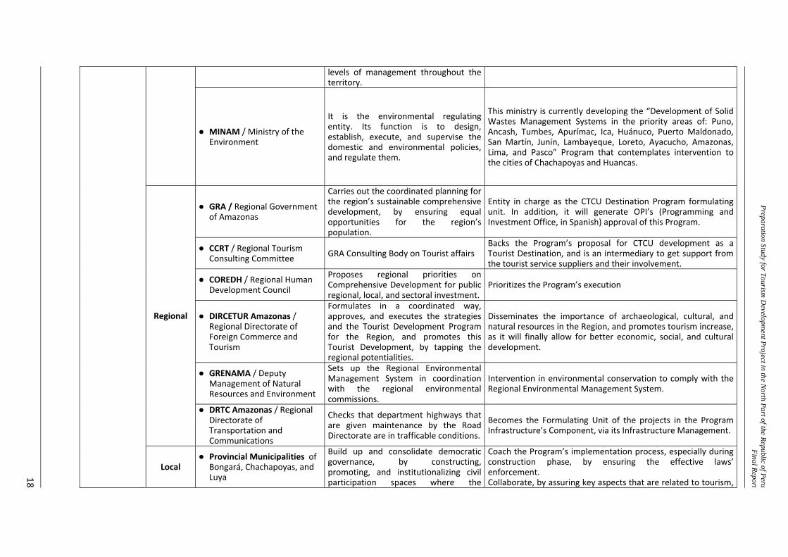
levels of management throughout the territory.
● MINAM / Ministry of the Environment
It is the environmental regulating entity. Its function is to design, establish, execute, and supervise the domestic and environmental policies, and regulate them.
This ministry is currently developing the “Development of Solid Wastes Management Systems in the priority areas of: Puno, Ancash, Tumbes, Apurímac, Ica, Huánuco, Puerto Maldonado, San Martín, Junín, Lambayeque, Loreto, Ayacucho, Amazonas, Lima, and Pasco” Program that contemplates intervention to the cities of Chachapoyas and Huancas.
Regional
● GRA / Regional Government of Amazonas
Carries out the coordinated planning for the region’s sustainable comprehensive development, by ensuring equal opportunities for the region’s population.
Entity in charge as the CTCU Destination Program formulating unit. In addition, it will generate OPI’s (Programming and Investment Office, in Spanish) approval of this Program.
● CCRT / Regional Tourism Consulting Committee GRA Consulting Body on Tourist affairs
Backs the Program’s proposal for CTCU development as a Tourist Destination, and is an intermediary to get support from the tourist service suppliers and their involvement.
● COREDH / Regional Human Development Council
Proposes regional priorities on Comprehensive Development for public regional, local, and sectoral investment.
Prioritizes the Program’s execution
● DIRCETUR Amazonas / Regional Directorate of Foreign Commerce and Tourism
Formulates in a coordinated way, approves, and executes the strategies and the Tourist Development Program for the Region, and promotes this Tourist Development, by tapping the regional potentialities.
Disseminates the importance of archaeological, cultural, and natural resources in the Region, and promotes tourism increase, as it will finally allow for better economic, social, and cultural development.
● GRENAMA / Deputy Management of Natural Resources and Environment
Sets up the Regional Environmental Management System in coordination with the regional environmental commissions.
Intervention in environmental conservation to comply with the Regional Environmental Management System.
● DRTC Amazonas / Regional Directorate of Transportation and Communications
Checks that department highways that are given maintenance by the Road Directorate are in trafficable conditions.
Becomes the Formulating Unit of the projects in the Program Infrastructure’s Component, via its Infrastructure Management.
Local ● Provincial Municipalities of
Bongará, Chachapoyas, and Luya
Build up and consolidate democratic governance, by constructing, promoting, and institutionalizing civil participation spaces where the
Coach the Program’s implementation process, especially during construction phase, by ensuring the effective laws’ enforcement. Collaborate, by assuring key aspects that are related to tourism,
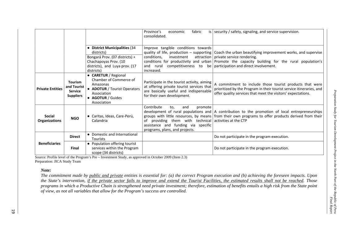
Preparation Study for Tourism D
evelopment Project in the N
orth Part of the Republic of PeruFinal Report
19
Province’s economic fabric is consolidated.
security / safety, signaling, and service supervision.
● District Municipalities (34 districts)
Improve tangible conditions towards quality of life, production – supporting conditions, investment attraction conditions for productivity and urban and rural competitiveness to be increased.
Coach the urban beautifying improvement works, and supervise private service rendering. Promote the capacity building for the rural population’s participation and direct involvement.
Bongará Prov. (07 districts) + Chachapoyas Prov. (10 districts), and Luya prov. (17 districts)
Private Entities
Tourism and Tourist Service Suppliers
● CARETUR / Regional Chamber of Commerce of Amazonas
● ADOTUR / Tourist Operators Association
● AGOTUR / Guides Association
Participate in the tourist activity, aiming at offering private tourist services that are basically useful and indispensable for their own development.
A commitment to include those tourist products that were prioritized by the Program in their tourist service itineraries, and offer quality services that meet the visitors’ expectations.
Social Organizations NGO ● Caritas, Ideas, Care‐Perú,
Calandria
Contribute to, and promote development of rural populations and groups with little resources, by means of providing them with technical assistance and funding via specific programs, plans, and projects.
A contribution to the promotion of local entrepreneurships from their own programs to offer products derived from their activities at the CTP
Beneficiaries
Direct ● Domestic and International Tourists Do not participate in the program execution.
Final ● Population offering tourist
services within the Program scope (34 districts)
Do not participate in the program execution.
Source: Profile level of the Program’s Pre – Investment Study, as approved in October 2009 (Item 2.3) Preparation: JICA Study Team
Note: The commitment made by public and private entities is essential for: (a) the correct Program execution and (b) achieving the foreseen impacts. Upon the State’s intervention, if the private sector fails to improve and extend the Tourist Facilities, the estimated results shall not be reached. Those programs in which a Productive Chain is strengthened need private investment; therefore, estimation of benefits entails a high risk from the State point of view, as not all variables that allow for the Program’s success are controlled.
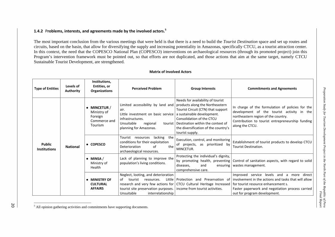
Preparation Study for Tourism D
evelopment Project in the N
orth Part of the Republic of PeruFinal Report
20
1.4.2 Problems, interests, and agreements made by the involved actors.5 The most important conclusion from the various meetings that were held is that there is a need to build the Tourist Destination space and set up routes and circuits, based on the basin, that allow for diversifying the supply and increasing potentiality in Amazonas, specifically CTCU, as a tourist attraction center. In this context, the need that the COPESCO National Plan (COPESCO) interventions on archaeological resources (through its promoted project) join this Program’s intervention framework must be pointed out, so that efforts are not duplicated, and those actions that aim at the same target, namely CTCU Sustainable Tourist Development, are strengthened.
Matrix of Involved Actors
Type of Entities Levels of Authority
Institutions, Entities, or
Organizations
Perceived Problem Group Interests Commitments and Agreements
Public Institutions National
● MINCETUR / Ministry of Foreign Commerce and Tourism
Limited accessibility by land and air. Little investment on basic service infrastructures. Unsuitable regional tourist planning for Amazonas.
Needs for availability of tourist products along the Northeastern Tourist Circuit (CTN) that support a sustainable development. Consolidation of the CTCU Destination within the context of the diversification of the country’s tourist supply.
In charge of the formulation of policies for the development of the tourist activity in the northeastern region of the country. Contribution to tourist entrepreneurship funding along the CTCU.
● COPESCO
Tourist resources lacking the conditions for their exploitation Deterioration of the archaeological resources.
Execution, control, and monitoring of projects, as prioritized by MINCETUR.
Establishment of tourist products to develop CTCU Tourist Destination.
● MINSA / Ministry of Health
Lack of planning to improve the population’s living conditions.
Protecting the individual’s dignity, by promoting health, preventing diseases, and ensuring comprehensive care.
Control of sanitation aspects, with regard to solid wastes management.
● MINISTRY OF CULTURAL AFFAIRS
Neglect, looting, and deterioration of tourist resources. Little research and very few actions for tourist site preservation purposes. Unsuitable interrelationship
Protection and Preservation of CTCU Cultural Heritage Increased income from tourist activities.
Improved service levels and a more direct involvement in the actions and tasks that will allow for tourist resource enhancement s. Faster paperwork and negotiation process carried out for program development.
5 All opinion gathering activities and commitments have supporting documents.
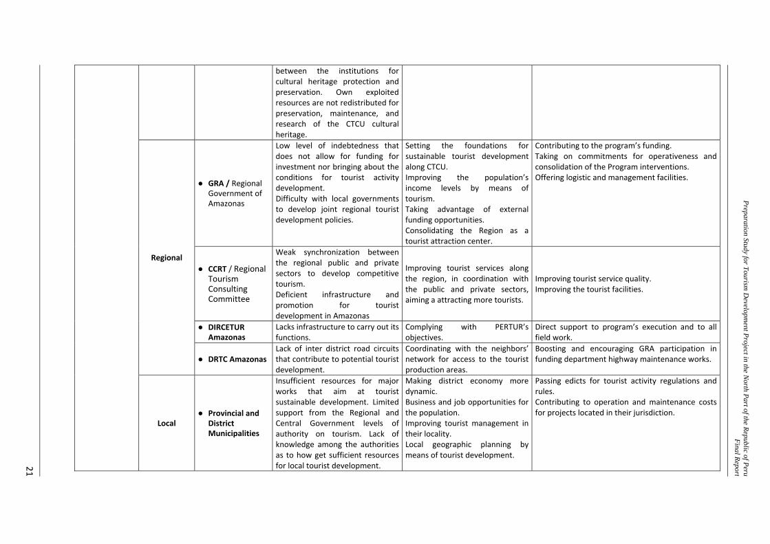
Preparation Study for Tourism D
evelopment Project in the N
orth Part of the Republic of PeruFinal Report
21
between the institutions for cultural heritage protection and preservation. Own exploited resources are not redistributed for preservation, maintenance, and research of the CTCU cultural heritage.
Regional
● GRA / Regional Government of Amazonas
Low level of indebtedness that does not allow for funding for investment nor bringing about the conditions for tourist activity development. Difficulty with local governments to develop joint regional tourist development policies.
Setting the foundations for sustainable tourist development along CTCU. Improving the population’s income levels by means of tourism. Taking advantage of external funding opportunities. Consolidating the Region as a tourist attraction center.
Contributing to the program’s funding. Taking on commitments for operativeness and consolidation of the Program interventions. Offering logistic and management facilities.
● CCRT / Regional Tourism Consulting Committee
Weak synchronization between the regional public and private sectors to develop competitive tourism. Deficient infrastructure and promotion for tourist development in Amazonas
Improving tourist services along the region, in coordination with the public and private sectors, aiming a attracting more tourists.
Improving tourist service quality. Improving the tourist facilities.
● DIRCETUR Amazonas
Lacks infrastructure to carry out its functions.
Complying with PERTUR’s objectives.
Direct support to program’s execution and to all field work.
● DRTC AmazonasLack of inter district road circuits that contribute to potential tourist development.
Coordinating with the neighbors’ network for access to the tourist production areas.
Boosting and encouraging GRA participation in funding department highway maintenance works.
Local ● Provincial and
District Municipalities
Insufficient resources for major works that aim at tourist sustainable development. Limited support from the Regional and Central Government levels of authority on tourism. Lack of knowledge among the authorities as to how get sufficient resources for local tourist development.
Making district economy more dynamic. Business and job opportunities for the population. Improving tourist management in their locality. Local geographic planning by means of tourist development.
Passing edicts for tourist activity regulations and rules. Contributing to operation and maintenance costs for projects located in their jurisdiction.
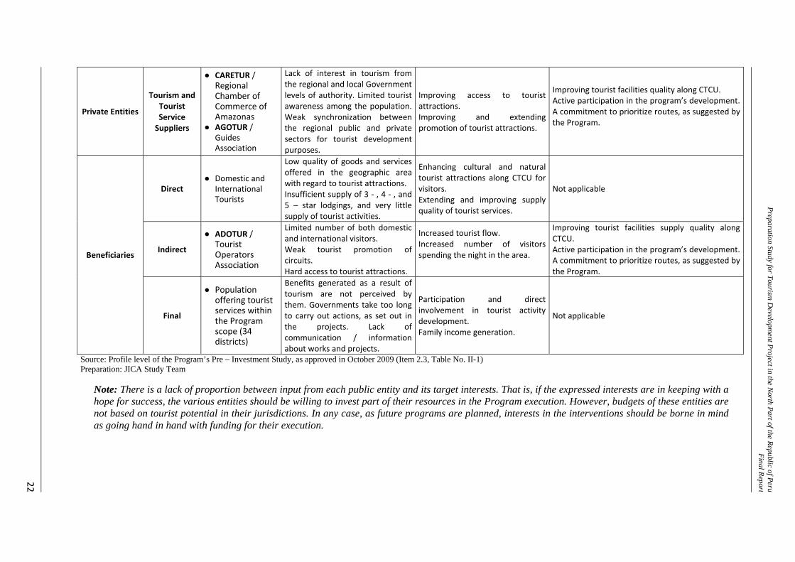
Preparation Study for Tourism D
evelopment Project in the N
orth Part of the Republic of PeruFinal Report
22
Private Entities
Tourism and Tourist Service Suppliers
● CARETUR / Regional Chamber of Commerce of Amazonas
● AGOTUR / Guides Association
Lack of interest in tourism from the regional and local Government levels of authority. Limited tourist awareness among the population. Weak synchronization between the regional public and private sectors for tourist development purposes.
Improving access to tourist attractions. Improving and extending promotion of tourist attractions.
Improving tourist facilities quality along CTCU. Active participation in the program’s development. A commitment to prioritize routes, as suggested by the Program.
Beneficiaries
Direct ● Domestic and
International Tourists
Low quality of goods and services offered in the geographic area with regard to tourist attractions. Insufficient supply of 3 ‐ , 4 ‐ , and 5 – star lodgings, and very little supply of tourist activities.
Enhancing cultural and natural tourist attractions along CTCU for visitors. Extending and improving supply quality of tourist services.
Not applicable
Indirect
● ADOTUR / Tourist Operators Association
Limited number of both domestic and international visitors. Weak tourist promotion of circuits. Hard access to tourist attractions.
Increased tourist flow. Increased number of visitors spending the night in the area.
Improving tourist facilities supply quality along CTCU. Active participation in the program’s development. A commitment to prioritize routes, as suggested by the Program.
Final
● Population offering tourist services within the Program scope (34 districts)
Benefits generated as a result of tourism are not perceived by them. Governments take too long to carry out actions, as set out in the projects. Lack of communication / information about works and projects.
Participation and direct involvement in tourist activity development. Family income generation.
Not applicable
Source: Profile level of the Program’s Pre – Investment Study, as approved in October 2009 (Item 2.3, Table No. II-1) Preparation: JICA Study Team
Note: There is a lack of proportion between input from each public entity and its target interests. That is, if the expressed interests are in keeping with a hope for success, the various entities should be willing to invest part of their resources in the Program execution. However, budgets of these entities are not based on tourist potential in their jurisdictions. In any case, as future programs are planned, interests in the interventions should be borne in mind as going hand in hand with funding for their execution.
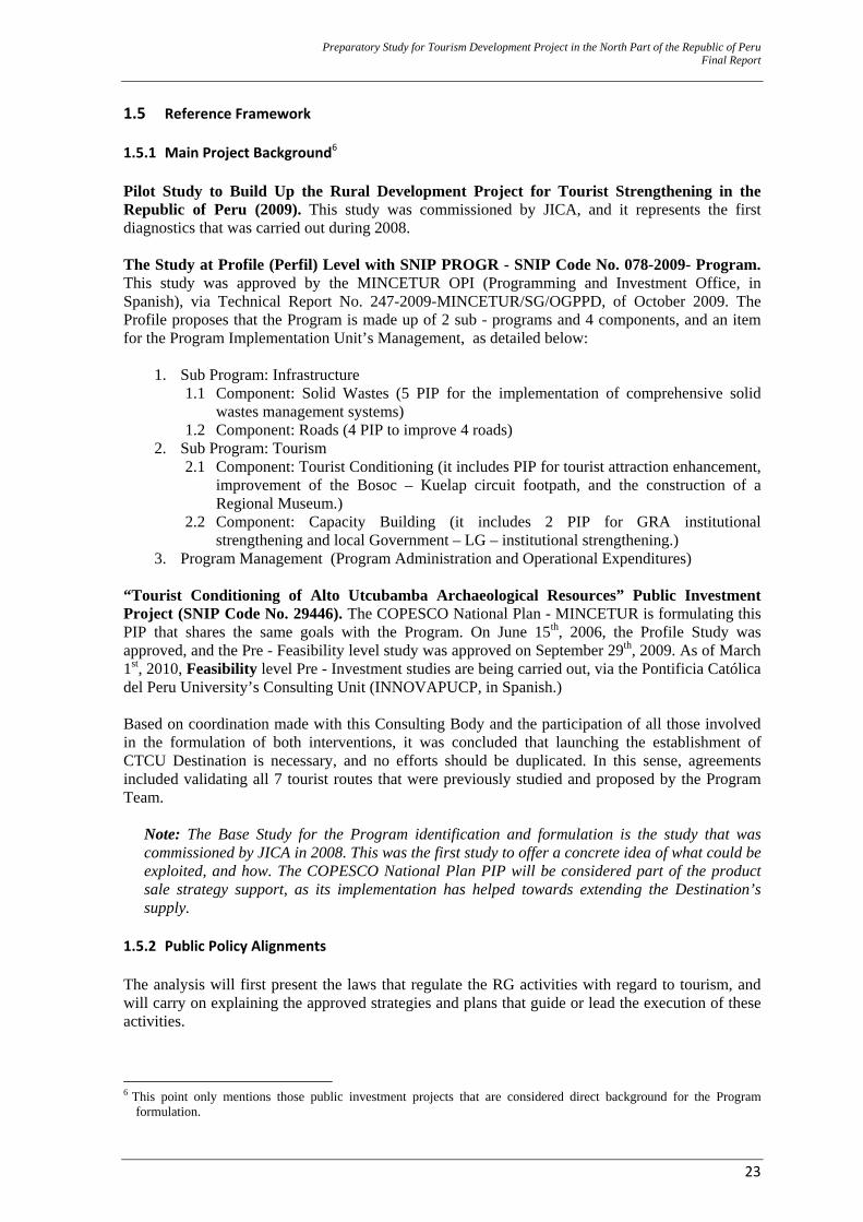
Preparatory Study for Tourism Development Project in the North Part of the Republic of Peru Final Report
23
1.5 Reference Framework 1.5.1 Main Project Background6 Pilot Study to Build Up the Rural Development Project for Tourist Strengthening in the Republic of Peru (2009). This study was commissioned by JICA, and it represents the first diagnostics that was carried out during 2008. The Study at Profile (Perfil) Level with SNIP PROGR - SNIP Code No. 078-2009- Program. This study was approved by the MINCETUR OPI (Programming and Investment Office, in Spanish), via Technical Report No. 247-2009-MINCETUR/SG/OGPPD, of October 2009. The Profile proposes that the Program is made up of 2 sub - programs and 4 components, and an item for the Program Implementation Unit’s Management, as detailed below:
1. Sub Program: Infrastructure
1.1 Component: Solid Wastes (5 PIP for the implementation of comprehensive solid wastes management systems)
1.2 Component: Roads (4 PIP to improve 4 roads) 2. Sub Program: Tourism
2.1 Component: Tourist Conditioning (it includes PIP for tourist attraction enhancement, improvement of the Bosoc – Kuelap circuit footpath, and the construction of a Regional Museum.)
2.2 Component: Capacity Building (it includes 2 PIP for GRA institutional strengthening and local Government – LG – institutional strengthening.)
3. Program Management (Program Administration and Operational Expenditures) “Tourist Conditioning of Alto Utcubamba Archaeological Resources” Public Investment Project (SNIP Code No. 29446). The COPESCO National Plan - MINCETUR is formulating this PIP that shares the same goals with the Program. On June 15th, 2006, the Profile Study was approved, and the Pre - Feasibility level study was approved on September 29th, 2009. As of March 1st, 2010, Feasibility level Pre - Investment studies are being carried out, via the Pontificia Católica del Peru University’s Consulting Unit (INNOVAPUCP, in Spanish.) Based on coordination made with this Consulting Body and the participation of all those involved in the formulation of both interventions, it was concluded that launching the establishment of CTCU Destination is necessary, and no efforts should be duplicated. In this sense, agreements included validating all 7 tourist routes that were previously studied and proposed by the Program Team.
Note: The Base Study for the Program identification and formulation is the study that was commissioned by JICA in 2008. This was the first study to offer a concrete idea of what could be exploited, and how. The COPESCO National Plan PIP will be considered part of the product sale strategy support, as its implementation has helped towards extending the Destination’s supply.
1.5.2 Public Policy Alignments The analysis will first present the laws that regulate the RG activities with regard to tourism, and will carry on explaining the approved strategies and plans that guide or lead the execution of these activities.
6 This point only mentions those public investment projects that are considered direct background for the Program
formulation.
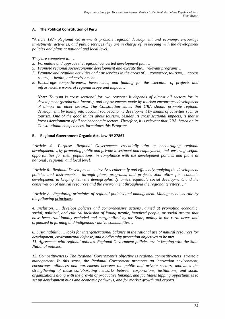
Preparatory Study for Tourism Development Project in the North Part of the Republic of Peru Final Report
24
A. The Political Constitution of Peru “Article 192.- Regional Governments promote regional development and economy, encourage investments, activities, and public services they are in charge of, in keeping with the development policies and plans at national and local level. They are competent to: … 2. Formulate and approve the regional concerted development plan… 5. Promote regional socioeconomic development and execute the… relevant programs… 7. Promote and regulate activities and / or services in the areas of … commerce, tourism,… access
routes,… health, and environment… 8. Encourage competitiveness, investments, and funding for the execution of projects and
infrastructure works of regional scope and impact…”
Note: Tourism is cross sectional for two reasons: It depends of almost all sectors for its development (production factors), and improvements made by tourism encourages development of almost all other sectors. The Constitution states that GRA should promote regional development, by taking into account socioeconomic development by means of activities such as tourism. One of the good things about tourism, besides its cross sectional impacts, is that it favors development of all socioeconomic sectors. Therefore, it is relevant that GRA, based on its Constitutional competences, formulates this Program.
B. Regional Government Organic Act, Law Nº 27867 “Article 4.- Purpose. Regional Governments essentially aim at encouraging regional development…, by promoting public and private investment and employment, and ensuring…equal opportunities for their populations, in compliance with the development policies and plans at national , regional, and local level. “Article 6.- Regional Development. … involves coherently and efficiently applying the development policies and instruments..., through plans, programs, and projects…that allow for economic development, in keeping with the demographic dynamics, equitable social development, and the conservation of natural resources and the environment throughout the regional territory,…” “Article 8.- Regulating principles of regional policies and management. Management…is rule by the following principles: 4. Inclusion. … develops policies and comprehensive actions…aimed at promoting economic, social, political, and cultural inclusion of Young people, impaired people, or social groups that have been traditionally excluded and marginalized by the State, mainly in the rural areas and organized in farming and indigenous / native communities… 8. Sustainability. … looks for intergenerational balance in the rational use of natural resources for development, environmental defense, and biodiversity protection objectives to be met. 11. Agreement with regional policies. Regional Government policies are in keeping with the State National policies. 13. Competitiveness.- The Regional Government’s objective is regional competitiveness’ strategic management. In this sense, the Regional Government promotes an innovation environment, encourages alliances and agreements between the public and private sectors, motivates the strengthening of those collaborating networks between corporations, institutions, and social organizations along with the growth of productive linkings, and facilitates tapping opportunities to set up development hubs and economic pathways, and for market growth and exports.”
Preparatory Study for Tourism Development Project in the North Part of the Republic of Peru Final Report
25
Note: With regard to the above mentioned regulations, it must be pointed out that Kuelap is prioritizing a national tourist development strategy. One tourist development characteristic is that it should have a regional (not a local) vision, and, at the same time, it strengthens development of all socioeconomic strata. In addition, tourism does not exploit resources, it makes the best use of them. In this sense, RG goals and principles that rule them match the intended dynamics for tourism in Peru.
“Article 63.- Functions with regard to Tourism a) Formulating, approving, executing, evaluating, conducting, controlling, and administering
policies related to regional tourist activity development, in compliance with the Government’s general policy and sectoral plans.
b) Formulating in a concerted way, approving, and executing the strategies and the tourist
development program for the region. c) Approving tourist activity - related regulations, as well as technical criteria that assure
accomplishment of objectives and goals that derive from the National Tourism Policy. d) Promoting tourist development, by means of tapping the regional potentialities. f) Coordinating actions with the local Governments on regional scope tourism. h) Identifying investment possibilities and areas of tourist interest around the region, and
promoting participation of any investors, who might be interested in tourist projects. i) Setting out and declaring prioritized areas for regional scope tourist development. j) Arranging facilities and security / safety measures for tourists, and executing regional tourist
protection and tourist awareness disseminating campaigns, in coordination with other public and private organisms.
k) Verifying compliance to environmental and natural resource conservation regulations around
the region, as related to tourist activity. m) Supervising the correct application of legal regulations, with regard to tourist activity, and
compliance to standards, as required to the tourist service providers around the region, as well as applying the relevant sanctions, in case of non – fulfillment, in compliance with the effective regulations.
n) Subscribing agreements, contracts, or inter – institutional cooperation agreements with public
or private entities. o) Promoting capacity building and training to staff that participates in the tourist activity. q) Organizing and conducting tourist promotion activities around the region, in coordination with
the tourist activity organizations and local Governments. r) Developing tourist circuits that could become regional development hubs.” “Article 47.- Functions related to education, culture, science, technology, sports, and recreation. l) Protecting and preserving, in coordination with the local Governments and relevant organisms,
all existing national cultural heritage around the region, as well as promoting the declaration,
Preparatory Study for Tourism Development Project in the North Part of the Republic of Peru Final Report
26
by the relevant organizations, of all those cultural / historical assets around the region that are still to be recognized.”
Note: Paragraph modified by Article 9 of Law N° 27902.
Note: These written out regulations are to prove the legal foundation for the RG to carry out a intervention on tourism (Article 63) and cultural heritage preservation (Article 47.)
C. General Tourism Act, Law No. 29408 “Article 2.- The Act’s Objective. … to promote, encourage, and regulate tourist activity sustainable development. Its application is mandatory at all three (3) levels of Government…in coordination with the various actors that are linked to this sector…” “Article 3.-Principles of the Tourist Activity. … the following: (Sustainable Development, inclusion, non – discrimination, encouragement to private investment, decentralization, quality, competitiveness, fair trade in tourism, tourist culture – participation of, and commitment to the population -, identity, and conservation / preservation.)”
Note: The Tourism Act’s objective and the tourist activity principles match the purpose and principles that rule the RG.
“Article 5.- Functions of the Regulating Organism. … (MINCETUR)… carries out the following tourism functions:
5.2 Developing a national tourist product through the competent regional body for each particular case, by defining individual needs that are required by the tourist destinations around the country…”
“Article 11.- National Tourism Strategic Plan. (MINCETUR) approves and upgrades (PENTUR) within the State policies, as a long – term planning and management instrument in the tourism sector at national scope.” “Article 20.- Promotion of Tourism Investment. (MINCETUR) promotes (PIP) execution at national level that contributes to the country’s economic and social development…” “Article 21.- Project prioritization. Throughout the tourist investment project prioritization process, involving both infrastructure and services… impact of such investment on the job generation objectives… (and) poverty alleviation… should be considered as major criteria…”
Note: According to regulations, Kuelap is prioritized in MINCETUR’ approved PENTUR. PENTUR sets the tourist development planning alignments for all the departments of Peru.
“Article 41.- Tourist Promotion. … is carried out according to the tourism sectoral policies, and involves implementation and development of tourism strategic plans … (and) … formulation … and execution of institutional plans and strategies that launch Peru as a tourist destination…” “Article 42.- Execution of tourism promotion plans and strategies. Tourist promotion is carried out by (PromPerú) both at domestic and international levels, within the institutional strategic plan framework … that … allows for disseminating and positioning the country as a tourist destination.” D. General Tourism Act Regulation, Supreme Decree N° 003‐2010‐MINCETUR “Article 39.- Tourism promotion plans. …Tourism national and regional promotion plans, as well as strategic institutional plans for relevant promotion, are formulated within the framework of PENTUR’s objectives and strategies.”
Preparatory Study for Tourism Development Project in the North Part of the Republic of Peru Final Report
27
“Article 40.- Competent entities. PromPeru is in charge of promoting all of Peruvian tourist attractions, both at domestic and international levels, based on the sectoral policy that was established by MINCETUR and PENTUR regulations. It is the regional Governments’ responsibility …, in collaboration with the regional chambers of commerce, to carry out promotion actions on behalf of tourist attractions located within their geographic areas.”
Note: Any sales strategy and positioning of the product that are to be proposed in this Program should be first coordinated with PromPeru, and must align to the national promotion and tourist development strategy. This is not a limiting factor for such proposal to be carried out by GRA.
E. General National Cultural Heritage Act, Law No. 28296 “Article II.- Definition An asset that is part of Peruvian Cultural Heritage is understood to be any manifestation of human activity – whether tangible or intangible – that, due to its importance, value, and meaning, in paleontological, archaeological, architectural, historical, artistic, military, social, anthropological, traditional, religious, ethnological, scientific, technological, or intellectual terms, actually is, or there is a legal assumption for it to be, expressly stated as such. Those assets are considered public or private property with the limitations established by this Act.” “Article III.- Legal Assumption Assets – whether tangible or intangible – from pre – Hispanic, colonial and republican times are assumed as having the condition of assets that are part of Peruvian Cultural Heritage, regardless their status as public or private property,…” “Article IV.- Declaration of Social Interest and Public Need Identification, registration, inventory listing, statement, protection, restoration, research, preservation, enhancement, and dissemination of Peruvian Cultural Heritage are to be declared as activities of social interest and public need.” “Article V.- Protection Regardless their status as private or public property, all assets that are part of Peruvian Cultural Heritage are protected by the State, and are subject to the specific regime that is regulated under this Act…”
Note: In Amazonas, most resources that will be tapped for tourism promotion purposes are pre – Hispanic. They are all considered to be Peruvian Cultural Heritage, and are protected by law. Regulations in law match the tourism alignments that propose resource economic, social, and environmental care and sustainability (tapping the resources, not exploiting them.)
“Article 19.- Competent Bodies The National Institute of Cultural Affairs (INC, in Spanish) 7 , the National Library, and the National General Archive Authority are in charge of identifying, inventory listing, classifying, registering, researching, protecting, preserving, disseminating, and promoting all those assets that are part of Peruvian Cultural Heritage, according to their competence.” “Article 22.- Protection of Property (Real Estate) 22.1 Any public or private construction works that are new, refurbished, restored, extended, repaired, conditioned, demolished, enhanced, or any other construction works that involve real 7 Any references to the INC must be understood as the Ministry of Cultural Affairs.
Preparatory Study for Tourism Development Project in the North Part of the Republic of Peru Final Report
28
estate that is part of Peruvian Cultural Heritage, require to be previously authorized by the National Institute of Cultural Affairs for their execution. “Article 23.- Protection of Personal Property (Movable Items) Protection of cultural personal property that is part of Peruvian Cultural Heritage involves identifying, registering, researching, conservation, restoration, preservation, enhancing, promoting, and disseminating such personal property;…” “Article 24.- Protection of Intangible Property Protection of intangible property that is part of Peruvian Cultural Heritage involves identifying, documenting, registering, researching, preservation, promoting, enhancing, transmitting, and revitalizing such intangible property.”
Note: The law states that the meaning of protection includes preservation and enhancement. Tourism just taps the enhanced resource for visitors to live an experience, it preserves cultural heritage out of respect and for its exploitation to be sustainable over time.
“Article 28.- Regional Governments In compliance with the Organic Law for Regional Governments , as stated in its functions and powers, Regional Governments will offer care and cooperation to the relevant bodies for the execution of research, restoration, conservation projects, and the dissemination of assets that are part of Peruvian Cultural Heritage located within their jurisdiction. Bodies referred to in Article 19 in this Act will approve and supervise all projects that are executed for that purpose.”
Note: The law states that when the INC (Ministry of Cultural Affairs), the National Library or the National General Archive Authority intervene, RG will assist any of these entities in their project executions.
F. 2008 – 2018 National Tourism Strategic Plan (PENTUR)
Tourist Policies that Guide Tourism Development in Peru: Sustainable tourism represents the foundation for Peruvian comprehensive development, as it promotes the responsible use of cultural and natural resources, improves quality of life of the local populations, and strengthens their social, cultural, environmental, and economic development.- Sustainable tourism should be a benchmark to prevent any changes or deterioration of the country’s natural and cultural resources… The use of Peruvian history, natural sceneries or traditions for tourist purposes should not imply the destruction of these resources. Diversification and extension of Peruvian tourist supply is oriented towards the development of innovating tourist products that respond to the requirements of the domestic and international demand.- In order to become a competitive country in terms of tourism, Peru should try new formulas that allow it to better position itself in a globalized and changing environment. Faced with ever more segmented tourist markets, Peruvian current supply can be barely differentiated, and so, Peru can be very easily exchangeable with other countries. However, there are two pillars of great value and penetration capacity in the markets (nature and culture)8, these are starting points to structure a strategic model, and develop competitive tourist destinations. Peru should become a select destination that assures expectations being met by diverse segments of tourists, who will in turn favor length of average sojourns, and will generate larger volumes of expenditures throughout the geographic area. In this sense, selection and good use of the major
8 According to the Travel and Tourism Competitiveness Index, as formulated by the 2009 World Economic Forum, Perú
ranks 8 and 42 with regard to natural resources and cultural resources, respectively. This is based on a sample of 133 countries.
Preparatory Study for Tourism Development Project in the North Part of the Republic of Peru Final Report
29
benchmarks and the major sales proposals for a destination are necessary to open all potentialities, and favor the geographic area’s development. In order to do this, segmenting and theming our destinations, and rooting them into each location’s geographic - cultural reality has been deemed essential. There is an increasing global demand for cultural exchange, with an effective interest in visiting archaeological heritage sites, although combined with an interest in knowing about living cultures, and contributing to environmental conservation. Modalities, tourist products, and tourist management methods that promote economic, social, political, and cultural inclusion of the excluded and vulnerable social groups are deemed a priority… One of the factors for economic wellbeing to permeate ever wider population strata is getting a suitable tourist strategy that is profitable, modern, and inclusive, and generates an equitable and more advanced society. In this sense, suggested measures will only be sustainable if all society members directly or indirectly benefit from them, as a sector that improves living conditions among the local population around the tourist destinations, by promoting social inclusion and bringing out new opportunities for the excluded population, both rural and urban. Investment promotion is carried out with intended efficiency in mind. Domestic and international investment have equal opportunities, as they contribute to job generation, improved quality of life for the host population, and a transformation of resources into competitive and sustainable tourist products.-… In such a competitive sector like tourism, a firm political decision aimed at favoring private investment towards new job generations becomes apparent … In this sense, a suitable atmosphere for both domestic and international private investment should be strengthened, by assuring access of investors to information,… The development of quality tourist products and services make up the foundation of competitiveness for tourist destinations.- Public and private tourist agents should understand that Peru is heading to a new tourist model that requires, up to some extent, replacing the cost leadership policy (maximizing profitability, by lowering the tourist service prices) by another policy that is based on product differentiation based on a product’s quality. The ongoing improvement to tourist products and services should become a key policy in the Tourist Sector…, it intends to combine attractions, services, and facilities in such a way that motivates a tourist’s decision to travel (dimension of supply), as well as a client’s needs and aspirations to have his / her expectations met (dimension of demand.) Security/safety is an essential component for the development of tourist products and services. A culture of security/safety is an essential element in all destinations, in terms of quality of life for both the population and all tourists coming to visit their areas.- In the same way as with quality, security/safety has become a basic benchmark for Peruvian tourist development… Tourist activity undoubtedly depends on the environment it develops; therefore, a destination’s stability should offer a tourist and the population a suitable atmosphere to assure physical, juridical, heritage, psychological, and economic integrity… Tourism management combines work carried out by both the public and private sector, as they look for participation and integration from the Regional and Local Governments and the representative groups within the Tourist Sector.-… Transfer of functions from the Central Government aims at the comprehensive, harmonious, and sustainable development of Peruvian destinations, via the coordination and integration of the various Government levels of authority… Involvement and commitment from the population on the whole and those actors involved in tourist activity and tourist attraction protection endeavors is essential and a priority throughout the process to generate the conditions that allow for tourist development.- One strategy to improve conditions for tourist activity development consists in motivating the population to have a more positive attitude, at individual or collective levels, as hosts or visitors to other tourist
Preparatory Study for Tourism Development Project in the North Part of the Republic of Peru Final Report
30
destinations…As a basic progress strategy, the inclusion of training on tourism (and the preparation of a curriculum with tourist themes in it), is a key point for tourist awareness raising, identity strengthening, and respect for national cultural heritage … Promotion is carried out on behalf of destinations that have achieved a developed tourist supply. In this way, distinct priority markets are targeted, by tapping suitable commercialization channels.- The theme capacity of Peruvian tourist destinations is diverse, has an added value, as it holds a differentiated brand. Actual and potential consumers of theme - based tourist products should develop in their minds a clear, concise, and definite image of the various tourist destinations in Peru. For this to be accomplished, promotion of the destinations with a favorable tourist environment and a suitable demand should be the trend for Tourism Sector development in Peru. Formulation of the intended positioning in the priority markets is the main technical instrument for design and the definition of our messages. Promotion, which is the last link in the tourist service chain, is an excellent tool to reach the final consumer, capture a specific market, and commercialize tourist destinations.
Note: Two things here: (a) All alignments need to be memorized here so that they can be followed during the Program’s formulation and execution, and (b) PENTUR recognizes that promotion is essential to generate impact on society (by means of attracting tourists), and should be a part of the Program proposals.
Tourist Model, as suggested by PENTUR9 The concrete focus is a model based on the Destination Concept. This concept is defined as a specific geographic area with distinct features involving climate, roots, infrastructures, and services, and a certain administrative capacity to develop common planning instruments. In this way, this location will become a focus, as it attracts tourists via products that are perfectly structured and adapted to meet the targeted tourist needs, thanks to the enhancement and arrangement of the available tourist sites / attractions. In addition, it is provided with a brand, and it is commercialized, based on its comprehensive character.
Note: Therefore, a Destination and a Brand should be defined, and proposals for Tourist Destinations should be modeled, based on the identified Destination. Purchase and operation of these proposals should be feasible.
PENTUR’s Strategic Objectives ‐ Promoting a tourist culture and safety/security for visitors ‐ Developing a competitive and sustainable tourist supply ‐ Promoting a sustainable tourist demand ‐ Strengthening all institutions that are linked to tourist activity
Note: In keeping with the strategic objectives, the study should analyze proposals based on identity, security / safety, tourist supply, product positioning, and institutional strengthening.
G. 2008 – 2021 Regional Concerted Development Plan Development Vision to 2021 9 Strategic tourist model, as proposed in PENTUR, is not a policy alignment, but rather a tool that will facilitate this
Study’s formulation. This is why this model’s focus is just established as an alignment.
Preparatory Study for Tourism Development Project in the North Part of the Republic of Peru Final Report
31
Strategic Line (2).- A leader in (i) special coffee growing/production and (ii) transformation and commercialization of farming (agriculture and animal breeding) and aquaculture products, both under quality agroforestry and forest systems and linked to agri – ecotourism and environmental conservation.
(Clarification Note: This strategic line is understood as a supplement to improve competitiveness in agricultural production, and not as a work alignment for Program planning purposes. This assumption is supported by the fact that no projects related to this Line ever mention agritourism.)
Strategic Line (4).- Tourist products and resources are positioned with a suitable service rendering, under the principles and regulations of sustainable tourist development for the Higher and Lower Utcubamba Valley, along with the recovery of ancestral traditions in the central and southern areas of Amazonas; rural community, cultural, ecological, and experiential tourism along the Huayabamba, Utcubamba, and Marañón Basins are encouraged; the Awajun and Wampis identities are asserted This strategic line has 5 strategic objectives: ‐ Enhancing and setting up the tourist circuits or corridors, and implementing infrastructure and
tourist services along the Higher and Lower Utcubamba Valley, with public and private investment,
‐ Capacity strengthening of tourist service suppliers along the Higher and Lower Utcubamba, encouragement of worthy jobs, and potentiating the recovery of ancestral traditions in the central and southern parts of Amazonas,
‐ Promoting rural community, cultural, ecological, and experiential tourism along the Huayabamba, Utcubamba, and Marañón Basins, and asserting the Awajun and Wampi local identities,
‐ Promoting the positioning of tourist products and resources from the Amazonas Region in both the domestic and international markets, and
‐ Promoting tourist development throughout the region, by keeping the cultural, archaeological, and natural heritages, under the sustainable tourist development principles and regulations.
Note: The Regional Concerted Development Plan (PRDC, in Spanish) recognizes the Higher Utcubamba Valley’s potentiality, and establishes that efforts should be focused on this valley.
H. 2009‐ 2015 Regional Strategic Tourism Plan: PERTUR Amazonas Strategic Vision: Encouraging tourism as a sustainable development hub, and positioning the Amazonas Region as a competitive tourist destination. Strategic Objectives: PERTUR proposes 4 Stretegic Objectives, but for the Program planning purposes only the following Stretegic Objectives will be mentioned: “Positioning the Competitive Tourist Supply,” and its related Outcome: “Regional Tourist Products positioned in the Tourist Market.”
Note: This is a significant outcome, as the success indicator depends on two previously developed and positioned tourist (2) products: The Kuelap Fortress (Archaeology) and the Gocta Waterfall (Natural Resource.) PERTUR recognizes these products as the anchor for tourist development and Destination tourist promotion in Amazonas.
Preparatory Study for Tourism Development Project in the North Part of the Republic of Peru Final Report
32
1.5.3 Project Priority A. Ministry of Foreign Commerce and Tourism (MINCETUR) At present, the Sector is generating an important tourist promotion policy that aims at positioning Peru as one of the most highly valued tourist destinations worldwide. The 2007 world acknowledgment and declaration of Machu Picchu as a Historical Sanctuary and one of the World’s Seven Wonders is being exploited here. This has placed Peru on the map as a destination that is mainly known and valued for its archaeological, historical, cultural, natural richness, and abundant living cultural expressions (folklore, food, etc.). As a part of the promotion strategy, two (2) weaknesses have been identified: (a) The concentration of tourist supply in the southern part of the country (the so alled Southern Tourist Corridor that includes Cusco, Puno, and Arequipa); this includes Machu Picchu that largely accounts for the high concentration of receptive tourism, and (b) The fact that for over 10 years, tourist supply commercialized by Peru in the international market has not undergone any significant changes. With this in mind, the Sector especially focuses on the Macro Northern Circuit tourist development, which includes the Northeastern Tourist Circuit (CTN, in Spanish). This circuit involves the departments of Lambayeque, Cajamarca, La Libertad, and Amazonas. The major reasons to strengthen tourism in this Mega Circuit include: ‐ Contributing to poverty alleviation and economic development generation, by means of
launching tourist activity.
‐ Collaborating to Peruvian decentralization and tourist diversification, and so, increase the tourist flow into new Destinations within a relatively short period of time.
‐ This area offers a variety of different resources and, due to its characteristics, “multiactivity”
products (one of the current demand’s tendencies) can be offered. COPESCO has developed the following projects: ‐ Construction of a Tourist Parador and implementation of Tourist signaling at the Kuelap
Archaeological Complex (in progress.)
‐ Tourist and traditional architecture conditioning - María - Luya Locality (completed.)
‐ Forest Development in the Higher Utcubamba Valley Tourist Areas, via a Tourist and Ecological Zoning (in progress.)
‐ Implementation of Tourist Signaling at the Kuelap - Amazonas Destination (in formulation
progress.)
‐ Tourist Conditioning to the Gocta Waterfall (in formulation progress – profile (perfil) study has been started.)
‐ Tourist conditioning of Archaeological Resources in the Higher Utcubamba Valley (in
formulation progress - Feasibility study level.)
Note: As a token of the Sector’s interest and prioritization, COPESCO (MINCETUR’s Project Implementation Unit) has devoted 38 % of its investments between 2003 and 2008 to the Northeastern Region. 46 % of these investments were channeled to Amazonas.
Preparatory Study for Tourism Development Project in the North Part of the Republic of Peru Final Report
33
B. Regional Government of Amazonas (GRA)
Promotion, strengthening and development of the Destination are essential, as it will allow for decidedly encouraging tourist and cultural identity activity development in the southern part of the department. GRA has developed the following projects (status of each project is detailed): ‐ Conditioning of the Pedro Ruiz - Cuispes-Chinata-San Carlos-Pedro Ruiz Tourist Circuit in the
Bongará Province, Amazonas Region (in progress.)
‐ Consolidation and tourist conditioning of the Kuelap Fortress Emergency Areas, namely, the Southern Wall Sector (in progress.)
‐ Sustainable tourist development in the Chachapoyas, Rodríguez de Mendoza, Luya, and
Bongará provinces (in progress.)
‐ Tourist capacity strengthening in the Amazonas Region (in progress) ‐ Capacity building of middle management skills for Competitive Tourist Service Rendering in
the Amazonas Region (in progress.) ‐ Research, preservation, and conditioning of Levanto for tourist purposes (in progress.)
‐ Rehabilitation, preservation, and enhancement of the Allpachaca Pre Hispanic Channel in the
Levanto District, Chachapoyas Province, Amazonas (viable)
‐ Construction of the Kuelap Scientific Environmental Cultural Economic Eco - Center, in the Magdalenta District (under assessment)
‐ Sustainable development of routes, services, and tourist information in the southern area of the Amazonas Region, with the City of Chachapoyas as Distribution and Operation Center (under assessment)
‐ Preservation and recovery of the Chachapoyas Historical Center (under assessment.)
‐ Promotion of tourist actions in the Condorcanqui Province (in formulation progress.)
Note: Interventions are listed in the PRDC and PERTUR prioritized projects. At the time when PRDC and PERTUR were developed, interventions were known to be necessary for tourist development in Amazonas in the short and medium terms. The set of interventions, objectives, and goals are the same for both the Program and other projects under execution, only structure varies in each individual case.
C. Tourist Destination of the Utcubamba Corridor Tourist Circuit (CTCU) and its connection to the Northeastern Tourist Circuit (CTN)
CTCU represents a geographic and tourist space that is part of Peruvian CTN. The Amazonas geographic land - tourist portion of the CTN is introduced as holding 2 representative icons of regional and national heritage: The Kuelap Fortress and the Gocta Waterfall. The CTN strategy states that these 2 products should be jointly positioned along with the other many cultural and natural available resources, for a comprehensive conception of a CTCU tourist space to be introduced. As already mentioned, there is an interest in decentralizing the Southern Tourist Circuit (Cusco -Puno - Arequipa), and, with this in mind, the northern area of Peru has been focused. This circuit
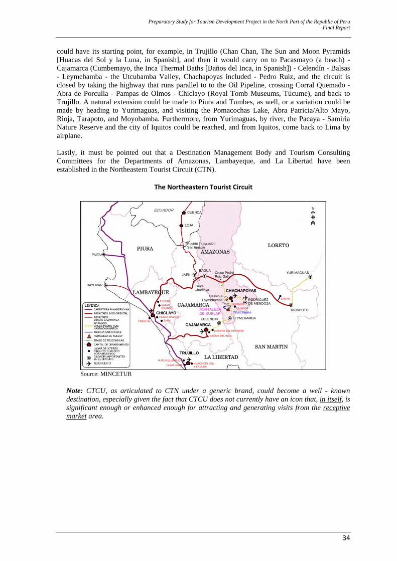
Preparatory Study for Tourism Development Project in the North Part of the Republic of Peru Final Report
34
could have its starting point, for example, in Trujillo (Chan Chan, The Sun and Moon Pyramids [Huacas del Sol y la Luna, in Spanish], and then it would carry on to Pacasmayo (a beach) - Cajamarca (Cumbemayo, the Inca Thermal Baths [Baños del Inca, in Spanish]) - Celendín - Balsas - Leymebamba - the Utcubamba Valley, Chachapoyas included - Pedro Ruiz, and the circuit is closed by taking the highway that runs parallel to to the Oil Pipeline, crossing Corral Quemado - Abra de Porculla - Pampas de Olmos - Chiclayo (Royal Tomb Museums, Túcume), and back to Trujillo. A natural extension could be made to Piura and Tumbes, as well, or a variation could be made by heading to Yurimaguas, and visiting the Pomacochas Lake, Abra Patricia/Alto Mayo, Rioja, Tarapoto, and Moyobamba. Furthermore, from Yurimaguas, by river, the Pacaya - Samiria Nature Reserve and the city of Iquitos could be reached, and from Iquitos, come back to Lima by airplane. Lastly, it must be pointed out that a Destination Management Body and Tourism Consulting Committees for the Departments of Amazonas, Lambayeque, and La Libertad have been established in the Northeastern Tourist Circuit (CTN).
The Northeastern Tourist Circuit
ECUADOR
PIURA AMAZONASLORETO
LAMBAYEQUE
CAJAMARCA
SAN MARTIN
LA LIBERTADTRUJILLO
CAJAMARCA
CHICLAYO
CHACHAPOYAS
TARAPOTO
YURIMAGUAS
LAMAS RODRIGUEZDE MENDOZA LEVANTO
LA JALCA
LEYMEBAMBACELENDIN
CUARTO DEL RESCATE
BAÑOS DEL INCA
HUACA DEL SOL Y LA LUNA CHAN CHAN
HUACA EL BRUJO
PIMENTEL ZAÑAHUACA RAJADA
TUCUMEBATAN GRANDE
PAITA
BAYOVAR
CUENCA
LOJA
Puente IntegracionSan Ignacio
JAENBAGUA
CruceChamaya
Cruce PedroRuiz Gallo
Desvio aLaymebamba
Tingo
TELECABINAS FORTALEZADE KUELAP
Source: MINCETUR
Note: CTCU, as articulated to CTN under a generic brand, could become a well - known destination, especially given the fact that CTCU does not currently have an icon that, in itself, is significant enough or enhanced enough for attracting and generating visits from the receptive market area.

Preparatory Study for Tourism Development Project in the North Part of the Republic of Peru Final Report
35
CHAPTER II IDENTIFICATION
Preparatory Study for Tourism Development Project in the North Part of the Republic of Peru Final Report
36
2.0 IDENTIFICATION 2.1 What Knowledge about the Current Situation is needed to Sell a Tourist Product in Peru? This program is formally conceived from the formulation of the pre-investment study at Profile (Perfil) level. Accordingly, the Perfil offers the basic guidelines for the formulation of this study and any other PIP pre-investment studies. In this sense, it is necessary to identify the core problem and continue by taking into account any other projects that are identified by this study and its relevant proposals, always with a more in-depth and improved analysis in mind. The Perfil identifies the Program’s core problem as “unsuitable socioeconomic conditions along the Utcubamba Valley Tourist Corridor that do not allow for an equitable and inclusive rural economic development.” With this in mind, the following essential means were identified:
‐ Suitable vehicle accessibility conditions to access tourist attractions ‐ Suitable comprehensive solid waste management systems ‐ Suitable basic sanitation infrastructure conditions ‐ Tourist conditioning and enhancement of tourist attractions along the corridor ‐ Suitable service supply for exhibition and exposition of cultural heritage and development
of cultural events ‐ Capacity building on tourist management for Local Governments ‐ GRA institutional strengthening on tourism
These essential means were the starting point to identify a specific number of projects that allow for a solution to the core problem. By the time the Perfil was being formulated, Amazonas’ potentiality and the concept of CTCU as Tourist Destination were already known, just as they are known as this study is being prepared. The number of tourists coming to Amazonas is very few, and it is known that Peruvian current supply is barely differentiated, thus, Peru can be very easily exchangeable with other countries. Peru has two pillars that are enormously valuable for tourism purposes and with a market penetrating capacity: nature and culture. Amazonas has these two pillars, which is an advantage, but they are known, and their projection is mainly at local level. However, a strategic model can be structured based on these pillars for competitive tourist destinations to be developed with internal and receptive projection and positioning. But for Amazonas to become a select destination that meets the requirements of various segments, selection and best use of the major benchmarks for a destination and major sales proposals are necessary for all potentialities to be at hand, and territorial development to be encouraged. Finally, as the last link in the productive chain, investments should be made in the CTCU/Amazonas Destination’s positioning. But this investment should only be made when the destination has a developed tourist supply. An equitable tourist supply that offers opportunities to a local population who is willing to develop tourist activities will start once suitable basic services for that population are available. Therefore, the following services should be successfully rendered: water, sanitation, electric power, solid waste management, and security/safety. Immediately after that, or at the same time, road improvement projects should be carried out for people, goods, and productive factors (not only tourist-related factors) to be transported and mobilized. With this in mind, the Tourist Development Strategy (PERTUR) should be set up with the following specific definitions: (i) The institutionality of tourist activities (both public and private) as the basis for development, (ii) the concept of destination and the brand, which is the element that triggers strong development, (iii) the enhancement projects for the resources that will give this Destination a distinctive character, and (iv) the investment in positioning and promotion that will encourage and establish the benefits and the differentiation of the CTCU/Amazonas product. Based on this strategy and the planning
Preparatory Study for Tourism Development Project in the North Part of the Republic of Peru Final Report
37
execution, the private agents will have market signs that will allow them to improve or extend the already existing tourist facilities. Amazonas’ case has beenunusual, as tourist development planning (PERTUR) has included development projects for basic services and road development that are needed for the tourist product development. Having said that, the following is needed for an improved tourist supply that allows for equitable and inclusive rural development (in the same order as explained above): 1. Basic public services: water and sanitation, electric power, solid wastes, communications, and security/safety. 2. Public transportation infrastructure: roads/highways and airports. 3. A sales strategy that is based on:
3.0 A Tourist Development Strategy - PERTUR. 3.1 Public and private institutionality and capacities at individual level, for instititutionality to
be provided with sustainability and the involvement of regional education authorities, in terms of identity and tourism.
3.2 Enhancement of historical and natural attractions. 3.3 Public Tourist Services: Paradors (for rest and grooming), signage, Accesses,
Dissemination (Museums and Interpretation Centres). 3.4 A tourist’s profile and his/her current preferences. This not only applies to tourists coming
to Amazonas, but also domestic and international tourists on the whole (this aspect has not been developed in PERTUR).
3.5 Positioning and promotion of - and information about - tourist attractions, on a permanent basis. Current alignment is that, if public investment will be ventured in promoting a certain tourist attraction, this tourist attraction should already represent a tourist product (this aspect has not been developed in PERTUR).
3.6 Private services (Tourist Facilities): Hotels, Restaurants, People and Transportation of people and goods (inter-department), Local Transportation, Tourist Operators, Travel Agencies, Staff (these aspects have not been developed in PERTUR).
As PERTUR Amazonas already exists (tourist development long term planning), and apart from the private sector’s participation (in the tourist facilities, communications, and its input to institutionality), the identified essential means are actually “what is needed” to improve tourist supply on the whole, and particularly in Amazonas; therefore, their relevance is affirmed. The following part of this study will account for: ‐ The current situation of the population’s socioeconomic characteristics for the level of relevance
of the Program’s execution to be defined. ‐ The diagnostics of each specific service and need that will later lead to project selection support. ‐ The current situation of tourist demand (studied profile included) and tourism in Peru and
worldwide.
Preparatory Study for Tourism Development Project in the North Part of the Republic of Peru Final Report
38
2.2 Diagnostics of the CTCU destination’s current situation 2.2.1 General All kinds of project planning studies start with diagnostics of the current reality and the context situation, both internal and external. Diagnostics aim at gaining knowledge of the characteristics, conditions, evolution, restraints and limitations posed by the analyzed situation. Diagnostics Process. The study has its starting point on understanding the concept of “territory” or land (in our case, the CTCU Destination). Once the territory is well known, the next step will be to carry out the diagnostics that strictly refer to identifying the way in which tourist activity is performed throughout the “CTCU Destination” territory. Based on this whole analysis, a suitable intervention strategy may be established (in the chapter on formulation). 2.2.2 Diagnostics – Population and Society Carrying out the external context diagnostics involves all of the Amazonas Department geographic area. The internal context diagnostics are also carried out, and it involves the CTCU Destination (3 provinces and 34 districts). Structuring an index that separates analysis for both contexts is extremely hard to do; therefore a decision has been made to account for the external context only, and the details that are relevant to the internal context are explained whenever applicable. A. Geopolitics and Territory – Amazonas 10 11 The Department of Amazonas is located in the northeastern part of Peru, between 2°59’15” and 6°59’20” Southern Latitude, and 77°9’45” and 78°42’30” Western Longitude.12 Its limits are: to the north, the Republic of Ecuador; to the east, the Departments of Loreto and San Martín; to the west, the Department of Cajamarca; and to the south, the Departments of La Libertad and San Martín. Its geographic area is 39,249.13 Km2, and it represents 3.5% of the country’s territory. The Department of Amazonas is geopolitically divided into 7 provinces and 83 districts. The Condorcanqui Province covers most of the Department’s area (17,865.39 Km2, 45.52% of the total area), whereas Rodríguez de Mendoza is the smallest province, covering 6.01% of the total area (2,359.39 Km2). Most of the Department of Amazonas is jungle area (this involves the Rodriguez de Mendoza, Condorcanqui, Bagua, and Bongará Provinces), and it shows lower jungle, higher jungle, and “edge [or beginning] of jungle” (Ceja de selva, in Spanish) ecosystems along a surface of 3´420,363 Ha (approximately 86.1%). This jungle area is the closest jungle area to the Pacific Ocean. The remaining land in Amazonas is the Andean region, also called Amazon Andes (554,031 Ha, 13.9 %), and it is located in the southern area (Chachapoyas, Luya, and Utcubamba Provinces). It is covered with shrub-type vegetation.
10 Not all information about this department is shown, but a decision was made to select all relevant information that is
useful to the analysis and the purposes of a rural development-focused Tourist Program. For example, the current situation of education and health services will not be analyzed, but some of their basic indicators will be detailed so that the relevance of the intervention (a need for economic development) is defined.
11 Major information sources are 2009 – 2021 PDRC (Spanish for ‘Concerted Regional Development Plan’), as approved in December 2009, and the INEI (Spanish for ‘National Institute of Statistics and Information Technology’) 2007 Census.
12 “Nororiental” (“Northeastern”) is the Peruvian term to the Northern Jungle Area of Perú. In fact, Amazonas is located to the north and west of Perú if Lima (the capital city), or the central geographic point of Perú, is taken as a reference.
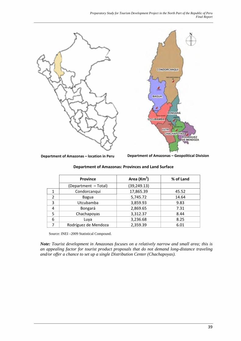
Preparatory Study for Tourism Development Project in the North Part of the Republic of Peru Final Report
39
Department of Amazonas – location in Peru
Department of Amazonas – Geopolitical Division
Department of Amazonas: Provinces and Land Surface
Province Area (Km2) % of Land (Department – Total) (39,249.13) 1 Condorcanqui 17,865.39 45.52 2 Bagua 5,745.72 14.64 3 Utcubamba 3,859.93 9.83 4 Bongará 2,869.65 7.31 5 Chachapoyas 3,312.37 8.44 6 Luya 3,236.68 8.25 7 Rodríguez de Mendoza 2,359.39 6.01
Source: INEI –2009 Statistical Compound.
Note: Tourist development in Amazonas focuses on a relatively narrow and small area; this is an appealing factor for tourist product proposals that do not demand long-distance traveling and/or offer a chance to set up a single Distribution Center (Chachapoyas).
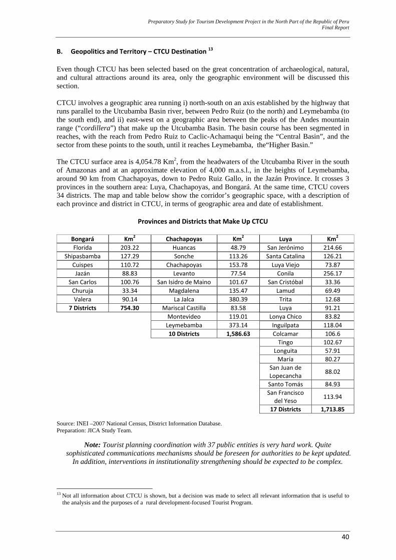
Preparatory Study for Tourism Development Project in the North Part of the Republic of Peru Final Report
40
B. Geopolitics and Territory – CTCU Destination 13 Even though CTCU has been selected based on the great concentration of archaeological, natural, and cultural attractions around its area, only the geographic environment will be discussed this section. CTCU involves a geographic area running i) north-south on an axis established by the highway that runs parallel to the Utcubamba Basin river, between Pedro Ruiz (to the north) and Leymebamba (to the south end), and ii) east-west on a geographic area between the peaks of the Andes mountain range (“cordillera”) that make up the Utcubamba Basin. The basin course has been segmented in reaches, with the reach from Pedro Ruiz to Caclic-Achamaqui being the “Central Basin”, and the sector from these points to the south, until it reaches Leymebamba, the“Higher Basin.” The CTCU surface area is 4,054.78 Km2, from the headwaters of the Utcubamba River in the south of Amazonas and at an approximate elevation of 4,000 m.a.s.l., in the heights of Leymebamba, around 90 km from Chachapoyas, down to Pedro Ruiz Gallo, in the Jazán Province. It crosses 3 provinces in the southern area: Luya, Chachapoyas, and Bongará. At the same time, CTCU covers 34 districts. The map and table below show the corridor’s geographic space, with a description of each province and district in CTCU, in terms of geographic area and date of establishment.
Provinces and Districts that Make Up CTCU
Bongará Km2 Chachapoyas Km2 Luya Km2
Florida 203.22 Huancas 48.79 San Jerónimo 214.66Shipasbamba 127.29 Sonche 113.26 Santa Catalina 126.21
Cuispes 110.72 Chachapoyas 153.78 Luya Viejo 73.87Jazán 88.83 Levanto 77.54 Conila 256.17
San Carlos 100.76 San Isidro de Maino 101.67 San Cristóbal 33.36Churuja 33.34 Magdalena 135.47 Lamud 69.49Valera 90.14 La Jalca 380.39 Trita 12.68
7 Districts 754.30 Mariscal Castilla 83.58 Luya 91.21
Montevideo 119.01 Lonya Chico 83.82Leymebamba 373.14 Inguilpata 118.04
10 Districts 1,586.63 Colcamar 106.6 Tingo 102.67 Longuita 57.91 María 80.27
San Juan de Lopecancha 88.02
Santo Tomás 84.93
San Francisco del Yeso 113.94
17 Districts 1,713.85 Source: INEI –2007 National Census, District Information Database. Preparation: JICA Study Team.
Note: Tourist planning coordination with 37 public entities is very hard work. Quite sophisticated communications mechanisms should be foreseen for authorities to be kept updated.
In addition, interventions in institutionality strengthening should be expected to be complex.
13 Not all information about CTCU is shown, but a decision was made to select all relevant information that is useful to
the analysis and the purposes of a rural development-focused Tourist Program.
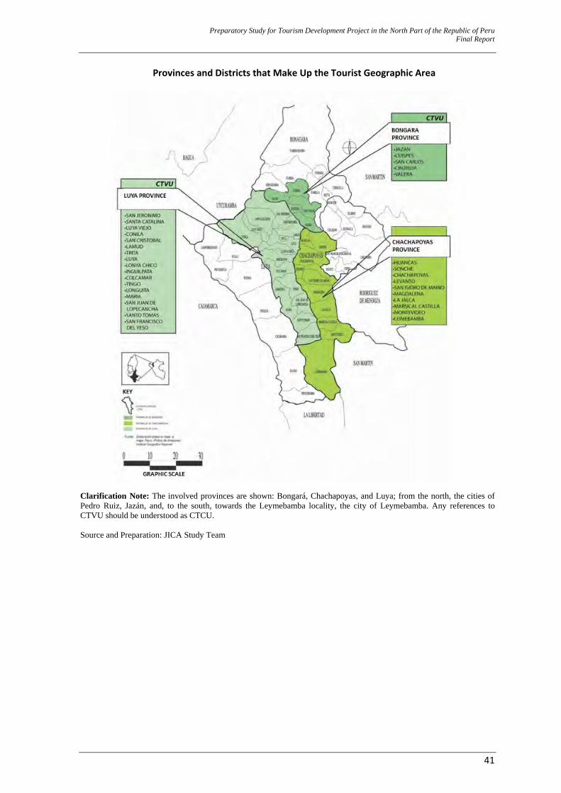
Preparatory Study for Tourism Development Project in the North Part of the Republic of Peru Final Report
41
Provinces and Districts that Make Up the Tourist Geographic Area
Clarification Note: The involved provinces are shown: Bongará, Chachapoyas, and Luya; from the north, the cities of Pedro Ruiz, Jazán, and, to the south, towards the Leymebamba locality, the city of Leymebamba. Any references to CTVU should be understood as CTCU. Source and Preparation: JICA Study Team
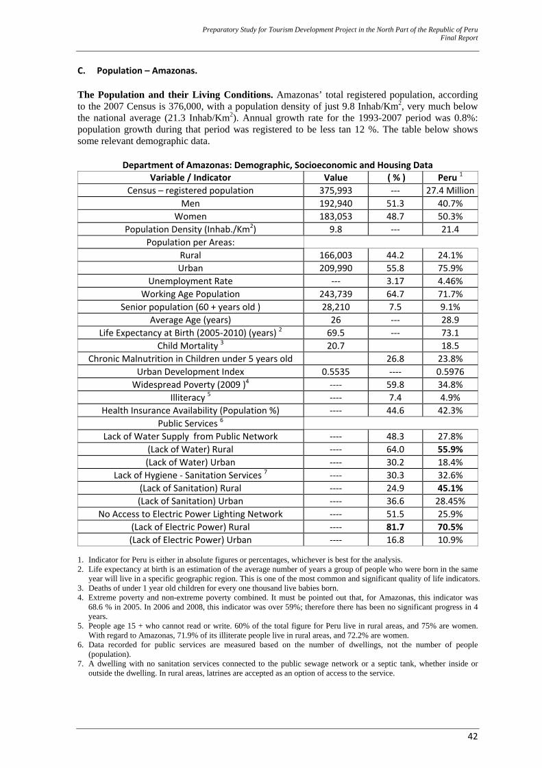
Preparatory Study for Tourism Development Project in the North Part of the Republic of Peru Final Report
42
C. Population – Amazonas. The Population and their Living Conditions. Amazonas’ total registered population, according to the 2007 Census is 376,000, with a population density of just 9.8 Inhab/Km2, very much below the national average (21.3 Inhab/Km2). Annual growth rate for the 1993-2007 period was 0.8%: population growth during that period was registered to be less tan 12 %. The table below shows some relevant demographic data.
Department of Amazonas: Demographic, Socioeconomic and Housing Data Variable / Indicator Value ( % ) Peru 1
Census – registered population 375,993 ‐‐‐ 27.4 MillionMen 192,940 51.3 40.7%
Women 183,053 48.7 50.3% Population Density (Inhab./Km2) 9.8 ‐‐‐ 21.4
Population per Areas: Rural 166,003 44.2 24.1% Urban 209,990 55.8 75.9%
Unemployment Rate ‐‐‐ 3.17 4.46% Working Age Population 243,739 64.7 71.7%
Senior population (60 + years old ) 28,210 7.5 9.1% Average Age (years) 26 ‐‐‐ 28.9
Life Expectancy at Birth (2005‐2010) (years) 2 69.5 ‐‐‐ 73.1 Child Mortality 3 20.7 18.5
Chronic Malnutrition in Children under 5 years old 26.8 23.8% Urban Development Index 0.5535 ‐‐‐‐ 0.5976 Widespread Poverty (2009 )4 ‐‐‐‐ 59.8 34.8%
Illiteracy 5 ‐‐‐‐ 7.4 4.9% Health Insurance Availability (Population %) ‐‐‐‐ 44.6 42.3%
Public Services 6 Lack of Water Supply from Public Network ‐‐‐‐ 48.3 27.8%
(Lack of Water) Rural ‐‐‐‐ 64.0 55.9% (Lack of Water) Urban ‐‐‐‐ 30.2 18.4%
Lack of Hygiene ‐ Sanitation Services 7 ‐‐‐‐ 30.3 32.6% (Lack of Sanitation) Rural ‐‐‐‐ 24.9 45.1% (Lack of Sanitation) Urban ‐‐‐‐ 36.6 28.45%
No Access to Electric Power Lighting Network ‐‐‐‐ 51.5 25.9% (Lack of Electric Power) Rural ‐‐‐‐ 81.7 70.5% (Lack of Electric Power) Urban ‐‐‐‐ 16.8 10.9%
1. Indicator for Peru is either in absolute figures or percentages, whichever is best for the analysis. 2. Life expectancy at birth is an estimation of the average number of years a group of people who were born in the same
year will live in a specific geographic region. This is one of the most common and significant quality of life indicators. 3. Deaths of under 1 year old children for every one thousand live babies born. 4. Extreme poverty and non-extreme poverty combined. It must be pointed out that, for Amazonas, this indicator was
68.6 % in 2005. In 2006 and 2008, this indicator was over 59%; therefore there has been no significant progress in 4 years.
5. People age 15 + who cannot read or write. 60% of the total figure for Peru live in rural areas, and 75% are women. With regard to Amazonas, 71.9% of its illiterate people live in rural areas, and 72.2% are women.
6. Data recorded for public services are measured based on the number of dwellings, not the number of people (population).
7. A dwelling with no sanitation services connected to the public sewage network or a septic tank, whether inside or outside the dwelling. In rural areas, latrines are accepted as an option of access to the service.
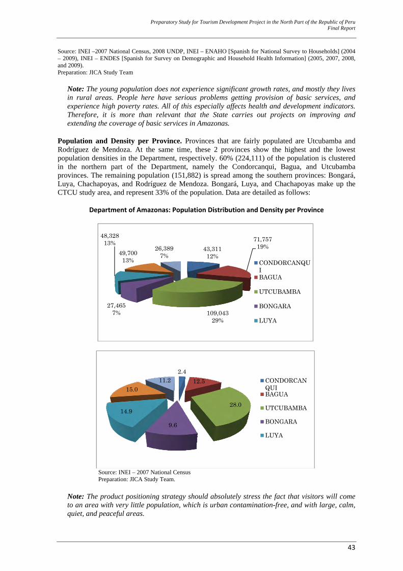
Preparatory Study for Tourism Development Project in the North Part of the Republic of Peru Final Report
43
Source: INEI –2007 National Census, 2008 UNDP, INEI – ENAHO [Spanish for National Survey to Households] (2004 – 2009), INEI – ENDES [Spanish for Survey on Demographic and Household Health Information] (2005, 2007, 2008, and 2009). Preparation: JICA Study Team
Note: The young population does not experience significant growth rates, and mostly they lives in rural areas. People here have serious problems getting provision of basic services, and experience high poverty rates. All of this especially affects health and development indicators. Therefore, it is more than relevant that the State carries out projects on improving and extending the coverage of basic services in Amazonas.
Population and Density per Province. Provinces that are fairly populated are Utcubamba and Rodríguez de Mendoza. At the same time, these 2 provinces show the highest and the lowest population densities in the Department, respectively. 60% (224,111) of the population is clustered in the northern part of the Department, namely the Condorcanqui, Bagua, and Utcubamba provinces. The remaining population (151,882) is spread among the southern provinces: Bongará, Luya, Chachapoyas, and Rodríguez de Mendoza. Bongará, Luya, and Chachapoyas make up the CTCU study area, and represent 33% of the population. Data are detailed as follows:
Department of Amazonas: Population Distribution and Density per Province
Source: INEI – 2007 National Census Preparation: JICA Study Team.
Note: The product positioning strategy should absolutely stress the fact that visitors will come to an area with very little population, which is urban contamination-free, and with large, calm, quiet, and peaceful areas.
43,31112%
71,75719%
109,04329%
27,4657%
48,32813%
49,70013%
26,3897%
CONDORCANQUIBAGUA
UTCUBAMBA
BONGARA
LUYA
2.412.5
28.0
9.6
14.9
15.011.2 CONDORCAN
QUIBAGUA
UTCUBAMBA
BONGARA
LUYA
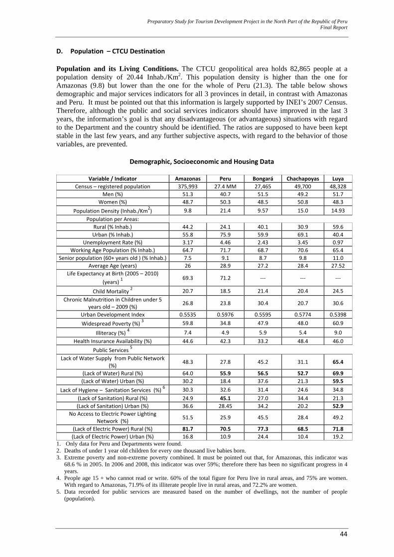
Preparatory Study for Tourism Development Project in the North Part of the Republic of Peru Final Report
44
D. Population – CTCU Destination Population and its Living Conditions. The CTCU geopolitical area holds 82,865 people at a population density of 20.44 Inhab./Km2. This population density is higher than the one for Amazonas (9.8) but lower than the one for the whole of Peru (21.3). The table below shows demographic and major services indicators for all 3 provinces in detail, in contrast with Amazonas and Peru. It must be pointed out that this information is largely supported by INEI’s 2007 Census. Therefore, although the public and social services indicators should have improved in the last 3 years, the information’s goal is that any disadvantageous (or advantageous) situations with regard to the Department and the country should be identified. The ratios are supposed to have been kept stable in the last few years, and any further subjective aspects, with regard to the behavior of those variables, are prevented.
Demographic, Socioeconomic and Housing Data
Variable / Indicator Amazonas Peru Bongará Chachapoyas Luya Census – registered population 375,993 27.4 MM 27,465 49,700 48,328
Men (%) 51.3 40.7 51.5 49.2 51.7 Women (%) 48.7 50.3 48.5 50.8 48.3
Population Density (Inhab./Km2) 9.8 21.4 9.57 15.0 14.93 Population per Areas:
Rural (% Inhab.) 44.2 24.1 40.1 30.9 59.6 Urban (% Inhab.) 55.8 75.9 59.9 69.1 40.4
Unemployment Rate (%) 3.17 4.46 2.43 3.45 0.97 Working Age Population (% Inhab.) 64.7 71.7 68.7 70.6 65.4
Senior population (60+ years old ) (% Inhab.) 7.5 9.1 8.7 9.8 11.0 Average Age (years) 26 28.9 27.2 28.4 27.52
Life Expectancy at Birth (2005 – 2010) (years) 1
69.3 71.2 ‐‐‐ ‐‐‐ ‐‐‐
Child Mortality 2 20.7 18.5 21.4 20.4 24.5 Chronic Malnutrition in Children under 5
years old – 2009 (%) 26.8 23.8 30.4 20.7 30.6
Urban Development Index 0.5535 0.5976 0.5595 0.5774 0.5398 Widespread Poverty (%) 3 59.8 34.8 47.9 48.0 60.9
Illiteracy (%) 4 7.4 4.9 5.9 5.4 9.0 Health Insurance Availability (%) 44.6 42.3 33.2 48.4 46.0
Public Services 5 Lack of Water Supply from Public Network
(%) 48.3 27.8 45.2 31.1 65.4
(Lack of Water) Rural (%) 64.0 55.9 56.5 52.7 69.9 (Lack of Water) Urban (%) 30.2 18.4 37.6 21.3 59.5
Lack of Hygiene – Sanitation Services (%) 6 30.3 32.6 31.4 24.6 34.8 (Lack of Sanitation) Rural (%) 24.9 45.1 27.0 34.4 21.3 (Lack of Sanitation) Urban (%) 36.6 28.45 34.2 20.2 52.9
No Access to Electric Power Lighting Network (%) 51.5 25.9 45.5 28.4 49.2
(Lack of Electric Power) Rural (%) 81.7 70.5 77.3 68.5 71.8 (Lack of Electric Power) Urban (%) 16.8 10.9 24.4 10.4 19.2
1. Only data for Peru and Departments were found. 2. Deaths of under 1 year old children for every one thousand live babies born. 3. Extreme poverty and non-extreme poverty combined. It must be pointed out that, for Amazonas, this indicator was
68.6 % in 2005. In 2006 and 2008, this indicator was over 59%; therefore there has been no significant progress in 4 years.
4. People age 15 + who cannot read or write. 60% of the total figure for Peru live in rural areas, and 75% are women. With regard to Amazonas, 71.9% of its illiterate people live in rural areas, and 72.2% are women.
5. Data recorded for public services are measured based on the number of dwellings, not the number of people (population).
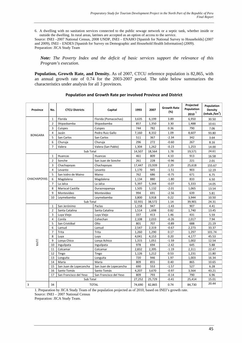
Preparatory Study for Tourism Development Project in the North Part of the Republic of Peru Final Report
45
6. A dwelling with no sanitation services connected to the public sewage network or a septic tank, whether inside or outside the dwelling. In rural areas, latrines are accepted as an option of access to the service.
Source: INEI –2007 National Census, 2008 UNDP, INEI – ENAHO [Spanish for National Survey to Households] (2007 and 2009), INEI – ENDES [Spanish for Survey on Demographic and Household Health Information] (2009). Preparation: JICA Study Team
Note: The Poverty Index and the deficit of basic services support the relevance of this Program’s execution.
Population, Growth Rate, and Density. As of 2007, CTCU reference population is 82,865, with an annual growth rate of 0.74 for the 2003-2007 period. The table below summarizes the characteristics under analysis for all 3 provinces.
Population and Growth Rate per involved Province and District
Province No. CTCU Districts Capital 1993 2007 Growth Rate (%)
Projected Population
2010 1
Population Density
(Inhab./km2)
BONGARA
1 Florida Florida (Pomacochas) 3,635 6,199 3.89 6,950 30.50 2 Shipasbamba Shipasbamba 857 1,350 3.30 1,488 10.61 3 Cuispes Cuispes 744 782 0.36 790 7.06 4 Jazán Pedro Ruiz Gallo 7,160 8,332 1.09 8,607 93.80 5 San Carlos San Carlos 511 367 ‐2.34 342 3.64 6 Churuja Churuja 296 272 ‐0.60 267 8.16 7 Valera Valera (San Pablo) 1,304 1,262 ‐0.23 1,253 14.00
Sub Total 14,507 18,564 1.78 19,571 24.61
CHACHAPOYAS
1 Huancas Huancas 461 809 4.10 913 16.58 2 Sonche San Juan de Sonche 261 228 ‐0.96 221 2.01 3 Chachapoyas Chachapoyas 17,447 23,939 2.29 25,618 155.67 4 Levanto Levanto 1,170 945 ‐1.51 903 12.19 5 San Isidro de Maino Maino 762 686 ‐0.75 671 6.75 6 Magdalena Magdalena 1,134 880 ‐1.80 833 6.50 7 La Jalca La Jalca 5,397 5,344 ‐0.07 5,333 14.05 8 Mariscal Castilla Duraznopampa 1,505 1,132 ‐2.01 1,065 13.54 9 Montevideo Montevideo 994 691 ‐2.56 639 5.81 10 Leymebamba Leymebamba 3,800 3,918 0.22 3,944 10.50
Sub Total 32,931 38,572 1.14 39,901 24.31LU
YA 1 San Jerónimo Paclas 1,158 947 ‐1.43 907 4.412 Santa Catalina Santa Catalina 1,514 1,698 0.82 1,740 13.453 Luya Viejo Luya Viejo 337 413 1.46 431 5.59 4 Conila Cohechan 2,108 2,033 ‐0.26 2,017 7.945 San Cristóbal Olto 801 707 ‐0.89 688 21.196 Lamud Lamud 2,547 2,319 ‐0.67 2,273 33.377 Trita Trita 1,260 1,290 0.17 1,297 101.748 Luya Luya 4,041 4,153 0.20 4,177 45.539 Lonya Chico Lonya Xchico 1,315 1,051 ‐1.59 1,002 12.5410 Inguilpata Inguilpata 978 694 ‐2.42 645 5.8811 Colcamar Colcamar 2,832 2,395 ‐1.19 2,311 22.4712 Tingo Tingo 1,126 1,212 0.53 1,231 11.8013 Longuita Longuita 720 946 1.97 1,003 16.3414 María María 809 855 0.40 865 10.6515 San Juan de Lopecancha San Juan de Lopecancha 690 553 ‐1.57 527 6.2816 Santo Tomás Santo Tomás 4,207 3,670 ‐0.97 3,564 43.2117 San Francisco del Yeso San Francisco del Yeso 809 793 ‐0.14 790 6.96
Sub Total 27,252 25,729 ‐0.41 25,414 15.01
3 34 TOTAL 74,690 82,865 0.74 84,730 20.44
1. Preparation by JICA Study Team of the population projected as of 2010, based on INEI’s growth rate. Source: INEI – 2007 National Census Preparation: JICA Study Team.
Preparatory Study for Tourism Development Project in the North Part of the Republic of Peru Final Report
46
‐ Bongará: 18,564 inhabitants with an annual growth rate of 1.78%, although 3 of its districts (San Carlos, Churuja, and Valera) show a negative rate.
‐ Chachapoyas: 38,572 inhabitants with negative annual growth rates in all of its districts except
Huancas, Chachapoyas, and Leymebamba, which keep a positive population growth.
‐ Luya: 25,729 inhabitants with an annual growth rate of -0.41%. Most of its 17 districts are identified as showing a negative rate, especially Montevideo, Inguilpata, San Carlos, and Mariscal Castilla, with average growth rates of -2.3%. This fact becomes apparent mainly as a result of the low productivity and socioeconomic coordination (limited to small scale agriculture and cattle/animal breeding).
Note: Based on the sociodemographic indicators for all 3 provinces, negative growth rates are understandable (by emigration of population looking for better opportunities).
E. History and Socio Cultural Patterns Historical Background. The history of the Department of Amazonas can be traced back 6,000 or 7,000 years. Rocky walls show the cave paintings of Chiñuña-Yamón, Limones-Calpán, Tambolic y Cerro Pata, and Pollorua in the provinces of Utcubamba and Luya. In addition, an important civilization would develop in more recent times throughout the region, and would leave its legacy to the current communities. The Department of Amazonas today is not only characterized by its native communities living along the jungle areas located in its northern part, namely the Condorcanqui, Bagua, and Bongará Provinces. Historically speaking, reference should be made to a huge region located further south, between the Huallaga and Marañón Rivers, at an elevation of 2,000 to 3,000 metres, and permanently covered with clouds. Since the 9th Century, this region was populated by a major civilization that developed here until its decline and disappearance with the Inca invasion and occupation in the 15th century (1475). At that point, this region was annexed to the Inca Empire, under the reign of Tupac Inca Yupanqui. The Chachapoyas or Sachapcollas people (people of the forest areas) were made up of various related ethnic groups that traveled throughout the area extending north to south (around 300 km), from the Marañón in the Bagua area down to the Abiseo Basin. Some hypotheses claim that the Chachapoyas descended from culturally Andean immigrants from the Andes Mountain Range (“Cordillera”). They modified their ancestral culture when faced with the new environment, and adopted some of the traditions of the people from the Amazon jungle, as they gradually depredated the forests and burnt their lands on an annual basis, in order to transform the jungle scenery into wilderness. As a result of this interaction between human beaings and the environment, the Chachapoyas civilization has left behind a significant number of major stone monuments, as well as many sarcophaguses or caskets, mummy bundles, and necropolis. This was a civilization in which communities developed in an autonomous way and in an environment that isolated them. Their major constructions can be found in places that are almost inaccessible, and this represents a much appealing element for this civilization to be studied.14 The major centre of the Chachapoyas civilization is located on the Utcubamba Basin, in the higher Jungle area. This area is characterized by its dense vegetation cover and its elevation at over 2,000 m.a.s.l., the Architectural Complexes of Olán, Yalapé, Purunllacta or "Monte Peruvia" (“Peruvia Mount”), Congón (renamed Gran [Great] Vilaya), Vira Vira, Pajatén, and others are found here.
14 It must be mentioned that the Chipuric and Revach civilizations (A.D. 800 to 1200) were located in the Luya Province.
Preparatory Study for Tourism Development Project in the North Part of the Republic of Peru Final Report
47
But the Kuelap Fortress is, beyond any doubt, the greatest stone monument, almost 600m long with walls almost 20m high. The Chachapoyas architecture is characterized by its huge circular stone constructions that are decorated with friezes and defensive walls. The housing constructions and monuments are circular with high bases, big and flat stone cornices that jut out from the base surfaces. They have inclined ramps or staircases that lead to the entrance. The Chachapoyas developed a common symbolic language with geometric decoration shapes, such as triangles, rhombuses, zig-zags, squares. These shapes appear on the circular dwellings’ stone friezes. These symbols had ethnical and social values, and were used to show the strength of a local identity that was kept throughout the Inca period. After the Inca conquest, the Spaniards occupied the area. During the Colonial years, Alonso de Alvarado founded the city of San Juan de la Frontera de los Chachapoyas (September 5th, 1538); this city became a significant entry point in the Marañón River region to the jungle. Although the Loreto and San Martín Departments were established, Chachapoyas carried on being an operations centre for the Spaniards, as they strived to conquer the Jungle. Colonial influence on this city’s architecture is significant. During the Independence years, the Chachapoyas population made a decision to support the freedom fighters, and deposed the Spanish Empire Deputy Representative and the Bishop of Maynas. This fact generated a rapid response that led to the Battle of Higos Urco (June 6th, 1821) that was won by the Independence fighters. Once the Republic of Peru was established, the Department of Amazonas was established under the administration of Agustín Gamarra, on November 21st, 1832, with San Juan de la Frontera de Chachapoyas as its capital city. With regard to the provinces that make up the CTCU, the Chachapoyas Province was established with a Supreme Decree of February 12th, 1821 (without a number). Its capital was the “San Juan de la Frontera de los Chachapoyas” City. It was not until 1832 that the Chachapoyas Province would become a part of the newly established Department of Amazonas. The Luya Province was established on January 5th, 1861, with Lamud as its capital city. The Bongará Province was established with an Act of December 26th, 1870, with San Carlos as its temporary capital town; later, Law No. 64 of September 12th, 1905, established Jumbilla as Bongará’s definite capital town, and Jumbilla’s status was upgraded from town to city.
Note: Amazonas is, in itself, an isolated niche with abundant riches and traditions, and so filled with resources that are worth being proud of. This pride should be instilled in the Amazonas population from a very early age, and this regional pride will in turn strengthen the tourism-local population relationship.
Socio Cultural Patterns. An analysis carried out by Limachi (2007) on the Amazonas ZEE (Spanish for Ecological and Economic Zone) of living conditions and the origin of the population groups has defined 4 distinct Socio Cultural Major Groups: The Indigenous Amazon People, the Migrant Settlers, the Regional Mestizos (people of mixed heritage, usually of both Spanish and Indigenous descent), and the Urban Mestizos. All of these are shown on the map below.
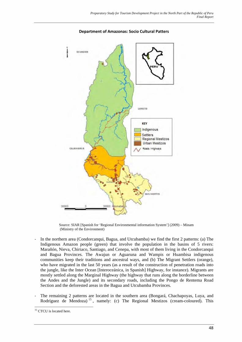
Preparatory Study for Tourism Development Project in the North Part of the Republic of Peru Final Report
48
Department of Amazonas: Socio Cultural Patters
Source: SIAR [Spanish for ‘Regional Environmental information System’] (2009) – Minam (Ministry of the Environment)
‐ In the northern area (Condorcanqui, Bagua, and Utcubamba) we find the first 2 patterns: (a) The
Indigenous Amazon people (green) that involve the population in the basins of 5 rivers: Marañón, Nieva, Chiriaco, Santiago, and Cenepa, with most of them living in the Condorcanqui and Bagua Provinces. The Awajun or Aguaruna and Wampis or Huambisa indigenous communities keep their traditions and ancestral ways, and (b) The Migrant Settlers (orange), who have migrated in the last 50 years (as a result of the construction of penetration roads into the jungle, like the Inter Ocean [Interoceánica, in Spanish] Highway, for instance). Migrants are mostly settled along the Marginal Highway (the highway that runs along the borderline between the Andes and the Jungle) and its secondary roads, including the Pongo de Rentema Road Section and the deforested areas in the Bagua and Utcubamba Provinces.
‐ The remaining 2 patterns are located in the southern area (Bongará, Chachapoyas, Luya, and
Rodríguez de Mendoza) 15 , namely: (c) The Regional Mestizos (cream-coloured). This 15 CTCU is located here.
Preparatory Study for Tourism Development Project in the North Part of the Republic of Peru Final Report
49
population is of Andean origin, and it is made up of small, scattered population groups. The Regional Mestizos are the major suppliers of farming products to small and large regional markets. Their major economic activities include cattle or animal breeding and farming (corn, potatoes, rice, and coffee); and (d) the Urban Mestizos, who mostly live in the towns and cities, and have access to basic services, communications, the Internet, etc. Urban Mestizos make up the population of the large cities of Chachapoyas, Bagua Grande, and Bagua Chica.
Note: Social characterization (multiculturalism) should be taken into account, as projects are being formulated and executed. It is a very common mistake to think other societies behave like ours.
F. Territory and Environment Aspects that are related to the dynamics that emerge when establishing the geographic area are developed. In addition, characteristics involving environmental dynamics, natural resources, and ecological processes that take place in the studied geographic area are analyzed. Geophysical Characteristics. A characteristic of the Amazonas geographic scope is that it shows up to 10 different physiographic scenarios. CTCU basically shows a strong scenery around the corridor, some hills, especially along the left bank of the Utcumbamba River, and wavy or corrugated Andean plateaus where cities like Chachapoyas and Lamud are located. Geomorphology. Influence from the Andes Mountain Range (The Cordillera - the Central Range, the Eastern Range, and the Sub-Andean Eastern Range) that shows a lower elevation and extension in this area than in the rest of the Peruvian territory defines the complexity of the geomorphological units that are present in Amazonas. To the northwest, the Condor Cordillera is the most important relief; it sets the border between Peru and Ecuador, and makes up the water divide between the Santiago and Zamora Rivers. 50% of Amazonas’ surface shows average gradients of over 25°; this is an indicator of the restraints local intensive farming activity development is faced with. Elevations vary between 400 m.a.s.l. to maximum elevations in the southern part of the department of 4,200 m.a.s.l. These peaks are covered with strongly intervened Amazon forests, and, as a result of anthropic actions, erosion processes accelerate with subsequent mud streams and mudslides (“huaicos” in Quechua), and leave behind deeply cut-apart surfaces or surfaces with stony characteristics. Climate. As a result of the presence of the Andes Cordillera, the closeness to the Equatorial area, the prevailing Amazon vegetation, and the wind movement, Amazonas has a quite diverse climate. But we can clearly distinguish different climate patterns between the northern area (Condorcanqui and Bagua provinces) and the rest of the region. The southern area, and specifically the CTCU context, shows climates that are mainly humid, mild-warm and mild-cold, as well as slightly humid on the wavy plateaus that are close to the city of Chachapoyas. Hydrography. Hydrography in Amazonas is mainly made up of 9 identified basins and sub-basins. The Utcubamba Basin’s area is 7,127.20 Km², and it is the Marañon River’s main tributary. The Utcubamba River is born in the Sierpe Lake, located in the Atuén Hamlet (“Anexo” in Spanish), in the Chuquibamba Rural Community. Major tributaries to the Sierpe Lake are: The Sonche River, on the right Banks, and the Magunchal River and the Honda Brook, on the left bank. Ecology / Eco regions. The eco regions maps represent the most updated division of the national territory. 11 of these maps have been conceptualized, each one showing its geographic boundaries and natural characteristics. CTCU would be included in the so-called High Jungle eco region, between 600 and 3,500 m.a.s.l. This eco region holds various types of forests and a wide variety of animals. The cock of the rock (“Gallito de las Rocas”, in Spanish), the yellow tailed woolly
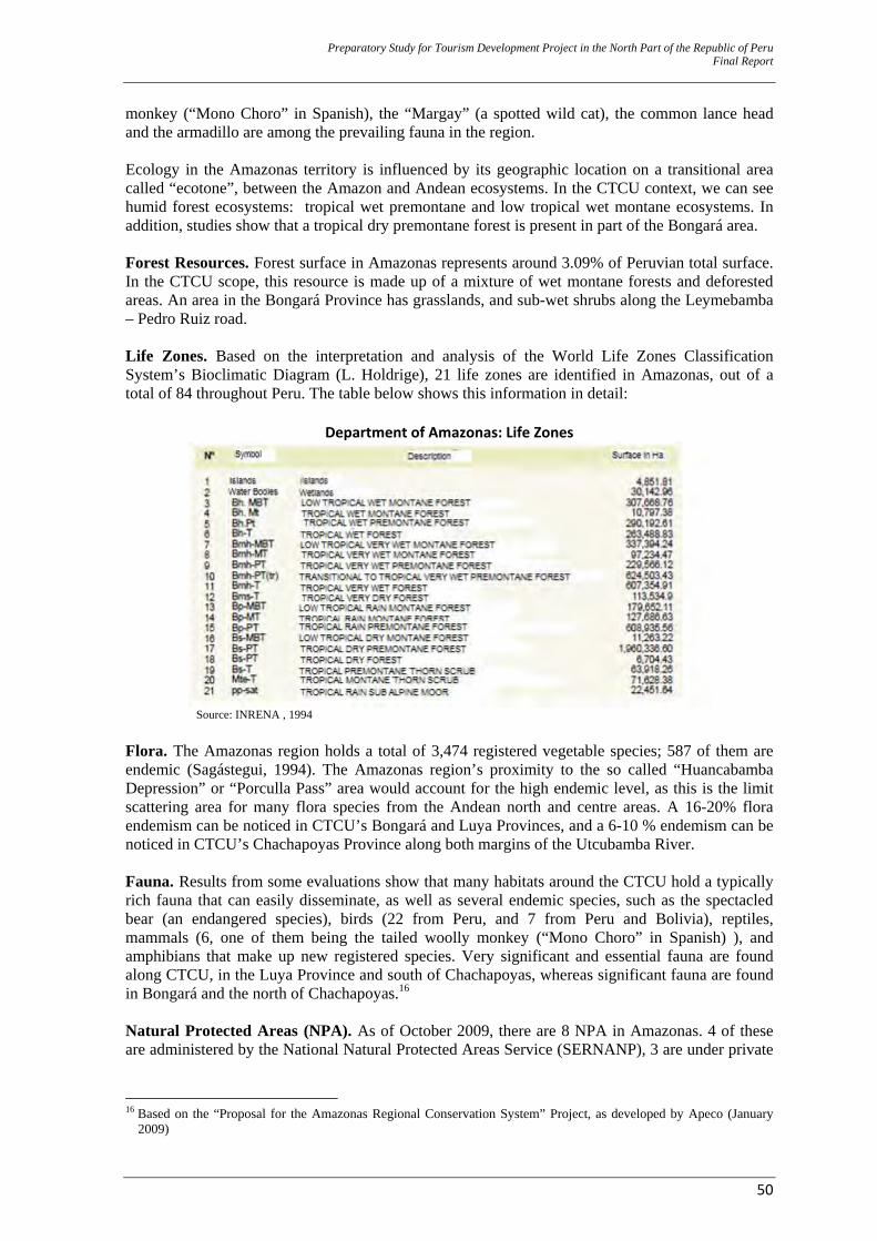
Preparatory Study for Tourism Development Project in the North Part of the Republic of Peru Final Report
50
monkey (“Mono Choro” in Spanish), the “Margay” (a spotted wild cat), the common lance head and the armadillo are among the prevailing fauna in the region. Ecology in the Amazonas territory is influenced by its geographic location on a transitional area called “ecotone”, between the Amazon and Andean ecosystems. In the CTCU context, we can see humid forest ecosystems: tropical wet premontane and low tropical wet montane ecosystems. In addition, studies show that a tropical dry premontane forest is present in part of the Bongará area. Forest Resources. Forest surface in Amazonas represents around 3.09% of Peruvian total surface. In the CTCU scope, this resource is made up of a mixture of wet montane forests and deforested areas. An area in the Bongará Province has grasslands, and sub-wet shrubs along the Leymebamba – Pedro Ruiz road. Life Zones. Based on the interpretation and analysis of the World Life Zones Classification System’s Bioclimatic Diagram (L. Holdrige), 21 life zones are identified in Amazonas, out of a total of 84 throughout Peru. The table below shows this information in detail:
Department of Amazonas: Life Zones
Source: INRENA , 1994
Flora. The Amazonas region holds a total of 3,474 registered vegetable species; 587 of them are endemic (Sagástegui, 1994). The Amazonas region’s proximity to the so called “Huancabamba Depression” or “Porculla Pass” area would account for the high endemic level, as this is the limit scattering area for many flora species from the Andean north and centre areas. A 16-20% flora endemism can be noticed in CTCU’s Bongará and Luya Provinces, and a 6-10 % endemism can be noticed in CTCU’s Chachapoyas Province along both margins of the Utcubamba River. Fauna. Results from some evaluations show that many habitats around the CTCU hold a typically rich fauna that can easily disseminate, as well as several endemic species, such as the spectacled bear (an endangered species), birds (22 from Peru, and 7 from Peru and Bolivia), reptiles, mammals (6, one of them being the tailed woolly monkey (“Mono Choro” in Spanish) ), and amphibians that make up new registered species. Very significant and essential fauna are found along CTCU, in the Luya Province and south of Chachapoyas, whereas significant fauna are found in Bongará and the north of Chachapoyas.16 Natural Protected Areas (NPA). As of October 2009, there are 8 NPA in Amazonas. 4 of these are administered by the National Natural Protected Areas Service (SERNANP), 3 are under private
16 Based on the “Proposal for the Amazonas Regional Conservation System” Project, as developed by Apeco (January
2009)
Preparatory Study for Tourism Development Project in the North Part of the Republic of Peru Final Report
51
administration, and 1 is under municipal administration. 2 of the NPAs in Amazonas are located in CTCU, and are considered Private Conservation Areas (PCA): ‐ Huiquilla PCA. This PCA is located in the Longuita District, in the Luya Province, 17 km away
from the Kuelap Fortress. It is part of the “La Perla” estate that is owned by the La Torre Montoya family. Huiquilla extends between 2,500 and 3,800 m.a.s.l., and its area is 1,140.54 Ha. Its recognition aims at ensuring the conservation of the many flora and fauna species and hydric resources held by this PCA. Some of these species are endemic. Another goal is to prevent depredation of the archaeological remains that are located in the PCA.
‐ San Antonio PCA. This PCA is located in the Chachapoyas District, in the Chachapoyas Province. It is owned by Luis Vidal Sandoval Merino and Marisabel Saavedra de Sandoval. It extends between 1,700 and 2,100 m.a.s.l., and its area is 357.39 Ha. Its recognition aims at the conservation and protection of the mountain forests that are close to the city of Chachapoyas and the dry Utcubamba forests, as well as the conservation and protection of the Loddigesia mirabilis, “Wonderful Hummingbird” (“Picaflor maravilloso”, in Spanish) habitat, as this bird has been classified as an endangered species.
Note: In addition to a large variety of resources in a small geographic space, a diverse environment is another resource that represents a very good scenario for tourist product promotion purposes. Furthermore, another factor to be taken into account is that all of Amazonas variety will be tapped by the Private Sector (operators and communities) in the short term, and so tourist environmental packages will be sold; therefore, not only will the environment be the scenery and scenario, but part of the product itself.
Deforestation. By 2002, according to the Peruvian Amazon Research Institute’s (IIAP) 2006 Regional Strategy for the Amazonas Biological Diversity:
“…deforestation in Amazonas affected 640,472.53 ha., as follows:… Bongará, 81,049.58 ha., Chachapoyas, 53,665.91 Ha. …Luya, 80,239.89 Ha., Rodríguez de Mendoza, 78,875.68 Ha., and Utcubamba, 107,082.28 Ha., as focused on the areas of influence of the roads, the populated areas along the Imaza and Utcubamba Rivers, and the areas close to urban centers.”
Economic reasons for deforestation include looking for further income generation from agriculture and lumbering. Tourist-based businesses are almost non-existent, but they are sustainable, environmentally friendly, and in many cases, more profitable than farming or lumbering businesses. Selective Overexploitation. It is mostly carried out on the wild flora and fauna. There is illegal trade close to roads and towns. In addition, traditional fishing lacks training, and it has been found out that fishermen use explosives and toxic chemicals in their fishing activities; that has been the case in the basin headwaters and water bodies close to urban centres. Contamination. The CTCU provinces show high levels of contamination in the rivers as a result of untreated solid waste and sewage being directly discharged into them. During 2008 and 2009 evaluations have been carried out, and reports have been prepared on solid waste in some provinces, Chachapoyas and Luya, for instance. Results of these evaluations and reports were later included in the Comprehensive Solid Wastes Environmental Management Plan (PIGARS) for each province. Data show that, in the case of the Chachapoyas Province, 21,405 tons of domestic solid waste is generated every day. 10,436 tons is generated by the city of Chachapoyas alone. This city lacks a landfill sites, therefore solid waste is dumped on a brook that discharges to the Sonche River, 20 minutes away from the city, for final disposal. In the case of Luya, 21.46 tons of domestic solid waste is generated every day. 3.31 tons come from the cities of Luya and Lamud. No landfills are available for any of the districts around the province, therefore solid wastes are dumped on brooks for final disposal purposes.
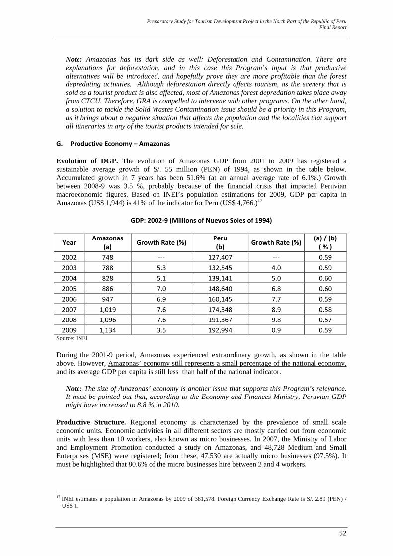
Preparatory Study for Tourism Development Project in the North Part of the Republic of Peru Final Report
52
Note: Amazonas has its dark side as well: Deforestation and Contamination. There are explanations for deforestation, and in this case this Program’s input is that productive alternatives will be introduced, and hopefully prove they are more profitable than the forest depredating activities. Although deforestation directly affects tourism, as the scenery that is sold as a tourist product is also affected, most of Amazonas forest depredation takes place away from CTCU. Therefore, GRA is compelled to intervene with other programs. On the other hand, a solution to tackle the Solid Wastes Contamination issue should be a priority in this Program, as it brings about a negative situation that affects the population and the localities that support all itineraries in any of the tourist products intended for sale.
G. Productive Economy – Amazonas Evolution of DGP. The evolution of Amazonas GDP from 2001 to 2009 has registered a sustainable average growth of S/. 55 million (PEN) of 1994, as shown in the table below. Accumulated growth in 7 years has been 51.6% (at an annual average rate of 6.1%.) Growth between 2008-9 was 3.5 %, probably because of the financial crisis that impacted Peruvian macroeconomic figures. Based on INEI’s population estimations for 2009, GDP per capita in Amazonas (US$ 1,944) is 41% of the indicator for Peru (US$ 4,766.)17
GDP: 2002‐9 (Millions of Nuevos Soles of 1994)
Year Amazonas (a) Growth Rate (%) Peru
(b) Growth Rate (%) (a) / (b) ( % )
2002 748 ‐‐‐ 127,407 ‐‐‐ 0.59 2003 788 5.3 132,545 4.0 0.59 2004 828 5.1 139,141 5.0 0.60 2005 886 7.0 148,640 6.8 0.60 2006 947 6.9 160,145 7.7 0.59 2007 1,019 7.6 174,348 8.9 0.58 2008 1,096 7.6 191,367 9.8 0.57 2009 1,134 3.5 192,994 0.9 0.59
Source: INEI During the 2001-9 period, Amazonas experienced extraordinary growth, as shown in the table above. However, Amazonas’ economy still represents a small percentage of the national economy, and its average GDP per capita is still less than half of the national indicator.
Note: The size of Amazonas’ economy is another issue that supports this Program’s relevance. It must be pointed out that, according to the Economy and Finances Ministry, Peruvian GDP might have increased to 8.8 % in 2010.
Productive Structure. Regional economy is characterized by the prevalence of small scale economic units. Economic activities in all different sectors are mostly carried out from economic units with less than 10 workers, also known as micro businesses. In 2007, the Ministry of Labor and Employment Promotion conducted a study on Amazonas, and 48,728 Medium and Small Enterprises (MSE) were registered; from these, 47,530 are actually micro businesses (97.5%). It must be highlighted that 80.6% of the micro businesses hire between 2 and 4 workers.
17 INEI estimates a population in Amazonas by 2009 of 381,578. Foreign Currency Exchange Rate is S/. 2.89 (PEN) /
US$ 1.
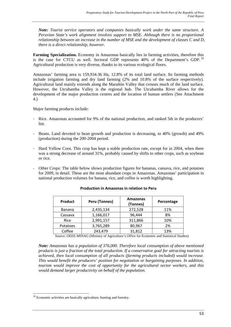
Preparatory Study for Tourism Development Project in the North Part of the Republic of Peru Final Report
53
Note: Tourist service operators and companies basically work under the same structure. A Peruvian State’s work alignment involves support to MSE. Although there is no proportional relationship between an increase in the number of MSE and the development of classes C and D, there is a direct relationship, however.
Farming Specialization. Economy in Amazonas basically lies in farming activities, therefore this is the case for CTCU as well. Sectoral GDP represents 40% of the Department’s GDP. 18 Agricultural production is very diverse, thanks to its various ecological floors. Amazonas’ farming area is 159,934.36 Ha, 12.8% of its total land surface. Its farming methods include irrigation farming and dry land farming (2% and 10.8% of the surface respectively). Agricultural land mainly extends along the Marañón Valley that crosses much of the land surface. However, the Utcubamba Valley is the regional hub. The Utcubamba River allows for the development of the major production centres and the location of human settlers (See Attachment 4.) Major farming products include: ‐ Rice. Amazonas accounted for 9% of the national production, and ranked 5th in the producers’
list.
‐ Beans. Land devoted to bean growth and production is decreasing, to 40% (growth) and 49% (production) during the 200-2004 period.
‐ Hard Yellow Corn. This crop has kept a stable production rate, except for in 2004, when there was a strong decrease of around 31%, probably caused by shifts to other crops, such as soybean or rice.
‐ Other Crops: The table below shows production figures for bananas, cassava, rice, and potatoes
for 2009, in detail. These are the most abundant crops in Amazonas. Amazonas’ participation in national production volumes for banana, rice, and coffee is worth highlighting.
Production in Amazonas in relation to Peru
Product Peru (Tonnes) Amazonas (Tonnes) Percentage
Banana 2,435,134 272,528 11% Cassava 1,166,017 96,444 8% Rice 2,991,157 311,866 10%
Potatoes 3,765,289 80,967 2% Coffee 243,479 31,812 13%
Source: OEEE-MINAG (Ministry of Agriculture’s Office for Economic and Statistical Studies)
Note: Amazonas has a population of 376,000. Therefore local consumption of above mentioned products is just a fraction of the total production. If a conservative goal for attracting tourists is achieved, then local consumption of all products (farming products included) would increase. This would benefit the producers’ position for negotiation or bargaining purposes. In addition, tourism would improve the cost of opportunity for the agricultural sector workers, and this would demand larger productivity on behalf of the population.
18 Economic activities are basically agriculture, hunting and forestry.
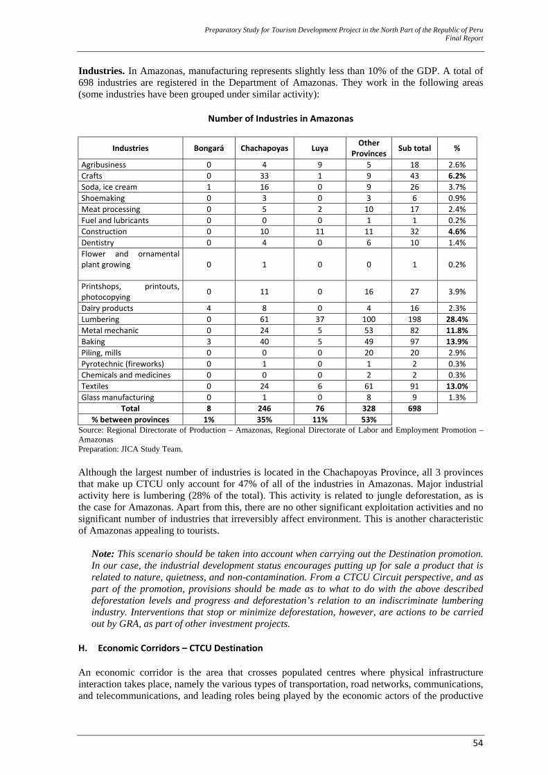
Preparatory Study for Tourism Development Project in the North Part of the Republic of Peru Final Report
54
Industries. In Amazonas, manufacturing represents slightly less than 10% of the GDP. A total of 698 industries are registered in the Department of Amazonas. They work in the following areas (some industries have been grouped under similar activity):
Number of Industries in Amazonas
Industries Bongará Chachapoyas Luya Other Provinces Sub total %
Agribusiness 0 4 9 5 18 2.6% Crafts 0 33 1 9 43 6.2% Soda, ice cream 1 16 0 9 26 3.7% Shoemaking 0 3 0 3 6 0.9% Meat processing 0 5 2 10 17 2.4% Fuel and lubricants 0 0 0 1 1 0.2% Construction 0 10 11 11 32 4.6% Dentistry 0 4 0 6 10 1.4% Flower and ornamental plant growing
0 1 0 0 1 0.2%
Printshops, printouts, photocopying 0 11 0 16 27 3.9%
Dairy products 4 8 0 4 16 2.3% Lumbering 0 61 37 100 198 28.4% Metal mechanic 0 24 5 53 82 11.8% Baking 3 40 5 49 97 13.9% Piling, mills 0 0 0 20 20 2.9% Pyrotechnic (fireworks) 0 1 0 1 2 0.3% Chemicals and medicines 0 0 0 2 2 0.3% Textiles 0 24 6 61 91 13.0% Glass manufacturing 0 1 0 8 9 1.3%
Total 8 246 76 328 698 % between provinces 1% 35% 11% 53%
Source: Regional Directorate of Production – Amazonas, Regional Directorate of Labor and Employment Promotion – Amazonas Preparation: JICA Study Team. Although the largest number of industries is located in the Chachapoyas Province, all 3 provinces that make up CTCU only account for 47% of all of the industries in Amazonas. Major industrial activity here is lumbering (28% of the total). This activity is related to jungle deforestation, as is the case for Amazonas. Apart from this, there are no other significant exploitation activities and no significant number of industries that irreversibly affect environment. This is another characteristic of Amazonas appealing to tourists.
Note: This scenario should be taken into account when carrying out the Destination promotion. In our case, the industrial development status encourages putting up for sale a product that is related to nature, quietness, and non-contamination. From a CTCU Circuit perspective, and as part of the promotion, provisions should be made as to what to do with the above described deforestation levels and progress and deforestation’s relation to an indiscriminate lumbering industry. Interventions that stop or minimize deforestation, however, are actions to be carried out by GRA, as part of other investment projects.
H. Economic Corridors – CTCU Destination An economic corridor is the area that crosses populated centres where physical infrastructure interaction takes place, namely the various types of transportation, road networks, communications, and telecommunications, and leading roles being played by the economic actors of the productive
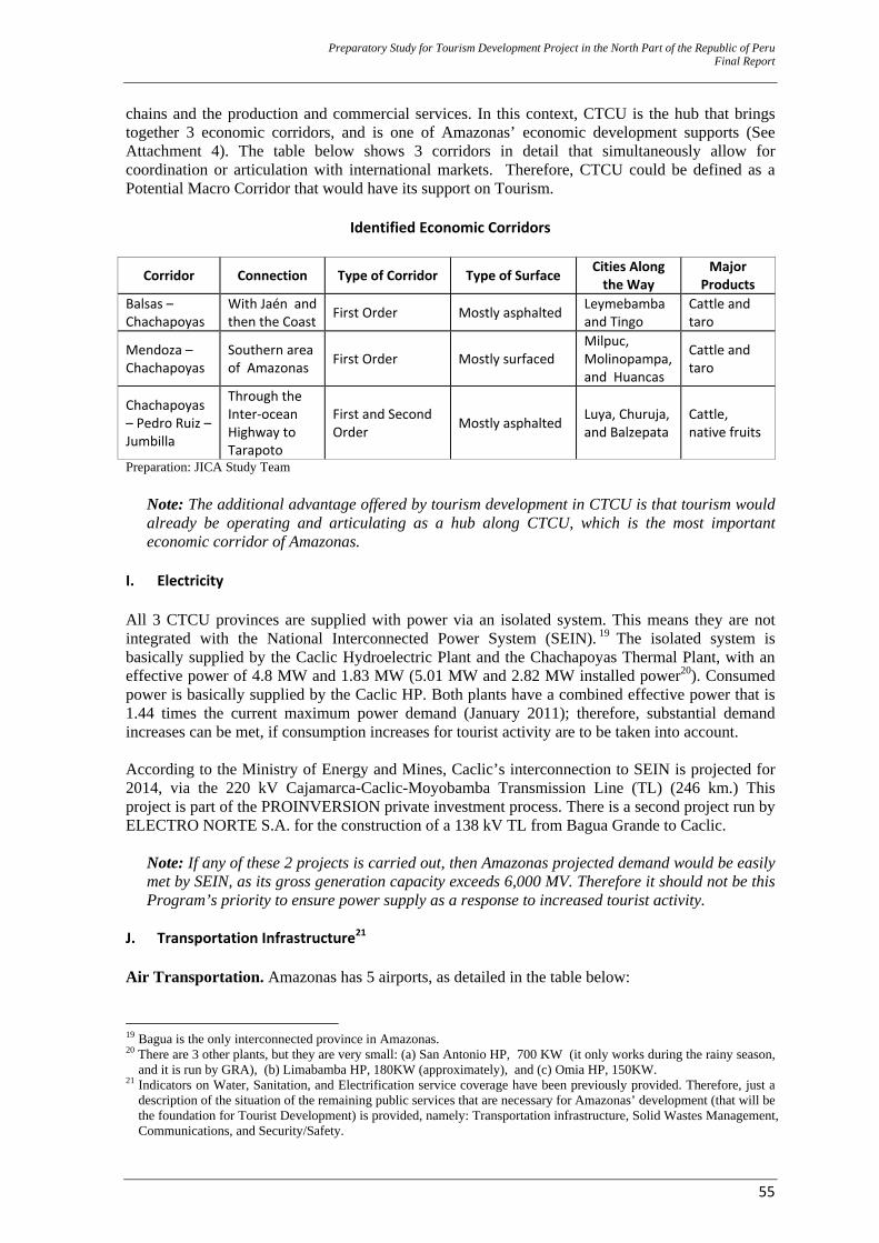
Preparatory Study for Tourism Development Project in the North Part of the Republic of Peru Final Report
55
chains and the production and commercial services. In this context, CTCU is the hub that brings together 3 economic corridors, and is one of Amazonas’ economic development supports (See Attachment 4). The table below shows 3 corridors in detail that simultaneously allow for coordination or articulation with international markets. Therefore, CTCU could be defined as a Potential Macro Corridor that would have its support on Tourism.
Identified Economic Corridors
Corridor Connection Type of Corridor Type of Surface Cities Along the Way
Major Products
Balsas – Chachapoyas
With Jaén and then the Coast First Order Mostly asphalted Leymebamba
and Tingo Cattle and taro
Mendoza – Chachapoyas
Southern area of Amazonas First Order Mostly surfaced
Milpuc, Molinopampa, and Huancas
Cattle and taro
Chachapoyas – Pedro Ruiz – Jumbilla
Through the Inter‐ocean Highway to Tarapoto
First and Second Order Mostly asphalted Luya, Churuja,
and Balzepata Cattle, native fruits
Preparation: JICA Study Team
Note: The additional advantage offered by tourism development in CTCU is that tourism would already be operating and articulating as a hub along CTCU, which is the most important economic corridor of Amazonas.
I. Electricity All 3 CTCU provinces are supplied with power via an isolated system. This means they are not integrated with the National Interconnected Power System (SEIN). 19 The isolated system is basically supplied by the Caclic Hydroelectric Plant and the Chachapoyas Thermal Plant, with an effective power of 4.8 MW and 1.83 MW (5.01 MW and 2.82 MW installed power20). Consumed power is basically supplied by the Caclic HP. Both plants have a combined effective power that is 1.44 times the current maximum power demand (January 2011); therefore, substantial demand increases can be met, if consumption increases for tourist activity are to be taken into account. According to the Ministry of Energy and Mines, Caclic’s interconnection to SEIN is projected for 2014, via the 220 kV Cajamarca-Caclic-Moyobamba Transmission Line (TL) (246 km.) This project is part of the PROINVERSION private investment process. There is a second project run by ELECTRO NORTE S.A. for the construction of a 138 kV TL from Bagua Grande to Caclic.
Note: If any of these 2 projects is carried out, then Amazonas projected demand would be easily met by SEIN, as its gross generation capacity exceeds 6,000 MV. Therefore it should not be this Program’s priority to ensure power supply as a response to increased tourist activity.
J. Transportation Infrastructure21 Air Transportation. Amazonas has 5 airports, as detailed in the table below:
19 Bagua is the only interconnected province in Amazonas. 20 There are 3 other plants, but they are very small: (a) San Antonio HP, 700 KW (it only works during the rainy season,
and it is run by GRA), (b) Limabamba HP, 180KW (approximately), and (c) Omia HP, 150KW. 21 Indicators on Water, Sanitation, and Electrification service coverage have been previously provided. Therefore, just a
description of the situation of the remaining public services that are necessary for Amazonas’ development (that will be the foundation for Tourist Development) is provided, namely: Transportation infrastructure, Solid Wastes Management, Communications, and Security/Safety.
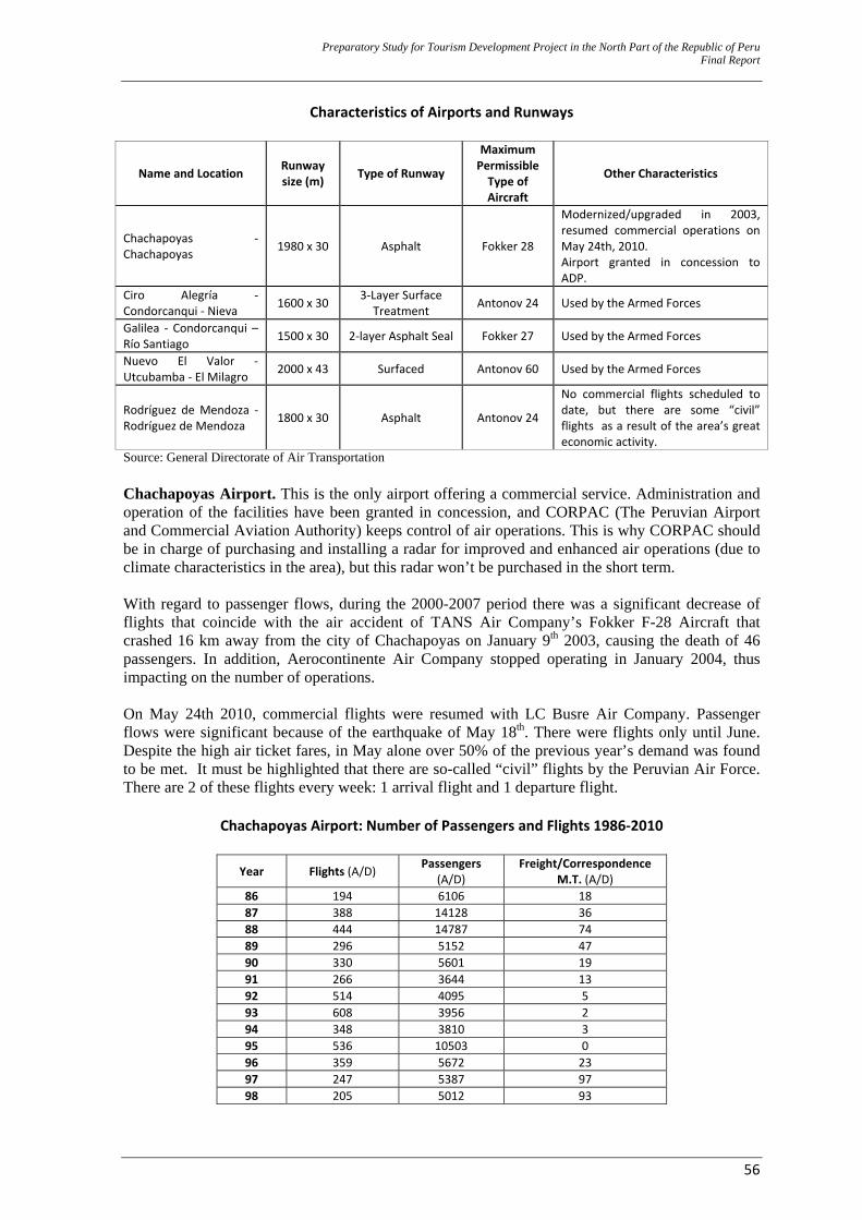
Preparatory Study for Tourism Development Project in the North Part of the Republic of Peru Final Report
56
Characteristics of Airports and Runways
Name and Location Runway size (m) Type of Runway
Maximum Permissible Type of Aircraft
Other Characteristics
Chachapoyas ‐ Chachapoyas 1980 x 30 Asphalt Fokker 28
Modernized/upgraded in 2003, resumed commercial operations on May 24th, 2010. Airport granted in concession to ADP.
Ciro Alegría ‐ Condorcanqui ‐ Nieva 1600 x 30 3‐Layer Surface
Treatment Antonov 24 Used by the Armed Forces
Galilea ‐ Condorcanqui – Río Santiago 1500 x 30 2‐layer Asphalt Seal Fokker 27 Used by the Armed Forces
Nuevo El Valor ‐ Utcubamba ‐ El Milagro 2000 x 43 Surfaced Antonov 60 Used by the Armed Forces
Rodríguez de Mendoza ‐ Rodríguez de Mendoza 1800 x 30 Asphalt Antonov 24
No commercial flights scheduled to date, but there are some “civil” flights as a result of the area’s great economic activity.
Source: General Directorate of Air Transportation Chachapoyas Airport. This is the only airport offering a commercial service. Administration and operation of the facilities have been granted in concession, and CORPAC (The Peruvian Airport and Commercial Aviation Authority) keeps control of air operations. This is why CORPAC should be in charge of purchasing and installing a radar for improved and enhanced air operations (due to climate characteristics in the area), but this radar won’t be purchased in the short term. With regard to passenger flows, during the 2000-2007 period there was a significant decrease of flights that coincide with the air accident of TANS Air Company’s Fokker F-28 Aircraft that crashed 16 km away from the city of Chachapoyas on January 9th 2003, causing the death of 46 passengers. In addition, Aerocontinente Air Company stopped operating in January 2004, thus impacting on the number of operations. On May 24th 2010, commercial flights were resumed with LC Busre Air Company. Passenger flows were significant because of the earthquake of May 18th. There were flights only until June. Despite the high air ticket fares, in May alone over 50% of the previous year’s demand was found to be met. It must be highlighted that there are so-called “civil” flights by the Peruvian Air Force. There are 2 of these flights every week: 1 arrival flight and 1 departure flight.
Chachapoyas Airport: Number of Passengers and Flights 1986‐2010
Year Flights (A/D) Passengers (A/D)
Freight/Correspondence M.T. (A/D)
86 194 6106 18 87 388 14128 36 88 444 14787 74 89 296 5152 47 90 330 5601 19 91 266 3644 13 92 514 4095 5 93 608 3956 2 94 348 3810 3 95 536 10503 0 96 359 5672 23 97 247 5387 97 98 205 5012 93
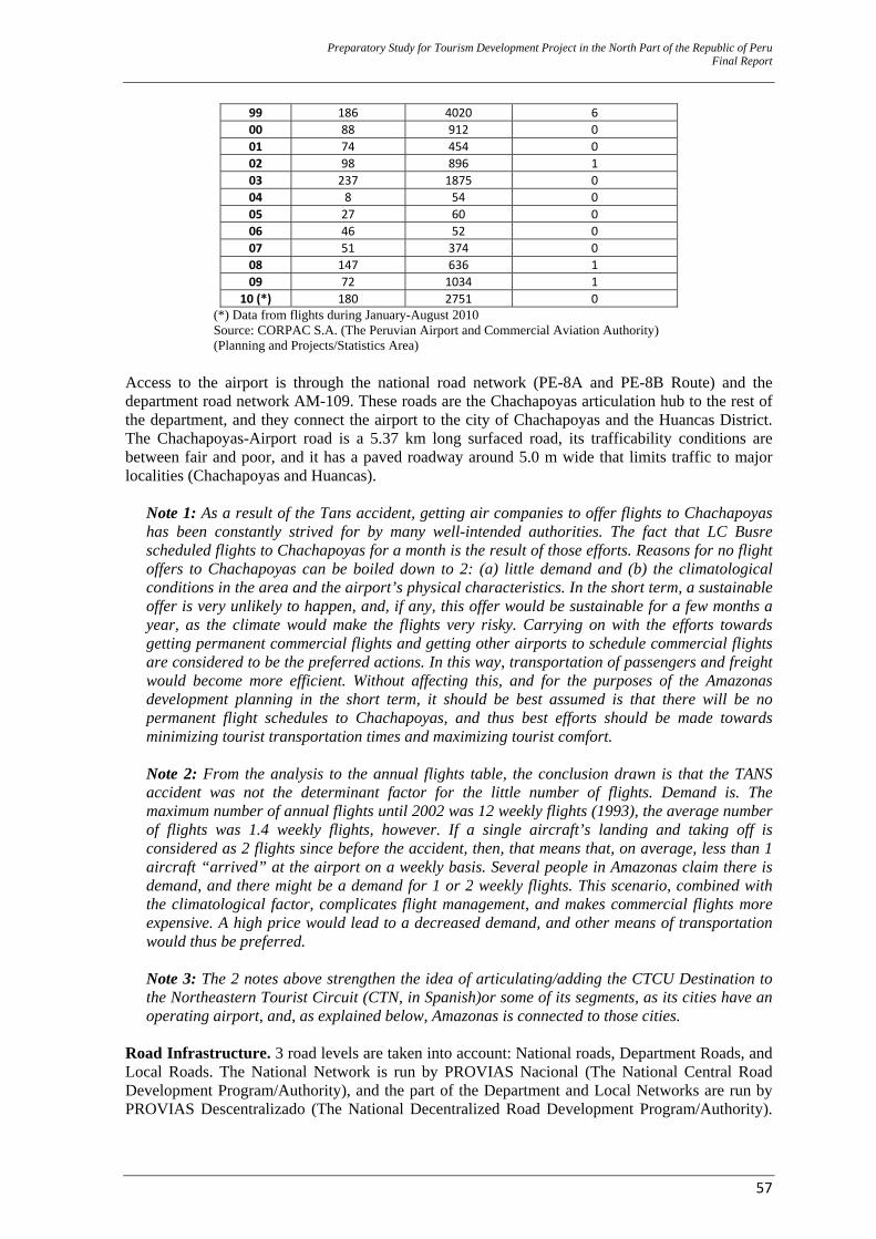
Preparatory Study for Tourism Development Project in the North Part of the Republic of Peru Final Report
57
99 186 4020 6 00 88 912 0 01 74 454 0 02 98 896 1 03 237 1875 0 04 8 54 0 05 27 60 0 06 46 52 0 07 51 374 0 08 147 636 1 09 72 1034 1
10 (*) 180 2751 0 (*) Data from flights during January-August 2010 Source: CORPAC S.A. (The Peruvian Airport and Commercial Aviation Authority) (Planning and Projects/Statistics Area)
Access to the airport is through the national road network (PE-8A and PE-8B Route) and the department road network AM-109. These roads are the Chachapoyas articulation hub to the rest of the department, and they connect the airport to the city of Chachapoyas and the Huancas District. The Chachapoyas-Airport road is a 5.37 km long surfaced road, its trafficability conditions are between fair and poor, and it has a paved roadway around 5.0 m wide that limits traffic to major localities (Chachapoyas and Huancas).
Note 1: As a result of the Tans accident, getting air companies to offer flights to Chachapoyas has been constantly strived for by many well-intended authorities. The fact that LC Busre scheduled flights to Chachapoyas for a month is the result of those efforts. Reasons for no flight offers to Chachapoyas can be boiled down to 2: (a) little demand and (b) the climatological conditions in the area and the airport’s physical characteristics. In the short term, a sustainable offer is very unlikely to happen, and, if any, this offer would be sustainable for a few months a year, as the climate would make the flights very risky. Carrying on with the efforts towards getting permanent commercial flights and getting other airports to schedule commercial flights are considered to be the preferred actions. In this way, transportation of passengers and freight would become more efficient. Without affecting this, and for the purposes of the Amazonas development planning in the short term, it should be best assumed is that there will be no permanent flight schedules to Chachapoyas, and thus best efforts should be made towards minimizing tourist transportation times and maximizing tourist comfort. Note 2: From the analysis to the annual flights table, the conclusion drawn is that the TANS accident was not the determinant factor for the little number of flights. Demand is. The maximum number of annual flights until 2002 was 12 weekly flights (1993), the average number of flights was 1.4 weekly flights, however. If a single aircraft’s landing and taking off is considered as 2 flights since before the accident, then, that means that, on average, less than 1 aircraft “arrived” at the airport on a weekly basis. Several people in Amazonas claim there is demand, and there might be a demand for 1 or 2 weekly flights. This scenario, combined with the climatological factor, complicates flight management, and makes commercial flights more expensive. A high price would lead to a decreased demand, and other means of transportation would thus be preferred. Note 3: The 2 notes above strengthen the idea of articulating/adding the CTCU Destination to the Northeastern Tourist Circuit (CTN, in Spanish)or some of its segments, as its cities have an operating airport, and, as explained below, Amazonas is connected to those cities.
Road Infrastructure. 3 road levels are taken into account: National roads, Department Roads, and Local Roads. The National Network is run by PROVIAS Nacional (The National Central Road Development Program/Authority), and the part of the Department and Local Networks are run by PROVIAS Descentralizado (The National Decentralized Road Development Program/Authority).
Preparatory Study for Tourism Development Project in the North Part of the Republic of Peru Final Report
58
Both authorities are under the Ministry of Transportation and Communications (MTC) supervision. The scopes for each category are under the MTC revision. There is a road classifier that establishes the road significance status (or “hierarchy”) around Peru. This classifier is being constantly updated, depending on the availability of the sub national Government budgets.22 Road significance status dictates the Government level that is responsible for road intervention, as applicable: National Roads, MTC; Department Roads, Regional Government, and Byroads, Local Government. The next 2 tables below show (a) the road distribution (by road significance status and rolling surface) for Amazonas and CTCU, and (b) a detailed description of the routes along the national and department category roads in Amazonas. These routes are the articulating hubs for commercial and people traffic. Byroads (access roads for tourist resources) are detailed in Attachment 5.
Note: Significance of the distribution road status impact on the resources lies in the fact that serious criteria are implied when analyzing traffic on these roads at the time of valuing the quality of the tourist service (globally speaking). After their arrival to the support city, tourists will travel on those routes almost on a permanent basis, and their experience will be of a lower quality if they are forced to endure roads in very poor conditions.
22 On November 28th, 2008 S.D. No. 044-2008-MTC was issued. This law approved updating the Road Network Route
Classifier.
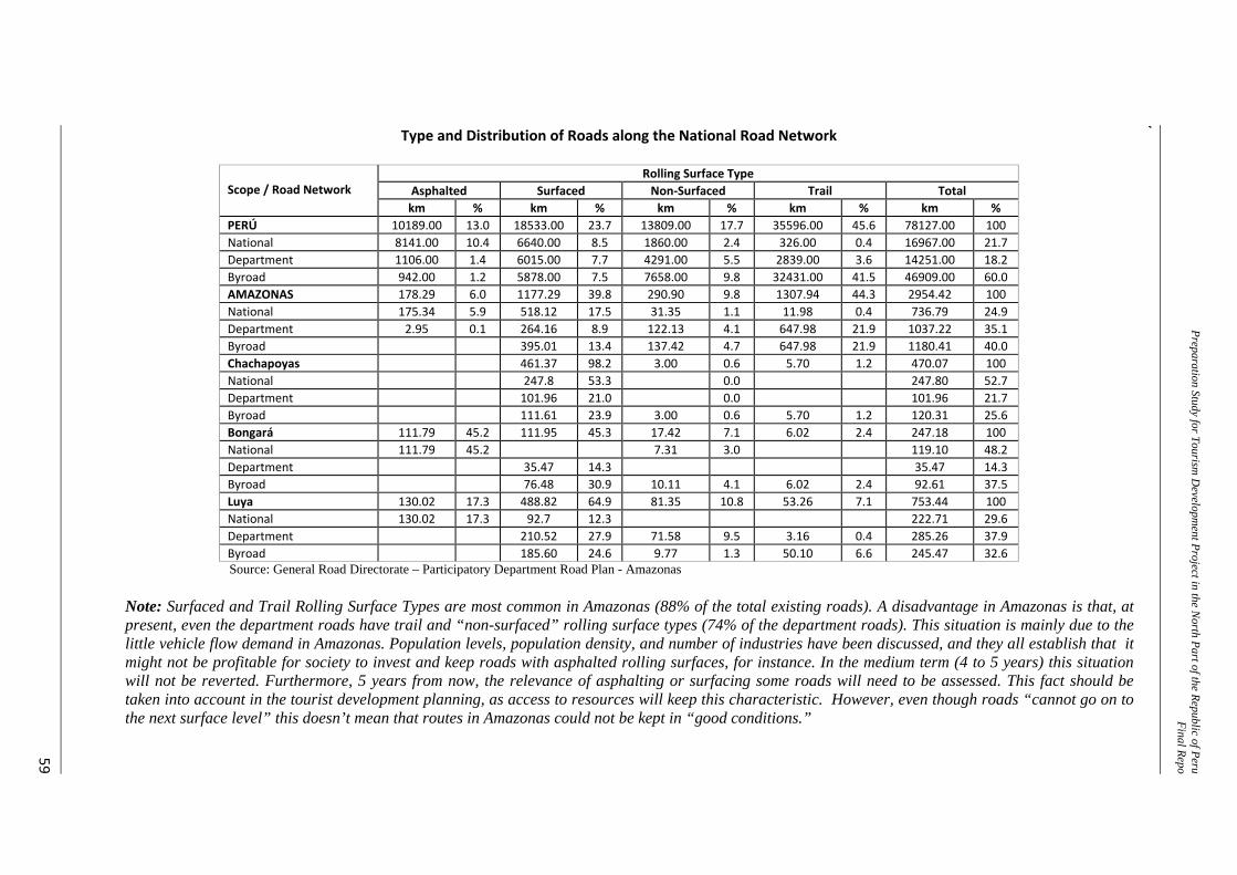
Preparation Study for Tourism D
evelopment Project in the N
orth Part of the Republic of PeruFinal Repo
t
59
Type and Distribution of Roads along the National Road Network
Scope / Road Network
Rolling Surface Type Asphalted Surfaced Non‐Surfaced Trail Total km % km % km % km % km %
PERÚ 10189.00 13.0 18533.00 23.7 13809.00 17.7 35596.00 45.6 78127.00 100 National 8141.00 10.4 6640.00 8.5 1860.00 2.4 326.00 0.4 16967.00 21.7Department 1106.00 1.4 6015.00 7.7 4291.00 5.5 2839.00 3.6 14251.00 18.2Byroad 942.00 1.2 5878.00 7.5 7658.00 9.8 32431.00 41.5 46909.00 60.0AMAZONAS 178.29 6.0 1177.29 39.8 290.90 9.8 1307.94 44.3 2954.42 100 National 175.34 5.9 518.12 17.5 31.35 1.1 11.98 0.4 736.79 24.9Department 2.95 0.1 264.16 8.9 122.13 4.1 647.98 21.9 1037.22 35.1Byroad 395.01 13.4 137.42 4.7 647.98 21.9 1180.41 40.0Chachapoyas 461.37 98.2 3.00 0.6 5.70 1.2 470.07 100 National 247.8 53.3 0.0 247.80 52.7Department 101.96 21.0 0.0 101.96 21.7Byroad 111.61 23.9 3.00 0.6 5.70 1.2 120.31 25.6Bongará 111.79 45.2 111.95 45.3 17.42 7.1 6.02 2.4 247.18 100 National 111.79 45.2 7.31 3.0 119.10 48.2Department 35.47 14.3 35.47 14.3Byroad 76.48 30.9 10.11 4.1 6.02 2.4 92.61 37.5Luya 130.02 17.3 488.82 64.9 81.35 10.8 53.26 7.1 753.44 100 National 130.02 17.3 92.7 12.3 222.71 29.6Department 210.52 27.9 71.58 9.5 3.16 0.4 285.26 37.9Byroad 185.60 24.6 9.77 1.3 50.10 6.6 245.47 32.6Source: General Road Directorate – Participatory Department Road Plan - Amazonas
Note: Surfaced and Trail Rolling Surface Types are most common in Amazonas (88% of the total existing roads). A disadvantage in Amazonas is that, at present, even the department roads have trail and “non-surfaced” rolling surface types (74% of the department roads). This situation is mainly due to the little vehicle flow demand in Amazonas. Population levels, population density, and number of industries have been discussed, and they all establish that it might not be profitable for society to invest and keep roads with asphalted rolling surfaces, for instance. In the medium term (4 to 5 years) this situation will not be reverted. Furthermore, 5 years from now, the relevance of asphalting or surfacing some roads will need to be assessed. This fact should be taken into account in the tourist development planning, as access to resources will keep this characteristic. However, even though roads “cannot go on to the next surface level” this doesn’t mean that routes in Amazonas could not be kept in “good conditions.”
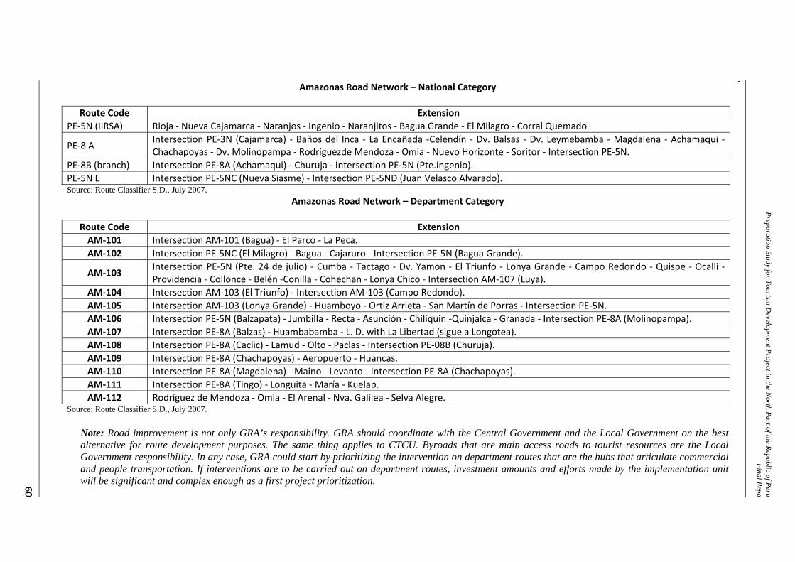
Preparation Study for Tourism D
evelopment Project in the N
orth Part of the Republic of PeruFinal Repo
t
60
Amazonas Road Network – National Category
Route Code Extension PE‐5N (IIRSA) Rioja ‐ Nueva Cajamarca ‐ Naranjos ‐ Ingenio ‐ Naranjitos ‐ Bagua Grande ‐ El Milagro ‐ Corral Quemado
PE‐8 A Intersection PE‐3N (Cajamarca) ‐ Baños del Inca ‐ La Encañada ‐Celendín ‐ Dv. Balsas ‐ Dv. Leymebamba ‐ Magdalena ‐ Achamaqui ‐ Chachapoyas ‐ Dv. Molinopampa ‐ Rodríguezde Mendoza ‐ Omia ‐ Nuevo Horizonte ‐ Soritor ‐ Intersection PE‐5N.
PE‐8B (branch) Intersection PE‐8A (Achamaqui) ‐ Churuja ‐ Intersection PE‐5N (Pte.Ingenio). PE‐5N E Intersection PE‐5NC (Nueva Siasme) ‐ Intersection PE‐5ND (Juan Velasco Alvarado). Source: Route Classifier S.D., July 2007.
Amazonas Road Network – Department Category
Route Code Extension AM‐101 Intersection AM‐101 (Bagua) ‐ El Parco ‐ La Peca. AM‐102 Intersection PE‐5NC (El Milagro) ‐ Bagua ‐ Cajaruro ‐ Intersection PE‐5N (Bagua Grande).
AM‐103 Intersection PE‐5N (Pte. 24 de julio) ‐ Cumba ‐ Tactago ‐ Dv. Yamon ‐ El Triunfo ‐ Lonya Grande ‐ Campo Redondo ‐ Quispe ‐ Ocalli ‐ Providencia ‐ Collonce ‐ Belén ‐Conilla ‐ Cohechan ‐ Lonya Chico ‐ Intersection AM‐107 (Luya).
AM‐104 Intersection AM‐103 (El Triunfo) ‐ Intersection AM‐103 (Campo Redondo). AM‐105 Intersection AM‐103 (Lonya Grande) ‐ Huamboyo ‐ Ortiz Arrieta ‐ San Martín de Porras ‐ Intersection PE‐5N. AM‐106 Intersection PE‐5N (Balzapata) ‐ Jumbilla ‐ Recta ‐ Asunción ‐ Chiliquin ‐Quinjalca ‐ Granada ‐ Intersection PE‐8A (Molinopampa). AM‐107 Intersection PE‐8A (Balzas) ‐ Huambabamba ‐ L. D. with La Libertad (sigue a Longotea). AM‐108 Intersection PE‐8A (Caclic) ‐ Lamud ‐ Olto ‐ Paclas ‐ Intersection PE‐08B (Churuja). AM‐109 Intersection PE‐8A (Chachapoyas) ‐ Aeropuerto ‐ Huancas. AM‐110 Intersection PE‐8A (Magdalena) ‐ Maino ‐ Levanto ‐ Intersection PE‐8A (Chachapoyas). AM‐111 Intersection PE‐8A (Tingo) ‐ Longuita ‐ María ‐ Kuelap. AM‐112 Rodríguez de Mendoza ‐ Omia ‐ El Arenal ‐ Nva. Galilea ‐ Selva Alegre.
Source: Route Classifier S.D., July 2007.
Note: Road improvement is not only GRA’s responsibility. GRA should coordinate with the Central Government and the Local Government on the best alternative for route development purposes. The same thing applies to CTCU. Byroads that are main access roads to tourist resources are the Local Government responsibility. In any case, GRA could start by prioritizing the intervention on department routes that are the hubs that articulate commercial and people transportation. If interventions are to be carried out on department routes, investment amounts and efforts made by the implementation unit will be significant and complex enough as a first project prioritization.
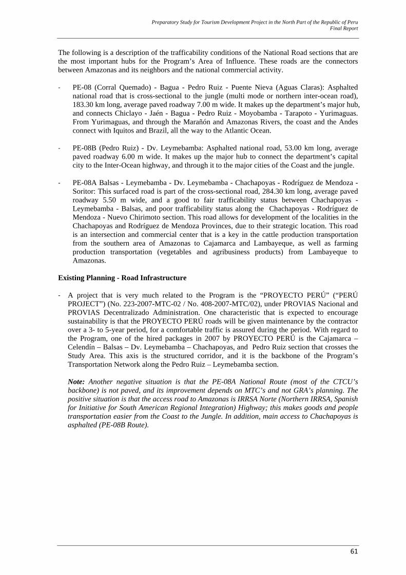
Preparatory Study for Tourism Development Project in the North Part of the Republic of Peru Final Report
61
The following is a description of the trafficability conditions of the National Road sections that are the most important hubs for the Program’s Area of Influence. These roads are the connectors between Amazonas and its neighbors and the national commercial activity. ‐ PE-08 (Corral Quemado) - Bagua - Pedro Ruiz - Puente Nieva (Aguas Claras): Asphalted
national road that is cross-sectional to the jungle (multi mode or northern inter-ocean road), 183.30 km long, average paved roadway 7.00 m wide. It makes up the department’s major hub, and connects Chiclayo - Jaén - Bagua - Pedro Ruiz - Moyobamba - Tarapoto - Yurimaguas. From Yurimaguas, and through the Marañón and Amazonas Rivers, the coast and the Andes connect with Iquitos and Brazil, all the way to the Atlantic Ocean.
‐ PE-08B (Pedro Ruiz) - Dv. Leymebamba: Asphalted national road, 53.00 km long, average
paved roadway 6.00 m wide. It makes up the major hub to connect the department’s capital city to the Inter-Ocean highway, and through it to the major cities of the Coast and the jungle.
‐ PE-08A Balsas - Leymebamba - Dv. Leymebamba - Chachapoyas - Rodríguez de Mendoza -
Soritor: This surfaced road is part of the cross-sectional road, 284.30 km long, average paved roadway 5.50 m wide, and a good to fair trafficability status between Chachapoyas - Leymebamba - Balsas, and poor trafficability status along the Chachapoyas - Rodríguez de Mendoza - Nuevo Chirimoto section. This road allows for development of the localities in the Chachapoyas and Rodríguez de Mendoza Provinces, due to their strategic location. This road is an intersection and commercial center that is a key in the cattle production transportation from the southern area of Amazonas to Cajamarca and Lambayeque, as well as farming production transportation (vegetables and agribusiness products) from Lambayeque to Amazonas.
Existing Planning - Road Infrastructure ‐ A project that is very much related to the Program is the “PROYECTO PERÚ” (“PERÚ
PROJECT”) (No. 223-2007-MTC-02 / No. 408-2007-MTC/02), under PROVIAS Nacional and PROVIAS Decentralizado Administration. One characteristic that is expected to encourage sustainability is that the PROYECTO PERÚ roads will be given maintenance by the contractor over a 3- to 5-year period, for a comfortable traffic is assured during the period. With regard to the Program, one of the hired packages in 2007 by PROYECTO PERÚ is the Cajamarca – Celendín – Balsas – Dv. Leymebamba – Chachapoyas, and Pedro Ruiz section that crosses the Study Area. This axis is the structured corridor, and it is the backbone of the Program’s Transportation Network along the Pedro Ruiz – Leymebamba section. Note: Another negative situation is that the PE-08A National Route (most of the CTCU’s backbone) is not paved, and its improvement depends on MTC’s and not GRA’s planning. The positive situation is that the access road to Amazonas is IRRSA Norte (Northern IRRSA, Spanish for Initiative for South American Regional Integration) Highway; this makes goods and people transportation easier from the Coast to the Jungle. In addition, main access to Chachapoyas is asphalted (PE-08B Route).
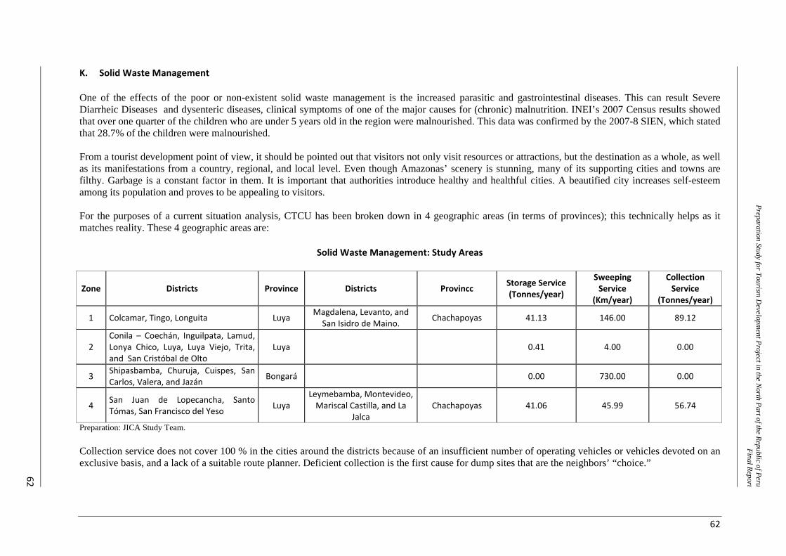
62
Preparation Study for Tourism D
evelopment Project in the N
orth Part of the Republic of PeruFinal Report
62
K. Solid Waste Management One of the effects of the poor or non-existent solid waste management is the increased parasitic and gastrointestinal diseases. This can result Severe Diarrheic Diseases and dysenteric diseases, clinical symptoms of one of the major causes for (chronic) malnutrition. INEI’s 2007 Census results showed that over one quarter of the children who are under 5 years old in the region were malnourished. This data was confirmed by the 2007-8 SIEN, which stated that 28.7% of the children were malnourished. From a tourist development point of view, it should be pointed out that visitors not only visit resources or attractions, but the destination as a whole, as well as its manifestations from a country, regional, and local level. Even though Amazonas’ scenery is stunning, many of its supporting cities and towns are filthy. Garbage is a constant factor in them. It is important that authorities introduce healthy and healthful cities. A beautified city increases self-esteem among its population and proves to be appealing to visitors. For the purposes of a current situation analysis, CTCU has been broken down in 4 geographic areas (in terms of provinces); this technically helps as it matches reality. These 4 geographic areas are:
Solid Waste Management: Study Areas
Zone Districts Province Districts Provincc Storage Service (Tonnes/year)
Sweeping Service
(Km/year)
Collection Service
(Tonnes/year)
1 Colcamar, Tingo, Longuita Luya Magdalena, Levanto, and San Isidro de Maino. Chachapoyas 41.13 146.00 89.12
2 Conila – Coechán, Inguilpata, Lamud, Lonya Chico, Luya, Luya Viejo, Trita, and San Cristóbal de Olto
Luya 0.41 4.00 0.00
3 Shipasbamba, Churuja, Cuispes, San Carlos, Valera, and Jazán Bongará 0.00 730.00 0.00
4 San Juan de Lopecancha, Santo Tómas, San Francisco del Yeso Luya
Leymebamba, Montevideo, Mariscal Castilla, and La
Jalca Chachapoyas 41.06 45.99 56.74
Preparation: JICA Study Team. Collection service does not cover 100 % in the cities around the districts because of an insufficient number of operating vehicles or vehicles devoted on an exclusive basis, and a lack of a suitable route planner. Deficient collection is the first cause for dump sites that are the neighbors’ “choice.”
Preparatory Study for Tourism Development Project in the North Part of the Republic of Peru Final Report
63
There are no landfills for suitable waste treatment. Common practice (100%) in all localities involves dumping collected waste at the unsuitably named “municipal dump sites.” These sites are generally a dry brook, a nearby pit, the foot of a hill, or a natural depression, and their selection does not follow any minimum sanitation criteria. Waste is dumped in these sites in a messy, untreated way, without any sanitation measures. Logical thinking here leads one to assume that this practice affects the environment and the population’s quality of life. The following are some examples of dump sites: ‐ Magdalena District: Shimbilla Brook ‐ Tingo District: A brook located 3 km from the urban centre ‐ Colcamar District: Waste is buried in the people’s homes, and there is no collection service. ‐ Longuita District: Waste is buried in a pit 300 m away from the central square or plaza. ‐ Kuelap Fortress: INC appointed an area for waste storage for it to be later transported to brooks
close to the Longuita and María localities. ‐ María District: Covan Pass ‐ Levanto District: LLumal Brook ‐ San Isidro de Maino District: Chucahuayco Brook Citizens do not exert their supervising and control work, and are not aware of the effects and side-effects of poor management. Collection service on streets and roads is carried out at a minimum, there are some deteriorated garbage bins that lack a suitable design, and thus, they are not suitable for municipal workers to handle them. Neglect shown by districts to their “hamlets” (“anexos” in Spanish) and other areas close to the localities that are in the Program’s scope is something common, and it poses a risk for infectious and contagious respiratory and skin diseases. In addition, the accumulation of solid waste generates foul smells, traffic disruption of public roads, and insect proliferation.
Note: Reversing this situation is a PRIORITY. The tourist product does not envision “selling” sceneries that are filled with garbage, and interacting with people who are ill as a result of living too close to waste. In addition, this is a basic service that shows a society’s developmental level. In the case of tourism in Amazonas, this is even more relevant, because environmental protection should be used as a supplement to the identified products.
L. Communications General. CTCU has a telephone landline and Internet service run by the Movistar Company. With regard to mobile telephones, there are 2 service suppliers (Movistar and Claro); however, only major cities, like Chachapoyas, were benefited with the largest coverage and access. In other districts, satellite systems are commonly used for both telephone services and even the Internet service. Recently, the Peruvian – U.S. CIFSA Telecom SAC – STM Wireless Inc. Associates Consortium has won the Public International Tender, and will be hired to render public telecommunications services in the rural areas, including the “Northern Area” (Piura, Cajamarca, and Amazonas Departments). Telephone Landline. Chachapoyas is the only district that is benefited with telephone landline service. The remaining districts are served with wireless connection payphones; there are 27 payphone booths operated by Telefónica del Peru and 12 payphone booths operated by Gilat to Home, and they are not enough. The cost for receiving calls is S/. 1 (PEN) per minute and the cost for calling is S/. 0.50 (PEN) per minute. Payphone booth services are not good quality. Some telephones were checked, and were not working properly: Coins are not given back, and in some cases, some telephones only allow for receiving calls, not making them. Locations chosen to set up the payphone booths are not the most suitable ones, and in some cases, out of ignorance, equipment (satellite dishes) is not properly
Preparatory Study for Tourism Development Project in the North Part of the Republic of Peru Final Report
64
protected (isolated), to the point that supports are used as clotheslines. People in charge of the administration of these payphone booths said that technical service is not carried out on a timely basis; the service shows constant disruptions, and it takes days or even weeks before the telephones are repaired, and this affects the concessionaires. The Movistar office’s administration reports to the Cajamarca main communication hub, and there is only one remote access unit (URA) in Chachapoyas. Whenever there is a failure in a user’s connection, repair and maintenance are carried out from Cajamarca or Chiclayo. The whole technical management is centralized in Cajamarca, and so are the traffic control and billing. On the other hand, there is no office to serve the Gilat to Home users. Nobody knows the address of any office in Chachapoyas. Only a telephone number is provided, and users may call for repair services, and a technician would reportedly have to travel all the way from Chiclayo. Mobile or Cell phones. Claro Mobile Phones only offer coverage around the city of Chachapoyas, and they are just extending their service to Luya. Movistar Mobile Phones are in a similar situation, the only difference being that their extension plans include Luya and some other neighbouring districts. Communications – Radio and TV. The following operators are available: ‐ Cablevisión Chachapoyas: It operates cable TV services in Chachapoyas ‐ TV Cable Satélite Bagua: It operates Cable TV services in Bagua ‐ Julio Cesar Silva Reina: He operates Cable TV services in Chachapoyas ‐ In addition, there are radio stations: 14 in Chachapoyas, 8 in Bagua, 2 in Rodríguez de Mendoza,
1 in Luya, and 8 in Utcubamba.
Note 1: The capacity to contact family members or friends, whether by telephone or the Internet, and for safety/security or personal reasons, is considered to be an additional advantage in terms of attracting tourists. The possibility for an individual to interact with his/her regular life at home is something that meets a visitor’s needs and he/she appreciates it, usually as part of a tourist facility’s quality service, and will give a high score to a Destination’s quality assessment. Note 2: The communications service is rendered by the private sector. The National Government intervenes with subsidies for the rural areas via FITEL (Spanish for Telecommunications Investment Funds). Some of the current connections in Amazonas have been installed thanks to this service. Subsidies are granted because there is a flaw in the market’s demand (there is not enough demand for businesses to be profitable). As demand increases and marginal installation costs decrease, service coverage will extend. Improvement or enhancement of this service should not be a Program’s priority, although GRA should intervene anyway and coordinate with the telephone companies, on behalf of the population.
M. Public Transportation of People, both around and out of the Province Traveller traffic in Amazonas by bus accounted for 366,000 passengers in 2008. Traffic figures grew 145% compared to 2003 figures. Given the fact that the Amazonas airport has a very low or non-existent air traffic, land traffic will significantly increase along with Amazonas development. Routes. Most important interprovincial routes are: Chachapoyas-Chiclayo (443 km – 10 hours on the IRRSA Norte (Northern IRRSA, Spanish for Initiative for the South American Regional Integration Highway) ); Chachapoyas-Lima (1219 km – 22 hours that include the Pan American Highway and the IRRSA Norte Highway); and Chachapoyas-Tarapoto (363 km (8 hours on the IRRSA Norte Highway) ). The Chachapoyas-Cajamarca route is not a highly trafficked one, because of the poor conditions of the PE 08A Route (between the Leymebamba and Balsas Dv.)
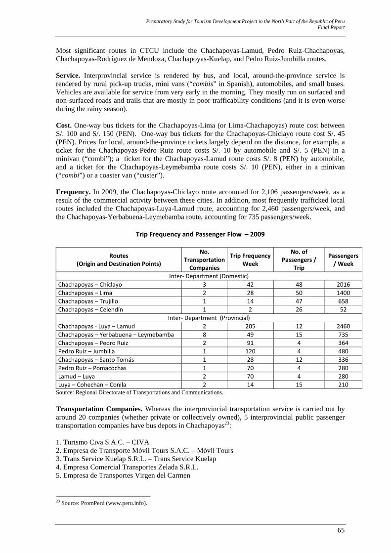
Preparatory Study for Tourism Development Project in the North Part of the Republic of Peru Final Report
65
Most significant routes in CTCU include the Chachapoyas-Lamud, Pedro Ruiz-Chachapoyas, Chachapoyas-Rodríguez de Mendoza, Chachapoyas-Kuelap, and Pedro Ruiz-Jumbilla routes. Service. Interprovincial service is rendered by bus, and local, around-the-province service is rendered by rural pick-up trucks, mini vans (“combis” in Spanish), automobiles, and small buses. Vehicles are available for service from very early in the morning. They mostly run on surfaced and non-surfaced roads and trails that are mostly in poor trafficability conditions (and it is even worse during the rainy season). Cost. One-way bus tickets for the Chachapoyas-Lima (or Lima-Chachapoyas) route cost between S/. 100 and S/. 150 (PEN). One-way bus tickets for the Chachapoyas-Chiclayo route cost S/. 45 (PEN). Prices for local, around-the-province tickets largely depend on the distance, for example, a ticket for the Chachapoyas-Pedro Ruiz route costs S/. 10 by automobile and S/. 5 (PEN) in a minivan (“combi”); a ticket for the Chachapoyas-Lamud route costs S/. 8 (PEN) by automobile, and a ticket for the Chachapoyas-Leymebamba route costs S/. 10 (PEN), either in a minivan (“combi”) or a coaster van (“custer”). Frequency. In 2009, the Chachapoyas-Chiclayo route accounted for 2,106 passengers/week, as a result of the commercial activity between these cities. In addition, most frequently trafficked local routes included the Chachapoyas-Luya-Lamud route, accounting for 2,460 passengers/week, and the Chachapoyas-Yerbabuena-Leymebamba route, accounting for 735 passengers/week.
Trip Frequency and Passenger Flow – 2009
Routes (Origin and Destination Points)
No. Transportation Companies
Trip Frequency Week
No. of Passengers /
Trip
Passengers / Week
Inter‐ Department (Domestic)Chachapoyas – Chiclayo 3 42 48 2016Chachapoyas – Lima 2 28 50 1400Chachapoyas – Trujillo 1 14 47 658Chachapoyas – Celendín 1 2 26 52
Inter‐ Department (Provincial)Chachapoyas ‐ Luya – Lamud 2 205 12 2460Chachapoyas – Yerbabuena – Leymebamba 8 49 15 735Chachapoyas – Pedro Ruiz 2 91 4 364Pedro Ruiz – Jumbilla 1 120 4 480Chachapoyas – Santo Tomás 1 28 12 336Pedro Ruiz – Pomacochas 1 70 4 280Lamud – Luya 2 70 4 280Luya – Cohechan – Conila 2 14 15 210
Source: Regional Directorate of Transportations and Communications. Transportation Companies. Whereas the interprovincial transportation service is carried out by around 20 companies (whether private or collectively owned), 5 interprovincial public passenger transportation companies have bus depots in Chachapoyas23: 1. Turismo Civa S.A.C. – CIVA 2. Empresa de Transporte Móvil Tours S.A.C. – Móvil Tours 3. Trans Service Kuelap S.R.L. – Trans Service Kuelap 4. Empresa Comercial Transportes Zelada S.R.L. 5. Empresa de Transportes Virgen del Carmen
23 Source: PromPerú (www.peru.info).
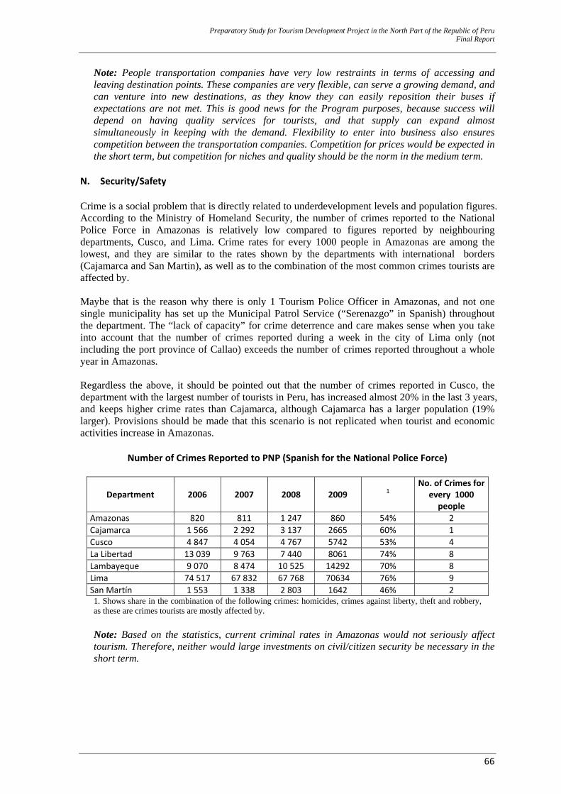
Preparatory Study for Tourism Development Project in the North Part of the Republic of Peru Final Report
66
Note: People transportation companies have very low restraints in terms of accessing and leaving destination points. These companies are very flexible, can serve a growing demand, and can venture into new destinations, as they know they can easily reposition their buses if expectations are not met. This is good news for the Program purposes, because success will depend on having quality services for tourists, and that supply can expand almost simultaneously in keeping with the demand. Flexibility to enter into business also ensures competition between the transportation companies. Competition for prices would be expected in the short term, but competition for niches and quality should be the norm in the medium term.
N. Security/Safety Crime is a social problem that is directly related to underdevelopment levels and population figures. According to the Ministry of Homeland Security, the number of crimes reported to the National Police Force in Amazonas is relatively low compared to figures reported by neighbouring departments, Cusco, and Lima. Crime rates for every 1000 people in Amazonas are among the lowest, and they are similar to the rates shown by the departments with international borders (Cajamarca and San Martin), as well as to the combination of the most common crimes tourists are affected by. Maybe that is the reason why there is only 1 Tourism Police Officer in Amazonas, and not one single municipality has set up the Municipal Patrol Service (“Serenazgo” in Spanish) throughout the department. The “lack of capacity” for crime deterrence and care makes sense when you take into account that the number of crimes reported during a week in the city of Lima only (not including the port province of Callao) exceeds the number of crimes reported throughout a whole year in Amazonas. Regardless the above, it should be pointed out that the number of crimes reported in Cusco, the department with the largest number of tourists in Peru, has increased almost 20% in the last 3 years, and keeps higher crime rates than Cajamarca, although Cajamarca has a larger population (19% larger). Provisions should be made that this scenario is not replicated when tourist and economic activities increase in Amazonas.
Number of Crimes Reported to PNP (Spanish for the National Police Force)
Department 2006 2007 2008 2009 1 No. of Crimes for
every 1000 people
Amazonas 820 811 1 247 860 54% 2 Cajamarca 1 566 2 292 3 137 2665 60% 1 Cusco 4 847 4 054 4 767 5742 53% 4 La Libertad 13 039 9 763 7 440 8061 74% 8 Lambayeque 9 070 8 474 10 525 14292 70% 8 Lima 74 517 67 832 67 768 70634 76% 9 San Martín 1 553 1 338 2 803 1642 46% 2 1. Shows share in the combination of the following crimes: homicides, crimes against liberty, theft and robbery, as these are crimes tourists are mostly affected by.
Note: Based on the statistics, current criminal rates in Amazonas would not seriously affect tourism. Therefore, neither would large investments on civil/citizen security be necessary in the short term.
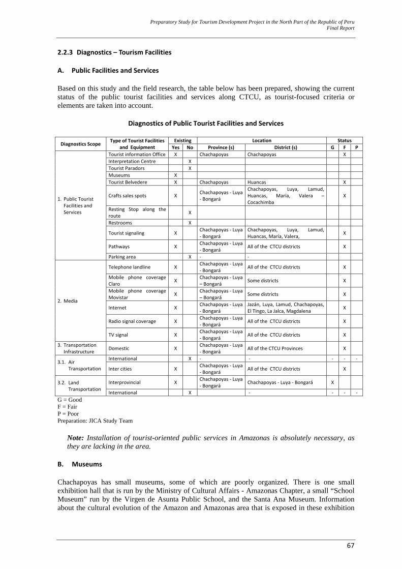
Preparatory Study for Tourism Development Project in the North Part of the Republic of Peru Final Report
67
2.2.3 Diagnostics – Tourism Facilities A. Public Facilities and Services Based on this study and the field research, the table below has been prepared, showing the current status of the public tourist facilities and services along CTCU, as tourist-focused criteria or elements are taken into account.
Diagnostics of Public Tourist Facilities and Services
Diagnostics Scope Type of Tourist Facilities and Equipment
Existing Location StatusYes No Province (s) District (s) G F P
1. Public Tourist Facilities and Services
Tourist information Office X Chachapoyas Chachapoyas XInterpretation Centre XTourist Paradors XMuseums XTourist Belvedere X Chachapoyas Huancas X
Crafts sales spots X Chachapoyas ‐ Luya ‐ Bongará
Chachapoyas, Luya, Lamud, Huancas, María, Valera –Cocachimba
X
Resting Stop along the route X
Restrooms X
Tourist signaling X Chachapoyas ‐ Luya ‐ Bongará
Chachapoyas, Luya, Lamud, Huancas, María, Valera, X
Pathways X Chachapoyas ‐ Luya ‐ Bongará All of the CTCU districts X
Parking area X ‐ ‐
2. Media
Telephone landline X Chachapoyas ‐ Luya ‐ Bongará All of the CTCU districts X
Mobile phone coverage Claro X Chachapoyas ‐ Luya
– Bongará Some districts X
Mobile phone coverage Movistar X Chachapoyas ‐ Luya
– Bongará Some districts X
Internet X Chachapoyas ‐ Luya ‐ Bongará
Jazán, Luya, Lamud, Chachapoyas, El Tingo, La Jalca, Magdalena X
Radio signal coverage X Chachapoyas ‐ Luya ‐ Bongará All of the CTCU districts X
TV signal X Chachapoyas ‐ Luya ‐ Bongará All of the CTCU districts X
3. Transportation Infrastructure Domestic X Chachapoyas ‐ Luya
‐ Bongará All of the CTCU Provinces X
3.1. Air Transportation
International X ‐ ‐ ‐ ‐ ‐
Inter cities X Chachapoyas ‐ Luya ‐ Bongará All of the CTCU districts X
3.2. Land Transportation
Interprovincial X Chachapoyas ‐ Luya ‐ Bongará Chachapoyas ‐ Luya ‐ Bongará X
International X ‐ ‐ ‐ ‐G = Good F = Fair P = Poor Preparation: JICA Study Team
Note: Installation of tourist-oriented public services in Amazonas is absolutely necessary, as they are lacking in the area.
B. Museums Chachapoyas has small museums, some of which are poorly organized. There is one small exhibition hall that is run by the Ministry of Cultural Affairs - Amazonas Chapter, a small “School Museum” run by the Virgen de Asunta Public School, and the Santa Ana Museum. Information about the cultural evolution of the Amazon and Amazonas area that is exposed in these exhibition
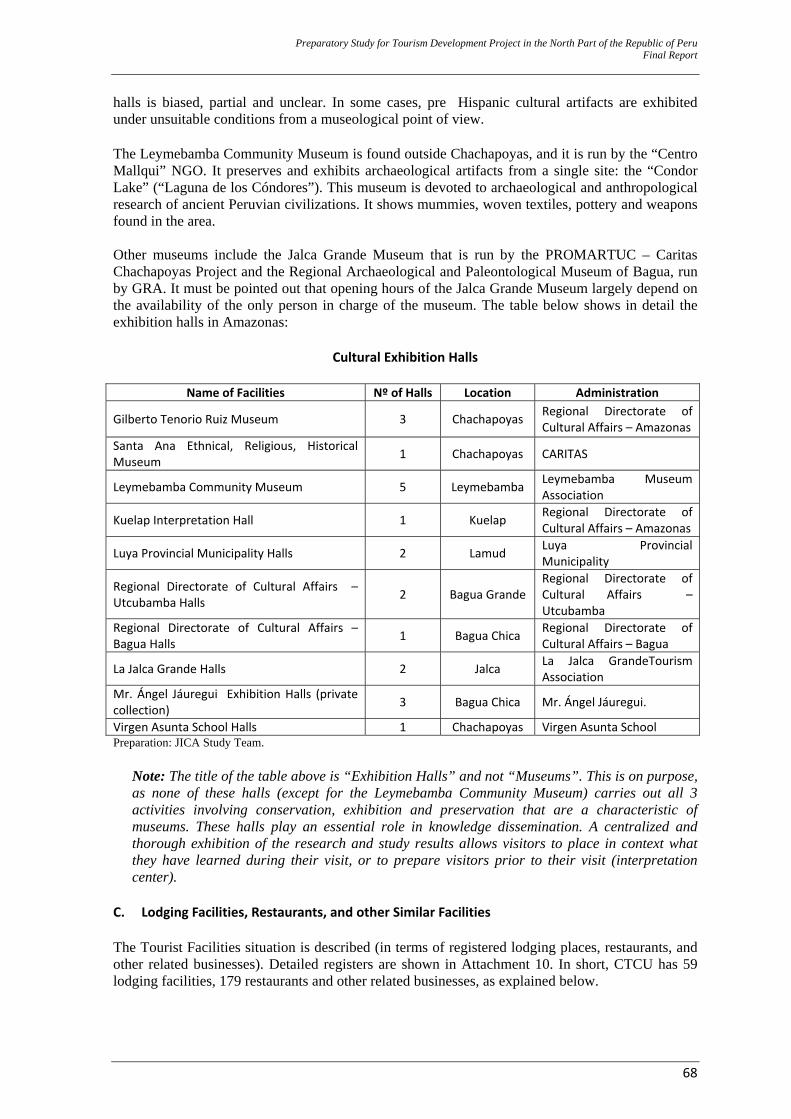
Preparatory Study for Tourism Development Project in the North Part of the Republic of Peru Final Report
68
halls is biased, partial and unclear. In some cases, pre Hispanic cultural artifacts are exhibited under unsuitable conditions from a museological point of view. The Leymebamba Community Museum is found outside Chachapoyas, and it is run by the “Centro Mallqui” NGO. It preserves and exhibits archaeological artifacts from a single site: the “Condor Lake” (“Laguna de los Cóndores”). This museum is devoted to archaeological and anthropological research of ancient Peruvian civilizations. It shows mummies, woven textiles, pottery and weapons found in the area. Other museums include the Jalca Grande Museum that is run by the PROMARTUC – Caritas Chachapoyas Project and the Regional Archaeological and Paleontological Museum of Bagua, run by GRA. It must be pointed out that opening hours of the Jalca Grande Museum largely depend on the availability of the only person in charge of the museum. The table below shows in detail the exhibition halls in Amazonas:
Cultural Exhibition Halls
Name of Facilities Nº of Halls Location Administration
Gilberto Tenorio Ruiz Museum 3 Chachapoyas Regional Directorate of Cultural Affairs – Amazonas
Santa Ana Ethnical, Religious, Historical Museum 1 Chachapoyas CARITAS
Leymebamba Community Museum 5 Leymebamba Leymebamba Museum Association
Kuelap Interpretation Hall 1 Kuelap Regional Directorate of Cultural Affairs – Amazonas
Luya Provincial Municipality Halls 2 Lamud Luya Provincial Municipality
Regional Directorate of Cultural Affairs – Utcubamba Halls 2 Bagua Grande
Regional Directorate of Cultural Affairs – Utcubamba
Regional Directorate of Cultural Affairs –Bagua Halls 1 Bagua Chica Regional Directorate of
Cultural Affairs – Bagua
La Jalca Grande Halls 2 Jalca La Jalca GrandeTourism Association
Mr. Ángel Jáuregui Exhibition Halls (private collection) 3 Bagua Chica Mr. Ángel Jáuregui.
Virgen Asunta School Halls 1 Chachapoyas Virgen Asunta SchoolPreparation: JICA Study Team.
Note: The title of the table above is “Exhibition Halls” and not “Museums”. This is on purpose, as none of these halls (except for the Leymebamba Community Museum) carries out all 3 activities involving conservation, exhibition and preservation that are a characteristic of museums. These halls play an essential role in knowledge dissemination. A centralized and thorough exhibition of the research and study results allows visitors to place in context what they have learned during their visit, or to prepare visitors prior to their visit (interpretation center).
C. Lodging Facilities, Restaurants, and other Similar Facilities The Tourist Facilities situation is described (in terms of registered lodging places, restaurants, and other related businesses). Detailed registers are shown in Attachment 10. In short, CTCU has 59 lodging facilities, 179 restaurants and other related businesses, as explained below.
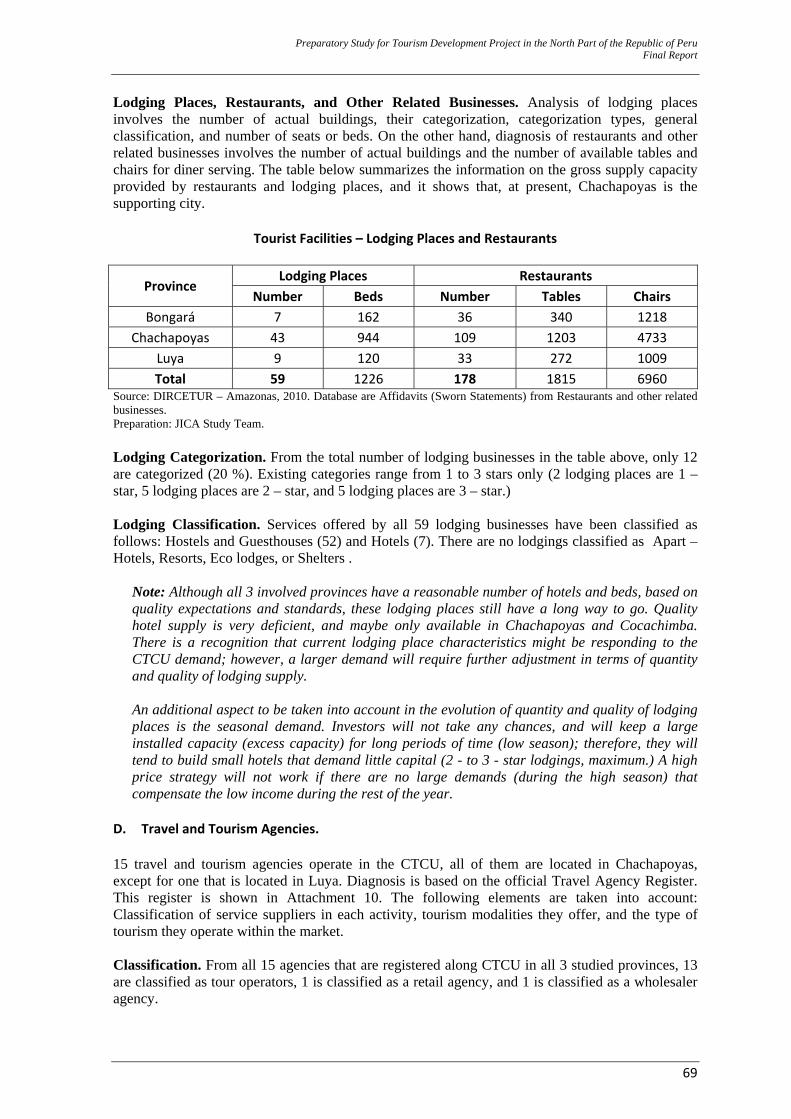
Preparatory Study for Tourism Development Project in the North Part of the Republic of Peru Final Report
69
Lodging Places, Restaurants, and Other Related Businesses. Analysis of lodging places involves the number of actual buildings, their categorization, categorization types, general classification, and number of seats or beds. On the other hand, diagnosis of restaurants and other related businesses involves the number of actual buildings and the number of available tables and chairs for diner serving. The table below summarizes the information on the gross supply capacity provided by restaurants and lodging places, and it shows that, at present, Chachapoyas is the supporting city.
Tourist Facilities – Lodging Places and Restaurants
Province Lodging Places Restaurants
Number Beds Number Tables Chairs Bongará 7 162 36 340 1218
Chachapoyas 43 944 109 1203 4733 Luya 9 120 33 272 1009 Total 59 1226 178 1815 6960
Source: DIRCETUR – Amazonas, 2010. Database are Affidavits (Sworn Statements) from Restaurants and other related businesses. Preparation: JICA Study Team.
Lodging Categorization. From the total number of lodging businesses in the table above, only 12 are categorized (20 %). Existing categories range from 1 to 3 stars only (2 lodging places are 1 – star, 5 lodging places are 2 – star, and 5 lodging places are 3 – star.) Lodging Classification. Services offered by all 59 lodging businesses have been classified as follows: Hostels and Guesthouses (52) and Hotels (7). There are no lodgings classified as Apart – Hotels, Resorts, Eco lodges, or Shelters .
Note: Although all 3 involved provinces have a reasonable number of hotels and beds, based on quality expectations and standards, these lodging places still have a long way to go. Quality hotel supply is very deficient, and maybe only available in Chachapoyas and Cocachimba. There is a recognition that current lodging place characteristics might be responding to the CTCU demand; however, a larger demand will require further adjustment in terms of quantity and quality of lodging supply. An additional aspect to be taken into account in the evolution of quantity and quality of lodging places is the seasonal demand. Investors will not take any chances, and will keep a large installed capacity (excess capacity) for long periods of time (low season); therefore, they will tend to build small hotels that demand little capital (2 - to 3 - star lodgings, maximum.) A high price strategy will not work if there are no large demands (during the high season) that compensate the low income during the rest of the year.
D. Travel and Tourism Agencies. 15 travel and tourism agencies operate in the CTCU, all of them are located in Chachapoyas, except for one that is located in Luya. Diagnosis is based on the official Travel Agency Register. This register is shown in Attachment 10. The following elements are taken into account: Classification of service suppliers in each activity, tourism modalities they offer, and the type of tourism they operate within the market. Classification. From all 15 agencies that are registered along CTCU in all 3 studied provinces, 13 are classified as tour operators, 1 is classified as a retail agency, and 1 is classified as a wholesaler agency.
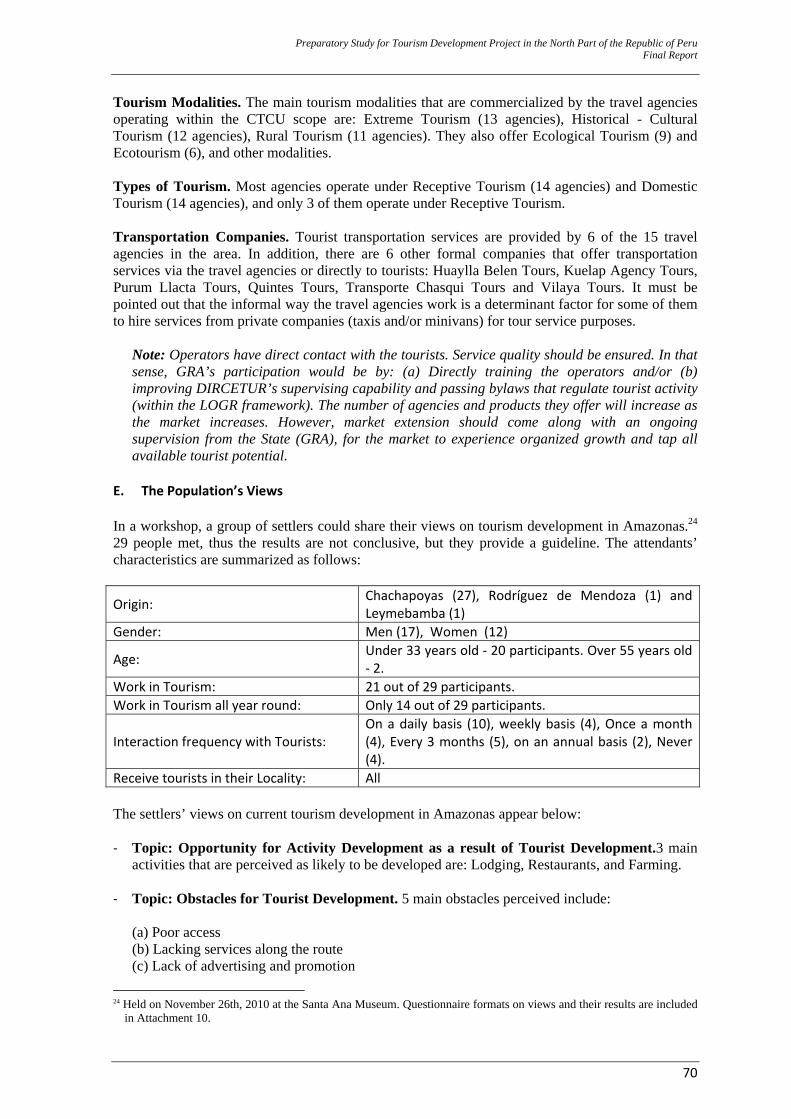
Preparatory Study for Tourism Development Project in the North Part of the Republic of Peru Final Report
70
Tourism Modalities. The main tourism modalities that are commercialized by the travel agencies operating within the CTCU scope are: Extreme Tourism (13 agencies), Historical - Cultural Tourism (12 agencies), Rural Tourism (11 agencies). They also offer Ecological Tourism (9) and Ecotourism (6), and other modalities. Types of Tourism. Most agencies operate under Receptive Tourism (14 agencies) and Domestic Tourism (14 agencies), and only 3 of them operate under Receptive Tourism. Transportation Companies. Tourist transportation services are provided by 6 of the 15 travel agencies in the area. In addition, there are 6 other formal companies that offer transportation services via the travel agencies or directly to tourists: Huaylla Belen Tours, Kuelap Agency Tours, Purum Llacta Tours, Quintes Tours, Transporte Chasqui Tours and Vilaya Tours. It must be pointed out that the informal way the travel agencies work is a determinant factor for some of them to hire services from private companies (taxis and/or minivans) for tour service purposes.
Note: Operators have direct contact with the tourists. Service quality should be ensured. In that sense, GRA’s participation would be by: (a) Directly training the operators and/or (b) improving DIRCETUR’s supervising capability and passing bylaws that regulate tourist activity (within the LOGR framework). The number of agencies and products they offer will increase as the market increases. However, market extension should come along with an ongoing supervision from the State (GRA), for the market to experience organized growth and tap all available tourist potential.
E. The Population’s Views In a workshop, a group of settlers could share their views on tourism development in Amazonas.24 29 people met, thus the results are not conclusive, but they provide a guideline. The attendants’ characteristics are summarized as follows:
Origin: Chachapoyas (27), Rodríguez de Mendoza (1) and Leymebamba (1)
Gender: Men (17), Women (12)
Age: Under 33 years old ‐ 20 participants. Over 55 years old ‐ 2.
Work in Tourism: 21 out of 29 participants. Work in Tourism all year round: Only 14 out of 29 participants.
Interaction frequency with Tourists: On a daily basis (10), weekly basis (4), Once a month (4), Every 3 months (5), on an annual basis (2), Never (4).
Receive tourists in their Locality: All The settlers’ views on current tourism development in Amazonas appear below: ‐ Topic: Opportunity for Activity Development as a result of Tourist Development.3 main
activities that are perceived as likely to be developed are: Lodging, Restaurants, and Farming.
‐ Topic: Obstacles for Tourist Development. 5 main obstacles perceived include: (a) Poor access (b) Lacking services along the route (c) Lack of advertising and promotion
24 Held on November 26th, 2010 at the Santa Ana Museum. Questionnaire formats on views and their results are included
in Attachment 10.
Preparatory Study for Tourism Development Project in the North Part of the Republic of Peru Final Report
71
(d) Neglect of tourist resources and local language, and (e) Little cultural, recreational, and amusement activities.
‐ Topic: Benefits for the Population from Tourist Activity. All the attendants think that tourism does benefit them. Major benefits perceived are: (a) Increased Job opportunities (b) Improved Road, highway, and access ways (c) Increased Economic income and cultural identity (d) Improved community participation, and (e) Improved local public services.
‐ Topic: Tourists. All attendants agreed that they like being paid visits by tourists in their
communities and that tourists are friendly people.
‐ Topic: Impact on the Community. Most attendants (27 out of 29) perceive changes in the community that have been caused by tourism, although around the same number of attendants also perceive those changes as positive.
Note: Population perceives that tourism encourages development and it is relevant as a development alternative.
2.2.4 Diagnostics – Tourism’s Current Situation A. Identity and Tourist Awareness 25 In the Tourism sector, the largest effort to strengthen the population’s identity with their cultural heritage and bring it closer to tourists has been the Comprehensive Tourism Strengthening Project in Peru (FIT Peru, in Spanish). This project was set up by MINCETUR (The Ministry of Foreign Commerce and Tourism) and AECID (The Spanish International Cooperation Agency for Development) with concrete actions towards developing tourist awareness in the educational sector and among the population, as well as strengthening tourist management by local and regional Governments of Amazonas, Cajamarca, La Libertad, Lambayeque, Piura and San Martín. FIT Peru Project was executed during the 2002 - 2007 period and its core objective was the capacity building of the human resources, as these are the major actors and agents promoting tourist products. In that sense, FIT activity planning, and later execution, base their starting point on the principle that a two-fold exercise must be carried out for tourist development to be stimulated: (a) Population, especially children and young people, should be oriented towards a major national tourism development project in Peru, and (b) population should be prepared to play a leading role in this major project. Within this framework of ideas, the Project structure had 2 components: 1 of them was Tourist Awareness via training. This component was further sub–divided in 2 sub–components: The Education sector and the Population in general.26 27 One specific objective was to get children and teenagers fully identified with their national heritage, as cultural heritage - and tourism – related themes are inserted in junior and high school curricula. An interrelation matrix for curriculums and tourism–related topics was designed and it was revised by the Ministry of Education (MINEDU). This was the foundation to prepare the Tourist Guide and insert tourism–related topics into the national educational curriculum, by means of a curricular diversification. In addition, 190 specialists and teachers were trained, as they make up the Regional 25 This section is developed based on Tourist Awareness Program’s Monitoring Report in the Amazonas Region.
MINCETUR et al. July 2008. 26 The other component is related to capacity building and municipal management awareness. Unfortunately, this
component did not have a strong impact, especially because of the high staff turnover in the municipalities. Those municipal servants who participated at first did not carry on in their positions.
27 Tourist awareness activities, by means of overall population training, are related to productive activities (tourism – and craft making – related business opportunities (like cab / taxi drivers, for example.)
Preparatory Study for Tourism Development Project in the North Part of the Republic of Peru Final Report
72
or Provincial Educational Tourism Trainers. They all report to a coordinator, who is MINEDU’s Intermediate Body representative (DRE [The Regional Directorate of Education, in Spanish] or UGEL [The Local Education Management Authority, in Spanish]). Schemes for intervention in the Education Sector and insertion of tourist contents in the School curriculum are described in Attachment 6. Major outcomes in Amazonas include:
‐ 85% of the students in Amazonas recognize tourist resources in their region, as their schools frequently organize visits to tourist sites.
‐ Most input from the teachers, as they work with their students, has included compilation of myths, stories, and legends.
‐ 52% of the students know about the importance of preserving their cultural and natural heritage (although 48% of them fail to identify these significant topics for tourism purposes.)
‐ 83% of the students think their schools are permanently supporting the dissemination of traditions and ways through music, dancing, and playing typical instruments.
‐ Most students (71%) seem to become increasingly aware that good treatment to tourists and providing them with accurate tourist information in a kind and polite way are important tools to disseminate a tourist culture among the population.
‐ 92% of the teachers apply tourist–heritage and cultural identity–related topics in several subjects of their curricula.
‐ Aspects, such as Tourism or regional identity, have been included as part of the Regional Educational Project policy alignments; this will ensure educational tourism sustainability in the region. Unfortunately, no laws have yet been passed (and these were promotion laws from DRE and UGEL), and this makes it less likely that schools and teachers include tourism as a cross sectional theme in their planning documents.
‐ All UGELs have included actions or strategies in their monitoring plans for educational tourism follow–up and have monitored up to 60% of the trained teachers. It is important to highlight that all high school education specialists at DRE and UGEL know about and monitor tourism actions.
‐ 87% of the schools have inserted tourism–related and regional identity–related topics in their Institutional Educational Projects.
‐ All schools around the region have diversified their Center Curricular Project with identity and tourism –related contents (all teachers teach these topics.) Areas with the highest diversification percentages are Social Studies, Language and Grammar, and Family and Human Relations.
‐ Facilities are provided to the teachers for educational tourism activities to be scheduled. Most important activities include: Guided visits (44 %), setting up, or participating in cultural events (28 %), and school outings (22 %).
‐ All schools within the Project intervention scope have a Tourist Contents Guide for the Amazonas Region.
‐ Most frequent techniques used by teachers to promote tourism learning among their students include guided visits, role playing, and timelines.
It must be pointed out that within the education intervention strategy framework, 3,720 people from 4 departments (Amazonas, Cajamarca, Lambayeque, and La Libertad) were also trained on the following topics: Tourist Awareness, Tourism and Community Development, Cultural Identity and Heritage, Traffic Laws and Rules, Quality Client Service, The Importance of the Media in the Tourist Activity, etc. All of these are aimed at street working children, taxi drivers, shoeshine boys, journalists, crafts people, and police officers.
Note: The best time to instill identity in the population is during an individual’s school years. A strategy to do so through the school curriculum is considered to be a very good one, that’s why the described impact is made. Monitoring results also shows that resources to keep teachers’
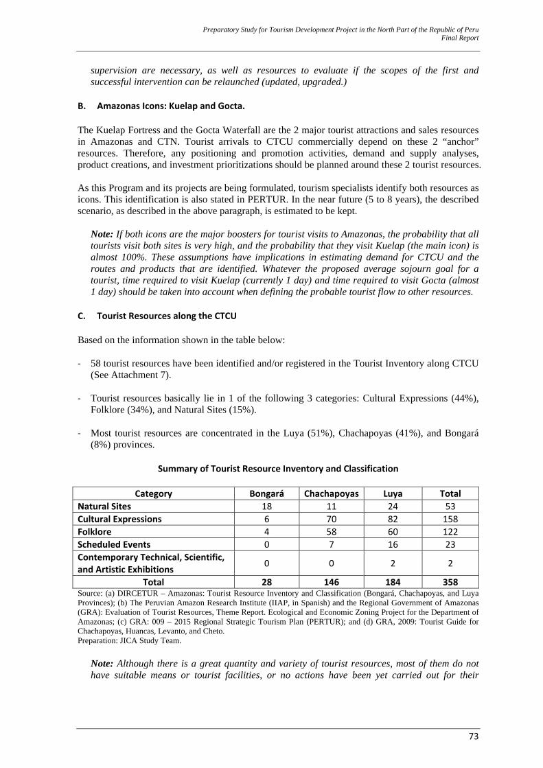
Preparatory Study for Tourism Development Project in the North Part of the Republic of Peru Final Report
73
supervision are necessary, as well as resources to evaluate if the scopes of the first and successful intervention can be relaunched (updated, upgraded.)
B. Amazonas Icons: Kuelap and Gocta. The Kuelap Fortress and the Gocta Waterfall are the 2 major tourist attractions and sales resources in Amazonas and CTN. Tourist arrivals to CTCU commercially depend on these 2 “anchor” resources. Therefore, any positioning and promotion activities, demand and supply analyses, product creations, and investment prioritizations should be planned around these 2 tourist resources. As this Program and its projects are being formulated, tourism specialists identify both resources as icons. This identification is also stated in PERTUR. In the near future (5 to 8 years), the described scenario, as described in the above paragraph, is estimated to be kept.
Note: If both icons are the major boosters for tourist visits to Amazonas, the probability that all tourists visit both sites is very high, and the probability that they visit Kuelap (the main icon) is almost 100%. These assumptions have implications in estimating demand for CTCU and the routes and products that are identified. Whatever the proposed average sojourn goal for a tourist, time required to visit Kuelap (currently 1 day) and time required to visit Gocta (almost 1 day) should be taken into account when defining the probable tourist flow to other resources.
C. Tourist Resources along the CTCU Based on the information shown in the table below: ‐ 58 tourist resources have been identified and/or registered in the Tourist Inventory along CTCU
(See Attachment 7).
‐ Tourist resources basically lie in 1 of the following 3 categories: Cultural Expressions (44%), Folklore (34%), and Natural Sites (15%).
‐ Most tourist resources are concentrated in the Luya (51%), Chachapoyas (41%), and Bongará
(8%) provinces.
Summary of Tourist Resource Inventory and Classification
Category Bongará Chachapoyas Luya Total Natural Sites 18 11 24 53 Cultural Expressions 6 70 82 158 Folklore 4 58 60 122 Scheduled Events 0 7 16 23 Contemporary Technical, Scientific, and Artistic Exhibitions 0 0 2 2
Total 28 146 184 358 Source: (a) DIRCETUR – Amazonas: Tourist Resource Inventory and Classification (Bongará, Chachapoyas, and Luya Provinces); (b) The Peruvian Amazon Research Institute (IIAP, in Spanish) and the Regional Government of Amazonas (GRA): Evaluation of Tourist Resources, Theme Report. Ecological and Economic Zoning Project for the Department of Amazonas; (c) GRA: 009 – 2015 Regional Strategic Tourism Plan (PERTUR); and (d) GRA, 2009: Tourist Guide for Chachapoyas, Huancas, Levanto, and Cheto. Preparation: JICA Study Team.
Note: Although there is a great quantity and variety of tourist resources, most of them do not have suitable means or tourist facilities, or no actions have been yet carried out for their
Preparatory Study for Tourism Development Project in the North Part of the Republic of Peru Final Report
74
enhancement. Therefore, existing tourist resources only represent a great potential for tourist activity development that is currently being underexploited. This potential is related to archaeology, history, nature (birds and orchids), several forms of community and various modes of “mild” extreme tourism (hikes, mountain biking, and horseback riding.) As a global product, CTCU has a great probability to develop multiproducts that are oriented to experience–seeking tourists.
D. Current Positioning and Tourist Promotion. General: Amazonas tourist promotion, and subsequently, CTCU tourist promotion, are carried out through the recently created Regional Tourism Consulting Committee (CCRT) Amazonas 28 , PromPerú and the tourist service suppliers. Some of these directly promote their services to tour operators so that tourists, mainly from Europe, are attracted. Peru. On the whole, the following must be taken into account: ‐ Markets have very little knowledge of what Peru can offer, apart from Cusco and Machu Picchu.
‐ With regard to receptive tourism, PromPerú is leading its efforts mainly to position the Peru
Destination and not a specific Destination in Peru, except for a case that will be described below. ‐ As a tourist destination, Peru has a series of advantages that determine that it is preferred over
other travel destinations around the world. These attributes will also define its identity to those travelers who are interested in gaining experiences.
Note: Percentage of people who rated a country from “Good” to “Very Good” with regard to the identified attributes. Sample of 1,526 people. Source: Future Brand: “Country Brand Index 2006”. Preparation: Source: Future Brand: “Country Brand Index 2006”
28 GRA Consulting Body, made up of both public and private tourist development actors. DIRCETUR is the Technical
Secretary. It coordinates with PromPerú’s Domestic Tourism Sub – Management the execution of its 2011 Promotional Campaign in the Northeastern Area. Its participation is focused on Amazonas, and on submitting proposals and trip packages that will affect diverse tourist products with a viable commercialization in the domestic market.
Preparatory Study for Tourism Development Project in the North Part of the Republic of Peru Final Report
75
‐ Peru is currently perceived worldwide as a country with a great historical legacy and the place
of origin of one of the oldest and most significant civilizations throughout world history. This turns this country into a destination with a great potential to establish emotional connections with travelers. A most recent study carried out by Future Brand Consulting Firm (2008) places Peru as the most valued tourist destination in the American continent because of its culture, history, and authenticity. Therefore, the foundation of our tourist industry rests on 4 pillars or strengths: Culture, History, Geography, and Biodiversity.
Note: Peruvian positioning: (1) provides a good foundation to set the positioning interventions alignments of Amazonas and the CTCU Destination and (2) makes positioning of new destinations in Peru easier, as it does not start from scratch (it can rely on a successful strategy that has already been developed.)
Amazonas. CTCU is one of the major tourist destinations in the Northeastern Tourist Circuit (CTN, in Spanish), because of the commitment to develop new attraction hubs (Kuelap and Gocta, for example). CTN positions as Peruvian second tourist destination and offers a viability to develop tourist multiproducts. However, CTN and subsequently, CTCU Amazonas, do not have a good positioning. It must be pointed out that at present, none of the CTN departments is strong enough to develop an individual (broken down) promotion. As already mentioned, some national and local tourist agents carry out promotion actions. Promotional action is planned and carried out in a poorly coordinated way and with very low synergy. Furthermore, given the low levels of profitability in the CTCU trade within the CTN framework, agents cannot afford expensive advertising campaigns. However, it seems that all CTCU actors would like to pursue direct marketing in the priority markets, but this is expensive and would not necessarily bring the expected results. Each agent suggests an individual promotion plan and the same thing happens at the CTN. Each department suggests a promotion action plan on an individual basis, as long as the promotion planning is not far away from the CTN actions nor PromPerú’s marketing strategy. This leads to a lack of efficiency in the promotional action that is necessary for the offer and the services to be suitably adjusted, and so a further dynamic tourist activity is accomplished in the area. As an example of a lack of articulation/coordination, the domestic “La Selva Pone” (“The Jungle Puts It”) tourism campaign that was launched by PromPerú in 2010 and included Amazonas, had only 3 companies submitting their trip offers to PromPerú to be posted on the website. In another example, the latest School Tourism workshop in Lima that was organized by PromPerú and was held in March 2011 had only 1 company from Amazonas participating. Because of articulation/coordination by the CTN actors, PromPerú launched an advertising campaign of promoting the Moche Route. This limits the supply to Archaeological themes and it negatively affects the Multiproduct Option the northern area and CTCU should be associated with. CTCU does not have, at present, an icon that is important enough to attract and hold, by itself, enough value to support a whole direct promotion campaign and generate visits to it by the receptive market. However, Amazonas is positioning archaeological and natural resources, such as Kuelap and Gocta. The “anchor” icon in the area is Kuelap and it mainly offers a conventional, cultural – type visit. On the other hand, thanks to Gocta, Amazonas is positioning a tourist supply involving nature and scenery: Gocta is its most important natural icon, and it is being given worldwide significance as it ranks as the 3rd highest waterfall in the world. This scenery is actually being exploited as part of the promotion campaigns, but with a natural conventional trade that is similar to Kuelap. Based on the above explanation, we have:

Preparatory Study for Tourism Development Project in the North Part of the Republic of Peru Final Report
76
‐ Low destination identification levels. Destination is almost non–existent in priority markets. ‐ Low image definition for a large portion of potential clients. ‐ Visit intentions little related to new products.
‐ Promotion not related to a multiproduct destination ‐ Insufficiently clear positioning (message) of tourist products ‐ Very little differentiated destination positioning. ‐ Lack of contents and little adaptation of the message to the prioritized markets. ‐ No global strategy for the tourist product’s presence.
Note 1: Virtually no progress has been made, in terms of Amazonas positioning as a Tourist Destination; in fact, tourists might even be led to confusion. Note 2: GRA is the major promoting body of Amazonas tourist development. Therefore, all positioning and promotion activities should be led and executed by GRA. Product promotion and sales strategies should be coordinated with PromPerú for 2 reasons: (a) because the law states it and (b) for leverage with the progress made by this body in the last few years.
PromPerú - Domestic Tourism29. The Domestic Tourism Sub–Management has scheduled a promotion campaign during October and November 2011 for the northern Amazon area: Tumbes, Piura, Lambayeque, La Libertad, Cajamarca, Amazonas, Loreto, and San Martín. Its budget amounts S/. 1.5 million (PEN), and its goal is 20,000 tourist trips to the area. Major activities in this campaign, according to strategic segments and commercialization channels, include: A. Current and Potential Traveler
A.1. Commercialization Supporting Campaigns − Mass media advertising (Media hub: Press, TV, Radio) − Other media (BTL30): Billboards, Theaters, Malls, Corporation Buildings − Internet: Website, Web Banners − Press Trips: TV, Written press, Web media A.2 Destination Promotion Campaigns Promotion Tools: Press trips, BTL, Internet
A.3 – Culture of Resistance - Traveling Campaigns B. School Segment
− Workshops − School Fairs − School Tourism Blog − BTL –Bazaars
C. Trade − Workshops − Seminars and Training Events − E–learning
D. Studies
− Vacationers − Potential traveler
29 PromPerú has a virtual permanent tourist promotion and commercialization support platform. All joint actions made by
both public and private tourist development actors in Amazonas should refer to it. 30 Below The Line
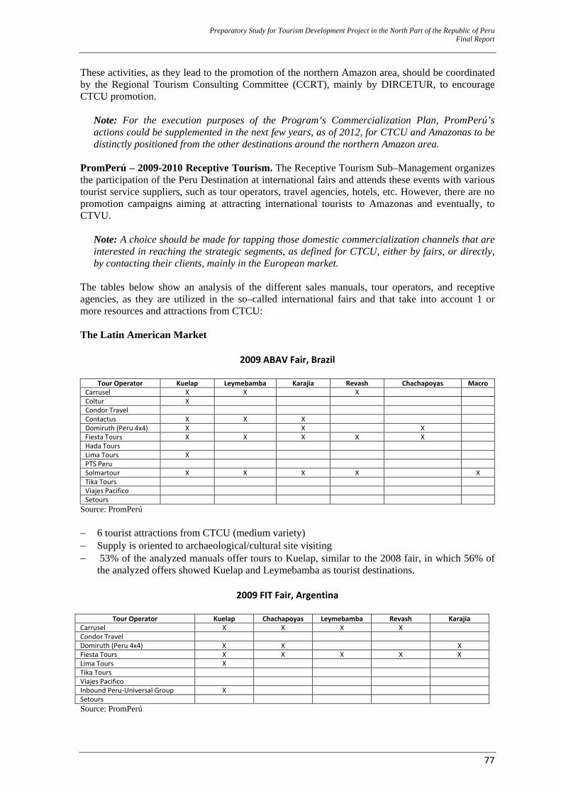
Preparatory Study for Tourism Development Project in the North Part of the Republic of Peru Final Report
77
These activities, as they lead to the promotion of the northern Amazon area, should be coordinated by the Regional Tourism Consulting Committee (CCRT), mainly by DIRCETUR, to encourage CTCU promotion.
Note: For the execution purposes of the Program’s Commercialization Plan, PromPerú’s actions could be supplemented in the next few years, as of 2012, for CTCU and Amazonas to be distinctly positioned from the other destinations around the northern Amazon area.
PromPerú – 2009-2010 Receptive Tourism. The Receptive Tourism Sub–Management organizes the participation of the Peru Destination at international fairs and attends these events with various tourist service suppliers, such as tour operators, travel agencies, hotels, etc. However, there are no promotion campaigns aiming at attracting international tourists to Amazonas and eventually, to CTVU.
Note: A choice should be made for tapping those domestic commercialization channels that are interested in reaching the strategic segments, as defined for CTCU, either by fairs, or directly, by contacting their clients, mainly in the European market.
The tables below show an analysis of the different sales manuals, tour operators, and receptive agencies, as they are utilized in the so–called international fairs and that take into account 1 or more resources and attractions from CTCU: The Latin American Market
2009 ABAV Fair, Brazil
Tour Operator Kuelap Leymebamba Karajia Revash Chachapoyas MacroCarrusel X X X Coltur X Condor Travel Contactus X X X Domiruth (Peru 4x4) X X X Fiesta Tours X X X X X Hada Tours Lima Tours X PTS Peru Solmartour X X X X XTika Tours Viajes Pacifico Setours
Source: PromPerú − 6 tourist attractions from CTCU (medium variety) − Supply is oriented to archaeological/cultural site visiting − 53% of the analyzed manuals offer tours to Kuelap, similar to the 2008 fair, in which 56% of
the analyzed offers showed Kuelap and Leymebamba as tourist destinations.
2009 FIT Fair, Argentina
Tour Operator Kuelap Chachapoyas Leymebamba Revash KarajiaCarrusel X X X X Condor Travel Domiruth (Peru 4x4) X X X Fiesta Tours X X X X X Lima Tours X Tika Tours Viajes Pacifico Inbound Peru‐Universal Group X Setours Source: PromPerú
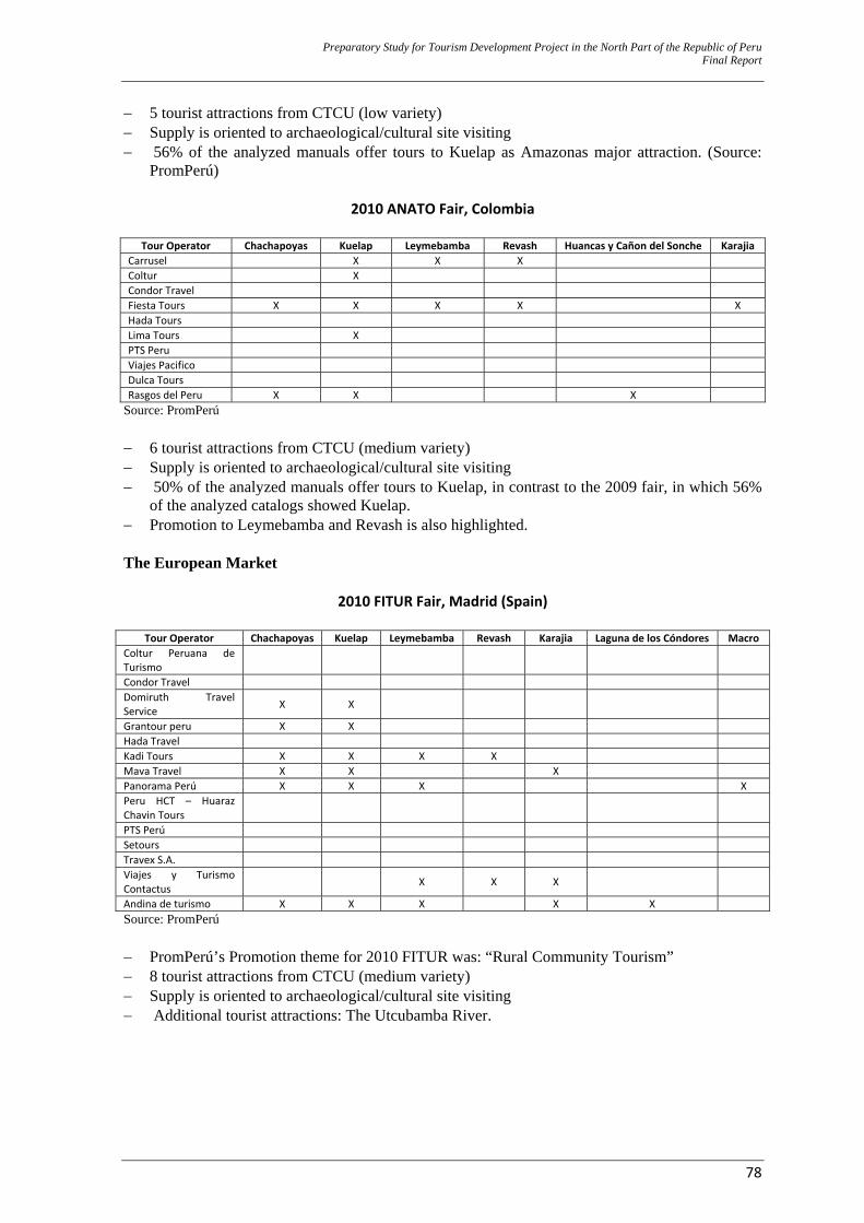
Preparatory Study for Tourism Development Project in the North Part of the Republic of Peru Final Report
78
− 5 tourist attractions from CTCU (low variety) − Supply is oriented to archaeological/cultural site visiting − 56% of the analyzed manuals offer tours to Kuelap as Amazonas major attraction. (Source:
PromPerú)
2010 ANATO Fair, Colombia
Tour Operator Chachapoyas Kuelap Leymebamba Revash Huancas y Cañon del Sonche KarajiaCarrusel X X X Coltur X Condor Travel Fiesta Tours X X X X XHada Tours Lima Tours X PTS Peru Viajes Pacifico Dulca Tours Rasgos del Peru X X X
Source: PromPerú − 6 tourist attractions from CTCU (medium variety) − Supply is oriented to archaeological/cultural site visiting − 50% of the analyzed manuals offer tours to Kuelap, in contrast to the 2009 fair, in which 56%
of the analyzed catalogs showed Kuelap. − Promotion to Leymebamba and Revash is also highlighted. The European Market
2010 FITUR Fair, Madrid (Spain)
Tour Operator Chachapoyas Kuelap Leymebamba Revash Karajia Laguna de los Cóndores MacroColtur Peruana de Turismo
Condor Travel Domiruth Travel Service X X
Grantour peru X X Hada Travel Kadi Tours X X X X Mava Travel X X X Panorama Perú X X X XPeru HCT – Huaraz Chavin Tours
PTS Perú Setours Travex S.A. Viajes y Turismo Contactus X X X
Andina de turismo X X X X X Source: PromPerú − PromPerú’s Promotion theme for 2010 FITUR was: “Rural Community Tourism” − 8 tourist attractions from CTCU (medium variety) − Supply is oriented to archaeological/cultural site visiting − Additional tourist attractions: The Utcubamba River.
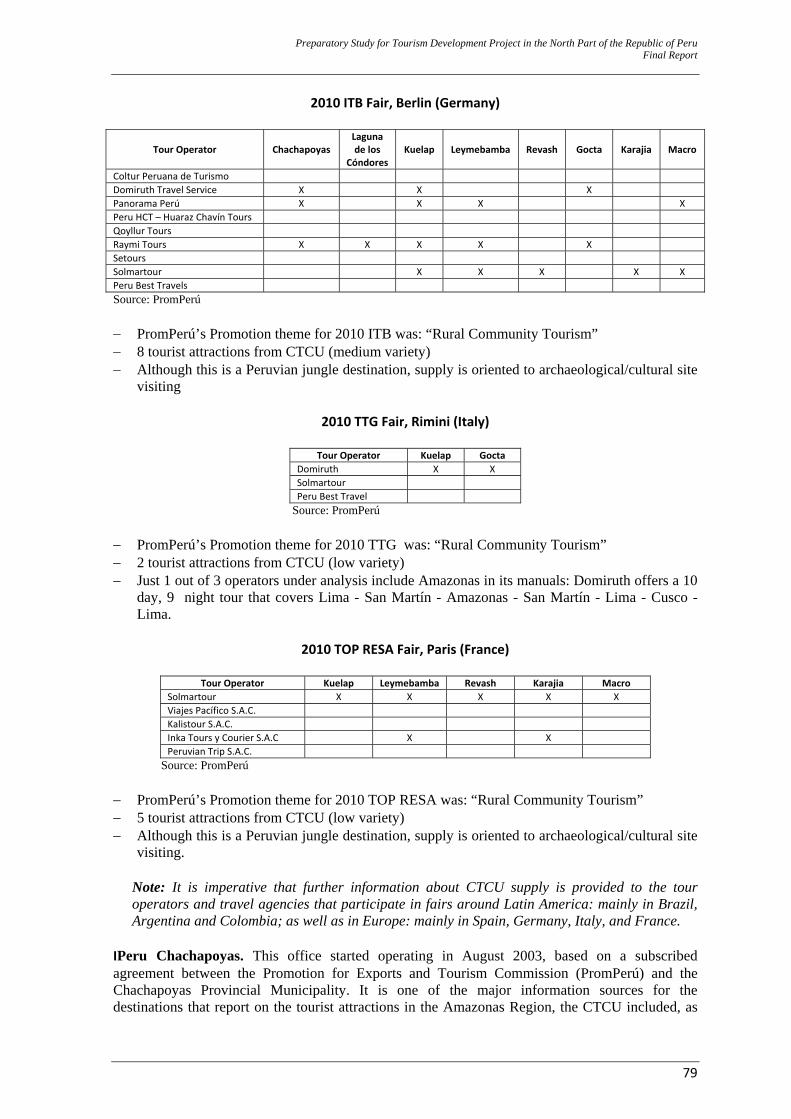
Preparatory Study for Tourism Development Project in the North Part of the Republic of Peru Final Report
79
2010 ITB Fair, Berlin (Germany)
Tour Operator ChachapoyasLaguna de los
CóndoresKuelap Leymebamba Revash Gocta Karajia Macro
Coltur Peruana de Turismo Domiruth Travel Service X X X Panorama Perú X X X XPeru HCT – Huaraz Chavín Tours Qoyllur Tours Raymi Tours X X X X X Setours Solmartour X X X X XPeru Best Travels Source: PromPerú − PromPerú’s Promotion theme for 2010 ITB was: “Rural Community Tourism” − 8 tourist attractions from CTCU (medium variety) − Although this is a Peruvian jungle destination, supply is oriented to archaeological/cultural site
visiting
2010 TTG Fair, Rimini (Italy)
Tour Operator Kuelap GoctaDomiruth X XSolmartourPeru Best Travel
Source: PromPerú − PromPerú’s Promotion theme for 2010 TTG was: “Rural Community Tourism” − 2 tourist attractions from CTCU (low variety) − Just 1 out of 3 operators under analysis include Amazonas in its manuals: Domiruth offers a 10
day, 9 night tour that covers Lima - San Martín - Amazonas - San Martín - Lima - Cusco - Lima.
2010 TOP RESA Fair, Paris (France)
Tour Operator Kuelap Leymebamba Revash Karajia Macro
Solmartour X X X X X Viajes Pacífico S.A.C. Kalistour S.A.C. Inka Tours y Courier S.A.C X X Peruvian Trip S.A.C.
Source: PromPerú − PromPerú’s Promotion theme for 2010 TOP RESA was: “Rural Community Tourism” − 5 tourist attractions from CTCU (low variety) − Although this is a Peruvian jungle destination, supply is oriented to archaeological/cultural site
visiting.
Note: It is imperative that further information about CTCU supply is provided to the tour operators and travel agencies that participate in fairs around Latin America: mainly in Brazil, Argentina and Colombia; as well as in Europe: mainly in Spain, Germany, Italy, and France.
IPeru Chachapoyas. This office started operating in August 2003, based on a subscribed agreement between the Promotion for Exports and Tourism Commission (PromPerú) and the Chachapoyas Provincial Municipality. It is one of the major information sources for the destinations that report on the tourist attractions in the Amazonas Region, the CTCU included, as
Preparatory Study for Tourism Development Project in the North Part of the Republic of Peru Final Report
80
well as on Amazonas folklore, crafts, gastronomy, festivities and a contact data list with the major tourist service agencies. E. Current Supply by the Local Tourist Operators
‐ Current tourist supply is focused on the major reference tourist destination, namely, the Kuelap
Fortress, followed by the Leymebamba Community Museum and the Gocta Waterfall. The service supply to the other existing archaeological sites is still incipient.
‐ Local agencies only supply tourist services to a small group of tourist facilities, as most of these have not been enhanced. As mentioned in the previous chapter, travel agencies mainly supply tourism in the extreme, historical–cultural and rural modalities.
‐ “Full Day” round circuits are promoted in Chachapoyas and visits are supplied to specific known sites. To date, this “base circuit” is only used for overall and little sustainable tourist activity promotion. The scheme below shows the available tourist supply, in spite of the existence of a great diversity of tourist resources (that, too, can be visited.)
‐ A totally unorganized supply that lacks an actual route planning is noticed. The above
mentioned paragraph gives proof of this: A well articulated tourist planning model would allow for resources to be suitably organized and set in routes and/or circuits for tourist visiting purposes.
‐ There are very few suitably trained guides who are able to (i) maximize Amazonas’ attractions,
(ii) make a visitor’s experience meet all of his/her expectations and (iii) lead a sustainable visit (by minimizing resource deterioration), all at the same time.
‐ The tourist supply’s current situation is partly because 87% of the agencies are retailers and
Tour operators; therefore, tourism is operated in an elementary and monotonous way. ‐ Agencies lack organization, coordination and entrepreneurship. They run their services with
minimum quality standards. It must be pointed out that out of a total of 15 registered travel agencies, only 7 are registered in the “Tourism Operators Association” – ADOTUR, in Spanish. The rest operate under very informal and irregular conditions.
In the pages below, the following are shown: (a) one of the tourist promotion posters made by one of the travel agencies; (the preparation of this poster has not been coordinated with DIRCETUR), (b) a table with all the tourist resources that are currently “commercialized” by some travel agencies.
Note (ex ante): Analysis of the tables will allow for concluding that agencies have far more resources to offer “in their portfolio” than those they usually commercialize. Products (as described in the second table) have been actually coordinated among the agencies in a joint effort to come up with a single price for a service. However, products are only related to the most visited sites and no attempts are made for supply extension purposes.
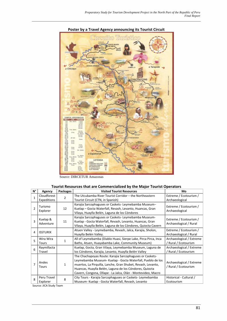
Preparatory Study for Tourism Development Project in the North Part of the Republic of Peru Final Report
81
Poster by a Travel Agency announcing its Tourist Circuit
Source: DIRCETUR Amazonas
Tourist Resources that are Commercialized by the Major Tourist Operators
N° Agency Packages Visited Tourist Resources Mo
1 Cloudforest Expeditions 2 The Utcubamba River Tourist Corridor – the Northeastern
Tourist Circuit (CTN, in Spanish) Extreme / Ecotourism / Archaeological
2 Turismo Explorer 12
Karajia Sarcophaguses or Caskets‐ Leymebamba Museum– Kuelap – Gocta Waterfall, Revash, Levanto, Huancas, Gran Vilaya, Huaylla Belén, Laguna de los Cóndores
Extreme / Ecotourism / Archaeological
3 Kuelap & Adventure 11
Karajia Sarcophaguses or Caskets‐ Leymebamba Museum‐ Kuelap ‐ Gocta Waterfall, Revash, Levanto, Huancas, Gran Vilaya, Huaylla Belén, Laguna de los Cóndores, Quiocta Cavern
Extreme / Ecotourism / Archaeological / Rural
4 ISSTURIX Atuen Valley ‐ Leymebamba, Revash, Jalca, Karajia, Sholon, Huaylla Belén Valley.
Extreme / Ecotourism / Archaeological / Rural
5 Wira Wira Tours 1 All of Leymebamba (Diablo Huasi, Sierpe Lake, Pirca Pirca, Inca
Baths, Atuen, Huayabamba Lake, Community Museum) Archaeological / Extreme / Rural / Ecotourism
6 Raymillacta Travel Kuelap, Gocta, Gran Vilaya, Leymebamba Museum, Laguna de
los Cóndores, Karajia, Levanto, Huaylla Belén Valley Archaeological / Extreme / Rural / Ecotourism
7 Andes Tours 1
The Chachapoyas Route: Karajia Sarcophaguses or Caskets‐ Leymebamba Museum‐ Kuelap ‐ Gocta Waterfall, Pueblo de los muertos, La Pirquilla, Lanche, Gran Shubet, Revash, Levanto, Huancas, Huaylla Belén, Laguna de los Cóndores, Quiocta Cavern, Congona, Ollape ‐ La Jalca, Olán ‐ Montevideo, Macro
Archaeological / Extreme / Rural / Ecotourism
8 Peru Travel Explorer 8 City Tours ‐ Karajia Sarcophaguses or Caskets‐ Leymebamba
Museum‐ Kuelap ‐ Gocta Waterfall, Revash, Levanto Historical ‐ Cultural / Ecotourism
Source: JICA Study Team
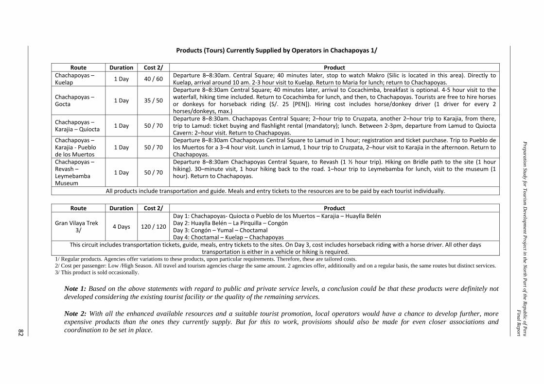
Preparation Study for Tourism D
evelopment Project in the N
orth Part of the Republic of PeruFinal Report
82
Products (Tours) Currently Supplied by Operators in Chachapoyas 1/
Route Duration Cost 2/ ProductChachapoyas –Kuelap 1 Day 40 / 60 Departure 8–8:30am. Central Square; 40 minutes later, stop to watch Makro (Silic is located in this area). Directly to
Kuelap, arrival around 10 am. 2‐3 hour visit to Kuelap. Return to Maria for lunch; return to Chachapoyas.
Chachapoyas – Gocta 1 Day 35 / 50
Departure 8–8:30am Central Square; 40 minutes later, arrival to Cocachimba, breakfast is optional. 4‐5 hour visit to the waterfall, hiking time included. Return to Cocachimba for lunch, and then, to Chachapoyas. Tourists are free to hire horses or donkeys for horseback riding (S/. 25 [PEN]). Hiring cost includes horse/donkey driver (1 driver for every 2 horses/donkeys, max.)
Chachapoyas – Karajia – Quiocta 1 Day 50 / 70
Departure 8–8:30am. Chachapoyas Central Square; 2–hour trip to Cruzpata, another 2–hour trip to Karajia, from there, trip to Lamud: ticket buying and flashlight rental (mandatory); lunch. Between 2‐3pm, departure from Lamud to Quiocta Cavern: 2–hour visit. Return to Chachapoyas.
Chachapoyas –Karajia ‐ Pueblo de los Muertos
1 Day 50 / 70 Departure 8–8:30am Chachapoyas Central Square to Lamud in 1 hour; registration and ticket purchase. Trip to Pueblo de los Muertos for a 3–4 hour visit. Lunch in Lamud, 1 hour trip to Cruzpata, 2–hour visit to Karajia in the afternoon. Return to Chachapoyas.
Chachapoyas –Revash –Leymebamba Museum
1 Day 50 / 70
Departure 8–8:30am Chachapoyas Central Square, to Revash (1 ½ hour trip). Hiking on Bridle path to the site (1 hour hiking). 30–minute visit, 1 hour hiking back to the road. 1–hour trip to Leymebamba for lunch, visit to the museum (1 hour). Return to Chachapoyas.
All products include transportation and guide. Meals and entry tickets to the resources are to be paid by each tourist individually.
Route Duration Cost 2/ Product
Gran Vilaya Trek 3/ 4 Days 120 / 120
Day 1: Chachapoyas‐ Quiocta o Pueblo de los Muertos – Karajia – Huaylla BelénDay 2: Huaylla Belén – La Pirquilla – Congón Day 3: Congón – Yumal – Choctamal Day 4: Choctamal – Kuelap – Chachapoyas
This circuit includes transportation tickets, guide, meals, entry tickets to the sites. On Day 3, cost includes horseback riding with a horse driver. All other days transportation is either in a vehicle or hiking is required.
1/ Regular products. Agencies offer variations to these products, upon particular requirements. Therefore, these are tailored costs. 2/ Cost per passenger: Low /High Season. All travel and tourism agencies charge the same amount. 2 agencies offer, additionally and on a regular basis, the same routes but distinct services. 3/ This product is sold occasionally.
Note 1: Based on the above statements with regard to public and private service levels, a conclusion could be that these products were definitely not developed considering the existing tourist facility or the quality of the remaining services. Note 2: With all the enhanced available resources and a suitable tourist promotion, local operators would have a chance to develop further, more expensive products than the ones they currently supply. But for this to work, provisions should also be made for even closer associations and coordination to be set in place.
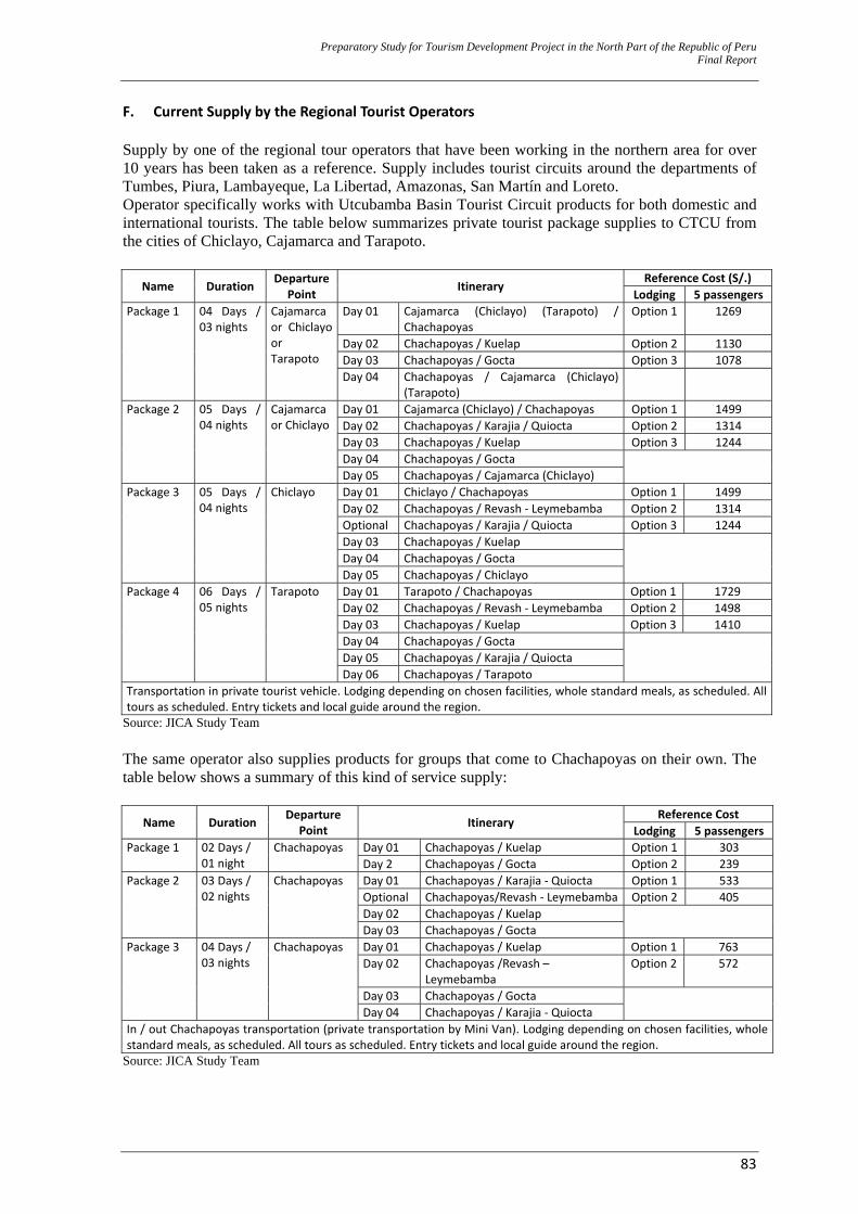
Preparatory Study for Tourism Development Project in the North Part of the Republic of Peru Final Report
83
F. Current Supply by the Regional Tourist Operators Supply by one of the regional tour operators that have been working in the northern area for over 10 years has been taken as a reference. Supply includes tourist circuits around the departments of Tumbes, Piura, Lambayeque, La Libertad, Amazonas, San Martín and Loreto. Operator specifically works with Utcubamba Basin Tourist Circuit products for both domestic and international tourists. The table below summarizes private tourist package supplies to CTCU from the cities of Chiclayo, Cajamarca and Tarapoto.
Name Duration Departure Point Itinerary
Reference Cost (S/.) Lodging 5 passengers
Package 1 04 Days / 03 nights
Cajamarca or Chiclayo or Tarapoto
Day 01 Cajamarca (Chiclayo) (Tarapoto) / Chachapoyas
Option 1 1269
Day 02 Chachapoyas / Kuelap Option 2 1130 Day 03 Chachapoyas / Gocta Option 3 1078 Day 04 Chachapoyas / Cajamarca (Chiclayo)
(Tarapoto)
Package 2 05 Days / 04 nights
Cajamarca or Chiclayo
Day 01 Cajamarca (Chiclayo) / Chachapoyas Option 1 1499 Day 02 Chachapoyas / Karajia / Quiocta Option 2 1314 Day 03 Chachapoyas / Kuelap Option 3 1244 Day 04 Chachapoyas / Gocta Day 05 Chachapoyas / Cajamarca (Chiclayo)
Package 3 05 Days / 04 nights
Chiclayo Day 01 Chiclayo / Chachapoyas Option 1 1499 Day 02 Chachapoyas / Revash ‐ Leymebamba Option 2 1314 Optional Chachapoyas / Karajia / Quiocta Option 3 1244 Day 03 Chachapoyas / Kuelap Day 04 Chachapoyas / Gocta Day 05 Chachapoyas / Chiclayo
Package 4 06 Days / 05 nights
Tarapoto Day 01 Tarapoto / Chachapoyas Option 1 1729 Day 02 Chachapoyas / Revash ‐ Leymebamba Option 2 1498 Day 03 Chachapoyas / Kuelap Option 3 1410 Day 04 Chachapoyas / Gocta Day 05 Chachapoyas / Karajia / Quiocta Day 06 Chachapoyas / Tarapoto
Transportation in private tourist vehicle. Lodging depending on chosen facilities, whole standard meals, as scheduled. All tours as scheduled. Entry tickets and local guide around the region.
Source: JICA Study Team The same operator also supplies products for groups that come to Chachapoyas on their own. The table below shows a summary of this kind of service supply:
Name Duration Departure Point Itinerary
Reference Cost Lodging 5 passengers
Package 1 02 Days / 01 night
Chachapoyas Day 01 Chachapoyas / Kuelap Option 1 303 Day 2 Chachapoyas / Gocta Option 2 239
Package 2 03 Days / 02 nights
Chachapoyas Day 01 Chachapoyas / Karajia ‐ Quiocta Option 1 533 Optional Chachapoyas/Revash ‐ Leymebamba Option 2 405 Day 02 Chachapoyas / Kuelap Day 03 Chachapoyas / Gocta
Package 3 04 Days / 03 nights
Chachapoyas Day 01 Chachapoyas / Kuelap Option 1 763 Day 02 Chachapoyas /Revash –
Leymebamba Option 2 572
Day 03 Chachapoyas / Gocta Day 04 Chachapoyas / Karajia ‐ Quiocta
In / out Chachapoyas transportation (private transportation by Mini Van). Lodging depending on chosen facilities, whole standard meals, as scheduled. All tours as scheduled. Entry tickets and local guide around the region.
Source: JICA Study Team
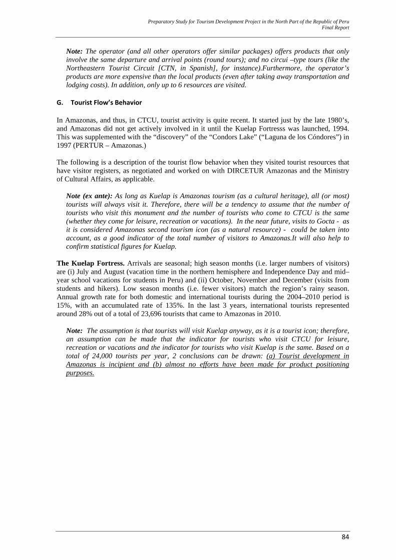
Preparatory Study for Tourism Development Project in the North Part of the Republic of Peru Final Report
84
Note: The operator (and all other operators offer similar packages) offers products that only involve the same departure and arrival points (round tours); and no circui –type tours (like the Northeastern Tourist Circuit [CTN, in Spanish], for instance).Furthermore, the operator’s products are more expensive than the local products (even after taking away transportation and lodging costs). In addition, only up to 6 resources are visited.
G. Tourist Flow’s Behavior In Amazonas, and thus, in CTCU, tourist activity is quite recent. It started just by the late 1980’s, and Amazonas did not get actively involved in it until the Kuelap Fortresss was launched, 1994. This was supplemented with the “discovery” of the “Condors Lake” (“Laguna de los Cóndores”) in 1997 (PERTUR – Amazonas.) The following is a description of the tourist flow behavior when they visited tourist resources that have visitor registers, as negotiated and worked on with DIRCETUR Amazonas and the Ministry of Cultural Affairs, as applicable.
Note (ex ante): As long as Kuelap is Amazonas tourism (as a cultural heritage), all (or most) tourists will always visit it. Therefore, there will be a tendency to assume that the number of tourists who visit this monument and the number of tourists who come to CTCU is the same (whether they come for leisure, recreation or vacations). In the near future, visits to Gocta - as it is considered Amazonas second tourism icon (as a natural resource) - could be taken into account, as a good indicator of the total number of visitors to Amazonas.It will also help to confirm statistical figures for Kuelap.
The Kuelap Fortress. Arrivals are seasonal; high season months (i.e. larger numbers of visitors) are (i) July and August (vacation time in the northern hemisphere and Independence Day and mid–year school vacations for students in Peru) and (ii) October, November and December (visits from students and hikers). Low season months (i.e. fewer visitors) match the region’s rainy season. Annual growth rate for both domestic and international tourists during the 2004–2010 period is 15%, with an accumulated rate of 135%. In the last 3 years, international tourists represented around 28% out of a total of 23,696 tourists that came to Amazonas in 2010.
Note: The assumption is that tourists will visit Kuelap anyway, as it is a tourist icon; therefore, an assumption can be made that the indicator for tourists who visit CTCU for leisure, recreation or vacations and the indicator for tourists who visit Kuelap is the same. Based on a total of 24,000 tourists per year, 2 conclusions can be drawn: (a) Tourist development in Amazonas is incipient and (b) almost no efforts have been made for product positioning purposes.
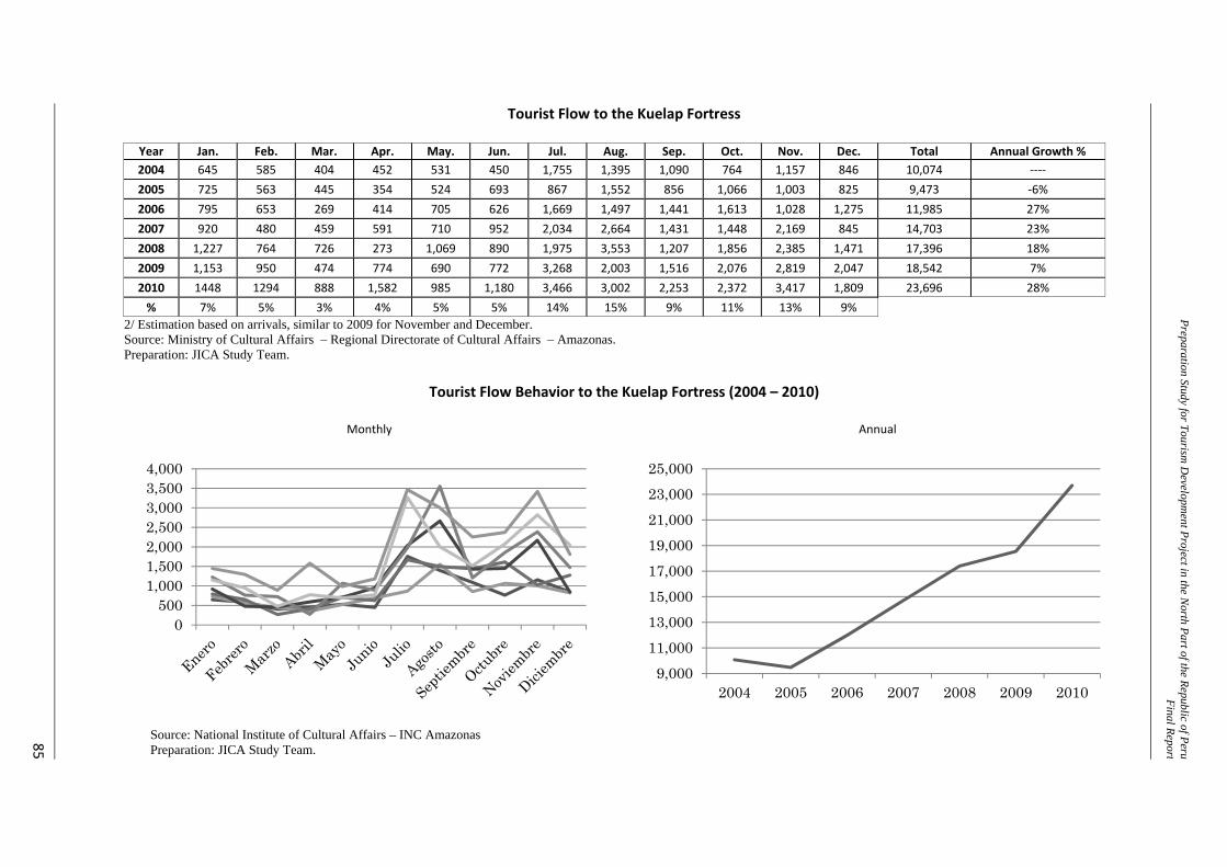
Preparation Study for Tourism D
evelopment Project in the N
orth Part of the Republic of PeruFinal Report
85
Tourist Flow to the Kuelap Fortress
Year Jan. Feb. Mar. Apr. May. Jun. Jul. Aug. Sep. Oct. Nov. Dec. Total Annual Growth % 2004 645 585 404 452 531 450 1,755 1,395 1,090 764 1,157 846 10,074 ‐‐‐‐ 2005 725 563 445 354 524 693 867 1,552 856 1,066 1,003 825 9,473 ‐6% 2006 795 653 269 414 705 626 1,669 1,497 1,441 1,613 1,028 1,275 11,985 27% 2007 920 480 459 591 710 952 2,034 2,664 1,431 1,448 2,169 845 14,703 23% 2008 1,227 764 726 273 1,069 890 1,975 3,553 1,207 1,856 2,385 1,471 17,396 18% 2009 1,153 950 474 774 690 772 3,268 2,003 1,516 2,076 2,819 2,047 18,542 7% 2010 1448 1294 888 1,582 985 1,180 3,466 3,002 2,253 2,372 3,417 1,809 23,696 28% % 7% 5% 3% 4% 5% 5% 14% 15% 9% 11% 13% 9%
2/ Estimation based on arrivals, similar to 2009 for November and December. Source: Ministry of Cultural Affairs – Regional Directorate of Cultural Affairs – Amazonas. Preparation: JICA Study Team.
Tourist Flow Behavior to the Kuelap Fortress (2004 – 2010)
Monthly
Annual
Source: National Institute of Cultural Affairs – INC Amazonas Preparation: JICA Study Team.
0500
1,0001,5002,0002,5003,0003,5004,000
9,00011,00013,00015,00017,00019,00021,00023,00025,000
2004 2005 2006 2007 2008 2009 2010
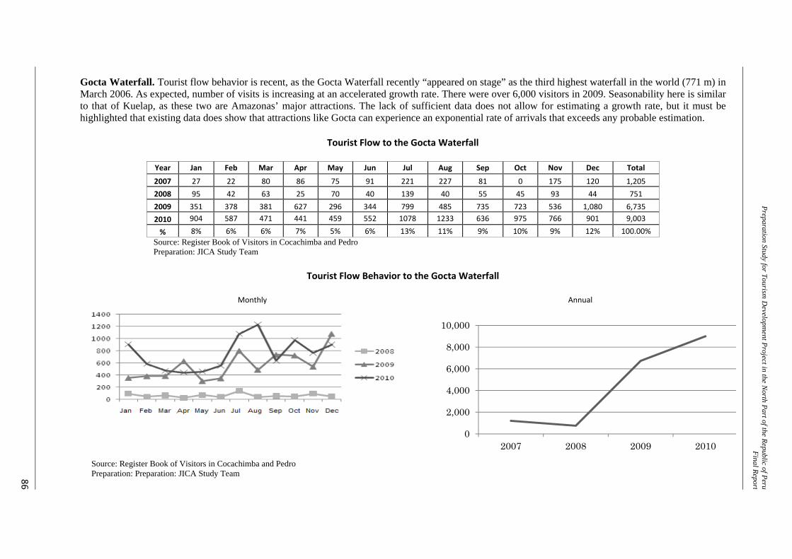
Preparation Study for Tourism D
evelopment Project in the N
orth Part of the Republic of PeruFinal Report
86
Gocta Waterfall. Tourist flow behavior is recent, as the Gocta Waterfall recently “appeared on stage” as the third highest waterfall in the world (771 m) in March 2006. As expected, number of visits is increasing at an accelerated growth rate. There were over 6,000 visitors in 2009. Seasonability here is similar to that of Kuelap, as these two are Amazonas’ major attractions. The lack of sufficient data does not allow for estimating a growth rate, but it must be highlighted that existing data does show that attractions like Gocta can experience an exponential rate of arrivals that exceeds any probable estimation.
Tourist Flow to the Gocta Waterfall
Year Jan Feb Mar Apr May Jun Jul Aug Sep Oct Nov Dec Total
2007 27 22 80 86 75 91 221 227 81 0 175 120 1,205 2008 95 42 63 25 70 40 139 40 55 45 93 44 751 2009 351 378 381 627 296 344 799 485 735 723 536 1,080 6,735 2010 904 587 471 441 459 552 1078 1233 636 975 766 901 9,003
% 8% 6% 6% 7% 5% 6% 13% 11% 9% 10% 9% 12% 100.00% Source: Register Book of Visitors in Cocachimba and Pedro Preparation: JICA Study Team
Tourist Flow Behavior to the Gocta Waterfall
Monthly
Annual
Source: Register Book of Visitors in Cocachimba and Pedro Preparation: Preparation: JICA Study Team
0
2,000
4,000
6,000
8,000
10,000
2007 2008 2009 2010
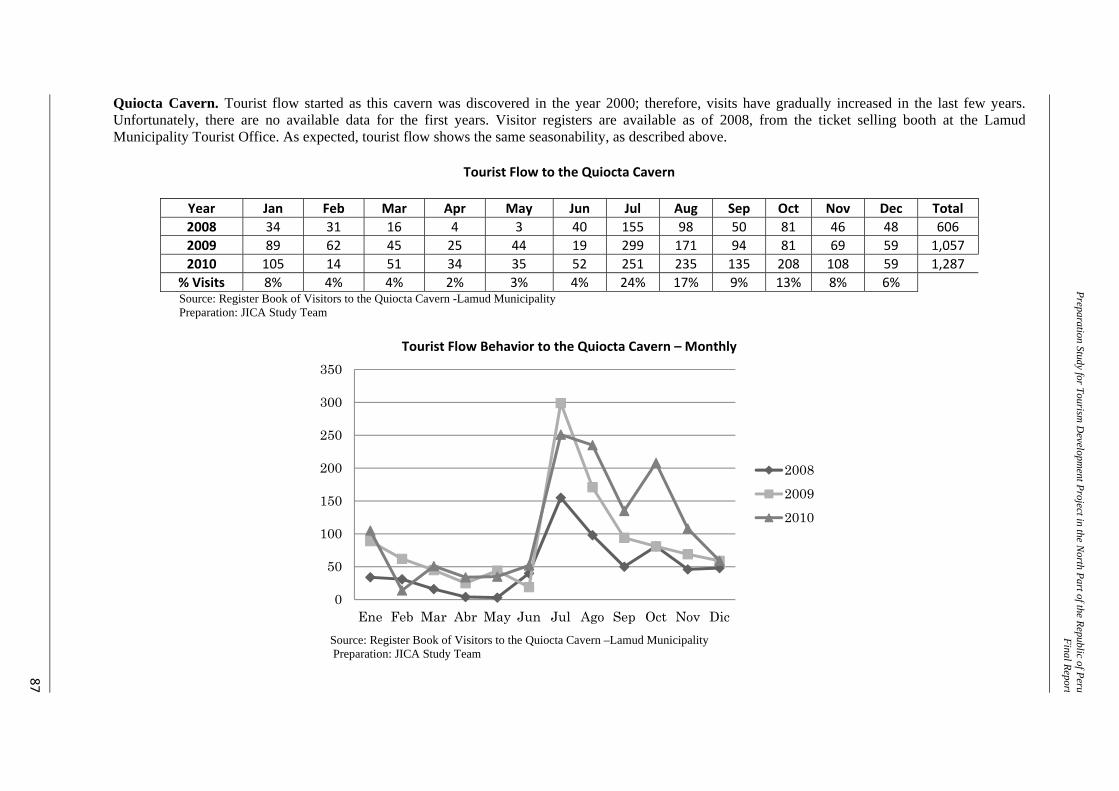
Preparation Study for Tourism D
evelopment Project in the N
orth Part of the Republic of PeruFinal Report
87
Quiocta Cavern. Tourist flow started as this cavern was discovered in the year 2000; therefore, visits have gradually increased in the last few years. Unfortunately, there are no available data for the first years. Visitor registers are available as of 2008, from the ticket selling booth at the Lamud Municipality Tourist Office. As expected, tourist flow shows the same seasonability, as described above.
Tourist Flow to the Quiocta Cavern
Year Jan Feb Mar Apr May Jun Jul Aug Sep Oct Nov Dec Total 2008 34 31 16 4 3 40 155 98 50 81 46 48 606 2009 89 62 45 25 44 19 299 171 94 81 69 59 1,057 2010 105 14 51 34 35 52 251 235 135 208 108 59 1,287
% Visits 8% 4% 4% 2% 3% 4% 24% 17% 9% 13% 8% 6% Source: Register Book of Visitors to the Quiocta Cavern -Lamud Municipality Preparation: JICA Study Team
Tourist Flow Behavior to the Quiocta Cavern – Monthly
Source: Register Book of Visitors to the Quiocta Cavern –Lamud Municipality Preparation: JICA Study Team
0
50
100
150
200
250
300
350
Ene Feb Mar Abr May Jun Jul Ago Sep Oct Nov Dic
200820092010
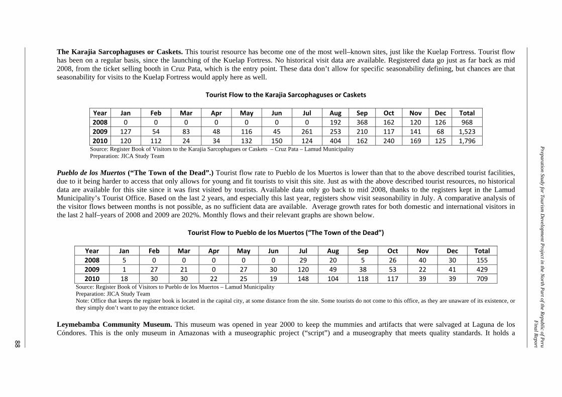
Preparation Study for Tourism D
evelopment Project in the N
orth Part of the Republic of PeruFinal Report
88
The Karajia Sarcophaguses or Caskets. This tourist resource has become one of the most well–known sites, just like the Kuelap Fortress. Tourist flow has been on a regular basis, since the launching of the Kuelap Fortress. No historical visit data are available. Registered data go just as far back as mid 2008, from the ticket selling booth in Cruz Pata, which is the entry point. These data don’t allow for specific seasonability defining, but chances are that seasonability for visits to the Kuelap Fortress would apply here as well.
Tourist Flow to the Karajia Sarcophaguses or Caskets
Year Jan Feb Mar Apr May Jun Jul Aug Sep Oct Nov Dec Total 2008 0 0 0 0 0 0 0 192 368 162 120 126 968 2009 127 54 83 48 116 45 261 253 210 117 141 68 1,523 2010 120 112 24 34 132 150 124 404 162 240 169 125 1,796
Source: Register Book of Visitors to the Karajia Sarcophagues or Caskets – Cruz Pata – Lamud Municipality Preparation: JICA Study Team
Pueblo de los Muertos (“The Town of the Dead”.) Tourist flow rate to Pueblo de los Muertos is lower than that to the above described tourist facilities, due to it being harder to access that only allows for young and fit tourists to visit this site. Just as with the above described tourist resources, no historical data are available for this site since it was first visited by tourists. Available data only go back to mid 2008, thanks to the registers kept in the Lamud Municipality’s Tourist Office. Based on the last 2 years, and especially this last year, registers show visit seasonability in July. A comparative analysis of the visitor flows between months is not possible, as no sufficient data are available. Average growth rates for both domestic and international visitors in the last 2 half–years of 2008 and 2009 are 202%. Monthly flows and their relevant graphs are shown below.
Tourist Flow to Pueblo de los Muertos (“The Town of the Dead”)
Year Jan Feb Mar Apr May Jun Jul Aug Sep Oct Nov Dec Total 2008 5 0 0 0 0 0 29 20 5 26 40 30 155 2009 1 27 21 0 27 30 120 49 38 53 22 41 429 2010 18 30 30 22 25 19 148 104 118 117 39 39 709
Source: Register Book of Visitors to Pueblo de los Muertos – Lamud Municipality Preparation: JICA Study Team Note: Office that keeps the register book is located in the capital city, at some distance from the site. Some tourists do not come to this office, as they are unaware of its existence, or they simply don’t want to pay the entrance ticket.
Leymebamba Community Museum. This museum was opened in year 2000 to keep the mummies and artifacts that were salvaged at Laguna de los Cóndores. This is the only museum in Amazonas with a museographic project (“script”) and a museography that meets quality standards. It holds a
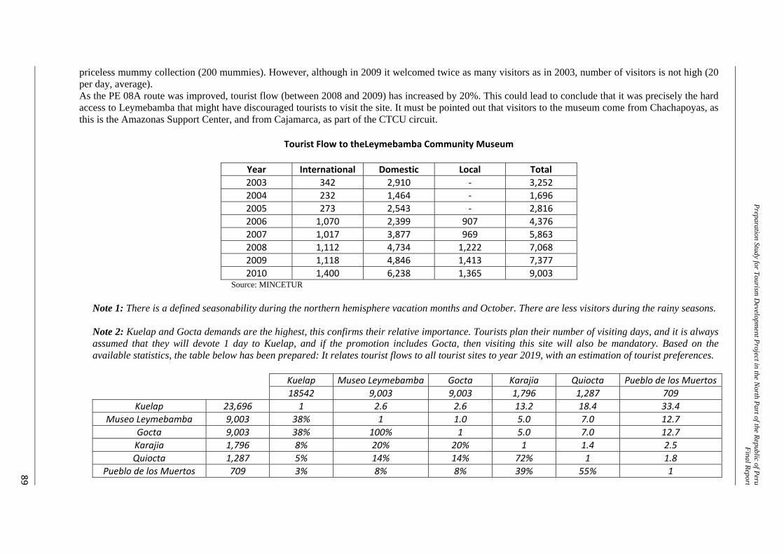
Preparation Study for Tourism D
evelopment Project in the N
orth Part of the Republic of PeruFinal Report
89
priceless mummy collection (200 mummies). However, although in 2009 it welcomed twice as many visitors as in 2003, number of visitors is not high (20 per day, average). As the PE 08A route was improved, tourist flow (between 2008 and 2009) has increased by 20%. This could lead to conclude that it was precisely the hard access to Leymebamba that might have discouraged tourists to visit the site. It must be pointed out that visitors to the museum come from Chachapoyas, as this is the Amazonas Support Center, and from Cajamarca, as part of the CTCU circuit.
Tourist Flow to theLeymebamba Community Museum
Year International Domestic Local Total 2003 342 2,910 ‐ 3,252 2004 232 1,464 ‐ 1,696 2005 273 2,543 ‐ 2,816 2006 1,070 2,399 907 4,376 2007 1,017 3,877 969 5,863 2008 1,112 4,734 1,222 7,068 2009 1,118 4,846 1,413 7,377 2010 1,400 6,238 1,365 9,003
Source: MINCETUR
Note 1: There is a defined seasonability during the northern hemisphere vacation months and October. There are less visitors during the rainy seasons. Note 2: Kuelap and Gocta demands are the highest, this confirms their relative importance. Tourists plan their number of visiting days, and it is always assumed that they will devote 1 day to Kuelap, and if the promotion includes Gocta, then visiting this site will also be mandatory. Based on the available statistics, the table below has been prepared: It relates tourist flows to all tourist sites to year 2019, with an estimation of tourist preferences.
Kuelap Museo Leymebamba Gocta Karajia Quiocta Pueblo de los Muertos 18542 9,003 9,003 1,796 1,287 709
Kuelap 23,696 1 2.6 2.6 13.2 18.4 33.4 Museo Leymebamba 9,003 38% 1 1.0 5.0 7.0 12.7
Gocta 9,003 38% 100% 1 5.0 7.0 12.7 Karajia 1,796 8% 20% 20% 1 1.4 2.5 Quiocta 1,287 5% 14% 14% 72% 1 1.8
Pueblo de los Muertos 709 3% 8% 8% 39% 55% 1
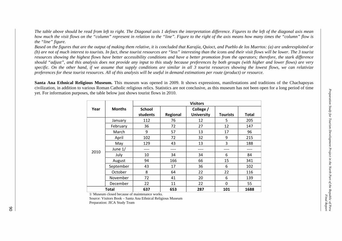
Preparation Study for Tourism D
evelopment Project in the N
orth Part of the Republic of PeruFinal Report
90
The table above should be read from left to right. The Diagonal axis 1 defines the interpretation difference. Figures to the left of the diagonal axis mean how much the visit flows on the “column” represent in relation to the “line”. Figure to the right of the axis means how many times the “column” flow is the “line” figure. Based on the figures that are the output of making them relative, it is concluded that Karajía, Quioct, and Pueblo de los Muertos: (a) are underexploited or (b) are not of much interest to tourists. In fact, these tourist resources are “less” interesting than the icons and their visit flows will be lower. The 3 tourist resources showing the highest flows have better accessibility conditions and have a better promotion from the operators; therefore, the stark difference should “adjust”, and this analysis does not provide any input to this study because preferences by both groups (with higher and lower flows) are very specific. On the other hand, if we assume that supply conditions are similar in all 3 tourist resources showing the lowest flows, we can relativize preferences for these tourist resources. All of this analysis will be useful in demand estimations per route (product) or resource. Santa Ana Ethnical Religious Museum. This museum was opened in 2009. It shows expressions, manifestations and traditions of the Chachapoyas civilization, in addition to various Roman Catholic religious relics. Statistics are not conclusive, as this museum has not been open for a long period of time yet. For information purposes, the table below just shows tourist flows in 2010.
Year Months Visitors
School students Regional
College / University Tourists Total
2010
January 112 76 12 5 205 February 36 72 27 12 147 March 9 57 13 17 96 April 102 72 32 9 215 May 129 43 13 3 188
June 1/ ‐‐‐‐ ‐‐‐‐ ‐‐‐‐ ‐‐‐‐ ‐‐‐‐ July 10 34 34 6 84
August 94 166 66 15 341 September 43 17 36 6 102 October 8 64 22 22 116 November 72 41 20 6 139 December 22 11 22 0 55
Total 637 653 287 101 1688 1/ Museum closed because of maintenance works. Source: Visitors Book – Santa Ana Ethnical Religious Museum Preparation: JICA Study Team
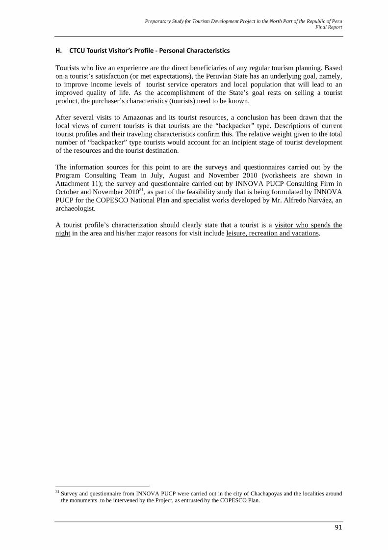
Preparatory Study for Tourism Development Project in the North Part of the Republic of Peru Final Report
91
H. CTCU Tourist Visitor’s Profile ‐ Personal Characteristics Tourists who live an experience are the direct beneficiaries of any regular tourism planning. Based on a tourist’s satisfaction (or met expectations), the Peruvian State has an underlying goal, namely, to improve income levels of tourist service operators and local population that will lead to an improved quality of life. As the accomplishment of the State’s goal rests on selling a tourist product, the purchaser’s characteristics (tourists) need to be known. After several visits to Amazonas and its tourist resources, a conclusion has been drawn that the local views of current tourists is that tourists are the “backpacker” type. Descriptions of current tourist profiles and their traveling characteristics confirm this. The relative weight given to the total number of “backpacker” type tourists would account for an incipient stage of tourist development of the resources and the tourist destination. The information sources for this point to are the surveys and questionnaires carried out by the Program Consulting Team in July, August and November 2010 (worksheets are shown in Attachment 11); the survey and questionnaire carried out by INNOVA PUCP Consulting Firm in October and November 201031, as part of the feasibility study that is being formulated by INNOVA PUCP for the COPESCO National Plan and specialist works developed by Mr. Alfredo Narváez, an archaeologist. A tourist profile’s characterization should clearly state that a tourist is a visitor who spends the night in the area and his/her major reasons for visit include leisure, recreation and vacations.
31 Survey and questionnaire from INNOVA PUCP were carried out in the city of Chachapoyas and the localities around
the monuments to be intervened by the Project, as entrusted by the COPESCO Plan.
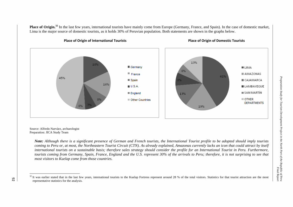
Preparation Study for Tourism D
evelopment Project in the N
orth Part of the Republic of PeruFinal Repor t
92
Place of Origin.32 In the last few years, international tourists have mainly come from Europe (Germany, France, and Spain). In the case of domestic market, Lima is the major source of domestic tourists, as it holds 30% of Peruvian population. Both statements are shown in the graphs below.
Place of Origin of International Tourists
Place of Origin of Domestic Tourists
Source: Alfredo Narváez, archaeologist Preparation: JICA Study Team
Note: Although there is a significant presence of German and French tourists, the International Tourist profile to be adopted should imply tourists coming to Peru or, at most, the Northeastern Tourist Circuit (CTN). As already explained, Amazonas currently lacks an icon that could attract by itself international tourists on a sustainable basis; therefore sales strategy should consider the profile for an International Tourist in Peru. Furthermore, tourists coming from Germany, Spain, France, England and the U.S. represent 30% of the arrivals to Peru; therefore, it is not surprising to see that most visitors to Kuelap come from those countries.
32 It was earlier stated that in the last few years, international tourists to the Kuelap Fortress represent around 28 % of the total visitors. Statistics for that tourist attraction are the most
representative statistics for the analysis.
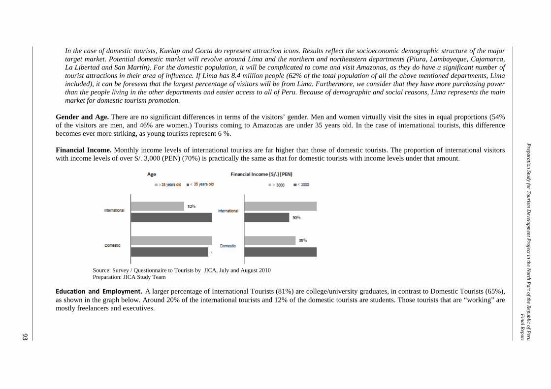
Preparation Study for Tourism D
evelopment Project in the N
orth Part of the Republic of PeruFinal Repor t
93
In the case of domestic tourists, Kuelap and Gocta do represent attraction icons. Results reflect the socioeconomic demographic structure of the major target market. Potential domestic market will revolve around Lima and the northern and northeastern departments (Piura, Lambayeque, Cajamarca, La Libertad and San Martín). For the domestic population, it will be complicated to come and visit Amazonas, as they do have a significant number of tourist attractions in their area of influence. If Lima has 8.4 million people (62% of the total population of all the above mentioned departments, Lima included), it can be foreseen that the largest percentage of visitors will be from Lima. Furthermore, we consider that they have more purchasing power than the people living in the other departments and easier access to all of Peru. Because of demographic and social reasons, Lima represents the main market for domestic tourism promotion.
Gender and Age. There are no significant differences in terms of the visitors’ gender. Men and women virtually visit the sites in equal proportions (54% of the visitors are men, and 46% are women.) Tourists coming to Amazonas are under 35 years old. In the case of international tourists, this difference becomes ever more striking, as young tourists represent 6 %. Financial Income. Monthly income levels of international tourists are far higher than those of domestic tourists. The proportion of international visitors with income levels of over S/. 3,000 (PEN) (70%) is practically the same as that for domestic tourists with income levels under that amount.
Source: Survey / Questionnaire to Tourists by JICA, July and August 2010 Preparation: JICA Study Team
Education and Employment. A larger percentage of International Tourists (81%) are college/university graduates, in contrast to Domestic Tourists (65%), as shown in the graph below. Around 20% of the international tourists and 12% of the domestic tourists are students. Those tourists that are “working” are mostly freelancers and executives.
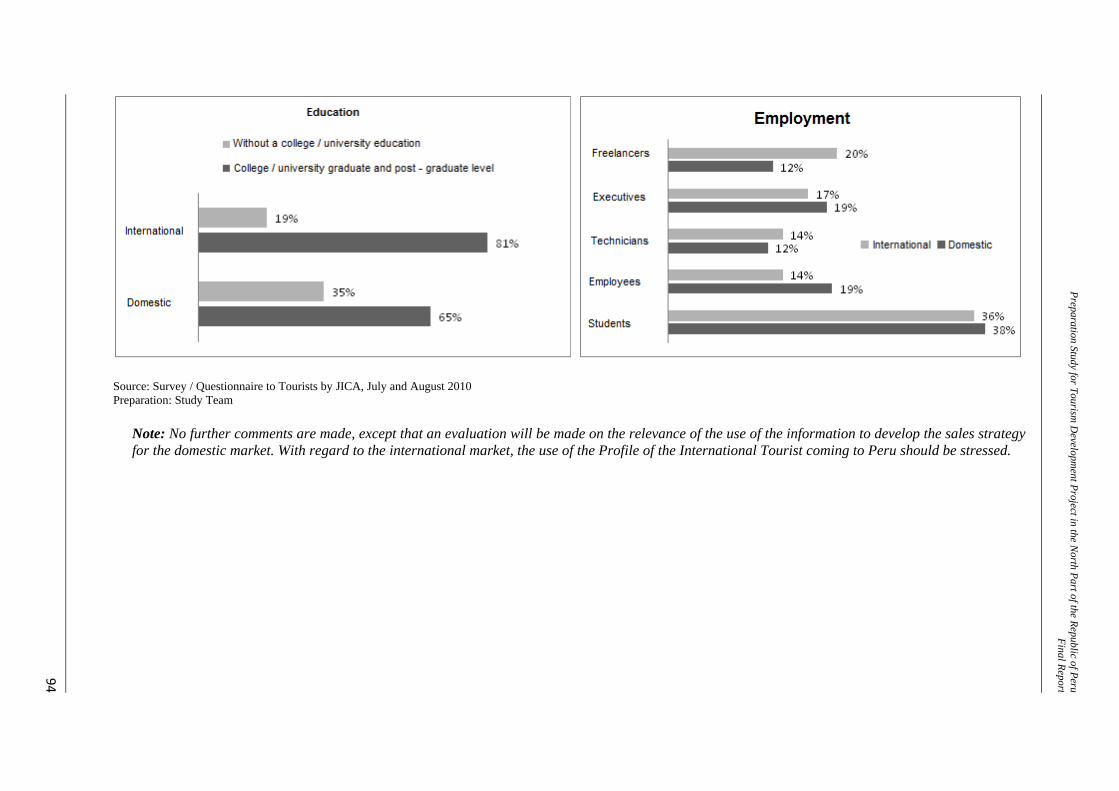
Preparation Study for Tourism D
evelopment Project in the N
orth Part of the Republic of PeruFinal Repor t
94
Source: Survey / Questionnaire to Tourists by JICA, July and August 2010 Preparation: Study Team
Note: No further comments are made, except that an evaluation will be made on the relevance of the use of the information to develop the sales strategy for the domestic market. With regard to the international market, the use of the Profile of the International Tourist coming to Peru should be stressed.
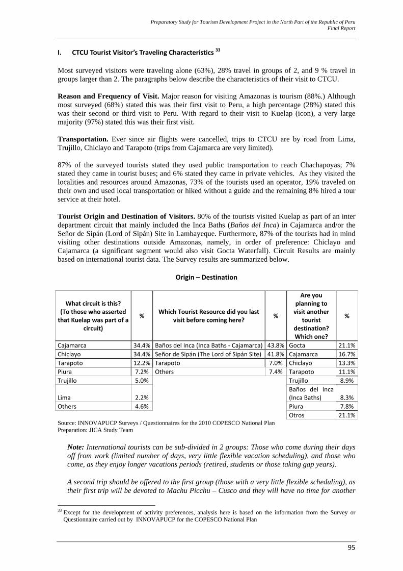
Preparatory Study for Tourism Development Project in the North Part of the Republic of Peru Final Report
95
I. CTCU Tourist Visitor’s Traveling Characteristics 33 Most surveyed visitors were traveling alone (63%), 28% travel in groups of 2, and 9 % travel in groups larger than 2. The paragraphs below describe the characteristics of their visit to CTCU. Reason and Frequency of Visit. Major reason for visiting Amazonas is tourism (88%.) Although most surveyed (68%) stated this was their first visit to Peru, a high percentage (28%) stated this was their second or third visit to Peru. With regard to their visit to Kuelap (icon), a very large majority (97%) stated this was their first visit. Transportation. Ever since air flights were cancelled, trips to CTCU are by road from Lima, Trujillo, Chiclayo and Tarapoto (trips from Cajamarca are very limited). 87% of the surveyed tourists stated they used public transportation to reach Chachapoyas; 7% stated they came in tourist buses; and 6% stated they came in private vehicles. As they visited the localities and resources around Amazonas, 73% of the tourists used an operator, 19% traveled on their own and used local transportation or hiked without a guide and the remaining 8% hired a tour service at their hotel. Tourist Origin and Destination of Visitors. 80% of the tourists visited Kuelap as part of an inter department circuit that mainly included the Inca Baths (Baños del Inca) in Cajamarca and/or the Señor de Sipán (Lord of Sipán) Site in Lambayeque. Furthermore, 87% of the tourists had in mind visiting other destinations outside Amazonas, namely, in order of preference: Chiclayo and Cajamarca (a significant segment would also visit Gocta Waterfall). Circuit Results are mainly based on international tourist data. The Survey results are summarized below.
Origin – Destination
What circuit is this? (To those who asserted that Kuelap was part of a
circuit)
% Which Tourist Resource did you last visit before coming here? %
Are you planning to visit another
tourist destination? Which one?
%
Cajamarca 34.4% Baños del Inca (Inca Baths ‐ Cajamarca) 43.8% Gocta 21.1%Chiclayo 34.4% Señor de Sipán (The Lord of Sipán Site) 41.8% Cajamarca 16.7%Tarapoto 12.2% Tarapoto 7.0% Chiclayo 13.3%Piura 7.2% Others 7.4% Tarapoto 11.1%Trujillo 5.0% Trujillo 8.9%
Lima 2.2% Baños del Inca (Inca Baths) 8.3%
Others 4.6% Piura 7.8% Otros 21.1%Source: INNOVAPUCP Surveys / Questionnaires for the 2010 COPESCO National Plan Preparation: JICA Study Team
Note: International tourists can be sub-divided in 2 groups: Those who come during their days off from work (limited number of days, very little flexible vacation scheduling), and those who come, as they enjoy longer vacations periods (retired, students or those taking gap years). A second trip should be offered to the first group (those with a very little flexible scheduling), as their first trip will be devoted to Machu Picchu – Cusco and they will have no time for another
33 Except for the development of activity preferences, analysis here is based on the information from the Survey or
Questionnaire carried out by INNOVAPUCP for the COPESCO National Plan
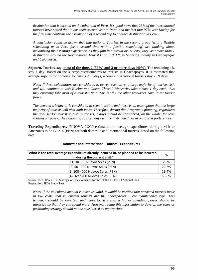
Preparatory Study for Tourism Development Project in the North Part of the Republic of Peru Final Report
96
destination that is located on the other end of Peru. It’s good news that 28% of the international tourists have stated that it was their second visit to Peru, and the fact that 97% visit Kuelap for the first time confirms the assumption of a second trip to another destination in Peru. A conclusion could be drawn that International Tourists in the second group (with a flexible scheduling or in Peru for a second time with a flexible scheduling) are thinking about maximizing their visiting experience, as they join in a circuit or, at least, they visit more than 1 destination around the Northeastern Tourist Circuit (CTN, in Spanish), mainly in Lambayeque and Cajamarca.
Sojourn. Tourists stay, most of the time, 2 (56%) and 3 or more days (40%). The remaining 4% stay 1 day. Based on the surveys/questionnaires to tourists in Chachapoyas, it is estimated that average sojourn for domestic tourists is 2.38 days, whereas international tourists stay 2.59 days.
Note: If these calculations are considered to be representative, a large majority of tourists visit and will continue to visit Kuelap and Gocta. These 2 itineraries take almost 1 day each, thus they currently take most of a tourist’s time. This is why the other resources have lower tourist flows. The demand’s behavior is considered to remain stable and there is an assumption that the large majority of tourists will visit both icons. Therefore, during this Program’s planning, regardless the goal set for tourist sojourn purposes, 2 days should be considered, on the whole, for icon visiting purposes. The remaining sojourn days will be distributed based on tourist preferences.
Traveling Expenditures. INNOVA PUCP estimated the average expenditures during a visit to Amazonas to be S/. 214 (PEN) for both domestic and international tourists, based on the following data:
Domestic and International Tourists ‐ Expenditures
What is the total average expenditure already incurred in, or planned to be incurred in during the current visit? %
(1) 30 ‐ 50 Nuevos Soles (PEN) 2.8% (2) 50 ‐ 100 Nuevos Soles (PEN) 22.2% (3) 100 ‐ 200 Nuevos Soles (PEN) 19.4% (4) Over 200 Nuevos Soles (PEN) 55.6%
Source: INNOVA PUCP Surveys or Questionnaires for the 2010 COPESCO National Plan Preparation: JICA Study Team
Note: If the calculated amount is taken as valid, it would be verified that attracted tourists incur in low costs, that is, current tourists are the “backpacker”, low maintenance type. This tendency should be reverted, and more tourists with a higher spending power should be attracted so that they can spend more. However, using this information to develop the sales or positioning strategy should not be considered as appropriate.
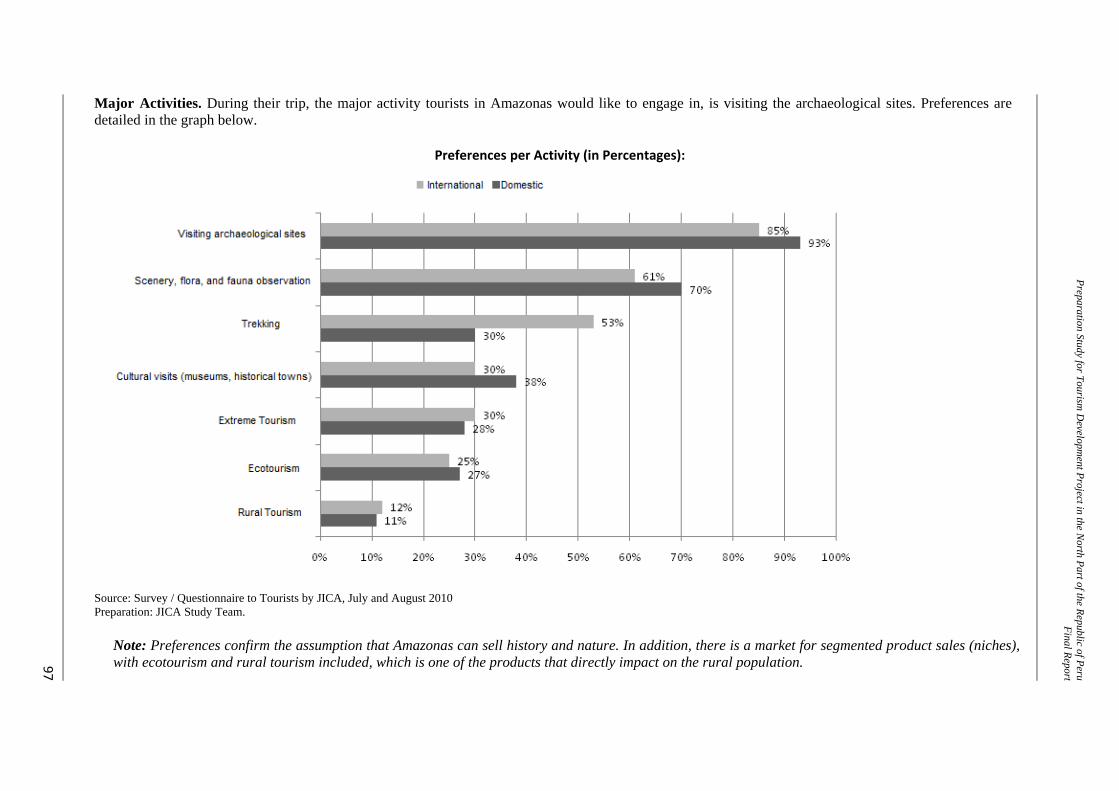
Preparation Study for Tourism D
evelopment Project in the N
orth Part of the Republic of PeruFinal Report
97
Major Activities. During their trip, the major activity tourists in Amazonas would like to engage in, is visiting the archaeological sites. Preferences are detailed in the graph below.
Preferences per Activity (in Percentages):
Source: Survey / Questionnaire to Tourists by JICA, July and August 2010 Preparation: JICA Study Team.
Note: Preferences confirm the assumption that Amazonas can sell history and nature. In addition, there is a market for segmented product sales (niches), with ecotourism and rural tourism included, which is one of the products that directly impact on the rural population.
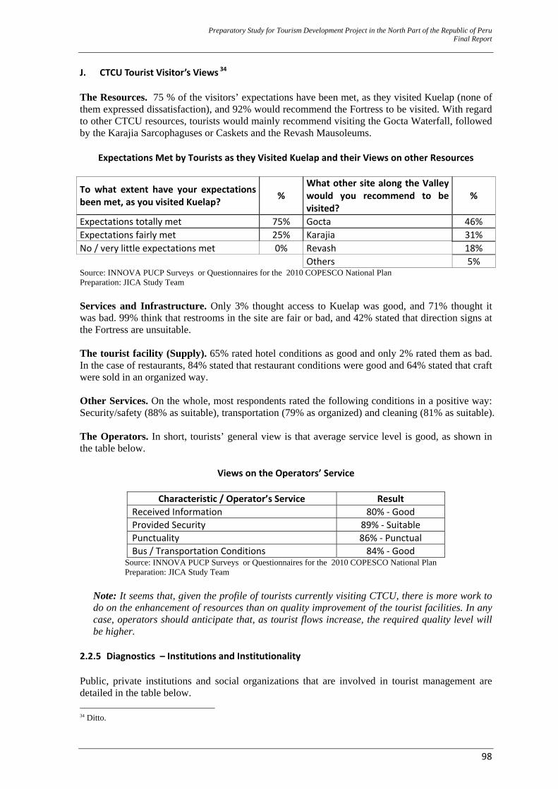
Preparatory Study for Tourism Development Project in the North Part of the Republic of Peru Final Report
98
J. CTCU Tourist Visitor’s Views 34 The Resources. 75 % of the visitors’ expectations have been met, as they visited Kuelap (none of them expressed dissatisfaction), and 92% would recommend the Fortress to be visited. With regard to other CTCU resources, tourists would mainly recommend visiting the Gocta Waterfall, followed by the Karajia Sarcophaguses or Caskets and the Revash Mausoleums.
Expectations Met by Tourists as they Visited Kuelap and their Views on other Resources
To what extent have your expectations been met, as you visited Kuelap? %
What other site along the Valley would you recommend to be visited?
%
Expectations totally met 75% Gocta 46% Expectations fairly met 25% Karajia 31% No / very little expectations met 0% Revash 18% Others 5% Source: INNOVA PUCP Surveys or Questionnaires for the 2010 COPESCO National Plan Preparation: JICA Study Team Services and Infrastructure. Only 3% thought access to Kuelap was good, and 71% thought it was bad. 99% think that restrooms in the site are fair or bad, and 42% stated that direction signs at the Fortress are unsuitable. The tourist facility (Supply). 65% rated hotel conditions as good and only 2% rated them as bad. In the case of restaurants, 84% stated that restaurant conditions were good and 64% stated that craft were sold in an organized way. Other Services. On the whole, most respondents rated the following conditions in a positive way: Security/safety (88% as suitable), transportation (79% as organized) and cleaning (81% as suitable). The Operators. In short, tourists’ general view is that average service level is good, as shown in the table below.
Views on the Operators’ Service
Characteristic / Operator’s Service Result Received Information 80% ‐ Good Provided Security 89% ‐ Suitable Punctuality 86% ‐ Punctual Bus / Transportation Conditions 84% ‐ Good
Source: INNOVA PUCP Surveys or Questionnaires for the 2010 COPESCO National Plan Preparation: JICA Study Team
Note: It seems that, given the profile of tourists currently visiting CTCU, there is more work to do on the enhancement of resources than on quality improvement of the tourist facilities. In any case, operators should anticipate that, as tourist flows increase, the required quality level will be higher.
2.2.5 Diagnostics – Institutions and Institutionality Public, private institutions and social organizations that are involved in tourist management are detailed in the table below. 34 Ditto.
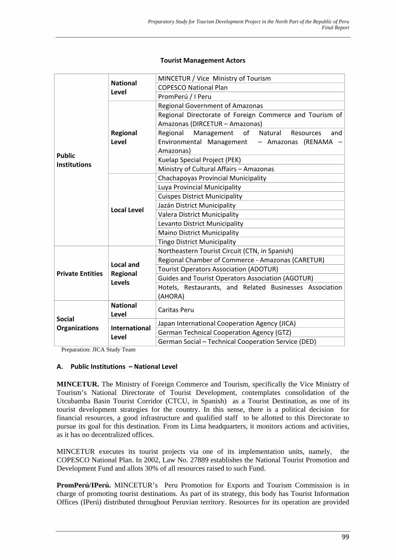
Preparatory Study for Tourism Development Project in the North Part of the Republic of Peru Final Report
99
Tourist Management Actors
Public Institutions
National Level
MINCETUR / Vice Ministry of Tourism COPESCO National Plan PromPerú / I Peru
Regional Level
Regional Government of Amazonas Regional Directorate of Foreign Commerce and Tourism of Amazonas (DIRCETUR – Amazonas) Regional Management of Natural Resources and Environmental Management – Amazonas (RENAMA – Amazonas) Kuelap Special Project (PEK) Ministry of Cultural Affairs – Amazonas
Local Level
Chachapoyas Provincial Municipality Luya Provincial Municipality Cuispes District Municipality Jazán District Municipality Valera District Municipality Levanto District Municipality Maino District Municipality Tingo District Municipality
Private Entities Local and Regional Levels
Northeastern Tourist Circuit (CTN, in Spanish) Regional Chamber of Commerce ‐ Amazonas (CARETUR) Tourist Operators Association (ADOTUR) Guides and Tourist Operators Association (AGOTUR) Hotels, Restaurants, and Related Businesses Association (AHORA)
Social Organizations
National Level Caritas Peru
International Level
Japan International Cooperation Agency (JICA) German Technical Cooperation Agency (GTZ) German Social – Technical Cooperation Service (DED)
Preparation: JICA Study Team A. Public Institutions – National Level MINCETUR. The Ministry of Foreign Commerce and Tourism, specifically the Vice Ministry of Tourism’s National Directorate of Tourist Development, contemplates consolidation of the Utcubamba Basin Tourist Corridor (CTCU, in Spanish) as a Tourist Destination, as one of its tourist development strategies for the country. In this sense, there is a political decision for financial resources, a good infrastructure and qualified staff to be allotted to this Directorate to pursue its goal for this destination. From its Lima headquarters, it monitors actions and activities, as it has no decentralized offices. MINCETUR executes its tourist projects via one of its implementation units, namely, the COPESCO National Plan. In 2002, Law No. 27889 establishes the National Tourist Promotion and Development Fund and allots 30% of all resources raised to such Fund. PromPerú/IPerú. MINCETUR’s Peru Promotion for Exports and Tourism Commission is in charge of promoting tourist destinations. As part of its strategy, this body has Tourist Information Offices (IPerú) distributed throughout Peruvian territory. Resources for its operation are provided
Preparatory Study for Tourism Development Project in the North Part of the Republic of Peru Final Report
100
via the Funds in Law No. 27889 that states an allotment of 70% for it. In this sense, it should have enough financial means to carry out its CTCU Destination positioning and promotion task. The city of Chachapoyas has 1 IPerú office that is located in the Provincial Municipality building, on the Central Plaza. This is thanks to a previously subscribed agreement with the municipality. IPerú has 2 staff, who provide information to tourists, and it is also supplied with information and promotional material about the resources in Amazonas and Peru. B. Public Institutions – Regional Level The Regional Government of Amazonas (GRA) and the Regional Directorate of Foreign Commerce and Tourism of Amazonas (DIRCETUR). GRA is politically, economically and administratively autonomous to promote Amazonas’ comprehensive development under its political administration. Its headquarters are located in Chachapoyas and it has 2 Decentralized Sub–Managements that are located in the capital cities of the Bagua and Condorcanqui Provinces. The Headquarters premises do not have enough rooms to hold a group of Managers and Directorates; therefore, these are compelled to rent other premises (the building allotted to the Regional Directorate of Foreign Commerce and Tourism included). This causes a “lack of closeness” that is not suitable for management purposes. Until 2009, GRA had spent S/. 359 million (PEN) from the budget for investment projects.The amount devoted to the tourism sector was S/. 1.9 million (PEN) (0.5%). DIRCETUR is a sectoral unit in GRA that reports to the Regional Economic Development Management. Its powers, in terms of tourism, include formulating, approving, executing, evaluating, leading, controlling and managing the development policies of the National Government’s general policy activity and the sectoral plans, as it works as the regulating body of all tourist activities around the Department. ‐ The allotted premises has 10 rooms for administrative offices and offices for the “Sustainable
Tourist Development for the Chachapoyas, Rodríguez de Mendoza, Luya and Bongará Provinces” and the “Strengthening of Middle Management Development for Competitive Tourist Service Rendering in the Amazonas Region – (FOSETUC)” projects.
‐ Local equipment is minimal and most of it has been declared inoperative. Suitable materials for orientation work and for tourist activity checking in the region are not available either.
‐ In 2009, S/. 1,650 (PEN) were allotted on a monthly basis for operational expenses. The amount
transferred by GRA is used to pay for rent and basic services. This amount is currently insufficient for scheduled activities within the regional tourist calendar to be developed.
‐ Most staff members belong to projects. The permanent staffing is insufficient to carry out
administrative, technical, client service, promotion, dissemination and other tasks. There are only 4 permanent staff (3 administrative staff included), who are currently lack training, and are unaware of he sector tools. Total staff currently working at DIRCETUR is:
‐ Regional Director (01) ‐ Secretary (01) ‐ Director, Tourism Office (01) ‐ Administrative Staff (02) ‐ Professional, technical and supporting staff for the Sustainable Tourism Development
Project (15) ‐ Professional and technical staff for the FOSETUC Project (04)
Preparatory Study for Tourism Development Project in the North Part of the Republic of Peru Final Report
101
Note: If GRA is the body in charge of tourist development management, DIRCETUR is its arms. If DIRCETUR lacks enough abilities (funding of operations, equipment, and human resources), tourism will grow, but in an unorganized way, and there is no guarantee that the estimated impacts are made. This office should absolutely be strengthened.
Kuelap Special Project (PEK). A specialized unit that is not connected to GRA, established by Regional Law 042 – 2004 – GRA. Its functions include carrying out the evaluation, diagnostics, preparation, formulation and execution of the interventions in the archaeological heritage areas, as a means to encourage promotion and development of towns and cities around Amazonas. Its administrative office works in rented premises in Chachapoyas. At present, it has computers, furniture, field equipment for a suitable performance, as well as a vehicle for staff transportation. As of January 2010, PEK has been carrying out the “Tourist Consolidation and Conditioning in the Emergency Areas of the Kuelap Fortress – South Wall Sector” under the supervisión of the COPESCO National Plan. This project will be completed on the first quarter of 2011. In addition, a number of PIP have been executed, for a combined amount of S/. 9 million (PEN). Executed PIP include: the “Restoration of the San Bartolo Historical Town in the Higher Utcubamba Valley Project”, the “Emergency Project for Research, Conservation and Tourist Conditioning of the Kuelap Fortess Project” and the “Research, Conservation and Tourist Conditioning of Yalape–Levanto, Chachapoyas Project.”
Note: A suggested alternative was that PEK became the Program’s Implementation Unit. However, PEK execution would be just like setting up a new Implementation Unit, but its multiple competences would compel it to serve all of Amazonas, and there would be no Program execution on CTCU on an exclusive basis.
Ministry of Cultural Affairs – Amazonas Branch (former Institute of Cultural Affairs – Amazonas) ‐ This Ministry’s headquarters are located in the city of Lima, and the Amazonas Office reports to
the Lima headquarters from an organizational, administrative and financial point of view.
‐ Its premises are located in Chachapoyas; it is a 2–floor building with administrative offices and an exhibition hall that displays artifacts from the Chachapoyas civilization, such as pottery, woven textiles, tools, remains and other artifacts.
‐ Its staffs are permanent and it includes a director, administrative staff, and 2 archaeologists, who
are in charge of the archaeological and research work to archaeological resources around Amazonas. This staff is insufficient, given the overwhelming number of cultural manifestations/expressions that are present in the area.
‐ It is in charge of the Kuelap Fortress administration. It has appointed 3 staff to check visitors and keep the Fortress. This staff is insufficient, given the number of visitors and the tourist site’s area.
‐ Income generated from the entry tickets to Kuelap is submitted to the Ministry for redistribution.
Around 50% of the generated income comes back to Amazonas.
Note: The Ministry of Cultural Affairs took on all of the INC’s (National Institute of Cultural Affairs) functions and competences. GRA cannot contribute to strengthening the Ministry’s Office in Amazonas, but it is necessary that the Ministry upgrades its work structure in all of its outsourced offices.
Preparatory Study for Tourism Development Project in the North Part of the Republic of Peru Final Report
102
C. Public Institutions – Local Level All municipalities are legal, financial and administrative entities. In addition, they are in charge of urban and rural development, as well as zoning, urbanism and geographic conditioning of their jurisdictions. Chachapoyas Provincial Municipality. Its vision is that Chachapoyas is considered a tourist city and tourist center in the northeastern part of the country. Its objectives include the promotion, dissemination and exploitation of tourist activity, by promoting a comprehensive, sustainable and harmonious development in its jurisdiction. Apart from its “vision”, the Chachapoyas Provincial Municipality does not have any offices nor appointed staffs that carry out any actions on behalf of its tourist development. None of the Municipality’s staff is sufficiently or suitably trained on tourist development, although Chachapoyas is the Support City for a Destination in progress. Its financial resources for 2010 were based on transfers, taxes and services. Total estimated monthly amount was S/. 345,000 (PEN) and it should pay for all expenditures. Luya Provincial Municipality. Most of the Chachapoyas Civilization Archaeological Resources are found in this province. Its capital city is Lamud and the Municipality’s headquarters are located there. This Municipality’s vision is to have tourist activity as one of its development hubs. Its staff is 15, including the mayor, staff, workers, technicians, helpers and supporting hired workers. Monthly income from transfers, taxes, and services amounts to S/. 197,000 (PEN) (FONCOMUN – Municipal Compensation Funds, in Spanish) and monthly income from other taxes amounts to S/. 3,000 (PEN). The Municipality works in a 2–floor building. The first floor holds a tourist information office that is in charge of checking and selling entry tickets to tourists, who come to visit Karajia, Quiocta and Pueblo de los Muertos (“Town of the Dead”). The head is a member of staff with a Tourist Administration Degree. In addition, there is a small exhibition hall that displays some objects, tools, pottery, woven textiles and other artifacts from the Chachapoyas civilization. This office’s furniture includes 2 tables, 5 chairs, 1 power stabilizer, but no computer. Cuispes District Municipality. The Yumbilla Waterfall (that is a candidate to be ranked as an even higher waterfall than Gocta) is located in this District. This Municipality works in an adobe building, with a tiled roof, and cement and wooden floors. It has minimum equipment (1 computer, 1 sound system, 2 desks, 6 tables, 100 plastic chairs, 8 wooden chairs and 2 benches). Administrative staff includes 1 secretary and a civil registration clerk, as well as the mayor and the 5 councilmen. This Municipality’s resources come from transfers, taxes and its own sources of income, such as: FONCOMUN (S/. 25,000 [PEN] monthly) and collection of water and electricity services (S/. 300 [PEN] monthly). Jazán District Municipality. This Municipality is larger in relation to the population and the set up tourist facilities. In addition, it is the entry point to the Utcubamba Basin Tourist Corridor. Its capital is the city of Pedro Ruiz that is crossed by the IRRSA Norte (Northern IRRSA, Spanish for Initiative for the South American Regional Integration) Highway. The municipality works in a 2–floor adobe building with a corrugated iron roof, cement and wooden floors, and has minimum equipment. It holds a total of 52 staff and none of them work in any tourist areas or have been trained to render a suitable service and develop tourist activities. The
Preparatory Study for Tourism Development Project in the North Part of the Republic of Peru Final Report
103
Municipality has not cared for this service, even though the capital city has a significant hotel, restaurant and transportation infrastructure. This Municipality’s financial resources for the whole of 2009 amounted to S/. 389,000, from transfers, taxes and public services. Valera District Municipality. Even though its building is a cement construction, this Municipality’s equipment is minimum (1 TV set, 1 DVD, 2 desks, 12 chairs, 1 shelf and 1 typewriter). In addition to the mayor and his 5 councilmen, the Municipality’s staff includes 1 secretary, 1 treasurer, 1 cleaning staff and 2 staff in charge of checking visits to the Gocta Waterfall (a total of 5 staff). This Municipality has no area or staff for tourist activity development in its District. It only offers some information with no suitable technical management at the ticket booths to the tourists, who come to the Cocachimba and San Pablo de Valera localities. This is a matter of concern, given the fact that the third highest waterfall in the world is located in this District (Gocta Waterfall). Its income is mainly supported by FONCOMUN, for an amount of S/. 352,000 (PEN.). It also perceives income from the sales of entry tickets to the Gocta Waterfall, although there are less than 7,000 registered visits, thus the relevant income is minimum. Levanto District Municipality. It works in an adobe building. It has 2 staff (in addition to the mayor and his councilmen.) Equipment includes 5 computers, multimedia and office equipment, 1 vehicle for community transportation service and 1 dump truck with a capacity of 4m3 for garbage collection purposes. Its financial resources come from transfers and income from taxes and public services. Total resources transferred to the Municipality in 2010 was S/. 502,000 (PEN), with transfers amounting S/. 123,000 (PEN) included, for temporary Municipal upgrading programs and incentives for management improvements. That is, “permanent” income amounted around S/. 378,000 (PEN), which means, S/. 32,000 (PEN) per month. This Municipality has no tourism area or office. This situation is a matter of concern, given the fact that Levanto was one of the capitals of the Chachapoyas civilization, and it holds a significant number of archaeological, architectural and urbanistic resources. Maino District Municipality. Its headquarters is a 2-floor adobe construction with plaster lining, cement and wooden floors, and a tiled roof. The building shows structural damage, a result of an earthquake on May 18th, 2010. It is in the process of being officially declared in emergency state for its reconstruction. The Municipality also has modern premises for the Municipal Theater that is located 100 meters away from the headquarters. The modern building has 6 rooms, a hall for children under 3 years old, a patio and an auditorium. In addition to the mayor and 5 councilmen, the Municipality has: 1 secretary, 1 treasurer, 1 attorney (external), 1 systems engineer (external), 1 civil engineer (external), 2 administrative helpers and 3 administrative technicians. None of them are in charge of, or have been trained on, Tourist Management. The fact that this District has archaeological resources and that it is located midway through the Levanto and Magdalenta Districts should be taken into account.
Preparatory Study for Tourism Development Project in the North Part of the Republic of Peru Final Report
104
Tingo District Municipality. The Kuelap Fortress, Silic, and the El Imperio archaeological sites are located in this District, along with other tourist resources. No staff are in charge of tourist affairs in this District. Its building is located at the Central Plaza of the Tingo Hamlet (“anexo” in Spanish) and it is a cement construction. Staff include: 1 secretary, 1 civil registration clerk, 1 driver, 1 gardener and 1 water service administrator, in addition to the mayor and 4 councilmen. It has minimum equipment: 2 computers, 2 printers, 1 photocopier, 1 photo camera, 1 TV set, 1 DVD and other minor equipment. It must be mentioned that monthly perceived income amounts S/. 26,000 (PEN) from FONCOMUN and S/. 2,500 (PEN) from water service bills.
Note: Those closer to the problem should be able to solve it (subsidiarity). If municipalities lack a supervising capacity on tourist activities around their jurisdictions, as tourist flows increase, 2 things might happen: (a) the heritage (resource) might be affected (degraded) and (b) there might be a negative impact on the lifestyles of the support localities. It is an alarming fact that LG (Local Governments) lack a capacity for tourist management, not even to cope with small tourist flow levels.
D. Private Organizations. Regional Chamber of Tourism (CARETUR) - Amazonas. CARETUR is a member of the National Chamber of Tourism (CANATUR), a civil non-political, non-profit association that brings together institutions, organizations, corporations and individuals engaged in tourist activities in Peru. Amazonas has 1 representative based in Chachapoyas. At present, this Association hosts very few events in Amazonas. It does not have a permanent office nor staff. Its representative is the only one in charge of carrying out coordination with other actors and activities. Tourist Operators Association (ADOTUR) - Amazonas. This Association is made up of 10 Tourist Operators in Amazonas. It is registered in the Public Registry Office and its legal residence is in the city of Chachapoyas. Its objectives include carrying out actions that help toward the development of tourist activities. It actively participates in the preparation of development policies that are set out for Amazonas, and its members eagerly collaborate with each other. At present, this Association has no premises or staff. Coordination and meetings are held at the members’ facilities or private homes, as applicable. Guides and Tourist Operators Association (AGOTUR) - Amazonas. This Association is registered at the Public Registry Office. It has 40 members and its legal residence is in the city of Chachapoyas. This Association’s establishment intended to bring together all tourist guides and operators working in Amazonas to carry out joint actions on behalf of the sector’s wellbeing and growth. In this sense, it participates in the preparation of tourism–related policies. This Association does not have a building or office. Coordination and meetings are held at the members’ facilities or private homes, as applicable. Hotels, Restaurants, and Related Businesses Association (AHORA) - Amazonas. This Association has been established in Amazonas for a longer time than ADOTUR and AGOTUR . It is mostly made up of hotel and restaurant owners or representatives. Its members also include tourist operators and tourist guides in Amazonas. Just like all the other tourist–related service groups, this Association does not have a building or office. Coordination and meetings are held at the members’ facilities or private homes, as applicable.
Preparatory Study for Tourism Development Project in the North Part of the Republic of Peru Final Report
105
Northeastern Tourist Circuit (CTN) This Project has been identified as a development priority for the northern area of Peru for the last 25 years. In December 2004, the CTN Project and the Regional Chamber of Tourism of Amazonas started their inter-institutional coordination activities, and Amazonas became part of CTN. This Project’s objective is to consolidate development of the Northeastern Tourist Circuit (CTN, as a Tourist Destination). This Project engages the Departments of La Libertad, Lambayeque, Amazonas and Cajamarca in a circuit that includes archaeological, natural, and cultural heritage elements along its route. This Project is being given support from various institutions for its consolidation to become a Tourist Destination in the country. The connection with CTN takes place at the northern end of CTCU, in Pedro Ruiz (Bongará province). This city lies on the inflection point of the IRRSA Norte (Northern IRRSA, Spanish for Initiative for the South American Regional Integration) Highway, and it is CTCU’s starting point. From Pedro Ruiz, roads can lead to Chiclayo in the est and to Moyobamba and Tarapoto in the east. Interconnection south of CTCU takes place in Leymebamba, via the road that runs east to through Balsas to Cajamarca. CTN objectives include instilling competitiveness among the micro, small and medium businesses for product design and commercialization purposes. This would strengthen the sector’s management and its combined elements will define the Tourist Destination. Activities carried out within its work plan include regular workshops and courses in the various cities involved. In addition, CTN has published the “Management of the Northeastern Tourist Circuit Attractions Public Use” Guide and has identified (and recommended) 3 circuits of up to 17 days long that include Amazonas as a Destination from its various access points (Cajamarca, Trujillo, and Tarapoto).
Note: During the Program execution, active coordination should be carried out with the private sector. The private sector is expected to get better organized, as implementation of this Program and other investment projects in the portfolio consolidates and tourist flows experience substantial growth.
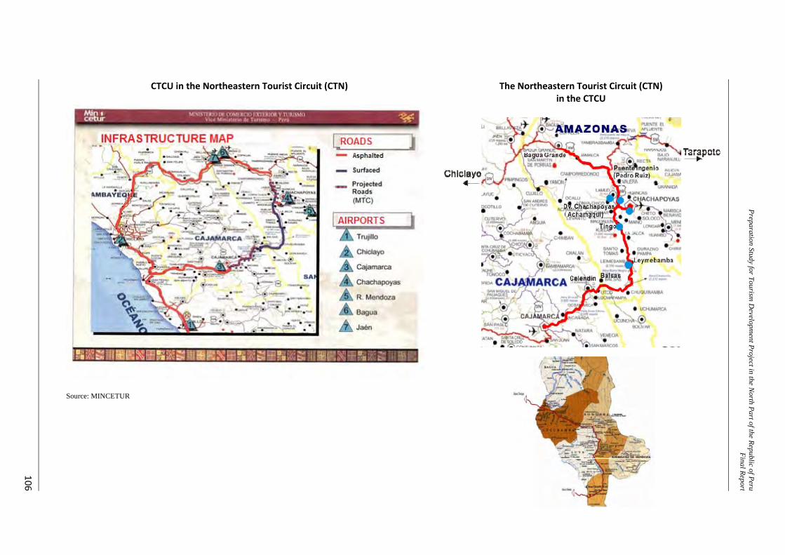
Preparation Study for Tourism D
evelopment Project in the N
orth Part of the Republic of PeruFinal Repor t
106
CTCU in the Northeastern Tourist Circuit (CTN)
The Northeastern Tourist Circuit (CTN) in the CTCU
Source: MINCETUR
Preparatory Study for Tourism Development Project in the North Part of the Republic of Peru Final Report
107
E. Social Organizations. CARITAS PERÚ. This is an organization that is run by the Roman Catholic Church. It was established on October 4th, 1955 by the Peruvian Episcopal Conference. It is made up of 49 Diocesan CARITAS organizations around Peru and the Chachapoyas Chapter is one of them. Since 2003, CARITAS developed a project called: “Program for a Suitable Management of Tourist Resources with Community Participation for Income Generation Purposes” - PROMACTUC, in Spanish, with support from the Italian–Peruvian Fund. Provinces involved included Chachapoyas, Luya, Bongará and Rodríguez de Mendoza, and this project was completed in 2008. Some of its accomplishments include the Gocta Ecotourism Shelter, the Quiocta Tourist Parador and the bridle path to the Gocta Waterfall conditioning. Its training and management activities include the preparation of Crafts Business Plans, Quality Certification to Tourist Services, Training on Crafts and Agribusiness, Installation of Orchid and Palm Tree Nurseries and the Implementation of Tourist Paradors (“Tambos” in Spanish). At present, CARITAS is not developing any tourist projects, but it gives its ongoing support to the organizations it established, as a result of its above mentioned project. German Technical Cooperation Agency (GTZ). This organization works with various German Government institutions. Its major objective is capacity building, by strengthening abilities towards a successful and sustainable development. During 2008 and 2009, its projects in Peru supported GRA on tourist planning endeavors, as it took on the technical and financial preparation of PERTUR - Amazonas and the Regional Tourist Guide, as well as other activities in the tourism sector. At present, GTZ is no longer present in Amazonas; however, according to DIRCETUR, there is a possibility that GTZ returns to Peru in 2011, and will carry on with supplementary projects towards PERTUR completion. German Social–Technical Cooperation Service (DED). This is a German Government agency that is part of the German Cooperation to Peru along with other agencies. DED promotes sustainable tourism, by sending experts to prepare and set up projects that will lead to local income of the least privileged, via natural resource conservation and cultural identity preservation. In March 2010, DED has subscribed a cooperation agreement with DIRCETUR for a 5–year period. This agreement states that an advisor will support DIRCETUR to involve rural population in tourist activities that will lead to Community Rural Tourism development.
Note: DIRCETUR should organize interventions of the various actors (but not as part of this Program) for them to follow alignments, as defined by GRA, towards tourist development and synergies to be generated among the interventions.
Preparatory Study for Tourism Development Project in the North Part of the Republic of Peru Final Report
108
2.3 Defining the Problem and its Causes35 This second level of study allows for an in-depth analysis to check that the problem still exists, and the causes identified in the pre–investment study at Profile (Perfil) level are still defining the identified core problem. Based on the diagnostics results, the conclusion is that the negative situation and its root causes still prevail. 2.3.1 Core Problem “Unsuitable socioeconomic conditions along the Utcubamba Valley Tourist Corridor that do not allow for an equitable and inclusive rural economic development.” Utcubamba Valley should be understood as referring to the CTCU Scope. 2.3.2 Cause Analyses Direct Cause (DC) 1: The first main and critical cause is the unsuitable infrastructure for the corridor’s development. ‐ Indirect cause (IC) 1.1: Unsuitable vehicle access conditions to reach tourist attractions. ‐ IC 1.2: Lack of a comprehensive solid wastes management system. ‐ IC 1.3: Unsuitable basic sanitation infrastructure conditions. DC 2: The second main and critical cause is the tourist attractions’ limited development. ‐ IC 2.1: Little conditioning and deterioration of the tourist attractions along the corridor. ‐ IC 2.2: Unsuitable service supplies for heritage display and exhibition and cultural event
developments. DC 3: The third main and critical cause is the weak tourist management capacity building at regional and local level. ‐ IC 3.1: Little Capacity building on tourist management to local governments. ‐ IC 3.2: Regional Government’s insufficient institutional strengthening on tourism. Direct Cause 4: The fourth Direct Cause is the reduced electrification coverage. The Regional Government of Amazonas and MINEM are executing coverage extension projects along the Higher Utcubamba Valley corridor; therefore, they will not be taken into account in the means and ends analyses. 2.3.3 Effect Analyses Direct Effect (DE) 1: Loss of cultural identity. ‐ Indirect Effect (IE) 1.1: Decreased number of visitors. ‐ IE 1.2: Growing dissatisfaction from tourists. DE 2: Wasted tourist development potentialities. ‐ EI 2.1: Low income generation among the population and tourist service operators. In this context, the final effect that results from all of the above is the “Limited socioeconomic and environmental development in the Utcubamba Valley.”
35 This chapter is virtually a copy of the development of the pre – investment study at Profile (Perfil) level. The problem
persists, and so do the causes for it. The only things that maybe have changed, is the extent or level in which the problem affects society, and the causes’ characteristics.
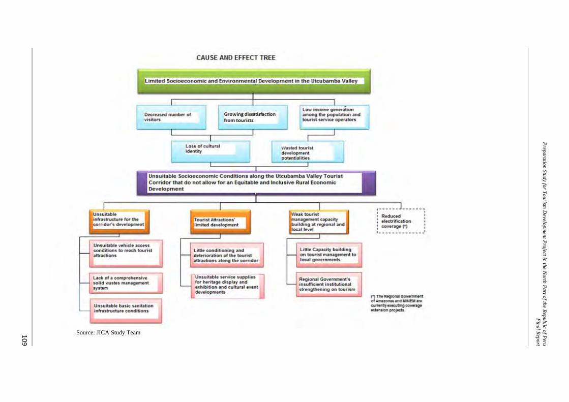
109
Preparation Study for Tourism D
evelopment Project in the N
orth Part of the Republic of PeruFinal Repor t
Source: JICA Study Team
Preparatory Study for Tourism Development Project in the North Part of the Republic of Peru Final Report
110
2.4 The Program’s Objective 2.4.1 Definition of the Core Objective “Suitable socioeconomic rural conditions along the Utcubamba Valley Tourist Corridor that allow for an equitable and inclusive rural economic development.” 2.4.2 Means to meet the Core Objective Means for the First Level 1: Suitable infrastructure for the corridor’s development. ‐ Essential Means (EM) 1.1: Suitable vehicle access conditions to reach tourist attractions ‐ EM 1.2: Suitable comprehensive solid wastes management system. ‐ EM 1.3: Suitable basic sanitation infrastructure conditions. Means for the First Level 2: Development of Tourist Attractions. ‐ EM 2.1: Conditioning and enhancement of the tourist attractions along the corridor. This
includes disseminating the culture and strengthening the population’s identity with regard to their heritage.
‐ EM 2.2: Suitable service supplies for heritage display and exhibition and cultural event developments. This includes having quality tourist facilities.
Means for the First Level 3: Development of tourist management capacity building at regional and local level ‐ EM 3.1: Capacity building on tourist management to local governments. ‐ EM 3.2: Regional Government’s institutional strengthening on tourism. 2.4.3 Ends of the Core Objective Direct End 1: Restoration and preservation of cultural identity. This generates the following indirect ends: ‐ Indirect End 1.1: Increased number of visitors and longer sojourns. ‐ Indirect End 1.2: Growing satisfaction from tourists. Direct End 2: Best use of tourist development potentialities. This generates in turn: ‐ Indirect End 2.1: Increased income generation among the population and tourist service
operators. In this context, the final end that results from all of the above is the “Socioeconomic and environmental development in the Utcubamba Valley.”
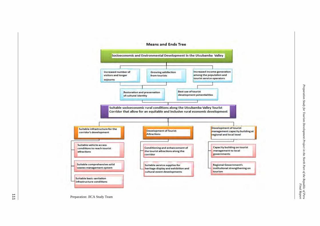
Preparation Study for Tourism D
evelopment Project in the N
orth Part of the Republic of PeruFinal Repor t
111
Preparation: JICA Study Team
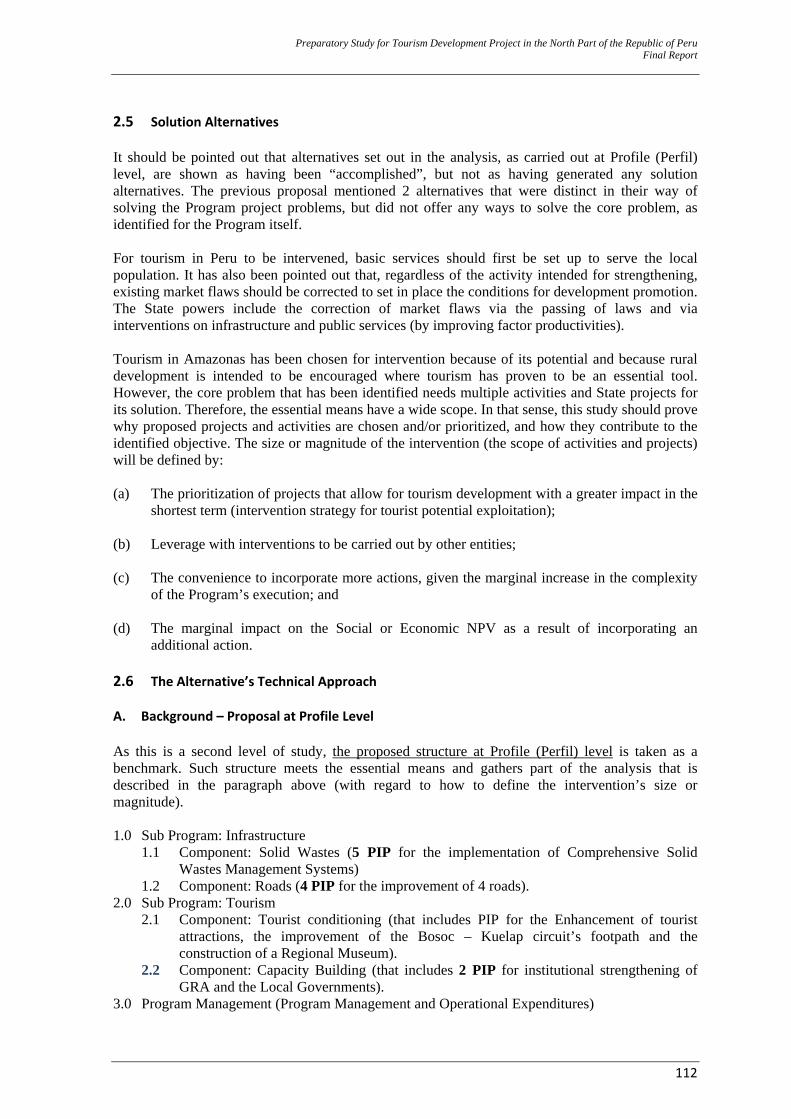
Preparatory Study for Tourism Development Project in the North Part of the Republic of Peru Final Report
112
2.5 Solution Alternatives It should be pointed out that alternatives set out in the analysis, as carried out at Profile (Perfil) level, are shown as having been “accomplished”, but not as having generated any solution alternatives. The previous proposal mentioned 2 alternatives that were distinct in their way of solving the Program project problems, but did not offer any ways to solve the core problem, as identified for the Program itself. For tourism in Peru to be intervened, basic services should first be set up to serve the local population. It has also been pointed out that, regardless of the activity intended for strengthening, existing market flaws should be corrected to set in place the conditions for development promotion. The State powers include the correction of market flaws via the passing of laws and via interventions on infrastructure and public services (by improving factor productivities). Tourism in Amazonas has been chosen for intervention because of its potential and because rural development is intended to be encouraged where tourism has proven to be an essential tool. However, the core problem that has been identified needs multiple activities and State projects for its solution. Therefore, the essential means have a wide scope. In that sense, this study should prove why proposed projects and activities are chosen and/or prioritized, and how they contribute to the identified objective. The size or magnitude of the intervention (the scope of activities and projects) will be defined by: (a) The prioritization of projects that allow for tourism development with a greater impact in the
shortest term (intervention strategy for tourist potential exploitation);
(b) Leverage with interventions to be carried out by other entities;
(c) The convenience to incorporate more actions, given the marginal increase in the complexity of the Program’s execution; and
(d) The marginal impact on the Social or Economic NPV as a result of incorporating an
additional action. 2.6 The Alternative’s Technical Approach A. Background – Proposal at Profile Level As this is a second level of study, the proposed structure at Profile (Perfil) level is taken as a benchmark. Such structure meets the essential means and gathers part of the analysis that is described in the paragraph above (with regard to how to define the intervention’s size or magnitude).
1.0 Sub Program: Infrastructure
1.1 Component: Solid Wastes (5 PIP for the implementation of Comprehensive Solid Wastes Management Systems)
1.2 Component: Roads (4 PIP for the improvement of 4 roads). 2.0 Sub Program: Tourism
2.1 Component: Tourist conditioning (that includes PIP for the Enhancement of tourist attractions, the improvement of the Bosoc – Kuelap circuit’s footpath and the construction of a Regional Museum).
2.2 Component: Capacity Building (that includes 2 PIP for institutional strengthening of GRA and the Local Governments).
3.0 Program Management (Program Management and Operational Expenditures)
Preparatory Study for Tourism Development Project in the North Part of the Republic of Peru Final Report
113
B. General Proposal Based on the structure, as described in the above paragraph, the following intervention is proposed for the Program, based on the analysis that has been carried out in this Study: 1.0 Sub Program: Infrastructure
1.1 Component: Solid Wastes (4 PIP for the implementation of Comprehensive Solid Wastes Management)
1.2 Component: Roads (2 PIP for the improvement of 2 roads).
2.0 Sub Program: Tourism 2.1 Component: Tourist conditioning (that includes 5 PIP for the Enhancement of tourist
attractions – both natural and historical -, 1 PIP for the construction of a Regional museum and 1 PIP for the construction of Community Tourist Paradors).
2.2 Component: Capacity Building (that includes 1 PIP for institutional strengthening of GRA and the Local Governments – LG).
3.0 Sub Program: Activities (1 Activity to support PERTUR Amazonas’ upgrading)
4.0 Program Management (Program Administration and Operational Expenditures) Change in the number of interventions lies on 2 factors: (a) PIP structuring once diagnoses that are based on field information were available and (b) the fact that the entities will intervene in the pre–selected locations. It must be pointed out that interventions are not described in detail, as only a “traditional” pre–investment study contents is being taken into account. An Investment Program in Tourism intends to sell a product and maximize income from tourist activity for the benefit of Peruvian society. Therefore, the chapter on Formulation is the one that defines specific interventions, as it proposes and justifies the intervention strategy and the product sale strategy. In addition, it accounts for the change in the number of interventions. C. Areas that will not be under this Program’s Intervention Improvement in the Tourist Facilities’ service quality and strengthening the population’s identity based on their heritage are themes that are not subject to intervention. With regard to identity strengthening, MINCETUR has carried out some very intense work that has caused great impact in the last few years, by means of modifications reached by consensus in the elementary and high school curriculums. In addition, the COPESCO National Plan’s Project (Patau Project) has a component that includes support to this work. In any case, texts, manuals and guides are to be updated and related actions are to be carried out in the years to come. With regard to the tourist facilities, it can be divided in 2 aspects: (a) The population’s Capacity building to access tourist–related work and (b) installed capacity’s improvement for a comprehensive tourist service (hotels, restaurants, operators, etc.). Installed capacity is something to be developed by the private sector. State support could be foreseen, by means of co-funding, but it will be more effective when “tourists come”, that is, after this Program and its relevant projects are set up. The private sector will try to maximize its benefits and this will happen, by planning investment, as more tourists come. With regard to the population’s capacity building, GRA projects (see paragraph 1.5.3.B) and some GNOs are intervening with specific activities on the subject.

Preparatory Study for Tourism Development Project in the North Part of the Republic of Peru Final Report
114
CHAPTER III FORMULATION
Preparatory Study for Tourism Development Project in the North Part of the Republic of Peru Final Report
115
3.0 FORMULATION 3.1 What Knowledge is needed to Develop the Intervention Proposal? The analysis structure is as follows: 1. Delimiting the intervention scope, based on tourism criteria and establishing Tourist Zones
(especially for tourist management and based on tourist attractions).
2. Knowing what a tourist wants.
3. Based on what a tourist wants and what the scope of intervention is, suggesting products that are liable to be sold.
4. Based on the suggested products, defining the necessary interventions (projects and activities) for product developments.
5. Intervention Proposal: Listing projects and activities and defining which are or will be
executed by third parties and which are or will be executed within this Program’s framework under the following considerations, as set out: (a) The convenience of incorporating more actions, given the marginal increase in the complexity of the Program’s execution; (b) the marginal impact on the Social or Economic NPV, as an additional action is included.
6. Based on projects and activities that will be carried out (by third parties or this Program), designing a commercial plan/marketing plan proposal for tourist product sales.
The scheme is simple: Enhancing the available resources, based on the tourist profile and positioning them for exploitation and getting income from the tourist product sale. 3.2 Delimitation of the Destination For an intervention proposal to be developed, CTCU destination should be delimited from a tourist point of view.36 This delimitation is established, based on the delimitation that was submitted in the diagnostics and the evaluation of 3 elements: (a) Theexisting tourist potential in the area, (b) physical-geographic considerations that show an extent of unity by homogeneity in the area and (c) the relative extent, in terms of administrative capability, of the area, aiming at the actual probability of its comprehensive planning. Regardless of any established definition, the fact that CTCU is already connected to the Northeastern Tourist Circuit (CTN, in Spanish) should never be forgotten. Each improvement in the tourist positioning and CTN’s institutionality allows for CTCU’s leverage and extension of its scope of influence within the Northern macro region. That is, benefits are also generated the other way round (from the CTCU to the CTN). 3.2.1 Destination, Tourist Corridor, and Basin Route For the purposes of the Program, the CTCU Destination scope is defined as a:
36 MINCETUR defines Destination as a “specific geographic area with distinct features involving climate, roots,
infrastructures, and services and a certain administrative capacity to develop common planning instruments. In this way, this location will become a focus, as it attracts tourists via products that are perfectly structured and adapted to meet the targeted tourist needs, thanks to the enhancement and arrangement of the available tourist sites/attractions. In addition, it is provided with a brand and is commercialized, based on its comprehensive character.”
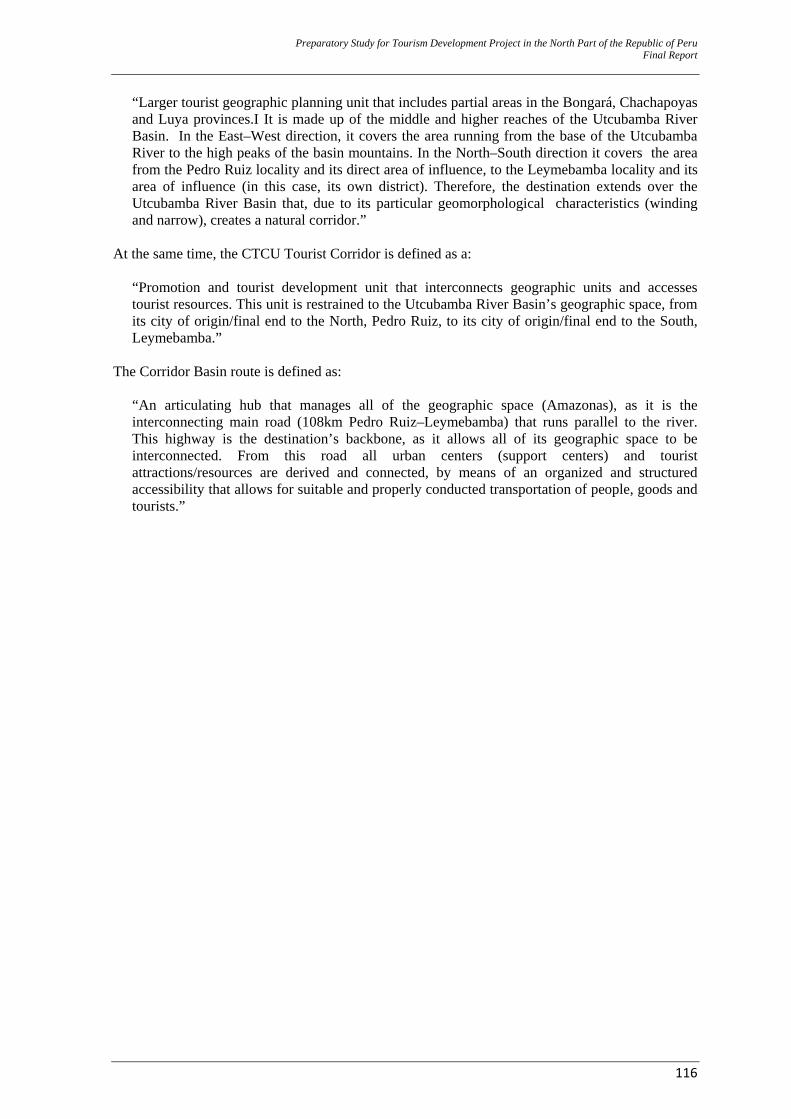
Preparatory Study for Tourism Development Project in the North Part of the Republic of Peru Final Report
116
“Larger tourist geographic planning unit that includes partial areas in the Bongará, Chachapoyas and Luya provinces.I It is made up of the middle and higher reaches of the Utcubamba River Basin. In the East–West direction, it covers the area running from the base of the Utcubamba River to the high peaks of the basin mountains. In the North–South direction it covers the area from the Pedro Ruiz locality and its direct area of influence, to the Leymebamba locality and its area of influence (in this case, its own district). Therefore, the destination extends over the Utcubamba River Basin that, due to its particular geomorphological characteristics (winding and narrow), creates a natural corridor.”
At the same time, the CTCU Tourist Corridor is defined as a:
“Promotion and tourist development unit that interconnects geographic units and accesses tourist resources. This unit is restrained to the Utcubamba River Basin’s geographic space, from its city of origin/final end to the North, Pedro Ruiz, to its city of origin/final end to the South, Leymebamba.”
The Corridor Basin route is defined as:
“An articulating hub that manages all of the geographic space (Amazonas), as it is the interconnecting main road (108km Pedro Ruiz–Leymebamba) that runs parallel to the river. This highway is the destination’s backbone, as it allows all of its geographic space to be interconnected. From this road all urban centers (support centers) and tourist attractions/resources are derived and connected, by means of an organized and structured accessibility that allows for suitable and properly conducted transportation of people, goods and tourists.”
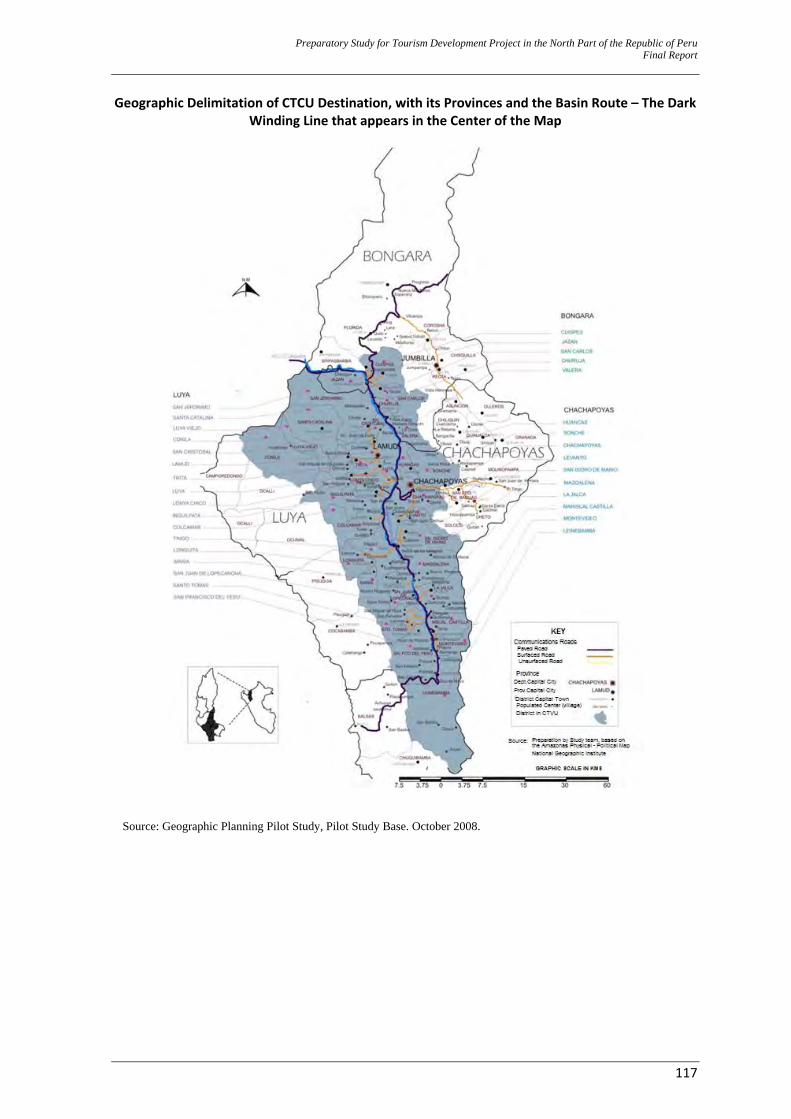
Preparatory Study for Tourism Development Project in the North Part of the Republic of Peru Final Report
117
Geographic Delimitation of CTCU Destination, with its Provinces and the Basin Route – The Dark Winding Line that appears in the Center of the Map
Source: Geographic Planning Pilot Study, Pilot Study Base. October 2008.
Preparatory Study for Tourism Development Project in the North Part of the Republic of Peru Final Report
118
The Corridor Basin Route – Diagram and Geographic Articulation of the Destination (Support Localities are Shown)
Preparation: JICA Study Team 3.2.2 Tourist Zones 37 4 Tourist zones are clearly identified along the Utcubamba River, (TZ 01: Northeastern, TZ 02: Central Western, TZ 03: Central, TZ 04: Southern) based on the following considerations: ‐ The physical–geographic and elevation characteristics, the physical–spatial dynamics and the
crossings or road detours.
37 Tourist Zones are suggested in the Profile (“Perfil”) level study. For analysis purposes, the “Pilot Study on the
Preparation of the Rural Development Project for Tourist Strengthening Purposes in the Republic of Perú” (JICA 2009) was used. This study prioritized the territorial heritage focus to identify what was known as the “Geo–Heritage–Tourist Units/UGPT.”
Preparatory Study for Tourism Development Project in the North Part of the Republic of Peru Final Report
119
‐ The location of the greatest concentration of archaeological, natural and cultural attractions with highest current and potential demand (that will be the basis for tourist development and takeoff).
‐ The close connectivity of attractions to a road access.
‐ Availability of minimum water and electric power services supply.
‐ Easy access (to the zone) and, at the same time, facilities for ongoing connectivity. ‐ Plenty of time to access the sites.
‐ The resources can be offered in a package based on road availability, transportation time and
site characteristics.
‐ The populations have a similar socioeconomic development level and in compliance with the physical-spatial dynamics among the localities.
It must be pointed out that, during the pre–investment study at Program Profile (“Perfil”) level, the criteria that defined that intervention would only take place on TZ 01, 02 and 03 while the first tourist planning period (immediately) was being established. Set out criteria include: ‐ Location of tourist icons (the Kuelap Fortress and the Gocta Waterfall). ‐ Location of Amazonas’ capital city (Chachapoyas), that works as a support city for the
destination (tourist distribution hub). ‐ Largest tourist development along the CTCU corresponds to these 3 areas. However, based on the diagnostics in–depth analysis, an investment possibility along CTCU should be pondered. The product for supply should consider all the “tourist-able” resources in all 4 TZ, as long as the marginal (both individual and global) benefits of supplying an additional tourist resource are greater than the investment of enhancing and positioning it. Quality work will be ensured; therefore, resources for supply should add to a tourist’s experience. For example, with the exclusion of TZ 04, the city of Leymembamba and its scope of tourist influence (Mausoleums, Laguna de los Cóndores (“Condor Lake”) and the Leymebamba Museum) are no longer considered; in addition, the locality of Yerbabuena’s great regional and local influence through its traditional Sunday fair is disregarded. TZ are described in the two graphs below.
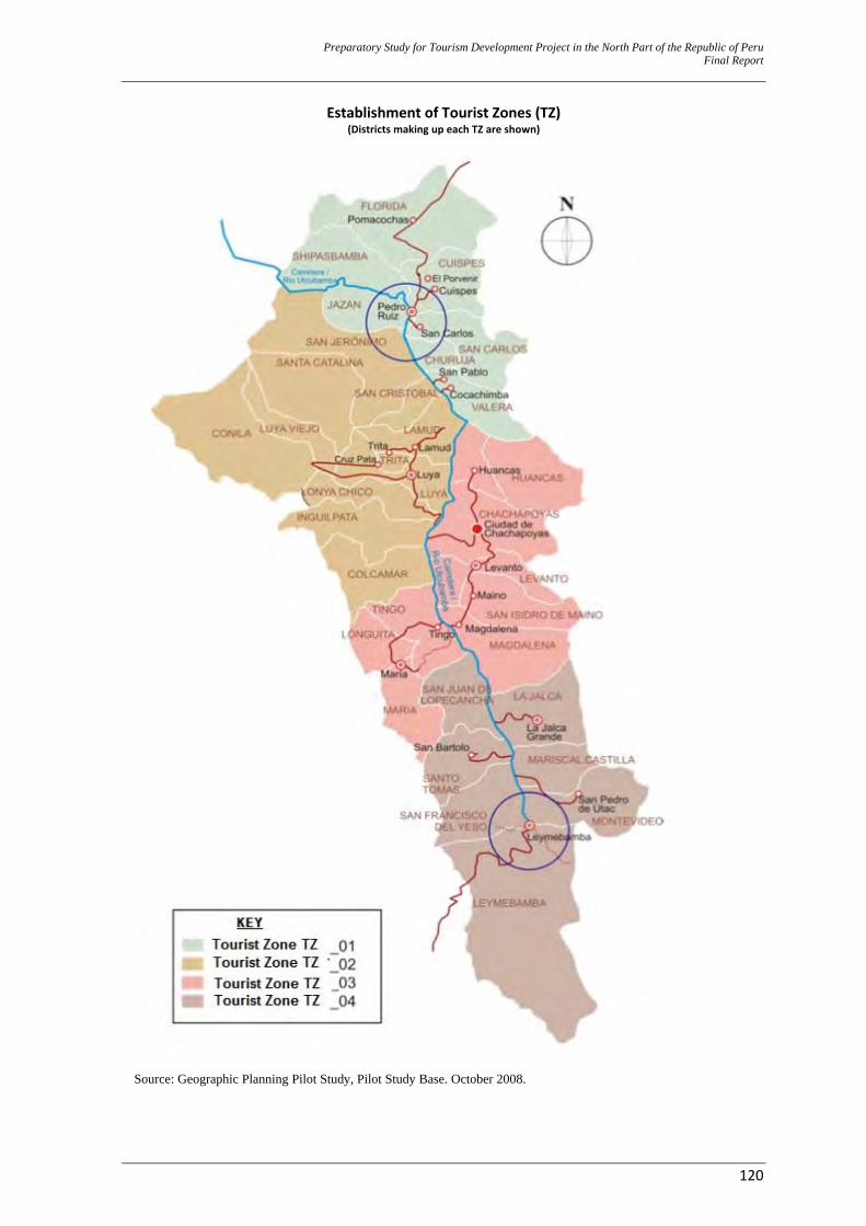
Preparatory Study for Tourism Development Project in the North Part of the Republic of Peru Final Report
120
Establishment of Tourist Zones (TZ) (Districts making up each TZ are shown)
Source: Geographic Planning Pilot Study, Pilot Study Base. October 2008.
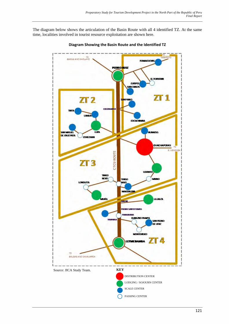
Preparatory Study for Tourism Development Project in the North Part of the Republic of Peru Final Report
121
The diagram below shows the articulation of the Basin Route with all 4 identified TZ. At the same time, localities involved in tourist resource exploitation are shown here.
Diagram Showing the Basin Route and the Identified TZ
Source: JICA Study Team.
KEY DISTRIBUTION CENTER LODGING / SOJOURN CENTER SCALE CENTER PASSING CENTER
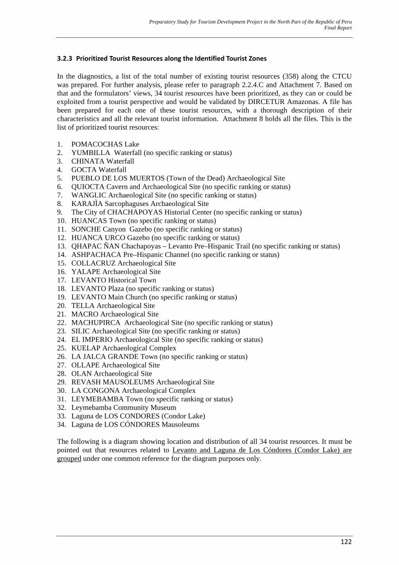
Preparatory Study for Tourism Development Project in the North Part of the Republic of Peru Final Report
122
3.2.3 Prioritized Tourist Resources along the Identified Tourist Zones In the diagnostics, a list of the total number of existing tourist resources (358) along the CTCU was prepared. For further analysis, please refer to paragraph 2.2.4.C and Attachment 7. Based on that and the formulators’ views, 34 tourist resources have been prioritized, as they can or could be exploited from a tourist perspective and would be validated by DIRCETUR Amazonas. A file has been prepared for each one of these tourist resources, with a thorough description of their characteristics and all the relevant tourist information. Attachment 8 holds all the files. This is the list of prioritized tourist resources: 1. POMACOCHAS Lake 2. YUMBILLA Waterfall (no specific ranking or status) 3. CHINATA Waterfall 4. GOCTA Waterfall 5. PUEBLO DE LOS MUERTOS (Town of the Dead) Archaeological Site 6. QUIOCTA Cavern and Archaeological Site (no specific ranking or status) 7. WANGLIC Archaeological Site (no specific ranking or status) 8. KARAJÌA Sarcophaguses Archaeological Site 9. The City of CHACHAPOYAS Historial Center (no specific ranking or status) 10. HUANCAS Town (no specific ranking or status) 11. SONCHE Canyon Gazebo (no specific ranking or status) 12. HUANCA URCO Gazebo (no specific ranking or status) 13. QHAPAC ÑAN Chachapoyas – Levanto Pre–Hispanic Trail (no specific ranking or status) 14. ASHPACHACA Pre–Hispanic Channel (no specific ranking or status) 15. COLLACRUZ Archaeological Site 16. YALAPE Archaeological Site 17. LEVANTO Historical Town 18. LEVANTO Plaza (no specific ranking or status) 19. LEVANTO Main Church (no specific ranking or status) 20. TELLA Archaeological Site 21. MACRO Archaeological Site 22. MACHUPIRCA Archaeological Site (no specific ranking or status) 23. SILIC Archaeological Site (no specific ranking or status) 24. EL IMPERIO Archaeological Site (no specific ranking or status) 25. KUELAP Archaeological Complex 26. LA JALCA GRANDE Town (no specific ranking or status) 27. OLLAPE Archaeological Site 28. OLAN Archaeological Site 29. REVASH MAUSOLEUMS Archaeological Site 30. LA CONGONA Archaeological Complex 31. LEYMEBAMBA Town (no specific ranking or status) 32. Leymebamba Community Museum 33. Laguna de LOS CONDORES (Condor Lake) 34. Laguna de LOS CÓNDORES Mausoleums The following is a diagram showing location and distribution of all 34 tourist resources. It must be pointed out that resources related to Levanto and Laguna de Los Cóndores (Condor Lake) are grouped under one common reference for the diagram purposes only.
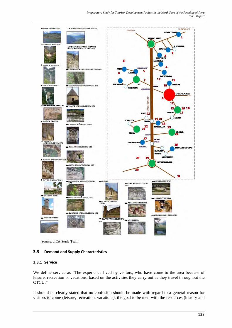
Preparatory Study for Tourism Development Project in the North Part of the Republic of Peru Final Report
123
Source: JICA Study Team.
3.3 Demand and Supply Characteristics 3.3.1 Service We define service as “The experience lived by visitors, who have come to the area because of leisure, recreation or vacations, based on the activities they carry out as they travel throughout the CTCU.” It should be clearly stated that no confusion should be made with regard to a general reason for visitors to come (leisure, recreation, vacations), the goal to be met, with the resources (history and

Preparatory Study for Tourism Development Project in the North Part of the Republic of Peru Final Report
124
nature) that will allow for partly meeting the demand for the service. Experience goes beyond visiting historical sites or hiking through national parks; it encompasses a tourist’s visit as a whole, from the time he/she enters the country until he/she leaves it (the destination will always be related to the host country). 3.3.2 Knowing the Client Wishes and Behavior – International This involves what a tourist wants and looks for and what is needed to match supply and services to that for a tourist flow to CTN and CTCU. A. The International Tourist Market Characteristics The new tourist wants to enjoy an enriching experience at the destination that is based on “multiactivities”; that is, itineraries that hold distinct activities that are based on various products that have now become experiences. These experiences are nowadays in demand by the international tourist market. International tourists who look for experiences want multiple activities.
Important Traveling Aspects.38 The new tourist’s preferences include: (1) Experiencing a culture on a “day to day” basis, by participating in the activities of the local population in the area the tourist is visiting, (2) having personal and genuine experiences that bring him/her closer to cultures and traditions that are different to his/her own and (3) getting in touch with the environment, natural sceneries or places that are away from, or beyond a common tourist circuit. Major Motivations.39 Major motivations that were identified for tourists to get engaged in a subsequent trip to the same country included: (1) Having the opportunity to discover new, genuine and exotic places and enjoying enriching experiences. (2) Learning about history and cultures. (3) Participating in activities that make him/her get involved with the places he/she visits. The quote below has been taken from the “Vive la Leyenda: Construyendo Experiencias” (“Live the Legend: Building Experiences”) publication by PromPerú, 2009:
“This is the reason why tourists today are more sophisticated and harder to please; they want more and thus, they travel looking for unique experiences that wake up their senses. Recent research carried out by firms, such as Plunkett Research, Ltd.40 share the same opinion and point out that the new trend in the world tourist market has experiences at its core, under the premise that even the simplest activity could be transformed into an unforgettable experience to a tourist, just depending on how this activity is introduced. The new tourist will not be content, by just visiting a monument and having some pictures taken but will give more importance to his/her feelings, the emotions that are stirred up in him/her as he/she visits a specific place or carries out a specific activity, the memories that he/she will keep once the trip is over and he/she comes back home. In other words, tourists look for travelling experiences.”
What is the new tourist like? ‐ His/her values, attitudes and motivations in life are led towards acting and not just being a
simple spectator. ‐ He/she pays attention to what happens around him/her and in the world.
38 Based on the “Vive la Leyenda: Construyendo Experiencias” (“Live the Legend: Building Experiences”) publication.
PromPerú 2010. 39 Ditto. 40 Punklett Research Ltd. “Travel Airline, Hotel & Tourism Industry Trend”. September 2008. <http://plunkettresearch.com>.
Preparatory Study for Tourism Development Project in the North Part of the Republic of Peru Final Report
125
‐ He/she is highly educated, with a wide general knowledge and a broad mind. ‐ He/she is motivated by the opportunities for his/her development and individual self–
accomplishment. ‐ He/she is not a specialist but has a good understanding of a wide array of themes. ‐ He/she is a positive, curious, joyful person who enjoys life. ‐ He/she is not afraid of challenges. ‐ His/her financial income is above average. ‐ He/she is a natural leader looking for experiences he/she can show off in his/her social circle. ‐ He/she prefers long trips and is not worried about extra expenditures. ‐ He/she is not materialistic and does his/her purchasing guided by an ethical and social equality-
motivated spirit. ‐ He/she is aware of a human being’s impact on environment and thus, he/she would rather go for
those products that minimize environmental impact. What does the new tourist look for? ‐ Learning about other cultures and their history. ‐ Discover him/herself and become more educated as he/she travels. ‐ Opportunities that help him/her to grow as a person and meet his/her goals. ‐ Experiencing culture on a “day to day” basis, by participating in the local population’s activities
in the areas he/she visits. ‐ Interacting with people, making friends and interrelating. ‐ Personal and genuine experiences that bring him/her closer to different cultures, ways and
traditions. ‐ Getting in touch with the environment, natural sceneries or places that are away from or beyond
a common tourist circuit. ‐ Understanding and experiencing other lifestyles. What motivates the “new tourist” to travel?41 ‐ Enriching experiences ‐ Discovering something different, genuine and exotic. ‐ Learning about history and cultures. ‐ Participating in activities that get him/her involved with the places he/she visits. ‐ Breaking schemes and certain standards. ‐ Empathy with a country and its people. ‐ The pleasure he/she gets from the experiences and how this appeals to his/her senses. Characteristics of the “New Tourist” Unlike other segments, the “experience seeker” makes informed decisions. The table below shows some of the “new tourist’s” traits:
Channels used for Destination selection
35% Family and friends18% Internet 13% TV program or movie 10% Article from a newspaper, journal or magazine 7% Special traveling offer 6% Travel Agency 3% Advertising
Where additional information is looked for once the destination is selected.
67% Internet12% Travel Agencies 8% Family and friends
Some important aspects about the trip
A modern tourist’s preferences42 include: (1) Experiencing culture on a “day to day” basis, by participating in the local population’s activities in
41 Future Brand. “Country Brand Index 2006”
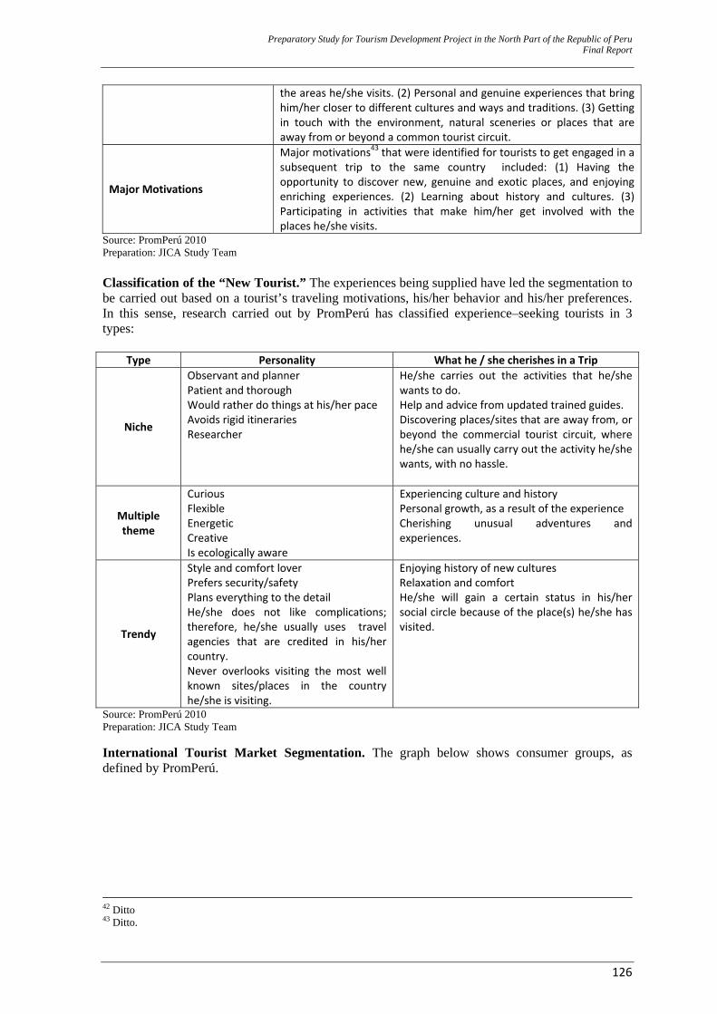
Preparatory Study for Tourism Development Project in the North Part of the Republic of Peru Final Report
126
the areas he/she visits. (2) Personal and genuine experiences that bring him/her closer to different cultures and ways and traditions. (3) Getting in touch with the environment, natural sceneries or places that are away from or beyond a common tourist circuit.
Major Motivations
Major motivations43 that were identified for tourists to get engaged in a subsequent trip to the same country included: (1) Having the opportunity to discover new, genuine and exotic places, and enjoying enriching experiences. (2) Learning about history and cultures. (3) Participating in activities that make him/her get involved with the places he/she visits.
Source: PromPerú 2010 Preparation: JICA Study Team Classification of the “New Tourist.” The experiences being supplied have led the segmentation to be carried out based on a tourist’s traveling motivations, his/her behavior and his/her preferences. In this sense, research carried out by PromPerú has classified experience–seeking tourists in 3 types:
Type Personality What he / she cherishes in a Trip
Niche
Observant and plannerPatient and thorough Would rather do things at his/her pace Avoids rigid itineraries Researcher
He/she carries out the activities that he/she wants to do. Help and advice from updated trained guides. Discovering places/sites that are away from, or beyond the commercial tourist circuit, where he/she can usually carry out the activity he/she wants, with no hassle.
Multiple theme
Curious Flexible Energetic Creative Is ecologically aware
Experiencing culture and history Personal growth, as a result of the experience Cherishing unusual adventures and experiences.
Trendy
Style and comfort loverPrefers security/safety Plans everything to the detail He/she does not like complications; therefore, he/she usually uses travel agencies that are credited in his/her country. Never overlooks visiting the most well known sites/places in the country he/she is visiting.
Enjoying history of new cultures Relaxation and comfort He/she will gain a certain status in his/her social circle because of the place(s) he/she has visited.
Source: PromPerú 2010 Preparation: JICA Study Team International Tourist Market Segmentation. The graph below shows consumer groups, as defined by PromPerú.
42 Ditto 43 Ditto.
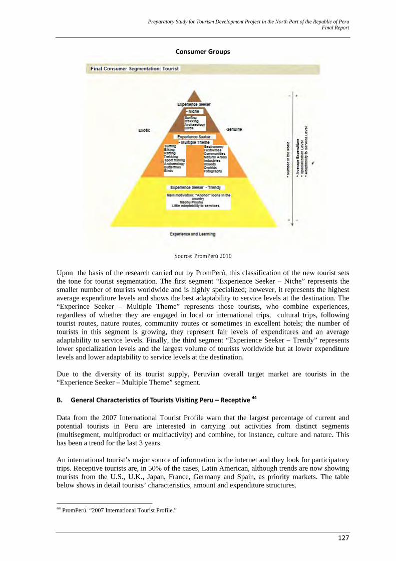
Preparatory Study for Tourism Development Project in the North Part of the Republic of Peru Final Report
127
Consumer Groups
Source: PromPerú 2010
Upon the basis of the research carried out by PromPerú, this classification of the new tourist sets the tone for tourist segmentation. The first segment “Experience Seeker – Niche” represents the smaller number of tourists worldwide and is highly specialized; however, it represents the highest average expenditure levels and shows the best adaptability to service levels at the destination. The “Experince Seeker – Multiple Theme” represents those tourists, who combine experiences, regardless of whether they are engaged in local or international trips, cultural trips, following tourist routes, nature routes, community routes or sometimes in excellent hotels; the number of tourists in this segment is growing, they represent fair levels of expenditures and an average adaptability to service levels. Finally, the third segment “Experience Seeker – Trendy” represents lower specialization levels and the largest volume of tourists worldwide but at lower expenditure levels and lower adaptability to service levels at the destination. Due to the diversity of its tourist supply, Peruvian overall target market are tourists in the “Experience Seeker – Multiple Theme” segment. B. General Characteristics of Tourists Visiting Peru – Receptive 44 Data from the 2007 International Tourist Profile warn that the largest percentage of current and potential tourists in Peru are interested in carrying out activities from distinct segments (multisegment, multiproduct or multiactivity) and combine, for instance, culture and nature. This has been a trend for the last 3 years. An international tourist’s major source of information is the internet and they look for participatory trips. Receptive tourists are, in 50% of the cases, Latin American, although trends are now showing tourists from the U.S., U.K., Japan, France, Germany and Spain, as priority markets. The table below shows in detail tourists’ characteristics, amount and expenditure structures. 44 PromPerú. “2007 International Tourist Profile.”
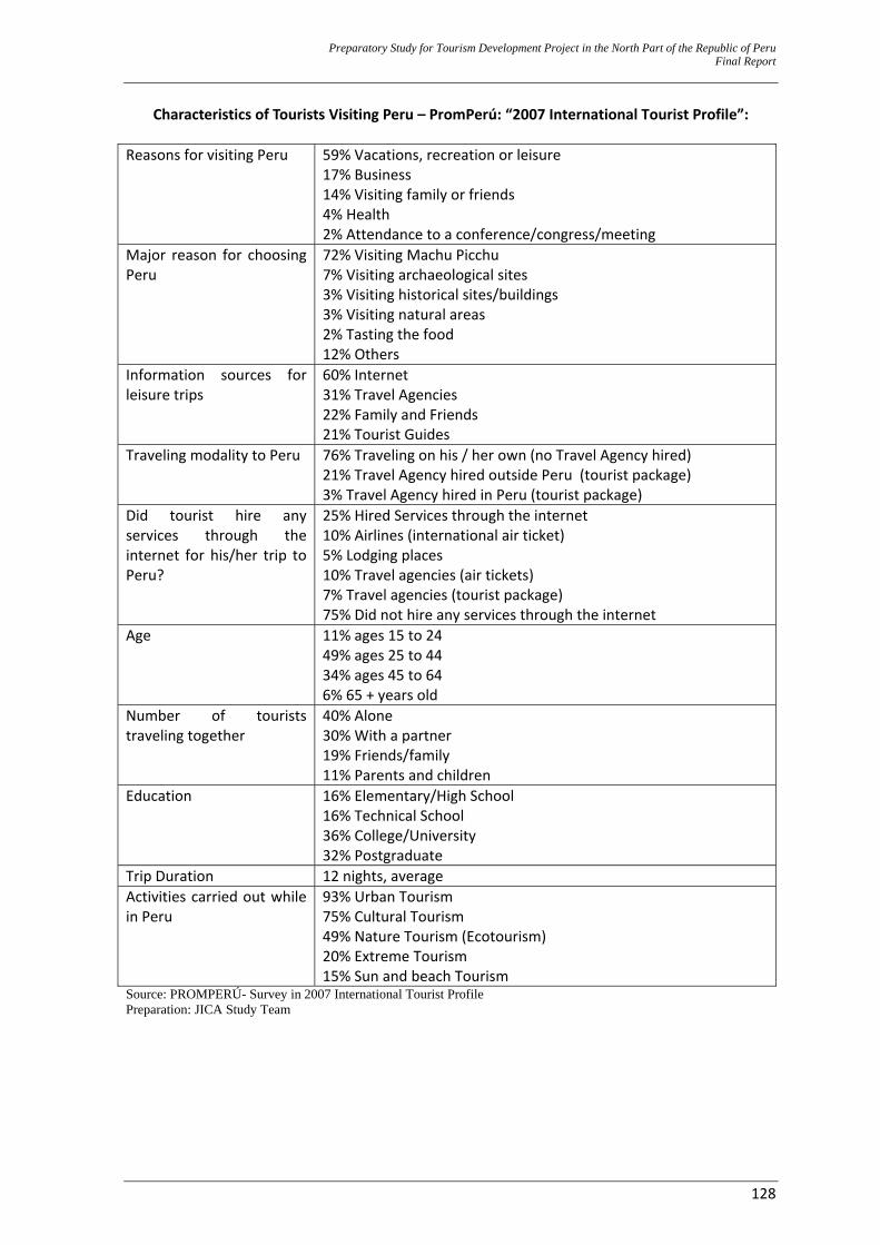
Preparatory Study for Tourism Development Project in the North Part of the Republic of Peru Final Report
128
Characteristics of Tourists Visiting Peru – PromPerú: “2007 International Tourist Profile”: Reasons for visiting Peru 59% Vacations, recreation or leisure
17% Business 14% Visiting family or friends 4% Health 2% Attendance to a conference/congress/meeting
Major reason for choosing Peru
72% Visiting Machu Picchu 7% Visiting archaeological sites 3% Visiting historical sites/buildings 3% Visiting natural areas 2% Tasting the food 12% Others
Information sources for leisure trips
60% Internet 31% Travel Agencies 22% Family and Friends 21% Tourist Guides
Traveling modality to Peru 76% Traveling on his / her own (no Travel Agency hired) 21% Travel Agency hired outside Peru (tourist package) 3% Travel Agency hired in Peru (tourist package)
Did tourist hire any services through the internet for his/her trip to Peru?
25% Hired Services through the internet 10% Airlines (international air ticket) 5% Lodging places 10% Travel agencies (air tickets) 7% Travel agencies (tourist package) 75% Did not hire any services through the internet
Age 11% ages 15 to 24 49% ages 25 to 44 34% ages 45 to 64 6% 65 + years old
Number of tourists traveling together
40% Alone 30% With a partner 19% Friends/family 11% Parents and children
Education 16% Elementary/High School 16% Technical School 36% College/University 32% Postgraduate
Trip Duration 12 nights, average Activities carried out while in Peru
93% Urban Tourism 75% Cultural Tourism 49% Nature Tourism (Ecotourism) 20% Extreme Tourism 15% Sun and beach Tourism
Source: PROMPERÚ- Survey in 2007 International Tourist Profile Preparation: JICA Study Team
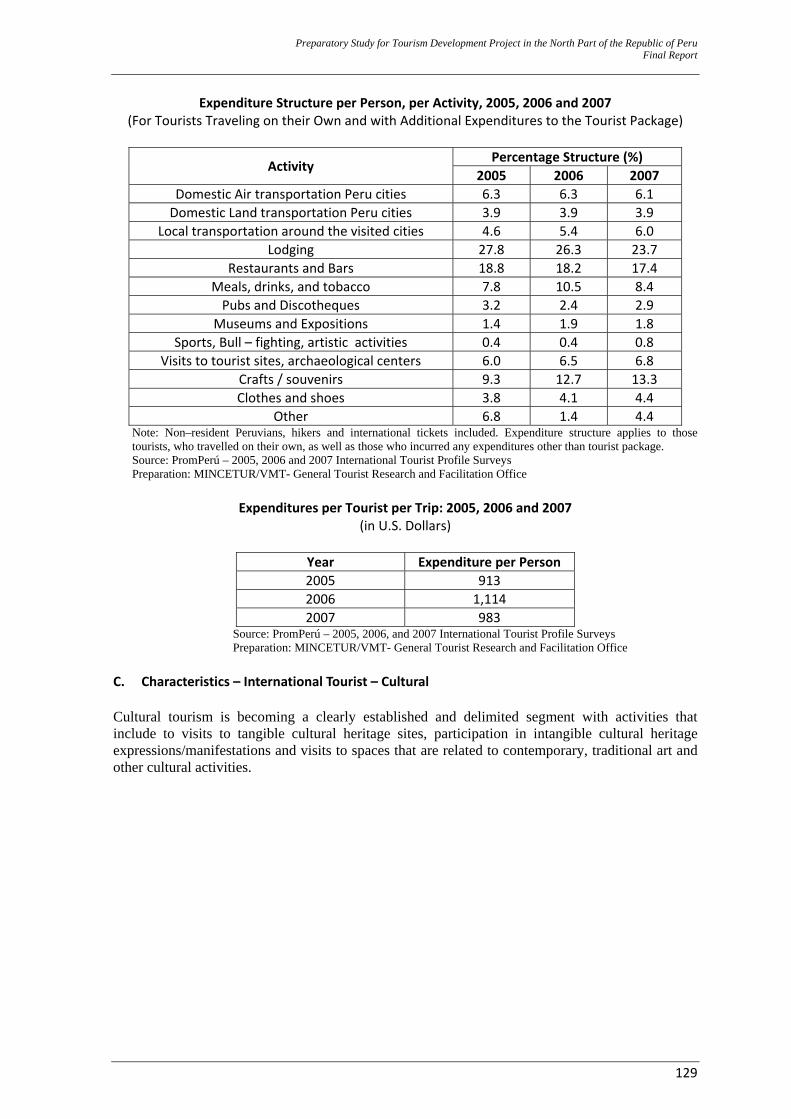
Preparatory Study for Tourism Development Project in the North Part of the Republic of Peru Final Report
129
Expenditure Structure per Person, per Activity, 2005, 2006 and 2007 (For Tourists Traveling on their Own and with Additional Expenditures to the Tourist Package)
Activity Percentage Structure (%)
2005 2006 2007 Domestic Air transportation Peru cities 6.3 6.3 6.1 Domestic Land transportation Peru cities 3.9 3.9 3.9
Local transportation around the visited cities 4.6 5.4 6.0 Lodging 27.8 26.3 23.7
Restaurants and Bars 18.8 18.2 17.4 Meals, drinks, and tobacco 7.8 10.5 8.4 Pubs and Discotheques 3.2 2.4 2.9
Museums and Expositions 1.4 1.9 1.8 Sports, Bull – fighting, artistic activities 0.4 0.4 0.8
Visits to tourist sites, archaeological centers 6.0 6.5 6.8 Crafts / souvenirs 9.3 12.7 13.3 Clothes and shoes 3.8 4.1 4.4
Other 6.8 1.4 4.4 Note: Non–resident Peruvians, hikers and international tickets included. Expenditure structure applies to those tourists, who travelled on their own, as well as those who incurred any expenditures other than tourist package. Source: PromPerú – 2005, 2006 and 2007 International Tourist Profile Surveys Preparation: MINCETUR/VMT- General Tourist Research and Facilitation Office
Expenditures per Tourist per Trip: 2005, 2006 and 2007
(in U.S. Dollars)
Year Expenditure per Person 2005 913 2006 1,114 2007 983
Source: PromPerú – 2005, 2006, and 2007 International Tourist Profile Surveys Preparation: MINCETUR/VMT- General Tourist Research and Facilitation Office
C. Characteristics – International Tourist – Cultural Cultural tourism is becoming a clearly established and delimited segment with activities that include to visits to tangible cultural heritage sites, participation in intangible cultural heritage expressions/manifestations and visits to spaces that are related to contemporary, traditional art and other cultural activities.
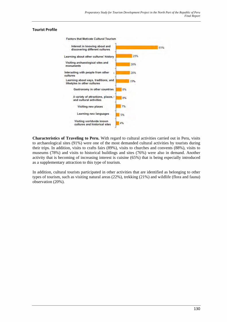
Preparatory Study for Tourism Development Project in the North Part of the Republic of Peru Final Report
130
Tourist Profile
Characteristics of Traveling to Peru. With regard to cultural activities carried out in Peru, visits to archaeological sites (91%) were one of the most demanded cultural activities by tourists during their trips. In addition, visits to crafts fairs (89%), visits to churches and convents (88%), visits to museums (78%) and visits to historical buildings and sites (76%) were also in demand. Another activity that is becoming of increasing interest is cuisine (65%) that is being especially introduced as a supplementary attraction to this type of tourism. In addition, cultural tourists participated in other activities that are identified as belonging to other types of tourism, such as visiting natural areas (22%), trekking (21%) and wildlife (flora and fauna) observation (20%).
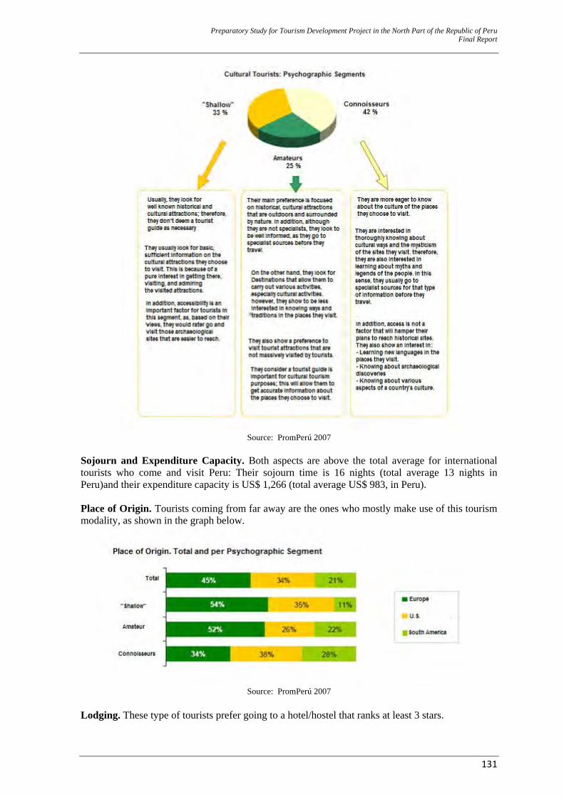
Preparatory Study for Tourism Development Project in the North Part of the Republic of Peru Final Report
131
Source: PromPerú 2007
Sojourn and Expenditure Capacity. Both aspects are above the total average for international tourists who come and visit Peru: Their sojourn time is 16 nights (total average 13 nights in Peru)and their expenditure capacity is US$ 1,266 (total average US$ 983, in Peru). Place of Origin. Tourists coming from far away are the ones who mostly make use of this tourism modality, as shown in the graph below.
Source: PromPerú 2007
Lodging. These type of tourists prefer going to a hotel/hostel that ranks at least 3 stars.
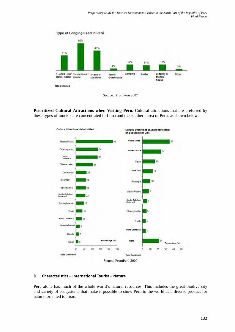
Preparatory Study for Tourism Development Project in the North Part of the Republic of Peru Final Report
132
Source: PromPerú 2007
Prioritized Cultural Attractions when Visiting Peru. Cultural attractions that are preferred by these types of tourists are concentrated in Lima and the southern area of Peru, as shown below.
Source: PromPerú 2007
D. Characteristics – International Tourist – Nature Peru alone has much of the whole world’s natural resources. This includes the great biodiversity and variety of ecosystems that make it possible to show Peru to the world as a diverse product for nature–oriented tourism.
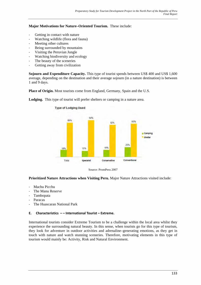
Preparatory Study for Tourism Development Project in the North Part of the Republic of Peru Final Report
133
Major Motivations for Nature–Oriented Tourism. These include:
‐ Getting in contact with nature ‐ Watching wildlife (flora and fauna) ‐ Meeting other cultures ‐ Being surrounded by mountains ‐ Visiting the Peruvian Jungle ‐ Watching biodiversity and ecology ‐ The beauty of the sceneries ‐ Getting away from civilization Sojourn and Expenditure Capacity. This type of tourist spends between US$ 400 and US$ 1,600 average, depending on the destination and their average sojourn (in a nature destination) is between 1 and 9 days. Place of Origin. Most tourists come from England, Germany, Spain and the U.S. Lodging. This type of tourist will prefer shelters or camping in a nature area.
Source: PromPeru 2007 Prioritized Nature Attractions when Visiting Peru. Major Nature Attractions visited include: ‐ Machu Picchu ‐ The Manu Reserve ‐ Tambopata ‐ Paracas ‐ The Huascaran National Park E. Characteristics – – International Tourist – Extreme. International tourists consider Extreme Tourism to be a challenge within the local area whilst they experience the surrounding natural beauty. In this sense, when tourists go for this type of tourism, they look for adventure in outdoor activities and adrenaline–generating emotions, as they get in touch with nature and watch stunning sceneries. Therefore, motivating elements in this type of tourism would mainly be: Activity, Risk and Natural Environment.
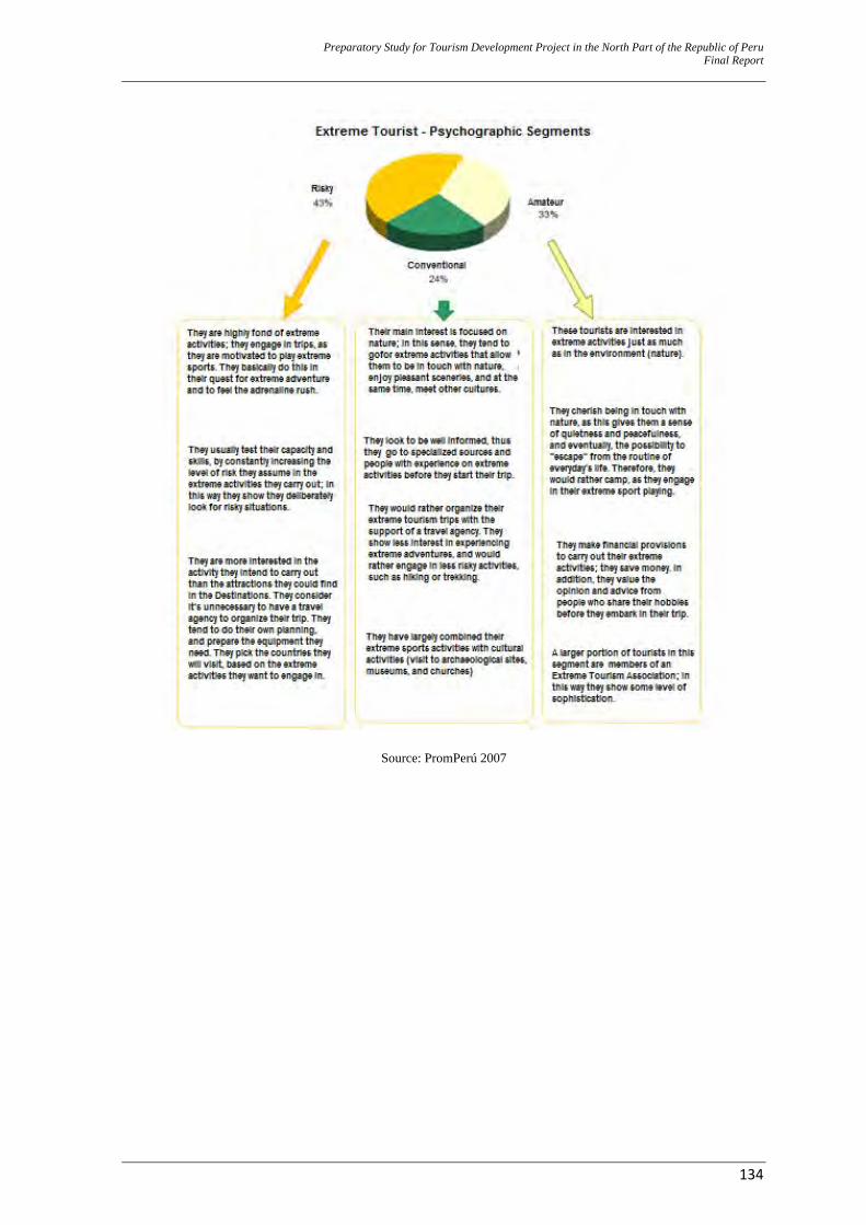
Preparatory Study for Tourism Development Project in the North Part of the Republic of Peru Final Report
134
Source: PromPerú 2007
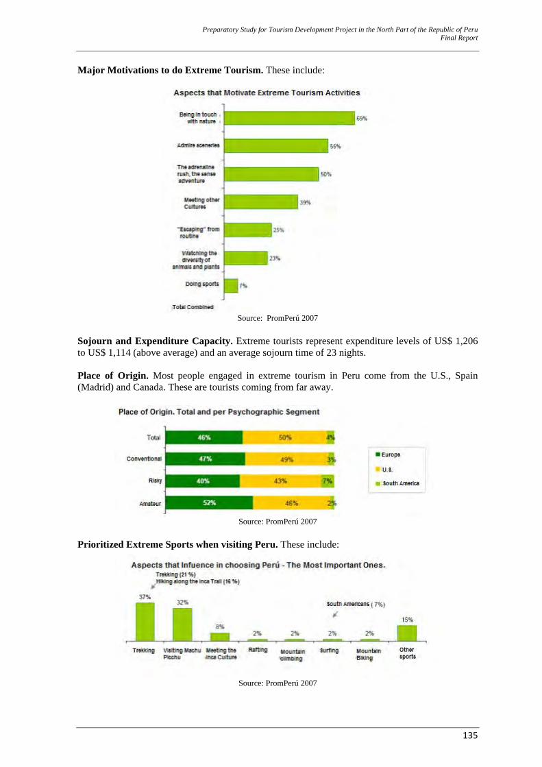
Preparatory Study for Tourism Development Project in the North Part of the Republic of Peru Final Report
135
Major Motivations to do Extreme Tourism. These include:
Source: PromPerú 2007
Sojourn and Expenditure Capacity. Extreme tourists represent expenditure levels of US$ 1,206 to US$ 1,114 (above average) and an average sojourn time of 23 nights. Place of Origin. Most people engaged in extreme tourism in Peru come from the U.S., Spain (Madrid) and Canada. These are tourists coming from far away.
Source: PromPerú 2007
Prioritized Extreme Sports when visiting Peru. These include:
Source: PromPerú 2007
Preparatory Study for Tourism Development Project in the North Part of the Republic of Peru Final Report
136
F. Characteristics – International Tourist – Rural Community In Peru, rural community tourism represents the wish to offer tourists a chance for personal contact, as they enjoy a physical and human environment in the rural areas and participate in traditional ancestral activities and lifestyles that have survived throughout the centuries. Major motivators for Rural Community Tourism. These include: ‐ Getting to know a community’s culture and traditions ‐ The curiosity to know something new ‐ Getting in touch with nature ‐ Interacting with the local population ‐ Experiencing local cuisine Sojourn and Expenditure Capacity. On the whole, tourists engaged in rural community tourism stayed in Peru between 13 and 15 nights. 1 or 2 of those nights were spent in a native community. Average expenditure by a rural community tourist amounted between US$ 800 and US$ 1,600 as he/she travelled throughout Peru. His/her actual expenditure in a native community ranged between US$ 71 and US$ 87. Segments – Market Niches. These type of tourists are all college graduates. Most of them are male and single. Tourist packages bought by most of them included a visit and, in some cases, even spending a night in native communities. Place of Origin. People engaged in this type of tourism mostly come from the U.S., Spain, Italy, France and England. Lodging. With regard to lodging service requirements, tourists pointed out that they would like a rustic place but without having their comfort compromised. Lodging places included: ‐ A local settler’s home (90% of the tourists prefer this lodging alternative). ‐ A community house. ‐ A shelter (when the community is located in the jungle). ‐ Camping. Positioned Communities in Peru. These are: ‐ Puno: Uros, Taquile, Amantaní, Sillustani, Chucuito, and Anapia. ‐ Cusco: The Maras Community, Raqchi, Panpallaqta, Viacha, Cuyo Chico, Cuyo Grande, The
Chincheros Community. ‐ Madre de Dios: Comunidad el Infierno, Shipibo-Conibo, Comunidad Amahuapa, Palma Real,
Sonere. G. Characteristics – International Tourist – By Place of Origin For this point to be developed, PromPerú’s 2007 Foreign Tourist Profile and some of MINCETUR’s published statistics were taken as a benchmark. The following places of origin were taken into account: Germany, Argentina, Australia, Belgium, Bolivia, Brazil, Canada, Chile, Colombia, Spain, U.S., France, Holland, England, Italy, Japan, Mexico, Switzerland and the U.K.
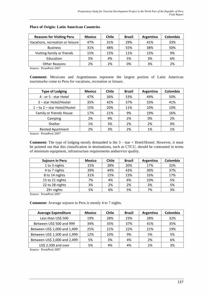
Preparatory Study for Tourism Development Project in the North Part of the Republic of Peru Final Report
137
Place of Origin: Latin American Countries
Reasons for Visiting Peru Mexico Chile Brazil Argentina Colombia Vacations, recreation or leisure 47% 31% 29% 41% 33%
Business 31% 48% 55% 38% 50% Visiting family or friends 15% 15% 11% 15% 9%
Education 5% 4% 5% 3% 6% Other Reasons 2% 2% 0% 3% 2%
Source: PromPerú 2007 Comment: Mexicans and Argentineans represent the largest portion of Latin American touristswho come to Peru for vacations, recreation or leisure.
Type of Lodging Mexico Chile Brazil Argentina Colombia 4 ‐ or 5 ‐ star Hotel 47% 36% 53% 49% 50% 3 – star Hotel/Hostel 35% 42% 37% 33% 41%
1 – to 2 – star Hotel/Hostel 15% 20% 11% 10% 10% Family or friends House 17% 21% 9% 19% 16%
Camping 2% 9% 2% 0% 2% Shelter 1% 3% 2% 2% 0%
Rented Apartment 2% 3% 2% 1% 1% Source: PromPerú 2007 Comment: The type of lodging mostly demanded is the 3 – star + Hotel/Hostel. However, it must be pointed out that this classification in destinations, such as CTCU, should be contrasted in terms of minimum equipment, infrastructure requirements andservice quality.
Sojourn in Peru Mexico Chile Brazil Argentina Colombia 1 to 3 nights 15% 28% 20% 17% 32% 4 to 7 nights 39% 44% 43% 30% 37% 8 to 14 nights 31% 15% 23% 33% 17% 15 to 21 nights 7% 4% 6% 10% 5% 22 to 28 nights 3% 2% 2% 3% 5% 29+ nights 5% 6% 5% 7% 3%
Source: PromPerú 2007 Comment: Average sojourn in Peru is mostly 4 to 7 nights.
Average Expenditure Mexico Chile Brazil Argentina Colombia Less than US$ 500 19% 28% 23% 28% 32%
Between US$ 500 and 999 34% 35% 37% 41% 35% Between US$ 1,000 and 1,499 25% 21% 22% 21% 19% Between US$ 1,500 and 1,999 12% 10% 9% 5% 5% Between US$ 2,000 and 2,499 5% 3% 4% 2% 6%
US$ 2,500 and over 5% 4% 4% 2% 3% Source: PromPerú 2007
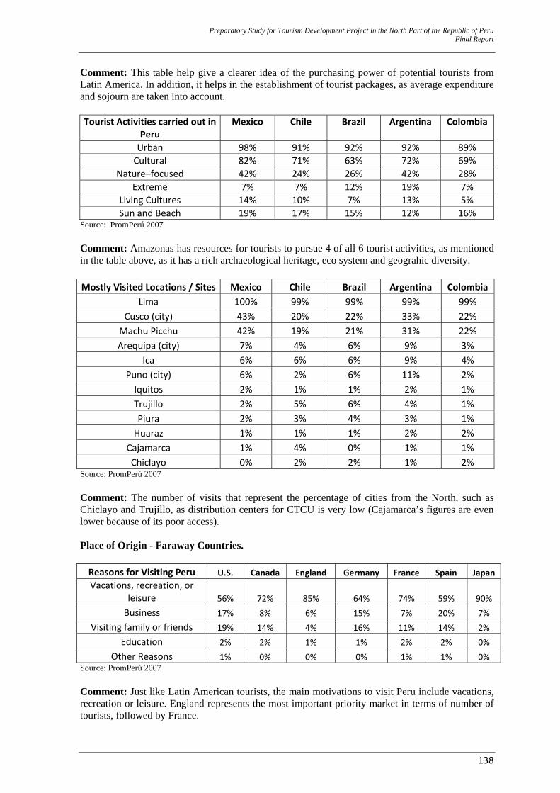
Preparatory Study for Tourism Development Project in the North Part of the Republic of Peru Final Report
138
Comment: This table help give a clearer idea of the purchasing power of potential tourists from Latin America. In addition, it helps in the establishment of tourist packages, as average expenditure and sojourn are taken into account. Tourist Activities carried out in
Peru Mexico Chile Brazil Argentina Colombia
Urban 98% 91% 92% 92% 89% Cultural 82% 71% 63% 72% 69%
Nature–focused 42% 24% 26% 42% 28% Extreme 7% 7% 12% 19% 7%
Living Cultures 14% 10% 7% 13% 5% Sun and Beach 19% 17% 15% 12% 16%
Source: PromPerú 2007 Comment: Amazonas has resources for tourists to pursue 4 of all 6 tourist activities, as mentioned in the table above, as it has a rich archaeological heritage, eco system and geograhic diversity. Mostly Visited Locations / Sites Mexico Chile Brazil Argentina Colombia
Lima 100% 99% 99% 99% 99% Cusco (city) 43% 20% 22% 33% 22% Machu Picchu 42% 19% 21% 31% 22% Arequipa (city) 7% 4% 6% 9% 3%
Ica 6% 6% 6% 9% 4% Puno (city) 6% 2% 6% 11% 2% Iquitos 2% 1% 1% 2% 1% Trujillo 2% 5% 6% 4% 1% Piura 2% 3% 4% 3% 1% Huaraz 1% 1% 1% 2% 2%
Cajamarca 1% 4% 0% 1% 1% Chiclayo 0% 2% 2% 1% 2%
Source: PromPerú 2007 Comment: The number of visits that represent the percentage of cities from the North, such as Chiclayo and Trujillo, as distribution centers for CTCU is very low (Cajamarca’s figures are even lower because of its poor access). Place of Origin - Faraway Countries. Reasons for Visiting Peru U.S. Canada England Germany France Spain JapanVacations, recreation, or
leisure 56% 72% 85% 64% 74% 59% 90%Business 17% 8% 6% 15% 7% 20% 7%
Visiting family or friends 19% 14% 4% 16% 11% 14% 2% Education 2% 2% 1% 1% 2% 2% 0%
Other Reasons 1% 0% 0% 0% 1% 1% 0% Source: PromPerú 2007 Comment: Just like Latin American tourists, the main motivations to visit Peru include vacations, recreation or leisure. England represents the most important priority market in terms of number of tourists, followed by France.
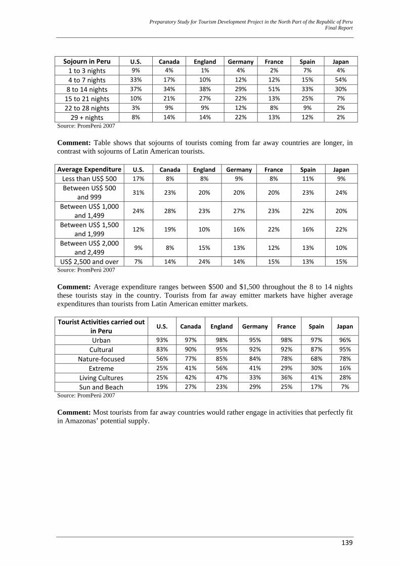
Preparatory Study for Tourism Development Project in the North Part of the Republic of Peru Final Report
139
Sojourn in Peru U.S. Canada England Germany France Spain Japan 1 to 3 nights 9% 4% 1% 4% 2% 7% 4%4 to 7 nights 33% 17% 10% 12% 12% 15% 54%8 to 14 nights 37% 34% 38% 29% 51% 33% 30%15 to 21 nights 10% 21% 27% 22% 13% 25% 7%22 to 28 nights 3% 9% 9% 12% 8% 9% 2%29 + nights 8% 14% 14% 22% 13% 12% 2%
Source: PromPerú 2007 Comment: Table shows that sojourns of tourists coming from far away countries are longer, in contrast with sojourns of Latin American tourists. Average Expenditure U.S. Canada England Germany France Spain Japan Less than US$ 500 17% 8% 8% 9% 8% 11% 9% Between US$ 500
and 999 31% 23% 20% 20% 20% 23% 24%
Between US$ 1,000 and 1,499
24% 28% 23% 27% 23% 22% 20%
Between US$ 1,500 and 1,999
12% 19% 10% 16% 22% 16% 22%
Between US$ 2,000 and 2,499
9% 8% 15% 13% 12% 13% 10%
US$ 2,500 and over 7% 14% 24% 14% 15% 13% 15% Source: PromPerú 2007 Comment: Average expenditure ranges between $500 and $1,500 throughout the 8 to 14 nights these tourists stay in the country. Tourists from far away emitter markets have higher average expenditures than tourists from Latin American emitter markets. Tourist Activities carried out
in Peru U.S. Canada England Germany France Spain Japan
Urban 93% 97% 98% 95% 98% 97% 96%Cultural 83% 90% 95% 92% 92% 87% 95%
Nature‐focused 56% 77% 85% 84% 78% 68% 78%Extreme 25% 41% 56% 41% 29% 30% 16%
Living Cultures 25% 42% 47% 33% 36% 41% 28%Sun and Beach 19% 27% 23% 29% 25% 17% 7%
Source: PromPerú 2007 Comment: Most tourists from far away countries would rather engage in activities that perfectly fit in Amazonas’ potential supply.
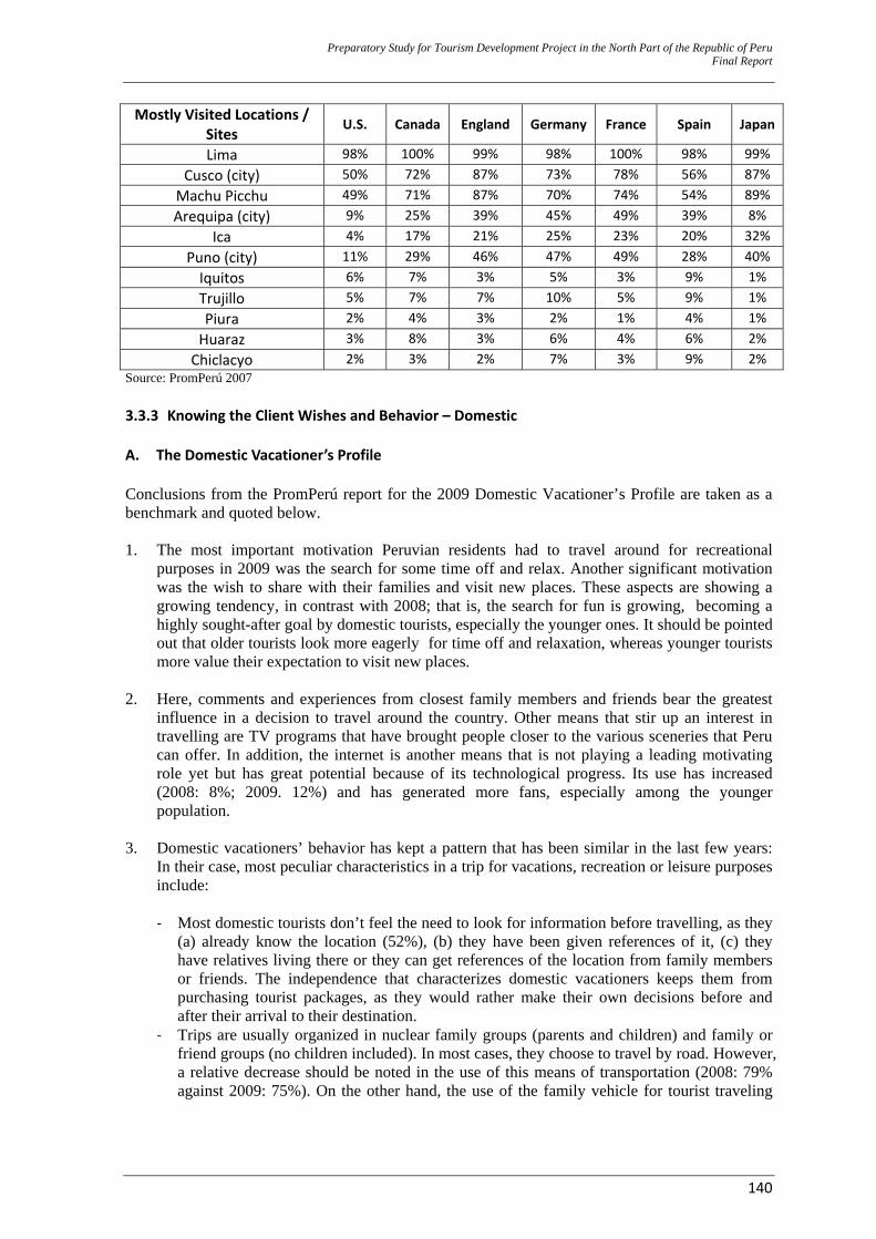
Preparatory Study for Tourism Development Project in the North Part of the Republic of Peru Final Report
140
Mostly Visited Locations / Sites
U.S. Canada England Germany France Spain Japan
Lima 98% 100% 99% 98% 100% 98% 99%Cusco (city) 50% 72% 87% 73% 78% 56% 87%Machu Picchu 49% 71% 87% 70% 74% 54% 89%Arequipa (city) 9% 25% 39% 45% 49% 39% 8%
Ica 4% 17% 21% 25% 23% 20% 32%Puno (city) 11% 29% 46% 47% 49% 28% 40%Iquitos 6% 7% 3% 5% 3% 9% 1%Trujillo 5% 7% 7% 10% 5% 9% 1%Piura 2% 4% 3% 2% 1% 4% 1%Huaraz 3% 8% 3% 6% 4% 6% 2%Chiclacyo 2% 3% 2% 7% 3% 9% 2%
Source: PromPerú 2007 3.3.3 Knowing the Client Wishes and Behavior – Domestic A. The Domestic Vacationer’s Profile Conclusions from the PromPerú report for the 2009 Domestic Vacationer’s Profile are taken as a benchmark and quoted below. 1. The most important motivation Peruvian residents had to travel around for recreational
purposes in 2009 was the search for some time off and relax. Another significant motivation was the wish to share with their families and visit new places. These aspects are showing a growing tendency, in contrast with 2008; that is, the search for fun is growing, becoming a highly sought-after goal by domestic tourists, especially the younger ones. It should be pointed out that older tourists look more eagerly for time off and relaxation, whereas younger tourists more value their expectation to visit new places.
2. Here, comments and experiences from closest family members and friends bear the greatest influence in a decision to travel around the country. Other means that stir up an interest in travelling are TV programs that have brought people closer to the various sceneries that Peru can offer. In addition, the internet is another means that is not playing a leading motivating role yet but has great potential because of its technological progress. Its use has increased (2008: 8%; 2009. 12%) and has generated more fans, especially among the younger population.
3. Domestic vacationers’ behavior has kept a pattern that has been similar in the last few years:
In their case, most peculiar characteristics in a trip for vacations, recreation or leisure purposes include:
‐ Most domestic tourists don’t feel the need to look for information before travelling, as they
(a) already know the location (52%), (b) they have been given references of it, (c) they have relatives living there or they can get references of the location from family members or friends. The independence that characterizes domestic vacationers keeps them from purchasing tourist packages, as they would rather make their own decisions before and after their arrival to their destination.
‐ Trips are usually organized in nuclear family groups (parents and children) and family or friend groups (no children included). In most cases, they choose to travel by road. However, a relative decrease should be noted in the use of this means of transportation (2008: 79% against 2009: 75%). On the other hand, the use of the family vehicle for tourist traveling
Preparatory Study for Tourism Development Project in the North Part of the Republic of Peru Final Report
141
has increased from 9% to 14% with regard to the previous year, especially among males aged 35 to 44, who belong to the population segment with higher purchasing power.
‐ Average expenditure per domestic traveler is estimated to be S/. 326 (PEN), with an average sojourn of 6 nights. Major financial source for trips continues to be the vacationers’ savings, although a higher tendency to spend the last salary is noted, especially among those working in the public sector.
‐ The most popular lodging place used is going to homes of friends and relatives: From 45% in 2008 to 50% in 2009. Paying for lodging services, though, is also very much used by vacationers: The use of hotels and hostels is showing a growing tendency (2007: 35%; 2008: 40%; 2009: 45%), especially among population from the middle and higher socioeconomic strata.
‐ Lima is one of the departments with highest demand among domestic vacationers (one third), especially among the Lima people themselves (36%), as well as by the people from Huancayo (37%), followed by the people from Ica (10%) and Arequipa (8%). Arequipa is another department with highest demand among its own population (55%). In the case of Junin (Huancayo is its capital city) (7%), it is interesting to note that 33% of the people from Huancayo travel around their own department, whereas La Libertad (6%) is travelled around by the people of its capital city, Trujillo and people from the city of Chiclayo.
‐ In addition, other preferred activities by domestic vacationers include shopping and nature tourism, especially by tourists from Lima. As expected, each region has its own preferences: In the case of the people from Trujillo and Chiclayo, they are interested in shopping and cultural tourism. People from Arequipa are mostly attracted to sun and beach and shopping tourism; whereas people from Huancayo would mostly go for nature tourism.
‐ With regard to their demographic profile, the domestic tourist segment is mostly made up of young people, aged 18 to 34 (66%) who are educated (73%). In addition, one third of them work in the private sector and one quarter are freelancers. Over half of them have children and almost all of them are financially independent.
4. With regard to the domestic vacationers’ classification based on their traveling motivations,
most remarkable characteristics include: ‐ Tourists that travel looking for time off and relaxation (39%) give preference to contact
with nature, natural sceneries and going out with the family. Most of them have children (who are financially dependent) and they usually come from the private and independent sector. They show a larger preference to stay in family and friend’s homes when reaching their destinations. A second option would be hotels. Average sojourn is 5 nights and average expenditure per person is S/. 321 (PEN).
‐ Connoisseurs (17%) look for carrying out cultural activities through new experiences along with sceneries and a variety of attractions that are supplied by the destination. In this segment, the traveling group is made up of nuclear family members, parents and children. They prefer staying in hotels and in the homes of other family members and friends. Average sojourn is 6 nights in the visited location and individual expenditures per person amounts S/. 364 (PEN). Most tourists in this segment use their savings to fund their trips.
‐ The tourist segment known as the “fun seekers” (25%), includes vacationers, who look for fun with some adventure. Over half of them belong to the youngest age group, between 18 and 34 years old. They are single men and are college/university students. The traveling group is made up by friends and family members, no children included. Their average sojourn is 5 nights at the destination and individual expenditure per tourist amounts S/. 332 (PEN).
‐ Savers (19%) prioritize finances and saving money, look for destinations that are known to them or close by and they usually travel to the same destinations on repeated occasions. This segment is made up of women, most of them engaged in a couple relationship and with children (64%). This segment shows the longer sojourns at a destination (7 nights, average). In addition, their individual expenditures are lower (S/. 292 [PEN] per tourist. This is justified, as 62% use their savings to fund their traveling expenses.
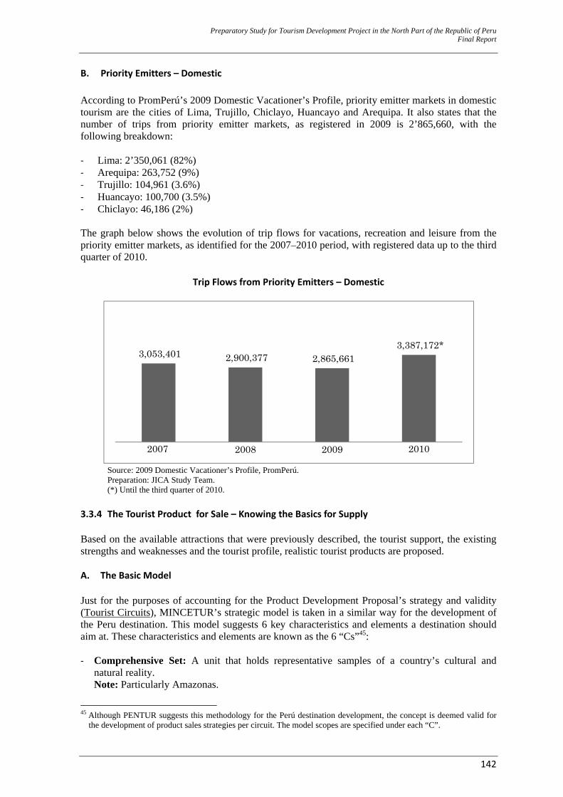
Preparatory Study for Tourism Development Project in the North Part of the Republic of Peru Final Report
142
B. Priority Emitters – Domestic According to PromPerú’s 2009 Domestic Vacationer’s Profile, priority emitter markets in domestic tourism are the cities of Lima, Trujillo, Chiclayo, Huancayo and Arequipa. It also states that the number of trips from priority emitter markets, as registered in 2009 is 2’865,660, with the following breakdown: ‐ Lima: 2’350,061 (82%) ‐ Arequipa: 263,752 (9%) ‐ Trujillo: 104,961 (3.6%) ‐ Huancayo: 100,700 (3.5%) ‐ Chiclayo: 46,186 (2%) The graph below shows the evolution of trip flows for vacations, recreation and leisure from the priority emitter markets, as identified for the 2007–2010 period, with registered data up to the third quarter of 2010.
Trip Flows from Priority Emitters – Domestic
Source: 2009 Domestic Vacationer’s Profile, PromPerú. Preparation: JICA Study Team. (*) Until the third quarter of 2010.
3.3.4 The Tourist Product for Sale – Knowing the Basics for Supply Based on the available attractions that were previously described, the tourist support, the existing strengths and weaknesses and the tourist profile, realistic tourist products are proposed. A. The Basic Model Just for the purposes of accounting for the Product Development Proposal’s strategy and validity (Tourist Circuits), MINCETUR’s strategic model is taken in a similar way for the development of the Peru destination. This model suggests 6 key characteristics and elements a destination should aim at. These characteristics and elements are known as the 6 “Cs”45: ‐ Comprehensive Set: A unit that holds representative samples of a country’s cultural and
natural reality. Note: Particularly Amazonas.
45 Although PENTUR suggests this methodology for the Perú destination development, the concept is deemed valid for
the development of product sales strategies per circuit. The model scopes are specified under each “C”.
3,053,401 2,900,377 2,865,661 3,387,172*
2007 2008 2009 2010
Preparatory Study for Tourism Development Project in the North Part of the Republic of Peru Final Report
143
‐ Complementary: The destination should offer a significant contribution that is distinct from
the comprehensive set that applies to other destinations. Note: In this case, the destination should be understood as a circuit.
‐ Calibrated: Tourist resources in the destination should generate an equitable benefit throughout its area. Note: No accuracy level is necessary.
‐ Consistent: The Destination should hold enough resources that are valued and positively ranked by the Tourist Resource Inventory (TRI). Note: PENTUR mentions that there should be at least 3 Tourist Resources that rank 3 per destination. This indicator cannot be met, as it is about circuits, and the destination is CTCU. Therefore, the product’s benefit will be scored, based on the distribution of all 34 prioritized resources.
‐ Connected: The tourist areas that make up the destination should interconnect as they work, in such a way that tourist flows are a reality throughout the area. Note: No accuracy level is necessary.
‐ Competitive: Objectives that are specific to each geographic area should be met, by allotting a suitable and profitable investment. Note: No accuracy level is necessary.
B. What prevents or stops Tourist Development along the CTCU? – Obstacles Based on the diagnostics that were developed in the chapter on identification, existing obstacles are described in the CTCU’s Tourist Development that will allow for identifying how the State or the Private Sector can participate in their solution. In addition, there will be “unsolvable” obstacles (on a permanent basis or in the short term) that should be taken into account for the development of intervention strategies and for the product’s sale. Actual obstacles (weaknesses) and probable obstacles (threats) that are relevant to the analysis are listed below: ‐ Environment: Humid climate that shortens main visiting seasons to between April and
November. Forest depredation and subsequent loss of biodiversity, as well as changes in the use of land, shifting to farming and animal raising activities that will lead to a loss of scenery and environmental quality.
‐ Population: Low educational and training levels on tourist services and little valuation of the local culture (identity). The population settles in an unorganized way in the cities or towns.
‐ Institutionality: A weak presence of the State in the sector. No coordination capacities with the other sectors, no capacity or knowledge of public management and an utterly insufficient budget for operational expenditures. In addition, high staff overturn and low qualified staff hiring.
‐ Infrastructure: Only access with small aircraft (less than 100 passengers) is available. There is no plan or action execution for risk management that could disrupt the continuity of services. Intradepartmental roads are not asphalted. Low levels of basic sanitation. Low or non–existent solid wastes management and/or negotiation.
‐ Tourist Facility. Small and low quality tourist facility. ‐ Positioning. Little or no promotion of civilization and heritage or the communities’ traditions
and ways. Lack of structured and articulated efforts to promote CTN. Each Regional Government that is involved in the CTN promotes its own brand without taking into account the Comprehensive Set’s alignments.
Preparatory Study for Tourism Development Project in the North Part of the Republic of Peru Final Report
144
‐ Tourist Resources. Most of them have not been enhanced and they are subject to degradation as a result of neglect.
C. What can encourage Tourist Development along the CTCU – Potentialities Factors that will be useful as leverage (strengths and opportunities) for the product’s sale: ‐ Environment: CTCU does not have a large industrial plant. Diverse flora and fauna and
presence of endemic species. ‐ Population: Population density is very low and with a high percentage in rural areas.
Revaluation process of the Chachapoyas Civilization. Peaceful and safe cities and towns. Presence of a living culture in some communities.
‐ Institucionality: Presence of local community organizations and associations. ‐ Infrastructure: Major access through the IRRSA Norte Highway. ‐ Tourist Facility. Increased tourist facility, based on foreign investments. ‐ Positioning. Kuelap is considered an icon of northeastern Peru that promotes tourist activity
flow. It is part of CTN and investments are being executed on the various attractions along the CTN. It has natural and historical attractions in a relatively small geographic space.
‐ Tourist Resources. A diversity of cultural, archaeological and urbanistic resources. Preservation of the architectural structure in the urban spaces. Investments for resource enhancements start being executed.
D. The Suggested Tourist Routes Based on the interpretation, projection and perspective that would be offered by the potentiality, as identified in the TZ, resources that can or could be exploited from a tourist point of view, based on the formulators’ views, have been prioritized. In that sense, we suggest 07 Tourist Routes, from the identification, selection and grouping of cultural, urban–architectural heritage and nature site resources .46
46 There is another level between a TZ and a Route, known as the Tourist Core. The Program’s Pre-Investment Study at
Profile (Perfil) level defined the existence of 7 of these (See Attachment 3). For the purposes of this study and for practical reasons, levels go directly from TZ to Route. The pages below will mention Tourist Areas or TA (these are a new analysis of the tourist core). There are 6 TA: (1) Pedro Ruiz - Chachapoyas, (2) Luya - Lamud, (3) Chachapoyas Huancas, (4) Levanto - Magdalena - Tingo, (5) La Jalca - Santo Tomás, and (6) Leymebamba.
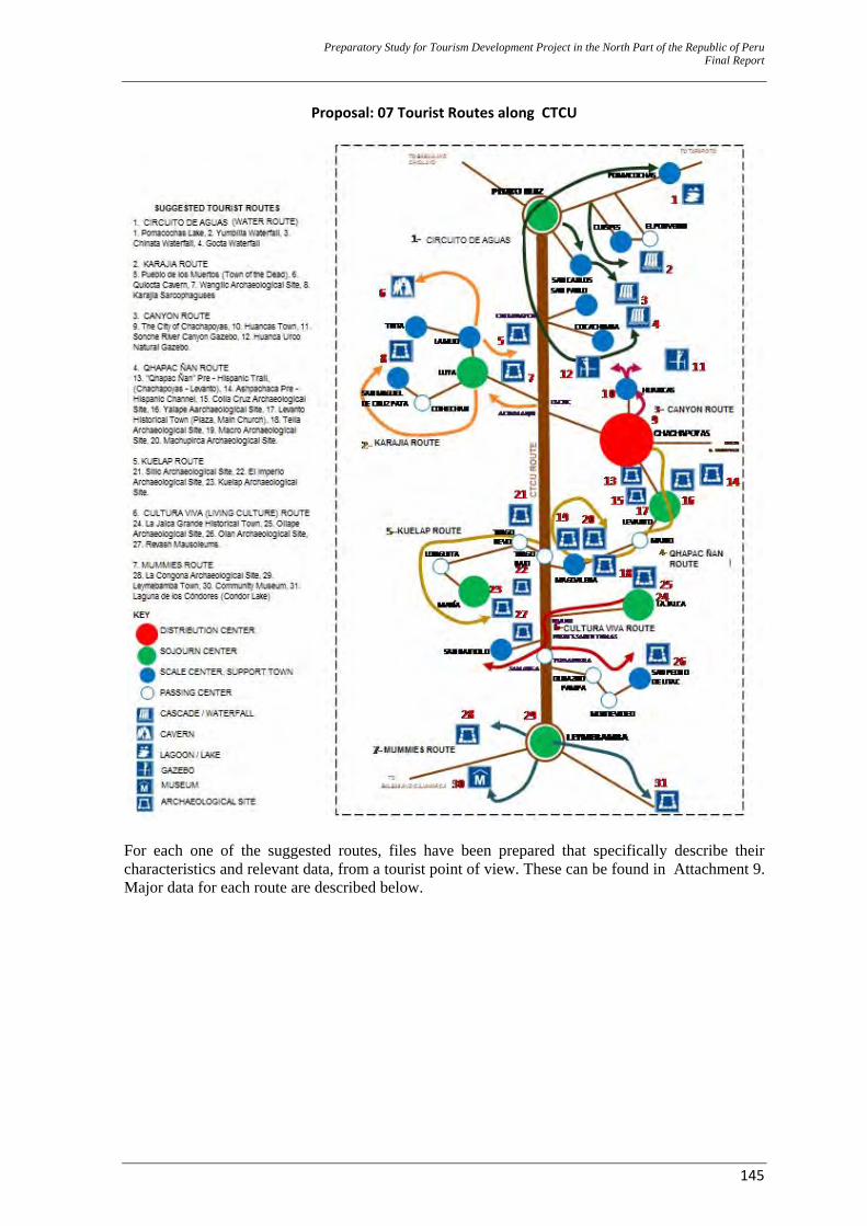
Preparatory Study for Tourism Development Project in the North Part of the Republic of Peru Final Report
145
Proposal: 07 Tourist Routes along CTCU
For each one of the suggested routes, files have been prepared that specifically describe their characteristics and relevant data, from a tourist point of view. These can be found in Attachment 9. Major data for each route are described below.
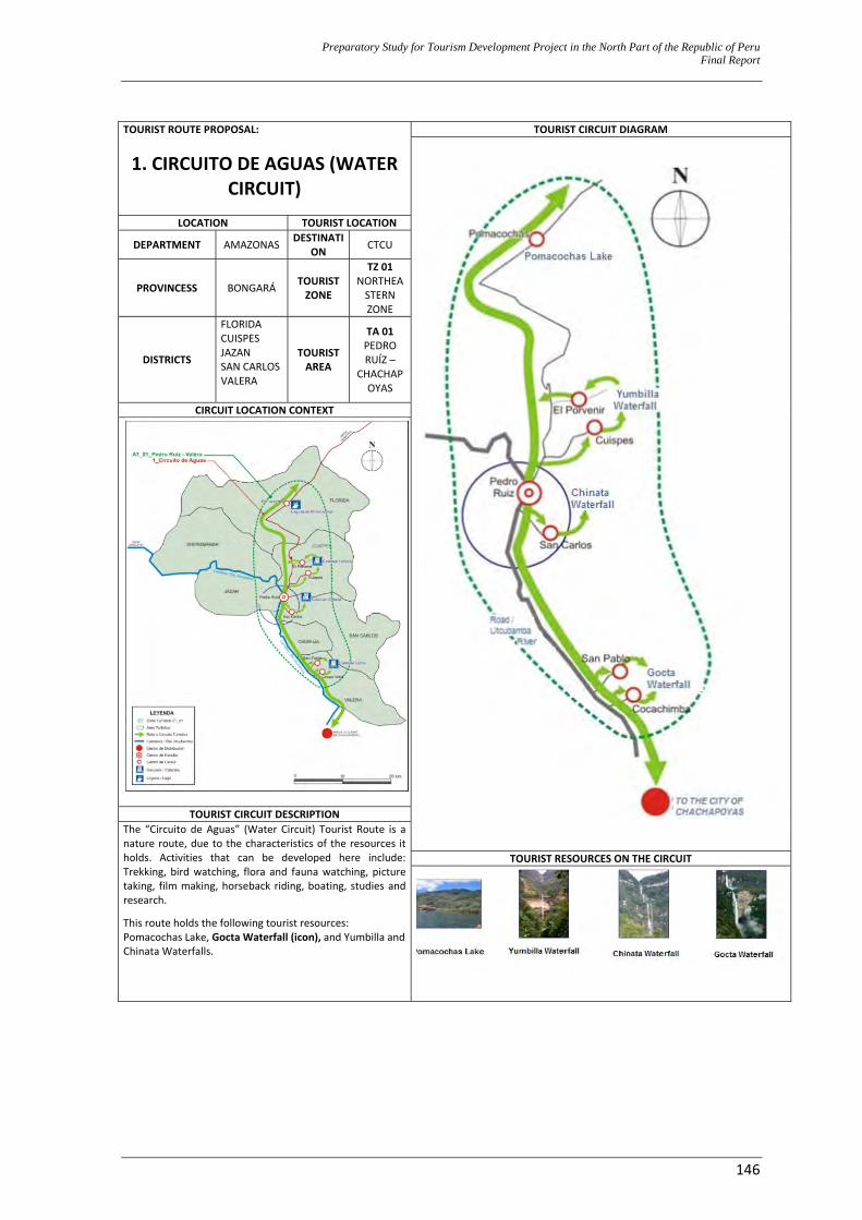
Preparatory Study for Tourism Development Project in the North Part of the Republic of Peru Final Report
146
TOURIST ROUTE PROPOSAL:
1. CIRCUITO DE AGUAS (WATER CIRCUIT)
TOURIST CIRCUIT DIAGRAM
LOCATION TOURIST LOCATION
DEPARTMENT AMAZONAS DESTINATION CTCU
PROVINCESS BONGARÁ TOURIST ZONE
TZ 01NORTHEASTERN ZONE
DISTRICTS
FLORIDACUISPES JAZAN SAN CARLOS VALERA
TOURIST AREA
TA 01 PEDRO RUÍZ –
CHACHAPOYAS
CIRCUIT LOCATION CONTEXT
TOURIST CIRCUIT DESCRIPTION The “Circuito de Aguas” (Water Circuit) Tourist Route is a nature route, due to the characteristics of the resources it holds. Activities that can be developed here include: Trekking, bird watching, flora and fauna watching, picture taking, film making, horseback riding, boating, studies and research.
This route holds the following tourist resources: Pomacochas Lake, Gocta Waterfall (icon), and Yumbilla and Chinata Waterfalls.
TOURIST RESOURCES ON THE CIRCUIT
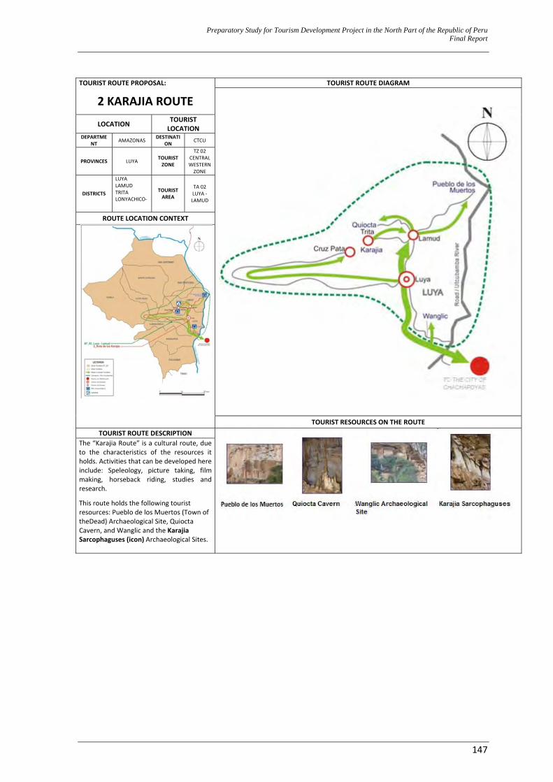
Preparatory Study for Tourism Development Project in the North Part of the Republic of Peru Final Report
147
TOURIST ROUTE PROPOSAL:
2 KARAJIA ROUTE TOURIST ROUTE DIAGRAM
LOCATION TOURIST LOCATION
DEPARTMENT AMAZONAS DESTINATI
ON CTCU
PROVINCES LUYA TOURIST ZONE
TZ 02 CENTRAL WESTERN ZONE
DISTRICTS
LUYA LAMUD TRITA LONYACHICO‐
TOURIST AREA
TA 02 LUYA ‐ LAMUD
ROUTE LOCATION CONTEXT
TOURIST RESOURCES ON THE ROUTE TOURIST ROUTE DESCRIPTION
The “Karajia Route” is a cultural route, due to the characteristics of the resources it holds. Activities that can be developed here include: Speleology, picture taking, film making, horseback riding, studies and research.
This route holds the following tourist resources: Pueblo de los Muertos (Town of theDead) Archaeological Site, Quiocta Cavern, and Wanglic and the Karajia Sarcophaguses (icon) Archaeological Sites.
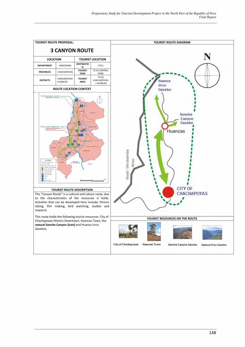
Preparatory Study for Tourism Development Project in the North Part of the Republic of Peru Final Report
148
TOURIST ROUTE PROPOSAL:
3 CANYON ROUTE TOURIST ROUTE DIAGRAM
LOCATION TOURIST LOCATION
DEPARTMENT AMAZONAS DESTINATION CTCU
PROVINCES CHACHAPOYAS TOURIST ZONE
TZ 03 CENTRAL ZONE
DISTRICTS CHACHAPOYASHUANCAS
TOURIST AREA
TA 03 CHACHAPOYAS – HUANCAS
ROUTE LOCATION CONTEXT
TOURIST ROUTE DESCRIPTION The “Canyon Route” is a cultural and nature route, due to the characteristics of the resources it holds. Activities that can be developed here include: Picture taking, film making, bird watching, studies and research.
This route holds the following tourist resources: City of Chachapoyas Historic Downtown, Huancas Town, the natural Sonche Canyon (icon) and Huanca Urco Gazebos.
TOURIST RESOURCES ON THE ROUTE
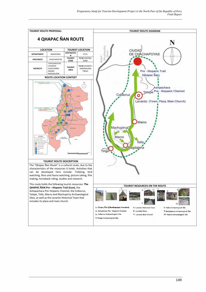
Preparatory Study for Tourism Development Project in the North Part of the Republic of Peru Final Report
149
TOURIST ROUTE PROPOSAL:
4 QHAPAC ÑAN ROUTE
TOURIST ROUTE DIAGRAM
LOCATION TOURIST LOCATIONDEPARTMENT AMAZONAS DESTINATIO
N CTCU
PROVINCES CHACHAPOYAS TOURIST ZONE
TZ 03 CENTRAL ZONE
DISTRICTS
CHACHAPOYAS LEVANTO SnAN ISIDRO MAINO MAGDALENA
TOURIST AREA
TA 04 LEVANTO ‐ MAGDALENA‐
TINGO
ROUTE LOCATION CONTEXT
TOURIST ROUTE DESCRIPTION The “Qhapac Ñan Route” is a cultural route, due to the characteristics of the resources it holds. Activities that can be developed here include: Trekking, bird watching, flora and fauna watching, picture taking, film making, horseback riding, studies and research.
This route holds the following tourist resources: The QHAPAC ÑAN Pre – Hispanic Trail (icon), the Ashapachaca Pre–Hispanic Channel, the Collacruz, Yalape, Tella, Macro and Machupirca Archaeological Sites, as well as the Levanto Historical Town that includes its plaza and main church.
TOURIST RESOURCES ON THE ROUTE
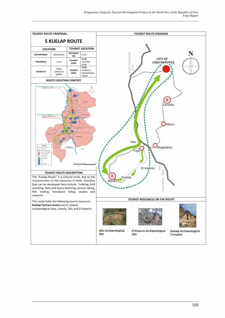
Preparatory Study for Tourism Development Project in the North Part of the Republic of Peru Final Report
150
TOURIST ROUTE PROPOSAL:
5 KUELAP ROUTE TOURIST ROUTE DIAGRAM
LOCATION TOURIST LOCATION
DEPARTMENT AMAZONAS DESTINATION CTCU
PROVINCES LUYA TOURIST ZONE
TZ 03 CENTRAL ZONE
DISTRICTS TINGO
LÓNGUITA MARÍA
TOURIST AREA
TZ 04 LEVANTO ‐ MAGDALENA‐ TINGO
ROUTE LOCATION CONTEXT
TOURIST ROUTE DESCRIPTION The “Kuelap Route” is a cultural route, due to the characteristics of the resources it holds. Activities that can be developed here include: Trekking, bird watching, flora and fauna watching, picture taking, film making, horseback riding, studies and research.
This route holds the following tourist resources: Kuelap Fortress (icon) and its related archaeological sites, namely, Silic and El Imperio.
TOURIST RESOURCES ON THE ROUTE
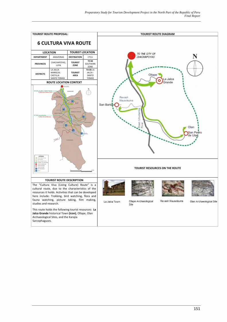
Preparatory Study for Tourism Development Project in the North Part of the Republic of Peru Final Report
151
TOURIST ROUTE PROPOSAL:
6 CULTURA VIVA ROUTE
TOURIST ROUTE DIAGRAM
LOCATION TOURIST LOCATIONDEPARTMENT AMAZONAS DESTINATION CTCU
PROVINCES CHACHAPOYAS, LUYA
TOURIST ZONE
TZ 04 SOUTHERN
ZONE
DISTRICTS
LA JALCA MARISCAL CASTILLA SANTO TOMAS
TOURIST AREA
TA 05 LA JALCA ‐ SANTO TOMAS
ROUTE LOCATION CONTEXT
TOURIST RESOURCES ON THE ROUTE
TOURIST ROUTE DESCRIPTION
The “Cultura Viva (Living Culture) Route” is a cultural route, due to the characteristics of the resources it holds. Activities that can be developed here include: Trekking, bird watching, flora and fauna watching, picture taking, film making, studies and research.
This route holds the following tourist resources: La Jalca Grande historical Town (icon), Ollape, Olan Archaeological Sites, and the Karajía Sarcophaguses.
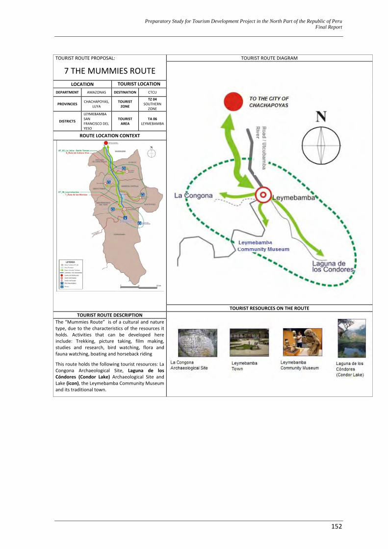
Preparatory Study for Tourism Development Project in the North Part of the Republic of Peru Final Report
152
TOURIST ROUTE PROPOSAL:
7 THE MUMMIES ROUTE TOURIST ROUTE DIAGRAM
LOCATION TOURIST LOCATIONDEPARTMENT AMAZONAS DESTINATION CTCU
PROVINCIES CHACHAPOYAS, LUYA
TOURIST ZONE
TZ 04 SOUTHERN
ZONE
DISTRICTS
LEYMEBAMBA SAN FRANCISCO DEL YESO
TOURIST AREA
TA 06 LEYMEBAMBA
ROUTE LOCATION CONTEXT
TOURIST RESOURCES ON THE ROUTE TOURIST ROUTE DESCRIPTION
The “Mummies Route” is of a cultural and nature type, due to the characteristics of the resources it holds. Activities that can be developed here include: Trekking, picture taking, film making, studies and research, bird watching, flora and fauna watching, boating and horseback riding
This route holds the following tourist resources: La Congona Archaeological Site, Laguna de los Cóndores (Condor Lake) Archaeological Site and Lake (icon), the Leymebamba Community Museum and its traditional town.
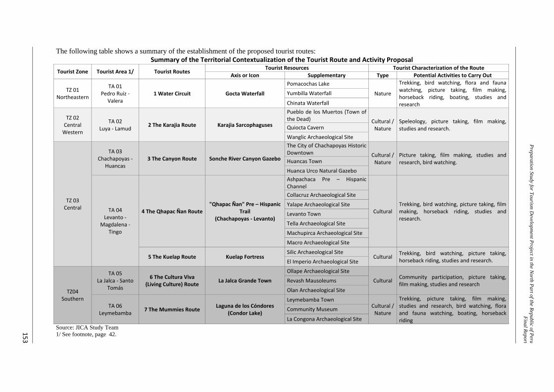
Preparation Study for Tourism D
evelopment Project in the N
orth Part of the Republic of PeruFinal Repor t
153
The following table shows a summary of the establishment of the proposed tourist routes: Summary of the Territorial Contextualization of the Tourist Route and Activity Proposal
Tourist Zone Tourist Area 1/ Tourist Routes Tourist Resources Tourist Characterization of the Route
Axis or Icon Supplementary Type Potential Activities to Carry Out
TZ 01 Northeastern
TA 01 Pedro Ruíz ‐
Valera 1 Water Circuit Gocta Waterfall
Pomacochas Lake
Nature
Trekking, bird watching, flora and fauna watching, picture taking, film making, horseback riding, boating, studies and research
Yumbilla Waterfall
Chinata Waterfall
TZ 02 Central Western
TA 02 Luya ‐ Lamud 2 The Karajia Route Karajia Sarcophaguses
Pueblo de los Muertos (Town of the Dead) Cultural /
Nature Speleology, picture taking, film making, studies and research. Quiocta Cavern
Wanglic Archaeological Site
TZ 03 Central
TA 03 Chachapoyas ‐
Huancas 3 The Canyon Route Sonche River Canyon Gazebo
The City of Chachapoyas Historic Downtown Cultural /
Nature Picture taking, film making, studies and research, bird watching. Huancas Town
Huanca Urco Natural Gazebo
TA 04 Levanto ‐
Magdalena ‐ Tingo
4 The Qhapac Ñan Route"Qhapac Ñan" Pre – Hispanic
Trail (Chachapoyas ‐ Levanto)
Ashpachaca Pre – Hispanic Channel
CulturalTrekking, bird watching, picture taking, film making, horseback riding, studies and research.
Collacruz Archaeological Site
Yalape Archaeological Site
Levanto Town
Tella Archaeological Site
Machupirca Archaeological Site
Macro Archaeological Site
5 The Kuelap Route Kuelap Fortress Silic Archaeological Site
Cultural Trekking, bird watching, picture taking, horseback riding, studies and research. El Imperio Archaeological Site
TZ04 Southern
TA 05 La Jalca ‐ Santo
Tomás
6 The Cultura Viva (Living Culture) Route La Jalca Grande Town
Ollape Archaeological Site
Cultural Community participation, picture taking, film making, studies and research Revash Mausoleums
Olan Archaeological Site
TA 06 Leymebamba 7 The Mummies Route Laguna de los Cóndores
(Condor Lake)
Leymebamba Town Cultural / Nature
Trekking, picture taking, film making, studies and research, bird watching, flora and fauna watching, boating, horseback riding
Community Museum
La Congona Archaeological Site Source: JICA Study Team 1/ See footnote, page 42.
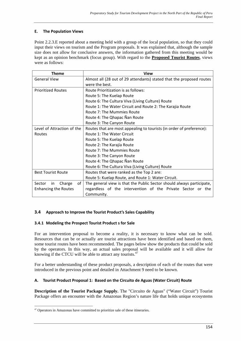
Preparatory Study for Tourism Development Project in the North Part of the Republic of Peru Final Report
154
E. The Population Views Point 2.2.3.E reported about a meeting held with a group of the local population, so that they could input their views on tourism and the Program proposals. It was explained that, although the sample size does not allow for conclusive answers, the information gathered from this meeting would be kept as an opinion benchmark (focus group). With regard to the Proposed Tourist Routes, views were as follows:
Theme View General View Almost all (28 out of 29 attendants) stated that the proposed routes
were the best. Prioritized Routes Route Prioritization is as follows:
Route 5: The Kuelap Route Route 6: The Cultura Viva (Living Culture) Route Route 1: The Water Circuit and Route 2: The Karajia Route Route 7: The Mummies Route Route 4: The Qhapac Ñan Route Route 3: The Canyon Route
Level of Attraction of the Routes
Routes that are most appealing to tourists (in order of preference): Route 1: The Water Circuit Route 5: The Kuelap Route Route 2: The Karajía Route Route 7: The Mummies Route Route 3: The Canyon Route Route 4: The Qhapac Ñan Route Route 6: The Cultura Viva (Living Culture) Route
Best Tourist Route Routes that were ranked as the Top 2 are: Route 5: Kuelap Route, and Route 1: Water Circuit.
Sector in Charge of Enhancing the Routes
The general view is that the Public Sector should always participate, regardless of the intervention of the Private Sector or the Community.
3.4 Approach to Improve the Tourist Product’s Sales Capability 3.4.1 Modeling the Prospect Tourist Product s for Sale For an intervention proposal to become a reality, it is necessary to know what can be sold. Resources that can be or actually are tourist attractions have been identified and based on them, some tourist routes have been recommended. The pages below show the products that could be sold by the operators. In this way, an actual sales proposal will be available and it will allow for knowing if the CTCU will be able to attract any tourists.47 For a better understanding of these product proposals, a description of each of the routes that were introduced in the previous point and detailed in Attachment 9 need to be known. A. Tourist Product Proposal 1: Based on the Circuito de Aguas (Water Circuit) Route Description of the Tourist Package Supply. The "Circuito de Aguas" (“Water Circuit”) Tourist Package offers an encounter with the Amazonas Region’s nature life that holds unique ecosystems
47 Operators in Amazonas have committed to prioritize sale of these itineraries.
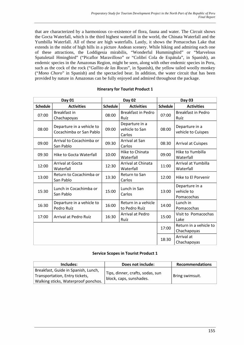
Preparatory Study for Tourism Development Project in the North Part of the Republic of Peru Final Report
155
that are characterized by a harmonious co–existence of flora, fauna and water. The Circuit shows the Gocta Waterfall, which is the third highest waterfall in the world, the Chinata Waterfall and the Yumbilla Waterfall. All of these are high waterfalls. Lastly, it shows the Pomacochas Lake that extends in the midst of high hills in a picture Andean scenery. While hiking and admiring each one of these attractions, the Loddigesia mirabilis, “Wonderful Hummingbird” or “Marvelous Spatuletail Hmingbird” (“Picaflor Maravilloso” or “Colibrí Cola de Espátula”, in Spanish), an endemic species in the Amazonas Region, might be seen, along with other endemic species in Peru, such as the cock of the rock (“Gallito de las Rocas”, in Spanish), the yellow tailed woolly monkey (“Mono Choro” in Spanish) and the spectacled bear. In addition, the water circuit that has been provided by nature in Amazonas can be fully enjoyed and admired throughout the package.
Itinerary for Tourist Product 1
Day 01 Day 02 Day 03 Schedule Activities Schedule Activities Schedule Activities
07:00 Breakfast in Chachapoyas 08:00 Breakfast in Pedro
Ruíz 07:00 Breakfast in Pedro Ruíz
08:00 Departure in a vehicle to Cocachimba or San Pablo 09:00
Departure in a vehicle to San Carlos
08:00 Departure in a vehicle to Cuispes
09:00 Arrival to Cocachimba or San Pablo 09:30 Arrival at San
Carlos 08:30 Arrival at Cuispes
09:30 Hike to Gocta Waterfall 10:00 Hike to Chinata Waterfall 09:00 Hike to Yumbilla
Waterfall
12:00 Arrival at Gocta Waterfall 12:30 Arrival at Chinata
Waterfall 11:00 Arrival at Yumbilla Waterfall
13:00 Return to Cocachimba or San Pablo 13:30 Return to San
Carlos 12:00 Hike to El Porvenir
15:30 Lunch in Cocachimba or San Pablo 15:00 Lunch in San
Carlos 13:00Departure in a vehicle to Pomacochas
16:30 Departure in a vehicle to Pedro Ruíz 16:00 Return in a vehicle
to Pedro Ruíz 14:00 Lunch in Pomacochas
17:00 Arrival at Pedro Ruíz 16:30 Arrival at Pedro Ruíz 15:00 Visit to Pomacochas
Lake
17:00 Return in a vehicle to
Chachapoyas
18:30 Arrival at Chachapoyas
Service Scopes in Tourist Product 1
Includes: Does not include: Recommendations
Breakfast, Guide in Spanish, Lunch, Transportation, Entry tickets, Walking sticks, Waterproof ponchos.
Tips, dinner, crafts, sodas, sun block, caps, sunshades. Bring swimsuit.
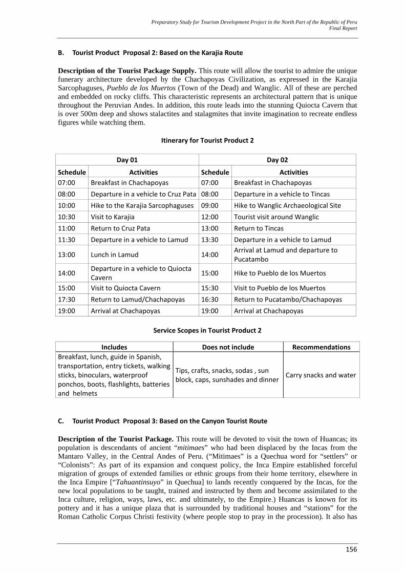
Preparatory Study for Tourism Development Project in the North Part of the Republic of Peru Final Report
156
B. Tourist Product Proposal 2: Based on the Karajia Route Description of the Tourist Package Supply. This route will allow the tourist to admire the unique funerary architecture developed by the Chachapoyas Civilization, as expressed in the Karajia Sarcophaguses, Pueblo de los Muertos (Town of the Dead) and Wanglic. All of these are perched and embedded on rocky cliffs. This characteristic represents an architectural pattern that is unique throughout the Peruvian Andes. In addition, this route leads into the stunning Quiocta Cavern that is over 500m deep and shows stalactites and stalagmites that invite imagination to recreate endless figures while watching them.
Itinerary for Tourist Product 2
Day 01 Day 02
Schedule Activities Schedule Activities 07:00 Breakfast in Chachapoyas 07:00 Breakfast in Chachapoyas 08:00 Departure in a vehicle to Cruz Pata 08:00 Departure in a vehicle to Tincas 10:00 Hike to the Karajia Sarcophaguses 09:00 Hike to Wanglic Archaeological Site 10:30 Visit to Karajia 12:00 Tourist visit around Wanglic 11:00 Return to Cruz Pata 13:00 Return to Tincas 11:30 Departure in a vehicle to Lamud 13:30 Departure in a vehicle to Lamud
13:00 Lunch in Lamud 14:00 Arrival at Lamud and departure to Pucatambo
14:00 Departure in a vehicle to Quiocta Cavern 15:00 Hike to Pueblo de los Muertos
15:00 Visit to Quiocta Cavern 15:30 Visit to Pueblo de los Muertos 17:30 Return to Lamud/Chachapoyas 16:30 Return to Pucatambo/Chachapoyas 19:00 Arrival at Chachapoyas 19:00 Arrival at Chachapoyas
Service Scopes in Tourist Product 2
C. Tourist Product Proposal 3: Based on the Canyon Tourist Route Description of the Tourist Package. This route will be devoted to visit the town of Huancas; its population is descendants of ancient “mitimaes” who had been displaced by the Incas from the Mantaro Valley, in the Central Andes of Peru. (“Mitimaes” is a Quechua word for “settlers” or “Colonists”: As part of its expansion and conquest policy, the Inca Empire established forceful migration of groups of extended families or ethnic groups from their home territory, elsewhere in the Inca Empire [“Tahuantinsuyo” in Quechua] to lands recently conquered by the Incas, for the new local populations to be taught, trained and instructed by them and become assimilated to the Inca culture, religion, ways, laws, etc. and ultimately, to the Empire.) Huancas is known for its pottery and it has a unique plaza that is surrounded by traditional houses and “stations” for the Roman Catholic Corpus Christi festivity (where people stop to pray in the procession). It also has
Includes Does not include Recommendations Breakfast, lunch, guide in Spanish, transportation, entry tickets, walking sticks, binoculars, waterproof ponchos, boots, flashlights, batteries and helmets
Tips, crafts, snacks, sodas , sun block, caps, sunshades and dinner Carry snacks and water
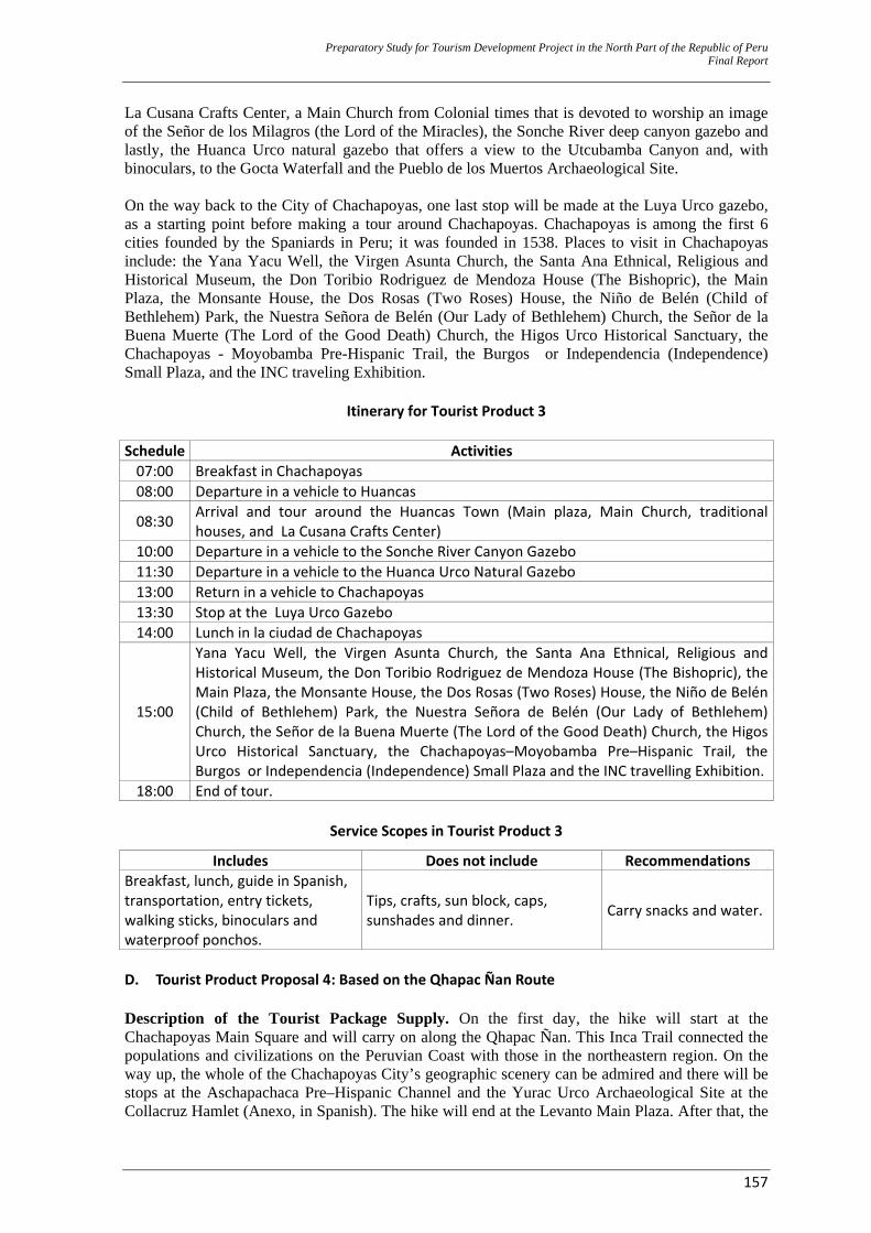
Preparatory Study for Tourism Development Project in the North Part of the Republic of Peru Final Report
157
La Cusana Crafts Center, a Main Church from Colonial times that is devoted to worship an image of the Señor de los Milagros (the Lord of the Miracles), the Sonche River deep canyon gazebo and lastly, the Huanca Urco natural gazebo that offers a view to the Utcubamba Canyon and, with binoculars, to the Gocta Waterfall and the Pueblo de los Muertos Archaeological Site. On the way back to the City of Chachapoyas, one last stop will be made at the Luya Urco gazebo, as a starting point before making a tour around Chachapoyas. Chachapoyas is among the first 6 cities founded by the Spaniards in Peru; it was founded in 1538. Places to visit in Chachapoyas include: the Yana Yacu Well, the Virgen Asunta Church, the Santa Ana Ethnical, Religious and Historical Museum, the Don Toribio Rodriguez de Mendoza House (The Bishopric), the Main Plaza, the Monsante House, the Dos Rosas (Two Roses) House, the Niño de Belén (Child of Bethlehem) Park, the Nuestra Señora de Belén (Our Lady of Bethlehem) Church, the Señor de la Buena Muerte (The Lord of the Good Death) Church, the Higos Urco Historical Sanctuary, the Chachapoyas - Moyobamba Pre-Hispanic Trail, the Burgos or Independencia (Independence) Small Plaza, and the INC traveling Exhibition.
Itinerary for Tourist Product 3
Schedule Activities 07:00 Breakfast in Chachapoyas 08:00 Departure in a vehicle to Huancas
08:30 Arrival and tour around the Huancas Town (Main plaza, Main Church, traditional houses, and La Cusana Crafts Center)
10:00 Departure in a vehicle to the Sonche River Canyon Gazebo 11:30 Departure in a vehicle to the Huanca Urco Natural Gazebo 13:00 Return in a vehicle to Chachapoyas 13:30 Stop at the Luya Urco Gazebo 14:00 Lunch in la ciudad de Chachapoyas
15:00
Yana Yacu Well, the Virgen Asunta Church, the Santa Ana Ethnical, Religious and Historical Museum, the Don Toribio Rodriguez de Mendoza House (The Bishopric), the Main Plaza, the Monsante House, the Dos Rosas (Two Roses) House, the Niño de Belén (Child of Bethlehem) Park, the Nuestra Señora de Belén (Our Lady of Bethlehem) Church, the Señor de la Buena Muerte (The Lord of the Good Death) Church, the Higos Urco Historical Sanctuary, the Chachapoyas–Moyobamba Pre–Hispanic Trail, the Burgos or Independencia (Independence) Small Plaza and the INC travelling Exhibition.
18:00 End of tour.
Service Scopes in Tourist Product 3
Includes Does not include Recommendations Breakfast, lunch, guide in Spanish, transportation, entry tickets, walking sticks, binoculars and waterproof ponchos.
Tips, crafts, sun block, caps, sunshades and dinner. Carry snacks and water.
D. Tourist Product Proposal 4: Based on the Qhapac Ñan Route Description of the Tourist Package Supply. On the first day, the hike will start at the Chachapoyas Main Square and will carry on along the Qhapac Ñan. This Inca Trail connected the populations and civilizations on the Peruvian Coast with those in the northeastern region. On the way up, the whole of the Chachapoyas City’s geographic scenery can be admired and there will be stops at the Aschapachaca Pre–Hispanic Channel and the Yurac Urco Archaeological Site at the Collacruz Hamlet (Anexo, in Spanish). The hike will end at the Levanto Main Plaza. After that, the
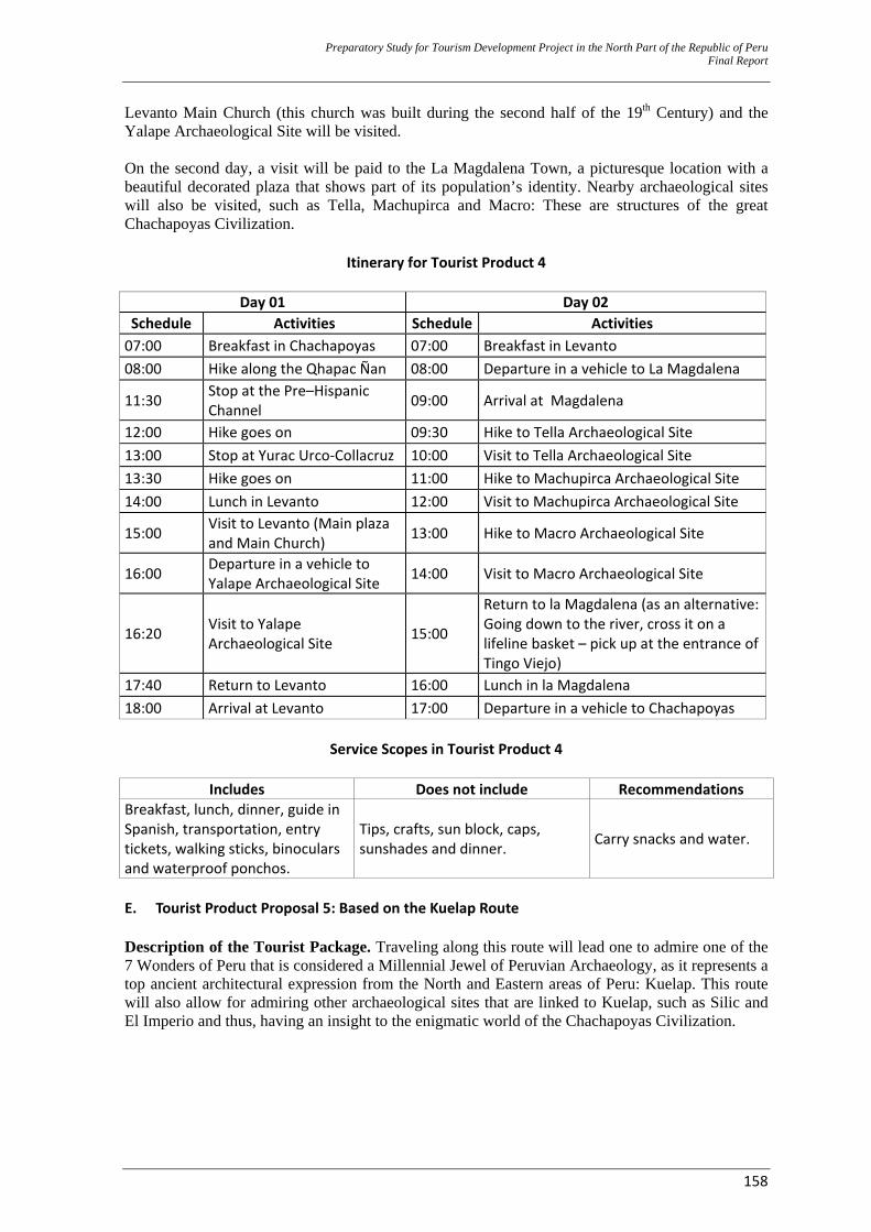
Preparatory Study for Tourism Development Project in the North Part of the Republic of Peru Final Report
158
Levanto Main Church (this church was built during the second half of the 19th Century) and the Yalape Archaeological Site will be visited. On the second day, a visit will be paid to the La Magdalena Town, a picturesque location with a beautiful decorated plaza that shows part of its population’s identity. Nearby archaeological sites will also be visited, such as Tella, Machupirca and Macro: These are structures of the great Chachapoyas Civilization.
Itinerary for Tourist Product 4
Day 01 Day 02
Schedule Activities Schedule Activities 07:00 Breakfast in Chachapoyas 07:00 Breakfast in Levanto 08:00 Hike along the Qhapac Ñan 08:00 Departure in a vehicle to La Magdalena
11:30 Stop at the Pre–Hispanic Channel 09:00 Arrival at Magdalena
12:00 Hike goes on 09:30 Hike to Tella Archaeological Site 13:00 Stop at Yurac Urco‐Collacruz 10:00 Visit to Tella Archaeological Site 13:30 Hike goes on 11:00 Hike to Machupirca Archaeological Site 14:00 Lunch in Levanto 12:00 Visit to Machupirca Archaeological Site
15:00 Visit to Levanto (Main plaza and Main Church) 13:00 Hike to Macro Archaeological Site
16:00 Departure in a vehicle to Yalape Archaeological Site 14:00 Visit to Macro Archaeological Site
16:20 Visit to Yalape Archaeological Site 15:00
Return to la Magdalena (as an alternative: Going down to the river, cross it on a lifeline basket – pick up at the entrance of Tingo Viejo)
17:40 Return to Levanto 16:00 Lunch in la Magdalena 18:00 Arrival at Levanto 17:00 Departure in a vehicle to Chachapoyas
Service Scopes in Tourist Product 4
Includes Does not include Recommendations Breakfast, lunch, dinner, guide in Spanish, transportation, entry tickets, walking sticks, binoculars and waterproof ponchos.
Tips, crafts, sun block, caps, sunshades and dinner. Carry snacks and water.
E. Tourist Product Proposal 5: Based on the Kuelap Route Description of the Tourist Package. Traveling along this route will lead one to admire one of the 7 Wonders of Peru that is considered a Millennial Jewel of Peruvian Archaeology, as it represents a top ancient architectural expression from the North and Eastern areas of Peru: Kuelap. This route will also allow for admiring other archaeological sites that are linked to Kuelap, such as Silic and El Imperio and thus, having an insight to the enigmatic world of the Chachapoyas Civilization.
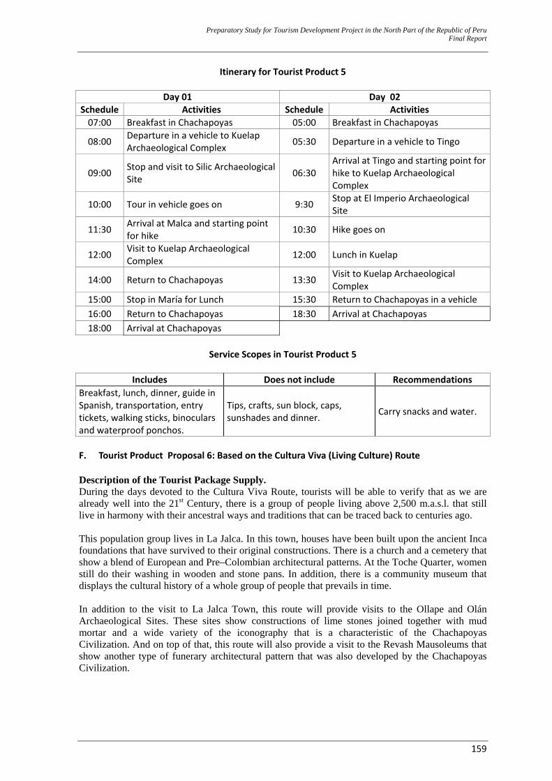
Preparatory Study for Tourism Development Project in the North Part of the Republic of Peru Final Report
159
Itinerary for Tourist Product 5
Day 01 Day 02 Schedule Activities Schedule Activities 07:00 Breakfast in Chachapoyas 05:00 Breakfast in Chachapoyas
08:00 Departure in a vehicle to Kuelap Archaeological Complex 05:30 Departure in a vehicle to Tingo
09:00 Stop and visit to Silic Archaeological Site 06:30
Arrival at Tingo and starting point for hike to Kuelap Archaeological Complex
10:00 Tour in vehicle goes on 9:30 Stop at El Imperio Archaeological Site
11:30 Arrival at Malca and starting point for hike 10:30 Hike goes on
12:00 Visit to Kuelap Archaeological Complex 12:00 Lunch in Kuelap
14:00 Return to Chachapoyas 13:30 Visit to Kuelap Archaeological Complex
15:00 Stop in María for Lunch 15:30 Return to Chachapoyas in a vehicle 16:00 Return to Chachapoyas 18:30 Arrival at Chachapoyas 18:00 Arrival at Chachapoyas
Service Scopes in Tourist Product 5
Includes Does not include Recommendations
Breakfast, lunch, dinner, guide in Spanish, transportation, entry tickets, walking sticks, binoculars and waterproof ponchos.
Tips, crafts, sun block, caps, sunshades and dinner. Carry snacks and water.
F. Tourist Product Proposal 6: Based on the Cultura Viva (Living Culture) Route Description of the Tourist Package Supply. During the days devoted to the Cultura Viva Route, tourists will be able to verify that as we are already well into the 21st Century, there is a group of people living above 2,500 m.a.s.l. that still live in harmony with their ancestral ways and traditions that can be traced back to centuries ago. This population group lives in La Jalca. In this town, houses have been built upon the ancient Inca foundations that have survived to their original constructions. There is a church and a cemetery that show a blend of European and Pre–Colombian architectural patterns. At the Toche Quarter, women still do their washing in wooden and stone pans. In addition, there is a community museum that displays the cultural history of a whole group of people that prevails in time. In addition to the visit to La Jalca Town, this route will provide visits to the Ollape and Olán Archaeological Sites. These sites show constructions of lime stones joined together with mud mortar and a wide variety of the iconography that is a characteristic of the Chachapoyas Civilization. And on top of that, this route will also provide a visit to the Revash Mausoleums that show another type of funerary architectural pattern that was also developed by the Chachapoyas Civilization.
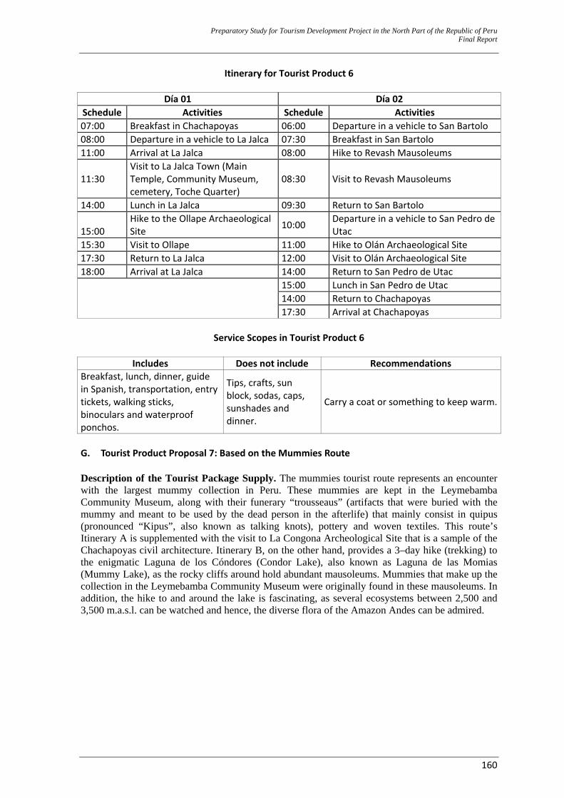
Preparatory Study for Tourism Development Project in the North Part of the Republic of Peru Final Report
160
Itinerary for Tourist Product 6
Día 01 Día 02 Schedule Activities Schedule Activities 07:00 Breakfast in Chachapoyas 06:00 Departure in a vehicle to San Bartolo 08:00 Departure in a vehicle to La Jalca 07:30 Breakfast in San Bartolo 11:00 Arrival at La Jalca 08:00 Hike to Revash Mausoleums
11:30 Visit to La Jalca Town (Main Temple, Community Museum, cemetery, Toche Quarter)
08:30 Visit to Revash Mausoleums
14:00 Lunch in La Jalca 09:30 Return to San Bartolo
15:00 Hike to the Ollape Archaeological Site 10:00 Departure in a vehicle to San Pedro de
Utac 15:30 Visit to Ollape 11:00 Hike to Olán Archaeological Site 17:30 Return to La Jalca 12:00 Visit to Olán Archaeological Site 18:00 Arrival at La Jalca 14:00 Return to San Pedro de Utac
15:00 Lunch in San Pedro de Utac 14:00 Return to Chachapoyas 17:30 Arrival at Chachapoyas
Service Scopes in Tourist Product 6
Includes Does not include Recommendations
Breakfast, lunch, dinner, guide in Spanish, transportation, entry tickets, walking sticks, binoculars and waterproof ponchos.
Tips, crafts, sun block, sodas, caps, sunshades and dinner.
Carry a coat or something to keep warm.
G. Tourist Product Proposal 7: Based on the Mummies Route Description of the Tourist Package Supply. The mummies tourist route represents an encounter with the largest mummy collection in Peru. These mummies are kept in the Leymebamba Community Museum, along with their funerary “trousseaus” (artifacts that were buried with the mummy and meant to be used by the dead person in the afterlife) that mainly consist in quipus (pronounced “Kipus”, also known as talking knots), pottery and woven textiles. This route’s Itinerary A is supplemented with the visit to La Congona Archeological Site that is a sample of the Chachapoyas civil architecture. Itinerary B, on the other hand, provides a 3–day hike (trekking) to the enigmatic Laguna de los Cóndores (Condor Lake), also known as Laguna de las Momias (Mummy Lake), as the rocky cliffs around hold abundant mausoleums. Mummies that make up the collection in the Leymebamba Community Museum were originally found in these mausoleums. In addition, the hike to and around the lake is fascinating, as several ecosystems between 2,500 and 3,500 m.a.s.l. can be watched and hence, the diverse flora of the Amazon Andes can be admired.
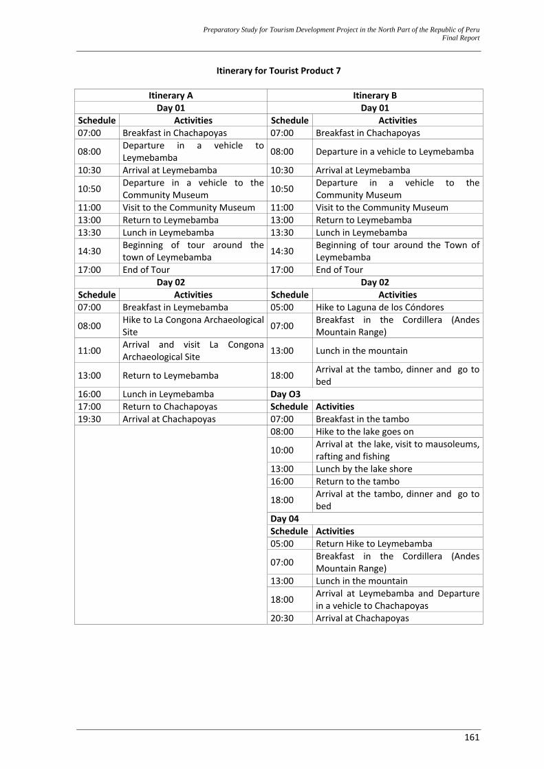
Preparatory Study for Tourism Development Project in the North Part of the Republic of Peru Final Report
161
Itinerary for Tourist Product 7
Itinerary A Itinerary B Day 01 Day 01
Schedule Activities Schedule Activities 07:00 Breakfast in Chachapoyas 07:00 Breakfast in Chachapoyas
08:00 Departure in a vehicle to Leymebamba 08:00 Departure in a vehicle to Leymebamba
10:30 Arrival at Leymebamba 10:30 Arrival at Leymebamba
10:50 Departure in a vehicle to the Community Museum 10:50 Departure in a vehicle to the
Community Museum 11:00 Visit to the Community Museum 11:00 Visit to the Community Museum 13:00 Return to Leymebamba 13:00 Return to Leymebamba 13:30 Lunch in Leymebamba 13:30 Lunch in Leymebamba
14:30 Beginning of tour around the town of Leymebamba 14:30 Beginning of tour around the Town of
Leymebamba 17:00 End of Tour 17:00 End of Tour
Day 02 Day 02 Schedule Activities Schedule Activities 07:00 Breakfast in Leymebamba 05:00 Hike to Laguna de los Cóndores
08:00 Hike to La Congona Archaeological Site 07:00 Breakfast in the Cordillera (Andes
Mountain Range)
11:00 Arrival and visit La Congona Archaeological Site 13:00 Lunch in the mountain
13:00 Return to Leymebamba 18:00 Arrival at the tambo, dinner and go to bed
16:00 Lunch in Leymebamba Day O3 17:00 Return to Chachapoyas Schedule Activities 19:30 Arrival at Chachapoyas 07:00 Breakfast in the tambo
08:00 Hike to the lake goes on
10:00 Arrival at the lake, visit to mausoleums, rafting and fishing
13:00 Lunch by the lake shore 16:00 Return to the tambo
18:00 Arrival at the tambo, dinner and go to bed
Day 04 Schedule Activities 05:00 Return Hike to Leymebamba
07:00 Breakfast in the Cordillera (Andes Mountain Range)
13:00 Lunch in the mountain
18:00 Arrival at Leymebamba and Departure in a vehicle to Chachapoyas
20:30 Arrival at Chachapoyas
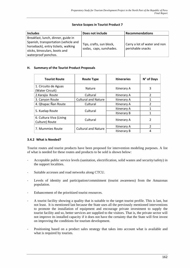
Preparatory Study for Tourism Development Project in the North Part of the Republic of Peru Final Report
162
Service Scopes in Tourist Product 7
Includes Does not include Recommendations Breakfast, lunch, dinner, guide in Spanish, transportation (vehicle and horseback), entry tickets, walking sticks, binoculars, boots and waterproof ponchos.
Tips, crafts, sun block, sodas, caps, sunshades.
Carry a lot of water and non perishable snacks
H. Summary of the Tourist Product Proposals
Tourist Route Route Type Itineraries N° of Days
1. Circuito de Aguas (Water Circuit) Nature Itinerary A 3
2.Karajia Route Cultural Itinerary A 2 3. Canyon Route Cultural and Nature Itinerary A 1 4. Qhapac Ñan Route Cultural Itinerary A 2
5. Kuelap Route Cultural Itinerary A 1 Itinerary B 1
6. Cultura Viva (Living Culture) Route Cultural Itinerary A 2
7. Mummies Route Cultural and NatureItinerary A 2 Itinerary B 4
3.4.2 What is Needed? Tourist routes and tourist products have been proposed for intervention modeling purposes. A list of what is needed for these routes and products to be sold is shown below: ‐ Acceptable public service levels (sanitation, electrification, solid wastes and security/safety) in
the support localities. ‐ Suitable accesses and road networks along CTCU.
‐ Levels of identity and participation/commitment (tourist awareness) from the Amazonas
population. ‐ Enhancement of the prioritized tourist resources.
‐ A tourist facility showing a quality that is suitable to the target tourist profile. This is last, but
not least. It is mentioned last because the State uses all the previously mentioned interventions to promote the installation of equipment and encourage private investment to supply the tourist facility and so, better services are supplied to the visitors. That is, the private sector will not improve its installed capacity if it does not have the certainty that the State will first invest on improving the conditions for tourism development.
‐ Positioning based on a product sales strategy that takes into account what is available and
what is required by tourists.
Preparatory Study for Tourism Development Project in the North Part of the Republic of Peru Final Report
163
‐ Tourist Development Strategy by consensus (PENTUR should be updated). PERTUR alignments are one of the foundations for this proposal’s formulation. If this proposal is carried out, the planning context will experience a radical change; therefore, the development strategy should be adjusted and updated to the “new” context, with already executed projects or projects in progress.
‐ Institutionality in the Public Sector.
3.4.3 What is Missing? An analysis will be carried out and a conclusion will be drawn, with regard to what is missing to improve the Amazonas–CTCU capacity and upgrade its potentiality as a tourist destination for each one of the identified “production factors”: A. Utilities at the Support Centers Proposals developed in paragraph 3.4.1 provide a detailed description of the probable itineraries for the suggested products, based on the identified tourist routes. In this sense, itineraries identify the localities (support city–distribution center, sojourn centers, and scale centers) that would support the tourist operation that will lead to the exploitation of all 34 prioritized resources. Localities that are included in the suggested tours and their relation to the tour activities are: ‐ Chachapoyas: visit, stay for the night, meals. ‐ Cocachimba: starting point for the hike to Gocta. ‐ Pedro Ruiz: stay for the night, meals ‐ San Carlos: starting point for the hike to Chinata. ‐ Cuispes: starting point for the hike to Yumbilla. ‐ Cruz Pata: starting point for the hike to Karajia. ‐ Lamud: meals ‐ Tincas: starting point for the hike to Wanglic. ‐ Levanto: visit, stay for the night, meals. ‐ Huancas: Route on the way to the gazebos. ‐ Magdalena: starting point for the hike to Tella. ‐ María: meals ‐ Tingo: starting point for the hike to Kuelap. ‐ La Jalca: visit, stay for the night, meals. ‐ San Bartolo: starting point for the hike to Revash. ‐ San Pedro de Utac: starting point for the hike to Olán. ‐ Leymebamba: visit, stay for the night, meals. Although all localities are somehow related to the itineraries, a differentiation should be made in terms of the use and support given to them. Some of them will only be a passing point for the tourists, as they are on their way to visit the resources. Therefore, analyzing the status of the basic services is not a priority for the proposal’s support but it is strongly recommended that the local or regional authority carries out all necessary actions that will lead to a suitable service level for the community, by means of other programs or projects. On the other hand, service levels in the localities of Chachapoyas, Pedro Ruiz, Lamud (Lunch), Levanto, María (Lunch), La Jalca and Leymebamba are an essential support for itineraries to be carried out. These localities should have infrastructure and basic utilities to welcome and serve tourists. If there were any deficient services that should be provided by the public sector, public investment projects should be scheduled to set up or improve such services to acceptable standards. Service coverage levels and infrastructure are described in the table below.
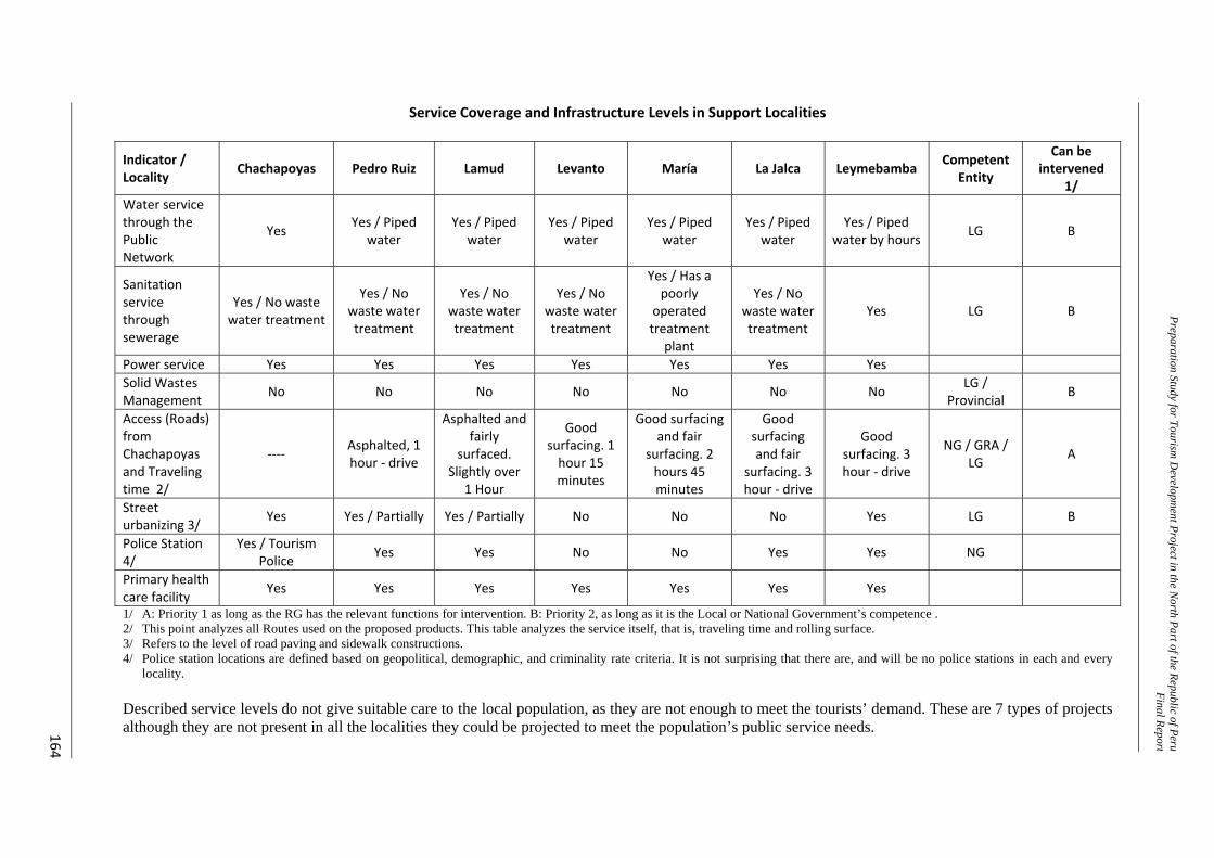
Preparation Study for Tourism D
evelopment Project in the N
orth Part of the Republic of PeruFinal Repor t
164
Service Coverage and Infrastructure Levels in Support Localities
Indicator / Locality Chachapoyas Pedro Ruiz Lamud Levanto María La Jalca Leymebamba Competent
Entity
Can be intervened
1/ Water service through the Public Network
Yes Yes / Piped water
Yes / Piped water
Yes / Piped water
Yes / Piped water
Yes / Piped water
Yes / Piped water by hours LG B
Sanitation service through sewerage
Yes / No waste water treatment
Yes / No waste water treatment
Yes / No waste water treatment
Yes / No waste water treatment
Yes / Has a poorly
operated treatment
plant
Yes / No waste water treatment
Yes LG B
Power service Yes Yes Yes Yes Yes Yes Yes Solid Wastes Management No No No No No No No LG /
Provincial B
Access (Roads) from Chachapoyas and Traveling time 2/
‐‐‐‐ Asphalted, 1 hour ‐ drive
Asphalted and fairly
surfaced. Slightly over
1 Hour
Good surfacing. 1 hour 15 minutes
Good surfacing and fair
surfacing. 2 hours 45 minutes
Good surfacing and fair
surfacing. 3 hour ‐ drive
Good surfacing. 3 hour ‐ drive
NG / GRA / LG A
Street urbanizing 3/ Yes Yes / Partially Yes / Partially No No No Yes LG B
Police Station 4/
Yes / Tourism Police Yes Yes No No Yes Yes NG
Primary health care facility Yes Yes Yes Yes Yes Yes Yes
1/ A: Priority 1 as long as the RG has the relevant functions for intervention. B: Priority 2, as long as it is the Local or National Government’s competence . 2/ This point analyzes all Routes used on the proposed products. This table analyzes the service itself, that is, traveling time and rolling surface. 3/ Refers to the level of road paving and sidewalk constructions. 4/ Police station locations are defined based on geopolitical, demographic, and criminality rate criteria. It is not surprising that there are, and will be no police stations in each and every
locality. Described service levels do not give suitable care to the local population, as they are not enough to meet the tourists’ demand. These are 7 types of projects although they are not present in all the localities they could be projected to meet the population’s public service needs.
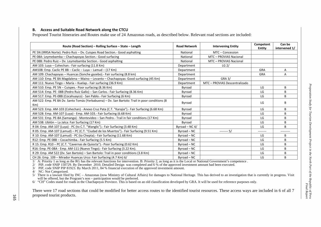
Preparation Study for Tourism D
evelopment Project in the N
orth Part of the Republic of PeruFinal Repor t
165
B. Access and Suitable Road Network along the CTCU Proposed Tourist Itineraries and Routes make use of 24 Amazonas roads, as described below. Relevant road sections are included:
Route (Road Section) – Rolling Surface – State – Length Road Network Intervening Entity Competent Entity
Can be intervened 1/
PE 5N (IRRSA Norte): Pedro Ruiz – Dv. Cuispes Road Section.‐ Good asphalting National MTC – Concession PE 08A: Leymebamba – Chachapoyas Section.‐ Good surfacing National MTC – PROVIAS Nacional PE 08B: Pedro Ruiz – Dv. Leymebamba Section.‐ Good asphalting National MTC – PROVIAS Nacional AM 103: Luya – Cohechan.‐ Fair surfacing (11.8 Km) Department LG 2/ AM108: Emp. Caclic PE 8B – Caclic – Luya – Lamud – (17 Km) Department GRA A AM 109: Chachapoyas – Huancas (Sonche gazebo).‐ Fair surfacing (8.8 km) Department GRA A AM 110: Emp. PE 8A Magdalena – Maino – Levanto – Chachapoyas: Good surfacing (45 Km) Department GRA 3/ AM 111: Nuevo Tingo – María – Kuelap.‐ Fair surfacing (36.9 Km) Department MTC – PROVIAS Descentralizado AM 510: Emp. PE 5N – Cuispes.‐ Poor surfacing (8.36 Km) Byroad LG B AM 514: Emp. PE‐ 08B (Pedro Ruiz Gallo) – San Carlos.‐ Fair Surfacing (8.36 Km) Byroad LG B AM 517: Emp. PE‐08B (Cocahuayco) ‐ San Pablo.‐ Fair Surfacing (6 Km) Byroad LG B AM 522: Emp. PE 8A Dv. Santo Tomás (Yerbabuena) – Dv. San Bartolo: Trail in poor conditions (8 Km) Byroad LG B
AM 523: Emp. AM‐103 (Cohechan) ‐ Anexo Cruz Pata (C.T. "Karajia").‐ Fair Surfacing (6.68 Km) Byroad LG B AM 528: Emp. AM‐107 (Luya) ‐ Emp. AM‐103.‐ Fair Surfacing (6.68 Km) Byroad LG B AM 531: Emp. PE‐8A (Samanga) ‐ Montevideo – San Pedro.‐ Trail in fair conditions (17 Km) Byroad LG B AM 538: Ubilón – La Jalca: Fair Surfacing (17 Km) Byroad LG B R 04: Emp. AM‐107 (Luya) ‐ PC (to C.T. "Wanglic").‐ Fair Surfacing (3.48 Km) Byroad – NC 4/ LG B R 05: Emp. AM‐107 (Lamud) – PC (C.T. "Ciudad de los Muertos").‐ Fair Surfacing (9.51 Km) Byroad – NC ‐‐‐‐‐‐‐‐ 5/ ‐‐‐‐‐‐‐‐ ‐‐‐‐‐‐‐‐‐ R 10: Emp. AM‐107 (Lamud) ‐ PC (to Chepta).‐ Fair Surfacing (11.68 Km) Byroad – NC LG B R12: Emp. PE 08B – Cocachimba.‐ Fair Surfacing (5.5 Km) Byroad – NC LG B R 15: Emp. R10 – PC (C.T. "Cavernas de Quiocta").‐ Poor Surfacing (0.62 Km) Byroad – NC LG B R16: Emp. PE‐08A ‐ Emp. AM‐111 (Nuevo Tingo).‐ Fair Surfacing (3.22 Km). Byroad – NC LG B R 29: Emp. AM 522 (Dv. San Bartolo) – San Bartolo: Trail in poor conditions (3.8 Km) Byroad – NC LG B CH 26: Emp. 109 – Mirador Huancas Urco: Fair Surfacing (4.7 Km) 6/ Byroad – NC LG B 1/ A: Priority 1 as long as the RG has the relevant functions for intervention. B: Priority 2, as long as it is the Local or National Government’s competence . 2/ PIP, code SNIP 150729. By December 2010, Detailed Design was completed and 6 % of the approved investment amount had been executed. 3/ PIP, code SNIP PIP 81923. By March 2011, 84 % financial execution of the approved investment amount. 4/ NC: Not Categorized. 5/ There is a lawsuit filed by INC – Amazonas (now Ministry of Cultural Affairs) for damages to National Heritage. This has derived to an investigation that is currently in progress. Visit
will be offered, but the Program’s non – participation would be preferred. 6/ “CH” Codes stand for roads in the Chachapoyas Province. This is based on an old classification developed by GRA. It will be used for reference purposes only. There were 17 road sections that could be modified for better access routes to the identified tourist resources. These access ways are included in 6 of all 7 proposed tourist products.
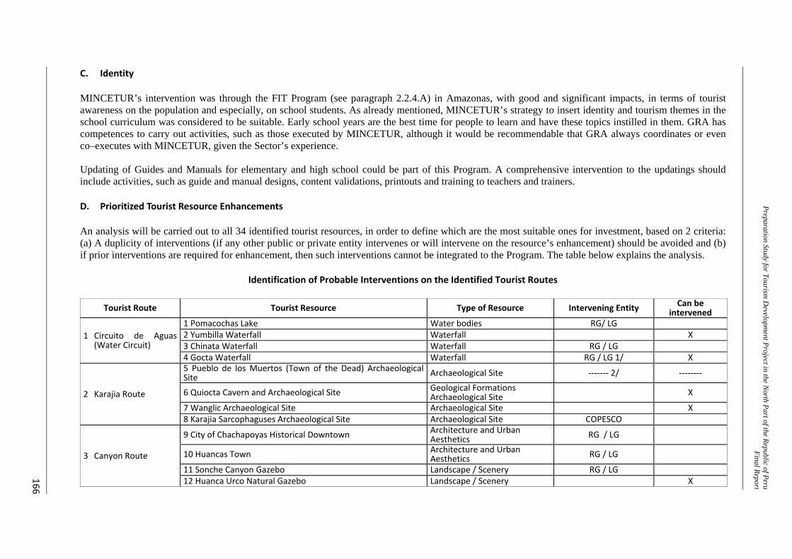
Preparation Study for Tourism D
evelopment Project in the N
orth Part of the Republic of PeruFinal Repor t
166
C. Identity MINCETUR’s intervention was through the FIT Program (see paragraph 2.2.4.A) in Amazonas, with good and significant impacts, in terms of tourist awareness on the population and especially, on school students. As already mentioned, MINCETUR’s strategy to insert identity and tourism themes in the school curriculum was considered to be suitable. Early school years are the best time for people to learn and have these topics instilled in them. GRA has competences to carry out activities, such as those executed by MINCETUR, although it would be recommendable that GRA always coordinates or even co–executes with MINCETUR, given the Sector’s experience. Updating of Guides and Manuals for elementary and high school could be part of this Program. A comprehensive intervention to the updatings should include activities, such as guide and manual designs, content validations, printouts and training to teachers and trainers. D. Prioritized Tourist Resource Enhancements An analysis will be carried out to all 34 identified tourist resources, in order to define which are the most suitable ones for investment, based on 2 criteria: (a) A duplicity of interventions (if any other public or private entity intervenes or will intervene on the resource’s enhancement) should be avoided and (b) if prior interventions are required for enhancement, then such interventions cannot be integrated to the Program. The table below explains the analysis.
Identification of Probable Interventions on the Identified Tourist Routes
Tourist Route Tourist Resource Type of Resource Intervening Entity Can be intervened
1 Circuito de Aguas (Water Circuit)
1 Pomacochas Lake Water bodies RG/ LG2 Yumbilla Waterfall Waterfall X3 Chinata Waterfall Waterfall RG / LG4 Gocta Waterfall Waterfall RG / LG 1/ X
2 Karajia Route
5 Pueblo de los Muertos (Town of the Dead) Archaeological Site Archaeological Site ‐‐‐‐‐‐‐ 2/ ‐‐‐‐‐‐‐‐
6 Quiocta Cavern and Archaeological Site Geological Formations Archaeological Site X
7 Wanglic Archaeological Site Archaeological Site X8 Karajia Sarcophaguses Archaeological Site Archaeological Site COPESCO
3 Canyon Route
9 City of Chachapoyas Historical Downtown Architecture and Urban Aesthetics RG / LG
10 Huancas Town Architecture and Urban Aesthetics RG / LG
11 Sonche Canyon Gazebo Landscape / Scenery RG / LG12 Huanca Urco Natural Gazebo Landscape / Scenery X
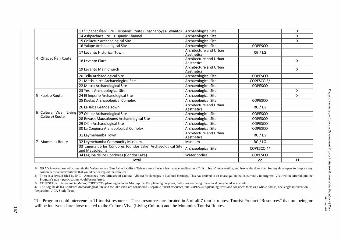
Preparation Study for Tourism D
evelopment Project in the N
orth Part of the Republic of PeruFinal Repor t
167
4 Qhapac Ñan Route
13 "Qhapac Ñan" Pre – Hispanic Route (Chachapoyas‐Levanto) Archaeological Site X14 Ashpachaca Pre – Hispanic Channel Archaeological Site X15 Collacruz Archaeological Site Archaeological Site X16 Yalape Archaeological Site Archaeological Site COPESCO
17 Levanto Historical Town Architecture and Urban Aesthetics RG / LG
18 Levanto Plaza Architecture and Urban Aesthetics X
19 Levanto Main Church Architecture and Urban Aesthetics X
20 Tella Archaeological Site Archaeological Site COPESCO21 Machupirca Archaeological Site Archaeological Site COPESCO 3/22 Macro Archaeological Site Archaeological Site COPESCO
5 Kuelap Route 23 Yeslic Archaeological Site Archaeological Site X24 El Imperio Archaeological Site Archaeological Site X25 Kuelap Archaeological Complex Archaeological Site COPESCO
6 Cultura Viva (Living Culture) Route
26 La Jalca Grande Town Architecture and Urban Aesthetics RG / LG
27 Ollape Archaeological Site Archaeological Site COPESCO28 Revash Mausoleums Archaeological Site Archaeological Site COPESCO29 Olán Archaeological Site Archaeological Site COPESCO
7 Mummies Route
30 La Congona Archaeological Complex Archaeological Site COPESCO
31 Leymebamba Town Architecture and Urban Aesthetics RG / LG
32 Leymebamba Community Museum Museum RG / LG33 Laguna de los Cóndores (Condor Lake) Archaeological Site and Mausoleums Archaeological Site COPESCO 4/
34 Laguna de los Cóndores (Condor Lake) Water bodies COPESCOTotal 22 11
1/ GRA’s intervention will come via the Valera access (San Pablo locality). This resource has not been conceptualized as a “micro basin” intervention, and leaves the door open for any developers to propose any
comprehensive interventions that would better exploit the resource. 2/ There is a lawsuit filed by INC – Amazonas (now Ministry of Cultural Affairs) for damages to National Heritage. This has derived to an investigation that is currently in progress. Visit will be offered, but the
Program’s non – participation would be preferred. 3/ COPESCO will intervene in Macro; COPESCO’s planning includes Machupirca. For planning purposes, both sites are being treated and considered as a whole. 4/ The Laguna de los Condores Archaeological Site and the lake itself are considered 2 separate tourist resources, but COPESCO’s planning treats and considers them as a whole, that is, one single intervention. Preparation: JICA Study Team. The Program could intervene in 11 tourist resources. These resources are located in 5 of all 7 tourist routes. Tourist Product “Resources” that are being or will be intervened are those related to the Cultura Viva (Living Culture) and the Mummies Tourist Routes.
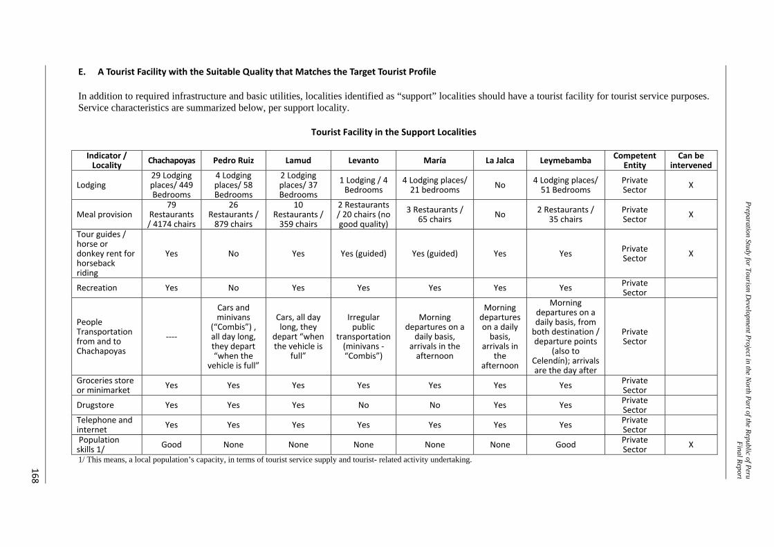
Preparation Study for Tourism D
evelopment Project in the N
orth Part of the Republic of PeruFinal Repor t
168
E. A Tourist Facility with the Suitable Quality that Matches the Target Tourist Profile In addition to required infrastructure and basic utilities, localities identified as “support” localities should have a tourist facility for tourist service purposes. Service characteristics are summarized below, per support locality.
Tourist Facility in the Support Localities Indicator / Locality Chachapoyas Pedro Ruiz Lamud Levanto María La Jalca Leymebamba Competent
EntityCan be
intervened
Lodging 29 Lodging places/ 449 Bedrooms
4 Lodging places/ 58 Bedrooms
2 Lodging places/ 37 Bedrooms
1 Lodging / 4 Bedrooms
4 Lodging places/ 21 bedrooms No 4 Lodging places/
51 Bedrooms Private Sector X
Meal provision 79
Restaurants / 4174 chairs
26 Restaurants / 879 chairs
10 Restaurants / 359 chairs
2 Restaurants / 20 chairs (no good quality)
3 Restaurants / 65 chairs No 2 Restaurants /
35 chairs Private Sector X
Tour guides / horse or donkey rent for horseback riding
Yes No Yes Yes (guided) Yes (guided) Yes Yes Private Sector X
Recreation Yes No Yes Yes Yes Yes Yes Private Sector
People Transportation from and to Chachapoyas
‐‐‐‐
Cars and minivans
(“Combis”) , all day long, they depart “when the
vehicle is full”
Cars, all day long, they
depart “when the vehicle is
full”
Irregular public
transportation (minivans ‐“Combis”)
Morning departures on a
daily basis, arrivals in the afternoon
Morning departures on a daily basis,
arrivals in the
afternoon
Morning departures on a daily basis, from both destination / departure points
(also to Celendín); arrivals are the day after
Private Sector
Groceries store or minimarket Yes Yes Yes Yes Yes Yes Yes Private
Sector
Drugstore Yes Yes Yes No No Yes Yes Private Sector
Telephone and internet Yes Yes Yes Yes Yes Yes Yes Private
Sector
Population skills 1/ Good None None None None None Good Private
Sector X
1/ This means, a local population’s capacity, in terms of tourist service supply and tourist- related activity undertaking.
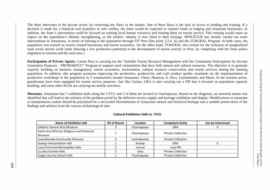
Preparation Study for Tourism D
evelopment Project in the N
orth Part of the Republic of PeruFinal Repor t
169
The State intervenes in the private sector, by correcting any flaws in the market. One of these flaws is the lack of access to funding and training. If a decision is made for a financial tool (transfers or soft credits), the State would be expected to channel funds to lodging and restaurant businesses. In addition, the State’s intervention could be focused on training local human resources and training them on tourist service. This training would cause an impact on the population’s identity strengthening, as the settlers’ identity is now liked to their heritage. MINCETUR has already carried out some interventions in Amazonas, in terms of training to the population through FIT Peru (See point 2.2.4. A) and the TURURAL Program. In both cases, the population was trained on tourist–related businesses and tourist awareness. On the other hand, TURURAL also looked for the inclusion of marginalized rural social sectors (with lands showing a low productive potential) in the development of tourist activity in Peru, by complying with the State policy alignment to tourism and the rural area.) Participation of Private Agents. Caritas Peru is carrying out the “Suitable Tourist Resource Management with the Community Participation for Income Generation Purposes – PROMARTUC” Program to support rural communities that have both natural and cultural resources. The objective is to generate capacity building on business management, tourist awareness, environment, cultural resource conservation and tourist services among the farming population. In addition, this program promotes improving the production, productivity and craft product quality standards via the implementation of productive workshops to the population in 5 communities around Amazonas: Cheto, Huancas, la Jalca, Leymebamba and María. In the tourism sector, guesthouses have been equipped for tourist service purposes. Just like Caritas, GRA is also carrying out a PIP that is focused on population capacity building, and some other NGOs are carrying out similar activities. Museums. Amazonas has 7 exhibition halls along the CTCU and 3 of them are located in Chachapoyas. Based on the diagnosis, an essential means was identified that will lead to the solution of the problem posed by the deficient service supply and heritage exhibition and display: Modifications to museums or interpretation centers should be prioritized for a successful dissemination of Amazonas natural and historical heritage and a suitable preservation of the findings and artifacts from the various archaeological sites.
Cultural Exhibition Halls in CTCU
Name of Exhibition Hall Nº of Rooms Location Competent Entity Can be intervenedGilberto Tenorio Ruiz Museum 3 Chachapoyas GRA XSanta Ana Ethnical, Religious and Historical Museum 1 Chachapoyas Private Collection
Leymebamba Community Museum 5 Leymebamba Private CollectionKuelap Interpretation Hall 1 Kuelap GRA XLuya Provincial Municipality Halls 2 Lamud Luya PMLa Jalca Grande Halls 2 Jalca Private CollectionVirgen Asunta School Halls 1 Chachapoyas Private Collection
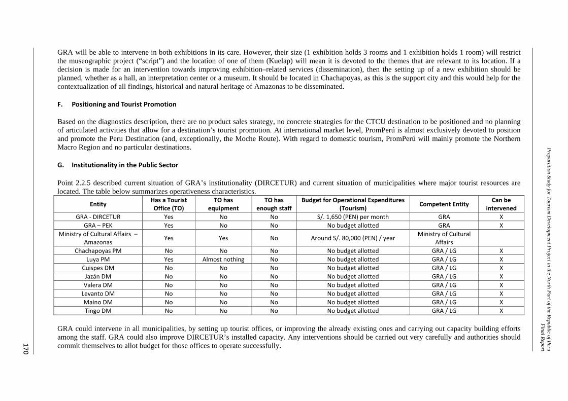
Preparation Study for Tourism D
evelopment Project in the N
orth Part of the Republic of PeruFinal Repor t
170
GRA will be able to intervene in both exhibitions in its care. However, their size (1 exhibition holds 3 rooms and 1 exhibition holds 1 room) will restrict the museographic project (“script”) and the location of one of them (Kuelap) will mean it is devoted to the themes that are relevant to its location. If a decision is made for an intervention towards improving exhibition–related services (dissemination), then the setting up of a new exhibition should be planned, whether as a hall, an interpretation center or a museum. It should be located in Chachapoyas, as this is the support city and this would help for the contextualization of all findings, historical and natural heritage of Amazonas to be disseminated. F. Positioning and Tourist Promotion Based on the diagnostics description, there are no product sales strategy, no concrete strategies for the CTCU destination to be positioned and no planning of articulated activities that allow for a destination’s tourist promotion. At international market level, PromPerú is almost exclusively devoted to position and promote the Peru Destination (and, exceptionally, the Moche Route). With regard to domestic tourism, PromPerú will mainly promote the Northern Macro Region and no particular destinations. G. Institutionality in the Public Sector Point 2.2.5 described current situation of GRA’s institutionality (DIRCETUR) and current situation of municipalities where major tourist resources are located. The table below summarizes operativeness characteristics.
Entity Has a Tourist Office (TO)
TO has equipment
TO has enough staff
Budget for Operational Expenditures (Tourism) Competent Entity Can be
intervened GRA ‐ DIRCETUR Yes No No S/. 1,650 (PEN) per month GRA X
GRA – PEK Yes No No No budget allotted GRA X Ministry of Cultural Affairs –
Amazonas Yes Yes No Around S/. 80,000 (PEN) / year Ministry of Cultural Affairs
Chachapoyas PM No No No No budget allotted GRA / LG X Luya PM Yes Almost nothing No No budget allotted GRA / LG X
Cuispes DM No No No No budget allotted GRA / LG X Jazán DM No No No No budget allotted GRA / LG X Valera DM No No No No budget allotted GRA / LG X Levanto DM No No No No budget allotted GRA / LG X Maino DM No No No No budget allotted GRA / LG X Tingo DM No No No No budget allotted GRA / LG X
GRA could intervene in all municipalities, by setting up tourist offices, or improving the already existing ones and carrying out capacity building efforts among the staff. GRA could also improve DIRCETUR’s installed capacity. Any interventions should be carried out very carefully and authorities should commit themselves to allot budget for those offices to operate successfully.
Preparatory Study for Tourism Development Project in the North Part of the Republic of Peru Final Report
171
H. Tourist Development Strategy by Consensus (PENTUR upgrading) PERTUR is the long term strategy that promotes Amazonas Tourist Development. Latest PERTUR was approved in 2009 for the 2009–2015 period. This planning offers initial action alignments and base alignments for tourist development, to the extent that tourism in Amazonas and CTCU is beginning. Based on the execution of all projects being formulated (this Program included) and the completion of all those projects still in progress, the current situation from which actions are planned will change dramatically and PENTUR will be left outdated. PENTUR’s development and/or updating (upgrading) is GRA’s responsibility, in coordination with MINCETUR. 3.4.4 Selection of Interventions Based on the described possibilities, a final selection of intervention priorities should be carried out, by taking into account the levels of service rendered by the utilities to the population that will enable tourist service and considering the strategic convenience of doing it (from a tourist point of view). All of this should be based on an analysis of the impact on tourism, as a result of a joint intervention (synergies) on CTCU. The following paragraphs will explain the selection of the items to be intervened by the Program, as well the criteria for such selection and the reasons for deciding not to intervene in some specific cases. Although selection is explained, based on an index that broken down by items, a global vision should prevail, based on the diagnostics and the tourist product proposals that have been explained. A. Utilities From the analysis that was carried out, the Program could intervene in projects that would improve water service through the public network, sanitation service through sewerage, solid wastes management, access ways (roads) and urban street planning. Water and Sanitation. The Ministry of Housing, Construction and Sanitation has formulated the “Potable Water and Sanitation Program for the Rural Amazon Region” Public Investment Program (Code: PROG-050-2009-SNIP) that includes all CTCU localities. It must be pointed out that, according to the Sanitation Sector standards, any locality with a population of less than 2,000 is considered to be rural. This would include all the support localities, except for Chachapoyas. Chachapoyas is served by a Utility (EPS, in Spanish) that should be in charge of a wastewater treatment plant construction. Based on the above, the Program should not consider intervention in this area. Solid Wastes Management. This is another basic utility the support localities should have to benefit the local population and tourists. Aspects for consideration: ‐ Just like the sanitation utility, not having a suitable SW management or suitable operation
causes an impact on the population’s health. In addition, it impacts the urban and rural scenery that is part of the tourist experience.
‐ As long as the scenery is part of the experience, any intervention’s scope should reach, at least, all the towns and villages to be “hit” by the itineraries: Chachapoyas, Cocachimba, Pedro Ruiz, San Carlos, Cuispes, Cruz Pata, Lamud, Tincas, Levanto, Huancas, Magdalena, María, Tingo, La Jalca, San Bartolo, and San Pedro de Utac.
Preparatory Study for Tourism Development Project in the North Part of the Republic of Peru Final Report
172
‐ Interventions based on the geographic location of the towns and villages (following the sizing
technique) and not on a geopolitical distribution, should be proposed. Therefore, solid wastes management projects should take into account service to more localities than those originally mentioned in the above paragraph, if the technique allows it.
‐ If a decision is made for intervention, an analysis of how to meet the needs of each one of the
mentioned localities will need to be carried out, by defining the technical feasibility for a sustainable service. The size of the localities and the time taken for collection purposes are two of the variables that will condition the prioritization of the interventions.
‐ Solid wastes management is a Provincial Municipality’s responsibility and a Provincial
Municipality could authorize GRA for it to intervene. The intervention vision is that of a “zone” development and district municipality lacks this vision.
‐ No municipality has been found to be carrying out this type of project formulations and/or
evaluations. ‐ The Ministry of the Environment is planning the execution of a Program that sets in place a
solid wastes utility in various localities around Peru, Chachapoyas included.
Based on the above, the Program would intervene in the setting in place of solid wastes management utilities around the area, except for Chachapoyas and Huancas (due to its closeness to Chachapoyas, Huancas should be included as part of Chachapoyas). Urban Planning. This is a municipal function: Municipalities should enhance natural and urban environments, by means of urban beautification projects that will benefit the population. In any case, GRA could fund urban enhancement projects, if these projects are closely related to historical heritage salvage and to tourism, as in the case of Chachapoyas, Leymebamba and Levanto. These towns and cities are part of the itinerary not only as support localities but as part of the whole tour. Therefore, the Program would not intervene in this item in the short term, unless the intervention is necessary as an enhancement component. B. Access and Suitable Road Network along the CTCU National Road Network Classification: Through its various offices, MTC is carrying out intervention in all the national roads around Amazonas, whether directly or via concessions. GRA cannot intervene. Nevertheless, it must be pointed out that PE 08A and PE 08B routes between Pedro Ruiz and Leymebamba make up the Basin Route. Department Road Network Classification: GRA has prioritized investment in these routes, as they are part of the Amazonas connecting network. There are 5 Department Roads: ‐ AM 103 (Access Way to Karajia48): With the municipality’s intervention. Implementation
started in 2010. In addition, from a tourist development point of view, implementation could be planned later, as this road (12km long) would be used as access way to one single resource (Karajia).
‐ AM 108 (Access Way to the Karajia Tourist Product): Besides being the access way to a tourist product, this route is part of the “distribution” ways in the CTCU western area. Hence, GRA should prioritize intervention in this road section.
48 A diferencia de otras vías Departmentes, a través de esta se accede únicamente a Karajía (recurso) y no a un Producto
Turístico (varios recursos).
Preparatory Study for Tourism Development Project in the North Part of the Republic of Peru Final Report
173
‐ AM 109: It has two road sections: One of them is virtually urban, running from Huancas and
the other one, running from the Dv. Huancas–Airport. Both road sections are important for tourist development and the development of the City of Chachapoyas. Improvement of this road will benefit the city from an urbanistic point of view; in addition, this is one of the “introduction” roads that access the city. Therefore, GRA should prioritize intervention in this road section.
‐ AM 110 (The Qhapaq ÑanTourist Product Route): This route has just been intervened by
GRA by means of an improvement project.
‐ AM 111 (Access Way to the Kuelap Tourist Product): Is being intervened by GRA and it is currently in arbitration process with the contractor. It must be pointed out that there is a project for a cableway construction; this cableway will replace the use of this way. However, a greater demand would need to be generated for the intervention to be carried out.
Byroad Road Network Classification: Although they are subject to intervention, these byroads are the Local Governments’ competence. The byroads’ improvement during this stage should correspond to the Local Governments. In any case, GRA’s intervention could be taken into account in a second stage. Based on the above, the Program would intervene the described road sections of Routes AM 109 and AM 108. C. Identity The importance of strengthening the population’s links to their heritage is high and it will bear impacts, not only on tourist development but on all of Amazonas development scopes. Therefore, just for prioritization purposes, this Program would not intervene in this item. However, as the PIP and selected activities are developed (for intervention purposes), a decision could be made for intervention in this item, depending on the level of complexity for the Program’s execution. D. Prioritized Tourist Resource Enhancements Tourist Resources. The 11 Tourist Resources the Program could intervene in are: (1) Yumbilla Waterfall, (2) Quiocta Cavern and Archaeological Site, (3) Wanglic Archaeological Site, (4) Huanca Urco Natural Gazebo, (5) "Qhapac Ñan" Pre–Hispanic Trail (Chachapoyas-Levanto), (6) Ashpachaca Pre–Hispanic Channel, (7) Collacruz Archaeological Site, (8) Levanto Plaza, (9) Levanto Main Church, (10) Yeslic Archaeological Site, and (11) El Imperio Archaeological Site. Huanca Urco is ruled out, as GRA has not prioritized interventions in TA 04. All 10 remaining resources are located in 04 Tourist Routes: (1) Circuito de Aguas (Water Circuit–Yumbilla Waterfall), (2) Karajia Route (Quiocta Cavern and Wanglic Archaeological Site), (3) Qhapac Ñan Route ("Qhapac Ñan" Pre–Hispanic Trail–Chachapoyas-Levanto, Levanto Plaza, and Levanto Main Church, Ashpachaca, and Collacruz) and (4) Kuelap Route (Yeslic Archaeological Site and El Imperio Archaeological Site). In addition to an interest to upgrade the Resource upon the basis of a Tourist Route, the Program should intervene in the research and preservation of the archaeological sites and the enhancement of the natural resources, due to their tourism generation capacity. In this sense, the following analysis has been carried out: ‐ Not enough research has been carried out on Wanglic Archaeological Site for its enhancing in
the short term.
Preparatory Study for Tourism Development Project in the North Part of the Republic of Peru Final Report
174
‐ There are three resources related to the Qhapac Ñan Route and the Collacruz, Ashpachaca, and
Levanto Archaeological Sites. Qhapac Ñan is the tourist product’s icon resource, thus, intervention in the trail should be prioritized. Levanto complements the route to a greater extent than the other two archaeological sites. Therefore, Levanto should be prioritized. Studies and supplementary interventions are foreseen in Collacruz and Ashpachaca for a subsequent implementation stage.
Based on the above, studies to define how to intervene in the enhancement of all 7 resources should be carried out. Two of these resources are icons in the proposed Tourist Routes, and the remaining 5 are considered to probably have a significant impact on the tourist inflow and sojourn rates, due to their relative importance within CTCU. E. Tourist Facilities with the Suitable Quality that Match the Target Tourist Profile Installed Capacity. Supply from third parties (NGOs, mainly) for funding and support in the construction or improvement of tourist services (especially in communities that are the State’s target population) is available in Amazonas. Therefore, the State’s intervention to correct the market flaws, in terms of access to funding or training, will not be prioritized. In any case, some activities could be scheduled in the future, after the tourist flow increases, and tourist products become consolidated. In this way, needs and localities lacking support for tourism purposes would be further identified. DIRCETUR and the RG should permanently encourage private investment to supply/improve the necessary Tourist Facilities, and offer better services to visitors. Population’s Capacities. As mentioned earlier, GRA is executing a PIP that is related to these activities. The Program should not intervene in this item, except for some actions that are related to the resources that are being enhanced, as a component that allows for capacity building in areas around the sites. Involvement of the population living close to the sites reinforces the enhancement’s sustainability. Museum. Knowledge dissemination is an additional intervention that is related to enhancing the resources. Based on the diagnostics, an essential means for the problem’s solution was identified and is related to the service supply for the heritage’s display and exhibition. In this way, intervention in a museum or interpretation center should be prioritized for knowledge dissemination about Amazonas’ natural and historical heritage. F. Positioning and Tourist Promotion Without an intervention that ensures that the potential client (tourist) knows about the Destination and the chance he/she will have to enjoy it, none of the interventions will make sense from a tourist point of view and will simply be considered as basic utility services. This Program should develop and agree upon a product commercialization plan and then carry out actions that allow for the Destination’s positioning, as planned. G. Institutionality in the Public Sector Entities with the ability to (a) promote and (b) supervise the sector’s development should be available. No sustainability to the resources’ enhancements can be ensured without these abilities and the tourist activities (by operators and tourists) will grow, but in an unorganized way. No municipality has trained staff or the necessary equipment to carry out its tourism–related work. However, several of these municipalities are bound to collaborate in resource
Preparatory Study for Tourism Development Project in the North Part of the Republic of Peru Final Report
175
conservation/preservation activities around their jurisdictions. For the Program and the whole sector experience suitable development in Amazonas, intervention must be prioritized, both in all identified municipalities and DIRCETUR. H. Tourist Development Strategy by Consensus (PENTUR upgrading) Those involved should know the way to go on and what to do after all planning has been executed. As already explained, this means that all basic context for tourist development planning will change and PERTUR’s alignments will become outdated. At this time, the “new” PERTUR should develop: (a) the conceptualization of the DESTINATION, and (b) the development of the BRAND (and its logo). In addition, it should carry on planning the next projects that will improve the utilities’ coverage, quality levels and promote tourist development in Amazonas. I. New Interventions As explained in every point, there is a series of interventions that supplement the identified essential means, but these are not included in the Program. Some of them have been prioritized, basically by taking into account if GRA has the relevant competences to carry out the intervention. However, in all cases, except for the police stations, the relevant entity could authorize GRA, by means of an agreement. That’s the reason why it is specifically stated that a prioritization and not a total exclusion criterion was followed. Another reason for action prioritization that comes along with this criterion is the extent of complexity that adds on to the Program’s execution. Therefore, until the Program is not stated as viable and as progress is being made in the formulation of the selected interventions’ pre-investment studies, a possibility to include new actions that are framed within the Program design and the needs for tourist product sale should always be assessed. 3.4.5 How do Interventions Supplement – Synergy A. The Dependence Chain ‐ If resources are not enhanced, only those visitors who have a passion for history or adventure
will come enjoy them.
‐ If resources are enhanced, but access ways (roads) are not built or improved, only workers that are related to the resources and the nearby population will come and a handful of visitors, who would do whatever it takes to reach the resource.
‐ If resources are enhanced and access ways are improved, but utilities to the population are not
improved, only environmental–careless visitors who don’t care about the population conditions, or who, in any case, have no need of utilities during their whole visit, will come.
‐ If resources are enhanced, access ways are improved and utilities to the population are
improved, but no suitable tourist facility is available, only “low maintenance” visitors, adventure lovers, or history lovers will come.
‐ If resources are enhanced, access ways are improved, utilities to the population are improved,
suitable tourist facilities are in place, but resources are not properly promoted and/or the product fails to be positioned as an unmatched and very attractive experience, tourists still won’t come!!! At least, not in the expected numbers.
‐ If resources are enhanced, access ways are improved, utilities to the population are improved,
suitable tourist facilities are in place, available resources are promoted and/or the product is
Preparatory Study for Tourism Development Project in the North Part of the Republic of Peru Final Report
176
positioned as an unmatched and very attractive experience, but if entities in charge of the sector’s development are not strengthened, then the sector will grow, but will fail to make the best use of all of its potential and will experience unorganized growth.
All of this in mind leads to the need of carrying out all the selected actions. It must be pointed out that enhancement includes conservation/preservation and dissemination. A museum that carries out research on the societies that developed along CTCU will help in these tasks. Lastly, Amazonas’ potential won’t be maximized without a common goal. The tourist development strategy for the department needs to be updated. B. Synergy For the purposes of this Program, tourists represent the additional impact for executing all the selected interventions at the same time. Specifically, impacts are in terms of increase of tourist flows in CTCU, longer tourist sojourns and increased tourist expenditures. All of this finds its foundation on the execution of a product commercialization plan that positions the Destination in the international and domestic tourist markets. If the Program is not formulated and the Product’s commercialization plan is not executed, interventions should be carried out anyway and they would bring benefits of their own that are independent from those generated by the other interventions. The reason for intervention execution would not be essentially of a tourist nature, but would be based on heritage preservation/conservation matters (legal mandate), utility improvements (intervention by the State itself), dissemination of culture (this is a task to be carried out by several entities themselves) and the compliance with administrative functions. Therefore, the valuation of the visitors’ incremental expenditure would be based on the value of the synergy implied in the implementation of all the projects as a whole. C. Modeling and Reality – Other Synergies It was mentioned that tourist products are modeled/suggested to know if the CTCU Destination would attract any tourists. Based on those products, necessary interventions for their sale were defined. Operators reportedly made a commitment to prioritize proposed product sales. However, in the practice, operators are known to take advantage of the resource enhancements, depending on the demand requirements (that are changing). They will also take advantage of other tourist resources in Amazonas that are not part of the proposed itineraries (sceneries, rural tourism, thermal baths, folklore and flora). They will be able to do all this thanks to the interventions in promotion, utilities, identity and institutional strengthening (support services) that have been, or will be executed, as part of this Program. Some suggestions for probable products include: ‐ Departure from a visitor’s city/department of origin (this applies to people from Chiclayo,
Piura, Trujillo, and San Martin.)
‐ Several days tour, by combining some itineraries and spending nights not only in Chachapoyas; aimed to tourists, who come with no previously purchased packages.
‐ Long tour (over 7 day/6 nights) that provides a set of itineraries in Amazonas; aimed at tourists
coming in their own 4X4 (SUV) vehicles or in extreme tourist groups (looking for adventure).
‐ Long or medium size tour that combines CTN Destinations and even resources from different
Preparatory Study for Tourism Development Project in the North Part of the Republic of Peru Final Report
177
Destinations.
‐ Tour that provides various activities (multiactivity or multipurpose tour), for instance, one day covers a visit to Kuelap in the morning, a typical lunch (to taste the regional cuisine in a restaurant in the future) and a biking/horseback ride or bird watching in the afternoon.
This Program intends to be the foundation for tourist development and this is a dynamic productive sector that should adapt and meet the requirements posed by the “new demands”. In this sense, Program simultaneously becomes a private investment promoter. As the investments make better use of this Program’s interventions to sell new products and improve the Tourist Facilities, more synergies will be generated that will in turn create further benefits, thanks to a joint investment by State and Private Sector. 3.4.6 The Intervention Proposal A. General The following themes or items are suggested for intervention: ‐ Utilities ‐ Infrastructure for geographic development ‐ Heritage conservation/preservation ‐ Tourist Conditioning of Resources (both archaeological and natural) ‐ Dissemination of cultura ‐ Capacity building on tourist management, heritage protection and local land planning and
registration ‐ Tourist Development Management ‐ Tourist Promotion B. Program Structure The program is made up of 5 components: 1. Tourist conditioning 2. Institutional strengthening 3. Transportation 4. Solid wastes 5. Activities for tourism strengthening Component 1: Tourist Conditioning. It involves 7 PIP: 1.1 Research, conservation/preservation, and enhancement of Qhapac Ñan–Chachapoyas
Province–Amazonas. 1.2 Research, conservation/preservation, and enhancement of Town of Levanto–Chachapoyas
Province-Amazonas. 1.3 Research, preservation/conservation, and enhancement of the Yeslic and El Imperio
Archaeological Sites–Luya Province–Amazonas. 1.4 Enhancement of the Yumbilla Waterfall. 1.5 Enhancement of Quiocta Cavern. 1.6 Installation of tourist service infrastructure to articulate and strengthen the Route along the
Utcubamba Basin Tourist Corridor, by constructing and setting up Community Tourist Paradors–CTP on strategic locations, in the Bongará, Chachapoyas and Luya Provinces–Amazonas Region.
1.7 Development, construction, equipment and implementation of the Amazonas Regional
Preparatory Study for Tourism Development Project in the North Part of the Republic of Peru Final Report
178
Museum and Cultural Center, in the City of Chachapoyas. Component 2: Institutional Strengthening. It involves 1 PIP: 2.1 Institutional Strengthening on Tourist Management to Regional Government and Local
Governments along the Utcubamba Basin Tourist Corridor Component 3: Transportation. It involves 2 PIP: 3.1 Chachapoyas-Airport Highway Improvement 3.2 Caclic–Luya–Lamud Highway Improvement Component 4: Solid Wastes. It involves 4 PIP: 4.1 Extension and improvement of the municipal solid wastes management - towns of
Magdalena, Levanto and San Isidro de Maino (Chachapoyas Province) and towns of Tingo, Longuita, María and Colcamar (Luya Province).
4.2 Extension and improvement of the municipal solid wastes management - localities of Conila Cohechán, Inguilpata, Lamud, Lonya Chico, Luya, Luya Viejo, Trita and San Cristóbal de Olto, Luya Province, Amazonas Region.
4.3 Extension and improvement of the municipal solid wastes management in the urban residential centers of the localities of Jazán, Shipasbamba, San Carlos, Cuispes, Churuja and San Pablo de Valera and the rural centers of Suyobamba, Chosgón, San Jerónimo and Cocachimba; Bongará Province, Amazonas Region.
4.4 Extension and improvement of the municipal solid wastes management in the localities of San Juan de Lopecancha, Santo Tomás, San Francisco del Yeso, Leymebamba, Montevideo, Mariscal Castilla and La Jalca; Luya and Chachapoyas Provinces, Amazonas Region.
Component 5: Activities for Tourism Strengthening. It involves 2 Activities: 5.1 PERTUR Amazonas upgrading. The following should be developed: (a) Conceptualization
of the DESTINATION, (b) Development of the BRAND (and its logo) and (c) Projects to be executed after the Program’s implementation and the other identified interventions that will follow, considering the “new” development stage they would be in.
5.2 Commercialization and Support to Commercialization Plan for the CTCU. 3.4.7 PIP Actions Detailed Description 49 The table below briefly describes the preliminary actions suggested for each PIP. Detailed planning for each one is developed in its relevant pre–investment study.
Suggested Actions for PIP
PIP Suggested Actions
1.1 Research, preservation and enhancement of the Qhapac Ñan–Chachapoyas Province–Amazonas.
1. Conditioning the Tourist Attraction.• Creating tourist services: Parador and tourist Gazebo. • Suitable signing and tourist information. • Training to tourist guides. 2. Enhancing the Tourist Attraction. • Conditioning the Tourist Attraction. • Enhancing the Tourist Attraction: Pre–Hispanic road (starting from
the city of Chachapoyas) and the Levanto Inca “Tambo” (Parador).
49 Detailed description of activity actions (PERTUR updating and Tourist Promotion) are shown separately, as their
analysis and development are part of this pre–investment study.
Preparatory Study for Tourism Development Project in the North Part of the Republic of Peru Final Report
179
1.2 Research, preservation and enhancement of the Town of Levanto–Chachapoyas Province–Amazonas.
1. Suitable tourist services.• Conditioning of the parsonage. • Qualified guides. 2. Enhancing the Tourist Attraction. • Enhancing the Colonial Church: Archaeological research and
restoring the Levanto Church. • Enhancing the Central Plaza: Road paving with irregular stones,
plaza remodeling and facade refurbishment.
1.3 Research, preservation and enhancement of the Yeslic and El Imperio Archaeological Sites–Luya Province–Amazonas.
1. Archaeological research at El Imperio and Yeslic. 2. Preservation of El Imperio and Yeslic. 3. Infrastructure. • Access road to Yeslic. (Road surfacing L=500m W=6m). • El Imperio Tourist Parador. • Yeslic Tourist Parador. • Training to guides.
1.4 Enhancement of the Yumbilla Waterfall
1. Infrastructure.• Belvedere (Complete view of the Yumbilla Waterfall) • 07 bridges of different sizes. (6 to 10 meter span) • 03 sewers (water passes) • 02 resting stops along the Cuispes Yumbilla route. • 01 Information–Interpretation office. • Stone pavement along the Cuispes–Yumbilla Waterfall path. • Signage • Furniture for the Interpretation Center 2. Training and Promotion. • Training and Motivation and Awareness Raising Workshops to the
population. • Training to the staff in charge of the Interpretation Office and
workers. 3. Others. • Delimitation of the Conservation area. • Study of Flora and Fauna.
1.5 Enhancement of the Quiocta Cavern
1. Infrastructure. • Access improvement (road) • Civil Works • Lighting with photovoltaic panels • Equipment 2. Others. • Research and Conservation • Training and Motivation and Awareness Raising Workshops to the
population. • Training to the staff in charge of the resource management.
1.6 Installation of tourist service infrastructure along the route to articulate and strengthen the Utcubamba Basin tourist corridor, by constructing and setting up Community Tourist Paradors–CTP on strategic locations, in the Bongará, Chachapoyas and Luya Provinces–Amazonas Region.
Availability of infrastructure, equipment and highly trained staff to offer tourist services along the Utcubamba Basin Tourist Corridor; and organization of and promotion among the local population in those districts where the CTP are located. 1. Building Community Tourist Paradors. 2. Training to local staff that will run the CTP facilities. 3. Purchase of furniture and basic equipment for CTP facilities. 4. Awareness raising and motivation workshops on tourist activity
participation and support to CTP. 5. Training workshops on local tourist service and promotion to the
population in those districts where CTP are located (03 districts.) 1.7 Development, construction,
equipment and implementation of the
1. Design and construction of the museum’s infrastructure • 04 exhibition halls. • Provision of melamine and acrylic showing cases.
Preparatory Study for Tourism Development Project in the North Part of the Republic of Peru Final Report
180
Amazonas Regional Museum and Cultural Center in the city of Chachapoyas.
2. Training and promotion.• Development of technical–administrative skills. • Publicity/advertising strategies.
PIP Suggested Actions
2.1 Institutional strengthening on tourist management to the Regional Government and local Governments along the Utcubamba Basin Tourist Corridor
1. Construction of suitable infrastructure for DIRCETUR. 2. Equipment. • For DIRCETUR. • Demonstration Modules for Tourist Management Development
Office (ODGTUR, in Spanish). 3. Training • To the Regional Government of Amazonas (GRA, in Spanish) staff, on
sustainable tourist management, land planning and registration. • To the local Government staff, on sustainable tourist management
and development and identifying, developing and inserting local goods into the sustainable economic and tourist activity.
PIP Description of Intervention and Intervened Road Characteristics
3.1 Chachapoyas‐Airport Highway Improvement (AM 109 Department Route)
Road type (AM‐109 Department Network)ADR P1=479 (Veh/day), P2=1260(Veh/day) Extent of intervention (Improvement to asphalt paved level) Length in kms: 5.327 Number of lanes: 2, Width of paved roadway: 6.0m, Berms: 0.5m on each side Sheet asphalt pavement: e=2" Design speed: 30kph Maximum gradient: 12%, minimum gradient: 0.5% Minimum radius: 24m, Minimum exceptional radius: 18m Triangular concrete ditches: 0.40m x1.00m Right of way: 16m Restricted property Strip: 10m Ditch length: 9794m, No. of sewers: 12, diameter = 36" Drainage trenches: 1050
3.2 Caclic–Luya–Lamud Highway Improvement
Road type (AM‐109 Department Network)ADR P1=479 (Veh/day), P2=1260(Veh/day) Extent of intervention (Improvement to asphalt paved level) Length in kms: 5.327, number of lanes: 2 Width of paved roadway: 6.0 m, Berms: 0.5m on each side Sheet asphalt pavement: e=2" Design speed: 30kph Maximum gradient: 12%, minimum gradient: 0.5% Minimum radius: 24m, Minimum exceptional radius: 18m Triangular concrete ditches: 0.40m x1.00m Right of way: 16m Restricted property Strip: 10m Ditch length: 9794m, No. of sewers: 12, diameter = 36" Drainage trenches: 1050
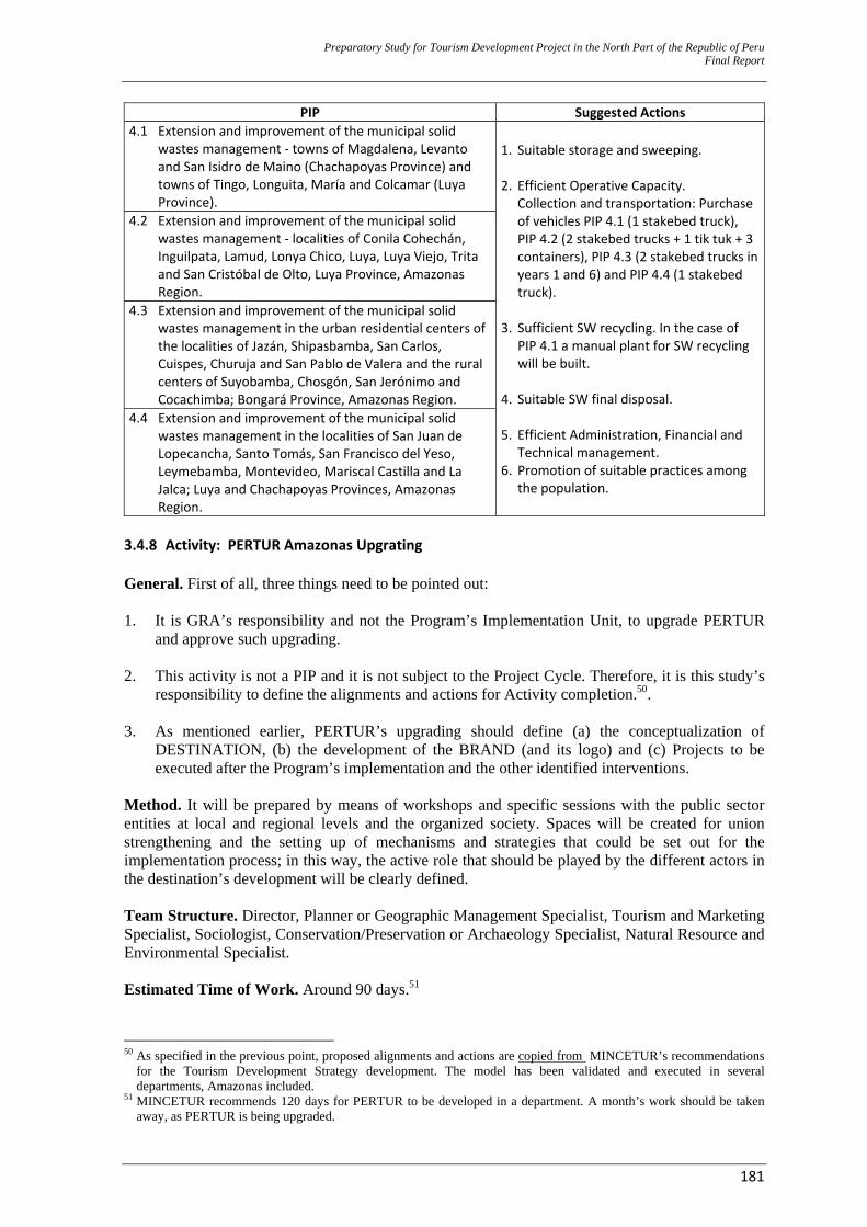
Preparatory Study for Tourism Development Project in the North Part of the Republic of Peru Final Report
181
PIP Suggested Actions 4.1 Extension and improvement of the municipal solid
wastes management ‐ towns of Magdalena, Levanto and San Isidro de Maino (Chachapoyas Province) and towns of Tingo, Longuita, María and Colcamar (Luya Province).
1. Suitable storage and sweeping. 2. Efficient Operative Capacity. Collection and transportation: Purchase
of vehicles PIP 4.1 (1 stakebed truck), PIP 4.2 (2 stakebed trucks + 1 tik tuk + 3 containers), PIP 4.3 (2 stakebed trucks in years 1 and 6) and PIP 4.4 (1 stakebed truck).
3. Sufficient SW recycling. In the case of
PIP 4.1 a manual plant for SW recycling will be built.
4. Suitable SW final disposal. 5. Efficient Administration, Financial and
Technical management. 6. Promotion of suitable practices among
the population.
4.2 Extension and improvement of the municipal solid wastes management ‐ localities of Conila Cohechán, Inguilpata, Lamud, Lonya Chico, Luya, Luya Viejo, Trita and San Cristóbal de Olto, Luya Province, Amazonas Region.
4.3 Extension and improvement of the municipal solid wastes management in the urban residential centers of the localities of Jazán, Shipasbamba, San Carlos, Cuispes, Churuja and San Pablo de Valera and the rural centers of Suyobamba, Chosgón, San Jerónimo and Cocachimba; Bongará Province, Amazonas Region.
4.4 Extension and improvement of the municipal solid wastes management in the localities of San Juan de Lopecancha, Santo Tomás, San Francisco del Yeso, Leymebamba, Montevideo, Mariscal Castilla and La Jalca; Luya and Chachapoyas Provinces, Amazonas Region.
3.4.8 Activity: PERTUR Amazonas Upgrating General. First of all, three things need to be pointed out: 1. It is GRA’s responsibility and not the Program’s Implementation Unit, to upgrade PERTUR
and approve such upgrading. 2. This activity is not a PIP and it is not subject to the Project Cycle. Therefore, it is this study’s
responsibility to define the alignments and actions for Activity completion.50. 3. As mentioned earlier, PERTUR’s upgrading should define (a) the conceptualization of
DESTINATION, (b) the development of the BRAND (and its logo) and (c) Projects to be executed after the Program’s implementation and the other identified interventions.
Method. It will be prepared by means of workshops and specific sessions with the public sector entities at local and regional levels and the organized society. Spaces will be created for union strengthening and the setting up of mechanisms and strategies that could be set out for the implementation process; in this way, the active role that should be played by the different actors in the destination’s development will be clearly defined. Team Structure. Director, Planner or Geographic Management Specialist, Tourism and Marketing Specialist, Sociologist, Conservation/Preservation or Archaeology Specialist, Natural Resource and Environmental Specialist. Estimated Time of Work. Around 90 days.51
50 As specified in the previous point, proposed alignments and actions are copied from MINCETUR’s recommendations
for the Tourism Development Strategy development. The model has been validated and executed in several departments, Amazonas included.
51 MINCETUR recommends 120 days for PERTUR to be developed in a department. A month’s work should be taken away, as PERTUR is being upgraded.

Preparatory Study for Tourism Development Project in the North Part of the Republic of Peru Final Report
182
Structure and Minimum Contents to be Developed. These are: 1. Methodological Framework 2. Strategic Analysis
2.1. External Analysis
2.1.1. International Context 2.1.2. Domestic Tourist Context 2.1.3. Regional Tourist Context (competitors - synergies)
2.2. Internal Analysis
2.2.1. Tourist Supply and Demand Structure: Demand Survey/Questionnaire and Analysis
2.2.2. Planning and Management Characteristics (Tourist Policy, Comprehensive Coordination and Institutionality)
2.2.3. Geographic/Land and Destination Characteristics (Land Planning and Registration, Infrastructure and Equipment and Heritage Conservation/Preservation)
2.2.4. Product Characteristics (Heritage Valuation–Crafts, Human Resources and Training, Product and Service Creation and Private Investment)
2.2.5. Promotion, Communication and Commercialization Characteristics (Tourist Promotion, Communicatons, Dissemination and Awareness Raising, Tourist Information System and Commercial Structure Development)
2.2.6. Quality Characteristics (Quality in terms of Destination, Products, and Services) 2.2.7. Security/Safety Characteristics (Security/Safety in Support Cities,
Security/Safety on Roads) 3. Work Methodology
3.1. On–site taskforce: Workshops 3.2. SWOT Analysis 3.3. Program Strategic Planning Validation: Operative Plan
4. Program Introduction
4.1. Planning and Management Program 4.2. Land and Destination Program 4.3. Product Program 4.4. Promotion, Communiction and Commercialization Program 4.5. Quality Program 4.6. Security/Safety Program
5. Monitoring and Follow–Up to the Plan Costs. Budget amounts S/.226,200 PEN), as specified in Attachment 16. 3.4.9 Activity: Commercialization Plan and Support to Commercialization in CTVU52. This intervention has been formulated upon the basis of the dissemination of the initial proposal and PromPerú’s input (both receptive and internal), international operators, international and
52 From this point, its name will be CTVU. Based on the meetings held with PromPerú, a decision was made that the term
“Valley” appears to be more appealing than “Basin”, as Valley brings to mind another already positioned product, namely, the Inca Valley.
Preparatory Study for Tourism Development Project in the North Part of the Republic of Peru Final Report
183
domestic tourist agency associations and the Amazonas operators. Therefore, alignments that are detailed below should be followed during the activity’s execution. All of this, regardless of the fact that the promotion products will be designed in compliance with the existing requirements and technologies at the time when the relevant services are hired. These are deemed the most outstanding points for the development of guiding policy alignments on behalf of the intervention zone, both at supply level and mainly, with regard to a sustainable demand that makes it possible for the involved zone to be sustained or supported as a whole. 1. Objectives (Alignments).
− Increasing the flow of both domestic and international tourists into CTVU, by means of
promotional campaigns and actions that support commercialization, both at domestic and inernational levels that are aimed at defined markets and strategic segments, with the participation of the Regional Coordination Council of Amazonas.
− Positioning the Utcubamba Valley as a tourist destination in the northern area of Perú, by taking advantage of its comparative advantage through Kuelap/Gocta, in terms of cultural and nature tourism.
2. Markets and Strategic Segments 2.1 Domestic Tourism The major emitter markets, according to PromPerú’s 2009 Domestic Vacationer’s Profile are: Chiclayo (46,000), Trujillo (105,000), Lima (2.3 million), Arequipa (263,000) and Huancayo (100,000). Because of their closeness to CTVU, Lima, Trujillo and Chiclayo represent CTVU’s major domestic tourist emitter markets. Target market among the CTVU domestic vacationers is made up of those tourists whose major motivation defines them as “connoisseurs”: They represent 17% of the domestic vacationers that travel for recreation purposes, according to PromPerú’s 2009 Domestic Vacationer’s Profile:
“Connoisseurs look for carrying out cultural activities through new experiences along with sceneries and a variety of attractions that are supplied by the Destination. In this segment, traveling group is made up of nuclear family members, parents and children. They prefer staying in hotels and in the homes of other family members and friends. Average sojourn is 6 nights in the visited location and individual expenditures per person amounts to S/.364 (PEN). Most tourists in this segment use their savings to fund their trips.”
2.2 Receptive Tourism According to PromPerú’s statistics on markets and strategic segments in its 2007 International Tourist’s Profile, some European countries (long distance or long houl markets) and Latin American countries hold a large percentage of tourists who would rather carry out activities that fit perfectly with the Amazonas Region supply potential, namely cultural and nature tourism. This is thanks to its Amazonas’ archaeological heritage, diverse ecosystems and geographic features. Markets Europe In the European Continent, strategic markets that are mostly interested in culture and nature are: United Kingdom and Germany. Both markets show a high percentage of tourists, who show an interest in those specific segments.
Preparatory Study for Tourism Development Project in the North Part of the Republic of Peru Final Report
184
South America In South America, strategic markets that are mostly interested in culture and nature are Argentina and Chile. Both markets show a high percentage of tourists who show an interest in the cultural segment. 3 Communication Strategies (alignments) 3.1 Communicating the intended image to be developed for the Destination – Receptive Tourism 3.1.1 A specialist experience, ranked as multiple activities or “multiproducts” that are to be
promoted as a whole and articulated to CTN. 3.1.2 CTVU Marketing Strategy will adopt the first two key mobilizers that have been studied by
PromPerú: 1. Ancestral Civilizations. “Anchor”: Kuelap Fortress 2. Unexplored Amazonia and Lush Nature: “Anchor”: Gocta Waterfall, the third highest
waterfall in the world. 3.2 Target population – Receptive Tourism A multiple theme experience seeker requires a multiplicity of activities in the CTVU, coming from the European market. 3.3 Communicating the intended image to be developed for the Destination – Domestic Tourism 3.3.1 CTVU marketing strategy will adopt both Destination “anchors”: − “Anchor”: Kuelap Fortress − “Anchor”: Gocta Waterfall, the highest in Perú. 3.4 Target market – Domestic Tourism Domestic vacationer in the strategic segment known as “connoisseurs”, from the most important emitter markets for CTVU: Lima, Trujillo and Chiclayo. 4 Promotion Strategies
4.1 Receptive Tourism
a. Designing theme contents and formats that are suitable to the commercialization channels that
operate in the defined markets and strategic segments from Europe. − Focusing promotion on commercialization channels that aim at markets and segments that have
been defined as strategic. − Developing a technological promotion strategy via the use of ITC to upgrade the supply that
has not been commercialized by the middlemen. b. Carrying out promotional campaigns that announce a CTVU multiple theme supply. − Positioning cultural, nature and mild extreme tourism around the “anchors”: Kuelap and Gocta. − Encouraging the promotion of products and services that have been combined with and
integrated to CTN. c. Steadily supporting the CTVU trade for commercialization. − Organizing and/or supporting family trips and press trips with the major press operators and
media. − Keeping a direct relationship with the commercialization agents. The minimum positioning process in a Route or Circuit Destination in the international market is no less than 3 to 5 years. Considering that the tourist product commercialization process at international level leads to a traffic of no less than 18 months, from the time a decision is made to
Preparatory Study for Tourism Development Project in the North Part of the Republic of Peru Final Report
185
include a Route or Circuit Destination in the manuals offered by the international tour operators, all the way through until it reaches a final consumer. As a differentiated product for niches/multitheme product is supplied, given the fact that massive tourism commercialization’s integration is vertical, major tour operators such as Kuony and TUI have centralized their operations on Condor Travel and Lima Tours, respectively. Therefore, CTVU supply becomes a differentiated alternative for the other domestic tour operators and receptive agencies. 4.2 Domestic Tourism a. Focusing promotion on the priority emitter markets: Lima, Trujillo and Chiclayo. − Adjusting contents, formats and channels so far used in promotion campaigns. − Designing a suitable commercialization strategy via the participation in domestic and regional
fairs. − Developing a technological promotion strategy via the use of ITC that are able to meet the
needs posed by markets and defined segments. b. Steadily supporting the CTVU trade for commercialization. − Organizing and/or supporting fam trips and press trips with the major press operators and
media. − Channeling tourist supply via public relations with the media. − Keeping a direct relationship with the commercialization agents. c. Carrying out promotion campaigns aimed at final consumers. − Leading direct promotion actions aimed at the consumers, especially in the strategic markets. − Setting up current and potential tourist databases that allow for establishing direct
communication with them. d. Encouraging travel promotions during low seasons via traveling programs that are
commercialized by the CTVU Private Sector. e. Encouraging travel during long holidays, traditional holidays and non–traditional holidays, for
CTVU supply diversification purposes. f. Encouraging study trips (student segment) to CTVU. 5. Strategies for Destination sale. 5.1 Price
− Positioning CTVU prices in keeping with the actual service conditions − Supporting CTVU trade for the targeted Price positioning − Encouraging promotion campaigns with discounts, especially during low season 6 Promotion and Commercialization Support Actions on behalf of CTVU
For the purposes of the sustainability of the Tourist Routes that have been mentioned in this Program, a promotion and commercialization process should be started for Investment Program’s execution years 2, 3 and 4. In this case, target domestic and receptive market segments should be considered (as described in the paragraph above) and the following actions should be taken: 6.1 Preparation of a CTVU Destination Website A CTVU Website will be prepared, introducing CTVU as a Destination. This website will focus on: − Trip planning: Information about the Destination − “During the Trip”: On–site services − Post “Cross-reference”: Forums and social networks
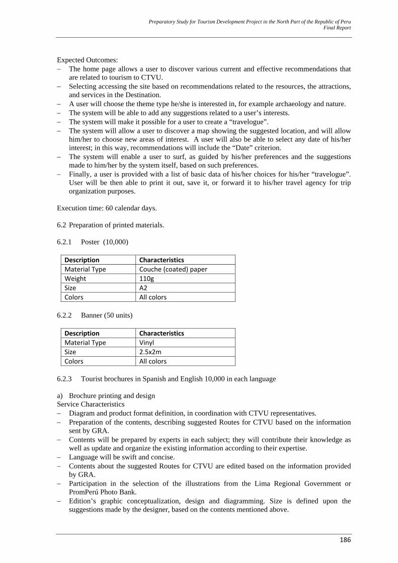
Preparatory Study for Tourism Development Project in the North Part of the Republic of Peru Final Report
186
Expected Outcomes: − The home page allows a user to discover various current and effective recommendations that
are related to tourism to CTVU. − Selecting accessing the site based on recommendations related to the resources, the attractions,
and services in the Destination. − A user will choose the theme type he/she is interested in, for example archaeology and nature. − The system will be able to add any suggestions related to a user’s interests. − The system will make it possible for a user to create a “travelogue”. − The system will allow a user to discover a map showing the suggested location, and will allow
him/her to choose new areas of interest. A user will also be able to select any date of his/her interest; in this way, recommendations will include the “Date” criterion.
− The system will enable a user to surf, as guided by his/her preferences and the suggestions made to him/her by the system itself, based on such preferences.
− Finally, a user is provided with a list of basic data of his/her choices for his/her “travelogue”. User will be then able to print it out, save it, or forward it to his/her travel agency for trip organization purposes.
Execution time: 60 calendar days. 6.2 Preparation of printed materials.
6.2.1 Poster (10,000)
Description Characteristics Material Type Couche (coated) paper Weight 110g Size A2 Colors All colors
6.2.2 Banner (50 units)
Description Characteristics Material Type Vinyl Size 2.5x2m Colors All colors
6.2.3 Tourist brochures in Spanish and English 10,000 in each language
a) Brochure printing and design Service Characteristics − Diagram and product format definition, in coordination with CTVU representatives. − Preparation of the contents, describing suggested Routes for CTVU based on the information
sent by GRA. − Contents will be prepared by experts in each subject; they will contribute their knowledge as
well as update and organize the existing information according to their expertise. − Language will be swift and concise. − Contents about the suggested Routes for CTVU are edited based on the information provided
by GRA. − Participation in the selection of the illustrations from the Lima Regional Government or
PromPerú Photo Bank. − Edition’s graphic conceptualization, design and diagramming. Size is defined upon the
suggestions made by the designer, based on the contents mentioned above.
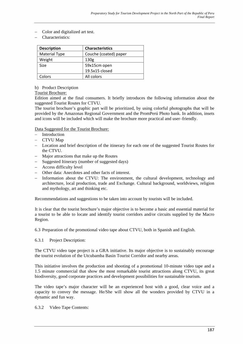
Preparatory Study for Tourism Development Project in the North Part of the Republic of Peru Final Report
187
− Color and digitalized art test. − Characteristics:
Description Characteristics Material Type Couche (coated) paper Weight 130g Size 59x15cm open
19.5x15 closed Colors All colors
b) Product Description Tourist Brochure: Edition aimed at the final consumers. It briefly introduces the following information about the suggested Tourist Routes for CTVU. The tourist brochure’s graphic part will be prioritized, by using colorful photographs that will be provided by the Amazonas Regional Government and the PromPerú Photo bank. In addition, insets and icons will be included which will make the brochure more practical and user–friendly. Data Suggested for the Tourist Brochure: − Introduction − CTVU Map − Location and brief description of the itinerary for each one of the suggested Tourist Routes for
the CTVU. − Major attractions that make up the Routes − Suggested Itinerary (number of suggested days) − Access difficulty level − Other data: Anecdotes and other facts of interest. − Information about the CTVU: The environment, the cultural development, technology and
architecture, local production, trade and Exchange. Cultural background, worldviews, religion and mythology, art and thinking etc.
Recommendations and suggestions to be taken into account by tourists will be included. It is clear that the tourist brochure’s major objective is to become a basic and essential material for a tourist to be able to locate and identify tourist corridors and/or circuits supplied by the Macro Region. 6.3 Preparation of the promotional video tape about CTVU, both in Spanish and English.
6.3.1 Project Description: The CTVU video tape project is a GRA initiative. Its major objective is to sustainably encourage the tourist evolution of the Utcubamba Basin Tourist Corridor and nearby areas. This initiative involves the production and shooting of a promotional 10-minute video tape and a 1.5 minute commercial that show the most remarkable tourist attractions along CTVU, its great biodiversity, good corporate practices and development possibilities for sustainable tourism. The video tape’s major character will be an experienced host with a good, clear voice and a capacity to convey the message. He/She will show all the wonders provided by CTVU in a dynamic and fun way. 6.3.2 Video Tape Contents:
Preparatory Study for Tourism Development Project in the North Part of the Republic of Peru Final Report
188
Major CTVU resources and attractions will be highlighted: The appeal to adventure, natural sanctuaries that are ideal for hiking, visits to archaeological sites and nature areas, in addition to the variety of the local cuisine and the living cultures that are offered by the region. 6.3.3 Target population: − International tourists. − Family groups traveling together. − College/University students, ages 18 to 24, and young working population, ages 25 to 34. − Young couples. 6.3.4 Narrative Style: Modern visual style. The video tape will have various image compositions. These include: A 2-D or 3-D introduction to the topic (3-D and 2-D animation. Route description along a 2-D Route sheet) information data in a 2-D and 3-D introduction/presentation. The edition will have a modern style, and will follow state-of-the-art edition programs, such as FINAL CUT PRO, After Effects etc. A music theme will be especially composed for the documentary, thus ensuring a perfect image–sound harmony and copyright protection for free use by the media. 6.3.5 Resources.
‐ For the video tape preparation, the following equipment will be used: − High definition equipment (HDV cameras). − Sony Boom microphone, Senheissser wireless microphones − Manfrotto Tripods, Mac Computers − Additional technical equipment: Edition studio and sound studio for speeches and
musicalization. − Software: Final CUT PRO, MOTION, AFTER EFFECTS, SOUD TRACK PRO, PRO TOOLS,
Illustrator, Photoshop, etc. 6.3.6 Proposal
The proposal should include, as a minimum: − Pre-Production (Research, coordinations, technical script and script and creative proposal.) − Production (Transportation, lodging, logistics and administrative expenses) − Lead: Host, models and extras − Direction (The documentary’s general direction) − Assistants − Edition (Edition and musicalization–music composition) − Post-Production (2-D and 3-D image composition) − Technical equipment and Team 6.3.7 Conditions:
The Regional Government of Amazonas will be the exclusive owner of the video tape, and will be able to use it for dissemination purposes in various media and communication channels, as well as private alternative channels, State organizations, NGOs and the Internet. 6.3.8 Deliverables:
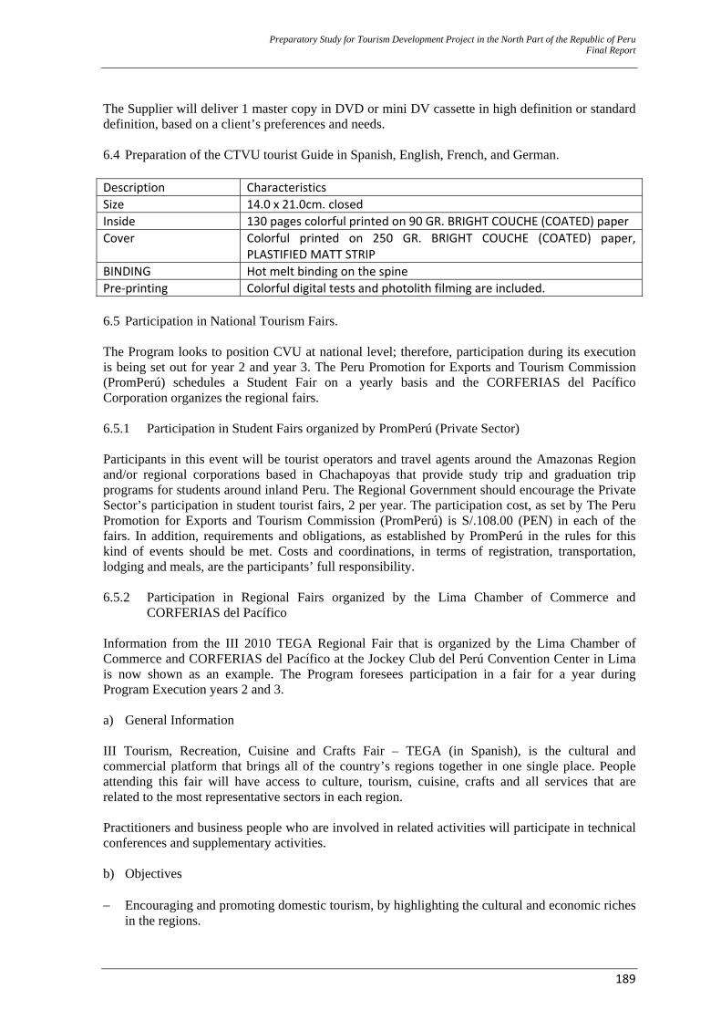
Preparatory Study for Tourism Development Project in the North Part of the Republic of Peru Final Report
189
The Supplier will deliver 1 master copy in DVD or mini DV cassette in high definition or standard definition, based on a client’s preferences and needs. 6.4 Preparation of the CTVU tourist Guide in Spanish, English, French, and German. Description Characteristics Size 14.0 x 21.0cm. closed Inside 130 pages colorful printed on 90 GR. BRIGHT COUCHE (COATED) paper Cover Colorful printed on 250 GR. BRIGHT COUCHE (COATED) paper,
PLASTIFIED MATT STRIP BINDING Hot melt binding on the spine Pre‐printing Colorful digital tests and photolith filming are included. 6.5 Participation in National Tourism Fairs. The Program looks to position CVU at national level; therefore, participation during its execution is being set out for year 2 and year 3. The Peru Promotion for Exports and Tourism Commission (PromPerú) schedules a Student Fair on a yearly basis and the CORFERIAS del Pacífico Corporation organizes the regional fairs. 6.5.1 Participation in Student Fairs organized by PromPerú (Private Sector) Participants in this event will be tourist operators and travel agents around the Amazonas Region and/or regional corporations based in Chachapoyas that provide study trip and graduation trip programs for students around inland Peru. The Regional Government should encourage the Private Sector’s participation in student tourist fairs, 2 per year. The participation cost, as set by The Peru Promotion for Exports and Tourism Commission (PromPerú) is S/.108.00 (PEN) in each of the fairs. In addition, requirements and obligations, as established by PromPerú in the rules for this kind of events should be met. Costs and coordinations, in terms of registration, transportation, lodging and meals, are the participants’ full responsibility. 6.5.2 Participation in Regional Fairs organized by the Lima Chamber of Commerce and
CORFERIAS del Pacífico Information from the III 2010 TEGA Regional Fair that is organized by the Lima Chamber of Commerce and CORFERIAS del Pacífico at the Jockey Club del Perú Convention Center in Lima is now shown as an example. The Program foresees participation in a fair for a year during Program Execution years 2 and 3. a) General Information III Tourism, Recreation, Cuisine and Crafts Fair – TEGA (in Spanish), is the cultural and commercial platform that brings all of the country’s regions together in one single place. People attending this fair will have access to culture, tourism, cuisine, crafts and all services that are related to the most representative sectors in each region. Practitioners and business people who are involved in related activities will participate in technical conferences and supplementary activities. b) Objectives
− Encouraging and promoting domestic tourism, by highlighting the cultural and economic riches
in the regions.
Preparatory Study for Tourism Development Project in the North Part of the Republic of Peru Final Report
190
− Accomplishing a cultural and business exchange that makes a lasting impact among the regions around the country.
− Promoting the commercialization of products manufactured by those entities that are representative in the regions, by giving support to those showing their products/services at the fair and those purchasing them, as they identify any business opportunities and build up productive relationships.
− Promoting the growth of SMEs, by generating new spaces for commercial, industrial and cultural activity promotion around the regions.
c) Schedule
10:00 to 21:00 hrs. The Jockey Club del Perú’s Exhibition Center (Entrance Gate No.1 Monterrico Racecourse - Av. Javier Prado Access.) d) Ticket Office General Ticket Value Recommended amount to be S/. 10.00 (PEN) The Jockey Club del Perú’s Exhibition Center (Entrance Gate No.1 Monterrico Racecourse - Av. Javier Prado Access.) e) Organizers
− The Lima Chamber of Commerce, through the COMTUR – The Tourism Committee. The Lima Chamber of Commerce - (CCL) and its Tourism Committee - COMTUR, developed 2 versions of the recreation and Cuisine Fair, aiming at promoting sustainable development of these sectors. At this fair’s latest version, over 114 participants who showed their products and/or services as well as 30,000 visitors, confirmed an existing demand by a specific population for an active involvement of business people coming directly from their regions of origin, so that this population is able to experience the reality of the regional cultures. Therefore domestic tourism is encouraged. − CORFERIAS del Pacífico CORFERIAS del Pacífico is a professional fair operator established in Perú. It focuses its work from an international perspective, as it develops networks and strategic alliances, aiming at providing a world-class hallmark. It becomes a modern commercial instrument for regional development purposes, which will allow Peru to position itself at worldwide level, as a hub for business operations, fairs, events, exhibitions, conventions and meetings. f) Theme Areas Tourism − Tourist Destinations − Hotels − Tourist Operators − Travel Agencies − Recreational Services (Art Centers, Recreational Activities, Extreme Sports, etc.)
Preparatory Study for Tourism Development Project in the North Part of the Republic of Peru Final Report
191
Cuisine − Traditional Cuisine − Restaurants − Bars Crafts − The best selection of the craftwork creativity that shows cultural expressions in our regions. Regional Projects − Productive initiatives, development and infrastructure plans aiming at tourism on the whole.
Cross – Sectional Services − Transportation Service (air, land, railway, river and lake.) − Universities, colleges, institutes and schools. − Financial institutions − Telecommunications − Institutions and public or private corporations. − The media (press, radio, TV). − NGO’s and associations. g) Participants’ Profile The regions of Perú will be the “stars” at the fair. The Regional Governments will bring to Lima their best cultural and commercial selection, by means of representative corporations in the areas of: Tourism, Recreation, Cuisine and Crafts. There will also be other corporations participating. These corporations will offer cross –sectional services within the national scope, and will supplement tourist and regional development around Perú. h) Benefits
− It is the best showcase for regions and their products to be promoted. − It is a suitable space for the best cultural and commercial exhibition. − It participates in tourist and regional development around Perú. − It successfully positions brands and generates product retail sales. i) Proposal for Regional Government Participation: Exposition Area, Characteristics and
Participation Cost.
Total Area: 90 m² − 10 booths, 6m² each − 1 institutional booth, 12m², for a Regional Government − 1 booth, 18m² in the Cuisine area Pre–decoration, turnkey, with the following elements: Floor: − Gray carpet covering the whole area. Friezes: − Perimeter friezes that join the booths. Octanorm Construction:
Preparatory Study for Tourism Development Project in the North Part of the Republic of Peru Final Report
192
− Panels: 2.48m high, aluminum profiles and Duraplac panels for booth delimitation. − Friezes: Perimeter friezes that join the booths Regional Area: − 1 Counter and 2 chairs for Regional Government delegates to give information. − Giant banner announcing or promoting the Region. Signaling: − Cylindrical-shaped totem with the Region’s name on it. 10 Pre- Decorated Stands: − Basic booth, 6m2 (2m x 3m) − Participant’s name on the frieze. − 1 table and 2 chairs. − 3 shelves to show products. − Lighting with 3 brackets holding 60 Watt lamps. − One outlet. − Power consumption up to 300 Watts. − Registration in the Official Regional Fair Catalog. − Permanent Cards for staff giving information in the booth (number according to each
corporation’s needs.)
Booth in the Cuisine Area − Basic Booth, 18 m2 (3m x 6m). − Construction in octanorm with aluminum profiles and Duraplac panels. − Frieze with the restaurant’s name Regional Government’s participation cost Cost: S/. 60,200.00 (PEN) (Sales Tax [IGV] included) Additional Activities − 1 hour in each one of the spaces devoted to academic and supplementary activities. − Auditorium: Space to show region–related themes. − Stage: Presentation of a typical regional show. − Cuisine Demo: Showing how typical regional meals are cooked. The Visitor’s Profile − Peruvian and foreign citizens with an interest in traveling and visiting other national realities. − People from the region who had moved to Lima and are looking for a cultural meeting with
their roots. − Business people, practitioners, specialists and students, who are related to tourism, cuisine,
recreation and crafts. 6.6 Organization of family Trips and workshops, aimed at tour operators and domestic travel
agencies in Chachapoyas. Organization of, or participation in workshops and business roundtables between tourist operators and travel agencies from different regions aim at creating a work framework that will make commercial or business exchange between the basic tourist supply and the professional distribution channels much easier. In addition, it provides a possibility to carry out parallel activities, such as training events on the product to an audience that is really interested in what is being supplied. The Program sets out the preparation of 2 workshops per year, for 2 years; one of them with the participation of domestic retail and wholesale travel agencies and the other one, with the
Preparatory Study for Tourism Development Project in the North Part of the Republic of Peru Final Report
193
participation of tour operators and receptive agencies that operate in the European market, which is a potential consumer of the CTVU product. a) Implementation For a workshop to be successfully organized, the first step is to identify and define the number of tourist operators and travel agencies that will participate in the event as CTVU representatives, as well as the number of guests that will be the counterpart. Once the number of attendants is defined, a space that is large and comfortable enough and the necessary equipment for the workshop development should be found. Other aspects to be taken into account include the decoration of the area, identification of the corporations, catering, hiring a photographer and a final poll. Some aspects that are necessary for a workshop’s implementation are listed below: − Name of the event − Objectives − Venue of the event’s development − Program’s Schedule and duration − Defining how many tour operators/wholesalers, agencies, retail operators and speakers will be
invited to participate at the event − Establishing an estimated total number of attendants − Defining the contents of the invitation cards/letters − Call and post follow–up − Weekly reports of guests who confirm their attendance − Final list of attendants − Name tags for attendants − Hiring supporting staff − Suitable area for the workshop − Necessary furniture and equipment, based on the number of attendants − Hiring catering service − Hiring a photographer − Conclusions and Final Report b) Workshop organization plan and family trip with the selected travel agencies from Lima,
Trujillo and Chiclayo. − Place: Chachapoyas − 4–day visit to CTVU. − Objective This action will allow for negotiating and developing suitable tools towards a successful establishment of an association and/or group of economic agents that are related to the tourism sector. This intends to position CTVU in the markets of Lima, Trujillo and Chiclayo. Participants: Economic agents at local and national level should participate, such as: − Local Agents: Retail travel agencies, tourist operators, lodging places (hotels and hostels), meal
supply places (restaurants and tourist restaurants), public transportation companies, private transportation companies (for tours, on an exclusive basis) , etc.
− Domestic agents: Businesses that are associated to national groups (CANATUR, AHORA, APAVIT, etc.), public institutions (PromPerú, I-PERÚ), etc.
This activity includes a family trip for CTVU field reconnaissance and commercialization purposes. This will allow for articulating/coordinating actions between the local economic agents, the national economic agents and public and private institutions. Contents of the Workshop’s organization:
Preparatory Study for Tourism Development Project in the North Part of the Republic of Peru Final Report
194
− Renting premises for 1 day. Premises will be located in Chachapoyas; it will be fully equipped and with furniture enough to hold 60 people. In addition, there will be a sound system, data show, microphones, etc. available.
− Premises decoration: This will involve equipment, tables, chairs, etc. to be rented. − Lodging: The event’s organization includes 3–night quality guaranteed lodging in
Chachapoyas for 60 people. − Meals at the Roundtable (1 day). This includes coffee break snacks and lunch for 60 people. − Facilitators: This involves service rendered by 2 facilitators at the 1–day event. − Hostesses: Participation of 4 hostesses for the event is foreseen. − Work material in the workshop: 60 participants − Catering service for 60 people. − Promotional welcoming gifts for regional promotion purposes: 60 local crafts, S/. 20 (PEN)
each. Contents of the Visit (fam trip): For the purposes of introducing CTVU tourist circuits and the changes carried out in the Tourist Circuit with the Program, a 4–day visit is set out to show guest visitors all enhancements made to the Project and on the conditioned Route. Tourist packages will be identified and tourist services will be linked to each of the spots along the Route. − Number of participants: 60 people − Transportation for 60 people to travel along CTVU (4 days) − Tour Conductors (2 people): Specialist guides, who will introduce CTVU and its tourist
resources. − Work material during the Route: A copy of the CTVU video tape. c) Workshop organization plan and fam trip with the tour operators and receptive agencies
operating in the European market. − Place: Chachapoyas − 4–day visit to CTVU. − Objective This action will allow for negotiating and developing suitable tools towards a successful establishment of an association and/or group of economic agents that are related to the tourism sector. This intends to position CTVU in the tour operator and receptive agency sales manuals, and thus, in their commercialization chain. Participants: Economic agents at local and national level should participate, such as: − Local Agents: Retail travel agencies, tourist operators, lodging places (hotels and hostels), meal
supply places (restaurants and tourist restaurants), public transportation companies, private transportation companies (for tours, on an exclusive basis) , etc.
− Tour operators and receptive agencies operating in the European market, public institutions (PromPerú, I-PERÚ), etc.
This activity includes a family trip for CTVU field reconnaissance and commercialization purposes. This will allow for articulating/coordinating actions between the local economic agents, the national economic agents and public and private institutions. Contents of the Workshop’s organization: − Renting premises for 1 day. Premises will be located in Chachapoyas; it will be fully equipped
and with furniture enough to hold 60 people. In addition, there will be a sound system, data show, microphones, etc. available.
− Premises decoration: This will involve equipment, tables, chairs, etc. to be rented.
Preparatory Study for Tourism Development Project in the North Part of the Republic of Peru Final Report
195
− Lodging: The event’s organization includes 3–night quality guaranteed lodging in Chachapoyas for 60 people.
− Meals at the Roundtable (1 day). This includes coffee break snacks and lunch for 60 people. − Facilitators: This involves service rendered by 2 facilitators at the 1–day event. − Hostesses: Participation of 4 hostesses for the event is foreseen. − Work material in the workshop: 60 participants − Catering service for 60 people. − Promotional welcoming gifts for regional promotion purposes: 60 local crafts, S/. 20 (PEN)
each. Contents of the Visit (family trip): For the purposes of introducing CTVU tourist circuits and the changes carried out in the Tourist Circuit with the Program, a 4–day visit is set out to show guest visitors all enhancements made to the Project and on the conditioned Route. Tourist packages will be identified and tourist services will be linked to each of the spots along the Route. − Number of participants: 60 people − Transportation for 60 people to travel along CTVU (4 days) − Tour Conductors (2 people): Specialist guides, who will introduce CTVU and its tourist
resources − Work material during the Route: A copy of the CTVU video tape. 6.7 Organization of press tours, aimed at domestic media and international media that are credited
in Peru. This process will allow for promoting CTVU to the specialist media, both at national and international level, via the participation of well–known journalists in the nature, rural and extreme tourist world. It will also allow for opening new markets. This will be a 4–day long activity that will be carried out with the participation of 50 specialist journalists. Organization and/or support to family trips/press tours, trips aimed at travel agents and media, respectively. The objective is to provide a tailored introduction of the product and the services in the area that will in turn allow for CTVU promotion and dissemination. The selected service suppliers for these activities should be of the highest level, as the attractions and services supplied are intended to cause the best impression on the travel agents or media. In the case of the press tours, a local journalist’s attendance is needed, for a direct dialog to be established with the media and lead them, with regard to the information intended for publication. In this sense, a press dossier should have been prepared in advance. This dossier should include all the information about the CTVU and the various attractions and services that can be supplied in it. The project sets out the organization of 2 press tours over a 2–year period, with the participation of the national press and international press correspondents who are specialists in nature and culture. It is necessary to point out that the press tour organization and preparation costs could be decreased by means of strategic alliances with the local tourist service suppliers. These in turn, should be quality suppliers, as a positive image of CTVU and its surroundings is intended to be introduced. Implementation: The following guidelines need to be taken into account for a press tour organization: − Establishing a potential sales itinerary with a specific number of days and nights in the zone
intended for promotion. − Establishing a group of media who would be interested in promoting the area. − The group should not exceed 30 people and they all should be decision makers at corporate
level.
Preparatory Study for Tourism Development Project in the North Part of the Republic of Peru Final Report
196
− Services offered in the itinerary intend to be sold through this group, that is, lodging, meals, transportation and guided tours. The following are to be considered: Simple bedroom lodgings, whole–day meals (breakfast, lunch and dinner), private transportation should have air conditioning, first aid kit and a capacity that exceeds the number of passengers that make up the group. In addition, the guide provided should be an experienced one.
− Costs/investment are directly taken on by the organizer and he/she will have the opportunity to get into strategic alliances with the service providers for costs to be lowered, namely, transportation, lodging and meals.
− Local service suppliers are recommended to have the highest priority to do. 6.8 BTL Advertising for the “Chachapoyas Pone” (“Chachapoyas Puts It”) Campaign in Lima,
Trujillo and Chiclayo.
6.8.1 The Service’s Objective
This campaign contributes to the tourist promotion of the Utcubamba Basin Tourist Corridor (CTVU) and the Amazonas Region. This involves resources, attractions and tourist routes, as suggested in CTVU. The objective is to increase and encourage traveling to this destination. This campaign will provide attractive and new offers that will be good domestic tourism generators. The Regional Government of Amazonas intends to carry out different communication actions; some of these include advertising via BTL activities and aiming at reinforcing communication to the final target population and motivating them to visit the Amazonas Region, especially CTVU. Another strategy involves handing out supporting printouts to the target population. 6.8.2 Service Description
Implementation of a BTL activity is required for this campaign. This activity is to be carried out at various commercial centers in the cities of Lima, Trujillo and Chiclayo, that according to studies carried out by PromPerú, concentrate a large portion of the target market for this campaign. 6 activities will be carried out in Lima, 3 activities will be carried out in Trujillo and 3 activities will be carried out in Chiclayo (1 activity per date), with a minimum of 4 hours duration per day and per location. Each BTL activation will include 1 photographic display showing the destination support (backing) resources that have been set up at the location where the target population is, that is the mall or a rented public space. There the target population will experience about being in the different CTVU Routes and the Amazonas Region that are being promoted and will be informed in a learning–by–playing way, about the traveling packages that the “Chachapoyas Pone” (“Chachapoyas Puts It”) campaign supplies. In addition, database of the participants will be registered and catalogs will be handed out with the detailed information on the supply; in this way, any queries from the potential travelers will be answered. Finally, folk musicians and dancers from the Amazonas Region will perform. This will motivate the target population to travel and experience the Chachapoyas destination for real. The BTL supplier to be selected should create and produce all the elements in the activity, negotiate the permits, carry out and supervise the BTL activity. In this sense, quotation from BTL agencies that are specialists in this activity is strongly recommended. The campaign’s target populations include: − Family groups traveling together − 18–24 year old college/university students and 25–34 year old working young people. − Young couples.
Preparatory Study for Tourism Development Project in the North Part of the Republic of Peru Final Report
197
The target population is intended to get informed about the “Chachapoyas Puts It” Campaign and become motivated to travel, because of the attractive prices and the diversity of activities that are being promoted, with a promise of rest, fun and knowledge about CTVU and the Amazonas Region in all promoted destinations. This is because the Amazonas Region has some stunning monuments that were built by the Chachapoyas Civilization, such as Kuelap and it also has the highest waterfall in Perú (Gocta), natural riches, abundant biodiversity, a rich cuisine and especially lots of adventure; all of this allows a potential traveler to come to this region at a special price, as offered for the campaign. The campaign should use a language that is appealing to a young, fun–loving market of potential travelers, who are informed about the resources and attractions that are waiting for them in CTVU and the Amazonas Region and that they can access because of the low prices. The tone of the message should be fresh, dynamic and should focus on the benefits for those who travel to the Amazonas Region, as they take advantage of the promotion (Price is an influential factor). What is the Key Insight that provides the best foundation for creativity? Chachapoyas inputs include: Nice waterfalls, such as Gocta Ancestral civilizations like Kuelap Diverse cuisine Stunning nature and especially lots of adventure. For the set out strategy to be accomplished, a supplier who provides logistics and the following management, is required: a) Activities: Props and Backing: − Printing of 6 banners: 2.20m high x 2.40m wide, with a fastening system and installation on the
backings, as submitted by the supplier. − Production and preparation of resources (elements) for the staging of the physical space where
the Destination context is to be recreated. − Production and preparation of dresses and accessories for 2 characters: 1 dress of a
Chachapoyas Civilization authority and 1 dress of a woman from La Jalca rural community. − Rental of a 5 x 3 carpeted stage and a canopy for an activity at the mall on all the scheduled
days. This includes: installation, transportation and staff.
Transportation: − Picking up and giving back materials: Backings, fliers, information modules and all the props
needed for the activity: Regional Government Store room/BTL agency store room/Local Government Store room.
− Transportation of informational material, props and backings to the relevant malls; this includes staff for assembling and disassembling backings and props.
− Transportation of staff (characters, artistic show, promoter and supervisor) to the relevant malls. − Transportation to coordination meetings during the days prior to the event. Permits: − Negotiating and paying agreed upon amounts for the rented areas in the required malls. − Negotiating permits with the relevant municipalities. b) Staff:
Preparatory Study for Tourism Development Project in the North Part of the Republic of Peru Final Report
198
Pre - event: − The supplier should have staff in charge of producing the materials and doing the negotiations
to get what is required. During the event: − 01 supervisor, in charge of the activity. − 01 promoter, in charge of attracting people to the activity. − 01 photographer. − 01 assistant photographer. − 02 performers, who will represent 2 characters: A Chachapoyas Civilization authority and a
woman from La Jalca rural community. − 06 people for the artistic show: 4 musicians and 2 dancers Post - event: − 01 person in charge of database information input in Excel, for database and photographs to be
released in a CD. − Activities report Deliverables: GRA will submit a CD to the supplier with all the artwork for banner production and printing. In addition, GRA will provide the supplier with printed t-shirts, printouts and other materials for campaign advertising purposes. The week after the activity has been carried out, the supplier should submit 1 CD with all photographs and the Excel database of all registered people. In addition, the supplier should have an address in the cities of Lima, Trujillo and Chiclayo, as applicable and have the minimum communications and coordination equipment available (mobile phone or e-mail). 6.8.3 Execution Venue and Schedules The supplier will start rendering the service as early as on the day after the agreement’s subscription, until the end of the campaign. The Amazonas Regional Government will provide the supplier with all the materials for service rendering purposes as early as on the day after service rendering is authorized. Activation dates would lie between March and April, preferably during the weekends (Saturdays and Sundays). The whole service would cover a total of 12 execution dates. Preferable venues would be the following malls (C.C. or “centros comerciales” in Spanish) in Lima: Lima: − C.C. Megaplaza (02 activations) − C.C. Jockey Plaza (02 activations) − C.C. Lima Sur (02 activations) Trujillo: − Mall Aventura Plaza Trujillo (01 activation). − Centro Comercial real Plaza Trujillo − Los Jardines Open Plaza
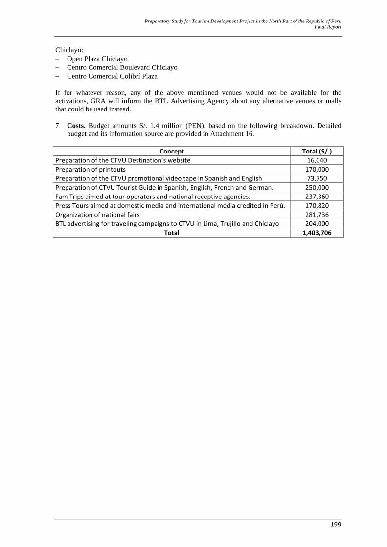
Preparatory Study for Tourism Development Project in the North Part of the Republic of Peru Final Report
199
Chiclayo: − Open Plaza Chiclayo − Centro Comercial Boulevard Chiclayo − Centro Comercial Colibrí Plaza If for whatever reason, any of the above mentioned venues would not be available for the activations, GRA will inform the BTL Advertising Agency about any alternative venues or malls that could be used instead. 7 Costs. Budget amounts S/. 1.4 million (PEN), based on the following breakdown. Detailed
budget and its information source are provided in Attachment 16.
Concept Total (S/.) Preparation of the CTVU Destination’s website 16,040 Preparation of printouts 170,000 Preparation of the CTVU promotional video tape in Spanish and English 73,750 Preparation of CTVU Tourist Guide in Spanish, English, French and German. 250,000 Fam Trips aimed at tour operators and national receptive agencies. 237,360 Press Tours aimed at domestic media and international media credited in Perú. 170,820 Organization of national fairs 281,736 BTL advertising for traveling campaigns to CTVU in Lima, Trujillo and Chiclayo 204,000
Total 1,403,706

Preparatory Study for Tourism Development Project in the North Part of the Republic of Peru Final Report
200
CHAPTER IV EVALUATION
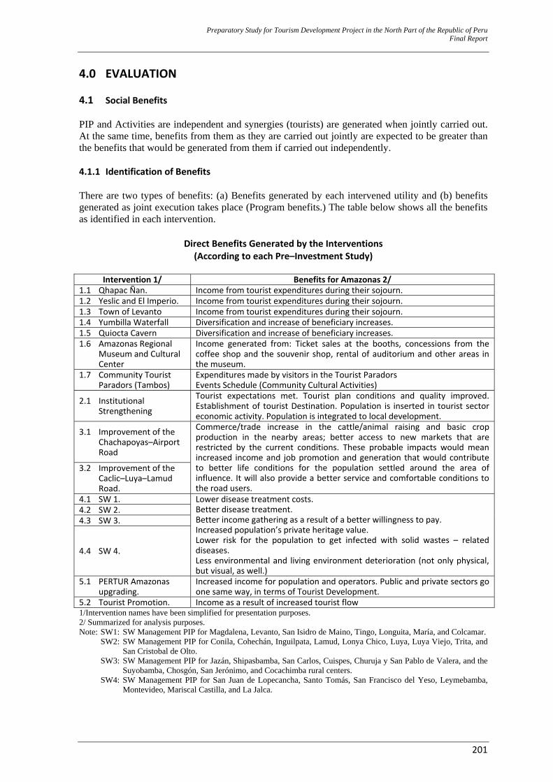
Preparatory Study for Tourism Development Project in the North Part of the Republic of Peru Final Report
201
4.0 EVALUATION 4.1 Social Benefits PIP and Activities are independent and synergies (tourists) are generated when jointly carried out. At the same time, benefits from them as they are carried out jointly are expected to be greater than the benefits that would be generated from them if carried out independently. 4.1.1 Identification of Benefits There are two types of benefits: (a) Benefits generated by each intervened utility and (b) benefits generated as joint execution takes place (Program benefits.) The table below shows all the benefits as identified in each intervention.
Direct Benefits Generated by the Interventions (According to each Pre–Investment Study)
Intervention 1/ Benefits for Amazonas 2/
1.1 Qhapac Ñan. Income from tourist expenditures during their sojourn. 1.2 Yeslic and El Imperio. Income from tourist expenditures during their sojourn. 1.3 Town of Levanto Income from tourist expenditures during their sojourn. 1.4 Yumbilla Waterfall Diversification and increase of beneficiary increases. 1.5 Quiocta Cavern Diversification and increase of beneficiary increases. 1.6 Amazonas Regional
Museum and Cultural Center
Income generated from: Ticket sales at the booths, concessions from the coffee shop and the souvenir shop, rental of auditorium and other areas in the museum.
1.7 Community Tourist Paradors (Tambos)
Expenditures made by visitors in the Tourist Paradors Events Schedule (Community Cultural Activities)
2.1 Institutional Strengthening
Tourist expectations met. Tourist plan conditions and quality improved. Establishment of tourist Destination. Population is inserted in tourist sector economic activity. Population is integrated to local development.
3.1 Improvement of the Chachapoyas–Airport Road
Commerce/trade increase in the cattle/animal raising and basic crop production in the nearby areas; better access to new markets that are restricted by the current conditions. These probable impacts would mean increased income and job promotion and generation that would contribute to better life conditions for the population settled around the area of influence. It will also provide a better service and comfortable conditions to the road users.
3.2 Improvement of the Caclic–Luya–Lamud Road.
4.1 SW 1. Lower disease treatment costs. Better disease treatment. Better income gathering as a result of a better willingness to pay. Increased population’s private heritage value. Lower risk for the population to get infected with solid wastes – related diseases. Less environmental and living environment deterioration (not only physical, but visual, as well.)
4.2 SW 2. 4.3 SW 3.
4.4 SW 4.
5.1 PERTUR Amazonas upgrading.
Increased income for population and operators. Public and private sectors go one same way, in terms of Tourist Development.
5.2 Tourist Promotion. Income as a result of increased tourist flow 1/Intervention names have been simplified for presentation purposes. 2/ Summarized for analysis purposes. Note: SW1: SW Management PIP for Magdalena, Levanto, San Isidro de Maino, Tingo, Longuita, María, and Colcamar. SW2: SW Management PIP for Conila, Cohechán, Inguilpata, Lamud, Lonya Chico, Luya, Luya Viejo, Trita, and
San Cristobal de Olto. SW3: SW Management PIP for Jazán, Shipasbamba, San Carlos, Cuispes, Churuja y San Pablo de Valera, and the
Suyobamba, Chosgón, San Jerónimo, and Cocachimba rural centers. SW4: SW Management PIP for San Juan de Lopecancha, Santo Tomás, San Francisco del Yeso, Leymebamba,
Montevideo, Mariscal Castilla, and La Jalca.
Preparation Study for Tourism D
evelopment Project in the N
orth Part of the Republic of PeruFinal Repor t
202
4.1.2 Measurement of Benefits A. Benefits from PIP (Public Investment Projects) Sectors being intervened include: ‐ Sanitation/Health: Solid Wastes. ‐ Transportation: Roads ‐ Tourism: Enhancement of natural and historic resources and tourist promotion and development. ‐ Prime Minister’s Office (PCM, in Spanish): Institutional Management Strengthening ‐ Culture: Museum. Each PIP has taken each sector’s technique for benefit measurement and valuation/appraisal. In this sense, transportation and tourism are the only interventions that value benefits, to the point that only transportation and tourism PIP are evaluated by the cost/benefit methodology. B. Benefits from Tourism – Expenditure per Day/Tourist Tourism benefits boil down to the increased income in the intervention area as a result of tourist expenditures. This increase is due to: (a) An increased number of tourists, (b) an increased sojourn and (c) increased tourist/day expenditures. Domestic Tourists. If impact all over Perú is taken into account in the social (economic) evaluation, expenditures incurred by domestic tourists would bear no impact at all. It would make no difference for a Peruvian resident to spend his/her money in Lima, Trujillo or Chachapoyas. Money is spent and the Peruvian society keeps the same capital stock (although it could be assumed that foreign exchange is kept from leaving the country). Therefore, an assumption could be made that, given the level of poverty and underdevelopment in Amazonas, with regard to the major emitters (Lima, La Libertad and Lambayeque), there is a distributional benefit for the Amazonas population. In this sense, income generated from expenditures made by domestic tourists in Amazonas is considered to be beneficial. Increased Tourists and Increased Sojourns. The calculation is specified below and is based on the assumptions, as explained in point 3.7.
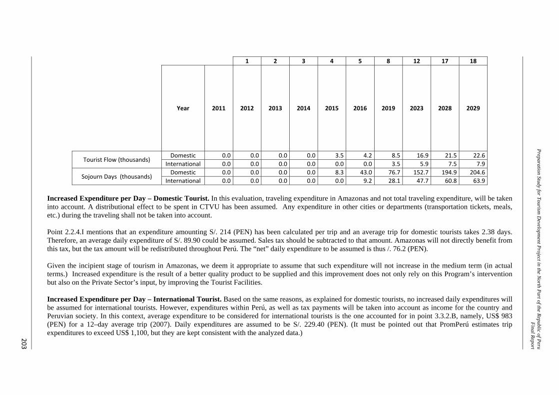
Preparation Study for Tourism D
evelopment Project in the N
orth Part of the Republic of PeruFinal Repor t
203
1 2 3 4 5 8 12 17 18
Year 2011 2012 2013 2014 2015 2016 2019 2023 2028 2029
Tourist Flow (thousands) Domestic 0.0 0.0 0.0 0.0 3.5 4.2 8.5 16.9 21.5 22.6
International 0.0 0.0 0.0 0.0 0.0 0.0 3.5 5.9 7.5 7.9
Sojourn Days (thousands) Domestic 0.0 0.0 0.0 0.0 8.3 43.0 76.7 152.7 194.9 204.6
International 0.0 0.0 0.0 0.0 0.0 9.2 28.1 47.7 60.8 63.9 Increased Expenditure per Day – Domestic Tourist. In this evaluation, traveling expenditure in Amazonas and not total traveling expenditure, will be taken into account. A distributional effect to be spent in CTVU has been assumed. Any expenditure in other cities or departments (transportation tickets, meals, etc.) during the traveling shall not be taken into account. Point 2.2.4.I mentions that an expenditure amounting S/. 214 (PEN) has been calculated per trip and an average trip for domestic tourists takes 2.38 days. Therefore, an average daily expenditure of S/. 89.90 could be assumed. Sales tax should be subtracted to that amount. Amazonas will not directly benefit from this tax, but the tax amount will be redistributed throughout Perú. The “net” daily expenditure to be assumed is thus /. 76.2 (PEN). Given the incipient stage of tourism in Amazonas, we deem it appropriate to assume that such expenditure will not increase in the medium term (in actual terms.) Increased expenditure is the result of a better quality product to be supplied and this improvement does not only rely on this Program’s intervention but also on the Private Sector’s input, by improving the Tourist Facilities. Increased Expenditure per Day – International Tourist. Based on the same reasons, as explained for domestic tourists, no increased daily expenditures will be assumed for international tourists. However, expenditures within Perú, as well as tax payments will be taken into account as income for the country and Peruvian society. In this context, average expenditure to be considered for international tourists is the one accounted for in point 3.3.2.B, namely, US$ 983 (PEN) for a 12–day average trip (2007). Daily expenditures are assumed to be S/. 229.40 (PEN). (It must be pointed out that PromPerú estimates trip expenditures to exceed US$ 1,100, but they are kept consistent with the analyzed data.)
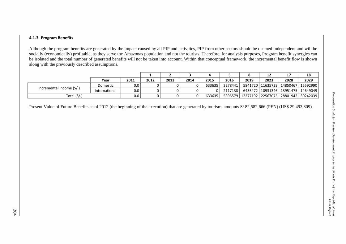
Preparation Study for Tourism D
evelopment Project in the N
orth Part of the Republic of PeruFinal Repor t
204
4.1.3 Program Benefits Although the program benefits are generated by the impact caused by all PIP and activities, PIP from other sectors should be deemed independent and will be socially (economically) profitable, as they serve the Amazonas population and not the tourists. Therefore, for analysis purposes, Program benefit synergies can be isolated and the total number of generated benefits will not be taken into account. Within that conceptual framework, the incremental benefit flow is shown along with the previously described assumptions.
1 2 3 4 5 8 12 17 18 Year 2011 2012 2013 2014 2015 2016 2019 2023 2028 2029
Incremental Income (S/.) Domestic 0.0 0 0 0 633635 3278441 5841720 11635729 14850467 15592990
International 0.0 0 0 0 0 2117138 6435472 10931346 13951475 14649049 Total (S/.) 0.0 0 0 0 633635 5395579 12277192 22567075 28801942 30242039
Present Value of Future Benefits as of 2012 (the beginning of the execution) that are generated by tourism, amounts S/.82,582,666 (PEN) (US$ 29,493,809).
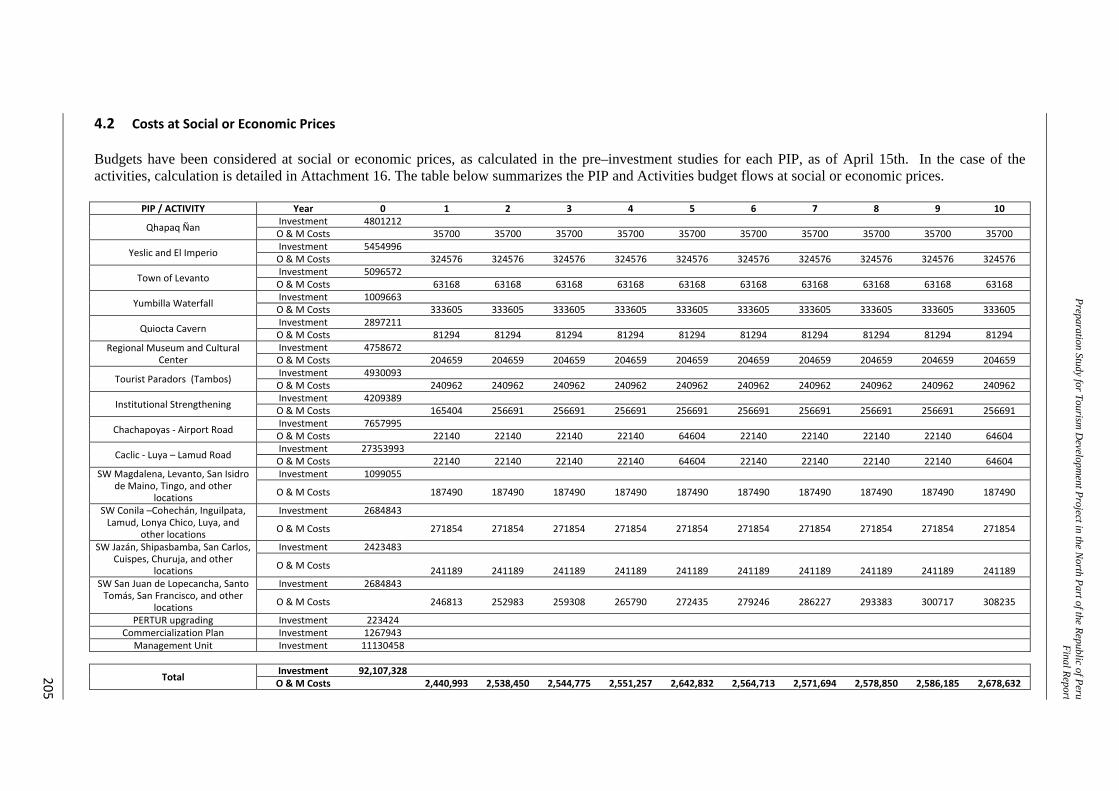
Preparation Study for Tourism D
evelopment Project in the N
orth Part of the Republic of PeruFinal Repor t
205
4.2 Costs at Social or Economic Prices Budgets have been considered at social or economic prices, as calculated in the pre–investment studies for each PIP, as of April 15th. In the case of the activities, calculation is detailed in Attachment 16. The table below summarizes the PIP and Activities budget flows at social or economic prices.
PIP / ACTIVITY Year 0 1 2 3 4 5 6 7 8 9 10
Qhapaq Ñan Investment 4801212 O & M Costs 35700 35700 35700 35700 35700 35700 35700 35700 35700 35700
Yeslic and El Imperio Investment 5454996 O & M Costs 324576 324576 324576 324576 324576 324576 324576 324576 324576 324576
Town of Levanto Investment 5096572 O & M Costs 63168 63168 63168 63168 63168 63168 63168 63168 63168 63168
Yumbilla Waterfall Investment 1009663 O & M Costs 333605 333605 333605 333605 333605 333605 333605 333605 333605 333605
Quiocta Cavern Investment 2897211 O & M Costs 81294 81294 81294 81294 81294 81294 81294 81294 81294 81294
Regional Museum and Cultural Center
Investment 4758672 O & M Costs 204659 204659 204659 204659 204659 204659 204659 204659 204659 204659
Tourist Paradors (Tambos) Investment 4930093 O & M Costs 240962 240962 240962 240962 240962 240962 240962 240962 240962 240962
Institutional Strengthening Investment 4209389 O & M Costs 165404 256691 256691 256691 256691 256691 256691 256691 256691 256691
Chachapoyas ‐ Airport Road Investment 7657995 O & M Costs 22140 22140 22140 22140 64604 22140 22140 22140 22140 64604
Caclic ‐ Luya – Lamud Road Investment 27353993 O & M Costs 22140 22140 22140 22140 64604 22140 22140 22140 22140 64604
SW Magdalena, Levanto, San Isidro de Maino, Tingo, and other
locations
Investment 1099055
O & M Costs 187490 187490 187490 187490 187490 187490 187490 187490 187490 187490
SW Conila –Cohechán, Inguilpata, Lamud, Lonya Chico, Luya, and
other locations
Investment 2684843
O & M Costs 271854 271854 271854 271854 271854 271854 271854 271854 271854 271854
SW Jazán, Shipasbamba, San Carlos, Cuispes, Churuja, and other
locations
Investment 2423483
O & M Costs 241189 241189 241189 241189 241189 241189 241189 241189 241189 241189 SW San Juan de Lopecancha, Santo Tomás, San Francisco, and other
locations
Investment 2684843
O & M Costs 246813 252983 259308 265790 272435 279246 286227 293383 300717 308235
PERTUR upgrading Investment 223424 Commercialization Plan Investment 1267943
Management Unit Investment 11130458
Total Investment 92,107,328 O & M Costs 2,440,993 2,538,450 2,544,775 2,551,257 2,642,832 2,564,713 2,571,694 2,578,850 2,586,185 2,678,632
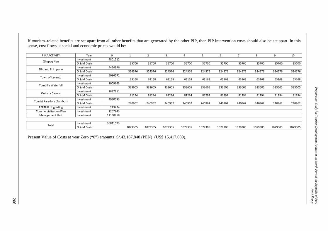
Preparation Study for Tourism D
evelopment Project in the N
orth Part of the Republic of PeruFinal Repor t
206
If tourism–related benefits are set apart from all other benefits that are generated by the other PIP, then PIP intervention costs should also be set apart. In this sense, cost flows at social and economic prices would be:
PIP / ACTIVITY Year 0 1 2 3 4 5 6 7 8 9 10
Qhapaq Ñan Investment 4801212O & M Costs 35700 35700 35700 35700 35700 35700 35700 35700 35700 35700
Silic and El Imperio Investment 5454996O & M Costs 324576 324576 324576 324576 324576 324576 324576 324576 324576 324576
Town of Levanto Investment 5096572O & M Costs 63168 63168 63168 63168 63168 63168 63168 63168 63168 63168
Yumbilla Waterfall Investment 1009663O & M Costs 333605 333605 333605 333605 333605 333605 333605 333605 333605 333605
Quiocta Cavern Investment 2897211O & M Costs 81294 81294 81294 81294 81294 81294 81294 81294 81294 81294
Tourist Paradors (Tambos) Investment 4930093O & M Costs 240962 240962 240962 240962 240962 240962 240962 240962 240962 240962
PERTUR Upgrading Investment 223424Commercialization Plan Investment 1267943
Management Unit Investment 11130458
Total Investment 36811573O & M Costs 1079305 1079305 1079305 1079305 1079305 1079305 1079305 1079305 1079305 1079305
Present Value of Costs at year Zero (“0”) amounts S/.43,167,848 (PEN) (US$ 15,417,089).
Preparatory Study for Tourism Development Project in the North Part of the Republic of Peru Final Report
207
4.3 Social or Economic Evaluation 4.3.1 Social or Economic NPV Calculation Based on the calculations, as detailed in the previous paragraph, social (economic) NPV is positive and amounts S/.39,414,818 (PEN) (US$ 14,076,720). 4.3.2 Sensitivity Analysis A. Critical Variables These variables are related to income generated by tourism more than to implementation costs. Critical variables include: ‐ Average sojourn ‐ Tourist flow growth rate ‐ Average expenditure: Although this is a critical variable, this analysis shall not be taken into
account, as the historic expenditures and not any increases to them have been taken on. B. Evaluation Results Average number of days: NPV would be positive only if average sojourn manages to be 2.7 days. Tourist Flow Growth Rate.
‐ International Tourists: If the impact is nil, NPV is still positive. ‐ Domestic Tourists: If the impact is nil, NPV is still positive. ‐ If the impact is nil in both tourist flows, NPV is still positive.
Conclusion: In this case, the variable that determines the social (economic) NPV’s social (economic) profitability is the tourists’ sojourn. Just by meeting an average 3–day sojourn goal among tourists visiting CTVU for leisure, recreation or vacations, a positive social (economic) NPV would be accomplished. Therefore, the basic strategy of further resources for tourists to visit and stay longer in CTVU is validated.
4.4 Sustainability Analysis 4.4.1 The Foreseen Institutional Arrangements For the Program’s execution itself, no institutional agreements with any other entities are necessary. However, each pre–investment study in every PIP should support the institutional agreements that are necessary to ensure each intervention’s sustainability. Actions that are particular to the Program include PERTUR upgrading, tourist positioning and promotion. In both cases, the Implementation Unit will be a GRA unit (no covenants or agreements need to be established.) PERTUR upgrading will be based on consensus and agreements between the parties, but as part of the execution (no ex–ante agreements). On the other hand, the tourist positioning and promotion strategy was introduced by GRA in a workshop on March 31st 2011 to all the involved parties and in coordination with PromPerú. In this workshop, the proposal was validated and no specific explicit agreements are needed.
Preparatory Study for Tourism Development Project in the North Part of the Republic of Peru Final Report
208
4.4.2 Legal Framework needed for Project Execution and Operation There is no need of a new or refined legal framework for the project to be executed or the Program’s sustainability to be ensured. 4.4.3 Operation and Maintenance (O&M) Cost Funding Each and every PIP should define the best option that allows for ensuring sufficient funds to cover O&M Costs. In addition to PIP, the Investment program has an activity that requires permanent funds and that derives from the investment in tourist positioning and promotion that will be executed within the Program’s framework. Permanent activity will be carried out by PromPerú and private agents as part of their regular and regulated activities (in any other Destination). 4.4.4 The Beneficiaries’ Participation The beneficiaries’ participation is basically the investment in the Tourist Facilities. This is a private activity that should be executed by private agents. In the short term, beneficiaries are expected not to increase the Tourist Facilities (in terms of volume), but to improve their quality service. At present, installed capacity exceeds the demand and private agents will tend not to invest in supply increases, but competition will push for better quality. In addition, private agents are considered to be expecting to know if this intervention and COPESCO National Plan’s intervention are true and will be carried out, so that they can make their investment decisions. However, although their response capacity is quick, beneficiaries (whether operators or families) are expected to increase their capacities at the necessary level, so as to meet the expected demand. 4.5 Environmental Impact and Risk Analysis The Program is a set of independent projects that generate synergies, as they are set up as a whole. If the intervention of the Program “alone” is considered to be equal to the total minus the PIP interventions, then there are 2 activities left (PERTUR upgrading and Tourist Promotion). Those activities imply paperwork and advertising, they are strategies, they do not define any relevant environmental impacts and likewise their execution will not be affected by any probable hazards that might be activated. Each PIP, on the other hand, should carry out an environmental impact analysis due to the intervention and the service being rendered. In addition, each PIP should know about all the dangers and vulnerabilities in the components or vulnerable factors that allow for this service to be rendered and the population that will be benefited with such service. 4.6 Organization and Management 4.6.1 The Program’s Implementation Unit A. The Establishment of the Management Unit It is GRA’s responsibility that the Program is implemented and the establishment of a Management Unit (MU) is suggested. MU would be made up of a technical team of experts, whose mission will be to meet the scheduled objectives and it should be technically and administratively autonomous, as it aims at developing the Program’s projects.
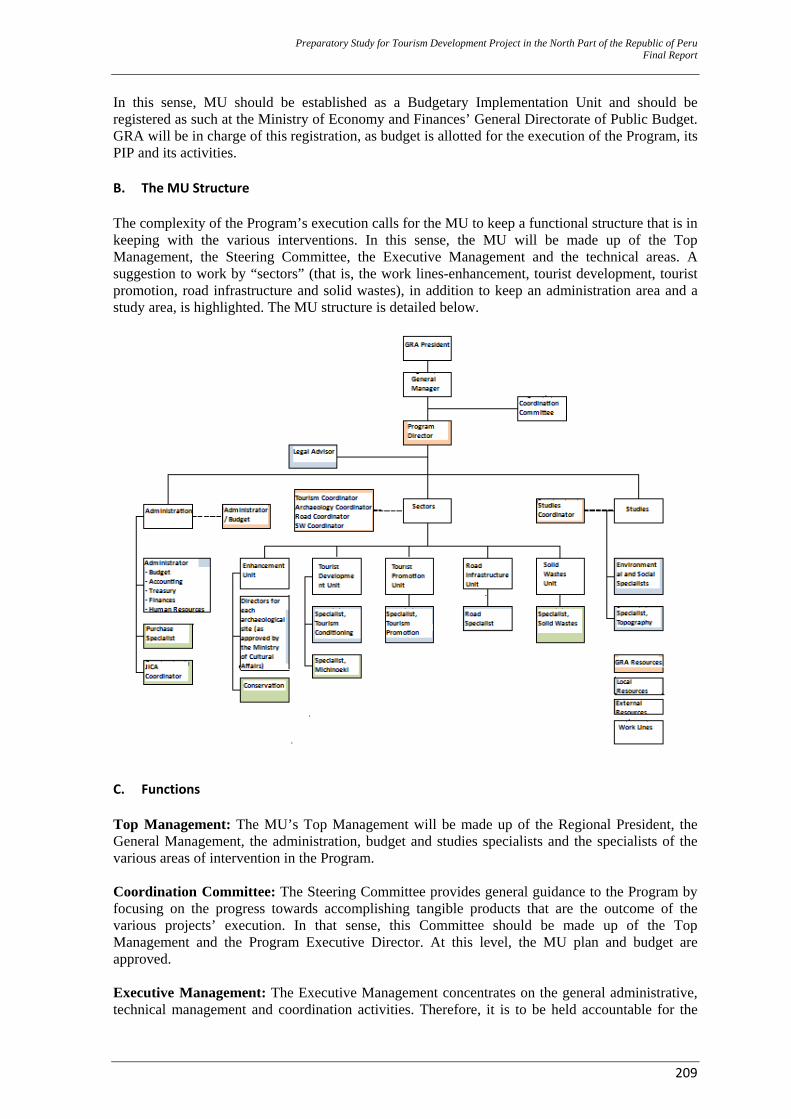
Preparatory Study for Tourism Development Project in the North Part of the Republic of Peru Final Report
209
In this sense, MU should be established as a Budgetary Implementation Unit and should be registered as such at the Ministry of Economy and Finances’ General Directorate of Public Budget. GRA will be in charge of this registration, as budget is allotted for the execution of the Program, its PIP and its activities. B. The MU Structure The complexity of the Program’s execution calls for the MU to keep a functional structure that is in keeping with the various interventions. In this sense, the MU will be made up of the Top Management, the Steering Committee, the Executive Management and the technical areas. A suggestion to work by “sectors” (that is, the work lines-enhancement, tourist development, tourist promotion, road infrastructure and solid wastes), in addition to keep an administration area and a study area, is highlighted. The MU structure is detailed below.
C. Functions Top Management: The MU’s Top Management will be made up of the Regional President, the General Management, the administration, budget and studies specialists and the specialists of the various areas of intervention in the Program. Coordination Committee: The Steering Committee provides general guidance to the Program by focusing on the progress towards accomplishing tangible products that are the outcome of the various projects’ execution. In that sense, this Committee should be made up of the Top Management and the Program Executive Director. At this level, the MU plan and budget are approved. Executive Management: The Executive Management concentrates on the general administrative, technical management and coordination activities. Therefore, it is to be held accountable for the

Preparatory Study for Tourism Development Project in the North Part of the Republic of Peru Final Report
210
administrative and technical aspects of the Program and it should plan, lead and supervise the execution of all of its components. It is also to be held accountable for meeting the MU objectives and goals. In that sense, the Executive Management is in charge of carrying out a follow–up to the formulation of the PIP pre–investment studies in the Program, which were not given the viable status when the Program was given the status of viable. It will be the relevant units’ joint responsibility to carry out his latter function (as detailed further below.) The Executive Manager is selected based on a tender process, and he/she will be appointed by the Regional President. As he/she carries out technical coordination activities, the Executive Manager will supervise works and activities and whenever applicable, he/she will approve all of the Program’s technical aspects. This area will also be in charge of the administration of contracts with consultants, operators and contractors. The Executive Management’s Functions
‐ Leading, controlling, supervising and evaluating the MU development, in compliance with the plans, policies, objectives and goals, as approved by the Steering Committee.
‐ Arranging and supervising the development of policies, laws and instructions, as approved by the Steering Committee and the Top Management for the MU.
‐ Leading the development of the MU projects with technical and financial efficiency. ‐ Approving and executing the actions that are relevant to institutional image and
communications. ‐ Formulating, coordinating and submitting to the Board all the plans, programs and budgets
for the MU. ‐ Ensure the efficient and correct administration of the MU’s budget and assets. ‐ Coordinating work between the various MU areas.
Legal Advisor: The Legal Advisor will be in charge of supervising, advising and carrying out all actions within his/her scope, in total compliance with the effective laws in the labor, administrative and contracting law. The Legal Advisor will carry out his/her work in coordination with the Executive Management. The Legal Advisor’s Functions:
‐ Sponsoring the MU in the legal, administrative and other procedures within the effective law frameworks.
‐ Advising the MU bodies on the legal aspects they might be involved in. ‐ Sponsoring the MU in legal matters and aspects with regard to purchases and contracts. ‐ Providing a legal opinion with regard to contracts, purchases and any other general legal
aspects related to the MU development. ‐ Providing specialist legal advice on any issues, as required by the various areas. ‐ Ensuring that the MU’s legal and administrative exercise adjusts to the national legal
structures. The Administration and Budget Office: This office will be in charge of organizing, executing and evaluating the direction and management of (i) those actions that are inherent to the budget process executions, (ii) the staff, accounting, treasury, assets and purchase systems and (iii) the security, maintenance and preserving the institutional infrastructure. The Administration and Budget Office’s Functions:
‐ Planning, organizing, leading and controlling human, material, financial, economic resources and worth/equity of the MU, in compliance with the effective regulations and laws.
‐ Leading, supervising and controlling the administrative systems within the scope of this Office’s competence.
‐ Organizing, leading, supervising and controlling the MU heritage assets. ‐ Subscribing agreements and contracts that are related to the purchase of goods/assets and
Preparatory Study for Tourism Development Project in the North Part of the Republic of Peru Final Report
211
service hiring. ‐ Supervising the fulfillment of terms and conditions in the agreements and contracts within
this Office’s field of competence. ‐ Formulating and suggesting guidelines on the administrative systems that are this Office’s
responsibility. ‐ Approving the discharging, putting out of service and final disposal of the
furniture/movable assets that are the MU’s property. ‐ Leading and controlling internal security/safety actions in the MU. ‐ Leading and coordinating the MU’s annual budget preparation process. Carrying out
management assessments by using duly standardized and approved indicators that allow for a homogeneous measurement and application.
‐ Leading, regulating and updating the MU IT system on a permanent basis. ‐ Formulating, consolidating and controlling the MU’s Purchase and Contracting Plan,
according to the forecasts made in the various areas, in compliance with the existing laws and legal guidelines.
‐ Coordinating the formulation of goods/assets and services purchase contracts with the Legal Advice Office.
‐ Ensuring the timely payment to the suppliers and payments for obligations derived from goods/assets and services purchases.
‐ Receiving (after having checked), storing and handing out purchased goods on a timely basis.
‐ Carrying out the store room’s inventory and keeping it updated. ‐ Providing advice to the other MU areas on issues that are their competence. ‐ Leading and regulating the staff administration system, in compliance with the institutional
policy and the relevant effective laws.
Person in Charge of Monitoring and Evaluation: He/she will be in charge of doing follow–up to the actions’ execution and evaluating the outcomes by analyzing and checking the Project efficiency and effectiveness. In this way, goals and weaknesses are identified and corrective measures are recommended for optimized expected results both in the projects and the Program. In addition, this person will evaluate the MU’s comprehensive development. Studies Unit: This unit will be in charge of advising, supervising, and evaluating the detailed design studies that are submitted by the Consulting Firms. It will also coordinate the preparation and evaluation of these studies with the Executive Management and the implementation units on a permanent basis; this will allow for making any comments when set goals for each project are not to be met. The Studies Unit’s Functions:
‐ Leading and supervising all studies developed by the MU ‐ Advising, supervising and evaluating the detailed design studies that are submitted by the
consulting firms in all the bids called by the MU. ‐ Coordinating the evaluation of the detailed design studies that are submitted by the
consulting firms with the Executive Management and the Implementation Units. ‐ Expressing its opinion and reporting on all economic, environmental and social aspects that
are its competence, as required to it by the MU areas and the Executive Management. Implementation Units: The Implementation Unit is made up of each one of the units that are part of the Program Components, namely: a) the Archaeological Heritage enhancement, b) Tourist development, c) Tourist promotion, d) Road infrastructure and e) Solid Wastes. Archaeological Heritage Enhancement Unit: First of all, this unit is in charge of leading the archaeological excavations that are carried out by a multidisciplinary team, by making use of comprehensive and authenticity–based criteria, such as analyzing and processing all information found in the field. Secondly, this unit is in charge of leading the restoration and consolidation
Preparatory Study for Tourism Development Project in the North Part of the Republic of Peru Final Report
212
works on the architecture found at the Archaeological Site and protecting its major structures from weathering caused by climate and the environment that might affect its preservation; this would find its foundation on the archaeological evidence and the previous studies on material compositions, among other studies, strictly with regard to authenticity. Finally, the Archaeological Heritage Enhancement Unit is in charge of defining the Archaeological Site’s tourist conditioning for its promotion and dissemination. The Archaeological Heritage Enhancement Unit’s Functions: Archaeological Excavations:
‐ Preparing the Archaeological Research Project (ARP or PIA, in Spanish), based on the detailed design study, for its submitting to and approval by the Ministry of Cultural Affairs. Negotiating its approval and implementing it.
‐ Preparing and submitting the final research report to the Ministry of Cultural Affairs. ‐ Designing and implementing the research policies and actions, field and office
methodologies, as well as the techniques to be used. ‐ Leading the systematic archaeological excavations at the Archaeological Site and their
thorough registration, via reports, drawings and photographs showing the work processes. ‐ Submitting monthly technical reports, annual comprehensive reports. ‐ Leading office analysis work, classification and analysis of materials gathered in situ
during field work. ‐ Sharing the research results, by means of scientific journals that are published on a regular
basis. ‐ Coordinating with the person in charge of preservation on a permanent basis, in keeping
with the salvaged archaeological evidence.
Preservation Work: ‐ Negotiating the detailed design study’s approval before the Ministry of Cultural Affairs. ‐ Designing and setting up the preservation and restoration policies and actions,
methodologies and techniques to be used, in compliance with the detailed design study. ‐ Leading the preservation and restoration works. ‐ Coordinating the experimental tests that are related to the work with the preservation
specialists ‐ Monitoring preservation works; if necessary, calling other specialists based on the set out
solution characteristics ‐ Calling other specialists ‐ Coordinating with those in charge of preservation work on a permanent basis
Tourist Development Unit: This unit is in charge of developing the tourist conditioning projects and its components with professional experts on tourism, in such a way that tourist product development is accomplished by articulating the interventions in the tourist resources, tourist facilities and tourist infrastructure. The Tourist Development Unit’s Functions:
‐ Planning, organizing, leading, supervising and controlling the viability of the MU’s solid wastes investment project executions, in keeping with SNIP and the Annual Plan and Budget.
‐ Coordinating, evaluating, expressing an opinion and submitting technical reports on the actions, with regard to the PERTUR upgrading, the preparation of the detailed design studies, the execution of the tourist conditioning projects and the strengthening of the tourist management and institutions, along with the experts in the Regional Directorate of Foreign Commerce and Tourism.
‐ Supervising the fulfillment of the National Public Investment System (SNIP, in Spanish) laws in the projects that are its competence.
‐ Reporting on the situation and performance of projects to the higher levels of authority on a regular and systematic basis, ensuring that goals and objectives are met.
Preparatory Study for Tourism Development Project in the North Part of the Republic of Peru Final Report
213
Tourist Promotion Unit: This unit is in charge of developing a sustainable management and a permanent articulation/coordination between the actors, who are linked to CTVU tourism, namely, the Regional Public Sector, DIRCETUR Amazonas, provincial and district Municipalities and the Private Sector in the Regions (formally established associations). The goal is that CTVU reaches a competitive positioning as a tourist destination. The Tourist Promotion Unit’s Functions:
‐ Carrying out follow–up to and controlling the execution of the CTVU promotion and commercialization support plan.
‐ Promoting an improved quality of the tourist supply and encouraging CTVU’s positioning as the Amazonas Region’s tourist Destination.
‐ Calling, organizing, advising and leading the participation of local Governments and tourist service suppliers in tourist fairs and workshops, as well as their articulation to travel agencies, tour operators and receptive agencies at national level.
‐ Calling, organizing, leading and carrying out tourist promotion events (tourist fairs, gastronomic/cuisine fairs and other types of fairs) in CTVU.
‐ Monitoring the information activities and assistance to tourists at the Destination. Road Infrastructure Unit: This unit is in charge of developing the road infrastructure management projects with road specialist engineers. Technical evaluation of profiles and detailed design studies (technical study) will be carried out by the design evaluator, who will be separately hired by the MU in order to maintain transparency with regard to the designs. The Road Infrastructure Unit’s Functions:
‐ Planning, organizing, leading, supervising and controlling the viability of the MU’s solid wastes investment project executions in keeping with SNIP and the Annual Plan and Budget.
‐ Evaluating and expressing an opinion and submitting technical reports on the pre–investment studies.
‐ Supervising the fulfillment of the National Public Investment System (SNIP, in Spanish) laws in the projects that are its competence.
‐ Reporting on the situation and performance of projects to the higher levels of authority on a regular and systematic basis, ensuring that goals and objectives are met.
Solid Wastes Unit: This unit is in charge of developing the solid wastes management projects with solid wastes specialist engineers. Technical evaluation of profiles and detailed design studies (technical study) will be carried out by the design evaluator, who will be separately hired by the MU, as transparency is intended to be kept before the control entities, with regard to the designs. The Solid Wastes Unit’s Functions:
‐ Planning, organizing, leading, supervising and controlling the viability of the MU’s solid wastes investment project executions, in keeping with SNIP and the Annual Plan and Budget.
‐ Evaluating and expressing an opinion and submitting technical reports on the pre–investment studies.
‐ Recommending and requesting the viable status. ‐ Supervising the fulfillment of the National Public Investment System (SNIP, in Spanish)
laws in the projects that are its competence. ‐ Reporting on the situation and performance of projects to the higher levels of authority on
a regular and systematic basis, ensuring that goals and objectives are met.
D. Operative Consultants: Specialists It is deemed necessary that the MU has a regular support from both international and domestic
Preparatory Study for Tourism Development Project in the North Part of the Republic of Peru Final Report
214
specialists, for internal practices to be sped up and improved, based on these consultants’ experience. Areas where cooperation is deemed to be necessary include:
‐ Administration and Budget: Taking into account that Amazonas has no experience in the application of the JICA regulations whatsoever.
‐ Tourist Conditioning: Initial field work for awareness raising and community grouping into associations and the activities involving promotion and training to the population on Michinoekis call for an external advisor with experience in designing, executing and operating these services.
‐ Capacity Generation: Having an experience on comprehensive intervention implementations is a plus. The magnitude of the intervention (all of the CTCU), institutional strengthening involving LG and GRA, as well as the vision of unity that should be handled, are all new concepts in the country.
‐ Transportation ‐ Solid Wastes: The application of laws and regulations on SW is minimal. Capacities at
national level for projects as complex as the ones already identified are still being developed. All projects are inter district (in rural areas) and some are inter provincial.
E. Staff and Costs A list of 31 staff has been prepared as staff requirements for MU to carry out its functions, plus 5 international supporting specialists. In addition, assistance from domestic consultants will be budgeted, if necessary. Total list of staff and consultants, unit costs, months worked and total budget for the MU (goods, assets and services included), are detailed in Attachment 17. Hiring period of specialists (both domestic and/or international) is based on each PIP’s implementation plans, as detailed in Attachment 18. 4.6.2 Implementation Plan A. Implementation Alignment Locally implied actors should totally participate in the Program’s implementation; this would include the community as much as possible. This will be a requirement in all tender processes, whether for consultancy or execution purposes. B. Projects with Buildings and Infrastructure and Institutional Strengthening Projects Consulting Firm. The MU will need to call to a tender to select a qualified firm for consultancy services to be carried out. These services would include the preparation of detailed design studies, the supervision of the project implementations and administrative and operational support during the execution stage. The Consulting Firm will also carry out institutional strengthening–related actions. The Consulting Firm will develop the detailed design studies that include research, the preparation of the architecture, structure, sanitation, electrification drawings, topographic survey, soil mechanics studies, environmental impact study, unit costs analysis, detailed execution schedules and descriptive memoire. In addition, the Consulting Firm will need to provide training on organization, administration, operation and maintenance to the municipalities and other involved institutions. During the implementation period, the Consulting firm will also carry out the works supervision, based on JICA, FIDIC alignments and the Rules set by the State Contracting Law, as long as they do not oppose JICA alignments.
Preparatory Study for Tourism Development Project in the North Part of the Republic of Peru Final Report
215
Tender for Execution. For the execution of each one of the Program projects that include buildings and/or infrastructure, there will be a public tender that brings together all interventions in such a way that quality contractors with a capacity for construction procedure management in multiple locations are attracted to bid. C. Archaeological Enhancement Projects Characteristics of archaeological preservation make it almost impossible for goals and schedules to be set. Preservation comes along and is carried out at the same time with research and unexpected findings that suspend and delay intervention schedules. Therefore, the MU should have a team with specialists and workers that allow for the execution of PIP that include archaeological enhancement actions, in compliance with the particular aspects of the Preservation activity (that reports to the Archaeological Heritage Enhancement Unit). 4.7 Funding Structure Program execution funds will come from the resources provided by the Government of Japan’s Financial Cooperation, via JICA (debt amount still to be agreed upon) and GRA. The total amount still to be agreed upon would be a maximum of US$ 50 million and US$ 7 million. Exact amounts to be allotted to each PIP or Activity will be defined during the negotiation process. It must be pointed out that those items that are not eligible for JICA’s funding include, on the whole, the following: Any type of taxes, costs for land purchase or compensation and the Implementation Unit’s administration costs and in the Program’s particular case, the consultancy costs for profile (perfil) and design evaluations. On the day this Study was submitted, financial conditions for a loan from JICA continued to be as follows: 1. Interest Rate: 0-65% annual. 2. Commission charges for non-disbursed balances: 0.10% annual. 3. Charges for disbursement period extensions: 0.20% of the non-disbursed amount multiplied
times the number of years. 4. Debt repayment period. 40 years 5. Grace period: 10 years.
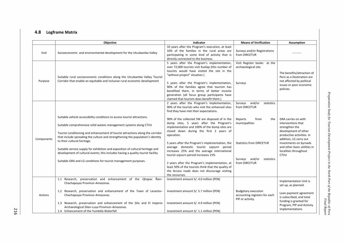
Preparation Study for Tourism D
evelopment Project in the N
orth Part of the Republic of PeruFinal Repor t
216
4.8 Logframe Matrix
Objective Indicator Means of Verification Assumption
End Socioeconomic and environmental development for the Utcubamba Valley
10 years after the Program’s execution, at least 10% of the families in the rural areas are participating in some kind of activity that is directly connected to the business.
Surveys and/or Registrations from DIRCETUR ‐‐‐‐‐‐‐‐‐
Purpose Suitable rural socioeconomic conditions along the Utcubamba Valley Tourist Corridor that enable an equitable and inclusive rural economic development
5 years after the Program’s implementation, over 72,000 tourists visit Kuelap (this number of tourists would have visited the site in the “without project” situation.) 5 years after the Program’s implementation, 90% of the families agree that tourism has benefited them, in terms of better income generation (all focus group participants have claimed that tourism does benefit them.)
Visit Register books at the archaeological site. Surveys
The benefits/attraction of Perú as a Destination are not affected by political issues or poor economic policies.
Components
Suitable vehicle accessibility conditions to access tourist attractions. Suitable comprehensive solid wastes management systems along CTVU Tourist conditioning and enhancement of tourist attractions along the corridor that include spreading the culture and strengthening the population’s identity to their cultural heritage. Suitable service supply for exhibition and exposition of cultural heritage and development of cultural events; this includes having a quality tourist facility Suitable GRA and LG conditions for tourist management purposes.
2 years after the Program’s implementation, 90% of the tourists who visit the enhanced sites find they have met their expectations. 90% of the collected SW are disposed of in the dump sites, 5 years after the Program’s implementation and 100% of the dump sites are closed down during the first 2 years of operation. 5 years after the Program’s implementation, the average domestic tourist sojourn period increases 25% and the average international tourist sojourn period increases 15% 2 years after the Program’s implementation, at least 50% of the tourists think that the quality of the Access roads does not discourage visiting the recourses.
Surveys and/or statistics from DIRCETUR Reports from the municipalities Statistics from DIRCETUR Surveys and/or statistics from DIRCETUR
GRA carries on with interventions that strengthen the development of other productive activities. In addition, LG carry out investments on byroads and other basic utilities in localities throughout CTVU
Actions
1.1 Research, preservation and enhancement of the Qhapac Ñan–Chachapoyas Province–Amazonas.
1.2 Research, preservation and enhancement of the Town of Levanto–
Chachapoyas Province–Amazonas. 1.3 Research, preservation and enhancement of the Silic and El Imperio
Archaeological Sites–Luya Province–Amazonas. 1.4 Enhancement of the Yumbilla Waterfall
Investment amount S/. 4.0 million (PEN) Investment amount S/. 5.7 million (PEN) Investment amount S/. 4.9 million (PEN) Investment amount S/. 1.1 million (PEN).
Budgetary execution accounting registers for each PIP or activity.
Implementation Unit is set up, as planned. Loan payment agreement is subscribed, and total funding is granted for Program, PIP and Activity implementations
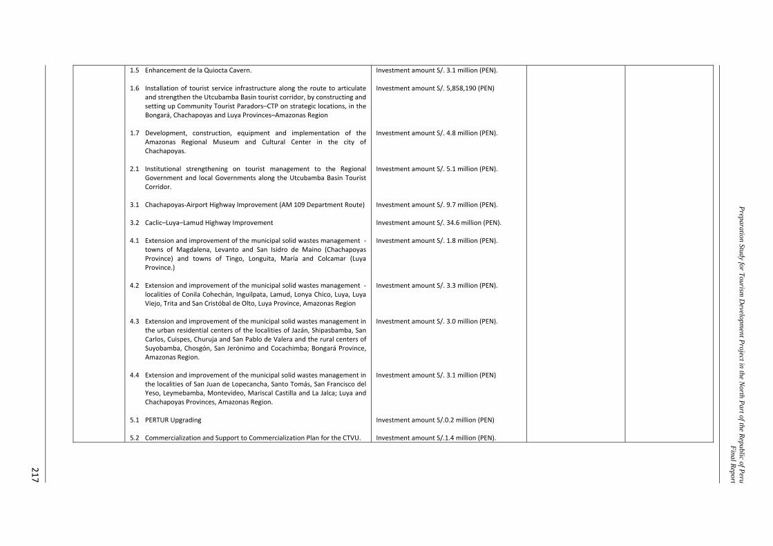
Preparation Study for Tourism D
evelopment Project in the N
orth Part of the Republic of PeruFinal Repor t
217
1.5 Enhancement de la Quiocta Cavern. 1.6 Installation of tourist service infrastructure along the route to articulate
and strengthen the Utcubamba Basin tourist corridor, by constructing and setting up Community Tourist Paradors–CTP on strategic locations, in the Bongará, Chachapoyas and Luya Provinces–Amazonas Region
1.7 Development, construction, equipment and implementation of the
Amazonas Regional Museum and Cultural Center in the city of Chachapoyas.
2.1 Institutional strengthening on tourist management to the Regional
Government and local Governments along the Utcubamba Basin Tourist Corridor.
3.1 Chachapoyas‐Airport Highway Improvement (AM 109 Department Route) 3.2 Caclic–Luya–Lamud Highway Improvement 4.1 Extension and improvement of the municipal solid wastes management ‐
towns of Magdalena, Levanto and San Isidro de Maino (Chachapoyas Province) and towns of Tingo, Longuita, María and Colcamar (Luya Province.)
4.2 Extension and improvement of the municipal solid wastes management ‐
localities of Conila Cohechán, Inguilpata, Lamud, Lonya Chico, Luya, Luya Viejo, Trita and San Cristóbal de Olto, Luya Province, Amazonas Region
4.3 Extension and improvement of the municipal solid wastes management in
the urban residential centers of the localities of Jazán, Shipasbamba, San Carlos, Cuispes, Churuja and San Pablo de Valera and the rural centers of Suyobamba, Chosgón, San Jerónimo and Cocachimba; Bongará Province, Amazonas Region.
4.4 Extension and improvement of the municipal solid wastes management in
the localities of San Juan de Lopecancha, Santo Tomás, San Francisco del Yeso, Leymebamba, Montevideo, Mariscal Castilla and La Jalca; Luya and Chachapoyas Provinces, Amazonas Region.
5.1 PERTUR Upgrading 5.2 Commercialization and Support to Commercialization Plan for the CTVU.
Investment amount S/. 3.1 million (PEN). Investment amount S/. 5,858,190 (PEN) Investment amount S/. 4.8 million (PEN). Investment amount S/. 5.1 million (PEN). Investment amount S/. 9.7 million (PEN). Investment amount S/. 34.6 million (PEN). Investment amount S/. 1.8 million (PEN). Investment amount S/. 3.3 million (PEN). Investment amount S/. 3.0 million (PEN). Investment amount S/. 3.1 million (PEN) Investment amount S/.0.2 million (PEN) Investment amount S/.1.4 million (PEN).

Preparation Study for Tourism Development Project in the North Part of the Republic of Peru Final Report
218
CHAPTER V CONCLUSIONS
Preparation Study for Tourism Development Project in the North Part of the Republic of Peru Final Report
219
5.0 CONCLUSIONS 1. Based on the detailed analysis to the Program’s pre–feasibility level study, this study is
considered to bear the characteristics that make it viable.
2. Program’s total investment amounts S/. 103 million (PEN) and the Program’s social or economic evaluation estimates a Economic Net Present Value of S/. 39.4 million (PEN).
3. The Program is designed for impacts caused by different projects that when combined with
tourist promotion, generate synergies that encourage sustainably increasing tourist flows in the future.
4. Tourism is a business with large and small capitals involved. Amazonas’ demographic and
geographic characteristics and the type of tourism intended for sale along the CTVU (“for connoisseurs” and “multiple theme”) are expected to encourage small capitals and populations in the rural areas to actively participate and generate sustainable income that will benefit the families.
Preparatory Study
for Tourism Development Project in the Northern Part of the Republic of Peru
(Código SNIP No: PROG – 078 – 2009 – SNIP)
ANNEX
atory Study for Tourism Development Project in the North Part of the Republic of Peru Final Report (Annex)
GRA / Consultor JICA i
Contents 6.0 ANNEX .................................................................................................................................... 2
6.1 Annex 1: Photos of Workshops .......................................................................................... 2 6.2 Annex 2: Background ......................................................................................................... 4 6.2.1 Minute of Meeting for Inception Meeting of the Program in Lima. .......................... 4 6.2.2 Summary of Inception Meeting for the Program in Chachapoyas. ............................ 9 6.2.3 Tele‐conference for Presentation of the Draft Pre‐F/S ............................................ 17 6.2.4 Minutes of Understanding between MINCETUR and JBIC. ...................................... 23
6.3 Annex 3: Strategy of Tourism Development for CTCU – Summary of Perfil Study .......... 26 6.3.1 Major Tourism Resources......................................................................................... 26 6.3.2 Potential Tourism Resources .................................................................................... 27 6.3.3 Priority Potential Tourism Resources ....................................................................... 28 6.3.4 Potential Tourism Circuits ........................................................................................ 29
6.4 Annex 4: Information of Environmental and Economic System for CTCU ....................... 30 6.4.1 Data of Caracterization for Environmental System and Natural Resources ............ 30 6.4.2 Map of Amazonas Economic Corridor ...................................................................... 31
6.5 Annex 5: Road Network in Amazonas .............................................................................. 32 6.5.1 Rutes – Bongará, Luya and Chachapoyas. ................................................................ 32 6.5.2 Rutes – Bongará and Luya. ....................................................................................... 33
6.6 Annex 6: Project of Integrated Tourism Developement. ................................................. 34 6.7 Annex 7: Inventory and Categorization of Tourism Resources in CTCU .......................... 35 6.7.1 Inventory of Tourism Resources in Bongará ............................................................ 36 6.7.2 Inventory of Tourism Resources in Chachapoyas. ................................................... 37 6.7.3 Inventory of Toursim Resources in Luya .................................................................. 42
6.8 Annex 8: Profile of Potential Tourism Resources ............................................................. 49 6.8.1 Laguna Pomacochas. ................................................................................................ 50 6.8.2 Catarata Yumbilla. .................................................................................................... 52 6.8.3 Catarata Chinata ....................................................................................................... 54 6.8.4 Catarata Gocta.......................................................................................................... 56 6.8.5 Pueblo de los Muertos ............................................................................................. 59 6.8.6 Caverna de Quiocta .................................................................................................. 61 6.8.7 Sitio Arqueológico de Wanglic ................................................................................. 63 6.8.8 Sarcófagos de Karajía ............................................................................................... 65 6.8.9 Centro Histórico de Chachapoyas ............................................................................ 67 6.8.10 Pueblo Histórico de Huancas.................................................................................... 69 6.8.11 Mirador Cañón del Río Sonche ................................................................................. 71 6.8.12 Mirador de Huanca Urco .......................................................................................... 73 6.8.13 Qhapac Ñan Chachapoyas – Levanto ....................................................................... 75 6.8.14 Canal Prehispánico de Allpachaca ............................................................................ 77
Preparatory Study for Tourism Development Project in the North Part of the Republic of Peru Final Report (Annex)
GRA / Consultor JICA ii
6.8.15 Sitio Arqueológico Collacruz ..................................................................................... 79 6.8.16 Sitio Arqueológico Yálape ......................................................................................... 81 6.8.17 Pueblo Histórico de Levanto .................................................................................... 83 6.8.18 Plaza Principal Levanto ............................................................................................. 85 6.8.19 Iglesia Matriz Levanto .............................................................................................. 87 6.8.20 Sitio Arqueológico Tella ............................................................................................ 89 6.8.21 Sitio Arqueológico Machupirca ................................................................................ 91 6.8.22 Sitio Arqueológico Macro ......................................................................................... 93 6.8.23 Sitio Arqueológico de Sílic ........................................................................................ 95 6.8.24 Sitio Arqueológico El Imperio ................................................................................... 97 6.8.25 Fortaleza de Kuélap .................................................................................................. 99 6.8.26 Pueblo Histórico de La Jalca ................................................................................... 101 6.8.27 Sitio Arqueológico de Ollape .................................................................................. 103 6.8.28 Mausoleos de Revash ............................................................................................. 105 6.8.29 Sitio Arqueológico de Olán ..................................................................................... 107 6.8.30 Sitio Arqueológico La Congona ............................................................................... 109 6.8.31 Pueblo de Leymebamba ......................................................................................... 111 6.8.32 Museo Comunitario de Leymebamba .................................................................... 113 6.8.33 Mausoleos de La Laguna de Los Cóndores ............................................................. 115 6.8.34 Laguna de los Cóndores ......................................................................................... 117
6.9 Annex 9: Profiles of Proposed Tourism Rutes ................................................................ 119 6.9.1 Proposed Tourism Rute 1: Ruta Circuito de Aguas. ............................................... 119 6.9.2 Proposed Tourism Rute 2: Ruta de los Karajía. ...................................................... 123 6.9.3 Proposed Tourism Rute 3. Ruta de los Cañones. ................................................... 127 6.9.4 Proposed Tourism Rute 4: Ruta del Qhapac Ñan. .................................................. 131 6.9.5 Proposed Tourism Rute 5: Ruta Kuélap. ................................................................ 135 6.9.6 Proposed Tourism Rute 6: Ruta de Cultura Viva. ................................................... 139 6.9.7 Proposed Tourism Rute 7: Ruta de las Momias. .................................................... 143
6.10 Annex 10: Facilities and Tourism Services. ..................................................................... 147 6.10.1 Accomodation Facilities in Bongará, Chachapoyas and Luya ................................. 148 6.10.2 Restaurants Facilities in CTCU ................................................................................ 152 6.10.3 Travel Agencies ........................... エラー! ブックマークが定義されていません。
6.11 Annex 11: Information for Questionnaires and Workshops .......................................... 163 6.11.1 Questionnaires for Tourists – Work Plan. .............................................................. 163 6.11.2 Questionnaires for Tourists and Tour Operators ‐ Formats. .................................. 166 6.11.3 Participatory Workshops with Local Stakeholders ................................................. 176
6.12 Annex 12: Activities in each PIP with Local Stakeholders .............................................. 181 6.13 Annex 13: Characteristics of National Vacationists – ENVIR 2007/2008. ...................... 182 6.13.1 Conclusions of ENVIR. ............................................................................................ 182 6.13.2 Characteristics of Internal Tourism by Department – ENVIR. ................................ 182
6.14 Annex 14: Profiles of PIPs in the Program. ..................................................................... 184 6.14.1 PIP Qhapac Ñan. ..................................................................................................... 184 6.14.2 PIP Sílic y El Imperio. .............................................................................................. 185 6.14.3 PIP Pueblo de Levanto. ........................................................................................... 186 6.14.4 PIP Yumbilla. ........................................................................................................... 187 6.14.5 PIP Quiocta. ............................................................................................................ 189
Preparatory Study for Tourism Development Project in the North Part of the Republic of Peru Final Report (Annex)
GRA / Consultor JICA iii
6.14.6 PIP Museo y Centro Cultural Regional de Amazonas. ............................................ 191 6.14.7 PIP Infraestructura de Servicios Turísticos. ............................................................ 192 6.14.8 PIP Fortalecimiento Institucional. .......................................................................... 193 6.14.9 PIP Carretera Chachapoyas – Aeropuerto. ............................................................. 195 6.14.10 PIP Carretera Cáclic – Luya – Lámud. ..................................................................... 197 6.14.11 PIP Residuos Sólidos Magdalena, Tingo y otros. .................................................... 199 6.14.12 PIP Residuos Sólidos Conila – Cohechán, Luya y otros. .......................................... 201 6.14.13 PIP Residuos Sólidos Jazán – Suyobamba y otros. ................................................. 203 6.14.14 PIP Residuos Sólidos Santo Tomas, La Jalca y otros. .............................................. 205
6.15 Annex 15: Summary of Interventions by Rute ............................................................... 207 6.15.1 Ruta Circuito de Aguas. .......................................................................................... 207 6.15.2 Ruta: Ruta de Los Karajía. ....................................................................................... 208 6.15.3 Ruta de Los Cañones. ............................................................................................. 209 6.15.4 Ruta Qhapac Ñan.................................................................................................... 210 6.15.5 Ruta Kuélap. ........................................................................................................... 211 6.15.6 Ruta de Cultura Viva. .............................................................................................. 212 6.15.7 Ruta de Las Momias. .............................................................................................. 213
6.16 Annex 16: Budget for Activities of Component 5. .......................................................... 214 6.16.1 Activitiy: Actualization of PERTUR Amazonas. ....................................................... 214 6.16.2 Activity: Promotion and Assistance Plan for Comercialization. ............................. 215
6.17 Annex 17: Implementation Plans of PIPs. ...................................................................... 221
Preparatory Study for Tourism Development Project in the North Part of the Republic of Peru Final Report (Annex)
GRA / Consultor JICA 1
ANNEX
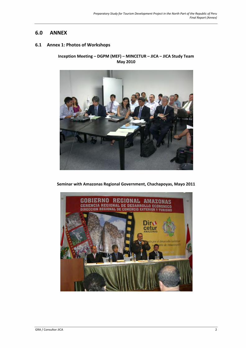
Preparatory Study for Tourism Development Project in the North Part of the Republic of Peru Final Report (Annex)
GRA / Consultor JICA 2
6.0 ANNEX 6.1 Annex 1: Photos of Workshops
Inception Meeting – DGPM (MEF) – MINCETUR – JICA – JICA Study Team May 2010
Seminar with Amazonas Regional Government, Chachapoyas, Mayo 2011
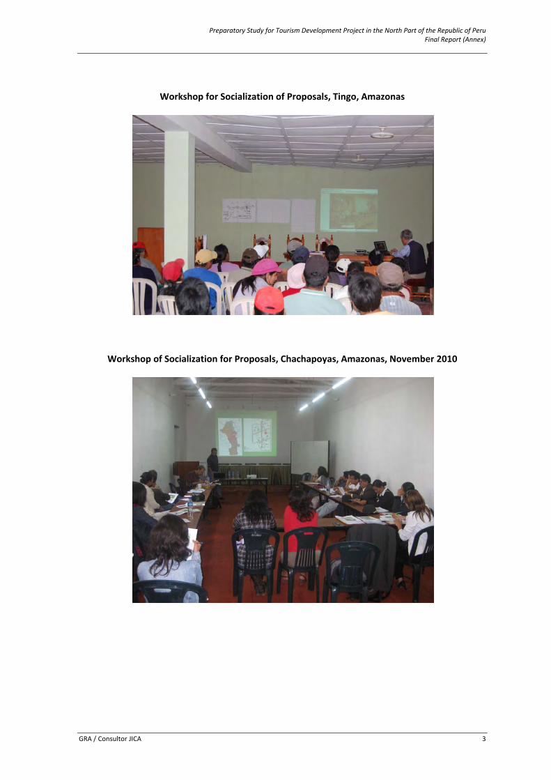
Preparatory Study for Tourism Development Project in the North Part of the Republic of Peru Final Report (Annex)
GRA / Consultor JICA 3
Workshop for Socialization of Proposals, Tingo, Amazonas
Workshop of Socialization for Proposals, Chachapoyas, Amazonas, November 2010
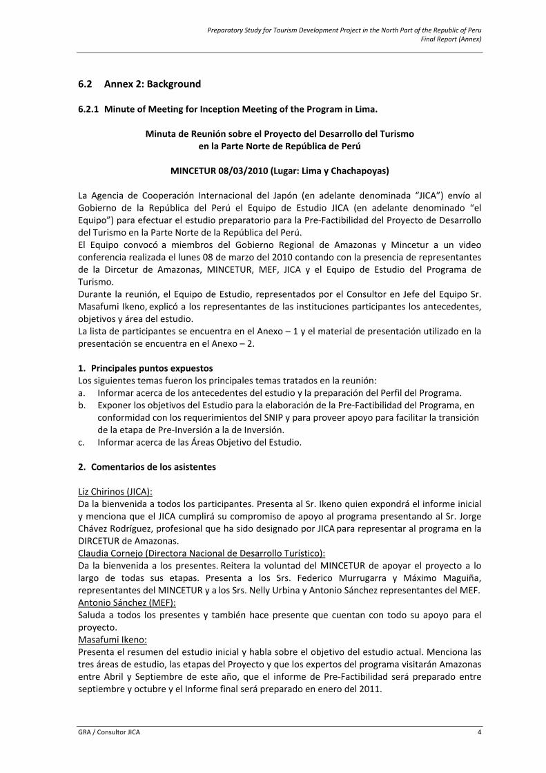
Preparatory Study for Tourism Development Project in the North Part of the Republic of Peru Final Report (Annex)
GRA / Consultor JICA 4
6.2 Annex 2: Background 6.2.1 Minute of Meeting for Inception Meeting of the Program in Lima.
Minuta de Reunión sobre el Proyecto del Desarrollo del Turismo en la Parte Norte de República de Perú
MINCETUR 08/03/2010 (Lugar: Lima y Chachapoyas)
La Agencia de Cooperación Internacional del Japón (en adelante denominada “JICA”) envío al Gobierno de la República del Perú el Equipo de Estudio JICA (en adelante denominado “el Equipo”) para efectuar el estudio preparatorio para la Pre‐Factibilidad del Proyecto de Desarrollo del Turismo en la Parte Norte de la República del Perú. El Equipo convocó a miembros del Gobierno Regional de Amazonas y Mincetur a un video conferencia realizada el lunes 08 de marzo del 2010 contando con la presencia de representantes de la Dircetur de Amazonas, MINCETUR, MEF, JICA y el Equipo de Estudio del Programa de Turismo. Durante la reunión, el Equipo de Estudio, representados por el Consultor en Jefe del Equipo Sr. Masafumi Ikeno, explicó a los representantes de las instituciones participantes los antecedentes, objetivos y área del estudio. La lista de participantes se encuentra en el Anexo – 1 y el material de presentación utilizado en la presentación se encuentra en el Anexo – 2. 1. Principales puntos expuestos Los siguientes temas fueron los principales temas tratados en la reunión: a. Informar acerca de los antecedentes del estudio y la preparación del Perfil del Programa. b. Exponer los objetivos del Estudio para la elaboración de la Pre‐Factibilidad del Programa, en
conformidad con los requerimientos del SNIP y para proveer apoyo para facilitar la transición de la etapa de Pre‐Inversión a la de Inversión.
c. Informar acerca de las Áreas Objetivo del Estudio. 2. Comentarios de los asistentes Liz Chirinos (JICA): Da la bienvenida a todos los participantes. Presenta al Sr. Ikeno quien expondrá el informe inicial y menciona que el JICA cumplirá su compromiso de apoyo al programa presentando al Sr. Jorge Chávez Rodríguez, profesional que ha sido designado por JICA para representar al programa en la DIRCETUR de Amazonas. Claudia Cornejo (Directora Nacional de Desarrollo Turístico): Da la bienvenida a los presentes. Reitera la voluntad del MINCETUR de apoyar el proyecto a lo largo de todas sus etapas. Presenta a los Srs. Federico Murrugarra y Máximo Maguiña, representantes del MINCETUR y a los Srs. Nelly Urbina y Antonio Sánchez representantes del MEF. Antonio Sánchez (MEF): Saluda a todos los presentes y también hace presente que cuentan con todo su apoyo para el proyecto. Masafumi Ikeno: Presenta el resumen del estudio inicial y habla sobre el objetivo del estudio actual. Menciona las tres áreas de estudio, las etapas del Proyecto y que los expertos del programa visitarán Amazonas entre Abril y Septiembre de este año, que el informe de Pre‐Factibilidad será preparado entre septiembre y octubre y el Informe final será preparado en enero del 2011.
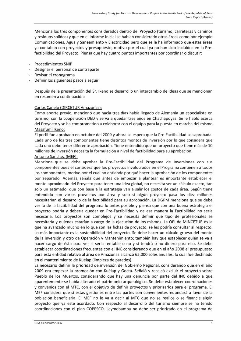
Preparatory Study for Tourism Development Project in the North Part of the Republic of Peru Final Report (Annex)
GRA / Consultor JICA 5
Menciona los tres componentes considerados dentro del Proyecto (turismo, carreteras y caminos y residuos sólidos) y que en el Informe Inicial se habían considerado otras áreas como por ejemplo Comunicaciones, Agua y Saneamiento y Electricidad pero que se le ha informado que estas áreas ya contaban con proyectos y presupuesto, motivo por el cual ya no han sido incluidos en la Pre‐factibilidad del Proyecto. Piensa que hay cuatro puntos importantes por coordinar o discutir:
- Procedimientos SNIP - Designar el personal de contraparte - Revisar el cronograma - Definir los siguientes pasos a seguir
Después de la presentación del Sr. Ikeno se desarrollo un intercambio de ideas que se mencionan en resumen a continuación: Carlos Canelo (DIRCETUR Amazonas): Como aporte previo, mencionó que hacía tres días había llegado de Alemania un especialista en turismo, con la cooperación DED y se va a quedar tres años en Chachapoyas. Se le habló acerca del Proyecto y se ha comprometido a colaborar con el equipo para la puesta en marcha del mismo. Masafumi Ikeno: El perfil fue aprobado en octubre del 2009 y ahora se espera que la Pre‐Factibilidad sea aprobada. Cada uno de los tres componentes tiene distintos montos de inversión por lo que considera que cada uno debe tener diferente aprobación. Tiene entendido que un proyecto que tiene más de 10 millones de inversión necesita la formulación a nivel de factibilidad para su aprobación. Antonio Sánchez (MEF): Menciona que se debe aprobar la Pre‐Factibilidad del Programa de Inversiones con sus componentes pues él considera que los proyectos involucrados en el Programa contienen a todos los componentes, motivo por el cual no entiende por qué hacer la aprobación de los componentes por separado. Además, señala que antes de empezar a plantear es importante establecer el monto aproximado del Proyecto para tener una idea global, no necesita ser un cálculo exacto, tan solo un estimado, que con base a la estrategia van a salir los costos de cada área. Según tiene entendido son varios proyectos por área y solo si algún proyecto pasa los diez millones necesitarían el desarrollo de la factibilidad para su aprobación. La DGPM menciona que se debe ver lo de la factibilidad del programa lo antes posible y piensa que con una buena estrategia el proyecto podría y debería quedar en Pre‐Factibilidad y de esa manera la Factibilidad no sería necesaria. Los proyectos son complejos y se necesita definir qué tipo de profesionales se necesitaría y quienes estarían a cargo de la ejecución de los mismos. La OPI de MINCETUR es la que ha avanzado mucho en lo que son las fichas de proyecto, se les podría consultar al respecto. Lo más importante es la sostenibilidad del proyecto. Se debe hacer un cálculo grueso del monto de la inversión y otro de Operación y Mantenimiento; también hay que establecer quién se va a hacer cargo de ésta para ver si sería rentable o no y si tendrá o no dinero para ello. Se debe establecer coordinaciones frecuentes con el INC considerando que en el año 2008 el presupuesto para esta entidad relativa al área de Amazonas alcanzó 65,000 soles anuales, lo cual fue destinado en el mantenimiento de Kuélap (limpieza de paredes). Es necesario definir la prioridad de inversión del Gobierno Regional, considerando que en el año 2009 era empezar la promoción con Kuélap y Gocta. Señaló y recalcó excluir el proyecto sobre Pueblo de los Muertos, considerando que hay una denuncia por parte del INC debido a que aparentemente se había alterado el patrimonio arqueológico. Se debe establecer coordinaciones y convenios con el MTC, con el objetivo de definir proyectos y priorizarlos para el programa. El MEF considera que si estas gestiones entre las partes son convenientes redundará a favor de la población beneficiaria. El MEF no le va a decir al MTC que no se realice o se financie algún proyecto que ya este acordado. Con respecto al desarrollo del turismo siempre se ha tenido coordinaciones con el plan COPESCO. Leymebamba no debe ser priorizado en el programa de
Preparatory Study for Tourism Development Project in the North Part of the Republic of Peru Final Report (Annex)
GRA / Consultor JICA 6
inversión puesto que su intervención es de carácter privado y el SNIP no financia iniciativas privadas. Acerca del museo en Chachapoyas, se debe definir si la intervención constituirá un museo o un centro de interpretación. Si se trata de un museo este debe desarrollar funciones de Conservación, Investigación e Interpretación. Respecto a la Conservación se requiere de grandes recursos (se tendría que ver cuántas piezas habrían), mientras que la Investigación implica contar con un staff de profesionales, y no cree que el INC cuente con ellos. Recomienda que el programa de inversiones considere un Centro de Interpretación. Con respecto al fortalecimiento de los recursos humanos y de la capacitación y concientización en el pueblo dice que es importante si y solo si sirve para lograr los fines del proyecto, de no ser así, no es importante. Considera que la estrategia es muy importante en este estudio, por lo que menciona que se debe definir el producto a ofertar, los mecanismos de venta y promoción del mismo. En cuanto al tema de la estrategia de promoción , menciona que hace un año se habló con MINCETUR sobre el tema de las líneas aéreas y el aeropuerto de Chachapoyas, lo cual es sumamente importante puesto que si queremos promocionar Chachapoyas como destino turístico el contar con alguna línea aérea facilitaría que se incremente la demanda turística a la zona a intervenir por el proyecto convirtiéndolo en un destino mucho más atractivo ya que el arribo de turistas a Amazonas por carretera no sería muy rápido y dinámico. Julio Sagástegui (Vice‐Presidente del Gobierno Regional de Amazonas): Informa que a través de las comunicaciones con el ministerio de transportes y comunicaciones se ha llegado a un acuerdo acerca del servicio aéreo subvencionado de Lima o Chiclayo hasta el aeropuerto de Chachapoyas a través de la Dirección de Aeronáutica Civil del Perú y ya se ha puesto en licitación. Antonio Sánchez (MEF): También hay que tener en cuenta los convenios con el Gobierno Regional y ver cuánto va a ser el aporte de los gobiernos locales pues estos convenios suelen tomar meses. Rohicer Silva: Pregunta por el tema del desarrollo humano, quiere saber hasta que monto es rentable. Antonio Sánchez (MEF): La intervención en recursos humanos es dable cuando es importante para lograr el objetivo y no es una labor permanente del consultor. Rohicer Silva: Menciona que dentro del programa del JICA esta el proyecto de “Un Pueblo, Un Producto” y piensa que el fortalecimiento de capacidades es importante para desarrollar las fortalezas de cada pueblo. Arq. Luis Bernos: Piensa que el fortalecimiento de capacidades de los pueblos si es inversión pública. Antonio Sánchez (MEF): Menciona que se debe brindar capacitación a profesionales de la DIRCETUR para que éstos otorguen capacitación al pueblo, lo que debe ser considerado en el proyecto. Lo que no se puede hacer es apoyar la capacitación de personal en el sector privado. Arq. Luis Bernos: Pregunta por los proyectos productivos Antonio Sánchez (MEF): No existe el proyecto productivo. Solo se da apoyo para inversiones públicas, pero el apoyo es sólo hasta la “vereda de entrada”, no se puede hacer nada en el sector privado. Marcos Alegre: En el caso de los residuos sólidos se han planteado proyectos que se deben definir ahora, por ejemplo: Cuando el relleno sanitario se hace para dos o más distritos pequeños, ¿se necesita hacer el PIP por distrito o por relleno sanitario si es que es el Municipio Distrital el que administra el relleno sanitario? Antonio Sánchez (MEF):
Preparatory Study for Tourism Development Project in the North Part of the Republic of Peru Final Report (Annex)
GRA / Consultor JICA 7
El PIP se puede hacer por relleno sanitario, no hay problema. En el caso del Gobierno Regional, este define quien es el que administra el relleno sanitario. Marcos Alegre: Piensa que sería mejor hacer un proyecto provincial. Antonio Sánchez (MEF): Manifiesta que eso dependería del tamaño de la operación y recomienda conversar con el Sr. Jorge Gibo (sectorista MEF) Rohicer Silva: Pregunta acerca del tema de promoción turística, que si este puede ser incluido en el monto de inversión o no. Antonio Sánchez (MEF): Si se debe incluir pues es importante pero con un monto y un tiempo definido para la promoción turística. Acerca de este tema precisa que definitivamente se debe incluir la promoción turística dentro del monto de inversión pues esta es de suma importancia puesto que no nos sirve de nada implementar el proyecto si no se promueve domestica e internacionalmente como destino turístico pero que se debe establecer el plazo y monto de esta promoción y calcular su impacto. Carlos Canelo (DIRCETUR Amazonas): Se han identificado varias rutas en las que se puede implementar los rellenos sanitarios y se pueden hacer por sub‐grupos. Antonio Sánchez (MEF): Dice que haremos lo que la técnica nos diga y luego salvamos los demás temas, pero que no lo hagamos en cada pueblo pues nuestro ámbito es el turismo y tenemos que mantenernos en ese perfil. Luis Gómez (OPI‐MINCETUR) Para efectos de hacer conocer el atractivo en una mayor escala tanto nacional como internacional se requiere no solo de esfuerzos sino también de nuevas herramientas conceptuales que ayuden a dicho propósito, en tal sentido en la OPI MINCETUR para abordar el tema de promoción desde una perspectiva de inversión (y no de gasto corriente)se considera conveniente el uso del concepto alternativo: POSICIONAMIENTO, el cual supone un esfuerzo mayor y, mejor de lo que es la Promoción simple, y que resulta concordante con la conceptualización de un PIP. Igualmente se refirió la necesidad de planificar el desarrollo del programa y de los proyectos que lo integran, haciendo uso de lo que en Project se conoce como la EDT (Estructura Desglosada de Tareas), herramienta que posibilitará alcances en términos de tiempos, recursos, producto, fechas (Hitos), componentes, etc. Manuel Aparicio (Jefe de la OPI – MINCETUR) Los proyectos ya están identificados, sería bueno que hagan un listado y lo pasen para poder saber cuáles son. Antonio Sánchez (MEF): Primero tiene que preparar la estrategia. Ojo: si la OPI dice que no el MEF no puede decir que sí. Para ver la factibilidad hay que tener una gama de opciones de las cuales escoger, pero finalmente se debe definir cuál de las opciones se va a aplicar. Sería bueno organizar más reuniones entre los consultores y las demás OPI`s y con el INC. En programas tan grandes como este cada proyecto tiene que ser aprobado por el ministerio competente. Si son proyectos pequeños no hay problema pero cuando son más grandes ya necesita aprobación del ministerio a cargo, por ejemplo en el caso de carreteras tendría que ser el MTC, en el caso de museos el INC, etc. Masafumi Ikeno: Informa que esta es una reunión inicial y que los demás detalles los veremos más adelante. Necesitamos tener una contraparte en Amazonas y necesitaríamos que nos brinden el nombre de esta persona y que también necesitamos una contraparte en MINCETUR. Federico Murrugarra (Director de Comercio Exterior y Turismo):
Preparatory Study for Tourism Development Project in the North Part of the Republic of Peru Final Report (Annex)
GRA / Consultor JICA 8
Menciona que la contraparte por parte del MINCETUR van a ser él y el Sr. Máximo Maguiña y alguien más de la OPI que todavía no se ha definido y nos van a informa por mail. Carlos Canelo (DIRCETUR Amazonas): Querían saber quiénes va a ir a Chachapoyas para poder coordinar la logística de la visita. Deseaban saber cuántos y quiénes iban. Masafumi iIkeno: Indicó que en los próximos días estaría detallando esa información vía E‐mail. Liz Chirinos (JICA): Siendo las 5:30pm, despide la reunión y anuncia que esta semana se debe estar coordinando otras reuniones con las OPIs de los sectores de Medio Ambiente; Transporte; Educación, y demás organismos. 3. Conclusión Como resultado de la reunión realizada por el consultor, y de los comentarios y recomendaciones formuladas en la subsiguiente discusión, los firmantes están de acuerdo con los alcances generales del contenido de la presentación y de la presente minuta, y expresan su disposición de cooperar con el Equipo durante el proceso de elaboración del Estudio de Factibilidad para la culminación del mismo en los plazos previstos.
Fin del documento Lista de Asistentes Fecha: 08 de marzo del 2010 Lugar: Sala de video conferencias del Ministerio de Comercio Exterior y Turismo Asistentes: 7. MINCETUR: Srta. Claudia Cornejo Directora Nacional de Desarrollo Turístico Sr. Federico Murrugarra Director de Desarrollo del Producto Turístico Sr. Máximo Maguiña Especialista en Proyectos de Inversión Sr. Manuel Aparicio Director de la OCTIP Sr. Luis Gómez Profesional de la OCTIP 8. MEF: Sr. Antonio Sánchez ‐ Especialista Sectorial Srta. Nelly Urbina ‐ Analista de la DGPM 9. JICA: Srta. Liz Chirinos ‐ Sectorista Senior Jorge Chávez Rodríguez ‐ Consultor 10. Miembros del Equipo de Estudio: Sr. Masafumi Ikeno ‐ Lider del Equipo Sr. Munetoshi Ishida ‐ Consultor de Análisis Económico Sr. Jorge Chávez Salas ‐ Consultor de Turismo y Ambiente Sr. Cesar Ruiz Ramírez ‐ Consultor de Estudio SNIP Sr. Luis Bernós ‐ Consultor de Arquitectura Sr. Marcos Alegre ‐ Consultor de Manejo de Residuos Sólidos
Preparatory Study for Tourism Development Project in the North Part of the Republic of Peru Final Report (Annex)
GRA / Consultor JICA 9
6.2.2 Summary of Inception Meeting for the Program in Chachapoyas.
Taller para el Estudio Preparatorio para el Desarrollo del Turismo en la Parte Norte de la República del Perú
Llevada a cabo el 09 de Abril en Chachapoyas, Amazonas
La Agencia Internacional de Cooperación Japonesa (llamado de ahora en adelante “JICA”) envió un equipo de estudio (llamado de ahora en adelante “el Equipo de Estudio”) a la República del Perú para realizar el Estudio Preparatorio para el Desarrollo del Turismo en la Parte Norte de la República del Perú. A lo largo de la reunión, los miembros del Equipo de Estudio presentaron los contenidos del proyecto de turismo propuesto para Amazonas, ante el Gobierno Regional de Amazonas, el Ministerio de Comercio Exterior y Turismo (llamado de ahora en adelante “MINCETUR”), el Ministerio de Economía y Finanzas (llamado de ahora en adelante “MEF”), e inversionistas locales. La lista de participantes se encuentra en el Anexo‐1, y el material usado para la presentación se encuentra en el Anexo‐2.
1. Discurso de apertura por parte del Sr. Oscar Altamirano Quispe, Presidente, Gobierno
Regional de Amazonas
Da la bienvenida al Sr. Ikeno y otros miembros del Equipo de Estudio así como también a todos los presentes (INC, MINCETUR, MEF, Autoridades Locales, alcaldes e inversionistas locales). Dice que hoy va a ser un día muy importante para el desarrollo del turismo en Amazonas. La visita del Equipo de Estudio de JICA es el resultado de más de tres años de trabajo llevado a cabo por el Gobierno Regional con el Gobierno de Japón. En el año 2003 el Gobierno Regional y el MINCETUR trabajaron en conjunto para concretar la realización del Programa de inversión japonesa y se han firmado ya varios acuerdos y esa es la razón x la cual ellos se encuentran aquí hoy. La región Amazonas es una de las regiones más ricas del Perú, llena de recursos turísticos, naturales, arqueológicos, medio ambientales con una gran variedad de flora y fauna. Él cree que este proyecto de inversión con el Gobierno Japonés es un gran paso adelante. Comenta que este es un programa integral que va a mejorar las condiciones para eventualmente impulsar el turismo nacional e internacional. Este programa involucra mejoramiento de carreteras y caminos, manejo de residuos sólidos y el mejoramiento de los sitios turísticos incluyendo investigación, restauración y desarrollo de instalaciones. También mencionó que el estudio se llevará a cabo este año y que el proyecto estará listo para ejecutarse en el 2011, después de su aprobación. Invoca a la gente de Amazonas a evitar críticas y más bien a unirse para aprovechar esta oportunidad. También expresó su gratitud al Equipo de Estudio de JICA por este proyecto y por este esfuerzo. También dijo que la gente que ha dedicado sus vidas al sector turismo se verán beneficiados con este proyecto y verán sus esfuerzos y dedicación recompensados. Espera que este proyecto se haga realidad pronto para el beneficio de la región y su gente.
2. Presentaciones por parte de los miembros del Equipo de Estudio
1) Sr. Rohicer Silva, Consultor para el Desarrollo de Recursos Humanos en el área Turística, Equipo de Estudio JICA
Primero expresó su gratitud por la confianza depositada en él para hacer la presentación del Proyecto. Le dice a la gente de Amazonas que en este momento se encuentran ante
Preparatory Study for Tourism Development Project in the North Part of the Republic of Peru Final Report (Annex)
GRA / Consultor JICA 10
los ojos del mundo; que la revista National Geographic ha recomendado a Kuélap como uno de los 50 destinos más importantes en el mundo y que el turismo es una de las fuentes de ingresos más importantes de nuestro país. Amazonas está en medio del circuito turístico del norte del Perú, compitiendo con sitios en Lambayeque, Cajamarca, Chiclayo, Iquitos, etc., por fondos para desarrollar sus territorios. Preguntó a los presentes acerca de cómo se debería hacer esto, como hacer para conseguir el desarrollo turístico. Dijo que todas las provincias de Amazonas cuentan con muchos recursos pero la pregunta es cómo atenderlas a todas. Luego de una encuesta se supo que solo el 3% de los turistas, tanto nacionales como extranjeros, asocian Kuélap con la región Amazonas. También dijo que el año 2009 no fue muy favorable para el turismo, el crecimiento del número de turistas captados el 2008 fue de 20% y este cayó al 10 % en el 2009. El cree que el desarrollo del turismo es clave para aliviar la pobreza y que tienen que hacer de este proyecto una realidad; que ellos tienen un consejo regional de turismo, que ha sido llamado Comité Consultivo Regional de Turismo. La pregunta es donde desarrollar el turismo en Amazonas; todos han identificado la zona sur de Amazonas como la 1era zona a potenciar turísticamente. Esto ayudará eventualmente a que las áreas circundantes también crezcan, con cooperación de las ONGs, Mincetur y universidades. Él dijo que se les ha informado que el MTC (Ministerio de Transportes y Comunicaciones) ha empezado el proceso de licitación para los vuelos comerciales subsidiados hacia el aeropuerto de Chachapoyas pero la asociación Japonesa en turismo nos va a dar una mano para ayudarnos a lograr esto.
2) Sr. Masafumi Ikeno, Jefe del Equipo, Equipo de Estudio JICA Da la bienvenida a todos los asistentes y dice que va a explicar brevemente la historia del proyecto. Explica que el Perfil de este programa fue formulado en el año 2008 y fue aprobado el 2009, y el Equipo de Estudio trabajará en el estudio de pre‐factibilidad y factibilidad a lo largo del 2010. Menciona que el objeto de este proyecto son las provincias de Luya, Bongará y Chachapoyas, y el estudio formulará un programa conformado por proyectos en los sectores de turismo e infraestructura. La Implementación de este proyecto influenciará otros factores como, por ejemplo, el número de turistas, el largo de su estadía y el monto de sus consumos, y eventualmente esto brindará beneficios a todas las provincias. También presentó a los miembros del Equipo de Estudio y solicitó la colaboración de la audiencia con el estudio.
3) Sr. Jorge Chávez Salas, Consultor para la Evaluación de Estudio Ambiental (Natural), Equipo de Estudio JICA El Sr. Chávez se presentó como parte del grupo de desarrollo de turismo y Estudio Ambiental del Equipo de Estudio JICA. Explicó que el proyecto consiste en 2 sub programas y que el sub programa de turismo tiene 2 sub componentes; acondicionamiento turístico y capacitación. Explicó que el Equipo de Estudio aún está deliberando acerca de cuáles son las áreas de intervención potenciales y que los proyectos serán ejecutados para el mejoramiento de varios sitios en el área para poder crear circuitos. Mencionó que hay una deficiencia de investigación y mantenimiento de los sitios por lo que estos se encuentran a merced del vandalismo y/o inclemencias climáticas. Cree que debemos mejorar la puesta en valor de estos sitios. Haciendo esto los turistas se quedarían más tiempo en la región y recomendarían amazonas como destino turístico a otros turistas potenciales una vez que regresen a sus lugares de origen. Explica que el monto del presupuesto asignado para el proyecto de turismo es aproximadamente de 38 millones de soles, de acuerdo a la estimación extraída del Perfil
Preparatory Study for Tourism Development Project in the North Part of the Republic of Peru Final Report (Annex)
GRA / Consultor JICA 11
del 2008‐2009. También explicó que una evaluación de costos más detallada se llevará a cabo más adelante en el presente estudio. Como contenidos del proyecto, habló acerca de los Michinoekis, los tambos turísticos que serán construidos al lado de los caminos con más movimiento y que serán utilizadas como plataforma para la comercialización de productos locales, servicios de información turística, servicios higiénicos, etc. También habló sobre los planes de construir un museo/ centro cultural y de cómo este museo no está planeado solamente para los turistas si no para toda la gente de Amazonas como lugar para consolidar la identidad cultural.
4) Sra. Megumi Takahashi, Consultora para el Desarrollo de los Recursos Turísticos, Equipo de Estudio JICA La Sra. Takahashi mostró una presentación con ejemplos de proyectos de desarrollo turístico con asistencia japonesa en Sri Lanka. Explicó que Japón ha asistido una serie de proyectos de desarrollo turístico en Sri Lanka, considerando las necesidades de desarrollar el turismo en el país puesto que este estaba recuperándose del impacto de una cruenta guerra civil. Explicó que el proyecto planeado en Amazonas contendrá componentes similares a los proyectos en Sri Lanka, ambos buscando una aproximación holística para un desarrollo turístico sostenible. También mostró varias diapositivas del museo construido en Sri Lanka como ejemplo de la asistencia Japonesa. Explicó que concepto para el museo en Amazonas será desarrollado en el curso del Estudio, considerando factores como las necesidades, costo para la construcción y operación, sistema de operación y administración, así como su sostenibilidad.
5) Sr. Munetoshi Ishida, Consultor de Análisis Económico / Capacidad de Desarrollo del Gobierno, Equipo de Estudio JICA Sr. Ishida presento dos proyectos propuestos buscando la generación de capacidades; 1) Fortalecimiento en turismo para el Gobierno Regional, y 2) Fortalecimiento en la capacidad de gestión turística para los Gobiernos locales. Explica que la generación de capacidades del Gobierno Regional está dirigida a generar un desarrollo institucional que garantice la ampliación de la misión de la Dircetur. El proyecto incluye la construcción de la sede de la Dircetur y su equipamiento. El monto de inversión detallado será calculado en el Estudio y su factibilidad está siendo analizada. Por el momento el fortalecimiento de los Gobiernos locales está dirigido a desarrollar capacidades de gestión y el ayudar a estos con la planificación turística y a elaborar planes de ordenamiento territorial en los distritos que estén dentro del ámbito del proyecto.
6) Sr. Masanobu Shimosaka, Consultor de Transportes, Equipo de Estudio JICA El Sr. Shimosaka expresó que está muy feliz de regresar a este proyecto después año y medio. Explicó que él está a cargo del sector transporte y habló sobre los proyectos planeados en este sector para transporte aéreo y transporte terrestre. Respecto al transporte aéreo, expresó que es muy importante que el aeropuerto de Chachapoyas cuente con vuelos comerciales regulares. Dijo que el aeropuerto ha sido mejorado y está listo para ser usado por lo que hay que estudiar medidas para atraer los servicios comerciales, considerando las características técnicas del aeropuerto y los requerimientos para los aviones. Dice que tenemos que encontrar la manera de ayudar y recomendar los vuelos subsidiados. También solicitó asistencia por si alguna persona tiene la información acerca de este tema. En cuanto a transporte terrestre, dice que el camino de Pedro Ruiz a Chachapoyas ha sido mejorado y que esto ha hecho que el tiempo de viaje sea más corto. Explicó que el desvío de Achamaqui a Leymebamba va a ayudar muchísimo al mejoramiento del transporte. Explica que en el programa de desarrollo turístico propuesto se han planeado hasta el momento dos proyectos de mejoramiento de caminos; mejoramiento de la carretera de Cáclic a Lámud (espera poder llegar a pavimentarla) y la carretera de Chachapoyas al Aeropuerto. Una vez que se ejecuten estos mejoramientos se ahorrará tiempo en
Preparatory Study for Tourism Development Project in the North Part of the Republic of Peru Final Report (Annex)
GRA / Consultor JICA 12
traslados y este tiempo extra puede ser aprovechado por los turistas para pasar más tiempo en los atractivos turísticos. También mencionó el ámbito del Estudio y dijo que espera contar con el apoyo de “Provías descentralizado”, el Gobierno Regional y de los alcaldes de los pueblos para que le informen acerca del tráfico, accidentes, causas de cierre de pasos (lluvias, derrumbes), diagnóstico de impactos para los residentes a lo largo de caminos afirmados (enfermedades, impactos negativos), topografía, investigación geotécnica y la señalización vinculada con el turismo.
7) Sr. Satoshi Higashinakagawa, Consultor de Manejo de Residuos Sólidos, Equipo de Estudio JICA. El Sr. Higashinakagawa mostró su presentación sobre Manejo de residuos Sólidos. Hizo una revisión de las 5 fichas y el plan PIGARS que ya han sido hechas para los distritos de Chachapoyas, Luya y Bongará y la existencia un perfil para Chachapoyas también Bongará. Explicó que estas fichas necesitan mayor estudio como por ejemplo un estudio de caracterización, una consulta pública y también un estudio de selección de sitios candidatos para el relleno sanitario. Habló acerca de lo importante que es considerar la situación actual de los sistemas manejo de los residuos sólidos y las características regionales y también sobre la necesidad de un estudio de selección de un sitio para el relleno sanitario. El Sr. Higashinakagawa explicó cuán importante es el mejorar efectivamente el Manejo de Residuos Sólidos considerando la promoción del turismo y también sobre como planear el proyecto respecto a su sostenibilidad.
3. Preguntas y Respuestas
P1. Porque solamente la parte sur de Amazonas ha sido seleccionada como área objetivo de este proyecto? Respuesta (Sr. Rohicer Silva): Como se explicó en la presentación, toda la región Amazonas está incluida dentro de la estrategia de desarrollo turístico del Mincetur, y no estamos excluyendo ninguna área. El área sur ha sido identificada como el núcleo a desarrollar en la primera fase del Estudio, es por esto que esta área será el punto de partida para reforzar el desarrollo turístico. Mientras el área sur se desarrolla llevaremos a cabo más estudios y planearemos proyectos adicionales para otras áreas. P2. Este programa podrá financiar o proveer becas para maestrías en eco turismo en la Universidad Agraria para profesores de la Universidad de Amazonas? Respuesta (Sr. Jorge Chávez): Estamos considerando capacitación a varios niveles y esas becas pueden ser una opción. Por favor contacten con el Sr. Rohicer Silva para hacer el planteamiento. P3. Respecto a el sitio del relleno sanitario, la encuesta o audiencia pública con los residentes será decisiva para la ubicación final del sitio? Respuesta (Sr. Satoshi Higashinakagawa): La encuesta o audiencia pública están planeadas para crear conciencia en manejo de residuos sólidos, así como para investigar acerca de la caracterización y sobre las características regionales de los sistemas de manejo de residuos sólidos actuales. La localización para el relleno será discutida y decidida con los gobiernos locales involucrados. P4. Amazonas es una de las regiones que pierde más bosques anualmente. Han considerado la reforestación dentro del Programa? Respuesta (Sr. Jorge Chávez): Nos preocupa mucho la deforestación, especialmente la que se ve en torno a Kuélap. Si bien no tenemos un componente de reforestación dentro del proyecto, colaboraremos con la protección de taludes para los caminos con especies arbóreas y también con la capacitación y sensibilización sobre el cuidado ambiental y su vínculo con el turismo como temas prioritarios. P5. La Universidad y los ciudadanos se verán beneficiados con este proyecto?
Preparatory Study for Tourism Development Project in the North Part of the Republic of Peru Final Report (Annex)
GRA / Consultor JICA 13
Respuesta (Sr. Rohicer Silva): Consideramos a la universidad, ciudadanos y asociaciones como aliados estratégicos así como a todas las instituciones públicas que forman el sector turismo. Los consideramos como una parte importante del desarrollo turístico del área. P6. Se ha considerado el mejoramiento del ornato urbano en el proyecto? Respuesta (Sr. Jorge Chávez): Este es un componente que se ha trabajado mucho en la primera etapa del proyecto. Pero no se ha considerado para la primera fase de ejecución aunque si a mediano plazo. Ponemos a disposición de los municipios y otros interesados la información y recomendaciones que tenemos disponibles y que pueden server para otras iniciativas. P7. Porque no realizar un proyecto directamente con la población beneficiada? Respuesta (Sr. Rohicer Silva): El SNIP (Sistema Nacional de Inversión Pública) no permite un trabajo directo con la población (sector privado). Tenemos que trabajar con instituciones públicas que nos garanticen la sostenibilidad del proyecto de inversión. Para garantizar esta sostenibilidad tenemos a la DGPM del MEF velando para que los proyectos cumplan con los parámetros que exige el estado Peruano. Por lo tanto el proyecto, no puede invertir en instituciones privadas directamente. Sólo en organismos o instituciones públicas que estén autorizados para la inversión. P8. Todos los distritos deben tener oficinas de información turística? Respuesta (Sr. Jorge Chávez): Aún no, con una en Chachapoyas sería suficiente por el momento, pues debido al bajo flujo turístico no es necesario aún. Recomendamos a las municipalidades el tener algún personal responsable de absolver preguntas de turismo y de tener materiales de difusión pero aún no invertir en ello.
4. Discurso de clausura por parte del Sr. Carlos Canelo, Director Regional de Desarrollo
Económico, Gobierno Regional de Amazonas Expreso su gratitud por el proyecto de desarrollo turístico. Dice que muchas personas le han preguntado cuando iba ser ejecutado este proyecto. Dijo que un proceso de negociación de esta magnitud toma alrededor de 4 años en ser ejecutado. También menciona acerca de las recientes declaraciones del Ministro, que fueron publicadas en el periódico “El Peruano”. Esto muestra que este es un proyecto de interés nacional para el Gobierno Peruano y del Presidente mismo. Muchos representantes de otras regiones nos han dicho que la Región Amazonas ha tenido mucha suerte al lograr la inversión con la cooperación del Gobierno Japonés. Pero él dice que no ha sido suerte, no ha sido al azahar, si no que es el resultado del esfuerzo del Gobierno Regional y las negociaciones y acuerdos que ha realizado.
Fin del documento Anexo 1: Lista de Participantes Anexo 2: Material de la Presentación
Lista de Participantes Fecha: Viernes, 09 de Abril del 2010 Sitio: Auditorio de la Iglesia de Santa Ana, Chachapoyas, Amazonas
• Miembros del Equipo: Sr. Mesafumi Ikeno Sr. Satoshi Higashinakagawa Sr. Takeshi Yoshida Sr. Masanobu Shimosaka Sr. Munetoshi Ishida Sra. Megumi Takahashi Sr. Rohicer Silva Sr. Jorge Chávez Salazar Sra. Fanny Eto
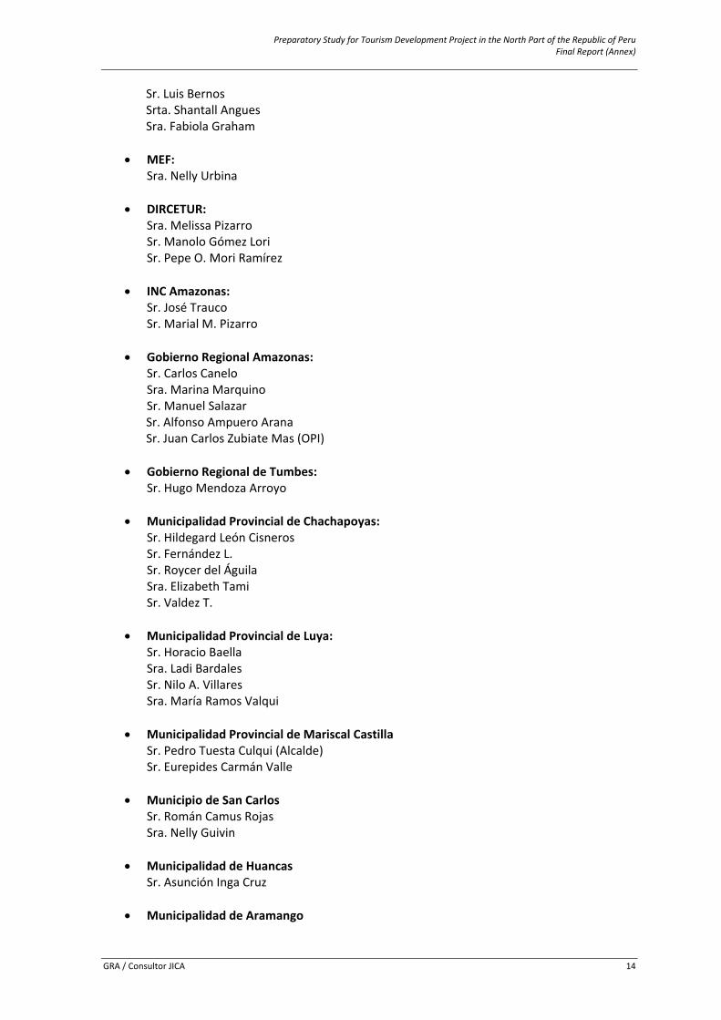
Preparatory Study for Tourism Development Project in the North Part of the Republic of Peru Final Report (Annex)
GRA / Consultor JICA 14
Sr. Luis Bernos Srta. Shantall Angues Sra. Fabiola Graham
• MEF: Sra. Nelly Urbina
• DIRCETUR: Sra. Melissa Pizarro Sr. Manolo Gómez Lori Sr. Pepe O. Mori Ramírez
• INC Amazonas: Sr. José Trauco Sr. Marial M. Pizarro
• Gobierno Regional Amazonas: Sr. Carlos Canelo Sra. Marina Marquino Sr. Manuel Salazar
Sr. Alfonso Ampuero Arana Sr. Juan Carlos Zubiate Mas (OPI)
• Gobierno Regional de Tumbes:
Sr. Hugo Mendoza Arroyo
• Municipalidad Provincial de Chachapoyas: Sr. Hildegard León Cisneros Sr. Fernández L. Sr. Roycer del Águila Sra. Elizabeth Tami Sr. Valdez T.
• Municipalidad Provincial de Luya: Sr. Horacio Baella Sra. Ladi Bardales Sr. Nilo A. Villares Sra. María Ramos Valqui
• Municipalidad Provincial de Mariscal Castilla Sr. Pedro Tuesta Culqui (Alcalde) Sr. Eurepides Carmán Valle
• Municipio de San Carlos Sr. Román Camus Rojas Sra. Nelly Guivin
• Municipalidad de Huancas
Sr. Asunción Inga Cruz
• Municipalidad de Aramango
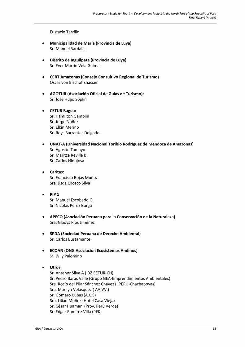
Preparatory Study for Tourism Development Project in the North Part of the Republic of Peru Final Report (Annex)
GRA / Consultor JICA 15
Eustacio Tarrillo
• Municipalidad de María (Provincia de Luya) Sr. Manuel Bardales
• Distrito de Inguilpata (Provincia de Luya)
Sr. Ever Martin Vela Guimac
• CCRT Amazonas (Consejo Consultivo Regional de Turismo) Oscar von Bischoffshacsen
• AGOTUR (Asociación Oficial de Guías de Turismo): Sr. José Hugo Soplin
• CETUR Bagua: Sr. Hamilton Gambini Sr. Jorge Núñez Sr. Elkin Merino Sr. Roys Barrantes Delgado
• UNAT‐A (Universidad Nacional Toribio Rodríguez de Mendoza de Amazonas) Sr. Agustín Tamayo Sr. Maritza Revilla B. Sr. Carlos Hinojosa
• Caritas: Sr. Francisco Rojas Muñoz Sra. Jisda Orosco Silva
• PIP 1 Sr. Manuel Escobedo G. Sr. Nicolás Pérez Burga
• APECO (Asociación Peruana para la Conservación de la Naturaleza) Sra. Gladys Ríos Jiménez
• SPDA (Sociedad Peruana de Derecho Ambiental) Sr. Carlos Bustamante
• ECOAN (ONG Asociación Ecosistemas Andinos) Sr. Wily Palomino
• Otros: Sr. Antenor Silva A ( DZ.EETUR‐CH) Sr. Pedro Baras Valle (Grupo GEA‐Emprendimientos Ambientales) Sra. Rocío del Pilar Sánchez Chávez ( IPERU‐Chachapoyas) Sra. Marilyn Velásquez ( AA.VV.) Sr. Gomero Cubas (A.C.S) Sra. Lilian Muñoz (Hotel Casa Vieja) Sr. César Huamani (Proy. Perú Verde) Sr. Edgar Ramírez Villa (PEK)
Preparatory Study for Tourism Development Project in the North Part of the Republic of Peru Final Report (Annex)
GRA / Consultor JICA 16
Sr. Eduardo Inga (Asociación Tmo – Comunidad Campesina de Yambrasbamba) Sr. Edilberto Yoplac (Kuélap&Adventure) Sr. Danny Gallardo (Radio Activa) Sr. Percy Tuesta Vargas (Radio Activa) Sr. Juan Verastegui (Radio Bongará) Sr. Andrés Gutiérrez ( Radio Reina de la S.) Sr. Jorge Silva Díaz Sra. Jane Mori Culqui Sr. Antonio Servan Sra. Mildred Saldaña Rabonal
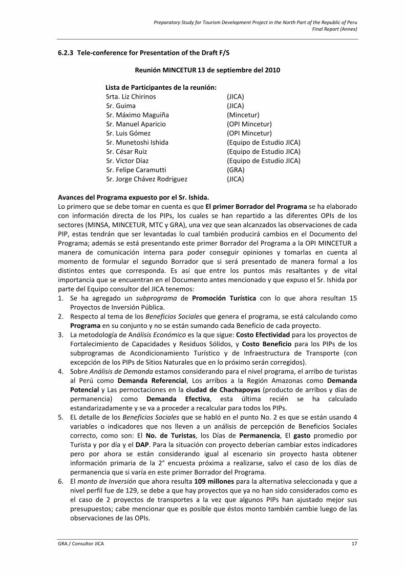
Preparatory Study for Tourism Development Project in the North Part of the Republic of Peru Final Report (Annex)
GRA / Consultor JICA 17
6.2.3 Tele‐conference for Presentation of the Draft F/S
Reunión MINCETUR 13 de septiembre del 2010
Lista de Participantes de la reunión: Srta. Liz Chirinos (JICA) Sr. Guima (JICA) Sr. Máximo Maguiña (Mincetur) Sr. Manuel Aparicio (OPI Mincetur) Sr. Luis Gómez (OPI Mincetur) Sr. Munetoshi Ishida (Equipo de Estudio JICA) Sr. César Ruiz (Equipo de Estudio JICA) Sr. Victor Díaz (Equipo de Estudio JICA) Sr. Felipe Caramutti (GRA) Sr. Jorge Chávez Rodríguez (JICA)
Avances del Programa expuesto por el Sr. Ishida. Lo primero que se debe tomar en cuenta es que El primer Borrador del Programa se ha elaborado con información directa de los PIPs, los cuales se han repartido a las diferentes OPIs de los sectores (MINSA, MINCETUR, MTC y GRA), una vez que sean alcanzados las observaciones de cada PIP, estas tendrán que ser levantadas lo cual también producirá cambios en el Documento del Programa; además se está presentando este primer Borrador del Programa a la OPI MINCETUR a manera de comunicación interna para poder conseguir opiniones y tomarlas en cuenta al momento de formular el segundo Borrador que si será presentado de manera formal a los distintos entes que corresponda. Es así que entre los puntos más resaltantes y de vital importancia que se encuentran en el Documento antes mencionado y que expuso el Sr. Ishida por parte del Equipo consultor del JICA tenemos: 1. Se ha agregado un subprograma de Promoción Turística con lo que ahora resultan 15
Proyectos de Inversión Pública. 2. Respecto al tema de los Beneficios Sociales que genera el programa, se está calculando como
Programa en su conjunto y no se están sumando cada Beneficio de cada proyecto. 3. La metodología de Análisis Económico es la que sigue: Costo Efectividad para los proyectos de
Fortalecimiento de Capacidades y Residuos Sólidos, y Costo Beneficio para los PIPs de los subprogramas de Acondicionamiento Turístico y de Infraestructura de Transporte (con excepción de los PIPs de Sitios Naturales que en lo próximo serán corregidos).
4. Sobre Análisis de Demanda estamos considerando para el nivel programa, el arribo de turistas al Perú como Demanda Referencial, Los arribos a la Región Amazonas como Demanda Potencial y Las pernoctaciones en la ciudad de Chachapoyas (producto de arribos y días de permanencia) como Demanda Efectiva, esta última recién se ha calculado estandarizadamente y se va a proceder a recalcular para todos los PIPs.
5. EL detalle de los Beneficios Sociales que se habló en el punto No. 2 es que se están usando 4 variables o indicadores que nos lleven a un análisis de percepción de Beneficios Sociales correcto, como son: El No. de Turistas, los Días de Permanencia, El gasto promedio por Turista y por día y el DAP. Para la situación con proyecto deberían cambiar estos indicadores pero por ahora se están considerando igual al escenario sin proyecto hasta obtener información primaria de la 2° encuesta próxima a realizarse, salvo el caso de los días de permanencia que si varía en este primer Borrador del Programa.
6. El monto de Inversión que ahora resulta 109 millones para la alternativa seleccionada y que a nivel perfil fue de 129, se debe a que hay proyectos que ya no han sido considerados como es el caso de 2 proyectos de transportes a la vez que algunos PIPs han ajustado mejor sus presupuestos; cabe mencionar que es posible que éstos monto también cambie luego de las observaciones de las OPIs.
Preparatory Study for Tourism Development Project in the North Part of the Republic of Peru Final Report (Annex)
GRA / Consultor JICA 18
7. Se explicó la propuesta de la Unidad de Gestión para la ejecución del programa en su etapa de Inversión.
Comentarios y Observaciones por parte de los participantes de la Reunión: Una vez concluida la disertación se procede a intercambiar ideas, comentarios y observaciones para enriquecimiento del Documento del Programa y para aclarar algunos puntos. a. La Srta. Liz Chirinos preguntó acerca de la Unidad de Gestión del Programa, quería saber si es
que en el Informe esta explicada la razón y porque de esta. Se explicó que efectivamente esto estaba explicado en el Informe. Se acordó que esto debía ser revisado y esperar los comentarios de las áreas para poder ir mejorándolo.
b. El Ing. Máximo Maguiña preguntó sobre los cambios en los montos de inversión, si es que se calcula que estos serían del 20% ó 30%. Al respecto se explicó que se esperaba que los cambios no fuesen tan grandes debido a que por lo general los cambios podrían ocurrir en los Proyectos que llegan hasta Prefactibilidad (2 PIPs) y los que lleguen a Factibilidad (1 PIP) los cuales pertenecen al subprograma de transporte; es decir de los 15 PIPs sólo 3 estarían siendo sensibles a posibles cambios en los Montos de Inversión, pero lógicamente siempre hay algún cambio. El Ing. Máximo Maguiña explicó que podían haber cambios en los costos y otros pero que lo que no debería cambiar es la metodología con la que ese está trabajando; y es precisamente por eso que para el segundo borrador se va uniformizar y estandarizar la metodología de todos los PIPs y respecto al Programa.
c. Se comentó que aparentemente el tema del museo no es muy rentable o atractivo. Al respecto se explicó que para la segunda versión esto será corregido en su totalidad.
d. El Sr. Luis Gómez comentó que hasta el momento, y en base a los perfiles revisados, se han dado cuenta que no hay un enfoque global de Programa. “La mayoría de los proyectos tienen supuestos individuales que no integran todo el Valle, no tienen secuencia con el Programa y cada uno tiene su propia metodología”. El único que tiene un contexto de enfoque metodológico, temático y abarca todo el espacio turístico del valle como el área de intervención es el del Arquitecto Luis Bernos y que a los demás perfiles les falta esto. Comentó también que el Programa debería tener una estrategia y para esto se debe tomar cada tema y elevarlo a nivel Programa y que haya relación entre los perfiles, pero aparentemente cada consultor a trabajado individualmente y no hay este objetivo global como Programa. Al respecto se explicó que efectivamente el Programa si cuenta con una estrategia turística que pasa desde un ordenamiento territorial, físico espacial que luego recae en un ordenamiento turístico donde se generan zonas turísticas, áreas turísticas y por lo consecuente rutas, circuitos y productos turísticos y esto equivale a conformar un “Destino Turístico” y justamente como se comenta esta estrategia está inmersa en el PIP de los Paradores Turísticos Comunales que recoge toda la problemática a nivel de Corredor en el Diagnóstico y que como se puede verificar en el objetivo central del PIP antes mencionado que dice: “ADECUADA ARTICULACIÓN TURISTICA DE LA RUTA DEL CTCU”, que incluso en coordinaciones con el Plan COPESCO se ha intentado consolidar sus intervenciones individuales con el PIP de los Paradores ya que se encuentran en el mismo espacio turístico, el inconveniente ha sido al momento de integrar todos los PIPs al programa cosa que se va resarcir para la segunda versión y dejamos constancia que el eje transversal a todos los PIPs es el de los Paradores como quedó demostrado en esta reunión, y los demás tendrán que enmarcarse en esta estrategia, además que para el nivel programa se tendrá que ahondar en las políticas y objetivos turísticos que como consecuencia puedan resultar en un plan turísticos (de acción y/o operativo).
e. El Sr. Manuel Aparicio comentó que en el documento debe explicitar el análisis y esfuerzo del Consultor. Es decir se nos pide que se haya recogido bien el análisis de los PIP’s, el análisis del
Preparatory Study for Tourism Development Project in the North Part of the Republic of Peru Final Report (Annex)
GRA / Consultor JICA 19
Espacio de visita y la demanda. Si esto estuviese bien explicito en el Programa sería más fácil y claro para la persona que lee y analiza el Programa. El hecho que haya relación entre los proyectos y que cada proyecto individual debería explicitar cual es el objetivo global del Programa es muy importante. Los perfiles deberían tener relación entre ellos. Comentario totalmente de acuerdo a lo que se pretende en esta etapa.
f. Acerca del planteamiento de la estrategia global del Programa el Ing. Máximo Maguiña habló
sobre la importancia de plantearla y explicarla a todos los especialistas del Equipo de Estudio. El Sr. Luis Gomez indica que el planteamiento que está en el proyecto del Arquitecto Luis Bernos es muy bueno y que deberíamos trasladarlo a los otros proyectos. También mencionó algunos problemas que encontró en algunos de los proyectos que ha revisado como aquel en el que se ha usado “Costo / Efectividad” y que eso no es lo adecuado y en el proyecto de la caverna de Quiocta en el cual se ha seleccionado, en la propuesta, la opción que más depreda el ambiente. Al respecto se respondió la reformulación en algunos aspectos de dicho proyecto esta vez enmarcándolo en la política y estrategia del Programa.
g. El Sr. Jorge Chávez Rodríguez habló acerca de la falta de estructura de tratamiento del
Espacio turístico y que el Programa debe tener un objetivo general y cada uno de los proyectos debería estar vinculado con el resto mediante este objetivo específico. Punto muy importante a tener en cuenta de aquí en adelante donde los PIPs tengan como objetivos específicos las metas que plantea el Programa. También habló sobre el proyecto vial “Mayno – Levanto”; mencionó que ya hay un proyecto que está en ejecución, que para que el nuestro sea aprobado este tendría que ser cerrado pero como está en ejecución esto sería muy difícil y quería saber si, como consultores, teníamos alguna estrategia para enfrentar esta situación. El Ing. Máximo Maguiña acotó que él había hablado con la Ing. Fanny Eto y que este proyecto (Financiado por Foniprel) era un proyecto de mantenimiento, no de mejoramiento. El Sr. Felipe Caramutti dijo que no era solamente de mantenimiento sino también de Mejoramiento y que esta situación los pone en problemas pues hasta qué punto es viable cerrar el proyecto que está en ejecución. El Ing. Máximo Maguiña dijo que sería importante saber cuáles fueron las coordinaciones que ha habido entre la Ing. Fanny Eto y el MTC. Al respecto queda como tarea averiguar dichas observaciones y presentar a los señores participantes del programa el estado de estas observaciones.
h. El Ing. Máximo Maguiña manifestó que sería importante que los miembros del Equipo de Estudio tengan una reunión para poder definir la estrategia del Programa y que es importante que se tome en cuenta el enfoque de trabajo del Arquitecto Bernos. Por parte del programa se tomó en cuenta esta sugerencia como imprescindible para levantar cada una de estas observaciones.
i. Se habló sobre la primera encuesta realizada, de que esta no fue muy buena y vamos a
Realizar una segunda. El Ing. Máximo Maguiña indicó que sería bueno preparar bien la estrategia global del Programa antes de realizar la segunda encuesta pues esto ayudaría a obtener un mejor resultado.
j. La Srta. Liz Chirinos mencionó que el MEF siempre dijo que el Programa se podía quedar a
nivel de pre factibilidad pero que sería importante saber si esto se sigue manteniendo en pie o no y que esto debería ser definido internamente.
k. El Sr. Manuel Aparicio dijo que debería hacerse una revisión al análisis de demanda de manera armónica con los proyectos. También mencionó que sería bueno brindar algunas observaciones a nivel borrador para que estas puedan ser subsanadas por el Equipo de Estudio, para lo cual se acordó que se estaría remitiendo el informe preliminar (Primer
Preparatory Study for Tourism Development Project in the North Part of the Republic of Peru Final Report (Annex)
GRA / Consultor JICA 20
Borrador del Programa) a la OPI MINCETUR pero a manera de comunicación interna para obtener las observaciones respectivas, además se sugirió que se revise en primera instancia el Primer Borrador del PIP de los Paradores Turísticos Comunales y se haga llegar lo más pronto dichas observaciones para tener este PIP como Norte del Programa.
l. El Sr. Jorge Chávez Rodríguez dijo que se debía mejorar el recurso turístico para darle al Programa una estructura más sólida y el Sr. Luis Gómez dijo que los objetivos del Programa debían ser más específicos.
m. La Srta. Liz Chirinos puntualizó que uno de los puntos más importantes es el del diseño de la unidad ejecutora, que es muy importante que ya vayamos teniendo una idea más clara de cómo se va a realizar el diseño. El Sr. Máximo Maguiña acotó que el organigrama de la unidad ejecutora es muy importante y que debíamos definirla.
n. El Sr. Felipe Caramutti dijo que hay un elemento activo que es el GRA, ellos “son la unidad formuladora y como tal cree que deben tener un rol más activo y participar, no sólo de reuniones como esta, si no del día a día de la elaboración del Programa pues este se va a desarrollar en su territorio y ellos han demostrado que están abiertos a cooperar y que tienen las puertas abiertas para que los consultores puedan acercarse a ellos en caso de alguna inquietud o apoyo”. También comento que no son solamente un ente que escucha video conferencias o alguna que otra opinión sino que deben tener una mayor presencia y acción en la elaboración del Programa. Mencionó que las veces que nos hemos reunido con ellos se ha quedado en ciertos acuerdos que no se han cumplido, motivo por el cual piden que se les tenga en cuenta para estas reuniones y de esta manera puedan estar más al tanto de lo que se acuerde. Al respecto se opinó por parte del programa que es totalmente aceptable la crítica y será tomada en cuenta pero a la vez los representantes de la JICA comentaron que también estamos dispuestos a aceptar todas las reuniones que el GRA pueda organizar activamente.
o. El Sr. Manuel Aparicio manifestó que para fines de mes la OPI MINCETUR estaría entregando un borrador con las observaciones a nuestro primer borrador del Programa.
p. Además de todo lo anterior el Sr. Luis Gómez manifestó que debido al monto de Inversión del
Programa se solicitaría enfáticamente presentar como sustento estudios como: Levantamientos topográficos, Estudios de Impacto Ambiental, propuestas arquitectónicas, Estudio Mecánico de Suelos, Estudios Hidrológicos. Tema que el Sr. Manuel Aparicio comentó que sólo de ser el caso que estos estudios se exijan en la normativa como requisitos indispensables se solicitarán, es decir los proyectos que lleguen a Prefactibilidad o factibilidad tendrían que presentar dichos estudios. Al respecto de los estudios antes mencionados se sugiere que sean considerados por los consultores de los PIPs, el estudio de impacto ambiental (quizá sólo un DIA – Declaración de impacto ambiental) y la propuesta arquitectónica preliminar de las intervenciones ya que para el nivel Perfil no es exigido los demás salvo el caso del subprograma de Transporte.
Conclusiones Las conclusiones que a continuación se presentan se han redactado en un orden de importancia y según las acciones inmediatas a tomar que no perjudiquen la consolidación final del programa, principal preocupación en éstos momentos. 1. En general según la presentación de avances del Programa Vs. Los comentarios y/u
observaciones recogidas durante la reunión no hemos podido consolidar bien el programa teniendo como déficit la integración de los PIPs al Programa esto internamente sabemos que ocurrió debido al apretado tiempo que tuvimos en la recta final para presentar primer
Preparatory Study for Tourism Development Project in the North Part of the Republic of Peru Final Report (Annex)
GRA / Consultor JICA 21
borrador de Perfiles a esto le llamaron “Enfoque Global del Programa” en el comentario d. e. h. La identificación de los objetivos de cada PIP deberá estar reflejado en las metas del Programa y en su objetivo central.
2. Se ha incidido mucho y desde hace algún tiempo en la Estrategia Global y de Turismo (comentarios d. e. f. g. y h.) que vamos a presentar a nivel programa, como comentario a esto el Plan COPESCO en un inicio empezó estudiando la zona del CTCU como programa denominado PATAU pero según comentario de ellos mismos en otra reunión manifestaron que debido a la complejidad que se les presentó tanto físicamente, espacialmente, turísticamente y por tema de tiempos y cronogramas decidieron realizar los estudios de pre inversión individualmente sin considerar el espacio turístico por lo que a nosotros como Programa nos toca esta difícil tarea de elaborar una estrategia de turismo bien sustentada y consistente con todos los PIPs considerando al CTCU desde un enfoque articulador como Espacio Turístico estructurado. Por estrategia global se refieren a la vinculación de los PIPs al programa y cuáles serían los pasos a seguir para este propósito se sugirió no seguir trabajando individualmente cada PIP.
3. Sobre los Proyectos de Transporte, caso del proyecto Levanto – Mayno se incidió mucho en averiguar el estado de las coordinaciones con el MTC y el GRA sobre otros proyectos ya en ejecución en el mismo lugar para no duplicar esfuerzos más bien complementarlos. (comentario g.).
4. Sobre el análisis económico; en cuanto a los montos de inversión (comentario b.) se espera no varíen mucho los presupuestos de los PIPs en nivel de Perfil; la metodología para hallar los beneficios económicos tendrá que ser la misma en todos los PIPs de acondicionamiento turístico para lo cual se deben usar los indicadores explicados en el punto No. 5 de la explicación de avances del programa y para el nivel programa se está preparando otra encuesta más específica (comentario i.); además se requiere usar una misma metodología de evaluación económica por lo cual para el proyecto de la caverna de Quiocta y Jumbilla se tendrá que adecuar a la metodología Costo/Beneficio para tener el mismo análisis (comentario f.), por último para este punto del comentario c. hay que buscar la viabilidad económica para el Museo ya que la evaluación económica es parámetro primordial de evaluación por parte de las OPIs.
5. Respecto al análisis de demanda, es imprescindible trabajar con una misma data para todos los PIPs especialmente los del Subprograma de Turismo para poder elevarlo luego al programa y satisfacer observaciones planteadas. (comentario K.).
6. Una última conclusión importante es respecto a la unidad de Gestión que plantea el programa, esta debe ya ir siendo conversada con los actores que plantea el programa para esta unidad e ir definiéndola.
Acciones asertivas e inmediatas a tomar:
Las acciones recomendables que se presentan a continuación llevan un orden cronológico que esperamos comentarios para organizar algún cronograma. 1. Primero la interrogante para los consultores si van a seguir contando con el apoyo de sus
asistentes, para poder coordinar directamente con ellos próximas reuniones. 2. Es merecido decir que cada uno de nosotros sabe en que ha fallado en la formulación de los
PIPs debido al apretado tiempo, por lo que se solicita ir ya avizorando, comentando, intercambiando y corrigiendo dichos posibles errores.
3. Se necesita plantear una estrategia global primero para poder seguir una misma línea todos los proyectos, para lo cual se estará reuniendo el Equipo del programa para luego convocar a los consultores de los PIPs y discutir el horizonte a tomar. Según las condiciones como se presentan, tendrá que ser un ida y vuelta entre Programa y PIPs, es decir alimentar al
Preparatory Study for Tourism Development Project in the North Part of the Republic of Peru Final Report (Annex)
GRA / Consultor JICA 22
programa con los proyectos y a la vez los proyectos adecuarse a datos, metodologías y lineamientos que plantee el programa.
4. Para el tema medular tan solicitado de estrategia del Turismo y la articulación de los Proyectos con el Programa se decide considerar como Norte el PIP de los Paradores Turísticos Comunales ya que en él se encuentra inmerso el análisis sobre el espacio turístico que después de las intervenciones pretendemos construir el Destino Turístico. Por tal motivo necesitamos repartir dicha información a todos los consultores y asistentes que se vayan informando para luego convocar al Arq. Luis Bernos y equipo técnico que se integre a la dirección del Programa en este campo y pueda explicarnos a todos lo concerniente a la estrategia Turística planteada.
5. Coordinar el tema del proyecto de transporte que fue observado en la reunión como una posible duplicidad de esfuerzos.
6. Sobre la metodología de análisis económico se necesita que los proyectos de Quiocta y Jumbilla recalculen por metodología Costo/Beneficio y para el punto de Beneficios Sociales con proyectos consideren los indicadores líneas arriba mencionados.
7. EL análisis de demanda tendrá también que ser calculado con nueva data y nuevas consideraciones, ya que ahora el programa ha visto conveniente considerar como demanda potencial sólo los arribos a Chachapoyas, datos que los está manejando muy bien Rodolfo Namuche y que en próximos mails los hará llegar a todos para de inmediato proceder al re cálculo y comparar que es lo que resulta, ya que se debe escoger al final la al opción más acertada para todos.
Lima, 16 de Setiembre de 2010
Equipo Técnico Programa JICA 2010
Preparatory Study for Tourism Development Project in the North Part of the Republic of Peru Final Report (Annex)
GRA / Consultor JICA 23
6.2.4 Minues of Understanding between MINCETUR and JBIC
Preparatory Study for Tourism Development Project in the North Part of the Republic of Peru Final Report (Annex)
GRA / Consultor JICA 24
Preparatory Study for Tourism Development Project in the North Part of the Republic of Peru Final Report (Annex)
GRA / Consultor JICA 25
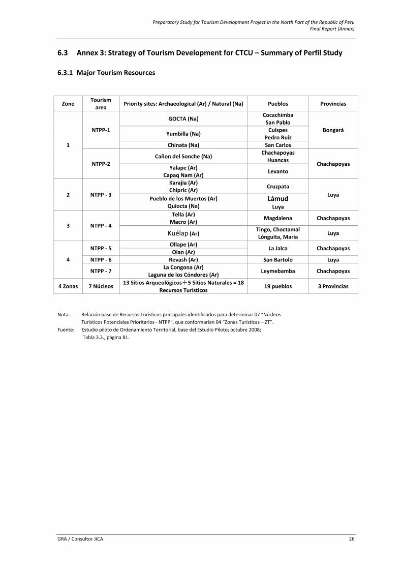
Preparatory Study for Tourism Development Project in the North Part of the Republic of Peru Final Report (Annex)
GRA / Consultor JICA 26
6.3 Annex 3: Strategy of Tourism Development for CTCU – Summary of Perfil Study 6.3.1 Major Tourism Resources
Zone Tourism area Priority sites: Archaeological (Ar) / Natural (Na) Pueblos Provincias
1
NTPP‐1
GOCTA (Na) Cocachimba San Pablo
Bongará Yumbilla (Na) Cuispes Pedro Ruiz
Chinata (Na) San Carlos
NTPP‐2 Cañon del Sonche (Na) Chachapoyas
Huancas Chachapoyas Yalape (Ar)
Capaq Nam (Ar) Levanto
2 NTPP ‐ 3
Karajia (Ar) Chipric (Ar) Cruzpata
Luya Pueblo de los Muertos (Ar)
Quiocta (Na) Lámud Luya
3 NTPP ‐ 4
Tella (Ar) Macro (Ar) Magdalena Chachapoyas
Kuélap (Ar) Tingo, Choctamal Lónguita, Maria Luya
4
NTPP ‐ 5 Ollape (Ar)
La Jalca Chachapoyas Olan (Ar)
NTPP ‐ 6 Revash (Ar) San Bartolo Luya
NTPP ‐ 7 La Congona (Ar) Laguna de los Cóndores (Ar) Leymebamba Chachapoyas
4 Zonas 7 Núcleos 13 Sitios Arqueológicos+5 Sitios Naturales = 18 Recursos Turísticos
19 pueblos 3 Provincias
Nota: Relación base de Recursos Turísticos principales identificados para determinar 07 “Núcleos Turísticos Potenciales Prioritarios ‐ NTPP”, que conformarían 04 “Zonas Turísticas – ZT”.
Fuente: Estudio piloto de Ordenamiento Territorial, base del Estudio Piloto; octubre 2008; Tabla 3.3., página 81.
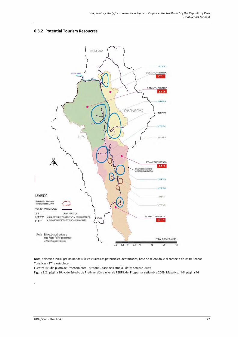
Preparatory Study for Tourism Development Project in the North Part of the Republic of Peru Final Report (Annex)
GRA / Consultor JICA 27
6.3.2 Potential Tourism Resoucres
Nota: Selección inicial preliminar de Núcleos turísticos potenciales identificados, base de selección, e el contexto de las 04 “Zonas Turísticas ‐ ZT” a establecer. Fuente: Estudio piloto de Ordenamiento Territorial, base del Estudio Piloto; octubre 2008; Figura 3.2., página 80; y, de Estudio de Pre‐inversión a nivel de PERFIL del Programa, setiembre 2009; Mapa No. III‐8, página 44
.
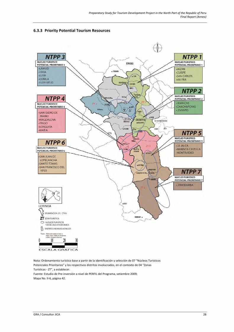
Preparatory Study for Tourism Development Project in the North Part of the Republic of Peru Final Report (Annex)
GRA / Consultor JICA 28
6.3.3 Priority Potential Tourism Resources
Nota: Ordenamiento turístico base a partir de la identificación y selección de 07 “Núcleos Turísticos Potenciales Prioritarios” y los respectivos distritos involucrados, en el contexto de 04 “Zonas Turísticas ‐ ZT”, a establecer. Fuente: Estudio de Pre‐inversión a nivel de PERFIL del Programa, setiembre 2009; Mapa No. II‐6, página 42.
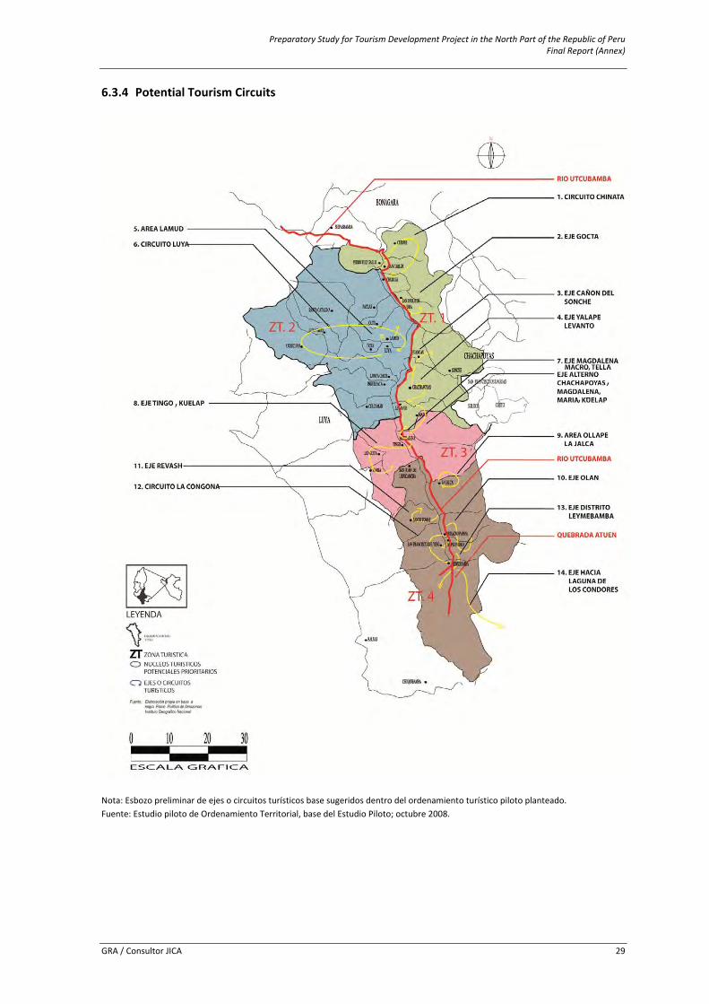
Preparatory Study for Tourism Development Project in the North Part of the Republic of Peru Final Report (Annex)
GRA / Consultor JICA 29
6.3.4 Potential Tourism Circuits
Nota: Esbozo preliminar de ejes o circuitos turísticos base sugeridos dentro del ordenamiento turístico piloto planteado. Fuente: Estudio piloto de Ordenamiento Territorial, base del Estudio Piloto; octubre 2008.
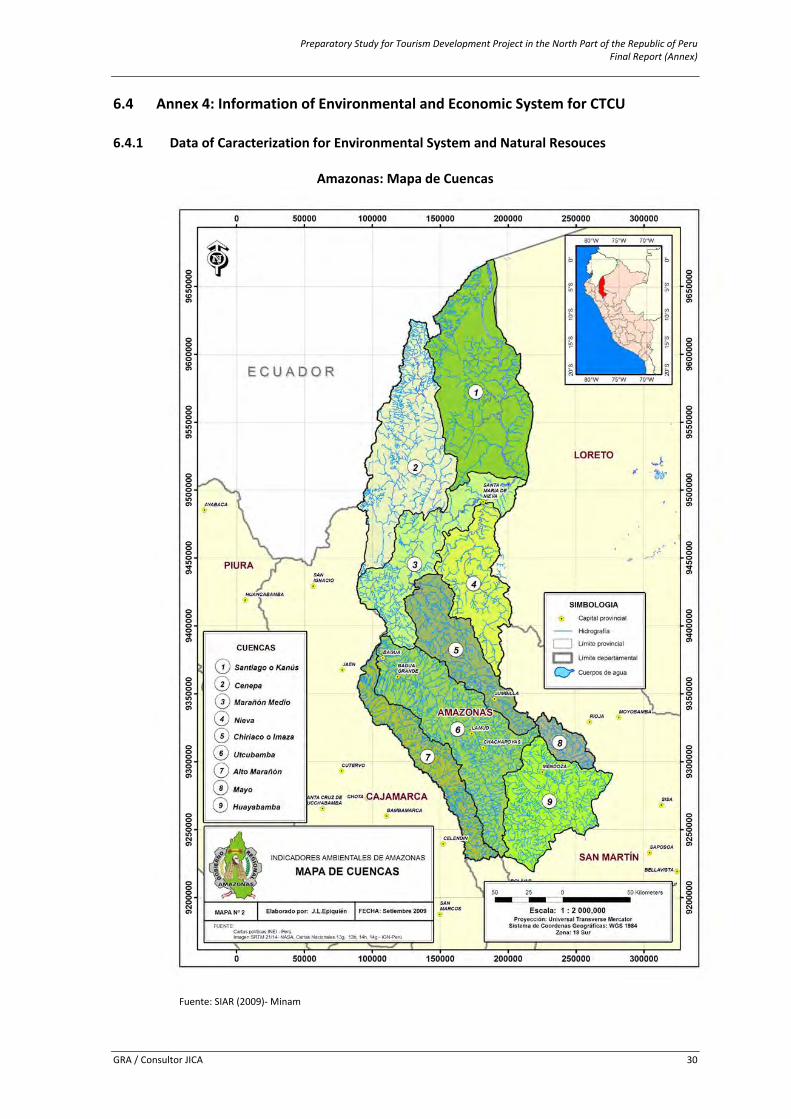
Preparatory Study for Tourism Development Project in the North Part of the Republic of Peru Final Report (Annex)
GRA / Consultor JICA 30
6.4 Annex 4: Information of Environmental and Economic System for CTCU 6.4.1 Data of Caracterization for Environmental System and Natural Resouces
Amazonas: Mapa de Cuencas
Fuente: SIAR (2009)‐ Minam
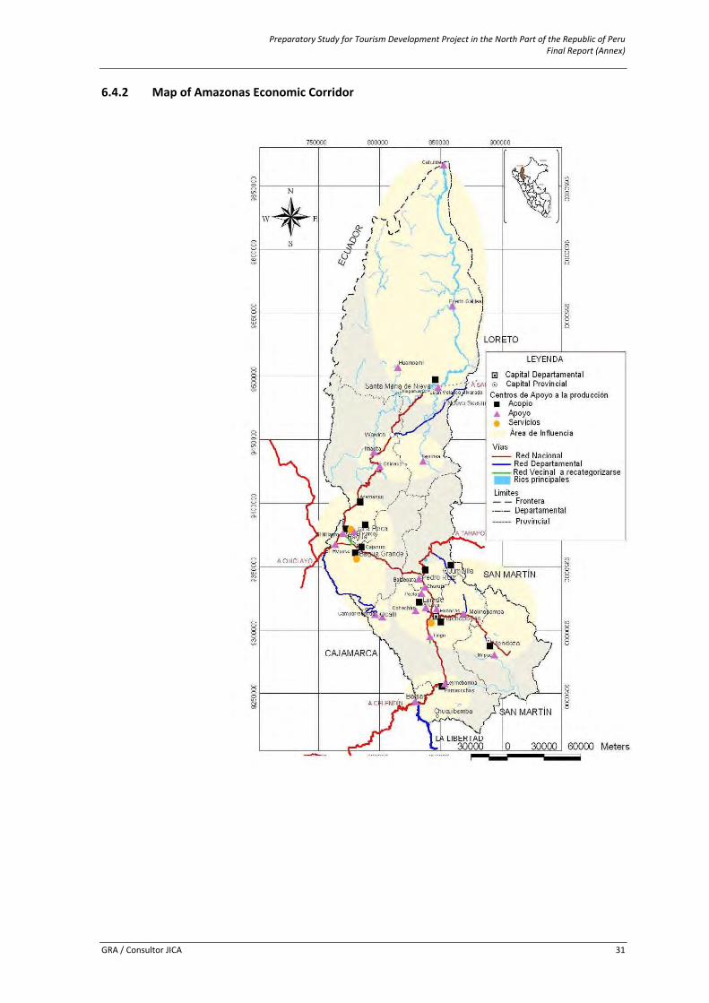
Preparatory Study for Tourism Development Project in the North Part of the Republic of Peru Final Report (Annex)
GRA / Consultor JICA 31
6.4.2 Map of Amazonas Economic Corridor
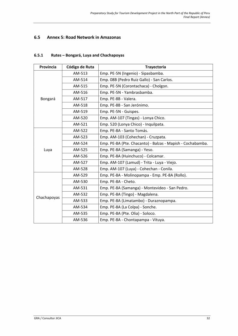
Preparatory Study for Tourism Development Project in the North Part of the Republic of Peru Final Report (Annex)
GRA / Consultor JICA 32
6.5 Annex 5: Road Network in Amazonas 6.5.1 Rutes – Bongará, Luya and Chachapoyas
Provincia Código de Ruta Trayectoria
Bongará
AM‐513 Emp. PE‐5N (Ingenio) ‐ Sipasbamba. AM‐514 Emp. 08B (Pedro Ruiz Gallo) ‐ San Carlos. AM‐515 Emp. PE‐5N (Corontachaca) ‐ Cholgon. AM‐516 Emp. PE‐5N ‐ Yambrasbamba. AM‐517 Emp. PE‐8B ‐ Valera. AM‐518 Emp. PE‐8B ‐ San Jerónimo. AM‐519 Emp. PE‐5N ‐ Guispes. AM‐520 Emp. AM‐107 (Tingas) ‐ Lonya Chico. AM‐521 Emp. 520 (Lonya Chico) ‐ Inquilpata.
Luya
AM‐522 Emp. PE‐8A ‐ Santo Tomás. AM‐523 Emp. AM‐103 (Cohechan) ‐ Cruzpata. AM‐524 Emp. PE‐8A (Pte. Chacanto) ‐ Balzas ‐ Mapish ‐ Cochabamba. AM‐525 Emp. PE‐8A (Samanga) ‐ Yeso. AM‐526 Emp. PE‐8A (Huinchuco) ‐ Colcamar. AM‐527 Emp. AM‐107 (Lamud) ‐ Trita ‐ Luya ‐ Viejo. AM‐528 Emp. AM‐107 (Luya) ‐ Cohechan ‐ Conila.
Chachapoyas
AM‐529 Emp. PE‐8A ‐ Molinopampa ‐ Emp. PE‐8A (Rollo). AM‐530 Emp. PE‐8A ‐ Cheto. AM‐531 Emp. PE‐8A (Samanga) ‐ Montevideo ‐ San Pedro. AM‐532 Emp. PE‐8A (Tingo) ‐ Magdalena. AM‐533 Emp. PE‐8A (Limatambo) ‐ Duraznopampa. AM‐534 Emp. PE‐8A (La Colpa) ‐ Sonche. AM‐535 Emp. PE‐8A (Pte. Olia) ‐ Soloco. AM‐536 Emp. PE‐8A ‐ Chontapampa ‐ Vituya.
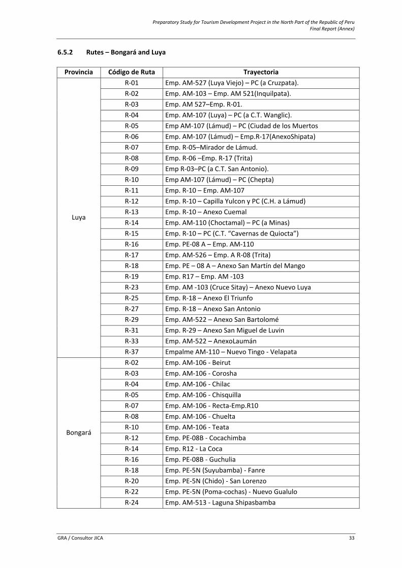
Preparatory Study for Tourism Development Project in the North Part of the Republic of Peru Final Report (Annex)
GRA / Consultor JICA 33
6.5.2 Rutes – Bongará and Luya Provincia Código de Ruta Trayectoria
Luya
R‐01 Emp. AM‐527 (Luya Viejo) – PC (a Cruzpata). R‐02 Emp. AM‐103 – Emp. AM 521(Inquilpata). R‐03 Emp. AM 527–Emp. R‐01. R‐04 Emp. AM‐107 (Luya) – PC (a C.T. Wanglic). R‐05 Emp AM‐107 (Lámud) – PC (Ciudad de los Muertos R‐06 Emp. AM‐107 (Lámud) – Emp.R‐17(AnexoShipata) R‐07 Emp. R‐05–Mirador de Lámud. R‐08 Emp. R‐06 –Emp. R‐17 (Trita) R‐09 Emp R‐03–PC (a C.T. San Antonio). R‐10 Emp AM‐107 (Lámud) – PC (Chepta) R‐11 Emp. R‐10 – Emp. AM‐107 R‐12 Emp. R‐10 – Capilla Yulcon y PC (C.H. a Lámud) R‐13 Emp. R‐10 – Anexo Cuemal R‐14 Emp. AM‐110 (Choctamal) – PC (a Minas) R‐15 Emp. R‐10 – PC (C.T. “Cavernas de Quiocta”) R‐16 Emp. PE‐08 A – Emp. AM‐110 R‐17 Emp. AM‐526 – Emp. A R‐08 (Trita) R‐18 Emp. PE – 08 A – Anexo San Martín del Mango R‐19 Emp. R17 – Emp. AM ‐103 R‐23 Emp. AM ‐103 (Cruce Sitay) – Anexo Nuevo Luya R‐25 Emp. R‐18 – Anexo El Triunfo R‐27 Emp. R‐18 – Anexo San Antonio R‐29 Emp. AM‐522 – Anexo San Bartolomé R‐31 Emp. R‐29 – Anexo San Miguel de Luvin R‐33 Emp. AM‐522 – AnexoLaumán R‐37 Empalme AM‐110 – Nuevo Tingo ‐ Velapata
Bongará
R‐02 Emp. AM‐106 ‐ Beirut R‐03 Emp. AM‐106 ‐ Corosha R‐04 Emp. AM‐106 ‐ Chilac R‐05 Emp. AM‐106 ‐ Chisquilla R‐07 Emp. AM‐106 ‐ Recta‐Emp.R10 R‐08 Emp. AM‐106 ‐ Chuelta R‐10 Emp. AM‐106 ‐ Teata R‐12 Emp. PE‐08B ‐ Cocachimba R‐14 Emp. R12 ‐ La Coca R‐16 Emp. PE‐08B ‐ Guchulia R‐18 Emp. PE‐5N (Suyubamba) ‐ Fanre R‐20 Emp. PE‐5N (Chido) ‐ San Lorenzo R‐22 Emp. PE‐5N (Poma‐cochas) ‐ Nuevo Gualulo R‐24 Emp. AM‐513 ‐ Laguna Shipasbamba
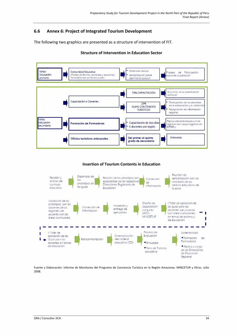
Preparatory Study for Tourism Development Project in the North Part of the Republic of Peru Final Report (Annex)
GRA / Consultor JICA 34
6.6 Annex 6: Project of Integrated Tourism Development The following two graphics are presented as a structure of intervention of FIT.
Structure of Intervention in Education Sector
Insertion of Tourism Contents in Education
Fuente y Elaboración: Informe de Monitoreo del Programa de Conciencia Turística en la Región Amazonas. MINCETUR y Otros. Julio 2008.
Preparatory Study for Tourism Development Project in the North Part of the Republic of Peru Final Report (Annex)
GRA / Consultor JICA 35
6.7 Annex 7: Inventory and Categorization of Tourism Resources in CTCU This Annex includes identified tourism resources at the 34 districts involved of the 3 provinces that comprise the Tourism Corridor of the valley of Utcubamba ‐ CTCU which will be described according to the 5 classified categories of the tourism resources as well as its political‐administrative location. The Inventory will be presented by the respective provinces as follows. The information sources used to consolidate the Inventory are as follows: a) Inventory and Catalogue of the Tourism Resources (Bongará, Chachapoyas and Luya)
elaborated by the DIRCETUR – Amazonas, 2010
b) Evaluation of Tourism Resources, R. Alva Cruz; Thematic report. Project of Ecologic and Economic Zoning of Amazonas, elaborated in agreement between the Research Institute of the Peruvian Amazon Region (IIAP) and the Regional Government of Amazonas (GRA), Iquitos, Perú, 2010
c) Inventory of Tourism Resources within the “Regional Strategic Plan of Tourism (PERTUR) 2009 – 2015”, DIRCETUR – GRA Amazonas
d) Tourist Script of Chachapoyas, Huancas, Levanto and Cheto, 2009, DIRCETUR – Amazonas
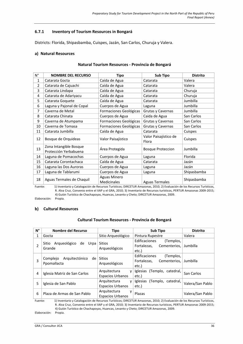
Preparatory Study for Tourism Development Project in the North Part of the Republic of Peru Final Report (Annex)
GRA / Consultor JICA 36
6.7.1 Inventory of Tourism Resources in Bongará Districts: Florida, Shipasbamba, Cuispes, Jazán, San Carlos, Churuja y Valera. a) Natural Resources
Natural Tourism Resources ‐ Provincia de Bongará
N° NOMBRE DEL RECURSO Tipo Sub Tipo Distrito1 Catarata Gocta Caída de Agua Catarata Valera 2 Catarata de Cajuachi Caída de Agua Catarata Valera 3 Catarata Lindapa Caída de Agua Catarata Churuja 4 Catarata de Adariyacu Caída de Agua Catarata Churuja 5 Catarata Goquete Caída de Agua Catarata Jumbilla 6 Laguna y Pajonal de Copal Cuerpos de Agua Laguna Jumbilla 7 Caverna de Metal Formaciones Geológicas Grutas y Cavernas Jumbilla 8 Catarata Chinata Cuerpos de Agua Caida de Agua San Carlos9 Caverna de Atumpama Formaciones Geológicas Grutas y Cavernas San Carlos10 Caverna de Tomasa Formaciones Geológicas Grutas y Cavernas San Carlos11 Catarata Jumbilla Caída de Agua Catarata Cuispes
12 Bosque de Orquideas Valor Paisajístico Valor Paisajístico de Flora Cuispes
13 Zona Intangible Bosque Protección Yerbabuena Área Protegida Bosque Proteccion Jumbilla
14 Laguna de Pomacochas Cuerpos de Agua Laguna Florida 15 Catarata Corontachaca Caída de Agua Catarata Jazán 16 Laguna las Dos Auroras Cuerpos de Agua Laguna Jazán 17 Laguna de Tablarumi Cuerpos de Agua Laguna Shipasbamba
18 Aguas Termales de Chaquil Aguas Minero Medicinales Aguas Termales Shipasbamba
Fuente: 1) Inventario y Catalogación de Recursos Turísticos; DIRCETUR Amazonas, 2010; 2) Evaluación de los Recursos Turísticos, R. Alva Cruz, Convenio entre el IIAP y el GRA, 2010; 3) Inventario de Recursos turísticos, PERTUR Amazonas 2009‐2015; 4) Guión Turístico de Chachapoyas, Huancas, Levanto y Cheto; DIRCETUR Amazonas, 2009.
Elaboración: Propia.
b) Cultural Resources
Cultural Tourism Resources ‐ Provincia de Bongará
N° Nombre del Recurso Tipo Sub Tipo Distrito1 Gocta Sitio Arqueológico Pintura Rupestre Valera
2 Sitio Arqueológico de Urpa Grande
Sitios Arqueológicos
Edificaciones (Templos, Fortalezas, Cementerios, etc.)
Jumbilla
3 Complejo Arquitectónico de Ppomallacta
Sitios Arqueológicos
Edificaciones (Templos, Fortalezas, Cementerios, etc.)
Jumbilla
4 Iglesia Matriz de San Carlos Arquitectura y Espacios Urbanos
Iglesias (Templo, catedral, etc.) San Carlos
5 Iglesia de San Pablo Arquitectura y Espacios Urbanos
Iglesias (Templo, catedral, etc.) Valera/San Pablo
6 Plaza de Armas de San Pablo Arquitectura y Espacios Urbanos Plazas Valera/San Pablo
Fuente: 1) Inventario y Catalogación de Recursos Turísticos; DIRCETUR Amazonas, 2010; 2) Evaluación de los Recursos Turísticos, R. Alva Cruz, Convenio entre el IIAP y el GRA, 2010; 3) Inventario de Recursos turísticos, PERTUR Amazonas 2009‐2015; 4) Guión Turístico de Chachapoyas, Huancas, Levanto y Cheto; DIRCETUR Amazonas, 2009.
Elaboración: Propia.

Preparatory Study for Tourism Development Project in the North Part of the Republic of Peru Final Report (Annex)
GRA / Consultor JICA 37
c) Folklore
Folklore Tourism Resources ‐ Provincia de Bongará
N° Nombre Del Recurso Tipo Sub Tipo Distrito1 Cosecha Del Café Música y Danza Danza Jazán
2 Laguna de Ochenta Manifestaciones Religiosas y Creencias Populares Mitos y Leyendas Valera
3 Santo Patrón de Poma cochas Manifestaciones Religiosas y Creencias Populares Mitos y Leyendas Florida ‐ Pomacochas
(Iglesia Matriz)
4 Creación de Pomaccochas Manifestaciones Religiosas y Creencias Populares Mitos y Leyendas Florida ‐ Pomacochas
Fuente: 1) Inventario y Catalogación de Recursos Turísticos; DIRCETUR Amazonas, 2010; 2) Evaluación de los Recursos Turísticos, R. Alva Cruz, Convenio entre el IIAP y el GRA, 2010; 3) Inventario de Recursos turísticos, PERTUR Amazonas 2009‐2015; 4) Guión Turístico de Chachapoyas, Huancas, Levanto y Cheto; DIRCETUR Amazonas, 2009.
Elaboración: Propia. Nota: Según las fuentes consultadas no existe registro de recursos turísticos en las categorías de Acontecimientos
Programados y Realizaciones Técnicas, Científicas y Artísticas Contemporáneas en la provincia de Bongará involucrada en el Corredor Turístico de la Cuenca del Utcubamba CTCU.
6.7.2 Inventory of Tourism Resources in Chachapoyas Districts: Huancas, Sonche, Chachapoyas, Levanto, San Isidro del Maino, Magdalena, La Jalca, Mariscal Castilla, Montevideo y Leymebamba. a) Natural Resources
Natural Tourism Resources ‐ Provincia de Chachapoyas
N° Nombre del Recurso Tipo Sub Tipo Distrito 1 ACP San Antonio Área Protegida Zona Reservada Chachapoyas2 Río Utcubamba Río ‐ Leymebamba
3 Mirador Natural de Puma Urco Valor Paisajístico Mirador Natural Levanto
4 Rio Yacu Ríos ‐ Magdalena5 Rio Condechaca Ríos ‐ Magdalena6 Cavernas de Shiual Formaciones Geológicas Grutas y Cavernas Magdalena7 Laguna de los Condores Cuerpos de Agua Laguna Leymebamba8 Mirador Cañon del Sonche Valor Paisajístico Mirador Natural Huancas9 Mirador de Huanca Urco Valor Paisajístico Mirador Natural Huancas10 Laguna de Mamacocha Cuerpos de Agua Laguna Jalca Grande11 Caverna de YAC YECUJ Formaciones Geológicas Grutas y Cavernas Jalca Grande Fuente: 1) Inventario y Catalogación de Recursos Turísticos; DIRCETUR Amazonas, 2010; 2) Evaluación de los Recursos Turísticos,
R. Alva Cruz, Convenio entre el IIAP y el GRA, 2010; 3) Inventario de Recursos turísticos, PERTUR Amazonas 2009‐2015; 4) Guión Turístico de Chachapoyas, Huancas, Levanto y Cheto; DIRCETUR Amazonas, 2009.
Elaboración: Propia.
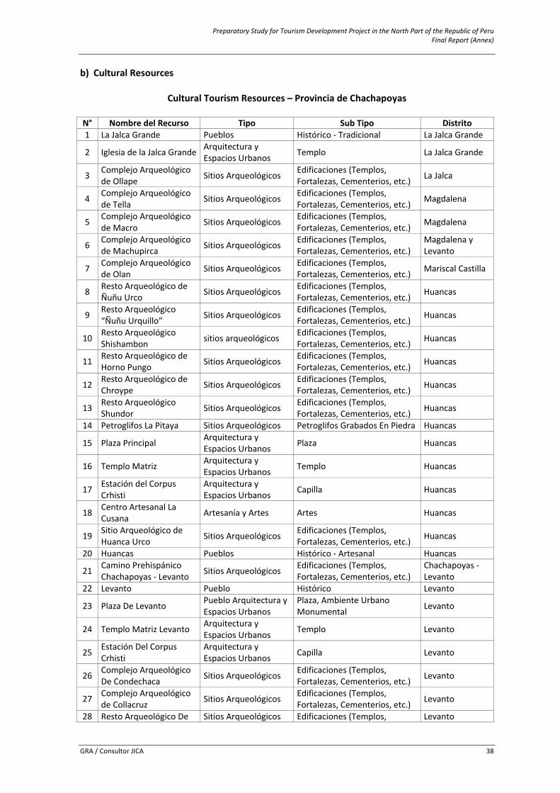
Preparatory Study for Tourism Development Project in the North Part of the Republic of Peru Final Report (Annex)
GRA / Consultor JICA 38
b) Cultural Resources
Cultural Tourism Resources – Provincia de Chachapoyas
N° Nombre del Recurso Tipo Sub Tipo Distrito1 La Jalca Grande Pueblos Histórico ‐ Tradicional La Jalca Grande
2 Iglesia de la Jalca Grande Arquitectura y Espacios Urbanos Templo La Jalca Grande
3 Complejo Arqueológico de Ollape Sitios Arqueológicos Edificaciones (Templos,
Fortalezas, Cementerios, etc.) La Jalca
4 Complejo Arqueológico de Tella Sitios Arqueológicos Edificaciones (Templos,
Fortalezas, Cementerios, etc.) Magdalena
5 Complejo Arqueológico de Macro Sitios Arqueológicos Edificaciones (Templos,
Fortalezas, Cementerios, etc.) Magdalena
6 Complejo Arqueológico de Machupirca Sitios Arqueológicos Edificaciones (Templos,
Fortalezas, Cementerios, etc.) Magdalena yLevanto
7 Complejo Arqueológico de Olan Sitios Arqueológicos Edificaciones (Templos,
Fortalezas, Cementerios, etc.) Mariscal Castilla
8 Resto Arqueológico de Ñuñu Urco Sitios Arqueológicos Edificaciones (Templos,
Fortalezas, Cementerios, etc.) Huancas
9 Resto Arqueológico “Ñuñu Urquillo” Sitios Arqueológicos Edificaciones (Templos,
Fortalezas, Cementerios, etc.) Huancas
10 Resto Arqueológico Shishambon sitios arqueológicos Edificaciones (Templos,
Fortalezas, Cementerios, etc.) Huancas
11 Resto Arqueológico de Horno Pungo Sitios Arqueológicos Edificaciones (Templos,
Fortalezas, Cementerios, etc.) Huancas
12 Resto Arqueológico de Chroype Sitios Arqueológicos Edificaciones (Templos,
Fortalezas, Cementerios, etc.) Huancas
13 Resto Arqueológico Shundor Sitios Arqueológicos Edificaciones (Templos,
Fortalezas, Cementerios, etc.) Huancas
14 Petroglifos La Pitaya Sitios Arqueológicos Petroglifos Grabados En Piedra Huancas
15 Plaza Principal Arquitectura y Espacios Urbanos Plaza Huancas
16 Templo Matriz Arquitectura y Espacios Urbanos Templo Huancas
17 Estación del Corpus Crhisti
Arquitectura y Espacios Urbanos Capilla Huancas
18 Centro Artesanal La Cusana Artesanía y Artes Artes Huancas
19 Sitio Arqueológico de Huanca Urco Sitios Arqueológicos Edificaciones (Templos,
Fortalezas, Cementerios, etc.) Huancas
20 Huancas Pueblos Histórico ‐ Artesanal Huancas
21 Camino Prehispánico Chachapoyas ‐ Levanto Sitios Arqueológicos Edificaciones (Templos,
Fortalezas, Cementerios, etc.) Chachapoyas ‐Levanto
22 Levanto Pueblo Histórico Levanto
23 Plaza De Levanto Pueblo Arquitectura y Espacios Urbanos
Plaza, Ambiente Urbano Monumental Levanto
24 Templo Matriz Levanto Arquitectura y Espacios Urbanos Templo Levanto
25 Estación Del Corpus Crhisti
Arquitectura y Espacios Urbanos Capilla Levanto
26 Complejo Arqueológico De Condechaca Sitios Arqueológicos Edificaciones (Templos,
Fortalezas, Cementerios, etc.) Levanto
27 Complejo Arqueológico de Collacruz Sitios Arqueológicos Edificaciones (Templos,
Fortalezas, Cementerios, etc.) Levanto
28 Resto Arqueológico De Sitios Arqueológicos Edificaciones (Templos, Levanto
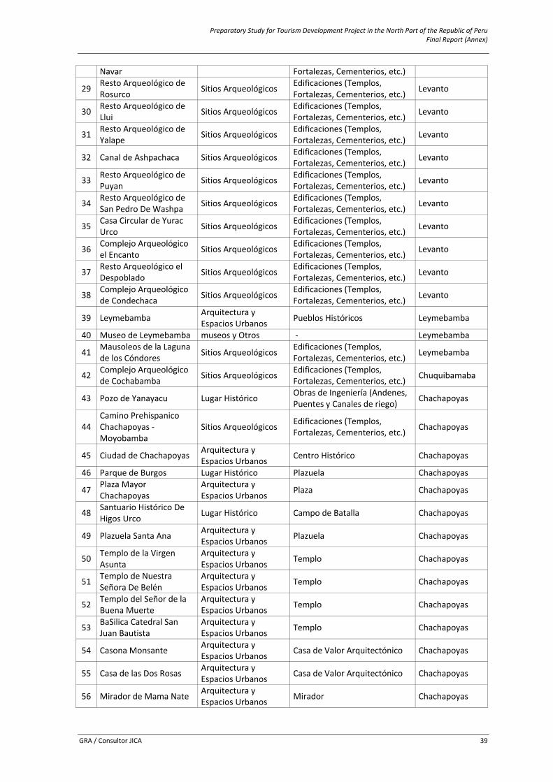
Preparatory Study for Tourism Development Project in the North Part of the Republic of Peru Final Report (Annex)
GRA / Consultor JICA 39
Navar Fortalezas, Cementerios, etc.)
29 Resto Arqueológico de Rosurco Sitios Arqueológicos Edificaciones (Templos,
Fortalezas, Cementerios, etc.) Levanto
30 Resto Arqueológico de Llui Sitios Arqueológicos Edificaciones (Templos,
Fortalezas, Cementerios, etc.) Levanto
31 Resto Arqueológico de Yalape Sitios Arqueológicos Edificaciones (Templos,
Fortalezas, Cementerios, etc.) Levanto
32 Canal de Ashpachaca Sitios Arqueológicos Edificaciones (Templos, Fortalezas, Cementerios, etc.) Levanto
33 Resto Arqueológico de Puyan Sitios Arqueológicos Edificaciones (Templos,
Fortalezas, Cementerios, etc.) Levanto
34 Resto Arqueológico de San Pedro De Washpa Sitios Arqueológicos Edificaciones (Templos,
Fortalezas, Cementerios, etc.) Levanto
35 Casa Circular de Yurac Urco Sitios Arqueológicos Edificaciones (Templos,
Fortalezas, Cementerios, etc.) Levanto
36 Complejo Arqueológico el Encanto Sitios Arqueológicos Edificaciones (Templos,
Fortalezas, Cementerios, etc.) Levanto
37 Resto Arqueológico el Despoblado Sitios Arqueológicos Edificaciones (Templos,
Fortalezas, Cementerios, etc.) Levanto
38 Complejo Arqueológico de Condechaca Sitios Arqueológicos Edificaciones (Templos,
Fortalezas, Cementerios, etc.) Levanto
39 Leymebamba Arquitectura y Espacios Urbanos Pueblos Históricos Leymebamba
40 Museo de Leymebamba museos y Otros ‐ Leymebamba
41 Mausoleos de la Laguna de los Cóndores Sitios Arqueológicos Edificaciones (Templos,
Fortalezas, Cementerios, etc.) Leymebamba
42 Complejo Arqueológico de Cochabamba Sitios Arqueológicos Edificaciones (Templos,
Fortalezas, Cementerios, etc.) Chuquibamaba
43 Pozo de Yanayacu Lugar Histórico Obras de Ingeniería (Andenes, Puentes y Canales de riego) Chachapoyas
44 Camino Prehispanico Chachapoyas ‐ Moyobamba
Sitios Arqueológicos Edificaciones (Templos, Fortalezas, Cementerios, etc.) Chachapoyas
45 Ciudad de Chachapoyas Arquitectura y Espacios Urbanos Centro Histórico Chachapoyas
46 Parque de Burgos Lugar Histórico Plazuela Chachapoyas
47 Plaza Mayor Chachapoyas
Arquitectura y Espacios Urbanos Plaza Chachapoyas
48 Santuario Histórico De Higos Urco Lugar Histórico Campo de Batalla Chachapoyas
49 Plazuela Santa Ana Arquitectura y Espacios Urbanos Plazuela Chachapoyas
50 Templo de la Virgen Asunta
Arquitectura y Espacios Urbanos Templo Chachapoyas
51 Templo de Nuestra Señora De Belén
Arquitectura y Espacios Urbanos Templo Chachapoyas
52 Templo del Señor de la Buena Muerte
Arquitectura y Espacios Urbanos Templo Chachapoyas
53 BaSilica Catedral San Juan Bautista
Arquitectura y Espacios Urbanos Templo Chachapoyas
54 Casona Monsante Arquitectura y Espacios Urbanos Casa de Valor Arquitectónico Chachapoyas
55 Casa de las Dos Rosas Arquitectura y Espacios Urbanos Casa de Valor Arquitectónico Chachapoyas
56 Mirador de Mama Nate Arquitectura y Espacios Urbanos Mirador Chachapoyas
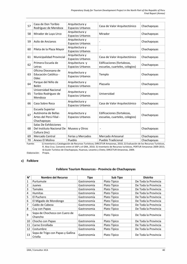
Preparatory Study for Tourism Development Project in the North Part of the Republic of Peru Final Report (Annex)
GRA / Consultor JICA 40
57 Casa de Don Toribio Rodríguez de Mendoza
Arquitectura y Espacios Urbanos Casa de Valor Arquitectónico Chachapoyas
58 Mirador de Luya Urco Arquitectura y Espacios Urbanos Mirador Chachapoyas
59 Asilo de Ancianos Arquitectura y Espacios Urbanos ‐ Chachapoyas
60 Pileta de la Plaza Mayor Arquitectura y Espacios Urbanos ‐ Chachapoyas
61 Municipalidad Provincial Arquitectura y Espacios Urbanos Casa de Valor Arquitectónico Chachapoyas
62 Primera Escuela de Letras
Arquitectura ∙y Espacios Urbanos
Edificaciones (fortalezas, escuelas, cuarteles, colegios) Chachapoyas
63 Oficina Diocesana de Educación Católica ‐ Odec
Arquitectura y Espacios Urbanos Templo Chachapoyas
64 Parque del Niño de Belén
Arquitectura y Espacios Urbanos Plazuela Chachapoyas
65 Universidad Nacional Toribio Rodríguez de Mendoza
Arquitectura y Espacios Urbanos Universidad Chachapoyas
66 Casa Sobre Roca Arquitectura y Espacios Urbanos Casa de Valor Arquitectónico Chachapoyas
67
Escuela Superior Autónoma de Bellas Artes del Perú Filial ‐ Chachapoyas
Arquitectura y Espacios Urbanos
Edificaciones (fortalezas, escuelas, cuarteles, colegios) Chachapoyas
68 Salas De Exhibiciones Del Instituto Nacional De Cultura (Inc)
Museos y Otros ‐ Chachapoyas
69 Mercado Central Ferias y Mercados Mercado Artesanal Chachapoyas70 Anexo El Molino Pueblo Pueblo Tradicional ChachapoyasFuente: 1) Inventario y Catalogación de Recursos Turísticos; DIRCETUR Amazonas, 2010; 2) Evaluación de los Recursos Turísticos,
R. Alva Cruz, Convenio entre el IIAP y el GRA, 2010; 3) Inventario de Recursos turísticos, PERTUR Amazonas 2009‐2015; 4) Guión Turístico de Chachapoyas, Huancas, Levanto y Cheto; DIRCETUR Amazonas, 2009.
Elaboración: Propia.
c) Folklore
Folklore Tourism Resources ‐ Provincia de Chachapoyas
N° Nombre del Recurso Tipo Sub Tipo Distrito 1 Purtumute Gastronomía Plato Típico De Toda la Provincia2 Juanes Gastronomía Plato Típico De Toda la Provincia3 Tamales Gastronomía Plato Típico De Toda la Provincia4 Humitas Gastronomía Plato Típico De Toda la Provincia5 El Puchero Gastronomía Plato Típico De Toda la Provincia6 El Migado de Mondongo Gastronomía Plato Típico De Toda la Provincia7 Caldo de Cabeza Gastronomia Plato Típico De Toda la Provincia8 Cuy con Papas Gastronomia Plato Típico De Toda la Provincia
9 Sopa de Chochoca con Cuero de Chancho Gastronomia Plato Típico De Toda la Provincia
10 Chocho con Papas Gastronomía Plato Típico De Toda la Provincia11 Carne Enrollada Gastronomía Plato Típico De Toda la Provincia12 Costumbre Gastronomía Plato Típico De Toda la Provincia
13 Sopa de Trigo con Papas y Gallina Criolla Gastronomía Plato Típico De Toda la Provincia
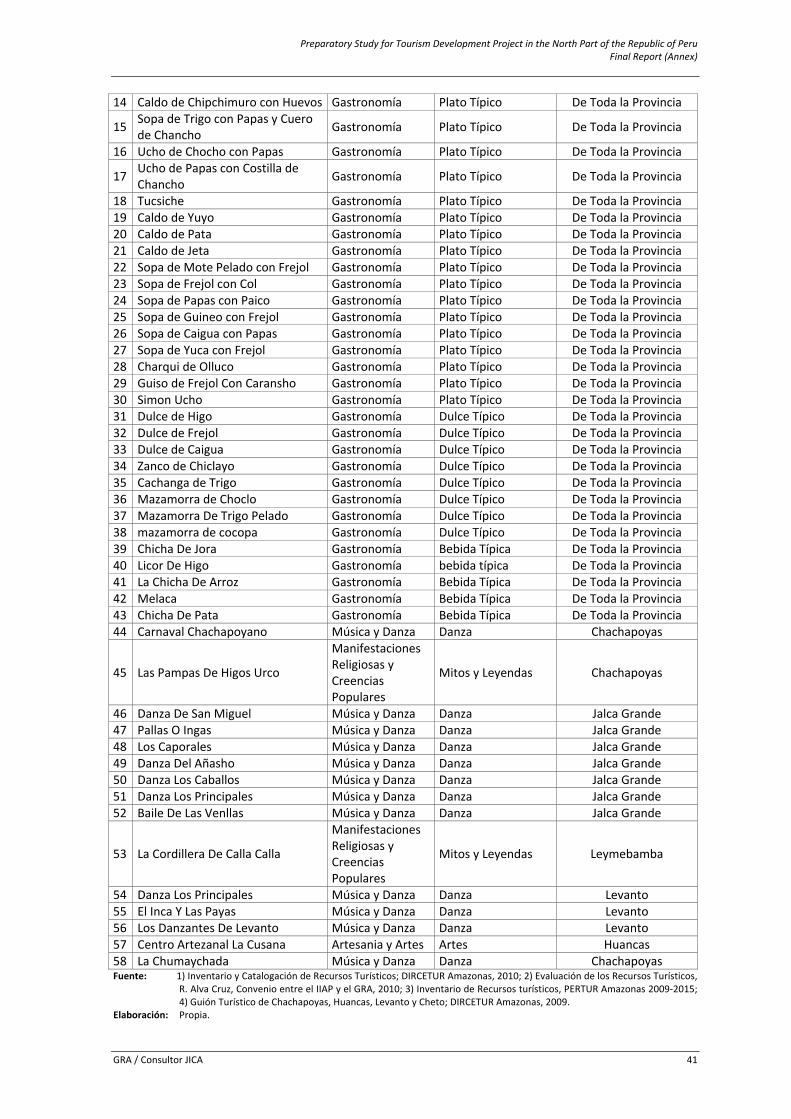
Preparatory Study for Tourism Development Project in the North Part of the Republic of Peru Final Report (Annex)
GRA / Consultor JICA 41
14 Caldo de Chipchimuro con Huevos Gastronomía Plato Típico De Toda la Provincia
15 Sopa de Trigo con Papas y Cuero de Chancho Gastronomía Plato Típico De Toda la Provincia
16 Ucho de Chocho con Papas Gastronomía Plato Típico De Toda la Provincia
17 Ucho de Papas con Costilla de Chancho Gastronomía Plato Típico De Toda la Provincia
18 Tucsiche Gastronomía Plato Típico De Toda la Provincia19 Caldo de Yuyo Gastronomía Plato Típico De Toda la Provincia20 Caldo de Pata Gastronomía Plato Típico De Toda la Provincia21 Caldo de Jeta Gastronomía Plato Típico De Toda la Provincia22 Sopa de Mote Pelado con Frejol Gastronomía Plato Típico De Toda la Provincia23 Sopa de Frejol con Col Gastronomía Plato Típico De Toda la Provincia24 Sopa de Papas con Paico Gastronomía Plato Típico De Toda la Provincia25 Sopa de Guineo con Frejol Gastronomía Plato Típico De Toda la Provincia26 Sopa de Caigua con Papas Gastronomía Plato Típico De Toda la Provincia27 Sopa de Yuca con Frejol Gastronomía Plato Típico De Toda la Provincia28 Charqui de Olluco Gastronomía Plato Típico De Toda la Provincia29 Guiso de Frejol Con Caransho Gastronomía Plato Típico De Toda la Provincia30 Simon Ucho Gastronomía Plato Típico De Toda la Provincia31 Dulce de Higo Gastronomía Dulce Típico De Toda la Provincia32 Dulce de Frejol Gastronomía Dulce Típico De Toda la Provincia33 Dulce de Caigua Gastronomía Dulce Típico De Toda la Provincia34 Zanco de Chiclayo Gastronomía Dulce Típico De Toda la Provincia35 Cachanga de Trigo Gastronomía Dulce Típico De Toda la Provincia36 Mazamorra de Choclo Gastronomía Dulce Típico De Toda la Provincia37 Mazamorra De Trigo Pelado Gastronomía Dulce Típico De Toda la Provincia38 mazamorra de cocopa Gastronomía Dulce Típico De Toda la Provincia39 Chicha De Jora Gastronomía Bebida Típica De Toda la Provincia40 Licor De Higo Gastronomía bebida típica De Toda la Provincia41 La Chicha De Arroz Gastronomía Bebida Típica De Toda la Provincia42 Melaca Gastronomía Bebida Típica De Toda la Provincia43 Chicha De Pata Gastronomía Bebida Típica De Toda la Provincia44 Carnaval Chachapoyano Música y Danza Danza Chachapoyas
45 Las Pampas De Higos Urco
Manifestaciones Religiosas y Creencias Populares
Mitos y Leyendas Chachapoyas
46 Danza De San Miguel Música y Danza Danza Jalca Grande47 Pallas O Ingas Música y Danza Danza Jalca Grande48 Los Caporales Música y Danza Danza Jalca Grande49 Danza Del Añasho Música y Danza Danza Jalca Grande50 Danza Los Caballos Música y Danza Danza Jalca Grande51 Danza Los Principales Música y Danza Danza Jalca Grande52 Baile De Las Venllas Música y Danza Danza Jalca Grande
53 La Cordillera De Calla Calla
Manifestaciones Religiosas y Creencias Populares
Mitos y Leyendas Leymebamba
54 Danza Los Principales Música y Danza Danza Levanto 55 El Inca Y Las Payas Música y Danza Danza Levanto 56 Los Danzantes De Levanto Música y Danza Danza Levanto 57 Centro Artezanal La Cusana Artesania y Artes Artes Huancas 58 La Chumaychada Música y Danza Danza ChachapoyasFuente: 1) Inventario y Catalogación de Recursos Turísticos; DIRCETUR Amazonas, 2010; 2) Evaluación de los Recursos Turísticos,
R. Alva Cruz, Convenio entre el IIAP y el GRA, 2010; 3) Inventario de Recursos turísticos, PERTUR Amazonas 2009‐2015; 4) Guión Turístico de Chachapoyas, Huancas, Levanto y Cheto; DIRCETUR Amazonas, 2009.
Elaboración: Propia.
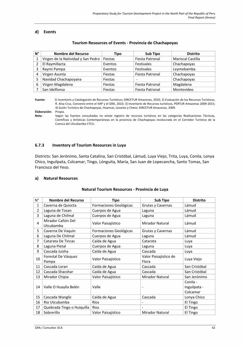
Preparatory Study for Tourism Development Project in the North Part of the Republic of Peru Final Report (Annex)
GRA / Consultor JICA 42
d) Events
Tourism Resources of Events ‐ Provincia de Chachapoyas
N° Nombre del Recurso Tipo Sub Tipo Distrito 1 Virgen de la Natividad y San Pedro Fiestas Fiesta Patronal Mariscal Castilla 2 El Raymillacta Eventos Festivales Chachapoyas 3 Raymi Pampa Eventos Festivales Leymebamba 4 Virgen Asunta Fiestas Fiesta Patronal Chachapoyas 5 Navidad Chachapoyana Fiestas ‐ Chachapoyas 6 Virgen Magdalena Fiestas Fiesta Patronal Magdalena 7 San Idelfonso Fiestas Fiesta Patronal Montevideo Fuente: 1) Inventario y Catalogación de Recursos Turísticos; DIRCETUR Amazonas, 2010; 2) Evaluación de los Recursos Turísticos,
R. Alva Cruz, Convenio entre el IIAP y el GRA, 2010; 3) Inventario de Recursos turísticos, PERTUR Amazonas 2009‐2015; 4) Guión Turístico de Chachapoyas, Huancas, Levanto y Cheto; DIRCETUR Amazonas, 2009.
Elaboración: Propia. Nota: Según las fuentes consultadas no existe registro de recursos turísticos en las categorías Realizaciones Técnicas,
Científicas y Artísticas Contemporáneas en la provincia de Chachapoyas involucrada en el Corredor Turístico de la Cuenca del Utcubamba CTCU.
6.7.3 Inventory of Tourism Resources in Luya Districts: San Jerónimo, Santa Catalina, San Cristóbal, Lámud, Luya Viejo, Trita, Luya, Conila, Lonya Chico, Inguilpata, Colcamar, Tingo, Lónguita, María, San Juan de Lopecancha, Santo Tomas, San Francisco del Yeso. a) Natural Resources
Natural Tourism Resources ‐ Provincia de Luya
N° Nombre del Recurso Tipo Sub Tipo Distrito1 Caverna de Quiocta Formaciones Geológicas Grutas y Cavernas Lámud 2 Laguna de Tosan Cuerpos de Agua Laguna Lámud 3 Laguna de Chilmal Cuerpos de Agua Laguna Lámud
4 Mirador Cañón Del Utcubamba Valor Paisajístico Mirador Natural Lámud
5 Caverna De Vaquin Formaciones Geológicas Grutas y Cavernas Lámud 6 Laguna De Chilmal Cuerpos de Agua Laguna Lámud 7 Catarata De Tincas Caída de Agua Catarata Luya 8 Laguna Pietal Cuerpos de Agua Laguna Luya 9 Cascada Juisha Caída de Agua Cascada Luya
10 Forestal De Vásquez Pampa Valor Paisajístico Valor Paisajístico de
Flora Luya Viejo
11 Cascada Loran Caída de Agua Cascada San Cristóbal12 Cascada Shacshar Caída de Agua Cascada San Cristóbal13 Mirador Chipia Valor Paisajístico Mirador Natural San Jerónimo
14 Valle O Huaylla Belén Valle ‐ Conila ‐ Inguilpata ‐ Colcamar
15 Cascada Wanglic Caída de Agua Cascada Lonya Chico16 Rio Utcubamba Ríos ‐ El Tingo 17 Quebrada Tingo o Huiquilla Rios ‐ El Tingo 18 Sobrerillo Valor Paisajístico Mirador Natural El Tingo
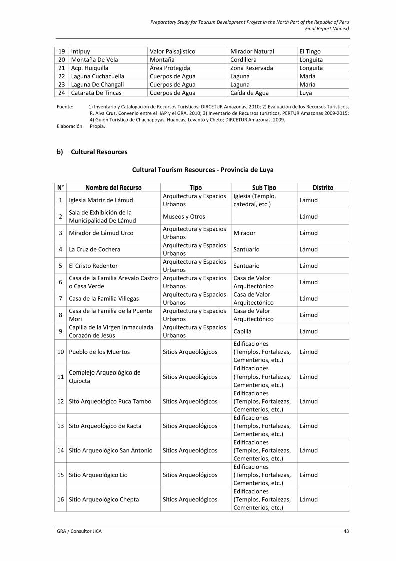
Preparatory Study for Tourism Development Project in the North Part of the Republic of Peru Final Report (Annex)
GRA / Consultor JICA 43
19 Intipuy Valor Paisajístico Mirador Natural El Tingo 20 Montaña De Vela Montaña Cordillera Longuita 21 Acp. Huiquilla Área Protegida Zona Reservada Longuita 22 Laguna Cuchacuella Cuerpos de Agua Laguna María 23 Laguna De Changali Cuerpos de Agua Laguna María 24 Catarata De Tincas Cuerpos de Agua Caída de Agua Luya Fuente: 1) Inventario y Catalogación de Recursos Turísticos; DIRCETUR Amazonas, 2010; 2) Evaluación de los Recursos Turísticos,
R. Alva Cruz, Convenio entre el IIAP y el GRA, 2010; 3) Inventario de Recursos turísticos, PERTUR Amazonas 2009‐2015; 4) Guión Turístico de Chachapoyas, Huancas, Levanto y Cheto; DIRCETUR Amazonas, 2009.
Elaboración: Propia.
b) Cultural Resources
Cultural Tourism Resources ‐ Provincia de Luya
N° Nombre del Recurso Tipo Sub Tipo Distrito
1 Iglesia Matriz de Lámud Arquitectura y Espacios Urbanos
Iglesia (Templo, catedral, etc.) Lámud
2 Sala de Exhibición de la Municipalidad De Lámud Museos y Otros ‐ Lámud
3 Mirador de Lámud Urco Arquitectura y Espacios Urbanos Mirador Lámud
4 La Cruz de Cochera Arquitectura y Espacios Urbanos Santuario Lámud
5 El Cristo Redentor Arquitectura y Espacios Urbanos Santuario Lámud
6 Casa de la Familia Arevalo Castro o Casa Verde
Arquitectura y Espacios Urbanos
Casa de Valor Arquitectónico Lámud
7 Casa de la Familia Villegas Arquitectura y Espacios Urbanos
Casa de Valor Arquitectónico Lámud
8 Casa de la Familia de la Puente Mori
Arquitectura y Espacios Urbanos
Casa de Valor Arquitectónico Lámud
9 Capilla de la Virgen Inmaculada Corazón de Jesús
Arquitectura y Espacios Urbanos Capilla Lámud
10 Pueblo de los Muertos Sitios Arqueológicos Edificaciones (Templos, Fortalezas, Cementerios, etc.)
Lámud
11 Complejo Arqueológico de Quiocta Sitios Arqueológicos
Edificaciones (Templos, Fortalezas, Cementerios, etc.)
Lámud
12 Sito Arqueológico Puca Tambo Sitios Arqueológicos Edificaciones (Templos, Fortalezas, Cementerios, etc.)
Lámud
13 Sito Arqueológico de Kacta Sitios Arqueológicos Edificaciones (Templos, Fortalezas, Cementerios, etc.)
Lámud
14 Sitio Arqueológico San Antonio Sitios Arqueológicos Edificaciones (Templos, Fortalezas, Cementerios, etc.)
Lámud
15 Sitio Arqueológico Lic Sitios Arqueológicos Edificaciones (Templos, Fortalezas, Cementerios, etc.)
Lámud
16 Sitio Arqueológico Chepta Sitios Arqueológicos Edificaciones (Templos, Fortalezas, Cementerios, etc.)
Lámud
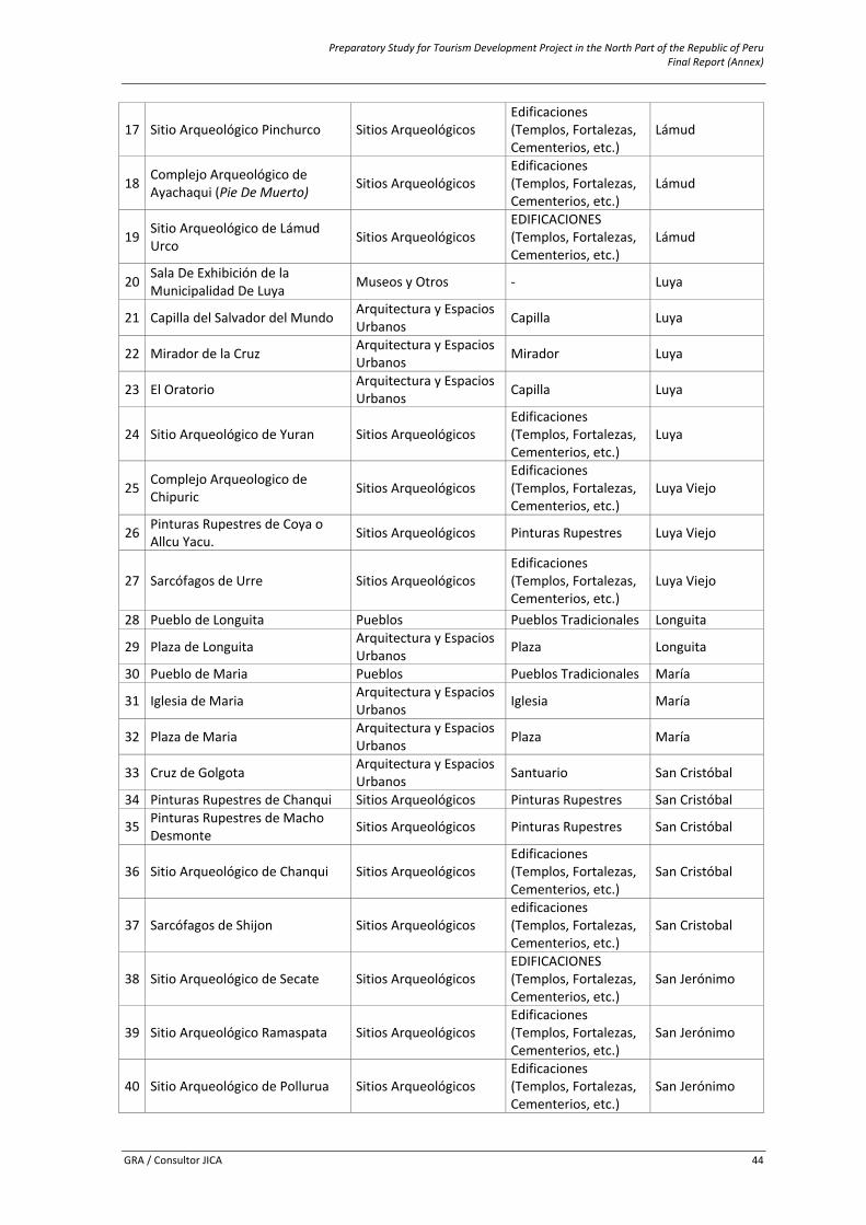
Preparatory Study for Tourism Development Project in the North Part of the Republic of Peru Final Report (Annex)
GRA / Consultor JICA 44
17 Sitio Arqueológico Pinchurco Sitios Arqueológicos Edificaciones (Templos, Fortalezas, Cementerios, etc.)
Lámud
18 Complejo Arqueológico de Ayachaqui (Pie De Muerto) Sitios Arqueológicos
Edificaciones (Templos, Fortalezas, Cementerios, etc.)
Lámud
19 Sitio Arqueológico de Lámud Urco Sitios Arqueológicos
EDIFICACIONES (Templos, Fortalezas, Cementerios, etc.)
Lámud
20 Sala De Exhibición de la Municipalidad De Luya Museos y Otros ‐ Luya
21 Capilla del Salvador del Mundo Arquitectura y Espacios Urbanos Capilla Luya
22 Mirador de la Cruz Arquitectura y Espacios Urbanos Mirador Luya
23 El Oratorio Arquitectura y Espacios Urbanos Capilla Luya
24 Sitio Arqueológico de Yuran Sitios Arqueológicos Edificaciones (Templos, Fortalezas, Cementerios, etc.)
Luya
25 Complejo Arqueologico de Chipuric Sitios Arqueológicos
Edificaciones (Templos, Fortalezas, Cementerios, etc.)
Luya Viejo
26 Pinturas Rupestres de Coya o Allcu Yacu. Sitios Arqueológicos Pinturas Rupestres Luya Viejo
27 Sarcófagos de Urre Sitios Arqueológicos Edificaciones (Templos, Fortalezas, Cementerios, etc.)
Luya Viejo
28 Pueblo de Longuita Pueblos Pueblos Tradicionales Longuita
29 Plaza de Longuita Arquitectura y Espacios Urbanos Plaza Longuita
30 Pueblo de Maria Pueblos Pueblos Tradicionales María
31 Iglesia de Maria Arquitectura y Espacios Urbanos Iglesia María
32 Plaza de Maria Arquitectura y Espacios Urbanos Plaza María
33 Cruz de Golgota Arquitectura y Espacios Urbanos Santuario San Cristóbal
34 Pinturas Rupestres de Chanqui Sitios Arqueológicos Pinturas Rupestres San Cristóbal
35 Pinturas Rupestres de Macho Desmonte Sitios Arqueológicos Pinturas Rupestres San Cristóbal
36 Sitio Arqueológico de Chanqui Sitios Arqueológicos Edificaciones (Templos, Fortalezas, Cementerios, etc.)
San Cristóbal
37 Sarcófagos de Shijon Sitios Arqueológicos edificaciones (Templos, Fortalezas, Cementerios, etc.)
San Cristobal
38 Sitio Arqueológico de Secate Sitios Arqueológicos EDIFICACIONES (Templos, Fortalezas, Cementerios, etc.)
San Jerónimo
39 Sitio Arqueológico Ramaspata Sitios Arqueológicos Edificaciones (Templos, Fortalezas, Cementerios, etc.)
San Jerónimo
40 Sitio Arqueológico de Pollurua Sitios Arqueológicos Edificaciones (Templos, Fortalezas, Cementerios, etc.)
San Jerónimo
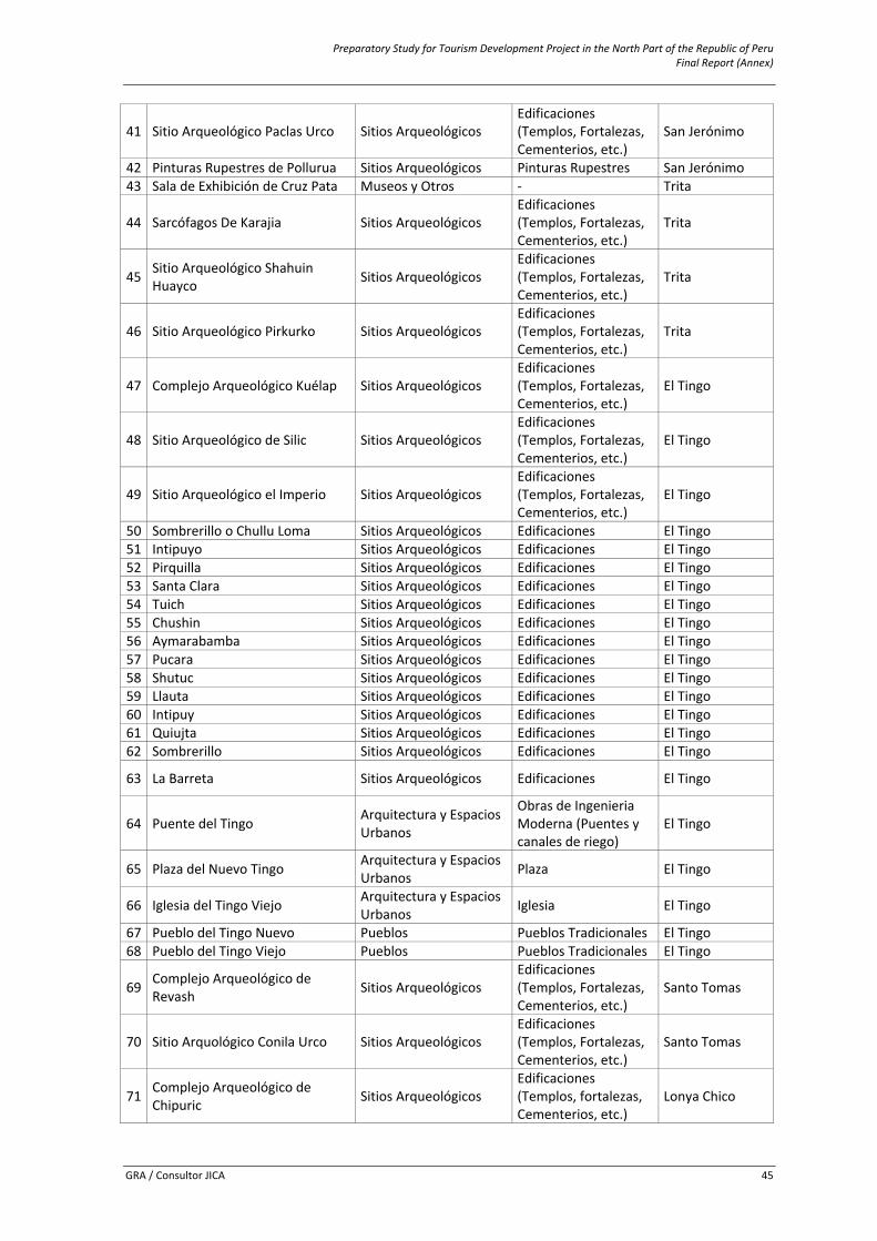
Preparatory Study for Tourism Development Project in the North Part of the Republic of Peru Final Report (Annex)
GRA / Consultor JICA 45
41 Sitio Arqueológico Paclas Urco Sitios Arqueológicos Edificaciones (Templos, Fortalezas, Cementerios, etc.)
San Jerónimo
42 Pinturas Rupestres de Pollurua Sitios Arqueológicos Pinturas Rupestres San Jerónimo43 Sala de Exhibición de Cruz Pata Museos y Otros ‐ Trita
44 Sarcófagos De Karajia Sitios Arqueológicos Edificaciones (Templos, Fortalezas, Cementerios, etc.)
Trita
45 Sitio Arqueológico Shahuin Huayco Sitios Arqueológicos Edificaciones (Templos, Fortalezas, Cementerios, etc.)
Trita
46 Sitio Arqueológico Pirkurko Sitios Arqueológicos Edificaciones (Templos, Fortalezas, Cementerios, etc.)
Trita
47 Complejo Arqueológico Kuélap Sitios Arqueológicos Edificaciones (Templos, Fortalezas, Cementerios, etc.)
El Tingo
48 Sitio Arqueológico de Silic Sitios Arqueológicos Edificaciones (Templos, Fortalezas, Cementerios, etc.)
El Tingo
49 Sitio Arqueológico el Imperio Sitios Arqueológicos Edificaciones (Templos, Fortalezas, Cementerios, etc.)
El Tingo
50 Sombrerillo o Chullu Loma Sitios Arqueológicos Edificaciones El Tingo 51 Intipuyo Sitios Arqueológicos Edificaciones El Tingo 52 Pirquilla Sitios Arqueológicos Edificaciones El Tingo 53 Santa Clara Sitios Arqueológicos Edificaciones El Tingo 54 Tuich Sitios Arqueológicos Edificaciones El Tingo 55 Chushin Sitios Arqueológicos Edificaciones El Tingo 56 Aymarabamba Sitios Arqueológicos Edificaciones El Tingo 57 Pucara Sitios Arqueológicos Edificaciones El Tingo 58 Shutuc Sitios Arqueológicos Edificaciones El Tingo 59 Llauta Sitios Arqueológicos Edificaciones El Tingo 60 Intipuy Sitios Arqueológicos Edificaciones El Tingo 61 Quiujta Sitios Arqueológicos Edificaciones El Tingo 62 Sombrerillo Sitios Arqueológicos Edificaciones El Tingo
63 La Barreta Sitios Arqueológicos Edificaciones El Tingo
64 Puente del Tingo Arquitectura y Espacios Urbanos
Obras de Ingenieria Moderna (Puentes y canales de riego)
El Tingo
65 Plaza del Nuevo Tingo Arquitectura y Espacios Urbanos Plaza El Tingo
66 Iglesia del Tingo Viejo Arquitectura y Espacios Urbanos Iglesia El Tingo
67 Pueblo del Tingo Nuevo Pueblos Pueblos Tradicionales El Tingo 68 Pueblo del Tingo Viejo Pueblos Pueblos Tradicionales El Tingo
69 Complejo Arqueológico de Revash Sitios Arqueológicos
Edificaciones (Templos, Fortalezas, Cementerios, etc.)
Santo Tomas
70 Sitio Arquológico Conila Urco Sitios Arqueológicos Edificaciones (Templos, Fortalezas, Cementerios, etc.)
Santo Tomas
71 Complejo Arqueológico de Chipuric Sitios Arqueológicos
Edificaciones (Templos, fortalezas, Cementerios, etc.)
Lonya Chico
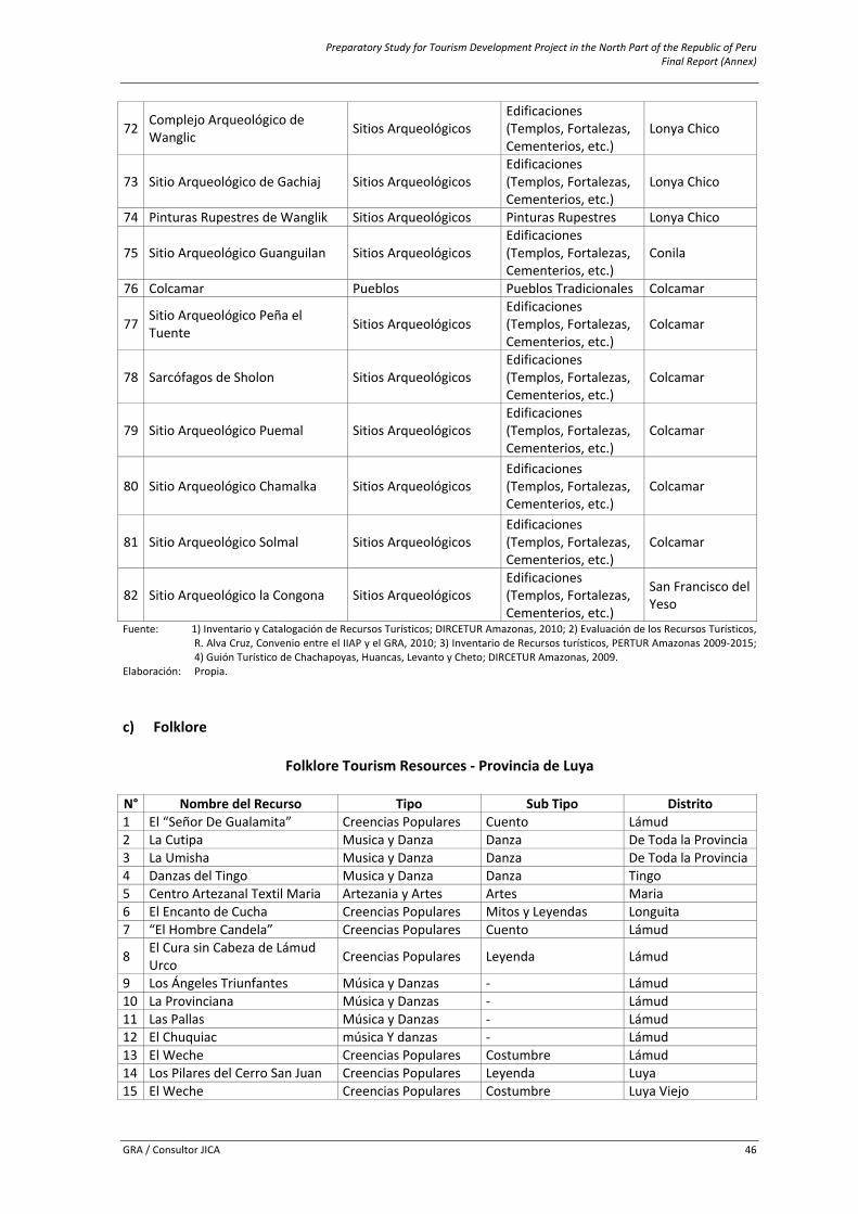
Preparatory Study for Tourism Development Project in the North Part of the Republic of Peru Final Report (Annex)
GRA / Consultor JICA 46
72 Complejo Arqueológico de Wanglic Sitios Arqueológicos
Edificaciones (Templos, Fortalezas, Cementerios, etc.)
Lonya Chico
73 Sitio Arqueológico de Gachiaj Sitios Arqueológicos Edificaciones (Templos, Fortalezas, Cementerios, etc.)
Lonya Chico
74 Pinturas Rupestres de Wanglik Sitios Arqueológicos Pinturas Rupestres Lonya Chico
75 Sitio Arqueológico Guanguilan Sitios Arqueológicos Edificaciones (Templos, Fortalezas, Cementerios, etc.)
Conila
76 Colcamar Pueblos Pueblos Tradicionales Colcamar
77 Sitio Arqueológico Peña el Tuente Sitios Arqueológicos Edificaciones (Templos, Fortalezas, Cementerios, etc.)
Colcamar
78 Sarcófagos de Sholon Sitios Arqueológicos Edificaciones (Templos, Fortalezas, Cementerios, etc.)
Colcamar
79 Sitio Arqueológico Puemal Sitios Arqueológicos Edificaciones (Templos, Fortalezas, Cementerios, etc.)
Colcamar
80 Sitio Arqueológico Chamalka Sitios Arqueológicos Edificaciones (Templos, Fortalezas, Cementerios, etc.)
Colcamar
81 Sitio Arqueológico Solmal Sitios Arqueológicos Edificaciones (Templos, Fortalezas, Cementerios, etc.)
Colcamar
82 Sitio Arqueológico la Congona Sitios Arqueológicos Edificaciones (Templos, Fortalezas, Cementerios, etc.)
San Francisco del Yeso
Fuente: 1) Inventario y Catalogación de Recursos Turísticos; DIRCETUR Amazonas, 2010; 2) Evaluación de los Recursos Turísticos, R. Alva Cruz, Convenio entre el IIAP y el GRA, 2010; 3) Inventario de Recursos turísticos, PERTUR Amazonas 2009‐2015; 4) Guión Turístico de Chachapoyas, Huancas, Levanto y Cheto; DIRCETUR Amazonas, 2009.
Elaboración: Propia.
c) Folklore
Folklore Tourism Resources ‐ Provincia de Luya
N° Nombre del Recurso Tipo Sub Tipo Distrito1 El “Señor De Gualamita” Creencias Populares Cuento Lámud 2 La Cutipa Musica y Danza Danza De Toda la Provincia3 La Umisha Musica y Danza Danza De Toda la Provincia4 Danzas del Tingo Musica y Danza Danza Tingo 5 Centro Artezanal Textil Maria Artezania y Artes Artes Maria 6 El Encanto de Cucha Creencias Populares Mitos y Leyendas Longuita 7 “El Hombre Candela” Creencias Populares Cuento Lámud
8 El Cura sin Cabeza de Lámud Urco Creencias Populares Leyenda Lámud
9 Los Ángeles Triunfantes Música y Danzas ‐ Lámud 10 La Provinciana Música y Danzas ‐ Lámud 11 Las Pallas Música y Danzas ‐ Lámud 12 El Chuquiac música Y danzas ‐ Lámud 13 El Weche Creencias Populares Costumbre Lámud 14 Los Pilares del Cerro San Juan Creencias Populares Leyenda Luya 15 El Weche Creencias Populares Costumbre Luya Viejo
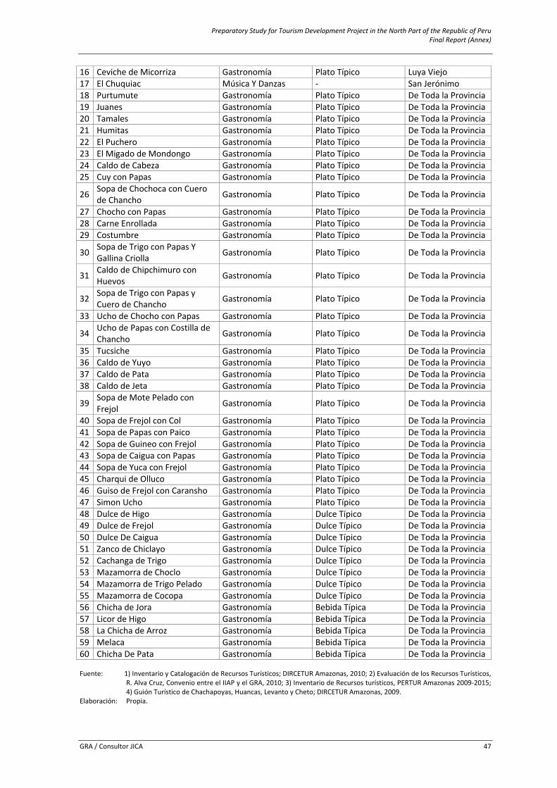
Preparatory Study for Tourism Development Project in the North Part of the Republic of Peru Final Report (Annex)
GRA / Consultor JICA 47
16 Ceviche de Micorriza Gastronomía Plato Típico Luya Viejo 17 El Chuquiac Música Y Danzas ‐ San Jerónimo 18 Purtumute Gastronomía Plato Típico De Toda la Provincia19 Juanes Gastronomía Plato Típico De Toda la Provincia20 Tamales Gastronomía Plato Típico De Toda la Provincia21 Humitas Gastronomía Plato Típico De Toda la Provincia22 El Puchero Gastronomía Plato Típico De Toda la Provincia23 El Migado de Mondongo Gastronomía Plato Típico De Toda la Provincia24 Caldo de Cabeza Gastronomía Plato Típico De Toda la Provincia25 Cuy con Papas Gastronomía Plato Típico De Toda la Provincia
26 Sopa de Chochoca con Cuero de Chancho Gastronomía Plato Típico De Toda la Provincia
27 Chocho con Papas Gastronomía Plato Típico De Toda la Provincia28 Carne Enrollada Gastronomía Plato Típico De Toda la Provincia29 Costumbre Gastronomía Plato Típico De Toda la Provincia
30 Sopa de Trigo con Papas Y Gallina Criolla Gastronomía Plato Típico De Toda la Provincia
31 Caldo de Chipchimuro con Huevos Gastronomía Plato Típico De Toda la Provincia
32 Sopa de Trigo con Papas y Cuero de Chancho Gastronomía Plato Típico De Toda la Provincia
33 Ucho de Chocho con Papas Gastronomía Plato Típico De Toda la Provincia
34 Ucho de Papas con Costilla de Chancho Gastronomía Plato Típico De Toda la Provincia
35 Tucsiche Gastronomía Plato Típico De Toda la Provincia36 Caldo de Yuyo Gastronomía Plato Típico De Toda la Provincia37 Caldo de Pata Gastronomía Plato Típico De Toda la Provincia38 Caldo de Jeta Gastronomía Plato Típico De Toda la Provincia
39 Sopa de Mote Pelado con Frejol Gastronomía Plato Típico De Toda la Provincia
40 Sopa de Frejol con Col Gastronomía Plato Típico De Toda la Provincia41 Sopa de Papas con Paico Gastronomía Plato Típico De Toda la Provincia42 Sopa de Guineo con Frejol Gastronomía Plato Típico De Toda la Provincia43 Sopa de Caigua con Papas Gastronomía Plato Típico De Toda la Provincia44 Sopa de Yuca con Frejol Gastronomía Plato Típico De Toda la Provincia45 Charqui de Olluco Gastronomía Plato Típico De Toda la Provincia46 Guiso de Frejol con Caransho Gastronomía Plato Típico De Toda la Provincia47 Simon Ucho Gastronomía Plato Típico De Toda la Provincia48 Dulce de Higo Gastronomía Dulce Típico De Toda la Provincia49 Dulce de Frejol Gastronomía Dulce Típico De Toda la Provincia50 Dulce De Caigua Gastronomía Dulce Típico De Toda la Provincia51 Zanco de Chiclayo Gastronomía Dulce Típico De Toda la Provincia52 Cachanga de Trigo Gastronomía Dulce Típico De Toda la Provincia53 Mazamorra de Choclo Gastronomía Dulce Típico De Toda la Provincia54 Mazamorra de Trigo Pelado Gastronomía Dulce Típico De Toda la Provincia55 Mazamorra de Cocopa Gastronomía Dulce Típico De Toda la Provincia56 Chicha de Jora Gastronomía Bebida Típica De Toda la Provincia57 Licor de Higo Gastronomía Bebida Típica De Toda la Provincia58 La Chicha de Arroz Gastronomía Bebida Típica De Toda la Provincia59 Melaca Gastronomía Bebida Típica De Toda la Provincia60 Chicha De Pata Gastronomía Bebida Típica De Toda la Provincia Fuente: 1) Inventario y Catalogación de Recursos Turísticos; DIRCETUR Amazonas, 2010; 2) Evaluación de los Recursos Turísticos,
R. Alva Cruz, Convenio entre el IIAP y el GRA, 2010; 3) Inventario de Recursos turísticos, PERTUR Amazonas 2009‐2015; 4) Guión Turístico de Chachapoyas, Huancas, Levanto y Cheto; DIRCETUR Amazonas, 2009.
Elaboración: Propia.
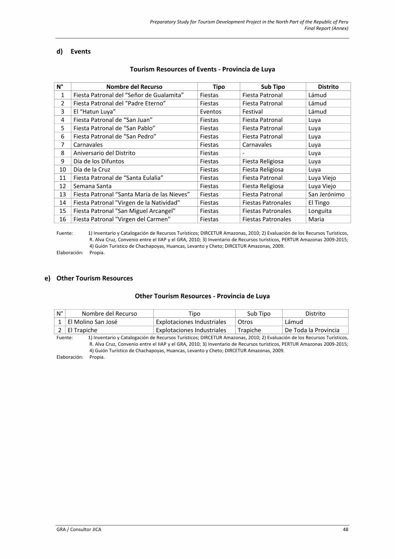
Preparatory Study for Tourism Development Project in the North Part of the Republic of Peru Final Report (Annex)
GRA / Consultor JICA 48
d) Events
Tourism Resources of Events ‐ Provincia de Luya
N° Nombre del Recurso Tipo Sub Tipo Distrito1 Fiesta Patronal del “Señor de Gualamita” Fiestas Fiesta Patronal Lámud2 Fiesta Patronal del “Padre Eterno” Fiestas Fiesta Patronal Lámud3 El “Hatun Luya” Eventos Festival Lámud4 Fiesta Patronal de “San Juan” Fiestas Fiesta Patronal Luya 5 Fiesta Patronal de “San Pablo” Fiestas Fiesta Patronal Luya 6 Fiesta Patronal de “San Pedro” Fiestas Fiesta Patronal Luya 7 Carnavales Fiestas Carnavales Luya 8 Aniversario del Distrito Fiestas ‐ Luya 9 Día de los Difuntos Fiestas Fiesta Religiosa Luya 10 Día de la Cruz Fiestas Fiesta Religiosa Luya 11 Fiesta Patronal de “Santa Eulalia” Fiestas Fiesta Patronal Luya Viejo12 Semana Santa Fiestas Fiesta Religiosa Luya Viejo13 Fiesta Patronal “Santa María de las Nieves” Fiestas Fiesta Patronal San Jerónimo14 Fiesta Patronal "Virgen de la Natividad" Fiestas Fiestas Patronales El Tingo15 Fiesta Patronal "San Miguel Arcangel" Fiestas Fiestas Patronales Longuita16 Fiesta Patronal "Virgen del Carmen" Fiestas Fiestas Patronales Maria
Fuente: 1) Inventario y Catalogación de Recursos Turísticos; DIRCETUR Amazonas, 2010; 2) Evaluación de los Recursos Turísticos,
R. Alva Cruz, Convenio entre el IIAP y el GRA, 2010; 3) Inventario de Recursos turísticos, PERTUR Amazonas 2009‐2015; 4) Guión Turístico de Chachapoyas, Huancas, Levanto y Cheto; DIRCETUR Amazonas, 2009.
Elaboración: Propia.
e) Other Tourism Resources
Other Tourism Resources ‐ Provincia de Luya
N° Nombre del Recurso Tipo Sub Tipo Distrito 1 El Molino San José Explotaciones Industriales Otros Lámud 2 El Trapiche Explotaciones Industriales Trapiche De Toda la ProvinciaFuente: 1) Inventario y Catalogación de Recursos Turísticos; DIRCETUR Amazonas, 2010; 2) Evaluación de los Recursos Turísticos,
R. Alva Cruz, Convenio entre el IIAP y el GRA, 2010; 3) Inventario de Recursos turísticos, PERTUR Amazonas 2009‐2015; 4) Guión Turístico de Chachapoyas, Huancas, Levanto y Cheto; DIRCETUR Amazonas, 2009.
Elaboración: Propia.
Preparatory Study for Tourism Development Project in the North Part of the Republic of Peru Final Report (Annex)
GRA / Consultor JICA 49
6.8 Annex 8: Profile of Potential Tourism Resources
Of the 34 resources presented below, 17 are categorized and prioritized by DIRECETUR – Amazonas and validated by MINCETUR. Most of the remaining 17 are itemized (Phase I Categorization). The information sources are the MINCETUR web site as well as the inventory and documents of DIRCETUR‐Amazonas.
In the description of the resources the following will be taken into consideration: location, categorization and hierarchy, characteristics, current estate, access route, services and facilities (public and private), type and volume of visitors, activities, and specifications for the visitors.
The key issues are mentioned to understand tourism resources as follows. Categorization and hierarchy. The prioritized tourism resources is in consistency with the manual for inventory formulation of the tourism resources nationwide, and its objective is to facilitate the suitable planning and development of the tourism. The prioritization consists in the assignation of the relative important level to each one of the tourism resources that distinguishes the particular place. The above‐mentioned level or hierarchy value can be within 1 and 4, (4 is the highest level). Influx Grade. With this indicator the amount of tourists arrivals will be make. The indicator must be assigned by the type of visitors that makes the most of the tourism resources (foreigner, national, regional and local). The flow scale is from 1 to 4 (4 is the highest level) taking the arrivals statistic data as a reference. Access route to the resource. The access route to the resources is described taking Chachapoyas city as the main distribution center.
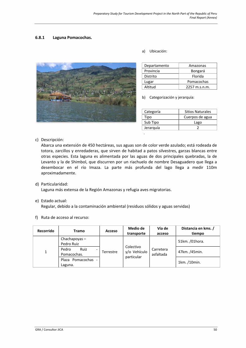
Preparatory Study for Tourism Development Project in the North Part of the Republic of Peru Final Report (Annex)
GRA / Consultor JICA 50
6.8.1 Laguna Pomacochas.
c) Descripción: Abarca una extensión de 450 hectáreas, sus aguas son de color verde azulado; está rodeada de totora, zarcillos y enredaderas, que sirven de habitad a patos silvestres, garzas blancas entre otras especies. Esta laguna es alimentada por las aguas de dos principales quebradas, la de Levanto y la de Shimbol, que discurren por un riachuelo de nombre Desaguadero que llega a desembocar en el río Imaza. La parte más profunda del lago llega a medir 110m aproximadamente.
d) Particularidad:
Laguna más extensa de la Región Amazonas y refugia aves migratorias.
e) Estado actual: Regular, debido a la contaminación ambiental (residuos sólidos y aguas servidas)
f) Ruta de acceso al recurso:
Recorrido Tramo Acceso Medio de transporte
Vía de acceso
Distancia en kms. / tiempo
1
Chachapoyas – Pedro Ruiz
Terrestre Colectivo y/o Vehículo particular
Carretera asfaltada
51km. /01hora.
Pedro Ruiz ‐ Pomacochas. 47km. /45min.
Plaza Pomacochas ‐ Laguna. 1km. /10min.
a) Ubicación:
Departamento AmazonasiProvincia BongaráDistrito FloridaLugar PomacochasAltitud 2257 m.s.n.m.
b) Categorización y jerarquía:
Categoría Sitios NaturalesTipo Cuerpos de aguaSub Tipo Lago Jerarquía 2 .
Preparatory Study for Tourism Development Project in the North Part of the Republic of Peru Final Report (Annex)
GRA / Consultor JICA 51
g) Servicios e instalaciones actuales:
Fuera del Recurso Dentro del recurso Servicios TipoBásicos Agua, Luz, Desagüe
Muelle y sendero
Públicos Centro de salud, Comisaría, ParroquiaComunicación Teléfono, internet, radioHospedaje Hostales, hoteles y casa hospedajeRestauración Restaurantes y cafésEsparcimiento Recreos y bares
h) Tipo de visitante y grado de afluencia:
Tipo de Visitante Grado de Afluencia
Local 3Regional 4
i) Actividades desarrolladas dentro y fuera del recurso turístico:
Actividad Tipo
Paseos Excursiones, Paseos en Lancha o CanoaDeportes Acuáticos Pesca DeportivaNaturaleza Observación de Flora y faunaDeportes / Aventura Caminata, pesca, natación, motonáuticaOtros (Especificar Tipo) Toma de Fotografías y Filmaciones
j) Especificaciones para el visitante:
Época propicia
de visita Horario de
Visita Tipo de Ingreso
Propiedad Actual Administración Poblado más
Cercano
Todo el Año Todo el día Libre Estado Municipalidad
Distrital de Florida Pomacochas
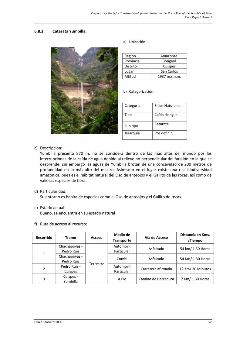
Preparatory Study for Tourism Development Project in the North Part of the Republic of Peru Final Report (Annex)
GRA / Consultor JICA 52
6.8.2 Catarata Yumbilla.
a) Ubicación:
Región Amazonasi Provincia Bongará Distrito Cuispes Lugar San Carlos Altitud 1937 m.s.n.m. b) Categorización:
Categoría Sitios Naturales
Tipo Caída de agua
Sub tipo Catarata
Jerarquía Por definir…
c) Descripción:
Yumbilla presenta 870 m. no se considera dentro de las más altas del mundo por las interrupciones de la caída de agua debido al relieve no perpendicular del farallón en la que se desprende; sin embargo las aguas de Yumbilla brotan de una concavidad de 200 metros de profundidad en lo más alto del macizo. Asimismo en el lugar existe una rica biodiversidad amazónica, pues es el hábitat natural del Oso de anteojos y el Gallito de las rocas, así como de valiosas especies de flora.
d) Particularidad:
Su entorno es habita de especies como el Oso de anteojos y el Gallito de rocas. e) Estado actual:
Bueno, se encuentra en su estado natural f) Ruta de acceso al recurso:
Recorrido Tramo Acceso Medio de Transporte
Vía de Acceso Distancia en Kms.
/Tiempo
1
Chachapoyas ‐ Pedro Ruiz
Terrestre
Automóvil Particular Asfaltado 54 km/ 1.30 Horas
Chachapoyas ‐ Pedro Ruiz Combi Asfaltado 54 Km/ 1.30 Horas
2 Pedro Ruiz ‐ Cuispes
Automóvil Particular Carretera afirmada 12 Km/ 30 Minutos
3 Cuispes ‐ Yumbilla A Pie Camino de Herradura 7 Km/ 1.30 Horas
Preparatory Study for Tourism Development Project in the North Part of the Republic of Peru Final Report (Annex)
GRA / Consultor JICA 53
g) Servicios e instalaciones actuales:
Fuera del recursoDentro del recurso
Servicios TipoBásicos Agua, Luz, Desagüe
Ninguno Comunicación Teléfono Hospedaje Casa hospedajeRestauración Restaurantes y bodegas Otros Guiado, alquiler de acémilas
h) Tipo de visitante y grado de afluencia:
Tipo de Visitante Grado de Afluencia
Extranjero
Por definir Local Nacional Regional
i) Actividades desarrolladas dentro y fuera del recurso turístico:
Actividad TipoNaturaleza Observación de faunaNaturaleza Observación de floraDeportes / Aventura Caminata – treking, cabalgataOtros (Especificar Tipo) Toma de Fotografías y Filmaciones
j) Especificaciones para el visitante:
Época propicia de
visita Horario de
Visita Tipo de Ingreso
Propiedad Actual
Administración Poblado más
cercano
Todo el Año Todo el día Libre Municipalidad distrital de Cuispes
Municipalidad distrital de Cuispes Cuispes
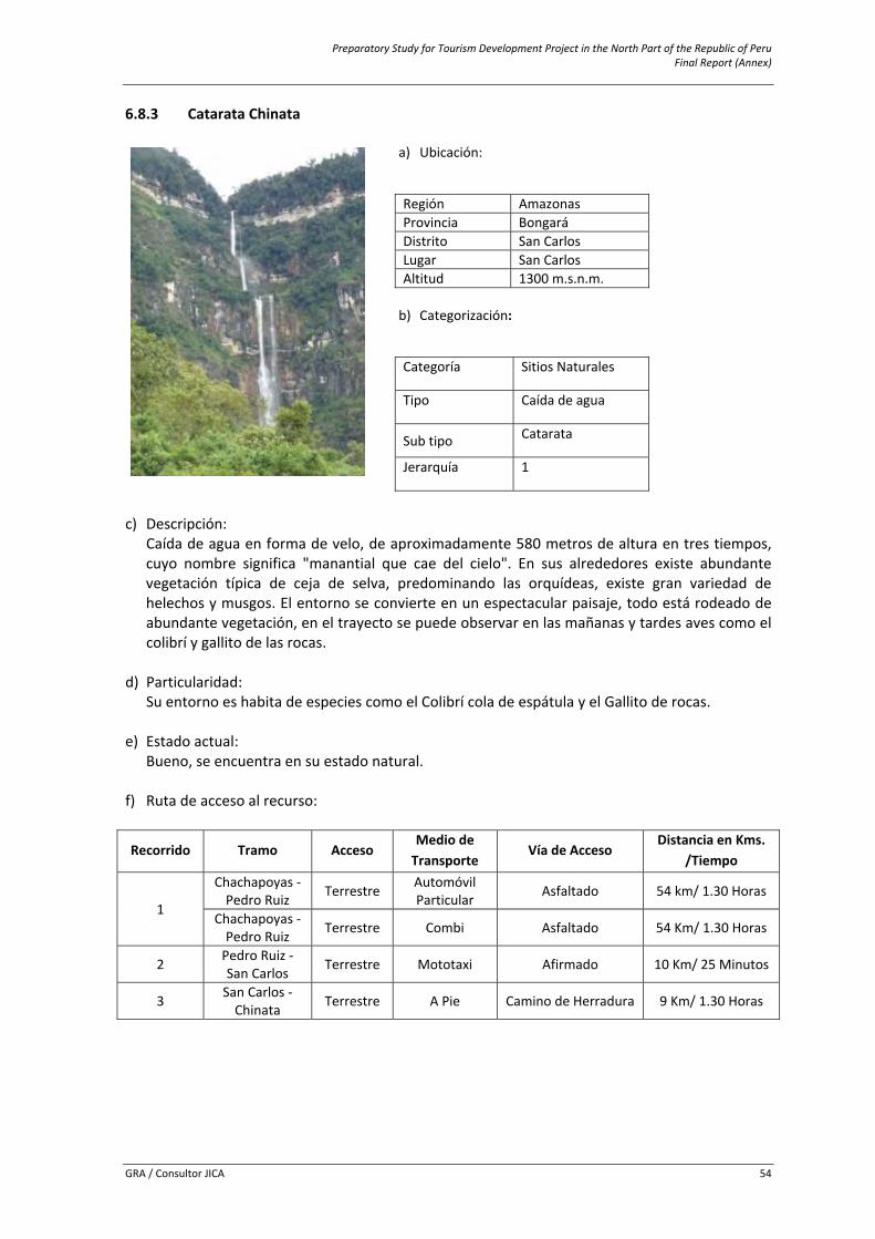
Preparatory Study for Tourism Development Project in the North Part of the Republic of Peru Final Report (Annex)
GRA / Consultor JICA 54
6.8.3 Catarata Chinata
a) Ubicación:
Región AmazonasiProvincia Bongará Distrito San CarlosLugar San CarlosAltitud 1300 m.s.n.m.
b) Categorización:
Categoría Sitios Naturales
Tipo Caída de agua
Sub tipo Catarata
Jerarquía 1
c) Descripción:
Caída de agua en forma de velo, de aproximadamente 580 metros de altura en tres tiempos, cuyo nombre significa "manantial que cae del cielo". En sus alrededores existe abundante vegetación típica de ceja de selva, predominando las orquídeas, existe gran variedad de helechos y musgos. El entorno se convierte en un espectacular paisaje, todo está rodeado de abundante vegetación, en el trayecto se puede observar en las mañanas y tardes aves como el colibrí y gallito de las rocas.
d) Particularidad: Su entorno es habita de especies como el Colibrí cola de espátula y el Gallito de rocas.
e) Estado actual: Bueno, se encuentra en su estado natural.
f) Ruta de acceso al recurso:
Recorrido Tramo Acceso Medio de Transporte
Vía de Acceso Distancia en Kms.
/Tiempo
1
Chachapoyas ‐ Pedro Ruiz Terrestre Automóvil
Particular Asfaltado 54 km/ 1.30 Horas
Chachapoyas ‐ Pedro Ruiz Terrestre Combi Asfaltado 54 Km/ 1.30 Horas
2 Pedro Ruiz ‐ San Carlos Terrestre Mototaxi Afirmado 10 Km/ 25 Minutos
3 San Carlos ‐ Chinata Terrestre A Pie Camino de Herradura 9 Km/ 1.30 Horas
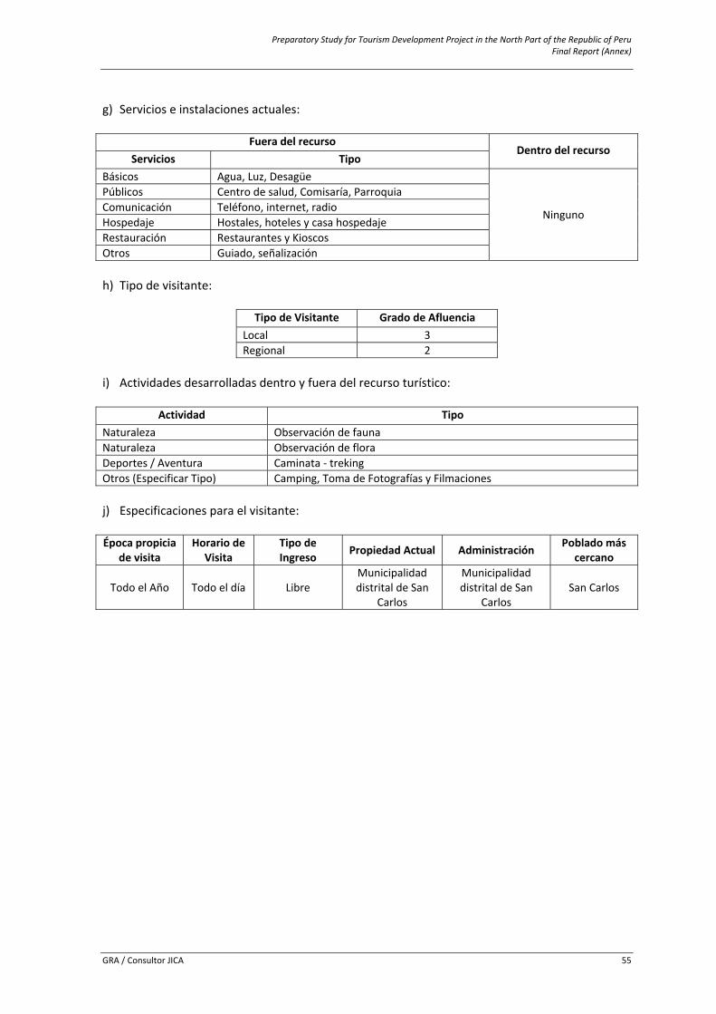
Preparatory Study for Tourism Development Project in the North Part of the Republic of Peru Final Report (Annex)
GRA / Consultor JICA 55
g) Servicios e instalaciones actuales:
Fuera del recurso
Dentro del recurso Servicios Tipo
Básicos Agua, Luz, Desagüe
Ninguno
Públicos Centro de salud, Comisaría, ParroquiaComunicación Teléfono, internet, radioHospedaje Hostales, hoteles y casa hospedajeRestauración Restaurantes y KioscosOtros Guiado, señalización
h) Tipo de visitante:
Tipo de Visitante Grado de Afluencia
Local 3Regional 2
i) Actividades desarrolladas dentro y fuera del recurso turístico:
Actividad TipoNaturaleza Observación de faunaNaturaleza Observación de floraDeportes / Aventura Caminata ‐ trekingOtros (Especificar Tipo) Camping, Toma de Fotografías y Filmaciones
j) Especificaciones para el visitante:
Época propicia
de visita Horario de
Visita Tipo de Ingreso Propiedad Actual Administración Poblado más
cercano
Todo el Año Todo el día Libre Municipalidad distrital de San
Carlos
Municipalidad distrital de San
Carlos San Carlos
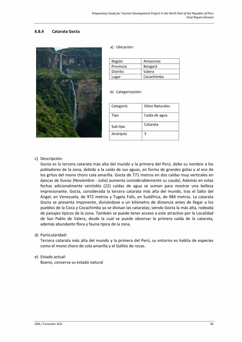
Preparatory Study for Tourism Development Project in the North Part of the Republic of Peru Final Report (Annex)
GRA / Consultor JICA 56
6.8.4 Catarata Gocta
a) Ubicación:
Región AmazonasiProvincia Bongará Distrito ValeraLugar Cocachimba b) Categorización:
Categoría Sitios Naturales
Tipo Caída de agua
Sub tipo Catarata
Jerarquía 3
c) Descripción:
Gocta es la tercera catarata más alta del mundo y la primera del Perú, debe su nombre a los pobladores de la zona, debido a la caída de sus aguas, en forma de grandes gotas y al eco de los gritos del mono choro cola amarilla. Gocta de 771 metros en dos caídas muy verticales en épocas de lluvias (Noviembre ‐ Julio) aumenta considerablemente su caudal, Además en estas fechas adicionalmente veintidós (22) caídas de agua se suman para mostrar una belleza impresionante. Gocta, considerada la tercera catarata más alta del mundo, tras el Salto del Ángel, en Venezuela, de 972 metros y Tugela Falls, en Sudáfrica, de 984 metros. La catarata Gocta se presenta imponente, divisándose a un kilómetro de distancia antes de llegar a los pueblos de la Coca y Cocachimba ya se divisan las cataratas; siendo Gocta la más alta, rodeada de paisajes típicos de la zona. También se puede tener acceso a este atractivo por la Localidad de San Pablo de Valera, desde la cual se puede observar la primera caída de la catarata, además abundante flora y fauna típica de la zona.
d) Particularidad: Tercera catarata más alta del mundo y la primera del Perú, su entorno es habita de especies como el mono choro de cola amarilla y el Gallito de rocas.
e) Estado actual:
Bueno, conserva su estado natural
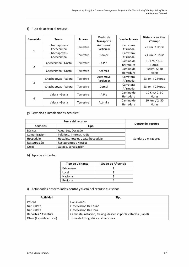
Preparatory Study for Tourism Development Project in the North Part of the Republic of Peru Final Report (Annex)
GRA / Consultor JICA 57
f) Ruta de acceso al recurso:
Recorrido Tramo Acceso Medio de Transporte Vía de Acceso Distancia en Kms.
/Tiempo
1
Chachapoyas ‐ Cocachimba Terrestre Automóvil
Particular Carretera Afirmada 21 Km. 2 Horas
Chachapoyas ‐ Cocachimba Terrestre Combi Carretera
Afirmada 21 km. 2 Horas
2 Cocachimba ‐ Gocta Terrestre A Pie Camino de
herradura 10 Km. / 2.30
Horas.
Cocachimba ‐ Gocta Terrestre Acémila Camino de Herradura
10 km. /2.30 Horas
3 Chachapoyas ‐ Valera Terrestre Automóvil
Particular Carretera Afirmada 23 km. / 2 Horas.
Chachapoyas ‐ Valera Terrestre Combi Carretera Afirmada 23 km. / 2 Horas.
4 Valera ‐ Gocta Terrestre A Pie Camino de
Herradura 10 Km./ 2. 30
Horas
Valera ‐ Gocta Terrestre Acémila Camino de Herradura
10 Km. / 2. 30 Horas
g) Servicios e instalaciones actuales:
Fuera del recurso
Dentro del recurso Servicios Tipo
Básicos Agua, Luz, Desagüe
Sendero y miradores Comunicación Teléfono, internet, radioHospedaje Hostales, hoteles y casa hospedajeRestauración Restaurantes y KioscosOtros Guiado, señalización
h) Tipo de visitante:
Tipo de Visitante Grado de Afluencia
Extranjero 1Local 2Nacional 3Regional 4
i) Actividades desarrolladas dentro y fuera del recurso turístico:
Actividad TipoPaseos ExcursionesNaturaleza Observación De FaunaNaturaleza Observación De FloraDeportes / Aventura Caminata, natación, treking, descenso por la catarata (Rapel) Otros (Especificar Tipo) Toma de Fotografías y Filmaciones
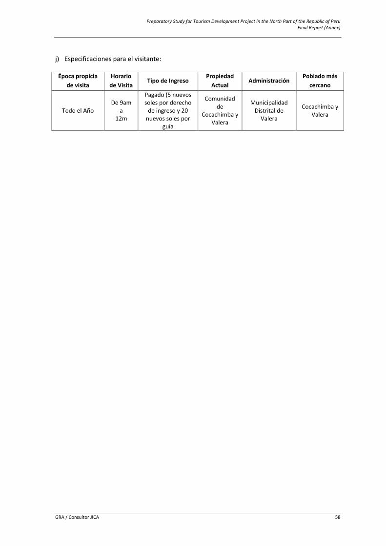
Preparatory Study for Tourism Development Project in the North Part of the Republic of Peru Final Report (Annex)
GRA / Consultor JICA 58
j) Especificaciones para el visitante:
Época propicia
de visita Horario de Visita
Tipo de Ingreso Propiedad Actual
Administración Poblado más
cercano
Todo el Año De 9am
a 12m
Pagado (5 nuevos soles por derecho de ingreso y 20 nuevos soles por
guía
Comunidad de
Cocachimba y Valera
Municipalidad Distrital de Valera
Cocachimba y Valera
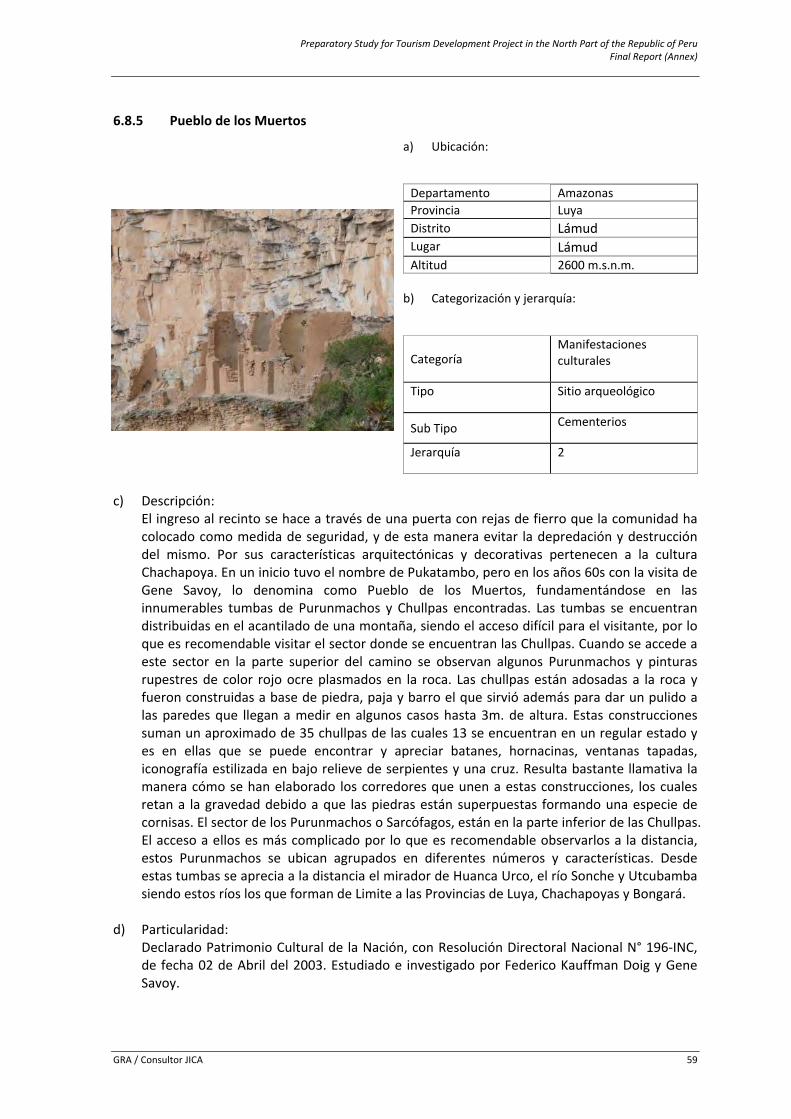
Preparatory Study for Tourism Development Project in the North Part of the Republic of Peru Final Report (Annex)
GRA / Consultor JICA 59
6.8.5 Pueblo de los Muertos
c) Descripción:
El ingreso al recinto se hace a través de una puerta con rejas de fierro que la comunidad ha colocado como medida de seguridad, y de esta manera evitar la depredación y destrucción del mismo. Por sus características arquitectónicas y decorativas pertenecen a la cultura Chachapoya. En un inicio tuvo el nombre de Pukatambo, pero en los años 60s con la visita de Gene Savoy, lo denomina como Pueblo de los Muertos, fundamentándose en las innumerables tumbas de Purunmachos y Chullpas encontradas. Las tumbas se encuentran distribuidas en el acantilado de una montaña, siendo el acceso difícil para el visitante, por lo que es recomendable visitar el sector donde se encuentran las Chullpas. Cuando se accede a este sector en la parte superior del camino se observan algunos Purunmachos y pinturas rupestres de color rojo ocre plasmados en la roca. Las chullpas están adosadas a la roca y fueron construidas a base de piedra, paja y barro el que sirvió además para dar un pulido a las paredes que llegan a medir en algunos casos hasta 3m. de altura. Estas construcciones suman un aproximado de 35 chullpas de las cuales 13 se encuentran en un regular estado y es en ellas que se puede encontrar y apreciar batanes, hornacinas, ventanas tapadas, iconografía estilizada en bajo relieve de serpientes y una cruz. Resulta bastante llamativa la manera cómo se han elaborado los corredores que unen a estas construcciones, los cuales retan a la gravedad debido a que las piedras están superpuestas formando una especie de cornisas. El sector de los Purunmachos o Sarcófagos, están en la parte inferior de las Chullpas. El acceso a ellos es más complicado por lo que es recomendable observarlos a la distancia, estos Purunmachos se ubican agrupados en diferentes números y características. Desde estas tumbas se aprecia a la distancia el mirador de Huanca Urco, el río Sonche y Utcubamba siendo estos ríos los que forman de Limite a las Provincias de Luya, Chachapoyas y Bongará.
d) Particularidad: Declarado Patrimonio Cultural de la Nación, con Resolución Directoral Nacional N° 196‐INC, de fecha 02 de Abril del 2003. Estudiado e investigado por Federico Kauffman Doig y Gene Savoy.
a) Ubicación:
Departamento Amazonasi Provincia Luya Distrito Lámud Lugar Lámud Altitud 2600 m.s.n.m.
b) Categorización y jerarquía:
Categoría Manifestaciones culturales
Tipo Sitio arqueológico
Sub Tipo Cementerios
Jerarquía 2
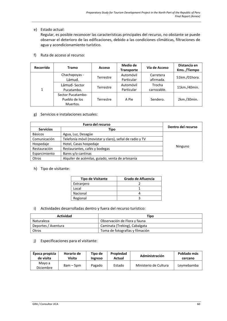
Preparatory Study for Tourism Development Project in the North Part of the Republic of Peru Final Report (Annex)
GRA / Consultor JICA 60
e) Estado actual: Regular, es posible reconocer las características principales del recurso, no obstante se puede observar el deterioro de las edificaciones, debido a las condiciones climáticas, filtraciones de agua y acondicionamiento turístico.
f) Ruta de acceso al recurso:
Recorrido Tramo Acceso Medio de Transporte Vía de Acceso Distancia en
Kms. /Tiempo
1
Chachapoyas ‐ Lámud. Terrestre Automóvil
Particular Carretera afirmada. 51km./01hora.
Lámud‐ Sector Pucatambo.
Terrestre Automóvil Particular
Trocha carrozable. 11km./40min.
Sector Pucatambo‐ Pueblo de los Muertos.
Terrestre A Pie Sendero. 2km./30min.
g) Servicios e instalaciones actuales:
Fuera del recurso
Dentro del recurso Servicios Tipo
Básicos Agua, Luz, Desagüe
Ninguno
Comunicación Telefonía móvil (movistar y claro), señal de radio y TVHospedaje Hotel, Casas hospedajeRestauración Restaurantes, cafés y bodegas Esparcimiento Bares y/o cantinas Otros Alquiler de acémilas, guiado, venta de artesanía
h) Tipo de visitante:
Tipo de Visitante Grado de Afluencia
Extranjero 2Local 1Nacional 4Regional 3
i) Actividades desarrolladas dentro y fuera del recurso turístico:
Actividad TipoNaturaleza Observación de Flora y faunaDeportes / Aventura Caminata (Treking), CabalgataOtros Toma de fotografías y filmación
j) Especificaciones para el visitante:
Época propicia
de visita Horario de
Visita Tipo de Ingreso
Propiedad Actual Administración Poblado más
cercano Mayo a
Diciembre 8am – 5pm Pagado Estado Ministerio de Cultura Leymebamba
Preparatory Study for Tourism Development Project in the North Part of the Republic of Peru Final Report (Annex)
GRA / Consultor JICA 61
6.8.6 Caverna de Quiocta
c) Descripción:
Se ingresa por una gruta de aproximadamente 5 metros de diámetro, en esta caverna se aprecian impresionantes formaciones naturales de estalactitas y estalagmitas. Los pobladores han dividido esta caverna en siete sectores o salones; el primer salón se considera servía como cementerio de algún asentamiento cercano al lugar, en el cual se observan restos óseos y partes de ceramios, desde los salones del 2 al 7 se observan formaciones peculiares y caprichosas que han formado las estalactitas y estalagmitas dejando a la imaginación del visitante el darle un significado. El salón 7 que es el final de la caverna es el lugar donde se aprecian las más espectaculares figuras. La profundidad de esta caverna es de aproximadamente 700 metros, y se caracteriza por la excesiva humedad del suelo, debido a que por toda la extensión de la caverna discurre una pequeña quebrada cuyas aguas brotan de la roca y que además propicia la formación de diversas fuentes de agua.
d) Particularidad: Caverna que presenta una mayor cantidad de estalactitas y estalagmitas, y que aun se encuentran en formación.
e) Estado actual:
Presente un buen estado de conservación
a) Ubicación:
Departamento Amazonasi Provincia Luya Distrito Lámud Lugar Lámud Altitud 2793 m.s.n.m.
b) Categorización y jerarquía:
Categoría Sitios Naturales
Tipo Grutas o cavernas, cuevas
Sub Tipo …
Jerarquía Por definir
Preparatory Study for Tourism Development Project in the North Part of the Republic of Peru Final Report (Annex)
GRA / Consultor JICA 62
f) Ruta de acceso al recurso:
Recorrido Tramo Acceso Medio de Transporte Vía de Acceso Distancia en Kms.
/Tiempo
1
Chachapoyas ‐ Lámud Terrestre
Automóvil Particular
Carretera Afirmada 51 Km. / 1 Horas
Lámud – Sector Chumblate
Terrestre Carretera Afirmada
10 Km. / 20 minutos
2 Sector
Chumblate ‐ Quiocta
Terrestre A pie Sendero 600 m. / 10 minutos
g) Servicios e instalaciones actuales:
Fuera del recurso
Dentro del recurso Servicios Tipo
Básicos Agua, Luz, Desagüe
Ninguno
Comunicación Telefonía móvil (movistar y claro), señal de radio y TVHospedaje Hotel, Casas hospedajeRestauración Restaurantes, cafés y bodegas Esparcimiento Bares y/o cantinas Otros Guiado, venta de artesanía, centro de salud
h) Tipo de visitante:
Tipo de Visitante Grado de Afluencia
Extranjero
Por definir Local Nacional Regional
i) Actividades desarrolladas dentro y fuera del recurso turístico:
Actividad Tipo
Deportes / Aventura Caminata (Treking)Estudios e investigaciones Arqueológicos, geológicosOtros Toma de fotografía y filmación, guiado
j) Especificaciones para el visitante:
Época propicia
de visita Horario de
Visita Tipo de Ingreso
Propiedad Actual Administración Poblado más
cercano
Todo el año Permanente Pagado Estado Municipalidad
Distrital de Lámud Lámud
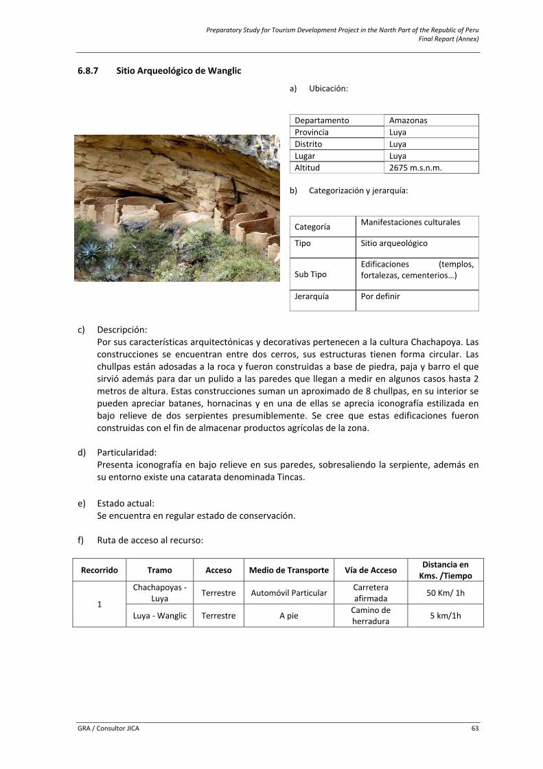
Preparatory Study for Tourism Development Project in the North Part of the Republic of Peru Final Report (Annex)
GRA / Consultor JICA 63
6.8.7 Sitio Arqueológico de Wanglic
c) Descripción:
Por sus características arquitectónicas y decorativas pertenecen a la cultura Chachapoya. Las construcciones se encuentran entre dos cerros, sus estructuras tienen forma circular. Las chullpas están adosadas a la roca y fueron construidas a base de piedra, paja y barro el que sirvió además para dar un pulido a las paredes que llegan a medir en algunos casos hasta 2 metros de altura. Estas construcciones suman un aproximado de 8 chullpas, en su interior se pueden apreciar batanes, hornacinas y en una de ellas se aprecia iconografía estilizada en bajo relieve de dos serpientes presumiblemente. Se cree que estas edificaciones fueron construidas con el fin de almacenar productos agrícolas de la zona.
d) Particularidad: Presenta iconografía en bajo relieve en sus paredes, sobresaliendo la serpiente, además en su entorno existe una catarata denominada Tincas.
e) Estado actual: Se encuentra en regular estado de conservación.
f) Ruta de acceso al recurso:
Recorrido Tramo Acceso Medio de Transporte Vía de Acceso Distancia en Kms. /Tiempo
1
Chachapoyas ‐ Luya Terrestre Automóvil Particular Carretera
afirmada 50 Km/ 1h
Luya ‐ Wanglic Terrestre A pie Camino de herradura 5 km/1h
a) Ubicación:
Departamento Amazonasi Provincia Luya Distrito Luya Lugar Luya Altitud 2675 m.s.n.m.
b) Categorización y jerarquía:
Categoría Manifestaciones culturales
Tipo Sitio arqueológico
Sub Tipo Edificaciones (templos, fortalezas, cementerios…)
Jerarquía Por definir
Preparatory Study for Tourism Development Project in the North Part of the Republic of Peru Final Report (Annex)
GRA / Consultor JICA 64
g) Servicios e instalaciones actuales:
Dentro y fuera del recurso
Servicios TipoBásicos Agua, Luz, Desagüe Comunicación Telefonía móvil (movistar y claro), señal de radio y TV Hospedaje Hotel, Casas hospedajeRestauración Restaurantes y bodegas h) Tipo de visitante:
Tipo de Visitante Grado de Afluencia
Extranjero
Por definir Local Nacional Regional
i) Actividades desarrolladas dentro y fuera del recurso turístico:
Actividad Tipo
Naturaleza Observación de Flora y faunaDeportes / Aventura Caminata (Treking), CabalgataOtros Toma de fotografías y filmación
j) Especificaciones para el visitante:`
Época propicia de
visita Horario de Visita Tipo de Ingreso Administración Poblado más cercano
Todo el año Todo el día Libre Municipalidad Distrital de Luya Luya
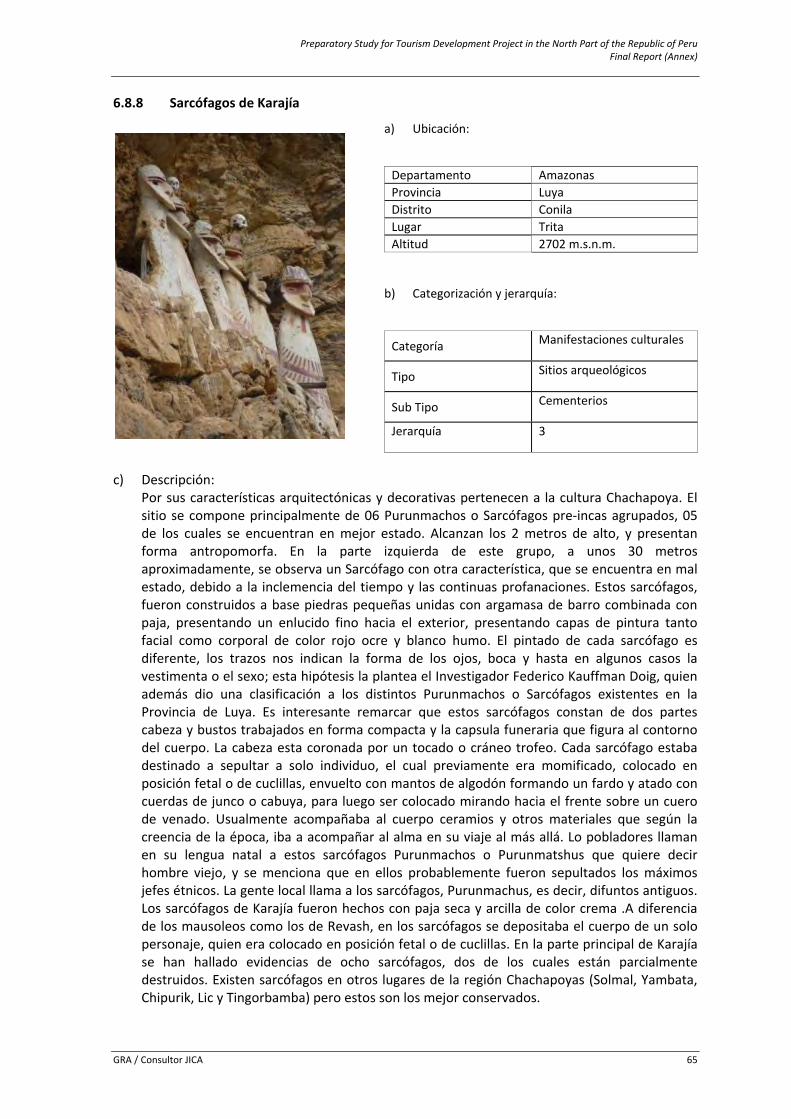
Preparatory Study for Tourism Development Project in the North Part of the Republic of Peru Final Report (Annex)
GRA / Consultor JICA 65
6.8.8 Sarcófagos de Karajía
c) Descripción:
Por sus características arquitectónicas y decorativas pertenecen a la cultura Chachapoya. El sitio se compone principalmente de 06 Purunmachos o Sarcófagos pre‐incas agrupados, 05 de los cuales se encuentran en mejor estado. Alcanzan los 2 metros de alto, y presentan forma antropomorfa. En la parte izquierda de este grupo, a unos 30 metros aproximadamente, se observa un Sarcófago con otra característica, que se encuentra en mal estado, debido a la inclemencia del tiempo y las continuas profanaciones. Estos sarcófagos, fueron construidos a base piedras pequeñas unidas con argamasa de barro combinada con paja, presentando un enlucido fino hacia el exterior, presentando capas de pintura tanto facial como corporal de color rojo ocre y blanco humo. El pintado de cada sarcófago es diferente, los trazos nos indican la forma de los ojos, boca y hasta en algunos casos la vestimenta o el sexo; esta hipótesis la plantea el Investigador Federico Kauffman Doig, quien además dio una clasificación a los distintos Purunmachos o Sarcófagos existentes en la Provincia de Luya. Es interesante remarcar que estos sarcófagos constan de dos partes cabeza y bustos trabajados en forma compacta y la capsula funeraria que figura al contorno del cuerpo. La cabeza esta coronada por un tocado o cráneo trofeo. Cada sarcófago estaba destinado a sepultar a solo individuo, el cual previamente era momificado, colocado en posición fetal o de cuclillas, envuelto con mantos de algodón formando un fardo y atado con cuerdas de junco o cabuya, para luego ser colocado mirando hacia el frente sobre un cuero de venado. Usualmente acompañaba al cuerpo ceramios y otros materiales que según la creencia de la época, iba a acompañar al alma en su viaje al más allá. Lo pobladores llaman en su lengua natal a estos sarcófagos Purunmachos o Purunmatshus que quiere decir hombre viejo, y se menciona que en ellos probablemente fueron sepultados los máximos jefes étnicos. La gente local llama a los sarcófagos, Purunmachus, es decir, difuntos antiguos. Los sarcófagos de Karajía fueron hechos con paja seca y arcilla de color crema .A diferencia de los mausoleos como los de Revash, en los sarcófagos se depositaba el cuerpo de un solo personaje, quien era colocado en posición fetal o de cuclillas. En la parte principal de Karajía se han hallado evidencias de ocho sarcófagos, dos de los cuales están parcialmente destruidos. Existen sarcófagos en otros lugares de la región Chachapoyas (Solmal, Yambata, Chipurik, Lic y Tingorbamba) pero estos son los mejor conservados.
a) Ubicación:
Departamento Amazonasi Provincia Luya Distrito Conila Lugar Trita Altitud 2702 m.s.n.m.
b) Categorización y jerarquía:
Categoría Manifestaciones culturales
Tipo Sitios arqueológicos
Sub Tipo Cementerios
Jerarquía 3
Preparatory Study for Tourism Development Project in the North Part of the Republic of Peru Final Report (Annex)
GRA / Consultor JICA 66
d) Particularidad: Declarado Patrimonio Cultural de la Nación, con Resolución Directoral Nacional N° 196‐INC, de fecha 02 de Abril del 2003. Tipo de enterramiento Pre‐inca único en el Perú.
e) Estado actual: Bueno, el recurso es distinguible y apreciable.
f) Ruta de acceso al recurso:
Recorrido Tramo Acceso Medio de Transporte Vía de Acceso Distancia en Kms.
/Tiempo
1 Chachapoyas ‐ Cruzpata. Terrestre Automóvil
Particular Carretera afirmada.
51km./1hora 30min.
Cruzpata ‐ Karajia. Terrestre A Pie Sendero. 2km./30min.
g) Servicios e instalaciones actuales:
Fuera del recursoDentro del recurso
Servicios TipoBásicos Agua, Luz, Desagüe
Ninguno
Comunicación Telefonía móvil (movistar), señal de radio y TVHospedaje Casas hospedaje Restauración Restaurantes y bodegas Esparcimiento Bares y/o cantinas
Otros Señalización, Posta médica, venta artesanía, guiado, alquiler de acémilas
h) Tipo de visitante:
Tipo de Visitante Grado de Afluencia
Extranjero 4Local 1Nacional 3Regional 2
i) Actividades desarrolladas dentro y fuera del recurso turístico:
Actividad Tipo
Naturaleza Observación de Flora y faunaDeportes / Aventura Caminata (Treking), CabalgataOtros Toma de fotografías y filmación
j) Especificaciones para el visitante:
Época propicia
de visita Horario de
Visita Tipo de Ingreso
Propiedad Actual Administración Poblado más
cercano
Todo el año De 8am a 5pm Pagado Estado
Comité de Pro defensa del Patrimonio
Cultural de Karajía ‐ Cruzpata.
San Miguel de Cruzpata
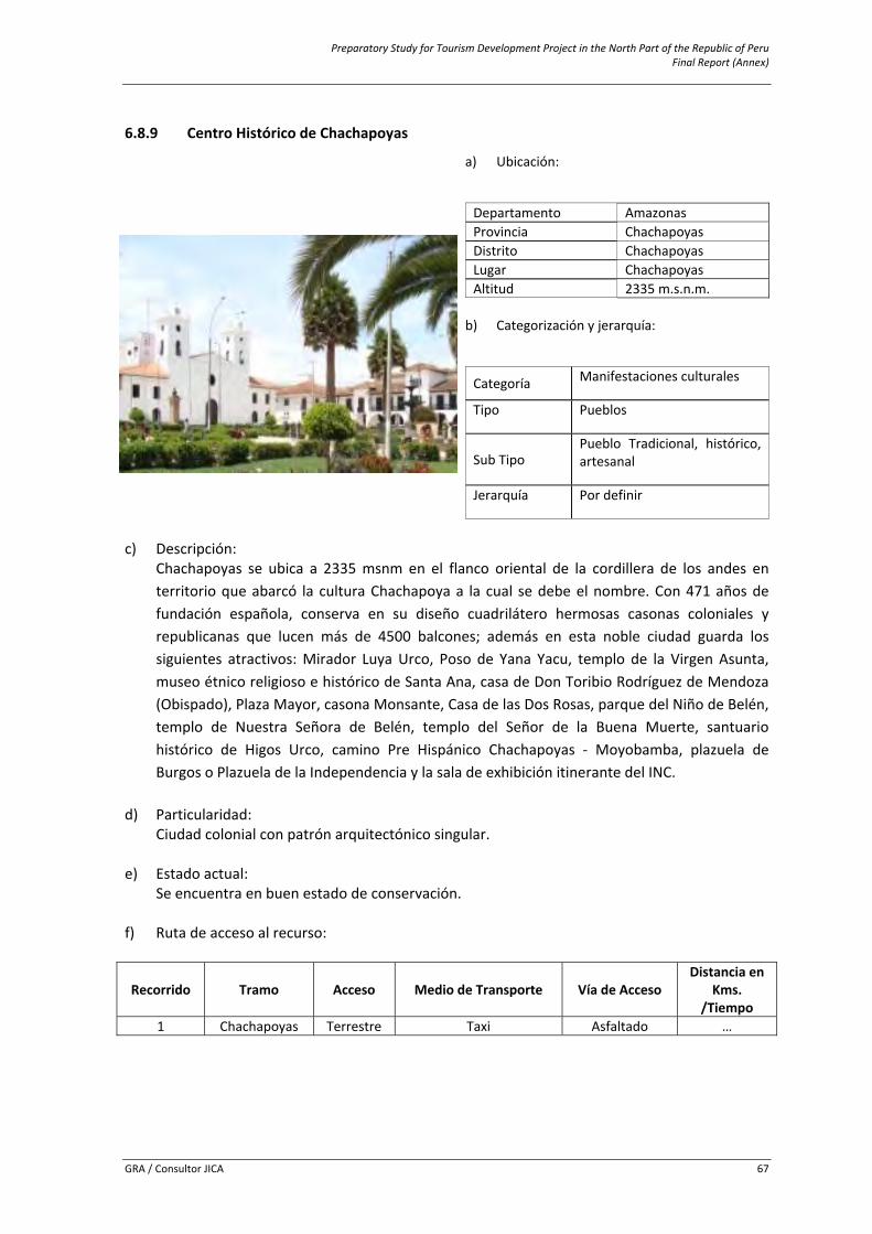
Preparatory Study for Tourism Development Project in the North Part of the Republic of Peru Final Report (Annex)
GRA / Consultor JICA 67
6.8.9 Centro Histórico de Chachapoyas
c) Descripción:
Chachapoyas se ubica a 2335 msnm en el flanco oriental de la cordillera de los andes en territorio que abarcó la cultura Chachapoya a la cual se debe el nombre. Con 471 años de fundación española, conserva en su diseño cuadrilátero hermosas casonas coloniales y republicanas que lucen más de 4500 balcones; además en esta noble ciudad guarda los siguientes atractivos: Mirador Luya Urco, Poso de Yana Yacu, templo de la Virgen Asunta, museo étnico religioso e histórico de Santa Ana, casa de Don Toribio Rodríguez de Mendoza (Obispado), Plaza Mayor, casona Monsante, Casa de las Dos Rosas, parque del Niño de Belén, templo de Nuestra Señora de Belén, templo del Señor de la Buena Muerte, santuario histórico de Higos Urco, camino Pre Hispánico Chachapoyas ‐ Moyobamba, plazuela de Burgos o Plazuela de la Independencia y la sala de exhibición itinerante del INC.
d) Particularidad:
Ciudad colonial con patrón arquitectónico singular.
e) Estado actual: Se encuentra en buen estado de conservación.
f) Ruta de acceso al recurso:
Recorrido Tramo Acceso Medio de Transporte Vía de Acceso Distancia en
Kms. /Tiempo
1 Chachapoyas Terrestre Taxi Asfaltado …
a) Ubicación:
Departamento Amazonasi Provincia Chachapoyas Distrito Chachapoyas Lugar Chachapoyas Altitud 2335 m.s.n.m.
b) Categorización y jerarquía:
Categoría Manifestaciones culturales
Tipo Pueblos
Sub Tipo Pueblo Tradicional, histórico, artesanal
Jerarquía Por definir
Preparatory Study for Tourism Development Project in the North Part of the Republic of Peru Final Report (Annex)
GRA / Consultor JICA 68
g) Servicios e instalaciones actuales:
Dentro y fuera del recurso
Servicios TipoBásicos Agua, Luz, Desagüe Comunicación Telefonía móvil, señal de radio y TVHospedaje Hoteles, Hostales, Casas hospedaje.Restauración Restaurantes y bodegas Esparcimiento Discotecas, bares. Karaokes, recreos campestres, etc.Transporte Agencias de viajeOtros Hospitales, mercados, Comisaría, bancos, centro artesanal, aeropuerto, etc. h) Tipo de visitante:
Tipo de Visitante Grado de AfluenciaExtranjero
Por definir Local NacionalRegional
i) Actividades desarrolladas dentro y fuera del recurso turístico:
Actividad Tipo
Otros Toma de fotografías y filmación j) Especificaciones para el visitante:
Época propicia de
visita Horario de Visita Tipo de Ingreso Administración Poblado más cercano
Todo el año Todo el día Libre Municipalidad Distrital de La Jalca Chachapoyas
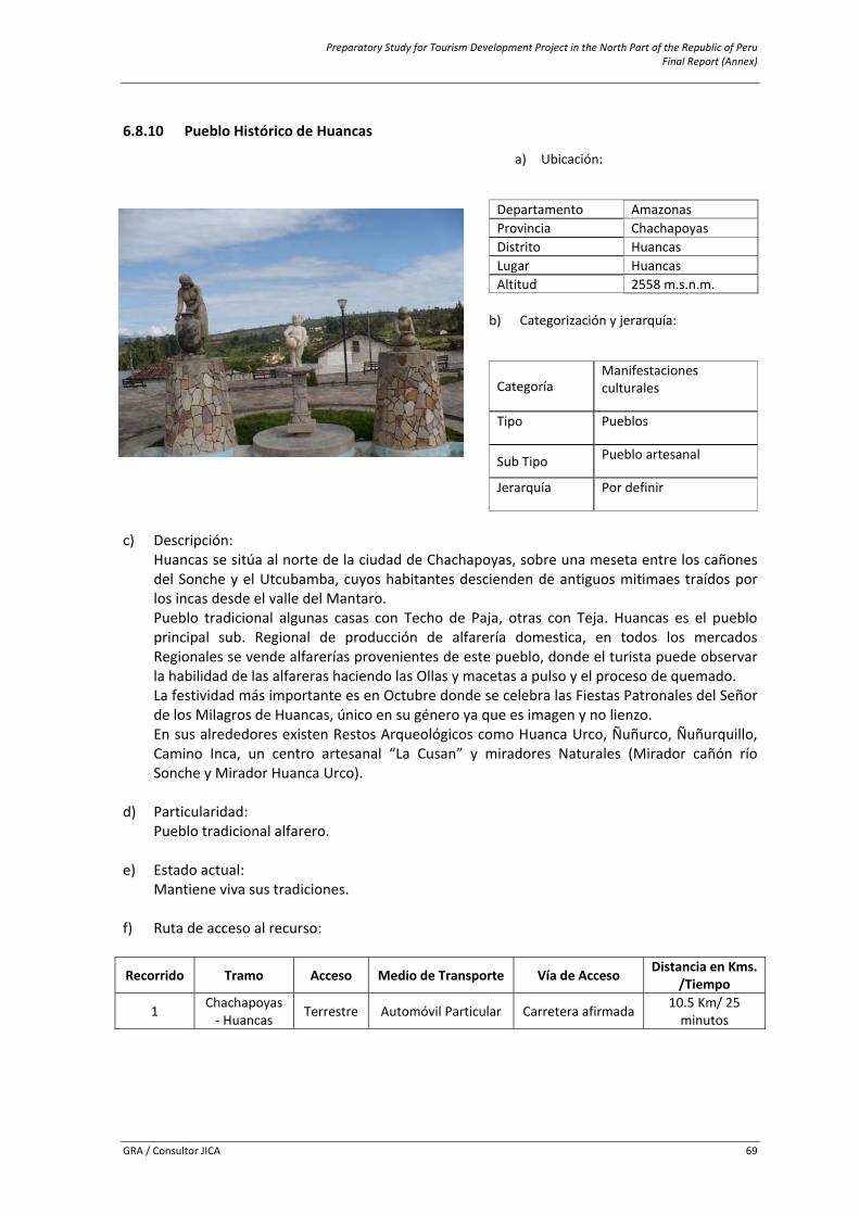
Preparatory Study for Tourism Development Project in the North Part of the Republic of Peru Final Report (Annex)
GRA / Consultor JICA 69
6.8.10 Pueblo Histórico de Huancas
c) Descripción:
Huancas se sitúa al norte de la ciudad de Chachapoyas, sobre una meseta entre los cañones del Sonche y el Utcubamba, cuyos habitantes descienden de antiguos mitimaes traídos por los incas desde el valle del Mantaro. Pueblo tradicional algunas casas con Techo de Paja, otras con Teja. Huancas es el pueblo principal sub. Regional de producción de alfarería domestica, en todos los mercados Regionales se vende alfarerías provenientes de este pueblo, donde el turista puede observar la habilidad de las alfareras haciendo las Ollas y macetas a pulso y el proceso de quemado. La festividad más importante es en Octubre donde se celebra las Fiestas Patronales del Señor de los Milagros de Huancas, único en su género ya que es imagen y no lienzo. En sus alrededores existen Restos Arqueológicos como Huanca Urco, Ñuñurco, Ñuñurquillo, Camino Inca, un centro artesanal “La Cusan” y miradores Naturales (Mirador cañón río Sonche y Mirador Huanca Urco).
d) Particularidad:
Pueblo tradicional alfarero.
e) Estado actual: Mantiene viva sus tradiciones.
f) Ruta de acceso al recurso:
Recorrido Tramo Acceso Medio de Transporte Vía de Acceso Distancia en Kms. /Tiempo
1 Chachapoyas ‐ Huancas Terrestre Automóvil Particular Carretera afirmada 10.5 Km/ 25
minutos
a) Ubicación:
Departamento Amazonasi Provincia Chachapoyas Distrito Huancas Lugar Huancas Altitud 2558 m.s.n.m.
b) Categorización y jerarquía:
Categoría Manifestaciones culturales
Tipo Pueblos
Sub Tipo Pueblo artesanal
Jerarquía Por definir
Preparatory Study for Tourism Development Project in the North Part of the Republic of Peru Final Report (Annex)
GRA / Consultor JICA 70
g) Servicios e instalaciones actuales:
Dentro y fuera del recurso
Servicios TipoBásicos Agua, Luz, Desagüe Comunicación Telefonía fija y móvil (movistar y claro), señal de radio y TV Hospedaje Hoteles, Hostales, Casas hospedajeRestauración Restaurantes y bodegasOtros Discotecas, Guiado, venta de artesanía, internet h) Tipo de visitante:
Tipo de Visitante Grado de AfluenciaExtranjero
Por definir Local NacionalRegional
i) Actividades desarrolladas dentro y fuera del recurso turístico:
Actividad TipoNaturaleza Observación de Flora y faunaDeportes / Aventura Caminata (Treking)Otros Toma de fotografías y filmación j) Especificaciones para el visitante: Época propicia de
visita Horario de Visita Tipo de Ingreso Administración Poblado más cercano
Todo el año Todo el día Libre Municipalidad Distrital de Huancas
Ciudad de Chachapoyas
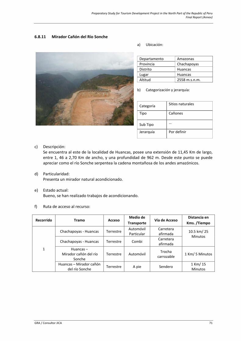
Preparatory Study for Tourism Development Project in the North Part of the Republic of Peru Final Report (Annex)
GRA / Consultor JICA 71
6.8.11 Mirador Cañón del Río Sonche
c) Descripción:
Se encuentra al este de la localidad de Huancas, posee una extensión de 11,45 Km de largo, entre 1, 46 a 2,70 Km de ancho, y una profundidad de 962 m. Desde este punto se puede apreciar como el río Sonche serpentea la cadena montañosa de los andes amazónicos.
d) Particularidad:
Presenta un mirador natural acondicionado.
e) Estado actual: Bueno, se han realizado trabajos de acondicionando.
f) Ruta de acceso al recurso:
Recorrido Tramo Acceso Medio de Transporte
Vía de Acceso Distancia en Kms. /Tiempo
1
Chachapoyas ‐ Huancas Terrestre Automóvil Particular
Carretera afirmada 10.5 km/ 25
Minutos Chachapoyas ‐ Huancas Terrestre Combi Carretera
afirmada Huancas –
Mirador cañón del río Sonche
Terrestre Automóvil Trocha carrozable 1 Km/ 5 Minutos
Huancas – Mirador cañón del río Sonche Terrestre A pie Sendero 1 Km/ 15
Minutos
a) Ubicación:
Departamento Amazonasi Provincia Chachapoyas Distrito Huancas Lugar Huancas Altitud 2558 m.s.n.m.
b) Categorización y jerarquía:
Categoría Sitios naturales
Tipo Cañones
Sub Tipo …
Jerarquía Por definir
Preparatory Study for Tourism Development Project in the North Part of the Republic of Peru Final Report (Annex)
GRA / Consultor JICA 72
g) Servicios e instalaciones actuales:
Fuera del recursoDentro del recurso
Servicios TipoBásicos Agua, Luz, Desagüe
Mirador Comunicación Telefonía fija y móvil (movistar y claro), señal de radio y TVHospedaje Hoteles, Casa hospedajeRestauración Restaurantes y bodegas Otros Guiado, señalización, venta de artesanía, agencias de viaje
h) Tipo de visitante:
Tipo de Visitante Grado de Afluencia
Extranjero
Por definir Local Nacional Regional
i) Actividades desarrolladas dentro y fuera del recurso turístico:
Actividad Tipo
Naturaleza Observación de faunaNaturaleza Observación de floraDeportes / Aventura Caminata – trekingOtros (Especificar Tipo) Toma de Fotografías y Filmaciones j) Especificaciones para el visitante: Época propicia
de visita Horario de
Visita Tipo de Ingreso
Propiedad Actual Administración Poblado más
cercano
Todo el Año Todo el día Pagado Municipalidad distrital de Huancas
Municipalidad distrital de Huancas
Huancas
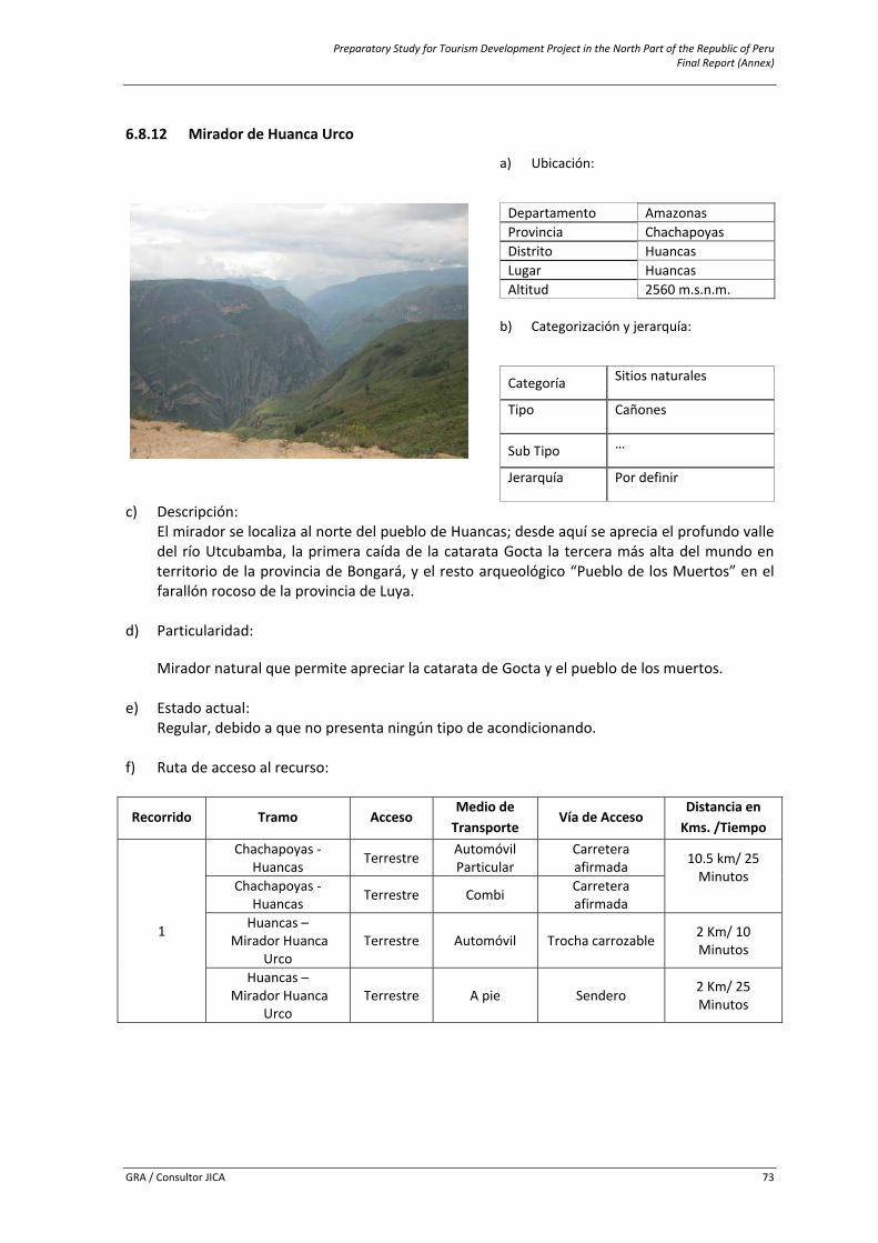
Preparatory Study for Tourism Development Project in the North Part of the Republic of Peru Final Report (Annex)
GRA / Consultor JICA 73
6.8.12 Mirador de Huanca Urco
c) Descripción: El mirador se localiza al norte del pueblo de Huancas; desde aquí se aprecia el profundo valle del río Utcubamba, la primera caída de la catarata Gocta la tercera más alta del mundo en territorio de la provincia de Bongará, y el resto arqueológico “Pueblo de los Muertos” en el farallón rocoso de la provincia de Luya.
d) Particularidad:
Mirador natural que permite apreciar la catarata de Gocta y el pueblo de los muertos. e) Estado actual:
Regular, debido a que no presenta ningún tipo de acondicionando. f) Ruta de acceso al recurso:
Recorrido Tramo Acceso Medio de Transporte
Vía de Acceso Distancia en Kms. /Tiempo
1
Chachapoyas ‐ Huancas Terrestre Automóvil
Particular Carretera afirmada 10.5 km/ 25
Minutos Chachapoyas ‐
Huancas Terrestre Combi Carretera afirmada
Huancas – Mirador Huanca
Urco Terrestre Automóvil Trocha carrozable 2 Km/ 10
Minutos
Huancas – Mirador Huanca
Urco Terrestre A pie Sendero 2 Km/ 25
Minutos
a) Ubicación:
Departamento Amazonasi Provincia Chachapoyas Distrito Huancas Lugar Huancas Altitud 2560 m.s.n.m.
b) Categorización y jerarquía:
Categoría Sitios naturales
Tipo Cañones
Sub Tipo …
Jerarquía Por definir
Preparatory Study for Tourism Development Project in the North Part of the Republic of Peru Final Report (Annex)
GRA / Consultor JICA 74
g) Servicios e instalaciones actuales:
Fuera del recurso Dentro del recurso Servicios Tipo
Básicos Agua, Luz, Desagüe
Mirador Comunicación Telefonía fija y móvil (movistar y claro), señal de radio y TVHospedaje Hoteles, Casa hospedajeRestauración Restaurantes y bodegas Otros Guiado, señalización, venta de artesanía, agencias de viaje
h) Tipo de visitante:
Tipo de Visitante Grado de Afluencia
Extranjero
Por definir Local Nacional Regional
i) Actividades desarrolladas dentro y fuera del recurso turístico:
Actividad Tipo
Naturaleza Observación de faunaNaturaleza Observación de floraDeportes / Aventura Caminata ‐ trekingOtros (Especificar Tipo) Toma de Fotografías y Filmaciones j) Especificaciones para el visitante: Época propicia
de visita Horario de
Visita Tipo de Ingreso
Propiedad Actual Administración Poblado más
cercano
Todo el Año Todo el día Pagado Municipalidad distrital de Huancas
Municipalidad distrital de Huancas
Huancas
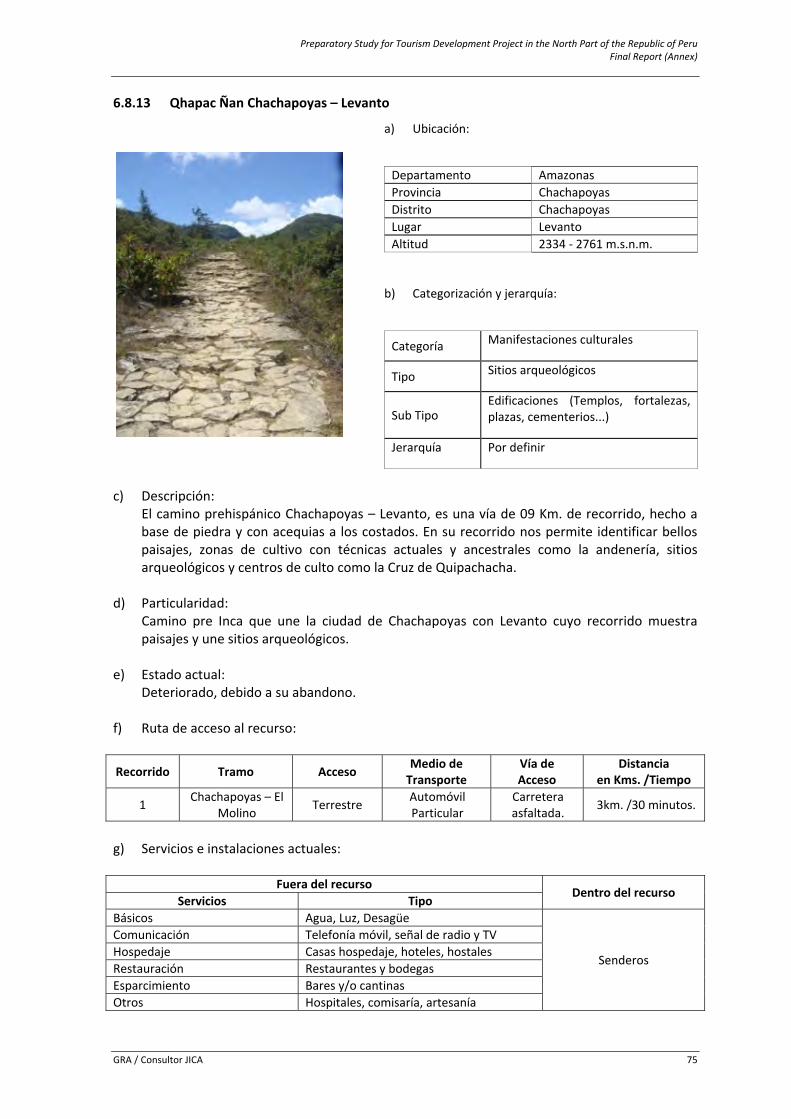
Preparatory Study for Tourism Development Project in the North Part of the Republic of Peru Final Report (Annex)
GRA / Consultor JICA 75
6.8.13 Qhapac Ñan Chachapoyas – Levanto
c) Descripción:
El camino prehispánico Chachapoyas – Levanto, es una vía de 09 Km. de recorrido, hecho a base de piedra y con acequias a los costados. En su recorrido nos permite identificar bellos paisajes, zonas de cultivo con técnicas actuales y ancestrales como la andenería, sitios arqueológicos y centros de culto como la Cruz de Quipachacha.
d) Particularidad: Camino pre Inca que une la ciudad de Chachapoyas con Levanto cuyo recorrido muestra paisajes y une sitios arqueológicos.
e) Estado actual: Deteriorado, debido a su abandono.
f) Ruta de acceso al recurso:
Recorrido Tramo Acceso Medio de Transporte
Vía de Acceso
Distanciaen Kms. /Tiempo
1 Chachapoyas – El Molino Terrestre Automóvil
Particular Carretera asfaltada. 3km. /30 minutos.
g) Servicios e instalaciones actuales:
Fuera del recursoDentro del recurso
Servicios TipoBásicos Agua, Luz, Desagüe
Senderos
Comunicación Telefonía móvil, señal de radio y TVHospedaje Casas hospedaje, hoteles, hostalesRestauración Restaurantes y bodegas Esparcimiento Bares y/o cantinas Otros Hospitales, comisaría, artesanía
a) Ubicación:
Departamento Amazonasi Provincia Chachapoyas Distrito Chachapoyas Lugar Levanto Altitud 2334 ‐ 2761 m.s.n.m.
b) Categorización y jerarquía:
Categoría Manifestaciones culturales
Tipo Sitios arqueológicos
Sub Tipo Edificaciones (Templos, fortalezas,plazas, cementerios...)
Jerarquía Por definir
Preparatory Study for Tourism Development Project in the North Part of the Republic of Peru Final Report (Annex)
GRA / Consultor JICA 76
h) Tipo de visitante:
Tipo de Visitante Grado de AfluenciaExtranjero
Por definir Local Nacional Regional
i) Actividades desarrolladas dentro y fuera del recurso turístico:
Actividad Tipo
Naturaleza Observación de Flora y faunaDeportes / Aventura Caminata (Treking), CabalgataOtros Toma de fotografías y filmación j) Especificaciones para el visitante: Época propicia
de visita Horario de
Visita Tipo de Ingreso
Propiedad Actual Administración Poblado más
cercano
Todo el año De 6:00 am a 3:00 pm Libre Estado
Municipalidad Distrital de Levanto y Ministerio de
Cultura
Chachapoyas /
Levanto
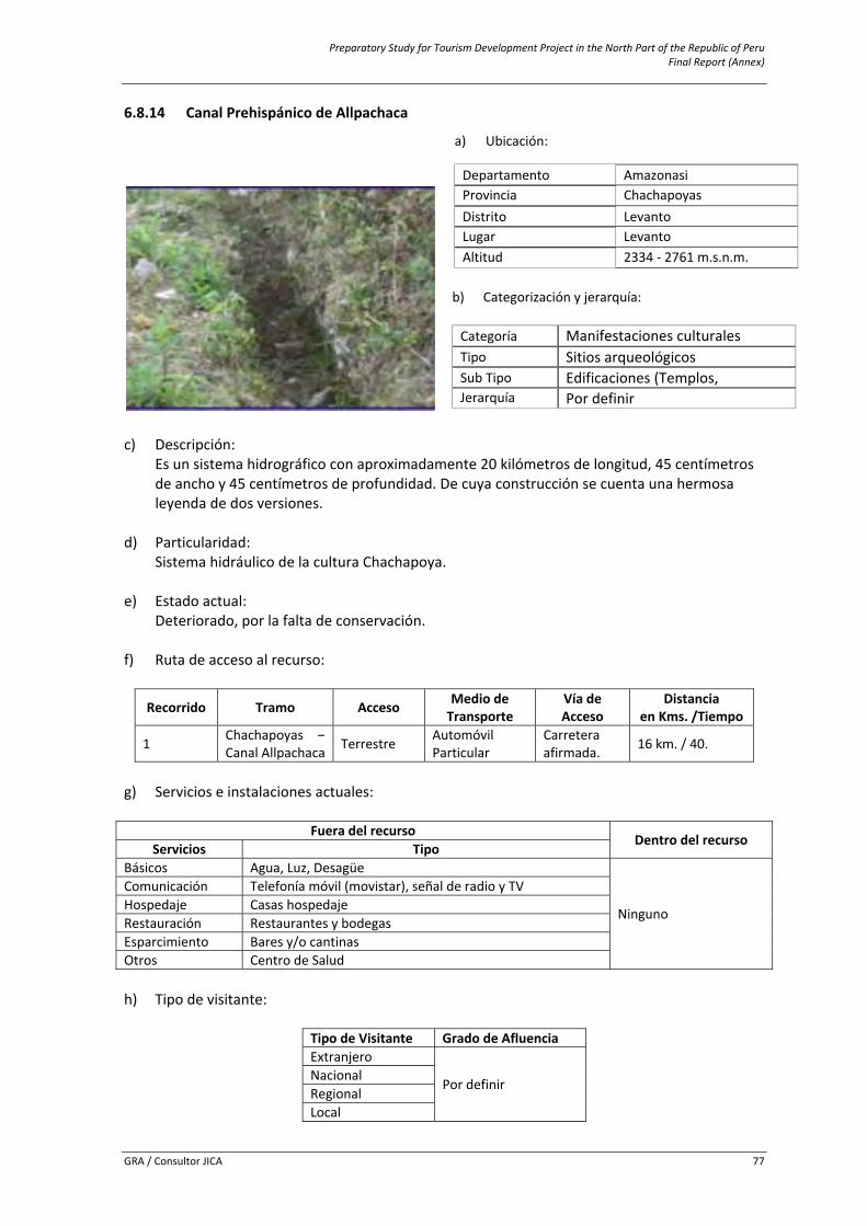
Preparatory Study for Tourism Development Project in the North Part of the Republic of Peru Final Report (Annex)
GRA / Consultor JICA 77
6.8.14 Canal Prehispánico de Allpachaca
c) Descripción: Es un sistema hidrográfico con aproximadamente 20 kilómetros de longitud, 45 centímetros de ancho y 45 centímetros de profundidad. De cuya construcción se cuenta una hermosa leyenda de dos versiones.
d) Particularidad: Sistema hidráulico de la cultura Chachapoya.
e) Estado actual:
Deteriorado, por la falta de conservación. f) Ruta de acceso al recurso:
Recorrido Tramo Acceso Medio de Transporte
Vía deAcceso
Distanciaen Kms. /Tiempo
1 Chachapoyas –Canal Allpachaca Terrestre Automóvil
Particular Carretera afirmada. 16 km. / 40.
g) Servicios e instalaciones actuales:
Fuera del recurso
Dentro del recurso Servicios Tipo
Básicos Agua, Luz, Desagüe
Ninguno
Comunicación Telefonía móvil (movistar), señal de radio y TVHospedaje Casas hospedaje Restauración Restaurantes y bodegas Esparcimiento Bares y/o cantinas Otros Centro de Salud h) Tipo de visitante:
Tipo de Visitante Grado de AfluenciaExtranjero
Por definir NacionalRegionalLocal
a) Ubicación:
Departamento Amazonasi Provincia Chachapoyas Distrito Levanto Lugar Levanto Altitud 2334 ‐ 2761 m.s.n.m.
b) Categorización y jerarquía: Categoría Manifestaciones culturales Tipo Sitios arqueológicos Sub Tipo Edificaciones (Templos, Jerarquía Por definir
Preparatory Study for Tourism Development Project in the North Part of the Republic of Peru Final Report (Annex)
GRA / Consultor JICA 78
i) Actividades desarrolladas dentro y fuera del recurso turístico: Actividad TipoNaturaleza Observación de Flora y faunaDeportes / Aventura Caminata (Treking), CabalgataOtros Toma de fotografías y filmación j) Especificaciones para el visitante: Época propicia de visita
Horario de Visita
Tipo de Ingreso
Propiedad Actual Administración Poblado más
cercano
Todo el año De 6:00 am a 3:00 pm Libre Estado
Municipalidad Distrital de Levanto y Ministerio de Cultura
Chachapoyas / Levanto
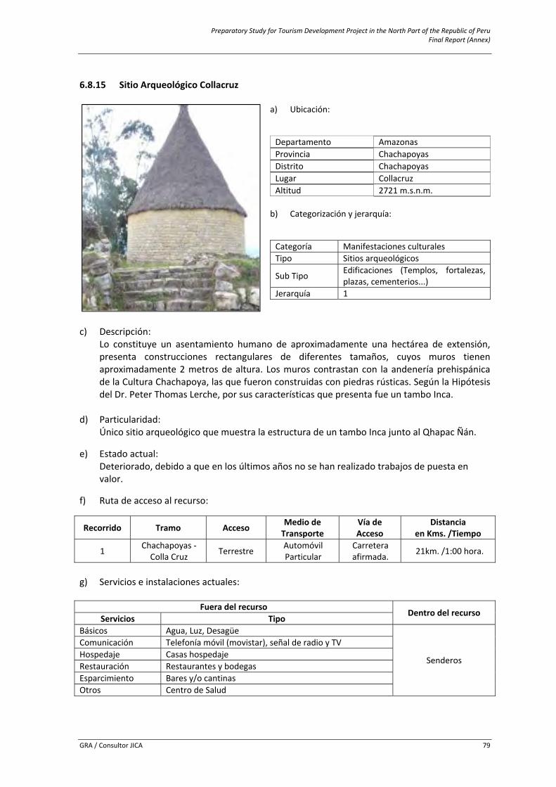
Preparatory Study for Tourism Development Project in the North Part of the Republic of Peru Final Report (Annex)
GRA / Consultor JICA 79
6.8.15 Sitio Arqueológico Collacruz
a) Ubicación:
Departamento Amazonasi Provincia Chachapoyas Distrito Chachapoyas Lugar Collacruz Altitud 2721 m.s.n.m.
b) Categorización y jerarquía:
Categoría Manifestaciones culturales Tipo Sitios arqueológicos
Sub Tipo Edificaciones (Templos, fortalezas,plazas, cementerios...)
Jerarquía 1
c) Descripción:
Lo constituye un asentamiento humano de aproximadamente una hectárea de extensión, presenta construcciones rectangulares de diferentes tamaños, cuyos muros tienen aproximadamente 2 metros de altura. Los muros contrastan con la andenería prehispánica de la Cultura Chachapoya, las que fueron construidas con piedras rústicas. Según la Hipótesis del Dr. Peter Thomas Lerche, por sus características que presenta fue un tambo Inca.
d) Particularidad: Único sitio arqueológico que muestra la estructura de un tambo Inca junto al Qhapac Ñán.
e) Estado actual: Deteriorado, debido a que en los últimos años no se han realizado trabajos de puesta en valor.
f) Ruta de acceso al recurso:
Recorrido Tramo Acceso Medio de Transporte
Vía de Acceso
Distanciaen Kms. /Tiempo
1 Chachapoyas ‐ Colla Cruz Terrestre Automóvil
Particular Carreteraafirmada. 21km. /1:00 hora.
g) Servicios e instalaciones actuales:
Fuera del recursoDentro del recurso
Servicios TipoBásicos Agua, Luz, Desagüe
Senderos
Comunicación Telefonía móvil (movistar), señal de radio y TVHospedaje Casas hospedaje Restauración Restaurantes y bodegas Esparcimiento Bares y/o cantinas Otros Centro de Salud
Preparatory Study for Tourism Development Project in the North Part of the Republic of Peru Final Report (Annex)
GRA / Consultor JICA 80
h) Tipo de visitante:
Tipo de Visitante Grado de AfluenciaExtranjero 3Nacional 2Regional 4
i) Actividades desarrolladas dentro y fuera del recurso turístico:
Actividad TipoNaturaleza Observación de Flora y faunaDeportes / Aventura Caminata (Treking), Cabalgata Otros Toma de fotografías y filmación j) Especificaciones para el visitante: Época propicia
de visita Horario de
Visita Tipo de Ingreso
Propiedad Actual Administración Poblado más
cercano
Todo el año De 6:00 am a 5:00 pm Libre Estado
Municipalidad Distrital de Levanto y Ministerio de
Cultura San Bartolo
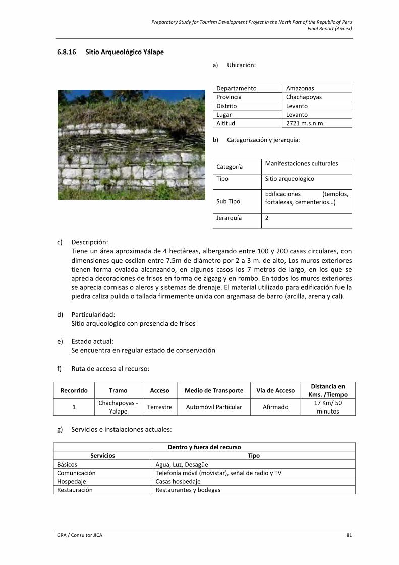
Preparatory Study for Tourism Development Project in the North Part of the Republic of Peru Final Report (Annex)
GRA / Consultor JICA 81
6.8.16 Sitio Arqueológico Yálape
c) Descripción:
Tiene un área aproximada de 4 hectáreas, albergando entre 100 y 200 casas circulares, con dimensiones que oscilan entre 7.5m de diámetro por 2 a 3 m. de alto, Los muros exteriores tienen forma ovalada alcanzando, en algunos casos los 7 metros de largo, en los que se aprecia decoraciones de frisos en forma de zigzag y en rombo. En todos los muros exteriores se aprecia cornisas o aleros y sistemas de drenaje. El material utilizado para edificación fue la piedra caliza pulida o tallada firmemente unida con argamasa de barro (arcilla, arena y cal).
d) Particularidad: Sitio arqueológico con presencia de frisos
e) Estado actual: Se encuentra en regular estado de conservación
f) Ruta de acceso al recurso:
Recorrido Tramo Acceso Medio de Transporte Vía de Acceso Distancia en Kms. /Tiempo
1 Chachapoyas ‐ Yalape Terrestre Automóvil Particular Afirmado 17 Km/ 50
minutos
g) Servicios e instalaciones actuales:
Dentro y fuera del recursoServicios Tipo
Básicos Agua, Luz, Desagüe Comunicación Telefonía móvil (movistar), señal de radio y TVHospedaje Casas hospedajeRestauración Restaurantes y bodegas
a) Ubicación:
Departamento Amazonasi Provincia Chachapoyas Distrito Levanto Lugar Levanto Altitud 2721 m.s.n.m.
b) Categorización y jerarquía:
Categoría Manifestaciones culturales
Tipo Sitio arqueológico
Sub Tipo Edificaciones (templos, fortalezas, cementerios…)
Jerarquía 2
Preparatory Study for Tourism Development Project in the North Part of the Republic of Peru Final Report (Annex)
GRA / Consultor JICA 82
h) Tipo de visitante:
Tipo de Visitante Grado de AfluenciaExtranjero 4Local 1Nacional 3Regional 2
i) Actividades desarrolladas dentro y fuera del recurso turístico:
Actividad TipoNaturaleza Observación de Flora y faunaDeportes / Aventura Caminata (Treking), CabalgataOtros Toma de fotografías y filmación j) Especificaciones para el visitante: Época propicia de
visita Horario de
Visita Tipo de Ingreso Administración Poblado más cercano
Todo el año 6:00 am a 5:00 pm Libre Municipalidad Distrital
de Levanto Levanto
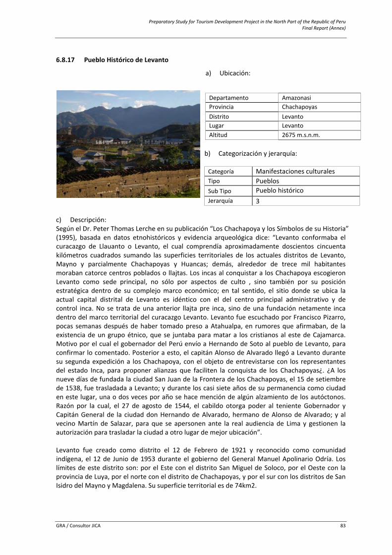
Preparatory Study for Tourism Development Project in the North Part of the Republic of Peru Final Report (Annex)
GRA / Consultor JICA 83
6.8.17 Pueblo Histórico de Levanto
c) Descripción: Según el Dr. Peter Thomas Lerche en su publicación “Los Chachapoya y los Símbolos de su Historia” (1995), basada en datos etnohistóricos y evidencia arqueológica dice: “Levanto conformaba el curacazgo de Llauanto o Levanto, el cual comprendía aproximadamente doscientos cincuenta kilómetros cuadrados sumando las superficies territoriales de los actuales distritos de Levanto, Mayno y parcialmente Chachapoyas y Huancas; demás, alrededor de trece mil habitantes moraban catorce centros poblados o llajtas. Los incas al conquistar a los Chachapoya escogieron Levanto como sede principal, no sólo por aspectos de culto , sino también por su posición estratégica dentro de su complejo marco económico; en tal sentido, el sitio donde se ubica la actual capital distrital de Levanto es idéntico con el del centro principal administrativo y de control inca. No se trata de una anterior llajta pre inca, sino de una fundación netamente inca dentro del marco territorial del curacazgo Levanto. Levanto fue escuchado por Francisco Pizarro, pocas semanas después de haber tomado preso a Atahualpa, en rumores que afirmaban, de la existencia de un grupo étnico, que se juntaba para matar a los cristianos al este de Cajamarca. Motivo por el cual el gobernador del Perú envío a Hernando de Soto al pueblo de Levanto, para confirmar lo comentado. Posterior a esto, el capitán Alonso de Alvarado llegó a Levanto durante su segunda expedición a los Chachapoya, con el objeto de entrevistarse con los representantes del estado Inca, para proponer alianzas que faciliten la conquista de los Chachapoyas¿. ¿A los nueve días de fundada la ciudad San Juan de la Frontera de los Chachapoyas, el 15 de setiembre de 1538, fue trasladada a Levanto; y durante los casi siete años de su permanencia como ciudad en este lugar, una o dos veces por año se hace mención de algún alzamiento de los autóctonos. Razón por la cual, el 27 de agosto de 1544, el cabildo otorga poder al teniente Gobernador y Capitán General de la ciudad don Hernando de Alvarado, hermano de Alonso de Alvarado; y al vecino Martín de Salazar, para que se apersonen ante la real audiencia de Lima y gestionen la autorización para trasladar la ciudad a otro lugar de mejor ubicación”. Levanto fue creado como distrito el 12 de Febrero de 1921 y reconocido como comunidad indígena, el 12 de Junio de 1953 durante el gobierno del General Manuel Apolinario Odría. Los límites de este distrito son: por el Este con el distrito San Miguel de Soloco, por el Oeste con la provincia de Luya, por el norte con el distrito de Chachapoyas, y por el sur con los distritos de San Isidro del Mayno y Magdalena. Su superficie territorial es de 74km2.
a) Ubicación:
Departamento Amazonasi Provincia Chachapoyas Distrito Levanto Lugar Levanto Altitud 2675 m.s.n.m.
b) Categorización y jerarquía: Categoría Manifestaciones culturales Tipo Pueblos Sub Tipo Pueblo histórico Jerarquía 3
Preparatory Study for Tourism Development Project in the North Part of the Republic of Peru Final Report (Annex)
GRA / Consultor JICA 84
d) Particularidad:
Segundo lugar de asentamiento y fundación de la ciudad San Juan de la Frontera de Los Chachapoyas, el 15 de setiembre de 1538.
e) Estado actual:
Se encuentra en buen estado de conservación f) Ruta de acceso al recurso:
Recorrido Tramo Acceso Medio de Transporte Vía de Acceso
Distancia en Kms. /Tiempo
1 Chachapoyas ‐ Levanto Terrestre Automóvil Particular Afirmado 38 Km/ 1h
g) Servicios e instalaciones actuales:
Dentro y fuera del recursoServicios Tipo
Básicos Agua, Luz, Desagüe Comunicación Telefonía móvil (movistar), señal de radio y TV Hospedaje Casas hospedaje Restauración Restaurantes y bodegas h) Tipo de visitante:
Tipo de Visitante Grado de Afluencia
Extranjero 4Local 1
Nacional 3Regional 2
i) Actividades desarrolladas dentro y fuera del recurso turístico:
Actividad TipoNaturaleza Observación de Flora y faunaDeportes / Aventura Caminata (Treking), Cabalgata hoursing Otros Toma de fotografías y filmación j) Especificaciones para el visitante: Época propicia
de visita Horario de Visita Tipo de Ingreso Administración Poblado más cercano
Todo el año Todo el día Libre Municipalidad Distrital de Levanto
Ciudad de Chachapoyas y San Isidro del Mayno
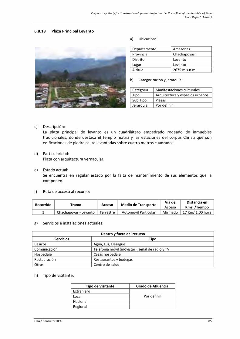
Preparatory Study for Tourism Development Project in the North Part of the Republic of Peru Final Report (Annex)
GRA / Consultor JICA 85
6.8.18 Plaza Principal Levanto
c) Descripción:
La plaza principal de levanto es un cuadrilátero empedrado rodeado de inmuebles tradicionales, donde destaca el templo matriz y las estaciones del corpus Christi que son edificaciones de piedra caliza levantadas sobre cuatro metros cuadrados.
d) Particularidad:
Plaza con arquitectura vernacular.
e) Estado actual: Se encuentra en regular estado por la falta de mantenimiento de sus elementos que la componen.
f) Ruta de acceso al recurso:
Recorrido Tramo Acceso Medio de Transporte Vía de Acceso
Distancia en Kms. /Tiempo
1 Chachapoyas ‐ Levanto Terrestre Automóvil Particular Afirmado 17 Km/ 1:00 hora
g) Servicios e instalaciones actuales:
Dentro y fuera del recursoServicios Tipo
Básicos Agua, Luz, Desagüe Comunicación Telefonía móvil (movistar), señal de radio y TVHospedaje Casas hospedajeRestauración Restaurantes y bodegas Otros Centro de salud
h) Tipo de visitante:
Tipo de Visitante Grado de Afluencia
Extranjero Por definir Local
Nacional Regional
a) Ubicación: Departamento Amazonasi Provincia Chachapoyas Distrito Levanto Lugar Levanto Altitud 2675 m.s.n.m.
b) Categorización y jerarquía:
Categoría Manifestaciones culturalesTipo Arquitectura y espacios urbanosSub Tipo Plazas Jerarquía Por definir
Preparatory Study for Tourism Development Project in the North Part of the Republic of Peru Final Report (Annex)
GRA / Consultor JICA 86
i) Actividades desarrolladas dentro y fuera del recurso turístico:
Actividad Tipo
Deporte aventura CaminatasOtros Camping, Toma de fotografías y filmación
j) Especificaciones para el visitante:
Época propicia de
visita Horario de Visita Tipo de Ingreso Administración Poblado más cercano
Todo el año 6:00 am a 5:00 pm Libre Municipalidad
Distrital de Levanto Levanto
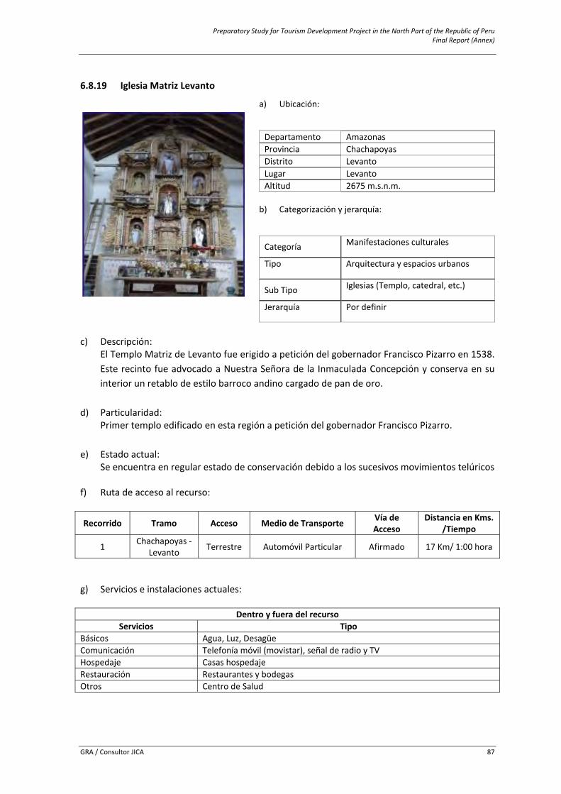
Preparatory Study for Tourism Development Project in the North Part of the Republic of Peru Final Report (Annex)
GRA / Consultor JICA 87
6.8.19 Iglesia Matriz Levanto
c) Descripción:
El Templo Matriz de Levanto fue erigido a petición del gobernador Francisco Pizarro en 1538. Este recinto fue advocado a Nuestra Señora de la Inmaculada Concepción y conserva en su interior un retablo de estilo barroco andino cargado de pan de oro.
d) Particularidad: Primer templo edificado en esta región a petición del gobernador Francisco Pizarro.
e) Estado actual: Se encuentra en regular estado de conservación debido a los sucesivos movimientos telúricos
f) Ruta de acceso al recurso:
Recorrido Tramo Acceso Medio de Transporte Vía de Acceso
Distancia en Kms. /Tiempo
1 Chachapoyas ‐ Levanto Terrestre Automóvil Particular Afirmado 17 Km/ 1:00 hora
g) Servicios e instalaciones actuales:
Dentro y fuera del recurso
Servicios TipoBásicos Agua, Luz, Desagüe Comunicación Telefonía móvil (movistar), señal de radio y TVHospedaje Casas hospedajeRestauración Restaurantes y bodegas Otros Centro de Salud
a) Ubicación:
Departamento AmazonasiProvincia Chachapoyas Distrito LevantoLugar LevantoAltitud 2675 m.s.n.m.
b) Categorización y jerarquía:
Categoría Manifestaciones culturales
Tipo Arquitectura y espacios urbanos
Sub Tipo Iglesias (Templo, catedral, etc.)
Jerarquía Por definir
Preparatory Study for Tourism Development Project in the North Part of the Republic of Peru Final Report (Annex)
GRA / Consultor JICA 88
h) Tipo de visitante:
Tipo de Visitante Grado de AfluenciaExtranjero
Por definir Local Nacional Regional
i) Actividades desarrolladas dentro y fuera del recurso turístico:
Actividad Tipo
Deportes de aventura Caminata Otros Toma de fotografías y filmación
j) Especificaciones para el visitante:
Época propicia de
visita Horario de
Visita Tipo de Ingreso Administración Poblado más cercano
Todo el año 6:00 am a 6:00 pm Libre Catequista de Levanto Levanto
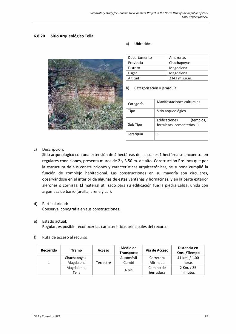
Preparatory Study for Tourism Development Project in the North Part of the Republic of Peru Final Report (Annex)
GRA / Consultor JICA 89
6.8.20 Sitio Arqueológico Tella
c) Descripción:
Sitio arqueológico con una extensión de 4 hectáreas de las cuales 1 hectárea se encuentra en regulares condiciones, presenta muros de 2 y 3.50 m. de alto. Construcción Pre‐Inca que por la estructura de sus construcciones y características arquitectónicas, se supone cumplió la función de complejo habitacional. Las construcciones en su mayoría son circulares, observándose en el interior de algunas de estas ventanas y hornacinas, y en la parte exterior alerones o cornisas. El material utilizado para su edificación fue la piedra caliza, unida con argamasa de barro (arcilla, arena y cal).
d) Particularidad: Conserva iconografía en sus construcciones.
e) Estado actual:
Regular, es posible reconocer las características principales del recurso.
f) Ruta de acceso al recurso:
Recorrido Tramo Acceso Medio de Transporte Vía de Acceso Distancia en
Kms. /Tiempo
1
Chachapoyas ‐ Magdalena Terrestre
AutomóvilCombi
Carretera Afirmada
41 Km. / 1.00 horas
Magdalena ‐ Tella A pie Camino de
herradura 2 Km. / 35 minutos
a) Ubicación:
Departamento Amazonasi Provincia Chachapoyas Distrito Magdalena Lugar Magdalena Altitud 2343 m.s.n.m.
b) Categorización y jerarquía:
Categoría Manifestaciones culturales
Tipo Sitio arqueológico
Sub Tipo Edificaciones (templos, fortalezas, cementerios…)
Jerarquía 1
Preparatory Study for Tourism Development Project in the North Part of the Republic of Peru Final Report (Annex)
GRA / Consultor JICA 90
g) Servicios e instalaciones actuales:
Fuera del recurso
Dentro del recurso Servicios Tipo
Básicos Agua, Luz, Desagüe
Senderos
Comunicación Telefonía móvil (movistar), señal de radio y TVHospedaje Casas hospedaje, hostalesRestauración Restaurantes y bodegas Esparcimiento Bares y/o cantinas Otros Venta de artesanía. Centro de salud
h) Tipo de visitante:
Tipo de Visitante Grado de AfluenciaExtranjero 1Local 4Nacional 2Regional 3
i) Actividades desarrolladas dentro y fuera del recurso turístico:
Actividad Tipo
Naturaleza Observación de Flora y faunaDeportes / Aventura Caminata (Treking), CabalgataOtros Toma de fotografías y filmación
j) Especificaciones para el visitante:
Época propicia
de visita Horario de
Visita Tipo de Ingreso
Propiedad Actual Administración Poblado más
cercano
Todo el año 6:00 a.m.
a 5:00 p.m
Libre Estado Municipalidad Distrital de Magdalena y Ministerio de
la Cultura Magdalena
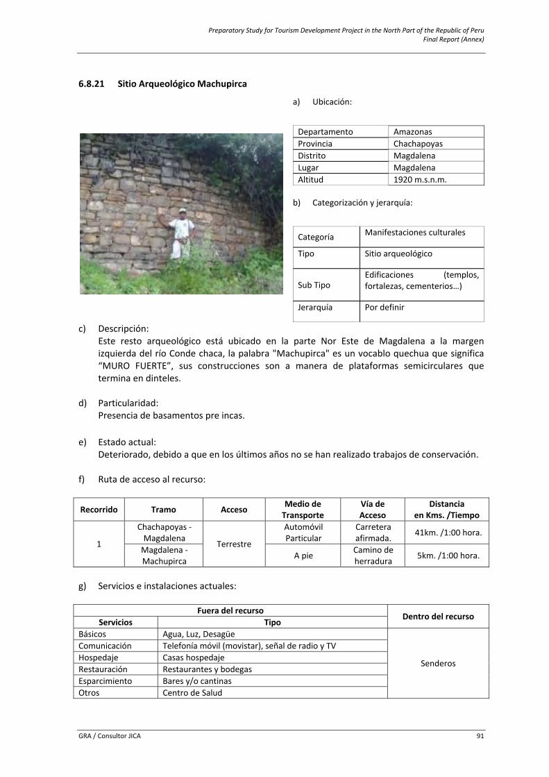
Preparatory Study for Tourism Development Project in the North Part of the Republic of Peru Final Report (Annex)
GRA / Consultor JICA 91
6.8.21 Sitio Arqueológico Machupirca
c) Descripción: Este resto arqueológico está ubicado en la parte Nor Este de Magdalena a la margen izquierda del río Conde chaca, la palabra "Machupirca" es un vocablo quechua que significa “MURO FUERTE”, sus construcciones son a manera de plataformas semicirculares que termina en dinteles.
d) Particularidad: Presencia de basamentos pre incas.
e) Estado actual:
Deteriorado, debido a que en los últimos años no se han realizado trabajos de conservación.
f) Ruta de acceso al recurso:
Recorrido Tramo Acceso Medio de Transporte
Vía de Acceso
Distanciaen Kms. /Tiempo
1
Chachapoyas ‐ Magdalena
Terrestre
Automóvil Particular
Carretera afirmada. 41km. /1:00 hora.
Magdalena ‐ Machupirca A pie Camino de
herradura 5km. /1:00 hora.
g) Servicios e instalaciones actuales:
Fuera del recurso
Dentro del recurso Servicios Tipo
Básicos Agua, Luz, Desagüe
Senderos
Comunicación Telefonía móvil (movistar), señal de radio y TVHospedaje Casas hospedaje Restauración Restaurantes y bodegas Esparcimiento Bares y/o cantinas Otros Centro de Salud
a) Ubicación:
Departamento Amazonasi Provincia Chachapoyas Distrito Magdalena Lugar Magdalena Altitud 1920 m.s.n.m.
b) Categorización y jerarquía:
Categoría Manifestaciones culturales
Tipo Sitio arqueológico
Sub Tipo Edificaciones (templos, fortalezas, cementerios…)
Jerarquía Por definir
Preparatory Study for Tourism Development Project in the North Part of the Republic of Peru Final Report (Annex)
GRA / Consultor JICA 92
h) Tipo de visitante:
Tipo de Visitante Grado de AfluenciaExtranjero
Por definir Nacional Regional
i) Actividades desarrolladas dentro y fuera del recurso turístico:
Actividad Tipo
Naturaleza Observación de Flora y faunaDeportes / Aventura Caminata (Treking), CabalgataOtros Toma de fotografías y filmación
j) Especificaciones para el visitante:
Época propicia
de visita Horario de
Visita Tipo de Ingreso
Propiedad Actual Administración Poblado más
cercano
Todo el año De 6:00 am a 3:00 pm Libre Estado
Municipalidad Distrital de Magdalena y Ministerio de
Cultura Magdalena
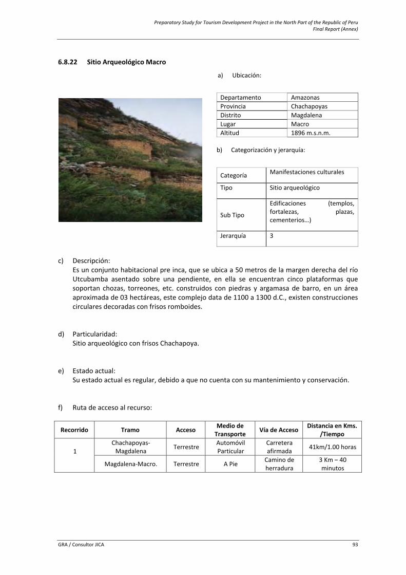
Preparatory Study for Tourism Development Project in the North Part of the Republic of Peru Final Report (Annex)
GRA / Consultor JICA 93
6.8.22 Sitio Arqueológico Macro
c) Descripción:
Es un conjunto habitacional pre inca, que se ubica a 50 metros de la margen derecha del río Utcubamba asentado sobre una pendiente, en ella se encuentran cinco plataformas que soportan chozas, torreones, etc. construidos con piedras y argamasa de barro, en un área aproximada de 03 hectáreas, este complejo data de 1100 a 1300 d.C., existen construcciones circulares decoradas con frisos romboides.
d) Particularidad: Sitio arqueológico con frisos Chachapoya.
e) Estado actual: Su estado actual es regular, debido a que no cuenta con su mantenimiento y conservación.
f) Ruta de acceso al recurso:
Recorrido Tramo Acceso Medio de Transporte Vía de Acceso Distancia en Kms.
/Tiempo
1
Chachapoyas‐Magdalena Terrestre Automóvil
Particular Carretera afirmada 41km/1.00 horas
Magdalena‐Macro. Terrestre A Pie Camino de herradura
3 Km – 40 minutos
a) Ubicación:
Departamento Amazonasi Provincia Chachapoyas Distrito Magdalena Lugar Macro Altitud 1896 m.s.n.m.
b) Categorización y jerarquía:
Categoría Manifestaciones culturales
Tipo Sitio arqueológico
Sub Tipo
Edificaciones (templos, fortalezas, plazas, cementerios…)
Jerarquía 3
Preparatory Study for Tourism Development Project in the North Part of the Republic of Peru Final Report (Annex)
GRA / Consultor JICA 94
g) Servicios e instalaciones actuales:
Fuera del recurso
Dentro del recurso Servicios Tipo
Básicos Agua, Luz, Desagüe
Senderos
Comunicación Telefonía móvil (movistar), señal de radio y TVHospedaje Casas hospedaje, hostalesRestauración Restaurantes y bodegas Esparcimiento Bares y/o cantinas Otros Centro de salud
h) Tipo de visitante:
Tipo de Visitante Grado de AfluenciaExtranjero 1Local 2Regional 3
i) Actividades desarrolladas dentro y fuera del recurso turístico:
Actividad Tipo
Naturaleza Observación de Flora y faunaDeportes / Aventura Caminata (Treking), CabalgataOtros Toma de fotografías y filmación
j) Especificaciones para el visitante:
Época propicia
de visita Horario de
Visita Tipo de Ingreso
Propiedad Actual Administración Poblado más
cercano
Todo el año De 7am
a Pm
Libre Estado Municipalidad Distrital de Magdalena y Ministerio de
Cultura Magdalena
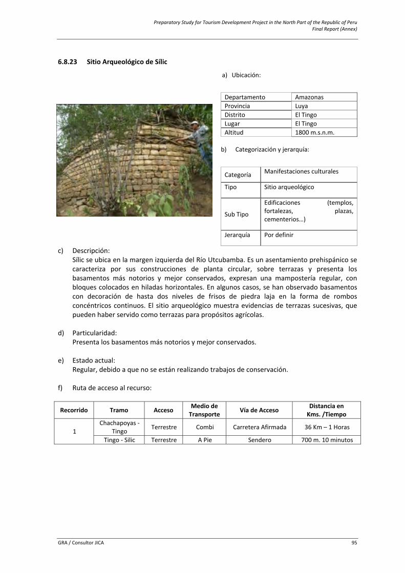
Preparatory Study for Tourism Development Project in the North Part of the Republic of Peru Final Report (Annex)
GRA / Consultor JICA 95
6.8.23 Sitio Arqueológico de Sílic
c) Descripción: Sílic se ubica en la margen izquierda del Río Utcubamba. Es un asentamiento prehispánico se caracteriza por sus construcciones de planta circular, sobre terrazas y presenta los basamentos más notorios y mejor conservados, expresan una mampostería regular, con bloques colocados en hiladas horizontales. En algunos casos, se han observado basamentos con decoración de hasta dos niveles de frisos de piedra laja en la forma de rombos concéntricos continuos. El sitio arqueológico muestra evidencias de terrazas sucesivas, que pueden haber servido como terrazas para propósitos agrícolas.
d) Particularidad: Presenta los basamentos más notorios y mejor conservados.
e) Estado actual: Regular, debido a que no se están realizando trabajos de conservación.
f) Ruta de acceso al recurso:
Recorrido Tramo Acceso Medio de Transporte Vía de Acceso Distancia en
Kms. /Tiempo
1 Chachapoyas ‐
Tingo Terrestre Combi Carretera Afirmada 36 Km – 1 Horas
Tingo ‐ Silic Terrestre A Pie Sendero 700 m. 10 minutos
a) Ubicación:
Departamento Amazonasi Provincia Luya Distrito El Tingo Lugar El Tingo Altitud 1800 m.s.n.m.
b) Categorización y jerarquía:
Categoría Manifestaciones culturales
Tipo Sitio arqueológico
Sub Tipo
Edificaciones (templos, fortalezas, plazas, cementerios…)
Jerarquía Por definir
Preparatory Study for Tourism Development Project in the North Part of the Republic of Peru Final Report (Annex)
GRA / Consultor JICA 96
g) Servicios e instalaciones actuales:
Fuera del recurso
Dentro del recurso Servicios Tipo
Básicos Agua, Luz, Desagüe
Ninguno
Comunicación Telefonía móvil (movistar, claro), señal de radio y TVHospedaje Casas hospedaje Restauración Restaurantes y bodegas Esparcimiento Bares y/o cantinas Otros Posta médica, servicios higiénicos
h) Tipo de visitante:
Tipo de Visitante Grado de AfluenciaExtranjero
Por definir Local Nacional Regional
i) Actividades desarrolladas dentro y fuera del recurso turístico:
Actividad Tipo
Naturaleza Observación de Flora y faunaDeportes / Aventura Caminata (Treking)Otros Toma de fotografías y filmación, estudios de investigación
j) Especificaciones para el visitante:
Época propicia
de visita Horario de
Visita Tipo de Ingreso
Propiedad Actual Administración Poblado más
cercano
Todo el año Todo el día Libre Estado Municipalidad distrital de El Tingo y Ministerio
de cultura Nuevo Tingo
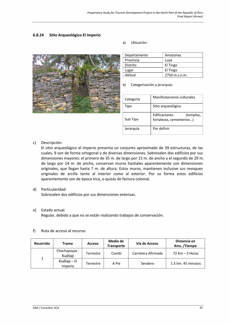
Preparatory Study for Tourism Development Project in the North Part of the Republic of Peru Final Report (Annex)
GRA / Consultor JICA 97
6.8.24 Sitio Arqueológico El Imperio
c) Descripción:
El sitio arqueológico el Imperio presenta un conjunto aproximado de 39 estructuras, de las cuales, 9 son de forma ortogonal y de diversas dimensiones. Sobresalen dos edificios por sus dimensiones mayores: el primero de 35 m. de largo por 15 m. de ancho y el segundo de 29 m. de largo por 14 m. de ancho, conservan muros hastiales aparentemente con dimensiones originales, que llegan hasta 7 m. de altura. Estos muros, mantienen inclusive sus revoques originales de arcilla tanto al interior como al exterior. Por su forma estos edificios aparentemente son de época Inca, o quizás de factura colonial.
d) Particularidad: Sobresalen dos edificios por sus dimensiones extensas.
e) Estado actual: Regular, debido a que no se están realizando trabajos de conservación.
f) Ruta de acceso al recurso:
Recorrido Tramo Acceso Medio de Transporte Vía de Acceso Distancia en
Kms. /Tiempo
1
Chachapoyas ‐ Kuélap Terrestre Combi Carretera Afirmada 72 Km – 3 Horas
Kuélap – El Imperio
Terrestre A Pie Sendero 1.5 km. 45 minutos
a) Ubicación:
Departamento Amazonasi Provincia Luya Distrito El Tingo Lugar El Tingo Altitud 2750 m.s.n.m.
b) Categorización y jerarquía:
Categoría Manifestaciones culturales
Tipo Sitio arqueológico
Sub Tipo Edificaciones (templos, fortalezas, cementerios…)
Jerarquía Por definir
Preparatory Study for Tourism Development Project in the North Part of the Republic of Peru Final Report (Annex)
GRA / Consultor JICA 98
g) Servicios e instalaciones actuales:
Fuera del recurso
Dentro del recurso Servicios Tipo
Básicos Agua, Luz, Desagüe
Ninguno
Comunicación Telefonía móvil (movistar, claro), señal de radio y TVHospedaje Casas hospedaje Restauración Restaurantes y bodegas Esparcimiento Bares y/o cantinas Otros Posta médica, servicios higiénicos
h) Tipo de visitante:
Tipo de Visitante Grado de AfluenciaExtranjero
Por definir Local Nacional Regional
i) Actividades desarrolladas dentro y fuera del recurso turístico:
Actividad Tipo
Naturaleza Observación de Flora y faunaDeportes / Aventura Caminata (Treking)Otros Toma de fotografías y filmación, estudios de investigación
j) Especificaciones para el visitante:
Época propicia
de visita Horario de
Visita Tipo de Ingreso
Propiedad Actual Administración Poblado más
cercano
Todo el año Todo el día Libre Estado Municipalidad distrital de El Tingo y Ministerio
de cultura Kuélap
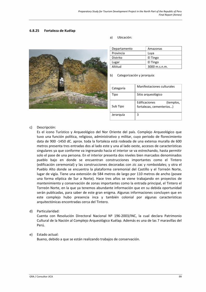
Preparatory Study for Tourism Development Project in the North Part of the Republic of Peru Final Report (Annex)
GRA / Consultor JICA 99
6.8.25 Fortaleza de Kuélap
c) Descripción:
Es el icono Turístico y Arqueológico del Nor Oriente del país. Complejo Arqueológico que tuvo una función política, religioso, administrativo y militar, cuyo periodo de florecimiento data de 900 ‐1450 dC. aprox. toda la fortaleza está rodeada de una extensa muralla de 600 metros presenta tres entradas dos al lado este y una al lado oeste, accesos de características singulares ya que conforme va ingresando hacia el interior se va estrechando, hasta permitir solo el pase de una persona. En el interior presenta dos niveles bien marcados denominados pueblo bajo en donde se encuentran construcciones importantes como el Tintero (edificación ceremonial) y las construcciones decoradas con zic zac y romboidales; y otra el Pueblo Alto donde se encuentra la plataforma ceremonial del Castillo y el Torreón Norte, lugar de vigía. Tiene una extensión de 584 metros de largo por 110 metros de ancho (posee una forma elíptica de Sur a Norte). Hace tres años se viene trabajando en proyectos de mantenimiento y conservación de zonas importantes como la entrada principal, el Tintero el Torreón Norte, en la que ya tenemos abundante información que en su debida oportunidad serán publicadas, para saber de este gran enigma. Algunas informaciones concluyen que en este complejo hubo presencia inca y también colonial por algunas características arquitectónicas encontradas cerca del Tintero.
d) Particularidad: Cuenta con Resolución Directoral Nacional Nº 196‐2003/INC, la cual declara Patrimonio Cultural de la Nación al Complejo Arqueológico Kuélap. Además es una de las 7 maravillas del Perú.
e) Estado actual: Bueno, debido a que se están realizando trabajos de conservación.
a) Ubicación:
Departamento Amazonasi Provincia Luya Distrito El Tingo Lugar El Tingo Altitud 3000 m.s.n.m.
b) Categorización y jerarquía:
Categoría Manifestaciones culturales
Tipo Sitio arqueológico
Sub Tipo Edificaciones (templos, fortalezas, cementerios…)
Jerarquía 3
Preparatory Study for Tourism Development Project in the North Part of the Republic of Peru Final Report (Annex)
GRA / Consultor JICA 100
f) Ruta de acceso al recurso:
Recorrido Tramo Acceso Medio de Transporte Vía de Acceso Distancia en
Kms. /Tiempo
1 Chachapoyas –
Kuélap Terrestre Automóvil Particular Carretera Afirmada 72 Km. 3 Horas
Aprox.
2
Chachapoyas – Tingo Terrestre Combi Carretera Afirmada 36 Km – 1 Horas
Tingo ‐ Kuélap Terrestre A Pie Camino de herradura 36 Km. 2 Horas
g) Servicios e instalaciones actuales:
Fuera del recurso
Dentro del recurso Servicios Tipo
Básicos Agua, Luz, Desagüe
Señalización
Comunicación Telefonía móvil (movistar, claro), señal de radio y TVHospedaje Casas hospedaje Restauración Restaurantes y bodegas Esparcimiento Bares y/o cantinas
Otros Posta médica, venta artesanía, guiado, centro de interpretación, servicios higiénicos
h) Tipo de visitante:
Tipo de Visitante Grado de AfluenciaExtranjero 3Local 2Nacional 4Regional 3
i) Actividades desarrolladas dentro y fuera del recurso turístico:
Actividad Tipo
Paseos ExcursionesNaturaleza Observación de Flora y faunaDeportes / Aventura Caminata (Trekking)Otros Toma de fotografías y filmación, estudios de investigación
j) Especificaciones para el visitante:
Época propicia
de visita Horario de
Visita Tipo de Ingreso
Propiedad Actual Administración Poblado más
cercano
Todo el año De 8am a 5pm Libre Estado Ministerio de la cultura Kuélap
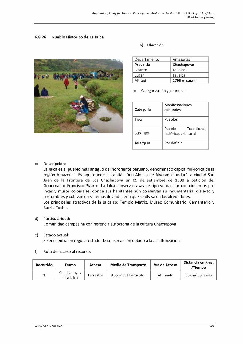
Preparatory Study for Tourism Development Project in the North Part of the Republic of Peru Final Report (Annex)
GRA / Consultor JICA 101
6.8.26 Pueblo Histórico de La Jalca
c) Descripción:
La Jalca es el pueblo más antiguo del nororiente peruano, denominado capital folklórica de la región Amazonas. Es aquí donde el capitán Don Alonso de Alvarado fundará la ciudad San Juan de la Frontera de Los Chachapoya un 05 de setiembre de 1538 a petición del Gobernador Francisco Pizarro. La Jalca conserva casas de tipo vernacular con cimientos pre Incas y muros coloniales, donde sus habitantes aún conservan su indumentaria, dialecto y costumbres y cultivan en sistemas de andenería que se divisa en los alrededores. Los principales atractivos de la Jalca so: Templo Matriz, Museo Comunitario, Cementerio y Barrio Toche.
d) Particularidad:
Comunidad campesina con herencia autóctona de la cultura Chachapoya
e) Estado actual: Se encuentra en regular estado de conservación debido a la a culturización
f) Ruta de acceso al recurso:
Recorrido Tramo Acceso Medio de Transporte Vía de Acceso Distancia en Kms. /Tiempo
1 Chachapoyas – La Jalca Terrestre Automóvil Particular Afirmado 85Km/ 03 horas
a) Ubicación:
Departamento Amazonasi Provincia Chachapoyas Distrito La Jalca Lugar La Jalca Altitud 2795 m.s.n.m.
b) Categorización y jerarquía:
Categoría Manifestaciones culturales
Tipo Pueblos
Sub Tipo Pueblo Tradicional, histórico, artesanal
Jerarquía Por definir
Preparatory Study for Tourism Development Project in the North Part of the Republic of Peru Final Report (Annex)
GRA / Consultor JICA 102
g) Servicios e instalaciones actuales:
Dentro y fuera del recurso
Servicios TipoBásicos Agua, Luz, Desagüe Comunicación Telefonía móvil, señal de radio y TVHospedaje Casas hospedaje, hospedajesRestauración Restaurantes y bodegas Otros Centro de Salud, Comisaría, centro artesanal
h) Tipo de visitante:
Tipo de Visitante Grado de Afluencia
ExtranjeroPor definir Local
NacionalRegional
i) Actividades desarrolladas dentro y fuera del recurso turístico:
Actividad Tipo
Deporte / aventura CaminataOtros Toma de fotografías y filmación
j) Especificaciones para el visitante:
Época propicia de
visita Horario de Visita Tipo de Ingreso Administración Poblado más cercano
Todo el año Todo el día Libre Municipalidad Distrital de La Jalca La Jalca
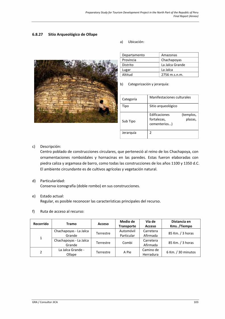
Preparatory Study for Tourism Development Project in the North Part of the Republic of Peru Final Report (Annex)
GRA / Consultor JICA 103
6.8.27 Sitio Arqueológico de Ollape
c) Descripción:
Centro poblado de construcciones circulares, que perteneció al reino de los Chachapoya, con ornamentaciones romboidales y hornacinas en las paredes. Estas fueron elaboradas con piedra caliza y argamasa de barro, como todas las construcciones de los años 1100 y 1350 d.C. El ambiente circundante es de cultivos agrícolas y vegetación natural.
d) Particularidad: Conserva iconografía (doble rombo) en sus construcciones.
e) Estado actual: Regular, es posible reconocer las características principales del recurso.
f) Ruta de acceso al recurso:
Recorrido Tramo Acceso Medio de Transporte
Vía de Acceso
Distancia en Kms. /Tiempo
1
Chachapoyas ‐ La Jalca Grande Terrestre Automóvil
Particular Carretera Afirmada 85 Km. / 3 horas
Chachapoyas ‐ La Jalca Grande Terrestre Combi Carretera
Afirmada 85 Km. / 3 horas
2 La Jalca Grande ‐ Ollape Terrestre A Pie Camino de
Herradura 6 Km. / 30 minutos
a) Ubicación:
Departamento Amazonasi Provincia Chachapoyas Distrito La Jalca Grande Lugar La Jalca Altitud 2756 m.s.n.m.
b) Categorización y jerarquía:
Categoría Manifestaciones culturales
Tipo Sitio arqueológico
Sub Tipo
Edificaciones (templos, fortalezas, plazas, cementerios…)
Jerarquía 2
Preparatory Study for Tourism Development Project in the North Part of the Republic of Peru Final Report (Annex)
GRA / Consultor JICA 104
g) Servicios e instalaciones actuales:
Fuera del recurso
Dentro del recurso Servicios Tipo
Básicos Agua, Luz, Desagüe
Senderos
Comunicación Telefonía móvil (movistar), señal de radio y TVHospedaje Casas hospedaje Restauración Restaurantes y bodegas Esparcimiento Bares y/o cantinas Otros Venta de artesanía, Museo de sitio, guiado
h) Tipo de visitante:
Tipo de Visitante Grado de Afluencia
Extranjero 1Local 2Regional 3
i) Actividades desarrolladas dentro y fuera del recurso turístico:
Actividad Tipo
Naturaleza Observación de Flora y faunaDeportes / Aventura Caminata (Treking), Cabalgata Otros Toma de fotografías y filmación
j) Especificaciones para el visitante:
Época propicia de
visita Horario de
Visita Tipo de Ingreso
Propiedad Actual Administración Poblado más
cercano
Todo el año Todo el día Libre Estado Municipalidad Distrital de La Jalca Grande y Ministerio de Cultura
La Jalca
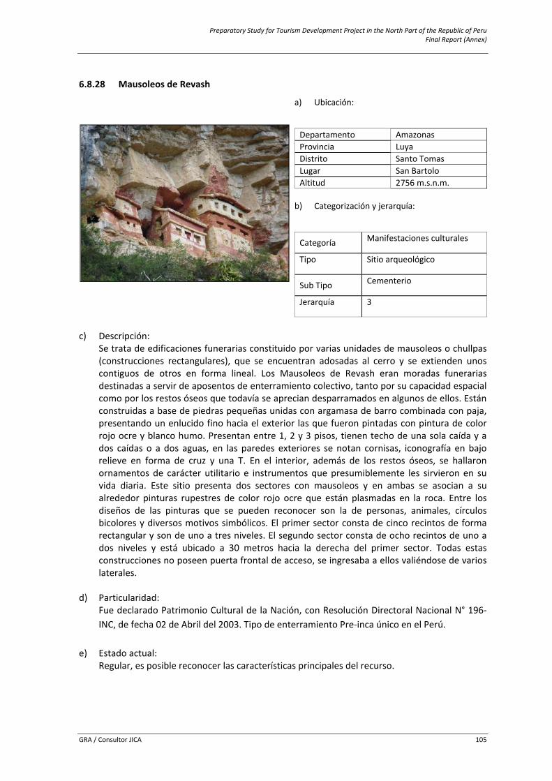
Preparatory Study for Tourism Development Project in the North Part of the Republic of Peru Final Report (Annex)
GRA / Consultor JICA 105
6.8.28 Mausoleos de Revash
c) Descripción:
Se trata de edificaciones funerarias constituido por varias unidades de mausoleos o chullpas (construcciones rectangulares), que se encuentran adosadas al cerro y se extienden unos contiguos de otros en forma lineal. Los Mausoleos de Revash eran moradas funerarias destinadas a servir de aposentos de enterramiento colectivo, tanto por su capacidad espacial como por los restos óseos que todavía se aprecian desparramados en algunos de ellos. Están construidas a base de piedras pequeñas unidas con argamasa de barro combinada con paja, presentando un enlucido fino hacia el exterior las que fueron pintadas con pintura de color rojo ocre y blanco humo. Presentan entre 1, 2 y 3 pisos, tienen techo de una sola caída y a dos caídas o a dos aguas, en las paredes exteriores se notan cornisas, iconografía en bajo relieve en forma de cruz y una T. En el interior, además de los restos óseos, se hallaron ornamentos de carácter utilitario e instrumentos que presumiblemente les sirvieron en su vida diaria. Este sitio presenta dos sectores con mausoleos y en ambas se asocian a su alrededor pinturas rupestres de color rojo ocre que están plasmadas en la roca. Entre los diseños de las pinturas que se pueden reconocer son la de personas, animales, círculos bicolores y diversos motivos simbólicos. El primer sector consta de cinco recintos de forma rectangular y son de uno a tres niveles. El segundo sector consta de ocho recintos de uno a dos niveles y está ubicado a 30 metros hacia la derecha del primer sector. Todas estas construcciones no poseen puerta frontal de acceso, se ingresaba a ellos valiéndose de varios laterales.
d) Particularidad: Fue declarado Patrimonio Cultural de la Nación, con Resolución Directoral Nacional N° 196‐INC, de fecha 02 de Abril del 2003. Tipo de enterramiento Pre‐inca único en el Perú.
e) Estado actual:
Regular, es posible reconocer las características principales del recurso.
a) Ubicación:
Departamento Amazonasi Provincia Luya Distrito Santo Tomas Lugar San Bartolo Altitud 2756 m.s.n.m.
b) Categorización y jerarquía:
Categoría Manifestaciones culturales
Tipo Sitio arqueológico
Sub Tipo Cementerio
Jerarquía 3
Preparatory Study for Tourism Development Project in the North Part of the Republic of Peru Final Report (Annex)
GRA / Consultor JICA 106
f) Ruta de acceso al recurso:
Recorrido Tramo Acceso Medio de Transporte
Vía de Acceso
Distanciaen Kms. /Tiempo
1 Chachapoyas ‐ San
Bartolo. Terrestre Automóvil Particular
Carretera afirmada. 74km./2h. 30min.
San Bartolo ‐Revash. Terrestre A Pie (treking) Sendero. 2km. /25min.
2
Chachapoyas – Puente Santo Tomas ‐
El Ingenio Terrestre Automóvil
Particular Carretera afirmada. …
El Ingenio – Revash Terrestre A pie (treking) Sendero 4.5km./45min
g) Servicios e instalaciones actuales:
Fuera del recursoDentro del recurso
Servicios TipoBásicos Agua, Luz, Desagüe
Senderos
Comunicación Telefonía móvil (movistar), señal de radio y TVHospedaje Casas hospedaje Restauración Restaurantes y bodegas Esparcimiento Bares y/o cantinas Otros Señalización de San Bartolo a Revash
h) Tipo de visitante:
Tipo de Visitante Grado de AfluenciaExtranjero 4Local 1Nacional 3Regional 2
i) Actividades desarrolladas dentro y fuera del recurso turístico:
Actividad Tipo
Naturaleza Observación de Flora y faunaDeportes / Aventura Caminata (Treking), CabalgataOtros Toma de fotografías y filmación
j) Especificaciones para el visitante:
Época propicia de
visita Horario de
Visita Tipo de Ingreso
Propiedad Actual Administración Poblado más
cercano
Mayo ‐ Octubre De 6am a 5pm Libre Estado
Municipalidad Distrital de Santo Tomas y
Ministerio de Cultura San Bartolo
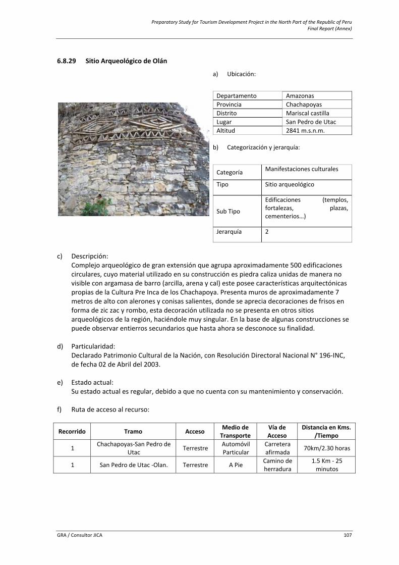
Preparatory Study for Tourism Development Project in the North Part of the Republic of Peru Final Report (Annex)
GRA / Consultor JICA 107
6.8.29 Sitio Arqueológico de Olán
c) Descripción:
Complejo arqueológico de gran extensión que agrupa aproximadamente 500 edificaciones circulares, cuyo material utilizado en su construcción es piedra caliza unidas de manera no visible con argamasa de barro (arcilla, arena y cal) este posee características arquitectónicas propias de la Cultura Pre Inca de los Chachapoya. Presenta muros de aproximadamente 7 metros de alto con alerones y conisas salientes, donde se aprecia decoraciones de frisos en forma de zic zac y rombo, esta decoración utilizada no se presenta en otros sitios arqueológicos de la región, haciéndole muy singular. En la base de algunas construcciones se puede observar entierros secundarios que hasta ahora se desconoce su finalidad.
d) Particularidad: Declarado Patrimonio Cultural de la Nación, con Resolución Directoral Nacional N° 196‐INC, de fecha 02 de Abril del 2003.
e) Estado actual: Su estado actual es regular, debido a que no cuenta con su mantenimiento y conservación.
f) Ruta de acceso al recurso:
Recorrido Tramo Acceso Medio de Transporte
Vía de Acceso
Distancia en Kms. /Tiempo
1 Chachapoyas‐San Pedro de Utac Terrestre Automóvil
Particular Carretera afirmada 70km/2.30 horas
1 San Pedro de Utac ‐Olan. Terrestre A Pie Camino de herradura
1.5 Km ‐ 25 minutos
a) Ubicación:
Departamento Amazonasi Provincia Chachapoyas Distrito Mariscal castilla Lugar San Pedro de UtacAltitud 2841 m.s.n.m.
b) Categorización y jerarquía:
Categoría Manifestaciones culturales
Tipo Sitio arqueológico
Sub Tipo
Edificaciones (templos, fortalezas, plazas, cementerios…)
Jerarquía 2
Preparatory Study for Tourism Development Project in the North Part of the Republic of Peru Final Report (Annex)
GRA / Consultor JICA 108
g) Servicios e instalaciones actuales:
Fuera del recurso
Dentro del recurso Servicios Tipo
Básicos Agua, Luz, Desagüe
Senderos
Comunicación Telefonía móvil (movistar), señal de radio y TVHospedaje Casas hospedaje Restauración Restaurantes y bodegas Esparcimiento Bares y/o cantinas Otros Centro de salud
h) Tipo de visitante:
Tipo de Visitante Grado de Afluencia
Regional 4
i) Actividades desarrolladas dentro y fuera del recurso turístico:
Actividad Tipo
Naturaleza Observación de Flora y faunaDeportes / Aventura Caminata (Treking), CabalgataOtros Toma de fotografías y filmación
j) Especificaciones para el visitante:
Época propicia
de visita Horario de Visita
Tipo de Ingreso
Propiedad Actual Administración Poblado más
cercano
Mayo ‐ Octubre De 6am a 5pm Libre Estado
Municipalidad Distrital de Mariscal Castilla y
Ministerio de Cultura
San Pedro de Utac
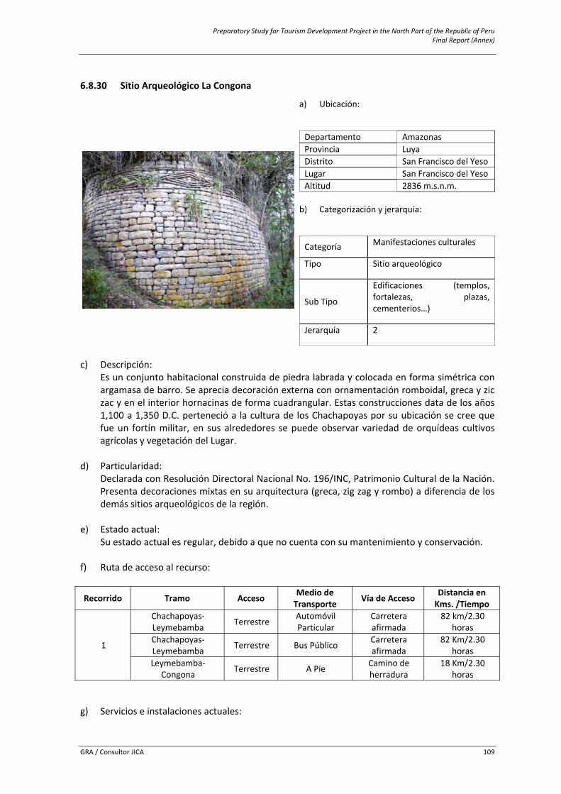
Preparatory Study for Tourism Development Project in the North Part of the Republic of Peru Final Report (Annex)
GRA / Consultor JICA 109
6.8.30 Sitio Arqueológico La Congona
c) Descripción:
Es un conjunto habitacional construida de piedra labrada y colocada en forma simétrica con argamasa de barro. Se aprecia decoración externa con ornamentación romboidal, greca y zic zac y en el interior hornacinas de forma cuadrangular. Estas construcciones data de los años 1,100 a 1,350 D.C. perteneció a la cultura de los Chachapoyas por su ubicación se cree que fue un fortín militar, en sus alrededores se puede observar variedad de orquídeas cultivos agrícolas y vegetación del Lugar.
d) Particularidad: Declarada con Resolución Directoral Nacional No. 196/INC, Patrimonio Cultural de la Nación. Presenta decoraciones mixtas en su arquitectura (greca, zig zag y rombo) a diferencia de los demás sitios arqueológicos de la región.
e) Estado actual:
Su estado actual es regular, debido a que no cuenta con su mantenimiento y conservación.
f) Ruta de acceso al recurso:
Recorrido Tramo Acceso Medio de Transporte Vía de Acceso Distancia en
Kms. /Tiempo
1
Chachapoyas‐ Leymebamba Terrestre Automóvil
Particular Carretera afirmada
82 km/2.30 horas
Chachapoyas‐ Leymebamba Terrestre Bus Público Carretera
afirmada 82 Km/2.30
horas Leymebamba‐
Congona Terrestre A Pie Camino de herradura
18 Km/2.30 horas
g) Servicios e instalaciones actuales:
a) Ubicación:
Departamento Amazonasi Provincia Luya Distrito San Francisco del YesoLugar San Francisco del YesoAltitud 2836 m.s.n.m.
b) Categorización y jerarquía:
Categoría Manifestaciones culturales
Tipo Sitio arqueológico
Sub Tipo
Edificaciones (templos, fortalezas, plazas, cementerios…)
Jerarquía 2
Preparatory Study for Tourism Development Project in the North Part of the Republic of Peru Final Report (Annex)
GRA / Consultor JICA 110
Fuera del recurso Dentro del
recurso Servicios TipoBásicos Agua, Luz, Desagüe
Ninguno
Comunicación Telefonía móvil (movistar), señal de radio y TVHospedaje Casas hospedaje Restauración Restaurantes y bodegas Esparcimiento Bares y/o cantinas Otros Centro de salud, venta artesanía, guiado, alquiler de acémilas
h) Tipo de visitante:
Tipo de Visitante Grado de Afluencia
Extranjero 4Local 3
i) Actividades desarrolladas dentro y fuera del recurso turístico:
Actividad Tipo
Naturaleza Observación de Flora y faunaDeportes / Aventura Caminata (Treking), CabalgataOtros Camping, Toma de fotografías y filmación
j) Especificaciones para el visitante:
Época propicia
de visita Horario de
Visita Tipo de Ingreso
Propiedad Actual Administración Poblado más
cercano
Todo el año De 6am a 4pm Libre Estado
Municipalidad Distrital de San
Francisco del Yeso
Leymebamba y San Francisco del
Yeso
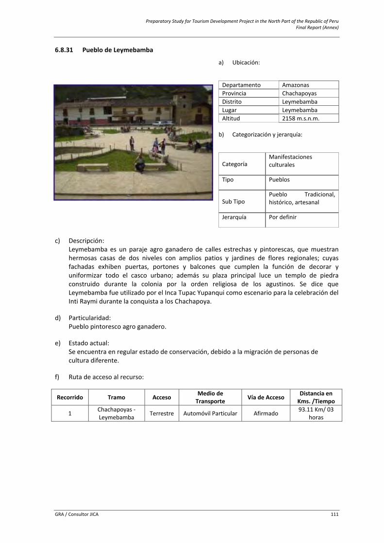
Preparatory Study for Tourism Development Project in the North Part of the Republic of Peru Final Report (Annex)
GRA / Consultor JICA 111
6.8.31 Pueblo de Leymebamba
c) Descripción:
Leymebamba es un paraje agro ganadero de calles estrechas y pintorescas, que muestran hermosas casas de dos niveles con amplios patios y jardines de flores regionales; cuyas fachadas exhiben puertas, portones y balcones que cumplen la función de decorar y uniformizar todo el casco urbano; además su plaza principal luce un templo de piedra construido durante la colonia por la orden religiosa de los agustinos. Se dice que Leymebamba fue utilizado por el Inca Tupac Yupanqui como escenario para la celebración del Inti Raymi durante la conquista a los Chachapoya.
d) Particularidad:
Pueblo pintoresco agro ganadero.
e) Estado actual: Se encuentra en regular estado de conservación, debido a la migración de personas de cultura diferente.
f) Ruta de acceso al recurso:
Recorrido Tramo Acceso Medio de Transporte Vía de Acceso Distancia en
Kms. /Tiempo
1 Chachapoyas ‐ Leymebamba Terrestre Automóvil Particular Afirmado 93.11 Km/ 03
horas
a) Ubicación:
Departamento Amazonasi Provincia Chachapoyas Distrito Leymebamba Lugar Leymebamba Altitud 2158 m.s.n.m.
b) Categorización y jerarquía:
Categoría Manifestaciones culturales
Tipo Pueblos
Sub Tipo Pueblo Tradicional, histórico, artesanal
Jerarquía Por definir
Preparatory Study for Tourism Development Project in the North Part of the Republic of Peru Final Report (Annex)
GRA / Consultor JICA 112
g) Servicios e instalaciones actuales:
Dentro y fuera del recurso
Servicios TipoBásicos Agua, Luz, Desagüe Comunicación Telefonía móvil (movistar), señal de radio y TVHospedaje Casas hospedaje, hostales, hoteles.Restauración Restaurantes y bodegas Otros Centro de Salud, comisaría. Centros artesanales
h) Tipo de visitante:
Tipo de Visitante Grado de AfluenciaExtranjero
Por definir Local NacionalRegional
i) Actividades desarrolladas dentro y fuera del recurso turístico:
Actividad Tipo
Deporte / aventura Caminata Otros Toma de fotografías y filmación
j) Especificaciones para el visitante:
Época propicia de visita
Horario de Visita
Tipo de Ingreso Administración Poblado más
cercano Todo el año Todo el día Libre Municipalidad Distrital de Leymebamba Leymebamba
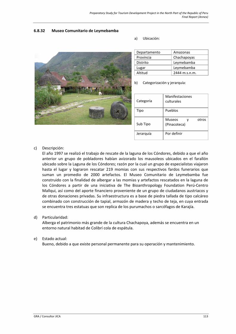
Preparatory Study for Tourism Development Project in the North Part of the Republic of Peru Final Report (Annex)
GRA / Consultor JICA 113
6.8.32 Museo Comunitario de Leymebamba
c) Descripción:
El año 1997 se realizó el trabajo de rescate de la laguna de los Cóndores, debido a que el año anterior un grupo de pobladores habían avizorado los mausoleos ubicados en el farallón ubicado sobre la Laguna de los Cóndores; razón por la cual un grupo de especialistas viajaron hasta el lugar y lograron rescatar 219 momias con sus respectivos fardos funerarios que suman un promedio de 2000 artefactos. El Museo Comunitario de Leymebamba fue construido con la finalidad de albergar a las momias y artefactos rescatados en la laguna de los Cóndores a partir de una iniciativa de The Bioanthropology Foundation Perú‐Centro Mallqui, así como del aporte financiero proveniente de un grupo de ciudadanos austriacos y de otras donaciones privadas. Su infraestructura es a base de piedra tallada de tipo calcáreo combinado con construcción de tapial, armazón de madera y techo de teja, en cuya entrada se encuentra tres estatuas que son replica de los purumachos o sarcófagos de Karajía.
d) Particularidad: Alberga el patrimonio más grande de la cultura Chachapoya, además se encuentra en un entorno natural habitad de Colibrí cola de espátula.
e) Estado actual: Bueno, debido a que existe personal permanente para su operación y mantenimiento.
a) Ubicación:
Departamento Amazonasi Provincia Chachapoyas Distrito Leymebamba Lugar Leymebamba Altitud 2444 m.s.n.m.
b) Categorización y jerarquía:
Categoría Manifestaciones culturales
Tipo Pueblos
Sub Tipo Museos y otros (Pinacoteca)
Jerarquía Por definir
Preparatory Study for Tourism Development Project in the North Part of the Republic of Peru Final Report (Annex)
GRA / Consultor JICA 114
f) Ruta de acceso al recurso:
Recorrido Tramo Acceso Medio de Transporte Vía de Acceso Distancia en Kms.
/Tiempo
1
Chachapoyas ‐ Leymebamba Terrestre Automóvil
Particular Carretera Afirmada
93.11 Km. / 3 Horas
Chachapoyas ‐ Leymebamba Terrestre Combi Carretera
Afirmada 93.11 Km. / 3
Horas
2 Leymebamba – Museo Terrestre Movilidad
particular Carretera Afirmada
3 km. / 15 Minutos
g) Servicios e instalaciones actuales:
Fuera del recurso
Dentro del recurso Servicios Tipo
Básicos Agua, Luz, Desagüe Centro de interpretación, Venta de artesanía y material informativo, servicios higiénicos, guiado, internet, estacionamiento
Comunicación Telefonía móvil (movistar y claro), señal de radio y TVHospedaje Hoteles, Hostales, Casas hospedajeRestauración Restaurantes, cafés y bodegas Esparcimiento Discoteca, Bares y/o cantinas Otros Alquiler de acémilas y botes, venta de artesanía, internet
h) Tipo de visitante:
Tipo de Visitante Grado de Afluencia
Extranjero 4Local 1Nacional 3Regional 2
i) Actividades desarrolladas dentro y fuera del recurso turístico:
Actividad Tipo
Paseos ExcursionesNaturaleza Observación de Flora y faunaDeportes / Aventura Caminata (Treking)Otros Camping, Toma de fotografías y filmación
j) Especificaciones para el visitante:
Época propicia
de visita Horario de
Visita Tipo de Ingreso
PropiedadActual Administración Poblado más
cercano
Todo el año 9 am – 1 pm 3 pm – 5 pm Pagado
Asociación Museo de
LeymebambaCentro Mallqui Leymebamba
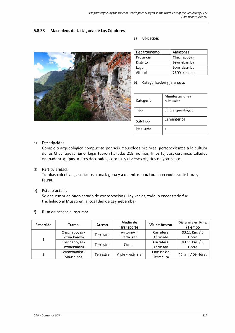
Preparatory Study for Tourism Development Project in the North Part of the Republic of Peru Final Report (Annex)
GRA / Consultor JICA 115
6.8.33 Mausoleos de La Laguna de Los Cóndores
c) Descripción:
Complejo arqueológico compuesto por seis mausoleos preincas, pertenecientes a la cultura de los Chachapoya. En el lugar fueron halladas 219 momias, finos tejidos, cerámica, tallados en madera, quipus, mates decorados, coronas y diversos objetos de gran valor.
d) Particularidad: Tumbas colectivas, asociados a una laguna y a un entorno natural con exuberante flora y fauna.
e) Estado actual: Se encuentra en buen estado de conservación ( Hoy vacías, todo lo encontrado fue trasladado al Museo en la localidad de Leymebamba)
f) Ruta de acceso al recurso:
Recorrido Tramo Acceso Medio de Transporte Vía de Acceso Distancia en Kms.
/Tiempo
1
Chachapoyas ‐ Leymebamba Terrestre Automóvil
Particular Carretera Afirmada
93.11 Km. / 3 Horas
Chachapoyas ‐ Leymebamba Terrestre Combi Carretera
Afirmada 93.11 Km. / 3
Horas
2 Leymebamba ‐ Mausoleos Terrestre A pie y Acémila Camino de
Herradura 45 km. / 09 Horas
a) Ubicación:
Departamento Amazonasi Provincia Chachapoyas Distrito Leymebamba Lugar Leymebamba Altitud 2600 m.s.n.m.
b) Categorización y jerarquía:
Categoría Manifestaciones culturales
Tipo Sitio arqueológico
Sub Tipo Cementerios
Jerarquía 3
Preparatory Study for Tourism Development Project in the North Part of the Republic of Peru Final Report (Annex)
GRA / Consultor JICA 116
g) Servicios e instalaciones actuales:
Fuera del recurso
Dentro del recursoServicios Tipo
Básicos Agua, Luz, Desagüe
Ninguno
Comunicación Telefonía móvil (movistar y claro), señal de radio y TVHospedaje Casas hospedajeRestauración Restaurantes, cafés y bodegas Esparcimiento Bares y/o cantinas Otros Alquiler de acémilas, guiado, venta de artesanía
h) Tipo de visitante:
Tipo de Visitante Grado de AfluenciaLocal 1
i) Actividades desarrolladas dentro y fuera del recurso turístico:
Actividad Tipo
Naturaleza Observación de Flora y faunaDeportes / Aventura Caminata (Treking), CabalgataOtros Camping, Toma de fotografías y filmación
j) Especificaciones para el visitante:
Época propicia
de visita Horario de
Visita Tipo de Ingreso
Propiedad Actual Administración Poblado más
cercano
Todo el año Permanente Libre Estado Municipalidad Distrital de Leymebamba y
Ministerio de Cultura Leymebamba
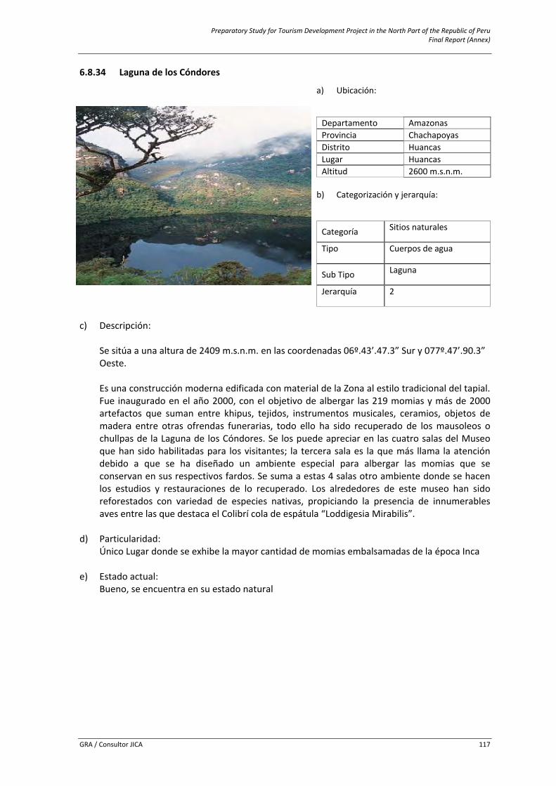
Preparatory Study for Tourism Development Project in the North Part of the Republic of Peru Final Report (Annex)
GRA / Consultor JICA 117
6.8.34 Laguna de los Cóndores
c) Descripción:
Se sitúa a una altura de 2409 m.s.n.m. en las coordenadas 06º.43’.47.3” Sur y 077º.47’.90.3” Oeste. Es una construcción moderna edificada con material de la Zona al estilo tradicional del tapial. Fue inaugurado en el año 2000, con el objetivo de albergar las 219 momias y más de 2000 artefactos que suman entre khipus, tejidos, instrumentos musicales, ceramios, objetos de madera entre otras ofrendas funerarias, todo ello ha sido recuperado de los mausoleos o chullpas de la Laguna de los Cóndores. Se los puede apreciar en las cuatro salas del Museo que han sido habilitadas para los visitantes; la tercera sala es la que más llama la atención debido a que se ha diseñado un ambiente especial para albergar las momias que se conservan en sus respectivos fardos. Se suma a estas 4 salas otro ambiente donde se hacen los estudios y restauraciones de lo recuperado. Los alrededores de este museo han sido reforestados con variedad de especies nativas, propiciando la presencia de innumerables aves entre las que destaca el Colibrí cola de espátula “Loddigesia Mirabilis”.
d) Particularidad: Único Lugar donde se exhibe la mayor cantidad de momias embalsamadas de la época Inca
e) Estado actual: Bueno, se encuentra en su estado natural
a) Ubicación:
Departamento Amazonasi Provincia Chachapoyas Distrito Huancas Lugar Huancas Altitud 2600 m.s.n.m.
b) Categorización y jerarquía:
Categoría Sitios naturales
Tipo Cuerpos de agua
Sub Tipo Laguna
Jerarquía 2
Preparatory Study for Tourism Development Project in the North Part of the Republic of Peru Final Report (Annex)
GRA / Consultor JICA 118
f) Ruta de acceso al recurso:
Recorrido Tramo Acceso Medio de Transporte Vía de Acceso Distancia en
Kms. /Tiempo
1
Chachapoyas ‐ Leymebamba Terrestre Automóvil
Particular Carretera Afirmada
93.11 Km. / 3 Horas
Chachapoyas ‐ Leymebamba Terrestre Combi Carretera
Afirmada 93.11 Km. / 3
Horas
2 Leymebamba ‐ Museo Terrestre A pie y Acémila Camino de
Herradura 05 km. / 10 minutos
g) Servicios e instalaciones actuales:
Fuera del recurso
Dentro del recurso Servicios Tipo
Básicos Agua, Luz, Desagüe
Ninguno
Comunicación Telefonía móvil (movistar y claro), señal de radio y TVHospedaje Casas hospedajeRestauración Restaurantes, cafés y bodegas Esparcimiento Bares y/o cantinas Otros Guiado, venta de artesanía
h) Tipo de visitante:
Tipo de Visitante Grado de Afluencia
Local 1
i) Actividades desarrolladas dentro y fuera del recurso turístico:
Actividad Tipo
Paseos Paseos en lancha o boteDeportes / Aventura Caminata (Treking)Otros Toma de fotografía y filmación, guiado
j) Especificaciones para el visitante:
Época propicia de
visita Horario de
Visita Tipo de Ingreso
Propiedad Actual Administración Poblado más
cercano
Todo el año Permanente Libre Estado Municipalidad Distrital de Leymebamba Leymebamba
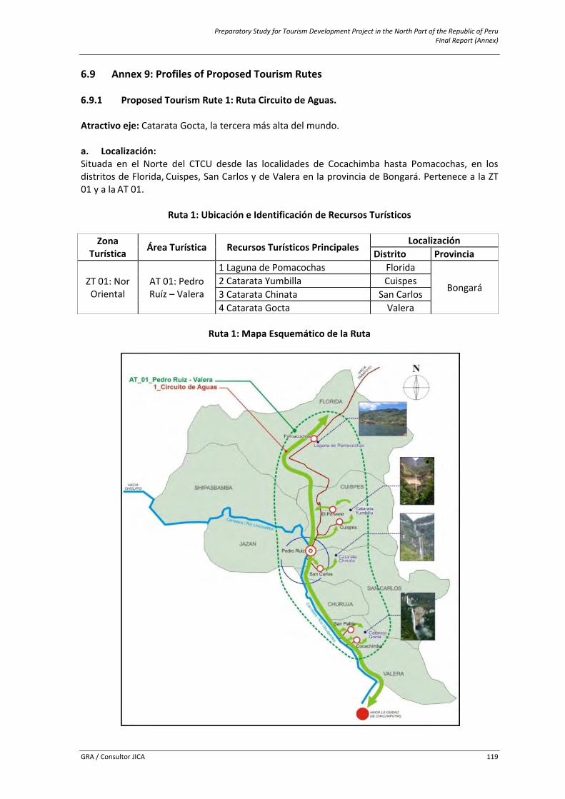
Preparatory Study for Tourism Development Project in the North Part of the Republic of Peru Final Report (Annex)
GRA / Consultor JICA 119
6.9 Annex 9: Profiles of Proposed Tourism Rutes 6.9.1 Proposed Tourism Rute 1: Ruta Circuito de Aguas. Atractivo eje: Catarata Gocta, la tercera más alta del mundo. a. Localización: Situada en el Norte del CTCU desde las localidades de Cocachimba hasta Pomacochas, en los distritos de Florida, Cuispes, San Carlos y de Valera en la provincia de Bongará. Pertenece a la ZT 01 y a la AT 01.
Ruta 1: Ubicación e Identificación de Recursos Turísticos
Zona Turística Área Turística Recursos Turísticos Principales
Localización Distrito Provincia
ZT 01: Nor Oriental
AT 01: Pedro Ruíz – Valera
1 Laguna de Pomacochas Florida
Bongará 2 Catarata Yumbilla Cuispes 3 Catarata Chinata San Carlos 4 Catarata Gocta Valera
Ruta 1: Mapa Esquemático de la Ruta
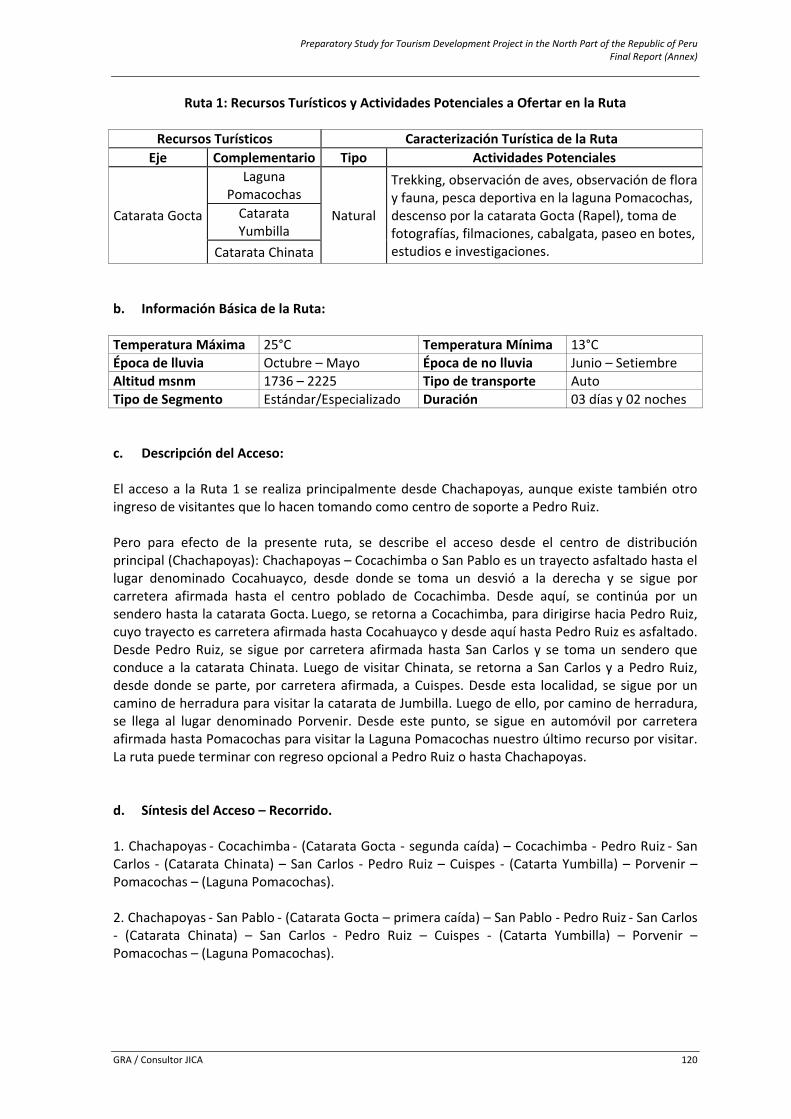
Preparatory Study for Tourism Development Project in the North Part of the Republic of Peru Final Report (Annex)
GRA / Consultor JICA 120
Ruta 1: Recursos Turísticos y Actividades Potenciales a Ofertar en la Ruta
Recursos Turísticos Caracterización Turística de la Ruta Eje Complementario Tipo Actividades Potenciales
Catarata Gocta
Laguna Pomacochas
Natural
Trekking, observación de aves, observación de flora y fauna, pesca deportiva en la laguna Pomacochas, descenso por la catarata Gocta (Rapel), toma de fotografías, filmaciones, cabalgata, paseo en botes, estudios e investigaciones.
Catarata Yumbilla
Catarata Chinata b. Información Básica de la Ruta: Temperatura Máxima 25°C Temperatura Mínima 13°C Época de lluvia Octubre – Mayo Época de no lluvia Junio – Setiembre Altitud msnm 1736 – 2225 Tipo de transporte Auto Tipo de Segmento Estándar/Especializado Duración 03 días y 02 noches c. Descripción del Acceso: El acceso a la Ruta 1 se realiza principalmente desde Chachapoyas, aunque existe también otro ingreso de visitantes que lo hacen tomando como centro de soporte a Pedro Ruiz. Pero para efecto de la presente ruta, se describe el acceso desde el centro de distribución principal (Chachapoyas): Chachapoyas – Cocachimba o San Pablo es un trayecto asfaltado hasta el lugar denominado Cocahuayco, desde donde se toma un desvió a la derecha y se sigue por carretera afirmada hasta el centro poblado de Cocachimba. Desde aquí, se continúa por un sendero hasta la catarata Gocta. Luego, se retorna a Cocachimba, para dirigirse hacia Pedro Ruiz, cuyo trayecto es carretera afirmada hasta Cocahuayco y desde aquí hasta Pedro Ruiz es asfaltado. Desde Pedro Ruiz, se sigue por carretera afirmada hasta San Carlos y se toma un sendero que conduce a la catarata Chinata. Luego de visitar Chinata, se retorna a San Carlos y a Pedro Ruiz, desde donde se parte, por carretera afirmada, a Cuispes. Desde esta localidad, se sigue por un camino de herradura para visitar la catarata de Jumbilla. Luego de ello, por camino de herradura, se llega al lugar denominado Porvenir. Desde este punto, se sigue en automóvil por carretera afirmada hasta Pomacochas para visitar la Laguna Pomacochas nuestro último recurso por visitar. La ruta puede terminar con regreso opcional a Pedro Ruiz o hasta Chachapoyas. d. Síntesis del Acceso – Recorrido. 1. Chachapoyas ‐ Cocachimba ‐ (Catarata Gocta ‐ segunda caída) – Cocachimba ‐ Pedro Ruiz ‐ San Carlos ‐ (Catarata Chinata) – San Carlos ‐ Pedro Ruiz – Cuispes ‐ (Catarta Yumbilla) – Porvenir – Pomacochas – (Laguna Pomacochas). 2. Chachapoyas ‐ San Pablo ‐ (Catarata Gocta – primera caída) – San Pablo ‐ Pedro Ruiz ‐ San Carlos ‐ (Catarata Chinata) – San Carlos ‐ Pedro Ruiz – Cuispes ‐ (Catarta Yumbilla) – Porvenir – Pomacochas – (Laguna Pomacochas).
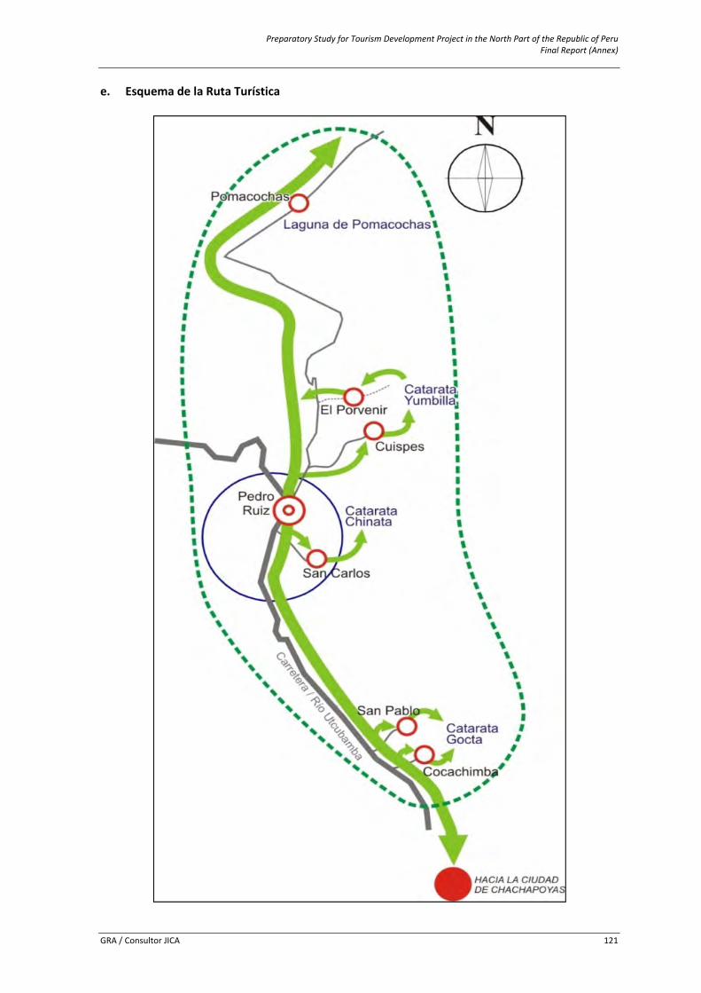
Preparatory Study for Tourism Development Project in the North Part of the Republic of Peru Final Report (Annex)
GRA / Consultor JICA 121
e. Esquema de la Ruta Turística
Preparatory Study for Tourism Development Project in the North Part of the Republic of Peru Final Report (Annex)
GRA / Consultor JICA 122
f. Centros de Soporte: Se detallan los centros de soporte con que dispone la Ruta en el cuadro siguiente. Dichos centros se han determinado teniendo en cuenta los servicios e infraestructura que se pueden encontrar en ellos y por la cercanía o relación directa con los recursos turísticos que conforman la ruta.
Ruta 1: Identificación de Centros de Soporte Asociados a la Ruta
Centros de Soporte Recursos Turísticos
Principales Centro de Distribución (ciudad soporte principal)
Centro de Estadía (ciudad soporte)
Centro de Escala (pueblo soporte)
Chachapoyas Pedro Ruíz
Pomacochas 1 Laguna Pomacochas El Porvenir
2 Catarata Yumbilla Cuispes
San Carlos 3 Catarata Chinata San Pablo
4 Catarata Gocta Cocachimba
g. Planta Turística Disponible: En la ruta, podemos encontrar diferentes servicios en varios lugares. En la gran mayoría de los lugares que se mencionan en el cuadro siguiente, existen servicios básicos como agua, luz y desagüe, además de otro tipo de instalaciones.
Ruta 1: Identificación de Servicios e Instalaciones en la Ruta
Servicios Tipo Lugar
Alojamiento
Hoteles, Hostales, Casas Hospedaje Chachapoyas, Pedro Ruiz, Pomacochas, Cocachimba
Casa hospedaje Cocachimba, San Pablo, San Carlos, Cuispes, Porvenir y Pomacochas
Alimentación Restaurantes y afines Chachapoyas, Cocachimba, San Pablo, Pedro Ruiz, San Carlos, Cuispes, Porvenir y Pomacochas
Esparcimiento Discotecas, Recreo Campestre Chachapoyas, Pedro Ruiz, Pomacochas
Transporte Agencias de viaje Chachapoyas, Pedro Ruiz
Otros servicios Centro de salud, Bancos, internet Chachapoyas, Pedro Ruiz y Pomacochas
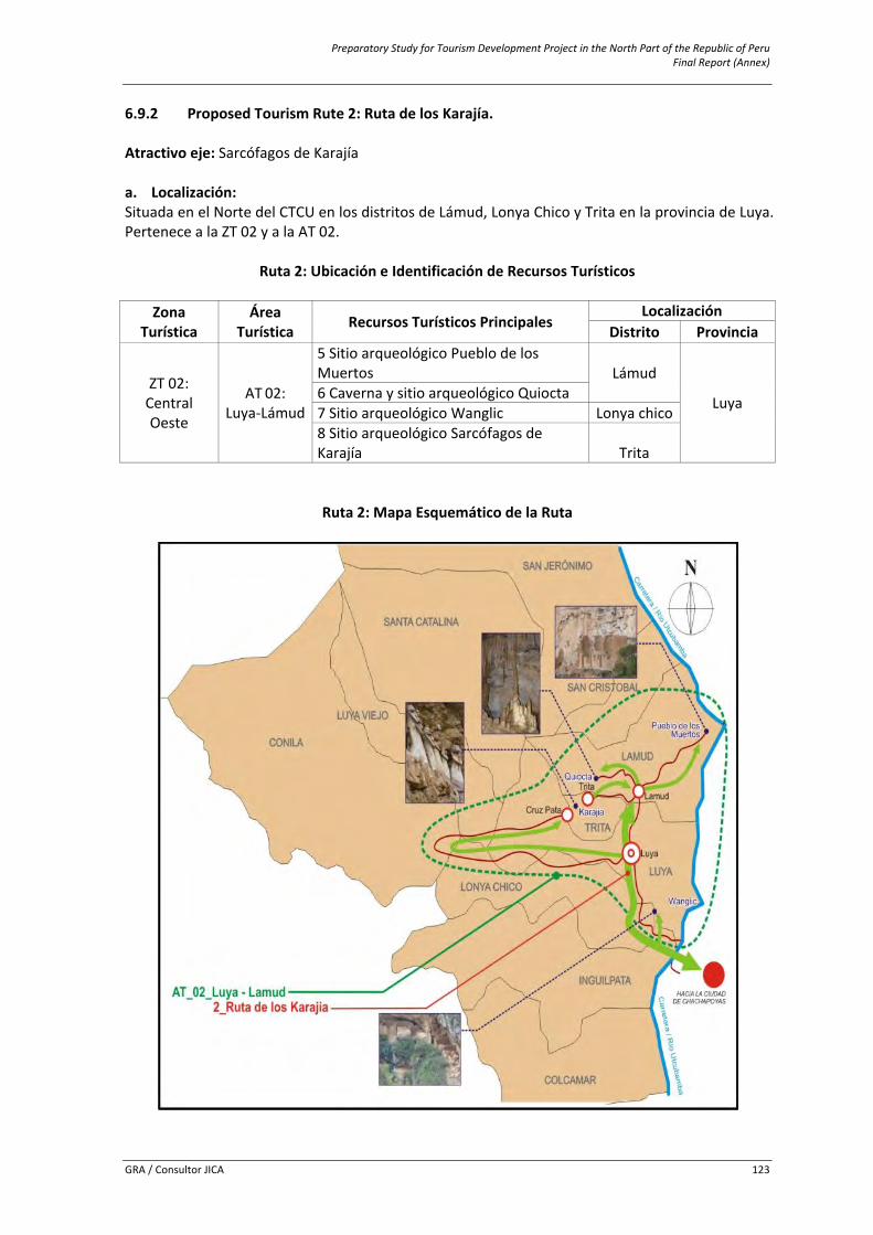
Preparatory Study for Tourism Development Project in the North Part of the Republic of Peru Final Report (Annex)
GRA / Consultor JICA 123
6.9.2 Proposed Tourism Rute 2: Ruta de los Karajía. Atractivo eje: Sarcófagos de Karajía a. Localización: Situada en el Norte del CTCU en los distritos de Lámud, Lonya Chico y Trita en la provincia de Luya. Pertenece a la ZT 02 y a la AT 02.
Ruta 2: Ubicación e Identificación de Recursos Turísticos
Zona Turística
Área Turística Recursos Turísticos Principales
Localización Distrito Provincia
ZT 02: Central Oeste
AT 02: Luya‐Lámud
5 Sitio arqueológico Pueblo de los Muertos Lámud
Luya 6 Caverna y sitio arqueológico Quiocta 7 Sitio arqueológico Wanglic Lonya chico 8 Sitio arqueológico Sarcófagos de Karajía Trita
Ruta 2: Mapa Esquemático de la Ruta
Preparatory Study for Tourism Development Project in the North Part of the Republic of Peru Final Report (Annex)
GRA / Consultor JICA 124
Ruta 2: Recursos Turísticos y Actividades Potenciales a Ofertar en la Ruta
Ruta Turística
Recursos turísticos Caracterización turística de la ruta Eje Complementario Tipo Actividades potenciales
2 Ruta de los Karajía
Sarcófagos de Karajía
Pueblo de los Muertos
Cultural / natural
Espeleología, Caminatas, toma de fotografías, observación de flora y fauna, filmaciones, cabalgata, estudio e investigaciones.
Caverna de Quiocta
Sitio arqueológico Wanglic
b. Información Básica de la Ruta:
c. Descripción del Acceso: El acceso a la Ruta 2 se realiza principalmente desde Chachapoyas, aunque existe también otro ingreso de visitantes que lo hacen tomando como centro de soporte a Pedro Ruiz. Pero para efecto de la presente ruta, se describe el acceso desde el centro de distribución principal: EL trayecto Chachapoyas – San Miguel de Cruzpata es asfaltado hasta el lugar denominado Cáclic. Desde este punto, se toma un desvió a la izquierda y se sigue por carretera afirmada hasta el centro poblado de San Miguel de Cruzpata, y se continua por un camino de herradura hasta la los Sarcofagos de Karajía. Luego de la visita, se retorna a Lámud, para dirigirnos hacia la Caverna de Quiocta, cuyo trayecto es un tramo carretera afirmada y otro tramo es un sendero que conduce hasta la Caverna (camino de 5 minutos). Después de conocer la Caverna, se retorna a Luya para seguir por carretera afirmada hasta el lugar de Tincas, y continuar por un sendero hasta el sitio arqueológico de Wanglic. Después de la visita, se retorna hacia Lámud para seguir por carretera afirmada por un tramo y luego caminar por un sendero hacia el Pueblo de los Muertos, último atractivo de la ruta 2. La ruta termina con regreso a Chachapoyas d. Síntesis del Acceso – Recorrido. Chachapoyas – San Miguel de Cruzpata ‐ (Sarcofagos de Karajía) – Lámud ‐ (Caverna de Quiocta) – Luya ‐ Tincas – (Pueblo de los Muertos).
Temperatura Máxima 23°C Temperatura Mínima 12°C Época de lluvia Octubre‐Mayo Época de no lluvia Junio ‐ Setiembre Altitud msnm 2339 ‐ 2728 Tipo de transporte Auto Tipo de Segmento Estándar/Especializado Duración 02 días y 01 noche
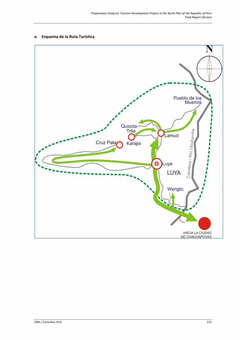
Preparatory Study for Tourism Development Project in the North Part of the Republic of Peru Final Report (Annex)
GRA / Consultor JICA 125
e. Esquema de la Ruta Turística
Preparatory Study for Tourism Development Project in the North Part of the Republic of Peru Final Report (Annex)
GRA / Consultor JICA 126
f. Centros de Soporte: Se detallan los centros de soporte con que dispone la Ruta en el cuadro siguiente. Dichos centros se han determinado teniendo en cuenta los servicios e infraestructura que se pueden encontrar en ellos y por la cercanía o relación directa con los recursos turísticos que conforman la ruta.
Ruta 2: Identificación de Centros de Soporte Asociados a la Ruta
Centros de Soporte Recursos Turísticos
Principales Centro de Distribución Centro de Estadía Centro de Escala(Ciudad Soporte Principal) (Ciudad Soporte) (Pueblo Soporte)
Chachapoyas Luya/Lámud
Lámud 5 Sitio arqueológico Pueblo de los Muertos 6 Caverna de Quiocta
Luya 7 Sitio arqueológico WanglicTrita 8 Sitio arqueológico
Sarcófagos de Karajía Cruzpata g. Planta Turística Disponible: En la ruta, podemos encontrar diferentes servicios en varios lugares. En la gran mayoría de los lugares que se mencionan en el cuadro siguiente, existen servicios básicos como agua, luz y desagüe, además de otro tipo de instalaciones.
Ruta 2: Identificación de Servicios e Instalaciones en la Ruta
Servicios Tipo Lugar
Alojamiento Hoteles, hostales, casas hospedaje Chachapoyas, Luya, Lámud Casa hospedaje Chachapoyas, Luya, Lámud
Alimentación Restaurantes y afines Chachapoyas, Luya, Lámud Esparcimiento Discotecas, recreo campestre Chachapoyas, Luya, Lámud Transporte Agencias de viaje Chachapoyas, Lámud Otros servicios Centro de salud, bancos, internet Chachapoyas, Luya, Lámud
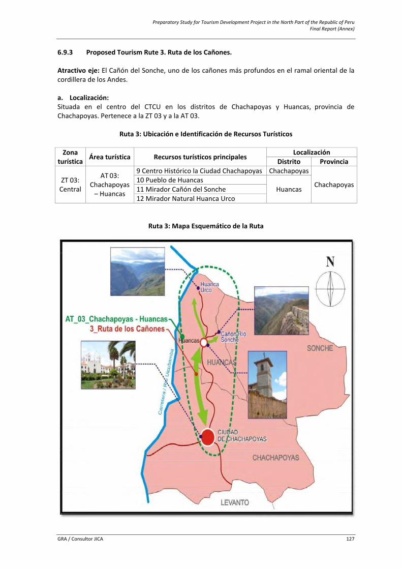
Preparatory Study for Tourism Development Project in the North Part of the Republic of Peru Final Report (Annex)
GRA / Consultor JICA 127
6.9.3 Proposed Tourism Rute 3. Ruta de los Cañones. Atractivo eje: El Cañón del Sonche, uno de los cañones más profundos en el ramal oriental de la cordillera de los Andes. a. Localización: Situada en el centro del CTCU en los distritos de Chachapoyas y Huancas, provincia de Chachapoyas. Pertenece a la ZT 03 y a la AT 03.
Ruta 3: Ubicación e Identificación de Recursos Turísticos Zona
turística Área turística Recursos turísticos principales Localización Distrito Provincia
ZT 03: Central
AT 03: Chachapoyas – Huancas
9 Centro Histórico la Ciudad Chachapoyas Chachapoyas
Chachapoyas10 Pueblo de Huancas Huancas 11 Mirador Cañón del Sonche
12 Mirador Natural Huanca Urco
Ruta 3: Mapa Esquemático de la Ruta
Preparatory Study for Tourism Development Project in the North Part of the Republic of Peru Final Report (Annex)
GRA / Consultor JICA 128
Ruta 3: Recursos Turísticos y Actividades Potenciales a Ofertar en la Ruta Recursos turísticos Caracterización Turística de la Ruta Eje Complementario Tipo Actividades Potenciales
Mirador Cañón del Río Sonche
C.H. de Ciudad de Chachapoyas
Cultural/ Natural
Caminatas (trekking), , observación de aves, observación de flora y fauna, toma de fotografías, filmaciones, estudio e investigaciones.
Pueblo de Huancas Mirador Natural Huanca Urco
b. Información básica de la Ruta:
Temperatura máxima 23°c Temperatura mínima 13°c Época de lluvia Octubre‐mayo Época de no lluvia Junio ‐ setiembre Altitud msnm 2334 – 2558 Tipo de transporte Auto Tipo de segmento Estándar/especializado Duración 01 día c. Descripción del Acceso: El recorrido se inicia en Chachapoyas a través de una carretera afirmada hasta el pueblo de Huancas donde se visita la Plaza principal, el Templo matriz, las casas tradicionales y el centro artesanal La Cusana. Luego de ello, se recorre una carretera afirmada al Mirador Cañón del Río Sonche y al Mirador Natural Huanca Urco. Después de terminar el recorrido en Huancas, se retorna a la ciudad de Chachapoyas para visitar los siguientes atractivos: Mirador Luya Urco, Poso de Yana Yacu, Templo de la Virgen Asunta, museo étnico religioso e histórico de Santa Ana, casa de Don Toribio Rodríguez de Mendoza (Obispado), Plaza Mayor, casona Monsante, Casa de las Dos Rosas, parque del Niño de Belén, templo de Nuestra Señora de Belén, templo del Señor de la Buena Muerte, santuario histórico de Higos Urco, camino Pre Hispánico Chachapoyas ‐ Moyobamba, plazuela de Burgos o Plazuela de la Independencia y la sala de exhibición itinerante del INC, donde acabará nuestro recorrido. d. Síntesis del Acceso – Recorrido. Chachapoyas ‐ Huancas ‐ Mirador Cañón del Río Sonche – Mirador Natural Huanca urco – Chachapoyas.
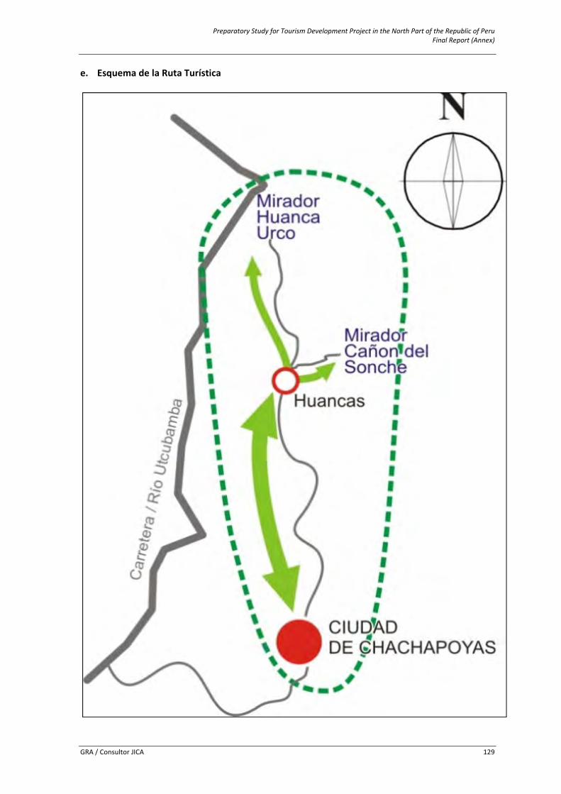
Preparatory Study for Tourism Development Project in the North Part of the Republic of Peru Final Report (Annex)
GRA / Consultor JICA 129
e. Esquema de la Ruta Turística
Preparatory Study for Tourism Development Project in the North Part of the Republic of Peru Final Report (Annex)
GRA / Consultor JICA 130
f. Centros de Soporte: Se detallan los centros de soporte con que dispone la Ruta en el cuadro siguiente. Dichos centros se han determinado teniendo en cuenta los servicios e infraestructura que se pueden encontrar en ellos y por la cercanía o relación directa con los recursos turísticos que conforman la ruta.
Ruta 3: Identificación de Centros de Soporte Asociados a la Ruta
Centros de Soporte Recursos Turísticos
Principales Centro de Distribución Centro de Estadía Centro de Escala
(Ciudad Soporte Principal) (Ciudad Soporte) (Pueblo Soporte)
Chachapoyas Chachapoyas
Chachapoyas 9 Centro Histórico Ciudad de Chachapoyas
Huancas
10 Pueblo de Huancas 11 Mirador Cañon del Río Sonche 12 Mirador Natural Huanca Urco
g. Planta turística disponible: En la ruta, podemos encontrar diferentes servicios en varios lugares. En la gran mayoría de los lugares que se mencionan en el cuadro siguiente, existen servicios básicos como agua, luz y desagüe, además de otro tipo de instalaciones.
Ruta 3: Identificación de Servicios e Instalaciones en la Ruta
Servicios Tipo Lugar
Alojamiento Hoteles, hostales, casas hospedaje
Chachapoyas
Casa hospedajeAlimentación Restaurantes y afinesEsparcimiento Discotecas, recreo campestreTransporte Agencias de viajeOtros servicios Centro de salud, bancos, internet
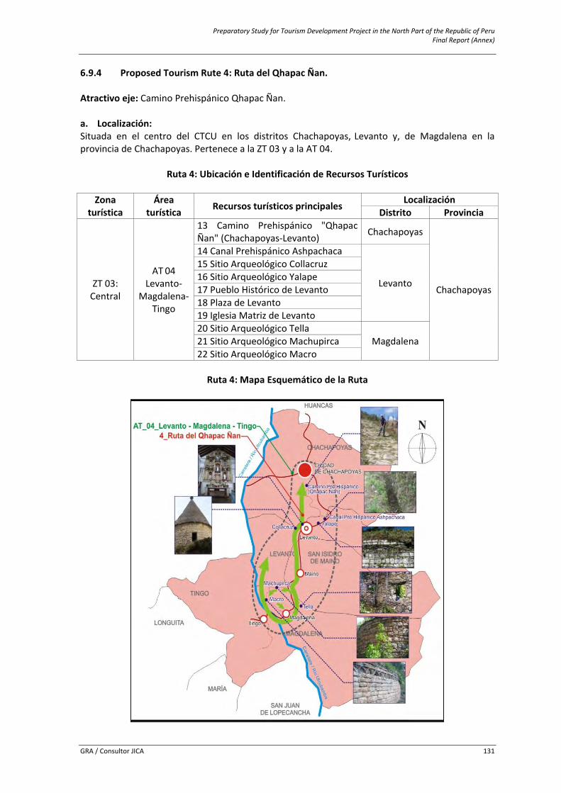
Preparatory Study for Tourism Development Project in the North Part of the Republic of Peru Final Report (Annex)
GRA / Consultor JICA 131
6.9.4 Proposed Tourism Rute 4: Ruta del Qhapac Ñan. Atractivo eje: Camino Prehispánico Qhapac Ñan. a. Localización: Situada en el centro del CTCU en los distritos Chachapoyas, Levanto y, de Magdalena en la provincia de Chachapoyas. Pertenece a la ZT 03 y a la AT 04.
Ruta 4: Ubicación e Identificación de Recursos Turísticos
Ruta 4: Mapa Esquemático de la Ruta
Zona turística
Área turística Recursos turísticos principales Localización
Distrito Provincia
ZT 03: Central
AT 04 Levanto‐
Magdalena‐Tingo
13 Camino Prehispánico "Qhapac Ñan" (Chachapoyas‐Levanto) Chachapoyas
Chachapoyas
14 Canal Prehispánico Ashpachaca
Levanto
15 Sitio Arqueológico Collacruz 16 Sitio Arqueológico Yalape 17 Pueblo Histórico de Levanto 18 Plaza de Levanto 19 Iglesia Matriz de Levanto 20 Sitio Arqueológico Tella
Magdalena 21 Sitio Arqueológico Machupirca 22 Sitio Arqueológico Macro
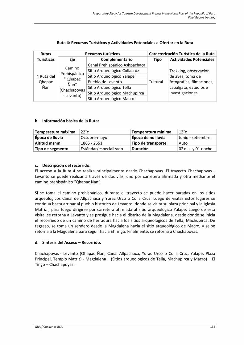
Preparatory Study for Tourism Development Project in the North Part of the Republic of Peru Final Report (Annex)
GRA / Consultor JICA 132
Ruta 4: Recursos Turísticos y Actividades Potenciales a Ofertar en la Ruta
Rutas Turísticas
Recursos turísticos Caracterización Turística de la RutaEje Complementario Tipo Actividades Potenciales
4 Ruta del Qhapac Ñan
Camino Prehispánico " Qhapac Ñan"
(Chachapoyas ‐ Levanto)
Canal Prehispánico Ashpachaca
Cultural
Trekking, observación de aves, toma de fotografías, filmaciones, cabalgata, estudios e investigaciones.
Sitio Arqueológico Collacruz Sitio Arqueológico Yalape Pueblo de Levanto Sitio Arqueológico Tella Sitio Arqueológico MachupircaSitio Arqueológico Macro
b. Información básica de la Ruta:
Temperatura máxima 22°c Temperatura mínima 12°c Época de lluvia Octubre‐mayo Época de no lluvia Junio ‐ setiembre Altitud msnm 1865 ‐ 2651 Tipo de transporte Auto Tipo de segmento Estándar/especializado Duración 02 días y 01 noche c. Descripción del recorrido: El acceso a la Ruta 4 se realiza principalmente desde Chachapoyas. El trayecto Chachapoyas – Levanto se puede realizar a través de dos vías, uno por carretera afirmada y otra mediante el camino prehispánico “Qhapac Ñan”. Si se toma el camino prehispánico, durante el trayecto se puede hacer paradas en los sitios arqueológicos Canal de Allpachaca y Yurac Urco o Colla Cruz. Luego de visitar estos lugares se continua hasta arribar al pueblo histórico de Levanto, donde se visita su plaza principal y la Iglesia Matriz , para luego dirigirse por carretera afirmada al sitio arqueológico Yalape. Luego de esta visita, se retorna a Levanto y se prosigue hacia el distrito de la Magdalena, desde donde se inicia el recorriedo de un camino de herradura hacia los sitios arqueológicos de Tella, Machupirca. De regreso, se toma un sendero desde la Magdalena hacia el sitio arqueológico de Macro, y se se retorna a la Magdalena para seguir hacia El Tingo. Finalmente, se retorna a Chachapoyas. d. Síntesis del Acceso – Recorrido. Chachapoyas ‐ Levanto (Qhapac Ñan, Canal Allpachaca, Yurac Urco o Colla Cruz, Yalape, Plaza Principal, Templo Matriz) ‐ Magdalena – (Sitios arqueológicos de Tella, Machupirca y Macro) – El Tingo – Chachapoyas.
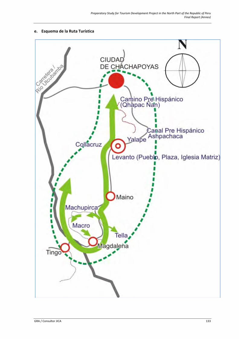
Preparatory Study for Tourism Development Project in the North Part of the Republic of Peru Final Report (Annex)
GRA / Consultor JICA 133
e. Esquema de la Ruta Turística
Preparatory Study for Tourism Development Project in the North Part of the Republic of Peru Final Report (Annex)
GRA / Consultor JICA 134
f. Centros de soporte: Se detallan los centros de soporte con que dispone la Ruta en el cuadro siguiente. Dichos centros se han determinado teniendo en cuenta los servicios e infraestructura que se pueden encontrar en ellos y por la cercanía o relación directa con los recursos turísticos que conforman la ruta.
Ruta 4: Identificación de Centros de Soporte Asociados a la Ruta
Centros de soporte
Recursos Turísticos Principales
Centro DE Distribución
(Ciudad Soporte Principal)
Centro DE Estadía (Ciudad Soporte)
Centro DE Escala (Pueblo Soporte)
Chachapoyas Levanto
Levanto
13 Camino Prehispánico "Qhapac Ñan" (Chachapoyas‐Levanto) 14 Canal Prehispánico Ashpachaca15 Sitio Arqueológico Collacruz 16 Sitio Arqueológico Yalape 17 Pueblo de Levanto 18 Plaza de Levanto 19 Iglesia Matriz de Levanto
Magdalena 20 Sitio Arqueológico Tella 21 Sitio Arqueológico Machupirca22 Sitio Arqueológico Macro
g. Planta turística disponible: En la ruta, podemos encontrar diferentes servicios en varios lugares. En la gran mayoría de los lugares que se mencionan en el cuadro siguiente, existen servicios básicos como agua, luz y desagüe, además de otro tipo de servicios e instalaciones.
Ruta 4: Identificación de Servicios e Instalaciones en la Ruta
Servicios Tipo Lugar
Alojamiento Hoteles, hostales, casas hospedaje Chachapoyas, levanto, magdalenaCasa hospedaje Levanto, magdalena
Alimentación Restaurantes y afines Chachapoyas, levanto, magdalenaEsparcimiento Discotecas, recreo campestre ChachapoyasTransporte Agencias de viaje ChachapoyasOtros servicios Centro de salud, bancos, internet Chachapoyas
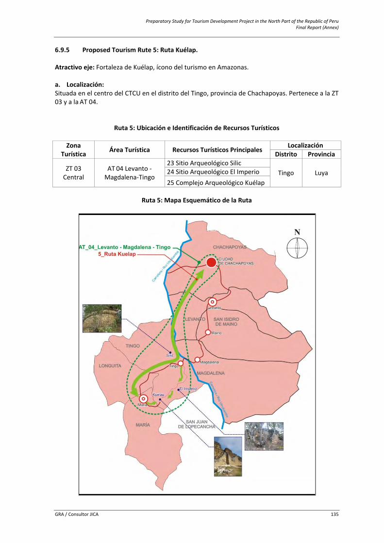
Preparatory Study for Tourism Development Project in the North Part of the Republic of Peru Final Report (Annex)
GRA / Consultor JICA 135
6.9.5 Proposed Tourism Rute 5: Ruta Kuélap. Atractivo eje: Fortaleza de Kuélap, ícono del turismo en Amazonas. a. Localización: Situada en el centro del CTCU en el distrito del Tingo, provincia de Chachapoyas. Pertenece a la ZT 03 y a la AT 04.
Ruta 5: Ubicación e Identificación de Recursos Turísticos
Zona
Turística Área Turística Recursos Turísticos Principales Localización Distrito Provincia
ZT 03 Central
AT 04 Levanto ‐Magdalena‐Tingo
23 Sitio Arqueológico Silic Tingo Luya 24 Sitio Arqueológico El Imperio
25 Complejo Arqueológico Kuélap
Ruta 5: Mapa Esquemático de la Ruta
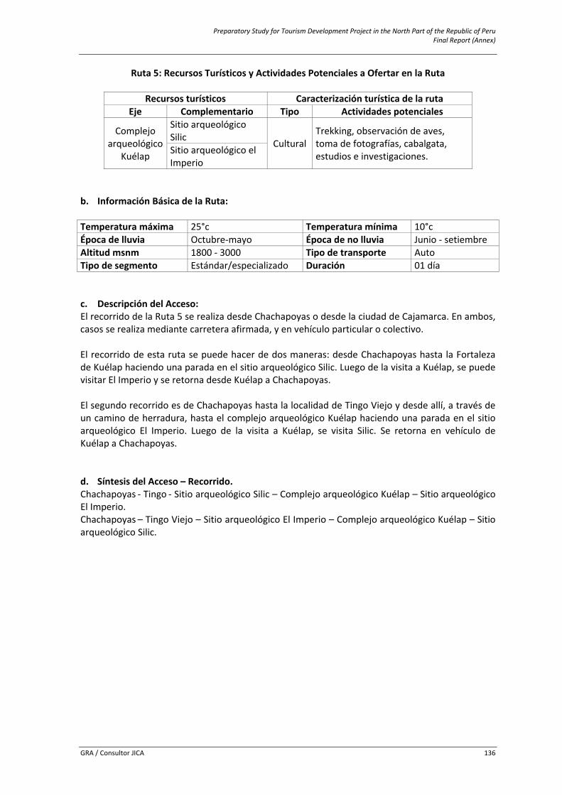
Preparatory Study for Tourism Development Project in the North Part of the Republic of Peru Final Report (Annex)
GRA / Consultor JICA 136
Ruta 5: Recursos Turísticos y Actividades Potenciales a Ofertar en la Ruta
Recursos turísticos Caracterización turística de la ruta Eje Complementario Tipo Actividades potenciales
Complejo arqueológico
Kuélap
Sitio arqueológico Silic Cultural
Trekking, observación de aves, toma de fotografías, cabalgata, estudios e investigaciones. Sitio arqueológico el
Imperio b. Información Básica de la Ruta: Temperatura máxima 25°c Temperatura mínima 10°c Época de lluvia Octubre‐mayo Época de no lluvia Junio ‐ setiembre Altitud msnm 1800 ‐ 3000 Tipo de transporte Auto Tipo de segmento Estándar/especializado Duración 01 día c. Descripción del Acceso: El recorrido de la Ruta 5 se realiza desde Chachapoyas o desde la ciudad de Cajamarca. En ambos, casos se realiza mediante carretera afirmada, y en vehículo particular o colectivo. El recorrido de esta ruta se puede hacer de dos maneras: desde Chachapoyas hasta la Fortaleza de Kuélap haciendo una parada en el sitio arqueológico Silic. Luego de la visita a Kuélap, se puede visitar El Imperio y se retorna desde Kuélap a Chachapoyas. El segundo recorrido es de Chachapoyas hasta la localidad de Tingo Viejo y desde allí, a través de un camino de herradura, hasta el complejo arqueológico Kuélap haciendo una parada en el sitio arqueológico El Imperio. Luego de la visita a Kuélap, se visita Silic. Se retorna en vehículo de Kuélap a Chachapoyas. d. Síntesis del Acceso – Recorrido. Chachapoyas ‐ Tingo ‐ Sitio arqueológico Silic – Complejo arqueológico Kuélap – Sitio arqueológico El Imperio. Chachapoyas – Tingo Viejo – Sitio arqueológico El Imperio – Complejo arqueológico Kuélap – Sitio arqueológico Silic.
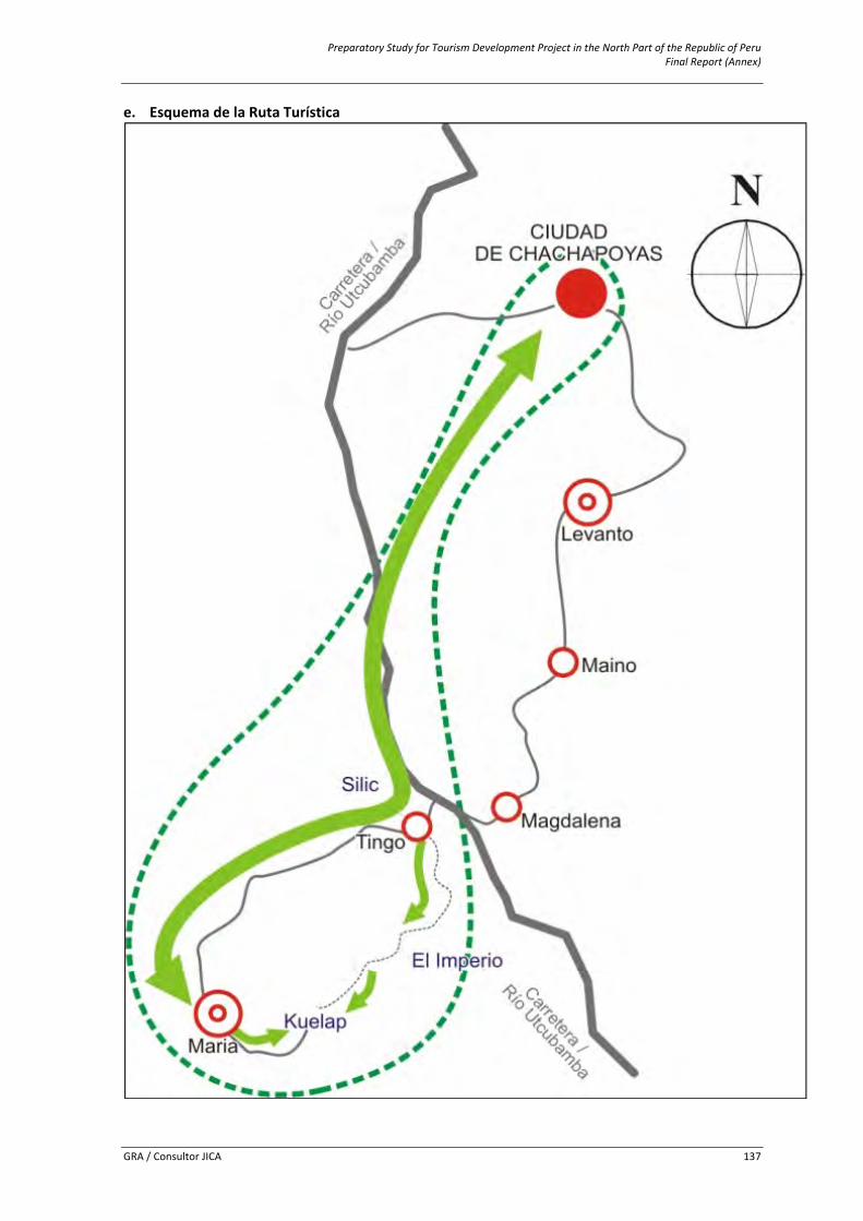
Preparatory Study for Tourism Development Project in the North Part of the Republic of Peru Final Report (Annex)
GRA / Consultor JICA 137
e. Esquema de la Ruta Turística
Preparatory Study for Tourism Development Project in the North Part of the Republic of Peru Final Report (Annex)
GRA / Consultor JICA 138
f. Centros de Soporte Se detallan los centros de soporte con que dispone la Ruta en el cuadro siguiente. Dichos centros se han determinado teniendo en cuenta los servicios e infraestructura que se pueden encontrar en ellos y por la cercanía o relación directa con los recursos turísticos que conforman la ruta.
Ruta 5: Identificación de Centros de Soporte Asociados a la Ruta
Productos Turísticos
Centros de Soporte
Recursos Turísticos Principales Centro de Distribución
Centro de Estadía
Centro de Escala
(Ciudad Soporte Principal)
(Ciudad Soporte)
(Pueblo Soporte)
5 ruta Kuélap Chachapoyas María
Tingo bajo/nuevo
tingo
23 Sitio Arqueológico Silic 24 Sitio Arqueológico el Imperio 25 Complejo Arqueológico Kuélap
g. Planta Turística Disponible En la ruta, podemos encontrar diferentes servicios en varios lugares. En la gran mayoría de los lugares que se mencionan en el cuadro siguiente, existen servicios básicos como agua, luz y desagüe, además de otro tipo de instalaciones.
Ruta 5: Identificación de Servicios e Instalaciones en la Ruta
Servicios Tipo Lugar Alojamiento Hoteles, hostales, casas hospedaje
Chachapoyas, Tingo María Alimentación Restaurantes y afines
Esparcimiento Dicotecas, recreo campestreChachapoyas Transporte Agencias de viaje
Otros servicios Centro de salud, bancos, internet
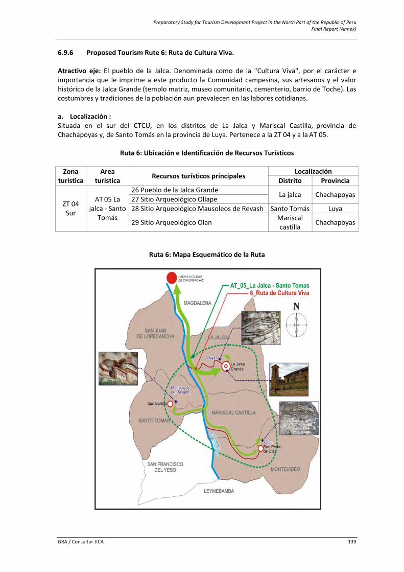
Preparatory Study for Tourism Development Project in the North Part of the Republic of Peru Final Report (Annex)
GRA / Consultor JICA 139
6.9.6 Proposed Tourism Rute 6: Ruta de Cultura Viva. Atractivo eje: El pueblo de la Jalca. Denominada como de la "Cultura Viva", por el carácter e importancia que le imprime a este producto la Comunidad campesina, sus artesanos y el valor histórico de la Jalca Grande (templo matriz, museo comunitario, cementerio, barrio de Toche). Las costumbres y tradiciones de la población aun prevalecen en las labores cotidianas. a. Localización : Situada en el sur del CTCU, en los distritos de La Jalca y Mariscal Castilla, provincia de Chachapoyas y, de Santo Tomás en la provincia de Luya. Pertenece a la ZT 04 y a la AT 05.
Ruta 6: Ubicación e Identificación de Recursos Turísticos Zona
turística Area
turística Recursos turísticos principales Localización Distrito Provincia
ZT 04 Sur
AT 05 La jalca ‐ Santo
Tomás
26 Pueblo de la Jalca Grande La jalca Chachapoyas27 Sitio Arqueológico Ollape 28 Sitio Arqueológico Mausoleos de Revash Santo Tomás Luya
29 Sitio Arqueológico Olan Mariscal castilla Chachapoyas
Ruta 6: Mapa Esquemático de la Ruta
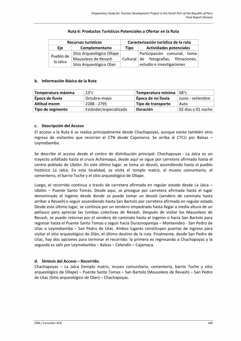
Preparatory Study for Tourism Development Project in the North Part of the Republic of Peru Final Report (Annex)
GRA / Consultor JICA 140
Ruta 6: Productos Turísticos Potenciales a Ofertar en la Ruta
Recursos turísticos Caracterización turística de la ruta Eje Complementario Tipo Actividades potenciales
Pueblo de la Jalca
Sitio Arqueológico OllapeCultural
Participación comunal, toma de fotografías, filmaciones, estudio e investigaciones
Mausoleos de Revash Sitio Arqueológico Olan
b. Información Básica de la Ruta Temperatura máxima 23°c Temperatura mínima 08°c Época de lluvia Octubre‐mayo Época de no lluvia Junio ‐ setiembre Altitud msnm 2288 ‐ 2795 Tipo de transporte Auto Tipo de segmento Estándar/especializado Duración 02 días y 01 noche c. Descripción del Acceso El acceso a la Ruta 6 se realiza principalmente desde Chachapoyas, aunque existe también otro ingreso de visitantes que recorren el CTN desde Cajamarca. Se arriba al CTCU por Balsas – Leymebamba. Se describe el acceso desde el centro de distribución principal: Chachapoyas ‐ La Jalca es un trayecto asfaltado hasta el cruce Achamaqui, desde aquí se sigue por carretera afirmada hasta el centro poblado de Ubilón. En este último lugar, se toma un desvió, ascendiendo hasta el pueblo histórico La Jalca. En esta localidad, se visita el templo matriz, el museo comunitario, el cementerio, el barrio Toche y el sitio arqueológico de Ollape.
Luego, el recorrido continua a través de carretera afirmada en regular estado desde La Jalca – Ubilón – Puente Santo Tomás. Desde aquí, se prosigue por carretera afirmada hasta el lugar denominado el Ingenio desde donde se puede tomar un desvió (sendero de caminata hasta arribar a Revash) o seguir ascendiendo hasta San Bartolo por carretera afirmada en regular estado. Desde este último lugar, se continúa por un sendero empedrado hasta llegar a media altura de un peñasco para apreciar las tumbas colectivas de Revash. Después de visitar los Mausoleos de Revash, se puede retornar por el sendero de caminata hasta el Ingenio o hacia San Bartolo para regresar hasta el Puente Santo Tomas y seguir hacia Duraznopampa – Montevideo ‐ San Pedro de Utac o Leymebamba – San Pedro de Utac. Ambos lugares constituyen puertas de ingreso para visitar el sitio arqueológico de Olán, el último destino de la ruta. Finalmente, desde San Pedro de Utac, hay dos opciones para terminar el recorrido: la primera es regresando a Chachapoyas y la segunda es salir por Leymebamba – Balzas – Celendín – Cajamaca. d. Síntesis del Acceso – Recorrido. Chachapoyas – La Jalca (templo matriz, museo comunitario, cementerio, barrio Toche y sitio arqueológico de Ollape) – Puente Santo Tomas – San Bartolo (Mausoleos de Revash) – San Pedro de Utac (Sitio arqueológico de Olan) – Chachapoyas.
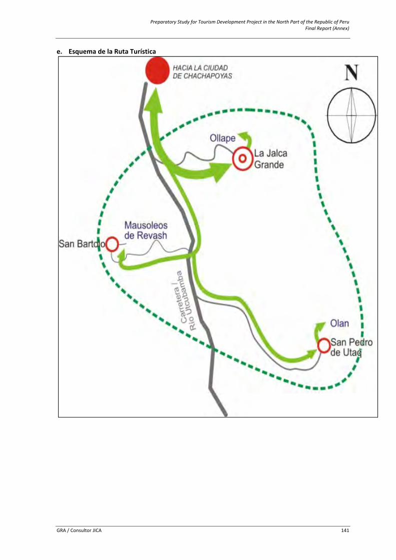
Preparatory Study for Tourism Development Project in the North Part of the Republic of Peru Final Report (Annex)
GRA / Consultor JICA 141
e. Esquema de la Ruta Turística

Preparatory Study for Tourism Development Project in the North Part of the Republic of Peru Final Report (Annex)
GRA / Consultor JICA 142
f. Centros de soporte Se detallan los centros de soporte con que dispone la Ruta en el cuadro siguiente. Dichos centros se han determinado teniendo en cuenta los servicios e infraestructura que se pueden encontrar en ellos y por la cercanía o relación directa con los recursos turísticos que conforman la ruta.
Ruta 6: Identificación de Centros de Soporte Asociados a la Ruta
Centros de soporte
Recursos Turísticos Principales Centro de Distribución(Ciudad Soporte Principal)
Centro de Estadía(Ciudad
Soporte)
Centro de Escala (Pueblo
Soporte)
Chachapoyas La jalca
La jalca 26 Pueblo de la Jalca Grande 27 Sitio Arqueológico Ollape
San Pedro de Utaq
28 Sitio Arqueológico Mausoleos de Revash
San Bartolo 29 Sitio Arqueológico Olán g. Planta turística disponible En la ruta, podemos encontrar diferentes servicios en varios lugares. En la gran mayoría de los lugares que se mencionan en el cuadro, existen servicios básicos como agua, luz y desagüe, además de otro tipo de instalaciones.
Ruta 6: Identificación de Servicios e Instalaciones en la Ruta
Servicios Tipo Lugar
Alojamiento Hotel Casa Hospedaje
Chachapoyas, La Jalca Grande, Santo Tomas/San Bartolo, Yerbabuena, Duraznopampa, Montevideo, Leymebamba.
Alimentación Restaurantes y Afines Chachapoyas, La Jalca Grande, Santo Tomas/San Bartolo, Yerbabuena, Duraznopampa, Montevideo, Leymebamba.
Transporte Agencias de Viaje Chachapoyas
Otros Servicios Centro de Salud, Bancos, Internet
Chachapoyas, La Jalca Grande, Santo Tomas/San Bartolo, Yerbabuena, Duraznopampa, Montevideo, Leymebamba.
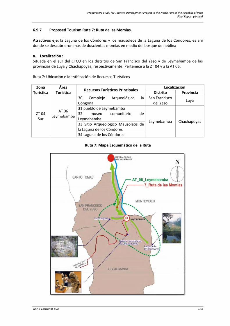
Preparatory Study for Tourism Development Project in the North Part of the Republic of Peru Final Report (Annex)
GRA / Consultor JICA 143
6.9.7 Proposed Tourism Rute 7: Ruta de las Momias. Atractivos eje: la Laguna de los Cóndores y los mausoleos de la Laguna de los Cóndores, es ahí donde se descubrieron más de doscientas momias en medio del bosque de neblina a. Localización : Situada en el sur del CTCU en los distritos de San Francisco del Yeso y de Leymebamba de las provincias de Luya y Chachapoyas, respectivamente. Pertenece a la ZT 04 y a la AT 06. Ruta 7: Ubicación e Identificación de Recursos Turísticos Zona
Turística Área
Turística Recursos Turísticos Principales Localización Distrito Provincia
ZT 04 Sur
AT 06 Leymebamba
30 Complejo Arqueológico la Congona
San Francisco del Yeso Luya
31 pueblo de Leymebamba
Leymebamba
Chachapoyas
32 museo comunitario de Leymebamba 33 Sitio Arqueológico Mausoleos de la Laguna de los Cóndores 34 Laguna de los Cóndores
Ruta 7: Mapa Esquemático de la Ruta
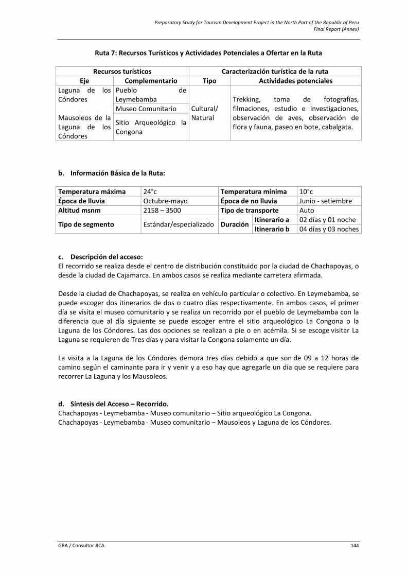
Preparatory Study for Tourism Development Project in the North Part of the Republic of Peru Final Report (Annex)
GRA / Consultor JICA 144
Ruta 7: Recursos Turísticos y Actividades Potenciales a Ofertar en la Ruta
Recursos turísticos Caracterización turística de la ruta Eje Complementario Tipo Actividades potenciales
Laguna de los Cóndores Mausoleos de la Laguna de los Cóndores
Pueblo de Leymebamba
Cultural/ Natural
Trekking, toma de fotografías, filmaciones, estudio e investigaciones, observación de aves, observación de flora y fauna, paseo en bote, cabalgata.
Museo Comunitario
Sitio Arqueológico la Congona
b. Información Básica de la Ruta:
Temperatura máxima 24°c Temperatura mínima 10°c Época de lluvia Octubre‐mayo Época de no lluvia Junio ‐ setiembre Altitud msnm 2158 – 3500 Tipo de transporte Auto
Tipo de segmento Estándar/especializado Duración Itinerario a 02 días y 01 nocheItinerario b 04 días y 03 noches
c. Descripción del acceso: El recorrido se realiza desde el centro de distribución constituido por la ciudad de Chachapoyas, o desde la ciudad de Cajamarca. En ambos casos se realiza mediante carretera afirmada. Desde la ciudad de Chachapoyas, se realiza en vehículo particular o colectivo. En Leymebamba, se puede escoger dos itinerarios de dos o cuatro días respectivamente. En ambos casos, el primer día se visita el museo comunitario y se realiza un recorrido por el pueblo de Leymebamba con la diferencia que al día siguiente se puede escoger entre el sitio arqueológico La Congona o la Laguna de los Cóndores. Las dos opciones se realizan a pie o en acémila. Si se escoge visitar La Laguna se requieren de Tres días y para visitar la Congona solamente un día. La visita a la Laguna de los Cóndores demora tres días debido a que son de 09 a 12 horas de camino según el caminante para ir y venir y a eso hay que agregarle un día que se requiere para recorrer La Laguna y los Mausoleos. d. Síntesis del Acceso – Recorrido. Chachapoyas ‐ Leymebamba ‐ Museo comunitario – Sitio arqueológico La Congona. Chachapoyas ‐ Leymebamba ‐ Museo comunitario – Mausoleos y Laguna de los Cóndores.
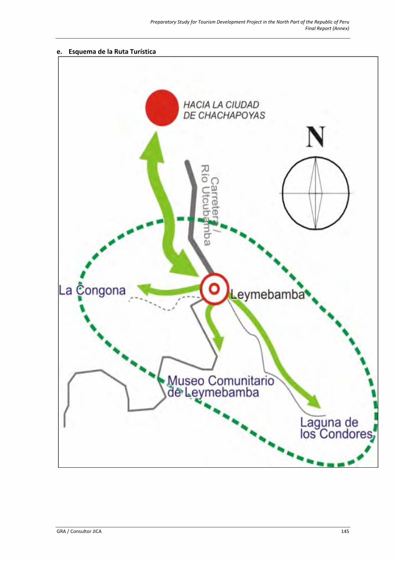
Preparatory Study for Tourism Development Project in the North Part of the Republic of Peru Final Report (Annex)
GRA / Consultor JICA 145
e. Esquema de la Ruta Turística
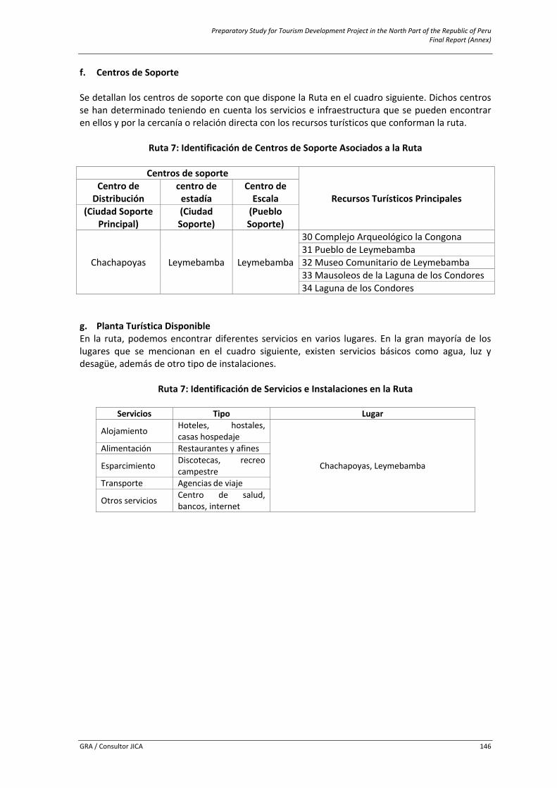
Preparatory Study for Tourism Development Project in the North Part of the Republic of Peru Final Report (Annex)
GRA / Consultor JICA 146
f. Centros de Soporte Se detallan los centros de soporte con que dispone la Ruta en el cuadro siguiente. Dichos centros se han determinado teniendo en cuenta los servicios e infraestructura que se pueden encontrar en ellos y por la cercanía o relación directa con los recursos turísticos que conforman la ruta.
Ruta 7: Identificación de Centros de Soporte Asociados a la Ruta
Centros de soporte
Recursos Turísticos Principales Centro de Distribución
centro de estadía
Centro de Escala
(Ciudad Soporte Principal)
(Ciudad Soporte)
(Pueblo Soporte)
Chachapoyas Leymebamba Leymebamba
30 Complejo Arqueológico la Congona 31 Pueblo de Leymebamba 32 Museo Comunitario de Leymebamba 33 Mausoleos de la Laguna de los Condores 34 Laguna de los Condores
g. Planta Turística Disponible En la ruta, podemos encontrar diferentes servicios en varios lugares. En la gran mayoría de los lugares que se mencionan en el cuadro siguiente, existen servicios básicos como agua, luz y desagüe, además de otro tipo de instalaciones.
Ruta 7: Identificación de Servicios e Instalaciones en la Ruta
Servicios Tipo Lugar
Alojamiento Hoteles, hostales, casas hospedaje
Chachapoyas, Leymebamba
Alimentación Restaurantes y afines
Esparcimiento Discotecas, recreo campestre
Transporte Agencias de viaje
Otros servicios Centro de salud, bancos, internet

Preparatory Study for Tourism Development Project in the North Part of the Republic of Peru Final Report (Annex)
GRA / Consultor JICA 147
6.10 Annex 10: Facilities and Tourism Services Registered facilities and tourism services are presented in this section. The inventory list of a) accomodations, b) restuaurants, cafeterias and bars and c) travel agencies are presented by Province (Bongará, Chachapoyas and Luya) as follows.
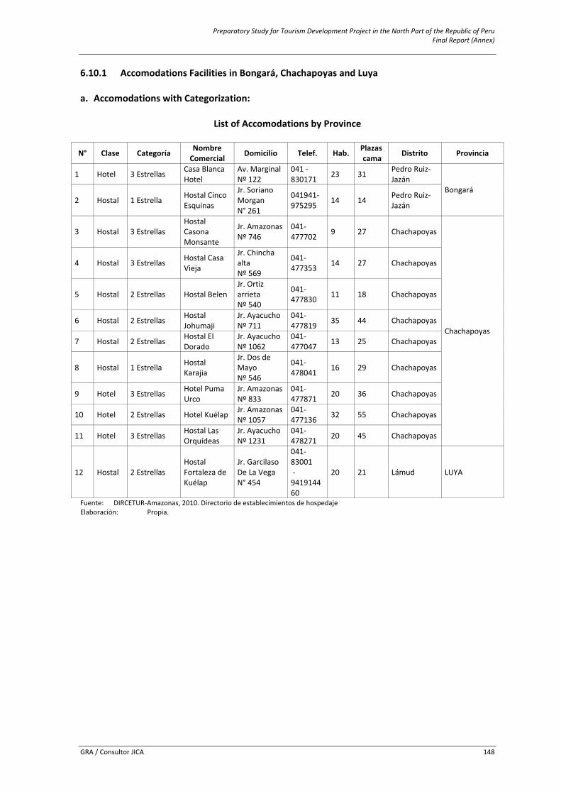
Preparatory Study for Tourism Development Project in the North Part of the Republic of Peru Final Report (Annex)
GRA / Consultor JICA 148
6.10.1 Accomodations Facilities in Bongará, Chachapoyas and Luya a. Accomodations with Categorization:
List of Accomodations by Province
N° Clase Categoría Nombre Comercial Domicilio Telef. Hab. Plazas
cama Distrito Provincia
1 Hotel 3 Estrellas Casa Blanca Hotel
Av. Marginal Nº 122
041 ‐ 830171 23 31 Pedro Ruiz‐
Jazán Bongará
2 Hostal 1 Estrella Hostal Cinco Esquinas
Jr. Soriano Morgan N° 261
041941‐975295 14 14 Pedro Ruiz‐
Jazán
3 Hostal 3 Estrellas Hostal Casona Monsante
Jr. Amazonas Nº 746
041‐477702 9 27 Chachapoyas
Chachapoyas
4 Hostal 3 Estrellas Hostal Casa Vieja
Jr. Chincha alta Nº 569
041‐477353 14 27 Chachapoyas
5 Hostal 2 Estrellas Hostal Belen Jr. Ortiz arrieta Nº 540
041‐477830 11 18 Chachapoyas
6 Hostal 2 Estrellas Hostal Johumaji
Jr. Ayacucho Nº 711
041‐477819 35 44 Chachapoyas
7 Hostal 2 Estrellas Hostal El Dorado
Jr. Ayacucho Nº 1062
041‐477047 13 25 Chachapoyas
8 Hostal 1 Estrella Hostal Karajia
Jr. Dos de Mayo Nº 546
041‐478041 16 29 Chachapoyas
9 Hotel 3 Estrellas Hotel Puma Urco
Jr. Amazonas Nº 833
041‐ 477871 20 36 Chachapoyas
10 Hotel 2 Estrellas Hotel Kuélap Jr. Amazonas Nº 1057
041‐477136 32 55 Chachapoyas
11 Hotel 3 Estrellas Hostal Las Orquídeas
Jr. Ayacucho Nº 1231
041‐478271 20 45 Chachapoyas
12 Hostal 2 Estrellas Hostal Fortaleza de Kuélap
Jr. Garcilaso De La Vega N° 454
041‐83001 ‐ 941914460
20 21 Lámud LUYA
Fuente: DIRCETUR‐Amazonas, 2010. Directorio de establecimientos de hospedaje Elaboración: Propia.
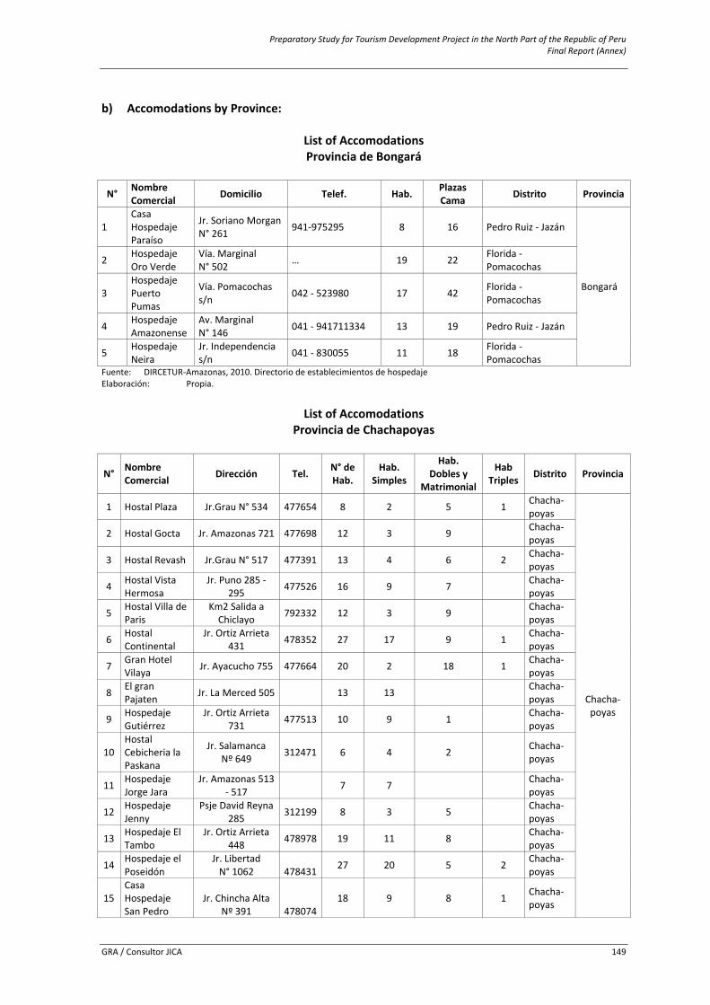
Preparatory Study for Tourism Development Project in the North Part of the Republic of Peru Final Report (Annex)
GRA / Consultor JICA 149
b) Accomodations by Province:
List of Accomodations Provincia de Bongará
N° Nombre Comercial Domicilio Telef. Hab. Plazas
Cama Distrito Provincia
1 Casa Hospedaje Paraíso
Jr. Soriano Morgan N° 261 941‐975295 8 16 Pedro Ruiz ‐ Jazán
Bongará
2 Hospedaje Oro Verde
Vía. Marginal N° 502 … 19 22 Florida ‐
Pomacochas
3 Hospedaje Puerto Pumas
Vía. Pomacochas s/n 042 ‐ 523980 17 42 Florida ‐
Pomacochas
4 Hospedaje Amazonense
Av. Marginal N° 146 041 ‐ 941711334 13 19 Pedro Ruiz ‐ Jazán
5 Hospedaje Neira
Jr. Independencia s/n 041 ‐ 830055 11 18 Florida ‐
Pomacochas Fuente: DIRCETUR‐Amazonas, 2010. Directorio de establecimientos de hospedaje Elaboración: Propia.
List of Accomodations
Provincia de Chachapoyas
N° Nombre Comercial Dirección Tel. N° de
Hab. Hab.
Simples
Hab. Dobles y
Matrimonial
Hab Triples Distrito Provincia
1 Hostal Plaza Jr.Grau N° 534 477654 8 2 5 1 Chacha‐poyas
Chacha‐poyas
2 Hostal Gocta Jr. Amazonas 721 477698 12 3 9 Chacha‐poyas
3 Hostal Revash Jr.Grau N° 517 477391 13 4 6 2 Chacha‐poyas
4 Hostal Vista Hermosa
Jr. Puno 285 ‐ 295 477526 16 9 7 Chacha‐
poyas
5 Hostal Villa de Paris
Km2 Salida a Chiclayo 792332 12 3 9 Chacha‐
poyas
6 Hostal Continental
Jr. Ortiz Arrieta 431 478352 27 17 9 1 Chacha‐
poyas
7 Gran Hotel Vilaya Jr. Ayacucho 755 477664 20 2 18 1 Chacha‐
poyas
8 El gran Pajaten Jr. La Merced 505 13 13 Chacha‐
poyas
9 Hospedaje Gutiérrez
Jr. Ortiz Arrieta 731 477513 10 9 1 Chacha‐
poyas
10 Hostal Cebicheria la Paskana
Jr. Salamanca Nº 649 312471 6 4 2
Chacha‐poyas
11 Hospedaje Jorge Jara
Jr. Amazonas 513 ‐ 517 7 7 Chacha‐
poyas
12 Hospedaje Jenny
Psje David Reyna 285 312199 8 3 5 Chacha‐
poyas
13 Hospedaje El Tambo
Jr. Ortiz Arrieta 448 478978 19 11 8 Chacha‐
poyas
14 Hospedaje el Poseidón
Jr. Libertad N° 1062 478431 27 20 5 2 Chacha‐
poyas
15 Casa Hospedaje San Pedro
Jr. Chincha Alta Nº 391 478074
18 9 8 1 Chacha‐poyas
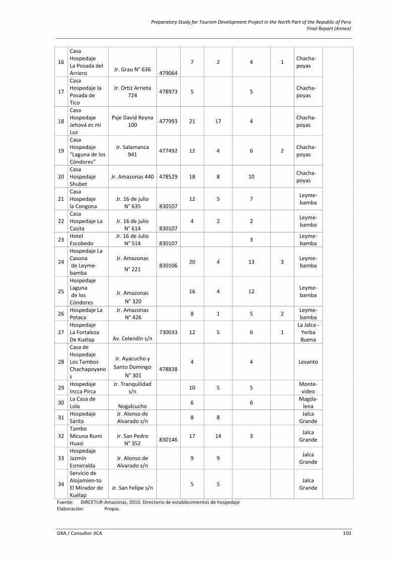
Preparatory Study for Tourism Development Project in the North Part of the Republic of Peru Final Report (Annex)
GRA / Consultor JICA 150
16
Casa Hospedaje La Posada del Arriero Jr. Grau N° 636 479064
7 2 4 1 Chacha‐poyas
17
Casa Hospedaje la Posada de Tico
Jr. Ortiz Arrieta 724 478973 5 5 Chacha‐
poyas
18
Casa Hospedaje Jehová es mi Luz
Psje David Reyna 100 477993 21 17 4 Chacha‐
poyas
19
Casa Hospedaje "Laguna de los Cóndores"
Jr. Salamanca 941 477492 12 4 6 2 Chacha‐
poyas
20 Casa Hospedaje Shubet
Jr. Amazonas 440 478529 18 8 10 Chacha‐poyas
21 Casa Hospedaje la Congona
Jr. 16 de julio N° 635 830107
12 5 7 Leyme‐bamba
22 Casa Hospedaje La Casita
Jr. 16 de julio N° 614 830107
4 2 2 Leyme‐bamba
23 Hotel Escobedo
Jr. 16 de Julio N° 514 830107 3 Leyme‐
bamba
24
Hospedaje La Casona de Leyme‐bamba
Jr. Amazonas
N° 221 830106 20 4 13 3 Leyme‐bamba
25
Hospedaje Laguna de los Cóndores
Jr. Amazonas N° 320
16 4 12
Leyme‐bamba
26 Hospedaje La Petaca
Jr. Amazonas N° 426 8 1 5 2 Leyme‐
bamba
27 Hospedaje La Fortaleza De Kuélap Av. Celendín s/n
730033 12 5 6 1 La Jalca ‐ Yerba Buena
28
Casa de Hospedaje Los Tambos Chachapoyanos
Jr. Ayacucho y Santo Domingo
N° 301 478838
4 4
Levanto
29 Hospedaje Incca Pirca
Jr. Tranquilidad s/n 10 5 5
Monte‐video
30 La Casa de Lola Nogalcucho 6 6
Magda‐lena
31 Hospedaje Sarita
Jr. Alonso de Alvarado s/n 8 8
Jalca Grande
32 Tambo Micuna Rumi Huasi
Jr. San Pedro N° 352 830146 17 14 3
Jalca Grande
33 Hospedaje Jazmín Esmeralda
Jr. Alonso de Alvarado s/n
9 9
Jalca Grande
34
Servicio de Alojamien‐to El Mirador de Kuélap
Jr. San Felipe s/n 5 5
Jalca Grande
Fuente: DIRCETUR‐Amazonas, 2010. Directorio de establecimientos de hospedaje Elaboración: Propia.
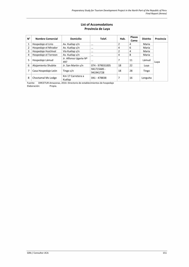
Preparatory Study for Tourism Development Project in the North Part of the Republic of Peru Final Report (Annex)
GRA / Consultor JICA 151
List of Accomodations Provincia de Luya
N° Nombre Comercial Domicilio Telef. Hab. Plazas Cama Distrito Provincia
1 Hospedaje el Lirio Av. Kuélap s/n … 2 4 Maria
Luya
2 Hospedaje el Mirador Av. Kuélap s/n … 4 6 Maria 3 Hospedaje Huichival Vía Kuélap s/n … 2 4 Maria 4 Hospedaje el Torreon Av. Kuélap s/n … 4 8 Maria
5 Hospedaje Lámud Jr. Alfonso Ugarte Nº 497 … 7 11 Lámud
6 Alojamiento Shubite Jr. San Martin s/n 074 ‐ 979031005 18 22 Luya
7 Casa Hospedaje León Tingo s/n 941715685 ‐ 941941728 18 28 Tingo
8 Choctamal Ms Lodge Km 17 Carretera a Kuélap 041 ‐ 478838 7 16 Longuita
Fuente: DIRCETUR‐Amazonas, 2010. Directorio de establecimientos de hospedaje Elaboración: Propia.
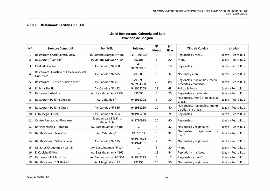
Preparatory Study for Tourism Development Project in the North Part of the Republic of Peru Final Report (Annex)
GRA / Consultor JICA 152
6.10.2 Restaurants Facilities in CTCU
List of Restaurants, Cafeteria and Bars Provincia de Bongará
Nº Nombre Comercial Domicilio Telefono Nº Mesas
Nº Sillas Tipo de Comida distrito
1 Restaurant Snack Cafetín Vicky Jr. Soriano Morgan Nº 302 041 – 793428 6 4 Regionales y menú. Jazán ‐ Pedro Ruiz 2 Restaurant "Carlitos" Jr. Soriano Morga Nº 454 792106 5 20 Menú. Jazán ‐ Pedro Ruiz
3 Caldo de Gallina Av. Cahuide Nº 860 043‐943959001 3 10 Regionales. Jazán ‐ Pedro Ruiz
4 Restaurant Turístico "El Descanso del Guerrero" Av. Cahuide Nº 625 793085 8 32 Nacional y menú. Jazán ‐ Pedro Ruiz
5 Restaurant Turístico "Puerto Rico" Av. Cahuide Nº 691 793993 978934330 22 88 Regionales, nacionales, menú,
pescados y mariscos. Jazán ‐ Pedro Ruiz
6 Pollería Pio Pio Av. Cahuide Nº 492 941909259 12 48 Pollo a la brasa. Jazán ‐ Pedro Ruiz 7 Restaurant Aleidita Av. Sacsahuamán Nº 734 830090 5 20 Regionales y nacionales. Jazán ‐ Pedro Ruiz
8 Restaurant Pollería Chepen Av. Cahuide s/n 941915292 9 30 Nacionales, menú y pollos a la brasa. Jazán ‐ Pedro Ruiz
9 Restaurant Pollería Cindy Av. Cahuide Nº 836 941983230 10 40 Nacionales, regionales, menú y pollos a la brasa. Jazán ‐ Pedro Ruiz
10 Elita Mego Quiroz Av. Cahuide Nº 654 941915280 3 9 Regionales. Jazán ‐ Pedro Ruiz
11 Centro Recreativo Playa Azul Suyubamba a 1 ½ Km.‐Pedro Ruiz 941710915 10 40 Regionales. Jazán ‐ Pedro Ruiz
12 Bar Picantería El Tambito Av. Sacsahuaman Nº 106 … 8 32 Nacionales y regionales. Jazán ‐ Pedro Ruiz
13 Bar Restaurant Nakytos Av. Cahuide s/n 94150131 8 32 Nacionales, regionales y menú. Jazán ‐ Pedro Ruiz
14 Bar Restaurant Sabor a Selva Av. Cahuide Nº 525 941997873 994924161 7 25 Nacionales y regionales. Jazán ‐ Pedro Ruiz
15 Milagros Chuquimez Huamán Av. Sacsahuaman Nº s/n … 5 20 Menú. Jazán ‐ Pedro Ruiz 16 El Cebiche El Rey Av. Sacsahuaman Nº 161 … 11 44 Pescados y mariscos. Jazán ‐ Pedro Ruiz 17 Restaurant El Manantial Av. Sacsayhuaman Nº 303 941942313 6 17 Regionales y menú. Jazán ‐ Pedro Ruiz 18 Bar Restaurant "El Shilico" Av. Marginal N° 189 793255 10 50 Nacionales y regionales. Jazán ‐ Pedro Ruiz
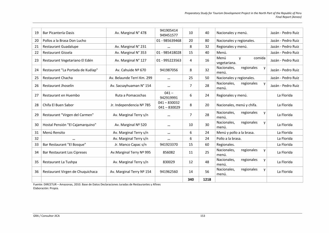
Preparatory Study for Tourism Development Project in the North Part of the Republic of Peru Final Report (Annex)
GRA / Consultor JICA 153
19 Bar Picantería Oasis Av. Marginal N° 478 941905414949451577 10 40 Nacionales y menú. Jazán ‐ Pedro Ruiz
20 Pollos a la Brasa Don Lucho 01 ‐ 985639468 20 80 Nacionales y regionales. Jazán ‐ Pedro Ruiz 21 Restaurant Guadalupe Av. Marginal N° 231 … 8 32 Regionales y menú. Jazán ‐ Pedro Ruiz 22 Restaurant Gissela Av. Marginal N° 353 01 ‐ 985418028 15 40 Menú. Jazán ‐ Pedro Ruiz
23 Restaurant Vegetariano El Edén Av. Marginal N° 127 01 ‐ 995223563 4 16 Menú y comida vegetariana. Jazán ‐ Pedro Ruiz
24 Restaurant "La Portada de Kuélap" Av. Cahuide Nº 670 941987056 8 32 Nacionales, regionales y menú. Jazán ‐ Pedro Ruiz
25 Restaurant Chacha Av. Belaunde Terri Km. 299 … 25 50 Nacionales y regionales. Jazán ‐ Pedro Ruiz
26 Restaurant Jhoselin Av. Sacsayhuaman N° 154 … 7 28 Nacionales, regionales y menú. Jazán ‐ Pedro Ruiz
27 Restaurant en Huembo Ruta a Pomacochas 041 –942919991 6 24 Regionales y menú. La Florida
28 Chifa El Buen Sabor Jr. Independencia Nº 785 041 – 830032 041 – 830029 8 20 Nacionales, menú y chifa. La Florida
29 Restaurant "Virgen del Carmen" Av. Marginal Terry s/n … 7 28 Nacionales, regionales y menú. La Florida
30 Hostal Pensión "El Cajamarquino" Av. Marginal Nº 520 … 10 30 Nacionales, regionales y menú. La Florida
31 Menú Rensito Av. Marginal Terry s/n … 6 24 Menú y pollo a la brasa. La Florida 32 … Av. Marginal Terry s/n … 6 24 Pollo a la brasa. La Florida 33 Bar Restaurant "El Bosque" Jr. Manco Capac s/n 941923370 15 60 Regionales. La Florida
34 Bar Restaurant Los Cipreses Av.Marginal Terry Nº 995 856082 11 25 Nacionales, regionales y menú. La Florida
35 Restaurant La Tushpa Av. Marginal Terry s/n 830029 12 48 Nacionales, regionales y menú. La Florida
36 Restaurant Virgen de Chuquichaca Av. Marginal Terry Nº 154 941962560 14 56 Nacionales, regionales y menú. La Florida
340 1218 Fuente: DIRCETUR – Amazonas, 2010. Base de Datos Declaraciones Juradas de Restaurantes y Afines Elaboración: Propia.
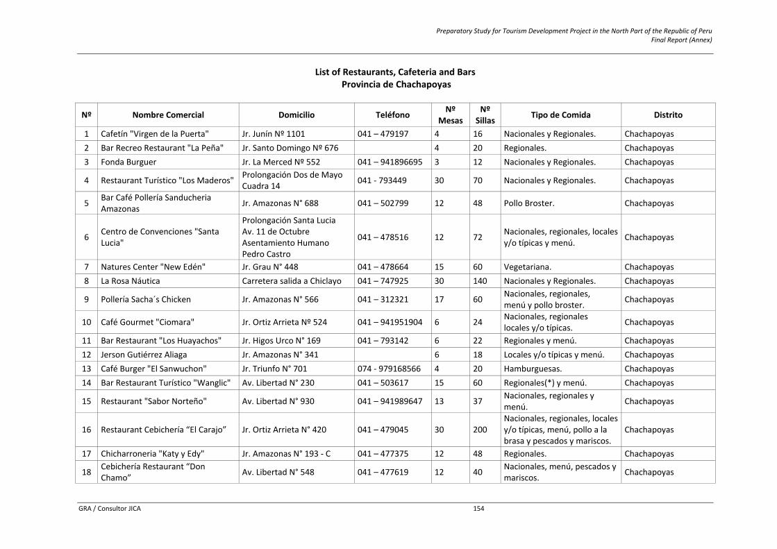
Preparatory Study for Tourism Development Project in the North Part of the Republic of Peru Final Report (Annex)
GRA / Consultor JICA 154
List of Restaurants, Cafeteria and Bars Provincia de Chachapoyas
Nº Nombre Comercial Domicilio Teléfono Nº Mesas
Nº Sillas Tipo de Comida Distrito
1 Cafetín "Virgen de la Puerta" Jr. Junín Nº 1101 041 – 479197 4 16 Nacionales y Regionales. Chachapoyas 2 Bar Recreo Restaurant "La Peña" Jr. Santo Domingo Nº 676 4 20 Regionales. Chachapoyas 3 Fonda Burguer Jr. La Merced Nº 552 041 – 941896695 3 12 Nacionales y Regionales. Chachapoyas
4 Restaurant Turístico "Los Maderos" Prolongación Dos de Mayo Cuadra 14 041 ‐ 793449 30 70 Nacionales y Regionales. Chachapoyas
5 Bar Café Pollería Sanducheria Amazonas Jr. Amazonas N° 688 041 – 502799 12 48 Pollo Broster. Chachapoyas
6 Centro de Convenciones "Santa Lucia"
Prolongación Santa Lucia Av. 11 de Octubre Asentamiento Humano Pedro Castro
041 – 478516 12 72 Nacionales, regionales, locales y/o típicas y menú. Chachapoyas
7 Natures Center "New Edén" Jr. Grau N° 448 041 – 478664 15 60 Vegetariana. Chachapoyas 8 La Rosa Náutica Carretera salida a Chiclayo 041 – 747925 30 140 Nacionales y Regionales. Chachapoyas
9 Pollería Sacha´s Chicken Jr. Amazonas N° 566 041 – 312321 17 60 Nacionales, regionales,menú y pollo broster. Chachapoyas
10 Café Gourmet "Ciomara" Jr. Ortiz Arrieta Nº 524 041 – 941951904 6 24 Nacionales, regionaleslocales y/o típicas. Chachapoyas
11 Bar Restaurant "Los Huayachos" Jr. Higos Urco N° 169 041 – 793142 6 22 Regionales y menú. Chachapoyas 12 Jerson Gutiérrez Aliaga Jr. Amazonas N° 341 6 18 Locales y/o típicas y menú. Chachapoyas 13 Café Burger "El Sanwuchon" Jr. Triunfo N° 701 074 ‐ 979168566 4 20 Hamburguesas. Chachapoyas 14 Bar Restaurant Turístico "Wanglic" Av. Libertad N° 230 041 – 503617 15 60 Regionales(*) y menú. Chachapoyas
15 Restaurant "Sabor Norteño" Av. Libertad N° 930 041 – 941989647 13 37 Nacionales, regionales y menú. Chachapoyas
16 Restaurant Cebichería “El Carajo” Jr. Ortiz Arrieta N° 420 041 – 479045 30 200 Nacionales, regionales, localesy/o típicas, menú, pollo a la brasa y pescados y mariscos.
Chachapoyas
17 Chicharroneria "Katy y Edy" Jr. Amazonas N° 193 ‐ C 041 – 477375 12 48 Regionales. Chachapoyas
18 Cebichería Restaurant “Don Chamo” Av. Libertad N° 548 041 – 477619 12 40 Nacionales, menú, pescados y
mariscos. Chachapoyas
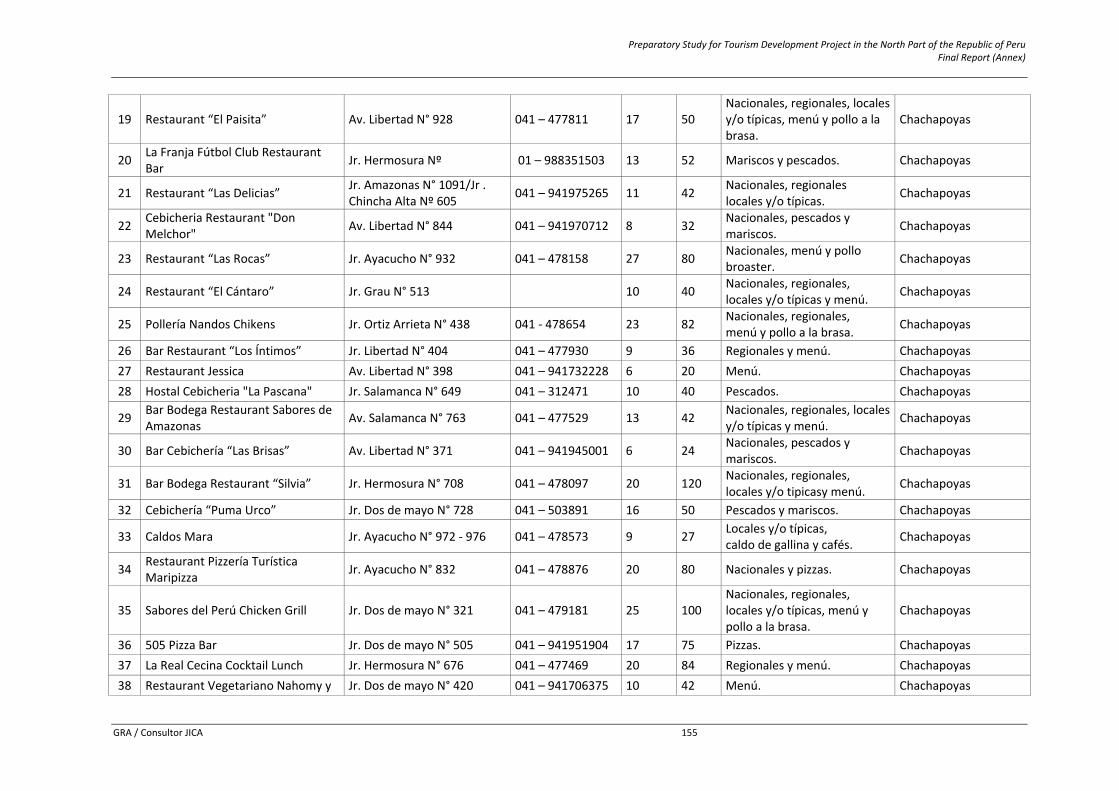
Preparatory Study for Tourism Development Project in the North Part of the Republic of Peru Final Report (Annex)
GRA / Consultor JICA 155
19 Restaurant “El Paisita” Av. Libertad N° 928 041 – 477811 17 50 Nacionales, regionales, localesy/o típicas, menú y pollo a la brasa.
Chachapoyas
20 La Franja Fútbol Club Restaurant Bar Jr. Hermosura Nº 01 – 988351503 13 52 Mariscos y pescados. Chachapoyas
21 Restaurant “Las Delicias” Jr. Amazonas N° 1091/Jr . Chincha Alta Nº 605 041 – 941975265 11 42 Nacionales, regionales
locales y/o típicas. Chachapoyas
22 Cebicheria Restaurant "Don Melchor" Av. Libertad N° 844 041 – 941970712 8 32 Nacionales, pescados y
mariscos. Chachapoyas
23 Restaurant “Las Rocas” Jr. Ayacucho N° 932 041 – 478158 27 80 Nacionales, menú y pollo broaster. Chachapoyas
24 Restaurant “El Cántaro” Jr. Grau N° 513 10 40 Nacionales, regionales,locales y/o típicas y menú. Chachapoyas
25 Pollería Nandos Chikens Jr. Ortiz Arrieta N° 438 041 ‐ 478654 23 82 Nacionales, regionales,menú y pollo a la brasa. Chachapoyas
26 Bar Restaurant “Los Íntimos” Jr. Libertad N° 404 041 – 477930 9 36 Regionales y menú. Chachapoyas 27 Restaurant Jessica Av. Libertad N° 398 041 – 941732228 6 20 Menú. Chachapoyas 28 Hostal Cebicheria "La Pascana" Jr. Salamanca N° 649 041 – 312471 10 40 Pescados. Chachapoyas
29 Bar Bodega Restaurant Sabores de Amazonas Av. Salamanca N° 763 041 – 477529 13 42 Nacionales, regionales, locales
y/o típicas y menú. Chachapoyas
30 Bar Cebichería “Las Brisas” Av. Libertad N° 371 041 – 941945001 6 24 Nacionales, pescados y mariscos. Chachapoyas
31 Bar Bodega Restaurant “Silvia” Jr. Hermosura N° 708 041 – 478097 20 120 Nacionales, regionales,locales y/o tipicasy menú. Chachapoyas
32 Cebichería “Puma Urco” Jr. Dos de mayo N° 728 041 – 503891 16 50 Pescados y mariscos. Chachapoyas
33 Caldos Mara Jr. Ayacucho N° 972 ‐ 976 041 – 478573 9 27 Locales y/o típicas,caldo de gallina y cafés. Chachapoyas
34 Restaurant Pizzería Turística Maripizza Jr. Ayacucho N° 832 041 – 478876 20 80 Nacionales y pizzas. Chachapoyas
35 Sabores del Perú Chicken Grill Jr. Dos de mayo N° 321 041 – 479181 25 100 Nacionales, regionales,locales y/o típicas, menú y pollo a la brasa.
Chachapoyas
36 505 Pizza Bar Jr. Dos de mayo N° 505 041 – 941951904 17 75 Pizzas. Chachapoyas 37 La Real Cecina Cocktail Lunch Jr. Hermosura N° 676 041 – 477469 20 84 Regionales y menú. Chachapoyas 38 Restaurant Vegetariano Nahomy y Jr. Dos de mayo N° 420 041 – 941706375 10 42 Menú. Chachapoyas
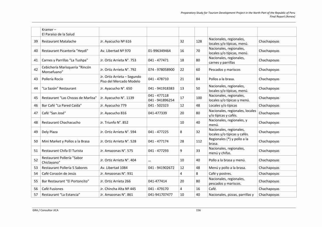
Preparatory Study for Tourism Development Project in the North Part of the Republic of Peru Final Report (Annex)
GRA / Consultor JICA 156
Kramer –El Paraíso de la Salud
39 Restaurant Matalache Jr. Ayacucho Nº 616 32 128 Nacionales, regionales, locales y/o típicas, menú. Chachapoyas
40 Restaurant Picantería "Heydi" Av. Libertad Nº 970 01‐996349464 16 70 Nacionales, regionales, locales y/o típicas, menú. Chachapoyas
41 Carnes y Parrillas “La Tushpa” Jr. Ortiz Arrieta N°. 753 041 ‐ 477471 18 80 Nacionales, regionales,carnes y parrillas Chachapoyas
42 Cebichería Marisquería “Rincón Monsefuano” Jr. Ortiz Arrieta N°. 792 074 ‐ 978058900 22 60 Pescados y mariscos Chachapoyas
43 Pollería Rocío Jr. Ortiz Arrieta – Segundo Piso del Mercado Modelo 041 ‐ 478710 21 84 Pollos a la brasa. Chachapoyas
44 "La Sazón" Restaurant Jr. Ayacucho N°. 650 041 ‐ 941918383 13 50 Nacionales, regionales, locales y/o típicas, menú. Chachapoyas
45 Restaurant "Las Chozas de Marlisa" Jr. Ayacucho N°. 1139 041 ‐ 477118041 ‐ 941896254 17 100 Nacionales, regionales,
locales y/o típicas y menú. Chachapoyas
46 Bar Café "La Pared Caída" Jr. Ayacucho 779 041 ‐ 502323 12 48 Locales y/o típicas Chachapoyas
47 Café "San José" Jr. Ayacucho 816 041‐477339 20 80 Nacionales, regionales, locales y/o típicas y cafés. Chachapoyas
48 Restaurant Chachacucho Jr. Triunfo N°. 852 10 40 Nacionales, regionales, y menú. Chachapoyas
49 Dely Plaza Jr. Ortiz Arrieta N°. 594 041 ‐ 477225 8 32 Nacionales, regionales,locales y/o típicas y cafés. Chachapoyas
50 Mini Market y Pollos a la Brasa Jr. Ortiz Arrieta N°. 528 041 ‐ 477174 28 112 Regionales (*) y pollo a la brasa. Chachapoyas
51 Restaurant Chifa El Turista Jr. Amazonas N°. 575 041 ‐ 477293 9 33 Nacionales, regionales, menú y chifas. Chachapoyas
52 Restaurant Pollería "Sabor Chiclayano" Jr. Ortiz Arrieta N°. 404 … 10 40 Pollo a la brasa y menú. Chachapoyas
53 Restaurant Pollería 5 Sabores Av. Libertad 1084 041 ‐ 941902672 12 48 Menú y pollo a la brasa. Chachapoyas 54 Café Corazón de Jesús Jr. Amazonas N°. 931 4 8 Café y postres. Chachapoyas
55 Bar Restaurant “El Portoncito” Jr. Ortiz Arrieta 266 041‐477414 20 80 Nacionales, regionales, pescados y mariscos. Chachapoyas
56 Café Fusiones Jr. Chincha Alta Nº 445 041 ‐ 479170 4 16 Café. Chachapoyas 57 Restaurant “La Estancia” Jr. Amazonas N°. 861 041‐941707477 10 40 Nacionales, pizzas, parrillas y Chachapoyas
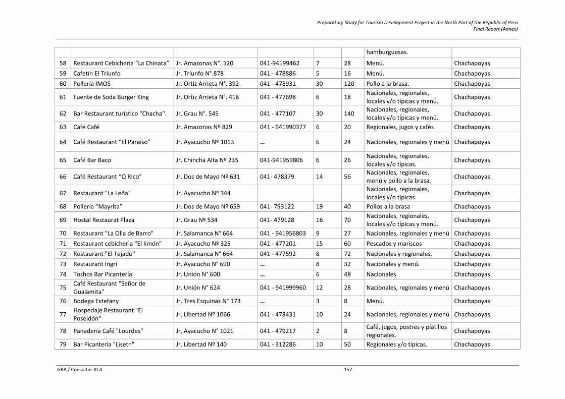
Preparatory Study for Tourism Development Project in the North Part of the Republic of Peru Final Report (Annex)
GRA / Consultor JICA 157
hamburguesas.
58 Restaurant Cebichería “La Chinata” Jr. Amazonas N°. 520 041‐94199462 7 28 Menú. Chachapoyas 59 Cafetín El Triunfo Jr. Triunfo N°.878 041 ‐ 478886 5 16 Menú. Chachapoyas 60 Pollería IMOS Jr. Ortiz Arrieta N°. 392 041 ‐ 478931 30 120 Pollo a la brasa. Chachapoyas
61 Fuente de Soda Burger King Jr. Ortiz Arrieta N°. 416 041 ‐ 477698 6 18 Nacionales, regionales, locales y/o típicas y menú. Chachapoyas
62 Bar Restaurant turístico "Chacha". Jr. Grau N°. 545 041 ‐ 477107 30 140 Nacionales, regionales, locales y/o típicas y menú. Chachapoyas
63 Café Café Jr. Amazonas Nº 829 041 ‐ 941990377 6 20 Regionales, jugos y cafés Chachapoyas
64 Café Restaurant “El Paraíso” Jr. Ayacucho Nº 1013 … 6 24 Nacionales, regionales y menú Chachapoyas
65 Café Bar Baco Jr. Chincha Alta Nº 235 041‐941959806 6 26 Nacionales, regionales, locales y/o típicas. Chachapoyas
66 Café Restaurant “Q Rico” Jr. Dos de Mayo Nº 631 041‐ 478379 14 56 Nacionales, regionales, menú y pollo a la brasa. Chachapoyas
67 Restaurant "La Leña" Jr. Ayacucho Nº 344 Nacionales, regionales, locales y/o típicas. Chachapoyas
68 Pollería “Mayrita” Jr. Dos de Mayo Nº 659 041‐ 793122 19 40 Pollos a la brasa Chachapoyas
69 Hostal Restaurat Plaza Jr. Grau Nº 534 041‐ 479128 16 70 Nacionales, regionales, locales y/o típicas y menú. Chachapoyas
70 Restaurant "La Olla de Barro" Jr. Salamanca N° 664 041 ‐ 941956803 9 27 Nacionales, regionales y menú Chachapoyas 71 Restaurant cebicheria "El limón" Jr. Ayacucho Nº 325 041 ‐ 477201 15 60 Pescados y mariscos Chachapoyas 72 Restaurant "El Tejado" Jr. Salamanca N° 664 041 ‐ 477592 8 72 Nacionales y regionales. Chachapoyas 73 Restaurant Ingri Jr. Ayacucho N° 690 … 8 32 Nacionales y menú. Chachapoyas 74 Toshos Bar Picantería Jr. Unión N° 600 … 6 48 Nacionales. Chachapoyas
75 Café Restaurant "Señor de Gualamita" Jr. Unión N° 624 041 ‐ 941999960 12 28 Nacionales, regionales y menú Chachapoyas
76 Bodega Estefany Jr. Tres Esquinas N° 173 … 3 8 Menú. Chachapoyas
77 Hospedaje Restaurant "El Poseidón" Jr. Libertad Nº 1066 041 ‐ 478431 10 24 Nacionales, regionales y menú Chachapoyas
78 Panadería Café "Lourdes" Jr. Ayacucho N° 1021 041 ‐ 479217 2 8 Café, jugos, postres y platillos regionales. Chachapoyas
79 Bar Picantería "Liseth" Jr. Libertad Nº 140 041 ‐ 312286 10 50 Regionales y/o típicas. Chachapoyas
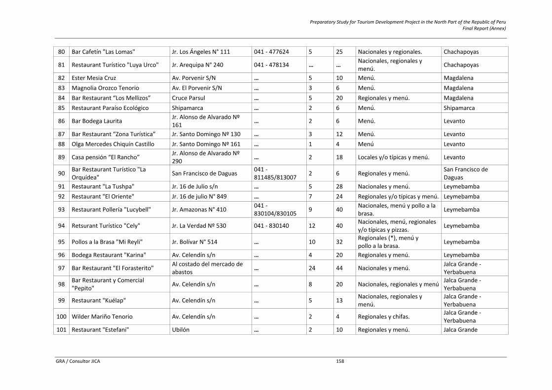
Preparatory Study for Tourism Development Project in the North Part of the Republic of Peru Final Report (Annex)
GRA / Consultor JICA 158
80 Bar Cafetín "Las Lomas" Jr. Los Ángeles N° 111 041 ‐ 477624 5 25 Nacionales y regionales. Chachapoyas
81 Restaurant Turístico "Luya Urco" Jr. Arequipa N° 240 041 ‐ 478134 … … Nacionales, regionales y menú. Chachapoyas
82 Ester Mesia Cruz Av. Porvenir S/N … 5 10 Menú. Magdalena 83 Magnolia Orozco Tenorio Av. El Porvenir S/N … 3 6 Menú. Magdalena 84 Bar Restaurant “Los Mellizos” Cruce Parsul … 5 20 Regionales y menú. Magdalena 85 Restaurant Paraíso Ecológico Shipamarca … 2 6 Menú. Shipamarca
86 Bar Bodega Laurita Jr. Alonso de Alvarado Nº 161 … 2 6 Menú. Levanto
87 Bar Restaurant “Zona Turística” Jr. Santo Domingo Nº 130 … 3 12 Menú. Levanto 88 Olga Mercedes Chiquín Castillo Jr. Santo Domingo Nº 161 … 1 4 Menú Levanto
89 Casa pensión “El Rancho” Jr. Alonso de Alvarado Nº 290 … 2 18 Locales y/o típicas y menú. Levanto
90 Bar Restaurant Turístico "La Orquídea" San Francisco de Daguas 041 ‐
811485/813007 2 6 Regionales y menú. San Francisco de Daguas
91 Restaurant "La Tushpa" Jr. 16 de Julio s/n … 5 28 Nacionales y menú. Leymebamba 92 Restaurant "El Oriente" Jr. 16 de julio N° 849 … 7 24 Regionales y/o típicas y menú. Leymebamba
93 Restaurant Pollería "Lucybell" Jr. Amazonas N° 410 041 ‐830104/830105 9 40 Nacionales, menú y pollo a la
brasa. Leymebamba
94 Retsurant Turístico "Cely" Jr. La Verdad Nº 530 041 ‐ 830140 12 40 Nacionales, menú, regionales y/o típicas y pizzas. Leymebamba
95 Pollos a la Brasa "Mi Reyli" Jr. Bolívar N° 514 … 10 32 Regionales (*), menú y pollo a la brasa. Leymebamba
96 Bodega Restaurant "Karina" Av. Celendín s/n … 4 20 Regionales y menú. Leymebamba
97 Bar Restaurant "El Forasterito" Al costado del mercado de abastos … 24 44 Nacionales y menú. Jalca Grande ‐
Yerbabuena
98 Bar Restaurant y Comercial "Pepito" Av. Celendín s/n … 8 20 Nacionales, regionales y menú Jalca Grande ‐
Yerbabuena
99 Restaurant "Kuélap" Av. Celendín s/n … 5 13 Nacionales, regionales y menú.
Jalca Grande ‐Yerbabuena
100 Wilder Mariño Tenorio Av. Celendín s/n … 2 4 Regionales y chifas. Jalca Grande ‐Yerbabuena
101 Restaurant "Estefani" Ubilón … 2 10 Regionales y menú. Jalca Grande
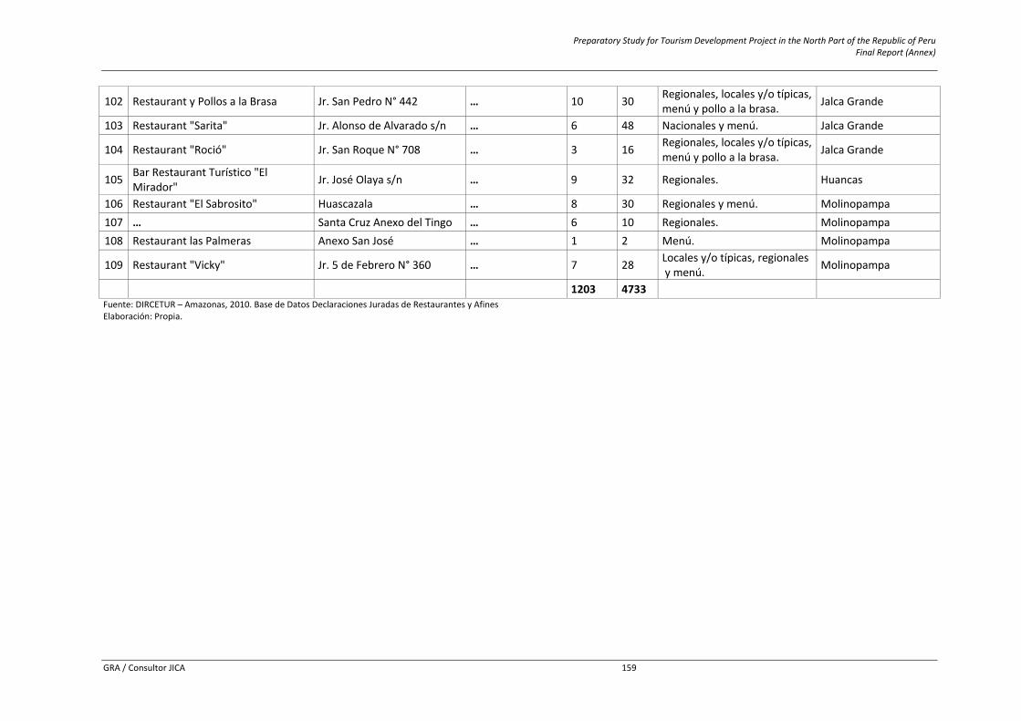
Preparatory Study for Tourism Development Project in the North Part of the Republic of Peru Final Report (Annex)
GRA / Consultor JICA 159
102 Restaurant y Pollos a la Brasa Jr. San Pedro N° 442 … 10 30 Regionales, locales y/o típicas,menú y pollo a la brasa. Jalca Grande
103 Restaurant "Sarita" Jr. Alonso de Alvarado s/n … 6 48 Nacionales y menú. Jalca Grande
104 Restaurant "Roció" Jr. San Roque N° 708 … 3 16 Regionales, locales y/o típicas,menú y pollo a la brasa. Jalca Grande
105 Bar Restaurant Turístico "El Mirador" Jr. José Olaya s/n … 9 32 Regionales. Huancas
106 Restaurant "El Sabrosito" Huascazala … 8 30 Regionales y menú. Molinopampa 107 … Santa Cruz Anexo del Tingo … 6 10 Regionales. Molinopampa 108 Restaurant las Palmeras Anexo San José … 1 2 Menú. Molinopampa
109 Restaurant "Vicky" Jr. 5 de Febrero N° 360 … 7 28 Locales y/o típicas, regionales y menú. Molinopampa
1203 4733 Fuente: DIRCETUR – Amazonas, 2010. Base de Datos Declaraciones Juradas de Restaurantes y Afines Elaboración: Propia.
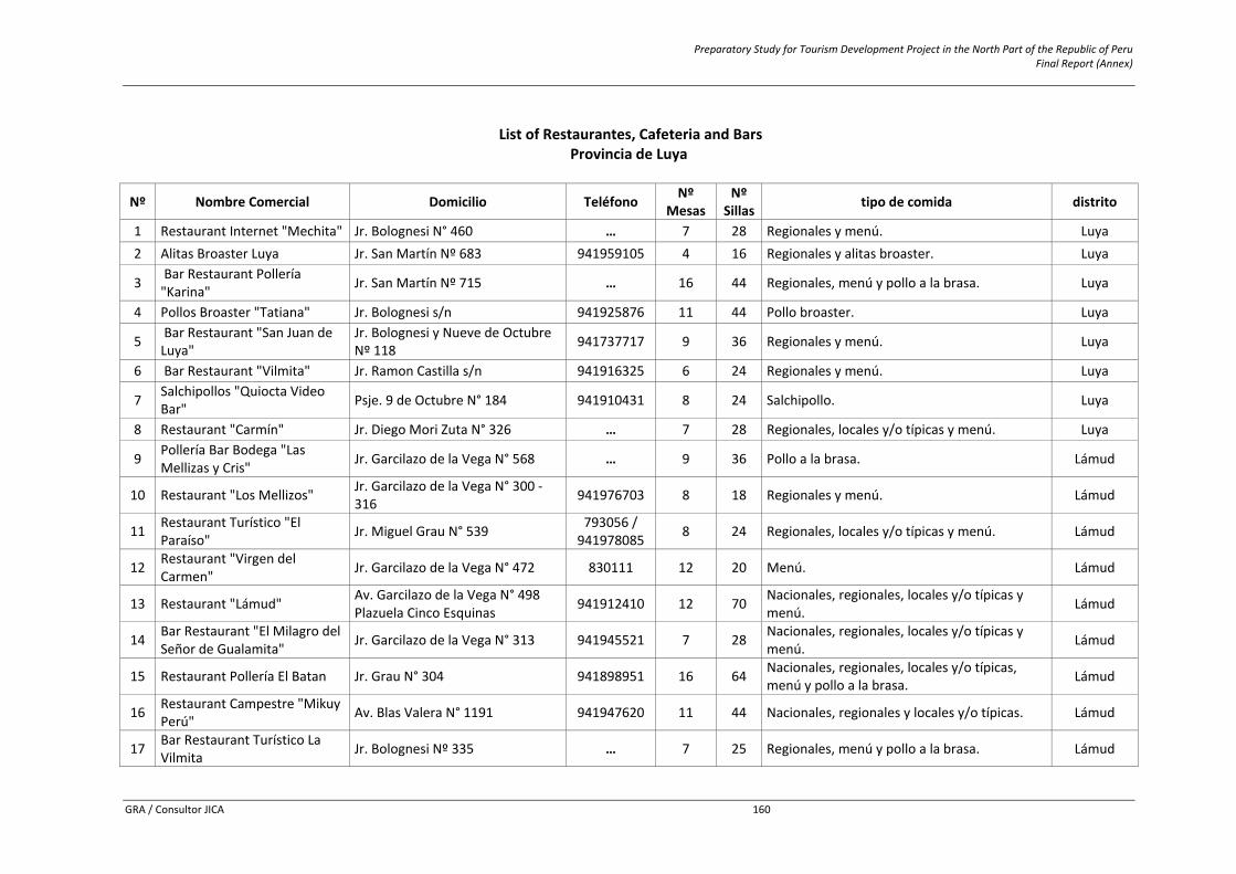
Preparatory Study for Tourism Development Project in the North Part of the Republic of Peru Final Report (Annex)
GRA / Consultor JICA 160
List of Restaurantes, Cafeteria and Bars
Provincia de Luya
Nº Nombre Comercial Domicilio Teléfono Nº Mesas
Nº Sillas tipo de comida distrito
1 Restaurant Internet "Mechita" Jr. Bolognesi N° 460 … 7 28 Regionales y menú. Luya 2 Alitas Broaster Luya Jr. San Martín Nº 683 941959105 4 16 Regionales y alitas broaster. Luya
3 Bar Restaurant Pollería "Karina" Jr. San Martín Nº 715 … 16 44 Regionales, menú y pollo a la brasa. Luya
4 Pollos Broaster "Tatiana" Jr. Bolognesi s/n 941925876 11 44 Pollo broaster. Luya
5 Bar Restaurant "San Juan de Luya"
Jr. Bolognesi y Nueve de Octubre Nº 118 941737717 9 36 Regionales y menú. Luya
6 Bar Restaurant "Vilmita" Jr. Ramon Castilla s/n 941916325 6 24 Regionales y menú. Luya
7 Salchipollos "Quiocta Video Bar" Psje. 9 de Octubre N° 184 941910431 8 24 Salchipollo. Luya
8 Restaurant "Carmín" Jr. Diego Mori Zuta N° 326 … 7 28 Regionales, locales y/o típicas y menú. Luya
9 Pollería Bar Bodega "Las Mellizas y Cris" Jr. Garcilazo de la Vega N° 568 … 9 36 Pollo a la brasa. Lámud
10 Restaurant "Los Mellizos" Jr. Garcilazo de la Vega N° 300 ‐316 941976703 8 18 Regionales y menú. Lámud
11 Restaurant Turístico "El Paraíso" Jr. Miguel Grau N° 539 793056 /
941978085 8 24 Regionales, locales y/o típicas y menú. Lámud
12 Restaurant "Virgen del Carmen" Jr. Garcilazo de la Vega N° 472 830111 12 20 Menú. Lámud
13 Restaurant "Lámud" Av. Garcilazo de la Vega N° 498 Plazuela Cinco Esquinas 941912410 12 70 Nacionales, regionales, locales y/o típicas y
menú. Lámud
14 Bar Restaurant "El Milagro del Señor de Gualamita" Jr. Garcilazo de la Vega N° 313 941945521 7 28 Nacionales, regionales, locales y/o típicas y
menú. Lámud
15 Restaurant Pollería El Batan Jr. Grau N° 304 941898951 16 64 Nacionales, regionales, locales y/o típicas, menú y pollo a la brasa. Lámud
16 Restaurant Campestre "Mikuy Perú" Av. Blas Valera N° 1191 941947620 11 44 Nacionales, regionales y locales y/o típicas. Lámud
17 Bar Restaurant Turístico La Vilmita Jr. Bolognesi Nº 335 … 7 25 Regionales, menú y pollo a la brasa. Lámud
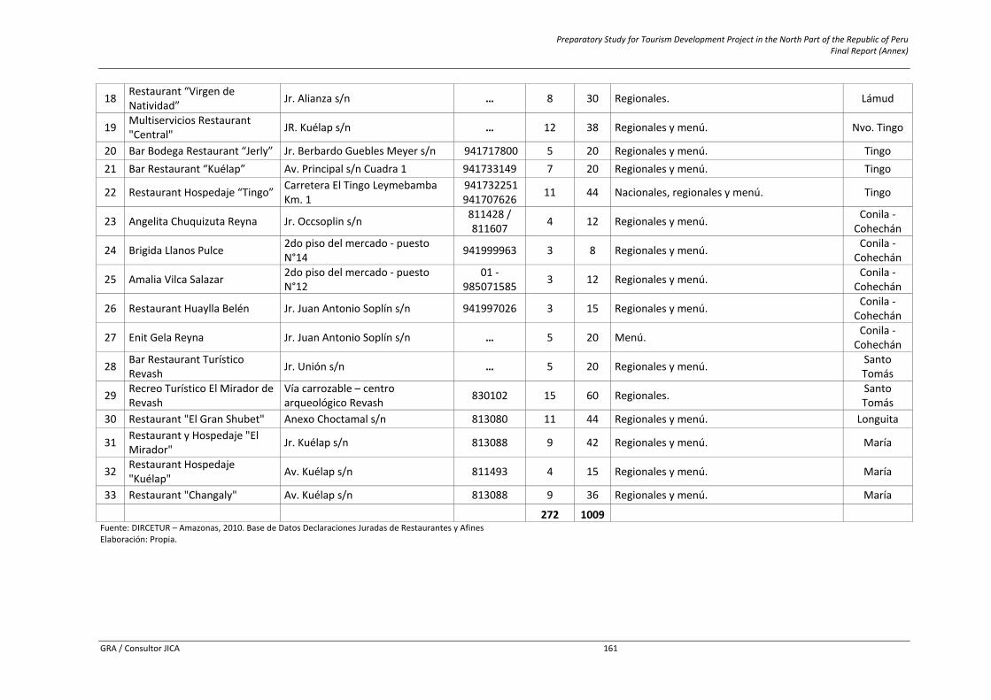
Preparatory Study for Tourism Development Project in the North Part of the Republic of Peru Final Report (Annex)
GRA / Consultor JICA 161
18 Restaurant “Virgen de Natividad” Jr. Alianza s/n … 8 30 Regionales. Lámud
19 Multiservicios Restaurant "Central" JR. Kuélap s/n … 12 38 Regionales y menú. Nvo. Tingo
20 Bar Bodega Restaurant “Jerly” Jr. Berbardo Guebles Meyer s/n 941717800 5 20 Regionales y menú. Tingo 21 Bar Restaurant “Kuélap” Av. Principal s/n Cuadra 1 941733149 7 20 Regionales y menú. Tingo
22 Restaurant Hospedaje “Tingo” Carretera El Tingo Leymebamba Km. 1
941732251941707626 11 44 Nacionales, regionales y menú. Tingo
23 Angelita Chuquizuta Reyna Jr. Occsoplin s/n 811428 / 811607 4 12 Regionales y menú. Conila ‐
Cohechán
24 Brigida Llanos Pulce 2do piso del mercado ‐ puesto N°14 941999963 3 8 Regionales y menú. Conila ‐
Cohechán
25 Amalia Vilca Salazar 2do piso del mercado ‐ puesto N°12
01 ‐985071585 3 12 Regionales y menú. Conila ‐
Cohechán
26 Restaurant Huaylla Belén Jr. Juan Antonio Soplín s/n 941997026 3 15 Regionales y menú. Conila ‐ Cohechán
27 Enit Gela Reyna Jr. Juan Antonio Soplín s/n … 5 20 Menú. Conila ‐ Cohechán
28 Bar Restaurant Turístico Revash Jr. Unión s/n … 5 20 Regionales y menú. Santo
Tomás
29 Recreo Turístico El Mirador de Revash
Vía carrozable – centro arqueológico Revash 830102 15 60 Regionales. Santo
Tomás 30 Restaurant "El Gran Shubet" Anexo Choctamal s/n 813080 11 44 Regionales y menú. Longuita
31 Restaurant y Hospedaje "El Mirador" Jr. Kuélap s/n 813088 9 42 Regionales y menú. María
32 Restaurant Hospedaje "Kuélap" Av. Kuélap s/n 811493 4 15 Regionales y menú. María
33 Restaurant "Changaly" Av. Kuélap s/n 813088 9 36 Regionales y menú. María
272 1009 Fuente: DIRCETUR – Amazonas, 2010. Base de Datos Declaraciones Juradas de Restaurantes y Afines Elaboración: Propia.
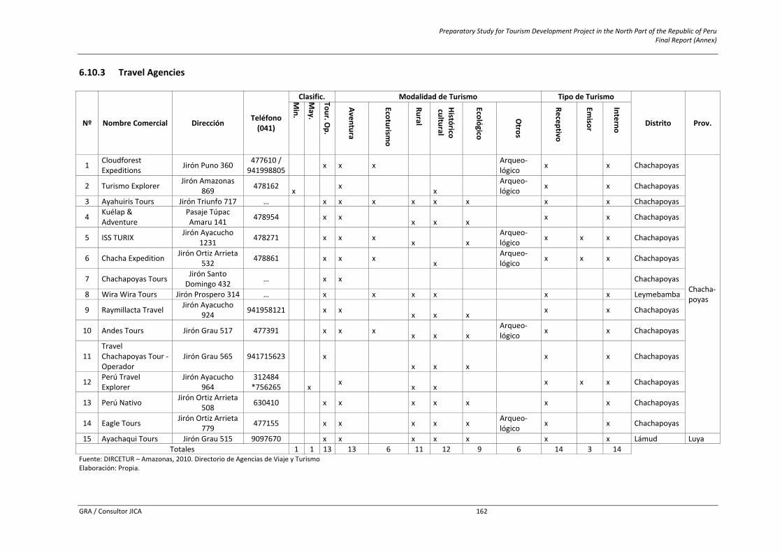
Preparatory Study for Tourism Development Project in the North Part of the Republic of Peru Final Report (Annex)
GRA / Consultor JICA 162
6.10.3 Travel Agencies
Nº Nombre Comercial Dirección Teléfono(041)
Clasific. Modalidad de Turismo Tipo de Turismo
Distrito Prov.
Min.
May.
Tour. Op.
Aventura
Ecoturismo
Rural
Histórico
cultural
Ecológico
Otros
Receptivo
Emisor
Interno 1 Cloudforest
Expeditions Jirón Puno 360 477610 / 941998805 x x x Arqueo‐
lógico x x Chachapoyas
Chacha‐poyas
2 Turismo Explorer Jirón Amazonas 869 478162 x x x
Arqueo‐lógico x x Chachapoyas
3 Ayahuiris Tours Jirón Triunfo 717 … x x x x x x x x Chachapoyas
4 Kuélap & Adventure
Pasaje Túpac Amaru 141 478954 x x x x x x x Chachapoyas
5 ISS TURIX Jirón Ayacucho 1231 478271 x x x x x
Arqueo‐lógico x x x Chachapoyas
6 Chacha Expedition Jirón Ortiz Arrieta 532 478861 x x x x
Arqueo‐lógico x x x Chachapoyas
7 Chachapoyas Tours Jirón Santo Domingo 432 … x x Chachapoyas
8 Wira Wira Tours Jirón Prospero 314 … x x x x x x Leymebamba
9 Raymillacta Travel Jirón Ayacucho 924 941958121 x x x x x x x Chachapoyas
10 Andes Tours Jirón Grau 517 477391 x x x x x x Arqueo‐lógico x x Chachapoyas
11 Travel Chachapoyas Tour ‐ Operador
Jirón Grau 565 941715623
x x x x
x x Chachapoyas
12 Perú Travel Explorer
Jirón Ayacucho 964
312484 *756265 x x x x x x x Chachapoyas
13 Perú Nativo Jirón Ortiz Arrieta 508 630410 x x x x x x x Chachapoyas
14 Eagle Tours Jirón Ortiz Arrieta 779 477155 x x x x x Arqueo‐
lógico x x Chachapoyas
15 Ayachaqui Tours Jirón Grau 515 9097670 x x x x x x x Lámud Luya Totales 1 1 13 13 6 11 12 9 6 14 3 14
Fuente: DIRCETUR – Amazonas, 2010. Directorio de Agencias de Viaje y Turismo Elaboración: Propia.
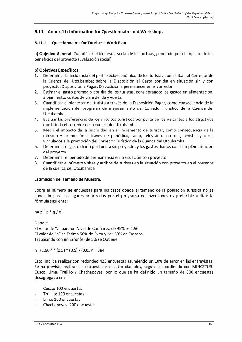
Preparatory Study for Tourism Development Project in the North Part of the Republic of Peru Final Report (Annex)
GRA / Consultor JICA 163
6.11 Annex 11: Information for Questionnaire and Workshops 6.11.1 Questionnaires for Tourists – Work Plan a) Objetivo General. Cuantificar el bienestar social de los turistas, generado por el impacto de los beneficios del proyecto (Evaluación social). b) Objetivos Específicos. 1. Determinar la incidencia del perfil socioeconómico de los turistas que arriban al Corredor de
la Cuenca del Utcubamba; sobre la Disposición al Gasto por día en situación sin y con proyecto, Disposición a Pagar, Disposición a permanecer en el corredor.
2. Estimar el gasto promedio por día de los turistas, considerando: los gastos en alimentación, alojamiento, costos de viaje de ida y vuelta.
3. Cuantificar el bienestar del turista a través de la Disposición Pagar, como consecuencia de la implementación del programa de mejoramiento del Corredor Turístico de la Cuenca del Utcubamba.
4. Evaluar las preferencias de los circuitos turísticos por parte de los visitantes a los atractivos que brinda el corredor de la cuenca del Utcubamba.
5. Medir el impacto de la publicidad en el incremento de turistas, como consecuencia de la difusión y promoción a través de periódico, radio, televisión, Internet, revistas y otros vinculados a la promoción del Corredor Turístico de la Cuenca del Utcubamba.
6. Determinar el gasto diario por turista sin proyecto; y los gastos diarios con la implementación del proyecto
7. Determinar el periodo de permanencia en la situación con proyecto 8. Cuantificar el número visitas y arribos de turistas en la situación con proyecto en el corredor
de la cuenca del Utcubamba. Estimación del Tamaño de Muestra. Sobre el número de encuestas para los casos donde el tamaño de la población turística no es conocido para los lugares priorizados por el programa de inversiones es preferible utilizar la fórmula siguiente: n= z2 * p * q / e2 Donde: El Valor de “z” para un Nivel de Confianza de 95% es 1.96 El valor de “p” se Estima 50% de Éxito y “q” 50% de Fracaso Trabajando con un Error (e) de 5% se Obtiene. n= (1.96)2 * (0.5) * (0.5) / (0.05)2 = 384 Esto implica realizar con redondeo 423 encuestas asumiendo un 10% de error en las entrevistas. Se ha previsto realizar las encuestas en cuatro ciudades, según lo coordinado con MINCETUR: Cusco, Lima, Trujillo y Chachapoyas, por lo que se ha definido un tamaño de 500 encuestas desagregado en: - Cusco: 100 encuestas - Trujillo: 100 encuestas - Lima: 100 encuestas - Chachapoyas: 200 encuestas
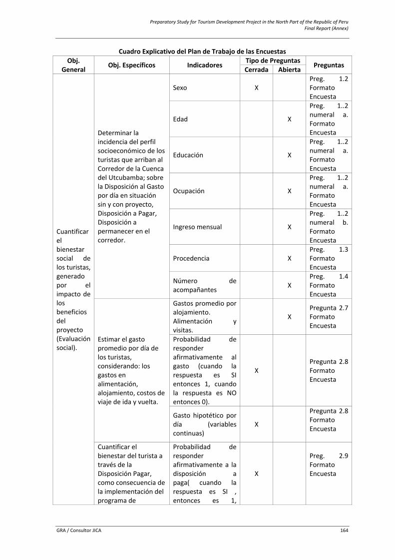
Preparatory Study for Tourism Development Project in the North Part of the Republic of Peru Final Report (Annex)
GRA / Consultor JICA 164
Cuadro Explicativo del Plan de Trabajo de las Encuestas Obj.
General Obj. Específicos Indicadores Tipo de Preguntas Preguntas Cerrada Abierta
Cuantificar el bienestar social de los turistas, generado por el impacto de los beneficios del proyecto (Evaluación social).
Determinar la incidencia del perfil socioeconómico de los turistas que arriban al Corredor de la Cuenca del Utcubamba; sobre la Disposición al Gasto por día en situación sin y con proyecto, Disposición a Pagar, Disposición a permanecer en el corredor.
Sexo X Preg. 1.2 Formato Encuesta
Edad X
Preg. 1..2 numeral a. Formato Encuesta
Educación X
Preg. 1..2 numeral a. Formato Encuesta
Ocupación X
Preg. 1..2 numeral a. Formato Encuesta
Ingreso mensual X
Preg. 1..2 numeral b. Formato Encuesta
Procedencia X Preg. 1.3 Formato Encuesta
Número de acompañantes X
Preg. 1.4 Formato Encuesta
Estimar el gasto promedio por día de los turistas, considerando: los gastos en alimentación, alojamiento, costos de viaje de ida y vuelta.
Gastos promedio por alojamiento. Alimentación y visitas.
X Pregunta 2.7 Formato Encuesta
Probabilidad de responder afirmativamente al gasto (cuando la respuesta es SI entonces 1, cuando la respuesta es NO entonces 0).
X Pregunta 2.8 Formato Encuesta
Gasto hipotético por día (variables continuas)
X
Pregunta 2.8 Formato Encuesta
Cuantificar el bienestar del turista a través de la Disposición Pagar, como consecuencia de la implementación del programa de
Probabilidad de responder afirmativamente a la disposición a paga( cuando la respuesta es SI , entonces es 1,
X
Preg. 2.9 Formato Encuesta
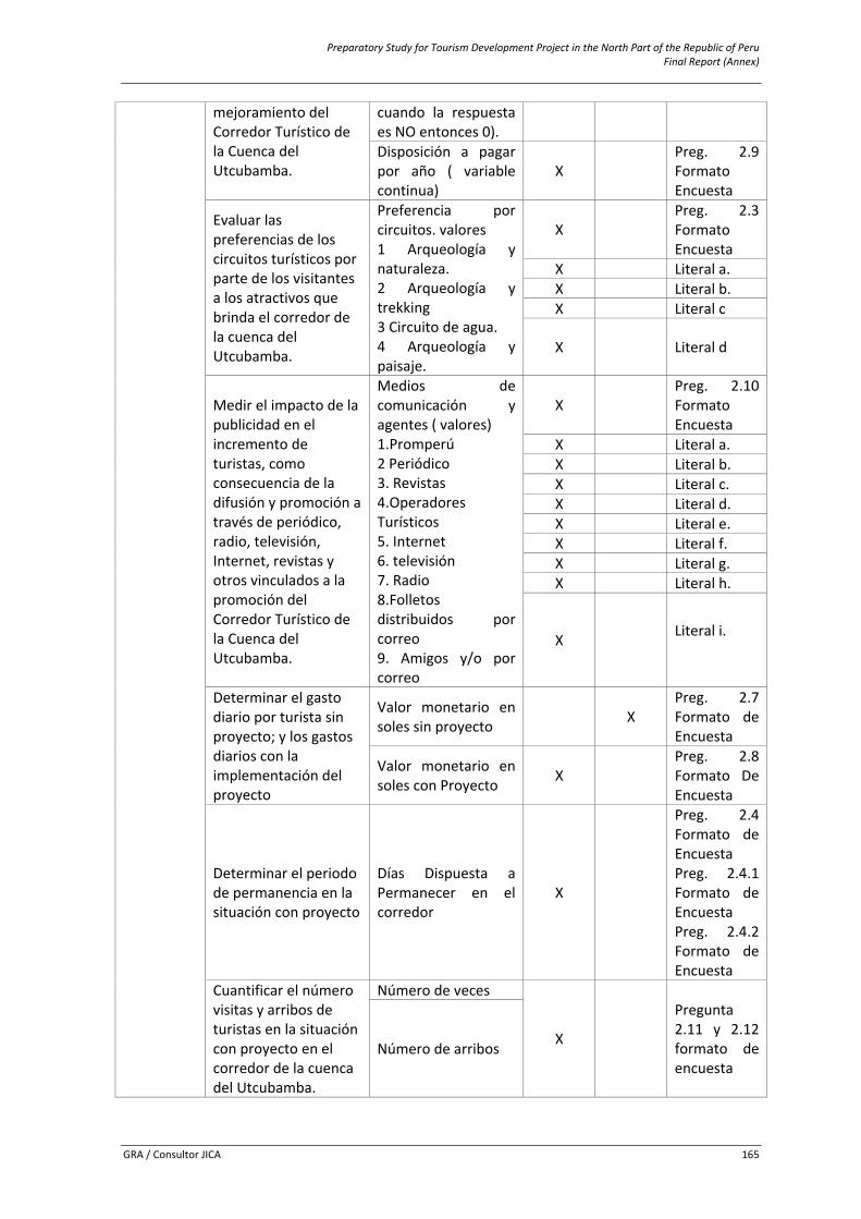
Preparatory Study for Tourism Development Project in the North Part of the Republic of Peru Final Report (Annex)
GRA / Consultor JICA 165
mejoramiento del Corredor Turístico de la Cuenca del Utcubamba.
cuando la respuesta es NO entonces 0). Disposición a pagar por año ( variable continua)
X Preg. 2.9 Formato Encuesta
Evaluar las preferencias de los circuitos turísticos por parte de los visitantes a los atractivos que brinda el corredor de la cuenca del Utcubamba.
Preferencia por circuitos. valores 1 Arqueología y naturaleza. 2 Arqueología y trekking 3 Circuito de agua. 4 Arqueología y paisaje.
X Preg. 2.3 Formato Encuesta
X Literal a. X Literal b. X Literal c
X Literal d
Medir el impacto de la publicidad en el incremento de turistas, como consecuencia de la difusión y promoción a través de periódico, radio, televisión, Internet, revistas y otros vinculados a la promoción del Corredor Turístico de la Cuenca del Utcubamba.
Medios de comunicación y agentes ( valores) 1.Promperú 2 Periódico 3. Revistas 4.Operadores Turísticos 5. Internet 6. televisión 7. Radio 8.Folletos distribuidos por correo 9. Amigos y/o por correo
X Preg. 2.10 Formato Encuesta
X Literal a. X Literal b. X Literal c. X Literal d. X Literal e. X Literal f. X Literal g. X Literal h.
X Literal i.
Determinar el gasto diario por turista sin proyecto; y los gastos diarios con la implementación del proyecto
Valor monetario en soles sin proyecto X
Preg. 2.7 Formato de Encuesta
Valor monetario en soles con Proyecto X
Preg. 2.8 Formato De Encuesta
Determinar el periodo de permanencia en la situación con proyecto
Días Dispuesta a Permanecer en el corredor
X
Preg. 2.4 Formato de Encuesta Preg. 2.4.1 Formato de Encuesta Preg. 2.4.2 Formato de Encuesta
Cuantificar el número visitas y arribos de turistas en la situación con proyecto en el corredor de la cuenca del Utcubamba.
Número de veces
X
Pregunta 2.11 y 2.12 formato de encuesta
Número de arribos

Preparatory Study for Tourism Development Project in the North Part of the Republic of Peru Final Report (Annex)
GRA / Consultor JICA 166
6.11.2 Questionnaires for Tourists and Tour Operators ‐ Formats
A. Formato de Encuesta a Turistas.
SURVEY FORM
Good morning/afternoon. My name is ___________The Regional Government of Amazonas with the financing of the Government of Japan is carrying out a pre‐investment study along the Corridor of the Utcubamba’s Basin which will made possible the implementation and put in value of tourism projects: archaeological, cultural, of adventure and natural.
With this survey I am going to ask you some issues that will help us to determine the size of the intervention for this to be defined.
The information that you will give to us is confidential, the results will be use to carry out an economic evaluation of the area to be intervened.
1. Socio‐economic Data
1.1 ¿Have you planned to visit any tourist site within the Utcubamba’s basin during the course of this year?
Yes → ¿How many mes? ______
No
1.2 Gender: M F
a. Age______ Level of Education_______ Occupation_______
b. Monthly Average Income S/.______________
c. Work Dependent Independent
1.3 ¿Which is your country of origin (country.)?____________________
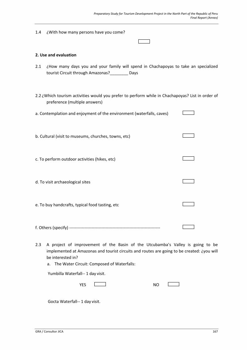
Preparatory Study for Tourism Development Project in the North Part of the Republic of Peru Final Report (Annex)
GRA / Consultor JICA 167
1.4 ¿With how many persons have you come?
2. Use and evaluation
2.1 ¿How many days you and your family will spend in Chachapoyas to take an specialized tourist Circuit through Amazonas?________ Days
2.2 ¿Which tourism activities would you prefer to perform while in Chachapoyas? List in order of preference (multiple answers)
a. Contemplation and enjoyment of the environment (waterfalls, caves)
b. Cultural (visit to museums, churches, towns, etc)
c. To perform outdoor activities (hikes, etc)
d. To visit archaeological sites
e. To buy handcrafts, typical food tasting, etc
f. Others (specify) ‐‐‐‐‐‐‐‐‐‐‐‐‐‐‐‐‐‐‐‐‐‐‐‐‐‐‐‐‐‐‐‐‐‐‐‐‐‐‐‐‐‐‐‐‐‐‐‐‐‐‐‐‐‐‐‐‐‐‐‐‐‐‐‐‐
2.3 A project of improvement of the Basin of the Utcubamba’s Valley is going to be implemented at Amazonas and tourist circuits and routes are going to be created: ¿you will be interested in? a. The Water Circuit: Composed of Waterfalls:
Yumbilla Waterfall‐‐ 1 day visit.
YES NO Gocta Waterfall‐‐ 1 day visit.
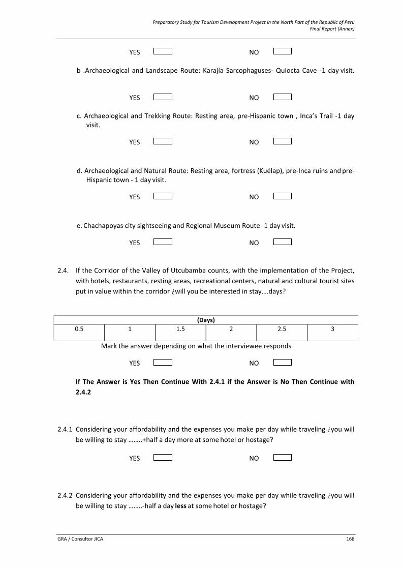
Preparatory Study for Tourism Development Project in the North Part of the Republic of Peru Final Report (Annex)
GRA / Consultor JICA 168
YES NO b .Archaeological and Landscape Route: Karajía Sarcophaguses‐ Quiocta Cave ‐1 day visit.
YES NO c. Archaeological and Trekking Route: Resting area, pre‐Hispanic town , Inca’s Trail ‐1 day
visit.
YES NO d. Archaeological and Natural Route: Resting area, fortress (Kuélap), pre‐Inca ruins and pre‐
Hispanic town ‐ 1 day visit.
YES NO e. Chachapoyas city sightseeing and Regional Museum Route ‐1 day visit.
YES NO
2.4. If the Corridor of the Valley of Utcubamba counts, with the implementation of the Project, with hotels, restaurants, resting areas, recreational centers, natural and cultural tourist sites put in value within the corridor ¿will you be interested in stay….days?
(Days)
0.5
1
1.5
2
2.5
3
Mark the answer depending on what the interviewee responds
YES NO
If The Answer is Yes Then Continue With 2.4.1 if the Answer is No Then Continue with 2.4.2
2.4.1 Considering your affordability and the expenses you make per day while traveling ¿you will be willing to stay ……..+half a day more at some hotel or hostage?
YES NO
2.4.2 Considering your affordability and the expenses you make per day while traveling ¿you will be willing to stay ……..‐half a day less at some hotel or hostage?

Preparatory Study for Tourism Development Project in the North Part of the Republic of Peru Final Report (Annex)
GRA / Consultor JICA 169
YES NO
2.5 ¿which is the transportation mean used in your visit to Amazonas?
a. Particular Vehicle
b. Public Transport
c. Airplane and Public Transport.
d. Other,
¿Which one? _______________
2.6 ¿Which was the method used to get to Amazonas?
a. Buying the travel package in your place of residence
b. Buying the travel package at the place of visit
c. On your own
d. Trip organized for a school, college or work center
e. Other (specify)
2.7 ¿How much do you think that you and your companions spend in travel tickets to Amazonas? (Round trip) S/. ______________
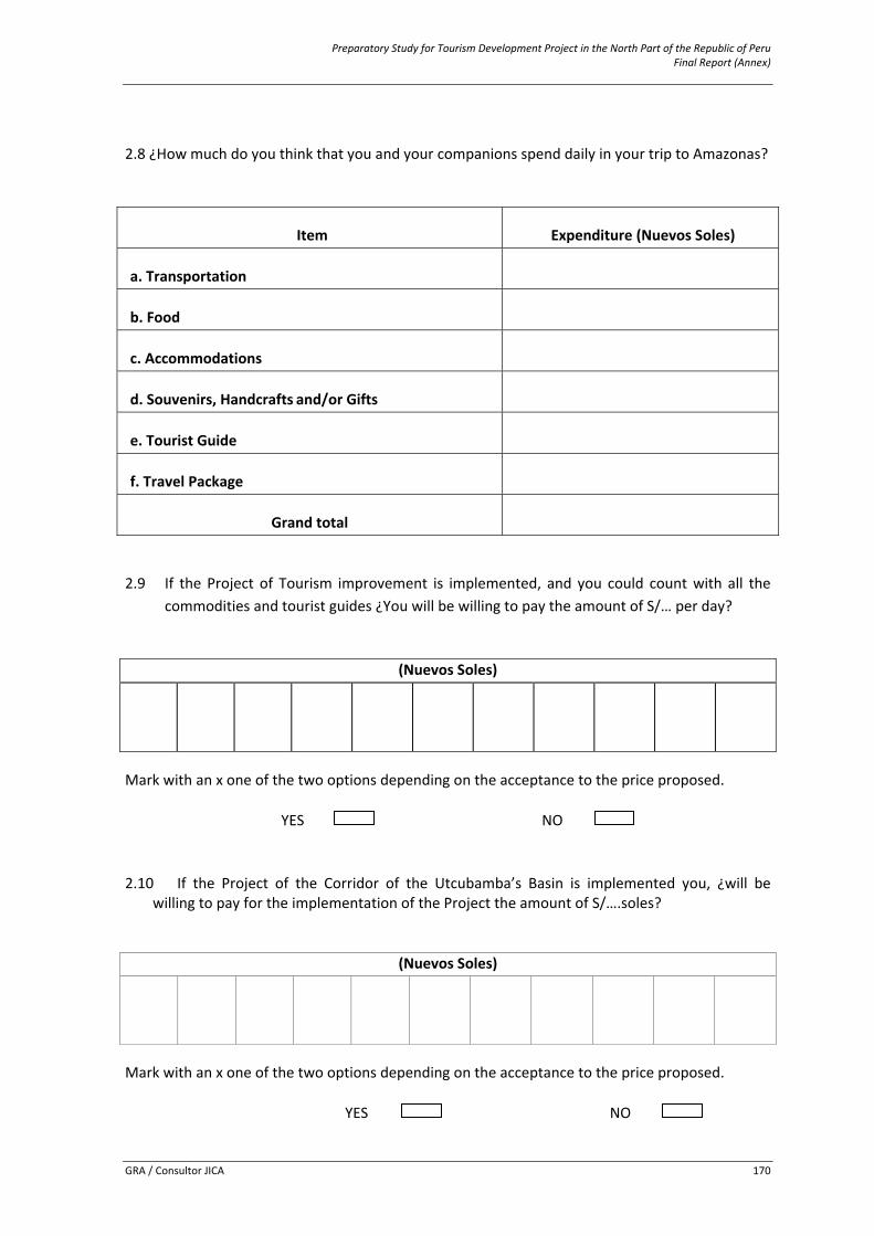
Preparatory Study for Tourism Development Project in the North Part of the Republic of Peru Final Report (Annex)
GRA / Consultor JICA 170
2.8 ¿How much do you think that you and your companions spend daily in your trip to Amazonas?
Item Expenditure (Nuevos Soles)
a. Transportation
b. Food
c. Accommodations
d. Souvenirs, Handcrafts and/or Gifts
e. Tourist Guide
f. Travel Package
Grand total
2.9 If the Project of Tourism improvement is implemented, and you could count with all the commodities and tourist guides ¿You will be willing to pay the amount of S/… per day?
(Nuevos Soles)
Mark with an x one of the two options depending on the acceptance to the price proposed.
YES NO
2.10 If the Project of the Corridor of the Utcubamba’s Basin is implemented you, ¿will be
willing to pay for the implementation of the Project the amount of S/….soles?
(Nuevos Soles)
Mark with an x one of the two options depending on the acceptance to the price proposed.
YES NO
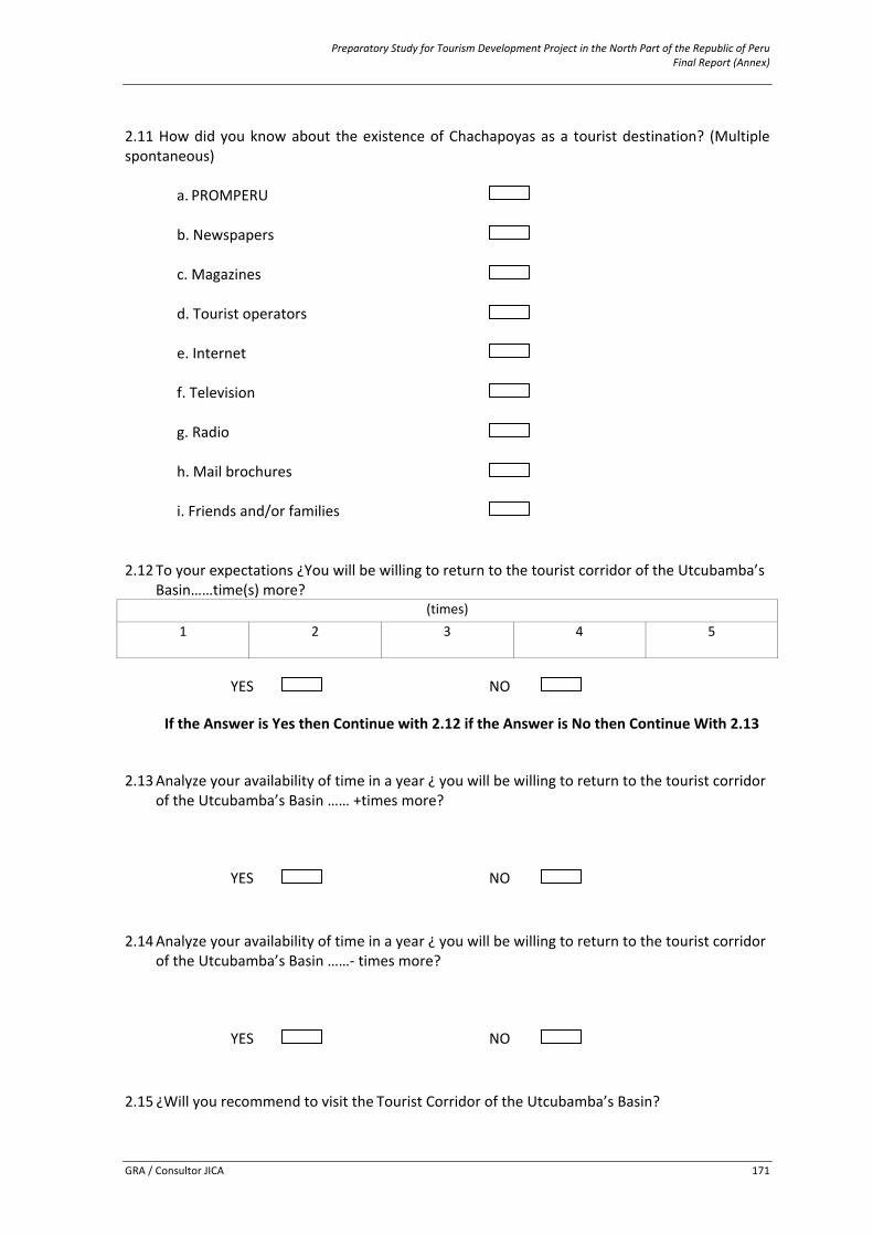
Preparatory Study for Tourism Development Project in the North Part of the Republic of Peru Final Report (Annex)
GRA / Consultor JICA 171
2.11 How did you know about the existence of Chachapoyas as a tourist destination? (Multiple spontaneous)
a. PROMPERU b. Newspapers c. Magazines d. Tourist operators e. Internet
f. Television g. Radio h. Mail brochures i. Friends and/or families
2.12 To your expectations ¿You will be willing to return to the tourist corridor of the Utcubamba’s Basin……time(s) more?
(times)1
2
3
4
5
YES NO
If the Answer is Yes then Continue with 2.12 if the Answer is No then Continue With 2.13
2.13 Analyze your availability of time in a year ¿ you will be willing to return to the tourist corridor
of the Utcubamba’s Basin …… +times more?
YES NO
2.14 Analyze your availability of time in a year ¿ you will be willing to return to the tourist corridor
of the Utcubamba’s Basin ……‐ times more?
YES NO
2.15 ¿Will you recommend to visit the Tourist Corridor of the Utcubamba’s Basin?

Preparatory Study for Tourism Development Project in the North Part of the Republic of Peru Final Report (Annex)
GRA / Consultor JICA 172
YES ¿To how many persons?
NO
2.16. Of the number of the recommended that you mentioned ¿how many of them you think will actually come to visit the Corridor?______
2.17¿How satisfied are you with the accommodations services of the area? Very satisfied Satisfied Not so satisfied Not satisfied 2.18¿How satisfied are you with the food services of the area? Very satisfied Satisfied Not so satisfied Not satisfied 2.19¿How satisfied are you with the tourist guides of the area? Very satisfied Satisfied Not so satisfied Not satisfied 2.20¿How satisfied are you with the travel packages services of the area? Very satisfied Satisfied Not so satisfied Not satisfied 2.21. Control data
Pollster: _______________________________________ Place: : ___________________________________________ Date: _____ / ______ / ______
Preparatory Study for Tourism Development Project in the North Part of the Republic of Peru Final Report (Annex)
GRA / Consultor JICA 173
B. Formato de Encuesta a Operadores Turísticos Variable Demanda
Nombre Dirección
Teléfono/Fax Correo Electrónico Pag
Web
1. Definiendo el extremo superior
1.1. De acuerdo a su experiencia ¿Cuál cree usted que será el mayor número posible de visitas turísticas al circuito de arqueología y paisajes (karajía‐caverna de Quiocta), si se implementaría el proyecto “Turismo Sostenible en el Corredor de la Cuenca del Utcubamba” el próximo año? X
1.2 ¿Y cuál considera que sería el menor número posible de visitas turísticas al circuito de
arqueología y paisajes (Karajía‐ Caverna de Quiocta), si se implementaría el proyecto próximo año?
Y
1.3 Supongamos que el número de visitas turísticas a karajía‐caverna de Quiocta fuese del orden
X+algo después de la implementación del proyecto el próximo año ¿En qué situaciones considera usted que se podría alcanzar ese nivel de visitas turísticas?
1.4 Si usted calcula de 0 a 100% entonces ¿Cual considera que sería la probabilidad de que
lleguen, más de X visitas turísticas?
P(X=x)=___
Preparatory Study for Tourism Development Project in the North Part of the Republic of Peru Final Report (Annex)
GRA / Consultor JICA 174
1.1 Definiendo el extremo inferior
1.1.1 Si el número de visitas turísticas al circuito de arqueología y paisajes (karajía‐caverna de Quiocta) fuese de Y‐algo, después de la implementación del proyecto el próximo año ¿Que podría haber pasado?
1.1.2 Si usted calcula de 0 a 100% entonces ¿Que probabilidad asignaría después de la
implementación del proyecto el próximo año a un menor número de Y visitas turísticas al circuito de arqueología y paisajes (karajía‐caverna de Quiocta)?
P(Y=y)=___
1.2 Definiendo el intermedio
3.3.1 Apostaría usted a que el número de visitas turísticas al circuito de arqueología y paisajes (karajía‐caverna de Quiocta) con la implementación del proyecto fuera menor o igual a (X+Y)/2=Z o que tras girar la rueda, el puntero terminará en la región naranja?.
A. El analista achica el área naranja
B. El analista achica más el área naranja y ¿Ahora?.
Preparatory Study for Tourism Development Project in the North Part of the Republic of Peru Final Report (Annex)
GRA / Consultor JICA 175
C. Está bien, y ¿qué le parece ahí?
D. Entonces, ¿Estaría indiferente apostar a que el número de visitas será menor que Z o que
el puntero terminará en el área naranja?
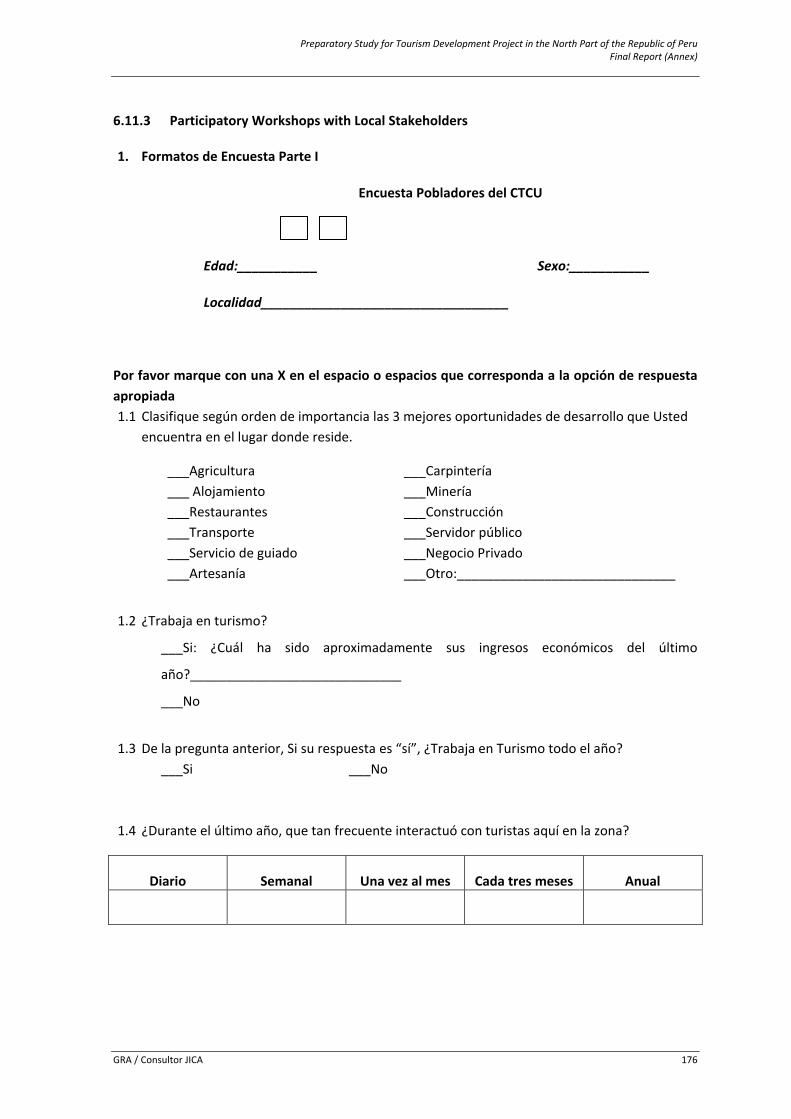
Preparatory Study for Tourism Development Project in the North Part of the Republic of Peru Final Report (Annex)
GRA / Consultor JICA 176
6.11.3 Participatory Workshops with Local Stakeholders
1. Formatos de Encuesta Parte I
Encuesta Pobladores del CTCU
Edad:___________ Sexo:___________
Localidad__________________________________
Por favor marque con una X en el espacio o espacios que corresponda a la opción de respuesta apropiada 1.1 Clasifique según orden de importancia las 3 mejores oportunidades de desarrollo que Usted
encuentra en el lugar donde reside.
___Agricultura ___ Alojamiento ___Restaurantes ___Transporte ___Servicio de guiado ___Artesanía
___Carpintería ___Minería ___Construcción ___Servidor público ___Negocio Privado ___Otro:______________________________
1.2 ¿Trabaja en turismo?
___Si: ¿Cuál ha sido aproximadamente sus ingresos económicos del último
año?_____________________________
___No
1.3 De la pregunta anterior, Si su respuesta es “sí”, ¿Trabaja en Turismo todo el año?
___Si ___No
1.4 ¿Durante el último año, que tan frecuente interactuó con turistas aquí en la zona?
Diario Semanal Una vez al mes Cada tres meses Anual
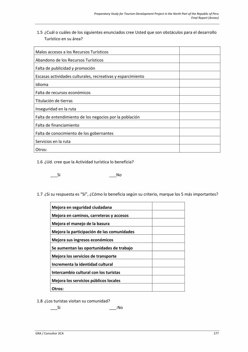
Preparatory Study for Tourism Development Project in the North Part of the Republic of Peru Final Report (Annex)
GRA / Consultor JICA 177
1.5 ¿Cuál o cuáles de los siguientes enunciados cree Usted que son obstáculos para el desarrollo Turístico en su área?
Malos accesos a los Recursos Turísticos
Abandono de los Recursos Turísticos
Falta de publicidad y promoción
Escasas actividades culturales, recreativas y esparcimiento
Idioma
Falta de recursos económicos
Titulación de tierras
Inseguridad en la ruta
Falta de entendimiento de los negocios por la población
Falta de financiamiento
Falta de conocimiento de los gobernantes
Servicios en la ruta
Otros:
1.6 ¿Ud. cree que la Actividad turística lo beneficia? ___Si ___No
1.7 ¿Si su respuesta es “Sí”, ¿Cómo lo beneficia según su criterio, marque los 5 más importantes?
Mejora en seguridad ciudadana
Mejora en caminos, carreteras y accesos
Mejora el manejo de la basura
Mejora la participación de las comunidades
Mejora sus ingresos económicos
Se aumentan las oportunidades de trabajo
Mejora los servicios de transporte
Incrementa la identidad cultural
Intercambio cultural con los turistas
Mejora los servicios públicos locales
Otros:
1.8 ¿Los turistas visitan su comunidad?
___Si ___:No
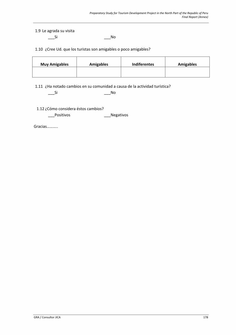
Preparatory Study for Tourism Development Project in the North Part of the Republic of Peru Final Report (Annex)
GRA / Consultor JICA 178
1.9 Le agrada su visita ___Si ___No
1.10 ¿Cree Ud. que los turistas son amigables o poco amigables?
Muy Amigables Amigables Indiferentes Amigables
1.11 ¿Ha notado cambios en su comunidad a causa de la actividad turística? ___Si ___No
1.12 ¿Cómo considera éstos cambios? ___Positivos ___Negativos
Gracias………..
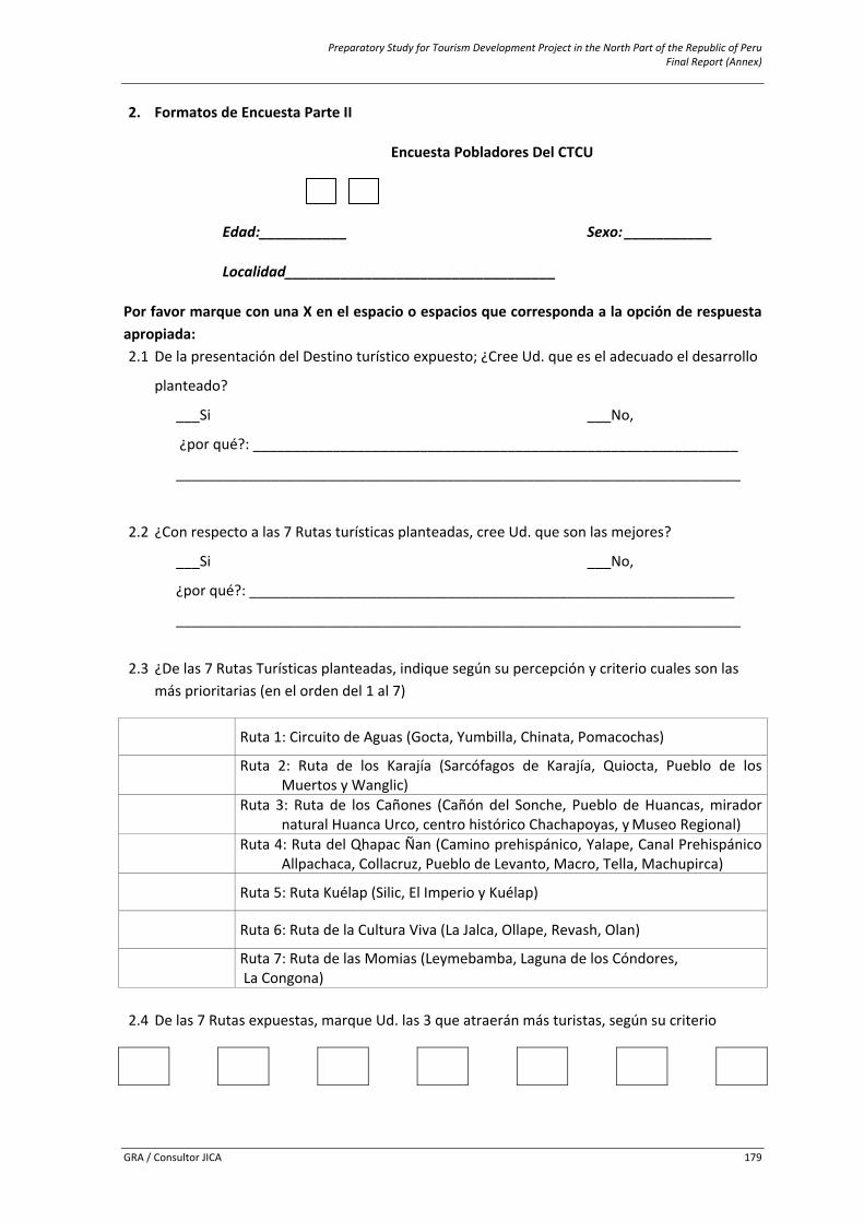
Preparatory Study for Tourism Development Project in the North Part of the Republic of Peru Final Report (Annex)
GRA / Consultor JICA 179
2. Formatos de Encuesta Parte II
Encuesta Pobladores Del CTCU
Edad:___________ Sexo: ___________
Localidad__________________________________
Por favor marque con una X en el espacio o espacios que corresponda a la opción de respuesta apropiada: 2.1 De la presentación del Destino turístico expuesto; ¿Cree Ud. que es el adecuado el desarrollo
planteado?
___Si ___No,
¿por qué?: _____________________________________________________________
_______________________________________________________________________
2.2 ¿Con respecto a las 7 Rutas turísticas planteadas, cree Ud. que son las mejores?
___Si ___No,
¿por qué?: _____________________________________________________________
_______________________________________________________________________
2.3 ¿De las 7 Rutas Turísticas planteadas, indique según su percepción y criterio cuales son las
más prioritarias (en el orden del 1 al 7)
Ruta 1: Circuito de Aguas (Gocta, Yumbilla, Chinata, Pomacochas)
Ruta 2: Ruta de los Karajía (Sarcófagos de Karajía, Quiocta, Pueblo de los Muertos y Wanglic)
Ruta 3: Ruta de los Cañones (Cañón del Sonche, Pueblo de Huancas, mirador natural Huanca Urco, centro histórico Chachapoyas, y Museo Regional)
Ruta 4: Ruta del Qhapac Ñan (Camino prehispánico, Yalape, Canal Prehispánico Allpachaca, Collacruz, Pueblo de Levanto, Macro, Tella, Machupirca)
Ruta 5: Ruta Kuélap (Silic, El Imperio y Kuélap)
Ruta 6: Ruta de la Cultura Viva (La Jalca, Ollape, Revash, Olan)
Ruta 7: Ruta de las Momias (Leymebamba, Laguna de los Cóndores, La Congona)
2.4 De las 7 Rutas expuestas, marque Ud. las 3 que atraerán más turistas, según su criterio

Preparatory Study for Tourism Development Project in the North Part of the Republic of Peru Final Report (Annex)
GRA / Consultor JICA 180
2.5 ¿Cuál de estas tres que marco Usted, es la mejor y porque?
2.6 ¿Estaría Ud. dispuesto a involucrarse y/o participar en alguna actividad turística que se desarrolle su localidad?
Actividades de Ocio Actividades económicas Actividades socioculturales
Visitas Turísticas Guiado turístico Danzas tradicionales
Fotografía Servicio de alimentación Teatro
Deporte de Aventura Servicio de alojamiento Venta y producción tradicional
Otros:…………………………………
Servicio de transporte vehicular
Otros:………………………………
Alquiler de acémilas
Venta artesanal
Otros:…………………………
2.7 ¿Para el desarrollo de estas rutas, Quienes cree Ud. que deberían intervenir, marque la o las que cree conveniente?
___La inversión privada ___La inversión pública
___La participación comunal
2.8 ¿Cómo reflexión final, existirían las condiciones para el desarrollo turístico, con la
intervención del presente programa? ___Si ___No,
¿por qué?: _____________________________________________________________
_______________________________________________________________________
Gracias…………..
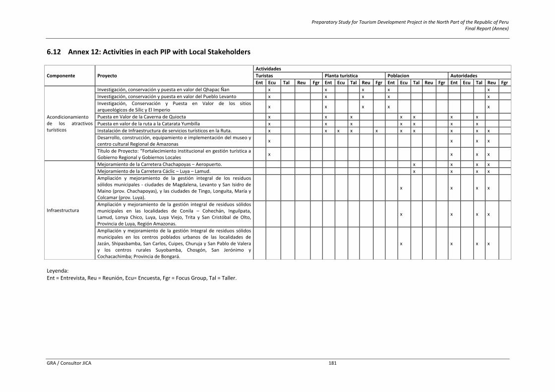
Preparatory Study for Tourism Development Project in the North Part of the Republic of Peru Final Report (Annex)
GRA / Consultor JICA 181
6.12 Annex 12: Activities in each PIP with Local Stakeholders
Componente Proyecto ActividadesTuristas Planta turistica Poblacion AutoridadesEnt Ecu Tal Reu Fgr Ent Ecu Tal Reu Fgr Ent Ecu Tal Reu Fgr Ent Ecu Tal Reu Fgr
Acondicionamiento de los atractivos turísticos
Investigación, conservación y puesta en valor del Qhapac Ñan x x x x x Investigación, conservación y puesta en valor del Pueblo Levanto x x x x x Investigación, Conservación y Puesta en Valor de los sitios arqueológicos de Sílic y El Imperio x x x x x
Puesta en Valor de la Caverna de Quiocta x x x x x x x Puesta en valor de la ruta a la Catarata Yumbilla x x x x x x x Instalación de Infraestructura de servicios turísticos en la Ruta. x x x x x x x x x x Desarrollo, construcción, equipamiento e implementación del museo y centro cultural Regional de Amazonas x x x x
Título de Proyecto: “Fortalecimiento institucional en gestión turística a Gobierno Regional y Gobiernos Locales x x x x
Infraestructura
Mejoramiento de la Carretera Chachapoyas – Aeropuerto. x x x x Mejoramiento de la Carretera Cáclic – Luya – Lamud. x x x x Ampliación y mejoramiento de la gestión integral de los residuos sólidos municipales ‐ ciudades de Magdalena, Levanto y San Isidro de Maino (prov. Chachapoyas), y las ciudades de Tingo, Longuita, María y Colcamar (prov. Luya).
x x x x
Ampliación y mejoramiento de la gestión integral de residuos sólidos municipales en las localidades de Conila – Cohechán, Inguilpata, Lamud, Lonya Chico, Luya, Luya Viejo, Trita y San Cristóbal de Olto, Provincia de Luya, Región Amazonas.
x x x x
Ampliación y mejoramiento de la gestión Integral de residuos sólidos municipales en los centros poblados urbanos de las localidades de Jazán, Shipasbamba, San Carlos, Cuipes, Churuja y San Pablo de Valera y los centros rurales Suyobamba, Chosgón, San Jerónimo y Cochacachimba; Provincia de Bongará.
x x x x
Leyenda: Ent = Entrevista, Reu = Reunión, Ecu= Encuesta, Fgr = Focus Group, Tal = Taller.
Preparatory Study for Tourism Development Project in the North Part of the Republic of Peru Final Report (Annex)
GRA / Consultor JICA 182
6.13 Annex 13: Caracteristics of National Vacationists – ENVIR 2007/2008. Como referencia para la formulación del plan de comercialización, se toma como referencia las conclusiones de la Encuesta Nacional de Viajes de los Residentes (ENVIR) que se realizó entre abril de 2007 a marzo de 2008. 6.13.1 Conclusions of ENVIR. - En el periodo comprendido entre abril de 2007 y marzo de 2008, el 23,1% de la población
urbana del Perú, viajó por turismo interno. - El número total de viajes realizados por los residentes urbanos del país fue de 24.2 millones. - El 51% de los turistas internos fue de sexo masculino y el 49% de sexo femenino. - Los principales departamentos visitados por los residentes nacionales fueron Lima, Ancash,
Arequipa, Junín, Piura, Cajamarca y Lambayeque. - El 42% de los turistas residentes en Lima visitó las provincias de su mismo departamento,
prefiriendo Cañete y Huaral. - El 52% de los turistas viajó al interior principalmente para visitar a familiares o amigos,
mientras que el 26% lo hizo por vacaciones, recreación u ocio. - El gasto promedio por persona durante el viaje, a nivel nacional, fue de S/. 293. - El turista residente en Madre de Dios registró el gasto más alto en su viaje S/. 857, siguiendo el
de Lima con S/. 349. El más bajo fue el del residente en Ayacucho con S/.141. - El 24% del gasto efectuado durante su viaje fue destinado al transporte de ida y vuelta. - La permanencia promedio a nivel nacional fue de 5,6 noches. La estadía más prolongada fue la
del turista proveniente de Ucayali con 13,1 noches en el lugar visitado, siguiendo La Libertad con 9,4; mientras que el periodo más corto de permanencia en el destino fue el del residente en Huancavelica con 3,6 noches.
- El 72% de los turistas internos se hospedó en vivienda de familiares y amigos. - El 97% viajó haciendo uso del transporte terrestre, siendo el de mayor demanda el transporte
interprovincial en 89%. - El 95% de los turistas internos organizó el viaje por su cuenta. - El 9% financió su viaje con tarjeta de crédito y/o préstamos personales. - De los servicios evaluados, y que superaron el nivel mínimo de satisfacción (puntaje 4, en una
escala del 1 al 5), destacan el de transporte aéreo, entretenimiento y/o diversión y el de restaurantes, sobre los cuales, los turistas manifestaron estar satisfechos con el servicio brindado durante su viaje.
- Entre los aspectos más importantes considerados para viajar, mencionaron el de tener amigos o familiares en el lugar visitado, las festividades, el gasto a efectuar en el viaje, el clima, la gastronomía y los paisajes.
- El 85% de los turistas declaró que recomendaría sin ninguna duda los lugares visitados a sus familiares o amigos.
- De los turistas entrevistados, el 13% indicó haber realizado turismo rural y de ellos, el 44% participó en actividades agrícolas y/o ganaderas, el 28% optó por el ecoturismo y el 27% hizo turismo vivencial principalmente en las provincias de Yauyos, Cañete, Huaylas y Puno.
6.13.2 Caracteristics of Internal Tourism by Department – ENVIR. Las características del turismo interno por departamentos que representan mercados emisores prioritarios para el plan de comercialización son: Departamento de La Libertad. Durante el periodo abril 2007 y marzo 2008, el 11,1% de la población urbana de este departamento viajó por turismo interno, un 11,4% de estos turistas
Preparatory Study for Tourism Development Project in the North Part of the Republic of Peru Final Report (Annex)
GRA / Consultor JICA 183
viajó por vacaciones, recreación u ocio, registrando un gasto promedio por persona de S/.487 y una permanencia promedio de 3,8 noches durante el último viaje realizado; asimismo, el 15,2% de los turistas internos se hospedó en Hotel u Hostal, el 97,9% demandó los servicios de transporte interprovincial y el 95,2% de ellos organizó el viaje por su cuenta. En cuanto a las características demográficas y socioeconómicas, se identificó que el 56,9% de la población viajera correspondió al sexo masculino y el 43,1% al sexo femenino. Asimismo, se observó que la población que más viajó por turismo interno fue la adulta de 26 a 59 años (60,2%), la mayoría de estos turistas tiene estudios universitarios completos (34,7%), principalmente son trabajadores independientes (26,1%), empleados públicos (23,0%) y empleados privados (18,7%), el 33,4% manifestó que la actividad económica principal de su centro de trabajo corresponde a otras actividades (sector público, bancos, salud, educación) y el 32,5% señaló el comercio; el 46,2% de los turistas percibe un ingreso promedio mensual que fluctúa entre S/. 500 y S/. 1 500. Los principales departamentos visitados son: Lima (33.7%), Cajamarca (22.1%), Lambayeque (17.6%), La Libertad (12.8%), Piura (5.9%) y Otros (7.9%). Departamento de Lambayeque. Durante el periodo abril 2007 y marzo 2008, el 16,5% de la población urbana de este departamento viajó por turismo interno, el 35,1% de estos turistas viajó por vacaciones, recreación u ocio, registrándose un gasto promedio por persona de S/. 262 y una permanencia promedio de 5,4 noches durante el último viaje realizado; asimismo, el 22,2% de los turistas internos se hospedó en Hostal u Hotel, el 92,6% demandó los servicios de transporte interprovincial y el 97,8% de ellos viajó por su cuenta. En relación a las características demográficas y socioeconómicas, el 39,3% de la población viajera correspondió al sexo masculino y 60,7% al sexo femenino. Asimismo, se observó que la población que más viajó por turismo interno fue la adulta (42,1%), la mayoría de estos turistas tiene estudios de secundaria completa (23,3%), principalmente son trabajadores independientes (30,2%) y empleados privados (26,8%), el 38,3% manifestó que la actividad económica principal de su centro de trabajo corresponde a otras actividades (sector público, bancos, salud, educación) y el 36,8% señaló el comercio; el 49,8% de los turistas percibe un ingreso promedio mensual que fluctúa entre S/. 500 y S/. 1 500. Los principales departamentos visitados son: Lima (26,9%), Piura (26,1%), Cajamarca (20,9%), La Libertad (18,6%), Tumbes (2,8%) y Otros (4,7%). Departamento de Lima. Durante el periodo abril 2007 y marzo 2008, el 31,2% de la población urbana de este departamento viajó por turismo interno, el 28,5% de estos turistas viajó por vacaciones, recreación u ocio, registrando un gasto promedio por persona de S/.418 y una permanencia promedio de 5,3 noches durante el último viaje realizado; además, el 16,3% de los turistas internos se hospedó en Hotel u Hostal, el 88,3% demandó los servicios de transporte interprovincial y el 92,4% de ellos viajó por su cuenta. En cuanto a las características demográficas y socioeconómicas, el 50,5% de la población viajera correspondió al sexo masculino y 49,5% al sexo femenino, asimismo se observó que la población que más viajó por turismo interno fue la adulta (55,0%), la mayoría de estos turistas tiene estudios de secundaria completa (31,0%), principalmente son empleados privados (23,9%), comerciantes (23,8%) y trabajadores independientes (19,8%), el 38,5% manifestó que la actividad económica principal de su centro de trabajo corresponde al comercio, el 14,9% señaló la manufactura y el 14,3% otras actividades; el 37,7% de los turistas percibe un ingreso promedio mensual que fluctúa entre S/. 500 y S/.1500. Los principales departamentos visitados son: Lima (42,3%), Ancash (11,3%), Junín (8%), Arequipa (5,6%), Piura (5,1%) y Otros (27,7%).
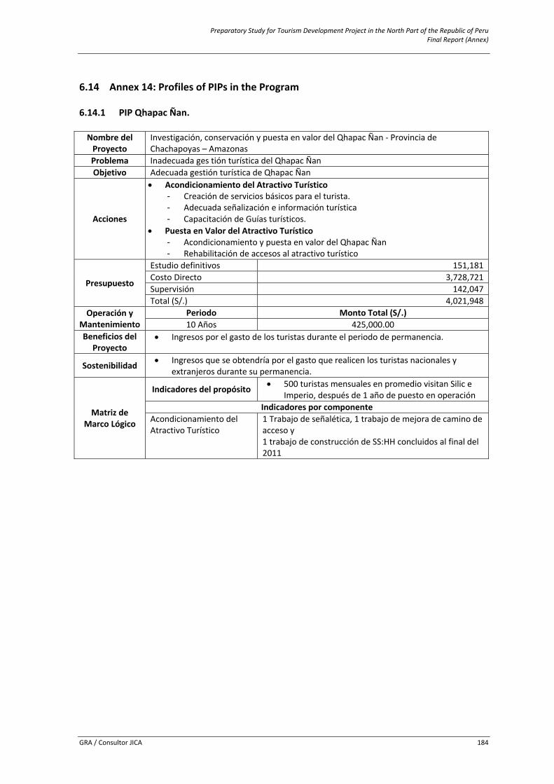
Preparatory Study for Tourism Development Project in the North Part of the Republic of Peru Final Report (Annex)
GRA / Consultor JICA 184
6.14 Annex 14: Profiles of PIPs in the Program 6.14.1 PIP Qhapac Ñan. Nombre del Proyecto
Investigación, conservación y puesta en valor del Qhapac Ñan ‐ Provincia de Chachapoyas – Amazonas
Problema Inadecuada ges tión turística del Qhapac ÑanObjetivo Adecuada gestión turística de Qhapac Ñan
Acciones
• Acondicionamiento del Atractivo Turístico - Creación de servicios básicos para el turista. - Adecuada señalización e información turística - Capacitación de Guías turísticos.
• Puesta en Valor del Atractivo Turístico - Acondicionamiento y puesta en valor del Qhapac Ñan - Rehabilitación de accesos al atractivo turístico
Presupuesto
Estudio definitivos 151,181Costo Directo 3,728,721Supervisión 142,047Total (S/.) 4,021,948
Operación y Mantenimiento
Periodo Monto Total (S/.) 10 Años 425,000.00
Beneficios del Proyecto
• Ingresos por el gasto de los turistas durante el periodo de permanencia.
Sostenibilidad • Ingresos que se obtendría por el gasto que realicen los turistas nacionales y extranjeros durante su permanencia.
Matriz de Marco Lógico
Indicadores del propósito • 500 turistas mensuales en promedio visitan Silic e Imperio, después de 1 año de puesto en operación
Indicadores por componenteAcondicionamiento delAtractivo Turístico
1 Trabajo de señalética, 1 trabajo de mejora de camino de acceso y 1 trabajo de construcción de SS:HH concluidos al final del 2011
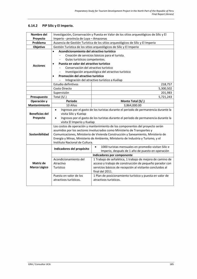
Preparatory Study for Tourism Development Project in the North Part of the Republic of Peru Final Report (Annex)
GRA / Consultor JICA 185
6.14.2 PIP Sílic y El Imperio. Nombre del Proyecto
Investigación, Conservación y Puesta en Valor de los sitios arqueológicos de Sílic y El Imperio ‐ provincia de Luya – Amazonas
Problema Ausencia de Gestión Turística de los sitios arqueológicos de Sílic y El Imperio Objetivo Gestión Turística de los sitios arqueológicos de Sílic y El Imperio
Acciones
• Acondicionamiento del atractivo turístico - Creación de servicios básicos para el turista. - Guías turísticos competentes.
• Puesta en valor del atractivo turístico - Conservación del atractivo turístico - Investigación arqueológica del atractivo turístico
• Promoción del atractivo turístico - Integración del atractivo turístico a Kuélap
Estudio definitivos 218,757 Costo Directo 5,300,502 Supervisión 201,983
Presupuesto Total (S/.) 5,721,243Operación y
Mantenimiento Periodo Monto Total (S/.) 10 Años 3,864,000.00
Beneficios del Proyecto
• Ingresos por el gasto de los turistas durante el periodo de permanencia durante la visita Silic y Kuelap
• Ingresos por el gasto de los turistas durante el periodo de permanencia durante la visita El Imperio y Kuelap
Sostenibilidad
Los costos de operación y mantenimiento de los componentes del proyecto seránasumidos por los sectores involucrados como Ministerio de Transportes y Comunicaciones, Ministerio de Vivienda Construcción y Saneamiento, Ministerio de Energía y Minas, Ministerio de Ambiente, Ministerio de Industria y Turismo, y el Instituto Nacional de Cultura.
Matriz de Marco Lógico
Indicadores del propósito • 1000 turistas mensuales en promedio visitan Silic e Imperio, después de 1 año de puesto en operación
Indicadores por componenteAcondicionamiento del Atractivo Turístico
1 Trabajo de señalética, 1 trabajo de mejora de camino de acceso y trabajo de construcción de pequeño parador con servicios básicos de recepción al visitante concluidos al final del 2011.
Puesta en valor de losatractivos turísticos.
1 Plan de posicionamiento turístico y puesta en valor de atractivos turísticos.
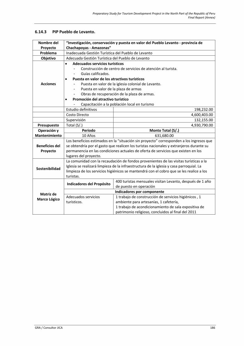
Preparatory Study for Tourism Development Project in the North Part of the Republic of Peru Final Report (Annex)
GRA / Consultor JICA 186
6.14.3 PIP Pueblo de Levanto. Nombre del Proyecto
“Investigación, conservación y puesta en valor del Pueblo Levanto ‐ provincia de Chachapoyas ‐ Amazonas”
Problema Inadecuada Gestión Turística del Pueblo de Levanto Objetivo Adecuada Gestión Turística del Pueblo de Levanto
Acciones
• Adecuados servicios turísticos - Construcción de centro de servicios de atención al turista. - Guías calificados.
• Puesta en valor de los atractivos turísticos - Puesta en valor de la iglesia colonial de Levanto. - Puesta en valor de la plaza de armas - Obras de recuperación de la plaza de armas.
• Promoción del atractivo turístico - Capacitación a la población local en turismo
Estudio definitivos 198,232.00 Costo Directo 4,600,403.00 Supervisión 132,155.00
Presupuesto Total (S/.) 4,930,790.00Operación y
Mantenimiento Periodo Monto Total (S/.) 10 Años 631,680.00
Beneficios del Proyecto
Los beneficios estimados en la “situación sin proyecto” corresponden a los ingresos que se obtendría por el gasto que realicen los turistas nacionales y extranjeros durante su permanencia en las condiciones actuales de oferta de servicios que existen en los lugares del proyecto.
Sostenibilidad
La comunidad con la recaudación de fondos provenientes de las visitas turísticas a la Iglesia se realizará limpieza de la infraestructura de la iglesia y casa parroquial. La limpieza de los servicios higiénicos se mantendrá con el cobro que se les realice a los turistas.
Matriz de Marco Lógico
Indicadores del Propósito 400 turistas mensuales visitan Levanto, después de 1 año de puesto en operación Indicadores por componente
Adecuados servicios turísticos.
1 trabajo de construcción de servicios higiénicos , 1 ambiente para artesanías, 1 cafetería, 1 trabajo de acondicionamiento de sala expositiva de patrimonio religioso, concluidos al final del 2011
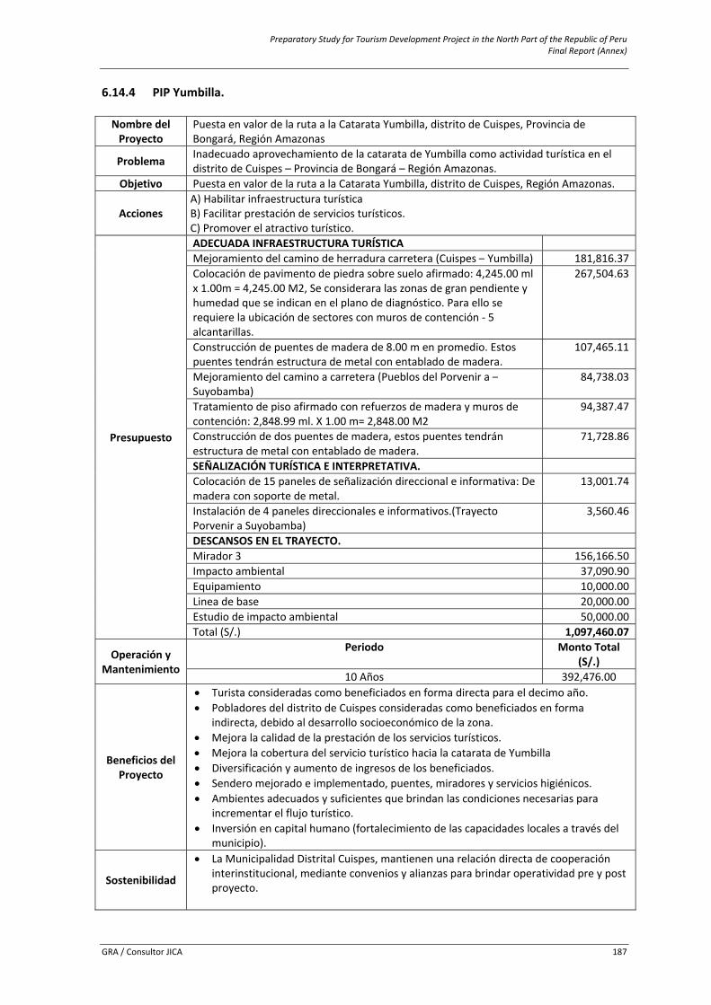
Preparatory Study for Tourism Development Project in the North Part of the Republic of Peru Final Report (Annex)
GRA / Consultor JICA 187
6.14.4 PIP Yumbilla. Nombre del Proyecto
Puesta en valor de la ruta a la Catarata Yumbilla, distrito de Cuispes, Provincia de Bongará, Región Amazonas
Problema Inadecuado aprovechamiento de la catarata de Yumbilla como actividad turística en el distrito de Cuispes – Provincia de Bongará – Región Amazonas.
Objetivo Puesta en valor de la ruta a la Catarata Yumbilla, distrito de Cuispes, Región Amazonas.
Acciones A) Habilitar infraestructura turísticaB) Facilitar prestación de servicios turísticos. C) Promover el atractivo turístico.
Presupuesto
ADECUADA INFRAESTRUCTURA TURÍSTICAMejoramiento del camino de herradura carretera (Cuispes – Yumbilla) 181,816.37 Colocación de pavimento de piedra sobre suelo afirmado: 4,245.00 ml x 1.00m = 4,245.00 M2, Se considerara las zonas de gran pendiente y humedad que se indican en el plano de diagnóstico. Para ello se requiere la ubicación de sectores con muros de contención ‐ 5 alcantarillas.
267,504.63
Construcción de puentes de madera de 8.00 m en promedio. Estos puentes tendrán estructura de metal con entablado de madera.
107,465.11
Mejoramiento del camino a carretera (Pueblos del Porvenir a –Suyobamba)
84,738.03
Tratamiento de piso afirmado con refuerzos de madera y muros de contención: 2,848.99 ml. X 1.00 m= 2,848.00 M2
94,387.47
Construcción de dos puentes de madera, estos puentes tendrán estructura de metal con entablado de madera.
71,728.86
SEÑALIZACIÓN TURÍSTICA E INTERPRETATIVA.Colocación de 15 paneles de señalización direccional e informativa: De madera con soporte de metal.
13,001.74
Instalación de 4 paneles direccionales e informativos.(Trayecto Porvenir a Suyobamba)
3,560.46
DESCANSOS EN EL TRAYECTO.Mirador 3 156,166.50Impacto ambiental 37,090.90Equipamiento 10,000.00Linea de base 20,000.00 Estudio de impacto ambiental 50,000.00 Total (S/.) 1,097,460.07
Operación y Mantenimiento
Periodo Monto Total (S/.)
10 Años 392,476.00
Beneficios del Proyecto
• Turista consideradas como beneficiados en forma directa para el decimo año. • Pobladores del distrito de Cuispes consideradas como beneficiados en forma
indirecta, debido al desarrollo socioeconómico de la zona. • Mejora la calidad de la prestación de los servicios turísticos. • Mejora la cobertura del servicio turístico hacia la catarata de Yumbilla • Diversificación y aumento de ingresos de los beneficiados. • Sendero mejorado e implementado, puentes, miradores y servicios higiénicos. • Ambientes adecuados y suficientes que brindan las condiciones necesarias para
incrementar el flujo turístico. • Inversión en capital humano (fortalecimiento de las capacidades locales a través del
municipio).
Sostenibilidad
• La Municipalidad Distrital Cuispes, mantienen una relación directa de cooperación interinstitucional, mediante convenios y alianzas para brindar operatividad pre y post proyecto.
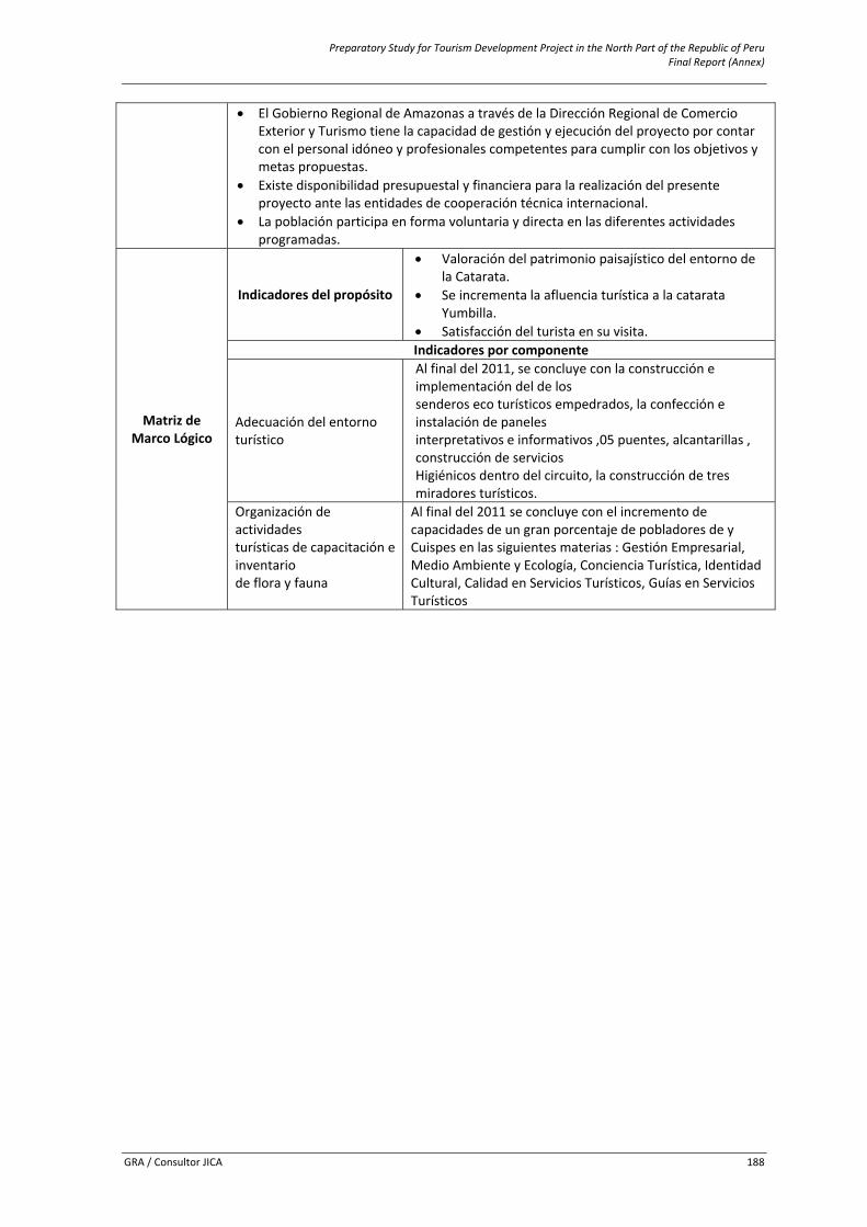
Preparatory Study for Tourism Development Project in the North Part of the Republic of Peru Final Report (Annex)
GRA / Consultor JICA 188
• El Gobierno Regional de Amazonas a través de la Dirección Regional de Comercio Exterior y Turismo tiene la capacidad de gestión y ejecución del proyecto por contar con el personal idóneo y profesionales competentes para cumplir con los objetivos y metas propuestas.
• Existe disponibilidad presupuestal y financiera para la realización del presente proyecto ante las entidades de cooperación técnica internacional.
• La población participa en forma voluntaria y directa en las diferentes actividades programadas.
Matriz de Marco Lógico
Indicadores del propósito
• Valoración del patrimonio paisajístico del entorno de la Catarata.
• Se incrementa la afluencia turística a la catarata Yumbilla.
• Satisfacción del turista en su visita. Indicadores por componente
Adecuación del entorno turístico
Al final del 2011, se concluye con la construcción e implementación del de los senderos eco turísticos empedrados, la confección e instalación de paneles interpretativos e informativos ,05 puentes, alcantarillas , construcción de servicios Higiénicos dentro del circuito, la construcción de tres miradores turísticos.
Organización de actividades turísticas de capacitación e inventario de flora y fauna
Al final del 2011 se concluye con el incremento de capacidades de un gran porcentaje de pobladores de y Cuispes en las siguientes materias : Gestión Empresarial, Medio Ambiente y Ecología, Conciencia Turística, Identidad Cultural, Calidad en Servicios Turísticos, Guías en Servicios Turísticos
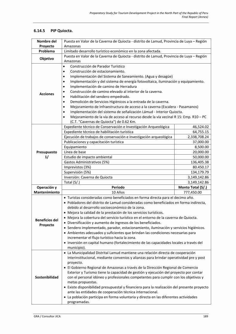
Preparatory Study for Tourism Development Project in the North Part of the Republic of Peru Final Report (Annex)
GRA / Consultor JICA 189
6.14.5 PIP Quiocta. Nombre del Proyecto
Puesta en Valor de la Caverna de Quiocta ‐ distrito de Lamud, Provincia de Luya – Región Amazonas
Problema Limitado desarrollo turístico económico en la zona afectada.
Objetivo Puesta en Valor de la Caverna de Quiocta ‐ distrito de Lamud, Provincia de Luya – Región Amazonas
Acciones
• Construcción de Parador Turístico • Construcción de estacionamiento. • Implementación del Sistema de Saneamiento. (Agua y desagüe) • Implementación y del sistema de energía fotovoltaica, iluminación y equipamiento. • Implementación de camino de Herradura • Construcción de camino elevado al interior de la caverna. • Habilitación del sendero empedrado. • Demolición de Servicios Higiénicos a la entrada de la caverna. • Mejoramiento de Infraestructura de acceso a la caverna (Escalera ‐ Pasamanos) • Implementación del sistema de señalización Lámud ‐ Interior Quiocta. • Mejoramiento de la vía de acceso al recurso desde la vía vecinal R 15: Emp. R10 – PC
(C.T. "Cavernas de Quiocta") de 0.62 Km.
Presupuesto 1/
Expediente técnico de Conservación e Investigación Arqueológica 46,524.02Expediente técnico de habilitación turística 64,755.15Ejecución de trabajos de conservación e investigación arqueológica 2,338,708.24 Publicaciones y capacitación turística 37,000.00Equipamiento 8,500.00 Línea de base 20,000.00 Estudio de impacto ambiental 50,000.00 Gastos Administrativos (5%) 136,405.38Imprevistos (3%) 80.450.17Supervisión (5%) 134,179.79Inversión: Caverna de Quiocta 3,149,142.86Total (S/.) 3,149,142.86
Operación y Mantenimiento
Periodo Monto Total (S/.)10 Años 777,450.00
Beneficios del Proyecto
• Turistas consideradas como beneficiados en forma directa para el decimo año. • Pobladores del distrito de Lamud consideradas como beneficiados en forma indirecta, debido al desarrollo socioeconómico de la zona.
• Mejora la calidad de la prestación de los servicios turísticos. • Mejora la cobertura del servicio turístico en el entorno de la caverna de Quiocta. • Diversificación y aumento de ingresos de los beneficiados. • Sendero implementado, parador, estacionamiento, iluminación y servicios higiénicos. • Ambientes adecuados y suficientes que brindan las condiciones necesarias para incrementar el flujo turístico hacia la zona.
• Inversión en capital humano (fortalecimiento de las capacidades locales a través del municipio).
Sostenibilidad
• La Municipalidad Distrital Lamud mantiene una relación directa de cooperación interinstitucional, mediante convenios y alianzas para brindar operatividad pre y post proyecto.
• El Gobierno Regional de Amazonas a través de la Dirección Regional de Comercio Exterior y Turismo tiene la capacidad de gestión y ejecución del proyecto por contar con el personal idóneo y profesionales competentes para cumplir con los objetivos y metas propuestas.
• Existe disponibilidad presupuestal y financiera para la realización del presente proyecto ante las entidades de cooperación técnica internacional.
• La población participa en forma voluntaria y directa en las diferentes actividades programadas.
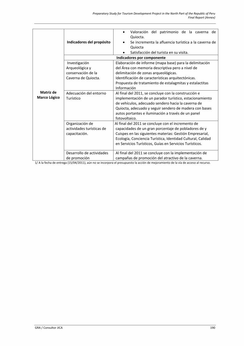
Preparatory Study for Tourism Development Project in the North Part of the Republic of Peru Final Report (Annex)
GRA / Consultor JICA 190
Matriz de Marco Lógico
Indicadores del propósito
• Valoración del patrimonio de la caverna de Quiocta.
• Se incrementa la afluencia turística a la caverna de Quiocta
• Satisfacción del turista en su visita. Indicadores por componente
Investigación Arqueológica y conservación de la Caverna de Quiocta.
Elaboración de informe (mapa base) para la delimitación del Área con memoria descriptiva pero a nivel de delimitación de zonas arqueológicas. Identificación de características arquitectónicas. Propuesta de tratamiento de estalagmitas y estalactitas Información
Adecuación del entorno Turístico
Al final del 2011, se concluye con la construcción e implementación de un parador turístico, estacionamiento de vehículos, adecuado sendero hacia la caverna de Quiocta, adecuado y seguir sendero de madera con bases autos portantes e iluminación a través de un panel fotovoltaico.
Organización de actividades turísticas de capacitación.
Al final del 2011 se concluye con el incremento de capacidades de un gran porcentaje de pobladores de y Cuispes en las siguientes materias: Gestión Empresarial, Ecología, Conciencia Turística, Identidad Cultural, Calidad en Servicios Turísticos, Guías en Servicios Turísticos.
Desarrollo de actividades de promoción
Al final del 2011 se concluye con la implementación de campañas de promoción del atractivo de la caverna.
1/ A la fecha de entrega (15/04/2011), aún no se incorpora el presupuesto la acción de mejoramiento de la vía de acceso al recurso.
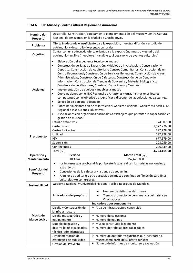
Preparatory Study for Tourism Development Project in the North Part of the Republic of Peru Final Report (Annex)
GRA / Consultor JICA 191
6.14.6 PIP Museo y Centro Cultural Regional de Amazonas. Nombre del Proyecto
Desarrollo, Construcción, Equipamiento e Implementación del Museo y Centro Cultural Regional de Amazonas, en la ciudad de Chachapoyas.
Problema Oferta inadecuada e insuficiente para la exposición, muestra, difusión y estudio del patrimonio, y desarrollo de eventos culturales
Objetivo Contar con una adecuada oferta orientada a la exposición, muestra y estudio del patrimonio tangible (mueble) e intangible y, al desarrollo de eventos culturales”
Acciones
• Elaboración del expediente técnico del museo • Construcción de Salas de Exposición; Módulos de Investigación, Conservación y
Depósito; Construcción de Auditorios o Centros Comunitarios; Construcción de un Centro Recreacional; Construcción de Servicios Generales; Construcción de Áreas Administrativas; Construcción de Cafeterías; Construcción de un Centro de Información; Construcción de Tiendas de Souvenirs y Material Bibliográfico; Construcción de Miradores; Construcción de Plazas y Caminos.
• Implementación de equipos y muebles al museo • Coordinaciones con el INC Regional de Amazonas y otras instituciones locales
competentes con el objetivo de identificar y disponer de las colecciones existentes. • Selección de personal adecuado • Coordinar la elaboración de talleres con el Gobierno Regional, Gobiernos Locales, INC
Regional e Instituciones Educativas. • Asociaciones con organismos nacionales o extranjero que permitan la capacitación en
gestión de museos.
Presupuesto
Estudio definitivos 74,307.00Costo Directo 2,972,276.00Costos Indirectos 297,228.00Utilidad 297,228.00IGV 677,679.00Supervisión 208,059.00Contingencias 226,339.00Total (S/.) 4,753,115.00
Operación y Mantenimiento
Periodo Monto Total (S/.) 10 Años 257,620.000
Beneficios del Proyecto
• los ingresos que se obtendría por boletería que realicen los turistas nacionales y extranjeros
• Concesiones de la cafetería y la tienda de souvenirs • Alquiler de auditorio y otros espacios del museo con fines de filmación para fines
culturales y/o comerciales.
Sostenibilidad Gobierno Regional y Universidad Nacional Toribio Rodríguez de Mendoza,
Matriz de Marco Lógico
Indicadores del propósito• Número de visitantes del museo. • Tiempo promedio de permanencia del turista en
Chachapoyas. Indicadores por componente
Diseño y Construcción de la infraestructura
Área de infraestructura construida
Diseño museográfico y equipamiento
Número de colecciones Número de equipos
Modelo de gestión y desarrollo de capacidades técnico‐ administrativas
Museo constituido legalmente Número de trabajadores capacitados
. Implementación de estrategias de publicidad
Número de operadores turísticos que incorporan al museo como parte de su oferta turística
Gestión del Proyecto Número de informes de monitoreo y evaluación
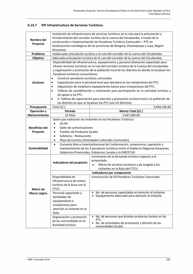
Preparatory Study for Tourism Development Project in the North Part of the Republic of Peru Final Report (Annex)
GRA / Consultor JICA 192
6.14.7 PIP Infraestructura de Servicios Turísticos.
Nombre del Proyecto
Instalación de infraestructura de servicios turísticos en la ruta para la articulación y fortalecimiento del corredor turístico de la cuenca del Utcubamba, a través de la construcción e implementación de Paradores Turísticos Comunales – PTC en localizaciones estratégicas de las provincias de Bongará, Chachapoyas y Luya, Región Amazonas.
Problema Inadecuada articulación turística a la ruta del corredor de la cuenca del UtcubambaObjetivo Adecuada articulación turística de la ruta del corredor de la cuenca del Utcubamba.
Acciones
Disponibilidad de infraestructura, equipamiento y personal altamente capacitado para ofrecer servicios turísticos en la ruta del corredor turístico de la Cuenca del Utcubamba; y organización y promoción de la población local de los distritos en donde se localizan los Paradores turísticos comunitarios. • Construir paradores turísticos comunales. • Capacitación para el personal local que atenderá en las instalaciones del PTC. • Adquisición de mobiliario equipamiento básico para instalaciones del PTC. • Talleres de sensibilización y motivación para participación en la actividad turística y
de apoyo a los PTC. • 5. Talleres de capacitación para atención y promoción turística local a la población de
los distritos en que se localizan los PTC (son 03 distritos). Presupuesto Total (S/.) 5,858,190.00Operación y
Mantenimiento Periodo Monto Total (S/.) 10 Años 2,667,600.00
Beneficios del Proyecto
Gasto que realizarán los visitantes en los Paradores Turísticos• SS.HH. • Salón de comunicaciones • Tambos de Productos locales • Cafetería – Restaurante • Plaza de Eventos (Actividades Culturales Comunales)
Sostenibilidad • Convenio Marco Interinstitucional de Conformación, compromiso, operación y
mantenimiento de los 3 paradores turísticos entre el Gobierno Regional Amazonas, Gobiernos Provinciales, Gobiernos Locales y la DIRCETUR.
Matriz de Marco Lógico
Indicadores del propósito
Incremento de la demanda turística respecto a lo proyectado. • Oferta de servicios turísticos y de acogida a los
visitantes en la Ruta del CTCU. Indicadores por componente
Disponibilidad de infraestructura de enlace turístico de la Ruta con el CTCU
Construcción de 03 Paradores Turísticos Comunales.
Personal capacitado y facilidades de equipamiento e instalaciones para atención al visitante en la Ruta
No. de personas capacitadas en atención al visitante. Equipamiento adecuado para atención al visitante
Organización y promoción de las comunidades en la Actividad turística
No. de personas que brindan productos locales en los PTC.
No. de actividades de promoción y difusión de las comunidades locales
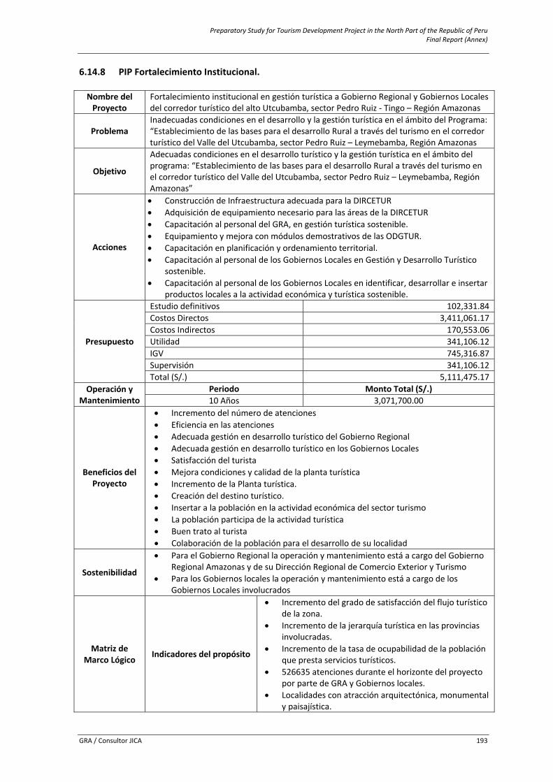
Preparatory Study for Tourism Development Project in the North Part of the Republic of Peru Final Report (Annex)
GRA / Consultor JICA 193
6.14.8 PIP Fortalecimiento Institucional. Nombre del Proyecto
Fortalecimiento institucional en gestión turística a Gobierno Regional y Gobiernos Locales del corredor turístico del alto Utcubamba, sector Pedro Ruiz ‐ Tingo – Región Amazonas
Problema Inadecuadas condiciones en el desarrollo y la gestión turística en el ámbito del Programa: “Establecimiento de las bases para el desarrollo Rural a través del turismo en el corredor turístico del Valle del Utcubamba, sector Pedro Ruiz – Leymebamba, Región Amazonas
Objetivo
Adecuadas condiciones en el desarrollo turístico y la gestión turística en el ámbito del programa: “Establecimiento de las bases para el desarrollo Rural a través del turismo en el corredor turístico del Valle del Utcubamba, sector Pedro Ruiz – Leymebamba, Región Amazonas”
Acciones
• Construcción de Infraestructura adecuada para la DIRCETUR • Adquisición de equipamiento necesario para las áreas de la DIRCETUR • Capacitación al personal del GRA, en gestión turística sostenible. • Equipamiento y mejora con módulos demostrativos de las ODGTUR. • Capacitación en planificación y ordenamiento territorial. • Capacitación al personal de los Gobiernos Locales en Gestión y Desarrollo Turístico
sostenible. • Capacitación al personal de los Gobiernos Locales en identificar, desarrollar e insertar
productos locales a la actividad económica y turística sostenible.
Presupuesto
Estudio definitivos 102,331.84Costos Directos 3,411,061.17Costos Indirectos 170,553.06Utilidad 341,106.12IGV 745,316.87Supervisión 341,106.12Total (S/.) 5,111,475.17
Operación y Mantenimiento
Periodo Monto Total (S/.) 10 Años 3,071,700.00
Beneficios del Proyecto
• Incremento del número de atenciones • Eficiencia en las atenciones • Adecuada gestión en desarrollo turístico del Gobierno Regional • Adecuada gestión en desarrollo turístico en los Gobiernos Locales • Satisfacción del turista • Mejora condiciones y calidad de la planta turística • Incremento de la Planta turística. • Creación del destino turístico. • Insertar a la población en la actividad económica del sector turismo • La población participa de la actividad turística • Buen trato al turista • Colaboración de la población para el desarrollo de su localidad
Sostenibilidad
• Para el Gobierno Regional la operación y mantenimiento está a cargo del Gobierno Regional Amazonas y de su Dirección Regional de Comercio Exterior y Turismo
• Para los Gobiernos locales la operación y mantenimiento está a cargo de los Gobiernos Locales involucrados
Matriz de Marco Lógico Indicadores del propósito
• Incremento del grado de satisfacción del flujo turístico de la zona.
• Incremento de la jerarquía turística en las provincias involucradas.
• Incremento de la tasa de ocupabilidad de la población que presta servicios turísticos.
• 526635 atenciones durante el horizonte del proyecto por parte de GRA y Gobiernos locales.
• Localidades con atracción arquitectónica, monumental y paisajística.
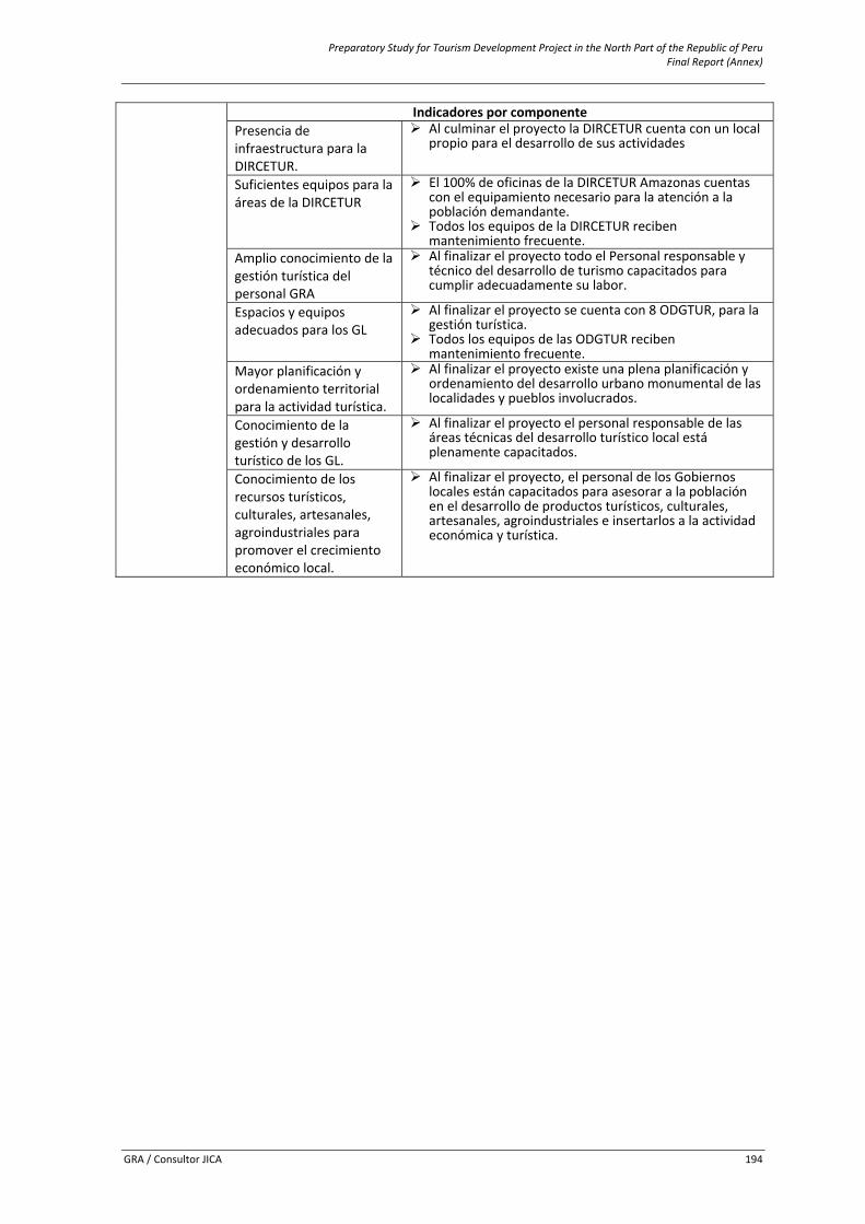
Preparatory Study for Tourism Development Project in the North Part of the Republic of Peru Final Report (Annex)
GRA / Consultor JICA 194
Indicadores por componentePresencia de infraestructura para la DIRCETUR.
Al culminar el proyecto la DIRCETUR cuenta con un local propio para el desarrollo de sus actividades
Suficientes equipos para la áreas de la DIRCETUR
El 100% de oficinas de la DIRCETUR Amazonas cuentas con el equipamiento necesario para la atención a la población demandante.
Todos los equipos de la DIRCETUR reciben mantenimiento frecuente.
Amplio conocimiento de la gestión turística del personal GRA
Al finalizar el proyecto todo el Personal responsable y técnico del desarrollo de turismo capacitados para cumplir adecuadamente su labor.
Espacios y equipos adecuados para los GL
Al finalizar el proyecto se cuenta con 8 ODGTUR, para la gestión turística.
Todos los equipos de las ODGTUR reciben mantenimiento frecuente.
Mayor planificación y ordenamiento territorial para la actividad turística.
Al finalizar el proyecto existe una plena planificación y ordenamiento del desarrollo urbano monumental de las localidades y pueblos involucrados.
Conocimiento de la gestión y desarrollo turístico de los GL.
Al finalizar el proyecto el personal responsable de las áreas técnicas del desarrollo turístico local está plenamente capacitados.
Conocimiento de los recursos turísticos, culturales, artesanales, agroindustriales para promover el crecimiento económico local.
Al finalizar el proyecto, el personal de los Gobiernos locales están capacitados para asesorar a la población en el desarrollo de productos turísticos, culturales, artesanales, agroindustriales e insertarlos a la actividad económica y turística.
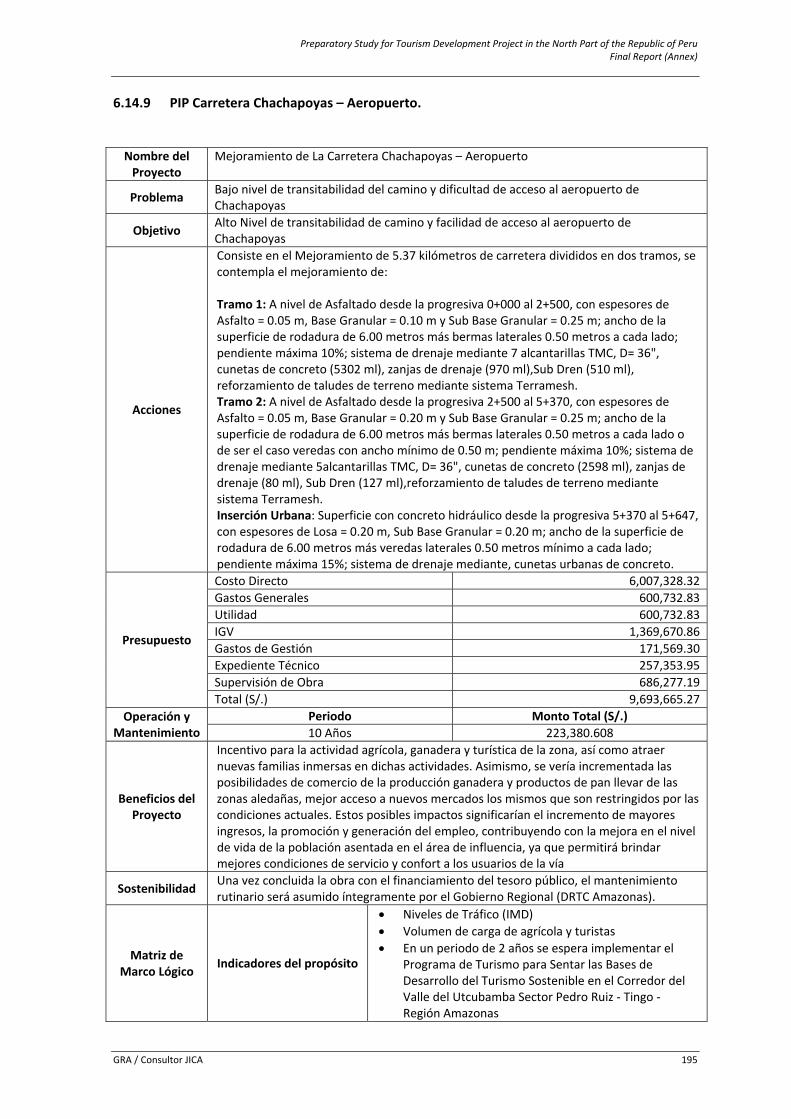
Preparatory Study for Tourism Development Project in the North Part of the Republic of Peru Final Report (Annex)
GRA / Consultor JICA 195
6.14.9 PIP Carretera Chachapoyas – Aeropuerto. Nombre del Proyecto
Mejoramiento de La Carretera Chachapoyas – Aeropuerto
Problema Bajo nivel de transitabilidad del camino y dificultad de acceso al aeropuerto de Chachapoyas
Objetivo Alto Nivel de transitabilidad de camino y facilidad de acceso al aeropuerto de Chachapoyas
Acciones
Consiste en el Mejoramiento de 5.37 kilómetros de carretera divididos en dos tramos, se contempla el mejoramiento de: Tramo 1: A nivel de Asfaltado desde la progresiva 0+000 al 2+500, con espesores de Asfalto = 0.05 m, Base Granular = 0.10 m y Sub Base Granular = 0.25 m; ancho de la superficie de rodadura de 6.00 metros más bermas laterales 0.50 metros a cada lado; pendiente máxima 10%; sistema de drenaje mediante 7 alcantarillas TMC, D= 36", cunetas de concreto (5302 ml), zanjas de drenaje (970 ml),Sub Dren (510 ml), reforzamiento de taludes de terreno mediante sistema Terramesh. Tramo 2: A nivel de Asfaltado desde la progresiva 2+500 al 5+370, con espesores de Asfalto = 0.05 m, Base Granular = 0.20 m y Sub Base Granular = 0.25 m; ancho de la superficie de rodadura de 6.00 metros más bermas laterales 0.50 metros a cada lado o de ser el caso veredas con ancho mínimo de 0.50 m; pendiente máxima 10%; sistema de drenaje mediante 5alcantarillas TMC, D= 36", cunetas de concreto (2598 ml), zanjas de drenaje (80 ml), Sub Dren (127 ml),reforzamiento de taludes de terreno mediante sistema Terramesh. Inserción Urbana: Superficie con concreto hidráulico desde la progresiva 5+370 al 5+647, con espesores de Losa = 0.20 m, Sub Base Granular = 0.20 m; ancho de la superficie de rodadura de 6.00 metros más veredas laterales 0.50 metros mínimo a cada lado; pendiente máxima 15%; sistema de drenaje mediante, cunetas urbanas de concreto.
Presupuesto
Costo Directo 6,007,328.32Gastos Generales 600,732.83Utilidad 600,732.83IGV 1,369,670.86Gastos de Gestión 171,569.30Expediente Técnico 257,353.95Supervisión de Obra 686,277.19Total (S/.) 9,693,665.27
Operación y Mantenimiento
Periodo Monto Total (S/.) 10 Años 223,380.608
Beneficios del Proyecto
Incentivo para la actividad agrícola, ganadera y turística de la zona, así como atraer nuevas familias inmersas en dichas actividades. Asimismo, se vería incrementada las posibilidades de comercio de la producción ganadera y productos de pan llevar de las zonas aledañas, mejor acceso a nuevos mercados los mismos que son restringidos por las condiciones actuales. Estos posibles impactos significarían el incremento de mayores ingresos, la promoción y generación del empleo, contribuyendo con la mejora en el nivel de vida de la población asentada en el área de influencia, ya que permitirá brindar mejores condiciones de servicio y confort a los usuarios de la vía
Sostenibilidad Una vez concluida la obra con el financiamiento del tesoro público, el mantenimiento rutinario será asumido íntegramente por el Gobierno Regional (DRTC Amazonas).
Matriz de Marco Lógico Indicadores del propósito
• Niveles de Tráfico (IMD) • Volumen de carga de agrícola y turistas • En un periodo de 2 años se espera implementar el
Programa de Turismo para Sentar las Bases de Desarrollo del Turismo Sostenible en el Corredor del Valle del Utcubamba Sector Pedro Ruiz ‐ Tingo ‐ Región Amazonas
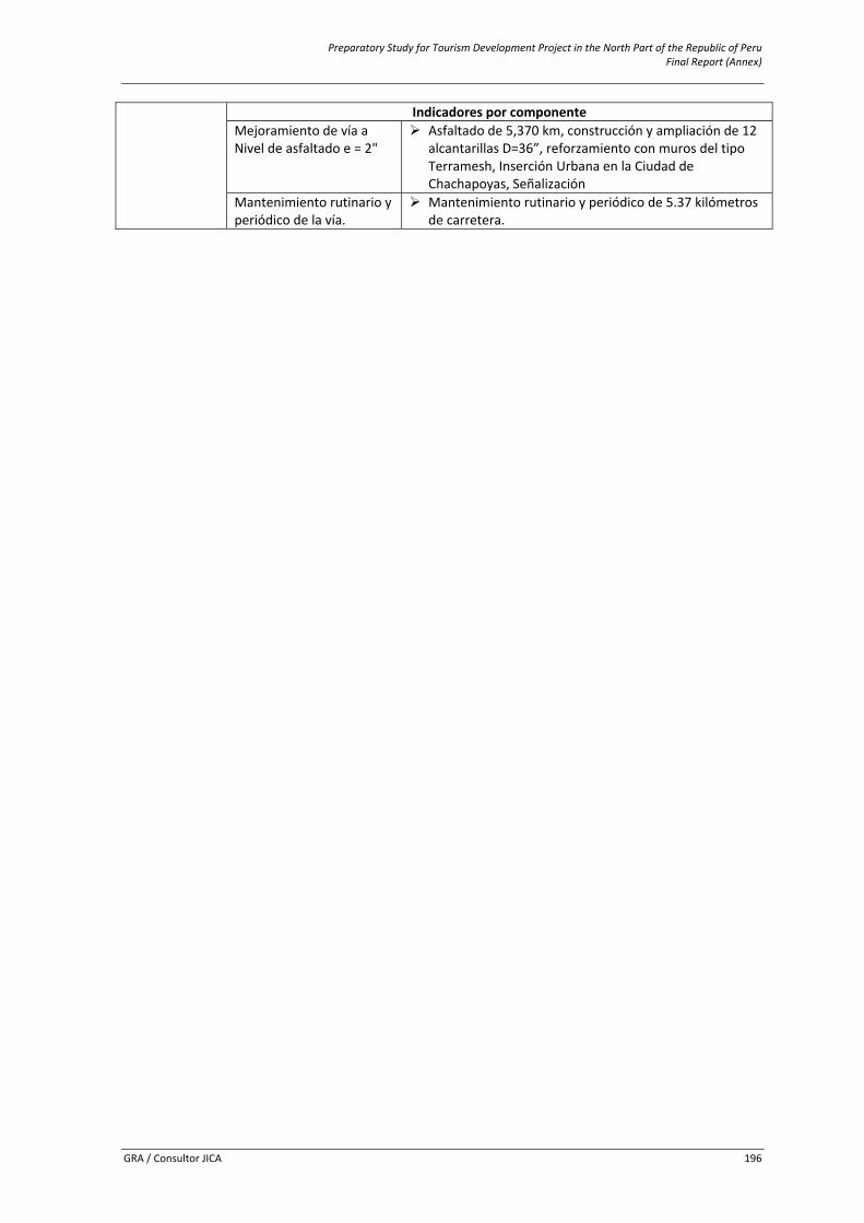
Preparatory Study for Tourism Development Project in the North Part of the Republic of Peru Final Report (Annex)
GRA / Consultor JICA 196
Indicadores por componenteMejoramiento de vía a Nivel de asfaltado e = 2"
Asfaltado de 5,370 km, construcción y ampliación de 12 alcantarillas D=36”, reforzamiento con muros del tipo Terramesh, Inserción Urbana en la Ciudad de Chachapoyas, Señalización
Mantenimiento rutinario y periódico de la vía.
Mantenimiento rutinario y periódico de 5.37 kilómetros de carretera.
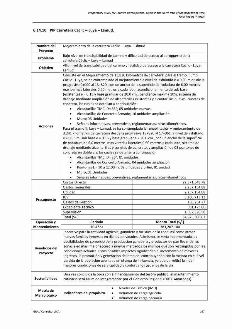
Preparatory Study for Tourism Development Project in the North Part of the Republic of Peru Final Report (Annex)
GRA / Consultor JICA 197
6.14.10 PIP Carretera Cáclic – Luya – Lámud. Nombre del Proyecto
Mejoramiento de la carretera Cáclic – Luya – Lámud
Problema Bajo nivel de transitabilidad de camino y dificultad de acceso al aeropuerto de la carretera Cáclic – Luya – Lamud
Objetivo Alto nivel de transitabilidad del camino y facilidad de acceso a la carretera Cáclic ‐ Luya‐ Lamud
Acciones
Consiste en el Mejoramiento de 13,820 kilómetros de carretera, para el tramo I: Emp. Cáclic ‐ Luya, se ha contemplado el mejoramiento a nivel de asfaltado e = 0.05 m desde la progresiva 0+000 al 13+820, con un ancho de la superficie de rodadura de 6.00 metros más bermas laterales 0.50 metros a cada lado, acondicionamiento de sub base (existente) e = 0.15 y base granular de 20.0 cm., pendiente máxima 10%, sistema de drenaje mediante ampliación de alcantarillas existentes y alcantarillas nuevas, cunetas de concreto, las cuales se detallan a continuación:
• Alcantarillas TMC, D= 36"; 05 unidades nuevas. • Alcantarillas de Concreto Armado; 16 unidades ampliación. • Muro; 06 Unidades • Señales informativas, preventivas, reglamentarias, hitos kilométricos.
Para el tramo II: Luya – Lamud, se ha contemplado la rehabilitación y mejoramiento de 3.241 kilómetros de carretera desde la progresiva 13+820 al 17+061, a nivel de asfaltado e = 0.05 m, sub base e = 0.15 y base granular e = 20.0 cm., con un ancho de la superficie de rodadura de 6.0 metros, mas veredas laterales 0.60 metros a cada lado, sistema de drenaje mediante alcantarillas y cunetas de concreto, y ampliación de 03 pontones de concreto en doble vía, las cuales se detallan a continuación:
• Alcantarillas TMC, D= 36"; 01 unidades. • Alcantarillas de Concreto Armado; 04 unidades ampliación • Pontones L = 10 a 12.00 m; 02 unidades y L=6m, 01 unidad. • Muro; 01 Unidades • Señales informativas, preventivas, reglamentarias, hitos kilométricos
Presupuesto
Costos Directo 22,371,548.78Gastos Generales 2,237,154.88Utilidad 2,237,154.88IGV 5,100,713.12Gastos de Gestión 180,234.77Expediente Técnico 901,173.86Supervisión 1,597,328.58Total (S/.) 34,625,308.87
Operación y Mantenimiento
Periodo Monto Total (S/.) 10 Años 383,207.100
Beneficios del Proyecto
Incentivo para la actividad agrícola, ganadera y turística de la zona, así como atraer nuevas familias inmersas en dichas actividades. Asimismo, se vería incrementada las posibilidades de comercio de la producción ganadera y productos de pan llevar de las zonas aledañas, mejor acceso a nuevos mercados los mismos que son restringidos por las condiciones actuales. Estos posibles impactos significarían el incremento de mayores ingresos, la promoción y generación del empleo, contribuyendo con la mejora en el nivel de vida de la población asentada en el área de influencia, ya que permitirá brindar mejores condiciones de servicialidad y confort a los usuarios de la vía
Sostenibilidad Una vez concluida la obra con el financiamiento del tesoro público, el mantenimiento rutinario será asumido íntegramente por el Gobierno Regional (DRTC Amazonas).
Matriz de Marco Lógico Indicadores del propósito
• Niveles de Tráfico (IMD) • Volumen de carga agrícola • Volumen de carga pecuaria
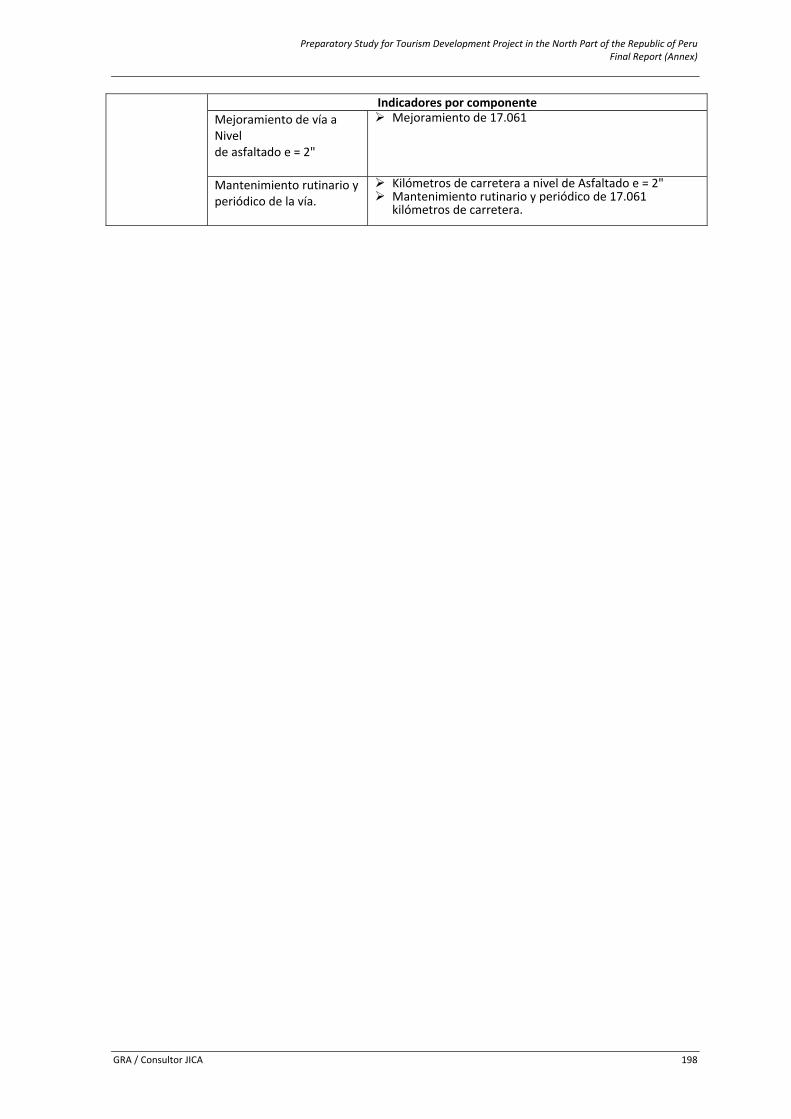
Preparatory Study for Tourism Development Project in the North Part of the Republic of Peru Final Report (Annex)
GRA / Consultor JICA 198
Indicadores por componenteMejoramiento de vía a Nivel de asfaltado e = 2"
Mejoramiento de 17.061
Mantenimiento rutinario yperiódico de la vía.
Kilómetros de carretera a nivel de Asfaltado e = 2" Mantenimiento rutinario y periódico de 17.061 kilómetros de carretera.
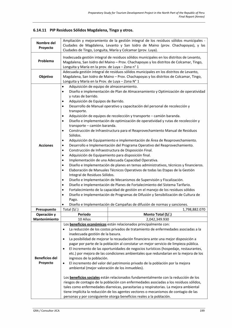
Preparatory Study for Tourism Development Project in the North Part of the Republic of Peru Final Report (Annex)
GRA / Consultor JICA 199
6.14.11 PIP Residuos Sólidos Magdalena, Tingo y otros.
Nombre del Proyecto
Ampliación y mejoramiento de la gestión integral de los residuos sólidos municipales ‐Ciudades de Magdalena, Levanto y San Isidro de Maino (prov. Chachapoyas), y las Ciudades de Tingo, Longuita, María y Colcamar (prov. Luya).
Problema Inadecuada gestión integral de residuos sólidos municipales en los distritos de Levanto, Magdalena, San Isidro del Maino – Prov. Chachapoyas y los distritos de Colcamar, Tingo, Longuita y María en la prov. de Luya – Zona n° 1
Objetivo Adecuada gestión integral de residuos sólidos municipales en los distritos de Levanto, Magdalena, San Isidro de Maino – Prov. Chachapoyas y los distritos de Colcamar, Tingo, Longuita y María en la Prov. de Luya – Zona N° 1
Acciones
• Adquisición de equipo de almacenamiento. • Diseño e implementación de Plan de Almacenamiento y Optimización de operatividad
y rutas de barrido. • Adquisición de Equipos de Barrido. • Desarrollo de Manual operativo y capacitación del personal de recolección y
transporte. • Adquisición de equipos de recolección y transporte – camión baranda. • Diseño e implementación de optimización de operatividad y rutas de recolección y
transporte – camión baranda. • Construcción de Infraestructura para el Reaprovechamiento Manual de Residuos
Sólidos. • Adquisición de Equipamiento e implementación de Área de Reaprovechamiento. • Desarrollo e Implementación del Programa Operativo del Reaprovechamiento. • Construcción de Infraestructura de Disposición Final. • Adquisición de Equipamiento para disposición final. • Implementación de una Adecuada Capacidad Operativa. • Diseño e Implementación de planes en temas administrativos, técnicos y financieros. • Elaboración de Manuales Técnicos Operativos de todas las Etapas de la Gestión
Integral de Residuos Sólidos. • Diseño e Implementación de Mecanismos de Supervisión y Fiscalización. • Diseño e Implementación de Planes de Fortalecimiento del Sistema Tarifario. • Fortalecimiento de la capacidad de gestión en el manejo de los residuos sólidos • Diseño e Implementación de Programas de Difusión y Sensibilización de Cultura de
Pago. • Diseño e Implementación de Campañas de difusión de normas y sanciones.
Presupuesto Total (S/.) 1,798,882.070Operación y
Mantenimiento Periodo Monto Total (S/.) 10 Años 2,042,349.930
Beneficios del Proyecto
Los beneficios económicos están relacionados principalmente con: • La reducción de los costos privados de tratamiento de enfermedades asociadas a la
inadecuada gestión de la basura. • La posibilidad de mejorar la recaudación financiera ante una mejor disposición a
pagar por parte de la población al constatar un mejor servicio de limpieza pública. • El incremento de las oportunidades de negocios turísticos (hospedaje, restaurantes,
etc.) por mejora de las condiciones ambientales que redundarían en la mejora de los ingresos de la población.
• El incremento del valor del patrimonio privado de la población por la mejora ambiental (mejor valoración de los inmuebles).
Los beneficios sociales están relacionados fundamentalmente con la reducción de los riesgos de contagio de la población con enfermedades asociadas a los residuos sólidos, tales como enfermedades diarreicas, parasitarias y respiratorias. La mejora ambiental tiene implícita la reducción de los agentes vectores o mecanismos de contagio de las personas y por consiguiente otorga beneficios reales a la población.
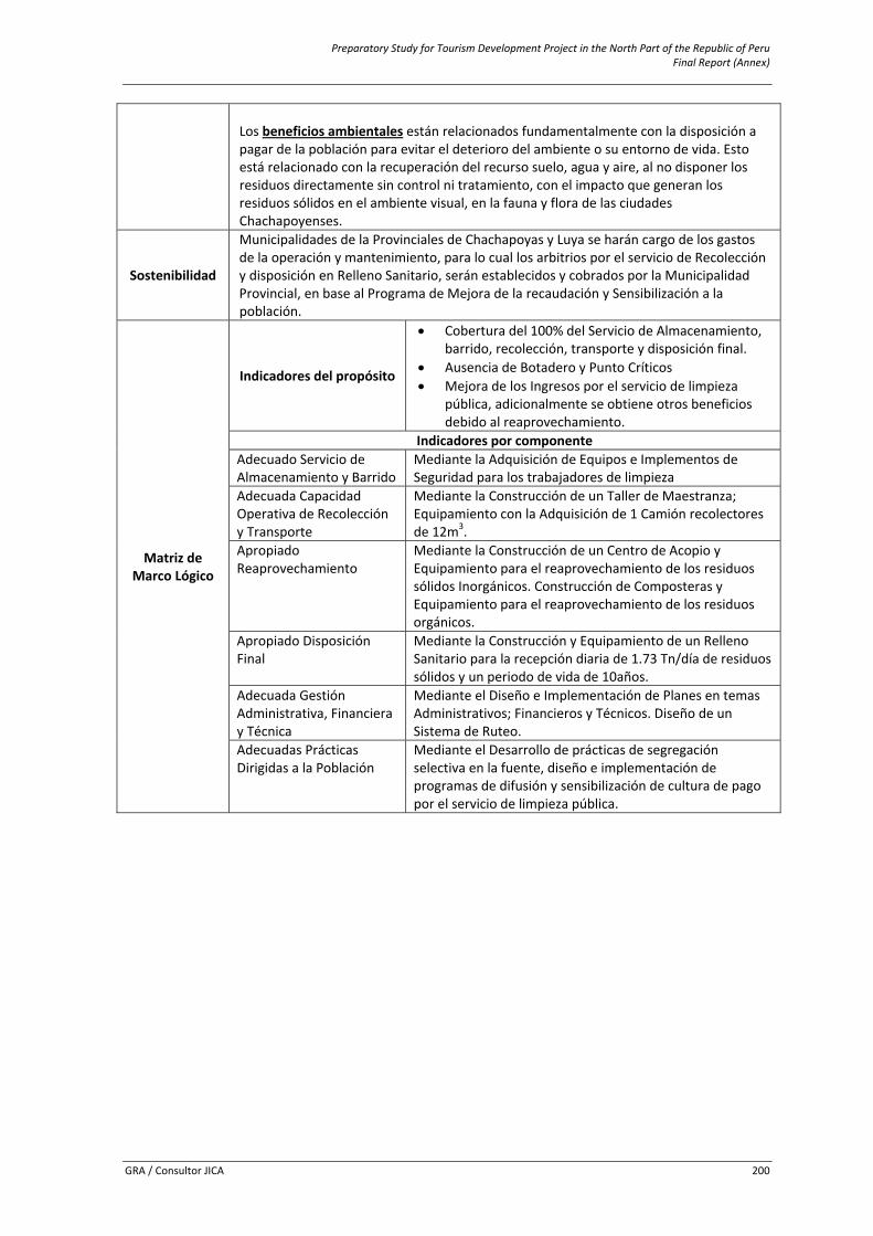
Preparatory Study for Tourism Development Project in the North Part of the Republic of Peru Final Report (Annex)
GRA / Consultor JICA 200
Los beneficios ambientales están relacionados fundamentalmente con la disposición a pagar de la población para evitar el deterioro del ambiente o su entorno de vida. Esto está relacionado con la recuperación del recurso suelo, agua y aire, al no disponer los residuos directamente sin control ni tratamiento, con el impacto que generan los residuos sólidos en el ambiente visual, en la fauna y flora de las ciudades Chachapoyenses.
Sostenibilidad
Municipalidades de la Provinciales de Chachapoyas y Luya se harán cargo de los gastos de la operación y mantenimiento, para lo cual los arbitrios por el servicio de Recolección y disposición en Relleno Sanitario, serán establecidos y cobrados por la Municipalidad Provincial, en base al Programa de Mejora de la recaudación y Sensibilización a la población.
Matriz de Marco Lógico
Indicadores del propósito
• Cobertura del 100% del Servicio de Almacenamiento, barrido, recolección, transporte y disposición final.
• Ausencia de Botadero y Punto Críticos • Mejora de los Ingresos por el servicio de limpieza
pública, adicionalmente se obtiene otros beneficios debido al reaprovechamiento.
Indicadores por componenteAdecuado Servicio de Almacenamiento y Barrido
Mediante la Adquisición de Equipos e Implementos de Seguridad para los trabajadores de limpieza
Adecuada Capacidad Operativa de Recolección y Transporte
Mediante la Construcción de un Taller de Maestranza; Equipamiento con la Adquisición de 1 Camión recolectores de 12m3.
Apropiado Reaprovechamiento
Mediante la Construcción de un Centro de Acopio y Equipamiento para el reaprovechamiento de los residuos sólidos Inorgánicos. Construcción de Composteras y Equipamiento para el reaprovechamiento de los residuos orgánicos.
Apropiado Disposición Final
Mediante la Construcción y Equipamiento de un Relleno Sanitario para la recepción diaria de 1.73 Tn/día de residuos sólidos y un periodo de vida de 10años.
Adecuada Gestión Administrativa, Financiera y Técnica
Mediante el Diseño e Implementación de Planes en temas Administrativos; Financieros y Técnicos. Diseño de un Sistema de Ruteo.
Adecuadas Prácticas Dirigidas a la Población
Mediante el Desarrollo de prácticas de segregación selectiva en la fuente, diseño e implementación de programas de difusión y sensibilización de cultura de pago por el servicio de limpieza pública.
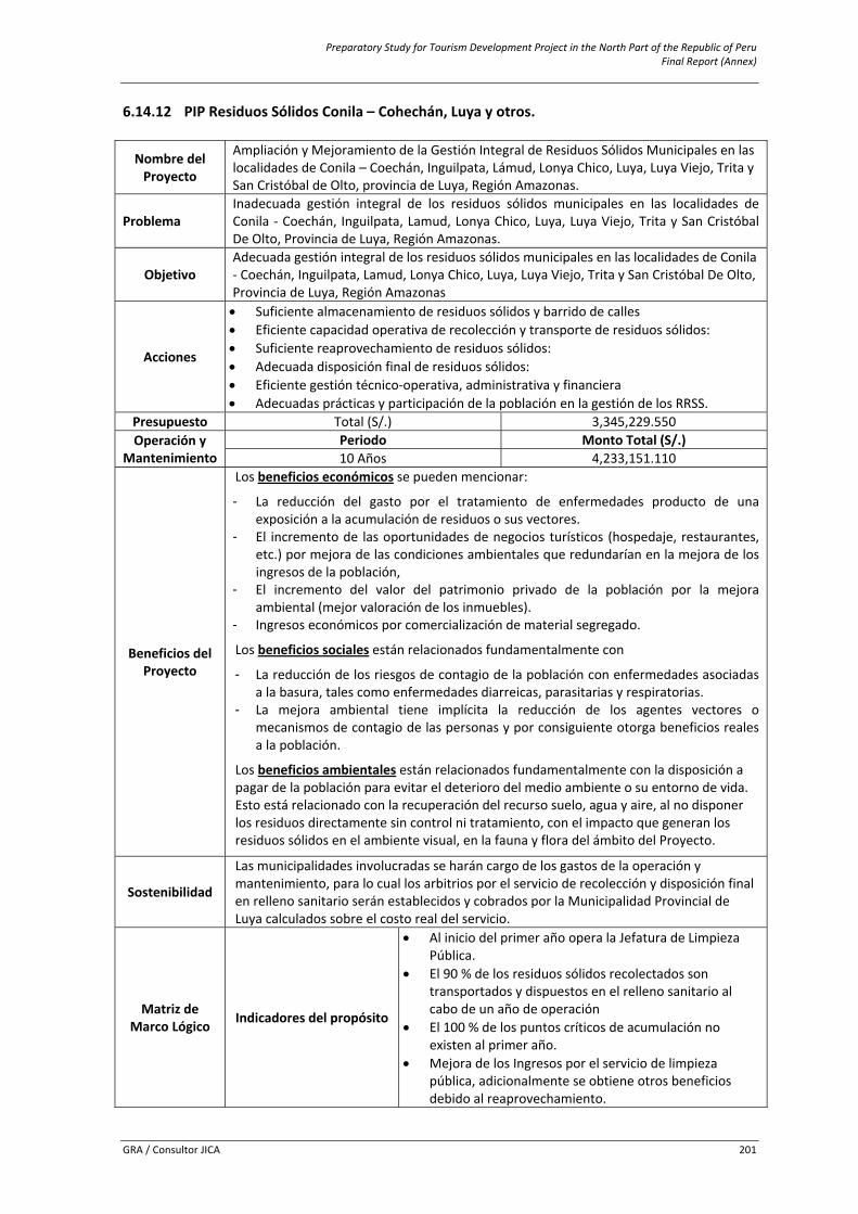
Preparatory Study for Tourism Development Project in the North Part of the Republic of Peru Final Report (Annex)
GRA / Consultor JICA 201
6.14.12 PIP Residuos Sólidos Conila – Cohechán, Luya y otros.
Nombre del Proyecto
Ampliación y Mejoramiento de la Gestión Integral de Residuos Sólidos Municipales en las localidades de Conila – Coechán, Inguilpata, Lámud, Lonya Chico, Luya, Luya Viejo, Trita y San Cristóbal de Olto, provincia de Luya, Región Amazonas.
Problema Inadecuada gestión integral de los residuos sólidos municipales en las localidades de Conila ‐ Coechán, Inguilpata, Lamud, Lonya Chico, Luya, Luya Viejo, Trita y San Cristóbal De Olto, Provincia de Luya, Región Amazonas.
Objetivo Adecuada gestión integral de los residuos sólidos municipales en las localidades de Conila ‐ Coechán, Inguilpata, Lamud, Lonya Chico, Luya, Luya Viejo, Trita y San Cristóbal De Olto, Provincia de Luya, Región Amazonas
Acciones
• Suficiente almacenamiento de residuos sólidos y barrido de calles • Eficiente capacidad operativa de recolección y transporte de residuos sólidos: • Suficiente reaprovechamiento de residuos sólidos: • Adecuada disposición final de residuos sólidos: • Eficiente gestión técnico‐operativa, administrativa y financiera • Adecuadas prácticas y participación de la población en la gestión de los RRSS.
Presupuesto Total (S/.) 3,345,229.550 Operación y
Mantenimiento Periodo Monto Total (S/.) 10 Años 4,233,151.110
Beneficios del Proyecto
Los beneficios económicos se pueden mencionar:
- La reducción del gasto por el tratamiento de enfermedades producto de una exposición a la acumulación de residuos o sus vectores.
- El incremento de las oportunidades de negocios turísticos (hospedaje, restaurantes, etc.) por mejora de las condiciones ambientales que redundarían en la mejora de los ingresos de la población,
- El incremento del valor del patrimonio privado de la población por la mejora ambiental (mejor valoración de los inmuebles).
- Ingresos económicos por comercialización de material segregado.
Los beneficios sociales están relacionados fundamentalmente con
- La reducción de los riesgos de contagio de la población con enfermedades asociadas a la basura, tales como enfermedades diarreicas, parasitarias y respiratorias.
- La mejora ambiental tiene implícita la reducción de los agentes vectores o mecanismos de contagio de las personas y por consiguiente otorga beneficios reales a la población.
Los beneficios ambientales están relacionados fundamentalmente con la disposición a pagar de la población para evitar el deterioro del medio ambiente o su entorno de vida. Esto está relacionado con la recuperación del recurso suelo, agua y aire, al no disponer los residuos directamente sin control ni tratamiento, con el impacto que generan los residuos sólidos en el ambiente visual, en la fauna y flora del ámbito del Proyecto.
Sostenibilidad
Las municipalidades involucradas se harán cargo de los gastos de la operación y mantenimiento, para lo cual los arbitrios por el servicio de recolección y disposición final en relleno sanitario serán establecidos y cobrados por la Municipalidad Provincial de Luya calculados sobre el costo real del servicio.
Matriz de Marco Lógico Indicadores del propósito
• Al inicio del primer año opera la Jefatura de Limpieza Pública.
• El 90 % de los residuos sólidos recolectados son transportados y dispuestos en el relleno sanitario al cabo de un año de operación
• El 100 % de los puntos críticos de acumulación no existen al primer año.
• Mejora de los Ingresos por el servicio de limpieza pública, adicionalmente se obtiene otros beneficios debido al reaprovechamiento.
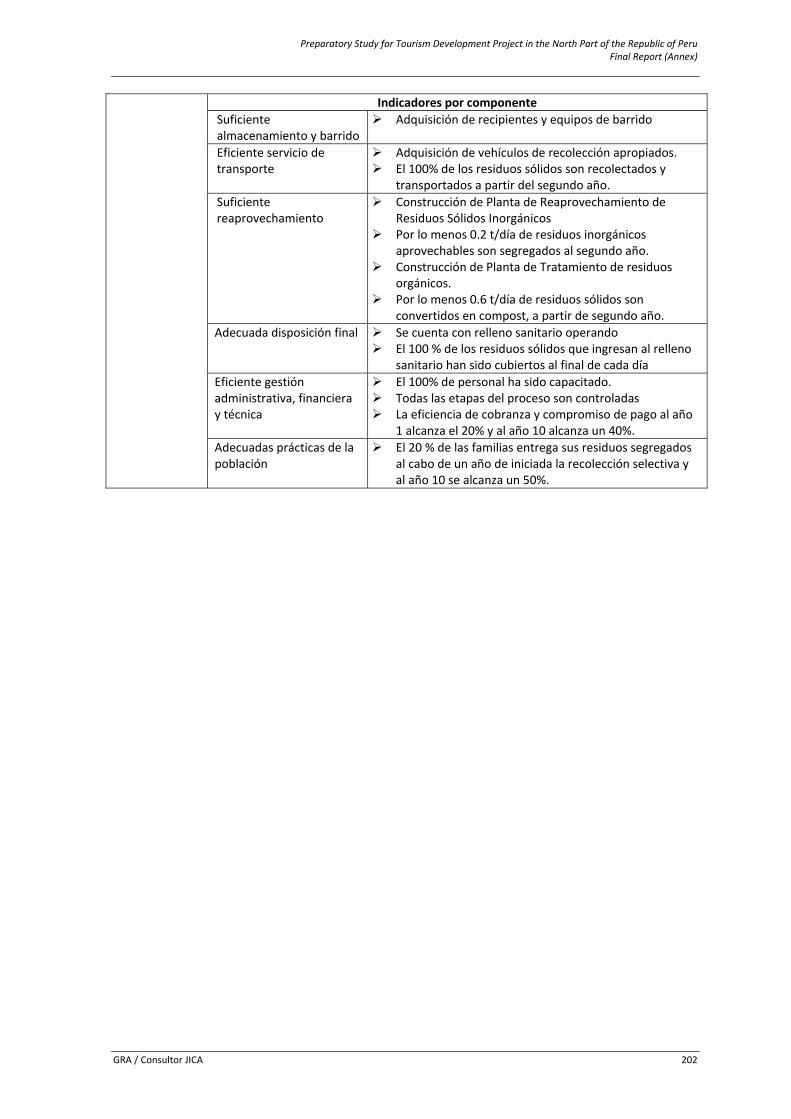
Preparatory Study for Tourism Development Project in the North Part of the Republic of Peru Final Report (Annex)
GRA / Consultor JICA 202
Indicadores por componenteSuficiente almacenamiento y barrido
Adquisición de recipientes y equipos de barrido
Eficiente servicio de transporte
Adquisición de vehículos de recolección apropiados. El 100% de los residuos sólidos son recolectados y transportados a partir del segundo año.
Suficiente reaprovechamiento
Construcción de Planta de Reaprovechamiento de Residuos Sólidos Inorgánicos
Por lo menos 0.2 t/día de residuos inorgánicos aprovechables son segregados al segundo año.
Construcción de Planta de Tratamiento de residuos orgánicos.
Por lo menos 0.6 t/día de residuos sólidos son convertidos en compost, a partir de segundo año.
Adecuada disposición final Se cuenta con relleno sanitario operando El 100 % de los residuos sólidos que ingresan al relleno sanitario han sido cubiertos al final de cada día
Eficiente gestión administrativa, financiera y técnica
El 100% de personal ha sido capacitado. Todas las etapas del proceso son controladas La eficiencia de cobranza y compromiso de pago al año 1 alcanza el 20% y al año 10 alcanza un 40%.
Adecuadas prácticas de la población
El 20 % de las familias entrega sus residuos segregados al cabo de un año de iniciada la recolección selectiva y al año 10 se alcanza un 50%.
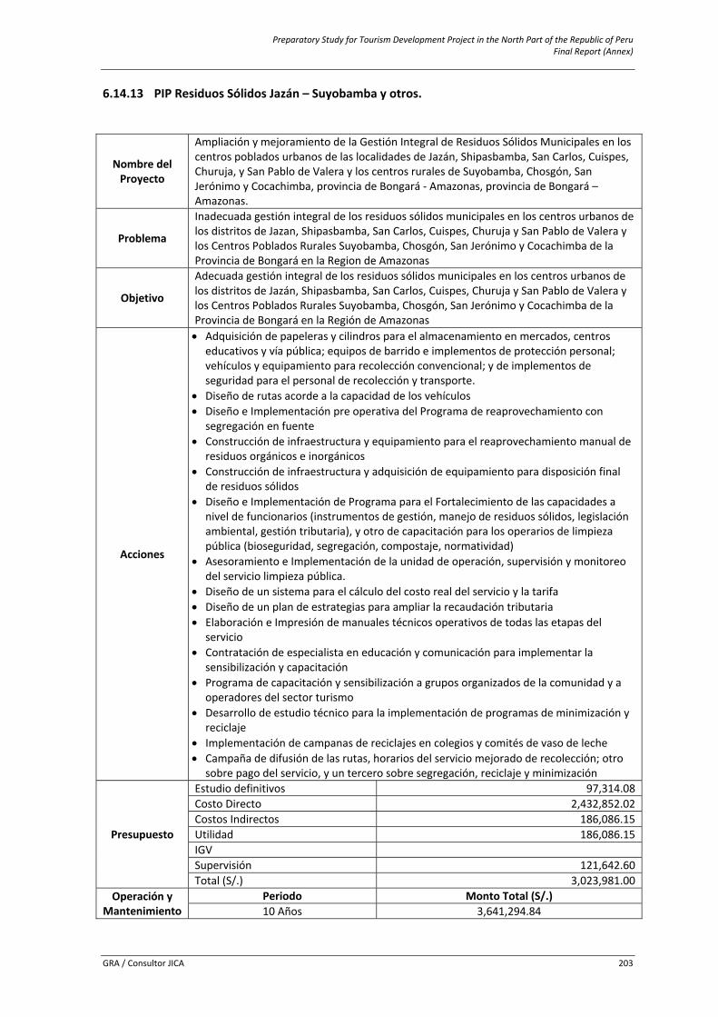
Preparatory Study for Tourism Development Project in the North Part of the Republic of Peru Final Report (Annex)
GRA / Consultor JICA 203
6.14.13 PIP Residuos Sólidos Jazán – Suyobamba y otros.
Nombre del Proyecto
Ampliación y mejoramiento de la Gestión Integral de Residuos Sólidos Municipales en los centros poblados urbanos de las localidades de Jazán, Shipasbamba, San Carlos, Cuispes, Churuja, y San Pablo de Valera y los centros rurales de Suyobamba, Chosgón, San Jerónimo y Cocachimba, provincia de Bongará ‐ Amazonas, provincia de Bongará – Amazonas.
Problema
Inadecuada gestión integral de los residuos sólidos municipales en los centros urbanos de los distritos de Jazan, Shipasbamba, San Carlos, Cuispes, Churuja y San Pablo de Valera y los Centros Poblados Rurales Suyobamba, Chosgón, San Jerónimo y Cocachimba de la Provincia de Bongará en la Region de Amazonas
Objetivo
Adecuada gestión integral de los residuos sólidos municipales en los centros urbanos de los distritos de Jazán, Shipasbamba, San Carlos, Cuispes, Churuja y San Pablo de Valera y los Centros Poblados Rurales Suyobamba, Chosgón, San Jerónimo y Cocachimba de la Provincia de Bongará en la Región de Amazonas
Acciones
• Adquisición de papeleras y cilindros para el almacenamiento en mercados, centros educativos y vía pública; equipos de barrido e implementos de protección personal; vehículos y equipamiento para recolección convencional; y de implementos de seguridad para el personal de recolección y transporte.
• Diseño de rutas acorde a la capacidad de los vehículos • Diseño e Implementación pre operativa del Programa de reaprovechamiento con
segregación en fuente • Construcción de infraestructura y equipamiento para el reaprovechamiento manual de
residuos orgánicos e inorgánicos • Construcción de infraestructura y adquisición de equipamiento para disposición final
de residuos sólidos • Diseño e Implementación de Programa para el Fortalecimiento de las capacidades a
nivel de funcionarios (instrumentos de gestión, manejo de residuos sólidos, legislación ambiental, gestión tributaria), y otro de capacitación para los operarios de limpieza pública (bioseguridad, segregación, compostaje, normatividad)
• Asesoramiento e Implementación de la unidad de operación, supervisión y monitoreo del servicio limpieza pública.
• Diseño de un sistema para el cálculo del costo real del servicio y la tarifa • Diseño de un plan de estrategias para ampliar la recaudación tributaria • Elaboración e Impresión de manuales técnicos operativos de todas las etapas del
servicio • Contratación de especialista en educación y comunicación para implementar la
sensibilización y capacitación • Programa de capacitación y sensibilización a grupos organizados de la comunidad y a
operadores del sector turismo • Desarrollo de estudio técnico para la implementación de programas de minimización y
reciclaje • Implementación de campanas de reciclajes en colegios y comités de vaso de leche • Campaña de difusión de las rutas, horarios del servicio mejorado de recolección; otro
sobre pago del servicio, y un tercero sobre segregación, reciclaje y minimización
Presupuesto
Estudio definitivos 97,314.08 Costo Directo 2,432,852.02 Costos Indirectos 186,086.15 Utilidad 186,086.15 IGVSupervisión 121,642.60 Total (S/.) 3,023,981.00
Operación y Mantenimiento
Periodo Monto Total (S/.) 10 Años 3,641,294.84
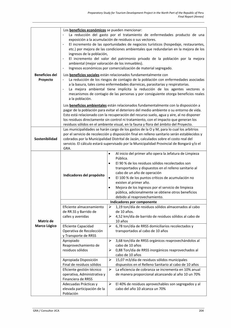
Preparatory Study for Tourism Development Project in the North Part of the Republic of Peru Final Report (Annex)
GRA / Consultor JICA 204
Beneficios del Proyecto
Los beneficios económicos se pueden mencionar:- La reducción del gasto por el tratamiento de enfermedades producto de una
exposición a la acumulación de residuos o sus vectores. - El incremento de las oportunidades de negocios turísticos (hospedaje, restaurantes,
etc.) por mejora de las condiciones ambientales que redundarían en la mejora de los ingresos de la población,
- El incremento del valor del patrimonio privado de la población por la mejora ambiental (mejor valoración de los inmuebles).
- Ingresos económicos por comercialización de material segregado.
Los beneficios sociales están relacionados fundamentalmente con - La reducción de los riesgos de contagio de la población con enfermedades asociadas
a la basura, tales como enfermedades diarreicas, parasitarias y respiratorias. - La mejora ambiental tiene implícita la reducción de los agentes vectores o
mecanismos de contagio de las personas y por consiguiente otorga beneficios reales a la población.
Los beneficios ambientales están relacionados fundamentalmente con la disposición a pagar de la población para evitar el deterioro del medio ambiente o su entorno de vida. Esto está relacionado con la recuperación del recurso suelo, agua y aire, al no disponer los residuos directamente sin control ni tratamiento, con el impacto que generan los residuos sólidos en el ambiente visual, en la fauna y flora del ámbito del Proyecto.
Sostenibilidad
Las municipalidades se harán cargo de los gastos de la O y M, para lo cual los arbitrios por el servicio de recolección y disposición final en relleno sanitario serán establecidos y cobrados por la Municipalidad Distrital de Jazán, calculados sobre el costo real del servicio. El cálculo estará supervisado por la Municipalidad Provincial de Bongará y/o el GRA.
Matriz de Marco Lógico
Indicadores del propósito
• Al inicio del primer año opera la Jefatura de Limpieza Pública.
• El 90 % de los residuos sólidos recolectados son transportados y dispuestos en el relleno sanitario al cabo de un año de operación
• El 100 % de los puntos críticos de acumulación no existen al primer año.
• Mejora de los Ingresos por el servicio de limpieza pública, adicionalmente se obtiene otros beneficios debido al reaprovechamiento.
Indicadores por componenteEficiente almacenamiento de RR.SS y Barrido de calles y avenidas
1,19 ton/día de residuos sólidos almacenados al cabo de 10 años.
4,52 km/día de barrido de residuos sólidos al cabo de 10 años
Eficiente Capacidad Operativa de Recolección y Transporte de RRSS
6,78 ton/día de RRSS domiciliarios recolectados y transportados al cabo de 10 años
Apropiado Reaprovechamiento de residuos sólidos
3,68 ton/día de RRSS orgánicos reaprovechándolos al cabo de 10 años
0,88 Ton/día de RRSS inorgánicos reaprovechados al cabo de 10 años
Apropiada Disposición Final de residuos sólidos
15,07 m3/día de residuos sólidos municipales dispuestos en el Relleno Sanitario al cabo de 10 años
Eficiente gestión técnico operativa, Administrativa y Financiera de RRSS
La eficiencia de cobranza se incrementa en 10% anual de manera proporcional alcanzando al año 10 un 70%
Adecuadas Prácticas y elevada participación de la Población
El 40% de residuos aprovechables son segregados y al cabo del año 10 alcanza un 70%
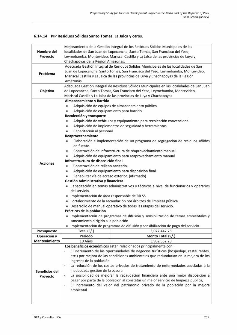
Preparatory Study for Tourism Development Project in the North Part of the Republic of Peru Final Report (Annex)
GRA / Consultor JICA 205
6.14.14 PIP Residuos Sólidos Santo Tomas, La Jalca y otros.
Nombre del Proyecto
Mejoramiento de la Gestión Integral de los Residuos Sólidos Municipales de las localidades de San Juan de Lopecancha, Santo Tomás, San Francisco del Yeso, Leymebamba, Montevideo, Mariscal Castilla y La Jalca de las provincias de Luya y Chachapoyas de la Región Amazonas.
Problema
Adecuada Gestión Integral de Residuos Sólidos Municipales de las localidades de San Juan de Lopecancha, Santo Tomás, San Francisco del Yeso, Leymebamba, Montevideo, Mariscal Castilla y La Jalca de las provincias de Luya y Chachapoyas de la Región Amazonas.
Objetivo Adecuada Gestión Integral de Residuos Sólidos Municipales en las localidades de San Juan de Lopecancha, Santo Tomás, San Francisco del Yeso, Leymebamba, Montevideo, Mariscal Castilla y La Jalca de las provincias de Luya y Chachapoyas
Acciones
Almacenamiento y Barrido• Adquisición de equipos de almacenamiento público • Adquisición de equipamiento para barrido. Recolección y transporte • Adquisición de vehículos y equipamiento para recolección convencional. • Adquisición de implementos de seguridad y herramientas. • Capacitación al personal. Reaprovechamiento • Elaboración e implementación de un programa de segregación de residuos sólidos
en fuente. • Construcción de infraestructura de reaprovechamiento manual. • Adquisición de equipamiento para reaprovechamiento manual Infraestructura de disposición final • Construcción de relleno sanitario. • Adquisición de equipamiento para disposición final. • Rehabilitar vía de acceso exterior. (afirmado) Gestión Administrativa y financiera • Capacitación en temas administrativos y técnicos a nivel de funcionarios y operarios
del servicio. • Implementación de área responsable de RR.SS. • Fortalecimiento de la recaudación por árbitros de limpieza pública. • Desarrollo de manual operativo de todas las etapas del servicio. Prácticas de la población • Implementación de programas de difusión y sensibilización de temas ambientales y
saneamiento dirigido a la población • Implementación de programas de difusión y sensibilización de pago del servicio.
Presupuesto Total (S/.) 3,077,447.75 Operación y
Mantenimiento Periodo Monto Total (S/.) 10 Años 3,902,552.23
Beneficios del Proyecto
Los beneficios económicos están relacionados principalmente con: - El incremento de las oportunidades de negocios turísticos (hospedaje, restaurantes,
etc.) por mejora de las condiciones ambientales que redundarían en la mejora de los ingresos de la población
- La reducción de los costos privados de tratamiento de enfermedades asociadas a la inadecuada gestión de la basura
- La posibilidad de mejorar la recaudación financiera ante una mejor disposición a pagar por parte de la población al constatar un mejor servicio de limpieza pública,
- El incremento del valor del patrimonio privado de la población por la mejora ambiental
Preparatory Study for Tourism Development Project in the North Part of the Republic of Peru Final Report (Annex)
GRA / Consultor JICA 206
Los beneficios sociales están relacionados fundamentalmente con la reducción de los riesgos de contagio de la población con enfermedades asociadas a la basura, tales como enfermedades diarreicas, parasitarias y respiratorias. La mejora ambiental tiene implícita la reducción de los agentes vectores o mecanismos de contagio de las personas y por consiguiente otorga beneficios reales a la población. Los beneficios ambientales están relacionados fundamentalmente con la disposición a pagar de la población para evitar el deterioro del medio ambiente o su entorno de vida. Esto está relacionado con la recuperación del recurso suelo, agua y aire, al no disponer los residuos directamente sin control ni tratamiento, con el impacto que generan los residuos sólidos en el ambiente visual, en la fauna y flora de su entorno.
Sostenibilidad
Las Municipalidad Provincial de Chachapoyas se hará cargo de los gastos de la O y M, para lo cual cobrará por el servicio de Recolección y disposición en Relleno Sanitario, con base en el Programa de Mejora de la recaudación y Sensibilización a la población. Todo ingreso por el nuevo sistema integral de manejo de residuos sólidos será administrado por la Municipalidad.
Matriz de Marco Lógico
Indicadores del propósito
• Cobertura del 100% del Servicio de Almacenamiento, barrido, recolección, transporte y disposición final.
• Ausencia de Botaderos y Puntos Críticos • Mejora de los Ingresos por el servicio de limpieza
pública, adicionalmente se obtiene otros beneficios debido al reaprovechamiento.
Indicadores por componenteAdecuado Servicio de Almacenamiento y Barrido
Mediante la Adquisición de Equipos e Implementos de Seguridad para 7 operarios de barrido
Adecuada Capacidad Operativa de Recolección y Transporte
Mediante la implementación de un Taller de Maestranza; Equipamiento con 2 Camiones recolectores; uno de 20 m3 y otro de 14m3 para recolección selectiva
Apropiado Reaprovechamiento
Mediante la Construcción de un Complejo de Residuos Municipales, donde se encuentre una planta manual de residuos orgánicos, y otra de residuos inorgánicos, con sus respectivos equipamientos, materiales y personal capacitado
Apropiado Disposición Final
Mediante la Construcción y Equipamiento de un Relleno Sanitario para la recepción diaria de 5,93 ton/día de residuos sólidos y un periodo de vida de 10años.
Adecuada Gestión Administrativa, Financiera y Técnica
Mediante el Diseño e Implementación de Planes en temas Administrativos; Financieros y Técnicos. Diseño de un Sistema de Ruteo
Adecuadas Prácticas Dirigidas a la Población
Mediante el Desarrollo de prácticas de segregación selectiva en la fuente, diseño e implementación de programas de difusión y sensibilización de cultura de pago por el servicio de limpieza pública.
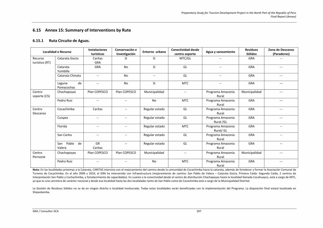
Preparatory Study for Tourism Development Project in the North Part of the Republic of Peru Final Report (Annex)
GRA / Consultor JICA 207
6.15 Annex 15: Summary of Interventions by Rute 6.15.1 Ruta Circuito de Aguas.
Localidad o Recurso Instalaciones turísticas
Conservación e Investigación Entorno urbana Conectividad desde
centro soporte Agua y saneamiento Residuos Sólidos
Zona de Descanso (Paradores)
Recurso turístico (RT)
Catarata Gocta Caritas GRA
Si Si MTC/GL ‐‐ GRA ‐‐
Catarata Yumbilla
GRA No Si GL ‐‐ GRA ‐‐‐
Catarata Chinata ‐‐ No ‐‐ GL ‐‐ GRA ‐‐‐
Laguna de Pomacochas
‐‐ No Si MTC ‐‐ GRA ‐‐‐
Centro soporte (CS)
Chachapoyas Plan COPESCO Plan COPESCO Municipalidad ‐‐ Programa Amazonia Rural
Municipalidad ‐‐‐
Pedro Ruiz ‐‐ ‐‐ No MTC Programa Amazonia Rural
GRA ‐‐‐
Centro Descanso
Cocachimba Caritas ‐‐ Regular estado GL Programa Amazonia Rural
GRA ‐‐‐
Cuispes ‐‐ ‐‐ Regular estado GL Programa Amazonia Rural /GL
GRA ‐‐‐
Florida ‐‐ ‐‐ Regular estado MTC Programa Amazonia Rural/ GL
GRA ‐‐
San Carlos ‐‐ ‐‐ Regular estado GL Programa Amazonia Rural
GRA ‐‐
San Pablo de Valera
GR Caritas
‐‐ Regular estado GL Programa Amazonia Rural
GRA ‐‐
Centro Pernocte
Chachapoyas
Plan COPESCO Plan COPESCO Municipalidad ‐‐ Programa Amazonia Rural
Municipalidad ‐‐‐
Pedro Ruiz ‐‐ ‐‐ No MTC Programa Amazonia Rural
GRA ‐‐‐
Nota: En las localidades próximas a la Catarata, CARITAS intervino con el mejoramiento del camino desde la comunidad de Cocachimba hacia la catarata, además de fortalecer y formar la Asociación Comunal de Turismo de Cocachimba. En el año 2009 y 2010, el GRA ha intervenido con Infraestructura (mejoramiento de camino: San Pablo de Valera – Catarata Gocta, Primera Caída‐ Segunda Caída, 2 centros de Interpretación San Pablo y Cochachimba, y fortalecimiento de capacidades). En cuanto a la conectividad desde el centro de distribución Chachapoyas hasta la localidad llamada Cocahuayco, está a cargo de MTC, ya que es una carretera de carácter nacional y desde esa localidad hasta las dos localidades tanto de San Pablo como de Cocachimba está a cargo de la Municipalidad Distrital. La Gestión de Residuos Sólidos no se da en ningún distrito o localidad involucrada. Todas estas localidades serán beneficiadas con la implementación del Programa. La disposición final estará localizada en Shipasbamba.
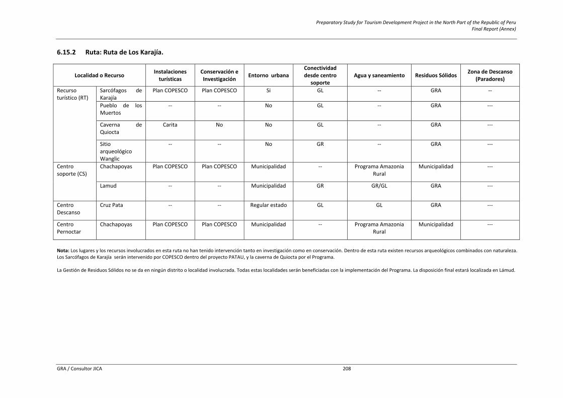
Preparatory Study for Tourism Development Project in the North Part of the Republic of Peru Final Report (Annex)
GRA / Consultor JICA 208
6.15.2 Ruta: Ruta de Los Karajía.
Localidad o Recurso Instalaciones turísticas
Conservación e Investigación Entorno urbana
Conectividad desde centro
soporte Agua y saneamiento Residuos Sólidos Zona de Descanso
(Paradores)
Recurso turístico (RT)
Sarcófagos de Karajía
Plan COPESCO Plan COPESCO Si GL ‐‐ GRA ‐‐
Pueblo de los Muertos
‐‐ ‐‐ No GL ‐‐ GRA ‐‐‐
Caverna de Quiocta
Carita No No GL ‐‐ GRA ‐‐‐
Sitio arqueológico Wanglic
‐‐ ‐‐ No GR ‐‐ GRA ‐‐‐
Centro soporte (CS)
Chachapoyas Plan COPESCO Plan COPESCO Municipalidad ‐‐ Programa Amazonia Rural
Municipalidad ‐‐‐
Lamud ‐‐ ‐‐ Municipalidad GR GR/GL GRA ‐‐‐
Centro Descanso
Cruz Pata ‐‐ ‐‐ Regular estado GL GL GRA ‐‐‐
Centro Pernoctar
Chachapoyas Plan COPESCO Plan COPESCO Municipalidad ‐‐ Programa Amazonia Rural
Municipalidad ‐‐‐
Nota: Los lugares y los recursos involucrados en esta ruta no han tenido intervención tanto en investigación como en conservación. Dentro de esta ruta existen recursos arqueológicos combinados con naturaleza. Los Sarcófagos de Karajía serán intervenido por COPESCO dentro del proyecto PATAU, y la caverna de Quiocta por el Programa. La Gestión de Residuos Sólidos no se da en ningún distrito o localidad involucrada. Todas estas localidades serán beneficiadas con la implementación del Programa. La disposición final estará localizada en Lámud.
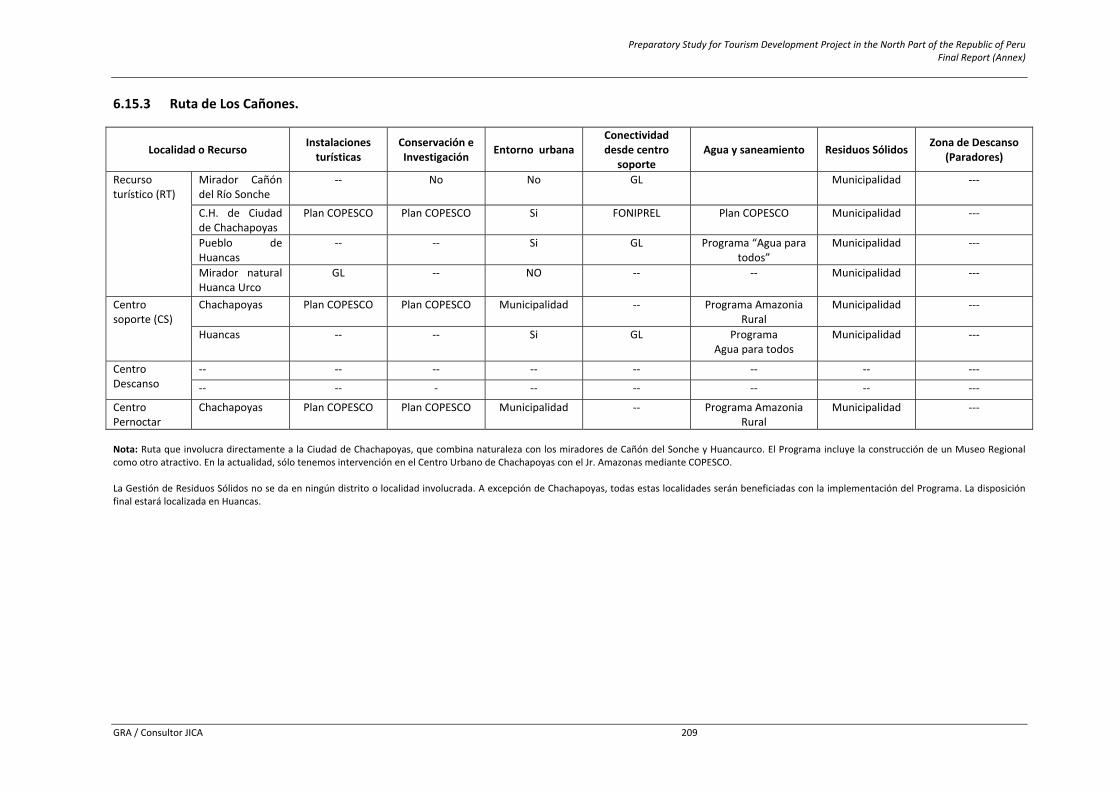
Preparatory Study for Tourism Development Project in the North Part of the Republic of Peru Final Report (Annex)
GRA / Consultor JICA 209
6.15.3 Ruta de Los Cañones.
Localidad o Recurso Instalaciones turísticas
Conservación e Investigación Entorno urbana
Conectividad desde centro
soporte Agua y saneamiento Residuos Sólidos Zona de Descanso
(Paradores)
Recurso turístico (RT)
Mirador Cañón del Río Sonche
‐‐ No No GL Municipalidad ‐‐‐
C.H. de Ciudad de Chachapoyas
Plan COPESCO Plan COPESCO Si FONIPREL Plan COPESCO Municipalidad ‐‐‐
Pueblo de Huancas
‐‐ ‐‐ Si GL Programa “Agua para todos”
Municipalidad ‐‐‐
Mirador natural Huanca Urco
GL ‐‐ NO ‐‐ ‐‐ Municipalidad ‐‐‐
Centro soporte (CS)
Chachapoyas Plan COPESCO Plan COPESCO Municipalidad ‐‐ Programa Amazonia Rural
Municipalidad ‐‐‐
Huancas ‐‐ ‐‐ Si GL Programa Agua para todos
Municipalidad ‐‐‐
Centro Descanso
‐‐ ‐‐ ‐‐ ‐‐ ‐‐ ‐‐ ‐‐ ‐‐‐
‐‐ ‐‐ ‐ ‐‐ ‐‐ ‐‐ ‐‐ ‐‐‐
Centro Pernoctar
Chachapoyas Plan COPESCO Plan COPESCO Municipalidad ‐‐ Programa Amazonia Rural
Municipalidad ‐‐‐
Nota: Ruta que involucra directamente a la Ciudad de Chachapoyas, que combina naturaleza con los miradores de Cañón del Sonche y Huancaurco. El Programa incluye la construcción de un Museo Regional como otro atractivo. En la actualidad, sólo tenemos intervención en el Centro Urbano de Chachapoyas con el Jr. Amazonas mediante COPESCO. La Gestión de Residuos Sólidos no se da en ningún distrito o localidad involucrada. A excepción de Chachapoyas, todas estas localidades serán beneficiadas con la implementación del Programa. La disposición final estará localizada en Huancas.
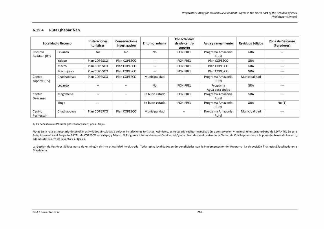
Preparatory Study for Tourism Development Project in the North Part of the Republic of Peru Final Report (Annex)
GRA / Consultor JICA 210
6.15.4 Ruta Qhapac Ñan.
Localidad o Recurso Instalaciones turísticas
Conservación e Investigación Entorno urbana
Conectividad desde centro
soporte Agua y saneamiento Residuos Sólidos Zona de Descanso
(Paradores)
Recurso turístico (RT)
Levanto No No No FONIPREL Programa Amazonia Rural
GRA ‐‐
Yalape Plan COPESCO Plan COPESCO ‐‐ FONIPREL Plan COPESCO GRA ‐‐‐ Macro Plan COPESCO Plan COPESCO ‐‐ FONIPREL Plan COPESCO GRA ‐‐‐ Machupirca Plan COPESCO Plan COPESCO ‐‐ FONIPREL Plan COPESCO GRA ‐‐‐
Centro soporte (CS)
Chachapoyas Plan COPESCO Plan COPESCO Municipalidad ‐‐ Programa Amazonia Rural
Municipalidad ‐‐‐
Levanto ‐‐ ‐‐ No FONIPREL Programa Agua para todos
GRA ‐‐‐
Centro Descanso
Magdalena ‐‐ ‐‐ En buen estado FONIPREL Programa Amazonia Rural
GRA ‐‐‐
Tingo ‐‐ ‐‐ En buen estado FONIPREL Programa Amazonia Rural
GRA No (1)
Centro Pernoctar
Chachapoyas Plan COPESCO Plan COPESCO Municipalidad ‐‐ Programa Amazonia Rural
Municipalidad ‐‐‐
1/ Es necesario un Parador (Descanso y aseo) por el trajín. Nota: En la ruta es necesario desarrollar actividades vinculadas a colocar instalaciones turísticas. Asimismo, es necesario realizar investigación y conservación y mejorar el entorno urbano de LEVANTO. En esta Ruta, intervendrá el Proyecto PATAU de COPESCO en Yálape, y Macro. El Programa intervendrá en el Camino del Qhapaq Ñan desde el centro de la Ciudad de Chachapoyas hasta la plaza de Armas de Levanto, además del Centro de Levanto y su Iglesia. La Gestión de Residuos Sólidos no se da en ningún distrito o localidad involucrada. Todas estas localidades serán beneficiadas con la implementación del Programa. La disposición final estará localizada en a Magdalena.
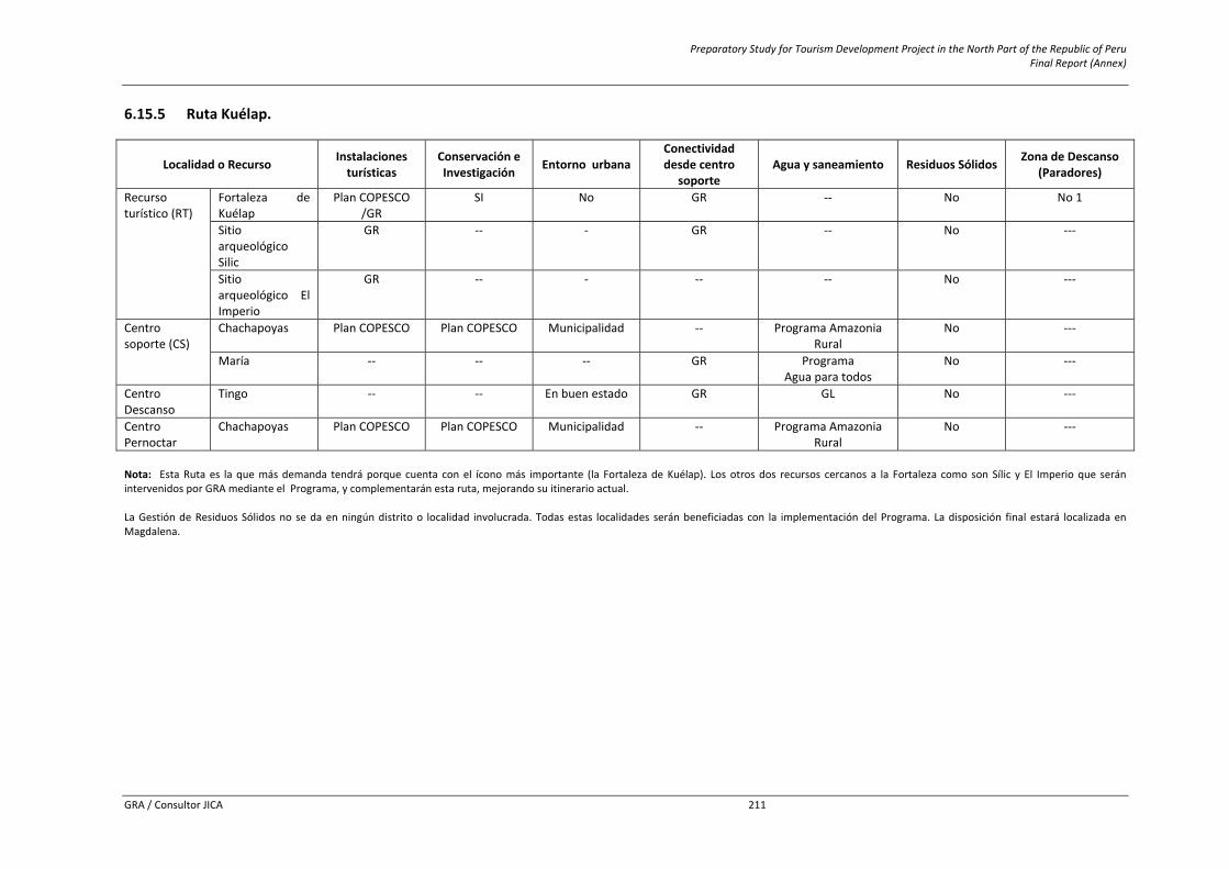
Preparatory Study for Tourism Development Project in the North Part of the Republic of Peru Final Report (Annex)
GRA / Consultor JICA 211
6.15.5 Ruta Kuélap.
Localidad o Recurso Instalaciones turísticas
Conservación e Investigación Entorno urbana
Conectividad desde centro
soporte Agua y saneamiento Residuos Sólidos Zona de Descanso
(Paradores)
Recurso turístico (RT)
Fortaleza de Kuélap
Plan COPESCO /GR
SI No GR ‐‐ No No 1
Sitio arqueológico Silic
GR ‐‐ ‐ GR ‐‐ No ‐‐‐
Sitio arqueológico El Imperio
GR ‐‐ ‐ ‐‐ ‐‐ No ‐‐‐
Centro soporte (CS)
Chachapoyas Plan COPESCO Plan COPESCO Municipalidad ‐‐ Programa Amazonia Rural
No ‐‐‐
María ‐‐ ‐‐ ‐‐ GR Programa Agua para todos
No ‐‐‐
Centro Descanso
Tingo ‐‐ ‐‐ En buen estado GR GL No ‐‐‐
Centro Pernoctar
Chachapoyas Plan COPESCO Plan COPESCO Municipalidad ‐‐ Programa Amazonia Rural
No ‐‐‐
Nota: Esta Ruta es la que más demanda tendrá porque cuenta con el ícono más importante (la Fortaleza de Kuélap). Los otros dos recursos cercanos a la Fortaleza como son Sílic y El Imperio que serán intervenidos por GRA mediante el Programa, y complementarán esta ruta, mejorando su itinerario actual. La Gestión de Residuos Sólidos no se da en ningún distrito o localidad involucrada. Todas estas localidades serán beneficiadas con la implementación del Programa. La disposición final estará localizada en Magdalena.
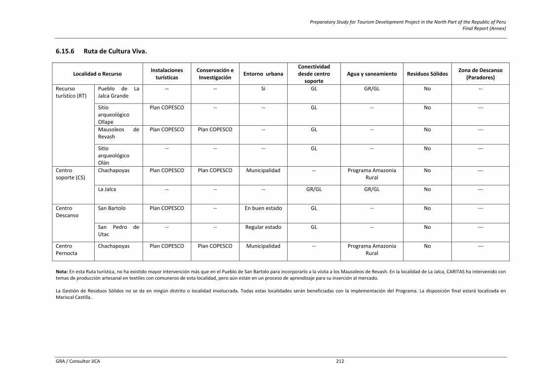
Preparatory Study for Tourism Development Project in the North Part of the Republic of Peru Final Report (Annex)
GRA / Consultor JICA 212
6.15.6 Ruta de Cultura Viva.
Localidad o Recurso Instalaciones turísticas
Conservación e Investigación Entorno urbana
Conectividad desde centro
soporte Agua y saneamiento Residuos Sólidos Zona de Descanso
(Paradores)
Recurso turístico (RT)
Pueblo de La Jalca Grande
‐‐ ‐‐ Si GL GR/GL No ‐‐
Sitio arqueológico Ollape
Plan COPESCO ‐‐ ‐‐ GL ‐‐ No ‐‐‐
Mausoleos de Revash
Plan COPESCO Plan COPESCO ‐‐ GL ‐‐ No ‐‐‐
Sitio arqueológico Olán
‐‐ ‐‐ ‐‐ GL ‐‐ No ‐‐‐
Centro soporte (CS)
Chachapoyas Plan COPESCO Plan COPESCO Municipalidad ‐‐ Programa Amazonia Rural
No ‐‐‐
La Jalca ‐‐ ‐‐ ‐‐ GR/GL GR/GL No ‐‐‐
Centro Descanso
San Bartolo Plan COPESCO ‐‐ En buen estado GL ‐‐ No ‐‐‐
San Pedro de Utac
‐‐ ‐‐ Regular estado GL ‐‐ No ‐‐‐
Centro Pernocta
Chachapoyas Plan COPESCO Plan COPESCO Municipalidad ‐‐ Programa Amazonia Rural
No ‐‐‐
Nota: En esta Ruta turística, no ha existido mayor intervención más que en el Pueblo de San Bartolo para incorporarlo a la visita a los Mausoleos de Revash. En la localidad de La Jalca, CARITAS ha intervenido con temas de producción artesanal en textiles con comuneros de esta localidad, pero aún están en un proceso de aprendizaje para su inserción al mercado. La Gestión de Residuos Sólidos no se da en ningún distrito o localidad involucrada. Todas estas localidades serán beneficiadas con la implementación del Programa. La disposición final estará localizada en Mariscal Castilla.

Preparatory Study for Tourism Development Project in the North Part of the Republic of Peru Final Report (Annex)
GRA / Consultor JICA 213
6.15.7 Ruta de Las Momias.
Localidad o Recurso Instalaciones turísticas
Conservación e Investigación Entorno urbana
Conectividad desde centro
soporte Agua y saneamiento Residuos Sólidos Zona de Descanso
(Paradores)
Recurso turístico (RT)
Laguna de los Cóndores
Plan COPESCO ‐‐ ‐‐ GL ‐‐ No ‐‐
Pueblo de Leymebamba
‐‐ ‐‐ ‐‐ MTC GL No ‐‐‐
Museo comunitario
Centro Malqui Centro Malqui ‐‐ MTC ‐‐ No ‐‐‐
Sitio arqueológico la Congona
Plan COPESCO ‐‐ ‐‐ GL ‐‐ No ‐‐‐
Centro soporte (CS)
Chachapoyas Plan COPESCO Plan COPESCO Municipalidad ‐‐ Programa Amazonia Rural
No ‐‐‐
Leymebamba ‐‐ ‐‐ ‐‐ Regular Estado
GL No ‐‐‐
Centro Descanso
‐‐ ‐‐ ‐‐ ‐‐ ‐‐ ‐‐ ‐‐ ‐‐‐
Centro Pernoctar
Chachapoyas Plan COPESCO Plan COPESCO Municipalidad ‐‐ Programa Amazonia Rural
No ‐‐‐
Leymebamba ‐‐ ‐‐ ‐‐ Regular Estado
GL No ‐‐‐
Nota: Dentro de esta ruta, el Museo ha sido construido por colaboraciones extranjeras mediante el Centro Malqui. Sigue recibiendo algunas donaciones para su funcionamiento y con sus ingresos generados operan y mantienen activo el museo para la visita de los turistas. La Laguna de los Cóndores y el sitio Arqueológico la Congona serán intervenidos por el proyecto PATAU. La conectividad desde Chachapoyas está a cargo del MTC, ya que es una vía nacional dentro de la conexión con el departamento de Cajamarca. La Gestión de Residuos Sólidos no se da en ningún distrito o localidad involucrada. Todas estas localidades serán beneficiadas con la implementación del Programa. La disposición final estará localizada en Mariscal Castilla.

Preparatory Study for Tourism Development Project in the North Part of the Republic of Peru Final Report (Annex)
GRA / Consultor JICA 214
6.16 Annex 16: Budget for Activities of Component 5 6.16.1 Activity: Actualization of PERTUR Amazonas Budget Nº Descripción Unidad Cantidad Parcial Total
1 Servicio 225,000 1.1 Ingeniero o Economista (Responsable) Persona x mes 3 10,000 30,000 1.2 Ingeniero Ambiental Mes 2 8,000 16,000 1.3 Especialista en Marketing Mes 3 8,000 24,000 1.4 Arquitecto Mes 2 8,000 16,000 1.5 Especialista en Ordenamiento Territorial Mes 3 8,000 24,000 1.6 Biólogo Mes 2 8,000 16,000 1.7 Arqueólogo Mes 2 8,000 16,000 1.8 Antropólogo Mes 2 8,000 16,000 1.9 Licenciado en Turismo y Hotelería Mes 2 10,000 20,000 1.10 Asistente Mes 3 2,000 6,000 1.11 Encuestadores Mes 14 1,000 14,000 1.12 Alquiler de local de operación y coordinación Mes 2 1,000 2,000 1.13 Servicio de Alquiler de Movilidad Terrestre Día 15 300 4,500 1.14 Servicio de Alimentación Persona x día 150 30 4,500 1.15 Servicio de Hospedaje Persona x día 150 40 6,000
1.16 Servicio de Diagnóstico Situacional de los recursos turísticos y planta turística Servicio 1 10,000 10,000
2 Otros 1,200 2.1 Material de oficina Global 1 1,200 1,200
Total 226,200 Total Budget and Social Prices
Rubro Presupuesto Total Factor de Corrección
Presupuesto a Precios Sociales
Mano de Obra Calificada 208,000 1.0000 208,000Bienes Nacionales No Transables 18,200 0.8475 15,424
Total 226,200 223,424
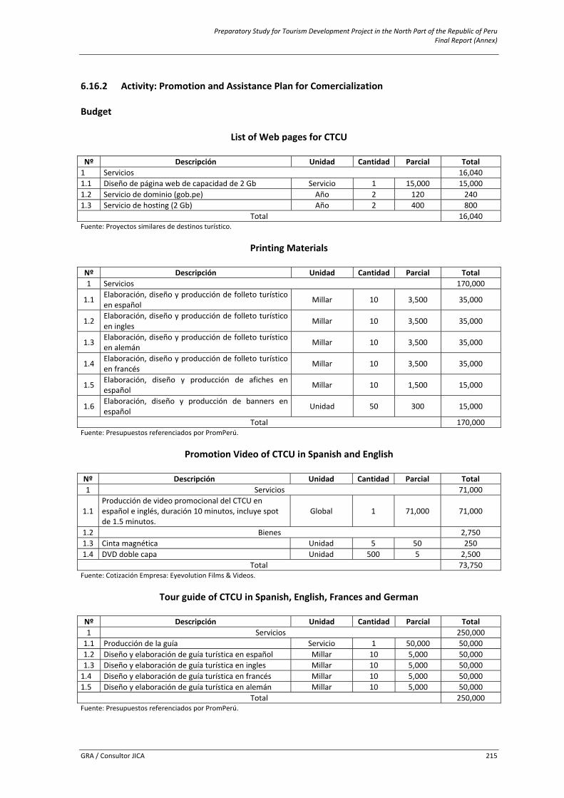
Preparatory Study for Tourism Development Project in the North Part of the Republic of Peru Final Report (Annex)
GRA / Consultor JICA 215
6.16.2 Activity: Promotion and Assistance Plan for Comercialization Budget
List of Web pages for CTCU
Nº Descripción Unidad Cantidad Parcial Total 1 Servicios 16,040 1.1 Diseño de página web de capacidad de 2 Gb Servicio 1 15,000 15,000 1.2 Servicio de dominio (gob.pe) Año 2 120 240 1.3 Servicio de hosting (2 Gb) Año 2 400 800
Total 16,040 Fuente: Proyectos similares de destinos turístico.
Printing Materials
Nº Descripción Unidad Cantidad Parcial Total 1 Servicios 170,000
1.1 Elaboración, diseño y producción de folleto turístico en español Millar 10 3,500 35,000
1.2 Elaboración, diseño y producción de folleto turístico en ingles Millar 10 3,500 35,000
1.3 Elaboración, diseño y producción de folleto turístico en alemán Millar 10 3,500 35,000
1.4 Elaboración, diseño y producción de folleto turístico en francés Millar 10 3,500 35,000
1.5 Elaboración, diseño y producción de afiches en español Millar 10 1,500 15,000
1.6 Elaboración, diseño y producción de banners en español Unidad 50 300 15,000
Total 170,000 Fuente: Presupuestos referenciados por PromPerú.
Promotion Video of CTCU in Spanish and English
Nº Descripción Unidad Cantidad Parcial Total 1 Servicios 71,000
1.1 Producción de video promocional del CTCU en español e inglés, duración 10 minutos, incluye spot de 1.5 minutos.
Global 1 71,000 71,000
1.2 Bienes 2,750 1.3 Cinta magnética Unidad 5 50 250 1.4 DVD doble capa Unidad 500 5 2,500
Total 73,750 Fuente: Cotización Empresa: Eyevolution Films & Videos.
Tour guide of CTCU in Spanish, English, Frances and German
Nº Descripción Unidad Cantidad Parcial Total 1 Servicios 250,000 1.1 Producción de la guía Servicio 1 50,000 50,000 1.2 Diseño y elaboración de guía turística en español Millar 10 5,000 50,000 1.3 Diseño y elaboración de guía turística en ingles Millar 10 5,000 50,000 1.4 Diseño y elaboración de guía turística en francés Millar 10 5,000 50,000 1.5 Diseño y elaboración de guía turística en alemán Millar 10 5,000 50,000
Total 250,000 Fuente: Presupuestos referenciados por PromPerú.
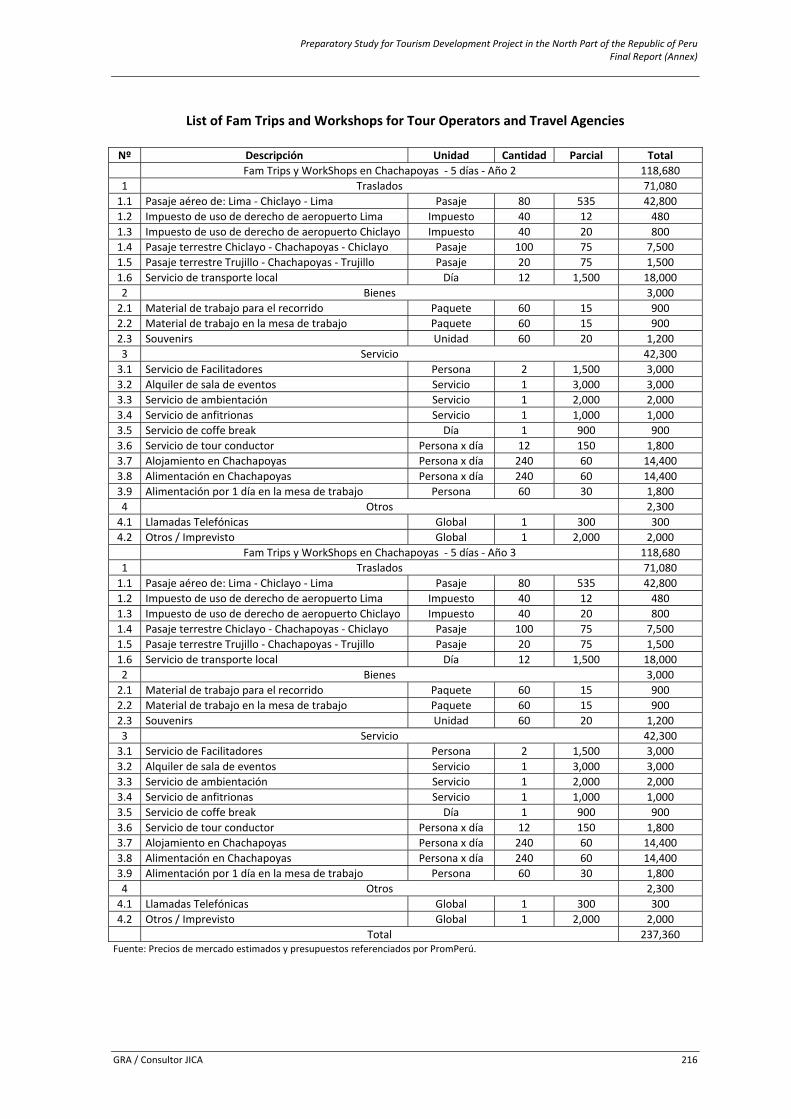
Preparatory Study for Tourism Development Project in the North Part of the Republic of Peru Final Report (Annex)
GRA / Consultor JICA 216
List of Fam Trips and Workshops for Tour Operators and Travel Agencies
Nº Descripción Unidad Cantidad Parcial Total
Fam Trips y WorkShops en Chachapoyas ‐ 5 días ‐ Año 2 118,680 1 Traslados 71,080 1.1 Pasaje aéreo de: Lima ‐ Chiclayo ‐ Lima Pasaje 80 535 42,800 1.2 Impuesto de uso de derecho de aeropuerto Lima Impuesto 40 12 480 1.3 Impuesto de uso de derecho de aeropuerto Chiclayo Impuesto 40 20 800 1.4 Pasaje terrestre Chiclayo ‐ Chachapoyas ‐ Chiclayo Pasaje 100 75 7,500 1.5 Pasaje terrestre Trujillo ‐ Chachapoyas ‐ Trujillo Pasaje 20 75 1,500 1.6 Servicio de transporte local Día 12 1,500 18,000 2 Bienes 3,000 2.1 Material de trabajo para el recorrido Paquete 60 15 900 2.2 Material de trabajo en la mesa de trabajo Paquete 60 15 900 2.3 Souvenirs Unidad 60 20 1,200 3 Servicio 42,300 3.1 Servicio de Facilitadores Persona 2 1,500 3,000 3.2 Alquiler de sala de eventos Servicio 1 3,000 3,000 3.3 Servicio de ambientación Servicio 1 2,000 2,000 3.4 Servicio de anfitrionas Servicio 1 1,000 1,000 3.5 Servicio de coffe break Día 1 900 900 3.6 Servicio de tour conductor Persona x día 12 150 1,800 3.7 Alojamiento en Chachapoyas Persona x día 240 60 14,400 3.8 Alimentación en Chachapoyas Persona x día 240 60 14,400 3.9 Alimentación por 1 día en la mesa de trabajo Persona 60 30 1,800 4 Otros 2,300 4.1 Llamadas Telefónicas Global 1 300 300 4.2 Otros / Imprevisto Global 1 2,000 2,000
Fam Trips y WorkShops en Chachapoyas ‐ 5 días ‐ Año 3 118,680 1 Traslados 71,080 1.1 Pasaje aéreo de: Lima ‐ Chiclayo ‐ Lima Pasaje 80 535 42,800 1.2 Impuesto de uso de derecho de aeropuerto Lima Impuesto 40 12 480 1.3 Impuesto de uso de derecho de aeropuerto Chiclayo Impuesto 40 20 800 1.4 Pasaje terrestre Chiclayo ‐ Chachapoyas ‐ Chiclayo Pasaje 100 75 7,500 1.5 Pasaje terrestre Trujillo ‐ Chachapoyas ‐ Trujillo Pasaje 20 75 1,500 1.6 Servicio de transporte local Día 12 1,500 18,000 2 Bienes 3,000 2.1 Material de trabajo para el recorrido Paquete 60 15 900 2.2 Material de trabajo en la mesa de trabajo Paquete 60 15 900 2.3 Souvenirs Unidad 60 20 1,200 3 Servicio 42,300 3.1 Servicio de Facilitadores Persona 2 1,500 3,000 3.2 Alquiler de sala de eventos Servicio 1 3,000 3,000 3.3 Servicio de ambientación Servicio 1 2,000 2,000 3.4 Servicio de anfitrionas Servicio 1 1,000 1,000 3.5 Servicio de coffe break Día 1 900 900 3.6 Servicio de tour conductor Persona x día 12 150 1,800 3.7 Alojamiento en Chachapoyas Persona x día 240 60 14,400 3.8 Alimentación en Chachapoyas Persona x día 240 60 14,400 3.9 Alimentación por 1 día en la mesa de trabajo Persona 60 30 1,800 4 Otros 2,300 4.1 Llamadas Telefónicas Global 1 300 300 4.2 Otros / Imprevisto Global 1 2,000 2,000
Total 237,360 Fuente: Precios de mercado estimados y presupuestos referenciados por PromPerú.
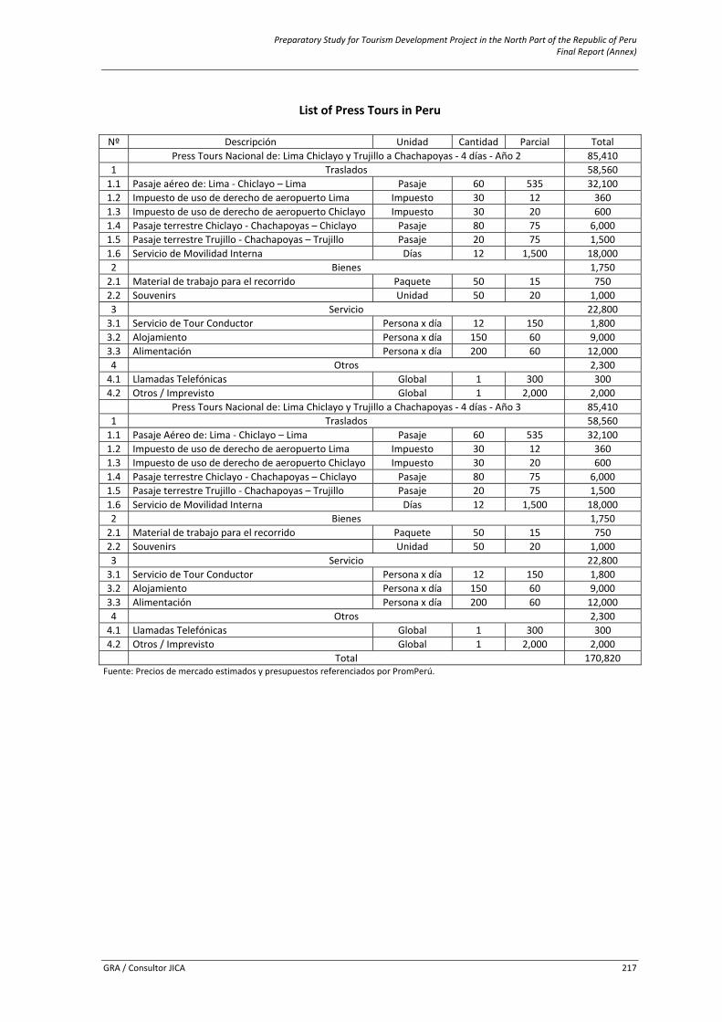
Preparatory Study for Tourism Development Project in the North Part of the Republic of Peru Final Report (Annex)
GRA / Consultor JICA 217
List of Press Tours in Peru
Nº Descripción Unidad Cantidad Parcial Total
Press Tours Nacional de: Lima Chiclayo y Trujillo a Chachapoyas ‐ 4 días ‐ Año 2 85,410 1 Traslados 58,560 1.1 Pasaje aéreo de: Lima ‐ Chiclayo – Lima Pasaje 60 535 32,100 1.2 Impuesto de uso de derecho de aeropuerto Lima Impuesto 30 12 360 1.3 Impuesto de uso de derecho de aeropuerto Chiclayo Impuesto 30 20 600 1.4 Pasaje terrestre Chiclayo ‐ Chachapoyas – Chiclayo Pasaje 80 75 6,000 1.5 Pasaje terrestre Trujillo ‐ Chachapoyas – Trujillo Pasaje 20 75 1,500 1.6 Servicio de Movilidad Interna Días 12 1,500 18,000 2 Bienes 1,750 2.1 Material de trabajo para el recorrido Paquete 50 15 750 2.2 Souvenirs Unidad 50 20 1,000 3 Servicio 22,800 3.1 Servicio de Tour Conductor Persona x día 12 150 1,800 3.2 Alojamiento Persona x día 150 60 9,000 3.3 Alimentación Persona x día 200 60 12,000 4 Otros 2,300 4.1 Llamadas Telefónicas Global 1 300 300 4.2 Otros / Imprevisto Global 1 2,000 2,000
Press Tours Nacional de: Lima Chiclayo y Trujillo a Chachapoyas ‐ 4 días ‐ Año 3 85,410 1 Traslados 58,560 1.1 Pasaje Aéreo de: Lima ‐ Chiclayo – Lima Pasaje 60 535 32,100 1.2 Impuesto de uso de derecho de aeropuerto Lima Impuesto 30 12 360 1.3 Impuesto de uso de derecho de aeropuerto Chiclayo Impuesto 30 20 600 1.4 Pasaje terrestre Chiclayo ‐ Chachapoyas – Chiclayo Pasaje 80 75 6,000 1.5 Pasaje terrestre Trujillo ‐ Chachapoyas – Trujillo Pasaje 20 75 1,500 1.6 Servicio de Movilidad Interna Días 12 1,500 18,000 2 Bienes 1,750 2.1 Material de trabajo para el recorrido Paquete 50 15 750 2.2 Souvenirs Unidad 50 20 1,000 3 Servicio 22,800 3.1 Servicio de Tour Conductor Persona x día 12 150 1,800 3.2 Alojamiento Persona x día 150 60 9,000 3.3 Alimentación Persona x día 200 60 12,000 4 Otros 2,300 4.1 Llamadas Telefónicas Global 1 300 300 4.2 Otros / Imprevisto Global 1 2,000 2,000
Total 170,820 Fuente: Precios de mercado estimados y presupuestos referenciados por PromPerú.
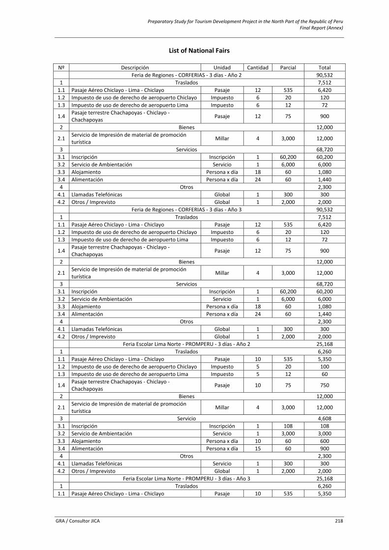
Preparatory Study for Tourism Development Project in the North Part of the Republic of Peru Final Report (Annex)
GRA / Consultor JICA 218
List of National Fairs
Nº Descripción Unidad Cantidad Parcial Total Feria de Regiones ‐ CORFERIAS ‐ 3 días ‐ Año 2 90,532
1 Traslados 7,512 1.1 Pasaje Aéreo Chiclayo ‐ Lima ‐ Chiclayo Pasaje 12 535 6,420 1.2 Impuesto de uso de derecho de aeropuerto Chiclayo Impuesto 6 20 120 1.3 Impuesto de uso de derecho de aeropuerto Lima Impuesto 6 12 72
1.4 Pasaje terrestre Chachapoyas ‐ Chiclayo ‐ Chachapoyas Pasaje 12 75 900
2 Bienes 12,000
2.1 Servicio de Impresión de material de promoción turística Millar 4 3,000 12,000
3 Servicios 68,720 3.1 Inscripción Inscripción 1 60,200 60,200 3.2 Servicio de Ambientación Servicio 1 6,000 6,000 3.3 Alojamiento Persona x día 18 60 1,080 3.4 Alimentación Persona x día 24 60 1,440 4 Otros 2,300 4.1 Llamadas Telefónicas Global 1 300 300 4.2 Otros / Imprevisto Global 1 2,000 2,000
Feria de Regiones ‐ CORFERIAS ‐ 3 días ‐ Año 3 90,532 1 Traslados 7,512 1.1 Pasaje Aéreo Chiclayo ‐ Lima ‐ Chiclayo Pasaje 12 535 6,420 1.2 Impuesto de uso de derecho de aeropuerto Chiclayo Impuesto 6 20 120 1.3 Impuesto de uso de derecho de aeropuerto Lima Impuesto 6 12 72
1.4 Pasaje terrestre Chachapoyas ‐ Chiclayo ‐ Chachapoyas Pasaje 12 75 900
2 Bienes 12,000
2.1 Servicio de Impresión de material de promoción turística Millar 4 3,000 12,000
3 Servicios 68,720 3.1 Inscripción Inscripción 1 60,200 60,200 3.2 Servicio de Ambientación Servicio 1 6,000 6,000 3.3 Alojamiento Persona x día 18 60 1,080 3.4 Alimentación Persona x día 24 60 1,440 4 Otros 2,300 4.1 Llamadas Telefónicas Global 1 300 300 4.2 Otros / Imprevisto Global 1 2,000 2,000
Feria Escolar Lima Norte ‐ PROMPERU ‐ 3 días ‐ Año 2 25,168 1 Traslados 6,260 1.1 Pasaje Aéreo Chiclayo ‐ Lima ‐ Chiclayo Pasaje 10 535 5,350 1.2 Impuesto de uso de derecho de aeropuerto Chiclayo Impuesto 5 20 100 1.3 Impuesto de uso de derecho de aeropuerto Lima Impuesto 5 12 60
1.4 Pasaje terrestre Chachapoyas ‐ Chiclayo ‐ Chachapoyas Pasaje 10 75 750
2 Bienes 12,000
2.1 Servicio de Impresión de material de promoción turística Millar 4 3,000 12,000
3 Servicio 4,608 3.1 Inscripción Inscripción 1 108 108 3.2 Servicio de Ambientación Servicio 1 3,000 3,000 3.3 Alojamiento Persona x día 10 60 600 3.4 Alimentación Persona x día 15 60 900 4 Otros 2,300 4.1 Llamadas Telefónicas Servicio 1 300 300 4.2 Otros / Imprevisto Global 1 2,000 2,000
Feria Escolar Lima Norte ‐ PROMPERU ‐ 3 días ‐ Año 3 25,168 1 Traslados 6,260 1.1 Pasaje Aéreo Chiclayo ‐ Lima ‐ Chiclayo Pasaje 10 535 5,350
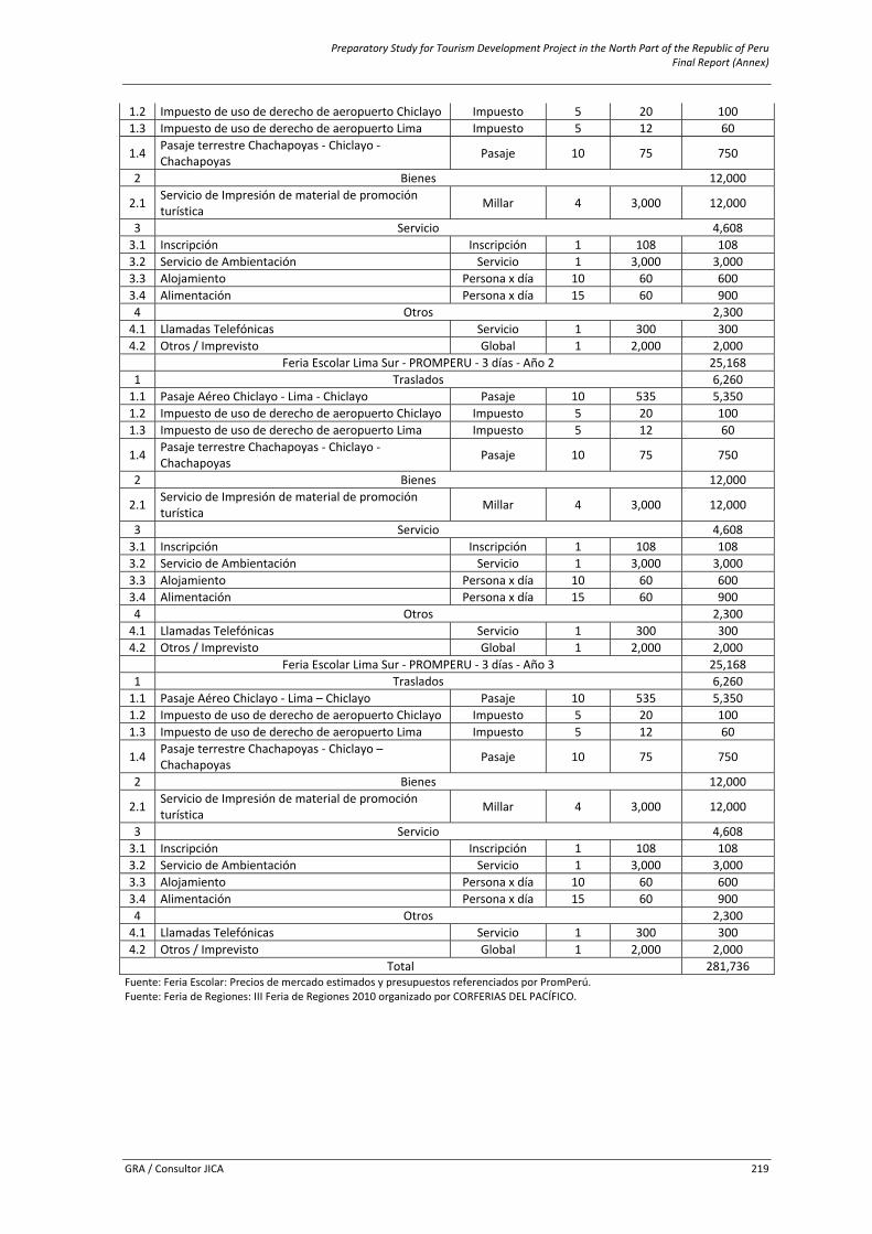
Preparatory Study for Tourism Development Project in the North Part of the Republic of Peru Final Report (Annex)
GRA / Consultor JICA 219
1.2 Impuesto de uso de derecho de aeropuerto Chiclayo Impuesto 5 20 100 1.3 Impuesto de uso de derecho de aeropuerto Lima Impuesto 5 12 60
1.4 Pasaje terrestre Chachapoyas ‐ Chiclayo ‐ Chachapoyas Pasaje 10 75 750
2 Bienes 12,000
2.1 Servicio de Impresión de material de promoción turística Millar 4 3,000 12,000
3 Servicio 4,608 3.1 Inscripción Inscripción 1 108 108 3.2 Servicio de Ambientación Servicio 1 3,000 3,000 3.3 Alojamiento Persona x día 10 60 600 3.4 Alimentación Persona x día 15 60 900 4 Otros 2,300 4.1 Llamadas Telefónicas Servicio 1 300 300 4.2 Otros / Imprevisto Global 1 2,000 2,000
Feria Escolar Lima Sur ‐ PROMPERU ‐ 3 días ‐ Año 2 25,168 1 Traslados 6,260 1.1 Pasaje Aéreo Chiclayo ‐ Lima ‐ Chiclayo Pasaje 10 535 5,350 1.2 Impuesto de uso de derecho de aeropuerto Chiclayo Impuesto 5 20 100 1.3 Impuesto de uso de derecho de aeropuerto Lima Impuesto 5 12 60
1.4 Pasaje terrestre Chachapoyas ‐ Chiclayo ‐ Chachapoyas Pasaje 10 75 750
2 Bienes 12,000
2.1 Servicio de Impresión de material de promoción turística Millar 4 3,000 12,000
3 Servicio 4,608 3.1 Inscripción Inscripción 1 108 108 3.2 Servicio de Ambientación Servicio 1 3,000 3,000 3.3 Alojamiento Persona x día 10 60 600 3.4 Alimentación Persona x día 15 60 900 4 Otros 2,300 4.1 Llamadas Telefónicas Servicio 1 300 300 4.2 Otros / Imprevisto Global 1 2,000 2,000
Feria Escolar Lima Sur ‐ PROMPERU ‐ 3 días ‐ Año 3 25,168 1 Traslados 6,260 1.1 Pasaje Aéreo Chiclayo ‐ Lima – Chiclayo Pasaje 10 535 5,350 1.2 Impuesto de uso de derecho de aeropuerto Chiclayo Impuesto 5 20 100 1.3 Impuesto de uso de derecho de aeropuerto Lima Impuesto 5 12 60
1.4 Pasaje terrestre Chachapoyas ‐ Chiclayo – Chachapoyas Pasaje 10 75 750
2 Bienes 12,000
2.1 Servicio de Impresión de material de promoción turística Millar 4 3,000 12,000
3 Servicio 4,608 3.1 Inscripción Inscripción 1 108 108 3.2 Servicio de Ambientación Servicio 1 3,000 3,000 3.3 Alojamiento Persona x día 10 60 600 3.4 Alimentación Persona x día 15 60 900 4 Otros 2,300 4.1 Llamadas Telefónicas Servicio 1 300 300 4.2 Otros / Imprevisto Global 1 2,000 2,000
Total 281,736 Fuente: Feria Escolar: Precios de mercado estimados y presupuestos referenciados por PromPerú. Fuente: Feria de Regiones: III Feria de Regiones 2010 organizado por CORFERIAS DEL PACÍFICO.
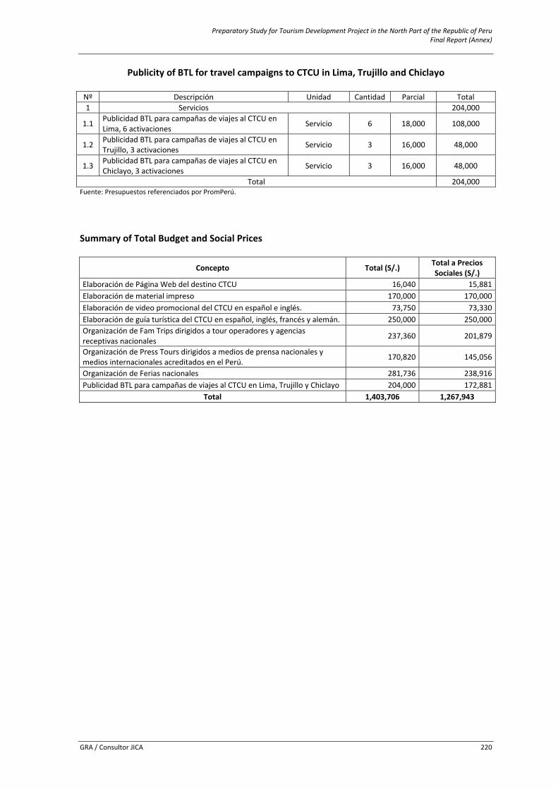
Preparatory Study for Tourism Development Project in the North Part of the Republic of Peru Final Report (Annex)
GRA / Consultor JICA 220
Publicity of BTL for travel campaigns to CTCU in Lima, Trujillo and Chiclayo
Nº Descripción Unidad Cantidad Parcial Total 1 Servicios 204,000
1.1 Publicidad BTL para campañas de viajes al CTCU en Lima, 6 activaciones Servicio 6 18,000 108,000
1.2 Publicidad BTL para campañas de viajes al CTCU en Trujillo, 3 activaciones Servicio 3 16,000 48,000
1.3 Publicidad BTL para campañas de viajes al CTCU en Chiclayo, 3 activaciones Servicio 3 16,000 48,000
Total 204,000 Fuente: Presupuestos referenciados por PromPerú. Summary of Total Budget and Social Prices
Concepto Total (S/.) Total a Precios Sociales (S/.)
Elaboración de Página Web del destino CTCU 16,040 15,881Elaboración de material impreso 170,000 170,000Elaboración de video promocional del CTCU en español e inglés. 73,750 73,330Elaboración de guía turística del CTCU en español, inglés, francés y alemán. 250,000 250,000Organización de Fam Trips dirigidos a tour operadores y agencias receptivas nacionales 237,360 201,879
Organización de Press Tours dirigidos a medios de prensa nacionales y medios internacionales acreditados en el Perú. 170,820 145,056
Organización de Ferias nacionales 281,736 238,916Publicidad BTL para campañas de viajes al CTCU en Lima, Trujillo y Chiclayo 204,000 172,881
Total 1,403,706 1,267,943
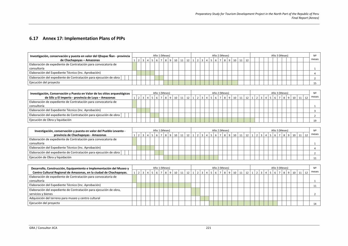
Preparatory Study for Tourism Development Project in the North Part of the Republic of Peru Final Report (Annex)
GRA / Consultor JICA 221
6.17 Annex 17: Implementation Plans of PIPs Investigación, conservación y puesta en valor del Qhapac Ñan ‐ provincia
de Chachapoyas – Amazonas Año 1 (Meses) Año 2 (Meses) Año 3 (Meses) Nº
meses 1 2 3 4 5 6 7 8 9 10 11 12 1 2 3 4 5 6 7 8 9 10 11 12 Elaboración de expediente de Contratación para convocatoria de consultoría 1 1 Elaboración del Expediente Técnico (Inc. Aprobación) 1 1 1 1 4 Elaboración del expediente de Contratación para ejecución de obra 1 1 2 Ejecución del proyecto 1 1 1 1 1 1 1 1 1 1 1 1 1 1 1 15
Investigación, Conservación y Puesta en Valor de los sitios arqueológicos de Sílic y El Imperio ‐ provincia de Luya – Amazonas
Año 1 (Meses) Año 2 (Meses) Año 3 (Meses) Nº meses 1 2 3 4 5 6 7 8 9 10 11 12 1 2 3 4 5 6 7 8 9 10 11 12 1 2 3 4 5 6 7 8 9 10 11 12
Elaboración de expediente de Contratación para convocatoria de consultoría 1 1 Elaboración del Expediente Técnico (Inc. Aprobación) 1 1 1 3 Elaboración del expediente de Contratación para ejecución de obra 1 1 2 Ejecución de Obra y liquidación 1 1 1 1 1 1 1 1 1 1 1 1 1 1 1 1 1 1 1 19
Investigación, conservación y puesta en valor del Pueblo Levanto ‐ provincia de Chachapoyas ‐ Amazonas
Año 1 (Meses) Año 2 (Meses) Año 3 (Meses) Nº meses 1 2 3 4 5 6 7 8 9 10 11 12 1 2 3 4 5 6 7 8 9 10 11 12 1 2 3 4 5 6 7 8 9 10 11 12
Elaboración de expediente de Contratación para convocatoria de consultoría 1 1 Elaboración del Expediente Técnico (Inc. Aprobación) 1 1 1 1 4 Elaboración del expediente de Contratación para ejecución de obra 1 1 2 Ejecución de Obra y liquidación 1 1 1 1 1 1 1 1 1 1 1 11
Desarrollo, Construcción, Equipamiento e Implementación del Museo y Centro Cultural Regional de Amazonas, en la ciudad de Chachapoyas.
Año 1 (Meses) Año 2 (Meses) Año 3 (Meses) Nº meses 1 2 3 4 5 6 7 8 9 10 11 12 1 2 3 4 5 6 7 8 9 10 11 12 1 2 3 4 5 6 7 8 9 10 11 12
Elaboración de expediente de Contratación para convocatoria de consultoría 1 1 Elaboración del Expediente Técnico (Inc. Aprobación) 1 1 1 1 1 1 1 1 1 1 1 11 Elaboración del expediente de Contratación para ejecución de obra, servicios y bienes 1 1 2 Adquisición del terreno para museo y centro cultural Ejecución del proyecto 1 1 1 1 1 1 1 1 1 1 1 1 1 1 14
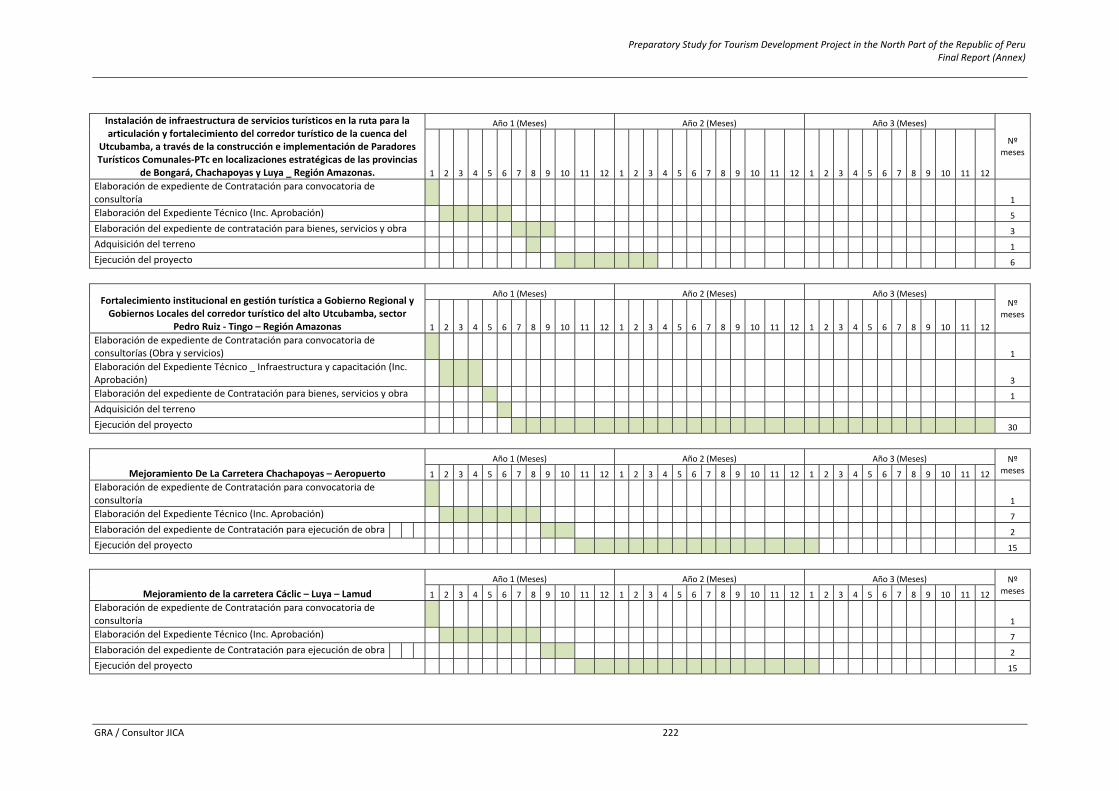
Preparatory Study for Tourism Development Project in the North Part of the Republic of Peru Final Report (Annex)
GRA / Consultor JICA 222
Instalación de infraestructura de servicios turísticos en la ruta para la articulación y fortalecimiento del corredor turístico de la cuenca del
Utcubamba, a través de la construcción e implementación de Paradores Turísticos Comunales‐PTc en localizaciones estratégicas de las provincias
de Bongará, Chachapoyas y Luya _ Región Amazonas.
Año 1 (Meses) Año 2 (Meses) Año 3 (Meses)
Nº meses
1 2 3 4 5 6 7 8 9 10 11 12 1 2 3 4 5 6 7 8 9 10 11 12 1 2 3 4 5 6 7 8 9 10 11 12 Elaboración de expediente de Contratación para convocatoria de consultoría 1 1 Elaboración del Expediente Técnico (Inc. Aprobación) 1 1 1 1 1 5 Elaboración del expediente de contratación para bienes, servicios y obra 1 1 1 3 Adquisición del terreno 1 1 Ejecución del proyecto 1 1 1 1 1 1 6
Fortalecimiento institucional en gestión turística a Gobierno Regional y Gobiernos Locales del corredor turístico del alto Utcubamba, sector
Pedro Ruiz ‐ Tingo – Región Amazonas
Año 1 (Meses) Año 2 (Meses) Año 3 (Meses) Nº
meses 1 2 3 4 5 6 7 8 9 10 11 12 1 2 3 4 5 6 7 8 9 10 11 12 1 2 3 4 5 6 7 8 9 10 11 12
Elaboración de expediente de Contratación para convocatoria de consultorías (Obra y servicios) 1 1 Elaboración del Expediente Técnico _ Infraestructura y capacitación (Inc. Aprobación) 1 1 1 3 Elaboración del expediente de Contratación para bienes, servicios y obra 1 1 Adquisición del terreno Ejecución del proyecto 1 1 1 1 1 1 1 1 1 1 1 1 1 1 1 1 1 1 1 1 1 1 1 1 1 1 1 1 1 1 30
Mejoramiento De La Carretera Chachapoyas – Aeropuerto Año 1 (Meses) Año 2 (Meses) Año 3 (Meses) Nº
meses 1 2 3 4 5 6 7 8 9 10 11 12 1 2 3 4 5 6 7 8 9 10 11 12 1 2 3 4 5 6 7 8 9 10 11 12 Elaboración de expediente de Contratación para convocatoria de consultoría 1 1 Elaboración del Expediente Técnico (Inc. Aprobación) 1 1 1 1 1 1 1 7 Elaboración del expediente de Contratación para ejecución de obra 1 1 2 Ejecución del proyecto 1 1 1 1 1 1 1 1 1 1 1 1 1 1 1 15
Mejoramiento de la carretera Cáclic – Luya – Lamud Año 1 (Meses) Año 2 (Meses) Año 3 (Meses) Nº
meses 1 2 3 4 5 6 7 8 9 10 11 12 1 2 3 4 5 6 7 8 9 10 11 12 1 2 3 4 5 6 7 8 9 10 11 12 Elaboración de expediente de Contratación para convocatoria de consultoría 1 1 Elaboración del Expediente Técnico (Inc. Aprobación) 1 1 1 1 1 1 1 7 Elaboración del expediente de Contratación para ejecución de obra 1 1 2 Ejecución del proyecto 1 1 1 1 1 1 1 1 1 1 1 1 1 1 1 15
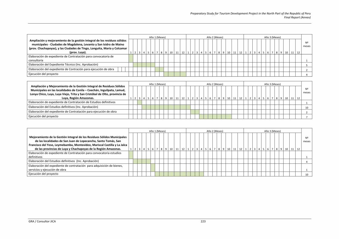
Preparatory Study for Tourism Development Project in the North Part of the Republic of Peru Final Report (Annex)
GRA / Consultor JICA 223
Ampliación y mejoramiento de la gestión integral de los residuos sólidos municipales ‐ Ciudades de Magdalena, Levanto y San Isidro de Maino
(prov. Chachapoyas), y las Ciudades de Tingo, Longuita, María y Colcamar (prov. Luya).
Año 1 (Meses) Año 2 (Meses) Año 3 (Meses)
Nº meses
1 2 3 4 5 6 7 8 9 10 11 12 1 2 3 4 5 6 7 8 9 10 11 12 1 2 3 4 5 6 7 8 9 10 11 12 Elaboración de expediente de Contratación para convocatoria de consultoría 1 1 Elaboración del Expediente Técnico (Inc. Aprobación) 1 1 1 1 1 5 Elaboración del expediente de Contración para ejecución de obra 1 1 2 Ejecución del proyecto 1 1 1 1 4
Ampliación y Mejoramiento de la Gestión Integral de Residuos Sólidos Municipales en las localidades de Conila – Coechán, Inguilpata, Lamud, Lonya Chico, Luya, Luya Viejo, Trita y San Cristóbal de Olto, provincia de
Luya, Región Amazonas.
Año 1 (Meses) Año 2 (Meses) Año 3 (Meses)
Nº meses
1 2 3 4 5 6 7 8 9 10 11 12 1 2 3 4 5 6 7 8 9 10 11 12 1 2 3 4 5 6 7 8 9 10 11 12 Elaboración de expediente de Contratación de Estudios definitivos 1 1 Elaboración del Estudios definitivos (Inc. Aprobación) 1 1 1 1 1 1 1 1 1 1 10 Elaboración del expediente de Contratación para ejecución de obra 1 1 2 Ejecución del proyecto 1 1 1 1 1 1 1 7
Mejoramiento de la Gestión Integral de los Residuos Sólidos Municipales de las localidades de San Juan de Lopecancha, Santo Tomás, San
Francisco del Yeso, Leymebamba, Montevideo, Mariscal Castilla y La Jalca de las provincias de Luya y Chachapoyas de la Región Amazonas.
Año 1 (Meses) Año 2 (Meses) Año 3 (Meses)
Nº meses
1 2 3 4 5 6 7 8 9 10 11 12 1 2 3 4 5 6 7 8 9 10 11 12 1 2 3 4 5 6 7 8 9 10 11 12 Elaboración de expediente de Contratación para convocatoria estudios definitivos 1 1 Elaboración del Estudios definitivos (Inc. Aprobación) 1 1 1 1 4 Elaboración del expediente de contratación para adquisición de bienes, servicios y ejecución de obra 1 1 Ejecución del proyecto 1 1 1 1 1 1 1 1 1 1 10