Embed Size (px)
Citation preview
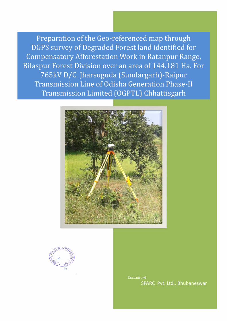
Preparation of the Geo-referenced map throughDGPS survey of Degraded Forest land identified forCompensatory Afforestation Work in Ratanpur Range,Bilaspur Forest Division over an area of 144.181 Ha. For765kV D/C Jharsuguda (Sundargarh)-RaipurTransmission Line of Odisha Generation Phase-IITransmission Limited (OGPTL) Chhattisgarh
ConsultantSPARC Pvt. Ltd., Bhubaneswar
Preparation of the Geo-referenced map throughDGPS survey of Degraded Forest land identified forCompensatory Afforestation Work in Ratanpur Range,Bilaspur Forest Division over an area of 144.181 Ha. For765kV D/C Jharsuguda (Sundargarh)-RaipurTransmission Line of Odisha Generation Phase-IITransmission Limited (OGPTL) Chhattisgarh
Prepared for:
Odisha Generation Phase-II TransmissionLimited,
Prepared by:Spatial Planning & Analysis Research Centre Pvt. Ltd.E-11, Infocity, Chandaka Industrial Estate,Bhubaneswar – 751 024, www.sparcindia.com
February-2017
Project office: House No :B-1/03,Phase-IISurya Vihar ,Junwani,Bhilai,Pin-490020(C.G)
DGPS Survey of CA Land in Ratanpur Range, Bilaspur Division
SPARC / OGPTL DGPS Survey of CA Land / Jan’ 2017 1
1. INTRODUCTION AND BACKGROUND INFORMATIONThe Government of India, Central Electricity Authority vide Gazette Notification dated February
06, 2015 has notified PFC Consulting Limited to be the Bid Process Coordinator (BPC) for the
purpose of selection of Bidder as Transmission Service Provider (TSP) to establish transmission
system for “Common Transmission System for Phase-II Generation Projects in Odisha and
Immediate Evacuation System for OPGC (1320 MW) Project in Odisha” through tariff based
competitive bidding process
Sterlite Grid 3 Limited had been participated in the international competitive bidding process
for Transmission Scheme for “Common Transmission System for Phase-II Generation Projects
in Odisha and Immediate Evacuation System for OPGC (1320 MW) Project in Odisha “.
Power Finance Corporation Consulting Limited (PFCCL), Government of India has accepted our
Bid and SGL 3 has been declared as the successful bidder.
Special Purpose Vehicle (SPV) constructed for this project is “Odisha Generation Phase II
Transmission Ltd”. SPV acquisition process is under progress.
Prior approval under Section 68(1) of Electricity Act, 2003 from Ministry of Power, Government
of India has been already taken for construction of transmission element by “Odisha
Generation Phase II Transmission Ltd” (Associated Transmission Lines are 765kV D/C Raipur-
Jharsuguda & 400kV D/C OPGC-Jharsuguda) vide letter no. 68/ER/2015/1301 dated 3rd June
2015.
The details of lines is mentioned here under: -
1. 765kV D/C Raipur-Jharsuguda Transmission Line: 300 K.M (Approx.)
Above said line passes through Durg, Bematara, Baloda Bazar, Bilaspur, Janjgir Champa &
Raigarh districts of Chattisgarh State (Total Line length is 255 K.M Approx) and Jharsuguda
district of Odisha State (Total Line length is 45 K.M Approx).
After identification of Forest land for laying of 765kV D/C Raipur-Jharsuguda
Transmission Line, Forest area of 71.761 Hectare has been identified in Four Divisions
(Durg : 1.97 Hectare, Bilaspur : 4.33 Hectare , Janjgir Champa : 6.282 Hectare & Raigarh
: 59.179 Hectare) which comprises of Revenue & Protected Forest land . As per the
MoEF&CC Guidleine, Online Submission of Forest diversion proposal has been uploaded
on MoEF&CC Portal on 13th Sept 2016 whose proposal no. is FP/CG/TRANS/21354/2016.
Now as per MoEF&CC Guideline dated 11th July 2014, Compensatory Afforestation may be
raised over degraded forest land twice in extent of the forest area being diverted in
respect of the proposals for laying of transmission lines.
DGPS Survey of CA Land in Ratanpur Range, Bilaspur Division
SPARC / OGPTL DGPS Survey of CA Land / Jan’ 2017 2
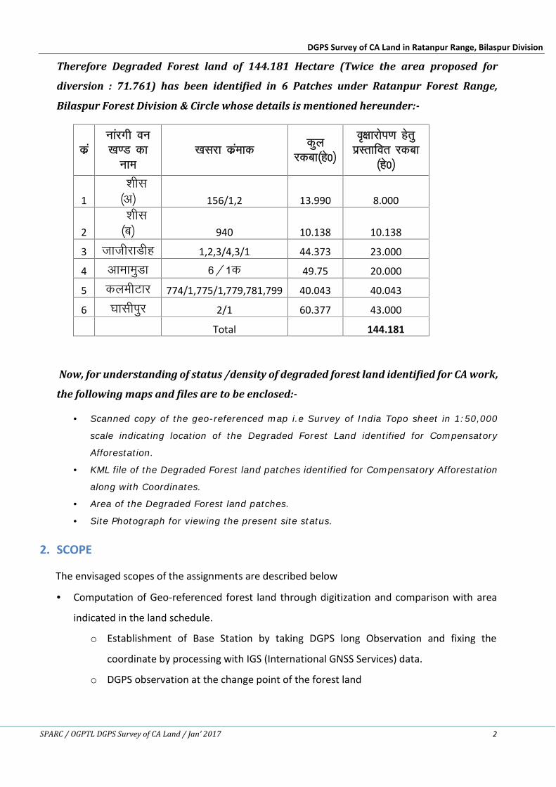
Therefore Degraded Forest land of 144.181 Hectare (Twice the area proposed for
diversion : 71.761) has been identified in 6 Patches under Ratanpur Forest Range,
Bilaspur Forest Division & Circle whose details is mentioned hereunder:-
dzaukajxh ou[k.M dk
uke[kljk dzaekd dqy
jdck¼gs0½
o`{kkjksi.k gsrqizLrkfor jdck
¼gs0½
1'khl
¼v½ 156/1,2 13.990 8.000
2'khl¼c½ 940 10.138 10.138
3 tkthjkMhg 1,2,3/4,3/1 44.373 23.000
4 vkekeqMk 6@1d 49.75 20.000
5 dyehVkj 774/1,775/1,779,781,799 40.043 40.043
6 ?kklhiqj 2/1 60.377 43.000
Total 144.181
Now, for understanding of status /density of degraded forest land identified for CA work,
the following maps and files are to be enclosed:-
Scanned copy of the geo-referenced map i.e Survey of India Topo sheet in 1:50,000
scale indicating location of the Degraded Forest Land identified for Compensatory
Afforestation.
KML file of the Degraded Forest land patches identified for Compensatory Afforestation
along with Coordinates.
Area of the Degraded Forest land patches.
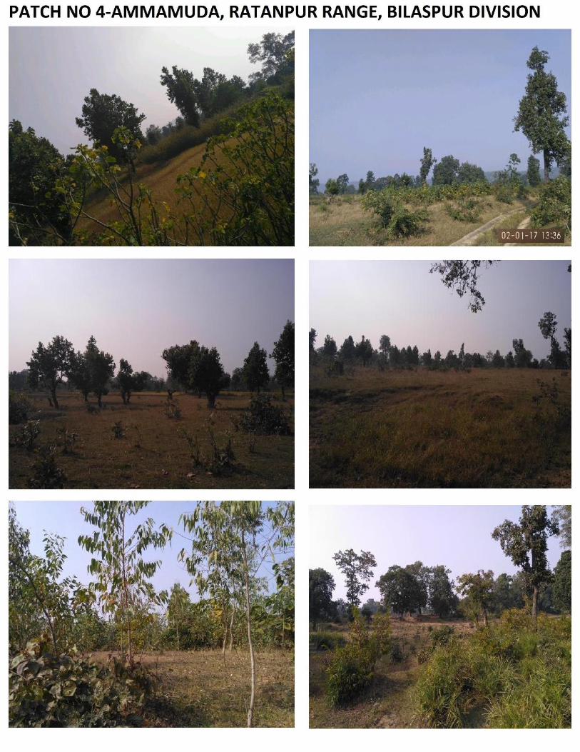
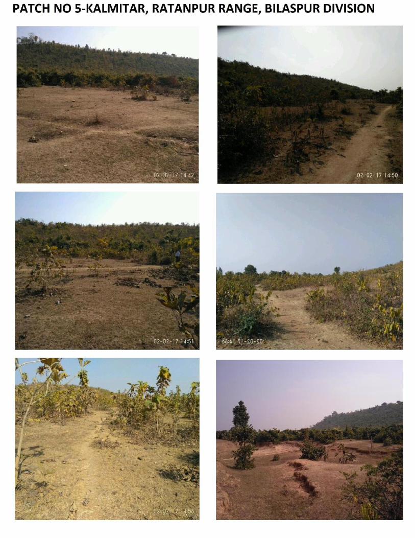
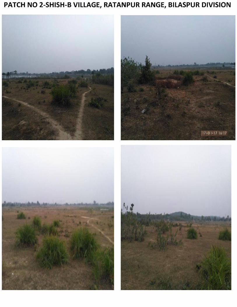
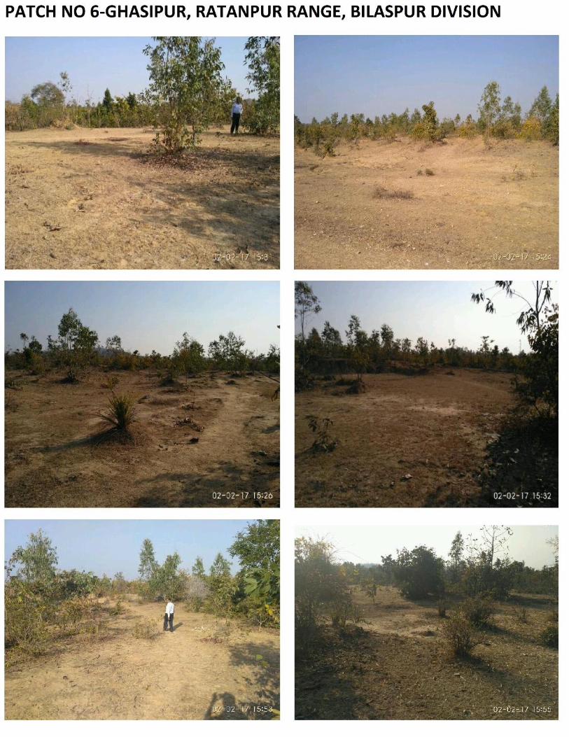
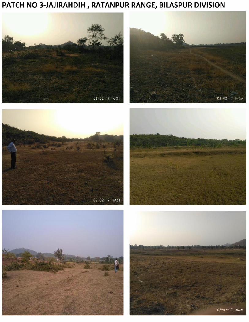
Site Photograph for viewing the present site status.
2. SCOPE
The envisaged scopes of the assignments are described below
Computation of Geo-referenced forest land through digitization and comparison with area
indicated in the land schedule.
o Establishment of Base Station by taking DGPS long Observation and fixing the
coordinate by processing with IGS (International GNSS Services) data.
o DGPS observation at the change point of the forest land
DGPS Survey of CA Land in Ratanpur Range, Bilaspur Division
SPARC / OGPTL DGPS Survey of CA Land / Jan’ 2017 3
Processing of DGPS observation and geo-referencing of the Forest land based on DGPS
Surveyed co-ordinates.
Generation of the kml file of the Degraded Forest land
Printing of Hard copy maps and report.
3. DELIVERABLE
Geo-referenced scanned cadastral/forest compartment maps based on field observation.
Geo-referenced Topomaps, kml file (soft copy) of the Forest land with area statement.
Submission of maps & report in 6 nos. hard copy along with soft copy and kml file as perrequirement of MoEF guidelines.
DGPS Survey of CA Land in Ratanpur Range, Bilaspur Division
SPARC / OGPTL DGPS Survey of CA Land / Jan’ 2017 4
4. METHODOLOGY
4.1 INPUT DATA
The land plan and maps required for geo-referencing was provided by OGPTL to M/s SPARC along
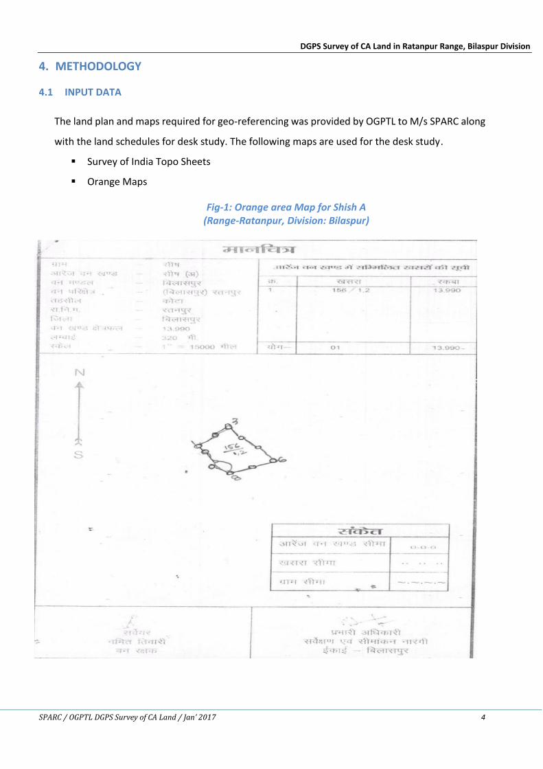
with the land schedules for desk study. The following maps are used for the desk study.
Survey of India Topo Sheets
Orange Maps
Fig-1: Orange area Map for Shish A(Range-Ratanpur, Division: Bilaspur)
DGPS Survey of CA Land in Ratanpur Range, Bilaspur Division
SPARC / OGPTL DGPS Survey of CA Land / Jan’ 2017 5
Fig-2: Orange Map for Shish B(Range-Ratanpur, Division: Bilaspur)
DGPS Survey of CA Land in Ratanpur Range, Bilaspur Division
SPARC / OGPTL DGPS Survey of CA Land / Jan’ 2017 6
Fig-3: Orange Map for Janjirahadih(Range-Ratanpur, Division: Bilaspur)
Fig-4: Orange Map for Aamamuda
DGPS Survey of CA Land in Ratanpur Range, Bilaspur Division
SPARC / OGPTL DGPS Survey of CA Land / Jan’ 2017 7
(Range-Ratanpur, Division: Bilaspur)
Fig-5: Orange Map for Kalmitar
DGPS Survey of CA Land in Ratanpur Range, Bilaspur Division
SPARC / OGPTL DGPS Survey of CA Land / Jan’ 2017 8
(Range-Ratanpur, Division: Bilaspur)
Fig-6: Orange Map for Ghasipur
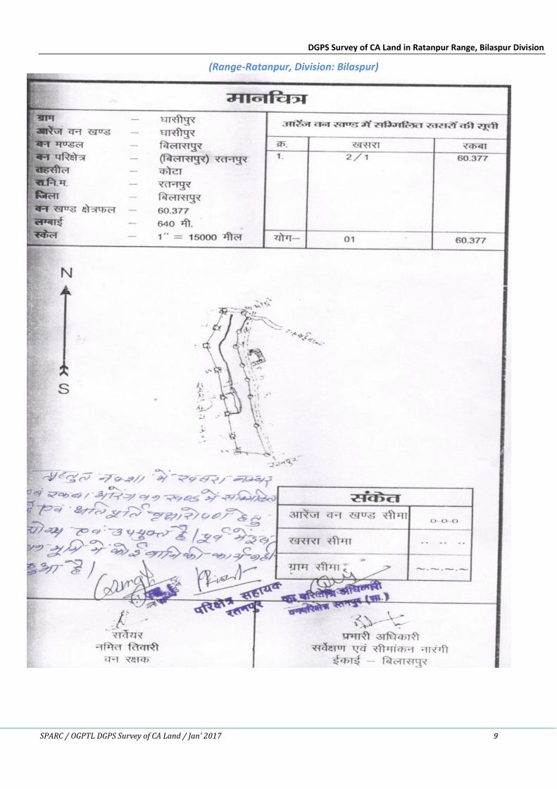
DGPS Survey of CA Land in Ratanpur Range, Bilaspur Division
SPARC / OGPTL DGPS Survey of CA Land / Jan’ 2017 9
(Range-Ratanpur, Division: Bilaspur)
DGPS Survey of CA Land in Ratanpur Range, Bilaspur Division
SPARC / OGPTL DGPS Survey of CA Land / Jan’ 2017 10
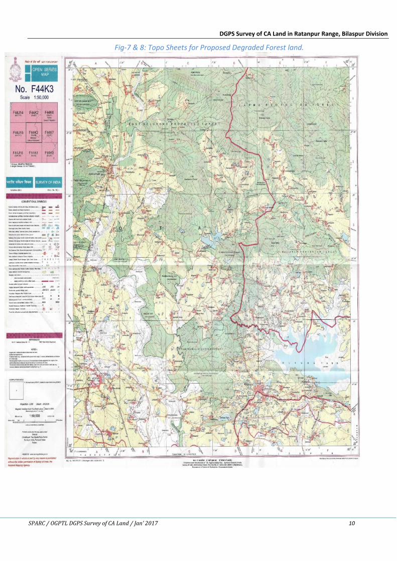
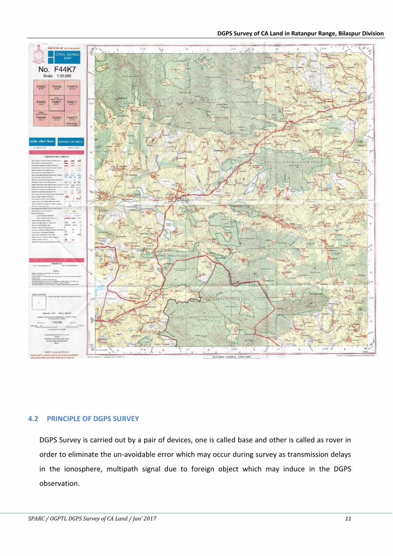
Fig-7 & 8: Topo Sheets for Proposed Degraded Forest land.
DGPS Survey of CA Land in Ratanpur Range, Bilaspur Division
SPARC / OGPTL DGPS Survey of CA Land / Jan’ 2017 11
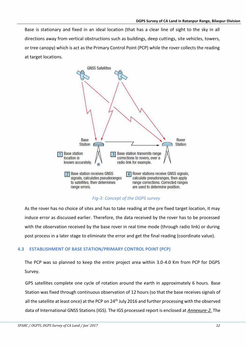
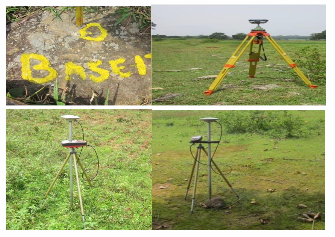
4.2 PRINCIPLE OF DGPS SURVEY
DGPS Survey is carried out by a pair of devices, one is called base and other is called as rover in
order to eliminate the un-avoidable error which may occur during survey as transmission delays
in the ionosphere, multipath signal due to foreign object which may induce in the DGPS
observation.
DGPS Survey of CA Land in Ratanpur Range, Bilaspur Division
SPARC / OGPTL DGPS Survey of CA Land / Jan’ 2017 12
Base is stationary and fixed in an ideal location (that has a clear line of sight to the sky in all
directions away from vertical obstructions such as buildings, deep cuttings, site vehicles, towers,
or tree canopy) which is act as the Primary Control Point (PCP) while the rover collects the reading
at target locations.
Fig-3: Concept of the DGPS survey
As the rover has no choice of sites and has to take reading at the pre fixed target location, it may
induce error as discussed earlier. Therefore, the data received by the rover has to be processed
with the observation received by the base rover in real time mode (through radio link) or during
post process in a later stage to eliminate the error and get the final reading (coordinate value).
4.3 ESTABLISHMENT OF BASE STATION/PRIMARY CONTROL POINT (PCP)
The PCP was so planned to keep the entire project area within 3.0-4.0 Km from PCP for DGPS
Survey.
GPS satellites complete one cycle of rotation around the earth in approximately 6 hours. Base
Station was fixed through continuous observation of 12 hours (so that the base receives signals of
all the satellite at least once) at the PCP on 24th July 2016 and further processing with the observed
data of International GNSS Stations (IGS). The IGS processed report is enclosed at Annexure-2. The
DGPS Survey of CA Land in Ratanpur Range, Bilaspur Division
SPARC / OGPTL DGPS Survey of CA Land / Jan’ 2017 13
processed coordinate value is as follows.
Table-2: Coordinate of Base Station
Location Latitude Longitude Northing (m) Easting (m)
Bilaspur 21°47’08.98262” N 82°18’36.53707” E 2409696.289 635445.435
As per the National Map policy is enclosed at Annexure-3, all the maps are prepared with UTM
Projection using the Datum WGS-1984 to seamless integration with new Open Series Maps
(OSM) Topo Sheets published by Survey of India.
4.4 SECONDARY CONTROL POINT (SCP) SURVEY
4-6 secondary point per revenue sheet are required to geo-reference the maps based on DGPS
survey. The Secondary Control Points (SCPs) in the area of interest were planned at convenient
location. SCPs are planned well distributing in the revenue maps covering Tri-junction, Bi-junction,
undistributed field bund.
DGPS observations were taken SCPs location (for 15 minutes each) using rover. The data observed
by base and rover were post processed using advanced Trimble Business Centre software for
obtaining the final SCP Co-ordinates.
5. CONCLUSION
The observed DGPS co-ordinates of SCPs of Kml Map and area are given in Table-3 and Table-4
respectively.
DGPS Survey of CA Land in Ratanpur Range, Bilaspur Division
SPARC / OGPTL DGPS Survey of CA Land / Jan’ 2017 14
Table-3: Coordinates of Secondary Control Points (SCPs)
Patch-1 :- Orange area - Shish A(Range-Ratanpur, Division: Bilaspur)
Point-ID Latitude (N) Longitude (E) Easting Northing ElevationCA 1 22°20'13.49" 82°15'47.26" 630077.83 2470684.29 309.466CA 2 22°20'12.36" 82°15'49.09" 630130.93 2470648.50 308.034CA 3 22°20'11.26" 82°15'50.91" 630183.00 2470615.00 309.230CA 4 22°20'10.16" 82°15'52.46" 630227.95 2470581.7 310.689CA 5 22°20'11.77" 82°15'54.56" 630287.57 2470631.28 307.456CA 6 22°20'11.47" 82°15'56.30" 630337.44 2470622.86 309.164CA 7 22°20'11.34" 82°15'59.41" 630427.01 2470621.31 310.879CA 8 22°20'10.15" 82°15'59.24" 630421.89 2470582.98 311.768CA 9 22°20'9.31" 82°16'1.56" 630488.48 2470557.70 309.896
CA 10 22°20'8.91" 82°16'3.73" 630550.67 2470545.92 310.524CA 11 22°20'6.01" 82°16'4.75" 630580.47 2470456.55 312.413CA 12 22°20'4.28" 82°16'2.35" 630513.39 2470404.78 313.043CA 13 22°20'3.43" 82°15'59.68" 630436.21 2470376.42 314.443CA 14 22°20'3.12" 82°15'57.25" 630366.77 2470366.31 313.682CA 15 22°20'4.36" 82°15'55.84" 630326.11 2470404.10 317.461CA 16 22°20'5.56" 82°15'56.27" 630338.10 2470441.11 315.024CA 17 22°20'6.41" 82°15'53.38" 630255.20 2470466.55 312.339CA 18 22°20'8.31" 82°15'47.43" 630082.58 2470522.75 311.419CA 19 22°20'10.56" 82°15'48.69" 630119.95 2470593.05 310.416CA 20 22°20'11.73" 82°15'46.47" 630056.27 2470627.83 309.014
DGPS Survey of CA Land in Ratanpur Range, Bilaspur Division
SPARC / OGPTL DGPS Survey of CA Land / Jan’ 2017 15
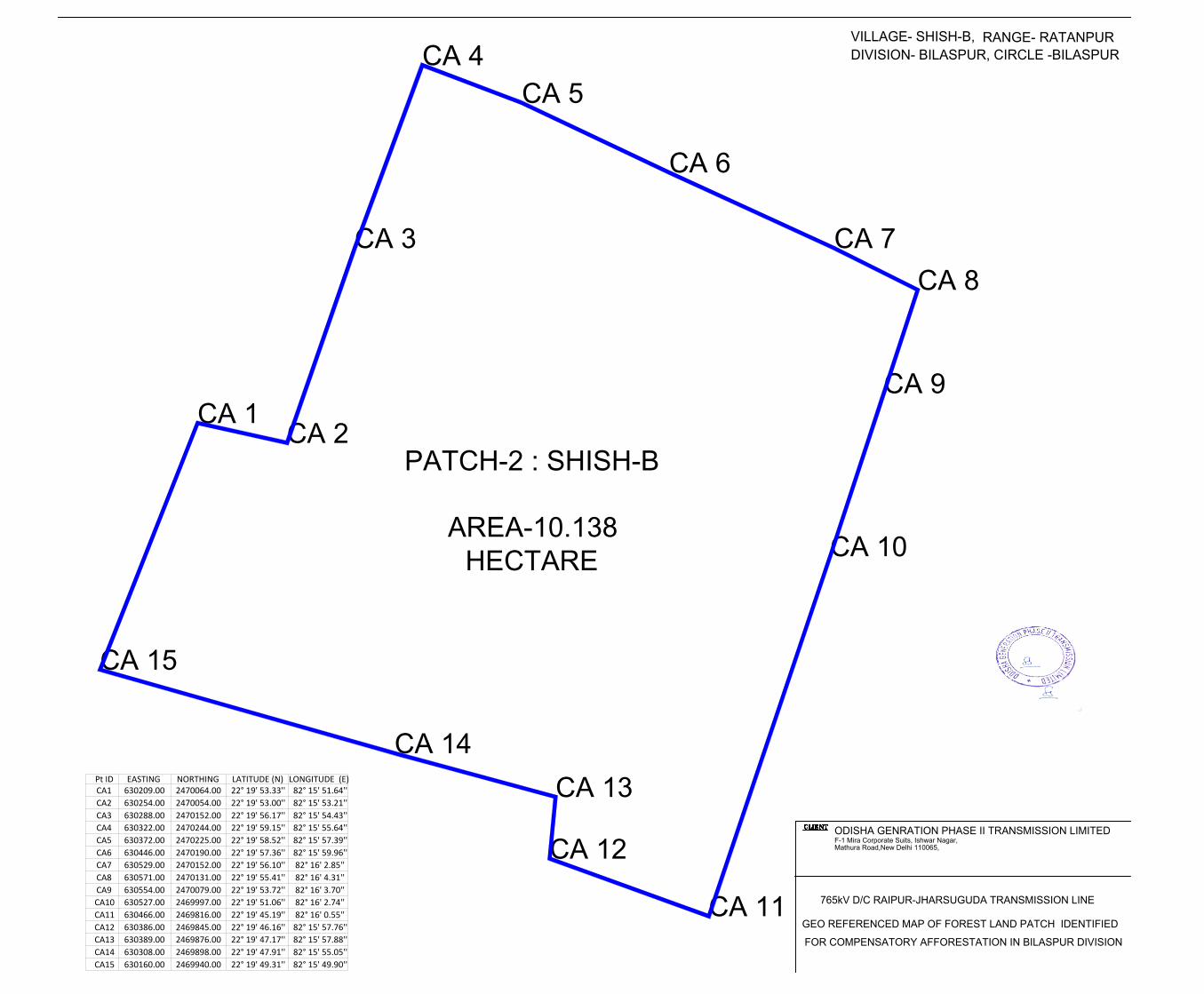
Patch-2 :- Orange area - Shish B(Range-Ratanpur, Division: Bilaspur)
Point-ID Latitude (N) Longitude (E) Easting Northing ElevationCA 1 22° 19' 53.33'' 82° 15' 51.64'' 630209.00 2470064.00 314.488CA 2 22° 19' 53.00'' 82° 15' 53.21'' 630254.00 2470054.00 315.031CA 3 22° 19' 56.17'' 82° 15' 54.43'' 630288.00 2470152.00 313.240CA 4 22° 19' 59.15'' 82° 15' 55.64'' 630322.00 2470244.00 313.689CA 5 22° 19' 58.52'' 82° 15' 57.39'' 630372.00 2470225.00 312.466CA 6 22° 19' 57.36'' 82° 15' 59.96'' 630446.00 2470190.00 311.844CA 7 22° 19' 56.10'' 82° 16' 2.85'' 630529.00 2470152.00 310.879CA 8 22° 19' 55.29'' 82° 16' 4.75'' 630583.00 2470127.00 311.768CA 9 22° 19' 53.72'' 82° 16' 4.13'' 630566.00 2470079.00 309.826
CA 10 22° 19' 50.96'' 82° 16' 3.15'' 630539.00 2469994.00 310.514CA 11 22° 19' 45.16'' 82° 16' 1.00'' 630479.00 2469815.00 309.413CA 12 22° 19' 46.16'' 82° 15' 57.76'' 630386.00 2469845.00 308.063CA 13 22° 19' 47.17'' 82° 15' 57.88'' 630389.00 2469876.00 310.113CA 14 22° 19' 47.91'' 82° 15' 55.05'' 630308.00 2469898.00 311.651CA 15 22° 19' 49.31'' 82° 15' 49.90'' 630160.00 2469940.00 312.444
DGPS Survey of CA Land in Ratanpur Range, Bilaspur Division
SPARC / OGPTL DGPS Survey of CA Land / Jan’ 2017 16
Patch-3 :- Orange area - Jajiradih(Range-Ratanpur, Division: Bilaspur)
Point-ID Latitude (N) Longitude (E) Easting Northing ElevationCA 1 22° 16' 1.58'' 82° 8' 18.87'' 617309.00 2462834.00 308.111CA 2 22° 16' 1.72'' 82° 8' 16.18'' 617232.00 2462838.00 309.044CA 3 22° 16' 3.09'' 82° 8' 7.53'' 616984.00 2462878.00 311.471CA 4 22° 16' 2.18'' 82° 8' 1.79'' 616820.00 2462849.00 312.642CA 5 22° 16' 2.02'' 82° 7' 57.91'' 616709.00 2462843.00 312.411CA 6 22° 16' 0.91'' 82° 7' 55.41'' 616637.69 2462808.55 311.096CA 7 22° 16' 1.98'' 82° 7' 53.20'' 616574.00 2462841.00 310.956CA 8 22° 16' 3.14'' 82° 7' 49.85'' 616478.00 2462876.00 311.138CA 9 22° 16' 2.67'' 82° 7' 48.03'' 616426.00 2462861.00 309.216CA 10 22° 16' 1.24'' 82° 7' 47.84'' 616421.00 2462817.00 310.514CA 11 22° 16' 0.16'' 82° 7' 49.23'' 616461.00 2462784.00 305.413CA 12 22° 15' 58.48'' 82° 7' 51.11'' 616515.00 2462733.00 304.063CA 13 22° 15' 56.34'' 82° 7' 50.77'' 616506.00 2462667.00 303.113CA 14 22° 15' 54.48'' 82° 7' 51.18'' 616518.00 2462610.00 304.651CA 15 22° 15' 54.68'' 82° 8' 5.08'' 616916.00 2462619.00 302.412CA 16 22° 15' 50.84'' 82° 8' 5.26'' 616922.00 2462501.00 308.111CA 17 22° 15' 51.01'' 82° 8' 9.18'' 617034.00 2462507.00 309.826CA 18 22° 15' 46.22'' 82° 8' 12.10'' 617118.67 2462360.23 310.514CA 19 22° 15' 52.08'' 82° 8' 14.95'' 617199.00 2462541.00 309.413CA 20 22° 15' 54.30'' 82° 8' 15.11'' 617203.00 2462609.00 308.063CA 21 22° 15' 56.13'' 82° 8' 15.90'' 617225.00 2462666.00 310.113CA 22 22° 15' 57.93'' 82° 8' 14.20'' 617176.00 2462721.00 311.651CA 23 22° 16' 0.37'' 82° 8' 19.46'' 617326.00 2462797.00 312.444
DGPS Survey of CA Land in Ratanpur Range, Bilaspur Division
SPARC / OGPTL DGPS Survey of CA Land / Jan’ 2017 17
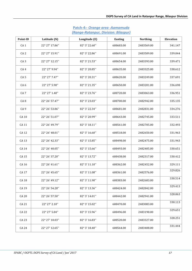
Patch-4:- Orange area -Aamamuda(Range-Ratanpur, Division: Bilaspur)
Point-ID Latitude (N) Longitude (E) Easting Northing ElevationCA 1 22° 27' 17.86'' 82° 3' 22.60'' 608683.00 2483569.00 341.147CA 2 22° 27' 15.91'' 82° 3' 22.86'' 608691.00 2483509.00 339.044CA 3 22° 27' 12.15'' 82° 3' 21.53'' 608654.00 2483393.00 339.471CA 4 22° 27' 9.94'' 82° 3' 20.85'' 608635.00 2483325.00 338.612CA 5 22° 27' 7.47'' 82° 3' 20.31'' 608620.00 2483249.00 337.691CA 6 22° 27' 5.90'' 82° 3' 21.35'' 608650.00 2483201.00 336.698CA 7 22° 27' 1.40'' 82° 3' 23.76'' 608720.00 2483063.00 336.951CA 8 22° 26' 57.47'' 82° 3' 23.03'' 608700.00 2482942.00 335.135CA 9 22° 26' 53.86'' 82° 3' 22.34'' 608681.00 2482831.00 334.276CA 10 22° 26' 51.07'' 82° 3' 20.99'' 608643.00 2482745.00 333.511CA 11 22° 26' 49.79'' 82° 3' 18.11'' 608561.00 2482705.00 332.493CA 12 22° 26' 48.01'' 82° 3' 16.60'' 608518.00 2482650.00 331.963CA 13 22° 26' 42.33'' 82° 3' 15.85'' 608498.00 2482475.00 331.943CA 14 22° 26' 40.05'' 82° 3' 15.66'' 608493.00 2482405.00 330.651CA 15 22° 26' 37.20'' 82° 3' 13.72'' 608438.00 2482317.00 330.412CA 16 22° 26' 41.61'' 82° 3' 11.10'' 608362.00 2482452.00 329.111CA 17 22° 26' 45.65'' 82° 3' 11.08'' 608361.00 2482576.00 329.826CA 18 22° 26' 49.12'' 82° 3' 11.90'' 608383.00 2482683.00 330.514CA 19 22° 26' 54.28'' 82° 3' 13.36'' 608424.00 2482842.00 329.413CA 20 22° 26' 57.50'' 82° 3' 14.01'' 608442.00 2482941.00 328.063CA 21 22° 27' 2.10'' 82° 3' 15.02'' 608470.00 2483083.00 330.113CA 22 22° 27' 5.84'' 82° 3' 15.96'' 608496.00 2483198.00 329.651CA 23 22° 27' 10.03'' 82° 3' 16.83'' 608520.00 2483327.00 328.251CA 24 22° 27' 12.65'' 82° 3' 18.40'' 608564.00 2483408.00 331.444
DGPS Survey of CA Land in Ratanpur Range, Bilaspur Division
SPARC / OGPTL DGPS Survey of CA Land / Jan’ 2017 18
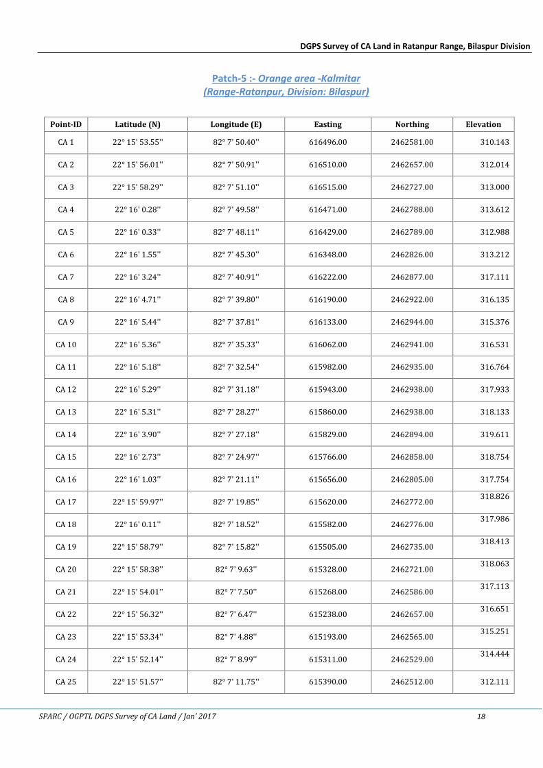
Patch-5 :- Orange area -Kalmitar(Range-Ratanpur, Division: Bilaspur)
Point-ID Latitude (N) Longitude (E) Easting Northing ElevationCA 1 22° 15' 53.55'' 82° 7' 50.40'' 616496.00 2462581.00 310.143CA 2 22° 15' 56.01'' 82° 7' 50.91'' 616510.00 2462657.00 312.014CA 3 22° 15' 58.29'' 82° 7' 51.10'' 616515.00 2462727.00 313.000CA 4 22° 16' 0.28'' 82° 7' 49.58'' 616471.00 2462788.00 313.612CA 5 22° 16' 0.33'' 82° 7' 48.11'' 616429.00 2462789.00 312.988CA 6 22° 16' 1.55'' 82° 7' 45.30'' 616348.00 2462826.00 313.212CA 7 22° 16' 3.24'' 82° 7' 40.91'' 616222.00 2462877.00 317.111CA 8 22° 16' 4.71'' 82° 7' 39.80'' 616190.00 2462922.00 316.135CA 9 22° 16' 5.44'' 82° 7' 37.81'' 616133.00 2462944.00 315.376CA 10 22° 16' 5.36'' 82° 7' 35.33'' 616062.00 2462941.00 316.531CA 11 22° 16' 5.18'' 82° 7' 32.54'' 615982.00 2462935.00 316.764CA 12 22° 16' 5.29'' 82° 7' 31.18'' 615943.00 2462938.00 317.933CA 13 22° 16' 5.31'' 82° 7' 28.27'' 615860.00 2462938.00 318.133CA 14 22° 16' 3.90'' 82° 7' 27.18'' 615829.00 2462894.00 319.611CA 15 22° 16' 2.73'' 82° 7' 24.97'' 615766.00 2462858.00 318.754CA 16 22° 16' 1.03'' 82° 7' 21.11'' 615656.00 2462805.00 317.754CA 17 22° 15' 59.97'' 82° 7' 19.85'' 615620.00 2462772.00 318.826CA 18 22° 16' 0.11'' 82° 7' 18.52'' 615582.00 2462776.00 317.986CA 19 22° 15' 58.79'' 82° 7' 15.82'' 615505.00 2462735.00 318.413CA 20 22° 15' 58.38'' 82° 7' 9.63'' 615328.00 2462721.00 318.063CA 21 22° 15' 54.01'' 82° 7' 7.50'' 615268.00 2462586.00 317.113CA 22 22° 15' 56.32'' 82° 7' 6.47'' 615238.00 2462657.00 316.651CA 23 22° 15' 53.34'' 82° 7' 4.88'' 615193.00 2462565.00 315.251CA 24 22° 15' 52.14'' 82° 7' 8.99'' 615311.00 2462529.00 314.444CA 25 22° 15' 51.57'' 82° 7' 11.75'' 615390.00 2462512.00 312.111
DGPS Survey of CA Land in Ratanpur Range, Bilaspur Division
SPARC / OGPTL DGPS Survey of CA Land / Jan’ 2017 19
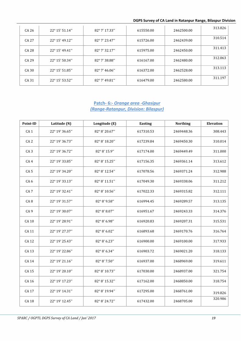
CA 26 22° 15' 51.14'' 82° 7' 17.33'' 615550.00 2462500.00 313.826CA 27 22° 15' 49.12'' 82° 7' 23.47'' 615726.00 2462439.00 310.514CA 28 22° 15' 49.41'' 82° 7' 32.17'' 615975.00 2462450.00 311.413CA 29 22° 15' 50.34'' 82° 7' 38.88'' 616167.00 2462480.00 312.063CA 30 22° 15' 51.85'' 82° 7' 46.06'' 616372.00 2462528.00 313.113CA 31 22° 15' 53.52'' 82° 7' 49.81'' 616479.00 2462580.00 311.197
Patch- 6:- Orange area -Ghasipur(Range-Ratanpur, Division: Bilaspur)
Point-ID Latitude (N) Longitude (E) Easting Northing ElevationCA 1 22° 19' 36.65'' 82° 8' 20.67'' 617310.53 2469448.36 308.443CA 2 22° 19' 36.73'' 82° 8' 18.20'' 617239.84 2469450.30 310.014CA 3 22° 19' 36.72'' 82° 8' 15.9'' 617174.00 2469449.49 311.000CA 4 22° 19' 33.85'' 82° 8' 15.25'' 617156.35 2469361.14 313.612CA 5 22° 19' 34.20'' 82° 8' 12.54'' 617078.56 2469371.24 312.988CA 6 22° 19' 33.13'' 82° 8' 11.51'' 617049.30 2469338.06 311.212CA 7 22° 19' 32.41'' 82° 8' 10.56'' 617022.33 2469315.82 312.111CA 8 22° 19' 31.57'' 82° 8' 9.58'' 616994.45 2469289.57 313.135CA 9 22° 19' 30.07'' 82° 8' 8.07'' 616951.67 2469243.33 314.376CA 10 22° 19' 28.91'' 82° 8' 6.98'' 616920.83 2469207.31 315.531CA 11 22° 19' 27.37'' 82° 8' 6.02'' 616893.68 2469170.76 316.764CA 12 22° 19' 25.43'' 82° 8' 6.23'' 616900.00 2469100.00 317.933CA 13 22° 19' 22.86'' 82° 8' 6.34'' 616903.72 2469021.20 318.133CA 14 22° 19' 21.16'' 82° 8' 7.50'' 616937.00 2468969.00 319.611CA 15 22° 19' 20.10'' 82° 8' 10.73'' 617030.00 2468937.00 321.754CA 16 22° 19' 17.23'' 82° 8' 15.32'' 617162.00 2468850.00 318.754CA 17 22° 19' 14.31'' 82° 8' 19.94'' 617295.00 2468761.00 319.826CA 18 22° 19' 12.45'' 82° 8' 24.72'' 617432.00 2468705.00 320.986
DGPS Survey of CA Land in Ratanpur Range, Bilaspur Division
SPARC / OGPTL DGPS Survey of CA Land / Jan’ 2017 20
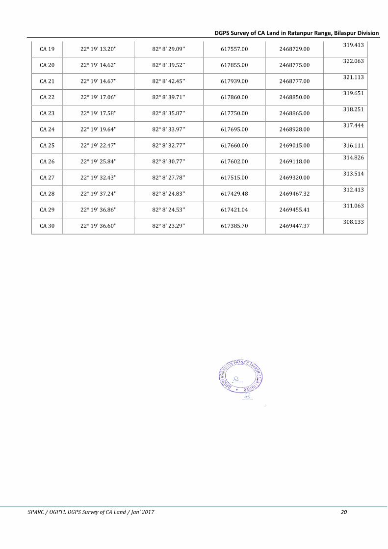
CA 19 22° 19' 13.20'' 82° 8' 29.09'' 617557.00 2468729.00 319.413CA 20 22° 19' 14.62'' 82° 8' 39.52'' 617855.00 2468775.00 322.063CA 21 22° 19' 14.67'' 82° 8' 42.45'' 617939.00 2468777.00 321.113CA 22 22° 19' 17.06'' 82° 8' 39.71'' 617860.00 2468850.00 319.651CA 23 22° 19' 17.58'' 82° 8' 35.87'' 617750.00 2468865.00 318.251CA 24 22° 19' 19.64'' 82° 8' 33.97'' 617695.00 2468928.00 317.444CA 25 22° 19' 22.47'' 82° 8' 32.77'' 617660.00 2469015.00 316.111CA 26 22° 19' 25.84'' 82° 8' 30.77'' 617602.00 2469118.00 314.826CA 27 22° 19' 32.43'' 82° 8' 27.78'' 617515.00 2469320.00 313.514CA 28 22° 19' 37.24'' 82° 8' 24.83'' 617429.48 2469467.32 312.413CA 29 22° 19' 36.86'' 82° 8' 24.53'' 617421.04 2469455.41 311.063CA 30 22° 19' 36.60'' 82° 8' 23.29'' 617385.70 2469447.37 308.133
DGPS Survey of CA Land in Ratanpur Range, Bilaspur Division
SPARC / OGPTL DGPS Survey of CA Land / Jan’ 2017 21
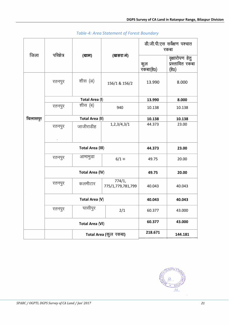
Table-4: Area Statement of Forest Boundary
ftyk ifj{ks= ( ाम) (खसरा न)ं
Mh-th-ih-,l losZ{k.k i'pkrjdck
dqyjdck¼gs0½
o`{kkjksi.k gsrqizLrkfor jdck¼gs0½
िबलासपुर
jruiqj 'khl ¼v½ 156/1 & 156/2 13.990 8.000
Total Area ¼I½ 13.990 8.000jruiqj 'khl ¼c½ 940 10.138 10.138
Total Area ¼II½ 10.138 10.138
jruiqj
+
tkthjkMhg 1,2,3/4,3/1 44.373 23.00
Total Area ¼III½ 44.373 23.00
jruiqj vkekeqMk 6/1 d 49.75 20.00
Total Area ¼IV½ 49.75 20.00
jruiqj dyehVkj774/1,
775/1,779,781,799 40.043 40.043
Total Area ¼V½ 40.043 40.043
jruiqj ?kklhiqj 2/1 60.377 43.000
Total Area ¼VI½ 60.377 43.000
Total Area (dqy jdck) 218.671 144.181
DGPS Survey of CA Land in Ratanpur Range, Bilaspur Division
SPARC / OGPTL DGPS Survey of CA Land / Jan’ 2017 22
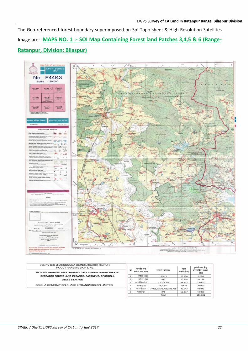
The Geo-referenced forest boundary superimposed on SoI Topo sheet & High Resolution Satellites
Image are:- MAPS NO. 1 :- SOI Map Containing Forest land Patches 3,4,5 & 6 (Range-
Ratanpur, Division: Bilaspur)
DGPS Survey of CA Land in Ratanpur Range, Bilaspur Division
SPARC / OGPTL DGPS Survey of CA Land / Jan’ 2017 23
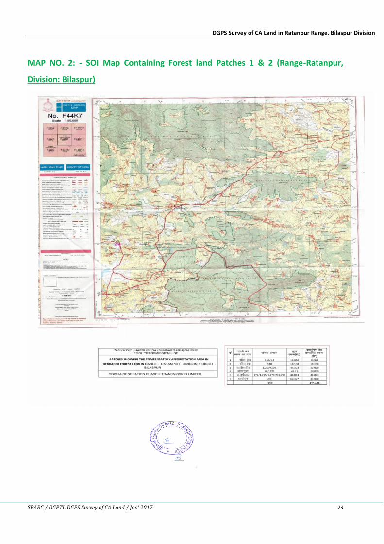
MAP NO. 2: - SOI Map Containing Forest land Patches 1 & 2 (Range-Ratanpur,
Division: Bilaspur)

DGPS Survey of CA Land in Ratanpur Range, Bilaspur Division
SPARC / OGPTL DGPS Survey of CA Land / Jan’ 2017 24
MAP NO. 3:- Google Earth file Containing Forest land Patch 1 (Village: Shish-A, Range-
Ratanpur, Division: Bilaspur)
MAP NO. 4 :- Google Earth file Containing Forest land Patch 2 (Village: Shish-B, Range-
Ratanpur, Division: Bilaspur)
DGPS Survey of CA Land in Ratanpur Range, Bilaspur Division
SPARC / OGPTL DGPS Survey of CA Land / Jan’ 2017 25
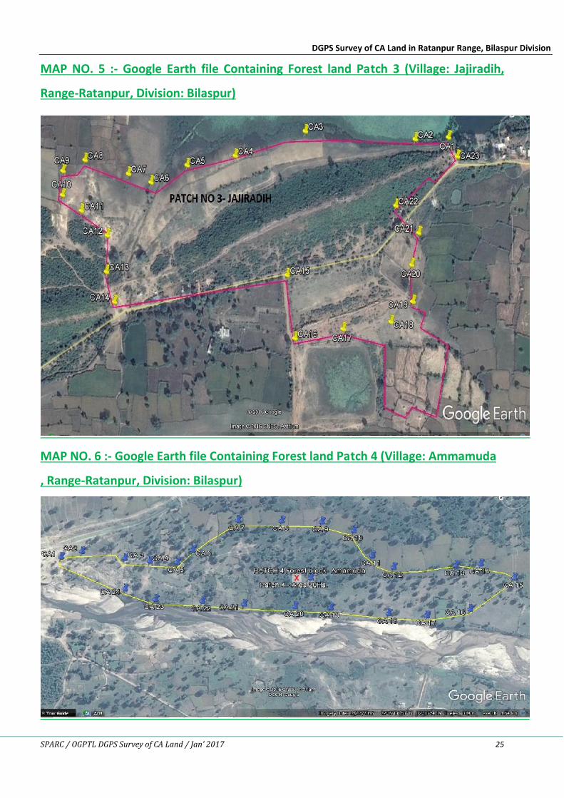
MAP NO. 5 :- Google Earth file Containing Forest land Patch 3 (Village: Jajiradih,
Range-Ratanpur, Division: Bilaspur)
MAP NO. 6 :- Google Earth file Containing Forest land Patch 4 (Village: Ammamuda
, Range-Ratanpur, Division: Bilaspur)
DGPS Survey of CA Land in Ratanpur Range, Bilaspur Division
SPARC / OGPTL DGPS Survey of CA Land / Jan’ 2017 26
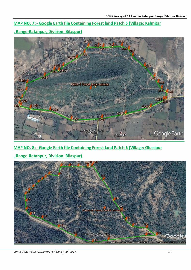
MAP NO. 7 :- Google Earth file Containing Forest land Patch 5 (Village: Kalmitar
, Range-Ratanpur, Division: Bilaspur)
MAP NO. 8 :- Google Earth file Containing Forest land Patch 6 (Village: Ghasipur
, Range-Ratanpur, Division: Bilaspur)
DGPS Survey of CA Land in Ratanpur Range, Bilaspur Division
SPARC / OGPTL DGPS Survey of CA Land / Jan’ 2017 27
6. SPECIFICATION OF DGPS EQUIPMENT & SOFTWARE
SPARC deployed advanced and hi-precision devices to carry out the DGPS survey. The DGPS
performance specifications are given below. The corresponding fact sheets are placed at
Annexure-4 for ready reference.
DGPS Survey of CA Land in Ratanpur Range, Bilaspur Division
SPARC / OGPTL DGPS Survey of CA Land / Jan’ 2017 28
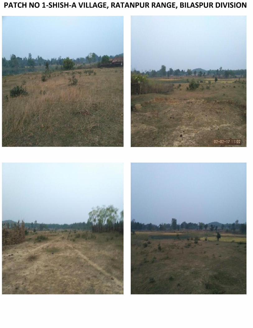
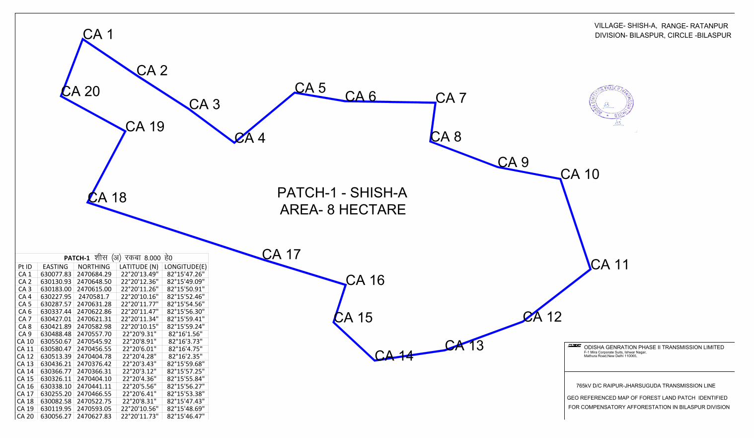
PATCH-1 - SHISH-A
AREA- 8 HECTARE
ODISHA GENRATION PHASE II TRANSMISSION LIMITED
F-1 Mira Corporate Suits, Ishwar Nagar,
Mathura Road,New Delhi 110065,
CA 1
CA 2
CA 3
CA 4
CA 5
CA 6
CA 7
CA 8
CA 9
CA 10
CA 11
CA 12
CA 13
CA 14
CA 15
CA 16
CA 17
CA 18
CA 19
CA 20
Pt ID EASTING NORTHING LATITUDE (N) LONGITUDE(E)CA 1 630077.83 2470684.29 22°20'13.49" 82°15'47.26"CA 2 630130.93 2470648.50 22°20'12.36" 82°15'49.09"CA 3 630183.00 2470615.00 22°20'11.26" 82°15'50.91"CA 4 630227.95 2470581.7 22°20'10.16" 82°15'52.46"CA 5 630287.57 2470631.28 22°20'11.77" 82°15'54.56"CA 6 630337.44 2470622.86 22°20'11.47" 82°15'56.30"CA 7 630427.01 2470621.31 22°20'11.34" 82°15'59.41"CA 8 630421.89 2470582.98 22°20'10.15" 82°15'59.24"CA 9 630488.48 2470557.70 22°20'9.31" 82°16'1.56"CA 10 630550.67 2470545.92 22°20'8.91" 82°16'3.73"CA 11 630580.47 2470456.55 22°20'6.01" 82°16'4.75"CA 12 630513.39 2470404.78 22°20'4.28" 82°16'2.35"CA 13 630436.21 2470376.42 22°20'3.43" 82°15'59.68"CA 14 630366.77 2470366.31 22°20'3.12" 82°15'57.25"CA 15 630326.11 2470404.10 22°20'4.36" 82°15'55.84"CA 16 630338.10 2470441.11 22°20'5.56" 82°15'56.27"CA 17 630255.20 2470466.55 22°20'6.41" 82°15'53.38"CA 18 630082.58 2470522.75 22°20'8.31" 82°15'47.43"CA 19 630119.95 2470593.05 22°20'10.56" 82°15'48.69"CA 20 630056.27 2470627.83 22°20'11.73" 82°15'46.47"
PATCH-1 'khl ¼v½ jdck 8-000 gs0
765kV D/C RAIPUR-JHARSUGUDA TRANSMISSION LINE
GEO REFERENCED MAP OF FOREST LAND PATCH IDENTIFIED
FOR COMPENSATORY AFFORESTATION IN BILASPUR DIVISION
VILLAGE- SHISH-A,RANGE- RATANPUR
DIVISION- BILASPUR, CIRCLE -BILASPUR
CA 1
CA 2
CA 3
CA 4
CA 5
CA 6
CA 7
CA 8
CA 9
CA 10
CA 11
CA 12
CA 13
CA 14
CA 15
PATCH-2 : SHISH-B
AREA-10.138
HECTARE
Pt ID EASTING NORTHING LATITUDE (N) LONGITUDE (E)CA1 630209.00 2470064.00 22° 19' 53.33'' 82° 15' 51.64''CA2 630254.00 2470054.00 22° 19' 53.00'' 82° 15' 53.21''CA3 630288.00 2470152.00 22° 19' 56.17'' 82° 15' 54.43''CA4 630322.00 2470244.00 22° 19' 59.15'' 82° 15' 55.64''CA5 630372.00 2470225.00 22° 19' 58.52'' 82° 15' 57.39''CA6 630446.00 2470190.00 22° 19' 57.36'' 82° 15' 59.96''CA7 630529.00 2470152.00 22° 19' 56.10'' 82° 16' 2.85''CA8 630571.00 2470131.00 22° 19' 55.41'' 82° 16' 4.31''CA9 630554.00 2470079.00 22° 19' 53.72'' 82° 16' 3.70''CA10 630527.00 2469997.00 22° 19' 51.06'' 82° 16' 2.74''CA11 630466.00 2469816.00 22° 19' 45.19'' 82° 16' 0.55''CA12 630386.00 2469845.00 22° 19' 46.16'' 82° 15' 57.76''CA13 630389.00 2469876.00 22° 19' 47.17'' 82° 15' 57.88''CA14 630308.00 2469898.00 22° 19' 47.91'' 82° 15' 55.05''CA15 630160.00 2469940.00 22° 19' 49.31'' 82° 15' 49.90''
ODISHA GENRATION PHASE II TRANSMISSION LIMITED
F-1 Mira Corporate Suits, Ishwar Nagar,
Mathura Road,New Delhi 110065,
765kV D/C RAIPUR-JHARSUGUDA TRANSMISSION LINE
GEO REFERENCED MAP OF FOREST LAND PATCH IDENTIFIED
FOR COMPENSATORY AFFORESTATION IN BILASPUR DIVISION
VILLAGE- SHISH-B,RANGE- RATANPUR
DIVISION- BILASPUR, CIRCLE -BILASPUR
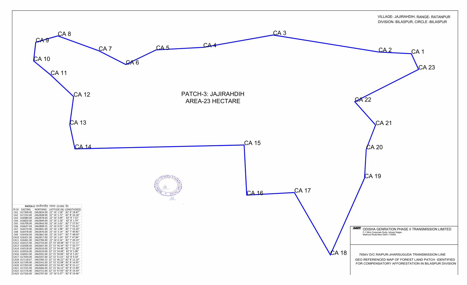
PATCH-3: JAJIRAHDIH
AREA-23 HECTARE
ODISHA GENRATION PHASE II TRANSMISSION LIMITED
F-1 Mira Corporate Suits, Ishwar Nagar,
Mathura Road,New Delhi 110065,
Pt ID EASTING NORTHING LATITUDE (N) LONGITUDE(E)CA1 617309.00 2462834.00 22° 16' 1.58'' 82° 8' 18.87''CA2 617232.00 2462838.00 22° 16' 1.72'' 82° 8' 16.18''CA3 616984.00 2462878.00 22° 16' 3.09'' 82° 8' 7.53''CA4 616820.00 2462849.00 22° 16' 2.18'' 82° 8' 1.79''CA5 616709.00 2462843.00 22° 16' 2.02'' 82° 7' 57.91''CA6 616637.69 2462808.55 22° 16' 0.91'' 82° 7' 55.41''CA7 616574.00 2462841.00 22° 16' 1.98'' 82° 7' 53.20''CA8 616478.00 2462876.00 22° 16' 3.14'' 82° 7' 49.85''CA9 616426.00 2462861.00 22° 16' 2.67'' 82° 7' 48.03''CA10 616421.00 2462817.00 22° 16' 1.24'' 82° 7' 47.84'' CA11 616461.00 2462784.00 22° 16' 0.16'' 82° 7' 49.23''CA12 616515.00 2462733.00 22° 15' 58.48'' 82° 7' 51.11''CA13 616506.00 2462667.00 22° 15' 56.34'' 82° 7' 50.77''CA14 616518.00 2462610.00 22° 15' 54.48'' 82° 7' 51.18''CA15 616916.00 2462619.00 22° 15' 54.68'' 82° 8' 5.08''CA16 616922.00 2462501.00 22° 15' 50.84'' 82° 8' 5.26''CA17 617034.00 2462507.00 22° 15' 51.01'' 82° 8' 9.18''CA18 617118.67 2462360.23 22° 15' 46.22'' 82° 8' 12.10''CA19 617199.00 2462541.00 22° 15' 52.08'' 82° 8' 14.95''CA20 617203.00 2462609.00 22° 15' 54.30'' 82° 8' 15.11''CA21 617225.00 2462666.00 22° 15' 56.13'' 82° 8' 15.90''CA22 617176.00 2462721.00 22° 15' 57.93'' 82° 8' 14.20''CA23 617326.00 2462797.00 22° 16' 0.37'' 82° 8' 19.46''
PATCH-3 tkthjkMhg jdck 23-000 gs0
CA 1
CA 2
CA 3
CA 4
CA 5
CA 6
CA 7
CA 8
CA 9
CA 10
CA 11
CA 12
CA 13
CA 14
CA 15
CA 16
CA 17
CA 18
CA 19
CA 20
CA 21
CA 22
CA 23
VILLAGE- JAJIRAHDIH,RANGE- RATANPUR
DIVISION- BILASPUR, CIRCLE -BILASPUR
765kV D/C RAIPUR-JHARSUGUDA TRANSMISSION LINE
GEO REFERENCED MAP OF FOREST LAND PATCH IDENTIFIED
FOR COMPENSATORY AFFORESTATION IN BILASPUR DIVISION
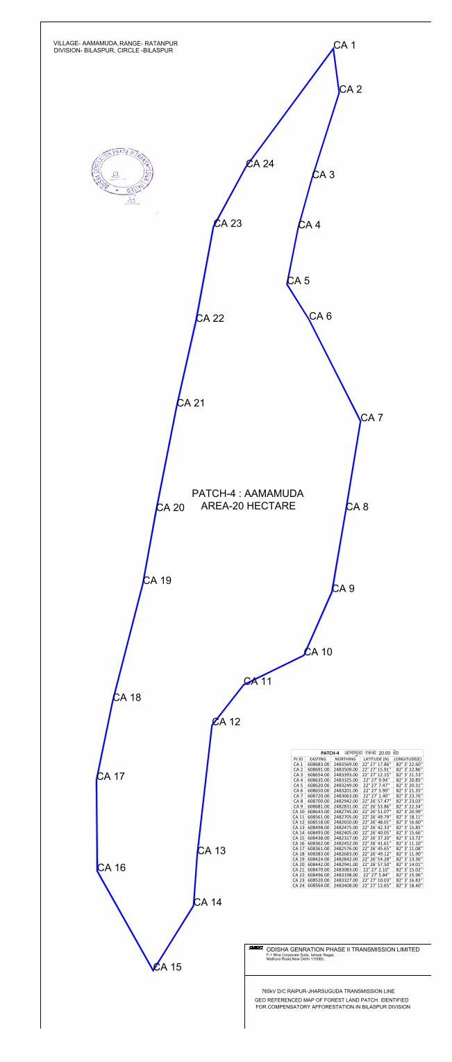
PATCH-4 : AAMAMUDA
AREA-20 HECTARE
ODISHA GENRATION PHASE II TRANSMISSION LIMITED
F-1 Mira Corporate Suits, Ishwar Nagar,
Mathura Road,New Delhi 110065,
Pt ID EASTING NORTHING LATITUDE (N) LONGITUDE(E)CA 1 608683.00 2483569.00 22° 27' 17.86'' 82° 3' 22.60''CA 2 608691.00 2483509.00 22° 27' 15.91'' 82° 3' 22.86''CA 3 608654.00 2483393.00 22° 27' 12.15'' 82° 3' 21.53''CA 4 608635.00 2483325.00 22° 27' 9.94'' 82° 3' 20.85''CA 5 608620.00 2483249.00 22° 27' 7.47'' 82° 3' 20.31''CA 6 608650.00 2483201.00 22° 27' 5.90'' 82° 3' 21.35''CA 7 608720.00 2483063.00 22° 27' 1.40'' 82° 3' 23.76''CA 8 608700.00 2482942.00 22° 26' 57.47'' 82° 3' 23.03''CA 9 608681.00 2482831.00 22° 26' 53.86'' 82° 3' 22.34''CA 10 608643.00 2482745.00 22° 26' 51.07'' 82° 3' 20.99''CA 11 608561.00 2482705.00 22° 26' 49.79'' 82° 3' 18.11''CA 12 608518.00 2482650.00 22° 26' 48.01'' 82° 3' 16.60''CA 13 608498.00 2482475.00 22° 26' 42.33'' 82° 3' 15.85''CA 14 608493.00 2482405.00 22° 26' 40.05'' 82° 3' 15.66''CA 15 608438.00 2482317.00 22° 26' 37.20'' 82° 3' 13.72''CA 16 608362.00 2482452.00 22° 26' 41.61'' 82° 3' 11.10''CA 17 608361.00 2482576.00 22° 26' 45.65'' 82° 3' 11.08''CA 18 608383.00 2482683.00 22° 26' 49.12'' 82° 3' 11.90''CA 19 608424.00 2482842.00 22° 26' 54.28'' 82° 3' 13.36''CA 20 608442.00 2482941.00 22° 26' 57.50'' 82° 3' 14.01''CA 21 608470.00 2483083.00 22° 27' 2.10'' 82° 3' 15.02''CA 22 608496.00 2483198.00 22° 27' 5.84'' 82° 3' 15.96''CA 23 608520.00 2483327.00 22° 27' 10.03'' 82° 3' 16.83''CA 24 608564.00 2483408.00 22° 27' 12.65'' 82° 3' 18.40''
PATCH-4 vkekeqMk jdck 20-00 gs0
CA 1
CA 2
CA 3
CA 4
CA 5
CA 6
CA 7
CA 8
CA 9
CA 10
CA 11
CA 12
CA 13
CA 14
CA 15
CA 16
CA 17
CA 18
CA 19
CA 20
CA 21
CA 22
CA 23
CA 24
765kV D/C RAIPUR-JHARSUGUDA TRANSMISSION LINE
GEO REFERENCED MAP OF FOREST LAND PATCH IDENTIFIED
FOR COMPENSATORY AFFORESTATION IN BILASPUR DIVISION
VILLAGE- AAMAMUDA,RANGE- RATANPUR
DIVISION- BILASPUR, CIRCLE -BILASPUR
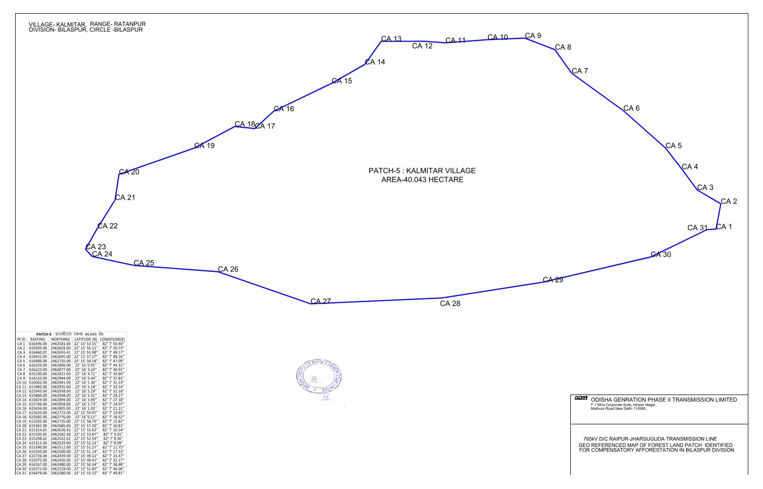
PATCH-5 : KALMITAR VILLAGE
AREA-40.043 HECTARE
ODISHA GENRATION PHASE II TRANSMISSION LIMITED
F-1 Mira Corporate Suits, Ishwar Nagar,
Mathura Road,New Delhi 110065,
Pt ID EASTING NORTHING LATITUDE (N) LONGITUDE(E)CA 1 616496.00 2462581.00 22° 15' 53.55'' 82° 7' 50.40''CA 2 616505.00 2462629.00 22° 15' 55.11'' 82° 7' 50.73''CA 3 616460.07 2462655.41 22° 15' 55.98'' 82° 7' 49.17''CA 4 616431.00 2462695.00 22° 15' 57.27'' 82° 7' 48.16''CA 5 616400.00 2462735.00 22° 15' 58.58'' 82° 7' 47.09''CA 6 616320.00 2462806.00 22° 16' 0.91'' 82° 7' 44.31''CA 7 616222.00 2462877.00 22° 16' 3.24'' 82° 7' 40.91''CA 8 616190.00 2462922.00 22° 16' 4.71'' 82° 7' 39.80''CA 9 616133.00 2462944.00 22° 16' 5.44'' 82° 7' 37.81''CA 10 616062.00 2462941.00 22° 16' 5.36'' 82° 7' 35.33''CA 11 615982.00 2462935.00 22° 16' 5.18'' 82° 7' 32.54''CA 12 615943.00 2462938.00 22° 16' 5.29'' 82° 7' 31.18''CA 13 615860.00 2462938.00 22° 16' 5.31'' 82° 7' 28.27''CA 14 615829.00 2462894.00 22° 16' 3.90'' 82° 7' 27.18''CA 15 615766.00 2462858.00 22° 16' 2.73'' 82° 7' 24.97''CA 16 615656.00 2462805.00 22° 16' 1.03'' 82° 7' 21.11''CA 17 615620.00 2462772.00 22° 15' 59.97'' 82° 7' 19.85''CA 18 615582.00 2462776.00 22° 16' 0.11'' 82° 7' 18.52''CA 19 615505.00 2462735.00 22° 15' 58.79'' 82° 7' 15.82''CA 20 615362.00 2462685.00 22° 15' 57.20'' 82° 7' 10.81''CA 21 615354.65 2462636.42 22° 15' 55.63'' 82° 7' 10.54''CA 22 615320.95 2462582.30 22° 15' 53.87'' 82° 7' 9.35''CA 23 615298.62 2462542.62 22° 15' 52.59'' 82° 7' 8.56''CA 24 615311.00 2462529.00 22° 15' 52.14'' 82° 7' 8.99''CA 25 615390.00 2462512.00 22° 15' 51.57'' 82° 7' 11.75''CA 26 615550.00 2462500.00 22° 15' 51.14'' 82° 7' 17.33''CA 27 615726.00 2462439.00 22° 15' 49.12'' 82° 7' 23.47''CA 28 615975.00 2462450.00 22° 15' 49.41'' 82° 7' 32.17''CA 29 616167.00 2462480.00 22° 15' 50.34'' 82° 7' 38.88''CA 30 616372.00 2462528.00 22° 15' 51.85'' 82° 7' 46.06''CA 31 616479.00 2462580.00 22° 15' 53.52'' 82° 7' 49.81''
PATCH-5 dyehVkj jdck 40-043 gs0
CA 1
CA 2
CA 3
CA 4
CA 5
CA 6
CA 7
CA 8
CA 9
CA 10
CA 11
CA 12
CA 13
CA 14
CA 15
CA 16
CA 17
CA 18
CA 19
CA 20
CA 21
CA 22
CA 23
CA 24
CA 25
CA 26
CA 27
CA 28
CA 29
CA 30
CA 31
765kV D/C RAIPUR-JHARSUGUDA TRANSMISSION LINE
GEO REFERENCED MAP OF FOREST LAND PATCH IDENTIFIED
FOR COMPENSATORY AFFORESTATION IN BILASPUR DIVISION
VILLAGE- KALMITAR,
RANGE- RATANPUR
DIVISION- BILASPUR, CIRCLE -BILASPUR

PATCH-6 : GHASIPUR
AREA-43 HECTARE
ODISHA GENRATION PHASE II TRANSMISSION LIMITED
F-1 Mira Corporate Suits, Ishwar Nagar,
Mathura Road,New Delhi 110065,
Pt ID EASTING NORTHING LATITUDE (N) LONGITUDE(E)CA 1 617310.53 2469448.36 22° 19' 36.65'' 82° 8' 20.67''CA 2 617239.84 2469450.30 22° 19' 36.73'' 82° 8' 18.20''CA 3 617174.00 2469449.49 22° 19' 36.72'' 82° 8' 15.9''CA 4 617156.35 2469361.14 22° 19' 33.85'' 82° 8' 15.25''CA 5 617078.56 2469371.24 22° 19' 34.20'' 82° 8' 12.54''CA 6 617049.30 2469338.06 22° 19' 33.13'' 82° 8' 11.51''CA 7 617022.33 2469315.82 22° 19' 32.41'' 82° 8' 10.56''CA 8 616994.45 2469289.57 22° 19' 31.57'' 82° 8' 9.58''CA 9 616951.67 2469243.33 22° 19' 30.07'' 82° 8' 8.07''
CA 10 616920.83 2469207.31 22° 19' 28.91'' 82° 8' 6.98''CA 11 616893.68 2469170.76 22° 19' 27.37'' 82° 8' 6.02''CA 12 616900.00 2469100.00 22° 19' 25.43'' 82° 8' 6.23''CA 13 616903.72 2469021.20 22° 19' 22.86'' 82° 8' 6.34''CA 14 616937.00 2468969.00 22° 19' 21.16'' 82° 8' 7.50''CA 15 617030.00 2468937.00 22° 19' 20.10'' 82° 8' 10.73''CA 16 617162.00 2468850.00 22° 19' 17.23'' 82° 8' 15.32''CA 17 617295.00 2468761.00 22° 19' 14.31'' 82° 8' 19.94''CA 18 617432.00 2468705.00 22° 19' 12.45'' 82° 8' 24.72''CA 19 617557.00 2468729.00 22° 19' 13.20'' 82° 8' 29.09''CA 20 617855.00 2468775.00 22° 19' 14.62'' 82° 8' 39.52''CA 21 617939.00 2468777.00 22° 19' 14.67'' 82° 8' 42.45''CA 22 617860.00 2468850.00 22° 19' 17.06'' 82° 8' 39.71''CA 23 617750.00 2468865.00 22° 19' 17.58'' 82° 8' 35.87''CA 24 617695.00 2468928.00 22° 19' 19.64'' 82° 8' 33.97''CA 25 617660.00 2469015.00 22° 19' 22.47'' 82° 8' 32.77''CA 26 617602.00 2469118.00 22° 19' 25.84'' 82° 8' 30.77''CA 27 617515.00 2469320.00 22° 19' 32.43'' 82° 8' 27.78''CA 28 617429.48 2469467.32 22° 19' 37.24'' 82° 8' 24.83''CA 29 617421.04 2469455.41 22° 19' 36.86'' 82° 8' 24.53''CA 30 617385.70 2469447.37 22° 19' 36.60'' 82° 8' 23.29''
PATCH -6 ?kklhiqj jdck 43-000 gs0
CA 1
CA 2CA 3
CA 4
CA 5
CA 6
CA 7
CA 8
CA 9
CA 10
CA 11
CA 12
CA 13
CA 14
CA 15
CA 16
CA 17
CA 18
CA 19
CA 20
CA 21
CA 22
CA 23
CA 24
CA 25
CA 26
CA 27
CA 28
CA 29
CA 30
765kV D/C RAIPUR-JHARSUGUDA TRANSMISSION LINE
GEO REFERENCED MAP OF FOREST LAND PATCH IDENTIFIED
FOR COMPENSATORY AFFORESTATION IN BILASPUR DIVISION
VILLAGE- GHASIPUR,
RANGE- RATANPUR
DIVISION- BILASPUR, CIRCLE -BILASPUR