Embed Size (px)
Citation preview
PREMIER RIDGE - DIORITE
Terrestrial Ecosystem Mapping (T.E.M.) Project
VOLUME I
for
Marcie BelcherCrestbrook Forest Industries Ltd.
Box 4600Cranbrook, B.C.
V1C 4J7Phone (250) 426-6241
fax (250) 426-5372
Submitted by:
Gareth Kernaghan Forest Tech.Keyes Lessard Env. Tech.
Maureen V. Ketcheson MSc. RPBio.
JMJ Holdings Inc.#208 - 507 Baker Street
Nelson, BC V1L 4J2phone (250) 354-4913 fax (250) 354-1162
April 25, 2000
Premier Ridge - Diorite Terrestrial Ecosystem Mapping
JMJ Holdings Inc. 208-507 Baker Street Nelson, BC V1L 4J2 (250) 354-4913 fax (250)354-1162 [email protected] 2
TABLE OF CONTENTS
1.0 INTRODUCTION ........................................................................................................ 51.1 OBJECTIVES ............................................................................................................ 61.2 LOCATION............................................................................................................... 7
2.0 ECOSECTION AND BIOGEOCLIMATIC CLASSIFICATION OF PREMIERRIDGE - DIORITE............................................................................................................. 83.0 METHODS.................................................................................................................. 18
3.1 PRE-STRATIFICATION OF ECOSYSTEMS USING THE BIOTERRAINAPPROACH.................................................................................................................. 18
3.1.1 AIR PHOTO INTERPRETATION................................................................... 193.2 SAMPLING............................................................................................................. 19
3.2.1 DATA FORMS ................................................................................................. 203.3 BIOTERRAIN ATTRIBUTES................................................................................ 203.4 ECOSYSTEM UNIT MAPPING............................................................................ 21
3.4.1 NAMING OF ECOSYSTEM MAP UNITS ..................................................... 233.5 SITE SERIES MAPS............................................................................................... 233.6 WORKING LEGEND............................................................................................. 243.7 PLANT IDENTIFICATION ................................................................................... 243.8 DATA ANALYSIS.................................................................................................. 24
4.0 DATABASES ............................................................................................................. 244.1 VENUS AND GRAVITI DATABASES................................................................. 244.2 BIOTERRAIN AND ECOSYSTEM DATABASE................................................. 254.3 SPATIAL DATABASE........................................................................................... 25
5.0 SUBZONE AND SITE SERIES OVERVIEW........................................................... 255.1 PPdh2 ....................................................................................................................... 255.2 IDFdm2 .................................................................................................................... 265.3 MSdk........................................................................................................................ 285.4 ESSFdk .................................................................................................................... 285.5 ESSFdku.................................................................................................................. 295.6 ESSFdkp .................................................................................................................. 305.7 AT ............................................................................................................................ 31
6.0 LITERATURE CITED ............................................................................................... 32

Premier Ridge - Diorite Terrestrial Ecosystem Mapping
JMJ Holdings Inc. 208-507 Baker Street Nelson, BC V1L 4J2 (250) 354-4913 fax (250)354-1162 [email protected] 3
LIST OF PLATES, FIGURES, TABLES AND APPENDICES
LIST OF PLATES
Plate 1. Overview of the Premier Ridge – Diorite Study AreaPlate 2. Typical PPdh2 sitePlate 3. Example of fire disturbance within the PPdh2 subzonePlate 4. Typical IDFdm2 sitePlate 5. Typical MSdk sitePlate 6. Typical ESSFdk sitePlate 7. Typical ESSFdku sitePlate 8. Typical ESSFdkp sitePlate 9. Typical AT site
LIST OF FIGURES
Figure 1. Premier Ridge – Diorite TEM Project LocationFigure 2. Biogeoclimatic Subzones within the Premier Ridge – Diorite Landscape Unit
LIST OF TABLES
Table 1. Bioterrain Unit Letter NotationTable 2. Site series modifiersTable 3. Structural stagesTable 4. Site series allocation in hectares in the PPdh2Table 5. Structural stage allocation in hectares in the PPdh2Table 6. Site series allocation in hectares in the IDFdm2Table 7. Structural stage allocation in hectares in the IDFdm2Table 8. Site series allocation in hectares in the MSdkTable 9. Structural stage allocation in hectares in the MSdkTable 10. Site series allocation in hectares in the ESSFdkTable 11. Structural stage allocation in hectares in the ESSFdkTable 12. Site series allocation in hectares in the ESSFdkuTable 13. Structural stage allocation in hectares in the ESSFdkuTable 14. Site series allocation in hectares in the ESSFdkpTable 15. Structural stage allocation in hectares in the ESSFdkpTable 16. Site series allocation in hectares in the ATTable 17. Structural stage allocation in hectares in the AT
LIST OF APPENDICES
Appendix I. Vegetation ReportAppendix II. Ecosystem Unit ListAppendix III. Working legendAppendix IV. Plot databasesAppendix V. Wildlife SpeciesAppendix VI. Rare Elements

Premier Ridge - Diorite Terrestrial Ecosystem Mapping
JMJ Holdings Inc. 208-507 Baker Street Nelson, BC V1L 4J2 (250) 354-4913 fax (250)354-1162 [email protected] 4
LIST OF APPENDICES (cont.)
Appendix VII. Terrain Maps and DatabaseAppendix VIII. Ecosystem and Terrain DatabaseAppendix IX. Terrestrial Ecosystem Maps
Premier Ridge - Diorite Terrestrial Ecosystem Mapping
JMJ Holdings Inc. 208-507 Baker Street Nelson, BC V1L 4J2 (250) 354-4913 fax (250)354-1162 [email protected] 5
1.0 INTRODUCTION
Terrestrial Ecosystem Mapping (TEM) was initiated in the Premier Ridge - DioriteLandscape Unit (see Plate 1) in 1996 by the Ministry of Forests, Invermere District andMinistry of Environment, Cranbrook. However, for a variety of reasons, the project wasnot completed by the original consultant, Jim Poriz of Ecological Insights, ColemanAlberta. Responsibility for the project was transferred to Crestbrook Forest Industries(CFI) and in June of 1999 CFI of Cranbrook, BC issued a Request For Proposals for thecompletion of the 1:20,000 Terrestrial Ecosystem Mapping (TEM) in the Premier Ridge -Diorite Landscape Unit. JMJ Holdings Inc. of Nelson B.C. was awarded the contract; theoriginal consultant did not submit a proposal to complete the work.
The initial contract, in 1996, supported ecosystem pre-typing, an initial working legend,and some fieldwork. The focus of this sampling was primarily for range related interests.The subsequent contract awarded in September of 1999 to JMJ Holdings Inc. supportedcompletion of field sampling to 15% polygon visitation, re-working existing bioterrainpolygons, assessment and correction of existing plot data and VENUS and GRAVITIdata bases, and initiation and completion of site series mapping. Bioterrain and site seriesmapping was done to RIC 1998 (Ecosystems Working Group, 1998) standards andquality assurance procedures. Owing to budgetary constraints wildlife suitability ratingsand an expanded legend were not completed under this contract. However, theseimportant elements of this TEM mapping project can be completed at a later date whenfunding becomes available.
The objective of the TEM in Premier Ridge - Diorite was to complete the project to RIC1998 (Ecosystems Working Group, 1998) standards and to provide an ecologicalclassification from which interpretations about a variety of forest management issuescould be generated.

Premier Ridge - Diorite Terrestrial Ecosystem Mapping
JMJ Holdings Inc. 208-507 Baker Street Nelson, BC V1L 4J2 (250) 354-4913 fax (250)354-1162 [email protected] 6
Plate 1. Overview of the Premier Ridge - Diorite study area.
1.1 OBJECTIVES
The following objectives were proposed and met in this project:
1. To complete bioterrain ecosystem unit mapping and digitize to RIC 1998(Ecosystems Working Group and Ecological Data Committee, 1998) standards forTEM and Digital Data Capture.
2. To execute a sampling plan for completion of field work in 1999 to survey intensitylevel 5 at a polygon inspection rate of 7%. Actual inspection rate achieved was 15%which just makes it into the survey intensity level 4.
3. To enter new data into VENUS and GRAVITI databases and to correct andsynthesize with existing databases.
4. To create a digital plot location map to RIC 1998 (Ecological Data Committee, 1998)standards.
5. To follow appropriate quality assurance ( QA) procedures during all steps of themapping and insure sign-off is obtained for each activity.
Premier Ridge - Diorite Terrestrial Ecosystem Mapping
JMJ Holdings Inc. 208-507 Baker Street Nelson, BC V1L 4J2 (250) 354-4913 fax (250)354-1162 [email protected] 7
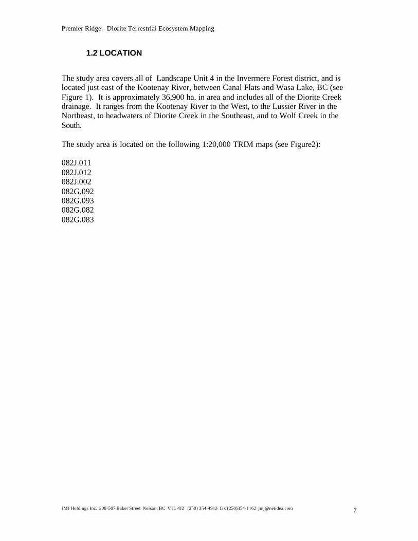
1.2 LOCATION
The study area covers all of Landscape Unit 4 in the Invermere Forest district, and islocated just east of the Kootenay River, between Canal Flats and Wasa Lake, BC (seeFigure 1). It is approximately 36,900 ha. in area and includes all of the Diorite Creekdrainage. It ranges from the Kootenay River to the West, to the Lussier River in theNortheast, to headwaters of Diorite Creek in the Southeast, and to Wolf Creek in theSouth.
The study area is located on the following 1:20,000 TRIM maps (see Figure2):
082J.011082J.012082J.002082G.092082G.093082G.082082G.083
Premier Ridge - Diorite Terrestrial Ecosystem Mapping
JMJ Holdings Inc. 208-507 Baker Street Nelson, BC V1L 4J2 (250) 354-4913 fax (250)354-1162 [email protected] 8
N
5 0 5 10 Kilomete rs
Premier-Dio rite TEM Study Area
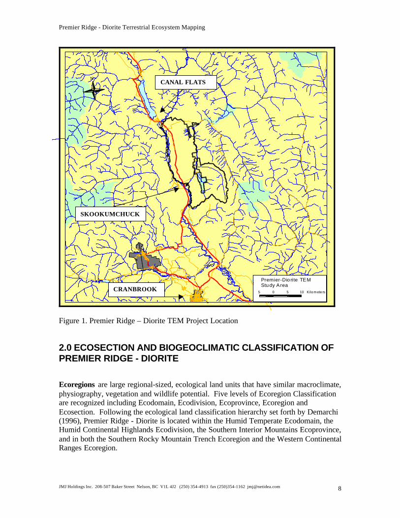
Figure 1. Premier Ridge – Diorite TEM Project Location
2.0 ECOSECTION AND BIOGEOCLIMATIC CLASSIFICATION OFPREMIER RIDGE - DIORITE
Ecoregions are large regional-sized, ecological land units that have similar macroclimate,physiography, vegetation and wildlife potential. Five levels of Ecoregion Classificationare recognized including Ecodomain, Ecodivision, Ecoprovince, Ecoregion andEcosection. Following the ecological land classification hierarchy set forth by Demarchi(1996), Premier Ridge - Diorite is located within the Humid Temperate Ecodomain, theHumid Continental Highlands Ecodivision, the Southern Interior Mountains Ecoprovince,and in both the Southern Rocky Mountain Trench Ecoregion and the Western ContinentalRanges Ecoregion.
CANAL FLATS
SKOOKUMCHUCK
CRANBROOK
Premier Ridge - Diorite Terrestrial Ecosystem Mapping
JMJ Holdings Inc. 208-507 Baker Street Nelson, BC V1L 4J2 (250) 354-4913 fax (250)354-1162 [email protected] 9
Ecosections are subregional units within ecoregions that are similar in climate,landforms, bedrock geology, soils, and plant and animal distributions. Demarchi (1996)classifies Premier Ridge - Diorite as being located within both the East Kootenay Trench(EKT) and Southern Park Ranges (SPK) Ecosections.
The East Kootenay Trench (EKT) is a broad, flat glacial plain with a distinctiverainshadow and is dominated by Douglas-fir and lodgepole pine forests. The PPdh2 andmost of the IDFdm2 are within this ecosection.
The Southern Park Ranges (SPK) is a large area of rugged mountains intersperced bylong narrow valleys. It is dominated by hybrid white spruce and lodgepole pine at lowerelevations and subalpine forests at higher elevations.The MSdk, ESSFdk, ESSFdku,ESSFdkp, AT, and a small portion of IDFdm2 (in the Northeast portion of the study area)are within this ecosection.
Biogeoclimatic Zones, Subzones and Variants occur within each Ecosection and areclassified using the Ministry of Forests Biogeoclimatic Ecosystem (BEC) system(Braumandl and Curran 1992). These units represent groups of ecosystems under theinfluence of the same regional climate. Premier Ridge - Diorite is located in the DryClimate Region (PPdh2, IDFdm2, MSdk, ESSFdk, ESSFdku, ESSFdkp, and AT). Theseseven biogeoclimatic subzones represented in Premier Ridge - Diorite (Figure 2) arebriefly described below.
Premier Ridge - Diorite Terrestrial Ecosystem Mapping
JMJ Holdings Inc. 208-507 Baker Street Nelson, BC V1L 4J2 (250) 354-4913 fax (250)354-1162 [email protected] 10
082J012082J011
082J002
082G093082G092
082G083082G082
Biogeoclimatic SubzonesATESSFdkESSFdkpESSFdkuIDFdm2MSdkPPdh2
Figure 2. Biogeoclimatic Subzones within the Premier Ridge – Diorite L.U.
Premier Ridge - Diorite Terrestrial Ecosystem Mapping
JMJ Holdings Inc. 208-507 Baker Street Nelson, BC V1L 4J2 (250) 354-4913 fax (250)354-1162 [email protected] 11
Plate 2. Typical PPdh2 site.
1) PPdh2 - The Kootenay Dry Hot Ponderosa Pine Variant generally occurs between 700and 900m in elevation (see Plate 2). It is found in the Southwestern portion of the studyarea. This zone is characterized by very hot, very dry summers and mild winters withvery light snowfall. Zonal sites (Braumandl and Curran 1992) support open stands ofPonderosa pine and Douglas-fir. Common species in the understory include bluebunchwheatgrass, saskatoon, prairie rose, and rosy pussytoes. There has been extensive fire,grazing, and logging disturbance within this subzone in Premier Ridge – Diorite (seePlate 3). This subzone supports a wide variety of wildlife species dependent on openforests and is an especially important winter range for mule deer, white-tailed deer andelk.
Premier Ridge - Diorite Terrestrial Ecosystem Mapping
JMJ Holdings Inc. 208-507 Baker Street Nelson, BC V1L 4J2 (250) 354-4913 fax (250)354-1162 [email protected] 12
Plate 3. Example of fire disturbance within the PPdh2 subzone.
Premier Ridge - Diorite Terrestrial Ecosystem Mapping
JMJ Holdings Inc. 208-507 Baker Street Nelson, BC V1L 4J2 (250) 354-4913 fax (250)354-1162 [email protected] 13
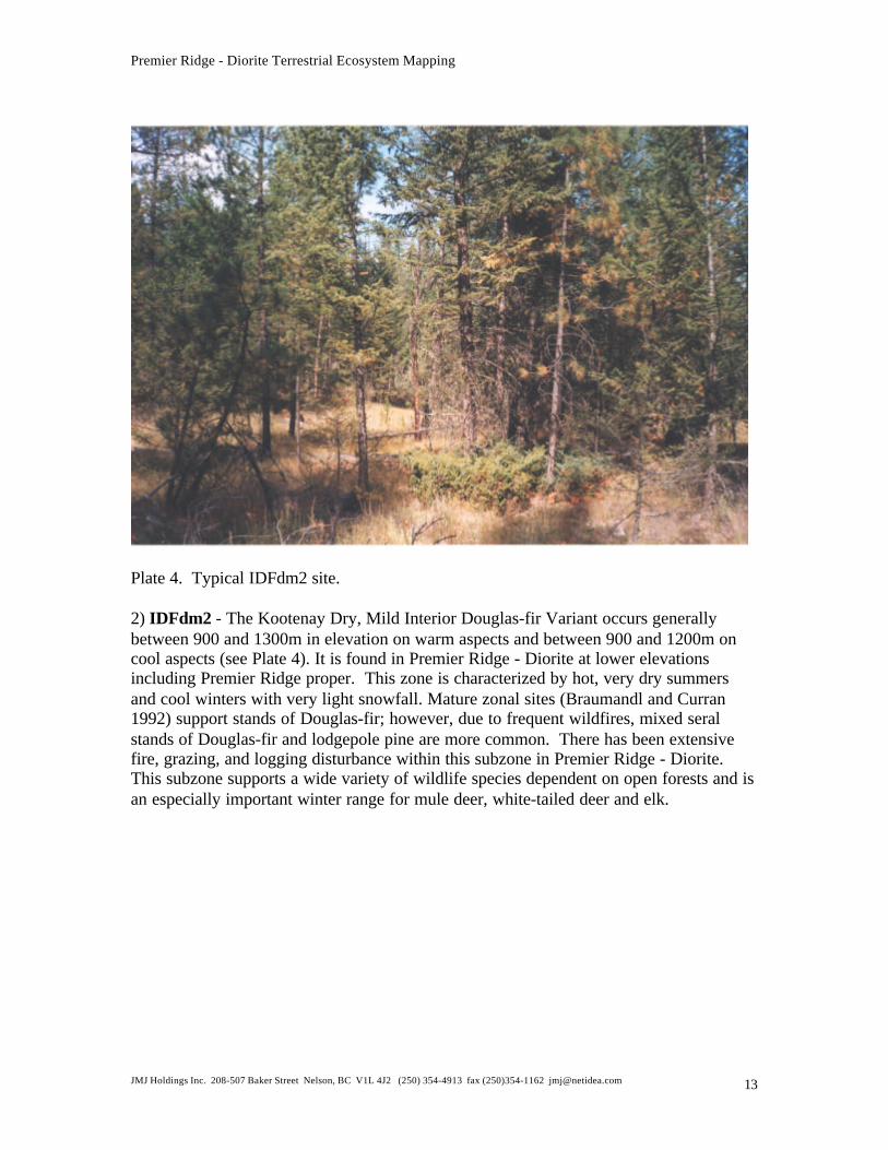
Plate 4. Typical IDFdm2 site.
2) IDFdm2 - The Kootenay Dry, Mild Interior Douglas-fir Variant occurs generallybetween 900 and 1300m in elevation on warm aspects and between 900 and 1200m oncool aspects (see Plate 4). It is found in Premier Ridge - Diorite at lower elevationsincluding Premier Ridge proper. This zone is characterized by hot, very dry summersand cool winters with very light snowfall. Mature zonal sites (Braumandl and Curran1992) support stands of Douglas-fir; however, due to frequent wildfires, mixed seralstands of Douglas-fir and lodgepole pine are more common. There has been extensivefire, grazing, and logging disturbance within this subzone in Premier Ridge - Diorite.This subzone supports a wide variety of wildlife species dependent on open forests and isan especially important winter range for mule deer, white-tailed deer and elk.
Premier Ridge - Diorite Terrestrial Ecosystem Mapping
JMJ Holdings Inc. 208-507 Baker Street Nelson, BC V1L 4J2 (250) 354-4913 fax (250)354-1162 [email protected] 14
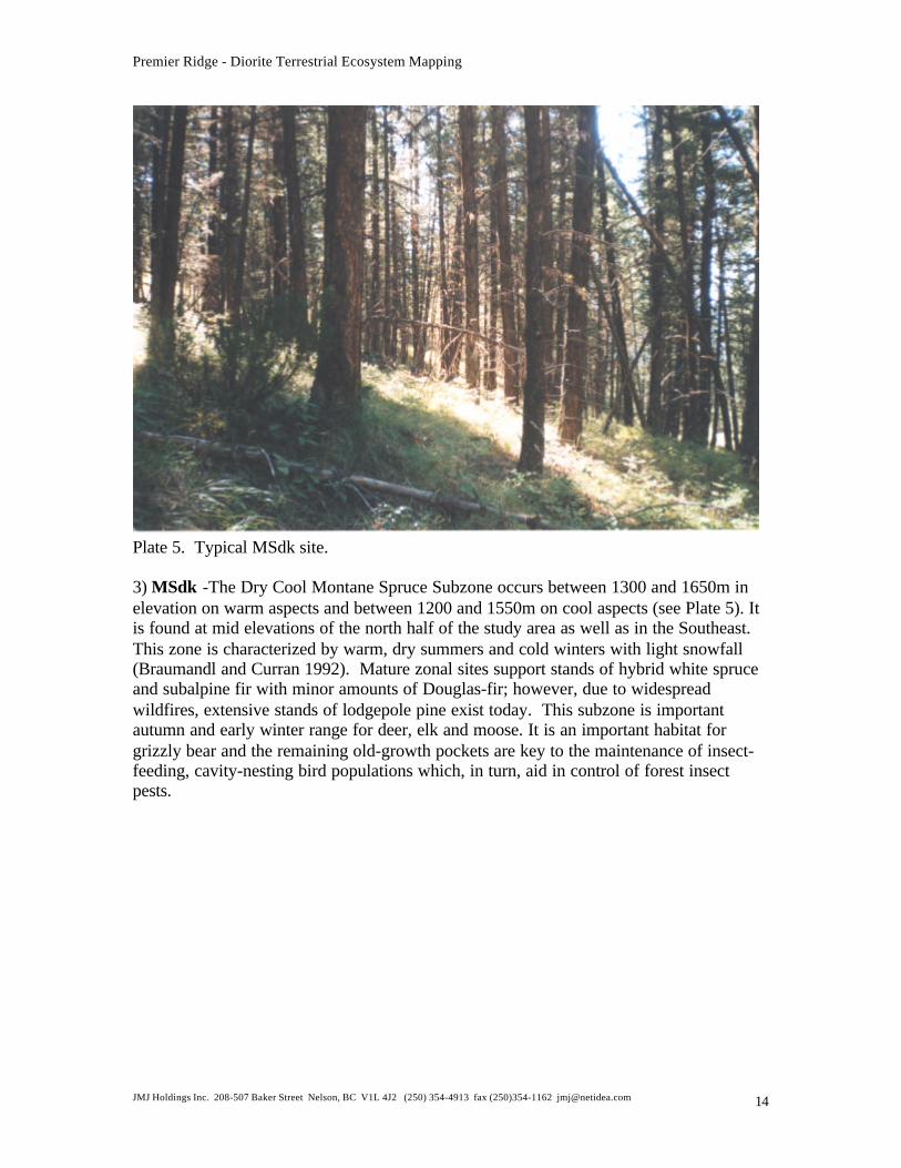
Plate 5. Typical MSdk site.
3) MSdk -The Dry Cool Montane Spruce Subzone occurs between 1300 and 1650m inelevation on warm aspects and between 1200 and 1550m on cool aspects (see Plate 5). Itis found at mid elevations of the north half of the study area as well as in the Southeast.This zone is characterized by warm, dry summers and cold winters with light snowfall(Braumandl and Curran 1992). Mature zonal sites support stands of hybrid white spruceand subalpine fir with minor amounts of Douglas-fir; however, due to widespreadwildfires, extensive stands of lodgepole pine exist today. This subzone is importantautumn and early winter range for deer, elk and moose. It is an important habitat forgrizzly bear and the remaining old-growth pockets are key to the maintenance of insect-feeding, cavity-nesting bird populations which, in turn, aid in control of forest insectpests.
Premier Ridge - Diorite Terrestrial Ecosystem Mapping
JMJ Holdings Inc. 208-507 Baker Street Nelson, BC V1L 4J2 (250) 354-4913 fax (250)354-1162 [email protected] 15
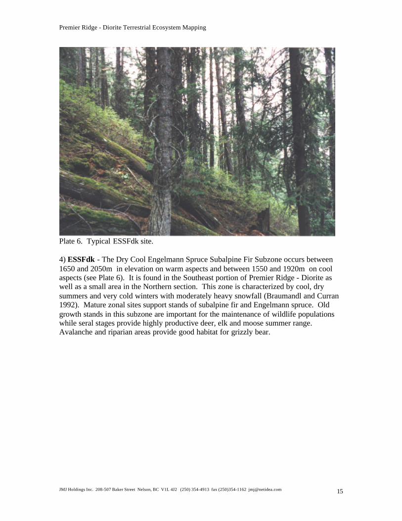
Plate 6. Typical ESSFdk site.
4) ESSFdk - The Dry Cool Engelmann Spruce Subalpine Fir Subzone occurs between1650 and 2050m in elevation on warm aspects and between 1550 and 1920m on coolaspects (see Plate 6). It is found in the Southeast portion of Premier Ridge - Diorite aswell as a small area in the Northern section. This zone is characterized by cool, drysummers and very cold winters with moderately heavy snowfall (Braumandl and Curran1992). Mature zonal sites support stands of subalpine fir and Engelmann spruce. Oldgrowth stands in this subzone are important for the maintenance of wildlife populationswhile seral stages provide highly productive deer, elk and moose summer range.Avalanche and riparian areas provide good habitat for grizzly bear.
Premier Ridge - Diorite Terrestrial Ecosystem Mapping
JMJ Holdings Inc. 208-507 Baker Street Nelson, BC V1L 4J2 (250) 354-4913 fax (250)354-1162 [email protected] 16
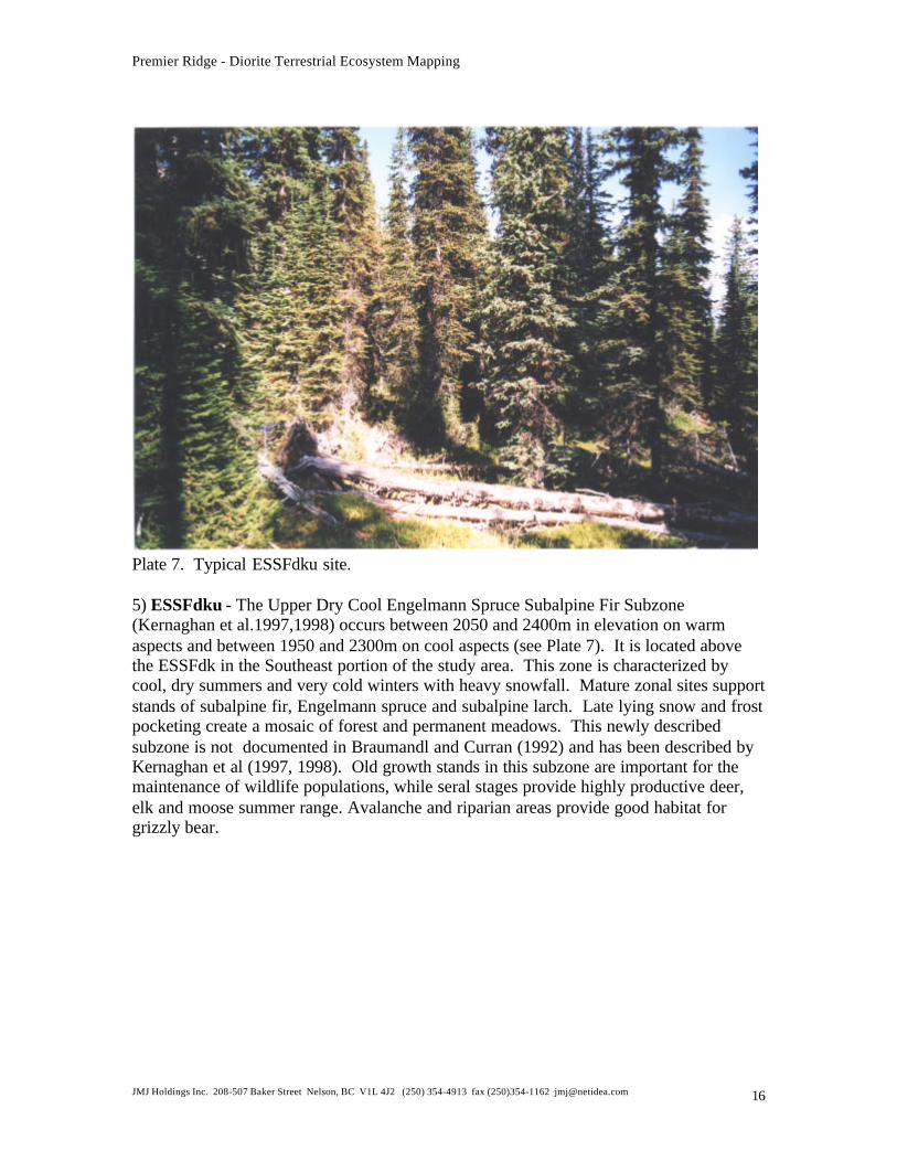
Plate 7. Typical ESSFdku site.
5) ESSFdku - The Upper Dry Cool Engelmann Spruce Subalpine Fir Subzone(Kernaghan et al.1997,1998) occurs between 2050 and 2400m in elevation on warmaspects and between 1950 and 2300m on cool aspects (see Plate 7). It is located abovethe ESSFdk in the Southeast portion of the study area. This zone is characterized bycool, dry summers and very cold winters with heavy snowfall. Mature zonal sites supportstands of subalpine fir, Engelmann spruce and subalpine larch. Late lying snow and frostpocketing create a mosaic of forest and permanent meadows. This newly describedsubzone is not documented in Braumandl and Curran (1992) and has been described byKernaghan et al (1997, 1998). Old growth stands in this subzone are important for themaintenance of wildlife populations, while seral stages provide highly productive deer,elk and moose summer range. Avalanche and riparian areas provide good habitat forgrizzly bear.
Premier Ridge - Diorite Terrestrial Ecosystem Mapping
JMJ Holdings Inc. 208-507 Baker Street Nelson, BC V1L 4J2 (250) 354-4913 fax (250)354-1162 [email protected] 17
Plate 8. Typical ESSFdkp site.
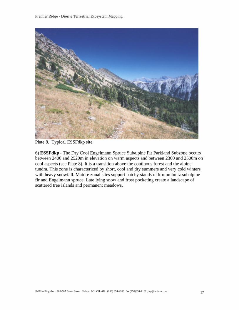
6) ESSFdkp - The Dry Cool Engelmann Spruce Subalpine Fir Parkland Subzone occursbetween 2400 and 2520m in elevation on warm aspects and between 2300 and 2500m oncool aspects (see Plate 8). It is a transition above the continous forest and the alpinetundra. This zone is characterized by short, cool and dry summers and very cold winterswith heavy snowfall. Mature zonal sites support patchy stands of krummholtz subalpinefir and Engelmann spruce. Late lying snow and frost pocketing create a landscape ofscattered tree islands and permanent meadows.

Premier Ridge - Diorite Terrestrial Ecosystem Mapping
JMJ Holdings Inc. 208-507 Baker Street Nelson, BC V1L 4J2 (250) 354-4913 fax (250)354-1162 [email protected] 18
Plate 9. Typical AT site.
7) AT - Alpine Tundra biogeoclimatic zone occurs at elevations above 2520m inelevation on warm aspects and above 2500m on cool aspects (see Plate 9). Itencompasses the high, treeless peaks of the Rocky Mountains at the Southeastern edge ofPremier Ridge - Diorite. This zone is characterized by short, cool and dry summers andvery cold winters with heavy snowfall. Much of the subzone is non-vegetated and zonalvegetated sites are characterized by mountain avens and arctic willow with no conifers.
3.0 METHODS
3.1 PRE-STRATIFICATION OF ECOSYSTEMS USING THEBIOTERRAIN APPROACH
Bioterrain mapping is based on primary terrain and soil mapping standards, it includesany ecologically significant feature which is thought to influence the function of anecosystem (Ecosystems Working Group, 1998).
The first step was to map terrain according to the Terrain Classification System forBritish Columbia (Howes and Kenk, 1997). These surficial units were subdivided byfeatures such as directional exposure, depth to water table, avalanche zones, vegetatedrock and very thin rubble surfaces, talus, cliffs, and significant changes in bedrock. Thefeatures considered important for this study area were agreed upon with the client,technical experts and the consultant's team. These subdivisions attempt to identify and
Premier Ridge - Diorite Terrestrial Ecosystem Mapping
JMJ Holdings Inc. 208-507 Baker Street Nelson, BC V1L 4J2 (250) 354-4913 fax (250)354-1162 [email protected] 19
classify as many habitats and sensitive site conditions as possible for the basis for theecosystem map (Ecosystems Working Group, 1998).
These units of bioterrain were initially mapped by Joel Fitzpatrick as solid lines in ink onair photos using a number 2 size pen. They were sent to the appropriate technical expert(Larry Lacelle, MOELP, Resources Inventory Branch) for approval. When site seriesmapping commenced we found that extensive correction and subdivision of these lineswas necessary to facilitate site series mapping. As the air photos were gettting damagedby the extent of the changes and the type of ink originally used, we choose to make newlinework in a digital format and use this for the basis of the bioterrain and site seriesmapping. This linework was sent for correlation and the improvements recognized andaccepted. Consequently, the most up-to-date bioterrain map exists in digital format andis included in Appendix VII. Final terrain mapping consists of numbered polygons and ahard copy bioterrain database.
3.1.1 AIR PHOTO INTERPRETATION
Air photo interpretation was accomplished using 1:20,000 scale, 1991, black & white airphotos and with checks of more recent structural stage and resource development using1:20,000 forest cover maps and recent LANDSAT imagery. Due to the nature of blackand white photography, the presence of alpine vegetation and the difference between herband between low (3a) and tall (3b) shrubby structural stages was sometimes difficult tointerpret. For polygons that were indicated as being logged on the forest cover map afterthe date the air photos were taken, the logging was deemed to be clearcut even thoughthere may have been some partial cuts.
3.2 SAMPLING
The ecosystem survey intensity level achieved in the field was 4 with 15% polygonvisitation. Ecosystem data was collected to the standards set forth the Field Manual forDescribing Terrestrial Ecosystems (1998). Sample plots were chosen subjectively to bestrepresent the distribution of ecosystems and structural stages within each biogeoclimaticunit. There was also extensive range sampling done under the 1996 contract, howeversome of the data was not made available to us and could not be incorporated into plotdatabases. Gail Berg, MOF Invermere has this data. If this data was incorporated intothe mapping, the survey intensity level would be considerably higher. Due to budgetaryconstraints in the 1999 contract, wildlife surveys were not completed. However, somewildlife sampling was done 1997 by Ecological Insights. Observations or sign of thespecies found during the sampling in Premier Ridge - Diorite can be found in AppendixV. Rare element lists were compiled and can be found in Appendix VI.
Premier Ridge - Diorite Terrestrial Ecosystem Mapping
JMJ Holdings Inc. 208-507 Baker Street Nelson, BC V1L 4J2 (250) 354-4913 fax (250)354-1162 [email protected] 20
3.2.1 DATA FORMS
Detailed data for vegetation, site, soil, and wildlife was collected on “Ecosystem FieldForms” (revised FS882) and Ground Inspections and Visual plot data was collected on“Ground Inspection Forms” all according to the standards set forth in the “Field Manualfor Describing Ecosystems” (1998). Some of this original plot data can be found inAppendix IV.
Plots were subjectively located in homogenous areas representing a spectrum of siteseries and structural stages, and were 0.04 ha in area. The standard size for a sample plotis 20 x 20 m, but the shape of the plot was varied according to the spatial distribution ofthe ecosystem unit. A plot sampling a narrow riparian site may be 10 x 40m in size.
3.3 BIOTERRAIN ATTRIBUTES
Bioterrain attributes were typed following the standards of Howes and Kenk (1997) andRIC 1998 (Ecosystems Working Group, 1998). Symbology follows the system of Howesand Kenk (1997). Complex polygons can have up to three terrain units within a singlepolygon. Percentage distribution of terrain units was represented by deciles from 1 to 10(1=10% and 10=100%).
TEXTURE SURFICIAL MATERIAL SURFACE EXPRESSION GEOLOGICAL PROCESS SOILDRAINAGE
a=blocksb=bouldersc=clayd=mixedfragmentse=fibricg=gravelh=humick=cobblesm=mudp=pebblesr=rubbles=sandu=mesicx=angularfragmentsz=silt
A= anthropogenic materialC=colluvialD=weathered bedrockE=eolianF=fluvialFG= glacial fluvialI=iceL=lacustrineLG=glaciolacustrineM=morainalN=aquaticO=organicR=bedrockU=undifferentiatedmaterial
a=moderate slope (25-50%)b=blanket (>1m thick)c=coned=depressionf=fanh=hummockyj=gentle slope (,<25%)k=moderately steepm=rollingp=plainr=ridgeds=steep (>70%)t=terraceu=undulatingv=veneer (20-100cm thick)w=mantle of varing thicknessx=thin veneer (2-20cm thick)
A=avalanchesB=braided channelC=cryoturbationD=deflationE=channelledF=slow mass movementH=kettledI=irregular channelJ=anastamosing channelK=karst processesM=meandering channelN=nivationP=pipingR=rapid mass movementS=solifluctionU=inundationV=gully erosionW=washingX=permafrostZ=periglacial processesA = active processI = inactive process
x = very rapidr = rapidw = wellm =moderatelywelli = imperfectp = poorv = very poor
(from Howes and Kenk, 1997)
Table 1: Bioterrain Unit Letter Notation
Premier Ridge - Diorite Terrestrial Ecosystem Mapping
JMJ Holdings Inc. 208-507 Baker Street Nelson, BC V1L 4J2 (250) 354-4913 fax (250)354-1162 [email protected] 21
EXAMPLE TERRAIN POLYGON NOTATION
surface materialsurface expression
decile 6 sr C bv -4M bj - Af geological process
Rs texture w , m soil drainage
This polygon label would be read as:
60% sandy, rubbly Colluvial blanket-veneer, overlying steep rock; well drained and 40% Morainal blanket, gently sloping,with freqent avalanching; moderately well drained
3.4 ECOSYSTEM UNIT MAPPING
An ecosystem map unit incorporates site series, site modifiers and structural stage into alabel. Ecosystem units were mapped using airphoto interpretation and sample plot dataaccording to the standards set forth in Standard for Terrestrial Ecosystem Mapping in BC(RIC 1998). Ecosystem units were mapped within the boundaries of the pre-stratifiedbioterrain polygons. Bioterrain polygons were split when natural disturbances, such asfire, or cultural disturbances such as logging, resulted in two strongly contrastingstructural stages. Pre-stratified bioterrain polygons were also subdivided bybiogeoclimatic subzone boundaries.
Sample plots were classified to site series for the PPdh2, IDFdm2, MSdk and ESSFdkusing Braumandl and Curran (1992); and for the ESSFdku, ESSFdkp, and AT to siteseries used by Kernaghan et al (1998).
Polygons with sample plots were used as mapping control points for site series andstructural stage classification and terrain relationships. Site series were identified withineach unsampled polygon using the algorithms set forth in the working legend (seeAppendix III). The characteristics of the terrain unit, sample plots that occurred withinsimilar polygons, and structural stages from differences in air photo textures and ageclass information from forest cover maps were utilized to map unsampled polygons. Upto three site series were mapped within each polygon.
Site modifying codes were used with a site series designation when it differed from whatis described as typical for that site series (see Table 2). When specific features of the sitesignificantly altered the nature of the floristics of an ecosystem unit, that unit received aseparate description in the expanded legend. Modifiers increase the resolution of themapping. Braumandl and Curran (1992) site series were described in more general termsbased on forest management objectives.
Premier Ridge - Diorite Terrestrial Ecosystem Mapping
JMJ Holdings Inc. 208-507 Baker Street Nelson, BC V1L 4J2 (250) 354-4913 fax (250)354-1162 [email protected] 22
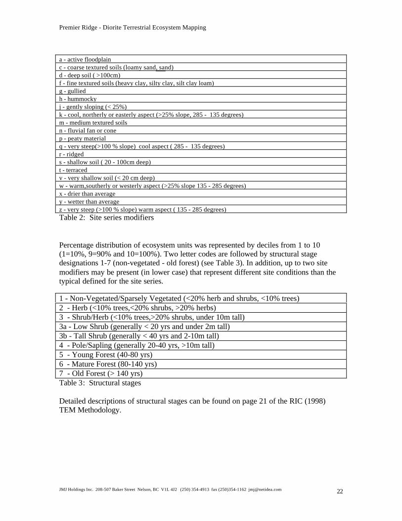
a - active floodplainc - coarse textured soils (loamy sand, sand)d - deep soil ( >100cm)f - fine textured soils (heavy clay, silty clay, silt clay loam)g - gulliedh - hummockyj - gently sloping (< 25%)k - cool, northerly or easterly aspect (>25% slope, 285 - 135 degrees)m - medium textured soilsn - fluvial fan or conep - peaty materialq - very steep(>100 % slope) cool aspect ( 285 - 135 degrees)r - ridgeds - shallow soil ( 20 - 100cm deep)t - terracedv - very shallow soil (< 20 cm deep)w - warm,southerly or westerly aspect (>25% slope 135 - 285 degrees)x - drier than averagey - wetter than averagez - very steep (>100 % slope) warm aspect ( 135 - 285 degrees)Table 2: Site series modifiers
Percentage distribution of ecosystem units was represented by deciles from 1 to 10(1=10%, 9=90% and 10=100%). Two letter codes are followed by structural stagedesignations 1-7 (non-vegetated - old forest) (see Table 3). In addition, up to two sitemodifiers may be present (in lower case) that represent different site conditions than thetypical defined for the site series.
1 - Non-Vegetated/Sparsely Vegetated (<20% herb and shrubs, <10% trees)2 - Herb (<10% trees,<20% shrubs, >20% herbs)3 - Shrub/Herb (<10% trees,>20% shrubs, under 10m tall)3a - Low Shrub (generally < 20 yrs and under 2m tall)3b - Tall Shrub (generally < 40 yrs and 2-10m tall)4 - Pole/Sapling (generally 20-40 yrs, >10m tall)5 - Young Forest (40-80 yrs)6 - Mature Forest (80-140 yrs)7 - Old Forest (> 140 yrs)Table 3: Structural stages
Detailed descriptions of structural stages can be found on page 21 of the RIC (1998)TEM Methodology.
Premier Ridge - Diorite Terrestrial Ecosystem Mapping
JMJ Holdings Inc. 208-507 Baker Street Nelson, BC V1L 4J2 (250) 354-4913 fax (250)354-1162 [email protected] 23
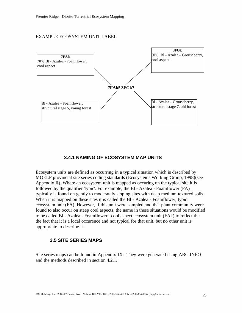
EXAMPLE ECOSYSTEM UNIT LABEL
7FAk5 3FGk7
3.4.1 NAMING OF ECOSYSTEM MAP UNITS
Ecosystem units are defined as occurring in a typical situation which is described byMOELP provincial site series coding standards (Ecosystems Working Group, 1998)(seeAppendix II). Where an ecosystem unit is mapped as occuring on the typical site it isfollowed by the qualifier 'typic'. For example, the Bl - Azalea - Foamflower (FA)typically is found on gently to moderately sloping sites with deep medium textured soils.When it is mapped on these sites it is called the Bl - Azalea - Foamflower; typicecosystem unit (FA). However, if this unit were sampled and that plant community werefound to also occur on steep cool aspects, the name in these situations would be modifiedto be called Bl - Azalea - Foamflower; cool aspect ecosystem unit (FAk) to reflect thethe fact that it is a local occurence and not typical for that unit, but no other unit isappropriate to describe it.
3.5 SITE SERIES MAPS
Site series maps can be found in Appendix IX. They were generated using ARC INFOand the methods described in section 4.2.1.
7FAk70% Bl - Azalea - Foamflower,cool aspect
3FGk30% Bl - Azalea - Grouseberry,cool aspect
Bl - Azalea - Foamflower,structural stage 5, young forest
Bl - Azalea - Grouseberry,structural stage 7, old forest
Premier Ridge - Diorite Terrestrial Ecosystem Mapping
JMJ Holdings Inc. 208-507 Baker Street Nelson, BC V1L 4J2 (250) 354-4913 fax (250)354-1162 [email protected] 24
3.6 WORKING LEGEND
While in the field, a working legend was developed to assist tracking the frequency withwhich combinations of bioterrain and site series were sampled. The working legend isthen used as a basis for algorithm development to define the observed relationshipsbetween terrain, slope, aspect and site series based on sample plots (see Appendix III).
3.7 PLANT IDENTIFICATION
Unknown plants were collected, pressed and labelled in the field. Identification wascompleted in January, 2000. Botanical nomenclature is according to Douglas, Straley andMeidinger Vascular Plants of British Columbia, Parts 1-4. Some plant materials were sentto provincial specialists for verification. A list of species noted in Premier Ridge - Dioriteis included in Appendix 1. A number of species were identified by the previousconsultant as being Provincially Red – listed according to the Conservation Data Centreof BC. These are noted in the plant lists. We were not given the voucher specimens withthe existing plot cards from the previous consultant, so we have no way of verifying thered-listed species. However, some of the red-listed species were noted as being collectedin ecosystems where those species would not normally be found.
3.8 DATA ANALYSIS
Each plot was allocated to an existing MOF site series by using the keys provided inBraumandl and Curran (1992), and Kernaghan et al (1997,1998). For the subzones notdescribed by Braumandl and Curran (1992), the ESSFdku, ESSFdkp and AT, site serieswere based on the adjacent TEM projects from Steamboat Mountain (Kernaghan et al.1998) with the approval of the Regional Ecologist.
4.0 DATABASES
4.1 VENUS AND GRAVITI DATABASES
VENUS (Vegetation and Environment NexUS) and GRAVITI are databases created bythe Ministries of Forests and Environment in Victoria that houses a provincial databasefor vegetation, site, soil, wildlife from Ecosystem Field Forms (FS882) and GroundInspection Forms. The program can also sort and summarize vegetation andenvironmental data used to aid in the classification and correlation efforts in T.E.M. andother vegetation mapping projects.
Premier Ridge - Diorite Terrestrial Ecosystem Mapping
JMJ Holdings Inc. 208-507 Baker Street Nelson, BC V1L 4J2 (250) 354-4913 fax (250)354-1162 [email protected] 25
4.2 BIOTERRAIN AND ECOSYSTEM DATABASE
R.I.C.(1998) standard EXCEL 7.0 spread sheets were used to record bioterrain andecosystem attributes for each polygon. Each row describes a polygon number with up tothree terrain and ecosystem attributes. The content of each column follows the formatsuggested by the technical coordinator. The bioterrain and ecosystem database is found inAppendix VIII. Standards follow RIC 1998 (Ecosystems Working Group, 1998).
4.3 SPATIAL DATABASE
Bioterrain polygons were digitized from typed 1:20,000 air photos using controlledmonorestitution with TRIM 1 - Z axis control points. These polygons were presented indraft format on TRIM base maps. After field sampling the polygons were refined andnumbered. Polygon numbers were added to the spatial files.
ARC INFO GIS version 7.2.1 was used as the processing system for the spatialcomponent of the TEM database. In accordance to the RIC standards manual, (Standardfor Terrestrial Ecosystem Mapping (TEM) Data Capture in BC.1998), polygonsrepresenting ecosystem units were delineated by a contiguous ARC/INFO coverage forthe study area. Each polygon within the coverage is assigned a unique number whichcorresponds to a record within the ecosystem database.
The non-spatial component of the TEM database is a table representing the ecosystemand terrain attributes of mapped polygons. Each record in the table describes a singleecosystem unit. A unique number for each record links to a single polygon in the spatialdata (polygons) and the TEM attributes (table). The tabular database is structured as perRIC standards, in an ASCII Comma Separated Value (CSV) file.
5.0 SUBZONE AND SITE SERIES OVERVIEW
Tables were generated showing the number of hectares of each site series and structuralstage within each subzone. The N/A in the site series tables refer to the non vegetated,sparsely vegetated, and anthopogenic units (see Appendix II). The N/A in the structuralstage tables refer to the non vegetated, sparsely vegetated, and anthopogenic units that donot require a stuctural stage based on RIC 1998 (Ecosystems Working Group, 1998)standards.
5.1 PPdh2
The PW (01) site series strongly dominates 83% of the PPdh2 (see Table 4). The secondmost common site series is the WJ (02) at 6%. The most common structural stage in the
Premier Ridge - Diorite Terrestrial Ecosystem Mapping
JMJ Holdings Inc. 208-507 Baker Street Nelson, BC V1L 4J2 (250) 354-4913 fax (250)354-1162 [email protected] 26
PPdh2 is 5 (49%) (see Table 5). There is no structural stage 7 (old forest) in the PPdh2because of repeated disturbances of fire and logging. The PPdh2 has three rare plantassociations. The CD (04) and the WJ (02) site series, representing 8% of the PPdh2, areboth red listed. The AR (03) site series representing 3% of the PPdh2, is blue listed (seeAppendix VI).
Subzone Site Series Site Series Number Area (hectares)PPdh2 PW 01 4390.9PPdh2 WJ 02 327.1PPdh2 AR 03 134.4PPdh2 CD 04 78.4PPdh2 SF 00 2.9PPdh2 CF N/A 218.3PPdh2 RP N/A 41.1PPdh2 RI N/A 26.5PPdh2 LA N/A 25.4PPdh2 ES N/A 24.3PPdh2 PD N/A 13.5PPdh2 OW N/A 11.1PPdh2 MU N/A 10.2PPdh2 GP N/A 4.9PPdh2 GB N/A 2.4PPdh2 RO N/A 0.9PPdh2 TA N/A 0.2Total 5312.5Table 4: Site series allocation in hectares in the PPdh2.
Subzone Structural Stage Area (hectares)PPdh2 5 2613.6PPdh2 6 1167.3PPdh2 3 674.0PPdh2 2 564.0PPdh2 4 133.3PPdh2 N/A 117.5PPdh2 1 42.9PPdh2 7 0Total 5312.5Table 5: Structural stage allocation in hectares in the PPdh2.
5.2 IDFdm2
The DT (01) site series dominates 65% of the IDFdm2 (see Table 6). The second mostcommon site series is the DS (03) at 19%. The most common structural stage in theIDFdm2 is 5 (56%) (see Table 7). As in the PPdh2 there is no structural stage 7 (old
Premier Ridge - Diorite Terrestrial Ecosystem Mapping
JMJ Holdings Inc. 208-507 Baker Street Nelson, BC V1L 4J2 (250) 354-4913 fax (250)354-1162 [email protected] 27
forest) in the IDFdm2 because of repeated disturbances of fire and logging. The IDFdm2has four rare plant associations. The SF (00) and DS (03) site series, representing 19% ofthe IDFdm2, are both red listed. The AW (02) and BH (06) site series, representing 5% ofthe IDFdm2, are both blue listed (see Appendix VI).
Subzone Site Series Site Series Number Area (hectares)IDFdm2 DT 01 11773.0IDFdm2 DS 03 3404.3IDFdm2 AW 02 708.8IDFdm2 SP 04 619.0IDFdm2 SH 07 273.2IDFdm2 BH 06 253.5IDFdm2 SS 05 222.1IDFdm2 SM 00 22.6IDFdm2 SF 00 21.4IDFdm2 CT 00 13.6IDFdm2 CL 00 8.5IDFdm2 BU 00 0.8IDFdm2 RO N/A 208.8IDFdm2 RP N/A 146.3IDFdm2 RI N/A 119.6IDFdm2 OW N/A 97.4IDFdm2 TA N/A 92.3IDFdm2 GB N/A 37.9IDFdm2 ES N/A 22.3IDFdm2 LA N/A 12.7IDFdm2 GP N/A 9.3IDFdm2 PD N/A 3.8Total 18074.8Table 6: Site series allocation in hectares in the IDFdm2.
Subzone Structural Stage Area (hectares)IDFdm2 5 10226.7IDFdm2 6 3159.2IDFdm2 3 2982.2IDFdm2 4 773.7IDFdm2 N/A 383.1IDFdm2 1 379.2IDFdm2 2 170.7IDFdm2 7 0Total 18074.8Table 7: Structural stage allocation in hectares in the IDFdm2.
Premier Ridge - Diorite Terrestrial Ecosystem Mapping
JMJ Holdings Inc. 208-507 Baker Street Nelson, BC V1L 4J2 (250) 354-4913 fax (250)354-1162 [email protected] 28
5.3 MSdk
The LP (04) site series dominates 62% of the MSdk (see Table 8). The second mostcommon site series is the SG (01) at 13%. The most common structural stage in theMSdk is 6 (48%) (see Table 9). Stand ages tend to be somewhat older in the MSdk thanin the PPdh2 and IDFdm2. However, there is no structural stage 7 because of pastdisturbances.
Subzone Site Series Site Series Number Area (hectares)MSdk LP 04 3288.2MSdk SG 01 692.5MSdk LJ 03 967.0MSdk SW 02 45.5MSdk AF 00 31.2MSdk AS 00 26.4MSdk SS 05 16.8MSdk AW 00 6.5MSdk SM 00 3.2MSdk EF 00 0.3MSdk FC 00 0.1MSdk RO N/A 165.1MSdk TA N/A 75.5MSdk CL N/A 27.2MSdk RI N/A 0.8Total 5346.3Table 8: Site series allocation in hectares in the MSdk.
Subzone Structural Stage Area (hectares)MSdk 6 2548.5MSdk 5 1418.0MSdk 3 1019.4MSdk 1 267.9MSdk 4 88.2MSdk 2 3.6MSdk N/A 0.8MSdk 7 0Total 5346.3Table 9: Structural stage allocation in hectares in the MSdk.
5.4 ESSFdk
The FS (04) site series dominates 46% of the ESSFdk (see Table 10). The second mostcommon site series is the DM (02) at 22%.This indicates large areas of drier sites. Themost common structural stage in the ESSFdk is 6 (55%) (see Table 11). Stand ages tend
Premier Ridge - Diorite Terrestrial Ecosystem Mapping
JMJ Holdings Inc. 208-507 Baker Street Nelson, BC V1L 4J2 (250) 354-4913 fax (250)354-1162 [email protected] 29
to be somewhat older in the ESSFdk than in the PPdh2 and IDFdm2. However, there isno structural stage 7 because of past disturbances.
Subzone Site Series Site Series Number Area (hectares)ESSFdk FS 04 1316.5ESSFdk DM 02 621.7ESSFdk AF 00 105.7ESSFdk FA 01 105.5ESSFdk FM 05 63.3ESSFdk EF 00 52.6ESSFdk AS 00 43.2ESSFdk SE 00 41.7ESSFdk FH 06 22.3ESSFdk AW 00 6.3ESSFdk TA N/A 277.5ESSFdk RO N/A 167.9ESSFdk CL N/A 15.0ESSFdk MO N/A 3.2Total 2842.4Table 10: Site series allocation in hectares in the ESSFdk.
Subzone Structural Stage Area (hectares)ESSFdk 6 1561.2ESSFdk 1 463.6ESSFdk 5 462.5ESSFdk 3 225.2ESSFdk 4 72.5ESSFdk 2 57.4ESSFdk 7 0Total 2842.4Table 11: Structural stage allocation in hectares in the ESSFdk.
5.5 ESSFdku
The FG (00) site series dominates 25% of the ESSFdku (see Table 12). The second mostcommon site series is the PJ (00) at 16%. The most common structural stage in theESSFdku is 6 (40%) (see Table 13). The second most common structural stage is 1 (nonvegetated). Stand ages tend to be older in the ESSFdku than in the lower elevationsubzones. Structural stage 7 (old forest) is fairly common at 9% of the ESSFdku.
Subzone Site Series Site Series Number Area (hectares)ESSFdku FG 00 896.1ESSFdku PJ 00 566.6
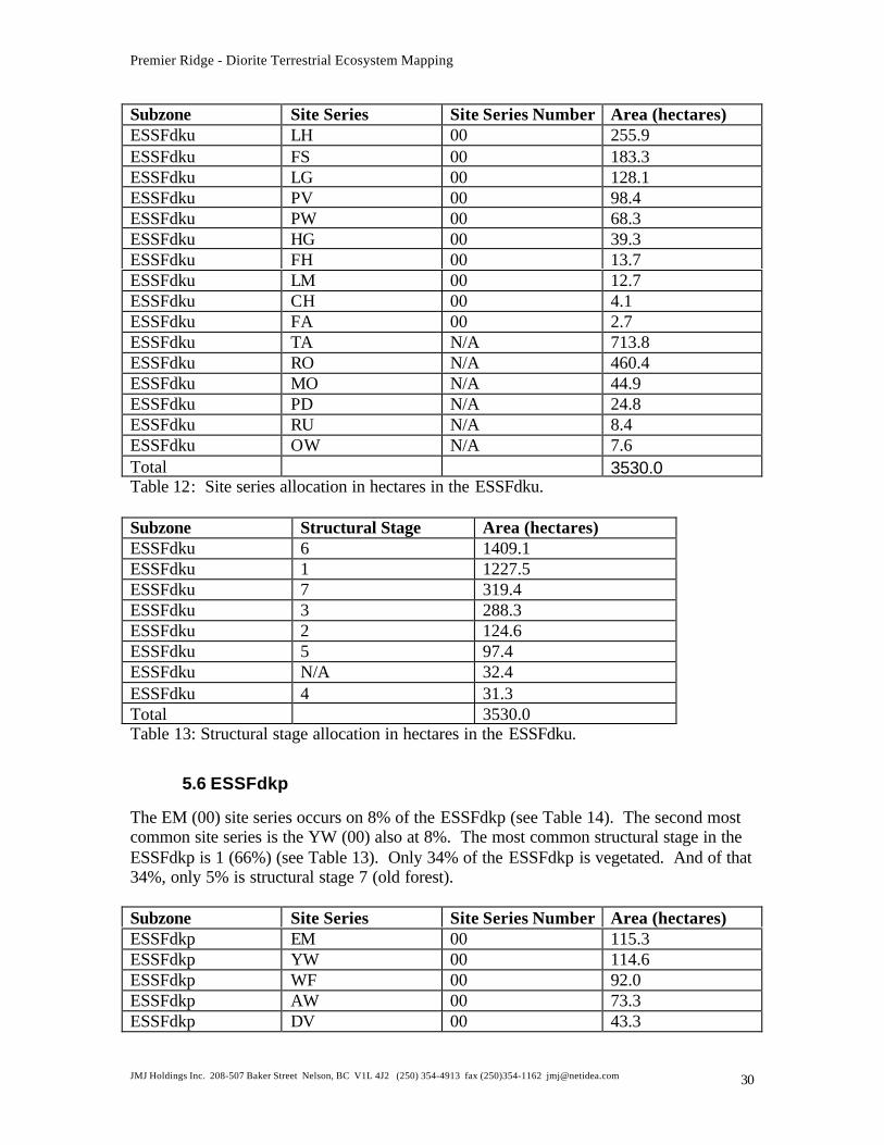
Premier Ridge - Diorite Terrestrial Ecosystem Mapping
JMJ Holdings Inc. 208-507 Baker Street Nelson, BC V1L 4J2 (250) 354-4913 fax (250)354-1162 [email protected] 30
Subzone Site Series Site Series Number Area (hectares)ESSFdku LH 00 255.9ESSFdku FS 00 183.3ESSFdku LG 00 128.1ESSFdku PV 00 98.4ESSFdku PW 00 68.3ESSFdku HG 00 39.3ESSFdku FH 00 13.7ESSFdku LM 00 12.7ESSFdku CH 00 4.1ESSFdku FA 00 2.7ESSFdku TA N/A 713.8ESSFdku RO N/A 460.4ESSFdku MO N/A 44.9ESSFdku PD N/A 24.8ESSFdku RU N/A 8.4ESSFdku OW N/A 7.6Total 3530.0Table 12: Site series allocation in hectares in the ESSFdku.
Subzone Structural Stage Area (hectares)ESSFdku 6 1409.1ESSFdku 1 1227.5ESSFdku 7 319.4ESSFdku 3 288.3ESSFdku 2 124.6ESSFdku 5 97.4ESSFdku N/A 32.4ESSFdku 4 31.3Total 3530.0Table 13: Structural stage allocation in hectares in the ESSFdku.
5.6 ESSFdkp
The EM (00) site series occurs on 8% of the ESSFdkp (see Table 14). The second mostcommon site series is the YW (00) also at 8%. The most common structural stage in theESSFdkp is 1 (66%) (see Table 13). Only 34% of the ESSFdkp is vegetated. And of that34%, only 5% is structural stage 7 (old forest).
Subzone Site Series Site Series Number Area (hectares)ESSFdkp EM 00 115.3ESSFdkp YW 00 114.6ESSFdkp WF 00 92.0ESSFdkp AW 00 73.3ESSFdkp DV 00 43.3
Premier Ridge - Diorite Terrestrial Ecosystem Mapping
JMJ Holdings Inc. 208-507 Baker Street Nelson, BC V1L 4J2 (250) 354-4913 fax (250)354-1162 [email protected] 31
Subzone Site Series Site Series Number Area (hectares)ESSFdkp LM 00 26.6ESSFdkp FS 00 12.7ESSFdkp TA N/A 492.5ESSFdkp RO N/A 385.0ESSFdkp MO N/A 34.9ESSFdkp RU N/A 9.2ESSFdkp OW N/A 2.1ESSFdkp PD N/A 1.6Total 1403.1Table 14: Site series allocation in hectares in the ESSFdkp.
Subzone Structural Stage Area (hectares)ESSFdkp 1 921.6ESSFdkp 2 210.8ESSFdkp 6 149.4ESSFdkp 3 88.6ESSFdkp 7 23.0ESSFdkp 5 6.0ESSFdkp N/A 3.7ESSFdkp 4 0Total 1403.1Table 15: Structural stage allocation in hectares in the ESSFdkp.
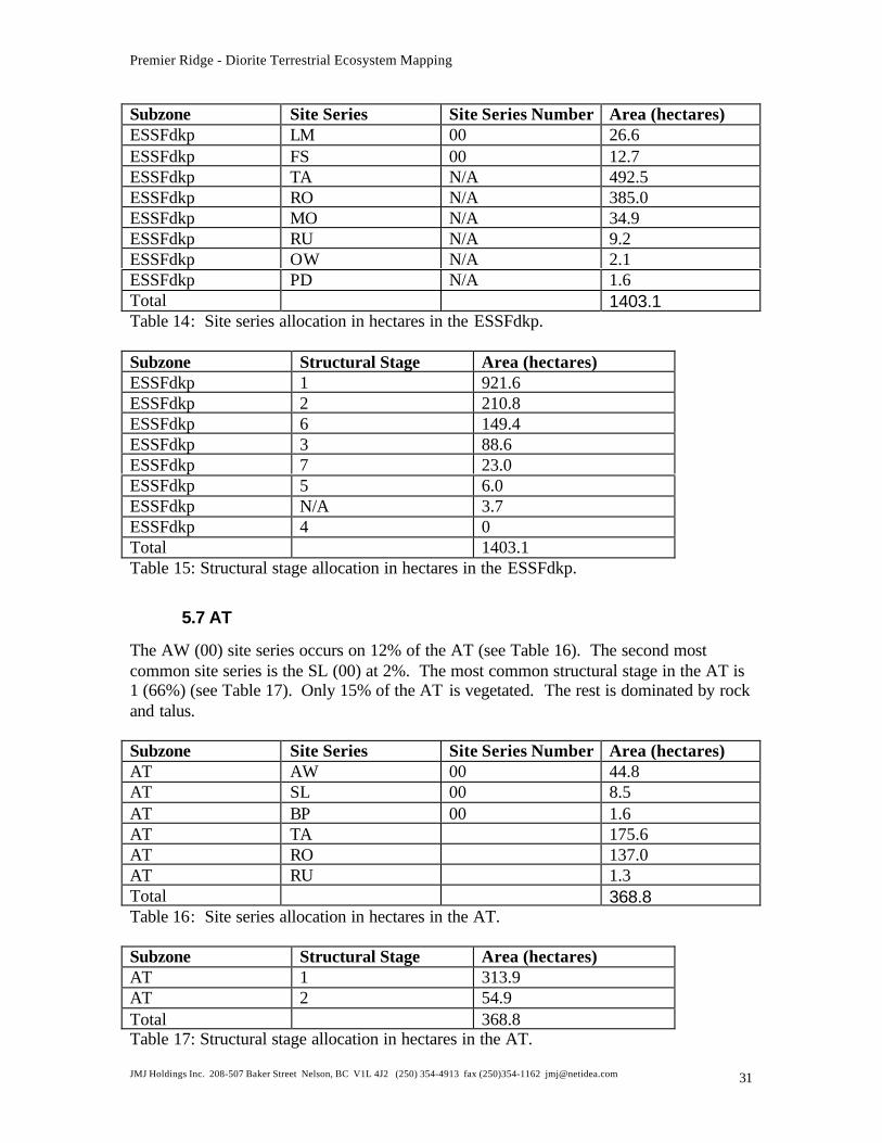
5.7 AT
The AW (00) site series occurs on 12% of the AT (see Table 16). The second mostcommon site series is the SL (00) at 2%. The most common structural stage in the AT is1 (66%) (see Table 17). Only 15% of the AT is vegetated. The rest is dominated by rockand talus.
Subzone Site Series Site Series Number Area (hectares)AT AW 00 44.8AT SL 00 8.5AT BP 00 1.6AT TA 175.6AT RO 137.0AT RU 1.3Total 368.8Table 16: Site series allocation in hectares in the AT.
Subzone Structural Stage Area (hectares)AT 1 313.9AT 2 54.9Total 368.8Table 17: Structural stage allocation in hectares in the AT.
Premier Ridge - Diorite Terrestrial Ecosystem Mapping
JMJ Holdings Inc. 208-507 Baker Street Nelson, BC V1L 4J2 (250) 354-4913 fax (250)354-1162 [email protected] 32
6.0 LITERATURE CITED
B.C. Ministry of Environment, Lands and Parks, BC Ministry of Forests. 1998. FieldManual for Describing Terrestrial Ecosystems. Victoria
Braumandl, T.F., and M. Curran. 1992. A Field Guide for Site Identification andInterpretation for the Nelson Forest Region. Land Management HandbookNumber 29, BC Ministry of Forests. Nelson.
Demarchi, D.A. 1996. An Introduction to the Ecoregions of British Columbia. WildlifeBranch, B.C. Ministry of Environment Lands and Parks.Victoria
Douglas, G.W., G.B. Straley and D. Meidinger. 1989. The Vascular Plants of BritishColumbia. B.C. Ministry of Forests Special Report Series, Parts 1-4.
Ecological Data Committee, Ecosystems Working Group. 1998. Standard for DigitalTerrestrial Ecosystems Mapping (TEM) Data Capture in British Columbia,Version 2. Resources Inventory Committee (RIC) Victoria
Ecosystems Working Group. 1998. Standards for Terrestrial Ecosystems Mapping inBritish Columbia, Resources Inventory Committee (RIC) Victoria
Howes, D.E. and E. Kenk (Ed.). 1997. Terrain Classification System for BritishColumbia. MOE Manual 10 (Version 2). Recreational Fisheries Branch, Ministryof Environment and Surveys and Resource Mapping Branch, Ministry of CrownLands, Victoria, BC
Kernaghan, G., B.A. Sinclair, J.Riddell, M.V.Ketcheson. 1997. Brewer Creek TerrestrialEcosystem Mapping. Unpublished report. BC Ministry of Environment,Lands andParks. Invermere, BC.
Kernaghan, G., B.A. Sinclair, K. Lessard, D. Spaeth, M.V.Ketcheson. 1998. SteamboatMountain Terrestrial Ecosystem Mapping Project. Unpublished report. SlocanForest Products Ltd.. Radium, BC.
Marcoux, D., G. Kernaghan, U. Lowrey, M. Mathers, M. Ketcheson. 1997. ExpandedEcosystem Legend for Stoddart Creek Study Area. Unpublished report. ColumbiaBasin Fish and Wildlife Compensation Program. Invermere, B.C..


![RECORDED HOLDER: SAME As ABOVE [x] · 8E 9E l Trace of Surface Coarse-grained Diorite Metasediments Fine-grained Diorite Metasedimerits ... 24-29 Trace of Surface Mafic Volcanic 29-166](https://img.pdfslide.us/doc/110x75/602e86480298185fcc310b44/recorded-holder-same-as-above-x-8e-9e-l-trace-of-surface-coarse-grained-diorite.jpg)