Embed Size (px)
Citation preview
© Copyright Critical Software SA 2001. All rights reserved
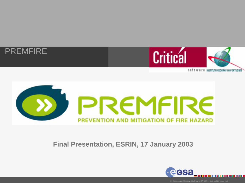
PREMFIRE
Final Presentation, ESRIN, 17 January 2003
2
PREMFIRE
© Copyright Critical Software SA 2001. All rights reserved
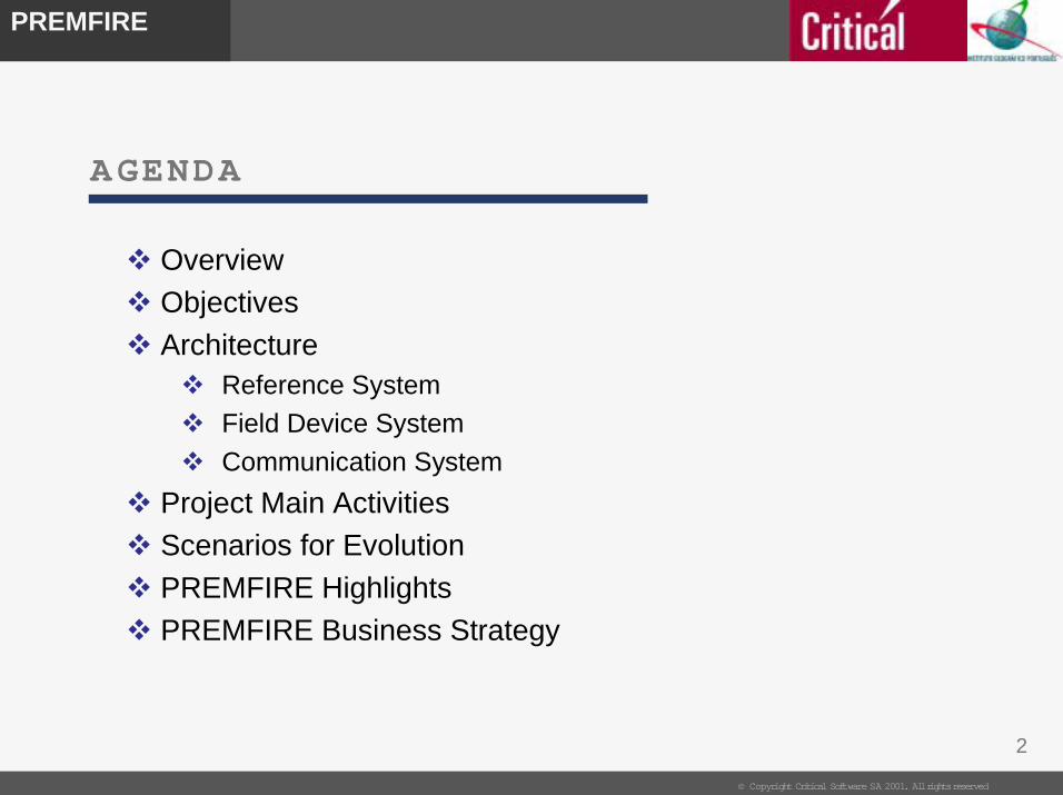
AGENDA
! Overview
! Objectives
! Architecture! Reference System
! Field Device System
! Communication System
! Project Main Activities
! Scenarios for Evolution
! PREMFIRE Highlights
! PREMFIRE Business Strategy
3
PREMFIRE
© Copyright Critical Software SA 2001. All rights reserved
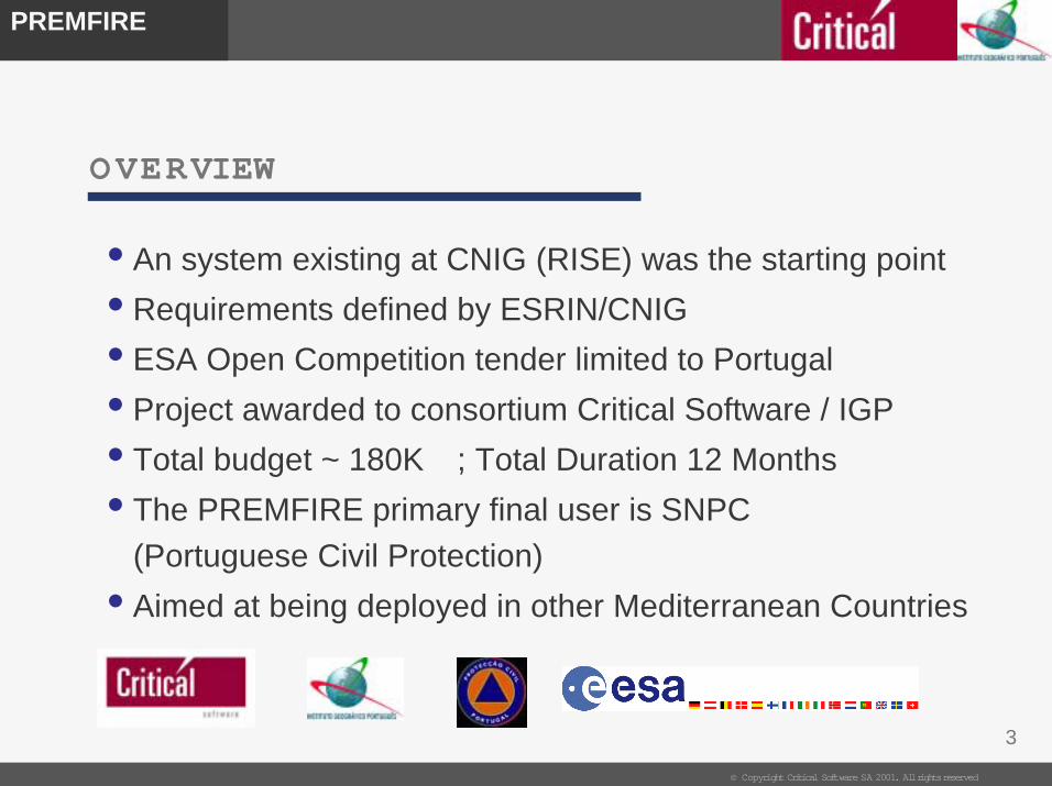
OVERVIEW
• An system existing at CNIG (RISE) was the starting point
• Requirements defined by ESRIN/CNIG
• ESA Open Competition tender limited to Portugal
• Project awarded to consortium Critical Software / IGP
• Total budget ~ 180K� ; Total Duration 12 Months
• The PREMFIRE primary final user is SNPC
(Portuguese Civil Protection)
• Aimed at being deployed in other Mediterranean Countries
4
PREMFIRE
© Copyright Critical Software SA 2001. All rights reserved
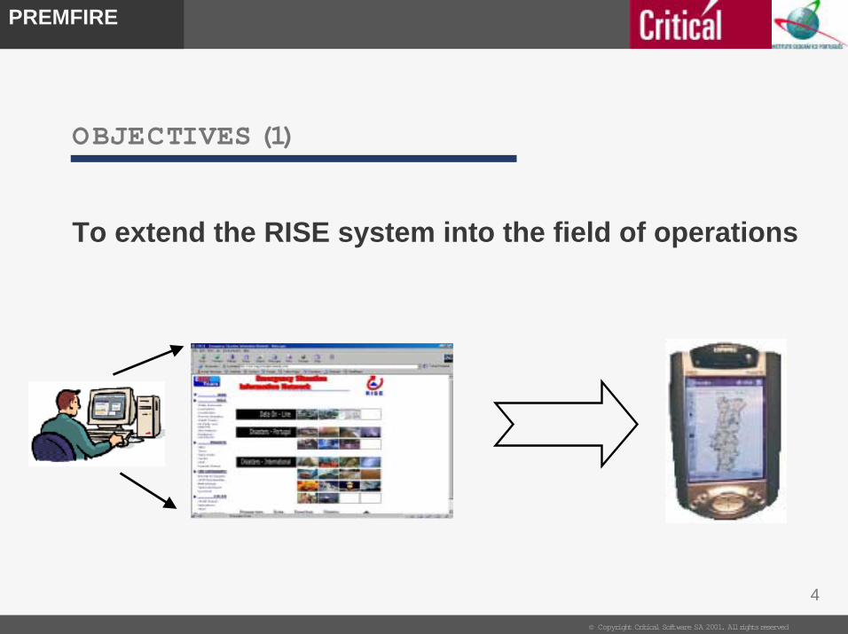
To extend the RISE system into the field of operations
OBJECTIVES (1)
5
PREMFIRE
© Copyright Critical Software SA 2001. All rights reserved
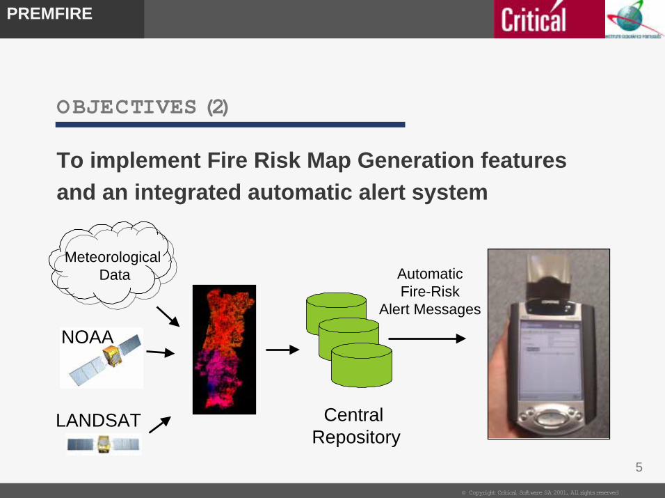
OBJECTIVES (2)
To implement Fire Risk Map Generation features
and an integrated automatic alert system
Central Repository
LANDSAT
NOAA
Automatic Fire-Risk
Alert Messages
MeteorologicalData
6
PREMFIRE
© Copyright Critical Software SA 2001. All rights reserved
OBJECTIVES (3)
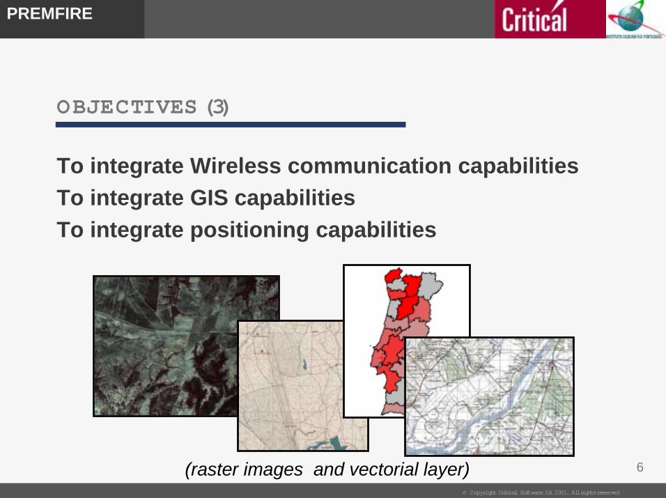
To integrate Wireless communication capabilities
To integrate GIS capabilities
To integrate positioning capabilities
(raster images and vectorial layer)
7
PREMFIRE
© Copyright Critical Software SA 2001. All rights reserved
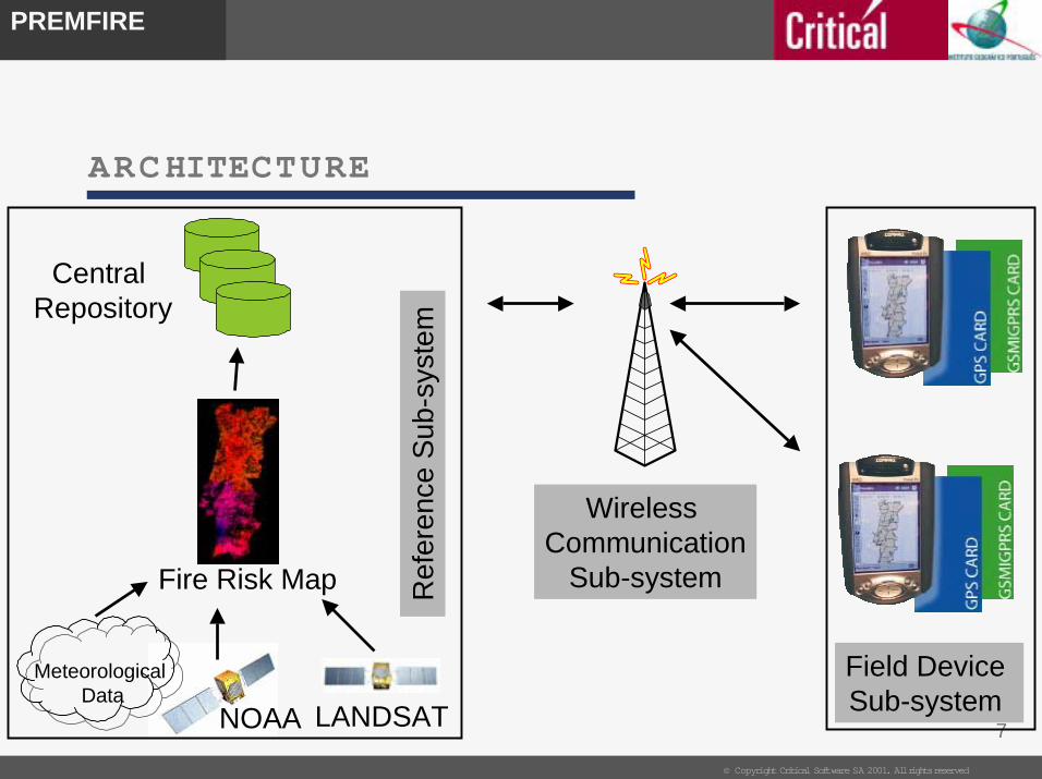
ARCHITECTURE
Central Repository
Wireless Communication
Sub-system
LANDSATNOAA
Fire Risk Map
Field Device Sub-system
Re
fere
nce
Sub
-sys
tem
MeteorologicalData
8
PREMFIRE
© Copyright Critical Software SA 2001. All rights reserved
REFERENCE SUBSYSTE M (1)
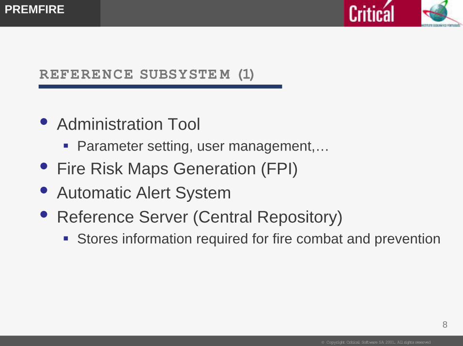
• Administration Tool " Parameter setting, user management,…
• Fire Risk Maps Generation (FPI)
• Automatic Alert System
• Reference Server (Central Repository)" Stores information required for fire combat and prevention
9
PREMFIRE
© Copyright Critical Software SA 2001. All rights reserved
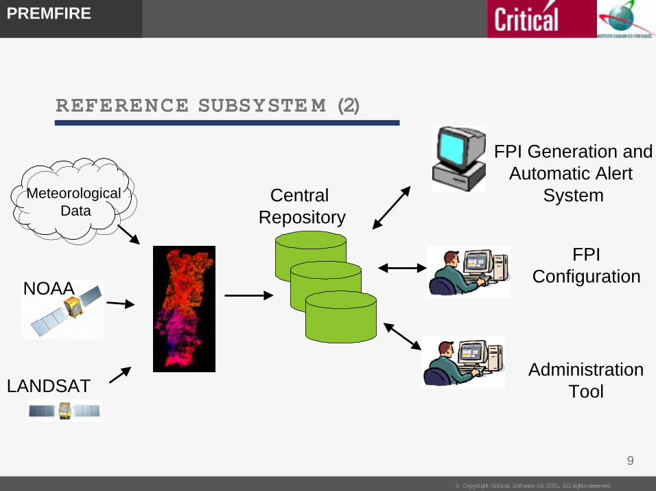
REFERENCE SUBSYSTE M (2)
Central Repository
LANDSAT
NOAA
USER
AdministrationTool
FPIConfiguration
FPI Generation andAutomatic Alert
SystemMeteorologicalData
10
PREMFIRE
© Copyright Critical Software SA 2001. All rights reserved
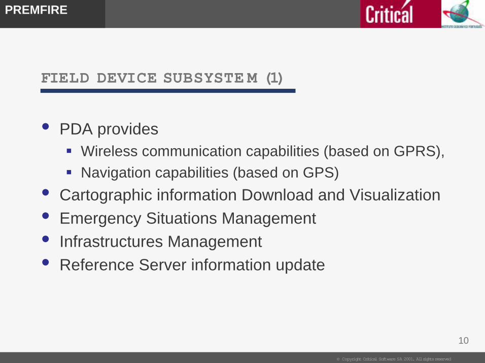
FIELD DEVICE SUBSYSTE M (1)
• PDA provides " Wireless communication capabilities (based on GPRS),
" Navigation capabilities (based on GPS)
• Cartographic information Download and Visualization
• Emergency Situations Management
• Infrastructures Management
• Reference Server information update
11
PREMFIRE
© Copyright Critical Software SA 2001. All rights reserved
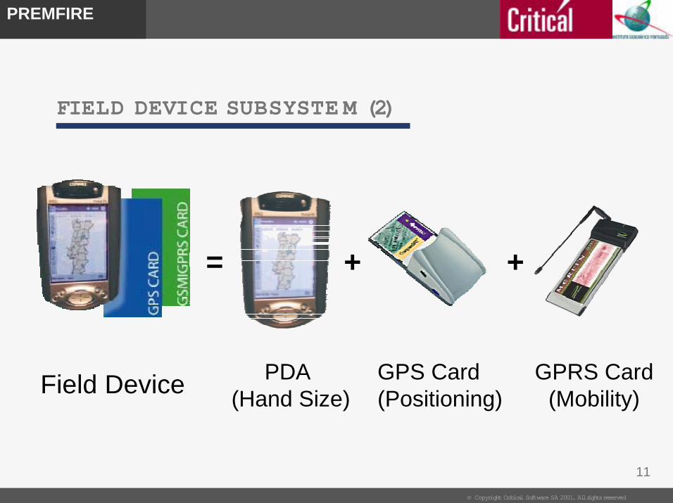
FIELD DEVICE SUBSYSTE M (2)
PDA (Hand Size)
GPS Card(Positioning)
GPRS Card(Mobility)
=
Field Device
+ +
12
PREMFIRE
© Copyright Critical Software SA 2001. All rights reserved
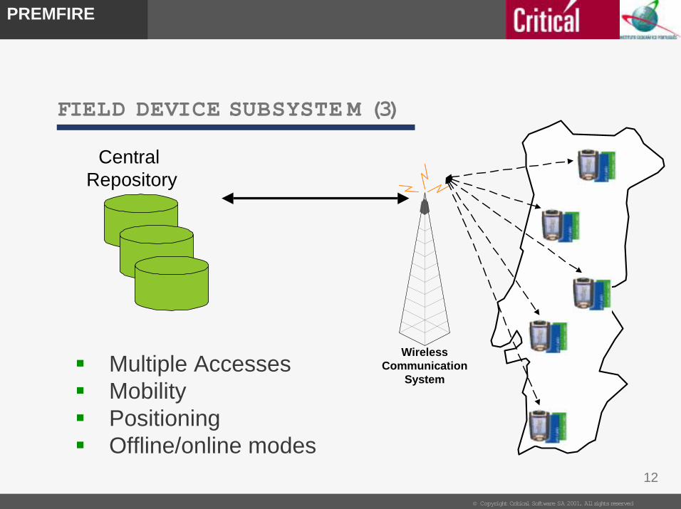
FIELD DEVICE SUBSYSTE M (3)
" Multiple Accesses" Mobility" Positioning" Offline/online modes
Central Repository
WirelessCommunication
System
13
PREMFIRE
© Copyright Critical Software SA 2001. All rights reserved
CO M M UNICATION SUBSYSTE M (1)
• Modular structure (portability in mind)
• Presently using GPRS or GSM technology
• May use other technologies (TETRA, TETRAPOL,
UMTS, etc..),
• Only dependent of availability of hardware cards for
these alternative technologies

14
PREMFIRE
© Copyright Critical Software SA 2001. All rights reserved
Mobile Phone(infrared link)
Wireless Cards
OR
CO M M UNICATION SUBSYSTE M (2)

15
PREMFIRE
© Copyright Critical Software SA 2001. All rights reserved
PROJECT M AIN ACTIVITIES
• Users Requirements definition,
• Solution evaluation and specification
• Fire Risk Map methodology definition
• Software development • FPI generation and automatic alert system,
• Administration tool,
• FPI configuration and Field Device application
• Communication System definition and implementation
• System integration
• System transferencePREMFIRE Project
WP-100 - ProjectManagement & Quality
Assurance
WP-200 - Analysis,Design and
Requirements Definition
WP-300 - Fire risk mapsmethodology
WP-400 - SoftwareDevelopment
WP-700 - SystemValidation, Testing and
Review
WP-600 - SystemIntegration and Service
Implementation
WP-500 - Developmentof the telecommunication
testbed

16
PREMFIRE
© Copyright Critical Software SA 2001. All rights reserved
SCENARIOS FOR EVOLUTION (1)
" Infrastructures Enhancement " Completing the infrastructures set of operations
" Generic module to insert any type of infrastructures
" Enhanced Integration " Migrating the field device software code to C++
" Integrating both field device components
" Communication technologies " Deploy other wireless communication technologies (Tetra, UMTS)
" Portability Enhancement " The GPS coordinates
" The GIS module (adaptable files to allow any coordinate system)
17
PREMFIRE
© Copyright Critical Software SA 2001. All rights reserved
SCENARIOS FOR EVOLUTION (2)
" Leverage the existing infrastruture into other
application fields" Maritime pollution prevention and combat (e.g. oil spills)
" Natural disasters (floods, earthquakes, volcano, etc..)
" Large event management
" Security (Police, national guard,..)
" Etc…
18
PREMFIRE
© Copyright Critical Software SA 2001. All rights reserved
SCENARIOS FOR EVOLUTION (3)
Fire Risk Maps" Development of fuel models and respective dead fuel moisture extinction
values, specifically related to forest classes used on land cover maps
available in Portugal
" Utilization/combination of NDVI data from new sensors with spatial
resolution of 1-km or greater
" Identification of the suitable historical period for the acquisition of
maximum and minimum NDVI historical values
" Optimisation of best interpolation methods for 10-hour time lag dead fuel
moisture estimation
" Identification and inclusion of representative human induced variables in
feasible models of fire risk
19
PREMFIRE
© Copyright Critical Software SA 2001. All rights reserved
PRE MFIRE HIGHLIGHTS
1. Mobile system
2. Hand size system
3. Automatic Alert system for fire prevention
4. User-friendly (visual) interfaces.
5. Full-duplex communications (near real-time)
20
PREMFIRE
© Copyright Critical Software SA 2001. All rights reserved
PRE MFIRE BUSINESS STRATEGY
- PREMFIRE is not an END but the BEGINNING- Productize and market PREMFIRE
- Business opportunities to exploit- Commercialize PREMFIRE solution
- Leverage PREMFIRE infrastructure into other domains
- Demonstrate capabilities and know-how through PREMFIRE
- What we have done so far:- Product Image, Commercial Brochure
- Dissemination in Workshops/Conferences
- Presentation to potential customers
- Presentation to potencial integration partners.

21
PREMFIRE
© Copyright Critical Software SA 2001. All rights reserved
FINAL NOTES
- PREMFIRE will only be a success in the short-term
when fully deployed at SNPC in Portugal.
- PREMFIRE success in the medium/long term should
be measured in terms of new markets and business it
is able to bring to the company.
1
PREMFIREPREMFIRE
-- PREMFIRE PREMFIRE --
Prevention and Mitigation of revention and Mitigation of
Fire Hazard in PortugalFire Hazard in Portugal
FIRE RISK MAPS METHODOLOGYFIRE RISK MAPS METHODOLOGY
Final Meeting[ESA - Rome, 17 January 2003]
Mário CaetanoMário CaetanoHugo Hugo CarrãoCarrãoSérgio FreireSérgio Freire
Portuguese Geographic Institute, PortugalPortuguese Geographic Institute, Portugal
2
PREMFIREPREMFIRE
SummarySummary
• Introduction & Goals
• Fire Risk Mapping
• Proposed Methodology & Data Sets
• Verification & Validation
• Conclusions
3
PREMFIREPREMFIRE
GoalsGoals
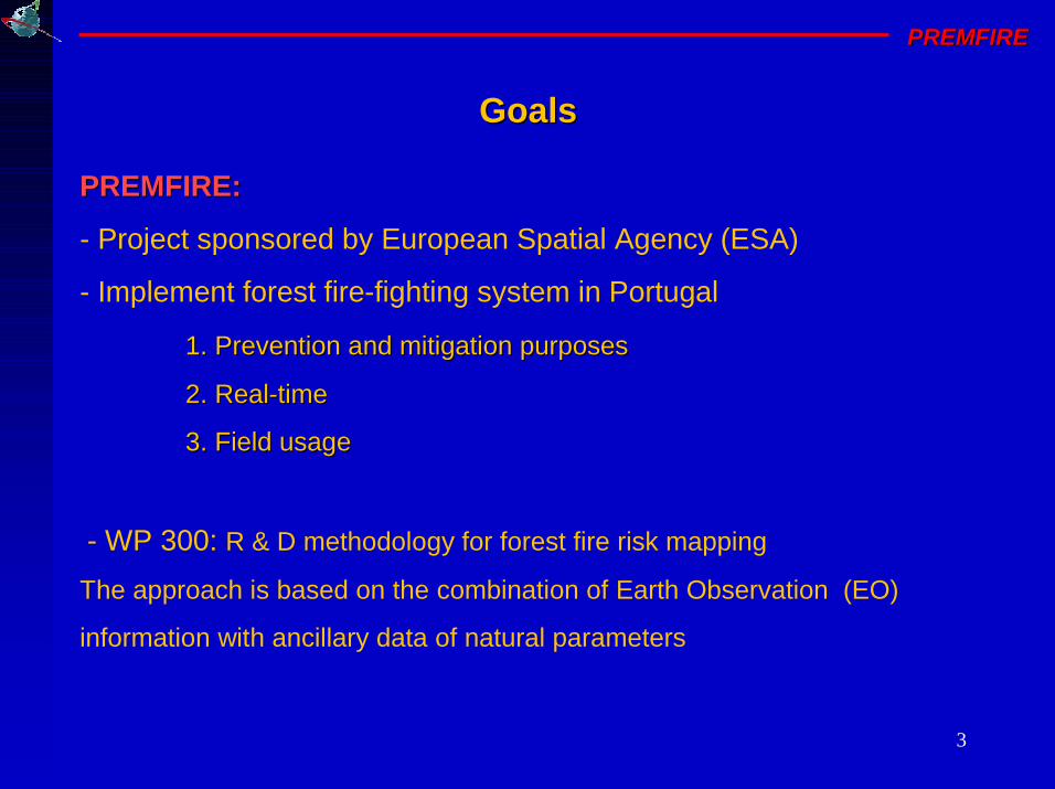
PREMFIRE:PREMFIRE:
- Project sponsored by European Spatial Agency (ESA)
- Implement forest fire-fighting system in Portugal
1. Prevention and mitigation purposes1. Prevention and mitigation purposes
2. Real2. Real--timetime
3. Field usage3. Field usage
- WP 300: R & D methodology for forest fire risk mapping
The approach is based on the combination of Earth Observation (EO)
information with ancillary data of natural parameters
4
PREMFIREPREMFIRE
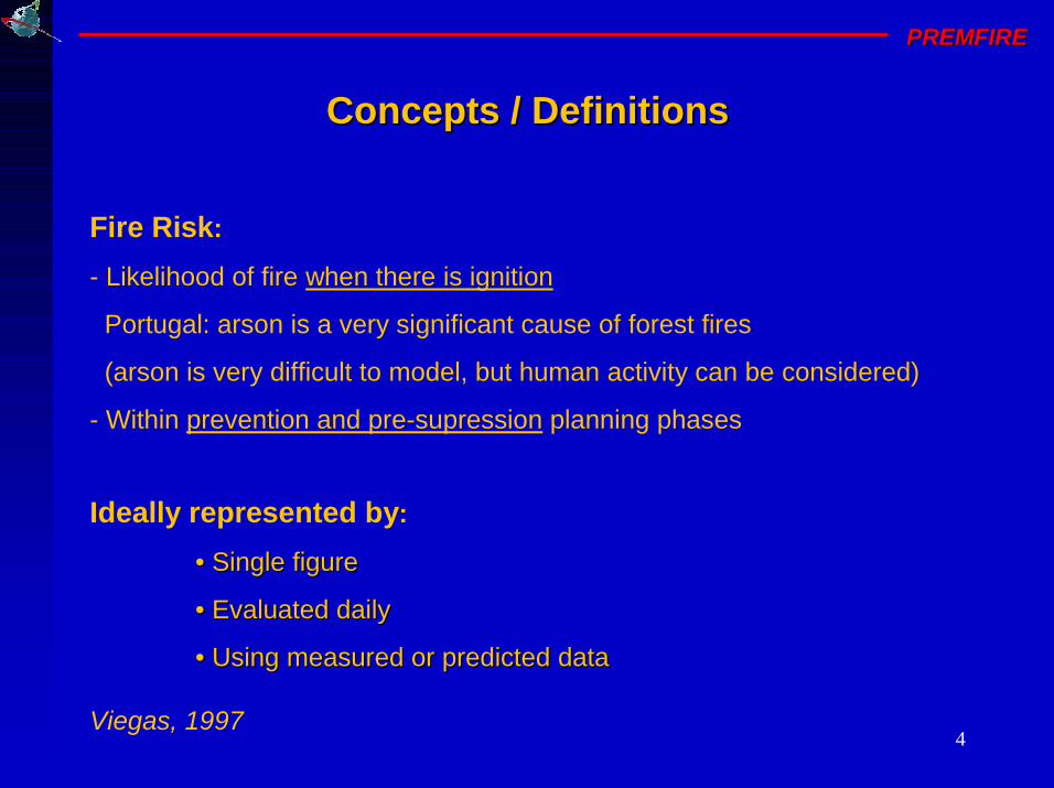
Fire Risk:
- Likelihood of fire when there is ignition
Portugal: arson is a very significant cause of forest fires
(arson is very difficult to model, but human activity can be considered)
- Within prevention and pre-supression planning phases
Concepts / DefinitionsConcepts / Definitions
Ideally represented by:
• Single figure• Single figure
• Evaluated daily• Evaluated daily
• Using measured or predicted data• Using measured or predicted data
Viegas, 1997
5
PREMFIREPREMFIRE
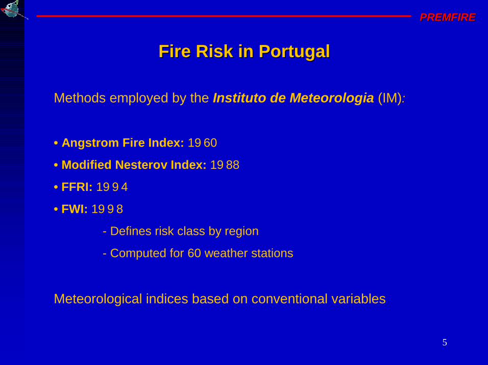
Methods employed by the Instituto de Meteorologia (IM):
• Angstrom Fire Index: 1960
• Modified Nesterov Index: 1988
• FFRI: 1994
• FWI: 1998
- Defines risk class by region
- Computed for 60 weather stations
Meteorological indices based on conventional variables
Fire Risk in PortugalFire Risk in Portugal
6
PREMFIREPREMFIRE
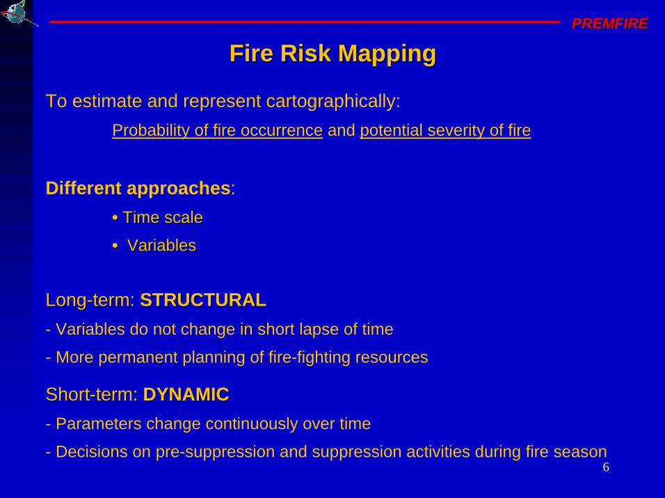
To estimate and represent cartographically:
Probability of fire occurrence and potential severity of fire
Different approaches:
• • Time scaleTime scale
• • VariablesVariables
Fire Risk MappingFire Risk Mapping
ShortShort--term: term: DYNAMICDYNAMIC
- Parameters change continuously over time
- Decisions on pre-suppression and suppression activities during fire season
LongLong--term: term: STRUCTURALSTRUCTURAL
- Variables do not change in short lapse of time
- More permanent planning of fire-fighting resources
7
PREMFIREPREMFIRE
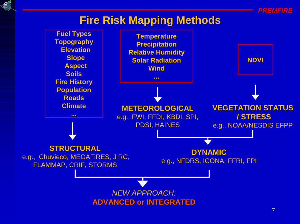
STRUCTURALSTRUCTURALe.g., Chuvieco, MEGAFiRES, JRC,
FLAMMAP, CRIF, STORMS
Fire Risk Mapping MethodsFire Risk Mapping MethodsFuel TypesTopography
ElevationSlope
AspectSoils
Fire HistoryPopulation
RoadsClimate
...
TemperaturePrecipitation
Relative HumiditySolar Radiation
Wind...
NDVI
NEW APPROACH:ADVANCED or INTEGRATEDADVANCED or INTEGRATED
VEGETATION STATUSVEGETATION STATUS/ STRESS/ STRESS
e.g., NOAA/NESDIS EFPP
METEOROLOGICALMETEOROLOGICALe.g., FWI, FFDI, KBDI, SPI,
PDSI, HAINES
DYNAMICDYNAMICe.g., NFDRS, ICONA, FFRI, FPI
8
PREMFIREPREMFIRE
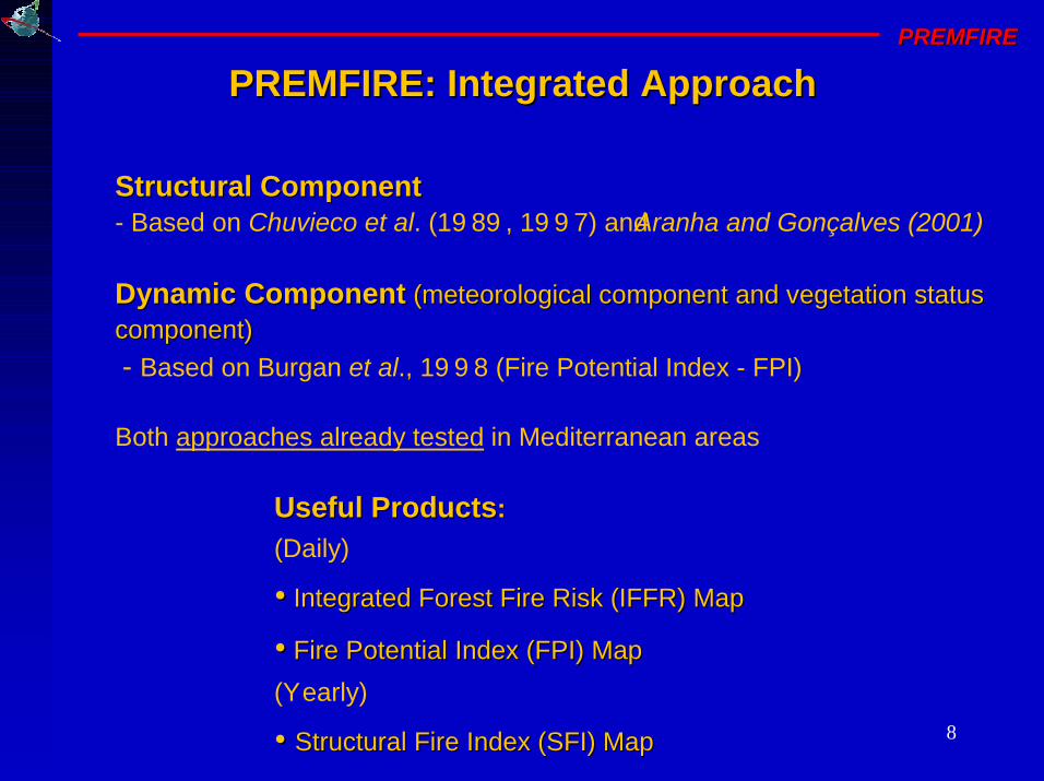
PREMFIRE: Integrated ApproachPREMFIRE: Integrated Approach
Structural ComponentStructural Component- Based on Chuvieco et al. (1989, 1997) and Aranha and Gonçalves (2001)
Dynamic ComponentDynamic Component (meteorological component and vegetation status (meteorological component and vegetation status component)component)
- Based on Burgan et al., 1998 (Fire Potential Index - FPI)
Both approaches already tested in Mediterranean areas
Useful ProductsUseful Products:
(Daily)
•• Integrated Forest Fire Risk (IFFR) MapIntegrated Forest Fire Risk (IFFR) Map
•• Fire Potential Index (FPI) MapFire Potential Index (FPI) Map
(Yearly)
• • Structural Fire Index (SFI) MapStructural Fire Index (SFI) Map
9
PREMFIREPREMFIREIntegrated Forest Fire Risk
Generic flow - chart
UPDATED LAND COVER MAP
URBAN
ROADS
ELEVATION
ASPECT
SLOPE
STRUCTURALINDEX MAP (255-0)
COMBINE
YEARLY
INTEG. FORESTFIRE RISK MAP
(1 - 3)
LIVE FUELRATIO MAP
FRACTIONAL 10-HMOISTURE
NORMALIZE CONVERT TOFRACTION
VEGETATION COMPONENT
10 H FUELMOISTURE MAP
INTERPOLATION
10 H FUELMOISTURE
Temp
Relative Hum.
State of weather
DAILY
METEOROL. COMPONENT
REL. GREENNESSMAP
NDVI MAX. 10-DAYCOMPOSITE
DAILYNDVI
COMPOSITE
HISTORICALNDVI DATA SET
MIN. NDVI
MAX. LIVERATIO MAP
MAX. NDVI
F P INDEXMAP (0 - 100)
FUEL MODEL MAP
DEAD FUEL EXT.MOISTURE %
RECLASSIFY
STRUCTURAL COMPONENT
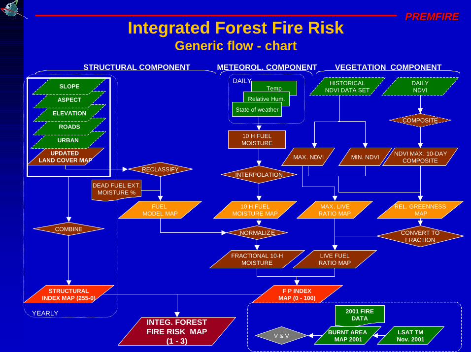
10
PREMFIREPREMFIRE
UPDATED LAND COVER MAP
URBAN
ROADS
ELEVATION
ASPECT
SLOPE
STRUCTURALINDEX MAP (255-0)
COMBINE
YEARLY
Integrated Forest Fire RiskGeneric flow - chart
INTEG. FORESTFIRE RISK MAP
(1 - 3)
LIVE FUELRATIO MAP
FRACTIONAL 10-HMOISTURE
NORMALIZE CONVERT TOFRACTION
VEGETATION COMPONENT
10 H FUELMOISTURE MAP
INTERPOLATION
10 H FUELMOISTURE
Temp
Relative Hum.
State of weather
DAILY
METEOROL. COMPONENT
REL. GREENNESSMAP
NDVI MAX. 10-DAYCOMPOSITE
DAILYNDVI
COMPOSITE
HISTORICALNDVI DATA SET
MIN. NDVI
MAX. LIVERATIO MAP
MAX. NDVI
F P INDEXMAP (0 - 100)
FUEL MODEL MAP
DEAD FUEL EXT.MOISTURE %
RECLASSIFY
STRUCTURAL COMPONENT
LSAT TMNov. 2001
V & V
2001 FIREDATA
BURNT AREAMAP 2001
11
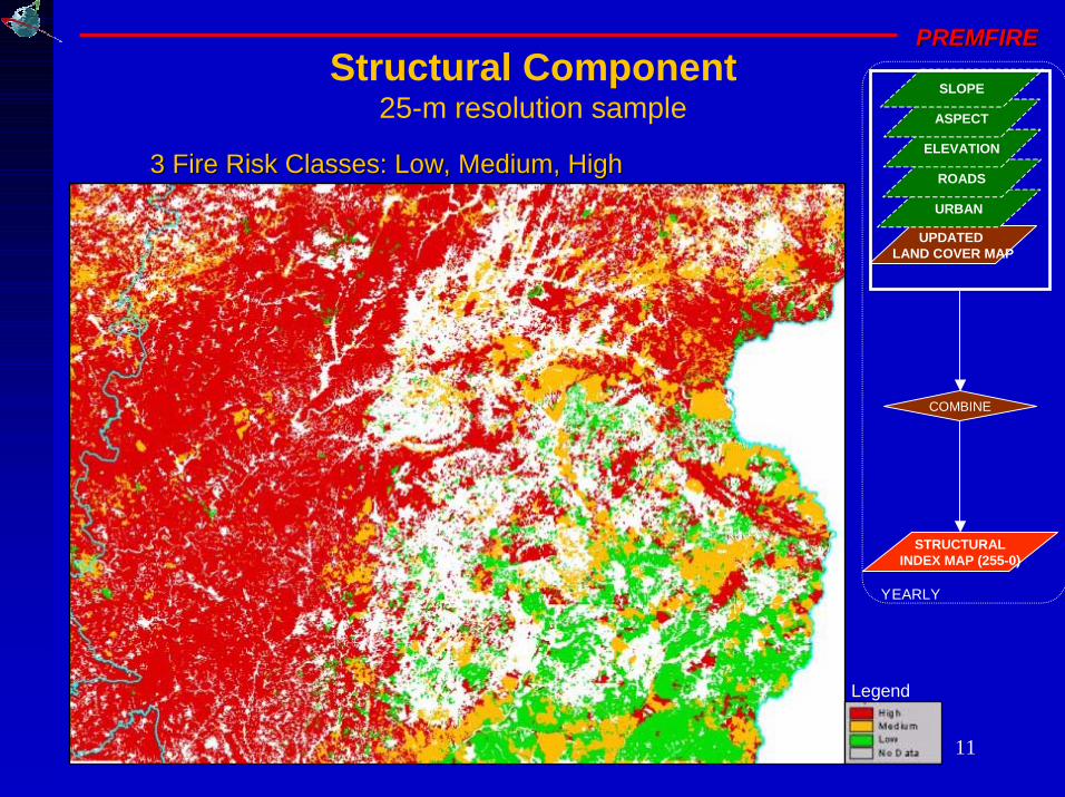
PREMFIREPREMFIRE
Structural Component25-m resolution sample
UPDATED LAND COVER MAP
URBAN
ROADS
ELEVATION
ASPECT
SLOPE
STRUCTURALINDEX MAP (255-0)
COMBINE
YEARLY
3 Fire Risk Classes: Low, Medium, High3 Fire Risk Classes: Low, Medium, High
Legend
12
PREMFIREPREMFIRE
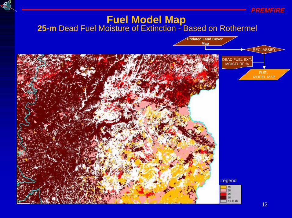
Fuel Model Map25-m Dead Fuel Moisture of Extinction - Based on Rothermel
Updated Land Cover Map
FUEL MODEL MAP
DEAD FUEL EXT.MOISTURE %
RECLASSIFY
Legend
13
PREMFIREPREMFIRE
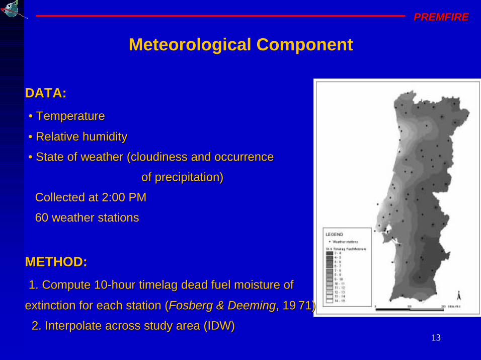
Meteorological Component
DATADATA:
• • TemperatureTemperature
• • Relative humidity Relative humidity
• • State of weatherState of weather ((cloudinesscloudiness and and occurrenceoccurrence
of precipitationof precipitation))
Collected at 2:00 PM
60 weather stations
METHODMETHOD:
1. 1. Compute 10Compute 10--hour hour timelagtimelag dead fuel moisture of dead fuel moisture of
extinction for each station (extinction for each station (FosbergFosberg & Deeming& Deeming, 1971) , 1971)
2. Interpolate across study area (IDW)2. Interpolate across study area (IDW)
14
PREMFIREPREMFIRE
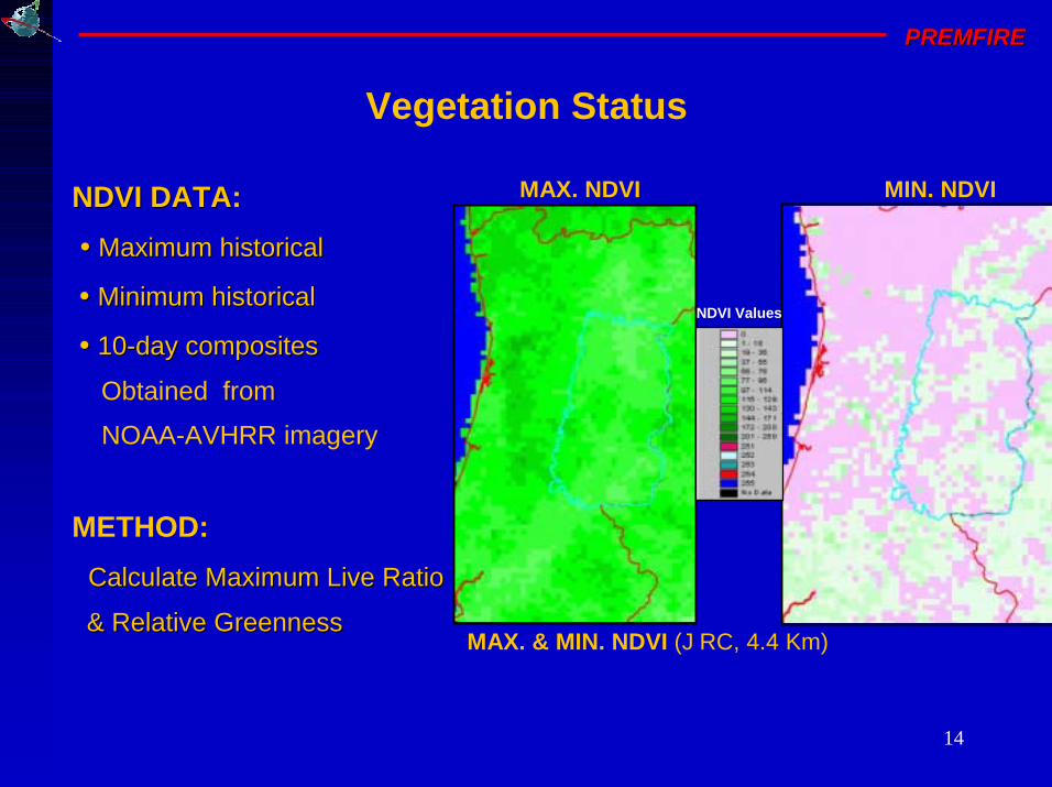
Vegetation Status
NDVI DATANDVI DATA:
• • Maximum historical Maximum historical
• • Minimum historical Minimum historical
• • 1010--day compositesday composites
Obtained from
NOAA-AVHRR imagery
METHOD:
Calculate Maximum Live Ratio Calculate Maximum Live Ratio
& Relative Greenness& Relative GreennessMAX. & MIN. NDVI (JRC, 4.4 Km)
MAX. NDVI MIN. NDVI
NDVI Values
15
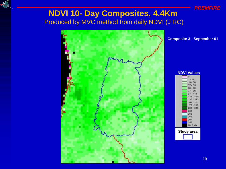
PREMFIREPREMFIRENDVI 10- Day Composites, 4.4Km
Produced by MVC method from daily NDVI (JRC)
NDVI Values
Composite 1 - June 01Composite 2 - June 01Composite 3 - June 01Composite 1 - July 01Composite 2 - July 01Composite 3 - July 01Composite 1 - August 01Composite 2 - August 01Composite 3 - August 01Composite 1 - September 01Composite 2 - September 01Composite 3 - September 01
Study area
16
PREMFIREPREMFIRE
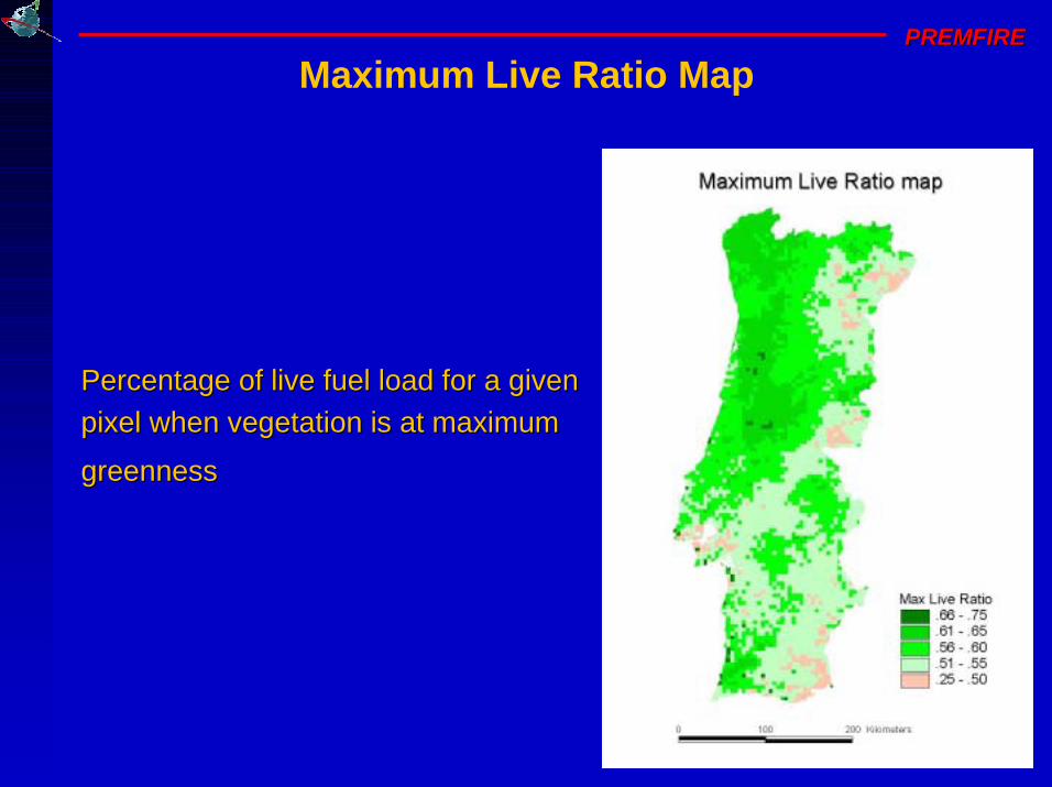
Maximum Live Ratio Map
Percentage of live fuel load for a given Percentage of live fuel load for a given
pixel when vegetation is at maximum pixel when vegetation is at maximum
greennessgreenness

17
PREMFIREPREMFIRE
Fire Potential Index (FPI) Map550-m resolution sample
4 4 Fire RiskFire Risk Classes:Classes:
•• LowLow
•• MediumMedium
•• HighHigh
•• Very highVery high
FPI Values
July 01July 01July 02July 02July 03July 03July 04July 04July 05July 05July 06July 06July 09July 09July 10July 10July 11July 11July 12July 12July 13July 13July 14July 14July 15July 15July 16July 16July 17July 17July 18July 18July 19July 19July 20July 20
1
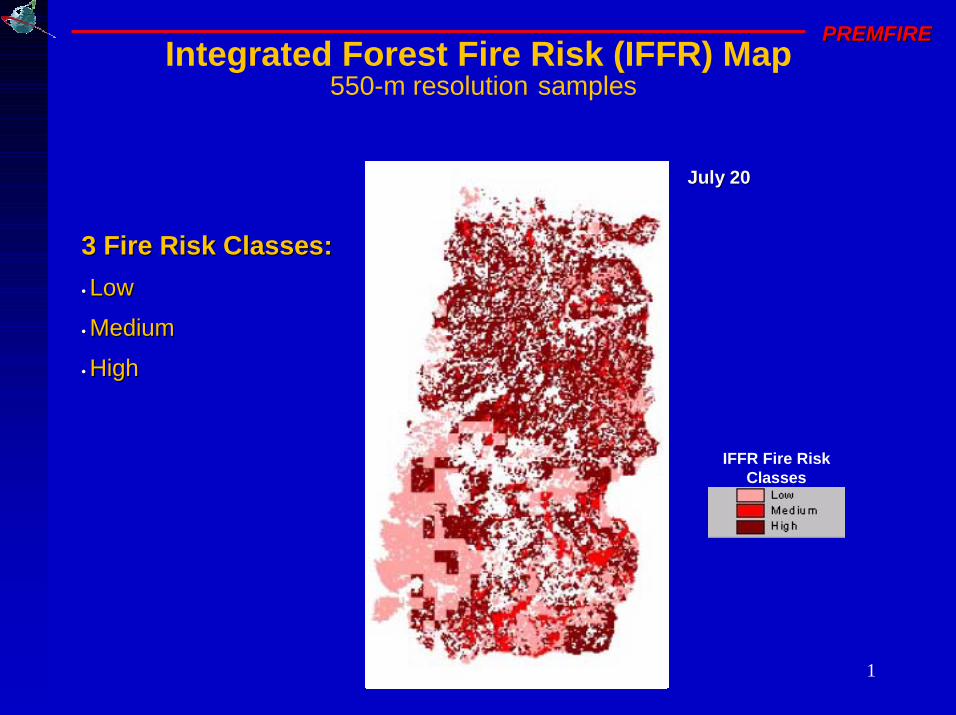
PREMFIREPREMFIREIntegrated Forest Fire Risk (IFFR) Map
550-m resolution samples
3 3 Fire RiskFire Risk Classes:Classes:
•• LowLow
•• MediumMedium
• • HighHigh
July 01July 01July 02July 02July 03July 03July 04July 04July 05July 05July 06July 06July 09July 09July 10July 10July 11July 11July 12July 12July 13July 13July 14July 14July 15July 15July 16July 16July 17July 17July 18July 18July 19July 19July 20July 20
IFFR Fire Risk Classes
2
PREMFIREPREMFIRE
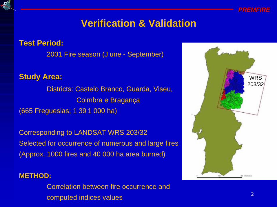
Verification & Validation
Test Period:Test Period:
2001 Fire season (June - September)
Study Area:Study Area:
Districts: Castelo Branco, Guarda, Viseu,
Coimbra e Bragança
(665 Freguesias; 1 391 000 ha)
Corresponding to LANDSAT WRS 203/32
Selected for occurrence of numerous and large fires
(Approx. 1000 fires and 40 000 ha area burned)
METHOD:METHOD:
Correlation between fire occurrence and
computed indices values
WRS203/32

3
PREMFIREPREMFIRE
RGB 432RGB 432
Burnt Area Map
DATA:
LandsatLandsat 5 TM, 9/04/20015 TM, 9/04/2001
LSAT TMNov. 2001
V & V
2001 FIREDATA
BURNT AREAMAP 2001
RGB 432RGB 432
LandsatLandsat 7 ETM, 11/11/20017 ETM, 11/11/2001
Ignition pointsIgnition points (DGF)(DGF)
METHOD:
Change detection in 2001
(MapUp) &
visual analysis (RGB 743)
11/11/200111/11/200109/04/200109/04/2001
RGB 432RGB 432RGB 432RGB 432
4
PREMFIREPREMFIRE
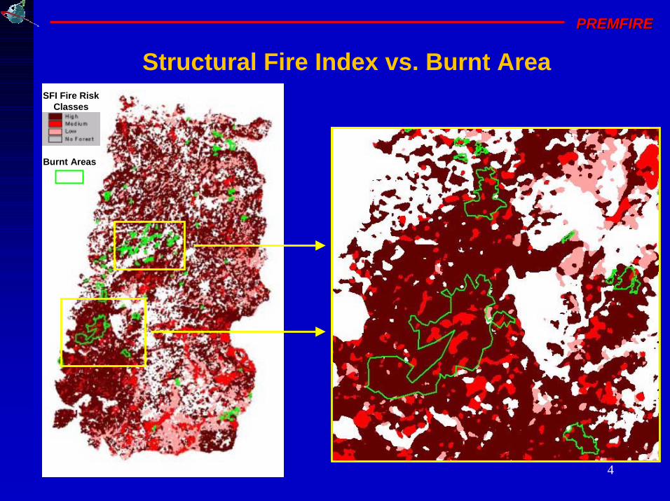
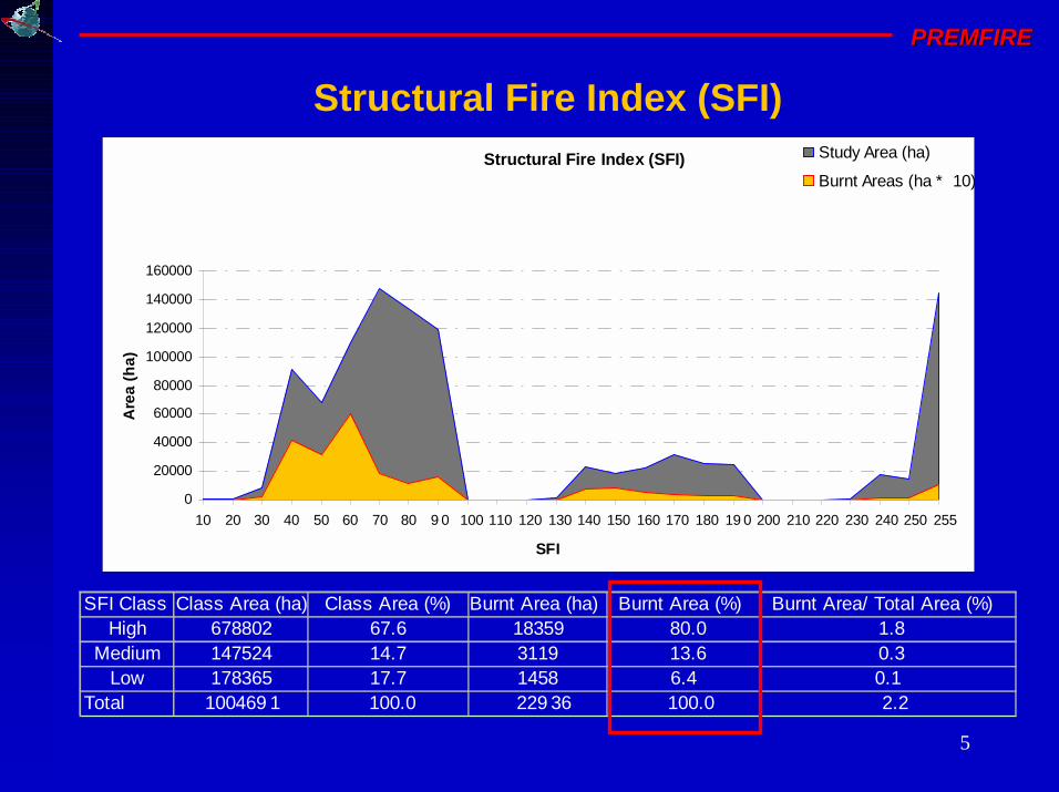
SFI Fire Risk Classes
Burnt Areas
Structural Fire Index vs. Burnt Area
5
PREMFIREPREMFIRE
Structural Fire Index (SFI)
Structural Fire Index (SFI)
0
20000
40000
60000
80000
100000
120000
140000
160000
10 20 30 40 50 60 70 80 90 100 110 120 130 140 150 160 170 180 190 200 210 220 230 240 250 255
SFI
Are
a (
ha
)
Study Area (ha)
Burnt Areas (ha * 10)
SFI Class Class Area (ha) Class Area (%) Burnt Area (ha) Burnt Area (%) Burnt Area/ Total Area (%)High 678802 67.6 18359 80.0 1.8
Medium 147524 14.7 3119 13.6 0.3Low 178365 17.7 1458 6.4 0.1
Total 1004691 100.0 22936 100.0 2.2
6
PREMFIREPREMFIRE
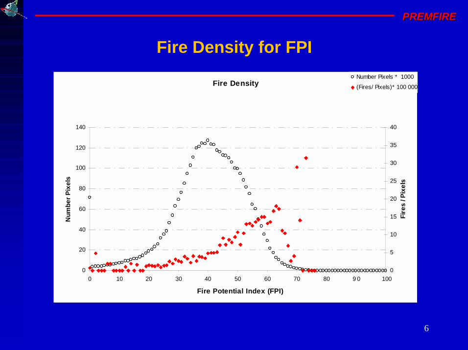
Fire Density for FPI
Fire Density
0
20
40
60
80
100
120
140
0 10 20 30 40 50 60 70 80 90 100
Fire Potential Index (FPI)
Nu
mb
er
Pix
els
0
5
10
15
20
25
30
35
40
Fir
es
/ P
ixe
ls
Number Pixels * 1000
(Fires/ Pixels)*100 000
7
PREMFIREPREMFIRE
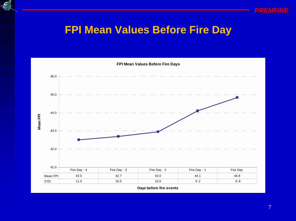
FPI Mean Values Before Fire Days
41.0
42.0
43.0
44.0
45.0
46.0
Days before fire events
Mea
n F
PI
Mean FPI 42.5 42.7 43.0 44.1 44.8
STD 11.0 10.5 10.0 9.2 9.8
Fire Day - 4 Fire Day - 3 Fire Day - 2 Fire Day - 1 Fire Day
FPI Mean Values Before Fire Day

8
PREMFIREPREMFIRE
Fire Density
0
20
40
60
80
100
120
140
160
180
200
0 1 2 3 4
Integrated Fire Risk (IFR)
Nu
mb
er P
ixel
s
0
2
4
6
8
10
12
Fir
es /
Pix
els
Number Pixels * 10 000
(Fires/ Pixels)*10 000
Fire Density for IFFR
9
PREMFIREPREMFIRE
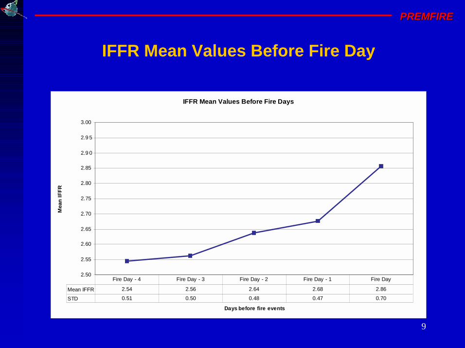
IFFR Mean Values Before Fire Days
2.50
2.55
2.60
2.65
2.70
2.75
2.80
2.85
2.90
2.95
3.00
Days before fire events
Mea
n I
FF
R
Mean IFFR 2.54 2.56 2.64 2.68 2.86
STD 0.51 0.50 0.48 0.47 0.70
Fire Day - 4 Fire Day - 3 Fire Day - 2 Fire Day - 1 Fire Day
IFFR Mean Values Before Fire Day
10
PREMFIREPREMFIRE
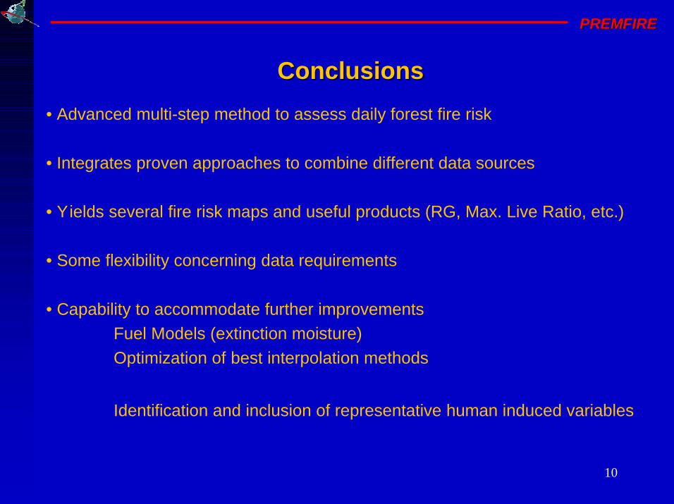
ConclusionsConclusions
• Advanced multi-step method to assess daily forest fire risk
• Integrates proven approaches to combine different data sources
• Yields several fire risk maps and useful products (RG, Max. Live Ratio, etc.)
• Some flexibility concerning data requirements
• Capability to accommodate further improvements
Fuel Models (extinction moisture)
Optimization of best interpolation methods
Identification and inclusion of representative human induced variables
11
PREMFIREPREMFIRE
AknowledgementsAknowledgements
European Space Agency (ESA)
Joint Research Centre of the European Commission (JRC)
Instituto de Meteorologia (IM)
Direcção Geral das Florestas (DGF)
Robert Burgan (USDA Forest Service, USA)
Paulo Barbosa (JRC)
Giorgio Libertà (JRC)
Ana Sebastian (JRC)
José Aranha (UTAD)
This research was funded by ESA under the PREMFIRE project
(ESA Ref. AO/1-3880/01/I-SB).
12
PREMFIREPREMFIRE
-- PREMFIRE PREMFIRE --
Prevention and Mitigation revention and Mitigation
of of
Fire Hazard in PortugalFire Hazard in Portugal
Mário CaetanoMário [email protected]
Portuguese Geographic Institute, PortugalPortuguese Geographic Institute, Portugalwww.www.igeoigeo.pt.pt