Embed Size (px)
Citation preview
l l l l l l l l l l l l l l l l l l l
42A04NW8553 3 .11712 KENOGAMING 010
PRELIMINARY REPORT on theOutcrop Stripping - Trenching Program
Reeves Joint Venture Propertyfor
GLEN AUDEN RESOURCES LIMITEDand
GOLDROCK RESOURCES INC.by
Ron Burk, M.Sc.Eng, August 10, 1988
i H
LANDS SECTION
M-223
l l l l l l l l l l l l l l l l l l l
42A04NW8553 Z . 11712 KENOGAMING 010C
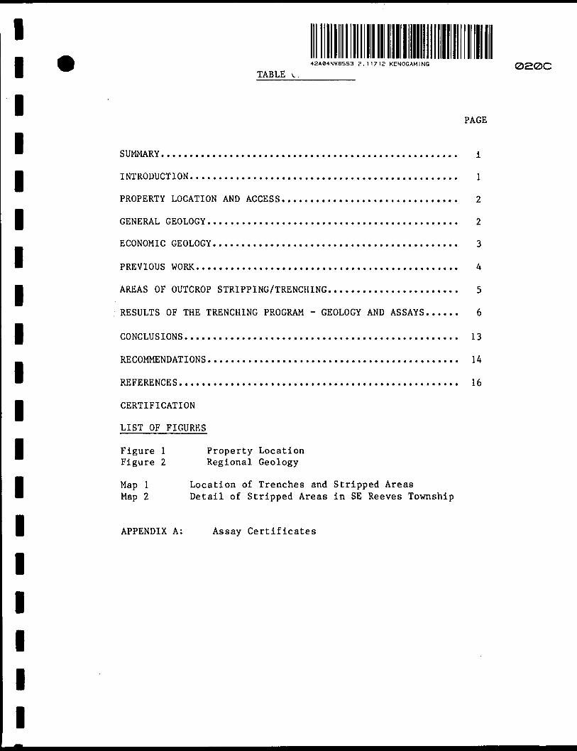
TABLE OF CONTENTS
INTRODUCTION.
AREAS MARKED FOR OUTCROP STRIPPING/TRENCHING.
COMPLETED WORK.
CERTIFICATION
PAGE
l
1
2
LIST OF FIGURES
Figure l Map l Map 2
Property Location Property Claim Map Trench Locations

l l
l
INTRODUCTION
l A program of mechanical outcrop stripping and trenching was
initiated by Glen Auden Resources and Goldrock Resources in June,
~ -1988 on their jointly held Reeves Joint Venture (RJV) property
B located in Reeves, Sewell, Kenogaming and Penhorwood Townships.
This work is being done to follow-up geologic mapping,
l geophysical surveying (ground magnetics and induced polarization
methods) and a limited amount of outcrop stripping done in
B November, 1987. Specifically, the trenching will attempt to
H expose areas marked by chargeability/resistivity (IP) anomalies
which ideally indicate concentrations of sulfide mineralization,
l Machinery being used for this work consists of a D7F Caterpillar
bulldozer and a 945 Caterpillar excavator. Bedrock exposed by
the stripping and trenching is being mapped and sampled for gold
content. High-pressure water pumps are being used to wash loose
dirt and rubble from the bedrock surfaces. In trenches where
l bedrock is not reached samples of glacial till will be collected
and analyzed for gold.
M AREAS MARKED FOR OUTCROP STRIPPING/TRENCHING
Geologic mapping and the interpretation of airborne and
l ground magnetics survey data suggest that within the mafic
volcanic sequences which underlie much of the RJV property there
' are westerly and southwesterly striking high strain deformation
l
l
l
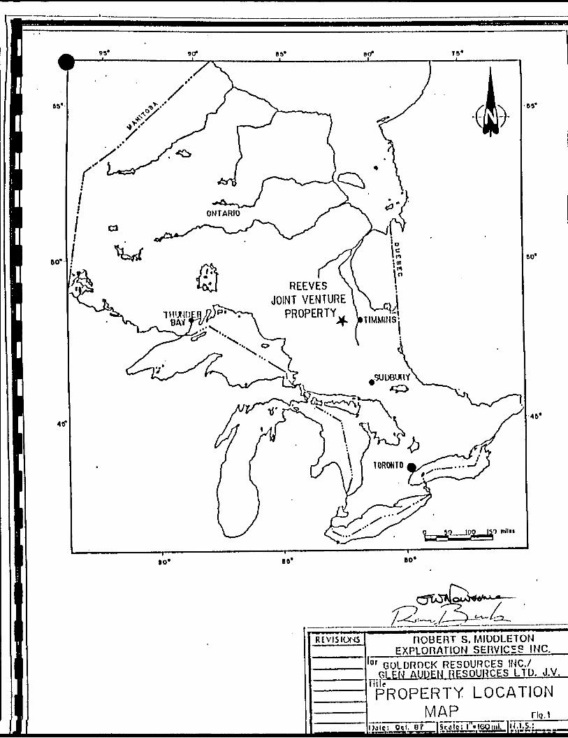
REEVES JOINT VENTURE
lo* BO*
REVISIONS ROBERT S. MIDDLETON EXPLOnATION SERVICES INC.
lor GOLDROCK RESOURCES INC./ GLEN AUDEN RESOURCES LTD. J.V.
Tilir
PROPERTY LOCATIONMAP Flq.l
i Oct. gf 1 Sf.jioil"*i60nil, 1U. L S.!_____
l- 2 -
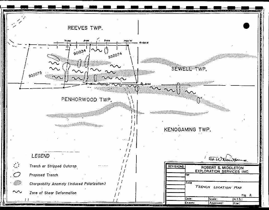
lzones. These zones are considered to be prospective areas for
l gold mineralization. Chargeability anomalies located
coincidently with the interpreted positions of the deformation
zones represent the higher priority targets for the current
B trenching program (Map 2, see back pocket).
The southeast corner of Reeves Township is one area where
l mapping has identified a wide zone of highly sheared and
chemically altered rock which is also marked by a series of
B chargeability anomalies. Other target areas are located within
B 1500 meters northwest and southwest of Deerfoot Lake in
Kenogaming Township. A group of induced polarization anomalies
l in Penhorwood Township which are associated with a sheared
ultramafic unit altered to a talc-carbonate, and locally
B fuchsitic schist will also likely be trenched. Map 2 shows the
tt location of the more prominent chargeability anomalies which have
been targeted for trenching.
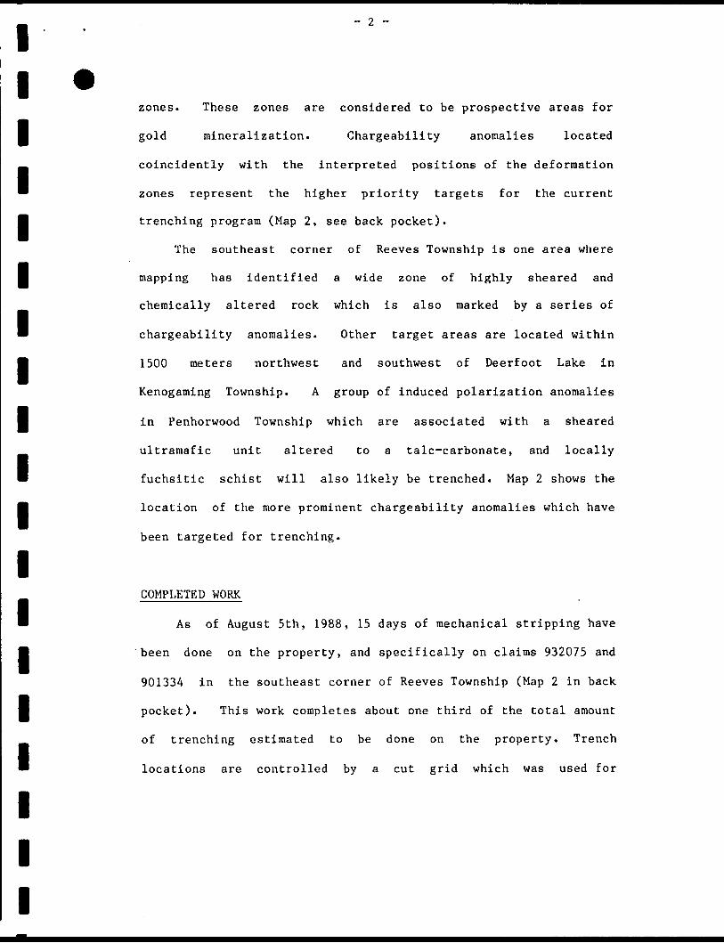
lCOMPLETED WORK
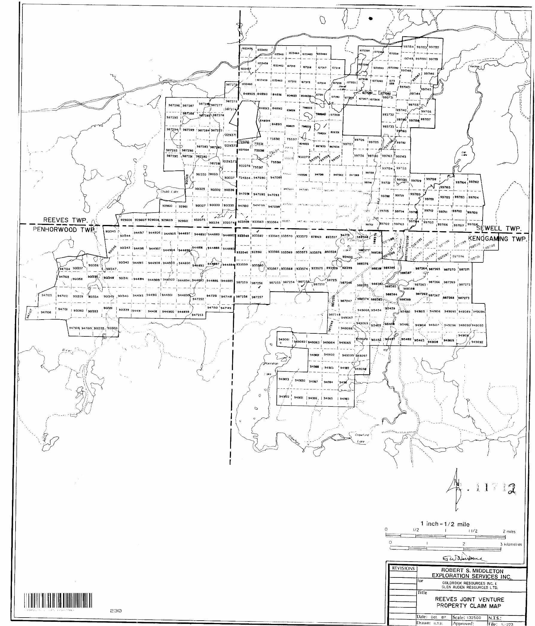
B As of August 5th, 1988, 15 days of mechanical stripping have
H 'been done on the property, and specifically on claims 932075 and
901334 in the southeast corner of Reeves Township (Map 2 in back
B pocket). This work completes about one third of the total amount
of trenching estimated to be done on the property. Trench
B locations are controlled by a cut grid which was used for
l
l
l
o
YC^ 4W#^;# M#^\y^ . \
PENHORWOOD TWP.
LEGEND . '
Trench or S tripped- Outcrop
Proposed Trench
Chargeability Anomaly (Induced Polarization)
Zone of Shear Deformation
11
/;;
li li
l
fir
KENOGAMING TWP.
REVISJOS ROBERT S. MIDDLETON EXPLORATION SERVICES INC,
for
JitleTR.EHCH LOCATION MAP
Fig. ZDale: Drawn:
Scale: j Approved:
ll *
geophysical surveying. An east-west base-line follows the
l Reeves/Penhorwood and Sewell/Kenogaming township lines, with the
0+OOE/O+OON grid coordinate located at the mutual corner point of
B the four townships.
B The main area of stripping so far has been on line 7+OOW,
between 0+50N and 2+50N (see Map 2). An area of 1500 square
B meters which has been stripped between 7+OOW/1+75N and
7+OOW/2+OON has exposed highly deformed and altered mafic
B volcanic rock consisting of chlorite, sericite and iron
B carbonate. Narrow, discontinuous quartz veins (stringers) are
locally abundant. Schist rock hosting these veins contains
l appreciable concentrations of pyrite. There is also a number of
westerly trending ankerite-quartz veins, 20 to 50 centimeters
B wide, which are exposed in the outcrop.
m Trenches at 8+50W/2+75N, 7+OOW/2+25N and 5+80W/2+15N have
exposed a grey coloured, relatively massive rock which has been
l strongly ankeritized and is locally pyritic. This rock appears
to be highly altered greywacke. Spatially associated with this
B rock are narrow zones or units of dark grey, carbonaceous schist
B commonly containing 20 to 40 percent pyrite.
The trenching work done to date has been successful in
l uncovering previously unknown zones of shear deformation,
alteration, quartz veining and pyrite mineralization, as well as
B expanding existing exposures of such rock. Overburden
l
l
l
l
lthicknesses have not exceeded the depth penetration of the
l excavator, however, eastwards from the completed trenches the
. overburden is expected to be thicker, and consequently sampling
l of glacial till instead of bedrock may have to be done.
l Respectfully submitted
lRon Burk, M.Sc.Eng.
- W*
l
l
l
l
l
l
l
lB
l
l
l
11
1
1111111111
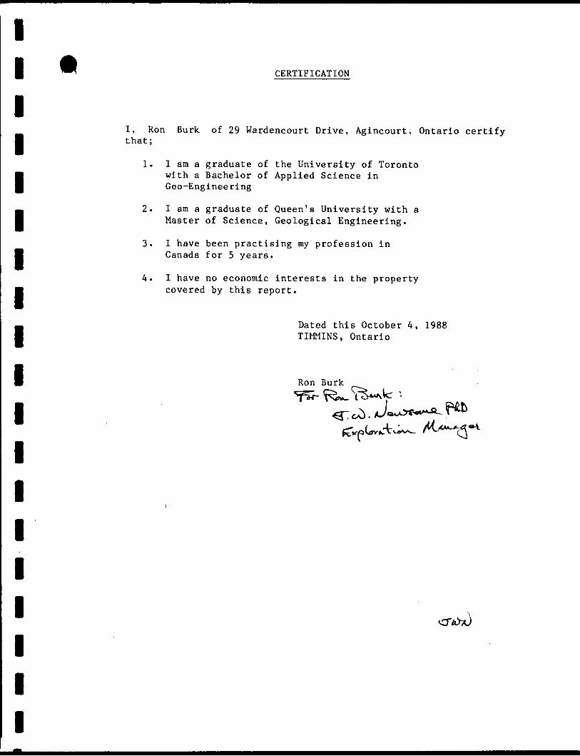
CERTIFICATION
I, Ron Burk of 29 Wardencourt Drive, Agincourt, Ontario certify that;
1. I am a graduate of the University of Toronto
with a Bachelor of Applied Science in Geo-Engineering
2. I am a graduate of Queen's University with a l Master of Science, Geological Engineering.
I have been practising my profession in Canada for 4 years.
4. I have no economic interests in the property M covered by this report.
Dated this August 10, 1988 l TIMMINS, Ontario
Ron Burk
C-C
l l l l l l l l l l l l l l l l l l l
42A04NW8553 2 .11712 KENOGAMING 020
REPORT on the OUTCROP STRIPPINGand
TRENCHING PROGRAMon the
Reeves Joint Venture Propertyfor
GLEN AUDEN RESOURCES LIMITEDby
Ron Burk, M.Se. Eng. October, 1988
n i: c; r. i v i: D
!i;!KG LANDS SECTION
M-223
l l l l l l l l l l l l l l l l l l l
42Ae4NW8553 2.11712 KENOGAMING
TABLE
SUMMARY.
INTRODUCTION..
PROPERTY LOCATION AND ACCESS..........................
GENERAL GEOLOGY
ECONOMIC GEOLOGY.
PREVIOUS WORK
AREAS OF OUTCROP STRIPPING/TRENCHING..................
RESULTS OF THE TRENCHING PROGRAM - GEOLOGY AND ASSAYS.
CONCLUSIONS
RECOMMENDATIONS
REFERENCES.
CERTIFICATION
LIST OF FIGURES
PAGE
i
1
2
2
3
4
5
6
13
14
16
Figure l Figure 2
Map l Map 2
APPENDIX A:
Property Location Regional Geology
Location of Trenches and Stripped Areas Detail of Stripped Areas in SE Reeves Township
Assay Certificates
020C
l l l l l
l
l l
j —.
SUMMARY
A program of mechanical outcrop stripping and trenching was
carried out from July 14 to September 9, 1988 on the Reeves Joint
l Venture mining property located in Reeves, Sewell, Kenogaming and
Penhorwood Townships, Porcupine Mining Division, approximately 55
l km west of Timmins, Ontario. This work has exposed a westerly
trending zone of high strain deformation, 150 meters wide and
likely more than one kilometer in length, in southeastern Reeves
l Township. This zone is characterized by the development of
strongly foliated chlorite-ankerite schist, drag folding of the
f schist, and the presence of ankerite-quartz veins. More than 200
B - rock channel samples were taken from stripped areas along this
deformation zone. Assays show that sheared and carbonatized
l mafic volcanic rock rarely contains anomalous amounts of gold,
but that pyrite-rich, chlorite or sericite schist is weakly
enriched in gold.
The outcrop stripping has, however, uncovered a new gold
occurrence on claim 932074 in the southeast corner of Reeves
l Township. The showing consists of a narrow quartz vein with
visible native gold that dips at a moderate angle to the
l
ll
southwest apparently orthogonal to the plunge of a fold which is
l developed in the chlorite-iron carbonate schist, or host rock of
the vein.
' It is recommended that additional stripping/trenching be
H done in the immediate area of the gold-bearing vein. As well, a
number of short diamond drill holes are proposed to test for the
l presence of hidden veins oriented parallel to the known vein.
The major shear zone exposed by the stripping program also
B warrants more exploration work. A number of widely spaced,
H relatively long drill holes drilled northwards through the shear
zone would test for potential vein systems hidden by low-lying
l ground bordering a north-northeasterly flowing creek which occurs
north of the stripped areas.
l
l
l
l
l
l
l
l
l
l l
INTRODUCTION
l Mechanical outcrop stripping and trenching was done from
July 14 to September 9 1988 on the Reeves Joint Venture (RJV)l '" property located in Reeves, Sewell Kenogaming and Penhorwood
fl Townships. Porcupine Mining Division. Ontario. The property is
jointly held by Toronto-based junior mining companies, Glen Auden
l Resources Limited and Goldrock Resources Inc. This work was done
to follow-up geologic mapping, geophysical surveying (ground
H magnetics and induced polarization methods), and a limited amount
B of outcrop stripping done in October, 1987. The trenching has
exposed bedrock areas marked by chargeability (IP) anomalies
l which were interpreted as sites of disseminated sulfide
mineralization.
B The machinery used for the trenching consisted of a D7F
M Caterpillar bulldozer and a 945 Caterpillar excavator. A
high-pressure water pump was used to wash loose dirt and rubble
l from bedrock surfaces. Exposed bedrock was then mapped at 1:200
scale and sampled for gold content. Approximately 250 rock
l channel samples, cut with a power rock saw (using carbide blades)
H and typically one meter in length, were analyzed by Technical
Services Laboratories in Timmins using the fire assay/atomic
l . absorption method.
l
l
l
l
l l
l l l
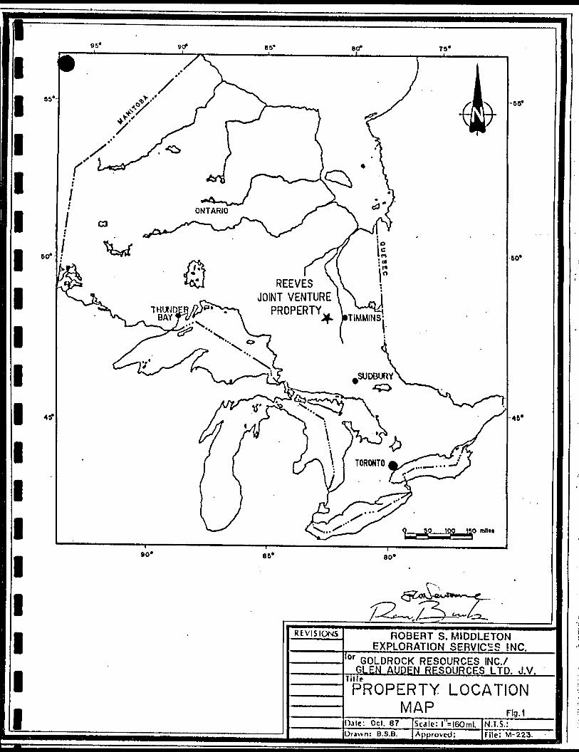
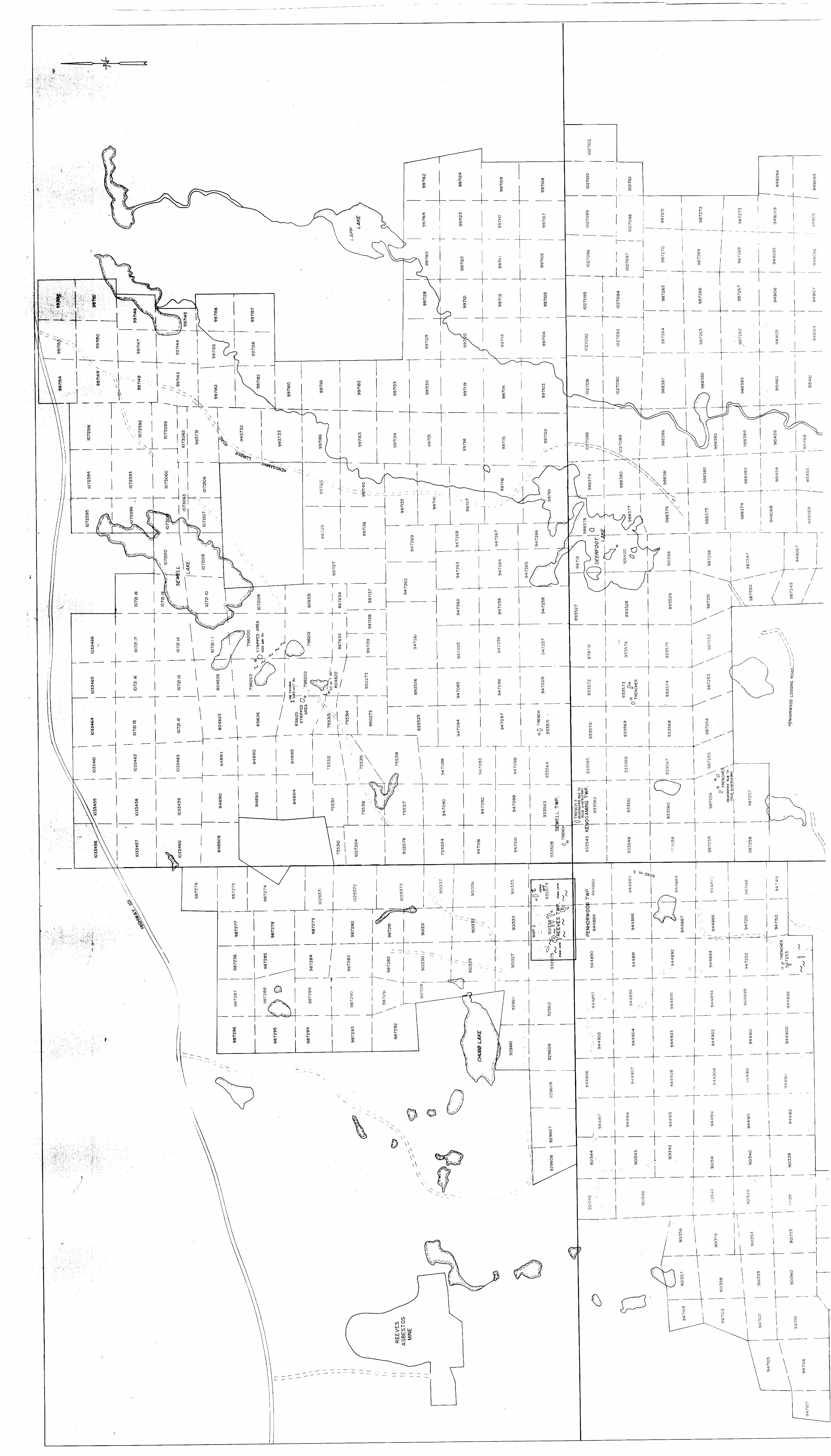
PROPERTY LOCATION AND ACCESS
l The Reeves Joint Venture (RJV) property consists of 427
contiguous unpatented mining claims encompassing approximately
B 6,850 hectares which are broadly centred on the four-corner
B junction of Reeves, Sewell, Kenogaming and Penhorwood Townships,
some 55 kilometers west of Timmins, Ontario (Figure 1). Access
l to the property is via Highway 101 which skirts the northern
boundary of the property, and the main Kenogaming logging road.
B Branching northwards from the Kenogaming road is logging road #3
H which directly accesses the area of the property where most of
the trenching was done.
lGENERAL GEOLOGY
B The Reeves Joint Venture property lies in the northern part
fl of the Archean-age Swayze Greenstone Belt (Figure 2) and covers
typical sequences of mafic submarine flows and less abundant
l Intermediate to felsic volcanics (Milne, 1972: Burk, 1987).
Exposures of sedimentary rocks are sparse on the property, though
B two prominent units of oxide and sulfide facies banded iron
j formation have been identified. Intrusive sheets and pods of
ultramafic and mafic rocks are common, particularly in the
l western and southeastern portions of the claim group.
l l l l l l l l l l l l l l l l l i
85*-
REEVESVENTURE
PROPERTY
80*
REVISIONS ROBERT S. MIDDLETON EXPLORATION SERVICES INC.
for GOLDROCK RESOURCES INC./ GLEN AUDEN RESOURCES LTD. J.V.
TitlePROPERTY LOCATION
MAP Flg .iOjle: Oct. 87Drawn: B.S.B.
Scale: l s|60mi.Approved:
N.T.S.:File: M-223.

1 Mafic lo Intermediate Volcanic Rocks2 Felsic lo Intermediate Volcanic Rocks3 Clastic Sedimentary Rockt4 —*— Iron Formallon5 Mafic lo Ullromoflc Intrusive Rock*6 Felsic Porphyry7 Granitoid Intrusive RocksB Diabase
A Mineral Occurrence
" Mines
~~ Deformation Zone
—— Fault
—— — Geological Boundary—@- Highway '
— - Gravel Road
4—*- Railway
—— Properly Boundary
REVISIONS ROBERT S. MIDDLETONEXPLORATION SERVICES INC.
GLEN AUDEN RESOURCES LTD.
REEVES JOINT VENTURE PROPERTY AND REGIONAL GEOLOGY
2LUlt: Aug. 66 Solf.l" . 4ml. N.T.S.! Uriwn: Approved:___ fitt.' M-gg3
l
l
- 3 -
l
l
l
l
l
ECONOMIC GEOLOGY
l Geologic mapping done in 1987 (Burk, 1987) and the
interpretation of airborne and ground magnetics survey data
l indicate that within the mafic volcanic sequences underlying much
m of the RJV property there are westerly and southwesterly
striking, high strain deformation zones which are deemed to be
l prospective areas for gold mineralization. Chargeability
anomalies located coincidently with these deformation zones
B constitute particularly attractive targets for detailed
m exploration work. One such target area is in the southeast
corner of Reeves Township (claims 932075 and 901334) where
l mapping has identified a wide zone of highly sheared and
hydrothermally altered rock which is also marked by a series of
B chargeability anomalies. Old reports from the files of the
m Ministry of Northern Development and Mines describe trenching
work done in this area of Reeves Township in 1935-36 by Erie
l Canadian Mines. This early work was done to locate the source of
black, pyritic quartz rubble evidently containing visible gold
l and assaying 0.14 ounces gold per ton which was discovered in the
m area. In addition, in 1946, Kalbrook Mining drilled 13 holes in
the vicinity of the "float" trench. Apparently no economic gold
mineralization was encountered, although drill logs are not
available.
l
l
l
l
- 4 -
l
l
l
l
l
PREVIOUS WORK
The geology of the original 267 claims of the RJV property
was most recently mapped in the 1987 field season and is
described by Burk (1987). Early in 1988, eighty-six kilometers
of cut grid lines located within the limits of the original claim
group were surveyed with a magnetometer (Burk, 1988A). In June,
l 1988, an induced polarization survey was done on approximately 26
line-kilometers of the same grid, specifically in areas where
P geologic mapping and the magnetic data suggested good potential
M for shear zone-hosted sulfide mineralization (report in
progress),
l In addition to the geologic mapping and geophysical
surveys, mechanical stripping and trenching was carried out in
P October, 1987 in the southeast corner of Reeves Township, eastern
| Penhorwood Township, and just west of Deerfoot Lake in Kenogaming
Township (Garner, 1987). Two series of overburden pits were also
l excavated and sampled in these areas (Garner, 1987).
For a more comprehensive review of exploration work done on
l the Reeves Joint Venture property by Glen Auden/Goldrock as well
m as other mining companies which previously held claims in the
area the reader is referred to Burk (1987).
l
l
g-
AREAS OF OUTCROP STRIPPING/TRENCHING
l The majority of the stripping and trenching was done on
claims 932075, 901334 and 932074 in the southeastern corner of
l Reeves Township. Nine separate areas were stripped or trenched
m on these claims; their locations are 'tied' to the metric grid
which has its baseline following the Reeves/Penhorwood township
l boundary and its 0+OON/O+OOE coordinate at the junction point of
Reeves, Sewell, Kenogaming and Penhorwood Townships (Maps l and
l 2). Stripped areas identified as Trenches 1,3,8 and 6 were
B targeted on an easterly trending, strong chargeability anomaly
which extends at least 900 meters between lines 3+OOW and 12+OOW,
l
m
l
8
l
l
l
(see Map 2, Back pocket). A second chargeability anomaly, south
of, and parallel to the other anomaly was investigated by
Trenches 2 and 5. Three areas on these claims were trenched
because of the presence of small outcroppings of sheared and
hydrothermally altered rock, and are exposed in Trenches 2,7 and
Elsewhere on the RJV property eight trenches were dug to
investigate chargeability anomalies on claims 933528, 933562,
933571, 933573, 987256 and 947253 (Trenches 10 to 16, Map 1). Inm
addition, two areas with known auriferous quartz veining located
on claims 798201 and 798202 (Trenches 17 and 18) optioned by R.
Tremblay of Timmins to Glen Auden Resources, were stripped to
determine the extent of the vein systems. Both of these showings
l
l
l
can be accessed via an abandoned logging road which branches
southwestwards off the main Kenogaming road and passes south of
Sewell Lake.
RESULTS OF THE TRENCHING PROGRAM - GEOLOGY AND ASSAYS
- 6 -
l
l
l
The trenching and stripping done during the 1988 field
l season was successful in uncovering previously unknown zones of
shear deformation, hydrothermal alteration, quartz veining and
8 pyrite mineralization. As well, existing outcrops of such rock
. were enlarged. Most important, however, stripping done in the
* northern part of claim 932074, southeastern Reeves Township, has
B led to the discovery of a new gold showing,
The new gold occurrence is located at about 2+90W/3+70N on
f the cut grid (see Trench 4, Map 2). The exposure consists of
^ tightly folded chlorite-ankerite schist which likely represents
* highly deformed and altered mafic lava rock. The rock is
8 strongly foliated and with the segregation of chlorite and iron
carbonate displays a thinly laminated texture. The configuration
B of asymmetric folds in the outcrop suggests the presence of a
M large-scale, westerly-verging fold. Based on the orientation of
the small, parasitic folds and crenulations, the larger fold
B plunges roughly 50 degrees northeast. Native gold occurs as fine
specks in a white quartz vein, 3 to 10 centimeters wide, which
B partially coats a fracture surface oriented at 125"/40"SW. The
l- 7 -
orientation of this vein-filled fracture is such that it is
l roughly orthogonal to the axial plunge of the large fold. The
best assays for 8 samples from the vein were 1.1, 0.13, 0.04 and
l 0.04 ounces gold per ton. Samples of chlorite-ankerite schist
mu f rom the immediate footwall of the gold-bearing vein (where the
vein rock has broken away from the fracture surface) yielded
l assay values of 550, 130, 40, 270 parts per billion (ppb) gold.
Several meters from the vein the altered mafic volcanic rock
l contains only marginally anomalous gold concentrations (10-40 ppb
m gold).
The stripped area in Trench l clearly reveals the source of
l the chargeability anomaly which has been delineated through the
centre of claim 901334 between lines 3+OOW and 12+OOW. The
l exposure (see Inset l, Map 2) shows a strongly foliated, and
m locally drag-folded, pyritic chlorite-ankerite schist.
Disseminated grains and foliation-parallel lenses of pyrite
l constitute between 5 and 15 percent of the rock. Where pyrite
concentrations are greatest, the rock is primarily composed of a
l blackish-green chlorite. Minor amounts of chalcopyrite were
mm observed in disrupted quartz veins hosted by the sulfide-rich
rock. Also observed in the stripped outcrop are a dioritic dike
l which strikes east-west and a 4-meter long pod of ankerite-quartz
rock which is believed to be a boudinaged segment of a
l carbonate-quartz vein. The pyritic rock, the precursor of which
l
l
l
- 8 -
l
may have been a sulfide-bearing. fine-grained volcanic
l sedimentary rock, is not appreciably enriched in gold. Of 18
samples collected from this rock all but 2 samples gave assays of
l less than 50 ppb gold. A sample taken at the schist/dike contact
m had the highest gold content, 100 ppb.
The source of the chargeability anomaly which was uncovered
l in Trench l was also the target of Trench 3. At the second
location (see Inset 3, Map 2), three zones of pyrite-rich
l chlorite schist were determined to be the cause of the high
m chargeability. Two of the sulfide zones follow the margins of an
intermediate dike, about 1.5 meters wide, which in appearance
l resembles the dioritic dike exposed in Trench 1. The
intermediate dike is characterized by the presence of muscovite
l phenocrysts up to 20 mm in size, is pervasively carbonatized, and
m contains a minor amount of disseminated pyrite. The sulfide zones
consist of strongly foliated chlorite and laminated aggregates of
l pyrite, with sporadic, small pods of massive pyrite. The third
sulfide zone lies a few meters south of the dike and trends
l obliquely to the dike. It is suggested that with the intrusion
m of t he dike into a pyritic rock, pre-existing sulfide was
remobilized and concentrated at the margins of the dike.
l Seventeen samples were collected from this exposure. Only 3
samples contain slightly anomalous amounts of gold (120, 85, 60
l ppb), all of them being from the pyrite-rich zones.
l
l
l
- 9 -
Trenches 6 and 8 (see Map 2) failed to reveal the eastern
l extension of the strong chargeability anomaly which was
investigated in the two previously described stripped areas.
l Instead, variolitic and locally pillowed mafic flow rock was
m exposed. Based on the shapes of variolites and pillows, it
appears that these rocks have undergone much less shear
l deformation than the rocks exposed in the stripped areas to the
west. Hydrothermal alteration is also less intense in the
l exposure of the pillowed flow. Weak to moderate iron
H carbonatization is, however, developed at the south end of Trench
6, and disseminated euhedral pyrite (chargeability source) occurs
l just north of this carbonate alteration. None of the 27 samples
taken from these exposures yielded gold assays of greater than 30
l ppb.
B The source of a moderate to strong chargeability anomaly
which strikes across the southern portions of claims 932074,
l 901334 and 932075 was the target of Trenches 5 and 9. At the
former location there had been previous stripping and blasting
l done, probably dating back to the late 1930' s. Detailed mapping
M of this area (Insets 5 and 6, Map 2) shows the presence of
moderately to well foliated chlorite-ankerite schist, i.e.
l sheared and altered mafic volcanic rock. Small-scale drag folds
and crenulations are commonly developed in the schistose rock.
l In addition, a folded unit of weakly foliated, medium-grained
l
l
l
l - 10 -
feldspathic rock has been identified. This rock is characterized
l by the presence of angular clasts or clots of chlorite (which are
altered to fuchsite close to quartz veins). The unit appears to
l be either an intermediate pyroclastic or an early dike with
mm widely dispersed mafic, xenolithic clasts.
Pods of massive pyrite, less than one meter long, and narrow
l zones of pyrite-rich, quartz-sericite rock which appear to pinch
and swell are found at 4+75W/0+80N and 4+95W/0+85N (see Insets 5
l and 6, Map 2). At the latter site narrow, smokey quartz veins
mm are common and the adjacent volcanic rock is bleached (altered)
and pyritic. Five samples were cut from sulfide-rich rock, and
l returned assay values of 100, 190, 900, 170, and 100 ppb gold.
An additional 12 samples were collected from the surrounding
l chlorite-ankerite schist, with gold values ranging between 10 and
mm 1 20 ppb.
The chargeability anomaly investigated by Trench 9 was shown
l to be caused by a 1.5 meter wide zone of highly foliated chlorite
schist hosting narrow, smokey quartz veins which contain
l coarse-grained pyrite. Five samples from this zone failed to
mm yield gold assay values greater than 25 ppb gold. A 30 cm wide
quartz pod located a few meters south of the sulf ide-bearing zone
l of veining does, however, contain appreciable amounts of gold,
with two samples assaying 450 and 1950 ppb gold.
P The trenching and stripping done just west of Line 7+OOW,
l
l
l
ll *
between 0+60N and 2+10N (Trenches 2 nd 9) has exposed a zone of
l high strain deformation roughly 125 meters wide. Mafic volcanic
rock has been sheared and altered to chlorite-iron carbonate
l schist, where the foliation strikes 080 to 100 degrees and dips
M steeply north. Evidence of the shear deformation is best
observed in the large stripped area of Trench 2 (see Inset 2, Map
l 2). Here, there are numerous westerly trending ankerite-quartz
veins, 10 to 50 cm wide, which have been boudinaged and drag
l folded in a dextral sense. Another noticeable feature of this
M exposure is the local abundance of foliation-parallel quartz
stringers. Low concentrations of pyrite d-3% of the rock) are
l commonly associated with these quartz stringers. (Interestingly,
no chargeability anomalies were detected over these areas of
f sulfide mineralization). A total of 78 channel samples were
M taken from this stripped area. Of these samples only 5 returned
assay values greater than 100 ppb gold, the highest value being
m 240 ppb, with all of these samples consisting of weakly pyritic,
quartz vein-bearing chloite-ankerite schist. Several samples
f were collected from ankerite-quartz vein rock, however, none of
B these gave assay values greater than 100 ppb gold.
Outside of the southeastern corner of Reeves Township eight
l trenches were dug to test weak to moderate chargeability
anomalies. Trenches in claims 933562 (Trench 11) and 987256
l (Trenches 15 and 16) failed to reach bedrock and were abandoned.
l
l
l
l
l
- 12 -
The bedrock exposed in Trenches 10,12,13,14 and 17 proved in each
l case to be only weakly altered or structurally deformed. Mafic
volcanic rock with minor amounts of disseminated pyrite or
l pyrrhotite, as is the case in Trench 17, appears to be the source
M of the weak chargeability anomalies investigated by the trenches.
Finally, the stripping which was done on claims 798201
l (Trench 18) and 798202 (Trench 19) southwest of Sewell Lake was
to examine two different styles of auriferous mineralization.
l Detailed mapping of these stripped areas is yet to be done,
B however, key aspects of their geology could still be recognized.
On claim 798201 (Trench 18) a quartz-ankerite vein containing
l coarse-grained pyrite has been traced discontinuously in a
northwest direction for about 30 meters, and is seen to be hosted
l by pyritic, and locally banded, chlorite-ankerite rock.
| Small-scale asymmetric folds in the vicinity of the vein and the
well developed foliation suggests the vein may be structurally
l related to a northwesterly trending fault shown to occur just
west of the stripped area. Grab samples collected from the
l pyritic vein rock has yielded assay values up to 1500 ppb gold,
M while samples of pyrite-rich wall rock generally run in the low
100's of ppb gold.
l The stripping done on claim 798202 (Trench 19) reveals a
very different style of mineralization, one which consists of a
l series of northerly trending, westerly dipping, quartz-filled
l
l
l
l l l l l l l l l l l l l l l l l l l
- 13 -
fissures within a massive, medium-grained dioritic rock. Between
5 and 10 veins, l to 10 cm in thickness, occur across a distance
of about 15 meters. Trace amounts of pyrite and galena are
present in the veins which have iron carbonate alteration halos a
few centimeters wide. This system of veins has been located 200
meters to the north and an equal distance to the south. At the
northern end of their known extent the veins are exposed in a
number of old blasted pits and trenches. Grab samples recently
taken of the blasted rock which contain a few percent pyrite and
galena have assayed as high as 0.45 ounces gold per ton.
CONCLUSIONS
1. A major, westerly trending zone of high strain deformation has been identified in the central portions of claims 932075, 901334 and 932074 in the southeastern corner of Reeves Township. In places this zone is at least 200 meters wide and is characterized by a highly foliated chlorite-ankerite schist, right-handed drag folding of the schist, and the presence of boudinaged ankerite-quartz veins.
2. Pervasive hydrothermal alteration has affected the mafic volcanic rock within the shear zone, primarily in the form of iron carbonatization.
3. Within the broad zone of deformed mafic volcanic rock there are a number of westerly striking horizons along which small pods of massive pyrite and, more commonly, zones of laminated chlorite-pyrite rock have been identified. These zones of sulfide mineralization are the sources of strong, linear chargeability anomalies, and are believed to be narrow, structurally disrupted sulfide-facies iron formations.
l l l l l l l l l l l l l l l l l l l
- 14 -
4. Close to 250 rock channel samples were collected from the stripped areas in southeastern Reeves Township. Assays show that strongly carbonatized volcanic rock is generally not enriched in gold; typical gold contents being 5 to 15 ppb gold. Ankerite-quartz vein rock is only marginally enriched in gold, with assay values in the order of 50 ppb gold being most common. Samples from pyrite-rich rock contain geochemically anomalous amounts of gold, but rarely greater than 250 ppb gold.
5. In the northwest corner of claim 932074 sheared mafic volcanic rock has been folded into a west-verging, northeast-plunging structure. The deformation and alteration seen here appears to be separate from the major deformation zone passing 200 meters to the south. A narrow quartz vein oriented orthogonal to the plunge of the fold contains visible gold.
6. Trenching done in Kenogaming and Penhorwood Townships did not uncover zones of deformation and hydrothermal alteration comparable to those identified in south eastern Reeves Township.
7. Economic concentrations of gold occur in fissure-filled quartz veins hosted by dioritic rock southwest of Sewell Lake. However, stripping done on the trend of the veins shows them to be too widely spaced for an actual mineralized zone to be well defined.
RECOMMENDATIONS
1. The newly discovered gold-bearing quartz vein on claim 932074 should be the focus of future exploration work. Additional stripping/trenching could be done in the immediate area of the vein. A number of short drill holes collared in a crescent pattern around the fold, i.e. drilled at 50"NE, 50 e N and 50 0 E would test if a system of parallel veins transects the plunge of the fold in the sheared and carbonatized volcanic rock.
2. The intensity of deformation and alteration and the size of the shear zone identified in the central areas of claims 932075, 901334 and 932074 make it highly prospective for gold, even though the recent sampling program failed to identify economic mineralization. A number of widely spaced, relatively long holes are recommended to be drilled northwards through and
l l l l l l l l l l l l l l l l l l l
- 15 -
beyond the defined main shear zone. These holes will test for vein systems which might exist north of the exposed areas lying beneath a north-northeasterly flowing creek. The creek may be reflecting an unidentified structure, one which may be related to the folding and shearing seen in the exposure where the gold-bearing vein occurs.
A series of relatively short drill holes oriented due east are recommended to test the northerly trending system of quartz fissure veins along its 400 meter known strike length on claim 798202. If these veins pass from diorite rock into foliated volcanic rock they may increase in size and/or be concentrated into a more confined zone.
Respectfully submitted
Ron Burk, M.Sc.Eng.
l
l
l
l
l
l
l
l
l
l
l
l
l
l
l
l
l
l
l
- 16 -
REFERENCES
BURK, R.1987 Geological Report on the Reeves Joint Venture
Property of Goldrock Resources Inc. and Glen Auden Resources Limited, Reeves, Sewell, Penhorwood and Kenogaming Townships, Porcupine Mining Division.
BURK, R.1988A Report on Magnetometer Survey on the Reeves
Joint Venture Property o f Glen Auden Resources Ltd. and Goldrock Resources Inc.
BURK, R.1988B Preliminary Report on the 1988 Trenching
Program on the Reeves Joint Venture Property of Glen Auden Resources Ltd. and Goldrock Resources Inc.
ll ^ CERTIFICATION
lI, Ron Burk of 29 Wardencourt Drive, Agincourt, Ontario certify
8 that;
1. I am a graduate of the University of Toronto
I with a Bachelor of Applied Science in Geo-Engineering
2. I am a graduate of Queen's University with a B Master of Science, Geological Engineering.
3. I have been practising my profession in B Canada for 5 years.
4. I have no economic interests in the property m covered by this report.
m Dated this October 4, 1988 B TIMMINS, Ontario
l
l
l l l l l l l
Ron Burk
APPENDIX A
11 ^Sft
' ^I^^^Hfl^V^1 p^^""^
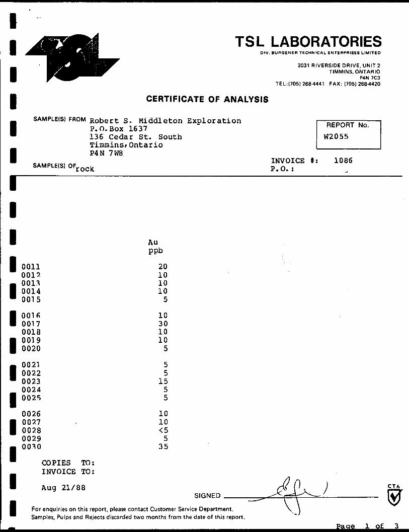
iSAMPLE(S) FROM Robert B
1 P.O.BOX
TSL LABORATORIESDIV. BUROENER TECHNICAL ENTERPRISES LIMITED
2031 RIVERSIDE DRIVE, UNIT 2TIMMINS, ONTARIO
P4N 7C3TEL: (705) 268-4441 FAX: (705)268-4420
CERTIFICATE OF ANALYSIS
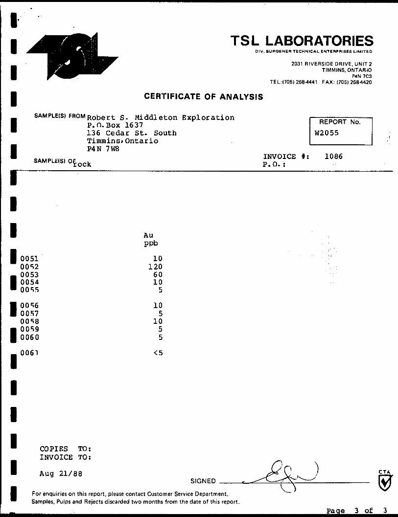
^Middleton Exploration REpQRT N Q
" 136 Cedar St. South W2055Timmins/
1 P4N 7W8SAMPLE(S) OFro(, k
1111 0011
001?- 0011I 0014" 0015
I OQlfi 00170018
1 0019 0020
- 0021l 0022" 0023- 0024| 0025
0026
1 0027 00280029
1 00^0
COPIES TO:INVOICE TO:
1 Aug 21/88
Ontario
INVOICE #: 1086 P.O.:
Auppb
20101010
5
10 301010
5
55
1555
1010 ^
535
M (1 )SlfiNED ^C^4-^-- — ' \±A
I ~- - y \ W For enquiries on this report, please contact Customer Service Department. \ j QannnlAc Di 1 1 rt c a o ri DoiA^tc A \tr-^rAt*r\ ti**r\ rv^rvntKr •Fc^rv* tKja ^-ato j-^-f t K i c KAnrkiH-
Pa ae l of
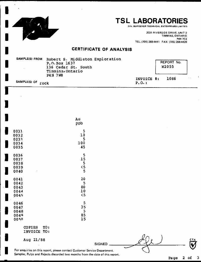
lTSL LABORATORIES
DIV. BURGENER TECHNICAL ENTERPRISES LIMITED
2031 RIVERSIDE DRIVE, UNIT 2111111111I1111111
^SAMPLE(S) FROM
SAMPLE(S) OF r (
0031003200330034 0035
0036 0037003800390040
00410042 004300440045
00460047 0048004QOOsn
COPIESINVOICE
•^r TIMMINS, ONTARIO ^^^ P4N 7C3
TEL:(705) 268-4441 FAX: (705)268-4420
CERTIFICATE OF ANALYSIS
Robert S. Middleton Exploration , —— ———— .P.O.BOX 1637 REPORT No. 136 Cedar St. South W2055Timmins/ OntarioP4N 7W8
INVOICE t: 1086)ck P.O. :
Auppb
510
5100
45
5 15
5<5
5
205
8010^
535
58515
TO:TO:
Aug 21/88 ^Q f J Fi
For enquiries on this Samoles Pulos and R
Rifiwpn ^~ -^\/^ — ' lyi
report, please contact Customer Service Department. V^ J elects discarded two months from the date of this reoort.
Page 2 of 3
l l l l l l r i i i i i i i i i i i i
TSL LABORATORIESDIV. BURGENER TECHNICAL ENTERPRISES LIMITED
2031 RIVERSIDE DRIVE, UNIT 2TIMMINS, ONTARIO
P4N 7C3TEL:(705) 268-4441 FAX: (705)268-4420
CERTIFICATE OF ANALYSIS
SAMPLE(S) FROM Robert s. Middleton Exploration P.O.BOX 1637 136 Cedar St. South Timmins*Ontario P4N 7W8
SAMPLE(S) Orock
REPORT No,
W2055
INVOICE t: P.O. :
1086
00510052005300540055
00560057 00*800590060
0061
COPIES INVOICE
TO: TO:
Aug 21/88
Au ppb
1012060105
105
1055
SIGNEDCTA
For enquiries on this report, please contact Customer Service Department. Samples, Pulps and Rejects discarded two months from the date of this report.
Page 3 of 3
TSL LABORATORIESDIV. BURQENER TECHNICAL ENTERPRISES LIMITED
2031 RIVERSIDE DRIVE, UNIT 21 W^1
SAMPLE(S) FROM
B
^^T TIMMINS, ONTARIO ^^ P4N 7C3
TEL:(705) 268-4441 FAX: (705) 268-4420
CERTIFICATE OF ANALYSIS
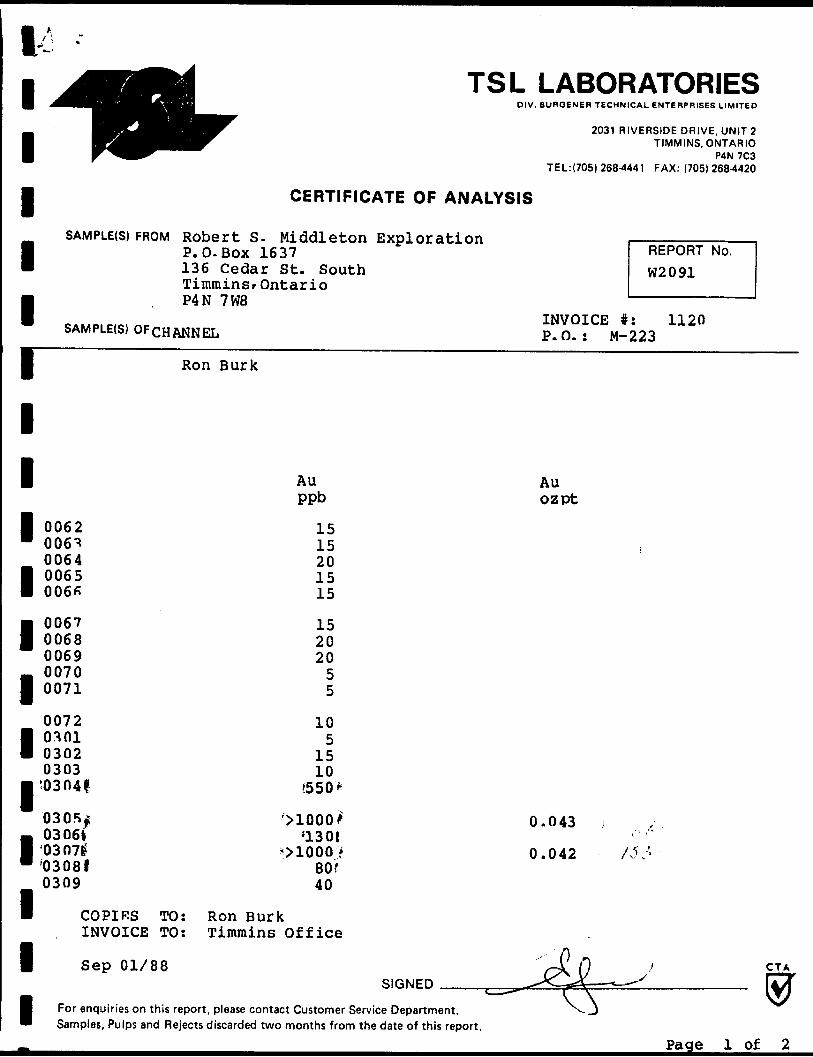
Robert S- Middleton Exploration j ————————— -iP.O.BOX 1637 REPORT No. 136 Cedar St. South W2091TimminSf OntarioP4N 7W8
INVOICE #: 1120SAMPLE(S) OFCHANNEL P.O.: M-223
1
1
1
B 0062" 006^
0064
1 0065 006*
1 0067 00680069
- 00701 0071
0072
1 0301 03020303
• '03041
0305*;- 03061| '03071" '03081
0309
B COPIES TOINVOICE TO
I Sep 01/88
Ron Burk
Au Auppb o z pt
1515 ,2015 15
15 2020
55
105
1510
(550*
'XLOOOl 0.043 i'130 1
^1000 f 0.042 /,V* -80 f40
: Ron Burk: Timmins Office
s-L fi ) C TA (s\ \J S i fQlrtMPn ^-^C — *-sA —— ~t-~-^ IA.A
m *~~^ \\ ^l For enquiries on this report, please contact Customer Service Department. ^-) ™ Samples, Pulps and Rejects discarded two months from the date of this report.
Page l of 2
l-' ; -~1 ^^Hflfci TSL LABORATORIES| jftn^f^^^^B^^m O IV. BUROENER TECHNICAL ENTERPRISES LIMITED
^^^^^^^^H|^^r 2031 RIVERSIDE DRIVE UNIT 2
1 P^^^"^ T IMMINS ' OJJNA™^ TEL:(705) 268-4441 FAX: (705) 268-4420
| CERTIFICATE OF ANALYSIS
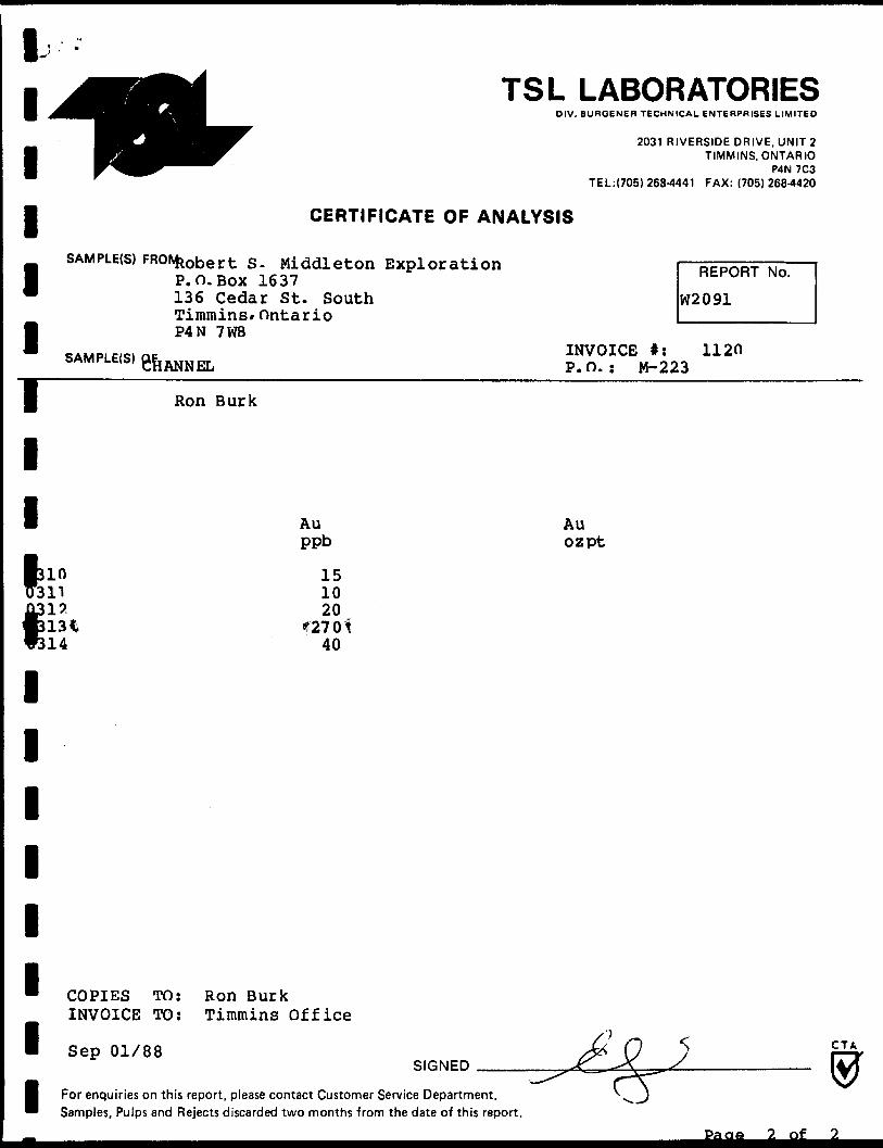
SAMPLE(S) FRONbrihor f- Q Mi c\A~\ o hnn Rynl or Ai-i rm i ———————M i\uucLu o- rixuuj. CL.UII CMAJJ± UL a L. j. wu DCDOC 1 P.O.Box 1637 HtPUI"— 136 Cedar St. South W2091
Timmins* Ontario
I P4N 7W8 *AMP. e,ei ne INVOICE #: 112n s* MI-t:(b ' CHANNEL P.O.: M-223
| Ron Burk
1
Au Auppb ozpt
k in 15 n 10
11315 20
IT No.
14 40
l l l l l l l l
COPIES TO: Ron Burk INVOICE TO: Timmins Office
Sep 01/88SIGNED J
CTA
For enquiries on this report, please contact Customer Service Department. Samples, Pulps and Rejects discarded two months from the date of this report.
Pa ae 2 of
1 S 7052684420 TSL TIMMINS 08/30/88 13:35
i
| 9
P. 02
^jmflM! TSL LABORATORIESI ^H*HUn^^^^^HK 0 |V **JKOf NER TECHNICAL INTIRPRISES LIMITkO
HB^^^KBJMntufB^H^^^^^^^R^HJlB' 2031 RIVERSIDE DRIVE, UNIT 2BHH^^^^HHH^ TIMMINS, ONTARIO
H Ir^^^^^^^^^'^^^ P4N 7C31 ' TEL:|7051 268-4441 FAX: (705) 268 4420
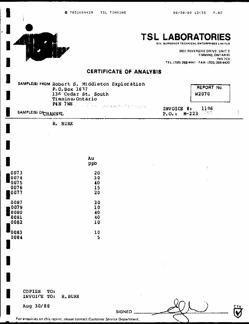
CERTIFICATE OF ANALYSIS1* SAMPLE(S) FROM Robert S. Middleton Exploration l ————
P.O.BOX 16^7 REPOP1 136 Cedar St. South W2070 m Timmins* Ontario
P4N 7W8 , , , r..
IT No.
| ! ' INVOICE tt lineSAMPLEIS) OFcjj^jjp^ P.O.I M-223 '
. R. BURK
1
-l
l-0073• 0074
Au ppb
l007500760077
0087
1 0079008000810082
\
l
l
l
l
00830084
2030401520
3010404010
105
COPIES TOsINVOICE TO: R.BURK
Aug 30/88SIGNED
For enquiries on this report, please contact Customer Service Department
CTA
DIV. BURGENER TECHNICAL ENTERPRISES LIMITED
2031 RIVERSIDE DRIVE, UNIT 2TIMMINS, ONTARIO
PAN 7C3TEL:(705) 268-4441 FAX: (705) 268-4420
11111
SAMPLER) FROM Robert S P. 0. BOX
CERTIFICATE OF ANALYSIS
. Middleton Exploration i ————————— i1637 E-*y*w- "w REPORT No.
136 Cedar St. South W2083Timmins/P4N 7W8
SAMPLE(s)0fChannels
Ron Burk
Ontario
INVOICE #: 1104P.O.: M-223
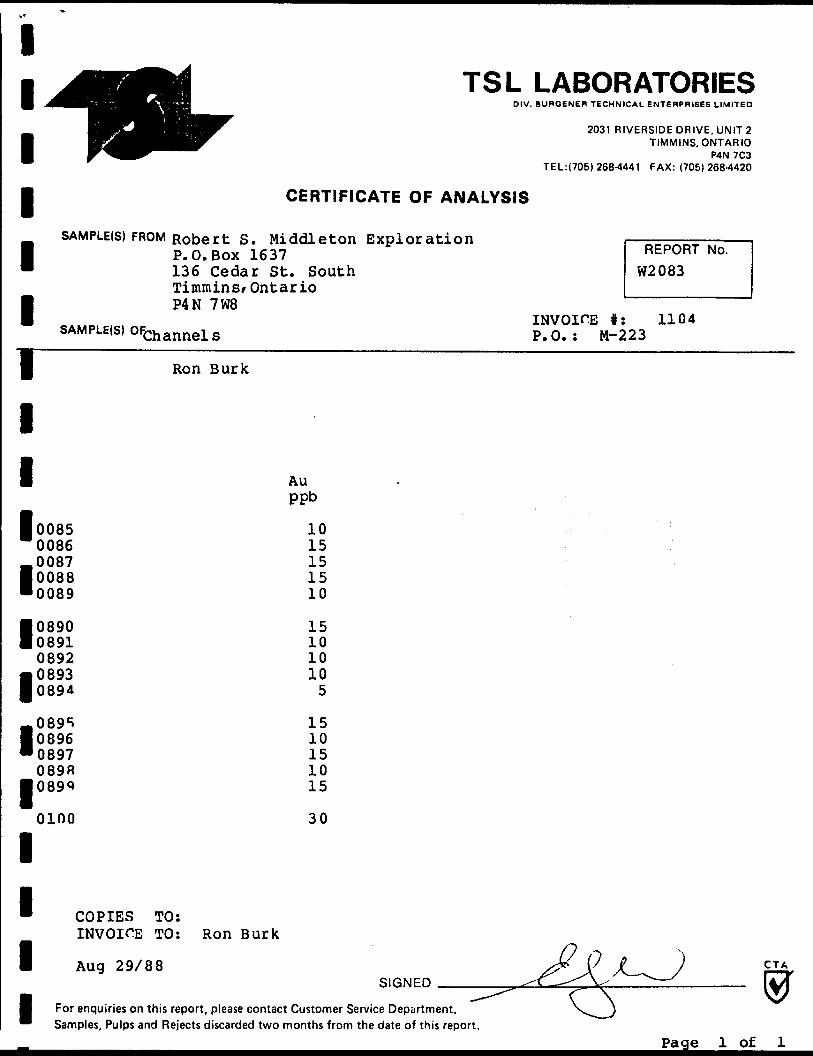
l l l l l l l l l l l
AU ppb
00850086008700880089
0890089108920893 089^
089508960897 089R 089Q
0100
1015151510
15101010
5
1510151015
30
COPIES TO: INVOICE TO:
Aug 29/88
Ron Burk
SIGNEDCTA
For enquiries on this report, please contact Customer Service Department. Samples, Pulps and Rejects discarded two months from the date of this report.
Page l of l
TSL LABORATORIESDIV. lUanENEH TICHNIKAl ENTiRPAIfiy* l IMITIO
2031 RIVERSIDE DRIVE, UNIT 2 TIMMINS, ONTARIO1 ^
1SAMPLE(S)
1JSAMPLE(S)
1
1
1oilsB 16011703180| 19
03200|21 0|2203230|24
OT250126OK707280329
oMo0331
|^^^^^^ P4N 'C3 TEL:|705) 266-4441 FAX: (705) 26H-4420
CERTIFICATE OF ANALYSIS
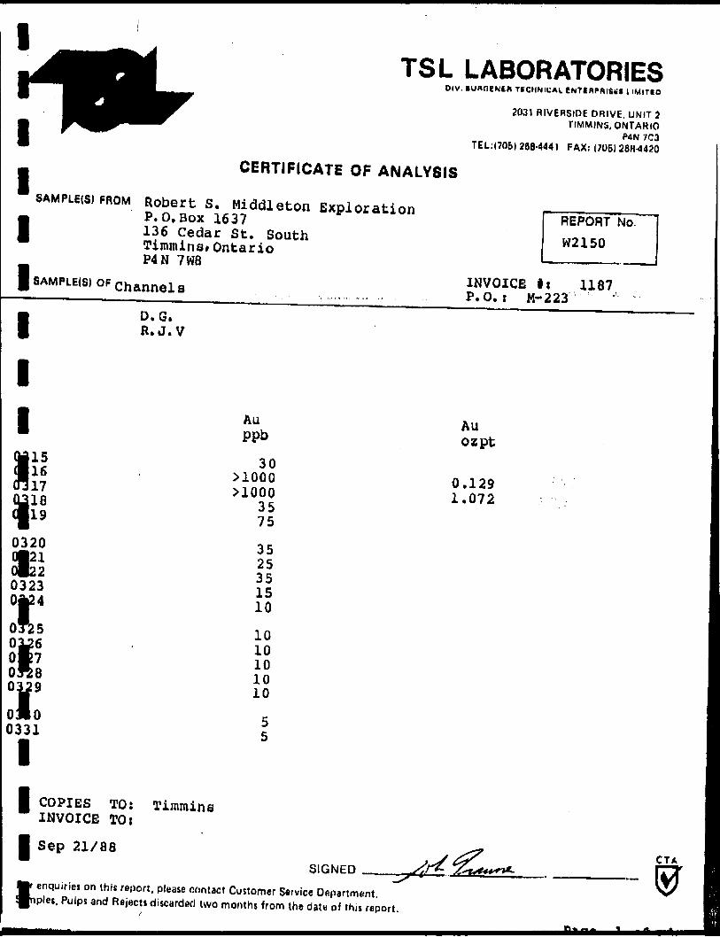
FROM Robert S. Middleton Exploration i — p ee,^QT k, —— i P.O.Box 1637 REPORT No.136 Cedar St. South W2150Timmins* OntarioP4N 7W8
INVOICE li 1187OF Channels , , ..., .. P.O.: M-223 ' "D. G.R.J.V
Au AU ppb ozpt30
>1000 0.129nOOO 1.07235 75
3525351510
1010101010
55l
l l I
COPIES TO: INVOICE TOiSep 21/88
Timmins
SIGNEDCTA
enquiries on (his report, please contact Customer Setvice Department, pies. Pulps arid Rejects discarded (wo months from the date of this report.
TSL LABORATORIESDIV. BOBGENIH TECHNICAL ENTEMPRIfiCfe LIMIT* O
2031 RIVERSIDE DRIVE, UNl l 'i TIMMINS, ONTARIO
T E l.!(70fi) 268-44 41 FAX: (705)2684420
CERTIFICATE OF ANALYSIS
•SAMPLE! S) FRO
1BsAMPLE(S) OF
1
1
1J1379 •380 13810382•383
0384
(385 386 387
A3 88
1111 COPIES
INVOIC1
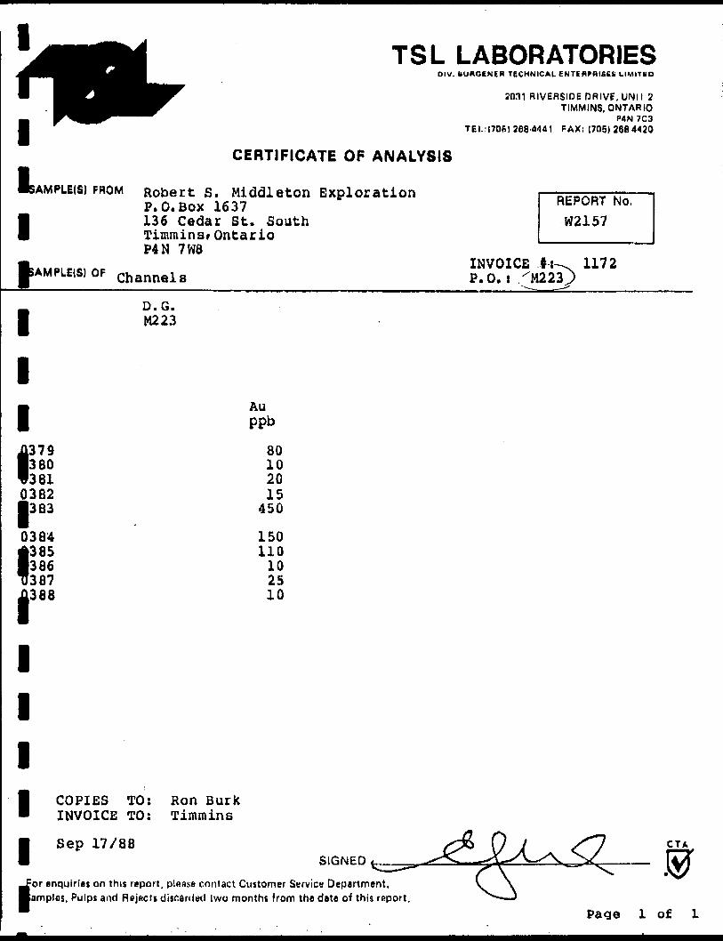
M Robert S t Middleton Exploration ^— - —— — - —— P.O.BOX 1637 REPORT No.136 Cedar St. South W2157 Timmins^ OntarioP4N 7 W8
INVOICE ,l-i^ 1172 Channels P.O. i^M223j)
D. G.M223
Au ppb
80 10 2015
450
150110
10 2510
TO: Ron Burk 3 TO: Timmins
17/88
i enquiries on this report, plaass contact Customer Service Department. amplos. Pulps and Rejhcis dis^anled Iwo months from the date of this rnport.
Page l of L
TSL LABORATORIESOIV. BUROENEH TECHNICAL ENTERPRISES LIMITED
2031 RIVERSIDE DRIVE, UNIT 21 n1
SAMPLE(S)
11* SAMPLE(S)
1
1
1
1 0389 03900391
1 0392 0393
1 0394 03950396
m 0 397l 0398
0399| 0400
11
^^^^^^^ TIMMINS, ONTARIO ^^^^^^ P4N 7C3
TEL:(705) 268-4441 FAX: (705) 268-4420
CERTIFICATE OF ANALYSIS
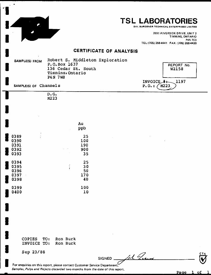
CBOM Robert S. Middleton ExplorationP.O.Box 1637 REPORT No. 136 Cedar St. South W2158Timmins/ OntarioP4N 7W8 1 —————————— 1
IN VOICED— 11 97OF Channels P .O. : (^222.)
D. G. M223
Auppb
i 25 100190900 35
25l 30
50170
40
10010
* COPIES TO: Ron BurkINVOICE TO: Ron Burk
1 Sep
f For enquiries
23/88 ^ C TASlftNFD ^ L l?Z,*~~t JT^
on this report, please contact Customer Service Department.Samples, Pulps and Rejects discarded two months from the date of this report.
Page l of

TSL LABORATORIESDIV. BURGENER TECHNICAL ENTERPRISES LIMITED
2031 RIVERSIDE DRIVE. UNIT 2TIMMINS, ONTARIO
P4N 7C3TEL:(705) 268-4441 FAX: (705) 268-4420
1 1 11
CERTIFICATE OF ANALYSIS
SAMPI F(S) FROM Robert S . Middleton ExplorationP.O.BOX 1637 REPORT No. 136 Cedar St. South W2047 Timmins^ OntarioP4N 7W8 ' —————————— '
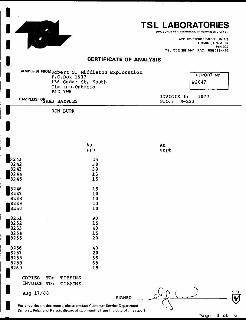
INVOICE #: 1077 SAMPLE(S) OFGRAB SAMPLES P.O.: M-223
RON BURK
l l l l l l l l l l l l
82018202820382048205
82068207820882098210
82118212821382148215
82168217821882198220
Au ppb
2025151515
14030
13075170
18025654040
2525453030
COPIES INVOICE
TO: TO:
TIMMINS TIMMINS
Aug 17/88
Au ozpt
SIGNEDCTA
For enquiries on this report, please contact Customer Service Department. Samples, Pulps and Rejects discarded two months from the date of this report.
Page l of 6

*
TSL LABORATORIESDIV. BURQENER TECHNICAL ENTERPRISES LIMITED
l W^1
SAMPLE(S) FROM
^^^r T IMMINS. ONTARIO ^^^ P4N 7C3
TEL:(705) 268-4441 FAX: (705) 268-4420
CERTIFICATE OF ANALYSIS
Robert S. Middleton Exploration i — RFPOBT M^ —— l P.O.BOX 1637 REPORT No.136 Cedar St. South W2047Timmins/ OntarioP4N 7W8
INVOICE #: 1077SAMPLE(S) OrV""DAn GAMOT i?c? n ** ** ** ~. \3t\t\o oArl.rlj.CiO P.O. * M~223
1
1
1
1 8221" 8222
82231 8224 m 8225
1 8226 82278228
1 8229 8230
8231• 8232 • 8233
8234• 8235
8236
1 8237 823882398240
1" COPIES TO
INVOICE TO
l Aug 17/88
I For enquiries on this Samnlas Pnlns and F
RON BURK
Au AuPPb ozpt
15151515 15
- 60 502020 30
75240 303035
2075153015
: TIMMINS: TIMMINS
/y p, ) CTAS.ONED ^ #X^ [VT
c— — r \ \yreport, please contact Customer Service Department. V )eier:ts rlisrardpri two months from thp date of this renort
TSL LABORATORIESDIV. BUROENER TECHNICAL ENTERPRISES LIMITED
1
1
1
1
1
1
1
^IS^^^^ff^r T IMMINS, ONTARIO W^^^^^^^^ P4N 7C3
TEL: (705) 268-4441 FAX: (705) 268-4420
CERTIFICATE OF ANALYSIS
SAMPLE(S) FROMRobert S. Middleton Exploration l ———— P.O.Box 1637 REPOF136 Cedar St. South W2047Timmins/ OntarioP4N 7W8
INVOICE t: 1077b M LE(S) 0GRAB SAMPLES P.O.: M-223
RON BURK
Au AU
IT No.
l
l
l
l
l
l
l
l
l
l
ppb
82418242824382448245
82468247824882498250
82518252825382548255
82568257825882596260
2530301515
1510102010
9015401520
4020556515
COPIES TO: INVOICE TO:
Aug 17/88
TIMMINS TIMMINS
ozpt
SIGNEDCTA
For enquiries on this report, please contact Customer Service Department, Samples, Pulps and Rejects discarded two months from the date of this report.
Page 3 of 6

TSL LABORATORIESDIV. BUROENER TECHNICAL ENTERPRISES LIMITED
2031 RIVERSIDE DRIVE, UNIT 2TIMMINS, ONTARIO
P4N 7C3TEL:(705) 268-4441 FAX: (705) 268-4420
1 1 11
SAMPLE(S) FROIVftObert S . P.O.Box 16 136 Cedar Timmins/ On P4N 7W8
SAMPLE(S) HSRAB SAMPLES
RON BURK
CERTIFICATE OF ANALYSIS
Middleton Exploration , —————————— ,37 REPORT No.St. South W2047 tario
INVOICE #: 1077 P.O.: M-223
l l Au
ppb
7090251515
1510502520
1540203010
Au ozpt
1010101010
l
l
COPIES TO: INVOICE TO:
Aug 17/88
TIMMINS TIMMINS
SIGNEDCTA
For enquiries on this report, please contact Customer Service Department. Samples, Pulps and Rejects discarded two months from the date of this report.
Pa np A. nf

ft
l l l l l
TSL LABORATORIESDIV. BURGENER TECHNICAL E NTERPRISES LIMITED
2031 RIVERSIDE DRIVE, UNIT 2TIMMINS, ONTARIO
P4N 7C3TEL:(705) 268-4441 FAX: (705)268-4420
CERTIFICATE OF ANALYSIS
SAMPLE(S) FROM Robert S. Middleton Exploration P. O.Boxl637 136 Cedar St. South Timmins/ Ontario P4N 7W8
SAMPLE(S) OlGRAB SAMPLES
REPORT No.
W2047
INVOICE l: 1077 P.O.: M-223
l
l
l
l
l
l
RON BURK
82818282828382848285
82868287826882898290
Au ppb
1010
3535
2520202020
2520152030
10151015
410
COPIES TO: INVOICE TO:
Aug 17/88
TIMMINS TIMMINS
Au ozpt
0.057
SIGNEDCTA
For enquiries on this report, please contact Customer Service Department. Samples, Pulps and Rejects discarded two months from the date of this report.
Pa a e e\f
i i i i i i
TSL LABORATORIESDIV. BURGENER TECHNICAL ENTERPRISES LIMITED
2031 RIVERSIDE DRIVE, UNIT 2TIMMINS, ONTARIO
P4N 7C3TEL:(705) 268-4441 FAX: (705)268-4420
CERTIFICATE OF ANALYSIS
SAMPLE(S) FROM Robert S. Middleton Exploration P.O.Box 1637 136 Cedar St. South Timminsf Ontario P4N 7W8
SAMPLE(S) OfcRAB SAMPLES
REPORT No.
W2047
INVOICE f: 1077 P.O.: M-223
l
l
l
l
l
l
l
l
l
l
l
l
l
RON BURK
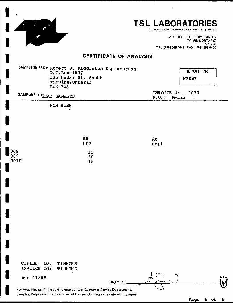
0080090010
Au ppb
152015
COPIES TO: TIMMINS INVOICE TO: TIMMINS
Aug 17/88
Au ozpt
SIGNEDCTA
For enquiries on this report, please contact Customer Service Department. Samples, Pulps and Rejects discarded two months from the date of this report.
Page 6 of 6
Ministry ofNorthern Development
•and MinesOntario
Report of Work(Geophysical, Geological, Geochemical and Expenditures)
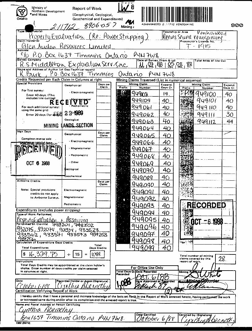
42ASI4NW8553 Z . 1 17 12 KENOGAMING 900
^^^ Wope f tClaim Holder(i)
f R.C . Po^ef Stru? p/nq )i)
Township or Area
Prospector's Licence No.
Address
c ?b P.O.&OX.Survey Company
Name *nd Address of Author (of Geo-Technical report!
K-fevult i P o
Date of Survey (from A to) {Total Miles of line Cut
4- OuJaraoCredits Requested per Each Claim in Columns at right Mining Claims Traversed (List in numerical sequence)Special Provisions
For first survey:
Enter 40 days. (Thisincludes line cutting) .Jvfcgnupmaier
For each additional survey: using the same grid:
Enter 20 days (for efecfilt
Geophysical
- Electromagnetic
Geological
MINING lAMfl&nSECTION
Airborne Credits
Note: Special provisionscredits do not apply to Airborne Surveys.
Electromagnetic
Magnetometer
Radiometric
Expenditures (excludes power stripping)Type of Work Performed
PerfdrmecTon Claim(s)
Calculation of Expenditure Days Credits
Total Expenditures
Toial number of mining claims covered by this report of work.Instructions
Total Days Credits may be apportioned at the claim holder's choice. Enter number of days credits per claim selected In columns at right.
For Office Use OnlyTotal Days Cr. Date Recorded Recorded
Certification Vefifying Repora of Workl hereby certify that l have a personal and intimate knowledge of the facts set fbr-Uyn the Report of Work annexed hereto, having perf or witnessed same during and/or after its completion and the annexed report is true.
Name and Postal Address of Person Certifying
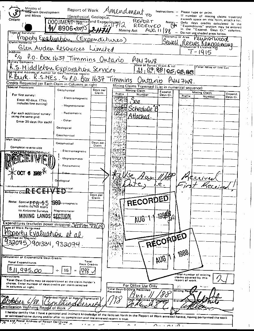
Minjstry of Report of Workhern Development and Mines _____ (Geophysical, GeologicaTOnlario
Type of Survey(s)
and Expe^jdityjas) . l < Mining Act AUC-. l l
Instructions: Please type or print. If number of mining claims traversed exceeds space on this form, attach a list. (Mote^ Only days credits calculated in the "Expenditures" section may be entered in the "Expend. Days Cr." columns.
Do not use shaded areas below.Township or Area
Claim Holder!
GLe.iv AudetA...,----Prospector's LicenceT- iqisAddress
P.O. focKib3?TiVv\mtnsSurvey Company
me and Address of Author (of Geo'technical report)
Date of Survey (from A to)
Day
Total Miles o' line Cut
. fi .s-HEs . fru r7. 0- 6ox fbS^ "Timmins OiAjtcun'pCredits Requested per Each Claim in Columns at right Mining Claims Traversed (List in numerical sequence)Special Provisions
For first survey:- ElectromagneticEnter 40 days. (This
includes line cutting) - Magnetometer
For each additional survey: using the same grid:
Enter 20 days (for each)
Man Days
Complete reverse side
Geophysical
,, - Electromagnetic(J - Magnetometer
Note: Special ErpiQ iofjs J-j credits doTiot apply
Magnetornetcf
TnStT/omM r i c
lo Airborne Surveys
MINING LANDSExpenditures (excludes power stripping) S
number of mining Claims covered by this report Of work.
For Office Use OnlyTotal Days Cr. Recorded
Recrded Hold/r or Agonti(Signature)
ftification Ve/fying Repqfj^of Work Sl hereby certify lhat l have a personal and intimate knowledge o( the facts jet forth in (he Report of Work annexed hereto, having performed the work or witnessed same during and/or after its completion and the annexed report is true.am* and Potial Ad ci r DM of Person Certifying
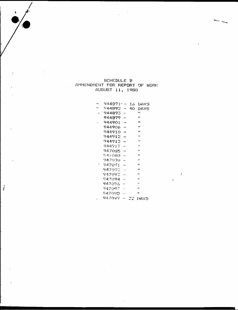
SCHEDULE BAMMENDMENT FOR REPORT OF WORK
AUGUST 11, 1988
944891" - l w DAYS944392 - 4O DAYS944993 -. "944999 - "9449O1 -944906 -9449lO - "944912 -944913 -944737 -Y947OB5 -917008 - "V47O70 -947091 -947092 -- "9-17093 -947O94 - "
947098 -- "947099 -- 22 DAYS
L
ro Q 0
o ?. 5 :
1 O o. o
' Z
p D M r*
* D jj 6 •3 T* JT
^
—^^
——
^^^^^^^^^^^^^^"^
^^••
••"•
•^••
•1^*^
S * w 1 5 e z
o > z u CO c D T! > n
in 00 C) 3: H in
MB
^
i*
CO
S-
^ in
P b
i i
w
?- c
^5
zT
l ~
- >
^
o
cim
35
S0
x
T
HH
(/
l
33 rn > CO • ~ -1 x D •J}
^
?
^! Tt :u f
4
w
Q
XO
*-
^
r-
r~
K^ wviB
wra
^i
. H D 00 "D
O CO H O Z ••R
MD
! H t' i ;
^ S
m 'E
^
rn Tl
f;'
* :f
LJ^
f"—
f]d
irn
PEN
HO
RW
OO
D
TWP.
m
o H
o* \i
n
m *~
"—
"c *
*-J^
-*-^
s
i
9/^
Sl'I
ii
i ( *
f
-s)-l
! -
J-iL-
^-lL
IJ
1
O) m r* m f~
r
CR
OTH
ER
S
TWR
PH
AR
AN
D
TWP.
m Vi
CD-:
K) OJ
CD
o
J) -
Z. S
(DO
)-'
^ P"
2o
5 w'
5 B
L5
s ^
S a
ro
z M
m
5v V
o
w •H
71 O^1.
O
r^
w,S 5?:
3
m Z O g o I
JS
*
W
O^
>Z
2
0
0
3J
Om
3)
s s "5? 5 -Si
(SI m
P
vi -
^ S
5j
3 *
> >
5S
R o
J)
Q*
33O
f
SURCAC
SURFAC
RIG
IGHTS
0
O
W-n
^
O
OMININ
HT
O I 3
d H
C
DISPOSITION
O DO
O f .
O t/-
a s sS f s
y^ f,
o 5
o
r\
O88 ^•
n
iU
T?^
0
n
t*
C) ?
C
2
J- g
Kg
I l
^
i 7
* d
-s O
3J n m r~ y m
-1
O
rn
CO a
REFERENCES
AREAS WITHDRAWN FROM DISPOSITION
M.R.O.-MINING RIGHTS ONLYS.R.O. - SURFACE RIGHTS ONLYM.+ S. - MINING AND SURFACE RIGHTS
OMCription Q rdmr No. DIM Dispnition Fit*
Ste 43/70 W3C'T7 H/3/77 S R. O i5i?*B
5EC.4J/TO W. l 9/7 B 10/4/76 S H. O ****0 l 8 854 3
SEC 43/70 W 1 0/78 14/11/78 SRO I35'48
DUMP ATTENUATION ZONE
SEC 36/80 W.46/8S 14/8/83 H * S
Nor oovn for troting AWAITING INSPECTION 71/66
"FILED ONLY- D-ze/86
NOT OPEN FOB STAKING- BON* rt DE APP L iCATION UNDER
PUBLIC LANDS ACT PENDING 2I/OI/87
MELROSE TWP FREY TWP
CRAvl
M T. C
M T. C
M-T C
M T C.
M.T.C
SAND AND GRAVE L
1*i T O? r
PIT 3H-I FILE '3ST4B
PIT 1576
PIT 3H-2 FI l. E 184702
PIT 1243
40J '074063. Of 40*4"" """ ~"
7 t N i ' ) I1 1074^69 J (07406* ^7*067 j O7*O66^3-|p~r .'""-!."- ", *174071. LroJ*?. jO**O
^"S^ **
-tk- --V
997tffcy*9*Bf i f5n . T |4*iaaa l*****il l " "-™-— w - r j j i i - *-nw| . mmfurv* f i v VWfV * ' M y tt**1———— ,^-. — —,—— -.^. —— —u.. — ^ , — .—E.I.—— ———— ——— --.jMLr-ft-p ;, p ' p i" | p "*i * o!;; p/ IP T p- iP 9JTS /i P --. '. : '- J ——WS
66121*
7 w 2*.26efn iG.JSchi
PHARAND TWR
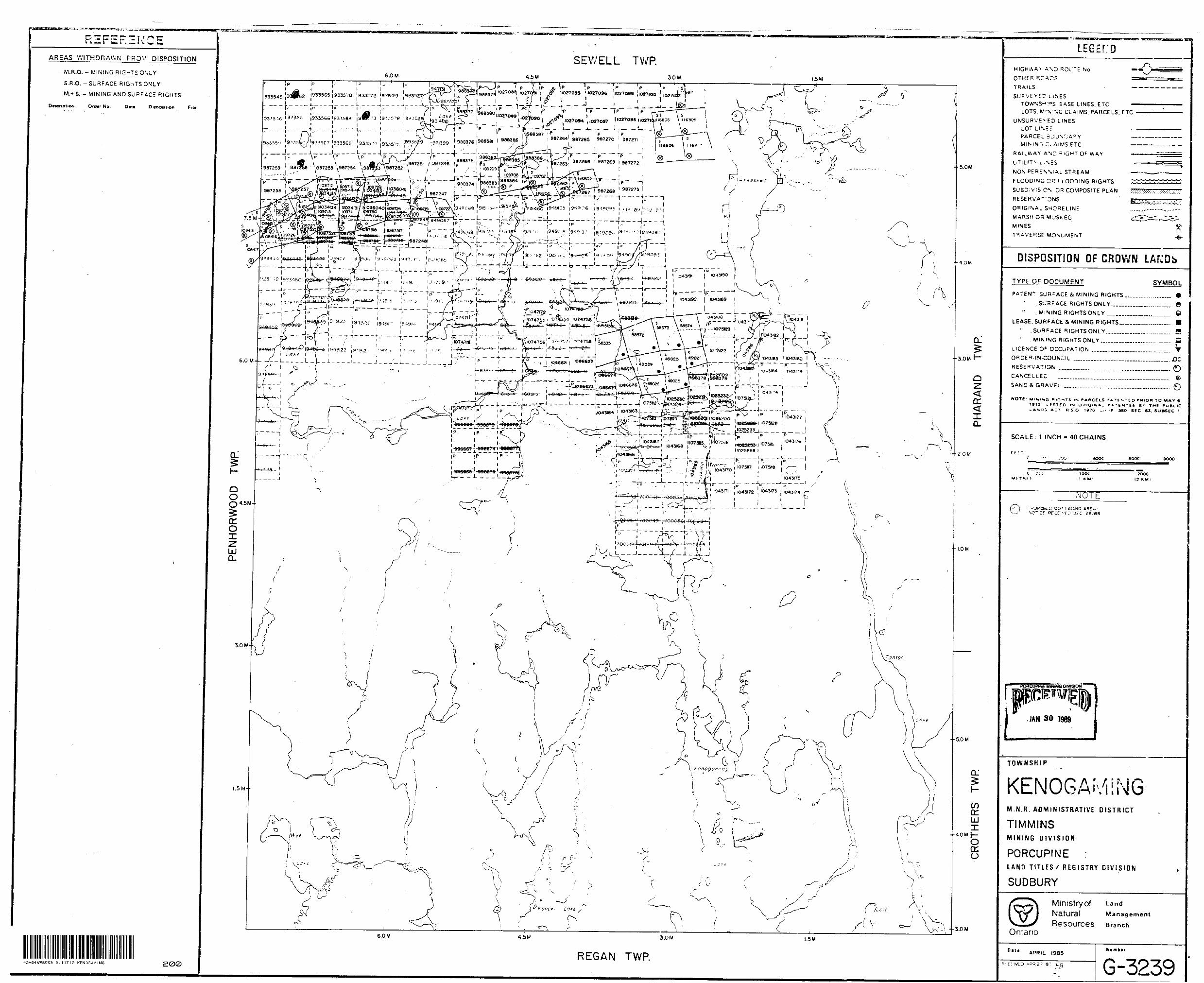
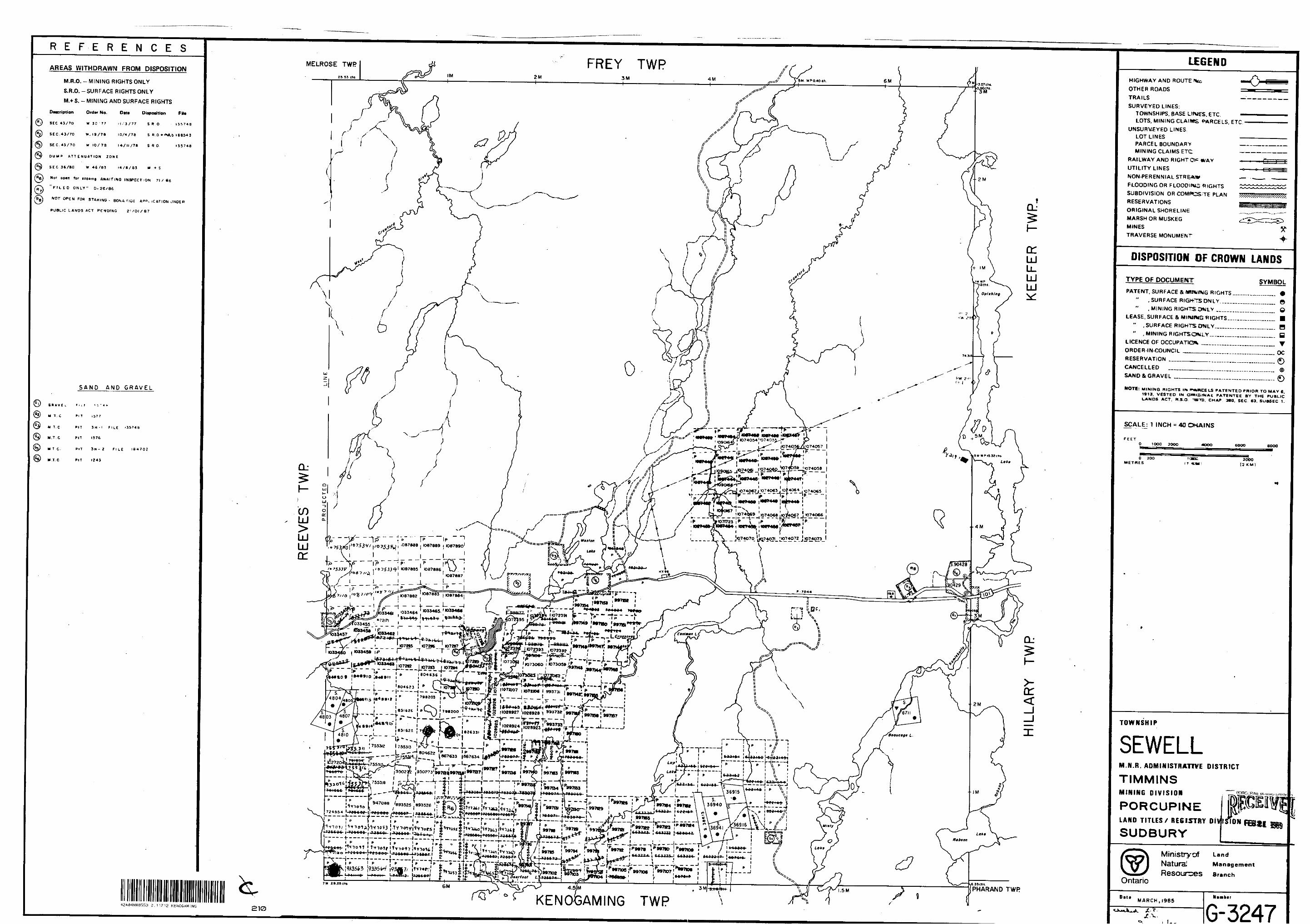
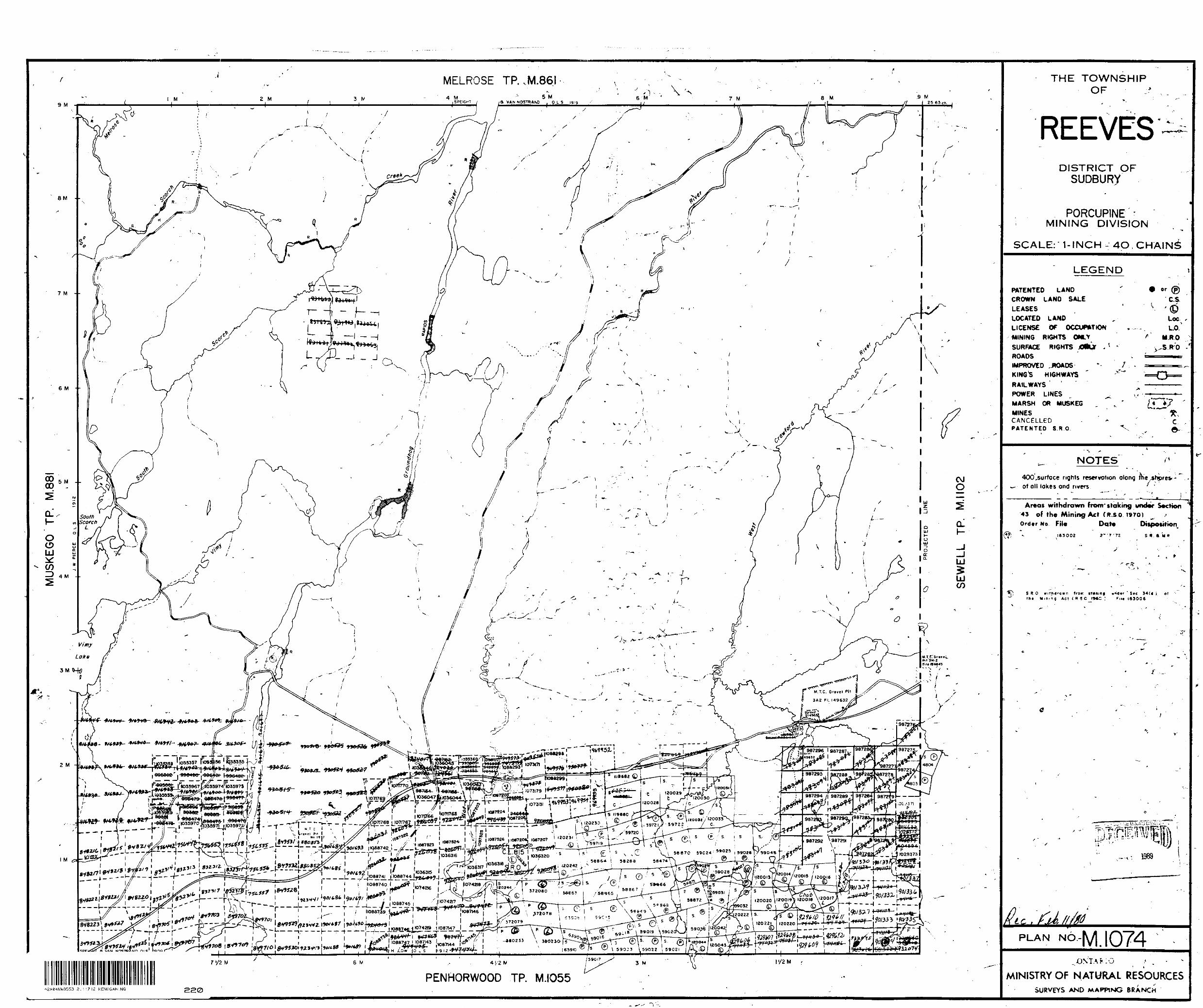
KENOAMING TWP42A04NW8553 E.11712 KENOGAMING 210
LEGENDHIGHWAY AND ROUTE tec OTHER ROADS TRAILS SURVEYED LINES:
TOWNSHIPS, BASE LIKttS. ETC.LOTS, MINING CLAIMS f^RCELS, ETC
UNSURVEYED LINES.LOT LINESPARCEL BOUNDARYMINING CLAIMS ETC
RAILWAY AND RIGHTO^ WAY UTILITY LINES NON-PERENNIAL STREAM FLOODING OR FLOODIKiS RIGHTS SUBDIVISION OR COMPCSTE PLAN RESERVATIONS ORIGINAL SHORELINE MARSH OR MUSKEG MINES TRAVERSE MONUMENT
DISPOSITION OF CROWN LANDS
TYPE OF DOCUMENT SYMBOLPATENT, SURFACE Bt MlWJfigG RIGHTS
" , SURFACE RIGHfTSDNLY,...," .MINING RIGHTSONLY — . ..,
LEASE, SURFACE 8t M IWUIWG RIGHTS.." , SURFACE RIGHTS OWLY. __ .." . MINING RIGHTSOMLY.........
LICENCE OF OCCUPATlGWk __ ...™.. ORDER-IN-COUNCIL ______ RESERVATION __________ ,......CANCELLED __________ ,......SAND ft GRAVEL . ________ .... .
e e
—. B ™. B—. T—. OC
NOTE: MINING RIGHTS IF* ^*WCELS PATENTED PRIOR TO MAY C. 1913, VESTED IM OmtSINAt PATENTEE BY THE PUBLIC LANDS ACT. R.S-Q TBTO. CHAP 300. SEC. 63, SUBSEC 1.
SCALE: 1 I NCH = 40 CHAINS
FEETo 1000 2000 400O 6OOO aooo
O 200 METRES
20OO[3 K M)
TOWNSHIP
SEWELLM.N.R. ADMINISTRATIVE D ISTRICT
TIMMINSMINING DIVISION
PORCUPINELAND T ITLES/ REGISTRY DIV
SUDBURYISION
f LandManagement
Resources BranchOntario
DiliMARCHJ985
G-3247
MUS
KEG
O
TP.
M.8
8I
l j-"'"
^^ i
. V
L *
k
. ^
SE
WE
LL
TP.
M.I
102
z CO
3 3
Z c 25 c:>
*. ^-i
-t
J, m
? O
1
c s rn CO
D r z o "t O
-* w
? " o
/
13 iXj
V u K
O
r m O m z o
C/) o > r m z o I
D
O
o w
S i
m
m m O)
H
I m H 00 z in ±
1 V
397154 997153' 997152
I0334SI I l0334* 4 l (033483 10334*6.^j.__r
848909 848910 164899 8O4623 1804*3
74MOO 11072109
831623 ; 7982O3987294/1 967289 | 9872841 9872TS
l , l X 102937!; 75531?
75a3| i- 1804622 a' '
967293 l 367290997136 997140 ' 997163 n 997i63987292 \967291 '
-' -- -J---L-.^^, l997134 C 997133
93526 S 9472W
997f30 997129724554 l 947090 ;
901329 90(332 ' 901336
997122 l 937123 l 997R4
---f-- ——t901327 f 901333 l 901335929610 i 929611 l l 997114 9971* . 997t|2 '997111 '9971(0 997109
929606 9296071 92960ft 929609 929612997101 97102 (997103
REEVES TWP.PENHORWOOD TW i l 901345 f\ 944917 ! 944906
901344 .944897 i 94489044889 [944662 933343 .'933562 '933565,933570 .93357? 878419 893527
944S9I j 944688 | 944863933546 (933561 l 933566,9333*9 ;933573 ^933376 1^3528
901342 944913 : S449D8 i 9449^)3 , 944895 A MAM .l ) ' 9*4892 9448841 933559 i l 968364 , !l '967264,967265 967270 ! 987271
966367
853* 933567 933568 933574 933575 ; 893579 j
901341 , 9449,4 944909 l 94^902 i 9 44894 j 94483 944886 1944865 987259 (987256X
^0040 -944913 1-449.0 . .44.0, 1^. ^7251 947,48 987258 .987257947105 i 947102 901359 ' 901354i l 967247
949105 ! 549106 949095 949089 ,'S49094947101 l 901360 l 9DI353 9449r j 94491 944900 ' 944898
947109; 901352,, '901330
^ nncnl9/9062(949063949064 , 949065
949IW 1949100 949099' &9097
94918 j 949U3 l 949^2 ^49090'
949f23 ; 9 49f20
949121 949116, 949U5 l 949110
1 inch = '\/2 m ilet/2 l l I/2
REVISIONS ROBERT S. MIDDLETON EXPLORATION SERVICES INC
GOLDROCK RESOURCES INC. fi GLEN AUDEN R ESOURCES LTD.
REEVES JOINT VENTURE PROPERTY CLAIM MAP
Date: Oct. 87 Scale: t:325ooDrawn: a.S.B
9971
49^
X
' 10
7212
0
SE
WE
LL
LAK
E
11
997
143
1073
063
1072
107,
',-
STR
IPPE
D
AREA
I5O
O p
pb
Au
old
trenc
hes
0]4
5 o
z-f
Au
STR
IPPE
D O
A
RE
A
w "9
7553
I3/
'0.1
1 oz
T
Au
804622
LA
PP LA
KE
RE
EV
ES
A
SB
ES
TOS
M
INE
CH
UB
B L
AK
E
12
TRE
NC
H
SE
WE
LL T
WP
.
f; TR
ENC
H
li 1
aban
done
d du
e to
th
ick
over
burd
en93
3545
KE
NO
GAM
ING
TW
PPE
NH
OR
WO
OD
TW
P.
94
48
89
l
944882
988
378
OD
EE
RFO
OT l A
KF
TRE
NC
HE
S
94
489
3
l
r?l5
" TR
EN
CH
ER
aban
done
d du
e to
\
thic
k ov
erbu
rden
17 /
? TR
EN
CH
ES
9^47
253
PE
NH
OR
WO
OD
LO
GG
ING
R
OA
D

SA
MP
LE:
AU
o';c
ted,
grey
ch
lorit
e-an
kerit
e sc
hist
w
ith
num
erou
s py
rite
lens
es
span
gly
anke
ritic
, ch
lo-t
e
schi
st
, nte
rmedia
te
dike
abun
dant
py
rite
lens
esan
kerit
e-ch
lorit
e sc
hist
-thi
n an
kent
e-ric
h la
yers
se
para
ted
by
chlo
rite
lam
inae
ho
stin
g sm
all
lens
es
of
smok
ey
quar
tz
inse
t
anke
rite-q
uart
z-
chlo
rite
pod
gass
anou
s O
lccK
ch
lorite
sc
hist
w
ith 20X
pyr
ite
Sca
le
! :2C
C
chlo
rite
sc
his
t 1 0
70
pyr
ite
and
y narr
ow
quart
z
SA
MP
LES
a.2
zone
of
qu
artz
"st
ringers
an
d pyr
itel
47
quart
z
stringers
an
d pyr
ite
y.
quart
z-anke
rite
62
vein
quar
tz
strin
gers
an
d py
rite
zone
of
qu
artz
"1 st
ringe
rs
and
pyrit
e
boud
inag
e d
a n k
e r. l
e
05
pyrit
e ch
lorit
e-an
kerit
e sc
hist
dior
ite
dike
s
\
TRE
NC
H l
anke
rite-
quar
tz
pod
see
inse
t l.
.-e
..*
quar
tz
s;.- ,
--ge
rs
and
pyrit
e
quart
z ve
ins
chlo
ritoi
d po
rphy
rob
SA
MP
LES
SA
MP
LES
A
ufpp
b)0020
002
0022
0023
^• o
*
Au(
ppb)
8246
- 15
mse
;S
ea e
l:
200
250
*:^
200
150
min
or p
yrite
\
-,r^
ir^—
:~
\
TRE
NC
H 2
anke
rite-
quar
li ve
ins
quar
tz \
:r ^
strin
gers
high
ly
folia
ted
chlo
rite
-ank
erite
sc
hist
anke
rite^
quar
tz
vein
sS
\ch
lorit
e\
S
100
SA
MP
LE
0008 -
0009 -
0010
-
0011
-
0012
-
0013
-
0014
-
0015
-
0044 -
8275
--7
6 -
77
-78
-79 -
80
-81
-
82
-83
-
84
-85
-86
-
87
-88
-89
-90
-91
-
92
-93
-94
-95
-96
-
97
-98
-99
-
8300
-0379
-0380
-03
81
-0382
-0383
-
Au(
ppb)
15 20 15 20
10 10 10 5 10 10 10 10 10 10 10 10 1019
50 35 35
25 20
20
20
20
25 20 15 20
30 10 15 10 15
410 80
10 20 15
450
85
, 00
15
"^
-
001
4i O
OI3
""*
. l 0
012 l
OO
ID
— - t
l
see
inse
t 2
bush
ro
ad
ox
J hi
ghly
fol
iate
d ch
lorit
e-an
kerit
e sc
hist
-* lo
cally
qua
rtz-
anke
rite
boud
inag
ed v
eins
} tra
ce p
yrite
6299
l l
— c
hlor
ite-a
nker
ite
schi
st
with
ch
lorit
oid
porp
hyro
blas
ts
1-3^
l \-
94
l \
-93
~921
,. /,
..379 1
1-91
.'
dlM
. -''
" I-*
-
-891 38
311~
1-7
9 f
1-7
7
pale
gre
y,
fine
grai
ned,
m
assi
ve
to
wea
kly
folia
ted
inte
rmed
iate
to
m
afic
flo
wS
AM
PLE
S
Au(
ppb)
purp
lish
grey
, m
assi
ve
maf
ic flo
w v
lo
cally
va
riolit
ef
poor
ly
form
ed
vario
lites
are
fla
ttened
2:1
nter
^ned
iate
to
m
afic
, m
assiv
e
flow
Scal
e 1:
200
pyrit
e-ric
h zo
ne
med
ium
-gra
ined
, in
term
edia
te
dike
w
ith
mus
covi
te
phenocry
sts
(u
p to
20
mm
)i m
inor
fu
chsitC
i pe
rvas
ive
Fe
carb
onat
e altera
tion
and
/0py
rite
'pyr
ife-r
ich,
high
ly fo
liate
d
chlo
rite
schi
stf
sulfid
e
is
lam
inat
edm
ediu
m
grey
, fine-g
rain
ed
chlo
rite,
±ser
icite
, *
Fe carb
onate
; m
inor
p'y
-anke
rite
altera
tion
and
folia
tion
inte
nsity
in
crea
ses
tow
ard
s
dike
oxid
ized
, pyrite
-ric
h,
chlo
rite
anke
rite
schi
st;
adja
cent
rock
is
anke
rific
an
d str
ongly
fo
liate
d
inse
t 3.
wea
kly
folia
ted,
lo
cally
va
riolit
ic
maf
ic
flow
inte
rmed
iate
di
ke
wel
l fo
liate
d,
pyrit
ic
chlo
rite
schi
st
stro
ngly
ox
idiz
ed,
pyrit
e-ric
h,
chlo
rite-
anke
rite
schi
st
SAMPLES
0073
-- ^4 -
- 75 -
- 76 -
- 77 -
- 78 -
- 79 -
- 80 -
- 81
-
Au(ppb)
2030
0082
- 10,
40
83
- 1C
5 - 84
520
r-
- - -J
30 i 0 4040
t /KJ ,
,1'*i-
f
^C.
'Or
''li
1 L,
see
inse
t 3.
\
flattened
pillo
w
chlo
ritic
rims,
anke
ritic
co
res
\ }
^~
,'-^
il .o'*
l
weakl
y ca
rbbo
natiz
ed
~ 62
~^t~
, ^
-83
TR
EN
CH
8
fine-g
rain
ed,
mas
sive
, va
riolit
ic
and
loca
lly
- pi
llow
ed
mafic
flo
w(
J -7
0
J-69
pillo
ws
poss
ibly
fa
ce
sout
h s
lack
of
ox
ide
wea
ther
ing
v su
gges
ts
little
Fe
ca
rbon
ate
\al
tera
tion
l -se
\1-
67
-65,
l -
66^
92
SA
MP
LES
A
u(p
pb
—
high
ly
folia
ted,
chlo
rite
-anke
rite
sc
hist
w
ith
narr
ow,
boud
inag
ed quart
z
vein
TRE
NC
H 7
' lN,_
_ v
ario
litic
, po
orly
fo
rmed
pillo
ws
wea
kly
stra
ined
pill
ows,
to
ps
sout
h ?
l-3cm
w
ide
boud
inag
ed
quar
tz
vein
gr
ey,
fine-
grai
ned,
mass
iv e
m
afic
w
eak
Fe
carb
onat
e altera
tion,
min
or
pyrit
e su
bhed
ral
x'Is
~~~
na
rrow
sh
ear
mod
erat
e Fe
ca
rbon
ate
altera
tion
tight
ly
fold
ed
chlo
rite-
anke
rite
schi
st (
0306
)w
hite
qu
artz
ve
in
4cm
w
ide
at
125/
45
s w
ith
trac
e py
rite
(0307,0
308)
shea
red
and
anke
rittiz
ed
maf
ic
flow
ro
ck
min
or
fold
s pl
unge
50
0 NE
SAMPLES
0302
- -303
-304
-305
-306
-307
-308
-309
- 310-
31!
-312
-313
-
0328
ch
iorit
e-
anke
rite
0329
sc
hist
wea
kly
folia
ted,
fr
actu
red
maf
ic
volc
anic
! w
eakl
y ca
rbon
atiz
ed
SA
MP
LES
A
u(pp
b)03
14 315
316
317
318
319
320
321
322
323
40
30
- 4680
- 38
890 35
75
35
25
35
i 5
whi
te
quar
tz
vein
3-I
Ocm
th
ick
fillin
g fr
act
ure
at
125/4
0
SW
, tr
ace
pyrit
etig
htly
fo
lded
S,
fo
liatio
n in
chlo
rite
-anke
rite
sc
hist
; ax
ial
surf
aces
at
85
g
shea
r su
rfac
e at
S
O"
SA
MP
LES
0324
-32
5 -
326
-32
7 -
328
-32
9 -
330
-
Au(
ppb)
i ^
. ^*
. J
l O
Sca
le
i 200
4.
-275
m
25O
m
see
inse
t 4.
high
ly
folia
ted,
fo
lded
ch
lorit
e-an
kerit
e sc
hist
w
ith
shal
low
di
ppin
g qu
artz
' l
vein
,- vi
sibl
e go
ld
;
TRE
NC
H
4
folia
tion
inte
nsity
an
d am
ount
of
car
bona
te
alte
ratio
n de
crea
ses
tow
ards
N
and
S en
ds
of
expo
sure
- 22
5m
TRE
NC
H 6
-4
iow
gro
und
smok
ey
quar
tzve
ins
high
ly
folia
ted
chlo
rite
-anke
rite
sc
hist
bo
udin
aged
qu
artz
st
ringe
rs
•sam
pled
!9
87j
see
Gar
ner,
19
87
SA
MP
LE
S0085
--8
6
-87
-88
-89
-90
-91
-
92
-93
-
94
-95
-
96
-97
-98
-
99
-0100
-
Au(
ppb)
10 15 15 15 10 15 10 10 10 5 15 10 (5 10 1 5 30
——
——
— —
i
Au
(ppb
anke
rite
-quart
z po
d (b
oudi
n)
SAMPLES
0393
394
395
396
397
398
399
400
narr
ow
anke
rite
bard
s pa
ralle
l ea
rly
folia
tion,
py
rite
cube
s
fold
ed
quar
tz
vein
35 25 30
50
170
40
100
10qu
artz
st
ringe
rs
perv
asiv
ely
anke
ritiz
ed
maf
ic tu
ff
or
brec
cia
chlo
rite
clot
s-^
s-
onia
l pl
anar
^T
^
^
cteo
voga
ol
050*
quar
lz
vein
di
ps
shal
low
W
sulfi
de
pod
quar
tz jj
ash
es
at
120'
Sca
le
l: 200
inse
t 6.
. 20
Om
o 17
5m
- IS
Om
low
gro
und,
ce
dar
bush
//
smal
l pyr
ite p
ods/
'
high
ly f
olia
ted
chlo
rite-
anke
rite
schi
stbo
udin
aged
, sm
okey
gr
ey
quar
tz-a
nker
ite
vein
ssa
mpl
e -9
1 fr
om
1.5m
w
ide
zone
of
qu
artz
ve
ins
loca
lly
cont
aini
ng
coar
se-g
rain
ed
pyrit
e^~
" da
rk
grey
ch
lorit
e sc
hist
w
ith
hum
erou
s qu
artz
le
nses
an
d po
ds^
trac
e py
rite
-No.
8283
J/om
30
cm
wid
e qu
artz
po
d
wel
l fo
liate
d ch
lorit
e-an
kerit
e ±
seric
ite s
chis
t
wes
t-dip
ping
, bl
ack
quar
tz
vein
y/
prev
ious
ly s
tripp
ed a
rea
,/
V
380
N— 3
81
382
80
-76
1827
5
^
\\
'dia
mon
d1 c
leav
age
at 80/9
0,
110/
90
—
mod
erat
ely
folia
ted,
w
eak
to
mod
erat
e an
kerit
e al
tera
tion
decr
easi
ng
folia
tion,
al
tera
tion
loca
lly
vagu
e,
stre
tche
d pi
llow
s
mod
erat
ely
folia
ted
chlo
rite-
t-an
kerit
± se
ricite
^ sc
hist
(m
afic
flo
w)
V \
\ \
\
sam
pled
19
87,
see
Gar
ner,
1987
\su
lfide
fa
cies
iro
n fo
rmat
ion
wea
kly
folia
ted,
car
bona
tlzeg
i' m
afic
flo
w
^ —
—--
'/
5O c
m
^Jac
k qu
artz
vei
n/
f^
s
v \
over
grow
n tre
n-
TRE
NC
H 5
\\
SA
MP
LES
A
u(pp
b)0384
!50
385
110
lorit
e-an
kerit
e sc
hist
j al
tere
d m
afic
flo
w
inte
rmedio
te tu
ff
or
bre
ccia
di
ke
maf
ic
flaw
.'sul
fide-
ch
erty
—
rich
laye
rsse
e in
set
6.
i ;
\ o l
d ov
ergr
own
tren
ch\
'
. 12
5m
- 10
0m
- T5
m
^.
xol
d ov
ergr
own
tren
ch5O
m
x.
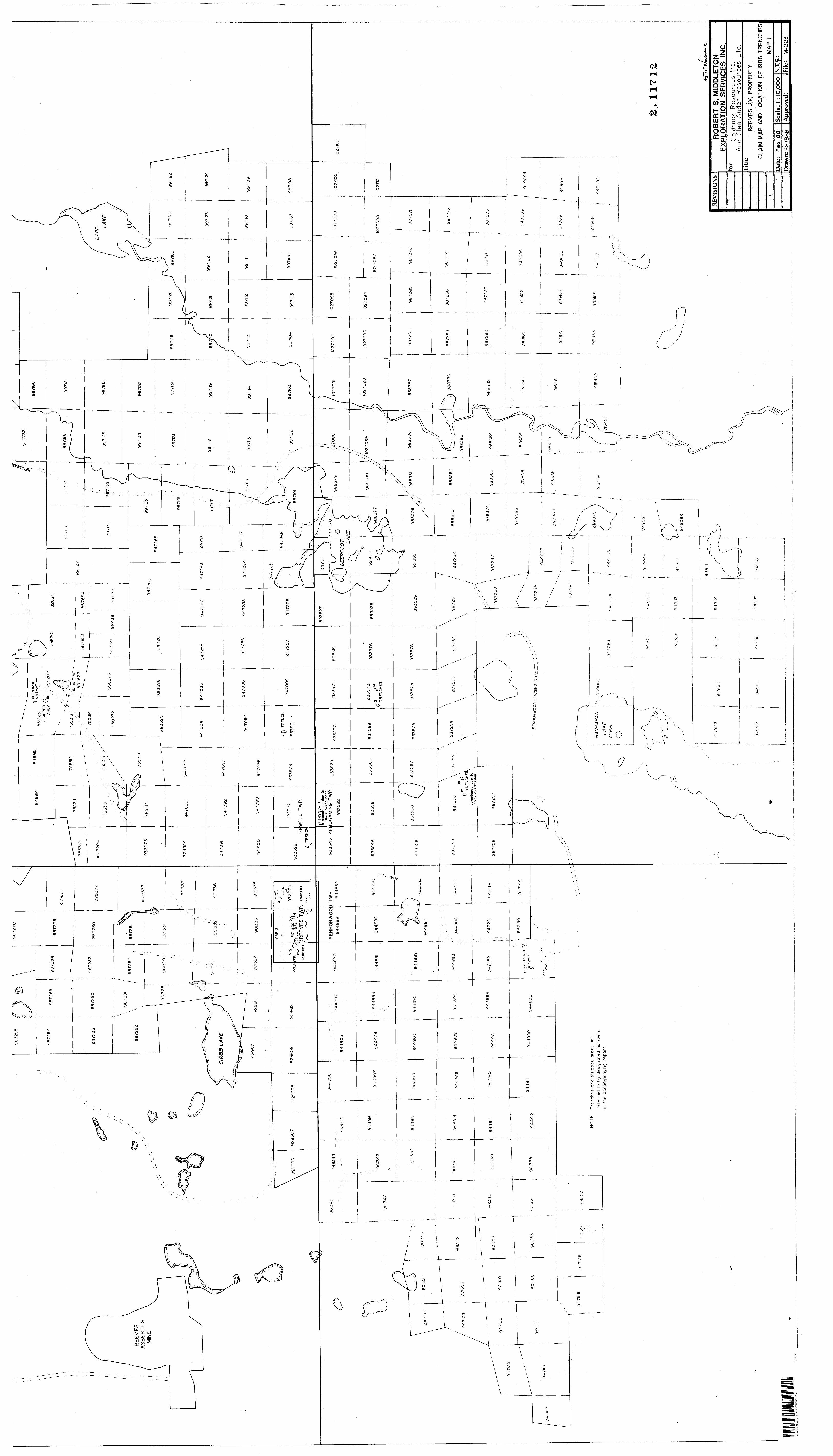
, T
,,O
.ll
OZ
T A
u
8046
22
RE
EV
ES
A
SB
ES
TOS
M
INE
CMUB
0 LA
KE
visi
ble
gold
9320
74
\ 99
7102
SE
WE
LL T
WP
.
r; TR
ENCH
aban
done
d du
e to
th
ick
over
burd
en93
3545
K
EN
OG
AM
ING
TW
PPE
NH
OR
WO
OD
TW
P.
94
488
9
94
48
82
DE
ER
FOO
T LAK
E
13n ~
TR
EN
CH
ES
.5r?
15 v
" TR
EN
CH
ER
aban
done
d du
e to
^
thic
k ov
erbu
rden
\
1 TR
EN
CH
ES
PE
NH
OR
WO
OD
LO
GG
ING
R
OA
D
NO
TE
Tren
ches
and
str
ippe
d ar
eas
are
refe
rred
to
by d
esig
nate
d nu
mbe
rs
in th
e ac
com
pany
ing
repo
rt.
HA
NR
A H
AN
LAK
E94906
94
90
99
42
A04
NW
3553
2-1
1712
KE
NO
GA
MIN
G
REV
ISIO
NS
RO
BE
RT
S. M
IDD
LETO
N
EX
PLO
RA
TIO
N S
ER
VIC
ES
IN
C.
Gol
droc
k R
esou
rces
A
nd
Gle
n A
uden
R
esou
Titl
eRE
CLA
IM M
AP t
Dat
e:
Feb.
88
Dra
wn:
SS
/BSB
Inc.
rc
es
Ltd.
EVES
J.V
. PR
OPE
RTY
WD
LO
CAT
ION
O
F 19
88 T
REN
CH
ES
MAP
1Sc
ale:
1 : 1
0,00
0A
ppro
ved:
N.T.
S.:
j.
Fite
: M
-223
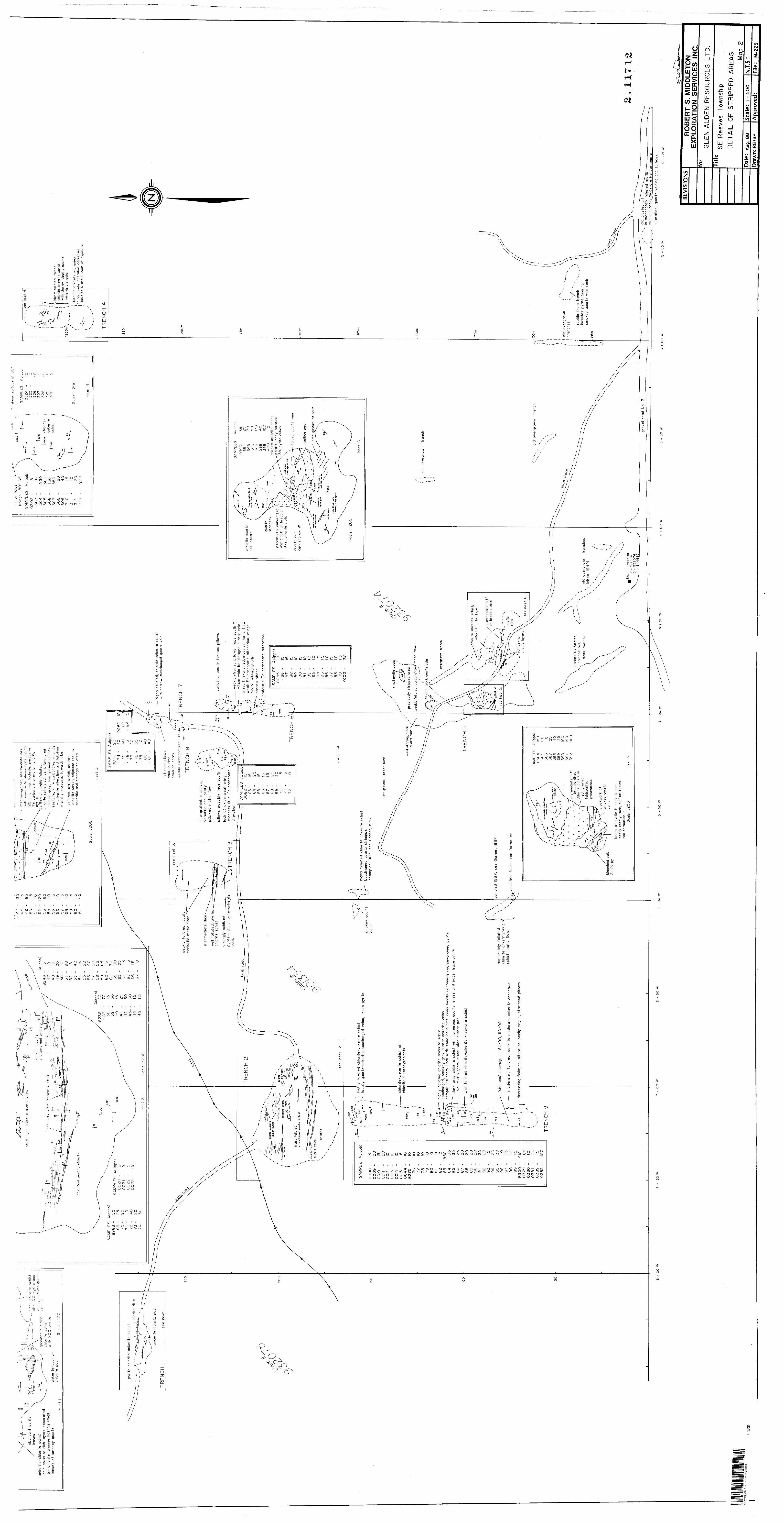
high
ly
folia
ted,
fo
lded
ch
lorit
e-an
kerit
e sc
hist
w
ith
shal
low
di
ppin
g qu
artz
ve
in;
visi
ble
gold
l fo
liatio
n in
tens
ity
and
amou
nt
of c
arbo
nate
a l
tera
tion
d ecr
ease
s to
war
ds
N an
d S
ends
o f
ex
posu
re
8 t
00
W
snea
r su
r?ac
e at
au
min
or
fold
s ol
unge
50"
NESAMPLES
Aulppb^
0324
-325
- J
326
- l O
327
-328
- . G
329
- O
330
- 5
med
ium
-gra
ined
, in
term
edia
te
dike
w
ith
mus
covi
te
phen
ocry
sts
(up
to
2Om
m)i
min
or
fuch
site
j pe
rvas
ive
Fe
carb
onat
e a
ltera
tion
an
d i"7
0 p
yrite
pyr
ife-r
ich
, hi
ghly
fo
liate
d
chlo
rite
sc
hist
^ su
lfide
is
la
min
ated
m
ediu
m
grey
, fin
e-g
rain
ed
chlo
rite,
±se
rici
te,
* Fe
ca
rbo
na
te;
min
or p
y -
anke
rite
alte
ratio
n
and
folia
tion
nte
nsi
ty
incr
ease
s to
ward
s di
ke
— —
- se
e in
set
4S
AM
PL
ES
boud
inaq
eaab
unda
nt
pyrit
e le
nses
. ac
k ch
lorite
sc
hist
w
ith
'Oy0
p
yrite
an
d o
c a ; i
y na
rrow
qu
artz
quar
tzqe
rs
and
pyr
ite o
; 02
anke
rite-
chlo
rite
schi
st-t
hin
anke
rite-
rich
laye
rs
sepa
rate
dby
ch
lorit
e la
min
ae
host
ing
smal
lle
nses
of
sm
okey
qu
artz
goss
ano'
js
blac
k ch
lorite
sc
hist
w
ith
20X
pyr
ite03
28
chlo
rite
- an
kerit
e 03
29
schi
stbo
ua'n
aged
an
Ker
quar
tz
vein
san
kent
e-qu
artz
- ch
lorit
e po
dS
cale
!:2
0C
oxid
ized
, pyn
te-r
ich,
chlo
rite
- an
kerit
e sc
hist
; ad
jace
nt
rock
is
anke
ritic
an
d st
rong
ly
folia
ted
Sca
le
i 2
00
chlo
ritoi
d po
rphy
robl
a
TRE
NC
H
4
SA
MP
LES
A
u(pp
b)
0020
- 5
00
20
02
2
-0
02
3
-py
rite
chlo
rite-
anke
rite
schi
stdi
orite
di
ke
anke
rite-
quar
tz
pod
see
inse
t
—
high
ly
folia
ted,
ch
lorite
-an
kerite
sc
hist
w
ith
narr
ow,
boud
inag
ed
quar
tz
vein
TRE
NC
H l
flatte
ned
pillo
ws;
ch
lorit
ic
rims,
an
kerit
ic
core
sse
e in
set
3.w
eakl
y ca
rbbo
natiz
edTR
EN
CH
7w
eakl
y fo
liate
d,
loca
lly
vario
litic
m
afic
flo
wTR
EN
CH
8
fine-
grai
ned,
m
assi
ve,
vario
litic
an
d lo
cally
pi
liow
ed
maf
ic
flow
inte
rmed
iate
di
ke
wel
l fo
liate
d,
pyrit
ic
chlo
rite
schi
stva
riolit
ic,
poor
ly
form
ed
pillo
ws
pillo
ws
poss
ibly
fa
ce
sout
hla
ck
of
oxid
e w
eath
erin
g ^
sugg
ests
lit
tle
Fe
carb
onat
e -
* ^
alte
ratio
n \
0^"/
stro
ngly
ox
idiz
ed,
pyrit
e-ric
h,
chlo
rite-
anke
rite
schi
st\-
_V
rRE
NC
H 3
wea
kly
stra
ined
pill
ows,
to
ps
sout
h ?
-3cm
w
ide
boud
inag
ed
quar
tz
vein
35 25 30 50 !70
40 100 10
narr
ow
anke
rite
band
spa
ralle
l ea
rly
folia
tion,
3
07o
pyrit
e cu
bes
SA
MP
LES
A
u(pp
b)bu
sh
road
grey
, fin
e-gr
aine
d, m
assi
ve
maf
ic
wea
k Fe
ca
rbon
ate
alte
ratio
n,
min
or
pynt
e su
bhed
ral
x'ls
na
rrow
sh
ear
TRE
NC
H 2
anke
rite-
quar
tz
pod
(bou
din)
modera
te
Fe
carb
onate
a
ltera
tion
quar
tz
strin
gers
perv
asiv
ely
anke
ritiz
ed
maf
ic tu
ff
or
brec
cia
dike
; ch
lorit
e cl
ots
TRE
NC
Hfo
lded
qu
artz
ve
inqu
ariz
ve
inhi
ghly
fol
iate
d ch
lorit
e-an
kerit
e sc
hist
dips
sh
allo
w
Wsu
lfide
po
d
quar
tz
gash
es
at
120
anke
rite-
qu
artz
ve
ins
ank*
rltli
*d m
afic
vo
lcan
ic,
trac
t py
rile
see
inse
t 2
Sca
le
1:20
0
folia
ted
chlo
rite-
anke
rite
schi
sthi
ghly
fo
liate
d ch
lorit
e-an
kerit
e sc
hist
bo
udin
aged
qu
artz
st
ringe
rs
•sam
pled
19
87.
see
Gar
ner.
1987
loca
lly
quar
tz-a
nker
ite b
oudi
nage
d ve
inSj
tra
ce p
yrite
smok
ey
quar
tzve
ins
low
gro
und,
ceda
r bu
sh
smal
l pyr
ite p
ods/
- ch
lorit
e-an
kerit
e sc
hist
w
ith
chlo
ritoi
d po
rphy
robl
asts
wes
t-dip
ping
, bl
ack
prev
ious
ly s
tripp
ed a
rea
quar
tz
vein
wea
kly
folia
ted,
car
bona
tlzei
j m
afic
flo
w
old
over
grow
n tr
ench
50 c
m
t^ia
ck q
uartz
vei
n
high
ly
folia
ted
chlo
rite-
anke
rite
schi
stbo
udin
aged
, sm
okey
gr
ey
quar
tz-a
nker
ite
vein
ssa
mpl
e -9
1 fr
om
1.5m
w
ide
zone
of
qu
artz
ve
ins
loca
lly
cont
aini
ng
coar
se-g
rain
ed
pyrit
e
over
grow
n tre
nch
dark
gr
ey
chlo
rite
schi
st
with
nu
mer
ous
quar
tz
lens
es
and
pods
* tr
ace
pyrit
e -N
o.
82
83
Ir
om
30cm
w
ide
quar
tz
pod
TRE
NC
H
5w
ell
folia
ted
chlo
rite
-an
kerite
±
serici
te
schi
st
chlo
rite-
anke
rite
sch
ist
\ al
tere
d m
afic
flo
w
inte
rmed
iate
tu
ff
or
brec
cia
dike
sam
pled
19
87,
see
Gar
ner,
19
87m
odera
tely
fo
liate
d
chlo
r it e
* a
nk e
r it
± se
rici
te
schi
st
(ma
fic
flow
)
'dia
mon
d'
clea
vage
at
80/9
0,
11
0/9
0
mod
erat
ely
folia
ted,
wea
k to
m
oder
ate
anke
rite
alte
ratio
n
\ se
e In
set
o.
sulfi
de
faci
es
iron
form
atio
n
sulfi
de-r
ich
cher
ty
laye
rsde
crea
sing
fo
liatio
n,
alte
ratio
n lo
cally
va
gue,
st
retc
hed
pillo
ws
see
inse
t 6
old
over
grow
n tre
nch
SA
MP
LES
A
u(pp
b)
TRE
NC
H 9
old
over
grow
n tr
ench
esin
term
edia
te
tuff
or
brec
cia
dike
s ch
lorit
e cl
asts
in
med
. gr
aine
d fe
ldsp
athi
c gr
ound
mas
s
\ m
oder
atel
y fo
liate
d,ru
bble
fr
om
trenc
hin
clud
es
pyrit
e-be
arin
g sm
okey
qu
artz
ve
in
rock
carb
on
ate
d,
i ol
d ov
ergr
own
tren
ches
\ \
(circ
a.
1942
) \
x \
x /x
\ m
afic
vo
lcan
ic
stoc
kwor
k of
sm
okey
qu
artz
blea
ched
vo
le,
pyle
nses
of
py
rite
in se
riciti
c an
d lo
cally
ch
erty
ro
ck;
sulfi
de-f
acie
s iro
n fo
rmat
ion
?S
cale
1:2
00
No.
i
- 9
44
89
92
- 90
1334
3 -
932074
4 -
94
48
62
old
blas
ted
pit
in m
oder
atel
y fo
liate
d rn
afi
volc
anic
ro
cKi
mod
erat
e Fe
ca
rbon
ati
grav
el
road
No
. 3
2.
11
71
2
oo w
2 *
50 W
alte
ratio
n,
quar
tz
vein
ing
and
sulfi
des
2 -t-
00 w
42
A0
4N
W8
5S
3 S
.H7
I2
KE
NO
GA
MIN
G
25
0
REV
ISIO
NS
for
RO
BER
T S.
MID
DLE
TON
EX
PLO
RA
TIO
N S
ERVI
CES
IN
C.
GLE
N A
UD
EN R
ESO
UR
CES
LTD
.T
itle
SE R
eeve
s To
wns
hip
DE
TAIL
OF
STR
IPP
ED
A
RE
AS Map
2Da
te:
Aug.
88D
raw
n: R
B /S
PSc
ale:
l:
500
App
rove
d:N
T. S.
:Fi
le:
M-22
3