Embed Size (px)
Citation preview

Customer-Focused
TRC Reference Number: 02136-0490-01X39
September 3, 2003
David Lederer
U.S. EPA New England, Region 1
Office of Site Remediation and Restoration
One Congress Street, Suite 1100
Boston, MA 02114
Subject: Hatheway and Patterson Superfund Site
Preliminary Reuse Assessment
Dear Dave:
Please find enclosed five copies of the Preliminary Reuse Assessment for the Hatheway
and Patterson Superfund Site. TRC will incorporate any additional comments received
from the Towns of Mansfield and Foxborough, and MADEP, upon EPA’s request.
Please feel free to contact Laura Lefebvre at (978) 656-3517 or me at (978) 656-3560 if
you have any questions or comments.
Sincerely yours,
Dale S. Weiss, P.G.
Senior Program Manager
cc: John Podgurski, EPA
Laura Lefebvre, TRC

Preliminary Reuse Assessment
Hatheway and Patterson Superfund Site
September 2003
- DRAFT

Hatheway and Patterson Superfund Site
Preliminary Reuse Assessment
TABLE OF CONTENTS
PURPOSE OF THIS DOCUMENT .............................................................. 1
SECTION 1 - SITE BACKGROUND........................................................... 3
General Site Description............................................................... 3Neighboring Activities and Land Uses .......................................... 9Site Zoning ................................................................................. 12Environmental History/Status.................................................... 12
Past Plant Operations ........................................................................... 12Federal and State Response Actions....................................................... 14Site Contamination ............................................................................... 15
SECTION 2 - REUSE STATUS ................................................................ 19
Mansfield Parcels........................................................................ 19Current Uses........................................................................................ 21Potential Future Uses............................................................................ 21Potential Use/Reuse Considerations ....................................................... 23
Foxborough Parcel...................................................................... 25Current Uses........................................................................................ 25Potential Future Uses............................................................................ 25Potential Use/Reuse Considerations ....................................................... 25
SECTION 3 - GENERAL FINDINGS AND RECOMMENDATIONS ............. 27
Reasonably Anticipated Future Land Uses (RAFLUs) ................. 27Site Control/Ownership.............................................................. 28Superfund Liability Concerns...................................................... 28Use Restrictions.......................................................................... 29
REFERENCES ........................................................................................ 31
FIGURES
Figure 1 Site Location on USGS Map........................................................... 4Figure 2 Aerial Photograph of Hatheway and Patterson Superfund Site ......... 6Figure 3 Aerial Photograph, Land Use Within 1-Mile Radius of Hatheway
and Patterson Superfund Site ....................................................... 7Figure 4 Habitat Assessment, Hatheway and Patterson Site ......................... 8Figure 5 Street Map in Local Vicinity of Hatheway and Patterson
Superfund Site .......................................................................... 11Figure 6 Potential Primary Contaminant Source Areas................................ 17Figure 7 Conceptual Summary of Contaminant Distribution ........................ 18Figure 8 Tax Map Parcels, Hatheway and Patterson Superfund Site ............ 20
L2003-165 i
Hatheway and Patterson Superfund Site
Preliminary Reuse Assessment
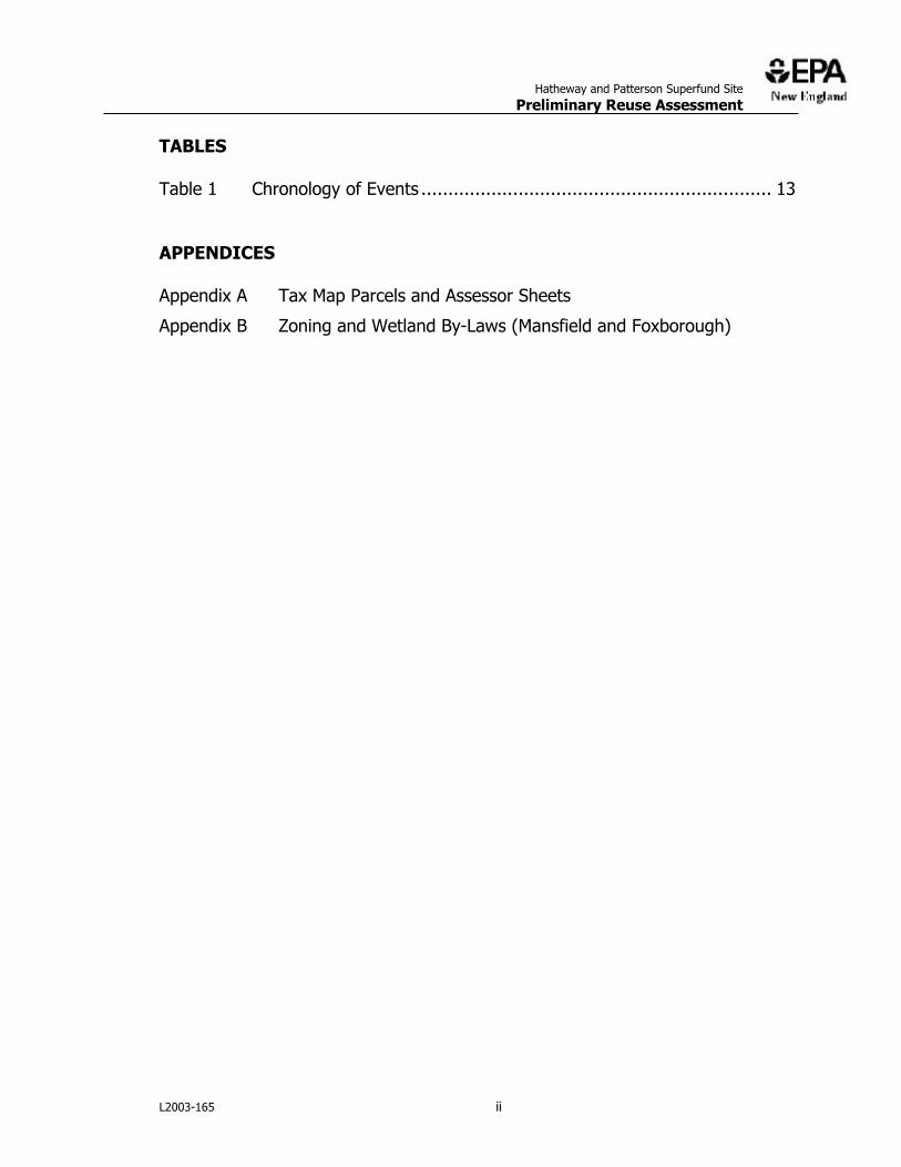
TABLES
Table 1 Chronology of Events ................................................................. 13
APPENDICES
Appendix A Tax Map Parcels and Assessor Sheets
Appendix B Zoning and Wetland By-Laws (Mansfield and Foxborough)
L2003-165 ii

Hatheway and Patterson Superfund Site
Preliminary Reuse Assessment
PURPOSE OF THIS DOCUMENT
EPA-New England is responsible for the cleanup of over 100 Superfund sites throughout New England. Although protecting human health and the environment is the primary objective of these cleanups, EPA also recognizes the value in helping to return Superfund sites to beneficial reuse. Understanding the current and likely future uses of a site is fundamental to achieving both objectives.
Most importantly, accurate information on the likely uses of a Superfund site and the surrounding area is necessary to make reasonable assumptions about possible exposures to contaminants. These assumptions form the basis for establishing site-specific cleanup levels and, ultimately, for designing a protective remedy. Uncertainty in this information makes it difficult to appropriately tailor the site investigation and cleanup, and oftentimes leads to increased project costs and delays.
From the standpoint of facilitating site reuse, details regarding current or planned uses can enable EPA to consider those uses in the selection, design, and implementation of the remedy. However, such accommodations will only be considered if they do not compromise the protectiveness of the cleanup. For instance, it may be possible to locate a soil or groundwater treatment system so as not to physically restrict the construction of future buildings. In other cases, the cleanup might be phased in a way that allows certain portions of a site to be available sooner. There are numerous Superfund sites across the country where reuse has already been facilitated in this manner.
This Reuse Assessment summarizes information on the current and potential future land uses at the Hatheway and Patterson Superfund Site that is currently known to the EPA case team. Potential reuse-related issues, data gaps, and other relevant considerations are also described.
EPA will continue to work with the local community and other stakeholders to resolve remaining uncertainties and develop a more complete and realistic understanding of site use. This information will be used to support EPA=s
decisions regarding future response actions at the Site.
The Reuse Assessment is presented in three sections:
x Section 1 - Site Background: Describes the physical, environmental, and historical context of the site.
x Section 2 - Reuse Status: Describes the current and potential future uses of the separate parcels or discrete areas within the Site. Potential
L2003-165 SUPERFUND REUSE ASSESSMENT / 1
x
Hatheway and Patterson Superfund Site
Preliminary Reuse Assessment
use/reuse considerations relating to these parcels or areas are also discussed
Section 3 - General Findings and Recommendations: Provides a general summary of relevant findings and potential issues.
L2003-165 SUPERFUND REUSE ASSESSMENT / 2
Hatheway and Patterson Superfund Site
Preliminary Reuse Assessment
SECTION 1 - SITE BACKGROUND
General Site Description
QUICK FACTS
35 County Street Mansfield (Bristol County) and Foxborough (Norfolk County)
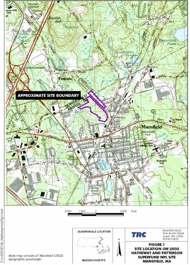
Latitude: 42 deg 02 min 12.59 sec Longitude: -71 deg 11 min 54.82 sec See Figures 1 and 2
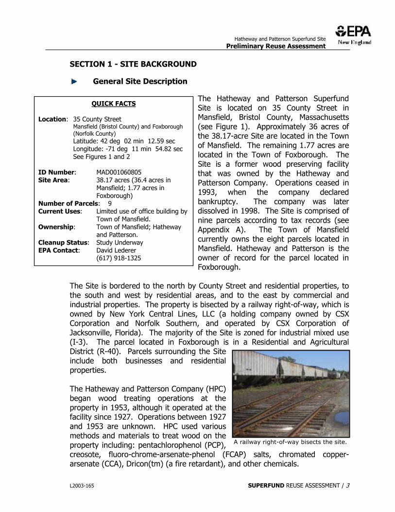
The Hatheway and Patterson Superfund Site is located on 35 County Street in Mansfield, Bristol County, Massachusetts (see Figure 1). Approximately 36 acres of the 38.17-acre Site are located in the Town of Mansfield. The remaining 1.77 acres are located in the Town of Foxborough. The Site is a former wood preserving facility that was owned by the Hatheway and Patterson Company. Operations ceased in 1993, when the company declared bankruptcy. The company was later dissolved in 1998. The Site is comprised of nine parcels according to tax records (see Appendix A). The Town of Mansfield currently owns the eight parcels located in Mansfield. Hatheway and Patterson is the owner of record for the parcel located in Foxborough.
Location:
ID Number: MAD001060805 Site Area: 38.17 acres (36.4 acres in
Mansfield; 1.77 acres in Foxborough)
Number of Parcels: 9 Current Uses: Limited use of office building by
Town of Mansfield. Ownership: Town of Mansfield; Hatheway
and Patterson. Cleanup Status: Study Underway EPA Contact: David Lederer (617) 918-1325
The Site is bordered to the north by County Street and residential properties, to the south and west by residential areas, and to the east by commercial and industrial properties. The property is bisected by a railway right-of-way, which is owned by New York Central Lines, LLC (a holding company owned by CSX Corporation and Norfolk Southern, and operated by CSX Corporation of Jacksonville, Florida). The majority of the Site is zoned for industrial mixed use (I-3). The parcel located in Foxborough is in a Residential and Agricultural District (R-40). Parcels surrounding the Site include both businesses and residential properties.
The Hatheway and Patterson Company (HPC) began wood treating operations at the property in 1953, although it operated at the facility since 1927. Operations between 1927 and 1953 are unknown. HPC used various methods and materials to treat wood on the property including: pentachlorophenol (PCP), A railway right-of-way bisects the site.
creosote, fluoro-chrome-arsenate-phenol (FCAP) salts, chromated copper-arsenate (CCA), Dricon(tm) (a fire retardant), and other chemicals.
L2003-165 SUPERFUND REUSE ASSESSMENT / 3
Hatheway and Patterson Superfund Site
Preliminary Reuse Assessment
Figure 2 shows a 2001 aerial photograph of the Site. The Site is relatively level and includes areas of pavement and concrete as well as bare ground. Two rock outcrops rise above grade south of railway right-of-way. The majority of the former Site operations and buildings are located north of the railway right-of-way. An area just south of the right-of-way was used as a wood storage area. The southern-most part of the Site is occupied by wetlands.
Based on the Flood Insurance Rate Map, portions of the Site are located within areas of the 100-year flood zone (Zone A3) and between limits of the 100-year flood and 500-year flood zone (Zone B) for the Rumford River. Figure 3 shows the boundaries of the flood zones.
Ground water elevations show that the average annual depth to ground water is generally less than 15 feet. In accordance with 310 CMR 40.0932, Site ground water with an average annual depth of less then 15 feet and within 30 feet of an occupied building or structure is classified as Ground Water Category GW-2. Category GW-2 ground water is considered to be a potential source of vapors of oil and/or hazardous material to indoor air. Additionally, the Massachusetts Department of Environmental Protection (MADEP) considers all ground water in Massachusetts to have potential for discharge to surface water; therefore, site ground water is also classified as GW-3.
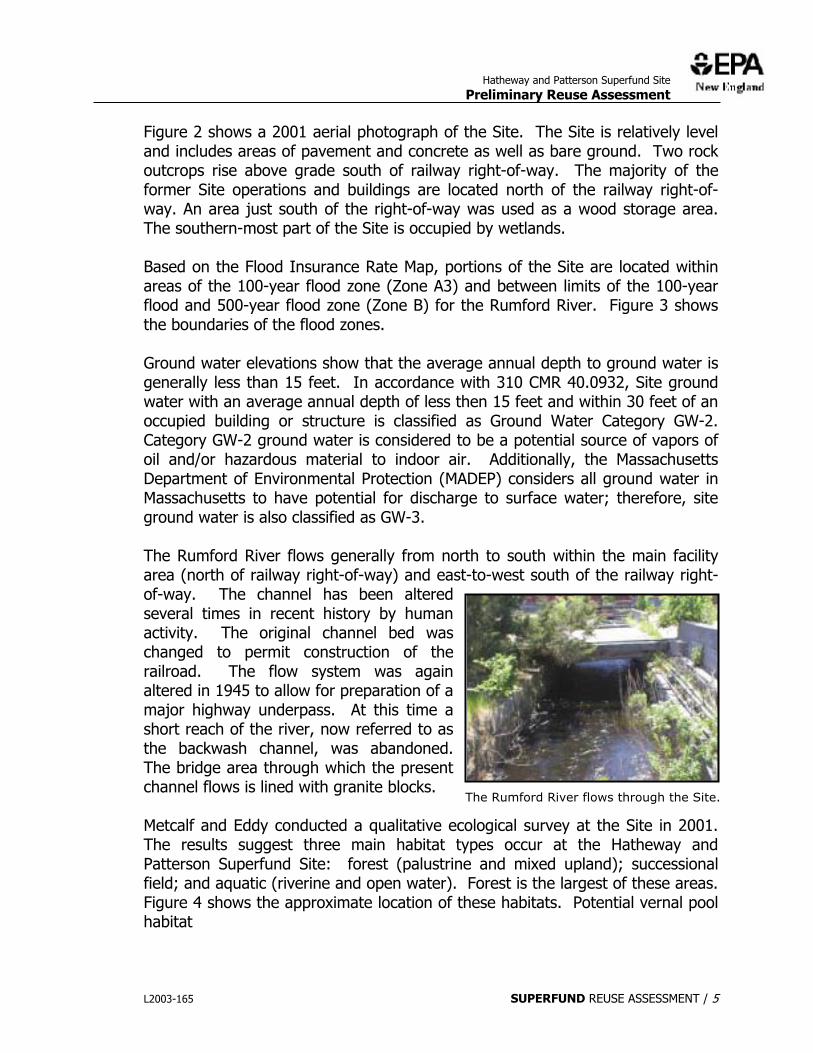
The Rumford River flows generally from north to south within the main facility area (north of railway right-of-way) and east-to-west south of the railway right-of-way. The channel has been altered several times in recent history by human activity. The original channel bed was changed to permit construction of the railroad. The flow system was again altered in 1945 to allow for preparation of a major highway underpass. At this time a short reach of the river, now referred to as the backwash channel, was abandoned. The bridge area through which the present channel flows is lined with granite blocks.
The Rumford River flows through the Site.
Metcalf and Eddy conducted a qualitative ecological survey at the Site in 2001. The results suggest three main habitat types occur at the Hatheway and Patterson Superfund Site: forest (palustrine and mixed upland); successional field; and aquatic (riverine and open water). Forest is the largest of these areas. Figure 4 shows the approximate location of these habitats. Potential vernal pool habitat
L2003-165 SUPERFUND REUSE ASSESSMENT / 5
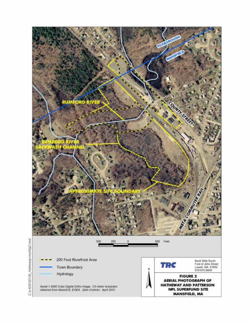
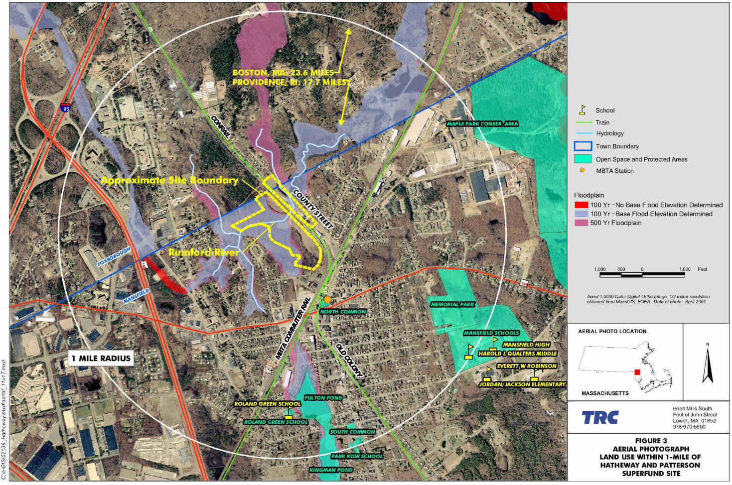

FIGURE 4
& Metcalf & Eddy
Boott Mills South Foot of John Street Lowell, MA 01852 978-970-5600
RAC SUBCONTRACT NO.: 107061
HATHEWAY AND PATTERSON SUPERFUND NPL SITE
MANSFIELD, MASSACHUSETTS TRC PROJ. NO.: 02136-0310-01X31
EPA CONTRACT NO.: 68-W6-0042
HABITAT ASSESSMENT
0213
6/H
ATH
AW
AY
REU
SE A
SSES
SMEN
T/H
AB
ITA
T

Hatheway and Patterson Superfund Site
Preliminary Reuse Assessment
areas were also identified in the southern portion of the Site in a follow-up survey conducted by Metcalf and Eddy in the spring of 2002.
According to 314 CMR 4.00, the Rumford River is a Class B surface water. Class B waters are designated as habitat for fish, other aquatic life and wildlife, and for primary and secondary contact recreation. Where designated, Class B waters are suitable as a source of public water supply with appropriate treatment. Class B waters are also suitable for irrigation and other agricultural uses and for compatible industrial cooling and process uses. Class B waters shall have consistently good aesthetic value.
Neighboring Activities and Land Uses
Most of the Hatheway and Patterson Superfund Site is located in Mansfield. Mansfield is located in southeastern Massachusetts, bordered by North Attleborough on the west; Attleboro on the southwest; Norton on the south; Easton on the east; Sharon on the northeast; and Foxborough on the North. Mansfield is 26 miles south of Boston and 19 miles northeast of Providence, Rhode Island. The Town of Mansfield has a population of approximately 22,414 residents (2000 US Census), and a density of 810 persons per square mile. Mansfield comprises 20.72 square miles.
According to the Mansfield Master Plan (1997), the rate of growth began to increase in the late 1960s with completion of Route I-95 and accelerated as Route I-495 was completed. As a result, thirty percent of the homes in Mansfield were built in the 1980s. The general pattern of development in Mansfield focuses on its downtown concentration of commercial and public uses in the north central part of town. Today there are extensive suburban residential areas throughout both East Mansfield, east of Canoe River, and West Mansfield, west of Plymouth Street Recreation area and Hodges Brook.
The 1970s also saw development and expansion of Mansfield’s major industrial and business area, the Cabot Business Park, between Route I-95, Route I-495, and Route 140. This industrial park is now expanding to the west of Route I-495 along Plymouth Street. Mansfield is enhancing its ability to compete for new industry and commercial development through the efforts of the revitalized Industrial Development Commission. To reap maximum economic and environmental benefits from the development of its commercial land, the Mansfield Master Plan urges the Town to actively welcome, support, and guide the location of desirable uses into the Town (Kreutziger, 1997).
Mansfield has potential for a substantial build out of new commercial/industrial space. The amount of commercial development that is allowable under
L2003-165 SUPERFUND REUSE ASSESSMENT / 9
Hatheway and Patterson Superfund Site
Preliminary Reuse Assessment
Mansfield’s present zoning is estimated at 17 million square feet or an expansion of 280 percent (Kreutziger, 1997).
According to Mansfield Town Officials, Mansfield wants to control future growth while providing tax revenues. Mitigating school growth is a consideration as it is in most Commonwealth communities. (EPA, 2003)
Mansfield is served by the Massachusetts Bay Transportation Authority (MBTA) Attleboro Commuter Line, which provides a link to downtown Boston. As a result, Mansfield attracts many people who commute into Boston.
A small portion of the Hatheway and Patterson Superfund Site is located in Foxborough. Foxborough, located in Norfolk County, comprises 19.77 square miles. It is a growing community of 16,000, with a population density of 822 people per square mile.
Figure 3 shows the general land uses and sensitive receptors within a 1-mile radius of the Site. The Site is located in an area heavily populated by both commercial and industrial businesses and residential properties. The closest residence is located on County Street approximately 40 feet north of the site. The closest school is the Roland Green Preschool, which is located approximately 0.6 miles south from the site on Dean Street.
From a transportation standpoint, the Site is ideally situated in close proximity to two major interstate highways: Route I-495 and Route I-95.
The Site is also located within walking distance to the MBTA Commuter Rail Station on Crocker Street. The Mansfield Station, which is scheduled to be rebuilt and expanded, has become a regional hub for commuters from neighboring communities as well as from as far south as Rhode Island. There are approximately 1,000 parking spaces adjacent or within walking distance to the station to accommodate approximately 1,435 commuters per day. Along with replacement of the present station, the MBTA plans to expand rail services and reconfigure parking.
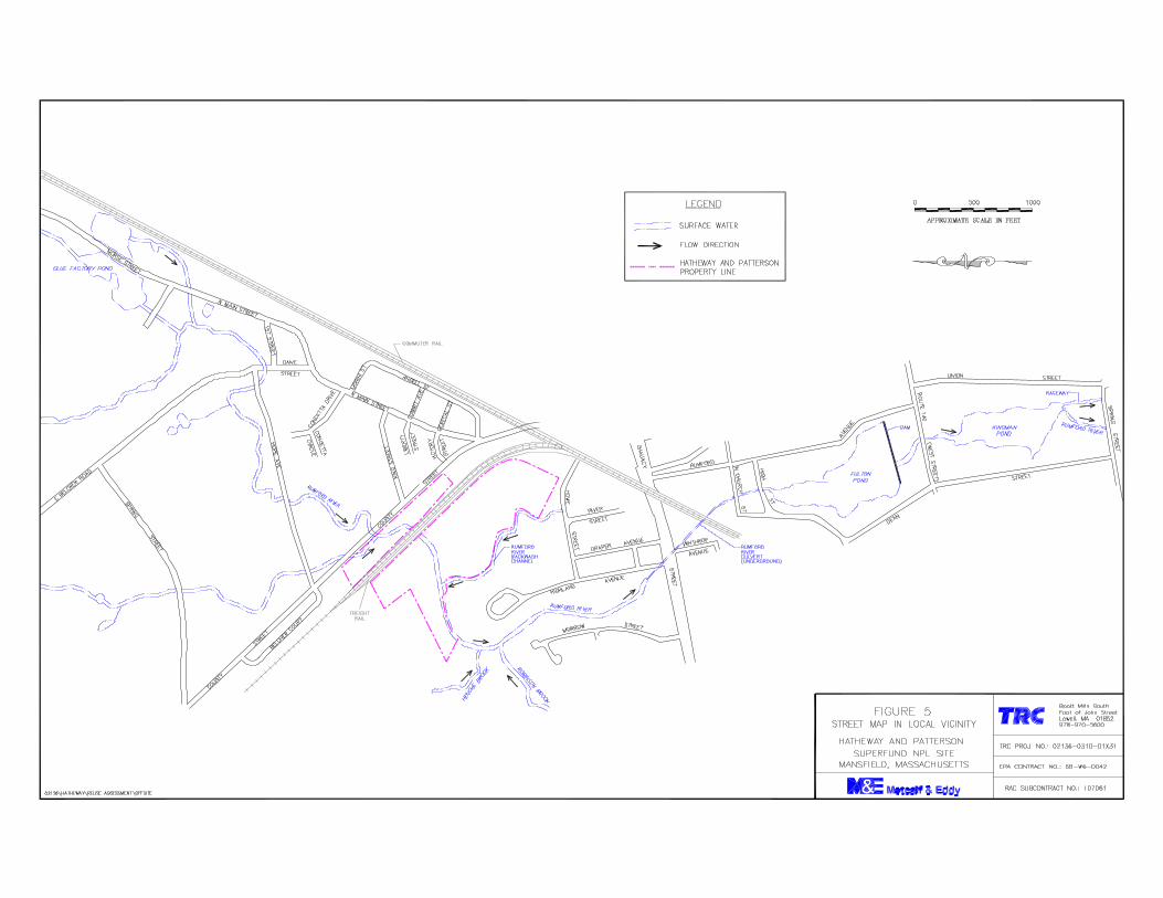
There are several parking lots that serve the MBTA Station. There are several aspects of the commuter parking at the Mansfield Station that need attention (Kreutziger, 1996). Current parking for the MBTA Station is insufficient. In addition, there are difficult connections between the commuter lots and State and Interstate highways and traffic congestion on outlet streets and intersections (e.g., Highland Avenue and Chauncy Street; Winthrop Avenue and Chauncy Street) when the evening peak outbound trains arrive (Kreutziger, 1996). (See Figure 5 for a street map showing local roads in the vicinity of the Site.)
L2003-165 SUPERFUND REUSE ASSESSMENT / 10
Hatheway and Patterson Superfund Site
Preliminary Reuse Assessment
The Town of Mansfield owns the Old Colony Railroad corridor, which runs from the center of Mansfield and extends south to Norton. The Town of Mansfield is proposing to make this corridor into a bike trail, which will become part of the East Coast Greenway, a multi-user trail that will run from Maine to Florida. This trail is characterized as the “urban equivalent” to the Appalachian Trail, and thus the entire trail is designated as the Millennium Trail. The location of the corridor is shown on Figure 3.
Site Zoning
The Mansfield Parcels are in an I-3 zone. This is a flexible mixed use industrial zone, which allows an array of uses from heavy manufacturing to multi-family dwellings to daycare centers. Table B-1 summarizes the allowable uses in this zone according to the Town of Mansfield Zoning By-Laws, Schedule of Principal Use Regulations (see Appendix B).
The following uses are not allowed in the I-3 zone: residential compound, assisted care retirement facility, residential facilities for residents 55 or older, community life care center, aviation, mall, fast food restaurant, car wash, motor vehicle salvage, and adult establishments.
The Foxborough Parcel is in a Residential and Agricultural District (R-40). This district is established to promote agricultural uses and low-density residential uses and to allow other selected uses, which are compatible with the open and rural character of the district. Table B-2 summarizes the allowable uses in this zone according to the Town of Foxborough Zoning By-Laws, Use Regulations (see Appendix B).
Appendix B also provides copies of the Town of Mansfield Zoning By-Law and Town of Foxborough Zoning By-Law.
Environmental History/Status
Past Plant Operations
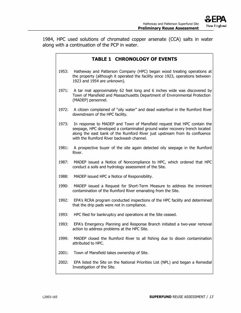
Table 1 provides a chronology of key environmental events. From 1953 to 1993, HPC operated a wood treatment/preservation facility at the Site for wood sheeting, planking, timber, piling, poles, and other wood products. According to historical information, HPC began operations at the site in 1953 utilizing PCP in fuel oil and creosote to treat lumber. From 1958 to 1974, solutions of PCP in fuel oil and fluoro-chrome-arsenate-phenol (FCAP) salt in water were used, and from 1960 to 1984, PCP in mineral spirits was also used. From 1974 through
L2003-165 SUPERFUND REUSE ASSESSMENT / 12
Hatheway and Patterson Superfund Site
Preliminary Reuse Assessment
1984, HPC used solutions of chromated copper arsenate (CCA) salts in water along with a continuation of the PCP in water.
TABLE 1 CHRONOLOGY OF EVENTS
1953: Hatheway and Patterson Company (HPC) began wood treating operations at the property (although it operated the facility since 1923, operations between 1923 and 1954 are unknown).
1971: A tar mat approximately 62 feet long and 6 inches wide was discovered by Town of Mansfield and Massachusetts Department of Environmental Protection (MADEP) personnel.
1972: A citizen complained of “oily water” and dead waterfowl in the Rumford River downstream of the HPC facility.
1973: In response to MADEP and Town of Mansfield request that HPC contain the seepage, HPC developed a contaminated ground water recovery trench located along the east bank of the Rumford River just upstream from its confluence with the Rumford River backwash channel.
1981: A prospective buyer of the site again detected oily seepage in the Rumford River.
1987: MADEP issued a Notice of Noncompliance to HPC, which ordered that HPC conduct a soils and hydrology assessment of the Site.
1988: MADEP issued HPC a Notice of Responsibility.
1990: MADEP issued a Request for Short-Term Measure to address the imminent contamination of the Rumford River emanating from the Site.
1992: EPA's RCRA program conducted inspections of the HPC facility and determined that the drip pads were not in compliance.
1993: HPC filed for bankruptcy and operations at the Site ceased.
1993: EPA's Emergency Planning and Response Branch initiated a two-year removal action to address problems at the HPC Site.
1999: MADEP closed the Rumford River to all fishing due to dioxin contamination attributed to HPC.
2001: Town of Mansfield takes ownership of Site.
2002: EPA listed the Site on the National Priorities List (NPL) and began a Remedial Investigation of the Site.
L2003-165 SUPERFUND REUSE ASSESSMENT / 13
Hatheway and Patterson Superfund Site
Preliminary Reuse Assessment
Federal and State Response Actions
In 1971, a tar mat approximately 62 feet long and 6 inches wide was discovered by Town of Mansfield and Massachusetts Department of Environmental Protection (MADEP) personnel. In 1972, a citizen complained of “oily water” and dead waterfowl in the Rumford River downstream of the HPC facility. Subsequently, MADEP and the Town of Mansfield requested that HPC contain the seepage. By 1973, HPC developed a contaminated ground water recovery trench located along the east bank of the Rumford River just upstream from its confluence with the Rumford River backwash channel. Oily seepage was again detected in the Rumford River in 1981 by a prospective buyer of the site.
In 1987, the MADEP issued a Notice of Noncompliance to HPC, which ordered the company to conduct a soils and hydrology assessment of the site. In 1990, MADEP issued a Request for Short-Term Measure to address the imminent contamination of the Rumford River caused by seepage emanating from the site. In 1992, EPA's RCRA program personnel conducted inspections of the HPC facility and determined that the drip pads were not in compliance. In 1993, HPC filed for bankruptcy and ceased operations in April 1993.
Because wood treating solvents, chemicals, sludges, tanks, sumps, and drums were abandoned by HPC, conditions at the Site were determined to pose a significant threat of hazardous substance release. Therefore, in December 1993, EPA initiated a two year removal action to address problems at the HPC Site. Upon initiating the removal action, EPA found several process and support buildings that contained large tanks, process vessels, drums, sumps, pits, and various small containers.
Outside on the property, EPA found three drip pads, treated lumber storage areas, three above ground tanks containing PCP, another tank containing fuel oil, three tanks containing Dricon(tm) in water, and six underground storage tanks. Over 50,000 gallons of wastewater was removed by EPA during this action; an undetermined amount of contaminated soil remains at the site. HPC's operations and abandoned materials have caused releases of site-related contaminants to soils, ground water, and surface water.
In 1999, the State of Massachusetts closed a portion of the Rumford River to fishing due to dioxin contamination attributed to HPC.
EPA conducted a preliminary environmental investigation in the fall of 2001 and issued a Final Data Report on June 4, 2002. The preliminary environmental investigation focused on sampling existing ground water monitoring wells and collecting water and sediment samples from the Rumford River. The Final Data
L2003-165 SUPERFUND REUSE ASSESSMENT / 14
Hatheway and Patterson Superfund Site
Preliminary Reuse Assessment
Report summarizes all historical soils data collected at the site as well as data collected during the preliminary environmental investigation. Based on the information presented in the Final Data Report, EPA was able to identify where additional information is needed to complete a Remedial Investigation.
In 2002, EPA listed the Site on the National Priorities List (NPL) because releases of facility related dioxins, furans, and phenols to the Rumford River have impacted fisheries and wetlands, and releases of arsenic, chromium, copper, phenols (including PCP), and polycyclic aromatic hydrocarbons (PAHs) to ground water pose a threat to nearby municipal and private drinking water wells. A Remedial Investigation of the site began in October 2002.
Field work will continue through 2003 and the Remedial Investigation Report is expected to be available for review in the Spring of 2004. Field activities conducted in the fall of 2002 included sediment sampling of the Rumford River Backwater channel, surface soil sampling, subsurface soil sampling, and an investigation looking for undissolved wood preservative chemicals that may have leaked into the ground. Some of the field activities expected for 2003 includes ground water sampling, sediment sampling in Fulton Pond, and fish sampling in Fulton Pond and the Norton Reservoir.
EPA is the lead agency on this project.
Site Contamination
Figure 6 shows the location of potential contaminant source areas that were identified based on a review of historic information and test results from EPA’s 2001 preliminary environmental investigation.
The potential primary contaminant source areas include the following.
x Process areas (oil, arsenic, copper, chromium, PCP, dioxin); x Drip pads (arsenic, copper, chromium, PCP, dioxin);
x Wood drying areas (arsenic, copper, chromium, PCP, dioxin); and x Reported wood dipping pit (oil, PCP, dioxin, SVOCs).
Secondary contaminant source areas (not shown) may also be present and include subsurface accumulations of NAPL.
Figure 7 shows a conceptual summary of the distribution of contaminants at the site together with the most likely contaminant transport pathways. The red areas show zones of known soil contamination (arsenic, pentachlorophenol [PCP]), the gray areas show the areas of contaminated ground water (arsenic,
L2003-165 SUPERFUND REUSE ASSESSMENT / 15
Hatheway and Patterson Superfund Site
Preliminary Reuse Assessment
PCP) and light non-aqueous phase liquid (LNAPL) and the green area shows the stretch of river containing contaminated sediment. With the exception of lead in the sediment of the Rumsford River, the extent of contamination appears to be limited to the site.
L2003-165 SUPERFUND REUSE ASSESSMENT / 16