Embed Size (px)
Citation preview

PRELIMINARY RESULTS ARCHAEOLOGICAL INVESTIGATION
STAGE 2c
Parramatta Justice Precinct former Parramatta Hospital Site
cnr Marsden & George Streets, Parramatta
For
Multiplex
September 2006

i
Executive Summary Results of the Stage 2c Archaeological Program The Stage 2c archaeological investigation has revealed substantive and extensive remains of the 2nd hospital (1792-1818) and the courtyard and outbuildings associated with the convict phase of the 3rd hospital (1818-1844) as well as considerable remains of the hospital boundary wall and further evidence associated with the later nineteenth-century alterations. In addition remains of a second timber structure associated with the Marsden Street convict hut and the nineteenth-century occupation of Brislington were found. The main archaeological features found during Stage 2c were: Second Hospital
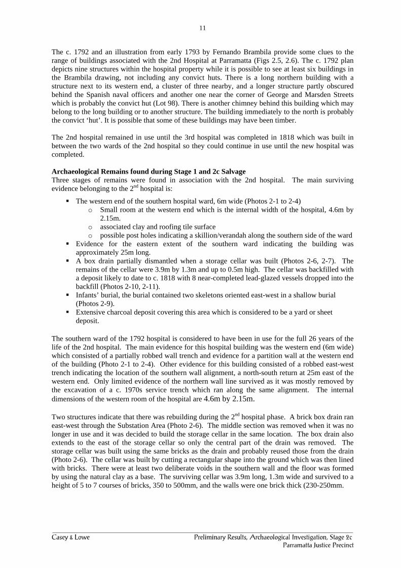
The western end of the southern hospital ward, 6m wide (Photos 2-1 to 2-4). This included: o Small room at the western end which is the internal width of the hospital, 4.6m by
2.15m. o associated clay and roofing tile surface o possible post holes indicating a skillion/verandah along the southern side of the
ward. Evidence for the eastern end of the southern ward indicated the building was approximately
25m long. A box drain partially dismantled when a storage cellar was built (Photos 2-6, 2-7). The
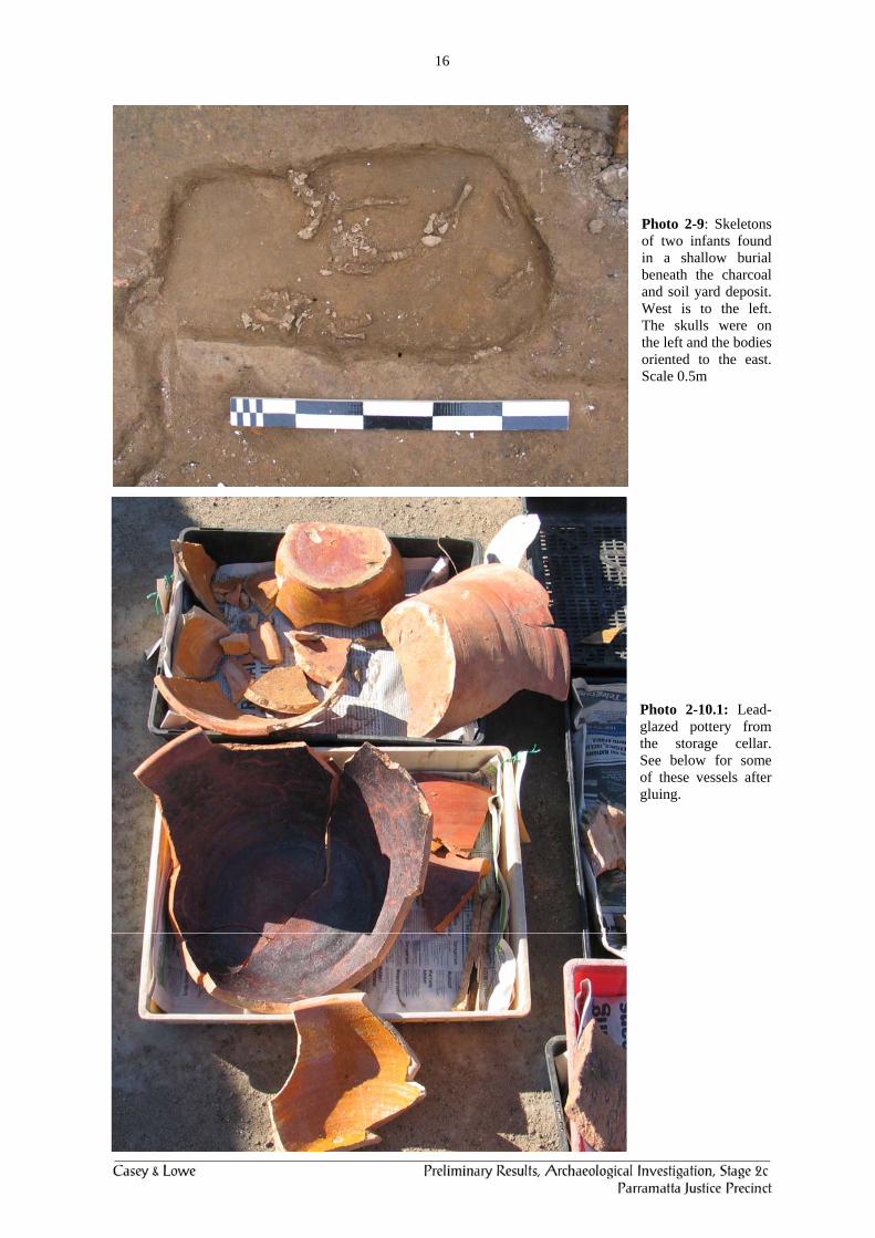
remains of the cellar were 3.9m by 1.3m and up to 0.5m high. The cellar was backfilled with a deposit likely to date to c. 1818 with 8 near-completed lead-glazed vessels dropped into the backfill (Photos 2-10, 2-11).
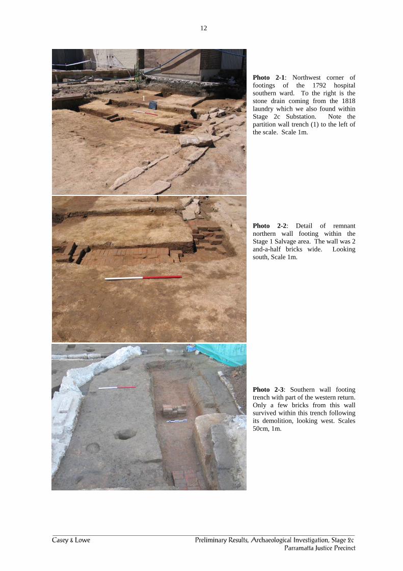
Infants’ burial, the burial contained two skeletons oriented east-west in a shallow burial (Photos 2-9).
Marsden Street Convict Hut
A timber structure which was probably an additional building to the north of the convict hut (Photos 2-12 to 2-14).
Third Hospital Other 3rd hospital remains found during this stage were:
Well (Photo 2-17). Water cistern (Photo 2-18), phasing uncertain. Eastern brick cesspit/privy (Photo 2-19). Robbed trenches of the eastern kitchen/dead room outbuilding (Photo 2-20). Some remains of other structures/drains (Photo 2-21). Southern part of western privy and cesspool (Photo 2-22). Drain adjacent to the western privy and cesspool (Photo 2-23). Section of brick drain running westwards to the creek line which is part of the circular drain
found during Stage 1 and further to the west (Photo 2-25). Section of stone box drain running from the 1818 laundry to connect into the brick drain
(Photo 2-25, 2-26, 2-27). Pit containing amputated hand, animal bones, smoking pipes and bone-stopper shaped like a
fist (Photos 2-28 to 2-32). Phase 5: 1840s Upgrading for the District Hospital (1844–1878)
Hospital boundary wall (Photos 2-33 to 2-42). Amendments to the 1818 privies (Photo 2-22).
Phase 6: Rebuilding of the kitchen/laundry block, operating theatre, southern road, 1879–1902
Southern road (Photos 2-45, 2-46). 1879 toilets (Photos 2-44).
ii
Brislington, Lot 98 Wellington Jug and associated locally-made artefacts (Photos 2-57). Limited evidence for uses associated with convict period. Evidence for the garden and outbuildings (photo 2-62 to 2-64).
Top Ten Discoveries for all Stages of the PJP Archaeological Program The most significant archaeological remains and evidence recovered from Stages 1, 2b and 2c of the PJP archaeological program are, in a general order of importance but not precedence:
1. Remains of the 2nd hospital. 2. Footings of the 1818 colonial hospital. 3. Remains of the 3rd hospital: privies, courtyard, artefacts, fences, etc. 4. Infants’ Burial. 5. Wellington Jug. 6. Surgeon’s Residence and evidence for internal plasterwork decoration of the house. 7. Marsden Street convict hut and outbuilding. 8. Bone button manufacturing and part of leg iron. 9. The boundary wall and associated 1840s alterations and how they assist us to understand
changing colonial practices from a convict to a completely free colony. 10. Lead-glazed pottery from 2nd hospital and Brislington (Photos 2-10.1, 2-10.2, 2-10.3, .
There is a lot of artefactual evidence which we have not yet had time to address and these may in time turn out to be more significant then we currently realise. This list contains the most ‘important’ evidence from my perspective and reflects my personal and professional biases although I do not think other archaeologists would necessarily produce a different type of list perhaps just a different order. These items should form the framework around which the interpretation strategy is developed for the Heritage Courtyard.
Contents Executive Summary ............................................................................................................................. i 1.0 Background.............................................................................................................................. 1
1.1 Background ........................................................................................................................... 1 1.2 Authorship............................................................................................................................. 2
2.0 Results of Stage 2c Archaeological Program ........................................................................ 4
2.1 Aims of the Archaeological Program.................................................................................... 4 2.2 Phasing of the Archaeological Remains................................................................................ 7 2.3 Convict Hospitals .................................................................................................................. 8
2.3.1 Phase 1: Natural Landscape .......................................................................................... 8 2.3.2 Phase 2: Aboriginal Occupation.................................................................................... 8 2.3.3 Phase 3.1: Early Clearing and Agriculture (1789–1790) .............................................. 9 2.3.4 Phase 3.2: Convict Parramatta and Early Emancipated/Free Settlement (1790–1818)10 2.3.5 Phase 4: Third Convict Hospital (1818–1844)............................................................ 20 2.3.6 Phase 5: 1840s Upgrading for the District Hospital (1844–1878)……………………38 2.3.7 Phase 6: New Services to the Hospital, 1879–1902…………………………………..45 3.3.8 Phase 7: Construction of the Sulman Power Hospital, 1890s–1902, the Fourth Hospital,
and Demolition of the Third Hospital………………………………………………..47 2.3.9 Phase 8: Later twentieth-century construction of buildings and services, 1902–1999..49
2.4 Lot 98 – Brislington……………………………………………………………………….49 2.4.1 Historical Background………………………………………………………………....49 2.4.2 Archaeological Phases in Lot 98……………………………………………………....53 2.4.3 Phase 1: Natural Landscape……………………………………………………………54 2.4.4 Phase 2: Aboriginal Occupation……………………………………………………….54 2.4.5 Phase 3: Early Convict and Leaseholders’ Occupation, 1790s–1821…………………54 2.4.6 Phase 4: Building and Occupation of Brislington c. 1821–1947……………………...57 2.4.7 Phase 5: Twentieth-century Hospital uses of Brislington, 1951–2006………………..64 3.0 Results & Recommendations………………………………………………………………..64 3.1 Results of the Stage 2c Archaeological Program…………………………………………..64 3.2 Top Ten Discoveries……………………………………………………………………….65 4.0 Interpretation Opportunities……………………………………………………………….66 4.1 General Issues………………………………………………………………………………66 4.2 Suggested Interpretative Methods……………………………………………………….....66 4.3 Products from the Archaeological Program which can assist the Public Interpretation
Program………………………………………………………………………………67 5.0 Research Questions for the Archaeological Program…………………………………….68 5.1 Research Questions Submitted in March 2005…………………………………………….69 5.2 New Research Questions Based on the Results of the Archaeological Program…………..70 5.2.1 Locally-Made Pottery, Bricks & Tiles……………………………………………….71 5.2.2 End of Convict Transportation – the evidence of the hospital boundary wall and other
remains……………………………………………………………………………….71 6.0 Bibliography………………………………………………………………………………….72 Appendices Appendix 1: S60 Permit Conditions Appendix 2: Bricks from the 2nd and 3rd hospital Appendix 3: John Hodges, extract from Kass 1990

Preliminary Results Archaeological Investigation, Stage 2c
Parramatta Justice Precinct former Parramatta Hospital Site,
cnr Marsden & George Streets, Parramatta
1.0 Background 1.1 Background Casey & Lowe were commissioned by the NSW Department of Commerce to undertake Stage 1 of the archaeological program to identify and record the archaeological remains predicted to be within the area of the proposed new Parramatta Justice Precinct (Fig. 1-1). Following the completion of the tender to construct the Parramatta Justice Precinct, the successful tenderer Multiplex, commissioned Casey & Lowe to undertake all subsequent stages of the archaeology program. This was followed by Stage 1 Salvage and Stage 2b Blood Bank in November/December 2005 and Stage 2c June to August 2006. All major archaeological works are now completed although there will be some limited recording of areas in association with the construction of the Heritage Courtyard. Casey & Lowe has written a number of archaeological reports relating to this archaeology program:
Excavation Permit Application, Parramatta Hospital Site, Marsden Street, Parramatta, March 2005.
Preliminary Results, Archaeological Investigation, Stage 1 – Parramatta Hospital Site, Marsden & George Streets, Parramatta, August, 2005.
Preliminary Excavation Report, Stage 2b – Blood Bank, Parramatta Justice Precinct, former Parramatta Hospital, George & Marsden Streets, Parramatta, December 2005.
These earlier reports are available at http://www.caseyandlowe.com.au/sitepjp.htm. The permit application report included a review of historical material relating to the site and provided the archaeological methodology and strategy for conducting the archaeological program. Other reports relating to the archaeology and heritage at this site and written prior to the current works include:
Parramatta Hospital, An Historical Analysis for an Archaeological Assessment of the Site (draft, Terry Kass 1990).
Historical and Archaeological Analysis of Parramatta Hospital, Parramatta, NSW (Edward Higginbotham & Associates 1990).
Historical and Archaeological Management Plan for Parramatta Hospital, Parramatta, NSW, (Edward Higginbotham & Associates 1990 for DPWS).
Report on the Archaeological Excavation of the site of the new Blood Bank, Parramatta Hospital, George Street, Parramatta, (Edward Higginbotham, for DPW, Health Department, August 1994).
Heritage Study, Sulman and Power Building, Parramatta Hospital, (Rod Howard and Wendy Thorp, for State Property, 1998).
Parramatta Hospital Site, Archaeological Test Excavations (Stages 1 & 2), Final Report, (DPWS Heritage Design Services for DPWS Major Developments, June 2001).
Parramatta Hospital & Attorney-General’s Carpark Site, Conservation Management Plan, (DPWS Heritage Design Services, February 2003).
An Archaeological Assessment, Research Design & Excavation Methodology, Colonial Hospital Site, Parramatta, NSW (AHMS, for NSW DPWS, February 2003).
Archaeological Assessment and Excavation Permit Application Proposed Parramatta Children’s Court Site, cnr George & O’Connell Streets, Parramatta, (Casey & Lowe Pty Ltd, Government Architect’s Office on behalf of NSW Attorney-General’s Department, January 2004).
2
Parramatta District Hospital, Marsden Street, Parramatta, NSW, Report on Archaeological Test Investigations at the Colonial Hospital Site (1818-1900), (AHMS, for the Government Architect’s Office, NSW Department of Commerce, August 2004).
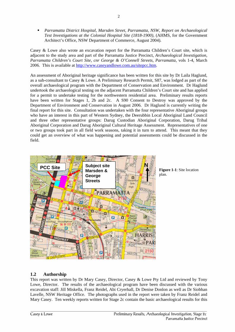
Casey & Lowe also wrote an excavation report for the Parramatta Children’s Court site, which is adjacent to the study area and part of the Parramatta Justice Precinct, Archaeological Investigation, Parramatta Children’s Court Site, cnr George & O’Connell Streets, Parramatta, vols 1-4, March 2006. This is available at http://www.caseyandlowe.com.au/sitepcc.htm. An assessment of Aboriginal heritage significance has been written for this site by Dr Laila Haglund, as a sub-consultant to Casey & Lowe. A Preliminary Research Permit, S87, was lodged as part of the overall archaeological program with the Department of Conservation and Environment. Dr Haglund undertook the archaeological testing on the adjacent Parramatta Children’s Court site and has applied for a permit to undertake testing for the northwestern residential area. Preliminary results reports have been written for Stages 1, 2b and 2c. A S90 Consent to Destroy was approved by the Department of Environment and Conservation in August 2006. Dr Haglund is currently writing the final report for this site. Consultation was undertaken with the four representative Aboriginal groups who have an interest in this part of Western Sydney, the Deerubbin Local Aboriginal Land Council and three other representative groups: Darug Custodian Aboriginal Corporation, Darug Tribal Aboriginal Corporation and Darug Aboriginal Cultural Heritage Assessment. Representatives of one or two groups took part in all field work seasons, taking it in turn to attend. This meant that they could get an overview of what was happening and potential assessments could be discussed in the field.
Figure 1-1: Site location plan.
1.2 Authorship This report was written by Dr Mary Casey, Director, Casey & Lowe Pty Ltd and reviewed by Tony Lowe, Director. The results of the archaeological program have been discussed with the various excavation staff: Jill Miskella, Franz Reidel, Abi Cryerhall, Dr Denise Donlon as well as Dr Siobhan Lavelle, NSW Heritage Office. The photographs used in the report were taken by Franz Reidel and Mary Casey. Ten weekly reports written for Stage 2c contain the basic archaeological results for this
Subject site Marsden & George Streets
N PCC Site

3
stage. This Stage 2c report will be superseded by the final archaeological report which will incorporate the results, analysis and interpretation from all stages of the project and is to be completed in mid to late 2007.
Figure 1-2: Plan of the three main archaeological stages 1, 2b, 2c. The purple square indicates testing for the Brislington convict hut, Stage 2a.
PCC site
Substation Area
Trial Courts
Brislington

4
2.0 Results of Stage 2c Archaeological Program 2.1 Aims of the Archaeological Program The aims of the overall archaeological program are set out in Casey & Lowe 2005a. The main focus is the conservation of remains for the future and for public interpretation, display and education. Some areas are also subject to salvage excavation, two of which are within the Stage 2c areas. The Stage 2c archaeological program focused on exposing and recording the remains underneath the Stage 2 demolition (Figs 1-2, 2-2) which covered all buildings in the backyard of Brislington (c1821) which was also the backyard of an earlier convict hut, exposure of the area to the south of the 3rd hospital and within the heritage courtyard area, salvage of the archaeology within the southern part of the Substation Area, and exposure and recording of remains found beneath Noller Kiosk. The salvage areas are within the Trial Courts and Substation footprints. The archaeology program within the Conservation Area focused on determining the archaeological potential and opportunities for conservation and interpretation within the Heritage Courtyard and implementation of the interpretation program to be designed as part of the heritage outcomes for the project. Archaeological works within the Substation and Trial Courts footprints involved salvage of remains within the approved development footprint (Fig. 1-2). This salvage work therefore had the most substantial results as we were able to fully excavate these remains. Within the area of Noller Kiosk we exposed remains of a timber structure. As some of these were to be impacted by the redesign of the entrance to Jeffery House, the northern section was fully excavated.
Figure 2-1: The buildings demolished as part of Stage 2 are outlined in red. Courtesy Ross Gunthorp, Department of Commerce, 11 July 2005.

5
Figure 2-2: Plan showing the potential archaeological remains within the study area and the staged demolition.
The overly of earlier archaeological remains has been updated (Fig. 2-3) and the footprint of the conservation areas has also been amended.

6
Figure 2-3: Plan showing the potential archaeological remains within the study area and the staged demolition.
The overlay of earlier archaeological remains has been updated (Fig. 2.4) and the footprint of the conservation areas has also been amended.
3rd hospital building (1818-1902)

7
2.2 Phasing of the Archaeological Remains The phasing of the archaeological remains from the site is based on the major chronological events which shaped the occupation within this site: Hospital Phasing
Phase 1: Natural Landscape Phase 2: Aboriginal Occupation
Phase 3: Beginnings of Settlement: Agriculture, Convict Town to Free Settlement, 1789–
1817) Phase 3.1: Early Clearing and Agriculture, 1789–1792
First Hospital (?), 1789–1792 Phase 3.2 Convict Parramatta and Emancipated/Free Settlement, 1790–1818
Second Hospital, 1792–1818 3.2.1: building the 2nd hospital 3.2.2: rebuilding the hospital, storage cellar, infants’ burial Marsden Street Convict Hut, c1792–1817 3.2.1: building the convict hut, c1792 3.2.2: Occupying the convict hut (c1792–1818), includes additional timber structure
found underneath Noller Kiosk, evidence for bone button manufacturing
Phase 4: Third Convict Hospital (1818–1843) Phase 4.1: Building a new hospital and Demolishing the 2nd hospital Phase 4.2: Occupying the hospital
Phase 5: 1840s Upgrading for the District Hospital (1844–1878)
Phase 5.1: new wall, rebuilding of the western privy Phase 5.2: occupation of the District Hospital
Phase 6: Rebuilding of the kitchen/laundry block, operating theatre, southern road system,
1879–1902
Phase 7: Construction of the Sulman Power Hospital (1890s–1902) the Fourth Hospital and Demolition of the Third Hospital
Phase 8: Later twentieth-century construction of buildings and services, 1902–1999
The phases provide a chronological and interpretative framework for the analysis of the layering of the archaeological evidence found at the site and will guide the structure of the final excavation report. Please note that they have been amended since the Stage 1 and 2b reports. The phases are not a definitive interpretation of the site but are a means of logically presenting the archaeological evidence to reveal what was happening on the site during any specific time period. There is separate phasing for Lot 98 and Lot 99 but with very similar patterns to the hospital for the first phases of occupation. Lot 98, Brislington Phase 1: Natural Landscape.
Phase 2: Aboriginal Occupation.
Phase 3: Beginnings of Settlement: Agriculture, Convict Town to Free Settlement, 1790s-1821.

8
Phase 3.1: Early Clearing and Agriculture, 1789–1790 Phase 3.2: Convict Occupation, 1790-1804 Phase 3.3: Leaseholder Occupation of Convict Hut, 1804-1821
Phase 4: Building and Occupation of Brislington c. 1821 to 1900.
Phase 4.1: Building Brislington, 1819-c. 1821 Phase 4.2: Occupying Brislington, c. 1821-1857 Phase 4.3: Occupying Brislington, Brown Family, 1857-1947
Phase 5: Twentieth-century Hospital Uses of Brislington (need to fix up dates yet). 2.3 Convict Hospitals 2.3.1 Phase 1: Natural Landscape Considerable evidence for the east-west slope down to the creekline was found and surveyed in. There was also a fall in the slope from the high point where the 1818 hospital was built to the south towards George Street. Roy Lawrie, Soil Scientist, NSW Department of Agriculture undertook further recording of this soil profile. The western part of the site contained some remnant topsoil (A1 horizon) but none survived in the eastern area beneath the 1970s hospital. It had been cut down for the 1970s hospital to assist with the Marsden Street entrance. The pale buff silty sandy subsoil (A2 horizon) was also found across much of the site and it was often mixed through with some lumps of the A1 horizon indicating that there had been higher ground levels across the site and that there was considerable changing of levels throughout the nineteenth and twentieth centuries as well as tilling of the soil. Discussions with Roy Lawrie about using the B horizon as the basis for identifying the original slope were generally supportive and appropriate recording was undertaken to allow us to identify this slope in the area behind Brislington, within Lot 98. Only limited evidence survived within the original hospital property to reconstruct the original landform. Soil and pollen samples were taken of natural across the site, using the test holes excavated for testing for the Aboriginal archaeology as survey locations for recording. The pollen analysis should allow us to reconstruct further evidence for both the pre- and post-1788 vegetation across the area. 2.3.2 Phase 2: Aboriginal Occupation Dr Laila Haglund, Haglund & Associates, in consultation with the various Aboriginal stakeholders, undertook a five-day testing program to identify the potential for Aboriginal archaeology within Stage 2c. A section 87 approval was obtained from the Department of Environment and Conservation (DEC) for this work. This was the third stage of testing with previous work being undertaken as part of Stages 1 and 2b. A preliminary report was written for this work and lodged with DEC who approved a S90 for the whole site in August 2006. Only limited Aboriginal remains were found across the site as much of the area was disturbed by nineteenth and twentieth-century occupation and various hospital construction activities. The type of stone artefacts found mostly conforms to a pattern of background artefact scatters with no clear activity areas. The ‘best’ examples of Aboriginal artefacts were found in ‘historic’ features and deposits. All these have been provided to Dr Haglund for analysis as part of the overall project. The final report on the Aboriginal archaeology should be completed by the end of October 2006.

9
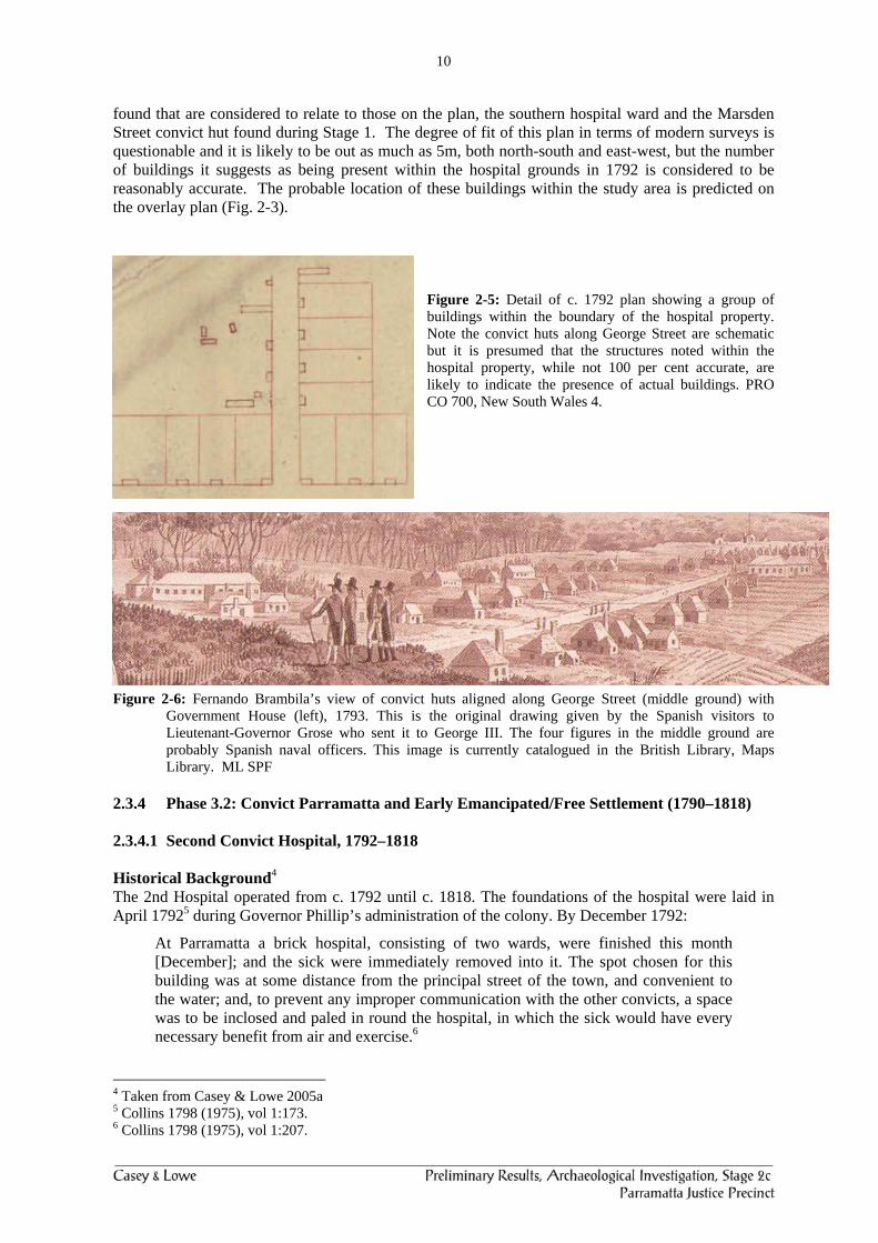
2.3.3 Phase 3.1: Early Clearing and Agriculture (1789–1790) 2.3.3.1 First Convict Hospital (?) (1789–1792) To date no clear evidence, historical or archaeological, for the presence of the 1st hospital, the tent hospital, has been found within the Parramatta Justice Precinct. The main basis for the identification of the first or tent hospital within the precinct appears to be the 1792 plan. The earliest plan showing structures likely to be part of the 1st hospital dates to c. 1790 (Fig. 2-4). An archaeological excavation on the northeast corner of Marsden and Phillip Streets found evidence of what was considered likely to be part of the 1st hospital and accords with Figure 2-4.1 The c. 1790 plan does have a squarish structure within the current study area and suggests the presence of quite early structures within the property. To date no remains that could clearly be identified as being part of the 1st hospital have been identified as being within the study area.
Figure 2-4: Early plan of Parramatta c. 1790. The main rectangular structure is to the east, presumably on the other side of Hospital Lane, later Marsden Street. Kass et al. 1996:2.
The description of the hospital in December 1791 noted:
a new hospital has been talked of for the last two years, but it has not yet begun; two long sheds, built in the form of a tent, and thatched, are however finished, and capable of holding two hundred patients; the sick list of to-day contains three hundred and eighty-two names.2
The c. 1790 plan only shows one of the ‘two long sheds’ and it is possible that the 1792 plan may be an accumulation of the 1st and 2nd convict hospitals. It is noted that the reference to the tent hospital above referred to two wards which still leaves one of the ‘long sheds’ unaccounted for unless it was the other structure within the study area. The 1792 plan has led to the identification of the 1st hospital as possibly being within the Justice Precinct (Fig. 2-5). Research by Casey & Lowe for this project has suggested that the 1792 plan more accurately represents the 2nd hospital built prior to Governor Phillip’s departure in December 1792 (Fig. 2-5).3 The depiction of the hospital in the April 1793 drawing by visiting Italian artist Fernando Brambila, who was one of two artists with Malaspina’s Spanish expedition, depicts a similar range and grouping of buildings to those on the 1792 plan (Fig. 2-6). The results of the archaeological evidence has certainly supported the ‘accuracy’ of the 1792 plan as two building were
1 AHMS November 2002. The CMP for the site is ambivalent about the first hospital being within this property, (Heritage Design Services 2003) and notes that AHMS are doing work in Marsden Street and may have found at least one of the 1st hospital buildings. 2 Tench 1793 (1979):246 3 Casey & Lowe 2005a
Tent hospital?
10
found that are considered to relate to those on the plan, the southern hospital ward and the Marsden Street convict hut found during Stage 1. The degree of fit of this plan in terms of modern surveys is questionable and it is likely to be out as much as 5m, both north-south and east-west, but the number of buildings it suggests as being present within the hospital grounds in 1792 is considered to be reasonably accurate. The probable location of these buildings within the study area is predicted on the overlay plan (Fig. 2-3).
Figure 2-5: Detail of c. 1792 plan showing a group of buildings within the boundary of the hospital property. Note the convict huts along George Street are schematic but it is presumed that the structures noted within the hospital property, while not 100 per cent accurate, are likely to indicate the presence of actual buildings. PRO CO 700, New South Wales 4.
Figure 2-6: Fernando Brambila’s view of convict huts aligned along George Street (middle ground) with Government House (left), 1793. This is the original drawing given by the Spanish visitors to Lieutenant-Governor Grose who sent it to George III. The four figures in the middle ground are probably Spanish naval officers. This image is currently catalogued in the British Library, Maps Library. ML SPF
2.3.4 Phase 3.2: Convict Parramatta and Early Emancipated/Free Settlement (1790–1818) 2.3.4.1 Second Convict Hospital, 1792–1818 Historical Background4 The 2nd Hospital operated from c. 1792 until c. 1818. The foundations of the hospital were laid in April 17925 during Governor Phillip’s administration of the colony. By December 1792:
At Parramatta a brick hospital, consisting of two wards, were finished this month [December]; and the sick were immediately removed into it. The spot chosen for this building was at some distance from the principal street of the town, and convenient to the water; and, to prevent any improper communication with the other convicts, a space was to be inclosed and paled in round the hospital, in which the sick would have every necessary benefit from air and exercise.6
4 Taken from Casey & Lowe 2005a 5 Collins 1798 (1975), vol 1:173. 6 Collins 1798 (1975), vol 1:207.
11
The c. 1792 and an illustration from early 1793 by Fernando Brambila provide some clues to the range of buildings associated with the 2nd Hospital at Parramatta (Figs 2.5, 2.6). The c. 1792 plan depicts nine structures within the hospital property while it is possible to see at least six buildings in the Brambila drawing, not including any convict huts. There is a long northern building with a structure next to its western end, a cluster of three nearby, and a longer structure partly obscured behind the Spanish naval officers and another one near the corner of George and Marsden Streets which is probably the convict hut (Lot 98). There is another chimney behind this building which may belong to the long building or to another structure. The building immediately to the north is probably the convict ‘hut’. It is possible that some of these buildings may have been timber. The 2nd hospital remained in use until the 3rd hospital was completed in 1818 which was built in between the two wards of the 2nd hospital so they could continue in use until the new hospital was completed. Archaeological Remains found during Stage 1 and 2c Salvage Three stages of remains were found in association with the 2nd hospital. The main surviving evidence belonging to the 2nd hospital is:
The western end of the southern hospital ward, 6m wide (Photos 2-1 to 2-4) o Small room at the western end which is the internal width of the hospital, 4.6m by
2.15m. o associated clay and roofing tile surface o possible post holes indicating a skillion/verandah along the southern side of the ward
Evidence for the eastern extent of the southern ward indicating the building was approximately 25m long.
A box drain partially dismantled when a storage cellar was built (Photos 2-6, 2-7). The remains of the cellar were 3.9m by 1.3m and up to 0.5m high. The cellar was backfilled with a deposit likely to date to c. 1818 with 8 near-completed lead-glazed vessels dropped into the backfill (Photos 2-10, 2-11).
Infants’ burial, the burial contained two skeletons oriented east-west in a shallow burial (Photos 2-9).
Extensive charcoal deposit covering this area which is considered to be a yard or sheet deposit.
The southern ward of the 1792 hospital is considered to have been in use for the full 26 years of the life of the 2nd hospital. The main evidence for this hospital building was the western end (6m wide) which consisted of a partially robbed wall trench and evidence for a partition wall at the western end of the building (Photo 2-1 to 2-4). Other evidence for this building consisted of a robbed east-west trench indicating the location of the southern wall alignment, a north-south return at 25m east of the western end. Only limited evidence of the northern wall line survived as it was mostly removed by the excavation of a c. 1970s service trench which ran along the same alignment. The internal dimensions of the western room of the hospital are 4.6m by 2.15m. Two structures indicate that there was rebuilding during the 2nd hospital phase. A brick box drain ran east-west through the Substation Area (Photo 2-6). The middle section was removed when it was no longer in use and it was decided to build the storage cellar in the same location. The box drain also extends to the east of the storage cellar so only the central part of the drain was removed. The storage cellar was built using the same bricks as the drain and probably reused those from the drain (Photo 2-6). The cellar was built by cutting a rectangular shape into the ground which was then lined with bricks. There were at least two deliberate voids in the southern wall and the floor was formed by using the natural clay as a base. The surviving cellar was 3.9m long, 1.3m wide and survived to a height of 5 to 7 courses of bricks, 350 to 500mm, and the walls were one brick thick (230-250mm.
12
Photo 2-1: Northwest corner of footings of the 1792 hospital southern ward. To the right is the stone drain coming from the 1818 laundry which we also found within Stage 2c Substation. Note the partition wall trench (1) to the left of the scale. Scale 1m. Photo 2-2: Detail of remnant northern wall footing within the Stage 1 Salvage area. The wall was 2 and-a-half bricks wide. Looking south, Scale 1m.
Photo 2-3: Southern wall footing trench with part of the western return. Only a few bricks from this wall survived within this trench following its demolition, looking west. Scales 50cm, 1m.
1

13
Photo 2-4: View to east at a section through the demolition backfill (1) of the 1792 hospital footing trench and another through the backfill of the construction trench (2). Scale 1m. Photo 2-5: Red-surfaced road above bituminous surfacing cut through by the 4th hospital footings to the left. Excavation of service trenches exposed what appears to be the eastern wall trench of the 2nd hospital (arrowed). This is 25m from the western end of the building.
The bricks from the drain and the storage cellar were larger than the bricks in the 2nd hospital ward and the 1818 hospital footings (Appendix 2). They were probably made with bricks using the Birmingham standard mould. The presence of this larger brick in the box drain may suggest that it was built later than the 2nd hospital ward and that there are actually three or more separate chronological events which we can identify as part of the early occupation of the 2nd hospital. Another question to ask is what was the purpose of the box drain prior to it being partially removed for the storage cellar? As a section of it was found further to the east, beyond the cellar, it may have linked up with the 2nd hospital ward or with another structure. It may be the end of the box drain found at the edge of the trench where we found the cesspool but this is uncertain.
1
2

14
Photo 2-6: To the left is a brick box drain which was cut by the brick storage cellar on the right. The storage cellar contained approximately eight early lead-glazed vessels dropped into the cellar when it was being backfilled. These two structures indicate at least two phases of building in association with the 2nd hospital. Scale 1m
Immediately south of the southern wall of the 2nd hospital ward was a thick red clay surface with quantities of broken tile mixed throughout the deposit (Photo 2-8). While not completely certain this would have acted as a reliable surface the use of the roofing tile as drainage aggregate does indicate that there would have been some degree of drainage. A thick black soil and charcoal deposit covered the area immediately south of the red clay surface but beyond the concrete footing. This charcoal soil layer was stratigraphically later than the clay surface and is interpreted as a yard deposit relating to the occupation of this corner of the site during the 2nd hospital phase. Later than the construction of the box drain and storage cellar but earlier than the black soil and charcoal deposit was the burial of two infants in a single shallow grave (Photo 2-9). These three sets of remains, the drain, cellar and burial are all currently considered to be part of the 2nd hospital phase of occupation. It is possible that following cataloguing of artefacts the phasing may be adjusted but the analysis of the bricks above and the preliminary review of the artefacts on site does suggest that this is the most likely analysis. These infant burials are an extremely rare find on an archaeological site. A research design for the analysis of these remains is in draft form and should be finalised soon. The demolition of the cellar, which is presumed to be around 1818 but this will be clarified once the artefacts have been catalogued, contained a group of pots that appear to have been thrown into the cellar when it was being backfilled. These pots were only found in the eastern part. Predicted remains identified on the 1792 plan that were not found included a squarish outbuilding in the eastern courtyard area and typically shown on the plans immediately to the north of the southern ward (Fig. 2.5). This area was quite disturbed and only limited evidence of the 1818 eastern outbuilding, possibly the kitchen ad men’s dead room, survived. No remains thought to belong to this phase were identified in this area.

15
Photo 2-7: Western end of storage cellar where it blocks the earlier drain. A thick strip of natural clay floor is discoloured and indicates where the drain would have continued to the east (1). Behind the scale is a deliberately built void in the southern wall. Scale 1m. Photo 2-8: Red clay deposit immediately south of the 2nd hospital. Black line shows approximate position of the outer edges of 2nd hospital footing trench. Scale 1m.
Infants’ Burial The two infants were buried in a shallow circular grave, immediately north of the southern boundary wall and immediately east of the 1790s storage cellar. The pit for the burial was cut through the clay upcast created by the excavation of the storage cellar and therefore post-dates this phase 2 structure which is associated with the 2nd hospital (1792-1818). It was buried beneath a thick brick and tile layer which we do not think was associated with the storage cellar but probably with another structure to the east or north. The two babies were probably buried between the later 1790s and the early 1800s, and are considered to date prior to 1818. This dating will be re-examined in light of the date of the artefacts from all related deposits once they have been catalogued. The two babies were lying side-by-side and were oriented east-west with their heads at the western end. This is a typical Christian burial practice where the head of the deceased is oriented towards the east and the rising sun. We do not know if the babies are twins or two babies born close together in time at the hospital who died. The discovery of a baby burial was not completely unexpected at an early hospital site where burial practices for stillborn or newborn babies may have been more haphazard, especially perhaps if the convict mother had also died or had no real desire to have the baby in the first place. But the burial of two infants together in unconsecrated ground with Christian orientation, although they presumably were not baptised prior to their death, does suggest that there was some care in how they were buried.
1
16
Photo 2-9: Skeletons of two infants found in a shallow burial beneath the charcoal and soil yard deposit. West is to the left. The skulls were on the left and the bodies oriented to the east. Scale 0.5m Photo 2-10.1: Lead-glazed pottery from the storage cellar. See below for some of these vessels after gluing.
17
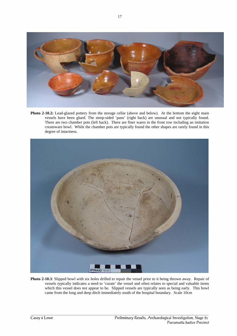
Photo 2-10.2: Lead-glazed pottery from the storage cellar (above and below). At the bottom the eight main vessels have been glued. The steep-sided ‘pans’ (right back) are unusual and not typically found. There are two chamber pots (left back). There are finer wares in the front row including an imitation creamware bowl. While the chamber pots are typically found the other shapes are rarely found in this degree of intactness.
Photo 2-10.3: Slipped bowl with six holes drilled to repair the vessel prior to it being thrown away. Repair of vessels typically indicates a need to ‘curate’ the vessel and often relates to special and valuable items which this vessel does not appear to be. Slipped vessels are typically seen as being early. This bowl came from the long and deep ditch immediately south of the hospital boundary. Scale 10cm

18
2.3.4.1 Marsden Street Convict Hut (c1792–1817) The site of the Marsden Street convict hut was identified and recorded during Stage 1.7 This site is currently protected under geotextile fabric, sand and concrete slab. The post holes and wall lines of one of the two 1790s convict huts thought to be located on the Marsden Street alignment was exposed by the removal of the remnant topsoil layer which obscured the post holes. The main elements of this convict hut were five wall lines consisting of post holes, the perimeter walls and a partition wall, making it a two-roomed hut (Photo 2-11). We could not investigate further to the north during Stage 1 as Noller Kiosk had not been demolished.
Photo 2-11: The convict hut was outlined with green tape for the Open Day presentation. The tape indicates the approximate position of the hut based on the evidence of the post holes. Note the location of Noller Kiosk just beyond the western end of the hut. Looking north. Scale 1 m Photo 2-12: Noller Kiosk area with evidence for a timber structure consisting of trenches with post pipes and post holes. The black lines interpret evidence for the structure. Top left is the base of a gate post for the main entrance into the hospital property, looking east. Scale 1m
7 Casey & Lowe 2005b:28-32.
2
1
1
19
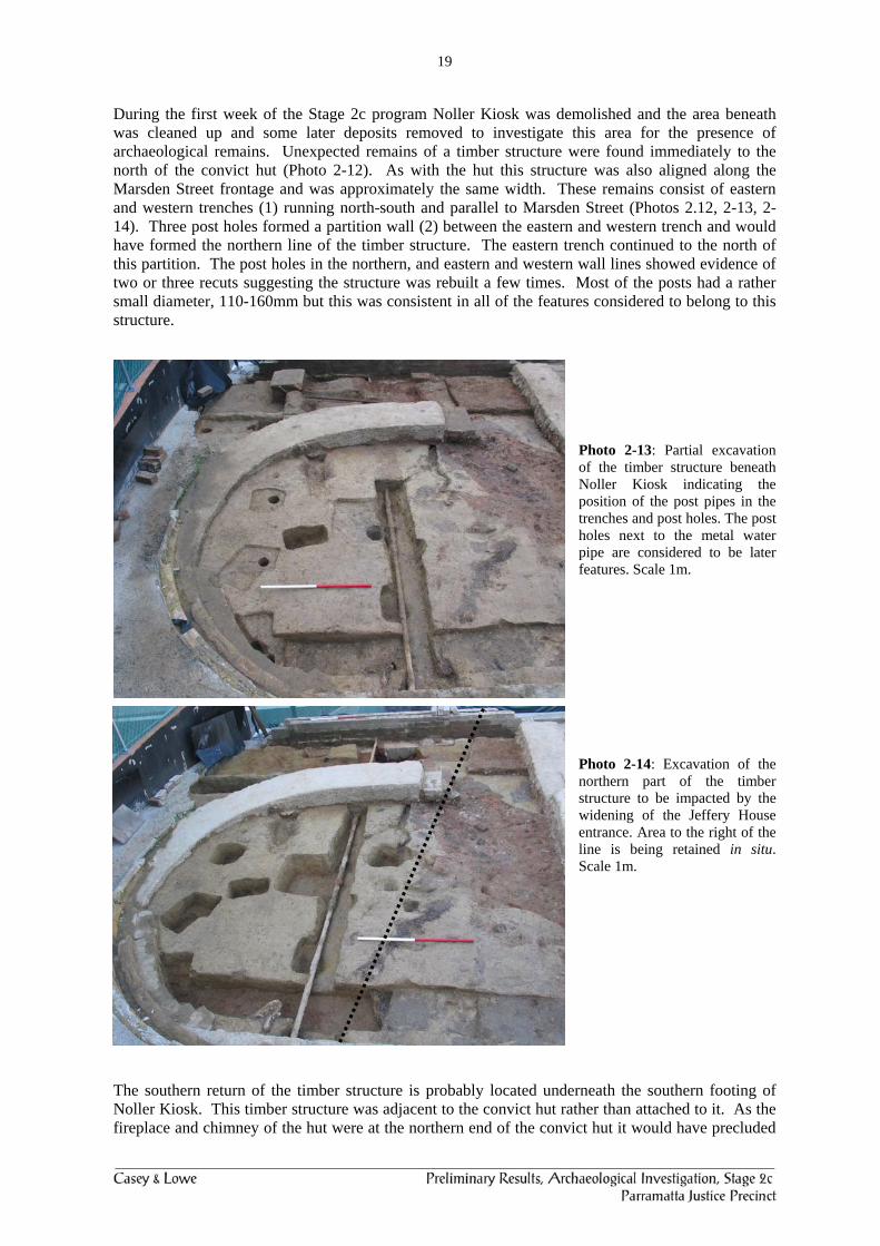
During the first week of the Stage 2c program Noller Kiosk was demolished and the area beneath was cleaned up and some later deposits removed to investigate this area for the presence of archaeological remains. Unexpected remains of a timber structure were found immediately to the north of the convict hut (Photo 2-12). As with the hut this structure was also aligned along the Marsden Street frontage and was approximately the same width. These remains consist of eastern and western trenches (1) running north-south and parallel to Marsden Street (Photos 2.12, 2-13, 2-14). Three post holes formed a partition wall (2) between the eastern and western trench and would have formed the northern line of the timber structure. The eastern trench continued to the north of this partition. The post holes in the northern, and eastern and western wall lines showed evidence of two or three recuts suggesting the structure was rebuilt a few times. Most of the posts had a rather small diameter, 110-160mm but this was consistent in all of the features considered to belong to this structure.
Photo 2-13: Partial excavation of the timber structure beneath Noller Kiosk indicating the position of the post pipes in the trenches and post holes. The post holes next to the metal water pipe are considered to be later features. Scale 1m.
Photo 2-14: Excavation of the northern part of the timber structure to be impacted by the widening of the Jeffery House entrance. Area to the right of the line is being retained in situ. Scale 1m.
The southern return of the timber structure is probably located underneath the southern footing of Noller Kiosk. This timber structure was adjacent to the convict hut rather than attached to it. As the fireplace and chimney of the hut were at the northern end of the convict hut it would have precluded
20
them being attached. Therefore this structure was probably a freestanding timber building immediately to the north and associated with the occupation of the convict hut between c1792 and 1818. Artefacts were found within the fills of the post holes and trenches during the preliminary investigation of this structure. These consisted of clay roofing tiles, slipped and lead-glazed pottery, tiny fragments of Chinese export porcelain and a few corroded nails. The presence of the clay roofing tiles indicates that this timber structure was built after 1792 as the roofing tile on the site is thought to be related to the 2nd hospital period (1792-1818). The presence of artefacts within the fill deposit also indicates there had been some occupation on the site prior to the construction of the building. Dating of this structure is based on its orientation to Marsden Street, laid out by c. 1792. It is within 0.5m of the front wall of the 1818 hospital and would therefore have been demolished prior to its construction. We considered the possibility that this structure may have been ‘scaffolding’ for the 1818 hospital, because of the orientation, but the trenches and posts extend too far to the north of the 1818 hospital for this to be a reasonable interpretation. This structure could possible be the second convict hut shown on the 1792 plan but this is not certain and is too close to be likely as the huts were supposed to be 60 to 100 feet apart. It may have been built adjacent to the ‘convict hut’ to the south or possibly as part of the 2nd hospital and not drawn on plan as it was built after 1792. The latter is less likely because this land was known to be leased prior to it being acquired in 1818 for the 3rd hospital. Its most likely interpretation is as a structure used in association with the ‘convict hut’ to the south. Pollen Analysis Preliminary results from the pollen analysis from hoe marks found during Stage 1, to the south of the Marsden Street convict hut, indicate: Fossil pollen that was part of a very early convict garden although the most likely cultigen cannot
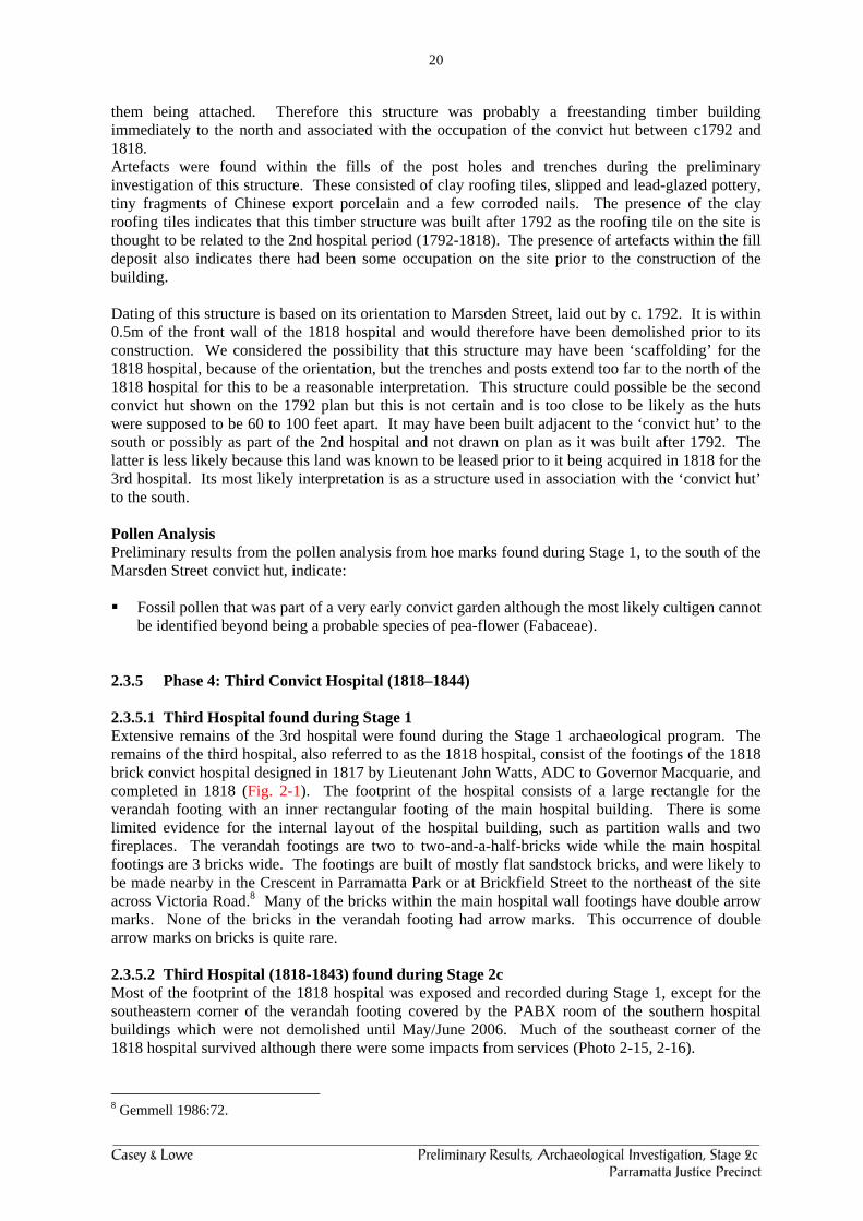
be identified beyond being a probable species of pea-flower (Fabaceae). 2.3.5 Phase 4: Third Convict Hospital (1818–1844) 2.3.5.1 Third Hospital found during Stage 1 Extensive remains of the 3rd hospital were found during the Stage 1 archaeological program. The remains of the third hospital, also referred to as the 1818 hospital, consist of the footings of the 1818 brick convict hospital designed in 1817 by Lieutenant John Watts, ADC to Governor Macquarie, and completed in 1818 (Fig. 2-1). The footprint of the hospital consists of a large rectangle for the verandah footing with an inner rectangular footing of the main hospital building. There is some limited evidence for the internal layout of the hospital building, such as partition walls and two fireplaces. The verandah footings are two to two-and-a-half-bricks wide while the main hospital footings are 3 bricks wide. The footings are built of mostly flat sandstock bricks, and were likely to be made nearby in the Crescent in Parramatta Park or at Brickfield Street to the northeast of the site across Victoria Road.8 Many of the bricks within the main hospital wall footings have double arrow marks. None of the bricks in the verandah footing had arrow marks. This occurrence of double arrow marks on bricks is quite rare. 2.3.5.2 Third Hospital (1818-1843) found during Stage 2c Most of the footprint of the 1818 hospital was exposed and recorded during Stage 1, except for the southeastern corner of the verandah footing covered by the PABX room of the southern hospital buildings which were not demolished until May/June 2006. Much of the southeast corner of the 1818 hospital survived although there were some impacts from services (Photo 2-15, 2-16).
8 Gemmell 1986:72.

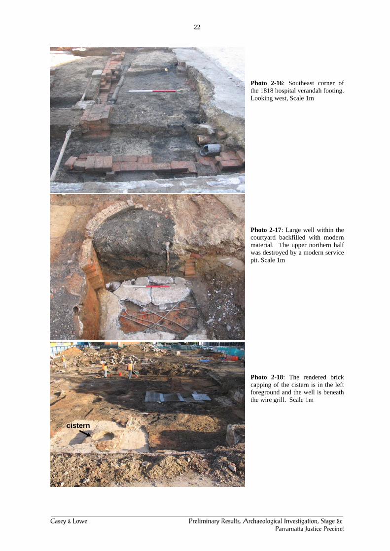
21
Other 3rd hospital remains found during this stage were: Well (Photo 2-17). Water cistern (Photo 2-18), phasing uncertain. Eastern brick cesspit/privy (Photo 2-19). Robbed trenches of the eastern kitchen/male dead room outbuilding (Photo 2-20). Some remains of other structures/drains (Photo 2-21). Southern part of western privy and cesspool (Photo 2-22). Drain adjacent to the western privy and cesspool (Photo 2-23). Section of brick drain running westwards to the creek line which is part of the circular drain
found during Stage 1 further to the west (Photo 2-25). Section of stone box drain running from the 1818 laundry to link into the brick drain (Photo
2-25, 2-26, 2-27). Pit containing animal bones, amputated hand, smoking pipes and bone stopper shaped like a
fist (Photos 2-28 to 2-32). The phasing of this pit as part of the convict period is confirmed by it predating the construction of the western boundary wall.
These remains were evidence of a series of structures predicted to survive within the courtyard of the 1818 hospital based on the various historic building plans and the maps of the site and outlined in the Stage 1 Preliminary Report and then further detailed in February 2005 (Fig. 2-7).
Photo 2-15: Looking southwest over the southeast corner of the 1818 hospital footing and the courtyard of the 3rd hospital. Scale 1m
22
Photo 2-16: Southeast corner of the 1818 hospital verandah footing. Looking west, Scale 1m Photo 2-17: Large well within the courtyard backfilled with modern material. The upper northern half was destroyed by a modern service pit. Scale 1m Photo 2-18: The rendered brick capping of the cistern is in the left foreground and the well is beneath the wire grill. Scale 1m
cistern
23
Photo 2-19: Rectangular brick cesspit in the eastern part of the hospital courtyard. Scale 1m Photo 2-20: Northwest corner of the trench indicating the position of the 1818 outbuilding, probably the kitchen and male dead room. Scale 1m Photo 2-21: Section of drain in the courtyard area with a section surviving beneath a concrete footing. This may have been a dish drain or the base of an elliptical or oviform drain.

24
Photo 2-22: View to west along the southern end of the 1879 kitchen. Showing the remains of the rebuilt privy and cesspool to the south of the kitchen. Compare with Photo 2-24.
Photo 2-23: Section of drain that may have been associated with the cesspool.
Privy wall
Cesspool
Box drain
25
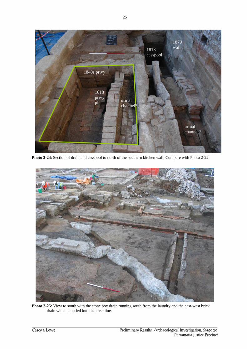
Photo 2-24: Section of drain and cesspool to north of the southern kitchen wall. Compare with Photo 2-22.
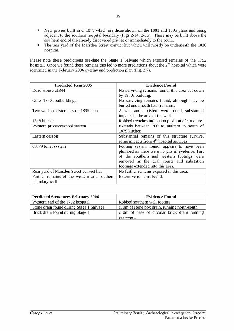
Photo 2-25: View to south with the stone box drain running south from the laundry and the east-west brick drain which emptied into the creekline.
1818 privy pit
1840s privy
1818 cesspool
urinal channel?
urinal channel?
1879 wall
1
2

26
Photo 2-26: Cut stone within the drain was poorly cut but indicates reused stone not specifically designed for this drain. Scale 0.5m Photo 2-27: Junction of the stone drain with the brick drain. This indicates the contemporary nature of the two sets of drains as part of a working system. Scale 0.5m and 1m Photo 2-28: Section through pit with lots of charcoal, part of an amputated hand, lots of animal bone and quite a few bowls with ‘Prince of Wales feathers’. Scale 0.5m

27
Photo 2-29: Bones from an amputated left hand, two teeth and possible foetal bones. Photo 2-30: Animal bone found in the pit with the amputated hand.

28
Photo 2-31: Buttons and small bottle stopper shaped like a fist and carved from bone. This may have replaced a lost or broken glass stopper and may have been in a small pharmaceutical bottle.
Photo 2-32: Two of the pipes from the bone pit, one of Queen Victoria and the other with the ‘Prince of Wales feathers’.
2.3.5.3 Potential Remains within the Stage 2 Hospital Area9
Dead house, built in 1844, central area of the southern wall as shown on 1881 and 1895 maps and the new overlay (Figs 2-14, 2-15.10
Other 1840s outbuildings, thought to include a bathhouse whose location is unknown.11 Two wells or cisterns, as shown on the 1895 plan. These are described as wells on the
surveyor’s field book plan. 1818 kitchen, presumably to the east of the wells. Based on 1817 plans which indicate the
presence of two single-storey kitchen and laundry structures (Figs 2-8, 2-9). Further extension of the identified privy and cesspool system found under the southern end
of the 1879 kitchen. Another set of privies (male or female) presumed to be to the east. These will be either two
or three rooms and should link into the privy system. The 1817 plans indicated two sets of privies (Figs 2-8, 2-9).
9 Casey & Lowe 2005b:42. 10 CMP 2003:97; Kass 1990:20. 11 CMP 2003:33.
29
New privies built in c. 1879 which are those shown on the 1881 and 1895 plans and being adjacent to the southern hospital boundary (Figs 2-14, 2-15). These may be built above the southern end of the already discovered privies or immediately to the south.
The rear yard of the Marsden Street convict hut which will mostly be underneath the 1818 hospital.
Please note these predictions pre-date the Stage 1 Salvage which exposed remains of the 1792 hospital. Once we found these remains this led to more predictions about the 2nd hospital which were identified in the February 2006 overlay and prediction plan (Fig. 2.7).
Predicted Item 2005 Evidence Found Dead House c1844 No surviving remains found, this area cut down
by 1970s building. Other 1840s outbuildings: No surviving remains found, although may be
buried underneath later remains. Two wells or cisterns as on 1895 plan A well and a cistern were found, substantial
impacts in the area of the well. 1818 kitchen Robbed trenches indication position of structure Western privy/cesspool system Extends between 300 to 400mm to south of
1879 kitchen Eastern cesspit Substantial remains of this structure survive,
some impacts from 4th hospital services c1879 toilet system Footing system found, appears to have been
plumbed as there were no pits in evidence. Part of the southern and western footings were removed as the trial courts and substation footings extended into this area.
Rear yard of Marsden Street convict hut No further remains exposed in this area. Further remains of the western and southern boundary wall
Extensive remains found.
Predicted Structures February 2006 Evidence Found Western end of the 1792 hospital Robbed southern wall footing Stone drain found during Stage 1 Salvage c10m of stone box drain, running north-south Brick drain found during Stage 1 c10m of base of circular brick drain running
east-west.

30
Figure 2-7: Plan of the Conservation and Substation Areas with various remains predicted to survive within the
study area, February 2006.
2nd convict hospital – c1792 male or female ward & other building to right
convict hut
1818 kitchen?
M + F privies? and drain
1818 laundry?
prediction of likely remains of 1818 hospital
remains of 1818 hospital
1818
Stage 1 Salvage Area
Western end of 2nd hospital found during Dec 2005 excavation
31
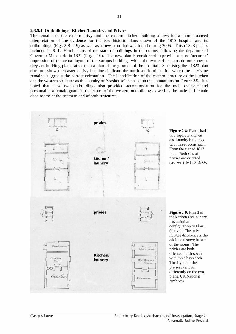
2.3.5.4 Outbuildings: Kitchen/Laundry and Privies The remains of the eastern privy and the eastern kitchen building allows for a more nuanced interpretation of the evidence for the two historic plans drawn of the 1818 hospital and its outbuildings (Figs 2-8, 2-9) as well as a new plan that was found during 2006. This c1823 plan is included in S. L. Harris plans of the state of buildings in the colony following the departure of Governor Macquarie in 1821 (Fig. 2-10). The new plan is considered to provide a more ‘accurate’ impression of the actual layout of the various buildings which the two earlier plans do not show as they are building plans rather than a plan of the grounds of the hospital. Surprising the c1823 plan does not show the eastern privy but does indicate the north-south orientation which the surviving remains suggest is the correct orientation. The identification of the eastern structure as the kitchen and the western structure as the laundry or ‘washouse’ is based on the annotations on Figure 2.9. It is noted that these two outbuildings also provided accommodation for the male overseer and presumable a female guard in the centre of the western outbuilding as well as the male and female dead rooms at the southern end of both structures.
Figure 2-8: Plan 1 had two separate kitchen and laundry buildings with three rooms each. From the signed 1817 plan. Both sets of privies are oriented east-west. ML, SLNSW Figure 2-9: Plan 2 of the kitchen and laundry has a similar configuration to Plan 1 (above). The only notable difference is the additional stove in one of the rooms. The privies are both oriented north-south with three bays each. The layout of the privies is shown differently on the two plans. UK National Archives
kitchen/ laundry
Kitchen/ laundry
privies
privies

32
Figure 2-10: Layout of the 1818 hospital and outbuildings and northern elevation. Standish Lawrence Harris - Report & Estimate of the Value of the Improvements which have taken place in the Public Buildings of Sydney, Parramatta, Windsor, Liverpool and Campbelltown, between the 25th of December 1822 & the 24th of December 1823 inclusive, and an Expose of the present state of the Public Buildings in New South Wales, 1824, CY 1035, frames 49-98 (C226), ML, SLNSW
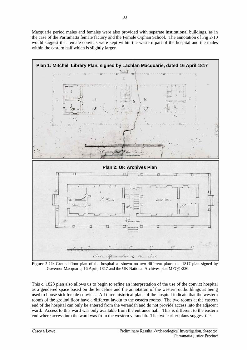
2.3.5.5 Plan of the 1818 Hospital and Grounds and Interpretation of the use of Spaces The presence of a fenceline running north-south divides the hospital grounds into two areas, presumably relating to male and female activities and control of these spaces. The separation of male and female convicts from each other is considered to be major underlying structuring element where services are provided to both sexes within the same institutional building. It is noted that during the
33
Macquarie period males and females were also provided with separate institutional buildings, as in the case of the Parramatta female factory and the Female Orphan School. The annotation of Fig 2-10 would suggest that female convicts were kept within the western part of the hospital and the males within the eastern half which is slightly larger.
Figure 2-11: Ground floor plan of the hospital as shown on two different plans, the 1817 plan signed by Governor Macquarie, 16 April, 1817 and the UK National Archives plan MFQ/1/236.
This c. 1823 plan also allows us to begin to refine an interpretation of the use of the convict hospital as a gendered space based on the fenceline and the annotation of the western outbuildings as being used to house sick female convicts. All three historical plans of the hospital indicate that the western rooms of the ground floor have a different layout to the eastern rooms. The two rooms at the eastern end of the hospital can only be entered from the verandah and do not provide access into the adjacent ward. Access to this ward was only available from the entrance hall. This is different to the eastern end where access into the ward was from the western verandah. The two earlier plans suggest the
Plan 1: Mitchell Library Plan, signed by Lachlan Macquarie, dated 16 April 1817
Plan 2: UK Archives Plan
34
Figure 2-12: Scale drawing of main hospital related remains from Stage 1 and Stage 1 Salvage.

35
entrance is through the southern room while the c. 1823 plan has it through the northern room. The archaeological evidence does not resolve this divergence amongst the plans although it shows the northwestern room did have a fireplace but that is indicated on all three historical plans (Fig. 2.12). The first floor of the hospital is only known from one of the three historic plans (Fig 2-11) but does support this general pattern of physical control and separation of male and female convicts. Ward D in the western half is entered from the central staircase but does not connect with the three other western rooms. This may suggest that wards C and D were used for male convicts and E, G and F for female convicts. Such a usage would indicate that the first floor had a different spatial use to the ground floor but there would always be more male then female convict patients within the hospital due to the disproportionate number of males to females in the early colony. This analysis then supports the plan with the southwestern room of the 1818 hospital as the location for a second staircase to the first floor, as shown on the plan signed by Governor Macquarie and not shown on the other two plans (Figs 2-11, 2-13). The design of the hospital was deliberately intended to separate and control access into the male and female wards on the ground floor, from two separate points and this division along, with the provision of a fenceline through the site, would have been an important controlling element in the separation of the two groups from each other.
Figure 2-13: First floor plan of ‘General Hospital’, the 1817 plan signed by Governor Macquarie, 16 April, 1817, ML, SLNSW
The fenceline running through the site is also shown on the 1881 and 1895 plans (Figs 2-14, 2-15) and is seen as a feature remaining from the 1818 partition of the site whose presence may have stayed unquestioned or evolved into an alternative use within the hospital, perhaps as a means of separating different groups within the hospital, staff and patients, public and staff. This division of the east and western site into male and female was not replicated in the way males and females were separated within the 1792 hospital (Fig. 2-5). Part of the evidence for this is based on the presence of the double infant burial behind the southern ward which suggests that it was for the female convicts and the northern ward was therefore used to accommodate male convicts. The layout of buildings on the 1792 plan had already indicated that the two wards, the long rectangular buildings, were deliberately placed at some distance from each other, at opposite ends of the site with other buildings off to the side and only one building in between. Early indications were that this was the way in which male and female convicts were separated. The 1792 plan does not show any fencing but it is possible there was internal fencing within the 2nd hospital.

36
Figure 2-14: 1881 plan of Parramatta hospital. Plan of the Reserve for the Hospital, Town of Parramatta, E. Elssworth (LDPL P.171.750).

37
Figure 2-15: 1895 Metropolitan Detail Plan, Parramatta. SLNSW, ML 4/811/1301/1/Sheet 20.
Lot 98 Lot 99