Embed Size (px)
Citation preview

PRELIMINARY OBSERVATIONS ON QUATERNARYSTRATIGRAPHY AND ASSOCIATED ARTIFACTS OFTWO PREHISTORIC SITES OF DULUNG RIVERVALLEY, WEST BENGAL
MAN, ENVIRONMENT AND SOCIETYVol. 1, No. 2, 2020, 153-171© ARF India. All Right ReservedISSN: 2582-7669URL : www.arfjournals.com
Shubhrakanti Baul Junior Research Fellow (UGC-NET), Department of Anthropology, West BengalState University, West Bengal. Email: [email protected]
ABSTRACT
The present article is the outcome of the primary investigation onprehistoric artifacts and associated quaternary deposits of twoprehistoric sites in Dulung River valley, Jhargram district, WestBengal. Two sites namely Kukrakhonpi (22° 32’ N and 86° 48’E)and Sahari (22° 37’ N and 86° 47’E) are primarily studied by theauthor first-time in 2015 and later again in 2019 by means of theunderstanding surface features, sediments of natural and artificialsections and also the typo-technological attributes of lithic artifacts.For understanding the context of prehistoric cultural remains inQuaternary sedimentary units of the sites a mixed geochronologicaland archaeological approach is used in the present work. The resultof this study shows that in both these sites prehistoric tools can befound from various sedimentary contexts like gravel deposit,ferricrete deposit, as well as in paleosol deposits. Tool types recoveredfrom the sites mostly comprised of various Paleoliths and Microliths.The present study makes the addition of new data in the existingunderstandings of the Prehistoric culture of West Bengal.
Article History
Received : 22 October 2020Revised : 29 October 2020Accepted : 18 November 2020Published : 31 December 2020
Key wordsDulung River Valley, QuaternaryDeposit, Paleolithic Culture,Microlithic Culture, West Bengal.
INTRODUCTION
Recent developments of human origin research in India have shown that geographicallocation, as well as the diverse climatic condition of this country, must have some
Peer Reviewed Journal © 2020 ARF 153

Shubhrakanti Baul
154 Peer Reviewed Journal © 2020 ARF
vital effects on adaptation as well as the dispersal of Pleistocene hominids in theOld world (Joshi 1985). Presence of various Lower Paleolithic cultural traditions inthe Indian subcontinent (Mishra 2007, 2008) and the presence of some of the earliestlower Paleolithic sites (Mishra et al. 1995; Paddayya et al. 2002; Pappu et al. 2011)have proven the above-mentioned fact is true. Furthermore, all this evidence indicatesthat probably India was inhabited by the earliest members of genus Homo and thisform of human developed diverse patterns of adaptation to cope with diverse theclimatic condition of this subcontinent.
Evidence of lower Paleolithic culture of India are found from various broadEco zones, and within these Eco zones lower Paleolithic people probably inhabiteda variety of microhabitats location of which are recorded from the Siwalik hill regionsof northern India to the Tamilnadu in the south (Misra, 2001, 494). In eastern Indiaevidence of lower Paleolithic culture are found buried in the boulder, pebble andsecondary laterite depositions, found in the drainage regions of the rivers likeMahanadi, Subarnarekha, and Damodar etc. Geomorphological as well as geologicalevidence show that all these aforesaid rivers have their origin at the eastern extensionof the archaic erosional landscape of Peninsular India.
Sedimentary deposits and associated prehistoric cultural remains of theSubarnarekha river the valley has been studied since the time of British administratorsand continued up to recent times (Ball 1881; Anderson 1917; Mitra 1926; Murray1941; Sinha 1951; Sen and Ghosh 1960; Sen et al. 1962; Ghosh 1966, 1970; Ghoshand Chaudhuri 1991; Chakrabarti 1993). Lower Subarnarekha river valley, whichfalls within West Bengal, was first studied by A. K. Ghosh (Ghosh 1962; cited inChakrabarti 1993, 169). Later on, works in this area were extended (Sen et al. 1962;Chakrabarti 1986; Datta 1995; Basak 1997; Basak et al. 1998;Bhengra 2007; Polleyand Ray 2010; Polley 2017) by other archaeologists and anthropologists, which showsgreat potency of this area in understanding a succession of prehistoric cultures ofeastern India.
In the background of aforesaid works, fieldwork was carried out in 2015 andagain in 2019 and this work brings forward a preliminary study of two differentprehistoric sites of the upper Dulung catchment area (part of Subarnarekha drainagesystem) namely Kukrakhonpi and Sahari (Fig. 1), which falls in Jamboni block andBinpur II block respectively under the administrative division of newly formed

Preliminary Observations on Quaternary Stratigraphy and Associated Artifacts of Two Prehistoric Sites...
Peer Reviewed Journal © 2020 ARF 155
Jhargram district of West Bengal. Previously these two sites were explored andinvestigated by various scholars (Ghosh 1966; IAR 1986-87; IAR 1991-92; also citedin Saren et al. 2016, 469-72). Past exploration revealed about both Paleolithic andMicrolithic tools from a different context like gravel bed as well as paleosol deposition(Ghosh 1966; IAR 1986-87). Results of this preliminary study bring forwardobservations of prehistoric artifacts recovered from the said regions in the light ofStratigraphic context; it also makes the addition of Geomorphological data andtypo-technological data of lithic tools to the reported prehistoric sites of West Bengaland that of eastern India in the broader context.
METHOD AND MATERIALS
To identify and study sedimentary units of Dulung River and associated culturalremains a purely geochronological and archaeological approach is used in the presentwork. To study and understand the sedimentological and geomorphological contextof the studied sites a classic “Empirical Paradigm” approach (Miall 2010, 5) ofgeological stratigraphy is used. In this approach study of geomorphic features like
Fig. 1: Map showing location of studied sites in Dulung river valley
Shubhrakanti Baul
156 Peer Reviewed Journal © 2020 ARF
fluvial deposits, calcretes, regolith deposits etc. is used to study physiographic featuresand sections of geological stratigraphy of the surveyed region. Before going intothe field geological and geomorphological maps and reports of the surveyed areaare consulted. Besides various ‘Earth Observatory Software Applications like GoogleEarth and ISRO Bhuvan are used to get an idea about geomorphology and morpho-stratigraphy of the study area. GIS tools and software like ISRO Bhuvan, TCXConverter and Quick Grid Viewer are used to understand the geomorphologicalcontext of the study area. To study the stratigraphy of Quaternary sediments in thefield, methods of descriptive stratigraphy (Miall 2010, 4-6) are used. Studies of theStratigraphic sections are purposefully selected within the sites and studied accordingly.Selections of the sites were done with the help of a geomorphological map of theregion and also with the help of Earth Observatory Software applications like GoogleEarth. Near-surface sediment characters of the litho-units are studied from thetruncated profiles of the river bank and the exposed sections of diverse landformslike levee abandoned channel and point bar deposits (Brown 1997, 63-70). Then ageological survey schedule was developed, following methods of field survey ofsedimentary rocks (Lahee 1952; Herz and Garrison 1998, 37-45; Tucker 2003) andwas applied to study and interpret sedimentological units in the field. In determiningthe relative age of the sedimentological units, the rules applied in the present contextis the relative position of the sedimentary units in a stratigraphic section and alsoposition of the units in relation to the present-day river channel (Lahee 1952, 115-16;
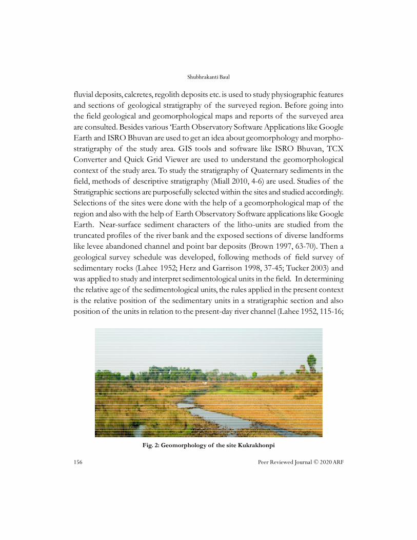
Fig. 2: Geomorphology of the site Kukrakhonpi

Preliminary Observations on Quaternary Stratigraphy and Associated Artifacts of Two Prehistoric Sites...
Peer Reviewed Journal © 2020 ARF 157
Tucker 2003, 194-95). Beside this degree of compaction and paedogenesis are alsoused to understand relative age of various sedimentary units and climatic conditionat the time of their origin. The depositional environment has been deducted on thebasis of sedimentological characters of the fluvial deposits (Lahee 1952, 61-115;Tucker 2003, 191-213).
Stone artifacts collected in this exploration are studied in the field and also inthe laboratory. Context of the recovered artifacts are recorded in the field and arelative comparison of the spots of artifact recovery is done in the field. In thelaboratory, various typo-technological attributes of the recovered artifacts are studiedprincipally by using an empirical approach (Minzoni-Deroche 1985). On the basisof the aforesaid attributes recovered artifacts are categorized according to theirprobable function.
PHYSIOGRAPHIC CONTEXT
The two different sites Kukrakhonpi (22° 32’ N and 86° 48’E) and Sahari (22° 37’ Nand 86° 47’E) (see Fig. 1) are studied in the present context. Physio-graphically boththese sites fall within the easternmost extension of the Chhotanagpur plateau. Thearea is moderately undulating with an average elevation of 100-150 meters fromMSL. Most of the surveyed area has a pediplain like physiography and it can bedivided into two distinct landforms:
i) The ferricritized upland and dissected plateau covering by for the largestpart of the area and
ii) alluvial terraces to different levels.
The occurrences of ferricrete covered plateaus are higher in number in higherelevations and are most places curved by gullying action. Both of the sites Sahariand Kukrakhonpi are low ferricrete mounds and are dissected by a number oferosional rain gullies. Stone tools of lower Paleolithic culture are found scattered inthese erosional rain gullies. In some areas, particularly where the ferricrete arerepresented in the topmost parts by latosol the intricate pattern of the gullies closelyresembles badland topography (Chatterjee 1986). The alluvial terraces are relativelylow-lying flat tracts gently sloping towards the trunk channel. Subarnarekha Landformelements present in this part abandoned channels, aggraded channels, meander scarsand meander scrolls.

Shubhrakanti Baul
158 Peer Reviewed Journal © 2020 ARF
River is the principal agency for shaping the morphology of the area. Thesediments derived from the Precambrian to the west were deposited in a fluviatile toFluvia-deltaic environment. In its middle reaches here, the Subarnarekha is mainlyin the phase of transportation. Erosion is confined to the banks particularly on thespur edges. The small tributaries flowing down to Subarnarekha is, however, in aphase of degradation. The secondary dynamic agency is the rainwater leading to theformation of gullies mainly in the ferricrete covered plateaus and in the older alluvialterraces (Chatterjee 1986). Observations in both of the sites indicate that stonetools have become exposed due to the erosional activity of the rainwater at the timeof gullying. Since the vegetation in the plateau areas is sparse, sheet wash is alsoconsiderably active in the area.
Outcrop of highly decomposed rocks of igneous origin forms occasional lowhills of this region, which are found at the western-north western part of this region.These low hills constitute the easternmost extension of the Tata-Dalma range ofhills. Regarding the drainage pattern of this region, it can be said that the area fallswithin the Subarnarekha-Kasai drainage system in general. Tarapheni and Dulungare the important rivers of this region and both of these rivers are fed by rainwater.River Tarapheni is part of the Kasai drainage system and Dulung River falls withinthe Subarnarekha drainage system. Besides these major rivers, a number of rivuletslike Kupon Nod, Simana (tributaries of Dulung) and small canals are present in thisregion. The flow of the rivers and other rain water-fed canals show that the generalslope of the landscape of this region is from North-West to South-East.
STRATIGRAPHIC CONTEXT
Quaternary sediments exposed in Kukrakhonpi and Sahari show that they can beroughly divided into two distinct litho-units resting over bedrock. These litho-unitsare recognized as Unit-I- Consolidated ferricrete deposit and Unit-II- reddish sandysoil. In both sites’ deposition of quaternary litho-units begin over the bedrock ofpre-Quaternary origin. The bedrock consists of rocks of igneous origin withprofound quartz veins in them. Exposure of quartz veins is more found at anincreasing rate near Sahari and Belpahari region.
Unit-I consists of red-colored unsorted cobbles and pebbles of different rocksof igneous origin and pisolitic nodules of iron oxide (see Fig. 3). The deposit isconsolidated in nature, however, the upper part of this exposed deposit is sometimes

Preliminary Observations on Quaternary Stratigraphy and Associated Artifacts of Two Prehistoric Sites...
Peer Reviewed Journal © 2020 ARF 159
loose and, in some regions, cemented (Fig. 4) and forms a hard crust. It sometimesconsists cobble sized clasts of ferricretes with prominent vesicular structures withinthem. In Kukrakhonpi, sometimes ferricrete can be observed with colluvium contextunconformably over the vesicular ferricrete. The presence of subrounded pebbleswithin the colluvium in some places indicates fluvial action that happened in thetime of aggradation. Also, the horizontal iron band in the colluvium indicates thesame as water had been logged in that places for some time. The matrix of this unit
Fig. 3: stratigraphic layers of cobbly-pebbly conglomerate, consolidated ferricrete and siltdeposits near Kukrakhonpi
Fig. 4: section shows consolidated ferricrete deposit with some pebbles and implement

Shubhrakanti Baul
160 Peer Reviewed Journal © 2020 ARF
is formed by fine sands and silts. Also, ferricrete exposure near Sahari shows horizontaliron bands within it. Thickness of this deposit in both sites ranges between 1-2meters. In Kukrakhonpi, Acheulian artifacts are found exposed in this deposit(Fig. 8) as well as in dried nullahs and rain gullies (Fig. 7). However, in Sahari, noAcheulian artifacts are found from this deposit. In Kukrakhonpi the ferricretedeposition and iron band are highly weathered.
Unit-II consists of almost 0.5-meter-thick unconsolidated sandy silt (Fig. 5),reddish-brown in color and is predominantly sandy in nature. In Sahari, microlithicartifacts are found exposed in this deposit. Sometimes, Microliths are found scatteredover the exposed surface of ferricrete, but the presence of these artifacts near thesections of reddish sandy soil indicates that they were washed out of the soil depositdue to rainwater activity.
Fig. 5: section showing sandy silt layer in Sahari
Fig. 6: artifacts on ferricritised silt deposits

Preliminary Observations on Quaternary Stratigraphy and Associated Artifacts of Two Prehistoric Sites...
Peer Reviewed Journal © 2020 ARF 161
Fig. 7: artifacts in erosional rain gullies
Fig. 8: ferricretised context of recovered artifacts.
OBSERVATION ON RECOVERED ARTIFACTS
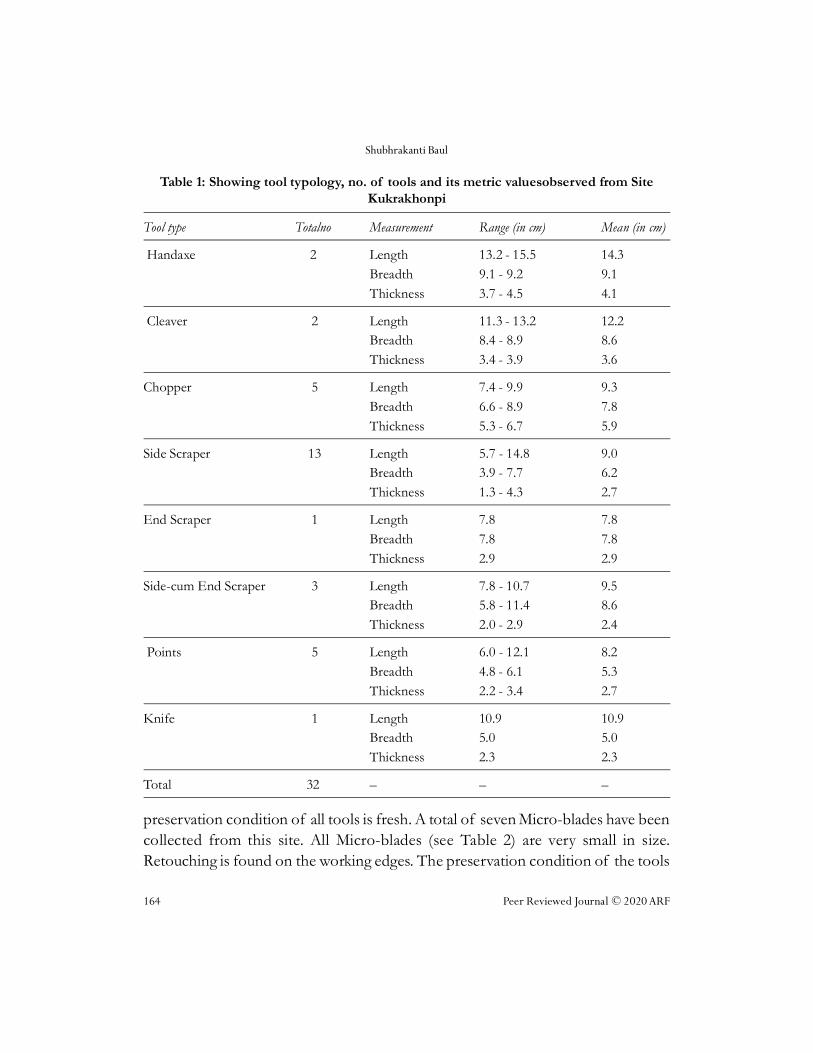
A total 32 lower Paleolithic artifacts (see Table 1) were recovered from the siteKukrakhonpi and 33 microlithic artifacts (see Table 2) were recovered from the site

Shubhrakanti Baul
162 Peer Reviewed Journal © 2020 ARF
Sahari. Lower Paleolithic artifacts, that are recovered from Kukrakhonpi are highlyweathered and are made on both quartz (11 nos.) and quartzite (21 nos.) and theycan be classified into eight different typological categories, they are- Chopper, HandAxe, Cleaver, Side Scraper, End Scraper, Side cum End Scraper, Point and Knife(see Table 1). Classification of these different typologies are based on the type ofretouch, location of probable working edges, working ends, probable butt/haftingends and overall shape of the artifacts.
Total two Handaxes have been collected from the site Kukrakhonpi. Thesetools are made of Quartzite and these are made on the core. Working ends are verypointed. The tools are made mainly by primary flaking. Probably hard hammertechnique was used for the tool making. The tools are patinated and weathered byweathering. A total of two cleavers have been collected from the site Kukrakhonpi.These are made of both Quartzite and Quartz. The tools have a broad workingedge and made by primary flaking also some secondary flaking is found on theworking edge. The hard hammer technique was used for making a cleaver. The toolsare patinated. A total of five Choppers have been found from the site. Two of themare elongated and the other three are round shaped. Four Choppers are made ofQuartzite and another one is made of Quartz. The cutting edge of these tools iszigzag-shaped. Large primary flake surfaces are present on both dorsal and ventralsurfaces in three choppers. In two choppers, there is no flake surface on the surfaces.These two have primary flake surfaces only on the cutting edge. The choppers weremade with block-on-block technique. Total thirteen side scrapers have been collectedfrom the site Kukrakhonpi. Total five tools are made of Quartz and others made ofQuartzite. The tools are made on both Clactonian and Levalloisian flakes. So, thereare main flake surfaces and striking platforms on many side scrapers. The primaryflake surface is present on the dorsal surface. Secondary flake surfaces are seen onthe working edge. Working edges are more or less straight and broad. Both Clactonianand Levalloisian technique was used for the tools making. On nine Side Scrapers,there are marks of Levalloisian technique. The other four scrapers were made withthe Clactonian technique. Only one end scraper has been collected from the siteKukrakhonpi. It is made of quartzite. Working edge is present on the end of thetool. The working edge is made by secondary flaking. The tool is made on aLevalloisian flake. The tool is patinated. Total three side-cum-end Scrapers havebeen found from the site Kukrakhonpi. One tool is made of quartzite and the other

Preliminary Observations on Quaternary Stratigraphy and Associated Artifacts of Two Prehistoric Sites...
Peer Reviewed Journal © 2020 ARF 163
two are made of quartz. The tools are made by primary flaking. These tools havemany working edges. One is on the distal end of the tool and the others on thelateral margins. Both Levalloisian and Clactonian technique was used for these toolsmaking. Two of them are made on Levalloisian flake and another one is made onClactonian flake. The preservation condition of these tools is fresh. A total of fivepoints have been found from the site Kukrakhonpi. All points are triangular shaped.The tools are made on a flake that was detached from the prepared core. All toolshave a main flake surface and a striking platform. A midrib is present on the dorsalsurface of all points. The working end is pointed. The tools are made on bothLevalloisian flakes and large unprepared flakes. The marks of the Levalloisiantechnique are found on four points when the other one is made with the free flakingtechnique. Only one knife, made of quartzite has been collected from the siteKukrakhonpi. One lateral edge of the tool is sharp and another lateral edge is blunt.The tool has a patination mark on its surface.
All the tools were recovered from the exposed ferricritized bed, sometimesfrom ferricrete duricrust and sometimes from the upper surface of loose ferricretepellets near small nullahs and rain gullies. Some of the tools are highly weatheredand brownish patination can be noticed on the surfaces of the tools.
Microliths are recovered only from the site Sahari and they are 33 in number(see Table 2). All the microliths are also highly weathered and are made of quartz.On the basis of the type of retouch, location of probable working edges, workingends, probable butt/hafting ends and overall shape of the artifacts, recoveredMicroliths can be classified into 12 different tool categories- Side Scraper, End Scraper,Side-cum-End Scraper, Notched Scraper, Thumbnail Scraper, Point, Micro-burin,Microblade, Awl, Lunate, Triangle and Trapeze (see Table 2).
A total of three Side Scrapers have been found from the site Sahari. All toolsare small in size. Secondary flake surfaces are present on both dorsal and ventralsurfaces. Retouching is seen on the working edge. These tools are made on the flake.Total four End Scrapers have been recovered from the site. The tools are also madeon the flake. Working edge is seen on the end of the tools. Working edges aresharpened by retouching. Only one small-sized Side-cum-End scraper has been foundfrom here which is made on a flake. A total of four points has been collected as well.The tools are small to medium in size. All tools have a striking platform and themain flake surface. The working end of all points is pointed and sharp. The
Shubhrakanti Baul
164 Peer Reviewed Journal © 2020 ARF
Table 1: Showing tool typology, no. of tools and its metric valuesobserved from SiteKukrakhonpi
Tool type Totalno Measurement Range (in cm) Mean (in cm)
Handaxe 2 Length 13.2 - 15.5 14.3Breadth 9.1 - 9.2 9.1Thickness 3.7 - 4.5 4.1
Cleaver 2 Length 11.3 - 13.2 12.2Breadth 8.4 - 8.9 8.6Thickness 3.4 - 3.9 3.6
Chopper 5 Length 7.4 - 9.9 9.3Breadth 6.6 - 8.9 7.8Thickness 5.3 - 6.7 5.9
Side Scraper 13 Length 5.7 - 14.8 9.0Breadth 3.9 - 7.7 6.2Thickness 1.3 - 4.3 2.7
End Scraper 1 Length 7.8 7.8Breadth 7.8 7.8Thickness 2.9 2.9
Side-cum End Scraper 3 Length 7.8 - 10.7 9.5Breadth 5.8 - 11.4 8.6Thickness 2.0 - 2.9 2.4
Points 5 Length 6.0 - 12.1 8.2Breadth 4.8 - 6.1 5.3Thickness 2.2 - 3.4 2.7
Knife 1 Length 10.9 10.9Breadth 5.0 5.0Thickness 2.3 2.3
Total 32 – – –
preservation condition of all tools is fresh. A total of seven Micro-blades have beencollected from this site. All Micro-blades (see Table 2) are very small in size.Retouching is found on the working edges. The preservation condition of the tools

Preliminary Observations on Quaternary Stratigraphy and Associated Artifacts of Two Prehistoric Sites...
Peer Reviewed Journal © 2020 ARF 165
Table 2: Showing tool typology, no. of tools and its metric values observed fromsiteSahari
Tool type Total no Measurement Range (in cm) Mean (in cm)
Side Scraper 3 Length 2.7 - 5.4 4.1
Breadth 1.8 - 3.9 3.0
Thickness 0.6 - 2.0 1.2
End Scraper 4 Length 2.3 - 8.8 5.4
Breadth 2.1 - 8.4 5.1
Thickness 0.8 - 2.4 1.7
Side-cum-End Scraper 1 Length 3.1 3.1
Breadth 2.4 2.4
Thickness 1.0 1.0
Point 4 Length 2.8 - 5.1 3.5
Breadth 1.9 - 4.0 2.6
Thickness 1.0 - 1.3 1.1
Notch Scraper 2 Length 2.3 - 3.7 3
Breadth 1.4 - 3.2 2.3
Thickness 1.0 - 1.5 1.2
Microblade 7 Length 1.3 - 1.8 1.6
Breadth 1.0 - 1.8 1.3
Thickness 0.4 - 0.7 0.5
Micro-burin 3 Length 2.1 - 3.2 2.8
Breadth 1.2 - 2.0 1.6
Thickness 0.5 - 0.8 0.6
Thumbnail Scraper 2 Length 1.7 - 2.0 1.8
Breadth 1.9 - 2.1 2.0
Thickness 0.6 0.6
Awl 2 Length 1.9 - 2.9 2.4
Breadth 1.2 - 2.4 1.8
Thickness 0.9 - 1.2 1.0
Shubhrakanti Baul
166 Peer Reviewed Journal © 2020 ARF
is fresh. Total three Micro-burins have been collected from the site. These are madeon a small blade. The working end of these tools is screw-shaped and long elongated.Two small-sized awls have been found from the site Sahari. These tools have a verysharp pointed working end. A total of two triangles have been found from the siteSahari. These are made on a small flake which was after the blade technique. A totalof two trapezes are found from this site. These Microliths are made after bladetechniques. Only one lunate has been found from the site. A total of two Thumbnailscrapers have been observed from the site Sahari. The proximal end of the tools isthick and the distal end is more or less thin. The working edge lies on the distal end.The working edge is broad and very sharp. The working edge is sharpened withsmall retouching. Levalloisian technique was used for tool making. The state of
Lunate 1 Length 3.0 3.0
Breadth 1.6 1.6
Thickness 0.6 0.6
Triangle 2 Length 1.7 - 1.8 1.7
Breadth 1.5 - 1.9 1.7
Thickness 0.4 - 0.5 0.4
Trapeze 2 Length 1.5 1.5
Breadth 1.5 - 1.7 1.6
Thickness 0.5 - 0.7 0.6
Total 33 – – –
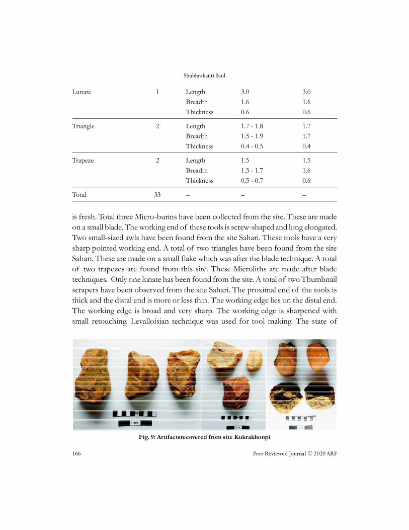
Fig. 9: Artifactsrecovered from site Kukrakhonpi
Preliminary Observations on Quaternary Stratigraphy and Associated Artifacts of Two Prehistoric Sites...
Peer Reviewed Journal © 2020 ARF 167
preservation of the tools is fresh. Total two Notch Scrapers have been collectedfrom this site. These are small to medium-sized flake tools. These are formed afterdetaching from the prepared core. The notch is found on the lateral edge of thetools. The preservation condition of the tools is fresh.
Microlithic assemblage in this site includes some tool types which generallyrepresent upper paleolithic occurrence although these are in the form of small size.All the tools are very fresh by means of preservation.
DISCUSSION
The eastern part of India mainly comprises four different states, which include Bihar,Jharkhand, Orissa and West Bengal. This broad part of the Indian sub-continenthas yielded a number of prehistoric sites, distributed throughout extensive ecologicalniches (Ghosh et al. 1991). K ukrakhonpi and Sahari both sites fall within the aforesaidcluster of prehistoric sites. A study of the physiography and Quaternarysedimentological units of the surveyed region indicates that the surveyed region ispresently underlain by pre-Quaternary metamorphic and igneous rocks (probablyDharwarian in nature). Besides this, deposits believed to be of late Tertiary are foundon the hilltops of this region in the form of hardpan deposits or duricrusts. ThePleistocene deposits of this region are primarily characterized by the erosionalactivities in the hills and uplands and by the deposition and redisposition of thiserosional debris along the pathways of present-day rivers or river valleys. Seeing thequality and quantity of data found from this region Ghosh et al. (1991) put thisregion as one of the most significant paleo-ecozone of eastern India.
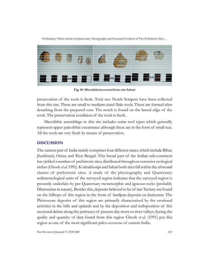
Fig. 10: Microlithsrecovered from site Sahari

Shubhrakanti Baul
168 Peer Reviewed Journal © 2020 ARF
Quaternary sedimentary units found both in Kukrakhonpi and Sahari has amorpho-stratigraphic and litho-stratigraphic similarity with Lalgarh formation(Chatterjee 1986; Ghosh and Majumdar 1991). A number of scholars have reportedlithostratigraphically similar deposit from the middle part of the Subarnarekha basin(Chatterjee and Chottopadhyay 1986; Chatterjee 1986) and dated this deposit to themiddle Pleistocene. In the present context, prehistoric artifacts recovered fromsedimentary unit 1 are designated to the lower and middle paleolithic culture andthis finding supports the claim of the previous scholars also. The sandy silt depositor unit 2 was probably developed by residual weathering of sedimentary unit 1 andprobably belongs to the later period than unit 1. The reason behind this claim is thepresence of microlithic artifacts in this unit. The presence of microliths insedimentological unit 2 indicates that it can be dated to the end of the Pleistocene toearly Holocene.
Implements show a great variety in terms of tool typology but not in forms ofraw material in these sites. Quartz and quartzite had been used for tool manufacturingwhich was exploited from the river bed in the forms of pebbles and cobbles andalso chunks from colluvium context and from the quartz vein of exposed bedrockoutcrop in places where microliths are made only of quartz. The implements observedin Kukrakhonpi made on core and flake while flake-made tools observed in Sahari.Implements and context of the tools show ecological diversity as well as typo-technological variation in this region. Ferricretized formation has a great potency tooccupy the early stone age implements, mostly found in rain gullies of ferricrete bedas well as the microliths consisting in ferruginous-silty context. Study shows humanactivity near to river bank when water was in aggradational mode also in thedegradational phase near the waterlogged area.
Microlithic assemblage mostly found by earlier researcher in alluvium andcolluvium context of the arid and semi-arid zone of Purulia and Medinipur andother places. It is known that not only the alluvium context (Ghosh 1970; Basak et al.1998, 731-40; Bhattacharyya 2011), also colluvium (Basak 2013, 83-84; Basak et al.2014) contains Microliths. Finding of prehistoric artifacts of Kukrakhonpi and Sahariwith all its limitations show that the watershed regions of middle Subarnarekhariver valley may provide significant information in the field of prehistory of EasternIndia.

Preliminary Observations on Quaternary Stratigraphy and Associated Artifacts of Two Prehistoric Sites...
Peer Reviewed Journal © 2020 ARF 169
ACKNOWLEDGMENT
The author acknowledges Dr. Debasis Kumar Mondal, Assistant professor, Universityof Calcutta for Supporting in the Fieldwork and also grateful to Dr. KrishnenduPolley, Assistant Professor, Department of Anthropology, Bidhannagar College forhelping to write the manuscript and the guidance. Acknowledgment also goes toTriparna Barman of the School of Oceanographic Studies of Jadavpur Universityfor making maps of the sites discussed in this paper and to Mr. Avick Biswas, AssistantProfessor, Vidyasagar University for his support and suggestion.
ReferencesAnderson, C.W. 1917. A Note on Prehistoric Stone Implements Found in the Singhbhum
District. Journal of Bihar Orrisa Research Society, 3: 349-62.
Ball, V. 1881. The Geology of Manbhum and Singhbhum. Memoirs of Geological Survey of India18(2).
Basak, B. 1997. Microlithic Sites in the Tarafeni Valley, Midnapore District: A Discussion. Manand Environment 22(2):11-28.
Basak, B. 2013. Excavation of a Microlithic Site and Exploration in the Ayodhya Hills, Purulia,West Bengal:2011-12 and 2012-13. Pratna Samiksha, New Series 4:83-87.
Basak, B., G.L. Badam, A. Kshirsagar and S.N. Rajaguru. 1998. Late Quaternary Environment,Palaeontology and Culture of Tarafeni Valley, Midnapur District, West Bengal-A PreliminaryStudy. Journal-Geological Society of India 51:731-740.
Basak, B., P. Srivastava, S. Dasgupta, A. Kumar and S.N. Rajaguru. 2014. Earliest dates andimplications of Microlithic industries of Late Pleistocene from Mahadebbera and Kana,Purulia district, West Bengal. Current Science 107(7):1167-1171.
Bhengra, D. 2007. Archaeology of Chottanagpur Division (Jharkhand). New Delhi: Agam KalaPrakashan.
Brown, A.G. 1997. Alluvial Geoarchaeology: Floodplain Archaeology and Environmental Change.Cambridge, Cambridge University Press.
Chakrabarti, D.K. 1986. The lithic Industries of the Santal Parganas with Notes on the DaminIndustry. Man and Environment 10:141-149.
Chakrabarti, D.K. 1993. Archaeology of Eastern India: Chhotanagpur Plateau and West Bengal. NewDelhi: Munshiram Manoharlal Publishers Pvt. Limited.
Chatterjee, A. 1986. Quaternary Geology and Geomorphology of a part of Subarnarekha basin, Medinipurdistrict, West Bengal, Mayurbhanj district, Orissa and Singhbhum district, Bihar: Progress report for thefield season 1983-84. Geological Survey of India. Calcutta: Government of India Publications.

Shubhrakanti Baul
170 Peer Reviewed Journal © 2020 ARF
Chatterjee, A. and G.S. Chattopadhyay. 1986. Quaternary Geology and Geomorphology of Kasai-Subarnarekha basin, Medinipur and Bankura districts, West Bengal, Singhbhum district, Bihar andMayurbhanj district, Orissa. Unpublished Report. Geological Survey of India. Government ofIndia.
Datta, A. K. 1995. ‘Upper Palaeolithic Culture in Midnapur: An Appraisal’ in India at the Dawnof History (A. K. Datta, A. K. Ghosh and C. Margabandhu eds.) New Delhi: Agam kalaPrakashan.75-85.
Ghosh, A.K. 1962. Discovery of prehistoric stone implements from northwest Midnapur,West Bengal. Science and Culture 28(7): 338-339.
Ghosh, A.K. 1966. Implementiferous Laterite in Eastern India. In D. Sen, A. K. Ghosh (eds.),Studies in Prehistory: Robert Bruce Foote Memorial Volume, 149-162. Calcutta: Firma K.L.Mukhopadhyay.
Ghosh, A. K. 1970. The Paleolithic Cultures of Singhbhum. Transactions of the AmericanPhilosophical Society 60 (1): 3-68.
Ghosh, A. K. and D. Chaudhuri. 1991. Pebble Core Element of Paleolithic Culture of WestBengal. In A. Datta (eds.), Studies in Archaeology: Papers presented in memory of P.C Dasgupta,41-57. New Delhi: Books and Books.
Ghosh, R. N. and S. Majumdar. 1991. Geology and Morphostratigraphy of West Bengal: ADatabase for Archaeological Exploration. In A. Datta (Eds.), Studies in Archaeology: Paperspresented in memory of P.C Dasgupta, 7-37. New Delhi: Books and Books.
Herz, N. and E. G Garrison. 1998. Geological methods for archaeology. New York, Oxford UniversityPress.
Indian Archaeology: A Review.1986-87. Archaeological Survey of India, New Delhi.
Indian Archaeology: A Review.1991-92. Archaeological Survey of India, New Delhi.
Joshi, R.V. 1985. Fossilization process of animal bones of Indian Quaternary Period-a chemicalstudy. Publication of the Centre of Advanced Study in Geology Panjab University Chandigarh n.s.1:83-88.
Lahee, F.H. 1952. Field Geology. London: McGraw-Hill Book Company.
Miall, A.D. 2010. The Geology of Stratigraphic Sequences. London: Springer Publications.
Minzoni Déroche, A. 1985. Lithic Artefacts Interpretation: An Empirical Approach. WorldArchaeology 17(1):20-31.
Mishra, S. 2007. The Indian Lower Paleolithic. Bulletin of the Deccan College Post-Graduate andResearch Institute 66-67:47-94.
Mishra, S. 2008. Lower Paleolithic: A Review of Recent Findings. Man and Environment. 33(1):14-29.

Preliminary Observations on Quaternary Stratigraphy and Associated Artifacts of Two Prehistoric Sites...
Peer Reviewed Journal © 2020 ARF 171
Mishra, S., T. R. Venkatesan, S. N. Rajaguru and B. L. K. Somayajulu. 1995. Earliest AcheulianIndustry from Peninsular India. Current Anthropology 36(5):847-51.
Misra, V.N. 2001. Prehistoric human colonization of India. Journal of Biosciences26(4):491-531.
Murray, E.F.O. 1941. The Ancient Workers of Western Dhalbhum. Journal of Royal AsiaticSociety of Bengal 6(2):61-104.
Mitra, P. 1926. Prehistoric India. Calcutta: University of Calcutta Publications.
Paddayya, K., B.A.A. Blackwell, R. Jhaldiyal, M.D. Petraglia, D.A. Chadertonii, J.I.B Blacksteinand A.R. Skinner. 2002. Recent findings on the Acheulian of the Hunsgi and Baichbalvalleys, Karnataka, with special reference to the Isampur excavation and its dating. CurrentScience 83:5.
Pappu, S., Y. Gunnell, K. Braucher, M. Taieb, F. Demory and N. Thouveny. 2011. EarlyPleistocene Presence of Acheulian Hominins in South India. Science 331:1596-1600.
Polley, K. 2017. Preliminary Observations on the Quaternary Sediments and Associated CulturalRemains of the Subarnarekha River Basin, Ghatsila, Eastern India. J. Indian Anthrop.Soc. 52:45-61.
Polley, K. and R. Ray. 2010. A preliminary study on the stone age cultures of Khunty and itsadjoining Regions, Jharkhand. Puratattva 40:51-70.
Saren, S. 2016. Identification of Archaeological Remains Around the “Rarha” Region andLittoral Tract of Medinipur, West Bengal, India. International Journal of Research inSocial Sciences 6(3):463-482.
Sen, D. and A. K. Ghosh. 1960. On the occurrence of palaeoliths in Singhbhum. Man inIndia 40(3):178-191.
Sen, D., G. S. Ray and A. K. Ghosh. 1962. Paleoliths from Manbhum and Singhbhum. Man inIndia 42(1):10-18.
Sinha, S.C. 1951. The Discovery of Some Prehistoric Stone Tools in South Manbhum. Scienceand Culture 17:164.
Tucker, M. E. 2003. Sedimentary Rocks in the Field. London, John Willey and Sons.
Whittaker, J. 2009. Flint Knapping: Making and Understanding Stone tools. Austin: University ofTexas Press.
To cite this article:
Shubhrakanti Baul. Preliminary Observations on Quaternary Stratigraphy and AssociatedArtifacts of two Prehistoric Sites of Dulung River Valley, West Bengal. Man, Environmentand Society, Vol. 1, No. 2, 2020, pp. 153-171


![Strauss preliminary observations, gods in thucydides [integral]](https://img.pdfslide.us/doc/110x75/579056361a28ab900c9846f4/strauss-preliminary-observations-gods-in-thucydides-integral.jpg)