Embed Size (px)
Citation preview
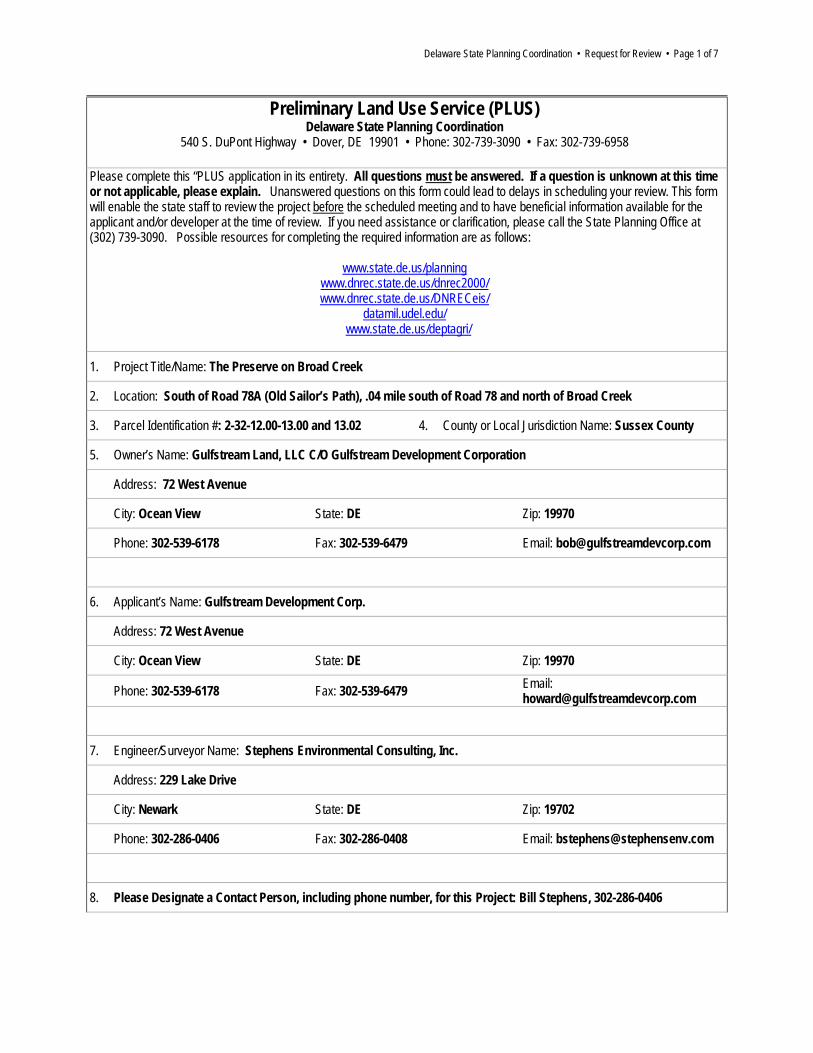
Delaware State Planning Coordination • Request for Review • Page 1 of 7
Preliminary Land Use Service (PLUS) Delaware State Planning Coordination
540 S. DuPont Highway • Dover, DE 19901 • Phone: 302-739-3090 • Fax: 302-739-6958
Please complete this “PLUS application in its entirety. All questions must be answered. If a question is unknown at this time or not applicable, please explain. Unanswered questions on this form could lead to delays in scheduling your review. This form will enable the state staff to review the project before the scheduled meeting and to have beneficial information available for the applicant and/or developer at the time of review. If you need assistance or clarification, please call the State Planning Office at (302) 739-3090. Possible resources for completing the required information are as follows:
www.state.de.us/planning www.dnrec.state.de.us/dnrec2000/ www.dnrec.state.de.us/DNRECeis/
datamil.udel.edu/ www.state.de.us/deptagri/
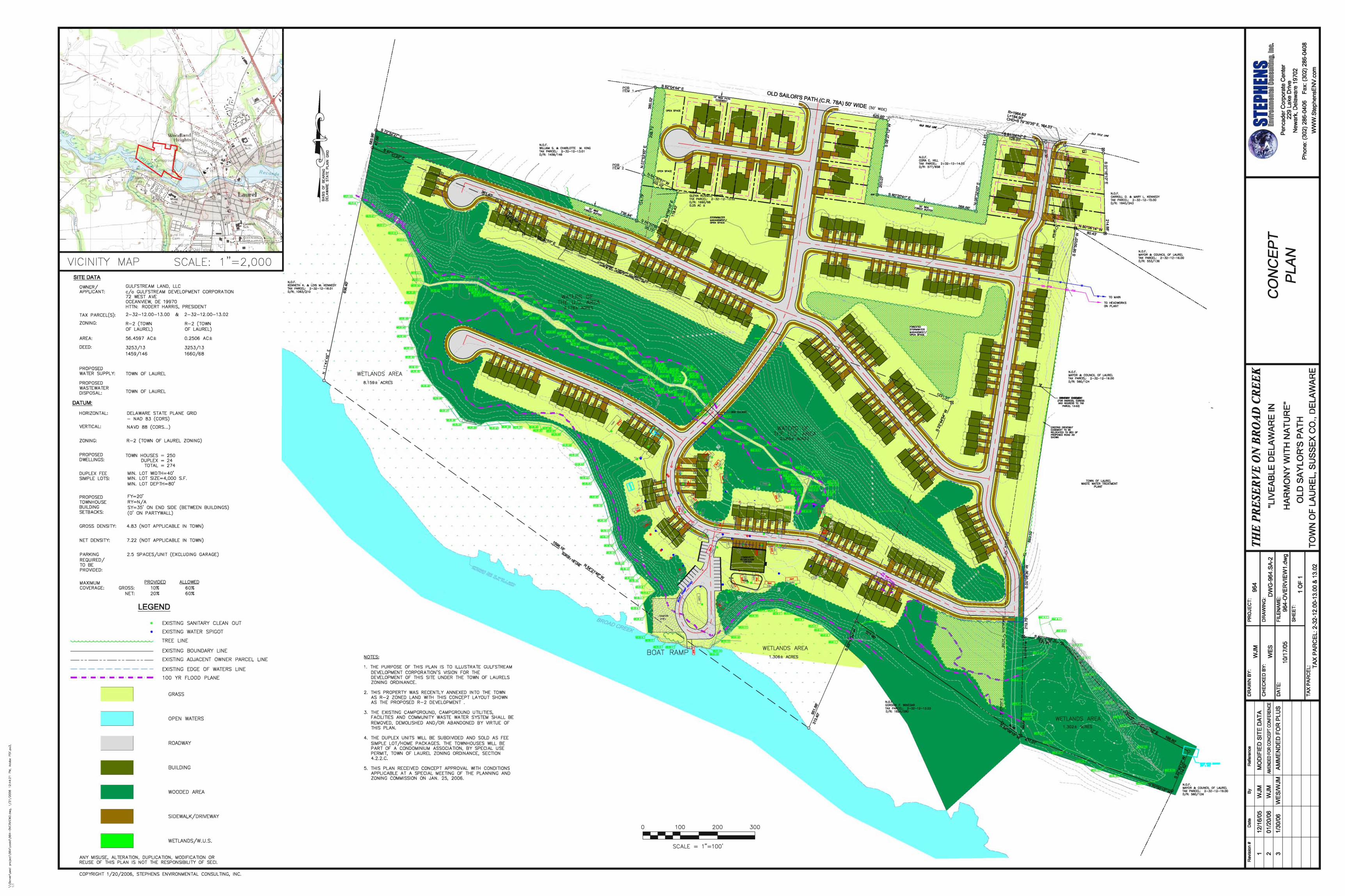
1. Project Title/Name: The Preserve on Broad Creek
2. Location: South of Road 78A (Old Sailor’s Path), .04 mile south of Road 78 and north of Broad Creek
3. Parcel Identification #: 2-32-12.00-13.00 and 13.02 4. County or Local Jurisdiction Name: Sussex County
5. Owner’s Name: Gulfstream Land, LLC C/O Gulfstream Development Corporation
Address: 72 West Avenue
City: Ocean View State: DE Zip: 19970
Phone: 302-539-6178 Fax: 302-539-6479 Email: [email protected]
6. Applicant’s Name: Gulfstream Development Corp.
Address: 72 West Avenue
City: Ocean View State: DE Zip: 19970
Phone: 302-539-6178 Fax: 302-539-6479 Email: [email protected]
7. Engineer/Surveyor Name: Stephens Environmental Consulting, Inc.
Address: 229 Lake Drive
City: Newark State: DE Zip: 19702
Phone: 302-286-0406 Fax: 302-286-0408 Email: [email protected]
8. Please Designate a Contact Person, including phone number, for this Project: Bill Stephens, 302-286-0406
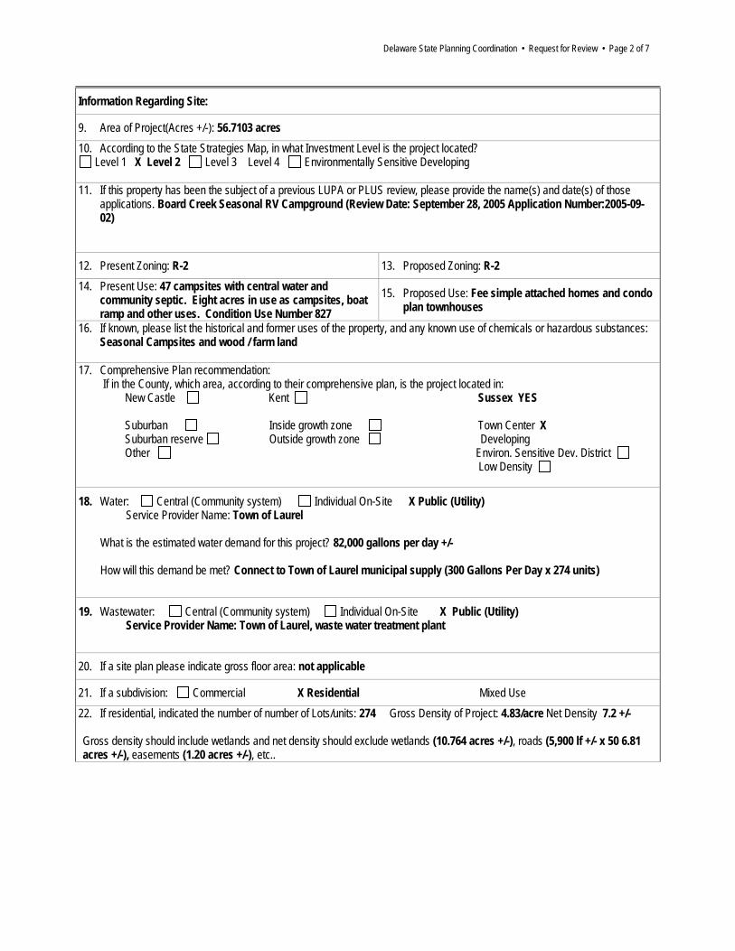
Delaware State Planning Coordination • Request for Review • Page 2 of 7
Information Regarding Site:
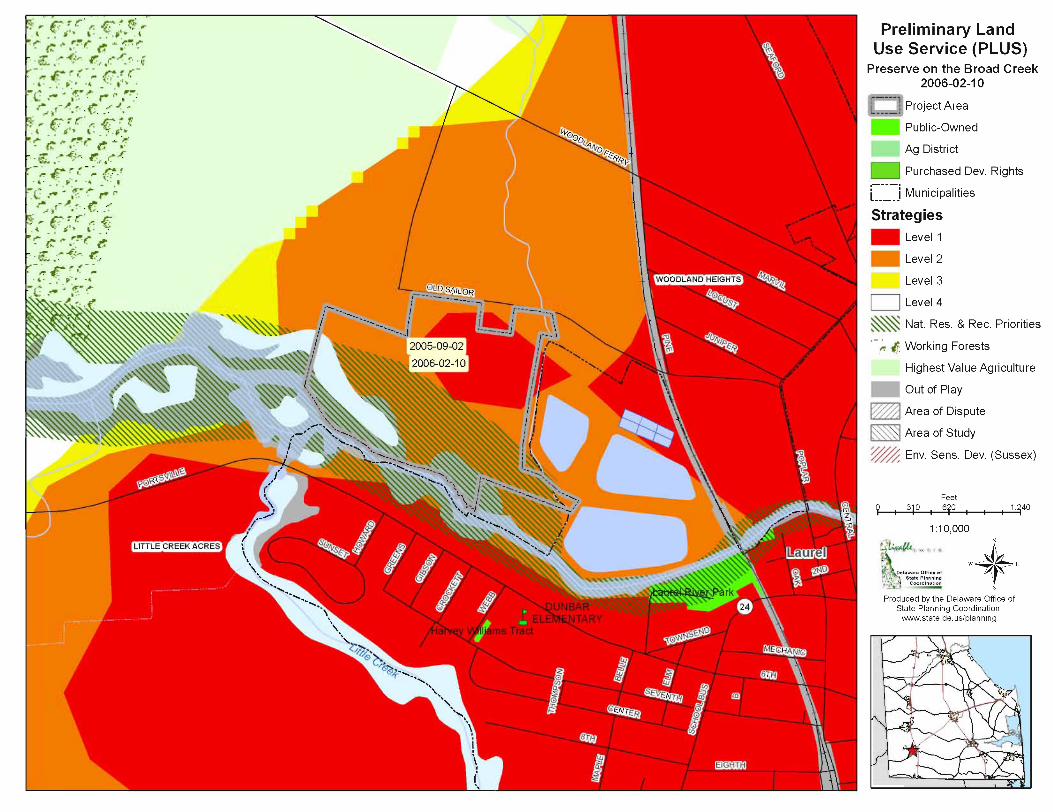
9. Area of Project(Acres +/-): 56.7103 acres 10. According to the State Strategies Map, in what Investment Level is the project located?
Level 1 X Level 2 Level 3 Level 4 Environmentally Sensitive Developing 11. If this property has been the subject of a previous LUPA or PLUS review, please provide the name(s) and date(s) of those
applications. Board Creek Seasonal RV Campground (Review Date: September 28, 2005 Application Number:2005-09-02)
12. Present Zoning: R-2 13. Proposed Zoning: R-2 14. Present Use: 47 campsites with central water and
community septic. Eight acres in use as campsites, boat ramp and other uses. Condition Use Number 827
15. Proposed Use: Fee simple attached homes and condo plan townhouses
16. If known, please list the historical and former uses of the property, and any known use of chemicals or hazardous substances: Seasonal Campsites and wood / farm land
17. Comprehensive Plan recommendation: If in the County, which area, according to their comprehensive plan, is the project located in: New Castle Kent Sussex YES Suburban Inside growth zone Town Center X Suburban reserve Outside growth zone Developing Other Environ. Sensitive Dev. District Low Density
18. Water: Central (Community system) Individual On-Site X Public (Utility) Service Provider Name: Town of Laurel What is the estimated water demand for this project? 82,000 gallons per day +/- How will this demand be met? Connect to Town of Laurel municipal supply (300 Gallons Per Day x 274 units)
19. Wastewater: Central (Community system) Individual On-Site X Public (Utility) Service Provider Name: Town of Laurel, waste water treatment plant
20. If a site plan please indicate gross floor area: not applicable
21. If a subdivision: Commercial X Residential Mixed Use 22. If residential, indicated the number of number of Lots/units: 274 Gross Density of Project: 4.83/acre Net Density 7.2 +/- Gross density should include wetlands and net density should exclude wetlands (10.764 acres +/-), roads (5,900 lf +/- x 50 6.81 acres +/-), easements (1.20 acres +/-), etc..

Delaware State Planning Coordination • Request for Review • Page 3 of 7
23. If residential, please indicate the following: Number of renter-occupied units: Approximately 28 Number of owner-occupied units: Approximately 246 Target Population (check all that apply): Renter-occupied units X Family Active Adult (check only if entire project is restricted to persons over 55) Owner-occupied units
X First-time homebuyer – if checked, how many units 137 X Move-up buyer – if checked, how many units 28 X Second home buyer – if checked, how many units 109 Active Adult (Check only if entire project is restricted to persons over 55) 24. Present Use: % of Impervious Surfaces: .2.2% Square Feet: 55,000 +/-
Proposed Use: % of Impervious Surfaces: 20% Square Feet: 103,000 +/-
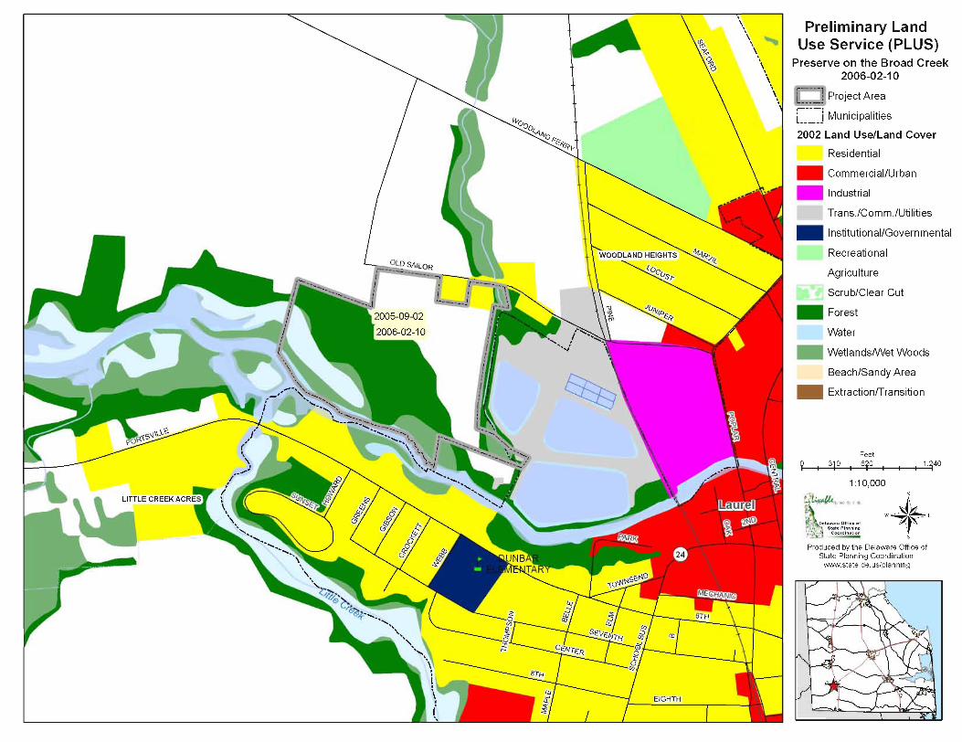
25. What are the environmental impacts this project will have? No significant negative impacts How much forest land is presently on-site? 27.620 ac +/- How much forest land will be removed? 5 acres +/- cleared
3 to 5 Acres +/- planted / replaced Net loss projected landscaped 0-1 acre
Are there known rare, threatened, or endangered species on-site? Yes X No Is the site in a sourcewater (for example, an excellent groundwater recharge) protection area? Yes X No Does it have the potential to impact a sourcewater protection area? Yes X No
26. Is any portion of construction located in a Special Flood Hazard Area as defined by the Federal Emergency Management Agency (FEMA) Flood Insurance Rate Maps (FIRM)? Yes X No Will this project contribute more rainwater runoff to flood hazard areas than prior to development? Yes X No If “Yes,” please include this information on the site map. 27. Are there any wetlands, as defined by the U.S. Army Corps of Engineers or the Department of Natural Resources and Environmental Control, on the site? X Yes No
Are the wetlands: X Tidal Acres 10.764 Non-tidal Acres If “Yes”, have the wetlands been delineated? X Yes No Has the Army Corp of Engineers signed off on the delineation? Yes X No Will the wetlands be directly impacted and/or do you anticipate the need for wetland permits? Yes X No If “Yes”, describe the impacts: Will there be ground disturbance within 100 feet of wetlands X Yes No

Delaware State Planning Coordination • Request for Review • Page 4 of 7
28. Are there streams, lakes, or other natural water bodies on the site? X Yes No If the water body is a stream, is it: X Perennial (permanent) Intermittent Ephemeral (Seasonal) If “Yes”, have the water bodies been identified? X Yes No Will there be ground disturbance within 100 feet of the water bodies X Yes No If “Yes”, please describe :
• Stabilize existing boat trailer parking with turf reinforcement • Stabilize existing loop access to boat ramp and dock
29. Does this activity encroach on or impact any tax ditch, public ditch, or private ditch (ditch that directs water off-site)? Yes X No If yes, please list name: 30. List the proposed method(s) of stormwater management for the site: Underground pipes, stormwater inlets & manholes Define the anticipated outlet location(s) for stormwater generated by the site (for example, perennial stream, tax ditch, roadside swale, storm drain system, infiltration, etc.): Stormwater Basin Infiltration, Swale Will development of the proposed site create or worsen flooding upstream or downstream of the site? Yes X No 31. Is open space proposed? Yes X No If “Yes,” how much? What is the intended use of the open space (for example, active recreation, passive recreation, stormwater management, wildlife habitat, historical or archeological protection)? Where is the open space located? Are you considering dedicating any land for community use (e.g., police, fire, school)? Yes X No NOTE: A substantial proportion of the site will be dedicated for either passive recreation stormwater management and/or conservation open space. 32. Does it border existing natural habitat or preserved (for example, an agricultural preservation district or protected State Resource Area) land? X Yes No If “Yes,” what are they? The
The wetlands and creek are assumed to be protected lands and will be conserved. 33. Is any developer funding for infrastructure improvement anticipated? X Yes No If “Yes,” what are they? Full developer funding for water and sewer, including small pump station. 34. Are any environmental mitigation measures included or anticipated with this project? Yes X No Acres on-site that will be permanently protected 10.764 acres of tidal wetlands Acres on-site that will be restored 0 Acres of required wetland mitigation 0 Stormwater, erosion and sediment control, and construction best management practices (BMPs) that will be employed : Infiltration practices, dry retention ponds, plus ( and (1.03 acres of fee simple forested buffer / open space) afforestation and reforestation (1-2 acres +/- of cutover timer) and landscaping of approximate 8.0 acres +/- of farmland
Buffers from wetlands, streams, lakes, and other natural water bodies Buffers vary and are non-permanent
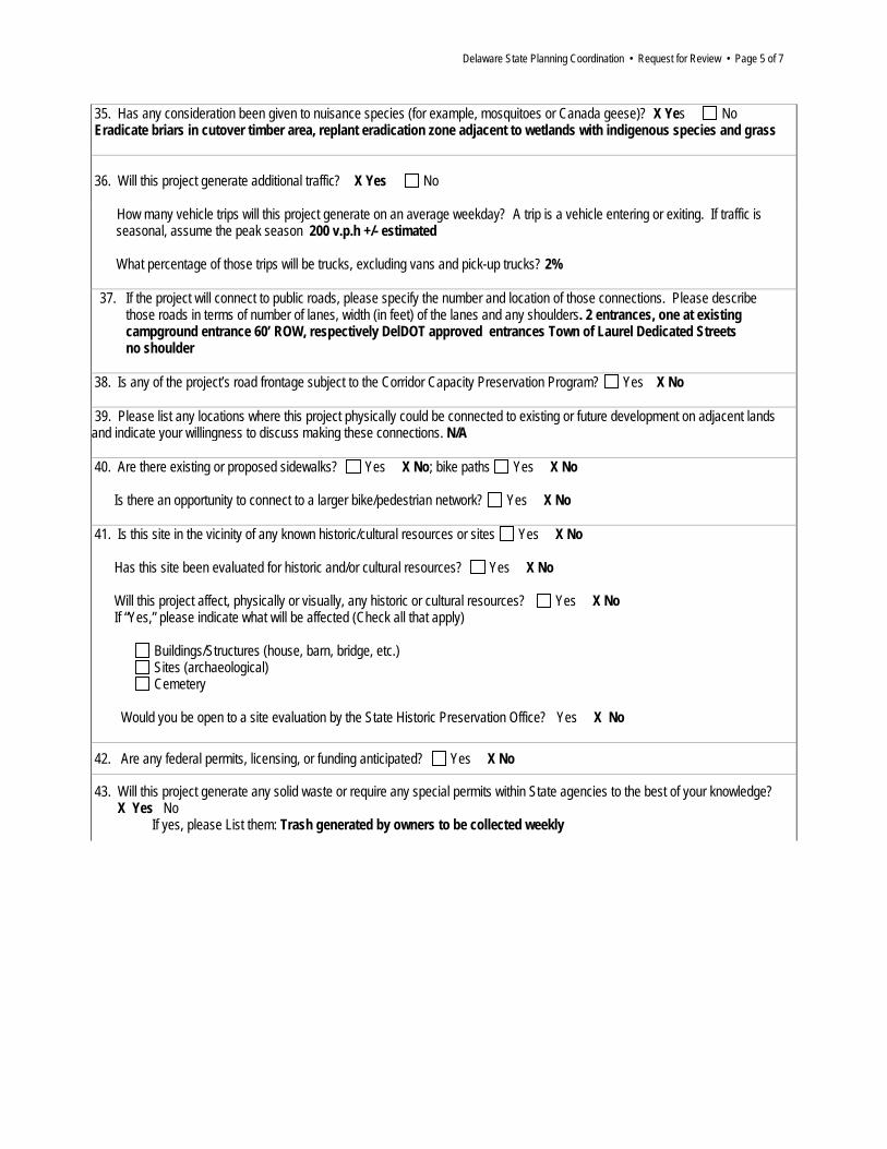
Delaware State Planning Coordination • Request for Review • Page 5 of 7
35. Has any consideration been given to nuisance species (for example, mosquitoes or Canada geese)? X Yes No Eradicate briars in cutover timber area, replant eradication zone adjacent to wetlands with indigenous species and grass 36. Will this project generate additional traffic? X Yes No How many vehicle trips will this project generate on an average weekday? A trip is a vehicle entering or exiting. If traffic is seasonal, assume the peak season 200 v.p.h +/- estimated What percentage of those trips will be trucks, excluding vans and pick-up trucks? 2%
37. If the project will connect to public roads, please specify the number and location of those connections. Please describe
those roads in terms of number of lanes, width (in feet) of the lanes and any shoulders. 2 entrances, one at existing campground entrance 60’ ROW, respectively DelDOT approved entrances Town of Laurel Dedicated Streets no shoulder
38. Is any of the project’s road frontage subject to the Corridor Capacity Preservation Program? Yes X No
39. Please list any locations where this project physically could be connected to existing or future development on adjacent lands and indicate your willingness to discuss making these connections. N/A 40. Are there existing or proposed sidewalks? Yes X No; bike paths Yes X No Is there an opportunity to connect to a larger bike/pedestrian network? Yes X No 41. Is this site in the vicinity of any known historic/cultural resources or sites Yes X No Has this site been evaluated for historic and/or cultural resources? Yes X No Will this project affect, physically or visually, any historic or cultural resources? Yes X No If “Yes,” please indicate what will be affected (Check all that apply) Buildings/Structures (house, barn, bridge, etc.) Sites (archaeological) Cemetery Would you be open to a site evaluation by the State Historic Preservation Office? Yes X No 42. Are any federal permits, licensing, or funding anticipated? Yes X No
43. Will this project generate any solid waste or require any special permits within State agencies to the best of your knowledge? X Yes No If yes, please List them: Trash generated by owners to be collected weekly
Delaware State Planning Coordination • Request for Review • Page 6 of 7
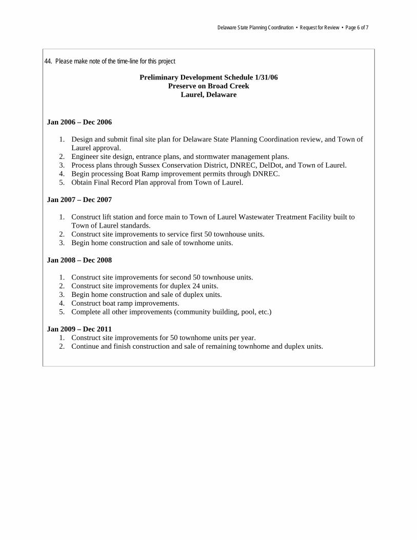
44. Please make note of the time-line for this project
Preliminary Development Schedule 1/31/06 Preserve on Broad Creek
Laurel, Delaware Jan 2006 – Dec 2006
1. Design and submit final site plan for Delaware State Planning Coordination review, and Town of Laurel approval.
2. Engineer site design, entrance plans, and stormwater management plans. 3. Process plans through Sussex Conservation District, DNREC, DelDot, and Town of Laurel. 4. Begin processing Boat Ramp improvement permits through DNREC. 5. Obtain Final Record Plan approval from Town of Laurel.
Jan 2007 – Dec 2007
1. Construct lift station and force main to Town of Laurel Wastewater Treatment Facility built to Town of Laurel standards.
2. Construct site improvements to service first 50 townhouse units. 3. Begin home construction and sale of townhome units.
Jan 2008 – Dec 2008
1. Construct site improvements for second 50 townhouse units. 2. Construct site improvements for duplex 24 units. 3. Begin home construction and sale of duplex units. 4. Construct boat ramp improvements. 5. Complete all other improvements (community building, pool, etc.)
Jan 2009 – Dec 2011
1. Construct site improvements for 50 townhome units per year. 2. Continue and finish construction and sale of remaining townhome and duplex units.
Delaware State Planning Coordination • Request for Review • Page 7 of 7
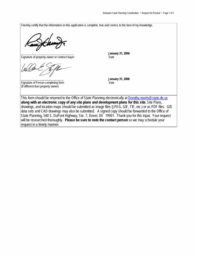
I hereby certify that the information on this application is complete, true and correct, to the best of my knowledge.
____________________________________ January 31, 2006 Signature of property owner or contract buyer Date
_____________________________ January 31, 2006 Signature of Person completing form Date (If different than property owner)
This form should be returned to the Office of State Planning electronically at [email protected] along with an electronic copy of any site plans and development plans for this site. Site Plans, drawings, and location maps should be submitted as image files (JPEG, GIF, TIF, etc.) or as PDF files. GIS data sets and CAD drawings may also be submitted. A signed copy should be forwarded to the Office of State Planning, 540 S. DuPont Highway, Ste. 7, Dover, DE 19901. Thank you for this input. Your request will be researched thoroughly. Please be sure to note the contact person so we may schedule your request in a timely manner.