1
Qmt 3 Qmt 4 Qmt 4 Qmt 2 Qt Qu Qt KJfm Qt Qls Qmt 3 Qmt 2 Qls Qha Qds Qmt 1 Qmt 2 Qu Qmt 4 Qls Qt KJfm Qls Qbs Qbs KJfm af gs Qmt 4 Qbs Qa Qmt 1 KJfm Qmt 2 Qls Qmt 1 Qls Qmt 3 Qbs Qt Qls KJfm Qls Qmt 1 Qmt 2 Qmt 1 Qbs Qmt 3 Qls KJfm Qmt 2 Qls KJfm Qmt 3 KJfm Qmt 1 LOST MAN FAULT FAULT GROGAN ZONE PATRICKS POINT FAULT Qu KJfm Qmt 4 Qmt 3 Qmt 2 Qls Qls Qls Qmt 1 Qmt 6 Qmt 1 Qls Qa Qmt 2 Qls MOUNTAIN BALD FAULT LAGOON FAULT BIG Qmt 4 Qa Qls Qls KJfm gs Qmt 5 Qa Qls Qls Qmt 4 Qmt 5 TRINIDAD FAULT mg Qmt 1 Qls Qmt 5 Qls Qls Qha Qmt 1 Qmt 2 gs KJfm Qls KJfpp Qmt 5 sp af Qu Qha KJfpp Qmt 2 Qls mv Qmt 2 Qls Qmt 1 af Qe Qls Qe Qe Qha Qmt 4 Qha Qls Qe Qha sp Qu Qmt Qls sp Qt mv KJfm Qt Qmt KJfm Qmt KJfm Qls Qht Qt Qls Qbs Qt Qa Qls KJfm Qha Qls Qe Qls Qt Qls Qls Qhf Qbs Qls Qht KJfrc KJfrc mv Qls Qmt Qht Qmt mv Qhc Qa Qmt Qht Qbs Qmt KJfrc Qds Qls Qhc Qht mv Qhf KJfrc Qmt Qls Qf Qsc Qht Qbs Qsc Qha Qhc Qha Qha Qhc Qls Qls Qls Qhc Qmt Qht Qls Qls KJfrc Qa Qls KJfg Qmt Qhf KJfc Qha KJfc Qht QTp c Qbs KJfrc KJfc KJfl Qha KJfl Qt KJfg KJfc Qt Qa Qha Qha Qf Qt QTpc Qmt Qmt QTpc Qa Qa Qa Qsc KJfbf Qha Qsc Qa KJfrc Qa Qls Qsc Qbs Qha KJfmc Qls QTpc Qsc Qsc KJfbf QTpc KJfbf KJfmc KJfrc mg Qsc Qbs Qsc Qls Qls Qbs KJfmc Qls Qsc Qsc Qls Qsc Qsc KJfmc KJfbf Qsc Qsc KJfmc Qls KJfbf Qls Qls Qha KJfrc Qha KJfrc Qmt 4 Qu Qmt 2 20 86 24 14 24 66 54 26 15 46 76 30 22 37 20 19 62 34 23 44 19 33 15 51 90 12 46 9 49 23 50 29 41 20 44 43 23 41 9 45 40 37 11 40 43 62 45 1 5 17 16 20 10 12 12 24 8 15 20 24 36 50 24 29 25 84 74 42 40 29 74 30 67 41 81 36 60 44 49 21 40 60 50 50 80 7 55 58 63 84 67 83 46 81 25 25 31 30 26 22 40 45 29 15 41 42 21 28 22 29 29 50 48 32 41 38 76 19 38 28 13 23 41 30 19 18 24 44 52 45 44 71 30 39 43 63 42 33 42 15 36 32 26 37 61 50 16 61 26 9 64 60 45 30 42 10 35 33 35 32 57 30 25 73 35 56 81 80 65 75 52 30 34 55 10 85 45 27 32 48 23 55 42 37 38 62 82 55 28 50 42 16 22 30 25 31 51 53 60 38 78 16 31 24 34 47 25 60 68 25 54 54 22 56 30 22 30 46 30 20 47 51 38 15 20 38 40 32 14 18 45 60 31 33 46 23 27 30 41 41 30 42 37 15 20 38 36 75 37 23 25 86 50 40 36 20 49 20 64 21 36 42 55 42 33 15 50 33 8 30 55 10 67 28 23 44 13 32 36 14 21 47 42 36 38 10 25 70 42 57 45 37 24 5 39 33 86 55 34 60 30 68 30 11 23 44 50 48 70 40 41 34 35 45 42 51 25 45 45 57 60 15 27 21 42 42 76 35 72 35 34 31 36 60 20 66 45 32 55 52 33 37 43 45 45 42 63 65 50 45 40 50 18 32 45 62 25 60 19 15 15 40 55 24 35 70 30 54 51 42 24 39 35 32 80 56 78 48 45 18 71 45 32 34 38 12 34 48 46 38 16 25 30 45 68 78 54 45 Qhf Qls Qhc Twi Qls gr KJfbf Qls Qe gs Qt Qht Qha KJfbf KJfbf Jdc Twi Qhf ms Qls Qby Qls Qha Qhc Twi Qht Juc Qls Qls Qt Qt Qhc Qbs Qby Qls Qa Qha Qls KJfbf Qls KJfbf Qe KJfbf KJfbf Qht Qf Qds Jgb Qe Qht Qe Qls Jdc Qe Qt Qds Jgb Jpd Qha Twi Qt Qf Qhc KJfbf Qa sp Jdc af Qha Twi KJfbf KJfmc Qa Twi spm Qf Qhc Qt Qbs Juc Qls Jgb KJfmc Tsg KJfbf Qf KJfmg Qf spm Twi Jdc Qha Qby Qbs Qls Twi Tsg spm Qby Jdc KJfbf Twi KJfbf Qt KJfbf Qa Qha Jgb spm Qt Qls Qls Qbs Tsg Jgb Qls Jpd Jpd Jdc Qt Qha Jgb Qt Qhc Qls Qls Qls Qls Qhc Qt Qt Qhc Qf Qt Jdc Jdc Qt Qls Qls Qha Qf Jpd Jdc Qha Qls af Qt Qhc Qls Qhc Qf Qls Qls KJfbf Qht Qhc spm Qby KJfmg sp Twi sp Qt Qht gr Twi Jgb Qha Qls KJfbf KJfbf Jdc Qa Twi Jpd KJfbf Jgb Jgb Qt Qf KJfbf KJfbf Jdc Qt Qha Qls Jpd KJfbf KJfbf Qbs Qls Qmt Qls Qls Qha gs gs af Qsc Qmt u Qls Qls Qmt Qht Qht Qls Qt Qsc Qsc Qls Qht Qhc af KJfbf Qha ch Qhc Qa Qha Qmt Qls Qls Qls Qha KJfbf Qht KJfmc Qht Qht Qha Qhc Qls Qha Qha Qht Qha Qbs ch Qls u Qht Qha Qt Qls ch Qa Qls Qt Qt Qls ch Qf Qha Qls Qha Qf Qls Qf Qls KJfbf u Qa Qha Qf Qha Qls Qls KJfmc KJfbf u Qha Qls Qha Qbs Qhc 20 KJfmc u Qha Qha Qhc Qls u KJfbf KJfmc Qls Qls Qls Qls KJfmc Qa Qhc Qls Qls Qls Qha Qls KJ fmg Qt Qls Qls Qls Qls Qls Qt Qls Qls Qls Qls Qls Qha Qbs Twi Qls Qls KJfbf Qby Qls Qa Qls Qls Twi Qf Qa Qls Qa Qls Qf Qha Twi KJfbf Qt gs Qa Qls Qbs Qbs af Twi KJfbf Qhc af Qha Juc Jpd Jpd af Qha Qls sp Jgb Qls sp Qh f Qls KJfmg Jpd Jpd Qhc Jpd Qls Jpd spm Jpd Qf KJfmc Qf Qls Jpd Qhc Qls KJbf sp Qht Qht Qhc Qhc Qls Qt Qf Qhc Qls Juc Qls KJfbf Qha Jpd Qls JPd KJfbf Qls Qls KJfbf Jpd Qha Qls Qa Qls Qha Qt Qls Qhc Qht KJfbf Qls Qbs Qf Qls Qf Qls Qha Qls Qls Qds Qha Qf Qls Qa Qls Qls Qha Qbs Qls KJfmc af Qha Qa Qls Qls Qds Qls Qls Qls Qls Qls Qls Jpd Qbs Qhc Qls Qls Qls Qls Qls Qls Qhf Qls Qls Qls Qht Qby Qls Qa Qls Qls Qa Qhf Qa Qls Qf Qls Qha Qa Qls Qf Qls Qls Qls Jpd Qht Qhc KJfbf Qls Qby Jpd Qls Qha Qls Jgb Jgb Qt Qt KJfbf Qls Qhc Qls Qhc sp sp Qls Qls Qls Qls Qa Qls Qds Qbs KJfmc Qls Qls Qby KJfbf Qa DEL NORTE FAULT ROWDY CREEK FAULT Qls RANGE THRUST RANGE COAST THRUST COAST ms Qls Qsc Qls Qls Qls Qls Qls Qls Qls Qls PRELIMINARY GEOLOGIC MAP OF ONSHORE PORTIONS OF THE CALIFORNIA GEOLOGICAL SURVEY JOHN G. PARRISH, Ph.D., STATE GEOLOGIST PRELIMINARY GEOLOGIC MAP OF ONSHORE PORTIONS OF THE CRESCENT CITY AND ORICK 30' x 60' QUADRANGLES, CALIFORNIA Compilation and Digital Preparation by Marc Delattre and Anne Rosinski 2012 Copyright © 2012 by the California Department of Conservation. All rights reserved. No part of this publication may be reproduced without written consent of the California Geological Survey. The Department of Conservation makes no warranties as to the suitability of this product for any particular purpose. 41°00' 42°00' 124°00' 124°52'30” 124°52'30” 124°00' 42°00' Projection: Uiversal Transverse Mercator, Zone 10N, North American Datum 1927. Topographic base from USGS Crescent City and Orick 30'x60' quadrangles, 1983. Shaded relief image derived from USGS 1/3 arc-second National Elevation Dataset (NED). This geologic map was funded in part by the U.S. Geological Survey National Cooperative Geologic Mapping Program, STATEMAP Award no. G11AC20220. Geology compiled 2011-2012 41°00' STATE OF CALIFORNIA - EDMUND G. BROWN JR., GOVERNOR NATURAL RESOURCES AGENCY - JOHN LAIRD, SECRETARY DEPARTMENT OF CONSERVATION - MARK NECHODOM, DIRECTOR 41°30' 41°30' 124°15' 124°15' CRESCENT CITY ORICK CRESCENT CITY AND ORICK 30' x 60' QUADRANGLES, CALIFORNIA Preliminary Geologic Map available from: http://www.conservation.ca.gov/cgs/rghm/rgm/preliminary_geologic_maps.htm SCALE 1:100,000 6 Miles 2 0 2 4 2 0 2 4 6 Kilometers Contour Interval: 50 meters APPROXIMATE MEAN DECLINATION, 2012 15.27° TRUE NORTH MAGNETIC NORTH ? 27 ? D U 25 25 Contact between map units - Hashed where gradational; solid where accurately located, dashed where approximately located; short dash where inferred; dotted where concealed; queried where uncertain. Fault - Solid where accurately located; dashed where approximately located; short dash where inferred; dotted where concealed; queried where uncertain; bar and ball on downthrown side. U = upthrown block, D = downthrown block. Thrust fault - Sawteeth on upper plate; solid where accurately located; dashed where approximately located; short dash where inferred; dotted where concealed; queried where existance uncertain Anticline - Solid where accurately located, dashed where approximately located; dotted where concealed. Syncline - Solid where accurately located, dashed where approximately located; dotted where concealed. 25 25 25 ? ? 25 25 SYMBOL EXPLANATION ? Strike and dip of bedding: Inclined Vertical Overturned Crumpled Approximate Strike and dip of foliation: Iinclined Vertical Strike and dip of joints or fractures Strike and dip if igneous layering Strike and dip of dike walls Landslide - arrows indicate principal direction of movement. QUATERNARY TERTIARY CRETACEOUS JURASSIC Holocene Pleistocene Miocene Pliocene MESOZOIC CENOZOIC CRESCENT CITY ORICK Trinidad Crescent City 0 10 20 5 Kilometers 0 6 12 3 Miles Pacific Ocean ABBREVIATED INDEX TO GEOLOGIC SOURCE DATA 9 6 1 5 7 3 2 4 10 11 8 t u t u t u t u 0 6 12 s r e t e m o l i K 3 0 1 5 0 s e l i M 5 . 2 (SEE PAMPHLET FOR COMPLETE REFERENCES) 1. Harper, 1980; Elder and Reichert, 2010; Evans, 1984; Stone, 1983, for Wimer Formation; Quaternary mapping by Delattre, this study. 2. Davenport, 1983b; Aalto, 1981; Quaternary mapping by Delattre, this study. 3. Davenport, 1983c; Back, 1957; Aalto and others, 1981; Quaternary mapping by Delattre, this study. 4. Davenport, 1983a; Back, 1957; Aalto and others, 1981; Stone, 1983, for Wimer Formation; Quaternary mapping by Delattre, this study. 5. Davenport, 1982; Back, 1957; Aalto, 2006, for Point St. George area; Polenz and Kelsey, 1999; Quaternary mapping by Delattre, this study. 6. Davenport, 1984a; Aalto and Harper, 1982; Wills, 2000; Ristau, 1979; Quaternary mapping by Delattre, this study. 7. Davenport, 1984b; Aalto and Harper, 1982; Quaternary mapping by Delattre, this study. 8. Aalto and others, 1981; Cashman and others, 1995; Kelsey and Trexler, 1989. 9. Dell’Osso and others, 2003; Cashman and others, 1995; Hardin and others, 1982; Aalto and others, 1981; Quaternary mapping by Delattre and Rosinski, this study. 10. Aalto and others, 1981; Quaternary mapping by Delattre and Rosinski, this study. 11. Aalto and others, 1981; Carver, 1992, Woodward-Clyde Consultants, 1980, and Aalto, 1989b for marine terraces; Quaternary mapping by Delattre and Rosinski, this study. 42°0'0" 41°30'0" 41°30'0" 124°0'0" 41°0'0" 124°0'0" 41°0'0" 125°0'0" 42°0'0" 125°0'0" INDEX MAP OF 7.5’ QUADRANGLES (Happy Camp) (Hoopa) (Eureka) WITHIN THE CRESCENT CITY AND ORICK 30’ X 60‘ QUADRANGLES ch mg u gr ms gs gs mv sp gs Tsg Twi KJfm KJfbf KJfmc KJfmg KJfc KJfg KJfl KJfpp KJfrc sp Jdc Jgb Jpd Juc spm Franciscan Complex - Central Belt Mélange of the Central Belt (Late Cretaceous to Late Jurassic) Greenstone block within mélange Franciscan Complex - Eastern Belt Broken formation (Early Cretaceous to Middle Jurassic) Mélange unit of Crescent City area (Early Cretaceous to Middle Jurassic) Blocks within mélange: Blocks within mélange: Greenstone Greenstone Metagraywacke Chert Undifferentiated Transitional rocks of the Grogan Fault Zone (Cretaceous to Jurassic) Coherent unit of Lacks Creek (Cretaceous to Jurassic) Redwood Creek watershed units of Hardin and others (1982) Metagraywacke (Cretaceous to Jurassic) Incoherent unit of Coyote Creek (Cretaceous to Jurassic) Redwood Creek Schist (Early Cretaceous to Late Jurassic) Interbedded metatuff Serpentinite block Patricks Point unit of Aalto and others, 1981 (Cretaceous to Jurassic) Klamath Mountains Province - Western Jurassic Belt Josephine Ophiolite of Harper (1980) Dike Complex (Late Jurassic) Gabbro (Late Jurassic) Cumulate ultramafic rocks (Late Jurassic) Sheared serpentinite (Jurassic) Serpentinite matrix mélange (Jurassic) Granitic rocks Metasedimentary rocks Peridotite (Late Jurassic) af Qhc Qht Qe Qls Qa Qf Qt Qby Qmt Qmt 1 Qmt 2 Qmt 3 Qmt 4 Qmt 5 Qmt 6 Qsc Qu Marine terrace deposits (Pleistocene) Trinidad marine terraces; names and approximate ages (ka=1000 years) from Woodward-Clyde Consultants (1980), and Carver (1992): Patricks Pt. terrace, age 64 ka Savage Creek terrace, age 83 ka, and McKinleyville terrace, age 96 ka Westhaven terrace, 103 ka Fox Farm terrace, 120 ka, and Sky Horse terrace, 130 ka A-Line terrace, 176 ka and older Maple Stump terrace, 200+ ka Terrace gravels of Surpur Creek (Pleistocene) Prairie Creek Formation (early Pleistocene to late Pliocene) Undifferentiated marine and nonmarine overlap deposits (Pleistocene to late Pliocene?) Wimer Formation (late Miocene) St. George Formation (late Miocene) Stream channel deposits (latest Holocene) Beach deposits (latest Holocene) Young alluvial deposits, undifferentiated (Holocene) Young alluvial fan deposits (Holocene) Dune sand (Holocene) Estuarine deposits (Holocene) Landslide deposits (historical to Pleistocene) Alluvial deposits, undifferentiated (Holocene to latest Pleistocene) Alluvial fan deposits (Holocene to Pleistocene) Stream terrace deposits (early Holocene to Pleistocene) Battery Formation (late Pleistocene) Artificial fill (historical) Young stream terrace deposits (Holocene) ABBREVIATED EXPLANATION (Approximate stratigraphic relationships only; see pamphlet for more detailed information) Qbs Qds Qha Qhf QTpc

PRELIMINARY GEOLOGIC MAP OF ONSHORE … ls Q s Ql s Qh a Ql s KJg Qt Ql s Ql s Ql s Ql s Qt Ql s Ql s l s Ql s Ql s Ql s Qh a Qb s i l Ql s KJf bf Qb y Ql s a s Ql s i Qf Qa Ql s Qa

Embed Size (px)

Citation preview

Qmt3 Qmt4Qmt4

Qmt2

Qt

Qu

QtKJfm

Qt Qls

Qmt3

Qmt2

Qls

QhaQds

Qmt1Qmt2Qu

Qmt4Qls

Qt

KJfm

QlsQbs

Qbs

KJfmafgs Qmt4

Qbs

QaQmt1

KJfm

Qmt2

Qls

Qmt1

Qls

Qmt3

Qbs

Qt

Qls

KJfm

QlsQmt1

Qmt2

Qmt1Qbs Qmt3

Qls

KJfmQmt2

QlsKJfm Qmt3

KJfm

Qmt1

LOST M

AN FAULT

FAULT

GROG

AN

ZONE

PATRICKS POINT

FAULT

Qu

KJfm

Qmt4

Qmt3

Qmt2 Qls

Qls

Qls

Qmt1

Qmt6

Qmt1

Qls

Qa

Qmt2

Qls

MOUNTAIN

BALD

FAULT

LAGO

ON

FAULT

BIG

Qmt4

QaQls Qls

KJfm

gs

Qmt5

Qa

Qls

Qls

Qmt4

Qmt5

TRINIDAD

FAULT

mg

Qmt1

Qls

Qmt5Qls

QlsQha

Qmt1 Qmt2gs

KJfm

QlsKJfpp

Qmt5 sp

af

QuQha

KJfpp

Qmt2

Qls

mvQmt2

QlsQmt1af

Qe

QlsQeQe

Qha

Qmt4

Qha

Qls

Qe

Qha

sp

Qu

Qmt

Qls

spQt

mv

KJfm

Qt

Qmt

KJfm

Qmt

KJfm

Qls

QhtQt

Qls

Qbs

QtQaQls

KJfm

Qha

Qls

Qe

Qls

QtQlsQls

QhfQbs

QlsQht

KJfrc

KJfrc

mvQls

Qmt Qht

Qmt

mv

Qhc

Qa

Qmt

Qht

Qbs

Qmt

KJfrc

QdsQls

Qhc

Qht

mv

QhfKJfrc

Qmt

QlsQf

QscQht

Qbs

Qsc

Qha

Qhc

Qha

Qha

QhcQls

Qls Qls

Qhc

QmtQht

Qls

Qls

KJfrc

Qa

Qls

KJfg

Qmt Qhf

KJfc

Qha

KJfc

QhtQTpc

Qbs

KJfrc

KJfc

KJflQha

KJfl

Qt

KJfg

KJfc

Qt

Qa

Qha

Qha

QfQt

QTpc

Qmt

Qmt

QTpc

QaQa

Qa

Qsc

KJfbf

Qha

Qsc

Qa

KJfrc Qa

Qls

Qsc

Qbs

QhaKJfmc

Qls

QTpc

Qsc

QscKJfbf

QTpc

KJfbf

KJfmc

KJfrc

mgQsc

Qbs

Qsc

QlsQls

Qbs

KJfmc

Qls Qsc

Qsc

Qls

Qsc

Qsc

KJfmcKJfbf Qsc

Qsc

KJfmc

Qls

KJfbf

Qls

Qls

Qha

KJfrc

Qha

KJfrc

Qmt4

Qu

Qmt2

2086

24 14

24

66

54

26

15

46

76

30

22

37 20

19

6234

2344

1933

15

51

901246

9

4923

5029

4120 44

43

23

41

945

403711

40

4362

45

1

517 16

20

1012

12 24

8

15

20

24

36

5024

29

25

84

74

4240 29

743067

41

81

3660

44

49

21

40

6050

50

807

55 58

6384

67

83

4681

2525

31

3026

2240

45291541

42

2128

22

29

29

50 48

32

41

3876

19

3828

1323

413019

18

24 44

52

45

44

71

30

3943

6342

33

42

15

3632

26

37

61

5016

61269

64

60

45

30

42

10

35 33

35

32

57

30

2573

35

56

81 80

65

7552

30

34

55

10

85

45

27

32

48

23

55

42 37

38

62

82

55

28

5042

1622

30

25

31

51

53

60

38

78

16

31

2434

47

25

60

68

25

5454

22

56

30

22

30

4630

20

4751

38

15

2038

40

32

14

1845

60

31

33 46

23

27

30

41

41

30

42

37

15

20

38

36

75

37

23

2586

50

40

36

20

49

20

64

21

36

4255

42

33

15

50

33

8

30

55 10

6728

2344

13

32

36

14

21

47

42

36

38

10

25

70

42

57

45

37

24

5

39

33

86

5534

60

30

68

30

11

23

44

50

4870

40 41

34

3545

42

51

25

45

45

57

60

15

27

21

42 42

76

35

72

35

34

31

36

60

20

66

45

32

55

52

33

3743

45

45

42

6365

50

45

40

50

18

32

45

62

25

60

19

1515

4055

24 35

70

30

54

51

42

24

39

35

32

80

56

78 48

45

18

71

45

32

3438

12

34

48

46

38

16

25

30

45

68

78

54

45

Qhf Qls

Qhc

TwiQls

gr

KJfbf

Qls

Qe

gsQt

Qht

QhaKJfbf

KJfbf

JdcTwi

Qhfms

QlsQby

Qls

Qha Qhc

Twi

QhtJucQls

QlsQt

QtQhc

Qbs

Qby

QlsQa

Qha

QlsKJfbfQlsKJfbf

Qe

KJfbf

KJfbf

Qht

Qf

QdsJgb

Qe

Qht

Qe

Qls

Jdc

Qe

Qt

Qds

JgbJpd

Qha

Twi

Qt

Qf Qhc

KJfbf

Qa

sp

Jdc

af

Qha

Twi

KJfbf

KJfmc

QaTwi

spm

QfQhcQt

Qbs

Juc

Qls

Jgb

KJfmc

Tsg

KJfbf

Qf

KJfmgQf

spm

TwiJdc

Qha

Qby

Qbs

QlsTwi

TsgspmQby

Jdc

KJfbfTwiKJfbf

Qt

KJfbf Qa

Qha

Jgb

spm

Qt

QlsQls

Qbs

Tsg

Jgb

Qls Jpd

Jpd

Jdc

Qt

QhaJgb

Qt

Qhc

QlsQls

QlsQls

Qhc

Qt

Qt

Qhc

Qf Qt

JdcJdc

Qt

QlsQls

Qha

Qf

JpdJdc

Qha

Qlsaf

Qt

Qhc

Qls

Qhc

Qf

Qls

QlsKJfbf

Qht

Qhc

spm

Qby

KJfmg

spTwi

sp

Qt

Qht

grTwi

Jgb

Qha

QlsKJfbf

KJfbf

Jdc

Qa

TwiJpd

KJfbfJgbJgb

QtQf

KJfbf

KJfbf

JdcQt

Qha

Qls

Jpd

KJfbfKJfbf

QbsQls

QmtQls

Qls

Qha

gs gsaf

Qsc

Qmtu

Qls

Qls

QmtQhtQht

Qls

Qt

Qsc

Qsc

Qls

QhtQhc

af

KJfbf

Qha

chQhc

Qa

QhaQmt

Qls

QlsQls

QhaKJfbf

Qht

KJfmc QhtQht

Qha

QhcQlsQha

Qha

Qht Qha

Qbs

ch

Qlsu Qht

Qha

QtQls

ch

Qa

QlsQt

Qt Qls

ch

Qf

Qha

Qls

Qha

Qf

Qls

Qf

Qls

KJfbf

u

Qa

QhaQf

Qha

QlsQls

KJfmc

KJfbf

uQha

Qls

QhaQbs

Qhc

20

KJfmc

u QhaQhaQhc

Qlsu

KJfbf

KJfmcQls

QlsQls

Qls

KJfmcQa

QhcQlsQls Qls

Qha

Qls

KJfmg

Qt

QlsQls

Qls

Qls

QlsQtQls Qls

QlsQls

Qls

Qha

Qbs

Twi

Qls QlsKJfbf

QbyQls

Qa

QlsQls

TwiQf

QaQls

Qa

QlsQfQha

Twi

KJfbfQt

gsQa Qls

Qbs

Qbsaf

TwiKJfbfQhc

af Qha JucJpd

Jpd

af Qha

Qls

spJgb

Qls sp

Qhf Qls

KJfmg

Jpd

Jpd

Qhc

Jpd

QlsJpd

spm

Jpd

Qf

KJfmc

Qf

Qls

Jpd

Qhc

Qls

KJbf sp

Qht

Qht

Qhc

Qhc

QlsQt

Qf

Qhc

Qls

Juc

QlsKJfbf

Qha

Jpd

Qls

JPdKJfbf

QlsQls

KJfbf

Jpd

Qha

Qls

Qa Qls

Qha

Qt

Qls

Qhc

Qht

KJfbf Qls

Qbs

Qf

QlsQf

Qls

QhaQls

Qls

Qds

Qha

Qf

Qls

Qa QlsQls

Qha

Qbs

QlsKJfmc

af

Qha

QaQls

Qls

QdsQls Qls

Qls

QlsQls Qls

Jpd

Qbs

QhcQlsQls Qls

Qls

QlsQls

Qhf

Qls

QlsQls

Qht

Qby Qls

Qa

QlsQls

Qa

Qhf

Qa

QlsQfQls

QhaQa

QlsQf

Qls

Qls Qls

Jpd

Qht

Qhc

KJfbf

QlsQby

Jpd QlsQhaQls

Jgb

Jgb

Qt

Qt

KJfbf QlsQhc

QlsQhc

sp

sp

Qls

Qls Qls Qls

Qa

QlsQds

Qbs

KJfmc QlsQls

Qby

KJfbf

Qa

DE

L

N

OR

TE

FAU

LT

ROWDY CREEK FAULT

Qls

RAN

GE T

HRU

ST

RANGE

CO

AST

THRUST

COAST

ms

Qls

Qsc

Qls

Qls

Qls

Qls

Qls

Qls

Qls

Qls

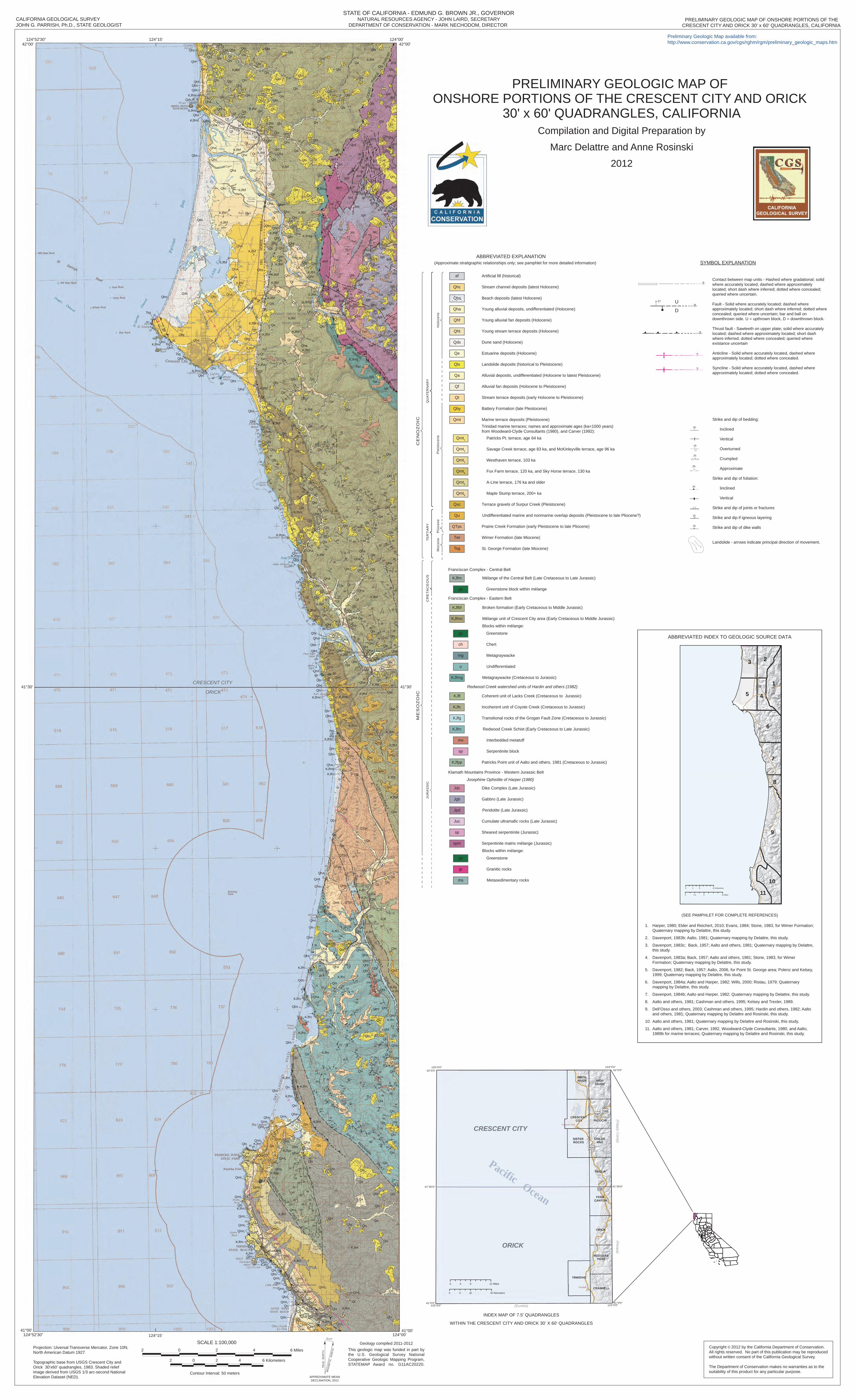
PRELIMINARY GEOLOGIC MAP OF ONSHORE PORTIONS OF THECALIFORNIA GEOLOGICAL SURVEYJOHN G. PARRISH, Ph.D., STATE GEOLOGIST

PRELIMINARY GEOLOGIC MAP OF ONSHORE PORTIONS OF THE CRESCENT CITY AND ORICK

30' x 60' QUADRANGLES, CALIFORNIACompilation and Digital Preparation by

Marc Delattre and Anne Rosinski

2012

Copyright © 2012 by the California Department of Conservation. All rights reserved. No part of this publication may be reproducedwithout written consent of the California Geological Survey.

The Department of Conservation makes no warranties as to the suitability of this product for any particular purpose.

41°00'

42°00'

124°00'124°52'30”

124°52'30” 124°00'42°00'

Projection: Uiversal Transverse Mercator, Zone 10N, North American Datum 1927.

Topographic base from USGS Crescent City and Orick 30'x60' quadrangles, 1983. Shaded relief image derived from USGS 1/3 arc-second National Elevation Dataset (NED).

This geologic map was funded in part by the U.S. Geological Survey National Cooperative Geologic Mapping Program, STATEMAP Award no. G11AC20220.

Geology compiled 2011-2012

41°00'

STATE OF CALIFORNIA - EDMUND G. BROWN JR., GOVERNORNATURAL RESOURCES AGENCY - JOHN LAIRD, SECRETARY

DEPARTMENT OF CONSERVATION - MARK NECHODOM, DIRECTOR

41°30'41°30'

124°15'

124°15'

CRESCENT CITY

ORICK

CRESCENT CITY AND ORICK 30' x 60' QUADRANGLES, CALIFORNIA

Preliminary Geologic Map available from:http://www.conservation.ca.gov/cgs/rghm/rgm/preliminary_geologic_maps.htm

SCALE 1:100,000 6 Miles 2 0 2 4

2 0 2 4 6 Kilometers

Contour Interval: 50 metersAPPROXIMATE MEANDECLINATION, 2012

15.27°

TRU

E N

OR

THM

AG

NE

TIC

NO

RTH

?

27?

D

U

25

25

Contact between map units - Hashed where gradational; solid where accurately located, dashed where approximately located; short dash where inferred; dotted where concealed; queried where uncertain.

Fault - Solid where accurately located; dashed where approximately located; short dash where inferred; dotted where concealed; queried where uncertain; bar and ball on downthrown side. U = upthrown block, D = downthrown block.

Thrust fault - Sawteeth on upper plate; solid where accurately located; dashed where approximately located; short dash where inferred; dotted where concealed; queried where existance uncertain

Anticline - Solid where accurately located, dashed where approximately located; dotted where concealed.

Syncline - Solid where accurately located, dashed where approximately located; dotted where concealed.

25

25

25

?

?

25

25

SYMBOL EXPLANATION

?

Strike and dip of bedding:

Inclined

Vertical Overturned

Crumpled

Approximate

Strike and dip of foliation:

Iinclined

Vertical

Strike and dip of joints or fractures

Strike and dip if igneous layering

Strike and dip of dike walls

Landslide - arrows indicate principal direction of movement.

QU

ATE

RN

AR

YTE

RTI

AR

YC

RE

TAC

EO

US

JUR

AS

SIC

Hol

ocen

eP

leis

toce

neM

ioce

ne P

lioce

ne

ME

SO

ZO

ICC

EN

OZ

OIC

CRESCENT CITY

ORICK

Trinidad

Crescent City

0 10 205 Kilometers

0 6 123 Miles

Pacific Ocean

ABBREVIATED INDEX TO GEOLOGIC SOURCE DATA

9

6

1

5

7

3 2

4

10

11

8

tu

tu

tu

tu

0 6 12 sretemoliK3

0150 seliM5.2

(SEE PAMPHLET FOR COMPLETE REFERENCES)

1. Harper, 1980; Elder and Reichert, 2010; Evans, 1984; Stone, 1983, for Wimer Formation; Quaternary mapping by Delattre, this study.

2. Davenport, 1983b; Aalto, 1981; Quaternary mapping by Delattre, this study.

3. Davenport, 1983c; Back, 1957; Aalto and others, 1981; Quaternary mapping by Delattre, this study.

4. Davenport, 1983a; Back, 1957; Aalto and others, 1981; Stone, 1983, for Wimer Formation; Quaternary mapping by Delattre, this study.

5. Davenport, 1982; Back, 1957; Aalto, 2006, for Point St. George area; Polenz and Kelsey, 1999; Quaternary mapping by Delattre, this study.

6. Davenport, 1984a; Aalto and Harper, 1982; Wills, 2000; Ristau, 1979; Quaternary mapping by Delattre, this study.

7. Davenport, 1984b; Aalto and Harper, 1982; Quaternary mapping by Delattre, this study.

8. Aalto and others, 1981; Cashman and others, 1995; Kelsey and Trexler, 1989.

9. Dell’Osso and others, 2003; Cashman and others, 1995; Hardin and others, 1982; Aalto and others, 1981; Quaternary mapping by Delattre and Rosinski, this study.

10. Aalto and others, 1981; Quaternary mapping by Delattre and Rosinski, this study.

11. Aalto and others, 1981; Carver, 1992, Woodward-Clyde Consultants, 1980, and Aalto, 1989b for marine terraces; Quaternary mapping by Delattre and Rosinski, this study.

42°0'0"

41°30'0"41°30'0"

124°0'0"

41°0'0"124°0'0"

41°0'0"125°0'0"

42°0'0"125°0'0"

INDEX MAP OF 7.5’ QUADRANGLES

(Happy C

amp)

(Hoopa)

(Eureka)

WITHIN THE CRESCENT CITY AND ORICK 30’ X 60‘ QUADRANGLES

ch

mg

u

gr

ms

gs

gs

mv

sp

gs

Tsg

Twi

KJfm

KJfbf

KJfmc

KJfmg

KJfc

KJfg

KJfl

KJfpp

KJfrc

sp

Jdc

Jgb

Jpd

Juc

spm

Franciscan Complex - Central Belt

Mélange of the Central Belt (Late Cretaceous to Late Jurassic)

Greenstone block within mélange

Franciscan Complex - Eastern Belt

Broken formation (Early Cretaceous to Middle Jurassic)

Mélange unit of Crescent City area (Early Cretaceous to Middle Jurassic)

Blocks within mélange:

Blocks within mélange:

Greenstone

Greenstone

Metagraywacke

Chert

Undifferentiated

Transitional rocks of the Grogan Fault Zone (Cretaceous to Jurassic)

Coherent unit of Lacks Creek (Cretaceous to Jurassic)

Redwood Creek watershed units of Hardin and others (1982)

Metagraywacke (Cretaceous to Jurassic)

Incoherent unit of Coyote Creek (Cretaceous to Jurassic)

Redwood Creek Schist (Early Cretaceous to Late Jurassic)

Interbedded metatuff

Serpentinite block

Patricks Point unit of Aalto and others, 1981 (Cretaceous to Jurassic)

Klamath Mountains Province - Western Jurassic Belt

Josephine Ophiolite of Harper (1980)

Dike Complex (Late Jurassic)

Gabbro (Late Jurassic)

Cumulate ultramafic rocks (Late Jurassic)

Sheared serpentinite (Jurassic)

Serpentinite matrix mélange (Jurassic)

Granitic rocks

Metasedimentary rocks

Peridotite (Late Jurassic)

af

Qhc

Qht

Qe

Qls

Qa

Qf

Qt

Qby

Qmt

Qmt1

Qmt2

Qmt3

Qmt4

Qmt5

Qmt6

Qsc

Qu

Marine terrace deposits (Pleistocene)Trinidad marine terraces; names and approximate ages (ka=1000 years)from Woodward-Clyde Consultants (1980), and Carver (1992):

Patricks Pt. terrace, age 64 ka

Savage Creek terrace, age 83 ka, and McKinleyville terrace, age 96 ka

Westhaven terrace, 103 ka

Fox Farm terrace, 120 ka, and Sky Horse terrace, 130 ka

A-Line terrace, 176 ka and older

Maple Stump terrace, 200+ ka

Terrace gravels of Surpur Creek (Pleistocene)

Prairie Creek Formation (early Pleistocene to late Pliocene)

Undifferentiated marine and nonmarine overlap deposits (Pleistocene to late Pliocene?)

Wimer Formation (late Miocene)

St. George Formation (late Miocene)

Stream channel deposits (latest Holocene)

Beach deposits (latest Holocene)

Young alluvial deposits, undifferentiated (Holocene)

Young alluvial fan deposits (Holocene)

Dune sand (Holocene)

Estuarine deposits (Holocene)

Landslide deposits (historical to Pleistocene)

Alluvial deposits, undifferentiated (Holocene to latest Pleistocene)

Alluvial fan deposits (Holocene to Pleistocene)

Stream terrace deposits (early Holocene to Pleistocene)

Battery Formation (late Pleistocene)

Artificial fill (historical)

Young stream terrace deposits (Holocene)

ABBREVIATED EXPLANATION(Approximate stratigraphic relationships only; see pamphlet for more detailed information)

Qbs

Qds

Qha

Qhf

QTpc