Embed Size (px)
Citation preview
Norfolk Vanguard Offshore Wind Farm
Chapter 15 Shipping and Navigation Preliminary Environmental Information Report Volume 1
Author: Royal HaskoningDHV Applicant: Norfolk Vanguard Ltd Document Reference: PB4476-004-015 Date: October 2017 Photo: Kentish Flats Offshore Wind Farm
Preliminary Environmental Information Report Norfolk Vanguard Offshore Wind Farm PB4476-004-015 Page i
Environmental Impact Assessment Preliminary Environmental Information Report Document Reference: PB4476-004-015 October 2017
For and on behalf of Norfolk Vanguard Ltd Approved by: Kathy Wood and Ruari Lean
Signed: Date: 23/10/17
October 2017 Norfolk Vanguard Offshore Wind Farm PB4476-004-015 Page ii
Date Issue
No.
Remarks / Reason for Issue Author Checked Approved
30/06/2017 00D First draft for NV Ltd review AF JM SW
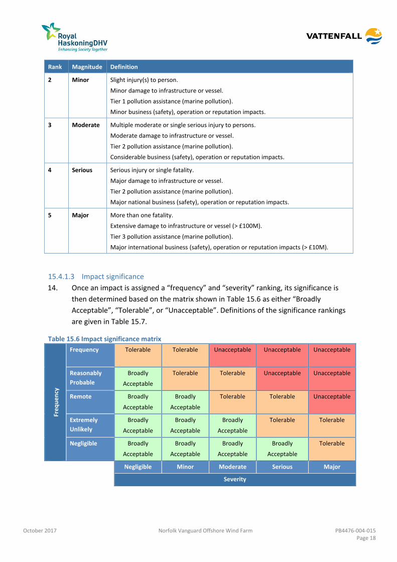
07/08/2017 01D Update following comments KS AF SW
20/09/2017 02D Second draft for NV Ltd review SW AF SW
06/10/2017 03F Final version for PEIR AF JM SW
October 2017 Norfolk Vanguard Offshore Wind Farm PB4476-004-015 Page iii
Table of Contents
15 Shipping and Navigation ......................................................................................... 1
Introduction ........................................................................................................... 1 15.1
Legislation, Guidance and Policy ............................................................................. 1 15.2
Consultation ........................................................................................................... 4 15.3
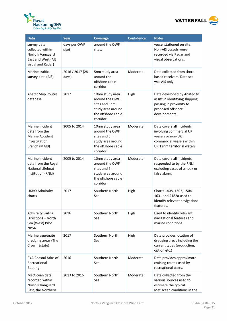
Assessment Methodology ..................................................................................... 17 15.4
Scope ................................................................................................................... 20 15.5
Existing Environment ............................................................................................ 23 15.6
Potential Impacts.................................................................................................. 32 15.7
Cumulative Impact Assessment (CIA) .................................................................... 74 15.8
Transboundary Impacts ........................................................................................ 83 15.9
Inter-relationships ................................................................................................ 84 15.10
Summary .............................................................................................................. 85 15.11
References ........................................................................................................... 96 15.12
October 2017 Norfolk Vanguard Offshore Wind Farm PB4476-004-015 Page iv
Tables
Table 15.1 Summary of NPS EN-3 guidance 1
Table 15.2 Summary of NPS EN-3 policy on decision making 2
Table 15.3 Consultation responses 4
Table 15.4 Definitions of frequency levels for shipping and navigation 17
Table 15.5 Definitions of severity levels for shipping and navigation 17
Table 15.6 Impact significance matrix 18
Table 15.7 Risk rankings 19
Table 15.8 Data sources 20
Table 15.9: Route summary in the vicinity of the project 26
Table 15.10 Worst case assumptions 34
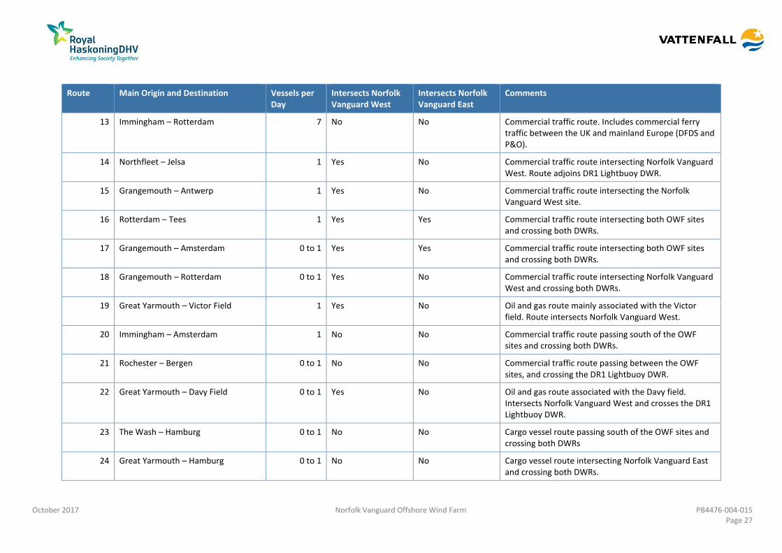
Table 15.11 Potential cumulative impacts 74
Table 15.12 Summary of projects considered for the CIA in relation to the shipping 77
Table 15.13 Chapter topic inter-relationships 85
Table 15.14 Potential impacts identified for shipping and navigation 88
Figures (Volume 2)
Figure 15.1 Overview of Norfolk Vanguard
Figure 15.2 Key Navigational Features Overview
Figure 15.3 Overview of AIS and Radar Data within Norfolk Vanguard East Study Area
Excluding Temporary Traffic (14 Days Summer 2016)
Figure 15.4 Overview of AIS and Radar Data within Norfolk Vanguard East Study Area
Excluding Temporary Traffic (14 Days Winter 2016)
Figure 15.5 Overview of AIS and Radar Data within Norfolk Vanguard West Study Area
Excluding Temporary Traffic (14 Days Summer 2016)
Figure 15.6 Overview of AIS and Radar Data within Norfolk Vanguard West Study Area
Excluding Temporary Traffic (14 Days Winter 2016)
Figure 15.7 Main Traffic Routes and 90th Percentiles within OWF Sites Study Area
Appendices (Volume 3)
Appendix 15.1 Navigation Risk Assessment
October 2017 Norfolk Vanguard Offshore Wind Farm PB4476-004-015 Page v
Glossary
AfL Agreement for Lease
AIS Automatic Identification System
ALARP As Low As Reasonably Practicable
CA Cruising Association
CAA Civil Aviation Authority
CIA Cumulative Impact Assessment
COLREGS International Convention on the International Regulations for preventing
Collisions at Sea (1972)
CoS Chamber of Shipping
CTV Crew Transfer Vessel
DSC Digital Selective Calling
DWR Deep Water Route
EEA European Economic Area
EIA Environmental Impact Assessment
ERCoP Emergency Response Cooperation Plan
ERP Emergency Response Plan
ES Environmental Statement
EU European Union
FSA Formal Safety Assessment
GLA General Lighthouse Authority
HSE Health and Safety Executive
HVAC High Voltage Alternating Current
HVDC High Voltage Direct Current
IALA International Association of Marine Aids to Navigation and Lighthouse
Authorities
IMO International Maritime Organization
km Kilometre
m Metre
MAIB Marine Accident Investigation Branch
MCA Maritime and Coastguard Agency
MCC Marine Coordination Centre
Met Mast Meteorological Mast
MGN Marine Guidance Note
MHWS Mean High Water Spring
MMO Marine Management Organisation
MOD Ministry of Defence
MW Megawatt
nm Nautical Mile
NPS National Policy Statement
NRA Navigation Risk Assessment
NUC Not Under Command
OREI Offshore Renewable Energy Installation
OWF Offshore Wind Farm
PEIR Preliminary Environmental Information Report
October 2017 Norfolk Vanguard Offshore Wind Farm PB4476-004-015 Page vi
PEXA Practice and Exercise Area
RAM Restricted in Ability to Manoeuvre
RNLI Royal National Lifeboat Institution
RYA Royal Yachting Association
SAR Search and Rescue
SNSOWF Southern North Sea Offshore Wind Forum
SOLAS International Convention on the Safety of Life at Sea (1974)
SoS Secretary of State
SPS Significant Peripheral Structure
TH Trinity House
TSS Traffic Separation Scheme
UK United Kingdom
UKCS United Kingdom Continental Shelf
VHF Very High Frequency
Terminology
Allision The act of striking or collision of a moving vessel against a stationary object.
Array cables Cables which link the wind turbine generators and the offshore substation
platform.
Automatic Identification
System (AIS)
A system by which vessels automatically broadcast their identity, key statistics
e.g. length, brief navigation details e.g. location, destination, speed and current
status e.g. survey. Most commercial vessels and European Union (EU) fishing
vessels over 15m are required to carry AIS.
Base Case The assessment of risk based on current shipping densities and traffic types as
well as the marine environment.
Collision The act or process of colliding (crashing) between two moving objects.
Deep Water Route (DWR) A route in a designated area within defined limits which has been accurately
surveyed for clearance of sea bottom and submerged articles. They are of
particular use to vessels restricted in their ability to manoeuvre due to their
draught size.
Formal Safety Assessment
(FSA)
A structured and systematic process for assessing the risks and costs (if
applicable) associated with the shipping activity.
Future Case An assessment of future traffic trends by assuming a set increase in vessel
numbers on identified routeing within the area.
Hazard Log Details the impacts upon shipping and navigation that may arise from the
construction, operation and maintenance, and decommissioning of Norfolk
Vanguard.
IMO Routeing Predetermined shipping routes established by the International Maritime
Organization.
Interconnector cables Buried offshore cables which link offshore substation platforms.
Landfall Where the offshore cables come ashore.
LiDAR A detection system which works on the principle of Radar, but uses light from a
laser.
Marine Guidance Note A system of guidance notes issued by the Maritime and Coastguard Agency
October 2017 Norfolk Vanguard Offshore Wind Farm PB4476-004-015 Page vii
(MGN) which provide significant advice relating to the improvement of the safety of
shipping and of life at sea, and to prevent or minimise pollution from shipping.
Not Under Command
(NUC)
A vessel not moored or anchored and not under control of its course or speed
due to mechanical failure.
Offshore accommodation
platform
A fixed structure (if required) providing accommodation for offshore personnel.
An accommodation vessel may be used instead.
Offshore cable corridor The area where the offshore export cables would be located.
Offshore electrical platform A fixed structure located within the wind farm area, containing electrical
equipment to aggregate the power from the wind turbine generators and
convert it into a more suitable form for export to shore. In an HVAC solution the
substation steps up the power from 66kV (array cable voltage) to 220kV (export
cable voltage). In an HVDC solution the substation/convertor station steps up
the voltage and also converts the power from Alternating current (AC) to Direct
Current (DC).
Offshore export cables The cables which transmit electricity from the offshore substation platform to
the landfall.
Offshore project area The overall area of Norfolk Vanguard East, Norfolk Vanguard West and the
provisional offshore cable corridor.
Offshore Renewable
Energy Installation (OREI)
Offshore Renewable Energy Installations (OREIs) as defined by Guidance on UK
Navigational Practice, Safety and Emergency Response Issues, MGN 543. For the
purpose of this report and in keeping with the consistency of the Environmental
Impact Assessment, OREI can mean offshore wind turbines and the associated
infrastructures such as accommodation platforms and sub station platforms.
Radar Radio Detection And Ranging – an object-detection system which uses radio
waves to determine the range, altitude, direction, or speed of objects.
Safety Zone A marine zone outlined for the purposes of safety around a possibly hazardous
installation or works / construction area under the Energy Act 2004.
The Applicant Norfolk Vanguard Ltd.
The OWF sites The two distinct offshore wind farm areas, Norfolk Vanguard East and Norfolk
Vanguard West.
The project Norfolk Vanguard Offshore Wind Farm, including the onshore and offshore
infrastructure.
Traffic Separation Scheme
(TSS)
A traffic-management route-system ruled by the International Maritime
Organization. The traffic-lanes (or clearways) indicate the general direction of
the vessels in that zone; vessels navigating within a TSS all sail in the same
direction or they cross the lane in an angle as close to 90 degrees as possible.
October 2017 Norfolk Vanguard Offshore Wind Farm PB4476-004-015 Page 1
15 SHIPPING AND NAVIGATION
Introduction 15.1
1. This chapter summarises the shipping and navigation baseline for the proposed
Norfolk Vanguard offshore wind farm (herein ‘the project’), the impacts arising as a
result of the proposed project, the proposed mitigation, and the anticipated residual
effects.
2. This chapter has been prepared by Anatec Ltd with reference to the relevant
National Policy Statement (NPS), namely the Overarching NPS for Energy (EN-1) (July
2011) and the NPS for Renewable Energy Infrastructure (EN-3) (July 2011).
3. In line with Maritime and Coastguard Agency (MCA) requirements, their
methodology (MCA, 2015) for assessing marine navigational risk has been used along
with the International Maritime Organization Formal Safety Assessment (FSA) (IMO,
2002) to assess risks associated with the development of Norfolk Vanguard within
the Navigation Risk Assessment (NRA) (Appendix 15.1). The NRA is a technical
document which scopes out impacts that are not significant for the Preliminary
Environmental Information Report (PEIR). The results of the NRA are summarised in
this chapter.
Legislation, Guidance and Policy 15.2
4. Guidance on the issues to be addressed for offshore renewable energy projects are
set out in the Overarching NPS for Energy (EN-1) (DECC, 2001) and the NPS for
Renewable Energy Infrastructure (EN-3) (DECC, 2011).
5. Only NPS EN-3 includes guidance specific to shipping and navigation, although the
overarching guidance principles set out in NPS EN-1 have been considered. A
summary of the relevant guidance from NPS EN-3 and where it has been addressed
within the PEIR is shown in Table 15.1.
Table 15.1 Summary of NPS EN-3 guidance
Summary of NPS EN-3 Guidance Paragraph in NPS EN-3 Where Addressed in the PEIR
Stakeholders in the navigation sector should be
engaged in the early stages of the development
phase and this should continue throughout
construction, operation and decommissioning.
2.6.153 Section 15.2 summarises
consultation undertaken with
stakeholders relevant to
shipping and navigation.
October 2017 Norfolk Vanguard Offshore Wind Farm PB4476-004-015 Page 2
Summary of NPS EN-3 Guidance Paragraph in NPS EN-3 Where Addressed in the PEIR
Consultation should be undertaken with the
Marine Management Organisation (MMO), MCA,
relevant General Lighthouse Authority (GLA),
relevant industry bodies and representatives of
recreational users
2.6.154 Section 15.2 summarises
consultation undertaken with
the organisations stated.
Consultation with the MMO is
ongoing at an overarching
project level.
Information on internationally recognised sea
lanes should be considered prior to undertaking
assessments.
2.6.155 Section 15.6.1 provides
information on IMO Routeing
Measures in the vicinity of the
proposed project. These sea
lanes are considered
throughout the assessment.
An NRA should be undertaken in accordance with
Government guidance.
2.6.156 See Appendix 15.1.
The potential effect on recreational craft, such as
yachts, should be considered in any assessment.
2.6.160 Sections 15.7 and 15.8 consider
the impacts and cumulative
impacts respectively of the
proposed project upon
recreational craft.
6. NPS EN-3 also highlights a number of factors relating to the determination of an
application and in relation to mitigation. A summary of these factors and where they
have been addressed within the PEIR is shown in Table 15.2.
Table 15.2 Summary of NPS EN-3 policy on decision making
Summary of NPS EN-3 Policy on Decision Making Paragraph in NPS EN-3 Where Addressed in the PEIR
Consent shall not be granted to the construction
or extension of an offshore wind farm if the
development is likely to interfere with recognised
sea lanes essential to international navigation.
2.6.161 Section 15.6.1 provides
information on IMO Routeing
Measures in the vicinity of the
proposed project. These sea
lanes are considered
throughout the assessment.
Site selection should have been made with a view
to avoiding or minimising disruption or economic
loss to the shipping and navigation industries.
2.6.162 Sections 15.7 and 15.8 consider
the impacts and cumulative
impacts of the proposed project
including analysis of the
disruption and economic loss to
the shipping and navigation
industry.
Negative impacts on less strategically important
shipping routes should be reduced to As Low as
2.6.163 Section 15.6.2 includes an
analysis of all shipping and main
routes in the vicinity of the
October 2017 Norfolk Vanguard Offshore Wind Farm PB4476-004-015 Page 3
Summary of NPS EN-3 Policy on Decision Making Paragraph in NPS EN-3 Where Addressed in the PEIR
Reasonably Practicable (ALARP). proposed project.
A detailed Search and Rescue (SAR) Response
Assessment should be undertaken prior to the
commencement of construction.
2.6.164 Section 11 of Appendix 15.1
outlines emergency response
resources relative to the
proposed project and sections
15.7 and 15.8 consider
potential impacts and
cumulative impacts upon
emergency response.
Applications which pose unacceptable risks to
navigational safety after all possible mitigation
measures have been considered will not be
consented.
2.6.165 Sections 15.7 and 15.8 consider
the impacts and cumulative
impacts of the proposed
project, including relevant
mitigation for each impact.
The scheme must be designed to minimise the
effect on recreational craft.
2.6.166 Section 15.7.1 summarises
embedded mitigation, including
measures designed to minimise
the effect on recreational craft.
The extent and nature of any obstruction of or
danger to navigation which is likely to be caused
by the development will be considered.
2.6.168 Sections 15.7 and 15.8 consider
the impacts and cumulative
impacts of the proposed
project, including risks posed to
navigation caused by the
proposed project.
Cumulative effects of the development with other
relevant proposed, consented and operational
wind farms will be considered.
2.6.169 Section 15.8 considers the
cumulative impacts of the
proposed project.
7. The primary guidance considered for this chapter is the MGN 543 (MCA, 2016),
which highlights issues requiring to be considered when assessing the impact upon
shipping and navigation from OREIs. The impact assessment has been carried out
based on the IMO FSA Process (IMO, 2002), as required by the MCA Methodology for
Assessing Marine Navigation Risk (MCA, 2013).
8. Other guidance considered is listed below:
MGN 372 (MGN 372 M+F) Offshore Renewable Energy Installations (OREIs)
Guidance to Mariners Operating in the Vicinity of United Kingdom (UK)
Offshore Renewable Energy Installations (OREIs) (MCA, 2008);
IALA Recommendation O-139 on the Marking of Man-Made Offshore
Structures, Edition 2 (IALA, 2013);
October 2017 Norfolk Vanguard Offshore Wind Farm PB4476-004-015 Page 4
The RYA’s Position on Offshore Renewable Energy Developments: Paper 1 –
Wind Energy (RYA, 2013);
BEIS Standard Marking Schedule for Offshore Installations (2011); and
The Recreational Craft Directives 94/25/EC and 2003/44/EC - implemented
into UK law by the Recreational Craft Regulations 2004 (SI No. 2004/1464),
apply to recreational craft and are intended to ensure the free movement of
goods on the European Economic Area (EEA) market.
Consultation 15.3
9. Stakeholders relevant to shipping and navigation have been consulted with
throughout the process to date. Relevant responses from consultees received to
date are summarised in Table 15.3 below. It is noted that additional consultation was
undertaken specifically for the hazard log (required by the MCA methodology).
Further details on the hazard log, including responses, are summarised in section 25
of Appendix 15.1.
Table 15.3 Consultation responses
Consultee Date
/Document
Comment Response / where addressed
in the PEIR
MCA and TH 12th
January
2016
Meeting with
MCA and TH.
Overview of initial proposed project.
MCA advised on guidance including the
updated MGN 543. Boundaries
between DWRs were discussed.
This PEIR has been informed by
the relevant guidance
(including MGN 543) as shown
in section 15.2. An assessment
of the DWRs relative to Norfolk
Vanguard is presented in
Appendix 15.1.
Secretary of
State (SoS)
Scoping Opinion
November 2016
The environmental statement should
assess the impacts on ports and
harbours which could be affected by
the development, such as increased
traffic at the ports and changes to
shipping times and durations as a
result of routes being diverted around
or through the development. The
Secretary of State recommends
consultation with the appropriate
harbour Authorities.
An assessment of deviation of
vessel routeing resulting from
the project is presented in
Appendix 15.1. Harbour
authorities were contacted
during the consultation process
(including Lowestoft, Great
Yarmouth, and Rotterdam),
with relevant responses
included in this table.
Allision and collision modelling
(section 21 of Appendix 15.1)
has been undertaken assuming
a 10% growth in traffic. At the
request of the CoS, collision
rates have also been modelled
assuming a 20% growth in
traffic.
October 2017 Norfolk Vanguard Offshore Wind Farm PB4476-004-015 Page 5
Consultee Date
/Document
Comment Response / where addressed
in the PEIR
SoS Scoping Opinion
November 2016
As the layout of the array will not be
fixed at the point of the application,
the Environmental Statement (ES)
should consider a worst case scenario
in its navigation assessment. The ES
should set out how such a worst case
scenario has been determined.
A description of the worst case
assessed within this PEIR, and
the rationale by which it has
been chosen is presented in
section 15.7.2.
SoS Scoping Opinion
November 2016
The Secretary of State welcomes the
proposed Navigational Risk
Assessment (NRA) and directs the
Applicant’s attention to the comments
of the Maritime and Coastguard
Agency (MCA) and Trinity House (TH)
(Appendix 3 of this Opinion) for their
comments on the proposed
assessment. The ES should provide
details of the collision risk modelling
used within the NRA.
The MCA and TH comments
have been addressed, as
summarised in this table.
Results of the collision risk
modelling have been
summarised in this PEIR within
the relevant impact discussions
in section 15.7, with full details
available in Appendix 15.1.
SoS Scoping Opinion
November 2016
Paragraph 614 of the Scoping Report
states that the NRA modelling will
assume a 10% increase in future traffic.
The ES should justify the 10% future
case increase.
As traffic trends are difficult to
predict, cases of 0%, 10%, and
20% increases in traffic have
been assessed within the
allision and collision modelling,
the results of which are
available in the NRA. This PEIR
has presented the 10% case in
line with other similar projects.
The 20% case was included at
the request of the Chamber of
Shipping (CoS).
SoS Scoping Opinion
November 2016
This chapter of the ES should identify
and consider within the assessment
any necessary safety or buffer zones.
The application for safety
zones is assumed to be
embedded mitigation, and is
discussed in section 15.7.1.
Norfolk County
Council
Scoping Opinion
November 2016
The Scoping Report (page 179,
paragraph 659) refers to the potential
cumulative impacts on shipping and
navigation arising from other sites in
the former East Anglia Zone. This
needs to be extended to the wider
cumulative impacts arising from other
operational, consented and proposed
wind farms off the Norfolk Coast (i.e.
taking into account wind farms
Appendix 15.1 includes an
assessment of the cumulative
impact on routes from
southern North Sea wind
farms, which are then assessed
in section 15.8. All impacts to
commercial, fishing and
recreational vessels were
assessed as being within
tolerable levels (with additional
October 2017 Norfolk Vanguard Offshore Wind Farm PB4476-004-015 Page 6
Consultee Date
/Document
Comment Response / where addressed
in the PEIR
consented under earlier consenting
rounds / licencing regimes). The
impacts need to be considered in
terms of (a) commercial shipping; (b)
fishing vessels and (c) recreational
vessels. The County Council
acknowledges that it will be a matter
for the appropriate regulatory bodies
to comment on the detailed matters
relating to shipping and navigation,
however, the County Council is keen to
ensure that there will not be any
demonstrable negative impact on
Norfolk’s ports as a consequence of
the proposed offshore wind farms and
any potential change in shipping and
navigational routes.
mitigation implemented where
necessary).
Norfolk County
Council
Scoping Opinion
November 2016
The Environmental Impact Assessment
(EIA) should indicate that suitable
navigation and shipping mitigation
measures can be agreed with the
appropriate regulatory bodies to
ensure that Norfolk’s Ports (King’s Lynn
and Wells) are not adversely affected
by this proposal. The EIA will need to
consider the wider cumulative impacts
taking into account existing
operational wind farm; those under
construction; those consented and
those in planning.
Embedded mitigation
measures are listed in section
15.7.1. Where identified as
necessary, proposed additional
mitigation measures are
presented in section 0. With
additional mitigation in place,
all impacts were assessed to be
within tolerable levels.
Cumulative impacts have been
assessed in section 15.8. Again,
these were all within tolerable
levels with additional
mitigation in place where
necessary.
MCA Scoping Opinion
November 2016
The ES should supply detail on the
possible impacts on navigational issues
for both commercial and recreational
craft:
a) Collision risk;
b) Navigational safety;
c) Visual intrusion and noise;
d) Risk Management and Emergency
response;
e) Marking and lighting of site and
information to mariners;
f) Effect on small craft navigational
and communication equipment;
g) The risk to drifting recreational
An assessment of the relevant
impacts to commercial and
recreational vessels is provided
in section 15.7:
a) Collision risk to both
commercial vessels and
recreational vessels has
been assessed
b) Appendix 15.1 and Chapter
15: Shipping and
Navigation have been
authored for the purpose
of ensuring navigational
October 2017 Norfolk Vanguard Offshore Wind Farm PB4476-004-015 Page 7
Consultee Date
/Document
Comment Response / where addressed
in the PEIR
craft in adverse weather or tidal
conditions; and
h) The likely squeeze of small craft
into the routes of larger
commercial vessels.
safety of all vessels
c) Visual intrusion and noise
impact are covered in
section 23 of Appendix
15.1.
d) Section 15.7 provides an
assessment of the
identified impacts. This
assessment includes
(where identified as
necessary) additional risk
management measures.
An ERCoP will be created
as per the embedded
mitigation listed in section
15.7.1.
e) Marking and lighting of the
site and promulgation of
information have been
assumed to be embedded
mitigation, and are listed
in section 15.7.1.
f) Effects on position fixing
and communication
equipment are assessed
within section 23 of
Appendix 15.1.
g) Allision risks to
recreational vessels is
covered in section 15.7
h) Displacement impacts
have been assessed within
section 15.7.
MCA Scoping Opinion
November 2016
An NRA will need to be submitted in
accordance with MGN 543 (and MGN
372) and the MCA Methodology for
Assessing the Marine Navigation Safety
& Emergency Response Risks of
Offshore Renewable Energy
Installations (OREI). This NRA should be
accompanied by a detailed MGN 543
Checklist which can be downloaded
from the MCA website.
The NRA is available in
Appendix 15.1, and includes
the completed MGN 543
checklist as an appendix.
MCA Scoping Opinion
November 2016
It is noted that traffic data had been
collected between September 2012
and April 2014 and that a further 28
day traffic survey (AIS, Radar and visual
The project will comply with
the requirements of MGN 543
as per embedded mitigation –
section 15.7.1. This includes
October 2017 Norfolk Vanguard Offshore Wind Farm PB4476-004-015 Page 8
Consultee Date
/Document
Comment Response / where addressed
in the PEIR
observations) will be conducted to
ensure data is up to date.
MGN 543 Annex 2 requires that
hydrographic surveys should fulfil the
requirements of the International
Hydrographic Organisation (IHO) Order
1a standard, with the final data
supplied as a digital full density data
set, and survey reports to the MCA
Hydrography Manager. Failure to
report the survey or conduct it to
Order 1a might invalidate the NRA if it
was deemed not fit for purpose.
the collection of 28 days of
marine traffic survey data. The
data collected has been
analysed, the results of which
are shown in section 12 of
Appendix 15.1.
MCA Scoping Opinion
November 2016
Particular attention should be paid to
cabling routes and where appropriate
burial depth for which a Burial
Protection Index study should be
completed and, subject to the traffic
volumes, an anchor penetration study
may be necessary. If cable protection
are required e.g. rock bags, concrete
mattresses, the MCA would be willing
to accept a 5% reduction in
surrounding depths referenced to
Chart Datum.
As described in section 15.7.1,
a Cable Burial Risk Assessment
will be undertaken post
consent. This will include an
assessment of expected cable
burial depths and a plan for
other forms of protection
where necessary.
MCA Scoping Opinion
November 2016
The Radar effects of a wind farm on
ships’ Radars are an important issue
and the effects, particularly with
respect to adjacent wind farms on
either side of a route, will need to be
assessed on a site specific basis taking
into consideration previous reports on
the subject available on the MCA
website.
Effects on marine Radar are
assessed within section 23 of
Appendix 15.1. The assessment
includes discussion of previous
radar trials undertaken with
MCA involvement.
MCA Scoping Opinion
November 2016
The development area carries a
significant amount of through traffic
and liner routes. Attention needs to be
paid to routeing; particularly in heavy
weather ensuring shipping can
continue to make safe passage without
significant large scale deviations.
Impacts on vessel routeing are
considered within the impact
assessment and Appendix 15.1.
This includes an assessment of
routeing during adverse
weather (section 16).
MCA Scoping Opinion
November 2016
Particular consideration will need to be
given to the implications of the site
size and location of SAR resources and
The project will comply with
the requirements of MGN 543
as per embedded mitigation –
October 2017 Norfolk Vanguard Offshore Wind Farm PB4476-004-015 Page 9
Consultee Date
/Document
Comment Response / where addressed
in the PEIR
Emergency Response Cooperation
Plans (ERCoP). Attention should be
paid to the level of Radar surveillance,
AIS and shore-based Very High
Frequency (VHF) radio coverage and
give due consideration for appropriate
mitigation such as Radar, AIS receivers
and in-field, Marine Band VHF radio
communications aerial(s) (VHF voice
with Digital Selective Calling (DSC))
that can cover the entire wind farm
sites and their surrounding areas.
section 15.7.1.
Existing SAR resources relative
to the project are summarised
in section 10 of Appendix 15.1.
As listed in section 15.7.1, an
ERCoP will be created post
consent.
TH Scoping Opinion
November 2016
The NRA should include:
Comprehensive vessel traffic
analysis in accordance with MGN
543; and
Assessment of the possible
cumulative and in-combination
effects on shipping routes and
patterns.
Any proposed layouts should conform
with MGN 543; however, should some
structures such as OSPs lie outwith the
actual wind farm turbine layout, then
additional risk assessment should be
undertaken.
An MGN 543 checklist has been
completed as part of Appendix
B in Appendix 15.1.
Up to date marine traffic
survey data has been used to
assess current shipping levels
and patterns within the vicinity
of the project. The results of
the analysis are available in
section 12 of Appendix 15.1.
Vessel routeing has been
considered on a cumulative
basis in section 19 of the
Appendix 15.1. Associated
impacts have been assessed in
this PEIR in section 15.8.
TH Scoping Opinion
November 2016
We consider that the wind farm(s) will need to be marked with marine aids to navigation by the developer/operator in accordance with the general principles outlined in International Association of Marine Aids to Navigation and Lighthouse Authorities (IALA) Recommendation O 139 on the Marking of Man-Made Offshore Structures as a risk mitigation measure. In addition to the marking of the structures themselves, it should be borne in mind that additional aids to navigation such as buoys may be necessary to mitigate the risk posed to the mariner, particularly during the construction phase. All marine navigational marking, which will be required to be provided and thereafter maintained by the developer, will need
The project will comply with
the requirements of IALA O-
139 as per embedded
mitigation – section 15.7.1. All
lighting and marking will be
agreed with TH prior to
implementation.
October 2017 Norfolk Vanguard Offshore Wind Farm PB4476-004-015 Page 10
Consultee Date
/Document
Comment Response / where addressed
in the PEIR
to be addressed and agreed with TH. This will include the necessity for the aids to navigation to meet the internationally recognised standards of availability.
Appropriate buffer zones surrounding
the two IMO Deep Water Routes
(DWRs) should be fully considered.
Appendix 15.1 includes an
assessment of the cumulative
impact (including buffer zones)
on routes from southern North
Sea wind farms, which are then
assessed in section 15.8.
Spacing between the OWF sites
and the DWRs has been agreed
with the MCA.
Any possible national trans-boundary
issues should be assessed, through
consultation with the Dutch
authorities.
Consultation was undertaken
with the Dutch Authorities
through Rijkswaterstaat
(Ministry of Infrastructure and
the Environment), as shown in
this table.
Transboundary issues are
discussed in section 15.9.
October 2017 Norfolk Vanguard Offshore Wind Farm PB4476-004-015 Page 11
Consultee Date
/Document
Comment Response / where addressed
in the PEIR
A Decommissioning Plan, which
includes a scenario where upon
decommissioning and upon
completion of removal operations an
obstruction is left on site (attributable
to the wind farm) which is considered
to be a danger to navigation and which
it has not proved possible to remove,
should be considered. Such an
obstruction may require to be marked
until such time as it is either removed
or no longer considered a danger to
navigation, the continuing cost of
which would need to be met by the
developer/operator.
A Decommissioning Plan will be
created post consent.
Impacts associated with the
decommissioning of the project
are considered in section
15.11.3.
The possible requirement for
navigational marking of the export
cables and the vessels laying them. If it
is necessary for the cables to be
protected by rock armour, concrete
mattresses or similar protection which
lies clear of the surrounding seabed,
the impact on navigation and the
requirement for appropriate risk
mitigation measures needs to be
assessed.
As described in section 15.7.1,
a Cable Burial Risk Assessment
will be undertaken post
consent. This will include
identification of any sections of
cable requiring protection
other than burial. Any
associated risks will be
assessed within the Cable
Burial Risk Assessment.
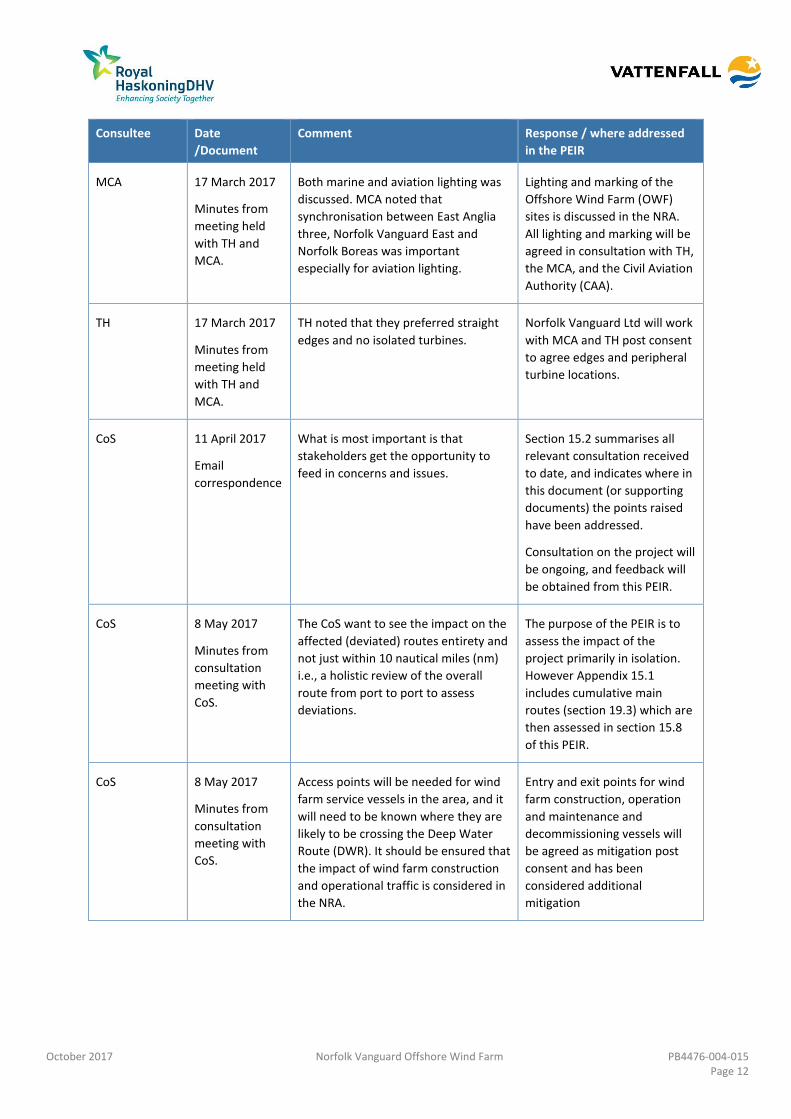
MCA and TH 24 May 2016
Meeting with
MCA and TH.
Agreement was reached on the survey
methodology proposed by Norfolk
Vanguard including dates and time
period.
The marine traffic survey is
summarised in section 15.6.2.
MCA 17 March 2017
Minutes from
meeting held
with TH and
MCA.
Indicative position of substations or
other platforms had not yet been
agreed; MCA noted that the platforms
should be in rows with wind turbines.
As shown in Chapter 5 Project
Description, platforms have
been kept in a grid format with
the wind turbines.
MCA 17 March 2017
Minutes from
meeting held
with TH and
MCA.
MCA require two lines of orientation
but would be content to see a safety
case for one line of orientation.
Regular grid layouts have been
assessed within the NRA; if a
single line of orientation is
considered post consent it will
be supported by a relevant
safety case.
October 2017 Norfolk Vanguard Offshore Wind Farm PB4476-004-015 Page 12
Consultee Date
/Document
Comment Response / where addressed
in the PEIR
MCA 17 March 2017
Minutes from
meeting held
with TH and
MCA.
Both marine and aviation lighting was
discussed. MCA noted that
synchronisation between East Anglia
three, Norfolk Vanguard East and
Norfolk Boreas was important
especially for aviation lighting.
Lighting and marking of the
Offshore Wind Farm (OWF)
sites is discussed in the NRA.
All lighting and marking will be
agreed in consultation with TH,
the MCA, and the Civil Aviation
Authority (CAA).
TH 17 March 2017
Minutes from
meeting held
with TH and
MCA.
TH noted that they preferred straight
edges and no isolated turbines.
Norfolk Vanguard Ltd will work
with MCA and TH post consent
to agree edges and peripheral
turbine locations.
CoS 11 April 2017
correspondence
What is most important is that
stakeholders get the opportunity to
feed in concerns and issues.
Section 15.2 summarises all
relevant consultation received
to date, and indicates where in
this document (or supporting
documents) the points raised
have been addressed.
Consultation on the project will
be ongoing, and feedback will
be obtained from this PEIR.
CoS 8 May 2017
Minutes from
consultation
meeting with
CoS.
The CoS want to see the impact on the
affected (deviated) routes entirety and
not just within 10 nautical miles (nm)
i.e., a holistic review of the overall
route from port to port to assess
deviations.
The purpose of the PEIR is to
assess the impact of the
project primarily in isolation.
However Appendix 15.1
includes cumulative main
routes (section 19.3) which are
then assessed in section 15.8
of this PEIR.
CoS 8 May 2017
Minutes from
consultation
meeting with
CoS.
Access points will be needed for wind
farm service vessels in the area, and it
will need to be known where they are
likely to be crossing the Deep Water
Route (DWR). It should be ensured that
the impact of wind farm construction
and operational traffic is considered in
the NRA.
Entry and exit points for wind
farm construction, operation
and maintenance and
decommissioning vessels will
be agreed as mitigation post
consent and has been
considered additional
mitigation
October 2017 Norfolk Vanguard Offshore Wind Farm PB4476-004-015 Page 13
Consultee Date
/Document
Comment Response / where addressed
in the PEIR
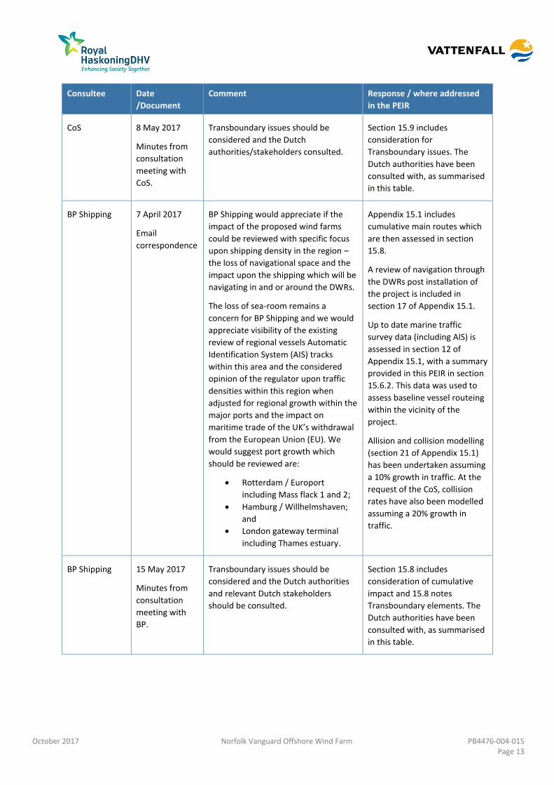
CoS 8 May 2017
Minutes from
consultation
meeting with
CoS.
Transboundary issues should be
considered and the Dutch
authorities/stakeholders consulted.
Section 15.9 includes
consideration for
Transboundary issues. The
Dutch authorities have been
consulted with, as summarised
in this table.
BP Shipping 7 April 2017
correspondence
BP Shipping would appreciate if the
impact of the proposed wind farms
could be reviewed with specific focus
upon shipping density in the region –
the loss of navigational space and the
impact upon the shipping which will be
navigating in and or around the DWRs.
The loss of sea-room remains a
concern for BP Shipping and we would
appreciate visibility of the existing
review of regional vessels Automatic
Identification System (AIS) tracks
within this area and the considered
opinion of the regulator upon traffic
densities within this region when
adjusted for regional growth within the
major ports and the impact on
maritime trade of the UK’s withdrawal
from the European Union (EU). We
would suggest port growth which
should be reviewed are:
Rotterdam / Europort
including Mass flack 1 and 2;
Hamburg / Willhelmshaven;
and
London gateway terminal
including Thames estuary.
Appendix 15.1 includes
cumulative main routes which
are then assessed in section
15.8.
A review of navigation through
the DWRs post installation of
the project is included in
section 17 of Appendix 15.1.
Up to date marine traffic
survey data (including AIS) is
assessed in section 12 of
Appendix 15.1, with a summary
provided in this PEIR in section
15.6.2. This data was used to
assess baseline vessel routeing
within the vicinity of the
project.
Allision and collision modelling
(section 21 of Appendix 15.1)
has been undertaken assuming
a 10% growth in traffic. At the
request of the CoS, collision
rates have also been modelled
assuming a 20% growth in
traffic.
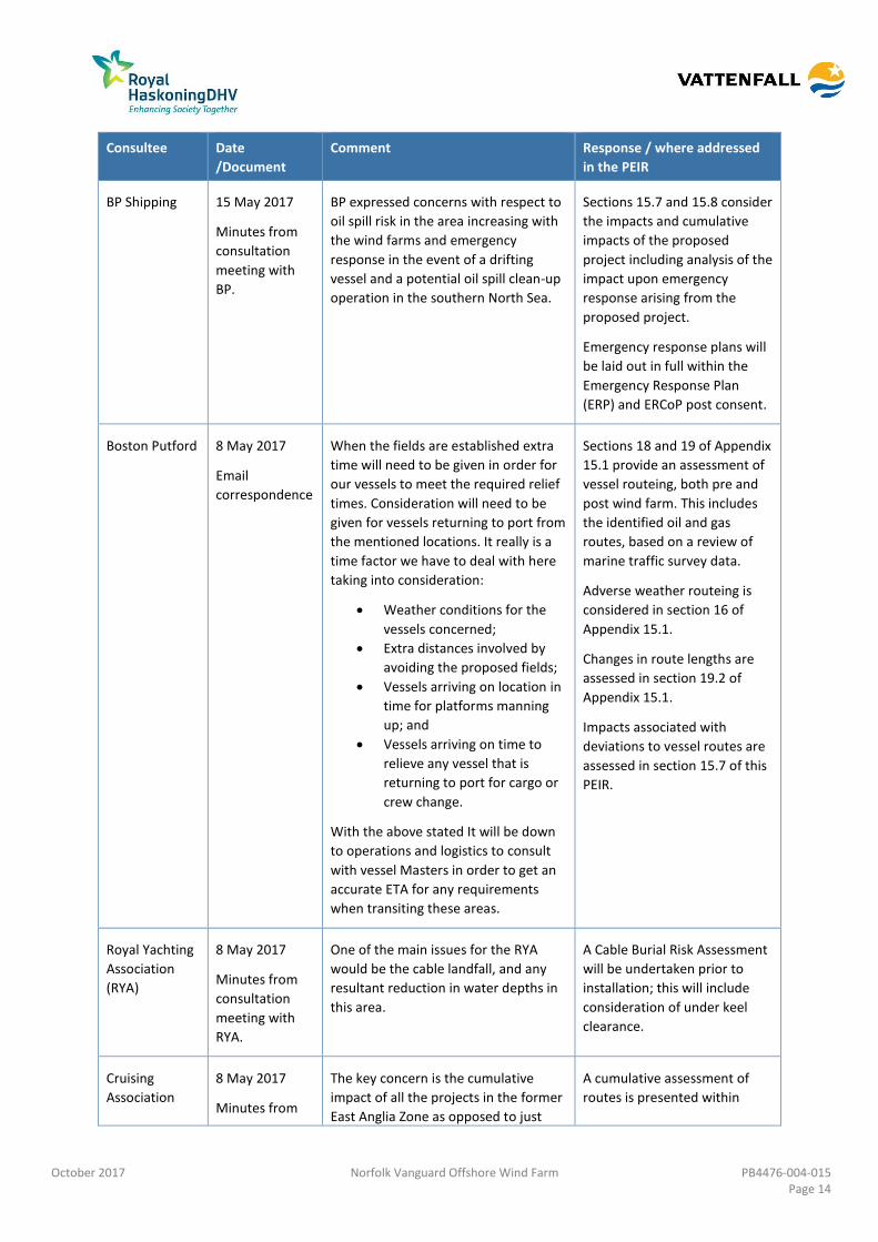
BP Shipping 15 May 2017
Minutes from
consultation
meeting with
BP.
Transboundary issues should be
considered and the Dutch authorities
and relevant Dutch stakeholders
should be consulted.
Section 15.8 includes
consideration of cumulative
impact and 15.8 notes
Transboundary elements. The
Dutch authorities have been
consulted with, as summarised
in this table.
October 2017 Norfolk Vanguard Offshore Wind Farm PB4476-004-015 Page 14
Consultee Date
/Document
Comment Response / where addressed
in the PEIR
BP Shipping 15 May 2017
Minutes from
consultation
meeting with
BP.
BP expressed concerns with respect to
oil spill risk in the area increasing with
the wind farms and emergency
response in the event of a drifting
vessel and a potential oil spill clean-up
operation in the southern North Sea.
Sections 15.7 and 15.8 consider
the impacts and cumulative
impacts of the proposed
project including analysis of the
impact upon emergency
response arising from the
proposed project.
Emergency response plans will
be laid out in full within the
Emergency Response Plan
(ERP) and ERCoP post consent.
Boston Putford 8 May 2017
correspondence
When the fields are established extra
time will need to be given in order for
our vessels to meet the required relief
times. Consideration will need to be
given for vessels returning to port from
the mentioned locations. It really is a
time factor we have to deal with here
taking into consideration:
Weather conditions for the
vessels concerned;
Extra distances involved by
avoiding the proposed fields;
Vessels arriving on location in
time for platforms manning
up; and
Vessels arriving on time to
relieve any vessel that is
returning to port for cargo or
crew change.
With the above stated It will be down
to operations and logistics to consult
with vessel Masters in order to get an
accurate ETA for any requirements
when transiting these areas.
Sections 18 and 19 of Appendix
15.1 provide an assessment of
vessel routeing, both pre and
post wind farm. This includes
the identified oil and gas
routes, based on a review of
marine traffic survey data.
Adverse weather routeing is
considered in section 16 of
Appendix 15.1.
Changes in route lengths are
assessed in section 19.2 of
Appendix 15.1.
Impacts associated with
deviations to vessel routes are
assessed in section 15.7 of this
PEIR.
Royal Yachting
Association
(RYA)
8 May 2017
Minutes from
consultation
meeting with
RYA.
One of the main issues for the RYA
would be the cable landfall, and any
resultant reduction in water depths in
this area.
A Cable Burial Risk Assessment
will be undertaken prior to
installation; this will include
consideration of under keel
clearance.
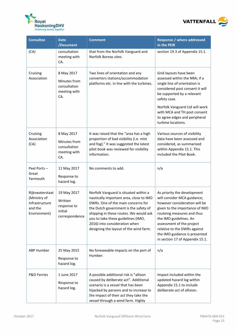
Cruising
Association
8 May 2017
Minutes from
The key concern is the cumulative
impact of all the projects in the former
East Anglia Zone as opposed to just
A cumulative assessment of
routes is presented within
October 2017 Norfolk Vanguard Offshore Wind Farm PB4476-004-015 Page 15
Consultee Date
/Document
Comment Response / where addressed
in the PEIR
(CA) consultation
meeting with
CA.
that from the Norfolk Vanguard and
Norfolk Boreas sites.
section 19.3 of Appendix 15.1.
Cruising
Association
8 May 2017
Minutes from
consultation
meeting with
CA.
Two lines of orientation and any
convertors stations/accommodation
platforms etc. in line with the turbines.
Grid layouts have been
assessed within the NRA; if a
single line of orientation is
considered post consent it will
be supported by a relevant
safety case.
Norfolk Vanguard Ltd will work
with MCA and TH post consent
to agree edges and peripheral
turbine locations.
Cruising
Association
(CA)
8 May 2017
Minutes from
consultation
meeting with
CA.
It was raised that the “area has a high
proportion of bad visibility (i.e. mist
and fog).” It was suggested the latest
pilot book was reviewed for visibility
information.
Various sources of visibility
data have been assessed and
considered, as summarised
within Appendix 15.1. This
included the Pilot Book.
Peel Ports –
Great
Yarmouth
11 May 2017
Response to
hazard log.
No comments to add. n/a
Rijkswaterstaat
(Ministry of
Infrastructure
and the
Environment)
19 May 2017
Written
response to
initial
correspondence
Norfolk Vanguard is situated within a
nautically important area, close to IMO
DWRs. One of the main concerns for
the Dutch government is the safety of
shipping in these routes. We would ask
you to take these guidelines (IMO,
2016) into consideration when
designing the layout of the wind farm.
As priority the development
will consider MCA guidance;
however consideration will be
given to the importance of IMO
routeing measures and thus
the IMO guidelines. An
assessment of the project
relative to the DWRs against
the IMO guidance is presented
in section 17 of Appendix 15.1.
ABP Humber 25 May 2015
Response to
hazard log.
No foreseeable impacts on the port of
Humber.
n/a
P&O Ferries 1 June 2017
Response to
hazard log.
A possible additional risk is “allison
caused by deliberate act”. Additional
scenario is a vessel that has been
hijacked by persons and to increase to
the impact of their act they take the
vessel through a wind farm. Highly
Impact included within the
updated hazard log within
Appendix 15.1 to include
deliberate act of allision.
October 2017 Norfolk Vanguard Offshore Wind Farm PB4476-004-015 Page 16
Consultee Date
/Document
Comment Response / where addressed
in the PEIR
unlikely but the type of incident we are
preparing for.
Rijkswaterstaat
(Ministry of
Infrastructure
and the
Environment)
15 June 2017 We appreciate the systematic
approach with regard to the content
and the stakeholder process very much
and would like to stay in touch on a
regular basis in the remainder of the
process.
Regarding the nautical safety aspects
of Norfolk Vanguard we would like to
refer to the documents as presented in
our letter dated 19th May 2017 in
which the design criteria for safe
distances between shipping lanes and
OWFs are attached.
Section 17 of Appendix 15.1
demonstrates compliance of
the project with the referenced
documents.
It is noted that the buffers
between the OWF sites and the
DWRs were agreed as part of
the former East Anglia Zone
process.
VISNED
(Coöperatie
Kottervisserij
Nederland
U.A.)
9 June 2017
Response to
hazard log.
“The displacement will be influenced
by how big the turbines will turn out to
be. Fishermen I talk to aren’t really
happy about the prospects of fishing
inside an array. The spacing between
the turbines will have a major impact
on a skipper’s decision to trawl there.
The smaller the spacing between
turbines, the smaller the chances are
of skippers taking the risks. Correct me
if I’m wrong but when opting for the 7
MW turbines the spacing would be
about 900 meters between. Most
fishermen won’t take their chances
with such a small area to manoeuvre.
In that case the most likely
consequence will be the same as the
worst case scenario: loss of fishing
grounds and a major impact on
businesses, especially when the
cumulative effects of other arrays are
taken into effect. This last point
bothers us quite a bit since the effects
of large wind arrays on fishing are
always presented individually and
never accumulated as they should be
in our view. We think the largest
turbines (15 MW) with the biggest
spacing will be the best options for
having the least impact on our
members and their activities.”
Issues in relation to
displacement of fishing activity
are covered within the PEIR in
Chapter 14 Commercial
Fisheries.
October 2017 Norfolk Vanguard Offshore Wind Farm PB4476-004-015 Page 17
Assessment Methodology 15.4
Impact Assessment Methodology 15.4.1
10. Shipping and navigation impacts have been assessed using the FSA process, as
required by the MCA. The FSA assigns each impact a “frequency” ranking, and a
“severity” ranking as defined in the proceeding sections. These are then used to
determine the “significance” of each impact. It is noted that this approach is broadly
similar to that used for the Environmental Impact Assessment (EIA) (see Chapter 6
EIA Methodology).
11. Identified impacts and their initial significance rankings were provided to the
relevant shipping and navigation stakeholders in the form of a hazard log, with a
request for input. All responses received were considered prior to finalisation of the
log, and the final log was agreed with all stakeholders. The responses received are
available in the NRA. The rankings in the log were used in conjunction with the
modelling results and expert opinion to inform the rankings used in the FSA.
15.4.1.1 Frequency
12. The definitions of “frequency” used to assess shipping and navigation impacts are
presented in Table 15.4.
Table 15.4 Definitions of frequency levels for shipping and navigation
Rank Frequency Definition
1 Negligible < 1 occurrence per 10,000 years
2 Extremely
Unlikely
1 per 100 to 10,000 years
3 Remote 1 per 10 to 100 years
4 Reasonably
Probable
1 per 1 to 10 years
5 Frequent Yearly
15.4.1.2 Consequence
13. The definitions of “severity of consequence” used to assess shipping and navigation
impacts are presented in Table 15.5.
Table 15.5 Definitions of severity levels for shipping and navigation
Rank Magnitude Definition
1 Negligible No injury to persons.
No significant damage to infrastructure or vessel.
No significant environmental impacts.
No significant business (safety), operation or reputation impacts.
October 2017 Norfolk Vanguard Offshore Wind Farm PB4476-004-015 Page 18
Rank Magnitude Definition
2 Minor Slight injury(s) to person.
Minor damage to infrastructure or vessel.
Tier 1 pollution assistance (marine pollution).
Minor business (safety), operation or reputation impacts.
3 Moderate Multiple moderate or single serious injury to persons.
Moderate damage to infrastructure or vessel.
Tier 2 pollution assistance (marine pollution).
Considerable business (safety), operation or reputation impacts.
4 Serious Serious injury or single fatality.
Major damage to infrastructure or vessel.
Tier 2 pollution assistance (marine pollution).
Major national business (safety), operation or reputation impacts.
5 Major More than one fatality.
Extensive damage to infrastructure or vessel (> £100M).
Tier 3 pollution assistance (marine pollution).
Major international business (safety), operation or reputation impacts (> £10M).
15.4.1.3 Impact significance
14. Once an impact is assigned a “frequency” and “severity” ranking, its significance is
then determined based on the matrix shown in Table 15.6 as either “Broadly
Acceptable”, “Tolerable”, or “Unacceptable”. Definitions of the significance rankings
are given in Table 15.7.
Table 15.6 Impact significance matrix
Fre
qu
en
cy
Frequency Tolerable
Tolerable Unacceptable Unacceptable Unacceptable
Reasonably
Probable
Broadly
Acceptable
Tolerable Tolerable Unacceptable Unacceptable
Remote Broadly
Acceptable
Broadly
Acceptable
Tolerable Tolerable Unacceptable
Extremely
Unlikely
Broadly
Acceptable
Broadly
Acceptable
Broadly
Acceptable
Tolerable Tolerable
Negligible Broadly
Acceptable
Broadly
Acceptable
Broadly
Acceptable
Broadly
Acceptable
Tolerable
Negligible Minor Moderate Serious Major
Severity
October 2017 Norfolk Vanguard Offshore Wind Farm PB4476-004-015 Page 19
Table 15.7 Risk rankings
No Impact No impact on shipping and navigation receptors.
Broadly Acceptable Risk ALARP with no additional mitigations or monitoring required above
embedded mitigations. Includes impacts that have no perceptible effect
(effect would not be noticeable to receptors).
Tolerable (with or
without mitigation)
Risk acceptable but may require additional mitigation measures and
monitoring in place to control and reduce to ALARP.
Unacceptable Significant risk mitigation or design modification required to reduce to
ALARP.
Cumulative Impact Assessment 15.4.2
15. Cumulative impacts have been considered for shipping and navigation receptors, this
includes other offshore developments, as well as activities associated with other
marine operations. However it should be noted that fishing, recreational and marine
aggregate dredging transits have been considered as part of the baseline
assessment.
16. Other developments which may increase the effect of impacts to shipping and
navigation receptors when considered with the project were assessed, and screened
in or out depending upon the outcome of the assessment. The full cumulative
screening process is presented in Appendix 15.1.
17. All impacts presented in section 15.7 of this chapter were then assessed for potential
cumulative impact when considered with the developments scoped in during the
screening stage undertaken as part of the NRA process (Appendix 15.1). As raised
during consultation, the key cumulative impact was considered to be vessel routeing
when considered with the other southern North Sea wind farm developments,
however all impacts presented have been considered cumulatively.
Transboundary Impact Assessment 15.4.3
18. Transboundary impacts of offshore wind developments with regards to vessel
routeing and international ports have been considered in section 15.9. Fishing,
recreational and marine aggregate dredging impacts, although they have the
potential to be internationally owned or located, have been considered as part of the
baseline assessment.
October 2017 Norfolk Vanguard Offshore Wind Farm PB4476-004-015 Page 20
Scope 15.5
Study Areas 15.5.1
19. To ensure focus on the traffic relevant to the project is considered, the marine traffic
survey data described in the following section (which formed the primary input to
the NRA) has been assessed within a 10nm buffer of the two sites (hereby referred
to as the “OWF sites study area”). This study area encompasses all relevant shipping
routes within the vicinity of the proposed project, including those associated with
the IMO Routeing Measures passing the OWF sites. It is noted that in some cases,
data sets have been considered beyond the 10nm extent if considered appropriate.
In particular, cumulative routeing has been assessed over a wider geographical area,
as vessel displacement can impact routeing beyond 10nm.
20. In addition to the OWF sites, marine traffic data (AIS only) has also been considered
within a 5nm buffer of the offshore cable corridor (hereby referred to as the
“offshore cable corridor study area”).
21. Cumulative impacts are again considered within a 10nm buffer around the project
but then extended where applicable to encompass vessel routeing (hereby referred
to as the “cumulative study area”). This includes consideration of transboundary
offshore wind farm projects and shipping routes. However, for a cumulative or
transboundary wind farm to be considered in the cumulative routeing assessment, a
vessel route needs to be impacted (route through or in proximity to) by both the
screened wind farm and the project.
22. The study areas for the OWF sites and for the offshore cable corridor are presented
in Figure 15.1.
Data Sources 15.5.2
23. The data sources considered in the NRA and within this chapter are summarised in
Table 15.8.
Table 15.8 Data sources
Data Year Coverage Confidence Notes
Marine traffic
survey data
collected for the
former East Anglia
Four (now Norfolk
Vanguard East) (AIS,
visual and Radar)
2012/2013/2014
(four ten day
surveys)
10nm study area
around the former
East Anglia Four.
High Data collected by a survey
vessel stationed on site.
Non-AIS vessels were
recorded via Radar and
visual observations. Data
used to inform the initial
methodology.
Marine traffic 2016 / 2017 (28 10nm study area High Data collected by a survey
October 2017 Norfolk Vanguard Offshore Wind Farm PB4476-004-015 Page 21
Data Year Coverage Confidence Notes
survey data
collected within
Norfolk Vanguard
East and West (AIS,
visual and Radar)
days per OWF
site)
around the OWF
sites.
vessel stationed on site.
Non-AIS vessels were
recorded via Radar and
visual observations.
Marine traffic
survey data (AIS)
2016 / 2017 (28
days)
5nm study area
around the
offshore cable
corridor
Moderate Data collected from shore-
based receivers. Data set
was AIS only.
Anatec Ship Routes
database
2017 10nm study area
around the OWF
sites and 5nm
study area around
the offshore cable
corridor
High Data developed by Anatec to
assist in identifying shipping
passing in proximity to
proposed offshore
developments.
Marine incident
data from the
Marine Accident
Investigation
Branch (MAIB)
2005 to 2014 10nm study area
around the OWF
sites and 5nm
study area around
the offshore cable
corridor
Moderate Data covers all incidents
involving commercial UK
vessels or non-UK
commercial vessels within
UK 12nm territorial waters.
Marine incident
data from the Royal
National Lifeboat
Institution (RNLI)
2005 to 2014 10nm study area
around the OWF
sites and 5nm
study area around
the offshore cable
corridor
Moderate Data covers all incidents
responded to by the RNLI
excluding cases of a hoax or
false alarm.
UKHO Admiralty
charts
2017 Southern North
Sea
High Charts 1408, 1503, 1504,
1631 and 2182a used to
identify relevant navigational
features.
Admiralty Sailing
Directions – North
Sea (West) Pilot
NP54
2016 Southern North
Sea
High Used to identify relevant
navigational features and
marine conditions.
Marine aggregate
dredging areas (The
Crown Estate)
2017 Southern North
Sea
High Data provides location of
dredging areas including the
current types (production,
option etc.)
RYA Coastal Atlas of
Recreational
Boating
2016 Southern North
Sea
Moderate Data provides approximate
cruising routes used by
recreational users.
MetOcean data
recorded within
Norfolk Vanguard
East, the Northern
2013 to 2016 Southern North
Sea
Moderate Data collected from the
various sources used to
estimate the typical
MetOcean conditions in the
October 2017 Norfolk Vanguard Offshore Wind Farm PB4476-004-015 Page 22
Data Year Coverage Confidence Notes
Meteorological
Mast (Met Mast),
UK Admiralty
Charts, and the Pilot
Book
vicinity of the project.
Assumptions and Limitations 15.5.3
24. Assumptions that have been made in relation to, or limitations associated with, the
data sources presented in Table 15.8 are described in the subsections below.
15.5.3.1 Marine traffic survey data
25. The following assumptions have been made in relation to the marine traffic survey
data:
Vessels under a legal obligation to broadcast via AIS will do so; and
The details transmitted via AIS are accurate (e.g., vessel type, vessel
dimensions) unless there is clear evidence to the contrary.
26. The following limitations associated with the available marine traffic survey data are
acknowledged:
During the OWF site surveys, visual identification of vessels recorded via
radar was not always possible, depending on visibility conditions;
The coverage of AIS can be affected by atmospheric conditions;
The marine traffic survey data used to assess the offshore cable corridor was
AIS only (i.e., vessels not carrying AIS such as fishing vessels less than 15m in
length and recreational vessels were not accounted for);
Limited coverage was available of Norfolk Vanguard West on the 10th and 11th
September 2016 due to an emergency steering drill; and
Some downtime was recorded from the onshore coastal receivers used to
supplement the marine traffic survey data to provide comprehensive
coverage of the offshore cable corridor. However, multiple onshore feeds
were used to ensure coverage was continuous (i.e., there was no point during
the 28 day period when no onshore receiver was active).
15.5.3.2 MAIB incident data
27. Although all UK commercial vessels are required to report accidents to the MAIB,
non-UK vessels do not have to report unless they are in a UK port or within 12nm
territorial waters and carrying passengers to a UK port. There are also no
requirements for non-commercial recreational craft to report accidents to the MAIB.
October 2017 Norfolk Vanguard Offshore Wind Farm PB4476-004-015 Page 23
15.5.3.3 UKHO Admiralty charts
28. It is noted that the Admiralty charts are updated on a periodic basis. As a result
information shown on the charts may not reflect the real time features within the
sea with 100% accuracy. For example, the Horne and Wren platform was
decommissioned in 2017, but is still shown on Admiralty charts located
approximately 1.01nm to the east of Norfolk Vanguard West at the time of writing.
15.5.3.4 MetOcean data
29. MetOcean conditions have been estimated based on various sources, including
buoys within Norfolk Vanguard East, the Northern Met Mast, UK Admiralty Charts,
and the Pilot Book (UKHO, 2016).
30. Wave data recorded within Norfolk Vanguard East was used to estimate the
likelihood of calm, moderate, and severe weather conditions to use as input to the
risk modelling undertaken within the NRA. The conditions estimated have been
assumed to be indicative of the surrounding area, including Norfolk Vanguard West.
31. Wind data was recorded from the Northern Met Mast, located north of the OWF
sites. This data has been used to estimate wind direction probabilities for the
purposes of the NRA risk modelling. The results are assumed to be indicative of the
project area, and have been validated against Anatec’s in-house wind data.
32. The probability of poor visibility has been estimated based on information given in
the Pilot Book (UKHO, 2016), average statistics for the southern North Sea, and
additional data recorded from a Met Mast stationed near Ijmuiden. Based on the
available data, the UK North Sea average was assumed to be representative of the
project area.
33. Tidal stream information has been taken from UK Admiralty Charts, and it has been
assumed that the provided details are accurate.
Existing Environment 15.6
34. The existing environment baseline has been established using the data sources
presented in Table 15.8, and is summarised below. The full baseline assessment is
provided in the NRA.
Navigational Features 15.6.1
35. The navigational features in the immediate vicinity of the project are presented in
Figure 15.2. The key navigational features are the IMO Routeing Measures, most
notably the DR1 Lightbuoy DWR and the West Friesland DWR. The DR1 Lightbuoy
DWR passes between Norfolk Vanguard East and Norfolk Vanguard West
(approximately 1nm from both OWF sites), and connects to the Off Botney Ground
October 2017 Norfolk Vanguard Offshore Wind Farm PB4476-004-015 Page 24
TSS, located approximately 20 to 25nm north of the OWF sites. This DWR intersects
the offshore cable corridor. The West Friesland DWR passes approximately 2nm to
the east of Norfolk Vanguard East, and links to the Off Brown Ridge TSS. The two
DWRs join approximately 25nm south of the OWF sites.
36. There are no charted anchorages in the vicinity of the proposed project. However, it
is noted that the Pilot Book (UKHO, 2016) states that vessels may anchor coastally
within The Would between Bacton and Winterton Ness. The next closest preferred
anchorage areas to the proposed project are the Yarmouth and Caister Road
anchorage areas located approximately 5.74nm south of the offshore cable corridor,
as shown in Figure 15.2.
37. There are no Ministry of Defence (MOD) Practice and Exercise Areas (PEXAs)
intersecting the OWF sites or the offshore cable corridor.
38. Figure 15.2 presents the oil and gas surface installation platforms in the vicinity of
the proposed project. There are no oil or gas surface platforms located within the
offshore project area itself, with infrastructure concentrated to the north of the OWF
sites. The nearest offshore surface installation to the proposed project is the Thames
AR Platform, located approximately 2.54nm the north-west of Norfolk Vanguard
West. The landfall site is located in close proximity to the Bacton Gas Terminal and
its associated pipelines. There are ten such pipelines, all of which are active, and all
landing at Bacton. None of these pipelines are within the offshore cable corridor at
the landfall site itself; however two pipelines do cross the corridor further offshore.
39. There are no marine aggregate dredging areas intersecting the OWF sites or offshore
cable corridor. The two closest aggregate dredging areas are both production areas
located approximately 3.14nm south of the offshore cable corridor (see Figure 15.2).
40. Other offshore wind farm developments in the vicinity of the proposed project which
are currently operational are presented in Figure 15.2. The closest operational wind
farm project relative to the project is the Scroby Sands Offshore Wind Farm, located
approximately 7.3nm south-west of the offshore cable corridor.
Marine Traffic 15.6.2
15.6.2.1 OWF sites
41. The marine traffic survey data collected on site by vessels stationed within the OWF
sites was used to establish the shipping baseline for the OWF sites. The data
collected is shown in Figures 15.3 to 15.6.
42. Throughout the summer period of the marine traffic survey, there was on average 69
unique vessels per day recorded within the Norfolk Vanguard East study area, and 46
October 2017 Norfolk Vanguard Offshore Wind Farm PB4476-004-015 Page 25
unique vessels per day recorded within the Norfolk Vanguard West study area.
Throughout the winter period of the marine traffic survey, there was on average 63
unique vessels per day recorded within the Norfolk Vanguard East study area, and 39
unique vessels per day recorded within the Norfolk Vanguard West study area.
43. The majority of traffic recorded within the OWF study areas was observed to be
cargo vessels and tankers. The majority of these vessels utilised the IMO Routeing
Measures in the area; however other main routes were identified outwith the DWRs,
including routes which intersected the OWF sites. Fishing activity was also notable in
the area (see section 15.6.4).
44. The marine traffic survey data and Anatec’s internal vessel routes database were
used to estimate the positions of the main routes and their corresponding 90th
percentiles within the OWF sites study area, as shown in Figure 15.7. A summary of
each route is presented in Table 15.9. It is noted that the origin and destination ports
shown represent the most common destinations transmitted via AIS by vessels using
those routes within the OWF sites study area. Actual origins and destinations may
vary per vessel.
October 2017 Norfolk Vanguard Offshore Wind Farm PB4476-004-015 Page 26
Table 15.9: Route summary in the vicinity of the project
Route Main Origin and Destination Vessels per Day
Intersects Norfolk Vanguard West
Intersects Norfolk Vanguard East
Comments
1 Off Brown Ridge TSS / Rotterdam 17 No No Southbound traffic leaving the Off Brown Ridge TSS and transiting the West Friesland DWR.
2 Rotterdam / Off Brown Ridge TSS 11 No No Northbound traffic in the West Friesland DWR, bound for the Off Brown Ridge TSS.
3 Off Botney TSS / Rotterdam 4 No No Southbound traffic in the DR1 Lightbuoy DWR, originating from the Off Botney TSS.
4 Rotterdam / Off Botney TSS 5 No No Northbound traffic in the DR1 Lightbuoy DWR, bound for the Off Botney TSS.
5 Off Brown Ridge TSS / Rotterdam 4 No No Southbound traffic leaving the Off Brown Ridge TSS, but then exiting the West Friesland DWR.
6 Rotterdam / Off Brown Ridge TSS 3 No No Northbound traffic joining the West Friesland DWR at the access point to the northbound lane of the Off Brown Ridge TSS.
7 Amsterdam – Immingham 1 Yes Yes Commercial traffic route which crosses both DWRs and intersects both OWF sites.
8 Rotterdam – Tees 1 No Yes Commercial traffic route which intersects Norfolk Vanguard East and crosses the West Friesland DWR.
9 Rotterdam – Immingham 1 Yes No Commercial traffic route which intersects Norfolk Vanguard West and crosses the DR1 Lightbuoy DWR.
10 Antwerp – Immingham 1 Yes No Commercial traffic route utilising the DR1 Lightbuoy DWR. Route intersects Norfolk Vanguard West.
11 Great Yarmouth – Leman Field 1 No No Oil and gas route associated with the Leman field.
12 Killingholme – Rotterdam 2 No No Commercial traffic route. Includes commercial ferry traffic between the UK and mainland Europe (DFDS and P&O).
October 2017 Norfolk Vanguard Offshore Wind Farm PB4476-004-015 Page 27
Route Main Origin and Destination Vessels per Day
Intersects Norfolk Vanguard West
Intersects Norfolk Vanguard East
Comments
13 Immingham – Rotterdam 7 No No Commercial traffic route. Includes commercial ferry traffic between the UK and mainland Europe (DFDS and P&O).
14 Northfleet – Jelsa 1 Yes No Commercial traffic route intersecting Norfolk Vanguard West. Route adjoins DR1 Lightbuoy DWR.
15 Grangemouth – Antwerp 1 Yes No Commercial traffic route intersecting the Norfolk Vanguard West site.
16 Rotterdam – Tees 1 Yes Yes Commercial traffic route intersecting both OWF sites and crossing both DWRs.
17 Grangemouth – Amsterdam 0 to 1 Yes Yes Commercial traffic route intersecting both OWF sites and crossing both DWRs.
18 Grangemouth – Rotterdam 0 to 1 Yes No Commercial traffic route intersecting Norfolk Vanguard West and crossing both DWRs.
19 Great Yarmouth – Victor Field 1 Yes No Oil and gas route mainly associated with the Victor field. Route intersects Norfolk Vanguard West.
20 Immingham – Amsterdam 1 No No Commercial traffic route passing south of the OWF sites and crossing both DWRs.
21 Rochester – Bergen 0 to 1 No No Commercial traffic route passing between the OWF sites, and crossing the DR1 Lightbuoy DWR.
22 Great Yarmouth – Davy Field 0 to 1 Yes No Oil and gas route associated with the Davy field. Intersects Norfolk Vanguard West and crosses the DR1 Lightbuoy DWR.
23 The Wash – Hamburg 0 to 1 No No Cargo vessel route passing south of the OWF sites and crossing both DWRs
24 Great Yarmouth – Hamburg 0 to 1 No No Cargo vessel route intersecting Norfolk Vanguard East and crossing both DWRs.
October 2017 Norfolk Vanguard Offshore Wind Farm PB4476-004-015 Page 28
45. The busiest routes were those utilising the IMO Routeing Measures:
Routes 1 and 2: Southbound (route 1) and northbound (route 2) traffic in the
West Friesland DWR (heading from / to the Off Brown Ridge TSS) comprised
approximately 17 and 11 vessels per day respectively;
Routes 3 and 4: Southbound (route 3) and northbound (route 4) traffic in the
DR1 Lightbuoy DWR (heading from / to the Off Botney Ground TSS)
comprised four and five vessels per day respectively; and
Routes 5 and 6: Southbound (route 5) and northbound (route 6) traffic
heading from / to the Off Brown Ridge TSS via the West Friesland DWR
(although vessels leave / join the DWR on approach to the TSS) comprised
four and three vessels per day respectively.
46. There were approximately seven vessels per day recorded on route 13, with this
route including commercial ferry traffic (including both DFDS Seaways and P&O
Ferries vessels) on regular routes between the UK and mainland Europe.
15.6.2.2 Offshore cable corridor
47. The marine traffic survey data collected via a shore-based receiver was used to
establish the shipping baseline for the offshore cable corridor. The data collected is
shown in section 16 of Appendix 15.1.
48. Throughout the summer period of the marine traffic survey, there was on average 96
unique vessels per day recorded within the offshore cable corridor study area.
Throughout the winter period of the marine traffic survey, there was on average 92
unique vessels per day recorded within the offshore cable corridor study area.
49. Similarly to the OWF sites, the most significant vessel types recorded within the
offshore cable corridor study area were cargo vessels and tankers, which comprised
more than 70% of the traffic across the survey periods.
Recreational Vessel Activity 15.6.3
50. It is noted that as per EU Directive 2013/53/EU, the recreational vessel activity
presented in this section includes all sailing vessels and motor craft recorded via AIS
or Radar with length between 2.4 and 24m.
15.6.3.1 OWF sites
51. Throughout the summer period of the marine traffic survey, there were eight unique
recreational transits recorded within the Norfolk Vanguard East study area, and four
unique recreational transits recorded within the Norfolk Vanguard West study area.
Ten out of the 12 recreational vessels recorded were identified as sailing vessels,
with the type of the two remaining vessels not possible to confirm.
October 2017 Norfolk Vanguard Offshore Wind Farm PB4476-004-015 Page 29
52. Throughout the winter period of the marine traffic survey, there were no
recreational vessels recorded within the Norfolk Vanguard East study area, and just
one recreational vessel recorded within the Norfolk Vanguard West study area; this
was a sailing vessel.
15.6.3.2 Offshore cable corridor
53. Throughout the summer period of the marine traffic survey, there was on average
one unique recreational vessel transit recorded every two days, with the majority of
transits taking place along the UK coast. The recreational vessels were a combination
of sailing vessels and motor yachts.
54. During the winter period of the marine traffic survey, just two unique recreational
vessel transits were recorded, with both transits taking place along the UK coast.
Both recreational vessels were motor yachts.
15.6.3.3 RYA coastal atlas
55. The RYA cruising routes in the vicinity of the proposed project were analysed, but no
cruising routes were found to intersect the OWF sites.
56. Four medium use RYA cruising routes intersect the offshore cable corridor. Two of
these routes are between the UK and the Netherlands, and cross the corridor south
of Norfolk Vanguard West. The remaining two are coastal routes crossing the
corridor near the landfall site.
Fishing Vessel Activity 15.6.4
15.6.4.1 OWF sites
57. Throughout the summer period of the marine traffic survey, there were on average
12 unique fishing vessels per day recorded within the Norfolk Vanguard East study
area, and four unique fishing vessels per day recorded within the Norfolk Vanguard
West study area. During the winter period of the marine traffic survey, there were
on average six unique fishing vessels per day recorded within the Norfolk Vanguard
East study area, and one unique vessel per day recorded within the Norfolk
Vanguard West study area.
58. The majority of fishing vessels recorded throughout the marine traffic surveys were
beam trawlers (72% within the Norfolk Vanguard East study area and 83% within the
Norfolk Vanguard West study area), with a significant number of these trawlers
actively engaged in fishing activity. Demersal trawling, pelagic trawling and seiner
activity was also recorded within both OWF sites.
59. In terms of nationality, the majority of fishing vessels recorded throughout the
marine traffic surveys were from the Netherlands (80% within the Norfolk Vanguard
East study area and 87% within the Norfolk Vanguard West study area).
October 2017 Norfolk Vanguard Offshore Wind Farm PB4476-004-015 Page 30
15.6.4.2 Offshore cable corridor
60. Throughout the summer period of the marine traffic survey, there were on average
five to six unique fishing vessels per day recorded within the offshore cable corridor
study area. Throughout the winter period of the marine traffic survey, there were on
average one to two unique fishing vessels per day recorded within the offshore cable
corridor study area.
61. The majority of fishing vessels recorded throughout the marine traffic survey were
beam trawlers (74% within the offshore cable corridor study area), with a significant
number of these trawlers actively engaged in fishing activity, whilst others were
transiting near the UK coast. Potting activity associated with Sea Palling was also
observed near the landfall site.
62. In terms of nationality, the majority of fishing vessels recorded throughout the
marine traffic surveys were from the Netherlands (66% within the offshore cable
corridor study area). However, it is noted that the majority of vessels within the UK
12nm territorial limit were UK registered (approximately 70%).
Anchoring Activity 15.6.5
15.6.5.1 OWF sites
63. One vessel was observed to transmit a navigational status of “At Anchor” within the
OWF sites study area during the marine traffic surveys. However this was a 300m
tanker undertaking a vessel to vessel manoeuvre, and based upon a visual check of
the vessel’s movements it is not considered likely that the vessel’s anchor was
actually deployed at the time. No other anchor activity was recorded during the
marine traffic surveys undertaken for the OWF sites.
15.6.5.2 Offshore cable corridor
64. Two vessels were recorded at anchor within the offshore cable corridor study area
during the marine traffic survey. One of the vessels anchored within the offshore
cable corridor itself, this being a 142m cargo vessel which anchored for a week
before departing for Hamburg. An 87m tanker was also recorded anchoring 0.3nm
south of the offshore cable corridor, before departing for Immingham after 24 hours.
65. It should be noted that as only AIS data was included in the marine traffic survey for
the offshore cable corridor, anchoring activity from vessels not required to transmit
AIS was not accounted for. As discussed in section 15.6.1, the Pilot Book (UKHO,
2016) states that anchorage is available coastally within The Would between Bacton
and Winterton Ness, and there is therefore the potential that recreational or fishing
vessels may anchor within this area.
October 2017 Norfolk Vanguard Offshore Wind Farm PB4476-004-015 Page 31
Maritime Accidents and Incidents 15.6.6
15.6.6.1 OWF sites
66. Throughout the ten year period between January 2005 and December 2014, a total
of nine unique incidents were reported to the MAIB within the OWF sites study area,
corresponding to an average of approximately one incident per year. None of the
incidents occurred within the proposed OWF sites. The most frequently recorded
incident type was “Accident to Person”, representing three of the nine incidents. The
most frequently recorded vessel type was oil and gas associated vessels, accounting
for three of the nine incidents.
67. Throughout the ten year period between January 2005 and December 2014, a total
of 11 launches were reported by the RNLI within the OWF sites study area,
corresponding to an average of approximately one incident per year. One of the
launches was to a location within the Norfolk Vanguard West site, with this being a
large fishing vessel which experienced flooding. The most frequently recorded
incident types were “Person in Danger” and “Machinery Failure”, each representing
36% of the total number of incidents. The most frequently recorded vessel type was
recreational vessels, accounting for 45% of the total number of incidents.
15.6.6.2 Offshore cable corridor
68. Throughout the ten year period between January 2005 and December 2014, a total
of 83 unique incidents were reported to the MAIB within the offshore cable corridor
study area, corresponding to an average of eight to nine incidents per year. The
majority of incidents reported occurred in the vicinity of the UK east coast. Of the
incidents reported within the offshore cable corridor study area, 17% occurred
within the offshore cable corridor. The most frequently recorded incident type was
“Machinery Failure”, representing 36% of the total number of incidents. The most
frequently recorded vessel type was fishing vessels, accounting for 30% of the total
number of incidents.
69. Throughout the ten year period between January 2005 and December 2014, a total
of 102 launches were reported by the RNLI within the offshore cable corridor study
area, corresponding to an average of approximately 10 incidents per year. The
majority of incidents reported occurred in the nearshore area. Of the incidents
reported within the offshore cable corridor study area, 26% occurred within the
offshore cable corridor, although only 3% of these incidents occurred outside of the
nearshore area. The most frequently recorded incident type was “Person in Danger”
followed by “Machinery Failure”, representing 42% and 32% of the total number of
incidents respectively. The most frequently recorded vessel type was recreational
vessels, accounting for 45% of the total number of incidents.
October 2017 Norfolk Vanguard Offshore Wind Farm PB4476-004-015 Page 32
Potential Impacts 15.7
70. This section details the impacts that have been identified based on the available
data, and the established existing environment baseline.
71. The impact assessment has been divided into sections to consider each impact on
different shipping and navigation receptors. The following receptors have been
identified as potentially being impacted during the construction, operation and
maintenance, and decommissioning phases of the proposed project:
Commercial vessels;
Fishing vessels (impacts on navigation);
Recreational vessels; and
Emergency response responders i.e. SAR helicopters.
72. The hazard log identified both a realistic and a worst case ranking, with the final
assessment considering multiple sources to identify the ranking under the FSA. These
hazard log rankings have then been considered against marine traffic survey results,
quantitative modelling, consultation and expert knowledge to identify EIA rankings.
Embedded Mitigation 15.7.1
73. For the purpose of this impact assessment, it has been assumed that, where
possible, the embedded mitigation measures (relevant to shipping and navigation)
listed below would be in place:
Application for 500m safety zones surrounding all fixed structures where
work is being undertaken by a construction vessel or maintenance vessel;
Application for 50m safety zones around all surface structures up until the
point of commissioning;
Cable Burial Risk Assessment undertaken pre-construction, including
consideration of under keel clearance. All subsea cables suitably protected
based on risk assessment, and the protection monitored and maintained as
appropriate;
Compliance from all vessels associated with the proposed project with
international maritime regulations as adopted by the relevant flag state (most
notably International Convention for the Prevention of Collision at Sea
(COLREGS) (IMO, 1972) and International Convention for the Safety of Life at
Sea (SOLAS) (IMO, 1974));
Final site design to include consideration of lighting and marking. Site design
to ensure no outlying or extreme peripheral turbines and regular edges either
side of the DWR;
October 2017 Norfolk Vanguard Offshore Wind Farm PB4476-004-015 Page 33
Foundations to be considered post consent to ensure they do not impact on
vessels transiting within the array (under keel clearance issues);
Floating foundation mooring lines to be independently verified by a third
party and meet required ISO standards;
Information relevant to the proposed project to be promulgated via Notice to
Mariners and other appropriate media including provision of information for
use in fish plotters (where available);
Marine traffic coordination;
MGN 372 (MCA, 2008), COLREGs (IMO, 1972) and SOLAS (IMO, 1974) which
set out rules and regulations for third party vessels operating in the area
including advice on navigating in proximity to a wind farm to be followed;
Structures and all cables (offshore export and array) to be clearly marked on
appropriately scaled nautical charts and electronic charts;
Suitable lighting and marking of the OWF sites complying with IALA
Recommendations O-139 (IALA, 2013), to be finalised in consultation with TH
and the MCA;
The proposed project to be constructed in accordance with MGN 543 (MCA,
2016);
Use of guard vessel during the deployment of safety zones, and during any
other key construction periods; and
Wind turbines to have at least 22m clearance above Mean High Water Spring
(MHWS).
Worst Case 15.7.2
The layout of the wind turbines will be defined post consent. The maximum capacity 74.
across the widest area (and hence the worst-case scenario from a shipping and
navigation perspective) is 1,800 Megawatts (MW), split across both OWF sites (i.e.
100% of the potential turbines). For the purpose of the PEIR an indicative layout has
been assessed which considers the maximum deployment of wind turbines across
the maximum project area within both Norfolk Vanguard East and Norfolk Vanguard
West, causing the maximum displacement. Any alternative configurations would
then lie within impacts assessed for the worst-case scenario.
75. Indicative programmes for the phased construction approaches under consideration
(including the worst case considered within this chapter) are provided in Chapter 5
Project Description. In summary, the overall duration of construction activity could
be as follows, within a construction window of three to seven years, depending on
the time between commencement of phases:
Single phase (up to 1,800MW) – approximately 23 months
October 2017 Norfolk Vanguard Offshore Wind Farm PB4476-004-015 Page 34
Two phase (up to 900MW per phase) - approximately 13 months per phase,
26 months in total
Three phase (up to 600MW per phase) - approximately eight months per
phase, 24 months in total
76. Within the project, several different sizes of wind turbine are being considered in the
range of 7MW to 20MW. In order to achieve the maximum 1,800MW installed
capacity, there would be between 90 (20MW wind turbines) and 257 (7MW wind
turbines). The maximum number of structures, 257 wind turbines of 7MW, has been
considered the worst case given the largest deployment area required and the
maximum number of structures, regardless of the size of those structures.
77. In addition, up to three offshore electrical platforms, two offshore accommodation
platforms, two Met Masts, two LiDARS, two wave buoys, plus offshore export cables
are considered as part of the worst case scenario.
78. Two electrical solutions are being considered for the project, a High Voltage
Alternating Current (HVAC) and a High Voltage Direct Current (HVDC) solution. The
HVAC option requires the greatest number of cables and offshore platforms;
therefore this represents the worst-case scenario and is the basis of the parameters
shown in Table 15.10. The choice between HVAC and HVDC will have no impact on
the number or type of wind turbines.
79. The worst case scenarios with regard to shipping and navigation are presented by
impact in Table 15.10. Parameters are based upon Chapter 5 Project Description. The
worst case scenario assumes embedded mitigation (as per section 15.7.1) is in place.
Table 15.10 Worst case assumptions
Impact Parameter Notes
Construction
Effects on vessel routeing and / or
displacement
Largest extent of
buoyed
construction area
and areas of
consecutive cable
installation over
longest
construction
period.
OWF sites construction area and duration
Offshore project constructed as three phases (3 x 600MW) for which the buoyed construction area will be deployed;
Buoyed construction area deployed around the maximum extent of the OWF sites including 500m construction safety zones and 50m pre commissioning safety zones; and
Maximum construction duration of ten years.
Array, interconnector and offshore export cable installation
Maximum export cable length 640km (for six cables). Up to 10km per cable may extend into the OWF sites, the rest will be within the offshore cable corridor which is
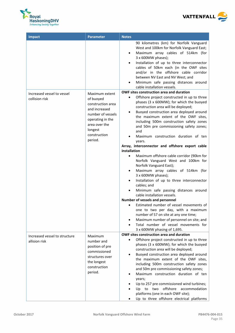
October 2017 Norfolk Vanguard Offshore Wind Farm PB4476-004-015 Page 35
Impact Parameter Notes
90 kilometres (km) for Norfolk Vanguard West and 100km for Norfolk Vanguard East;
Maximum array cables of 514km (for 3 x 600MW phases);
Installation of up to three interconnector cables of 50km each (in the OWF sites and/or in the offshore cable corridor between NV East and NV West; and
Minimum safe passing distances around cable installation vessels.
Increased vessel to vessel
collision risk
Maximum extent
of buoyed
construction area
and increased
number of vessels
operating in the
area over the
longest
construction
period.
OWF sites construction area and duration
Offshore project constructed in up to three phases (3 x 600MW); for which the buoyed construction area will be deployed;
Buoyed construction area deployed around the maximum extent of the OWF sites, including 500m construction safety zones and 50m pre commissioning safety zones; and
Maximum construction duration of ten years.
Array, interconnector and offshore export cable installation
Maximum offshore cable corridor (90km for Norfolk Vanguard West and 100km for Norfolk Vanguard East);
Maximum array cables of 514km (for 3 x 600MW phases);
Installation of up to three interconnector cables; and
Minimum safe passing distances around cable installation vessels.
Number of vessels and personnel
Estimated number of vessel movements of one to two per day, with a maximum number of 57 on site at any one time;
Maximum number of personnel on site; and
Total number of vessel movements for 3 x 600MW phasing of 1,695.
Increased vessel to structure
allision risk
Maximum
number and
position of pre
commissioned
structures over
the longest
construction
period.
OWF sites construction area and duration
Offshore project constructed in up to three phases (3 x 600MW); for which the buoyed construction area will be deployed;
Buoyed construction area deployed around the maximum extent of the OWF sites, including 500m construction safety zones and 50m pre commissioning safety zones;
Maximum construction duration of ten years;
Up to 257 pre commissioned wind turbines;
Up to two offshore accommodation platforms (one in each OWF site);
Up to three offshore electrical platforms
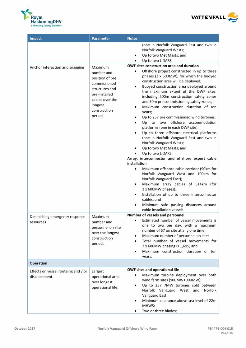
October 2017 Norfolk Vanguard Offshore Wind Farm PB4476-004-015 Page 36
Impact Parameter Notes
(one in Norfolk Vanguard East and two in Norfolk Vanguard West);
Up to two Met Masts; and
Up to two LiDARS.
Anchor interaction and snagging Maximum
number and
position of pre
commissioned
structures and
pre-installed
cables over the
longest
construction
period.
OWF sites construction area and duration
Offshore project constructed in up to three phases (3 x 600MW); for which the buoyed construction area will be deployed;
Buoyed construction area deployed around the maximum extent of the OWF sites, including 500m construction safety zones and 50m pre commissioning safety zones;
Maximum construction duration of ten years;
Up to 257 pre commissioned wind turbines;
Up to two offshore accommodation platforms (one in each OWF site);
Up to three offshore electrical platforms (one in Norfolk Vanguard East and two in Norfolk Vanguard West);
Up to two Met Masts; and
Up to two LiDARS. Array, interconnector and offshore export cable installation
Maximum offshore cable corridor (90km for Norfolk Vanguard West and 100km for Norfolk Vanguard East);
Maximum array cables of 514km (for 3 x 600MW phases);
Installation of up to three interconnector cables; and
Minimum safe passing distances around cable installation vessels.
Diminishing emergency response
resources
Maximum
number and
personnel on site
over the longest
construction
period.
Number of vessels and personnel
Estimated number of vessel movements is one to two per day, with a maximum number of 57 on site at any one time;
Maximum number of personnel on site;
Total number of vessel movements for 3 x 600MW phasing is 1,695; and
Maximum construction duration of ten years.
Operation
Effects on vessel routeing and / or
displacement
Largest
operational area
over longest
operational life.
OWF sites and operational life
Maximum turbine deployment over both wind farm sites (900MW+900MW);
Up to 257 7MW turbines split between Norfolk Vanguard West and Norfolk Vanguard East;
Minimum clearance above sea level of 22m MHWS;
Two or three blades;
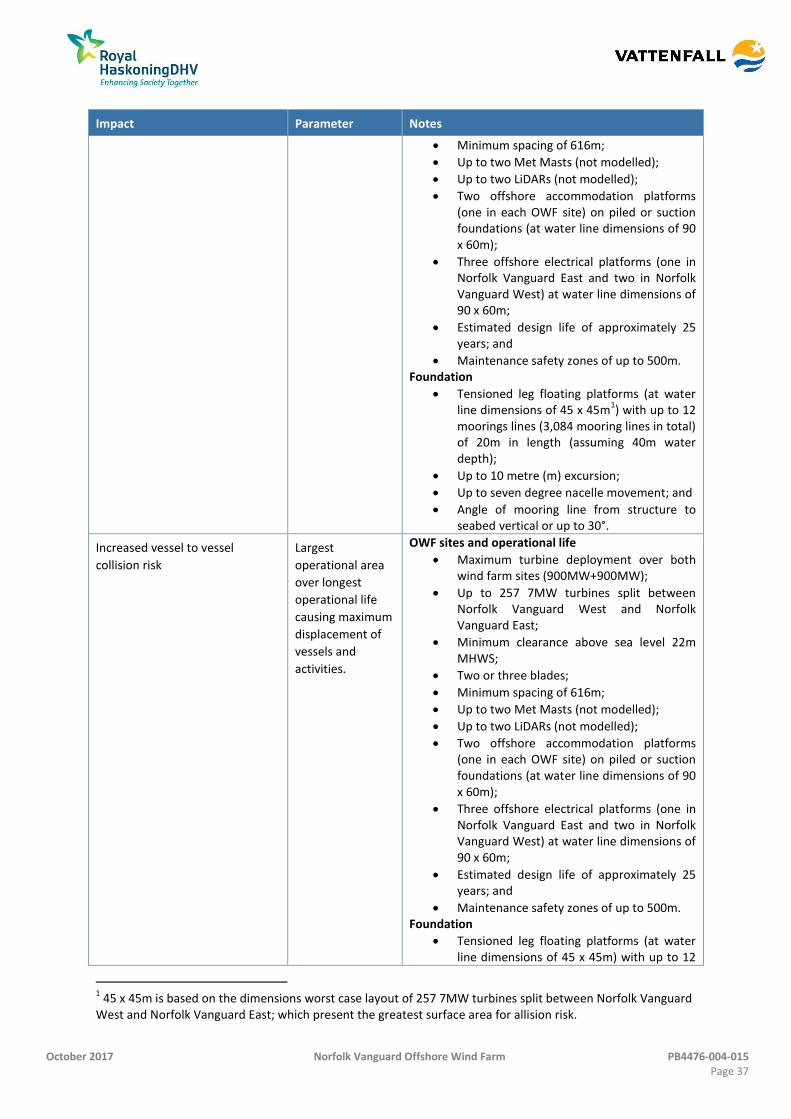
October 2017 Norfolk Vanguard Offshore Wind Farm PB4476-004-015 Page 37
Impact Parameter Notes
Minimum spacing of 616m;
Up to two Met Masts (not modelled);
Up to two LiDARs (not modelled);
Two offshore accommodation platforms (one in each OWF site) on piled or suction foundations (at water line dimensions of 90 x 60m);
Three offshore electrical platforms (one in Norfolk Vanguard East and two in Norfolk Vanguard West) at water line dimensions of 90 x 60m;
Estimated design life of approximately 25 years; and
Maintenance safety zones of up to 500m. Foundation
Tensioned leg floating platforms (at water line dimensions of 45 x 45m
1) with up to 12
moorings lines (3,084 mooring lines in total) of 20m in length (assuming 40m water depth);
Up to 10 metre (m) excursion;
Up to seven degree nacelle movement; and
Angle of mooring line from structure to seabed vertical or up to 30°.
Increased vessel to vessel
collision risk
Largest
operational area
over longest
operational life
causing maximum
displacement of
vessels and
activities.
OWF sites and operational life
Maximum turbine deployment over both wind farm sites (900MW+900MW);
Up to 257 7MW turbines split between Norfolk Vanguard West and Norfolk Vanguard East;
Minimum clearance above sea level 22m MHWS;
Two or three blades;
Minimum spacing of 616m;
Up to two Met Masts (not modelled);
Up to two LiDARs (not modelled);
Two offshore accommodation platforms (one in each OWF site) on piled or suction foundations (at water line dimensions of 90 x 60m);
Three offshore electrical platforms (one in Norfolk Vanguard East and two in Norfolk Vanguard West) at water line dimensions of 90 x 60m;
Estimated design life of approximately 25 years; and
Maintenance safety zones of up to 500m. Foundation
Tensioned leg floating platforms (at water line dimensions of 45 x 45m) with up to 12
1 45 x 45m is based on the dimensions worst case layout of 257 7MW turbines split between Norfolk Vanguard
West and Norfolk Vanguard East; which present the greatest surface area for allision risk.
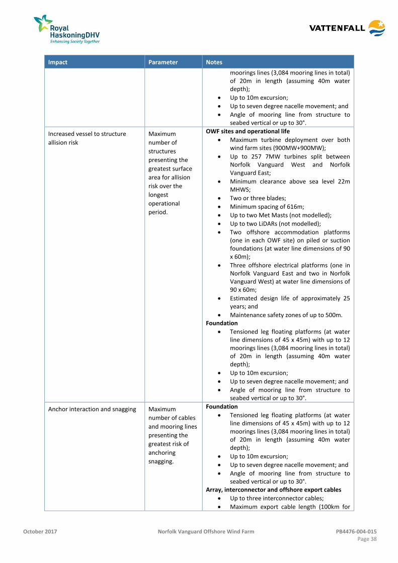
October 2017 Norfolk Vanguard Offshore Wind Farm PB4476-004-015 Page 38
Impact Parameter Notes
moorings lines (3,084 mooring lines in total) of 20m in length (assuming 40m water depth);
Up to 10m excursion;
Up to seven degree nacelle movement; and
Angle of mooring line from structure to seabed vertical or up to 30°.
Increased vessel to structure
allision risk
Maximum
number of
structures
presenting the
greatest surface
area for allision
risk over the
longest
operational
period.
OWF sites and operational life
Maximum turbine deployment over both wind farm sites (900MW+900MW);
Up to 257 7MW turbines split between Norfolk Vanguard West and Norfolk Vanguard East;
Minimum clearance above sea level 22m MHWS;
Two or three blades;
Minimum spacing of 616m;
Up to two Met Masts (not modelled);
Up to two LiDARs (not modelled);
Two offshore accommodation platforms (one in each OWF site) on piled or suction foundations (at water line dimensions of 90 x 60m);
Three offshore electrical platforms (one in Norfolk Vanguard East and two in Norfolk Vanguard West) at water line dimensions of 90 x 60m;
Estimated design life of approximately 25 years; and
Maintenance safety zones of up to 500m. Foundation
Tensioned leg floating platforms (at water line dimensions of 45 x 45m) with up to 12 moorings lines (3,084 mooring lines in total) of 20m in length (assuming 40m water depth);
Up to 10m excursion;
Up to seven degree nacelle movement; and
Angle of mooring line from structure to seabed vertical or up to 30°.
Anchor interaction and snagging Maximum
number of cables
and mooring lines
presenting the
greatest risk of
anchoring
snagging.
Foundation
Tensioned leg floating platforms (at water line dimensions of 45 x 45m) with up to 12 moorings lines (3,084 mooring lines in total) of 20m in length (assuming 40m water depth);
Up to 10m excursion;
Up to seven degree nacelle movement; and
Angle of mooring line from structure to seabed vertical or up to 30°.
Array, interconnector and offshore export cables
Up to three interconnector cables;
Maximum export cable length (100km for
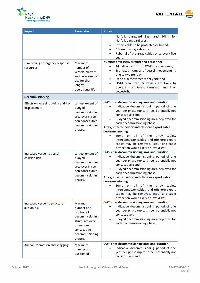
October 2017 Norfolk Vanguard Offshore Wind Farm PB4476-004-015 Page 39
Impact Parameter Notes
Norfolk Vanguard East and 90km for Norfolk Vanguard West);
Export cable to be protected or buried;
514km of array cables; and
Reburial of the array cables once every five years.
Diminishing emergency response
resources
Maximum
number of
vessels, aircraft
and personnel on
site for the
longest
operational life.
Number of vessels, aircraft and personnel
14 helicopter trips to OWF sites per week;
Estimated number of vessel movements is one to two per day;
Up to 480 movements per year; and
O&M crew transfer vessels are likely to operate from Great Yarmouth and / or Lowestoft.
Decommissioning
Effects on vessel routeing and / or
displacement
Largest extent of
buoyed
decommissioning
area over three
non-consecutive
decommissioning
phases.
OWF sites decommissioning area and duration
Indicative decommissioning period of one year per phase (up to three, potentially not consecutive); and
Buoyed decommissioning area deployed for each decommissioning phase.
Array, interconnector and offshore export cable decommissioning
Some or all of the array cables, interconnector cables, and offshore export cables may be removed. Scour and cable protection would likely be left in situ.
Increased vessel to vessel
collision risk
Largest extent of
buoyed
decommissioning
area over three
non-consecutive
decommissioning
phases.
OWF sites decommissioning area and duration
Indicative decommissioning period of one year per phase (up to three, potentially not consecutive); and
Buoyed decommissioning area deployed for each decommissioning phase.
Array, interconnector and offshore export cable decommissioning
Some or all of the array cables, interconnector cables, and offshore export cables may be removed. Scour and cable protection would likely be left in situ.
Increased vessel to structure
allision risk
Maximum
number and
position of
decommissioning
structures over
three non-
consecutive
decommissioning
phases.
OWF sites decommissioning area and duration
Indicative decommissioning period of one year per phase (up to three, potentially not consecutive).
Buoyed decommissioning area deployed for each decommissioning phase.
Anchor interaction and snagging Maximum
number and
position of
OWF sites decommissioning area and duration
Indicative decommissioning period of one year per phase (up to three, potentially not consecutive); and
October 2017 Norfolk Vanguard Offshore Wind Farm PB4476-004-015 Page 40
Impact Parameter Notes
decommissioning
structures and
cables over three
non-consecutive
decommissioning
phases.
Buoyed decommissioning area deployed for each decommissioning phase.
Array, interconnector and offshore export cable decommissioning
Some or all of the array cables, interconnector cables, and offshore export cables may be removed. Scour and cable protection would likely be left in situ.
Diminishing emergency response
resources
Maximum
number and
personnel on site
over three non-
consecutive
decommissioning
phases.
Number of vessels and personnel
Maximum number of decommissioning vessels on site; and
Maximum number of personnel on site.
Cumulative
Cumulative effects on deviation Maximum
number of
offshore wind
farm
developments
within the
southern North
Sea.
Worst case assumption for the project plus UK and
EU wind farms.
Cumulative effects on allision Maximum
number of
offshore wind
farm
developments
(and maximum
number of
structures) within
the southern
North Sea.
Worst case assumption for the project plus UK and
EU wind farms.
Cumulative effects on emergency
response
Maximum
number of
offshore wind
farm
developments
within the
southern North
Sea; with
significant
construction
overlap.
Worst case assumption for the project plus UK and
EU wind farms.
October 2017 Norfolk Vanguard Offshore Wind Farm PB4476-004-015 Page 41
Potential Impacts during Construction Phase 15.7.3
15.7.3.1 Effects on vessel routeing and / or displacement – OWF sites including
interconnector and array cables
80. The physical presence of pre commissioned structures and associated works could
have an effect on vessel routeing and displacement of activities within the OWF sites
study area and the offshore cable corridor study area (discussed in section 15.7.3.2).
15.7.3.1.1 Commercial vessels
81. Marine traffic movements within the OWF sites study area and the offshore cable
corridor study area have been captured through dedicated marine traffic surveys and
AIS surveys as noted in section 15.6.2. The marine traffic survey data assessments
have been considered alongside historical analysis in the form of the former East
Anglia Zone assessments and vessel route databases (Anatec ShipRoutes, 2016) to
define a full and detailed picture of commercial vessel movement.
82. Maximum deviations during the construction phase would be associated with the
buoyed construction area, which will be defined by TH pre construction. However,
this could be expected to extend 500m beyond the Agreement for Lease (AfL)
boundary or the final layout. The buoyed construction area would only be deployed
with TH authority and guidance and it is therefore assumed that it would be
designed so as to minimise impacts on vessels within the DWR. The worst case
assumes that the buoyed construction area will be in place for the entire
construction period (three phases lasting up to ten years).
83. As is standard for construction within UK waters, the buoyed construction area
would allow vessels access through areas currently not being installed (which would
be marked by 500m safety zones), allowing greater freedom through the OWF sites.
Experience at other UK wind farms shows that generally commercial vessels will
avoid the buoyed construction area but that smaller vessels such as recreational and
fishing vessels will enter but stay clear of ongoing activities.
84. Ongoing activities would be promulgated through Notice to Mariners, KIS-ORCA and
other standard methods of communication to ensure that vessel Masters are able to
effectively passage plan to minimise deviations and avoid current areas of activity.
Given the flexible access to the OWF sites throughout construction, main route
deviations are only considered within the impacts for the operation and
maintenance phase (see section 15.7.4.1).
85. It is noted that installation of the array and interconnector cables may also
temporarily displace traffic during installation, however given the minimum safe
passing distances (around Restricted in Ability to Manoeuvre (RAM) vessel(s) used
for installation) will be small, likely 1,000m or less, the fact that the location of
October 2017 Norfolk Vanguard Offshore Wind Farm PB4476-004-015 Page 42
installation vessel(s) will regularly change and that COLREGS (IMO, 1972) effectively
manages manoeuvres there are not expected to be any identifiable impacts.
86. Noting that the main purpose of the NRA is to assess navigational safety risk not
commercial impacts, the severity of consequence is considered to be minor for the
OWF sites given that any displacement or deviations during construction will not
adversely increase navigational safety risk to vessels operating on the deviated
routes. This is due to there being negligible risk to persons or the environment, but
the potential for some business impacts associated with safety, i.e. increased bridge
manning.
87. The frequency of the effect is considered to be reasonably probable and is based on
the possibility that a deviation will occur but that there will be only a minor
measurable consequence to users. The impact has therefore been classed as
tolerable, noting that promulgation of information would enable the vessel Masters
to effectively passage plan to minimise disruption. This impact is considered not
significant under EIA terms with embedded mitigation in place.
15.7.3.1.2 Recreational vessels
88. Recreational vessel (classed as 2.5 to 24m length) movements were very low during
the marine traffic surveys and there are no RYA cruising routes passing through the
OWF sites. Given the low number of vessels, consultation responses indicating no
concerns over the project, the continued ability to transit through the buoyed
construction area and embedded mitigation of promulgation of information, the
displacement of recreational vessels from the proposed project has no perceptible
effects and is not significant in EIA terms (no impact).
15.7.3.1.3 Fishing vessels in transit
89. Throughout the survey periods there was an average of eight (Norfolk Vanguard
East) and three (Norfolk Vanguard West) unique fishing vessels recorded per day
passing with the OWF study areas. The majority of vessels were non UK beam
trawlers.
90. Chapter 14 Commercial Fisheries considers commercial fishing displacement. From a
navigational safety perspective, fishing vessels would be able to transit through the
buoyed construction area during construction using the embedded mitigation of
promulgation of information (noting areas of current construction activity). Given
the smaller size of fishing vessels navigating within the area and their ability to
navigate through the buoyed construction area, the frequency of deviations and re-
routeing (of vessels in transit) is expected to be lower than that of commercial
vessels.
October 2017 Norfolk Vanguard Offshore Wind Farm PB4476-004-015 Page 43
91. The severity of consequence from the OWF sites is considered to be negligible and
the frequency of effect is considered to be remote. The impact has therefore been
classed as broadly acceptable for navigational safety during transit which is not
significant under EIA terms.
15.7.3.2 Effects on vessel routeing and / or displacement – Offshore cable corridor
15.7.3.2.1 Commercial vessels, recreational vessels and fishing vessels in transit
92. Given that the offshore cable corridor will create a negligible deviation during
installation (an anticipated safe passing distance around RAM installation vessel(s)),
any impact on vessels is not considered to have a perceptible effect with regards to
navigational safety (no impact).
15.7.3.3 Increased vessel to vessel collision risk – OWF sites, including interconnector and
array cables
93. The physical presence of pre commissioned structures and associated works could
result in the displacement of vessels and activities within the OWF sites study area
and offshore cable corridor study area and therefore increased encounters and
vessel to vessel collision risk.
15.7.3.3.1 Commercial vessels
94. For the construction phase this impact can be separated into three impacts,
increased encounters and collision risk between a third party vessel and a Norfolk
Vanguard construction vessel, increased encounters and collision risk between third
party vessels, and increased encounters and collision risk in adverse weather.
95. A three phased construction period (of up to ten years) has been identified as the
worst case as it is assumed that the buoyed construction area would be deployed to
the fullest extent over the largest area regardless of phasing.
Increased encounters and vessel to vessel collision risk between third party vessels and
construction vessels
96. The increased level of vessel activity required for the project may lead to an increase
in encounters and therefore vessel to vessel collision risk due to displacement of
third party vessels and increased encounters with construction vessels. During the
construction phase it is estimated that up to 57 vessels could be used to construct
the worst case scenario of 257 wind turbines, including foundation installation, cable
installation and wind turbine installation vessels, most of which would remain within
the construction area for extended periods and therefore reduce the potential for
interaction with third party vessels. In total there are estimated to be 1,695 vessel
movements during the construction phase with approximately 100 crew transfer
vessel (CTV) movements likely to be operating out of Great Yarmouth or Lowestoft.
October 2017 Norfolk Vanguard Offshore Wind Farm PB4476-004-015 Page 44
All construction vessel movements will be managed by a Marine Coordinator who
will ensure that construction traffic does not interact with third party vessels.
97. Embedded mitigation would be in place to manage increased traffic levels and
encounters between construction and third party vessels. These are likely to include:
Buoyed construction area clearly identifying the overall area of construction;
500m safety zones around installations attended by a vessel;
MGN 372 (MCA, 2008) which provides advice to mariners navigating within
proximity to a wind farm;
Marine traffic coordination; and
Promulgation of information noting the current area of construction.
98. When considering experience at other constructing wind farms it is identified that
third party vessels do consider Notice to Mariners during passage planning and avoid
current areas of construction. There has not been any recorded incident within the
buoyed construction area of a UK wind farm whereby a third party vessel has
collided with a construction vessel. It is also likely in reality that vessels will pass clear
of the edge of the buoyed construction area, meaning that, given the sea room, the
number of hot spots where vessels would be likely to meet would be reduced, thus
lowering the risk of encounter.
Increased encounters and collision risk between third party vessels
99. As noted in section 15.7.3.1, there is expected to be some level of displacement
associated with the construction of the project. The majority of denser routes would
not be deviated and those routes which would require deviation are transited by at
most one vessel per day. Therefore when considered against the low number of
deviated vessels, the embedded mitigation in place and the fact that the DWR width
and operation is not impacted, there are not expected to be any notable hot spots of
encounters or collision created during the construction phase. Embedded mitigation
includes:
Compliance with Flag State regulations including International Maritime
Organization (IMO) Conventions including COLREGs (IMO, 1972) and the
Safety of Life at Sea (SOLAS) (IMO, 1974);
MGN 372 (MCA, 2008); and
Promulgation of Information.
Increased encounters and collision risk in adverse weather
100. Adverse weather includes wind, wave and tidal conditions as well as reduced
visibility due to fog that can hinder a vessel’s normal route and / or speed of
navigation. Adverse weather routes are assessed to be significant course
adjustments to mitigate vessel movement in adverse weather conditions. When
October 2017 Norfolk Vanguard Offshore Wind Farm PB4476-004-015 Page 45
transiting in adverse weather conditions, a vessel is likely to encounter various kinds
of weather and tidal phenomena, which may lead to severe roll motions, potentially
causing damage to cargo, equipment and / or danger to persons on board. The
sensitivity of a vessel to these phenomena will depend on the actual stability
parameters, hull geometry, vessel type, vessel size and speed.
101. The probability of occurrence in a particular sea state may differ for each vessel.
Adverse weather is considered most significant for passenger vessels, due to the
potential health and safety risks (as well as the effect on passenger comfort) to
people on board (such as sea sickness and difficulty moving around the vessel). This
can also have implications for regular timetabled vessels, due to increases in journey
time and potential cancellations. Mitigations for vessels include adjusting their
heading to position themselves 45° to the wind, altering or delaying sailing times,
reducing speed and potentially cancelling journeys. Due to the distance from shore
and the feedback received as part of the hazard log it is likely that most adverse
weather routes would track close to the UK before crossing the southern North Sea
at the shortest or most protected point. Any vessel navigating within adverse
weather within the DWR would have to consider the presence of the OWF sites
construction areas within their passage plan; however there is ample sea room to
navigate and again a Marine Coordinator will ensure that project vessels do not
enter the DWR or restrict the movement of third party vessels in adverse weather
(outside of the buoyed construction area).
102. The project would be marked and lit in accordance with requirements defined by TH
and this scheme will include fog horns to alert vessels to the position of structures
when visibility is poor. Vessels are also required to take appropriate measures with
regards to safe speed under the COLREGS (IMO, 1972 plus amendments), which
considers determining a safe speed in conjunction with the state of visibility, the
wind, sea and current as well as the proximity of navigational hazards. the project
would also have additional resources on site that may be used under SOLAS
obligations to assist third party vessels in difficulty in adverse weather.
103. The severity of consequence from the OWF sites is considered to be minor, noting
that the most likely consequences are increased encounters rather than collision.
The frequency of effect is therefore considered to be reasonably probable. The
impact is therefore expected to be tolerable noting the mitigation of managing
construction traffic. This impact is therefore not significant under EIA terms.
15.7.3.3.2 Recreational vessels
104. Based on the marine traffic surveys, a recreational vessel was on average recorded
within the OWF sites study area once every two days during the summer surveys.
October 2017 Norfolk Vanguard Offshore Wind Farm PB4476-004-015 Page 46
Only one recreational vessel was recorded throughout the winter surveys. Therefore
recreational activity was considered to be very low within the OWF sites.
Encounters and vessel to vessel collision risk between third party vessels and construction
vessels
105. As with consideration of commercial vessels there would be some risk for
recreational craft associated with construction vessels transiting in the area.
However, given the very low levels of recreational traffic and embedded mitigation
(including guard vessels and marine traffic coordination) there are not expected to
be any perceptible effects.
Increased encounters and collision risk between third party vessels
106. During construction, it is anticipated that the presence of the buoyed construction
area (containing the active construction work and safety zones) will displace the
existing recreational activity from within the OWF sites; however experience at other
UK wind farm developments shows that recreational vessels will transit within
buoyed construction areas where no current activity is occurring, meaning that
recreational vessels would stay out with areas used by construction vessels.
107. For the OWF sites, there are not expected to be any effects associated with
recreational craft encountering or colliding with construction or other third party
vessels and therefore this impact is considered not significant under EIA terms (no
impact).
15.7.3.3.3 Fishing vessels in transit
108. Moderate levels of fishing activity were recorded within the OWF sites study area
during the marine traffic surveys. The marine traffic surveys identified an average of
11 unique fishing vessels per day throughout the survey periods. The majority of
vessels were recorded within Norfolk Vanguard East. As with impacts associated with
displacement it is considered likely that the construction activities will displace any
existing fishing activity during the construction phase; however as the NRA is
considered with fishing vessels transiting there are not expected to be any
perceptible effects associated with the construction of the OWF sites (no impact).
109. The installation of the offshore export cables would cause temporary displacement
to existing fishing vessels transiting; however as this work will be limited to a small
geographical area moving along the offshore export cable route, the impact from the
installation itself would be minor. It should be noted that the installed cable may
have a permanent displacement impact upon active fishing, as fishing vessels could
choose to avoid the risk of a gear snagging. This is considered in more detail within
Chapter 14 Commercial Fisheries.
October 2017 Norfolk Vanguard Offshore Wind Farm PB4476-004-015 Page 47
15.7.3.4 Increased vessel to vessel collision risk – Offshore cable corridor
15.7.3.4.1 Commercial vessels
110. The vessels associated with laying the offshore export cables would cause some
displacement to existing routes and activities; however this impact would be
temporary and limited to a small geographical area surrounding the installation
activity.
111. Given embedded mitigation including minimum safe passing distances and COLREGS
(IMO 1972) plus amendments), the severity of consequence from the offshore cable
corridor is considered to be minor, and the frequency of effect is considered to be
remote. The impact is therefore expected to be broadly acceptable which is again
not significant under EIA terms.
15.7.3.4.2 Recreational vessels and fishing vessels in transit
112. There are no perceptible impacts associated with the construction of the offshore
export cable for recreational vessels and fishing vessels in transit (no impact).
15.7.3.5 Increased vessel to structure allision risk - OWF Sites, including interconnector
and array cables
113. The physical presence of pre commissioned structures would create a vessel to
structure allision risk for a vessel navigating within the OWF sites and offshore cable
corridor.
15.7.3.5.1 Commercial vessels
114. During the construction phase, the presence of partially constructed structures, or
structures that have been completed but not yet commissioned, creates an allision
risk to passing commercial traffic. It is noted that during the construction phase, the
final lighting and marking of the structures may not yet have been implemented.
115. It is assumed that through effective promulgation of information, passing
commercial vessels would be aware of the ongoing construction, and would passage
plan in advance to avoid the OWF sites. The temporary lighting and marking in place
during construction would also provide an indication to passing vessels of the allision
hazard, and guard vessels would be deployed where required to protect sensitive
areas of construction. It is considered extremely unlikely that a commercial vessel
would deliberately enter the buoyed construction area and approach ongoing
construction operations, and any allision scenario is likely to be due to human error
or machinery failure.
116. Experience in wind farm construction for developers, their contractors and the vessel
operators is now extensive, with a number of operational wind farms having been
constructed within dense shipping and development areas. Consequently standard
October 2017 Norfolk Vanguard Offshore Wind Farm PB4476-004-015 Page 48
mitigation measures, as outlined in embedded mitigation section 15.7.1, are tried
and tested within the industry.
117. Phased project layouts are not available at this stage but it is assumed that any
layout would be agreed in advance with the MMO (in conjunction with the MCA and
TH) as per the DCO requirements.
118. The severity of consequence from the OWF sites is considered to be minor given the
embedded mitigation in place, and the frequency of effect considered to be
extremely unlikely. The impact has therefore been classed as broadly acceptable
which is not significant under EIA terms.
15.7.3.5.2 Recreational vessels
119. It is expected that the majority of recreational activity would avoid the buoyed
construction area altogether and promulgation of information would ensure
recreational users are well informed of the site. Embedded mitigation would ensure
that recreational users are aware of ongoing construction activities (including
current safety zones) although some recreational craft could still enter the buoyed
construction area including accidentally. If a recreational vessel were to enter into
the buoyed construction area a guard vessel (or other vessels on site) would inform
the vessel of the ongoing works.
120. The impact on recreational vessel transits throughout the construction period
(regardless of the construction approach adopted) would not differ greatly and has
been assessed as such throughout this subsection. The severity of consequence from
the OWF sites is considered to be minor given the low energy and low speed of any
allision incident, and the frequency of effect is considered to be negligible. Following
consideration of embedded mitigation the risk is expected to be broadly acceptable
and is not significant under EIA terms.
15.7.3.5.3 Fishing vessels in transit
121. It is considered unlikely that vessels would engage in fishing activity within the
buoyed construction area near areas of ongoing activity or installed structures during
the construction phase. As with recreational craft, the promulgation of information
would ensure that fisherman are well informed of the site. There will also be guard
vessels on site in the case that a fishing vessel did enter the buoyed construction
area. Any allision scenario involving a fishing vessel is therefore likely to be due to
machinery failure, adverse weather or human error.
122. Consequently this impact should be mitigated with proactive promulgation of
information as well as ongoing consultation with the fishing community. The safety
zones and guard vessels would also ensure that fishing vessels are safely displaced
from areas that may present a risk to them. Therefore the severity of consequence

October 2017 Norfolk Vanguard Offshore Wind Farm PB4476-004-015 Page 49
from the OWF sites is considered to be moderate, and the frequency of effect is
considered to be extremely unlikely, due to embedded mitigation measures. The
impact has therefore been classed as broadly acceptable which is not significant
under EIA terms.
15.7.3.6 Increased vessel to structure allision risk – Offshore cable corridor
15.7.3.6.1 Commercial vessels, recreational vessels and fishing vessels in transit
123. There is no allision risk associated with the offshore export cables during the
construction phase for commercial vessels, recreational vessels or fishing vessels in
transit; there are no surface structures within the offshore cable corridor (no
impact).
15.7.3.7 Anchor interaction and snagging risk – OWF Sites, including interconnector and
array cables
124. The presence of pre commissioned structures with mooring lines or cables could
create an increased snagging risk for vessels navigating within the OWF sites study
area and offshore cable corridor study area.
15.7.3.7.1 Commercial vessels
125. With the exception of the tanker manoeuvre described in section 16.10 of Appendix
15.1, no vessels transmitted a navigational status of “At Anchor” within the OWF
sites (excluding cases where vessels transmitted such a status, but a visual check of
the vessel’s movements indicated that the vessel was unlikely to be at anchor at the
time). Additionally, a speed analysis was undertaken to identify any vessels
transmitting a status other than “At Anchor” but exhibiting behaviour suggesting
they were anchored at the time. No such vessels were identified. Therefore it is
assumed that anchoring within the OWF sites is low to negligible.
126. It is considered extremely unlikely that a commercial vessel would deliberately
anchor within the buoyed construction area during the construction phase, and any
anchor interaction is therefore anticipated to be from a vessel dragging anchor from
outside the buoyed construction area, or a vessel anchoring in an emergency (e.g. a
vessel anchoring to avoid drifting into a structure). It is noted that such scenarios are
also considered unlikely.
127. During the construction phase installation vessels would be compliant with COLREGS
(IMO, 1972) and display RAM status; they would also ask for minimum safe passing
distance to ensure that any third party vessels do not come into close proximity with
construction activities. The cable would be buried and / or protected where it is
installed. When this has not yet been carried out and there is a risk to navigational
safety, additional temporary mitigation such as buoyage may be deployed. However,
October 2017 Norfolk Vanguard Offshore Wind Farm PB4476-004-015 Page 50
given the route of the offshore cable corridor and the levels of anchoring the
frequency of any potential interaction is considered to be very low.
128. Given the mitigations in place during the construction phase including Marine
Coordination, promulgation of information and safety zones that will prevent vessels
approaching areas not fully installed, the severity of consequence from the OWF
sites is considered to be minor and the frequency of effect is considered to be
remote. The impact has therefore been classed as broadly acceptable which is not
significant under EIA terms.
15.7.3.7.2 Recreational vessels
129. Recreational vessels (and their anchors) are typically much smaller than commercial
vessels. Interaction with subsea cables or mooring lines could therefore have more
serious implications for a recreational vessel, with the worst case being a snagging
leading to a capsize, following loss of stability. The crew of a recreational vessel may
also lack the marine experience of that of a commercial vessel, and are therefore
more likely to enter into the buoyed construction area, either deliberately or
accidently. However the majority of the sea area within the OWF sites is of a depth
greater than 30m and so small recreational vessels are considered unlikely to
attempt to anchor in such depths.
130. It is noted that although the marine traffic survey for the OWF sites did include AIS
and Radar data, the marine traffic survey for the offshore cable corridor included
only AIS data, and this may have resulted in recreational vessel anchoring not being
recorded. However given the exposed nature of the coastline and the fact that there
are no charted or designated anchorages, it is unlikely that there would be a
significant number of recreational vessels anchoring.
131. The severity of consequence from the OWF sites is considered to be negligible given
the size of recreational vessels and their anchors and the frequency of effect is
considered to be negligible given the very low frequency of anchoring. The impact
has therefore been classed as broadly acceptable which is not significant under EIA
terms.
15.7.3.7.3 Fishing vessels in transit
132. In addition to potential for anchor snagging, fishing vessels may also snag their gear
on the cables or mooring lines; this is considered separately within Chapter 14
Commercial Fisheries.
133. As with recreational vessels, fishing vessels are typically small when compared to
commercial vessels but are likely to have larger anchors than recreational vessels;
therefore the severity of consequence from the OWF sites is considered to be minor
and the frequency of effect is considered to be remote given the water depths. The
October 2017 Norfolk Vanguard Offshore Wind Farm PB4476-004-015 Page 51
impact has therefore been classed as broadly acceptable which is not significant
under EIA terms.
15.7.3.8 Anchor interaction and snagging risk – Offshore cable corridor
15.7.3.8.1 Commercial vessels
134. For the offshore cable corridor study area, two vessels were recorded anchoring,
with one of these located within the offshore cable corridor.
135. The severity of consequence from the offshore cable corridor is considered to be
minor (given the assessment in section 15.7.3.7) and the frequency of effect is
considered to be remote. The impact has therefore been classed as broadly
acceptable and not significant under EIA terms.
15.7.3.8.2 Recreational vessels and fishing vessels in transit
136. For recreational vessels, the severity of consequence from the offshore cable
corridor is considered to be negligible and the frequency of effect is considered to be
extremely unlikely given that recreational vessels are more likely to anchor near
shore either to shelter from adverse weather or to make emergency repairs. This
impact has therefore been classed as broadly acceptable which is not significant
under EIA terms.
137. For fishing vessels, the severity of consequence for the offshore cable corridor is
considered to be minor and the frequency of effect is considered to be remote given
that fishing vessels are more likely to transit in adverse weather and anchor near
shore. The impact has therefore been classed as broadly acceptable which is not
significant under EIA terms.
15.7.3.9 Diminishing emergency response resources – OWF sites, including interconnector
and array cables
15.7.3.9.1 All sea users
138. The construction of the project, including the increased presence of vessels and
people within the area may diminish the ability of emergency responders. The total
number of vessel movements for three construction phases (3 x 600MW) is
predicated to be 1,695 or on average one to two vessels per day. The construction
period could last up to ten years.
139. Under national and international law the operators of Norfolk Vanguard would be
required to comply with existing emergency response requirements, as detailed in
the NRA, as well as give consideration to other response groups within the area.
Owing to the increased level of activity in and around the proposed project there
would be expected to be some increased demands on SAR facilities within the area.
The project could also increase traffic and activity to a level such that self-help
October 2017 Norfolk Vanguard Offshore Wind Farm PB4476-004-015 Page 52
emergency response would be required and consideration in the ERCoP would be
given to what resources would be required to provide a level of response that would
ensure that response time and resources are not impacted.
140. Embedded mitigation includes compliance with MGN 543 and the development of an
ERCoP. The Applicant would comply with the requirements of MGN 543 including
Annex 4 ‘Safety and mitigation measures recommended to OREIs during
construction, operation and decommissioning’ and Annex 5 ‘Search and Rescue and
emergency response matters’.
141. An ERCoP should include the following but may also consider site specific
parameters:
Facilitation of SAR responders (helicopters);
Place of safe refuge;
Remote monitoring and control; and
Marking and lighting.
142. Those sectors of emergency response in which the Applicant considers it could
directly cooperate and contribute (as well self-help capability) include:
SAR as defined by the SAR convention of 1979 and subsequent amendments;
The rendering of assistance to vessels in distress as detailed in the SOLAS
(IMO, 1974) and in subsequent amendments;
First response as described in the salvage convention of 1989; and
First response in respect of the National Contingency Plan for Marine
Pollution for shipping and offshore installations (currently being updated by
the MCA).
143. Due to the increased level of personnel and vessels on site during the construction
phase there would be an increased risk of an incident occurring, thus diminishing the
overall ability of the current level of emergency response facilities, including
pollution response.
144. Potential residual impacts identified following consideration of embedded mitigation
include reduced emergency response capability / oil spill response owing to the
presence of the project.
145. For emergency response, Norfolk Vanguard Ltd would undertake a gap analysis to
identify which resources may be required. This could include the establishment of a
self-help capability as part of its ERCoP and Safety Management Systems. It is
possible that Norfolk Vanguard would also generally increase facilities in the area for
all third party users; however during construction the increased number of personnel
October 2017 Norfolk Vanguard Offshore Wind Farm PB4476-004-015 Page 53
and vessels (associated with the project) would decrease the capacity of SAR current
resources but increase on site resources within an area that was previously void.
146. Given the increased number of vessels on site and the potential for moderate
damage to vessels, including multiple or single serious injuries and Tier 22 pollution
incidents which require assistance, the severity of consequence from the OWF sites
is considered to be moderate. However, the frequency of this level of incident is
considered to be remote (based on predicted vessel and personnel numbers). The
impact will therefore be expected to be tolerable, noting the mitigation of the
increase in self-help capabilities and other resources to assist third parties on site.
15.7.3.10 Diminishing emergency response resources – Offshore cable corridor
15.7.3.10.1 All users
147. There are not expected to be any perceptible impacts associated with the offshore
cable corridor given the low level of personnel and vessels working on the
installation (no impact).
Potential Impacts during Operation and Maintenance Phase 15.7.4
15.7.4.1 Effects on vessel routeing and displacement – OWF sites, including interconnector
and array cables
148. The physical presence of the OWF sites could result in effects on vessel routeing and
displacement of activities within the OWF sites study area.
149. It is noted that given the distance from aggregate sites and the distance that the
OWF sites are located from the coastline and therefore ports, no effects were
identified on marine aggregates dredgers and they were therefore screened out of
the assessment in the NRA (Appendix 15.1).
15.7.4.1.1 Commercial vessels
150. The worst case scenario for the project assumes that all 257 turbines, three offshore
electrical platforms, two offshore accommodation platforms, Met Masts and two
LiDARs will be deployed across both OWF sites, causing the maximum area of
displacement.
151. Following principles set out in MGN 543 (MCA, 2015), 24 main routes were identified
transiting within the OWF sites study area. Given the location of the OWF sites
between the DR1 Lightbuoy and West Friesland DWRs, the majority of vessels on
these routes will not be impacted by the operation of the project. The busiest route
2 A Tier 2 spill is larger than a Tier 1 spill, but is still one that occurs in the area of the producing company's
facilities. Tier 2 spills usually require the aid of other companies and resources, including the government.
October 2017 Norfolk Vanguard Offshore Wind Farm PB4476-004-015 Page 54
(17 vessels per day) is located to the east of both sites (Off Brown Ridge TSS /
Rotterdam) and does not require any deviation due to the project.
152. Of the 24 main routes identified, 12 will require a deviation if the project is built to
its fullest extent. Of the 12 routes requiring deviation all are operated by no more
than one vessel per day.
153. Only one route requires a deviation of greater than 5% of its total journey length.
The Great Yarmouth–Victor Field route would require a worst case deviation of
between 11.5% and 13.8% of the total journey length; however this route is only
operated on average by one vessel every two days.
154. Six routes have deviations of greater than 1% but less than 5% of the total journey
length. Again these are worst case deviations with the greatest being 3.3% for the
Great Yarmouth–Hamburg route, used by one vessel every three days.
155. As a standard approach required by consultees these worst case deviations assume
that the vessel deviates and returns to its historical route as soon as possible. In
reality vessels could take more realistic routeing options, with less severe course
alterations, that would significantly decrease the overall deviation.
156. Norfolk Vanguard, as with other UK projects, would be open to vessels wishing to
enter; however consultation feedback with commercial operators indicates that it is
highly unlikely that commercial vessels will navigate through the array. There are
factors that would influence a mariner’s decision (including recreational sailors) to
navigate through, around or avoid a wind farm and the choice is influenced by a
number of factors including the vessel’s characteristics, the weather and the sea
conditions; however MGN 372 (MCA, 2008) concluded that “Although offshore
renewable energy installations present new challenges to safe navigation around the
UK coast, proper voyage planning, taking into account all relevant information,
should ensure a safe passage and the safety of life and the vessel should not be
compromised.”
157. The increase in route distances for vessels displaced by the project would be
minimised by embedded mitigation including promulgation of information (such as
notice to mariners) and charting which would enable vessels to effectively passage
plan in advance of encountering the OWF sites.
158. The severity of consequence from the OWF sites is considered to be minor as there
are no notable navigational safety impacts expected and the frequency of effect is
considered to be reasonably probable given that this effect would happen on a
regular basis. The impact has therefore been classed as tolerable which is not
significant under EIA terms.
October 2017 Norfolk Vanguard Offshore Wind Farm PB4476-004-015 Page 55
15.7.4.1.2 Recreational vessels
159. Based on the latest RYA Cruising Routes (2016), there are no cruising routes, general
sailing areas, or racing areas within the OWF sites. The offshore cable corridor does
intersect with general sailing areas near shore and four medium use cruising routes
cross the offshore cable corridor (two of which do so within 2.5nm of the coastline).
160. The minimum spacing between turbines is 616m and at least one line of orientation
will be maintained which should allow (based on consultation feedback) adequate
sea room for recreational craft to navigate through the OWF sites. Recreational users
are likely to take due consideration for the weather conditions and passage plan
accordingly to ensure safe transits. It is assumed that in adverse weather and winter
periods limited recreational activity would be present within the OWF sites.
161. As with the construction phase, given the very low numbers, consultation responses
indicating no concerns over the proposed project and the embedded mitigation
(promulgation of information), displacement of recreational vessels from the
proposed project has no perceptible effects and is not significant under EIA terms
(no impact).
15.7.4.1.3 Fishing vessels in transit
162. As with the equivalent construction impact, Chapter 14 Commercial Fisheries
considers commercial displacement. From a navigational safety perspective, fishing
vessels would be able to transit through the OWF sites as noted in paragraph 90.
163. Given the size of fishing vessels (on average 42m length) navigating within the area,
the ability to transit through is expected to be higher than that of commercial vessels
and the consequences lower (given that fishing vessels are smaller and more
manoeuvrable; with impacts resulting in lower levels of damage). As with the impact
on recreational vessels, minimum spacing between turbines is 616m which should
allow adequate sea room for fishing vessels to navigate through the OWF sites, again
noting that a minimum of one line of orientation would be maintained.
164. The severity of consequence from the OWF site is considered to be negligible and
the frequency of effect is considered to be remote. The impact has therefore been
classed as broadly acceptable for navigational safety during transit which is not
significant under EIA terms.
15.7.4.2 Effects on vessel routeing and displacement – Offshore cable corridor
15.7.4.2.1 Commercial Vessels, Recreational Vessels and Fishing Vessels in Transit
165. Given that the offshore export cables would be buried and / or protected, there is no
displacement and therefore no impact identified. This assumes that any under keel
clearance issues which could cause a deviation are assessed as part of the Cable
October 2017 Norfolk Vanguard Offshore Wind Farm PB4476-004-015 Page 56
Burial Risk Assessment that would be undertaken post consent (embedded
mitigation) (no impact).
15.7.4.3 Increased vessel to vessel collision risk – OWF sites, including interconnector
cables and array cables
166. The physical presence of the project could result in the displacement of vessels and
activities within the OWF sites study area and offshore cable corridor study area and
therefore increase encounters and vessel to vessel collision risk.
15.7.4.3.1 Commercial vessels
167. As part of the assessment of vessel to vessel collision risk within the NRA, the
following scenarios have been considered:
Base case without wind farm (i.e., based on the current undeviated routes);
Future case with wind farm (assuming 0% traffic growth);
Future case with wind farm (assuming 10% traffic growth); and
Future case with wind farm (assuming 20% traffic growth).
168. The case of a 20% increase in traffic was requested by the CoS, and this was
therefore included in the modelling of vessel to vessel collision risk.
Increased encounters and collision risk between third party vessels
169. The baseline assessment showed that the most significant commercial traffic routes
in the vicinity of the OWF sites utilised the IMO Routeing Measures (DWRs) passing
between or to the east of the OWF sites. While any impact from the OWF sites to the
mean position of these routes is likely to be negligible, there is the potential for the
number of vessels using the routes to increase if vessels on other established routes
outside of the DWRs deviate into them as a result of the proposed project. Further
assessment on traffic levels within the DWRs is considered in section 18 of the
Appendix 15.1.
170. The baseline assessment also identified a number of routes intersecting the locations
of the proposed OWF sites. As stated above, it is likely that some of this traffic would
re-route into the DWRs, but a proportion could opt to cross the DWRs either north
or south of the OWF sites.
171. The majority of encounters between vessels (defined as at least two vessels
positioned within close proximity to each other – further information is provided in
Appendix 15.1) identified within the OWF sites study area in the marine traffic survey
occurred within the DR1 Lightbuoy and West Friesland DWRs, along the
Immingham–Rotterdam commercial ferry route located to the south-west of the
OWF sites, and at the Leman Field located to the north-west of the OWF sites. By
comparison there were relatively few encounters within the OWF sites, although
October 2017 Norfolk Vanguard Offshore Wind Farm PB4476-004-015 Page 57
there was a number of fishing vessel encounters within Norfolk Vanguard East. The
majority of vessels involved in encounters were observed to be commercial vessels,
with 58% of involved vessels being either cargo vessels or tankers. The majority of
encounters recorded within the OWF sites were fishing vessels actively engaged in
fishing activities and encountering transiting vessels.
172. The change in potential vessel to vessel collision frequency due to the construction
of the project, based upon a 10% growth in traffic, was estimated to be 1.52 x 10⁻²
per year. This represents a 22% increase from the pre wind farm collision risk for the
area considered, with a high proportion of this increase occurring within the DR1
Lightbuoy DWR. High increases in the collision frequency were also observed in the
dense routes that already exist around the periphery of the OWF sites. However, as
Table 22.1 of the NRA shows, this increase is largely associated with increases in
vessel numbers in the conservative future case assessments (10% and 20%) rather
than the deviated routes. It is noted that the vessel to vessel collision risk within the
West Friesland DWR (to the east of Norfolk Vanguard East) was largely unaffected by
the deviated routes.
173. With consideration for the deviations and encounters between vessels, increases in
collision risk are expected to be minor overall given the lower densities of traffic on
the deviated routes (meaning those routes do not significantly increase vessel to
vessel collision risk), embedded mitigation and good seamanship such as continuous
compliance with COLREGs (IMO, 1972). Compliance with COLREGS includes the
conduct of vessels in restricted visibility, following safe speed principles and
compliance with the “give way” rules.
IMO routeing measures (DWR) and agreed buffers
174. Following consultation undertaken with regulators as part of the former East Anglia
Zone it was agreed that a 1nm clearance from the edge of the DR1 DWR and 2nm
from the West Friesland DWR would allow sufficient room for safe navigation (given
the varying traffic levels and types). Therefore in order to maintain uniformity of
future sites, including Norfolk Vanguard, this 1nm buffer from the DR1 DWR has
been maintained.
175. Notably those include the constraints of weather, sea and tidal conditions that may
be expected at the location and mean that it will not always be possible for a vessel
to make good a planned course. The MCA (2016) note ‘that experience shows that in
heavy sea conditions it is much harder to turn the vessel around and it may not be
possible to achieve a dead stop. Deviations from the planned course by as much as
20° or more are common and must be considered in developing corridors”. For
Norfolk Vanguard, the OWF sites form a corridor (considered as wind turbines
October 2017 Norfolk Vanguard Offshore Wind Farm PB4476-004-015 Page 58
directly opposite either side of a route) of 2.9nm length and 6.8nm width which
satisfactorily meets the requirements of MGN 543 (MCA, 2016).
176. The buffers and distances between sites should also prevent crossing encounters or
collisions associated with east to west traffic and the DWRs by allowing sufficient sea
room for vessels to visually and electronically acquire targets before crossing the
DWR.
177. It is considered unlikely that larger commercial vessels would transit through the
OWF sites, given the size and manoeuvrability of vessels. Most regular operators
should be familiar with the proposed project by the start of the operation and
maintenance phase, and the OWF sites will be marked on nautical charts, thus
ensuring that vessels have the information to deviate as necessary and allow full
flexibility to avoid encounters and therefore minimise collision risk.
Encounters and collision risk between third party vessels and operation and maintenance
vessels
178. It is noted that vessels associated with the project during the operation and
maintenance phase would number around one to two vessels per day and up to 460
per year. These vessels are likely to operate from Great Yarmouth or Lowestoft and
can be effectively managed by Marine Coordination to ensure that they avoid
entering denser areas of shipping or the DWRs and contributing to increased
encounters and collision risk.
Adverse weather
179. As with the construction phase, due to the distance from shore and the feedback
received as part of the hazard log it is likely that most adverse weather routes would
track close to the UK before crossing the southern North Sea at the shortest or most
protected point. Any vessel navigating within adverse weather within the DWR will
have ample sea room to manoeuvre as required, based on guidance within MGN 543
(MCA, 2016), MGN 372 (MCA, 2008) and COLREGs (IMO, 1972).
180. Given the low level of potential damage caused by a vessel to vessel collision, the
severity of consequence from the OWF sites is considered to be minor. With
mitigation in place (such as lighting, marking and charting) alongside experience that
is developed about the proposed project by mariners and general good seamanship
the frequency of effect is considered to be remote. The impact has therefore been
classed as broadly acceptable which is not significant under EIA terms.
15.7.4.3.2 Recreational vessels
181. The wind turbine spacing within the OWF sites (minimum of 616m) provides ample
spacing for smaller recreational vessels to safely transit through the OWF sites during
the operation and maintenance phase should they choose to. A minimum of one line
October 2017 Norfolk Vanguard Offshore Wind Farm PB4476-004-015 Page 59
of orientation would also be maintained which is preferred by recreational
consultees. Despite the very low level of recreational activity there may be a small
increase in encounters with other vessels; however given adherence to COLREGs
(IMO, 1972) (in particular in relation to crossing the DWR) and good seamanship,
there are not expected to be any perceptible effects associated with recreational
vessels with regards to collision risk and therefore this impact is considered not
significant under EIA terms (no impact).
15.7.4.3.3 Fishing vessels in transit
182. As with recreational vessels, fishing vessels may still choose to transit through the
OWF sites based on the wind turbine spacing (minimum spacing of 616m); however
it is noted that certain foundation types will have an impact on levels of active fishing
due to the snagging risk associated with mooring lines. This is considered further
within Chapter 14 Commercial Fisheries.
183. As the NRA considers fishing vessels in transit only, there are not expected to be any
perceptible effects associated with the development of the OWF sites (no impact).
Impacts on Commercial Fisheries are considered further in Chapter 14.
15.7.4.4 Increased vessel to vessel collision risk – Offshore cable corridor
15.7.4.4.1 Commercial vessels
184. Given that the offshore export cables will be buried, there is no associated
displacement and therefore no collision risk impact identified (no impact). This
assumes that any under keel clearance issues are assessed as part of the Cable Burial
Risk Assessment that will be undertaken post consent.
15.7.4.4.2 Recreational vessels and fishing vessels in transit
185. As with commercial vessels, given that the offshore export cables will be buried,
there is no associated displacement and therefore no collision risk impact identified
(no impact). This assumes that any under keel clearance issues are assessed as part
of the Cable Burial Risk Assessment that will be undertaken post consent.
15.7.4.5 Increased vessel to structure allision risk – OWF sites, including interconnector
cables and array cables
186. The physical presence of structures would create a vessel to structure allision risk for
a vessel navigating within the OWF sites and offshore cable corridor.
15.7.4.5.1 Commercial vessels
187. During the operation and maintenance phase, the structures within the OWF sites
would create an allision risk to passing commercial traffic, either from a vessel
transiting under power, or a Not Under Command (NUC) vessel. It is not considered
likely that commercial vessels would choose to transit through the OWF sites (based
October 2017 Norfolk Vanguard Offshore Wind Farm PB4476-004-015 Page 60
on consultation feedback) and therefore any allision risk is expected to be (in the
majority) from a commercial vessel intending to use the IMO Routeing Measures, or
intending to pass to the north or south of the OWF sites.
188. Modelling was undertaken for both vessel allision risk under way and allision risk
associated with vessels NUC. The full results can be found in section 21 of Appendix
15.1.
189. Based on modelling of the revised routeing following the complete installation and
commissioning of the project, and assuming a 10% growth in traffic, the frequency of
a passing powered commercial vessel allision is estimated to be 3.86 x 10⁻⁴ per year,
corresponding to a return period of 2,590 years. The allision return period is lower
than the historical average of 5.3 x 10⁻⁴ (one in 1,900 years) per installation year for
offshore installations on the United Kingdom Continental Shelf (UKCS) (Health and
Safety Executive (HSE), 2010). Other percentage increases have been demonstrated
within Appendix 15.1; however the 10% has been detailed within this chapter to
allow consistency with other projects.
190. Should a commercial vessel allide with a structure within the OWF sites, there is a
very low potential for the vessel to founder, resulting in loss of life. Larger
commercial vessels may also have the capacity to seriously damage the allided
structure.
191. Evidence at other wind farm projects shows that vessels are able to navigate safely
and effectively in close proximity to a wind farm. Embedded mitigations are well
tested and include consideration for wind turbine array layout. Notably:
The avoidance of extreme peripheral turbines;
Regular shapes and edges to aid effective navigational marking; and
A minimum of one line of orientation is preferred by recreational consultees.
192. It is also noted that increased minimum spacing in round three projects (compared
to round one and two projects) allows increased room to manoeuvre and thus
navigational safety.
193. Compliance with COLREGS (IMO, 1972) will also ensure vessels navigate with
consideration for the visibility, sea state and other factors that affect a vessel’s ability
to acquire a target (either visually or electronically) and take corrective action.
194. It is also noted that any layouts will require final signoff with the MMO in
consultation with the MCA and TH.
195. The severity of consequence from the OWF sites is considered to be minor given the
potential for minor damage to vessels, and the frequency is considered to be remote
October 2017 Norfolk Vanguard Offshore Wind Farm PB4476-004-015 Page 61
which is higher than the construction phase allision risk due to the removal of
mitigations such as construction buoyage. This impact has therefore been classed as
broadly acceptable and not significant under EIA terms.
15.7.4.5.2 Recreational vessels
196. There is the potential for a recreational vessel to allide with a structure within the
OWF sites during the operation and maintenance phase. Unlike commercial vessels,
recreational vessels may choose to transit through the OWF sites on a regular basis,
and allision from a vessel intending to be within the OWF sites is therefore
considered a possibility. It is not considered likely that a recreational vessel would
transit through the OWF sites at high speed and at this distance from shore,
recreational users will tend to be better equipped and more experienced.
197. The air clearance between wind turbines rotors and sea level at MHWS would not be
less than 22m, as per guidance, and this would minimise the risk of interaction
between rotor blades and yacht masts.
198. Under keel allision, especially with tension leg floating platforms, should be
considered to ensure that navigational safety is not impacted in relation to small
craft that may approach the structures. The RYA request a minimum of 4m under
keel clearance and the Norfolk Vanguard OWF sites are expected to achieve this.
199. Should a recreational vessel allide with a structure within the OWF sites, any damage
to the structure is unlikely to be as severe as that from a larger commercial vessel.
However, there is a greater potential for damage to a recreational vessel and a
greater risk of capsize.
200. The severity of consequence from the OWF sites is considered to be moderate and
the frequency of effect is considered to be extremely unlikely given the low level of
recreational activity. The impact has therefore been classed as broadly acceptable
and not significant under EIA terms.
15.7.4.5.3 Fishing vessels in transit
201. There is the potential for a fishing vessel to allide with a structure within the OWF
sites during the operation and maintenance phase. As with recreational vessels,
fishing vessels may choose to transit through the OWF sites during the operation and
maintenance phase. There is also potential for an allision to occur whilst engaged in
fishing activity and although gear snagging is considered in Commercial Fisheries
Chapter 14, the NRA assessed only the impact of waterline allisions.
202. There is potential for fishing activity to be impacted by the OWF sites during the
operation and maintenance phase. The worst case fishing vessel to structure allision
risk is estimated to be 2.91 x 10⁻¹, corresponding to a return period of 3.4 years
October 2017 Norfolk Vanguard Offshore Wind Farm PB4476-004-015 Page 62
(defined by the maximum number of installations and the maximum target area)
However this estimation assumes that all vessels are in transit. In reality, any allision
incident would be likely to occur whilst engaged in fishing activity (should a fishing
vessel have its gear deployed it may have reduced mobility compared to a transiting
vessel, and would therefore have less scope for initiating avoidance manoeuvres
when on an allision course). Consequently any allision incident would likely occur at
slow speed and with low energy. It is also noted that during the operation and
maintenance phase vessels are likely to be more familiar with the layout (locations
programmed into fish plotter etc.) and therefore the frequency of allision would be
lower than during the construction phase.
203. As with recreational vessels there is the potential that fishing vessels may get close
to turbines (whilst fishing) and any potential under keel allision risks would need to
be effectively mitigated (i.e., through additional marking).
204. Allision consequences for fishing vessels are more similar to recreational vessels than
for commercial vessels (i.e., increased potential for capsize); however it should be
noted that fishing vessels (average of 42m recorded within the vessel surveys) may
be considerably larger than a typical recreational vessel.
205. The severity of consequence from the OWF sites is considered to be moderate given
the potential for damage including from under keel allision, and the frequency of
effect is considered to be remote given the level of fishing recorded within the
marine traffic surveys. The impact has therefore been classed as tolerable noting
that further mitigation (depending upon the foundation type selected) may be
required to ensure risk remains ALARP and not significant under EIA terms.
15.7.4.6 Increased vessel to structure allision risk – Offshore cable corridor
15.7.4.6.1 Commercial vessels, recreational vessels and fishing vessels in transit
206. There is no allision risk associated with the offshore export cables during the
operation and maintenance phase for commercial vessels, recreational vessels or
fishing vessels in transit; there are no surface structures within the offshore cable
corridor (no impact).
15.7.4.7 Anchor interaction and snagging risk – OWF sites, including interconnector cables
and array cables
207. The physical presence of structures with mooring lines or cables could create an
increased snagging risk for vessels navigating within the OWF site study area and
offshore cable corridor study area.
October 2017 Norfolk Vanguard Offshore Wind Farm PB4476-004-015 Page 63
15.7.4.7.1 Commercial vessels
208. As stated in the equivalent impact for the construction phase, with the exception of
the tanker manoeuvre described in section 16.10 of Appendix 15.1, no vessels
transmitted a navigation status of “At Anchor” within the OWF sites (excluding cases
where vessels transmitted such a status, but a visual check of the vessel’s
movements indicated that the vessel was unlikely to be at anchor at the time).
Additionally, a speed analysis was undertaken to identify any vessels transmitting a
status other than “At Anchor”, but exhibiting behaviour suggesting they were
anchored at the time. No such vessels were identified. Therefore it is assumed that
anchoring within the OWF sites is low to negligible.
209. Where possible the interconnector and array cables would be buried and where
additional protection is required, an assessment will be carried out to understand
the risks in relation to anchoring, emergency anchoring or under keel clearance.
210. The foundation mooring lines associated with the tensioned floating foundations
may also create a minor snagging risk to the anchors of commercial vessels (given
that they will extend to 11.5m beyond the foundation platform). All mooring lines
would be subject to a third party validation.
211. The severity of consequence from the OWF sites is considered to be negligible, and
the frequency of effect is considered to be extremely unlikely. The impact has
therefore been classed as broadly acceptable which is not significant under EIA
terms.
15.7.4.7.2 Recreational vessels
212. As stated in the equivalent impact for the construction phase, recreational vessels
(and their anchors) are typically much smaller than commercial vessels. Interaction
with subsea cables or mooring lines could therefore have more serious implications
for a recreational vessel, with the worst case being a snagging leading to a capsize,
following loss of stability. The crew of a recreational vessel may also lack the marine
experience of that of a commercial vessel, and are therefore more likely to enter into
the OWF sites, either deliberately or accidently. It is also noted that mitigation
measures such as lighting and marking of structures and cable protection could be
implemented if required. The majority of the sea area within the OWF sites is of a
depth greater than 30m, and so small recreational vessels are considered unlikely to
attempt to anchor in such depths.
213. The severity of consequence from the OWF sites is considered to be negligible given
the size of recreational vessels and their anchors and the frequency is considered to
be negligible given the very low frequency of anchoring. The impact has therefore
been classed as broadly acceptable which is not significant under EIA terms.
October 2017 Norfolk Vanguard Offshore Wind Farm PB4476-004-015 Page 64
15.7.4.7.3 Fishing vessels in transit
214. As stated in the equivalent impact for the construction phase, in addition to
potential for anchor snagging, fishing vessels may also snag their gear on the cables
or mooring lines; this is considered separately within Chapter 14 Commercial
Fisheries.
215. As with recreational vessels, fishing vessels are typically small when compared to
commercial vessels but are likely to have larger anchors than recreational vessels;
therefore the severity of consequence from the OWF sites is considered to be minor
and the frequency of effect is considered to be extremely unlikely given the water
depths and mitigations (such as cable burial, protection and charting) that would be
deployed. The impact has therefore been classed as broadly acceptable which is not
significant under EIA terms.
15.7.4.8 Anchor interaction and snagging risk – Offshore cable corridor
15.7.4.8.1 Commercial vessels and fishing vessels in transit
216. For the offshore cable corridor study area; two vessels were recorded anchoring,
with one of these located within the offshore cable corridor. It is noted that the
marine traffic survey for the offshore cable corridor included only AIS data, and this
may have resulted in some fishing vessel anchoring not being recorded. However
given the exposed nature of the coastline and the fact that there are no charted or
designated anchorages, it is unlikely that there would be a significant number of
vessels anchoring.
217. Where possible the export cable would be buried and where protection is required, a
cable risk assessment will be carried out to understand risks in relation to anchoring,
emergency anchoring or under keel clearance
218. The size of commercial vessels in the area indicates that should an anchor interaction
occur with the offshore export cables, the most likely outcome is damage to the
cable, rather than a snagging. Fishing gear snagging is considered within Chapter 14
Commercial Fisheries.
219. The severity of consequence for the offshore cable corridor is considered to be
minor and the frequency of effect is considered to be remote given that commercial
and fishing vessels are more likely to transit in adverse weather and anchor near
shore. The impact has therefore been classed as broadly acceptable which is not
significant under EIA terms.
15.7.4.8.2 Recreational vessels
220. The severity of consequence for the offshore cable corridor is considered to be
negligible and the frequency of effect is considered to be extremely unlikely given
October 2017 Norfolk Vanguard Offshore Wind Farm PB4476-004-015 Page 65
that recreational vessels are more likely to anchor in coastal areas (either to break
their journey, shelter from weather or to make emergency repairs) than they are
directly on or within the export cable route. Therefore recreational vessels are
unlikely to come in proximity or interact with the cables. This impact has therefore
been classed as broadly acceptable which is not significant under EIA terms.
15.7.4.9 Diminishing emergency response resources – OWF sites, including interconnector
and array cables
15.7.4.9.1 All sea users
221. As with the equivalent impact for the construction phase, the operation and
maintenance phase would be expected to put increased demand on SAR facilities
within the area. However, as the maximum number of personnel and vessels is
considered lower than during the construction phase, the frequency is reduced.
222. Potential residual impacts identified include reduced emergency response capability
/ oil spill response owing to the presence of the project; however project ERPs would
take into consideration managing a self-help capability.
223. Due to the reduction in activity on site the frequency of effect is reduced to
extremely unlikely and the severity of consequence is considered to be minor
meaning the impact is considered broadly acceptable and not significant under EIA
terms.
15.7.4.10 Diminishing emergency response resources – Offshore cable corridor
15.7.4.10.1 All sea users
224. There are not expected to be any impacts associated with the offshore cable corridor
given the low level of personnel and vessels working on the offshore export cables
during periods of maintenance (no impact).
Potential Impacts during Decommissioning Phase 15.7.5
15.7.5.1 Effects on vessel routeing and / or displacement – OWF sites, including
interconnector and array cables
225. The physical presence of decommissioning structures and associated works could
have an effect on vessel routeing and displacement of activities within the OWF sites
study area and the offshore cable corridor study area.
15.7.5.1.1 Commercial vessels
226. Marine traffic movements within the OWF sites study area and the offshore cable
corridor study areas have been captured through dedicated marine traffic surveys
and AIS surveys as noted in section 15.6.2. As stated in the equivalent impact for the
construction phase, when marine traffic survey data assessments are considered
October 2017 Norfolk Vanguard Offshore Wind Farm PB4476-004-015 Page 66
alongside historical analysis in the form of the former East Anglia Zone assessments
and vessel route databases (Anatec ShipRoutes, 2016) a full and detailed picture of
commercial vessel movement is defined.
227. Maximum deviations during the decommissioning phase would be associated with
the buoyed decommissioning area. The layout consisting of 257 wind turbines plus
associated structures spread across the entirety of both OWF sites has been
considered as the worst case parameters for deviations associated with the
proposed project. The buoyed decommissioning area would only be deployed with
TH authority and guidance and it is therefore assumed that the buoyed
decommissioning area would be designed so as to minimise impacts on vessels
within the DWR. As standard for UK waters the buoyed decommissioning area would
allow vessels access through areas currently not being worked on, allowing greater
freedom through the site. Notice to Mariners and other methods of information
promulgation would also ensure that vessel Masters are able to effectively passage
plan to minimise deviations. Given the flexible access to the OWF sites throughout
decommissioning, main route deviations are only considered within the impacts for
the operation and maintenance phase (see section 15.7.4.1).
228. Noting that the main purpose of the NRA is to assess navigational safety risk, the
severity of consequence is considered to be minor for the OWF sites given that any
displacement or deviations during decommissioning will not increase risk to vessels
operating on the deviated routes. This is due to there being negligible risk to persons
or environment, but the potential for some business impacts associated with safety,
i.e. increased bridge manning. The frequency of effect is considered to be reasonably
probable. This is based on the possibility that a deviation will occur but that there
will be some measurable consequence to users. The impact has therefore been
classed as tolerable, noting that promulgation of information would enable the
vessel Masters to effectively passage plan to minimise disruption. This impact is
considered not significant under EIA terms.
15.7.5.1.2 Recreational vessels
229. As stated in the equivalent impacts for the construction and operation and
maintenance phases, recreational vessel movement was low during the marine
traffic surveys and there are no RYA cruising routes passing through the OWF sites.
Given the low vessel numbers, consultation responses indicating no concerns over
the project, the continued ability to transit through the decommissioning area and
the embedded mitigations of promulgation of information, the displacement of
recreational vessels from the proposed project has no perceptible effects and is not
significant under EIA terms (no impact).
October 2017 Norfolk Vanguard Offshore Wind Farm PB4476-004-015 Page 67
15.7.5.1.3 Fishing vessels in transit
230. As stated in the equivalent impacts for the construction and operation and
maintenance phases, throughout the survey periods there was an average of eight
and three unique fishing vessels recorded per day passing within the Norfolk
Vanguard East and Norfolk Vanguard West study areas respectively. The majority of
vessels were non UK beam trawlers.
231. Chapter 14 Commercial Fisheries considers commercial displacement. From a
navigational safety perspective, fishing vessels would be able to transit through the
decommissioning area during decommissioning using the embedded mitigation of
promulgation of information (noting areas of current decommissioning activity).
Given the smaller size of fishing vessels navigating within the area and their ability to
navigate through the decommissioning area, the frequency is expected to be lower
than that of commercial vessels.
232. The severity of consequence from the OWF sites is considered to be negligible, and
the frequency of effect is considered to be remote. The impact has therefore been
classed as broadly acceptable for navigational safety during transit which is not
significant under EIA terms.
15.7.5.2 Effects on vessel routeing and / or displacement – Offshore cable corridor
15.7.5.2.1 Commercial vessels, recreational vessels and fishing vessels in transit
233. The vessels associated with decommissioning the offshore export cables would cause
some minor displacement to existing commercial routes; however this would be
temporary and limited to a small geographic area surrounding the decommissioning
activity. Post commissioning, there is unlikely to be any deviations to vessels
resulting from any cables left in situ; however this does assume that an assessment
of under keel clearance would be undertaken as part of the Decommissioning Plan
(no impact).
15.7.5.3 Increased vessel to vessel collision risk – OWF sites, including interconnector and
array cables
234. The physical presence of decommissioning structures and associated works could
result in the displacement of vessels and activities within the OWF sites study area
and offshore cable corridor study area and therefore increased encounters and
vessel to vessel collision risk.
15.7.5.3.1 Commercial vessels
235. During decommissioning, there would be an increased vessel presence within the
OWF sites, which may cause vessel displacement. However, as commercial vessels
are unlikely to be transiting through the OWF sites during the operation and
maintenance phase, any additional deviation impact from the vessels associated with
October 2017 Norfolk Vanguard Offshore Wind Farm PB4476-004-015 Page 68
decommissioning the wind turbines and other structures is expected to be minimal
(including the potential for safety zones around fixed structures). Deviation resulting
from the OWF sites post decommissioning would be dependent on what
infrastructure is left in situ; however there would be no additional deviations to
those experienced during the operation and maintenance phase.
236. The severity of consequence from the OWF sites is considered to be minor, noting
that the most likely consequences are increased encounters rather than collision.
Frequency of effect is considered to be reasonably probable. The impact has
therefore been classed as tolerable, noting the mitigation of managing construction
traffic. This impact is therefore not significant under EIA terms.
15.7.5.3.2 Recreational vessels
237. The increased vessel presence (including the potential for safety zones around fixed
structures) associated with the decommissioning of the wind turbines and other
structures may displace recreational vessels, noting that recreational users may have
been previously transiting the OWF sites during the operation and maintenance
phase. Post decommissioning, any recreational displacement associated with the
OWF sites would be dependent upon any structures left in situ; however there would
be no additional displacement to that observed during the operation and
maintenance phase.
238. For the OWF sites, there are not expected to be any effects associated with
recreational craft encountering or colliding with decommissioning or other third
party vessels and therefore this impact is considered not significant under EIA terms
(no impact).
239. Similarly to the construction phase, within the offshore cable corridor and near shore
there was some recreational activity recorded which would be temporarily displaced
around a decommissioning vessel. However as this work would be limited to a small
geographical area moving along the offshore export cable route (1km around the
installation vessel) the impact of any displacement would be negligible unless under
keel clearance was significantly reduced. As a mitigation measure, under keel
clearance would be assessed and managed as part of the Cable Burial Risk
Assessment to ensure that recreational routes are not impacted.
15.7.5.3.3 Fishing vessels in transit
240. The increased vessel presence (including the potential for safety zones around fixed
structures) associated with the decommissioning of the wind turbines and other
structures may displace fishing vessel activity, noting that fishing vessels may have
been using the OWF sites during the operation and maintenance phase, for either
transit or fishing purposes. Post decommissioning, fishing vessel displacement will be

October 2017 Norfolk Vanguard Offshore Wind Farm PB4476-004-015 Page 69
dependent on any structures left in situ. It is noted that should any subsurface
structures be left in place, the gear snagging risk may displace fishing activity, even if
the surface structures are removed; however as the NRA considers only fishing
vessels transiting there are not expected to be any perceptible effects associated
with the construction of the OWF sites (no impact).
241. The decommissioning of the offshore export cables would cause temporary
displacement to existing fishing vessels transiting; however as the work will be
limited to a small geographical area moving along the offshore export cable route,
the impact from the decommissioning itself would be minor. Any cables left in situ
could cause displacement due to the gear snagging risk dissuading active fishing, as
fishing vessels may have concerns with fishing over inactive cables (as protection
measures are no longer monitored and maintained).
15.7.5.4 Increased vessel to vessel collision risk –Offshore cable corridor
15.7.5.4.1 Commercial vessels, recreational vessels and fishing vessels in transit
242. The vessels associated with decommissioning the offshore export cables would cause
some minor displacement to existing commercial routes; however this would be
temporary and limited to a small geographic area surrounding the decommissioning
activity. Post decommissioning, there is unlikely to be any deviations to vessels
resulting from any cables left in situ; however this does assume that an assessment
of under keel clearance would be undertaken as part of the decommissioning plan
(no impact).
15.7.5.5 Increased vessel to structure allision risk –OWF sites, including interconnector and
array cables
243. The physical presence of decommissioned structures would create a vessel to
structure allision risk for a vessel navigating within the OWF sites and offshore cable
corridor.
15.7.5.5.1 Commercial vessels
244. The allision risk to commercial vessels post decommissioning would be dependent
upon which structures from the operational layout are left in place. Should any
surface structures be left in place, there is the potential for allision from a
commercial vessel, particularly as operational lighting and marking could no longer
be active. However commercial vessels are considered unlikely to transit within the
immediate vicinity of decommissioned structures. It is noted that lighting and
marking of decommissioned structures would be implemented in consultation with
TH, and any such structures would be clearly marked on nautical charts.
October 2017 Norfolk Vanguard Offshore Wind Farm PB4476-004-015 Page 70
245. The severity of consequence from the OWF sites is considered to be minor given the
embedded mitigations in place and the frequency of effect is considered to be
extremely unlikely. The impact has therefore been classed as broadly acceptable.
15.7.5.5.2 Recreational vessels
246. The allision risk to recreational vessels post decommissioning would be dependent
upon which structures from the operational layout are left in place. Should any
surface structures be left in place, there is the potential for allision from a
recreational vessel, particularly as operational lighting and marking could no longer
be active. It is noted that recreational users may pass significantly closer to
decommissioned structures than a commercial vessel would, due to vessel size,
marine inexperience, and the potential for curiosity from a leisure user.
247. Lighting and marking of decommissioned structures would be implemented in
consultation with TH, and any such structures would be clearly marked on nautical
charts.
248. Similarly to the equivalent impact for the construction phase, the impact on
recreational vessel transits throughout the decommissioning period (regardless of
the decommissioning approach adopted) would not differ greatly and has been
assessed as such throughout this subsection. The severity of consequence from the
OWF sites is considered to be minor given the low energy and low speed of any
allision incident, and the frequency of effect is considered to be negligible. Following
consideration of embedded mitigation the risk is considered to be broadly
acceptable and is not significant under EIA terms.
15.7.5.5.3 Fishing vessels in transit
249. The allision risk to fishing vessels post decommissioning would be dependent upon
which structures from the operational layout are left in place. Similarly to
recreational vessels, fishing vessels may pass significantly closer to decommissioned
structures than a commercial vessel would, and it should be noted that operational
lighting and marking could no longer be active.
250. However, lighting and marking of decommissioned structures would be implemented
in consultation with TH, and any such structures would be clearly marked on nautical
charts.
251. Similarly to the equivalent impact for the construction phase, the impact on fishing
vessel transits throughout the decommissioning period (regardless of the
decommissioning approach adopted) would not differ greatly and has been assessed
as such throughout this subsection. The severity of consequence from the OWF sites
is considered to be moderate and the frequency of effect is considered to be
October 2017 Norfolk Vanguard Offshore Wind Farm PB4476-004-015 Page 71
extremely unlikely. The impact has therefore been classed as broadly acceptable
which is not significant under EIA terms.
15.7.5.6 Increased vessel to structure allision risk –Offshore cable corridor
15.7.5.6.1 Commercial vessels, recreational vessels and fishing vessels in transit
252. There is no allision risk associated with the offshore export cables during the
decommissioning phase; there are no structures outside of the OWF sites (no
impact).
15.7.5.7 Anchor interaction and snagging risk –OWF sites, including interconnector and
array cables
253. The presence of decommissioning structures and infrastructure left in situ post
decommissioning with mooring lines or cables could create an increased risk for
vessels navigating within the OWF site study area and offshore cable corridor study
area.
15.7.5.7.1 Commercial vessels
254. It is considered extremely unlikely that a commercial vessel would anchor within the
OWF sites during the decommissioning phase, particularly as there would be an
increase in vessel presence / activity surrounding active decommissioning work,
including the potential for safety zones. For this reason a commercial vessel anchor
interaction with the mooring lines is considered to be an unlikely event.
255. Post decommissioning, any infrastructure left in situ within the OWF sites could
cause a snagging risk. If surface structures are removed, then it should be noted that
there would be less indication of the presence of subsurface infrastructure,
particularly if operational lighting and marking are also removed. However, it is
assumed that any commercial vessel anchoring within the OWF sites would take
charted information into account prior to anchoring.
256. Given the mitigation in place during the decommissioning phase including Marine
Coordination, promulgation of information and potentially safety zones that will
prevent vessels approaching areas not fully decommissioned, the severity of
consequence from the OWF sites is considered to be minor and the frequency of
effect is considered to be extremely unlikely. The impact has therefore been classed
as broadly acceptable which is not significant under EIA terms.
15.7.5.7.2 Recreational vessels
257. Water depths within the OWF sites suggest that recreational anchoring is unlikely,
particularly during decommissioning when there would be an increase in vessel
presence / activity surrounding active decommissioning work, including the potential
for safety zones. It should be noted that post decommissioning, the risk of snagging
October 2017 Norfolk Vanguard Offshore Wind Farm PB4476-004-015 Page 72
on subsurface infrastructure within the OWF sites would increase if surface
structures and operational lighting and marking are also removed.
258. The severity of consequence from the OWF sites is considered to be negligible given
the size of recreational vessels and their anchors, and the frequency of effect is
considered to be negligible given the very low frequency of anchoring. The impact
has therefore been classed as broadly acceptable which is not significant under EIA
terms.
15.7.5.7.3 Fishing vessels in transit
259. It is considered unlikely that fishing activity would occur within the vicinity of active
decommissioning work. Post decommissioning, levels and locations of fishing within
the OWF sites would depend upon what infrastructure is left in situ. It is assumed
that any snagging hazards left in situ (i.e. subsurface infrastructure) would be
marked on nautical charts. Water depths within the OWF sites suggest that fishing
vessel anchoring is unlikely.
260. As with recreational vessels, fishing vessels are small when compared to commercial
vessels but are likely to have larger anchors than recreational vessels. Therefore the
severity of consequence from the OWF sites is considered to be minor and the
frequency of effect is considered to be extremely unlikely given the water depths.
The impact has therefore been classed as broadly acceptable which is not significant
under EIA terms.
15.7.5.8 Anchor interaction and snagging risk –Offshore cable corridor
15.7.5.8.1 Commercial vessels
261. Post decommissioning, any offshore export cables left in situ within the offshore
cable corridor would create a snagging risk, and it is noted that operational
maintenance and monitoring would no longer be active. However, it is assumed that
the charted presence of the abandoned offshore export cables would be taken into
consideration by commercial vessels prior to anchoring.
262. It is therefore assumed that the decommissioning phase would present the same
impact as the construction and operation and maintenance phase. The severity of
consequence for the offshore cable corridor is considered to be minor and the
frequency of effect is considered to be remote given that commercial vessels are
more likely to transit in adverse weather and anchor near shore. The impact has
therefore been classed as broadly acceptable which is not significant under EIA
terms.
October 2017 Norfolk Vanguard Offshore Wind Farm PB4476-004-015 Page 73
15.7.5.8.2 Recreational vessels
263. Post decommissioning, any offshore export cables left in situ within the offshore
cable corridor would create a snagging risk, and it is noted that operational
maintenance and monitoring would no longer be active. However, it is assumed that
the charted presence of the abandoned offshore export cables would be taken into
consideration by recreational vessels prior to anchoring.
264. Should a snagging occur, the relatively small size of a typical recreational vessel
means that loss of stability and subsequent capsize is considered a possibility.
265. The severity of consequence for the offshore cable corridor is considered to be
negligible and the frequency of effect is considered to be extremely unlikely given
that recreational vessels are more likely to anchor near shore either to shelter from
adverse weather or to make emergency repairs. This impact has therefore been
classed as broadly acceptable which is not significant under EIA terms.
15.7.5.8.3 Fishing vessels in transit
266. Should the offshore export cables be left in place post decommissioning, there is the
potential for fishing gear / anchor snagging, and it should be considered that
operational maintenance and monitoring of the cable protection would no longer be
active.
267. Due to the size of a typical fishing vessel, should a snagging occur, loss of stability
with the potential for capsize is a risk. However, the more likely outcome is damage
to, or loss of the gear. Any damage to the offshore export cable at this stage would
be non-consequential.
268. The severity of consequence for the offshore cable corridor is considered to be
minor, and the frequency of effect is considered to be remote given that fishing
vessels are more likely to transit in adverse weather and anchor near shore. The
impact has therefore been classed as broadly acceptable which is not significant
under EIA terms.
269. Future case monitoring of offshore cables shall be considered.
15.7.5.9 Diminishing emergency response resources –– OWF sites, including
interconnector and array cables
270. As with the equivalent impact for the construction and operation and maintenance
phases, the decommissioning phase would be expected to put increased demand on
SAR facilities within the area.
271. Given the potential for moderate damage to vessels, multiple or single serious
injuries and Tier 2 pollution incidents which require assistance, the severity of
consequence from the OWF sites is considered to be moderate and the frequency of
October 2017 Norfolk Vanguard Offshore Wind Farm PB4476-004-015 Page 74
effect of this level of incident considered to be remote. The impact has therefore
been classed as tolerable, noting the mitigation of the increase in self-help
capabilities and other resources to assist third parties on site. This impact is
therefore considered not significant under EIA terms.
15.7.5.10 Diminishing emergency response resources – Offshore cable corridor
15.7.5.10.1 All sea users
272. There are not expected to be any perceptible impacts associated with the offshore
cable corridor given the low level of personnel and vessels working on the
decommissioning (no impact).
Cumulative Impact Assessment (CIA) 15.8
273. The presentation of cumulative impact has been a two stage process. Firstly, all the
impacts from previous sections have been presented and assessed for cumulative
impacts with scoped in projects noted in Table 15.12. Then those impacts which have
an effect have been assessed and ranked as per the FSA process detailed in section
15.4.
Cumulative Effects with Oil and Gas Platforms 15.8.1
274. Given the limited spatial extent of gas platforms and fields within the area there is
not considered to be any cumulative routeing impacts and therefore collision risk
associated with existing gas installations in the southern North Sea. With regards to
allision risk it is also noted that the Horne and Wren platform could have posed a
small cumulative increase in collision risk when considered against the project.
However it is understood from the operators that Horne and Wren had its topside
removed in 2017 (despite still being shown on the nautical charts used within this
chapter and the NRA) and is expected to be fully decommissioned by the end of the
year.
275. Should any future surface gas developments be applied for within the gas fields
within the area they would be subject to their own navigational risk assessments
including at a cumulative level.
Cumulative Effects Summary15.8.2
Table 15.11 Potential cumulative impacts
Impact Potential for cumulative
impact
Data confidence Rationale
Construction
Vessel routeing and /
or displacement
Yes Medium This was raised as a key point
to be considered during
October 2017 Norfolk Vanguard Offshore Wind Farm PB4476-004-015 Page 75
Impact Potential for cumulative
impact
Data confidence Rationale
consultation.
Increased vessel to
vessel collision risk
Yes Medium This was raised as a key point
to be considered during
consultation.
Increased vessel to
structure allision risk
Yes Medium Only with projects located
within the former East Anglia
Zone (Norfolk Vanguard,
Norfolk Boreas, East Anglia
Three, East Anglia One, East
Anglia Two and East Anglia One
North)
Anchor interaction
and snagging risk
No Medium Snagging risk during anchoring
operations is localised to the
offshore cables and cannot
have a cumulative effect. The
offshore cable corridor is also
not situated with other cables
within a known or charted
anchorage area.
Diminishing
emergency response
resources
Yes Low Increase in activity
cumulatively within the
southern North Sea area.
Operation and Maintenance
Vessel routeing and /
or displacement
Yes Medium This was raised as a key point
to be considered during
consultation.
Increased vessel to
vessel collision risk
Yes Medium This was raised as a key point
to be considered during
consultation.
Increased vessel to
structure allision risk
Yes Medium Only with projects located
within the former East Anglia
Zone (Norfolk Vanguard,
Norfolk Boreas, East Anglia
Three, East Anglia One, East
Anglia Two and East Anglia One
North).
Anchor interaction
and snagging risk
No Medium Snagging risk during anchoring
operations is localised to the
offshore cables and cannot
have a cumulative effect. The
offshore cable corridor is also
not situated with other cables
within a known or charted
anchorage area.
October 2017 Norfolk Vanguard Offshore Wind Farm PB4476-004-015 Page 76
Impact Potential for cumulative
impact
Data confidence Rationale
Diminishing
emergency response
resources
Yes Low Increase in activity
cumulatively within the south
North Sea area.
Decommissioning
Vessel routeing and /
or displacement
Yes Medium This was raised as a key point
to be considered during
consultation.
Increased vessel to
vessel collision risk
Yes Medium This was raised as a key point
to be considered during
consultation.
Increased vessel to
structure allision risk
Yes Medium Only with projects located
within the former East Anglia
Zone (Norfolk Vanguard,
Norfolk Boreas, East Anglia
Three, East Anglia One, East
Anglia Two and East Anglia One
North).
Anchor interaction
and snagging risk
No Medium Snagging risk during anchoring
operations is localised to the
offshore cables and cannot
have a cumulative effect. The
offshore cable corridor is also
not situated with other cables
within a known or charted
anchorage area.
Diminished
emergency response
resources
Yes Low Increase in activity
cumulatively within the
southern North Sea area.
276. Table 15.12 shows those projects that are deemed to have a cumulative effect. Due
to the national and international nature of shipping, impacts on vessel routeing can
occur a significant distance from the project being assessed. Therefore the
cumulative list for shipping and navigation includes all constructed, consented or
planned wind farms within the southern North Sea that could cumulatively influence
a vessel’s navigational routeing.
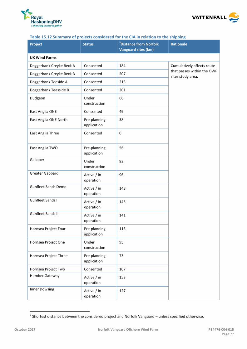
October 2017 Norfolk Vanguard Offshore Wind Farm PB4476-004-015 Page 77
Table 15.12 Summary of projects considered for the CIA in relation to the shipping
Project Status 3Distance from Norfolk
Vanguard sites (km)
Rationale
UK Wind Farms
Doggerbank Creyke Beck A Consented 184 Cumulatively affects route
that passes within the OWF
sites study area. Doggerbank Creyke Beck B Consented 207
Doggerbank Teeside A Consented 213
Doggerbank Teesside B Consented 201
Dudgeon Under
construction
66
East Anglia ONE Consented 49
East Anglia ONE North Pre-planning
application
38
East Anglia Three Consented
0
East Anglia TWO Pre-planning
application
56
Galloper Under
construction
93
Greater Gabbard Active / in
operation
96
Gunfleet Sands Demo Active / in
operation
148
Gunfleet Sands I Active / in
operation
143
Gunfleet Sands II Active / in
operation
141
Hornsea Project Four Pre-planning
application
115
Hornsea Project One Under
construction
95
Hornsea Project Three Pre-planning
application
73
Hornsea Project Two Consented 107
Humber Gateway Active / in
operation
153
Inner Dowsing Active / in
operation
127
3 Shortest distance between the considered project and Norfolk Vanguard – unless specified otherwise.
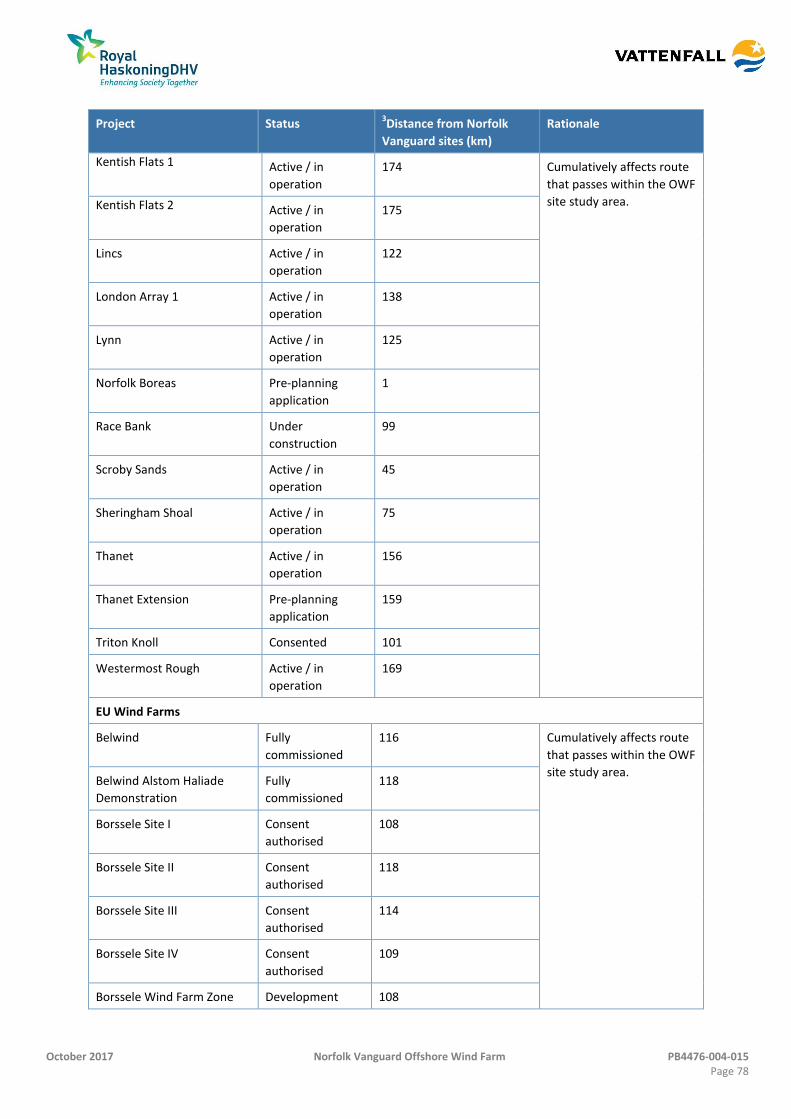
October 2017 Norfolk Vanguard Offshore Wind Farm PB4476-004-015 Page 78
Project Status 3Distance from Norfolk
Vanguard sites (km)
Rationale
Kentish Flats 1 Active / in
operation
174 Cumulatively affects route
that passes within the OWF
site study area. Kentish Flats 2 Active / in
operation
175
Lincs Active / in
operation
122
London Array 1 Active / in
operation
138
Lynn Active / in
operation
125
Norfolk Boreas Pre-planning
application
1
Race Bank Under
construction
99
Scroby Sands Active / in
operation
45
Sheringham Shoal Active / in
operation
75
Thanet Active / in
operation
156
Thanet Extension Pre-planning
application
159
Triton Knoll Consented 101
Westermost Rough Active / in
operation
169
EU Wind Farms
Belwind Fully
commissioned
116 Cumulatively affects route
that passes within the OWF
site study area. Belwind Alstom Haliade
Demonstration
Fully
commissioned
118
Borssele Site I Consent
authorised
108
Borssele Site II Consent
authorised
118
Borssele Site III Consent
authorised
114
Borssele Site IV Consent
authorised
109
Borssele Wind Farm Zone Development 108
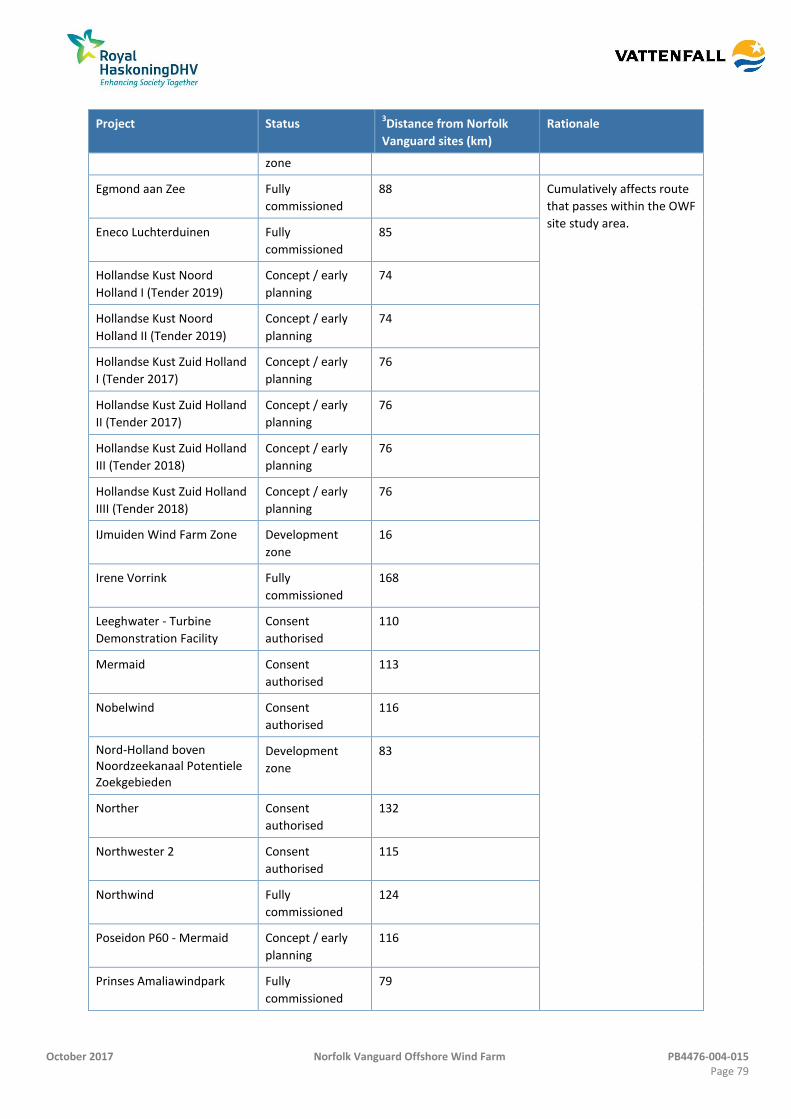
October 2017 Norfolk Vanguard Offshore Wind Farm PB4476-004-015 Page 79
Project Status 3Distance from Norfolk
Vanguard sites (km)
Rationale
zone
Egmond aan Zee Fully
commissioned
88 Cumulatively affects route
that passes within the OWF
site study area. Eneco Luchterduinen Fully
commissioned
85
Hollandse Kust Noord
Holland I (Tender 2019)
Concept / early
planning
74
Hollandse Kust Noord
Holland II (Tender 2019)
Concept / early
planning
74
Hollandse Kust Zuid Holland
I (Tender 2017)
Concept / early
planning
76
Hollandse Kust Zuid Holland
II (Tender 2017)
Concept / early
planning
76
Hollandse Kust Zuid Holland
III (Tender 2018)
Concept / early
planning
76
Hollandse Kust Zuid Holland
IIII (Tender 2018)
Concept / early
planning
76
IJmuiden Wind Farm Zone Development
zone
16
Irene Vorrink Fully
commissioned
168
Leeghwater - Turbine
Demonstration Facility
Consent
authorised
110
Mermaid Consent
authorised
113
Nobelwind Consent
authorised
116
Nord-Holland boven Noordzeekanaal Potentiele Zoekgebieden
Development
zone
83
Norther Consent
authorised
132
Northwester 2 Consent
authorised
115
Northwind Fully
commissioned
124
Poseidon P60 - Mermaid Concept / early
planning
116
Prinses Amaliawindpark Fully
commissioned
79
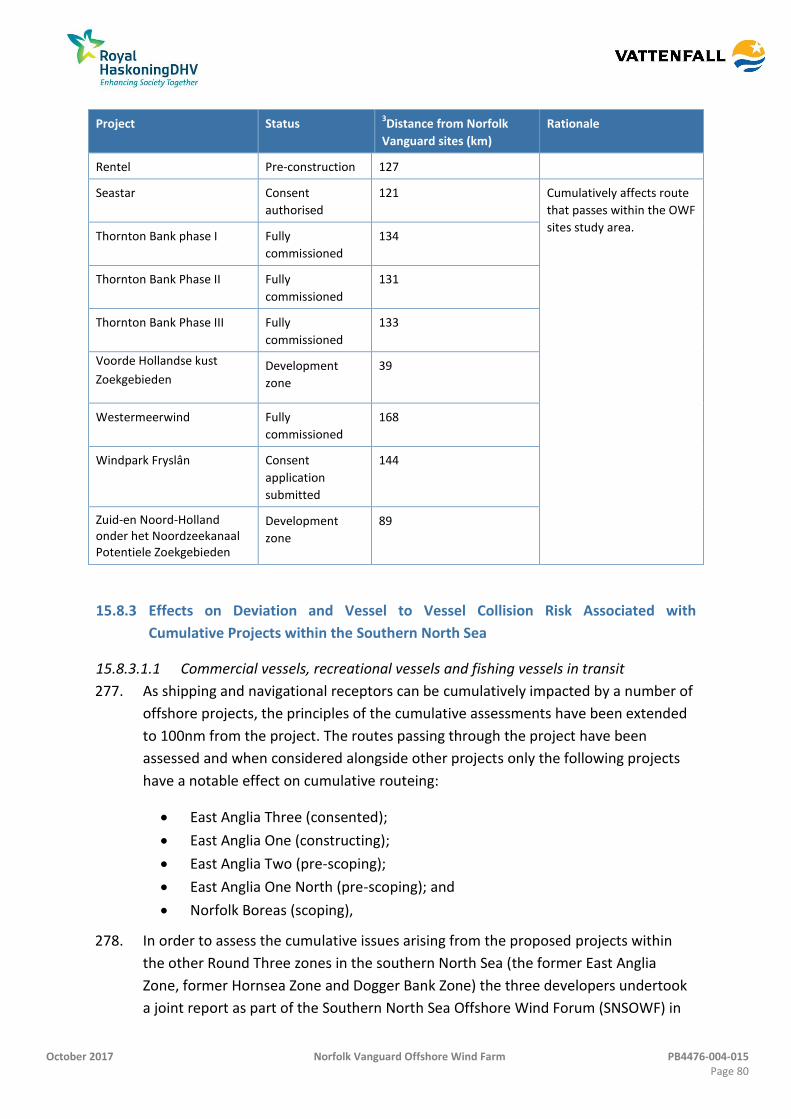
October 2017 Norfolk Vanguard Offshore Wind Farm PB4476-004-015 Page 80
Project Status 3Distance from Norfolk
Vanguard sites (km)
Rationale
Rentel Pre-construction 127
Seastar Consent
authorised
121 Cumulatively affects route
that passes within the OWF
sites study area. Thornton Bank phase I Fully
commissioned
134
Thornton Bank Phase II Fully
commissioned
131
Thornton Bank Phase III Fully
commissioned
133
Voorde Hollandse kust
Zoekgebieden Development
zone
39
Westermeerwind Fully
commissioned
168
Windpark Fryslân Consent
application
submitted
144
Zuid-en Noord-Holland onder het Noordzeekanaal Potentiele Zoekgebieden
Development
zone
89
Effects on Deviation and Vessel to Vessel Collision Risk Associated with 15.8.3
Cumulative Projects within the Southern North Sea
15.8.3.1.1 Commercial vessels, recreational vessels and fishing vessels in transit
277. As shipping and navigational receptors can be cumulatively impacted by a number of
offshore projects, the principles of the cumulative assessments have been extended
to 100nm from the project. The routes passing through the project have been
assessed and when considered alongside other projects only the following projects
have a notable effect on cumulative routeing:
East Anglia Three (consented);
East Anglia One (constructing);
East Anglia Two (pre-scoping);
East Anglia One North (pre-scoping); and
Norfolk Boreas (scoping),
278. In order to assess the cumulative issues arising from the proposed projects within
the other Round Three zones in the southern North Sea (the former East Anglia
Zone, former Hornsea Zone and Dogger Bank Zone) the three developers undertook
a joint report as part of the Southern North Sea Offshore Wind Forum (SNSOWF) in
October 2017 Norfolk Vanguard Offshore Wind Farm PB4476-004-015 Page 81
2013. This work is currently being updated by Norfolk Vanguard Ltd; however a
summary of cumulative routeing is considered within the Appendix 15.1.
279. The majority of traffic within the area is contained within IMO Routeing Measures
which have been left clear of cumulative development and therefore remains
undeviated. However it is noted that an increase in traffic within these routes may
be observed depending upon future traffic trends.
280. There are a number of developments located to the west of the project including
Triton Knoll (consented), Dudgeon (under construction), Race Bank (under
construction) and Sheringham Shoal (operational) whereby vessels are required to
navigate on distinct routes (due to water depths) through sand banks prior to
reaching them. This combined with the size of the projects and minimum deviation
associated with Triton Knoll, Race Bank, Dudgeon and Sheringham Shoal, means
there is not expected to be any cumulative impacts greater than those assessed for
the project in isolation.
281. Overall, given the separation distance from Round One and Two wind farms and
other mainland European wind farms and considering the cumulative routeing with
regards to other Round Three zones, the frequency of a collision incident occurring is
considered reasonably probable and of a moderate consequence meaning this
impact is considered to be tolerable with mitigation. However the change in
frequency for a base case level of traffic is 0.5% (i.e., the change between base case
and future case collision risk assuming no increase in traffic levels) demonstrating
that collision risk is already high within the area. Mitigation such as COLREGS
(IMO, 1972) and good seamanship ensure that in reality traffic operates safely within
the area and can continue to so. Going forward the cumulative situation will be
assessed for each of the projects as part of the updated SNSOWF report in Quarter
Three 2017.
282. It is noted that vessel to vessel collision risk (and all other impacts) has been
assessed using the worst case parameters as laid out in Table 15.10. The significance
of impacts are therefore likely to be less than assessed within this PEIR.
283. No impacts have been identified on cumulative displacement of fishing and
recreational activity, and thus collision risks. This is due to recreational and fishing
vessels in the majority transiting within the wind turbine arrays avoiding the majority
of displaced commercial traffic. Vessels related to the construction, operation and
maintenance or decommissioning of any of the cumulative projects will be managed
by the Marine Coordinators.
October 2017 Norfolk Vanguard Offshore Wind Farm PB4476-004-015 Page 82
Effects on Vessel to Structure Allision Risk Associated with Cumulative Projects 15.8.4
within the Southern North Sea
284. Following assessment of the cumulative routeing it has been identified that the
development of Norfolk Vanguard, Norfolk Boreas, East Anglia Three, East Anglia
One, East Anglia One North and East Anglia Two has the potential to cumulatively
impact upon navigational transits and thus to cumulatively increase vessel to
structure allision risk. Cumulative allision is considered to affect vessels transiting
within the cumulative study area including recreational and fishing vessels.
15.8.4.1 Alignment either side of the DWR
285. In order to facilitate vessel transits within the DWR, wind turbines adjacent to the
proposed navigational corridor must be aligned in a straight line. Lighting and
marking (of the proposed navigational corridor) requires consideration alongside
lighting of other projects in line with TH guidance to ensure that it aids vessel
navigation within the site. It is noted that non-linear boundaries and peripheral
turbines can cause negative effects on marine Radar and visual navigation by
obscuring or preventing position fixing. When defining layouts or phasing, Norfolk
Vanguard will give full consideration to navigational safety.
15.8.4.2 Cumulative lighting and marking causing confusion due to the proliferation of
AtoNs
286. As well as lighting and marking in general, cumulative lighting (notably the array
boundaries bordering the DWR) must be considered in order to minimise any
potential effects and avoid confusion from a proliferation of aids to navigation in a
high density development of turbines. The mariner would use SPS lights (similar to
entering a port) to navigate with, including fixing their position. Following agreement
on the final layout post consent, the applicant (for the project and other cumulative
sites) will identify aids to navigation, in consultation with TH, which are most
appropriate within the DWR.
15.8.4.3 NUC vessels within the DWR
287. Within the proposed navigational corridor, emergency anchoring (dependent on the
vessel’s speed) could be used to prevent allision with a structure. As an existing IMO
routeing measure the DWR is hazard free which will generally allow safe anchoring.
A vessel will have emergency anchoring procedures for areas where there may be
subsea hazards (such as port approaches), and these procedures would likely be
used within the proposed navigational corridor. It is noted that Rule 9 of COLREGS
(IMO, 1972) prevents anchoring within a narrow channel under normal conditions.
288. For other types of emergency incidents it is noted that the cumulative projects will
all be significant marine operations, with each including a variety of support vessels
October 2017 Norfolk Vanguard Offshore Wind Farm PB4476-004-015 Page 83
during the construction and operation and maintenance phases that will be able to
provide emergency support (noting potential downtime during periods of adverse
weather).
15.8.4.4 Differing design envelopes
289. Norfolk Boreas and East Anglia Three, given the different times at which they were
assessed, may include different design envelopes to that proposed for the project.
The final layout of the project may include differing size wind turbines, spacing and
floating foundations and therefore consideration would need to be given to the
alignment with wind turbines on directly opposing sides of an AfL area. This is to
ensure that the projects comply fully with MGN 543 and allow SAR functions to be
undertaken effectively.
290. The impact as a whole is considered to be of moderate consequence given the
potential for damage to be caused to vessels in the event of allision and reasonably
probable given the low frequency of occurrence. Therefore the impact is expected to
be tolerable with mitigation. Post consent discussions would include consideration
of cumulative lighting, consideration of directly adjacent wind farm boundaries and
alignment of wind turbines that face the DWR (in conjunction with TH) to ensure that
differing design envelopes do not adversely affect shipping and navigation.
291. No impacts have been identified on cumulative displacement of recreational or
fishing vessels in transit.
Diminishing Emergency Response Resources due to Cumulative Projects within the 15.8.5
Southern North Sea
292. With developments both within UK waters and transboundary developments there is
likely to be a collective increase in emergency response requirements within the
southern North Sea. However, it is likely that each individual development would
require its own self-help capability and therefore should be considered within the
project specific impacts as per section 15.7. Potentially there may be some overlap in
resources but this would be considered at a commercial and local level between
project developers. Therefore the severity of consequence is considered to be
moderate and the frequency of effect is considered to be reasonably probable.
Therefore the impact has been classed as tolerable which is not significant under EIA
terms, noting that each project defines and develops its own ERCoP and self-help
capability.
Transboundary Impacts 15.9
293. Transboundary impacts relate to impacts that may occur from an activity within one
EEA state on the environment or interests of another.
October 2017 Norfolk Vanguard Offshore Wind Farm PB4476-004-015 Page 84
294. Assessment of vessel routeing has identified that there was potential for significant
transboundary effects with regard to shipping and navigation from the project upon
the interests of other EEA states; however due to the international nature of
shipping and navigation this has been considered within the baseline (section 15.7)
and cumulative assessments (section 15.8).
295. It was identified that transboundary issues could arise from the project having an
effect upon commercial shipping routes transiting between the UK and other EEA
ports. This could also include impacts upon international ports, shipping routes and /
or routes affected by other international offshore renewable energy developments.
The potentially affected areas include ports within the southern North Sea. The
development of the project could affect routes operating between the UK and ports
located in the Netherlands, Denmark, Belgium and Germany. The results of the
vessel deviation assessments in the NRA identified some deviations for routes;
however the deviations identified were found to have no perceptible impacts (no
impact) on ports following consideration of the cumulative routeing scenarios. It is
noted that the project is located centrally within the southern North Sea and that
levels of displacement for vessel routeing were considered broadly acceptable.
296. All EU member states are consulted as part of the formal phases of consultation.
Dialogue with these authorities will continue to take place throughout the
development of the project in relation to transboundary impacts.
297. Rijkwaterstaat (see section 15.2) did respond to consultation noting general advice
with regards to development. This has been considered, however existing guidance
given by the MCA on the distance from routeing measures has been adhered to as a
priority in order to ensure consistency and alignment with other projects.
Inter-relationships 15.10
298. The following section identifies potential inter-relationships associated with shipping
and navigation and other identified effects associated with the development of the
proposed project. It should be noted that shipping and navigation as a receptor
contains a number of marine activities that are both transient in the form of a
navigating vessel as well as localised in terms of their activity, e.g. fishing vessels on
transit and fishing vessels engaged in fishing. This chapter has already considered
these receptors in their navigational or transient state and the following table
highlights any additional interrelationships with their localised activities.
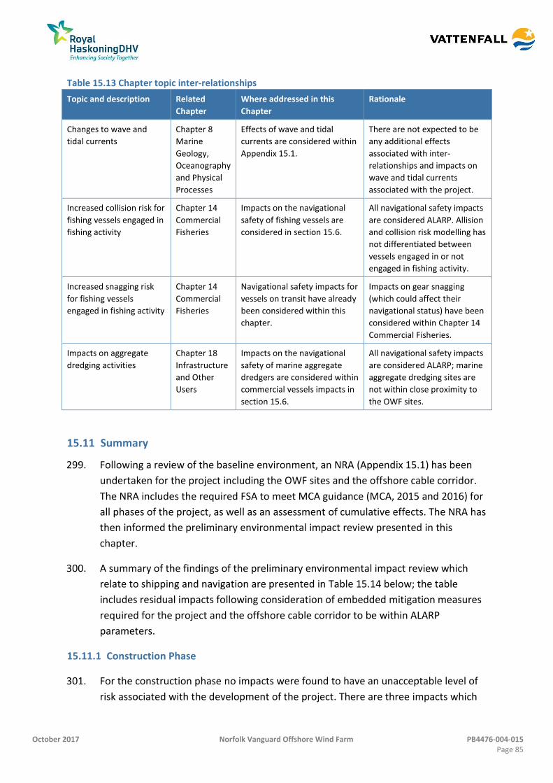
October 2017 Norfolk Vanguard Offshore Wind Farm PB4476-004-015 Page 85
Table 15.13 Chapter topic inter-relationships
Topic and description Related
Chapter
Where addressed in this
Chapter
Rationale
Changes to wave and
tidal currents
Chapter 8
Marine
Geology,
Oceanography
and Physical
Processes
Effects of wave and tidal
currents are considered within
Appendix 15.1.
There are not expected to be
any additional effects
associated with inter-
relationships and impacts on
wave and tidal currents
associated with the project.
Increased collision risk for
fishing vessels engaged in
fishing activity
Chapter 14
Commercial
Fisheries
Impacts on the navigational
safety of fishing vessels are
considered in section 15.6.
All navigational safety impacts
are considered ALARP. Allision
and collision risk modelling has
not differentiated between
vessels engaged in or not
engaged in fishing activity.
Increased snagging risk
for fishing vessels
engaged in fishing activity
Chapter 14
Commercial
Fisheries
Navigational safety impacts for
vessels on transit have already
been considered within this
chapter.
Impacts on gear snagging
(which could affect their
navigational status) have been
considered within Chapter 14
Commercial Fisheries.
Impacts on aggregate
dredging activities
Chapter 18
Infrastructure
and Other
Users
Impacts on the navigational
safety of marine aggregate
dredgers are considered within
commercial vessels impacts in
section 15.6.
All navigational safety impacts
are considered ALARP; marine
aggregate dredging sites are
not within close proximity to
the OWF sites.
Summary 15.11
299. Following a review of the baseline environment, an NRA (Appendix 15.1) has been
undertaken for the project including the OWF sites and the offshore cable corridor.
The NRA includes the required FSA to meet MCA guidance (MCA, 2015 and 2016) for
all phases of the project, as well as an assessment of cumulative effects. The NRA has
then informed the preliminary environmental impact review presented in this
chapter.
300. A summary of the findings of the preliminary environmental impact review which
relate to shipping and navigation are presented in Table 15.14 below; the table
includes residual impacts following consideration of embedded mitigation measures
required for the project and the offshore cable corridor to be within ALARP
parameters.
Construction Phase 15.11.1
301. For the construction phase no impacts were found to have an unacceptable level of
risk associated with the development of the project. There are three impacts which
October 2017 Norfolk Vanguard Offshore Wind Farm PB4476-004-015 Page 86
have a tolerable effect on shipping and navigation. These are summarised below. All
other impacts are broadly acceptable or have no impact.
302. Effects on vessel routeing and / or displacement associated with OWF sites,
interconnector and array cables have a tolerable level of impact on commercial
vessels. This is due to the frequency at which a commercial vessel would likely be
deviated due to the presence of buoyed construction area; however consequences
of these deviations would be minor with no navigational safety impacts associated.
This therefore means that the impact is tolerable and does not require additional
mitigation (to manage safety) aside for that already agreed to as embedded
mitigation such as promulgation of information which allows mariners to effectively
passage plan to minimise impacts.
303. Given the increase in commercial vessel deviations there is also a potential for
increased vessel to vessel collision when considered alongside the location of the
DR1 Lightbuoy DWR and the expected level of construction vessels associated with
the project. This impact is considered tolerable with mitigation, with management of
construction traffic (including the creation of construction vessel routeing and
entry/exit points into the OWF sites) and as part of the marine coordination process
to ensure that the risk is ALARP.
304. The impact of diminishing emergency response resources is considered to be
moderate due to the potential for moderate damage to vessels, multiple or single
serious injuries and Tier 2 pollution incidents which require assistance. There are not
expected to be any perceptible impacts associated with the offshore cable corridor.
305. Mitigation of this impact includes effective emergency response planning and self-
help capabilities including compliance with MGN 543, development of an ERCoP; and
a gap analysis to identify resources which may be required.
Operation and Maintenance Phase 15.11.2
306. For the operation and maintenance phase there were no impacts considered to have
unacceptable risks associated with the development of the project. Two impacts
were identified to have tolerable levels of effect including, as with the construction
phase, commercial vessel deviations. These deviations were frequent but of low
consequence and therefore require no additional mitigation to bring them within
ALARP parameters.
307. Allision risk with fishing vessels was also identified as a tolerable impact due to the
potential for large tensioned leg floating platforms to be used within the OWF sites
which when considered against the potential for commercial fishing vessels to transit
within the wind turbine array requires further consideration of foundation design
October 2017 Norfolk Vanguard Offshore Wind Farm PB4476-004-015 Page 87
post consent to ensure it does not impact on allision and under keel clearance. This
will be secured as part of the layout sign off process (with MMO and in conjunction
with MCA) and cable burial risk assessments included as part of the DCO. This will
ensure this impact remains in tolerable parameters.
308. It is noted that during the operation and maintenance phase vessel numbers (and
personnel numbers) working on the project will be lower than during the
construction or decommissioning phases, thus reducing the vessel to vessel collision
risk but also diminishing emergency response resources.
Decommissioning Phase 15.11.3
309. For the decommissioning phase the assessment of effects was similar to the
construction phase with no unacceptable impacts and identical tolerable impacts
(three) that would be mitigated in the same way to ALARP parameters.
310. It is noted that the worst case scenario assumes the offshore export cable(s) would
be left in situ reducing the number of vessels on site but requiring future case
monitoring to ensure that cable remain buried and/or protected.
Cumulative Impacts 15.11.4
311. All cumulative impacts are tolerable and so the impacts do not require further
mitigation to reduce risk to ALARP levels. Vessel deviation and displacement, and any
subsequent vessel to vessel collision risk would require additional mitigation of
traffic management (at a project level) to ensure that cumulative project
development does not adversely affect a vessel’s safe passage through the southern
North Sea area.
312. Cumulative allision risk is only associated with projects within the former East Anglia
Zone, notably Norfolk Vanguard, Norfolk Boreas, East Anglia One, East Anglia Two,
East Anglia Three and East Anglia One North and can be mitigated with further
consideration of cumulative lighting, consideration of MGN 543 with regard to
directly adjacent wind farm boundaries, and straight line edges of projects bordering
the DR1 Lightbuoy DWR.
313. As with diminishing emergency response resources being impacted by the project in
isolation, cumulative developments may also have an impact and should again be
mitigated by each project effectively managing its own ERPs and self-help capability.
314. The transboundary impacts, relating to impacts that may occur from an activity
within one EEA state on the environment or interests of another, have been assessed
in regard to shipping and navigation.
October 2017 Norfolk Vanguard Offshore Wind Farm PB4476-004-015 Page 88
315. It was identified that transboundary issues could arise from the project having an
effect upon commercial shipping routes transiting between the UK and other EEA
ports. However given the minor deviations expected and the distance of the project
from the UK or mainland Europe coastline there are not expected to be any
perceptible impacts.
Inter-Related Impacts 15.11.5
316. Inter-related effects associated with shipping and navigation have been identified in
this chapter and are provided in
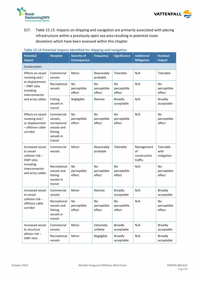
October 2017 Norfolk Vanguard Offshore Wind Farm PB4476-004-015 Page 89
317. Table 15.13. Impacts on shipping and navigation are primarily associated with placing
infrastructure within a previously open sea area resulting in potential route
deviations which have been assessed within this chapter.
Table 15.14 Potential impacts identified for shipping and navigation
Potential
Impact
Receptor Severity of
Consequence
Frequency Significance Additional
Mitigation
Residual
Impact
Construction
Effects on vessel
routeing and /
or displacement
– OWF sites
including
interconnector
and array cables
Commercial
vessels
Minor Reasonably
probable
Tolerable N/A Tolerable
Recreational
vessels
No
perceptible
effect
No
perceptible
effect
No
perceptible
effect
N/A No
perceptible
effect
Fishing
vessels in
transit
Negligible Remote Broadly
acceptable
N/A Broadly
acceptable
Effects on vessel
routeing and /
or displacement
– offshore cable
corridor
Commercial
vessels,
recreational
vessels and
fishing
vessels in
transit
No
perceptible
effect
No
perceptible
effect
No
perceptible
effect
N/A No
perceptible
effect
Increased vessel
to vessel
collision risk –
OWF sites
including
interconnector
and array cables
Commercial
vessels
Minor Reasonably
probable
Tolerable Management
of
construction
traffic.
Tolerable
with
mitigation
Recreational
vessels and
fishing
vessels in
transit
No
perceptible
effect
No
perceptible
effect
No
perceptible
effect
N/A No
perceptible
effect
Increased vessel
to vessel
collision risk –
offshore cable
corridor
Commercial
vessels
Minor Remote Broadly
acceptable
N/A Broadly
acceptable
Recreational
vessels and
fishing
vessels in
transit
No
perceptible
effect
No
perceptible
effect
No
perceptible
effect
N/A No
perceptible
effect
Increased vessel
to structure
allision risk –
OWF sites
Commercial
vessels
Minor Extremely
unlikely
Broadly
acceptable
N/A Broadly
acceptable
Recreational
vessels
Minor Negligible Broadly
acceptable
N/A Broadly
acceptable
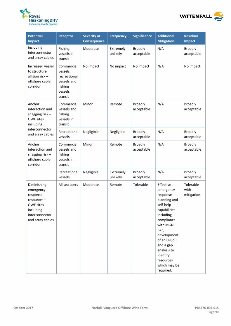
October 2017 Norfolk Vanguard Offshore Wind Farm PB4476-004-015 Page 90
Potential
Impact
Receptor Severity of
Consequence
Frequency Significance Additional
Mitigation
Residual
Impact
including
interconnector
and array cables
Fishing
vessels in
transit
Moderate Extremely
unlikely
Broadly
acceptable
N/A Broadly
acceptable
Increased vessel
to structure
allision risk –
offshore cable
corridor
Commercial
vessels,
recreational
vessels and
fishing
vessels
transit
No impact No impact No impact N/A No impact
Anchor
interaction and
snagging risk –
OWF sites
including
interconnector
and array cables
Commercial
vessels and
fishing
vessels in
transit
Minor Remote Broadly
acceptable
N/A Broadly
acceptable
Recreational
vessels
Negligible Negligible Broadly
acceptable
N/A Broadly
acceptable
Anchor
interaction and
snagging risk –
offshore cable
corridor
Commercial
vessels and
fishing
vessels in
transit
Minor Remote Broadly
acceptable
N/A Broadly
acceptable
Recreational
vessels
Negligible Extremely
unlikely
Broadly
acceptable
N/A Broadly
acceptable
Diminishing
emergency
response
resources –
OWF sites
including
interconnector
and array cables
All sea users Moderate Remote Tolerable Effective
emergency
response
planning and
self-help
capabilities
including
compliance
with MGN
543,
development
of an ERCoP;
and a gap
analysis to
identify
resources
which may be
required.
Tolerable
with
mitigation
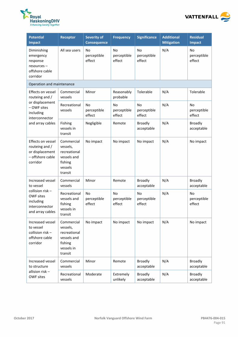
October 2017 Norfolk Vanguard Offshore Wind Farm PB4476-004-015 Page 91
Potential
Impact
Receptor Severity of
Consequence
Frequency Significance Additional
Mitigation
Residual
Impact
Diminishing
emergency
response
resources –
offshore cable
corridor
All sea users No
perceptible
effect
No
perceptible
effect
No
perceptible
effect
N/A No
perceptible
effect
Operation and maintenance
Effects on vessel
routeing and /
or displacement
– OWF sites
including
interconnector
and array cables
Commercial
vessels
Minor Reasonably
probable
Tolerable N/A Tolerable
Recreational
vessels
No
perceptible
effect
No
perceptible
effect
No
perceptible
effect
N/A No
perceptible
effect
Fishing
vessels in
transit
Negligible Remote Broadly
acceptable
N/A Broadly
acceptable
Effects on vessel
routeing and /
or displacement
– offshore cable
corridor
Commercial
vessels,
recreational
vessels and
fishing
vessels
transit
No impact No impact No impact N/A No impact
Increased vessel
to vessel
collision risk –
OWF sites
including
interconnector
and array cables
Commercial
vessels
Minor Remote Broadly
acceptable
N/A Broadly
acceptable
Recreational
vessels and
fishing
vessels in
transit
No
perceptible
effect
No
perceptible
effect
No
perceptible
effect
N/A No
perceptible
effect
Increased vessel
to vessel
collision risk –
offshore cable
corridor
Commercial
vessels,
recreational
vessels and
fishing
vessels in
transit
No impact No impact No impact N/A No impact
Increased vessel
to structure
allision risk –
OWF sites
Commercial
vessels
Minor Remote Broadly
acceptable
N/A Broadly
acceptable
Recreational
vessels
Moderate Extremely
unlikely
Broadly
acceptable
N/A Broadly
acceptable
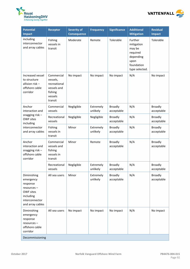
October 2017 Norfolk Vanguard Offshore Wind Farm PB4476-004-015 Page 92
Potential
Impact
Receptor Severity of
Consequence
Frequency Significance Additional
Mitigation
Residual
Impact
including
interconnector
and array cables
Fishing
vessels in
transit
Moderate Remote Tolerable Further
mitigation
may be
required
depending
upon
foundation
type selected.
Tolerable
Increased vessel
to structure
allision risk –
offshore cable
corridor
Commercial
vessels,
recreational
vessels and
fishing
vessels
transit
No impact No impact No impact N/A No impact
Anchor
interaction and
snagging risk –
OWF sites
including
interconnector
and array cables
Commercial
vessels
Negligible Extremely
unlikely
Broadly
acceptable
N/A Broadly
acceptable
Recreational
vessels
Negligible Negligible Broadly
acceptable
N/A Broadly
acceptable
Fishing
vessels in
transit
Minor Extremely
unlikely
Broadly
acceptable
N/A Broadly
acceptable
Anchor
interaction and
snagging risk –
offshore cable
corridor
Commercial
vessels and
fishing
vessels in
transit
Minor Remote Broadly
acceptable
N/A Broadly
acceptable
Recreational
vessels
Negligible Extremely
unlikely
Broadly
acceptable
N/A Broadly
acceptable
Diminishing
emergency
response
resources –
OWF sites
including
interconnector
and array cables
All sea users Minor Extremely
unlikely
Broadly
acceptable
N/A Broadly
acceptable
Diminishing
emergency
response
resources –
offshore cable
corridor
All sea users No impact No impact No impact N/A No impact
Decommissioning
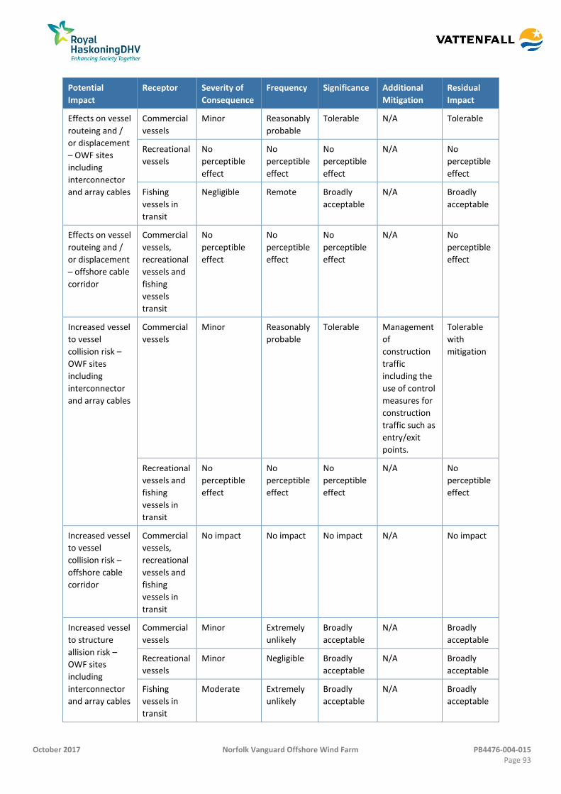
October 2017 Norfolk Vanguard Offshore Wind Farm PB4476-004-015 Page 93
Potential
Impact
Receptor Severity of
Consequence
Frequency Significance Additional
Mitigation
Residual
Impact
Effects on vessel
routeing and /
or displacement
– OWF sites
including
interconnector
and array cables
Commercial
vessels
Minor Reasonably
probable
Tolerable N/A Tolerable
Recreational
vessels
No
perceptible
effect
No
perceptible
effect
No
perceptible
effect
N/A No
perceptible
effect
Fishing
vessels in
transit
Negligible Remote Broadly
acceptable
N/A Broadly
acceptable
Effects on vessel
routeing and /
or displacement
– offshore cable
corridor
Commercial
vessels,
recreational
vessels and
fishing
vessels
transit
No
perceptible
effect
No
perceptible
effect
No
perceptible
effect
N/A No
perceptible
effect
Increased vessel
to vessel
collision risk –
OWF sites
including
interconnector
and array cables
Commercial
vessels
Minor Reasonably
probable
Tolerable Management
of
construction
traffic
including the
use of control
measures for
construction
traffic such as
entry/exit
points.
Tolerable
with
mitigation
Recreational
vessels and
fishing
vessels in
transit
No
perceptible
effect
No
perceptible
effect
No
perceptible
effect
N/A No
perceptible
effect
Increased vessel
to vessel
collision risk –
offshore cable
corridor
Commercial
vessels,
recreational
vessels and
fishing
vessels in
transit
No impact No impact No impact N/A No impact
Increased vessel
to structure
allision risk –
OWF sites
including
interconnector
and array cables
Commercial
vessels
Minor Extremely
unlikely
Broadly
acceptable
N/A Broadly
acceptable
Recreational
vessels
Minor Negligible Broadly
acceptable
N/A Broadly
acceptable
Fishing
vessels in
transit
Moderate Extremely
unlikely
Broadly
acceptable
N/A Broadly
acceptable

October 2017 Norfolk Vanguard Offshore Wind Farm PB4476-004-015 Page 94
Potential
Impact
Receptor Severity of
Consequence
Frequency Significance Additional
Mitigation
Residual
Impact
Increased vessel
to structure
allision risk –
offshore cable
corridor
Commercial
vessels,
recreational
vessels and
fishing
vessels
transit
No impact No impact No impact N/A No impact
Anchor
interaction and
snagging risk –
OWF site
including
interconnector
and array cables
Commercial
vessels and
fishing
vessels in
transit
Minor Extremely
unlikely
Broadly
acceptable
N/A Broadly
acceptable
Recreational
vessels
Negligible Negligible Broadly
acceptable
N/A Broadly
acceptable
Anchor
interaction and
snagging risk –
offshore cable
corridor
Commercial
vessels and
fishing
vessels in
transit
Minor Remote Broadly
acceptable
N/A Broadly
acceptable
Recreational
vessels
Negligible Extremely
unlikely
Broadly
acceptable
N/A Broadly
acceptable
Diminishing
emergency
response
resources –
OWF sites
including
interconnector
and array cables
All sea users Moderate Remote Tolerable Effective
emergency
response
planning and
self-help
capabilities
Tolerable
with
mitigation
Diminishing
emergency
response
resources –
offshore cable
corridor
All sea users No
perceptible
effect
No
perceptible
effect
No
perceptible
effect
N/A No
perceptible
effect
Cumulative
Effects on
deviation and
vessel and
vessel collision
risk associated
with cumulative
projects within
the southern
North Sea
Commercial
vessels,
recreational
vessels and
fishing
vessels in
transit
Moderate Reasonably
probable
Tolerable Management
of
construction
traffic
Tolerable
with
mitigation
October 2017 Norfolk Vanguard Offshore Wind Farm PB4476-004-015 Page 95
Potential
Impact
Receptor Severity of
Consequence
Frequency Significance Additional
Mitigation
Residual
Impact
Effects on vessel
to structure
allision risk
associated with
cumulative
projects within
the southern
North Sea
Commercial
vessels,
recreational
vessels and
fishing
vessels in
transit
Moderate Reasonably
probable
Tolerable Consideration
of cumulative
lighting,
consideration
of MGN 543
with regard
to directly
adjacent wind
farm
boundaries
and straight
line edges of
projects
bordering the
DR1
Lightbuoy
DWR.
Tolerable
with
mitigation
Diminishing
emergency
response
resources due
to cumulative
projects within
the southern
North Sea
Commercial
vessels,
recreational
vessels and
fishing
vessels in
transit
Moderate Reasonably
probable
Tolerable Effective
emergency
response
planning and
self-help
capabilities
Tolerable
with
mitigation
Transboundary
Effects on
deviation
causing
transboundary
impacts at
mainland
European ports.
Commercial
vessel
routeing.
No
perceptible
effect
No
perceptible
effect
No
perceptible
effect
N/A No
perceptible
effect
October 2017 Norfolk Vanguard Offshore Wind Farm PB4476-004-015 Page 96
References 15.12
Anatec. (2016) ShipRoutes Software. Aberdeen: Anatec.
Anatec. (2017) Navigation Risk Assessment Norfolk Vanguard Offshore Wind Farm. Aberdeen: Anatec.
BEIS. (2012) The Recreational Craft Directives 94/25/EC and 2003/44/EC, London: BEIS.
DECC. (2011) Standard Marking Schedule for Offshore Installations, London: DECC.
DECC. (2011a) National Policy Statement for Renewable Energy Infrastructure (EN-3), London: DECC.
DECC. (2011b) Overarching National Policy Statement for Energy (EN-1). London, DECC.
East Anglia Offshore Wind (EAOW) (2012a) East Anglia Offshore Wind Zonal Environmental Appraisal Report March 2012
HM Government (2011). Marine Policy Statement. Available at: https://www.gov.uk/government/uploads/system/uploads/attachment_data/file/69322/pb3654-marine-policy-statement-110316.pdf
IALA. (2013) O-139 the Marking of Man-Made Offshore Structures, Edition 2. Saint Germain en Laye, France: IALA.
IMO. (1972) Convention on the International Regulations for Preventing Collisions at Sea (COLREGS), London: IMO.
IMO. (1974) International Convention for the Safety of Life at Sea (SOLAS), London: IMO.
IMO. (1979) International Convention on Maritime Search and Rescue (SAR), London: IMO.
IMO. (1988) International Convention for the Safety of Life at Sea (SOLAS) 1988 Amendments, London: IMO.
IMO. (1989) International Convention on Salvage, London: IMO.
IMO. (2002) Guidelines for Formal Safety Assessment (FSA) for Use in the IMO Rule Making Process, London: IMO.
MCA (2015). Methodology for Assessing the Marine Navigational Safety Risks of Offshore Wind Farms, Southampton: MCA.
MCA. (2006) National Contingency Plan for Marine Pollution for Shipping And Offshore Installations, Southampton: MCA.
MCA. (2008) Marine Guidance Notice 372 (MGN 372 M+F) Offshore Renewable Energy Installations (OREIs): Guidance to Mariners Operating in the Vicinity of UK OREIs, Southampton: MCA.
MCA. (2016) Marine Guidance Note (MGN 543 (M+F)). Southampton: MCA.
RYA. (2016) UK Coastal Atlas of Recreational Boating, Updated 2016, Southampton: RYA. GIS Shape files dated 2016.
UKHO. (2016). Admiralty Sailing Directions – North Sea (West) Pilot NP5, Somerset: UKHO.