Embed Size (px)
Citation preview

04-SOL-12 PM 19.3/10-SAC-12 PM 5.8
ATTACHMENT G – PRELIMINARY ENVIRONMENTAL STUDY


Preliminary Environmental Study
Project Information District 4 County Solano/ Sacramento Route SR-12 Post Mile 19.3/5.8 EA 04-4A490K Project Title: State Route-12 Realignment and Rio Vista Bridge Reconstruction
Project Manager: Steve Mislinski Phone # (916) 635-5233
Project Engineer: Keen Poong Phone # (408) 886-9500
Study Prepared by: Bill Mayer, Amberly Morgan Phone # (916) 630-4600 Project Description The project study limits extend easterly from State Route 113 (Sol-19.3) west of Rio Vista to the Mokelumne River (Sac-5.8) as shown in the vicinity map. The section of SR12 within the study limits, along with the existing river bridge, provide an important link along Route 12 between Interstate 80 in the North Bay Area of Solano County and the Interstate 5 corridor servicing Sacramento and San Joaquin Counties, as well as the Central Valley Region. The existing roadway alignment carries traffic through the City of Rio Vista adjacent to the City’s central business district, and the river crossing is considered to be a “gateway” to both Solano County and the Bay Area due to its significance within the larger regional transportation system. As such, the route facilitates inter- and intra-regional traffic, as well as traffic between counties. For example, east Contra Costa County commuters use the bridge as a link to Solano County, while residents of Solano County (including Rio Vista) use the bridge in the opposite direction, commuting to Contra Costa County and the Central Valley. In addition, commuters and commercial truck traffic use the bridge and Highway 12 as a direct link between the Central Valley and the Bay Area. The study was initiated by the Solano Transportation Authority (STA) at the request of the City of Rio Vista with funding provided by the City through Federal Demonstration funds. Oversight by Caltrans District 4 was terminated, as the project is not currently in the Regional Transportation Plan. This report documents the first step in identifying feasible alignment alternatives for an improved State Route 12 (SR12) crossing of the Sacramento River in the vicinity of the City of Rio Vista. In addition, the current study reassesses alternatives that were considered as part of a 1994 Project Study Report (PSR) level study with respect to potential impacts on existing and planned development as well as to environmental, river navigation and engineering constraints, and investigates revised routes to minimize these impacts. This report provides background information regarding previous studies undertaken to investigate improvements to SR12 and the Sacramento River crossing at Rio vista, and summarizes proposed alignment alternatives to be further investigated during the Project Approval and Environmental Documentation (PA/ED) phase. This study will serve as a supplement to the SR12 Major Investment Study from Interstate 80 to Interstate 5 which is proposed to fulfill the Project Initiation Document (PID) requirement for authorization to proceed with PA/ED. With the combined documents as stated above serving as the PID, this report will be used to program the support costs needed from State Transportation Improvement Plan (STIP) to conduct the PA/ED phase.

04-4A490K February 1, 2010
Purpose and Need: The existing SR 12 facility carries large volumes of traffic through the City of Rio Vista, between the Central Valley, Solano County and the Bay Area. The existing facility is a 2-lane road with narrow shoulders and lacks turning lanes at intersections. The existing Rio Vista Bridge on SR 12 at the Sacramento River has limited vertical clearance between the waterway and the structure which presents a navigation hazard and requires that the bridge be operated to allow passage of nearly all water vessels. These circumstances form a basis of need for increasing highway capacity through Rio Vista and across the Sacramento River, relieving waterway traffic conflicts with the bridge, and improving traffic operational safety.
The purpose of the project is to:
• Improve Traffic Capacity
• Minimize Navigation Hazards and Surface/River Transportation Conflicts
• Preserve Travel Safety
Alternatives: This preliminary alignment/corridor assessment documents the first phase for the SR12 Realignment/Rio Vista Bridge Preliminary Study and establishes feasible alignment alternatives for further study in the next phase of the project. The study has assessed various alignment alternatives based on current and planned land use, as well as environmental and engineering constraints. The study includes a reassessment of alignment alternatives considered as part of the Preliminary Site Selection Study that was completed in December, 1992 and the subsequent Project Feasibility Report (1994 PSR level document) that was completed in October, 1994, both of which were initiated by the City of Rio Vista and overseen by Caltrans District 10. Based on review of the previously studied alignments and current constraints, five (5) alternatives, including the No Build Alternative, are further assessed, and three (3) of the four (4) alignment alternatives shown in Preliminary Engineering Report (Alternative 2, 3, & 5) are recommended to be further developed and assessed in more detail during the project environmental phase. Anticipated Environmental Approval Anticipated CEQA environmental documentation will be an Environmental Impact Report (EIR). The CEQA process will require a 45-day public review period prior to approval of the environmental document. Anticipated NEPA environmental documentation will be an Environmental Impact Statement (EIS) leading to approval of a Record of Decision (ROD). Joint preparation of CEQA and NEPA environmental documentation is anticipated. It is expected that Project Approval and Environmental Document (PA/ED) approval will take 30 to 36 months to complete. The project is located in a rural area, although urbanization has occurred in the vicinity and development projects are approved and/or proposed within or adjacent to the alternative alignments. Anticipated Environmental Approval CEQA NEPA
Categorical Exemption/Statutory Exemption Categorical Exclusion/Programmatic CE Negative Declaration/Mitigated ND Finding of No Significant Impact Environmental Impact Report Environmental Impact Statement

04-4A490K February 1, 2010
PSR Summary Statement Focused studies for each project alternative will include farmland, water quality, traffic, noise, air quality/greenhouse gas emissions, paleontology, cultural resources (Historic Property Survey Report, Historic Resources Evaluation Report, Archaeological Survey Report), Initial Site Assessment (hazardous wastes), geotechnical, biological resources (special status species/biological assessment, wetlands delineation, Natural Environment Study), socioeconomic/population/housing (Community Impact Assessment/Environmental Justice), Visual Impact Assessment, Floodplain Study Report, Location Hydraulic Study, Energy, Relocation Impact Study and Section 4(f) Evaluation). Key issues associated with the project alternatives include air quality and greenhouse gas emission assessments. The significant increase in traffic volumes to meet Year 2025 conditions or beyond could cause violations of local carbon monoxide (CO) concentration standards. Sensitive receptors for air quality impacts are currently located in the vicinity. An air quality analysis will be required to determine project-specific impacts, conformity and mitigation. In addition, the air quality analysis will include an analysis of Mobile Source Air Toxics, based on FHWA guidance. Short-term mitigation measures may be necessary to mitigate construction-related emissions. The project’s effects on energy resources, including energy consumption, will need to be estimated. Finally, an assessment of the project’s effects on global climate changes will need to be conducted. Potential noise issues are expected from the alternatives. Sensitive receptors for noise impacts are currently located in the vicinity of all alternatives. A technical noise analysis will be required. Noise mitigation will be necessary to protect sensitive receptors. Traffic conditions are expected to change significantly with the new bridge and roadway facilities. Some of the alternatives serve as bypass roadways around the City of Rio Vista. All of the alternatives serve to increase capacity and improve future operational conditions and level of service, significantly enhancing the transportation services provided by SR-12, including reducing delay associated with crossing the Sacramento River. A Traffic Forecast Report and Traffic Operations Report will be required to analysis the forecast traffic effects on the region. An Initial Site Assessment will be required to determine the potential presence of hazardous wastes within the study area for the alternatives. A government records search and site survey will be required. Pesticides, herbicides, and insecticides used on agricultural lands may have left residual hazardous wastes in the soil. Aerially deposited lead in soil, lead paint on structures, asbestos components on the existing structures, and other potential hazardous wastes should also be investigated. Various geotechnical and soil conditions are present throughout the study area. Unstable soil conditions are present in some of the undeveloped hillsides, wetland/marsh areas and agricultural lands. Seismic conditions could also create challenging roadway and bridge development constraints. A geotechnical study will be required to evaluate soil conditions/differential settlement/expansive conditions, seismic hazards (earthquake faulting, liquefaction) and landslide constraints throughout the study area. The project site is located within a large drainage shed where numerous drainages convey surface runoff that ultimately discharges runoff into the Sacramento River. Hydraulic/hydrologic studies will need to be conducted to determine the amount of runoff generated from new paved surfaces and the effect on existing drainage facilities. Also, studies will need to be conducted to determine the effects of the new bridge/support foundations (piers/piles) and their effect on the Sacramento River hydraulics and water surface elevation. A Location Hydraulic Study and Floodplain Study Report will need to be prepared. While additional runoff will be generated by the new bridge and roadway, the additional runoff can be
04-4A490K February 1, 2010
addressed through the application of standard water quality measures and Best Management Practices. A Water Quality Assessment Report will need to be prepared. A Natural Environment Study will be required to address general biological resources, including both plant and wildlife species. Existing ground squirrel burrows should be inspected for the presence of burrowing owls (surveys can be conducted throughout the year). Swainson’s hawk preconstruction surveys should be conducted based on tree removal activities (surveys between March-September). Bird surveys should be completed in the spring/summer season. Valley elderberry longhorn beetle (VELB) species is known to occur within the project area and will need to be surveyed. Giant garter snake habitat is likely present and will require surveys during the spring/summer season. Some of the large expanses of annual grasslands may contain vernal pool habitat. Vernal pools provide habitat for State listed and federally listed fairy shrimp, vernal pool tadpole shrimp, Conservancy shrimp and special status plant species. These pools and the associated upland habitat may also provide suitable habitat for federally listed California tiger salamander. Reaches of the Sacramento River provide migratory habitat for special status species including green sturgeon, delta smelt, steelhead, and chinook salmon. Formal Section 7 consultation with the United States Fish and Wildlife Service (USFWS) and the National Marine Fisheries Service (NMFS) would be necessary concluding in the issuance of Biological Opinions (BO). Several native trees occur along the alternative alignment and may be removed. Special status plants species may occur in, and along the banks of, the water features in the study area. CNDDB records document occurrences of Mason’s lilaeopsis, delta tule pea, and Suisun marsh aster, along the east bank of the Sacramento River. Regulatory permits will be required for this project. A formal delineation should be conducted to verify the status of jurisdictional waters in the project area. If it determined jurisdictional waters occur in the project area and will be impacted by the project, regulatory permits from the U.S. Army Corps of Engineers, Regional Water Quality Control Board, and California Department of Fish and Game may be required. For visual/aesthetics, some of the alternative alignments will modify the existing natural conditions and/or established urban environment. The proj3ect could have an adverse affect on designated visual or scenic resources should they be present within or adjacent to the project area. Farmland impacts and tree losses (native oak and non-native) are expected with all the alternatives. Although these resources have no scenic designation, the impact may be a local community concern (in addition to biological) and farmland/tree replacement options should receive input from the community. Cultural resource studies may be needed to address requirements of Section 106 of the National Historic Preservation Act. A Historic Property Survey Report (HPSR), an Archaeological Survey Report (ASR), and a Historic Resources Evaluation Report (HRER) should be prepared (including Native American consultation) to address the potential for impacts to historic and pre-historic resources. Background research identified a number of resources in the study area. These include the potential for a historical cultural landscape associated with agriculture and recreation, numerous buildings in the older section of Rio Vista, the Rio Vista Army Reserve Center, various historical archaeological sites, cemeteries, subdivisions older than 50 years, historic farms/farmhouses, and sunken historic vessels (shipwrecks) in the Sacramento River. During the PA/ED phase, a determination will be made regarding exemption of properties in consultation with Caltrans Professionally Qualified Staff (PQS). If the project has an impact on National Register eligible properties, a Section 4(f) Evaluation may be needed. Unique paleontological resources have been identified in Quaternary-aged alluvial deposits in the Rio Vista area. Although no specific paleontological resources have been identified on the project site, a Paleontological Identification Report (PIR) would be prepared and certified by a qualified paleontologist to document the identification efforts for paleontological resources and the need for paleontological monitoring during construction activities based on the alternative being reviewed.

04-4A490K February 1, 2010
The project is expected to have an affect on the local community or the economy. At present, there are several existing businesses and commercial uses in the study area that will be impacted by some alternatives. Proposed improvements will cause direct or indirect effects on an established neighborhood or community and could affect group that might be subject to issues involving environmental justice. Also, alternatives serving as bypass roadways will have some impact on the economic health of the existing businesses. Likewise, alternatives that increase traffic through downtown Rio Vista could also impact the business community either by increasing congestion and degrading commercial access, or by providing additional exposure and improving business opportunities. A Community Impact Assessment (including Environmental Justice and economic assessments) and a Draft Relocation Impact Study will be required. The study area includes a substantial amount of farmlands. These farmlands could be affected by all alternatives, particularly on the east side of the river. A Farmland Conversion Study will be necessary to assess the effects from loss of any prime, unique or local importance farmlands as well as land under Williamson Act Contracts. Biological Resources Summary of Findings LSA Associates, Inc. (LSA) conducted a biological records search, and a reconnaissance level survey of the Rio Vista Bridge study area to prepare this biological resources summary of findings. The biological records search included queries of the California Natural Diversity Data Base and the California Native Plant Society (CNPS) lists for sensitive plant and wildlife species in the vicinity, as well as review of U.S. Fish and Wildlife Service lists of federally listed species. The reconnaissance level survey of the alignment corridor was conducted by vehicle. Inaccessible areas were surveyed by vehicle windshield and review of aerial photography. Accessible portions of the areas that may support biological resources were surveyed on foot. For this survey, the study area was divided into two areas, based on the two distinct habitats that occur there. These habitats are located on the east and west side of the Sacramento River. The east side is characterized as farmland. Farmland is primarily composed of row crops that rely on supplemental irrigation water. The west side of the river is characterized as ranchland. Ranchland is annual grassland that supports livestock and commonly includes meandering creeks and localized wetlands that provide supplemental water for livestock. Rural residences also occur in the two habitat areas. LSA identified the following biological resources in the study area: Farmland Habitat • The drainages and sloughs that occur on the east side of the Sacramento River may be considered
jurisdictional waters. These waters may be regulated by the Army Corps of Engineers (Corps), the Regional Water Quality Control Board (RWQCB), and/or the California Department of Fish and Game (CDFG).
• The associated uplands, including agricultural farmland, adjacent to the water features, provide suitable habitat for a number of special status species including, western burrowing owl and giant garter snake. Western burrowing owls utilize underground burrows year round, for nesting in the spring and summer and roosting in the fall and winter. Giant garter snakes also utilize burrows during their inactive or hibernating period in the fall and winter, and use the water features and associated vegetation in the spring and summer for foraging.
• Valley elderberry longhorn beetle (VELB) may also occur in the study area. VELB inhabit elderberry shrubs and live out their life cycle in this habitat. Since the presence of VELB cannot always be

04-4A490K February 1, 2010
detected in the elderberry shrub, the shrub is also protected. During the survey, VELB habitat was observed along the eastern limits of Terminous Road (North) and the western limits of Grand Island Road.
• Special status plants species may occur in, and along the banks of, the water features in the study area. CNDDB records document occurrences of Mason’s lilaeopsis, delta tule pea, and Suisun marsh aster, along the east bank of the Sacramento River.
• Large trees that occur along the edge of the water features noted above, may provide suitable nesting habitat for Swainson’s hawks, a State listed species. CNDDB records document known occurrences of Swainson’s hawks nesting in the vicinity of River Road East along the Sacramento River.
Ranchland Habitat • The drainages, creeks, wetlands, and sloughs that occur on the west side of the Sacramento River may
be considered jurisdictional waters that are regulated by the Corps, RWQCB, and/or CDFG. The associated upland habitat adjacent to the water features may also provide suitable habitat for western burrowing owl, giant garter snake and VELB.
• Special status plant species may occur in, and along the banks of, the water features in the study area west of the Sacramento River. CNDDB records document occurrences of woolly rose-mallow, San Joaquin spearscale and delta mudwort, in tributaries of the River.
• Ranchland comprised of annual grassland may provide suitable nesting and wintering habitat for western burrowing owl. CNDDB records document occurrences of nesting and wintering burrowing owls on Robinson Road (southeast corner), Azevedo Road (south of Highway 12), and Montezuma Road (east of Azevedo Road). Mountain plovers, another State listed species, are also known to winter in annual grasslands. CNDDB records from 2007 document known occurrences of more than 100 mountain plovers wintering in the vicinity of Robinson and Flannery Road, and also south of Flannery Road, and west of Canright Road.
• Some of the large expanses of annual grasslands may contain vernal pool habitat. Vernal pools provide habitat for State listed and federally listed fairy shrimp, vernal pool tadpole shrimp, Conservancy shrimp and special status plant species. These pools and the associated upland habitat may also provide suitable habitat for federally listed California tiger salamander.
• Large trees that border several water features and rural residences may provide suitable nesting habitat for Swainson’s hawks.
• Sand dunes that occur on the north side of Airport Road may provide suitable habitat for special status beetle species include, the Antioch dunes anthicid beetle and Sacramento anthicid beetle. CNDDB records document an occurrence of Sacramento anthicid beetle at a dredge disposal site located on the north side of Airport Road.
• Reaches of the Sacramento River provide migratory habitat for special status species including green sturgeon, delta smelt, steelhead, and chinook salmon.
In summary, based on the results of the survey, there are several special status biological resources that may occur within the alignment of the proposed highway footprint. As a result, the alignment may directly or indirectly affect these resources. It is LSA’s recommendation that additional, focused surveys be conducted to determine if special status plant and wildlife species occur in the alignment. A jurisdictional waters delineation should also be performed.

04-4A490K February 1, 2010
Cultural Resources Summary of Findings Constraints analysis for cultural resources included conducted background research and general reconnaissance field work. Background research included a records search of the Native American Heritage Commission (NAHC) and the California State land Commission (CSLC). A windshield survey of the Rio Vista area was performed. LSA reviewed the information provided by the NAHC and the CSLA as well as data collected from the windshield survey. A review from the NAHC of the Sacred Land File did not indicate any “Native American Cultural Resources in the immediate project area.” The CSLA responded with information from old newspapers of approximately six sunken vessels within the general vicinity of Rio Vista. The CSLC does not know if the shipwrecks have been salvaged or re-floated. After careful record search and windshield survey the following cultural constraints have been identified along the different alignment within the study area:
1. Bridge No. 23 0024 on Highway 12 over the Sacramento River, listed as category 5, is not eligible for the National or California registers. The bridge requires no further cultural resources study.
2. The area east of the Sacramento River may constitute a historical cultural landscape associated
with agriculture and recreation and may need to be evaluated for National and California register eligibility. A further assessment is required to determine whether the area east of the Sacramento River meets criteria for the National and California Register.
3. The portion of Rio Vista between Sacramento Street, 7th Street, the marina, and the Sacramento
River contains many residences and commercial buildings that are older than 50 years of age and retain historical integrity (boundaries approximate). It is very likely that this portion of Rio Vista constitutes a historic district. If a highway alignment were to affect these resources they would need to be evaluated for eligibility for listing in the National and California registers, both individually and as a district.
4. The Rio Vista Army Reserve Center contains 11 buildings that are eligible for listing in the
National Register, according to a 1997 JRP Historical Consulting Services evaluation (boundaries approximate). A further assessment is required to determine whether the Rio Vista Army Reserve Center is eligible for the National Register.
5. The records search identified historical archaeological site CA-SOL-396H, the remains of a
ranch, on the south side of SR12, approximately 4,000 feet east of the SR12/Birds Landing Road intersection. If a highway alignment were to directly affect this resource it may need to be evaluated for eligibility for listing in the National and California Registers.
6. Two cemeteries are on Rio Vista Road, in the northwestern portion of Rio Vista.
7. The mid-1950s subdivisions on the north side of SR12 in Rio Vista might need to be evaluated
for eligibility for listing in the National and California Registers if a highway alignment were to affect these resources (boundaries approximate).
8. The records search identified P-48-000578, a historical archaeological site consisting of “a large,
diffuse scatter of eroded concrete and macadam chunks” in an area southwest of the Rio Vista Airport. If a highway alignment were to directly affect this resource it may need to be evaluated for eligibility for listing in the National and California Registers.

04-4A490K February 1, 2010
9. The records search identified P-48-000577, an archaeological resource consisting of several
separate segments of an old fence line southwest of the Rio Vista Airport. If a highway alignment were to directly affect this resource it may need to be evaluated for eligibility for listing in the National and California Registers.
10. The windshield survey identified a historical archaeological site on the south side of Airport Road
approximately 1,000 feet east of the Airport Road/Liberty Island Road intersection. If a highway alignment were to directly affect this resource it may need to be evaluated for eligibility for listing in the National and California Registers.
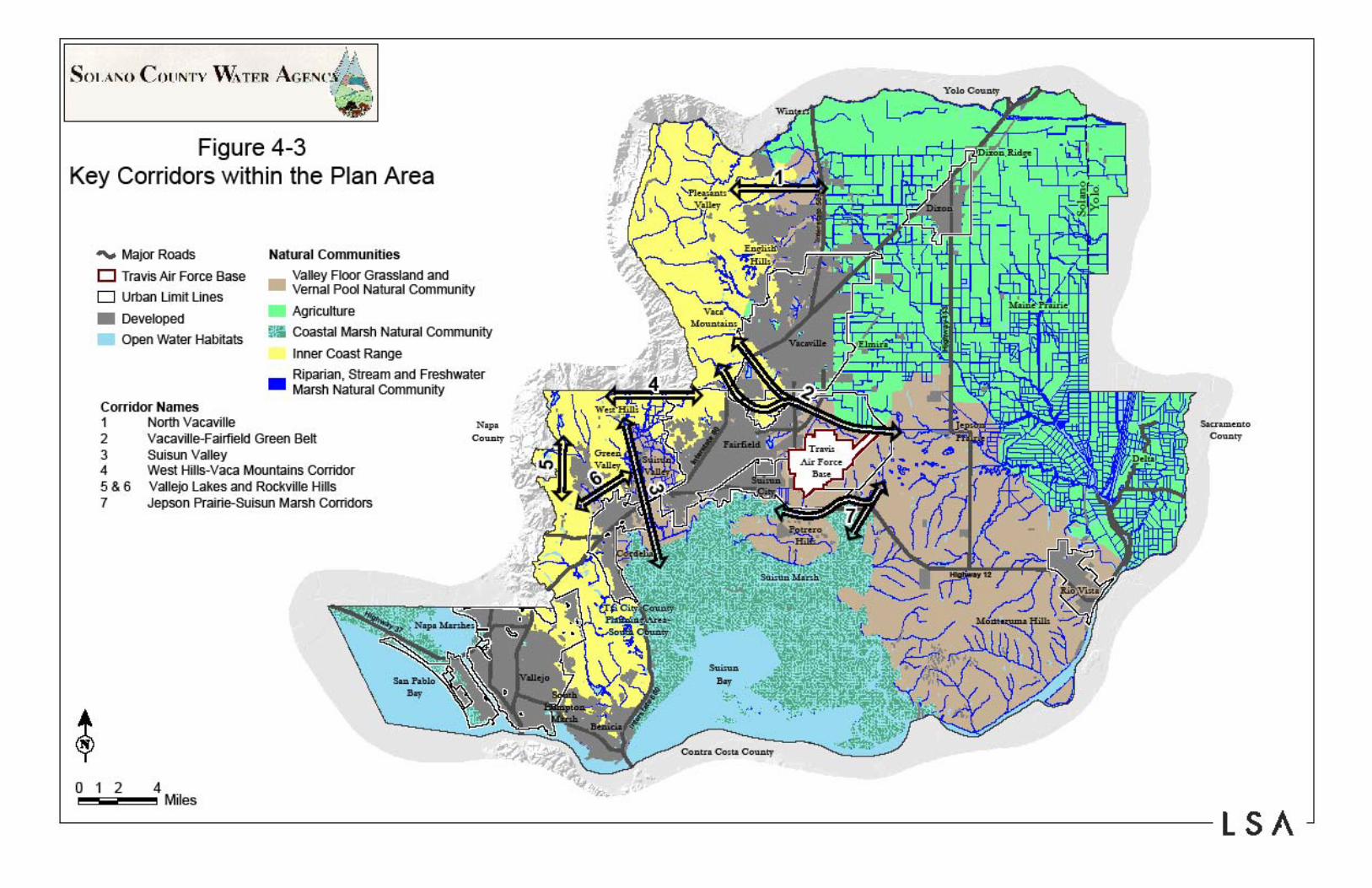
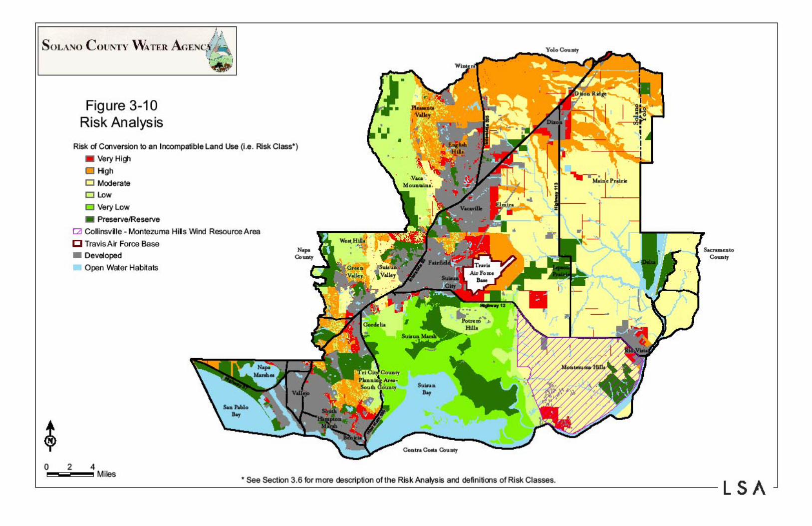
Recommendations No prehistoric cultural resources were identified within the study area. There are several sites that might be eligible for listing the National and California Registers. Further assessment of these sites is necessary to determine if they are eligible for the register. Since the shipwrecks are unknown a sonar scan will need to be performed within the study are to determine if or where the shipwrecks are located. Regardless of the alignments chosen, archeological, historical and underwater cultural resources survey will likely need to be performed. Relevant Projects A number of projects that have been approved or are in the process of being implemented are relevant to the proposed bridge study. The Solano County Water Agency is nearing completion of a Habitat Conservation Plan that will allow future development projects to mitigate for project and cumulative impacts through payment of fees. The fee program will be used to acquire and preserve land and/or restore habitat to compensate for loss to biological resources. Copies of the HCP graphics that are constraints to the proposed bridge project are attached. The City and County General Plans both identify land uses throughout the study area that have been approved based on long-term visions for land development. The plans do not consider development of a new bridge that involves alternative alignments or major upsizing of roadway capacity and expressway/freeway purpose. The Delta Protection Commission Regional Plan is intended to preserve the resources associated with the delta. While new development is prohibited in the primary delta zone, to the extent that roadway/infrastructure projects are consistent with regional plans, the Delta Protection Commission would support the development of a modified roadway/bridge alignment. A number of wind farm projects and natural gas well projects have been implemented or are approved in the rural lands of Solano County surrounding Rio Vista. Alternative roadway/bridge alignments that extend through these energy generating projects will disrupt the network systems and could cause significant impacts to the existing investments and operational systems. Two relevant land development projects have been approved or are nearing approval in the City of Rio Vista. The Riverwalk project (approved in 2007) proposes a master-planned community including a combination of single-family and multi-family residential uses, commercial and open space. Impacts considered significant and unavoidable include aesthetics and light/glare, air quality (construction and operational emissions), noise (construction), and traffic (delay associated with the drawbridge). All other impacts, including cumulative impacts, were either not significant, or were mitigated to less than significant levels. Although not approved, the Del Rio Hills project has been analyzed in a Draft EIR and has been circulated for public review. Impacts deemed significant and unavoidable include air quality (construction

04-4A490K February 1, 2010
and operational), traffic (existing plus project conditions/baseline plus project conditions), and cumulative global climate change. All other impacts, including cumulative impacts, were either not significant, or were mitigated to less than significant levels.


RIVER
SAN
JOAQUIN
RIVER
CLIFTONCOURT
FOREBAY
BAY
AQUI
URTRBAYA
BAAYYAAA
50
580
580
205
5
5
80
80
4
4
120
99
99
12
12
12
113
220
160
160
84
to Fairfield
to Vallejo
to Fresno
Y O L O C O U N T Y
S A C R A M E N T OC O U N T Y
S A N J O A Q U I NC O U N T Y
A L A M E D A C O U N T Y
C O N T R A C O S T AC O U N T Y
S O L A N O C O U N T Y
Lodi
Sacramento
Rio Vista
WalnutGrove
Locke
Hood
Clarksburg
Freeport
Collinsville
Pittsburg Antioch
Tracy
Stockton
Lathrop
Courtland
Isleton
Oakley
Brentwood
Knightsen
Discovery Bay
West Sacramento
This map and/or data has been prepared for general information purposes only. The map and/or data has not been approved by the Delta Protection Commission and does not constitute an official map or dataset of the Commission, nor does it establish the boundary lines or land uses of any lands depicted on the map or described in the data. The map and/or data is preliminary, is based upon available information, and is subject to revision as the need arises. Any republication or other distribution of this map and/or data, by any means whatsoever, must include this disclaimer.
S E C O N D A R Y Z O N E
P R I M A R Y Z O N E
N
0 2 4 6
scale in miles
C ALIFORNIA DELTA
Delta Primary Zone
Delta Secondary Zone


3
4
5

6

7

8

9

10

11

12