Embed Size (px)
Citation preview
Preliminary Contamination Investigation
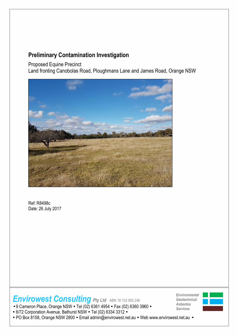
Proposed Equine Precinct Land fronting Canobolas Road, Ploughmans Lane and James Road, Orange NSW Ref: R8498c Date: 26 July 2017
Envirowest Consulting Pty Ltd ABN 18 103 955 246
9 Cameron Place, Orange NSW Tel (02) 6361 4954 Fax (02) 6360 3960
6/72 Corporation Avenue, Bathurst NSW Tel (02) 6334 3312 PO Box 8158, Orange NSW 2800 Email [email protected] Web www.envirowest.net.au
Environmental Geotechnical Asbestos Services
Client: Saunders and Staniforth Valuers
210 Lords Place Orange NSW 2800
Assessor: Claire McQueeney BEnvScMgt
Environmental Scientist Checked by: Greg Madafiglio CPSS Senior Soil Scientist Authorising Officer: Greg Madafiglio CPSS Senior Soil Scientist Interested authorities: Orange City Council Report number: R8498c
Date: 26 July 2017
Copyright © 2017 Envirowest Consulting Pty Ltd. This document is copyright apart from specific uses by the client. No part may be reproduced by any process or persons without the written permission of Envirowest Consulting Pty Ltd. All rights reserved. No liability is accepted for unauthorised use of the report.
Summary report
Address: Canobolas Road, Orange NSW
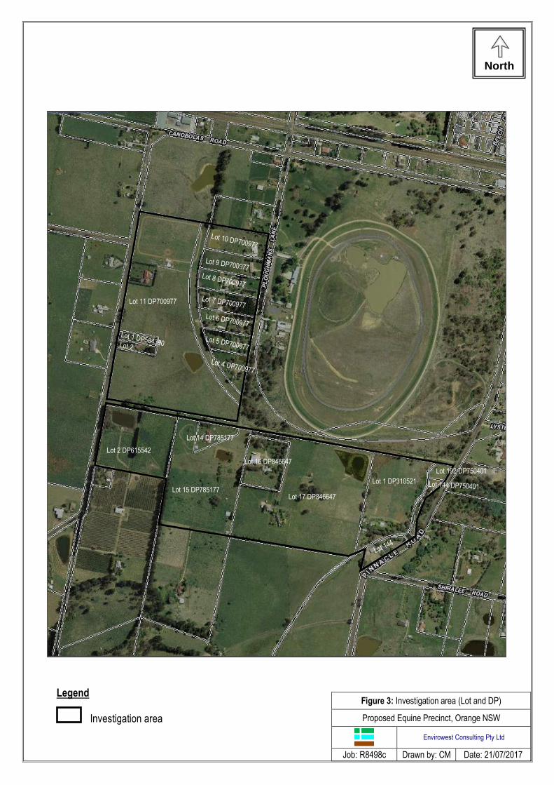
Lot: Lots 1 and 2 Section: - DP: DP584390 Lot 11 DP700977 Lots 4, 5, 6, 7, 8, 9, 10 DP700977 Part Lot 2 DP615542 Lot 14 and part lot 15 DP785177 Lots 16 and 17 DP846647 Lots 192 and 144 DP750401 Lot 1 DP310521 Dates of works 17 July 2017
Main areas of concern The investigation area included rural with a historical orcharding and grazing land-use.
Notable contaminant concentrations
No sampling and analysis was undertaken.
Nature of works carried out Preliminary investigations comprising desktop study, site walkover and review of the available history was undertaken.
Nature and extent of residual contamination No soil samples were collected. Potential contaminants of concern identified include heavy metals and organochlorine pesticides from historical orcharding land-use.
Risk factors The potential contamination sources included heavy metals and organochlorine pesticides from historical orcharding land-use. The potential exposure pathways include direct exposure (ingestion and absorption) The potential receptors included on-site workers (builders and contractors), residential and recreational, and off-site ecological and residential and recreational.
Waste removed Nil
Remediation summary Nil
Statement of suitability A soil sampling and analysis program is required to be undertaken within the proposed building envelopes to determine the contamination status of the study area.
This is an accurate summary of the report titled: Preliminary Contamination Investigation Produced by: Envirowest Consulting Pty Ltd Dated: 21/07/2017 Name: Gregory Madafiglio Certification details: Pending
Contents
page
1. Introduction .................................................................................................................................... 5
2. Scope of work ................................................................................................................................ 5 3. Site identification............................................................................................................................ 5 4. Site history ..................................................................................................................................... 5
5. Site condition and environment..................................................................................................... 8 6. Conceptual site model ................................................................................................................. 10 7. Results and discussion ................................................................................................................ 10
8. Conclusions ................................................................................................................................. 10 9. Report limitations and intellectual property ................................................................................ 12
10. References ................................................................................................................................... 13 Figures ................................................................................................................................................. 14 Figure 1. Locality map Figure 2. Aerial photograph Figure 3. Investigation area (Lot and DP) Figure 4. Former land-use over study area Figure 5. Proposed site plan (Saunders and Staniforth) Figure 6. Photographs of the site Figure 7. Historical aerial photographs

Page 5
Envirowest Consulting Pty Ltd R8498c
1. Introduction Rezoning to an equine precinct comprising large rural-residential lots is proposed for land fronting James Road, Canobolas Road and Ploughmans Lane, Orange NSW. The study area has a grazing and orcharding land-use history. A preliminary investigation of the site is required to determine potential areas of contamination and suitability for residential land-use. A desktop study and a review of the available history was undertaken of the site. A walkover and site inspection for evidence of contamination from past activities was conducted on 17 July 2017.
2. Scope of work Envirowest Consulting Pty Ltd was commissioned by Saunders and Staniforth Valuers to undertake a preliminary contamination investigation, in accordance with the contaminated land management planning guidelines, from the Contaminated Land Management Act 1997 and the State Environmental Policy No. 55 (SEPP 55), on the proposed rezoning and subdivision of land fronting James Road, Canobolas Road and Ploughmans Lane, Orange NSW. The objective was to identify past potentially contaminating activities, identify potential contamination types, discuss the site condition, provide a preliminary assessment of site contamination and assess the need for further investigation and suitability for residential land-use. The existing dwelling lots/yards are excluded from the assessment.
3. Site identification Address
Land fronting James Road, Canobolas Road and Ploughmans Lane Orange NSW 2800
Client
Saunders and Staniforth Valuers
Deposited plans Lots 1 and 2 DP584390 Lot 11 DP700977 Lots 4, 5, 6, 7, 8, 9, 10 DP700977 Part Lot 2 DP615542 Lot 14 and part lot 15 DP785177 Lots 16 and 17 DP846647 Lots 192 and 144 DP750401 Lot 1 DP310521
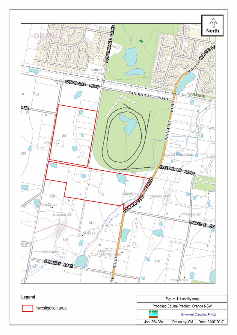
Locality map Figure 1
Site plan
Figure 3
Photographs
Figure 4
Area
Approximately 65 hectares
4. Site history 4.1 Zoning The study area is zoned RU1 – Primary Production and R5 – Large Lot Residential under the Orange Local Environmental Plan (2011). Rezoning to R5 – Large Lot Residential is proposed. James Road is a gazetted road that will be constructed as part of the proposed development.
Page 6
Envirowest Consulting Pty Ltd R8498c
4.2 Land-use The study area is located in a rural-residential area adjacent the Towac Racecourse, Orange NSW. Current land-use comprises grazing of horses and other livestock on larger lots and large residential backyards. Horses are trained on a track in the northern section of Lot 11 DP700977. The investigation did not include inspection of rural-residential house lots/yards containing existing dwellings. 4.3 Summary of council records Review of the Orange Local Environmental Plan (2011) identified the site as being within a groundwater vulnerable area. 4.3.1 Section 149 (2) Certificate
Orange City Council has not received notice under the Contaminated Land Management Act 1997
that the land is significantly contaminated subject to a management order subject to an ongoing maintenance order subject to a site audit statement.
The land does not include or comprise critical habitat
The land was not identified as biodiversity certified land
The land is not bushfire prone land
The land is not affected by any road widening or road realignment proposals 4.4 Sources of information
Site inspection on 17 July 2017 by Envirowest Consulting Pty Ltd
NSW EPA records of public notices under the CLM Act 1997
Soil and geological maps
Spatial information exchange historic parish maps
Aerial photographs (1954, 1984, 1993, 2003, 2010, 2013 and 2016)
Orange Local Environmental Plan 2011
Orange City Council s149 certificate 4.5 Historical site review 4.5.1 Chronological site uses Orcharding of pome and stone fruits is expected to have occurred over majority of the study area from the early 1900’s to early 1980’s (Figure 4). A gradual decrease in orchard size over the study area occurred from the mid 1980’s to early 2000’s. The study area is currently pasture with some grazing of horses and other livestock occurring. 4.5.2 Historical parish and topographic maps Review of historical parish maps (1895 and 1939) identify Elias Astill and Joshua Cantril as the owners of the land located in the northern section of the study area. James Dale and James Dalton are identified as owners of land in the southern section of the study area. The 1989 topographic map identifies the northern section of the study area (Lot 11 DP700977) as pasture. The southern section of the study area is mostly orchard with the exclusion of Lot 14 and 15 DP785177, Lots 192 and 144 DP750401, and Lot 1 DP310251 identified as pasture or medium vegetation.

Page 7
Envirowest Consulting Pty Ltd R8498c
4.5.3 Historical aerial photographs Year of photograph
Site land-use observations
1954 Land-use on Lot 11 DP700977 is cultivated land with some orcharding in the southern section. The northern section of Lot 2 DP615542, Lot 15 DP757177 and 17 DP846647 appear to be pasture with orcharding occurring in the southern section of the lots. Lots 192 and 144 DP750401 appear to be undeveloped/vegetated.
1984 Lot 11 DP700977 appears to be pasture. A dwelling is present on Lots 1 and 2 DP584390. Large irrigation dams are present on a number of lots. Lot 2 DP615542, Lot 15 DP757177 and 17 DP846647 appear to be mostly orcharding. Lot 1 DP310251 is pasture. Lots 192 and 144 DP750401 appear to be vegetated/undeveloped.
1993 Lot 17 DP846647 remains as orcharding land.
2003 Rural-residential lots are present as Lots 4, 5, 6, 7, 8, 9 and 10 DP700977.
2006 Trotting track, round-yard, shed and stables present in northern section of Lot 11 DP700977. Lot 17 DP846647 appears to be pasture.
Current Trotting track, round-yard, shed and stables present in northern section of Lot 11 DP700977. All areas under investigation appear to be pasture. The current owner of Lot 11 DP700977 is Brad and Kim Draper. Other landholders include the McMullen and White families.
4.6 Buildings and infrastructure Infrastructure on-site includes:
Residential dwellings on Lot 11 DP700977, Lots 1 and 2 DP584390, Lots 4, 5, 6, 7, 8, 9, 10 DP700977, Lot 14 DP785177, Lots 16 and 17 DP846647, Lot 1 DP310521 and Lot 144 DP750401
Fences on the boundaries of lots, and within lots to create paddocks
Four abandoned wells located on Lot 11 DP700977
Stables, round-yard, trotting track and shed located on Lot 11 DP700977
A number of sheds of varying dimensions 4.7 Contaminant sources The historic orcharding land-use is likely to have resulted in application of pesticides in routine management. Pesticides are regularly applied to pome and stone fruits. Fertilisers applied may contain heavy metal contaminants. No bio solids are known to have been applied to the site. Organochlorine pesticides may have been applied in the general management of pastures. Pesticide storage and mixing areas are located in existing dwelling lots which were not assessed as part of this investigation. 4.8 Contaminants of concern Based on historical activities and site inspection the contaminants of concern are:
Heavy metals (arsenic, cadmium, chromium, copper, nickel, lead, zinc and mercury)
Organochlorine pesticides (OCP)
Organochloride pesticides (OPP) 4.9 Relevant complaint history Nil
Page 8
Envirowest Consulting Pty Ltd R8498c
4.10 Contaminated site register The investigation area is not listed on the NSW EPA register of contaminated sites. 4.11 Previous investigations No previous investigations are known to have been undertaken on the site. 4.12 Neighbouring land-use North – Rural-residential, Towac Road South – Rural, orcharding and grazing East – Towac Racecourse, rural-residential West – Rural, pasture, rural-residential Historical and present neighbouring land-use to the south was orcharding and may have resulted in orchard chemicals migrating to the study area. 4.13 Integrity assessment The site history was obtained from a site inspection and history review. The information is consistent with the current site condition and to the best of the assessor’s knowledge is accurate.
5. Site condition and environment 5.1 Surface cover Surface cover over the study area comprised pasture grasses. Some isolated areas of invasive species including sweet briar and box thorn were present. Root stock of former orchard trees including apple, pear and cherry trees were present over the northern section of the study area. 5.2 Topography The study area is located on a lower to mid-slope with slope from 1-5%. Aspect is predominantly north and east over the study area. Site elevation ranged from 912m to 930m AHD. 5.3 Soils and geology The study area is within the Spring Hill Soil Landscape (Kovac et al. 1990). Dominant soils within the landscape include dark reddish brown loam topsoil over dark reddish brown clay loam and light c lay. Lots in the western section of the study area are imperfectly drained. The site is underlain by Tertiary volcanics from Mount Canobolas (Kovac et al. 1990). Parent rock comprises basalt flows separated to form layers of clay and slate. Parent material is in situ materials of colluvium derived from Tertiary volcanics. 5.4 Water 5.4.1 Surface water Surface run-off follows the topography of the site. Dams expected to be formerly used for orchard irrigation are located on Lot 11 DP700977, Lot 2 DP615542, Lot 15 DP785177 and Lot 17 DP846647. Upslope surface water flows to the site from the south. Blackmans Swamp Creek flows through the eastern section of the study area, creating a boundary between Lots 144 and 192 DP750401 and Lot 1 DP310521. Blackmans Swamp Creek is considered a highly disturbed ecosystem.
Page 9
Envirowest Consulting Pty Ltd R8498c
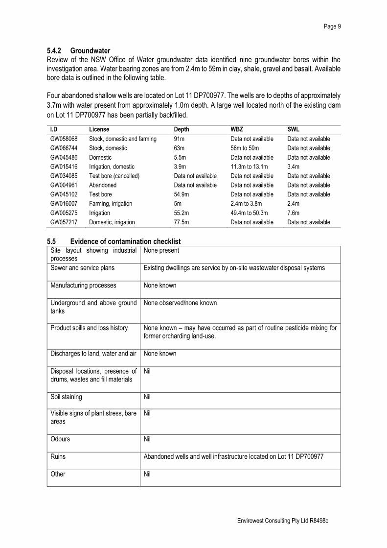
5.4.2 Groundwater Review of the NSW Office of Water groundwater data identified nine groundwater bores within the investigation area. Water bearing zones are from 2.4m to 59m in clay, shale, gravel and basalt. Available bore data is outlined in the following table. Four abandoned shallow wells are located on Lot 11 DP700977. The wells are to depths of approximately
3.7m with water present from approximately 1.0m depth. A large well located north of the existing dam
on Lot 11 DP700977 has been partially backfilled.
I.D License Depth WBZ SWL
GW058068 Stock, domestic and farming 91m Data not available Data not available
GW066744 Stock, domestic 63m 58m to 59m Data not available
GW045486 Domestic 5.5m Data not available Data not available
GW015416 Irrigation, domestic 3.9m 11.3m to 13.1m 3.4m
GW034085 Test bore (cancelled) Data not available Data not available Data not available
GW004961 Abandoned Data not available Data not available Data not available
GW045102 Test bore 54.9m Data not available Data not available
GW016007 Farming, irrigation 5m 2.4m to 3.8m 2.4m
GW005275 Irrigation 55.2m 49.4m to 50.3m 7.6m
GW057217 Domestic, irrigation 77.5m Data not available Data not available
5.5 Evidence of contamination checklist
Site layout showing industrial processes
None present
Sewer and service plans
Existing dwellings are service by on-site wastewater disposal systems
Manufacturing processes
None known
Underground and above ground tanks
None observed/none known
Product spills and loss history None known – may have occurred as part of routine pesticide mixing for former orcharding land-use.
Discharges to land, water and air None known
Disposal locations, presence of drums, wastes and fill materials
Nil
Soil staining Nil
Visible signs of plant stress, bare areas
Nil
Odours Nil
Ruins Abandoned wells and well infrastructure located on Lot 11 DP700977
Other Nil

Page 10
Envirowest Consulting Pty Ltd R8498c
6. Conceptual site model Potential contamination sources, exposure pathways and receptors are presented below.
Contamination source Potential exposure pathways Receptors
Metals and organochlorine pesticides from former orcharding land-use creating shallow impacted soil
Direct contact (ingestion and absorption) Surface water and groundwater
On-site Workers (builders and contractors) Residential Recreational Off-site Residential Rural Ecological Recreational
7. Results and discussion Surface cover over the study area comprised pasture grasses. Some isolated areas of invasive species including sweet briar and box thorn were present. Root stock of former orchard trees including apple, pear and cherry trees were present over the northern section of the study area. The study area has a historical land-use of orcharding, pasture and cultivated land. The orchard trees were removed over time and the land is now pasture. Four abandoned wells are located on Lot 11 DP700977 containing shallow groundwater. A large well located north of the existing dam on Lot 11 DP700977 had been partially backfilled. The wells are expected to have been constructed during establishment of the former orchards. No evidence of mines, sheep dips or contaminating industrial activities are present over the study area from the review of site history or site walkover. All pesticide mixing and storage sheds are located within existing rural-residential lots and do not form part of the study area.
8. Conclusions Rezoning to an equine precinct comprising large residential lots is proposed for land fronting James Road, Canobolas Road and Ploughmans Lane, Orange NSW. The study area has a grazing and orcharding land-use history. A preliminary investigation of the site was undertaken to determine potential areas of contamination and suitability for residential land-use. A desktop study and a review of the available history was undertaken of the site. A walkover and site inspection for evidence of contamination from past activities was conducted on 17 July 2017. Orchard trees including apple, pear and cherry trees were previously present over majority of the study area. The orchard trees have been replaced with pasture over time. Current land-use is pasture grazing of horses and other livestock. Some cropping for fodder is likely to have occurred. The use of agricultural pesticides over the area in the past is expected to have occurred as part of routine orchard, pasture and cropping management. The potential contaminants of concern are heavy metals and organochlorine pesticides.

Page 11
Envirowest Consulting Pty Ltd R8498c
8.2 Assumptions in reaching the conclusions The existing house lots/yards are excluded from the assessment. Farm sheds and former pesticide mixing areas are located within the existing house lots. 8.3 Extent of uncertainties The results relate only to the locations inspected during the site walkover and as such it cannot be excluded that unidentified contaminants may be present. 8.4 Suitability for proposed use of the site A soil sampling and analysis program is required to be undertaken within the proposed building envelopes to determine the contamination status of the site and suitability of the proposed residential land-use. 8.5 Limitations and constraints on the use of the site Soil sampling should be undertaken to confirm suitability for rural-residential land-use. 8.6 Recommendation for further work Additional investigations including a soil sampling program is required to confirm the contamination status of the study area. The soil sampling program is recommended to include the sampling of soil from within the proposed building envelopes. A minimum of eight locations are to be sampled over each building envelope at the 0-100mm depth and analysed for arsenic, cadmium, chromium, copper, lead, nickel, zinc, mercury (heavy metals), organochlorine pesticides (OCP) and organophosphate pesticides (OPP).
Page 12
Envirowest Consulting Pty Ltd R8498c
9. Report limitations and intellectual property This report has been prepared for the use of the client to achieve the objectives given the clients requirements. The level of confidence of the conclusion reached is governed by the scope of the investigation and the availability and quality of existing data. Where limitations or uncertainties are known, they are identified in the report. No liability can be accepted for failure to identify conditions or issues which arise in the future and which could not reasonably have been predicted using the scope of the investigation and the information obtained. The investigation identifies the actual subsurface conditions only at those points where samples are taken, when they are taken. Data derived through sampling and subsequent laboratory testing is interpreted by geologists, engineers or scientists who then render an opinion about overall subsurface conditions, the nature and extent of the contamination, its likely impact on the proposed development and appropriate remediation measures. Actual conditions may differ from those inferred to exist, because no professional, no matter how well qualified, and no sub-surface exploration program, no matter how comprehensive, can reveal what is hidden by earth, rock or time. The actual interface between materials may be far more gradual or abrupt than a report indicates. Actual conditions in areas not sampled may differ from predictions. It is thus important to understand the limitations of the investigation and recognise that we are not responsible for these limitations. This report, including data contained and its findings and conclusions, remains the intellectual property of Envirowest Consulting Pty Ltd. A licence to use the report for the specific purpose identified is granted for the persons identified in that section after full payment for the services involved in preparation of the report. This report should not be used by persons or for purposes other than those stated and should not be reproduced without the permission of Envirowest Consulting Pty Ltd.

Page 13
Envirowest Consulting Pty Ltd R8498c
10. References DEC (2006) Contaminated Sites: Guidelines for the NSW Site Auditors Scheme (NSW Department of Environment and Conservation, Chatswood) Central Mapping Authority (1989) Topographic Map of Orange 1:25 000. Second Edition (Department of Lands, Bathurst) Environment Protection Authority (1995) Contaminated sites: Sampling Design Guidelines (NSW Environment Protection Authority, Chatswood) Kovac M, Murphy BW and Lawrie, JW (1990) Soil Landscapes of the Bathurst 1:250,000 Sheet (Soil Conservation Service of NSW, Sydney) NEPC (1999 revised 2013) National Environment Protection (Assessment of Site Contamination) Measure 1999 (National Environment Protection Council Service Corporation, Adelaide)

Page 14
Envirowest Consulting Pty Ltd R8498c
Figures Figure 1. Locality map Figure 2. Aerial photograph Figure 3. Investigation area (Lot and DP) Figure 4. Former land-use Figure 5. Proposed site plan (Saunders and Staniforth) Figure 6. Photographs of the site Figure 7. Historical aerial photographs
North
Figure 1: Locality map
Proposed Equine Precinct, Orange NSW
Envirowest Consulting Pty Ltd
Job: R8498c Drawn by: CM Date: 21/07/2017
Legend Investigation area
North
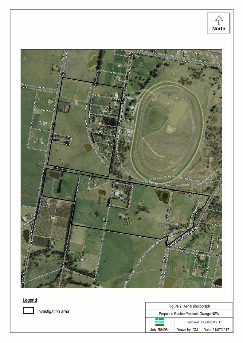
Figure 2: Aerial photograph
Proposed Equine Precinct, Orange NSW
Envirowest Consulting Pty Ltd
Job: R8498c Drawn by: CM Date: 21/07/2017
Legend
Investigation area
North
Figure 3: Investigation area (Lot and DP)
Proposed Equine Precinct, Orange NSW
Envirowest Consulting Pty Ltd
Job: R8498c Drawn by: CM Date: 21/07/2017
Lot 11 DP700977
Lot 2 DP615542
Lot 16 DP846647
Lot 14 DP785177
Lot 15 DP785177 Lot 17 DP846647
Lot 1 DP310521
Lot 192 DP750401
Legend Investigation area
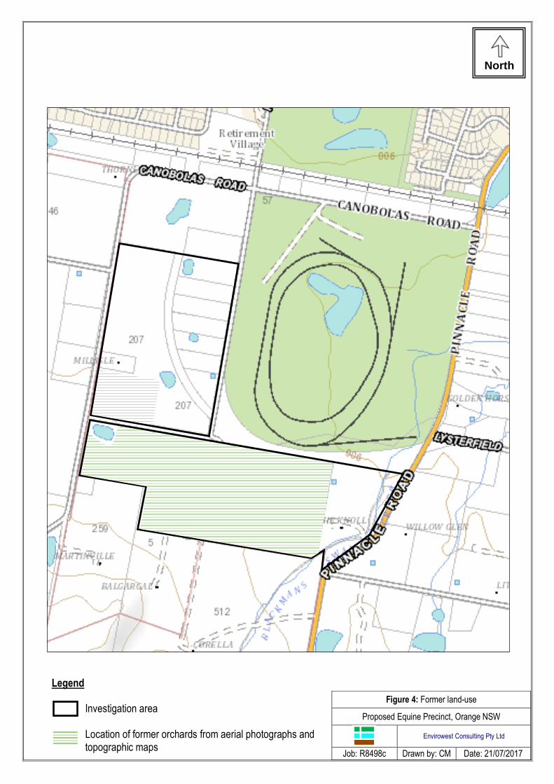
Legend Investigation area Location of former orchards from aerial photographs and topographic maps
Figure 4: Former land-use
Proposed Equine Precinct, Orange NSW
Envirowest Consulting Pty Ltd
Job: R8498c Drawn by: CM Date: 21/07/2017
North

Figure 5: Proposed site plan (Saunders & Staniforth 2017)
Proposed Equine Precinct, Orange NSW
Envirowest Consulting Pty Ltd
Job: R8498c Drawn by: - Date: 18/04/2017

Figure 6. Photographs of the site
Envirowest Consulting Pty Ltd
Job – R5078c Drawn by: EG Date: 2/5/2005
Abandoned well
Looking north across paddocks on Lot 11 DP700977 Abandoned well
Disused pump
View north-west across Lot 11 DP700977 Root stock of cherry tree
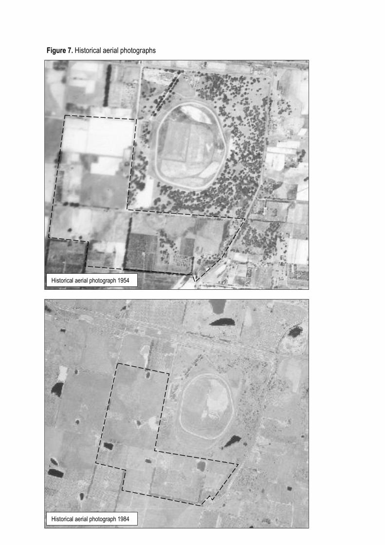
Figure 7. Historical aerial photographs
Historical aerial photograph 1954
Historical aerial photograph 1984