Embed Size (px)
Citation preview
Prehistoric Land Use in the Perkinsville Valley
Paul R. Fish
ABSTRACT
of archaeological excavation in the PerValley, Arizona, have been carried out by the
rtme1nt of Anthropology at Arizona State University. has produced considerable information on
known cultural sequence in the Upper Verde has also given insight into Hohokam and Anasazi
in central Arizona. The results of these are reviewe~ within the framework of prehis
use. Special emphasis is placed on information past and present environment.
LOCATION OF THE STUDY AREA
The Perkinsville Valley is a marked broadening of the Upper Verde River in northeastern Yavapai County, Arizona. It is bounded by parallels 34° 53' 30" and 34° 54' 3011 latitude and ll2° 9" 0011 and uzo 14 11
0011 longitude. The only modern settlement within this locality is the small mining and ranching community of Perkinsville (See Figure 1).
2

INTRODUCTION
. Sine~ the landmark publication Prehistoric Settlement Patterns in the ·. Viru Valley (Willey 1953), American archaeologists have paid increasing attention to patterned spatial arra!'lgement both within and between prehistoric settlemen.ts (Chang 1958: 299; 1962: 28; 1968: vii; Trigger' 1967: 149). The current popularity of settlement archaelogy can be best attributed to the fact th·at this concept provides a. realistic des-
' c::riptive framework whi<:h ;;Lllows for· a fuller interpretation of past hu:man behavil:>r. As Fitting (1969: 360) points out, "Settlement pattern· studi~s have ,provided a new lens for the study of prehistoric peoples, one Which can more accurately focus on changing patterns of human activity • • • "· Prehistoric land utilization in the Perkinsville Valley is discu!lsed within this conceptual framework. . .
fhl.rvey of the Perkinsville Valley has revealed nearly thirty major h<l,bitation sites and at least limited excavation has taken place at six' ~ tip:>e range from th~ Archaic to approximately A. D. 1425 is mani
·fes,t inthe survey data and excavations were conducted at sites dating fr.om A. D. 800 to 1400. Although the complete culture sequence is of
·regiqnal interest, this study is restricted to change in certain distinc-'tive attribu~es of settlement patterns in the valley. Patterned correla.1;ipns betwee.n placement of sites, environmental change and natural resources in the region are sought.

SETTING
'I'he Perkinsville Valley is considered a minor intrusion of the Upper Sonoran Life Zone into the Arizona Highlands (Fenneman 1936). The most impressive physiographic features in the vicinity are the Mogollon Rim and Colorado Plateau to the north and Woodchute Mountain in the. Black Hills to the south. The eight-mile stretch between the Verde River' and Woodchute Mountain is gently inclined, while the Mogollon Rim rises abruptly seveh miles to the north. Rock formations in this :region are of volcanic and sedimentary origin.
The clil;nate of the valley is arid to semi-arid with a yearly average . precipitation of 14. 39 inche.s and a mean annual temperature of 67°F. Ranges in both precipitation and temperature are considerable. The maXimum temperature recorded is 110°F. and the minimum is 7°F. The number of frost-free days within a single year ranges between 160 and 190 days. Yearly rainfall varies between a recorded low of 11.29 inches and a high of 18. 79 inches (U.S. Weather Bureau 1965}. Early spring and late summer are the two major seasons of precipitation in the region.
An extensive riparian flora including ash, cottonwood, hackberry, sycamore·, cattails, and arrowweed is found on the Verde River bottom. Out
. side this limited riverine environment, the vegetation within the valley would be generally classified as juniper woodland and savanna. Covering seven miles the transition between the riparian flora of the Verde and the Ponderosa Pine forests of the Mogollon Rim is rapid.
4

ENVIRONMENTAL ZONES AND THEIR ECONOMIC POTENTIAL
:>'(~1lthe :Pp.sis of distinctive floral assemblages, it has been possible to ; ,define four major environmental zones which would have been easily '\a,p<;essible to the prehistoric inhabitants of the Perkinsville Valley (See
· ·c·,·:lfi.gi:trll Z). Each has diverse and characteristic resources which were ,' . pptentially exploitable during all periods of occupation in the valley. c]'> 'J.'li~\zones are discussed individually with an emphasis on the availabil'>> fty'of natural resources. it·/? \.-L_,-:·.,'/O,'
; ; ''->:· -~'/: __ ::.'/,>·:::.~::::·· .. :·:.-.. ' ... c:·,c Zelle 1 :.. Riverine. The Riverine Zone consists of the Verde River and , , ~~.~.flood plain. The Verde River, now occupying an eroded channel, +w :q,?~s betw'een cut banks in fairly stable areas but meanders widely and ,·l',.J:fe>r!:l;ls extensive gravel bars near the mouth of the Perkinsville Valley. lj~cjf~~o\Vs, throughout the year and, even in the driest periods, contains >''·c,#ll.()ugh water for the irrigation of modern crops. About ninety acres of ,:•;i,,'cfbpp!i plain are currently farmed in this manner. i:t{>)/;·;·---
i\{'~·~i.~s·~ the turn of the century, the Verde has been undergoing an ero-.; ~{()rial cycle similar to that well-documented in southern Arizona
')J1,:;J~a~tj.Ilgs and Turner 1965). In the 1880's, the river was deep, flowed .f'))'lq~ly., and was impeded by many beaver dams (Mearns 1904: 354- 59), ,'·:)•:E.:x:(:ept for depressions near river obstructions, the Verde is today a :•i\cf.~J:l,all()W and strongly flowing stream. Changes in the river have caused si];:'p.~responding changes in the flood plain and the vegetation found there.
\: \i;;fgr example, the marshes that occupied much of the flood plain fifty ;:•i{¥'1l~l's ago are gone today and the now prevalent mesquite trees were "•!<l?rtl1~rly uncommon. As a result of the extensive ~arshes when the t,'''j.1f~).i'eywas first settled in the 1870's the Yavapai Indians, using simple ir'.',§itchirrigation, were able to cultivate only twenty of the 125 acres on ·f:tJ:ie.flood plain. (Mrs. Nick Perkins: personal communication).
''<_i:~!':\:.:-::' ·.
5
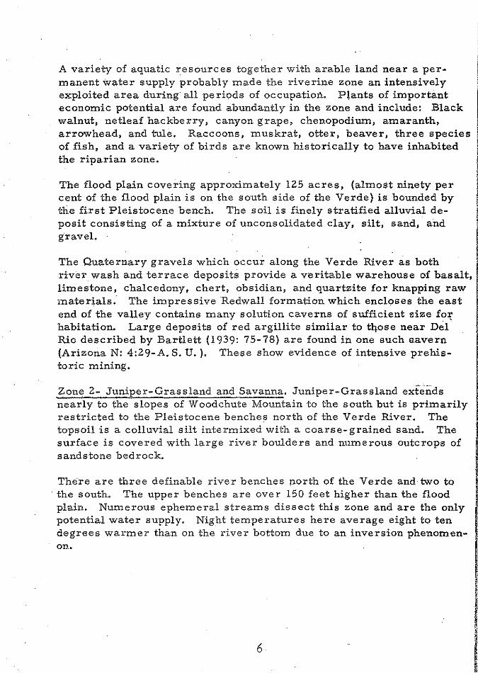
A variety of aquatic resources together with arable land near a permanent water supply probably made the riverine zone an intensively exploited area during· all periods of occupation. P~ants of important economic potential are found abundantly in the zone and include: Black walnut, netleaf hackberry, canyon grape, chenopodiurn, amaranth, arrowhead, and tule. Raccoons, muskrat, otter, beaver, three species of fish, and a variety of birds are known historically to have inhabited the riparian zone.
The flood plain covering approximately 125 acres, (almost ninety per cent of the flood plain is on the south side of the Verde) is bounded by the first Pleistocene bench. The soil is finely stratified alluvial deposit consisting of a mixture of unconsolidated clay, silt, sand, and gravel.
The Quaternary gravels which occur along the Verde River as both river wash and terrace deposits provide a veritable warehouse of basalt, limestone, chalcedony, chert, obsidian, and quartzite for knapping raw materials. The impressive Redwall formation which encloses the east end of the valley contains many solution caverns of sufficient size foJ2 habitation. Large deposits of red argillite similar to tqose near Del Rio described by Bartlett (1939: 75-78) are found in one such aavern (ArizonaN: 4:29-A. S. U. ). These show evidence of intensive prehistoric mining.
Zone 2- Juniper-Grassland and Savanna. Juniper-Grassland extends nearly to the slopes of Woodchute Mountain to the south but is primarily restricted to the Pleistocene benches north of the Verde River. The topsoil is a colluvial silt intermixed with a coarse- grained sand. The surface is covered with large river boulders and numerous outcrops of sandstone bedrock.
There are three definable river benches north of the Verde and· two to the south. The upper benches are over 150 feet higher than the flood plain. Numerous ephemeral streams dissect this zone and are the only potential water supply. Night temperatures here average eight to ten degrees warmer than on the river bottom due to an inversion phenomenon.
6
Since the early 1900's, a considerable amount of erosion and under·cutting has taken place in the arroyos and washes. Some of these ~tl;'~<'-ms have extensive alluvial fans which open 01,1to the first and ~ec:ond river benches. Although the larger alluvial fans contain only five to six acres of arable land, together approximately seventy acres V.,o~d be available for cultivation with dry farming. techniques •.
':j:'he greatest number of habitation sites in all phases are found in J~¢-per-Grassland Zone. They are situated on the edge of the first or
. ;;e<;:o!l!'\ bench and within two miles of the river. Even though no water
. ¢p~tJ:ol devi::ces such as check dams have been found in the washes, dry . f~iwigg during certain periods is inferred from the patterned placer:n~A.t of habitation sites on higher elevations adjacent to the fans. It is
· ii:l,!~r,esting to note that commercial dry farming took place on the Verde t~.J:t<>c:es .. near Camp Verde and Cottonwood in the 1920's (Agnes 1952). 9lt~CJ:t and. jasper deposits occur in many filled solution channels in the l<edwall f()rmation on the second and third Pleistocene benches and five ~tth~~~ (Arizona N:4:3l.(ASU); N:4:32 {ASU); N:4:33 (ASU); N:4:34 (ASU); <~;I19-, :!;'{:4: 36 fASU) show evidence of extensive mining in prehistoric times.
:t:'!'¥!'eJC()~S economically important plants are found growing wild in the .r~n.ip~;r:~Grassland and Savanna zone. These include: prickly pear,
. S~§~.ic,,, s.<>lt bush, amaranth, mesquite, Rocky Mountain beeweed, yucca, .. '!,.P,$\;.b.W:f.,__o gourds. Skunks, rabbits, rodents, deer, antelope, coyote,
· ·! : ..... ~~;}!<'Z'lo:t".iety of large birds including turkey are among the vertebrates ;,· JffiRW~Jor, this zone. The many species of snakes and lizards found here · c,1!!.9.Proyide another potential food source .
• ');::~~;.~~~Jier elevations in the valley, the savanna grades into jutliper wood'··!e!:l;4;·. Q~>.k and, to a lesser extent, pinyon pine form minor elements
~.i,tlt~!l,tl:J.is woodland association. Economically exploitable species, ••<, ·:•S'IJ,<!:J.:i1,C:teristically interspersed near the grassland-savanna boundary, : , ~Rfl,)l;4e tpa!fzanita, catclaw, mountain mahogany, apache-plume, bear
· • g,;t':'!:§}il .• • wesquite, greasewood, squaw berry, and cliffrose.
;\ '.~~~~3- Juniper-Pinyon. fn a transect of the general area, the Juniper''' w-~ygn' zone is found only to the north of the Verde River and outside the
. ,,SB!\f;l.l.es of the valley. It oC.curs on the upper reaches of the bajada be-' ;tC\Y~e.n t]:;e Pleistocene river benches and the slopes of the Mogollon Rim.
~.lj:;i~de varies from about 4500 feet to over 5200 feet above sea level.
?'
The zone is dissected by a profusion of draws, many of which are deep and rugged canyons in the white limestone bedrock of the Supai formation. Aside from a fe<N intermittent springs, there. are no permanent water sources. With the significantly higher orographic rainfall here, it seems probable that some of the major drainages flowed seasonally
· in the past.
While fewer plant species of economic importance are found in the zone, seasonal abundance of particular species probably encouraged yearly exploitation. Juniper, pinyon, agave, common dandelion, sunflower,. and yucca are among those with economic value. Mule deer, mountain lion, and black bear are the larger vertebrates characteristic of the Juniper- Pinyon zone.
Intensive survey of the zone has not yet taken place. Aside from a. number of small camp sites and widely scattered lithic implements, exploratory investigations have revealed no major habitation sites. Ceramics found at camp sites indicate long periods of use as well as intermittent utilization by archaeological cultures, such as theCohonina, not represented in the Perkinsville Valley itself.
Zone 4- Ponderosa-Pinyon. Ranging from five to ten miles from the Verde River, the Ponderosa-Pinyon zone is physiographically defined by the slopes of the Mogollon Rim. This area was likely utilized seasonally by the inhabitants of the Perkinsville Valley in order to exploit its abundant plant resources. Such plants that would have been sought after include pinyon, gooseberry, wild raspberry, common chokeberry, elder berry, dandelion, and sunflower. Historically extinct mammals characteristic of the zone include the larger mule deer, elk, and mountain sheep (Mearns 1904: 215, 337). Documented use of resources from the Ponderosa-Pinyon zone is limited to elk bone recovered from sites in the valley.
8
PAST ENVIRONMENT AND SUBSISTENCE
ents agree that there has been no major climatic change in the ~~ .... a·~• for the past five thousand years. However, considerable evi'l';~::.;'f~-~ accumulated indicating that various environmental ·changes in
J:>y climatic fluctuations have occurred. These fluctuations have ip;terp•rerte•d as changes in average annual effective· moisture values
~!'"fifrit~i ·and Stokes 1965), seasonal shifts in precipitation pattern enwetter and Dittert 1968), and increases or' decreases
(Schroeder 1968; Woodbury 1961).
~(j •. YJi·~~·~·9f?:fl.ges in distribution and relative abundance of many species are into:rrrlaltic•n from pollen and faunal analysis, studies of the
'"'"'"'~· in the Perkinsville Valley reflect a general similarity ~.~l;lr1:ne m•oaern and prehistoric biota. Minor climatic fluctuations
shifts during the past one thousand years are inferred data recovered from archaeological contexts in the valley. certain insights into the varied subsistence patterns prac
prehistoric inhabitants of the valley are provided by this ~~~:ti·~l;l •..
In the course of excavations in the Perkinsville Valley, 0 fragmentary and complete animal bones, teeth, ant
ater shells were recovered from five sites dating from 00, Analysis of these remains was undertaken by Dr. .
::~!!:l~t<;:1derv, Zoology Department, Arizona State University. 'As is Southwestern sites where the extraction of bone marrow
u<.:<.:.u.rs, most of the faunal sample (nearly 80%) were uni~entij$J~lii!lte•rs from the limb bones of ungulates. Although actual quan-
r\j,3llf<lrJqJ<l.ti.on is not yet available, statements of relative abundance ence provide clues not only to subsistence practices
M~.Q!'to'Jc>cacl .. environment (See Table 1). .
9
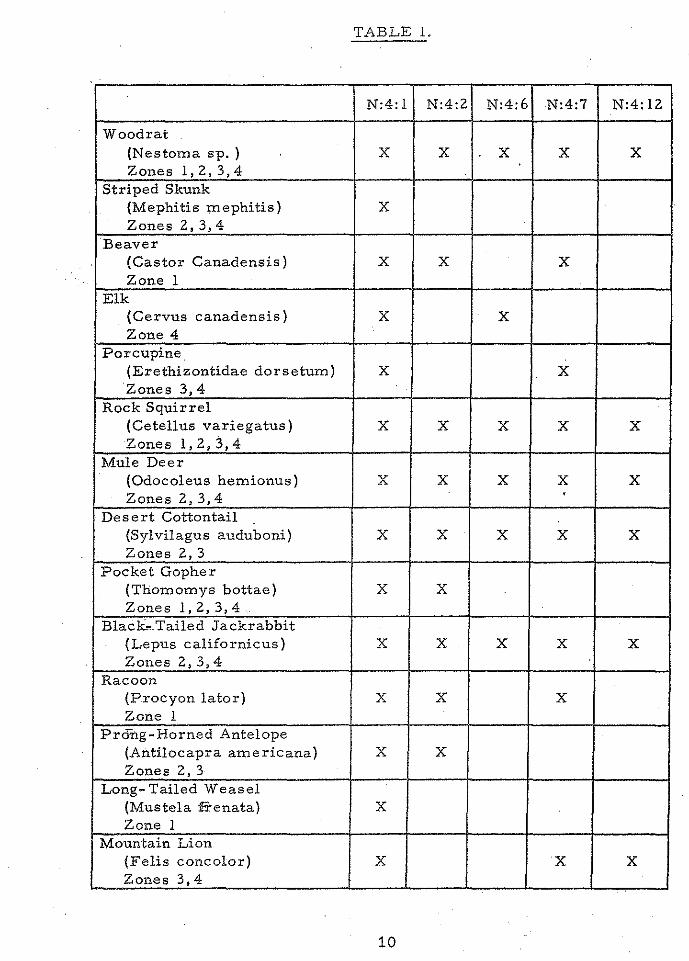
TABLE l.
.
N:4:1 N:4:2 N:4:6 N:4:7 N:4:12
Woodrat (Nestoma sp. ) X X X X X Zones 1, 2, 3, 4 .
Striped Skunk (Mephitis mephitis) X Zones2,3,4
Beaver (Castor Canadensis) X X X Zone 1
Elk (Cervus canadensis) X X Zone 4
Porcupine. (Erethizontidae dorsetum) X X Zones 3, 4
Rock Squirrel (Cetellus variegatus) X X X X X Zones l, 2, 3, 4
Mule Deer (Odocoleus hemionus) X X X X X Zones 2, 3, 4 '
Desert Cottontail {Sylvilagus auduboni) X X X X X Zones 2, 3
Pocket Gopher (Thomomys bottae) X X Zones 1, 2, 3, 4
B1ack,.Tailed Jackrabbit (Lepus californicus) X X X X X
. Zones 2, 3, 4 Racoon
{Procyon lator) X X X Zone l
Prcfug-Horned Antelope (Antilocapra americana) X X Zones 2, 3
Long-Tailed Weasel (Mustela :I!Tenata) X Zone 1
Mountain Lion (Felis concolor) X X X Zones 3,4
10
tiirelili!;tc>ri:c inhabitants of the Perkinsville Valley were hunters of , squirrels and small rodents throughout the occupation
These animals, with the addition of minor increments of and elk, account for the total assemblage of identifiable
recovered from earlier contexts (ca. A. D. 800 to 1200) .•
ti .. 'r<:itv of small game including raccoon, pocket gopher, weasel, beaver and striped skunk supplemented continued utilization bbit, and squirrel during later phases. One of the most
fk~t:illl c:h;il.nges in the faunal sequence was an obvious increase in utili-
,, ...•. aquatic resources. Hundreds of fragments of fish, turtle, >fi:<ia.ter mussel and migratory water fowl are recorded from sites
•>r<Jm A. D. 1200 to 1400. Information from earlier sites gives .111a:tc:autoJa of this kind of intensive exploitation of the riverine en-
from Arizona N:4:2 (Minckley and Alger 1968) and N:4:1 interpretation of pronounced changes in river and flood plain
Three of the fish species (Pantosteus clarki., Catostomus
~~;ti:ai~n:d Gila robusta robusta) still live in the Verde River near t; . and two (Xyreuchen texanus and Ptycheshellus lucius) are 9p.ger present, suggesting probable changes in the river. The latter
e indicative of large, strongly flowing streams of extensive .,.,., ... ,.swampy water, The recovery of large quantities of fresh
1'";-;'[l)l:tssels (Anadonta sp.) and turtles (Kinosternon Sp.) support the for more swampy conditions.
ation of the hunting pattern and the appearance of numerous n,,,.""· bf aquatic animals seen in faunal record of the Perkinsville
oY.ztgey·:fi.ts a "faunal break" hypothesized by Thomas Mathews for the region (personal communication). Only deer, antelope, jackand cottontail rabbit are known from excavated sites in the
Valley dating prior to A. D. 1200 (Breternitz 1958, 1960; 50, 1951). However, a diversity of faunal remains similar to
,tJt6\lt:icilate in the Perkinsville sequence is represented in assemother contemporary Middle Verde. sites. These include
:"-,.,;«H;oc•• (Caywood and Spicer 1935), Montezuma Well and Swallet Cave Mathews: personal communication). Available information is
.!il'll~;~ i"u,L'L1CO>en• to determine which aspects of "faunal break" are the re.environmental change and which can be attributed to variation
"'"' .. '"'"" pattern through time.
11
i
Vegetal Remains. Charred vegetal remains from open archaeological I sites are scant. Small pits with caches of black walnuts (Juglans major), were found in rooms ·at Arizona N:4:6 and N:4~7. Charred Zea Maize h been found at Arizona N:4: 2 and N:4:7 but there has been, no study to determine race, Some charred, human fecal material containing seed of the prickly pear was found in the basin of a metate at Arizona N:4:6 and is believed to represent a possible instance of "second harvest" (J. A. Pinkava: personal communication), Yucca quids and twine, ~ maize, cucurbits, and black walnuts were recovered during the excavation of a dry cave (Arizona N:4: 1) but analysis of this material has not yet begun.
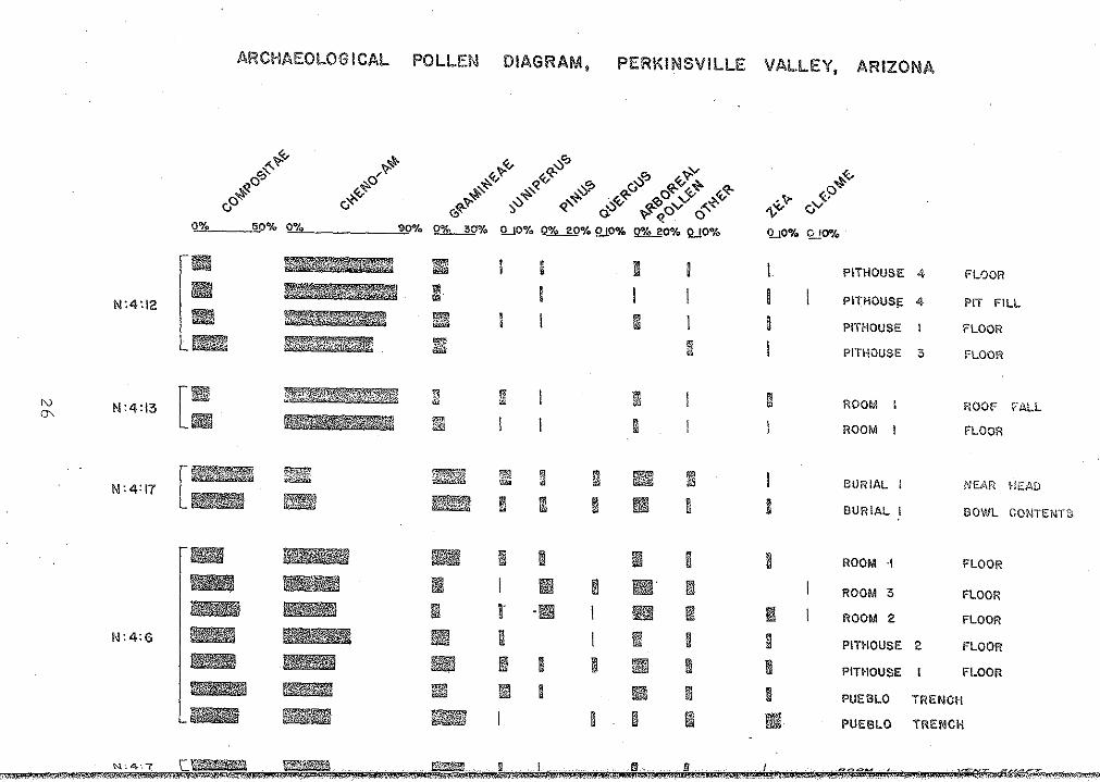
Palynology. The first archaeological pollen analysis in the Perkinsville Valley was undertaken by Dr. James Schoenwetter upon six samples from Arizona N:4:6, N:4:2, and N:4:7. The sediments were productive' of pollen, but tabulating techniques ·and environmental correlations of spectra developed for the Colorado Plateau proved inapplicable in the Perkinsville area. It was not possible to match the pollen data from Perkinsville with the corresponding segments of the Colorado Plateau pollen chronology (J, Schoenwetter, personal communication).
An expansion of the preliminary study by Suzanne Kitchen ,(n. d. ) followed in which a series of samples from the modern surface of the valley were collected and analyzed to provide information on the local palynological expression of environmental variation. All the archaeological sites sampled for pollen analysis occur within the modern confines of the Juniper-Grassland and Savanna Zone: the climatic varia-
. tion during the time period investigated archaeologically would likely have produced .effective moisture values within the mesic and xeric extremes found in the zones. A single woodland sample, high in arboreal. types, produced a spectrum unmatched in the archaeological record, Six samples from typical Juniper-Grassland and Savanna situations yielded statistically similar spectra characterized by 35 to 50 per cent; Compositae and about 20 per cent Cheno -Am pollen. A sample from a j locally more xeric environment in which thin soil over partially exposed bedrock resulted in reduced effective moisture availability contrasted :· with the other six. This sample yielded 21 percent Compositae and 55 11
per cent Cheno-Am pollen. ;,
!: Ten more archaeological samples were tabulated and earlier counts wef
12
2~l~i~~;·.:~:;~:of at least 200 grains. On the basis of these counts, ~· of climatic variation through time in terms of effec-
advanced (See Figure 3 and Table .2).
Cheno-Am values at Arizona N:4: 12 and N:4: 13 exceed .f·rorrit:hedriest locals within the Juniper-Grassland and Savanna ~4~}i; >""1•10n,er effective moisture availability was more reduced
e intervals than in the driest locals in the valley today H~''~''" C:heno-Am record results from cultural introduction •
.• ~X~P!).~.ill''Ctta<w,Lo!pc:al samples which have been interpreted as re\1\H~g····~.~·fecti.ve moisture conditions like present on the basis of
Cheno-Am values run 10 to 15 per cent higher than odle]~ri; SllrJ[ac:e samples from typical juniper grassland localities •
• ~}~.iJ.roJpl~~s fJ,"om the Arizona N:4: 17 burial exactly match modern Pollen- bearing plant parts of e·conomic value
f,~t~~ .• ~?,iiJ~~· have been introduced into a grave context than house ~; deposits. Furthermore, when Cheno-Am frequencies
qppe;c:l to the 55% value of modern xeric locals, and other per-·
~~.~T~f~~~~c omputed, the archaeological spectra with high Cheno-Am ~. esults similar to the modern surface. Therefore, although
12 and N:4: 13 yield spectra indicative of dry conditions, ;:\?!~Jh~il:'high Cheno-Am values are likely to be the result of eco-
p<?t~i!).tial. economic types that are so rare in surface spectra as to ~.;uullr<LL il~tx·oduction are Cleome (beeweed) at. Arizona N:4: 6 and
~Jt'~~·~?~~~ili~a~(~g;lobe mallow) at N:4:6, Liliaceae at N:4:6, N:4:7 ·~ (prickly pear) at N:4: 17, Agave at N:4: 6 and
and N:4:7. All sites from wl;).ich samples were
lJ

TABLE 2.
No. of Site Time Range Samples Effective Moisture Value
N:4: 12 A. D. 800-900 4 Drier- than: present. i
N:4: 13 A. D. 1000-1075 2 Drier-than-present.
N:4: 17 A. D. 1050-1125 2 Slightly drier than present? . .
N:4:6 A. D. 1190-1210 7 Like present.
N:4:7 A. D. 1200-1250 1 Like present?
:j
I fi I il :j
-,~ :.ffi i
'J ,, :o 'h
'{i .• ·~ l
·' ' i
14
SETTLEMENT PATTERN
segment of the paper is to present a descriptive . settlement pattern sequence in the Perkinsville Valley.
eque:nc:e has been developed within the operational strucp~:~ase .. concept as it is defined by Willey and Phillips (1958:
s of criteria were used to gauge culture change and ..... ,~"·~·,sequence: (1) changes in artifact styles, such as
l.n ceramic desigri; and (2) economic or adaptive }s:~en through such traits as habitation location and subsis
Each phase is characterized by a different complex of ;iri:dada~>ti·v·e traits. Because of the high correlation between
of new stylistic traits and new subsistence patterns, it ~,~<~·~.··.thLat such changes may be functionally interrelated.
with ceramic types of known age has been the :P'\eSJta,nlsm for dating habitation sites, tree ring dates and
played important roles in individual instances. By groups.outlined by Colton (1946:20; 1953: 66-67) and
for individual pottery types suggested by Breternitz een possible to place all ceramic-bearing sites within
each phase in tertns of settlement patterns has involved a of local culture history. An effort has been made to
.~i!;i:il.ii:ltu,:h detail as possible concerning settlement plan, house if'!Y,¢0m:m1C1nitv spacing, and environmental relationships. Figure·s 4
sequential change in settlement plan and site location.
15
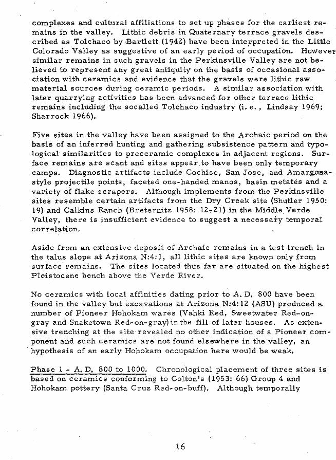
complexes and cultural affiliations to set up phases for the earliest remains in the valley. Lithic debris in Quaternary terrace gravels described as Tolchaco by ·Bartlett (1942) have been inte;rpreted in the Little Colorado Valley as suggestive of an early period of occupation. However, similar remains in such gravels in the Perkinsville Valley are not believed to represent any great antiquity on the basis of occasional association with ceramics and evidence that the gravels were lithic raw material sources during ceramic periods. A similar association with later quarrying activities has been advanced for other terrace lithic remains including the socalled Tolchaco industry (i, e., Lindsay 1969; Sharrock 1966),
Five sites in the valley have been assigned to the Archaic period on the basis of an inferred hunting and gathering subsistence pattern and typological similarities to preceramic complexes in adjacent regions. Surface remains are scant and sites appear to have been only temporary camps. Diagnostic artifacts include Cochise, San Jose, and Amar.j;,as,a-· style projectile points, faceted one-handed manos, basin metates and a variety of flake scrapers, Although implements from the Perkinsville sites resemble certain artifacts from the Dry Greek site (Shutler 1950: 19) and Calkins Ranch (Breternitz 1958: 12-21) in the Middle Verde Valley, there is insufficient evidence to suggest a necessary temporal correlation.
Aside from an extensive deposit of Archaic remains in a test trench in the talus slope at Arizona N:4: 1, all lithic sites are known only from surface remains. The sites located thus far are situated on the highest Pleistocene bench above the Verde River.
No ceramics with local affinities dating prior to A. D, 800 have been found in the valley but ·excavations at Arizona N:4: 12 (ASU) produced a number of Pioneer Hohokam wares (Vahki Red, Sweetwater Red-ongray and Snaketown Red-on-gray) in the fill of later houses, As extensive trenching at the site revealed no other indication of a Pioneer component and such ceramics are not found elsewhere in the valley, an
·hypothesis of an early Hohokam occupation here would be weak.
Phase 1 - A. D. 800 to 1000. Chronological placement of three sites is based on ceramics conforming to Colton's (1953: 66) Group 4 and Hohokam pottery (Santa Cruz Red-on-buff), Although temporally
16
~j!\~ii\'!~~1~.~~,a~;~rlt to both the Cloverleaf phase and the earlier portions of the rde Phase (Breternitz 1960: 22-24), this phase shows little
i~•'gm1~~~ relationship to those defined for the Middle Verde Valley.
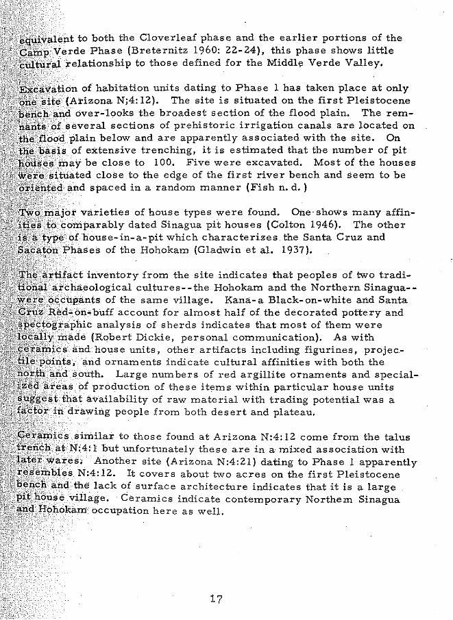
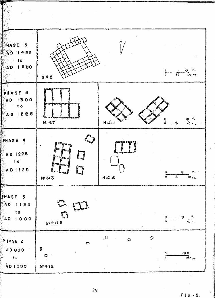
¢iiyatio'n of habitation units dating to Phase 1 has taken place at only ona N;4: 12). The site is situated on the first Pleistocene
over-looks the broadest section of the flood plain. The rem
ji~~~']o~~several sections of prehistoric irrigation canals are located on :.~ plain below and are apparently associated with the site. On
t.lile\lia!iis of extensive trenching, it is estimated that the number of pit may be close to 100. Five were excavated. Most of the houses
'~*'¢ :sittia close to the edge of the first river bench and seem to be !?!.:iJi!ilt!~d and spaced in a random manner (Fish n. d.)
+.~(5! ... ,£IJ•aJor varieties of house types were found. One· shows many affinA.!+!';'!': .•. ~u · oirif>arably dated Sinagua pit houses (Colton 1946). The other ){'~'""''tiitrii>bf house-in-a-pit which characterizes the Santa Cruz and
,...,,._r.rm :Phases of the Hohokam (Gladwin et al. 1937).
1~<>Dil:l'tifacct inventory from the site indicates that peoples of two tradiological cultures--the Hohokam and the Northern Sinagua-
se o.<:C::,lipan.ts of the same village. Kana- a Black- on-white and Santa ~ ..... .r>.ea-ori-huff account for almost half of the decorated pottery and '*>gJra]>hilc analysis of sherds indicates that most of them were
· iriade (Robert Dickie, personal communication). As with and. house units, other artifacts including figurines, projec
~U.iii!p():in1:s, and ornaments indicate cultural affinities with both the .south. Large numbers of red argillite ornaments and special-
>.areas bfproduction of these items within particular house units availability of raw material with trading potential was a
· drawing people from both desert and plateau.
rai!'.ni.cs similar to those found at Arizona N:4: 12 come from the talus N:4: l but unfortunately these are in a mixed association with
E!.i~te:.).\·W.a:t~)S. Another site (Arizona N:4:21) dating to Phase 1 apparently r:r:l'!'i<'i>_·ii_ >1 __ '1.~ s N:4: 12. It covers about two acres on the first Pleistocene }:lEi;ic;.l1•arid the lack of surface architecture indicates that it is a large
e village. Ceramics indicate contemporary Northern Sinagua ~"/-.ct]f!ohoka.m occupation here as well.
17

Phase 2 - A. D. I 000 to ll25. Sites are more numerous during the next 125 years,· with a total of seven major habitation localities surveyed. Sites are on both sides of the Verde and five of ther;n are situated on the first Pleistocene bench. The basis for dating the phase is Colton's Ceramic Group 6. The earlier Hohokam occupation does not seem to have continued into this phase in the Perkinsville Valley, although Hohokam presence is recognized in the contemporary later Camp Verde Phase in the Middle Verde Valley (Breternitz 1960: 23-24).
Two sites on the north side of the river appear to be small pit house · communities situated on erosional projections of the first Pleistocene bench. There is no evidence of masonry construction in these sites and only enough ground surface is available for one or two house units. Nearly eighty per cent of the pottery at these locations is little Colorado Ware. Tusayan Black-on-red and Black Mesa Black-on-white are also significantly represented painted wares. Such high percentages · of pottery types normally found in the Winslow region probably indicates· minor intrusions of people from that area rather than trading activity.
Three small pit house villages of partial masonry construction are apparent on the south side of the river. Although in on instance (Arizona N:4: 13) two pit house rooms appear contiguous, the villages typically contain five or six detached habitation units seemingly oriented in a random manner. Decorated pottery indicates a general contemporaneity with the sites on the north side of the river but over 90% of the surface ceramics are Alameda Brown Wares. Painted wares are repre,; sented by a very few sherds of non-local origin.
Information from Arizona N:4: 17 indicates that two important traits were introduced into the Perkinsville Valley towards the end of the phase-extended burials and Verde Black-on-gray pottery (Fish, Kitchen and McWilliams n. d.). Both the extended burial and Verde Black-on-gray pottery are characteristic elements of the Prescott Culture and mark the first evidence for contact with an area which greatly affected the later prehistory of the Perkinsville Valley.
Phase 3 - A. D. 1125 to 1300, Tree- ring dated pottery types in Colton's). Ceramic Groups 6 and 7 allow chronological placement of sites in this phase. Phase 3 equates temporally and in certain aspects of material culture with the Honanki Phase of the Southern Sinagua and the Prescott Phase of the Prescott Culture (Breternitz 1960; Colton 1936).
18

small caves and cavities in the east end of the valley were apparently the first time, Also the phase marks the first
rooms and surface architecture. Eight pueblo JO•ca,-,;eu on the flood plain and the first and second Pleistocene
!¥.'i'P"" sites in the phase are situated on the second Pleistocene jfiifii::r aLll1llV:ial fans on the first Pleistocene bench formed by the
u><•.•u• washes. Later there is a shift of settlement location the first Pleistocene bench and the flood plain itself.
o.unt of data from excavation exists for Phase 3 than any fi'z@r~n:; pueblo with associated pit houses (Arizona N:4:6)
of a masonry pueblo (Arizona N:4:7) have been excavated n. d.) .. Arizona N:4: 6 is a three room pueblo with two
:m.'pg~a..:rv pit houses which enclose one end of a plaza. A single tree 'R~;<;.~J:D''m.from this site yielded a date of A. D. 1183 (William
sonal communication).
pit house and pueblo structures are found at Arizona N:4:6, ~Gavat.ed rooms were apparently contemporary and occupied at the
;;~~i~~~~~:~:::~~ The importance of documenting pit house and ;§ within a single community and archaeological cul-
, . .,!',>vu cannot be underestimated. Similar associations have ;1ilPE'I1ted in the Kayenta and San Juan Regions (Hobler 1964;
:Lindsay, Ambler, Stein, and Hohler 1968; Gumerman 'flji\Jniline•al model of architectual development from subsurface
above ground masonry structures has long been standard H~'>;:<ll:Ure for central Arizona (Colton 1946; McGregor 1952),
. have been recorded for this time span in the Perkinsville \.)?l}a.11,any other, but the relative abundance may be attributed more eil,•S.e•:lutilization of small caves rather than to any actual increase
Surface evidence indicates that settlements are slightly ..... the later portions of the phase, but this too may be an 'easy visibility resulting from the final dominance of masonry .>;:·pit house architecture.
if:t:ti;;:-:'":'-=:;....:::..::.::.~::::_.:.;l4:::_2:.;:::5. Only two sites (Arizona N:4: 1 and N:4:2) 4 and these are dated on the basis of Colton's Ceramic
The presence of a large masonry pueblo resembling
19
Tuzig9ot and an extensive cliff dwelling similar to Montezuma's Castle, in association with Alameda Brown Wares, indicated cultural affiliation with the better known sites of the Tuzigoet Phase in the Middle Verde Valley (Colton 1939: 46-47). A hiatus exist~ in the archaeological record of the Verde Valley from the end of this phase until Spanish contact with the Yavapai (Schroeder 1952: 112).
20
CONCLUSIONS AND SUMMARY
!JOgl•ca.Hy, the Perkinsville Valley is transitional between the qr«u.u Plateau to the north and the Sonoran Desert to the south. The
elf is a minor intrusion of the Upper sonoran Life Zone into z.ona Highlands. Studies of the present biota have shown a rich
in the flora and fauna of this district.
r environmental zones have been described for a north- south ij;#:l3e•ct c·utllintg the Perkinsville Valley. Each zone has a character
s·.H•J.ra as well as a diverse and unique set of resources which would available to the prehistoric inhabitants of the valley.
onmental data when correlated with settlement information "'-,.~rned change through time. Sites occupied during Phase I
iJ¢•cacted on the first Pleistocene bench. The potential for irrigation 'lCU<-.:ure on the flood plain was probably great at this time and thus
area appealing to Hohokam settlers. The drier-than-present !~\\~~<lons·· indicated by the pollen spectrum would decrease extensive
such as the ones known historically on the flood plain and make 'i?.: .. ':'<.;'m>cJ:u•c-.:Jton of an irrigation system feasible. Occupation of the
Hi!~t,t'Jleistocerte bench continued through Phase 2. Pollen samples .early in the phase indicate drier conditions, while the record
later one shows moisture availability approaching the modern
nt data from the early portion of Phase 3 indicates a shift in ;J,.'"''"""". ,· o. from the first Pleistocene bench to .the second. Sites are
·~~c,;ea near alluvial fans which open onto the first Pleistocene b<mch. palynological data from this period indicates a corres
from drier-than-present conditions to moister ones.
21
agricultural potential of the flood plain and the first Pleistocene bench. Sites would tend to be situated on the higher river benches under conditions like present or moister because the mar·shy condition of the flood plain would not lend itself to agricultural purposes. Dry farming, however, wm1ld have been possible under such conditions in alluvial fans and washes of the first river bench. Under drier conditions, canal and flood water irrigation could have been practised on the entire flood plain and the sites would be located on the first Pleistocene bench or flood plain.
Schroeder (1960) suggests a progressive shift in the Middle Verde Valley of Settlement situations to higher and higher elevations. This appears to be true for the Perkinsville valley in only the most general sort of way. Elevations of sites at particular points in time are consistent but changes in situation through time include movement to lower as well as higher elevations. The correlation of site situation, environmental change, and the availability of agricultural land offers more insight into the settlement patterns of the region than previous interpreta- · tions.
22
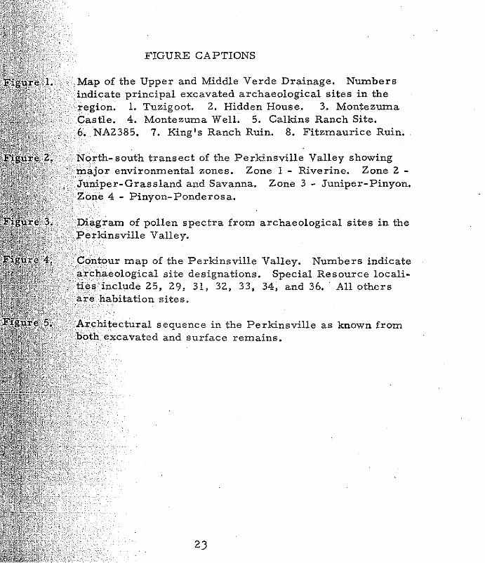
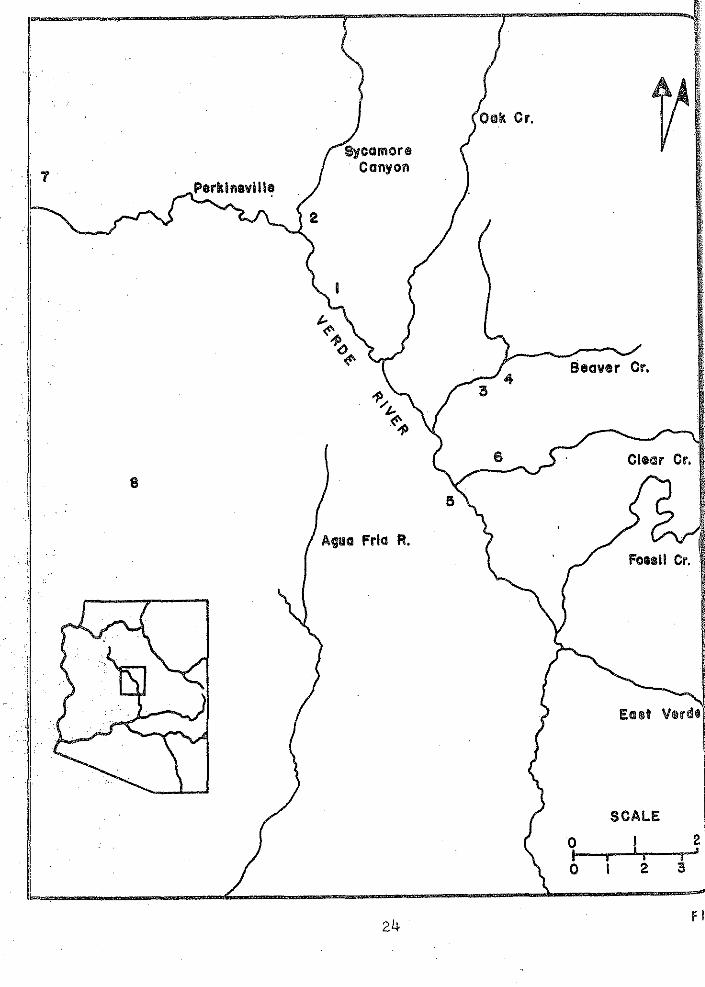
FIGURE CAPTIONS
Map of the Upper and Middle Verde Drainage. Numbers indicate principal excavated archaeological sites in the region. 1. Tuzigoot. 2. Hidden House. 3. Montezuma Castle. 4. Montezuma Well. 5. Calkins Ranch Site. 6. NA2385. 7. King's Ranch Ruin. 8. Fitzmaurice Ruin.
North-south transect of the Perkinsville Valley showing major environmental zones. Zone 1 - Riverine. Zone 2 -
sland and Savanna. Zone 3 - Juniper-Pinyon. Pinyon-Ponderosa.
of pollen spectra from archaeological sites in the Perkin,,ville Valley.
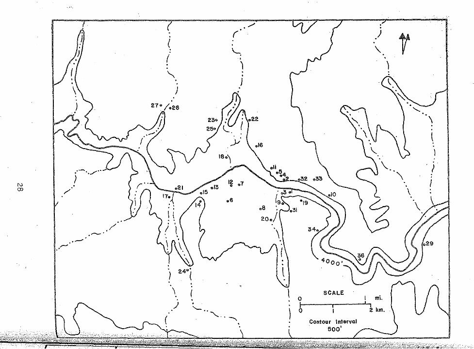
Ccmt:ou:r map of the Perkinsville Valley. Numbers indicate :3.:r'c.tta~lollo!;ic:al site designations. Special Resource locali
include 25, 29, 31, 32, 33, 34, and 36. ·All others
sequence in the Perkinsville as known from excavated and surface remains.
2)
.i 1 Perk I nevi 118
I
Sycamore Canyon
Agua Frla R.
24
5
0 I 0
Fossil cr.
SCALE I
I 21 I I • • I
I 2 5
f I

"" -~
"'
0 It,"! © 0 0 0 0 0 0
0 0 0
~-=-~=4=·~o~L.-db--b===========·~==~a=-===m=======
0 0
1'\) N 0 :z
00 I'll (II (")
1'\) :!:> r- (p8
.,ji> M
CJ!l (,j)l
l)l)
.,ji>
,.. !ill ?
N
~+ 0 ;!@ z =! ffl :::1:
~
ARCHAEOLOGICAL POLLEN DIAGRAM,
• a • -
[Wi$'4ii(
M¥#4¥1
---~~ ---II rfj
ill !'11.1'1
~
~
m I I a
PERKINSVILLE VALLEY, ARIZONA
m
I m
I I i I
I !
PITHOUSE 4
PITHOUSJ;: 4
PITHOUSE I
PITHOUSE 3
ROOM I
ROOM
BURIAL I
BURIAL I
ROOM ·I
ROOM 5
ROOM 2
PlniOUSE 2
PlniOUSE I
FLOOR
PIT FILL
FLOOR
FLOOR
ROOF FALL
FLOOR
BOWL CONTENTS
FLOOR
FLOOR
FLOOR
FLOOR
FLOOR
PUEBLO TRENCH
PUEBLO TRENCH

·N ---.1
-_,..-·
"'-.
.. /
(
(
I • .
"
. )
. J
\ )
. . I . . '-
. '-.
• I . • }
I~ o7
.s
\. f )
\
. l
I
SCALE 0 I mi. .
) 0 2 km.
Contour Interval 500'
FIG· I!.
• ( . ) t { '-. \.
( • ) I .
" ) . )
\ .
_;...- l l
. ( .·--./·· \ ; ) I N . OJ /
.s
. \ I SCALE
mi. 0 I . ) .
'- .. l 0 2 km.
' . -.... Interval Contour ·. 500'
;:: .·
····iMkse: 5
i(";('o I 4 2 5
to
·\AD I 3 00
pHASE 4
13 0 0
to
I 2 2 5
PHASE 4
AD 1225
t 0
D 112 5
. PliAS E 3
CAD I I 2 !S
to AD 1000
PHASE 2
AD 800 ::J
to
AD 1000
f'O"''=
I 0 ~· r-<
~"~ """' 0
000 ~ 0
0
29
v
[1J] g
0(} N:4:6
0 0
0 90 M.
0
0
0
0
0
0
0
50 100 fT.
20 M.
oo 60FT.
10 M.
20 40FT •
10 M.
40FT.
60 M
200 FT.
IFIG-!i.

ACKNOWLEDGEMENTS
Special credit must be given to the entire Perkins family (particularly Mrs. Nick Perkins) for their enthusiastic support of our research. Among those who have given technical assistance are Robert Dickie (spectographic analysis of ceramics), Suzanne Kitchen (pollen analysis), Alexander Lindsay (analysis of northern Arizona ceramics), W. Minckley (faunal analysis), W. Robinson (tree ring analysis), and J. Schoenwetter (pollen analysis). The pollen diagram (Figure 3) was prepared by Suzanne Kitchen. The figures were drafted by Karen Harris. Students who have carried out excavation in the Pe.rkinsville Valley include Norman Alger, Paul Fish, David Kayser, Albert Miller, Peter Pilles, and Godfrey Whiffen. Drs. A. E. Dittert, Jr., D. H. Morris, and R. J. Ruppe have read and offered their criti~isms of this paper.
30
BIBLIOGRAPHY
BARTLETT, KATHARINE
1939 "A Prehistoric 'Mine' of Red Argillite, Resembling Pipestone, near Del Rio, Arizona. 11
. Museum Notes, Museum of Northern Arizona, Vol. 11, No. 12, 75-78. Flagstaff.
BRETERNITZ, DAVID A.
J958
1960
1966
"The Calkins Ranch Site, NA 2385, A Preliminary Report. 11 Plateau, Vol. 31, No. 1, 19-20. Flagstaff.
Excavations at Three Sites in the Verde Valley, Arizona. Museum of Northern Arizona Bulletin 34. Flagstaff.
An Appraisal of Tree-Ring Dated Pottery in the Southwest. Anthropological Papers of the University of Arizona, No. 10 Tucson.
CAYWOOD, L. R. and E. H. SPICER
1935 Tuzigoot: The Excavation and Repair of a Ruin on the Verde River Near Clarkdale, Arizona. Field Division of Education, National Park Service. Berkeley.
CHANG, K. C.
1958 "Study of the Neolithic Social Groupings: Examples from the New World." American Anthropologist, Vol. 60, No. 2, 298-334. Menasha. ·
31
1962 A Typology of Settlement and Community Patterns in Some Circumpolar Societies. Arctic Anthropology, ·Vol. l, No.· l, pp. 28-41. Madison;
1968 "Toward a Science of Prehistoric Society, 11 in Settlement Archaeology, ed. by K. Chang. National Press Books. Palo Alto.
COLTON. HAROLD S.
1936
1939
1946
1953
The Rise and Fall of the Prehistoric Population of Northern Arizona. Science, Vol. 84, No. 2181, pp 337-43. Washington.
Prehistoric Culture Units ·and Their Relationships in Northern Arizona. Museum of Northern Ar Bull 1 7. Flagstaff.
The Sinagua: A summary of the Archaeology of the Flagstaff Region, Arizona. Bulletin 22. Flagstaff.
Potsherds: An Introduction to the Study of Prehistoric Southwestern Ceramics and their Use in Historic Rec struction. Museum of Northern Arizona Bulletin 25. Flag staff.
DITTER T, A. E. JR.
1968 Some Factors Affecting Southwestern Populations Du the Period A. D. 900- 1540. western Prehistory," Vol. 4, Preceedings VII Congre International Association for Quaternary Research. ited by Cynthia Irwin- Williams, pp. 17-20. Eastern Mexico University, Contributions in Anthropology, Vol; 1, No. l, Portales.
FENNEMAN, N. M.
1931 Physiography of the Western United States. McGraw Book Co. , Inc. New York.
2
FISH, P. R.
n. d. Recent Archaeological Investigation,s in the Perkinsville Valley, Arizona, Paper given at the 28th annual meeting of the American Archaeological Association, Santa Fe.
FISH, P.R. , S. KITCHEN, and R. McWILLIAMS
n. d. A Slab- Covered Burial from Perkinsville, Arizona. MS on File at the Department of Anthropology, Arizona State University.
FISH; P.R. and GODFREY WHIFFEN
n. d. Arizona N:4:6~~An EarlyPIII Site in.~he Perkinsville Valley, Arizona. Unpublished MS on File at the Department of Anthropology, AriZOJ:J.a State University.
FITTING, JAMES
1969 "Settlement Analysis in the Or.eat Lakes Region." SoUthwestern Journal of Anthropology, Vol. 25, 360-377. Albuquerque.
FRITTS, H. C., DAVID G. SMITH, and MARVIN A. STOKES
. 1965 The Biological Model for Paleoclimatic Interpretation of Mesa Verde Tree-Ring Series. In "Contributions of the Wetherill Mesa Archaeological Project," assembled by Douglass Osborne and edited by BernardS. Katz, Memoirs of the Society for American Archaeology, No. 19. Salt Lake City.
GLADWIN, H. S., E. HAURY, E. SAYLES, and N. GLADWIN
1937 Excavations at Snaketown: I. Material Culture. Medallion Papers, No. 6. Globe.
33

GUMERMAN, GEORGE J.
1969 The Archaeology of the Hopi Buttes. District, Arizona. Doctoral Dissertation, The University of Arizona, Tucson. University Microfilm, Ann Arbor.
HASTINGS, JAMES R. and RAYMOND M. TURNER
1965 The Changing Mile. University of Arizona Press Tucson.
HOBLER, PHILIP M.
· 1964 The Late Survival of Pithouse Architecture in the Kayenta Anasazi Area. MS, Master's thesis, University of Arizona Library, Tucson.
KITCHEN, SUZANNE
n. d. Archaeological Pollen Analysis in the Perkinsville Valley, Arizona. Paper given at the 1970 meeting of the Arizona Academy of Science. Phoenix.
LEHNER, ROBERT E.
1958 Geology of the Clarkdale Quadrangle. Geological Bulletin 1021-N. Washington.
LINDSAY, ALEXANDER J. JR., J. R. AMBLER, M. A. STEIN, and P.M. HOBLER
1968 Survey and Excavations North and East of Navajo Mountain Utah, 1959- 1962. Museum of Northern Arizona Bulletin 45, Glen Canyon Series 9. Flagstaff,
McGREGOR, J. C.
1965 Southwestern Archaeology, second edition. University of Illinois Press, Urbana.
34
MEARNS, EDGAR A.
1907 Mammals of the Mexican Boundary., Government Printing Office, Washington.
MINCKLEY, W. L. and ALGER, N. T.
1968 "Fish Remains from an Archaeological Site Along the Verde River, Yavapai County, Arizona. 11 Plateau, Vol. R, No. 3, 91-97. Flagstaff.
SCHOENWETTER, JAMES and ALFRED E. DITTERT, JR.
1968 An Ecological Interpretation of Anasazi Settlement Patterns. In Anthropological Archaeology in the Americas. Edited by Betty J. Meggers, pp. 41-66. Anthropological Society of Washington Washington.
SCHROEDER, ALBERT H.
1952b A Br1ef History of the Yavapa1 of the !\.fiddle Verde Valley, Plateau, Vol. 24, No.3, pp. 111-18. Flagstaff.
1968 Tentative Ecological and Cultural Factors and Their Effea:ts on Southwestern Farmers. In "Contributions to Southwestern Prehistory," Vol. 4, Preceedings VII Congress International Association for Quaternary Research, edited by Cynthia Irwin- Williams, pp. 14-16. Eastern New Mexico University, Contributions in Anthropology, Vol. I, No. 1. Portales.
SHARROCK, F. W.
1966 Prehistoric Occupation Patterns in Southwest Wyoming and Cultural Relationships with the Great Basin and Plains Culture Areas. University of Utah Anthro. Papers 77. Salt Lake City.
35
SHUTLER, DICK, JR.
1950 The Dry Creek Site. Plateau,· Vol.. 23, No. 1, pp. 6=-10. Flagstaff.
1951 Two Pueblo Ruins in the Verde Valley, Arizona. Plateau, Vol. 24, No. 1, pp. 1-9. Flagstaff.
TRIGGER, BRUCE
1967 Seii:lement Archaeology- -Its Goals and Promises, American Antiquity, Vol. 32, 149-161. Salt Lake City.
WILLEY, G.
1953 Prehistoric Settlement Patterns in the Viru Valley, Peru. Bulletin 155, Bureau of American Ethnology. Washington.
WILLEY, G. R., and PHILIP PHILLIES
1958 Method and Theory in American Archaeology. The University of Chicago Press, Chicago.
WOODBURY, RICHARD B.
1961 Climatic Chang¢'s and Prehistoric Agriculture in the Southwestern United States. Annals of the New Yor!< Academy of Sciences, Vol. 95, Art. 1, pp. 705-709, New York.