Embed Size (px)
Citation preview
PREFEASIBILITY REPORT
FOR
PROPOSED INDUSTRIAL PARK
At VILLAGE MANDAL DISTRICT STATE
KOPPARTHY (3662.97ACRES) CHINTAKOMMA
DINNE
KADAPA ANDHRA
PRADESH
TADIGOTAL (797.14 ACRES)
YADAVAPURAM (993.79 ACRES)
VALLUR THOLLAGANGANAPALLI (212.51
ACRES)
AMBAVARAM (704.70 ACRES)
RAMPATHADU (181.93 ACRES) PENDLIMARRI
Proposed Area -6553.04 Acres
[Project scheduled under 7[c] - category A as per EIA notification, 2006 and its
amendments]
Proposed By
ANDHRA PRADESH INDUSTRIAL INFRASTRUCTURE CORPORATION LTD.
4th Floor, Parisrama Bhavan, Fateh Maidan Road, Basheerbagh,
Hyderabad – 500 004,
Prepared by
HUBERT ENVIRO CARE SYSTEMS PVT LTD.,
CHENNAI
JANUARY, 2016
Prefeasibility Report for Industrial Park at Kopparthy
Hubert Enviro Care Systems Pvt. Ltd., Chennai ii
CONTENTS 1. INTRODUCTION ....................................................................................................... 1
1.1 ABOUT THE PROJECT PROPONENT ............................................................................. 1
1.2 OBJECTIVE OF APIIC ........................................................................................................ 1
1.3 ABOUT THE PROJECT ....................................................................................................... 2
2. PROJECT AREA PROFILE ......................................................................................... 3
2.1 OVERVIEW OF KADAPA DISTRICT ................................................................................ 3
2.2 DEMOGRAPHIC PROFILE ............................................................................................... 3
2.3 PROJECT SETTINGS ........................................................................................................... 4
2.4 PHYSICAL CONDITIONS .................................................................................................. 7
2.4.1 Climate .......................................................................................................................... 7
2.4.2 Rainfall ........................................................................................................................... 8
2.4.3 Seismicity ....................................................................................................................... 9
2.4.4 Topography ................................................................................................................ 10
2.4.5 Physiography .............................................................................................................. 10
2.4.6 Drainage and water bodies ................................................................................... 11
2.4.7 Soil ................................................................................................................................. 12
2.4.8 Geology ...................................................................................................................... 13
2.4.9 Hydro Geology .......................................................................................................... 14
2.4.10 Land Use/ Land Cover ............................................................................................. 16
2.4.11 Irrigation ....................................................................................................................... 18
2.4.12 Ground Water Resources ........................................................................................ 18
2.4.12.1 Ground water levels at Project site .................................................................... 19
2.5 ECONOMIC PROFILE ..................................................................................................... 19
2.5.1 Socio Economic Environment ................................................................................. 19
2.5.2 Educational Facilities ................................................................................................ 21
Prefeasibility Report for Industrial Park at Kopparthy
Hubert Enviro Care Systems Pvt. Ltd., Chennai iii
2.5.2.1 Colleges/Institutions .............................................................................................. 21
2.5.2.2 Schools ..................................................................................................................... 21
2.5.3 Medical Facilities ....................................................................................................... 21
3. PROJECT SITE ASSESSMENT ............................................................................. 22
3.1 LOCATION AND EXTENT OF SITE ...................................................................................... 22
3.2 SURROUNDING FEATURES................................................................................................. 25
3.3 CONNECTIVITY ................................................................................................................... 26
3.3.1 Road Connectivity .................................................................................................... 26
3.3.2 Rail ................................................................................................................................ 26
3.3.3 Airport .......................................................................................................................... 26
3.3.4 Seaport ........................................................................................................................ 27
3.4 MINERALS ............................................................................................................................ 27
3.5 INDUSTRIAL SCENARIO OF KADAPA DISTRICT .............................................................. 27
3.5.1 Existing Micro & Small enterprises and Artisan units in the District ................... 28
3.6 WATER BODIES .................................................................................................................... 28
3.7 SOCIAL CONSIDERATIONS ............................................................................................... 29
3.8 REHABILITATION AND RESETTLEMENT (R&R) .................................................................. 29
3.9 SAFETY ASPECTS ................................................................................................................. 29
4. SITE MASTER PLAN ................................................................................................ 30
4.1 ABOUT THE PROJECT ......................................................................................................... 30
4.2 SITE JUSTIFICATION ............................................................................................................. 30
4.3 PROPOSED MASTER PLAN BY APIIC................................................................................ 30
4.3.1 Area Break up for the Project ................................................................................. 31
4.3.2 Plotted Area ............................................................................................................... 31
4.3.3 Open Area .................................................................................................................. 33
4.3.4 Common Facilities ..................................................................................................... 33
4.3.5 Green Belt Area ......................................................................................................... 33
Prefeasibility Report for Industrial Park at Kopparthy
Hubert Enviro Care Systems Pvt. Ltd., Chennai iv
4.3.6 Road Area .................................................................................................................. 34
5. INFRASTRUCTURE SERVICES AND FACILITIES ..................................................... 35
5.1 PREAMBLE ........................................................................................................................... 35
5.2 WATER SUPPLY SYSTEM...................................................................................................... 35
5.2.1 Water Demand during Construction Phase ............................................................ 35
5.2.2 Operation Phase ........................................................................................................... 35
5.3 STORM WATER MANAGEMENT ........................................................................................ 37
5.3.1 Rain water Harvesting Scheme .................................................................................. 37
5.4 WASTEWATER MANAGEMENT SYSTEM ........................................................................... 38
5.5 POWER AND FUEL REQUIREMENT ................................................................................... 38
5.6 SOLID WASTE MANAGEMENT .......................................................................................... 39
5.6.1 Solid and Hazardous Wastes ....................................................................................... 39
5.6.2 Construction Waste Disposal ...................................................................................... 40
5.7 FACILITIES FOR STORAGE OF GOODS OR MATERIALS ................................................ 41
5.8 FACILITIES FOR STORAGE OF HAZARDOUS WASTE ...................................................... 41
5.9 MANPOWER REQUIREMENT ............................................................................................. 41
5.10 HEALTH & SAFETY MEASURES ........................................................................................... 41
6. PROJECT COST ESTIMATES................................................................................... 42
Prefeasibility Report for Industrial Park at Kopparthy
Hubert Enviro Care Systems Pvt. Ltd., Chennai v
LIST OF TABLES
Table 2-1 Kadappa District at a Glance ............................................................................................... 3
Table 2-2 Monthly rainfall distribution from 1999 to 2011 ................................................................ 8
Table 2-3 Land Use Pattern ............................................................................................................... 17
Table 2-4 Population of the Kappa District ....................................................................................... 20
Table 2-5 List of Schools in District ................................................................................................... 21
Table 2-6 Medical Facilities in the District ....................................................................................... 21
Table 3-1 Project Site Details ............................................................................................................. 24
Table 3-2 Proposed Project Surrounding Features .......................................................................... 25
Table 3-3 Availability of minerals Around the Project Site ............................................................. 27
Table 3-4 Industrial Scenario of Kadapa District .............................................................................. 27
Table 3-5 Type of Industries in Kadapa District ............................................................................... 28
Table 4-1 Village vise land extent...................................................................................................... 31
Table 4-2 Area Break up for the project ........................................................................................... 31
Table 4-3 Type of industry proposed ................................................................................................ 32
Table 4-4 List of Industries Allotted .................................................................................................. 32
Table 4-5 Common Tree Species for Plantation ............................................................................... 34
Table 5-1 Water requirement for Construction Phase ..................................................................... 35
Table 5-2 Water requirement for Different industries ..................................................................... 36
Table 5-3 Basis of calculation of CETP .............................................................................................. 38
Table 5-4 Power and Fuel Requirement Break up ........................................................................... 39
Table 6-0-1 Project Cost Estimates ................................................................................................... 42
LIST OF FIGURES
Figure 2-1 Location Map of the project site ........................................................................................ 4
Figure 2-2 Administrative Map ............................................................................................................. 5
Figure 2-3 Topo sheet showing the project site and surrounding features ..................................... 6
Figure 2-4 Mean monthly rainfall distribution ..................................................................................... 7
Figure 2-5 Yearly rainfall data for 5 years .......................................................................................... 8
Figure 2-6 Monthly Rainfall of Kadapa District ................................................................................... 9
Figure 2-7 Seismic Zoning Map of Andhra Pradesh ........................................................................... 9
Figure 2-8 Topography Map showing the project site and surrounding .................................. 10
Figure 2-9 Physiography Map ............................................................................................................ 11
Prefeasibility Report for Industrial Park at Kopparthy
Hubert Enviro Care Systems Pvt. Ltd., Chennai vi
Figure 2-10 Project Site showing Drainage and Water Body .......................................................... 12
Figure 2-11 Soil Classification of project site and surrounding ....................................................... 13
Figure 2-12 Geology Map ................................................................................................................... 14
Figure 2-13 Hydrogeology map of Kadapa District .......................................................................... 15
Figure 2-14 Land Use Classification Map .......................................................................................... 17
Figure 2-15 Land Use/ Land Cover Pattern ...................................................................................... 18
Figure 2-16 Ground Water Levels of the Site ................................................................................... 19
Figure 3-1 Satellite Image of the Site ............................................................................................... 22
Figure 3-2 10 Km radius Satellite image ........................................................................................... 23
Figure 3-3 Location of the Project Site.............................................................................................. 25
Figure 3-4 Connectivity of the Project Site ...................................................................................... 26
Figure 5-1 Water Balance Chart ........................................................................................................ 37
Prefeasibility report for Industrial Park at Kopparthy
Hubert Enviro Care Systems Pvt. Ltd., Chennai 1
1. INTRODUCTION
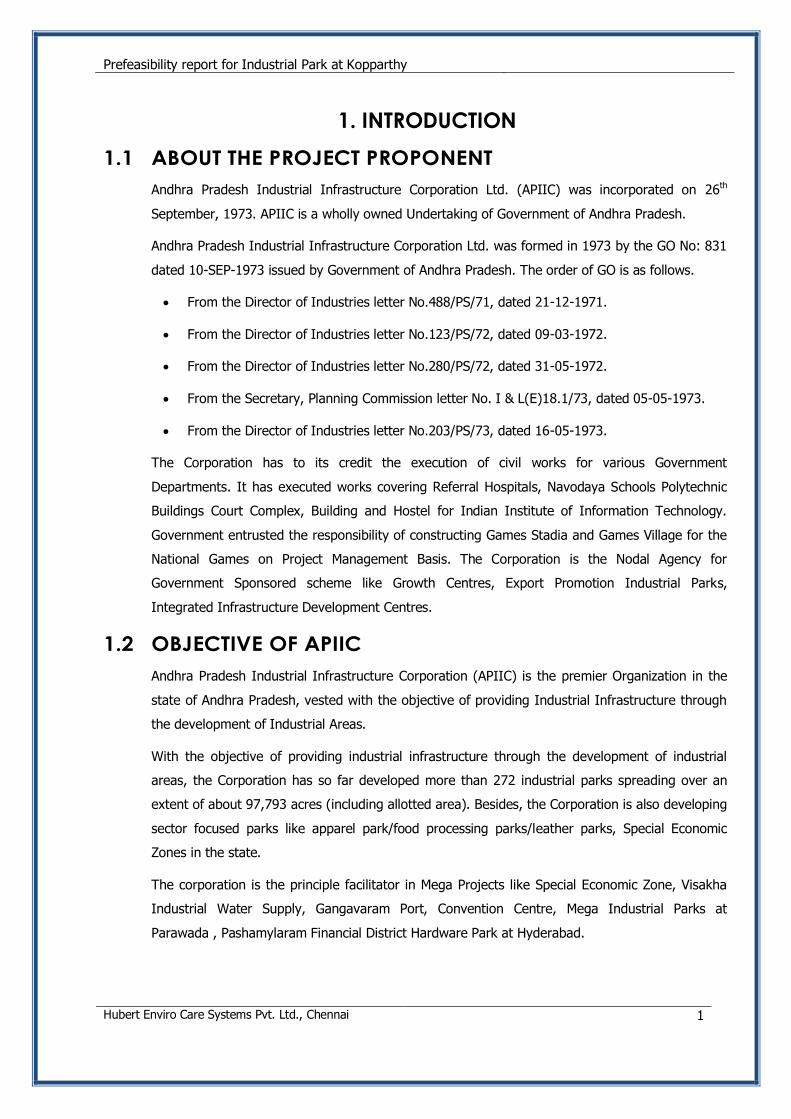
1.1 ABOUT THE PROJECT PROPONENT
Andhra Pradesh Industrial Infrastructure Corporation Ltd. (APIIC) was incorporated on 26th
September, 1973. APIIC is a wholly owned Undertaking of Government of Andhra Pradesh.
Andhra Pradesh Industrial Infrastructure Corporation Ltd. was formed in 1973 by the GO No: 831
dated 10-SEP-1973 issued by Government of Andhra Pradesh. The order of GO is as follows.
From the Director of Industries letter No.488/PS/71, dated 21-12-1971.
From the Director of Industries letter No.123/PS/72, dated 09-03-1972.
From the Director of Industries letter No.280/PS/72, dated 31-05-1972.
From the Secretary, Planning Commission letter No. I & L(E)18.1/73, dated 05-05-1973.
From the Director of Industries letter No.203/PS/73, dated 16-05-1973.
The Corporation has to its credit the execution of civil works for various Government
Departments. It has executed works covering Referral Hospitals, Navodaya Schools Polytechnic
Buildings Court Complex, Building and Hostel for Indian Institute of Information Technology.
Government entrusted the responsibility of constructing Games Stadia and Games Village for the
National Games on Project Management Basis. The Corporation is the Nodal Agency for
Government Sponsored scheme like Growth Centres, Export Promotion Industrial Parks,
Integrated Infrastructure Development Centres.
1.2 OBJECTIVE OF APIIC
Andhra Pradesh Industrial Infrastructure Corporation (APIIC) is the premier Organization in the
state of Andhra Pradesh, vested with the objective of providing Industrial Infrastructure through
the development of Industrial Areas.
With the objective of providing industrial infrastructure through the development of industrial
areas, the Corporation has so far developed more than 272 industrial parks spreading over an
extent of about 97,793 acres (including allotted area). Besides, the Corporation is also developing
sector focused parks like apparel park/food processing parks/leather parks, Special Economic
Zones in the state.
The corporation is the principle facilitator in Mega Projects like Special Economic Zone, Visakha
Industrial Water Supply, Gangavaram Port, Convention Centre, Mega Industrial Parks at
Parawada , Pashamylaram Financial District Hardware Park at Hyderabad.
Prefeasibility report for Industrial Park at Kopparthy
Hubert Enviro Care Systems Pvt. Ltd., Chennai 2
1.3 ABOUT THE PROJECT
APIIC proposes the development of Industrial Park at Kopparthy, Yadavapuram, Tadigotal,
Thollaganganapalli, Ambavaram and Rampathadu villages of Chintakomma Dinne, Vallur and
Pendlimarri Mandals of Kadapa District, Andhra Pradesh with an area of 6553.04 Acres to cater to
the socio-economic development of the region.
Hence the site attracts Environmental Clearance from the Ministry of Environment and Forests
Expert Appraisal Committee, as per Schedule 7(c) category A project, as per the guidelines of EIA
notification of 2006, and the amendments thereafter.
Prefeasibility report for Industrial Park at Kopparthy
Hubert Enviro Care Systems Pvt. Ltd., Chennai 3
2. PROJECT AREA PROFILE
2.1 OVERVIEW OF KADAPA DISTRICT
Kadapa District is surrounded by Kurnool District on the north, Chittoor District on the South,
Nellore on the East and Ananthapur on the West. Total Geographical area of the District is
15,379 Sq.Kms with 3 Revenue Divisions 51 mandals, 831 Gram Panchayats 965 Revenue
Villages and 4533 Habitations.
The district has occupied an important place in the Industrial map of Andhra Pradesh with its
highly valued rich mineral resources. It has the world’s single largest and the best deposits of
Barytes and enjoying monopoly in the superior variety of Asbestos. It is worth mentioning that
the state’s first one million tones capacity cement plant was established in Cuddapah District.
However the District has not been industrially developed as the expectations.
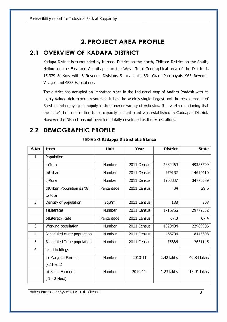
2.2 DEMOGRAPHIC PROFILE
Table 2-1 Kadappa District at a Glance
S.No Item Unit Year District State
1 Population
a)Total Number 2011 Census 2882469 49386799
b)Urban Number 2011 Census 979132 14610410
c)Rural Number 2011 Census 1903337 34776389
d)Urban Population as %
to total
Percentage 2011 Census 34 29.6
2 Density of population Sq.Km 2011 Census 188 308
a)Literates Number 2011 Census 1716766 29772532
b)Literacy Rate Percentage 2011 Census 67.3 67.4
3 Working population Number 2011 Census 1320404 22969906
4 Scheduled caste population Number 2011 Census 465794 8445398
5 Scheduled Tribe population Number 2011 Census 75886 2631145
6 Land holdings
a) Marginal Farmers
(<1Hect.)
Number 2010-11 2.42 lakhs 49.84 lakhs
b) Small Farmers
( 1 - 2 Hect)
Number 2010-11 1.23 lakhs 15.91 lakhs
Prefeasibility report for Industrial Park at Kopparthy
Hubert Enviro Care Systems Pvt. Ltd., Chennai 4
S.No Item Unit Year District State
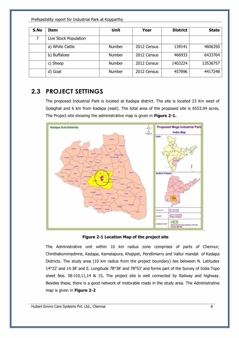
7 Live Stock Population
a) White Cattle Number 2012 Census 139141 4606350
b) Buffaloes Number 2012 Census 466933 6433764
c) Sheep Number 2012 Census 1403224 13536757
d) Goat Number 2012 Census 457896 4417248
2.3 PROJECT SETTINGS
The proposed Industrial Park is located at Kadapa district. The site is located 23 Km west of
Golaghat and 6 km from Kadapa (east). The total area of the proposed site is 6553.04 acres.
The Project site showing the administrative map is given in Figure 2-1.
.
Figure 2-1 Location Map of the project site
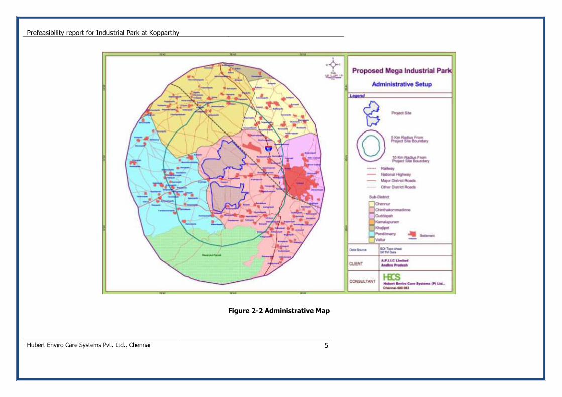
The Administrative unit within 10 km radius zone comprises of parts of Chennur,
Chinthakommadinne, Kadapa, Kamalapura, Khajipet, Pendlimarry and Vallur mandal of Kadapa
Districts. The study area (10 km radius from the project boundary) lies between N. Latitudes
14°22’ and 14.38’ and E. Longitude 78°38’ and 78°53’ and forms part of the Survey of India Topo
sheet Nos. 58-J10,11,14 & 15, The project site is well connected by Railway and highway.
Besides these, there is a good network of motorable roads in the study area. The Administrative
map is given in Figure 2-2
Prefeasibility report for Industrial Park at Kopparthy
Hubert Enviro Care Systems Pvt. Ltd., Chennai 5
Figure 2-2 Administrative Map
Prefeasibility report for Industrial Park at Kopparthy
Hubert Enviro Care Systems Pvt. Ltd., Chennai 6
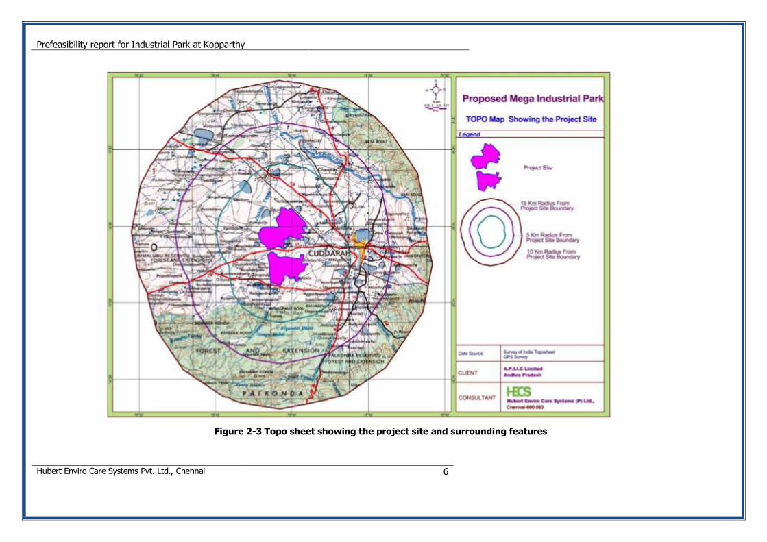
Figure 2-3 Topo sheet showing the project site and surrounding features
Prefeasibility report for Industrial Park at Kopparthy
Hubert Enviro Care Systems Pvt. Ltd., Chennai 7
2.4 PHYSICAL CONDITIONS
2.4.1 Climate
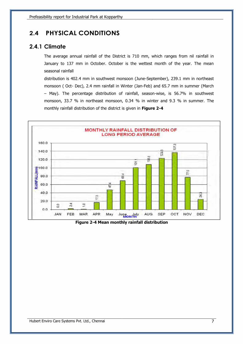
The average annual rainfall of the District is 710 mm, which ranges from nil rainfall in
January to 137 mm in October. October is the wettest month of the year. The mean
seasonal rainfall
distribution is 402.4 mm in southwest monsoon (June-September), 239.1 mm in northeast
monsoon ( Oct- Dec), 2.4 mm rainfall in Winter (Jan-Feb) and 65.7 mm in summer (March
– May). The percentage distribution of rainfall, season-wise, is 56.7% in southwest
monsoon, 33.7 % in northeast monsoon, 0.34 % in winter and 9.3 % in summer. The
monthly rainfall distribution of the district is given in Figure 2-4
Figure 2-4 Mean monthly rainfall distribution
Prefeasibility report for Industrial Park at Kopparthy
Hubert Enviro Care Systems Pvt. Ltd., Chennai 8
Table 2-2 Monthly rainfall distribution from 1999 to 2011
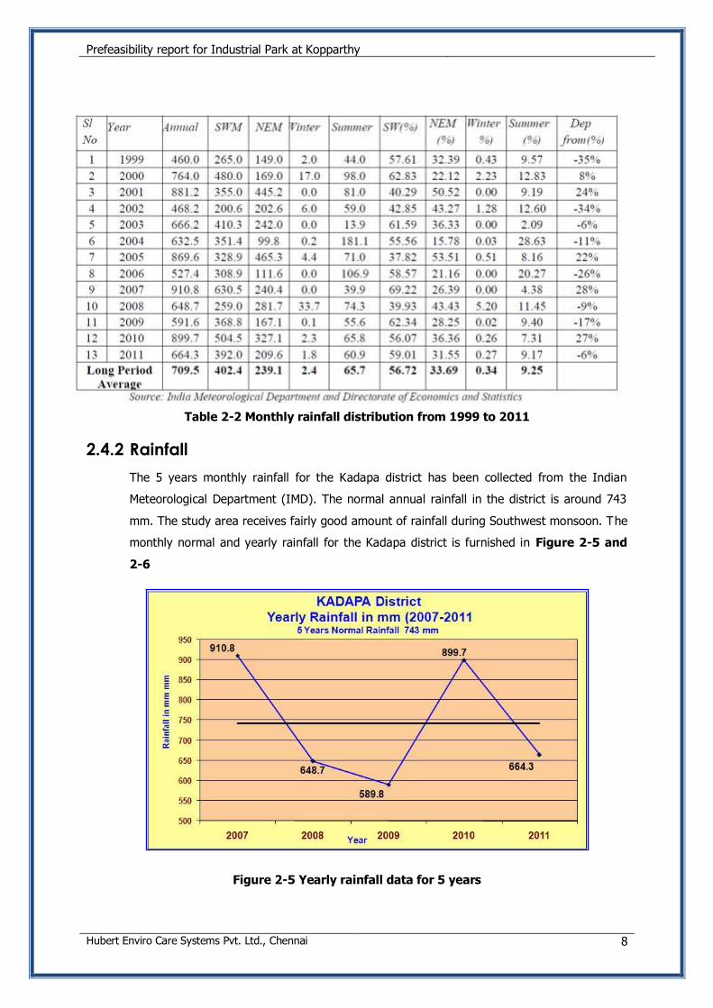
2.4.2 Rainfall
The 5 years monthly rainfall for the Kadapa district has been collected from the Indian
Meteorological Department (IMD). The normal annual rainfall in the district is around 743
mm. The study area receives fairly good amount of rainfall during Southwest monsoon. The
monthly normal and yearly rainfall for the Kadapa district is furnished in Figure 2-5 and
2-6
Figure 2-5 Yearly rainfall data for 5 years
Prefeasibility report for Industrial Park at Kopparthy
Hubert Enviro Care Systems Pvt. Ltd., Chennai 9
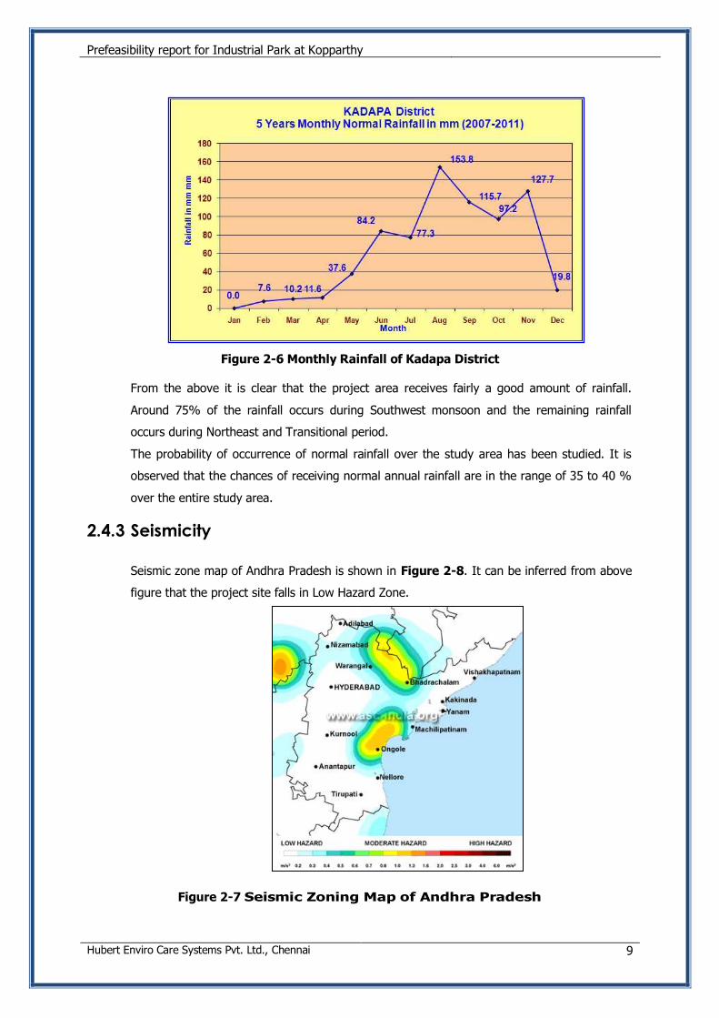
Figure 2-6 Monthly Rainfall of Kadapa District
From the above it is clear that the project area receives fairly a good amount of rainfall.
Around 75% of the rainfall occurs during Southwest monsoon and the remaining rainfall
occurs during Northeast and Transitional period.
The probability of occurrence of normal rainfall over the study area has been studied. It is
observed that the chances of receiving normal annual rainfall are in the range of 35 to 40 %
over the entire study area.
2.4.3 Seismicity
Seismic zone map of Andhra Pradesh is shown in Figure 2-8. It can be inferred from above
figure that the project site falls in Low Hazard Zone.
Figure 2-7 Seismic Zoning Map of Andhra Pradesh
Prefeasibility report for Industrial Park at Kopparthy
Hubert Enviro Care Systems Pvt. Ltd., Chennai 10
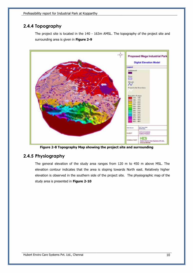
2.4.4 Topography
The project site is located in the 140 - 163m AMSL. The topography of the project site and
surrounding area is given in Figure 2-9
Figure 2-8 Topography Map showing the project site and surrounding
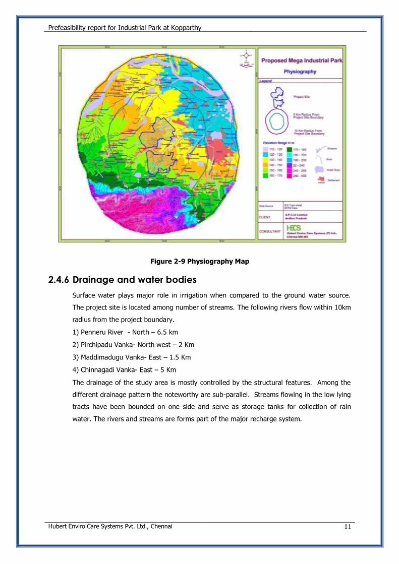
2.4.5 Physiography
The general elevation of the study area ranges from 120 m to 450 m above MSL. The
elevation contour indicates that the area is sloping towards North east. Relatively higher
elevation is observed in the southern side of the project site. The physiographic map of the
study area is presented in Figure 2-10
Prefeasibility report for Industrial Park at Kopparthy
Hubert Enviro Care Systems Pvt. Ltd., Chennai 11
Figure 2-9 Physiography Map
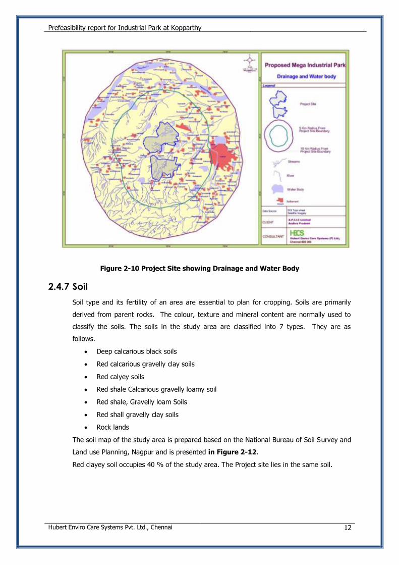
2.4.6 Drainage and water bodies
Surface water plays major role in irrigation when compared to the ground water source.
The project site is located among number of streams. The following rivers flow within 10km
radius from the project boundary.
1) Penneru River - North – 6.5 km
2) Pirchipadu Vanka- North west – 2 Km
3) Maddimadugu Vanka- East – 1.5 Km
4) Chinnagadi Vanka- East – 5 Km
The drainage of the study area is mostly controlled by the structural features. Among the
different drainage pattern the noteworthy are sub-parallel. Streams flowing in the low lying
tracts have been bounded on one side and serve as storage tanks for collection of rain
water. The rivers and streams are forms part of the major recharge system.
Prefeasibility report for Industrial Park at Kopparthy
Hubert Enviro Care Systems Pvt. Ltd., Chennai 12
Figure 2-10 Project Site showing Drainage and Water Body
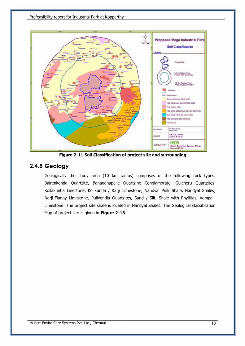
2.4.7 Soil
Soil type and its fertility of an area are essential to plan for cropping. Soils are primarily
derived from parent rocks. The colour, texture and mineral content are normally used to
classify the soils. The soils in the study area are classified into 7 types. They are as
follows.
Deep calcarious black soils
Red calcarious gravelly clay soils
Red calyey soils
Red shale Calcarious gravelly loamy soil
Red shale, Gravelly loam Soils
Red shall gravelly clay soils
Rock lands
The soil map of the study area is prepared based on the National Bureau of Soil Survey and
Land use Planning, Nagpur and is presented in Figure 2-12.
Red clayey soil occupies 40 % of the study area. The Project site lies in the same soil.
Prefeasibility report for Industrial Park at Kopparthy
Hubert Enviro Care Systems Pvt. Ltd., Chennai 13
Figure 2-11 Soil Classification of project site and surrounding
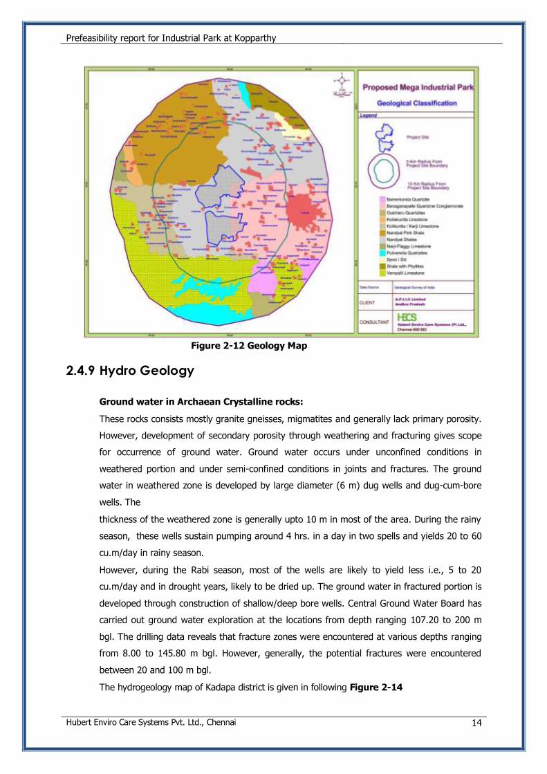
2.4.8 Geology
Geologically the study area (10 km radius) comprises of the following rock types.
Bairenkonda Quartzite, Banaganapalle Quartzine Conglamorate, Gulcheru Quartzites,
Koilakuntla Linestone, Koilkuntla / Karji Limestone, Nandyal Pink Shale, Nandyal Shales;
Narji-Flaggy Limestone, Pulivendla Quartzites, Sand / Silt, Shale with Phyllites, Vempalli
Limestone. The project site shale is located in Nandyal Shales. The Geological classification
Map of project site is given in Figure 2-13
Prefeasibility report for Industrial Park at Kopparthy
Hubert Enviro Care Systems Pvt. Ltd., Chennai 14
Figure 2-12 Geology Map
2.4.9 Hydro Geology
Ground water in Archaean Crystalline rocks:
These rocks consists mostly granite gneisses, migmatites and generally lack primary porosity.
However, development of secondary porosity through weathering and fracturing gives scope
for occurrence of ground water. Ground water occurs under unconfined conditions in
weathered portion and under semi-confined conditions in joints and fractures. The ground
water in weathered zone is developed by large diameter (6 m) dug wells and dug-cum-bore
wells. The
thickness of the weathered zone is generally upto 10 m in most of the area. During the rainy
season, these wells sustain pumping around 4 hrs. in a day in two spells and yields 20 to 60
cu.m/day in rainy season.
However, during the Rabi season, most of the wells are likely to yield less i.e., 5 to 20
cu.m/day and in drought years, likely to be dried up. The ground water in fractured portion is
developed through construction of shallow/deep bore wells. Central Ground Water Board has
carried out ground water exploration at the locations from depth ranging 107.20 to 200 m
bgl. The drilling data reveals that fracture zones were encountered at various depths ranging
from 8.00 to 145.80 m bgl. However, generally, the potential fractures were encountered
between 20 and 100 m bgl.
The hydrogeology map of Kadapa district is given in following Figure 2-14
Prefeasibility report for Industrial Park at Kopparthy
Hubert Enviro Care Systems Pvt. Ltd., Chennai 15
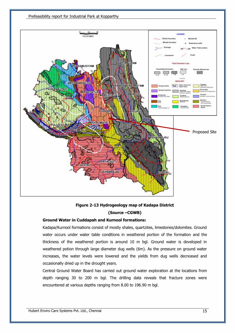
Figure 2-13 Hydrogeology map of Kadapa District
(Source –CGWB)
Ground Water in Cuddapah and Kurnool formations:
Kadapa/Kurnool formations consist of mostly shales, quartzites, limestones/dolomites. Ground
water occurs under water table conditions in weathered portion of the formation and the
thickness of the weathered portion is around 10 m bgl. Ground water is developed in
weathered potion through large diameter dug wells (6m). As the pressure on ground water
increases, the water levels were lowered and the yields from dug wells decreased and
occasionally dried up in the drought years.
Central Ground Water Board has carried out ground water exploration at the locations from
depth ranging 30 to 200 m bgl. The drilling data reveals that fracture zones were
encountered at various depths ranging from 8.00 to 196.90 m bgl.
Proposed Site
Prefeasibility report for Industrial Park at Kopparthy
Hubert Enviro Care Systems Pvt. Ltd., Chennai 16
Ground Water in Alluvium formation:
Alluvium occurs along the river courses in the district. The thickness of the alluvium varies
from 1 m to 20 m bgl. Ground water development in alluvium is through filter point wells
upto 15 m depths. The yields vary from 2 to 12 lps, depending upon the thickness of the
alluvium. Infiltration wells are also constructed at suitable locations for village water supply
and lift irrigation schemes in these formations.
Aquifer parameters
Central Ground Water Board has carried out pumping tests in bore wells to know the aquifer
parameters.
In Archaean formations, the dug wells sustain pumping for 3 to 7 hrs. per day and
capable of yielding of 101 to 217 cu.m/day.
The Kadapa/Kurnool formations sustain intermittent pumping for 5 to 8 hrs./day and
capable of yielding 198 to 290 cu.m/day.
The wells in alluvium sustain pumping for 5 to 7 hrs./day and can yield 136 to 237
cu.m/day.
2.4.10 Land Use/ Land Cover
Land use information of an area in the form of map and statistical data are very vital for
spatial analysis, planning, management and utilization of land for agriculture, forestry,
urban and industrial planning. The level of spatial classification is classed under 4
categories. They are Level 1 with 1:1 million scale, Level 2 with 1:250,000 scale, Level 3
with 1:50,000 scale and level with 1:25,000 or larger scale. The cost and availability of
data and purpose for which the land use classification is to be taken up is important for
taking up the level of classification.
In the present study Level 3 classification is made which is fairly a good classification of
urban and industrial planning. However level 4 classification is the ultimate for all kind of
planning and management. Owing to the exorbitant cost and time of obtaining the
Satellite Data from the concerned agencies, the present land use classification has been
restricted to level 3.
For the preparation of land use map IRS P6 LISS-III Satellite data has been procured
from NRSC, Hyderabad. At most care has been taken to select the cloud free satellite
data. The recent data dated March-2010 digital has been taken for the preparation of
land use mapping. Visual interpretation technique has been adopted for land use
classification based on the interpretation keys suggested in the guidelines of NNRMS,
Bangalore.
The land use of the study area reflects the socio-economic conditions of the people in
addition to the natural environmental factors. The factors controlling the land use pattern
of the area are land forms, slope, shape of the land, soil, natural resources and natural
Prefeasibility report for Industrial Park at Kopparthy
Hubert Enviro Care Systems Pvt. Ltd., Chennai 17
and manmade hazards. In the hills of the study area there is no dense vegetation.
Vegetation consists of thorny bushes and shrubs. The uncultivable area includes barren
and non-cultivable waste.
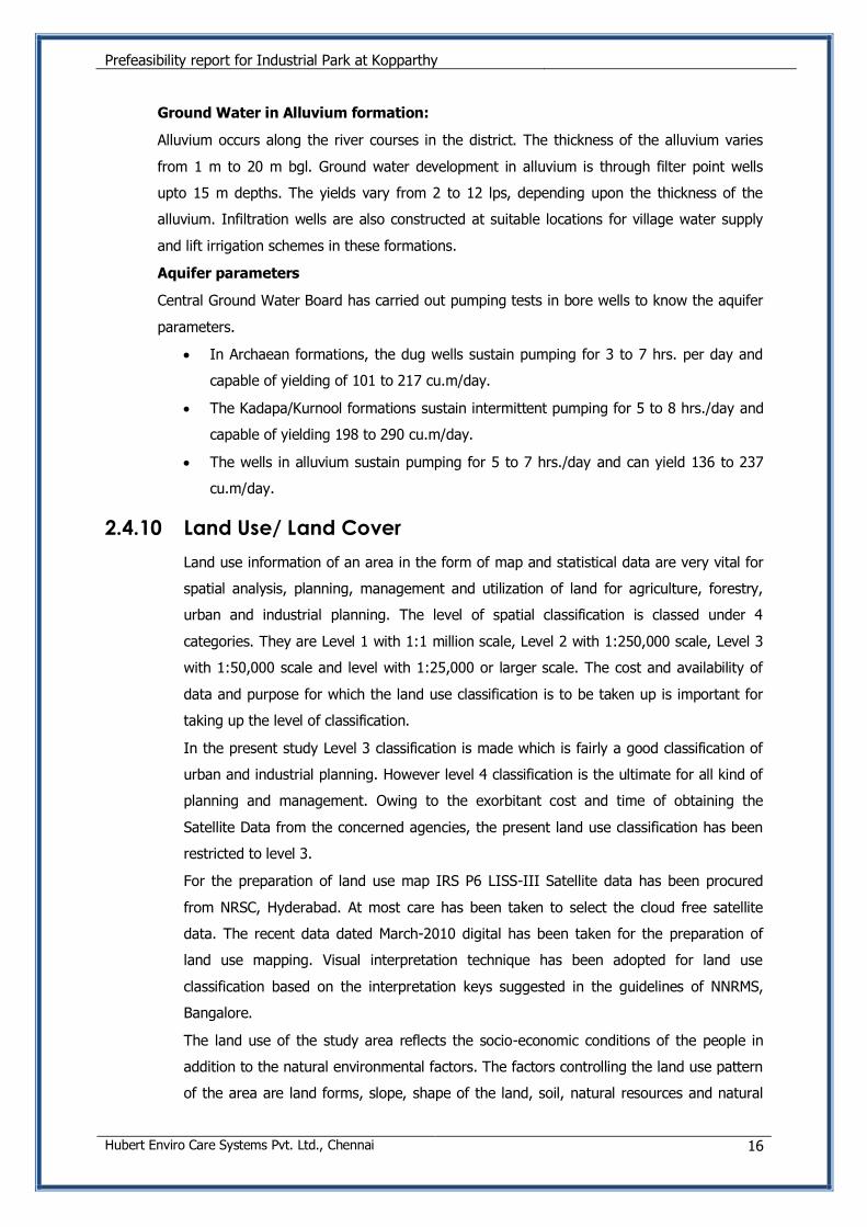
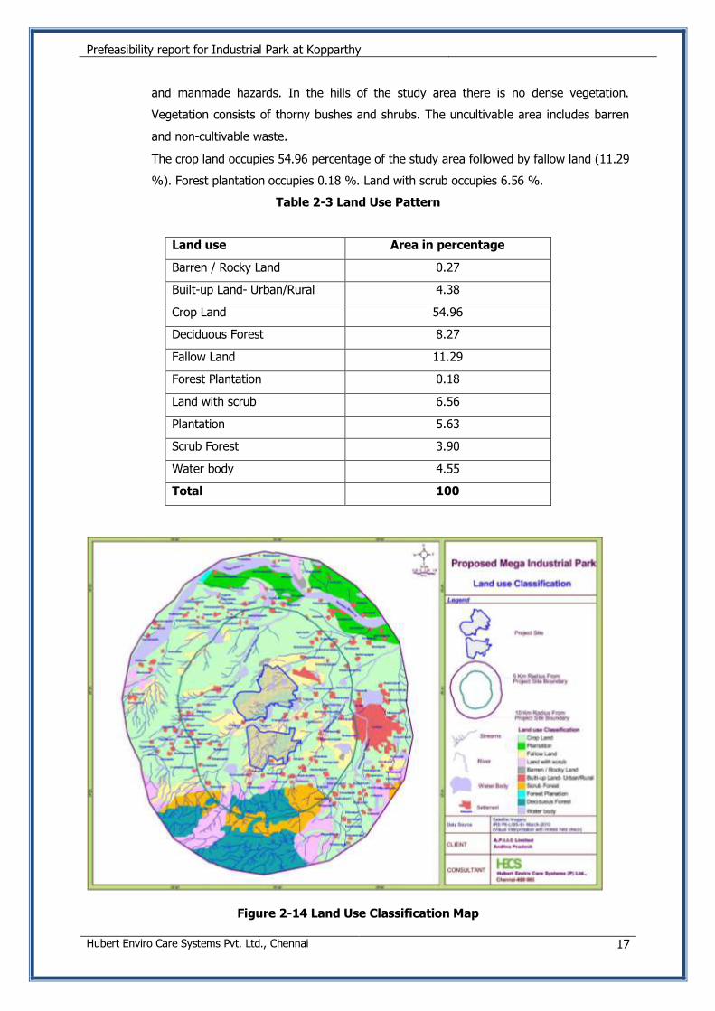
The crop land occupies 54.96 percentage of the study area followed by fallow land (11.29
%). Forest plantation occupies 0.18 %. Land with scrub occupies 6.56 %.
Table 2-3 Land Use Pattern
Figure 2-14 Land Use Classification Map
Land use Area in percentage
Barren / Rocky Land 0.27
Built-up Land- Urban/Rural 4.38
Crop Land 54.96
Deciduous Forest 8.27
Fallow Land 11.29
Forest Plantation 0.18
Land with scrub 6.56
Plantation 5.63
Scrub Forest 3.90
Water body 4.55
Total 100
Prefeasibility report for Industrial Park at Kopparthy
Hubert Enviro Care Systems Pvt. Ltd., Chennai 18
Figure 2-15 Land Use/ Land Cover Pattern
2.4.11 Irrigation
Irrigation in the district is through major, medium and minor irrigation projects. There are 4
major, 5 medium irrigation projects in the district.
The major irrigation projects are
1) Kurnool- canal
2) TBP HLC Stage-I,
3) TBP HLC Stage-II (Mylavaram) and
4) Pulivendula Branch canal with a total ayacut of 2,27,896 acres.
The five medium irrigation projects are
1) Lower Sagilru Project
2) Upper Sagileru Project
3) Pincha Project
4) Buggavanka Project and
5) Annamayya Project with a total ayacut of 55,625 acres.
The area irrigated during the year 2010-11 through these canals is 27,305 Ha., and through
ground water is 1,22,781 Ha., Irrigation from the other sources (1,125 ha.) and through
tanks 8,042 Ha.
2.4.12 Ground Water Resources
The net ground water availability is 1,62,783 ha.m in command area and 9,634 ha.m in
non-command area and total ground water resources available in the district 1,72,417
ha.m. The existing gross ground water draft for all uses in the district is 31,933 ha.m,
which is 27,604 ha.m in command area and 4,329 ha.m in non command area. The net
ground water availability for future irrigation is 1,28,445 ha.m and 4,137 ha.m in command
Prefeasibility report for Industrial Park at Kopparthy
Hubert Enviro Care Systems Pvt. Ltd., Chennai 19
and non command areas respectively. The stage of ground water development in command
area is 17%, while it is 45% in non command areas and 19% in the entire district. Most of
the mandals and falls under safe category.
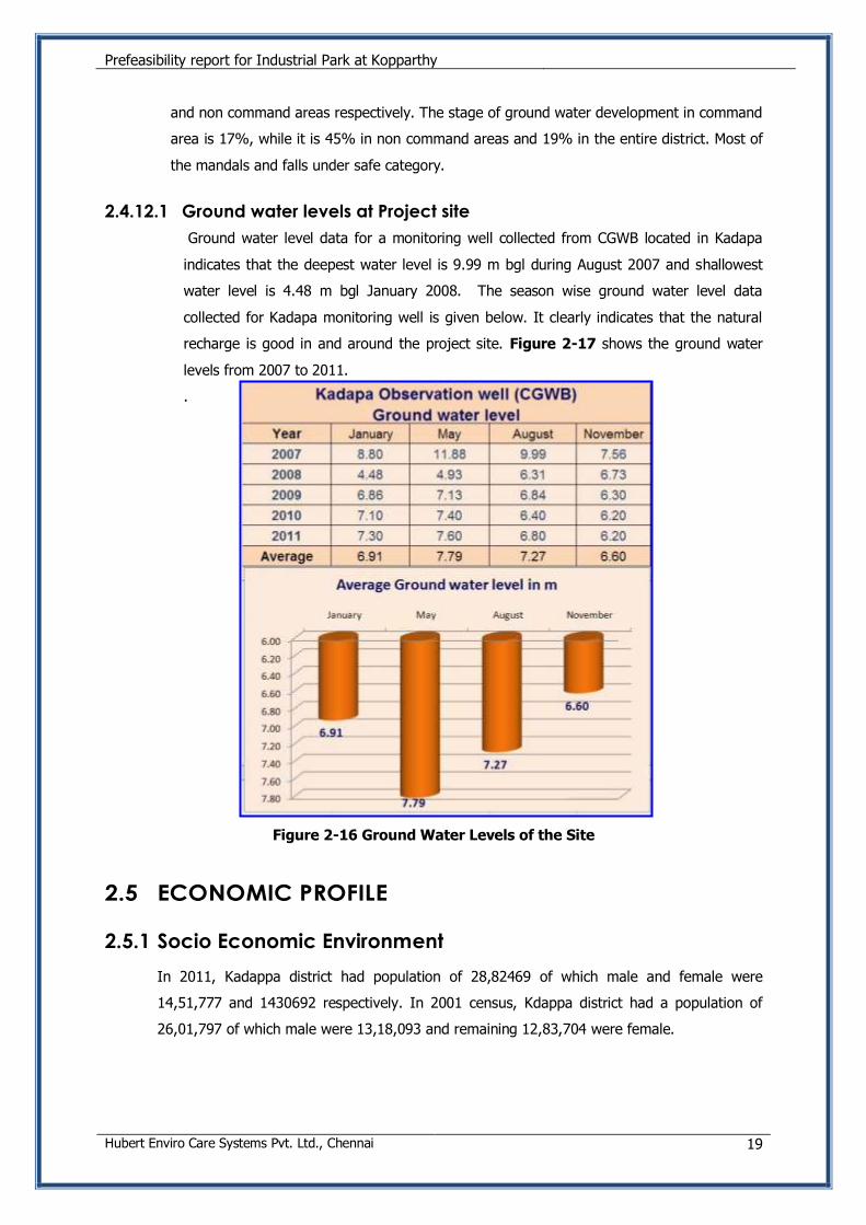
2.4.12.1 Ground water levels at Project site
Ground water level data for a monitoring well collected from CGWB located in Kadapa
indicates that the deepest water level is 9.99 m bgl during August 2007 and shallowest
water level is 4.48 m bgl January 2008. The season wise ground water level data
collected for Kadapa monitoring well is given below. It clearly indicates that the natural
recharge is good in and around the project site. Figure 2-17 shows the ground water
levels from 2007 to 2011.
.
Figure 2-16 Ground Water Levels of the Site
2.5 ECONOMIC PROFILE
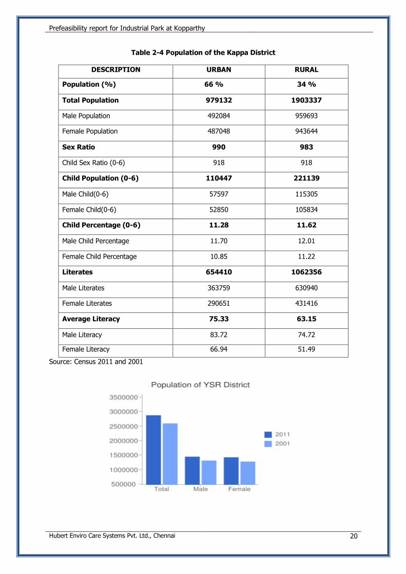
2.5.1 Socio Economic Environment
In 2011, Kadappa district had population of 28,82469 of which male and female were
14,51,777 and 1430692 respectively. In 2001 census, Kdappa district had a population of
26,01,797 of which male were 13,18,093 and remaining 12,83,704 were female.
Prefeasibility report for Industrial Park at Kopparthy
Hubert Enviro Care Systems Pvt. Ltd., Chennai 20
Table 2-4 Population of the Kappa District
DESCRIPTION URBAN RURAL
Population (%) 66 % 34 %
Total Population 979132 1903337
Male Population 492084 959693
Female Population 487048 943644
Sex Ratio 990 983
Child Sex Ratio (0-6) 918 918
Child Population (0-6) 110447 221139
Male Child(0-6) 57597 115305
Female Child(0-6) 52850 105834
Child Percentage (0-6) 11.28 11.62
Male Child Percentage 11.70 12.01
Female Child Percentage 10.85 11.22
Literates 654410 1062356
Male Literates 363759 630940
Female Literates 290651 431416
Average Literacy 75.33 63.15
Male Literacy 83.72 74.72
Female Literacy 66.94 51.49
Source: Census 2011 and 2001
Prefeasibility report for Industrial Park at Kopparthy
Hubert Enviro Care Systems Pvt. Ltd., Chennai 21
2.5.2 Educational Facilities
2.5.2.1 Colleges/Institutions
S.No Type of Colleges/Institutions No
1 Polytechnics 9
2 Degree colleges 49
3 Engineering colleges 24
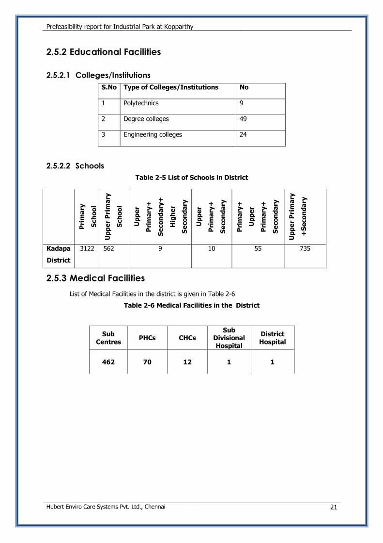
2.5.2.2 Schools
Table 2-5 List of Schools in District
Pri
ma
ry
Sch
oo
l
Up
pe
r P
rim
ary
Sch
oo
l
Up
pe
r
Pri
ma
ry+
Se
co
nd
ary
+
Hig
he
r
Se
co
nd
ary
Up
pe
r
Pri
ma
ry+
Se
co
nd
ary
Pri
ma
ry+
Up
pe
r
Pri
ma
ry+
Se
co
nd
ary
Up
pe
r P
rim
ary
+S
eco
nd
ary
Kadapa
District
3122 562 9 10 55 735
2.5.3 Medical Facilities
List of Medical Facilities in the district is given in Table 2-6
Table 2-6 Medical Facilities in the District
Sub Centres
PHCs CHCs Sub
Divisional Hospital
District Hospital
462 70 12 1 1
Prefeasibility report for Industrial Park at Kopparthy
Hubert Enviro Care Systems Pvt. Ltd., Chennai 22
3. PROJECT SITE ASSESSMENT
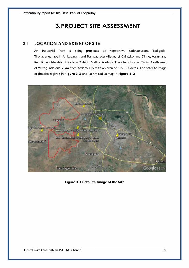
3.1 LOCATION AND EXTENT OF SITE
An Industrial Park is being proposed at Kopparthy, Yadavapuram, Tadigotla,
Thollaganganapalli, Ambavaram and Rampathadu villages of Chintakomma Dinne, Vallur and
Pendlimarri Mandals of Kadapa District, Andhra Pradesh. The site is located 24 Km North west
of Yerraguntla and 7 km from Kadapa City with an area of 6553.04 Acres. The satellite image
of the site is given in Figure 3-1 and 10 Km radius map in Figure 3-2.
Figure 3-1 Satellite Image of the Site
Prefeasibility report for Industrial Park at Kopparthy
Hubert Enviro Care Systems Pvt. Ltd., Chennai 23
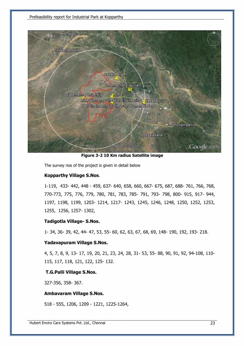
Figure 3-2 10 Km radius Satellite image
The survey nos of the project is given in detail below
Kopparthy Village S.Nos.
1-119, 433- 442, 448 - 459, 637- 640, 658, 660, 667- 675, 687, 688- 761, 766, 768,
770-773, 775, 776, 779, 780, 781, 783, 785- 791, 793- 798, 800- 915, 917- 944,
1197, 1198, 1199, 1203- 1214, 1217- 1243, 1245, 1246, 1248, 1250, 1252, 1253,
1255, 1256, 1257- 1302,
Tadigotla Village- S.Nos.
1- 34, 36- 39, 42, 44- 47, 53, 55- 60, 62, 63, 67, 68, 69, 148- 190, 192, 193- 218.
Yadavapuram Village S.Nos.
4, 5, 7, 8, 9, 13- 17, 19, 20, 21, 23, 24, 28, 31- 53, 55- 88, 90, 91, 92, 94-108, 110-
115, 117, 118, 121, 122, 125- 132.
T.G.Palli Village S.Nos.
327-356, 358- 367.
Ambavaram Village S.Nos.
518 - 555, 1206, 1209 - 1221, 1225-1264,
Prefeasibility report for Industrial Park at Kopparthy
Hubert Enviro Care Systems Pvt. Ltd., Chennai 24
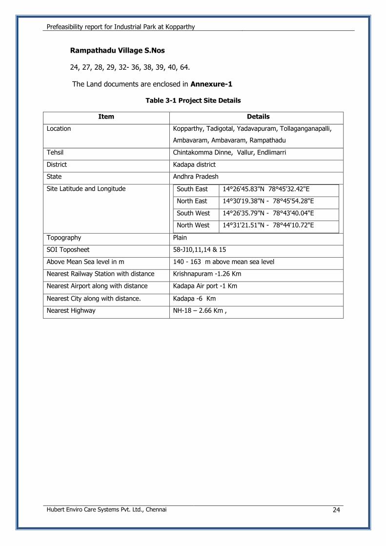
Rampathadu Village S.Nos
24, 27, 28, 29, 32- 36, 38, 39, 40, 64.
The Land documents are enclosed in Annexure-1
Table 3-1 Project Site Details
Item Details
Location Kopparthy, Tadigotal, Yadavapuram, Tollaganganapalli,
Ambavaram, Ambavaram, Rampathadu
Tehsil Chintakomma Dinne, Vallur, Endlimarri
District Kadapa district
State Andhra Pradesh
Site Latitude and Longitude South East 14°26'45.83"N 78°45'32.42"E
North East 14°30'19.38"N - 78°45'54.28"E
South West 14°26'35.79"N - 78°43'40.04"E
North West 14°31'21.51"N - 78°44'10.72"E
Topography Plain
SOI Toposheet 58-J10,11,14 & 15
Above Mean Sea level in m 140 - 163 m above mean sea level
Nearest Railway Station with distance Krishnapuram -1.26 Km
Nearest Airport along with distance Kadapa Air port -1 Km
Nearest City along with distance. Kadapa -6 Km
Nearest Highway NH-18 – 2.66 Km ,
Prefeasibility report for Industrial Park at Kopparthy
Hubert Enviro Care Systems Pvt. Ltd., Chennai 25
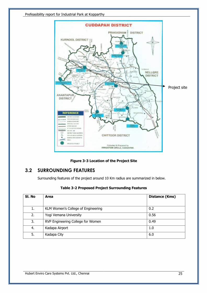
Figure 3-3 Location of the Project Site
3.2 SURROUNDING FEATURES
Surrounding features of the project around 10 Km radius are summarized in below.
Table 3-2 Proposed Project Surrounding Features
Sl. No Area Distance (Kms)
1. KLM Women’s College of Engineering 0.2
2. Yogi Vemana University 0.56
3. RVP Engineering College for Women 0.49
4. Kadapa Airport 1.0
5. Kadapa City 6.0
Project site
Prefeasibility report for Industrial Park at Kopparthy
Hubert Enviro Care Systems Pvt. Ltd., Chennai 26
3.3 CONNECTIVITY
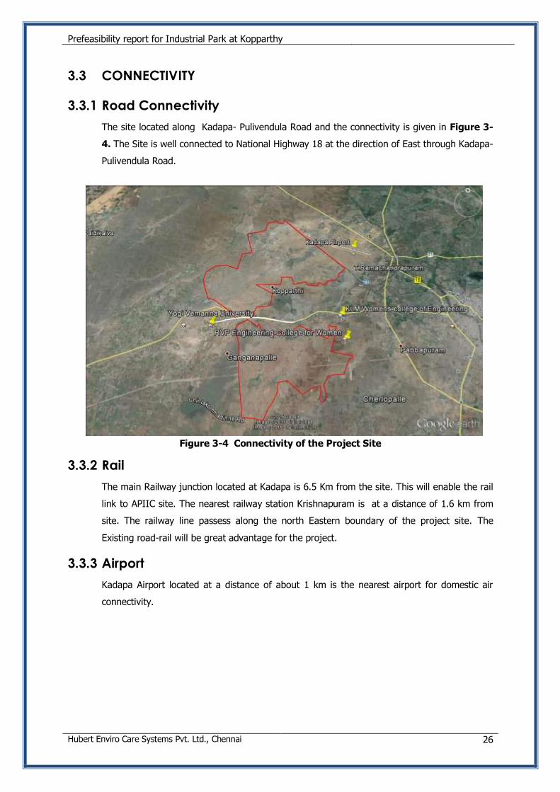
3.3.1 Road Connectivity
The site located along Kadapa- Pulivendula Road and the connectivity is given in Figure 3-
4. The Site is well connected to National Highway 18 at the direction of East through Kadapa-
Pulivendula Road.
Figure 3-4 Connectivity of the Project Site
3.3.2 Rail
The main Railway junction located at Kadapa is 6.5 Km from the site. This will enable the rail
link to APIIC site. The nearest railway station Krishnapuram is at a distance of 1.6 km from
site. The railway line passess along the north Eastern boundary of the project site. The
Existing road-rail will be great advantage for the project.
3.3.3 Airport
Kadapa Airport located at a distance of about 1 km is the nearest airport for domestic air
connectivity.
Prefeasibility report for Industrial Park at Kopparthy
Hubert Enviro Care Systems Pvt. Ltd., Chennai 27
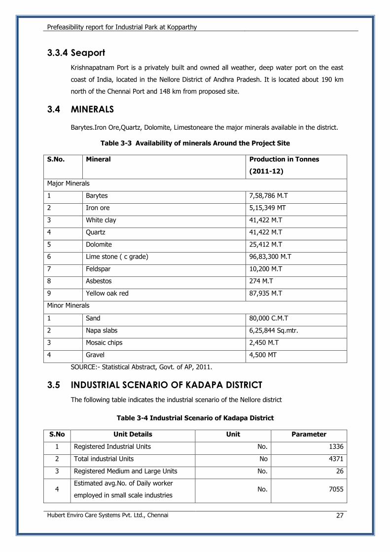
3.3.4 Seaport
Krishnapatnam Port is a privately built and owned all weather, deep water port on the east
coast of India, located in the Nellore District of Andhra Pradesh. It is located about 190 km
north of the Chennai Port and 148 km from proposed site.
3.4 MINERALS
Barytes.Iron Ore,Quartz, Dolomite, Limestoneare the major minerals available in the district.
Table 3-3 Availability of minerals Around the Project Site
S.No. Mineral Production in Tonnes
(2011-12)
Major Minerals
1 Barytes 7,58,786 M.T
2 Iron ore 5,15,349 MT
3 White clay 41,422 M.T
4 Quartz 41,422 M.T
5 Dolomite 25,412 M.T
6 Lime stone ( c grade) 96,83,300 M.T
7 Feldspar 10,200 M.T
8 Asbestos 274 M.T
9 Yellow oak red 87,935 M.T
Minor Minerals
1 Sand 80,000 C.M.T
2 Napa slabs 6,25,844 Sq.mtr.
3 Mosaic chips 2,450 M.T
4 Gravel 4,500 MT
SOURCE:- Statistical Abstract, Govt. of AP, 2011.
3.5 INDUSTRIAL SCENARIO OF KADAPA DISTRICT
The following table indicates the industrial scenario of the Nellore district
Table 3-4 Industrial Scenario of Kadapa District
S.No Unit Details Unit Parameter
1 Registered Industrial Units No. 1336
2 Total industrial Units No 4371
3 Registered Medium and Large Units No. 26
4 Estimated avg.No. of Daily worker
employed in small scale industries No. 7055
Prefeasibility report for Industrial Park at Kopparthy
Hubert Enviro Care Systems Pvt. Ltd., Chennai 28
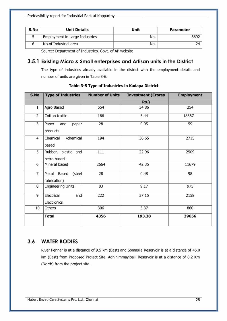
S.No Unit Details Unit Parameter
5 Employment in Large Industries No. 8692
6 No.of Industrial area No. 24
Source: Department of Industries, Govt. of AP website
3.5.1 Existing Micro & Small enterprises and Artisan units in the District
The type of industries already available in the district with the employment details and
number of units are given in Table 3-6.
Table 3-5 Type of Industries in Kadapa District
S.No Type of Industries Number of Units Investment (Crores
Rs.)
Employment
1 Agro Based 554 34.86 254
2 Cotton textile 166 5.44 18367
3 Paper and paper
products
28 0.95 59
4 Chemical /chemical
based
194 36.65 2715
5 Rubber, plastic and
petro based
111 22.96 2509
6 Mineral based 2664 42.35 11679
7 Metal Based (steel
fabrication)
28 0.48 98
8 Engineering Units 83 9.17 975
9 Electrical and
Electronics
222 37.15 2158
10 Others 306 3.37 860
Total 4356 193.38 39656
3.6 WATER BODIES
River Pennar is at a distance of 9.5 km (East) and Somasila Reservoir is at a distance of 46.0
km (East) from Proposed Project Site. Adhinimmayipalli Reservoir is at a distance of 8.2 Km
(North) from the project site.
Prefeasibility report for Industrial Park at Kopparthy
Hubert Enviro Care Systems Pvt. Ltd., Chennai 29
3.7 SOCIAL CONSIDERATIONS
There have been no significant social issues identified for the development of APIIC since
most of the land is barren land.
3.8 REHABILITATION AND RESETTLEMENT (R&R)
There is no Rehabilitation and Resettlement for this project since the land is handed over to
APIIC by Revenue Department.
3.9 SAFETY ASPECTS
Any industrial activity allocated land in the project site should ensure that there is enough
safety distance from the public roads and settlements. All along the periphery of the site
boundary, 15m green belt is proposed. Proper parking places will be provided for the
trucks and other vehicles by the industries to avoid any congestion or blocking of
roads.
Prefeasibility report for Industrial Park at Kopparthy
Hubert Enviro Care Systems Pvt. Ltd., Chennai 30
4. SITE MASTER PLAN
4.1 ABOUT THE PROJECT
APIIC proposes the development of Industrial Park at Kopparthy, Tadigotla, Yadavapuram,
Thollaganganapalli, Ambavaram, Ambavaram, Rampathadu villages, Chintakomma Dinne,
Vallur, Endlimarri mandals, Kadapa District in Andhra Pradesh. The park is proposed to be
spread over 6553.04 acres and cater to the socio-economic development of the region.
Since the project area is > 500 Ha, the project attracts Environmental Clearance from the
Ministry of Environment Forests and Climate Change, as per Schedule 7(c) category A
project, as per the guidelines of EIA notification of 2006, and the amendments thereafter.
4.2 SITE JUSTIFICATION
APIIC with the aim of industrial development has been developing industrial parks through-
out the state. The project site has road, rail and airport connectivity, which will be an added
advantage for the business & socio-economic development and improvement for the district.
Good and broad road and railway network is available from Kadapa to various parts of the
country. The availability of good mineral resources in the district has also made APIIC to
propose Industrial park in this district
The connectivity of the site to sea port, airport, railway and road is as follows:
a) Port Connectivity- The site is about 148 Km away from the Krishnapatnam Port.
b) Airport Connectivity- The site is about 1 from the Kadapa Airport
c) Rail Connectivity- The site is about 1.6 Km from Krishnapuram Station and 6.5 Km
from Kadapa Railway Station from which railway lines could be drawn in for goods
carriers.
d) Road Connectivity- The site located along Kadapa- Pulivendula Road and is well
connected to National Highway 18 at the direction of East through Kadapa-
Pulivendula Road.
4.3 PROPOSED MASTER PLAN BY APIIC
The proposed area for Industrial Estate is 6553.04 Acres. The Master Plan for Phase I is
approved by Local Planning Authority. The proposed Master Plan showing the layout, area
break up and tentative industries proposed is enclosed in Annexure-3.
Prefeasibility report for Industrial Park at Kopparthy
Hubert Enviro Care Systems Pvt. Ltd., Chennai 31
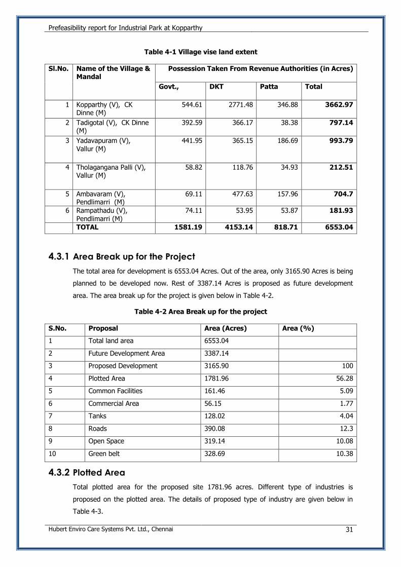
Table 4-1 Village vise land extent
Sl.No. Name of the Village & Mandal
Possession Taken From Revenue Authorities (in Acres)
Govt., DKT Patta Total
1 Kopparthy (V), CK Dinne (M)
544.61 2771.48 346.88 3662.97
2 Tadigotal (V), CK Dinne (M)
392.59 366.17 38.38 797.14
3 Yadavapuram (V),
Vallur (M)
441.95 365.15 186.69 993.79
4 Tholagangana Palli (V), Vallur (M)
58.82 118.76 34.93 212.51
5 Ambavaram (V), Pendlimarri (M)
69.11 477.63 157.96 704.7
6 Rampathadu (V), Pendlimarri (M)
74.11 53.95 53.87 181.93
TOTAL 1581.19 4153.14 818.71 6553.04
4.3.1 Area Break up for the Project
The total area for development is 6553.04 Acres. Out of the area, only 3165.90 Acres is being
planned to be developed now. Rest of 3387.14 Acres is proposed as future development
area. The area break up for the project is given below in Table 4-2.
Table 4-2 Area Break up for the project
S.No. Proposal Area (Acres) Area (%)
1 Total land area 6553.04
2 Future Development Area 3387.14
3 Proposed Development 3165.90 100
4 Plotted Area 1781.96 56.28
5 Common Facilities 161.46 5.09
6 Commercial Area 56.15 1.77
7 Tanks 128.02 4.04
8 Roads 390.08 12.3
9 Open Space 319.14 10.08
10 Green belt 328.69 10.38
4.3.2 Plotted Area
Total plotted area for the proposed site 1781.96 acres. Different type of industries is
proposed on the plotted area. The details of proposed type of industry are given below in
Table 4-3.
Prefeasibility report for Industrial Park at Kopparthy
Hubert Enviro Care Systems Pvt. Ltd., Chennai 32
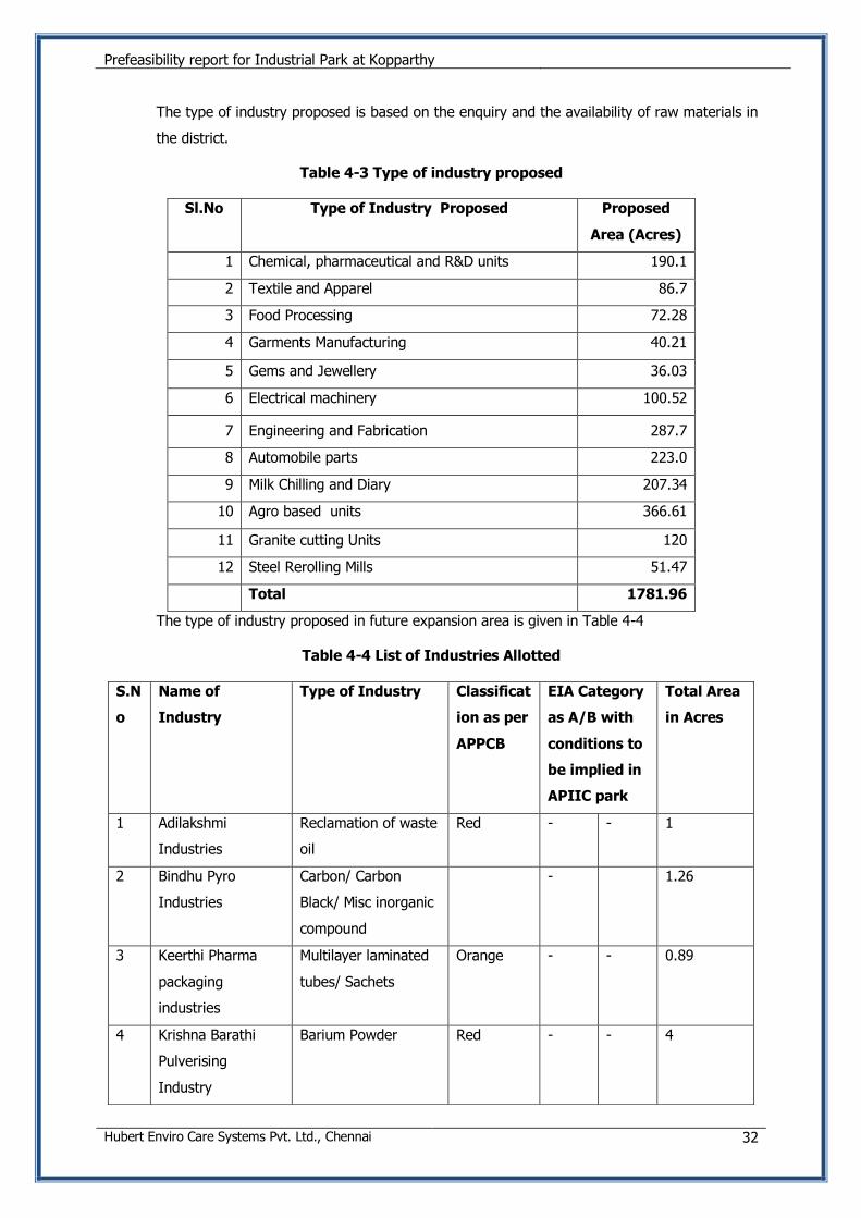
The type of industry proposed is based on the enquiry and the availability of raw materials in
the district.
Table 4-3 Type of industry proposed
Sl.No Type of Industry Proposed Proposed
Area (Acres)
1 Chemical, pharmaceutical and R&D units 190.1
2 Textile and Apparel 86.7
3 Food Processing 72.28
4 Garments Manufacturing 40.21
5 Gems and Jewellery 36.03
6 Electrical machinery 100.52
7 Engineering and Fabrication 287.7
8 Automobile parts 223.0
9 Milk Chilling and Diary 207.34
10 Agro based units 366.61
11 Granite cutting Units 120
12 Steel Rerolling Mills 51.47
Total 1781.96
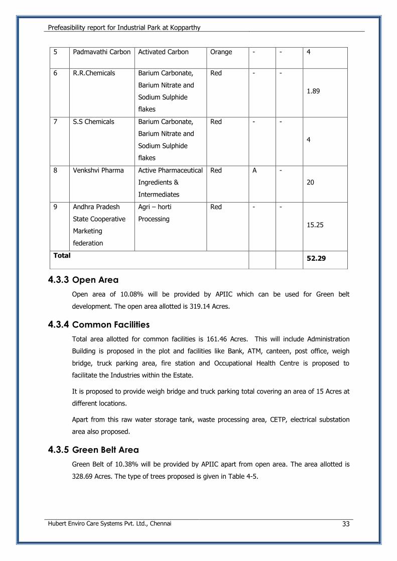
The type of industry proposed in future expansion area is given in Table 4-4
Table 4-4 List of Industries Allotted
S.N
o
Name of
Industry
Type of Industry Classificat
ion as per
APPCB
EIA Category
as A/B with
conditions to
be implied in
APIIC park
Total Area
in Acres
1 Adilakshmi
Industries
Reclamation of waste
oil
Red - - 1
2 Bindhu Pyro
Industries
Carbon/ Carbon
Black/ Misc inorganic
compound
- 1.26
3 Keerthi Pharma
packaging
industries
Multilayer laminated
tubes/ Sachets
Orange - - 0.89
4 Krishna Barathi
Pulverising
Industry
Barium Powder Red - - 4
Prefeasibility report for Industrial Park at Kopparthy
Hubert Enviro Care Systems Pvt. Ltd., Chennai 33
4.3.3 Open Area
Open area of 10.08% will be provided by APIIC which can be used for Green belt
development. The open area allotted is 319.14 Acres.
4.3.4 Common Facilities
Total area allotted for common facilities is 161.46 Acres. This will include Administration
Building is proposed in the plot and facilities like Bank, ATM, canteen, post office, weigh
bridge, truck parking area, fire station and Occupational Health Centre is proposed to
facilitate the Industries within the Estate.
It is proposed to provide weigh bridge and truck parking total covering an area of 15 Acres at
different locations.
Apart from this raw water storage tank, waste processing area, CETP, electrical substation
area also proposed.
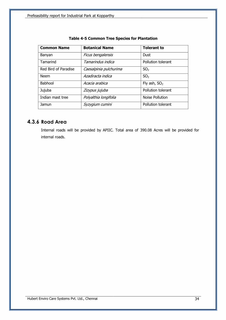
4.3.5 Green Belt Area
Green Belt of 10.38% will be provided by APIIC apart from open area. The area allotted is
328.69 Acres. The type of trees proposed is given in Table 4-5.
5 Padmavathi Carbon Activated Carbon Orange - - 4
6 R.R.Chemicals Barium Carbonate,
Barium Nitrate and
Sodium Sulphide
flakes
Red - -
1.89
7 S.S Chemicals Barium Carbonate,
Barium Nitrate and
Sodium Sulphide
flakes
Red - -
4
8 Venkshvi Pharma Active Pharmaceutical
Ingredients &
Intermediates
Red A -
20
9 Andhra Pradesh
State Cooperative
Marketing
federation
Agri – horti
Processing
Red - -
15.25
Total 52.29
Prefeasibility report for Industrial Park at Kopparthy
Hubert Enviro Care Systems Pvt. Ltd., Chennai 34
Table 4-5 Common Tree Species for Plantation
Common Name Botanical Name Tolerant to
Banyan Ficus bengalensis Dust
Tamarind Tamarindus indica Pollution tolerant
Red Bird of Paradise Caesalpinia pulchurima SO2
Neem Azadiracta indica SO2
Babhool Acacia arabica Fly ash, SO2
Jujuba Zizypus jujuba Pollution tolerant
Indian mast tree Polyalthia longifolia Noise Pollution
Jamun Syzygium cumini Pollution tolerant
4.3.6 Road Area
Internal roads will be provided by APIIC. Total area of 390.08 Acres will be provided for
internal roads.
Prefeasibility report for Industrial Park at Kopparthy
Hubert Enviro Care Systems Pvt. Ltd., Chennai 35
5. INFRASTRUCTURE SERVICES AND FACILITIES
5.1 PREAMBLE
This chapter describes the preliminary engineering aspects of the infrastructure facilities
proposed in the Industrial Park. These include the following.
Water supply network including proposal for WTP
Fire protection services
Wastewater management
Storm water management
Solid waste management
Power supply system
5.2 WATER SUPPLY SYSTEM
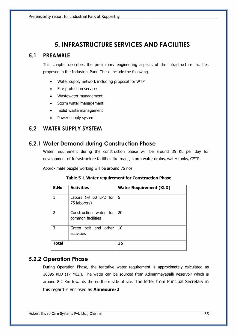
5.2.1 Water Demand during Construction Phase
Water requirement during the construction phase will be around 35 KL per day for
development of Infrastructure facilities like roads, storm water drains, water tanks, CETP.
Approximate people working will be around 75 nos.
Table 5-1 Water requirement for Construction Phase
S.No Activities Water Requirement (KLD)
1 Labors (@ 60 LPD for
75 laborers)
5
2 Construction water for
common facilities
20
3 Green belt and other
activities
10
Total 35
5.2.2 Operation Phase
During Operation Phase, the tentative water requirement is approximately calculated as
16895 KLD (17 MLD). The water can be sourced from Adinimmayapalli Reservoir which is
around 8.2 Km towards the northern side of site. The letter from Principal Secretary in
this regard is enclosed as Annexure-2
Prefeasibility report for Industrial Park at Kopparthy
Hubert Enviro Care Systems Pvt. Ltd., Chennai 36
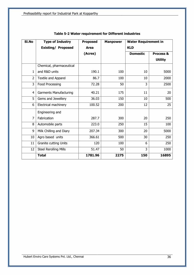
Table 5-2 Water requirement for Different industries
Sl.No Type of Industry
Existing/ Proposed
Proposed
Area
(Acres)
Manpower Water Requirement in
KLD
Domestic Process &
Utility
1
Chemical, pharmaceutical
and R&D units 190.1 100 10 5000
2 Textile and Apparel 86.7 100 10 2000
3 Food Processing 72.28 50 3 2500
4 Garments Manufacturing 40.21 175 11 20
5 Gems and Jewellery 36.03 150 10 500
6 Electrical machinery 100.52 200 12 25
7
Engineering and
Fabrication 287.7 300 20 250
8 Automobile parts 223.0 250 15 100
9 Milk Chilling and Diary 207.34 300 20 5000
10 Agro based units 366.61 500 30 250
11 Granite cutting Units 120 100 6 250
12 Steel Rerolling Mills 51.47 50 3 1000
Total 1781.96 2275 150 16895
Prefeasibility report for Industrial Park at Kopparthy
Hubert Enviro Care Systems Pvt. Ltd., Chennai 37
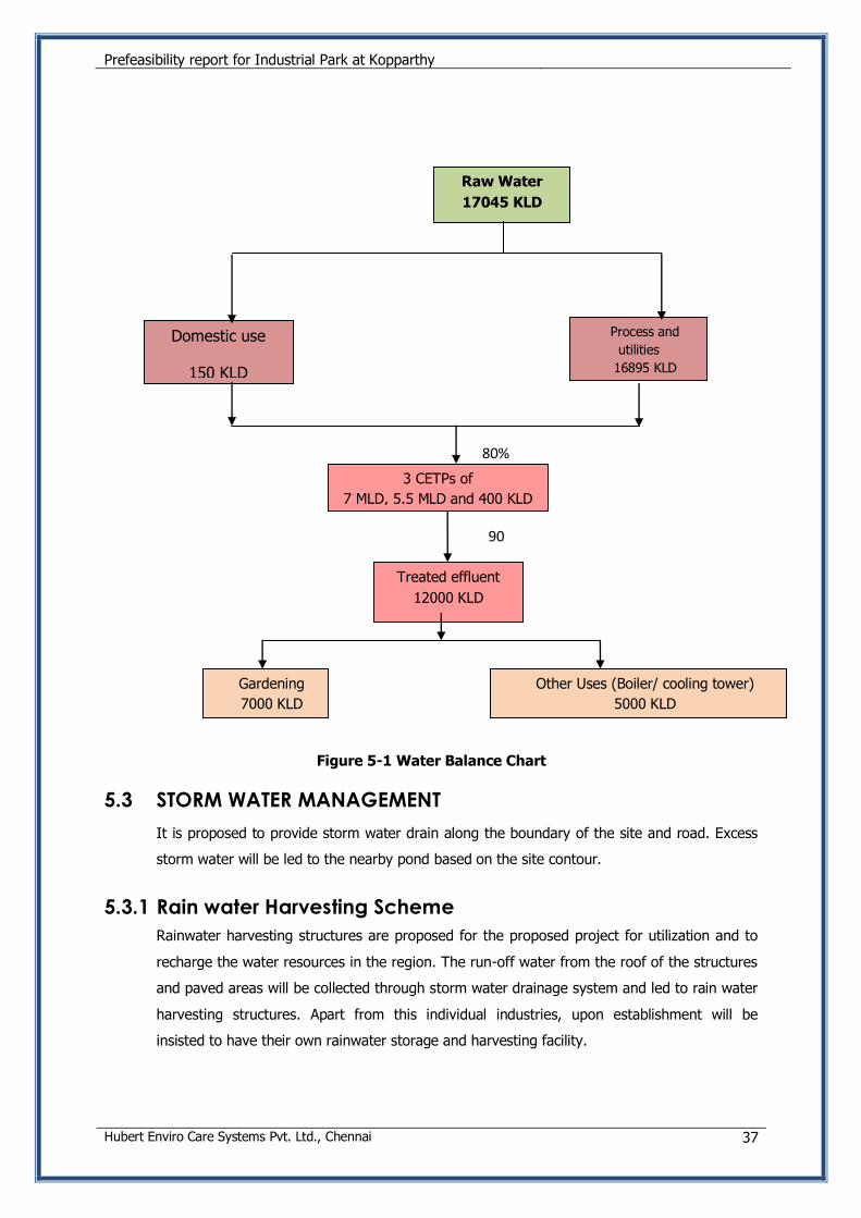
Figure 5-1 Water Balance Chart
5.3 STORM WATER MANAGEMENT
It is proposed to provide storm water drain along the boundary of the site and road. Excess
storm water will be led to the nearby pond based on the site contour.
5.3.1 Rain water Harvesting Scheme
Rainwater harvesting structures are proposed for the proposed project for utilization and to
recharge the water resources in the region. The run-off water from the roof of the structures
and paved areas will be collected through storm water drainage system and led to rain water
harvesting structures. Apart from this individual industries, upon establishment will be
insisted to have their own rainwater storage and harvesting facility.
Domestic use
150 KLD
Treated effluent
12000 KLD
Raw Water
17045 KLD
80%
Gardening
7000 KLD
Other Uses (Boiler/ cooling tower)
5000 KLD
3 CETPs of
7 MLD, 5.5 MLD and 400 KLD
Each 90
%
Process and
utilities
16895 KLD
Prefeasibility report for Industrial Park at Kopparthy
Hubert Enviro Care Systems Pvt. Ltd., Chennai 38
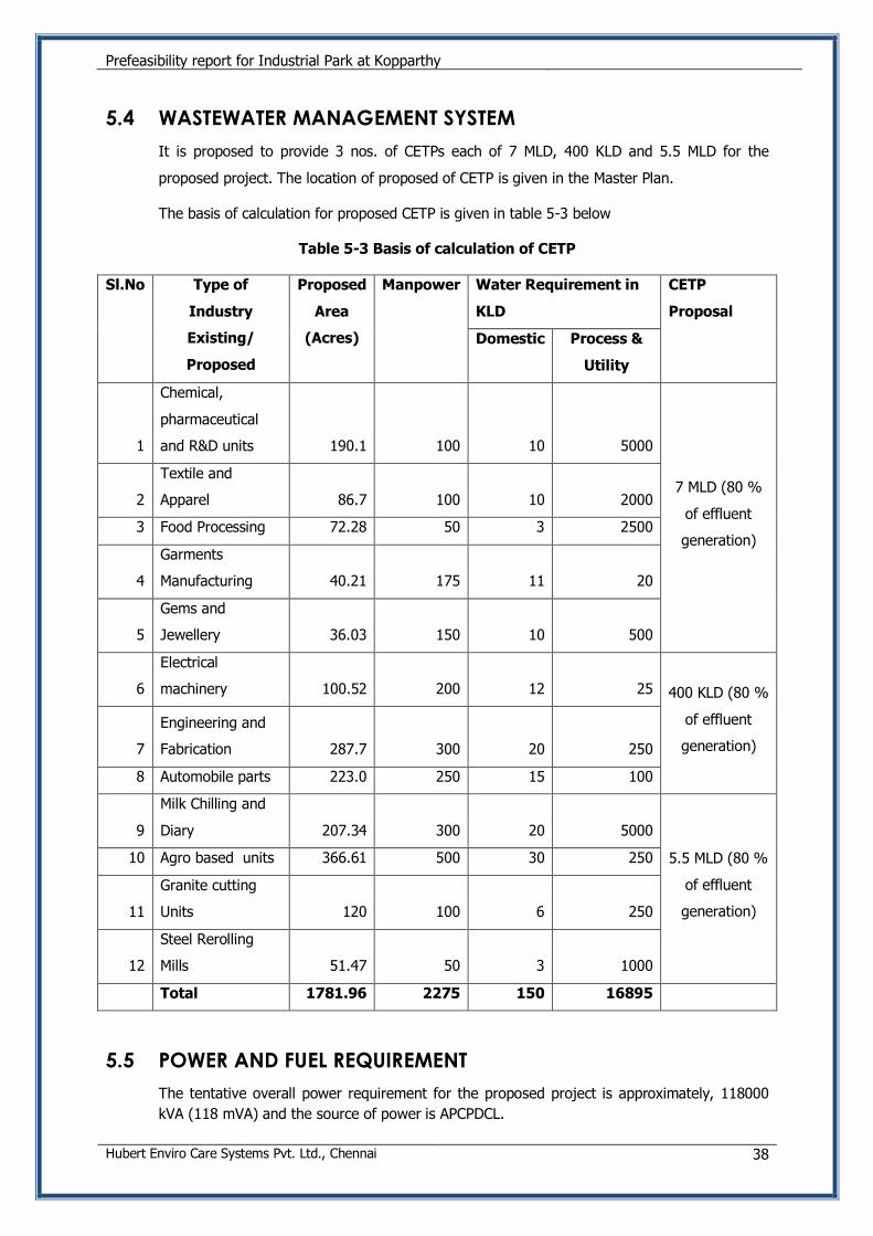
5.4 WASTEWATER MANAGEMENT SYSTEM
It is proposed to provide 3 nos. of CETPs each of 7 MLD, 400 KLD and 5.5 MLD for the
proposed project. The location of proposed of CETP is given in the Master Plan.
The basis of calculation for proposed CETP is given in table 5-3 below
Table 5-3 Basis of calculation of CETP
Sl.No Type of
Industry
Existing/
Proposed
Proposed
Area
(Acres)
Manpower Water Requirement in
KLD
CETP
Proposal
Domestic Process &
Utility
1
Chemical,
pharmaceutical
and R&D units 190.1 100 10 5000
7 MLD (80 %
of effluent
generation)
2
Textile and
Apparel 86.7 100 10 2000
3 Food Processing 72.28 50 3 2500
4
Garments
Manufacturing 40.21 175 11 20
5
Gems and
Jewellery 36.03 150 10 500
6
Electrical
machinery 100.52 200 12 25 400 KLD (80 %
of effluent
generation) 7
Engineering and
Fabrication 287.7 300 20 250
8 Automobile parts 223.0 250 15 100
9
Milk Chilling and
Diary 207.34 300 20 5000
5.5 MLD (80 %
of effluent
generation)
10 Agro based units 366.61 500 30 250
11
Granite cutting
Units 120 100 6 250
12
Steel Rerolling
Mills 51.47 50 3 1000
Total 1781.96 2275 150 16895
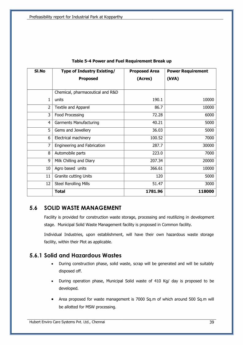
5.5 POWER AND FUEL REQUIREMENT
The tentative overall power requirement for the proposed project is approximately, 118000
kVA (118 mVA) and the source of power is APCPDCL.
Prefeasibility report for Industrial Park at Kopparthy
Hubert Enviro Care Systems Pvt. Ltd., Chennai 39
Table 5-4 Power and Fuel Requirement Break up
Sl.No Type of Industry Existing/
Proposed
Proposed Area
(Acres)
Power Requirement
(kVA)
1
Chemical, pharmaceutical and R&D
units 190.1 10000
2 Textile and Apparel 86.7 10000
3 Food Processing 72.28 6000
4 Garments Manufacturing 40.21 5000
5 Gems and Jewellery 36.03 5000
6 Electrical machinery 100.52 7000
7 Engineering and Fabrication 287.7 30000
8 Automobile parts 223.0 7000
9 Milk Chilling and Diary 207.34 20000
10 Agro based units 366.61 10000
11 Granite cutting Units 120 5000
12 Steel Rerolling Mills 51.47 3000
Total 1781.96 118000
5.6 SOLID WASTE MANAGEMENT
Facility is provided for construction waste storage, processing and reutilizing in development
stage. Municipal Solid Waste Management facility is proposed in Common facility.
Individual Industries, upon establishment, will have their own hazardous waste storage
facility, within their Plot as applicable.
5.6.1 Solid and Hazardous Wastes
During construction phase, solid waste, scrap will be generated and will be suitably
disposed off.
During operation phase, Municipal Solid waste of 410 Kg/ day is proposed to be
developed.
Area proposed for waste management is 7000 Sq.m of which around 500 Sq.m will
be allotted for MSW processing.
Prefeasibility report for Industrial Park at Kopparthy
Hubert Enviro Care Systems Pvt. Ltd., Chennai 40
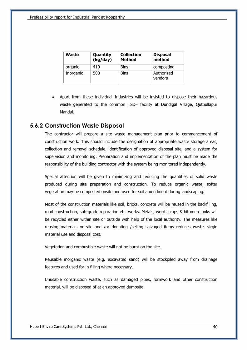
Waste Quantity (kg/day)
Collection Method
Disposal method
organic 410 Bins composting
Inorganic 500 Bins Authorized vendors
Apart from these individual Industries will be insisted to dispose their hazardous
waste generated to the common TSDF facility at Dundigal Village, Qutbullapur
Mandal.
5.6.2 Construction Waste Disposal
The contractor will prepare a site waste management plan prior to commencement of
construction work. This should include the designation of appropriate waste storage areas,
collection and removal schedule, identification of approved disposal site, and a system for
supervision and monitoring. Preparation and implementation of the plan must be made the
responsibility of the building contractor with the system being monitored independently.
Special attention will be given to minimizing and reducing the quantities of solid waste
produced during site preparation and construction. To reduce organic waste, softer
vegetation may be composted onsite and used for soil amendment during landscaping.
Most of the construction materials like soil, bricks, concrete will be reused in the backfilling,
road construction, sub-grade reparation etc. works. Metals, word scraps & bitumen junks will
be recycled either within site or outside with help of the local authority. The measures like
reusing materials on-site and /or donating /selling salvaged items reduces waste, virgin
material use and disposal cost.
Vegetation and combustible waste will not be burnt on the site.
Reusable inorganic waste (e.g. excavated sand) will be stockpiled away from drainage
features and used for in filling where necessary.
Unusable construction waste, such as damaged pipes, formwork and other construction
material, will be disposed of at an approved dumpsite.
Prefeasibility report for Industrial Park at Kopparthy
Hubert Enviro Care Systems Pvt. Ltd., Chennai 41
5.7 FACILITIES FOR STORAGE OF GOODS OR MATERIALS
For providing the Infrastructure facilities, there will be provision for storage of construction
materials.
Individual industries during establishment will have their own facility for storage of materials
during construction and operation phase.
5.8 FACILITIES FOR STORAGE OF HAZARDOUS WASTE
Individual Industries will be insisted to store the spent oil of from DG sets in HDPE drums in
isolated covered facility. This spent oil will be sold to vendors authorized by APPCB/ MoEF for
treatment of same. Suitable care will be taken so that spills / leaks of spent oil from storage
could be avoided.
Individual industries during establishment will apply for separate EC/ CFE as applicable,
wherein the quantity of Hazardous waste will be mentioned and authorization will be
obtained.
5.9 MANPOWER REQUIREMENT
The proposed project required about 75 personnel during construction phase and 2275
personnel during operation phase.
5.10 HEALTH & SAFETY MEASURES
Construction related activities will be confined only to project site area, hence no health
related impact are envisaged within the project influenced area during the construction stage
and will be limited to occupant levels.
Proper drinking water, sanitation and first aid facility will be provided at the construction site,
with trained shift supervisors, which will ensure minimum adverse occupational health
impacts on the construction worker.
In individual industries, safety officers will identify the hazardous and unsafe acts of workers
and advise on corrective actions, conduct safety audit, organize training programs and
provide professional expert advice on various issues related to occupational safety and
health.
Prefeasibility report for Industrial Park at Kopparthy
Hubert Enviro Care Systems Pvt. Ltd., Chennai 42
6. PROJECT COST ESTIMATES
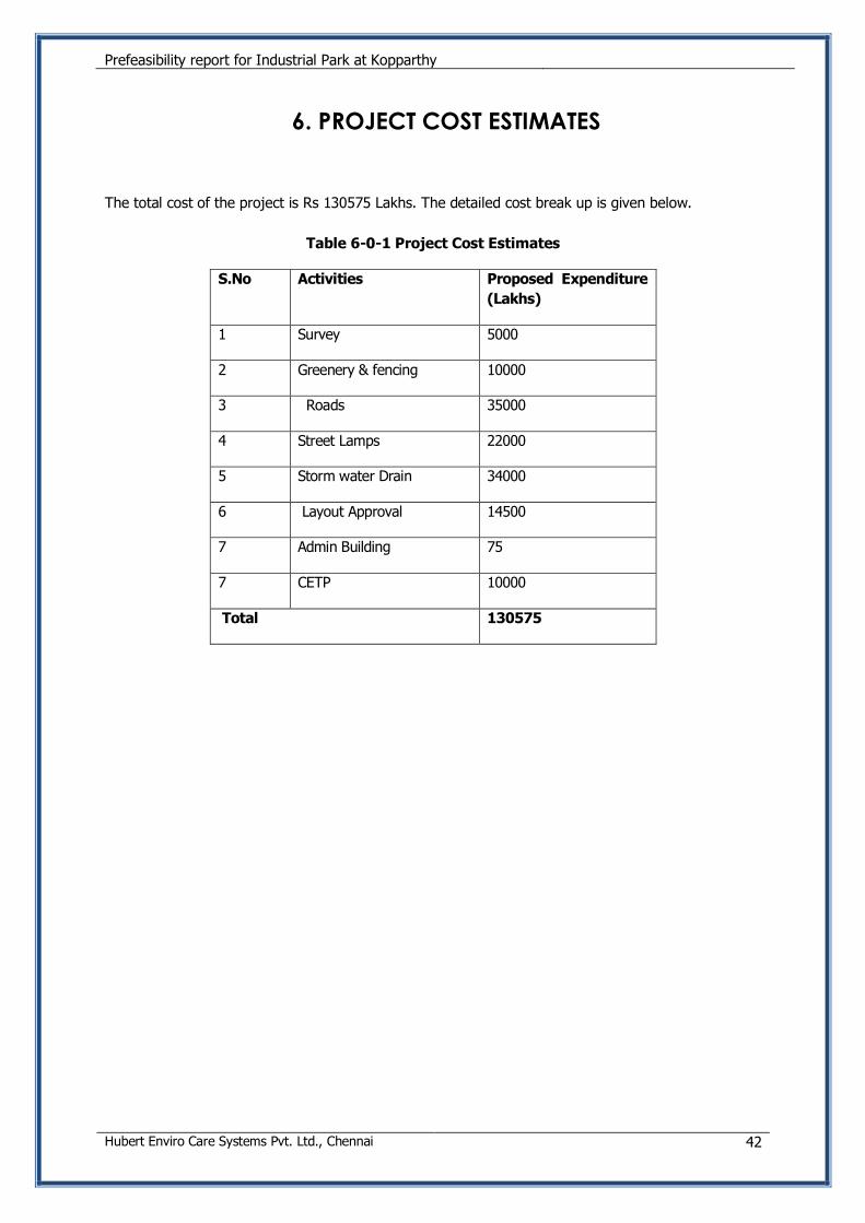
The total cost of the project is Rs 130575 Lakhs. The detailed cost break up is given below.
Table 6-0-1 Project Cost Estimates
S.No Activities Proposed Expenditure
(Lakhs)
1 Survey 5000
2 Greenery & fencing 10000
3 Roads 35000
4 Street Lamps 22000
5 Storm water Drain 34000
6 Layout Approval 14500
7 Admin Building 75
7 CETP 10000
Total 130575