Embed Size (px)
Citation preview
Precise Positioning Precise Positioning applications and applications and
developments in meeting developments in meeting market needs in MALAYSIAmarket needs in MALAYSIA
Noordin AhmadNational Space Agency of Malaysia
(ANGKASA)

Infrastructure 1: MyRTKnet
i. Owned and Operated by Department of Survey and Mapping Malaysia (JUPEM).
ii. Objectives:
* For GNSS Real-time Positioning.
* Reference Frame and Coordinates System.
* Geodynamic Studies.
iii. Use of a network of reference stations to model the systematic errors and provides the possibility of an error reduction.

i. Network of 50 dual frequency GNSS reference stations in Peninsular Malaysia
ii. Network of 28 dual frequency GNSS reference stations in East Malaysia
iii.Control Centre at JUPEM Headquarter, Kuala Lumpur.
99.00 99.50 100.00 100.50 101.00 101.50 102.00 102.50 103.00 103.50 104.00 104.50 105.00
Longitude
1.50
2.00
2.50
3.00
3.50
4.00
4.50
5.00
5.50
6.00
6.50
7.00
La
titu
de
ARAU
BABH
BANT
BEHR
GETI
GMUS
GRIK
JHJY
JUML
KLAW
KUAL
KUKP
LGKW
MERS
MERU
PEKN
PUPK
SGPT
TGPG
TLOH
UPMS
USMP
UUMK
AYER
BAHA
BENT
CAME
CENE
GAJA
JRNT
KRAI
KROM
LASA
LIPI
MUAD
MUKH
PASP
PDIC
PRTS
PUSI
SBKB
SEG1
SETI
SIK1
SPGR
SRIJ
TERI
TGRH
TLKI
TOKA
110 111 112 113 114 115 116 117 118 119
Longitude (E)
1
2
3
4
5
6
7
Latitu
de
(N
)
UMAS
AMAN
SIBU
BINT
MIRI
LAB1
UMSS
SAND
TAWA
SEMA
KAPI
BEAUKENI
KUDA
TENO
JAMB
TUNKLAHA
SEMP
RANA
KBEL
TEBE
MUKA BELA
MARU
LIMBLAWA
LSEM
MyRTKnet


Marine Navigation - SISPELSAT
IALA Recommendation on the Performance andMonitoring of DGNSS Services in the Frequency Band283 - 325 kHz
DGNSS system with coverage of Peninsular Malaysia :Control Station: Port Klang2 Remote Monitoring Station4 Broadcasting (Reference) Station:

By improving accuracy and safety of maritime navigation, the DGNSS system is able to accomplish the following:
�Increased nominal accuracy from 10-15m (GPS only) to 1-3m with DGPS.
�Faster transit times for commercial shipping
�Increased safety through reduced risk of collisions
�Cleaner seas through reduced risk of maritime accidents
�Better position for marine studies – hydrographic survey
�Aids to navigation system – positioning of Buoy
�Oceanographic studies/research
�Oil exploration
�Fisheries
Benefits Of SISPELSAT

ISKANDARnet
� A GPS positioning support system that provides a precise and accurate GPS satellite data correction services.
� Coverage of Iskandar
Development Region (IDR)
� Three CORS stations.

GPS on
Benchmark
Station of
Geodetic
Network
GPS
antenna
located
on top of
the
Platform
Seabe
d
- detect subsidence due to reservoir compaction- effect on structural integrity
P
IGSIGS
IGS
IGS
Platform Subsidence
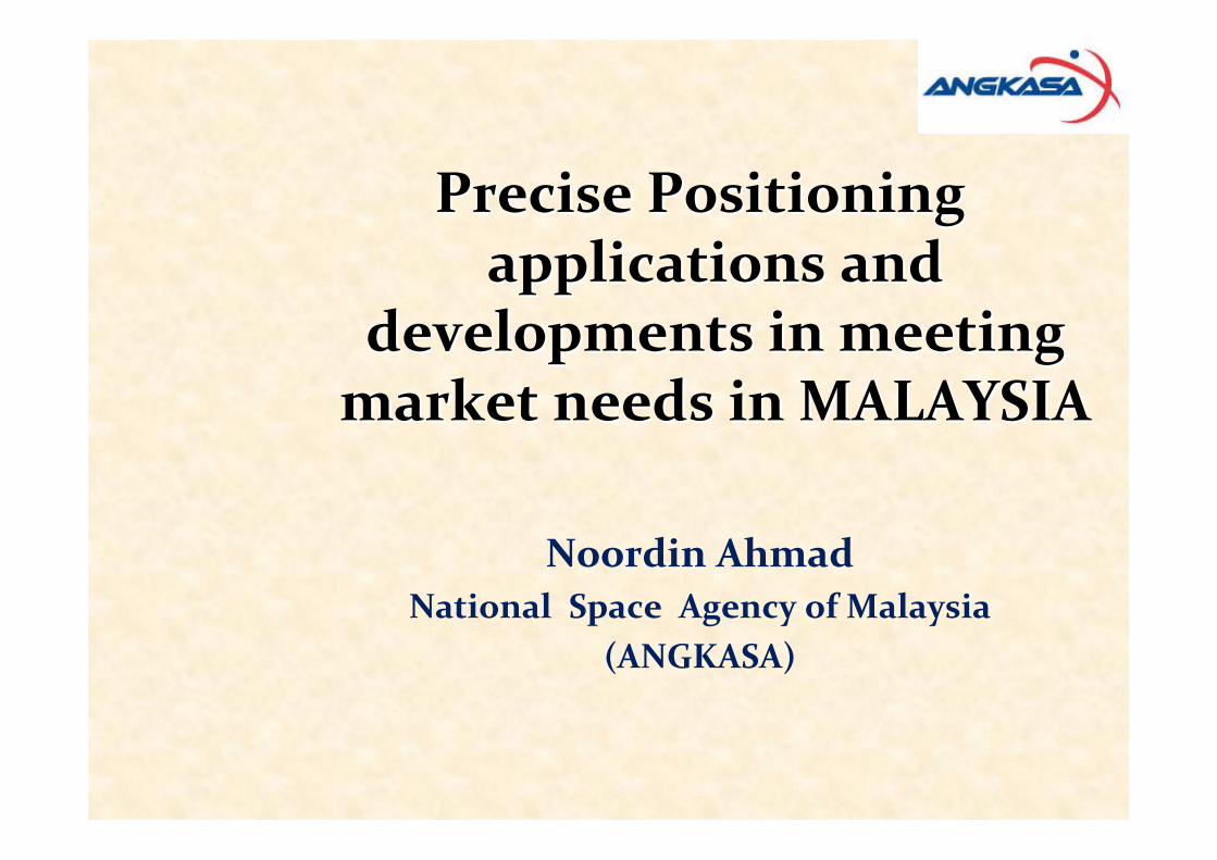
EXPLORATION APPRAISAL PRODUCTION
• Vessel positioning• Sensor positioning• Fish traps survey
• Rig positioning• Vessel positioning
• Vessel positioning• Barge positioning• Platform positioning• Pipeline positioning
• Barge positioning• Vessel tracking• Subsidence survey
DEVELOPMENT
• O&G Industry (Petronas)

Initiatives for Precision Farming

Various integration of GNSS
into Precision Farming
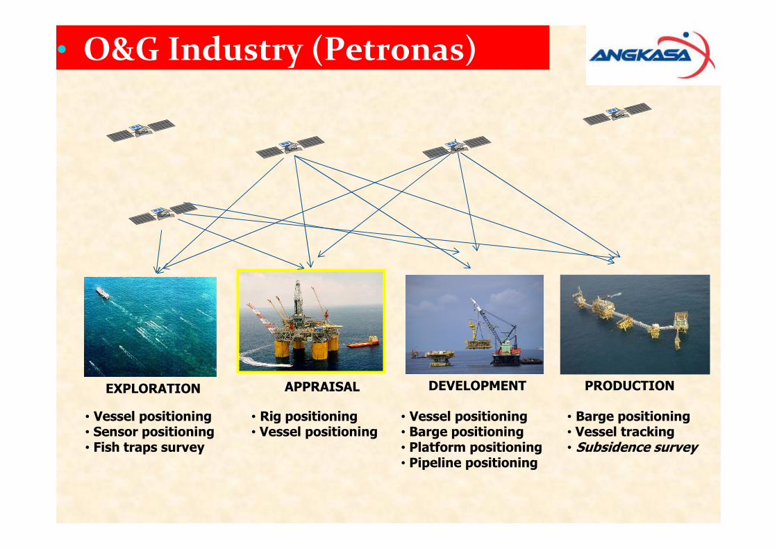
Nature Conservation
Elephant Satellite Tracking Movement Study
Dispersal of Turtle Hatchings Pattern
WWF Malaysia

Department of Agricultural
- Soil Investigation, Fertility, Conservation
- Land-use Investigation
- Crop pest diagnostic services
- Quality control
- Engineering
- Horticulture
Other Initiatives for
Precision Farming

GNSS Local Applications
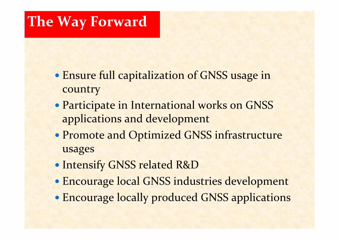
The Way Forward
� Ensure full capitalization of GNSS usage in country
� Participate in International works on GNSS applications and development
� Promote and Optimized GNSS infrastructure usages
� Intensify GNSS related R&D
� Encourage local GNSS industries development
� Encourage locally produced GNSS applications

THANK YOU