Embed Size (px)
Citation preview
GeoInformation Workshop 2004, Istanbul Kultur University, September 20-26, Antalya © 2004 Geo++® GmbH
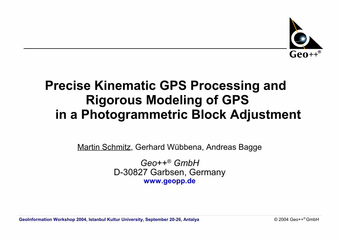
Precise Kinematic GPS Processing and Rigorous Modeling of GPS
in a Photogrammetric Block Adjustment
Martin Schmitz, Gerhard Wübbena, Andreas Bagge
Geo++® GmbHD-30827 Garbsen, Germany
www.geopp.de
GeoInformation Workshop 2004, Istanbul Kultur University, September 20-26, Antalya © 2004 Geo++® GmbH
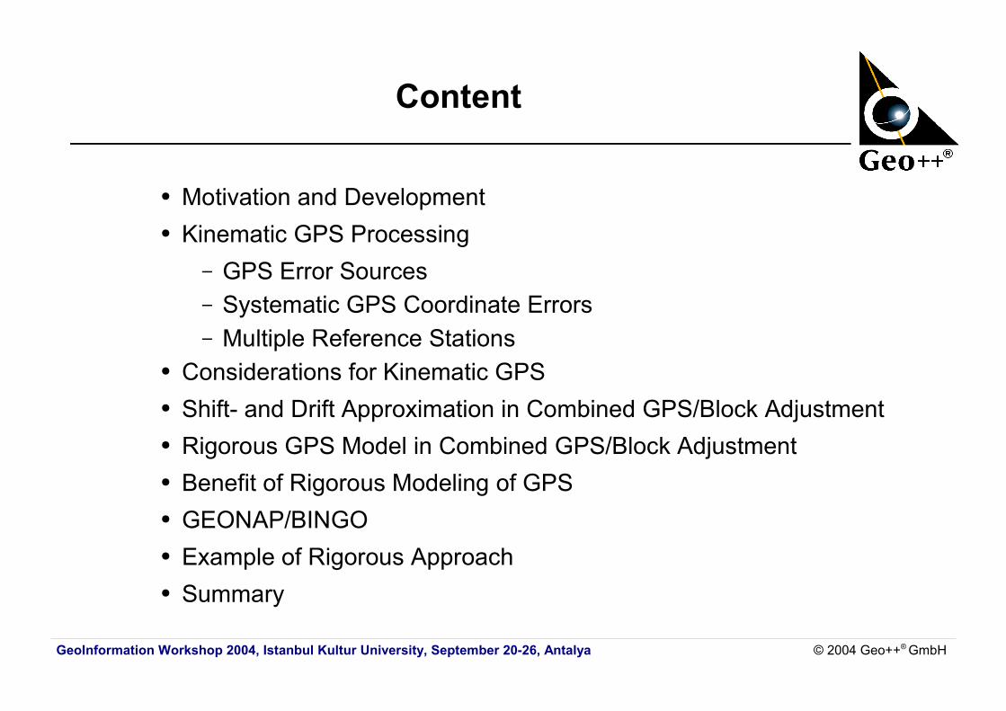
Content
● Motivation and Development● Kinematic GPS Processing
– GPS Error Sources– Systematic GPS Coordinate Errors– Multiple Reference Stations
● Considerations for Kinematic GPS● Shift- and Drift Approximation in Combined GPS/Block Adjustment● Rigorous GPS Model in Combined GPS/Block Adjustment● Benefit of Rigorous Modeling of GPS● GEONAP/BINGO● Example of Rigorous Approach● Summary
GeoInformation Workshop 2004, Istanbul Kultur University, September 20-26, Antalya © 2004 Geo++® GmbH
Motivation and Development
● precise kinematic GPS processing● challenging GPS task● combination of GPS and photogrammetric applications● handling of possible GPS coordinate errors● generally approximation without reflecting GPS model applied● research project at University of Hannover in 1995-1996
– rigorous GPS Model developed for combined GPS/block adjustment
● GEONAP-K GPS- / BINGO block adjustment● operationally applied since 1996
GeoInformation Workshop 2004, Istanbul Kultur University, September 20-26, Antalya © 2004 Geo++® GmbH
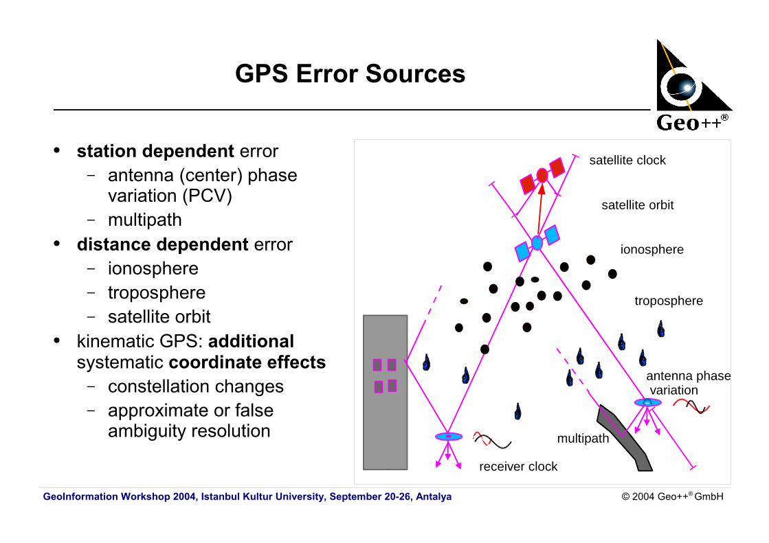
GPS Error Sources
● station dependent error– antenna (center) phase
variation (PCV)– multipath
● distance dependent error– ionosphere– troposphere– satellite orbit
● kinematic GPS: additional systematic coordinate effects – constellation changes– approximate or false
ambiguity resolution
troposphere
ionosphere
satellite clock
satellite orbit
receiver clock
antenna phase variation
multipath
GeoInformation Workshop 2004, Istanbul Kultur University, September 20-26, Antalya © 2004 Geo++® GmbH
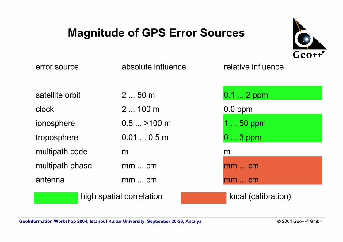
Magnitude of GPS Error Sources
high spatial correlation
error source absolute influence relative influence
satellite orbit 2 ... 50 m 0.1 ... 2 ppm
clock 2 ... 100 m 0.0 ppm
ionosphere 0.5 ... >100 m 1 ... 50 ppm
troposphere 0.01 ... 0.5 m 0 ... 3 ppm
multipath code m m
multipath phase mm ... cm mm ... cm
antenna mm ... cm mm ... cm
local (calibration)
GeoInformation Workshop 2004, Istanbul Kultur University, September 20-26, Antalya © 2004 Geo++® GmbH
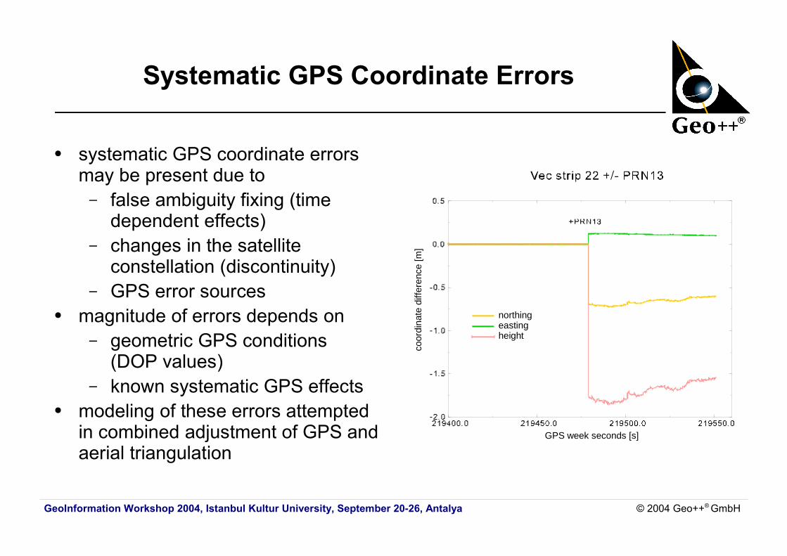
Systematic GPS Coordinate Errors
● systematic GPS coordinate errors may be present due to– false ambiguity fixing (time
dependent effects)– changes in the satellite
constellation (discontinuity)– GPS error sources
● magnitude of errors depends on– geometric GPS conditions
(DOP values)– known systematic GPS effects
● modeling of these errors attempted in combined adjustment of GPS and aerial triangulation
northingeastingheight
GPS week seconds [s]
coor
dina
te d
iffer
ence
[m]
GeoInformation Workshop 2004, Istanbul Kultur University, September 20-26, Antalya © 2004 Geo++® GmbH
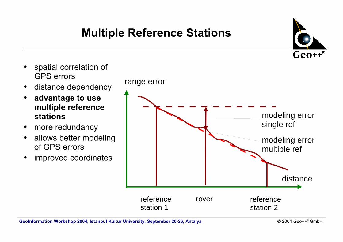
Multiple Reference Stations
● spatial correlation of GPS errors
● distance dependency ● advantage to use
multiple reference stations
● more redundancy● allows better modeling
of GPS errors● improved coordinates
range error
distance
reference station 1
rover referencestation 2
modeling error single ref
modeling error multiple ref
GeoInformation Workshop 2004, Istanbul Kultur University, September 20-26, Antalya © 2004 Geo++® GmbH
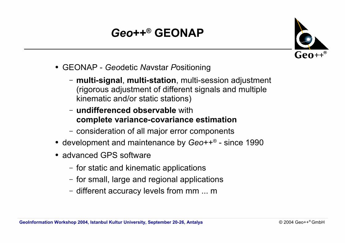
Geo++® GEONAP
● GEONAP - Geodetic Navstar Positioning– multi-signal, multi-station, multi-session adjustment
(rigorous adjustment of different signals and multiplekinematic and/or static stations)
– undifferenced observable with complete variance-covariance estimation
– consideration of all major error components● development and maintenance by Geo++® - since 1990● advanced GPS software
– for static and kinematic applications– for small, large and regional applications– different accuracy levels from mm ... m
GeoInformation Workshop 2004, Istanbul Kultur University, September 20-26, Antalya © 2004 Geo++® GmbH
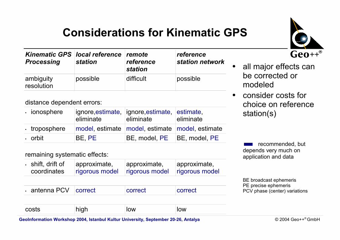
Considerations for Kinematic GPS
● all major effects can be corrected or modeled
● consider costs for choice on reference station(s)
recommended, but depends very much on application and data
BE broadcast ephemerisPE precise ephemerisPCV phase (center) variations
Kinematic GPSProcessing
local referencestation
remotereferencestation
referencestation network
ambiguityresolution
possible difficult possible
distance dependent errors:• ionosphere ignore,estimate,
eliminateignore,estimate,eliminate
estimate,eliminate
• troposphere model, estimate model, estimate model, estimate• orbit BE, PE BE, model, PE BE, model, PE
remaining systematic effects:• shift, drift of
coordinatesapproximate,rigorous model
approximate,rigorous model
approximate,rigorous model
• antenna PCV correct correct correct
costs high low low
GeoInformation Workshop 2004, Istanbul Kultur University, September 20-26, Antalya © 2004 Geo++® GmbH
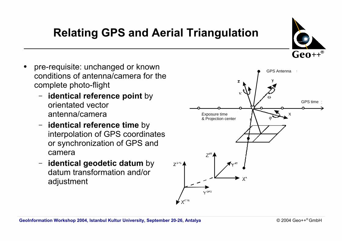
Relating GPS and Aerial Triangulation
● pre-requisite: unchanged or known conditions of antenna/camera for the complete photo-flight– identical reference point by
orientated vector antenna/camera
– identical reference time by interpolation of GPS coordinates or synchronization of GPS and camera
– identical geodetic datum by datum transformation and/or adjustment
GPS Antenna
Exposure time& Projection center
GPS time
GeoInformation Workshop 2004, Istanbul Kultur University, September 20-26, Antalya © 2004 Geo++® GmbH
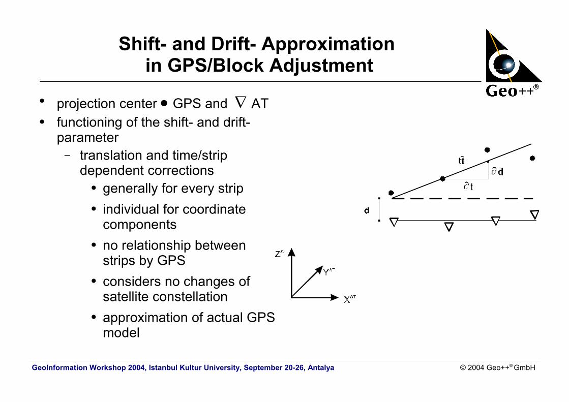
Shift- and Drift- Approximation in GPS/Block Adjustment
● projection center GPS and AT● functioning of the shift- and drift-
parameter– translation and time/strip
dependent corrections ● generally for every strip● individual for coordinate
components● no relationship between
strips by GPS● considers no changes of
satellite constellation● approximation of actual GPS
model
GeoInformation Workshop 2004, Istanbul Kultur University, September 20-26, Antalya © 2004 Geo++® GmbH
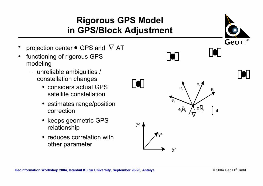
Rigorous GPS Modelin GPS/Block Adjustment
● projection center GPS and AT● functioning of rigorous GPS
modeling– unreliable ambiguities /
constellation changes● considers actual GPS
satellite constellation● estimates range/position
correction● keeps geometric GPS
relationship ● reduces correlation with
other parameter
d
GeoInformation Workshop 2004, Istanbul Kultur University, September 20-26, Antalya © 2004 Geo++® GmbH
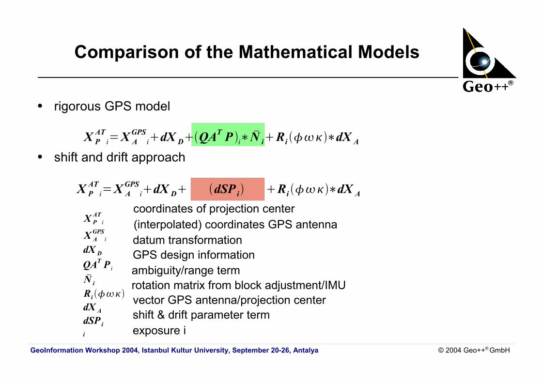
Comparison of the Mathematical Models
● rigorous GPS model
● shift and drift approach
coordinates of projection center(interpolated) coordinates GPS antenna
datum transformation GPS design information
ambiguity/range term rotation matrix from block adjustment/IMU
vector GPS antenna/projection centershift & drift parameter termexposure i
X PATi=X A
GPSidX DQAT P i∗ N iRi ∗dX A
X PATi=X A
GPSidX D dSP i Ri ∗dX A
X PATi
X AGPS
i
dX D
QAT P iN i
Ri dX A
dSP ii
GeoInformation Workshop 2004, Istanbul Kultur University, September 20-26, Antalya © 2004 Geo++® GmbH
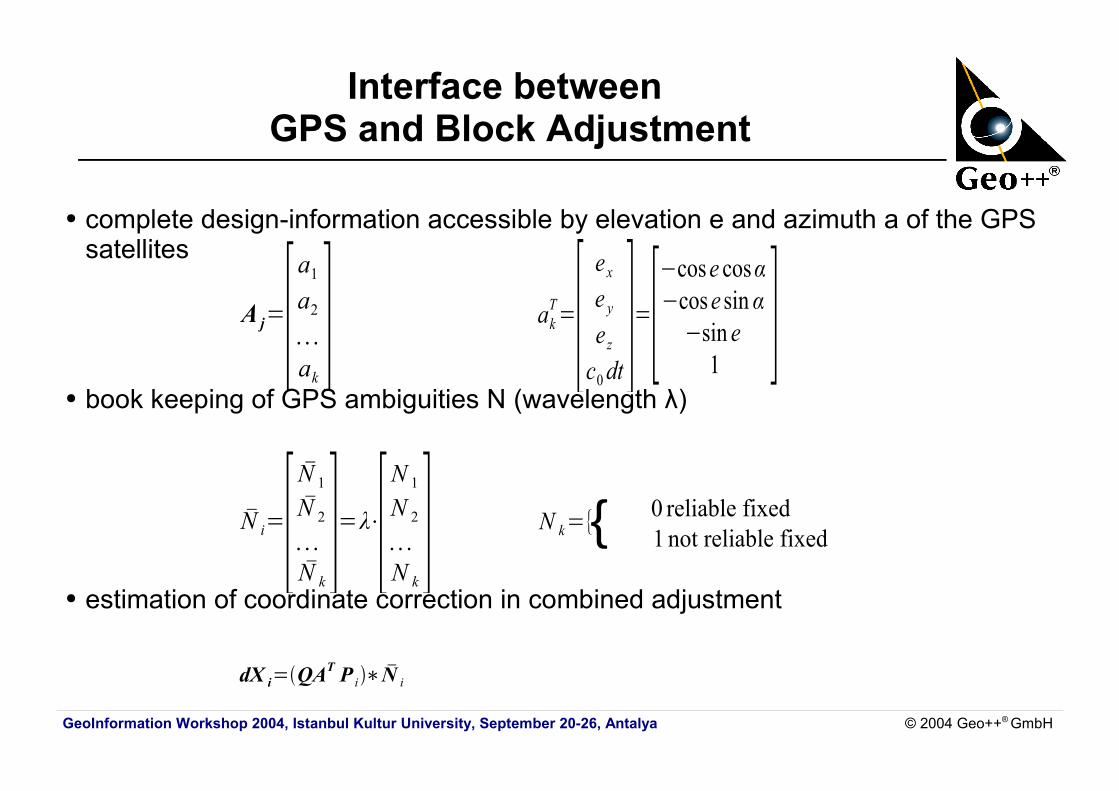
Interface between GPS and Block Adjustment
● complete design-information accessible by elevation e and azimuth a of the GPS satellites
● book keeping of GPS ambiguities N (wavelength λ)
● estimation of coordinate correction in combined adjustment
akT=[ e xe ye zc0dt
]=[−cose cosα−cose sin α
−sin e1 ]A j=[a1
a2
. . .ak]
N k={ 0 reliable fixed1 not reliable fixed
dX i=QAT P i∗ N i
N i=[ N 1
N 2
. . .N k]=λ⋅[N 1
N 2
. . .N k] {
GeoInformation Workshop 2004, Istanbul Kultur University, September 20-26, Antalya © 2004 Geo++® GmbH
Benefits of Rigorous Modeling of GPS
● correct modeling of all GPS errors● independent of strips/block● considers the actual GPS model● considers time dependent effects and GPS constellation changes● reduced number of unknowns in combined adjustment● relative accuracy of GPS coordinates is maintained
(for all strips and complete block)● no crossing strips required● separation of systematic GPS errors from
– e.g. datum parameters – additional parameters e.g. interior orientation
● reduction of ground control points and side lap possible● cost reduction feasible
GeoInformation Workshop 2004, Istanbul Kultur University, September 20-26, Antalya © 2004 Geo++® GmbH
GEONAP/BINGO
● GPS processing for photogrammetric application– simultaneous adjustment of several kinematic rovers
and reference station data possible● sophisticated feature: subsequent processing with
GEONAP-K package for GPS data andBINGO* for combined adjustment
● only operationally applied rigorous GPS modelingin block adjustment
● also termed CPAS (Combined Phase Ambiguity Solution)
* BINGO from GIP Geoinformation & Photogrammetric Engineering
D-73430 Aalenwww.gip-aalen.de
GeoInformation Workshop 2004, Istanbul Kultur University, September 20-26, Antalya © 2004 Geo++® GmbH
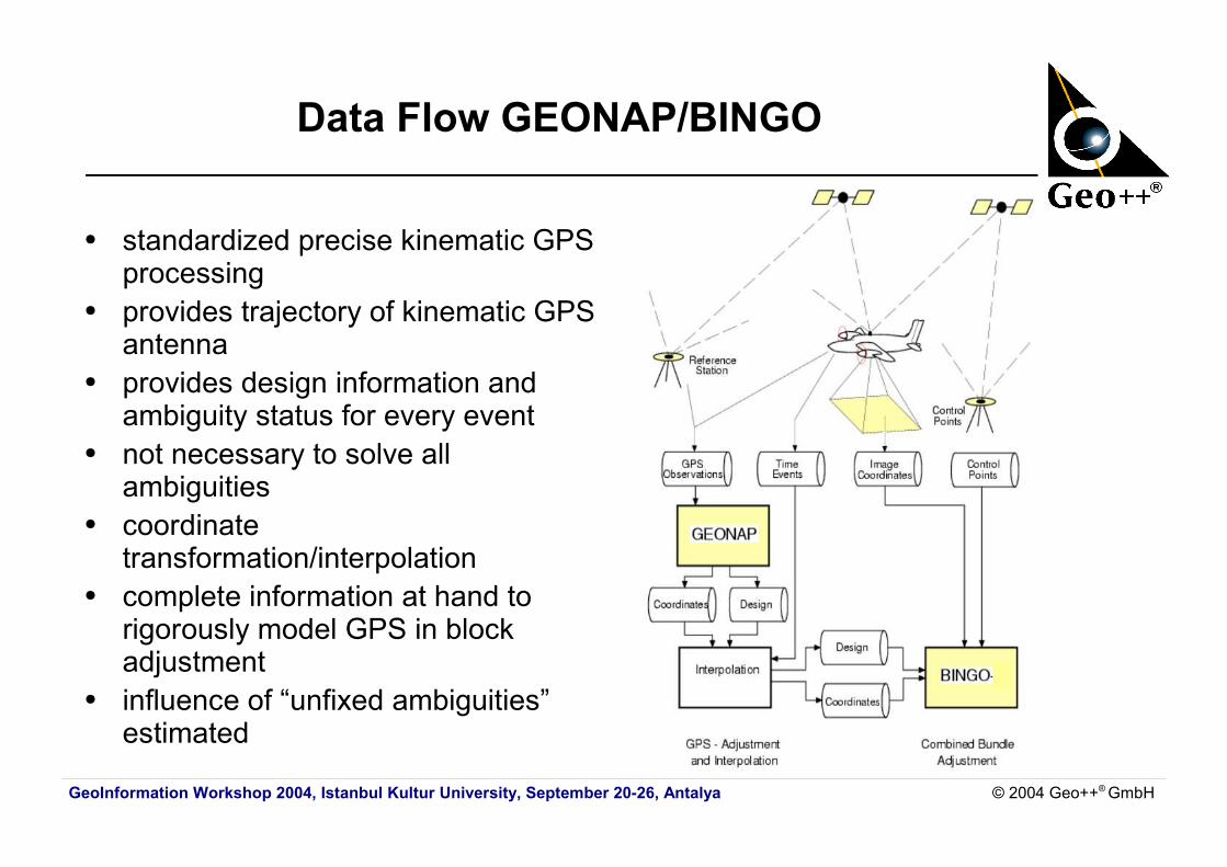
Data Flow GEONAP/BINGO
● standardized precise kinematic GPS processing
● provides trajectory of kinematic GPS antenna
● provides design information and ambiguity status for every event
● not necessary to solve all ambiguities
● coordinate transformation/interpolation
● complete information at hand to rigorously model GPS in block adjustment
● influence of “unfixed ambiguities” estimated
GeoInformation Workshop 2004, Istanbul Kultur University, September 20-26, Antalya © 2004 Geo++® GmbH
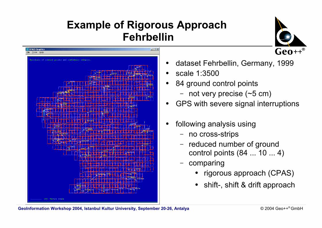
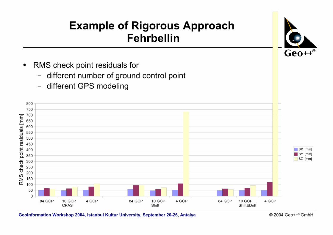
Example of Rigorous Approach Fehrbellin
● dataset Fehrbellin, Germany, 1999● scale 1:3500● 84 ground control points
– not very precise (~5 cm)● GPS with severe signal interruptions
● following analysis using– no cross-strips– reduced number of ground
control points (84 ... 10 ... 4)– comparing
● rigorous approach (CPAS)● shift-, shift & drift approach
GeoInformation Workshop 2004, Istanbul Kultur University, September 20-26, Antalya © 2004 Geo++® GmbH
84 GCP 10 GCP CPAS
4 GCP 84 GCP 10 GCP Shift
4 GCP 84 GCP 10 GCP Shift&Drift
4 GCP0
50100150200250300350400450500550600650700750800
SX [mm]SY [mm]SZ [mm]
RM
S c
heck
poi
nt re
sidu
als
[mm
]Example of Rigorous Approach
Fehrbellin
● RMS check point residuals for – different number of ground control point– different GPS modeling
GeoInformation Workshop 2004, Istanbul Kultur University, September 20-26, Antalya © 2004 Geo++® GmbH
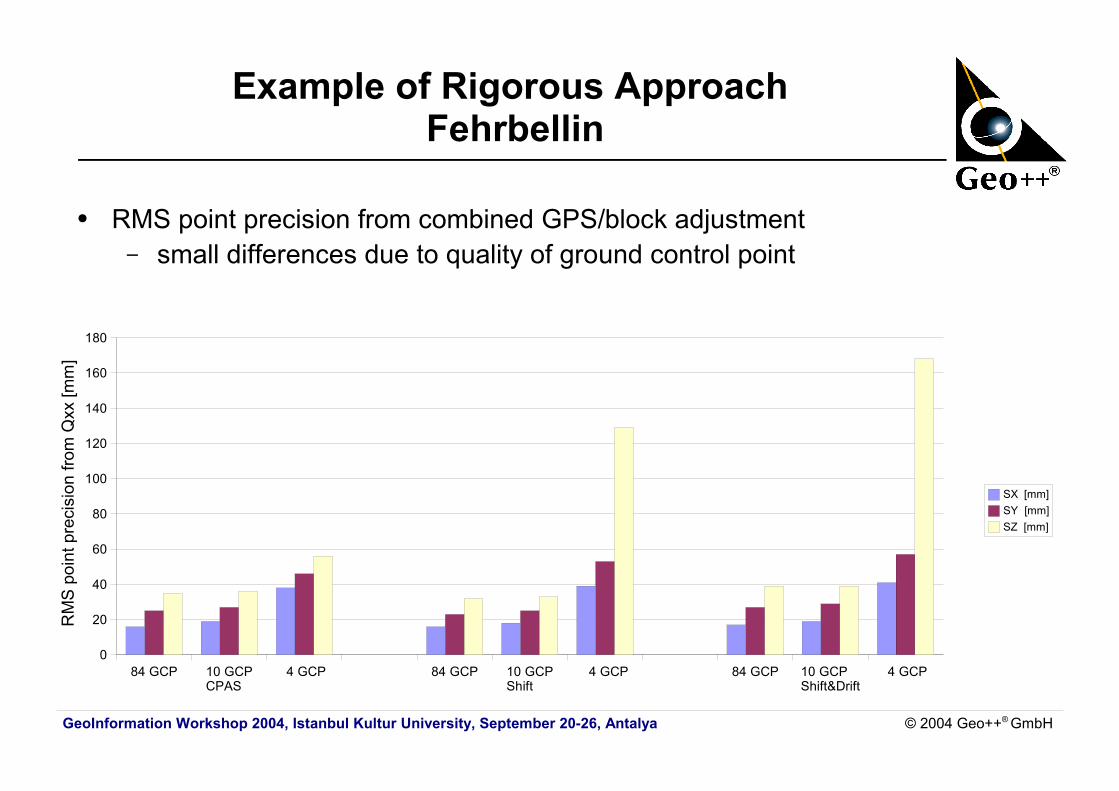
Example of Rigorous Approach Fehrbellin
● RMS point precision from combined GPS/block adjustment– small differences due to quality of ground control point
84 GCP 10 GCP CPAS
4 GCP 84 GCP 10 GCP Shift
4 GCP 84 GCP 10 GCP Shift&Drift
4 GCP0
20
40
60
80
100
120
140
160
180
SX [mm]SY [mm]SZ [mm]
RM
S p
oint
pre
cisi
on fr
om Q
xx [m
m]
GeoInformation Workshop 2004, Istanbul Kultur University, September 20-26, Antalya © 2004 Geo++® GmbH
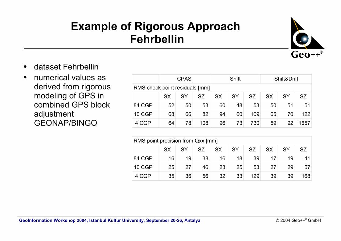
Example of Rigorous Approach Fehrbellin
● dataset Fehrbellin● numerical values as
derived from rigorous modeling of GPS in combined GPS block adjustmentGEONAP/BINGO
CPAS Shift Shift&Drift
RMS check point residuals [mm]
SX SY SZ SX SY SZ SX SY SZ
84 CGP 52 50 53 60 48 53 50 51 51
10 CGP 68 66 82 94 60 109 65 70 122
4 CGP 64 78 108 96 73 730 59 92 1657
RMS point precision from Qxx [mm]
SX SY SZ SX SY SZ SX SY SZ
84 CGP 16 19 38 16 18 39 17 19 41
10 CGP 25 27 46 23 25 53 27 29 57
4 CGP 35 36 56 32 33 129 39 39 168
GeoInformation Workshop 2004, Istanbul Kultur University, September 20-26, Antalya © 2004 Geo++® GmbH
Summary
● precise kinematic GPS processing revisited– all major error components can be corrected or modeled– advantages of multiple reference stations
● rigorous GPS modeling in combined GPS/block adjustment revisited– uses the actual GPS satellite geometry– advantages and benefits of approach
● keeps geometric GPS relationship / strengthening of geometry in block adjustment
● correct functional GPS model / reduced correlation with other parameter● operational experiences underline advantages:
reduction of ground control points, no cross-strips● operational procedure with GEONAP-K and BINGO since 1996

GeoInformation Workshop 2004, Istanbul Kultur University, September 20-26, Antalya © 2004 Geo++® GmbH
for publications on the presented topic refer also to
www.geopp.com
or directly to
http://www.geopp.com/publications/english/lit_e.htm


![Ocean tide loading displacements in western …...FES2004 OTL predictions. Ito et al. [2009] analyzed 4 months of Japan GEONET data using kinematic PPP GPS (GPS Tools v 0.6.3 with](https://img.pdfslide.us/doc/110x75/5e78ccf941451b083b7887c2/ocean-tide-loading-displacements-in-western-fes2004-otl-predictions-ito-et.jpg)