Embed Size (px)
Citation preview
1
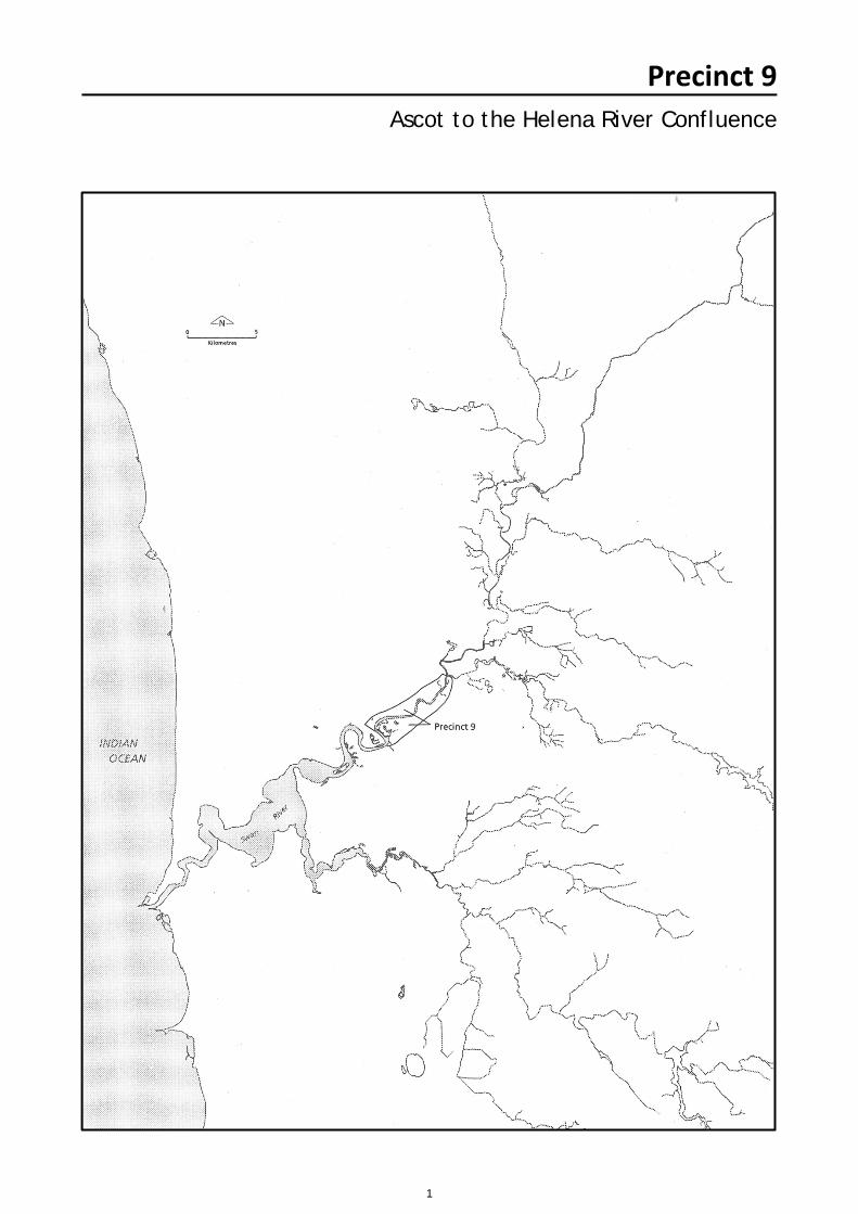
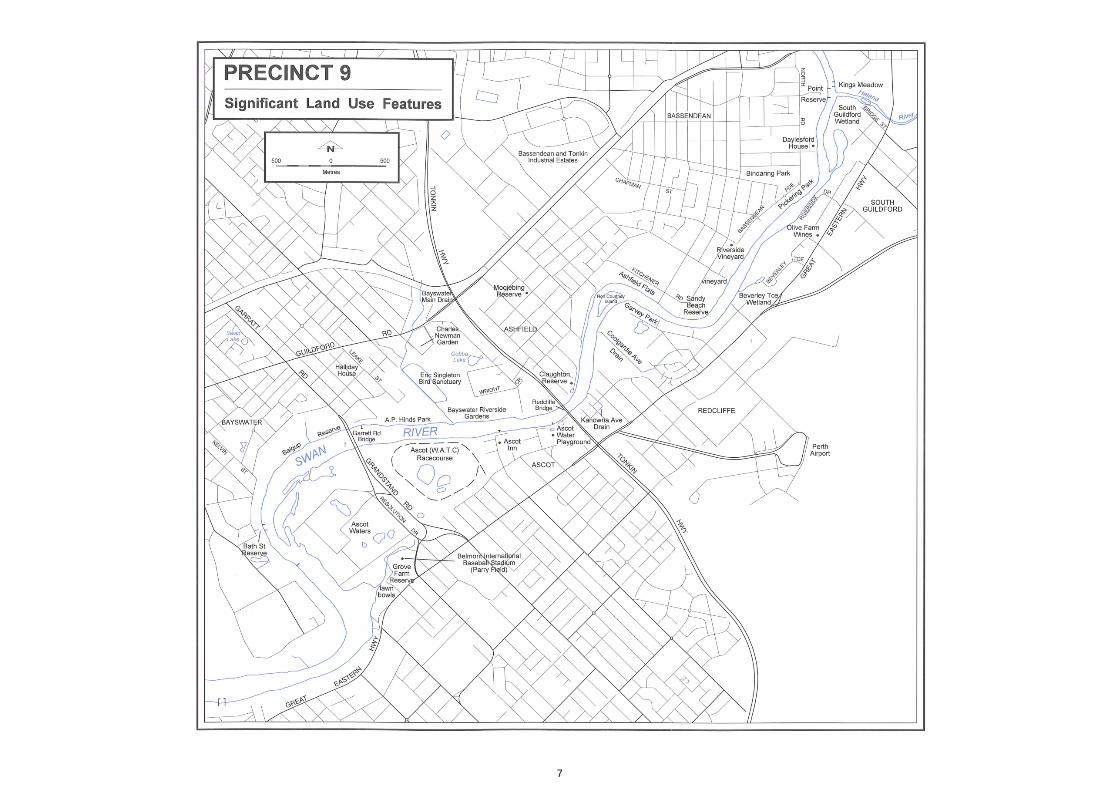
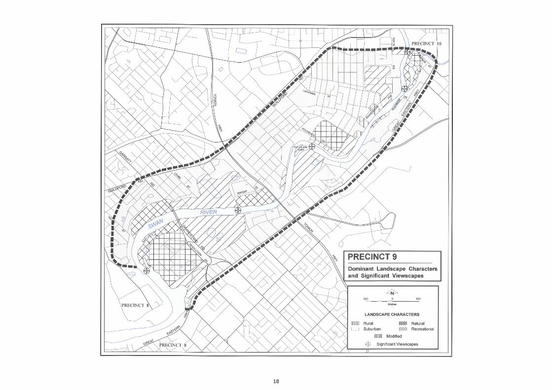
Precinct 9Ascot to the Helena River Confluence
2
Summary Ascot to the Helena River Confluence
The Swan River takes an irregularly meandering form with sections of straight channel in this section. The Ascot Peninsula forms an attractivewater body with several fingers of land extending into the river channel.
A sharp northerly bend in the river occurs after the Redcliff
Bridge where the river takes a straight course. A second right
angled bend occurs at Ron Courtney Island. The island itself is
almost a right angled triangle. Upstream the river is narrower and
has a higher sinuosity. The Helena River is a relatively narrow
channel which broadens at its t-section confluence with the Swan
River. Much of the silty foreshore is highly susceptible to erosion
and several sections have been hard walled. The landform in this
precinct consists of wide areas of low lying floodplain less than
five metres AHD, after which the floodplain meets the
Bassendean Dune System. This landform is gently undulating
and originally small damplands formed in the swale depressions.
The fringing vegetation communities in this area are often
degraded or have been replaced by grassy banks. The
indigenous vegetation is dominated by a variety of shorerushes,
sheoaks and paperbarks. Often the exotic bulrush has invaded
freshwater areas as well as watsonia and several grass species.
The original marri-flooded gum woodlands are mainly restricted
to public recreation reserves, where the original understorey has
been replaced by grasses giving the area a wooded paddock
landscape. Sections of low lying foreshore such as Ashfield Flats
have samphire community surrounded by fringing rushes and
sheoaks.
Due to river 'training' many of the rivers original bends have been
straightened and to reduce erosion retaining walls have been
constructed by many residents using different materials and
styles. Similarly, the parks and recreation reserves display a
variety of retaining walls. There are several public reserves in the
precinct which provide for both passive and active recreation. At
present, the Bayswater Riverside Gardens are being constructed
and the lack of vegetation and yellow clean fill are prominent
landscape features. Similarly the Ascot Peninsula is being
redeveloped as a housing estate and the old fill and sand is at
present being remodelled. The Ascot Raceway is a large low
lying area of flat treeless land which is prominent to the river
user. Most of land set back from the floodplain is used for
residential purposes and due to the ongoing subdivision the
houses range in age and style.
3
Resource Information
Biophysical Processes
Geological Processes The main soil association for the Bayswater area is the
Bassendean Association, however the site is located on the
Swan River flood plain (DCE, 1980). The Bassendean Soil
Association is characterised as having a grey surface sand with a
brownish yellow subsoil. However upstream and on the southern
banks the Guildford Formation is dominant with sandy clays to
clayey sands including some alluvium and colluvium. The
Guildford Formation consists of sand, clay and conglomerate.
Most of the unit is of fluvial origin but it includes estuarine
deposits. The Guildford Unit has layers which comprise older
layers characterised by duplex soils.
The soil type of the foreshore is generally Bassendean Sands
with areas of alluvium, peat, clay and swamp and river deposits
(McArthur and Bettenay, 1974). There are pockets of peat, heavy
clays and river silt deposits which are particularly evident in the
wetlands of Bayswater. At Ashfield, the low river flats consist of
heavy dark brown high clay content soil on light brown soil. The
clay content decreases on the higher slopes. The swan alluvial
terraces have red earths and duplex soils and the fluviatile
deposits of the Guildford flat plain consist of medium textured
deposits and yellow duplex soils.
Topography The area is part of the Bassendean Dune System which
represent a Pleistocene coastline. The quartz sand dunes
consist of low hills with sandy swamps in the swales. In this
precinct, flat low lying peninsulas have formed as the result of
meandering river flood plains. Most of the naturally damp lands
have been infilled so that the land appears artificially flat rather
than graded. The edge of the flood plain forms a flat foreshore
which rises in some cases quite quickly up to a maximum height
of around 10 metres. This higher area is the Bassendean dunes
while the lower silty area is the more recent alluvial deposits.
Hydrological Processes Water features The Swan River banks and inland at Ascot Peninsula and the
Redcliff Peninsula to Kalamunda Road are clay deposits. The
opposite banks are loamy deposits with clay deposits on the
upper streams. There is little tidal movement and no daily
alternation of fresh and salt waters in the Swan River and there
are distinct seasonal changes in salinity. As runoff decreases in
spring to summer and surface evaporation increases the estuary
is quite saline. There are a number of subsurface springs in the
area and originally there were several freshwater streams
entering the river. Many of these streams have been converted to
storm water runoff drains which have been trained and have
pipeheads and retaining banks. There are two backwaters on the
southern bank of the Swan River in this precinct. The Beverley
Terrace backwater has several small channels draining into the
river from a pool like wetland. The channels appear to be quite
silted up and shallow. In contrast, the backwater at South
Guildford is mainly seasonally wet apart from a permanent pool
joining the river channel. At Ashfield, there is a large wetland
which is circular shaped and has a samphire and Typha
orientalis community fringing the water. There is a seasonal
wetland at Bindaring Park.
Bathymetry The Swan River is shallow and only 2 to 3 metres deep in this
precinct. Parts have been dredged and straightened to allow
improved river transport access.
Flooding At Bayswater the 100 year flood level is calculated to be
approximately 4.4 metres AHD and the level is similar for the rest
of the river in this area. At Bassendean, inundation of the low
lying land occurs following heavy rains and historically the town
site has been frequently flooded the most significant years being
1917, 1926, 1945, 1954, 1955 and 1956 (Riggert, 1978). The
flood plain reaches up to 1 kilometre in width at Ashfield and is
quite irregular in width. A major section of Ashfield Flats is within
the 100 year flood fringe.
Erosion and accretion The river has been subject to ongoing erosion particularly long
the Garvey Park foreshore where hard walling has been put in
place to reduce the loss of the river bank.. Another prominent
area of erosion is the South Guildford foreshore where winter
floods have scoured the soil from the fringing tree roots.
4
Precinct 9 – Ascot to the Helena River Confluence
Vegetation Communities Native Swan Complex The Swan Complex edges the entire foreshore of this precinct
(DCE, 1980). The vegetation ranges from fringing woodland of
flooded gum (Eucalyptus rudis) and swamp paperbark
(Melaleuca rhaphiophylla) with localised occurrence of low open
forest of sheoak (Casuarina obesa) and saltwater paperbark
(Melaleuca cuticularis).
Along the very fringe of the river the emergent shorerush (Juncus
kraussii) and pale rush (Juncus pallidus) form a closed sedge
land..
In addition to these species, the Ashfield fringing rush community
has streaked arrowgrass (Triglochin striata) (Town of
Bassendean, 1988). At the Baigup Wetland Reserve, sword
sedge (Lepidosperma longitudinale) occurs in small patches
among the shorerush . Lake club-rush (Schoenoplectus validus)
occurs among several exotic species in areas with freshwater
springs and wetlands. At Bennett Brook wetland there is a
mixture of the native bulrush (Typha domingensis) and the
introduced species (Typha orientalis) which form a closed
sedgeland.
There are remnants of the salt water sheoak (Casuarina obesa)
and the fresh water paperbark (Melaleuca rhaphiophylla) along
the edges of the Swan River at Maylands and Ashfield (Swan
River Trust, 1991). The understorey is commonly degraded and
weeds such as the exotic bulrush (Typha orientalis) flourish. The
indigenous understorey consists of shorerush (Juncus kraussii),
club rush (Bolboschoenus caldwellii) and divided sedge (*Carex
divisa). There is minimal infestation of the by the indigenous
dodder (Cassytha sp) on the melaleucas and mistletoe (Amyema
sp) on the sheoaks.
Melaleuca swamp communities occur as the most extreme
freshwater associated complex found along the rivers, but have
been severely degraded by weeds. The dominant understorey
species consist of twig rush (Baumea juncea), jointed rush
(Baumea articulata), sword sedge (Lepidosperma longitudinale),
broad leaf rush (Juncus planifolius) and pale rush (Juncus
pallids). At Ashfield, there is swamp paperbark (Melaleuca
rhaphiophylla), mohan (Melaleuca viminea) and banbar
(Melaleuca teretifolia) community forming a sparse woodland.
The woodland of flooded gum (Eucalyptus rudis) and swamp
paperbark (Melaleuca rhaphiophylla) extends along the current
Bayswater drain.
The understorey consists of shorerush (Juncus sp) and club rush
(Scirpus sp). The area also supports coojong (Acacia saligna)
and exotic bulrush (Typha orientalis).
Guildford Complex South of the Swan Complex at Belmont, the vegetation
changes to the Guildford Complex (DCE, 1980). Small
patches of this complex are present at Redcliffe and
Caversham inland from the Swan Complex. The complex
ranges from a mixture of open to tall open forest of marri
(Eucalyptus calophylla), wandoo (Eucalyptus wandoo) and jarrah
(Eucalyptus marginata). The understorey species include bull
banksia (Banksia grandis), black gin (Kingia australis), blackboy
(Xanthorrhoea preissii), and buttercup (Hibbertia sp).
Bassendean Complex Away from the Swan River on the drier land at Belmont and
Bassendean, the flora is identified as belonging to the
Bassendean Complex. The vegetation ranges from
woodland of jarrah (Eucalyptus marginata), sheoak
(Allocasuarina obesa), and various banksia species including
firewood banksia (Banksia menziesii), slender banksia (Banksia
attenuata) and holly leaved banksia (Banksia ilicifoila), to sedge
lands on the moister and lower sites.
Southern River Complex The Southern River Complex occurs on the higher land at
South Guildford and Caversham (DCE, 1980). The complex
is identified as being jarrah (Eucalyptus marginata), marri
(Eucalyptus calophylla) and various banksia species with a
fringing woodland of flooded gum (Eucalyptus rudis) and
swamp paperbark (Melaleuca rhaphiophylla) along the creek
bedlines.
The latter fringing community only occurs where fresh water
conditions prevail. The understorey is often a composition of
shorerush (Juncus kraussii), pale rush (Juncus pallidus), club
rush (Bolboschoenus caldwellii), twig rush (Baumea juncea) and
divided sedge (Carex divisa).
5
Precinct 9 – Ascot to the Helena River Confluence
Exotic Numerous weeds have been introduced to the precinct due to
rubbish dumping and infilling. The weeds include buffalo grass
(*Stenotaphrum secundatum), kikuyu grass (*Pennisetum
clandestinum), couch (*Cynodon dactylon), blowfly grass (*Briza
maxima), African love grass (*Eragrostis curvula), the shrub
*Hastate orache, *Atriplex prostrata, castor oil plant (*Ricinus
communis), willow (*Salix sp), morning glory (*Ipomoea sp),
sunflowers (*Helianthus annuus), mint (*Mentha piperita), arum
lily (*Zantedeschia aethipica), Paterson's curse (*Echium
plantagineum), one leafed cape tulip (*Homeria flaccida),
watsonia (*Watsonia bulbillifera), thistles (*Cardusus and
*Sonchus sp), whiteflower fumatory (*Fumaria capreolata),
gladiolus (*Gladiolus angustus), fat hen (*Chenopodium album),
triangular leafed thistle (*Chenopodium glaucum), deadly night
shade (*Solanum nigrum), duck weed (Lemna tisulca), water
couch (*Paspalum dilatatum), clover (Tritalium sp), giant reed
(*Arundo donax) and bulrush (*Typha orientalis). Lemon scented
gums (*Eucalyptus citriodora) have been planted along adjacent
to the foreshore.
Historical Land use and Resulting Environmental Changes Captain Stirling described the scenery in the area which was to
become Bassendean and Guildford as a 'rich and romantic
country' due to the attractive vegetation and winding nature of
the river' (Carter, 1986). One of the more notable landowners in
the area was James Henty who established Stoke Farm on
Location S which included much of today's Bassendean and
Ashfield area. The property was later purchased by Peter Broun
who renamed the land Bassendean in late 1833. He named the
property after his home town in Scotland. The land was used for
pasture for sheep and cattle and is now known as Ashfield Flats.
Broun also purchased the small parcel of land opposite which
was named Saint Anne's. The old Bassendean Homestead
originally built by Henty was demolished in 1946 and at that time
was the oldest brick structure in the Perth metropolitan area.
In the gold rush era speculators divided properties into lots such
as the Tanner Estate, West End Estate, Eden Estate,
Bassendean and the Bindaring Park Estate (Van Nierop,
undated). By 1910 there were three bridges over the Swan River
which allowed West Guildford to become one of the comfortable
middle class suburbs.
The residents of West Guildford with their desire for tidiness and
order as a sign of respectability encouraged the alteration of the
attractive bushland. Roads and gardens replaced the fragile
bushland and increasingly only small pockets of bush were left.
There were several attempts to drain and re-divert the streams
and damp lands which were a source of mosquitoes and to
remove what was thought of as messy vegetation. To reclaim the
swamplands drains were cut and ran parallel to the roadways
and these drains subsequently became ideal for algae blooms
(Carter, 1986). Exotic trees, such as English oaks, were planted
along the roadside and neat boarded footpaths were put in place
by the local Road Board, having priority over a local school, a
consistent water supply and an official railway station. Many of
the properties were used as cattle leases, however in the 1920s
an outbreak of rinderpest meant that all cattle and goats in the
district were killed and burnt to prevent the spread of the disease.
The industry never fully recovered and many families sold their
properties or earned their income in another way.
In its pristine state the Bayswater area was drained by a series of
creeks and swamps to the Swan River (Garis, Undated). A main
channel drained towards a swamp lying between King William
Street and Slade Street. Due to geomorphologic barriers the
channel formed a series of lakes and swamps. By the mid 1960s
the area was almost entirely used for industrial and urban
purposes and the natural channel had been straightened and
cleared to form the Bayswater Main Drain.
From 1956 sanitary landfill was used to infill the Bayswater
floodplain area (BICM Steering Committee, 1993). This
continued for twenty five years. Each day the site was
compacted and then covered to reduce the health problems
associated with rubbish sites. The original site was separated by
a clay bund placed on the tip foreshore behind which the rubbish
was dumped. The waste was 75% solid waste and 25%
putrescibles. The fill included domestic, commercial, building and
industrial solid waste but there was no dumping of any liquid
waste. River sand was dumped on the then wetlands so that the
site would receive rubbish. The sand was obtained by dredging.
The site had sparse vegetation due to the difficulty of
establishing trees on the building rubble. The central river bed
was dredged in the 1960s and late 1977 (BICM Steering
Committee, 1993).
Bassendean Tonkin industrial park was built on an area of open
grazing land and wetlands in 1910. The site was used by CSBP
Cresco (from 1928) and other industries. Superphosphate was
produced in the area and often waste materials entered the
Swan River via the Bayswater Main Drain (BICM Steering
Committee, 1993). Sulphuric acid was used in the lead chamber
process which resulted in a by-product of sulphate and iron
oxide. On-site production of superphosphate ceased in 1978.
Most of the waste materials were removed from the industrial site
in the mid 1970s.
6
Precinct 9 – Ascot to the Helena River Confluence
The Bayswater area has been historically mainly used for
residential purposes. By 1850 many of the large original lots
were subdivided for market gardens and dairy. Chinese Market
gardens were established between 1898 and 1929 and some
were worked until the 1970s when the second Garratt Road
bridge was constructed (Carter, 1986). There were
approximately 20 Chinese market gardens in the Bayswater
Area. Swan Lake which is west of Garratt Road was originally a
large wetland, however infilling has reduced its size. The rich soil
was also ideal for horticulture and dairying. Smeeds Nursery
(established 1890s) took advantage of the rich soil at Coode
Street for several years.
Before 1956, land use within the Bayswater foreshore area was
limited as the area was a floodplain which regularly flooded.
Some market gardening occurred above the floodplain east of
Leake Street and east of Slade Street. Behind this the land was
mainly residential. The King William Street Drain divided the
floodplain into two sections and was used to carry storm water
from the Bayswater industrial site (Swan River Trust, 1990).
Dredging took place upstream of Garratt Road Bridge for flood
control and the spoil was dumped on the north bank Bayswater.
Present Land Use and Social Patterns The Baigup Wetland west of Garratt Road Bridge, Bayswater,
has been recently the focus of a management plan. In 1986 a
SECWA gas pipeline was constructed between Garratt Road
Bridge and Kelvin Road to provide additional gas supplies from
East Perth to the main Perth Dampier line. To achieve this, an
access road was built through the wetland with the
understanding that following the laying of the pipeline the road
would be removed. However it was decided that the limestone
road could be converted to a dual use path and consequently it
was bituminised and culverts were installed to allow water
movement between the river and the wetland (Regeneration
Technology, 1994). Unfortunately, there has been a rapid
invasion of *Typha orientalis into the shorerush community since
the construction of the pipe line due to the pooling of the fresh
water in the culverts. The main storm water drain is referred to as
Swan Lake Drain and has been subject to several toxic spills and
also blooms of duckweed (*Lemna disperma) and water fern
(*Azola ficuloidies).
A concept plan for the Bayswater Foreshore Area was prepared
in 1989. The plan outlined options for transforming the 40
hectares of old sanitary landfill into a community resource and
recreation area (Brian O'Brien, 1989).
At present, residual rubbish is being compacted; however during
the transitory phase rubbish protrudes from much of the old main
landfill site. Exotic plants were a major problem in the area,
although many have already been removed. Extensive planting
of native flora will be implemented once clean land fill has been
placed over the existing surfaces. The present plan suggests that
the high relief land to the east be used for a community/cultural
centre to meet theatrical artistic and related needs, while the flat
low lying land of the site would be used to concentrate passive
recreational needs. Recreational facilities include children's play
grounds, five bridges over the drain, a fishing jetty, cycle paths,
toilet facilities and an embayment with paddling beach.
There are two drains at Ashfield which carry road runoff water,
the Chapman Street and Kitchener Road drains (Swan River
Trust, 1991). Bindaring Park is a natural drainage basin for the
surrounding residential and commercial areas. Landfill was
dumped at three sites within the area and consisted of soil and
rubble, however scrap metal and tyres were also found. Due to
dumping of rubbish and samphire degradation of flats by vehicles
a management plan was made for Ashfield Parade by the Town
of Bassendean (1988) and the Swan River Trust (1991). The
plans recommended that indigenous flora be planted in the area
and log walls constructed in areas susceptible to erosion.
There are two bridges in the area, Garratt Road Bridge which has
a large number of wooden pylons interrupting the flow of the river
and Redcliffe Bridge which is the Tonkin Highway crossing. The
Redcliffe Industrial area is mainly concentrated on the eastern
side of the Great Eastern Highway and cannot be viewed from
the river foreshore. The area contains mainly workshops and
display centres and is generally of low aesthetic appeal due to
the use of large sign boards and vivid building colours.
At Ascot Racecourse there is a high concrete retaining wall
above a wire mesh enclosed rocky bank. A wooden jetty and
several boat sheds are located at AP Hinds Park upstream of
Garratt Road Bridge on the northern bank. At the Ascot horse
swimming area there is an approximately 30 metres long 2
metres wide wooden platform.
Much of the higher land in the area is residential. There has been
increasing pressure for subdivision resulting in a mixture of
residential house ages and styles. The houses which front onto
the foreshore are generally well maintained with landscaped
gardens of eclectic nature. Often there is a small wall constructed
to delineate the edge of the property which gives a horizontal
element. In this case, the adjoining public land is relatively
inaccessible and typically the gardens are highly maintained
compared to the foreshore reserve.
7
8
Precinct 9 – Ascot to the Helena River Confluence
Recreation Nodes
The foreshore in this area has several recreation nodes rather
than continuous foreshore access. The wetlands of Ascot
Peninsula are a popular spot for small boating and fishing from
the boat, however land based activities are restricted to the
formal recreation points of Parry Field and Ascot Racecourse.
The Baigup Wetland Reserve has a public information shelter, a
small viewing platform and a dual use pathway between Kelvin
Street and Garratt Road. The adjoining AP Hinds Reserve has
water based sporting clubs such as the Australian Natives
Association Rowing Club. The Bayswater Riverside Gardens are
at present used for passive recreational activities such as
walking the dog. There is a boat ramp at Claughton Reserve,
Bayswater as well as picnic amenities. The Sandy Beach
Reserve has a small picnic area, mowed fairways, a bicycle path
and a walk trail, while Pickering Park has a small boat ramp used
by the Bassendean Sea Scouts. The South Guildford foreshore
is a popular recreational area for teenagers due to the lack of
public amenities and the secluded nature of the area. Informal
BMX tracks have been created and the area is used for cubbies
by younger children. This is one of the few spots along the river
which provides for such informal recreation.
Public access A dual use path occurs between Kelvin Street and Garratt Road
along the Bayswater foreshore. On the southern side there is a
dual use path between Garvey Park and Grandstand Road on
the southern side of the river. Access to the foreshore is limited
by properties extending to the foreshore or close to the waters
edge, particularly on the southern section of the river due to the
swampy nature of the land and the proximity of private land
foreshore. However particularly at Bassendean and South
Guildford the driver cannot view the river due to private
properties being between the road and the river.
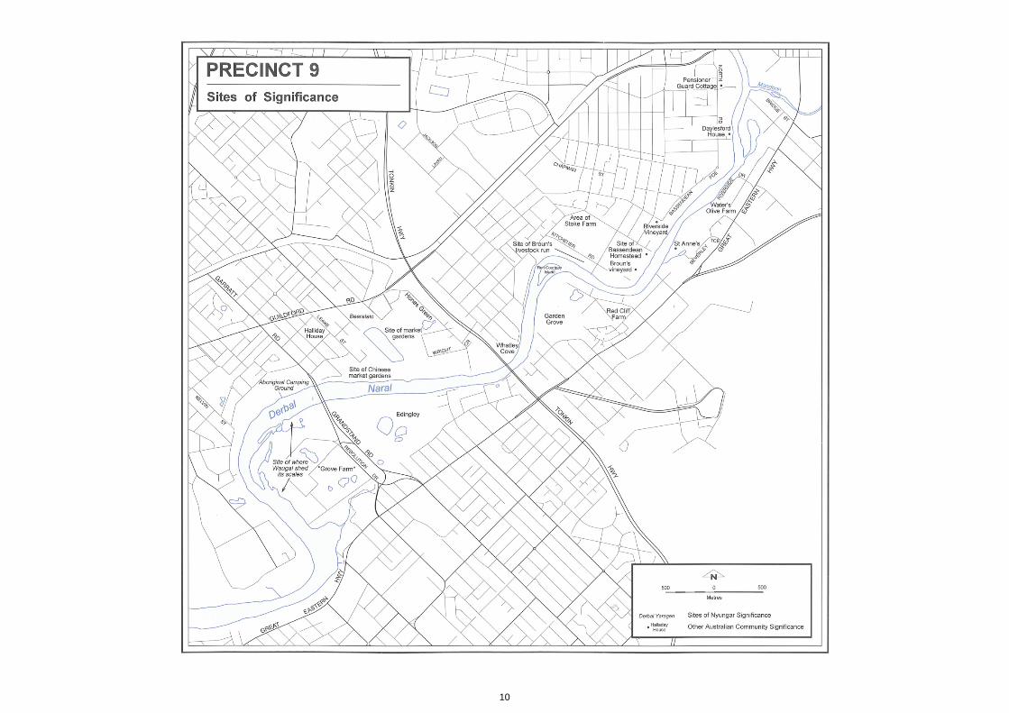
Sites of Nyungar & Wider Australian Community Significance Nyungar significance Nyungars believe that the Waugal shed its sunburnt skin near
Ascot which formed the beds of scale like shells which were
abundant along the river channel.
Captain Stirling on his 1927 exploratory voyage recorded that in
the area now know as Redcliffe were a 'whole Tribe of about
thirty natives' of whom 'the Warriors followed us along the bank'.
The Nyungars, who made signs of friendship, did not follow
Stirling's Party above a 'creek' possibly Helena River (Hallam,
1981).
This was one of the first encounters that Stirling had with the
Nyungar people.
During early colonial times as in other areas of the Swan River,
there were periods of considerable tension between the colonists
and Nyungar. In 1830, a Nyungar man was reputedly seen
robbing a house on the Upper Swan and escaping to the
surrounding bush. A local settler, Peter Broun, led one of the first
recorded organised military raids against local Nyungar. He
claimed to have come across a small group of Nyungars who had
been distributing the stolen goods amongst themselves. One
Nyungar man was killed and three wounded in the incident.
Following this, local Nyungar warriors were reported to have
killed a number of Broun's sheep and cows. Broun's shepherd
was also later killed in a separate incident (Bourke, 1987).
Robert Lyon, who owned a property adjacent to Peter Broun,
spent most of his time in the colony studying Nyungar culture and
learning their language. He wrote a series of articles for the Perth
Gazette on Nyungar customs and language and asked that their
plight be understood and respected. He recommended that to
improve black/white relations Nyungars be converted to
Christianity and taught to be a ' useful peasantry (Carter, 1986).
It is likely that the wetlands adjacent to the Garratt Road Bridge,
Bayswater, were used by Nyungar as a family camping ground.
Recently, the reserve was named Baigup which is Nyungar for
'the rushes'.
Other significance The Ashfield Pontoon is wrecked in this part of the river. It was
built 1942 (Thurlow et al, 1986).
Halliday House is classified by the National Trust and was built in
1,880s by Henry Thomas Halliday, one of the early settlers to the
area and also the first Chairman of the Bayswater Road Board
(Carter, 1986). The Road Board used his home as a meeting
place. The house has been recently renovated as part of the
Bayswater Riverside Gardens project. Nearby is Ellis House on
Neville St, Bayswater which is a local historic site (Lund and
Martin, 1996).
Daylesford House was built in 1890s and is registered by the
National Trust. Cyril Jackson built the house from brick and it has
particularly excellent examples of woodwork. Jackson came out
from England in 1869 to remodel the whole education system in
Western Australia. He established the Teachers Training College
at Claremont.
9
Precinct 9 – Ascot to the Helena River Confluence
The Pensioner Guard Cottage was built about 1864 and is the
only remaining Pensioner Guard residence left in the State. It
was originally a brick wall and shingled roof structure, however it
has now been rendered and a corrugated iron roof placed over
the original shingles. It was originally the home of John Law
Davis (Davies) who was granted the land in 1864 and lived here
until his death six years later.
At the City of Bayswater an olive tree was planted around 1850. It
is the official emblem of the city and open air church services
were once held under its shade until the first church was
constructed.
Claughton Reserve was originally known as Whatley Cove after
Dr J Whatley who was granted land here in 1830. This area
offered good landing facilities for goods transported from
Fremantle.
Riverside Vineyard is one of the smallest wineries in the State
and fronts onto the Swan River. The vineyard was first planted by
Luigi Nicoletto in the 1939 to supply table grapes but he later
changed to wine making. The Bassendean Estate Shiraz wines
have won awards in all Australian capital cities. On the opposite
bank is Olive Farm which was established in the 1860s by
Thomas Waters.
Ron Courtney Island was named in honour of the first chairman
of the Swan River Conservation Board which was formed in
1959. Statutory powers controlling reclamation, construction of
structures on the river and foreshore and permits for industrial
discharge were achieved for the first time with the proclamation
of the Swan River Conservation Act 1958.
Eric Singleton Bird Sanctuary was set aside in 1976 as a haven
for waterbirds exposed to the disruptions of recreational activities
on the river. There have been 74 species recorded there and
artificial nesting boxes have proved a great success (BICM
Steering Committee, 1993).
During the early years of the Swan River Colony a government
farm was located at Bassendean. It was under the charge of the
colonial botanist James Drummond (Carter, 1986). The farm was
used to experiment on suitable produce for the area and included
crops, citrus, fruit and vegetables. Several species were grown
as trial crops and are now noxious weeds including cape weed
(Arctotheca calendula), double gee (Emex australis), and
Guildford grass (Romulea rosea).
Conservation areas Wetlands See below.
System 6
M51 Swan River salt marshes, Belmont and Maylands
The recommended area extends from Garratt Road Bridge to
about 1 km downstream along the Swan River. The area is
affected by clay extraction. The salt marshes are most extensive
on the southern side of the river. The principal species are
Salicornia australis and Suaeda australis. The southern bank
has paperbark and flooded gum and the northern bank scattered
clumps of swamp sheoak. Downstream there are sand bars
which are covered with trees. Inland there is marri and wattle and
swamp sheoak. The area supports a wide variety of sheoaks.
M44 Swan River Backwater, South Guildford
The recommended area consists of the backwater south of the
Helena River in line with Kalamunda Road. The area contained
sewerage and drainage works and a pumping station. There is a
saline backwater with open pools of water and vegetation which
includes Suaeda australis, Atripiex hartala and Apium
prostratum. The backwater is fringed with scattered trees of
flooded gum and salt water paperbark and the understorey has
been replaced with Centella cordifolia, Cynodon dactylon and
Paspalum distichum. The area is a good refuge for many species
of bird and contributes to open space of regional significance.
10
11
Landscape Description
Precinct Description Waterform and natural riparian zone The Swan River channel takes an irregularly meandering form
with sections of straight channel in this section. Ascot Peninsula
forms an attractive water body with several fingers of land
extending into the river channel. Juncus and dead branches form
soft boundaries between the waterform and the landform and the
relatively dense sheoak fringing community add to the soft
textured effect. The area is subject to annual inundation as a
result of being flat and low lying. The foreshore edge is
meandering on the Ascot bank compared to the smooth curve of
the opposite Maylands foreshore which has been altered by hard
walling.
Upstream of Garratt Road Bridge the river is relatively straight
and even in width. A sharp northerly bend occurs after Redcliffe
Bridge where the river course is straight and of even width.
Around Ron Courtney Island the river forms a right angled bend.
The island is almost a right angled triangle with the two narrow
angles pointed into the main river channels at either end.
Upstream from Sandy Beach Reserve, the river width is more
irregular and narrower than downstream. At Beverley Terrace an
island is created by a backwater and two 'drains', however from
the river there is hardly any evidence of the backwater except for
the two very narrow channels which are fringed by vegetation. A
second backwater occurs in line with Riverside Drive. This
wetland has a broader channel confluence with the Swan River.
The Helena River is a relatively narrow channel which broadens
to a wide confluence, almost half the width of the Swan River
channel. The confluence is a t-section and the steeply grading
low lying silty banks are eroding exposing tree roots. The
foreshore along much of this area is susceptible to erosive
processes.
Many of the banks have been retained using various methods
which are described below. Despite the mixture of retaining
walls, vegetation types and historic channel straightening, much
of the foreshore at this section appears to be quite densely
vegetated to the river user. The fringing vegetation communities,
whether indigenous reeds and fringing woodland or mainly weed
species, have a softening effect when the vegetation
communities consist of emergent species which grade into the
floodplain communities.
The Baigup Reserve wetlands, Bayswater/Maylands, which
range from weed dominated communities to thick patches of
swamp paperbark and shorerush, is a visually more attractive
foreshore that to the barren grassy banks of A.P. Hinds Park.
The sandy beaches at the park however provide an easy access
area to the water and an area which is suitable for open space
recreation. Upstream of the Garratt Road Bridge the Ascot
foreshore becomes increasingly sparsely vegetated. Here, the
shorerush forms an attractive ribbon of vegetation, however in
front of the raceway the flat bank is mainly covered with grasses.
There is an area of seasonal inundation adjacent to Tonkin
Highway. The Gobba Lake wetland has an area of samphires,
small fringing paperbarks and sheoaks on the flat flood plain.
Similar low lying areas occur at Beverley Terrace and South
Guildford backwater. The Beverley Terrace wetland has quite a
noticeable wide channel leading from the area of inundation to
the estuary. The water appears shallow and silty in the wetland
area and several submerged branches can be seen exposed
during low level waters.
Landform The land form in this precinct consists of wide areas of low lying
floodplain less than 5 metres AHD. Areas such as Ascot
Peninsula and Redcliff Peninsula are particularly devoid of any
undulations. The land rises to approximately 10 metres on either
side of the river, however the location of this small escarpment
and its gradient varies considerably. At areas such as
Bassendean Parade, the increase in land height occurs as a
relatively steep slope from a very narrow flat floodplain. In areas
such as Garvey Park, the river escarpment becomes hardly
evident and the slope is very flat and gentle. However land use
has had a dramatic effect on the landform within the area. This is
exemplified at the South Guildford foreshore, where relatively
smooth flat areas used previously for grazing have become
lumps and depressions. It is interesting to note that due to the
relatively low lying Ascot Peninsula the viewscape has the
Darling Ranges as a backdrop and this emphasises the flatness
of the surrounding land.
Vegetation The foreshore of Ascot Peninsula has a large area of shorerush
species which forms a thick shiny fringing vegetation. The
overstorey consists of mono-specific stands of sheoak. The
needle like foliage of the swamp sheoak allows light to penetrate
to the lower storey often resulting in attractive softly lit foliage. In
winter, the samphire communities are a vivid rusty red providing
an attractive contrast to the dark green of the casuarinas and
shorerush. The vegetation is particularly dense viewed from the
eastern section of the river where the viewer is unable to see the
old rubbish dump site through the foliage. In contrast, the
southern section of foreshore has been infilled and weed species
such as kikuyu grass and cape lilac are the dominant species on
the old rubbish site area.
12
Precinct 9 – Ascot to the Helena River Confluence
Vegetation on the opposite Maylands and Bayswater foreshores
consist almost entirely weed communities. In front of the View
Terrace houses an occasional stand of shorerush occurs among
domestic gardens and weedy flood plains. At the Baigup Wetland
Reserve, the flood plain broadens and the swamp
paperbark-shorerush community is present, however *Typha
orientalis and pampas grass are the most dominant species
particularly north of the dual use path. The mono specific
shorerush community adjacent to the Garratt Road Bridge is
particularly attractive and forms almost a thick spiky carpet
against the occasional paperbark and sheoak.
From A. P. Hinds Park to Bayswater Riverside Gardens there is
little native vegetation. The dominant trees are exotics such as
flame trees and the steeply sloping embankments behind the
flood plain are a tangle of weeds. There is the occasional stand
of sheoak and shorerush, however the Bayswater Riverside
Gardens are currently being developed and there are plans to
re-establish indigenous flora to much of the foreshore, although
many of the trees will be exotic. Where the Bayswater Main Drain
enters the Swan River there are a few flooded gum and jarrah
and a weedy understorey. On the southern side of Redcliffe
Bridge, there is a patch of disturbed marri- jarrah woodland
behind a small area of regular inundation. The understorey is
predominantly exotic grasses and shrubs. This area is a
samphire flat edged by shorerush species and paperbark trees
around the dampland and river foreshore.
At Claughton Reserve there are some attractive mature flooded
gums on the undulating floodplain with a grassy understorey.
Casuarina and shorerush edge the sandy river banks and kikuyu
and couch grass are maintained as a foreshore lawn. The steep
banks of Ashfield Parade are the site of a few remnant trees from
the fringing paperbark-shorerush communities and marri
woodland. However the dominant species are grasses, bracken
and other weeds.
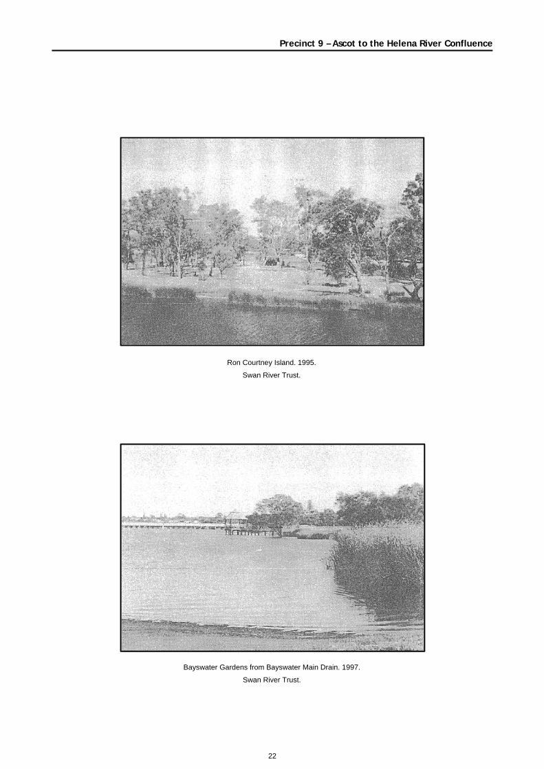
Ron Courtney Island has an attractive stand of flooded gum and
a fringing community of shorerush and lake club rush. The
understorey is predominantly exotic grass species which gives
the island a parkland character.
Ashfield Flats has a community of samphire-rush species which
are edged by flooded gum woodland. Most of the area however
is flat open grassland as a result of past land use. A very thin belt
of shorerush and melaleuca edge the foreshore meeting with the
open woodland of Sandy Beach Reserve. The fringing shorerush
vegetation is intermittent north of the reserve; however there are
healthy stands of shorerush in front of Pickering Park and Point
Reserve.
The South Guildford backwater area has a disturbed open
woodland of numerous mature flooded gum trees with an exotic
grass understorey giving the general appearance of a wooded
pasture. There is the occasional coojong; however these
understorey bushes are rare. The backwater is dominated by
*Typha orientalis with numerous flooded gum saplings growing
on its northern banks. There is also a small samphire community
edging the backwater. The Swan River waters edge consists of
clumps of shorerush and overhanging sheoak trees, however
there are several weed species, including cape tulip, which
flourish in the damp conditions.
The fringing rush communities occur intermittently between
patches of kikuyu, *Typha orientalis and watsonia stands which
are the dominant species along the Redcliffe foreshore. On the
steeply sloping banks, mature flooded gum tend to remain in an
area which has been mainly cleared of its indigenous vegetation.
The occasional paperbark and sheoak provide an interesting
brushy light texture against the more loosely spaced foliage of
the flooded gum.
The Beverley Terrace backwater has an attractive wide section
of shorerush species mainly edged by sheoaks and flooded gum
on the drier banks. The wetland has less exotic species than
along the river foreshore although in between the dark green of
the shorerush there are patches of bright green kikuyu grass.
Garvey Park is an open woodland of flooded gum and exotic
weed understorey. There are some areas of casuarina edging
the foreshore and intermittently spaced shorerushes in areas
which are not subject to erosion or have had retaining walls built
against the foreshore. The foreshore between Kanowna Avenue
drain and the Tibradden Development at Redcliffe is a low
casuarina dominated woodland. The understorey varies from
shorerush reeds to exotic grasses. There are several melaleuca
saplings and bushes within the area which act as a shrub layer
and consequently vegetation appears quite dense. The
vegetation north of Grandstand Road has been mainly greatly
disturbed. The flat swampy land is mainly the site of grasses and
other weeds such as the vivid purple flower of Paterson's curse. Riparian Land use
North of Bath Street Reserve there are several types of retaining
walls which have been constructed over the years by the various
land owners. The materials used include corrugated
cement/asbestos and wooden planks. Unfortunately, the result is
an unattractive riparian line between the waters edge and the
steep gradient of residential gardens. The small patches of
shorerush and weed at the edge of some properties are more
attractive than the straight elements created by the retaining
walls as the river bend has already been smoothed by past
13
Precinct 9 – Ascot to the Helena River Confluence
dredging giving a linear curve to the water’s edge compared to a
more natural slightly meandering edge.
There are several properties with high fence lines between the
edge of the property and the water, they are unattractive and a
restrictive element on the foreshore. Many properties have jetties
which allow boats to be moored up along the foreshore, which at
low density creates interesting focal points to the river user.
A dual use path was recently laid through the Baigup Wetland
Reserve. The path is boarded by pine bollards and adds a linear
element to the flat flood plain. At present, a new boardwalk and
information stand is being constructed adjacent to the Garratt
Road Bridge. These structures are relatively unobtrusive on the
wetland and sympathetic colours have been used for the shelter.
The new grey brick path which leads to the platform is quite
reflective and probably a mixture of two similar toned bricks
would have had a dulling effect on the pathway. The gas pipeline
maintenance point is surrounded by wire cyclone fencing which
could be made less obtrusive on the landscape by suitable shrub
planting.
Garratt Road Bridge is made up of two separate bridges which
have numerous wooden piles, and is low formed. The bridge acts
as a visual barrier, however its wooden piles are attractive to
boat users who pass beneath them. At Hinds Park, the beach is
flat and sandy with almost no riparian vegetation. A small jetty
makes an interesting focal point on a bland foreshore. Exotic and
Australian shade trees have been planted at regular intervals
well back from the foreshore. A number of recreational clubs are
based in boat sheds which are of simple design and are currently
being upgraded. They have been painted several tones of green
which slightly reduces their impact; however planting of attractive
gardens would enhance the flat lawn around the buildings. The
multicoloured play gym and older pine play equipment are
prominent features in this area. The parking area is in front of a
weedy embankment and the area is not as attractive as the
adjacent Baigup Foreshore.
The Bayswater Riverside Gardens are currently being
constructed. The area will be a passive recreation area with the
potential to be an attractive area of open space. At present, clean
fill has being distributed on the foreshore and consequently the
area is a gently undulating sandy pit. The foreshore has been
sculptured to form a meandering foreshore with small bays and a
small island. A few sheoaks have been retained, however the
rest of the gardens have yet to be planted. Adjacent to the new
island, a relatively long jetty with a gazebo over the water has
been constructed. The viewing platform is particularly prominent
in the viewscape, mainly because there are few trees on the
adjacent flat foreshore.
Halliday House has been renovated as part of the project and
raised paths are currently being constructed to the pale blue
homestead and over damplands. Adjacent is the Eric Singleton
Bird Sanctuary which is located on a lake created from an old
rubbish fill site and also has the Bayswater Main Drain flowing
through it. The site has shorerush paperbark flora present,
however most species are exotics. Despite the weedy condition,
the area provides a valuable wetland bird sanctuary, and it is
pleasant to use the dual use paths through the area. The King
William Street Drain runs adjacent to the WAWA pump station,
which although coloured a soft green has been gratified and is
quite prominent due to the flat nature of the land and lack of
vegetation. The area is the site of recent tree planting which aims
to upgrade the bank into a stream. The drain is currently being
landscaped to make it visually more acceptable and appear more
like a stream.
The Redcliffe Bridge is a modern concrete superstructure which
is a dominant feature on the landscape despite a small wetland
on its eastern bank which partly screens the large land based
concrete piles.
Claughton Reserve has a small almost informal boat ramp which
is adjacent to a sheoak stand. Several different materials are
used for bollards around the boat ramp and separating the road
from the vegetation. Sandy Beach Reserve has pine play
equipment and a few rock barbecues. The area overlooks
Ashfield Flats so the viewscape is quite wide despite fences
restricting access to the Ashfield Flats area. Pickering Park is
less attractive than Claughton Reserve as there are fewer
mature trees such as flooded gum. Several trees have been
planted around the boundary of the park emphasising the
geometric shape of the park, however a few saplings have been
planted within the grassy paddock and this will enhance the area.
Bindaring Lake Reserve is separated from Pickering Park by
Bassendean Parade. The parkland has a small wetland which is
dominated by * Typha orientalis and melaleuca trees. A number
of pine trees occur with a lawned area between the road and
wetland. Point Reserve is an attractive narrow parkland opposite
the Helena River confluence. The reserve has several mature
flooded gums which provide an attractive canopy in the narrow
reserve and help to create an enclosed effect.
Unfortunately, a sign has been nailed to a tree which detracts
from the tree form and the view of the rivers. A simple sign board
would have been more aesthetically pleasing. There is a small
car park which is not too obtrusive due to the narrow nature of the
parkland. The brick Point Reserve amenity blocks are
successfully screened by attractive Australian bushes.
14
Precinct 9 – Ascot to the Helena River Confluence
Several residential properties front onto the Bassendean
foreshore. These appear less obtrusive than the Maylands
properties due to the gentler slope of the land. A mixture of
retaining walls have been constructed, however there are quite a
few flooded gum, paperbark and shorerush along these
properties which break up the straight lines created by these
properties.
The South Guildford peninsula at the confluence with the Helena
River was originally used as pasture land and consequently the
understorey is quite degraded. The soil has become quite lumpy
and it is a popular location for local teenagers to display their
BMX skills on the dirt paths they have formed over the lumps and
ditches. A few informal paths are present through the reedy
understorey and the corner provides one of the few informal
recreational locations along the Swan River.
Most of the residential properties at South Guildford are well set
back from the foreshore and there are few jetties or retaining
walls. Olive Farm Wines, however is quite a prominent feature on
the landscape due to recent construction of limestone walls and
new large cloth green and white pergolas.
Garvey Park is part of the largely undeveloped peninsula
opposite Ron Courtney Island. The park has recently had a new
raised toilet block and kiosk constructed away from the
foreshore. The colours and materials conform with the
surrounding flooded gum and old quarry pit wetlands. In contrast,
the canoe club building is an unattractive concrete brick building
perched on a mound very close to the foreshore. There have
been several attempts to reduce erosion in the area using
different methods of hard walling. Pine bollards have been
placed in some areas while a recently constructed limestone wall
is the most obtrusive structure. In addition, a wheel chair access
ramp has been constructed using cement and metal poles. The
mix of materials is unattractive compared to the upstream
naturally vegetated banks. The surrounding vegetation of Garvey
Park is similar to a paddock with trees and grassy understorey.
An unobtrusive raised boardwalk is crosses at the Kanowna
drain wetland which allows access between Redcliff Bridge and
Garvey Park. The drain itself has an unattractive outlet with
corrugated fencing used as a retaining wall. The rest of the
embankment is kikuyu grass. There is a small wire fence
enclosing the drain area.
Land use One of the prominent features of the flat peninsula of Ascot is the
radio tower which is painted white and red. Other less obvious
vertical elements are the Perry Field lights, and the Ascot
Racecourse call boxes. The six brick towers of the historic Ascot
brickworks can be seen emerging from trees around Grandstand
Road, however from the river they are hardly prominent features
compared to the Ascot Raceway. The old gateway and
grandstand are quite attractive tile and white mortar buildings of
style. The grandstand merges into the height of the trees and the
surrounding land use while the raceway is located on the flat
foreshore where kikuyu grass and a lack of trees or other
elements make it a noticeable feature from the river. The old
Ascot rubbish fill site is currently being redeveloped into a water
front high density residential development with canals, recreation
and conservation reserves. The site is being prepared for
development and the old fill is being reshaped, so that at present
a mound of soil has been pushed to the edge of the river creating
a curved artificially shaped landmass compared to the
surrounding attractive flat wetlands communities.
The Maylands and Bayswater residential area has houses of
mixed styles and ages. There are several quite grand older style
houses; however those built in the middle of this century are
quite modest. Those single residences built along the foreshore
from the 1980s are quite large and more extravagantly styled.
There are several townhouses and flats which tend to be built
from the 1980s and have modern simple styles. The Maylands
residential area is on a slope set back from the foreshore and the
nature of the landform and the curve of the river allows the
houses to be partly obscured by the surrounding garden trees.
The effect is an unobtrusive urban environment which
demonstrates that height restrictions and mature gardens create
an attractive landscape.
The Bayswater foreshore is a flat landform mainly due to
previous land infilling from the flat foreshore. The gently sloping
Bassendean Dune has affected the degree of prominence of the
houses on the river landscape. Behind the A.P. Hinds Reserve
there are a number of residential houses and a senior citizen
hospital in an old house. The houses are located on the
escarpment which slopes quite steeply from the flat floodplain
area and many are hidden from the river by vegetation growing at
the base of the escarpment. There are several empty blocks
where weeds flourish. In contrast, the residential area in front of
the proposed Bayswater Riverside Gardens is currently quite
prominent as the large houses are emphasised by the treeless,
sandy foreground. However the houses distance from the
foreshore and the proposed gardens will make these less
obvious elements in the landscape.
15
Precinct 9 – Ascot to the Helena River Confluence
At present, Camilla Court retirement village is a prominent land
use on the flat Bayswater landscape, however the recent
establishment of tree saplings and bushes will minimise the
impact the single storey brick and tile units. At Wright Street, a
few remnant orchards exist which are an attractive reminder of
the once dominant use of the damplands.
At Bassendean, the slope of the foreshore is less steep than at
Bayswater and consequently residential developments have
been set back from the floodplain. The area has several trees
which shade the houses and although some buildings are two
storeys the flat nature and the setback has resulted in a less
obtrusive land use. Several undeveloped blocks or small
paddocks occur between Ashfield Flats and Pickering Park. Two
small vineyards are located on the northern floodplain and
provide an interesting landscape feature among the residential
land uses. On the southern foreshore the Olive Farm vines are
located adjacent to Great Eastern Highway and are less
important in the riverine landscape.
Saint Anne's is an attractive private property behind the Beverley
Terrace backwater which has a turn of the century styled house
painted white with a cottage style garden. The other houses in
the area are quite modest and are a mixture of 1940s and mid
1960s style. Around Ivy Street and Hay Road, Redcliffe, the few
residential properties between the river and the light industrial
area.
The residential areas of Ascot, Redcliffe and South Guildford are
not particularly dense, although recent residential infilling has
occurred at Tibradden. The houses are modest and mainly well
set back from the foreshore due to the wide nature of the flood
plain. Residential development in the area has been limited by
Great Eastern Highway which is very busy and has large blocks
of commercial and light industrial land uses on either side of the
road. The houses at Tibradden on Swan Estate are mainly
modern brick and tile styles which often have a 'Federation' style.
The area is quite treeless and there are still several undeveloped
sandy blocks. There is a small dampland at Coolgardie Avenue
and there are several non residential blocks which are reserved
for essential amenities.
Adjacent to the Redcliffe Bridge there are a few horse agistments
and several modest homes. There is also a caravan park which
is mainly used by permanent residents rather than holidayers.
The Ascot water playground is located on a sloping block and the
paddling pools take advantage of the slope with the water
running into one pool after another. The area is grassy and has
shade trees and shrubs and is neatly maintained. The foreshore
area has a small wooden jetty which is partly hidden by
vegetation.
Adjacent to the Ascot Inn and Motel, there is a large empty block.
The Inn itself built in the mid 1970s Mediterranean style and
painted white with red tiles. The hotel is fairly unobtrusive due to
its position on the sloping land and the stepped style of the
buildings.
At present, Camilla Court retirement village is a prominent land
use on the flat Bayswater landscape, however the recent
establishment of tree saplings and bushes will minimise the
impact the single storey brick and tile units. At Wright Street, a
few remnant orchards exist which are an attractive reminder of
the once dominant use of the damplands.
At Bassendean, the slope of the foreshore is less steep than at
Bayswater and consequently residential developments have
been set back from the floodplain. The area has several trees
which shade the houses and although some buildings are two
storeys the flat nature and the setback has resulted in a less
obtrusive land use. Several undeveloped blocks or small
paddocks occur between Ashfield Flats and Pickering Park. Two
small vineyards are located on the northern floodplain and
provide an interesting landscape feature among the residential
land uses. On the southern foreshore the Olive Farm vines are
located adjacent to Great Eastern Highway and are less
important in the riverine landscape.
Saint Anne's is an attractive private property behind the Beverley
Terrace backwater which has a turn of the century styled house
painted white with a cottage style garden. The other houses in
the area are quite modest and are a mixture of 1940s and mid
1960s style. Around Ivy Street and Hay Road, Redcliffe, the few
residential properties between the river and the light industrial
area.
The residential areas of Ascot, Redcliffe and South Guildford are
not particularly dense, although recent residential infilling has
occurred at Tibradden. The houses are modest and mainly well
set back from the foreshore due to the wide nature of the flood
plain. Residential development in the area has been limited by
Great Eastern Highway which is very busy and has large blocks
of commercial and light industrial land uses on either side of the
road. The houses at Tibradden on Swan Estate are mainly
modern brick and tile styles which often have a 'Federation' style.
The area is quite treeless and there are still several undeveloped
sandy blocks. There is a small dampland at Coolgardie Avenue
and there are several non residential blocks which are reserved
for essential amenities.
Adjacent to the Redcliffe Bridge there are a few horse agistments
and several modest homes. There is also a caravan park which
is mainly used by permanent residents rather than holidayers.

16
The Ascot water playground is located on a sloping block and the
paddling pools take advantage of the slope with the water
running into one pool after another. The area is grassy and has
shade trees and shrubs and is neatly maintained. The foreshore
area has a small wooden jetty which is partly hidden by
vegetation. Adjacent to the Ascot Inn and Motel, there is a large
empty block. The Inn itself built in the mid 1970s Mediterranean
style and painted white with red tiles. The hotel is fairly
unobtrusive due to its position on the sloping land and the
stepped style of the buildings.
Precinct 9 – Ascot to the Helena River Confluence
17
Landscape Interpretation
Dominant Landscape Character The original landscape character type of the foreshore area
would have been the attractive paperbark and sheoak
community fringed with sedges and samphires typical of the
natural landscape character. The fluviatile deposits would have
formed flat silty plains in front of the gently undulating
Bassendean dunes. At Belmont, the original Guildford landscape
character would have been gently undulating fluviatile deposits
supporting eucalyptus woodland.
At present, the remnant samphire and sheoak estuarine
communities at Belmont are an important natural landscape
element as the vegetation community is in relatively good
condition and appears to have had minimal disturbance. The
Baigup wetland by contrast has suffered weed invasion, however
current rehabilitation has improved the condition of the
community and it has a natural landscape character. The
embankment at Beverley Terrace has a remnant melaleuca
community with little understorey except for some sedges at the
edge of the river. This community has been classified as being
natural landscape despite the degradation. The South Guildford
wetland appears in parts to be relatively natural with areas of
wetland vegetation in good condition.
There are three isolated rural landscapes in this precinct. Two
vineyards in the area are only the size of a block, but provide an
important link to the past rural land use of the area. From the river
the Olive Farm vineyard from the river does not appear as a rural
landscape as there have been extensive additions to the original
sheds and homestead and from the foreshore the building
appears to be part of a suburban development.
At Belmont, a new suburban development is being constructed
on an old rubbish dump site. At present, the landscape character
is transitory and has been identified as a modified landscape.
A large portion of the precinct has been classified as a
parkland/recreational landscape character. At Bayswater, there
is currently a redevelopment of the foreshore to parkland and
although the site is still unfinished it has been classified as
parkland.
Most of the precinct has been classified as a suburban
landscape. In places, the suburban landscape occurs well away
from the foreshore area, while in parts of Bassendean the
suburban landscape reaches to the foreshore where the blocks
extend to the river.
Significant Viewscapes There are several significant viewscapes in this precinct. The
fringing vegetation at Ascot Peninsula makes an attractive view
from the river and the Bath Street Reserve. The several
backwaters are created by sedges forming fingers of vegetation
into the river. The fringing sheoaks are quite dense and the old
rubbish dump site is not easily seen from the river.
At the Tonkin Highway, there is a section of sedge and
melaleuca community in relatively good condition area of wide
open space in the river environment.
At Garvey Park, the view of Ron Courtney Island provides an
interesting element in the fluvial environment. The meander
curve is attractive and the raised embankment on the northern
side emphasises the river meander.
The confluence of the Swan and Helena Rivers is a significant
viewscape. The Swan River broadens slightly after the
confluence and the fringing vegetation on the southern side of
the river appears relatively natural.
Conforming and Non Conforming Elements in the Landscape The islands and fringing sedges at Ascot Peninsula are an
important element in the natural landscape. It is also an
important backdrop to Tranby House as the visitor to the main
entrance on the southern side of the homestead can view the
river apparently undeveloped against the well maintained house
and gardens. It gives the visitor a snapshot of how much of the
river would have been at the time the house was built. Retaining
this viewscape is important as the view of the homestead from
the river is now cluttered with houses and units.
At Garvey Park, the hard walling is made up of several materials
including limestone. There is the opportunity to use indigenous
vegetation to replace or reduce the impact of retaining walls. A
recently constructed limestone wall at Ashfield Flats opposite,
Ron Courtney Island detracts from the narrow band of fringing
vegetation. The foreshore adjacent to the A.P. Hinds boatsheds
is susceptible to erosion and the flat nature of the foreshore
makes it ideal for revegetation.
Claughton Reserve has a toilet block located on a prominent
earth mound and painted a bright shade of green. Similarly, at
the Riverside Gardens at Bayswater, the toilet amenities have
been built on a raised suffice and currently are prominent due to
the lack of trees in the partly completed garden.
18
19
Precinct 9 – Ascot to the Helena River Confluence
Recommendations for Maintenance and Enhancement of the Present Landscape Character
• It is strongly recommended that the islands and fingers of
land at Ascot Peninsula remain in an undeveloped state. The
vegetation is an attractive natural landscape character. It is
also an important backdrop to Tranby House as the visitor to
the main entrance on the southern side of the homestead
can view the river apparently undeveloped against the well
maintained house and gardens. It gives the visitor a
snapshot of how much of the river would have been at the
time the house was built. Retaining this viewscape is
important as the view of the homestead from the river is now
cluttered with houses and units.
• Ascot Peninsula is currently the site of a development
proposal. The proposal intends to split the site by forming a
regional parkland and river conservation zone on the
southern section and a high density residential area on the
northern section. There is the opportunity to take into
consideration the viewscape of the site and ensure that the
housing development does not infringe on the fringing
vegetation community.
• There is the opportunity to improve the visual amenity of hard
walling at Garvey Park by planting fringing vegetation to
screen the different building materials.
20
Precinct Specific ReferencesBassendean Preservation Group. 1985. A Regional Park Planfor the Ashfield Flats. A Proposal to Bassendean Town
Council.
Bayswater Integrated Catchment Management Steering
Committee. 1993. Recreating the Catchment. BayswaterMain Drain Draft Management Strategy. Edited by V.V. Klemm
and C.J. Switzer.
Blair, A. and Blatchford, D. 1978. The Ashfield Flats - A Study of Present and Potential Land Use. Department of
Conservation and Environment. Bulletin 45.
Brian J. O'Brian and Associates Pty Ltd. 1989. Concept Plan forthe Bayswater Foreshore Area. Prepared for the City of
Bayswater, Swan River Trust and State Planning Commission.
Brian J. O'Brien and Associates Pty Ltd. 1991. Public Environmental Review for the Proposed Riverside Gardens(West) Dredging and King William Street, Bayswater.February 1991.
Carter, J. 1986. Bassendean - A Social History 1829 -1979.
Published by the Town of Bassendean Perth, WA.
City of Stirling. 1987. Draft Management Plan MaylandsForeshore Reserve (Street to Fogerthorpe Crescent).Prepared by K. Meney.
City of Stirling. 1988. Draft Maylands Peninsula Land UseManagement Plan.
Garis, M. Undated. A History of Bayswater. Thesis.
Maunsell & Partners Pty Ltd. 1988 Tonkin Industrial Park.
Bassendean Environmental Report. Northcorp Ltd.
Smith, P. 1985. Bayswater Swan River Foreshore Study. An Appraisal of Planning Problems within Bayswater's SwanRiver Foreshore Area. Prepared for the City of Bayswater.
February 1985.
Swan River Trust. 1990. Pesticide and Metal Pollution of theSwan River Adjacent to the Bayswater Main Drain. August
1990.
Swan River Trust. 1991. Ashfield Parade Bassendean
Foreshore Management Plan. Report 3.
Town of Bassendean. 1988. Ashfield flats Design and Management Plan. Prepared by The Appropriate Technology
Development Group Incorporated of APACE WA.
Town of Bassendean. 1988. Bindaring/Pickering Park Design and Management Plan. Prepared by the Appropriate
Technology Development Group Incorporated of APACE WA.
Van Nierop, H. Undated. Bayswater, Some Aspects of its
Development. Thesis.
21
Precinct 9 – Ascot to the Helena River Confluence
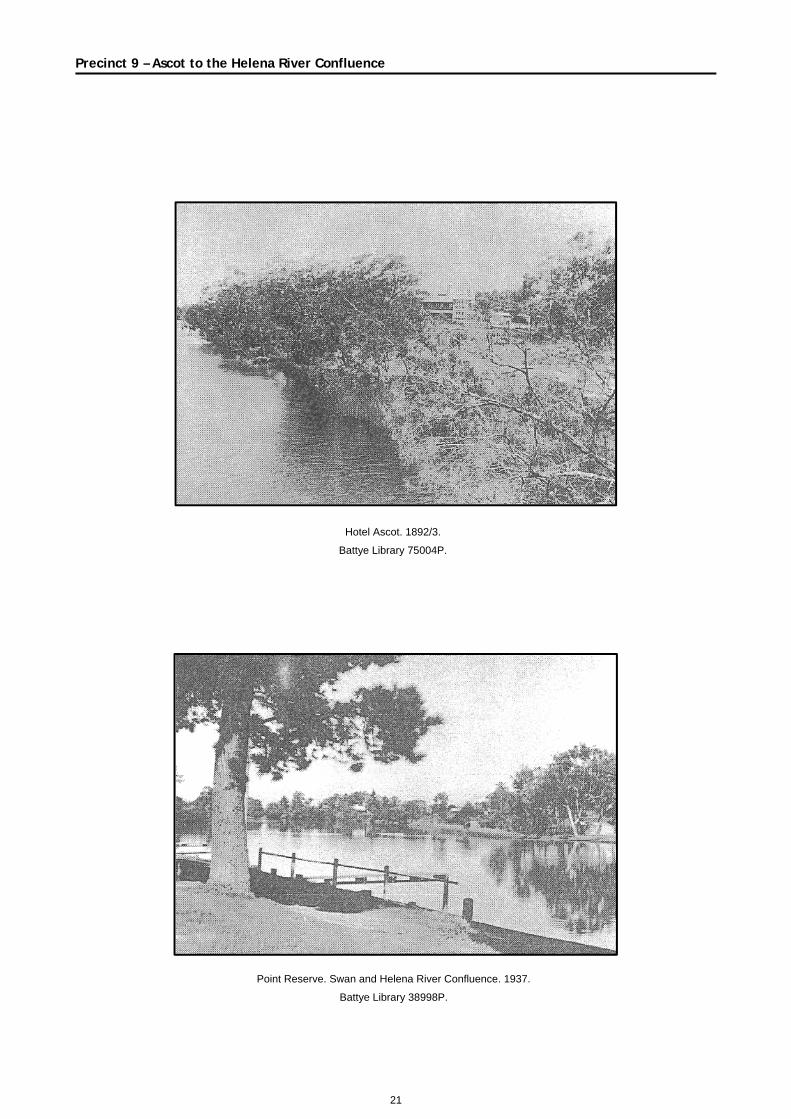
Hotel Ascot. 1892/3.
Battye Library 75004P.
Point Reserve. Swan and Helena River Confluence. 1937.
Battye Library 38998P.
22
Precinct 9 – Ascot to the Helena River Confluence
Ron Courtney Island. 1995.
Swan River Trust.
Bayswater Gardens from Bayswater Main Drain. 1997.
Swan River Trust.