Embed Size (px)
Citation preview

Pre-Operative Regional
CoastalEnvironment PlanTe Mahere Takutai ā-Rohe

RESOURCE MANAGEMENT ACT 1991
BAY OF PLENTY REGIONAL COUNCIL TOIMOANA
BAY OF PLENTY REGIONAL COASTAL ENVIRONMENT PLAN
The Bay of Plenty Regional Coastal Environment Plan was prepared by the Bay of Plenty Regional Council under section 64 and the First Schedule of the Resource Management Act 1991.
The Bay of Plenty Regional Council approved that part of the plan that is not part of the coastal marine area and adopted that part of the plan in the coastal marine area by resolution of the Council on the 301
h day of October 2018 in accordance with clauses 17 and 18 of the First Schedule of the Resource Management Act 1991.
The Common Seal of the BAY OF PLENTY REGIONAL COUNCIL was affixed hereto this 301
h day of October 2018 in the presence of:
Douglas Leeder Chairman
Fiona McTavish Chief Executive
Minister of Conservation approved that part of the Bay of Plenty Regional Coastal Environment Plan relating to the coastal marine area by signing it in accordance with clause 19 of the First Schedule of the Resource Management Act 1991 .
Hon. Eugenie Sage Minister of Conservation

Version 10.1 January 2019
PROPOSED BAY OF PLENTY
REGIONAL COASTAL ENVIRONMENT PLAN
PRE-OPERATIVE
This version incorporates changes resulting from consent orders and decisions issued by the Environment Court in order to resolve appeals.
Bay of Plenty Regional Council PO Box 364
Whakatāne 3158 New Zealand

Contents 30 October 2018
BAY OF PLENTY REGIONAL COUNCIL TOI MOANA i
Contents
Outstanding Appeals ix
Part One: Purpose, content, planning framework 1
1 Introduction 1
2 Purpose 1
3 Plan coverage 1
3.1 Geographic coverage 1
3.2 The coastal environment 2
3.3 Maritime Incidents 2
4 Plan structure 2
4.1 Overview 2
4.2 Rules 3
5 Plan mechanisms 4
5.1 Introduction 4
5.2 Zoning and overlays 4
6 Roles and responsibilities of other agencies 4
6.1 District and city councils 4
6.2 Department of Internal Affairs 5
6.3 Maritime New Zealand 5
6.4 Ministry for Primary Industries 5
6.5 Department of Conservation 5
6.5.1 The Minister of Conservation 6
6.6 Environmental Protection Authority (EPA) 6
6.7 Ministry for the Environment 6
6.8 Office of Treaty Settlements 6

30 October 2018 Contents
ii Pre-Operative Regional Coastal Environment Plan – 30 October 2018
7 Other policy documents 6
7.1 New Zealand Coastal Policy Statement 2010 6
7.2 The Bay of Plenty Regional Policy Statement 2014 7
7.3 National Policy Statement on Electricity Transmission 7
7.4 The National Environmental Standards for Electricity Transmission Activities 7
7.5 National Policy Statement for Renewable Energy Generation 2011 8
Part Two: Issues and objectives for the coastal environment 9
1 Issues 11
1.1 Integrated Management 11
1.2 Natural Heritage 11
1.3 Water Quality 12
1.4 Iwi Resource Management 13
1.5 Historic Heritage 14
1.6 Coastal Hazards and Climate Change 15
1.7 Recreation 15
1.8 Activities in the coastal marine area 16
1.9 Aquaculture issues 16
1.10 Harbour Development Zone 17
1.11 Port Zone 18
2 Objectives 18
2.1 Integrated management 18
2.2 Natural Heritage 19
2.3 Water Quality 19
2.4 Iwi Resource Management 20
2.5 Historic Heritage 21
2.6 Coastal Hazards 21
2.7 Recreation 21

Contents 30 October 2018
BAY OF PLENTY REGIONAL COUNCIL TOI MOANA iii
2.8 Activities in the Coastal Marine Area 21
2.9 Harbour Development Zone 23
2.10 Port Zone 24
Part Three: Resource management policies to achieve integrated management of the coastal environment 25
1 Integrated Resource Management (IR) 27
2 Natural Heritage (NH) 27
2.1 Policies 27
2.1.1 Appropriate use and development 27
2.1.2 How to remedy and mitigate 34
2.1.3 Maintain 34
2.1.4 Promoting protection and management of existing high value areas 35
3 Water Quality (WQ) 35
3.1 Policies 35
4 Iwi Resource Management (IW) 37
4.1 Policies 37
5 Historic Heritage (HH) 40
5.1 Policies 40
6 Coastal Hazards (CH) 41
6.1 Policies 41
6.1.1 General Approach to Coastal Hazard Management 41
6.1.2 Tsunami Hazard Risk 43
6.1.3 Sandy coasts and river mouth erosion and inundation 44
6.1.4 Harbour, estuary and cliff erosion and inundation 46
7 Recreation, public access and open space (RA) 49
7.1 Policies 49
7.1.1 Surf breaks 49
7.1.2 Public open space 49
7.1.3 Public access 50
30 October 2018 Contents
iv Pre-Operative Regional Coastal Environment Plan – 30 October 2018
7.1.4 Walking access 50
7.1.5 Vehicle access 51
7.1.6 Access infrastructure 52
Part Four: Activity-based policies and rules 55
1 Structures and occupation of space in the Coastal Marine Area (SO) 57
1.1 Policies 57
1.2 Rules 62
2 Disturbance, deposition and extraction (DD) 77
2.1 Policies 77
2.1.1 Additional policies for mineral extraction 79
2.1.2 Additional policies for dredging and spoil disposal 79
2.2 Rules 81
2.3 Policies and Rules for Mangrove Management 94
2.3.1 Policies for mangrove management 94
2.3.2 Rules for mangrove management 98
3 Coastal discharges (CD) 107
3.1 Policies 107
3.1.1 Additional policies relevant to discharges of human sewage 109
3.1.2 Additional policies specific to hazardous substances 110
3.1.3 Additional policies relevant to stormwater discharges 110
3.2 Rules and Regulations 111
3.3 Regulations For Information Only – not part of the Regional Coastal Environment Plan 111
3.4 Rules 114
4 Reclamation (RM) 122
4.1 Policies 122
4.2 Rules 124
Contents 30 October 2018
BAY OF PLENTY REGIONAL COUNCIL TOI MOANA v
5 Taking, using, damming or diversion of coastal water (TD) 126
5.1 Policies 126
5.2 Rules 127
6 Aquaculture (AQ) 127
6.1 Policies 127
6.2 Aquaculture rules 131
7 Biosecurity (BS) 140
7.1 Policies 140
7.2 Rules 141
8 Harbour Development Zone (HD) 143
8.1 Policies 143
8.1.1 General policies for the Harbour Development Zone 143
8.1.2 Additional policy specific to the Tauranga Harbour Development Zone 145
8.1.3 Additional policy specific to the Whakatāne Harbour Development Zone 145
8.1.4 Additional policies specific to the Ōpōtiki Harbour Development Zone 146
8.1.5 Additional policies specific to the Harbour Development Zones in northern Tauranga Harbour 146
8.2 Rules 146
9 Port Zone (PZ) 158
9.1 Policies 158
9.2 Rules 160
10 Noise (NS) 169
10.1 Policies 169
10.2 Rules 169
11 Geothermal Resources (GR) 171
11.1 Policies 171
11.2 Rules 172

30 October 2018 Contents
vi Pre-Operative Regional Coastal Environment Plan – 30 October 2018
12 Summary of Rules 175
Assessment Guidelines - Areas of significant cultural value 189
Part Five: Methods 191
1 Methods 193
1.1 Implementation, Monitoring and Reporting 193
1.2 Natural Heritage 193
1.3 Water Quality 194
1.4 Involvement of community groups and tāngata whenua 196
1.5 Cultural and Historic Heritage 197
1.6 Recreation and Public Space 198
1.7 Coastal Hazards 199
1.8 Vessel Routeing 200
1.9 Biosecurity 200
Definitions 201
Definitions of terms used in the Regional Coastal Environment Plan: 201
Part Six: Schedules to the Regional Coastal Environment Plan 215
Schedule 1 – Rivermouths 217
Schedule 2 – Indigenous Biological Diversity Areas in the Coastal Environment 221
Schedule 3 – Outstanding Natural Features and Landscapes in the Coastal Environment 279
Schedule 4 – Management guidelines for natural features and landscapes 355
Schedule 5 – Regionally Significant Surf Breaks 367
Schedule 6 – Areas of Significant Cultural Value 369
Schedule 7 – Historic Heritage Inventory 379
Schedule 8 – Harbour Development Zones 381
Tauranga City – Harbour Development Zone area 381

Contents 30 October 2018
BAY OF PLENTY REGIONAL COUNCIL TOI MOANA vii
Northern Tauranga Harbour – Harbour Development Zone areas 381
Whakatāne District – Harbour Development Zone area 382
Ōpōtiki District – Harbour Development Zone area 383
Schedule 9 – Outline Development Plan for the Port of Tauranga 2013 385
Schedule 10 – Water Quality Classifications 397
Schedule 11 – Financial Contributions 399
Schedule 12 – High Risk Facilities 405
Schedule 13 – Principles on Biodiversity Offsets 409
Schedule 14 – Marine and Coastal Area (Takutai Moana) Act 2011 411
Schedule 15 – Offshore Islands 415
Part Seven: Planning Maps for the Regional Coastal Environment Plan 417


Outstanding Appeals 30 October 2018
BAY OF PLENTY REGIONAL COUNCIL TOI MOANA ix
Outstanding Appeals There are two outstanding appeals these are:
• ONFL 5 – Matakana Barrier Arm
• Marine Spatial Planning
Once decisions have been released the plan will be updated to give effect to the Environment Court decision.

Purpose, content, planning framework 30 October 2018
BAY OF PLENTY REGIONAL COUNCIL TOI MOANA 1
Part One Purpose, content, planning framework
1 Introduction
This regional plan may be cited as the Bay of Plenty Regional Coastal Environment Plan. It has been prepared by the Regional Council.
This Plan incorporates the Regional Coastal Plan required by section 64 of the Resource Management Act 1991 (the RMA). Section 3.1 defines the geographic coverage of this Plan.
2 Purpose
The purpose of this Plan is to enable Regional Council to promote the sustainable management of the natural and physical resources of the Bay of Plenty coastal environment. The specific objectives of the Plan are set out in Part 2.
Nothing in this Plan removes the need for all people to fully comply with the provisions of all other statutes, regulations, plans, bylaws and any other legal requirements that are relevant to activities being undertaken or proposed to be undertaken in the coastal marine area.
3 Plan coverage
Geographic coverage 3.1
The Plan includes the entire coastal environment. The coastal environment includes the coastal marine area and land which is dominated by the coast, such as sand dunes and coastal wetlands. The landward extent of the coastal environment has been identified and mapped in the Regional Policy Statement and is shown in the maps that accompany this Plan.
The coastal marine area is defined in section 2 of the RMA. The coastal marine area starts at mean high water springs and extends 12 nautical miles (approximately 22 kilometres) offshore. The coastal perimeter of the region is 688 kilometres in length. This is made up of 259 kilometres of open coast and 369 kilometres of estuaries.
The index map in Part 7 shows the seaward extent of the coastal marine area for the Bay of Plenty region. Schedule 1 – River Mouths and the planning maps detail the landward extent of the coastal marine area within the rivers of the Bay of Plenty.
Discharges of contaminants to air in the coastal marine area are addressed in the Bay of Plenty Regional Air Plan.

30 October 2018 Purpose, content, planning framework
2 Pre-Operative Regional Coastal Environment Plan – 30 October 2018
The coastal environment 3.2
Regional councils are required by the RMA to prepare a regional plan for the coastal marine area – the ‘wet’ part of the coastal environment. However, important values and issues for the coastal marine area such as natural heritage, water quality, cultural values, public access and natural coastal hazards cannot be effectively managed in isolation from the land component of the coastal environment.
Accordingly this Plan deals with resource management issues that cross the land/water divide and includes objectives, policies and methods that apply to both the sea and land areas of the coast. The RMA allows for such an approach by empowering regional councils to develop objectives, policies and methods to achieve the integrated management of natural or physical resources.
The Regional Council cannot make rules that apply on land to provide for public access or historic or cultural heritage. These matters are regulated by district plans. Section 30(ga) of the RMA does allow the Regional Council to make rules to protect indigenous biodiversity on land; however, Policy IR 8C of the Regional Policy Statement directs that city and district councils are responsible for controlling the use of land to protect indigenous biodiversity (except in the coastal marine area and freshwater bodies). Therefore, this Plan uses rules only in the coastal marine area, and includes other methods (such as advocacy) with regard to the landward part.
The Regional Council can make rules on land controlling the discharge of contaminants and soil conservation. The discharge of contaminants and soil conservation are regulated by other regional plans.
Maritime Incidents 3.3
A specific policy and rule framework for the management of maritime incidents (such as shipwrecks) is not included in the Plan. This is because maritime incidents are unplanned events, which prevents prior site selection and limits the ability to avoid, remedy or mitigate effects in the short-term.
The Maritime Transport Act 1994 contains provisions to protect the marine environment from discharges of harmful substances arising from hazardous ships, structures and offshore operations.
Resource consents for activities associated with the management of maritime incidents that are controlled under the RMA are considered as a discretionary activity under the Plan unless a more permissive activity status applies (for example, for structures associated with monitoring and sampling or navigational aids).
4 Plan structure
Overview 4.1
Part One provides a background to the Plan and sets out its framework. It specifies the purpose of the Plan and outlines the spatial and topic coverage.
Part Two identifies the resource management issues for the coastal environment that are addressed in this Plan, and the objectives that the Plan seeks to achieve.
Part Three provides policy direction on those matters that cross the land/water divide and where an integrated approach to management is critical to achieving the objectives of the Plan.

Purpose, content, planning framework 30 October 2018
BAY OF PLENTY REGIONAL COUNCIL TOI MOANA 3
Part Four encompasses all of the restrictions on the use of the coastal marine area specified in sections 12, 14 and 15 of the RMA. It places these in a user-friendly format, listing them under activities which applicants should find easy to recognise.
Part Five contains the non-statutory methods which will be used to implement the policies of the Plan.
Part Six contains the Schedules to the Plan.
Part Seven of this Plan contains all the planning maps.
A Monitoring, Reporting and Review Plan will be developed to accompany the Plan, but will not be a formal (statutory) part of the Plan.
Rules 4.2
Part 4 of the Plan contains rules for activities that occur in the coastal marine area, which fall under the control of the Regional Council. Activities that are not specifically listed, but require a resource consent under Part 3 of the RMA, are treated as discretionary activities1.
The rules that have immediate effect under section 86 of the RMA are shaded in grey in the Plan. The new permitted rules that take immediate legal effect will become operative (i.e. a resource consent will no longer be required under the operative Plan) if there are no opposing submissions to the rule or if any appeals on the rule are resolved.
Permitted Activities can be undertaken without a resource consent provided that the activity complies with the standards, terms and conditions specified in the Plan.
A Controlled Activity requires a resource consent, but an application cannot be declined by the consent authority. The activity must comply with any requirements, conditions, and permissions set out in the rule. The consent authority can only impose additional conditions if they fall within the matters listed in the rule.
A Restricted Discretionary Activity requires a resource consent, and can be declined. The consent authority can only consider the matters listed in the rule when deciding whether to grant the consent and what conditions should be imposed.
A Discretionary Activity requires a resource consent, and can be declined. The consent authority is able to consider any relevant resource management considerations when deciding whether to grant the consent and what conditions should be imposed.
A Non-complying Activity requires a resource consent, and can only be granted if the effects of the proposed activity will be minor OR the application is not contrary to the objectives and policies of the Plan.
Prohibited Activities cannot be granted resource consent.
1 As set out in section 87B(1)(a) of the Resource Management Act 1991

30 October 2018 Purpose, content, planning framework
4 Pre-Operative Regional Coastal Environment Plan – 30 October 2018
5 Plan mechanisms
Introduction 5.1
To implement the provisions of the RMA and the New Zealand Coastal Policy Statement this Plan utilises a number of different planning mechanisms. Some of these are specifically provided for by the RMA (such as the use of standards and terms) while others are traditional planning methods (such as the use of zoning and port outline development plans).
Zoning and overlays 5.2
This Plan utilises zoning to recognise those areas where there is a high level of existing modification and where new uses and development may have a relatively low impact. Within the Bay of Plenty coastal marine area there are two zones: the Port Zone and the Harbour Development Zone. These are marked on the maps of this Plan.
Overlays are used to identify the different values of the Bay of Plenty coastal marine area, and trigger the application of specific policies and rules designed to manage the potential adverse effects of activities on natural heritage (natural character, natural features and landscapes and indigenous biological diversity), historic heritage, recreation (including surf-breaks) and areas of significant cultural value. The overlays are marked on the maps of the Plan and described in the Schedules to the Plan.
6 Roles and responsibilities of other agencies
There are certain functions and duties within the coastal marine area and the coastal environment that are the responsibility of other agencies. These are outside the scope of this Plan, and are outlined below:
District and city councils 6.1
District and city councils are responsible for preparing district or city plans and the consideration of resource consents for most land uses and subdivision.
District and city councils are also responsible for the implementation of bylaws for intertidal areas and land within their territories. Bylaws are used to manage nuisance, health and safety, or offensive behaviours, and may deal with short-term environmental management issues such as litter, dog control, vehicles and horses on beaches.
Under the Reserves Act 1977, district and city councils are responsible for the management of certain coastal reserves. This includes the preparation of reserve management plans.
District and city councils also provide services such as stormwater outfalls and pipelines, public wharfs, jetties, reclamations, protection works and recreational facilities.
Purpose, content, planning framework 30 October 2018
BAY OF PLENTY REGIONAL COUNCIL TOI MOANA 5
Department of Internal Affairs 6.2
The Department of Internal Affairs (DIA), on behalf of the Minister of Local Government, acts as the territorial authority for offshore islands that are not included in the boundaries of a city or district council. Offshore islands in our region include Motiti Island, Tūhua Island (Mayor Island) and Whakaari (White Island). Separate district plans for Motiti and Tūhua Islands may apply.
Maritime New Zealand 6.3
Maritime New Zealand is responsible for navigation and safety outside harbour limits, developing and monitoring maritime safety rules and marine protection rules and for coordinating oil spill response planning. This includes preparation and review of a national Marine Oil Spill Contingency Plan under the Maritime Transport Act 1994.
In the Bay of Plenty region, our harbour limits extend to the border of the territorial sea – 12 nautical miles out from the coastline.
Ministry for Primary Industries 6.4
The Ministry for Primary Industries (MPI) was formed in 2011 as a result of the merger of the Ministry of Fisheries (MFish) and the Ministry of Agriculture and Forestry (MAF). MPI has key responsibilities in the coastal marine area related to fishing, aquaculture and biosecurity. These include:
1 Conserving and managing all marine fisheries on a sustainable basis.
2 Establishing Taiāpure (a locally controlled coastal management area of special significance to iwi) and Mātaitai Reserves (traditional fishing grounds).
3 Implementing the Māori Commercial Aquaculture Claims Settlement Act 2004.
4 Assessing the effects of aquaculture proposals on fishing.
5 Imposing biosecurity controls on vessels entering New Zealand – including the discharge of ballast water and biofouling.
6 Imposing biosecurity controls on vessels and structures being moved between regions of New Zealand.
Department of Conservation 6.5
The Department of Conservation has legal responsibilities in the coastal marine area under the Conservation Act 1987, the Marine Reserves Act 1971, the Wildlife Act 1953, the Marine Mammals Protection Act 1978 and the Marine and Coastal Area (Takutai Moana) Act 2011.
The primary responsibilities of the Department include the protection of marine mammals, supervising whale and dolphin rescues (including the care or disposal of sick or injured marine mammals), wildlife protection, establishing and administering marine reserves, and statutory advocacy (providing a conservation perspective on the development of regional and district plans and on the consideration by councils of consent applications).
The Department also supports the Minister of Conservation to perform their functions under the Resource Management Act 1991.
30 October 2018 Purpose, content, planning framework
6 Pre-Operative Regional Coastal Environment Plan – 30 October 2018
6.5.1 The Minister of Conservation
The Minister of Conservation is responsible for:
1 Approving the Regional Coastal Environment Plan.
2 Preparing a New Zealand Coastal Policy Statement.
3 Monitoring the effect and implementation of the New Zealand Coastal Policy Statement.
4 Making directions on allocation of space for aquaculture in the coastal marine area.
The Minister of Conservation also has various functions under the Marine and Coastal Area (Takutai Moana) Act 2011.
Environmental Protection Authority (EPA) 6.6
The EPA facilitates the decision making process for proposals of national significance under the RMA. The Minister for the Environment may direct a resource consent application to be decided by a board of inquiry or the Environment Court if it is, or is part of, a proposal of national significance. The EPA is also consenting authority for activities taking place within the Exclusive Economic Zone and Continental Shelf, which lies beyond the boundary of the area governed by the Regional Council.
Ministry for the Environment 6.7
The Ministry for the Environment has the responsibility for making regulations under the RMA. Current regulations relevant to the coastal environment are those controlling marine dumping and discharges from vessels.
Office of Treaty Settlements 6.8
Under the Marine and Coastal Area (Takutai Moana) Act 2011, whānau, hapū and iwi can seek recognition and protection of long-standing customary interests. The Office of Treaty Settlements administers and provides advice to the Crown on applications made under the Marine and Coastal Area (Takutai Moana) Act 2011 for customary marine title or customary rights. Schedule 14 to this Plan contains more information on the Marine and Coastal Area (Takutai Moana) Act 2011 and how it is relevant to this Plan and resource consent applications in the coastal marine area.
7 Other policy documents
New Zealand Coastal Policy Statement 2010 7.1
The New Zealand Coastal Policy Statement (NZCPS) was gazetted in November 2010. The purpose of the NZCPS is to provide a policy framework that will promote the sustainable management of the natural and physical resources of the coastal environment. Policies in the current NZCPS seek to achieve the following objectives:
1 Protection of the integrity, form, functioning and resilience of the coastal environment and its ecosystems.
2 Preservation of the natural character of the coastal environment and its outstanding natural features and landscapes.
3 Recognition of the role of tāngata whenua as kaitiaki and tāngata whenua involvement in management of the coastal environment.
Purpose, content, planning framework 30 October 2018
BAY OF PLENTY REGIONAL COUNCIL TOI MOANA 7
4 Maintenance and enhancement of public open space and recreation opportunities in the coastal environment.
5 Management of coastal hazard risks.
6 The tension between enabling subdivision, use, and development in the coastal environment and managing potential adverse effects.
7 The implementation of New Zealand’s international obligations affecting the coastal environment.
The Bay of Plenty Regional Policy Statement 2014 7.2
The Proposed Bay of Plenty Regional Policy Statement (Proposed RPS) was notified on 9 November 2010. The Proposed RPS became operative on 1 October 2014.
The references made to the RPS in this Plan are references to policies in the Bay of Plenty Regional Policy Statement 2014.
The RPS contains policies on the region’s environment. The Coastal Environment, Iwi Resource Management, Matters of National Importance and Natural Hazards provisions are of particular relevance to this Plan.
The RPS is consistent with the NZCPS. This Plan is consistent with both the NZCPS and the RPS.
National Policy Statement on Electricity Transmission 7.3
The National Policy Statement on Electricity Transmission confirms the national significance of the electricity transmission network and the need to appropriately manage both the National Grid and activities and development close to it.
The objective of the National Policy Statement on Electricity Transmission is
‘To recognise the national significance of the National Grid by facilitating the operation, maintenance and upgrade of the existing National Grid and the establishment of new transmission resources to meet the needs of present and future generations, while:
• Managing the adverse environmental effects of the network; and
• Managing the adverse effects of other activities on the network.’
The National Environmental Standards for Electricity Transmission 7.4Activities
The National Environmental Standards for Electricity Transmission Activities came into effect on 14 January 2010. The standards in the National Environmental Standards for Electricity Transmission Activities recognise and provide for the operation, maintenance, upgrading, relocation and removal of the existing National Grid transmission network, having considered operational constraints and technical requirements. The standards provide a framework of consent requirements and permissions that take into account the policies in the National Policy Statement on Electricity Transmission. The National Environmental Standards for Electricity Transmission Activities do not apply to substations, new lines or lines that are not owned and operated by Transpower. The National Environmental Standards for Electricity Transmission Activities apply in the coastal marine area, as well as on land.
30 October 2018 Purpose, content, planning framework
8 Pre-Operative Regional Coastal Environment Plan – 30 October 2018
National Policy Statement for Renewable Energy Generation 2011 7.5
The National Policy Statement for Renewable Energy Generation 2011 sets out the objective and policies for renewable electricity generation. It came into effect on 13 May 2011.
Policy E1 requires regional plans to include objectives, policies and methods (including rules) that provide for the development, operation, maintenance, and upgrading of new and existing renewable electricity generation activities using solar, biomass, tidal, wave and ocean current energy resources to the extent applicable to the region. There are similar policies for wind resources (Policy E3) and geothermal resources (Policy E4).
Issues and objectives for the coastal environment 30 October 2018
BAY OF PLENTY REGIONAL COUNCIL TOI MOANA 9
Part Two Issues and objectives for the coastal
environment
This chapter provides an overview of the issues facing the coastal environment in the Bay of Plenty region that are addressed by the Regional Coastal Environment Plan. The chapter also sets out what objectives the Plan seeks to achieve.
Where an Objective or Policy refers to the ‘coastal marine area’, this Plan provides rules that shall be implemented. Where an Objective or Policy refers to the ‘coastal environment’ this Plan either provides rules that shall be implemented for the area below mean high water springs or provides policy guidance on decision-making as it applies to the area landward of the coastal marine area.
The issues are addressed under the following topic headings:
1 Integrated Management
2 Natural Heritage
3 Water Quality
4 Iwi Resource Management
5 Historic Heritage
6 Coastal Hazards and Climate Change
7 Recreation
8 Activities in the coastal marine area
9 Aquaculture
10 Harbour Development Zone
11 Port Zone


Issues and objectives for the coastal environment 30 October 2018
BAY OF PLENTY REGIONAL COUNCIL TOI MOANA 11
1 Issues
Integrated Management 1.1
Issue 1 The coastal environment contains a range of existing activities and uses important for people's social, economic and cultural well-being. Future urban growth areas in the coastal environment are identified in the RPS at Te Tumu and Katikati. New uses and activities will seek to locate in the coastal environment. A lack of integrated and comprehensive management of the coastal environment may increase adverse effects on the environment and limit the ability to restore degraded sites or coastal waters.
Issue 2 Some use and development, such as regionally significant infrastructure, and transportation infrastructure that provides access to and from islands, have significant social and economic benefits and can either only be located in the coastal environment or, due to technical and operational reasons, cannot avoid crossing these areas.
Issue 3 There is a need for integrated management of activities in the coastal environment that have components on land and within the coastal marine area, to ensure such activities are well-designed and environmentally sustainable.
Issue 4 Cumulative effects, including the effect of activities on resources over time, and the effects that arise in combination with other effects, need to be considered to achieve the integrated management of the coastal environment.
Issue 5 A long-term perspective is required to integrate climate change effects with the management of resources affecting the coast, the welfare of people, their communities and ecosystems.
Natural Heritage 1.2
Issue 6 There is ongoing and often incremental loss and degradation of natural character, natural features and landscapes and indigenous biodiversity through inappropriate subdivision, use, and development in the coastal environment. Areas particularly vulnerable to incremental loss and cumulative effects are:
(i) Wetlands.
(ii) Sand dunes.
(iii) Coastal forest.
(iv) Intact sequences of estuarine-freshwater-land habitat.
(v) Harbour margins.
(vi) Areas, features and characteristics of significance to Māori.
Issue 7 Māori cultural values, practices and mātauranga associated with natural character, natural features and landscapes and indigenous biodiversity are often not adequately recognised or provided for resulting in adverse effects on cultural values.

30 October 2018 Issues and objectives for the coastal environment
12 Pre-Operative Regional Coastal Environment Plan – 30 October 2018
Issue 8 Loss of biodiversity values is occurring in some parts of our coastal environment. Examples include loss of seagrass beds and areas of sandy intertidal flats in Tauranga Harbour and loss and degradation of sand-dunes, kelp forests and coastal forests across the region. The reasons for such losses include:
(i) Urban development, including subdivision and reclamation.
(ii) Increased sedimentation.
(iii) Habitat disturbance as a result of activities in or adjacent to the coastal marine area.
(iv) Grazing by black swans and Canada geese.
(v) Impact of pest plant and pest animal species.
(vi) Climate change.
(vii) Unsustainable fishing activity.
Issue 9 Inappropriate restoration, remediation or mitigation works can have a negative effect on the natural heritage values that we seek to protect or preserve.
Issue 10 An overly restrictive regulatory framework can inhibit or prevent the protection, restoration and rehabilitation of natural heritage in the coastal environment.
Issue 11 Regulation alone cannot achieve restoration of natural character and protection of natural heritage. Collaboration with the community and facilitation of community-based groups, ahi kaa and tāngata whenua provides a significant opportunity to progress restoration of natural character and protection of natural heritage in the coastal environment.
Water Quality 1.3
Issue 12 Water quality in harbours and estuaries is showing some signs of deterioration, particularly with regard to increased rates of sedimentation. Sedimentation can affect harbours and estuaries by making navigation channels shallower, degrading habitats such as sea grass, shellfish beds, and other habitats important for fish, kaimoana and avifauna, and changing the environment to favour mangrove growth.
Issue 13 Stormwater has the potential to transport contaminants into coastal waters via surface run-off or stormwater pipe discharges. Contaminants contained in stormwater such as heavy metals, hydrocarbons and microbes can adversely affect receiving environments (including kaimoana and coastal ecosystems) and can have a range of adverse effects, including cumulative effects and effects upon the mauri of the coastal environment and cultural values.
Issue 14 The concentrated discharge of stormwater into coastal waters can change the salinity of the receiving water and have an adverse effect on kaimoana and coastal ecosystems.

Issues and objectives for the coastal environment 30 October 2018
BAY OF PLENTY REGIONAL COUNCIL TOI MOANA 13
Issue 15 One of the key challenges facing Te Awanui (Tauranga Harbour), and other harbours and estuaries in the region, is the impact of land based activities and land use on water quality and the cumulative effects of these activities. Coastal areas in the Bay of Plenty where water quality is of concern and the contaminants of concern are:
(i) Te Awanui (Tauranga Harbour) – sedimentation; stormwater discharges; nutrients; faecal microbial contamination.
(ii) Ōhiwa Harbour – sedimentation; stormwater; faecal microbial contamination.
(iii) Waihī Estuary (Little Waihī) – sedimentation.
(iv) Kaituna River mouth and Ōngātoro/Maketū Estuary – sedimentation; nutrients; faecal microbial contamination; industrial discharges; stormwater.
(v) Whakatāne Estuary – faecal microbial contamination; contaminated land leachate; stormwater.
(vi) Tarawera River mouth - faecal microbial contamination.
(vii) Other low energy systems such as estuary and harbour environments that accumulate sediment bound contaminants.
Advisory note:
1 The Regional Coastal Environment Plan does not control land use or land based activities, unless these involve the discharge of contaminants directly into the coastal marine area.
Issue 16 Activities in the water that can have an adverse effect on water quality include:
(i) Boat maintenance.
(ii) Dredging.
(iii) Discharge of ballast water.
(iv) Sewage discharges.
(v) Aquaculture.
Iwi Resource Management 1.4
Issue 17 Ko te moana ko au, ko au ko te moana (I am the sea – the sea is me). Tangata whenua, as indigenous peoples, have rights protected by the Te Tiriti o Waitangi (the Treaty of Waitangi) and that consequently the RMA accords tangata whenua a status distinct from that of interest groups and members of the public.
Issue 18 Traditional Māori fisheries and waters that have cultural significance need protection from the adverse effects of activities such as sewage discharges, stormwater discharges, dredging and land-based activities that affect coastal water quality and mauri. Healthy kaimoana beds indicate a healthy harbour and uncompromised mauri.

30 October 2018 Issues and objectives for the coastal environment
14 Pre-Operative Regional Coastal Environment Plan – 30 October 2018
Issue 19 Wāhi tapu and other sites of significance to tāngata whenua can be adversely affected by human activities and coastal erosion. Degradation of coastal resources and the lack of recognition of the role of tāngata whenua as kaitiaki of this resource can adversely affect the relationship of Māori and their ancestral lands, waters, sites, wāhi tapu and other taonga.
Issue 20 Māori have a world-view that is unique and that can be misunderstood, unrecognised and insufficiently provided for in the statutory decision-making process.
Issue 21 Confusion can arise about who are appropriate tāngata whenua to engage in development of their cultural impact assessments of proposals for activities affecting the area of coastal environment for which they hold mana moana and for which statutory decisions are required.
Issue 22 Mātauranga Māori is not always incorporated or considered in resource management, including monitoring, assessment and decision-making.
Issue 23 Sprinkling human ashes on the moana is extremely culturally offensive to Māori.
Issue 24 The coastal environment, and iwi and hapū that depend on the coastal environment as a source of food and spiritual well-being, are vulnerable to events such as biosecurity incursions, oil spills and ship-groundings.
Issue 25 Many owners of Māori land in the coastal environment want to be able to develop and utilise that land – but there is a lack of housing and employment opportunities in some areas of the region.
Issue 26 Policy 6 of the NZCPS recognises tangata whenua needs for papakainga, marae and associated developments in the coastal environment; but tangata whenua aspirations in relation to use, values and development are not well understood, particularly in the coastal marine area.
Co-governance and co-management with iwi and hapū, education and advocacy and other non-regulatory methods are important components of this Regional Plan and will also require resourcing. The prioritisation of work programmes to implement the Plan must be balanced and afford tangata whenua provisions some priority status.
Historic Heritage 1.5
Issue 27 The coastal environment contains a high proportion of recorded archaeological sites, many of which are significant to Māori; however, historic heritage resources in the coastal marine area are not always recognised or identified. Historic heritage resources include places, structures and sites and also areas and surroundings that provide the historic context or landscape. Activities in the coastal environment can impact on these resources, and result in damage to or loss of historic heritage.
Issues and objectives for the coastal environment 30 October 2018
BAY OF PLENTY REGIONAL COUNCIL TOI MOANA 15
Working collaboratively with other agencies will be required to effectively manage historic heritage.
Issue 28 Not all archaeological and historical sites of significance to Māori are recorded or written. This knowledge is still held within the respective hapū and iwi and is produced on a need to know basis in order to protect cultural and intellectual property.
Coastal Hazards and Climate Change 1.6
Issue 29 The coast is subject to cyclical patterns of erosion and accretion. Trends of shoreline erosion have been observed at the following locations along the open coast – Hikuwai Beach (central section), Ōhope Beach, Pukehina Beach and the southern area of Waihī Beach.
Issue 30 Shoreline and cliff erosion is occurring in many parts of Tauranga Harbour and is affecting public and private properties and areas of significance to tāngata whenua, including marae and urupā.
Issue 31 Increasing sea level rise resulting from climate change (and the associated potential for increased storminess), mean that coastal development and sites of historic heritage, high natural, public and cultural value are likely to be subject to increased risk from coastal hazards (erosion and inundation).
Issue 32 A growing understanding of tsunami has identified that the region may be at higher risk of tsunami-related events than predicted by earlier studies.
Recreation 1.7
Issue 33 Increasing population and more diverse recreation interests will increase the demand for access to the coast and recreational experiences, including safe ocean and harbour access and contact recreation, such as swimming.
Issue 34 Inappropriate routes and methods of access to and along the coastal marine area can degrade dunes, other sensitive habitats and sites of cultural significance.
Issue 35 Many recreation experiences are closely linked with open space qualities and can be impacted by changes to access and by other uses and developments.
Issue 36 Loss of public access to the coast can occur as a result of:
(i) Activities and structures in the coastal marine area.
(ii) Sediment accumulation resulting from land use, and the consequential effects on mangrove growth and infilling of navigation channels.
(iii) Land use development in coastal areas.

30 October 2018 Issues and objectives for the coastal environment
16 Pre-Operative Regional Coastal Environment Plan – 30 October 2018
Activities in the coastal marine area 1.8
Issue 37 Excessive rates and volumes of stormwater discharged from point sources can lead to erosion and scour, reduced water quality and rubbish entering the coastal marine area.
Issue 38 There is a lack of information about geothermal resources and subtidal marine habitats and ecosystems in the coastal marine area.
Issue 39 Resources and ecosystems in the coastal marine area can be degraded by inappropriate development.
Issue 40 The use and development of resources in the coastal marine area can promote social, cultural and economic wellbeing and provide significant social, cultural and economic benefits but may also cause adverse effects on the coastal environment.
Issue 41 Mangrove spread has accelerated in Te Awanui (Tauranga Harbour) and Ōhiwa Harbour over the last 50 years due to drivers including, climate change, accelerated sedimentation and increased nutrient supply, and as a result a greater area of both harbours has changed to mangrove-based habitat. In some areas, this change has affected some cultural, recreational, access and amenity values that are important to the community.
Issue 42 Aquaculture activities, marinas and the movement of commercial and recreational boats can present a risk to biosecurity; however, all coastal users and activities in the coastal marine areas have the potential to facilitate the establishment and spread of marine pests and diseases into areas where they do not already occur. This could potentially result in significant adverse effects, both to the environment and to aquaculture operations.
Aquaculture issues 1.9
Issue 43 The current contribution to the region’s economy from aquaculture is minimal, but there is significant potential for growth. Enabling aquaculture in appropriate locations can provide significant social and economic benefits to local communities and the wider Bay of Plenty region and help meet the growth target set in the New Zealand Aquaculture Strategy.
Issue 44 Some tāngata whenua wish to investigate aquaculture options, particularly in and around Te Awanui (Tauranga Harbour), Matakana, the Ngā Potiki rohe, Maketū and Motiti Rohe Moana but there is limited ability due to existing water quality, potential conflicts with users over water space and the capacity of iwi, hapū and other tāngata whenua groups.
Issue 45 There is uncertainty for potential aquaculture developers and the community regarding how aquaculture will be assessed during the consenting process.
Issue 46 Appropriate land and water-based infrastructure is required to enable the opportunities presented by aquaculture to be fully realised, and for the benefits to accrue within the region.
Issues and objectives for the coastal environment 30 October 2018
BAY OF PLENTY REGIONAL COUNCIL TOI MOANA 17
Issue 47 Aquaculture can have range of adverse effects, depending on the location and design of the activity. These may include:
(i) Changes to the water column and hydrodynamics.
(ii) Changes to the seafloor.
(iii) Adverse effects on marine mammals, non-farmed fish, and seabirds.
(iv) Biosecurity effects.
(v) Escapee and genetic effects.
(vi) Effects associated with use of additives (such as feed supplements, antifoulants and antibiotics).
Issue 48 Aquaculture requires the occupation of the coastal environment, including intertidal and offshore areas. This space can also be used for a range of other activities, including recreational and commercial boating, and has other values such as landscape, natural character, ecological, amenity and cultural. Aquaculture developments can adversely affect these values.
Issue 49 Aquaculture requires clean water to grow quality product, and impacts from land use and land-based activities need to be managed carefully to avoid degradation of water quality.
Harbour Development Zone 1.10
Issue 50 Management of visual amenity within the Harbour Development Zone is necessary to maintain and enhance connectivity between urban land uses and the coast. Connectivity includes links between town/city centres and the water’s edge, and significant views from land to water.
Issue 51 Efficient operation and development of marine-based commercial activities within the Harbour Development Zone, including the ports at Whakatāne and Ōpōtiki, is of economic importance to the region.
Issue 52 The development of the Tauranga Harbour Development Zone through the Tauranga Waterfront Project has the potential to generate significant social, cultural and economic benefits, and integrate well with the Tauranga city centre.
Issue 53 Servicing the marine farm off Ōpōtiki and the development of other marine-based commercial activities facilitated by a reliable Ōpōtiki Harbour entrance will result in significant changes to the type and scale of activities occurring within Ōpōtiki Harbour.
Issue 54 Although the Harbour Development Zone areas are typically highly modified, these areas have significant cultural, historic and amenity values and the effects of activities on these values need to be managed.
30 October 2018 Issues and objectives for the coastal environment
18 Pre-Operative Regional Coastal Environment Plan – 30 October 2018
Issue 55 There are competing demands for space within and adjacent to the Harbour Development Zones, which is compounded by the confined nature of the zones and the high level of use for a broad range of new and well-established activities – both recreational and commercial – and the need to provide and maintain flood protection structures.
Issue 56 The Harbour Development Zones at Whakatāne and Ōpōtiki are located within river estuaries, which are dynamic environments subject to natural variations in river flow and sediment transport. The nature of the river estuary presents challenges to maintain safe operation of facilities and access through the river entrance to the sea.
Port Zone 1.11
Issue 57 The Port of Tauranga is the largest export port in New Zealand. The Port cannot relocate from its current location and its continued operation and incremental growth is of national significance. Maintenance dredging is required to keep the Port of Tauranga operational. The Port and its shipping channels are identified as regionally significant infrastructure in the RPS.
Issue 58 Capital dredging is required for the Port of Tauranga to deepen or widen existing shipping channels or berths, or to establish new shipping channels or berths. There is a potential for significant adverse effects when establishing new navigation channels or berths.
Issue 59 The volume of dredgings from the Port of Tauranga makes full land-based disposal impractical.
Issue 60 Further works are proposed to complete, extend and/or upgrade the wharfs, berth areas and navigation channels and are set out in Schedule 9 – Outline Development Plan for the Port of Tauranga. These works are designed to provide for growth and more efficient use of the existing port area, but may have adverse effects on the environment.
2 Objectives
Integrated management 2.1
Objective 1 Achieve integrated management of the coastal environment by:
Providing a consistent, efficient and integrated management (a)framework;
Adopting a whole of catchment approach to management of (b)the coastal environment;
Recognising and managing the effects of land uses and (c)freshwater-based activities (including discharges) on the coastal marine area;
Enabling the exercise of kaitiakitanga; (d)

Issues and objectives for the coastal environment 30 October 2018
BAY OF PLENTY REGIONAL COUNCIL TOI MOANA 19
(e) Planning for and managing:
(i) cumulative effects; and
(ii) the effects of climate change;
(f) Promoting the sustainable management of the Bay of Plenty coastal fisheries; and
(g) Providing for the future urban growth management areas identified in Appendix E of the RPS without compromising other regionally significant values of the coastal environment.
Natural Heritage 2.2
Objective 2 Protect the attributes and values of:
(a) Outstanding natural features and landscapes of the coastal environment; and
(b) Areas of high, very high and outstanding natural character in the coastal environment;
from inappropriate subdivision, use, and development, and restore or rehabilitate the natural character of the coastal environment where appropriate.
Objective 3 Safeguard the integrity, form, functioning and resilience of the coastal environment and sustain its ecosystems by:
(a) Protecting Indigenous Biological Diversity Areas A,
(b) Maintaining Indigenous Biological Diversity Areas B;
(c) Promoting the maintenance of indigenous biodiversity in general; and
(d) Enhancing or restoring indigenous biodiversity where appropriate.
Objective 4 Prevent the further loss of the quality and extent of rare and threatened habitats in the coastal environment of the region. These include coastal forest, seagrass beds, saltmarsh wetlands and sand dunes.
Objective 5 Enable the restoration and rehabilitation of the natural heritage of the coastal environment, including:
(a) Kaimoana resources;
(b) Natural heritage landforms or features that would increase resilience to natural hazards, and
(c) Degraded cultural sites which tāngata whenua wish to restore for natural heritage and cultural reasons.
Water Quality 2.3
Objective 6 Development and implementation of a framework for enhancement of coastal water quality where it has deteriorated so that it is having a significant adverse effect on ecosystems, natural habitats, or water based recreational activities, or is restricting existing uses (including cultural activities) and remedying or
30 October 2018 Issues and objectives for the coastal environment
20 Pre-Operative Regional Coastal Environment Plan – 30 October 2018
mitigating adverse effects on areas of coastal waters that are identified as being of particular interest to tāngata whenua.
Objective 7 Sediment accumulation in harbours and estuaries resulting from land use and accelerated erosion is minimised and reduced over time compared to 2014 levels.
Objective 8 Discharges of contaminants to the coastal marine area are managed to meet the following goals:
After reasonable mixing, discharges of contaminants meet (a)the water quality classification of the receiving water bodies as a minimum; and have no more than minor adverse effects on aquatic life, habitats, and recreational uses.
Discharges of contaminants occur in a manner that (b)recognises and provides for the cultural values of mana whenua acknowledged for that area.
(c) Cumulative effects of discharges are managed in a way that recognises the sensitivity and assimilative capacity of the receiving environment.
Advisory Note:
1 Policy CD 4 provides guidance on how to determine the radius of a reasonable mixing zone.
Objective 9 Prevent the discharge of persistent toxic contaminants into the coastal marine area.
Objective 10 Prevent the discharge of untreated sewage from ships to harbours and the open coast.
Objective 11 Integrated and comprehensive management of stormwater within a catchment or sub-catchment framework.
Objective 12 Minimisation of the risk of adverse environmental effects associated with the storage and use of hazardous substances within the coastal marine area.
Iwi Resource Management 2.4
Objective 13 Take into account the principles of the Treaty of Waitangi and provide for partnerships with the active involvement of tāngata whenua in management of the coastal environment when activities may affect their taonga, interests and values.
Objective 14 Tāngata whenua are able to undertake customary activities in the coastal marine area, and access to sites used for cultural practices, gathering kaimoana, mahinga mātaitai and areas of cultural significance is maintained or enhanced.
Objective 15 The recognition and protection of those taonga, sites, areas, features, resources, attributes or values of the coastal environment (including the Coastal Marine Area) which are either of significance or special value to tāngata whenua (where these are known).

Issues and objectives for the coastal environment 30 October 2018
BAY OF PLENTY REGIONAL COUNCIL TOI MOANA 21
Objective 16 The restoration or rehabilitation of areas of cultural significance, including significant cultural landscape features and culturally sensitive landforms, mahinga mātaitai, and the mauri of coastal waters, where customary activities or the ability to collect healthy kaimoana are restricted or compromised.
Objective 17 Where appropriate, cultural health indicators are used that recognise and express Māori values, and tāngata whenua are involved in monitoring the state of the coastal environment and impacts of consented activities.
Objective 18 Appropriate mitigation or remediation is undertaken when activities have an adverse effect on the mauri of the coastal environment, areas of cultural significance to tāngata whenua or the relationship of tāngata whenua and their customs and traditions with the coastal environment.
Historic Heritage 2.5
Objective 19 Protection of historic heritage values and historic heritage resources in the coastal environment from inappropriate subdivision, use and development.
Coastal Hazards 2.6
Objective 20 Coastal communities are aware of risks from natural hazards, and mitigation actions are in place to enhance the resilience of existing and future communities.
Objective 21 Development and activities in the coastal environment are managed to take account of the dynamic nature of coastal processes.
Objective 22 Development is managed to recognise the future effects of climate change and to maintain or enhance the natural biological and physical processes which occur in the coastal environment.
Objective 23 Recognise and provide for the protection and enhancement of natural defences to coastal hazards.
Recreation 2.7
Objective 24 Maintain and enhance integrated access to the coastal environment to support people’s recreational activities, safe ocean and harbour access for recreational boats and enjoyment of coastal open space and natural heritage qualities, unless vehicle access restrictions are necessary in accordance with Policy 20 (1) of the NZCPS, which sets our when to control use of vehicles on beaches, foreshore, seabed and adjacent public land.
Activities in the Coastal Marine Area 2.8
Objective 25 Exclusive occupation of parts of the common marine and coastal area is provided for in appropriate locations (recognising the positional requirements of some activities) for temporary or permanent activities that have a functional need to be in the coastal marine area and are incompatible with other activities.

30 October 2018 Issues and objectives for the coastal environment
22 Pre-Operative Regional Coastal Environment Plan – 30 October 2018
Objective 26 Resources and space in the coastal marine area are used efficiently and public access is appropriately provided for.
Objective 27 Activities and structures that depend upon the use of natural and physical resources in the coastal marine area, or have a functional need to be located in the coastal marine area are recognised and provided for in appropriate locations, recognising the positional requirements of some activities.
Objective 28 The operation, maintenance and upgrade of existing regionally significant infrastructure, and transportation infrastructure that provides access to and from islands, is recognised and enabled in appropriate circumstances to meet the needs of future and present generations.
Objective 29 Establishment of new regionally significant infrastructure, and transportation infrastructure that provides access to and from islands, is provided for in appropriate locations, recognising the positional requirements of such activities, and any technical or operational constraints.
Objective 30 Activities and structures in the coastal marine area are located, designed and undertaken in a manner that is appropriate given the values and existing uses of their location.
Objective 31 Structures that are abandoned or derelict are removed from the coastal marine area, especially where such structures have an adverse effect on cultural or natural heritage values; cause a navigation safety; are a danger to public health and safety; or restrict public access to and along the coastal marine area.
Objective 32 Inappropriate reclamation or drainage of the foreshore or seabed is avoided.
Objective 33 No significant changes in marine ecosystems from the taking, diversion or damming of water.
Objective 34 The diversion of natural watercourses in the coastal marine area is only undertaken where necessary to:
Protect people and property, including protection from the (a)adverse effects of flooding;
Provide for navigational safety and safe access to the ocean (b)and offshore islands;
Restore or rehabilitate the coastal environment; or (c)
Maintain or improve water quality. (d)
Advice Note:
1 Navigational safety includes the matters under Part 91 “Navigation Safety Rules” of the Maritime Rules in the 1 April 2015 consolidation.
Objective 35 The integrity of Existing River Schemes and Land Drainage Schemes and associated works is protected unless their original purpose is changed or they are shown to be unsustainable.
Issues and objectives for the coastal environment 30 October 2018
BAY OF PLENTY REGIONAL COUNCIL TOI MOANA 23
Objective 36 Provide for safe and efficient navigation of ships and aircraft in the coastal marine area.
Objective 37 Encourage and provide for the sustainable development of aquaculture in the Bay of Plenty.
Objective 38 Provide for tāngata whenua aspirations for sustainable aquaculture in accordance with tikanga Māori.
Objective 39 Provide for small-scale, low impact mangrove removal activities and provide for mangrove removal in appropriate areas where the activity is consistent with restoration of amenity, cultural or recreation values.
Objective 40 Mangrove management activities are undertaken where the activity is consistent with the continuation of existing activities or the restoration of amenity, cultural or recreation values and where mangrove management is part of a wider estuary, harbour or catchment management projects that recognises habitat values, coastal erosion risk and natural character values.
Objective 41 Protect significant natural, social, recreational and cultural values from inappropriate aquaculture development.
Objective 42 The generation of unreasonable levels of noise or light in the coastal marine area is avoided.
Objective 43 Geothermal resources in the coastal marine area are protected until there is sufficient information available to reclassify them into an appropriate Geothermal Management Group.
Objective 44 Exotic or introduced plants and harmful aquatic organisms are prevented from establishing in the coastal marine area and the adverse effects of existing infestations of exotic plants and harmful aquatic organisms in the coastal environment are remedied or mitigated.
Harbour Development Zone 2.9
Objective 45 Facilities and activities developed in the Harbour Development Zone enable the community to provide for their social, cultural and economic wellbeing and promote the public enjoyment of the waterfront.
Objective 46 Management of the Harbour Development Zone is integrated with adjoining land-uses.
Objective 47 Use and development within the Harbour Development Zone maintains and enhances public access and the use and enjoyment of the coastal marine area, unless public access restrictions are necessary in relation to Policy 19(3) NZCPS.
Objective 48 Use and development within the Harbour Development Zone is compatible with the visual amenity values of the Harbour Development Zone and existing or anticipated uses on land adjacent to the Zone.
30 October 2018 Issues and objectives for the coastal environment
24 Pre-Operative Regional Coastal Environment Plan – 30 October 2018
Objective 49 Marine-based commercial activities are facilitated, or undertaken in the Harbour Development Zone without being unduly restricted.
Objective 50 The importance of developing aquaculture servicing facilities and associated marine industry within the Harbour Development Zone at Ōpōtiki and Whakatāne is recognised.
Objective 51 The importance of continuing and developing marine-based events, cultural, recreational, entertainment, community and commercial activities that link closely to the Tauranga city centre within the Harbour Development Zone at Tauranga is recognised.
Port Zone 2.10
Objective 52 The current operational needs of the Port of Tauranga are provided for as a matter of priority while avoiding, remedying or mitigating the effects of those activities on cultural values and the environment.
Objective 53 The future expansion and operational needs of the Port of Tauranga and its shipping channels are provided for in appropriate locations, having regard to the potential adverse effects on the environment.

Resource management policies to achieve integrated 30 October 2018 management of the coastal environment
BAY OF PLENTY REGIONAL COUNCIL TOI MOANA 25
Part Three Resource management policies to achieve
integrated management of the coastal environment
This chapter contains policies that provide for the integrated management of natural and physical resources in the coastal environment.
Where an Objective or Policy refers to the ‘coastal marine area’, this Plan provides rules that shall be implemented. Where an Objective or Policy refers to the ‘coastal environment’ this Plan either provides rules that shall be implemented for the area below mean high water springs or provides policy guidance on decision-making as it applies to the area landward of the coastal marine area.
Policies are grouped under the following topic headings:
1 Integrated Resource Management (IR) 2 Natural Heritage (NH)
3 Water Quality (WQ)
4 Iwi Resource Management (IW)
5 Historic Heritage (HH)
6 Coastal Hazards (CH)
7 Recreation, Public Access and Open Space (RA)


Resource management policies to achieve integrated 30 October 2018 management of the coastal environment
BAY OF PLENTY REGIONAL COUNCIL TOI MOANA 27
1 Integrated Resource Management (IR)
A.1 Policies
Policy IR 1 Recognise the potential social, cultural and economic benefits that arise from use and development of the coastal environment and the constraints to future use and development.
Policy IR 2 Provide for activities that have a functional need to locate in the coastal marine area in appropriate locations (recognising the positional requirements of some activities), by decision-making, zoning or use of other spatial mechanisms.
2 Natural Heritage (NH)
Advisory note
The following terms are used in the natural heritage policies and in other policies and rules contained in this Plan:
Indigenous Biological Diversity Area A (IBDA A) – areas that meet the criteria contained in Policy 11(a) of the NZCPS, which directs the avoidance of adverse effects on certain biological diversity (biodiversity) values. These sites are identified on the Regional Coastal Environment Plan maps and summary information on why each area is identified is included in Schedule 2, Table 1.
Indigenous Biological Diversity Area B (IBDA B) – areas that meet the criteria contained in Policy 11(b) of the NZCPS, which directs the avoidance of significant adverse effects on certain biological diversity (biodiversity) values and that other adverse effects on these values are avoided, remedied or mitigated. These sites are identified on the Regional Coastal Environment Plan maps and summary information on why each area is identified is included in Schedule 2, Table 2.
Outstanding Natural Features and Landscapes (ONFL) – An area assessed as being an outstanding natural feature and landscape using the criteria contained in Policy 15(c) of the NZCPS and Appendix F set 2 to the RPS. NZCPS Policy 15 directs the avoidance of adverse effects on outstanding natural features and outstanding natural landscapes. These areas are identified on the Regional Coastal Environment Plan maps and summary information on why each area is identified is included in Schedule 3.
Policies 2.1
2.1.1 Appropriate use and development
Policy NH 1 In relation to the natural heritage of the coastal environment, activities may be considered appropriate if they contribute to the restoration and rehabilitation of natural heritage or cultural values associated with natural heritage (including kaimoana resources and cultural landscape features), or if:
They(1) :
Are compatible with the existing built environment and (a)level of modification to the environment. This includes but is not limited to:

30 October 2018 Resource management policies to achieve integrated management of the coastal environment
28 Pre-Operative Regional Coastal Environment Plan – 30 October 2018
(i) Modification that is anticipated as a permitted or controlled activity in an operative District or City Plan; and
(ii) Urban development activities and associated provision of quality open spaces in Urban Growth Areas contained in the Regional Policy Statement where urban development has been provided for in that area in the relevant District or City Plan, and the development is consistent with the Urban and Rural Growth Management Policies (UG policies) of the RPS; and
Are compact, and do not add to sprawl or sporadic (b)development; and
Have a functional need to be located in or near the (c)coastal environment in general, or in or near a specific part of the coastal environment and no reasonably practicable alternative locations exist; and
Are of an appropriate form, scale and design to be (d)compatible with the existing landforms, geological features and vegetation or will only have temporary and short-term effects on such features; and
Will not, by themselves or in combination with effects (e)of other activities, have significant adverse effects on the natural processes or ecological functioning of the coastal marine area; or
Involve the operation, maintenance, or upgrading of (f)existing regionally significant infrastructure; and
(2) They will not have unacceptable adverse effects on the values and attributes of an Outstanding Natural Feature and Landscape (ONFL), an area of Outstanding Natural Character (ONC) or an Indigenous Biological Area A (IBDA A) identified in NH4;
Except that clauses (1)(a), (b), (d) and (e) of Policy NH 1 do not apply for the National Grid.
Advisory note:
1 Advice note: When determining whether an activity may have unacceptable adverse effects under Clause (2) of Policy NH1, the following Policies apply: NH4, NH4A, NH5, NH11(1) and NH11(2).
Policy NH 2 Except where not practicable, new commercial development requiring a coastal marine location should be located in the port and harbour development zones in preference to other areas, provided that the development:
(a) Does not compromise the purpose of those zones as set out in Policy HD 1 (Harbour Development Zone) and Policy PZ 5 (Port Zone);
(b) Does not compromise the activities and uses anticipated by Rules PZ 1 to PZ 9 in the Port Zone and Rules HD 1 to HD 8 in the Harbour Development Zone; and

Resource management policies to achieve integrated 30 October 2018 management of the coastal environment
BAY OF PLENTY REGIONAL COUNCIL TOI MOANA 29
(c) Can be designed and located to avoid potential reverse sensitivity adverse effects on existing and consented uses of those zones.
Policy NH 3 Urban activities in the coastal environment of the western Bay of Plenty that extend beyond existing or planned urban limits (as mapped in Appendix E to the RPS), should be avoided unless it can be demonstrated that adverse effects on natural character have been managed in a manner that is consistent with Policy CE 2B and Policy CE 8B and IW policies of the RPS and the activities will not cause cumulative adverse effects on any outstanding natural features and landscapes or the life supporting capacity of the coastal environment.
Policy NH 3A Urban activities in the coastal environment surrounding Ōhiwa Harbour and Waiōtahe Estuary should be avoided unless:
(a) It can be demonstrated that the activities will not cause cumulative adverse effects on the natural character, natural features and biodiversity of these areas;
(ba) The location, scale, intensity and form of the activities is appropriate having regard to the natural heritage values; and
(b) The activities will be undertaken as part of a proposal that will have positive effects that will offset adverse effects on natural character, natural features and biodiversity. Positive effects may include, but are not limited to:
(i) Enhancing water quality, for example by reducing the amount of nutrients or other contaminants entering the coastal marine area;
(ii) Removing derelict or functionally redundant structures;
(iii) Restoring or enhancing natural elements including dunes, saline wetlands, intertidal saltmarsh, riparian margins and other natural coastal features or processes;
(iv) Restoring indigenous habitats and ecosystems (using local genetic stock where practicable) including restoring habitats of species that are important for cultural purposes (such as mahinga kai, kaimoana or raranga areas) identified in collaboration with tāngata whenua;
(v) Supporting the natural regeneration of indigenous species, including effective weed and animal pest management;
(vi) Creating or enhancing habitat for indigenous species;
(vii) Declaiming previously reclaimed and functionally redundant land where it will restore the natural character of the coastal marine area;
(viii) Restoring cultural landscape features; and
(ix) Providing more or enhanced public open space or public access to and along the coastal marine area where this is associated with passive recreation.
30 October 2018 Resource management policies to achieve integrated management of the coastal environment
30 Pre-Operative Regional Coastal Environment Plan – 30 October 2018
Policy NH 4 Adverse effects must be avoided on the values and attributes of the following areas:
Outstanding Natural Character areas (as identified in (a)Appendix I to the RPS);
Outstanding Natural Features and Landscapes (as identified (b)in Schedule 3);
Any Indigenous Biological Diversity Area A (as identified in (c)Schedule 2, Table 1); and
Adverse effects must be avoided on taxa that meet the criteria listed in Policy 11(a)(i) or (ii) of the NZCPS.
A summary of values and attributes for areas of Outstanding Natural Character is provided in Appendix J to the RPS. Values and attributes for Indigenous Biological Diversity Area A and Outstanding Natural Features and Landscapes are set out in Schedules 2 and 3 to this Plan respectively.
Policy NH 4A When assessing the extent and consequence of any adverse effects on the values and attributes of the areas listed in Policy NH 4 and identified in Schedules 2 and 3 to this Plan and Appendix I to the RPS:
(a) Recognise the existing activities that were occurring at the time that an area was assessed as having Outstanding Natural Character, being an Outstanding Natural Feature and Landscape or an Indigenous Biological Diversity Area A;
(b) Recognise that a minor or transitory effect may not be an unacceptable adverse effect;
(c) Recognise the potential for cumulative effects that are more than minor;
(d) Have regard to any restoration and enhancement of the affected attributes and values, and
(e) Have regard to the effects on the tāngata whenua cultural and spiritual values of ONFLs, working, as far as practicable, in accordance with tikanga Māori.
Policy NH 5 Consider providing for subdivision, use and development proposals that will adversely affect the values and attributes associated with the areas listed in Policy NH 4 where:
(aa) After an assessment of a proposal in accordance with Policy NH 4A, transient or minor adverse effects on the attributes
; or and values are found to be acceptable
(a) The proposal:
(i) Relates to the operation, maintenance, or protection of existing regionally significant infrastructure or upgrading regionally significant infrastructure provided that the scale and intensity of any long term adverse effects of the proposal are the same or similar as those arising from the existing infrastructure; or
Resource management policies to achieve integrated 30 October 2018 management of the coastal environment
BAY OF PLENTY REGIONAL COUNCIL TOI MOANA 31
(ia) Relates to the construction, operation, maintenance, protection or upgrading of the National Grid; or
(ii) Relates to the provision of access to offshore islands, or use and development, as set out in Schedule 15 to this Plan; or
(iii) Relates to the operation, maintenance and protection of an existing River Scheme or Land Drainage Scheme; or
(iv) Relates to the continuation of a use that was lawfully established on or before 22 June 2014, provided there has been no change to the scale and significance of effects associated with an activity; or
(v) Provides for the restoration or rehabilitation of indigenous biodiversity, natural features and landscapes or the natural character of the coastal environment in a manner that maintains or enhances the values and attributes associated with the areas listed in Policy NH 4; or
(vi) Provides for public walking, cycling or boating access to and along the coastal marine area in a manner that maintains or enhances the values and attributes associated with the areas listed in Policy NH 4.
Advisory note:
1 Some significant natural heritage areas are located next to existing and future urban areas.
2 Adverse effects could be caused by people accessing the coast for recreational purposes in inappropriate locations.
3 In some instances, appropriately located, designed and constructed structures, such as board walks and public toilets, may assist in remedying or mitigating these adverse effects.
Policy NH 6 Significant adverse effects must be avoided, and other adverse effects avoided, remedied or mitigated, on the values and attributes of:
(a) Any Indigenous Biological Diversity Area B (as identified in Schedule 2, Table 2); and
(b) Natural features and natural landscapes (including seascapes) in the coastal environment that are not listed as outstanding in Schedule 3.
Policy NH 6A Significant adverse effects on natural character in areas that are not identified as outstanding in Appendix I to the RPS are to be avoided, and other adverse effects avoided remedied or mitigated.
Advisory Note:
1 RPS Policy CE 8B provides direction on assessing the effects of subdivision, use and development on the natural character of the coastal environment.
30 October 2018 Resource management policies to achieve integrated management of the coastal environment
32 Pre-Operative Regional Coastal Environment Plan – 30 October 2018
Policy NH 7 Areas of indigenous biodiversity in the coastal environment not identified in Schedule 2 contribute to the overall natural character of the environment and cumulative adverse effects on these areas should be avoided, remedied or mitigated.
Policy NH 8 There should be no net loss as a result of subdivision, use and development of the quality and extent of seagrass beds, saltmarsh wetlands, bird roosting sites, sand dunes and coastal forest in the areas identified in Schedule 2. Where a biodiversity offset is proposed, it should be developed in a manner consistent with the principles contained in Schedule 13.
Policy NH 8A There should be no net loss of the quality and extent of seagrass beds, saltmarsh wetlands and bird roosting sites in the coastal environment as a result of subdivision, use and development.
Where a biodiversity offset is proposed, it should be developed in a manner consistent with the principles contained in Schedule 13.
Policy NH 9 Maintain ecological interconnections that are necessary to sustain indigenous species, including migratory routes, intact ecological sequences and ecological corridors. Irreversible and other significant adverse effects on these interconnections should be avoided, including significant cumulative adverse effects; other effects should be avoided, remedied or mitigated.
Policy NH 9A Recognise and provide for Māori cultural values and traditions when assessing the effects of a proposal on natural heritage, including by:
(a) Avoiding significant adverse effects, and avoiding, remedying, mitigating or offsetting other effects, on habitats of indigenous species that are important for traditional or cultural purposes; and on cultural and spiritual values associated with natural features and natural landscapes;
(b) Avoiding, remedying or mitigating cumulative adverse effects on the cultural landscape;
(c) Assessing whether restoration of cultural landscape features can be enabled; and
(d) Applying the relevant Iwi Resource Management policies from this Plan and the RPS.
Policy NH 10 Recognise that there is limited information available on the natural heritage values and attributes of the subtidal coastal environment. A site specific assessment will be required for activities that may have an adverse effect on subtidal areas, including an assessment of whether there is any impact on values and attributes of identified natural heritage areas. A precautionary approach should be adopted if there is scientific uncertainty and the adverse effects have the potential to be serious or irreversible.
Resource management policies to achieve integrated 30 October 2018 management of the coastal environment
BAY OF PLENTY REGIONAL COUNCIL TOI MOANA 33
Policy NH 11(1) An application for a proposal listed in Policy NH 5(a) must demonstrate that:
(a) There are no practical alternative locations available outside the areas listed in Policy NH 4; and
(b) The avoidance of effects required by Policy NH 4 is not possible; and
(c) Route or site selection has considered the avoidance of significant natural heritage areas listed in Policy NH 4 or, where avoidance is not practicable, it has considered utilising the more modified parts of these areas;
(d) Adverse effects are avoided to the extent practicable, having regard to the activity’s technical and operational requirements; and
(e) Adverse effects which cannot be avoided are remedied or mitigated to the extent practicable; and
(f) More than minor residual adverse effects on the values and attributes that contribute to any Indigenous Biological Diversity Area A (as identified in Schedule 2, Table 1) or on any taxa that meet the criteria listed in Policy 11(a)(i) or (ii) of the NZCPS which cannot be avoided, remedied or mitigated are offset to the extent practicable; and
(g) Significant residual adverse effects on the attributes and values of any Indigenous Biological Diversity Area A (as identified in Schedule 2, Table 1) or on any taxa that meet the criteria listed in Policy 11(a)(i) or (ii) of the NZCPS that cannot be offset are:
(i) Avoided; or
(ii) Only experienced over a short-term; or
(iii) Acceptable given the positive effects of the proposal on indigenous biodiversity values.
Except that clauses (f) and (g) do not apply to the National Grid.
Policy NH 11(2) For proposals listed in Policy NH 5(b), the Regional Council will consider allowing a biodiversity offset developed in a manner consistent with the principles contained in Schedule 13 to compensate for more than minor adverse effects on Indigenous Biological Diversity Area A (as identified in Schedule 2, Table 1) or on any taxa that meet the criteria listed in Policy 11(a)(i) or (ii) of the NZCPS that cannot be avoided, remedied or mitigated.
Policy NH 12 When assessing a biodiversity offset, decision-makers must ensure the offset is consistent with the principles contained in Schedule 13 and have regard to:
(a) The need to achieve no net loss of overall biodiversity values;
(b) Whether the proposed biodiversity offset is practicable and the stated outcomes are likely to be achieved;
(c) The desirability of providing for a net gain within the same habitat type;

30 October 2018 Resource management policies to achieve integrated management of the coastal environment
34 Pre-Operative Regional Coastal Environment Plan – 30 October 2018
(d) The desirability of providing for a net gain in the same ecologically relevant locality as the affected habitat;
(e) The appropriateness of establishing regionally significant infrastructure and other physical resources of regional or significance;
(f) The need to design a biodiversity offset to exchange affected biodiversity with the same type of biodiversity and as close as possible to where the impact occurs; and
(g) Where an exchange of the same biodiversity is not possible, and the affected biodiversity values are not high, a net biodiversity gain may be achieved by offsetting with biodiversity of demonstrably greater conservation value that that to be lost.
2.1.2 How to remedy and mitigate
Policy NH 13 The guidelines contained in Schedule 4 Management Guidelines for Natural Features and Landscapes should be considered during the development of a proposal to undertake an activity in the coastal environment unless more specific provisions apply in a relevant district or city plan. These guidelines will be taken into account during the consideration of resource consent applications to undertake activities in the coastal marine area.
Policy NH 14 Subdivision, use and development in the coastal environment should consider the use of design techniques, materials and colours that assist in avoiding significant adverse effects on natural character values and attributes. Markers or high visibility materials may be required to provide for safety where relevant. Development in the coastal environment may require set-back from beaches and sand dunes to avoid significant adverse effects on natural character.
Policy NH 15 Planting associated with remediation or mitigation of effects on natural heritage should use appropriate native species, and give preference to the use of eco-sourced native plants. The introduction of exotic plants into areas of Outstanding Natural Character (as identified in Appendix I to the RPS) or an Indigenous Biological Diversity Area A is inappropriate. The introduction of exotic plants into an Indigenous Biological Diversity Area B (as identified in Schedule 2 of the Plan), is inappropriate except where consistent with Policy BS 1.
Policy NH 16 Where the natural heritage values of the coastal marine area are likely to be adversely affected by the effects of activities, the consent authority may impose financial contributions as set out in Schedule 11 Financial Contributions, in order to remedy, mitigate or offset those adverse effects.
2.1.3 Maintain
Policy NH 17 In the consideration of resource consents, maintain identified view shafts of the outstanding natural features and landscapes identified in Schedule 3 Outstanding Natural Features and Landscapes.

Resource management policies to achieve integrated 30 October 2018 management of the coastal environment
BAY OF PLENTY REGIONAL COUNCIL TOI MOANA 35
2.1.4 Promoting protection and management of existing high value areas
Policy NH 18 To maintain or enhance natural heritage values by encouraging landowners and the community to:
Maintain or improve water quality in wetlands, estuaries and (a)harbours, while recognising that wetlands themselves are natural water filtering systems;
Maintain or improve the hydrological regime, including (b)enhancing water quantity and flows, providing for flood retention, connectivity and fluctuations of water levels;
Maintain or improve aquatic and terrestrial indigenous (c)biodiversity;
Maintain or enhance cultural values; (d)
Maintain or enhance amenity values; (e)
Retain natural landforms; (f)
Covenant or otherwise protect significant landscape and (g)natural character areas; and
(h) Enhance ecological interconnections that are necessary to sustain indigenous species, including migratory routes.
3 Water Quality (WQ)
Policies 3.1
Policy WQ 1 To manage land and water resources, including coastal waters, in the Bay of Plenty within an integrated catchment management framework that is consistent with Policy 21 of the Bay of Plenty Regional Water and Land Plan, Policies CE 10B, WL 2B, WL 3B, WL 4B, WL 5B, WL 7B and WL 8B of the RPS and gives effect to Policies 4, 21, 22, 23 and 24 of the NZCPS.
Policy WQ 2 To take into account the recommended actions, objectives and policies of the following documents when making decisions on the management of land and water resources, including coastal waters, in the Bay of Plenty region:
Tauranga Harbour Integrated Management Strategy; (a)
Ōhiwa Harbour Strategy; (b)
Kaituna River to Ōngātoro/Maketū Estuary Strategy; (c)
Any relevant planning document that is developed as a result (d)of Treaty of Waitangi Settlement agreements or recognitions made under the Marine and Coastal Area (Takutai Moana) Act 2011; and
Any relevant iwi or hapū resource management plan (e)recognised by an iwi authority and lodged with the Regional Council.
30 October 2018 Resource management policies to achieve integrated management of the coastal environment
36 Pre-Operative Regional Coastal Environment Plan – 30 October 2018
Policy WQ 3 Manage stormwater in coastal catchments so that stormwater discharges do not cause estuarine and harbour water quality to fail the standards set in Schedule 10, or cause accumulation of contaminants in harbour or estuary sediment at levels which have significant adverse effects on marine life. The following techniques should be considered and applied where appropriate:
Source control; (a)
Integrated management of whole stormwater catchments; (b)
Minimising the total area of impermeable catchment (c)surfaces;
Maximising, to the extent practicable, disposal of stormwater (d)to ground, except where this would cause flooding, instability or groundwater contamination;
Minimising the possibility of cross contamination of (e)stormwater systems with sewage;
The installation of stormwater treatment devices in new or (f)upgraded stormwater systems;
Ensuring that the layout of subdivision and services (g)facilitates the retention and enhancement of riparian margins and wetlands; and
Development of new wetlands to assist with management of (h)stormwater run-off.
Policy WQ 4 Promote the use of catchment based solutions to prevent or mitigate sediment runoff and increasing sedimentation of harbours and estuaries in preference to the use of methods to reverse the effects of sedimentation in harbours and estuaries, such as mangrove removal and dredging. However, the use of methods to reverse the effects of sedimentation may be appropriate when undertaken as part of a catchment based management plan and where necessary to:
Provide for maintenance of existing navigation channels; (a)
Provide for the ecological integrity of existing indigenous (b)habitats;
Provide for restoration of existing indigenous habitats, (c)amenity or cultural and customary values; or
Provide for existing surface water flow paths. (d)
Policy WQ 5 Avoid the adverse effects on coastal and estuarine ecosystems and coastal water quality that can result from stock access to, and use of, the coastal marine area.
Policy WQ 6 Where reasonable to do so, activities that contribute additional sediment load to Tauranga and Ōhiwa Harbour will be subject to a requirement to mitigate the effect by undertaking catchment based sediment mitigation controls if adverse effects of increased sedimentation in the coastal marine area cannot be avoided.
Resource management policies to achieve integrated 30 October 2018 management of the coastal environment
BAY OF PLENTY REGIONAL COUNCIL TOI MOANA 37
4 Iwi Resource Management (IW)
Policies 4.1
Policy IW 1 Proposals which may affect the relationship of Māori and their culture, traditions and taonga must recognise and provide for:
Traditional Māori uses, practices and customary activities (a)relating to natural and physical resources of the coastal environment such as mahinga kai, mahinga mātaitai, wāhi tapu, ngā toka taonga, tauranga waka, taunga ika and taiāpure in accordance with tikanga Māori;
The role and mana of tāngata whenua as kaitiaki of the (b)region’s coastal environment and the practical demonstration and exercise of kaitiakitanga;
The right of tāngata whenua to express their own (c)preferences and exhibit mātauranga Māori in coastal management within their tribal boundaries and coastal waters; and
Areas of significant cultural value identified in Schedule 6 (d)and other areas or sites of significant cultural value identified by Statutory Acknowledgements, iwi and hapū resource management plans or by evidence produced by tāngata whenua and substantiated by pūkenga, kuia and/or kaumatua; and.
The importance of Māori cultural and heritage values through (e)methods such as historic heritage, landscape and cultural impact assessments.
Policy IW 2 Avoid and where avoidance is not practicable remedy or mitigate adverse effects on resources or areas of spiritual, historical or cultural significance to tāngata whenua in the coastal environment identified using criteria consistent with those included in Appendix F set 4 to the RPS. Where adverse effects cannot be avoided, remedied or mitigated, it may be possible to provide positive effects that offset the effects of the activity.
Advice Note:
1 This policy may apply to specific resources or areas of significance or special value to Maori in the coastal environment which are identified under method 19A(b) as those which require protection through the avoidance of significant adverse effects.
2 The Areas of Significant Cultural Value identified in Schedule 6 are likely to strongly meet one or more of the criteria listed in Appendix F set 4 to the RPS.
Policy IW 3 To recognise the sensitivity associated with identifying sites, areas and resources of significance to Māori.
30 October 2018 Resource management policies to achieve integrated management of the coastal environment
38 Pre-Operative Regional Coastal Environment Plan – 30 October 2018
Policy IW 4 The following shall be taken into account during decision-making:
The consistency of the proposal with any iwi or hapū (a)resource management plan recognised by an Iwi Authority and lodged with the Regional Council that applies to the area affected;
Recognition provided under any other legislation – including (b)but not limited to: Treaty of Waitangi settlements; gazetting of Rohe Moana and Mātaitai under the Kaimoana Customary Fishing Regulations 1998 and the customary rights recognitions available under the Marine and Coastal Area (Takutai Moana) Act 2011 and
The principles of Te Tiriti o Waitangi (the Treaty of Waitangi), (c)recognising that these will continue to evolve and be defined.
Policy IW 5 Decision makers shall recognise that only tāngata whenua can identify and evidentially substantiate their relationship and that of their culture and traditions with their ancestral lands, water, sites, wāhi tapu and other taonga. Those relationships must be substantiated for evidential purposes by pūkenga, kuia and/or kaumātua.
Policy IW 6 Applications for coastal permits should include sufficient evidence of consultation with tāngata whenua likely to be affected by the proposed activity or those who otherwise have tribal jurisdiction over the location of the proposed activity. Tāngata whenua that may be affected by a proposal include those:
(a) That have mana moana or mana whenua over an affected area;
(b) That are ahi kā;
(c) That are landowners;
(d) Groups that have recognition under other legislation; or
(e) Tāngata whenua who have lived in an affected area for a long time.
Policy IW 7 Where proposals are likely to have an adverse effect on the mauri of the coastal environment, then (where it is appropriate for consent to be granted) the consent authority shall consider imposition of consent conditions that incorporate the use of mātauranga Māori based methods or cultural indicators that recognise and express Māori values to monitor the effects of the activity on the mauri of the natural and physical resources of the coastal environment.
Policy IW 8 Tāngata whenua shall be involved in establishing appropriate mitigation, remediation and offsetting options for activities that have an adverse effect on areas of significant cultural value (identified in accordance with Policy IW 1(d)).
Resource management policies to achieve integrated 30 October 2018 management of the coastal environment
BAY OF PLENTY REGIONAL COUNCIL TOI MOANA 39
Policy IW 9 With regard to Policy IW 8, recognise that appropriate mitigation, remediation and offsetting may include, but is not limited to, the following:
Restoring and protecting areas identified by tāngata whenua (a)as being of significant cultural or biodiversity value; habitat for taonga flora and fauna; or that are mahinga kai sites; or
Contributing resources (financial or otherwise) to (b)environmental, social or cultural enhancement and improvement programmes run by affected tāngata whenua; or
(c) Providing structures associated with customary activities or access to resources of cultural value.
Policy IW 9A Include a review condition in coastal permits where necessary, to address unforeseen adverse effects on taonga, sites, areas, features or resources of significance or special value to tangata whenua, which may arise from the exercise of the consent.
Policy IW 10 To avoid use and development which would restrict the access of tāngata whenua to sites used for cultural practices, gathering kaimoana and areas of cultural significance in the common marine and coastal area, unless:
(a) The restriction is consistent with one or more of the clauses (a) to (k) listed in Policy RA 4; or
(b) Alternative access can specifically be provided for; or
(c) The effects of the loss of access can be adequately remedied or mitigated.
Policy IW 11 To give consideration to appointing a commissioner or commissioners with expertise in tikanga Māori, mātauranga Māori or kaitiakitanga to a hearing committee or a panel of independent commissioners considering a resource consent application that is likely to affect one or more of the following areas recognised as being of high significance to Māori people:
Taiāpure established under the provisions of the Fisheries (a)Act 1996;
Mātaitai reserves established under the provisions of the (b)Treaty of Waitangi (Fisheries Claims) Settlement Act 1992;
Areas of significant cultural value (identified in Schedule 6); (c)
Sites subject to a Statutory Acknowledgement; (d)
A Customary Rights Area recognised under the Marine and (e)Coastal Area (Takutai Moana) Act 2011; and
Māori reserves. (f)
Policy IW 11A To facilitate partnerships between tangata whenua and statutory management agencies including Territorial Authorities and Crown Agencies.

30 October 2018 Resource management policies to achieve integrated management of the coastal environment
40 Pre-Operative Regional Coastal Environment Plan – 30 October 2018
Policy IW 12 Work with iwi and hapū to:
Identify areas where the scattering of ashes in the Coastal (a)Marine Area is not appropriate, and discourage disposal in those areas;
Develop material to educate the public about the scattering (b)of ashes; and
Provide advice and assistance to members of the public to (c)scatter ashes in acceptable locations, and in an appropriate manner.
Policy IW 13 Where Māori land owners, Trusts and their affiliated iwi authorities wish to undertake development on Māori land within areas that have natural heritage values (as identified in Schedule 2 or Schedule 3 to this Plan or Appendix I to the RPS), the Regional Council shall recognise that there may be no or limited alternative land available for them to occupy and will work with landowners to facilitate appropriate development by:
Supporting development of an integrated development plan (a)that balances the need to enable development, occupation and use of Māori land with the recognition of scheduled values, in accordance with mātauranga and tikanga Māori;
Providing an opportunity for a site-specific assessment of the (b)extent of the scheduled area in consultation with the landowners;
Considering measures for the on-going protection and (c)maintenance of values on the site scheduled in overlays through the use of protective covenants, fencing or other management techniques;
Investigating alternative locations within the site; or (d)
Considering alternative approaches to development that (e)maintain or enhance the scheduled values.
5 Historic Heritage (HH)
Advisory notes
1 Policies specific to Māori cultural heritage are found in Section 3 - Iwi Resource Management.
2 Heritage New Zealand Pouhere Taonga should be consulted regarding any activity that may modify or destroy the whole, or any part of, an archaeological site to determine whether an archaeological authority is required under the Heritage New Zealand Pouhere Taonga Act 2014.
Policies 5.1
Policy HH 1 Protect historic heritage resources within the Bay of Plenty coastal marine area that are:
Entered on the New Zealand Heritage List/Rārangi Korero; (a)
Recorded in the New Zealand Archaeological Association (b)Site Recording Scheme;
Resource management policies to achieve integrated 30 October 2018 management of the coastal environment
BAY OF PLENTY REGIONAL COUNCIL TOI MOANA 41
Listed in the Regional Historic Heritage Inventory in (c)Schedule 7;
Identified in any iwi and hapū resource management plan; or (d)
Otherwise identified as being of significance using criteria (e)consistent with Appendix F set 4: Māori culture and traditions or Appendix F set 5: Historic heritage to the Regional Policy Statement;
by avoiding any adverse effects of use or development on these historic heritage resources and where avoidance is not possible, requiring information on the resources to be recorded and any adverse effects to be remedied or mitigated.
Policy HH 2 When making decisions on any subdivision, use or development that may have an adverse effect on historic heritage resources in the coastal environment, regional, district and city councils shall:
Assess whether the historic heritage resource is of national (a)importance in accordance with Policy MN 1B of the RPS and Appendix F set 4 and set 5;
Determine whether the activity is appropriate based on (b)Policy MN 7B and Appendix G to the RPS;
Ensure matters of significance to Māori are managed in (c)accordance with RPS Policies IW 2B, IW 4B, and IW 5B and the policies specific to Māori cultural heritage in Section 3 - Iwi Resource Management of this Plan; and
Ensure an integrated management approach is taken in (d)accordance with RPS Policy IR 6B.
6 Coastal Hazards (CH)
Policies 6.1
6.1.1 General Approach to Coastal Hazard Management
Policy CH 1 Regional, city and district councils shall have regard to:
RPS policies on natural hazards relevant to the coastal (a)environment, and RPS Policies CE 8B(c), CE 12B; and
NZCPS Policies 24, 25, 26 and 27. (b)
Policy CH 2 The design of redevelopment and the design and location of activities in the coastal environment shall avoid increasing the level of risk of social, environmental and economic harm from coastal erosion or inundation over a 100 year period.
Policy CH 2A Despite Policy CH 2, new regionally significant infrastructure that has a functional need for a location in the coastal environment, shall, in the first instance, avoid locating in areas subject to coastal erosion or inundation; or where avoidance is not possible, shall be designed and located to mitigate to the extent practicable any potential threats to human life, property and the environment from coastal erosion or inundation.

30 October 2018 Resource management policies to achieve integrated management of the coastal environment
42 Pre-Operative Regional Coastal Environment Plan – 30 October 2018
Policy CH 2B Despite Policy CH 2, recognise that the use of areas of the coastal environment at risk of coastal erosion or inundation for passive recreation, including the placement and use of structures, is appropriate provided that the activity is consistent with the relevant Reserve Management Plan and the consequence of the loss of the structure to coastal erosion or inundation is minor.
Policy CH 3 When calculating sea level rise, the period to be considered is at least the next 100 years, and the following projections shall be used as minimal values:
A projection of a base sea level rise of at least 0.6 metres (a)(above the 1980-1999 average) for activities/ developments which are relocatable;
A projection of a base sea level rise of 0.9 metres (above the (b)1980-1999 average) for activities where future adaptation options are limited, such as regionally significant infrastructure and developments which cannot be relocated; and
An additional sea-level rise of 10 mm/annum for activities (c)with life spans beyond 2112.
Policy CH 4 In accordance with RPS Policies CE 4A, CE 7B and CE 8B(c), and NZCPS Policy 26, regional, city and district councils should through their district, city and regional plans and when making decisions on resource consent applications, protect, restore or enhance natural values and features that provide a natural defence from coastal hazards.
Natural defences include, but are not limited to, fore dunes, back dunes, dune vegetation, active offshore sand reservoirs, estuarine vegetation, wetlands, coastal cliffs and coastal cliff vegetation.
For any new development, a buffer shall be required to adequately provide for the future potential erosion and inundation trends of the coastal margin and the potential future inland migration of natural features or estuarine vegetation, and shall maintain or enhance any existing buffers.
Policy CH 5 Any lowering of the dune system or any breaches in the dune system shall be avoided. Any re-shaping of dunes shall only occur to increase or maintain the level of natural protection from coastal hazards, and includes re-shaping required for dune planting and the provision of formal coastal access ways.
Policy CH 6 Any new land-based subdivision, use or development, except for regionally significant infrastructure, should avoid future reliance, over the next 100 years, on hard protection structures.
Policy CH 7 When determining if new hard protection structures are appropriate the consent authority shall:
Give effect to RPS Policies on natural hazards relevant to (a)the coastal environment, RPS Policies CE 2B, CE 4A, CE 8B(c) and CE 12B, NZCPS Policy 27 and Bay of Plenty Regional Coastal Environment Plan Policy CH 3;

Resource management policies to achieve integrated 30 October 2018 management of the coastal environment
BAY OF PLENTY REGIONAL COUNCIL TOI MOANA 43
Give priority to the use of soft protection works, such as (b)dune care, beach nourishment and vegetation restoration;
Consider whether hard protection structures are the only (c)practical means to protect regionally significant infrastructure; and
Undertake a public-private cost-benefit analysis of the (d)environmental effects of the use of hard protection structures, with particular reference to access and natural character.
Policy CH 8 Require any new hard protection structures to be:
Located landward of the coastal marine area, where the (a)primary purpose of the structure is to protect private property;
Designed and constructed by a suitably qualified and (b)experienced professionals;
Designed to avoid as far as practicable any adverse effects (c)on beach amenity and natural character, and to ensure public access to and along the coastal marine area is not restricted, and enhanced where practicable;
Designed to incorporate the use of ‘soft’ protection options, (d)such as beach re-nourishment and planting, where practical;
Designed to withstand coastal processes, including the (e)potential effects of sea level rise, in accordance with the projections set out in Policy CH 3;
Designed to avoid any significant adverse effects at either (f)end of the structure or on neighbouring land; and
Subject to a management plan which as a minimum outlines (g)long-term responsibilities for the structure, including anticipated maintenance methods, timing and funding over the design life of the structure, and the thresholds for any adaptation actions that may be required over 100 years.
Policy CH 8A Having particular regard to Policies IW 1 and CH 7 when considering the most appropriate methods for protecting coastal urupā from the effects of coastal erosion.
6.1.2 Tsunami Hazard Risk
Policy CH 9 When assessing the potential risks from tsunami on the coastal marine area take into account as a minimum:
NZCPS Policy 24; (a)
A 1 in 1,000 year return period; (b)
The most recent NZ best practice guidance for defining (c)tsunami hazard risk and zones along with any overseas guidance as appropriate;
The projections for sea level rise as set out in Policy CH 3; (d)and
Tsunami hazard risk within ports, harbours and marinas. (e)

30 October 2018 Resource management policies to achieve integrated management of the coastal environment
44 Pre-Operative Regional Coastal Environment Plan – 30 October 2018
Policy CH 10 When considering any new use or development within the coastal marine area that is potentially affected by tsunami; consider whether the use of risk reduction measures will assist in reducing potential impacts and facilitating recovery. Possible risk reduction measures may include, but are not limited to:
(a) Navigation route planning that enables vessel evacuation;
(b) Adoption and communication of tsunami safety protocols for marinas, ports and other areas where vessels are moored;
(c) Signage and publicity of vessel evacuation routes;
(d) Structural design requirements; and
(e) Infrastructure design and location, including wharflines and pipelines.
6.1.3 Sandy coasts and river mouth erosion and inundation
Policy CH 11 On the open coast and near river mouths, where there are existing areas of subdivision, use or development and in any area where future residential, commercial or industrial uses or regionally significant infrastructure may be located, city and district councils should:
Prioritise areas over a planning period of 100 years in terms (a)of:
(i) The potential risk from coastal erosion and inundation; and
(ii) The potential areas for future subdivision, use or development.
Identify and map erosion and inundation hazard zone(s) in (b)the areas prioritised by Policy CH 11(a); and
Recognise that where (a) and (b) above have not resulted in (a)district or city plan hazard zones, site specific hazard assessments should be required for any new activity which requires a resource consent, and is within 100 metres of mean high water springs, where that activity has the potential to increase the risk of adverse effects from coastal hazards. This hazard assessment shall be in such detail as corresponds with the scale and significance of the increase to the coastal hazard risk.
Policy CH 12 When applying a method to define hazard zone(s) on open coasts and near river mouths and streams councils or resource consent applicants should take into account at least:
NZCPS Policy 24; (a)
The projections for sea level rise as set out in Policy CH 3; (b)
The most recent best practice guidance for defining erosion (c)and inundation hazard risk and zones;
A planning period of 100 years; (d)
Regionally available scientific guidance on sea level and sea (e)level rise predictions for the Bay of Plenty;

Resource management policies to achieve integrated 30 October 2018 management of the coastal environment
BAY OF PLENTY REGIONAL COUNCIL TOI MOANA 45
When considering the method to be used to define hazard (f)zones, the following criteria shall be applied:
(i) Evaluation of any coastal hazards should be based on a conceptual understanding of the wider coastal system in that area; including geomorphologic character and the physical drivers and processes that cause coastal change and inundation;
(ii) Shoreline response (i.e. erosion, progradation, flooding) to sea level rise, using scientifically appropriate models;
(iii) Long term trend: This should be derived from cadastral survey, aerial photography or other reliable historic data. The reference shoreline adopted should be the toe of the foredune where these land forms occur, or elsewhere should be the seaward limit of vegetation or some other datum as appropriate;
(iv) Short term and medium-term fluctuation: These should be derived from the most reliable records available at the time for particular stretches of the coast, and should err on the side of caution;
(v) Dune stability factor: This should be based on the angle of repose (AOR) of the dune sands as defined locally, or the stable angle of a shoreline based on geomorphologic characteristics;
(vi) Factor of safety: The coastal hazard area assessment should include an appropriate factor of safety, either built into the above criteria and standards, or added on in the final stage in the calculation, and as appropriate to the type of coast;
(vii) Any profiles (cross sections or long sections) should be carried out to accepted surveyor’s standards and practice. All levels must be in terms of mean sea level to Moturiki datum;
(viii) Tectonic processes (uplift and subsidence);
(ix) Sediment supply; and
(x) Coastal inundation assessment which considers the cumulative effects of sea-level rise, storm surge and wave height under storm conditions, and addresses alongshore variability in storm surge.
Policy CH 13 On open coasts and near river mouths and streams city and district councils should include land use policies and rules in district and city plans to manage coastal erosion and inundation hazards within hazard zones identified in accordance with Policy CH 12 and avoid exacerbating any potential threats to human life, property or the environment by applying the following risk reduction methods:
Minimum ground levels or building platforms, taking into (a)account:
(i) Sea level rise;

30 October 2018 Resource management policies to achieve integrated management of the coastal environment
46 Pre-Operative Regional Coastal Environment Plan – 30 October 2018
(ii) Minimum annual exceedance probability (AEP) for storm surge of 2%;
(iii) Tide levels;
(iv) Rainfall and river levels;
(v) Wave run-up and storm surge;
(vi) Wind effects;
(vii) Estuary effects;
(viii) Freeboard (0.5 metres is recommended);
(ix) Tectonic effects (uplift/ subsidence); and
(x) Fluvial processes;
Specifying in the district or city plan a relocation trigger for (b)new development which is either:
(i) An area-specific trigger based on the stable angle of repose of the sand dune and the height of the dune, to ensure appropriate geotechnical slope stability requirements are met (once erosion has reached the trigger point); or
(ii) If adequate to mitigate the erosion risk, a threshold of eight metres, whereby the toe of the erosion scarp reaches eight metres from any point of the foundation piling of a building, the building must be removed, or relocated landward; and
Design requirements for relocatable buildings, including a (c)relocation strategy, detailing as a minimum:
(i) The monitoring to be undertaken to determine when relocation is required;
(ii) The process to be used for relocation;
(iii) Rehabilitation of the site, including removal of services;
(iv) Timeframes for relocation to be completed; and
(v) The site for relocation.
Where risk reduction measures are insufficient to avoid (d)exacerbating potential threats to human life property or the environment, new subdivision or development shall only be provided for at a low intensity or avoid specific hazard locations altogether.
6.1.4 Harbour, estuary and cliff erosion and inundation
Policy CH 14 In harbours, estuaries and cliff areas, where there are existing areas of subdivision, use or development and in any area where future residential, commercial or industrial uses or regionally significant infrastructure may be located, city and district councils should:
Prioritise areas over a planning period of 100 years in terms (a)of (i) the potential risk from coastal erosion and inundation and (ii) the potential areas for future subdivision, use or development;

Resource management policies to achieve integrated 30 October 2018 management of the coastal environment
BAY OF PLENTY REGIONAL COUNCIL TOI MOANA 47
Identify and map erosion and inundation hazard zone(s) in (b)the areas prioritised by Policy CH 14(a); and
Recognise that where (a) and (b) above have not resulted in (c)district or city plan hazard zones, site specific hazard assessments should be required for any new activity which requires a resource consent, and which is within 15 metres of MHWS, where that activity has the potential to increase the risk of adverse effects from coastal hazards. This hazard assessment shall be in such detail as corresponds with the scale and significance of the increase to the coastal hazard risk.
Policy CH 15 When applying a method to define hazard zone(s) in harbours, estuaries and cliff areas councils or resource consent applicants should take into account at least:
NZCPS Policy 24; (a)
The projections for sea level rise as set out in Policy CH 3; (b)
A planning horizon of 100 years; (c)
The most recent best practice guideline for defining erosion (d)and inundation hazard risk and zones; and
Criteria including but not limited to: (e)
(i) The geological landform;
(ii) The drivers causing the erosion;
(iii) The historical rate of erosion or subsidence;
(iv) The height and shape of the eroding area;
(v) Estuary or harbour bathymetry;
(vi) The effect of structures on slope stability;
(vii) Wider and local harbour and estuary effects;
(viii) Seiche effects;
(ix) Factor of safety: The coastal hazard area assessment should include a factor of safety, either built into the above criteria and standards, or added on in the final stage in the calculation, and as appropriate to the type of coast; and
(x) Inundation assessments which consider the cumulative effects of sea-level rise, storm surge and wave height under storm conditions, and address area variability in storm surge, particularly in estuarine environments.
Policy CH 16 In harbours, estuaries and cliff areas city and district councils should include land use policies and rules in district and city plans to manage erosion and inundation hazards within hazard zone(s) identified in accordance with Policy CH 14 and avoid exacerbating any potential threats to human life, property or the environment by applying following risk reduction options:
30 October 2018 Resource management policies to achieve integrated management of the coastal environment
48 Pre-Operative Regional Coastal Environment Plan – 30 October 2018
Minimum ground levels or building platforms, taking into (a)account:
(i) Sea level rise;
(ii) Minimum annual exceedance probability (AEP) for storm surge of 2%;
(iii) Tide levels;
(iv) Rainfall and river levels;
(v) Wave run-up and storm surge;
(vi) Wind effects;
(vii) Estuary effects;
(viii) Freeboard (0.5 metres is recommended);
(ix) Tectonic effects (uplift/ subsidence); and
(x) Fluvial processes;
Ensuring surface water drainage is directed away from the (b)shoreline in order to avoid scour, shore-lowering or cliff collapse;
Specifying in the district or city plan a relocation trigger, (c)which is either:
(i) An area-specific trigger based on the stable angle of repose of the sand dune and the height of the dune, to ensure appropriate geotechnical slope stability requirements are met (once erosion has reached the trigger point); or
(ii) If adequate to mitigate the erosion risk, a threshold of eight metres, whereby when the toe of the erosion scarp reaches eight metres from any point of the foundation piling of a building (including decking), the building must be removed, or relocated landward; and
Design requirements for relocatable buildings, including a (d)relocation strategy, detailing as a minimum:
(i) The monitoring to be undertaken to determine when relocation is required;
(ii) The process to be used for relocation;
(iii) Rehabilitation of the site, including removal of services;
(iv) Timeframes for relocation to be completed; and
(v) The site for relocation.
Where other risk reduction measures are insufficient to avoid (e)exacerbating potential threats to human life property or the environment, new subdivision or development shall only be provided for at a low intensity or avoid specific hazard locations altogether.
Resource management policies to achieve integrated 30 October 2018 management of the coastal environment
BAY OF PLENTY REGIONAL COUNCIL TOI MOANA 49
7 Recreation, public access and open space (RA)
Policies 7.1
7.1.1 Surf breaks
Policy RA 1 Protect access to, and use of, the regionally significant surf breaks identified in Schedule 5 (Regionally Significant Surf Breaks), by ensuring that:
Any activities requiring resource consent that have the (a)potential to have a significant adverse effect on the quality of, or access to, these surf breaks, on a permanent or on-going basis are avoided;
Any activities in the coastal marine area requiring resource (b)consent that are proposed within a 1 kilometre radius of the surf breaks as mapped in Schedule 5 clearly demonstrate that the proposed activity will not have a significant adverse effect on wave quality, consistency or rarity or values associated with natural character (such as coastal processes, currents, water levels and seabed morphology), amenity or cultural heritage that contribute to the characteristics of the surf break; and
Other adverse effects on regionally significant surf breaks (c)and their swell corridors are avoided, remedied or mitigated.
7.1.2 Public open space
Policy RA 2 Protect the public open space qualities of the coastal environment by ensuring that any new activities or new facilities:
Have a functional need to locate in the coastal marine area (a)or are otherwise consistent with Policy SO 1;
Recognise the national and regional significance of the coast (b)for recreational activities, and give preference to avoiding any adverse effects on recreation opportunities, but recognising that where avoidance is not possible some adverse effects may be remedied or mitigated;
Recognise the national and regional significance of the coast (c)for cultural activities, and give preference to avoiding adverse effects on cultural opportunities, but recognising where avoidance is not possible some effects may be remedied or mitigated.
(d) Recognise the cumulative effect of the loss of public space at a local level;
(e) Are designed and located to:
(i) Maximise public use and access;
(ii) Ensure safe public access;
(iii) Minimise any restrictions on recreational access or people’s enjoyment of any foreshore and public reserve areas abutting coastal settlements; and

30 October 2018 Resource management policies to achieve integrated management of the coastal environment
50 Pre-Operative Regional Coastal Environment Plan – 30 October 2018
(iv) Maintain or enhance walking access linkages between public open spaces in the coastal environment; and
(v) Minimise adverse effects on site and activities of significant cultural value.
(f) Take particular account of RPS Policies CE 5A, CE 8B(g), CE 8B(h), CE 11B(c) and CE 11B(d).
7.1.3 Public access
Policy RA 3 Retain or establish appropriate public access to and along the coast, harbours and estuaries in a manner that is consistent with RPS Policy MN 5B, recognising that public access may only be restricted where the restriction is consistent with RPS Policy MN 6B, and
Promote consultation with tangata whenua early in the development of a proposal relating to provision or enhancement of public access to and along the coastal marine area.
7.1.4 Walking access
Policy RA 4 Public walking access along the coastal marine area may only be restricted in the following situations, and where it is restricted the restriction should cover as small an area as possible and alternative access routes or methods should be provided:
To protect threatened indigenous species; (a)
To protect significant areas of indigenous vegetation or (b)habitats of indigenous fauna, including bird-roosting areas, shorebird nesting areas and those indigenous biological diversity areas identified in Schedule 2 that are sensitive to disturbance;
To protect sites and activities of cultural value to Māori, (c)including for cultural events;
To protect historic heritage; (d)
To protect any other regionally significant sites or values; (e)
To protect public health or safety, having regard to land use (f)and land-based activities occurring adjacent to the coastal marine area;
To avoid or reduce conflict between public uses of the (g)coastal environment;
For management of short-term activities or special events; (h)
For defence purposes in accordance with the Defence Act (i)1990;
To ensure a level of security consistent with the purposes of (j)a resource consent;
To protect sites from erosion; or (k)
In other exceptional circumstances sufficient to justify the (l)restriction.
Resource management policies to achieve integrated 30 October 2018 management of the coastal environment
BAY OF PLENTY REGIONAL COUNCIL TOI MOANA 51
Advisory Note:
1 There is no general right of public access across private land. Landowners are entitled to refuse the public access to their land. This does not apply to emergency services or other agencies with statutory powers of entry.
7.1.5 Vehicle access
Policy RA 5 Regional, district and city councils should restrict, and prevent where appropriate, vehicle use on foreshore, seabed, beaches and adjacent public land:
For the parking of any vehicle in the coastal marine area, (a)except where required in association with the exceptions listed in (c);
On dunes, bird roosting areas, shorebird nesting areas and (b)any other areas sensitive to vehicle disturbance identified in a Schedule 2, Table 1 Indigenous Biological Diversity Area A, other than for surf lifesaving operations; emergency situations; law enforcement activities and coastal conservation management activities;
On any beach abutting an urbanised settlement area, with (c)the exception of:
(i) Surf lifesaving vehicles, police vehicles, emergency response vehicles, vehicles used by people with disabilities, vehicles used for boat launching and retrieval;
(ii) Local government vehicles undertaking public service activities including but not limited to coast care, debris removal, maintenance of structures;
(iii) Land yacht, all-terrain vehicles, or motor cycle provided it is driven at less than 15 kms per hour and does not have the potential to cause danger to any person; and provided it is not otherwise restricted by any Local Government Act Bylaw;
(iv) Vehicles used for setting up and running events on the beach, provided the event has been authorised by the District or City Council;
(v) Vehicles used for coastal conservation management activities; and
(vi) Vehicles used for the establishment and maintenance of regionally significant infrastructure.
At any part of the coastal environment, where the use of (d)vehicles is causing damage to dunes, vegetation or river mouths and where the damage from vehicles is or has the potential to result in an increased rate of erosion;
In any circumstances listed in NZCPS Policy 20(1). and (e)
In order to avoid significant adverse effects of tracked and (f)wheeled vehicle use on the natural character of the seabed.
30 October 2018 Resource management policies to achieve integrated management of the coastal environment
52 Pre-Operative Regional Coastal Environment Plan – 30 October 2018
Advisory Note:
1 This policy does not apply to land adjacent to beaches and the foreshore that is held in private title.
7.1.6 Access infrastructure
Policy RA 6 Promote the use of official public access ways to access the foreshore in dune areas and other sensitive environments; and for the purpose of recreational boat launching.
Policy RA 7 Regional, city and district councils shall:
Promote the location of appropriately designed and located (a)land-based infrastructure that will support recreational activities and access to the coastal marine area;
Avoid cumulative impacts of such infrastructure on the (b)coastal environment, by ensuring such infrastructure is located in the vicinity of official access ways and preferably where the coast is already modified or future development is planned (consented, zoned or designated); and
Recognise and provide for structures and activities to enable (c)access to and from off-shore islands where such access contributes to the social, economic, and cultural wellbeing of the community; and
(d) Promote consultation with tangata whenua early in the development of a proposal relating to provision or enhancement of public access to and along the coastal marine area.
Subdivision, use and development
Policy RA 8 Encourage district and city councils to:
Require esplanade reserves or strips on any coastal (a)subdivision or major development where doing so will:
(i) Protect the natural heritage values of coastal or harbour margins; or
(ii) Maintain or enhance water quality; or
(iii) Maintain, enhance or restore public access to and along the coastal marine area; or
(iv) Provide connections between existing public use areas; or
(v) Contribute to the management of natural hazards; or
(vi) Contribute to meeting public open space needs; or
(vii) Provide access to areas or sites of historic heritage; or
(viii) Provide for the relationship of Māori with their culture and traditions, with their ancestral lands, water, sites, wāhi tapu and other taonga;
Resource management policies to achieve integrated 30 October 2018 management of the coastal environment
BAY OF PLENTY REGIONAL COUNCIL TOI MOANA 53
And
Ensure any new facilities on the landward coastal margins (b)are designed to maximise public use and access, and recognise the need to accommodate over time, the effects of sea level rise.


Activity-based policies and rules 30 October 2018
BAY OF PLENTY REGIONAL COUNCIL TOI MOANA 55
Part Four Activity-based policies and rules
Part Four contains policies and rules specific to activities in the coastal marine area. The policies included in Part Three are also relevant to consideration of activities in the coastal marine area.
Where an Objective or Policy refers to the ‘coastal marine area’, this Plan provides rules that shall be implemented. Where an Objective or Policy refers to the ‘coastal environment’ this Plan either provides rules that shall be implemented for the area below mean high water springs or provides policy guidance on decision-making as it applies to the area landward of the coastal marine area.
Assessment Guidelines – Areas of significant cultural value are included at the end of Part Four and direct applicants and decision-makers to have regard to a range of matters when considering an application for resource consent for activities in Areas of Significant Cultural Value identified in Schedule 6 or other areas or sites of significant cultural value identified by Statutory Acknowledgments, Iwi / Hapū Management Plans, or by evidence produced by tangata whenua and substantiated by pūkenga, kuia and/or kaumatua.
Policies and rules are grouped according to the following topics:
1 Structures and occupation of space (SO)
2 Disturbance, deposition and extraction (DD)
3 Coastal discharges, dumping and disposal (CD)
4 Reclamation (RM)
5 Take, use, dam or divert coastal water (TD)
6 Aquaculture (AQ)
7 Biosecurity (BS)
8 Harbour Development Zone activities (HD)
9 Port Zone activities (PZ)
10 Noise (NS)
11 Geothermal resource use (GR)
A Summary of Rules is provided at the end of Part Four.
Schedule 14 to this Plan contains more information on the Marine and Coastal Area (Takutai Moana) Act 2011 and how it is relevant to this Plan and resource consent applications in the coastal marine area.

Activity-based policies and rules 30 October 2018
BAY OF PLENTY REGIONAL COUNCIL TOI MOANA 57
1 Structures and occupation of space in the Coastal Marine Area (SO)
This section does not cover activities in the Port Zone, Harbour Development Zone, or Aquaculture activities, unless specific reference is made in those sections to provisions in this section.
Building consents for new structures in the coastal marine area must be applied for and can be obtained from the city or district council.
Policies 1.1
Policy SO 1 Recognise that the following structures are appropriate in the coastal marine area, subject to the Natural Heritage (NH) Policies, Iwi Resource Management Policy IW 2 and an assessment of adverse effects on the location:
Structures associated with activities that have a functional (a)need to locate in the coastal marine area (including aquaculture); and
Structures associated with new and existing regionally (b)significant infrastructure; or
Structures that provide for public access or recreation that is (c)dependent on a coastal location; or
Structures associated with Existing River Schemes or Land (d)Drainage Schemes; or
(e) Structures associated with customary activities in the coastal marine are such as whare waka, tauranga waka or whare Wānanga; or
(f) Structures associated with use and development identified in Schedule 15 Offshore Islands.
Policy SO 2 Structures in the coastal marine area shall:
Be consistent with the requirements of the NZCPS, in (a)particular Policies 6(1)(a) and 6(2);
Where relevant, be consistent with the National Policy (b)Statement on Electricity Transmission;
Be consistent with the requirements of the RPS in relation to (c)the Coastal Environment, in particular Policies CE 2B, CE 4A, CE 5A, CE 8B, CE 9B, CE 11B, and CE 12B;
Avoid, remedy or mitigate adverse effects on coastal (d)hydrological and geomorphic processes;
Be designed to avoid or mitigate erosion or scour (including (e)stormwater outfall structures);
Avoid adverse effects on navigation channels and mooring (f)areas, while recognising structures associated with infrastructure, transportation (marine and land), public access, and structures below the seabed may be appropriate in such areas; and

30 October 2018 Activity-based policies and rules
58 Pre-Operative Regional Coastal Environment Plan – 30 October 2018
Not exceed the airport height restrictions in Tauranga (g)Harbour identified in Map Sheets 9c, 10c, 11c, 12c, 13c, 14c and 15c.
Policy SO 3 Adverse effects from the use of structures in the coastal marine area:
Will be controlled to appropriate levels, having regard to the (a)values of the site, or avoided altogether; and
Will not result in significant nuisance effects (such as noise, (b)dust, traffic, light, glare or smell) to adjoining occupiers of the coastal marine area or nearby land, and other nuisance effects will be avoided, remedied or mitigated.
Appropriate controls on nuisance effects will consider the district or city plan provisions relevant to the adjoining land.
Policy SO 4 Require the efficient use of space in the coastal marine area, including:
Concentration of mooring areas, so as to leave some areas (a)in a natural state free of boats, and to provide for efficient management of parking, storage and facilities;
Efficient use of existing structures, facilities and network (b)utility corridors. Where practical, new services and structures are located in, or adjacent to, existing infrastructure, whilst having regard to:
(i) Whether they are compatible with the existing services or utilities and meet any operational or safety requirements; and
(ii) Whether the environmental effects of locating at an existing facility will be less than the effects of alternatives.
Removal of derelict, redundant or abandoned structures for (c)which no person or agency can be found who is willing and able to take responsibility for the ownership and maintenance of the structure; and
That structures be made available for public or multiple use (d)where it will not conflict with operational or safety requirements.
Policy SO 5 Exclusive occupation of space will only be considered for activities:
(a)
(i) which have a functional need to locate in the coastal marine area; and
(ii) where multiple use of the area (including public access) is not appropriate for safety reasons; and
(iii) where, if practicable, alternative public access is provided; or
(b) when public access restrictions are necessary in accordance with NZCPS Policy 9 or Policy 19 or RPS Policy MN 6B.
Activity-based policies and rules 30 October 2018
BAY OF PLENTY REGIONAL COUNCIL TOI MOANA 59
Policy SO 6 Marinas and associated activities must:
Not be located in the following areas: (a)
(i) Waiōtahe Estuary;
(ii) Outstanding Natural Character areas (as identified in Appendix I to the RPS); or
(iii) An Indigenous Biological Diversity Area A (as identified in Schedule 2, Table 1); or
(iv) An Indigenous Biological Diversity Area B (as identified in Schedule 2, Table 2) unless the development is consistent with Policy NH 1 and manages adverse effects on biodiversity values in accordance with Policies NH 6, NH 8, NH 11 and NH 12;
Install the following: (b)
(i) Oil spill containment and clean-up equipment;
(ii) Adequate provision for immediate isolation of fuel dispensers and reticulations in the event of leakage, rupture or general failure;
(iii) A stormwater drainage system that has no:
1 Cross-connections or high flow vents/bypasses between stormwater and wastewater
2 Blockages that may cause backflows or integrity issues;
(iv) Clear identification of stormwater catch pits – for example, ‘drains to sea' stencils, metal dolphins or blue snapper;
(v) A shut-off valve at the last point of entry to the stormwater system prior to leaving the marina site, to intercept any spills;
(vi) Hard-standing bonding, slot drains, collection sumps, piping, diversion, storage and recycling of wash water and stormwater in order to prevent the discharge to the coastal marine area of contaminants associated with boat cleaning, repair and maintenance; and
(vii) Facilities for the collection of sewage, bilge water and rubbish and methods for their appropriate disposal;
Locate high risk working/processing areas and waste (c)storage areas away from stormwater catch pits/slot drains or other means of entry to the stormwater system;
Implement regular procedures for inspection and (d)maintenance/cleaning of all components of the stormwater drainage system, e.g. cleaning of cesspits, treatment devices, shut-off valves; and
Have a Marina Management Plan that : (e)
(i) Identifies the environmentally relevant features of the site;
30 October 2018 Activity-based policies and rules
60 Pre-Operative Regional Coastal Environment Plan – 30 October 2018
(ii) Specifies measures to avoid, remedy or mitigate discharges of contaminants from the site, including stormwater; and
(iii) Specifies measures to avoid remedy or mitigate the release or spread of harmful aquatic organisms.
Advisory Note:
1 The publication Best Practice Guidelines for Pollution prevention: Marine Industries and Recreational Boaties, Bay of Plenty Regional Council and Tauranga City Council 2013, provides further information on how to manage marine vessel maintenance and other marine related activities.
Policy SO 7 When considering the occupation of space in the common marine and coastal area, comply with the following:
The requirements of Policy 6(2) of the NZCPS; (a)
The requirements of Policy CE 11B of the RPS; (b)
Only impose restrictions on public walking access to or along (c)the coastal marine area where necessary in accordance with Policy 19(3) of the NZCPS; and
Encourage the provision of public access over existing and (d)new erosion protection structures, where appropriate to the location and public safety.
Policy SO 8 Discourage the proliferation of commercial, recreational or tourist activities (including structures for such activities) where these would unduly interfere with existing public access to, and recreational use of the coastal marine area. Care shall be taken to ensure that existing recreational opportunities and public access are not progressively lost through the cumulative impact of new development.
Policy SO 9 New moorings outside the designated mooring areas identified in the Bay of Plenty Regional Navigation Safety Bylaw shall:
Avoid adverse effects on navigation channels; and (a)
Not be located: (b)
(i) In an Indigenous Biological Diversity Area A (as identified in Schedule 2, Table 1);
(ii) Along the Open coast;
(iii) In the Port Zone; or
(iv) In the Harbour Development Zone.
When considering whether new moorings are appropriate, Policy SO 4 and Policy SO 6 are also relevant.
Policy SO 10 Investigate the application of coastal occupation charges in the Bay of Plenty, with the view to including such charges in this Plan in the future, if appropriate.
Activity-based policies and rules 30 October 2018
BAY OF PLENTY REGIONAL COUNCIL TOI MOANA 61
Policy SO 11 Take a precautionary approach to the storage of hazardous substances in the coastal marine area where there is scientific uncertainty and the potential for serious or irreversible effects. Risks of an activity will be assessed using the following:
Ministry for the Environment (MFE), Assessment Guide for (a)Hazardous Facilities, March 2000;
Provisions in the district or city plan relevant to the activity (b)and site;
Regionally available scientific information on the hazardous (c)substances;
Regionally available scientific information and guidance on (d)sea level rise and sea level rise predictions – as a minimum the levels of sea level rise stated in Policy CH 3 should be used; and
The most recent NZ best practice guidance for defining (e)tsunami hazard risk along with any overseas guidance as appropriate.
Where appropriate, a precautionary approach may include an adaptive management approach.
Policy SO 12 Require a management system to ensure the storage and use of hazardous substances in the coastal marine area is carried out in a manner that minimises any potential risk to the environment.
A management system is to include:
A site specific description of the facility and nature of the (a)activity;
Identification of coastal hazards that may affect the site and (b)measures to reduce coastal hazard risk;
Details of the surrounding environment/neighbourhood (c)including any sensitive features of land use, land pattern, landscape and land form (for example, rivers, coast, streams, buildings, schools and historical sites);
Description of the hazardous substances manufactured, (d)used and/or stored on the site including quantities, manner of storage and use, and location of such;
Identification of the level of hazard associated with the (e)substances used and stored on the site;
Spill containment systems operated to avoid release of (f)substances to the environment including loading and unloading areas;
Operational and procedural methods used to manage the (g)facility including emergency and evacuation systems and fire control;
Identification of New Zealand Standards, codes of practice (h)and regulations (as relevant) complied with for the operation and management of the substances;
30 October 2018 Activity-based policies and rules
62 Pre-Operative Regional Coastal Environment Plan – 30 October 2018
Identification of the risks associated with the substances (i)used and/or stored on the site in the event of release to the environment including the cumulative effects and synergistic effects (i.e. the effects of one substance upon another) of those substances in the environment;
Description of the methods used to avoid, remedy or mitigate (j)the effects on the environment of release or loss of the substances used and stored on the site, including the effects on adjoining property or activities;
Monitoring of the facility and the use of storage of the (k)substances on the site including indicators or triggers for early response in the event of release or loss to the environment; and
A description of how compliance with the Hazardous (l)Substances and New Organisms Act 1996 and regulations and any amendments to that legislation will be achieved and maintained over time.
Policy SO 13 Where there are any activities which cross the line of mean high water springs, the regional and city or district councils shall hold a joint hearing, or undertake a transfer of functions in accordance with section 33 of the RMA to enable one agency to be responsible for processing the related consents.
Rules 1.2
Rule SO 1 Permitted – Occupation of the common Marine and Coastal Area for recreational events
The occupation of any part of the common marine and coastal area for recreational events, where the activity is:
Not located in the Port Zone; 1
Not located in an Indigenous Biological Diversity Area A (as 2identified in Schedule 2, Table 1); or
Not located in the Harbour Development Zone, 3
Is a permitted activity, subject to the following conditions:
The event does not involve occupation for more than 14 (a)consecutive days in any 12 month period.
The event shall comply with the Regional Council’s (b)Navigation Safety Bylaws or be subject to a Navigation Safety Bylaw Exemption.
Provisions shall be in place to protect public safety. (c)
Toilet facilities which do not dispose human waste into the (d)coastal marine area shall be provided.
Any rubbish or other waste material resulting from the (e)activity shall be removed from the coastal marine area.
Lighting sources shall be sited, directed and screened to (f)avoid any hazard to navigation or safety.
Activity-based policies and rules 30 October 2018
BAY OF PLENTY REGIONAL COUNCIL TOI MOANA 63
The activity shall not obstruct other persons operating in (g)accordance with resource consent to occupy the coastal marine area.
The activity shall not damage or disturb a site listed in the (h)Regional Historic Heritage Inventory in Schedule 7.
The activity shall not create the emission of noise that (i)causes a permitted noise limit or level set for adjoining land in a district or city plan to be exceeded. Where no noise limits have been set for adjoining land, the emission of noise shall not exceed a reasonable level. This is particularly relevant for sensitive receiving environments such as mare adjoining the coastal marine area.
Advisory notes:
1 Temporary events in the Harbour Development Zone are specifically addressed in Section - 8 Harbour Development Zone.
2 If any of the standards listed above are not complied with, the recreational event is a discretionary activity under Rule SO 11.
3 The territorial authority that administers the adjoining land area may also have specific requirements that must be met (for example regarding traffic management, waste management, structures, lighting and noise generation).
4 The use of hire equipment in the coastal marine area is not considered to be occupation of the coastal marine area. Activities that will exceed the speed restrictions set in the Navigation Safety Bylaw or require reservation of an area covered by the Bylaw should apply for a Bylaw Exemption.
5 Heritage New Zealand Pouhere Taonga should be consulted regarding any proposal that may damage or destroy a historic heritage site.
6 The relevant iwi or hapū should be consulted if a rāhui is in place, as an event may not be appropriate.
7 In considering any activity within an Area of Significant Cultural Value (ASCV) the parties are referred to the assessment guidelines at page 191 of the Plan.
Rule SO 2 Temporary structures
The erection, placement, removal and use of structures ancillary to recreational events, where the structure is:
Not located in the Port Zone; 1
Not located in permanently navigable harbour waters; 2
Not located in an Indigenous Biological Diversity Area A 3(as identified in Schedule 2, Table 1); or
Not located in the Harbour Development Zone, 4
Is a permitted activity, subject to the following conditions:
The structure does not remain in the coastal marine area for (a)longer than 14 consecutive days.
The structure shall not be fixed to the foreshore and seabed (b)in a way that requires excavation or construction of foundations; the structure may be fixed by means of guy ropes, anchor ropes or similar.

30 October 2018 Activity-based policies and rules
64 Pre-Operative Regional Coastal Environment Plan – 30 October 2018
The structure shall be located and designed to ensure public (c)and navigational safety.
The structure shall not be likely to accelerate, worsen or (d)result in material damage to land or any other structure through erosion or inundation.
The structure shall be removed within seven days of the (e)completion of the event or use for which it was erected, and the site reinstated to the form and condition that existed before the event.
For the avoidance of doubt, this rule covers:
(i) The erection or placement, alteration, extension or removal of structures.
(ii) The use of structures.
(iii) Occupation of space in the common marine and coastal area by the structure.
(iv) Disturbance of the foreshore and seabed associated with the activity.
(v) Deposition of material in the coastal marine area associated with the activity.
(vi) Discharge of sediment to the coastal marine area resulting from the erection or placement, alteration, extension or removal of structures.
Advisory Notes:
1 If any of the standards listed above are not complied with, the recreational event is a discretionary activity under Rule SO 11.
2 Mobile surf lifesaving towers are not considered to be structures as they are not fixed to the foreshore or seabed.
3 In considering any activity within an Area of Significant Cultural Value (ASCV) the parties are referred to the assessment guidelines at page 191 of the Plan.
Rule SO 3 Permitted – Navigational aids
The use, erection, placement, alteration, extension or removal of navigational aids in the coastal marine area is a permitted activity, subject to the following conditions:
The activity is undertaken by either: (a)
(i) The Regional Council or its agents; or
(ii) The Port of Tauranga; or
(iii) Maritime New Zealand or its agents.
The activity shall not damage or disturb a site listed in the (b)Regional Historic Heritage Inventory in Schedule 7.
For the avoidance of doubt, this rule covers:
(i) The erection of placement, alteration, extension or removal of structures.

Activity-based policies and rules 30 October 2018
BAY OF PLENTY REGIONAL COUNCIL TOI MOANA 65
(ii) The use of navigational structures.
(iii) Occupation of space in the common marine and coastal area by the structure.
(iv) Disturbance of the foreshore and seabed associated with the activity.
(v) Deposition of material in the coastal marine area associated with the activity.
(vi) Discharge of sediment to the coastal marine area resulting from the erection, placement, alteration, extension or removal of navigational aids.
Advisory note:
1 Heritage New Zealand Pouhere Taonga should be consulted regarding any proposal that may damage or destroy a historic heritage site.
2 In considering any activity within an Area of Significant Cultural Value (ASCV) the parties are referred to the assessment guidelines at page 191 of the Plan.
Rule SO 4 Permitted – Swing Moorings in specified mooring areas
The erection, placement, maintenance, inspection or removal of swing mooring structures within the mooring areas shown in the maps to this Plan is a permitted activity, subject to the following conditions:
Where the activity is the removal of a swing mooring (a)structure, the removal shall only be carried out by the owner of the structure, or their agent.
The activity shall not damage or disturb a site listed in the (b)Regional Historic Heritage Inventory in Schedule 7.
For the avoidance of doubt, this rule covers:
(i) The erection or placement, alteration, extension or removal of structures.
(ii) Occupation of space in the common marine and coastal area by the structure.
(iii) Disturbance of the foreshore and seabed associated with the activity.
(iv) Deposition of material in the coastal marine area associated with the activity.
(v) Discharge of sediment to the coastal marine area resulting from maintenance or alteration of structures.
Advisory Notes:
1 This rule does not remove the obligation to comply with all other applicable Acts, regulations, bylaws and rules of law.
2 Heritage New Zealand Pouhere Taonga should be consulted regarding any proposal that may damage or destroy a historic heritage site.

30 October 2018 Activity-based policies and rules
66 Pre-Operative Regional Coastal Environment Plan – 30 October 2018
Rule SO 5 Permitted – Occupation of Space by Mooring or Anchorage
The use of lawful mooring structures (including trot moorings) or anchorage and the ongoing occupation of space by the vessel using the mooring or anchor, providing the following standards and terms are met:
No person shall stay overnight on a vessel while on the (a)mooring unless:
(i) The vessel is equipped with a sewage treatment system which is specified in Schedule 5 or 7, or is compliant with Schedule 6, of the Resource Management (Marine Pollution) Regulations 1998 and which is installed, maintained and operated in accordance with manufacturer’s instructions; or
(ii) If the vessel is equipped with a sewage holding tank, an effective outlet sealing device is installed to prevent sewage discharges; this device remaining activated in the sealed state or position at all times while the vessel is moored; or
(iii) The vessel has a portable toilet on board.
No person may stay overnight on a moored vessel if one or (b)more people have stayed overnight on board the vessel for more than five nights, and within the five nights the vessel has not:
(i) Pumped out all of the sewage from the vessel’s holding tank at a sewage pump out facility (if the vessel has a holding tank); or
(ii) Disposed of all of the sewage from all the vessel’s portable toilets at an authorised disposal site (if the vessel has a portable toilet); or
(iii) Navigated into waters where the discharge of sewage from the vessel is permitted and disposed of all its sewage into those waters.
For the avoidance of doubt, this rule covers:
(i) The use of structures for mooring.
(ii) Occupation of space in the common marine and coastal area by vessels using mooring structures or anchorages.
Advisory Note:
1 This rule does not apply to vessels moored in marinas.
Rule SO 6 Permitted – Monitoring and sampling structures
The use, erection, reconstruction, placement, alteration, or extension of a monitoring or sampling structure is a permitted activity, subject to the following conditions:
Activity-based policies and rules 30 October 2018
BAY OF PLENTY REGIONAL COUNCIL TOI MOANA 67
The structure is not located in a position that: (a)
(i) Would obstruct access by water to any wharf, landing place, boat ramp, slipway, navigational channel or mooring;
(ii) Will restrict navigation, unless subject to an exemption to the Bay of Plenty Regional Navigational Safety Bylaw;
(iii) Cause or have potential to cause, loss of life or injury to any person; or
(iv) Cause damage to any vessel or property.
The area occupied by any individual piece of equipment and (b)its associated mooring and anchorage systems shall not exceed 25 square metres.
The Regional Council shall be notified in writing of each (c)deployment of equipment no less than 10 working days before the deployment. The notification shall include:
(i) Location details of proposed deployment(s);
(ii) Proposed date(s) and approximate time(s) of deployment, scheduled maintenance and retrieval;
(iii) An image and description of the type of equipment to be deployed and its purpose; and
(iv) Details of who is responsible for the deployment.
Immediately following deployment, the Regional Council (d)Harbour Master shall be notified in writing of the actual position of the research equipment and any associated mooring and anchorage systems that have been deployed.
No individual piece of equipment and its associated mooring (e)and anchorage systems shall be deployed for a continuous period exceeding six months, except for:
(i) Equipment operated by the Port of Tauranga and located in the Port Zone, which shall be deployed for no longer than necessary;
(ii) Equipment operated by a local authority, which shall be deployed for no longer than necessary; or
(iii) Equipment operated by the holder of resource consent for an aquaculture activity which is located within the consented aquaculture area, which shall be deployed for no longer than necessary.
Surface buoyage of research equipment shall be clearly (f)labelled with the owner’s name and a 24-hour free phone contact number and the statement “Please Do Not Moor or Anchor within 100 m”.
Equipment and associated mooring and anchorage systems (g)deployed shall be maintained in good structural condition and in an effective capacity at all times.

30 October 2018 Activity-based policies and rules
68 Pre-Operative Regional Coastal Environment Plan – 30 October 2018
Equipment and any associated mooring and anchorage (h)systems shall be marked as required by the International Association of Marine Aids to Navigation and Lighthouse Authorities (IALA) System ‘A’ Maritime Buoyage System.
The activity shall not damage or disturb a site listed in the (i)Regional Historic Heritage Inventory in Schedule 7.
For the purposes of this rule, ‘monitoring and sampling’ means passive monitoring or sampling of the environment. It excludes the active containment and/or growth of aquatic species.
This rule does not authorise discharges from monitoring and sampling structures.
For the avoidance of doubt, this rule covers:
(i) The erection or placement, alteration, extension or removal of structures.
(ii) The use of structures for monitoring and sampling purposes.
(iii) Occupation of space in the common marine and coastal area by the structure.
(iv) Disturbance of the foreshore and seabed associated with the activity.
(v) Deposition of material in the coastal marine area associated with the activity.
(vi) Discharge of sediment to the coastal marine area resulting from the activity.
Advisory Notes:
1 The Bay of Plenty Regional Navigation Safety Bylaw controls obstructions to navigational safety. Advice should be sought from the Harbour master prior to deploying any equipment in coastal waters. A Bylaw Exemption may be required if use of a monitoring or sampling structure will restrict navigation.
2 Heritage New Zealand Pouhere Taonga should be consulted regarding any proposal that may damage or destroy a historic heritage site.
3 For the avoidance of doubt, Rule SO 6 controls the establishment of monitoring or sampling structures associated with lawfully established aquaculture activities and not Rule AQ 1.
4 In considering any activity within an Area of Significant Cultural Value (ASCV) the parties are referred to the assessment guidelines at page 191 of the Plan.
Rule SO 6A Permitted – Use of Existing Lawfully Authorised Structures
The use of any lawfully authorised structure in the coastal marine area where the structure and use existed on the date on which this rule becomes operative is a permitted activity.
Activity-based policies and rules 30 October 2018
BAY OF PLENTY REGIONAL COUNCIL TOI MOANA 69
Rule SO 7 Permitted – Maintenance or alteration of structures in the Coastal Marine Area
The maintenance or alteration of any authorised structure in the coastal marine area where the structure is:
Not in an Indigenous Biological Diversity Area A (as 1identified in Schedule 2, Table 1); and
Not located in the Port Zone or Harbour Development Zone, 2
Is a permitted activity, subject to the following conditions:
There shall be no increase in the permanent external length, (a)width, or height of any structure, except for increases for the purposes of:
(i) Replacement, removal or alteration of existing aerial telecommunications cables or existing aerial electricity transmission lines, where these activities will not result in an increase in the design voltage and the new or altered cables or lines will not be lower in height above the foreshore or seabed;
(ii) Replacement, removal, alteration or addition of insulators, circuits, earth wires, earth peaks and lightning rods;
(iii) Replacement, removal, alteration or addition of bridge footpaths, bridge side rails, bridge road seal, bridge road signs, bridge road lighting, and cables or pipes attached to bridges, where these activities will not cause an increase in the flood levels for a 1% annual exceedance probability (AEP) flood event; and provided that any increase in height does not exceed the specified airport slopes and surfaces of Tauranga Airport as shown on Map Sheets 9c, 10c, 11c, 12c, 13c, 14c, and 15c; or
(vi) Replenishment of existing rock armouring on structures associated with Existing River Schemes and Land Drainage Schemes where there is no increase in the height or length of the structure and the replenishment is consistent with the original design rock placement rate.
Any alterations shall be structurally sound and constructed in (b)accordance with good engineering practice.
There shall be no adverse effect on public access to, along (c)and through the coastal marine area, other than temporary restrictions during construction for reasons of public health and safety and not lasting more than one week unless an alternate access route or controlled access is provided.
Alterations shall not be for the purposes of new or additional (d)capacity to convey sewage, petroleum products or hazardous substances through the coastal marine area. This condition does not apply to transportation infrastructure (e.g. road, rail and bridging structures).
30 October 2018 Activity-based policies and rules
70 Pre-Operative Regional Coastal Environment Plan – 30 October 2018
Any excess building material, spoil, construction equipment or litter is removed from the coastal marine area within 24 hours of completion of any works.
Machinery shall, as far as practicable, be kept out of the (e)coastal marine area. Where vehicle movements in the coastal marine area are necessary to complete the maintenance works or transport materials for the maintenance works to the site, those movements shall be undertaken on beach that is not covered in seawater at the time of vehicle movement and as close as possible to the high tide mark.
No refuelling activities or fuel storage shall be carried out (f)within the coastal marine area, on the foreshore or within 20 metres landward of mean high water springs. Methods shall be employed to avoid or minimise any fuel spillage, including the provision of appropriate security and containment measures, where necessary.
The activity shall not damage or disturb a site listed in the (g)Regional Historic Heritage Inventory in Schedule 7.
For the avoidance of doubt, this rule covers:
(i) Disturbance of the foreshore and seabed associated with the activity.
(ii) Deposition of material in the coastal marine area associated with the activity.
(iii) Discharge of sediment to the coastal marine area resulting from maintenance or alteration of structures.
Advisory Notes:
1 Heritage New Zealand Pouhere Taonga should be consulted regarding any proposal that may damage or destroy a historic heritage site.
2 In the event of any inconsistency with the National Environmental Standards for Electricity Transmission Activities, the Standard prevails over any Rule in this Plan.
3 This rule includes structures related to rural production activities.
Rule SO 7A Permitted – Maintenance of structures in IBDA A in the Coastal Marine Area
The maintenance of any authorised structure in an Indigenous Biological Diversity Area A (as identified in Schedule 2, Table 1) in the coastal marine area is a permitted activity, subject to the following conditions:
(a) There shall be no increase in the permanent external length, width, or height of any structure, except for increases for the purpose of:
(i) Replacement, removal or alteration of existing aerial telecommunications cables or existing aerial electricity transmission lines, where these activities will not result in an increase in the design voltage and the new or

Activity-based policies and rules 30 October 2018
BAY OF PLENTY REGIONAL COUNCIL TOI MOANA 71
altered cables or lines will not be lower in height above the foreshore or seabed;
(ii) Replacement, removal, alteration or addition of insulators, circuits, earth wires, earth peaks and lightning rods; or
(iii) Replacement, removal, alteration or addition of bridge footpaths, bridge side rails, bridge road seal, bridge road signs, bridge road lighting, and cables or pipes attached to bridges, where these activities will not cause an increase in the flood levels for a 1% annual exceedance probability (AEP) flood event; and provided that any increase in the structure’s height does not exceed the specified airport slopes and surfaces of Tauranga Airport as shown on Map Sheets 9c, 10c, 11c, 12c, 13c, 14c, and 15c.
(b) Any maintenance activities shall be undertaken in accordance with good engineering practice and not result in a weakening of the structural integrity or strength of the structure.
(c) There shall be no adverse effect on public access to, along and through the coastal marine area, other than temporary restrictions during construction for reasons of public health and safety and not lasting more than one week unless an alternate access route or controlled access is provided.
(d) Any excess building material, spoil, construction equipment or litter is removed from the coastal marine area within 24 hours of completion of any works.
(e) Hydraulic excavators, cranes, compressors and other heavy machinery and heavy motor vehicles with a gross vehicle mass of more than 3.5 tonnes shall not be used on the foreshore and seabed.
(f) Where use of light vehicles is necessary to complete the maintenance works or transport materials for the maintenance works to the site, vehicles shall only travel on a part of the beach that is not covered in seawater at the time of vehicle movement and the vehicles must travel as close as possible to the high tide mark.
(g) The activity shall not result in any discharge or deposition of contaminants on the foreshore or seabed or into adjacent coastal waters; and
(h) No refuelling activities or fuel storage shall be carried out within the coastal marine area, on the foreshore or within 20 metres landward of mean high water springs. Methods shall be employed to avoid or minimise any fuel spillage, including the provision of appropriate security and containment measures, where necessary.
(i) The activity shall not damage or disturb a site listed in the Regional Historic Heritage Inventory in Schedule 7.
30 October 2018 Activity-based policies and rules
72 Pre-Operative Regional Coastal Environment Plan – 30 October 2018
For the avoidance of doubt, this rule covers:
(i) Disturbance of the foreshore and seabed associated with the activity.
Advisory Notes:
1 Heritage New Zealand Pouhere Taonga should be consulted regarding any proposal that may damage or destroy a historic heritage site.
2 In the event of any inconsistency with the National Environmental Standards for Electricity Transmission Activities, the Standard prevails over any Rule in this Plan.
3 This rule includes structures related to rural production activities.
Rule SO 8 Permitted – Temporary maimai
The use, erection, reconstruction, placement, alteration, extension, removal or demolition of temporary maimai in the coastal marine area, that is:
Not located in the Port Zone; and 1
Not located in the Harbour Development Zone, 2
Is a permitted activity, subject to the following conditions:
The structure shall be erected no earlier than one month (a)before the beginning of each annual hunting shooting season.
Maimais must be dismantled and completely removed within (b)one month of the close of each annual hunting season. Maimais erected in the Little Wāhi Estuary and Ōhiwa Harbour must be dismantled and removed within two weeks of the close of the season.
Indigenous vegetation shall not be used in the construction (c)of maimai.
No clearance of vegetation shall occur, other than (d)immediately underneath the maimai, and the minimum clearance necessary to maintain single file foot access to the maimai.
The footprint of the maimai shall be no more than 9 square (e)metres.
The structure shall be maintained in good order and repair (f)for the duration of the shooting season.
The activity shall not damage or disturb a site listed in the (g)Regional Historic Heritage Inventory in Schedule 7.
No maimai shall impede the use of navigable channels in the (h)Tauranga Harbour, Ōhiwa Harbour or Little Wāhi Estuary.
For the avoidance of doubt, this rule covers:
(ii) The erection or placement, alteration, extension or removal of structures.
Activity-based policies and rules 30 October 2018
BAY OF PLENTY REGIONAL COUNCIL TOI MOANA 73
(iii) The use of structures as maimai.
(iv) Occupation of space in the common marine and coastal area by the structure.
(v) Disturbance of the foreshore and seabed associated with the activity.
(vi) Discharge of sediment to the coastal marine area resulting from erection, reconstruction, placement, alteration, extension, removal or demolition of temporary maimai.
Advisory Note:
1 Heritage New Zealand Pouhere Taonga should be consulted regarding any proposal that may damage or destroy a historic heritage site.
Rule SO 9 Permitted – Removal of abandoned, redundant or derelict structures by specified persons
The removal of any structure in the coastal marine area that is derelict, redundant or abandoned and for which no person or agency can be found who is willing and able to take responsibility for the ownership and maintenance of the structure, where:
The structure is removed by the Regional Council, a 1Territorial Local Authority, the Department of Conservation, or their agents;
The structure is not in an Indigenous Biological Diversity 2Area A (as identified in Schedule 2, Table 1); and
The structure is not included in the Register of historic 3places, historic areas, wāhi tapu and wāhi tapu areas (Rārangi Taonga) or the Historic Heritage Inventory included in Schedule 7 to this Plan,
Is a permitted activity, subject to the following conditions:
The Regional Council shall be notified in writing of the (a)removal no less than 5 working days before the removal occurs. The notification shall include:
(i) Location and details of the structure to be removed;
(ii) Proposed date of removal; and
(iii) Details of who is responsible for the removal.
For the avoidance of doubt, this rule covers:
(i) Disturbance of the foreshore and seabed associated with the activity.
(ii) Temporary deposition of material in the coastal marine area associated with the activity.
(iii) Discharge of sediment to the coastal marine area resulting from the activity.
30 October 2018 Activity-based policies and rules
74 Pre-Operative Regional Coastal Environment Plan – 30 October 2018
Advisory Note:
1 Heritage New Zealand Pouhere Taonga should be consulted regarding any proposal that may damage or destroy a historic heritage site.
2 In considering any activity within an Area of Significant Cultural Value (ASCV) the parties are referred to the assessment guidelines at page 191 of the Plan.
Rule SO 11 Discretionary – Structures, occupation and use in the coastal marine area
The:
Occupation of any part of the common marine and coastal 1area;
Erection, reconstruction, placement, maintenance, alteration, 2extension, demolition, removal or abandonment of structures; and
Change in use of an existing structure in the coastal marine 3area.
That is not in an Indigenous Biological Diversity Area A (as identified in Schedule 2, Table 1), an Area of Outstanding Natural Character (as identified in Appendix I to the Regional Policy Statement), the Harbour Development Zone or Port Zone, and that is not otherwise a permitted, prohibited, or non-complying activity under a rule in this Plan is a discretionary activity.
For the avoidance of doubt, this rule covers:
(i) The erection, reconstruction, placement, maintenance, alteration, extension, demolition, removal or abandonment of structures.
(ii) Occupation of space in the common marine and coastal area by the structure.
(iii) Use of structures in the coastal marine area.
(iv) Disturbance of the foreshore and seabed associated with the activity.
(v) Deposition of material in the coastal marine area associated with the activity.
Advisory Note:
1 In the event of any inconsistency with the National Environmental Standards for Electricity Transmission Activities, the Standard prevails over any Rule in this Plan.
Rule SO 10 Discretionary – Structures, occupation and use in the coastal marine area in Indigenous Biological Diversity Area A or an Area of Outstanding Natural Character
The:
Occupation of any part of the common marine and coastal 1area;

Activity-based policies and rules 30 October 2018
BAY OF PLENTY REGIONAL COUNCIL TOI MOANA 75
Erection and placement of new structures, and the 2reconstruction, maintenance, alteration, extension, demolition, removal or abandonment of existing structures; and
Change in use of an existing structure in the coastal marine 3area.
In an Indigenous Biological Diversity Area A (as identified in Schedule 2, Table 1) or an Area of Outstanding Natural Character (as identified in Appendix I to the Regional Policy Statement) or that is not otherwise a permitted activity under a rule in this Plan, is a discretionary activity where the structure is one for one or more of the following purposes:
Providing protection, restoration or rehabilitation of the (a)biodiversity values associated with such areas;
Improving water quality, connections between water bodies (b)or between freshwater bodies and coastal water, or improving other cultural connections or natural processes in the Area;
Providing educational, scientific or passive recreational (c)opportunities that will enhance the understanding and long-term protection of the biodiversity values of the area;
Navigational aids; (d)
Structures erected, reconstructed, placed, altered, or (e)extended prior to the date on which this Plan was publicly notified;
The construction, operation, maintenance, protection, (f)upgrading or development of the National Grid;
The operation, maintenance, upgrading, and protection of (g)existing regionally significant infrastructure;
The operation, maintenance and protection of Existing River (h)Schemes and Land Drainage Schemes;
The maintenance or enhancement of navigational safety in (i)permanently navigable harbour waters;
(h) Use and development identified in Schedule 15 Offshore Islands; or
(i) Associated with maritime incidents and their management.
Advisory Note:
1 In the event of any inconsistency with the National Environmental Standards for Electricity Transmission Activities, the Standard prevails over any Rule in this Plan.
Rule SO 10A Non-Complying - New Regionally Significant Infrastructure in an Indigenous Biological Diversity Area A or an Area of Outstanding Natural Character

30 October 2018 Activity-based policies and rules
76 Pre-Operative Regional Coastal Environment Plan – 30 October 2018
The
1 Occupation of any part of the common marine and coastal area;
2 Erection, reconstruction and placement of new structures; and
3 Use of new structures in the coastal marine area, associated with the construction and development of new regionally significant infrastructure in any Indigenous Biological Diversity Area A (as identified in Schedule 2, Table 1) or an Area of Outstanding Natural Character (as identified in Appendix I to the Regional Policy Statement) is a non-complying activity, except where the structure or use is:
(a) A permitted activity under Rules SO 4, SO 6, SO 6A, SO 7 or SO 8; or
(b) A discretionary activity under Rule SO 10.
Rule SO 12 Non-complying –Structures in Indigenous Biological Diversity Area A or an Area of Outstanding Natural Character
The use, erection, reconstruction, maintenance, placement, alteration, or extension of any structure on the foreshore or seabed in any Indigenous Biological Diversity Area A (as identified in Schedule 2, Table 1) or an Area of Outstanding Natural Character (as identified in Appendix I to the Regional Policy Statement) is a non-complying activity provided that the structure has a functional need to be located in the coastal marine area, except where the structure or use is:
A permitted activity under Rules SO 4, SO 6, SO 6A, SO 7 or (a)SO 8; or
A discretionary activity under Rule SO 10. (b)
Rule SO 13 Non-complying – Structures within permanently navigable harbour waters
The use, erection or placement of any structure within permanently navigable harbour waters is a non-complying activity, except where the structure is one of the following:
Wharfs, jetties and pontoons; (a)
Boat ramps; (b)
Structures for the specific purpose of providing public access (c)to and along the coastal marine area;
Submarine cables and pipelines; (d)
(da) Structures associated with the National Grid;
Structures for the specific purpose of providing vessel (e)moorings or berths;
Bridges; or (f)
Cables or pipes attached to bridges. (g)
Activity-based policies and rules 30 October 2018
BAY OF PLENTY REGIONAL COUNCIL TOI MOANA 77
For the avoidance of doubt, this rule covers:
(i) The erection or placement, alteration, extension or removal of structures.
(ii) The use of structures.
(iii) Occupation of space in the common marine and coastal area by the structure.
(iv) Disturbance of the foreshore and seabed associated with the activity.
(v) Deposition of material in the coastal marine area associated with the activity.
Advisory Note:
1 In the event of any inconsistency with the National Environmental Standards for Electricity Transmission Activities, the Standard prevails over any Rule in this Plan.
Rule SO 14 Prohibited – New Structures in Indigenous Biological Diversity Area A or an Area of Outstanding Natural Character not otherwise provided for
The erection, reconstruction, placement, alteration, or extension of any structure on the foreshore or seabed in any Indigenous Biological Diversity Area A (as identified in Schedule 2, Table 1) or an Area of Outstanding Natural Character (as identified in Appendix I to the Regional Policy Statement), is a prohibited activity, except where the structure is:
A permitted activity under Rules SO 4 or SO 6; or (a)
A discretionary activity under Rule SO 10; or (b)
A non-complying activity under Rule SO10A or Rule SO 12. (c)
2 Disturbance, deposition and extraction (DD)
This section does not cover activities in the Port Zone or the Harbour Development Zone, unless specific reference is made in those sections to provisions in this section.
Policies 2.1
Policy DD 1 Avoid the adverse effects of disturbance and deposition within the coastal marine area caused by disposal of spoil from land-based activities.
Policy DD 2 Restrict the use of vehicles on the foreshore and seabed to those which have a legitimate need to use such areas.
Policy DD 3 Disturbance and deposition associated with temporary activities undertaken by the New Zealand Defence Force is appropriate except in an Indigenous Biological Diversity Area A (as identified in Schedule 2, Table 1) or an Outstanding Natural Character Area (as identified in Appendix I to the RPS).
30 October 2018 Activity-based policies and rules
78 Pre-Operative Regional Coastal Environment Plan – 30 October 2018
Policy DD 4 Recognise that dredging, disturbance and deposition is necessary to protect the integrity of Existing River Schemes and Land Drainage Schemes.
Policy DD 5 Where estuaries are being adversely affected by Existing River Schemes and Land Drainage Schemes, remedial work shall be undertaken, where practicable, when maintenance or additional works are undertaken. Remedial work may include measures to:
(a) Improve connections between water bodies or between freshwater bodies and coastal water;
(b) Reinstate fish passage;
(c) Incorporate appropriate planting or other methods that provide habitat for indigenous species;
(d) Provide for spawning of indigenous fish;
(e) Fence or otherwise protect estuary and river margins from stock access; or
(f) Restore cultural landscape features.
Policy DD 6 Discourage channelization or piping of watercourses flowing into estuaries or harbours.
Policy DD 7 Activities that cause disturbance of the foreshore and seabed shall:
Be undertaken at times of the day or year and using (a)methodologies, that will avoid significant adverse effects and remedy or mitigate other adverse effects on the environment, particularly on:
(i) The feeding, spawning and migratory patterns of indigenous fauna, including bird roosting, nesting and feeding, and whitebait runs;
(ii) Indigenous ecosystems and habitats that are particularly vulnerable to modification, including: estuaries, lagoons, coastal wetlands, dunelands, intertidal zones, rocky reef systems, eelgrass and saltmarsh; and
(iii) Habitats of indigenous species that are important for recreational, commercial, cultural or traditional purposes, including traditional Māori gathering, collection or harvest of kaimoana; and
Ensure that the foreshore or seabed is, as far as practicable, (b)reinstated in a manner which is in keeping with the natural character and visual amenity of the area;
Avoid significant adverse effects on biota caused by the (c)release of contaminants; and
Be undertaken at times of the day or year, and using (d)methodologies, that will avoid as far as practicable, remedy or mitigate adverse effects on:
(i) Recreational use of the coastal marine area; and
Activity-based policies and rules 30 October 2018
BAY OF PLENTY REGIONAL COUNCIL TOI MOANA 79
(ii) Other lawfully established activities in the coastal marine area.
Advice note:
1 Policies NH4, NH 4A, NH5, NH11(1), and NH11(2) apply if an activity may have adverse effects on the values and attributes of an Indigenous Biological Diversity Area A (IBDAA) identified in Schedule 2, Table 1.
2.1.1 Additional policies for mineral extraction
Policy DD 8 Disturbance of the foreshore and seabed associated with prospecting for, exploration for, and mining of sand, shell, shingle and other natural material from an Outstanding Natural Character area (as identified in Appendix I to the RPS) or an Indigenous Biological Diversity Area A (as identified in Schedule 2, Table 1) is inappropriate.
Policy DD 9 A precautionary approach to the removal of sand, shell, shingle and other natural materials, or dredging within the coastal marine area will be taken in recognition of:
The importance of maintaining the ability of coastal land (a)forms to resist erosion and flooding;
The limited knowledge of coastal processes in general and (b)local sediment dynamics in particular;
Rising sea level and the impact this will have on beach (c)erosion and coastal processes;
The limited knowledge and assessment of biodiversity (d)values in the subtidal environment of the Bay of Plenty region; and
The matters listed in Policy 3(2) of the NZCPS. (e)
Policy DD 10 Resource consents granted for sand, shell, shingle and/or mineral extraction shall include the following conditions as relevant to the size and effects of the activity:
The establishment and maintenance of suitable monitoring (a)programmes by the operator to determine the extent of any adverse effects of the activity;
A requirement to review the extraction operation annually, (b)with the power to reduce the amounts to be extracted over the subsequent 12 month period if the adverse effects of the activity justify a reduction; and
A requirement for bonds, financial contributions, or both. (c)
2.1.2 Additional policies for dredging and spoil disposal
Policy DD 11 Recognise the potential benefits of using sand from dredging for the purpose of beach replenishment or building up new high-tide bird roosts or breeding sites.

30 October 2018 Activity-based policies and rules
80 Pre-Operative Regional Coastal Environment Plan – 30 October 2018
Policy DD 12 Selection of deposition sites in the coastal marine area for dredging material will be subject to the following criteria:
Avoidance of adverse effects on areas of existing significant (a)fisheries, or shell fisheries or other areas containing nationally rare or outstanding examples of indigenous ecological community types;
Avoidance of areas of heavy commercial or recreational (b)navigation;
The capacity to return seawater to ambient conditions before (c)reaching any beach (except where beach replenishment is one of the purposes of dredging), or significant fishery, shell fishery or identified area or value of significance;
Minimum size to limit any adverse effects and to allow for (d)effective monitoring to determine any adverse effects; and
Maintenance of beaches and related sediment transport (e)processes.
Policy DD 13 Recognise that maintenance dredging is necessary for the continued operation of existing marinas and public boat ramps in the coastal marine area.
Policy DD 14 Recognise that maintenance dredging of existing navigation and access channels, including river mouths, is necessary to provide for:
The efficient and safe operation of navigation and access (a)channels;
The servicing of local shipping; and (b)
Efficient connections with other transport modes. (c)
Policy DD 15 Dredging and spoil disposal activities shall use methods of dredging, spoil transport and spoil disposal designed and operated to:
Minimise adverse effects on: (a)
(i) The benthic community adjacent to the area to be dredged or dumped on;
(ii) Recreational and commercial activities; and
(iii) Cultural and social values; and
Reduce adverse effects on water quality to comply with the (b)relevant Water Quality Classification Standards and Criteria in Schedule 10.
Advisory Note:
1 Applications to deliberately dispose of (dump) dredge material in the coastal marine area must include an assessment undertaken in accordance with Schedule 3 to the Resource Management (Marine Pollution) Regulations 1998.

Activity-based policies and rules 30 October 2018
BAY OF PLENTY REGIONAL COUNCIL TOI MOANA 81
Rules 2.2
Rule DD 1 Permitted – Channel clearance and maintenance of existing diversions in artificial watercourses or modified watercourses outside Indigenous Biological Diversity Areas identified in Schedule 2, Table 1
The disturbance of the foreshore or seabed of existing artificial watercourses or modified watercourses for the purposes of channel clearance and associated diversion of coastal water, or maintaining existing diversions and associated diversion of coastal water, or maintaining an existing land drainage function, is a permitted activity, subject to following conditions:
The activity is not in an Indigenous Biological Diversity Area (a)A (as identified in Schedule 2, Table 1).
The activity shall not: (b)
(i) Divert any part of the river or stream to a new course;
(ii) Result in the infilling of the existing bed; or
(iii) Lead to erosion or instability of the banks.
All material and sediment shall be removed from the (c)foreshore and seabed, placed in a stable position, and all reasonable steps shall be taken to prevent the dredged material and sediment from entering coastal or other waters.
The activity shall not damage or disturb a site listed in the (d)Regional Historic Heritage Inventory in Schedule 7.
Machinery shall not be located or driven on the foreshore or (e)seabed unless there is no practical alternative. Disturbance of the foreshore and seabed by vehicle movements shall be limited to the extent necessary to complete the works.
No work shall be undertaken in the wetted part of the (f)channel between 1 March and 31 May or between 15 August and 15 October inclusive.
No refuelling activities or fuel storage shall be carried out (g)within the coastal marine area or on the foreshore within 20 metres landward of mean high water springs. Methods shall be employed to minimise any fuel spillage, including the provision of appropriate security and containment measures.
The bed must be restored to a profile that does not inhibit (h)water flow or prevent fish passage upstream or downstream in water bodies that contain fish.
Advisory Notes:
1 Activities undertaken to maintain Existing River Schemes and Land Drainage Schemes operated by the Regional Council and the Waihī Drainage District Society Incorporated that do not fall within Rule DD 1 are controlled activities under Rule DD 10. This includes maintenance dredging and works in an Indigenous Biological Diversity Area A.

30 October 2018 Activity-based policies and rules
82 Pre-Operative Regional Coastal Environment Plan – 30 October 2018
2 Maintenance dredging, channel widening and works in an Indigenous Biological Diversity Area A undertaken to prevent existing houses from flooding, where the works are not part of Existing River Schemes and Land Drainage Schemes operated by the Regional Council and the Waihī Drainage District Society Incorporated, is a controlled activity under Rule DD 11.
3 Landowner approval should be sought before undertaking maintenance works landward of the coastal marine area, for example in reserve land owned by a district or city council.
Rule DD 2 Permitted – Burial of dead animals
The disturbance of the foreshore or seabed, and deposition of material, for the purposes of the burial of dead animals washed up on the foreshore is a permitted activity, subject to the following condition:
The activity shall not damage or disturb a site listed in the (a)Regional Historic Heritage Inventory in Schedule 7.
The works shall be undertaken by the Regional Council, a (b)territorial authority, the Department of Conservation or agents of those organisations.
Advisory Note:
1 Landowner approval should be sought before burying dead animals landward of the coastal marine area, for example in reserve land owned by a district or city council.
Rule DD 3 Permitted – Temporary military training activities of the New Zealand Defence Forces
The disturbance of, and deposition on, the foreshore or seabed for temporary military training activities of the New Zealand Defence Forces, where the activity is:
Not artillery gunfire, naval gunfire, or aerial bombardment, for 1military training; and
Not in an Indigenous Biological Diversity Area A (as 2identified in Schedule 2, Table 1) or Outstanding Natural Character Area (as identified in Appendix I to the RPS),
is a permitted activity, subject to the following conditions:
Regional Council, Department of Conservation, adjacent (a)territorial authorities, and the relevant iwi authority shall be advised five working days before the training takes place.
The activity shall not damage or disturb a site listed in the (b)Regional Historic Heritage Inventory in Schedule 7.
Rule DD 4 Permitted – Taking of driftwood without use of vehicles on the foreshore
The disturbance of the foreshore and seabed for the taking of driftwood from the coastal marine area is a permitted activity, subject to the activity not involving the use of vehicles on the foreshore or seabed.
Activity-based policies and rules 30 October 2018
BAY OF PLENTY REGIONAL COUNCIL TOI MOANA 83
Rule DD 5 Permitted – Planting indigenous plant species
The disturbance of the foreshore and seabed associated with the planting of indigenous plant species is a permitted activity, subject to the following conditions:
The disturbance of the foreshore or seabed shall be limited (a)to the extent necessary to carry out the activity; and
The activity shall not adversely affect a site of historic (b)heritage in Schedule 7.
Rule DD 6 Permitted – Wetland enhancement in the Coastal Marine Area
The modification of a wetland in the coastal marine area for the purposes of wetland maintenance or enhancement, where:
The activity is undertaken in accordance with either: 1
(a) A Coastal Wetland Management Agreement or Biodiversity Management Plan with the Regional Council; or
(b) A Reserve Management Plan prepared by a district or city council, the Department of Conservation, or the Regional Council; or a Conservation Management Strategy prepared by the Department of Conservation.
The maintenance or enhancement is restricted to the 2activities in the table below.
Activity Relevant Permitted Activity conditions
(a) The disturbance of the foreshore and seabed resulting from the removal of rubbish and debris using machinery. For the purposes of this rule: ‘Rubbish’ is any material from human activities. ‘Debris’ is vegetation and tree material from flood events.
(a) to (i)(j) inclusive
(b) The erection, reconstruction, placement, alteration, extension or removal of a structure for the purpose of improving public walking access to and along the coastal marine area, or for education. This includes, but is not limited to, boardwalks and signs. This excludes maimai.
(a) to (i)(j) inclusive
(c) The disturbance of the foreshore and seabed by earthworks to remove excess sediment or spoil, or restore natural or existing stream meanders.
(a) to (i)(j) inclusive
(d) The disturbance of the foreshore and seabed by the planting of indigenous plant species.
(c) and (h)
(e) The disturbance of the foreshore and seabed for the removal of flood protection works or structures to allow coastal water into low-lying areas to restore or enhance wetlands. Advice Note – refer to the Regional Water and Land Plan for activities above mean high water springs, including earthworks on the coastal margin.
(a) to (i)(j) inclusive
is a permitted activity, subject to the following conditions:

30 October 2018 Activity-based policies and rules
84 Pre-Operative Regional Coastal Environment Plan – 30 October 2018
Machinery shall not be located or driven on the foreshore (a)unless there is no other alternative access available. Machinery and vehicles shall be driven along the high tide mark, or as close to the high tide mark as possible.
The works shall be carried out during low tide or at other (b)times when the activity area is not covered by water.
The disturbance of the foreshore or seabed shall be limited (c)to the extent necessary to carry out the activity.
No refuelling activities or fuel storage shall be carried out (d)within the coastal marine area, on the foreshore or within 20 metres landward of mean high water springs. Methods shall be employed to avoid or minimise any fuel spillage, including the provision of appropriate security and containment measures, where necessary.
The activity shall not cause or induce erosion of the (e)foreshore, seabed or banks of any river or stream. Erosion includes:
(i) Instability of land or margins; and
(ii) Scour to the foreshore or seabed.
All material, sediment or rubbish/debris, shall be removed (f)from the foreshore and seabed, placed in a stable position, and all reasonable steps shall be taken to prevent the dredged material, sediment, rubbish or debris from entering coastal or other waters.
No works shall be carried out in tidal reaches of rivers and (g)streams between 1 March and 31 May.
The activity shall not adversely affect a site of historic (h)heritage in Schedule 7 or area of significant cultural value in Schedule 6.
The activity shall not cause reclamation of the coastal marine (i)area.
The activity shall not prevent the passage of migrating fish. (j)
Advisory Notes:
1 Any activities for the maintenance or enhancement of wetlands in the coastal marine area that are not permitted by Rule DD 6 are discretionary activities under Rule DD 14 or DD 15.
2 This rule does not authorise the removal of mangroves. Refer to rules DD 18 22.
3 Coastal Wetland Management Agreements are completed by landowners or community groups in partnership with a Regional Council Land Management Officer. Templates for Coastal Wetland Management Agreements are available from the Regional Council, or on Council’s website (www.boprc.govt.nz).
4 Refer to Rule BS 5 in Section 7 - Biosecurity for removal of exotic plant species.

Activity-based policies and rules 30 October 2018
BAY OF PLENTY REGIONAL COUNCIL TOI MOANA 85
Rule DD 7 Permitted – Vehicle access and use
Disturbance of the foreshore or seabed by the use of vehicles, where the activity:
Is associated with the use of a legally authorised structure in, 1or partly in, the coastal marine area, which provides for or requires vehicle access; or
Is associated with vehicle access to offshore islands in areas 2where access points are identified in Schedule 15; or
Is associated with conservation management activities 3undertaken in accordance with:
(a) A Coastal Wetland Management Agreement or Biodiversity Management Plan with the Regional Council; or
(b) A reserve management plan prepared by a district or city council or the Regional Council; or a Conservation Management Strategy or Conservation Management Plan prepared by the Department of Conservation; or
Is associated with environmental monitoring undertaken by 4city, district or regional councils or consent holders where the vehicle used has a gross weight of less than 3,000 kilograms; or
Is associated with the use of navigational safety equipment 5by the Port of Tauranga Limited or Regional Council where the vehicle used has a gross weight of less than 3,000 kilograms; or
Is permitted under Rule BS 1; or 6
The vehicle use is not in an Indigenous Biological Diversity 7Area A (as identified in Schedule 2, Table 1) and is for one or more of the following purposes:
Burial of dead animals by the Department of (a)Conservation, a local authority, or their delegated agent;
The removal of litter, nuisance matter (including the (b)accumulation of algae), and debris by a local authority or their agent;
Beach-grooming by a local authority or their agent (c)when provided for in a current Reserve Management Plan for the area;
Removal of driftwood by a local authority or their agent, (d)where the driftwood may affect navigation and safety of vessels, or is causing an obstruction to the flow of water;
The launching or retrieval of vessels at the closest (e)practical point along the seashore from the vehicle access;
The transportation of recreational equipment to the (f)water’s edge at the closest practical point along the seashore from the vehicle access;
30 October 2018 Activity-based policies and rules
86 Pre-Operative Regional Coastal Environment Plan – 30 October 2018
Coast Care and Estuary Care projects unless (g)associated with mangrove management activities, which are controlled by Rules DD 18 to DD 22;
Use of land yachts; (h)
Setting up and running of temporary recreational (i)events that are permitted by Rule SO 1;
Access for people with disabilities at the closest (j)practical point along the seashore from the vehicle access;
Maintenance of infrastructure; (k)
New Zealand Defence Force temporary military (l)training activities, provided that Regional Council, the Department of Conservation and adjacent territorial authorities have been advised before the training takes place, and the activity is otherwise permitted by Rule DD 3 (Temporary military training activities of the New Zealand Defence Forces);
Local authority, Government, and educational (m)institutions carrying out data collection, monitoring and maintenance activities, including the investigation of storm damage, where the vehicles do not exceed 1.8 tonnes kerb weight,
The Department of Conservation’s statutory functions, (n)
is a permitted activity, subject to the following conditions:
No contaminants shall be discharged to water or land from (a)the vehicle;
There shall be no use of vehicles on shellfish beds, (b)vegetated areas, or bird nesting areas during nesting season;
No vehicles shall be operated at a speed greater than (c)15 km/hr;
The vehicle shall take the most direct route, and shall only (d)operate within the area necessary to carry out the activity to ensure minimal disturbance to the foreshore and seabed;
Where vehicle use is to launch or retrieve a vessel, or (e)transport recreational equipment to the water’s edge, the vehicle shall not be parked on the beach;
Designated vehicle access points shall be used. (f)
Advisory Notes:
1 District and city councils may also have regulations and bylaws that control the use of vehicles on beaches. Compliance with those provisions is also required.
2 In relation to condition (e), vehicles should be parked in designated areas near the vehicle access point used to get to the beach. Where designated parking areas are not available, vehicles should park near the vehicle access point in a location that avoids congestion of the access way.

Activity-based policies and rules 30 October 2018
BAY OF PLENTY REGIONAL COUNCIL TOI MOANA 87
Rule DD 8 Permitted – Vehicle access/use for emergency or law enforcement
The disturbance of foreshore or seabed in any area by the use of vehicles for the following purposes:
Surf lifesaving operations; 1
Emergency situations, including (but not restricted to) 2firefighting, oil spills, rescue operations, salvage of vessels and sea mammal strandings; and
Law enforcement activities, provided the vehicles do not 3exceed 1.8 tonnes kerb weight,
is a permitted activity, subject to the following conditions:
No contaminants shall be discharged to water or land from (a)the vehicle.
The use of vehicles on shellfish beds, vegetated areas, or (b)bird nesting areas during nesting season, shall be avoided whenever reasonable.
The vehicle shall take the most direct route, and shall only (c)operate within the area necessary to carry out the activity to ensure minimal disturbance to the foreshore and seabed.
Rule DD 9 Controlled – Soft Protection Methods
The disturbance of the foreshore and seabed associated with beach replenishment or renourishment; dune slope modification; or dune rebuilding; is a controlled activity subject to the following conditions:
The works are undertaken for the purpose of providing (a)protection against coastal hazards; and
The works are designed by a suitably qualified and (b)experienced professional.
The Regional Council reserves control over the following matters:
Duration of the consent. (a)
Information and monitoring requirements. (b)
The quantity, nature and composition of the material to be (c)disturbed or deposited.
Measures to avoid, remedy or mitigate any adverse effects (d)on indigenous flora, fauna, natural character, historic heritage sites or cultural values.
The location and method of disturbance and deposition. (e)
The frequency and timing of disturbance and deposition. (f)
Planting of appropriate indigenous species. (g)
30 October 2018 Activity-based policies and rules
88 Pre-Operative Regional Coastal Environment Plan – 30 October 2018
Rule DD 10 Controlled – Maintenance of Existing River Schemes and Land Drainage Schemes
The operation and maintenance of Existing River Schemes and Land Drainage Schemes, including any associated disturbance of, deposition on, or dredging of the foreshore or seabed and associated diversion of coastal water that is not permitted by Rule DD 1 is a controlled activity subject to the following conditions:
The Existing River Schemes and Land Drainage Schemes (a)must be operated by either:
(i) The Regional Council or its agents; or
(ii) Waihī Drainage District Society Incorporated.
The purpose of the works is not to create new Existing River (b)Schemes and Land Drainage Schemes, or to extend existing
The Regional Council reserves control over the following matters:
Duration of the consent. (a)
Information and monitoring requirements. (b)
The quantity, nature and composition of the material to be (c)disturbed, dredged or deposited.
Measures to avoid, remedy or mitigate any adverse effects (d)on indigenous flora, fauna, natural character, historic heritage sites or cultural values.
The location and method of disturbance, diversion, (e)deposition or dredging.
The frequency or timing of disturbance, diversion, deposition (f)or dredging.
The design and dimensions of the diversion. (g)
Restoration or rehabilitation of the natural character of (h)estuaries or wetlands.
Rule DD 11 Controlled – Maintenance of artificial or modified watercourses to protect houses from flooding
The widening or dredging of any existing artificial watercourses or modified watercourses in the coastal marine area for the purpose of protecting existing houses from flooding, and associated diversion of coastal water; and
The disturbance of the foreshore or seabed of existing artificial watercourses or modified watercourses that are not in in an Indigenous Biological Diversity Area A (as identified in Schedule 2, Table 1), for the purposes of channel clearance that does not meet the conditions of Rule DD 1, and associated diversion of coastal water;
is a controlled activity, subject to the following standards and terms:
The works shall be carried out by the Regional Council, a (a)territorial authority, or their respective agents.

Activity-based policies and rules 30 October 2018
BAY OF PLENTY REGIONAL COUNCIL TOI MOANA 89
The activity shall not damage or disturb a site listed in the (b)Regional Historic Heritage Inventory in Schedule 7.
The Regional Council reserves control over the following matters:
Duration of the consent. (a)
Information and monitoring requirements. (b)
The quantity, nature and composition of the material to be (c)disturbed, dredged or deposited.
Measures to avoid, remedy or mitigate any adverse effects (d)on indigenous flora, fauna, natural character or cultural values.
The location and method of disturbance, deposition or (e)dredging.
The frequency or timing of disturbance, deposition or (f)dredging.
For the avoidance of doubt, this rule covers the following matters:
(i) Activities in existing artificial watercourses or modified watercourses in any part of the coastal marine area.
(ii) Disturbance of foreshore and seabed, and disturbance or damage to vegetation and habitats, resulting from the dredging of existing artificial watercourses or modified watercourses.
(iii) Diversion of water within existing artificial watercourses or modified watercourses.
(iv) Opening up of existing artificial watercourses or modified watercourses to allow free flow of water and drainage of water from inundated land.
Advisory Note:
1 Heritage New Zealand Pouhere Taonga should be consulted regarding any proposal that may damage or destroy a historic heritage site.
Rule DD 12 Restricted discretionary – Maintenance of existing artificial watercourses or modified watercourses and the opening of natural stream mouths by the Regional Council and territorial authorities in significant indigenous biological diversity areas.
The clearing or maintenance of existing artificial watercourses or modified watercourses and the opening of natural stream mouths in an Indigenous Biological Diversity Area A (as identified in Schedule 2, Table 1) and associated diversion of coastal water and where the purpose of the activity is not specified in Rule DD 17, is a restricted discretionary activity, subject to the following standards and terms:
The works shall be carried out by the Regional Council, (a)territorial authorities or their agents.

30 October 2018 Activity-based policies and rules
90 Pre-Operative Regional Coastal Environment Plan – 30 October 2018
The activity shall not damage or disturb a site listed in the (b)Regional Historic Heritage Inventory in Schedule 7.
The Regional Council restricts its discretion to the following matters:
Duration of the consent. (a)
Information and monitoring requirements. (b)
The quantity, nature and composition of the material to be (c)disturbed, dredged or deposited.
Any adverse effects on indigenous flora, fauna, natural (d)character or cultural values.
The location, design and method of disturbance, deposition, (e)diversion or dredging.
The frequency or timing of disturbance, deposition, diversion (f)or dredging.
For the avoidance of doubt, this rule covers the following matters:
(i) Disturbance of foreshore and seabed, and disturbance or damage to vegetation and habitats, resulting from the dredging of existing artificial watercourses and modified watercourses.
(ii) Diversion of water within existing artificial watercourses and modified watercourses.
(iii) Opening up of existing artificial watercourses, modified and natural watercourses to allow free flow of water and drainage of water from land.
Advisory Note:
1 Heritage New Zealand Pouhere Taonga should be consulted regarding any proposal that may damage or destroy a historic heritage site.
Rule DD 13 Restricted Discretionary – Dredging of existing navigational and access channels, marinas, boat ramps, wharves, jetties and pontoons
The disturbance or dredging of the foreshore or seabed in existing navigational and access channels, marinas, boat ramps, wharves, jetties and pontoons where the channel is not within the Harbour Development Zone or the Port Zone, is a restricted discretionary activity.
The Regional Council restricts its discretion to the following matters:
The duration of the consent. (a)
Information and monitoring requirements. (b)
The quantity, nature and composition of the material to be (c)disturbed or dredged.
Measures to avoid, remedy or mitigate any adverse effects (d)on natural heritage, amenity and cultural values.
Activity-based policies and rules 30 October 2018
BAY OF PLENTY REGIONAL COUNCIL TOI MOANA 91
The location of the disposal site for dredged material. (e)
Navigation safety. (f)
Measures to avoid, remedy or mitigate any adverse effects (g)on water quality.
Noise. (h)
For the avoidance of doubt, this rule covers:
(i) Disturbance of the foreshore and seabed associated with the activity.
(ii) Deposition of material in the coastal marine area associated with the activity.
Rule DD 14 Discretionary – Disturbance of, deposition on, dredging of, or removal of sand, shingle and shell
The:
Disturbance of the foreshore or seabed. 1
Deposition of material on the foreshore or seabed, including 2disposal of spoil.
Removal of sand, shell, shingle and minerals from the 3foreshore or seabed.
Dredging of the foreshore or seabed. 4
Removal, damage, modification or destruction of indigenous 5vegetation that is growing in the foreshore or seabed.
that is not a permitted, controlled, restricted discretionary, non-complying or prohibited activity under a rule in this Plan, is a discretionary activity.
For the avoidance of doubt, this rule includes, but is not limited to:
Disturbance of, or deposition on, the foreshore or seabed (a)resulting from artillery gunfire, naval gunfire, or aerial bombardment, for military training, where outside areas of Outstanding Natural Character (as identified in Appendix I to the RPS).
Removal for profit (mining) of sand, shell and shingle from (b)outside the active beach system of the open coast (where the active beach system is that area on the open coast between the 8.5 metre bathymetric contour and mean high water springs) unless in an Indigenous Biological Diversity Area A (as identified in Schedule 2, Table 1) or Outstanding Natural Character area (as identified in Appendix I to the RPS).
Removal for profit (mining) of minerals other than sand, shell (c)and shingle from within the coastal marine area unless in an Indigenous Biological Diversity Area A (as identified in Schedule 2, Table 1) or Outstanding Natural Character area (as identified in Appendix I to the RPS).
30 October 2018 Activity-based policies and rules
92 Pre-Operative Regional Coastal Environment Plan – 30 October 2018
Disposal to the coastal marine area of spoil from sand, shell, (d)shingle or mineral removal for profit (mining) unless in an Indigenous Biological Diversity Area A (as identified in Schedule 2, Table 1) or Outstanding Natural Character area (as identified in Appendix I to the RPS).
The widening, clearing, dredging or maintenance of existing (e)artificial watercourses or modified watercourses in an Indigenous Biological Diversity Area A (as identified in Schedule 2, Table 1).
Rule DD 15 Discretionary – Disturbance, deposition and extraction in Indigenous Biological Diversity Area A and areas of Outstanding Natural Character – specific circumstances
The:
Disturbance of the foreshore or seabed. 1
Deposition of material on the foreshore or seabed, including 2disposal of spoil.
Removal of sand, shell, shingle and minerals from the 3foreshore or seabed.
Dredging of the foreshore or seabed. 4
Removal, damage, modification or destruction of indigenous 5vegetation that is growing in the foreshore or seabed.
In an Indigenous Biological Diversity Area A or area of Outstanding Natural Character (as identified in Appendix I to the RPS) that is not otherwise a permitted, controlled, restricted discretionary activity or prohibited activity under a rule in this Plan is a discretionary activity where the activity is one for one or more of the following purposes:
Providing protection, restoration or rehabilitation for the (a)biodiversity or natural character values associated with such areas;
Improving water quality, connections between water bodies (b)or between freshwater bodies and coastal water, or other natural processes in the Area;
Providing educational, scientific or passive recreational (c)opportunities that will enhance the understanding and long-term protection of the biodiversity values or natural character of the area;
The operation, maintenance and protection of existing and (d)new regionally significant infrastructure;
The maintenance or enhancement of navigational safety in (e)permanently navigable harbour waters;
(e) Dredging and other disturbance of the foreshore and seabed in existing artificial watercourses or modified watercourses;
(f) The operation, maintenance and protection of Existing River Schemes and Land Drainage Schemes; or
Activity-based policies and rules 30 October 2018
BAY OF PLENTY REGIONAL COUNCIL TOI MOANA 93
(g) Use and development listed in Schedule 15 Offshore Islands.
Rule DD 15A Non complying – Specified activities in the coastal marine area
The following activities are non-complying activities in the coastal marine area:
Disturbance of the foreshore and seabed associated with 1prospecting for, exploration for, and mining of sand, shell, shingle and minerals in an Outstanding Natural Feature and Landscape as identified in Schedule 3; and
Disturbance of the foreshore and seabed associated with 2prospecting for, exploration for, and extraction of petroleum products in an Outstanding Natural Feature and Landscape as identified in Schedule 3.
Rule DD 16 Prohibited – Fracking in the Coastal Marine Area
Fracking (hydraulic fracturing) in the coastal marine area is a prohibited activity.
This rule applies to the following matters associated with fracking:
Erection or placement of a structure in, on, under or over the 1foreshore or seabed.
Disturbance of the foreshore and seabed. 2
Deposition of any substance in, on or under the foreshore 3and seabed.
Discharge of contaminants in the coastal marine area. 4
Rule DD 17 Prohibited – Specified activities in the coastal marine area
The following activities are prohibited activities in the coastal marine area unless specifically provided for by another rule in this Plan:
Construction of new artificial watercourses or modification of 1natural watercourses in an Indigenous Biological Diversity Area A (as identified in Schedule 2, Table 1) or Outstanding Natural Character area (as identified in Appendix I to the RPS).
Disturbance of the foreshore and seabed associated with 2prospecting for, exploration for, and mining of sand, shell, shingle and minerals, dredging and spoil disposal, in an Indigenous Biological Diversity Area A (as identified in Schedule 2, Table 1) or Outstanding Natural Character area (as identified in Appendix I to the RPS).
Disturbance of the foreshore and seabed associated with 3prospecting for, exploration for, and extraction of petroleum products in an Indigenous Biological Diversity Area A (as identified in Schedule 2, Table 1) or Outstanding Natural Character area (as identified in Appendix I to the RPS).
30 October 2018 Activity-based policies and rules
94 Pre-Operative Regional Coastal Environment Plan – 30 October 2018
Disposal of any spoil from land-based activities, excluding 4spoil from the diversion of coastal water, reclamation and beach replenishment.
Stock grazing and access, excluding horses. 5
The removal for profit (mining) of sand, shell and shingle 6from within the active beach system on the open coast (where the active beach system is that area on the open coast between the 8.5 metre bathymetric contour and mean high water springs).
Disturbance of, or deposition on, the foreshore or seabed 7resulting from artillery gunfire, naval gunfire, or aerial bombardment, for military training in areas of Outstanding Natural Character (as identified in Appendix I to the RPS).
The disturbance of foreshore or seabed by the use of 8vehicles in an Indigenous Biological Diversity Area A (as identified in Schedule 2, Table 1), except where the activity is permitted by Rule DD 7 or a consent has been obtained in accordance with the requirements of Rules SO 10, SO 12 or Rule DD 15.
Advisory Notes:
1 In relation to 1 above, the maintenance of existing artificial watercourses or modified watercourses in the Indigenous Biological Diversity areas identified in Schedule 2, Table 1 is addressed by Rules DD 11, DD 12 and DD 14.
2 In relation to 5 above, horse access and trekking along the coast may also be regulated by territorial authority bylaws. Compliance with the bylaws is also required.
Policies and Rules for Mangrove Management 2.3
2.3.1 Policies for mangrove management
Policy DD 16 Subject to Policy DD 17, mature mangrove removal may be appropriate:
Where mangrove removal is necessary to restore, maintain (a)or enhance the public amenity, recreation, or cultural values identified for the area, including:
(i) Tauranga ika, kaimoana beds and other mahinga kai;
(ii) Access to the coast from marae, or to areas of customary use;
(iii) Public access from land and water to and along beaches, the harbour and public open space areas in the coastal marine area;
(iv) Connections with reserves or publicly owned land and the sea;
(v) Water access and navigation, including tauranga waka and waka portage routes;
(vi) Other recreational values important to the community, such as swimming areas and traditional fishing spots; and
Activity-based policies and rules 30 October 2018
BAY OF PLENTY REGIONAL COUNCIL TOI MOANA 95
(vii) Sites listed in the Regional Historic Heritage Inventory in Schedule 7; or
To allow for the operation, maintenance and safe use of (b)lawful structures and infrastructure (including existing drainage systems); or
Where mangroves are having a significant adverse effect on threatened or at risk indigenous coastal flora and fauna or their habitats; or
(d) Where mangrove removal is undertaken as part of an integrated management plan to maintain or enhance ecological values of an area prepared in accordance with Method 60 of the RPS; or
(e) Where mangrove removal is consistent with a catchment management plan for the area.
Policy DD 17 Recognise that mangroves have ecological and natural character values and avoid the removal of mangroves when:
The mangroves are located in nationally significant examples (a)of indigenous ecosystems and where mangroves form an important part of that ecosystem;
The mangroves are at the limit of their natural range; (b)
The mangroves provide significant habitat for threatened or (c)at risk indigenous species;
Mangroves provide a buffer against coastal processes (d)causing erosion and their removal will increase the risk of coastal erosion and that increased risk cannot be appropriately remedied or mitigated by soft protection; or
(e) The mangroves have been set aside for full or partial protection of indigenous biological diversity under other legislation.
Advisory Notes:
1 Mangroves have been identified as forming an important part of nationally significant ecosystems in the following Indigenous Biological Diversity Areas (sites are described more fully in in Schedule 2, Table 1):
Ōhiwa Harbour Uretara Island Indigenous Biological Diversity Area A as identified on Mapsheet 25b
Ōhiwa Harbour Motuotu Island Nature Reserve Indigenous Biological Diversity Area A as identified on Mapsheet 25b
Ōhiwa Harbour Pataua Island Scientific Reserve and Extension Indigenous Biological Diversity Area A as identified on Mapsheet 26b
Tauranga Harbour Aongatete Estuary Indigenous Biological Diversity Area A as identified on Mapsheet 7b
Tauranga Harbour Athenree Indigenous Biological Diversity Area A as identified on Mapsheet 2b
Tauranga Harbour Blue Gum Bay 1 Indigenous Biological Diversity Area A as identified on Mapsheet 6b
Tauranga Harbour Tirohanga Mangroves Indigenous Biological Diversity Area A as identified on Mapsheet 5b

30 October 2018 Activity-based policies and rules
96 Pre-Operative Regional Coastal Environment Plan – 30 October 2018
Tauranga Harbour Te Hopai Island Indigenous Biological Diversity Area A as identified on Mapsheet 7b
2 Mangroves reach the south-eastern limit of their natural range in Ōhiwa Harbour. The Pataua Island Scientific Reserve (identified on Mapsheet 26b) was established to protect a small population of mangroves present around its margins at the southern limit of mangroves.
3 Harbour Margin Restoration Plans, Wetland Management Agreements or Biodiversity Management Plans are completed by landowners or community groups in partnership with a Regional Council Land Management Officer. Templates for Coastal Wetland Management Agreements are available from the Regional Council, or on Council’s website (www.boprc.govt.nz).
Policy DD 18 Proposals to remove mangroves that require a resource consent shall:
Be developed as part of a wider integrated catchment (a)management plan that also addresses sediment input into the coastal marine area, or an estuary/harbour enhancement programme that seeks to maintain, restore or enhance the natural character or ecological values of an area whilst having regard to the values of mangroves;
Provide for the long-term maintenance of cleared areas; (b)
Include a site-specific assessment of the effects of the (c)proposed method of removal and long-term effect on substrate at the removal site that considers such factors as hydrodynamics and local sediment characteristics;
(d) Include a site-specific assessment of the positive and adverse effects of mangrove removal that corresponds with the scale and significance of effects on the environment and includes consideration of the matters listed in Policy DD 20;
(e) Include an environmental effects monitoring programme that corresponds with the scale and significance of the effects that the activity may have on the environment; and
(f) Include a marginal buffer that will protect against edge effects and die-back; and
(g) Consider the extent of mangrove removal necessary to achieve the stated outcomes.
Advisory Note:
1 Any assessment of effects or monitoring programme included in a consent application should be prepared by a suitably qualified and experienced person and will be peer reviewed as part of the resource consent process.
Policy DD 19 Enhancement of saltmarsh and other wetland habitats or adjacent terrestrial vegetation may be required prior to (and after) clearance of mangroves to mitigate or offset the loss of mangrove habitat and any associated adverse effects on natural character. Enhancement may include pest control.

Activity-based policies and rules 30 October 2018
BAY OF PLENTY REGIONAL COUNCIL TOI MOANA 97
Policy DD 20 Ensure the removal of mangroves, and the methodology used to remove mangroves, avoids or mitigates the following adverse effects:
Effects on natural character including: (a)
(i) Creation of vegetated edges that have an unnatural looking contour, tracks or depositions which persist for more than six months from the time of removal;
(ii) Presence of plant or machinery in the coastal marine area;
(iii) Effects on natural elements, processes and patterns;
Significant adverse effects on overall natural landscape (b)values;
Effects on fauna or flora including: (c)
(i) Restricting faunal migration and movement;
(ii) Disturbing ecological sequences, corridors and areas important for linking Indigenous Biological Diversity Areas;
(iii) Disturbance, displacement or loss of associated fauna and their habitat, particularly species that are naturally rare, threatened, at risk or located in an Indigenous Biological Diversity Area A (as identified in Schedule 2, Table 1);
(iv) Reducing indigenous biodiversity value, including effects of compaction, sediment redistribution and deposition/storage of mangrove biomass;
(v) Decreasing water quality including impacts arising as a result of sediment, algal blooms or plant biomass remobilising and/or decomposing; and
(vi) Removing a buffer to sensitive ecological areas from the activities of people, animals and/or other threats;
Effects on people or communities including: (d)
(i) Cultural effects to Māori who are Kaitiaki for the area in which mangrove clearance is proposed; and
(ii) Amenity impacts including noise, odour and visual impacts such as material or plant storage on nearby residents; and
Effects on coastal processes including: (e)
(i) Potential increase in susceptibility to coastal inundation or erosion.
Advisory Note:
1 Policy DD 20 is relevant to the development and consideration of resource consent applications to remove mangroves under Rules DD 19A, DD 21, DD 21A and DD 22 of this Plan.
30 October 2018 Activity-based policies and rules
98 Pre-Operative Regional Coastal Environment Plan – 30 October 2018
2.3.2 Rules for mangrove management
Rule DD 18 Permitted – Removal of mangrove seedlings
The removal of mangrove seedlings is a permitted activity, subject to the following conditions:
Plants removed shall be single stemmed and unbranched (a)mangrove plants less than 60 cm in height.
Where more than 1,000 square metres of clearance is (b)proposed within one day, the Regional Council shall be notified of the proposed time, location and extent of removal, at least three working days prior to the work being undertaken. Notification may be provided on an annual basis.
Removal shall be undertaken by hand or using hand-held (c)tools.
Chemical herbicides shall not be used. (d)
The activity shall not disturb or damage areas of saltmarsh (e)or seagrass.
Access to removal areas shall be by existing open areas or (f)paths.
In areas that have been identified as bird roosting or nesting (g)sites in Schedule 2 to this Plan, removal must not be undertaken between 1 September and 31 January (inclusive) to avoid bird roosting and nesting seasons.
(h) Fuel must be stored in a bund or a place where spills will not enter the coastal marine area. The following methods shall be employed to avoid or minimise any fuel spillage during refuelling in, or adjacent to, the coastal marine area:
(i) Use of portable fuel containers that hold no more than five litres; and
(ii) Refuelling will occur in a fully contained area that has a volume at least twice that of the fuel container.
Removal shall not be undertaken in an Indigenous (h)Biodiversity Area A.
For the avoidance of doubt, this rule allows for:
(i) Disturbance of the foreshore or seabed.
(ii) Deposition of material on the foreshore or seabed.
(iii) Removal, damage, modification or destruction of mangroves seedlings growing in the foreshore or seabed.
(iv) Discharge of sediment to the coastal marine area resulting from mangrove removal.
Advisory Notes:
1 Resource consent is required for mangrove removal activities requiring the use of wheeled, tracked machinery or other mobile machinery in the coastal marine area.

Activity-based policies and rules 30 October 2018
BAY OF PLENTY REGIONAL COUNCIL TOI MOANA 99
3 The 1,000 square metres referred to in condition (b) of Rule DD 18 does not limit the area of mangrove seedlings that can be removed on one day. It is a trigger for notifying the Regional Council of intended seedling removal. Notification can be provided by a group on behalf of its members, and can be provided on an annual basis, for example, in an annual work plan.
4 Small scale removal of mangrove seedlings from IBDA A is permitted under Rule DD 19.
Rule DD 19 Permitted – Small-scale clearance of mangroves seedlings from Indigenous Biodiversity Area A sites and mature mangroves from all sites
The:
1 Removal of mangrove seedlings in IBDA A sites, where:
(i) The seedlings are located immediately adjacent to or within the footprint of a lawfully established structure, network infrastructure or existing drainage system, and where the removal does not exceed the limits set out in Table 1, Category 1 and Category 2; or
(ii) The removal of seedlings is to provide for access to marae, urupā and reserve access ways, and where the removal does not exceed the limits set out in Table 1, Category 3, or
(iii) The site is identified as a bird roosting site in Schedule 2A;
2 Removal of mature mangroves from any site where:
(i) The mangroves are located immediately adjacent to or within the footprint of a lawfully established structure, network infrastructure or existing drainage system that does not exceed the limits set out in Table 1, Category 1 and Category 2; or
(ii) The removal of mangroves is to provide for access to marae, urupā and reserve access ways that does not exceed the limits set out in Table 1, Category 3; or
(iii) The removal of mangroves is to maintain the existing Bird Roosting Sites listed in Schedule 2 that does not exceed the limits set out in Table 1, Category 4;
is a permitted activity, subject to the following conditions:
The Regional Council shall be notified of the proposed time, (a)location and extent of removal, at least ten working days prior to the work being undertaken.
Tracked or wheeled machinery shall not operate within the (b)coastal marine area.
Chemical herbicides shall not be used. (c)
(d) Mangrove plants larger than 60cm in height shall be removed to dry land at the end of each day in a location where they cannot re-enter the harbour, or be cut into small pieces for tidal dispersion if they are left in the harbour. Refer to Advice Note 3 for guidance on open burning.

30 October 2018 Activity-based policies and rules
100 Pre-Operative Regional Coastal Environment Plan – 30 October 2018
(e) The activity shall not damage or disturb a site listed in the Regional Historic Heritage Inventory in Schedule 7.
(f) The activity shall not disturb or damage areas of saltmarsh or seagrass.
(g) Access to removal areas shall be by existing open areas or paths.
(h) In areas that have been identified as bird roosting or nesting sites in Schedule 2 to this Plan, removal must not be undertaken between 1 September and 31 January (inclusive) to avoid bird roosting and nesting seasons.
(i) Fuel must be stored in a bund or a place where spills will not enter the coastal marine area. The following methods shall be employed to avoid or minimise any fuel spillage during refuelling in, or adjacent to, the coastal marine area:
(i) Use of portable fuel containers that hold no more than five litres; and
(ii) Refuelling will occur in a fully contained area that has a volume at least twice that of the fuel container.
Removal shall not be undertaken in the high value mangrove (j)sites listed below:
Ōhiwa Harbour Uretara Island Indigenous Biological Diversity Area A as identified on Mapsheet 25b
Ōhiwa Harbour Motuotu Island Nature Reserve Indigenous Biological Diversity Area A as identified on Mapsheet 25b
Ōhiwa Harbour Pataua Island Scientific Reserve and Extension Indigenous Biological Diversity Area A as identified on Mapsheet 26b
Tauranga Harbour Aongatete Estuary Indigenous Biological Diversity Area A as identified on Mapsheet 7b
Tauranga Harbour Athenree Indigenous Biological Diversity Area A as identified on Mapsheet 2b
Tauranga Harbour Blue Gum Bay 1 Indigenous Biological Diversity Area A as identified on Mapsheet 6b
Tauranga Harbour Tirohanga Mangroves Indigenous Biological Diversity Area A as identified on Mapsheet 5b
Tauranga Harbour Te Hopai Island Indigenous Biological Diversity Area A as identified on Mapsheet 7b
(k) Removal from access channels and drains shall be undertaken in a manner that creates a natural looking channel that follows existing water flows and contours where possible.
For the avoidance of doubt, this rule allows for:
(i) Disturbance of the foreshore or seabed.
(ii) Deposition of material on the foreshore or seabed.
(iii) Removal, damage, modification or destruction of mangroves growing in the foreshore or seabed.
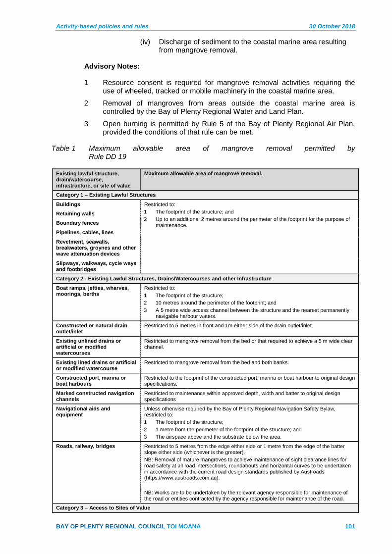
Activity-based policies and rules 30 October 2018
BAY OF PLENTY REGIONAL COUNCIL TOI MOANA 101
(iv) Discharge of sediment to the coastal marine area resulting from mangrove removal.
Advisory Notes:
1 Resource consent is required for mangrove removal activities requiring the use of wheeled, tracked or mobile machinery in the coastal marine area.
2 Removal of mangroves from areas outside the coastal marine area is controlled by the Bay of Plenty Regional Water and Land Plan.
3 Open burning is permitted by Rule 5 of the Bay of Plenty Regional Air Plan, provided the conditions of that rule can be met.
Table 1 Maximum allowable area of mangrove removal permitted by Rule DD 19
Existing lawful structure, drain/watercourse, infrastructure, or site of value
Maximum allowable area of mangrove removal.
Category 1 – Existing Lawful Structures
Buildings Restricted to: 1 The footprint of the structure; and 2 Up to an additional 2 metres around the perimeter of the footprint for the purpose of
maintenance.
Retaining walls
Boundary fences
Pipelines, cables, lines
Revetment, seawalls, breakwaters, groynes and other wave attenuation devices
Slipways, walkways, cycle ways and footbridges
Category 2 - Existing Lawful Structures, Drains/Watercourses and other Infrastructure
Boat ramps, jetties, wharves, moorings, berths
Restricted to: 1 The footprint of the structure; 2 10 metres around the perimeter of the footprint; and 3 A 5 metre wide access channel between the structure and the nearest permanently
navigable harbour waters.
Constructed or natural drain outlet/inlet
Restricted to 5 metres in front and 1m either side of the drain outlet/inlet.
Existing unlined drains or artificial or modified watercourses
Restricted to mangrove removal from the bed or that required to achieve a 5 m wide clear channel.
Existing lined drains or artificial or modified watercourse
Restricted to mangrove removal from the bed and both banks.
Constructed port, marina or boat harbours
Restricted to the footprint of the constructed port, marina or boat harbour to original design specifications.
Marked constructed navigation channels
Restricted to maintenance within approved depth, width and batter to original design specifications
Navigational aids and equipment
Unless otherwise required by the Bay of Plenty Regional Navigation Safety Bylaw, restricted to: 1 The footprint of the structure; 2 1 metre from the perimeter of the footprint of the structure; and 3 The airspace above and the substrate below the area.
Roads, railway, bridges Restricted to 5 metres from the edge either side or 1 metre from the edge of the batter slope either side (whichever is the greater). NB: Removal of mature mangroves to achieve maintenance of sight clearance lines for road safety at all road intersections, roundabouts and horizontal curves to be undertaken in accordance with the current road design standards published by Austroads (https://www.austroads.com.au). NB: Works are to be undertaken by the relevant agency responsible for maintenance of the road or entities contracted by the agency responsible for maintenance of the road.
Category 3 – Access to Sites of Value
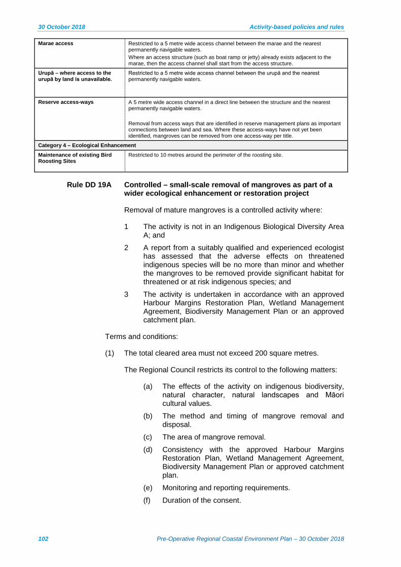
30 October 2018 Activity-based policies and rules
102 Pre-Operative Regional Coastal Environment Plan – 30 October 2018
Marae access Restricted to a 5 metre wide access channel between the marae and the nearest permanently navigable waters. Where an access structure (such as boat ramp or jetty) already exists adjacent to the marae, then the access channel shall start from the access structure.
Urupā – where access to the urupā by land is unavailable.
Restricted to a 5 metre wide access channel between the urupā and the nearest permanently navigable waters.
Reserve access-ways A 5 metre wide access channel in a direct line between the structure and the nearest permanently navigable waters. Removal from access ways that are identified in reserve management plans as important connections between land and sea. Where these access-ways have not yet been identified, mangroves can be removed from one access-way per title.
Category 4 – Ecological Enhancement
Maintenance of existing Bird Roosting Sites
Restricted to 10 metres around the perimeter of the roosting site.
Rule DD 19A Controlled – small-scale removal of mangroves as part of a wider ecological enhancement or restoration project
Removal of mature mangroves is a controlled activity where:
1 The activity is not in an Indigenous Biological Diversity Area A; and
2 A report from a suitably qualified and experienced ecologist has assessed that the adverse effects on threatened indigenous species will be no more than minor and whether the mangroves to be removed provide significant habitat for threatened or at risk indigenous species; and
3 The activity is undertaken in accordance with an approved Harbour Margins Restoration Plan, Wetland Management Agreement, Biodiversity Management Plan or an approved catchment plan.
Terms and conditions:
(1) The total cleared area must not exceed 200 square metres.
The Regional Council restricts its control to the following matters:
(a) The effects of the activity on indigenous biodiversity, natural character, natural landscapes and Māori cultural values.
(b) The method and timing of mangrove removal and disposal.
(c) The area of mangrove removal.
(d) Consistency with the approved Harbour Margins Restoration Plan, Wetland Management Agreement, Biodiversity Management Plan or approved catchment plan.
(e) Monitoring and reporting requirements.
(f) Duration of the consent.
Activity-based policies and rules 30 October 2018
BAY OF PLENTY REGIONAL COUNCIL TOI MOANA 103
For the avoidance of doubt, this rule allows for:
(i) Disturbance of the foreshore or seabed.
(ii) Deposition of material on the foreshore or seabed.
(iii) Removal, damage, modification or destruction of mangroves growing in the foreshore or seabed.
(iv) Discharge of sediment to the coastal marine area resulting from mangrove removal.
Advisory Notice:
1 Harbour Margins Restoration Plans, Wetland Management Agreements or Biodiversity Management Plans are completed by landowners or community groups in partnership with a Regional Council Land Management Officer. Templates for Coastal Wetland Management Agreements are available from the Regional Council, or on Council’s website (www.boprc.govt.nz).
2 Mangrove removal from an Indigenous Biological Diversity Area A for special circumstances is considered under Rule DD 21A as a discretionary activity
3 Mangrove removal from an Indigenous Biological Diversity Area B that does not meet the standards or terms of this rule is a restricted discretionary activity under Rule DD 21.
Rule DD 20 Permitted – Management of mangroves as part of ongoing maintenance areas where clearance has been lawfully undertaken
The removal of mangroves that is carried out as a part of (a)ongoing maintenance of areas where clearance of mature mangroves has previously been undertaken and authorised by a resource consent, is a permitted activity subject to the following standards and terms:
Removal of mangroves has been undertaken during the (b)preceding five years (this can include seedling removal).
The activity shall not damage or disturb a site listed in the (c)Regional Historic Heritage Inventory in Schedule 7.
Tracked or wheeled machinery shall not be used in the (d)coastal marine area.
Removal shall be undertaken by hand or using hand-held (e)tools.
Motorised hand tools shall not be used within 5 metres of the (f)boundary of an area from which mangroves have been lawfully removed.
Chemical herbicides shall not be used. (g)
The activity shall not disturb or damage areas of saltmarsh (h)or seagrass.
Access to removal areas shall be by existing open areas or (i)paths.

30 October 2018 Activity-based policies and rules
104 Pre-Operative Regional Coastal Environment Plan – 30 October 2018
In areas that have been identified as bird roosting or nesting (j)sites in Schedule 2 to this Plan, removal must not be undertaken between 1 September and 31 January (inclusive) to avoid bird roosting and nesting seasons.
For the avoidance of doubt, this rule allows for:
(i) Disturbance of the foreshore or seabed.
(ii) Deposition of material on the foreshore or seabed.
(iii) Removal, damage, modification or destruction of mangroves growing in the foreshore or seabed.
(iv) Discharge of sediment to the coastal marine area resulting from mangrove removal.
Advisory Notes:
1 Resource consent is required for mangrove removal activities requiring the use of wheeled, tracked or mobile machinery in the coastal marine area.
2 Mangroves may be removed by hand or with hand-held non-motorised tools where they are within 5 metres of the boundary of a previously cleared area.
Rule DD 21 Restricted Discretionary – Removal of mangroves
The removal of mangroves where the activity is not permitted by Rule DD 18, Rule DD 19 or Rule DD 20, or controlled under Rule DD 19A is a restricted discretionary activity, subject to the following standards and terms:
1 The activity is not in an Indigenous Biological Diversity Area A.
The Regional Council restricts its discretion to the following matters:
The matters listed in Policies DD 16, DD 17, DD 18, (a)DD 19 and DD 20.
The effects of the activity on amenity, recreation, (b)biodiversity and cultural values, including kaimoana, threatened or at risk indigenous species, threatened indigenous ecosystems, public access, navigational access and public safety.
The method and timing of mangrove removal and (c)disposal.
(d) The positive effects of retaining mangroves, taking into account the relative age, maturity and historic distribution of mangroves.
(e) Consistency with an existing catchment management plan for the area or approved Estuary Care Group Plan, Harbour Margins Restoration Plan, Wetland Management Agreement or Biodiversity Management Plan
Activity-based policies and rules 30 October 2018
BAY OF PLENTY REGIONAL COUNCIL TOI MOANA 105
For the avoidance of doubt, this rule includes the following activities:
(i) Disturbance of the foreshore or seabed.
(ii) Deposition of material on the foreshore or seabed.
(iii) Removal, damage, modification or destruction of mangroves growing in the foreshore or seabed.
(iv) Discharge of sediment to the coastal marine area resulting from mangrove removal.
Advisory Note:
1 Harbour Margins Restoration Plans, Wetland Management Agreements or Biodiversity Management Plans are completed by landowners or community groups in partnership with a Regional Council Land Management Officer. Templates for Coastal Wetland Management Agreements are available from the Regional Council, or on Council’s website (www.boprc.govt.nz).
2 Removal of mangroves from an Indigenous Biological Diversity Area A which is not permitted by Rules DD 19 or DD 20 is either discretionary under Rule DD 21A or non-complying under Rule DD 22.
Rule DD 21A Discretionary - removal of mangroves from an Indigenous Biological Diversity Area A – special circumstances
The removal of mangroves from an Indigenous Biological Diversity Area A is a discretionary activity subject to the following terms:
1 The mangroves are not within any of the following Indigenous Biological Diversity Area A:
Ōhiwa Harbour Uretara Island Indigenous Biological Diversity Area A as identified on Mapsheet 25b
Ōhiwa Harbour Motuotu Island Nature Reserve Indigenous Biological Diversity Area A as identified on Mapsheet 25b
Ōhiwa Harbour Pataua Island Scientific Reserve and Extension Indigenous Biological Diversity Area A as identified on Mapsheet 26b
Tauranga Harbour Aongatete Estuary Indigenous Biological Diversity Area A as identified on Mapsheet 7b
Tauranga Harbour Athenree Indigenous Biological Diversity Area A as identified on Mapsheet 2b
Tauranga Harbour Blue Gum Bay 1 Indigenous Biological Diversity Area A as identified on Mapsheet 6b
Tauranga Harbour Tirohanga Mangroves Indigenous Biological Diversity Area A as identified on Mapsheet 5b

30 October 2018 Activity-based policies and rules
106 Pre-Operative Regional Coastal Environment Plan – 30 October 2018
Tauranga Harbour Te Hopai Island Indigenous Biological Diversity Area A as identified on Mapsheet 7b
2 The mangrove removal is consistent with protecting the values of the relevant Indigenous Biological Diversity Area A.
3 The activity is for one or more of the following purposes:
Maintaining or enhancing the ecological values of the (a)Indigenous Biological Diversity Area A;
Improving water quality, connections between water (b)bodies or between freshwater bodies and coastal water, or other natural processes in the area;
Providing and maintaining boardwalks for access, (c)passive recreation or educational purposes, signage, or monitoring and sampling structures.
The operation, maintenance and protection of existing (d)regionally significant infrastructure; or
The operation, maintenance and protection of Existing (e)River Schemes and Land Drainage Schemes.
For the avoidance of doubt, this rule includes the following activities:
(i) Disturbance of the foreshore or seabed.
(ii) Deposition of material on the foreshore or seabed.
(iii) Removal, damage, modification or destruction of mangroves growing in the foreshore or seabed.
(iv) Discharge of sediment to the coastal marine area resulting from mangrove removal.
Rule DD 22 Non-complying – Removal of mangroves from an Indigenous Biodversity Area A
The removal of mangroves from an Indigenous Biological Diversity Area A where the activity is not permitted by Rule DD 19 or Rule DD 20 or discretionary under Rule DD 21A is a non-complying activity.
For the avoidance of doubt, this rule includes the following activities:
(i) Disturbance of the foreshore or seabed.
(ii) Deposition of material on the foreshore or seabed.
(iii) Removal, damage, modification or destruction of mangroves growing in the foreshore or seabed.
(iv) Discharge of sediment to the coastal marine area resulting from mangrove removal.
Activity-based policies and rules 30 October 2018
BAY OF PLENTY REGIONAL COUNCIL TOI MOANA 107
3 Coastal discharges (CD)
Policies 3.1
Policy CD 1 Discharges to the coastal marine area must:
Avoid significant adverse effects, including cumulative (a)effects, on aquatic life, habitats, feeding grounds, kaimoana (including shellfish gathering), ecosystems, contact recreation and amenity values in the coastal marine area after reasonable mixing;
Minimise adverse effects on the life-supporting capacity of (b)water within the mixing zone;
(e) Avoid the discharge of persistent toxic contaminants into the environment, and where avoidance cannot be practically achieved, the adverse effects of such discharges must be mitigated or remedied;
(f) Avoid, remedy or mitigate adverse effects on the stability of the coastal environment, including localised erosion and scour resulting from the discharge;
(g) Maintain or enhance the physical characteristics of receiving waters (including salinity) that contribute to their life-supporting capacity, including their ability to support indigenous flora and fauna and kaimoana beds; and
(h) Be of a quality that has particular regard to:
(i) The sensitivity of the receiving environment;
(ii) The capacity of the receiving environment to assimilate contaminants; and
(iii) The nature of the contaminants to be discharged, the concentration of contaminants needed to achieve the required water quality in the receiving environment, and the risks if that concentration of contaminants is exceeded.
Policy CD 2 Apply the water quality classifications and standards contained in Schedule 10 to discharges to the coastal marine area, unless other standards can be demonstrated to be more consistent with the purpose of the Resource Management Act 1991. When existing water quality is significantly better than the classification standards, a higher standard will be applied to prevent degradation of existing water quality.
Policy CD 3 If a water quality standard higher or additional to that set by Schedule 10 is required to prevent degradation of existing water quality, the standard will be selected in accordance with the following hierarchy:
1 New Zealand derived risk-based thresholds.
2 Rest of the world derived risk-based thresholds, with preference given to those that are methodological consistent with those already used in New Zealand.

30 October 2018 Activity-based policies and rules
108 Pre-Operative Regional Coastal Environment Plan – 30 October 2018
Policy CD 4 To define the radius of a reasonable mixing zone in the conditions of a resource consent for the point source discharge of contaminants to coastal waters having regard to the following matters:
Use of the smallest mixing zone necessary in order to (a)minimise adverse effects on the life-supporting capacity of water within the mixing zone and achieve the required water quality standard of the receiving environment.
The water quality standard in Schedule 10 to this Plan. (b)
The hydrological regime of the receiving water. (c)
The ambient concentrations of contaminants in the receiving (d)water.
Effluent discharge flow rate and contaminant concentrations. (e)
Existing discharge and abstraction consents in the area (f)affected by the proposed point source discharge.
The need to avoid significant adverse effects on ecosystems (g)and habitats after reasonable mixing.
The values and existing uses of the area affected by the (h)proposed point source discharge.
Māori cultural values (refer to Policy CD 6 and Iwi Resource (i)Management policies).
Proximity to bathing sites. (j)
Adverse environmental effects of the discharge, including (k)cumulative effects in relation to (a) to (j).
The location of the discharge and position of the outfall. (l)
Outfall diffuser design criteria. (m)
Information provided by the applicant. (n)
Any other information relevant to the nature of the discharge (o)and the site characteristics.
Policy CD 5 When considering measures to avoid, mitigate and remedy adverse effects on the coastal marine area, as a result of the discharge of contaminants, particular regard must be had to using alternative land based treatment and disposal systems, where appropriate and environmentally sustainable and where socially, technically and economically feasible.
Policy CD 6 To recognise and provide for the effects on the mauri of the receiving environment caused by the discharge of contaminants to the coastal marine area by:
Promoting efficient use of water, including reuse and (a)recycling of wastewater.
(aa) Discouraging disposal of toxic materials via wastewater systems.
Encouraging a shift to land based treatment and disposal (b)systems, where appropriate and environmentally sustainable and socially, technically and economically feasible. This
Activity-based policies and rules 30 October 2018
BAY OF PLENTY REGIONAL COUNCIL TOI MOANA 109
includes disposal of sewage by passage through land, soil or wetlands.
Avoiding, remedying or mitigating adverse effects on coastal (c)resources or sites that are of significance to tāngata whenua, where such resources or sites have been identified by tāngata whenua.
Also refer to Policies CD 9, CD 10 and CD 11.
Policy CD 7 To maintain a response capability with regard to unauthorised or accidental discharges or spills of contaminants into the coastal marine area.
Policy CD 8 When considering resource consent applications for marinas:
Require that facilities are available for the appropriate shore (a)based disposal of contaminants associated with the operation or maintenance of vessels.
Ensure that boat maintenance activities are managed to (b)prevent more than minor effects on coastal waters as a result of the discharge of toxic or harmful substances.
3.1.1 Additional policies relevant to discharges of human sewage
Policy CD 9 Discharges of treated human sewage to coastal water that has not passed through land, soil or wetlands may only be consented where:
The proposal is consistent with Policy 23(2)(b) of the (a)NZCPS;
There has been full consideration of the objectives and (b)policies of this Plan; and
The proposal to discharge treated human sewage directly to (c)coastal water better meets the purpose of the Resource Management Act 1991 than a discharge to coastal water that has first passed through land, soil or wetlands.
Policy CD 10 Recognise that the disposal of wastewater in a different rohe from where it is generated is culturally inappropriate to tāngata whenua.
Policy CD 11 During the assessment of applications to discharge treated human sewage to the coastal marine area, consider whether the proposal:
Promotes better use of fresh water by efficient use of water, (a)reuse and recycling of wastewater, and discouraging disposal of toxic materials via wastewater systems;
Includes the passing of sewage through land, soil or a (b)wetland or uses an alternative technology and disposal methodology that is acceptable to tangata whenua; and
Avoids highly sensitive discharge locations such as gazetted (c)taiāpure, mahinga kai, other traditional seafood gathering areas or recreational beaches.

30 October 2018 Activity-based policies and rules
110 Pre-Operative Regional Coastal Environment Plan – 30 October 2018
Policy CD 12 Prevent the following discharges in the coastal marine area:
Discharges prohibited by the Resource Management (Marine (a)Pollution) Regulations 1998;
Discharges of untreated sewage; and (b)
Discharges of sewage to harbours and estuaries in the (c)region.
3.1.2 Additional policies specific to hazardous substances
Policy CD 13 Prevent the disposal of hazardous substances to the coastal marine area.
Policy CD 14 Ensure the off-target effects of herbicide or pesticide use in the coastal marine area are avoided, remedied or mitigated.
3.1.3 Additional policies relevant to stormwater discharges
Policy CD 15 Apply the policies and methods in Section 4.2 – Discharge of Stormwater of the Regional Water and Land Plan to encourage or require integrated and comprehensive stormwater management.
Policy CD 16 Require the appropriate management of stormwater quality to maintain, and where necessary enhance, water quality in the coastal marine area, including:
The use of source controls to minimise the contamination (a)and sediment loading of stormwater;
The use of best practicable options to reduce the levels of (b)contaminants and sediments entering coastal waters;
Treatment of stormwater prior to discharge when necessary (c)to minimise the contamination and sedimentation of receiving environments; and
The prevention of inappropriate discharges of contaminants (d)to stormwater systems.
Policy CD 17 Require new stormwater discharge rates and volumes, and new stormwater discharge outlet structures, to be designed and managed to avoid or mitigate erosion and scour.
Policy CD 18 Require monitoring of stormwater discharges to the coastal environment at a frequency that corresponds with the scale and significance of the effects of the discharge.
Policy CD 19 Include a review clause in resource consents for the discharge of stormwater to the coastal marine area where necessary to provide for progressive improvement to discharge quality in the future (including the defining of appropriate contaminant loads).
Policy CD 20 (a) Where a stormwater discharge cannot meet the water quality classifications and standards contained in Schedule 10; or the Regional Council will consider allowing significant residual adverse effects to be offset.
Activity-based policies and rules 30 October 2018
BAY OF PLENTY REGIONAL COUNCIL TOI MOANA 111
(b) Where a stormwater discharge has the potential after reasonable mixing to cause accumulation of contaminants in harbour or estuary sediment at levels that would have adverse effects on marine life that cannot be avoided; the Regional Council will consider allowing a biodiversity offset for residual adverse effects on marine life that are more than minor but not significant.
Advisory note
1 Policies NH4, NH5, NH6 and NH11 apply if an activity may have adverse effects on the values and attributes of an IBDA A or B
Policy CD 21 When assessing an offset in accordance with Policy CD 20, Council will have regard to:
1 The matters in Policy NH 11 of Part 3: Section 1 – Natural Heritage and Schedule 13 Principles on Biodiversity Offsets to this Plan.
Policies IW 2, IW 6, IW 7 and IW 9 of Part 3: Section 3 (a)– Iwi Resource Management of this Plan.
The circumstances and purposes of Financial (b)Contributions in Schedule 11.
The availability of any reasonable alternatives. (c)
Rules and Regulations 3.2
Advisory Note:
1 Also refer to the Resource Management (Marine Pollution) Regulations 1998 in relation to the following discharges:
• Discharge of substances from ships or offshore installations for the purpose of avoiding, remedying, or mitigating oil spill.
• Discharge of oil from a ship or offshore installation.
• Discharge of noxious liquid substances as part of ballast water from a ship.
• Discharge of Grade A or Grade B treated sewage from a ship or offshore installation. Note that this discharge remains subject to Rule CD 13 of this Plan.
• Discharge of garbage from a ship.
• Discharge of ballast water.
• Discharges made as part of normal operations of a ship or offshore installation.
Regulations For Information Only – not part of the Regional Coastal 3.3Environment Plan
Regulation 16 of the Marine Pollution Regulations states: No rule may be included in any regional coastal plan, or proposed regional coastal plan, nor any resource consent granted relating to a discharge to which regulations 9, 10, 12, 13, 14, and 15 apply.

30 October 2018 Activity-based policies and rules
112 Pre-Operative Regional Coastal Environment Plan – 30 October 2018
The Resource Management (Marine Pollution) Regulations 1998 apply in relation to the following discharges:
Regulation 8 Discharge of substances for purpose of avoiding, remedying, or mitigating oil spill
(1) Any person may, in the coastal marine area, discharge from a ship or offshore installation any substance for the purpose of avoiding, remedying, or mitigating the adverse effects of an oil spill.
(2) This regulation does not authorise the discharge of any substance in contravention of Part 23 of the Maritime Transport Act 1994 or any marine protection rules made under Part 27 of that Act.
Regulation 9 Permitted - Discharge of oil
(1) Any person may, in the coastal marine area, discharge oil, or mixtures containing oil, from any ship if—
(a) the oil is not derived from the cargo of the ship; and
(b) the ship is proceeding en route; and
(c) the oil content of the discharge before dilution with any other substance does not exceed 15 parts per million.
(2) Any person may, in the coastal marine area, discharge oil, or mixtures containing oil, from an offshore installation, if—
(a) the oil content of the discharge before dilution with any other substance does not exceed 15 parts per million; and
(b) the discharge is platform drainage
Regulation 10 Permitted - Discharge of noxious liquid substances as part of a discharge of clean ballast water Any person may, in the coastal marine area, discharge from any ship carrying in bulk a noxious liquid substance, any noxious liquid substance if that noxious liquid substance is part of a discharge of clean ballast water or segregated ballast water.
Regulation 12 Permitted - Discharge of Grade A treated sewage in coastal marine area
(1) Any person may discharge Grade A treated sewage in the coastal marine area from a ship or offshore installation, but must not discharge it within 100 metres of a marine farm.
(2) Despite subclause (1), a rule may be included in a regional coastal plan or a proposed regional coastal plan if the rule—
(a) relates to discharges of Grade A treated sewage in the internal waters of Fiordland (as defined in section 4 of the Territorial Sea, Contiguous Zone, and Exclusive Economic Zone Act 1977); and
(b) restricts where those discharges may take place, being a distance of at least 100 metres from a marine farm; and
(c) does not relate to vessels operated by the New Zealand Defence Force.
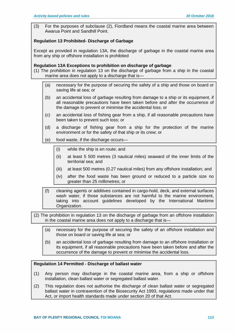
Activity-based policies and rules 30 October 2018
BAY OF PLENTY REGIONAL COUNCIL TOI MOANA 113
(3) For the purposes of subclause (2), Fiordland means the coastal marine area between Awarua Point and Sandhill Point.
Regulation 13 Prohibited- Discharge of Garbage
Except as provided in regulation 13A, the discharge of garbage in the coastal marine area from any ship or offshore installation is prohibited
Regulation 13A Exceptions to prohibition on discharge of garbage (1) The prohibition in regulation 13 on the discharge of garbage from a ship in the coastal
marine area does not apply to a discharge that is—
(a) necessary for the purpose of securing the safety of a ship and those on board or saving life at sea; or
(b) an accidental loss of garbage resulting from damage to a ship or its equipment, if all reasonable precautions have been taken before and after the occurrence of the damage to prevent or minimise the accidental loss; or
(c) an accidental loss of fishing gear from a ship, if all reasonable precautions have been taken to prevent such loss; or
(d) a discharge of fishing gear from a ship for the protection of the marine environment or for the safety of that ship or its crew; or
(e) food waste, if the discharge occurs—
(i) while the ship is en route; and
(ii) at least 5 500 metres (3 nautical miles) seaward of the inner limits of the territorial sea; and
(iii) at least 500 metres (0.27 nautical miles) from any offshore installation; and
(iv) after the food waste has been ground or reduced to a particle size no greater than 25 millimetres; or
(f) cleaning agents or additives contained in cargo-hold, deck, and external surfaces wash water, if those substances are not harmful to the marine environment, taking into account guidelines developed by the International Maritime Organization.
(2) The prohibition in regulation 13 on the discharge of garbage from an offshore installation in the coastal marine area does not apply to a discharge that is—
(a) necessary for the purpose of securing the safety of an offshore installation and those on board or saving life at sea; or
(b) an accidental loss of garbage resulting from damage to an offshore installation or its equipment, if all reasonable precautions have been taken before and after the occurrence of the damage to prevent or minimise the accidental loss.
Regulation 14 Permitted - Discharge of ballast water
(1) Any person may discharge in the coastal marine area, from a ship or offshore installation, clean ballast water or segregated ballast water.
(2) This regulation does not authorise the discharge of clean ballast water or segregated ballast water in contravention of the Biosecurity Act 1993, regulations made under that Act, or import health standards made under section 20 of that Act.

30 October 2018 Activity-based policies and rules
114 Pre-Operative Regional Coastal Environment Plan – 30 October 2018
Regulation 15 Permitted - Discharges made as part of normal operations of ship or offshore installation
Any person may discharge, in the coastal marine area, a contaminant that is incidental to, or derived from, or generated during, the operations listed in Schedule 4 to the Resource Management (Marine Pollution) Regulations 1998 as the normal operations of a ship or offshore installation, except a contaminant that is garbage and for which no exception is provided in regulation 13A.
Schedule 4 Normal operations of ship or offshore installation
2 Ship propulsion.
3 Heat exchange systems, including engine cooling systems, air conditioning, refrigeration, and condensers
4 Stormwater drainage from systems and scuppers, except from those areas used for the storage of any harmful substance.
5 The use of washing facilities in the accommodation areas producing greywater from showers, hand basins, baths, galleys, dishwashers, and laundries but does not include use of any dispensary, sick bay, or other medical premises.
6 The cleaning of the ship or offshore installation, except for the exterior of the hull below the load line or parts of the ship used for carrying cargo.
7 The incineration of waste or other matter generated from a ship or offshore installation.
8 Firefighting.
9 The operation of a weapon system on any ship of the New Zealand Defence Force.
Rules 3.4
Rule CD 1 Permitted – Discharge of aquatic herbicide over coastal water for weed control
The discharge of herbicides over coastal water for the purpose of spraying emergent aquatic plants,
is a permitted activity, subject to the following conditions:
The application of herbicide shall only be for the purpose of (a)controlling:
(i) Plant pest species listed in the ‘Regional Pest Management Plan for the Bay of Plenty’ or the National Pest Plant Accord; or
(ii) Exotic vegetation for the purpose of maintaining or enhancing indigenous biodiversity.
Only herbicides that have been approved for use over water (b)shall be used. Herbicides are approved under the Hazardous Substances and New Organisms Act 1996.
The herbicide shall be discharged in a manner that is (c)consistent with the manufacturer’s instructions.
The discharge shall not result in any fish kills. (d)
The discharge shall not contaminate any authorised water (e)take.

Activity-based policies and rules 30 October 2018
BAY OF PLENTY REGIONAL COUNCIL TOI MOANA 115
The discharge shall not result in any harmful concentration of (f)herbicide beyond the target area.
There shall be no discharge of herbicide in the tidal reach of (g)any surface water body between 1 March and 31 May.
The discharge of herbicide shall comply with the (h)requirements of the Operative Bay of Plenty Regional Air Plan.
Advisory Notes:
1 Resource users must also comply with Appendix M to the NZS 8409:2004 Management of Agrichemicals, and relevant regulations of the Hazardous Substances and New Organisms Act 1996. Resource users are advised to contact the Regional Council for more information.
2 Compliance with conditions (b) and (c) is largely expected to achieve compliance with (d). Resource users should also manage the extent of the vegetation targeted by the activity so that the amount of dead and rotting vegetation in a water body does not decrease oxygen levels in the water to a level that causes fish kills.
Rule CD 2 Permitted – Discharge of dye or gas tracers
The discharge of dye or gas tracer material, excluding radioisotope tracers, to coastal water for monitoring or research purposes is a permitted activity, subject to the following conditions:
Details of the proposed discharge shall be publicly notified at (a)least one week prior to the discharge being made by a public notice in the local newspaper and/or other recommended methods including letter drops stating:
(i) The area where the discharge will be made.
(ii) The type of discharge.
(iii) The reason for the discharge.
(iv) The duration of the discharge.
The discharge shall not contaminate any authorised water (b)takes.
The dye or gas shall be inert, and shall be non-toxic in the (c)concentration at which it is to be used.
The Regional Council and the relevant city or district council (d)shall be notified in writing of the proposed discharge, no less than five working days before the discharge. Such notification shall include:
(i) Persons responsible for the discharge including contact details;
(ii) Purpose of the tracer programme;
(iii) Description of the tracer programme;
(iv) Nature of the tracer (i.e. type, colour, product name/description);
(v) Discharge location and estimated timing; and

30 October 2018 Activity-based policies and rules
116 Pre-Operative Regional Coastal Environment Plan – 30 October 2018
(vi) Estimated duration of discharge.
Rule CD 3 Permitted – Minor Discharges of Water
The discharge of water into the coastal marine area is a permitted activity, subject to the following conditions:
Any change in visual water quality shall not be detectable (a)12 hours after the discharge ceases.
The discharge shall not cause erosion or scouring. (b)
The discharge shall not cause nor contribute to flooding or (c)ponding on any land or property owned or occupied by another person.
The discharge shall not occur in or at any area identified as (d)wāhi tapu.
The discharge shall not contain any hazardous substances. (e)
The discharge shall not contain any material which will cause (f)the production of conspicuous oil or grease films, scums or foams, or floatable suspended material outside a 5 metre radius of the point of discharge.
The natural temperature of the water shall not be changed (g)by more than 3 degrees Celsius.
The discharge shall not damage or destroy any Indigenous (h)Biological Diversity Area (as listed in Schedule 2).
The discharge shall not cause the Water Quality Standards (i)in Schedule 10 to be breached.
Rule CD 3A Permitted – Discharges from the operation of portable Micro-Filtration Reverse Osmosis (MFRO) water treatment units by the New Zealand Defence Force
The discharge of wastewater from portable Micro-Filtration Reverse Osmosis (MFRO) water treatment units into the coastal marine area is a permitted activity, subject to the following conditions:
(a) The water treatment unit is operated by the New Zealand Defence Force.
(b) The water treatment unit is used as part of military training exercises or in response to a civil defence emergency.
(c) Any change in visual water quality shall not be detectable twelve hours after the discharge ceases.
(d) The discharge shall not cause erosion or scouring.
(e) The discharge shall not cause or contribute to flooding or ponding on any land or property owned or occupied by another person.
(f) The discharge shall not occur in or at any area identified as wāhi tapu.
(g) The ambient temperature of the water shall not be changed by more than 3 degrees Celsius.

Activity-based policies and rules 30 October 2018
BAY OF PLENTY REGIONAL COUNCIL TOI MOANA 117
Rule CD 4 Permitted – Discharges of substances from aircraft for avoiding, remedying or mitigating oil spills
The discharge from an aircraft of any substance for the purpose of avoiding, remedying, or mitigating the adverse effects of an oil spill in the coastal marine area, is a permitted activity.
Advisory Note:
1 The Bay of Plenty Marine Oil Spill Contingency Plan (Tier II Plan) contains information on the appropriate use of dispersants.
2 This rule is an extension of Regulation 8 of the Resource Management (Marine Pollution) Regulations 1998.
Rule CD 5 Permitted – Discharge of stormwater to coastal water
The discharge of stormwater to coastal water is a permitted activity, subject to the following conditions:
The suspended solids concentration of the discharge shall (a)not be greater than 150 grams per cubic metre, except where a 10 minute duration 10% AEP storm event (10 year return period storm) is exceeded.
The discharge shall not cause the production of conspicuous (b)oil or grease films, scums or foams, where these are derived from human sources, or contain human-derived gross pollutants (particles that have a diameter greater than 5 mm).
The rate of discharge shall not exceed 125 litres per second (c)for a 10 minute duration 10% AEP storm event (10 year return period storm).
The discharge shall not cause or increase erosion to the bed (d)or banks of any surface water body, or to land, where the erosion is persistent or requires active erosion control measures to bring it under control. Erosion includes:
(i) Instability of land or the banks of the surface water body;
(ii) Scour to the bed of the surface water body; or
(iii) Damage to the margins or banks of the surface water body.
The discharge shall not cause or increase flooding of, or (e)ponding on, other properties.
The discharge must not cause nuisance or damage to other (f)property.
The discharge shall not give rise to significant adverse (g)effects on to marine, estuarine or coastal ecosystems.
The discharge shall not decrease water clarity by more than (h)20% as determined using a secchi disc vertical depth or black disc horizontal test.
The discharge shall not contain any stormwater from a high (i)risk facility as defined in Schedule 12.

30 October 2018 Activity-based policies and rules
118 Pre-Operative Regional Coastal Environment Plan – 30 October 2018
The discharge shall not contain any wastes (including, but (j)not limited to, wastewater or condensates) from a trade or industrial process.
Advisory Notes:
1 In relation to the application of condition (c), stormwater management systems for state highways, other roads and large areas may be designed to allow multiple discharges along a length of roadway or surface area, providing each individual discharge does not exceed the stated rate.
2 In relation to conditions (a) and (c), the storm event will be measured at the nearest Regional Council approved rainfall site.
3 Discharges of stormwater into the reticulated stormwater network may require a resource consent from the Regional Council under the Regional Water and Land Plan for a discharge to land that may enter fresh or coastal water. The network operator will be treated as an affected party to such applications.
5 In relation to the application of condition (g), and assessment of the likely effects of aquatic life and their significance can be undertaken by comparison of known contaminants contained in the discharge with the ANZECC Guidelines for Fresh and Marine Water Quality, 2000 or other acceptable measure.
6 In relation to the application of condition (h), a measurement should be taken at a location down-current of the discharge, at a distance of 200 metres from the point of discharge and compared with a control measurement taken at a point that is approximately 2 kilometres from the discharge.
Rule CD 6 Restricted Discretionary – Discharge of stormwater to coastal water
The discharge of stormwater to coastal water that is not permitted by Rule CD 5 is a restricted discretionary activity. The Regional Council restricts its discretion to the following matters:
Requirement for a Stormwater Management and (a)Maintenance Plan that includes:
(i) A suitably scaled drawing showing the site layout, boundaries, all private stormwater and wastewater drainage including the point of connection to the public networks, relevant buildings and outdoor spaces (including their use); and
(ii) A site assessment identifying all actual and potential sources of stormwater pollution; and
(iii) Existing methods in place to minimise contamination of the coastal marine area; and
(iv) Additional methods proposed to control contamination of the coastal marine area, and timeframes for implementation; and
(v) A description of the maintenance procedures in place and proposed; and
(vi) A description of how the stormwater system will be maintained and operated in order to achieve compliance with resource consent conditions; and

Activity-based policies and rules 30 October 2018
BAY OF PLENTY REGIONAL COUNCIL TOI MOANA 119
(vii) Spill prevention and spill response procedures.
Assessment of a reasonable mixing zone for the discharge. (b)
The volume of the discharge. (c)
Measures to avoid, remedy or mitigate the adverse effects of (d)the stormwater discharge on:
(i) Erosion, scour or land instability.
(ii) Water quality.
(iii) Flooding or ponding on land owned or occupied by another person.
(iv) Marine, estuarine and coastal ecosystems, indigenous flora and fauna, and the migration of fish species.
(v) Existing uses of the coastal marine area, including recreational use.
(vi) Resources, areas or sites of spiritual, historical or cultural significance to tāngata whenua.
Monitoring, reporting and review requirements. (e)
Rule CD 7 Discretionary – Dumping of specified matter in the coastal marine area
The dumping of the wastes and other matter listed below, in the coastal marine area from any ship, aircraft, or offshore installation is a discretionary activity.
Dredge material (where no other rule applies). (a)
Sewage sludge. (b)
Fish processing waste from an onshore facility. (c)
Ships and platforms or other man-made structures at sea. (d)
Inert, inorganic geological material. (e)
Organic materials of natural origin. (f)
Bulky items consisting mainly of iron, steel, and concrete. (g)
Advisory Note:
1 This is a deemed rule under Regulation 4 of the Resource Management (Marine Pollution) Regulations 1998, and excludes:
(a) Disposal or storage of waste or other matter arising directly from, or related to, the exploration, exploitation and associated offshore processing of seabed mineral resources; or
(b) A discharge made in accordance with section 15B of the RMA or Part 3 of the Resource Management (Marine Pollution) Regulations 1998.
Rule CD 8 Discretionary – Discharges to the Coastal Marine Area
The:
discharge of a contaminant to coastal water, 1
discharge of water to coastal water, or 2

30 October 2018 Activity-based policies and rules
120 Pre-Operative Regional Coastal Environment Plan – 30 October 2018
discharge of a contaminant to land where the contaminant 3may enter the Coastal Marine Area,
that is not:
Permitted by a rule in this Plan or the Resource (a)Management (Marine Pollution) Regulations 1998;
A controlled, restricted discretionary or non-complying (b)activity under a rule in this Plan;
Prohibited by a rule in this Plan or the Resource (c)Management (Marine Pollution) Regulations 1998; or
Allowed by Section 15B of the Resource Management Act (d)1991,
is a discretionary activity.
Rule CD 9 Non-Complying – Discharge of treated human sewage from land-based systems that has not passed through land, soil or wetlands
The discharge of treated human sewage to coastal water from land-based systems that has not passed through land, soil or wetlands is a non-complying activity.
Rule CD 9A Non-Complying – Disposal of waste related to the exploration, exploitation and associated offshore processing of seabed mineral resources in an Outstanding Natural Feature and Landscape
Disposal or storage of waste or other matter arising directly from, or related to, the exploration, exploitation and associated offshore processing of seabed mineral resources in an Outstanding Natural Feature and Landscape as identified in Schedule 3.
Rule CD 9B Prohibited – Disposal of waste related to the exploration, exploitation and associated offshore processing of seabed mineral resources in an IBDA A or area of Outstanding Natural Character
Disposal or storage of waste or other matter arising directly from, or related to, the exploration, exploitation and associated offshore processing of seabed mineral resources in an area of Outstanding Natural Character (as identified in Appendix I to the RPS) or in an Indigenous Biological Diversity Area A (as identified in Schedule 2, Table 1).
Rule CD 10 Prohibited – Dumping of waste and other matter
The dumping of waste or other matter in the coastal marine area from any ship, aircraft, or offshore installation is a prohibited activity unless the discharge is:
(a) Made in accordance with Rule CD 4; or
(b) Regulated under Rule CD 7; or

Activity-based policies and rules 30 October 2018
BAY OF PLENTY REGIONAL COUNCIL TOI MOANA 121
(c) Related to the dumping or storage of waste or other matter arising directly from, or related to, the exploration, exploitation, and associated offshore processing of, seabed mineral resources; or
(d) Made in accordance with section 15B of the RMA.
Advisory Notes:
1 This is a deemed rule under Regulation 4 of the Resource Management (Marine Pollution) Regulations 1998.
2 Waste and other matter means materials and substances of any kind, form or description.
Rule CD 11 Prohibited – Incineration of waste in marine incineration facilities
The incineration of waste or other matter in any marine incineration facility in the coastal marine area is a prohibited activity.
Advisory note
1 This is a deemed rule under Regulation 6 of the Resource Management (Marine Pollution) Regulations 1998.
Rule CD 12 Prohibited – Discharges of untreated sewage to the coastal marine area
The discharge of untreated sewage from land-based activities to the coastal marine area is a prohibited activity.
Rule CD 13 Prohibited – Discharge of untreated sewage to the coastal marine area
The discharge of untreated sewage from ships and offshore installations is prohibited in the following areas:
In any part of Tauranga Harbour and Ōhiwa Harbour; (a)
In any estuary; and (b)
On the open coast: (c)
(i) within 2 kilometres of mean high water springs for all ships less than 300 gross tonnage;
(ii) within 10 kilometres of mean high water springs for all ships of 300 gross tonnage and upwards;
(iii) within 500 metres of a marine farm or a mātaitai reserve;
(iv) where the water depth is less than five metres; or
(v) within 200 metres of a marine reserve.
For the purpose of this rule, the harbour entrances are defined respectively as:

30 October 2018 Activity-based policies and rules
122 Pre-Operative Regional Coastal Environment Plan – 30 October 2018
Tauranga Harbour - lines drawn across the Katikati and (a)Tauranga entrances at U13 748 109, U13 763 091, U14 883 926 and U14 902 926 respectively.
Ōhiwa Harbour - a line drawn across the Ōhiwa Entrance at (b)W15 738 492, W15 760 487.
Advisory Note:
1 This rule increases the distances seaward and the depth specified in Regulation 11 of the Resource Management (Marine Pollution) Regulations 1998.
4 Reclamation (RM)
Policies 4.1
1 Also refer to policies in Section 8 Harbour Development Zone of this Plan for policies relevant to that zone. Reclamation in the Port Zone is dealt with in Section 9.
Policy RM 2 Only consider granting consent for reclamation of land in the coastal marine area where all of the following criteria are met:
Land outside the coastal marine area is not available for the (a)proposed activity;
The activity which requires reclamation can only occur in or (b)adjacent to the coastal marine area;
The reclamation will avoid significant adverse effects on (c)kaimoana beds;
There are no practicable alternative methods of providing the (d)activity;
The reclamation will provide significant regional or national (e)benefit. In particular, the extent to which the reclamation and intended purpose would provide for the efficient operation of infrastructure, including ports, airports, coastal roads, pipelines, electricity transmission, railways and ferry terminals, and of marinas and electricity generation; and
(f) When the proposal incorporates declamation of land in another location or other off-site activities that will offset any significant adverse effects of the reclamation on natural heritage, cultural and amenity values, the offset must achieve no net loss and preferably a net gain in the affected values.
Policy RM 3 Where reclamation is considered to be a suitable use of the coastal marine area, in considering its form and design, the consent authority will have particular regard to:
The potential effects on the site of climate change, including (a)sea level rise, over no less than 100 years;
The shape of the reclamation, and, where appropriate, (b)whether the materials used are visually and aesthetically compatible with the adjoining coast;
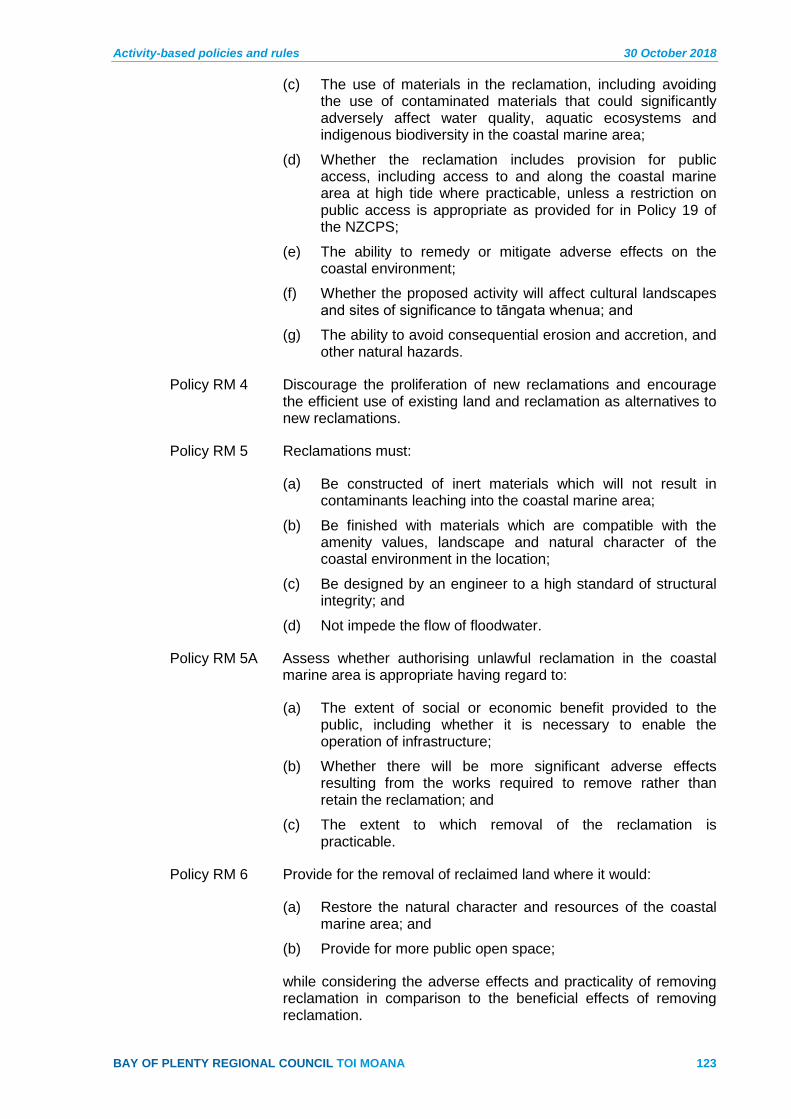
Activity-based policies and rules 30 October 2018
BAY OF PLENTY REGIONAL COUNCIL TOI MOANA 123
The use of materials in the reclamation, including avoiding (c)the use of contaminated materials that could significantly adversely affect water quality, aquatic ecosystems and indigenous biodiversity in the coastal marine area;
Whether the reclamation includes provision for public (d)access, including access to and along the coastal marine area at high tide where practicable, unless a restriction on public access is appropriate as provided for in Policy 19 of the NZCPS;
The ability to remedy or mitigate adverse effects on the (e)coastal environment;
Whether the proposed activity will affect cultural landscapes (f)and sites of significance to tāngata whenua; and
The ability to avoid consequential erosion and accretion, and (g)other natural hazards.
Policy RM 4 Discourage the proliferation of new reclamations and encourage the efficient use of existing land and reclamation as alternatives to new reclamations.
Policy RM 5 Reclamations must:
Be constructed of inert materials which will not result in (a)contaminants leaching into the coastal marine area;
Be finished with materials which are compatible with the (b)amenity values, landscape and natural character of the coastal environment in the location;
Be designed by an engineer to a high standard of structural (c)integrity; and
Not impede the flow of floodwater. (d)
Policy RM 5A Assess whether authorising unlawful reclamation in the coastal marine area is appropriate having regard to:
(a) The extent of social or economic benefit provided to the public, including whether it is necessary to enable the operation of infrastructure;
(b) Whether there will be more significant adverse effects resulting from the works required to remove rather than retain the reclamation; and
(c) The extent to which removal of the reclamation is practicable.
Policy RM 6 Provide for the removal of reclaimed land where it would:
Restore the natural character and resources of the coastal (a)marine area; and
Provide for more public open space; (b)
while considering the adverse effects and practicality of removing reclamation in comparison to the beneficial effects of removing reclamation.

30 October 2018 Activity-based policies and rules
124 Pre-Operative Regional Coastal Environment Plan – 30 October 2018
Rules 4.2
Advisory Note:
1 This section excludes rules for reclamation in the Port Zone. Refer to Section 9 – Port Zone of the Plan for those rules.
Rule RM 1 Restricted Discretionary – Removal of reclamations for specified purposes
The removal of reclamations in the coastal marine area, where the removal is to:
Restore the natural character and resources of the coastal 1marine area; or
Provide for more public open space; or 2
Provide for enhanced public walking access to and along the 3coastal marine area,
is a restricted discretionary activity.
The Regional Council restricts its discretion to the following matters:
Measures to restore the natural character or resources of the (a)coastal marine area; and to avoid, remedy or mitigate adverse effects on historic heritage, or cultural values.
Measures to avoid, remedy or mitigate the discharge of (b)sediment to water.
Measures to avoid, remedy or mitigate erosion, instability or (c)scour to land, the foreshore or seabed as a result of the activity.
The disposal site and management of the material removed (d)from the reclamation.
Timing and duration of works associated with the activity. (e)
Measures to avoid, remedy of mitigate adverse effects on (f)aquatic and terrestrial ecosystems in the coastal environment, including wetlands.
Noise levels and management resulting from the activity. (g)
Measures to minimise the disturbance of the foreshore and (h)seabed.
Measures to avoid the discharge of contaminants (other than (i)sediment) resulting from or associated with the activity.
Monitoring and information requirements. (j)
Rule RM 2 Discretionary – Reclamation and removal of reclamations in the Coastal Marine Area
The:
Reclamation of foreshore or sea-bed in the coastal marine 1area that is not prohibited by a rule in this Plan, or

Activity-based policies and rules 30 October 2018
BAY OF PLENTY REGIONAL COUNCIL TOI MOANA 125
Reclamation of foreshore or sea-bed in the coastal marine 2area that is not non complying under a rule in this Plan, or
Removal of reclamations in the coastal marine area that is 3not otherwise a restricted discretionary activity under Rule RM 1, or
4 The authorisation of a reclamation that has been reclaimed from any part of the coastal marine area unlawfully, where the reclamation occurred before 24 June 2014.
is a discretionary activity.
Rule RM 3 Non-complying – Reclamation associated with regionally significant infrastructure in areas of significant indigenous biological diversity or areas of outstanding natural character
The reclamation of the foreshore or sea-bed in the coastal marine area in an Indigenous Biological Diversity Area A (as identified in Schedule 2, Table 1) or area of Outstanding Natural Character (as identified in Appendix I to the RPS) is a non-complying activity where the reclamation is associated with:
1 The operation, maintenance and protection of existing and new regionally significant infrastructure;
2 Existing marinas and other marine-related service facilities; or
3 Existing and new electricity generation facilities; or
4 The protection, restoration or rehabilitation of the biodiversity or natural character values associated with such areas; or
5 The provision of safe public walking access to, within or adjacent to the coastal marine area; or
6 The provision of access to offshore islands in areas where access points are identified in Schedule 15.
Rule RM 3A Non-complying – Authorisation of an unlawful reclamation under section 355A of the RMA that was constructed after 24 June 2014 in Indigenous Biological Diversity Areas or areas of Outstanding Natural Character
The authorisation of a reclamation that has been reclaimed from the coastal marine area unlawfully in an Indigenous Biological Diversity Area A (as identified in Schedule 2, Table 1) or area of Outstanding Natural Character (as identified in Appendix I to the RPS) is a non-complying activity where the reclamation occurred after 24 June 2014.
Rule RM 4 Prohibited – Reclamation for specified purposes
The reclamation of the foreshore or sea-bed in the coastal marine area, where the reclamation is for any of the following purposes:
Disposal of dredged material as the primary purpose of the 1reclamation;

30 October 2018 Activity-based policies and rules
126 Pre-Operative Regional Coastal Environment Plan – 30 October 2018
Extension to or creation of farmland, playing fields, urban, 2and industrial areas excepting ports, or other marine-related servicing facilities and storage;
Carparks as the primary purpose of the reclamation; or 3
Rubbish disposal, including industrial, horticultural, farm and 4household;
is a prohibited activity.
Advisory Note:
1 The creation of walkways for public access to and along the coastal marine area is excluded from this rule.
Rule RM 5 Prohibited – Reclamation in areas of significant indigenous biological diversity or areas of outstanding natural character
The reclamation of the foreshore or sea-bed in the coastal marine area in an Indigenous Biological Diversity Area A (as identified in Schedule 2, Table 1) or area of Outstanding Natural Character (as identified in Appendix I to the RPS) is a prohibited activity unless a non-complying activity under Rule RM 3 or Rule RM 3A.
5 Taking, using, damming or diversion of coastal water (TD)
Policies 5.1
Policy TD 1 Coastal water shall not be taken in a quantity or at a rate that would cause adverse effects on marine fauna or ecosystems.
Policy TD 2 Damming or diversion of coastal water shall:
(a) Sustain the life-supporting capacity of marine ecosystems;
(b) Avoid adverse effects on the integrity and functioning of ecosystems that are threatened or naturally rare in the coastal environment;
(c) Be consistent with the natural heritage policies of this Plan;
(d) Recognise and provide for the relationship of Māori and their culture and traditions with their ancestral lands, water, sites, wāhi tapu, and other taonga in accordance with Policies IW 1 to IW 11; and
(e) Not increase the risk of flooding.
Policy TD 3 The diversion of unmodified watercourses within the coastal marine area is only appropriate where necessary to:
Protect people and property, including protection from the (a)effects of flooding;
Provide for navigational safety or safe access to the ocean (b)and offshore islands;
Provide for coastal restoration or enhancement, including (c)wetlands; and
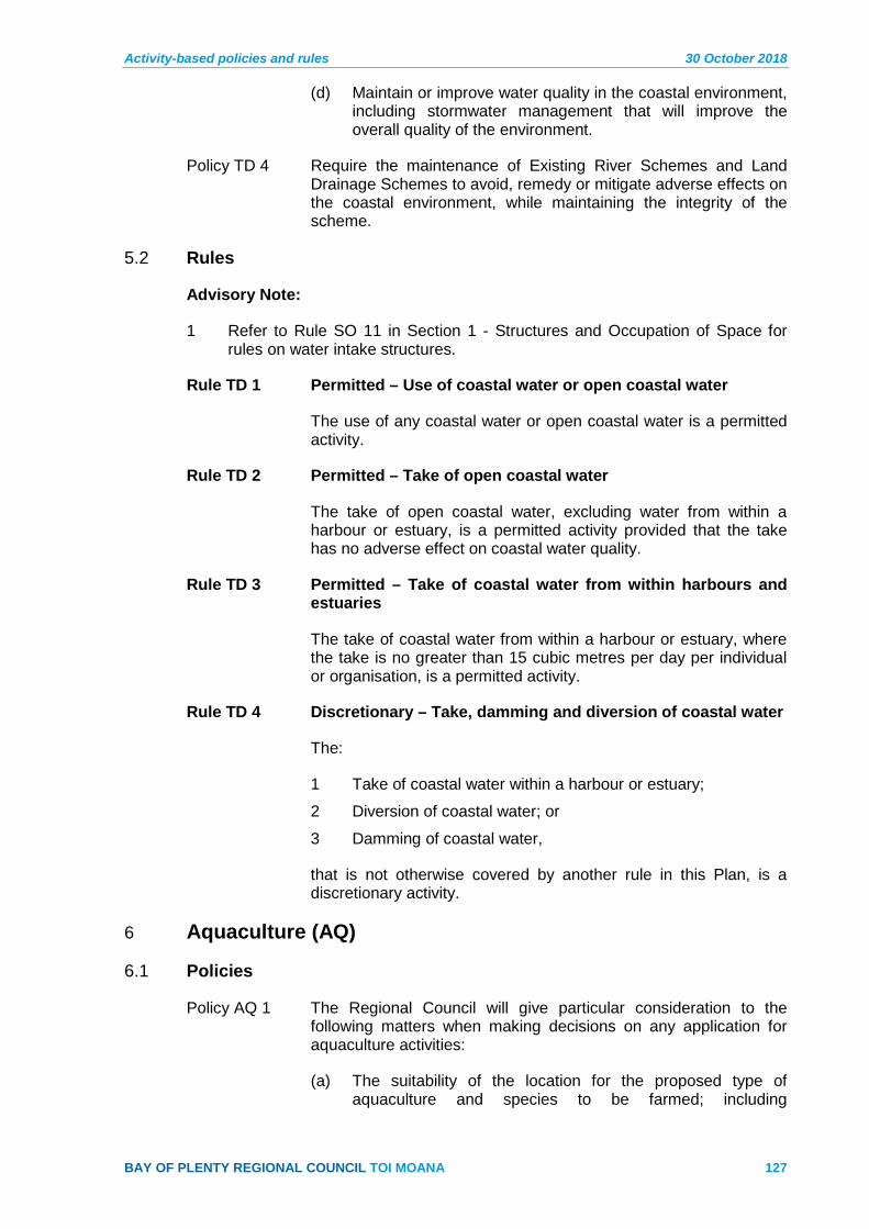
Activity-based policies and rules 30 October 2018
BAY OF PLENTY REGIONAL COUNCIL TOI MOANA 127
Maintain or improve water quality in the coastal environment, (d)including stormwater management that will improve the overall quality of the environment.
Policy TD 4 Require the maintenance of Existing River Schemes and Land Drainage Schemes to avoid, remedy or mitigate adverse effects on the coastal environment, while maintaining the integrity of the scheme.
Rules 5.2
Advisory Note:
1 Refer to Rule SO 11 in Section 1 - Structures and Occupation of Space for rules on water intake structures.
Rule TD 1 Permitted – Use of coastal water or open coastal water
The use of any coastal water or open coastal water is a permitted activity.
Rule TD 2 Permitted – Take of open coastal water
The take of open coastal water, excluding water from within a harbour or estuary, is a permitted activity provided that the take has no adverse effect on coastal water quality.
Rule TD 3 Permitted – Take of coastal water from within harbours and estuaries
The take of coastal water from within a harbour or estuary, where the take is no greater than 15 cubic metres per day per individual or organisation, is a permitted activity.
Rule TD 4 Discretionary – Take, damming and diversion of coastal water
The:
Take of coastal water within a harbour or estuary; 1
Diversion of coastal water; or 2
Damming of coastal water, 3
that is not otherwise covered by another rule in this Plan, is a discretionary activity.
6 Aquaculture (AQ)
Policies 6.1
Policy AQ 1 The Regional Council will give particular consideration to the following matters when making decisions on any application for aquaculture activities:
The suitability of the location for the proposed type of (a)aquaculture and species to be farmed; including
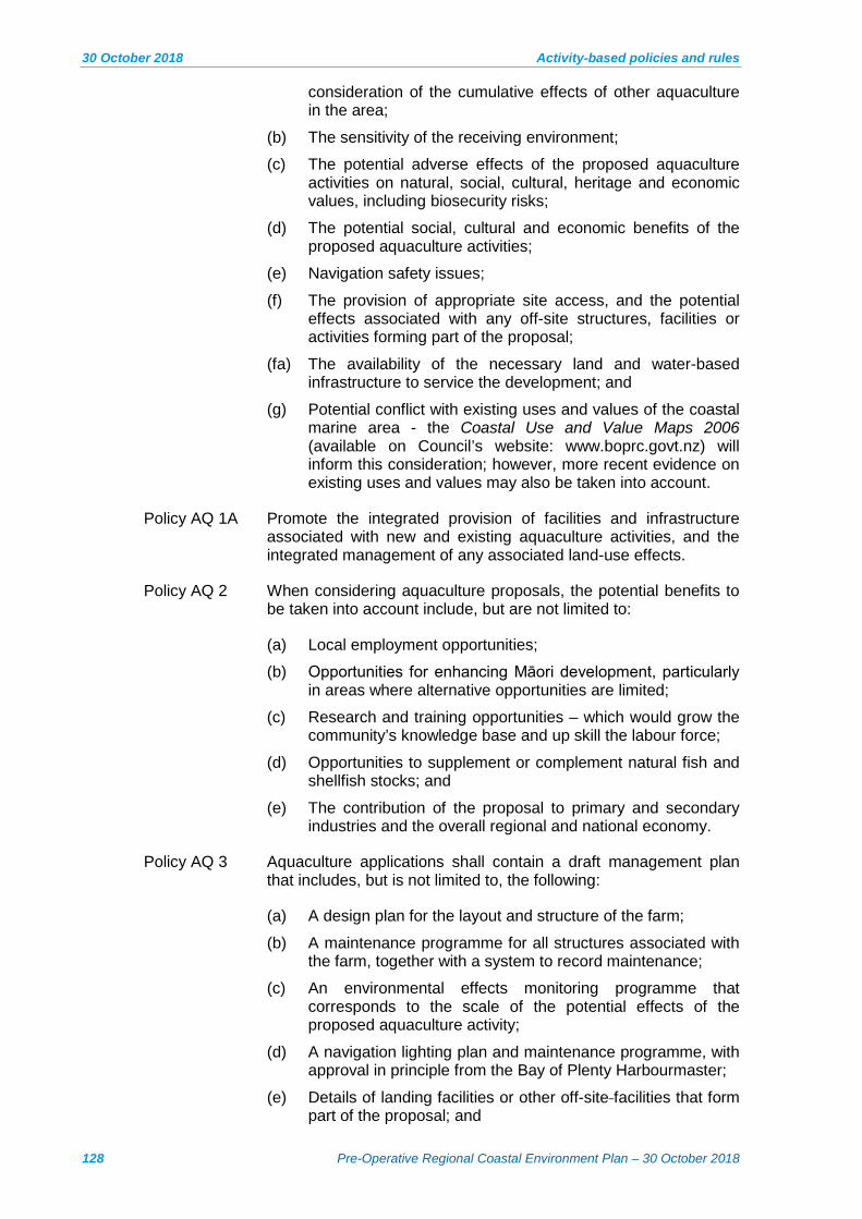
30 October 2018 Activity-based policies and rules
128 Pre-Operative Regional Coastal Environment Plan – 30 October 2018
consideration of the cumulative effects of other aquaculture in the area;
The sensitivity of the receiving environment; (b)
The potential adverse effects of the proposed aquaculture (c)activities on natural, social, cultural, heritage and economic values, including biosecurity risks;
The potential social, cultural and economic benefits of the (d)proposed aquaculture activities;
Navigation safety issues; (e)
The provision of appropriate site access, and the potential (f)effects associated with any off-site structures, facilities or activities forming part of the proposal;
(fa) The availability of the necessary land and water-based infrastructure to service the development; and
Potential conflict with existing uses and values of the coastal (g)marine area - the Coastal Use and Value Maps 2006 (available on Council’s website: www.boprc.govt.nz) will inform this consideration; however, more recent evidence on existing uses and values may also be taken into account.
Policy AQ 1A Promote the integrated provision of facilities and infrastructure associated with new and existing aquaculture activities, and the integrated management of any associated land-use effects.
Policy AQ 2 When considering aquaculture proposals, the potential benefits to be taken into account include, but are not limited to:
Local employment opportunities; (a)
Opportunities for enhancing Māori development, particularly (b)in areas where alternative opportunities are limited;
Research and training opportunities – which would grow the (c)community’s knowledge base and up skill the labour force;
Opportunities to supplement or complement natural fish and (d)shellfish stocks; and
(e) The contribution of the proposal to primary and secondary industries and the overall regional and national economy.
Policy AQ 3 Aquaculture applications shall contain a draft management plan that includes, but is not limited to, the following:
A design plan for the layout and structure of the farm; (a)
A maintenance programme for all structures associated with (b)the farm, together with a system to record maintenance;
An environmental effects monitoring programme that (c)corresponds to the scale of the potential effects of the proposed aquaculture activity;
A navigation lighting plan and maintenance programme, with (d)approval in principle from the Bay of Plenty Harbourmaster;
Details of landing facilities or other off-site facilities that form (e)part of the proposal; and

Activity-based policies and rules 30 October 2018
BAY OF PLENTY REGIONAL COUNCIL TOI MOANA 129
A biosecurity monitoring plan. (f)
Policy AQ 5 Aquaculture developments shall provide access for recreational fishers and other small watercraft to the aquaculture area, except where access restrictions are necessary to protect public health and safety or ensure a level of security consistent with the purpose of a resource consent.
Policy AQ 6 New commercial aquaculture is inappropriate in the following areas:
Any Indigenous Biological Diversity Area A (as identified in (a)Schedule 2, Table 1);
Areas of Outstanding Natural Character (as identified in (b)Appendix I to the RPS);
Within 5.5 kms (three nautical miles) of commercial shipping (c)lanes identified in the Coastal Use and Value Maps 2006 or navigable river mouths;
In any mooring area shown in the maps to this Plan, the Port (d)and Harbour Development Zones; and
New commercial aquaculture may be inappropriate in the areas of cultural significance, which iwi or hapū have identified in the Coastal Use and Value Maps 2006.
Policy AQ 7 Recognise that except for the re-consenting of existing authorised commercial aquaculture, the recreational values of harbours and estuaries in the Bay of Plenty region is such that commercial aquaculture, particularly that relying on the use of structures in the coastal marine area, is inappropriate in these areas unless more than minor adverse effects on public access and recreational use of the coastal marine area can be avoided.
Policy AQ 8 Provide for the continued operation of existing aquaculture activities located in the areas identified in Policy AQ 6 where the marine farm:
Is an existing legally authorised farm that will continue to (a)operate in exactly the same location; and
Has no redundant or derelict structures within the area being (b)applied for.
Policy AQ 9 Non-commercial aquaculture that provides significant environmental, social, cultural or educational benefits may be appropriate in areas of the coastal marine area that are described in Policy AQ 6 and AQ 7.
Policy AQ 10 The Regional Council will require new aquaculture activities to be developed in a staged manner, where:
The potential adverse effects cannot be adequately (a)predicted and are potentially significant;
New species are being introduced and any adverse effects (b)may not be known and are potentially significant;
30 October 2018 Activity-based policies and rules
130 Pre-Operative Regional Coastal Environment Plan – 30 October 2018
New technology is being proposed and the adverse effects (c)from such technology have not been recorded and are potentially significant; or
(e) The sensitivity of the receiving environment to aquaculture activities warrants a precautionary approach.
A staged approach will require:
A baseline environmental survey; (a)
A Development Plan showing the stages appropriate to the (b)scale of the aquaculture activity being applied for;
A staged Environment Limits and Monitoring Programme (c)that will assess environmental change and report on triggers that would allow for or restrict the rate of progression of further stages of the aquaculture development; and
Identification of actions that will be undertaken to avoid, (d)remedy or mitigate effects that exceed the environment limits set by way of consent conditions or within the Environment Limits and Monitoring Programme.
Policy AQ 11 The Regional Council will impose the maximum consent duration allowable under the RMA in order to provide certainty and security to the applicant, except where one or more of the following circumstances apply, in which case the Regional Council may consider limiting the consent duration for aquaculture activities:
The applicant has requested a shorter consent duration; or (a)
A shorter period is required to ensure that adverse effects on (b)the environment are adequately managed – circumstances that may necessitate a shorter period include, but are not limited to:
(i) There is uncertainty regarding the ability of consent conditions to avoid, remedy or mitigate adverse environmental effects;
(ii) There will be foreseeable change to the receiving environment; or
(iii) The receiving environment is particularly sensitive to the potential effects of aquaculture activities.
Policy AQ 12 Where it is deemed necessary relative to risk, the Regional Council will require a reasonable assurance, or in the absence of a reasonable assurance a bond, for new aquaculture activities in the coastal marine area to cover potential costs associated with:
The removal of abandoned or derelict farms; (a)
The restoration or reinstatement of the environment; and (b)
Any emergency repairs or rescue undertaken by the (c)Regional Council on behalf of the consent holder in the event of any part of the marine farm breaking loose or causing a potential navigational hazard.

Activity-based policies and rules 30 October 2018
BAY OF PLENTY REGIONAL COUNCIL TOI MOANA 131
Advisory Note:
1 Examples of reasonable assurance include the establishment of a fidelity fund or a form of insurance.
Policy AQ 13 When assessing the potential effects of aquaculture activities on fisheries resources, the following matters shall be considered as a minimum and at a level of detail appropriate to the significance of the potential effects:
Discharge and deposition of contaminants. (a)
Uptake of phytoplankton and zooplankton. (b)
Effects on the local marine ecosystems. (c)
Hydrodynamic effects. (d)
Nutrient cycling. (e)
Water clarity. (f)
Genetic effects. (g)
Unwanted and exotic species. (h)
Biosecurity. (i)
Effects on associated and dependent species. (j)
Policy AQ 14 All applications for commercial aquaculture ventures shall be accompanied by an assessment of the physical viability of the operation at the intended location. This assessment shall include consideration of whether the water quality in the proposed location is suitable for aquaculture.
Aquaculture rules 6.2
Advisory Note:
1 Under section 68A of the RMA, no aquaculture activity in the coastal marine areas can be included in the Plan as a permitted activity. Aquaculture is defined in section 2 of the RMA as:
aquaculture activities—
means any activity described in section 12 done for the purpose of the (a)breeding, hatching, cultivating, rearing, or ongrowing of fish, aquatic life, or seaweed for harvest if the breeding, hatching, cultivating, rearing, or ongrowing involves the occupation of a coastal marine area; and
includes the taking of harvestable spat if the taking involves the (b)occupation of a coastal marine area; but
does not include an activity specified in paragraph (a) if the fish, aquatic (c)life, or seaweed—
are not in the exclusive and continuous possession or control of the (d)person undertaking the activity; or
cannot be distinguished or kept separate from naturally occurring fish, aquatic life, or seaweed; and

30 October 2018 Activity-based policies and rules
132 Pre-Operative Regional Coastal Environment Plan – 30 October 2018
does not include an activity specified in paragraph (a) or (b) if the activity is carried out solely for the purpose of monitoring the environment.
A permitted rule for the use of structures in the coastal marine area for the purpose of monitoring the environment is included in Section 1.2 – Structures and Occupation of this Plan.
Rule AQ 1 Controlled – Aquaculture Research Existing Species
The:
Erection, reconstruction, placement, alteration, or extension 1of a structure that is fixed in, on, under or over the foreshore or seabed;
Disturbance of the foreshore or seabed associated with the 2structure;
Discharge and deposition of material on the seabed; and 3
Occupation of space in the common marine and coastal 4area.
For the purposes of aquaculture activities undertaken as scientific experiments to research or investigate one or more of the following:
The suitability of an area for aquaculture activities (a)
Species of fish, aquatic life, or seaweed (b)
Aquaculture structures (c)
Aquaculture techniques (d)
is a controlled activity subject to the following conditions:
The maximum footprint of the activity shall be no more than (a)two hectares.
The activity is not located within an area of Outstanding (b)Natural Character (as identified in Appendix I to the RPS) or an Indigenous Biological Diversity Area A (as identified in Schedule 2, Table 1).
The activity is not located in a mooring area shown in the (c)maps to this Plan, the Port or Harbour Development Zone.
The activity shall be limited to a five year duration. (d)
The activity does not require the placement of structures in (e)permanently navigable harbour waters.
The activity will use species that are indigenous to New (f)Zealand or farmed within the region.
The Species to be used in the activity are not listed as a pest (g)in the Regional Pest Management Plan or as an unwanted organism under the Biosecurity Act.
Activity-based policies and rules 30 October 2018
BAY OF PLENTY REGIONAL COUNCIL TOI MOANA 133
The Regional Council has reserved its control over the following matters:
Measures to avoid, remedy or mitigate the adverse effects of (a)the activity on:
(i) Ecology
(ii) Natural character
(iii) Cultural values
(iv) Recreation
(v) Heritage values.
Area of the common marine and coastal area occupied by (b)the activity.
Cumulative effects arising from other aquaculture activities. (c)
The total area being utilised for aquaculture research in the (d)region.
Use of underwater lighting (e)
Antifoulant management on structures – for example the use (f)of antifoulants, cleaning methods and associated discharges.
Navigation and safety requirements. (g)
Duration of the activity. (h)
Requirements to remove all structures, organisms and other (i)items from the research area at the completion of the project.
Use of feed or hormone additives in the coastal marine area. (j)
Monitoring and reporting requirements. (k)
Effects on adjacent land owners or occupiers. (l)
Management of biosecurity risks (m)
Advisory Note:
1 The placement of structures in permanently navigable harbour waters is a non-complying activity under Rule AQ 5.
2 Permanently navigable harbour waters are defined in the Definitions section of this Plan.
Rule AQ 1A Restricted Discretionary - Aquaculture Research – Other Species
The:
1 Erection, reconstruction, placement, alteration, or extension of a structure that is fixed in, on, under or over the foreshore or seabed;
2 Disturbance of the foreshore or seabed associated with the structure 3 Discharge and deposition of material on the seabed
3 Discharge of contaminants to the coastal marine area; and
30 October 2018 Activity-based policies and rules
134 Pre-Operative Regional Coastal Environment Plan – 30 October 2018
4 Occupation of space in the common marine and coastal area.
For the purposes of aquaculture activities undertaken as scientific experiments to research or investigate one or more of the following:
(a) The suitability of an area for aquaculture activities
(b) Species of fish, aquatic life, or seaweed
(c) Aquaculture structures
(d) Aquaculture techniques
is a restricted discretionary activity where it does not with comply with condition (f) of Rule AQ 1, subject to the following conditions:
(a) The maximum footprint of the activity shall be no more than two hectares.
(b) The activity is not located within an area of Outstanding Natural Character (as identified in Appendix I to the RPS) or an Indigenous Biological Diversity Area A (as identified in Schedule 2, Table 1).
(c) The activity is not located in a mooring area shown in the maps to this Plan, the Port or Harbour Development Zone.
(d) The activity shall be limited to a five year duration.
(e) The activity does not require the placement of structures in permanently navigable harbour waters.
The Regional Council restricts its discretion to the following matters:
(a) Measures to avoid, remedy or mitigate the adverse effects of the activity on:
(i) Ecology
(ii) Natural character
(iii) Cultural values
(iv) Recreation
(b) Area of the common marine and coastal area occupied by the activity.
(c) Cumulative effects arising from other aquaculture activities.
(d) The total area being utilised for aquaculture research in the region.
(e) Use of underwater lighting.
(f) Antifoulant management on structures - for example the use of antifoulants cleaning methods and associated discharges.
(g) Navigation safety requirements.
(h) Duration of the activity.

Activity-based policies and rules 30 October 2018
BAY OF PLENTY REGIONAL COUNCIL TOI MOANA 135
(i) Requirements to remove all structures, organisms and other items from the area if the operation is closed.
(j) Use of feed additives in the coastal marine area.
(k) Monitoring and reporting requirements.
(l) Management of biosecurity risks.
Rule AQ 2 Controlled – Aquaculture Enhancing and Restocking Indigenous Coastal Species
The:
Erection, reconstruction, placement, alteration, or extension 1of a structure that is fixed in, on, under or over the foreshore or seabed;
Disturbance of the foreshore or seabed associated with the 2structure;
Discharge and deposition of material on the seabed; and 3
Occupation of space in the common marine and coastal 4area.
An aquaculture activity that is for the purpose of enhancing or restocking indigenous coastal species (kaimoana), including for customary use, is a controlled activity subject to the following conditions:
Only species indigenous to New Zealand shall be used; (a)
Species used in aquaculture shall not be harvested for the (b)purpose of sale;
The activity is not located in a mooring area shown in the (c)maps to this Plan, the Port or Harbour Development Zone;
The activity does not require the placement of structures in (d)permanently navigable harbour waters or areas of Outstanding Natural Character (as identified in Appendix I to the RPS);
No antibiotic, hormone additives or other animal medicines (e)shall be used in the aquaculture activity; and
The maximum footprint of the aquaculture activity shall be no (f)more than two hectares.
The Regional Council has reserved its control over the following matters:
Measures to avoid, remedy or mitigate the adverse effects of (a)the aquaculture activities on:
(i) Ecology
(ii) Natural character
(iii) Cultural values
(iv) Recreation
(v) Heritage values.
30 October 2018 Activity-based policies and rules
136 Pre-Operative Regional Coastal Environment Plan – 30 October 2018
Area of the common marine and coastal area occupied by (b)the aquaculture activity.
Use of underwater lighting (c)
Antifoulant management on structures – for example the use (d)of antifoulants, cleaning methods and associated discharges.
Navigation and safety requirements. (e)
Duration of the activity. (f)
Requirements to remove all structures and other items from (g)the area at the completion of the project.
Use of feed additives in the coastal marine area. (h)
Monitoring and reporting requirements. (i)
Effects on adjacent land owners or occupiers. (j)
Management of biosecurity risks. (k)
Advisory Note:
1 The placement of structures in permanently navigable harbour waters is a non-complying activity under Rule AQ 5.
2 Non-commercial and non-research aquaculture activities requiring the placement of structures in areas of Outstanding Natural Character are a discretionary activity under Rule AQ 4.
3 This rule does not provide for the removal of indigenous vegetation that is growing in the foreshore and seabed.
Rule AQ 2A Controlled – Reconsenting Existing Commercial Aquaculture
The:
1 Erection, reconstruction, placement, alteration, or extension of a structure that is fixed in, on, under or over the foreshore or seabed;
2 Disturbance of the foreshore or seabed associated with the structure;
3 Discharge and deposition of material on the seabed;
4 Discharge of contaminants to the coastal marine area; and
5 Occupation of space in the common marine and coastal area.
for the purpose of:
(a) Reconsenting existing lawfully established commercial aquaculture activities; or
(b) Providing for small extensions to existing marine farms; or
(c) Replacing or reconstructing existing and legally authorised structures.
is a controlled activity subject to the following conditions:
(a) The existing marine farm is not located in an Indigenous Biological Diversity Area A (as identified in Schedule 2,

Activity-based policies and rules 30 October 2018
BAY OF PLENTY REGIONAL COUNCIL TOI MOANA 137
Table 1); or area of Outstanding Natural Character (as identified in Appendix I to the RPS); and
(b) The existing marine farm shall be extended by no more than 10% of the total consented area that existed prior to any consents being granted for extensions.
The Regional Council restricts its control to the following matters:
(a) Measures to avoid, remedy or mitigate the adverse effects of the aquaculture activities on:
(i) Ecology
(ii) Natural character
(iii) Cultural values
(iv) Recreation.
(b) Use of underwater lighting.
(c) Antifoulant management on structures – for example the use of antifoulants, cleaning methods and associated discharges.
(d) Navigation and safety requirements.
(e) Duration of the activity.
(f) Requirements to remove all structures, organisms and other items from the area if the operation is closed.
(g) Use of feed additives in the coastal marine area.
(h) Monitoring and reporting requirements.
(i) Management of biosecurity risks.
Rule AQ 3 Restricted Discretionary – Reconsenting Existing Commercial Aquaculture
The:
Erection, reconstruction, placement, alteration, or extension 1of a structure that is fixed in, on, under or over the foreshore or seabed;
Disturbance of the foreshore or seabed associated with the 2structure;
Discharge and deposition of material on the seabed; 3
Discharge of contaminants to the coastal marine area; and 4
Occupation of space in the common marine and coastal 5area.
in an Indigenous Biological Diversity Area A (as identified in Schedule 2, Table 1); or area of Outstanding Natural Character (as identified in Appendix I to the RPS) for the purpose of:
Reconsenting existing lawfully established commercial (a)aquaculture activities; or
Providing for small extensions to existing marine farms; or (b)
30 October 2018 Activity-based policies and rules
138 Pre-Operative Regional Coastal Environment Plan – 30 October 2018
Replacing or reconstructing existing and legally authorised (c)structure.
is a restricted discretionary activity subject to the following condition:
(b) The existing marine farm shall be extended by no more than 10% of the total consented area that existed prior to any consents being granted for extensions.
The Regional Council restricts its discretion to the following matters:
Measures to avoid, remedy or mitigate the adverse effects of (a)the aquaculture activities on:
(i) Ecology
(ii) Natural character
(iii) Cultural values
(iv) Recreation.
Area of the common marine and coastal area occupied by (b)the aquaculture activity.
Use of underwater lighting. (c)
Antifoulant management on structures – for example the use (d)of antifoulants, cleaning methods and associated discharges.
Navigation and safety requirements. (e)
Duration of the activity. (f)
Requirements to remove all structures, organisms and other (g)items from the area if the operation is closed.
Use of feed additives in the coastal marine area. (h)
Monitoring and reporting requirements. (i)
Management of biosecurity risks. (j)
Rule AQ 4 Discretionary – New Commercial Aquaculture (outside high value areas and permanently navigable harbour waters) and other Non-commercial Aquaculture
Commercial aquaculture where the activity is not prohibited by Rule AQ 6, non-complying under Rule AQ 5 or controlled under Rule AQ 2A; and
Non-commercial aquaculture that is not a controlled activity under Rule AQ 1 a restricted discretionary activity under AQ 1A, or a controlled activity under AQ 2 is a discretionary activity.
For the avoidance of doubt, this rule includes:
(i) Erection, reconstruction, placement, alteration, or extension of a structure that is fixed in, on, under or over the foreshore or seabed;
(ii) Disturbance of the foreshore or seabed associated with the structure;
Activity-based policies and rules 30 October 2018
BAY OF PLENTY REGIONAL COUNCIL TOI MOANA 139
(iii) Occupation of space in the common marine and coastal area;
(iv) Discharge of contaminants to the coastal marine area; and
(v) Deposition of material within the coastal marine area.
In relation to this rule, ‘commercial’ means aquaculture where any species farmed is harvested for the purpose of sale.
Rule AQ 5 Non Complying – New aquaculture structures in permanently navigable harbour waters
The erection or placement of new structures associated with an aquaculture activity within permanently navigable harbour waters is a non-complying activity.
This rule excludes the replacement or reconstruction of existing and legally authorised structures.
Rule AQ 6 Prohibited – New commercial aquaculture in high value areas
The:
Erection, reconstruction, placement, alteration, or extension 1of a structure that is fixed in, on, under or over the foreshore or seabed,
Disturbance of the foreshore or seabed associated with the 2structure,
Occupation of space in the common marine and coastal 3area,
Discharge of contaminants to the coastal marine area, and 4
Deposition of material within the coastal marine area. 5
for the purposes of new commercial aquaculture, where the activity is within one of the following high value areas as listed in Policy AQ 6:
An Indigenous Biological Diversity Area A (as identified in (a)Schedule 2, Table 1).
Areas of Outstanding Natural Character (as identified in (b)Appendix I to the RPS).
Within 5.5 kms (three nautical miles) of commercial shipping (c)lanes or navigable river mouths.
A mooring area shown in the maps to this Plan, Port and (d)Harbour Development Zones.
is a prohibited activity.
30 October 2018 Activity-based policies and rules
140 Pre-Operative Regional Coastal Environment Plan – 30 October 2018
7 Biosecurity (BS)
Policies 7.1
Policy BS 1 Only consider the introduction of exotic plants into the coastal marine area, excluding areas of Outstanding Natural Character (as identified in Appendix I to the RPS) or an Indigenous Biological Diversity Area A (as identified in Schedule 2, Table 1), only where the introduction is necessary for:
Soil conservation or erosion control purposes; or (a)
Prevention or mitigation of flood damage; and (b)
(c) Native plantings are not likely to be effective; and
(d) The species to be introduced are not listed in the National Pest Plant Accord or the Regional Pest Management Plan; and
(e) The species to be introduced is not listed as an unwanted organism under the Biosecurity Act.
Policy BS 2 Avoid or remedy the spread of exotic species and harmful aquatic organisms, particularly spartina and saltwater paspalum, as a result of the contamination of machinery and movement of material.
Policy BS 3 If eradication of spartina or saltwater paspalum is likely to result in erosion, consideration should be given to:
Replacement with native species appropriate to the location (a)as a first preference; or
Replacement with exotic species, subject to Rules BS 1 and (b)BS 4.
Replacement should be undertaken by the landowner or (c)agency which eradicated the spartina or saltwater paspalum.
Policy BS 4 The introduction of exotic plants to the coastal environment should be avoided where the introduction of those plants could have significant adverse effects on:
Landscape values; (a)
Natural character; (b)
The functioning of natural ecosystems; and (c)
The functioning of geophysical processes which form and (d)maintain estuaries and the coastal foredune.
Policy BS 5 When considering resource consent applications for the experimental introduction of exotic plants into the coastal marine area for trial purposes, consider the following matters:
Appropriate measures to ensure as far as practicable that (a)the species will be contained within the trial area;
The establishment and maintenance of suitable monitoring (b)programmes by the operator; and
Activity-based policies and rules 30 October 2018
BAY OF PLENTY REGIONAL COUNCIL TOI MOANA 141
Requirements for bonds of a sufficient amount to ensure (c)eradication if the species should escape.
Policy BS 6 Include conditions on resource consents to avoid the adverse effects of harmful aquatic organisms being released or otherwise spread as a result of activities in the coastal marine area. Such activities include:
The introduction of structures likely to be contaminated with (a)harmful aquatic organisms;
The discharge or disposal of organic material from dredging, (b)or from vessels (including ballast water) and structures, whether during maintenance, cleaning or otherwise; and whether in the coastal marine area or on land;
The provision and ongoing monitoring and maintenance of (c)moorings, marina berths, jetties and wharves; and
The establishment and relocation of equipment and stock (d)required for or associated with aquaculture.
Rules 7.2
Rule BS 1 Permitted – Disturbance of the foreshore or seabed for the removal of exotic plant species
The disturbance of the foreshore or seabed in the coastal marine area to remove exotic plant species, excluding spartina and saltwater paspalum, is a permitted activity, subject to the following conditions:
Only exotic plant species shall be removed. (a)
Exotic vegetation shall only be excavated from the coastal (b)marine area if the vegetation is causing erosion, otherwise the vegetation shall be cut and lifted from the coastal marine area.
The works shall be carried out during low tide or other times (c)when the activity site is not covered by water.
No works shall be carried out in tidal reaches of rivers and (d)streams between 1 March and 31 May.
The activity shall not cause or induce erosion of the bed or (e)banks of any coastal water body, river or stream. Erosion includes:
(i) Instability of the foreshore or seabed, or the banks and beds of rivers and streams; and
(ii) Scour to the foreshore or seabed.
The activity shall not prevent the passage of migrating fish. (f)
The activity shall not compromise the structural integrity or (g)use of any authorised structure or activity in the coastal marine area.
The activity shall not cause a hazard to navigation. (h)
The activity shall not alter the natural or existing course of a (i)river or stream.

30 October 2018 Activity-based policies and rules
142 Pre-Operative Regional Coastal Environment Plan – 30 October 2018
The disturbance of the foreshore or seabed, including by use (j)of vehicles, shall be limited to the extent necessary to remove the exotic plant species and meet the other conditions of this rule.
No refuelling activities or fuel storage shall be carried out (k)within the coastal marine area, on the foreshore or within 20 metres landward of mean high water springs. Methods shall be employed to avoid or minimise any fuel spillage, including the provision of appropriate security and containment measures, where necessary.
All vegetation shall be removed from the foreshore and (l)seabed, placed in a stable position, and all reasonable steps shall be taken to prevent the vegetation material, from entering coastal or other waters.
The activity shall not damage or disturb a site listed in the (m)Regional Historic Heritage Inventory in Schedule 7.
Advisory Notes:
1 Spartina and saltwater paspalum can only be controlled through the use of herbicides. Refer to Rule CD 1 of Section 3 – Coastal Discharges of this Plan for requirements specific to the use of herbicides by spraying.
2 Mangroves are a native species, and their removal is addressed by Mangrove Management Rules DD 18 – 21 in Section 2 – Disturbance, Deposition and Extraction of this Plan.
Rule BS 2 Discretionary – Disturbance of the foreshore or seabed for the removal of exotic plant species
The disturbance of the foreshore or seabed in the coastal marine area to remove exotic plant species, that is not:
prohibited by a rule in this Plan, or (a)
permitted by a rule in this Plan, (b)
is a discretionary activity.
Rule BS 3 Discretionary – Introduction of exotic plant species into the Coastal Marine Area
The introduction of exotic plant species into the coastal marine area that is not covered by Rule BS 3A is not prohibited by a rule in this Plan is a discretionary activity.
Rule BS 3A Non-Complying – Introduction of exotic plant species into IBDA B in the Coastal Marine Area
The introduction of exotic plant species into an Indigenous Biological Diversity Area B (as identified in Schedule 2, Table 2) in the coastal marine area is a non-complying activity.

Activity-based policies and rules 30 October 2018
BAY OF PLENTY REGIONAL COUNCIL TOI MOANA 143
Rule BS 4 Prohibited – Eradication or control of spartina and saltwater paspalum using mechanical harvesting
The disturbance of the coastal marine area resulting from the eradication or control of spartina or saltwater paspalum using mechanical harvesting is a prohibited activity.
Advisory Note:
1 Mechanical harvesting for the eradication or control of spartina and saltwater paspalum is not supported as any rhizome fragments left in the area can be moved by the tide and start new populations in other areas.
Rule BS 5 Prohibited – Introduction of spartina and saltwater paspalum into the Coastal Marine Area
The introduction, including spreading, of spartina and saltwater paspalum in the coastal marine area is a prohibited activity.
Rule BS 6 Prohibited – Introduction of exotic plant species into significant natural heritage areas in the Coastal Marine Area
The introduction of exotic plant species into an Indigenous Biological Diversity Area A (as identified in Schedule 2, Table 1) or areas of Outstanding Natural Character in the coastal marine area (as identified in Appendix I to the RPS) is a prohibited activity.
8 Harbour Development Zone (HD)
Policies 8.1
8.1.1 General policies for the Harbour Development Zone
1 Also refer to the following policies in other sections of this Plan, where relevant to a proposed activity:
All policies in Part 3 – Integrated Resource Management. (a)
Policies DD 7, DD 11 and DD 12 in Part 4, Section 2.1 – Disturbance, (b)Deposition and Extraction section
All policies in Part 4, Section 3.1 – Coastal Discharges. (c)
All policies in Part 4, Section 5.1 – Taking, using, damming or diversion (d)of coastal water.
All policies in Part 4, Section 7.1 – Biosecurity. (e)
All policies in Part 4, Section 10.1 – Noise. (f)
All policies in Part 4, Section 11.1 – Geothermal. (g)
Policy HD 1 Provide for activities that are consistent with the purposes of the Harbour Development Zone. The purpose of the Harbour Development Zone is to:
Concentrate structural development and associated activities (a)in areas that are already modified, so that development is guided away from other coastal areas of higher natural character and cultural value;
30 October 2018 Activity-based policies and rules
144 Pre-Operative Regional Coastal Environment Plan – 30 October 2018
Enable the development of facilities to support commercial, (b)recreational, community, cultural and entertainment activities that are compatible with, or operated in conjunction with the adjoining land use activities, to enable the local community to provide for its social, cultural and economic needs; and
Maintain and enhance public access to, and enjoyment of, (c)the coastal marine area to the extent practicable, recognising that these are important areas for public interaction with the water’s edge.
The Harbour Development Zone is defined in Schedule 8 and shown on map sheets 46c, 47c, 48c, 49c, 50c, 51c and 52c.
Policy HD 2 Natural character values within the Harbour Development Zone are retained to the extent reasonable having regard to the purpose of the zone as set out in Policy HD 1.
Policy HD 3 Activities within the Harbour Development Zone provide for the maintenance and enhancement of public access to and along the coastal marine area, particularly where adjoining land provides public space or areas subject to high levels of recreational or event use.
Policy HD 4 Any restriction on public access to the coastal marine area within the Harbour Development Zone is to be minimised to the extent necessary in accordance with Policies RA 3 and RA 4 in Part 3, Section 6.1 – Recreation, public access and open space.
Policy HD 5 Use and development in the Harbour Development Zone shall be managed according to the following:
Recognise that structures that support commercial, (a)recreational, community, cultural and entertainment activities and enable the local community to provide for its social, cultural and economic needs are appropriate in the Harbour Development Zone;
New structures within the Harbour Development Zone are (b)designed and located in a manner that is compatible with the existing and anticipated activities on the adjoining land. This includes the height, footprint and intended use of buildings and other structures, and maintaining or enhancing the visual amenity of the area;
Recognise that the Harbour Development Zone is a confined (c)area that is well used for a range of activities, and that structures within the coastal marine area reduce the availability of space for marine-based recreational activities, or can support the functioning of marine-based activities in specific areas;
Recognise and provide for the cultural and historic heritage (d)values associated with parts of the Harbour Development Zone where appropriate;
Development shall be appropriate in scale, design and (e)location to complement its waterfront setting and specific location within the Harbour Development Zone; and
Activity-based policies and rules 30 October 2018
BAY OF PLENTY REGIONAL COUNCIL TOI MOANA 145
(f) Recognise and provide for the operation, maintenance and upgrade of existing flood and erosion protection structures in the Harbour Development Zone.
Policy HD 6 When assessing the visual effects of buildings and other structures within the Harbour Development Zone, regard shall be had to:
Maintaining or enhancing the visual environment within the (a)Harbour Development Zone; and
Maintaining or enhancing the visual and physical links (b)between the coastal marine area and adjacent land in urban areas, including town and city centres.
Policy HD 7 Recognise that capital and maintenance dredging within the Harbour Development Zone may be necessary to provide and maintain vessel access to structures and activities, and is appropriate where it can support the purpose of the zone as described in Policy HD 1.
Policy HD 8 Recognise that some activities within the Harbour Development Zone require separation from other existing activities when considering the location and design of new development. Activities that may require separation include marine industries, such as aquaculture servicing and processing facilities.
Policy HD 9 Recognise that reclamation in the Harbour Development Zone may be appropriate in terms of Policy RM 2 in Part 4, Section 4.1 – Reclamation of this Plan and Policy 10 of the NZCPS, provided that it is consistent with the purposes of the Harbour Development Zone described in Policy HD 1.
8.1.2 Additional policy specific to the Tauranga Harbour Development Zone
Policy HD 10 The development of buildings and other structures within the Harbour Development Zone at Tauranga shall:
Maintain the role of the Street View Corridors identified in (a)Appendix 17B to the Tauranga City Plan as a visual connection of Tauranga Harbour, including harbour structures, to the City Centre;
Create an environment that emphasises high-quality, safe (b)public access and amenity;
Be of a bulk and scale that visually compliments the (c)Tauranga city centre waterfront landscape;
Support the use of the waterfront for temporary events; (d)
(e) Support the history of maritime commerce in the area.
8.1.3 Additional policy specific to the Whakatāne Harbour Development Zone
Policy HD 11 Use and development of the Harbour Development Zone at Whakatāne is to provide for the efficient provision of vessel berthing facilities having regard to the need to provide safe vessel storage during periods of high river flow.
30 October 2018 Activity-based policies and rules
146 Pre-Operative Regional Coastal Environment Plan – 30 October 2018
8.1.4 Additional policies specific to the Ōpōtiki Harbour Development Zone
Policy HD 12 Structures associated with the provision of aquaculture processing and servicing facilities are appropriate within the Harbour Development Zone at Ōpōtiki provided adverse effects are avoided, remedied or mitigated.
Policy HD 13 The development of marine industry activities in the Harbour Development Zone at Ōpōtiki should provide for public access to and along the coastal marine area where reasonable and consistent with maintaining health and safety.
8.1.5 Additional policies specific to the Harbour Development Zones in northern Tauranga Harbour
Policy HD 14 The use and development of buildings and other structures within the Harbour Development Zone areas in the northern Tauranga Harbour shall:
Support the maintenance and enhancement of existing (a)facilities and services;
Be consistent with the policy direction of the relevant (b)Reserve Management Plan; and
Recognise and provide for cultural values. (c)
Rules 8.2
Advisory Notes:
1 The following rules in Section 1.2 – Structures and occupation of space apply in the Harbour Development Zone:
• Rule SO 3 – Navigation aids (buoys and beacons).
• Rule SO 4 – Moorings in specified areas.
• Rule SO 5 – Occupation and Use of Moorings and Anchorages.
• Rule SO 6 – Monitoring structures.
• Rule SO 9 – Removal of abandoned structures.
2 The rules in Section 2.2 – Disturbance, Deposition and Extraction apply in the Harbour Development Zone, as appropriate.
3 All the rules in Section 3.2 – Coastal Discharges and Stormwater apply in the Harbour Development Zone.
4 All the rules in Section 4.2 – Reclamation apply in the Harbour Development Zone.
5 All the rules in Section 5.2 – Take and Use of Water apply in the Harbour Development Zone.
6 All the rules in Section 6.2 – Aquaculture apply in the Harbour Development Zone.
7 All the rules in Section 7.2 – Biosecurity apply in the Harbour Development Zone.

Activity-based policies and rules 30 October 2018
BAY OF PLENTY REGIONAL COUNCIL TOI MOANA 147
8 All the rules in Section 10.2 – Noise apply in the Harbour Development Zone, as appropriate.
9 All the rules in Section 11.2 – Geothermal apply in the Harbour Development Zone.
Rule HD 1 Permitted – Maintenance, minor alteration, repair or reconstruction of any lawful structure
The maintenance, minor alteration, repair or reconstruction of any existing lawful structure within the Harbour Development Zone, excluding electricity transmission lines, is a permitted activity, subject to the following conditions:
There shall be no increase in length, width or height of any (a)structure, except for the purposes of:
(i) Replacement, removal or alteration of existing aerial telecommunications structures or cables where these activities will comply with the New Zealand Standard (NZS 2772.1: 1999 Radiofrequency Fields Part 1: Maximum Exposure Levels 3 kHz to 300 GHz), and the new or altered cables will not be lower in height above the foreshore or seabed.
(ii) Replacement, removal, alteration, or addition of telecommunications insulators, circuits, earth wires, earth peaks or lightning rods.
(iii) Replacement or removal of bridge footpaths, bridge side rails, bridge road seal, bridge road signs, bridge road lighting, and cables or pipes attached to bridges.
(iv) Replenishment of existing rock armouring on structures associated with Existing River Schemes and Land Drainage Schemes where there is no increase in the height or length of the structure and the replenishment is consistent with the original design rock placement rate.
Any activity that does not meet the requirements of condition (a) will be considered as a controlled activity under Rule HD 3.
The building or structure shall not result in an increase in the (b)level of the 1% annual exceedance probability (AEP) flood event within the Whakatāne or Waioeka/Otara river schemes.
Any alterations shall be structurally sound and constructed in (c)accordance with good engineering practice.
Public access to, along and through the coastal marine area (d)shall not be restricted, other than temporary restrictions during construction for reasons of public health and safety.
Alterations shall not be for the purposes of new or additional (e)capacity for transport through the coastal marine area of sewage, petroleum products or hazardous substances.

30 October 2018 Activity-based policies and rules
148 Pre-Operative Regional Coastal Environment Plan – 30 October 2018
The activity shall not damage or disturb a site listed in the (f)Regional Historic Heritage Inventory in Schedule 7.
For the avoidance of doubt, this rule covers:
(i) The placement, alteration, extension or removal of structures.
(ii) Occupation of space in the common marine and coastal area by the structure.
(iii) Disturbance of the foreshore and seabed associated with the activity.
(iv) Deposition of material in the coastal marine area associated with the activity.
(v) Discharge of sediment to the coastal marine area resulting from maintenance or alteration of structures
Advisory Note:
1 In the event of any inconsistency with the National Environmental Standards for Electricity Transmission Activities, the Standard prevails over any Rule in this Plan.
Rule HD 2 Permitted – Temporary events, including associated structures
Temporary events in the Harbour Development Zone, including associated structures and buildings, are permitted activities subject to the following conditions:
In the Tauranga Harbour Development Zone, the associated (a)structures and buildings shall not occupy any area for more than 60 days, including the establishment and removal of such structures and buildings.
In all other Harbour Development Zones, the associated (b)structures and buildings shall not occupy any part of the Harbour development Zone for more than 21 days, including the establishment and removal of such structures and buildings.
Lighting sources shall be sited, directed and screened to (c)avoid any hazard to navigation or safety.
The event shall comply with the Regional Council’s (d)Navigation Safety Bylaws or be subject to a Navigation Safety Bylaw Exemption.
Any rubbish or other waste material resulting from the (e)activity shall be removed from the coastal marine area.
The activity shall not obstruct other persons operating in (f)accordance with a resource consent to occupy the coastal marine area.
The activity shall not create the emission of noise that (g)causes a permitted noise limit set for adjoining land in a District or City Plan to be exceeded. Where no noise limits have been set for adjoining land, the emission of noise shall not exceed a reasonable level. This is particularly relevant
Activity-based policies and rules 30 October 2018
BAY OF PLENTY REGIONAL COUNCIL TOI MOANA 149
for sensitive receiving environments such as marae adjoining the coastal marine area.
Any temporary structure shall be located and designed to (h)ensure public and navigational safety;
Any temporary structure shall not be likely to accelerate, (i)worsen or result in material damage to land or any other structure through erosion or inundation;
After removal of any temporary structures the site reinstated (j)to the form and condition that existed before the event.
For the avoidance of doubt, this rule covers:
(i) The placement or removal of structures.
(ii) Occupation of space in the common marine and coastal area by activity and any structure.
(iii) Disturbance of the foreshore and seabed associated with the activity.
(iv) Deposition of material in the coastal marine area associated with the activity.
(v) Discharge of sediment to the coastal marine area resulting from the activity.
Rule HD 3 Controlled – Maintenance, alteration, repair or reconstruction of any lawful structure
The maintenance, alteration, repair or reconstruction of any existing lawful structure within the Harbour Development Zone that does not comply with Rule HD 1 condition (a) is a controlled activity, subject to the following standards and terms:
The proposed works shall not increase the height or footprint (a)of the building or structure by more than 10%, as measured relative to the size of the building or structure at 24 June 2014.
The building or structure shall not result in an increase in the (b)level of the 1% annual exceedance probability (AEP) flood event within the Whakatāne or Waioeka-Otara river schemes.
Any alterations shall be structurally sound and constructed in (c)accordance with good engineering practice.
Public access to, along and through the coastal marine area (d)shall not be restricted, other than temporary restrictions during construction for reasons of public health and safety.
Alterations shall not be for the purposes of new or additional (e)capacity for transport through the coastal marine area of sewage, petroleum products or hazardous substances.
The Regional Council will retain control over the following matters:
The visual appearance of the proposed work when viewed (a)from a public place.

30 October 2018 Activity-based policies and rules
150 Pre-Operative Regional Coastal Environment Plan – 30 October 2018
Measures to avoid, remedy or mitigate adverse effects (b)associated with the method of construction.
Measures to avoid, remedy or mitigate adverse effects on (c)navigation and safety.
Measures to avoid, remedy or mitigate adverse effects on (d)hydrodynamic and geomorphic effects.
Measures to avoid, remedy or mitigate adverse effects on (e)cultural and heritage values under ss 6(e) or 7(a) of the RMA.
Applications for activities under this rule shall be considered without public notification unless special circumstances exist.
For the avoidance of doubt, this rule covers:
(i) The placement, alteration, extension or removal of structures.
(ii) Occupation of space in the common marine and coastal area by the structure.
(iii) Disturbance of the foreshore and seabed associated with the activity.
(iv) Deposition of material in the coastal marine area associated with the activity.
Rule HD 4 Controlled – Reconsenting any lawful structure
The reconsenting of any lawfully authorised structure within the Harbour Development Zone is a controlled activity, subject to the following standards and terms:
The structure shall be structurally sound and constructed in (a)accordance with good engineering practice.
Public access to, along and through the coastal marine area (b)shall not be restricted by the structure.
The Regional Council will retain control over the following matters:
Maintenance of the structure. (a)
Use of the structure. (b)
Measures to avoid, remedy or mitigate adverse effects (c)associated with the maintenance and use of the structure, including on indigenous biodiversity, historic heritage or cultural values under ss 6(e) or 7(a) of the RMA.
Measures to avoid, remedy or mitigate visual effects of the (d)structure on public places;
Measures to avoid, remedy or mitigate adverse effects on (e)hydrodynamic and geomorphic effects (including erosion and scour caused by the structure).
Monitoring and reporting requirements. (f)
Applications for activities under this rule shall be considered without public notification unless special circumstances exist.
Activity-based policies and rules 30 October 2018
BAY OF PLENTY REGIONAL COUNCIL TOI MOANA 151
For the avoidance of doubt, this rule covers:
(i) The alteration or extension of the structure associated with maintenance activities.
(ii) Occupation of space in the common marine and coastal area by the structure.
(iii) Use of the structure.
(iv) Disturbance of the foreshore and seabed associated with the maintenance of the structure.
(v) Deposition of material in the coastal marine area associated with the maintenance of the structure.
(vi) Any disturbance of the foreshore and seabed, discharge into the coastal marine area, or diversion of water within the coastal marine area caused by, or associated with, any existing structures.
Rule HD 5 Controlled – Maintenance dredging activities
Any discharge and disturbance (including removal of sand, shingle, shell, or other natural material) of, the foreshore or seabed associated with maintenance dredging is a controlled activity.
The Regional Council has reserved its control over the following matters:
The area, quantity, location and timing of disturbance and (a)discharge.
Effects on the hydrodynamic and geomorphic regime of the (b)harbour and open coastline, including maintenance of beaches and related sediment transport processes.
Effects on fisheries, indigenous biodiversity and ecosystems. (c)
The release and spread of harmful aquatic organisms. (d)
Coastal water quality including the provisions of Section 3 – (e)Coastal Discharges and Schedule 13 to this Plan.
Effects on other harbour users, navigation and public safety (f)during dredging.
Site specific historical or cultural values under ss 6(e) or 7(a) (g)of the RMA.
The review of conditions and the timing and purpose of that (h)review.
The amount and type of any financial contribution. (i)
Compliance monitoring. (j)
Applications for activities under this rule shall be considered without public notification unless special circumstances exist.

30 October 2018 Activity-based policies and rules
152 Pre-Operative Regional Coastal Environment Plan – 30 October 2018
Rule HD 6 Restricted Discretionary –Alteration or extension of existing structures
The maintenance, alteration, reconstruction or extension of any existing lawful structure within the Harbour Development Zone that is not otherwise a permitted or controlled activity under Rule HD 1, HD 2 or HD 3 is a restricted discretionary activity, subject to the following standards and terms:
The proposed work shall not result in the modification, (a)damage or destruction of any Indigenous Biological Diversity Area A (identified in Table 1, Schedule 2) or Outstanding Natural Character area (as identified in Appendix I to the RPS).
The activity shall not result in an increase in the 1% annual (b)exceedance probability (AEP) flood event within the Whakatāne or Waioeka/Otara river schemes.
Where the structure or building is associated with a (c)temporary event, the event has been authorised by the relevant district or city council.
Structures in the northern Tauranga Harbour areas shall be (d)provided for in a Reserves Management Plan that is relevant to the area.
(e) Adequate provision shall be made for the collection of hazardous substances in sumps or bunded areas, in the design of all new buildings, structures or areas used for the storage or handling of hazardous substances, so as to provide protection in the event of leakage or spillage. Such protection facilities shall be designed, constructed and maintained to have adequate capacity, enable detection of leakage or spillage and prevent discharge to stormwater systems or to the coastal marine area;
(f) Pipework shall be designed, constructed, operated and maintained so as to minimise the risk of discharge of hazardous substances to the coastal marine area. Regular inspection, testing and maintenance, shall be undertaken to ensure pipework is free of defects which may cause leakage or spillage, as required under the Hazardous Substances and New Organisms Act.
The Regional Council restricts its discretion to the following matters:
The compatibility of the structure and its intended use with (a)the purpose of the Harbour Development Zone and the adjacent land use.
The extent to which construction and on-going presence and (b)use of the structure or building provides for or affects the operation of existing commercial and recreational activities and events in the Harbour Development Zone.
The location, dimensions, scale and visual appearance of (c)any structure or building, including the visual appearance of the proposed work when viewed from public viewpoints.
Activity-based policies and rules 30 October 2018
BAY OF PLENTY REGIONAL COUNCIL TOI MOANA 153
For structures in the Tauranga Harbour Development Zone: (d)
(i) The visual appearance of the proposed work when viewed from the Waterfront sub-zone identified in the Tauranga City Plan.
(ii) The extent to which the structure or building affects the view corridors from land to the harbour identified in Policy HD 10.
Measures to avoid, remedy or mitigate any adverse effect of (e)the activity on public access.
Structural integrity. (f)
Measures to avoid, remedy or mitigate any adverse effects (g)on navigation and public safety.
Measures to avoid, remedy or mitigate any adverse effects (h)on hydrodynamic and geomorphic effects.
Measures to avoid, remedy or mitigate adverse effects on (i)cultural and heritage values under ss 6(e) or 7(a) of the RMA.
Nuisance effects, including glare, lighting and noise. (j)
For the avoidance of doubt, this rule covers:
(i) The placement, alteration, extension or removal of structures.
(ii) Occupation of space in the common marine and coastal area by the structure.
(iii) Disturbance of the foreshore and seabed associated with the activity.
(iv) Deposition of material in the coastal marine area associated with the activity.
Applications for activities under this rule shall be considered without public notification unless special circumstances exist.
Rule HD 6A Restricted Discretionary – New structures in the Harbour Development Zone (excluding the Tauranga Harbour Development Zone)
The erection or placement of any new structure or building within the Harbour Development Zone that is not otherwise a permitted or controlled activity under Rule HD 1, HD 2 or HD 3 is a restricted discretionary activity, subject to the following standards and terms:
The proposed work shall not result in the modification, (a)damage or destruction of any Indigenous Biological Diversity Area A (identified in Table 1, Schedule 2) or Outstanding Natural Character area (as identified in Appendix I to the RPS).
The activity shall not result in an increase in the level of the (b)1% annual exceedance probability (AEP) flood event within the Whakatāne or Waioeka/Otara river schemes.

30 October 2018 Activity-based policies and rules
154 Pre-Operative Regional Coastal Environment Plan – 30 October 2018
Where the structure or building is associated with a (c)temporary event, the event has been authorised by the relevant district or city council.
New structures in the northern Tauranga Harbour areas shall (d)be provided for in a Reserves Management Plan that is relevant to the area.
Adequate provision shall be made for the collection of (e)hazardous substances in sumps or bunded areas, in the design of all new buildings, structures or areas used for the storage or handling of hazardous substances, so as to provide protection in the event of leakage or spillage. Such protection facilities shall be designed, constructed and maintained to have adequate capacity, enable detection of leakage or spillage and prevent discharge to stormwater systems or to the coastal marine area;
Pipework shall be designed, constructed, operated and (f)maintained so as to minimise the risk of discharge of hazardous substances to the coastal marine area. Regular inspection, testing and maintenance, shall be undertaken to ensure pipework is free of defects which may cause leakage or spillage, as required under the Hazardous Substances and New Organisms Act.
The Regional Council restricts its discretion to the following matters:
The compatibility of the structure and its intended use with (a)the purpose of the Harbour Development Zone and the adjacent land use.
The extent to which construction and on-going presence and (b)use of the structure or building provides for or affects the operation of existing commercial and recreational activities and events in the Harbour Development Zone.
The location, dimensions, scale and visual appearance of (c)any structure or building, including the visual appearance of the proposed work when viewed from public viewpoints.
Measures to avoid, remedy or mitigate any adverse effect of (d)the activity on public access.
Structural integrity. (e)
Measures to avoid, remedy or mitigate any adverse effects (f)on navigation and public safety.
Measures to avoid, remedy or mitigate any adverse effects (g)on hydrodynamic and geomorphic effects.
Measures to avoid, remedy or mitigate adverse effects on (h)cultural and heritage values under ss 6(e) or 7(a) of the RMA.
Nuisance effects, including glare, lighting and noise. (i)
For the avoidance of doubt, this rule covers:
(i) The placement, alteration, extension or removal of structures.

Activity-based policies and rules 30 October 2018
BAY OF PLENTY REGIONAL COUNCIL TOI MOANA 155
(ii) Occupation of space in the common marine and coastal area by the structure.
(iii) Disturbance of the foreshore and seabed associated with the activity.
(iv) Deposition of material in the coastal marine area associated with the activity.
Rule HD 6B Restricted Discretionary – New structures in the Tauranga Harbour Development Zone)
The erection or placement of any new structure or building within the Tauranga Harbour Development Zone that is not otherwise a permitted or controlled activity under Rule HD 1, HD 2 or HD 3 is a restricted discretionary activity, subject to the following standards and terms:
Where the structure or building is associated with a (a)temporary event, the event has been authorised by the city council.
Adequate provision shall be made for the collection of (b)hazardous substances in sumps or bunded areas, in the design of all new buildings, structures or areas used for the storage or handling of hazardous substances, so as to provide protection in the event of leakage or spillage. Such protection facilities shall be designed, constructed and maintained to have adequate capacity, enable detection of leakage or spillage and prevent discharge to stormwater systems or to the coastal marine area;
Pipework shall be designed, constructed, operated and (c)maintained so as to minimise the risk of discharge of hazardous substances to the coastal marine area. Regular inspection, testing and maintenance, shall be undertaken to ensure pipework is free of defects which may cause leakage or spillage, as required under the Hazardous Substances and New Organisms Act.
The new structure was consented at the time the plan was (d)made operative; or
The new structure is generally consistent with the “Tauranga (e)Waterfront Master Plan – Refined Master Plan Summary Report” prepared by Wraight & Associates Limited and dated 7 October 2010 (R2) as referenced in Consent 66588 and provided in a manner that integrates the management of the Harbour Development Zone with the adjacent Waterfront sub-zone; and
The structure does not impinge on the viewshafts specified (f)in Appendix 17B of the Tauranga City Plan (12 March 2016); and
Use of the structure does not include helicopter landings. (g)
30 October 2018 Activity-based policies and rules
156 Pre-Operative Regional Coastal Environment Plan – 30 October 2018
The Regional Council restricts its discretion to the following matters:
The compatibility of the structure and its intended use with (a)the purpose of the Tauranga Harbour Development Zone and the adjacent land use.
The extent to which construction and on-going presence and (b)use of the structure or building provides for or affects the operation of existing commercial and recreational activities and events in the Tauranga Harbour Development Zone.
The location, dimensions, scale and visual appearance of (c)any structure or building, including the visual appearance of the proposed work when viewed from public viewpoints.
The visual appearance of the proposed work when viewed (d)from the Waterfront sub-zone identified in the Tauranga City Plan.
The extent to which the structure or building affects the view (e)corridors from land to the harbour identified in Policy HD 10.
Measures to avoid, remedy or mitigate any adverse effect of (f)the activity on public access.
Structural integrity. (g)
Measures to avoid, remedy or mitigate any adverse effects (h)on navigation and public safety.
Measures to avoid, remedy or mitigate any adverse effects (i)on hydrodynamic and geomorphic effects.
Measures to avoid, remedy or mitigate adverse effects on (j)cultural and heritage values under ss 6(e) or 7(a) of the RMA.
Nuisance effects, including glare, lighting and noise. (k)
For the avoidance of doubt, this rule covers:
(i) The placement, alteration, extension or removal of structures.
(ii) Occupation of space in the common marine and coastal area by the structure.
(iii) Disturbance of the foreshore and seabed associated with the activity.
(iv) Deposition of material in the coastal marine area associated with the activity.
Applications for activities under this rule shall be considered without public notification unless special circumstances exist.
Rule HD 7 Restricted Discretionary – Dredging in the Harbour Development Zone for vessel access
The disturbance or dredging of the foreshore or seabed within the Harbour Development Zone for the purposes of maintaining safe and practical vessel access to, and use of, existing facilities and structures is a restricted discretionary activity.
Activity-based policies and rules 30 October 2018
BAY OF PLENTY REGIONAL COUNCIL TOI MOANA 157
The Regional Council restricts its discretion to the following matters:
The area, quantity, location and timing of disturbance and (a)discharge.
Effects on the hydrodynamic and geomorphic regime of the (b)harbour and open coastline, including maintenance of beaches and related sediment transport processes.
Effects on fisheries, indigenous biodiversity and ecosystems. (c)
The release and spread of harmful aquatic organisms. (d)
Coastal water quality including the provisions of Section 3 – (e)Coastal Discharges and Schedule 13 to this Plan.
Effects on other harbour users, navigation and public safety (f)during dredging.
Site specific historical or cultural values under ss 6(e) or 7(a) (g)of the RMA.
The review of conditions and the timing and purpose of that (h)review.
The amount and type of any financial contribution. (i)
Compliance monitoring. (j)
For the avoidance of doubt, this rule covers:
(i) Disturbance of the foreshore and seabed associated with the activity.
(ii) Deposition of material in the coastal marine area associated with the activity, except where the material is dredge material.
Rule HD 8 Restricted Discretionary – Demolition or removal of structures in the Harbour Development Zone
The demolition or removal of any structure within the Harbour Development Zone to which Rule SO 9 does not apply is a restricted discretionary activity.
The Regional Council restricts its discretion to the following matters:
Any adverse effect of the activity on public access, amenity (a)values, and other activities within the zone.
Navigation and public safety. (b)
Hydrodynamic and geomorphic effects. (c)
Nuisance effects, including glare, lighting and noise. (d)
Disposal of material, including biosecurity risks. (e)
For the avoidance of doubt, this rule covers:
(i) The removal of structures.

30 October 2018 Activity-based policies and rules
158 Pre-Operative Regional Coastal Environment Plan – 30 October 2018
(ii) Disturbance of the foreshore and seabed associated with the activity.
Rule HD 9 Discretionary – Activities in the Harbour Development Zone
Any activity in the Harbour Development Zone, which is not provided for as a permitted, controlled, restricted discretionary or prohibited activity in this Plan, is a discretionary activity.
Advisory Note:
1 The deposition of dredge material is deemed to be a discretionary activity in accordance with Regulation 4 of the Resource Management (Marine Pollution) Regulations 1998.
9 Port Zone (PZ)
Policies 9.1
Also refer to the following policies of this Plan, where relevant to a proposed activity:
1 All policies in Part 3 Integrated Resource Management.
2 Policies DD 7, DD 11 and DD 12 in the Disturbance, Deposition and Extraction section.
3 All policies in Section 3.1 – Coastal Discharges.
4 All policies in Section 5.1 – Taking, using, damming or diversion of coastal water.
5 All policies in Section 7.1 – Biosecurity.
6 All policies in Section 11.1 – Geothermal.
Policy PZ 1 Recognise that the Port of Tauranga is pivotal to the regional economy and a significant component of the national economy, and that its continued operation is of national significance.
Policy PZ 2 Recognise that provision for the development of additional shipping capacity, including capital dredging, in appropriate locations is important to the continued efficient operation of the Port of Tauranga.
Policy PZ 3 Recognise that the structures, and capital dredging identified in Schedule 9 – Outline Development Plan Port of Tauranga, are appropriate within the Port Zone, subject to appropriate management of adverse effects.
Policy PZ 4 Recognise that maintenance dredging within the Port Zone is necessary for the continued operation of the Port, and is appropriate where it is to provide for the purpose of the Port Zone as described in Policy PZ 5.
Policy PZ 5 Provide for activities that are consistent with the purpose of the Port Zone, which is to:
Enable efficient use of existing port area, so that the regional (a)community may meet its social and economic needs;

Activity-based policies and rules 30 October 2018
BAY OF PLENTY REGIONAL COUNCIL TOI MOANA 159
Concentrate major new structural development in an area (b)already modified, so that development is guided away from other coastal areas of higher natural character, natural landscape, recreational value, and cultural value;
Minimise potential conflict between port activities or port (c)related activities and other activities; and
(d) Enable efficient and ongoing storage of vessels in the Tauranga Bridge Marina.
Activities that will significantly conflict with the achievement of the purpose or compromise Port operations should be avoided.
Policy PZ 5A Provide for the use and development of existing port-related activities where these do not significantly conflict with the achievement of the purpose set out in Policy PZ 5 or compromise the operation of the Port of Tauranga or Port activities.
Policy PZ 5B Recognise that the Tauranga Bridge Marina and Tauranga Harbour Marine Precinct provide recreation and economic benefits, and enable their continued existence, maintenance and development where doing so is consistent with both the purpose of the Port Zone as set out in Policy PZ 5 and with Policy PZ 5A.
Policy PZ 6 Have regard to the role of beach replenishment sites for the continued operation of the Port or Tauranga and take into account the potential benefits of using sand from dredging for the purpose of beach replenishment. Drawing No 324-75 of Schedule 9 – Outline Development Plan Port of Tauranga, identifies appropriate beach replenishment sites for sand dredgings from the Port of Tauranga, but other areas may also be appropriate for be ach replenishment.
Advisory Note:
1 Applications to deliberately dispose of (dump) dredge material in the coastal marine area must include an assessment undertaken in accordance with Schedule 3 to the Resource Management (Marine Pollution) Regulations 1998.
Policy PZ 7 New deposition sites in the coastal marine area (additional to those in Schedule 9 – Outline Development Plan Port of Tauranga) shall meet the requirements of Policy DD 12 of Section 2.1 – Disturbance, Deposition and Extraction.
Policy PZ 8 Manage noise from the Port of Tauranga using the Port Zone noise control boundary and appropriate standards.
Policy PZ 9 Consultation and engagement with the iwi of Ngati Ranginui, Ngaiterangi and Ngati Pūkenga and hapū groups that have a recognised relationship with Tauranga Harbour (Te Awanui) shall be undertaken during development of any proposals that involve capital works, other than any structure or building, excluding the Sulphur Point North End Berth shown on Map 270-27C contained in Schedule 9 to this Plan, within the area that the Port of Tauranga Limited has been granted a section 384A occupation permit.

30 October 2018 Activity-based policies and rules
160 Pre-Operative Regional Coastal Environment Plan – 30 October 2018
Policy PZ 10 Recognise that reclamation identified in Schedule 9 – Outline Development Plan Port of Tauranga is appropriate in terms of Policy PZ 11 of this Plan and Policy 10 of the NZCPS, provided that any adverse effects are appropriately managed, including by use of off-site mitigation.
Policy PZ 11 The consent authority will have particular regard to the following matters when considering the form and design of reclamations in the Port Zone:
The potential effects on the site of climate change, including (a)sea level rise, over no less than 100 years,
The shape of the reclamation, and, where appropriate, (b)whether the materials used are visually and aesthetically compatible with the adjoining coast,
The use of materials in the reclamation, including avoiding (c)the use of contaminated materials that could significantly adversely affect water quality, aquatic ecosystems and indigenous biodiversity in the coastal marine area,
The ability to remedy, mitigate or off-set significant adverse (d)effects on the coastal environment,
Whether the proposed activity will affect sites of significance (e)to Ngati Ranginui, Ngaiterangi and Ngati Pukenga, and
The ability to avoid consequential erosion and accretion, and (f)other natural hazards.
Policy PZ 12 Recognise that:
ASCV 4A and the shipping channels overlap, and that the (a)extent of the shipping channel shown on ASCV 4A is the toe line and that the batter slopes formed will be within Te Paritaha O Te Awanui as will the necessary channel markers; and
Te Paritaha O Te Awanui is situated in a natural dynamic (b)environment that changes and shifts over time.
Rules 9.2
Advisory Notes:
1 All structures will need to meet any requirements of the Civil Aviation Authority, the Civil Aviation Act 1990 and the Civil Aviation Rules including in relation to lighting and marking.
2 The following rules in Section 1.2 – Structures and Occupation of Space apply in the Port Zone:
• Rule SO 3 – Navigation aids (buoys and beacons)
• Rule SO 4 – Moorings in specified areas
• Rule SO 5 – Use of Moorings and Anchorages
• Rule SO 6 – Monitoring structures
• Rule SO 9 – Removal of abandoned structures
3 All the rules in Section 3.2 – Coastal Discharges apply in the Port Zone.
Activity-based policies and rules 30 October 2018
BAY OF PLENTY REGIONAL COUNCIL TOI MOANA 161
4 All the rules in Section 5.4 – Take and Use of Water apply in the Port Zone.
5 All the rules in Section 6 – Aquaculture apply in the Port Zone.
6 All the rules in Section 7 – Biosecurity apply in the Port Zone.
7 Rule NS 1 in Section 10.2 – Noise in the Port Zone.
8 All the rules in Section 11.2 – Geothermal apply in the Port Zone.
Rule PZ 1 Permitted – Noise from activities in the Port Zone
The emission of noise from activities in the coastal marine area of the Port Zone is a permitted activity, subject to the noise not exceeding the following conditions:
The long-term average sound level (Ldn) from all activities (a)within the Port Zone shall not exceed 55 dBA at any point outside the 55 dBA noise control boundary (shown on Map Sheet 11c) nor 65 dBA at any point outside the 65 dBA noise control boundary;
No single 15-minute sound measurement level shall exceed (b)65 dBA Leq between 2200 and 0700 at any point outside the 65 dBA noise control boundary;
The night-time maximum sound level (Lmax) shall not (c)exceed 85 dBA at any point outside of the 65 dBA noise control boundary;
Sound levels shall be measured in accordance with NZS (d)6801:2008 Acoustics - Measurement of Sound and assessed in accordance with NZS6809:1999 Acoustics – Port Noise Management and Land Use Planning.
Rule PZ 2 Permitted – Maintenance, minor alteration, repair or reconstruction of any lawful structure and erection of new buildings and ancillary services
The maintenance, minor alteration, repair, removal or (a)reconstruction of any existing lawful structure within the Port Zone, excluding electricity transmission lines; or
The reconstruction of existing wharf, jetty, pontoon or (b)gangway structures incorporating enhancements to accommodate modern shipping needs and changes to vessel design, provided that the overall structural form of the structure is not significantly altered from the original and adds no more than 10% to the horizontal or vertical cross-sectional area of the structure; or
Erection or placement or removal of any building on existing (c)structures for port activities or port related activities; or
Erection or placement of structures and services ancillary to (d)lawfully existing structures, buildings, port activities and port related activities;
is a permitted activity, subject to the following conditions:
The purpose of any additions or alterations must be for port (a)activities, port related activities or municipal infrastructure;
30 October 2018 Activity-based policies and rules
162 Pre-Operative Regional Coastal Environment Plan – 30 October 2018
The maximum height of any permanent building or structure (b)shall not exceed 25 metres;
The permitted noise requirements of Rule PZ 1 are met; (c)
All requirements of the Civil Aviation Authority, including (d)approval under Rule 77 of the Civil Aviation Rules, and requirements of the Tauranga Airport are met;
Adequate provision shall be made for the collection of (e)hazardous substances in sumps or bunded areas, in the design of all new buildings, structures or areas used for the storage or handling of hazardous substances, so as to provide protection in the event of leakage or spillage. Such protection facilities shall be designed, constructed and maintained to have adequate capacity, enable detection of leakage or spillage and prevent discharge to stormwater systems or to the coastal marine area;
Pipework shall be designed, constructed, operated and (f)maintained so as to minimise the risk of discharge of hazardous substances to the coastal marine area. Regular inspection, testing and maintenance, shall be undertaken to ensure pipework is free of defects which may cause leakage or spillage, as required under the Hazardous Substances and New Organisms Act; and
All exterior lighting associated with the activity shall be (g)managed so as to avoid the spill of light or glare that might be:
(i) Detrimental to other users; or
(ii) Detrimental to wildlife; or
(iii) A hazard to traffic safety on streets outside the coastal marine area; or
(iv) A hazard to navigation in the coastal marine area;
unless such lighting is necessary for reasons of public safety or operational safety.
Rule PZ 3 Permitted – Maintenance of Berths
The maintenance or repair of any existing berth that is required to maintain the required integrity of the berth and associated structure is a permitted activity, subject to the following conditions:
The purpose of the works must be for port activities or port (a)related activities;
Any materials deposited in the coastal marine as part of the (b)repair or maintenance works shall be inert materials that are free from hazardous substances;
The permitted noise requirements of Rule PZ 1 are met; and (c)
Any material removed from the seabed shall be deposited in (d)an authorised deposition site in the coastal marine area or at an appropriate land-based facility.
Activity-based policies and rules 30 October 2018
BAY OF PLENTY REGIONAL COUNCIL TOI MOANA 163
For the avoidance of doubt, this rule covers:
(i) Disturbance of the foreshore and seabed associated with the activity.
(ii) Deposition of material in the coastal marine area associated with the activity.
(iii) Discharge of sediment to the coastal marine area resulting from maintenance or alteration of structures.
Rule PZ 4 Permitted – Wharf Cranes
The erection, reconstruction, placement, alteration or extension of any wharf crane on the existing Sulphur Point Wharf, a portion of the proposed Sulphur Point Extension South (being 286 metres south of the existing Sulphur Point Wharf), and the Mt Maunganui Wharves north of the southern end of Berth 11 is a permitted activity, provided that:
The crane or any alteration or extension to it does not (a)exceed 100 metres (Moturiki datum) at any time, and
All requirements of the Civil Aviation Authority, including (b)approval under Rule 77 of the Civil Aviation Rules, and requirements of the Tauranga Airport are met;
For any port cranes on the Sulphur Point Wharves in the (c)area between 122 and 286 metres south of the existing Sulphur Point Wharves, it can be demonstrated that the navigational equipment at the Tauranga Airport has been upgraded sufficient to meet the requirements of the Civil Aviation Authority and the Tauranga Airport.
In this rule, ‘extension’ and ‘extended’ refer to the maximum vertical extension that can be achieved by any part of the crane.
Note: The existing Sulphur Point Wharf is shown in the Outline Development Plan referred to as Drawing No. 270-27 Amendment C contained in Schedule 9 to this Plan. The existing southern end of Berth 11 of the Mount Wharf is shown in the Outline Development Plan referred to as Drawing No. 270-68 Amendment C contained in Schedule 9 to this Plan.
Rule PZ 5 Controlled – Maintenance dredging activities
Any discharge and disturbance (including removal of sand, shingle, shell, or other natural material) of, the foreshore or seabed associated with maintenance dredging is a controlled activity.
The Regional Council has reserved its control over the following matters:
The area, quantity, location and timing of disturbance and (a)discharge.
Effects on the hydrodynamic and geomorphic regime of the (b)harbour and open coastline, including maintenance of beaches and related sediment transport processes.
Effects on fisheries, indigenous biodiversity and ecosystems. (c)

30 October 2018 Activity-based policies and rules
164 Pre-Operative Regional Coastal Environment Plan – 30 October 2018
The release and spread of harmful aquatic organisms. (d)
Coastal water quality including the provisions of Section 3 – (e)Coastal Discharges and Schedule 13 to this Plan.
Effects on other harbour users, navigation and public safety (f)during dredging.
Site specific historical or cultural values under ss 6(e) or 7(a) (g)of the RMA.
The review of conditions and the timing and purpose of that (h)review.
The amount and type of any financial contribution. (i)
Compliance monitoring. (j)
Applications for activities under this rule shall be considered without public notification unless special circumstances exist.
Rule PZ 5A Occupation of space and associated lawfully established structures
The following is a controlled activity:
1 The occupation of the common marine and coastal area by the Port of Tauranga Limited provided this is within the area shown in the current occupation permit granted to the Port under section 384A of the Resource Management Act 1991; and
2 The occupation of the common marine and coastal area by structures and activities in the Port Zone that were established at the date this Plan became operative.
The Regional Council reserves its control over the following matters:
(a) The duration of the consent having regard to the role of the Port as one of the Region's most significant pieces of infrastructure.
(b) Measures to avoid, remedy or mitigate adverse effects associated with maintenance and use of the structure including on indigenous biodiversity or cultural values under ss 6(e) or 7(a) of the RMA;
(c) Measures to avoid, remedy or mitigate adverse effects on hydrodynamics and geomorphics.
For the avoidance of doubt, the matters this Rule covers include:
(i) Any structure or any part of a structure fixed in, on, under, or over the foreshore or seabed.
(ii) Any disturbance of the foreshore and seabed, deposition of material to the seabed, discharge into the coastal marine area, or diversion of water within the coastal marine area caused by, or associated with, any existing structures.
(iii) Occupation of the common marine and coastal area.

Activity-based policies and rules 30 October 2018
BAY OF PLENTY REGIONAL COUNCIL TOI MOANA 165
Applications for activities under this Rule shall be considered without public notification unless special circumstances exist.
Rule PZ 5B: Controlled - Reconstruction of existing structures
Any reconstruction of lawfully established structures provided for in permitted activity Rule PZ 2(b), where reconstruction exceeds 10% of the horizontal or vertical cross-sectional areas of the structure at 24 June 2014, but all other conditions of Rule PZ 2 can be met, is a controlled activity.
The Regional Council has reserved its control over the following matters:
(a) The hydrodynamic and geomorphic effects on Tauranga Harbour; and
(b) Effects arising from the area, quantity, location and timing of any related disturbance and discharge; and
(c) Effects on the efficient operation of the Port of Tauranga, including its shipping channels.
Applications for activities under this Rule shall be considered without public notification or served on affected persons.
For the avoidance of doubt, this Rule covers:
(i) The erection or placement, alteration, extension or removal of structures and any associated batter slope.
(ii) Occupation of space in the common marine and coastal area by the structure.
(iii) Any disturbance of the foreshore and seabed associated with the activity.
(iv) Deposition of material in the coastal marine area associated with the activity.
(v) Any discharge associated with the construction or removal activity.
Rule PZ 6 Restricted Discretionary – Other buildings and structures in the Port Zone
With the exclusion of the Sulphur Point North End Berth shown on Map 270-27C contained in Schedule 9 to this Plan, the erection, reconstruction, placement, alteration, extension, removal or demolition of:
Any structure or building (excluding cranes) within the area (a)that the Port of Tauranga Limited has been granted a section 384A occupation permit that is not a permitted, or controlled activity is a restricted discretionary activity.
For the avoidance of doubt, this rule covers:
(i) The erection or placement, alteration, extension or removal of structures.
30 October 2018 Activity-based policies and rules
166 Pre-Operative Regional Coastal Environment Plan – 30 October 2018
(ii) Occupation of space in the common marine and coastal area by the structure.
(iii) Disturbance of the foreshore and seabed associated with the activity, including dredging required as part of the construction.
(iv) Deposition of material in the coastal marine area associated with the activity.
(v) Any discharge associated with the construction or removal activity.
The Regional Council restricts its discretion to the following matters:
The compatibility of the structure and its intended use with (a)the purpose of the Port Zone.
The finished visual appearance when viewed from a public (b)place.
The effects of glare and lighting. (c)
Structural integrity. (d)
Effects on the hydrodynamic and geomorphic regime of the (e)harbour.
Effects during construction on other harbour users, aviation, (f)navigation and public safety.
Management of hazardous substances (for buildings, (g)structures or areas used for the storage or handling of hazardous substances).
The review of conditions and the timing and purpose of that (h)review.
The amount and type of any financial contribution. (i)
Compliance monitoring. (j)
The quantity, location and timing of discharge. (k)
Coastal water quality including the provisions of Section 3 – (l)Coastal Discharges and Schedule 13 to this Plan.
The area, quantity, location and timing of any disturbance or (m)deposition.
The materials deposited. (n)
Site specific historical or cultural values under ss 6(e) or 7(a) (o)of the RMA.
Applications for activities under this rule shall be considered without public notification or served on affected persons, with the exception of the Tauranga Airport Authority and the Port of Tauranga.
Note: This Rule applies to the area occupied by the Port of Tauranga Limited under its current coastal occupation permit granted under section 384A of the Resource Management Act 1991. The extent of this area is shown for indicative purposes on Map Series 11c in this Plan. Rule PZ 6 applies in this area for port-

Activity-based policies and rules 30 October 2018
BAY OF PLENTY REGIONAL COUNCIL TOI MOANA 167
related activities as well as the activities undertaken by the Port of Tauranga.
Rule PZ 7 Restricted Discretionary – Cranes exceeding the permitted height or location
The erection, reconstruction, placement, alteration or extension of any wharf crane that exceeds the permitted height or location in Rule PZ 4 is a restricted discretionary activity.
The Regional Council restricts its discretion to the following matters:
The impact on the airport height restrictions identified in map (a)sheets 9c, 10c, 11c, 12c, 13c, 14c, and 15c.
The safe operation of Tauranga City Airport. (b)
Applications for activities under this rule shall be considered without public notification or served on affected persons, with the exception of the Tauranga Airport Authority.
Rule PZ 8 Restricted Discretionary – Specified dredging activities
Any discharge and disturbance (including removal of sand, shingle, shell, or other natural material) of, the foreshore or seabed for the following activities as shown on Plan 270-67 in Schedule 9 to this Plan:
Construction of the Sulphur Point North End Berth and (a)Shipping Channel,
Construction of the Sulphur Point Wharf Extension South (b)Sitting Basin and Shipping Channel,
Deepening of the Sulphur Point Town Reach (c)
The Mount Maunganui Wharfs Future Berth Deepening as (d)shown on Plan 270-25B, and
Deeping of the existing entrance passing lane (e)
is a restricted discretionary activity.
The Regional Council restricts its discretion to the following matters:
The area, quantity, location and timing of disturbance and (a)discharge.
Effects on the hydrodynamic and geomorphic regime of the (b)harbour and open coastline.
Effects on marine life and ecosystems. (c)
The release and spread of harmful aquatic organisms. (d)
Coastal water quality including the provisions of Section 3 – (e)Coastal Discharges and Schedule 13 to this Plan.
Effects on other harbour users, navigation and public safety (f)during construction.
30 October 2018 Activity-based policies and rules
168 Pre-Operative Regional Coastal Environment Plan – 30 October 2018
Site specific historical or cultural values under ss 6(e) or 7(a) (g)of the RMA.
The review of conditions and the timing and purpose of that (h)review.
The amount and type of any financial contribution. (i)
Compliance monitoring. (j)
Applications for activities under this rule shall be considered without public notification unless special circumstances exist.
Rule PZ 9 Restricted Discretionary – specified reclamations
The discharge, reclamation and deposition onto the foreshore or seabed for the following reclamations shown in Schedule 9 to this Plan:
Construction of the Sulphur Point Wharf Extension South to (a)accommodate the future wharf extension shown on drawing 270-27 in Schedule 9 to this Plan; and
Construction of the Mt Maunganui Wharf Extension South to (b)accommodate the future wharf extensions shown on drawing 270-68 in Schedule 9 to this Plan.
is a restricted discretionary activity.
The Regional Council restricts its discretion to the following matters:
The matters listed in Policy PZ 11. (a)
The material, quantity, area, location and timing of (b)deposition, reclamation and discharge.
Effects on the hydrodynamic and geomorphic regime of the (c)harbour.
Coastal water quality including the provisions of Section 3 – (d)Coastal Discharges and Schedule 13 to this Plan.
Effects on other harbour users, navigation and public safety (e)during construction.
Site specific historical or cultural values under ss 6(e) or 7(a) (f)of the RMA.
The review of conditions and the timing and purpose of that (g)review.
The amount and type of any financial contribution. (h)
Compliance monitoring. (i)
Applications for activities under this rule shall be considered without public notification unless special circumstances exist.
Rule PZ 9A Discretionary – specified dumping activities
Any deposition on, and discharge and disturbance of, the foreshore or seabed associated with the dumping of dredge

Activity-based policies and rules 30 October 2018
BAY OF PLENTY REGIONAL COUNCIL TOI MOANA 169
material in the deposition and replenishment sites identified in Schedule 9 to this Plan is a discretionary activity.
Applications for activities under this Rule shall be considered without public notification unless special circumstances exist.
Rule PZ 10 Discretionary – Activities in the Port Zone
Any activity in the Port Zone, which is not provided for as a permitted, controlled, restricted discretionary or prohibited activity, is a discretionary activity.
Advisory Notes:
1 An application to construct the new Otumoetai Shipping Channel, shown on Maps 270-65 and 270-67, will be considered as a discretionary activity under this rule.
2 The dumping of dredge material is deemed to be a discretionary activity in accordance with Regulation 4 of the Resource Management (Marine Pollution) Regulations 1998.
10 Noise (NS)
Policies 10.1
Policy NS 1 Recreational vessels such as personal watercraft, water ski boats, and hovercraft, which exceed the noise standards, should only operate within the personal watercraft and water ski areas identified in the Bay of Plenty Regional Council Navigation Safety Bylaws, or beyond 200 metres off the coast.
Policy NS 2 Protect the natural character and amenity values of the Tauranga Harbour (excluding the Port Zone) and Ōhiwa Harbour coastal environments from the adverse effects of noise.
Policy NS 3 In the coastal marine area outside the Tauranga Harbour, Port Zone and Ōhiwa Harbour, apply best management practices to manage noise, except in relation to Policy NS 4.
Advisory Note:
1 The 2013 Code of Conduct for Minimising Acoustic Disturbance to Marine Mammals from Seismic Survey Operations is an example of best management practice.
Policy NS 4 Manage noise resulting from activities that otherwise need a resource consent under this Plan as part of those consents.
Refer to Section 9 – Port Zone of this Plan for noise management in the Port of Tauranga.
Rules 10.2
Advisory Note:
1 Refer to Rule PZ 1 in Section 9.2 - Port Zone for the emission of noise from activities within the Port Zone in Tauranga Harbour.
30 October 2018 Activity-based policies and rules
170 Pre-Operative Regional Coastal Environment Plan – 30 October 2018
Rule NS 1 Permitted – Emission of noise from specified activities in the Coastal Marine Area
The emission of noise from the following activities in the coastal marine area:
Noise generated by navigational aids, safety signals, (a)warning devices, or emergency pressure relief valves;
Noise generated by emergency work undertaken to protect (b)human life, or to prevent loss or serious damage to property, or minimise or prevent environmental damage;
Noise generated by the discharge of firearms by licensed (c)hunters;
Noise generated by the use of weapons and the subsequent (d)detonation of munitions by the New Zealand Defence Forces;
Noise generated by the use of vessels within the water ski (e)access lanes and areas or personal watercraft areas identified in the Bay of Plenty Regional Council Navigation Safety Bylaws; and
Noise generated from temporary events, (f)
is a permitted activity, subject to the person(s) carrying out the activity using best management practices to ensure the emission of noise does not exceed a reasonable level, including measures to reduce noise effects on marine mammals.
Rule NS 2 Permitted – Emission of Noise in the Tauranga Harbour (excluding the Port Zone) and Ōhiwa Harbour
The emission of noise from activities in the coastal marine area of:
Tauranga Harbour, excluding the Port Zone; and (a)
Ōhiwa Harbour, (b)
is a permitted activity, subject to the noise not exceeding the following conditions:
Night time – 45 dBA L10; and an LMAX of the lower of (a)75dBA or the background sound level plus 30.
Day time – 55 dBA L10. The day time period is between (b)7.00 am – 10.00 pm.
This rule does not apply to the activities permitted in Rule NS 1.
For the purpose of this rule, the entrances of the Tauranga Harbour are defined by lines drawn across the Katikati entrance at U13 744104, U13 744100; and at the Tauranga entrance at U14 892914, U14 897914.
For the purpose of this rule, the entrance of the Ōhiwa Harbour is defined by a line drawn across the Ōhiwa Entrance at W15 744485, W15 748485.
Activity-based policies and rules 30 October 2018
BAY OF PLENTY REGIONAL COUNCIL TOI MOANA 171
The noise levels will be measured and assessed in accordance with the requirements of NZS 6801:1991 Measurement of Sound and NZS 6802:1991 Assessment of Environmental Sound. Noise will be measured at:
(i) Whichever is the lesser of, a residential property boundary or 20 metres from a residential building; and
(ii) The boundaries of any Indigenous Biological Diversity Area A (as identified in Schedule 2, Table 1).
Rule NS 3 Permitted – Emission of noise from other activities in the Coastal Marine Area
The emission of noise from activities in the coastal marine area outside:
(i) Tauranga Harbour and the Port Zone; and
(ii) Ōhiwa Harbour,
and not otherwise permitted by Rule NS 1, is a permitted activity, subject to the person(s) carrying out the activity using best management practices to ensure the emission of noise does not exceed a reasonable level.
Rule NS 4 Discretionary – Emission of Noise from activities in the Coastal Marine Area
The emission of noise in the coastal marine area that is not permitted by a rule in this Plan is a discretionary activity.
11 Geothermal Resources (GR)
Policies 11.1
Policy GR 1 Provide for research into the characteristics of geothermal systems in the coastal marine area that is necessary to support reclassification into an appropriate Geothermal Management Group. This includes the take and discharge of geothermal water for investigation purposes.
Policy GR 2 Manage the take, sustainable use and discharge of geothermal energy and water in the coastal marine area to avoid significant adverse effects on significant geothermal features.
Policy GR 3 Apply the following policies in the RPS when considering resource consent applications for the take, sustainable use and discharge of geothermal energy and water in the coastal marine area: Policies GR 2A(c), GR 3A, GR 5B, GR 6B, GR 8B, GR 9B, GR 12B.
Policy GR 4 Assess any research system that is identified in the Bay of Plenty region to determine its Geothermal Management Group classification (as specified in the RPS). To avoid development of a research system where it has not yet been classified in an appropriate Geothermal Management Group.
30 October 2018 Activity-based policies and rules
172 Pre-Operative Regional Coastal Environment Plan – 30 October 2018
Rules 11.2
Rule GR 1 Permitted – Take and use of geothermal water, heat or energy in the Coastal Marine Area in accordance with tikanga Māori
The take and use of geothermal water, heat or energy, in the coastal marine area, where the activity is in accordance with Section 14(3)(c) of the Resource Management Act 1991, is a permitted activity.
Advisory Note:
1 This rule is intended for the sustainable use of geothermal water, heat or energy for traditional Māori uses.
Rule GR 2 Discretionary – Activities associated with research and investigation of geothermal resources in the coastal marine area
The research and investigation of geothermal resources in the coastal marine area, including:
Take and use of geothermal water, heat or energy, (a)
Discharge of geothermal water, heat or energy, (b)
Disturbance of the foreshore or seabed resulting from the (c)installation of geothermal bores or research structures,
Geothermal bore or research and research structures, (d)
Discharge of drilling fluids, and (e)
Damming or diversion of geothermal water, and associated (f)structures,
is a discretionary activity.
For the avoidance of doubt, all relevant activities in 1 to 6 above will be considered as part of one resource consent.
Multiple drilling sites within a defined area will be considered within a single resource consent.
Advisory Note:
1 The installation of geothermal bores must also comply with Occupational Safety and Health regulations.
Rule GR 3 Non-Complying – Activities associated with development of geothermal resources in the coastal marine area
The development geothermal resources in the coastal marine area, including:
Take and use of geothermal water, heat or energy; (a)
Discharge of geothermal water, heat or energy; (b)
Disturbance of the foreshore or seabed resulting from the (c)installation of geothermal bores;
Activity-based policies and rules 30 October 2018
BAY OF PLENTY REGIONAL COUNCIL TOI MOANA 173
Discharge of drilling fluids; and (d)
Damming or diversion of geothermal water, and associated (e)structures;
is a non-complying activity.
Advisory Note:
1 The installation of geothermal bores must also comply with Occupational Safety and Health regulations.


Activity-based policies and rules 30 October 2018
BAY OF PLENTY REGIONAL COUNCIL TOI MOANA 175
12 Summary of Rules
The tables in this section summarise the rules which apply to the coastal marine area of the Bay of Plenty.
The rules are written out in full in the sections after the relevant policies. This is to assist readers who wish to view the rules in the context of particular policies. For regulatory purposes, it is the rules as set out in each chapter that are to be applied.
The rules are to be read subject to the following definitions:
1 The rules apply to activities in the coastal marine area only. They do not apply to activities on land outside the coastal marine area. The coastal marine area is described in Part 1, Section 3 – Plan Coverage.
2 Where an activity is a prohibited activity in the rules of this Plan, no resource consent shall be granted (refer to Section 2 of the Resource Management Act 1991).
3 Where a rule refers to the discharge of contaminants, it does not include the discharge of contaminants to air (refer to the Bay of Plenty Regional Air Plan).
4 Indigenous Biological Diversity Area A is an area that meets the criteria listed in Policy 11(a) of the NZCPS. These areas are identified in Schedule 2, Table 1.
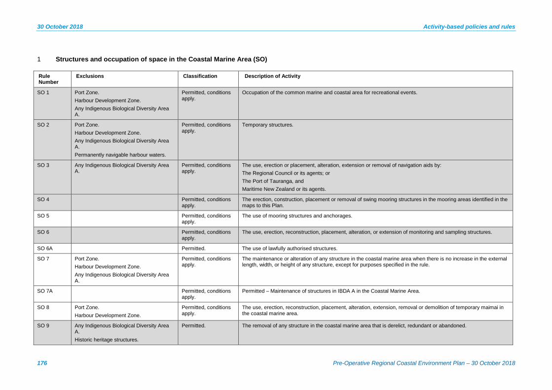
30 October 2018 Activity-based policies and rules
176 Pre-Operative Regional Coastal Environment Plan – 30 October 2018
1 Structures and occupation of space in the Coastal Marine Area (SO)
Rule Number
Exclusions Classification Description of Activity
SO 1 Port Zone. Harbour Development Zone. Any Indigenous Biological Diversity Area A.
Permitted, conditions apply.
Occupation of the common marine and coastal area for recreational events.
SO 2 Port Zone. Harbour Development Zone. Any Indigenous Biological Diversity Area A. Permanently navigable harbour waters.
Permitted, conditions apply.
Temporary structures.
SO 3 Any Indigenous Biological Diversity Area A.
Permitted, conditions apply.
The use, erection or placement, alteration, extension or removal of navigation aids by: The Regional Council or its agents; or The Port of Tauranga, and Maritime New Zealand or its agents.
SO 4 Permitted, conditions apply.
The erection, construction, placement or removal of swing mooring structures in the mooring areas identified in the maps to this Plan.
SO 5 Permitted, conditions apply.
The use of mooring structures and anchorages.
SO 6 Permitted, conditions apply.
The use, erection, reconstruction, placement, alteration, or extension of monitoring and sampling structures.
SO 6A Permitted. The use of lawfully authorised structures.
SO 7 Port Zone. Harbour Development Zone. Any Indigenous Biological Diversity Area A.
Permitted, conditions apply.
The maintenance or alteration of any structure in the coastal marine area when there is no increase in the external length, width, or height of any structure, except for purposes specified in the rule.
SO 7A Permitted, conditions apply.
Permitted – Maintenance of structures in IBDA A in the Coastal Marine Area.
SO 8 Port Zone. Harbour Development Zone.
Permitted, conditions apply.
The use, erection, reconstruction, placement, alteration, extension, removal or demolition of temporary maimai in the coastal marine area.
SO 9 Any Indigenous Biological Diversity Area A. Historic heritage structures.
Permitted. The removal of any structure in the coastal marine area that is derelict, redundant or abandoned.

Activity-based policies and rules 30 October 2018
BAY OF PLENTY REGIONAL COUNCIL TOI MOANA 177
Rule Number
Exclusions Classification Description of Activity
SO 10 Discretionary. The erection, reconstruction, placement, alteration, or extension of the following structures in an Indigenous Biological Diversity Area A: (a) Structures for the specific purpose of providing protection for the biodiversity values associated with such
areas. (aa) Structures for improving water quality, connections between water bodies, cultural connections or natural
processes. (b) Structures for the specific purpose of providing educational, scientific or passive recreational opportunities
that will enhance the understanding and long-term protection of the biodiversity values of the area. (c) Structures for navigational aids. (d) Structures erected, reconstructed, placed, altered, or extended prior to the date on which this Plan was
publicly notified. (e) Structures associated with the operation, maintenance and protection of existing and new regionally
significant infrastructure. (f) Operation and maintenance of Existing River Schemes and Land Drainage Schemes. (g) Maintenance or enhancement of navigational safety. (h) Use and development identified in Schedule 15 Offshore Islands. (i) Associated with maritime casualties and their management.
SO 10A Non-complying New Regionally Significant Infrastructure in IBDA A or ONC
SO 11 Harbour Development Zone. Port Zone.
Discretionary. Structures, occupation and use in the coastal marine area not covered by another rule in this Plan.
SO 12 Non complying. Structures in an Indigenous Biological Diversity Area A that have a functional need to locate in the coastal marine area, but do not fit within Rule SO 10.
SO 13 Wharfs, jetties, pontoons and boat ramps. Public access structures. Submarine cables and pipelines. Vessel moorings or berths. Bridges. National Grid
Non complying. The use, erection or placement of any structure within permanently navigable harbour waters.
SO 14 Prohibited. Structures in an Indigenous Biological Diversity Area A not otherwise provided for.

30 October 2018 Activity-based policies and rules
178 Pre-Operative Regional Coastal Environment Plan – 30 October 2018
2 Disturbance, deposition and extraction (DD)
Rule Number
Exclusions Classification Description of Activity
DD 1 Any Indigenous Biological Diversity Area A.
Permitted, conditions apply.
Channel clearance and maintenance of existing diversions and land drainage functions in artificial watercourses or modified watercourses.
DD 2 Historic Heritage sites. Permitted, conditions apply.
Burial of dead animals washed up on the foreshore.
DD 3 Any Indigenous Biological Diversity Area A or Outstanding Natural Character Area.
Permitted, conditions apply.
Temporary military training activities - New Zealand Defence Forces.
DD 4 Permitted, conditions apply.
Taking driftwood without use of vehicles on the foreshore
DD 5 Permitted, conditions apply.
Planting indigenous plant species
DD 6 Permitted, conditions apply.
Wetland enhancement
DD 7 Any Indigenous Biological Diversity Area A.
Permitted, conditions apply.
Specified vehicle access and use.
DD 8 Permitted, conditions apply.
Vehicle access/use for emergency or law enforcement.
DD 9 Controlled, conditions apply.
Use of soft coastal hazard protection methods.
DD 10 Controlled, conditions apply.
Maintenance of Existing River Schemes and Land Drainage Schemes – The Regional Council and Waihī Drainage District Society Incorporated.
DD 11 Controlled. Maintenance of artificial or modified watercourses to protect houses from flooding – The Regional Council.
DD 12 Restricted discretionary.
Maintenance of existing artificial watercourses or modified watercourses in an Indigenous Biological Diversity Area A by the Regional Council.
DD 13 Port Zone. Harbour Development Zone.
Restricted discretionary.
Maintenance dredging of existing navigational channels.
DD 14 Discretionary. Disturbance, deposition and excavation in the coastal marine area not covered by another rule in this Plan.
DD 15 Discretionary. Disturbance, deposition and extraction in an Indigenous Biological Diversity Area A or area of Outstanding Natural Character for specific purposes: (a) Providing protection for the biodiversity values associated with such areas. (ab) Improving water quality, connections between water bodies, cultural connections or natural processes. (b) Providing educational, scientific or passive recreational opportunities that will enhance the understanding and
long-term protection of the biodiversity values of the area.

Activity-based policies and rules 30 October 2018
BAY OF PLENTY REGIONAL COUNCIL TOI MOANA 179
Rule Number
Exclusions Classification Description of Activity
(c) Navigational aids. (d) Use of structures erected, reconstructed, placed, altered, or extended prior to the date on which this Plan was
publicly notified. (e) The operation, maintenance and protection of existing and new regionally significant infrastructure. (f) Maintenance or enhancement of navigational safety. (g) Dredging, and other disturbance, in existing artificial watercourses or modified watercourse. (h) Operation and maintenance of Existing River Schemes and Land Drainage Schemes. (i) Use and development identified in Schedule 15 Offshore Islands.
DD 15A Non-complying. Mining and petroleum exploration and exploitation in ONFLs.
DD 16 Prohibited. Fracking.
DD 17 Prohibited. Specified activities in the coastal marine area: (a) Construction of new artificial watercourses or modification of watercourses, in an Indigenous Biological
Diversity Area A. (b) Removal of sand, shell, shingle and minerals, dredging and spoil disposal, in an Indigenous Biological
Diversity Area A. (c) Disposal in the coastal marine area of any spoil from land-based activities. (d) Stock access (excluding horses). (e) Mining of sand, shell and shingle from the active beach system on the open coast. (f) Artillery gunfire, naval gunfire, or aerial bombardment for military training in areas of outstanding natural
character. (g) Vehicle use in an Indigenous Biological Diversity Area A, except emergency response and enforcement related
vehicles.
DD 18 IBDA A
Permitted, conditions apply.
Removal of mangrove seedlings.
DD 19 Ōhiwa Harbour Uretara Island IBDA A as identified on Mapsheet 25b Ōhiwa Harbour Motuotu Island Nature Reserve IBDA A as identified on Mapsheet 25b Ōhiwa Harbour Pataua Island Scientific Reserve and Extension IBDA A as identified on Mapsheet 26b Tauranga Harbour Aongatete Estuary IBDA A as identified on Mapsheet 7b Tauranga Harbour Athenree IBDA A as identified on Mapsheet 2b
Permitted, conditions apply.
Small-scale clearance of mangroves: 1 Removal of mature adult mangroves located immediately adjacent to or within the footprint of a lawfully
established structure, network infrastructure or existing drainage system that does not exceed the limits set out in Table 1, Category 1 and Category 2; or
2 Removal of mature mangroves to provide for access to marae, urupā and reserve access ways that does not exceed the limits set out in table 1, Category 3; or
3 Removal of mature mangroves to maintain the existing Bird Roosting Sites listed in Schedule 2 that does not exceed the limits set out in Table 1, Category 4.
4 Removal of mangrove seedlings from IBDA A, where: (i) The seedlings are located immediately adjacent to or within the footprint of a lawfully established structure,
network infrastructure or existing drainage system, and where the removal does not exceed the limits set out in Table 1, Category 1 and Category 2; or

30 October 2018 Activity-based policies and rules
180 Pre-Operative Regional Coastal Environment Plan – 30 October 2018
Rule Number
Exclusions Classification Description of Activity
Tauranga Harbour Blue Gum Bay 1 IBDA A as identified on Mapsheet 6b Tauranga Harbour Tirohanga Mangroves IBDA A as identified on Mapsheet 5b Tauranga Harbour Te Hopai Island IBDA A as identified on Mapsheet 7b
(ii) The removal of seedlings is to provide for access to marae, urupā and reserve access ways, and where the removal does not exceed the limits set out in Table 1, Category 3, or
(iii) The site is identified as a bird roosting site in Schedule 2A;
DD 19A Controlled. Removal of mature mangroves from any Indigenous Biological Diversity Area which is undertaken in accordance with an approved Harbour Margins Restoration Plan, Wetland Management Agreement or Biodiversity Management Plan where the total cleared area does not exceed: (i) 30 square metres in an Indigenous Biological Diversity Area A (as identified in Schedule 2, Table 1) within any 12-month period, or (ii) 200 square metres in Indigenous Biological Diversity Area B (as identified in Schedule 2, Table 2) any other area within any 12-month period.
DD 20 Ōhiwa Harbour Uretara Island IBDA A as identified on Mapsheet 25b Ōhiwa Harbour Motuotu Island Nature Reserve IBDA A as identified on Mapsheet 25b Ōhiwa Harbour Pataua Island Scientific Reserve and Extension IBDA A as identified on Mapsheet 26b Tauranga Harbour Aongatete Estuary IBDA A as identified on Mapsheet 7b Tauranga Harbour Athenree IBDA A as identified on Mapsheet 2b Tauranga Harbour Blue Gum Bay 1 IBDA A as identified on Mapsheet 6b Tauranga Harbour Tirohanga Mangroves IBDA A as identified on Mapsheet 5b Tauranga Harbour Te Hopai Island IBDA A as identified on Mapsheet 7b
Permitted, conditions apply.
Management of sites were mangrove removal has already occurred as part of ongoing maintenance areas where clearance has been lawfully undertaken.
DD 21 Ōhiwa Harbour Uretara Island IBDA A as identified on Mapsheet 25b Ōhiwa Harbour Motuotu Island Nature Reserve IBDA A as identified on Mapsheet 25b Ōhiwa Harbour Pataua Island Scientific Reserve and Extension IBDA A as identified on Mapsheet 26b
Restricted discretionary.
Mangrove management not covered by other rules – includes mechanical removal methods.

Activity-based policies and rules 30 October 2018
BAY OF PLENTY REGIONAL COUNCIL TOI MOANA 181
Rule Number
Exclusions Classification Description of Activity
Tauranga Harbour Aongatete Estuary IBDA A as identified on Mapsheet 7b Tauranga Harbour Athenree IBDA A as identified on Mapsheet 2b Tauranga Harbour Blue Gum Bay 1 IBDA A as identified on Mapsheet 6b Tauranga Harbour Tirohanga Mangroves IBDA A as identified on Mapsheet 5b Tauranga Harbour Te Hopai Island IBDA A as identified on Mapsheet 7b
Rule DD 22 Non complying. Mangrove removal in ‘high value’ mangrove areas.
3 Discharge of Contaminants (CD)
Rule Number
Exclusions Classification Description of Activity
CD 1 Permitted, conditions apply.
Discharge of aquatic herbicide over coastal water for weed control.
CD 2 Permitted, conditions apply.
Discharge of dye or gas tracers.
CD 3 Permitted, conditions apply.
Minor discharges of water.
CD 3A Permitted, conditions apply.
Discharges from the operation of portable Micro-Filtration Reverse Osmosis (MFRO) water treatment units by the New Zealand Defence Force.
CD 4 Permitted. Discharges of substances from aircraft for avoiding, remedying or mitigating oil spills.
CD 5 Permitted, conditions apply.
Discharge of stormwater to coastal water. Conditions include (but are not limited to):
1 Suspended solids concentration of the discharge shall not be greater than 150g/m³.
2 The rate of discharge shall not exceed 125 litres per second for a 10 minute duration.
3 The discharge shall not contain any stormwater from a high risk facility as defined in Schedule 12.
CD 6 Restricted discretionary, conditions apply.
Discharge of stormwater to coastal water not covered by permitted Rule CD 5.
CD 7 Discretionary. Dumping of specified waste or other matter in the coastal marine area: Dredge material. Sewage sludge.

30 October 2018 Activity-based policies and rules
182 Pre-Operative Regional Coastal Environment Plan – 30 October 2018
Rule Number
Exclusions Classification Description of Activity
Fish processing waste from an onshore facility. Ships and platforms or other man-made structures at sea. Inert, inorganic geological material. Organic materials of natural origin. Bulky items consisting mainly of iron, steel, and concrete.
CD 8 Discretionary. Discharges to the coastal marine area not covered by any other rule in this Plan or the Resource Management (Marine Pollution) Regulations 1998.
CD 9 Non-complying. Discharge of treated human sewage from land-based systems that has not passed through land, soil or wetlands.
CD 9A Non-complying. Disposal of waste associated with mining exploration and exploitation in an ONFL.
CD 10A Prohibited. Disposal of waste associated with mining exploration and exploitation in an IBDA A or area of outstanding natural character.
CD 10 Dredge material. Sewage sludge. Fish processing waste from an onshore facility. Ships and platforms or other man-made structures at sea. Inert, inorganic geological material. Organic materials of natural origin. Bulky items consisting mainly of iron, steel, and concrete.
Prohibited. Dumping of waste and other matter.
CD 11 Prohibited. Incineration of waste in marine incineration facilities.
CD 12 Prohibited. Discharge of untreated sewage from land-based activities.
CD 13 Prohibited. The discharge of sewage from ships and offshore installations in the following areas: 1 In any part of Tauranga Harbour and Ōhiwa Harbour, 2 In any estuary, and 3 On the open coast:
(a) within 500 m of mean high water springs, (b) within 500 m of a marine farm or a mātaitai reserve, (c) where the water depth is less than five metres, or (d) within 200 m of a marine reserve.

Activity-based policies and rules 30 October 2018
BAY OF PLENTY REGIONAL COUNCIL TOI MOANA 183
4 Reclamation (RM)
Rule Number
Exclusions Classification Description of Activity
RM 1 Restricted discretionary. Removal of reclamations to: 1 Restore the natural character and resources of the coastal marine area, or 2 Provide for more public open space. 3 Provide for enhanced walking access.
RM 2 Discretionary. Reclamation and removal of reclamations in the Coastal Marine Area not covered by another rule in this Plan.
RM 3 Non complying. Reclamation associated with regionally significant infrastructure in an Indigenous Biological Diversity Area A or Outstanding Natural Character Area.
RM 3A Non-complying. Authorisation of an unlawful reclamation under section 355A of the RMA that was constructed after 24 June 2014 in areas of significant indigenous biological diversity or areas of outstanding natural character.
RM 4 Port Zone. Prohibited. Reclamation for specified purposes: 1 Disposal of dredged material as the primary purpose of the reclamation, 2 Extension to or creation of farmland, playing fields, urban, and industrial areas excepting ports, or other marine
servicing facilities and storage, 3 Carparks as the primary purpose of the reclamation, or 4 Rubbish disposal, including industrial, horticultural, farm and household.
RM 5 Prohibited. Reclamation in an Indigenous Biological Diversity Area A or Outstanding Natural Character Area.
5 Taking, using, damming or diversion of coastal water (TD)
Rule Number
Exclusions Classification Description of Activity
TD 1 Permitted. Use of coastal water or open coastal water.
TD 2 Permitted. Take of open coastal water.
TD 3 Permitted. The take of up to 15 cubic metres coastal water per day from within a harbour or estuary.
TD 4 Discretionary. Take, damming and diversion of coastal water not covered by another rule in this Plan.

30 October 2018 Activity-based policies and rules
184 Pre-Operative Regional Coastal Environment Plan – 30 October 2018
6 Aquaculture (AQ)
Rule Number
Exclusions Classification Description of Activity
AQ 1 Any Indigenous Biological Diversity Area A. Mooring areas. Port Zone. Harbour Development Zone.
Controlled, subject to conditions.
Aquaculture Research Existing Species – maximum footprint of two hectares; limited to a five year duration; no structures in permanently navigable harbour waters; species must be indigenous to New Zealand or farmed in the region; no pest species or unwanted organisms to be used.
AQ 1A Any Indigenous Biological Diversity Area A. Mooring areas. Port Zone. Harbour Development Zone.
Restricted discretionary, subject to conditions
Aquaculture Research Other Species - As Rule AQ 1 but where exotic species used, which are not farmed in the region.
AQ 2 Mooring areas. Port Zone. Harbour Development Zone.
Controlled, subject to conditions.
Aquaculture Enhancing and Restocking Indigenous Coastal Species - maximum footprint of two hectares; no structures in permanently navigable harbour waters.
AQ 2A Controlled, subject to conditions.
Reconsenting Existing Commercial Aquaculture.
AQ 3 Restricted discretionary. Reconsenting existing aquaculture in an Indigenous Biological Diversity Area A; or area of Outstanding Natural Character.
AQ 4 Discretionary. Aquaculture not covered by any other rule in this Plan.
AQ 5 The replacement or reconstruction of existing and legally authorised structures.
Non complying. New aquaculture structures in permanently navigable harbour waters.
AQ 6 Prohibited. Commercial aquaculture in high value or high use areas, which are: (a) Indigenous Biological Diversity Areas A. (b) Areas of Outstanding Natural Character. (c) Within 5.5 kms (3 nautical miles) of commercial shipping lanes or navigable river mouths. (d) Mooring areas, Port and Harbour Development Zones.
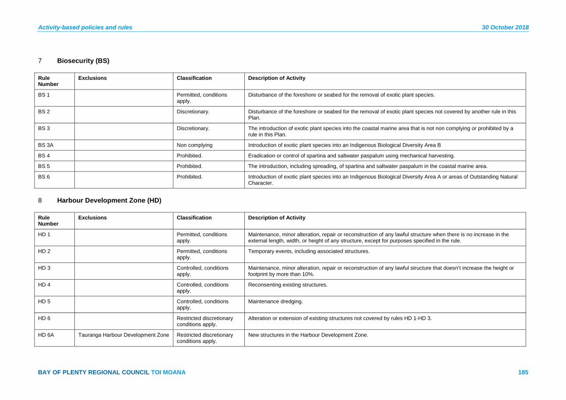
Activity-based policies and rules 30 October 2018
BAY OF PLENTY REGIONAL COUNCIL TOI MOANA 185
7 Biosecurity (BS)
Rule Number
Exclusions Classification Description of Activity
BS 1 Permitted, conditions apply.
Disturbance of the foreshore or seabed for the removal of exotic plant species.
BS 2 Discretionary. Disturbance of the foreshore or seabed for the removal of exotic plant species not covered by another rule in this Plan.
BS 3 Discretionary. The introduction of exotic plant species into the coastal marine area that is not non complying or prohibited by a rule in this Plan.
BS 3A Non complying Introduction of exotic plant species into an Indigenous Biological Diversity Area B
BS 4 Prohibited. Eradication or control of spartina and saltwater paspalum using mechanical harvesting.
BS 5 Prohibited. The introduction, including spreading, of spartina and saltwater paspalum in the coastal marine area.
BS 6 Prohibited. Introduction of exotic plant species into an Indigenous Biological Diversity Area A or areas of Outstanding Natural Character.
8 Harbour Development Zone (HD)
Rule Number
Exclusions Classification Description of Activity
HD 1 Permitted, conditions apply.
Maintenance, minor alteration, repair or reconstruction of any lawful structure when there is no increase in the external length, width, or height of any structure, except for purposes specified in the rule.
HD 2 Permitted, conditions apply.
Temporary events, including associated structures.
HD 3 Controlled, conditions apply.
Maintenance, minor alteration, repair or reconstruction of any lawful structure that doesn’t increase the height or footprint by more than 10%.
HD 4 Controlled, conditions apply.
Reconsenting existing structures.
HD 5 Controlled, conditions apply.
Maintenance dredging.
HD 6 Restricted discretionary conditions apply.
Alteration or extension of existing structures not covered by rules HD 1-HD 3.
HD 6A Tauranga Harbour Development Zone Restricted discretionary conditions apply.
New structures in the Harbour Development Zone.
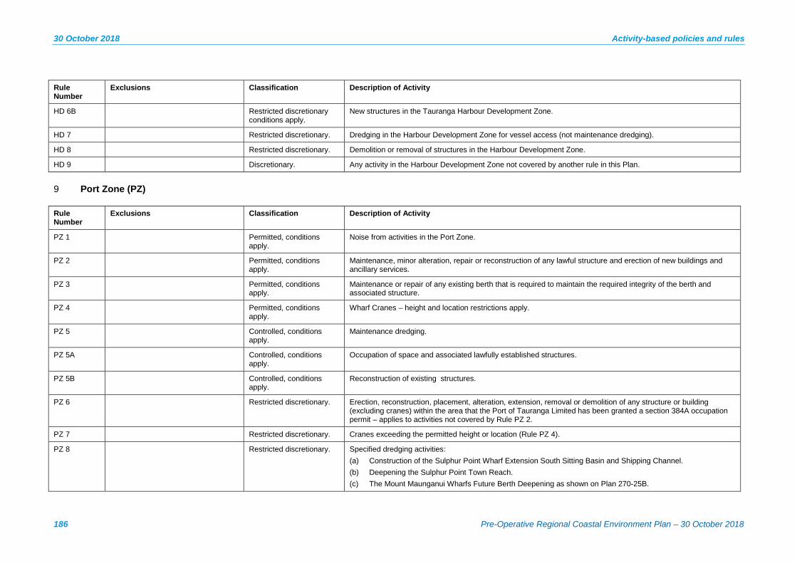
30 October 2018 Activity-based policies and rules
186 Pre-Operative Regional Coastal Environment Plan – 30 October 2018
Rule Number
Exclusions Classification Description of Activity
HD 6B Restricted discretionary conditions apply.
New structures in the Tauranga Harbour Development Zone.
HD 7 Restricted discretionary. Dredging in the Harbour Development Zone for vessel access (not maintenance dredging).
HD 8 Restricted discretionary. Demolition or removal of structures in the Harbour Development Zone.
HD 9 Discretionary. Any activity in the Harbour Development Zone not covered by another rule in this Plan.
9 Port Zone (PZ)
Rule Number
Exclusions Classification Description of Activity
PZ 1 Permitted, conditions apply.
Noise from activities in the Port Zone.
PZ 2 Permitted, conditions apply.
Maintenance, minor alteration, repair or reconstruction of any lawful structure and erection of new buildings and ancillary services.
PZ 3 Permitted, conditions apply.
Maintenance or repair of any existing berth that is required to maintain the required integrity of the berth and associated structure.
PZ 4 Permitted, conditions apply.
Wharf Cranes – height and location restrictions apply.
PZ 5 Controlled, conditions apply.
Maintenance dredging.
PZ 5A Controlled, conditions apply.
Occupation of space and associated lawfully established structures.
PZ 5B Controlled, conditions apply.
Reconstruction of existing structures.
PZ 6 Restricted discretionary. Erection, reconstruction, placement, alteration, extension, removal or demolition of any structure or building (excluding cranes) within the area that the Port of Tauranga Limited has been granted a section 384A occupation permit – applies to activities not covered by Rule PZ 2.
PZ 7 Restricted discretionary. Cranes exceeding the permitted height or location (Rule PZ 4).
PZ 8 Restricted discretionary. Specified dredging activities: (a) Construction of the Sulphur Point Wharf Extension South Sitting Basin and Shipping Channel. (b) Deepening the Sulphur Point Town Reach. (c) The Mount Maunganui Wharfs Future Berth Deepening as shown on Plan 270-25B.

Activity-based policies and rules 30 October 2018
BAY OF PLENTY REGIONAL COUNCIL TOI MOANA 187
Rule Number
Exclusions Classification Description of Activity
PZ 9 Restricted discretionary. Specified reclamations: (a) Construction of the Sulphur Point Wharf Extension South, and (b) Construction of the Mt Maunganui Wharf Extension.
PZ 9A Discretionary. Specified dumping (dredge disposal) activities.
PZ 10 Discretionary. Any activity in the Port Zone not covered by another rule in this Plan.
10 Noise
Rule Number
Exclusions Classification Description of Activity
NS 1 Permitted. Emission of noise from specified activities in the Coastal Marine Area: 1 Navigational aids, safety signals, warning devices, or emergency pressure relief valves; 2 Emergency work undertaken to protect human life, or to prevent loss or serious damage to property, or
minimise or prevent environmental damage; 3 The discharge of firearms by licensed hunters; 4 The use of weapons and detonation of munitions by the New Zealand Defence Forces; 5 The use of vessels within the water ski and personal watercraft areas identified in the Bay of Plenty
Regional Council Navigation Safety Bylaws, and 6 Temporary events.
NS 2 Port Zone. Permitted, conditions apply.
Emission of Noise in the Tauranga Harbour and Ōhiwa Harbour – noise limits apply.
NS 3 Port Zone. Tauranga Harbour. Ōhiwa Harbour.
Permitted. Emission of noise from other activities in the Coastal Marine Area – requirement to best management practices to ensure the emission of noise does not exceed a reasonable level.
NS 4 Discretionary. Emission of noise in the coastal marine area that is not permitted by a rule in this Plan.

30 October 2018 Activity-based policies and rules
188 Pre-Operative Regional Coastal Environment Plan – 30 October 2018
11 Geothermal Resources
Rule Number
Exclusions Classification Description of Activity
GR 1 Permitted. Take and use of geothermal water, heat or energy in the Coastal Marine Area in accordance with tikanga Māori.
GR 2 Discretionary. Activities associated with research and investigation of geothermal resources in the coastal marine area.
GR 3 Non complying. Activities associated with development of geothermal resources in the coastal marine area.
Activity-based policies and rules 30 October 2018
BAY OF PLENTY REGIONAL COUNCIL TOI MOANA 189
Assessment Guidelines - Areas of significant cultural value
When considering an application for a resource consent for activities within:
• Areas of Significant Cultural Value (in Schedule 6); or
• Other areas or sites of significant cultural value identified by Statutory Acknowledgments, Iwi / Hapū Management Plans, or by evidence produced by tangata whenua and substantiated by pūkenga, kuia and/or kaumatua;
those undertaking activities and decision-makers are to have regard to the following matters*:
(a) Effects on the relationship of Māori and their culture and traditions with their ancestral lands, water, sites, wāhi tapu, and other taonga, including whether proposed mitigation or remediation measures provide for this relationship.
Refer to s6(e) RMA, RPS Policy IW 2B and RCEP Policy IW 1 and Policy IW 8.
(b) Ability of tangata whenua to perform their role as kaitiaki and demonstrate kaitiakitanga.
Refer to s7(a) RMA, RPS Policy IW 2B(a)(ii) and RCEP Policy IW 1(b).
(c) Whether pūkenga, kuia and/or kaumātua or other persons who have the specialist or technical knowledge necessary to apply the criteria in Appendix F, Sets 4 and 5 of the RPS, have assessed an historic heritage resource or Māori cultural relationships and values.
Refer to RPS Policy IW 2B, RCEP Policy IW 1(d), Policy IW 2, Policy IW 3 and RCEP Policy IW 5.
(d) (i) Adverse effects on the traditional Māori uses, practices and customary activities relating to natural and physical resources of the coastal environment – examples include mahinga kai, mahinga mataitai, wāhi tapu, ngā toka taonga, tauranga waka, taunga ika and taiāpure.
(ii) Adverse effects on Areas of Significant Cultural Value identified in Schedule 6 and other areas or sites of significant cultural value identified by Statutory Acknowledgements, iwi and hapū resource management plans or by evidence produced by tāngata whenua and substantiated by pūkenga, kuia and/or kaumatua.
Refer to RCEP Policy IW 1(a) and (d).
(e) Effects on the mauri of the coastal environment, and whether and how effects on the mauri of natural resources should be monitored.
Refer to RPS Policy IW 5B(b) and RCEP Policy IW 7.
(f) Effects on the ability of tangata whenua to access sites used for cultural practices and areas of cultural significance.
Refer to RCEP Policy IW 10.
(g) The consistency of a proposal with any relevant iwi or hapū resource management plan; and recognition of tangata whenua values provided under any other legislation (such as Treaty of Waitangi settlements, the Kaimoana Customary Fishing Regulations 1998 and the Marine and Coastal Area (Takutai Moana) Act 2011).
Refer to RPS Policy IW 4B and RCEP Policy IW 4.
30 October 2018 Activity-based policies and rules
190 Pre-Operative Regional Coastal Environment Plan – 30 October 2018
(h) Effects on the cultural and spiritual values associated with natural features and natural landscapes and the Māori cultural landscape, including cumulative effects.
Refer to NZCPS Policy 15 and RCEP Policy NH 9A and IW 1(e).
(i) Effects on habitats of indigenous species which are important for traditional or cultural purposes.
Refer to NZCPS Policy 11 and RCEP Policy NH 9A.
(j) Consistency of the proposal with the outcomes and recommendations of consultation with tangata whenua; iwi or hapū resource management plans or with the findings of a cultural impact assessment.
Refer to RCEP Policies IW 4, IW 5 and IW 6
(k) The extent to which mātauranga Māori has been incorporated in the assessment of effects.
Refer to NZCPS Policy 2(c), RCEP Policy IW 1(c) and RCEP Policy IW 7
(l) Whether a review condition is necessary to address unforeseen adverse effects on taonga, sites, areas, features or resources of significance or special value to tangata whenua.
Refer to RCEP Policy IW 9A
* The policy references provide further direction on how these matters are to be assessed

Methods 30 October 2018
BAY OF PLENTY REGIONAL COUNCIL TOI MOANA 191
Part Five Methods
Part Five contains non-statutory methods for implementing the policies contained in Part Three and Part Four of this Plan.


Methods 30 October 2018
BAY OF PLENTY REGIONAL COUNCIL TOI MOANA 193
1 Methods
Implementation, Monitoring and Reporting 1.1
Method 1 Develop and implement a monitoring, review and reporting programme to assess the effectiveness of the Plan and whether the Plan objectives have been achieved. The programme will incorporate mātauranga Māori based methods and/or cultural health indicators that recognise and express Māori values.
The results of monitoring and investigations will be made available to the public through appropriate means.
Implementation responsibility: Regional Council.
Method 1A Investigate the establishment of a tangata whenua specialist practitioners group for the purposes of:
(a) Assisting with implementation of Methods 1, 2A, 6, 14, 17, 18, 18A and 19A (noting that this does not remove the requirement to consult with tangata whenua during a RMA Schedule 1 process); and
(b) Assisting with the development of cultural health indicators to assist in monitoring the state of the region's natural and physical coastal environment.
Implementation responsibility: Regional Council
Method 1B Address cross-boundary issues through a process of proactive collaboration and information sharing with neighbouring local authorities.
Implementation responsibility: Bay of Plenty Regional Council, Waikato Regional Council, Gisborne District Council, Tauranga City Council, Western Bay of Plenty District Council, Whakatāne District Council, Ōpōtiki District Council and the Department of Internal Affairs.
Natural Heritage 1.2
Method 2 Support private landowners to protect and enhance high value ecological sites in the coastal environment using sustainable land management, biodiversity protection and pest animal and pest plant control.
Implementation responsibility: Regional Council.
Method 2A Work with tangata whenua to incorporate mātauranga Māori in the assessment of Māori cultural values and attributes comprising the elements of Outstanding Natural Character, Outstanding Natural Features and Natural Landscapes Indigenous Biological Diversity Areas and Areas of Significant Cultural Value in the coastal environment. Work with tāngata whenua to develop a framework for assessment of effects on cultural values and attributes.
Work with tāngata whenua to develop a framework for assessment of effects on Māori cultural values and attributes.

30 October 2018 Methods
194 Pre-Operative Regional Coastal Environment Plan – 30 October 2018
Implementation responsibility: Regional Council.
Method 3 Support and facilitate research that will identify areas in the Bay of Plenty region where ecosystems and biodiversity values are most likely to be impacted by climate change, and research into the capacity and options available to manage such changes.
Implementation responsibility: Regional Council.
Method 3A Support research to identify areas in the Bay of Plenty region where ecosystems and biodiversity values are being, or are likely to be, adversely effected by fishing activities, and investigate the options available to manage such activities for the protection of indigenous biodiversity.
Implementation responsibility: Regional Council.
Method 4 Encourage district councils to take into account the adverse effects that domestic animals and garden plant varieties can have on natural heritage values, when preparing district plans that regulate urban development and public access in the coastal environment.
Implementation responsibility: Regional Council.
Method 5 Consider the removal of existing reclamations where practicable and consistent with lawfully established uses to assist in restoration of the Tauranga Harbour, Ōhiwa Harbour and Maketū Estuary margins.
Implementation responsibility: Regional Council, Tauranga City Council and Western Bay of Plenty District Council.
Water Quality 1.3
Method 6 Support further research to model sub-catchments in the Tauranga Harbour, and other catchments where urban or industrial areas discharge stormwater to the coastal environment, to determine assimilative capacity for stormwater. This will include the assimilative capacity for sediment-contaminated stormwater from land disturbance activities, and residually accumulative contaminants (e.g. heavy metals) and incorporate mātauranga Māori where practicable to do so. The results of the modelling will be used to manage cumulative effects and loading of contaminants from stormwater discharges.
Method 6A Work with tangata whenua to investigate classification of coastal waters as Class C – water managed for cultural purposes/other indicators of cultural health, and incorporate matauranga Māori in the classification and assessment of coastal waters where practicable to do so.
Implementation responsibility: Regional Council.
Method 7 Incorporate coastal and estuarine waters during implementation of the National Policy Statement for Freshwater Management Implementation Programme. In particular with regard to development of:

Methods 30 October 2018
BAY OF PLENTY REGIONAL COUNCIL TOI MOANA 195
Catchment Plans with specific targets focusing on particular (a)communities and whole water systems.
Waterbody plans for specific degraded, outstanding or (b)valued water bodies.
Implementation responsibility: Regional Council.
Method 8 Continue to research and support the use of effective catchment management practices and use its land management programmes for the direct or indirect protection of water quality in the coastal marine area, primarily by way of catchment, riparian and biodiversity management plans and the provision of information and advice to landowners and the community.
Implementation responsibility: Regional Council.
Method 8A Monitor a range of sites from which mangroves have been removed to:
(a) Determine long term ecological trends; (b) Assess effects on sedimentation and estuarine dynamics; (c) Assess effects on distribution and abundance of threatened
species; and/or (d) Inform future catchment and mangrove management
options.
Implementation responsibility: Regional Council and consent holders
Method 9 In conjunction with all other appropriate agencies, as circumstances permit, identify areas where it is unsafe for either contact recreation or shellfish gathering, and:
Inform the Medical Officer of Health, and where relevant, the (a)district council;
Investigate the cause of the problem; (b)
Where the cause is due to an identified activity, require (c)remedial actions; and
Undertake further research to identify ways to avoid or (d)remedy contamination of kaimoana.
Implementation responsibility: Regional Council.
Method 10 Reduce bacterial levels at bathing sites in coastal and estuarine waters that do not meet the bathing standards by:
Requiring effective treatment of on-site effluent before (a)discharge.
Promoting the fencing and planting of riparian areas. (b)
Requiring the appropriate management of stock access and (c)crossing of the beds of rivers and streams, especially those that flow into harbours and estuaries.
Promoting sustainable land management and catchment (d)management, including industry good management practice standards.
30 October 2018 Methods
196 Pre-Operative Regional Coastal Environment Plan – 30 October 2018
Requiring discharges of contaminants to water to meet the (e)bacterial standard of the Water Quality Classification of the receiving water body as a minimum.
Implementation responsibility: Regional Council.
Method 11 In conjunction with city and district councils, promote or otherwise ensure adequate provision is made for the collection, treatment and appropriate disposal of vessel maintenance and cleaning residues, as well as sewage from vessel holding tanks and contaminated bilge water. City and district councils should consider the installation of vessel waste disposal facilities at frequently used boat ramps.
Implementation responsibility: Regional Council, City and District Councils.
Method 12 Continue to participate in the Hazardous Substances Technical Liaison Committee for the prevention and clean-up of spills of hazardous substances.
Implementation responsibility: Regional Council.
Involvement of community groups and tāngata whenua 1.4
Method 13 Facilitate and support the involvement of community groups in the sustainable management and restoration of natural heritage, historic heritage and water quality in the coastal marine area.
Method 14 Facilitate and support tāngata whenua to exercise kaitiakitanga and apply mātauranga Māori in the sustainable management and restoration of natural, historic and cultural heritage and water quality in the coastal marine area.
Implementation responsibility: Regional Council.
Method 15 In conjunction with city and district councils and the Department of Conservation, support and administer community based programmes and Kaupapa Māori based initiatives that seek to:
Educate those who manage, benefit from or use resources in (a)the coastal environment about natural coastal ecosystems.
Increase community involvement, including kaitiaki and (b)whānau, in the management of the coastal environment, including beaches, dunes, harbours and estuaries.
Protect and enhance the natural character and biodiversity of (c)the coastal environment.
Improve the capacity of dune systems and other ecosystems (d)to withstand coastal hazards and relevant climate change effects.
Promote well-formed public access ways and restrict ad hoc (e)access in sensitive environments, through provision of information, signage, education and involvement of communities and tangata whenua.
Methods 30 October 2018
BAY OF PLENTY REGIONAL COUNCIL TOI MOANA 197
Implement protocols with tangata whenua that have (f)particular regard to the role of kaitiaki and pūkenga in the management of coastal resources;
Promote tangata whenua needs for papakāinga, marae, kura (g)moana whare matauranga, whare wānanga and associated developments in the coastal environment and facilitate provision for these developments where appropriate
Implementation responsibility: Regional Council.
Cultural and Historic Heritage 1.5
Method 16 Map or otherwise identify customary interests protected under the Marine and Coastal Area (Takutai Moana) Act 2011.
Implementation responsibility: Regional Council.
Method 17 Work with tāngata whenua, heritage agencies, and city and district councils to determine the most appropriate means of protecting sites of cultural heritage value without the need for their explicit identification.
Implementation responsibility: Regional Council.
Method 17B: Regional Council will, on a case-by-case basis, consider the transfer and/or delegation of RMA functions, powers or duties, in relation to the management of those characteristics which have been identified in the CMA as being of special value to tangata whenua.
Implementation responsibility: Regional Council.
Method 18 Work with tāngata whenua to identify degraded cultural sites in the coastal environment which tāngata whenua wish to restore for natural heritage and cultural reasons.
Implementation responsibility: Regional Council.
Method 19 In consultation with tāngata whenua and other heritage agencies organisations or groups that have an interest in historic heritage and maritime history, maintain and update the regional heritage inventory in Schedule 7. This will include a review of Appendix 2: List of Heritage Places for Information Only in the Coastal Historic Heritage Review Project: Historic Heritage Inventory 2006 to determine whether any places should be included in Schedule 7.
Implementation responsibility: Regional Council.
Method 19A: In consultation with tangata whenua:
Review Schedule 6 Areas of Significant Cultural Value; (a)
Identify areas or sites in the coastal environment of (b)significance or special value to Maori;
Identify cultural landscapes and features in a manner (c)consistent with NZCPS Policy 15(c)(viii);
30 October 2018 Methods
198 Pre-Operative Regional Coastal Environment Plan – 30 October 2018
Investigate the planning mechanisms and other methods (d)available to provide protection to identified areas and sites and support customary activities in ASCV;
Investigate the planning mechanisms and other methods (e)available to support the social, economic, cultural and recreational aspirations of tangata whenua in the coastal environment;
Identify options for providing for the expression of the (f)relationship tangata whenua as kaitiaki have with their identified taonga such as water, wahi tapu and kaimoana.
The review, identification and investigation should:
Incorporate matauranga Maori as directed by NZCPS (a)Policy 2(c);
Use the assessment criteria contained in the RPS (b)Appendix F: Set Maori culture and traditions; and
Give consideration to the most appropriate provisions in (c)the Plan for addressing matters arising out of the review.
Implementation responsibility: Regional Council.
Recreation and Public Space 1.6
Method 20 Support and work with community groups, tāngata whenua and recreation agencies to manage recreation issues, particularly in high use areas, and promote the use of non-statutory and Local Government Act enforcement options where this is the most effective method for achieving the objectives and policies.
Implementation responsibility: Regional Council.
Method 21A: Regional Council will work with tangata whenua to identify those areas of the coast which may need to have public access limited, to protect significant iwi values that are vulnerable to disturbance.
Implementation responsibility: Regional Council and tangata whenua.
Method 21 Work with city and district councils to:
Avoid any new, and rationalise existing, informal access (a)ways.
(ab) Identify appropriate vehicle access points and restrictions in the coastal environment consistent with RPS Method 71.
Identify priorities for taking management or enforcement (b)actions where vehicle access is causing damage or safety concerns, including working with New Zealand Police and territorial authority staff to enforce Rules and Bylaws at a level sufficient to avoid damage or accidents.
Ensure official public access ways are marked and provide (c)related public information on the location of access ways.

Methods 30 October 2018
BAY OF PLENTY REGIONAL COUNCIL TOI MOANA 199
Provide the most appropriate and effective methods to (d)control vehicle use on beaches, foreshore, seabed and adjacent public land, including through the use of district plan or reserve plan provisions, or Local Government Act or Reserves Act bylaws.
Provide and maintain formal boat launching facilities, (e)recognising the demand for and the constraints of providing such services.
Ensure subdivision, use and development in coastal margins (f)provide for public access and take into account the future effects of sea level rise.
Implementation responsibility: Regional Council.
Coastal Hazards 1.7
Method 22 Work with the community, tāngata whenua, science agencies and the Bay of Plenty Civil Defence Emergency Management Group to:
Develop the environmental, social, economic and/or cultural (a)triggers or thresholds that define the boundaries between differing levels of risk;
Develop appropriate methodologies for assessing the level (b)of risk in any area of the coastal environment;
Provide advice and information on options for risk reduction, (c)hazard response and adaptation planning; and
Identify where responsibilities lie for managing residual risk (d)and ensure communities are informed of this.
Implementation responsibility: Regional council, city and district councils.
Method 23 Work collaboratively with city and district councils to:
Assess the potential risk from tsunami and the potential (a)impacts on communities within the coastal environment; and
Prioritise mitigation actions which could reduce the risk to (b)communities and would be achievable at a reasonable cost.
Implementation responsibility: Regional Council.
Method 24 Work with city and district councils, marae trustees and/or marae committees and landowners to identify and implement actions that will enable marae and communities to adapt over time to the effects of sea level rise and the potential for increased erosion and inundation. Actions may include managed retreat from the coastal edge where the coastal hazard risk cannot be reduced to a tolerable level of risk and where hard protection structures are not considered to be appropriate.
Implementation responsibility: Regional Council.
Method 25 Work with city and district councils and landowners to identify and implement actions that will enable communities to sustainably manage the current effects of erosion.

30 October 2018 Methods
200 Pre-Operative Regional Coastal Environment Plan – 30 October 2018
Implementation responsibility: Regional Council.
Method 26 Work with the tāngata whenua, city and district councils and science agencies to increase understanding of the processes driving erosion within the Tauranga Harbour and how these can be appropriately managed.
Implementation responsibility: Regional Council.
Vessel Routeing 1.8
Method 27 Work with Maritime New Zealand and the Ministry of Transport to:
Assess the level of risk associated with current vessel (a)routeing in coastal waters in the Bay of Plenty Region; and
Progress solutions to address the risks associated with (b)vessel routeing in coastal waters of the Bay of Plenty region.
(c) Provide input as appropriate to the vessel routeing review being conducted by Maritime New Zealand.
Implementation responsibility: Regional Council and Maritime New Zealand.
Biosecurity 1.9
Method 28 Work with Maritime New Zealand, Ministry of Primary Industries, the Port of Tauranga and other industry partners to reduce biological risks to the marine environment through improved monitoring and management of bio-fouling, ship ballast water discharges and other activities in the coastal marine area.
Implementation responsibility: Regional Council.

Definitions 30 October 2018
BAY OF PLENTY REGIONAL COUNCIL TOI MOANA 201
Definitions Terms are not defined in this Plan if they are defined in the Resource Management Act 1991 (the RMA), the Marine and Coastal Area (Takutai Moana) Act 2011, the Crown Minerals Act 1991 or other commonly used Acts. The usual dictionary meaning applies to other terms not defined in this Plan.
The following terms are not included because they are defined in the Resource Management Act 1991 (the RMA), the Marine and Coastal Area (Takutai Moana) Act 2011 or the Crown Minerals Act 1991:
Aircraft – defined in the Resource Management Act 1991
Climate Change – defined in the Resource Management Act 1991
Common Marine and Coastal Area – defined in the Marine and Coastal Area (Takutai Moana) Act 2011
Contaminant – defined in the Resource Management Act 1991
Marine and Coastal Area – defined in the Marine and Coastal Area (Takutai Moana) Act 2011
Mining – defined in the Crown Minerals Act 1991
Mining Operations – defined in the Crown Minerals Act 1991
Prospecting – defined in the Crown Minerals Act 1991
Wetlands – defined in the Resource Management Act 1991
Definitions of terms used in the Regional Coastal Environment Plan: Abandoned Structure: Structure for which a legal owner, or person willing to take responsibility for obtaining any required resource consent and undertaking maintenance and repair of the structure, cannot be identified or located by the Regional Council.
Adaptation Measures: Actions that will be applied over time to reduce risk from coastal hazards.
Ahi kā: Continuous occupation - title to land through occupation by a group, generally over a long period of time. The group is able, through the use of whakapapa, to trace back to primary ancestors who lived on the land.
Ana taonga: Burial cave where taonga was stored or hidden.
Annual Exceedance Probability (AEP): A statistical measurement of the annual chances of a flow of a specified size being equal or exceeded.
Ancestral Land: Land that was the traditional home of Māori and holds some significance for the descendants of those who lived there. There must be some factor or nexus between the descendants’ culture and traditions and the land in question which affects the relationship of them to that land. Ancestral land is not confined to land under Māori ownership.
30 October 2018 Definitions
202 Pre-Operative Regional Coastal Environment Plan – 30 October 2018
Ancillary: Providing subsidiary support for, or is secondary to an identified activity, use or development, and includes for example - fenders, handrails, seating, weather protection devices, bicycle racks, refuse facilities, water and sewage reticulation, power and telecommunication cables, and minor facilities normally associated with port structures, buildings and activities.
Artificial Water Course: A watercourse which meets the following criteria:
Is not a natural or modified watercourse, and (a)
Is a completely human-made channel along which water would not naturally flow. (b)
Includes irrigation canals, water supply race, canals for the supply of water for electricity power generation, farm drains and other drains (e.g. roadside drains).
Atua: A god or gods (Māori).
Back Dune: Back or landward part of a sand dune system.
Ballast Water: Water that is pumped on board a ship prior to sailing to permit the ship to float at its proper height and to provide added stability for the ship during its voyage.
Benthic: Referring to organisms living in or on the sediments of aquatic habitats (estuaries, wetlands, the sea etc.).
Biodiversity: The variability among living organisms from all sources including inter alia, terrestrial, marine and other aquatic ecosystems and the ecological complexes of which they are a part; this includes diversity within species, between species and of ecosystems.
Biodiversity Loss: Biodiversity loss is usually observed as one or all of: (1) reduced area occupied by populations, species and community types, (2) loss of populations and the genetic diversity they contribute to the whole species and (3) reduced abundance (of populations and species) or condition (of communities and ecosystems). The likelihood of any biodiversity component persisting (the persistence probability) in the long term declines with lower abundance and genetic diversity and reduced habitat area.
Biodiversity Offsets: Biodiversity offsets are measurable conservation outcomes resulting from actions designed to compensate for significant residual adverse biodiversity impacts arising from project development after appropriate prevention and mitigation measures have been taken. The goal of biodiversity offsets is to achieve no net loss and preferably a net gain of biodiversity on the ground with respect to species composition, habitat structure, ecosystem function and people’s use and cultural values associated with biodiversity.
Biosecurity: The protection of the regional and national economy, environment and people's health and social and cultural wellbeing from pests and diseases.
Building: Has the same meaning as defined in Section 7 of the Building Act 2004, and includes the exemptions provided at Schedule 1 to that Act.
Buffer: An area established around an activity to separate the environment beyond from the adverse effects of that activity.
Capital Dredging: Excavating material from the bed of the CMA and removing the excavated material, where the excavation is for the purpose of providing increased water depths beyond existing approved levels or beyond natural levels where there is no existing approved level.

Definitions 30 October 2018
BAY OF PLENTY REGIONAL COUNCIL TOI MOANA 203
Catchment: An area bounded by natural features, such as mountain ranges or hills, from which surface runoff drains to a common lower point (e.g. a river, wetland, lake, harbour or ocean).
Channel Clearance: The clearance of vegetation and debris from river channels and river mouths to maintain efficient water flow, reduce the risk of flooding and erosion, maintain structures, and remove plant pest species and remove hazards for navigational uses.
Includes:
(i) clearing vegetation and debris or cutting vegetation in rivers and streams.
(ii) maintenance of land drainage and stormwater systems.
(iii) maintenance and clearing of road and drainage and water tables.
Excludes:
(i) Maintenance or capital dredging.
Coastal Accretion: A long-term trend of shoreline advance and/or gain of beach sediment volume over several decades. In many cases, accretion is beneficial and creates a buffer against future coastal hazards.
Coastal Environment: Includes all of the coastal marine area, land inland to the point defined in Maps 17-35 in Appendix I to the RPS, the natural and physical resources within it, and the atmosphere above it.
Coastal Erosion: A long-term trend of shoreline retreat and/or loss of beach sediment volume over several decades. ‘Cutback’ is a more suitable term for a dynamically ‘stable’ shoreline to describe the temporary loss of beach volume or shoreline retreat during a storm (before the volume gets replenished over ensuing weeks and months).
Coastal Hazards: A source of potential harm to people or property. Examples are coast erosion or inundation. Note a hazard does not necessarily lead to harm or damage.
Coastal Marine Area: The foreshore, seabed, and coastal water, and the air space above the water:
(a) Of which the seaward boundary is the outer limits of the territorial sea; and
(b) Of which the landward boundary is the line of mean high water springs, except that where that line crosses a river, where
(i) The landward boundary of the coastal marine area and the river mouth for each of the rivers is as set out in Table 1, Schedule 1 as agreed and set by the Regional Council, the relevant territorial authorities and the Department of Conservation in 2008.
(ii) For rivers not identified in Table 1, Schedule 1, the agreed and set “mouth” is a straight line representing a continuation of the mean high water springs on each side of the river; and the landward boundary of the CMA is whichever is the lesser of (i) the point 1 km upstream from the mouth of the river or (ii) the point upstream that is calculated by multiplying the width of the river mouth by 5.
Coastal Processes: A collective term covering the action of natural physical forces on the shoreline and adjoining seabed. Coastal processes include hydrodynamic processes and sediment transport and deposition processes.
30 October 2018 Definitions
204 Pre-Operative Regional Coastal Environment Plan – 30 October 2018
Codes of Practice: Operational procedures and practices designed to achieve compliance with regulatory requirements or other defined outcomes.
Compliance Monitoring: Monitoring to determine whether conditions imposed on resource consents are being met.
Contact Recreation: When users are in direct contact with water, and can fully immerse their body and swallow water. This includes activities such as surfing, water skiing, diving, swimming, or white water sports.
Continental Shelf: The seabed that comprises the underwater extension of a nation’s landmass.
Cultural Health Indicators: Indicators used iwi/hapū to express their cultural perspectives, values, and past and ongoing relationships with a location or area. It provides a holistic Māori perspective of health of an area or ecosystem.
Cultural Landscapes: Tangata whenua have a distinct set of natural heritage values which are conceptualized within a distinct worldview. Cultural landscapes are characterized not only by natural and physical aspects, but also through place names and associated traditions and events that bind tāngata whenua to their landscapes, just as the landscape is a part of tangata whenua, both the tangible and intangible. Such landscapes evoke whanaungatanga that link creation traditions with whakapapa, underpinning manawhenua manamoana, and giving body to kawa and tikanga.
Culture: The total of the inherited ideas, beliefs, values, and knowledge, which constitute the shared basis of social action.
Customary activities: Activities, uses and practices undertaken in accordance with tikanga Māori, can include structures necessary for undertaking an activity. Examples in the coastal marine area include collection of hangi stones, use of rāhui, mahinga kai, other resources such as harakeke, mahi tohora (recovery of whales), te hi ika (fishing), Waioranga (the use of water bodies for customary practices relating to the physical health and wellbeing of persons including bathing and cleansing), the transportation of human remains.
Derelict: In a very poor condition as a result of disuse and neglect.
Drainage: (1) The process or method of draining; (2) A system of watercourses.
Dune: A mound or ridge of windblown sand.
Dwelling: A self-contained residential unit designed for or occupied exclusively by one household and includes apartments, semi-detached and detached houses, home units, town houses and similar forms of residential development.
Ecological Sequence: A sequence that includes a natural transition from one indigenous ecosystem or habitat type to another. Ecological sequences may include transitions from aquatic (wetland or saltmarsh) to terrestrial systems, altitudinal gradients or gradients associated with changing lithology (e.g. from volcanic to sedimentary landforms).
Effluent: Liquid discharged as waste.
Estuary: A broad tidal area associated with a river where there is a mixing of saline and fresh water.
Estuarine Wetlands: Includes wetlands in estuaries, tidal reaches and mouths of coastal rivers, coastal lagoons, and wet habitats of open coasts where soil water is affected by sea salts.

Definitions 30 October 2018
BAY OF PLENTY REGIONAL COUNCIL TOI MOANA 205
Exclusive Economic Zone (EEZ): The area of sea, seabed and subsoil from 12 to 200 nautical miles offshore.
Existing River Schemes and Land Drainage Schemes: Existing River Schemes that extend into the coastal marine area are:
• Lower Kaituna River Scheme and Drainage Area.
• Tarawera River Scheme.
• Rangitaiki River Scheme (Maintenance Area 1).
• Whakatāne-Waimana Rivers Scheme.
• Waioeka-Otara Rivers Scheme.
Existing Drainage Schemes that may include structures and activities in the coastal marine area:
• Waihī Drainage District.
• Lower Kaituna River Drainage Area.
• Rangitaiki Drainage Scheme.
• Waiōtahe and Huntress Creek Drainage Schemes.
Exploration: Any activity undertaken for the purpose of identifying mineral deposits or occurrences and evaluating the feasibility of mining particular deposits or occurrences of 1 or more minerals; and includes any drilling, dredging, or excavations (whether surface or subsurface) that are reasonably necessary to determine the nature and size of a mineral deposit or occurrence; and to explore has a corresponding meaning.
Exotic: In relation to plants species, means plants that are not native to New Zealand. This includes plants that have been introduced by accident or imported for particular use.
Farm Drain: An artificial watercourse on production land that is used for land drainage purposes.
Fauna: All the animal life of a given place or time.
Flora: All the plant life of a given place or time.
Fore Dune: Front or seaward facing slope of dune system.
Forest: Woody vegetation in which the cover of trees and shrubs in the canopy is more than 80% and where there is more tree cover than shrub cover.
Functional Need: A need or requirement that must be met in order for a structure, development, network or building to operate including the technical and operational requirements of the National Grid. For example, a marina has a functional need to be located in water. Other common examples include shipping lanes and anchorages, ports, and aquaculture, and some infrastructure such as stormwater pipes.
Geothermal System: A system defined by scientific investigation comprising geothermal energy stored as geothermal water or steam and the rocks confining them and associated water, steam and gas emissions and the geothermal surface features resulting from these emissions.
Groundwater: All the water contained in the void space within rocks. The term is generally taken to include vadose water (water travelling between the surface and the water table).
30 October 2018 Definitions
206 Pre-Operative Regional Coastal Environment Plan – 30 October 2018
Hapū: a Māori sub-tribe or clan usually comprising a number of whānau (families) linked through a common ancestor.
Harbour Development Zone (HDZ): The HDZ contains areas of existing or consented harbour development that support commercial, recreational, community, cultural and entertainment activities and are adjacent to existing public services. The HDZ are identified on the Regional Coastal Environment Plan maps and summary information on why individual areas are in the HDZ is included in Schedule 8.
Hard Protection Structure: Includes a seawall, rock revetment, groyne, breakwater, stop bank, retaining wall or comparable structure or modification to the seabed, foreshore or coastal land that has the primary purpose of protecting an activity or structure from a coastal hazard, including erosion.
Hazardous Substances: As defined by section 2 of the Hazardous Substances and New Organisms Act 1996 (HSNO).
Hui: Meeting, congregation of people.
Identified view shaft: An identified view shaft is a view shaft that has been identified and mapped in a district plan.
Indigenous Biological Diversity Area A (IBDA A): An area that meets the criteria contained in Policy 11(a) of the NZCPS, which directs the avoidance of adverse effects on certain biological diversity (biodiversity) values. These sites are identified on the Regional Coastal Environment Plan maps and summary information on why each area is identified is included in Schedule 2, Table 1.
Indigenous Biological Diversity Area B (IBDA B): An area that meets the criteria contained in Policy 11(b) of the NZCPS, which directs the avoidance of significant adverse effects on certain biological diversity (biodiversity) values and that other adverse effects are avoided, remedied or mitigated. These sites are identified on the Regional Coastal Environment Plan maps and summary information on why each are is identified is included in Schedule 2, Table 2.
Indigenous Vegetation: Any native naturally occurring plant community containing a complement of habitats and native species normally associated with that vegetation type or having the potential to develop these characteristics. It includes vegetation with these characteristics that has regenerated following disturbance, has been restored or planted. It excludes plantations and vegetation that have been established for commercial purposes.
Intertidal: The area where the sea meets the land - it is covered by the sea at high tide and exposed at low tide.
Iwi: Tribe or grouping of people.
Iwi and Hapū Resource Management Plans: Any planning document prepared by an iwi or hapū, recognised by the relevant iwi authority and lodged with the regional, city or district council.
Kai mataara: Look-out point.
Kainga: Village or settlement.
Kaimoana: Seafood.
Definitions 30 October 2018
BAY OF PLENTY REGIONAL COUNCIL TOI MOANA 207
Kaitiaki: A person or agent who cares for taonga; may be spiritual or physical. Guardian, steward, but the meaning of kaitiaki in practical application may vary between different hapū and Iwi.
Kaumatua: Elder.
Kawa: Protocol.
Kuia: Female elder.
Kuri: Dog.
L10: Means the noise level that may be exceeded for 10% of the measurement period. L10 is an indicator of the mean maximum noise level and is the descriptor for intrusive noise.
Ldn: Means the A-frequency-weighted day-night average sound level in decibels.
Leq: Means the average continuous noise level measured as the time averaged sound level (on a log/energy basis) over the measurement period.
Lmax: Means the maximum sound level recorded during the measurement period.
Land Drainage Canal: A modified watercourse that is part of a land drainage scheme.
Mahinga kai: Garden, cultivation, food-gathering places.
Mahinga mātaitai: Customary seafood gathering site, shellfish bed.
Maimai: Hunting blinds.
Maintenance: Activities, including unscheduled repair works, which retain a structure, asset or a site location for its purpose, and where the character, intensity and scale of the structure, asset or site remains the same or similar. Excludes alteration, extension or reconstruction of structures or assets, or change in location.
Maintenance dredging: Excavating material from the bed of the CMA and removing the excavated material, where the excavation is for the purpose of removing accumulated sediment so that the seabed is returned to previously approved levels.
Mana: Effective customary authority or prestige.
Mana whenua: Authority over land or territory, jurisdiction over land or territory - power associated with possession and occupation of tribal land.
Mana moana: Authority over the sea. According to Māori custom, land rights extend to adjacent sea or lakes.
Marae: A specific area containing a complex of buildings which a hapū regards as their base for hosting meetings and other ceremonial occasions (hui).
Marina: An area of protected water and may be located either on or above seabed or, alternatively, on or above or within existing land which is to be excavated and incorporated into tidal water. Marina may include the following: Berthing private and commercial boats, launching and retrieval facilities for such boats, locker and storage facilities for such boats, vehicle, trailer and boat parking, caretaker residential accommodation, clubrooms and includes ancillary commercial retail (shop and convenience) and ancillary industrial land-use activities.
30 October 2018 Definitions
208 Pre-Operative Regional Coastal Environment Plan – 30 October 2018
Mātauranga Māori: Māori customary knowledge, traditional knowledge or intergenerational knowledge.
Mauri: The essential life force, energy or principle that tāngata whenua believe exists in all things in the natural world, including people. Tāngata whenua believe it is the vital essence or life force by which all things cohere in nature. When Mauri is absent there is no life. When Mauri is degraded, or absent, tāngata whenua believe this can mean that they have been remiss in their kaitiakitanga responsibilities and this affects their relationship with the atua (Māori gods). Mauri can also be imbued within manmade or physical objects.
Mean High Water Springs: The average line of high spring tides. Spring tides occur at or near each new and full moon.
Military Training: Any training undertaken by the New Zealand Defence Force for defence purposes (as defined by section 5 of the Defence Force Act 1990).
Moana: Sea, body of water.
Mobile machinery: Machinery (except hand-held or pedestrian controlled tools) which carries out work while it is travelling or which travels between different locations where it is used to carry out work. Such equipment would normally be moved on, for example wheels, tracks, rollers, skids, or air-cushions. Mobile machinery may be self-propelled, towed or remote controlled and may incorporate attachments.
Modified Watercourse: A watercourse that meets any of following criteria:
Is a river or stream that has been channelled or diverted. (a)
Is a channelled or diverted watercourse that has a natural headwater of either a (b)channel or spring, and generally follows the path of a historic natural watercourse or reasonably defined natural drainage channel.
Is the oxbow of a diverted river. (c)
Moturiki Datum: Sea level, as defined at Moturiki Island, Mount Maunganui, from which heights are measured.
Natural Heritage: includes indigenous flora and fauna, terrestrial, marine and freshwater ecosystems and habitats, landscapes, landforms, geological features, soils and the natural character of the coastline.
Ngā toka taonga: Sacred rocks
Nutrient: A substance contributing to nourishment. Nutrients can be contaminants; for example, nitrates and phosphates can have adverse effects on water quality
Outstanding Natural Feature and Landscape (ONFL): An area assessed as being an outstanding natural feature and landscape using the criteria contained in Policy 15(c) of the NZCPS and Appendix F set 2 to the RPS. NZCPS Policy 15 directs the avoidance of adverse effects on outstanding natural features and outstanding natural landscapes. These areas are identified on the Regional Coastal Environment Plan maps and summary information on why each area is identified is included in Schedule 3.
Palustrine Wetlands: All freshwater wetlands fed by rain, groundwater, or surface water, but not directly associated with estuaries, lakes, or rivers.
Papakainga: A settlement developed by and for tāngata whenua on ancestral land in their traditional rohe including but not limited to residential activities.
Definitions 30 October 2018
BAY OF PLENTY REGIONAL COUNCIL TOI MOANA 209
Parekura: Battlefield.
Permanently Navigable Harbour Waters: Harbour or estuary that is covered by water at the lowest astronomical tide, but excludes:
The open coast; (a)
The Port Zone; and the (b)
The Harbour Development Zone. (c)
Persistent Toxic Contaminants: A contaminant (or any other contaminant emanating as a result of natural processes from that contaminant) of long duration that is capable of causing ill-health, injury or damage to living organisms. Includes eco-toxic contaminants.
Personal Watercraft: a power driven vessel that has a fully enclosed hull and does not take on water if capsized and is designed to be operated by a person standing, sitting astride or kneeling on it, but not seated within it, and includes a jetski.
Point Source Discharges: A discharge from a specific and identifiable outlet, onto or into land, air, a water body or the sea.
Port Activities: Activities necessary to the operation of the Port of Tauranga including:
(aa) Shipping;
(ab) Bunkering of vessels;
Handling, storage, processing, consignment and transportation of cargo; (a)
Construction, maintenance or repair of Port operational facilities; (b)
Port offices and personnel facilities; (c)
Navigational aids and equipment. (d)
Port Related Activities: Industrial and commercial activities that for operational purposes require a location near the Port, including:
Commercial fishing facilities; (a)
Marine berthage and storage, construction, repair, servicing and maintenance facilities (b)– including the Tauranga Bridge Marina;
Bulk fuel supply infrastructure including terminals, wharflines and pipelines; (c)
Handling, storage, processing and transportation of cargo; and (d)
Navigational aids and equipment. (e)
Portable Toilet: A sewage containment device constructed in impermeable materials which is fully self-contained and removable and consists of two independently sealed chambers comprising a water holding tank and a sewage holding tank separated by a slide valve.
Precautionary Approach: A risk management approach which favours caution where an activity may have significant or irreversible effects and where there is imperfect information about the effects of an activity. On a case by case basis, it may be implemented through an avoidance response, or an adaptive management method where this would sufficiently diminish risk and uncertainty.
Pūkenga: Tāngata whenua persons acknowledged by their iwi, hapū or whānau as having the appropriate knowledge, expertise and genealogical linkages to allow them to assist

30 October 2018 Definitions
210 Pre-Operative Regional Coastal Environment Plan – 30 October 2018
kaitiaki to determine and express the group’s relationships and their culture and traditions with their ancestral lands, wāhi tapu, special sites and other taonga.
Reclamation: An activity that results in the formation of permanent land located above mean high water springs from land that was formerly below the line of mean high water springs (in the coastal marine area). Reclamation does not include:
The formation of land above mean high water springs as a result of natural processes, (a)including accretion; or
Structures such as breakwaters, moles, groynes, seawalls or jetties. (b)
Redundant: Not or no longer needed or useful; superfluous.
Regional Parks: those parks which are developed in accordance with the Regional Council’s Regional Parks Policy (2003) (e.g. Pāpāmoa Hills Regional Park).
Regionally Significant Infrastructure: Is infrastructure of regional and/or national significance and includes:
• Rotorua International, Whakatāne and Tauranga airports.
• The regional strategic transport network as defined in the Bay of Plenty Regional Land Transport Strategy or state highways defined in the National State Highway Classification System.
• The Bay of Plenty Rail network.
• Commercial port areas including Tauranga Harbour and its channels necessary for the operation of ports and adjoining land and storage tanks for bulk liquids.
• The national electricity grid, as defined by the Electricity Industry Act 2010.
• Facilities for the generation and/or transmission of electricity where it is supplied to the national electricity grid and/or the local electricity distribution network. This includes supply within the local electricity distribution network.
• Broadband and strategic telecommunications facilities, as defined in section 5 of the Telecommunications Act 2001.
• Strategic radio communications facilities, as defined in section 2(1) of the Radio Communications Act 1989.
• Local authority water supply network and water treatment plants.
• Local authority wastewater and stormwater networks, systems and wastewater treatment plants.
• Pipelines for the distribution or transmission of natural or manufactured gas or petroleum and other energy sources.
• Regional parks.
• Tauranga, Rotorua and Whakatāne public hospitals.
Residual adverse effects: Adverse effects that cannot be avoided, remedied or mitigated.
Residual Risk: Risk remaining after implementation of measures to modify risk.
Riparian Area or Margin: A strip of land of varying width adjacent to a waterway which contributes or may contribute to the maintenance and enhancement of the natural functioning, quality and character of the waterway and its margins.

Definitions 30 October 2018
BAY OF PLENTY REGIONAL COUNCIL TOI MOANA 211
Risk: Risk is a combination of the consequences of an event and the associated likelihood of occurrence.
River Mouth: As defined in Schedule 1 to this Plan.
Rohe: A territory or boundary which defines the area within which a tāngata whenua group claims traditional association and mana whenua.
Scarp: A very steep bank or slope; an escarpment.
Scrub: Woody vegetation in which the cover of shrubs and trees in the canopy is more than 80% and where there is more shrub cover than tree cover.
Shrub: A woody plant less than 10 cm DBH (diameter at breast height). Includes mangroves.
Shrubland: Cover of shrubs in the canopy is 20-80% and shrub cover exceeds that of any other growth form or bare ground.
Seagrass: Marine flowering plants. There is only one species of seagrass, Zostera capricorni in New Zealand. Seagrass occurs throughout the country across a range of environments, including estuaries, sheltered coastal beaches, intertidal rocky reef platforms, and in the bays of some coastal islands.
Sea-level Rise: Trend of annual mean sea level over timescales of at least three or more decades. Must be tied to one of the following two types: global – overall rise in absolute sea level in the world’s oceans; or relative – net rise relative to the local landmass (that may be subsiding or being uplifted).
Sedimentation: The settling out of particles (sediment) that have been transported by water.
Seiche effects: Seiche is a standing wave in an enclosed or partially enclosed body of water that can result in coastal flooding. Seiches cause the water levels to repeatedly rise and fall along a shoreline until an equilibrium is restored. Seiches can be caused by wind, earthquakes, tsunami, changes in barometric pressure or atmospheric changes.
Sewage: Waste matter from domestic or industrial establishments that is carried away in sewers, pipes or drains.
Ship: Every description of boat or craft used in navigation, whether or not it has any means of propulsion; and includes—
a barge, lighter, or other like vessel. (a)
a hovercraft or other thing deriving full or partial support in the atmosphere from the (b)reaction of air against the surface of the water over which it operates.
a submarine or other submersible. (c)
Soft Protection: includes a range of options intended to work with natural processes rather than against them to protect an activity from a coastal hazard, including erosion.
Examples of soft protection include:
• Beach replenishment or nourishment.
• Planting.
• Back beach reconstruction (dune building).
• Slope profile modification.

30 October 2018 Definitions
212 Pre-Operative Regional Coastal Environment Plan – 30 October 2018
• Access restriction in combination with other soft options.
• Managed retreat.
Storm Surge: Storm surge is the increase in the regional ocean level (excluding the effects of waves). It arises from low barometric pressure (known as the inverse barometric effect) and winds blowing either onshore or alongshore (known as wind stress or wind set-up).
Stormwater: Short-term runoff associated with rainfall events.
Structure: Any building, equipment, device, or other facility made by people and which is fixed to land, including land covered by water and the airspace above land.
Includes:
• Wharves.
• Jetties.
• Seawalls.
• Buildings, or other structures built on wharves or jetties.
• Moorings.
• Ramps.
• Rafts.
• Pipelines.
• Breakwaters, groynes and other wave attenuation devices.
• Cables and transmission lines laid on, over (including in the air space above) or under the foreshore or seabed.
Excludes:
• Signs.
Subtidal: Waters below the low tide mark.
Surf Break: A natural feature that is comprised of swell, swell corridors, currents, water levels, seabed morphology, and wind. The hydrodynamic character of the ocean (swell, currents and water levels) combines with the seabed morphology and winds to give rise to a ‘surfable’ wave.
Swing Mooring: A mooring that utilises a weight placed in or on the foreshore or seabed and a rode (a rope, cable, or chain) running to a float or buoy on the surface. The float allows a vessel to find the rode and connect to the anchor. A swing mooring is placed on the sea bed and allows the vessel to swing freely around it with the movement of tides and currents.
Means any weight or article placed in or on the foreshore, or the bed of a harbour, navigable lake, navigable river or of the sea for the purpose of securing a vessel, raft, aircraft or floating structure and includes any wire, rope, buoy or other device attached or connected to such weight or article, but does not include an anchor which is anchorage, and does not include any structures associated with a marina.
Taiāpure: An area declared under the Fisheries Act 1996 that has customarily been of special significance to any iwi or hapū either:
as a source of food; or (a)
Definitions 30 October 2018
BAY OF PLENTY REGIONAL COUNCIL TOI MOANA 213
for spiritual or cultural reasons. (b)
Taniwha: Water spirit, monster, chief.
Tikanga Māori: Customary system of Māori values and practices.
Taonga: Treasure, property; taonga are prized and protected as sacred possessions of the tribe. The term carries a deep spiritual meaning and taonga may be things that cannot be seen or touched. Included for example are te reo Māori (Māori language), Wāhi Tapu, waterways, fishing grounds and mountains.
Taonga tukuiho: Highly significant historical site.
Tapu: Sacredness or beyond common usage.
Taunga ika: Fishing ground.
Tauranga Harbour Marine Precinct: A marine servicing facility at Sulphur Point, also known as ‘Vessel Works’. The landward extent of the precinct occupies around 3.6 hectares and is bounded by Cross Road, Mirrielees Road (State Highway 2A) and Te Awanui Drive. The seaward extent of the precinct is in the Port Zone and 5.0 hectares. Existing structures in the coastal marine area (the Port Zone) include a seawall, slipway, wharves, jetties and finger piers.
The masterplan for the precinct provides for a variety of marine businesses, a 6500-square metre vessel storage area (hardstand), deep-water marina berths for large vessels and a vessel hoist /travel-lift.
Tauranga waka: Canoe landing sites.
Taxa: Named biological classification units assigned to individuals or sets of species (for example: species, subspecies, genus, order or variety).
Tino tapu: Highly spiritual.
Toka atua mana: Rock or reef imbued with the power of a deity or Māori god.
Toka ao wairua: A rock with spiritual powers.
Toka tipua: Rocks imbued with spiritual and sacred qualities.
Tohunga: Expert, master.
Toxic: Capable of causing ill-health, injury or damage to living organisms.
Tree: A woody plant that has a DBH (diameter at breast height) greater than 10 cm. Unlikely to encompass mangroves found in the Bay of Plenty region.
Tsunami: A sea wave of local or distant origin that results from sea floor fault movement, large scale sea floor slides or volcanic eruption on the sea floor.
Urban Activities Include:
• Residential accommodation at a density of more than one dwelling per 2000 square metres of site area.
• Commercial and industrial business, retailing and other commercial activities.

30 October 2018 Definitions
214 Pre-Operative Regional Coastal Environment Plan – 30 October 2018
• Papakāinga or other marae-based housing.
• Any other land use for which reticulated wastewater and water supply is a requirement.
Urban activities exclude those that provide for public open space, walkways, cycleways, activities provided for in reserve management plans or activities ancillary to recreational activities in the coastal marine area.
Uru: One of the names given to the old homeland of the Māori people.
Urupā: Burial ground.
View Corridor: A corridor through which a view can be seen, for example views of the Tauranga Harbour from the city.
Wāhi Tapu: A place sacred to Māori in the traditional, spiritual, religious, ritual or mythological sense (Section 2, Historic Places Act 1993).
Wāhi taonga: Treasured place.
Wāhi tuku mauri: Place where spirits depart.
Wairua: Spirit.
Waka: Canoe.
Wastewater: Waste matter from domestic or industrial establishments that is carried away in sewers or drains.
Watercourse: A channel consisting of a well-defined bed and banks, and a current of water. Excludes harbours and open coastal water.
Whakapapa: Genealogy.
Whānau: The extended family, i.e. grandparents, parents, and children, sharing a mutual existence.
Whare waka: Waka (canoe) house.
Whare wānanga: University or place of higher learning.
Wave Run-up: At the shoreline, the maximum vertical elevation reached by the sea is a combination of wave set-up that is induced landward of the wave breaking zone and wave run-up.
Whenua: Land, placenta.
Whenua taunaha: Named land - land claimed by right of discovery.
Whole of Catchment Approach: Resource management approach that considers the influences and effects from an entire catchment on natural resources in the coastal environment, and recognises and understands the interconnection of natural processes on a catchment-wide scale.

Schedules to the Regional Coastal Environment Plan 30 October 2018
BAY OF PLENTY REGIONAL COUNCIL TOI MOANA 215
Part Six Schedules to the Regional Coastal
Environment Plan
There are 15 Schedules to the Regional Coastal Environment Plan:
Schedule 1 River Mouths and Coastal Marine Area boundary.
Schedule 2 Indigenous Biological Diversity Areas.
Schedule 3 Outstanding Natural Features and Landscapes.
Schedule 4 Management Guidelines for Natural Features in Landscapes.
Schedule 5 Regionally Significant Surf Breaks.
Schedule 6 Areas of Significant Cultural Value.
Schedule 7 Historic Heritage Inventory.
Schedule 8 Harbour Development Zones.
Schedule 9 Outline Development Plan for the Port of Tauranga 2013.
Schedule 10 Water Quality Standards.
Schedule 11 Financial Contributions.
Schedule 12 High Risk Facilities.
Schedule 13 Principles on Biodiversity Offsets.
Schedule 14 Marine and Coastal Area (Takutai Moana) Act 2011.
Schedule 15 Offshore Islands.


Schedules to the Regional Coastal Environment Plan 30 October 2018
BAY OF PLENTY REGIONAL COUNCIL TOI MOANA 217
Schedule 1 – River mouths
1 The landward boundary of the coastal marine area and the river mouth for each of the rivers included in Table 1 was agreed and set by the Regional Council, the relevant territorial authorities and the Department of Conservation in 2008.
2 For rivers not identified in Table 1 of this schedule, the agreed and set “mouth”, for the purposes of section 2 of the Resource Management Act 1991, is a straight line representing a continuation of the mean high water springs on each side of the river.
3 The river mouths and coastal marine area boundary for the rivers included in Table 1 of this schedule are shown on the maps that accompany the Regional Coastal Environment Plan.
Table 1 Landward boundary of the coastal marine area for specified rivers in the Bay of Plenty region
River Description of river mouth and Coastal Marine Area (CMA) boundary
Waiau River: The river mouth is situated at map grid references 6413638 N-2771104 E to 6413631 N-2771111 E. The CMA boundary is located at the land property boundary on the downstream side of Steel Road between NZMG map references 6413644 N-2771016 E and 6413584 N-2771095 E.
Uretara Stream: The river mouth is located between map grid references 6401534 N-2768088 E and 6401509N-2768076 E. The CMA boundary is located at the land property boundary on the downstream side of the State Highway 2 Bridge, between map grid references 6401563 N-2767952 E and 6401541 N-2767959 E
Tuapiro Creek: The river mouth is located between map grid references 6407657 N-2769284 E and 6407616 N-2769280 E. The CMA boundary is located at the land property boundary on the downstream side of the State Highway 2 bridge, between map grid references 6407743 N-2769080 E and 6407709 N-2769071 E.
Te Mere Stream: The river mouth is located between map grid references 6398404 N-2767653 E and 6398409 N-2767652 E. The CMA boundary is located at the land property boundary on the downstream side of the disused Paeroa/Apata rail bridge abutment, between map grid references 6398371 N-2767631 E and 6398436 N-2767624 E.
Te Mania Stream: The river mouth is located between map grid references 6397875 N-2768171 E and 6397879 N-2768173 E. The CMA boundary is located at the land property boundary on the downstream side of the disused Paeroa/Apata rail bridge abutment across the Te Mania Stream, between map grid references 6397866 N-2768156 E and 6397873 N-2768147 E.
Aongatete River: The river mouth is located approximately 140 metres downstream of the Whatakao Stream tributary entering the Aongatete River between Map grid references 6394584 N-2770659 E and 6394569 N-2770636 E. The CMA boundary is located at the where the Whatakao Stream and the Aongatete River meet, between map grid references 6394702 N-2770598 E and 6394658 N-2770521 E.
Wainui River: The river mouth is located between map grid references 6391963 N-2771421 E and 6391964 N-2771401E. The CMA boundary is located at the land property boundary on the downstream side of the disused Paeroa/Apata Rail Bridge abutment across the Wainui River, between map grid references 6391870 N-2771412 E and 6391865 N-2771386 E.

30 October 2018 Schedules to the Regional Coastal Environment Plan
218 Pre-Operative Regional Coastal Environment Plan – 30 October 2018
River Description of river mouth and Coastal Marine Area (CMA) boundary
Stream Near Apata: The river mouth is located between map grid references 6390886 N-2773840 e and 6390885 N-2773845 E. the cma boundary is located at the land property boundary on the downstream side of the State Highway 2 Bridge across the stream, between map grid references 6390861 N-2773838 E and 6390866 N-2773821 E.
Waipapa River: The river mouth is located between map grid references 6389484 N-2775188 E and 6389476 N-2775203 E. The CMA boundary is located at the land property boundary on the downstream side of the State Highway 2 Bridge across the Waipapa River, between map grid references 6389416 N-2775142 E and 6389391 N-2775175 E.
Te Puna Stream: The river mouth is located between map grid references 6386484 N-2777926 E and 6386478 N-2777936 E. The CMA boundary is located at the land property boundary on the downstream side of the State Highway 2 Bridge across the Te Puna Stream, between map grid references 6386435 N-2777891 E and 6386429 N-2777905 E.
Wairoa River: The river mouth is located between map grid references 6385069 N-2782810 E and 6385081 N-2782909 E. The CMA boundary is located at the land property boundary on the downstream side of the State Highway 2 Bridge across the Wairoa River, between map grid references 6384648 N-2783099 E and 6384563 N-2782970 E.
Waimapu Stream: The river mouth is located between map grid references 6381021 N-2787384 E and 6380992 N-2787429 E. The CMA boundary is located at the land property boundary, between map grid references 6381106 N-2787523 E and 6381103 N-2787559 E.
Kaituna River: The river mouth is located between map grid references 6377767 N-2810780 E and 6377664 N-2810780 E. The CMA boundary is located between map grid references 6377851 N-2810296 E and 6377939 N-2810298 E.
Waitahanui Stream: The river mouth is located between map grid references 6368420 N-2826974 E and 6368409 N-2826991 E. The CMA boundary is located on the downstream side of the privately-owned bridge across the Waitahanui Stream, between map grid references 6368371 N-2826884 E and 6368341 N-2826911 E.
Tarawera River: The river mouth is located between map grid references 6360959 N-2843243 E and 6360940 N-2843341 E. The CMA boundary is located on the downstream side of the State Highway 2 bridge across the Tarawera River, between map grid references 6360472 N-2843118 E and 6360453 N-2843177 E.
Rangitaiki River: The river mouth is located between map grid references 6358420 N-2851410 E and 6358463 N-2851314 E. The CMA boundary is located between map grid references 6358182 N-2850842 E and 6358111 N-2851005 E.
Whakatāne River: The river mouth is located between map grid references 6353427 N-2859565 E and 6353371 N-2859683 E. The CMA boundary is located at the land property boundaries on the downstream side of the State Highway 2 Bridge across the Whakatāne River, between map grid references 6353005 N-2859162 E and 6352827 N-2859249 E.
Nukuhou River: The river mouth is located between map grid references 6344717 N-2870346 E and 6344736 N-2870365 E. The CMA boundary is located on the downstream side of the Cheddar Valley Road access bridge, between map grid references 6344608 N-2870430 E and 6344643 N-2870468 E.
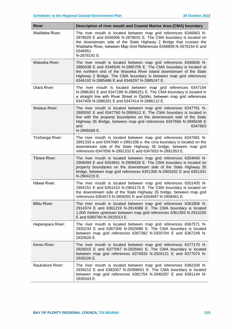
Schedules to the Regional Coastal Environment Plan 30 October 2018
BAY OF PLENTY REGIONAL COUNCIL TOI MOANA 219
River Description of river mouth and Coastal Marine Area (CMA) boundary
Waiōtahe River: The river mouth is located between map grid references 6346963 N-2878029 E and 6346995 N-2878031 E. The CMA boundary is located on the downstream side of the State Highway 2 Bridge that crosses the Waiōtahe River, between Map Grid References 6346859 N-2878154 E and 6346951 N-2878191 E.
Waioeka River: The river mouth is located between map grid references 6346606 N-2885638 E and 6346545 N-2885705 E. The CMA boundary is located at the northern end of the Waioeka River island downstream of the State Highway 2 Bridge. The CMA boundary is between map grid references 6346192 N-2885486 E and 6346297 N-2885247 E.
Otara River: The river mouth is located between map grid references 6347194 N-2886301 E and 6347189 N-2886251 E. The CMA boundary is located in a straight line with River Street in Ōpōtiki, between map grid references 6347405 N-2886261 E and 6347414 N-2886112 E.
Waiaua River: The river mouth is located between map grid references 6347761 N-2895592 E and 6347760 N-2895612 E. The CMA boundary is located in line with the property boundaries on the downstream side of the State Highway 35 Bridge, between map grid references 6347666 N-2895648 E and 6347663 N-2895568 E.
Tirohanga River: The river mouth is located between map grid references 6347681 N-2891333 e and 6347680 n-2891338 e. the cma boundary is located on the downstream side of the State Highway 35 bridge, between map grid references 6347656 N-2891332 E and 6347653 N-2891353 E.
Tōrere River: The river mouth is located between map grid references 6354840 N-2908494 E and 6354841 N-2908528 E. The CMA boundary is located on property boundaries on the downstream side of the State Highway 35 bridge, between map grid references 6351306 N-2904202 E and 6351341 N-2904215 E.
Hāwai River: The river mouth is located between map grid references 6351405 N-2904151 E and 6351410 N-2904170 E. The CMA boundary is located on the downstream side of the State Highway 35 bridge, between map grid references 6354673 N-2908391 E and 6354697 N-2908461 E.
Mōtu River: The river mouth is located between map grid references 6361806 N-2914374 E and 6361219 N-2914086 E. The CMA boundary is located 1,000 metres upstream between map grid references 6361393 N-2915250 E and 6360760 N-2915013 E.
Haparapara River: The river mouth is located between map grid references 6367571 N-2920234 E and 6367306 N-2920088 E. The CMA boundary is located between map grid references 6367392 N-2920704 E and 6367249 N-2920626 E.
Kereu River: The river mouth is located between map grid references 6377170 N-2926015 E and 6377067 N-2925941 E. The CMA boundary is located between map grid references 6376933 N-2926121 E and 6377074 N-2926226 E.
Raukokore River: The river mouth is located between map grid references 6382209 N-2939212 E and 6382057 N-29388691 E. The CMA boundary is located between map grid references 6381754 N-2940297 E and 6381144 N-2939343 E.
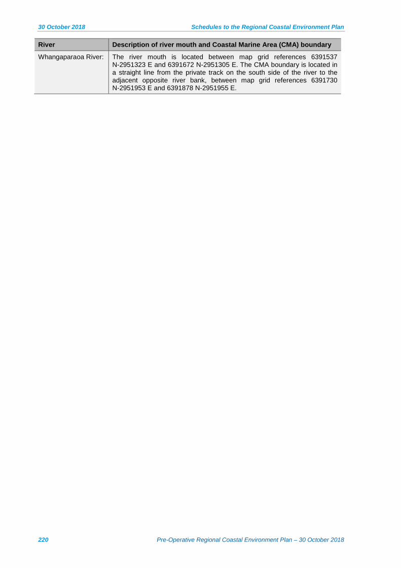
30 October 2018 Schedules to the Regional Coastal Environment Plan
220 Pre-Operative Regional Coastal Environment Plan – 30 October 2018
River Description of river mouth and Coastal Marine Area (CMA) boundary
Whangaparaoa River: The river mouth is located between map grid references 6391537 N-2951323 E and 6391672 N-2951305 E. The CMA boundary is located in a straight line from the private track on the south side of the river to the adjacent opposite river bank, between map grid references 6391730 N-2951953 E and 6391878 N-2951955 E.

Schedules to the Regional Coastal Environment Plan 30 October 2018
BAY OF PLENTY REGIONAL COUNCIL TOI MOANA 221
Schedule 2 – Indigenous Biological Diversity Areas in the Coastal Environment
Table 1: Indigenous Biological Diversity Areas A - Areas that meet the criteria listed in Policy 11(a) of the NZCPS
General location and map sheet
Indigenous Biological Diversity Area A
New Zealand Threat Status * - NZCPS Policy 11(a)(i)
International Threat Status * - NZCPS Policy 11(a)(ii)
Threatened or rare ecosystems and vegetation types - NZCPS Policy 11(a)(iii)
Habitat of indigenous species at limit of natural range or rare - NZCPS Policy 11(a)(iv)
Nationally significant area - NZCPS Policy 11(a)(v)
Biodiversity values protected by legislation - NZCPS Policy 11(a)(vi)
Waihī Beach Mapsheet 2b
Bowentown Heads IBDA A1
Y Flora: New Zealand spinach (At Risk-Naturally Uncommon). Avifauna: Northern little blue penguin (At Risk-Declining).
Y New Zealand dotterel (Endangered).
Y Pohutukawa forest. Y Southern limit of Coastal Brake (Pteris comans).
N Regionally Significant
Biodiversity values at the site are not formally protected, but part of the site is a WBOPDC reserve.
Waihī Beach Map sheet 2b
Bowentown Sand Dunes and Beach IBDA A2
Y Flora: Coprosma acerosa (At Risk-Declining), Sand pimelea (At Risk-Declining) (1983), Pingao (At Risk-Relict). Avifauna: Northern New Zealand dotterel (Threatened-Nationally Vulnerable), Variable oystercatcher (At Risk-Recovering).
Y Nesting area for New Zealand dotterel (Endangered).
Y Sand dunes are an “originally rare” ecosystem type and this site is a relatively large, high quality example of this ecosystem type. Bownentown Beach is a secondary roost site for shorebirds.
N Regionally Significant
Biodiversity values at the site are not formally protected, but part of the site is a WBOPDC reserve.
Waihī Beach Map sheet 1b
Orokawa (Part) IBDA A3
Y Flora: Picris burbidgeae (Threatened-Nationally Endangered); Pimelea tomentosa (Threatened-Nationally Vulnerable) (1996). Avifauna: Northern little blue penguin (At Risk-Declining).
Y Coastal forest, including pohutukawa forest.
Y Southern limit of Hebe pubescens subsp. pubescens (1985).
Y Nationally Significant
Y Most of the site is within Orokawa Scenic Reserve (Department of Conservation).

30 October 2018 Schedules to the Regional Coastal Environment Plan
222 Pre-Operative Regional Coastal Environment Plan – 30 October 2018
General location and map sheet
Indigenous Biological Diversity Area A
New Zealand Threat Status * - NZCPS Policy 11(a)(i)
International Threat Status * - NZCPS Policy 11(a)(ii)
Threatened or rare ecosystems and vegetation types - NZCPS Policy 11(a)(iii)
Habitat of indigenous species at limit of natural range or rare - NZCPS Policy 11(a)(iv)
Nationally significant area - NZCPS Policy 11(a)(v)
Biodiversity values protected by legislation - NZCPS Policy 11(a)(vi)
Tauranga Harbour Map sheets 5b, 7b
Aongatete Estuary IBDA A4
Y Avifauna: Australasian bittern (Threatened-Nationally Endangered), Banded rail (At Risk-Naturally Uncommon), Black shag (At Risk-Naturally Uncommon), North Island fernbird (At Risk-Declining), Pied stilt (At Risk-Declining). Fish: Inanga (At Risk-Declining), Longfin eel (At Risk-Declining), Redfin bully (At Risk-Declining).
Y Australasian bittern (Endangered).
Y High quality estuarine vegetation.
Y Nationally Significant
Biodiversity values at the site are not formally protected, but part of the site is a WBOPDC reserve.
Tauranga Harbour Map sheet 2b
Athenree IBDA A5
Y Avifauna: Australasian bittern (Threatened-Nationally Endangered), Spotless crake (At Risk-Relict), Marsh crake (At Risk-Relict), Banded rail (At Risk-Naturally Uncommon), North Island fernbird (At Risk-Declining). Fish: Longfin eel (At Risk-Declining), Redfin bully (At Risk-Declining), Torrentfish (At Risk-Declining).
Y Australasian bittern (Endangered).
Y High quality estuarine wetland with smaller examples of palustrine wetland.
Y Nationally Significant
Y Athenree Wildlife Refuge (Department of Conservation).
Tauranga Harbour map sheet 2b
Bowentown Shellbanks IBDA A6
Y Avifauna: Caspian tern (Threatened-Nationally Vulnerable), Northern New Zealand dotterel (Threatened-Nationally Vulnerable), Red-billed gull (Threatened-Nationally Vulnerable), New Zealand pied oystercatcher (At Risk-Declining), Variable oystercatcher (At Risk-Recovering).
Y The site is a largely unvegetated shellbank that is one of the most important roosting sites in Tauranga Harbour.
N Regionally Significant
Unprotected.
Tauranga Harbour map sheets 3b, 5b
Egg Island Sandbank IBDA A7
Y Avifauna: New Zealand pied oystercatcher (At Risk-Declining).
Y High tide roost that includes sandbanks and seagrass beds.
Y Nationally Significant
Y Partially protected (Stewardship Area, Department of Conservation).
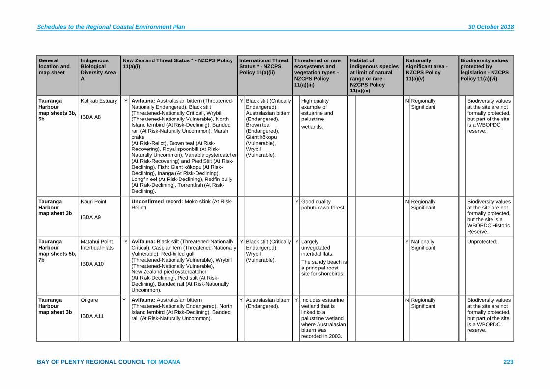
Schedules to the Regional Coastal Environment Plan 30 October 2018
BAY OF PLENTY REGIONAL COUNCIL TOI MOANA 223
General location and map sheet
Indigenous Biological Diversity Area A
New Zealand Threat Status * - NZCPS Policy 11(a)(i)
International Threat Status * - NZCPS Policy 11(a)(ii)
Threatened or rare ecosystems and vegetation types - NZCPS Policy 11(a)(iii)
Habitat of indigenous species at limit of natural range or rare - NZCPS Policy 11(a)(iv)
Nationally significant area - NZCPS Policy 11(a)(v)
Biodiversity values protected by legislation - NZCPS Policy 11(a)(vi)
Tauranga Harbour map sheets 3b, 5b
Katikati Estuary IBDA A8
Y Avifauna: Australasian bittern (Threatened-Nationally Endangered), Black stilt (Threatened-Nationally Critical), Wrybill (Threatened-Nationally Vulnerable), North Island fernbird (At Risk-Declining), Banded rail (At Risk-Naturally Uncommon), Marsh crake (At Risk-Relict), Brown teal (At Risk-Recovering), Royal spoonbill (At Risk-Naturally Uncommon), Variable oystercatcher (At Risk-Recovering) and Pied Stilt (At Risk-Declining). Fish: Giant kōkopu (At Risk-Declining), Inanga (At Risk-Declining), Longfin eel (At Risk-Declining), Redfin bully (At Risk-Declining), Torrentfish (At Risk-Declining).
Y Black stilt (Critically Endangered), Australasian bittern (Endangered), Brown teal (Endangered), Giant kōkopu (Vulnerable), Wrybill (Vulnerable).
High quality example of estuarine and palustrine wetlands.
N Regionally Significant
Biodiversity values at the site are not formally protected, but part of the site is a WBOPDC reserve.
Tauranga Harbour map sheet 3b
Kauri Point IBDA A9
Unconfirmed record: Moko skink (At Risk-Relict).
Y Good quality pohutukawa forest.
N Regionally Significant
Biodiversity values at the site are not formally protected, but the site is a WBOPDC Historic Reserve.
Tauranga Harbour map sheets 5b, 7b
Matahui Point Intertidal Flats IBDA A10
Y Avifauna: Black stilt (Threatened-Nationally Critical), Caspian tern (Threatened-Nationally Vulnerable), Red-billed gull (Threatened-Nationally Vulnerable), Wrybill (Threatened-Nationally Vulnerable), New Zealand pied oystercatcher (At Risk-Declining), Pied stilt (At Risk-Declining), Banded rail (At Risk-Nationally Uncommon).
Y Black stilt (Critically Endangered), Wrybill (Vulnerable).
Y Largely unvegetated intertidal flats. The sandy beach is a principal roost site for shorebirds.
Y Nationally Significant
Unprotected.
Tauranga Harbour map sheet 3b
Ongare IBDA A11
Y Avifauna: Australasian bittern (Threatened-Nationally Endangered), North Island fernbird (At Risk-Declining), Banded rail (At Risk-Naturally Uncommon).
Y Australasian bittern (Endangered).
Y Includes estuarine wetland that is linked to a palustrine wetland where Australasian bittern was recorded in 2003.
N Regionally Significant
Biodiversity values at the site are not formally protected, but part of the site is a WBOPDC reserve.
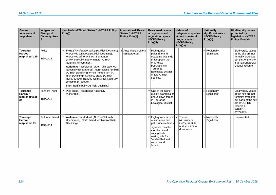
30 October 2018 Schedules to the Regional Coastal Environment Plan
224 Pre-Operative Regional Coastal Environment Plan – 30 October 2018
General location and map sheet
Indigenous Biological Diversity Area A
New Zealand Threat Status * - NZCPS Policy 11(a)(i)
International Threat Status * - NZCPS Policy 11(a)(ii)
Threatened or rare ecosystems and vegetation types - NZCPS Policy 11(a)(iii)
Habitat of indigenous species at limit of natural range or rare - NZCPS Policy 11(a)(iv)
Nationally significant area - NZCPS Policy 11(a)(v)
Biodiversity values protected by legislation - NZCPS Policy 11(a)(vi)
Tauranga Harbour map sheet 13b
Poike IBDA A12
Y Flora Dianella haematica (At Risk-Declining), Pterostylis paludosa (At Risk-Declining), Pterostylis aff. graminea “Sphagnum” (Taxonomically Indeterminate, At Risk-Naturally Uncommon). Avifauna: Australasian bittern (Threatened-Nationally Endangered), North Island fernbird (At Risk-Declining), White-fronted tern (At Risk-Declining), Spotless crake (At Risk-Relict) (1990), Banded rail (At Risk-Naturally Uncommon) (1990). Fish: Redfin bully (At Risk-Declining)
Y Australasian bittern (Endangered).
Y High quality palustrine and estuarine wetlands that support the only known populations in Tauranga Ecological District of two At Risk species.
N Regionally Significant
Biodiversity values at the site are not formally protected, but part of the site is a Tauranga City Council reserve.
Tauranga Harbour map sheets 2b, 3b
Tanners Point IBDA A13
Y Pied shag (Threatened-Nationally Vulnerable).
Y One of the higher quality examples of pohutukawa forest in Tauranga Ecological District.
N Regionally Significant
Biodiversity values at the site are not formally protected, but parts of the site are WBOPDC reserve or WBOPDC covenants.
Tauranga Harbour map sheet 7b
Te Hopai Island IBDA A14
Y Avifauna: Banded rail (At Risk-Naturally Uncommon), North Island fernbird (At Risk-Declining).
Y High quality mosaic of estuarine and palustrine wetlands. High-tide roost for shorebirds and wading birds. Nesting site for Banded Rail and North Island Fernbird.
Y Toetoe (Austroderia toetoe) is at its northern limit of distribution.
Y Nationally Significant
Unprotected.
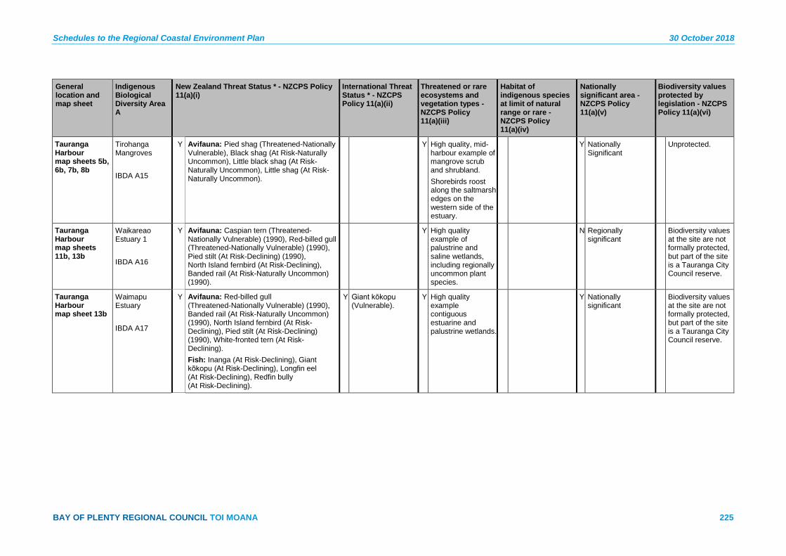
Schedules to the Regional Coastal Environment Plan 30 October 2018
BAY OF PLENTY REGIONAL COUNCIL TOI MOANA 225
General location and map sheet
Indigenous Biological Diversity Area A
New Zealand Threat Status * - NZCPS Policy 11(a)(i)
International Threat Status * - NZCPS Policy 11(a)(ii)
Threatened or rare ecosystems and vegetation types - NZCPS Policy 11(a)(iii)
Habitat of indigenous species at limit of natural range or rare - NZCPS Policy 11(a)(iv)
Nationally significant area - NZCPS Policy 11(a)(v)
Biodiversity values protected by legislation - NZCPS Policy 11(a)(vi)
Tauranga Harbour map sheets 5b, 6b, 7b, 8b
Tirohanga Mangroves IBDA A15
Y Avifauna: Pied shag (Threatened-Nationally Vulnerable), Black shag (At Risk-Naturally Uncommon), Little black shag (At Risk-Naturally Uncommon), Little shag (At Risk-Naturally Uncommon).
Y High quality, mid-harbour example of mangrove scrub and shrubland. Shorebirds roost along the saltmarsh edges on the western side of the estuary.
Y Nationally Significant
Unprotected.
Tauranga Harbour map sheets 11b, 13b
Waikareao Estuary 1 IBDA A16
Y Avifauna: Caspian tern (Threatened-Nationally Vulnerable) (1990), Red-billed gull (Threatened-Nationally Vulnerable) (1990), Pied stilt (At Risk-Declining) (1990), North Island fernbird (At Risk-Declining), Banded rail (At Risk-Naturally Uncommon) (1990).
Y High quality example of palustrine and saline wetlands, including regionally uncommon plant species.
N Regionally significant
Biodiversity values at the site are not formally protected, but part of the site is a Tauranga City Council reserve.
Tauranga Harbour map sheet 13b
Waimapu Estuary IBDA A17
Y Avifauna: Red-billed gull (Threatened-Nationally Vulnerable) (1990), Banded rail (At Risk-Naturally Uncommon) (1990), North Island fernbird (At Risk-Declining), Pied stilt (At Risk-Declining) (1990), White-fronted tern (At Risk-Declining). Fish: Inanga (At Risk-Declining), Giant kōkopu (At Risk-Declining), Longfin eel (At Risk-Declining), Redfin bully (At Risk-Declining).
Y Giant kōkopu (Vulnerable).
Y High quality example contiguous estuarine and palustrine wetlands.
Y Nationally significant
Biodiversity values at the site are not formally protected, but part of the site is a Tauranga City Council reserve.
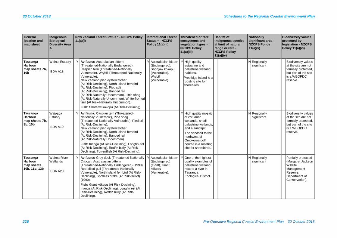
30 October 2018 Schedules to the Regional Coastal Environment Plan
226 Pre-Operative Regional Coastal Environment Plan – 30 October 2018
General location and map sheet
Indigenous Biological Diversity Area A
New Zealand Threat Status * - NZCPS Policy 11(a)(i)
International Threat Status * - NZCPS Policy 11(a)(ii)
Threatened or rare ecosystems and vegetation types - NZCPS Policy 11(a)(iii)
Habitat of indigenous species at limit of natural range or rare - NZCPS Policy 11(a)(iv)
Nationally significant area - NZCPS Policy 11(a)(v)
Biodiversity values protected by legislation - NZCPS Policy 11(a)(vi)
Tauranga Harbour map sheets 7b, 10b
Wainui Estuary IBDA A18
Y Avifauna: Australasian bittern (Threatened-Nationally Endangered), Caspian tern (Threatened-Nationally Vulnerable), Wrybill (Threatened-Nationally Vulnerable), New Zealand pied oystercatcher (At Risk-Declining), North Island fernbird (At Risk-Declining), Pied stilt (At Risk-Declining), Banded rail (At Risk-Naturally Uncommon), Little shag (At Risk-Naturally Uncommon), White-fronted tern (At Risk-Naturally Uncommon). Fish: Shortjaw kōkopu (At Risk-Declining).
Y Australasian bittern (Endangered), Shortjaw kōkopu (Vulnerable), Wrybill (Vulnerable).
Y High quality estuarine and palustrine wetland habitats. Prestidge Island is a roosting site for shorebirds.
N Regionally significant
Biodiversity values at the site are not formally protected, but part of the site is a WBOPDC reserve.
Tauranga Harbour map sheets 7b, 8b, 10b
Waipapa Estuary IBDA A19
Y Avifauna: Caspian tern (Threatened-Nationally Vulnerable), Pied shag (Threatened-Nationally Vulnerable), Pied stilt (At Risk-Declining), New Zealand pied oystercatcher (At Risk-Declining), North Island fernbird (At Risk-Declining), Banded rail (At Risk-Naturally Uncommon). Fish: Inanga (At Risk-Declining), Longfin eel (At Risk-Declining), Redfin bully (At Risk-Declining), Torrentfish (At Risk-Declining).
Y High quality mosaic of estuarine wetlands, small palustrine wetlands, and a sandspit. The sandspit to the northwest of Ōmokoroa golf course is a roosting site for shorebirds.
N Regionally significant
Biodiversity values at the site are not formally protected, but part of the site is a WBOPDC reserve.
Tauranga Harbour map sheets 10b, 11b, 13b
Wairoa River Wetlands IBDA A20
Y Avifauna: Grey duck (Threatened-Nationally Critical), Australasian bittern (Threatened-Nationally Endangered) (1990), Red-billed gull (Threatened-Nationally Vulnerable), North Island fernbird (At Risk-Declining), Spotless crake (At Risk-Relict) (1990). Fish: Giant kōkopu (At Risk-Declining), Inanga (At Risk-Declining), Longfin eel (At Risk-Declining), Redfin bully (At Risk-Declining).
Y Australasian bittern (Endangered) (1990), Giant kōkopu (Vulnerable).
Y One of the highest quality examples of palustrine wetland next to a river in Tauranga Ecological District.
N Regionally significant
Partially protected (Margaret Jackson Wildlife Management Reserve, Department of Conservation).
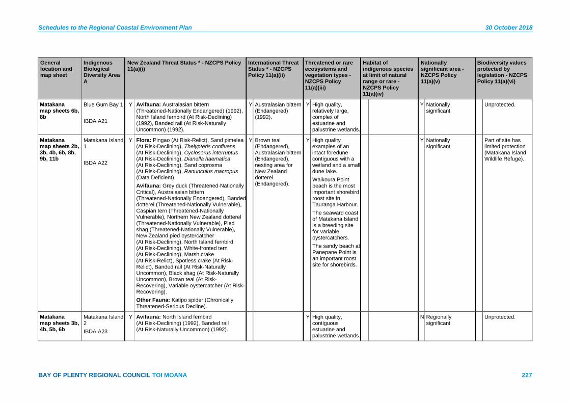
Schedules to the Regional Coastal Environment Plan 30 October 2018
BAY OF PLENTY REGIONAL COUNCIL TOI MOANA 227
General location and map sheet
Indigenous Biological Diversity Area A
New Zealand Threat Status * - NZCPS Policy 11(a)(i)
International Threat Status * - NZCPS Policy 11(a)(ii)
Threatened or rare ecosystems and vegetation types - NZCPS Policy 11(a)(iii)
Habitat of indigenous species at limit of natural range or rare - NZCPS Policy 11(a)(iv)
Nationally significant area - NZCPS Policy 11(a)(v)
Biodiversity values protected by legislation - NZCPS Policy 11(a)(vi)
Matakana map sheets 6b, 8b
Blue Gum Bay 1 IBDA A21
Y Avifauna: Australasian bittern (Threatened-Nationally Endangered) (1992), North Island fernbird (At Risk-Declining) (1992), Banded rail (At Risk-Naturally Uncommon) (1992).
Y Australasian bittern (Endangered) (1992).
Y High quality, relatively large, complex of estuarine and palustrine wetlands.
Y Nationally significant
Unprotected.
Matakana map sheets 2b, 3b, 4b, 6b, 8b, 9b, 11b
Matakana Island 1 IBDA A22
Y Flora: Pingao (At Risk-Relict), Sand pimelea (At Risk-Declining), Thelypteris confluens (At Risk-Declining), Cyclosorus interruptus (At Risk-Declining), Dianella haematica (At Risk-Declining), Sand coprosma (At Risk-Declining), Ranunculus macropus (Data Deficient). Avifauna: Grey duck (Threatened-Nationally Critical), Australasian bittern (Threatened-Nationally Endangered), Banded dotterel (Threatened-Nationally Vulnerable), Caspian tern (Threatened-Nationally Vulnerable), Northern New Zealand dotterel (Threatened-Nationally Vulnerable), Pied shag (Threatened-Nationally Vulnerable), New Zealand pied oystercatcher (At Risk-Declining), North Island fernbird (At Risk-Declining), White-fronted tern (At Risk-Declining), Marsh crake (At Risk-Relict), Spotless crake (At Risk-Relict), Banded rail (At Risk-Naturally Uncommon), Black shag (At Risk-Naturally Uncommon), Brown teal (At Risk-Recovering), Variable oystercatcher (At Risk-Recovering). Other Fauna: Katipo spider (Chronically Threatened-Serious Decline).
Y Brown teal (Endangered), Australasian bittern (Endangered), nesting area for New Zealand dotterel (Endangered).
Y High quality examples of an intact foredune contiguous with a wetland and a small dune lake. Waikoura Point beach is the most important shorebird roost site in Tauranga Harbour. The seaward coast of Matakana Island is a breeding site for variable oystercatchers. The sandy beach at Panepane Point is an important roost site for shorebirds.
Y Nationally significant
Part of site has limited protection (Matakana Island Wildlife Refuge).
Matakana map sheets 3b, 4b, 5b, 6b
Matakana Island 2 IBDA A23
Y Avifauna: North Island fernbird (At Risk-Declining) (1992), Banded rail (At Risk-Naturally Uncommon) (1992).
Y High quality, contiguous estuarine and palustrine wetlands.
N Regionally significant
Unprotected.

30 October 2018 Schedules to the Regional Coastal Environment Plan
228 Pre-Operative Regional Coastal Environment Plan – 30 October 2018
General location and map sheet
Indigenous Biological Diversity Area A
New Zealand Threat Status * - NZCPS Policy 11(a)(i)
International Threat Status * - NZCPS Policy 11(a)(ii)
Threatened or rare ecosystems and vegetation types - NZCPS Policy 11(a)(iii)
Habitat of indigenous species at limit of natural range or rare - NZCPS Policy 11(a)(iv)
Nationally significant area - NZCPS Policy 11(a)(v)
Biodiversity values protected by legislation - NZCPS Policy 11(a)(vi)
Matakana map sheets 2b, 3b
Matakana Wetlands B IBDA A24
Y Flora: Cyclosorus interruptus (At Risk-Declining), Thelypteris confluens (At Risk-Declining), Ranunculus macropus (Data Deficient). Avifauna: Grey duck (Threatened-Nationally Critical) (1992), Spotless crake (At Risk-Relict) (1992).
Y Nationally significant
Y Protected (Matakana Island Wildlife Refuge).
Matakana map sheet 8b
Opureora IBDA A25
Y Avifauna: Caspian tern (Threatened-Nationally Vulnerable) (1992), Northern New Zealand dotterel (Threatened-Nationally Vulnerable), New Zealand pied oystercatcher (At Risk-Declining), North Island fernbird (At Risk-Declining), Spotless crake (At Risk-Relict) (1992), Variable oystercatcher (At Risk-Recovering).
Y The sandspit is a nesting area for the New Zealand dotterel (Endangered).
Y High quality estuarine wetlands important for avifauna (shorebirds and estuarine birds) for nesting and roosting. Opureora sandspit is a principal shorebird roost site.
Y Nationally significant
Biodiversity values at the site are not formally protected, but part of the site is a WBOPDC reserve.
Matakana map sheet 8b
Otapu Bay IBDA A26
Y Avifauna: Australasian bittern (Threatened-Nationally Endangered) (1992), North Island fernbird (At Risk-Declining), Banded rail (At Risk-Naturally Uncommon) (1992).
Y Australasian bittern (Endangered) (1992).
Y High quality mosaic of estuarine and palustrine wetlands.
Y Nationally significant
Unprotected.
Matakana map sheet 8b
Tahunamanu Island IBDA A27
Y Avifauna: Caspian tern (Threatened-Nationally Endangered), Banded dotterel (Threatened-Nationally Vulnerable), Northern New Zealand dotterel (Threatened-Nationally Vulnerable), Red-billed gull (Threatened-Nationally Vulnerable), Wrybill (Threatened-Nationally Vulnerable), New Zealand pied oystercatcher (At Risk-Declining), Pied stilt (At Risk-Declining), White-fronted tern (At Risk-Declining), Little black shag (At Risk-Naturally Uncommon), Little shag (At Risk-Naturally Uncommon), Variable oystercatcher (At Risk-Recovering).
Y New Zealand dotterel (Endangered), Wrybill (Vulnerable).
Y Important nesting site and high tide roost for avifauna.
N Regionally significant
Unprotected.

Schedules to the Regional Coastal Environment Plan 30 October 2018
BAY OF PLENTY REGIONAL COUNCIL TOI MOANA 229
General location and map sheet
Indigenous Biological Diversity Area A
New Zealand Threat Status * - NZCPS Policy 11(a)(i)
International Threat Status * - NZCPS Policy 11(a)(ii)
Threatened or rare ecosystems and vegetation types - NZCPS Policy 11(a)(iii)
Habitat of indigenous species at limit of natural range or rare - NZCPS Policy 11(a)(iv)
Nationally significant area - NZCPS Policy 11(a)(v)
Biodiversity values protected by legislation - NZCPS Policy 11(a)(vi)
Mauāo map sheets 9b, 11b
Mauāo 1 IBDA A28
Y Flora: Pimelea tomentosa (Threatened-Nationally Vulnerable). Avifauna: Northern little blue penguins (At Risk-Declining).
Y High quality example of pohutukawa forest and secondary, indigenous scrub and shrublands.
Y Sword sedge (Lepidosperma laterale) is at, or close to, it’s known southern limit of distribution.
Y Nationally significant
Biodiversity values at the site are not formally protected.
Mauāo map sheets 9b, 11b, 12b
Motuotau (Rabbit Island) IBDA A29
Y Avifauna: Red-billed gulls (Threatened-Nationally Vulnerable), Reef heron (Threatened-Nationally Vulnerable), Northern little blue penguin (At Risk-Declining), New Zealand white-faced storm petrel (At Risk-Relict), Northern diving petrel (At Risk-Relict).
Y High quality pohutukawa forest.
Y Nationally significant
Y Motuotau Island Scenic Reserve (Department of Conservation).
Mount/ Pāpāmoa map sheets 12b, 14b
Otira Sand Dunes IBDA A30
Y Flora: Pingao (At Risk-Relict). Avifauna: New Zealand pipit (At Risk-Declining), Variable oystercatcher (At Risk-Recovering). Other Fauna: Katipo spider (Chronically Threatened-Serious Decline).
Y Sand dune habitats have been greatly reduced in extent both in the Bay of Plenty Region and nationally, and this site is dominated by indigenous vegetation types of relatively high quality.
N Regionally significant
Biodiversity values at the site are not formally protected, but parts are a Tauranga City Council reserve.
Mount/ Pāpāmoa map sheets 14b, 15b
Pāpāmoa Sand Dunes IBDA A31
Y Flora: Pingao (At Risk-Relict), Sand tussock (At Risk-Declining), Sand pimelea (At Risk-Declining). Avifauna: New Zealand pipit (At Risk-Declining), Variable oystercatcher (At Risk-Recovering). Other Fauna: Katipo (Chronically Threatened-Serious Decline).
Y Sand dune habitats have been greatly reduced in extent both in the Bay of Plenty Region and nationally, and this site is dominated by indigenous vegetation types of relatively high quality.
N Regionally significant
Biodiversity values at the site are not formally protected, but the site is a Tauranga City Council reserve.

30 October 2018 Schedules to the Regional Coastal Environment Plan
230 Pre-Operative Regional Coastal Environment Plan – 30 October 2018
General location and map sheet
Indigenous Biological Diversity Area A
New Zealand Threat Status * - NZCPS Policy 11(a)(i)
International Threat Status * - NZCPS Policy 11(a)(ii)
Threatened or rare ecosystems and vegetation types - NZCPS Policy 11(a)(iii)
Habitat of indigenous species at limit of natural range or rare - NZCPS Policy 11(a)(iv)
Nationally significant area - NZCPS Policy 11(a)(v)
Biodiversity values protected by legislation - NZCPS Policy 11(a)(vi)
Kaituna/ Maketū map sheet 16b
Arawa Wetland IBDA A32
Y Flora: Pterostylis micromega (Threatened-Nationally Critical), Cyclosorus interruptus (At Risk-Declining), Thelypteris confluens (At Risk-Declining), Pterostylis aff. graminea “sphagnum” (At Risk-Naturally Uncommon). Fish: Inanga (At Risk-Declining).
Y Parts are highly degraded but there is a very small, very high quality area that is an important habitat for threatened plant species.
N Regionally significant
Unprotected.
Kaituna/ Maketū map sheets 15b, 16b
Kaituna Sand Dunes and Wetland IBDA A33
Y Flora: Cyclosorus interruptus (At Risk-Declining), Myriophyllum robustum (At Risk-Declining), Sand tussock (At Risk-Declining), Thelypteris confluens (At Risk-Declining), Pingao (At Risk-Relict). Avifauna: Australasian bittern (Threatened-Nationally Endangered), Banded dotterel (Threatened-Nationally Vulnerable), Northern New Zealand dotterel (Threatened-Nationally Vulnerable), Red-billed gull (Threatened-Nationally Vulnerable), White-fronted tern (At Risk-Declining), Black shag (At Risk-Naturally Uncommon), New Zealand dabchick (At Risk-Naturally Uncommon), Variable oystercatcher (At Risk-Recovering). Other Fauna: Katipo (Chronically Threatened-Serious Decline). Possible Record: Amphibromus fluitans (Threatened-Nationally Endangered).
Y Australasian bittern (Endangered), New Zealand dotterel (Endangered).
Y Sand dune habitats have been greatly reduced in extent both in Bay of Plenty Region and nationally, and this site is dominated by indigenous vegetation types of relatively high quality.
N Regionally significant
Biodiversity values at the site are not formally protected, but the site is a Tauranga City Council reserve.

Schedules to the Regional Coastal Environment Plan 30 October 2018
BAY OF PLENTY REGIONAL COUNCIL TOI MOANA 231
General location and map sheet
Indigenous Biological Diversity Area A
New Zealand Threat Status * - NZCPS Policy 11(a)(i)
International Threat Status * - NZCPS Policy 11(a)(ii)
Threatened or rare ecosystems and vegetation types - NZCPS Policy 11(a)(iii)
Habitat of indigenous species at limit of natural range or rare - NZCPS Policy 11(a)(iv)
Nationally significant area - NZCPS Policy 11(a)(v)
Biodiversity values protected by legislation - NZCPS Policy 11(a)(vi)
Kaituna/ Maketū map sheet 16b
Lower Kaituna Wildlife Management Reserve IBDA A34
Y Avifauna: Australasian bittern (Threatened-Nationally Critical), White heron (Threatened-Nationally Critical), Grey duck (Threatened-Nationally Critical), New Zealand dabchick (Threatened-Nationally Vulnerable), Red-billed gull (Threatened-Nationally Vulnerable), Reef heron (Threatened-Nationally Vulnerable), New Zealand pipit (At Risk-Declining), North Island fernbird (At Risk-Declining), Pied stilt (At Risk-Declining), Marsh crake (At Risk-Relict), Spotless crake (At Risk-Relict), Banded rail (At Risk-Naturally Uncommon), Black shag (At Risk-Naturally Uncommon), Little black shag (At Risk-Naturally Uncommon), Royal spoonbill (At Risk-Naturally Uncommon), Little egret (Vagrant).
Y Australasian bittern (Endangered).
Y Large, high quality example of freshwater wetland, a habitat type that is threatened in the coastal environment.
Y Nationally significant
Y Protected (Lower Kaituna Wildlife Management Reserve).

30 October 2018 Schedules to the Regional Coastal Environment Plan
232 Pre-Operative Regional Coastal Environment Plan – 30 October 2018
General location and map sheet
Indigenous Biological Diversity Area A
New Zealand Threat Status * - NZCPS Policy 11(a)(i)
International Threat Status * - NZCPS Policy 11(a)(ii)
Threatened or rare ecosystems and vegetation types - NZCPS Policy 11(a)(iii)
Habitat of indigenous species at limit of natural range or rare - NZCPS Policy 11(a)(iv)
Nationally significant area - NZCPS Policy 11(a)(v)
Biodiversity values protected by legislation - NZCPS Policy 11(a)(vi)
Kaituna/ Maketū map sheet 16b
Maketū Estuary IBDA A35
Y Avifauna: New Zealand fairy tern (Threatened-Nationally Critical), Black stilt (Threatened-Nationally Critical), White heron (Threatened-Nationally Critical), Australasian bittern (Threatened-Nationally Endangered), Banded dotterel (Threatened-Nationally Vulnerable), Caspian tern (Threatened-Nationally Vulnerable), Northern New Zealand dotterel (Threatened-Nationally Vulnerable), Red-billed gull (Threatened-Nationally Vulnerable), Reef heron (Threatened-Nationally Vulnerable), Wrybill (Threatened-Nationally Vulnerable), New Zealand pied oystercatcher (At Risk-Declining), Northern little blue penguin (At Risk-Declining), Pied stilt (At Risk-Declining), Banded rail (At Risk-declining, Black shag (At Risk-Naturally Uncommon), Little shag (At Risk-Naturally Uncommon), White-fronted tern (At Risk-Naturally Uncommon), Variable oystercatcher (At Risk-Recovering). Fish: A suite of freshwater fish, including Threatened and At Risk species use Maketū Estuary as a migratory route and/or for parts of their life cycle.
Y Black stilt (Critically Endangered), Australasian bittern (Endangered), New Zealand dotterel (Endangered), Fairy tern (Vulnerable), Wrybill (Vulnerable).
Y Maketū Estuary has high ecological values and is among the highest quality examples in the region, particularly as avifauna habitat, including shorebird roosting sites on beaches, sandbanks and sandpits.
N Regionally significant

Schedules to the Regional Coastal Environment Plan 30 October 2018
BAY OF PLENTY REGIONAL COUNCIL TOI MOANA 233
General location and map sheet
Indigenous Biological Diversity Area A
New Zealand Threat Status * - NZCPS Policy 11(a)(i)
International Threat Status * - NZCPS Policy 11(a)(ii)
Threatened or rare ecosystems and vegetation types - NZCPS Policy 11(a)(iii)
Habitat of indigenous species at limit of natural range or rare - NZCPS Policy 11(a)(iv)
Nationally significant area - NZCPS Policy 11(a)(v)
Biodiversity values protected by legislation - NZCPS Policy 11(a)(vi)
Kaituna/ Maketū map sheet 16b
Maketū Spit and Wildlife Management Reserve IBDA A36
Y Flora: Pingao (At Risk-Relict), Sand tussock (At Risk-Declining) (not recorded recently). Avifauna: New Zealand fairy tern (Threatened-Nationally Critical), Australasian bittern (Threatened-Nationally Endangered), Banded dotterel (Threatened-Nationally Vulnerable), Caspian tern (Threatened-Nationally Vulnerable), Northern New Zealand dotterel (Threatened-Nationally Vulnerable), Reef heron (Threatened-Nationally Vulnerable), Wrybill (Threatened-Nationally Vulnerable), North Island fernbird (At Risk-Declining), Banded rail (At Risk-Naturally Uncommon), Variable oystercatcher (At Risk-Recovering). Other fauna: Katipo spider (Chronically Threatened-Serious Decline).
Y Australasian bittern (Endangered), New Zealand dotterel (Endangered), Fairy tern (Vulnerable), Wrybill (Vulnerable).
Y High quality example of indigenous dune vegetation on a relatively unmodified sandspit. Important shorebird and estuarine bird roost and breeding site.
N Regionally significant
Partially protected (Maketū Wildlife Management Reserve, Department of Conservation).
Little Waihī map sheet 16b
Waewaetutuki (Part) IBDA A37
Y Avifauna: Australasian bittern (Threatened-Nationally Endangered), Banded rail (At Risk-Naturally Uncommon), North Island fernbird (At Risk-Declining), pied stilt (At Risk-Declining). Fish: Giant kōkopu (At Risk-Declining), Inanga (At Risk-Declining), Longfin eel (At Risk-Declining), Redfin bully (At Risk-Declining). Flora: Pterostylis micromega (Nationally Critical), Mimulus repens (At Risk-Naturally Uncommon), Cyclosorus interruptus (At Risk-Declining), Ranunculus macropus (Data Deficient).
Y Australasian bittern (Endangered), Giant kōkopu (Vulnerable).
Y Largest wetland on the Pongakawa Plains, contiguous with Waihī Estuary.
Y Nationally significant Unprotected.
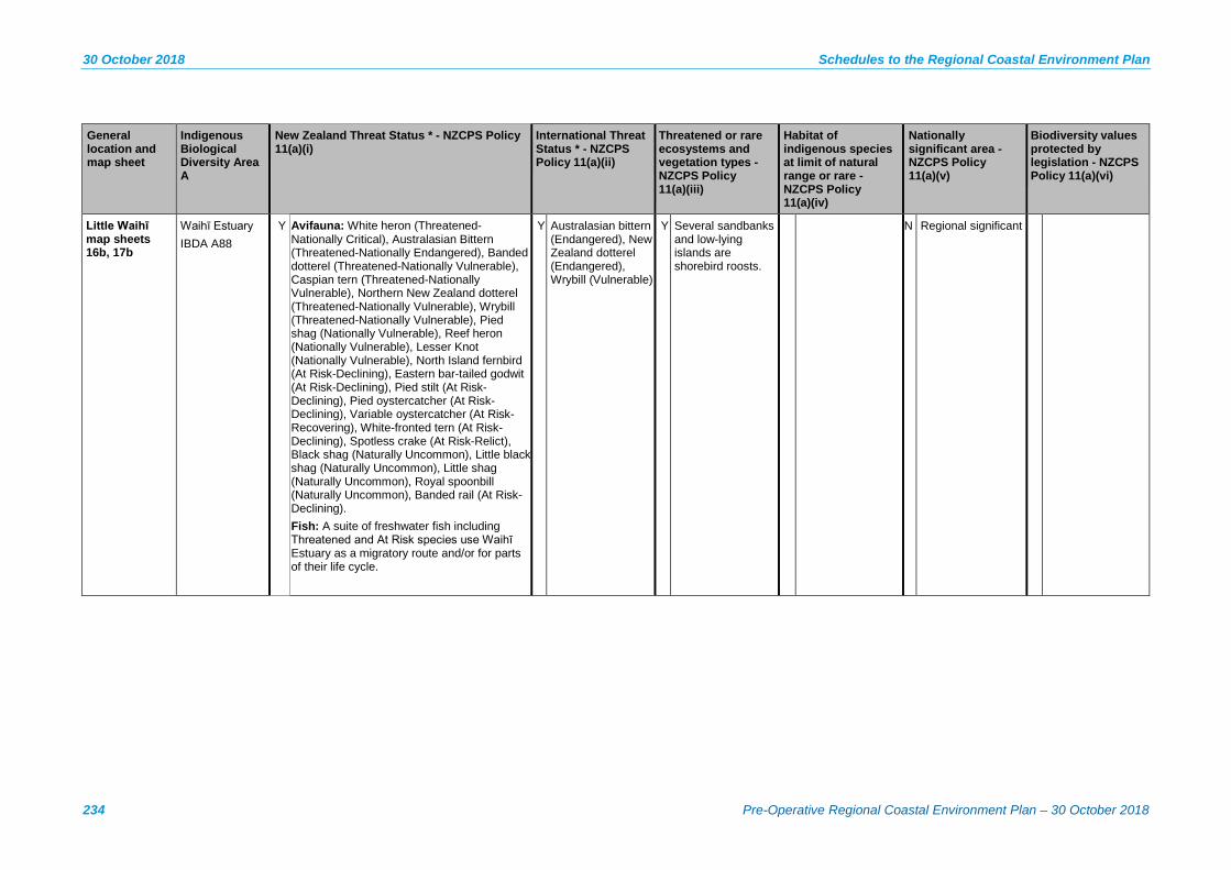
30 October 2018 Schedules to the Regional Coastal Environment Plan
234 Pre-Operative Regional Coastal Environment Plan – 30 October 2018
General location and map sheet
Indigenous Biological Diversity Area A
New Zealand Threat Status * - NZCPS Policy 11(a)(i)
International Threat Status * - NZCPS Policy 11(a)(ii)
Threatened or rare ecosystems and vegetation types - NZCPS Policy 11(a)(iii)
Habitat of indigenous species at limit of natural range or rare - NZCPS Policy 11(a)(iv)
Nationally significant area - NZCPS Policy 11(a)(v)
Biodiversity values protected by legislation - NZCPS Policy 11(a)(vi)
Little Waihī map sheets 16b, 17b
Waihī Estuary IBDA A88
Y Avifauna: White heron (Threatened-Nationally Critical), Australasian Bittern (Threatened-Nationally Endangered), Banded dotterel (Threatened-Nationally Vulnerable), Caspian tern (Threatened-Nationally Vulnerable), Northern New Zealand dotterel (Threatened-Nationally Vulnerable), Wrybill (Threatened-Nationally Vulnerable), Pied shag (Nationally Vulnerable), Reef heron (Nationally Vulnerable), Lesser Knot (Nationally Vulnerable), North Island fernbird (At Risk-Declining), Eastern bar-tailed godwit (At Risk-Declining), Pied stilt (At Risk-Declining), Pied oystercatcher (At Risk-Declining), Variable oystercatcher (At Risk-Recovering), White-fronted tern (At Risk-Declining), Spotless crake (At Risk-Relict), Black shag (Naturally Uncommon), Little black shag (Naturally Uncommon), Little shag (Naturally Uncommon), Royal spoonbill (Naturally Uncommon), Banded rail (At Risk-Declining). Fish: A suite of freshwater fish including Threatened and At Risk species use Waihī Estuary as a migratory route and/or for parts of their life cycle.
Y Australasian bittern (Endangered), New Zealand dotterel (Endangered), Wrybill (Vulnerable)
Y Several sandbanks and low-lying islands are shorebird roosts.
N Regional significant
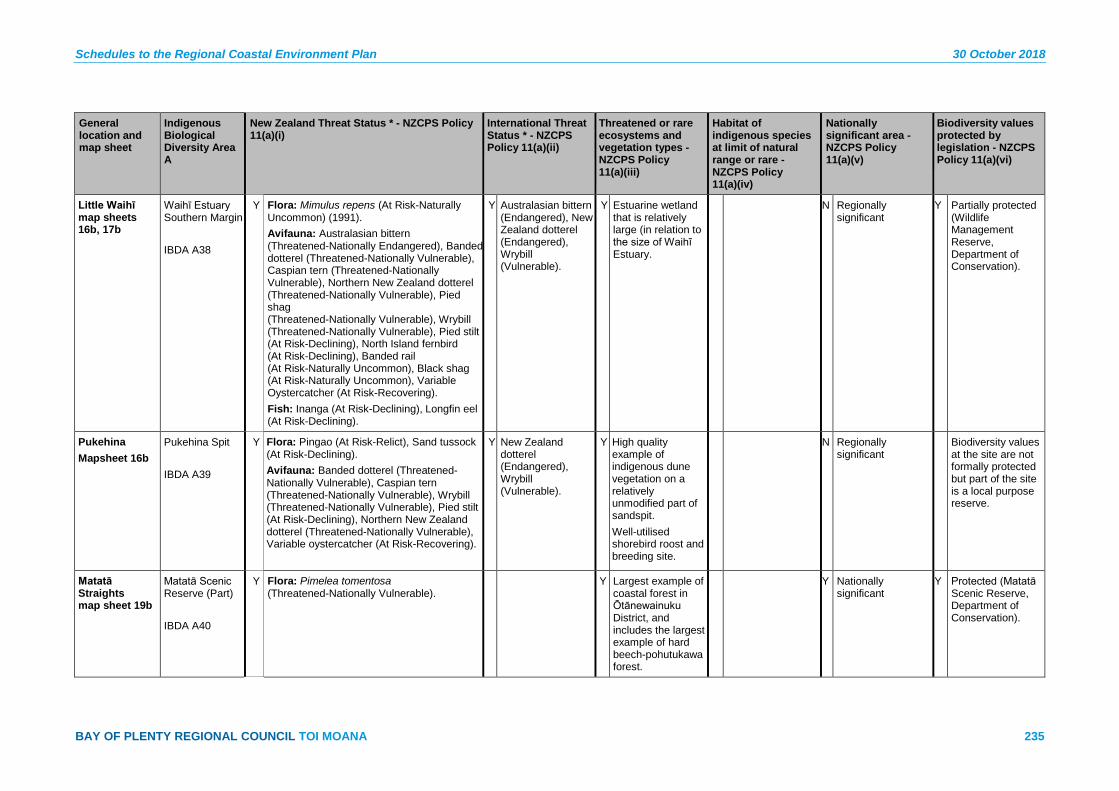
Schedules to the Regional Coastal Environment Plan 30 October 2018
BAY OF PLENTY REGIONAL COUNCIL TOI MOANA 235
General location and map sheet
Indigenous Biological Diversity Area A
New Zealand Threat Status * - NZCPS Policy 11(a)(i)
International Threat Status * - NZCPS Policy 11(a)(ii)
Threatened or rare ecosystems and vegetation types - NZCPS Policy 11(a)(iii)
Habitat of indigenous species at limit of natural range or rare - NZCPS Policy 11(a)(iv)
Nationally significant area - NZCPS Policy 11(a)(v)
Biodiversity values protected by legislation - NZCPS Policy 11(a)(vi)
Little Waihī map sheets 16b, 17b
Waihī Estuary Southern Margin IBDA A38
Y Flora: Mimulus repens (At Risk-Naturally Uncommon) (1991). Avifauna: Australasian bittern (Threatened-Nationally Endangered), Banded dotterel (Threatened-Nationally Vulnerable), Caspian tern (Threatened-Nationally Vulnerable), Northern New Zealand dotterel (Threatened-Nationally Vulnerable), Pied shag (Threatened-Nationally Vulnerable), Wrybill (Threatened-Nationally Vulnerable), Pied stilt (At Risk-Declining), North Island fernbird (At Risk-Declining), Banded rail (At Risk-Naturally Uncommon), Black shag (At Risk-Naturally Uncommon), Variable Oystercatcher (At Risk-Recovering). Fish: Inanga (At Risk-Declining), Longfin eel (At Risk-Declining).
Y Australasian bittern (Endangered), New Zealand dotterel (Endangered), Wrybill (Vulnerable).
Y Estuarine wetland that is relatively large (in relation to the size of Waihī Estuary.
N Regionally significant
Y Partially protected (Wildlife Management Reserve, Department of Conservation).
Pukehina Mapsheet 16b
Pukehina Spit IBDA A39
Y Flora: Pingao (At Risk-Relict), Sand tussock (At Risk-Declining). Avifauna: Banded dotterel (Threatened-Nationally Vulnerable), Caspian tern (Threatened-Nationally Vulnerable), Wrybill (Threatened-Nationally Vulnerable), Pied stilt (At Risk-Declining), Northern New Zealand dotterel (Threatened-Nationally Vulnerable), Variable oystercatcher (At Risk-Recovering).
Y New Zealand dotterel (Endangered), Wrybill (Vulnerable).
Y High quality example of indigenous dune vegetation on a relatively unmodified part of sandspit. Well-utilised shorebird roost and breeding site.
N Regionally significant
Biodiversity values at the site are not formally protected but part of the site is a local purpose reserve.
Matatā Straights map sheet 19b
Matatā Scenic Reserve (Part) IBDA A40
Y Flora: Pimelea tomentosa (Threatened-Nationally Vulnerable).
Y Largest example of coastal forest in Ōtānewainuku District, and includes the largest example of hard beech-pohutukawa forest.
Y Nationally significant
Y Protected (Matatā Scenic Reserve, Department of Conservation).
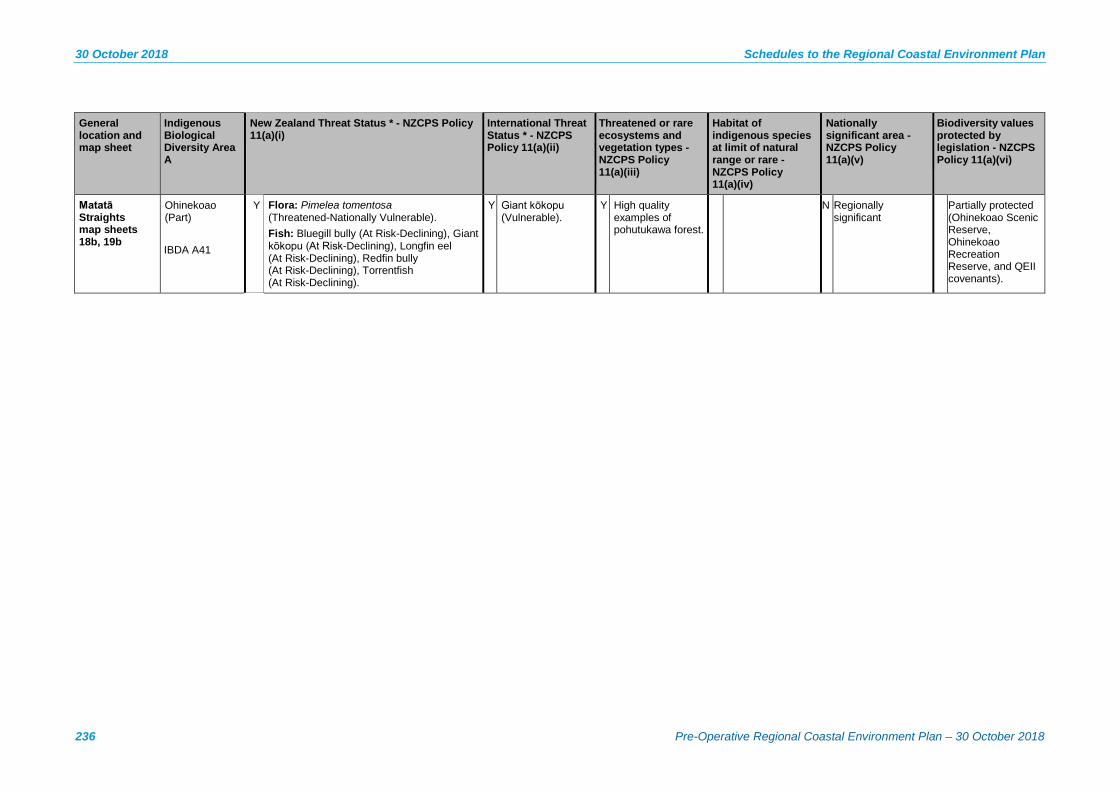
30 October 2018 Schedules to the Regional Coastal Environment Plan
236 Pre-Operative Regional Coastal Environment Plan – 30 October 2018
General location and map sheet
Indigenous Biological Diversity Area A
New Zealand Threat Status * - NZCPS Policy 11(a)(i)
International Threat Status * - NZCPS Policy 11(a)(ii)
Threatened or rare ecosystems and vegetation types - NZCPS Policy 11(a)(iii)
Habitat of indigenous species at limit of natural range or rare - NZCPS Policy 11(a)(iv)
Nationally significant area - NZCPS Policy 11(a)(v)
Biodiversity values protected by legislation - NZCPS Policy 11(a)(vi)
Matatā Straights map sheets 18b, 19b
Ohinekoao (Part) IBDA A41
Y Flora: Pimelea tomentosa (Threatened-Nationally Vulnerable). Fish: Bluegill bully (At Risk-Declining), Giant kōkopu (At Risk-Declining), Longfin eel (At Risk-Declining), Redfin bully (At Risk-Declining), Torrentfish (At Risk-Declining).
Y Giant kōkopu (Vulnerable).
Y High quality examples of pohutukawa forest.
N Regionally significant
Partially protected (Ohinekoao Scenic Reserve, Ohinekoao Recreation Reserve, and QEII covenants).
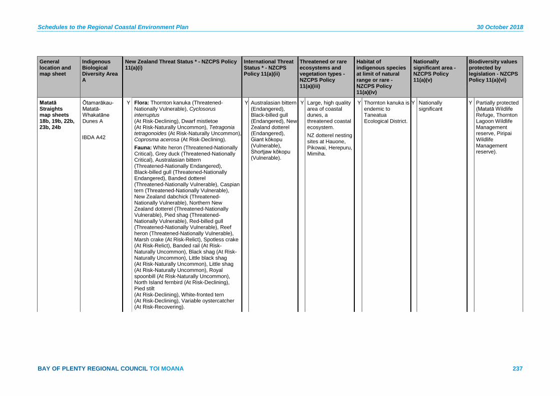
Schedules to the Regional Coastal Environment Plan 30 October 2018
BAY OF PLENTY REGIONAL COUNCIL TOI MOANA 237
General location and map sheet
Indigenous Biological Diversity Area A
New Zealand Threat Status * - NZCPS Policy 11(a)(i)
International Threat Status * - NZCPS Policy 11(a)(ii)
Threatened or rare ecosystems and vegetation types - NZCPS Policy 11(a)(iii)
Habitat of indigenous species at limit of natural range or rare - NZCPS Policy 11(a)(iv)
Nationally significant area - NZCPS Policy 11(a)(v)
Biodiversity values protected by legislation - NZCPS Policy 11(a)(vi)
Matatā Straights map sheets 18b, 19b, 22b, 23b, 24b
Ōtamarākau-Matatā-Whakatāne Dunes A IBDA A42
Y Flora: Thornton kanuka (Threatened-Nationally Vulnerable), Cyclosorus interruptus (At Risk-Declining), Dwarf mistletoe (At Risk-Naturally Uncommon), Tetragonia tetragonoides (At Risk-Naturally Uncommon), Coprosma acerosa (At Risk-Declining). Fauna: White heron (Threatened-Nationally Critical), Grey duck (Threatened-Nationally Critical), Australasian bittern (Threatened-Nationally Endangered), Black-billed gull (Threatened-Nationally Endangered), Banded dotterel (Threatened-Nationally Vulnerable), Caspian tern (Threatened-Nationally Vulnerable), New Zealand dabchick (Threatened-Nationally Vulnerable), Northern New Zealand dotterel (Threatened-Nationally Vulnerable), Pied shag (Threatened-Nationally Vulnerable), Red-billed gull (Threatened-Nationally Vulnerable), Reef heron (Threatened-Nationally Vulnerable), Marsh crake (At Risk-Relict), Spotless crake (At Risk-Relict), Banded rail (At Risk-Naturally Uncommon), Black shag (At Risk-Naturally Uncommon), Little black shag (At Risk-Naturally Uncommon), Little shag (At Risk-Naturally Uncommon), Royal spoonbill (At Risk-Naturally Uncommon), North Island fernbird (At Risk-Declining), Pied stilt (At Risk-Declining), White-fronted tern (At Risk-Declining), Variable oystercatcher (At Risk-Recovering).
Y Australasian bittern (Endangered), Black-billed gull (Endangered), New Zealand dotterel (Endangered), Giant kōkopu (Vulnerable), Shortjaw kōkopu (Vulnerable).
Y Large, high quality area of coastal dunes, a threatened coastal ecosystem. NZ dotterel nesting sites at Hauone, Pikowai, Herepuru, Mimiha.
Y Thornton kanuka is endemic to Taneatua Ecological District.
Y Nationally significant
Y Partially protected (Matatā Wildlife Refuge, Thornton Lagoon Wildlife Management reserve, Piripai Wildlife Management reserve).

30 October 2018 Schedules to the Regional Coastal Environment Plan
238 Pre-Operative Regional Coastal Environment Plan – 30 October 2018
General location and map sheet
Indigenous Biological Diversity Area A
New Zealand Threat Status * - NZCPS Policy 11(a)(i)
International Threat Status * - NZCPS Policy 11(a)(ii)
Threatened or rare ecosystems and vegetation types - NZCPS Policy 11(a)(iii)
Habitat of indigenous species at limit of natural range or rare - NZCPS Policy 11(a)(iv)
Nationally significant area - NZCPS Policy 11(a)(v)
Biodiversity values protected by legislation - NZCPS Policy 11(a)(vi)
Fish: Bluegill bully (At Risk-Declining), Giant kōkopu (At Risk-Declining), Inanga (At Risk-Declining), Kōaro (At Risk-Declining), Lamprey (At Risk-Declining), Longfin eel (At Risk-Declining), Redfin bully (At Risk-Declining), Shortjaw kōkopu (At Risk-Declining), Torrentfish (At Risk-Declining). Other Fauna: Moko skink (At Risk-Relict).
Whakatāne map sheet 24b
Kōhi Point IBDA A43
Y Flora: Pimelea tomentosa (Threatened-Nationally Vulnerable), Dwarf mistletoe (At Risk-Naturally Uncommon), Juncus pauciflorus (At Risk-Declining). Avifauna: Bush falcon (Threatened-Nationally Vulnerable), North Island brown kiwi (Threatened-Nationally Vulnerable), Long-tailed cuckoo (At Risk-Naturally Uncommon).
Y Northern brown kiwi (Endangered).
Y High quality site with unusually diverse vegetation.
N Regionally significant
Y Part is protected as Kōhi Point Scenic Reserve (Department of Conservation) and the remainder is a council reserve.
Whakatāne map sheet 24b
Whakatāne Estuary IBDA A44
Y Avifauna: White heron (Threatened-Nationally Critical), Banded dotterel (Threatened-Nationally Vulnerable) (1989), Caspian tern (Threatened-Nationally Vulnerable) (1989), New Zealand dabchick (Threatened-Nationally Vulnerable) (1989), Northern New Zealand dotterel (Threatened-Nationally Vulnerable), Pied shag (Threatened-Nationally Vulnerable), Reef heron (Threatened-Nationally Vulnerable) (1989), North Island fernbird (At Risk-Declining), Spotless crake (At Risk-Relict), Banded rail (At Risk-Naturally Uncommon), Black shag (At Risk-Naturally Uncommon), Little black shag (At Risk-Naturally Uncommon), Little shag (At Risk-Naturally Uncommon).
Y New Zealand dotterel (Endangered).
Y Estuaries are an originally rare ecosystem type, and this site includes the largest saltmarsh in Te Teko Ecological District.
N Regionally significant
Partially protected (Keepa Road Conservation Area and Piripai Wildlife Management Reserve).
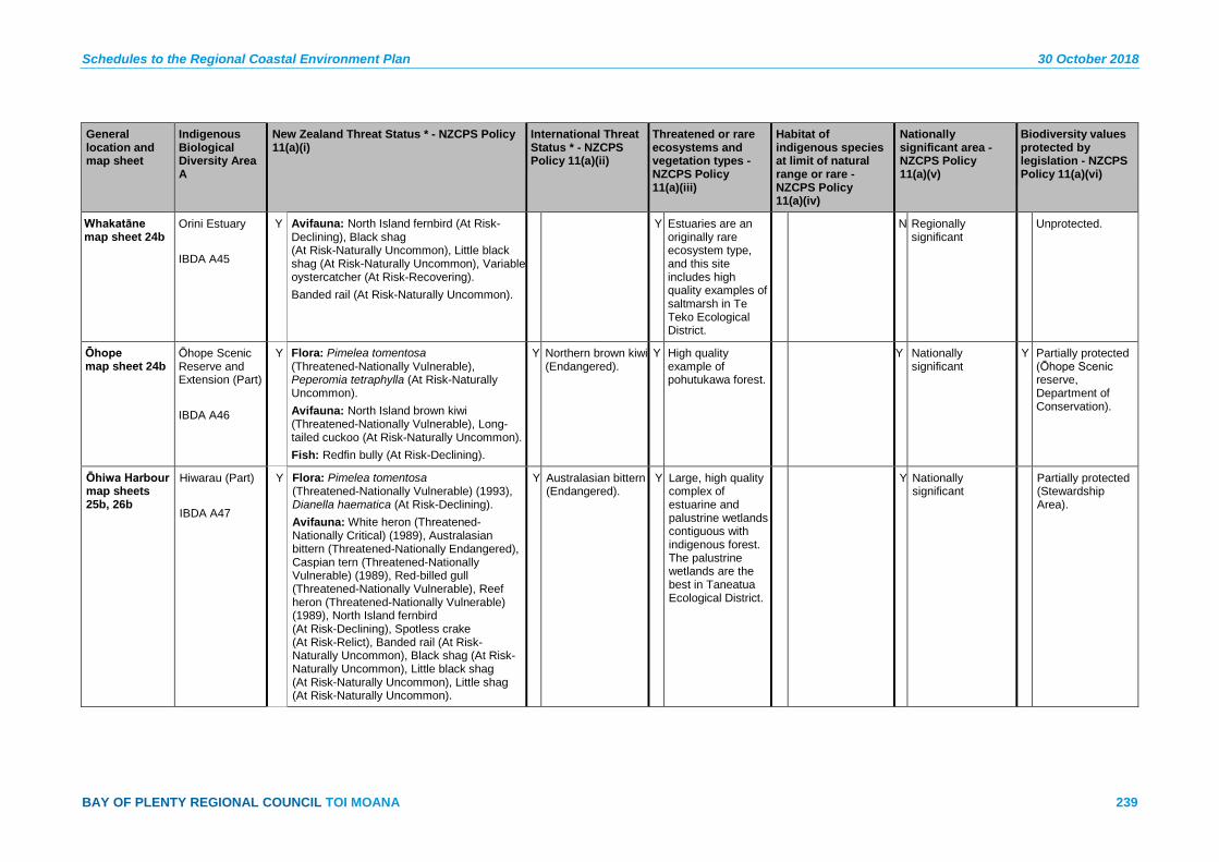
Schedules to the Regional Coastal Environment Plan 30 October 2018
BAY OF PLENTY REGIONAL COUNCIL TOI MOANA 239
General location and map sheet
Indigenous Biological Diversity Area A
New Zealand Threat Status * - NZCPS Policy 11(a)(i)
International Threat Status * - NZCPS Policy 11(a)(ii)
Threatened or rare ecosystems and vegetation types - NZCPS Policy 11(a)(iii)
Habitat of indigenous species at limit of natural range or rare - NZCPS Policy 11(a)(iv)
Nationally significant area - NZCPS Policy 11(a)(v)
Biodiversity values protected by legislation - NZCPS Policy 11(a)(vi)
Whakatāne map sheet 24b
Orini Estuary IBDA A45
Y Avifauna: North Island fernbird (At Risk-Declining), Black shag (At Risk-Naturally Uncommon), Little black shag (At Risk-Naturally Uncommon), Variable oystercatcher (At Risk-Recovering). Banded rail (At Risk-Naturally Uncommon).
Y Estuaries are an originally rare ecosystem type, and this site includes high quality examples of saltmarsh in Te Teko Ecological District.
N Regionally significant
Unprotected.
Ōhope map sheet 24b
Ōhope Scenic Reserve and Extension (Part) IBDA A46
Y Flora: Pimelea tomentosa (Threatened-Nationally Vulnerable), Peperomia tetraphylla (At Risk-Naturally Uncommon). Avifauna: North Island brown kiwi (Threatened-Nationally Vulnerable), Long-tailed cuckoo (At Risk-Naturally Uncommon). Fish: Redfin bully (At Risk-Declining).
Y Northern brown kiwi (Endangered).
Y High quality example of pohutukawa forest.
Y Nationally significant
Y Partially protected (Ōhope Scenic reserve, Department of Conservation).
Ōhiwa Harbour map sheets 25b, 26b
Hiwarau (Part) IBDA A47
Y Flora: Pimelea tomentosa (Threatened-Nationally Vulnerable) (1993), Dianella haematica (At Risk-Declining). Avifauna: White heron (Threatened-Nationally Critical) (1989), Australasian bittern (Threatened-Nationally Endangered), Caspian tern (Threatened-Nationally Vulnerable) (1989), Red-billed gull (Threatened-Nationally Vulnerable), Reef heron (Threatened-Nationally Vulnerable) (1989), North Island fernbird (At Risk-Declining), Spotless crake (At Risk-Relict), Banded rail (At Risk-Naturally Uncommon), Black shag (At Risk-Naturally Uncommon), Little black shag (At Risk-Naturally Uncommon), Little shag (At Risk-Naturally Uncommon).
Y Australasian bittern (Endangered).
Y Large, high quality complex of estuarine and palustrine wetlands contiguous with indigenous forest. The palustrine wetlands are the best in Taneatua Ecological District.
Y Nationally significant
Partially protected (Stewardship Area).

30 October 2018 Schedules to the Regional Coastal Environment Plan
240 Pre-Operative Regional Coastal Environment Plan – 30 October 2018
General location and map sheet
Indigenous Biological Diversity Area A
New Zealand Threat Status * - NZCPS Policy 11(a)(i)
International Threat Status * - NZCPS Policy 11(a)(ii)
Threatened or rare ecosystems and vegetation types - NZCPS Policy 11(a)(iii)
Habitat of indigenous species at limit of natural range or rare - NZCPS Policy 11(a)(iv)
Nationally significant area - NZCPS Policy 11(a)(v)
Biodiversity values protected by legislation - NZCPS Policy 11(a)(vi)
Ōhiwa Harbour map sheets 25b, 26b
Motuotu Island Nature Reserve IBDA A48
Y Avifauna: New Zealand fairy tern (Threatened-Nationally Critical), Banded rail (At Risk-Naturally Uncommon), North Island fernbird (At Risk-Declining). Provides Habitat For: White heron (Threatened-Nationally Endangered), Australasian bittern (Threatened-Nationally Endangered), Banded dotterel (Threatened-Nationally Vulnerable), Northern New Zealand dotterel (Threatened-Nationally Vulnerable), Reef heron (Threatened-Nationally Vulnerable), Caspian tern (Threatened-Nationally Vulnerable), Spotless crake (At Risk-Relict).
Y Fairy tern (Vulnerable).
Y Relatively large, good quality examples of estuarine vegetation, including one of the best stands of mangrove in Ōhiwa Harbour.
Y Austrostipa stipoides reaches its south-eastern limit in Ōhiwa Harbour.
Y Nationally significant
Y Protected (Motuotu Island Nature Reserve, Department of Conservation).

Schedules to the Regional Coastal Environment Plan 30 October 2018
BAY OF PLENTY REGIONAL COUNCIL TOI MOANA 241
General location and map sheet
Indigenous Biological Diversity Area A
New Zealand Threat Status * - NZCPS Policy 11(a)(i)
International Threat Status * - NZCPS Policy 11(a)(ii)
Threatened or rare ecosystems and vegetation types - NZCPS Policy 11(a)(iii)
Habitat of indigenous species at limit of natural range or rare - NZCPS Policy 11(a)(iv)
Nationally significant area - NZCPS Policy 11(a)(v)
Biodiversity values protected by legislation - NZCPS Policy 11(a)(vi)
Ōhiwa Harbour map sheets 25b, 26b, 27b
Ōhiwa Harbour IBDA A49
Y Avifauna: New Zealand fairy tern (Acutely Threatened, Nationally Critical), Australasian bittern (Threatened-Nationally Endangered), Banded dotterel (Threatened-Nationally Vulnerable), Caspian tern (Threatened-Nationally Vulnerable), Northern New Zealand dotterel (Threatened-Nationally Vulnerable), Pied shag (Threatened-Nationally Vulnerable), Red-billed gull (Threatened-Nationally Vulnerable), Reef heron (Threatened-Nationally Vulnerable), Wrybill (Threatened-Nationally Vulnerable), New Zealand pied oystercatcher (At Risk-Declining), North Island fernbird (At Risk-Declining), Pied stilt (At Risk-Declining), Little shag (At Risk-Naturally Uncommon) White-fronted tern (At Risk-Naturally Uncommon), Variable oystercatcher (At Risk-Recovering).
Y Australasian bittern (Endangered), New Zealand dotterel (Endangered), Fairy tern (Vulnerable), Wrybill (Vulnerable).
Y Ōhiwa Harbour has very high ecological values and is the second-highest quality example of an estuarine ecosystem in the region. The Uretara Shellbank, located east of Uretara Island, is the most important bird roosting site in Ōhiwa Harbour. Nesting birds at the site include White-fronted tern (At Risk-Declining), Caspian tern (Threatened-Nationally Vulnerable), Variable oystercatcher (At Risk-Recovering), Red-billed gull (Threatened-Nationally Critical), Black-backed gull
Y Nationally significant
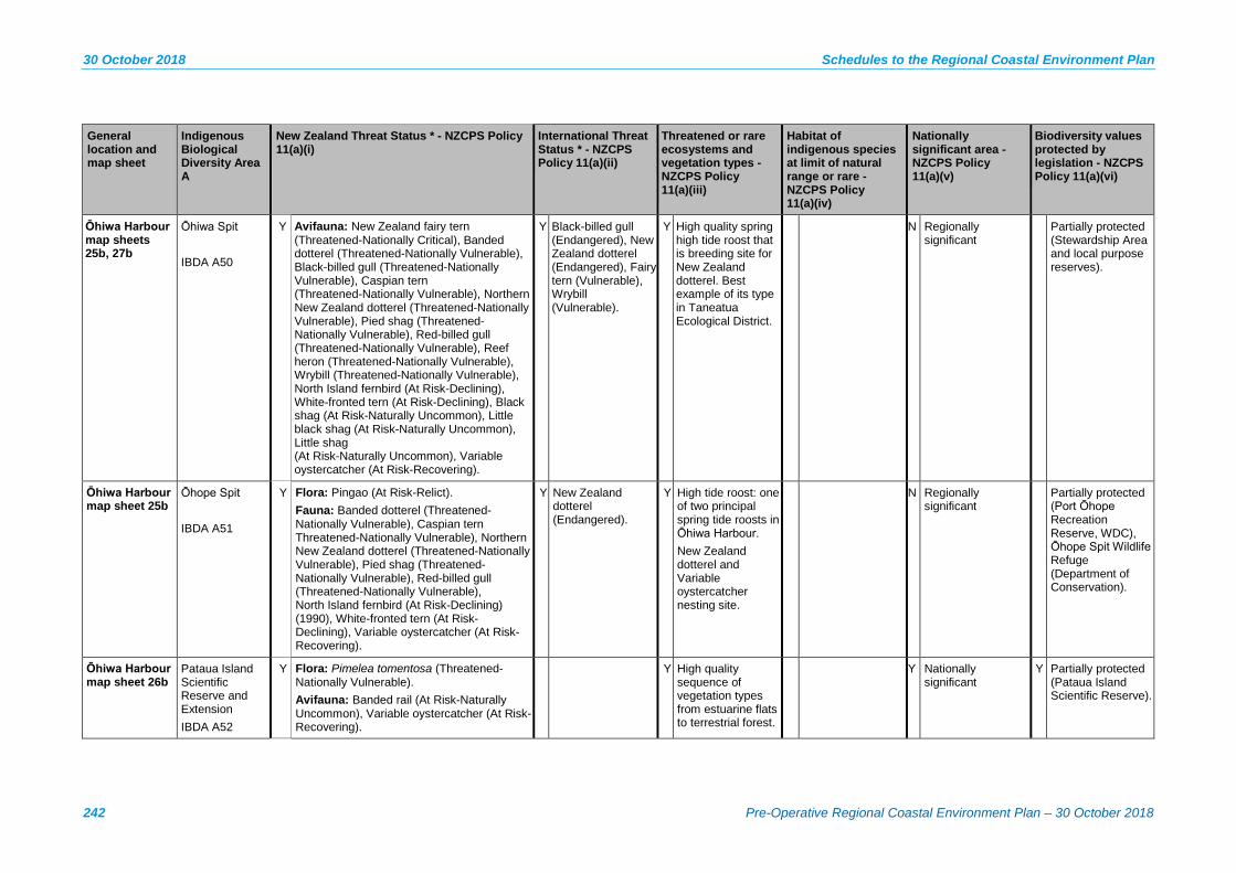
30 October 2018 Schedules to the Regional Coastal Environment Plan
242 Pre-Operative Regional Coastal Environment Plan – 30 October 2018
General location and map sheet
Indigenous Biological Diversity Area A
New Zealand Threat Status * - NZCPS Policy 11(a)(i)
International Threat Status * - NZCPS Policy 11(a)(ii)
Threatened or rare ecosystems and vegetation types - NZCPS Policy 11(a)(iii)
Habitat of indigenous species at limit of natural range or rare - NZCPS Policy 11(a)(iv)
Nationally significant area - NZCPS Policy 11(a)(v)
Biodiversity values protected by legislation - NZCPS Policy 11(a)(vi)
Ōhiwa Harbour map sheets 25b, 27b
Ōhiwa Spit IBDA A50
Y Avifauna: New Zealand fairy tern (Threatened-Nationally Critical), Banded dotterel (Threatened-Nationally Vulnerable), Black-billed gull (Threatened-Nationally Vulnerable), Caspian tern (Threatened-Nationally Vulnerable), Northern New Zealand dotterel (Threatened-Nationally Vulnerable), Pied shag (Threatened-Nationally Vulnerable), Red-billed gull (Threatened-Nationally Vulnerable), Reef heron (Threatened-Nationally Vulnerable), Wrybill (Threatened-Nationally Vulnerable), North Island fernbird (At Risk-Declining), White-fronted tern (At Risk-Declining), Black shag (At Risk-Naturally Uncommon), Little black shag (At Risk-Naturally Uncommon), Little shag (At Risk-Naturally Uncommon), Variable oystercatcher (At Risk-Recovering).
Y Black-billed gull (Endangered), New Zealand dotterel (Endangered), Fairy tern (Vulnerable), Wrybill (Vulnerable).
Y High quality spring high tide roost that is breeding site for New Zealand dotterel. Best example of its type in Taneatua Ecological District.
N Regionally significant
Partially protected (Stewardship Area and local purpose reserves).
Ōhiwa Harbour map sheet 25b
Ōhope Spit IBDA A51
Y Flora: Pingao (At Risk-Relict). Fauna: Banded dotterel (Threatened-Nationally Vulnerable), Caspian tern Threatened-Nationally Vulnerable), Northern New Zealand dotterel (Threatened-Nationally Vulnerable), Pied shag (Threatened-Nationally Vulnerable), Red-billed gull (Threatened-Nationally Vulnerable), North Island fernbird (At Risk-Declining) (1990), White-fronted tern (At Risk-Declining), Variable oystercatcher (At Risk-Recovering).
Y New Zealand dotterel (Endangered).
Y High tide roost: one of two principal spring tide roosts in Ōhiwa Harbour. New Zealand dotterel and Variable oystercatcher nesting site.
N Regionally significant
Partially protected (Port Ōhope Recreation Reserve, WDC), Ōhope Spit Wildlife Refuge (Department of Conservation).
Ōhiwa Harbour map sheet 26b
Pataua Island Scientific Reserve and Extension IBDA A52
Y Flora: Pimelea tomentosa (Threatened-Nationally Vulnerable). Avifauna: Banded rail (At Risk-Naturally Uncommon), Variable oystercatcher (At Risk-Recovering).
Y High quality sequence of vegetation types from estuarine flats to terrestrial forest.
Y Nationally significant
Y Partially protected (Pataua Island Scientific Reserve).

Schedules to the Regional Coastal Environment Plan 30 October 2018
BAY OF PLENTY REGIONAL COUNCIL TOI MOANA 243
General location and map sheet
Indigenous Biological Diversity Area A
New Zealand Threat Status * - NZCPS Policy 11(a)(i)
International Threat Status * - NZCPS Policy 11(a)(ii)
Threatened or rare ecosystems and vegetation types - NZCPS Policy 11(a)(iii)
Habitat of indigenous species at limit of natural range or rare - NZCPS Policy 11(a)(iv)
Nationally significant area - NZCPS Policy 11(a)(v)
Biodiversity values protected by legislation - NZCPS Policy 11(a)(vi)
Ōhiwa Harbour map sheet 25b
Uretara Island IBDA A53
Y Flora: Dianella haematica (At Risk-Declining), Adelopetalum tuberculatum (At Risk Naturally Uncommon). Avifauna: White heron (Threatened-Nationally Critical) (1989; 1994), Australasian bittern (Threatened-Nationally Endangered) (1989; 1994), Caspian tern (Threatened-Nationally Vulnerable) (1989; 1994), Northern New Zealand dotterel (Threatened-Nationally Vulnerable), Reef heron (Threatened-Nationally Vulnerable) (1989; 1994), North Island fernbird (At Risk-Declining), Spotless crake (At Risk-Relict), Banded rail (At Risk-Naturally Uncommon), Long-tailed cuckoo (At Risk-Naturally Uncommon), Variable oystercatcher (At Risk-Recovering).
Y Australasian bittern (Endangered), New Zealand dotterel (Endangered).
Y High quality estuarine wetlands, including of the best areas of mangrove in Ōhiwa Harbour, and a shore bird roosting site.
Y Austrostipa stipoides is at its southern limit of distribution.
Y Nationally significant
Y Most of the site is protected (Uretara Island Scenic Reserve, Department of Conservation).
Ōhiwa Harbour map sheets 25b, 27b
Whangakopikopiko Island IBDA A54
Y Flora: Thornton kanuka (Threatened-Nationally Vulnerable), Sand tussock (At Risk-Declining), Pingao (At Risk-Relict), New Zealand spinach (At Risk-Naturally Uncommon). Avifauna: Australasian bittern (Threatened-Nationally Endangered), Black-billed gull (Threatened-Nationally Endangered), Northern New Zealand dotterel (Threatened-Nationally Vulnerable), Red-billed gull (Threatened-Nationally Vulnerable), North Island fernbird (At Risk-Declining), Pied stilt (At Risk-Declining), Banded rail (At Risk-Naturally Uncommon), Royal spoonbill (At Risk-Naturally Uncommon), Variable oystercatcher (At Risk-Recovering).
Y Australasian bittern (Endangered), Black-billed gull (Endangered), New Zealand dotterel (Endangered).
Y High quality example of estuarine vegetation that includes one the largest herbfields in Ōhiwa Harbour. Nesting area for New Zealand Dotterel and a shorebird roost of moderate importance.
Y Thornton kanuka is endemic to Whakatāne Ecological Region.
N Regionally significant
Partially protected (Whangakopikopiko Wildlife Refuge Reserve, Department of Conservation).
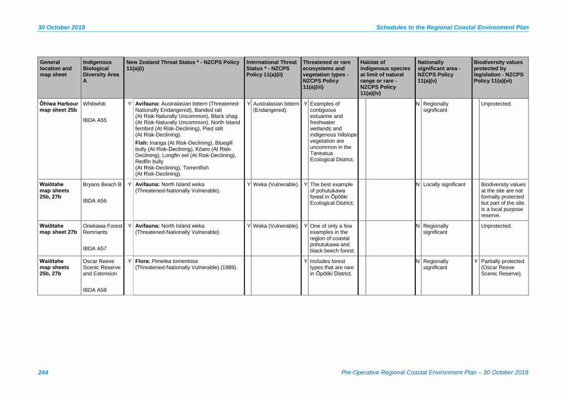
30 October 2018 Schedules to the Regional Coastal Environment Plan
244 Pre-Operative Regional Coastal Environment Plan – 30 October 2018
General location and map sheet
Indigenous Biological Diversity Area A
New Zealand Threat Status * - NZCPS Policy 11(a)(i)
International Threat Status * - NZCPS Policy 11(a)(ii)
Threatened or rare ecosystems and vegetation types - NZCPS Policy 11(a)(iii)
Habitat of indigenous species at limit of natural range or rare - NZCPS Policy 11(a)(iv)
Nationally significant area - NZCPS Policy 11(a)(v)
Biodiversity values protected by legislation - NZCPS Policy 11(a)(vi)
Ōhiwa Harbour map sheet 25b
Whitiwhiti IBDA A55
Y Avifauna: Australasian bittern (Threatened-Nationally Endangered), Banded rail (At Risk-Naturally Uncommon), Black shag (At Risk-Naturally Uncommon), North Island fernbird (At Risk-Declining), Pied stilt (At Risk-Declining). Fish: Inanga (At Risk-Declining), Bluegill bully (At Risk-Declining), Kōaro (At Risk-Declining), Longfin eel (At Risk-Declining), Redfin bully (At Risk-Declining), Torrentfish (At Risk-Declining).
Y Australasian bittern (Endangered).
Y Examples of contiguous estuarine and freshwater wetlands and indigenous hillslope vegetation are uncommon in the Taneatua Ecological District.
N Regionally significant
Unprotected.
Waiōtahe map sheets 25b, 27b
Bryans Beach B IBDA A56
Y Avifauna: North Island weka (Threatened-Nationally Vulnerable).
Y Weka (Vulnerable). Y The best example of pohutukawa forest in Ōpōtiki Ecological District.
N Locally significant Biodiversity values at the site are not formally protected but part of the site is a local purpose reserve.
Waiōtahe map sheet 27b
Onekawa Forest Remnants IBDA A57
Y Avifauna: North Island weka (Threatened-Nationally Vulnerable).
Y Weka (Vulnerable). Y One of only a few examples in the region of coastal pohutukawa and black beech forest.
N Regionally significant
Unprotected.
Waiōtahe map sheets 25b, 27b
Oscar Reeve Scenic Reserve and Extension IBDA A58
Y Flora: Pimelea tomentosa (Threatened-Nationally Vulnerable) (1989).
Y Includes forest types that are rare in Ōpōtiki District.
N Regionally significant
Y Partially protected (Oscar Reeve Scenic Reserve).
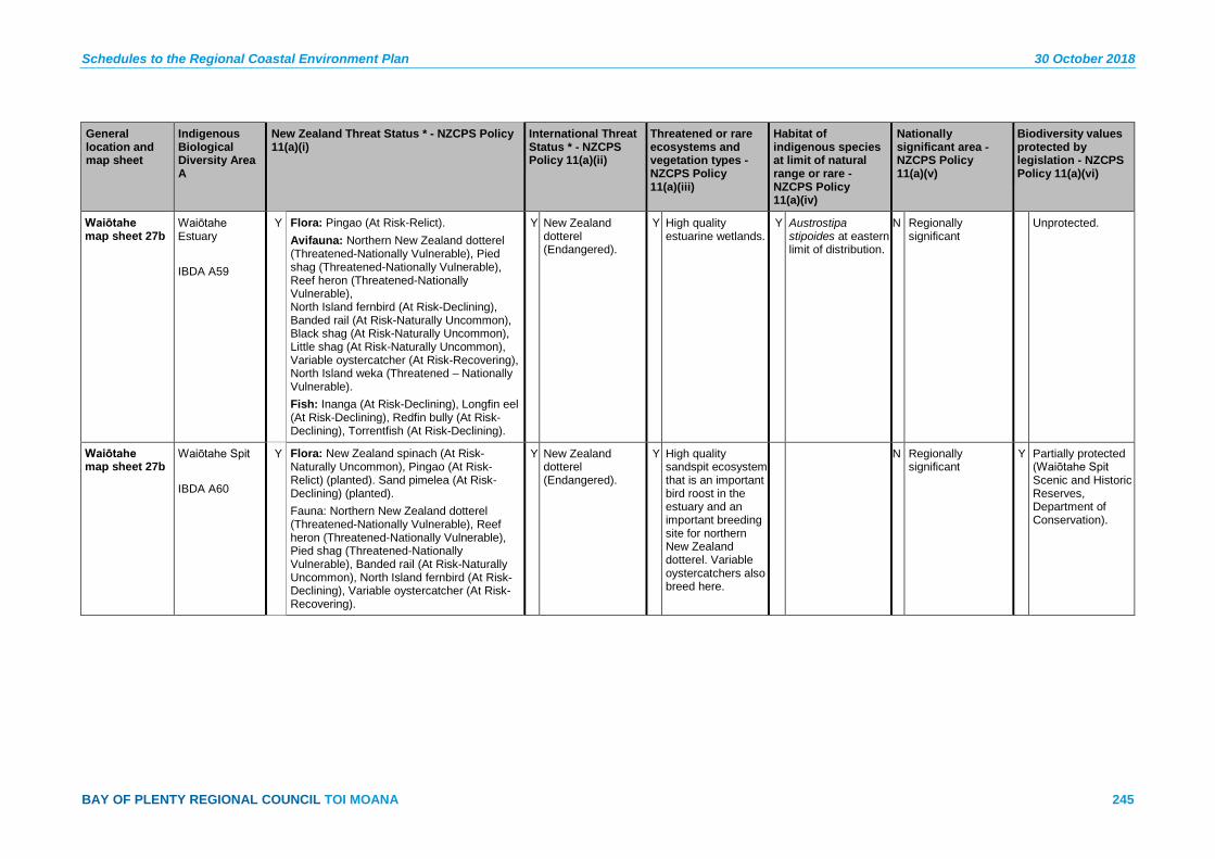
Schedules to the Regional Coastal Environment Plan 30 October 2018
BAY OF PLENTY REGIONAL COUNCIL TOI MOANA 245
General location and map sheet
Indigenous Biological Diversity Area A
New Zealand Threat Status * - NZCPS Policy 11(a)(i)
International Threat Status * - NZCPS Policy 11(a)(ii)
Threatened or rare ecosystems and vegetation types - NZCPS Policy 11(a)(iii)
Habitat of indigenous species at limit of natural range or rare - NZCPS Policy 11(a)(iv)
Nationally significant area - NZCPS Policy 11(a)(v)
Biodiversity values protected by legislation - NZCPS Policy 11(a)(vi)
Waiōtahe map sheet 27b
Waiōtahe Estuary IBDA A59
Y Flora: Pingao (At Risk-Relict). Avifauna: Northern New Zealand dotterel (Threatened-Nationally Vulnerable), Pied shag (Threatened-Nationally Vulnerable), Reef heron (Threatened-Nationally Vulnerable), North Island fernbird (At Risk-Declining), Banded rail (At Risk-Naturally Uncommon), Black shag (At Risk-Naturally Uncommon), Little shag (At Risk-Naturally Uncommon), Variable oystercatcher (At Risk-Recovering), North Island weka (Threatened – Nationally Vulnerable). Fish: Inanga (At Risk-Declining), Longfin eel (At Risk-Declining), Redfin bully (At Risk-Declining), Torrentfish (At Risk-Declining).
Y New Zealand dotterel (Endangered).
Y High quality estuarine wetlands.
Y Austrostipa stipoides at eastern limit of distribution.
N Regionally significant
Unprotected.
Waiōtahe map sheet 27b
Waiōtahe Spit IBDA A60
Y Flora: New Zealand spinach (At Risk-Naturally Uncommon), Pingao (At Risk-Relict) (planted). Sand pimelea (At Risk-Declining) (planted). Fauna: Northern New Zealand dotterel (Threatened-Nationally Vulnerable), Reef heron (Threatened-Nationally Vulnerable), Pied shag (Threatened-Nationally Vulnerable), Banded rail (At Risk-Naturally Uncommon), North Island fernbird (At Risk-Declining), Variable oystercatcher (At Risk-Recovering).
Y New Zealand dotterel (Endangered).
Y High quality sandspit ecosystem that is an important bird roost in the estuary and an important breeding site for northern New Zealand dotterel. Variable oystercatchers also breed here.
N Regionally significant
Y Partially protected (Waiōtahe Spit Scenic and Historic Reserves, Department of Conservation).
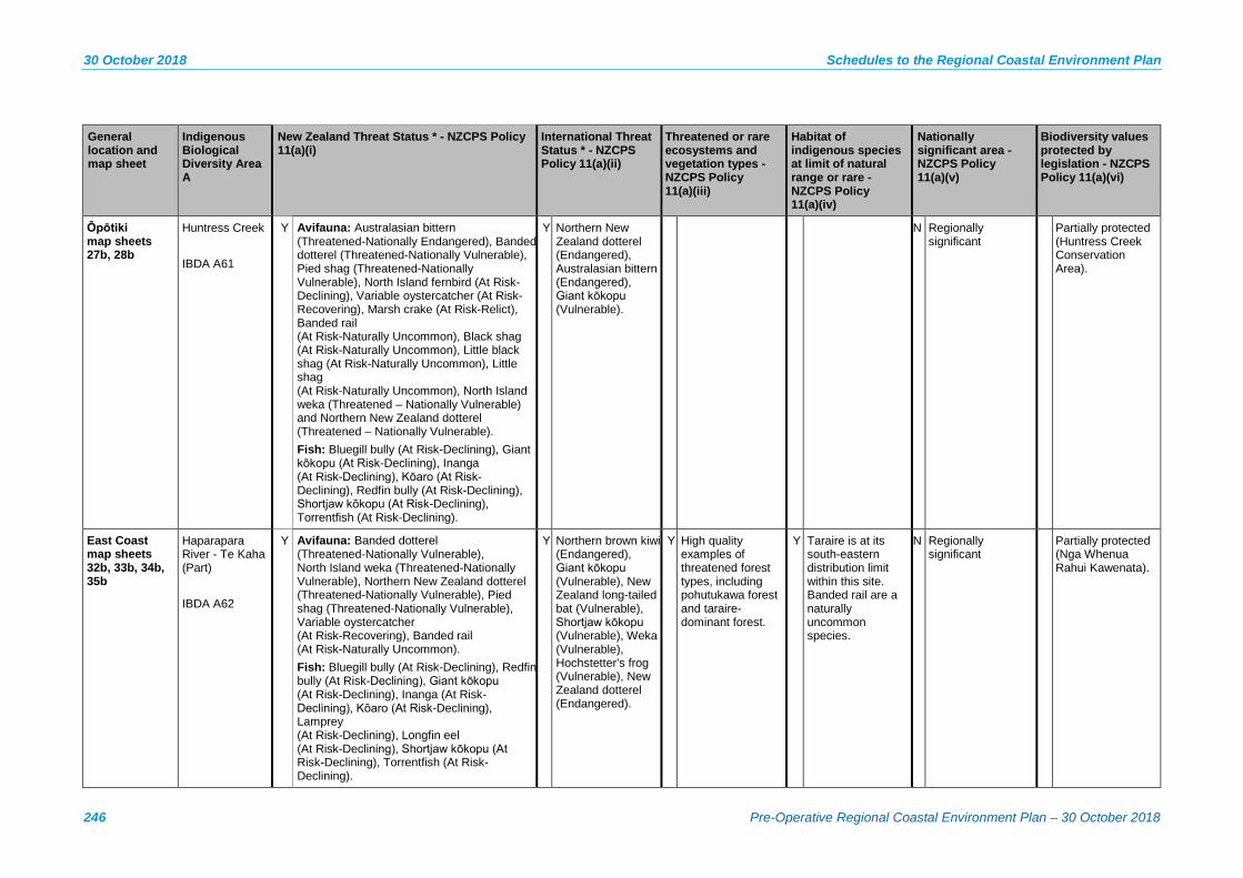
30 October 2018 Schedules to the Regional Coastal Environment Plan
246 Pre-Operative Regional Coastal Environment Plan – 30 October 2018
General location and map sheet
Indigenous Biological Diversity Area A
New Zealand Threat Status * - NZCPS Policy 11(a)(i)
International Threat Status * - NZCPS Policy 11(a)(ii)
Threatened or rare ecosystems and vegetation types - NZCPS Policy 11(a)(iii)
Habitat of indigenous species at limit of natural range or rare - NZCPS Policy 11(a)(iv)
Nationally significant area - NZCPS Policy 11(a)(v)
Biodiversity values protected by legislation - NZCPS Policy 11(a)(vi)
Ōpōtiki map sheets 27b, 28b
Huntress Creek IBDA A61
Y Avifauna: Australasian bittern (Threatened-Nationally Endangered), Banded dotterel (Threatened-Nationally Vulnerable), Pied shag (Threatened-Nationally Vulnerable), North Island fernbird (At Risk-Declining), Variable oystercatcher (At Risk-Recovering), Marsh crake (At Risk-Relict), Banded rail (At Risk-Naturally Uncommon), Black shag (At Risk-Naturally Uncommon), Little black shag (At Risk-Naturally Uncommon), Little shag (At Risk-Naturally Uncommon), North Island weka (Threatened – Nationally Vulnerable) and Northern New Zealand dotterel (Threatened – Nationally Vulnerable). Fish: Bluegill bully (At Risk-Declining), Giant kōkopu (At Risk-Declining), Inanga (At Risk-Declining), Kōaro (At Risk-Declining), Redfin bully (At Risk-Declining), Shortjaw kōkopu (At Risk-Declining), Torrentfish (At Risk-Declining).
Y Northern New Zealand dotterel (Endangered), Australasian bittern (Endangered), Giant kōkopu (Vulnerable).
N Regionally significant
Partially protected (Huntress Creek Conservation Area).
East Coast map sheets 32b, 33b, 34b, 35b
Haparapara River - Te Kaha (Part) IBDA A62
Y Avifauna: Banded dotterel (Threatened-Nationally Vulnerable), North Island weka (Threatened-Nationally Vulnerable), Northern New Zealand dotterel (Threatened-Nationally Vulnerable), Pied shag (Threatened-Nationally Vulnerable), Variable oystercatcher (At Risk-Recovering), Banded rail (At Risk-Naturally Uncommon). Fish: Bluegill bully (At Risk-Declining), Redfin bully (At Risk-Declining), Giant kōkopu (At Risk-Declining), Inanga (At Risk-Declining), Kōaro (At Risk-Declining), Lamprey (At Risk-Declining), Longfin eel (At Risk-Declining), Shortjaw kōkopu (At Risk-Declining), Torrentfish (At Risk-Declining).
Y Northern brown kiwi (Endangered), Giant kōkopu (Vulnerable), New Zealand long-tailed bat (Vulnerable), Shortjaw kōkopu (Vulnerable), Weka (Vulnerable), Hochstetter’s frog (Vulnerable), New Zealand dotterel (Endangered).
Y High quality examples of threatened forest types, including pohutukawa forest and taraire-dominant forest.
Y Taraire is at its south-eastern distribution limit within this site. Banded rail are a naturally uncommon species.
N Regionally significant
Partially protected (Nga Whenua Rahui Kawenata).

Schedules to the Regional Coastal Environment Plan 30 October 2018
BAY OF PLENTY REGIONAL COUNCIL TOI MOANA 247
General location and map sheet
Indigenous Biological Diversity Area A
New Zealand Threat Status * - NZCPS Policy 11(a)(i)
International Threat Status * - NZCPS Policy 11(a)(ii)
Threatened or rare ecosystems and vegetation types - NZCPS Policy 11(a)(iii)
Habitat of indigenous species at limit of natural range or rare - NZCPS Policy 11(a)(iv)
Nationally significant area - NZCPS Policy 11(a)(v)
Biodiversity values protected by legislation - NZCPS Policy 11(a)(vi)
Other: Hochstetter’s frog (At Risk-Declining), Long-tailed bat (Acutely Threatened-Nationally Vulnerable). Also provides habitat for: Bush falcon (Threatened-Nationally Vulnerable), North Island brown kiwi (Threatened-Nationally Vulnerable), North Island kākā (Threatened-Nationally Vulnerable), Whio (Threatened-Nationally Vulnerable), Kākāriki (At Risk-Relict).
East Coast map sheet 29b
Haurere and Opape Headlands (Part) IBDA A63
Y Flora: Olearia pachyphylla (Threatened-Nationally Critical), Pimelea tomentosa (Threatened-Nationally Vulnerable). Avifauna: Australasian bittern (Threatened-Nationally Endangered) (1989), Bush falcon (Threatened-Nationally Vulnerable), North Island weka (Threatened-Nationally Vulnerable) Fish: Longfin eel (At Risk-Declining).
Y Australasian bittern (Endangered), Weka (Vulnerable).
Y Coastal forest (including pohutukawa forest) and the only known location of thick-leaved tree daisy.
Y Only current known wild population of the native Tree Daisy (Olearia pachyphylla).
Y Nationally significant
Partially protected (Oroi Scenic Reserve).
East Coast map sheets 30b, 31b
Hawai-Mōtu River (Part) IBDA A64
Y Avifauna: North Island weka (Threatened-Nationally Vulnerable), Pied shag (Threatened-Nationally Vulnerable), Red-billed gull (Threatened-Nationally Vulnerable), White-fronted tern (At Risk-Declining). Fish: Longfin eel (At Risk-Declining).
Y Weka (Vulnerable). Y One of the best examples of pohutukawa-puriri forest in Motū Ecological District.
N Regionally significant
Unprotected.
East Coast map sheets 31b, 32b
Motu-Waikakariki River (Part) IBDA A65
Y Flora: Pimelea tomentosa (Threatened-Nationally Vulnerable). Avifauna: Banded dotterel (Threatened-Nationally Vulnerable), Bush falcon (Threatened-Nationally Vulnerable) (1980s), Caspian tern (Threatened-Nationally Vulnerable), Northern New Zealand dotterel (Threatened-Nationally Vulnerable), North Island brown kiwi (Threatened-Nationally Vulnerable) (1980s), Pied shag (Threatened-Nationally Vulnerable), Red-
Y New Zealand dotterel (Endangered), Northern brown kiwi (Endangered), Giant kōkopu (Vulnerable), Shortjaw kōkopu (Vulnerable).
Y Large, high quality, diverse site dominated by indigenous forest (including pohutukawa forest).
Y Nationally significant
Unprotected.

30 October 2018 Schedules to the Regional Coastal Environment Plan
248 Pre-Operative Regional Coastal Environment Plan – 30 October 2018
General location and map sheet
Indigenous Biological Diversity Area A
New Zealand Threat Status * - NZCPS Policy 11(a)(i)
International Threat Status * - NZCPS Policy 11(a)(ii)
Threatened or rare ecosystems and vegetation types - NZCPS Policy 11(a)(iii)
Habitat of indigenous species at limit of natural range or rare - NZCPS Policy 11(a)(iv)
Nationally significant area - NZCPS Policy 11(a)(v)
Biodiversity values protected by legislation - NZCPS Policy 11(a)(vi)
billed gull (Threatened-Nationally Vulnerable), Reef heron (Threatened-Nationally Vulnerable), White-fronted tern (At Risk-Declining), Variable oystercatcher (At Risk-Recovering). Fish: Bluegill bully (At Risk-Declining), Inanga (At Risk-Declining), Kōaro (At Risk-Declining), Longfin eel (At Risk-Declining), Giant kōkopu (At Risk-Declining), Redfin bully (At Risk-Declining), Shortjaw kōkopu (At Risk-Declining), Torrentfish (At Risk-Declining).
East Coast map sheet 31b
Motu – marine IBDA A66
Tokata Rock - a stack below the Maraenui Bluff, is a nesting area for White-fronted tern (At Risk-Declining) and Red-billed gull (Threatened-Nationally Vulnerable).
Y Only snapper spawning ground in the Bay of Plenty region.
N Regionally significant
Y Seasonal fishing restrictions in place to protect the snapper spawning ground under the Fisheries (Auckland and Kermadec Areas Amateur Fishing) Regulations 1986.
East Coast map sheets 35b, 36b
Raukokore River Mouth (Part) IBDA A67
Y Flora: Carmichaelia williamsii (At Risk-Relict), Stuckenia pectinata (At Risk-Naturally Uncommon) (1980s). Avifauna: Caspian tern (Threatened-Nationally Vulnerable) (2011), Banded dotterel (Threatened-Nationally Vulnerable) (2011), Northern New Zealand dotterel (Threatened-Nationally Vulnerable), Pied stilt (At Risk-Declining), Variable oystercatcher (At Risk-Recovering). Fish: Inanga (At Risk-Declining), Longfin eel (At Risk-Declining), Redfin bully (At Risk-Declining), Torrentfish (At Risk-Declining).
Y New Zealand dotterel (Endangered).
Y Includes pohutukawa forest and the only known location of taraire in Pukeamaru Ecological District. Only intact lagoon system in Motū ecological district.
Y Taraire reaches its southern and eastern distribution limits at Raukōkore.
Y Nationally significant
Unprotected.
Schedules to the Regional Coastal Environment Plan 30 October 2018
BAY OF PLENTY REGIONAL COUNCIL TOI MOANA 249
General location and map sheet
Indigenous Biological Diversity Area A
New Zealand Threat Status * - NZCPS Policy 11(a)(i)
International Threat Status * - NZCPS Policy 11(a)(ii)
Threatened or rare ecosystems and vegetation types - NZCPS Policy 11(a)(iii)
Habitat of indigenous species at limit of natural range or rare - NZCPS Policy 11(a)(iv)
Nationally significant area - NZCPS Policy 11(a)(v)
Biodiversity values protected by legislation - NZCPS Policy 11(a)(vi)
East Coast map sheets 36b, 37b
Te Ranginui-Oruaiti-Whangaparaoa-Tapuaeharuru (Part) IBDA A68
Y Flora: Pingao (At Risk-Relict). Fauna: Banded dotterel (Threatened-Nationally Vulnerable) (1989), Northern New Zealand dotterel (Threatened-Nationally Vulnerable), Pied shag (Threatened-Nationally Vulnerable).
Y New Zealand dotterel (Endangered).
Y Hard beech forest, pohutukawa forest.
Y Nationally significant
Partially protected (Nga Whenua Rahui Kawenata).
East Coast map sheets 36b, 37b
Oruaiti/ Waikanapanapa IBDA A69
Y Only intertidal and subtidal area on a Miocene age soft rock substrate in the Bay of Plenty region. The subtidal area supports a slightly different community of plants and animals to the hard rock habitat on the adjacent coast.
Y The Soft Rock Golden Limpet is commonly found in the intertidal area, at its northern limit.
N Regionally significant
East Coast map sheets 28b, 29b
Omarumutu IBDA A70
Y Flora: Pingao (At Risk-Relict) (planted). Avifauna: White heron (Threatened-Nationally Critical), Australasian bittern (Threatened-Nationally Endangered), Banded dotterel (Threatened-Nationally Vulnerable), Bush falcon (Threatened-Nationally Vulnerable) (1991), Caspian tern (Threatened-Nationally Vulnerable), Northern New Zealand dotterel (Threatened-Nationally Vulnerable), North Island weka (Threatened-Nationally Vulnerable), Reef heron (Threatened-Nationally Vulnerable), North Island fernbird (At Risk-Declining) (1991), Pied stilt (At Risk-Declining), Variable oystercatcher (At Risk-Recovering). Fish: Inanga (At Risk-Declining) (1990), Longfin eel (At Risk-Declining), Redfin bully (At Risk-Declining), Torrentfish (At Risk-Declining).
Y New Zealand dotterel (Endangered), Australasian bittern (Endangered), Weka (Vulnerable).
Y High quality area of estuary, dunes and dune slack wetlands which includes a variety of indigenous vegetation types.
Y Easternmost population of mangroves.
N Regionally significant
30 October 2018 Schedules to the Regional Coastal Environment Plan
250 Pre-Operative Regional Coastal Environment Plan – 30 October 2018
General location and map sheet
Indigenous Biological Diversity Area A
New Zealand Threat Status * - NZCPS Policy 11(a)(i)
International Threat Status * - NZCPS Policy 11(a)(ii)
Threatened or rare ecosystems and vegetation types - NZCPS Policy 11(a)(iii)
Habitat of indigenous species at limit of natural range or rare - NZCPS Policy 11(a)(iv)
Nationally significant area - NZCPS Policy 11(a)(v)
Biodiversity values protected by legislation - NZCPS Policy 11(a)(vi)
East Coast map sheets 34b, 35b
Whanarua (Part) IBDA A71
Y Flora: Pimelea tomentosa (Threatened-Nationally Vulnerable), Carmichaelia williamsii (At Risk-Relict), Scandia rosifolia (At Risk-Declining), Crassula mataikona (At Risk-Naturally Uncommon), New Zealand spinach (At Risk-Naturally Uncommon).
Y Giant kōkopu (Vulnerable), Hochstetter’s frog (Vulnerable), Shortjaw kōkopu (Vulnerable).
Y Includes high quality pohutukawa forest, a threatened ecosystem type.
Y Nationally significant
Partially protected (Whanarua Bay Scenic Reserve, QEII Covenants).
Fish: Bluegill bully (At Risk-Declining), Giant kōkopu (At Risk-Declining) (1989), Inanga (At Risk-Declining), Kōaro (At Risk-Declining), Longfin eel (At Risk-Declining), Redfin bully (At Risk-Declining), Shortjaw kōkopu (At Risk Declining), Torrentfish (At Risk-Declining). Frogs: Hochstetter’s frog (At Risk-Declining) (1993).
Whangaparaoa map sheets 37b, 38b
Tikirau (Cape Runaway) IBDA A72
Y Fauna: Pied shag (Threatened-Nationally Vulnerable), Red-billed gull (Threatened-Nationally Vulnerable), Little shag (At Risk-Naturally Uncommon).
Y High quality example of coastal forest.
Y Nationally significant
Unprotected.

Schedules to the Regional Coastal Environment Plan 30 October 2018
BAY OF PLENTY REGIONAL COUNCIL TOI MOANA 251
General location and map sheet
Indigenous Biological Diversity Area A
New Zealand Threat Status * - NZCPS Policy 11(a)(i)
International Threat Status * - NZCPS Policy 11(a)(ii)
Threatened or rare ecosystems and vegetation types - NZCPS Policy 11(a)(iii)
Habitat of indigenous species at limit of natural range or rare - NZCPS Policy 11(a)(iv)
Nationally significant area - NZCPS Policy 11(a)(v)
Biodiversity values protected by legislation - NZCPS Policy 11(a)(vi)
Whangaparaoa map sheets 37b, 38b
Whangaparaoa Beach and River Mouth IBDA A73
Y Flora: Pingao (At Risk-Relict) (1988), New Zealand Spinach (At Risk-Naturally Uncommon) Avifauna: Australasian bittern (Threatened-Nationally Endangered), Northern New Zealand dotterel (Threatened-Nationally Vulnerable), Banded dotterel (Threatened-Nationally Vulnerable) (2011), Pied shag (Threatened-Nationally Vulnerable), North Island fernbird (At Risk-Declining) (1988), Pied stilt (At Risk-Declining), Variable oystercatcher (At Risk-Recovering), Spotless crake (At Risk-Relict) (1988), Black shag (At Risk-Naturally Uncommon). Fish: Bluegill bully (At Risk-Declining), Giant kōkopu (At Risk-Declining) (1989), Inanga (At Risk-Declining), Longfin eel (At Risk-Declining) (1989), Redfin bully (At Risk-Declining), Torrentfish (At Risk-Declining).
Y Australasian bittern (Endangered), New Zealand dotterel (Endangered), Giant kōkopu (Vulnerable).
Y High quality examples of originally rare and/or threatened ecosystem types including sand dunes, dune deflation hollows, pohutukawa forest, and estuarine wetlands (including the best saltmarsh in the Ecological District). Northern NZ dotterel breeding nesting at Whangaparoa River mouth.
Y Nationally significant
Unprotected.
Offshore map sheets 4b, 6b, 42b
Karewa Island IBDA A74
Y Spinifex sandfield and grassland, pohuehue vineland, Ficinia nodosa sedgeland, and pohutukawa treeland and shrubland.
Y High quality example of indigenous forest on a pest-free offshore island.
Y Parapara (At Risk-Relict) is at the southern limit of its distribution (excluding Moutohorā (Whale Island), where it has been planted). Bay of Plenty's only population of flesh-footed shearwater (Puffinus carneipes) breeds here.
Y Nationally significant
Y Protected (Karewa Island Wildlife Sanctuary, Department of Conservation).
30 October 2018 Schedules to the Regional Coastal Environment Plan
252 Pre-Operative Regional Coastal Environment Plan – 30 October 2018
General location and map sheet
Indigenous Biological Diversity Area A
New Zealand Threat Status * - NZCPS Policy 11(a)(i)
International Threat Status * - NZCPS Policy 11(a)(ii)
Threatened or rare ecosystems and vegetation types - NZCPS Policy 11(a)(iii)
Habitat of indigenous species at limit of natural range or rare - NZCPS Policy 11(a)(iv)
Nationally significant area - NZCPS Policy 11(a)(v)
Biodiversity values protected by legislation - NZCPS Policy 11(a)(vi)
Off-shore map sheets 4b, 6b, 42b
Karewa Island – marine area IBDA A74
Y Only representative example of reef systems in a large area of sand. The inshore reef system supports the high density of tuatara present on the Island.
Y Nationally significant
Offshore map sheet 43b
Motiti Island IBDA A75
Y Flora: Lepidium oleraceum (Threatened-Nationally Vulnerable), New Zealand spinach (At Risk-Naturally Uncommon). Avifauna: Caspian tern (Threatened-Nationally Vulnerable), North Island kākā (Threatened-Nationally Vulnerable), Pied shag (Threatened-Nationally Vulnerable), Red-billed gull (Threatened-Nationally Vulnerable), White-fronted tern (At Risk-Declining), Northern diving petrel (At Risk-Relict), Variable oystercatcher (At Risk-Recovering).
Y Kākā (Endangered).
Y Pohutukawa forest and treeland, coastal cliffs, and sandfields.
N Regionally significant
Unprotected.
Offshore Astrolabe Reef IBDA A76
Y Ecosystem uncommon in NZ as it has both tropical fish and a strong pelagic school fish component. Coastal rock stack ecosystems (pinnacles) are naturally rare ecosystems in New Zealand.
N Regionally significant
Unprotected.
Schedules to the Regional Coastal Environment Plan 30 October 2018
BAY OF PLENTY REGIONAL COUNCIL TOI MOANA 253
General location and map sheet
Indigenous Biological Diversity Area A
New Zealand Threat Status * - NZCPS Policy 11(a)(i)
International Threat Status * - NZCPS Policy 11(a)(ii)
Threatened or rare ecosystems and vegetation types - NZCPS Policy 11(a)(iii)
Habitat of indigenous species at limit of natural range or rare - NZCPS Policy 11(a)(iv)
Nationally significant area - NZCPS Policy 11(a)(v)
Biodiversity values protected by legislation - NZCPS Policy 11(a)(vi)
Offshore map sheet 44b
Motunau (Plate Island) IBDA A77
Y Avifauna: Reef heron (Threatened-Nationally Vulnerable), Pied shag (Threatened-Nationally Vulnerable), Red-billed gulls (Threatened-Nationally Vulnerable), Northern little blue penguin (At Risk-Declining), White-fronted tern (At Risk-Declining), Fluttering shearwater (At Risk-Relict), New Zealand white-faced storm petrel (At Risk-Relict), Northern diving petrel (At Risk-Relict) Herpetofauna: Pacific gecko (At Risk-Relict), Northern tuatara (At Risk-Relict).
Y High quality examples of indigenous vegetation on an offshore island.
Y Nationally Significant
Y Protected (Plate Island Wildlife Sanctuary, Department of Conservation).
Offshore map sheet 44b
Motunau (Plate Island) – marine area IBDA A78
Y Fluttering shearwater (At Risk-Relict), White-fronted tern (At Risk-Declining).
Y Regionally threatened ecosystem containing surface schooling trevally, kahawai and blue maomao. Trevally and kahawai schools are usually accompanied by fluttering shearwater and white fronted terns. Contains a rift in the middle of the island containing a range of deep water species in shallow water (less than 5 metres). Species include cup sponges, hydroids and bryozoans. This is the only example in the Bay of Plenty region.
Y Nationally Significant
30 October 2018 Schedules to the Regional Coastal Environment Plan
254 Pre-Operative Regional Coastal Environment Plan – 30 October 2018
General location and map sheet
Indigenous Biological Diversity Area A
New Zealand Threat Status * - NZCPS Policy 11(a)(i)
International Threat Status * - NZCPS Policy 11(a)(ii)
Threatened or rare ecosystems and vegetation types - NZCPS Policy 11(a)(iii)
Habitat of indigenous species at limit of natural range or rare - NZCPS Policy 11(a)(iv)
Nationally significant area - NZCPS Policy 11(a)(v)
Biodiversity values protected by legislation - NZCPS Policy 11(a)(vi)
Offshore map sheet 43b
Motuputa Island IBDA A79
Y Flora: Cook’s scurvy grass (Threatened-Nationally Vulnerable) (1994).
Y Highest quality offshore rock stack in Motiti Ecological District.
N Regionally Significant
Unprotected.
Offshore map sheet 21b
Moutohorā (Whale Island) IBDA A80
Y Naturally Occurring Flora: Cyperus insularis (At Risk-Declining), Pingao (At Risk-Relict), Doodia squarrosa (At Risk-Naturally Uncommon), Myosotis spathulata (At Risk-Naturally Uncommon) (1990), New Zealand spinach (At Risk-Naturally Uncommon) (1990), Prostrate kanuka (At Risk-Naturally Uncommon), Schizaea dichotoma (At Risk-Naturally Uncommon). Planted Flora: Cook’s scurvy grass (Threatened-Nationally Vulnerable), Pimelea tomentosa (Threatened-Nationally Vulnerable), Parapara (At Risk-Relict), Mawhai (At Risk-Naturally Uncommon), New Zealand shore spurge (At Risk-Declining), Sand pimelea (At Risk-Declining), Sand tussock (At Risk-Declining), New Zealand spinach (At Risk-Naturally Uncommon).
Y Kākā (Endangered), New Zealand dotterel (Endangered), Northern brown kiwi (Endangered).
Y Offshore Island that is free of introduced animals and includes geothermal vegetation (an originally rare ecosystem type).
Y Hauraki Gulf Spleenwort (Asplenium haurakiense) is at the southern limit of its distribution, as is Parapara, which has been planted on the island.
Y Nationally Significant
Y Protected (Moutohorā (Whale) Island Wildlife Management Reserve, Department of Conservation).
Fauna: Banded dotterel (Threatened-Nationally Vulnerable), Bush falcon (Threatened-Nationally Vulnerable), Caspian tern (Threatened-Nationally Vulnerable), Northern New Zealand dotterel (Threatened-Nationally Vulnerable), North Island kākā (Threatened-Nationally Vulnerable), Red-billed gull (Threatened-Nationally Vulnerable), Reef heron (Threatened-Nationally Vulnerable), Northern little blue penguin (At Risk-Declining), White-fronted tern (At Risk-Declining).

Schedules to the Regional Coastal Environment Plan 30 October 2018
BAY OF PLENTY REGIONAL COUNCIL TOI MOANA 255
General location and map sheet
Indigenous Biological Diversity Area A
New Zealand Threat Status * - NZCPS Policy 11(a)(i)
International Threat Status * - NZCPS Policy 11(a)(ii)
Threatened or rare ecosystems and vegetation types - NZCPS Policy 11(a)(iii)
Habitat of indigenous species at limit of natural range or rare - NZCPS Policy 11(a)(iv)
Nationally significant area - NZCPS Policy 11(a)(v)
Biodiversity values protected by legislation - NZCPS Policy 11(a)(vi)
Herpetofauna: Speckled skink (At Risk-Declining), Northern tuatara (At Risk-Relict). Translocated Fauna: North Island brown kiwi (Threatened-Nationally Vulnerable), North Island saddleback (At Risk-Recovering) (1999), Red-crowned kākāriki (At Risk-Relict) (1986).
Offshore map sheet 20b
Rūrima, Moutoki, and Tokata Islands IBDA A81
Y Flora: Pingao (At Risk-Relict), New Zealand spinach (At Risk-Naturally Uncommon), Mawhai (At Risk-Naturally Uncommon). Avifauna: Pied shag (Threatened-Nationally Vulnerable), Red-billed gull (Threatened-Nationally Vulnerable), Reef heron (Threatened-Nationally Vulnerable), Northern little blue penguin (At Risk-Declining), Northern diving petrel (At Risk-Relict), Variable oystercatcher (At Risk-Recovering). Other Fauna: Northern tuatara (At Risk-Relict).
Y High quality examples of coastal vegetation and habitats on largely pest-free offshore islands.
Y Nationally significant
Y Protected (Rūrima Islands Wildlife Refuge, Department of Conservation).
Offshore map sheet 45b
Te Paepae O Aotea (Volkner Rocks) IBDA A82
Y Flora: Cook’s scurvy grass (Threatened-Nationally Vulnerable) (1993). Fauna: Red-billed gull (Threatened-Nationally Vulnerable), White-fronted tern (At Risk-Declining), Grey ternlet (At Risk-Naturally Uncommon).
Y High quality example of coastal vegetation (including Taupata scrub) on several small offshore islets.
Y Nationally significant
Unprotected (Marine Reserve surrounds the rocks).
30 October 2018 Schedules to the Regional Coastal Environment Plan
256 Pre-Operative Regional Coastal Environment Plan – 30 October 2018
General location and map sheet
Indigenous Biological Diversity Area A
New Zealand Threat Status * - NZCPS Policy 11(a)(i)
International Threat Status * - NZCPS Policy 11(a)(ii)
Threatened or rare ecosystems and vegetation types - NZCPS Policy 11(a)(iii)
Habitat of indigenous species at limit of natural range or rare - NZCPS Policy 11(a)(iv)
Nationally significant area - NZCPS Policy 11(a)(v)
Biodiversity values protected by legislation - NZCPS Policy 11(a)(vi)
Offshore map sheets 40b, 41b
Tūhua (Mayor Island) IBDA A83
Y Flora: Dwarf greenhood (Threatened-Nationally Critical), Native hibiscus (Threatened-Nationally Critical), Senecio scaberulus (Threatened-Nationally Critical), Rorippa divaricata (Threatened-Nationally Critical), Pimelea tomentosa (Threatened-Nationally Critical), Cyclosorus interruptus (At Risk-Declining), New Zealand shore spurge (At Risk-Declining), King fern (At Risk-Declining), Parapara (At Risk-Relict) (1981 record), Mawhai (At Risk-Naturally Uncommon), Blechnum norfolkianum (At Risk-Naturally Uncommon), Dwarf mistletoe (At Risk-Naturally Uncommon), New Zealand spinach (At Risk-Naturally Uncommon).
Y Australasian bittern (Endangered), Black-billed gull (Endangered), Kākā (Endangered). Translocation Species: Brown teal (Endangered), Northern brown kiwi (Endangered).
Y Pohutukawa forest. Y Blechnum norfolkianum is at its southern distributional limit.
Y Nationally significant
Y Mayor Island Wildlife Sanctuary.
Avifauna: Grey duck (Threatened-Nationally Critical), Australasian bittern (Threatened-Nationally Endangered), Black-billed gull (Threatened-Nationally Endangered), North Island kākā (Threatened-Nationally Vulnerable), Red-billed gull (Threatened-Nationally Vulnerable), Pied shag (Threatened-Nationally Vulnerable), Northern little blue penguin (At Risk-Declining), Long-tail cuckoo (At Risk-Naturally Uncommon), Little shag (At Risk-Naturally Uncommon).
Translocated Species: Orange-fronted parakeet (Threatened-Nationally Critical), North Island brown kiwi (Threatened-Nationally Vulnerable), Brown teal (At Risk-Recovering).
Herpetofauna: Moko skink (At Risk-Relict).

Schedules to the Regional Coastal Environment Plan 30 October 2018
BAY OF PLENTY REGIONAL COUNCIL TOI MOANA 257
General location and map sheet
Indigenous Biological Diversity Area A
New Zealand Threat Status * - NZCPS Policy 11(a)(i)
International Threat Status * - NZCPS Policy 11(a)(ii)
Threatened or rare ecosystems and vegetation types - NZCPS Policy 11(a)(iii)
Habitat of indigenous species at limit of natural range or rare - NZCPS Policy 11(a)(iv)
Nationally significant area - NZCPS Policy 11(a)(v)
Biodiversity values protected by legislation - NZCPS Policy 11(a)(vi)
Offshore map sheets 40b, 41b
Tūhua (Mayor Island) - marine area IBDA A84
Y Diverse assemblage of flora and fauna unique to New Zealand, including seaweed, sponges and corals. In the waters are top carnivores such as billfish, tuna and sharks. Subtropical reef species mix with fish at or near their northernmost range.
Y Relatively common occurrence of snakeskin chiton (Sypharochiton pelliserpentis) which is often rare or absent from other offshore islands. Fish at or near their northern-most range - including Blue moki (Latridopsis ciliaris) and Bluenose warehou (Hyperoglyphe antarctica).
Y Nationally significant
Y Tūhua Marine reserve.
Offshore map sheet 45b
Whakaari (White Island) IBDA A85
Y Geothermal ecosystems are ‘originally rare’.
Y Nationally significant
Y Protected (White Island Private Scenic Reserve).
Offshore map sheet 45b
Whakaari (White Island) and Te Paepae Aotea (Volkner Rock) – marine area IBDA A86
Y Geothermal ecosystems are ‘originally rare’.
Y Unique species assemblage. Several species reach southern limit including the Firebrick seastar Asterodiscides truncatus), urchins Diadema palmeri, Centrostephanus rodgersii and Brissus gigas, the starfish Astrostole rodolphi and the nudibranch Galeojanolus ionnae.
Y Nationally significant
Y Protected in part - Te Paepae o Aotea (Volkner Rocks) Marine Reserve.
30 October 2018 Schedules to the Regional Coastal Environment Plan
258 Pre-Operative Regional Coastal Environment Plan – 30 October 2018
General location and map sheet
Indigenous Biological Diversity Area A
New Zealand Threat Status * - NZCPS Policy 11(a)(i)
International Threat Status * - NZCPS Policy 11(a)(ii)
Threatened or rare ecosystems and vegetation types - NZCPS Policy 11(a)(iii)
Habitat of indigenous species at limit of natural range or rare - NZCPS Policy 11(a)(iv)
Nationally significant area - NZCPS Policy 11(a)(v)
Biodiversity values protected by legislation - NZCPS Policy 11(a)(vi)
Offshore map sheet
Calypso Vent IBDA A87
Y Geothermal ecosystems are ‘originally rare’.
Y Nationally significant
* The threat status of species may change over time, and can be classified differently nationally compared to internationally. It is recommended plan users consult the New Zealand Threat Classification System lists (available from the Department of Conservation website) to obtain the most up to date information on the New Zealand Threat Status and the International Union for Conservation of Nature and Natural Resources (IUCN) Red List of Threatened species (available from the website http://www.iucnredlist.org) for the most up to date information on the International Threat Status.
Schedules to the Regional Coastal Environment Plan 30 October 2018
BAY OF PLENTY REGIONAL COUNCIL TOI MOANA 259
Table 2: Indigenous Biological Diversity Areas B - Areas that meet the criteria listed in Policy 11(b) of the NZCPS General location and map sheet
Indigenous Biological Diversity Area B
Areas of predominately indigenous vegetation - NZCPS Policy 11(b)(i)
Habitats important during vulnerable life stages - NZCPS Policy 11(b)(ii)
Ecosystems and habitats vulnerable to modification - NZCPS - Policy 11(b)(iii)
Habitats and areas important to migratory species - NZCPS Policy 11(b)(v)
Ecological corridors - NZCPS Policy 11(b)(vi)
Waihī Beach map sheets 1b, 2b
Central Waihī Beach IBDA B1
Y Indigenous dune vegetation with areas of exotic vegetation.
Y Low-tide roosting habitat for red-billed gulls, Caspian tern, variable oystercatcher, northern New Zealand dotterel and Southern black-back gull.
Y Modified coastal dunes.
Y Provides a link between Orokawa (Part), in the north, and Bowentown Sand Dunes and Beach (to the south).
Tauranga Harbour map sheets 7b, 10b
Apata Estuary IBDA B2
Y Mangrove scrub and shrubland, oioi-sea rush rushland, raupo reedland.
Y Mangrove scrub and shrubland and oioi-sea rush rushland.
Tauranga Harbour map sheet 13b
Hairini IBDA B3
Y Small areas of indigenous estuarine wetland, grey willow forest with an indigenous understorey, and Machaerina articulata reedland.
Y The shoreline is a roosting site for shorebirds.
Y Indigenous estuarine wetland.
Tauranga Harbour map sheets 2b, 3b
Hikurangi IBDA B4
Y Mangrove scrub and shrubland, sea rush rushland, and manuka scrub.
Y Mangrove scrub and shrubland.
Tauranga Harbour map sheet 10b
Jess Road IBDA B5
Y Mangrove scrub and shrubland, sea rush-mangrove wetland, raupo reedland, and Carex geminata sedgeland.
Y Mangrove scrub and shrubland and sea rush-mangrove wetland.
Tauranga Harbour map sheet 13b
Kaitemako Stream Mouth IBDA B6
Y Mangrove scrub and shrubland, estuarine vegetation types, and palustrine wetland.
Y Mangrove scrub and shrubland and other estuarine vegetation types.
Y The stream mouth is a migratory pathway for indigenous freshwater fish.
Tauranga Harbour map sheet 10b
Kuka Road Wetlands IBDA B7
Y Indigenous palustrine wetlands.
Y Shorebirds roost on Kuka Road Beach, adjacent to the wetlands.
Tauranga Harbour map sheet 14b
Mangatawa IBDA B8
Y Mangrove scrub and shrubland, wetlands dominated by oioi, sea rush, and Bolboschoenus
Y Mangrove scrub and shrubland, wetlands dominated by oioi, sea rush, and Bolboschoenus
Y Mouth of Mangatawa Stream may be a migratory pathway for indigenous species of freshwater fish.

30 October 2018 Schedules to the Regional Coastal Environment Plan
260 Pre-Operative Regional Coastal Environment Plan – 30 October 2018
General location and map sheet
Indigenous Biological Diversity Area B
Areas of predominately indigenous vegetation - NZCPS Policy 11(b)(i)
Habitats important during vulnerable life stages - NZCPS Policy 11(b)(ii)
Ecosystems and habitats vulnerable to modification - NZCPS - Policy 11(b)(iii)
Habitats and areas important to migratory species - NZCPS Policy 11(b)(v)
Ecological corridors - NZCPS Policy 11(b)(vi)
fluviatilis. fluviatilis.
Tauranga Harbour map sheets 8b, 10b
Mangawhai Bay IBDA B9
Y Mangrove scrub and shrubland, other indigenous estuarine wetland vegetation types, and manuka scrub.
Y Mangroves and other estuarine wetlands.
Tauranga Harbour map sheet 10b
Mangawhai Bay Inlet IBDA B10
Y Mosaic of indigenous estuarine wetland vegetation types.
Y A small part of the site is a sandspit that is used as a high tide roost by shorebirds.
Y Estuarine wetlands.
Tauranga Harbour map sheets 5b, 7b
Matahui Road IBDA B11
Y Mangrove scrub and shrubland and other indigenous estuarine wetland vegetation types.
Y Mangrove scrub and shrubland and other estuarine wetland vegetation types which have been modified by weeds and domestic stock.
Tauranga Harbour map sheet 11b
Matua Estuary - Yorke Park IBDA B12
Y Mangrove scrub and shrubland, other indigenous estuarine wetlands, raupo reedland, and planted areas of indigenous scrub.
Y Mangrove scrub and shrubland and other indigenous estuarine wetland types.
Tauranga Harbour map sheets 8b, 10b, 11b
Motuhoa Island IBDA B13
Y Pohutukawa forest and karaka forest.
Y Pohutukawa forest and karaka forest.
Tauranga Harbour map sheets 11b, 13b
Motuopae Island IBDA B14
Y Manuka scrub and sea rush-oioi tussockland.
Y Sea rush-oioi tussockland.
Tauranga Harbour map sheet 13b
Motuopuhi Island IBDA B15
Y Estuarine wetland. The forest and treeland is not predominantly indigenous.
Y The beach is a shorebird roosting site.
Y Estuarine wetland.
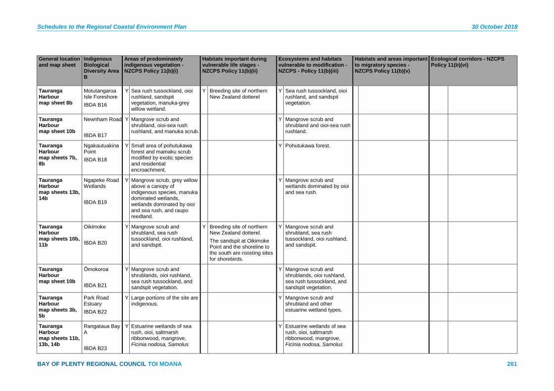
Schedules to the Regional Coastal Environment Plan 30 October 2018
BAY OF PLENTY REGIONAL COUNCIL TOI MOANA 261
General location and map sheet
Indigenous Biological Diversity Area B
Areas of predominately indigenous vegetation - NZCPS Policy 11(b)(i)
Habitats important during vulnerable life stages - NZCPS Policy 11(b)(ii)
Ecosystems and habitats vulnerable to modification - NZCPS - Policy 11(b)(iii)
Habitats and areas important to migratory species - NZCPS Policy 11(b)(v)
Ecological corridors - NZCPS Policy 11(b)(vi)
Tauranga Harbour map sheet 8b
Motutangaroa Isle Foreshore IBDA B16
Y Sea rush tussockland, oioi rushland, sandspit vegetation, manuka-grey willow wetland.
Y Breeding site of northern New Zealand dotterel
Y Sea rush tussockland, oioi rushland, and sandspit vegetation.
Tauranga Harbour map sheet 10b
Newnham Road IBDA B17
Y Mangrove scrub and shrubland, oioi-sea rush rushland, and manuka scrub.
Y Mangrove scrub and shrubland and oioi-sea rush rushland.
Tauranga Harbour map sheets 7b, 8b
Ngakautuakina Point IBDA B18
Y Small area of pohutukawa forest and mamaku scrub modified by exotic species and residential encroachment.
Y Pohutukawa forest.
Tauranga Harbour map sheets 13b, 14b
Ngapeke Road Wetlands IBDA B19
Y Mangrove scrub, grey willow above a canopy of indigenous species, manuka dominated wetlands, wetlands dominated by oioi and sea rush, and raupo reedland.
Y Mangrove scrub and wetlands dominated by oioi and sea rush.
Tauranga Harbour map sheets 10b, 11b
Oikimoke IBDA B20
Y Mangrove scrub and shrubland, sea rush tussockland, oioi rushland, and sandspit.
Y Breeding site of northern New Zealand dotterel. The sandspit at Oikimoke Point and the shoreline to the south are roosting sites for shorebirds.
Y Mangrove scrub and shrubland, sea rush tussockland, oioi rushland, and sandspit.
Tauranga Harbour map sheet 10b
Ōmokoroa IBDA B21
Y Mangrove scrub and shrublands, oioi rushland, sea rush tussockland, and sandspit vegetation.
Y Mangrove scrub and shrublands, oioi rushland, sea rush tussockland, and sandspit vegetation.
Tauranga Harbour map sheets 3b, 5b
Park Road Estuary IBDA B22
Y Large portions of the site are indigenous.
Y Mangrove scrub and shrubland and other estuarine wetland types.
Tauranga Harbour map sheets 11b, 13b, 14b
Rangataua Bay A IBDA B23
Y Estuarine wetlands of sea rush, oioi, saltmarsh ribbonwood, mangrove, Ficinia nodosa, Samolus
Y Estuarine wetlands of sea rush, oioi, saltmarsh ribbonwood, mangrove, Ficinia nodosa, Samolus

30 October 2018 Schedules to the Regional Coastal Environment Plan
262 Pre-Operative Regional Coastal Environment Plan – 30 October 2018
General location and map sheet
Indigenous Biological Diversity Area B
Areas of predominately indigenous vegetation - NZCPS Policy 11(b)(i)
Habitats important during vulnerable life stages - NZCPS Policy 11(b)(ii)
Ecosystems and habitats vulnerable to modification - NZCPS - Policy 11(b)(iii)
Habitats and areas important to migratory species - NZCPS Policy 11(b)(v)
Ecological corridors - NZCPS Policy 11(b)(vi)
repens and glasswort. repens and glasswort.
Tauranga Harbour map sheets 13b, 14b
Rangataua Bay B IBDA B24
Y Sea rush-oioi tussockland, manuka scrub, and forest of ti kouka and manuka with grey willow.
Y Sea rush-oioi tussockland.
Tauranga Harbour map sheets 13b, 14b
Ranginui Road IBDA B25
Y Grey willow above raupo, mangrove shrubland, sea rush tussockland, and sandfield.
Y Mangrove shrubland, sea rush tussockland, and sandfield.
Tauranga Harbour map sheets 8b, 9b
Rangiwaea Island East IBDA B26
Y Sea rush tussockland, oioi rushland, mangrove shrubland, manuka shrubland.
Y Sea rush tussockland, oioi rushland, mangrove shrubland.
Tauranga Harbour map sheets 8b, 11b
Rangiwaea Island Estuary IBDA B27
Y Sea rush tussockland, oioi rushland, manuka scrub, grey willow forest with an indigenous understorey, and sandspit vegetation.
Y Breeding site of northern New Zealand dotterel.
Y Sea rush tussockland, oioi rushland, and sandspit vegetation.
Tauranga Harbour map sheet 8b
Rangiwaea Island Foreshore IBDA B28
Y Manuka scrub, harakeke flaxland, sea rush tussockland, glasswort herbfield, Austrostipa stipoides tussockland, and Samolus repens herbfield.
Y Sea rush tussockland, glasswort herbfield, Austrostipa stipoides tussockland, and Samolus repens herbfield.
Tauranga Harbour map sheets 8b, 9b, 11b
Rangiwaea Island Sandspit IBDA B29
Y Sandspit and intertidal flats. Y Roosting site for shorebirds. Y Sandspit and intertidal flats.
Tauranga Harbour map sheet 5b
Rereatukahia IBDA B30
Y Mangrove scrub and shrubland with smaller areas of saltmarsh.
Y Mangrove scrub and shrubland and saltmarsh.
Tauranga Harbour map sheet 10b
Snodgrass Road Estuary IBDA B31
Y Mangrove scrub and shrubland, oioi-sea rush rushland, and mamaku forest.
Y Mangrove scrub and shrubland and oioi-sea rush rushland.

Schedules to the Regional Coastal Environment Plan 30 October 2018
BAY OF PLENTY REGIONAL COUNCIL TOI MOANA 263
General location and map sheet
Indigenous Biological Diversity Area B
Areas of predominately indigenous vegetation - NZCPS Policy 11(b)(i)
Habitats important during vulnerable life stages - NZCPS Policy 11(b)(ii)
Ecosystems and habitats vulnerable to modification - NZCPS - Policy 11(b)(iii)
Habitats and areas important to migratory species - NZCPS Policy 11(b)(v)
Ecological corridors - NZCPS Policy 11(b)(vi)
Tauranga Harbour map sheets 3b, 5b
Stokes Road Coastal Forest IBDA B32
Y Mixed indigenous and exotic secondary forest.
Secondary forest is not confined to the coastal environment.
Y The site is not a corridor, but it is a buffer to part of Katikati Estuary.
Tauranga Harbour map sheet 10b
Te Puna Estuary IBDA B33
Y Mangrove shrubland, other indigenous estuarine wetland vegetation, manuka-dominated wetland, and mamaku-(kamahi) forest).
Y Mangrove shrubland and other estuarine wetland types.
Y The Te Puna Stream is a migratory pathway for freshwater fish.
Tauranga Harbour map sheets 5b, 7b
Te Rereatukahia IBDA B34
Y Predominantly indigenous wetlands and scrub.
Y Estuarine wetlands. Y The mouth of the Ngututuru Stream is probably a migratory pathway for indigenous freshwater fish.
Tauranga Harbour map sheet 5b
Tetley Road Estuary IBDA B35
Y Mangrove scrub and other indigenous estuarine wetland vegetation types. The palustrine wetland is infested with grey willow.
Y Estuarine wetland. Y Migratory fish species have been recorded upstream of the site.
Tauranga Harbour map sheet 3b
Tuapiro IBDA B36
Y Mangrove scrub and scrubland and other estuarine wetland types.
Y Mangrove scrub and scrubland, other estuarine wetland types.
Y Tuapiro Creek is a migratory pathway for indigenous freshwater fish.
Tauranga Harbour map sheet 3b
Tuapiro Estuary Sandspit IBDA B37
Y The site is indigenous in character, comprising bare sand and intertidal flats.
Y The sandy beach is a secondary roost site for shorebirds.
Y Bare sand and intertidal flats.
Y Is a buffer to the adjacent site, Ongare.
Tauranga Harbour map sheet 5b
Tutaetaka Island IBDA B38
Y Small area of pohutukawa forest with some exotic species present.
Y Pohutukawa forest.
Tauranga Harbour map sheets 13b, 14b
Tye Park Inlet IBDA B39
Y Sandfield, oioi rushland, and mangrove scrub.
Y Sandfield, oioi rushland, and mangrove scrub.
Tauranga Harbour map sheet 10b
Waikaraka Estuary IBDA B40
Y Mangrove scrub and shrubland, oioi rushland, sea rush tussockland, and manuka scrub.
Y Mangrove scrub and shrubland, oioi rushland, and sea rush tussockland.
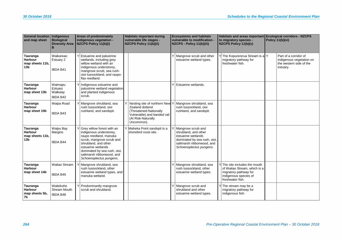
30 October 2018 Schedules to the Regional Coastal Environment Plan
264 Pre-Operative Regional Coastal Environment Plan – 30 October 2018
General location and map sheet
Indigenous Biological Diversity Area B
Areas of predominately indigenous vegetation - NZCPS Policy 11(b)(i)
Habitats important during vulnerable life stages - NZCPS Policy 11(b)(ii)
Ecosystems and habitats vulnerable to modification - NZCPS - Policy 11(b)(iii)
Habitats and areas important to migratory species - NZCPS Policy 11(b)(v)
Ecological corridors - NZCPS Policy 11(b)(vi)
Tauranga Harbour map sheets 11b, 13b
Waikareao Estuary 2 IBDA B41
Y Estuarine and palustrine wetlands, including grey willow wetland with an indigenous understorey, mangrove scrub, sea rush-oioi tussockland, and raupo-flax reedland.
Y Mangrove scrub and other estuarine wetland types.
Y The Kopurererua Stream is a migratory pathway for freshwater fish.
Y Part of a corridor of indigenous vegetation on the western side of the estuary.
Tauranga Harbour map sheet 13b
Waimapu Estuary Walkway IBDA B42
Y Indigenous estuarine and palustrine wetland vegetation and planted indigenous scrub.
Y Estuarine wetlands.
Tauranga Harbour map sheet 10b
Waipa Road IBDA B43
Y Mangrove shrubland, sea rush tussockland, oioi rushland, and sandspit.
Y Nesting site of northern New Zealand dotterel (Threatened-Nationally Vulnerable) and banded rail (At Risk-Naturally Uncommon).
Y Mangrove shrubland, sea rush tussockland, oioi rushland, and sandspit.
Tauranga Harbour map sheets 11b, 13b
Waipu Bay Margins IBDA B44
Y Grey willow forest with an indigenous understorey, raupo reedland, manuka scrub, mangrove scrub and shrubland, and other estuarine wetlands dominated by sea rush, oioi, saltmarsh ribbonwood, and Schoenoplectus pungens.
Y Maheka Point sandspit is a shorebird roost site.
Y Mangrove scrub and shrubland, and other estuarine wetlands dominated by sea rush, oioi, saltmarsh ribbonwood, and Schoenoplectus pungens.
Tauranga Harbour map sheet 14b
Waitao Stream IBDA B45
Y Mangrove shrubland, sea rush tussockland, other estuarine wetland types, and manuka wetland.
Y Mangrove shrubland, sea rush tussockland, other estuarine wetland types.
Y The site includes the mouth of Waitao Stream, which is a migratory pathway for indigenous species of freshwater fish.
Tauranga Harbour map sheets 5b, 7b
Waitekohe Stream Mouth IBDA B46
Y Predominantly mangrove scrub and shrubland.
Y Mangrove scrub and shrubland and other estuarine wetland types.
Y The stream may be a migratory pathway for indigenous fish.
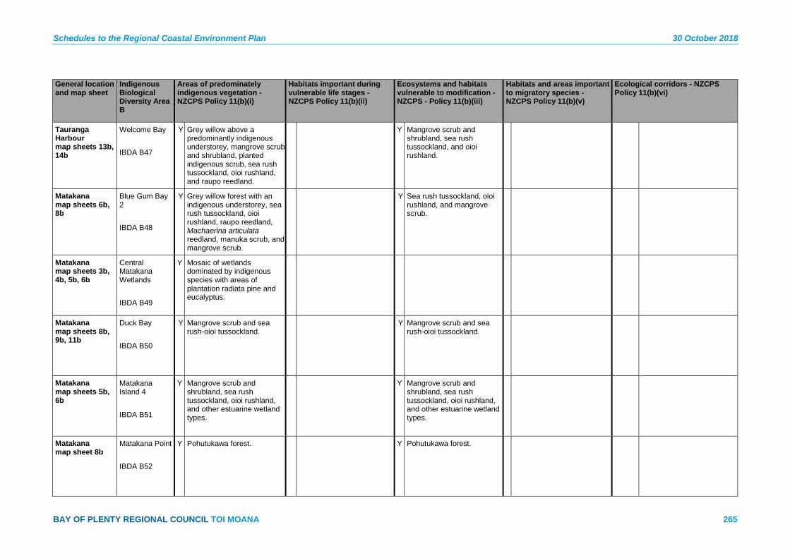
Schedules to the Regional Coastal Environment Plan 30 October 2018
BAY OF PLENTY REGIONAL COUNCIL TOI MOANA 265
General location and map sheet
Indigenous Biological Diversity Area B
Areas of predominately indigenous vegetation - NZCPS Policy 11(b)(i)
Habitats important during vulnerable life stages - NZCPS Policy 11(b)(ii)
Ecosystems and habitats vulnerable to modification - NZCPS - Policy 11(b)(iii)
Habitats and areas important to migratory species - NZCPS Policy 11(b)(v)
Ecological corridors - NZCPS Policy 11(b)(vi)
Tauranga Harbour map sheets 13b, 14b
Welcome Bay IBDA B47
Y Grey willow above a predominantly indigenous understorey, mangrove scrub and shrubland, planted indigenous scrub, sea rush tussockland, oioi rushland, and raupo reedland.
Y Mangrove scrub and shrubland, sea rush tussockland, and oioi rushland.
Matakana map sheets 6b, 8b
Blue Gum Bay 2 IBDA B48
Y Grey willow forest with an indigenous understorey, sea rush tussockland, oioi rushland, raupo reedland, Machaerina articulata reedland, manuka scrub, and mangrove scrub.
Y Sea rush tussockland, oioi rushland, and mangrove scrub.
Matakana map sheets 3b, 4b, 5b, 6b
Central Matakana Wetlands IBDA B49
Y Mosaic of wetlands dominated by indigenous species with areas of plantation radiata pine and eucalyptus.
Matakana map sheets 8b, 9b, 11b
Duck Bay IBDA B50
Y Mangrove scrub and sea rush-oioi tussockland.
Y Mangrove scrub and sea rush-oioi tussockland.
Matakana map sheets 5b, 6b
Matakana Island 4 IBDA B51
Y Mangrove scrub and shrubland, sea rush tussockland, oioi rushland, and other estuarine wetland types.
Y Mangrove scrub and shrubland, sea rush tussockland, oioi rushland, and other estuarine wetland types.
Matakana map sheet 8b
Matakana Point IBDA B52
Y Pohutukawa forest. Y Pohutukawa forest.
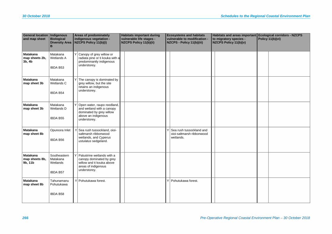
30 October 2018 Schedules to the Regional Coastal Environment Plan
266 Pre-Operative Regional Coastal Environment Plan – 30 October 2018
General location and map sheet
Indigenous Biological Diversity Area B
Areas of predominately indigenous vegetation - NZCPS Policy 11(b)(i)
Habitats important during vulnerable life stages - NZCPS Policy 11(b)(ii)
Ecosystems and habitats vulnerable to modification - NZCPS - Policy 11(b)(iii)
Habitats and areas important to migratory species - NZCPS Policy 11(b)(v)
Ecological corridors - NZCPS Policy 11(b)(vi)
Matakana map sheets 2b, 3b, 4b
Matakana Wetlands A IBDA B53
Y Canopy of grey willow or radiata pine or ti kouka with a predominantly indigenous understorey.
Matakana map sheet 3b
Matakana Wetlands C IBDA B54
Y The canopy is dominated by grey willow, but the site retains an indigenous understorey.
Matakana map sheet 3b
Matakana Wetlands D IBDA B55
Y Open water, raupo reedland, and wetland with a canopy dominated by grey willow above an indigenous understorey.
Matakana map sheet 8b
Opureora Inlet IBDA B56
Y Sea rush tussockland, oioi-saltmarsh ribbonwood wetlands, and Cyperus ustulatus sedgeland.
Y Sea rush tussockland and oioi-saltmarsh ribbonwood wetlands.
Matakana map sheets 8b, 9b, 11b
Southeastern Matakana Wetlands IBDA B57
Y Palustrine wetlands with a canopy dominated by grey willow and ti kouka above areas of indigenous understorey.
Matakana map sheet 8b
Tahunamanu Pohutukawa IBDA B58
Y Pohutukawa forest. Y Pohutukawa forest.

Schedules to the Regional Coastal Environment Plan 30 October 2018
BAY OF PLENTY REGIONAL COUNCIL TOI MOANA 267
General location and map sheet
Indigenous Biological Diversity Area B
Areas of predominately indigenous vegetation - NZCPS Policy 11(b)(i)
Habitats important during vulnerable life stages - NZCPS Policy 11(b)(ii)
Ecosystems and habitats vulnerable to modification - NZCPS - Policy 11(b)(iii)
Habitats and areas important to migratory species - NZCPS Policy 11(b)(v)
Ecological corridors - NZCPS Policy 11(b)(vi)
Matakana map sheets 5b, 6b
Tirohanga Point Beach IBDA B59
Y Unvegetated sandfield. Y Nesting site for northern New Zealand dotterel.
Y Sandfield.
Matakana map sheets 5b, 6b
Tirohanga Point Pohutukawa IBDA B60
Y Pohutukawa forest. Y Pohutukawa forest.
Matakana map sheet 8b
Waihirere Road Wetland IBDA B61
Y This site comprises a palustrine wetland canopy dominated by grey willow but with an indigenous understorey, and an estuarine rushland wetland.
Mauāo map sheets 9b, 11b
Hopukiore IBDA B62
Y Modified pohutukawa forest and scrub.
Mauāo map sheets 9b, 11b
Mauāo 2 IBDA B63
Y Modified, secondary, and planted pohutukawa treeland and coastal scrub.
Y Nesting site of northern little blue penguins (At Risk-Declining).
Mauāo map sheets 9b, 11b, 12b
Mauāo Marine IBDA B64
Y Reefs around the base of Mauāo act as a setting area for juvenile crayfish, pāua and kina.
Y Only mainland coastal rocky reef headland and nearshore island system between Coromandel Peninsula and Waihau Bay.
Y Site forms an ecological corridor with Motuotau Island, Moturiki and Mauāo.
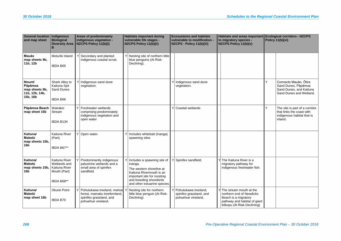
30 October 2018 Schedules to the Regional Coastal Environment Plan
268 Pre-Operative Regional Coastal Environment Plan – 30 October 2018
General location and map sheet
Indigenous Biological Diversity Area B
Areas of predominately indigenous vegetation - NZCPS Policy 11(b)(i)
Habitats important during vulnerable life stages - NZCPS Policy 11(b)(ii)
Ecosystems and habitats vulnerable to modification - NZCPS - Policy 11(b)(iii)
Habitats and areas important to migratory species - NZCPS Policy 11(b)(v)
Ecological corridors - NZCPS Policy 11(b)(vi)
Mauāo map sheets 9b, 11b, 12b
Moturiki Island IBDA B65
Y Secondary and planted indigenous coastal scrub.
Y Nesting site of northern little blue penguins (At Risk-Declining).
Mount/ Pāpāmoa map sheets 9b, 11b, 12b, 14b, 15b, 16b
Shark Alley to Kaituna Spit Sand Dunes IBDA B66
Y Indigenous sand dune vegetation.
Y Indigenous sand dune vegetation.
Y Connects Mauāo, Ōtira Sand Dunes, Pāpāmoa Sand Dunes, and Kaituna Sand Dunes and Wetland.
Pāpāmoa Beach map sheet 15b
Wairakei Stream IBDA B134
Y Freshwater wetlands comprising predominately indigenous vegetation and open water
Y Coastal wetlands Y The site is part of a corridor that links the coast with indigenous habitat that is inland.
Kaituna/ Maketū map sheets 15b, 16b
Kaituna River (Part) IBDA B67**
Y Open water. Y Includes whitebait (inanga) spawning sites
Kaituna/ Maketū map sheets 15b, 16b
Kaituna River Wetlands and Kaituna River Mouth (Part) IBDA B68**
Y Predominantly indigenous palustrine wetlands and a small area of spinifex sandfield.
Y Includes a spawning site of inanga. The western shoreline at Kaituna Rivermouth is an important site for roosting and breeding shorebirds and other estuarine species.
Y Spinifex sandfield. Y The Kaituna River is a migratory pathway for indigenous freshwater fish.
Kaituna/ Maketū map sheet 16b
Okurei Point IBDA B70
Y Pohutukawa treeland, mahoe forest, mamaku treefernland, spinifex grassland, and pohuehue vineland.
Y Nesting site for northern little blue penguin (At Risk-Declining)
Y Pohutukawa treeland, spinifex grassland, and pohuehue vineland.
Y The stream mouth at the northern end of Newdicks Beach is a migratory pathway and habitat of giant kōkopu (At Risk-Declining).

Schedules to the Regional Coastal Environment Plan 30 October 2018
BAY OF PLENTY REGIONAL COUNCIL TOI MOANA 269
General location and map sheet
Indigenous Biological Diversity Area B
Areas of predominately indigenous vegetation - NZCPS Policy 11(b)(i)
Habitats important during vulnerable life stages - NZCPS Policy 11(b)(ii)
Ecosystems and habitats vulnerable to modification - NZCPS - Policy 11(b)(iii)
Habitats and areas important to migratory species - NZCPS Policy 11(b)(v)
Ecological corridors - NZCPS Policy 11(b)(vi)
Little Waihī map sheet 16b
Wharere Road Wetland IBDA B72
Y Open water and raupo-dominated reedland.
Y Part of an ecological corridor that extends inland from Waihī Estuary and includes the site ‘Waewaetutuki’.
Pukehina map sheet 17b
Pukehina IBDA B73
Y Spinifex sandfield and grassland, pohuehue vineland, Ficinia nodosa sedgeland, and pohutukawa treeland and shrubland.
Y Shorebird roosting site. Y Spinifex sandfield and grassland, pohuehue vineland, Ficinia nodosa sedgeland, and pohutukawa treeland and shrubland.
Matatā Straights map sheets 17b, 18b, 19b
Ōtamarākau-Matatā-Whakatāne Dunes B IBDA B74
Y Indigenous dune vegetation and raupo reedland.
Waitahanui Stream Mouth is a nesting site for northern New Zealand dotterel.
Y Indigenous dune vegetation Y Waitahanui Stream is a migratory pathway for indigenous freshwater fish.
Y Provides a link between portions of Ōtamarākau-Matatā-Whakatāne Dunes A.
Matatā Straights map sheets 19b, 22b
Tarawera River Raupo Wetland IBDA B75
Y Raupo reedland. Y The river is a migratory pathway for indigenous freshwater fish.
Matatā Straights map sheets 19b, 22b
Thornton Road Dunes IBDA B76
Y The site is protected and is a key connection between the coast and the Thornton kanuka forest.
Matatā Straights map sheet 22b
Wahieroa Wetland IBDA B77
Y Grey willow above raupo reedland and open water.
Matatā Straights map sheet 22b
Walker Road Wetlands IBDA B78
Y Indigenous reedland and open water.
Whakatāne map sheet 24b
Orini Stream (Part) IBDA B79
Y Raupo reedland and duckweed herbfield.
Whakatāne map sheet 24b
Orini open water IBDA B135
Y This site is a migratory pathway for indigenous freshwater fish.
Y This site connects IBDA A45 Orini Estuary to IBDA A44 Whakatāne Estuary; both sites are in the coastal environment.

30 October 2018 Schedules to the Regional Coastal Environment Plan
270 Pre-Operative Regional Coastal Environment Plan – 30 October 2018
General location and map sheet
Indigenous Biological Diversity Area B
Areas of predominately indigenous vegetation - NZCPS Policy 11(b)(i)
Habitats important during vulnerable life stages - NZCPS Policy 11(b)(ii)
Ecosystems and habitats vulnerable to modification - NZCPS - Policy 11(b)(iii)
Habitats and areas important to migratory species - NZCPS Policy 11(b)(v)
Ecological corridors - NZCPS Policy 11(b)(vi)
Whakatāne map sheets 22b, 23b, 24b
Whakatāne Dunes IBDA B80
Y Indigenous dune vegetation dominated by mixtures of species such as spinifex, pohuehue, pingao, Ficinia nodosa, and Carex pumila.
Y Indigenous dune vegetation dominated by mixtures of species such as spinifex, pohuehue, pingao, Ficinia nodosa, and Carex pumila.
Y Part of a corridor of dune land that extends from Pukehina in the west to Whakatāne River in the East.
Ōhope map sheets 24b, 25b
Ōhope Dunes IBDA B81
Y Sandfield and spinifex sandfield.
Y Sandfield and spinifex sandfield.
Y The mouth of the Maraetōtara Stream is migratory pathway for indigenous freshwater fish.
Y Ōhope Dunes is contiguous with Ōhope Spit.
Ōhope map sheets 24b, 25b
Ōhope Pohutukawa Remnants IBDA B82
Y Pohutukawa forest with radiata pine and an indigenous understorey.
Y Pohutukawa forest.
Ōhiwa Harbour map sheet 25b
Awaraputuna Stream IBDA B83
Y Indigenous scrub and shrubland, and sea rush tussockland.
Y Sea rush tussockland. Y The stream is a migratory pathway for indigenous species of freshwater fish.
Ōhiwa Harbour map sheet 25b
Claydon Place IBDA B84
Y Pohutukawa forest. Y Pohutukawa forest is largely confined to the coastal environment.
Ōhiwa Harbour map sheet 25b
Harbour Quarry Shoreline IBDA B85
Y Estuarine wetlands of sea rush, oioi, mangroves, and Schoenoplectus pungens.
Y Estuarine wetlands of sea rush, oioi, mangroves, and Schoenoplectus pungens.
Ōhiwa Harbour map sheet 25b
Harbour Road IBDA B86
Y Sea rush tussockland, oioi rushland, and manuka scrub.
Y Estuarine wetlands of oioi, sea rush and manuka.
Ōhiwa Harbour map sheets 25b, 26b
Hiwarau Pohutukawa IBDA B87
Y Pohutukawa forest. Y Pohutukawa forest is largely confined to the coastal environment.
Ōhiwa Harbour map sheet 26b
Hiwarau Wetlands IBDA B88
Y Indigenous estuarine wetland vegetation, including mangroves.
Y Indigenous estuarine wetland vegetation.
Y The stream mouth may be a migratory pathway for indigenous freshwater fish.
Ōhiwa Harbour map sheets 25b, 26b
Hokianga Island IBDA B89
Y Mangrove, sea rush, estuarine margin vegetation, pohutukawa forest and other Indigenous forest and scrub.
Y Mangrove, sea rush, estuarine margin vegetation, and pohutukawa forest.
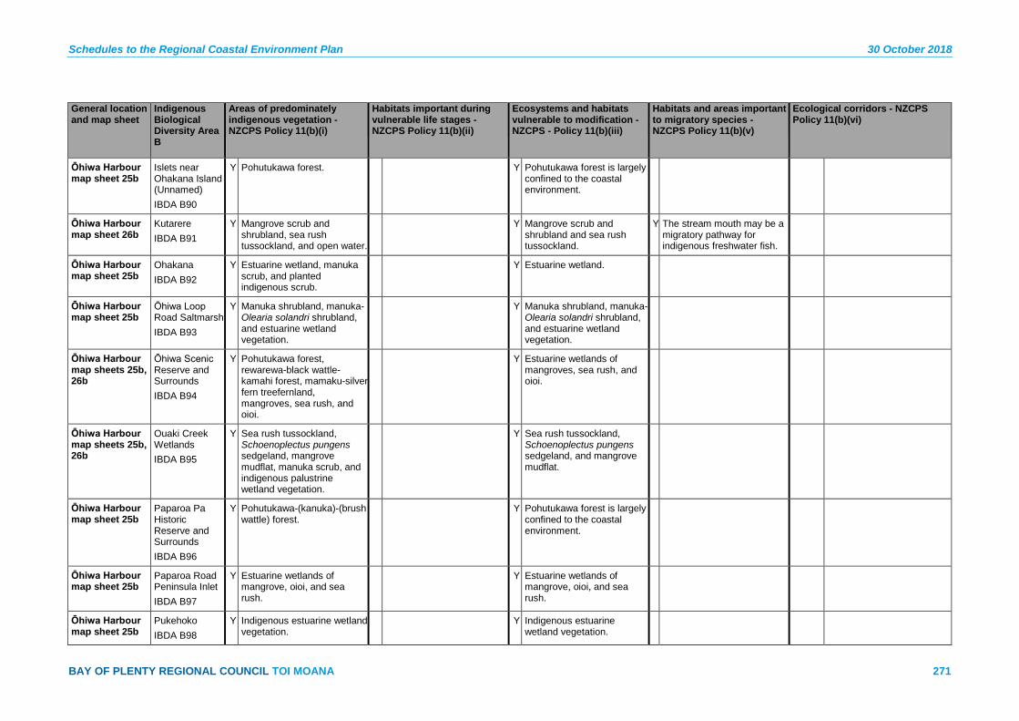
Schedules to the Regional Coastal Environment Plan 30 October 2018
BAY OF PLENTY REGIONAL COUNCIL TOI MOANA 271
General location and map sheet
Indigenous Biological Diversity Area B
Areas of predominately indigenous vegetation - NZCPS Policy 11(b)(i)
Habitats important during vulnerable life stages - NZCPS Policy 11(b)(ii)
Ecosystems and habitats vulnerable to modification - NZCPS - Policy 11(b)(iii)
Habitats and areas important to migratory species - NZCPS Policy 11(b)(v)
Ecological corridors - NZCPS Policy 11(b)(vi)
Ōhiwa Harbour map sheet 25b
Islets near Ohakana Island (Unnamed) IBDA B90
Y Pohutukawa forest. Y Pohutukawa forest is largely confined to the coastal environment.
Ōhiwa Harbour map sheet 26b
Kutarere IBDA B91
Y Mangrove scrub and shrubland, sea rush tussockland, and open water.
Y Mangrove scrub and shrubland and sea rush tussockland.
Y The stream mouth may be a migratory pathway for indigenous freshwater fish.
Ōhiwa Harbour map sheet 25b
Ohakana IBDA B92
Y Estuarine wetland, manuka scrub, and planted indigenous scrub.
Y Estuarine wetland.
Ōhiwa Harbour map sheet 25b
Ōhiwa Loop Road Saltmarsh IBDA B93
Y Manuka shrubland, manuka-Olearia solandri shrubland, and estuarine wetland vegetation.
Y Manuka shrubland, manuka-Olearia solandri shrubland, and estuarine wetland vegetation.
Ōhiwa Harbour map sheets 25b, 26b
Ōhiwa Scenic Reserve and Surrounds IBDA B94
Y Pohutukawa forest, rewarewa-black wattle-kamahi forest, mamaku-silver fern treefernland, mangroves, sea rush, and oioi.
Y Estuarine wetlands of mangroves, sea rush, and oioi.
Ōhiwa Harbour map sheets 25b, 26b
Ouaki Creek Wetlands IBDA B95
Y Sea rush tussockland, Schoenoplectus pungens sedgeland, mangrove mudflat, manuka scrub, and indigenous palustrine wetland vegetation.
Y Sea rush tussockland, Schoenoplectus pungens sedgeland, and mangrove mudflat.
Ōhiwa Harbour map sheet 25b
Paparoa Pa Historic Reserve and Surrounds IBDA B96
Y Pohutukawa-(kanuka)-(brush wattle) forest.
Y Pohutukawa forest is largely confined to the coastal environment.
Ōhiwa Harbour map sheet 25b
Paparoa Road Peninsula Inlet IBDA B97
Y Estuarine wetlands of mangrove, oioi, and sea rush.
Y Estuarine wetlands of mangrove, oioi, and sea rush.
Ōhiwa Harbour map sheet 25b
Pukehoko IBDA B98
Y Indigenous estuarine wetland vegetation.
Y Indigenous estuarine wetland vegetation.

30 October 2018 Schedules to the Regional Coastal Environment Plan
272 Pre-Operative Regional Coastal Environment Plan – 30 October 2018
General location and map sheet
Indigenous Biological Diversity Area B
Areas of predominately indigenous vegetation - NZCPS Policy 11(b)(i)
Habitats important during vulnerable life stages - NZCPS Policy 11(b)(ii)
Ecosystems and habitats vulnerable to modification - NZCPS - Policy 11(b)(iii)
Habitats and areas important to migratory species - NZCPS Policy 11(b)(v)
Ecological corridors - NZCPS Policy 11(b)(vi)
Ōhiwa Harbour map sheets 25b, 26b
Pukeruru IBDA B99
Y Manuka scrub, sea rush tussockland, and oioi rushland.
Y Sea rush tussockland, and oioi rushland.
Ōhiwa Harbour map sheets 25b, 26b, 27b
Reeves Road Wetlands IBDA B100
Y Mangrove scrub and shrubland, mudflat, Schoenoplectus pungens sedgeland, and sea rush tussockland.
Y Mangrove scrub and shrubland, mudflat, Schoenoplectus pungens sedgeland, and sea rush tussockland.
Ōhiwa Harbour map sheet 26b
Ruatuna Road IBDA B101
Y Mangroves, “rushland”. Y Mangrove shrubland. Y The stream mouth may be a migratory pathway for indigenous freshwater fish.
Ōhiwa Harbour map sheet 26b
Ruatuna Road Embayment IBDA B102
Y Estuarine vegetation. Y Estuarine vegetation.
Ōhiwa Harbour map sheet 26b
Te Kakaha Stream (SH2) IBDA B103
Y Sea rush tussockland and Juncus spp. tussockland.
Y Sea rush tussockland.
Ōhiwa Harbour map sheet 26b
Stipa - Ruatuna Road Inlet IBDA B104
Y Manuka scrub, sea rush tussockland, Austrostipa stipoides/Selliera radicans-sea couch tussockland, and estuarine herbfields.
Y Sea rush tussockland, Austrostipa stipoides/Selliera radicans-sea couch tussockland, and estuarine herbfields
Ōhiwa Harbour map sheet 25b
Tauwhare IBDA B105
Y Pohutukawa forest, mānuka-brush, wattle scrub and shrubland, sea rush tussockland, mangrove shrubland and raupo reedland.
Y Pohutukawa forest is largely confined to the coastal environment. Estuarine wetland vegetation.
Ōhiwa Harbour map sheet 26b
Te Awawairoa Stream IBDA B106
Y Schoenoplectus pungens sedgeland, mangrove scrub and shrubland, mangrove mudflat, sea rush tussockland, Juncus spp. rushland, estuary margin vegetation and freshwater wetland vegetation.
Y Estuarine wetland vegetation.
Y The stream may be a migratory pathway for freshwater fish.

Schedules to the Regional Coastal Environment Plan 30 October 2018
BAY OF PLENTY REGIONAL COUNCIL TOI MOANA 273
General location and map sheet
Indigenous Biological Diversity Area B
Areas of predominately indigenous vegetation - NZCPS Policy 11(b)(i)
Habitats important during vulnerable life stages - NZCPS Policy 11(b)(ii)
Ecosystems and habitats vulnerable to modification - NZCPS - Policy 11(b)(iii)
Habitats and areas important to migratory species - NZCPS Policy 11(b)(v)
Ecological corridors - NZCPS Policy 11(b)(vi)
Ōhiwa Harbour map sheet 25b
Toritori IBDA B107
Y Pohutukawa forest. Y Pohutukawa forest is largely confined to the coastal environment.
Ōhiwa Harbour map sheet 25b
Tunanui Stream Inlet IBDA B108
Y Estuarine wetland with species such as sea rush, oioi, saltmarsh ribbonwood, and mangrove.
Y Estuarine wetland with species such as sea rush, oioi, saltmarsh ribbonwood, and mangrove.
Ōhiwa Harbour map sheet 25b
Uawhaipata Island IBDA B109
Y Estuarine wetlands and pohutukawa/Olearia solandri-manuka shrubland.
Y Estuarine wetlands and pohutukawa/Olearia solandri-manuka shrubland.
Ōhiwa Harbour map sheet 25b
Wainui Road Bittern Spot IBDA B110
Y Impounded intertidal flat with estuarine wetland, and raupo reedland.
Y Estuarine wetland.
Ōhiwa Harbour map sheets 25b, 26b
Wainui Wetland IBDA B111
Y Sea rush tussockland, Schoenoplectus pungens sedgeland, raupo reedland, and Indigenous forest and shrubland.
Y Sea rush tussockland, Schoenoplectus pungens sedgeland, and other estuarine vegetation.
Ōhiwa Harbour map sheet 25b
Waiotane Stream IBDA B112
Y Sea rush tussockland and manuka scrub and shrubland.
Y Sea rush tussockland. Y Waiotane Stream may be a migratory pathway for indigenous species of freshwater fish.
Waiōtahe map sheets 25b, 27b
Bryans Beach A IBDA B113
Y Tawa-puriri-(pohutukawa) forest, (pohutukawa)/mahoe-kamahi-mamaku shrubland, and pohutukawa forest.
Y Pohutukawa forest is largely confined to the coastal environment.
Waiōtahe map sheets 25b, 27b
Onekawa IBDA B114
Y Pohutukawa-puriri forest, pohutukawa treeland and forest, manuka scrub, raupo reedland, and indigenous secondary scrub.
Y Pohutukawa-puriri forest and pohutukawa treeland and forest.
Y Onekawa may provide a corridor between Ōhiwa Spit, Bryans Beach A, and Waiōtahe Spit.
Waiōtahe map sheet 27b
Waiōtahe Beach IBDA B115
Y Pohutukawa-dominant forest. Y Breeding site for at least two pairs of northern New Zealand dotterel.
Y Pohutukawa-dominant forest.
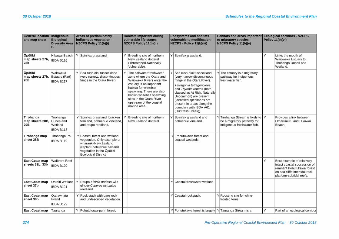
30 October 2018 Schedules to the Regional Coastal Environment Plan
274 Pre-Operative Regional Coastal Environment Plan – 30 October 2018
General location and map sheet
Indigenous Biological Diversity Area B
Areas of predominately indigenous vegetation - NZCPS Policy 11(b)(i)
Habitats important during vulnerable life stages - NZCPS Policy 11(b)(ii)
Ecosystems and habitats vulnerable to modification - NZCPS - Policy 11(b)(iii)
Habitats and areas important to migratory species - NZCPS Policy 11(b)(v)
Ecological corridors - NZCPS Policy 11(b)(vi)
Ōpōtiki map sheets 27b, 28b
Hikuwai Beach IBDA B116
Y Spinifex grassland. Y Breeding site of northern New Zealand dotterel (Threatened-Nationally Vulnerable).
Y Spinifex grassland. Y Links the mouth of Waioweka Estuary to Tirohanga Dunes and Wetland.
Ōpōtiki map sheets 27b, 28b
Waioweka Estuary (Part) IBDA B117
Y Sea rush-oioi tussockland (very narrow, discontinuous fringe in the Otara River).
Y The saltwater/freshwater zone where the Otara and Waioweka Rivers enter the estuary is an important habitat for whitebait spawning. There are also known whitebait spawning sites in the Otara River upstream of the coastal marine area.
Y Sea rush-oioi tussockland (very narrow discontinuous fringe in the Otara River). Tetragonia tetragonoides and Thyridia repens (both classed as At Risk, Naturally Uncommon) are present (identified specimens are present in areas along the boundary with IBDA A61 (Huntress Creek)).
Y The estuary is a migratory pathway for indigenous freshwater fish.
Tirohanga map sheets 28B, 29B
Tirohanga Dunes and Wetland IBDA B118
Y Spinifex grassland, bracken fernland, pohuehue vineland, and raupo reedland.
Y Breeding site of northern New Zealand dotterel.
Y Spinifex grassland and pohuehue vineland.
Y Tirohanga Stream is likely to be a migratory pathway for indigenous freshwater fish.
Y Provides a link between Omarumutu and Hikuwai Beach.
Tirohanga map sheet 28B
Tirohanga Pa IBDA B119
Y Coastal forest and wetland vegetation. Only example of wharariki-New Zealand iceplant-pohuehue flaxland vegetation in the Ōpōtiki Ecological District.
Y Pohutukawa forest and coastal wetlands.
East Coast map sheets 32b, 33b
Waiōrore Reef IBDA B120
Y Best example of relatively intact coastal succession of remnant Pohutukawa forest on sea cliffs-intertidal rock platform-subtidal reefs.
East Coast map sheet 37b
Oruaiti Wetland IBDA B121
Y Raupo-Ficinia nodosa-wild ginger-Cyperus ustulatus reedland.
Y Coastal freshwater wetland.
East Coast map sheet 38b
Otarawhata Island IBDA B122
Y Rock stack with bare rock and undescribed vegetation.
Y Coastal rockstack. Y Roosting site for white-fronted terns.
East Coast map Tauranga Y Pohutukawa-puriri forest, Y Pohutukawa forest is largely Y Tauranga Stream is a Y Part of an ecological corridor

Schedules to the Regional Coastal Environment Plan 30 October 2018
BAY OF PLENTY REGIONAL COUNCIL TOI MOANA 275
General location and map sheet
Indigenous Biological Diversity Area B
Areas of predominately indigenous vegetation - NZCPS Policy 11(b)(i)
Habitats important during vulnerable life stages - NZCPS Policy 11(b)(ii)
Ecosystems and habitats vulnerable to modification - NZCPS - Policy 11(b)(iii)
Habitats and areas important to migratory species - NZCPS Policy 11(b)(v)
Ecological corridors - NZCPS Policy 11(b)(vi)
sheets 36b, 37b Stream (Part) IBDA B123
kanuka-manuka-broadleaved scrub and forest.
confined to the coastal environment.
migratory pathway for indigenous freshwater fish.
linking natural areas on the coast with those in surrounding areas.
East Coast map sheets 29b, 30b
Te Whiorau (Part) IBDA B124
Y Kanuka-dominant forest and scrub, pohutukawa-puriri dominant forest.
Y Pohutukawa-puriri dominant forest.
Y Site is part of an ecological corridor from the coast to lowland-submontane bioclimatic zones in the Raukūmara Ranges.
East Coast map sheets 29b, 30b
Tōrere River mouth IBDA B125
Y Shingle beach; river mouth. Y Tōrere Rivermouth is a habitat or migratory pathway for indigenous species of freshwater fish.
East Coast map sheets 36b, 37b
Waihau Pohutukawa Remnants IBDA B126
Y Pohutukawa and puriri-dominant forest.
Y Forest dominated by pohutukawa and puriri is largely confined to the coastal environment.
Y Provides a link between the open coast and Te Ranginui-Oruaiti-Whangaparaoa (Part) and indigenous vegetation further inland.
East Coast map sheets 35b, 36b
Waimanu (Part) IBDA B127
Y Pohutukawa forest and treeland, tawa-puriri forest, scrub dominated by manuka, whauwhaupaku, and mamaku, and indigenous freshwater wetland.
East Coast map sheets 36b, 37b
Waiokaha Stream Corridor (Part) IBDA B128
Y Pohutukawa-dominant forest and treeland, kanuka-broadleaved forest.
Y Pohutukawa forest is largely confined to the coastal environment.
Y Waiokaha Stream is likely to be a migratory pathway for indigenous fish.
Y Part of a coastal-lowland corridor of regenerating indigenous vegetation through pasture and plantation forest.
East Coast map sheet 31b
Maraenui Wetland IBDA B129
Y Raupo-Machaerina dominant reedland.
Whangaparaoa map sheets 38b, 39b
Cape Runaway Pohutukawa Remnants IBDA B130
Y Pohutukawa forest. Y Pohutukawa forest.
Whangaparaoa Whangaparaoa Y Kanuka-dominant forest and Y Pohutukawa forest. Y Ecological buffer to

30 October 2018 Schedules to the Regional Coastal Environment Plan
276 Pre-Operative Regional Coastal Environment Plan – 30 October 2018
General location and map sheet
Indigenous Biological Diversity Area B
Areas of predominately indigenous vegetation - NZCPS Policy 11(b)(i)
Habitats important during vulnerable life stages - NZCPS Policy 11(b)(ii)
Ecosystems and habitats vulnerable to modification - NZCPS - Policy 11(b)(iii)
Habitats and areas important to migratory species - NZCPS Policy 11(b)(v)
Ecological corridors - NZCPS Policy 11(b)(vi)
map sheets 37b, 38b
B IBDA B131
a small area of pohutukawa forest.
Whangaparaoa Beach and River Mouth and a link to Te Ranginui-Oruaiti-Whangaparaoa (Part).
Offshore map sheet 43b
Motiti Islets IBDA B132
Y Coastal herbfields, pohutukawa-karo treeland and coastal rockland.
Y Coastal herbfields, pohutukawa-karo treeland and coastal rockland.
Offshore map sheet 43b
Taumaihi Island IBDA B133
Y Pohutukawa forest, flaxland, bracken fernland and coastal herbfields.
Y Pohutukawa forest and coastal herbfields.
* The threat status of species may change over time, and can be classified differently nationally compared to internationally. It is recommended plan users consult the New Zealand Threat Classification System lists (available from the Department of Conservation website) to obtain the most up to date information on the New Zealand Threat Status and the International Union for Conservation of Nature and Natural Resources (IUCN) Red List of Threatened species (available from the website http://www.iucnredlist.org) for the most up to date information on the International Threat Status.
** Land within the coastal environment at Te Tumu is identified in the Bay of Plenty Regional Policy Statement as a future growth area. A structure plan in accordance with Method 18 of the RPS will be prepared for this area to ensure integrated provision of infrastructure and integrated management of the environmental effects. Any large scale land use change on Ford Island will also be subject to structure planning.
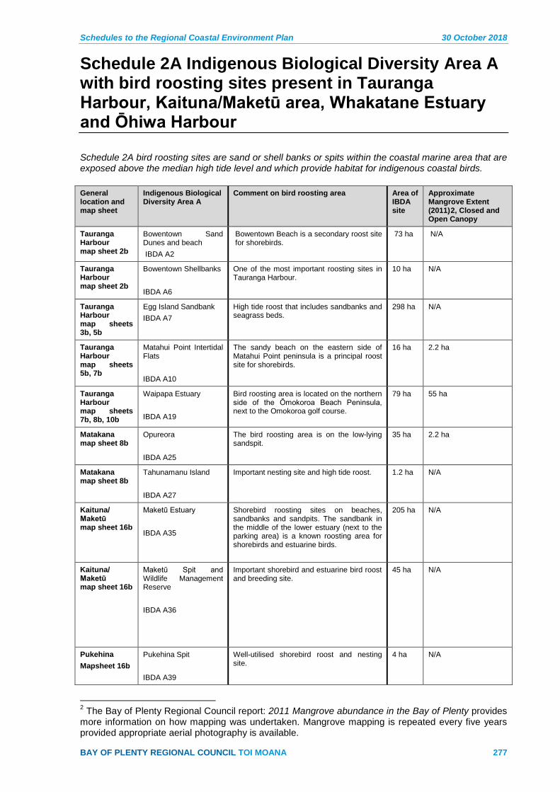
Schedules to the Regional Coastal Environment Plan 30 October 2018
BAY OF PLENTY REGIONAL COUNCIL TOI MOANA 277
Schedule 2A Indigenous Biological Diversity Area A with bird roosting sites present in Tauranga Harbour, Kaituna/Maketū area, Whakatane Estuary and Ōhiwa Harbour
Schedule 2A bird roosting sites are sand or shell banks or spits within the coastal marine area that are exposed above the median high tide level and which provide habitat for indigenous coastal birds. General location and map sheet
Indigenous Biological Diversity Area A
Comment on bird roosting area Area of IBDA site
Approximate Mangrove Extent (2011)2, Closed and Open Canopy
Tauranga Harbour map sheet 2b
Bowentown Sand Dunes and beach IBDA A2
Bowentown Beach is a secondary roost site for shorebirds.
73 ha N/A
Tauranga Harbour map sheet 2b
Bowentown Shellbanks IBDA A6
One of the most important roosting sites in Tauranga Harbour.
10 ha N/A
Tauranga Harbour map sheets 3b, 5b
Egg Island Sandbank IBDA A7
High tide roost that includes sandbanks and seagrass beds.
298 ha N/A
Tauranga Harbour map sheets 5b, 7b
Matahui Point Intertidal Flats IBDA A10
The sandy beach on the eastern side of Matahui Point peninsula is a principal roost site for shorebirds.
16 ha 2.2 ha
Tauranga Harbour map sheets 7b, 8b, 10b
Waipapa Estuary IBDA A19
Bird roosting area is located on the northern side of the Ōmokoroa Beach Peninsula, next to the Omokoroa golf course.
79 ha 55 ha
Matakana map sheet 8b
Opureora IBDA A25
The bird roosting area is on the low-lying sandspit.
35 ha 2.2 ha
Matakana map sheet 8b
Tahunamanu Island IBDA A27
Important nesting site and high tide roost. 1.2 ha N/A
Kaituna/ Maketū map sheet 16b
Maketū Estuary IBDA A35
Shorebird roosting sites on beaches, sandbanks and sandpits. The sandbank in the middle of the lower estuary (next to the parking area) is a known roosting area for shorebirds and estuarine birds.
205 ha N/A
Kaituna/ Maketū map sheet 16b
Maketū Spit and Wildlife Management Reserve IBDA A36
Important shorebird and estuarine bird roost and breeding site.
45 ha N/A
Pukehina Mapsheet 16b
Pukehina Spit IBDA A39
Well-utilised shorebird roost and nesting site.
4 ha N/A
2 The Bay of Plenty Regional Council report: 2011 Mangrove abundance in the Bay of Plenty provides more information on how mapping was undertaken. Mangrove mapping is repeated every five years provided appropriate aerial photography is available.
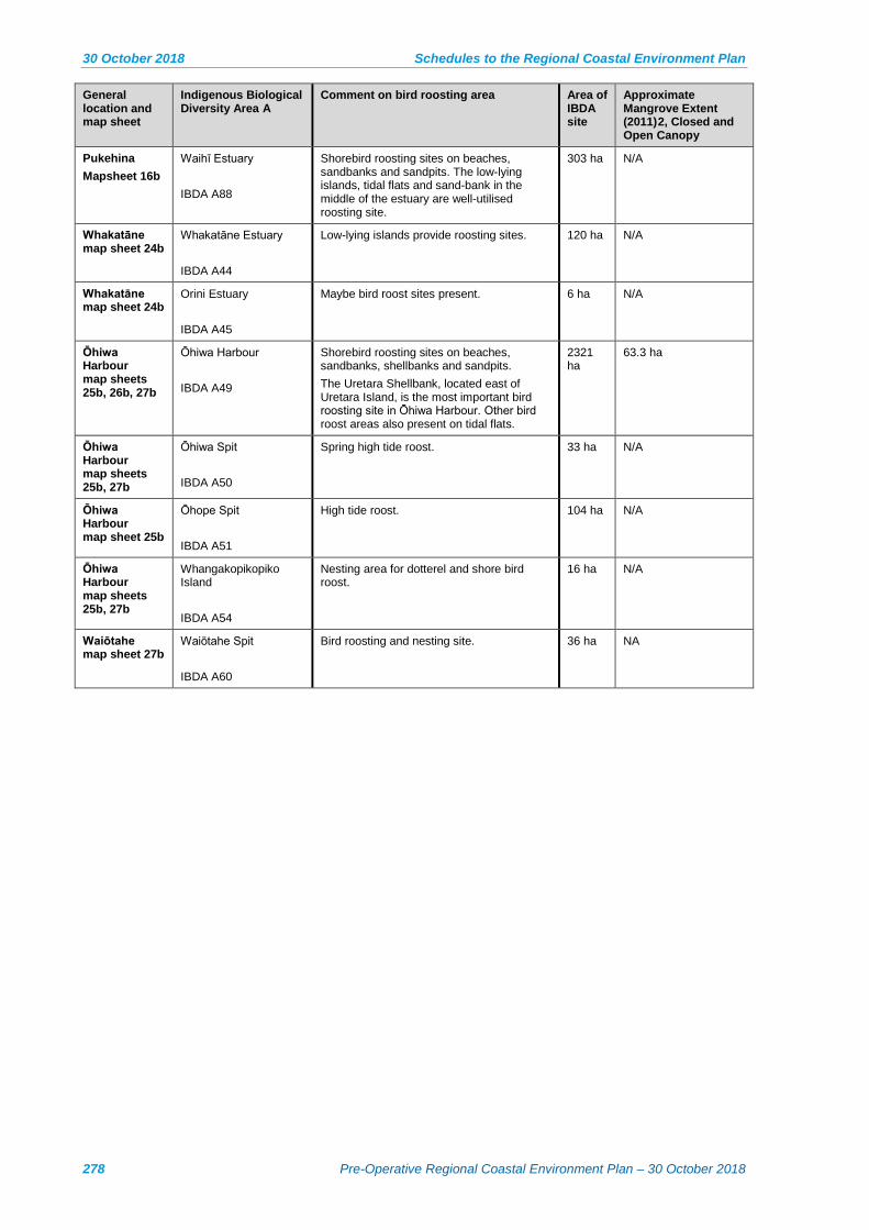
30 October 2018 Schedules to the Regional Coastal Environment Plan
278 Pre-Operative Regional Coastal Environment Plan – 30 October 2018
General location and map sheet
Indigenous Biological Diversity Area A
Comment on bird roosting area Area of IBDA site
Approximate Mangrove Extent (2011)2, Closed and Open Canopy
Pukehina Mapsheet 16b
Waihī Estuary IBDA A88
Shorebird roosting sites on beaches, sandbanks and sandpits. The low-lying islands, tidal flats and sand-bank in the middle of the estuary are well-utilised roosting site.
303 ha N/A
Whakatāne map sheet 24b
Whakatāne Estuary IBDA A44
Low-lying islands provide roosting sites. 120 ha N/A
Whakatāne map sheet 24b
Orini Estuary IBDA A45
Maybe bird roost sites present. 6 ha N/A
Ōhiwa Harbour map sheets 25b, 26b, 27b
Ōhiwa Harbour IBDA A49
Shorebird roosting sites on beaches, sandbanks, shellbanks and sandpits. The Uretara Shellbank, located east of Uretara Island, is the most important bird roosting site in Ōhiwa Harbour. Other bird roost areas also present on tidal flats.
2321 ha
63.3 ha
Ōhiwa Harbour map sheets 25b, 27b
Ōhiwa Spit IBDA A50
Spring high tide roost. 33 ha N/A
Ōhiwa Harbour map sheet 25b
Ōhope Spit IBDA A51
High tide roost. 104 ha N/A
Ōhiwa Harbour map sheets 25b, 27b
Whangakopikopiko Island IBDA A54
Nesting area for dotterel and shore bird roost.
16 ha N/A
Waiōtahe map sheet 27b
Waiōtahe Spit IBDA A60
Bird roosting and nesting site. 36 ha NA

Schedules to the Regional Coastal Environment Plan 30 October 2018
BAY OF PLENTY REGIONAL COUNCIL TOI MOANA 279
Schedule 3 – Outstanding Natural Features and Landscapes in the Coastal Environment

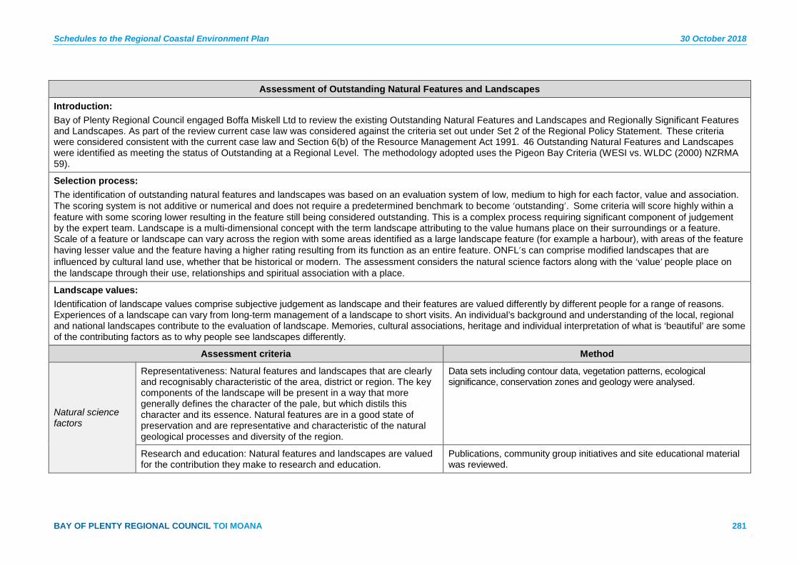
Schedules to the Regional Coastal Environment Plan 30 October 2018
BAY OF PLENTY REGIONAL COUNCIL TOI MOANA 281
Assessment of Outstanding Natural Features and Landscapes
Introduction: Bay of Plenty Regional Council engaged Boffa Miskell Ltd to review the existing Outstanding Natural Features and Landscapes and Regionally Significant Features and Landscapes. As part of the review current case law was considered against the criteria set out under Set 2 of the Regional Policy Statement. These criteria were considered consistent with the current case law and Section 6(b) of the Resource Management Act 1991. 46 Outstanding Natural Features and Landscapes were identified as meeting the status of Outstanding at a Regional Level. The methodology adopted uses the Pigeon Bay Criteria (WESI vs. WLDC (2000) NZRMA 59).
Selection process: The identification of outstanding natural features and landscapes was based on an evaluation system of low, medium to high for each factor, value and association. The scoring system is not additive or numerical and does not require a predetermined benchmark to become ‘outstanding’. Some criteria will score highly within a feature with some scoring lower resulting in the feature still being considered outstanding. This is a complex process requiring significant component of judgement by the expert team. Landscape is a multi-dimensional concept with the term landscape attributing to the value humans place on their surroundings or a feature. Scale of a feature or landscape can vary across the region with some areas identified as a large landscape feature (for example a harbour), with areas of the feature having lesser value and the feature having a higher rating resulting from its function as an entire feature. ONFL’s can comprise modified landscapes that are influenced by cultural land use, whether that be historical or modern. The assessment considers the natural science factors along with the ‘value’ people place on the landscape through their use, relationships and spiritual association with a place.
Landscape values: Identification of landscape values comprise subjective judgement as landscape and their features are valued differently by different people for a range of reasons. Experiences of a landscape can vary from long-term management of a landscape to short visits. An individual’s background and understanding of the local, regional and national landscapes contribute to the evaluation of landscape. Memories, cultural associations, heritage and individual interpretation of what is ‘beautiful’ are some of the contributing factors as to why people see landscapes differently.
Assessment criteria Method
Natural science factors
Representativeness: Natural features and landscapes that are clearly and recognisably characteristic of the area, district or region. The key components of the landscape will be present in a way that more generally defines the character of the pale, but which distils this character and its essence. Natural features are in a good state of preservation and are representative and characteristic of the natural geological processes and diversity of the region.
Data sets including contour data, vegetation patterns, ecological significance, conservation zones and geology were analysed.
Research and education: Natural features and landscapes are valued for the contribution they make to research and education.
Publications, community group initiatives and site educational material was reviewed.

30 October 2018 Schedules to the Regional Coastal Environment Plan
282 Pre-Operative Regional Coastal Environment Plan – 30 October 2018
Assessment of Outstanding Natural Features and Landscapes
Rarity: Natural features that are unique or rare in the region or nationally and few comparable examples exist.
Data sets including contour data, vegetation patterns, ecological significance, conservation zones and geology were analysed. Geo-preservation site data was considered.
Aesthetic values
Coherence: The patterns of land cover and land use that are largely in harmony with the underlying natural pattern of the landform of the area and there are no significant discordant elements of land cover or land use.
Vegetation patterns were reviewed using high resolution aerial data, along with field assessment.
Vividness: Natural features and landscapes that are widely recognised across the community and beyond the local area and remain clearly in the memory; striking landscapes that are symbolic of an area due to their recognisable and memorable qualities.
The prominence of a landscape and the analysis of a landscapes features were undertaken through field work, contour mapping, registered sites of ecological and geopreservation significance. Scale and context were key in the evaluation of this attribute.
Naturalness: Natural features and landscapes that appear largely uncompromised by modification and appear to comprise natural systems that are functional and healthy.
Natural features and landscapes that appear largely uncompromised by modification and appear to comprise natural systems that are functional and healthy.
Intactness: Natural systems that are intact and aesthetically coherent and do not display significant visual signs of human modification, intervention or manipulation. These are visually intact and highly aesthetic natural landscapes.
The absence of human modification and disruption to the natural systems that occur on the feature or landscape. This includes coastal processes, natural river systems and hydrology, modification to margins and extent of landform change.
Expressiveness (Legibility)
Natural features and landscapes that clearly demonstrate the natural processes that formed them. Examples of natural processes in a landscape exemplify the particular processes that formed that landscape or feature.
Geomorphological processes were reviewed with the assistance of topographical and hydrological mapping combined with field assessment.
Transient values
The consistent occurrence of transient features (for example the seasonal flowering of pohutukawa, intertidal movement and changes in landform) contributes to the character, qualities and values of the landscape. Landscapes that are widely recognised for their transient features and the contribution these features have to identify this feature or landscape.
Observation and anecdotal information on seasonal and constant change of the elements within this landscape or feature.
Shared and Recognised Values
Natural features and landscapes that are widely known and valued by the immediate and wider community for their contribution to a sense of place, leading to a strong community association with or high public esteem for the place.
Publications including Reserve Management Plans, regional, District and city plans, non-statutory strategies and site educational material were reviewed.
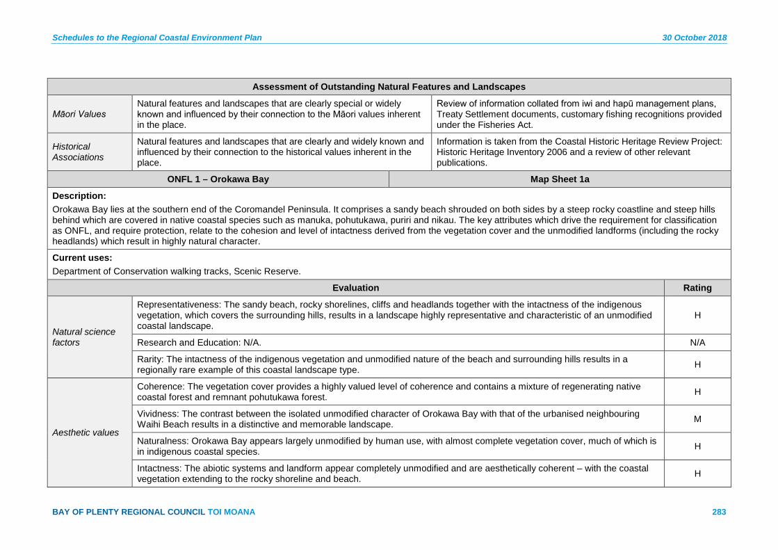
Schedules to the Regional Coastal Environment Plan 30 October 2018
BAY OF PLENTY REGIONAL COUNCIL TOI MOANA 283
Assessment of Outstanding Natural Features and Landscapes
Māori Values Natural features and landscapes that are clearly special or widely known and influenced by their connection to the Māori values inherent in the place.
Review of information collated from iwi and hapū management plans, Treaty Settlement documents, customary fishing recognitions provided under the Fisheries Act.
Historical Associations
Natural features and landscapes that are clearly and widely known and influenced by their connection to the historical values inherent in the place.
Information is taken from the Coastal Historic Heritage Review Project: Historic Heritage Inventory 2006 and a review of other relevant publications.
ONFL 1 – Orokawa Bay Map Sheet 1a
Description: Orokawa Bay lies at the southern end of the Coromandel Peninsula. It comprises a sandy beach shrouded on both sides by a steep rocky coastline and steep hills behind which are covered in native coastal species such as manuka, pohutukawa, puriri and nikau. The key attributes which drive the requirement for classification as ONFL, and require protection, relate to the cohesion and level of intactness derived from the vegetation cover and the unmodified landforms (including the rocky headlands) which result in highly natural character.
Current uses: Department of Conservation walking tracks, Scenic Reserve.
Evaluation Rating
Natural science factors
Representativeness: The sandy beach, rocky shorelines, cliffs and headlands together with the intactness of the indigenous vegetation, which covers the surrounding hills, results in a landscape highly representative and characteristic of an unmodified coastal landscape.
H
Research and Education: N/A. N/A
Rarity: The intactness of the indigenous vegetation and unmodified nature of the beach and surrounding hills results in a regionally rare example of this coastal landscape type. H
Aesthetic values
Coherence: The vegetation cover provides a highly valued level of coherence and contains a mixture of regenerating native coastal forest and remnant pohutukawa forest. H
Vividness: The contrast between the isolated unmodified character of Orokawa Bay with that of the urbanised neighbouring Waihi Beach results in a distinctive and memorable landscape. M
Naturalness: Orokawa Bay appears largely unmodified by human use, with almost complete vegetation cover, much of which is in indigenous coastal species. H
Intactness: The abiotic systems and landform appear completely unmodified and are aesthetically coherent – with the coastal vegetation extending to the rocky shoreline and beach. H
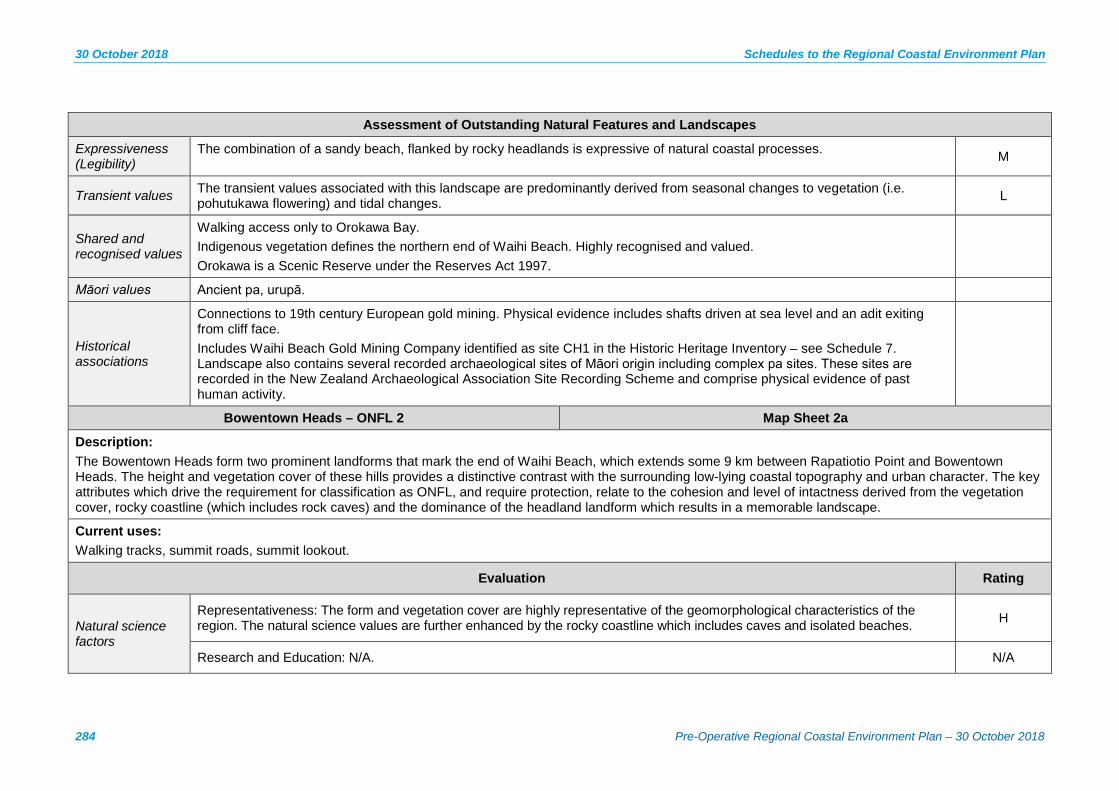
30 October 2018 Schedules to the Regional Coastal Environment Plan
284 Pre-Operative Regional Coastal Environment Plan – 30 October 2018
Assessment of Outstanding Natural Features and Landscapes
Expressiveness (Legibility)
The combination of a sandy beach, flanked by rocky headlands is expressive of natural coastal processes. M
Transient values The transient values associated with this landscape are predominantly derived from seasonal changes to vegetation (i.e. pohutukawa flowering) and tidal changes. L
Shared and recognised values
Walking access only to Orokawa Bay. Indigenous vegetation defines the northern end of Waihi Beach. Highly recognised and valued. Orokawa is a Scenic Reserve under the Reserves Act 1997.
Māori values Ancient pa, urupā.
Historical associations
Connections to 19th century European gold mining. Physical evidence includes shafts driven at sea level and an adit exiting from cliff face. Includes Waihi Beach Gold Mining Company identified as site CH1 in the Historic Heritage Inventory – see Schedule 7. Landscape also contains several recorded archaeological sites of Māori origin including complex pa sites. These sites are recorded in the New Zealand Archaeological Association Site Recording Scheme and comprise physical evidence of past human activity.
Bowentown Heads – ONFL 2 Map Sheet 2a
Description: The Bowentown Heads form two prominent landforms that mark the end of Waihi Beach, which extends some 9 km between Rapatiotio Point and Bowentown Heads. The height and vegetation cover of these hills provides a distinctive contrast with the surrounding low-lying coastal topography and urban character. The key attributes which drive the requirement for classification as ONFL, and require protection, relate to the cohesion and level of intactness derived from the vegetation cover, rocky coastline (which includes rock caves) and the dominance of the headland landform which results in a memorable landscape.
Current uses: Walking tracks, summit roads, summit lookout.
Evaluation Rating
Natural science factors
Representativeness: The form and vegetation cover are highly representative of the geomorphological characteristics of the region. The natural science values are further enhanced by the rocky coastline which includes caves and isolated beaches. H
Research and Education: N/A. N/A

Schedules to the Regional Coastal Environment Plan 30 October 2018
BAY OF PLENTY REGIONAL COUNCIL TOI MOANA 285
Assessment of Outstanding Natural Features and Landscapes
Rarity: The location of these features at the end of a sand spit and their prominence derived from their form (shape and height) is distinctive, acting as a landmark at the distal point of the sand spit. M
Aesthetic values
Coherence: The vegetation cover provides a highly valued level of coherence and contains a mixture of regenerating native coastal forest and remnant pohutukawa forest. Furthermore the sequence of both landforms visible together increases the overall aesthetic value.
M
Vividness: The location of these features at the end of Waihi Beach, and their prominence derived from their form (shape and height) against the lower coastal landforms is highly memorable and forms an identifiable termination of the spit. H
Naturalness: Some modification by previous Māori activities and modifications for public access (i.e. walking tracks and summit roads). However, the mature and regenerating pohutukawa forest on the rock edges provides habitat for uncommon indigenous plants and nesting sites for penguins, which results in a relatively functional and healthy appearance.
M
Intactness: The level of modification for public access, in its current form, does not undermine the level of intactness derived from the vegetation and rocky coastal edges which appear coherent and unmodified. H
Expressiveness (Legibility)
The distinctive form of these features, and their prominence, attributed by the height in relation to the surrounding low-lying coastal location, results in a highly expressive geomorphological landscape feature. This is further enhanced by the bar and the rock caves which are expressive of the dynamic natural processes occurring along the coastal edge.
H
Transient values The transient values associated with this landscape are predominantly derived from seasonal changes to vegetation (i.e. pohutukawa flowering). L
Shared and recognised values
Prominent features. Highly visible, valued and recognised. Popular recreational area.
Māori values Ancient pa – Te Kura a Maia, kāinga, urupā.
Translation: Te Kura a Maia – training ground for young warriors. An area of high significance to Ngai Te Rangi and tribes of Hauraki.

30 October 2018 Schedules to the Regional Coastal Environment Plan
286 Pre-Operative Regional Coastal Environment Plan – 30 October 2018
Assessment of Outstanding Natural Features and Landscapes
Historical associations
Connections to early 20th century European recreational activity in Anzac Bay.
Landscape contains archaeological sites, including the complex and regionally representative pa Te Kura a Maia. These sites are recorded in the New Zealand Archaeological Association Site Recording Scheme and comprise physical evidence of past human activity.
Te Awanui Tauranga Harbour, Waimapu Estuary & Welcome Bay – ONFL 3 Map Sheets 2a, 3a, 4a, 6a, 7a, 8a, 9a,10a, 11a, 12a, 13a, 14a
Description:
Tauranga Harbour is a shallow tidal estuary of 224 km². At low tide, 93% of the seabed is exposed. The harbour and its estuarine margins comprise numerous bays, estuaries, wetland and saltmarsh. The key attributes which drive the requirement for classification as ONFL, and require protection, relate to the high natural science values associated with the margins and habitats; the high transient values associated with the tidal influences; and the high aesthetic and natural character values of the vegetation and harbour patterns.
Current uses:
Bridges, national grid infrastructure, wharves, moorings, residential development, boardwalks, stormwater and sewer infrastructure, boat ramps, reclamations, recreational activities such as water skiing, fishing, boating, channel markers, navigational signs.
Evaluation Rating
Natural science factors
Representativeness: The spatial relationship the harbour has with the land, providing estuaries, bays and beaches, is of significant value in representing the character of the landscape. This value is further enhanced by the scale of the water body, its dynamic patterns, and areas of native estuarine vegetation – all of which are highly representative of the harbour.
H
Research and education: The proximity of the harbour to Tauranga, and the accessibility to large parts of the harbour edge, allows for educational and research opportunities both in the marine and terrestrial environments.
Rarity: The natural harbour margins and waters are not a rare landscape feature at a regional level. M-H
Aesthetic values
Coherence: The extent of the harbour waters, its associated sand and shell banks and patterns result in a coherent landscape. L
Vividness: The value associated with the vividness of Tauranga Harbour is not resultant from any particular section or margin (though it is recognised some margins may be more vivid than others), rather it is the extensive relationship of the complete harbour waters, which define the landform, the extent of the harbour and its coastal patterns, that is highly recognisable and memorable within the region.
H
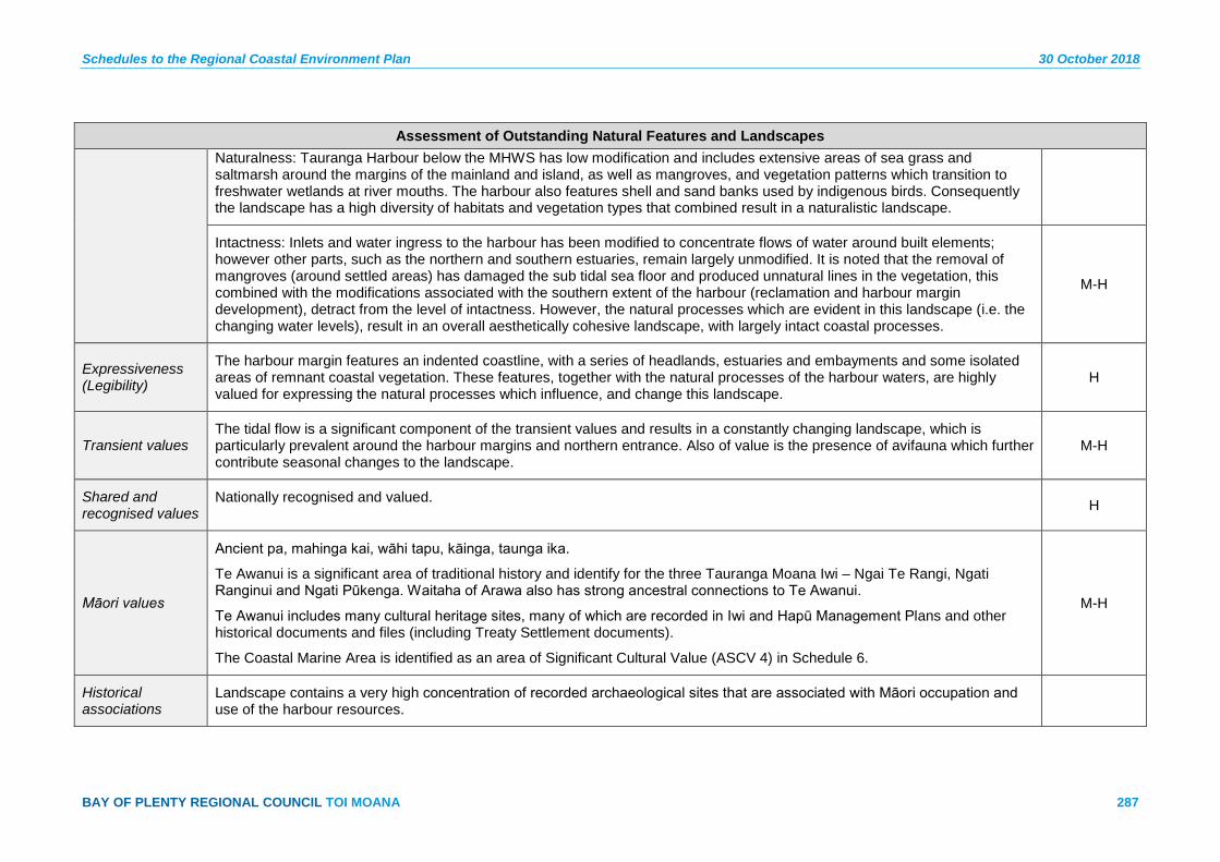
Schedules to the Regional Coastal Environment Plan 30 October 2018
BAY OF PLENTY REGIONAL COUNCIL TOI MOANA 287
Assessment of Outstanding Natural Features and Landscapes Naturalness: Tauranga Harbour below the MHWS has low modification and includes extensive areas of sea grass and saltmarsh around the margins of the mainland and island, as well as mangroves, and vegetation patterns which transition to freshwater wetlands at river mouths. The harbour also features shell and sand banks used by indigenous birds. Consequently the landscape has a high diversity of habitats and vegetation types that combined result in a naturalistic landscape.
Intactness: Inlets and water ingress to the harbour has been modified to concentrate flows of water around built elements; however other parts, such as the northern and southern estuaries, remain largely unmodified. It is noted that the removal of mangroves (around settled areas) has damaged the sub tidal sea floor and produced unnatural lines in the vegetation, this combined with the modifications associated with the southern extent of the harbour (reclamation and harbour margin development), detract from the level of intactness. However, the natural processes which are evident in this landscape (i.e. the changing water levels), result in an overall aesthetically cohesive landscape, with largely intact coastal processes.
M-H
Expressiveness (Legibility)
The harbour margin features an indented coastline, with a series of headlands, estuaries and embayments and some isolated areas of remnant coastal vegetation. These features, together with the natural processes of the harbour waters, are highly valued for expressing the natural processes which influence, and change this landscape.
H
Transient values The tidal flow is a significant component of the transient values and results in a constantly changing landscape, which is particularly prevalent around the harbour margins and northern entrance. Also of value is the presence of avifauna which further contribute seasonal changes to the landscape.
M-H
Shared and recognised values
Nationally recognised and valued. H
Māori values
Ancient pa, mahinga kai, wāhi tapu, kāinga, taunga ika.
Te Awanui is a significant area of traditional history and identify for the three Tauranga Moana Iwi – Ngai Te Rangi, Ngati Ranginui and Ngati Pūkenga. Waitaha of Arawa also has strong ancestral connections to Te Awanui.
Te Awanui includes many cultural heritage sites, many of which are recorded in Iwi and Hapū Management Plans and other historical documents and files (including Treaty Settlement documents).
The Coastal Marine Area is identified as an area of Significant Cultural Value (ASCV 4) in Schedule 6.
M-H
Historical associations
Landscape contains a very high concentration of recorded archaeological sites that are associated with Māori occupation and use of the harbour resources.
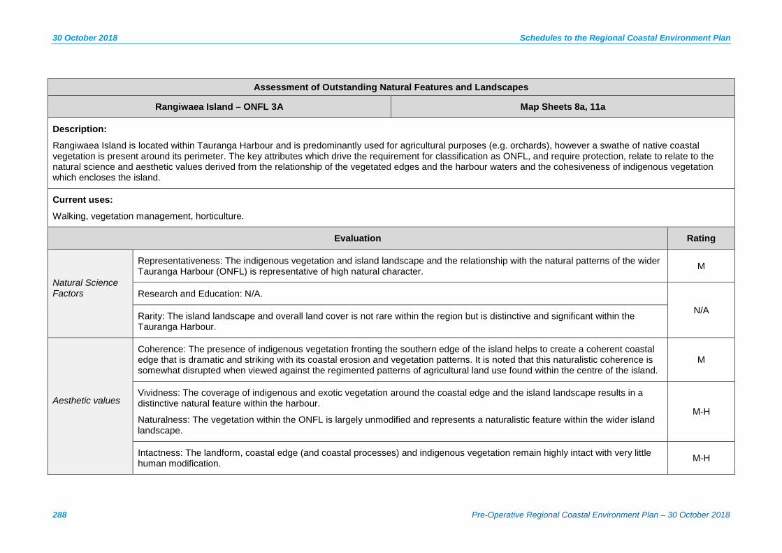
30 October 2018 Schedules to the Regional Coastal Environment Plan
288 Pre-Operative Regional Coastal Environment Plan – 30 October 2018
Assessment of Outstanding Natural Features and Landscapes
Rangiwaea Island – ONFL 3A Map Sheets 8a, 11a
Description:
Rangiwaea Island is located within Tauranga Harbour and is predominantly used for agricultural purposes (e.g. orchards), however a swathe of native coastal vegetation is present around its perimeter. The key attributes which drive the requirement for classification as ONFL, and require protection, relate to relate to the natural science and aesthetic values derived from the relationship of the vegetated edges and the harbour waters and the cohesiveness of indigenous vegetation which encloses the island.
Current uses:
Walking, vegetation management, horticulture.
Evaluation Rating
Natural Science Factors
Representativeness: The indigenous vegetation and island landscape and the relationship with the natural patterns of the wider Tauranga Harbour (ONFL) is representative of high natural character. M
Research and Education: N/A.
N/A Rarity: The island landscape and overall land cover is not rare within the region but is distinctive and significant within the Tauranga Harbour.
Aesthetic values
Coherence: The presence of indigenous vegetation fronting the southern edge of the island helps to create a coherent coastal edge that is dramatic and striking with its coastal erosion and vegetation patterns. It is noted that this naturalistic coherence is somewhat disrupted when viewed against the regimented patterns of agricultural land use found within the centre of the island.
M
Vividness: The coverage of indigenous and exotic vegetation around the coastal edge and the island landscape results in a distinctive natural feature within the harbour.
Naturalness: The vegetation within the ONFL is largely unmodified and represents a naturalistic feature within the wider island landscape.
M-H
Intactness: The landform, coastal edge (and coastal processes) and indigenous vegetation remain highly intact with very little human modification. M-H

Schedules to the Regional Coastal Environment Plan 30 October 2018
BAY OF PLENTY REGIONAL COUNCIL TOI MOANA 289
Assessment of Outstanding Natural Features and Landscapes
Expressiveness (Legibility)
The interplay between the harbour waters and the vegetated coastal edge is expressive of an island landscape with moderate to high natural character values (around its perimeter). L-M
Transient values Value includes the seasonal changes of the indigenous vegetation (i.e. pohutukawa) however these transient characteristics are not considered key in relation to the ONFL classification. L-M
Shared and recognised values
Distinctive and significant island coastline within Tauranga Harbour. M
Māori values Ancient pa, kāinga, mahinga kai.
The Matakana Rangiwaea Hapū Management Plan records values and sites of significance. L
Historical associations
Landscape contains many archaeological sites of Māori origin, recorded in the New Zealand Archaeological Association Site Recording Scheme, which comprise physical evidence of past human activity.
North Matakana Island Wetlands – ONFL 4 Map Sheets 2a, 3a, 4a
Description:
This area covers the northern end of Matakana Island including all wetland areas and associated native shrubland. The coastal edge of this feature is unmodified and displays highly dynamic processes of erosion and accretion of the island land mass. The key attributes which drive the requirement for classification as ONFL, and require protection, relate to the aesthetic qualities associated with the naturalness of the dune, wetland and the natural science values of the coastal processes.
Current uses:
Forestry (predominantly pine), forestry-related activities including formed and unformed roads, skid sites and associated harvesting activities, storage sheds and firefighting infrastructure, vehicle tracks.
Evaluation Rating
Natural science factors
Representativeness: The wetlands provide relatively undisturbed features that are highly representative of the coastal environment.
M-H
Research and education: The ecological values associated with the wetlands and their associated flora and fauna is of educational and research value.
M

30 October 2018 Schedules to the Regional Coastal Environment Plan
290 Pre-Operative Regional Coastal Environment Plan – 30 October 2018
Assessment of Outstanding Natural Features and Landscapes
Rarity: The distinctive dune landform together with the freshwater wetlands combined with the isolation of the island location, contributes to a relatively rare regional landscape.
M-H
Aesthetic values
Coherence: The level of coherence is disturbed to a degree by the vehicle access tracks, the presence of some invasive weed species (around the wetlands) and the discordant elements of land cover between areas of pine forestry and native coastal vegetation. The cohesiveness of the unmodified dune topography is valuable.
M
Vividness: The remoteness of the landscape together with its low level topography has reduced the potential for memorable recognition.
L
Naturalness: The freshwater wetlands vary in quality and many are modified to a degree by the presence of invasive weed species. They remain however, an important habitat for indigenous wetland fauna and create a distinctive aesthetic in relation to the surrounding dunes.
H
Intactness: The dune landscape (i.e. the contours and sandy material) are generally undistributed and appear as a highly intact natural feature, which is further complimented by the unmodified coastal edge and associated sand bars. The wetlands provide relatively undisturbed habitat for indigenous fauna and range in significance from local to national.
H
Expressiveness (Legibility)
A good example of natural process with no significant modifications to the coastal processes or the functioning of the wetland systems.
H
Transient values Transient values relate to the intertidal flow along the coastal edge, the changing visibility of the associated sandbars and the levels of water within the wetland systems.
L
Shared and recognised values
No public access – remote. Major component of view from Bowentown Heads.
Matakana Island Coastal Edge – ONFL 5 Map Sheets 3a, 4a, 6a, 8a, 9a, 11a
Description:
Matakana Island is the largest sand barrier island in New Zealand. The coastal extent of the island forms a large sand dune system that extends some 23 km between the northern and southern Tauranga harbour entrances. The harbour extent of the island comprises a raised landmass that supports a residential settlement and agricultural activities. The key attributes which drive the requirement for classification as ONFL, and require protection, relate to the high natural science values derived from the geomorphological and coastal processes which have formed this highly recognisable landform feature.
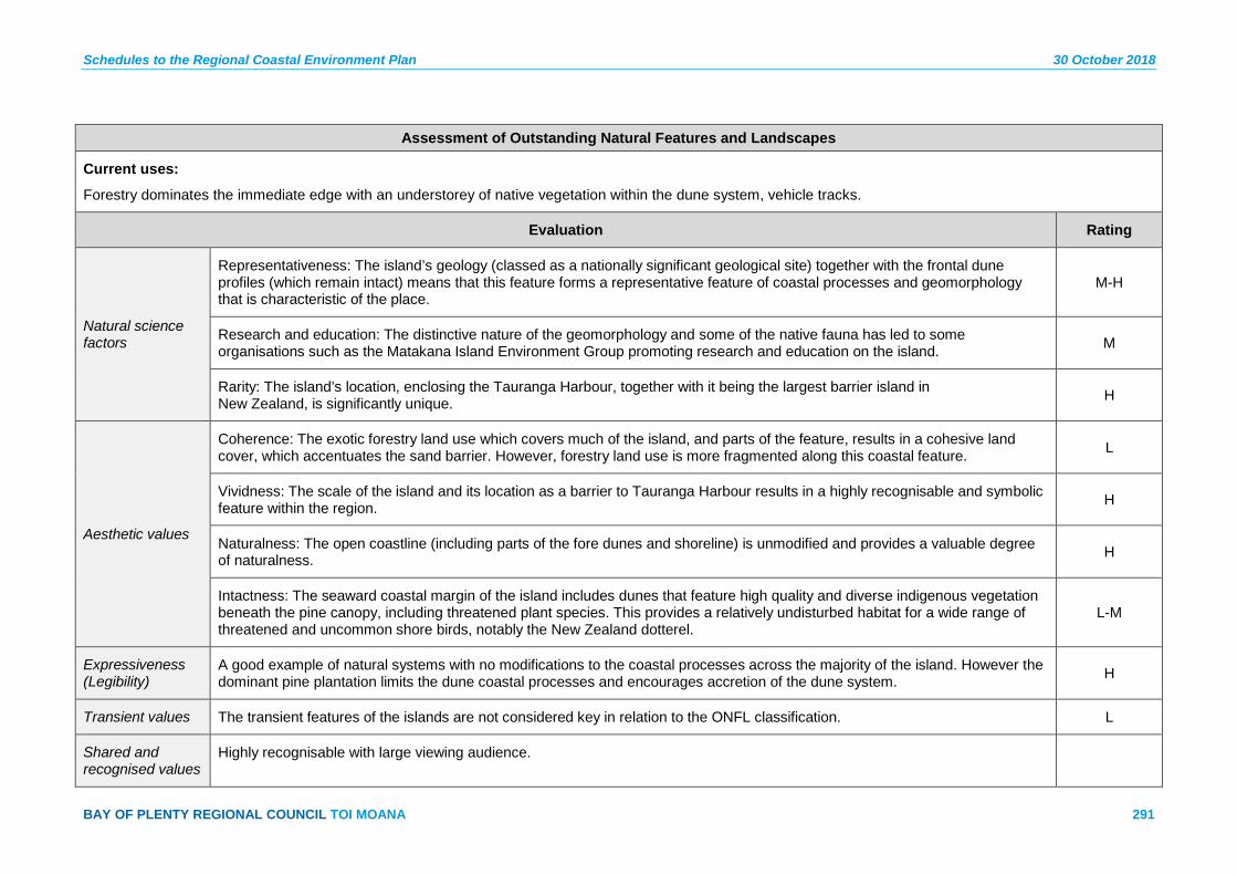
Schedules to the Regional Coastal Environment Plan 30 October 2018
BAY OF PLENTY REGIONAL COUNCIL TOI MOANA 291
Assessment of Outstanding Natural Features and Landscapes
Current uses:
Forestry dominates the immediate edge with an understorey of native vegetation within the dune system, vehicle tracks.
Evaluation Rating
Natural science factors
Representativeness: The island’s geology (classed as a nationally significant geological site) together with the frontal dune profiles (which remain intact) means that this feature forms a representative feature of coastal processes and geomorphology that is characteristic of the place.
M-H
Research and education: The distinctive nature of the geomorphology and some of the native fauna has led to some organisations such as the Matakana Island Environment Group promoting research and education on the island. M
Rarity: The island’s location, enclosing the Tauranga Harbour, together with it being the largest barrier island in New Zealand, is significantly unique. H
Aesthetic values
Coherence: The exotic forestry land use which covers much of the island, and parts of the feature, results in a cohesive land cover, which accentuates the sand barrier. However, forestry land use is more fragmented along this coastal feature. L
Vividness: The scale of the island and its location as a barrier to Tauranga Harbour results in a highly recognisable and symbolic feature within the region. H
Naturalness: The open coastline (including parts of the fore dunes and shoreline) is unmodified and provides a valuable degree of naturalness. H
Intactness: The seaward coastal margin of the island includes dunes that feature high quality and diverse indigenous vegetation beneath the pine canopy, including threatened plant species. This provides a relatively undisturbed habitat for a wide range of threatened and uncommon shore birds, notably the New Zealand dotterel.
L-M
Expressiveness (Legibility)
A good example of natural systems with no modifications to the coastal processes across the majority of the island. However the dominant pine plantation limits the dune coastal processes and encourages accretion of the dune system. H
Transient values The transient features of the islands are not considered key in relation to the ONFL classification. L
Shared and recognised values
Highly recognisable with large viewing audience.

30 October 2018 Schedules to the Regional Coastal Environment Plan
292 Pre-Operative Regional Coastal Environment Plan – 30 October 2018
Assessment of Outstanding Natural Features and Landscapes
Māori values The Matakana Island Hapū Management Plan records values and sites of significance. Ancient pa, kāinga, urupā, mahinga kai are recorded on the sand barrier island, sites of significance may be present in this feature.
Historical associations
The wider sand barrier landscape contains many archaeological sites of Māori origin, recorded in the New Zealand Archaeological Association Site Recording Scheme, which comprise physical evidence of past human activity. However, this feature has not yet been surveyed.
Tanners Point – ONFL 6 Map Sheet 3a
Description:
This ONFL covers the vegetated headland cliffs of Tanners Point which adjoin the Tauranga Harbour waters. The key attributes which drive the requirement for classification as ONFL, and require protection, relate to the natural science and aesthetic values derived from the cohesiveness of indigenous vegetation (predominantly pohutukawa) and unmodified nature of the distinctive coastal landform.
Current uses:
Track at the northern end.
Evaluation Rating
Natural science factors
Representativeness: The topography, indigenous vegetation and relationship of these elements with the harbour waters is highly characteristic and representative of a coastal edge, high in natural character. H
Research and education: N/A. N/A
Rarity: The topography, indigenous vegetation and interrelationship with the harbour is characteristic rather than rare. L
Aesthetic values
Coherence: The presence of indigenous vegetation (dominance of pohutukawa with native understorey vegetation) across the entire ONFL area helps to reinforce the distinctive natural patterns of this coastal landform. H
Vividness: The topographical patterns together with the dense coverage of indigenous vegetation results in a distinctive natural feature, particularly in the context of the surrounding modified harbour margins. M-H
Naturalness: Although the vegetation and landform within the ONFL are unmodified, the overall naturalness of the feature is impaired to a degree by the proximity of adjacent residential development. M

Schedules to the Regional Coastal Environment Plan 30 October 2018
BAY OF PLENTY REGIONAL COUNCIL TOI MOANA 293
Assessment of Outstanding Natural Features and Landscapes
Intactness: The cliffs and indigenous vegetation remain highly intact with very little human modification evident. H
Expressiveness (Legibility)
The topographical variations associated with the harbour cliffs and indentations are expressive of the geomorphological and coastal processes which formed them. L-M
Transient values Value includes the seasonal changes of the indigenous vegetation (i.e. pohutukawa) however these transient characteristics are not considered key in relation to the ONFL classification. L
Shared and recognised values
Not well known. Small viewing audience. Minimal public access.
Māori values Ancient pa, kāinga.
Historical associations
Connections to initial European settlement of area and early 20th century recreational use of harbour. Photographs from the 1930s of baches on water’s edge, now part of reclamation.
Landscape contains archaeological sites of Māori origin, recorded in the New Zealand Archaeological Association Site Recording Scheme, which comprise physical evidence of past human activity.
Ongare Point – ONFL 7 Map Sheet 3a
Description:
This ONFL covers the vegetated coastal edge of the Ongare Point headland which adjoins the Tauranga Harbour waters. The key attributes which drive the requirement for classification as ONFL, and require protection, relate to relate to the natural science and aesthetic values derived from the cohesiveness of indigenous vegetation (predominantly pohutukawa) and unmodified nature of this coastal landform.
Current uses:
Walking tracks.
Evaluation Rating
Natural science factors
Representativeness: The topography, indigenous vegetation (predominantly pohutukawa) and relationship of these elements with the harbour waters is highly characteristic and representative of a coastal edge with high natural character. H
Research and education: N/A. N/A
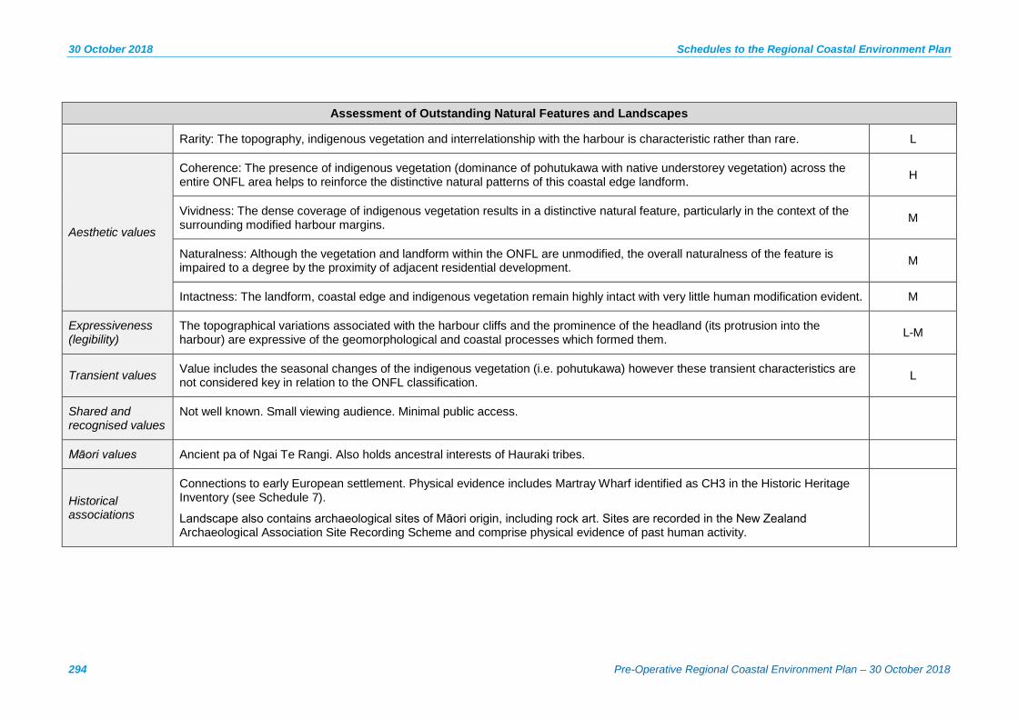
30 October 2018 Schedules to the Regional Coastal Environment Plan
294 Pre-Operative Regional Coastal Environment Plan – 30 October 2018
Assessment of Outstanding Natural Features and Landscapes
Rarity: The topography, indigenous vegetation and interrelationship with the harbour is characteristic rather than rare. L
Aesthetic values
Coherence: The presence of indigenous vegetation (dominance of pohutukawa with native understorey vegetation) across the entire ONFL area helps to reinforce the distinctive natural patterns of this coastal edge landform. H
Vividness: The dense coverage of indigenous vegetation results in a distinctive natural feature, particularly in the context of the surrounding modified harbour margins. M
Naturalness: Although the vegetation and landform within the ONFL are unmodified, the overall naturalness of the feature is impaired to a degree by the proximity of adjacent residential development. M
Intactness: The landform, coastal edge and indigenous vegetation remain highly intact with very little human modification evident. M
Expressiveness (legibility)
The topographical variations associated with the harbour cliffs and the prominence of the headland (its protrusion into the harbour) are expressive of the geomorphological and coastal processes which formed them. L-M
Transient values Value includes the seasonal changes of the indigenous vegetation (i.e. pohutukawa) however these transient characteristics are not considered key in relation to the ONFL classification. L
Shared and recognised values
Not well known. Small viewing audience. Minimal public access.
Māori values Ancient pa of Ngai Te Rangi. Also holds ancestral interests of Hauraki tribes.
Historical associations
Connections to early European settlement. Physical evidence includes Martray Wharf identified as CH3 in the Historic Heritage Inventory (see Schedule 7).
Landscape also contains archaeological sites of Māori origin, including rock art. Sites are recorded in the New Zealand Archaeological Association Site Recording Scheme and comprise physical evidence of past human activity.
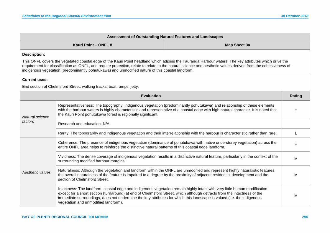
Schedules to the Regional Coastal Environment Plan 30 October 2018
BAY OF PLENTY REGIONAL COUNCIL TOI MOANA 295
Assessment of Outstanding Natural Features and Landscapes
Kauri Point – ONFL 8 Map Sheet 3a
Description:
This ONFL covers the vegetated coastal edge of the Kauri Point headland which adjoins the Tauranga Harbour waters. The key attributes which drive the requirement for classification as ONFL, and require protection, relate to relate to the natural science and aesthetic values derived from the cohesiveness of indigenous vegetation (predominantly pohutukawa) and unmodified nature of this coastal landform.
Current uses:
End section of Chelmsford Street, walking tracks, boat ramps, jetty.
Evaluation Rating
Natural science factors
Representativeness: The topography, indigenous vegetation (predominantly pohutukawa) and relationship of these elements with the harbour waters is highly characteristic and representative of a coastal edge with high natural character. It is noted that the Kauri Point pohutukawa forest is regionally significant.
H
Research and education: N/A
Rarity: The topography and indigenous vegetation and their interrelationship with the harbour is characteristic rather than rare. L
Aesthetic values
Coherence: The presence of indigenous vegetation (dominance of pohutukawa with native understorey vegetation) across the entire ONFL area helps to reinforce the distinctive natural patterns of this coastal edge landform. H
Vividness: The dense coverage of indigenous vegetation results in a distinctive natural feature, particularly in the context of the surrounding modified harbour margins. M
Naturalness: Although the vegetation and landform within the ONFL are unmodified and represent highly naturalistic features, the overall naturalness of the feature is impaired to a degree by the proximity of adjacent residential development and the section of Chelmsford Street.
M
Intactness: The landform, coastal edge and indigenous vegetation remain highly intact with very little human modification except for a short section (turnaround) at end of Chelmsford Street, which although detracts from the intactness of the immediate surroundings, does not undermine the key attributes for which this landscape is valued (i.e. the indigenous vegetation and unmodified landform).
M
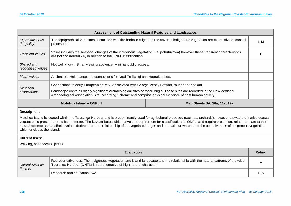
30 October 2018 Schedules to the Regional Coastal Environment Plan
296 Pre-Operative Regional Coastal Environment Plan – 30 October 2018
Assessment of Outstanding Natural Features and Landscapes
Expressiveness (Legibility)
The topographical variations associated with the harbour edge and the cover of indigenous vegetation are expressive of coastal processes. L-M
Transient values Value includes the seasonal changes of the indigenous vegetation (i.e. pohutukawa) however these transient characteristics are not considered key in relation to the ONFL classification. L
Shared and recognised values
Not well known. Small viewing audience. Minimal public access.
Māori values Ancient pa. Holds ancestral connections for Ngai Te Rangi and Hauraki tribes.
Historical associations
Connections to early European activity. Associated with George Vesey Stewart, founder of Katikati.
Landscape contains highly significant archaeological sites of Māori origin. These sites are recorded in the New Zealand Archaeological Association Site Recording Scheme and comprise physical evidence of past human activity.
Motuhoa Island – ONFL 9 Map Sheets 8A, 10a, 11a, 12a
Description:
Motuhoa Island is located within the Tauranga Harbour and is predominantly used for agricultural proposed (such as. orchards), however a swathe of native coastal vegetation is present around its perimeter. The key attributes which drive the requirement for classification as ONFL, and require protection, relate to relate to the natural science and aesthetic values derived from the relationship of the vegetated edges and the harbour waters and the cohesiveness of indigenous vegetation which encloses the island.
Current uses:
Walking, boat access, jetties.
Evaluation Rating
Natural Science Factors
Representativeness: The indigenous vegetation and island landscape and the relationship with the natural patterns of the wider Tauranga Harbour (ONFL) is representative of high natural character. M
Research and education: N/A. N/A
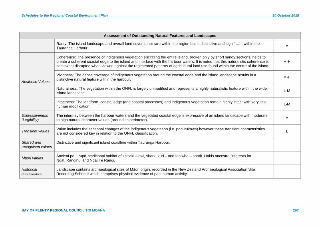
Schedules to the Regional Coastal Environment Plan 30 October 2018
BAY OF PLENTY REGIONAL COUNCIL TOI MOANA 297
Assessment of Outstanding Natural Features and Landscapes
Rarity: The island landscape and overall land cover is not rare within the region but is distinctive and significant within the Tauranga Harbour. M
Aesthetic Values
Coherence: The presence of indigenous vegetation encircling the entire island, broken only by short sandy sections, helps to create a coherent coastal edge to the island and interface with the harbour waters. It is noted that this naturalistic coherence is somewhat disrupted when viewed against the regimented patterns of agricultural land use found within the centre of the island.
M-H
Vividness: The dense coverage of indigenous vegetation around the coastal edge and the island landscape results in a distinctive natural feature within the harbour. M-H
Naturalness: The vegetation within the ONFL is largely unmodified and represents a highly naturalistic feature within the wider island landscape. L-M
Intactness: The landform, coastal edge (and coastal processes) and indigenous vegetation remain highly intact with very little human modification. L-M
Expressiveness (Legibility)
The interplay between the harbour waters and the vegetated coastal edge is expressive of an island landscape with moderate to high natural character values (around its perimeter). M
Transient values Value includes the seasonal changes of the indigenous vegetation (i.e. pohutukawa) however these transient characteristics are not considered key in relation to the ONFL classification. L
Shared and recognised values
Distinctive and significant island coastline within Tauranga Harbour.
Māori values Ancient pa, urupā, traditional habitat of kaitiaki – owl, shark, kuri – and taniwha – shark. Holds ancestral interests for Ngati Ranginui and Ngai Te Rangi.
Historical associations
Landscape contains archaeological sites of Māori origin, recorded in the New Zealand Archaeological Association Site Recording Scheme which comprises physical evidence of past human activity.
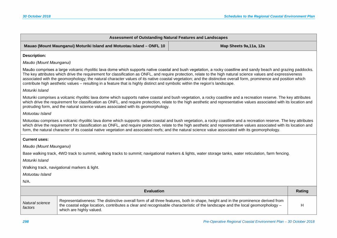
30 October 2018 Schedules to the Regional Coastal Environment Plan
298 Pre-Operative Regional Coastal Environment Plan – 30 October 2018
Assessment of Outstanding Natural Features and Landscapes
Mauao (Mount Maunganui) Moturiki Island and Motuotau Island – ONFL 10 Map Sheets 9a,11a, 12a
Description:
Mauāo (Mount Maunganui)
Mauāo comprises a large volcanic rhyolitic lava dome which supports native coastal and bush vegetation, a rocky coastline and sandy beach and grazing paddocks. The key attributes which drive the requirement for classification as ONFL, and require protection, relate to the high natural science values and expressiveness associated with the geomorphology; the natural character values of its native coastal vegetation; and the distinctive overall form, prominence and position which contribute high aesthetic values – resulting in a feature that is highly distinct and symbolic within the region’s landscape.
Moturiki Island
Moturiki comprises a volcanic rhyolitic lava dome which supports native coastal and bush vegetation, a rocky coastline and a recreation reserve. The key attributes which drive the requirement for classification as ONFL, and require protection, relate to the high aesthetic and representative values associated with its location and protruding form, and the natural science values associated with its geomorphology.
Motuotau Island
Motuotau comprises a volcanic rhyolitic lava dome which supports native coastal and bush vegetation, a rocky coastline and a recreation reserve. The key attributes which drive the requirement for classification as ONFL, and require protection, relate to the high aesthetic and representative values associated with its location and form, the natural character of its coastal native vegetation and associated reefs; and the natural science value associated with its geomorphology.
Current uses:
Mauāo (Mount Maunganui)
Base walking track, 4WD track to summit, walking tracks to summit; navigational markers & lights, water storage tanks, water reticulation, farm fencing.
Moturiki Island
Walking track, navigational markers & light.
Motuotau Island
N/A.
Evaluation Rating
Natural science factors
Representativeness: The distinctive overall form of all three features, both in shape, height and in the prominence derived from the coastal edge location, contributes a clear and recognisable characteristic of the landscape and the local geomorphology – which are highly valued.
H
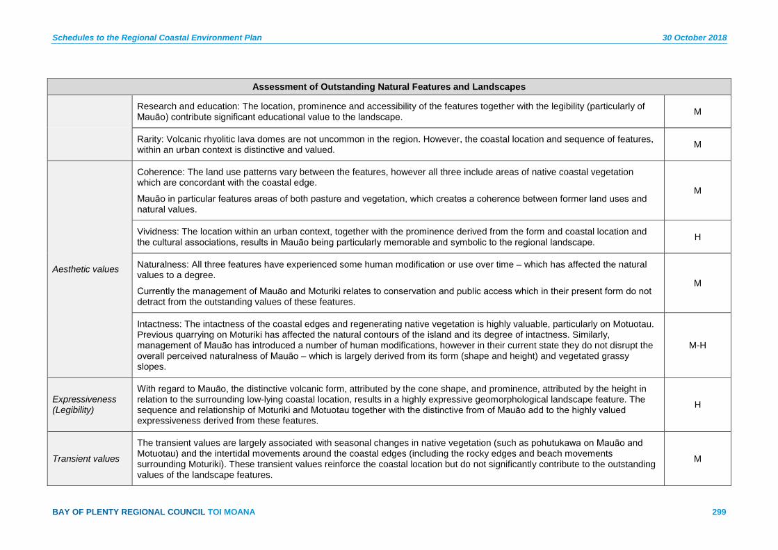
Schedules to the Regional Coastal Environment Plan 30 October 2018
BAY OF PLENTY REGIONAL COUNCIL TOI MOANA 299
Assessment of Outstanding Natural Features and Landscapes
Research and education: The location, prominence and accessibility of the features together with the legibility (particularly of Mauāo) contribute significant educational value to the landscape. M
Rarity: Volcanic rhyolitic lava domes are not uncommon in the region. However, the coastal location and sequence of features, within an urban context is distinctive and valued. M
Aesthetic values
Coherence: The land use patterns vary between the features, however all three include areas of native coastal vegetation which are concordant with the coastal edge.
Mauāo in particular features areas of both pasture and vegetation, which creates a coherence between former land uses and natural values.
M
Vividness: The location within an urban context, together with the prominence derived from the form and coastal location and the cultural associations, results in Mauāo being particularly memorable and symbolic to the regional landscape. H
Naturalness: All three features have experienced some human modification or use over time – which has affected the natural values to a degree.
Currently the management of Mauāo and Moturiki relates to conservation and public access which in their present form do not detract from the outstanding values of these features.
M
Intactness: The intactness of the coastal edges and regenerating native vegetation is highly valuable, particularly on Motuotau. Previous quarrying on Moturiki has affected the natural contours of the island and its degree of intactness. Similarly, management of Mauāo has introduced a number of human modifications, however in their current state they do not disrupt the overall perceived naturalness of Mauāo – which is largely derived from its form (shape and height) and vegetated grassy slopes.
M-H
Expressiveness (Legibility)
With regard to Mauāo, the distinctive volcanic form, attributed by the cone shape, and prominence, attributed by the height in relation to the surrounding low-lying coastal location, results in a highly expressive geomorphological landscape feature. The sequence and relationship of Moturiki and Motuotau together with the distinctive from of Mauāo add to the highly valued expressiveness derived from these features.
H
Transient values
The transient values are largely associated with seasonal changes in native vegetation (such as pohutukawa on Mauāo and Motuotau) and the intertidal movements around the coastal edges (including the rocky edges and beach movements surrounding Moturiki). These transient values reinforce the coastal location but do not significantly contribute to the outstanding values of the landscape features.
M

30 October 2018 Schedules to the Regional Coastal Environment Plan
300 Pre-Operative Regional Coastal Environment Plan – 30 October 2018
Assessment of Outstanding Natural Features and Landscapes
Shared and recognised values
Nationally known landscape feature strongly associated with Tauranga City and the Bay of Plenty. Iconic. Natural features are recognised in the Tauranga Coastal Reserves Management Plan 1998.
Māori values
Cultural icon, recited in oral tradition, navigation beacon, ancient pa, ancient battle site – Kokowai, urupā, reg. archaeological site. Ancient pa – Moturiki, mahinga kai.
Mauāo is the ancestral tupuna of Tauranga Moana iwi, Ngai Te Rangi, Ngati Ranginui and Ngati Pūkenga. Moturiki and Motuotau hold strong ancestral significance for Ngai Te Rangi.
The Coastal Marine Area is identified as an Area of Significant Cultural Value (ASCV 6) in Schedule 6.
Historical associations
Connections to historical European activity. Physical evidence includes Stone Jetty, identified as site CH 6 in the Historic Heritage Inventory – see Schedule 7.
Landscape contains internationally significant archaeological landscape. Sites are recorded in the New Zealand Archaeological Association Site Recording Scheme and comprise physical evidence of past human activity. Mauāo is a Historic Reserve in accordance with the Reserves Act 1977.
Maketu Estuary and Barrier Spit – ONFL 11 Map Sheet 16a
Description:
A shallow and highly intertidal estuary the Maketū Estuary and sand spit formed the historical river mouth to the Kaituna River. The sand spit formed the end of the Mount Maunganui to Maketū coastal dune system. The sand spit is a separate island feature that is largely untouched and of significant ecological value.
Current uses:
Maimai for duck shooting, boating, fishing and walking.
Evaluation Rating
Natural science factors
Representativeness: Significant estuary in relation to adjacent headland, Okurei Point. Defined by modified margins on the western and south eastern edges for farming flood control and settlement the estuary remains largely untouched. M
Research and education: Estuary demonstrates high natural character with significant opportunity and access for research. L-M
Rarity: These estuaries are not rare and are typical of the natural processes, albeit the hydrology of the area has changed significantly. L
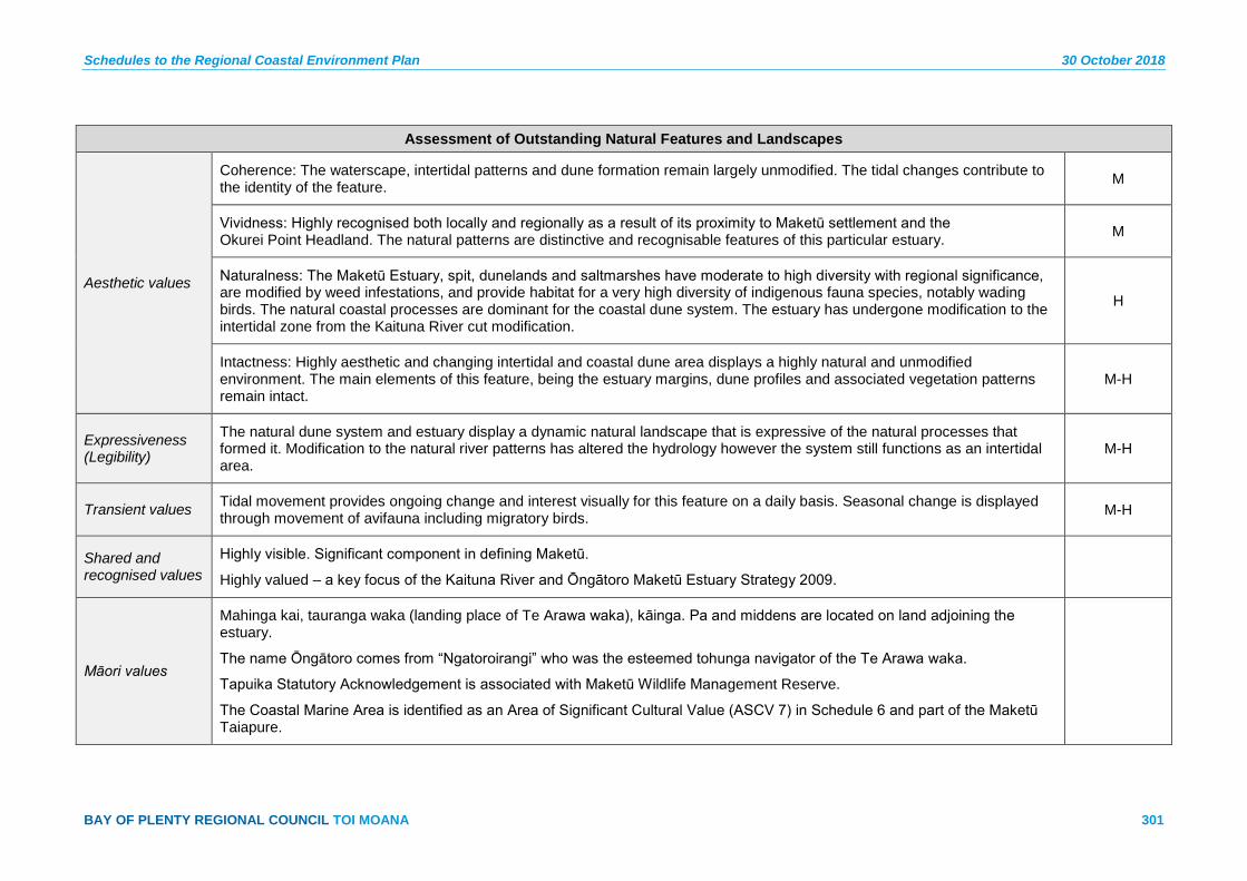
Schedules to the Regional Coastal Environment Plan 30 October 2018
BAY OF PLENTY REGIONAL COUNCIL TOI MOANA 301
Assessment of Outstanding Natural Features and Landscapes
Aesthetic values
Coherence: The waterscape, intertidal patterns and dune formation remain largely unmodified. The tidal changes contribute to the identity of the feature. M
Vividness: Highly recognised both locally and regionally as a result of its proximity to Maketū settlement and the Okurei Point Headland. The natural patterns are distinctive and recognisable features of this particular estuary. M
Naturalness: The Maketū Estuary, spit, dunelands and saltmarshes have moderate to high diversity with regional significance, are modified by weed infestations, and provide habitat for a very high diversity of indigenous fauna species, notably wading birds. The natural coastal processes are dominant for the coastal dune system. The estuary has undergone modification to the intertidal zone from the Kaituna River cut modification.
H
Intactness: Highly aesthetic and changing intertidal and coastal dune area displays a highly natural and unmodified environment. The main elements of this feature, being the estuary margins, dune profiles and associated vegetation patterns remain intact.
M-H
Expressiveness (Legibility)
The natural dune system and estuary display a dynamic natural landscape that is expressive of the natural processes that formed it. Modification to the natural river patterns has altered the hydrology however the system still functions as an intertidal area.
M-H
Transient values Tidal movement provides ongoing change and interest visually for this feature on a daily basis. Seasonal change is displayed through movement of avifauna including migratory birds. M-H
Shared and recognised values
Highly visible. Significant component in defining Maketū.
Highly valued – a key focus of the Kaituna River and Ōngātoro Maketū Estuary Strategy 2009.
Māori values
Mahinga kai, tauranga waka (landing place of Te Arawa waka), kāinga. Pa and middens are located on land adjoining the estuary.
The name Ōngātoro comes from “Ngatoroirangi” who was the esteemed tohunga navigator of the Te Arawa waka.
Tapuika Statutory Acknowledgement is associated with Maketū Wildlife Management Reserve.
The Coastal Marine Area is identified as an Area of Significant Cultural Value (ASCV 7) in Schedule 6 and part of the Maketū Taiapure.

30 October 2018 Schedules to the Regional Coastal Environment Plan
302 Pre-Operative Regional Coastal Environment Plan – 30 October 2018
Assessment of Outstanding Natural Features and Landscapes
Historical associations
Identified as an archaeological area in historic heritage inventory study for Coastal Environment Plan. Archaeological sites contain physical evidence of past human activity.
Okurei Point – ONFL 12 Map Sheet 16a
Description:
A dominant headland feature that forms the western end of the Mount Maunganui to Papamoa to Maketū beach line. The steep escarpments, cliff faces and scale of this landform is also culturally significant containing historical and prominent pa sites that overlook the landing site of the Māori Canoe Te Arawa.
Current uses:
Pastoral grazing, vehicle access, walking, fishing.
Evaluation Rating
Natural science factors
Representativeness: Dramatic headland with coastal cliffs, grazing land use and a strong identity to Maketū and Little Waihi. Elevated coastal headland that sits amongst lowland coastal plans to the east and west. M-H
Research and education: Opportunities for research on coastal and cultural values. M
Rarity: Moderately rare due to scale and location as a distinctive pointed headland landform and landmark feature defining bay. M
Aesthetic values
Coherence: Coastal native vegetation extends up the valleys and steep edges providing a continuous coastal fringe. The pastoral grazing areas define the cultural landscape features prevalent in this area. M
Vividness: Highly vivid at a district and regional level as a result of the scale and drama with the surrounding landform. H
Naturalness: Moderate levels of naturalness with the margins displaying high levels of naturalness. Modification to some edges occurs as a result of boat access and tracks. M
Intactness: The landform is expressive of the natural coastal processes and geomorphology of the feature. L-M
Expressiveness (legibility)
A highly expressive landform and feature in the wider landscape, the headland is highly legible. The coastal edge is expressive of coastal erosion which is a continuing process. M

Schedules to the Regional Coastal Environment Plan 30 October 2018
BAY OF PLENTY REGIONAL COUNCIL TOI MOANA 303
Assessment of Outstanding Natural Features and Landscapes
Transient values Transient values are apparent through the changing tides, flowering pohutukawa and dramatic coastal processes. L-M
Shared and recognised values
Limited public access. Prominent headland.
Māori values
Wahi tapu, ancient pa, whenua taunaha. Wahi taonga to Ngati Whakaue ki Maketū and Ngati Makino. Coastal Marine Area is part of the Maketū Taiapure.
Coastal Marine Area around Okurei Point is associated with a Tapuika Statutory Acknowledgement. The Coastal Marine Area is identified as an Area of Significant Cultural Value (ASCV 7) in Schedule 6.
Historical associations
Connections to early European settlement and activities, such as Tapsell’s flax milling and trading, also 1830s Mission settlement. Landscape contains archaeological sites including regionally representative pa. These sites are recorded in the New Zealand Archaeological Association Site Recording Scheme, and comprise physical evidence of past human activity.
Waihi Estuary – ONFL 13 Map Sheet 16a
Description:
Settlement of Little Waihi has resulted in retaining structures placed along the harbour edge to manage continue coastal erosion. Reclamation of parts of the estuary for farming has resulted in linear patterns within parts of the harbour.
Current uses:
Maimai for duck shooting, boating, fishing, walking.
Evaluation Rating
Natural science factors
Representativeness: Significant estuary in relation to adjacent headland, Okurei Point. Defined by Pukehina Spit with associated development. Some margins are modified for flood protection for the adjoining agricultural land. M
Research and education: Research and educational opportunities associated with estuarine fauna and benthic marine values. L-M
Rarity: Estuaries of this type are not rare and are typical of the natural processes of lowland coastal plains set behind coastal dune systems. L-M
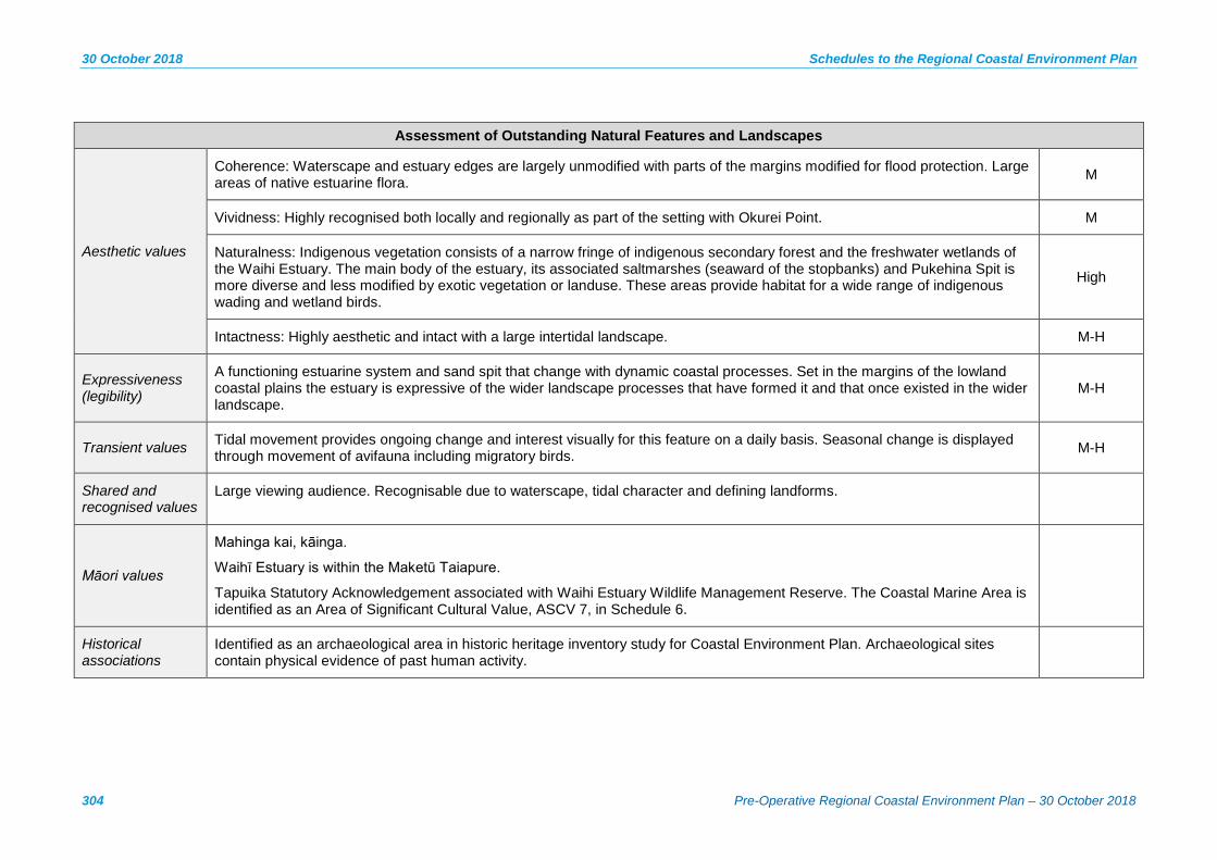
30 October 2018 Schedules to the Regional Coastal Environment Plan
304 Pre-Operative Regional Coastal Environment Plan – 30 October 2018
Assessment of Outstanding Natural Features and Landscapes
Aesthetic values
Coherence: Waterscape and estuary edges are largely unmodified with parts of the margins modified for flood protection. Large areas of native estuarine flora. M
Vividness: Highly recognised both locally and regionally as part of the setting with Okurei Point. M
Naturalness: Indigenous vegetation consists of a narrow fringe of indigenous secondary forest and the freshwater wetlands of the Waihi Estuary. The main body of the estuary, its associated saltmarshes (seaward of the stopbanks) and Pukehina Spit is more diverse and less modified by exotic vegetation or landuse. These areas provide habitat for a wide range of indigenous wading and wetland birds.
High
Intactness: Highly aesthetic and intact with a large intertidal landscape. M-H
Expressiveness (legibility)
A functioning estuarine system and sand spit that change with dynamic coastal processes. Set in the margins of the lowland coastal plains the estuary is expressive of the wider landscape processes that have formed it and that once existed in the wider landscape.
M-H
Transient values Tidal movement provides ongoing change and interest visually for this feature on a daily basis. Seasonal change is displayed through movement of avifauna including migratory birds. M-H
Shared and recognised values
Large viewing audience. Recognisable due to waterscape, tidal character and defining landforms.
Māori values
Mahinga kai, kāinga.
Waihī Estuary is within the Maketū Taiapure.
Tapuika Statutory Acknowledgement associated with Waihi Estuary Wildlife Management Reserve. The Coastal Marine Area is identified as an Area of Significant Cultural Value, ASCV 7, in Schedule 6.
Historical associations
Identified as an archaeological area in historic heritage inventory study for Coastal Environment Plan. Archaeological sites contain physical evidence of past human activity.

Schedules to the Regional Coastal Environment Plan 30 October 2018
BAY OF PLENTY REGIONAL COUNCIL TOI MOANA 305
Assessment of Outstanding Natural Features and Landscapes
Kohioawa Beach Dune Field and Wetlands – ONFL 14 Map Sheets 18a, 19a
Description:
Kohioawa Beach, its associated dunes and wetlands form an example of natural dune and rear dune wetland systems. Modification around settlement areas and post major storm events has resulted in the loss of some natural wetlands. The location of the State Highway and rail corridor create a divide however, the dune and coastal escarpment demonstrate vividly the current and historical coastal process that occur within the landscape. Therefore the key attributes which drive the requirement for classification as ONFL, and require protection, relate to aesthetic values derived the cohesiveness and naturalness of the coastline and its associated coastal processes, which form a distinctive and memorable landscape.
Current uses:
Recreational use (swimming, beach walking), car park, isolated houses, dune protection measures, fence lines.
Evaluation Rating
Natural science factors
Representativeness: The uninterrupted sweep of sandy beach, supported by associated dunes and wetlands is representative of an open beach coastline and the fresh water and salt water processes which occur along the coast. M-H
Research and education: Research and educational opportunities associated with the largely unmodified dune and wetland systems and associated biodiversity. M
Rarity: The features are not rare within the region; however the combination of a long sweep of coastline which features the combination of beach, dunes and wetlands is distinctive. L-M
Aesthetic values
Coherence: The patterns associated with the topographical changes in the dunes, and the relationship with the wetlands and coastal vegetation provides for a valuable level of aesthetic coherence along the coastal edge. M-H
Vividness: The uninterrupted scale and openness (of the aspect towards the bay) results in a highly vivid landscape which is recognisable and memorable to the relatively high numbers of people using the adjacent state highway and railway line. M
Naturalness: The dune lands and wetlands, although modified in some places (by invasive weed species and some development), generally feature natural processes that are uncompromised. It is noted that these areas provide limited habitat for indigenous species other than common species.
M

30 October 2018 Schedules to the Regional Coastal Environment Plan
306 Pre-Operative Regional Coastal Environment Plan – 30 October 2018
Assessment of Outstanding Natural Features and Landscapes
Intactness: The scale and ‘openness’ of this landscape results in a level of intactness that is dominant over the lesser human intrusions and adjacent transport corridors. It is noted that river cuts are present, which represent a modification from their original route. Dune protection measures (i.e. to manage erosion and accretion) are also present. The rear dune wetlands remain intact as do the secondary and tertiary dune profiles and natural coastal edge.
M
Expressiveness (Legibility)
The natural coastal processes are expressed through the dune landforms, wetlands and remnant indigenous scrubland. M-H
Transient values This landscape has transient value, derived from the movements of waves, changing tides, mists and contrasts between powerful and calm waters. M
Shared and recognised values
Highly distinctive feature. State Highway means large viewing audience. The dominant aspect of the drive along this stretch of road.
Māori values
Ancient pa, ana koiwi, wāhi tapu, kāinga, parekura. Ngapariwhakairo – the carved cliffs.
This feature is associated with a number of battles and internment and includes Te Kaokaoroa, Kaokaoroa Battlesite – a large area associated with a traditional urupā, and series of battles. Identified in the Te Mahere o Rohe ma Ngati Rangitihi 2012 and the Wahi Tapu sties of Ngati Awa 2000.
Historical associations
Landscape contains many archaeological sites of Māori origin, dominated by pa, along the escarpment. These sites are recorded in the New Zealand Archaeological Association Site Recording Scheme, and comprise physical evidence of past human activity.
Escarpment and Pohutukawa along Matata Straights – ONFL 15 Map Sheets 18a, 19a
Description:
The Matatā escarpment extends along State Highway 2 between Otamarakau and Matatā settlements. The escarpment rises gradually from the west to its highest point immediately behind the Matatā township. The escarpment is interrupted a number of times along its extent with a series of gully and streams that exit under the road to the coast. Key features include the combination of remnant mature pohutukawa trees perched along the exposed cliff faces, along with bush clad escarpments with the top of the escarpment covered with mature pohutukawa trees. Further east native coastal bush cover begins to extend down the slopes to provide more extensive cover on the mid to lower slopes. Pockets of native bush and remnant trees are set amongst paddocks along the lower slopes, used for stock grazing. This feature is highly recognisable at a regional level as being one of two features of its kind within the Bay of Plenty region.

Schedules to the Regional Coastal Environment Plan 30 October 2018
BAY OF PLENTY REGIONAL COUNCIL TOI MOANA 307
Assessment of Outstanding Natural Features and Landscapes
Current uses:
Driveway access along escarpment, stock and farm tracks, farm fencing on lower slopes, stock grazing.
Evaluation Rating
Natural science factors
Representativeness: Distinctive landward escarpment landform with patterning of wind induced erosion. Cover of pohutukawa reinforcing linear feature. Location of road creates awareness. Geological feature with overlay of distinctive erosion M-H
Research and Education: The location, dominance and location, together with legibility of the coastal erosion escarpments. Displays transects of coastal sedimentation and volcanic ash layers. NA
Rarity: Highly distinctive feature being one of two features alongside State Highway. H
Aesthetic values
Coherence: Generally highly consistent pattern of dominant pohutukawa and manuka clad escarpment. The weed cover detracts from coherence with some recent loss due to slips and storms. M
Vividness: Vivid and memorable landscape feature as a result of location of the State Highway. Memorable as a result of landform, exposed cliff faces clad with mature pohutukawa. H
Naturalness: Natural landform demonstrating the sedimentary and volcanic history of the area. Remnant mature vegetation cover exists with invasion of exotic weed species and human modification to landform for access and flood management. H
Intactness: Highly intact escarpment with modification to lower slopes for grazing, access and flood management. Pockets of weed infestation and grazing areas lower the overall intactness of the vegetation cover. M-H
Expressiveness (Legibility)
Highly expressive of the natural coastal erosion, tectonic and sedimentation processes, particularly in relation to the exposed cliff faces. H
Transient values Changes observed on a seasonal basis with the flowering of pohutukawa, puriri and manuka. The remnant and emerging native vegetation cover contributes to moderate transient values. M
Shared and recognised values
Limited public access. Prominent headland.
Māori values Wahi tapu, ancient pa, whenua taunaha.

30 October 2018 Schedules to the Regional Coastal Environment Plan
308 Pre-Operative Regional Coastal Environment Plan – 30 October 2018
Assessment of Outstanding Natural Features and Landscapes
Historical associations
Connections to early European settlement and activities, such as Tapsell’s flax milling and trading, also 1830s Mission settlement. Landscape contains archaeological sites including regionally representative pa. These sites are recorded in the New Zealand Archaeological Association Site Recording Scheme, and comprise physical evidence of past human activity.
Matata Wetlands – ONFL 16 Map Sheet 19a
Description:
A coastal back dune wetland in an original series of three main wetlands formed in the old river bed of the Tarawera River. In August 2005 two of the main wetlands were inundated with a large debris flow during a storm event, resulting in infilling with mud and rubble. The far eastern wetland remained largely unaffected and retains its earlier natural landscape character and outstanding natural landscape qualities. Restoration of the central wetland into a lagoon and wetland feature has resulted in improved amenity values for this part of the feature.
Current uses:
Walking and cycling around the margins, causeway access to campground between central and far eastern wetland.
Evaluation Rating
Natural science factors
Representativeness: A coastal back dune wetland in an original series of three main wetlands. Good cover in intact indigenous vegetation with some weed species. Characteristics of original duneland landscape and wetland and historical river system are demonstrated.
M-H
Research and education: Well preserved wetland system, particularly in the far eastern wetland. M
Rarity: Opportunities to monitor restoration and educational values for schools with existing wetlands. H
Aesthetic values
Coherence: Not rare regionally but a significant feature scale wise and due to its relationship with the broader series of rear dune wetlands from Otamarakau and Whakatāne. The rarity of the scale of the feature is unique to this part of the region. M
Vividness: The area is under conservation management, primarily indigenous wetland and terrestrial margin species. The proximity to the State Highway, sequencing of native wetland species and open bodies of water set immediately behind an active dune system create a vivid and memorable landscape. The natural processes and visual relationship between the features is a key factor in the vividness of this feature.
M
Naturalness: Excellent example of natural processes both long and short-term with modifications as a result of the State Highway and the causeway access. Sequencing and quality of native vegetation is relatively unmodified, excluding those areas
H
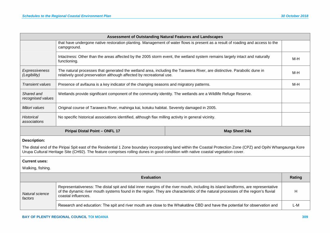
Schedules to the Regional Coastal Environment Plan 30 October 2018
BAY OF PLENTY REGIONAL COUNCIL TOI MOANA 309
Assessment of Outstanding Natural Features and Landscapes that have undergone native restoration planting. Management of water flows is present as a result of roading and access to the campground.
Intactness: Other than the areas affected by the 2005 storm event, the wetland system remains largely intact and naturally functioning. M-H
Expressiveness (Legibility)
The natural processes that generated the wetland area, including the Tarawera River, are distinctive. Parabolic dune in relatively good preservation although affected by recreational use. M-H
Transient values Presence of avifauna is a key indicator of the changing seasons and migratory patterns. M-H
Shared and recognised values
Wetlands provide significant component of the community identity. The wetlands are a Wildlife Refuge Reserve.
Māori values Original course of Tarawera River, mahinga kai, kotuku habitat. Severely damaged in 2005.
Historical associations
No specific historical associations identified, although flax milling activity in general vicinity.
Piripai Distal Point – ONFL 17 Map Sheet 24a
Description:
The distal end of the Piripai Spit east of the Residential 1 Zone boundary incorporating land within the Coastal Protection Zone (CPZ) and Opihi Whangaunga Kore Urupa Cultural Heritage Site (CH92). The feature comprises rolling dunes in good condition with native coastal vegetation cover.
Current uses:
Walking, fishing.
Evaluation Rating
Natural science factors
Representativeness: The distal spit and tidal inner margins of the river mouth, including its island landforms, are representative of the dynamic river mouth systems found in the region. They are characteristic of the natural processes of the region’s fluvial coastal influences.
H
Research and education: The spit and river mouth are close to the Whakatāne CBD and have the potential for observation and L-M
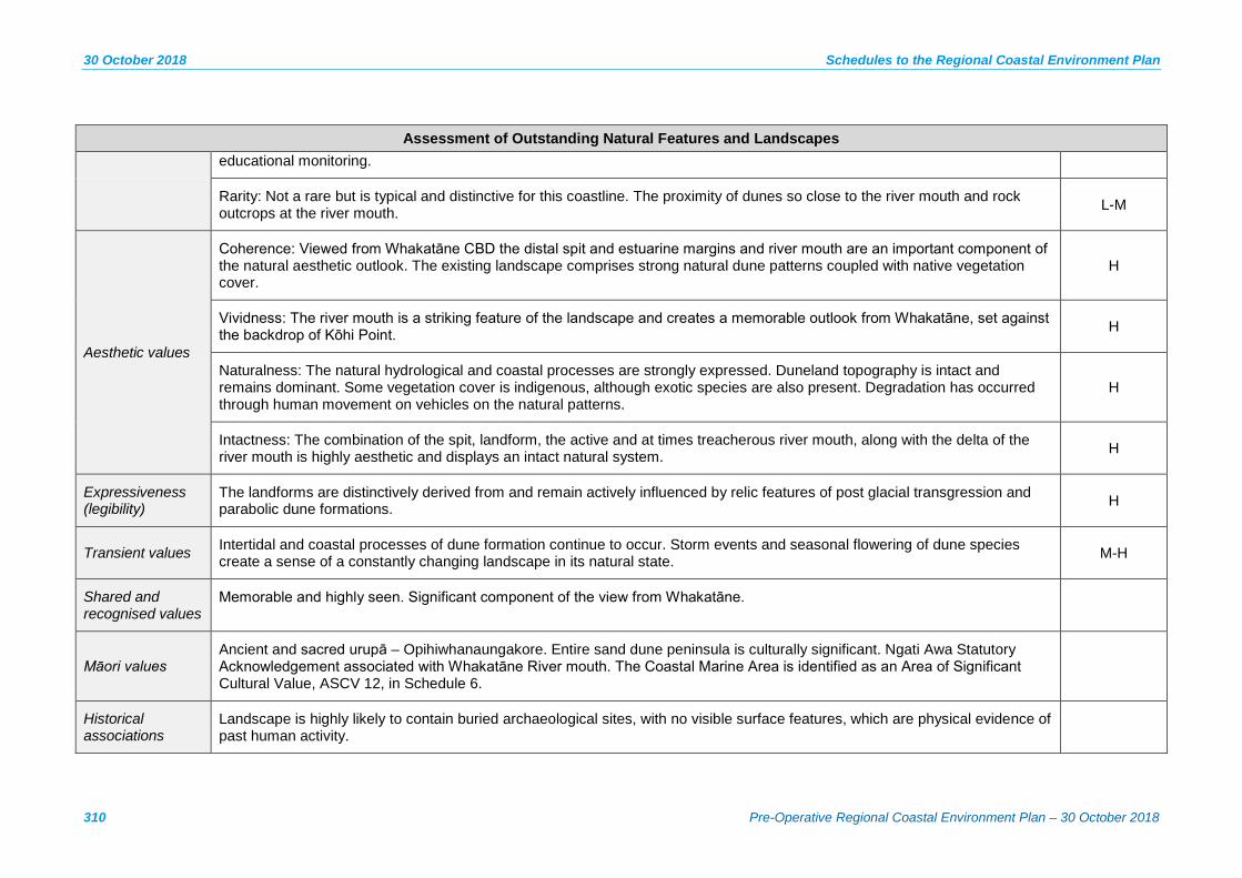
30 October 2018 Schedules to the Regional Coastal Environment Plan
310 Pre-Operative Regional Coastal Environment Plan – 30 October 2018
Assessment of Outstanding Natural Features and Landscapes educational monitoring.
Rarity: Not a rare but is typical and distinctive for this coastline. The proximity of dunes so close to the river mouth and rock outcrops at the river mouth. L-M
Aesthetic values
Coherence: Viewed from Whakatāne CBD the distal spit and estuarine margins and river mouth are an important component of the natural aesthetic outlook. The existing landscape comprises strong natural dune patterns coupled with native vegetation cover.
H
Vividness: The river mouth is a striking feature of the landscape and creates a memorable outlook from Whakatāne, set against the backdrop of Kōhi Point. H
Naturalness: The natural hydrological and coastal processes are strongly expressed. Duneland topography is intact and remains dominant. Some vegetation cover is indigenous, although exotic species are also present. Degradation has occurred through human movement on vehicles on the natural patterns.
H
Intactness: The combination of the spit, landform, the active and at times treacherous river mouth, along with the delta of the river mouth is highly aesthetic and displays an intact natural system. H
Expressiveness (legibility)
The landforms are distinctively derived from and remain actively influenced by relic features of post glacial transgression and parabolic dune formations. H
Transient values Intertidal and coastal processes of dune formation continue to occur. Storm events and seasonal flowering of dune species create a sense of a constantly changing landscape in its natural state. M-H
Shared and recognised values
Memorable and highly seen. Significant component of the view from Whakatāne.
Māori values Ancient and sacred urupā – Opihiwhanaungakore. Entire sand dune peninsula is culturally significant. Ngati Awa Statutory Acknowledgement associated with Whakatāne River mouth. The Coastal Marine Area is identified as an Area of Significant Cultural Value, ASCV 12, in Schedule 6.
Historical associations
Landscape is highly likely to contain buried archaeological sites, with no visible surface features, which are physical evidence of past human activity.
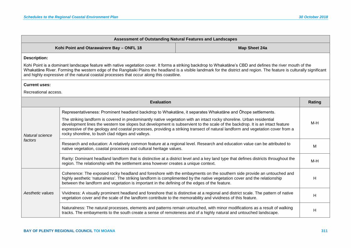
Schedules to the Regional Coastal Environment Plan 30 October 2018
BAY OF PLENTY REGIONAL COUNCIL TOI MOANA 311
Assessment of Outstanding Natural Features and Landscapes
Kohi Point and Otarawairere Bay – ONFL 18 Map Sheet 24a
Description:
Kohi Point is a dominant landscape feature with native vegetation cover. It forms a striking backdrop to Whakatāne’s CBD and defines the river mouth of the Whakatāne River. Forming the western edge of the Rangitaiki Plains the headland is a visible landmark for the district and region. The feature is culturally significant and highly expressive of the natural coastal processes that occur along this coastline.
Current uses:
Recreational access.
Evaluation Rating
Natural science factors
Representativeness: Prominent headland backdrop to Whakatāne, it separates Whakatāne and Ōhope settlements.
The striking landform is covered in predominantly native vegetation with an intact rocky shoreline. Urban residential development lines the western toe slopes but development is subservient to the scale of the backdrop. It is an intact feature expressive of the geology and coastal processes, providing a striking transect of natural landform and vegetation cover from a rocky shoreline, to bush clad ridges and valleys.
M-H
Research and education: A relatively common feature at a regional level. Research and education value can be attributed to native vegetation, coastal processes and cultural heritage values. M
Rarity: Dominant headland landform that is distinctive at a district level and a key land type that defines districts throughout the region. The relationship with the settlement area however creates a unique context. M-H
Aesthetic values
Coherence: The exposed rocky headland and foreshore with the embayments on the southern side provide an untouched and highly aesthetic ‘naturalness’. The striking landform is complimented by the native vegetation cover and the relationship between the landform and vegetation is important in the defining of the edges of the feature.
H
Vividness: A visually prominent headland and foreshore that is distinctive at a regional and district scale. The pattern of native vegetation cover and the scale of the landform contribute to the memorability and vividness of this feature. H
Naturalness: The natural processes, elements and patterns remain untouched, with minor modifications as a result of walking tracks. The embayments to the south create a sense of remoteness and of a highly natural and untouched landscape. H

30 October 2018 Schedules to the Regional Coastal Environment Plan
312 Pre-Operative Regional Coastal Environment Plan – 30 October 2018
Assessment of Outstanding Natural Features and Landscapes
Intactness: The vegetation sequence is largely untouched and in parts regenerating. Some modification for walking tracks and a recreational lookout have modified parts of the feature, but it largely remains untouched as a result mostly of the topography. H
Expressiveness (legibility)
The landform is highly expressive of the geomorphic processes that contributed to its formation. Modifications have not resulted in an alteration to the large scale of this feature. M
Transient values Pohutukawa clad escarpments and the intertidal movement are important transient values of this landscape. M
Shared and recognised values
Backdrop to Whakatāne. Highly visible. Strong community attachment.
Māori values
Statutory Acknowledgement associated to this site. Culturally significant to nga uri o Ngati Awa.
Toka tipua (rocks imbued with spiritual and sacred qualities).
Many culturally significant sites along Kohi Point through to Otarawairere. Some of which include: Papa Whariki, Taumata Kahawai, Te Rae o te Tamure pa, Papaka.
Ko-hi – to be ill. Named after an incident when Wairaka, Toroa’s daughter became ill. Ngati Awa Statutory acknowledgement associated with Kohi Point.
The Coastal Marine Area is identified as an Area of Significant Cultural Value (ASCV 12) in Schedule 6.
Historical associations
Connections to historical European activity, including European redoubt overlooking Whakatāne township.
Redoubt recorded in the New Zealand Archaeological Association Site Recording Scheme, is physical evidence of past human activity. Landscape contains several complex and archaeologically significant pa along escarpment. These sites are recorded in the New Zealand Archaeological Association Site Recording Scheme, and comprise physical evidence of past human activity.
Distal Point of Ohope Spit – ONFL 19 Map Sheet 25a
Description:
Ōhope Spit is a sand spit that forms a continuation of Ōhope beach and encloses the Ōhiwa harbour waters behind. This area relates to the eastern end of the spit, and the parts which lie outside of the golf course and residential development, which have modified the surrounding landscape. The key attributes which drive the requirement for classification as ONFL, and require protection, relate to natural science values associated with the unmodified coastal dunescape and the indigenous flora and fauna which it supports.

Schedules to the Regional Coastal Environment Plan 30 October 2018
BAY OF PLENTY REGIONAL COUNCIL TOI MOANA 313
Assessment of Outstanding Natural Features and Landscapes
Current uses:
Walking track.
Evaluation Rating
Natural science factors
Representativeness: The largely unmodified dune system (which contains frontal, secondary and tertiary dune profiles) and native dune vegetation, defines the termination of the spit and the entrance to the Ōhiwa Harbour. M-H
Research and education: Research opportunities associated with the largely unmodified dune systems and associated indigenous flora and fauna. L
Rarity: The dune landform and associated indigenous vegetation is not rare within the region but is distinctive. L-M
Aesthetic values
Coherence: The gently undulating patterns of topography associated with the dunes and the almost complete coverage of indigenous and exotic species, which are generally low in height, results in an openness and coherence across the landscape. M-H
Vividness: The distinctive shape and geographical position of the Ōhope Spit, and the distinctive patterns of the dune systems at the distal point, means that this landscape is memorable – predominantly for geographical reasons. M
Naturalness: The dune vegetation has high indigenous biodiversity and provides habitat for threatened indigenous fauna, whilst including some exotic species and modification from tracks. The highly dynamic coastal processes which occur along the harbour and coastal margins (i.e. waves, tides and currents) and intertidal processes further enhance the naturalness of this landscape.
M
Intactness: There is very little modification to the landscape other than by a number of tracks and some erosion control measures at the distal end; however the natural systems associated with the coast are largely intact. M
Expressiveness (Legibility)
The overall shape and dune land cover represent highly expressive values, demonstrating the formative coastal processes and dynamic nature of the Ōhiwa Harbour and open coastline. The natural dune patterns are remnant of the interface of the harbour and open costal water process.
H
Transient values The transient values are associated with the movements of water, both the waves of the open coastline and the associated tides which expose and cover lower parts of the sand bar and frequently change its form. L-M

30 October 2018 Schedules to the Regional Coastal Environment Plan
314 Pre-Operative Regional Coastal Environment Plan – 30 October 2018
Assessment of Outstanding Natural Features and Landscapes
Shared and recognised values
Low profile. Not well recognised. Ōhiwa Harbour Sandspit Wildlife Refuge is located on Ōhope Spit.
Māori values One Turuturu Spit (Wildlife Refuge). Part of Ōhiwa Harbour which is culturally significant and locally recognised by Māori, mahinga kai.
The Coastal Marine Area is identified as an Area of Significant Cultural Value (ASCV 13) in Schedule 6.
Historical associations
Landscape is highly likely to contain buried archaeological sites (with no visible surface features) which comprise physical evidence of past human activity.
Recorded archaeological sites immediately adjacent to identified area.
Ohiwa Harbour – ONFL 20 Map Sheets 25a, 26a, 27a
Description:
The harbour covers approximately 27 km² and supports an important habitat for native wildlife and flora. The key attributes which drive the requirement for classification as ONFL, and require protection, relate to the aesthetic values of the harbour, namely its level of intactness and naturalness which are the result of largely unmodified harbour waters, coastal vegetation on the margins and islands and the presence of distinctive and dynamic coastal processes and patterns.
Current uses:
Boat ramps, western jetty, marine farming, recreational use (e.g. boaties; fishing etc.), harbour fringe features some residential and agricultural uses.
Evaluation Rating
Natural science factors
Representativeness: The distinctive patterns and forms of the harbour, i.e. the estuaries and tidal flows together with the harbour edge (which is heavily indented) and islands, which are generally in a good state of preservation, results in a characteristic landscape feature.
M
Research and education: The relatively undisturbed nature of the coastal processes (i.e. increasing siltation) and related estuarine habitats provide for research and educational value. M-H
Rarity: The formation and natural character values associated with the harbour are valued for their relative rarity. M

Schedules to the Regional Coastal Environment Plan 30 October 2018
BAY OF PLENTY REGIONAL COUNCIL TOI MOANA 315
Assessment of Outstanding Natural Features and Landscapes
Aesthetic values
Coherence: There are minimal structures on the harbour waters and together with the large areas of saltmarsh and mangrove habitats, they provide a high level of coherence across the landscape, which is highly valuable. H
Vividness: The distinctive natural patterns of the harbour waters and associated sand banks, and the overall scale of the harbour results in a highly memorable landscape. M-H
Naturalness: There are some seawalls and dune protection measures which have affected the natural processes to a degree; however, overall these modifications are relatively minor considering the scale of the entire harbour. In general the harbour is a water body that displays a diverse habitat for marine aquatic flora and fauna and displays distinctive natural patterns due to its shallow depth and intertidal flow.
H
Intactness: Includes intact saltmarsh and plant communities that extend from salt water inland to terrestrial indigenous habitats – including mangrove habitats and pockets of freshwater wetlands, grading to saltmarsh. There are a number of small marine farms at the western end of the harbour; however, in their current form, they do not detract from the overall high level of intactness associated with the harbour waters.
H
Expressiveness (Legibility)
The natural patterns, islands, sand bars and indented shoreline within the harbour reflect the geomorphological processes and natural coastal processes of the harbour. M
Transient values The harbour has high transient values, resulting from the tidal flow which and shallow nature of the harbour, which exposes approximately 80% of its seabed at low tide. The harbour mouth is highly dynamic with the sand spit changing its form on a frequent basis.
H
Shared and recognised values
Nationally recognised. Visually prominent. An icon of the eastern Bay of Plenty. Values recognised in the Ōhiwa Harbour Strategy 2008.
Māori values Ngati Awa Statutory Acknowledgement associated to part of the Ōhiwa Harbour. Mahinga kai, tauranga waka, ancient pa, kāinga, wāhi tapu. The Coastal Marine Area is identified as an Area of Significant Cultural Value, ASCV 13, in Schedule 6.
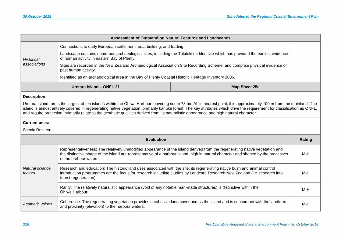
30 October 2018 Schedules to the Regional Coastal Environment Plan
316 Pre-Operative Regional Coastal Environment Plan – 30 October 2018
Assessment of Outstanding Natural Features and Landscapes
Historical associations
Connections to early European settlement, boat building, and trading.
Landscape contains numerous archaeological sites, including the Tokitoki midden site which has provided the earliest evidence of human activity in eastern Bay of Plenty.
Sites are recorded in the New Zealand Archaeological Association Site Recording Scheme, and comprise physical evidence of past human activity.
Identified as an archaeological area in the Bay of Plenty Coastal Historic Heritage Inventory 2006.
Uretara Island – ONFL 21 Map Sheet 25a
Description:
Uretara Island forms the largest of ten islands within the Ōhiwa Harbour, covering some 73 ha. At its nearest point, it is approximately 100 m from the mainland. The island is almost entirely covered in regenerating native vegetation, primarily kanuka forest. The key attributes which drive the requirement for classification as ONFL, and require protection, primarily relate to the aesthetic qualities derived from its naturalistic appearance and high natural character.
Current uses:
Scenic Reserve.
Evaluation Rating
Natural science factors
Representativeness: The relatively unmodified appearance of the island derived from the regenerating native vegetation and the distinctive shape of the island are representative of a harbour island, high in natural character and shaped by the processes of the harbour waters.
M-H
Research and education: The historic land uses associated with the site, its regenerating native bush and animal control introduction programmes are the focus for research including studies by Landcare Research New Zealand (i.e. research into forest regeneration).
M-H
Rarity: The relatively naturalistic appearance (void of any notable man-made structures) is distinctive within the Ōhiwa Harbour. M-H
Aesthetic values Coherence: The regenerating vegetation provides a cohesive land cover across the island and is concordant with the landform and proximity (elevation) to the harbour waters. M-H
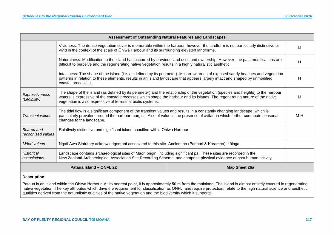
Schedules to the Regional Coastal Environment Plan 30 October 2018
BAY OF PLENTY REGIONAL COUNCIL TOI MOANA 317
Assessment of Outstanding Natural Features and Landscapes
Vividness: The dense vegetation cover is memorable within the harbour; however the landform is not particularly distinctive or vivid in the context of the scale of Ōhiwa Harbour and its surrounding elevated landforms. M
Naturalness: Modification to the island has occurred by previous land uses and ownership. However, the past modifications are difficult to perceive and the regenerating native vegetation results in a highly naturalistic aesthetic. H
Intactness: The shape of the island (i.e. as defined by its perimeter), its narrow areas of exposed sandy beaches and vegetation patterns in relation to these elements, results in an island landscape that appears largely intact and shaped by unmodified coastal processes.
H
Expressiveness (Legibility)
The shape of the island (as defined by its perimeter) and the relationship of the vegetation (species and heights) to the harbour waters is expressive of the coastal processes which shape the harbour and its islands. The regenerating nature of the native vegetation is also expressive of terrestrial biotic systems.
M
Transient values The tidal flow is a significant component of the transient values and results in a constantly changing landscape, which is particularly prevalent around the harbour margins. Also of value is the presence of avifauna which further contribute seasonal changes to the landscape.
M-H
Shared and recognised values
Relatively distinctive and significant island coastline within Ōhiwa Harbour.
Māori values Ngati Awa Statutory acknowledgement associated to this site. Ancient pa (Paripari & Karamea), kāinga.
Historical associations
Landscape contains archaeological sites of Māori origin, including significant pa. These sites are recorded in the New Zealand Archaeological Association Site Recording Scheme, and comprise physical evidence of past human activity.
Pataua Island – ONFL 22 Map Sheet 26a
Description:
Pataua is an island within the Ōhiwa Harbour. At its nearest point, it is approximately 50 m from the mainland. The island is almost entirely covered in regenerating native vegetation. The key attributes which drive the requirement for classification as ONFL, and require protection, relate to the high natural science and aesthetic qualities derived from the naturalistic qualities of the native vegetation and the biodiversity which it supports.

30 October 2018 Schedules to the Regional Coastal Environment Plan
318 Pre-Operative Regional Coastal Environment Plan – 30 October 2018
Assessment of Outstanding Natural Features and Landscapes
Current uses:
Scientific Reserve.
Evaluation Rating
Natural science factors
Representativeness: The relatively unmodified appearance of the island derived from the regenerating native vegetation are representative of a harbour island, high in natural character. M
Research and education: The regenerating native vegetation is of value to research and monitoring programmes such as that undertaken by the Bay of Plenty Regional Council concerning pohutukawa monitoring. M
Rarity: The relatively naturalistic appearance (void of any notable man-made structures) is distinctive within the Ōhiwa Harbour. M
Aesthetic values
Coherence: The regenerating vegetation provides a cohesive land cover across the island and is concordant with the landform. M
Vividness: The dense vegetation cover is memorable, within the harbour; however, the landform is not particularly distinctive or vivid in the context of the scale of Ōhiwa Harbour and its surrounding elevated landforms. M
Naturalness: The regenerating native vegetation results in a highly naturalistic aesthetic. H
Intactness: The island landscape appears isolated from the reaches of human modification by its island geography. It appears largely intact (from the dense native vegetation cover) and appears shaped by unmodified coastal processes. H
Expressiveness (Legibility)
In places the island landform is difficult to perceive given the proximity to the mainland and the coverage of mangroves in the adjacent channel. However the regenerating nature of the native vegetation is expressive of terrestrial biotic systems. M
Transient values The tidal flow is a significant component of the transient values and results in a constantly changing landscape, which is particularly prevalent around the harbour margins. Also of value is the presence of avifauna which further contribute seasonal changes to the landscape.
M
Shared and recognised values
Not highly recognisable or visible.

Schedules to the Regional Coastal Environment Plan 30 October 2018
BAY OF PLENTY REGIONAL COUNCIL TOI MOANA 319
Assessment of Outstanding Natural Features and Landscapes
Māori values Kainga (incl. middens, ovens).
Historical associations
Landscape contains archaeological sites, recorded in the New Zealand Archaeological Association Site Recording Scheme, which comprise physical evidence of past human activity.
Waiōtahe Estuary – ONFL 23 Map Sheet 27a
Description:
Set behind a sand spit the coastal edge the Waiōtahe Estuary is bound by the rising hills of Ōhiwa to the west. The lowland river valley is wide with pastoral farming either side of the river. The estuary margins have modification along the western and eastern edges as a result of road access and farming stop banks, with the remaining edges unmodified. The intertidal nature of the estuary is distinctive of the Bay of Plenty Coastal environment and the natural edges are important elements of this feature.
Current uses:
Stopbanks along eastern edge, retained road access along the western edge.
Evaluation Rating
Natural science factors
Representativeness: Important small harbour landscape contributes to identity and character of the locality. The harbour is in a good state of preservation although subject to siltation and landward drainage. As a shallow harbour it displays numerous shoals and sand banks that are similar to other shallow harbours in the region. The margins are relatively modified by drainage and pastoral land use. It forms a defining element of the river mouth.
M-H
Research and education: Habitat values for native flora and fauna are important with its close proximity to Ōhiwa Harbour. M
Rarity: Not rare at a regional level its scale is important as it dominate the valley floor and river mouth of the Waiōtahe River. L-M
Aesthetic values
Coherence: Harbour estuary is intact with meandering river patterns within the estuary. The remaining natural edges are important features with the native vegetation along the margins positively contributing to the natural patterns. M-H
Vividness: Located immediately alongside the State Highway the setting at the foot of the Ōhiwa hills forms a distinctive and memorable landscape feature. Views to this feature contribute to its vividness. M
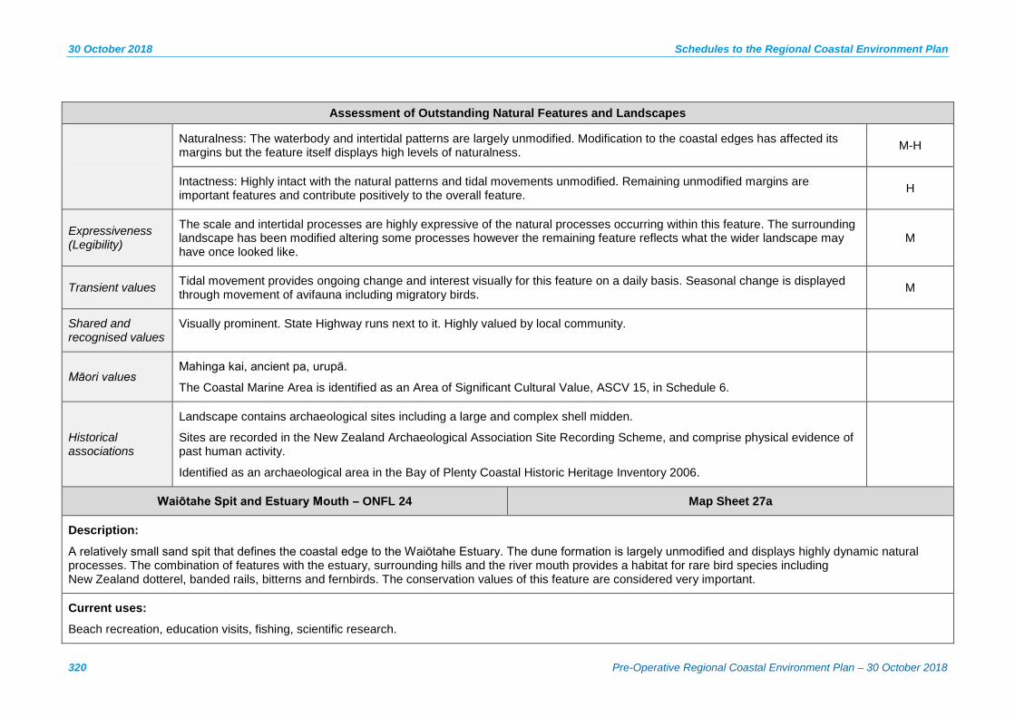
30 October 2018 Schedules to the Regional Coastal Environment Plan
320 Pre-Operative Regional Coastal Environment Plan – 30 October 2018
Assessment of Outstanding Natural Features and Landscapes
Naturalness: The waterbody and intertidal patterns are largely unmodified. Modification to the coastal edges has affected its margins but the feature itself displays high levels of naturalness. M-H
Intactness: Highly intact with the natural patterns and tidal movements unmodified. Remaining unmodified margins are important features and contribute positively to the overall feature. H
Expressiveness (Legibility)
The scale and intertidal processes are highly expressive of the natural processes occurring within this feature. The surrounding landscape has been modified altering some processes however the remaining feature reflects what the wider landscape may have once looked like.
M
Transient values Tidal movement provides ongoing change and interest visually for this feature on a daily basis. Seasonal change is displayed through movement of avifauna including migratory birds. M
Shared and recognised values
Visually prominent. State Highway runs next to it. Highly valued by local community.
Māori values Mahinga kai, ancient pa, urupā.
The Coastal Marine Area is identified as an Area of Significant Cultural Value, ASCV 15, in Schedule 6.
Historical associations
Landscape contains archaeological sites including a large and complex shell midden.
Sites are recorded in the New Zealand Archaeological Association Site Recording Scheme, and comprise physical evidence of past human activity.
Identified as an archaeological area in the Bay of Plenty Coastal Historic Heritage Inventory 2006.
Waiōtahe Spit and Estuary Mouth – ONFL 24 Map Sheet 27a
Description:
A relatively small sand spit that defines the coastal edge to the Waiōtahe Estuary. The dune formation is largely unmodified and displays highly dynamic natural processes. The combination of features with the estuary, surrounding hills and the river mouth provides a habitat for rare bird species including New Zealand dotterel, banded rails, bitterns and fernbirds. The conservation values of this feature are considered very important.
Current uses:
Beach recreation, education visits, fishing, scientific research.
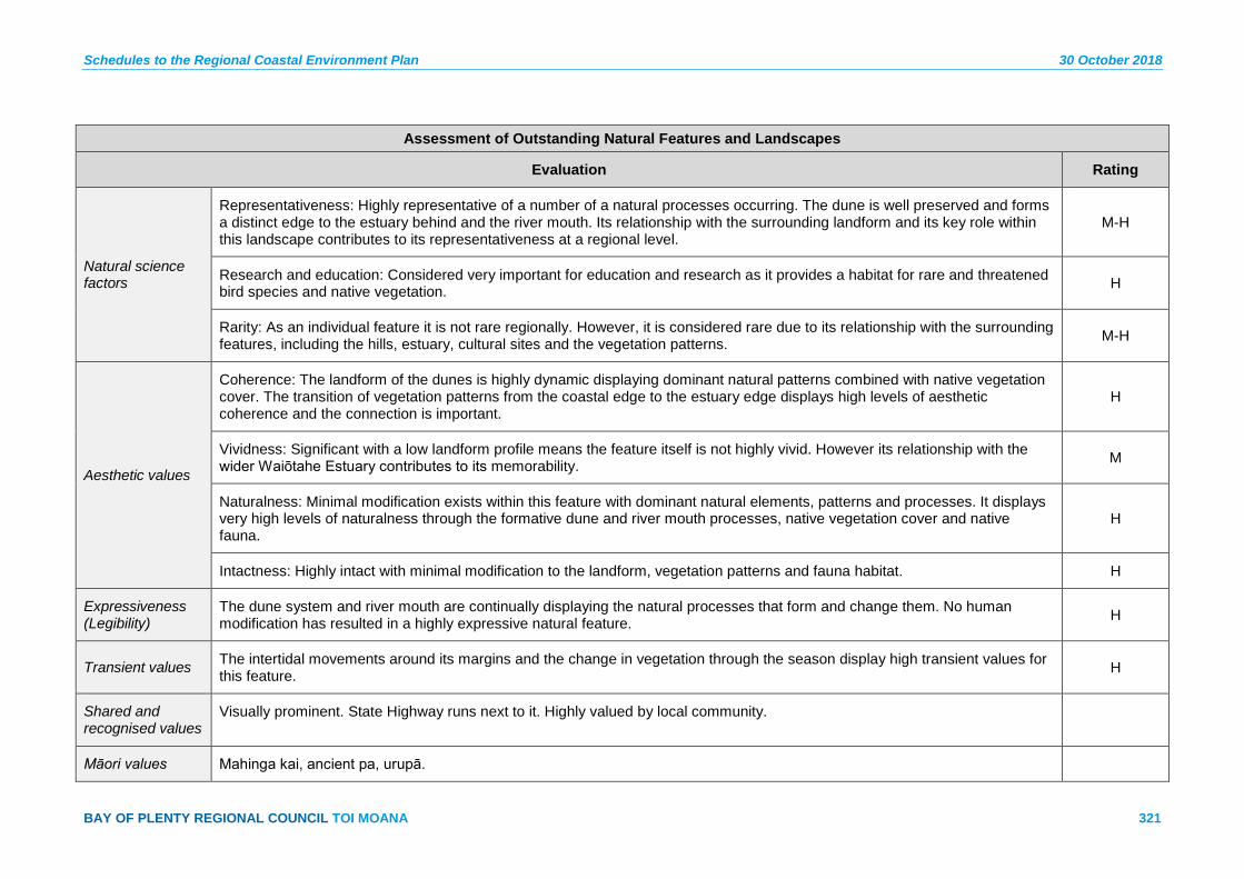
Schedules to the Regional Coastal Environment Plan 30 October 2018
BAY OF PLENTY REGIONAL COUNCIL TOI MOANA 321
Assessment of Outstanding Natural Features and Landscapes
Evaluation Rating
Natural science factors
Representativeness: Highly representative of a number of a natural processes occurring. The dune is well preserved and forms a distinct edge to the estuary behind and the river mouth. Its relationship with the surrounding landform and its key role within this landscape contributes to its representativeness at a regional level.
M-H
Research and education: Considered very important for education and research as it provides a habitat for rare and threatened bird species and native vegetation. H
Rarity: As an individual feature it is not rare regionally. However, it is considered rare due to its relationship with the surrounding features, including the hills, estuary, cultural sites and the vegetation patterns. M-H
Aesthetic values
Coherence: The landform of the dunes is highly dynamic displaying dominant natural patterns combined with native vegetation cover. The transition of vegetation patterns from the coastal edge to the estuary edge displays high levels of aesthetic coherence and the connection is important.
H
Vividness: Significant with a low landform profile means the feature itself is not highly vivid. However its relationship with the wider Waiōtahe Estuary contributes to its memorability. M
Naturalness: Minimal modification exists within this feature with dominant natural elements, patterns and processes. It displays very high levels of naturalness through the formative dune and river mouth processes, native vegetation cover and native fauna.
H
Intactness: Highly intact with minimal modification to the landform, vegetation patterns and fauna habitat. H
Expressiveness (Legibility)
The dune system and river mouth are continually displaying the natural processes that form and change them. No human modification has resulted in a highly expressive natural feature. H
Transient values The intertidal movements around its margins and the change in vegetation through the season display high transient values for this feature. H
Shared and recognised values
Visually prominent. State Highway runs next to it. Highly valued by local community.
Māori values Mahinga kai, ancient pa, urupā.

30 October 2018 Schedules to the Regional Coastal Environment Plan
322 Pre-Operative Regional Coastal Environment Plan – 30 October 2018
Assessment of Outstanding Natural Features and Landscapes
Historical associations
Connections to historical European activity, as forms part of former cattle droving route.
Landscape contains archaeological pa sites, recorded in the New Zealand Archaeological Association Site Recording Scheme, which comprise physical evidence of past human activity.
Landscape is also highly likely to contain buried archaeological sites (with no visible surface features).
Pohutukawa tunnels over SH at Waiōtahe Beach - 25 Map Sheet 27a
Description:
A striking pohutukawa clad coastal edge; this feature is set on either side of State Highway 2 on the coastal edge and escarpment edge. A striking and memorable feature; the dominant element is the mature pohutukawa trees that form a tunnel over the State Highway, creating a gateway to the Waiōtahe settlement and Ōpōtiki District.
Current uses:
Vehicle access.
Evaluation Rating
Natural science factors
Representativeness: The feature displays the natural coastal edge that once occurred along this coastline. The natural landform, whilst modified by the road represents the geomorphology of the region with a layer of native vegetation cover. M-H
Research and education: No particular importance for research and education. L
Rarity: An uncommon feature of this scale along the coastal edge of the region. The location of the road reinforces is rarity and forms one of two within the region. H
Aesthetic values
Coherence: The aesthetic values associated with the tunnel effect of the pohutukawa are a key feature. The mature trees and location on the escarpment reinforce the pattern and tunnel effect. Creating a sense of moving through native bush. M
Vividness: As one of two features of its kind within the region, it is highly memorable as a result of its scale, mature vegetation and the proximity to the road edge. The tunnel effect creates a striking and memorable feature that forms a gateway to Waiōtahe.
H

Schedules to the Regional Coastal Environment Plan 30 October 2018
BAY OF PLENTY REGIONAL COUNCIL TOI MOANA 323
Assessment of Outstanding Natural Features and Landscapes
Naturalness: The natural elements and processes are apparent. However modification to the landform is clear from the road formation. The naturalness remains high for the remaining areas. M-H
Intactness: The natural systems are largely intact however the integration of the road in the feature obstructs some of the natural processes. M
Expressiveness (Legibility)
Not particularly expressive of natural processes but more representative of the contrast between nature and culture. L
Transient values The flowering pohutukawa and other native vegetation display the seasons in a striking way. H
Shared and recognised values
Iconic section of road for local community and tourists. Well known and recognised.
Māori values Pa including ditches and terraces.
Transient values – cultural indicator of readiness of kaimoana (when pohutukawa in bloom).
Historical associations
Landscape contains archaeological sites on cliff top above road. These sites are recorded in the New Zealand Archaeological Association Site Recording Scheme, and comprise physical evidence of past human activity.
Tarekeha Point (Opape) – ONFL 26 Map Sheet 29a
Description:
Tarekeha Point is a prominent headland at the eastern end of the Tirohanga straights. It defines the end of the Ōpōtiki coastline and provides a dominant natural backdrop to the agricultural landuse to the west. The rocky shoreline and striking ridge covered in native bush cover contrast with the sandy shoreline and lowland plains to the west.
Current uses:
Minor recreational access to coastal edge.

30 October 2018 Schedules to the Regional Coastal Environment Plan
324 Pre-Operative Regional Coastal Environment Plan – 30 October 2018
Assessment of Outstanding Natural Features and Landscapes
Evaluation Rating
Natural science factors
Representativeness: Prominent headland defining the eastern end of a long open beach coastline east of Ōpōtiki. The indigenous vegetation cover extends from the shoreline over the entire feature and is bound by the State Highway to the south. The landform remains unmodified with some remnant and regenerating native bush. It is representative of typical coastal headlands in this part of the region.
M-H
Research and education: No particular importance for research and education. L
Rarity: Not rare at a regional level in this part of the region. L
Aesthetic values
Coherence: Entire landform feature is covered in native bush with a small pocket horticultural land along the toe of its eastern slope. The landform combined with the vegetation patterns provides a highly coherent and visually aesthetic feature. H
Vividness: Its location and contrast with the adjoining coastal plains makes this feature memorable. It forms the beginning of the Eastern Bay of Plenty’s distinctive and contiguous rocky coastline. M
Naturalness: Unmodified landform and native vegetation cover, the feature displays dominant natural processes, patterns and elements. Human modification exists only around the features margins, with no visible access tracks into the feature. The species diversity is high because of a range of vegetation types and sequences which support a wide range of bird species and critically endangered plant species.
H
Intactness: The natural systems are largely intact with no obstructions to the natural vegetation sequence and habitat use by fauna. M-H
Expressiveness (Legibility)
The striking landform and vegetation sequence is expressive of the natural processes and elements that have formed this landscape feature. M
Transient values Pohutukawa flowering and native bush flowering displays changes in seasons. The coastal edge and rocky shoreline provides dramatic displays of the changing coastal conditions. L-M
Shared and recognised values
Prominent feature. First impression of elevated indigenous vegetation along this section of State Highway.
Māori values Ancient pa.
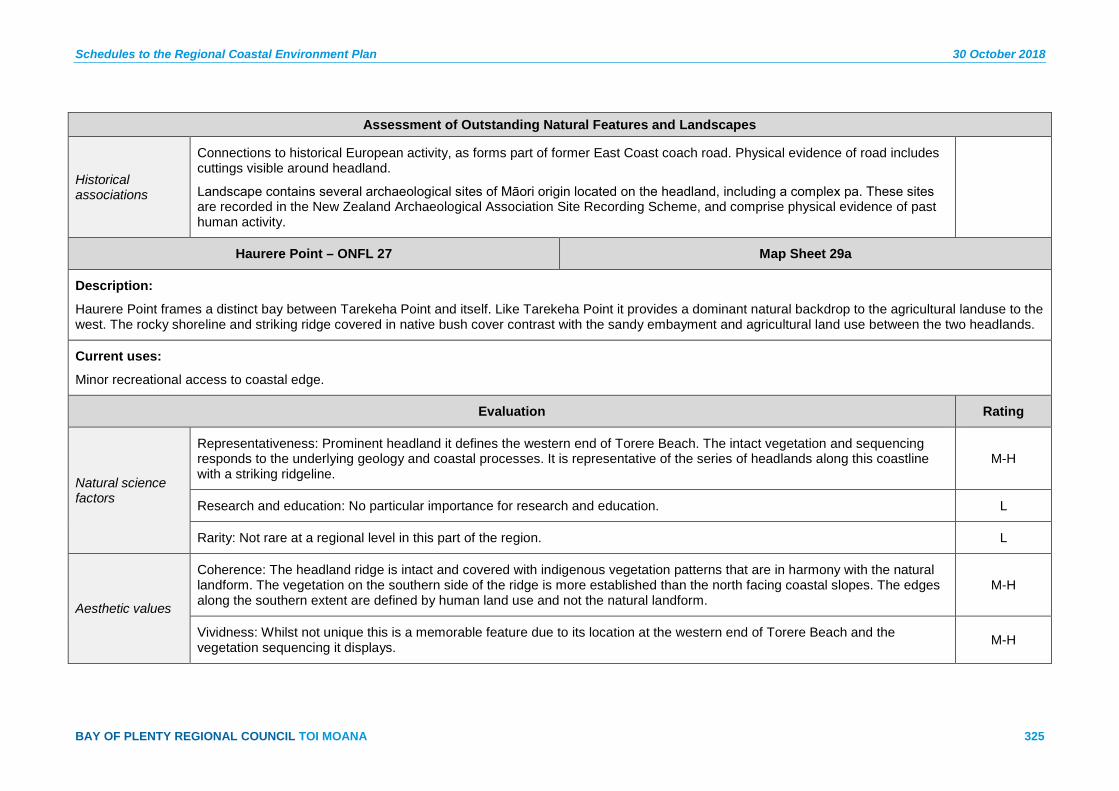
Schedules to the Regional Coastal Environment Plan 30 October 2018
BAY OF PLENTY REGIONAL COUNCIL TOI MOANA 325
Assessment of Outstanding Natural Features and Landscapes
Historical associations
Connections to historical European activity, as forms part of former East Coast coach road. Physical evidence of road includes cuttings visible around headland.
Landscape contains several archaeological sites of Māori origin located on the headland, including a complex pa. These sites are recorded in the New Zealand Archaeological Association Site Recording Scheme, and comprise physical evidence of past human activity.
Haurere Point – ONFL 27 Map Sheet 29a
Description:
Haurere Point frames a distinct bay between Tarekeha Point and itself. Like Tarekeha Point it provides a dominant natural backdrop to the agricultural landuse to the west. The rocky shoreline and striking ridge covered in native bush cover contrast with the sandy embayment and agricultural land use between the two headlands.
Current uses:
Minor recreational access to coastal edge.
Evaluation Rating
Natural science factors
Representativeness: Prominent headland it defines the western end of Torere Beach. The intact vegetation and sequencing responds to the underlying geology and coastal processes. It is representative of the series of headlands along this coastline with a striking ridgeline.
M-H
Research and education: No particular importance for research and education. L
Rarity: Not rare at a regional level in this part of the region. L
Aesthetic values
Coherence: The headland ridge is intact and covered with indigenous vegetation patterns that are in harmony with the natural landform. The vegetation on the southern side of the ridge is more established than the north facing coastal slopes. The edges along the southern extent are defined by human land use and not the natural landform.
M-H
Vividness: Whilst not unique this is a memorable feature due to its location at the western end of Torere Beach and the vegetation sequencing it displays. M-H

30 October 2018 Schedules to the Regional Coastal Environment Plan
326 Pre-Operative Regional Coastal Environment Plan – 30 October 2018
Assessment of Outstanding Natural Features and Landscapes
Naturalness: Unmodified landform and native vegetation cover, the feature displays dominant natural processes, patterns and elements. Human modification exists only around the features margins, with no visible access tracks into the feature. The species diversity is high because of a range of vegetation types and sequences which support a wide range of bird species and critically endangered plant species.
H
Intactness: The natural systems are largely intact with no obstructions to the natural vegetation sequence and habitat use by fauna. H
Expressiveness (Legibility)
The landform and vegetation sequences are highly expressive of the geomorphology and natural processes that are occurring. The change in vegetation patterns is expressive of the coastal winds and exposure, differing soil conditions and coastal erosion that affect this feature.
M-H
Transient values Pohutukawa flowering and native bush flowering displays changes in seasons. The coastal edge and rocky shoreline provide dramatic displays of the changing coastal conditions. L-M
Shared and recognised values
Visible from State Highway. Defines southern end of Torere Beach.
Māori values Mahinga kai, urupā.
Historical associations
Landscape is highly likely to contain buried archaeological sites (with no visible surface features) which are physical evidence of past human activity.
Pehitariri Point – ONFL 28 Map Sheet 30a
Description:
Pehitairi Point frames Torere Bay between Haurere Point and itself. Like Tarekeha Point it provides a dominant natural backdrop to the agricultural landuse to the east and west. The rocky shoreline and striking ridge covered in native bush cover contrast with the sandy embayment and agricultural land use between the two headlands. The wider ridgeline extending further inland has been subject to pockets of pine forestry disrupting the overall headlands vegetation sequencing.
Current uses:
Minor recreational access to coastal edge.
Assessment of Outstanding Natural Features and Landscapes
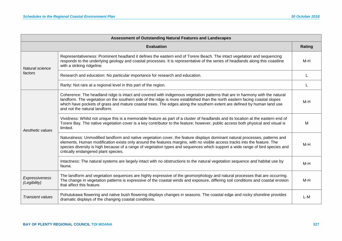
Schedules to the Regional Coastal Environment Plan 30 October 2018
BAY OF PLENTY REGIONAL COUNCIL TOI MOANA 327
Assessment of Outstanding Natural Features and Landscapes
Evaluation Rating
Natural science factors
Representativeness: Prominent headland it defines the eastern end of Torere Beach. The intact vegetation and sequencing responds to the underlying geology and coastal processes. It is representative of the series of headlands along this coastline with a striking ridgeline.
M-H
Research and education: No particular importance for research and education. L
Rarity: Not rare at a regional level in this part of the region. L
Aesthetic values
Coherence: The headland ridge is intact and covered with indigenous vegetation patterns that are in harmony with the natural landform. The vegetation on the southern side of the ridge is more established than the north eastern facing coastal slopes which have pockets of grass and mature coastal trees. The edges along the southern extent are defined by human land use and not the natural landform.
M-H
Vividness: Whilst not unique this is a memorable feature as part of a cluster of headlands and its location at the eastern end of Torere Bay. The native vegetation cover is a key contributor to the feature; however, public access both physical and visual is limited.
M
Naturalness: Unmodified landform and native vegetation cover, the feature displays dominant natural processes, patterns and elements. Human modification exists only around the features margins, with no visible access tracks into the feature. The species diversity is high because of a range of vegetation types and sequences which support a wide range of bird species and critically endangered plant species.
M-H
Intactness: The natural systems are largely intact with no obstructions to the natural vegetation sequence and habitat use by fauna. M-H
Expressiveness (Legibility)
The landform and vegetation sequences are highly expressive of the geomorphology and natural processes that are occurring. The change in vegetation patterns is expressive of the coastal winds and exposure, differing soil conditions and coastal erosion that affect this feature.
M-H
Transient values Pohutukawa flowering and native bush flowering displays changes in seasons. The coastal edge and rocky shoreline provides dramatic displays of the changing coastal conditions. L-M
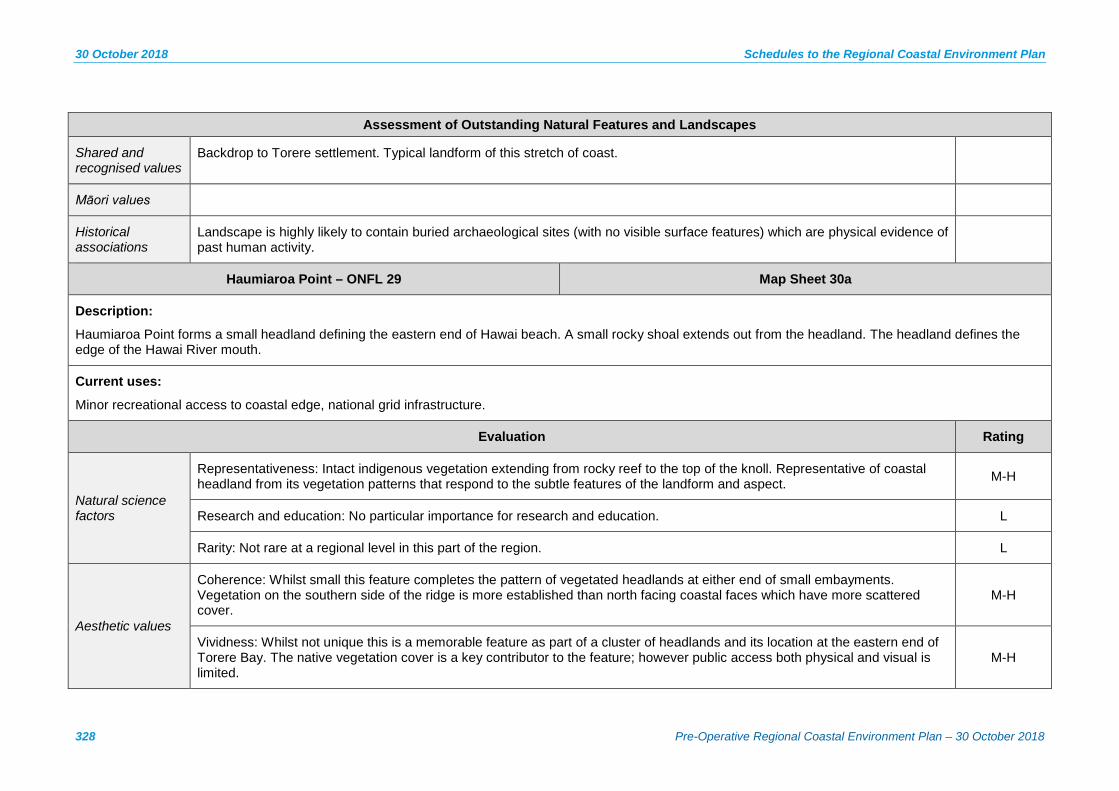
30 October 2018 Schedules to the Regional Coastal Environment Plan
328 Pre-Operative Regional Coastal Environment Plan – 30 October 2018
Assessment of Outstanding Natural Features and Landscapes
Shared and recognised values
Backdrop to Torere settlement. Typical landform of this stretch of coast.
Māori values
Historical associations
Landscape is highly likely to contain buried archaeological sites (with no visible surface features) which are physical evidence of past human activity.
Haumiaroa Point – ONFL 29 Map Sheet 30a
Description:
Haumiaroa Point forms a small headland defining the eastern end of Hawai beach. A small rocky shoal extends out from the headland. The headland defines the edge of the Hawai River mouth.
Current uses:
Minor recreational access to coastal edge, national grid infrastructure.
Evaluation Rating
Natural science factors
Representativeness: Intact indigenous vegetation extending from rocky reef to the top of the knoll. Representative of coastal headland from its vegetation patterns that respond to the subtle features of the landform and aspect. M-H
Research and education: No particular importance for research and education. L
Rarity: Not rare at a regional level in this part of the region. L
Aesthetic values
Coherence: Whilst small this feature completes the pattern of vegetated headlands at either end of small embayments. Vegetation on the southern side of the ridge is more established than north facing coastal faces which have more scattered cover.
M-H
Vividness: Whilst not unique this is a memorable feature as part of a cluster of headlands and its location at the eastern end of Torere Bay. The native vegetation cover is a key contributor to the feature; however public access both physical and visual is limited.
M-H
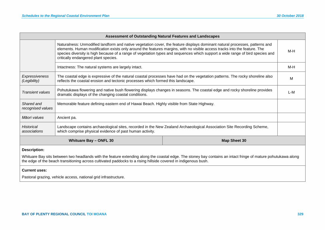
Schedules to the Regional Coastal Environment Plan 30 October 2018
BAY OF PLENTY REGIONAL COUNCIL TOI MOANA 329
Assessment of Outstanding Natural Features and Landscapes
Naturalness: Unmodified landform and native vegetation cover, the feature displays dominant natural processes, patterns and elements. Human modification exists only around the features margins, with no visible access tracks into the feature. The species diversity is high because of a range of vegetation types and sequences which support a wide range of bird species and critically endangered plant species.
M-H
Intactness: The natural systems are largely intact. M-H
Expressiveness (Legibility)
The coastal edge is expressive of the natural coastal processes have had on the vegetation patterns. The rocky shoreline also reflects the coastal erosion and tectonic processes which formed this landscape. M
Transient values Pohutukawa flowering and native bush flowering displays changes in seasons. The coastal edge and rocky shoreline provides dramatic displays of the changing coastal conditions. L-M
Shared and recognised values
Memorable feature defining eastern end of Hawai Beach. Highly visible from State Highway.
Māori values Ancient pa.
Historical associations
Landscape contains archaeological sites, recorded in the New Zealand Archaeological Association Site Recording Scheme, which comprise physical evidence of past human activity.
Whituare Bay – ONFL 30 Map Sheet 30
Description:
Whituare Bay sits between two headlands with the feature extending along the coastal edge. The stoney bay contains an intact fringe of mature pohutukawa along the edge of the beach transitioning across cultivated paddocks to a rising hillside covered in indigenous bush.
Current uses:
Pastoral grazing, vehicle access, national grid infrastructure.
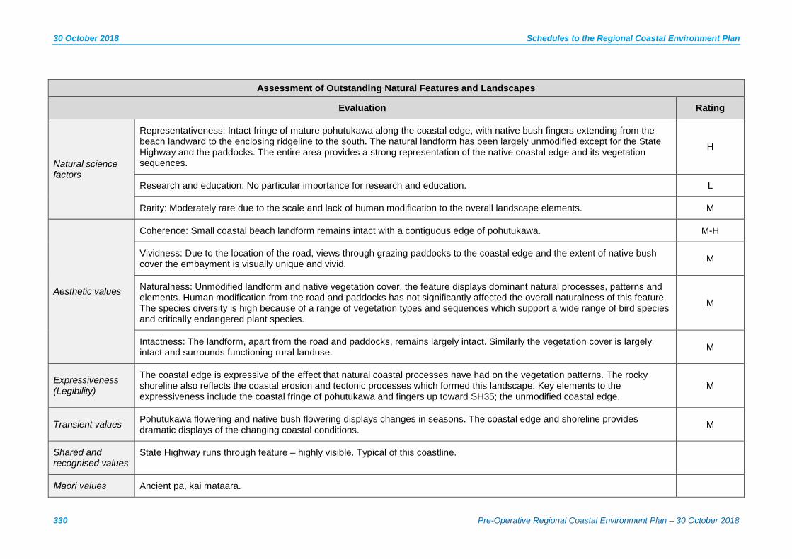
30 October 2018 Schedules to the Regional Coastal Environment Plan
330 Pre-Operative Regional Coastal Environment Plan – 30 October 2018
Assessment of Outstanding Natural Features and Landscapes
Evaluation Rating
Natural science factors
Representativeness: Intact fringe of mature pohutukawa along the coastal edge, with native bush fingers extending from the beach landward to the enclosing ridgeline to the south. The natural landform has been largely unmodified except for the State Highway and the paddocks. The entire area provides a strong representation of the native coastal edge and its vegetation sequences.
H
Research and education: No particular importance for research and education. L
Rarity: Moderately rare due to the scale and lack of human modification to the overall landscape elements. M
Aesthetic values
Coherence: Small coastal beach landform remains intact with a contiguous edge of pohutukawa. M-H
Vividness: Due to the location of the road, views through grazing paddocks to the coastal edge and the extent of native bush cover the embayment is visually unique and vivid. M
Naturalness: Unmodified landform and native vegetation cover, the feature displays dominant natural processes, patterns and elements. Human modification from the road and paddocks has not significantly affected the overall naturalness of this feature. The species diversity is high because of a range of vegetation types and sequences which support a wide range of bird species and critically endangered plant species.
M
Intactness: The landform, apart from the road and paddocks, remains largely intact. Similarly the vegetation cover is largely intact and surrounds functioning rural landuse. M
Expressiveness (Legibility)
The coastal edge is expressive of the effect that natural coastal processes have had on the vegetation patterns. The rocky shoreline also reflects the coastal erosion and tectonic processes which formed this landscape. Key elements to the expressiveness include the coastal fringe of pohutukawa and fingers up toward SH35; the unmodified coastal edge.
M
Transient values Pohutukawa flowering and native bush flowering displays changes in seasons. The coastal edge and shoreline provides dramatic displays of the changing coastal conditions. M
Shared and recognised values
State Highway runs through feature – highly visible. Typical of this coastline.
Māori values Ancient pa, kai mataara.
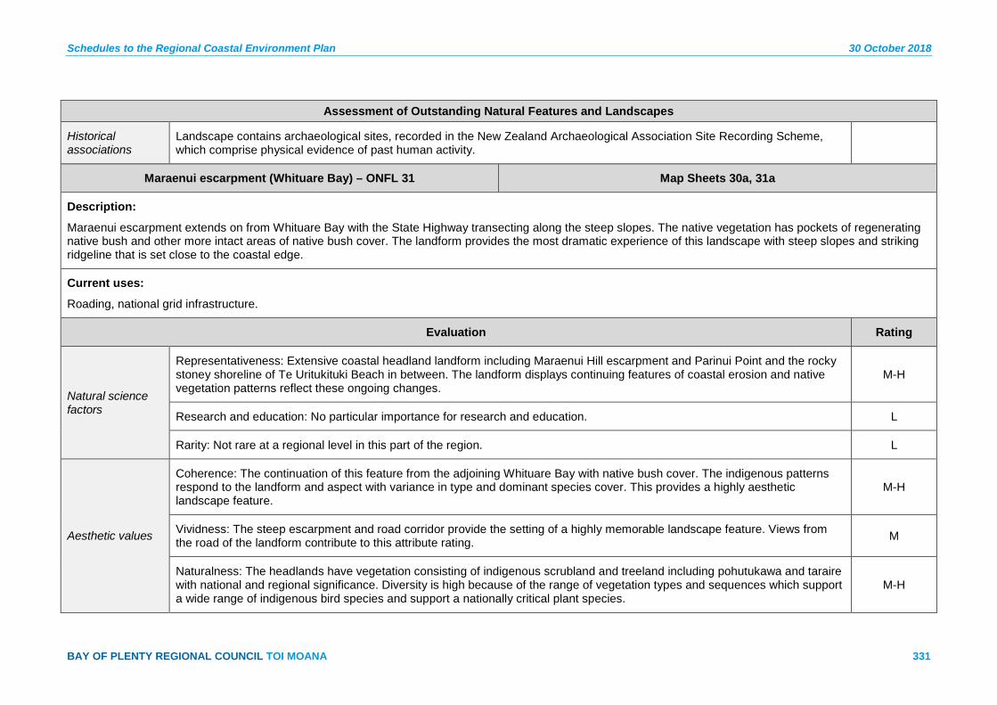
Schedules to the Regional Coastal Environment Plan 30 October 2018
BAY OF PLENTY REGIONAL COUNCIL TOI MOANA 331
Assessment of Outstanding Natural Features and Landscapes
Historical associations
Landscape contains archaeological sites, recorded in the New Zealand Archaeological Association Site Recording Scheme, which comprise physical evidence of past human activity.
Maraenui escarpment (Whituare Bay) – ONFL 31 Map Sheets 30a, 31a
Description:
Maraenui escarpment extends on from Whituare Bay with the State Highway transecting along the steep slopes. The native vegetation has pockets of regenerating native bush and other more intact areas of native bush cover. The landform provides the most dramatic experience of this landscape with steep slopes and striking ridgeline that is set close to the coastal edge.
Current uses:
Roading, national grid infrastructure.
Evaluation Rating
Natural science factors
Representativeness: Extensive coastal headland landform including Maraenui Hill escarpment and Parinui Point and the rocky stoney shoreline of Te Uritukituki Beach in between. The landform displays continuing features of coastal erosion and native vegetation patterns reflect these ongoing changes.
M-H
Research and education: No particular importance for research and education. L
Rarity: Not rare at a regional level in this part of the region. L
Aesthetic values
Coherence: The continuation of this feature from the adjoining Whituare Bay with native bush cover. The indigenous patterns respond to the landform and aspect with variance in type and dominant species cover. This provides a highly aesthetic landscape feature.
M-H
Vividness: The steep escarpment and road corridor provide the setting of a highly memorable landscape feature. Views from the road of the landform contribute to this attribute rating. M
Naturalness: The headlands have vegetation consisting of indigenous scrubland and treeland including pohutukawa and taraire with national and regional significance. Diversity is high because of the range of vegetation types and sequences which support a wide range of indigenous bird species and support a nationally critical plant species.
M-H

30 October 2018 Schedules to the Regional Coastal Environment Plan
332 Pre-Operative Regional Coastal Environment Plan – 30 October 2018
Assessment of Outstanding Natural Features and Landscapes
Intactness: Largely intact natural systems with the exception of the road corridor and associated drainage and earthworks. The remainder of the feature is visually intact and highly aesthetic. M
Expressiveness (Legibility)
The landform and vegetation sequences are highly expressive of the geomorphology and natural processes that are occurring. The change in vegetation patterns is expressive of the coastal winds and exposure, differing soil conditions and coastal erosion that affect this feature.
M-H
Transient values Pohutukawa flowering and native bush flowering displays changes in seasons. The coastal edge and rocky shoreline provides dramatic displays of the changing coastal conditions. L-M
Shared and recognised values
Typical but significant in defining the sense of place on this stretch of State Highway.
Māori values Ancient pa.
Historical associations
Landscape contains archaeological sites, recorded in the New Zealand Archaeological Association Site Recording Scheme, which comprise physical evidence of past human activity.
Motu River Mouth – ONFL 32 Map Sheet 31a
Description:
The Motu River remains an unmodified feature of the coastal edge, with its vegetation cover a mixture of native and exotic species. The river patterns are constantly changing, with the river mouth forming a shingle barrier between the coastal waters and the river course.
Current uses:
National grid infrastructure, fishing, walking, boating, white water rafting.
Evaluation Rating
Natural science factors
Representativeness: The scale of this river mouth creates a highly distinctive and recognisable river mouth. The backdrop of Tokata Point further defines the feature along with the wide river plains to the west. The shingle barrier at the river mouth is the largest in the region and representative of the river mouths in the Eastern Bay of Plenty.
H

Schedules to the Regional Coastal Environment Plan 30 October 2018
BAY OF PLENTY REGIONAL COUNCIL TOI MOANA 333
Assessment of Outstanding Natural Features and Landscapes
Research and education: Access to the feature provides numerous opportunities for research and education on the river system and coastal erosion. The wider Motu River catchment includes some observations on Hochstetter’s frog in the catchment. M
Rarity: Not rare as the type of river mouth but the scale is rare in the region. M
Aesthetic values
Coherence: The area includes small blocks of pastoral land use and sediment deposition from slip clearance. The unmodified river mouth provides a highly aesthetic series of braided patterns complimented by the backdrop of native bush of the adjoining escarpment.
H
Vividness: The scale of the feature provides a highly memorable feature with the relationship between the river bed, its margins and bush covered clad escarpment to the east forming a highly vivid feature H
Naturalness: The Motu River displays dynamic natural processes occurring at the river mouth entrance with an undefined channel. In many places the river exits through the shingle bank along the coastal shoreline. The Motu River is notable for high wildlife value supporting threatened indigenous fish and bird species and is of national significance.
H
Intactness: Largely intact and highly aesthetic with pockets of weed infestation. Rural land uses, land fill and vehicle access detract from the sequencing of native vegetation cover. M-H
Expressiveness (Legibility)
The dynamic coastal processes and braided river system with a closed shingle barrier are highly expressive of the natural environment. Minimal modification has occurred to this feature which in turn reinforces its expressiveness. H
Transient values Changes in river levels and braided river bed patterns display moderate transient values, providing interest to the viewer. The native bush cover also provides seasonal change and interest. M-H
Shared and recognised values
Highly recognised and valued feature.
Māori values Ancient pa, urupā, mahinga kai, taunga ika.
Historical associations
Strong historic association with mass drowning tragedy in 1900.
Landscape contains archaeological sites, recorded in the New Zealand Archaeological Association Site Recording Scheme, which comprise physical evidence of past human activity.
Identified as an archaeological area in the Coastal Historic Heritage Inventory 2006.

30 October 2018 Schedules to the Regional Coastal Environment Plan
334 Pre-Operative Regional Coastal Environment Plan – 30 October 2018
Assessment of Outstanding Natural Features and Landscapes
Orangoihuinui Point and Whitianga Bay, Whitianga Bay to Ohae Point – 33 Map Sheet 32a
Description:
Largely intact coastal headland extending from Tokata Point including the immediate rocky stoney shoreline along to Ohae Point. The area includes steep coastal escarpments and raised coastal plateau.
Current uses:
Stock grazing, roading, recreational access and some housing, national grid infrastructure.
Evaluation Rating
Natural science factors
Representativeness: The continuous coastal edge is representative of the geomorphological processes that formed the landscape. The native bush extending along the coastal edge is representative of the area. M-H
Research and education: No particular importance for research and education. L
Rarity: Not rare at a regional level in this part of the region. L
Aesthetic values
Coherence: The sequencing of landform and vegetation patterns is a key contributor to the aesthetic qualities of this landscape the connection of bush across the State Highway and the fringe of mature native vegetation along the coastal edge are key factors.
M-H
Vividness: The proximity of the road and native vegetation cover, pocketed views and large areas of uninterrupted bush clad hills creates a highly memorable landscape feature. M-H
Naturalness: The headlands have vegetation consisting of indigenous scrubland and treeland including pohutukawa and taraire with national and regional significance. Diversity is high because of the range of vegetation types and sequences which support a wide range of indigenous bird species and support a nationally critical plant species. Pockets of residential dwellings and the road detract from the naturalness but are set in discrete pockets and nestle into the feature.
M-H
Intactness: Largely intact natural systems with the exception of the road corridor and associated drainage and earthworks. The remainder of the feature is visually intact and highly aesthetic. M-H
Schedules to the Regional Coastal Environment Plan 30 October 2018
BAY OF PLENTY REGIONAL COUNCIL TOI MOANA 335
Assessment of Outstanding Natural Features and Landscapes
Expressiveness (Legibility)
The landform and vegetation sequences are highly expressive of the geomorphology and natural processes that are occurring. The change in vegetation patterns is expressive of the coastal winds and exposure, differing soil conditions and coastal erosion that affect this feature.
M-H
Transient values Pohutukawa flowering and native bush flowering displays changes in seasons. The coastal edge and rocky shoreline provides dramatic displays of the changing coastal conditions. L-M
Shared and recognised values
Highly valued and recognised sequence of coastal landscape, part of a series of rocky shoreline headlands along eastern coastline.
Māori values Mahinga kai, taunga ika.
Historical associations
Landscape contains archaeological sites, recorded in the New Zealand Archaeological Association Site Recording Scheme, which comprise physical evidence of past human activity.
Motunui Island and Associated Reefs – ONFL 34 Map Sheet 33a
Description:
Known for its small rocky island with native vegetation the area extends to incorporate rocky shore and intertidal rocky platforms. The coastal fringe of mature pohutukawa extends along the edge and provides a distinctive and well defined coastal edge.
Current uses:
Fishing, walking, recreational access.
Evaluation Rating
Natural science factors
Representativeness: The small rocky island and the continuing rocky platforms along the coastal edge, lined with pohutukawa trees is representative of the coastal edge of this part of the region. The natural coastal and tectonic processes are apparent along the rocky edge.
M-H
Research and education: No particular importance for research and education. L
Rarity: Not rare but a significant example of its type as a result of its scale. L

30 October 2018 Schedules to the Regional Coastal Environment Plan
336 Pre-Operative Regional Coastal Environment Plan – 30 October 2018
Assessment of Outstanding Natural Features and Landscapes
Aesthetic values
Coherence: The series of rocky platforms, Motunui Island and the continuous edge of mature pohutukawa trees creates a highly aesthetic coastal edge. H
Vividness: The combination of the island, rocky shelves and pohutukawa clad edge create a highly vivid feature. Whilst not unique on its own the island creates a sense of place that is distinctive. H
Naturalness: The unmodified series of landform features with intact fringe of coastal vegetation remains highly natural. The proximity of modified land use has affected the naturalness of the overall feature but it still remains high. M-H
Intactness: Intact coastal edge with modified pastoral backdrop. It is highly aesthetic and as its own feature remains largely intact. M-H
Expressiveness (Legibility)
The rocky reef platforms, the island and small gullies that connect to it create a coastal edge that is highly expressive of the natural processes that have formed it. M
Transient values Pohutukawa flowering and native bush flowering displays changes in seasons. The coastal edge and rocky shoreline provides dramatic displays of the changing coastal conditions.
Shared and recognised values
Highly valued and recognised sequence of coastal landscape, part of a series of rocky shoreline headlands along eastern coastline.
Māori values Ancient pa, urupā.
Historical associations
Landscape contains archaeological sites, recorded in the New Zealand Archaeological Association Site Recording Scheme, which comprise physical evidence of past human activity.
Whanarua Bay – ONFL 35 Map Sheet 35a
Description:
This area is a sequence of rocky intertidal reefs and shelves with pohutukawa clad headlands and embayments. The area excludes the settled areas of the bay but includes some pastoral land along the coast where it reinforces the natural landform.
Current uses:
Roading, walking, fishing, boat access.
Schedules to the Regional Coastal Environment Plan 30 October 2018
BAY OF PLENTY REGIONAL COUNCIL TOI MOANA 337
Assessment of Outstanding Natural Features and Landscapes
Evaluation Rating
Natural science factors
Representativeness: The broader landscape is a dominant feature in the overall headland and embayment of Whanarua Bay. The dominant ridgeline and native bush cover forms a landscape unit that is representative of the natural systems and processes that occur along this coastline.
H
Research and education: No particular importance for research and education. But displays unmodified river mouth which may provide opportunity for research along with the coastal margins and native bush cover. L-M
Rarity: Not rare but a significant example of its type as a result of its scale. M
Aesthetic values
Coherence: Coastal landform sequence of intertidal reefs, headlands, beach bay and coastal ridge as a backdrop to an area of intact native vegetation cover with natural patterns that in in harmony with the landscape and highly aesthetic. M
Vividness: Memorable and aesthetic sequence of coastal landscape and inland backdrop. This forms part of a series of rocky shoreline headlands and vegetated backdrop along the east coast. Its scale is of particular importance to its vividness. M-H
Naturalness: Relatively unmodified series of landform features with intact cover of regenerating native vegetation. The settlement areas detract from the naturalness and are not included in the area. M
Intactness: Largely intact naturally functioning systems. The native vegetation cover, unmodified hydrology set alongside some pastoral farming retains a moderate level of intactness. M
Expressiveness (Legibility)
Largely intact sequence of coastal landform, intertidal reefs, rocky headlands, bays and beaches with a large native bush backdrop is expressive of the sequencing of natural systems of this coastline. M
Transient values Pohutukawa flowering and native bush flowering displays changes in seasons. The coastal edge and rocky shoreline provides dramatic displays of the changing coastal conditions. M
Shared and recognised values
Highly valued and recognised sequence of coastal landscape, part of a series of rocky shoreline headlands along eastern coastline.
Māori values Ancient pa, kāinga, mahinga kai, urupā, ana taonga.
30 October 2018 Schedules to the Regional Coastal Environment Plan
338 Pre-Operative Regional Coastal Environment Plan – 30 October 2018
Assessment of Outstanding Natural Features and Landscapes
Historical associations
Landscape contains archaeological sites, recorded in the New Zealand Archaeological Association Site Recording Scheme, which comprise physical evidence of past human activity.
Raukokere River Mouth – ONFL 36 Map Sheet 36a
Description:
The Raukokore River mouth remains unmodified and demonstrates the natural river patterns and processes of other rivers along this part of the coast. The coastal lagoon is a distinctive feature and is one of few unmodified features in the region.
Current uses:
Fishing, walking, vehicle access, residential dwellings.
Evaluation Rating
Natural science factors
Representativeness: The combination of the shingle barrier river mouth lagoon and wide beach forms a highly distinctive braided river mouth feature. These features are representative of the natural processes that continue unmodified. H
Research and Education: No particular importance for research and education. But displays unmodified river mouth which may provide opportunity for research. M
Rarity: Not rare but a significant example of its type as a result of its scale. The lagoon is a unique feature and relatively rare in its unmodified state. M
Aesthetic values
Coherence: The feature includes small areas of grazing related to coastal and river flats and remnant patches of Kahikatea. The braided river and shingle barrier river mouth and lagoon remain in an unmodified state. M-H
Vividness: The proximity of the road and native vegetation cover, pocketed views of the river mouth set against the bush clad backdrop on the western side creates a highly memorable feature. Connectivity of the bush margins with the river edge contributes to this.
M
Naturalness: The Raukokore River is notable for outstanding wildlife value supporting threatened indigenous fish species and is of regional significance. It displays dynamic natural processes occurring at river mouth entrance with an undefined channel. In many places the river exits through the shingle bank along the coastal shoreline.
M-H
Schedules to the Regional Coastal Environment Plan 30 October 2018
BAY OF PLENTY REGIONAL COUNCIL TOI MOANA 339
Assessment of Outstanding Natural Features and Landscapes
Intactness: The natural systems are largely intact with some of the margins modified due to agricultural landuse and roading access, along with some pockets of residential dwellings. The remainder of the feature remains largely intact with some weed infestation.
M-H
Expressiveness (Legibility)
The dynamic coastal processes and braided river system with a closed shingle barrier are highly expressive of the natural environment. Minimal modification has occurred to this feature which in turn reinforces its expressiveness. M-H
Transient values Changes in river levels and braided river bed patterns display moderate transient values, providing interest to the viewer. The native bush cover also provides seasonal change and interest.
Shared and recognised values
Highly valued and recognised. Strong community connections. Visible from State Highway.
Māori values Ancient pa, mahinga kai, taunga ika, urupā. Mataitai Reserve.
Historical associations
Connections to historical shore whaling activity.
Identified as an archaeological area in Coastal Historic Heritage Inventory 2006.
Landscape is highly likely to contain buried archaeological sites with no visible surface features. Archaeological sites comprise physical evidence of past human activity.
Oruaiti Beach, offshore rocks and Waikanapanapa Cliffs – ONFL 37 Map Sheet 37a
Description:
The area extends from the rocky shoreline west of Oruaiti Beach to incorporate beach, associated dunes, rocky headland of Te Ahikehe Point and the shoreline east of Waikanapanapa. The rock shelves and intertidal reefs are distinctive and memorable features of this part of the region.
Current uses:
Beach recreation, education visits, fishing, scientific research.
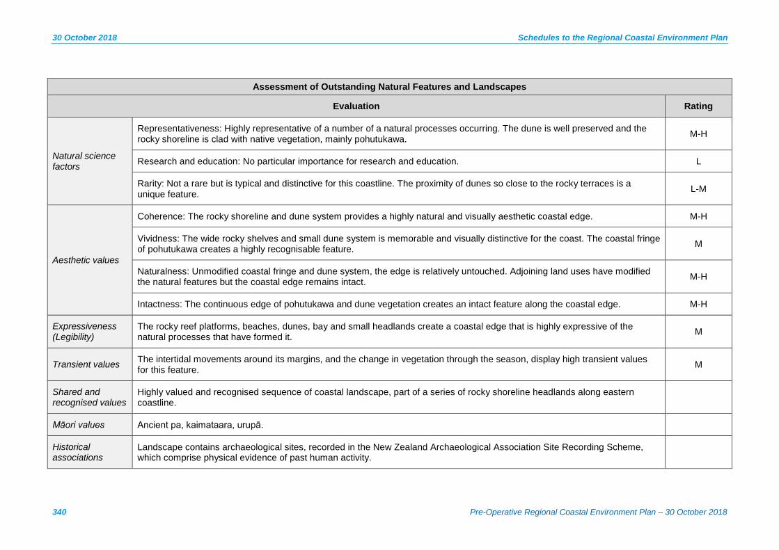
30 October 2018 Schedules to the Regional Coastal Environment Plan
340 Pre-Operative Regional Coastal Environment Plan – 30 October 2018
Assessment of Outstanding Natural Features and Landscapes
Evaluation Rating
Natural science factors
Representativeness: Highly representative of a number of a natural processes occurring. The dune is well preserved and the rocky shoreline is clad with native vegetation, mainly pohutukawa. M-H
Research and education: No particular importance for research and education. L
Rarity: Not a rare but is typical and distinctive for this coastline. The proximity of dunes so close to the rocky terraces is a unique feature. L-M
Aesthetic values
Coherence: The rocky shoreline and dune system provides a highly natural and visually aesthetic coastal edge. M-H
Vividness: The wide rocky shelves and small dune system is memorable and visually distinctive for the coast. The coastal fringe of pohutukawa creates a highly recognisable feature. M
Naturalness: Unmodified coastal fringe and dune system, the edge is relatively untouched. Adjoining land uses have modified the natural features but the coastal edge remains intact. M-H
Intactness: The continuous edge of pohutukawa and dune vegetation creates an intact feature along the coastal edge. M-H
Expressiveness (Legibility)
The rocky reef platforms, beaches, dunes, bay and small headlands create a coastal edge that is highly expressive of the natural processes that have formed it. M
Transient values The intertidal movements around its margins, and the change in vegetation through the season, display high transient values for this feature. M
Shared and recognised values
Highly valued and recognised sequence of coastal landscape, part of a series of rocky shoreline headlands along eastern coastline.
Māori values Ancient pa, kaimataara, urupā.
Historical associations
Landscape contains archaeological sites, recorded in the New Zealand Archaeological Association Site Recording Scheme, which comprise physical evidence of past human activity.
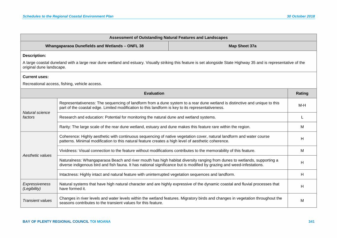
Schedules to the Regional Coastal Environment Plan 30 October 2018
BAY OF PLENTY REGIONAL COUNCIL TOI MOANA 341
Assessment of Outstanding Natural Features and Landscapes
Whangaparaoa Dunefields and Wetlands – ONFL 38 Map Sheet 37a
Description:
A large coastal duneland with a large rear dune wetland and estuary. Visually striking this feature is set alongside State Highway 35 and is representative of the original dune landscape.
Current uses:
Recreational access, fishing, vehicle access.
Evaluation Rating
Natural science factors
Representativeness: The sequencing of landform from a dune system to a rear dune wetland is distinctive and unique to this part of the coastal edge. Limited modification to this landform is key to its representativeness. M-H
Research and education: Potential for monitoring the natural dune and wetland systems. L
Rarity: The large scale of the rear dune wetland, estuary and dune makes this feature rare within the region. M
Aesthetic values
Coherence: Highly aesthetic with continuous sequencing of native vegetation cover, natural landform and water course patterns. Minimal modification to this natural feature creates a high level of aesthetic coherence. H
Vividness: Visual connection to the feature without modifications contributes to the memorability of this feature. M
Naturalness: Whangaparaoa Beach and river mouth has high habitat diversity ranging from dunes to wetlands, supporting a diverse indigenous bird and fish fauna. It has national significance but is modified by grazing and weed-infestations. H
Intactness: Highly intact and natural feature with uninterrupted vegetation sequences and landform. H
Expressiveness (Legibility)
Natural systems that have high natural character and are highly expressive of the dynamic coastal and fluvial processes that have formed it. H
Transient values Changes in river levels and water levels within the wetland features. Migratory birds and changes in vegetation throughout the seasons contributes to the transient values for this feature. M

30 October 2018 Schedules to the Regional Coastal Environment Plan
342 Pre-Operative Regional Coastal Environment Plan – 30 October 2018
Assessment of Outstanding Natural Features and Landscapes
Shared and recognised values
Recognised and valued.
Māori values Mahinga kai, tauranga waka, urupā. Landing place of the Tainui waka.
Historical associations
Landscape is highly likely to contain buried archaeological sites (with no visible surface features) which are physical evidence of past human activity.
Kopongatahi Point – ONFL 39 Map Sheet 38a
Description:
A prominent knoll and headland at the end of the Whangaparaoa Bay the feature is striking for its landform and rocky coastal edge. The distinctive conical hillock and regenerating vegetation cover are memorable within this landscape setting.
Current uses:
Farm access, recreational access, fishing.
Evaluation Rating
Natural science factors
Representativeness: The sequence of coastal landscape extending from rocky shoreline inland to incorporate the distinctive conical hillock. The coastal edge and edge of the hillside are representative of the natural processes that have formed them. Some modification to the landform has small impacts on the feature but due to its scale it is minimal.
M-H
Research and Education: No particular importance for research and education. L
Rarity: The hillock is a distinctive landform along with the wide rocky platform along the coastal edge. Not rare but the relationship with the adjoining river system creates a rare feature of the rocky shoreline. M
Aesthetic values
Coherence: Access tracks divide some of the regenerating vegetation patterns. The sequencing of coastal vegetation is in moderate condition with areas of pastoral farming amongst the native vegetation. M
Vividness: A prominent knoll and headland at the end of the Whangaparaoa Bay the feature is striking for its landform and rocky coastal edge. M-H

Schedules to the Regional Coastal Environment Plan 30 October 2018
BAY OF PLENTY REGIONAL COUNCIL TOI MOANA 343
Assessment of Outstanding Natural Features and Landscapes
Naturalness: Some modifications to the land cover with pastoral farming within parts of the feature. Dominant coastal processes occurring. M-H
Intactness: A visually intact and highly aesthetic pattern of native vegetation with pockets of pastoral farming. The farming areas contribute to the cultured nature of this feature and do not detract from it. M
Expressiveness (Legibility)
The distinctive landform and coastal edge, including the rocky platforms represent the natural processes that formed this landscape. Similarly the regenerating native vegetation cover contributes to expression of the regeneration. M
Transient values The coastal edge and rocky shoreline provides dramatic displays of the changing coastal conditions. L-M
Shared and recognised values
Visible from State Highway. Distinctive.
Māori values Ancient pa.
Historical associations
Landscape contains archaeological sites, recorded in the New Zealand Archaeological Association Site Recording Scheme, which comprise physical evidence of past human activity.
Cape Runaway – ONFL 40 Map Sheet 38a
Description:
Cape Runaway is a prominent headland located at the eastern limits of the region. The ONFL covers the entire headland landform from coastal edge (including offshore reefs and islets). Vegetation cover has been modified to accommodate grazing stock, however much of the headland is covered in regenerating native vegetation. The key attributes which drive the requirement for classification as ONFL, and require protection, relate to the high aesthetic values associated with the prominence and naturalness of the land cover and coastal edge; together with the representativeness and legibility derived from the position and form of the feature.
Current uses:
Sheep farming tracks.

30 October 2018 Schedules to the Regional Coastal Environment Plan
344 Pre-Operative Regional Coastal Environment Plan – 30 October 2018
Assessment of Outstanding Natural Features and Landscapes
Evaluation Rating
Natural science factors
Representativeness: The height, steep sided slopes and dense regenerating vegetation cover form a distinctive ridgeline which exaggerates the prominence and protrusion of this headland to such extent that it defines the eastern extent of the Bay of Plenty coastline.
H
Research and education: N/A. N/A
Rarity: The role of defining a sense of the extent of place (which is contributed by the location and prominence of the feature) is rare in the region. M-H
Aesthetic values
Coherence: Significant revegetation and regeneration (which includes indigenous scrub and pohutukawa forest) are largely responsive to the topography and coastal influences. M-H
Vividness: The protrusion of the headland into the ocean together with its prominence derived from its elevation and steep slopes has resulted in a highly vivid landscape that is associated with a sense of wilderness. H
Naturalness: Modification to the land cover has occurred through previous land use practices of farming, however the regenerating vegetation cover together with the prominent ridgeline contribute significant naturalness which is further enhanced by the unmodified coastal edge, reef and islets.
M-H
Intactness: Modification to the land cover has occurred through previous land use practices; however, the regenerating vegetation (which has high habitat values) and the associated rocky reefs and small islets (which are unmodified) and likely feature intertidal and sub tidal indigenous flora and fauna, all contribute to the highly functioning natural systems occurring within the landscape.
H
Expressiveness (Legibility)
The form (shape and height) and the position of the landform is expressive of the geomorphological and coastal process which formed the elevated headland, and the regenerating vegetation is expressive of the natural processes which are currently occurring within the landscape.
M-H
Transient values The transient features of the islands are not considered key in relation to the ONFL classification. L
Shared and recognised values
Highly recognised and valued feature.

Schedules to the Regional Coastal Environment Plan 30 October 2018
BAY OF PLENTY REGIONAL COUNCIL TOI MOANA 345
Assessment of Outstanding Natural Features and Landscapes
Māori values Ancient pa, kāinga, urupā.
Historical associations
Landscape contains many archaeological sites of Māori origin, including stone rows and evidence of extensive gardening activity. Sites are recorded in the New Zealand Archaeological Association Site Recording Scheme, and comprise physical evidence of past human activity.
Steep coastal hills between Cape Runaway and Lottin Point – ONFL 41 Map Sheets 38a, 39a
Description:
This area is defined by a steep rocky coastline which provides a wild and remote character, despite featuring some vegetation modification to accommodate sheep farming. The key attributes which drive the requirement for classification as ONFL, and require protection, relate to the high aesthetic values which derive from the limited shoreline accessibility, steep terrain and cohesiveness of the coastline, reefs and small islets.
Current uses:
Sheep farming, tracks (associated with agricultural use).
Evaluation Rating
Natural science factors
Representativeness: The area consists mainly of grazed pasture with isolated pohutukawa forest remnants and small areas of shrubland. The associated rocky reefs and small islets are relatively unmodified and are in a good state of preservation. M
Research and education: N/A. N/A
Rarity: The steep coastal hills and inaccessibility of the hills, which extend to the shoreline, are distinctive within the region. L-M
Aesthetic values
Coherence: The unmodified reefs and small islets provide a level of coherence along the shoreline; similarly the patterns of agriculture and vegetated gullies reflect the underlying topography. M
Vividness: The steep coastal hills, which continue to the shoreline making it relatively inaccessible, results in a landscape characterised by a sense of remoteness and consequently is highly memorable. M-H
Naturalness: Modification of the landscape relates to past clearance for sheep farming; however, the remnant pohutukawa forests reinforce the natural character. This is further enhanced by parts of the coastline, the associated reefs and small islets which are unmodified by human use.
M

30 October 2018 Schedules to the Regional Coastal Environment Plan
346 Pre-Operative Regional Coastal Environment Plan – 30 October 2018
Assessment of Outstanding Natural Features and Landscapes
Intactness: The associated reefs and small islets are unmodified and appear aesthetically coherent. The hills do not display any significant signs of human modification (i.e. built elements such as roads or houses). M-H
Expressiveness (Legibility)
The rocky coastline, associated reefs and small islets provide an excellent example of natural coastal processes such as coastal erosion. M
Transient values The transient features of the islands are not considered key in relation to the ONFL classification. L
Shared and recognised values
Strong local connection to feature but not highly visible.
Māori values Ancient pa.
Historical associations
Landscape contains many archaeological sites of Māori origin, including stone rows and evidence of extensive gardening activity. Sites are recorded in the New Zealand Archaeological Association Site Recording Scheme, and comprise physical evidence of past human activity.
Karewa Island and sub-tidal context – ONFL 42 Map Sheet 42a
Description:
Karewa Island is a small island (approximately 5 ha) located approximately 5 km west from Matakana Island. The island features a steep rocky landform, covered in part by native coastal vegetation which provides habitat for a number of endangered species, including the tuatara. The key attributes which drive the requirement for classification as ONFL, and require protection, relate to relate to the natural science and aesthetic values derived the unmodified nature of the islands natural processes and vegetation, which support a relatively high biodiversity.
Current uses:
DOC wildlife sanctuary.
Evaluation Rating
Natural science factors
Representativeness: The island is largely unmodified and features a form (topography and shape) and vegetation cover that is representative of the regions offshore volcanic islands. H

Schedules to the Regional Coastal Environment Plan 30 October 2018
BAY OF PLENTY REGIONAL COUNCIL TOI MOANA 347
Assessment of Outstanding Natural Features and Landscapes
Research and education: Karewa Island is a wildlife sanctuary and a marine reserve extends around the island. This means that there are opportunities for research, particularly into seabirds and the population of Tuatara. H
Rarity: The features and characteristics of this island are not particularly rare within the region. Though it is noted the inaccessibility is relatively distinctive amongst the offshore islands. M
Aesthetic values
Coherence: The dense cover of indigenous vegetation (nationally significant) which is intertwined with the steep rocky coastal cliffs, which transition in colour from base to summit, results in a high degree of coherence across the island. H
Vividness: The distinctive shape (particularly its steep cliffs and overall height (79 m)) and the dense unmodified vegetation cover create a landscape feature that is memorable and recognisable, primarily from the ocean, as a remote wilderness island. M
Naturalness: The vegetation, rocky cliffs and associated reefs are uncompromised by modification and appear to be influenced by natural coastal processes. The indigenous vegetation provides habitat for a range of flora and fauna species, notably tuatara and nesting for flesh-footed shearwater.
H
Intactness: The island has high natural character values, with a relatively unmodified land cover of indigenous vegetation and steep rocky cliffs which demonstrate natural coastal processes. The only visible modification has occurred as a result of the wreck of the Taranaki Steamer, which sank off the island in 1878.
H
Expressiveness (Legibility)
As an unmodified island landscape, the rocky shoreline and steep cliffs are all highly expressive of coastal processes. The island overall (its location and form) are expressive of geomorphological processes. H
Transient values There are transient values associated with the presence of nationally threatened migratory species such as the flesh-footed shearwater. M-H
Shared and recognised values
Highly recognised and valued. Gazetted as a Wildlife Reserve.
Māori values Taunga ika, mahinga kai. Karewa has strong ancestral and cultural links to Ngai Te Rangi and Ngati Ranginui. The coastal marine area is identified as an area of Significant Cultural Value, ASCV 3, in Schedule 6.
Historical associations
Connections with early European activity. Physical evidence includes the wreck of the Taranaki, identified as CH 12 in the Historic Heritage Inventory (see Schedule 7). Landscape contains archaeological sites, recorded in the New Zealand Archaeological Association Site Recording Scheme, which comprise physical evidence of past human activity.

30 October 2018 Schedules to the Regional Coastal Environment Plan
348 Pre-Operative Regional Coastal Environment Plan – 30 October 2018
Assessment of Outstanding Natural Features and Landscapes
Tūhua (Mayor Island) including sub-tidal landscape seascape features – ONFL 43 Map Sheets 40a, 41a
Description:
Tūhua is a 15 km wide shield volcano dominated by a 3 km caldera crater. It supports two lakes (Lake Aroarotamahine and Lake Te Paritu), native coastal vegetation and serves as a DOC and Marine Reserve. The ONFL area includes the island, marine reserve and parts of the sea bed – which were formed as part of the rhyolitic volcano of Tūhua, including ignimbrite and pumice flows. The key attributes which drive the requirement for classification as ONFL, and require protection, relate to the high natural science values derived from the highly representative and expressive volcanic features coastal processes and the highly aesthetic values derived from the unmodified nature of land use and the vividness of its isolated location and prominent form.
Current uses:
Beach side huts (i.e. caretaker hut), walking tracks.
Evaluation Rating
Natural science factors
Representativeness: Tūhua has high natural science values, derived from the summit (island) form of the volcano and the associated sub-tidal seabed features which are highly representative of the geomorphology of the region. H
Research and education: The Island has been a DOC wildlife refuge since 1953. The ONFL also covers the marine reserve, which was formed in 1993. Together these associated terrestrial and marine reserves offer valuable opportunities for research and education.
M-H
Rarity: The region includes a number of offshore volcanic islands, as well as numerous volcanic cones onshore; as such the terrestrial aspect of this feature is not significantly rare. The rarity value is associated with the volcanic underwater features. M
Aesthetic values
Coherence: The indigenous pohutukawa forest of Tūhua provides almost complete cover on the island with no distinguishable human patterns of land use – the forests are highly valuable for aesthetic reasons. H
Vividness: The isolated nature, high natural character (derived from the vegetation, natural form and limited modification of both island and reef) and history of volcanic activities have resulted in a highly vivid landscape which is widely recognised as a distinctive landscape feature of the region.
H
Naturalness: Tūhua and the surrounding reefs are essentially unmodified, there are no mammalian pests, very high biodiversity and they provide habitats for a wide range of endemic, threatened and of rare flora and fauna. Some exotic weeds are present. H

Schedules to the Regional Coastal Environment Plan 30 October 2018
BAY OF PLENTY REGIONAL COUNCIL TOI MOANA 349
Assessment of Outstanding Natural Features and Landscapes
Intactness: Tūhua is essentially unmodified and here are no modifications to the coastal processes or the sub-tidal seabed areas. H
Expressiveness (Legibility)
Tūhua is highly expressive of the geomorphological process which formed it. Of particular expressive value is the form of the cone and crater rim and the sub tidal reefs and seabed. Volcanic processes are also evident within the thermally heated lakes on the island. The vertical rocky cliffs also demonstrate the natural coastal processes of coastal erosion.
H
Transient values The seasonal changes of the indigenous vegetation (i.e. pohutukawa) and associated terrestrial and marine wildlife is valuable. M-H
Shared and recognised values
Highly recognised and valued.
Māori values Mahinga kai, taunga ika, kāinga, pa, urupā. Has strong cultural significance to Ngai Te Rangi and Ngati Ranginui. The Coastal Marine Area is identified as an area of Significant Cultural Value (ASCV 2) in Schedule 6.
Historical associations
Connections to early development of recreational big-game fishing. Landscape contains many archaeological sites. These sites are recorded in the New Zealand Archaeological Association Site Recording Scheme, and comprise physical evidence of past human activity. Island is source of distinctive type of obsidian which is found in archaeological sites throughout New Zealand.
Motiti Island margin and associated islands, reefs and shoals – ONFL 44 Map Sheet 43a
Description:
Motiti Island is the only permanently inhabited offshore island along the Bay of Plenty Coastline. Motiti is less intact than the other features within the grouping and less natural. Its coastline is considered to have high natural character and is included in the feature. The landward boundary of the ONFL on Motiti Island is similar to the high natural character area identified in Appendix I to the RPS. The small islands immediately surrounding Motiti are also included. The offshore islands of Motuhaku and Motunau are relatively small rocky islands with some coastal vegetation located upon the upper plateau of the islands. Other reefs and shoals exist around this wide grouping of islands including the Astrolabe Reef, Brewis Shoal and Okaparu Reef which form part of a wider complex of island features in the area and are included in the ONFL.
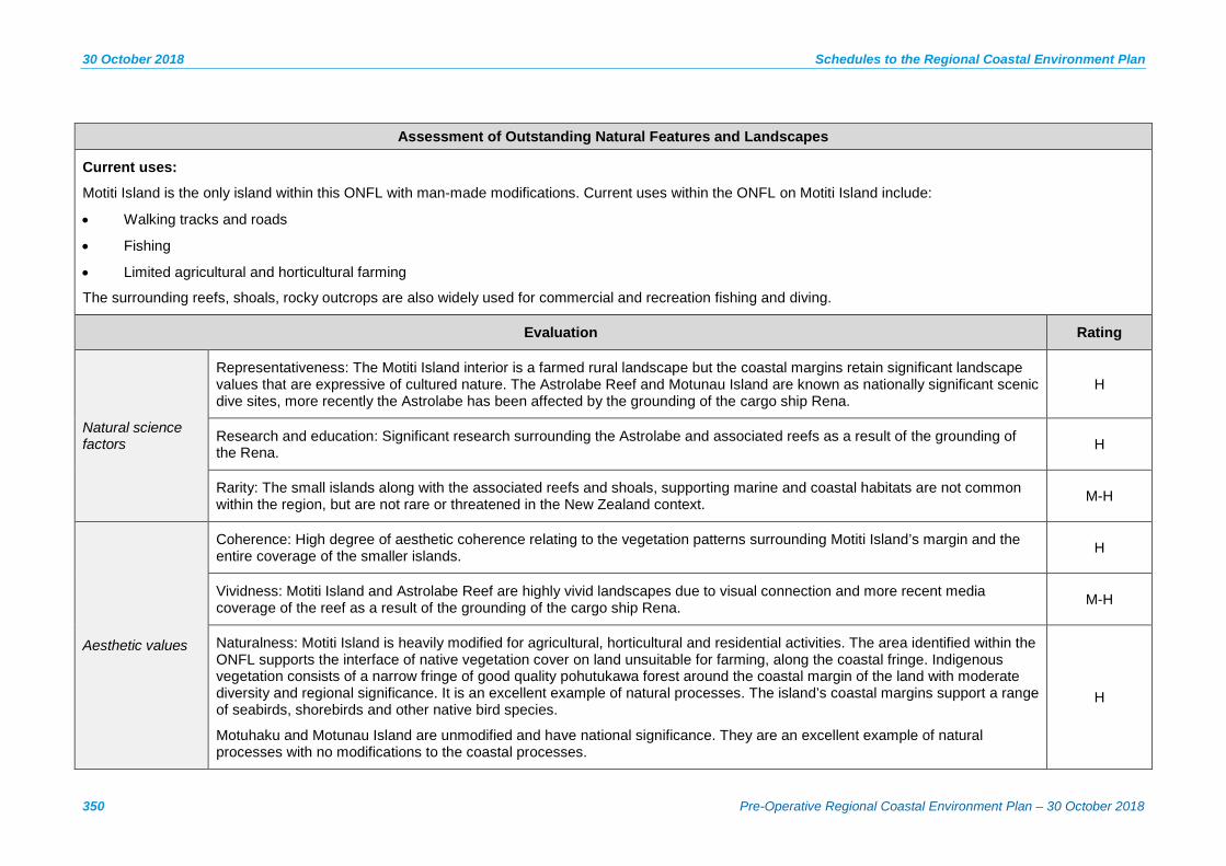
30 October 2018 Schedules to the Regional Coastal Environment Plan
350 Pre-Operative Regional Coastal Environment Plan – 30 October 2018
Assessment of Outstanding Natural Features and Landscapes
Current uses:
Motiti Island is the only island within this ONFL with man-made modifications. Current uses within the ONFL on Motiti Island include:
• Walking tracks and roads
• Fishing
• Limited agricultural and horticultural farming
The surrounding reefs, shoals, rocky outcrops are also widely used for commercial and recreation fishing and diving.
Evaluation Rating
Natural science factors
Representativeness: The Motiti Island interior is a farmed rural landscape but the coastal margins retain significant landscape values that are expressive of cultured nature. The Astrolabe Reef and Motunau Island are known as nationally significant scenic dive sites, more recently the Astrolabe has been affected by the grounding of the cargo ship Rena.
H
Research and education: Significant research surrounding the Astrolabe and associated reefs as a result of the grounding of the Rena. H
Rarity: The small islands along with the associated reefs and shoals, supporting marine and coastal habitats are not common within the region, but are not rare or threatened in the New Zealand context. M-H
Aesthetic values
Coherence: High degree of aesthetic coherence relating to the vegetation patterns surrounding Motiti Island’s margin and the entire coverage of the smaller islands. H
Vividness: Motiti Island and Astrolabe Reef are highly vivid landscapes due to visual connection and more recent media coverage of the reef as a result of the grounding of the cargo ship Rena. M-H
Naturalness: Motiti Island is heavily modified for agricultural, horticultural and residential activities. The area identified within the ONFL supports the interface of native vegetation cover on land unsuitable for farming, along the coastal fringe. Indigenous vegetation consists of a narrow fringe of good quality pohutukawa forest around the coastal margin of the land with moderate diversity and regional significance. It is an excellent example of natural processes. The island’s coastal margins support a range of seabirds, shorebirds and other native bird species.
Motuhaku and Motunau Island are unmodified and have national significance. They are an excellent example of natural processes with no modifications to the coastal processes.
H
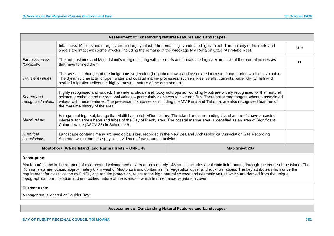
Schedules to the Regional Coastal Environment Plan 30 October 2018
BAY OF PLENTY REGIONAL COUNCIL TOI MOANA 351
Assessment of Outstanding Natural Features and Landscapes
Intactness: Motiti Island margins remain largely intact. The remaining islands are highly intact. The majority of the reefs and shoals are intact with some wrecks, including the remains of the wreckage MV Rena on Otaiti /Astrolabe Reef. M-H
Expressiveness (Legibility)
The outer islands and Motiti Island's margins, along with the reefs and shoals are highly expressive of the natural processes that have formed them. H
Transient values The seasonal changes of the indigenous vegetation (i.e. pohutukawa) and associated terrestrial and marine wildlife is valuable. The dynamic character of open water and coastal marine processes, such as tides, swells, currents, water clarity, fish and seabird migration reflect the highly transient nature of the environment.
Shared and recognised values
Highly recognised and valued. The waters, shoals and rocky outcrops surrounding Motiti are widely recognised for their natural science, aesthetic and recreational values – particularly as places to dive and fish. There are strong tangata whenua associated values with these features. The presence of shipwrecks including the MV Rena and Tahoma, are also recognised features of the maritime history of the area.
Māori values Kainga, mahinga kai, taunga ika. Motiti has a rich Māori history. The island and surrounding island and reefs have ancestral interests to various hapū and tribes of the Bay of Plenty area. The coastal marine area is identified as an area of Significant Cultural Value (ASCV 25) in Schedule 6.
Historical associations
Landscape contains many archaeological sites, recorded in the New Zealand Archaeological Association Site Recording Scheme, which comprise physical evidence of past human activity.
Moutohorā (Whale Island) and Rūrima Islets – ONFL 45 Map Sheet 20a
Description:
Moutohorā Island is the remnant of a compound volcano and covers approximately 143 ha – it includes a volcanic field running through the centre of the island. The Rūrima Islets are located approximately 8 km west of Moutohorā and contain similar vegetation cover and rock formations. The key attributes which drive the requirement for classification as ONFL, and require protection, relate to the high natural science and aesthetic values which are derived from the unique topographical form, location and unmodified nature of the islands – which feature dense vegetation cover.
Current uses:
A ranger hut is located at Boulder Bay.
Assessment of Outstanding Natural Features and Landscapes

30 October 2018 Schedules to the Regional Coastal Environment Plan
352 Pre-Operative Regional Coastal Environment Plan – 30 October 2018
Assessment of Outstanding Natural Features and Landscapes
Evaluation Rating
Natural science factors
Representativeness: The distinctive topographical form and volcanic geomorphology of Moutohorā Island (i.e. twin peaks) forms a landmark feature along the region’s coastline. H
Research and education: Moutohorā has had a long history of conservation research, which is actively encouraged by the Department of Conservation (Moutohorā (Whale Island) Research Strategy 2012). A large body of research has already occurred to date and has included long term studies of the grey-faced petrel population.
H
Rarity: The relationship of such a distinctive island profile (i.e. landform) and its prominence to the coastline is rare and results in highly valued coastal landmark and identity. H
Aesthetic values
Coherence: Both Moutohorā Island and the Rūrima Islets include complete cover of a diverse range of vegetation types which reinforces the topography and includes unique sequences of geothermal vegetation (on Moutohorā) from the high tide mark up to the forest.
H
Vividness: The distinctive topography and vegetation cover of Moutohorā, which are clearly visible from the mainland, results in a highly memorable and symbolic landform feature. H
Naturalness: All of the islands are highly unmodified. They have no mammalian pests, very high biodiversity and they provide habitats for a wide range of endemic, threatened and of rare flora (including a unique sequence of geothermal vegetation that is nationally significant) and fauna (notably tuatara). It is noted that some exotic weed species are present on Moutohorā.
H
Intactness: There have been some minor modifications to support tourist access and monitoring. The islands are otherwise an excellent example of natural processes with almost no modifications to the terrestrial environment (i.e. vegetation and topography are unmodified) and the coastal process (i.e. the coastal edge is unmodified).
H
Expressiveness (Legibility)
The distinctive forms and combined sequence of the islands together with the unmodified coastal edges, results in landscape features that are highly expressive of the natural processes that formed and continue to shape them. The vertical cliffs in particular demonstrate the natural coastal processes of coastal erosion.
H
Transient values The transient features of the islands are not considered key in relation to the ONFL classification. L
Shared and recognised values
Highly visible. Frequently in publications. Regionally recognised and valued. Wildlife Management Reserve.
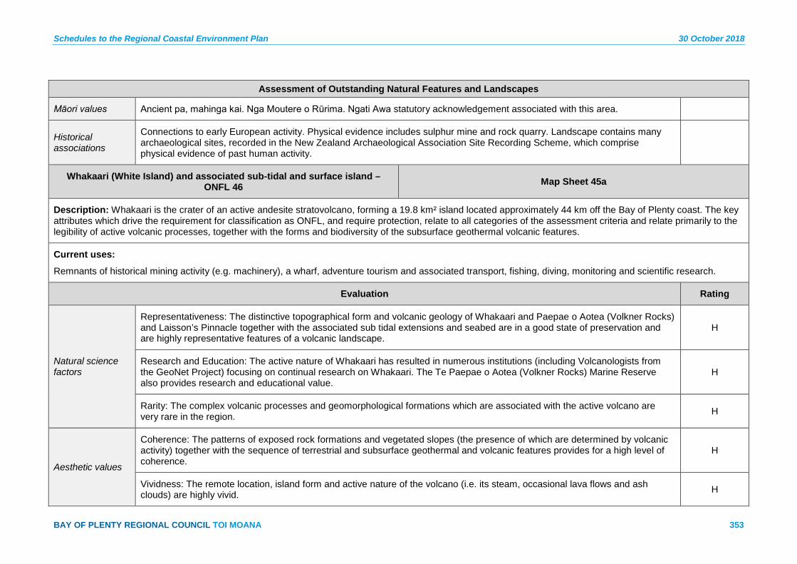
Schedules to the Regional Coastal Environment Plan 30 October 2018
BAY OF PLENTY REGIONAL COUNCIL TOI MOANA 353
Assessment of Outstanding Natural Features and Landscapes
Māori values Ancient pa, mahinga kai. Nga Moutere o Rūrima. Ngati Awa statutory acknowledgement associated with this area.
Historical associations
Connections to early European activity. Physical evidence includes sulphur mine and rock quarry. Landscape contains many archaeological sites, recorded in the New Zealand Archaeological Association Site Recording Scheme, which comprise physical evidence of past human activity.
Whakaari (White Island) and associated sub-tidal and surface island – ONFL 46 Map Sheet 45a
Description: Whakaari is the crater of an active andesite stratovolcano, forming a 19.8 km² island located approximately 44 km off the Bay of Plenty coast. The key attributes which drive the requirement for classification as ONFL, and require protection, relate to all categories of the assessment criteria and relate primarily to the legibility of active volcanic processes, together with the forms and biodiversity of the subsurface geothermal volcanic features.
Current uses:
Remnants of historical mining activity (e.g. machinery), a wharf, adventure tourism and associated transport, fishing, diving, monitoring and scientific research.
Evaluation Rating
Natural science factors
Representativeness: The distinctive topographical form and volcanic geology of Whakaari and Paepae o Aotea (Volkner Rocks) and Laisson’s Pinnacle together with the associated sub tidal extensions and seabed are in a good state of preservation and are highly representative features of a volcanic landscape.
H
Research and Education: The active nature of Whakaari has resulted in numerous institutions (including Volcanologists from the GeoNet Project) focusing on continual research on Whakaari. The Te Paepae o Aotea (Volkner Rocks) Marine Reserve also provides research and educational value.
H
Rarity: The complex volcanic processes and geomorphological formations which are associated with the active volcano are very rare in the region. H
Aesthetic values
Coherence: The patterns of exposed rock formations and vegetated slopes (the presence of which are determined by volcanic activity) together with the sequence of terrestrial and subsurface geothermal and volcanic features provides for a high level of coherence.
H
Vividness: The remote location, island form and active nature of the volcano (i.e. its steam, occasional lava flows and ash clouds) are highly vivid. H

30 October 2018 Schedules to the Regional Coastal Environment Plan
354 Pre-Operative Regional Coastal Environment Plan – 30 October 2018
Assessment of Outstanding Natural Features and Landscapes
Naturalness: Whakaari and the associated sub tidal features and surface islands are almost completely unmodified. H
Intactness: Whakaari and the associated sub tidal features and surface islands are highly intact, with the natural processes clearly evident (i.e. volcanic activity). H
Expressiveness (Legibility)
Whakaari and the associated sub tidal features and surface islands are excellent examples of the natural process which formed and continue to shape these landscape features. H
Transient values The volcanic activity associated with the island creates a highly transient landscape which features steam, occasional lava flows and ash clouds. H
Shared and recognised values
A national icon. Internationally recognised and valued. Significant tourist attraction.
Māori values Wahi tuku mauri, mahinga kai. Te Paepae o Aotea (Volkner Rocks). Highly significant to coastal tribes. Departing place of the spirits of Ngati Awa.
Historical associations
Connections to early European activity. Physical evidence includes sulphur mine.

Schedules to the Regional Coastal Environment Plan 30 October 2018
BAY OF PLENTY REGIONAL COUNCIL TOI MOANA 355
Schedule 4 – Management guidelines for natural features and landscapes
It is recommended that these guidelines be read in conjunction with A Landscape Assessment of the Bay of Plenty Coastal Environment, Environment Bay of Plenty 1993.


Schedules to the Regional Coastal Environment Plan 30 October 2018
BAY OF PLENTY REGIONAL COUNCIL TOI MOANA 357
S4.1 HEADLANDS
S4.1.1 Natural Character
Guidelines
Restrict the scale, density and skyline effects of development on headlands (a)so as to maintain their natural landform characteristics.
Prevent earthworks which have an adverse visual effect on the natural (b)landform of headlands.
Protect, in their natural state, the characteristic components of headland (c)landforms (i.e. cliff, escarpment, rocks, and remnant native vegetation).
Encourage planting which reinforces the natural pattern of headland (d)landforms.
Restrict the installation of aerial utilities and service corridors on headlands. (e)
Explanation/Principal Reasons
Headlands are by their very nature visually obvious components of the landscape. Protection of the natural character of headlands will contribute substantially to the perceived naturalness of the environment of which they are a part.
Development can be successfully incorporated on headland landforms without adverse effects on natural character if components such as the skyline, natural edge, natural landform and the patterns of the landscape are recognised, protected and reinforced.
S4.1.2 Public Access
Guideline
Where appropriate, promote sensitive access to headland vantage points for public views.
Explanation/Principal Reasons
Headlands provide natural vantage points. People enjoy being able to get to vantage points and right to the edge of the coast. It is desirable to encourage legal public access to and around significant coastal headlands to enhance the recreational values of the coastal environment. Public access can be secured over private land through agreements with land owners or through subdivision as part of an esplanade strip or reserve.
S4.1.3 Visual Corridors
Guideline
Protect visual corridors between public viewing points and headlands.
Explanation/Principal Reasons
Headlands tend to form a visually dominant component of the landscape due both to their characteristic height and projection out into the sea. They are generally the more widely visible components of the coastal environment.
30 October 2018 Schedules to the Regional Coastal Environment Plan
358 Pre-Operative Regional Coastal Environment Plan – 30 October 2018
For this reason some distant, and other close views of distinctive headlands which form an important component of the visual environment should be protected in the long term as a component of the public view.
Specific views to significant headlands should be identified and protected within the district plans.
S4.1.4 Subdivision
Guideline
Where subdivision is to occur, refer to section 4.9 of this Schedule.
Explanation/Principal Reasons
Because of their greater than average visibility, headlands are particularly sensitive to changes in landuse which could alter the character of the landscape.
Subdivision is one such landuse which could adversely affect the natural character and visual quality of headlands. The components of subdivision (including roading, utilities, land clearance and building development) can, however, be managed to recognise, protect and in some cases enhance the headland landscape. In particular, protection of the open space character of headlands is important. Methods to achieve appropriate subdivision of headlands can include the preparation of a comprehensive scheme plan for subdivision, either by the district council or developer. Covenanting of important native vegetation would also be appropriate.
S4.2 DUNELANDS
S4.2.1 Natural Character
Guidelines
Protect natural duneland landforms from inappropriate use and (a)development.
Protect and enhance existing wetlands as part of the duneland visual (b)continuum.
Discourage the installation of aerial utilities and service corridors on (c)dunelands and spits.
Explanation/Principal Reasons
Dunelands have a characteristic landform pattern which is a typical visual component of the natural character of the coastal environment. Duneland wetlands are an important, sensitive element within the duneland continuum, deserving special protection. The flat character of dunelands and their typical flat plains hinterland means that there is little immediate visual backdrop and generally few opportunities for the visual integration of structures, including aerial utilities.
Schedules to the Regional Coastal Environment Plan 30 October 2018
BAY OF PLENTY REGIONAL COUNCIL TOI MOANA 359
S4.2.2 Foredunes
Guidelines
Protect foredunes from subdivision and development. (a)
Protect foredunes from intensive pastoral farming and forestry landuses (b)(note that this guideline does not apply to duneland which is landward of the foredune).
Explanation/Principal Reasons
Foredunes are particularly sensitive components of the coastal environment. They are prone to rapid degradation and require protection to retain their natural character. Their characteristic landform pattern is an important visual component of the coastal environment.
S4.2.3 Backdunes
Guideline
Protect backdunes and spits from visually inappropriate subdivision, use and development.
Explanation/Principal Reasons
Degraded dunelands can be rehabilitated through the sensitive planting of appropriate native species. The establishment of good intact vegetative cover on dunelands improves their stability as well as their visual integrity.
S4.2.4 Subdivision
Guideline
Where subdivision is to occur, refer to section 4.9 of this Schedule.
S4.3 ESTUARINE
S4.3.1 Natural Character
Guidelines
Protect estuarine areas and their land backdrop from visually inappropriate (a)use and development.
Discourage incremental encroachment on estuarine edges. (b)
Where reclamation is to occur, encourage visually sensitive contouring of (c)the resultant land-sea interface.
Protect and maintain existing visually intact sequences of native vegetation (d)from saltwater to land.
30 October 2018 Schedules to the Regional Coastal Environment Plan
360 Pre-Operative Regional Coastal Environment Plan – 30 October 2018
Explanation/Principal Reasons
Estuaries are highly productive, sensitive ecosystems. They tend to have suffered degradation both by direct impacts such as reclamation, stock grazing and dumping and indirect impacts such as overland and stream based runoff, spray drift. Native vegetation which remains is of particular value both visually and ecologically and should be protected.
S4.3.2 Subdivision
Guideline
Where subdivision is to occur, refer to section 4.9 of this Schedule.
Explanation/Principal Reasons
Subdivision of land abutting estuaries needs to recognise the sensitivity of estuarine systems and to buffer them from any direct or cumulative adverse effects which may occur as a result of the development. In particular, vegetation clearance, construction impact (such as runoff, stormwater outfalls, and earthworks) and reclamation may adversely affect visual values of wetlands and estuaries.
S4.3.3 Development
Guideline
Ensure boat sheds, jetties and other structures are sited and designed to minimise any adverse visual effects on estuarine areas.
Explanation/Principal Reasons
Structures which require a waterfront or water based location, such as boatsheds and jetties, have the potential to generate adverse effects on estuaries, particularly in the construction phase but also in the long term.
It is recognised, however, that public structures of this nature can provide an important facility.
There is a well-established style of boatsheds, jetties and other nautical structures which can be employed in the design of any new structure to enhance its appropriate siting and design and to reduce any adverse visual effects.
S4.3.4 Rehabilitation
Guideline
Encourage and promote revegetation of estuarine edge areas with appropriate native coastal species.
Explanation/Principal Reasons
The buffering effects of edge vegetation in filtering out silt, nutrients and other harmful substances from runoff are important to the protection of estuarine ecosystems. Edge vegetation also provides an attractive visual transition between estuaries and land. Rehabilitation of degraded estuarine edges should be encouraged for these multiple benefits.
Schedules to the Regional Coastal Environment Plan 30 October 2018
BAY OF PLENTY REGIONAL COUNCIL TOI MOANA 361
S4.4 HARBOUR
S4.4.1 Natural Character
Guidelines
Prevent marina development in areas of Outstanding Natural Character (as (a)identified in Appendix I to the RPS).
Ensure moorings are located in areas where they do not have an adverse (b)visual effect.
Where moorings exist, ensure the numbers are such that in any one (c)location there remains a predominance of open water.
Prohibit new marine farming in areas of Outstanding Natural Character (as (d)identified in Appendix I to the RPS).
(e) Minimise the installation of aerial utilities and service corridors sited below the level of mean high water springs.
(f) Restrict use and development in areas of high visual sensitivity.
Explanation/Principal Reasons
Harbours are the flat, largely tidal, water bodies of the coastal environment. Their visual sensitivity is primarily due to the lack of integrating elements such as land form or vegetation. Structures within this environment are generally able to be seen in their entirety and if not sensitively designed and located can detract from the natural character of the harbour environment.
S4.4.2 Rehabilitation
Guideline
Promote the physical or visual enhancement of degraded harbours.
Explanation/Principal Reasons
The physical and visual pollution of harbours can occur incrementally over time. Opportunities to improve harbour quality, either by the removal of derelict structures with no historical significance or through the improvement of water quality should be taken advantage of.
S4.5 BAYS
S4.5.1 Natural Character
Guidelines
Restrict the scale and density of subdivision and redevelopment in the (a)visual catchment of bays to maintain their natural landform characteristics.
Restrict development on skyline ridges which form the enclosure to coastal (b)bays.
Restrict earthworks that have an adverse visual effect on the natural (c)landform of bays.
30 October 2018 Schedules to the Regional Coastal Environment Plan
362 Pre-Operative Regional Coastal Environment Plan – 30 October 2018
Explanation/Principal Reasons
Bays are characterised by their discrete enclosed character, and their generally small scale environment. The landform and vegetation of bays generally provide good opportunities for the integration of appropriately scaled development. Development on the skyline should be avoided due to its visual prominence and lack of containment within the bay itself.
S4.5.2 Subdivision
Guideline
Where subdivision is to occur, refer to section 4.9 of this Schedule.
Explanation/Principal Reasons
Bays tend to have a natural landform and vegetative pattern which provides good opportunities for the successful integration of appropriately-scaled development. Many bays have small traditional settlements which contribute positively to the visual character and diversity of the coastal environment.
Subdivision and papakāinga developments should respect the context of natural landform character and vegetative pattern to successfully integrate development
Retention of the open space character of bays (either by the clustering of buildings or through their separation) and the avoidance of suburban styled regular strip development along the roadways should be of paramount importance.
S4.5.3 Rehabilitation
Guidelines
Encourage and promote vegetation of earthwork cuts often associated with (a)roading and access tracks.
Encourage and promote planting that is compatible with the natural pattern (b)of the landform in bays.
Explanation/Principle Reasons
Vegetation, planted or natural, which is compatible with the natural patterns of the landscape (for example, in gullies or around escarpments) can substantially enhance the visual character and quality of the environment and assist in integrating development by providing a framework, backdrop and screening.
Planting can also assist the ecological health of the landscape by reducing erosion, runoff and providing habitat for New Zealand flora and fauna.
S4.6 SCARPS
S4.6.1 Natural Character
Guidelines
Protect scarps from visually inappropriate use and development. (a)
Protect intact native vegetation cover. (b)

Schedules to the Regional Coastal Environment Plan 30 October 2018
BAY OF PLENTY REGIONAL COUNCIL TOI MOANA 363
Encourage and promote retention of intact vegetation cover. (c)
Discourage the installation of aerial utilities and service corridors in scarps. (d)
Restrict new earthworks to that associated with the maintenance of existing (e)roads.
Explanation/Principal Reasons
Scarps are highly sensitive components of the coastal environment. They consist of steeply sloping land, much of which has been depleted of its natural vegetative cover. Where roads or access tracks cut across scarps, they tend to create highly visible scars in the landscape. This should be avoided wherever possible.
S4.6.2 Subdivision
Guidelines
Discourage subdivision of scarps. (a)
Where subdivision is to occur, refer to section 4.9 of this Schedule. (b)
Explanation/Principal Reasons
Scarps are steeply sloping landforms not given to subdivision due to the difficulty of creating a building platform or access way.
Wherever possible, subdivision should not encroach upon scarp landforms
S4.6.3 Rehabilitation
Guideline
Encourage and promote revegetation of modified scarps with appropriate native species.
Explanation/Principal Reasons
The sensitive nature of the scarp landform and their susceptibility to erosion make rehabilitation, through revegetation with appropriate native species, an important opportunity to enhance the character of the coastal environment.
S4.7 TERRACE
S4.7.1 Natural Character
Guidelines
Protect terrace escarpments from development. (a)
Restrict the scale, density and skyline effects of development on terraces to (b)maintain their landform characteristics.
Prevent earthworks which have an adverse visual effect on the natural (c)landform of terraces.
Protect intact native vegetation cover. (d)
Restrict the installation of aerial utilities and service corridors on terraces. (e)
30 October 2018 Schedules to the Regional Coastal Environment Plan
364 Pre-Operative Regional Coastal Environment Plan – 30 October 2018
Explanation/Principal Reasons
Terrace landforms include a characteristic escarpment with an upper plain. In some places there is a lower plain towards the coastline and in others the terrace escarpment forms a coastal cliff.
This escarpment is the most sensitive component of the terrace unit. Retaining this component intact and well vegetated will contribute strongly to protecting the natural character of the coastal environment.
Terraces often have an open character and skyline which is sensitive to the siting of structures or utilities. Siting of these elements without a visual backdrop should be avoided.
S4.7.2 Rehabilitation
Guideline
Encourage and promote planting which reinforces the natural pattern of the terrace landform.
Explanation/Principal Reasons
The opportunity exists to improve the visual quality of terraces, and particularly their escarpment, by planting to reinstate native plant communities which reinforce the natural pattern of the landscape.
S4.7.3 Subdivision
Guideline
Where subdivision is to occur, refer to section 4.9 of this Schedule.
Explanation/Principal Reasons
Opportunities for appropriate subdivision or papakāinga housing on terraces exist if the sensitive nature of the landform character is taken into account. This involves selecting areas isolated from the escarpment and which have a landform or vegetative backdrop and context. Appropriate planting can be used to assist in integrating these developments.
The open space character of terraces should be protected either through the clustering of houses or through discrete location and separation. Strip development along the State Highway should be avoided.
S4.8 ISLANDS
S4.8.1 Natural Character
Guidelines
Protect the landform profile of islands when viewed from land or sea. (a)
Prevent earthworks which have an adverse visual effect on the natural (b)landform of islands.
Protect intact native vegetation cover. (c)
Schedules to the Regional Coastal Environment Plan 30 October 2018
BAY OF PLENTY REGIONAL COUNCIL TOI MOANA 365
Prevent the installation of new aerial utilities on islands where this will have (d)a more than minor adverse visual effect on the landform profile or view of the island, unless no practical alternatives exist.
Explanation/Principal Reasons
Islands tend to be experienced predominantly as part of a view across water. As a focal point of the view they tend to come under greater visual analysis than a land based unit. Distance, however, plays a part in reducing the degree of which change in the island’s landscape is visible.
Protection of the natural qualities of the sky or outline of the island (including its landform and vegetation) is important.
S4.8.2 Rehabilitation
Guideline
Where appropriate, encourage and promote planting which reinforces the natural pattern of the island landform.
Explanation/Principal Reasons
Planting which reinforces the natural landform and pattern of an island landscape will improve the visual qualities of that island.
S4.8.3 Subdivision
Guideline
Where subdivision is to occur, refer to section 4.9 of this Schedule.
S4.9 SUBDIVISION
Where subdivision is to occur in any generic landscape area, the following should apply:
Retain the natural landform characteristics of the site and protect significant (a)landforms in their natural state.
Encourage and promote clustering of buildings to maintain a high (b)proportion of open space and to minimise adverse visual effects.
Encourage and promote buildings of an appropriate scale and density that (c)respond to the landform characteristics.
In areas without a landform backdrop (i.e. spits and ridge tops) encourage (d)and promote appropriate building forms that minimise adverse visual effects on the skyline and are compatible with the natural landform characteristics.
Encourage and promote the use of colour schemes that are compatible (e)with the natural colours of the landscape.
Encourage and promote the integration of development through the use of (f)appropriate native coastal plant species planted in relation to landform characteristics.
Give priority to the retention of public open space at, and public access to, (g)the coastal edge and prominent landforms to maintain amenity values.

30 October 2018 Schedules to the Regional Coastal Environment Plan
366 Pre-Operative Regional Coastal Environment Plan – 30 October 2018
Unless otherwise impracticable, esplanade reserves and/or strips should be (h)taken when land is subdivided along the coastal edge.
Where esplanade reserves and/or strips are not taken for whatever reason, (i)ensure the natural character of the coastal edge is maintained by other mechanisms.

Schedules to the Regional Coastal Environment Plan 30 October 2018
BAY OF PLENTY REGIONAL COUNCIL TOI MOANA 367
Schedule 5 – Regionally Significant Surf Breaks The following regionally significant surf breaks were identified through a process of community engagement. Further information on the values of each surf break is contained in the publication: Bay of Plenty Surf Break Study 2011, Bailey Perryman.
1 Orokawa Bay Map sheet 1b
2 Waihī Beach (North End) Map sheet 1b
3 Bowentown Map sheets 2b, 3b
4 North Matakana Map sheets 3b, 4b
5 Matakana Island (Puni’s Farm) Map sheets 8b, 9b
6 North West Rock, Mauāo Map sheets 9b, 11b
7 Main Beach, Mount Maunganui Map sheets 9b, 11b
8 Shark Alley, Mount Maunganui Map sheets 9b, 11b
9 Tay Street (Mount Coast) Map sheet 12b
10 Arataki (off Girven Road) Map sheets 12b, 14b
11 Pāpāmoa Beach (‘the Domain’) Map sheet 14b
12 Motiti Island (east side) Map sheet 43b
13 Kaituna Cut Map sheet 16b
14 Maketū Map sheet 16b
15 Newdicks Beach Map sheet 16b
16 Little Waihī Map sheet 16b
17 Pukehina Beach Map sheet 17b
18 Matatā Straights Map sheet 19b
19 Tarawera Cut (‘the Black Drain’) Map sheets 19b, 22b
20 Walkers Access Map sheet 22b (‘Walkers’, Walkers Road)
21 Thornton Beach /Rangitaiki Map sheet 22b
22 Airports Map sheet 23b
23 Coastlands Map sheet 24b
24 Whakatāne Heads Map sheet 24b
25 Ōhope (Westend) Map sheet 24b
26 Ōpōtiki (Waiōtahe beach) Map sheets 27b, 28b
27 Tōrere Map sheets 29b, 30b
28 Hāwai Map sheet 30b
29 Maraenui Map sheets 30b, 31b
30 Mōtu River Mouth Map sheet 31b
31 Hariki Beach Map sheet 33b
32 Waihau Bay Map sheet 37b

Schedules to the Regional Coastal Environment Plan 30 October 2018
BAY OF PLENTY REGIONAL COUNCIL TOI MOANA 369
Schedule 6 – Areas of Significant Cultural Value These are referred to in Part 3, Section 5 of the Regional Coastal Environment Plan – Iwi Resource Management and are shown in the maps.
Sites of significant cultural value are also recognised through the Treaty of Waitangi claim process. Through this process the Crown is able to formally acknowledge the mana of tāngata whenua over a specified area. It recognises the particular cultural, spiritual, historical and traditional association of iwi with the site, which is identified as a statutory area.
Ngā Whakaaetanga-ā-Ture ki Te Taiao ā Toi (Statutory Acknowledgements in the Bay of Plenty) is a compendium document to the Bay of Plenty Regional Coastal Environment Plan.
Ngā Whakaaetanga-ā-Ture ki Te Taiao ā Toi incorporates statutory acknowledgements arising from Treaty of Waitangi settlement legislation with the Bay of Plenty region's iwi. Iwi that currently have statutory acknowledgements are Ngāti Awa, Ngāti Tūwharetoa (Bay of Plenty), Te Arawa, affiliate Te Arawa iwi and hapū, Ngāti Whare, Ngāti Manawa, Ngāti Mākino, Waitaha, Tapuika, Ngati Rangiwewehi and Ngati Rangiteaorere.
SITE NAME: TŪHUA (MAYOR ISLAND)
SITE NUMBER: ASCV-2 MAP SHEETS: 40b, 41b
Tūhua is a Māori-owned wildlife refuge administered by the Tūhua Trust Board.
The tāngata whenua of Tūhua are Te Whānau a Tauwhao ki Tūhua. Māori have had a long and continuous relationship with Tūhua from pre-European times to today. Tūhua is also the Māori name of obsidian and is one of the few places in New Zealand where this resource can be found. The island was an important strategic asset for the local tribes, as a source of obsidian. As a result the island represents an important cultural landscape steeped in history beyond the physical remnants of pā and the present day marae and urupā. The island represents a connection between current and past generations. Te Whānau o Tauwhao ki Tūhua are the kaitiaki of the island.
Tūhua is of national archaeological and historic significance as it was one of the most important sources of obsidian stone tool material from the time of the earliest Polynesian arrivals.
SITE NAME: KAREWA ISLAND
SITE NUMBER: ASCV-3 MAP SHEET: 42b
Whanau a Tauwhao are the island’s people. Karewa, along with most other islands both offshore and in the inner harbour, is inextricably linked to and forms part of Whanau a Tauwhao’s renowned coastal identity. The enduring coastal presence of Whanau a Tauwhao and their relationship with their Islands is cemented through the Whanau a Tauwhao whakataukī:
Aue mahue mai e au he wahine mokemoke me he riri taku utu he mamae te utu me noho au he puhi ki te moana.
30 October 2018 Schedules to the Regional Coastal Environment Plan
370 Pre-Operative Regional Coastal Environment Plan – 30 October 2018
SITE NAME: TE AWANUI (TAURANGA MOANA or TAURANGA HARBOUR)
SITE NUMBER: ASCV-4 MAP SHEETS: 2b, 3b, 5b, 6b, 7b, 8b, 9b, 10b, 11b, 12b, 13b, 14b
Te Awanui and surrounding lands form the traditional rohe of Ngāi Te Rangi, Ngāti Ranginui and Ngāti Pūkenga, which extends from Wairakei in Pāpāmoa across the coastline to Ngā Kurī a Whārei at Otawhiwhi - known as “Mai i ngā Kurī a Whārei ki Wairakei.” Te Awanui is a significant area of traditional history and identity for the three Tauranga Moana iwi – Ngāi Te Rangi, Ngāti Ranginui and Ngāti Pūkenga. Hapū of the Tauranga Moana iwi maintain strong local communities which are dependent on maintenance of the life-supporting capacity of the harbour and surrounding land. Maintenance of kaimoana and coastal water quality is particularly important.
Waitaha of Te Arawa is acknowledged as having strong ancestral connections to Te Awanui. The Waitaha area of interest extends from Mauāo to Maketū. The rohe of Ngāti Hako, Ngāti Maru (Hauraki) and Ngāti Tamaterā also extends into parts of Te Awanui.
Te Awanui is rich in cultural heritage sites for Waitaha and the Tauranga Moana iwi. Many of these sites are recorded in Iwi and Hapū Management Plans and other historical documents and files. Treaty Settlement documents also contain areas of cultural significance to iwi and hapū. These iwi, along with their hapū, share Kaitiakitanga responsibilities of Te Awanui.
Traditionally, Tauranga Moana (harbour) was as significant, if not more so, than the land to tāngata whenua. It was the source of kaimoana and the means of access and communication among the various iwi, hapū and whānau around its shores. Today there are 24 marae in the Tauranga Moana district.
SITE NAME: TE PARITAHA O TE AWANUI
SITE NUMBER: ASCV-4A MAP SHEETS: 11b
Te Paritaha o Te Awanui is the original name for the large sand bank located offshore from Waikorere (Pilot Bay) Panepane (Matakana Island), Te Papa (Sulphur Point), and Otumoetai. Te Paritaha literally means "to flow over" and Te Awanui is the traditional name for the eastern portion of the Tauranga harbour.
Te Paritaha o Te Awanui is the largest pipi bed within Te Awanui (Tauranga Harbour), and is renowned for its abundant supply of pipi. The bed has been a customary harvesting ground for many generations and is still an important harvesting area today for the whanau and hapū of Ngāti Ranginui, Ngai Te Rangi and Ngāti Pūkenga. Te Paritaha is one of the few remaining sustainable shellfish beds within the harbour.
Te Paritaha is a taonga and a key source of sustenance for whānau, hapū and iwi of Tauranga Moana. Tauranga Moana whānau, hapū and iwi have a duty to protect the sustaining qualities of Paritaha. It is essential to protect the mauri of Paritaha to ensure that intertribal cultural practices of old will continue into the future.
The traditional practice of "ta koha" or reciprocity is the process of providing kaimoana and/or local resources to visitors or to traditional Maori both locally and inter regional events. The significance of these processes should not be under estimated. They are critical to ensuring the maintenance and enhancement of inter-tribal relationships and the physical and spiritual wellbeing of Maori. The practice invokes a deep sense of obligation underpinned by the principles of manaakitanga, Kaitiakitanga and mana.
Te Paritaha is said to be the source of mauri for all other pipi beds in Te Awanui. The role of whānau hapū and iwi as kaitiaki is to protect the mauri of Paritaha. Mauri in this regard refers to the integrity, form, functioning (including natural biological and ecological processes), resilience, physical and spiritual characteristics &qualities, mana-atua, mana-tangata, tapu life principle, tikanga and kawa practices, connectedness & interdependency and accessibility. This involves ensuring that the full physical extent of the integrity of Paritaha is acknowledged. In this way, the kaimoana that Paritaha supports is also protected.

Schedules to the Regional Coastal Environment Plan 30 October 2018
BAY OF PLENTY REGIONAL COUNCIL TOI MOANA 371
Figure 1 shows the full extent of Te Paritaha o Te Awanui, which includes the historic (1879) and current (2015) extent aligned to the bathymetry (1 metre contour line). While the areas of Te Paritaha that extend into the Port of Tauranga shipping channel, and identified in green as common areas on Figure 1, are excluded from the ASCV 4A shown on Map 11 b, the full extent of Te Paritaha o Te Awanui is recognised and acknowledged.
SITE NAME: MAUĀO (MOUNT MAUNGANUI)
SITE NUMBER: ASCV-6 MAP SHEETS: 9b, 11b
Mauāo (Mt Maunganui) stands at the eastern entrance to Tauranga Harbour, and is sacred for all tāngata whenua of Tauranga Moana. The Mauāo Historic Reserve and Mauāo Recreation Reserve are registered wāhi tapu. Mauāo’s cultural and spiritual significance extends from the ocean floor (including Tanea Shelf) to its peak. Most marae in Tauranga Moana have sightlines to Mauāo.
According to tradition, Mauāo was a victim of unrequited love for the beautiful mountain Pūwhenua. He asked the patupaiarehe (fairy people) to drag him into the ocean, so he could drown himself. As dawn broke, he was caught by the sun before he could accomplish his task. The mountain became a landmark of significance. To mark this new status he was given the name Mauāo, as he had been caught (mau) in the light of day (ao).
SITE NAME: MOTURIKI ISLAND AND MOTUOTAU ISLAND SITE NUMBER: ASCV-6 MAP SHEETS: 9b, 11b, 12b
Moturiki and Motuotau are of particular cultural significance to Ngāiterangi Iwi. Mauāo (Mount Maunganui) and Moturiki Island are both sites of pa, with numerous shell middens on the flanks of Mount Maunganui.
The land area adjacent to Moturiki (Leisure) and Motuotau (Rabbit) Islands is known as Hopukiore. The tribes who have occupied the area since the arrival of the waka migration from Hawaiki to Aotearoa were Ngāmarama, Ngāti Ranginui, Waitaha and Ngāiterangi.
30 October 2018 Schedules to the Regional Coastal Environment Plan
372 Pre-Operative Regional Coastal Environment Plan – 30 October 2018
The sea around these islands has been and remains an important source of kaimoana (seafood) for these iwi, in an area traditionally abundant with kina, pāua, mussel, tuatua, crayfish, snapper, tarakihi and kahawai. Māori retain their kaitiakitanga over their rohe moana.
During the 17th Century the east side of Moturiki, known as Te Takanga, was occupied by Pakira of Ngāti Kuku, whose pā was called "Ahikahore". The Westside was occupied by Tauaiti of Ngāi Tūwhiwhia hapū, and his Mahinga kai (cultivation gardens) was at Hopukiore. Tauaiti's whare (house) was called "Te Wairere", and his Pātaka (food storage house) was known as "Marutuahu". This was also the name given to the mussel rock north-east of Moturiki "Te Toka o Marutuahu'. The beach between Moturiki and the land is called "Ōwhare".
Motuotau was never settled permanently, but was claimed by Whare Tapu of Ngāiterangi Iwi. This was an island where mutton-birds, fern root and seafood were gathered.
SITE NAME: ŌNGĀTORO/MAKETŪ ESTUARY, WAIHĪ ESTUARIES AND OKUREI POINT
SITE NUMBER: ASCV-7 MAP SHEETS: 15b, 16b, 17b
Kaituna River and Ōngātoro/Maketū Estuary lie within the ancestral land of Te Arawa, which stretches from Mt Tongariro to the sea. Both are important to Te Arawa’s tribal history and culture.
The Te Arawa tribes include Tapuika, whose people live on the coastal plain and alongside the lower reaches of the Kaituna River. Tapuika’s territory merges with Ngāti Pikiao, who occupy the land alongside the upper reaches of the Kaituna River and most of the northern shores of Lake Rotoiti. Ngāti Whakaue ki Maketū, Ngāti Rangitihi, Ngāti Makino and Waitaha iwi also have a close relationship with the Kaituna River and Ōngātoro/Maketū Estuary.
Mauri
Waahi Tapu
Korero Tuturu/Historical
Rawa tuturu/Customary resources
Hiahiatanga tuturu/Customary needs
Whakaaronui o te Wa/Contemporary Esteem
Iwi and hapū management plans lodged with the Council (as at June 2017)
The Maketū Estuary is of immense cultural and historical importance to Te Arawa (“mai Maketū ki Tongariro” – from Maketū to Tongariro). Numerous pā and middens have been located on the lands adjacent to the estuary and Ōkurei Point. Ōkurei Point is a wāhi taonga (place of great cultural significance) to all Te Arawa tribes The Ōngātoro/Maketū Estuary is a regionally important tauranga waka – it is known as the final landing place of the Arawa waka canoe. Ōngātoro is the tāngata whenua name for the Maketū Estuary. The name comes from “Ngatoroirangi” who was the esteemed tohunga/navigator of the Te Arawa waka.
Mahinga kai: The Maketū Estuary is a regionally important mahinga kai - iwi refer to this area as the traditional “food bowl” of the Arawa people. Taunga ika: The Maketū Taiāpure local fishery was established in 1996 under the Māori Fisheries Act 1989 to set aside estuarine and shoreline coastal fishing areas of special significance to iwi or hapū as a source of food or for spiritual or cultural reasons. The Maketū Taiāpure area stretches from Wairakei (Pāpāmoa) in the west to Ōtamarākau in the east. Taunga ika moana: In the coastal waters there are a number of toka, reefs and
Nga Tikanga Whakahaere Taonga o Ngati Pikiao Whanui Iwi Resource Management Plan 1997 Ngāti Whakaue ki Maketū Iwi Resource Management Plan Phase 2 2011 Ngāti Rangitihi Iwi Environmental Management Plan 2011 Tapuika Environmental Management Plan 2014 Waitaha Iwi Management Plan 2014

Schedules to the Regional Coastal Environment Plan 30 October 2018
BAY OF PLENTY REGIONAL COUNCIL TOI MOANA 373
Before the landing of the waka at Maketū, the taumau (discovery of land) of Hei, Tia and Tamatekapua took place on board the waka. The name Maketū is a reminder of the fatherland Hawaiki, from where these early explorers journeyed.
other areas used as fishing grounds. Examples of taonga species in ASCV 7 are: Shellfish: Pipi, Tuangi (Venus Shell), Pūpū (Cat’s eye), Titiko (mudsnail), Tio (rock oyster), Tupa (Queen scallop), Kuakua (scallops), Toheroa (mussels), Niania (black mussel), Kōura (crayfish), Kahitua (Tuatua), Pāpaka (paddle crab) Echinoderms: Kina (sea urchin) Ika (fish): Patiki (flounder), Tarakihi (ocean bream), Kahawai, Tamure (Gilthead sea bream), Takeke (Garfish), Kuparu (John Dory), Inanga (whitebait), Tuna (eel), Haku (Kingfish), Kātaha (yellow-eyed mullet), Kupae (sprat)
SITE NAME: MOTITI ISLAND AND ASSOCIATED ISLANDS/REEFS AND SHOALS
SITE NUMBER: ASCV-25 MAP SHEET: 43b
Tāngata whenua of Motiti are Ngāi te Hapū, Te Patuwai and Te Whānau a Tauwhao ki Motiti.
Motiti Island has a long history of Maioriori and Māori occupation beginning from the ancient ‘Uru’ ancestors and the arrival of the ancestral migration canoe, Te Arawa waka haurua, which landed at Maketū directly on-shore from Motiti. The first occupant was the esteemed Tohunga, Ngatoroirangi who named the parts of the island and lived there with Waitaha descendants.
There are 30 distinct pā sites, 18 settlements and 20 ancient monuments that are situated throughout Motiti Island and the seabed and foreshore. These areas are located and coded in the “Motiti Island Native/Cultural Policy Management & Administration Plan 2012”; however, the detailed cultural and historical data information regarding wāhi tapu and wāhi taonga is found in the Cultural Heritage Wāhi Tapu document held exclusively in the care of “Korowai Kāhui o Te Patuwai Native Tribal Council”. Access to this information is restricted.
Motiti Island Management Plan identifies the reefs surrounding Motiti as mahinga kai, the fish species that was harvested and their cultural and spiritual significance.
The seabed and foreshore boundaries of Ngāti Te Hapū extend out to seven significant historical ocean landmarks anchored to the bottom of the ocean floor. This relates to a proverb that link together the territorial boundary of Moutere o Motuiti.
30 October 2018 Schedules to the Regional Coastal Environment Plan
374 Pre-Operative Regional Coastal Environment Plan – 30 October 2018
Ngā Tauranga tai kukume o te hukarere o ngā Aturere (the anchors that connect to the wind and the tides – that pathway of Aturere). Significant wāhi tapu heritage sites are located within the seabed and foreshore boundaries. Sites in the coastal marine area in close proximity to Motiti Island are identified in Appendix 3 to the Motiti Island Environmental Management Plan (MIEMP). Other wāhi tapu sites in the coastal marine area are identified in the Motiti Island Native/Cultural Policy Management & Administration Plan.
Traditional area of foreshore and seabed
Reference used in MIEMP
Traditional name of site Nature of site (wāhi tapu wāhi taonga)
Otungahoro Bay, Motiti north A1 Otungahoro Toka of cultural and spiritual significance. Linked to Ahurewa o Marumaru toka.
Marumaru Bay, Motiti north A2 Ahurewa o Marumaru (Te Rikarika rock)
Toka atua mana. Associated with: Te Maamangi, Koopu whakaairi.
Tumu Bay, Motiti north A4 Toka o Moropu Toka atua mana. Rock in the Tumu Bay.
A5 Toka a Puwhatawhata Cultural and spiritual observation platform for rituals.
Orongongatea Bay in an area known as “he kāinga tuturu o ngā tipuna” (sacred domain of the ancient ancestors)
A11 Te Ringa Moko Papaki o Tutarehia
Toka ao wairua. Rocks of high spiritual and cultural significance. Associated places: Te Kawakawa (Omahine).
Rotoharekeke Point, Motiti west
A12 Onuku Kino Toka mana atua. Cultural site for Māori atua. Te haruharu o nuku kino ki te moana o pu maomao.
Wairere Bay, Motiti south
A15 Hani Toka mana atua. Rock off-shore from Wairere Bay.
Otuhoka Bay, Motiti south
A17 Toka tapu Toka rere wairua, toka mana atua. Toka of Māori spirits and gods.
Wairanaki Bay, Motiti northwest
A20 Muirtai Toka tipua, toka mana atua. Highly significant cultural spiritual sacred rock.
A21 Tahau Cultural and spiritual observation platform. Associated toka: Muriwai, Takahuri, Horete, Tohu o Punui and Mauao.
A24 Takahuri Cultural and spiritual observation platform. Associated with Tahau.
Huruhi Bay, Motiti east
A30 Motu Arua Toka ao wairua (spiritual world). Cultural and spiritual observation platform. Associated with: Huruhi, Waewae.
Traditional area of foreshore and seabed
Reference used in Motiti Island Native/Cultural Policy Management & Administration Plan
Traditional name of site Nature of site (wāhi tapu wāhi taonga)
Okoroa Bay, Motiti west
A31 Manukakawhati Taonga tukuiho. Rock pointer; determine summer solstice.

Schedules to the Regional Coastal Environment Plan 30 October 2018
BAY OF PLENTY REGIONAL COUNCIL TOI MOANA 375
Traditional area of foreshore and seabed
Reference used in MIEMP
Traditional name of site Nature of site (wāhi tapu wāhi taonga)
Te Maamangi
VX12 Otaiti Toka tipua. Reef; traditional landmark “rapara o te kopu whakaari”; perform spiritual rituals that connect to the island.
Okarapu
VW13 Okarapu Toka tipua. Reef; traditional marker “rapara o te kopu whakaari”; perform spiritual rituals that connect to the island.
Okani
VX14 Omaroa Taonga tukuiho. Reef; traditional land marker
Matarehua
VX15 Rua o Tāne Taonga tukuiho. Reef; traditional marker.
Mataraakiitia
VX16 Mataraakiitia Tino tapu. Reef; traditional marker; battle site where many people lost their lives
Tokoroa
VX17 Tokoroa Toka tipua. Reef; heritage site links to star navigation – a traditional marker that forms part of the ancient equilateral triangle that connects Motiti Island and Maketū.
Motu Haku VX19 Mōtū Haku Toka tipua. Island; traditional marker “raparapa ki te whaka rii o te ra”; spiritual rituals connect the rising sun; is a monument/reference to the departure of the ancestors.
Otāiti is a reef within an area culturally known as Te Maamangi of particular cultural and spiritual significance to Te Patuwai, Ngāti Whakahemo, Ngāti Te Hapū and Ngāti Awa. The source of the mauri (spiritual essence) of Otāiti stems from ancient ‘Uru’ ancestors and rituals performed by the (high priest) of Te Arawa waka haurua Ngatoroirangi, who spent his last years at Motiti Island. Otaiti is a significant historical site of Te Arawa and is connected to the ancestor tohunga Ngatoroirangi who gave it its name. Otaiti marks the outer gateway to the moana o Te Arawa. It is connected to the geothermal pathways discovered by Ngatoroirangi.
Te Patuwai, the hapū on Motiti Island (of Mataatua waka origins) continue to regard Otāiti as a toka tipua (reef imbued with spiritual and sacred qualities) alongside Mōtū Haku Island to the north east that holds the same status. Otāiti, Mōtū Haku and the Oromai Tāngata ancient rock monuments, that link to a spiritual rock at the rear of Motiti Island named Kopu Whakaari, with the same reverence iwi and hapū on the mainland have towards their maunga or mountain. These areas are also a significant traditional fisheries “kāinga mahinga ika and mahinga mataitai”.
SITE NAME: MOTUNAU (PLATE) ISLAND
SITE NUMBER: ASCV-9 MAP SHEET: 44b
Motunau Island is a Māori-owned wildlife sanctuary protected under the Wildlife Act 1953 – gazetted under the Wildlife Sanctuary (Motunau Island) Order 1969. It is rated as a site of Special Wildlife Interest.
30 October 2018 Schedules to the Regional Coastal Environment Plan
376 Pre-Operative Regional Coastal Environment Plan – 30 October 2018
Motunau Island traditionally was a mahinga kai area within living memory, Tītī (mutton bird) was taken from the island. The rotation of harvesting enabled whānau and hapū access. Although the numbers of Tītī from Motunau were never in large numbers as those taken from Whakaari Island, they were nonetheless an important local mahinga kai and had significant cultural value to Ngāti Whakahemo whānau and hapū.
Motunau Island remains in the ownership of Ngāti Whakahemo whānau. It is administered by DoC and three kaitiaki of Ngāti Whakahemo Iwi. Motunau is of high heritage significance to Ngāti Whakahemo as it is part of their ‘pātaka kai’.
Taonga tukuiho - this site is linked to the study of stars – the road map to the Pacific Ocean used by
SITE NAME: MOUTOHORĀ (WHALE ISLAND) AND RŪRIMA ISLETS (TOKATĀ, RŪRIMA & MOUTOKI ISLANDS)
SITE NUMBER: ASCV-10 MAP SHEETS: 20b, 21b, 22b, 23b, 24b
Rūrima Rocks and Moutohorā (Whale Island) are important mahinga kai areas for Ngāti Awa. The Rūrima Rocks are of spiritual significance. Moutohorā has several coastal urupā and other wāhi tapu sites and wāhi taonga. Moutoki and Rūrima Islands are Wildlife Refuges in Māori ownership. Moutohorā is a Wildlife Management Reserve, also owned by Ngāti Awa.
SITE NAME: KŌHI POINT (INCLUDING PIRIPAI TO ŌTARAWAIRERE)
SITE NUMBER: ASCV-12 MAP SHEET: 24b
This area is of major spiritual significance to the people of Ngāti Awa for its wairua and mauri. After a tangi at Wairaka Marae the body was, and on occasion still is, taken across the estuary to be buried in the urupā (Ōpihiwhanaungakore) on the Ōpihi Spit. This urupā is recognised as a Māori Burial Reserve. Integrally linked to this urupā by Māori legend is the largest rock off the entrance of Whakatāne Estuary mouth, Turuturu Roimata, and Paepae o Aotea (Volkner Rocks) – The Departing Place of the Spirits of Ngāti Awa. After the burial of a person of importance, the spirit leaves the body to commence its journey to Hawaiki. The spirit, sad at leaving behind its friends at Whakatāne, weeps. This is manifested by the rock that weeps, Turuturu Roimata. From there the spirit travels across the water to Paepae o Aotea before finally departing for Hawaiki.
The area is also of significance to Ngāti Awa as a source of mahinga mātaitai. Rocks at the entrance to Whakatāne Estuary and the reefs on Kōhi Point and the rocky shore and reefs at Ōtarawairere and West End of Ōhope Beach are a significant source of seafood. This is recognised by the names of rocks and points. An example is Te Puku o te Wheke (“The Stomach of the Octopus”).
The adjacent headland, which includes Kōhi Point Scenic Reserve, is also very significant. It contains thirteen pā, several pit and hui sites, a cave and midden, including Toi’s pā, a site of great importance to Ngāti Awa.
SITE NAME: ŌHIWA HARBOUR/ŌHOPE BEACH
SITE NUMBER: ASCV-13 MAP SHEETs: 24b, 25b, 26b, 27b
Ōhiwa Harbour is of significant cultural importance to Te Whakatōhea, Te Upokorehe, Ngāti Awa and Tūhoe who are the kaitiaki of the harbour. These iwi and hapū acknowledge the relationship that distant iwi like Ngāitai, Te Whānau a Apanui, Te Whānau a te Ehutu, Ngāti Manawa, Ngāti Whare and others, have with Ōhiwa Harbour.
Ōhiwa Harbour is an important mahinga kai. Māori knowledge of the abundant food resources at Ōhiwa has endured for many centuries. The earliest names of the harbour reflected this, including "Te Kete Kai a Tairongo" (the food basket of Tairongo) and ‘Te Umu Taonoa a Tairongo’ or the place where Tairongo found an abundance of food ready to eat.
Schedules to the Regional Coastal Environment Plan 30 October 2018
BAY OF PLENTY REGIONAL COUNCIL TOI MOANA 377
The Ōhiwa Harbour area has a long history of Māori occupation. The Historic Places Inventory identifies more than ten historic sites of Māori origin on the margins of the harbour. The Department of Conservation undertook a major archaeological survey of Ōhiwa Harbour in 1994. Evidence of Māori occupation has survived in the form of numerous archaeological sites, including pā, urupā, shell middens and cultivation sites. Four pā exist in the Wainui Inlet, two on Hokianga Island, one in the Kutarere Inlet, two on Uretara Island, three in Nukuhou River Inlet, and six pā and numerous pits and terraces on Ohakana Island. Pataua Island was a battle site and canoe landing area, and Ōhakana Island is the site of a battle between Ngāti Awa and Whakatōhea. Hokianga Island is a Māori Reserve.
To Māori, Ōhiwa Harbour continues to be an important taonga, a priceless treasure that must be looked after so its rich resources are there for future generations to share.
Ōhope Beach and nearshore subtidal shellfish zone has been identified by Te Kōmiti Taiao o te Rūnanga o Ngāti Awa (Ngāti Awa Environmental and Cultural Resources Committee) as a mahinga mātaitai of regional significance. Hokianga Island has great wairua (spiritual significance) as the place where the chief Te Kooti died.
SITE NAME: WHAKAARI (WHITE ISLAND)/PAEPAE O AOTEA (VOLKNER ROCKS)
SITE NUMBER: ASCV-14 MAP SHEET: 45b
Whakaari is an important mahinga kai and historical repository for the Mataatua tribes. It is a wāhi tuku mauri which is the place where voyagers arriving in the Bay of Plenty (Te Moana a Toi) performed important rituals.
Paepae o Aotea is a highly significant wāhi tapu. It is the departing place of spirits on their final journey back to the spiritual homeland of Hawaiki.
SITE NAME: WAIOTAHE T ESTUARY
SITE NUMBER: ASCV-15 MAP SHEET: 27b
The site is located immediately adjacent to the Waiōtahe Spit Historic and Scenic Reserve. The historical value of the spit relates to early Māori habitation which inextricably links the spit and estuary.
Waiōtahe Spit was historically very highly valued as a food source for both fish and shellfish. This abundance of food led to the area often being contested for ownership and control by hapū of the Whakatōhea, the Upokorehe and the Ngātipatu people against Tūhoe. Whakatōhea were the inhabitants of the adjacent pā, but there were times when they were dislocated by Tūhoe and then Tūhoe would have control and occupation. The area is a meeting point on the Whakatōhea and Tūhoe traditional boundaries. The area is protected by the Atua kaitiaki and contains the urupā of both Tūhoe and Whakatōhea. Tāngata whenua never cross the estuary to the spit which is very tapu (sacred).
SITE NAME: WAIOEKA/OTARA ESTUARY
SITE NUMBER: ASCV-16 MAP SHEET: 27b, 28b
The Ōpōtiki Estuary provides a sheltered anchorage and has a long history of Māori occupation. It was an important early European coastal shipping port when settlement of Ōpōtiki began in 1839. It is also the site of the grounding of the troop transport steamer “Huntress” on the river bar during the Volkner affair in 1865.

30 October 2018 Schedules to the Regional Coastal Environment Plan
378 Pre-Operative Regional Coastal Environment Plan – 30 October 2018
SITE NAME: RAUKŌKORE MATAITAI RESERVE
SITE NUMBER: ASCV-17 MAP SHEET: 36b
Mātaitai reserves are areas where the tāngata whenua manage all non-commercial fishing by making bylaws. The bylaws must apply equally to all individuals. Mātaitai reserves may only be applied for in traditional fishing grounds and must be areas of special significance to the tāngata whenua. Raukōkore Mātaitai Reserve is in the Te Whānau a Maruhaeremuri rohe moana.
Schedules to the Regional Coastal Environment Plan 30 October 2018
BAY OF PLENTY REGIONAL COUNCIL TOI MOANA 379
Schedule 7 – Historic Heritage Inventory
CH1 Waihī Beach Gold Mining Company: Three mine shafts on bluff between Waihī Beach and Orokawa Bay. Constructed in 1898. Only coastal gold mining features in Bay of Plenty region. Map Sheet 1b.
CH2 Bowentown Jetty: Stone jetty in Anzac Bay, Bowentown Heads. Constructed circa 1910. Stone jetty construction rare in the Bay of Plenty. Map sheet 2b.
CH3 Martray Wharf: Located in Boat House Bay on 'Martray' estate property, Ongare Point peninsular, Katikati. Built circa 1878. Some intact features – including timber piles. Map sheet 3b.
CH4 Motuopae Causeway: Rock causeway From Judea to Motuopae Island in Waikareao Estuary, Tauranga. Only recorded rock causeway in the Bay of Plenty. Map sheets 11b and 13b.
CH6 Stone Jetty, Mount Maunganui: Jetty in Pilot Bay made of rhyolite boulders and surfaced with concrete. Built for small boat landings during excursions. 15 metres long. Moturiki Datum – bolt and arrow in concrete – survey point for harbour survey. Constructed c.1889. NZ Historic Places Trust Register, No. 4569 Cat II. Map sheets 9b and 11b.
CH7 Kutarere Wharf: Long timber causeway built over mudflats at Kutarere, Ōhiwa Harbour. Some intact features, but others may be unclear or damaged. Constructed c.1922. Map sheet 26b.
CH8 Mount Stewart Jetty (Bob Blakeney's Wharf): Remnants of timber wharf at Ongare Point. Map sheet 3b.
CH9 Martha Shipwreck: American whaler about 100 ft long. Built in USA c1805. Located off Sulphur Point marina near rock retaining wall. Highly likely that at least half of the hull is buried under the northern breakwater wall. Map sheet 11b.
CH10 Tasman Shipwreck: Wooden steamer,102 ft long. Built in Auckland c1903 as the Whangaparoa. Wrecked off Rūrima Reef, Matatā. Located at Tasman Reef. Map sheet 20b.
CH11 Taupō Shipwreck: Steamer in 38 fathoms between Mayor Island and Bowentown Heads. Recorded in NZAA Site Recording Scheme as U13/161.
CH12 Taranaki Shipwreck: Steamer built in Scotland in 1865. Sunk at Karewa Island. Map sheet 42b.


Schedules to the Regional Coastal Environment Plan 30 October 2018
BAY OF PLENTY REGIONAL COUNCIL TOI MOANA 381
Schedule 8 – Harbour Development Zones
Tauranga City – Harbour Development Zone area
Tauranga Harbour Development Zone – Map Sheets 11c, 13c and 51
The Harbour Development Zone at Tauranga is adjacent to the central business district of Tauranga city. The zone is defined as set out in the maps to this Plan. It includes a 60 metre wide strip of the coastal marine area extending from mean high water springs. The zone starts at the eastern end of Elizabeth Street and ends at the south-east corner of the Mission Cemetery on Marsh Street.
The Harbour Development Zone contains various structures and buildings, including wharves, jetties, moorings, seawall revetments and a boat ramp. The area is used for a range of commercial, recreational and entertainment activities and is a key connection between the city centre and Tauranga Harbour.
The waterfront and adjacent harbour area is extensively modified, with few remaining ecological values, and reduced natural character. However, there are significant cultural, historical and amenity values.
Tauranga City Council is redeveloping the downtown area adjacent to, and including part of, the Harbour Development Zone through the Tauranga Waterfront Project. The purpose of the project is to provide a waterfront focus for the city centre with facilities for a range of activities that utilise this area including public event spaces, recreational and community activities, vessel berthing facilities and improved access to the edge of the harbour. The redevelopment is supported by a number of strategic planning documents, including SmartGrowth, Smart Economy and the City Centre Strategy.
The main aims of the redevelopment are:
• To create an iconic destination that celebrates the city’s connection to the water and attracts people into the city centre; and
• To provide a parkland setting that enhances the city centre and adjacent harbour and enables people to enjoy a variety of active and passive activities.
Northern Tauranga Harbour – Harbour Development Zone areas
Bowentown Harbour Development Zone – Map Sheets 2c and 51
The Bowentown Harbour Development Zone is in the northern Tauranga Harbour adjacent to Bowentown Reserve and Poi Road. Existing facilities include boat ramps, a jetty, the Bowentown Boat and Fishing Club, the Waihī Beach Coastguard, swing moorings and land based facilities (including car-parking). The majority of the site and facilities are owned and managed by Western Bay of Plenty District Council under the Reserves Management Plan for the area.
The area is popular for water-based recreation and there are some existing congestion conflicts amongst different recreational user groups. There is scope for limited development of public infrastructure, such as additional boat-ramps, pontoons, wharves, jetties, boating berths, boating storage, car and trailer parking areas, provisioning and unloading of boats including commercial operators and fishers, recreational activities and public toilets.
30 October 2018 Schedules to the Regional Coastal Environment Plan
382 Pre-Operative Regional Coastal Environment Plan – 30 October 2018
Tanners Point Harbour Development Zone – Map Sheets 2c, 3c and 51
Tanners Point has the only all-tide boat-ramp in the northern Tauranga Harbour, and is well-used. The facilities (boat ramp, jetty and car and trailer parking areas) are owned and maintained by the Western Bay of Plenty District Council. There is scope for limited development of public infrastructure, such as additional boat-ramps, pontoons, wharf/jetty, boating berths/storage, car and trailer parking areas, provisioning and unloading of boats including commercial operators and fishers, recreational activities and public toilets.
Ōmokoroa Harbour Development Zone – Map Sheets 8c, 11c and 51
The Ōmokoroa Harbour Development Zone stretches from Ōmokoroa Point to the Ōmokoroa Road junction with Esplanade Road in the south. The area extends seaward to the edge of the existing channel. The Matakana Island ferry operates from the wharf, and this is an important harbour transport node within a rapidly growing township.
Existing facilities include boat ramps, a jetty, a pontoon, the Omokoroa Boat Club, swing moorings, car and trailer parking areas, and land-based facilities. There is scope for limited development of public infrastructure, such as additional boat-ramps, pontoons, wharves, jetties, boating berths, boating storage, car and trailer parking areas, provisioning and unloading of boats including commercial operators and fishers, recreational activities and public toilets.
Opureora Harbour Development Zone – Map Sheets 8c and 51
The Opureora Harbour Development Zone is located on Matakana Island and is the principal harbour transport node for Matakana Island.
Existing facilities include a boat ramp, jetty, pontoon and carparking areas. There is scope for limited development of public infrastructure, such as additional boat-ramps, pontoons, wharves, jetties, boating berths, boating storage, car and trailer parking areas, provisioning and unloading of boats including commercial operators and fishers, recreational activities and public toilets.
Panepane Point Harbour Development Zone – Map Sheets 9c, 11c and 52
The Panepane Point Harbour Development Zone is located on Matakana Island. The existing forestry operations are reliant on the barge service that runs from Panepane to Tauranga and the Port of Tauranga. The barge services are operated by the forestry companies but can also be used by the public.
Existing facilities are the barge landing facility (a boat ramp). The boat ramp can be reached by Matakana Island residents, along the privately owned Hume Highway, in accordance with access agreements between the landowners and Western Bay of Plenty District Council.
Whakatāne District – Harbour Development Zone area
Whakatāne Harbour Development Zone – Map Sheets 24c and 47
The Whakatāne Harbour Development Zone is located in the Whakatāne River estuary. The zone is defined as set out in the maps to this Plan. It includes the main river channel to the south of the estuary and extends from the east side of The Strand extension pump station, along the river and out through the river entrance.
Schedules to the Regional Coastal Environment Plan 30 October 2018
BAY OF PLENTY REGIONAL COUNCIL TOI MOANA 383
The southern side of the zone is extensively modified as a result of historical reclamations and existing wharf facilities. Whakatāne District Council owns and operates most of the facilities within the zone. These include several wharves, vessel launching facilities, rock rip-rap training walls and navigational aids. These facilities cater to a variety of activities, including commercial tourism operations, commercial and charter fishing, and recreational vessel launching and berthing.
It is anticipated that additional facilities will be developed to respond to levels of demand and may include recreational facilities such as boat ramps and vessel berthing areas. Whakatāne District Council has a strategic plan aimed at reconnecting the town centre with the river, which includes the development of additional structures and facilities within the Harbour Development Zone.
Natural character values have been reduced, although the north side of the estuary has some areas in a relatively natural state. The area also has high cultural, amenity and recreational values. Ngāti Awa has a Statutory Acknowledgement over the Whakatāne River and has customary title over a number of rocks at the river entrance.
The nature of the river estuary environment presents challenges in terms of maintaining safe operation of facilities and access through the river entrance to the sea. Whakatāne District Council is investigating options to provide a long-term solution to improving the navigability of the entrance.
During periods of high river flow, vessels moored within the zone are accommodated alongside wharves within the zone to provide shelter from these flows and associated debris. This places additional demands on the limited provision of berthing space at Whakatāne.
Ōpōtiki District – Harbour Development Zone area
Ōpōtiki Harbour Development Zone – Map Sheets 27c, 28c and 48
The Harbour Development Zone at Ōpōtiki is located in the Waioeka River Estuary. The zone is defined as set out in the maps to this Plan. It includes the coastal marine area extending from the confluence of the Waioeka and Otara Rivers downstream to the harbour entrance. The zone also extends approximately 150 metres up the Otara River from the confluence with the Waioeka River to incorporate the existing wharf facilities and boat ramp.
Ōpōtiki was the first port in the Eastern Bay of Plenty and was a significant commercial port for coastal shipping in the 19th and early 20th centuries. These days the area is primarily used for recreational activities with limited facilities comprising of a wharf, boat ramp and swimming area.
Ōpōtiki District Council holds resource consents for major capital works to improve the Ōpōtiki Harbour entrance. This involves realigning the harbour entrance to the east of its current location by constructing two 400 metre long training walls and undertaking capital and maintenance dredging activities. This project will enable Ōpōtiki to maximise the opportunities available within the coastal waters of the Eastern Bay of Plenty, including the large-scale marine farm off the coast of Ōpōtiki, which is fully consented and currently undergoing commercial trials.

Schedules to the Regional Coastal Environment Plan 30 October 2018
BAY OF PLENTY REGIONAL COUNCIL TOI MOANA 385
Schedule 9 – Outline Development Plan for the Port of Tauranga 2013


Schedules to the Regional Coastal Environment Plan 30 October 2018
BAY OF PLENTY REGIONAL COUNCIL TOI MOANA 387
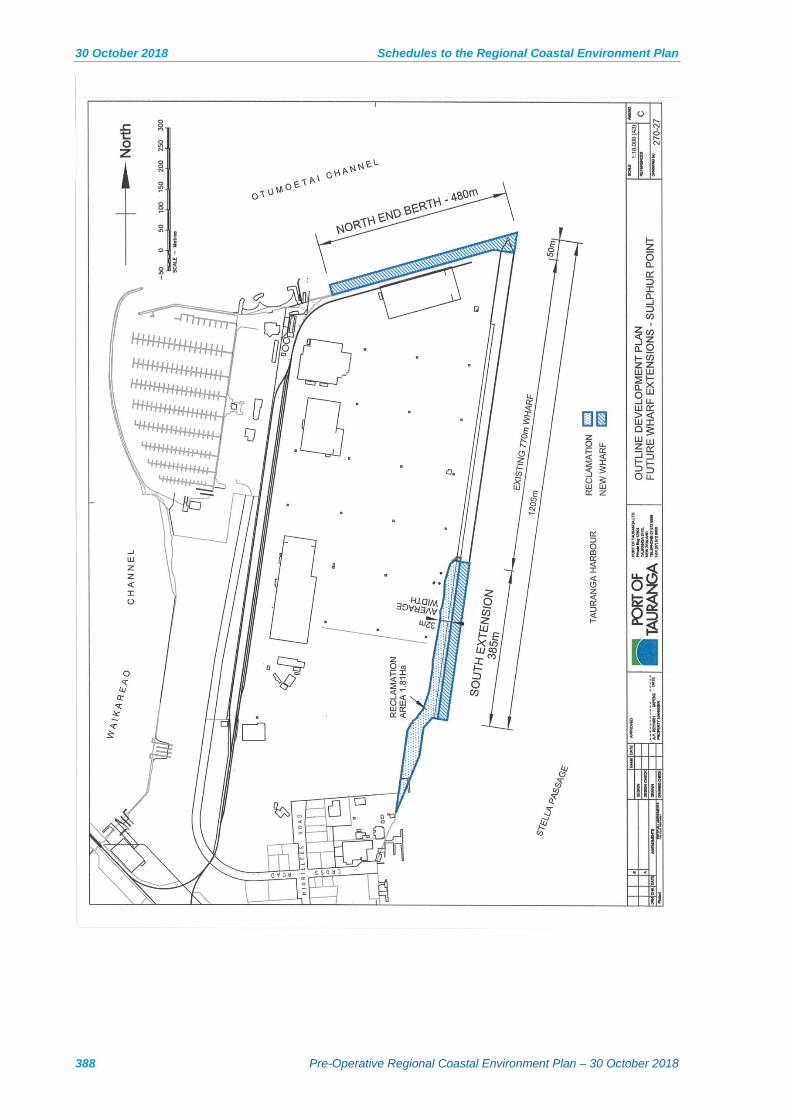
30 October 2018 Schedules to the Regional Coastal Environment Plan
388 Pre-Operative Regional Coastal Environment Plan – 30 October 2018

Schedules to the Regional Coastal Environment Plan 30 October 2018
BAY OF PLENTY REGIONAL COUNCIL TOI MOANA 389

30 October 2018 Schedules to the Regional Coastal Environment Plan
390 Pre-Operative Regional Coastal Environment Plan – 30 October 2018
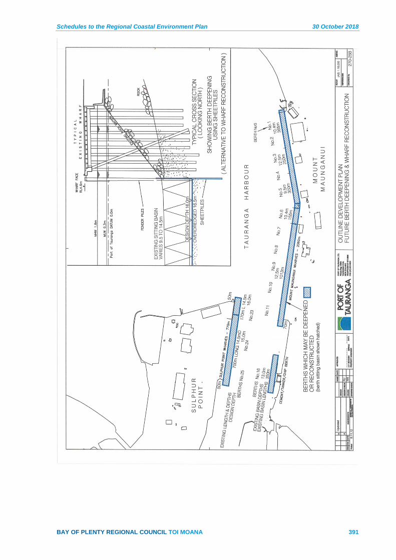
Schedules to the Regional Coastal Environment Plan 30 October 2018
BAY OF PLENTY REGIONAL COUNCIL TOI MOANA 391

30 October 2018 Schedules to the Regional Coastal Environment Plan
392 Pre-Operative Regional Coastal Environment Plan – 30 October 2018

Schedules to the Regional Coastal Environment Plan 30 October 2018
BAY OF PLENTY REGIONAL COUNCIL TOI MOANA 393
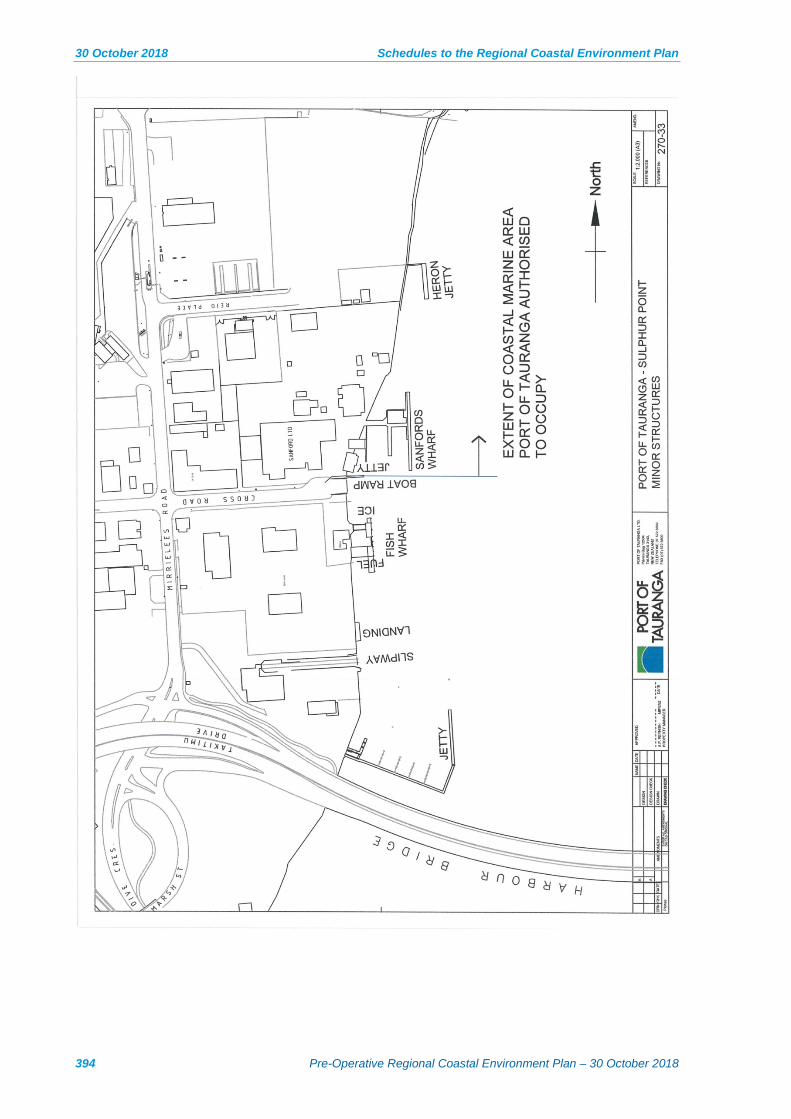
30 October 2018 Schedules to the Regional Coastal Environment Plan
394 Pre-Operative Regional Coastal Environment Plan – 30 October 2018
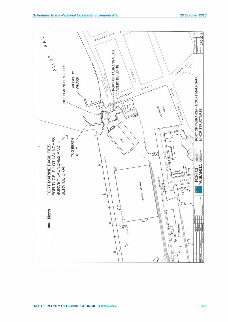
Schedules to the Regional Coastal Environment Plan 30 October 2018
BAY OF PLENTY REGIONAL COUNCIL TOI MOANA 395


Schedules to the Regional Coastal Environment Plan 30 October 2018
BAY OF PLENTY REGIONAL COUNCIL TOI MOANA 397
Schedule 10 – Water Quality Classifications
Explanation
This schedule provides receiving water quality standards for coastal waters.
The standards apply after reasonable mixing of any contaminant or water with the receiving water and disregarding the effect of any natural perturbations that may affect the water body.
The effect of more than one discharge may be assessed cumulatively and the standards apply whether or not the point of discharge is in the coastal marine area. This schedule is not an exclusive list of quantitative standards. When necessary, additional standards may be referred to in accordance with the approach set out in Policy CD 2A to prevent degradation of existing water quality.
Coastal Water Quality Classifications: Equivalent Qualitative and Quantitative Standards
Qualitative Standard Quantitative Standard Mātauranga Māori Coastal Water Classification
There shall be no conspicuous change in the colour or visual clarity.
The decrease in secchi disc vertical depth or black disc horizontal range shall not be greater than 20%.
Te Hauora o te Wai / the health and mauri of water Coastal waters support a healthy ecosystem appropriate to that locality (open coastal water, lagoon, estuary, coastal wetland, saltmarsh, intertidal areas, rocky reef system etc. Coastal water quality enables ecological processes to be maintained, supports an appropriate range and diversity of indigenous flora and fauna, and there is resilience to change.
All coastal waters. Water managed for aquatic ecosystem purposes.
There shall be no significant adverse effects on aquatic life.
Refer to: Australian and New Zealand Guidelines for Fresh and Marine Water Quality Australian and New Zealand Environment and Conservation Council, 2000.
There shall be no production of conspicuous oil or grease films, scums or foams, or floatable or suspended materials.
None
There shall be no emission of objectionable odour
Refer to the Bay of Plenty Regional Air Plan
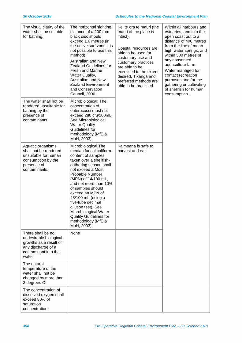
30 October 2018 Schedules to the Regional Coastal Environment Plan
398 Pre-Operative Regional Coastal Environment Plan – 30 October 2018
The visual clarity of the water shall be suitable for bathing.
The horizontal sighting distance of a 200 mm black disc should exceed 1.6 metres (in the active surf zone it is not possible to use this method). Australian and New Zealand Guidelines for Fresh and Marine Water Quality, Australian and New Zealand Environment and Conservation Council, 2000.
Kei te ora te mauri (the mauri of the place is intact). Coastal resources are able to be used for customary use and customary practices are able to be exercised to the extent desired. Tikanga and preferred methods are able to be practised.
Within all harbours and estuaries, and into the open coast out to a distance of 400 metres from the line of mean high water springs, and within 500 metres of any consented aquaculture farm. Water managed for contact recreation purposes and for the gathering or cultivating of shellfish for human consumption.
The water shall not be rendered unsuitable for bathing by the presence of contaminants.
Microbiological: The concentration of enterococci must not exceed 280 cfu/100ml. See Microbiological Water Quality Guidelines for methodology (MfE & MoH, 2003).
Aquatic organisms shall not be rendered unsuitable for human consumption by the presence of contaminants.
Microbiological The median faecal coliform content of samples taken over a shellfish-gathering season shall not exceed a Most Probable Number (MPN) of 14/100 mL, and not more than 10% of samples should exceed an MPN of 43/100 mL (using a five-tube decimal dilution test). See Microbiological Water Quality Guidelines for methodology (MfE & MoH, 2003).
Kaimoana is safe to harvest and eat.
There shall be no undesirable biological growths as a result of any discharge of a contaminant into the water
None
The natural temperature of the water shall not be changed by more than 3 degrees C
The concentration of dissolved oxygen shall exceed 80% of saturation concentration

Schedules to the Regional Coastal Environment Plan 30 October 2018
BAY OF PLENTY REGIONAL COUNCIL TOI MOANA 399
Schedule 11 – Financial Contributions
Para 1 The term ‘financial contribution’ is defined in section 108(9) of the RMA.
Para 2 The RMA requires the Regional Council to specify in the Plan the circumstances when a financial contribution may be imposed, the manner in which the level of contribution that may be imposed will be determined, and the general purposes for which the contribution may be used.
Para 3 Where the Regional Council grants a resource consent under the rules in this Plan, it may impose a condition requiring that a financial contribution be made for the purposes specified in the Plan. The Regional Council does not require financial contributions as ‘development impact fees’ as is the case with city and district councils. Financial contributions will not automatically be applied to any activity where a resource consent is required. Financial contributions are available to remedy, mitigate or offset the adverse effects on natural and physical resources that cannot otherwise be avoided, remedied or mitigated. Section 108(10)(a) of the RMA states that a financial contribution may be for the purposes specified in the plan, including the purpose of ensuring positive effects on the environment to offset any adverse effect.
Para 3A If adverse effects can be appropriately avoided, remedied, mitigated or, offset, and this is identified in a resource consent application, then financial contributions will not be required. However, the Regional Council may require financial contributions or a contractual agreement if mitigation or offsetting is dependent on a third party.
Para 4 The following provisions reflect the requirements of the RMA and set out:
The circumstances when financial contributions may be imposed. (a)
The purposes for which financial contributions may be required and used. (b)
The manner in which the amount of the contribution will be determined. (c)
Matters that the Regional Council will have regard to when deciding (d)whether to:
(i) Impose a financial contribution,
(ii) The type of contribution, and
(iii) The amount of any contribution, and the general provisions that would apply.
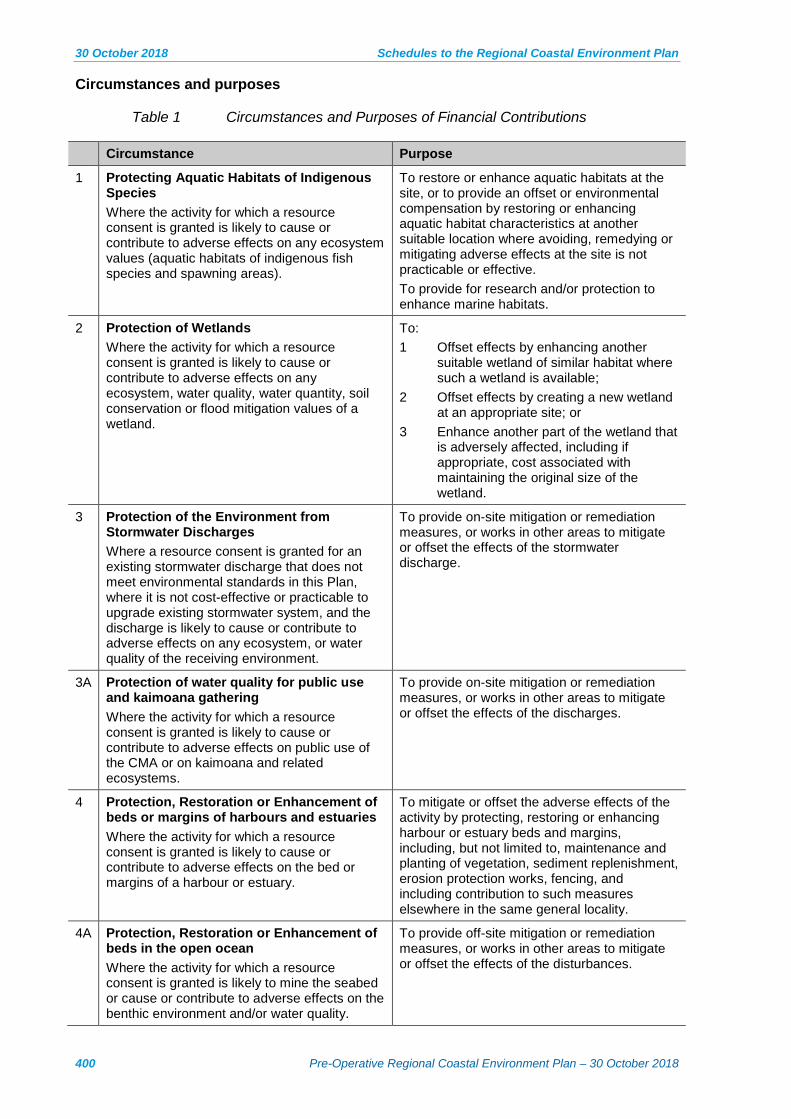
30 October 2018 Schedules to the Regional Coastal Environment Plan
400 Pre-Operative Regional Coastal Environment Plan – 30 October 2018
Circumstances and purposes
Table 1 Circumstances and Purposes of Financial Contributions
Circumstance Purpose
1 Protecting Aquatic Habitats of Indigenous Species Where the activity for which a resource consent is granted is likely to cause or contribute to adverse effects on any ecosystem values (aquatic habitats of indigenous fish species and spawning areas).
To restore or enhance aquatic habitats at the site, or to provide an offset or environmental compensation by restoring or enhancing aquatic habitat characteristics at another suitable location where avoiding, remedying or mitigating adverse effects at the site is not practicable or effective. To provide for research and/or protection to enhance marine habitats.
2 Protection of Wetlands Where the activity for which a resource consent is granted is likely to cause or contribute to adverse effects on any ecosystem, water quality, water quantity, soil conservation or flood mitigation values of a wetland.
To: 1 Offset effects by enhancing another
suitable wetland of similar habitat where such a wetland is available;
2 Offset effects by creating a new wetland at an appropriate site; or
3 Enhance another part of the wetland that is adversely affected, including if appropriate, cost associated with maintaining the original size of the wetland.
3 Protection of the Environment from Stormwater Discharges Where a resource consent is granted for an existing stormwater discharge that does not meet environmental standards in this Plan, where it is not cost-effective or practicable to upgrade existing stormwater system, and the discharge is likely to cause or contribute to adverse effects on any ecosystem, or water quality of the receiving environment.
To provide on-site mitigation or remediation measures, or works in other areas to mitigate or offset the effects of the stormwater discharge.
3A Protection of water quality for public use and kaimoana gathering Where the activity for which a resource consent is granted is likely to cause or contribute to adverse effects on public use of the CMA or on kaimoana and related ecosystems.
To provide on-site mitigation or remediation measures, or works in other areas to mitigate or offset the effects of the discharges.
4 Protection, Restoration or Enhancement of beds or margins of harbours and estuaries Where the activity for which a resource consent is granted is likely to cause or contribute to adverse effects on the bed or margins of a harbour or estuary.
To mitigate or offset the adverse effects of the activity by protecting, restoring or enhancing harbour or estuary beds and margins, including, but not limited to, maintenance and planting of vegetation, sediment replenishment, erosion protection works, fencing, and including contribution to such measures elsewhere in the same general locality.
4A Protection, Restoration or Enhancement of beds in the open ocean Where the activity for which a resource consent is granted is likely to mine the seabed or cause or contribute to adverse effects on the benthic environment and/or water quality.
To provide off-site mitigation or remediation measures, or works in other areas to mitigate or offset the effects of the disturbances.

Schedules to the Regional Coastal Environment Plan 30 October 2018
BAY OF PLENTY REGIONAL COUNCIL TOI MOANA 401
Circumstance Purpose
5 Public access to and along the coastal marine area (CMA) Where the activity for which a resource consent is granted will restrict or prevent existing legal or lawful public access to or along the CMA, except where such restrictions are necessary in accordance with Policy 19(3) NZCPS.
To provide for alternative public access in the vicinity of the activity or at another similar location.
5A Exclusive occupation of space To enhance public access or facilities in another similar location.
6 General Works Where the activity for which a resource consent is granted will cause or contribute to adverse effects on the environment which will not be adequately mitigated by any of the types of contribution described elsewhere in this section.
To provide works for the purpose of offsetting the adverse effects of the activity, including protecting, restoring or enhancing natural and physical resources elsewhere in the same general locality.
7 Structures in the coastal marine area Where the structure may cause a risk to navigational safety or public health and safety or cause adverse effects on the environment if abandoned, damaged or derelict.
To provide for: 1 The removal of abandoned or derelict
structures; 2 The reinstatement of the environment;
and 3 Any emergency repairs or rescue
undertaken by the Regional Council on behalf of the consent holder in the event of any part of the structure breaking loose or causing a potential navigational hazard.
Amount of contribution
Para 1 The amount of financial contribution must be an amount determined on a case-by-case basis by the Bay of Plenty Regional Council to be fair and reasonable. The amount must not exceed the reasonable cost of funding positive environmental effects required to offset the net adverse effects caused directly by the activity.
Para 2 For the purposes of this section, ‘net adverse effects’ means a reasonable assessment of the level of adverse effects after taking into account:
The extent to which significant adverse effects will be (a)avoided, remedied or mitigated by other consent conditions;
The extent to which there will be positive environmental (b)effects from the activity which may offset any or all adverse effects; and
The extent to which other environmental compensation is (c)offered as part of the activity which may offset any or all adverse effects.
30 October 2018 Schedules to the Regional Coastal Environment Plan
402 Pre-Operative Regional Coastal Environment Plan – 30 October 2018
Matters to be considered for financial contributions
Para 1 In deciding whether or not to impose financial contributions, the types of contribution and their value, Bay of Plenty Regional Council will have particular regard to the following matters:
Financial contributions shall be for the purpose of avoiding, (a)remedying, mitigating or offsetting adverse effects on natural and physical resources.
Financial contributions must be used to avoid, remedy, or (b)mitigate or offset adverse effects of the same type as those caused or potentially caused by the activity for which consent is sought.
Preference shall be given to the use of financial contributions (c)at, or close to, the site of the activity for which consent is sought. This shall not prevent the use of financial contributions at other locations when appropriate or agreed between parties to the application.
Financial contributions will only be required when: (d)
(i) The avoidance, remedy or mitigation of adverse effects could not be practically achieved by another condition of consent, or
(ii) A financial contribution would be more efficient than another condition of consent in achieving the avoidance, remedy or mitigation of adverse effects, or
(iii) A financial contribution is agreed by parties to the application to be the best outcome to avoid, remedy, mitigate or offset adverse effects on the environment.
(iv) The financial contribution is for the purpose of mitigating or offsetting adverse effects on natural and physical resources.
An assessment as to whether a financial contribution is (e)appropriate to the activity will be made on a case by case basis.
Preference will generally be for a financial contribution of (f)money, except where land may be more appropriate.
The value of the contribution will be the actual and (g)reasonable costs of measures required to offset the residual adverse effects that are unable to be avoided, remedied, or mitigated.
General Provisions
Para 1 In imposing a financial contribution, the following general provisions will apply:
All financial contributions shall be GST inclusive. (a)
Where the financial contribution is, or includes, a payment of (b)money, the Regional Council may specify in the condition:

Schedules to the Regional Coastal Environment Plan 30 October 2018
BAY OF PLENTY REGIONAL COUNCIL TOI MOANA 403
(i) The amount to be paid by the consent holder or the methods by which the amount of the payment shall be determined;
(ii) How payment is to be made, including whether payment is to be made by instalments;
(iii) When payment shall be made;
(iv) Whether the amount of the payment is to bear interest and, if so, the rate of interest;
(v) If the amount of the payment is to be adjusted to take account of inflation and, if so, how the amount is to be adjusted;
(vi) Whether any penalty is to be imposed for default in payment and, if so, the amount of the penalty or formula by which the penalty is to be calculated.
Where the financial contribution is, or includes, land, the (c)value of the land shall be determined by a Registered Valuer mutually agreed upon by the Regional Council and the resource consent applicant. In granting a consent, the Regional Council shall give reasons in its decision for its assessment of the value of the land.
Where the financial contribution is, or includes, land, (d)the Regional Council may specify:
(i) The location and the area of the land;
(ii) When and how the land is to be transferred to, or vested in the Regional Council.

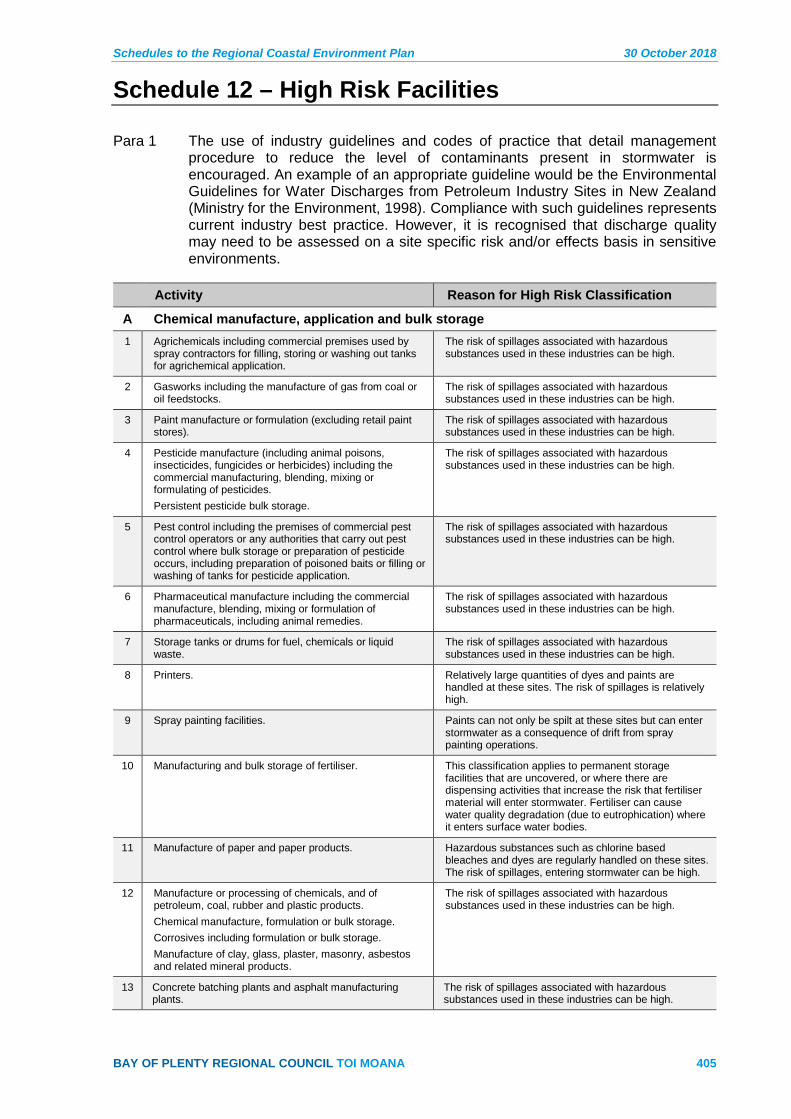
Schedules to the Regional Coastal Environment Plan 30 October 2018
BAY OF PLENTY REGIONAL COUNCIL TOI MOANA 405
Schedule 12 – High Risk Facilities
Para 1 The use of industry guidelines and codes of practice that detail management procedure to reduce the level of contaminants present in stormwater is encouraged. An example of an appropriate guideline would be the Environmental Guidelines for Water Discharges from Petroleum Industry Sites in New Zealand (Ministry for the Environment, 1998). Compliance with such guidelines represents current industry best practice. However, it is recognised that discharge quality may need to be assessed on a site specific risk and/or effects basis in sensitive environments.
Activity Reason for High Risk Classification
A Chemical manufacture, application and bulk storage 1 Agrichemicals including commercial premises used by
spray contractors for filling, storing or washing out tanks for agrichemical application.
The risk of spillages associated with hazardous substances used in these industries can be high.
2 Gasworks including the manufacture of gas from coal or oil feedstocks.
The risk of spillages associated with hazardous substances used in these industries can be high.
3 Paint manufacture or formulation (excluding retail paint stores).
The risk of spillages associated with hazardous substances used in these industries can be high.
4 Pesticide manufacture (including animal poisons, insecticides, fungicides or herbicides) including the commercial manufacturing, blending, mixing or formulating of pesticides. Persistent pesticide bulk storage.
The risk of spillages associated with hazardous substances used in these industries can be high.
5 Pest control including the premises of commercial pest control operators or any authorities that carry out pest control where bulk storage or preparation of pesticide occurs, including preparation of poisoned baits or filling or washing of tanks for pesticide application.
The risk of spillages associated with hazardous substances used in these industries can be high.
6 Pharmaceutical manufacture including the commercial manufacture, blending, mixing or formulation of pharmaceuticals, including animal remedies.
The risk of spillages associated with hazardous substances used in these industries can be high.
7 Storage tanks or drums for fuel, chemicals or liquid waste.
The risk of spillages associated with hazardous substances used in these industries can be high.
8 Printers. Relatively large quantities of dyes and paints are handled at these sites. The risk of spillages is relatively high.
9 Spray painting facilities. Paints can not only be spilt at these sites but can enter stormwater as a consequence of drift from spray painting operations.
10 Manufacturing and bulk storage of fertiliser. This classification applies to permanent storage facilities that are uncovered, or where there are dispensing activities that increase the risk that fertiliser material will enter stormwater. Fertiliser can cause water quality degradation (due to eutrophication) where it enters surface water bodies.
11 Manufacture of paper and paper products. Hazardous substances such as chlorine based bleaches and dyes are regularly handled on these sites. The risk of spillages, entering stormwater can be high.
12 Manufacture or processing of chemicals, and of petroleum, coal, rubber and plastic products. Chemical manufacture, formulation or bulk storage. Corrosives including formulation or bulk storage. Manufacture of clay, glass, plaster, masonry, asbestos and related mineral products.
The risk of spillages associated with hazardous substances used in these industries can be high.
13 Concrete batching plants and asphalt manufacturing plants.
The risk of spillages associated with hazardous substances used in these industries can be high.
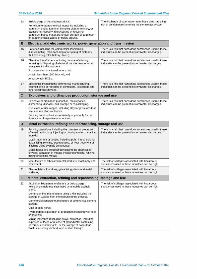
30 October 2018 Schedules to the Regional Coastal Environment Plan
406 Pre-Operative Regional Coastal Environment Plan – 30 October 2018
14 Bulk storage of petroleum products. Petroleum or petrochemical industries including a petroleum depot, terminal, blending plant or refinery, or facilities for recovery, reprocessing or recycling petroleum-based materials, or bulk storage of petroleum or petrochemicals above or below ground.
The discharge of stormwater from these sites has a high risk of contaminants entering the stormwater system.
B Electrical and electronic works, power generation and transmission 15 Batteries including the commercial assembling,
disassembling, manufacturing or recycling of batteries (but excluding retail battery stores).
There is a risk that hazardous substances used in these industries can be present in stormwater discharges.
16 Electrical transformers including the manufacturing, repairing or disposing of electrical transformers or other heavy electrical equipment. Excludes electrical transformers that:
contain less than 1500 litres oil; and do not contain PCBs.
There is a risk that hazardous substances used in these industries can be present in stormwater discharges.
17 Electronics including the commercial manufacturing, reconditioning or recycling of computers, televisions and other electronic devices.
There is a risk that hazardous substances used in these industries can be present in stormwater discharges.
C Explosives and ordinances production, storage and use 18 Explosive or ordinance production, maintenance,
dismantling, disposal, bulk storage or re-packaging. Gun clubs or rifle ranges, including clay targets clubs that use lead munitions outdoors. Training areas set aside exclusively or primarily for the detonation of explosive ammunition.
There is a risk that hazardous substances used in these industries can be present in stormwater discharges.
D Metal extraction, refining and reprocessing, storage and use 19 Foundry operations including the commercial production
of metal products by injecting or pouring molten metal into moulds. Metal treatment or coating including polishing, anodising, galvanising, pickling, electroplating, or heat treatment or finishing using cyanide compounds. Metalliferous ore processing including the chemical or physical extraction of metals, including smelting, refining, fusing or refining metals.
There is a risk that hazardous substances used in these industries can be present in stormwater discharges.
20 Manufacture of fabricated metal products, machinery and equipment.
The risk of spillages associated with hazardous substances used in these industries can be high.
21 Electroplaters, foundries, galvanising plants and metal surfacing.
The risk of spillages associated with hazardous substances used in these industries can be high.
E Mineral extraction, refining and reprocessing, storage and use 22 Asphalt or bitumen manufacture or bulk storage
(excluding single-use sites used by a mobile asphalt plant). Cement or lime manufacture using a kiln including the storage of wastes from the manufacturing process. Commercial concrete manufacture or commercial cement storage. Coal or coke yards. Hydrocarbon exploration or production including well sites or flare pits. Mining industries (excluding gravel extraction) including exposure of faces or release of groundwater containing hazardous contaminants, or the storage of hazardous wastes including waste dumps or dam tailings.
The risk of spillages associated with hazardous substances used in these industries can be high.

Schedules to the Regional Coastal Environment Plan 30 October 2018
BAY OF PLENTY REGIONAL COUNCIL TOI MOANA 407
F Vehicle refuelling, service and repair 23 Mechanical workshops, service stations, and automotive
dismantlers. Airports including fuel storage, workshops, washdown areas, or fire practice areas. Brake lining manufacturers, repairers or recyclers. Engine reconditioning workshops. Port activities including dry docks or marine vessel maintenance facilities. Railway yards including goods-handling yards, workshops, refuelling facilities or maintenance areas. Transport depots or yards including areas used for refuelling or the bulk storage of hazardous substances. Marinas. Exclusions: Manned refuelling facilities that comply with the Environmental Guidelines for Water Discharges from Petroleum Industry Sites in New Zealand, Ministry for the Environment. 1998.
These sites use and handle large volumes of oils and other petroleum products. Spillages of these substances are not uncommon; hence the greater risk of stormwater discharges to the environment.
24 Truck wash facilities. The activity of truck washing can discharge hazardous contaminants off trucks as well as sediments and wastes from spillages on site.
25 Car wash and valet services. High oil, solvent and solid discharges can occur from these activities.
G Waste recycling, treatment and disposal 26 Drum or tank reconditioning or recycling.
Landfill sites. Scrap yards including automotive dismantling, wrecking or scrap metal yards. Waste disposal to land (excluding where biosolids have been used as soil conditioners). Waste recycling or waste or wastewater treatment. Waste Management sites (transfer stations, compost sites, landfills, recycling operations, etc.).
Litter, hazardous substances and high BOD wastes can all enter stormwater systems from these sites.
H Food Processing 27 Meat, fish and shellfish processing industries, food and
pet food processing. Dairy products processing.
Wastes from these industries can typically have a high BOD. This can cause significant adverse effects when discharged into water bodies.
28 Bakeries. Outside washing of trays, discharges and pans can result in high BOD, fats, greases and detergents entering stormwater systems.
I Textiles, fibre and leather 29 Textile fibre and textile processing industries where
dying and washing of fabric occurs. Tanneries and leather finishing. Skin or wool processing including a tannery or fellmongery, or any other commercial facility for hide curing, drying, scouring or finishing or storing wool or leather products. Footwear manufacture.
Large quantities of dye and high BOD wastes (from wool scourers for instance) are handled on these sites. The risk of spillages that could enter stormwater is high.
30 Commercial laundries (excluding service laundrettes and laundromats). Dry-cleaning plants including dry-cleaning premises or the bulk storage of dry-cleaning solvents.
The risk of spillages associated with detergents, alkalis and salts used in this industry can be high.
J Wood and timber 31 Furniture/wood manufacturing and refinishing industries. Some of these industries work outside extensively,
usually with no stormwater treatment. Contaminants such as sawdust, glues, alkali stripper solution in the stormwater coming off these sites can include high solids, BOD and high pH.

30 October 2018 Schedules to the Regional Coastal Environment Plan
408 Pre-Operative Regional Coastal Environment Plan – 30 October 2018
32 Timber preservation, treatment and storage sites where chemically treated timber is stored.
A range of hazardous substances are used on these sites (e.g. Copper Chrome, Arsenic, Boron and copper-quinoline compounds). In addition, timber treatment chemicals have been shown to be able to leach from treated wood in storage, contaminating water bodies and soil.
33 Bulk log storage. The discharge of stormwater from these sites has a high risk of contaminants entering the stormwater system.
K Other 34 Stock sale yards. High BOD runoff can be associated with these sites.
35 Paint stripping or abrasive blasting operations. May produce wastes containing heavy metals. The risk and effect of spillages is relatively high.

Schedules to the Regional Coastal Environment Plan 30 October 2018
BAY OF PLENTY REGIONAL COUNCIL TOI MOANA 409
Schedule 13 – Principles on Biodiversity Offsets
The following Principles on Biodiversity Offsets are supported by the Business and Biodiversity Offsets Programme (BBOP) Advisory Committee.
Biodiversity offsets are measurable conservation outcomes resulting from actions designed to compensate for significant residual adverse biodiversity impacts arising from project development after appropriate prevention and mitigation measures have been taken. The goal of biodiversity offsets is to achieve no net loss and preferably a net gain of biodiversity on the ground with respect to species composition, habitat structure, ecosystem function and people’s use and cultural values associated with biodiversity. These principles establish a framework for designing and implementing biodiversity offsets and verifying their success.
Biodiversity offsets should be designed to comply with all relevant national and international law, and planned and implemented in accordance with the Convention on Biological Diversity and its ecosystem approach, as articulated in National Biodiversity Strategies and Action Plans.
1 No net loss: A biodiversity offset should be designed and implemented to achieve in situ, measurable conservation outcomes that can reasonably be expected to result in no net loss and preferably a net gain of biodiversity.
2 Additional conservation outcomes: A biodiversity offset should achieve conservation outcomes above and beyond results that would have occurred if the offset had not taken place. Offset design and implementation should avoid displacing activities harmful to biodiversity to other locations.
3 Adherence to the mitigation hierarchy: A biodiversity offset is a commitment to compensate for significant residual adverse impacts on biodiversity identified after appropriate avoidance, minimisation and on-site rehabilitation measures have been taken according to the mitigation hierarchy.
4 Limits to what can be offset: There are situations where residual impacts cannot be fully compensated for by a biodiversity offset because of the irreplaceability or vulnerability of the biodiversity affected.
5 Landscape context: A biodiversity offset should be designed and implemented in a landscape context to achieve the expected measurable conservation outcomes taking into account available information on the full range of biological, social and cultural values of biodiversity and supporting an ecosystem approach.
6 Stakeholder participation: In areas affected by the project and by the biodiversity offset, the effective participation of stakeholders should be ensured in decision-making about biodiversity offsets, including their evaluation, selection, design, implementation and monitoring.
7 Equity: A biodiversity offset should be designed and implemented in an equitable manner, which means the sharing among stakeholders of the rights and responsibilities, risks and rewards associated with a project and offset in a fair and balanced way, respecting legal and customary arrangements. Special consideration should be given to respecting both internationally and nationally recognised rights of indigenous peoples and local communities.
8 Long-term outcomes: The design and implementation of a biodiversity offset should be based on an adaptive management approach, incorporating monitoring and evaluation, with the objective of securing outcomes that last at least as long as the project’s impacts and preferably in perpetuity.

30 October 2018 Schedules to the Regional Coastal Environment Plan
410 Pre-Operative Regional Coastal Environment Plan – 30 October 2018
9 Transparency: The design and implementation of a biodiversity offset, and communication of its results to the public, should be undertaken in a transparent and timely manner.
10 Science and traditional knowledge: The design and implementation of a biodiversity offset should be a documented process informed by sound science, including an appropriate consideration of traditional knowledge.
Advisory Note
1 The document Guidance on Good Practice Biodiversity Offsetting in New Zealand 2014 provides a New Zealand context to biodiversity offsetting, including guidance on how the Principles on Biodiversity Offsets relate to RMA requirements. In particular, it provides an explanation for terminology used in the BBOP that has a different meaning under the RMA.

Schedules to the Regional Coastal Environment Plan 30 October 2018
BAY OF PLENTY REGIONAL COUNCIL TOI MOANA 411
Schedule 14 – Marine and Coastal Area (Takutai Moana) Act 2011
The Marine and Coastal Area (Takutai Moana) Act (MACAA) 2011 sets out a legal framework for recognising customary interests in the common marine and coastal area (CMCA).
The common marine and coastal area includes any part of the coastal marine area that is not privately owned, conservation land, a reserve or national park.
Iwi, hapū or whānau can apply for:
• Customary marine title (CMT), and/or
• Protected customary rights (PCR).
If either of these customary recognitions is granted, they can affect the way that resource consents are considered and what affected party approvals are required.
Customary Marine Title (CMT)
Customary Marine Title recognises that the group has an interest in a specific area of the CMCA and gives the group rights that are similar, but not equivalent, to a freehold landowner. If CMT is granted to a group, the group gains various rights (set out in section 62 of the MACAA). These rights exist once the CMT is given effect by an Act of Parliament (section 96 of the MACAA).
Most relevant to the Resource Management Act 1991 and resource consent processes are:
• A Resource Management Act 1991 (RMA) permission right – the right to grant or decline permission for an activity to occur that requires a resource consent in the CMT area for any reason (section 66 of the MACAA).
• A right to protect wāhi tapu and wāhi tapu areas – the CMT can contain conditions to protect wāhi tapu. The Regional Council is required to take any appropriate action that is reasonably necessary to encourage public compliance with any wāhi tapu conditions (see sections 78 to 81 of the MACAA).
• The ownership of minerals other than petroleum, gold, silver, and uranium.
• The right to create a planning document (see sections 85 to 93 MACAA) – after the planning document is lodged with the Regional Council it must be taken into account during decision making, and the Regional Council must review its planning documents to ensure that they recognise and provide for the CMT planning document.
When a CMT application is lodged
Once an application for a CMT is lodged, a resource consent applicant for an activity in that area must notify and ‘seek the views’ of the CMT applicant group before lodging their consent application. The Regional Council is notified of all CMT applications, and details are also available on the Office of Treaty Settlements website:http://www.justice.govt.nz/treaty-settlements/office-of-treaty-settlements/marine-and-coastal-area-takutai-moana/current-marine-and-coastal-applications.

30 October 2018 Schedules to the Regional Coastal Environment Plan
412 Pre-Operative Regional Coastal Environment Plan – 30 October 2018
When CMT is given effect
RMA Permission Right
The most important ‘right’ with regard to resource consents is the RMA permission right. In a CMT area, activities requiring a resource consent (including controlled activities) cannot be undertaken unless an RMA permission right has been obtained from the CMT group.
Accommodated activities do not require an RMA permission right. These activities are set out in section 64 of the MACAA and include:
• any activity if the application for resource consent was lodged before the CMT was granted.
• a minimum impact activity under the Crown Minerals Act 1991 relating to petroleum.
• existing infrastructure structures and associated activities (including maintenance).
• activities related to managing an existing marine reserve, wildlife sanctuary, marine mammal sanctuary or concession:
existing aquaculture activities provided there is no increase in the area or location (the species and method of farming can be changed.
emergency works (undertaken under section 330 of the RMA).
scientific research or monitoring that is undertaken or funded by the Crown, any Crown agent or the Regional Council.
a deemed accommodated activity (new infrastructure).
The process for obtaining a RMA permission right is set out in section 67 of the MACAA. In summary:
• A resource consent applicant must request an RMA permission right from the CMT group – this can be done at any point.
• The CMT group must notify the resource consent applicant and regional council of its decision.
• If the RMA permission right is granted it can be for a duration that is shorter than the resource consent term.
• If the resource consent is granted, but the applicant has not been notified of a decision on the RMA permission right, the CMT group has to make a decision within 40 working days from the day that it receives notification from the applicant that the consent has been granted.
• If no decision is made after 40 working days, then permission is deemed to have been given and the resource consent can commence.
• The resource consent applicant cannot appeal the decision made by the CMT group on the RMA permission right.
• The CMT group can grant or decline a RMA permission right on any grounds.
Schedules to the Regional Coastal Environment Plan 30 October 2018
BAY OF PLENTY REGIONAL COUNCIL TOI MOANA 413
Affected Party Status – accommodated activities
A consent authority must give limited notification to an affected CMT group even if a rule or national environmental standard precludes limited notification (see section 95B of the RMA). This only applies to CMT groups for accommodated activities.
A CMT group is deemed to an affected CMT group (see section 95G of the RMA) in relation to an accommodated activity if the activity is occurring in an area over which the group has been granted CMT and:
• the activity may have adverse effects on the exercise of rights applying to a CMT group; and
• written approval has not provided by the CMT group.
Protected Customary Rights (PCR)
Protected Customary Rights are activities, uses and practices that have been undertaken since 1840 in a particular part of the CMCA in accordance with tikanga. Possible examples include tauranga waka (waka landing sites) or collecting hangi stones.
Once PCR have been granted over an area, the following apply:
• A resource consent is not required to carry out the PCR in that area (section 52(1) of the MACAA 2011) – the Minister of Conservation may impose controls if there is likely to be significant adverse effects from an activity.
• The PCR group is not liable for any coastal occupation charges or royalty payments for sand and shingle associated with the PCR in that area (section 52(2) of the MACAA 2011).
• The PCR group can benefit commercially from a PCR activity (except from a non-commercial aquaculture or fishery activity).
• Rights can be delegated or transferred.
• The public cannot be excluded from the area.
• A resource consent cannot be granted for an activity (including controlled activities) that will have a more than minor adverse effect on a PCR unless the PCR group has given written approval or the activity is one of the following (section 55 of the MACAA):
Existing aquaculture activities provided there is no increase in the area or location (the species and method of farming can be changed).
Emergency works (undertaken under section 330 of the RMA). Existing infrastructure (see section 63 of the MACAA) provided the
adverse effects on the PCR are likely to remain the same or similar in extent OR temporary in nature.
A deemed accommodated activity (see section 65 of the MACAA).
Deemed accommodated activities are associated with new infrastructure in the CMCA that has national or regional significance. The Minister of Land Information has the power to decide whether an activity is a deemed accommodated activity, using a process set out in Schedule 2 to the MACAA.

30 October 2018 Schedules to the Regional Coastal Environment Plan
414 Pre-Operative Regional Coastal Environment Plan – 30 October 2018
If a resource consent application is for a deemed accommodated activity the consent authority must have particular regard to the nature of the PCR when considering the application.
Affected Party Status
A consent authority must give limited notification to an affected PCR group even if a rule or national environmental standard precludes limited notification (see section 95B of the RMA).
A PCR group is deemed to an affected PCR group (see section 95F of the RMA) in relation to an accommodated activity if the activity is occurring in an area over which the group has been granted PCR and:
• the activity may have adverse effects on a protected customary right; and
• written approval has not been provided by the PCR group.
Schedules to the Regional Coastal Environment Plan 30 October 2018
BAY OF PLENTY REGIONAL COUNCIL TOI MOANA 415
Schedule 15 – Offshore Islands
The Department of Internal Affairs (DIA), on behalf of the Minister of Local Government, administers territorial authority responsibilities for some offshore islands that are not included in the boundaries of a city or district council. Offshore islands in the Bay of Plenty region include Motiti Island, Tūhua Island (Mayor Island) and Whakaari (White Island). District plans have been developed for Motiti and Tūhua.
This schedule sets out the existing and planned landing and boat access points on specified offshore islands and appropriate locations for certain types of development on specified offshore islands. The purpose of this schedule is to assist with the interpretation of objectives, policies and rules associated with natural heritage, and the offshore islands (or parts thereof) that have been identified within the Plan as Outstanding Natural Features and Landscapes (ONFLs) or Indigenous Biological Diversity Areas (IBDA), or as areas of Outstanding Natural Character in the RPS.
Tūhua
Access to Tūhua is by sea or air – the main boat landing areas are adjacent to the Opo Bay, the Pānui area and Oira. Opo Bay and the Pānui area are the places of primary occupation on the island and the Tūhua District Plan identifies these areas as suitable for the location of built development.
Appropriate use and development on Tūhua includes:
• Use and development in Opo Bay and Pānui as provided for in the Tūhua District Plan including marae, residential activities/papakainga and visitor accommodation within prescribed limits in the Opo Bay and Pānui areas.
• Access tracks.
• Eco-tourism activities, and ecological maintenance and restoration.
• Scientific research and monitoring.
• Structures and disturbance related to transportation activities including the loading/unloading of boats and helicopters on the island.
• Boat launching, retrieval and mooring in the Opo Bay, Pānui area and Oira (there are rules within the Tūhua District Plan controlling access to the island to ensure its biodiversity values are protected).
Whakaari
There is no district plan for Whakaari, which is subject to limited use and development due to its geological nature (it is an active volcano). However, there are some existing activities on Whakaari that it is appropriate to continue, maintain and upgrade.
Appropriate use and development on Whakaari includes:
• Boat launching, retrieval and mooring at Te Awapuia Bay.
• Use and development associated with monitoring and research.
• Structures (such as basic shelters) associated with visitor access and health and safety.

30 October 2018 Schedules to the Regional Coastal Environment Plan
416 Pre-Operative Regional Coastal Environment Plan – 30 October 2018
Motiti Island
Motiti Island is covered by the Motiti Island Environmental Management Plan (MIEMP).
Motiti Island is the most developed of the offshore islands. Built development and infrastructure includes houses, marae, water tanks, septic tanks, landings places (air and sea) roads, tracks, electricity and telecommunications infrastructure and structures and activities associated with a working rural environment.
The MIEMP establishes a Te Tai Ao Turoa/Ecological Zone, which includes the island’s coastal margin, significant waterways and perennial springs. It also includes all recorded cultural heritage and ecological sites that are contiguous with the coastal margin and waterways. The purpose of the Zone is to provide protection of the primary cultural heritage, archaeological and ecological functions of the Island.
The remainder of the Island is covered by the MIEMP Te Tai Whenua/Rural Zone.
Appropriate use and development on Motiti Island within the ONFL, IBDA and area of high natural character (as identified in Appendix I to the RPS) includes:
• Activities and structures associated with boat launching, retrieval and mooring in areas identified in Map 4 of the MIEMP.
• Maintenance and upgrading of helicopter land areas and airstrips in the Te Tai Whenua/Rural Zone.
• Minor pruning or removal of indigenous vegetation in the Te Tai Ao/Ecological Zone for the reasons specified in Rule 3.3.5 of the MIEMP.
• Use, development and subdivision consistent with the provisions of the MIEMP noting that the MIEMP provides for:
Limited use and development in the Te Tai Ao/Ecological Zone.
Continuation of existing rural activities, limited subdivision and other a range of other activities in the Te Tai Whenua/Rural Zone.
Planning maps for the Regional Coastal Environment Plan 30 October 2018
BAY OF PLENTY REGIONAL COUNCIL TOI MOANA 417
Part Seven Planning Maps for the Regional Coastal
Environment Plan The planning maps identify various sites of significance, zones and existing uses in the coastal environment. The coastline has been split into 45 areas, and three maps have been produced for each of the areas along the coastline. Additional maps (46-52) are included that clearly show the locations of the Harbour Development Zone.
All maps show the landward extent of the coastal environment, as identified in the RPS.
The maps show:
Map Series a – Landscape
• Outstanding Natural Features and Landscapes (ONFLs) in the coastal environment.
Map Series b – Ecology, Culture and Heritage
• Historic heritage sites (including shipwrecks).
• Indigenous Biological Diversity Areas in the coastal environment – spilt into areas that meet the criteria contained in Policy 11(a) and 11(b) of the NZCPS (Indigenous biological diversity). Where a site is identified in Schedule 2 as a shorebird breeding site, the boundary of the site extends to mean low water.
• Areas of Significant Cultural Value (ASCV).
• Regionally Significant Surf Breaks.
Map series c – Use
• Harbour Development Zones.
• Port Zone.
• Port of Tauranga Occupation area.
• Port noise contours.
• Tauranga Airport height restrictions.
• Mooring areas.
• Personal water craft areas; water ski areas and water ski access lanes.
• Coastal marine area boundary in rivers.