Embed Size (px)
Citation preview

PRE – FEASIBILITY REPORT OF
SIRUGUDI LIMESTONE MINE
LOCATION OF THE MINE
S.F.Nos. 630/1A, 1B, 2, 631/10, 11
Sirugudi Village,
Natham Taluk,
Dindigul District,
Extent: 0.94.5Ha (less than 5Ha)
Category: B2 Project.
LESSEE
M/s.Sivam Mines,
Managing Partner
Thiru. S.Ilangovan, B.E
6/209, Main Road, Sirugudi Post,
Natham (Tk), Dindigul District.
Tamilnadu State.

1. EXECUTIVE SUMMARY
The pre feasibility report is prepared for the Sirugudi Limestone Mine, located in the
S.F.No’s. 630/1A,1B, 2, 631/10,11, over an extent of 0.94.5Ha Sirugudi Village, Natham Taluk,
Dindigul District.
• Initially, the mining lease for limestone was granted to Thiru. S.Ilangovan, Dindigul
district vide G.O. 3 (D).No. 318, Industries (MMA 2) Department, dated 26.10.1995 for
a period of 20 years. The lease deed was executed on 17.04.1996 and the lease will get
expired on 16.04.2016.
• The lease was transferred to M/s. Sivam Mines., 6/209, Main Road, Sirugudi Post,
Natham (Tk), Dindigul District vide G.O.(D) No.141 Inds (MMA1) dept., dated
22.09.2014.
• The mining plan was approved by Indian Bureau of Mines vide letter no. TN/D-
Anna/MP/LST-83-MDS, dated 13.07.1995
• The first scheme of mining was approved by Indian Bureau of Mines vide letter no.
TN/DGL/LST/MS-116-Mds, dated 14.02.2002
• The second scheme of mining was approved by Indian Bureau of Mines vide letter
no. TN/DGL/LST/MS-391-Mds, dated 15.09.2006
• The final scheme of mining (2011-12 to 2015-16) was approved by Indian Bureau of
Mines vide letter no. TN/DGL/LST/MS-783.MDS, dated 27.03.2013 and it is valid
upto 31.03.2016
• As the lease period is going to get expired on 16.04.2016. The lessee has decided to
renew the mining lease for a further period of Thirty years (from 17.04.2016 to
16.04.2046) and hence, this Modified Mining Plan along with Progressive Mine
Closure Plan [2016-17 to 2020-21] was prepared and got approval from the IBM,
Chennai vide Letter No TN/DGL/MP/LST-1970-MDS………DATED30.03.2016
As per the EIA notification S.O. 1533 (E) dated the 14th September, 2006,
All applications seeking prior environmental clearance for expansion with increase in the
production capacity beyond the capacity for which prior environmental clearance has
been granted under the notification of with increase production capacity in the case of
mining projects or for the modernization of an existing unit with increase in the total
production capacity beyond the threshold limit prescribed in the Schedule to this
notification.
SALIENT FEATURES OF THE PROJECT
S.NO PARTICULAR DETAILS
1. Name of the proponent M/s.Sivam Mines,
2. Type of Project Limestone Mining project
3. Location of the Mine Survey Nos. 630/1A,1B, 2, 631/10,11
Sirugudi Village,
Natham Taluk,
Dindigul District,
Tamilnadu State.
4. Mining lease area 0.94.5Ha
5. Latitude N 10˚14.809’
6. Longitude E 78˚17.844’
7. Topo sheet No. 58 – J/08
8. Type of land
Patta/forest/PWD
It is a Patta land - Non forest
630/2 (Government land)
9. Production capacity
In the Modified Mining plan period the (2016-17 to 2020-21)
Mineral reserves (ROM) = 46,565Ts
Limestone (60% Recovery) = 27,939Ts
Mineral Rejects (40%) = 63,424Ts
Top soil = 3,612Ts
10. Period of Mine Thirty years (from 17.04.2016 to 16.04.2046)
11. Method of Mining Mining operation is proposed to be carried out by
opencast semi mechanized method without involving
deep hole drilling and Heavy Earth moving
Machineries.
The benches are 3m height and 5m width with 60º
slope.
12. Ultimate depth of Mining The ultimate depth of the Mining is 20m below the
ground level.
13. Top soil & overburden
(quantity in m3)
The average depth of top soil is about 1m Depth. The
total quantity of top soil is 3612 Ts.
14. Ground water level The depth of water table is around 30m-35m (35m
during summer season and 30m during rainy season).
15. Nearest habitation Sirugudi – 3.0km – NE
16. Nearest Town Natham - 7km- SW
17. Nearest Railway station Dindigul Railway station -38km – NW
18. Nearest Airport Tiruchirapalli - 75km- NE
19. Nearest National Highways
& State Highways
NH-45B-Tiruchirapalli – Madurai – 9Km- East side.
SH-35- Natham – Dindigul - 8km- South West side.
20. Nearest Hospital Sirugudi - 3km- NE
21. Aerial distance to the
nearest Eco sensitive areas,
CRZ, forest, wild life
sanctuary, Interstate
boundary, critically polluted
area if the quarry site is
within 500m of these areas.
The area is More than 15Km from Eco sensitive areas,
CRZ, forest, wild life sanctuary, Interstate boundary
and critically polluted area.
22. Details of other quarries for
a radius of 500m around the
quarry site
Five mines located within the radius of 500m, the total
extent of the other mines is 6.55.5Ha (Please refer the
Affidavit and letter from the Assistant Director encloses
with this document)
23. Man power About 11 employees
24. Water requirement & source Total water requirement for 2.0KLD from water
vendors & existing bore well.
25. Cost of the project A. Fixed asset cost = Rs. 3,64,000/-
B. Operational cost = Rs. 76,83,000/-
C. EMP cost = Rs. 3,46,000/-
Total cost = Rs. 83,93,000/-
The Prefeasibility report preparing for following condition of Government of India Ministry of
Environment and Forests (No.L-11011/47/2011 –IA-II (M) Dated: 24th June, 2013)
There is no HACA region within the radius of 15km.
There is no Western Ghats region within the radius of 15km.
There is no interstate boundary within the radius of 15km.
There is no CRZ within the radius of 15km.
There are no Bird sanctuaries, wild life sanctuaries and National park as Act 1972, within the
radius of 15kms.

The following information is furnished.
We have applied for Environmental Clearance to SEIAA, Tamilnadu for Limestone Mine
situated in Sirugudi, S.F.Nos: 630/1A,1B, 2, 631/10,11, for over an extent of 0.94.5Ha in
Sirugudi Village, Natham Taluk and Dindigul District.
We swear to state and confirm that the following areas are not within the radius of 10km
from the periphery of the lease area.
• Protected areas notified under the wild life (Protection) Act, 1972,
• Critically polluted areas as notified by the central pollution control board constituted.
• Under water (Prevention and Control of Pollution) Act 1974.
• Eco-Sensitive areas as notified,
• Interstate boundaries and international boundaries within 10km radius from the boundary of
the proposed site.
• Another five mine is located within the radius of 500m the total extent of the other mines is
6.55.5Ha.
• There is no houses within the radius of 300m.
• I swear that Afforestation is being carried out during the course of mining operation and the
same will be maintained in the ensuing plan period.
• All the labours will be insured in the entire life of the Mine.
• Approach road belongs to us only and no other private patta roads encountered.
• We will not engage any child labour in our mine site and I aware that engaging child labour
is punishable under the law.
• All types of safety / Personal protective equipment (PPE) will be provided to all the
labourers working in mining area, the same will be checked periodically.
• The drinking water will be provided, the same will be keep in the easily accessible point.
• Periodical medical checkup will be conducted to all the labours.

2.0 INTRODUCTION OF THE PROJECT OR BACKGROUND INFORMATION
(i) Identification of project and project proponent: In case of mining project, a copy of mining
lease/letter of intent should be given
Identification of Project
Name of the Project : Sirugudi Limestone Mine
Lease area : 0.94.5Ha(Patta land/Poramboke land)-Non forest
Survey Nos. 630/1A,1B, 2, 631/10,11
Sirugudi Village, Natham Taluk,
Dindigul District and Tamilnadu State.
Topo sheet No. 58 – J/08
Lattitude : N 10˚14.809’
Longitude : E 78˚17.844’
Registration no. : IBM /5276/2011
Project Proponent Name with Address
M/s. Sivam Mines,
6/209, Main Road, Sirugudi Post,
Natham (Tk), Dindigul District.
Tamilnadu State.
Email id: [email protected]
• In case of mining project, a copy of mining lease/letter of intent should be given
� The mining plan was approved by Indian Bureau of Mines vide letter no. TN/D-
Anna/MP/LST-83-MDS, dated 13.07.1995
� The final scheme of mining (2011-12 to 2015-16) was approved by Indian
Bureau of Mines vide letter no. TN/DGL/LST/MS-783.MDS, dated 27.03.2013
and it is valid upto 31.03.2016.
� As the lease period is going to get expired on 16.04.2016. The lessee has
decided to renew the mining lease for a further period of Thirty years (from
17.04.2016 to 16.04.2046) and hence, this Modified Mining Plan along with
Progressive Mine Closure Plan [2016-17 to 2020-21] was prepared and got
approval from the IBM, Chennai vide Letter No… TN/DGL/MP/LST-1970-
MDS………DATED30.03.2016

(ii) Brief description of nature of the project
The nature of the project is extract the Limestone Mineral and use the minerals for the
processing plant, the method of mining is opencast semi mechanized method and the excavation
is not made by the system of deep hole blasting along with heavy earth moving machinery.
The drilling is carrying out with jack hammer of small diameter (30-32 mm) at shallow
depth is performed and blasted with class 2 slurry explosives. The imitation system is done with
controlled blasting techniques under the supervision of competent personnel’s.
The entire mined out mineral is used for its own captive plant in the name of
M/s. Air Mineral Enterprises which is located in Sirugudi, 3.0kms from mining lease area for
Pulverizing and also sold to the nearby cement and lime based industries which are located
within a radius of 35Km from the mine site.
Production details given below.
Mineral reserves (ROM) = 46,565Ts
Limestone (60% Recovery) = 27,939Ts
Mineral Rejects (40%) = 63,424Ts
Top soil = 3,612Ts
The mineral rejects is 40% of ROM which includes rock fragments, impurities
etc., mineral rejects are generated during the previous plan period was dumped in the western
portion of the area. The mineral reject that would be generated during the present plan period is
proposed to fill old pit situated in the southwestern side of the lease area.
(iii) Need of the project and its importance to the country and or region
Depending on the quality of the deposit, limestone can be quarried to service the needs of
the building and construction industries as raw material. Cement is a key ingredient of concrete,
huge volumes of which are poured each day to serve as roading, foundations, structural beams
and columns.
Agricultural use:
Limestone deposits with a calcium carbonate content around 90% can be mined to be
used by the farming sector. By crushing the limestone, various grades (based on particle size)
can be produced. These products are marketed as ‘agricultural lime’ Soil acidity is one of the
factors that can influence plant growth and can seriously limit crop production.

The calcium carbonate content of the limestone is capable of neutralising some of the
acid in the soil. This also has the effect of freeing up some of the soil minerals, such as
phosphates, and making them available for absorption into the plant.
The southern region accounts for the largest share in overall cement production due to the
vast availability of limestone. Cement industry is one of the main beneficiaries of the
infrastructure boom. Weaker sections housing, construction of public toilets, schools in rural area
apart from several private and public infrastructure projects will also give tremendous boost to
the cement consumption in the state.
Mineral Industries of the state of Tamilnadu provides employment opportunities for the
people of the state as well as in the specific project area. The Mining is one among the major
core sector industries which plays a vital process of country’s economic development and
foreign exchange.
(iv) Demand and supply gap
Limestone is the main raw material for cement production; the demand is always there
with that of cement. The mine produces good grade limestone leading to conservation of mineral
resources. The cement market has growth due to the central government liberalization policies
and new schemes for housing, road projects. The cement demand growth is anticipated to
increase on infrastructure development and the higher demand from the housing sector &
industrial projects.
(v) Imports vs indigenous production
There is no import of Limestone at present in India. India especially the peninsular India
(southern India), the southern India has good resource of Limestone and has a great demand in
the international supermarket. Indigenous Limestone almost shares more than 50% requirement
in the world.
(vi) Export Possibility
India, the world’s second largest cement manufacturer. United Kingdom is the largest
buyer of Indian limestone followed by Ireland and Belgium which imported Indian limestone.
Average price of indian limestone per unit is USD 4.05., currently experts two to three per cent
of its production and that is mainly in the form of clinker, an input for cement making to
neighboring countries.

(vii) Domestic/Export Markets
Sirugudi Limestone mine is one of the captive Limestone mine of the lessee and feeding
Limestone to the nearby cement factories and with the financial back up the mine.
(viii) Employment Generation (Direct and Indirect) due to the project
About 12 employees are deployed for this Limestone Mines directly and indirectly about
10 people will be benefited from the nearby local villages.
The above man power is adequate to meet out the production schedule and the machinery
strength envisaged in the plan and also to comply with the stationary provisions of mine safety
regulation.
It is been ensured that the labors will not be deployed less than 18 years, No Child
labors will engaged or entertained for any kind of mining operations. All the labors engaged
for mining operations will be insured till the end of life of mine.
3.0 PROJECT DESCRIPTION
(i) Type of project including interlinked and interdependent projects, if any
It is a Limestone Mining project, the Limestone will be excavated opencast semi
mechanized method. No processing works inside the project area, the Limestone raw material
directly sent to the cement industries for further processing.
(ii) Location (map showing general location, specific location, and project boundary & project
site layout) with coordinates
� The area is located in S.F.Nos. 630/1A,1B, 2, 631/10,11
� Sirugudi Village, Natham Taluk and Dindigul District.
� The entire mine lease area falls in the Patta land. (630/2 Government land)
� The Altitude of the area is above 220m from MSL.
� The area is mentioned in GSI Topo sheet No. 58 – J/08
� The Latitude between of N 10˚14.809’
� The Longitude between of E 78˚17.844’on WGS 1984 datum.

DRAWING SHOWN THE MINE LEASE BOUNDARY WITH CO-ORDINATES
DRAWING SHOW THE ENVIRONMENTAL PLAN

(iii) Details of alternate sites considered and the basis of selecting the proposed site, particularly
the environmental considerations gone into should be highlighted
The opencast Semi mechanized mining is proposed in the area for excavation of
Limestone with 20m depth. The mining operation is proposed in the patta land hence alternate
site for this project is not considered. The project is site specific.
(iv) Size or magnitude of operation
The total area of the project is about 0.94.5Ha. Out of this only 0.22.4 Ha is proposed for
an optimum depth of maximum 20m from RL 220.0m to RL 200.0m has been taken into
consideration for the utilization of the mineral in the present plan period.
Anticipated Daily production is about 32 tonnes (1 to 2 Tippers per day).
(v) Project description with process details (a schematic diagram/flow chart showing the
project layout, components of the project etc. should be given)
Details regarding topography, Geology of the area, Method of mining, Machineries
required and production details area given below:
Physiographic:
The area is almost plain topography sloping towards southern side, the altitude of the area
is 220m above MSL. It is a dry barren land, only seasonal cultivation is carried out. Water table
is found at a depth of 35m during summer and 30m during rainy season.
Geology of the area:
The area comprises crystalline Archaean rocks of deep seated metamorphic origin which
include mainly calc-gneiss, cordierite-sillimanite Gneiss, Biotite gneiss and granite gneiss. The
gneisses appear to have resulted by migratizations of the pre existing sediments by intrusive of
high grade metamorphism viz. High temperatures and pressures. In addition, younger intrusive
such as granites, pegmatites and quartz veins are found within the limestone. The above said
different types of metamaorphosed rocks occur in the form of long, narrow, parallel bands which
are traceable over a long distance. Limestone, band is noticed with prominent outcrops.
The regional trend of the rock in the area is N600E – S600W with Dip 60o NW. The
area was surveyed in detail to prepare a Geological map in the scale of 1:1000 showing the
various formations and attitude of the deposit. It is inferred that the Limestone mineral is of
cement grade and in form Band running N600E – S600W with dipping 75o NW. Reddish soil
cover upto a depth in about 1.0m. Recovery of minerals is estimated as 60% of the total

excavation of the ore body. The recovery percentage is based on the knowledge gained from the
present mine workings and adjacent working mine in this region, by the field tests carried out in
the lease area and analysis done in NABL Laboratories.
The general geological sequence of the limestone deposits is as follows:
Order of Super position:
AGE ROCKFORMATION
Recent - Reddish Soil
Achaean - Crystalline Limestone
- Calc-gneiss.
The physical attitude of the limestone band is demarked as follows:
Strike length (m) : 87
Width (m) : 55
Depth (m) Proved : 20
Strike direction : N600E – S60
0W
Dip amount and direction : 75o
NW.
The deposit is covered by 1.0m thickness of topsoil followed by 19m thickness of Limestone
bed.
Method of Mining:
The method of mining is opencast semi mechanized method, in the Mining operation
deep hole drilling and blasting is not carrying out. No Heavy Earth moving Machinaries like
excavators are deployed in this mining operation.
The limestone will be separated manually and loaded directly into the tippers. The
blasting is being carried out occasionally. The drilling is carrying out with jack hammer of small
diameter (30-32 mm) at shallow depth is performed and blasted with class 2 slurry explosives.
The imitation system is done with controlled blasting techniques under the supervision of
competent personnel’s.
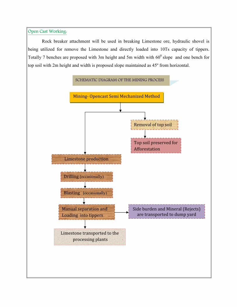
Open Cast Working:
Rock breaker attachment will be used in breaking Limestone ore, hydraulic shovel is
being utilized for remove the Limestone and directly loaded into 10Ts capacity of tippers.
Totally 7 benches are proposed with 3m height and 5m width with 600
slope and one bench for
top soil with 2m height and width is proposed slope maintained as 45º from horizontal.
SCHEMATIC DIAGRAM OF THE MINING PROCESS
Removal of top soil
Mining- Opencast Semi Mechanized Method
Top soil preserved for
Afforestation
Drilling (occasionally)
Blasting (occasionally)
(
Side burden and Mineral (Rejects)
are transported to dump yard
Limestone transported to the
processing plants
Manual separation and
Loading into tippers
Limestone production

Machinery Required:
I. Drilling Machine:
Type
No of
Jack
Hammer
Dia. Of
hole
Compressor
Capacity Make
Motive
power H.P
Tractor
mounted
compressor
1 32mm 140cfm Atlas
copco Diesel 45
Portable
Compressor 2 32 mm 250/150
Atlas
copco Diesel 210
II. Loading
The limestone is directly loaded into tippers manually.
III. Transport Equipment:
Type Nos. Size/Capacity Make Motive
power H.P.
Comet
Tipper 1 9 tonnes
Ashok
Leyland Diesel 90
Manpower details
The tentative man powers are available for this project shall be as follows.
DESIGNATION NO’S
Mining Engineer (Part time) 1
Mines office clerk (Full time) 1
Skilled Labour (Mate/Supervisor) 2
Semi-Skilled (Drivers) 2
Un skilled Labour 6
Total 12
Year wise development and production details for the present scheme period (2016-17 to
2020-21):
The year wise production detail for this present scheme period (2016-17 to 2020-21)
quantum of work proposed and the details of estimation of production quantity and generation of
waste are furnished below:

Summary of yearwise [2016-17 to 2020-21]
Year ROM(Ts) Limestone
@ 60% (Ts)
Mineral Rejects @ 40%
(Ts)
Side burden
(Ts)
Total Waste (Mineral
Rejects @ 40% + Side burden) Ts
Topsoil (Ts) Ore waste
ratio
2016-17 9528 5717 3811 26450 30261 3612 1;3.17
2017-18 9422 5653 3769 10444 14213 - 1;1.50
2018-19 9173 5504 3669 3713 7382 - 1;0.80
2019-20 9243 5546 3697 3042 6739 - 1;0.72
2020-21 9199 5519 3680 1149 4829 - 1;0.52
Total 46565 27939 18626 44798 63424 3612 1;1.36
(vi) Raw material required along with estimated quantity, likely source, marketing area of final
products, Mode of transport of raw Material and Finished Products
This is a mine project for exploiting Limestone; hence, there is no requirement for raw
material. This Limestone will be transported from the working pit head to processing plant.
Uses:
The Limestone mined will be used as a raw material in the cement plant for the production
of cement.
(vii) Resource optimization/recycling and reuse envisaged in the project, if any, should be
briefly outlined
No optimization/Recycling and Reuse envisaged in the proposed Limestone mine.
(viii) Availability of water its source, Energy/power requirement and source should be given
This Mining project does not require huge water for the project. The total water
requirement in the mine will be around 2.0 KLD for drinking, sprinkling and afforestation.
Potable drinking water will be brought from private suppliers; the rain water will be collected
and used for the Green belt development.
Purpose Quantity Sources
Drinking &
Domestic purpose
0.2 KLD Packaged drinking water will be brought from
nearby approved water vendors.
Dust suppression 0.4 KLD From existing borehole on nearby mine
Green belt 0.4 KLD From existing borehole on nearby mine
Total 1.0KLD
Energy Diesel (HSD) will be used for tractor mounted compressor only, diesel consumption of
Compressor is about 5Ltrs per hours, from the practical experience and the required production
the total number of Compressor running hours would be around 4Hours. Hence the total diesel
requirement is about 20Ltrs per day.
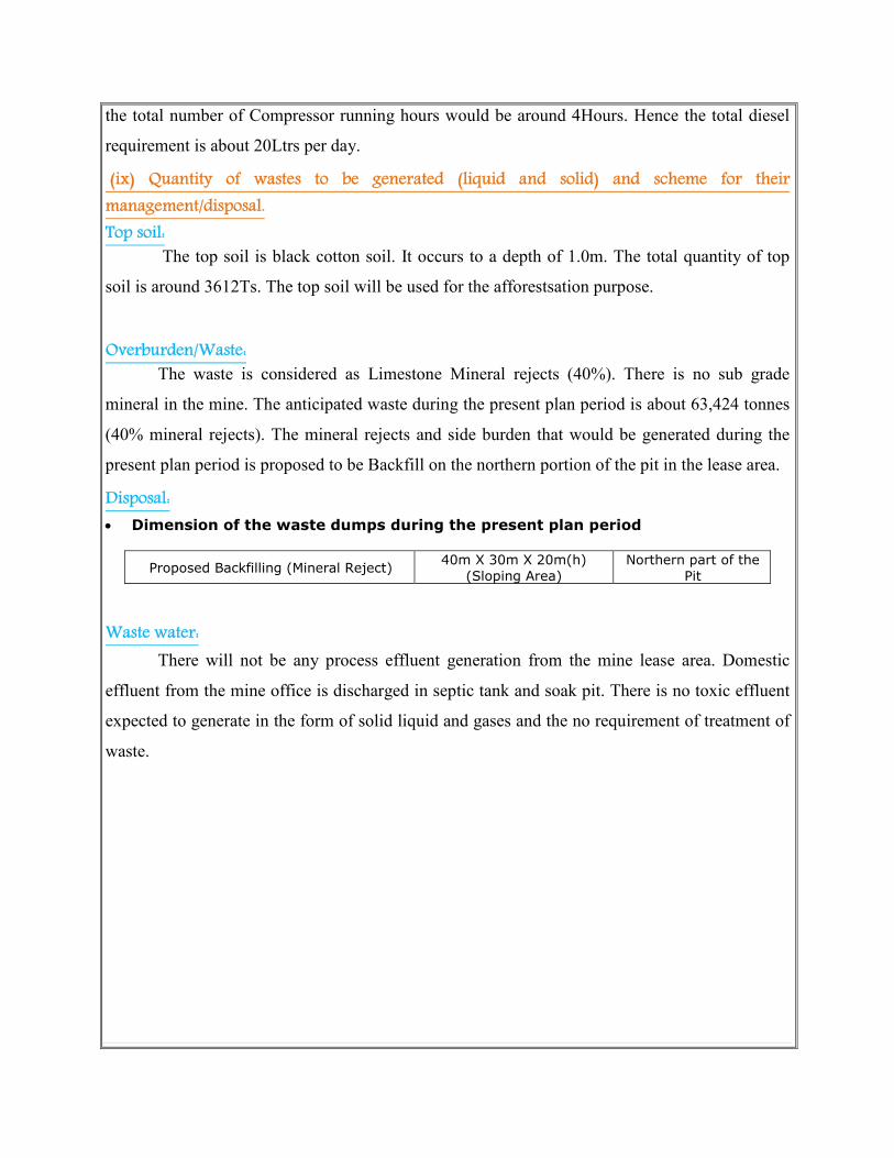
(ix) Quantity of wastes to be generated (liquid and solid) and scheme for their
management/disposal.
Top soil:
The top soil is black cotton soil. It occurs to a depth of 1.0m. The total quantity of top
soil is around 3612Ts. The top soil will be used for the afforestsation purpose.
Overburden/Waste:
The waste is considered as Limestone Mineral rejects (40%). There is no sub grade
mineral in the mine. The anticipated waste during the present plan period is about 63,424 tonnes
(40% mineral rejects). The mineral rejects and side burden that would be generated during the
present plan period is proposed to be Backfill on the northern portion of the pit in the lease area.
Disposal:
• Dimension of the waste dumps during the present plan period
Proposed Backfilling (Mineral Reject) 40m X 30m X 20m(h)
(Sloping Area)
Northern part of the
Pit
Waste water:
There will not be any process effluent generation from the mine lease area. Domestic
effluent from the mine office is discharged in septic tank and soak pit. There is no toxic effluent
expected to generate in the form of solid liquid and gases and the no requirement of treatment of
waste.

(x) Schematic representations of the feasibility drawing which give information of EIA purpose
4.0 SITE ANALYSIS
(i) Connectivity
Connectivity
(Road)
Description Km Direction
NH Road NH-45B- Madurai – Trichy 8 East
SH Road SH-35- Dindigul - Natham 8 SW
Railway station Dindigul 38 NW
Airport Trichy 75 NE
(ii) Land Form, Land use and Land ownership
Land form:
The lease area is characterized by plain topography. The area is sloping towards South.
Land use:
The lease area is dry barren land. The land was used for the Mining purpose past twenty
years. The area does not fall in forest land. There are no water courses flowing through the lease
area. There is no vegetation/plantation in this area. Some thorny bushes and shrubs are observed.
Form – 1
Along with Pre-feasibility Report
&
Mining plan with Annexure
To Submit SEIAA
Final Presentation

The conceptual land use pattern is as follows:
S.No Description
Present
Area
(Ha)
Additional Area
required during the
present MP Period(Ha)
[2016-17 to 2020-21]
Area at the end of
present Plan period
and end of life of
mine (Ha)
1 Mining (Quarry ) 0.32.2 0.22.4 0.54.6
2. Waste dump Nil 0.04.5 0.04.5
3. Office & infrastructure Nil 0.01.0 0.01.0
4. Processing plant - - -
5. Mineral stack processing yard - - -
6. Sub grade mineral stacks - - -
7. Mine roads 0.02.0 Nil 0.02.0
8. Areas under plantation 0.03.0 0.10.0 0.13.0
9. Un utilized area 0.57.3 0.19.4 0.19.4
10. Total 0.94.5 0.94.5
Land Ownership:
It is a patta land registered in the name of Thiru. E.Elangovan (Partner of Sivam Mines),
vide patta No 2425,489. Hence the proponent has surface rights over the area. (630/2 poramboke
land)
(iii) Topography (along with map)
The area is almost plain topography. The area is surrounded by dry barren land. Only
seasonal cultivation is done. In some areas agriculture is done with lift irrigation. Water table is
found at a depth of 35m during summer and 30m during rainy season. Average annual rainfall is
about 850mm in North east and south west monsoon season.
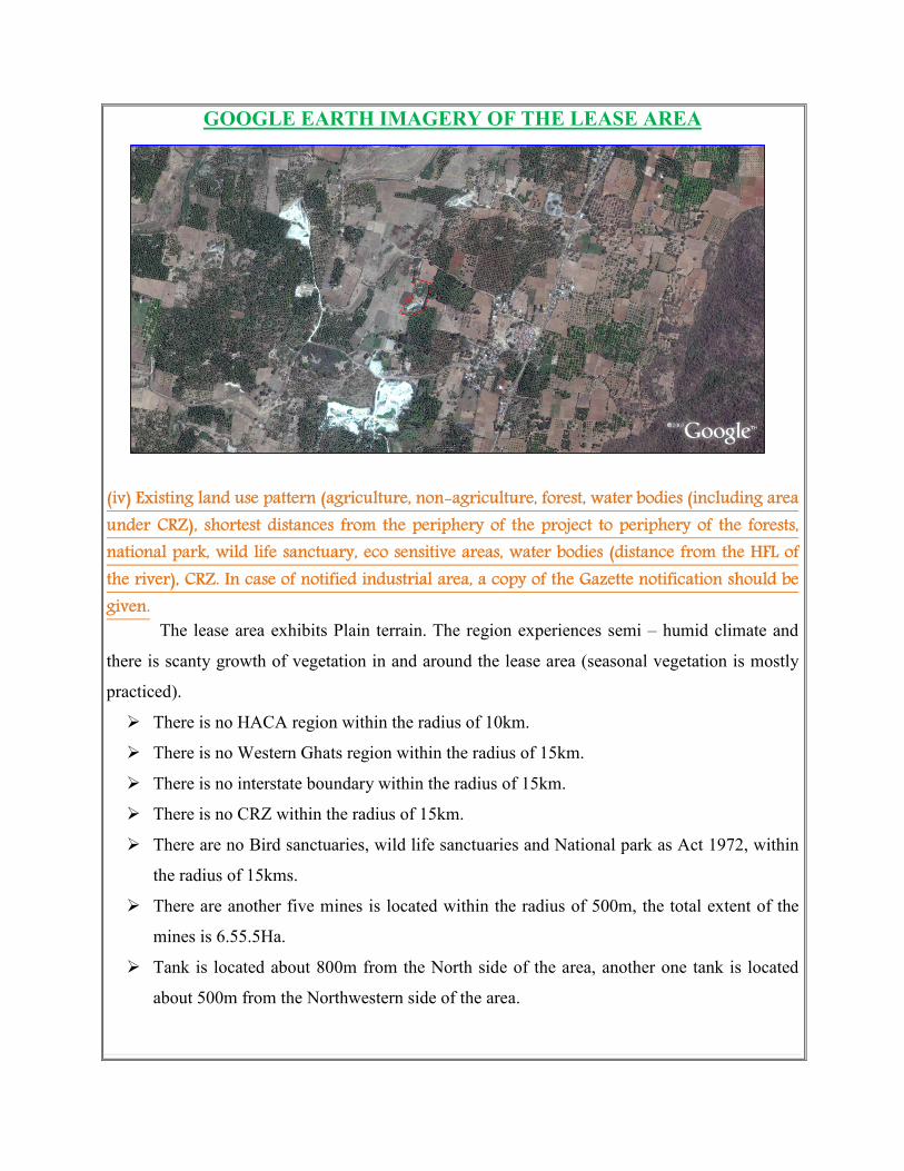
GOOGLE EARTH IMAGERY OF THE LEASE AREA
(iv) Existing land use pattern (agriculture, non-agriculture, forest, water bodies (including area
under CRZ), shortest distances from the periphery of the project to periphery of the forests,
national park, wild life sanctuary, eco sensitive areas, water bodies (distance from the HFL of
the river), CRZ. In case of notified industrial area, a copy of the Gazette notification should be
given.
The lease area exhibits Plain terrain. The region experiences semi – humid climate and
there is scanty growth of vegetation in and around the lease area (seasonal vegetation is mostly
practiced).
� There is no HACA region within the radius of 10km.
� There is no Western Ghats region within the radius of 15km.
� There is no interstate boundary within the radius of 15km.
� There is no CRZ within the radius of 15km.
� There are no Bird sanctuaries, wild life sanctuaries and National park as Act 1972, within
the radius of 15kms.
� There are another five mines is located within the radius of 500m, the total extent of the
mines is 6.55.5Ha.
� Tank is located about 800m from the North side of the area, another one tank is located
about 500m from the Northwestern side of the area.

(v) Existing Infrastructure
The Limestone project requires infrastructure like (Mine office, Labours shed, Toilet and
Rest shelter already has been constructed). Water for drinking purpose will be supplied from the
approved water vendors. A small water tank is also proposed which will be used for water
sprinkling, plantation etc.,
(vi) Soil Classification
The top soil is reddish in nature. It occurs to a depth of 1m. The top soil will be removed
and preserved all along the boundary barrier for the afforestsation purpose.
(vii) Climatic data form secondary sources
The area receives rainfall of about 850mm /per annum and the rainy season is mainly
from Oct–January during North East and South west monsoon. The summer is hot with
maximum temperature of 39°C and winter encounters a minimum temperature of 24°C.
(viii) Social infrastructure available
Social infrastructure like government office, Schools, hospitals are available in the
Sirugudi Village which is about 3Km from the North eastern side of the area.
5. PLANNING BRIEF
(i) Planning Concept (type of industries, facilities, transportation etc.,) Town and Country
Planning/Development authority Classification
The entire mined out mineral is used for its own captive plant in the name of M/s. Air
Mineral Enterprises which is located in Sirugudi, 3.0kms from mining lease area for Pulverizing
and also sold to the nearby cement and lime based industries which are located within a radius of
35Km from the mine site.
Facilities such as power, Transportation and commodities infrastructure facilities are
locally available near the project site.
Transportation
The limestone is being transported by the 10/20ts capacity of tippers to the needy
industries.

(ii) Population projection
There are few villages located in the 5km radius of mine site and approximate distance
and population are given below.
S.NO Name of village Distance in Km Population Direction
1 Sirugudi 3.0 950 Northeast
2 Samudrapatty 3.0 550 Southeast
3 Uralipatti 4.5 500 Southwest
4 Avichchipatti 4.0 450 West
Basic human welfare Amenities such as Health Center, Schools, Communication
Facilities, and Commercial Centers etc are available at Natham located at a distance of 8kms
from the South western side of the area.
(iii) Land use planning (breakup along with green belt etc.)
The land use planning along with breakup is given below.
S.No Description
Present
Area
(Ha)
Additional Area
required during the
present MP Period(Ha)
[2016-17 to 2020-21]
Area at the end of
present Plan period
and end of life of
mine (Ha)
1 Mining (Quarry ) 0.32.2 0.22.4 0.54.6
2. Waste dump Nil 0.04.5 0.04.5
3. Office & infrastructure Nil 0.01.0 0.01.0
4. Processing plant - - -
5. Mineral stack processing yard - - -
6. Sub grade mineral stacks - - -
7. Mine roads 0.02.0 Nil 0.02.0
8. Areas under plantation 0.03.0 0.10.0 0.13.0
9. Un utilized area 0.57.3 0.19.4 0.19.4
10. Total 0.94.5 0.94.5
The green belt area is about 0.13.0Ha from the total extent of 0.94.5.

(iv) Assessment of Infrastructure Demand (Physical & Social)
Physical infrastructure:
� The existing road facilities are already available which shall be used and maintained.
� The labors requirement is drawn from the nearest villages. The labors will be brought by
jeeps and vans to the mine site.
� Medical facilities are available near the project site, Government and private hospitals
and other basic amenities and infrastructure facilities like communication center, school
supermarket, bus stand are also available in Natham at a distance of 8kms (SW).
Social infrastructure:
� First aid room and rest shelter has been constructed to the labours.
� Workers will be sent to the vocational training centre.
� Safety equipment like dust mask, shoes, gloves, helmet etc.,
� This mining project will provide employment for about 15 persons directly.
(v) Amenities/Facilities
The simple methods adopted and the limited scale of activities involved in Limestone
mining does not require High Tension Electric Power supply or huge worship facilities.
The mining work is restricted to one general shift during day time only. Machinery repair works
are attended at Sirugudi village (3km- NE).
Potable drinking water is available from the nearby community wells and can be
transported to the work site in tippers. Mine office, storeroom, toilet and first-aid room will be
provided on permanent structures within the lease applied area.
6. PROPOSED INFRASTRUCTURE
(i) Industrial Area (Processing area)
There is no industrial or processing area proposed within the lease area.
(ii) Residential area (Non processing area)
There is no residential areas within 500m radius.
(iii) Green Belt
10.0m safety distance along the lease boundary on the northern side is selected for Green
belt development by planting and maintaining native species of Neem saplings. It is proposed to
plant 15plants per year. The total area for the proposed for Green belt is around 0.13.0Ha out of
0.94.5Ha.
(iv) Social infrastructure
The mining activity carried out in the area rather has a positive socio-economic impact
upon the nearby human settlement as indirect employment potential is created due to mining
activities in the area. About 12 employees is directly benefited, 10 peoples will be indirectly
beneficed, shopkeepers, Hotels, Machineries Transport Contractors etc.,
I ensure to share all responsible for special benefits like water, health care, Education
benefits, maintenance of village road and promotion of socio cultural activities of the nearby
villages.
(v) Connectivity (traffic and transportation road/ Rail/ Metro/ Water ways etc.,)
Mode Description
Road connectivity
1. The existing village road available in the mine area which
this road connecting in the National Highway (NH 45B).
2. The Nearest National Highway (NH-45B) Tiruchirapalli –
Madurai – 8Km- East side.
3. The Nearest State Highway (SH 35) Dindigul – Natham
8km- South side.
Railway station &
Railway line
1. Dindigul Railway station - 38km – North western side.
2. Railway line is Dindigul - Karur –38Km– North west side
Air port 1. Nearest airport Tiruchirapalli is -75km –North Eastern
side.
(vi) Drinking Water management (Source & Supply of water)
This mining project does not require huge water either for beneficiation or processing.
Water requirement for mining activity is 2.0KLD. Water required for drinking and domestic
consumption for labors is around 0.2KLD. The Packaged drinking water will be brought from
approved water vendors nearby village. The domestic waste water generated will be sent to
septic tanks followed by soak pits.
(vii) Sewerage System
Toilets constructed as permanent structure within the area and sewage will be discharged
once in three months. The sewage waste will be collected in soak pit and the sludge will be
discharged.
(viii) Industrial Waste Management
The Mineral processing is not carried out within the lease area hence industrial waste will
not be generated from the project.

(ix) Solid Waste Management
Mineral rejects:
The mineral rejects is 40% of ROM which includes rock fragments, impurities etc., The
mineral rejects are generated during the previous plan period was dumped in the western portion of
the area.
Disposal:
The mineral reject that would be generated during the present plan period is also proposed to
fill old pit situated in the southwestern side of the lease area.
Dump Dimension:
• Dimension of the waste dumps during the present plan period
Proposed
Backfilling (Mineral
Reject)
40m X 30m X 20m(h)
(Sloping Area)
Northern part
of the Pit
Proposed Backfilling
(Mineral Reject)
(x) Power Requirement & Supply / source
The Limestone mine operation is not require any power supply for the mining operation. It
is proposed to operate in day time only from 9 Am to 5Pm with 1 Hour lunch interval between
1Pm to 2Pm. The domestic consumption for the lights at the night is only for the century room,
mines office etc,
7. REHABILITATION AND RESETTLEMENT (R & R PLAN)
(i) Policy to be adopted (Central/State) in respect of the project affected persons including home
oustees, land oustees and landless laborers (a brief outline to be given)
There is no Rehabilitation and resettlement is involved. The deployed labours will be
insured as per the Government norms till the end of the life of the mine. Periodical medical test
will be conducted for the labors to monitor the occupational disease. The salaries and benefits
will be paid as specified by the instruction given by the labor enforcement officers.

8. PROJECT SCHEDULE & COST ESTIMATES (i) Likely date of start of construction and likely date of completion (Time schedule for the
project to be given)
The Limestone mining project is likely to get commenced after the execution of mine
lease.
The lease deed was executed on = 17.04.2016
The lease will get expired on = 16.04.2046
Final Scheme period = 2011-12 to 2015-16
Modified Mining plan period = 2016-17 to 2020-21.
(ii) Estimated project cost along with analysis in terms of economic viability of the project :
A. Fixed asset cost Land cost (present land cost is 2Lakh per Ha) = Rs. 1, 89,000/-
Labour shed = Rs. 50,000/-
First aid room & Accessories = Rs. 50,000/-
Sanitary facilities = Rs. 75,000/-
Total cost = Rs. 3, 64,000 /-
B. Operational Cost
The total operational cost is computed in the Mining plan is given below. The cost may
be slightly changed as per the present market scenario. The production cost is worked out for
the ton.
S.No. Particulars Cost of production
Per ton
1. Labour charges Rs. 60
2. Royalty paid to Mines & Geology Rs.82
3. Explosives expenses Rs.25
4. Drilling expenses Rs. 20
5. Transport from mine head to Stockyard (loading &
unloading) Rs.60
Total Rs.247
6. Miscellaneous and over heads Rs.28
Total Rs.275
Total ton of Limestone proposed in the present scheme period 27,939Ts X 275Rs
Total operational Cost = Rs. 76, 83,000/-
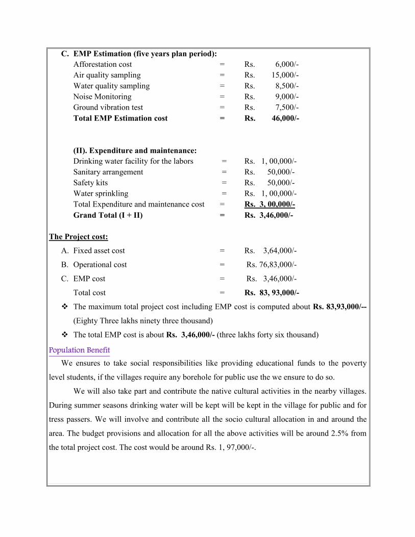
C. EMP Estimation (five years plan period):
Afforestation cost = Rs. 6,000/-
Air quality sampling = Rs. 15,000/-
Water quality sampling = Rs. 8,500/-
Noise Monitoring = Rs. 9,000/-
Ground vibration test = Rs. 7,500/-
Total EMP Estimation cost = Rs. 46,000/-
(II). Expenditure and maintenance:
Drinking water facility for the labors = Rs. 1, 00,000/-
Sanitary arrangement = Rs. 50,000/-
Safety kits = Rs. 50,000/-
Water sprinkling = Rs. 1, 00,000/-
Total Expenditure and maintenance cost = Rs. 3, 00,000/-
Grand Total (I + II) = Rs. 3,46,000/-
The Project cost:
A. Fixed asset cost = Rs. 3,64,000/-
B. Operational cost = Rs. 76,83,000/-
C. EMP cost = Rs. 3,46,000/-
Total cost = Rs. 83, 93,000/-
� The maximum total project cost including EMP cost is computed about Rs. 83,93,000/--
(Eighty Three lakhs ninety three thousand)
� The total EMP cost is about Rs. 3,46,000/- (three lakhs forty six thousand)
Population Benefit
We ensures to take social responsibilities like providing educational funds to the poverty
level students, if the villages require any borehole for public use the we ensure to do so.
We will also take part and contribute the native cultural activities in the nearby villages.
During summer seasons drinking water will be kept will be kept in the village for public and for
tress passers. We will involve and contribute all the socio cultural allocation in and around the
area. The budget provisions and allocation for all the above activities will be around 2.5% from
the total project cost. The cost would be around Rs. 1, 97,000/-.

Mine Closure Plan:
Steps proposed for phased restoration, reclamation of already mined out areas:
� It is an existing Limestone mine project.
� After the exploitation of Limestone mine reaches its ultimate pit limit, the pit will be
partially backfilled and partially act as a good storage of water.
� Before closure the mine, a parapet wall will be constructed to prevent inadvertent entry of
cattle and human beings.
� After closure of mine, the pit will be allowed to collect seepage and rain water. This will
help to charge the nearby agricultural wells.
Measures to be under taken on mine closure as per Act & Rules:
Measure will be taken as per Act & Rules.
Mitigation measure to be undertaken for safety and restoration / reclamation of the already mined
out area:
� Drilling will be carrying out by wet drilling to control the dust into the air.
� Controlled blasting will be carrying out on limited scale.
� Mist spray on haul road will be proposed to prevent the dust propagation into the air.
� The plantation will be carried out on the safety barriers to prevent Noise, besides wet
drilling will be practiced to prevent dust.
� All the machineries will be maintained in good conditions as per RTO and TNPCB
Norms to prevent Noise, Smoke and vibration.
� Machineries like compressor and jack hammer will be periodically maintained by
experienced mechanic to minimize noise, Smoke and ground vibration.
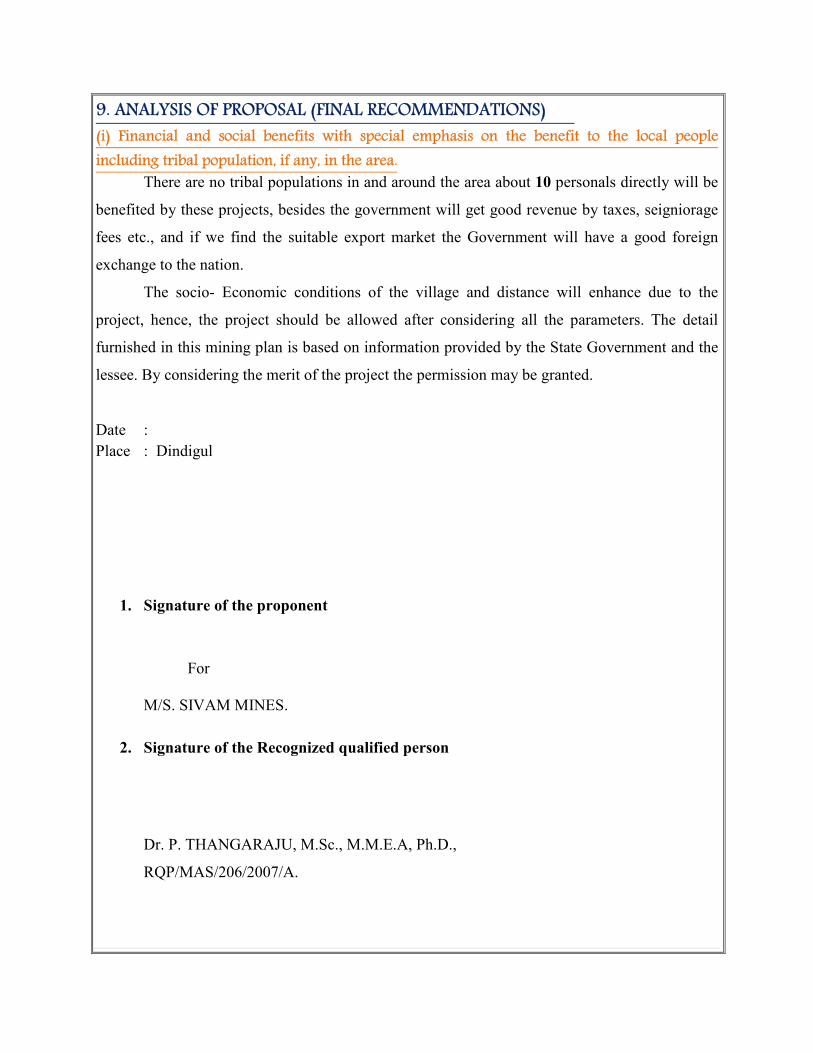
9. ANALYSIS OF PROPOSAL (FINAL RECOMMENDATIONS)
(i) Financial and social benefits with special emphasis on the benefit to the local people
including tribal population, if any, in the area.
There are no tribal populations in and around the area about 10 personals directly will be
benefited by these projects, besides the government will get good revenue by taxes, seigniorage
fees etc., and if we find the suitable export market the Government will have a good foreign
exchange to the nation.
The socio- Economic conditions of the village and distance will enhance due to the
project, hence, the project should be allowed after considering all the parameters. The detail
furnished in this mining plan is based on information provided by the State Government and the
lessee. By considering the merit of the project the permission may be granted.
Date :
Place : Dindigul
1. Signature of the proponent
For
M/S. SIVAM MINES.
2. Signature of the Recognized qualified person
Dr. P. THANGARAJU, M.Sc., M.M.E.A, Ph.D.,
RQP/MAS/206/2007/A.

Base Line Studies is Prepared for
Sirugudi
Limestone Mine

BASE LINE STUDIES
The base line a study is prepared for Sirugudi Limestone Mine. Base line studies provide
a base data for regular Environmental Monitoring and Environmental Impact Assessment (EIA).
The international Association for Impact Assessment (IAIA) defines the base line studies
as the process of identifying, predicting, evaluating and mitigating the Bio physical, Social and
other relevant effect of development proposals prior to major decision has been taken and
commitment mode.
Hence the baseline study provides a bench mark for carrying out environmental Impact
assessment due to the course of quarrying and mining activities. The purpose of these studies is
to evaluate the benefited and adverse effect of developing activities on the neighborhood
environment and the area where the mining is proposed to carry out.
M/s. Sivam Mines has applied for Limestone Mine lease for over an extent of 0.92.5 Ha in
S.F.Nos. 630/1A, 1B, 631/10, 11, 630/2 in Sirugudi Village, Natham Taluk, Dindigal District,
Tamilnadu State
The area proposed for mining for the present Scheme period is about 0.54.6 Ha which is
below 25% of the total area applied for lease; hence the impact assessment due to mining may be
considerably low.
As per the Gazette notification 2006 the proposed project falls under B2 Category.
The area proposed for mining is a fresh area and there are no factories, industries within
the radius of 1Km hence the atmospheric air is quite fresh. The area exhibits flat terrain which is
devoid of vegetation and Agriculture. In some small patches small agricultural activities are been
carried out by drift irrigation some thorny bushes and wild gars are found in the area with scanty
Palm trees (Borassus falabellifer). Tridax procumbens and Lucus aspera are some of the
common species along with Julia flora trees. The density of these about 20% to 40% in the area
and the remaining area is dry barren land.
As no agricultural activities are carried out the people in and around the villages migrate
to nearby town for their livelihood. Most of the people are illiterate and depend upon the
Garment factories, mining is the main industry in this district.
The project in this area will fetch a quit considerable employment to nearby village which
in turn enhance the earning source of the nearby villages. The comprehensive base line studies
and standards constitute of collecting data on Ambient Air quality, Dust fall rate, Water quality,
Soil analyze, Noise level and Ground vibration study in the area proposed for mining along with
Flora and Fauna statistics.
The Methodology adopted in this project is based on the basic principles of capitalization
identification analysis and preparation of action plan to Mitigate negate or adverse impact.
Baseline studies adverse the significant environmental Issue and also provide necessary
information pertaining to the Environmental Attributes in the project area. Monitoring and
evaluating the effect of the works environment factors on health of people working on Limestone
mine.
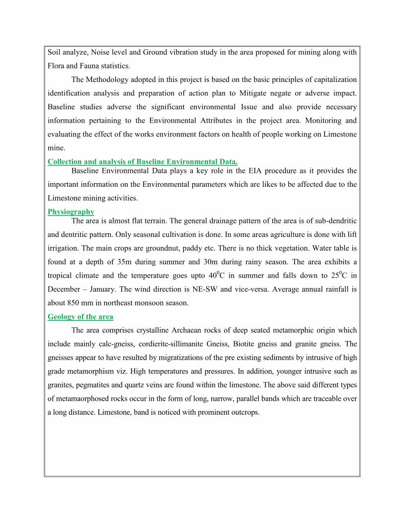
Collection and analysis of Baseline Environmental Data.
Baseline Environmental Data plays a key role in the EIA procedure as it provides the
important information on the Environmental parameters which are likes to be affected due to the
Limestone mining activities.
Physiography
The area is almost flat terrain. The general drainage pattern of the area is of sub-dendritic
and dentritic pattern. Only seasonal cultivation is done. In some areas agriculture is done with lift
irrigation. The main crops are groundnut, paddy etc. There is no thick vegetation. Water table is
found at a depth of 35m during summer and 30m during rainy season. The area exhibits a
tropical climate and the temperature goes upto 400C in summer and falls down to 250C in
December – January. The wind direction is NE-SW and vice-versa. Average annual rainfall is
about 850 mm in northeast monsoon season.
Geology of the area
The area comprises crystalline Archaean rocks of deep seated metamorphic origin which
include mainly calc-gneiss, cordierite-sillimanite Gneiss, Biotite gneiss and granite gneiss. The
gneisses appear to have resulted by migratizations of the pre existing sediments by intrusive of high
grade metamorphism viz. High temperatures and pressures. In addition, younger intrusive such as
granites, pegmatites and quartz veins are found within the limestone. The above said different types
of metamaorphosed rocks occur in the form of long, narrow, parallel bands which are traceable over
a long distance. Limestone, band is noticed with prominent outcrops.

The regional trend of the rock in the area is N600E – S600W with Dip 60o NW.
The area was surveyed in detail to prepare a Geological map in the scale of 1:1000 showing the
various formations and attitude of the deposit. It is inferred that the Limestone mineral is of cement
grade and in form Band running N600E – S600W with dipping 75o NW. Reddish soil cover upto a
depth in about 1.0m. Recovery of minerals is estimated as 60% of the total excavation of the ore
body. The recovery percentage is based on the knowledge gained from the present mine workings
and adjacent working mine in this region, by the field tests carried out in the lease area and analysis
done in NABL Laboratories.
The general geological sequence of the limestone deposits is as follows:
Order of Super position:
AGE ROCKFORMATION
Recent - Reddish Soil
Achaean - Crystalline Limestone
- Calc-gneiss.
The physical attitude of the limestone band is demarked as follows:
Strike length (m) : 87
Width (m) : 55
Depth (m) Proved : 20
Strike direction : N600E – S600W
Dip amount and direction : 75o NW.
The deposit is covered by 1.0m thickness of topsoil followed by 19m thickness of Limestone
bed.
Vegetation
The area is almost flat terrain. The general drainage pattern of the area is of dentritic
pattern. Only seasonal cultivation is done. In some area agriculture is done with lift irrigation. The
main crops are groundnut, chilli, cereals etc., some thorny bushes are grown, there is no thick
vegetation.

General approach to Environment
The Environmental besides data comprise of the features present of the site area its
includes environmental features such as forest area, conservation area, water bodies, industries,
wild life and fauna place of historic and importance etc.,
The data collected to cover the following.
1. Air environment 2. Noise Environment 3. Water environment 4. Ecology (Biological and Cultural Environment) 5. Physical Environment
Air Environment
Air environment is responsible for the health of human beings, animals, wild life and
vegetation. Air pollutants emitted by project and non point source are transported dispersed or
concentrated by meteorological and topographical conditions.
The atmosphere is dynamic system which absolute range of solid, Liquid or gases from
both Natural and Manmade source. There substances travel through the air disappear and reveal
among themselves and also with other substances both physically and chemically which result in
air pollution.
The limestone propose to mine is non toxic which does not emit any undesirable
pollutants in the form of solid liquid or gas. The dust emitted during the transportation of
vehicles the drilling will be carried out in wet condition to prevent dust into air and the haul
roads will be periodically sprinkled with mist water spray to prevent dust into the atmosphere.
The area in and around is quit fresh and the impact an air environment will always be under
controlled and will be monitored. No processing or beneficiation is proposed except mining
hence the impact an air will be controlled monitored and mitigated.
The ambient air quality within the study area on both core and buffer zone forms the
baseline information. The air quality monitoring points selected based on the Meteorological
conditions, topography of the study area and likely impact boundary location of the ambient air
quality monitoring stations was selected on the basis of wind pattern.
The ambient Air quality monitoring stations are shown in the map. Four major pollutions
were consideration significantly.

I. Particle matter - PM II. Suspended Particle Matter - SPM
III. Sulphur dioxide - SO2 IV. Nitrogen dioxide - NO2
Respectively the overall of emission we identified the direction of the wind in the
majority observed time was predominantly south west to North East direction. The Air quality
monitoring data is enclosed as Annexure No-I.
S.No
Test Parameters Unit Protocol Results CPCB Standards
1 Particulate matter less than 10 micron size (PM10)
µg/m3 IS 5182 Part 23-2006 42.2 100
2 Particulate matter less than 2.5 micro size (PM2.5)
µg/m3 IS 5182 part 4-1999 (Reaff 2010)
32.2 60
3 Sulphur dioxide SO2 µg/m3 IS 5182 part 2-2001 (Reaff 2006)
4.0 80
4 Nitrogen Dioxide NO2 µg/m3 IS 5182 Part 6-2006 5.2 80
Noise Environment
Sound/Noise can be defined as atmospheric or airborne vibration perceptible to the ear.
Noise is usually unwanted or undesired sound. Sound loud enough to be harmful is called noise
without regard to its other characteristics hence noise has a significant impact on the quality of
life and in that sense it is a health problem in accordance with the (WHO) definition of health.
Impact of noise on environment depends on various factors such as intensity distance
from the source type of exposure and nature (Impulse or continuous), the type of activities
movement of machineries, traffic density etc., hence it is to measure the levels so as to adjust the
environment Impact and undertake amendment measures if warranted.
Standard precession noise level meter were used for the purpose. The readings in the
form of instantaneous sound measures levels were taken in the time brackets of two hours in
order to here carry out assessment of noise level in the area.

There are no heavy industries nearby; the noise level of the area will be as same as the
regional level. More over the noise level measurements does not rise for this area since very low
explosives will be used for mining and the machineries to be used shall hydraulic types, it does
not create much noise except the compressor, drilling and jet bummers. The traffic density in the
area is very little. The average noise level in that area is less then 90dB (A) in and around 1Km
radius.
This noise level survey was carried out as per MOEF norms i.e., 1.5m above the ground
level and 2mts away from the noise emit source. At present the noise is only through the
movement of Vehicles in that area. No other significant noise emitting source found.
S.No Location Results
dB (A) CPCB Standard
Limit 1 Project site – Centre area 41.2 70*
2 Project Site SW corner 42.0 70*
3 Project site SE Corner 41.4 70* 4 Project site NE Corner 41.8 70*
Ground vibration studies
Hence the vibration source are only through the movement of vehicles where the
frequency is also very less. Hence the vibration is well below the standard permissible by
MOEF. Displacement, Velocity and acceleration of the three kinematics descriptions which are
to be studies to describe ground motion. The peak particle velocity is the more referred since the
area is virgin there is no significant measured velocity found in the area.
Water Environment
Geo Physical investigation was carried out by signal stacking resistivity meter 3 profiling
was carried out in the area applied for lease and 15 Vertical electrical sounding was carried out
to find out the lateral variation and vertical in homogeneity’s it was observed that the water table
is found to be 40mts below ground level and the same was correlated with the wells found at a
distance of 100mts SW & SE of the area.
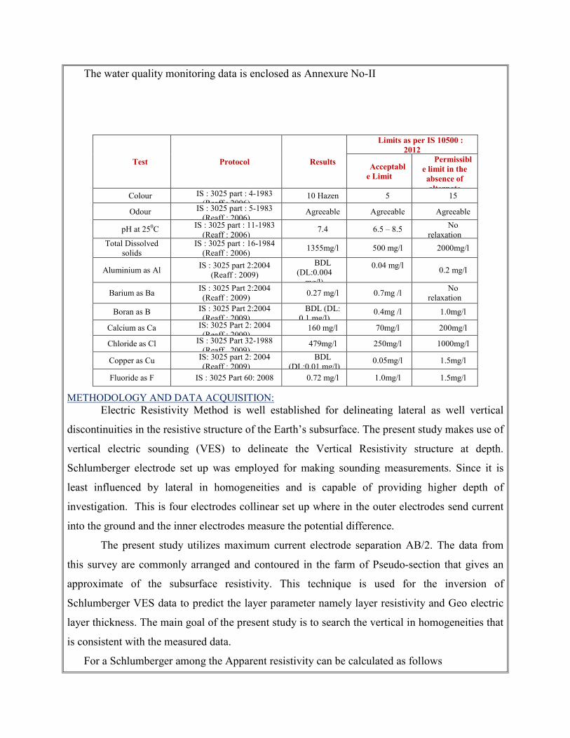
The water quality monitoring data is enclosed as Annexure No-II
METHODOLOGY AND DATA ACQUISITION: Electric Resistivity Method is well established for delineating lateral as well vertical
discontinuities in the resistive structure of the Earth’s subsurface. The present study makes use of
vertical electric sounding (VES) to delineate the Vertical Resistivity structure at depth.
Schlumberger electrode set up was employed for making sounding measurements. Since it is
least influenced by lateral in homogeneities and is capable of providing higher depth of
investigation. This is four electrodes collinear set up where in the outer electrodes send current
into the ground and the inner electrodes measure the potential difference.
The present study utilizes maximum current electrode separation AB/2. The data from
this survey are commonly arranged and contoured in the farm of Pseudo-section that gives an
approximate of the subsurface resistivity. This technique is used for the inversion of
Schlumberger VES data to predict the layer parameter namely layer resistivity and Geo electric
layer thickness. The main goal of the present study is to search the vertical in homogeneities that
is consistent with the measured data.
For a Schlumberger among the Apparent resistivity can be calculated as follows
Test Protocol Results
Limits as per IS 10500 :
2012
Acceptabl
e Limit
Permissibl
e limit in the
absence of
alternate Colour IS : 3025 part : 4-1983
(Reaff : 2006) 10 Hazen 5 15
Odour IS : 3025 part : 5-1983 (Reaff : 2006)
Agreeable Agreeable Agreeable
pH at 250C IS : 3025 part : 11-1983 (Reaff : 2006)
7.4 6.5 – 8.5 No relaxation
Total Dissolved solids
IS : 3025 part : 16-1984 (Reaff : 2006)
1355mg/l 500 mg/l 2000mg/l
Aluminium as Al IS : 3025 part 2:2004
(Reaff : 2009)
BDL (DL:0.004
mg/l)
0.04 mg/l
0.2 mg/l
Barium as Ba IS : 3025 Part 2:2004 (Reaff : 2009)
0.27 mg/l 0.7mg /l No
relaxation
Boran as B IS : 3025 Part 2:2004 (Reaff : 2009)
BDL (DL: 0.1 mg/l)
0.4mg /l 1.0mg/l
Calcium as Ca IS: 3025 Part 2: 2004 (Reaff : 2009)
160 mg/l 70mg/l 200mg/l
Chloride as Cl IS : 3025 Part 32-1988 (Reaff . 2009)
479mg/l 250mg/l 1000mg/l
Copper as Cu IS: 3025 part 2: 2004 (Reaff : 2009)
BDL (DL:0.01 mg/l)
0.05mg/l 1.5mg/l
Fluoride as F IS : 3025 Part 60: 2008 0.72 mg/l 1.0mg/l 1.5mg/l
ρa = G∆V
I
∆V = potential difference between receiving electrodes
G = Geometric Factor.
Rocks show wide variation in resistivity ranging from 10-8 more than 10+14 ohmmeter.
On a broad classification, one can group the rocks falling in the range of 10-8 to 1 ohmmeter as
good conductors. 1 to 106 ohmmeter as intermediate conductors and 106 to 1012 ohmmeter as
more as poor conductor. The resistivity of rocks and subsurface lithology, which is mostly
dependent on its porosity and the pore fluid resistivity is defined by Archie’s Law,
ρr = Fρw = a Øm
ρw
ρr = Resistivity of Rocks
ρw = Resistivity of water in pores of rock
F = Formation Factor
Ø = Fractional pore volume
A = Constants with values ranging from 0.5 to 2.5
SURVEY LAYOUT: The layout for a resistivity survey depends on the choice of the current and potential
electrode arrangement, which is called electrode array. Here the present study is considered with
Schlumberger array. In which the distance may be used for current electrode separation while
potential electrode separation is kept on third to one fifth of the same. One interesting aspect in
VES is the principle of reciprocity, which permits interchange of the potential and current
electrode without any effect on the measured apparent resistivity.
EQUIPMENT:
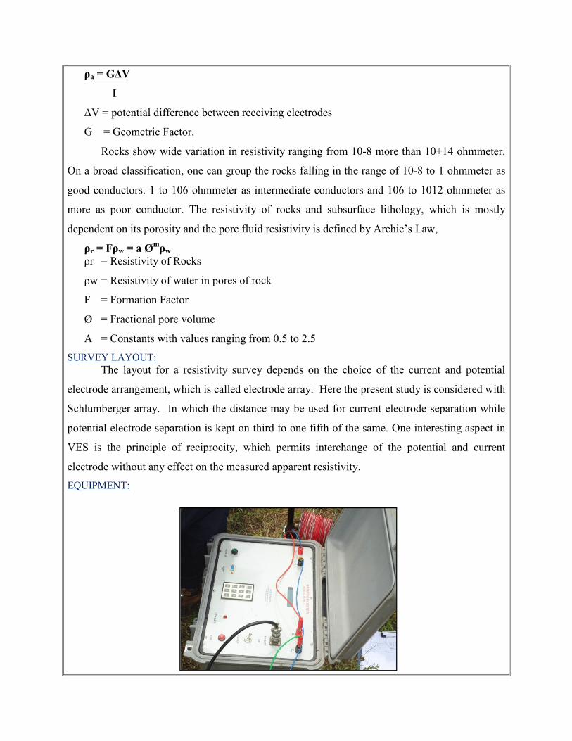
The field equipment deployed for the study is in a deep resistivity meter with a model of
SSR – MP – AT. This Signal stacking Resistivity meter is a high quality data acquisition system
incorporating several innovation features for Earth resistivity. In the presence of random earth
Noises the signal to nose ration can be enhanced by √N where N is the number of stacked
readings. This SSR meter in which running averages of measurements [1, (1+2)/2, (1+2+3)/3 …
(1+2...+16/16)] up to the chosen stacks are displayed and the final average is stored
automatically, in memory utilizing the principles of stacking to achieve the benefit of high
signals to noise ratio. Based on these above significations the signal stacking resistivity meter
was used for (VES) Vertical Electric Resistivity Sounding.
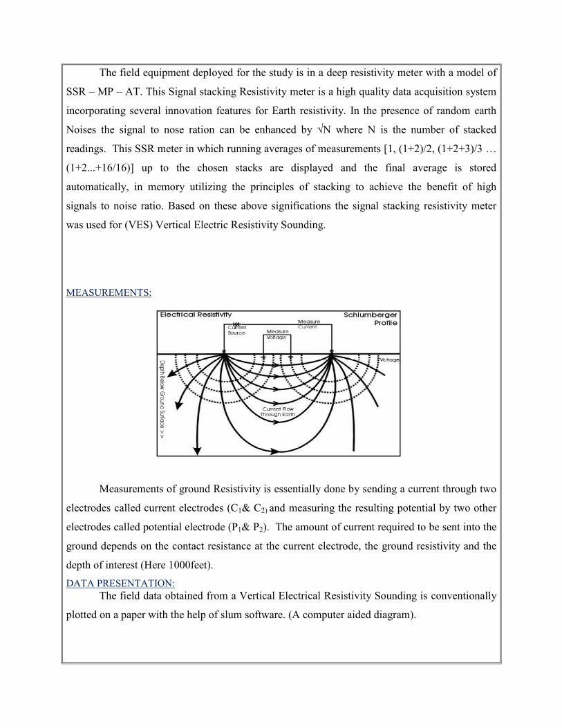
MEASUREMENTS:
Measurements of ground Resistivity is essentially done by sending a current through two
electrodes called current electrodes (C1& C2) and measuring the resulting potential by two other
electrodes called potential electrode (P1& P2). The amount of current required to be sent into the
ground depends on the contact resistance at the current electrode, the ground resistivity and the
depth of interest (Here 1000feet).
DATA PRESENTATION: The field data obtained from a Vertical Electrical Resistivity Sounding is conventionally
plotted on a paper with the help of slum software. (A computer aided diagram).
GEOPHYSICAL DATA INTERPRETATION The geophysical data’s was obtained to study the lateral variations, vertical in
homogeneities in the sub – surface with respect to the availability of groundwater. From the
interpreted data, it has inferred that the area has moderate groundwater potential in the
investigated area.
There are no streams, water bodies or water course within the radius of 500mts and the
rainfall in the area is poor varying for maximum 50 days in a year. The average rainfall is about
850mm as recorded by the meteorological department in the last three years. In some areas of the
District there was no Rainfall recorded for the last 3years. The underground water is portable
without any adverse health effects. There are no boreholes or open wells in the project area
hence the water collected in the area for analysis.
In summer the water drains and the well will be in dry condition. The quality of the water
from well has been analyzed for records. The Limestone mining does not require any water for
its operation. No beneficiation or processing is proposed in the project.
The water required is only for drinking and domestic purpose for which the water will be
brought out from authorized water vendors from the nearby towns.
As water is very vital natural resource and most essential for the survival of human beings,
the same will be consumed only after carrying out scientific studies and will be allowed if it is
within the prescribed standards.
Soil Analysis
As mentioned earlier the area applied for lease is an flat terrain. The soil is the main unit
for the eco system because of the dependence of flora and fauna. As the soil is acidic there are no
thick flora noticed except some common species which are native of the terrain.
The mining activities may have impact on soil. The soil samples were called in 50mts
grid fashion by average and after coning and quartering the same was send to laboratory for
investigation. The following sources are obtained from Agricultural department.

The soil analysis report is as below
S.No Test parameters Method Results
1 PH @250C Is 2720 part 26 (Reaff:2011) 7.2
2 Conductivity @250C Is 14767 : 2000 (Reaff : 2010) 346µmhos/Cm
3 Moisture content Is 2720 part 2: 1973 (Reaff : 2010) 6.1%
4 Organic matter Is 2720 part 22: 1972 (Reaff : 2010) 0.32%
Climate
The rain fall data of Salem region in a year is 850mm. Temperature falls between 39°C in
summer and falls down to 24°C in December-January. The wind direction is NE-SW and vice
versa.

Flora and fauna in and around the area
In small mining projects like this which involves very limited operations like secondary
drilling and blasting, Conservation of Flora and Fauna along with ecology does not have
significant impact of the overall eco system. A detail study related to flora and fauna was
carefully observed physically by environmental engineers, Botanist and zoologist. The following
table shows the flora and Fauna available at the region.
List of Faunas
S.N
o
Common Name Scientific name
1. Goat Capra hircus
2. rat Rattus norvegicus
3. Crow Corvus splenders
4. Squirrel Rodentia scrurus,
5. Ant Hymenopterous formicida,
6. Cat Felsis catus
7. Cow Bos taurus indicus
S.No. Common
Name
Botanical name Pictures
1. Neem Azadirachata indica
2. Ground nut Arachis hypogaea
3. Coconut Cocos nucifera
4. Millet Pennisetum glaucum
5. Cotton Gossypium Hirsutum
6. Sugar cane Saccharum officinarum
7. Gingelly Sesamum Indicum
Conclusion
The base line studies relents no hazardous levels of dust and noise and prevailing at the
project area. A well implemented environmental Management plan as discussed in the scheme of
mining will help in mitigation the adverse effects due to mining activities.
The project is a small operation were limited activities are being carried on the noise
creating device will be only jack hammer drilling which will always be mitigated in wet
condition to prevent noise and dust in the air. The movement of vehicles is very minimal. The
entire vehicle used will be periodically maintained by well experienced mechanic and kept under
TNPCB standards, emission testing will be carried out periodically and water will be sprinkled
periodically to prevent dust into air. The small quantity of non humus rich surface soil will be
removed and preserved in the boundary barrier to facilitate the Afforestation.
Blasting will be used for heaving effect and not shattering effect hence the fly rock
problem will not arise. The flora in the area is only small bushes as much of the area is flat
terrain. No trees are proposed to uproot for the project and Infect Trees will be planted on
boundary barrier which will act as acoustic sound barriers. Environmental care and attitude of
preventing environment is inducted to the proponent and advice to carry out and mitigate the
minor impacts due to mining. Appropriate persons are advice to get employed to protect the
Environment and Ecology of the area.
Date : Place :Dindigul
1. Signature of the proponent
For M/s.Sivam Mines,
2. Signature of the Recognized qualified person
Dr.P. Thangaraju, M.Sc., M.M.E.A.,
RQP/MAS/206/2007/A