Embed Size (px)
Citation preview
PRE FEASIBILITY REPORT OF MAVURETTIPATTY QUARTZ & FELDSPAR QUARRY K.MURUGESAN
UNDER EIA NOTIFICATION 2006
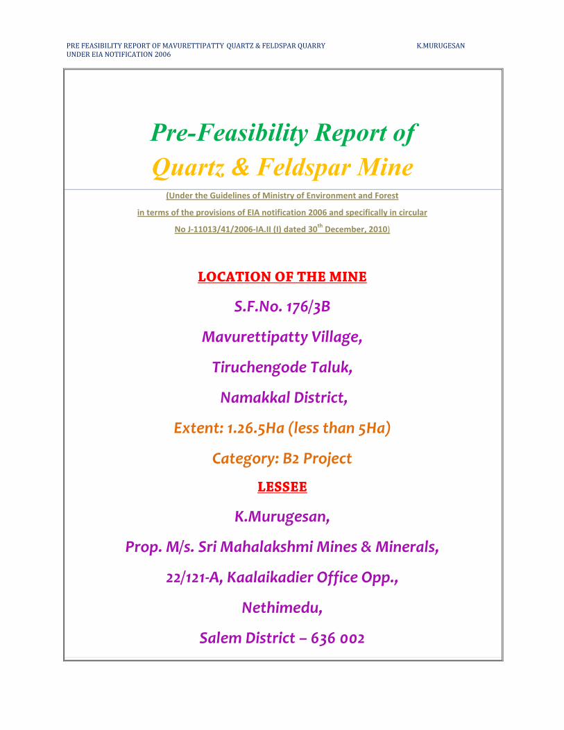
Pre-Feasibility Report of
Quartz & Feldspar Mine (Under the Guidelines of Ministry of Environment and Forest
in terms of the provisions of EIA notification 2006 and specifically in circular
No J-11013/41/2006-IA.II (I) dated 30th
December, 2010)
LOCATION OF THE MINE
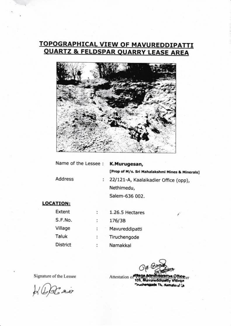
S.F.No. 176/3B
Mavurettipatty Village,
Tiruchengode Taluk,
Namakkal District,
Extent: 1.26.5Ha (less than 5Ha)
Category: B2 Project
LESSEE
K.Murugesan,
Prop. M/s. Sri Mahalakshmi Mines & Minerals,
22/121-A, Kaalaikadier Office Opp.,
Nethimedu,
Salem District – 636 002
PRE FEASIBILITY REPORT OF MAVURETTIPATTY QUARTZ & FELDSPAR QUARRY K.MURUGESAN
UNDER EIA NOTIFICATION 2006
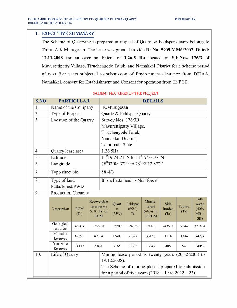
1. EXECUTIVE SUMMARY
The Scheme of Quarrying is prepared in respect of Quartz & Feldspar quarry belongs to
Thiru. A K.Murugesan. The lease was granted to vide Rc.No. 5909/MM6/2007, Dated:
17.11.2008 for an over an Extent of 1.26.5 Ha located in S.F.Nos. 176/3 of
Mavurettipatty Village, Tiruchengode Taluk, and Namakkal District for a scheme period
of next five years subjected to submission of Environment clearance from DEIAA,
Namakkal, consent for Establishment and Consent for operation from TNPCB.
SALIENT FEATURES OF THE PROJECT
S.NO PARTICULAR DETAILS
1. Name of the Company K.Murugesan
2. Type of Project Quartz & Feldspar Quarry
3. Location of the Quarry Survey Nos. 176/3B
Mavurettipatty Village,
Tiruchengode Taluk,
Namakkal District,
Tamilnadu State.
4. Quarry lease area 1.26.5Ha
5. Latitude 11019’24.21”N to 11
019’28.78”N
6. Longitude 78002’08.32”E to 78
002’12.87”E
7. Topo sheet No. 58 -I/3
8. Type of land
Patta/forest/PWD
It is a Patta land - Non forest
9. Production Capacity
Description
ROM
(Ts)
Recoverable
reserves @
60% (Ts) of
ROM
Quart
z
(35%)
Feldspar
(65%)
Ts
Mineral
reject
(40%) Ts
of ROM
Side
Burden
(Ts)
Topsoil
(Ts)
Total
waste
(40%
MR +
SB)
Geological
resources 320416 192250 67287 124962 128166 243518 7544 371684
Mineable
Reserves 82891 49734 17407 32327 33156 1118 1384 34274
Year wise
Reserves 34117 20470 7165 13306 13647 405 96 14052
10. Life of Quarry Mining lease period is twenty years (20.12.2008 to
19.12.2028).
The Scheme of mining plan is prepared to submission
for a period of five years (2018 – 19 to 2022 – 23).
PRE FEASIBILITY REPORT OF MAVURETTIPATTY QUARTZ & FELDSPAR QUARRY K.MURUGESAN
UNDER EIA NOTIFICATION 2006
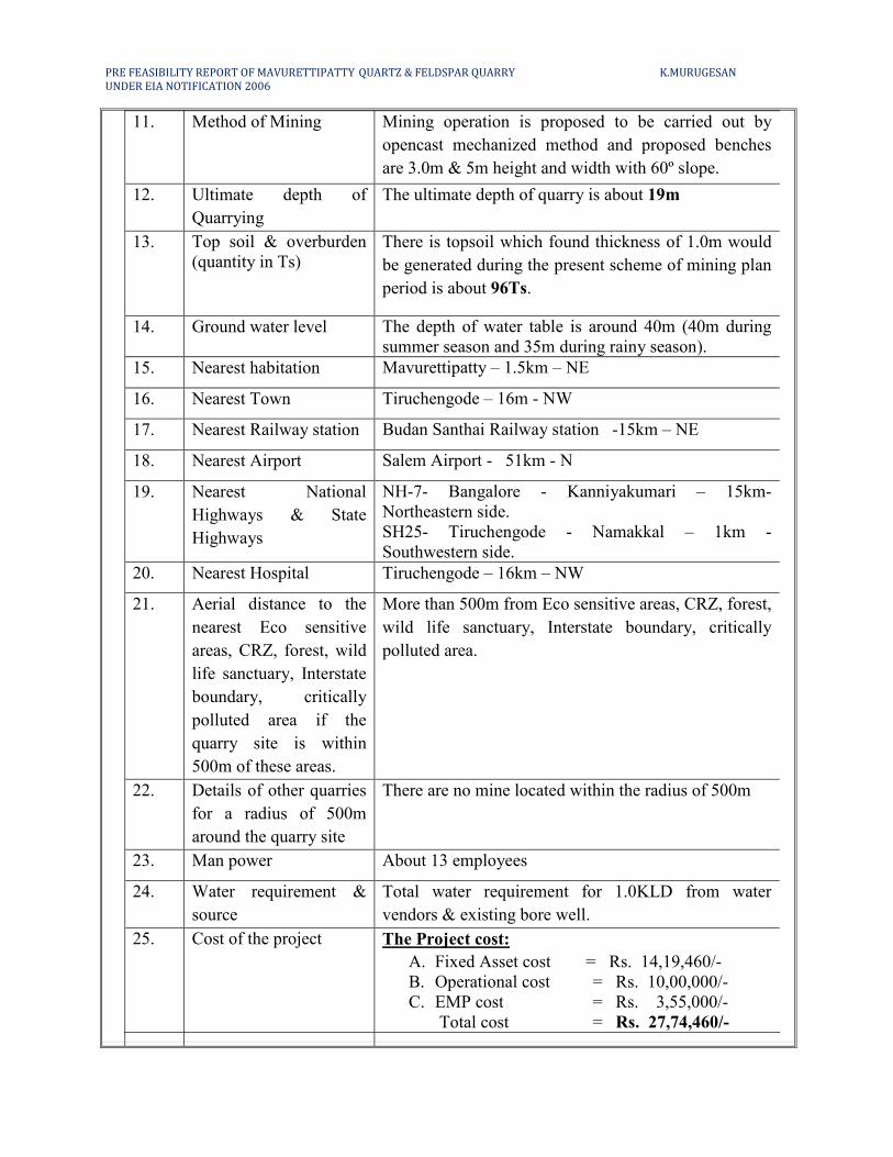
11. Method of Mining Mining operation is proposed to be carried out by
opencast mechanized method and proposed benches
are 3.0m & 5m height and width with 60º slope.
12. Ultimate depth of
Quarrying
The ultimate depth of quarry is about 19m
13. Top soil & overburden
(quantity in Ts)
There is topsoil which found thickness of 1.0m would
be generated during the present scheme of mining plan
period is about 96Ts.
14. Ground water level The depth of water table is around 40m (40m during
summer season and 35m during rainy season).
15. Nearest habitation Mavurettipatty – 1.5km – NE
16. Nearest Town Tiruchengode – 16m - NW
17. Nearest Railway station Budan Santhai Railway station -15km – NE
18. Nearest Airport Salem Airport - 51km - N
19. Nearest National
Highways & State
Highways
NH-7- Bangalore - Kanniyakumari – 15km-
Northeastern side.
SH25- Tiruchengode - Namakkal – 1km -
Southwestern side.
20. Nearest Hospital Tiruchengode – 16km – NW
21. Aerial distance to the
nearest Eco sensitive
areas, CRZ, forest, wild
life sanctuary, Interstate
boundary, critically
polluted area if the
quarry site is within
500m of these areas.
More than 500m from Eco sensitive areas, CRZ, forest,
wild life sanctuary, Interstate boundary, critically
polluted area.
22. Details of other quarries
for a radius of 500m
around the quarry site
There are no mine located within the radius of 500m
23. Man power About 13 employees
24. Water requirement &
source
Total water requirement for 1.0KLD from water
vendors & existing bore well.
25. Cost of the project The Project cost:
A. Fixed Asset cost = Rs. 14,19,460/-
B. Operational cost = Rs. 10,00,000/-
C. EMP cost = Rs. 3,55,000/-
Total cost = Rs. 27,74,460/-
PRE FEASIBILITY REPORT OF MAVURETTIPATTY QUARTZ & FELDSPAR QUARRY K.MURUGESAN
UNDER EIA NOTIFICATION 2006
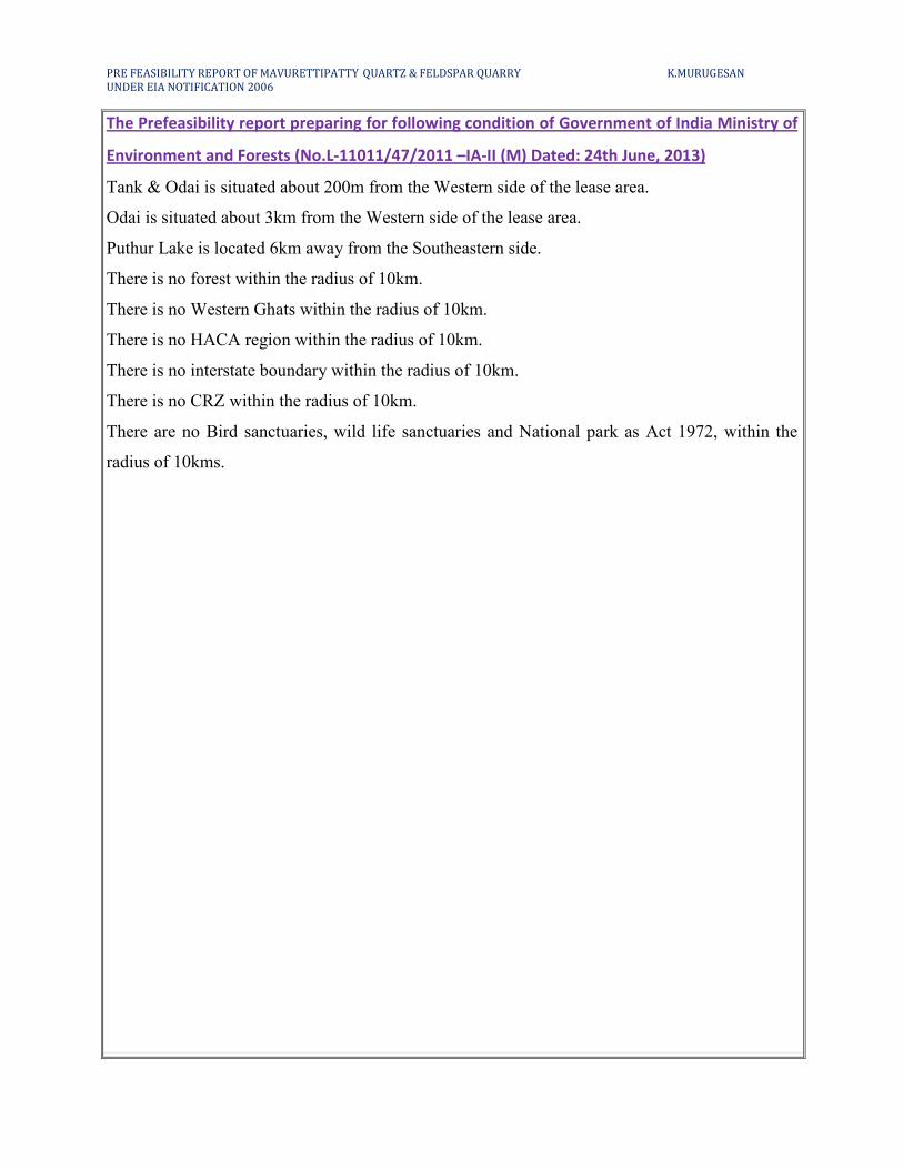
The Prefeasibility report preparing for following condition of Government of India Ministry of
Environment and Forests (No.L-11011/47/2011 –IA-II (M) Dated: 24th June, 2013)
Tank & Odai is situated about 200m from the Western side of the lease area.
Odai is situated about 3km from the Western side of the lease area.
Puthur Lake is located 6km away from the Southeastern side.
There is no forest within the radius of 10km.
There is no Western Ghats within the radius of 10km.
There is no HACA region within the radius of 10km.
There is no interstate boundary within the radius of 10km.
There is no CRZ within the radius of 10km.
There are no Bird sanctuaries, wild life sanctuaries and National park as Act 1972, within the
radius of 10kms.
PRE FEASIBILITY REPORT OF MAVURETTIPATTY QUARTZ & FELDSPAR QUARRY K.MURUGESAN
UNDER EIA NOTIFICATION 2006
The following information provided by the applicant
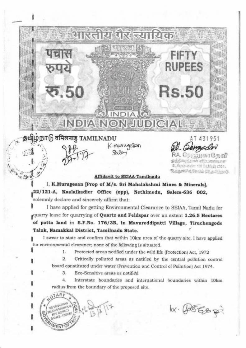
I have applied for Environmental Clearance to DEIAA,Namakkal, Tamilnadu for
Quartz & Feldspar lease for quarrying of Mavurettipatty in S.F.No: 176/3B for over an extent of
1.26.5Ha in Mavurettipatty Village, Tiruchengode Taluk and Namakkal District.
I swear to state and confirm that within 10km area of the mine site, I have applied for
environmental clearance; none of the following is situated.
Protected areas notified under the wild life (Protection) Act, 1972
Critically polluted areas as notified by the central pollution control board constituted
Under water (Prevention and Control of Pollution) Act 1974.
Eco-Sensitive areas as notified
Interstate boundaries and international boundaries within 5km radius from the boundary of the
proposed site.
There is no quarry located within the radius of 500m radius from periphery of the proposed
quarry.
There will not be any hindrance or disturbance to the people during transportation. No villages
are enrooted during transportation.
No habitations /villages observed within 300m radius from the periphery of quarrying area.
I swear that Afforestation will be carried out during the course of mining operation and
maintained.
The required insurance will be taken in the name of the labourers working in my quarry site.
Approach road belongs to us only and no other private patta roads encountered.
I will not engage any child labour in my mine site and I aware that engaging child labour is
punishable under the law.
All types of safety / protective equipment will be provided to all the labourers working in
quarrying area.
There is no permanent structures, temples etc., are located within 500m radius from the
periphery of my quarry.
PRE FEASIBILITY REPORT OF MAVURETTIPATTY QUARTZ & FELDSPAR QUARRY K.MURUGESAN
UNDER EIA NOTIFICATION 2006
2.0 INTRODUCTION OF THE PROJECT OR BACKGROUND INFORMATION
(i) Identification of project and project proponent: In case of quarrying project, a copy of
mining lease/letter of intent should be given
Identification of Project
Name of the Project Mavurettipatty Quartz & Feldspar Quarry
Lease area 1.26.5Ha (Patta land) -Non forest
Location
Survey No. 176/3B
Mavurettipatty Village, Tiruchengode Taluk,
Namakkal District and Tamilnadu State.
Topo sheet No. 58 -I/3
Project Proponent Name with Address
K.Murugesan,
Prop. of M/s. Sri Mahalakshmi Mines & Minerals,
No.22/121-A, (Opposite to) Kaalaikadier Office,
Nethimedu,
Salem District – 636 002
Mobile No: 98427 44845 & 95242 43236
Email id: [email protected]
In case of mining project, a copy of mining lease/letter of intent should be given
I. The Mining lease was granted under Rc. No. 5909/MM6/2007, Dated: 17.11.2008.
II. The Mining plan was approved by the IBM, Regional controller of mines, Chennai
vide Letter. No: TN/NMK/MP/QF-1701.MDS, Dated: 23.10.2008.
III. The Second Scheme was approved by Commissioner of Geology and Mining,
Chennai, vide Rc.No.7531/MM10/2017/NMK/Q&F/ SOM Dated: 08.11.2018.
PRE FEASIBILITY REPORT OF MAVURETTIPATTY QUARTZ & FELDSPAR QUARRY K.MURUGESAN
UNDER EIA NOTIFICATION 2006
(ii) Brief description of nature of the project
The opencast mining operation is proposed by the formation of benches. Two benches are
proposed on the mineral to form at 1.0m, 3.0m and 5.0m height and width with 45º, 60º slopes.
The mine is well exposed the pegmatite rocks consist of quartz and feldspar. Quartz is identified
by concoidal fracture, vitreous lusture and granular grains. Orthoclase Feldspar identified by
pinkish white in color, pearly lusture on cleavage faces. The quarry lease area is 1.26.5Ha; the
life of mine is twenty years.
The total quantity of Mineable reserves of Quartz & Feldspar (60%) of ROM is about
49734Ts (17407Ts of Quartz @35% & 32327Ts of Feldspar @65%) and the total waste is about
is 34274Ts (33156Ts of MR @ 40% + 1118Ts of SB) is up to depth of 19.0m for the entire life
of mine.
The proposed quantity of Quartz & Feldspar (60%) of ROM mined for during this period
(as in the scheme of mining) would be about 20470Ts (7165Ts @35% of Quartz & 813306Ts
@65% of Feldspar) and the total waste is about 14052Ts (13647Ts of MR @ 40% + 405Ts of
SB) up to depth of 7.0m for a this scheme period.
The mineral reject is calculated as 40% of ROM. This includes fragments, chips, etc., the
total waste it will be proposed to dump on the Northern side of the lease area. Water requirement
for the proposed project for drinking purpose, dust suppression and afforestation would be
around 1.0KLD which will be taken from nearby villages.
(iii) Need for the project and its importance to the country and or region
The minerals of Quartz and Feldspar are used in various forms in various industries to
manufacture various products. Quartz shall be used in ceramics, glass manufacturing,
ferrosilicon, electric lining industries and paints. Feldspar shall be used in glass, ceramics,
abrasives and electrodes.
This project will give employment opportunities to 13 members directly and 8 members
indirectly, besides this Quartz and Feldspar is well known in the international supermarket which
will fetch a good foreign exchange to the nation.
Mineral Industries of the state of Tamilnadu provides employment opportunities for the
people of the state as well as in the specific project area. The quarrying is one among the major
core sector industries which plays a vital process of country’s economic development and
foreign exchange.
PRE FEASIBILITY REPORT OF MAVURETTIPATTY QUARTZ & FELDSPAR QUARRY K.MURUGESAN
UNDER EIA NOTIFICATION 2006
(iv) Demand and supply gap
Quartz and Feldspar is one among the most used in various industries to manufacture
different kind of product. The demand of Quartz and Feldspar is ever growing with the growth of
ceramics, glass manufacturing, ferrosilicon, induction furnaces lining, electric lining and paint
industries.
The mineral is widely used in walls and floor tiles other ceramic product, soaps and
detergents, paints, paper, cosmetic and plastic. The requirement for the mineral is very high in
the nearby cities and towns.
(v) Imports vs indigenous production
There is no import of Quartz and Feldspar at present in India. India especially the
peninsular India (southern India) has good resource of Quartz and Feldspar and has a great
demand in the international supermarket. Indigenous Quartz and Feldspar almost shares more
than 50% requirement in the world.
(vi) Export Possibility
There are many possibilities for export the Quartz and Feldspar to foreign countries
especially to Japan, Malaysia etc., as the Indian Quartz and Feldspar is one of the mostly
important industries in the world. All the international Quartz and Feldspar players are in the
requirement for industries either domestic or exports. Hence there is a bright possibility for
export of Quartz and Feldspar most of the industries.
(vii) Domestic/Export Markets
The applicant after will fetch a good domestic market as mentioned earlier. The applicant
does not have any other mine in Tamilnadu. It is propose to sell Quartz and Feldspar to industries
and domestic markets. Quartz is mainly used in ferrosilicon, silicon carbide industries and
abrasive industry. The main use of feldspar is in ceramics and porcelain industry mainly as glaze
material. It is also used in the manufacturing of some specialized electrodes.
(viii) Employment Generation (Direct and Indirect) due to the project
It is proposed to deploy about 13 employees directly and indirectly about 8 people will be
benefited from the nearby local villages.
The above man power is adequate to meet out the production schedule and the machinery
strength envisaged in the plan and also to comply with the stationary provisions of mine safety
regulation.
PRE FEASIBILITY REPORT OF MAVURETTIPATTY QUARTZ & FELDSPAR QUARRY K.MURUGESAN
UNDER EIA NOTIFICATION 2006
It is been ensured that the labors will not be deployed less than 18 years, No Child
labors will engaged or entertained for any kind of quarrying operations. All the labors
engaged for mining operations will be insured till the end of life of mine.
3.0 PROJECT DESCRIPTION
(i) Type of project including interlinked and interdependent projects, if any
This is a quarrying project for production of mine deposit at proposed production is about
@ 60% of ROM 20470Ts (7165Ts @35% of Quartz & 13306Ts @65% of Feldspar) no other
allied actions like processing and polishing is proposed in this project.
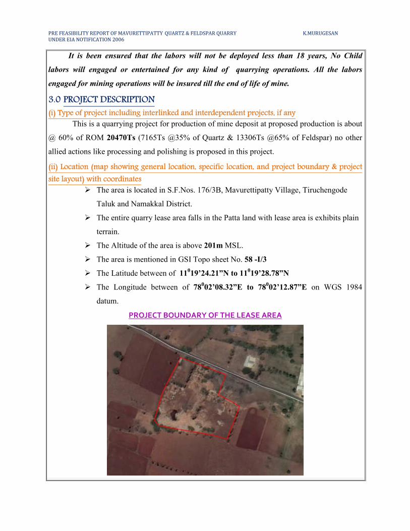
(ii) Location (map showing general location, specific location, and project boundary & project
site layout) with coordinates
� The area is located in S.F.Nos. 176/3B, Mavurettipatty Village, Tiruchengode
Taluk and Namakkal District.
� The entire quarry lease area falls in the Patta land with lease area is exhibits plain
terrain.
� The Altitude of the area is above 201m MSL.
� The area is mentioned in GSI Topo sheet No. 58 -I/3
� The Latitude between of 11019’24.21”N to 11
019’28.78”N
� The Longitude between of 78002’08.32”E to 78
002’12.87”E on WGS 1984
datum.
PROJECT BOUNDARY OF THE LEASE AREA
PRE FEASIBILITY REPORT OF MAVURETTIPATTY QUARTZ & FELDSPAR QUARRY K.MURUGESAN
UNDER EIA NOTIFICATION 2006
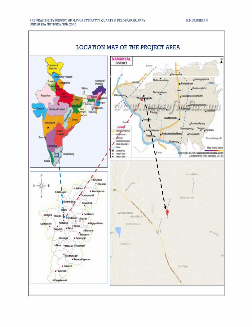
LOCATION MAP OF THE PROJECT AREA
v
PRE FEASIBILITY REPORT OF MAVURETTIPATTY QUARTZ & FELDSPAR QUARRY K.MURUGESAN
UNDER EIA NOTIFICATION 2006
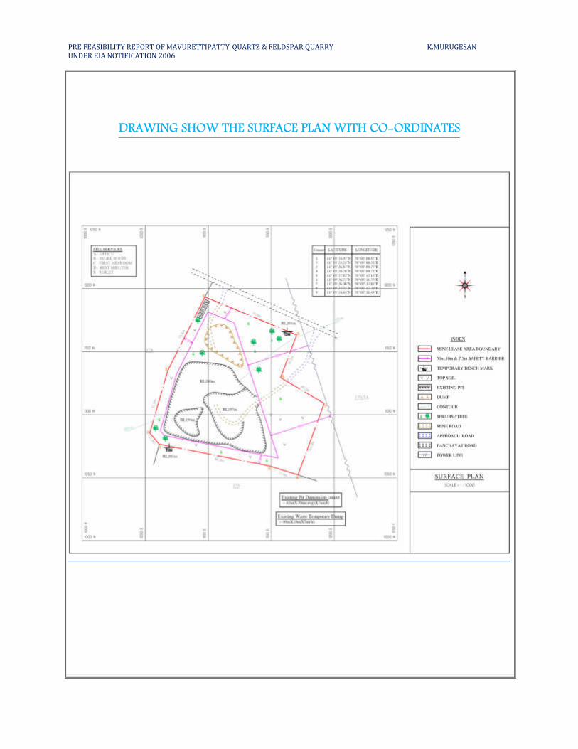
DRAWING SHOW THE SURFACE PLAN WITH CO-ORDINATES
PRE FEASIBILITY REPORT OF MAVURETTIPATTY QUARTZ & FELDSPAR QUARRY K.MURUGESAN
UNDER EIA NOTIFICATION 2006
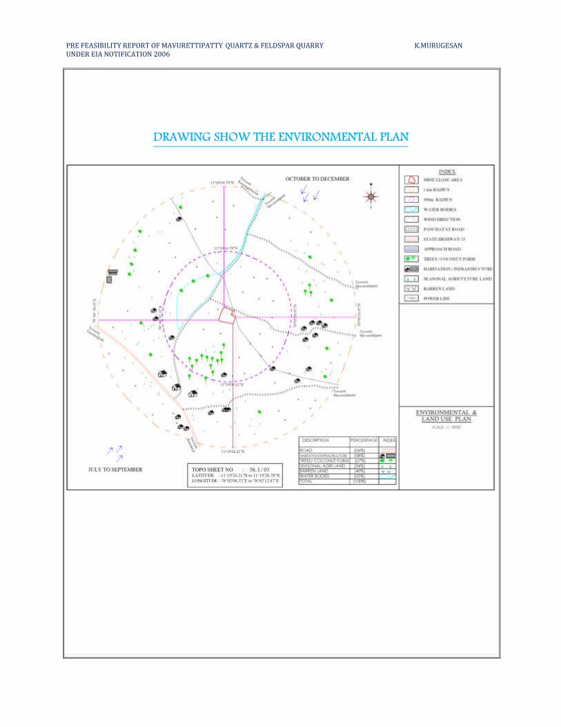
DRAWING SHOW THE ENVIRONMENTAL PLAN
PRE FEASIBILITY REPORT OF MAVURETTIPATTY QUARTZ & FELDSPAR QUARRY K.MURUGESAN
UNDER EIA NOTIFICATION 2006
(iii) Details of alternate sites considered and the basis of selecting the proposed site, particularly
the environmental considerations gone into should be highlighted
The opencast mining is proposed in the area for excavation of Quartz and Feldspar with
7.0m depth. The quarry is proposed in the applicant patta land hence alternate site for this project
is not considered. The project is site specific.
(iv) Size or magnitude of operation
The total area of the project is about 1.26.5 Ha. It is proposed for production (60%) of
ROM is about 20470Ts (7165Ts @35% of Quartz & 13306Ts @65% of Feldspar) by open cast
mining by deploys jackhammer drilling and blasting, hydraulic excavation of Quartz and
Feldspar from pithead to glass and ceramic manufacturing industries.
(v) Project description with process details (a schematic diagram/flow chart showing the
project layout, components of the project etc. should be given)
Details regarding topography, Geology of the area, Method of mining, Machineries
required and production details area given below:
Physiography
The area is almost plain terrain. The general drainage pattern of the area is dentritic pattern.
Only mining activity is being carried out in and around the area. In some areas agriculture is done
with lift irrigation. The main crops being millet, paddy, pulses etc. are grown as seasonal crops.
There is no Forest or Animal Sanctuaries near the area. There is no thick vegetation. Water table is
found at a depth of 40m during summer and 35m during rainy season. The area exhibits a
subtropical climate and the temperature that goes upto 420C in summer and falls down to 25
0C in
December – January. The wind direction is NE-SW and vice-versa. Average annual rainfall is about
750mm in Northeast and Southwest monsoon season.
Geology of the area
The Namakkal district is mostly underlain by the Archean crystalline, metamorphic
complex. The geology of the district is complicated due to recurring tectonic and magmatic
activities occurred during the pre-cambrian period. The famous Sittampundi complex is popularly
known for its complex geology is situated in this district. It forms a part of massive intrusion of
granites and pegmatites.
PRE FEASIBILITY REPORT OF MAVURETTIPATTY QUARTZ & FELDSPAR QUARRY K.MURUGESAN
UNDER EIA NOTIFICATION 2006
These rocks are exposed at some distance from the area. The gneisses are well foliated and
banded with alternate layers of feldspathic Biotite-hornblende minerals. Granites and pegmatites
have intruded the gneisses and they are of Archaean Age. Being more resistant than the gneisses
to erosion, the granites and pegmatites stand out as residual ridges in this area.
The general geological sequence of the rocks in the area is:-
AGE ROCK TYPE
Recent Thin reddish and gravelly soil
-----------------Unconformity-----------------------------------------
Archaean - Pegmatites and granite
Gneisses
- Pink pegmatoidal syenite
- Migmatites (Hb –Bi gneisses).
The area was surveyed in detail to prepare a Geological map in the scale 1:1000 Showing
the various formations and attitude of the deposit.
The physical attitude of the band is given below:
Strike length (m) - 118
Width (m) - 66 (max)
Depth (m) - 19m (1m Top soil+ 19m Quartz & Feldspar)
Strike direction - N700E - S70
0W
Dip amount - SE700
Colour of Quartz is white, massive in form, hardness 7.0, specific gravity 2.6, absence of
cleavage; streak is white, vitreous in luster. Colour of Feldspar is pink, massive in form, hardness
6, specific gravity 2.6, two sets of cleavage, streak is white, sub-vitreous in luster. Major
geological disturbances are totally absent in this area. Recovery of minerals is estimated as 60%
of the total excavation of the ore body. The recovery percentage is based on the knowledge
gained from the working mine in this belt.
PRE FEASIBILITY REPORT OF MAVURETTIPATTY QUARTZ & FELDSPAR QUARRY K.MURUGESAN
UNDER EIA NOTIFICATION 2006
Method of Mining:
Mining would be carried out by the opencast method of working. Since the daily rate of
production is very limited, no heavy earth moving machinery is required. The Quarrying
operation would be done in a systematic way by forming benches with all safety aspects as
stipulated in the Mines Act, Mines Rules and Metalliferous Mines Regulations.
Machineries like Jackhammer drilling, tractor mounted compressors and blasting by
developing the benches at 3.0m & 5.0m height and width. The drilling is carried out with
jackhammer of small diameter (30-32mm) at shallow depth and blasted with class 2 slurry
explosives with charge ratio as 0.2 to 0.3. The quarry would be operated with hydraulic
excavation & laborers with one shift only.
Open Cast Working
It is proposed to carry out quarrying operation by open cast method.
The dimension of the benches is proposed at 3m height and 5m width for the easy
movement of men and machinery during mining activities. The slope of the benches is
maintained at 60o and less for the safety factors of the machines and men working inside the
mine. There is one existing pit and the dimension is 63m x 70m (avg) x 7m (d).
The top soil is of 1m thickness, one bench is maintained with 1m height. There will be
six benches in mineral with 3m height, 5m width and slope maintained as 600 from horizontal.
During the present scheme period [2018-19 to 2022-23], the mine working is proposed to be
carried out in the centre portion of the mining lease area starting from North and progress
towards Southern of the lease area upto 7m [1m Topsoil+ 6m Pegmatite (Quartz + Feldspar)]
from RL 201.0m to RL 194.0m. During the present scheme period, the mining operations are
proposed to be carried out in the first, second and third benches.
The mineral rejects and side burden (i.e. Total waste) that would be generated during the
previous scheme period was dumped on the Northern side of the lease area, the same will be re-
arranged. The mineral rejects and side burden (i.e. Total waste) that would be generated during
the present scheme period is proposed to be dumped over the existing re-arranged waste dump
situated in the Northern side of the lease area. The topsoil that would be generated during the
present scheme period will be utilized for afforestation purposes.
PRE FEASIBILITY REPORT OF MAVURETTIPATTY QUARTZ & FELDSPAR QUARRY K.MURUGESAN
UNDER EIA NOTIFICATION 2006
Estimation of Reserves:
Geological Resources:
Maximum Length = 117m
Maximum Width = 125m (Max)
Maximum Depth = 19m
Section ROM
(Ts)
Recoverable
Reserves
@60% (Ts)
Quartz
(35%) Ts
Feldspar
(65%) Ts
Mineral
reject @
40%
(Ts)
Side
Burden
(Ts)
Topsoil
(Ts)
Total
waste
(40%
MR +
SB)
XY-AB 100643 60386 21135 39251 40257 28958 5544 69215
XY-CD 219773 131864 46152 85711 87909 214560 2000 302469
Total 320416 192250 67287 124962 128166 243518 7544 371684
Mining- Opencast semi mechanized Method
Blasting Drilling
Quartz & Feldspar
Hydraulic excavation and
transportation to the needy
industries
SCHEMATIC DIAGRAM OF THE MINING PROCESS
Topsoil/Overburden
Utilized for afforestation
purpose
PRE FEASIBILITY REPORT OF MAVURETTIPATTY QUARTZ & FELDSPAR QUARRY K.MURUGESAN
UNDER EIA NOTIFICATION 2006
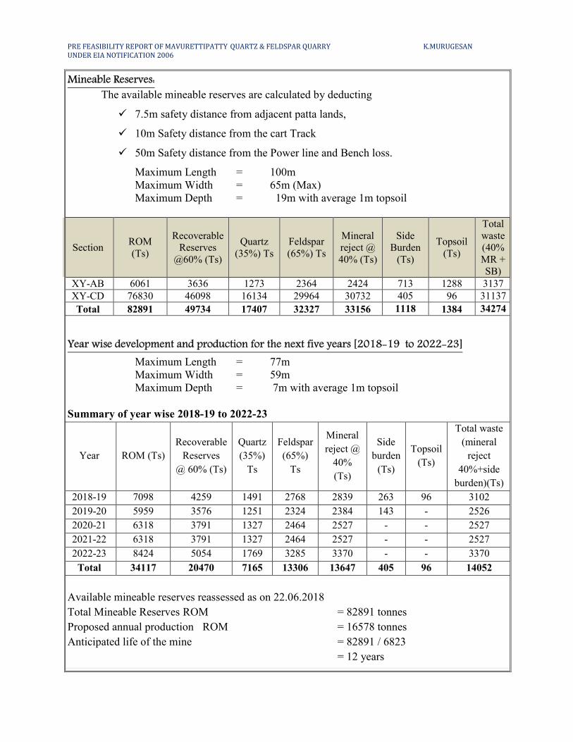
Mineable Reserves:
The available mineable reserves are calculated by deducting
� 7.5m safety distance from adjacent patta lands,
� 10m Safety distance from the cart Track
� 50m Safety distance from the Power line and Bench loss.
Maximum Length = 100m
Maximum Width = 65m (Max)
Maximum Depth = 19m with average 1m topsoil
Section ROM
(Ts)
Recoverable
Reserves
@60% (Ts)
Quartz
(35%) Ts
Feldspar
(65%) Ts
Mineral
reject @
40% (Ts)
Side
Burden
(Ts)
Topsoil
(Ts)
Total
waste
(40%
MR +
SB)
XY-AB 6061 3636 1273 2364 2424 713 1288 3137
XY-CD 76830 46098 16134 29964 30732 405 96 31137
Total 82891 49734 17407 32327 33156 1118 1384 34274
Year wise development and production for the next five years [2018-19 to 2022-23]
Maximum Length = 77m
Maximum Width = 59m
Maximum Depth = 7m with average 1m topsoil
Summary of year wise 2018-19 to 2022-23
Year ROM (Ts)
Recoverable
Reserves
@ 60% (Ts)
Quartz
(35%)
Ts
Feldspar
(65%)
Ts
Mineral
reject @
40%
(Ts)
Side
burden
(Ts)
Topsoil
(Ts)
Total waste
(mineral
reject
40%+side
burden)(Ts)
2018-19 7098 4259 1491 2768 2839 263 96 3102
2019-20 5959 3576 1251 2324 2384 143 - 2526
2020-21 6318 3791 1327 2464 2527 - - 2527
2021-22 6318 3791 1327 2464 2527 - - 2527
2022-23 8424 5054 1769 3285 3370 - - 3370
Total 34117 20470 7165 13306 13647 405 96 14052
Available mineable reserves reassessed as on 22.06.2018
Total Mineable Reserves ROM = 82891 tonnes
Proposed annual production ROM = 16578 tonnes
Anticipated life of the mine = 82891 / 6823
= 12 years
PRE FEASIBILITY REPORT OF MAVURETTIPATTY QUARTZ & FELDSPAR QUARRY K.MURUGESAN
UNDER EIA NOTIFICATION 2006
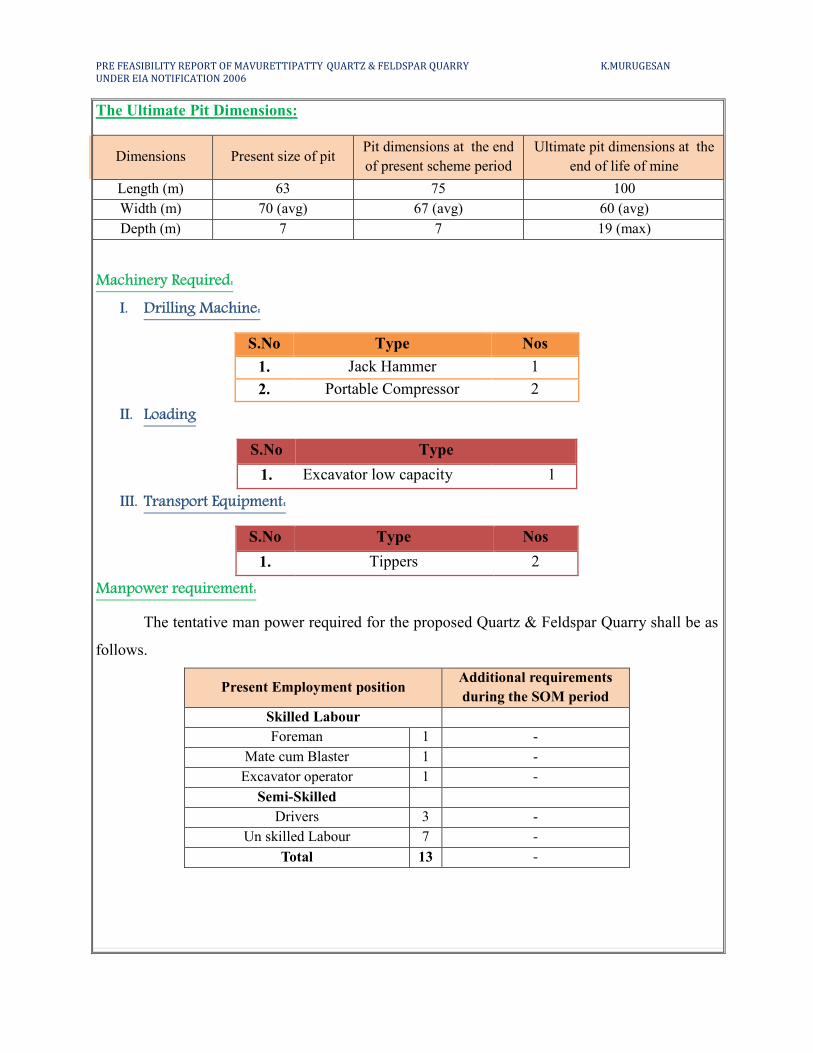
The Ultimate Pit Dimensions:
Dimensions Present size of pit Pit dimensions at the end
of present scheme period
Ultimate pit dimensions at the
end of life of mine
Length (m) 63 75 100
Width (m) 70 (avg) 67 (avg) 60 (avg)
Depth (m) 7 7 19 (max)
Machinery Required:
I. Drilling Machine:
S.No Type Nos
1. Jack Hammer 1
2. Portable Compressor 2
II. Loading
S.No Type
1. Excavator low capacity 1
III. Transport Equipment:
S.No Type Nos
1. Tippers 2
Manpower requirement:
The tentative man power required for the proposed Quartz & Feldspar Quarry shall be as
follows.
Present Employment position Additional requirements
during the SOM period
Skilled Labour
Foreman 1 -
Mate cum Blaster 1 -
Excavator operator 1 -
Semi-Skilled
Drivers 3 -
Un skilled Labour 7 -
Total 13 -
PRE FEASIBILITY REPORT OF MAVURETTIPATTY QUARTZ & FELDSPAR QUARRY K.MURUGESAN
UNDER EIA NOTIFICATION 2006
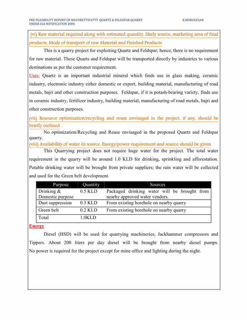
(vi) Raw material required along with estimated quantity, likely source, marketing area of final
products, Mode of transport of raw Material and Finished Products
This is a quarry project for exploiting Quartz and Feldspar; hence, there is no requirement
for raw material. These Quarts and Feldspar will be transported directly by industries to various
destinations as per the customer requirement.
Uses: Quartz is an important industrial mineral which finds use in glass making, ceramic
industry, electronic industry either domestic or export, building material, manufacturing of road
metals, bajri and other construction purposes. Feldspar, if it is potash-bearing variety, finds use
in ceramic industry, fertilizer industry, building material, manufacturing of road metals, bajri and
other construction purposes.
(vii) Resource optimization/recycling and reuse envisaged in the project, if any, should be
briefly outlined
No optimization/Recycling and Reuse envisaged in the proposed Quartz and Feldspar
quarry.
(viii) Availability of water its source, Energy/power requirement and source should be given
This Quarrying project does not require huge water for the project. The total water
requirement in the quarry will be around 1.0 KLD for drinking, sprinkling and afforestation.
Potable drinking water will be brought from private suppliers; the rain water will be collected
and used for the Green belt development.
Purpose Quantity Sources
Drinking &
Domestic purpose
0.5 KLD Packaged drinking water will be brought from
nearby approved water vendors.
Dust suppression 0.3 KLD From existing borehole on nearby quarry
Green belt 0.2 KLD From existing borehole on nearby quarry
Total 1.0KLD
Energy
Diesel (HSD) will be used for quarrying machineries, Jackhammer compressors and
Tippers. About 200 liters per day diesel will be brought from nearby diesel pumps.
No power is required for the project except for mine office and lighting during the night.
PRE FEASIBILITY REPORT OF MAVURETTIPATTY QUARTZ & FELDSPAR QUARRY K.MURUGESAN
UNDER EIA NOTIFICATION 2006
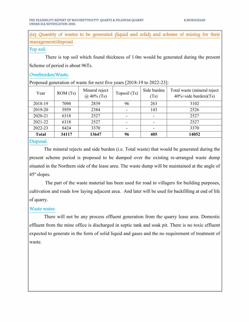
(ix) Quantity of wastes to be generated (liquid and solid) and scheme of mining for their
management/disposal.
Top soil:
There is top soil which found thickness of 1.0m would be generated during the present
Scheme of period is about 96Ts.
Overburden/Waste:
Proposed generation of waste for next five years [2018-19 to 2022-23]:
Year ROM (Ts) Mineral reject
@ 40% (Ts) Topsoil (Ts)
Side burden
(Ts)
Total waste (mineral reject
40%+side burden)(Ts)
2018-19 7098 2839 96 263 3102
2019-20 5959 2384 - 143 2526
2020-21 6318 2527 - - 2527
2021-22 6318 2527 - - 2527
2022-23 8424 3370 - - 3370
Total 34117 13647 96 405 14052
Disposal:
The mineral rejects and side burden (i.e. Total waste) that would be generated during the
present scheme period is proposed to be dumped over the existing re-arranged waste dump
situated in the Northern side of the lease area. The waste dump will be maintained at the angle of
45º slopes.
The part of the waste material has been used for road in villagers for building purposes,
cultivation and roads low laying adjacent area. And later will be used for backfilling at end of life
of quarry.
Waste water:
There will not be any process effluent generation from the quarry lease area. Domestic
effluent from the mine office is discharged in septic tank and soak pit. There is no toxic effluent
expected to generate in the form of solid liquid and gases and the no requirement of treatment of
waste.
PRE FEASIBILITY REPORT OF MAVURETTIPATTY QUARTZ & FELDSPAR QUARRY K.MURUGESAN
UNDER EIA NOTIFICATION 2006
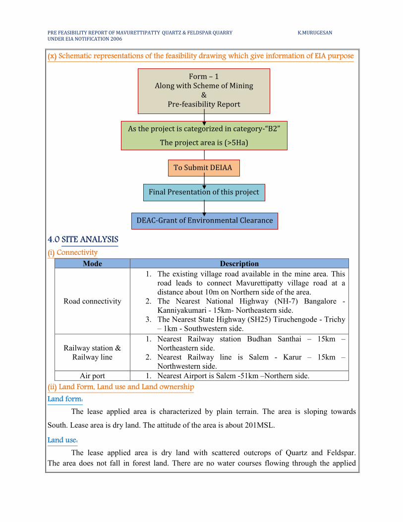
(x) Schematic representations of the feasibility drawing which give information of EIA purpose
4.0 SITE ANALYSIS
(i) Connectivity
Mode Description
Road connectivity
1. The existing village road available in the mine area. This
road leads to connect Mavurettipatty village road at a
distance about 10m on Northern side of the area.
2. The Nearest National Highway (NH-7) Bangalore -
Kanniyakumari - 15km- Northeastern side.
3. The Nearest State Highway (SH25) Tiruchengode - Trichy
– 1km - Southwestern side.
Railway station &
Railway line
1. Nearest Railway station Budhan Santhai – 15km –
Northeastern side.
2. Nearest Railway line is Salem - Karur – 15km –
Northwestern side.
Air port 1. Nearest Airport is Salem -51km –Northern side.
(ii) Land Form, Land use and Land ownership
Land form:
The lease applied area is characterized by plain terrain. The area is sloping towards
South. Lease area is dry land. The attitude of the area is about 201MSL.
Land use:
The lease applied area is dry land with scattered outcrops of Quartz and Feldspar.
The area does not fall in forest land. There are no water courses flowing through the applied
Form – 1
Along with Scheme of Mining
&
Pre-feasibility Report
To Submit DEIAA
As the project is categorized in category-“B2”
The project area is (>5Ha)
Final Presentation of this project
DEAC-Grant of Environmental Clearance
PRE FEASIBILITY REPORT OF MAVURETTIPATTY QUARTZ & FELDSPAR QUARRY K.MURUGESAN
UNDER EIA NOTIFICATION 2006
lease area. There is no vegetation/plantation in this area. Some thorny bushes and shrubs are
observed. Present mining land use pattern is as follows:
Description Present Area
(Ha)
Area to be reclaimed at the
end of present scheme Period
(Ha)
Area at the end of
life of mine (Ha)
Area under Mining 0.44.1 0.06.1 0.60.0
Dumps 0.07.2 0.04.1 0.13.4
Mineral Stockyard - - -
Office & infrastructure 0.01.0 Nil 0.01.0
Road 0.02.0 Nil 0.02.0
Green Belt 0.03.0 0.17.0 0.20.0
Un utilized area 0.69.2 0.42.0 0.30.1
Total 1.26.5 1.26.5
Land Ownership:
The proposed quarry lease area is 1.26.5Ha. It is patta land registered in the name of
Santhi, Murugesan, Govinthan vide patta no. 1032. The Lessee has obtained consent from the
Joint Pattadhars.
(iii) Topography (along with map)
The area is almost plain terrain and gently sloping towards South. The Altitude of the area is
above 201m MSL. The area is dry and seasonal cultivation is done in the nearby areas with lift
irrigation. Water is found at a depth of about 40m in summer and 35m in rainy season. Average
annual rainfall is about 750mm during North-East and southwest monsoon. The climate is dry and
the temperature goes up to 420C in summer and falls down to 25
0C in December – January.
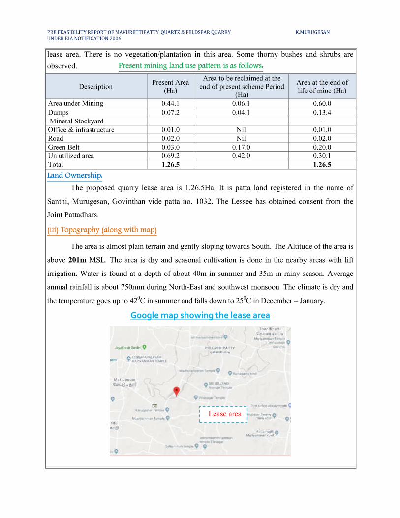
Google map showing the lease area
Lease area
PRE FEASIBILITY REPORT OF MAVURETTIPATTY QUARTZ & FELDSPAR QUARRY K.MURUGESAN
UNDER EIA NOTIFICATION 2006
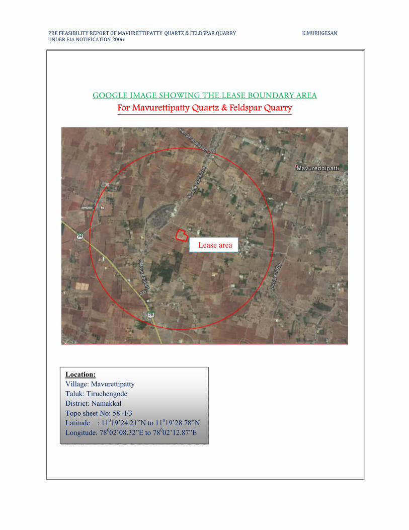
GOOGLE IMAGE SHOWING THE LEASE BOUNDARY AREA
For Mavurettipatty Quartz & Feldspar Quarry
Location:
Village: Mavurettipatty
Taluk: Tiruchengode
District: Namakkal
Topo sheet No: 58 -I/3
Latitude : 11019’24.21”N to 11
019’28.78”N
Longitude: 78002’08.32”E to 78
002’12.87”E
Lease area

PRE FEASIBILITY REPORT OF MAVURETTIPATTY QUARTZ & FELDSPAR QUARRY K.MURUGESAN
UNDER EIA NOTIFICATION 2006
(iv) Existing land use pattern (agriculture, no n-agriculture, forest, water bodies (including
area under CRZ), shortest distances from the periphery of the project to periphery of the
forests, national park, wild life sanctuary, eco sensitive areas, water bodies (distance from the
HFL of the river), CRZ. In case of notified industrial area, a copy of the Gazette notification
should be given.
The lease area exhibits plain terrain. The region experiences semi – humid climate and
there is scanty growth of vegetation in and around the lease area (seasonal vegetation is mostly
practiced).
� Tank & Odai is situated about 200m from the Western side of the lease area.
� Odai is situated about 3km from the Western side of the lease area.
� Puthur Lake is located 6km away from the Southeastern side.
� There is no forest within the radius of 10km.
� There is no Western Ghats region within the radius of 10km.
� There is no HACA region within the radius of 10km.
� There is no interstate boundary within the radius of 10km.
� There is no CRZ within the radius of 10km.
� There are no Bird sanctuaries, wild life sanctuaries and National park as Act 1972, within
the radius of 10kms.
� There are no mines located within the radius of 500m.
(v) Existing Infrastructure
The Quartz and Feldspar project requires infrastructure like (Mine office, Labours shed,
Toilet and Rest shelter) for quarrying shall made developed by the applicant after the grant of
lease. Water for drinking purpose be supplied form the approved water vendors. A small water
tank is also proposed which will be used for water sprinkling, plantation etc.
(vi) Soil Classification
There is topsoil which found thickness of 1.0m would be generated during the present
Scheme of mining plan period.
(vii) Climatic data form secondary sources
The area exhibits a subtropical climate and the temperature goes up to 42°C in summer
and falls down to 25°C in December to January. The wind direction is NE – SW and vice –
versa.
PRE FEASIBILITY REPORT OF MAVURETTIPATTY QUARTZ & FELDSPAR QUARRY K.MURUGESAN
UNDER EIA NOTIFICATION 2006
(viii) Social infrastructure available
There is no social infrastructure within the radius of 1Km like schools, universities,
hospitals, prisons and community housing etc.
5. PLANNING BRIEF
(i) Planning Concept (type of industries, facilities, transportation etc) Town and Country
Planning/Development authority Classification
The total area of the project is about 1.26.5 Ha. Open cast mechanized mining by deploys
jackhammer drilling and blasting, hydraulic excavation loading from pithead to various
industries.
The project land is devoid of vegetation and lies in the backward town of Namakkal
District. There are no specific industries or factories in and around the project area. The proposed
production is around 20470Ts (7165Ts @35% of Quartz & 13306Ts @65% of Feldspar) during
this scheme period. Plenty of labors are available in the nearby villages. Facilities such as power,
Transportation and commodities infrastructure facilities are locally available near the project site
with Tiruchengode 16km in Northwestern side.
Transportation
The quarry Quartz and Feldspar are transported from mine head to customer destination
by tippers. The mode of transport of the Quartz and Feldspar produces and transported by
various industries.
Quartz is an important industrial mineral which finds use in glass making, ceramic
industry and in electronic industry either domestic or export. Feldspar, if it is potash-bearing
variety, finds use in ceramic and fertilizer industry.
(ii) Population projection
There are few villages located in the 5km radius of mine site and approximate distance
and population are given below.
S. No Name of the
Village
Approximate distance
& Direction from lease
applied area
Approximate
population
1. Mavurettipatty 1.5km –NE 400
2. Ella Nagar 2.0km-SE 300
3. Koothanpoondi 2.0km-SW 500
4. Mettupudur 2.0km - NW 300
PRE FEASIBILITY REPORT OF MAVURETTIPATTY QUARTZ & FELDSPAR QUARRY K.MURUGESAN
UNDER EIA NOTIFICATION 2006
Basic human welfare Amenities such as Health Center, Schools, Communication
Facilities, and Commercial Centers etc are available at Tiruchengode located at a distance of
16kms from the Northwestern side of the quarrying area.
(iii) Land use planning (breakup along with green belt etc0.)
During this period, it proposed to plant 150 Neem saplings in the south and western
boundary of the lease area. 30 trees per annum with an interval of 3m.
(iv) Assessment of Infrastructure Demand (Physical & Social)
Physical infrastructure:
� The existing road facilities are already available which shall be used and maintained.
� The labors requirement is drawn from the nearest villages. The labors will be brought by
jeeps and vans to the mine site.
� Medical facilities are available near the project site, Government and private hospitals
and other basic amenities and infrastructure facilities like communication center, school
supermarket, bus stand are also available in Tiruchengode at a distance of 16kms (NW).
� This quarrying project will provide employment for about 13 persons directly.
Social infrastructure:
� Periodical Medical checkup program for all the workers and first- aid fox with necessary
equipment will be provided.
� Training for workers regarding occupational hazards.
� Safety equipment like dust mask, shoes, gloves, helmet etc.,
(v) Amenities/Facilities
The simple methods adopted and the limited scale of activities involved in Quartz and
Feldspar quarrying does not require High Tension Electric Power supply or huge worship
facilities. The quarry work is restricted to one general shift during day time only. Machinery
repair works are attended at Namakkal town (19km- SE) and minor repairs are carried out by the
company’s staff at the quarrying site itself.
Potable drinking water is available from the nearby community wells and can be
transported to the work site in tippers. Mine office, storeroom, toilet and first-aid room will be
provided on permanent structures within the lease applied area.
PRE FEASIBILITY REPORT OF MAVURETTIPATTY QUARTZ & FELDSPAR QUARRY K.MURUGESAN
UNDER EIA NOTIFICATION 2006
6. PROPOSED INFRASTRUCTURE
(i) Industrial Area (Processing area)
There is no industrial or processing area proposed within the lease area.
(ii) Residential area (Non processing area)
Local person will be given priority for employment. No houses are situated within the
radius of 300m.
(iii) Green Belt
All along the lease boundary barrier side is selected for Green belt development by
planting and maintaining native species of neem saplings. It is proposed to plant 30 plants per
year. The total area for the proposed for Green belt is around 0.17.0Ha out of 1.26.5Ha.
(iv) Social infrastructure
This proposed Quartz and Feldspar mine will fetch employment for about 13 people
directly and 5 peoples will be indirectly beneficed, shopkeepers, Hotels, Machineries Transport
Contractors etc., the lease ensure to share all responsible for special benefits like water, health
care, Education benefits, and promotion of socio cultural activities of the nearby villages.
(v) Connectivity (traffic and transportation road/ Rail/ Metro/ Water ways etc.,)
Mode Description
Road connectivity
1. The existing village road available in the mine area. This
road leads to connect Mavurettipatty village road at a
distance about 10m on Northern side of the area.
2. The Nearest National Highway (NH-7) Bangalore -
Kanniyakumari - 15km- Northeastern side.
3. The Nearest State Highway (SH25) Tiruchengode - Trichy
– 1km - Southwestern side.
Railway station &
Railway line
1. Nearest Railway station Budhan Santhai – 15km –
Northeastern side.
2. Nearest Railway line is Salem - Karur – 15km –
Northwestern side.
Air port 1. Nearest Airport is Salem -51km –Northern side.
PRE FEASIBILITY REPORT OF MAVURETTIPATTY QUARTZ & FELDSPAR QUARRY K.MURUGESAN
UNDER EIA NOTIFICATION 2006
(vi) Drinking Water management (Source & Supply of water)
This proposed quarrying project does not require huge water either for beneficiation or
processing. Water requirement for quarrying activity is 1.0KLD. Water required for drinking and
domestic consumption for labors is around 0.5KLD. The Packaged drinking water will be
brought from approved water vendors nearby village. The domestic waste water generated will
be sent to septic tanks followed by soak pits.
(vii) Sewerage System
Toilets will be constructed as permanent structure within the area and sewage will be
discharged once in three months. The sewage waste will be collected in soak pit and the sludge
will be discharged.
(viii) Industrial Waste Management
No industrial waste will be generated from the project.
(ix) Solid Waste Management
Mineral Reject:
The proposed Quartz & Feldspar Quarry and total anticipated waste during the present
scheme period (next five years) is about 14052Ts (13647Ts of MR @ 40% + 405Ts of SB).
Disposal:
The mineral rejects and side burden (i.e. Total waste) that would be generated during the
present scheme period is proposed to be dumped over the existing re-arranged waste dump
situated in the Northern side of the lease area.
Dump Dimension: Present Scheme period
Existing & Proposed waste (i.e. Mineral
reject and side burden) Temporary Dump-I 63m X 18m X 8m(h) North
(x) Power Requirement & Supply / source
The proposed Quartz & Feldspar Quarry does not require any power supply for the mining
operation. It is proposed to operate in day time only from 8Am to 6Pm with 1 Hour lunch
interval between 1Pm to 2Pm. The domestic consumption for the lights at the night is only for
the century room, mines office etc,
PRE FEASIBILITY REPORT OF MAVURETTIPATTY QUARTZ & FELDSPAR QUARRY K.MURUGESAN
UNDER EIA NOTIFICATION 2006
7. REHABILITATION AND RESETTLEMENT (R & R PLAN)
(i) Policy to be adopted (Central/State) in respect of the project affected persons including home
oustees, land oustees and landless laborers (a brief outline to be given)
There is no Rehabilitation and resettlement is involved. The deployed labours will be
insured as per the Government norms till the end of the life of the quarry. Periodical medical test
will be conducted for the labors to monitor the occupational disease. The salaries and benefits
will be paid as specified by the instruction given by the labor enforcement officers.
8. PROJECT SCHEDULE & COST ESTIMATES (i) Likely date of start of construction and likely date of completion (Time schedule for the
project to be given)
The Mining lease was granted under Rc. No. 5909/MM6/2007, Dated: 17.11.2008 for a
period of twenty years.
Lease deed executed : 20.12.2008
Mining operation commenced : 05.01.2009
Lease expire : 04.01.2029
The proposed production is about (60%) 20470Ts (7165Ts @35% of Quartz & 13306Ts @65%
of Feldspar) for during this scheme period for five year.
PRE FEASIBILITY REPORT OF MAVURETTIPATTY QUARTZ & FELDSPAR QUARRY K.MURUGESAN
UNDER EIA NOTIFICATION 2006
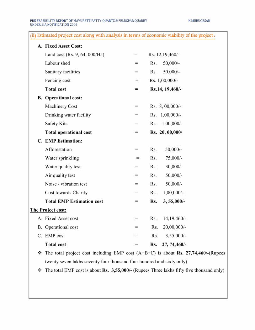
(ii) Estimated project cost along with analysis in terms of economic viability of the project :
A. Fixed Asset Cost:
Land cost (Rs. 9, 64, 000/Ha) = Rs. 12,19,460/-
Labour shed = Rs. 50,000/-
Sanitary facilities = Rs. 50,000/-
Fencing cost = Rs. 1,00,000/-
Total cost = Rs.14, 19,460/-
B. Operational cost:
Machinery Cost = Rs. 8, 00,000/-
Drinking water facility = Rs. 1,00,000/-
Safety Kits = Rs. 1,00,000/-
Total operational cost = Rs. 20, 00,000/
C. EMP Estimation:
Afforestation = Rs. 50,000/-
Water sprinkling = Rs. 75,000/-
Water quality test = Rs. 30,000/-
Air quality test = Rs. 50,000/-
Noise / vibration test = Rs. 50,000/-
Cost towards Charity = Rs. 1,00,000/-
Total EMP Estimation cost = Rs. 3, 55,000/-
The Project cost:
A. Fixed Asset cost = Rs. 14,19,460/-
B. Operational cost = Rs. 20,00,000/-
C. EMP cost = Rs. 3,55,000/-
Total cost = Rs. 27, 74,460/-
� The total project cost including EMP cost (A+B+C) is about Rs. 27,74,460/-(Rupees
twenty seven lakhs seventy four thousand four hundred and sixty only)
� The total EMP cost is about Rs. 3,55,000/- (Rupees Three lakhs fifty five thousand only)
PRE FEASIBILITY REPORT OF MAVURETTIPATTY QUARTZ & FELDSPAR QUARRY K.MURUGESAN
UNDER EIA NOTIFICATION 2006
Population Benefit
The applicant ensures to take social responsibilities like providing School Note books,
Uniforms to the Students below poverty level beside if the villages require any borehole for
public use the applicant ensure to do so.
The applicant will also take part and contribute the native cultural activities in the nearby
villages. During summer seasons packaged drinking water will be kept will be kept in the village
for public and for tress passers. The applicant will involve and contribute all the socio cultural
allocation in and around the area. The budget provisions and allocation for all the above
activities will be around Rs. 1,00,000/- for during this period.
Mine Closure Plan:
Steps proposed for phased restoration, reclamation of already mined out areas:
� The proposal for the project is existing Quartz & Feldspar Quarry.
� After the exploitation of Quartz & Feldspar Quarry reaches its ultimate pit limit, the pit
will be partially backfilled and partially act as a good storage of water.
� Before closure the mine, a parapet wall will be constructed to prevent inadvertent entry of
cattle and human beings.
� After closure of mine, the pit will be allowed to collect seepage and rain water. This will
help to charge the nearby agricultural wells.
Measures to be under taken on mine closure as per Act & Rules:
Measure will be taken as per Act & Rules.
Mitigation measure to be undertaken for safety and restoration / reclamation of the already mined
out area:
� Drilling will be carrying out by wet drilling to control the dust into the air.
� Minimum blasting will be carrying out on limited scale.
� Mist spray on haul road will be proposed to prevent the dust propagation into the air.
� The plantation will be carried out on the safety barriers to prevent Noise, besides wet
drilling will be practiced to prevent dust.
� All the machineries will be maintained in good conditions as per RTO and TNPCB
Norms to prevent Noise, Smoke and vibration.
� Machineries will be periodically maintained by experienced mechanic to minimize noise,
Smoke and ground vibration.
PRE FEASIBILITY REPORT OF MAVURETTIPATTY QUARTZ & FELDSPAR QUARRY K.MURUGESAN
UNDER EIA NOTIFICATION 2006
9. ANALYSIS OF PROPOSAL (FINAL RECOMMENDATIONS)
(i) Financial and social benefits with special emphasis on the benefit to the local people
including tribal population, if any, in the area.
There are few tribal populations in and around the area about 13 personals directly will
be benefited by these projects, besides the government. Will get good revenue by taxes,
seigniorage fees etc., and if the applicants find the suitable export market the Government will
have a good foreign exchange to the nation.
The socio- Economic conditions of the village and distance will enhance due to the
project, hence, the project should be allowed after considering all the parameters. The detail
furnished in this scheme of mining is based on information provided by the State Government
and the lessee. By considering the merit of the project the permission may be granted.
Date : 15.11.2018
Place : Namakkal
1. Signature of the proponent
For M/s. Sri Mahalakshmi Mines & Minerals
K.Murugesan
(Proprietor)
2. Signature of the Recognized qualified person
A.Jagannathan, B.E., F.C.C., M.M.E.A.,
RQP/MAS/019/87/A
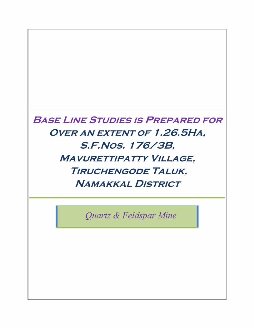
Base Line Studies is Prepared for
Over an extent of 1.26.5Ha,
S.F.Nos. 176/3B,
Mavurettipatty Village,
Tiruchengode Taluk,
Namakkal District
Quartz & Feldspar Mine
BBBAAASSSEEE LLLIIINNNEEE SSSTTTUUUDDDIIIEEESSS
The base line a study is prepared for Mavurettipatty Quartz & Feldspar Quarry. Base
line studies provide a base data for regular Environment Monitoring and Environment Impact
Assessment (EIA). The international Association for Impact Assessment (IAIA) defines the base
line studies as the process of identifying, predicting, evaluating and mitigating the Bio physical,
Social and other relevant effect of development proposals prior to major decision has been taken
and commitment mode. Hence the baseline study provides a bench mark for carrying out
environmental Impact assessment due to the course of mining activities. The purpose of these
studies is to evaluate the benefited and adverse effect of developing activities on the
neighborhood environment and the area where the quarrying is proposed to carry out.
Mr. K.Murugesan, Prop. M/s. Sri Mahalakshmi Mines & Minerals have applied for
Quartz & Feldspar Quarry lease for over an extent of 1.26.5Ha in S.F.No. 176/3B of
Mavurettipatty village, Tiruchengode Taluk and Namakkal District. The area proposed for
quarrying for the present mining period is about 0.06.1Ha which is below 15% of the total area
applied for lease; hence the impact assessment due to quarrying may be considerably low.
As per the Gazette notification 2006 the proposed project falls under B2 Category.
The area proposed for quarrying is a existing area and there are no factories, industries
within the radius of 1Km hence the atmospheric air is quite fresh. The area exhibits almost plain
terrain which is devoid of vegetation and Agriculture. In some small patches small agricultural
activities are been carried out by drift irrigation some thorny bushes and wild gars are found in
the area with scanty Palm trees (Borassus falabellifer), Tridax procumbens and Lucus aspera are
some of the common species along with Julia flora trees. The density of these about 20% to 40%
in the area and the remaining area is dry barren land.
The rest of the workforce is employed in agriculture, mining, raising livestock,
manufacturing, construction, trade and commerce. There is little agricultural activity in the town
on account of weather and irrigation facilities and the town has a set of Paper mill, oil mills, and
Automobile sectors within the town limits. The project in this area will fetch a quit considerable
employment to nearby village which in turn enhance the earning source of the nearby villages.
The comprehensive base line studies and standards constitute of collecting data on Ambient Air
quality, Dust fall rate, Water quality, Soil analyze, Noise level and Ground vibration study in the
area proposed for quarrying along with Flora and Fauna statistics.
The Methodology adopted in this project is based on the basic principles of capitalization
identification analysis and preparation of action plan to Mitigate negate or adverse impact.
Baseline studies adverse the significant environmental Issue and also provide necessary
information pertaining to the Environmental Attributes in the project area. Monitoring and
evaluating the effect of the works environment factors on health of people working on Quartz &
Feldspar Quarry.
Collection and analysis of Baseline Environmental Data.
Baseline Environmental Data plays a key role in the EIA procedure as it provides the
important information on the Environmental parameters which are likes to be affected due to the
Quartz & Feldspar quarrying activities.
Physiography
The area is almost plain terrain. The general drainage pattern of the area is dentritic pattern.
Only mining activity is being carried out in and around the area. In some areas agriculture is done
with lift irrigation. The main crops being millet, paddy, pulses etc. are grown as seasonal crops.
There is no Forest or Animal Sanctuaries near the area. There is no thick vegetation. Water table is
found at a depth of 40m during summer and 35m during rainy season. The area exhibits a
subtropical climate and the temperature that goes upto 420C in summer and falls down to 250C in
December – January. The wind direction is NE-SW and vice-versa. Average annual rainfall is about
750mm in Northeast and Southwest monsoon season.
Geology of the area
The Namakkal district is mostly underlain by the Archean crystalline, metamorphic
complex. The geology of the district is complicated due to recurring tectonic and magmatic
activities occurred during the pre-cambrian period. The famous Sittampundi complex is popularly
known for its complex geology is situated in this district. It forms a part of massive intrusion of
granites and pegmatites.
These rocks are exposed at some distance from the area. The gneisses are well foliated and
banded with alternate layers of feldspathic Biotite-hornblende minerals.Granites and pegmatites
have intruded the gneisses and they are of Archaean Age. Being more resistant than the gneisses
to erosion, the granites and pegmatites stand out as residual ridges in this area.
The general geological sequence of the rocks in the area is:-
AGE ROCK TYPE
Recent Thin reddish and gravelly soil
-----------------Unconformity-----------------------------------------
Archaean - Pegmatites and granite
Gneisses
- Pink pegmatoidal syenite
- Migmatites (Hb –Bi gneisses).
The area was surveyed in detail to prepare a Geological map in the scale 1:1000 Showing
the various formations and attitude of the deposit.
The physical attitude of the band is given below:
Strike length (m) - 118 Width (m) - 66 (max) Depth (m) - 19m (1m Top soil+ 19m Quartz & Feldspar) Strike direction - N700E - S700W Dip amount - SE700
Colour of Quartz is white, massive in form, hardness 7.0, specific gravity 2.6, absence of
cleavage; streak is white, vitreous in luster.
Colour of Feldspar is pink, massive in form, hardness 6, specific gravity 2.6, two sets of
cleavage, streak is white, sub-vitreous in luster.
Major geological disturbances are totally absent in this area. Recovery of minerals is
estimated as 60% of the total excavation of the ore body.
The recovery percentage is based on the knowledge gained from the working mine in this
belt.
Vegetation
The lease area is almost plain terrain, Quartz & Feldspar exposes in the lease area and it is
strewn with boulders of various sizes ranging from a few cm to one to half mater in diameter.
Except some small bushes there are no other trees in the applied area. Crops are only seasonal
cultivation with lift irrigation is practiced. The main crops being millet, paddy, pulses etc. are
grown as seasonal crops. There is no Forest or Animal Sanctuaries near the area. There is no thick
vegetation.
General approach to Environment
The Environmental besides data comprise of the features present of the site area its
includes environmental features such as forest area, conservation area, water bodies, industries,
wild life and fauna place of historic and importance etc.,
The data collected to cover the following.
1. Air environment
2. Noise Environment
3. Water environment
4. Ecology (Biological and Cultural Environment)
5. Physical Environment.
Air Environment
Air environment is responsible for the health of human beings, animals, wild life and
vegetation. Air pollutants emitted by project and non point source are transported dispersed or
concentrated by meteorological and topographical conditions. The atmosphere is dynamic
system which absolute range of solid, Liquid or gases from both Natural and Manmade source.
There substances travel through the air disappear and reveal among themselves and also with
other substances both physically and chemically which result in air pollution.
The Quartz and Feldspar propose to quarry is non toxic which does not emit any
undesirable pollutants in the form of solid liquid or gas. The dust emitted during the
transportation of vehicles the drilling will be carried out in wet condition to prevent dust into air
and the haul roads will be periodically sprinkled with mist water spray to prevent dust into the
atmosphere. The area in and around is quit fresh and the impact an air environment will always
be under controlled and will be monitored. No processing or beneficiation is proposed except
quarrying hence the impact an air will be controlled monitored and mitigated.
The ambient air quality within the study area on both core and buffer zone forms the
baseline information. The air quality monitoring points selected based on the Meteorological
conditions, topography of the study area and likely impact boundary location of the ambient air
quality monitoring stations was selected on the basis of wind pattern.
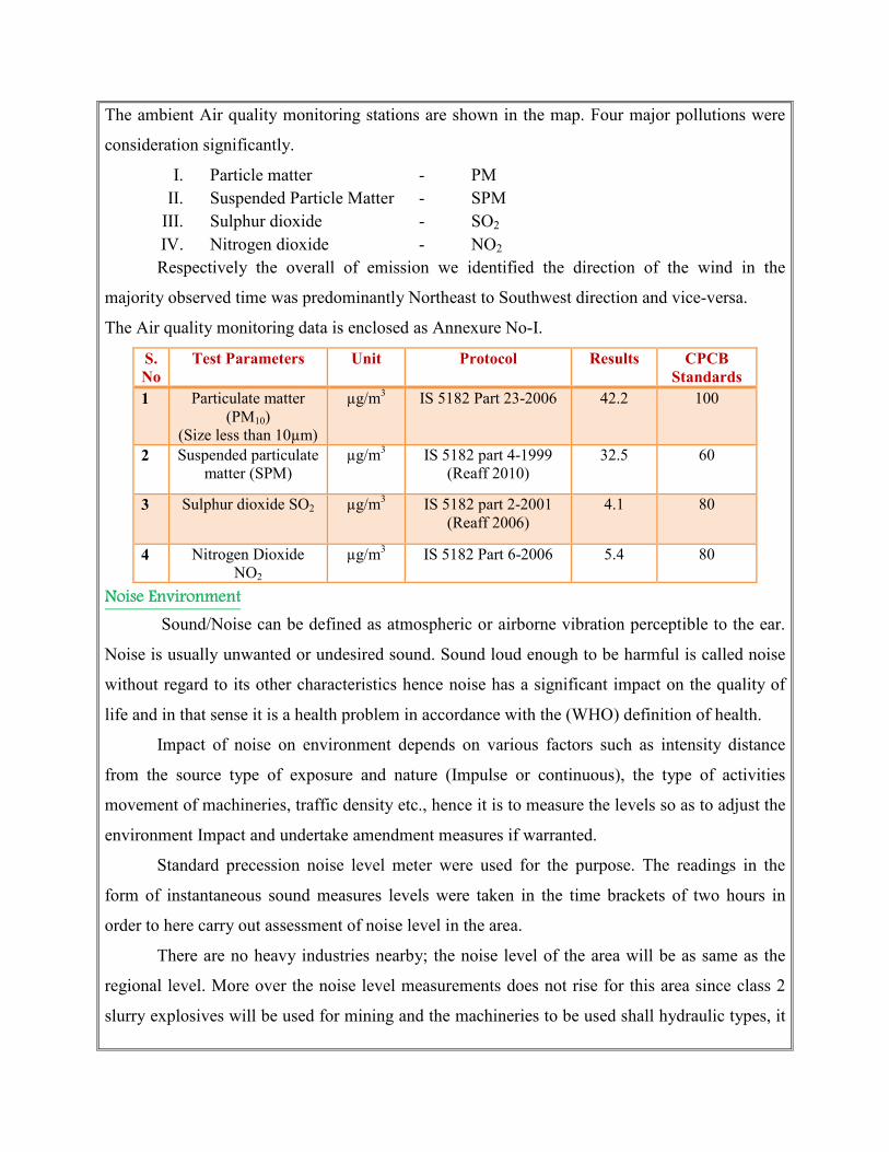
The ambient Air quality monitoring stations are shown in the map. Four major pollutions were
consideration significantly.
I. Particle matter - PM II. Suspended Particle Matter - SPM
III. Sulphur dioxide - SO2 IV. Nitrogen dioxide - NO2
Respectively the overall of emission we identified the direction of the wind in the
majority observed time was predominantly Northeast to Southwest direction and vice-versa.
The Air quality monitoring data is enclosed as Annexure No-I.
S.
No Test Parameters Unit Protocol Results CPCB
Standards 1 Particulate matter
(PM10) (Size less than 10µm)
µg/m3 IS 5182 Part 23-2006 42.2 100
2 Suspended particulate matter (SPM)
µg/m3 IS 5182 part 4-1999 (Reaff 2010)
32.5 60
3 Sulphur dioxide SO2 µg/m3 IS 5182 part 2-2001 (Reaff 2006)
4.1 80
4 Nitrogen Dioxide NO2
µg/m3 IS 5182 Part 6-2006 5.4 80
Noise Environment
Sound/Noise can be defined as atmospheric or airborne vibration perceptible to the ear.
Noise is usually unwanted or undesired sound. Sound loud enough to be harmful is called noise
without regard to its other characteristics hence noise has a significant impact on the quality of
life and in that sense it is a health problem in accordance with the (WHO) definition of health.
Impact of noise on environment depends on various factors such as intensity distance
from the source type of exposure and nature (Impulse or continuous), the type of activities
movement of machineries, traffic density etc., hence it is to measure the levels so as to adjust the
environment Impact and undertake amendment measures if warranted.
Standard precession noise level meter were used for the purpose. The readings in the
form of instantaneous sound measures levels were taken in the time brackets of two hours in
order to here carry out assessment of noise level in the area.
There are no heavy industries nearby; the noise level of the area will be as same as the
regional level. More over the noise level measurements does not rise for this area since class 2
slurry explosives will be used for mining and the machineries to be used shall hydraulic types, it
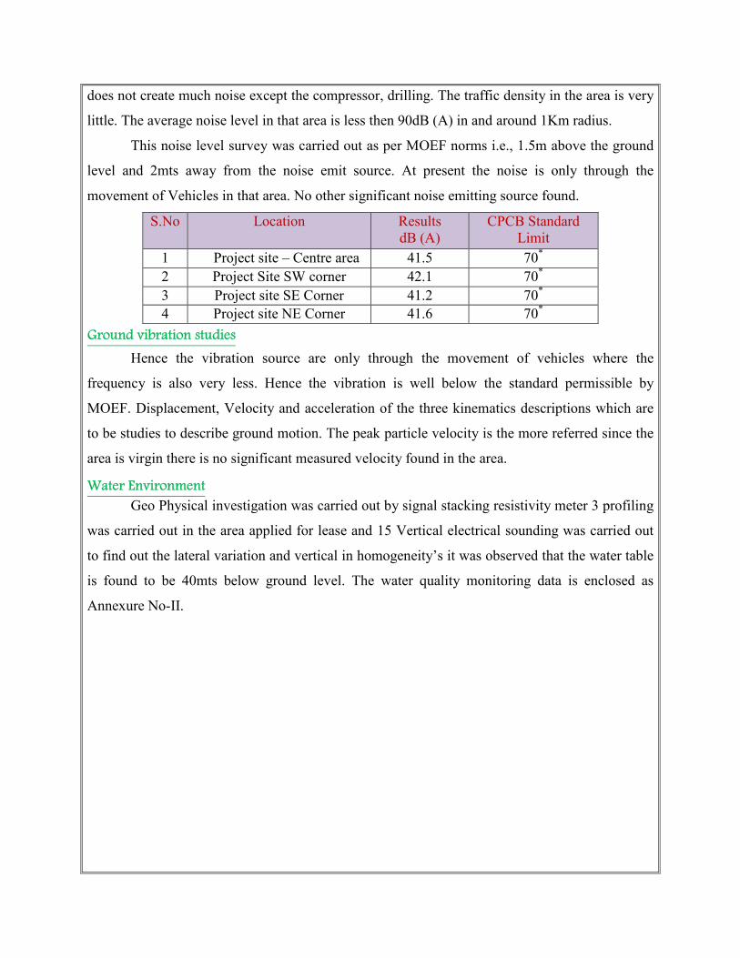
does not create much noise except the compressor, drilling. The traffic density in the area is very
little. The average noise level in that area is less then 90dB (A) in and around 1Km radius.
This noise level survey was carried out as per MOEF norms i.e., 1.5m above the ground
level and 2mts away from the noise emit source. At present the noise is only through the
movement of Vehicles in that area. No other significant noise emitting source found.
S.No Location Results
dB (A) CPCB Standard
Limit 1 Project site – Centre area 41.5 70*
2 Project Site SW corner 42.1 70*
3 Project site SE Corner 41.2 70* 4 Project site NE Corner 41.6 70*
Ground vibration studies
Hence the vibration source are only through the movement of vehicles where the
frequency is also very less. Hence the vibration is well below the standard permissible by
MOEF. Displacement, Velocity and acceleration of the three kinematics descriptions which are
to be studies to describe ground motion. The peak particle velocity is the more referred since the
area is virgin there is no significant measured velocity found in the area.
Water Environment
Geo Physical investigation was carried out by signal stacking resistivity meter 3 profiling
was carried out in the area applied for lease and 15 Vertical electrical sounding was carried out
to find out the lateral variation and vertical in homogeneity’s it was observed that the water table
is found to be 40mts below ground level. The water quality monitoring data is enclosed as
Annexure No-II.
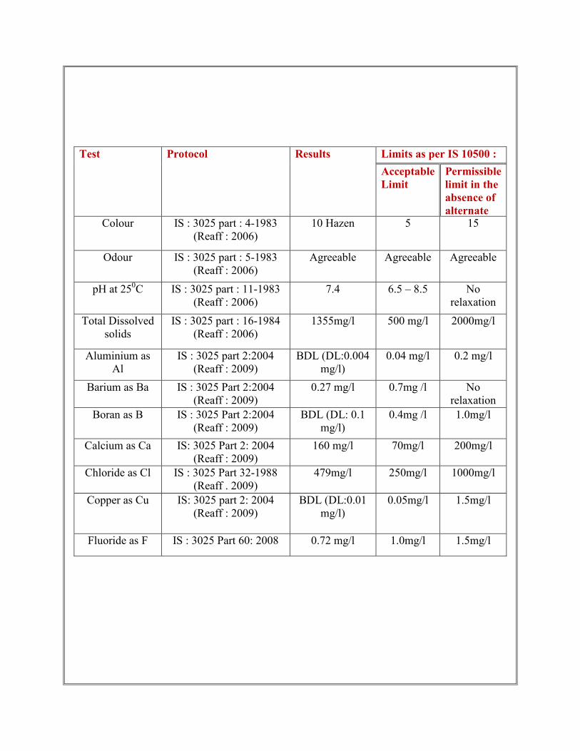
Test Protocol Results Limits as per IS 10500 :
2012 Acceptable
Limit
Permissible
limit in the
absence of
alternate Colour IS : 3025 part : 4-1983
(Reaff : 2006) 10 Hazen 5 15
Odour IS : 3025 part : 5-1983 (Reaff : 2006)
Agreeable Agreeable Agreeable
pH at 250C IS : 3025 part : 11-1983 (Reaff : 2006)
7.4 6.5 – 8.5 No relaxation
Total Dissolved solids
IS : 3025 part : 16-1984 (Reaff : 2006)
1355mg/l 500 mg/l 2000mg/l
Aluminium as Al
IS : 3025 part 2:2004 (Reaff : 2009)
BDL (DL:0.004 mg/l)
0.04 mg/l
0.2 mg/l
Barium as Ba IS : 3025 Part 2:2004 (Reaff : 2009)
0.27 mg/l 0.7mg /l No relaxation
Boran as B IS : 3025 Part 2:2004 (Reaff : 2009)
BDL (DL: 0.1 mg/l)
0.4mg /l 1.0mg/l
Calcium as Ca IS: 3025 Part 2: 2004 (Reaff : 2009)
160 mg/l 70mg/l 200mg/l
Chloride as Cl IS : 3025 Part 32-1988 (Reaff . 2009)
479mg/l 250mg/l 1000mg/l
Copper as Cu IS: 3025 part 2: 2004 (Reaff : 2009)
BDL (DL:0.01 mg/l)
0.05mg/l 1.5mg/l
Fluoride as F IS : 3025 Part 60: 2008 0.72 mg/l 1.0mg/l 1.5mg/l
METHODOLOGY AND DATA ACQUISITION:
Electric Resistivity Method is well established for delineating lateral as well vertical
discontinuities in the resistive structure of the Earth’s subsurface. The present study makes use of
vertical electric sounding (VES) to delineate the Vertical Resistivity structure at depth.
Schlumberger electrode set up was employed for making sounding measurements. Since it is
least influenced by lateral in homogeneities and is capable of providing higher depth of
investigation. This is four electrodes collinear set up where in the outer electrodes send current
into the ground and the inner electrodes measure the potential difference.
The present study utilizes maximum current electrode separation AB/2. The data from
this survey are commonly arranged and contoured in the farm of Pseudo-section that gives an
approximate of the subsurface resistivity. This technique is used for the inversion of
Schlumberger VES data to predict the layer parameter namely layer resistivity and Geo electric
layer thickness. The main goal of the present study is to search the vertical in homogeneities that
is consistent with the measured data.
For a Schlumberger among the Apparent resistivity can be calculated as follows
ρa = G∆V
I
∆V = potential difference between receiving electrodes
G = Geometric Factor.
Rocks show wide variation in resistivity ranging from 10-8 more than 10+14 ohmmeter.
On a broad classification, one can group the rocks falling in the range of 10-8 to 1 ohmmeter as
good conductors. 1 to 106 ohmmeter as intermediate conductors and 106 to 1012 ohmmeter as
more as poor conductor. The resistivity of rocks and subsurface lithology, which is mostly
dependent on its porosity and the pore fluid resistivity is defined by Archie’s Law,
ρr = Fρw = a Ømρw
ρr = Resistivity of Rocks
ρw = Resistivity of water in pores of rock
F = Formation Factor
Ø = Fractional pore volume
A = Constants with values ranging from 0.5 to 2.5
SURVEY LAYOUT:
The layout for a resistivity survey depends on the choice of the current and potential
electrode arrangement, which is called electrode array. Here the present study is considered with
Schlumberger array. In which the distance may be used for current electrode separation while
potential electrode separation is kept on third to one fifth of the same. One interesting aspect in
VES is the principle of reciprocity, which permits interchange of the potential and current
electrode without any effect on the measured apparent resistivity.
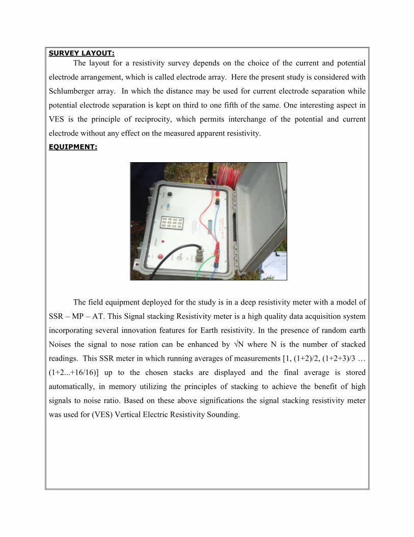
EQUIPMENT:
The field equipment deployed for the study is in a deep resistivity meter with a model of
SSR – MP – AT. This Signal stacking Resistivity meter is a high quality data acquisition system
incorporating several innovation features for Earth resistivity. In the presence of random earth
Noises the signal to nose ration can be enhanced by √N where N is the number of stacked
readings. This SSR meter in which running averages of measurements [1, (1+2)/2, (1+2+3)/3 …
(1+2...+16/16)] up to the chosen stacks are displayed and the final average is stored
automatically, in memory utilizing the principles of stacking to achieve the benefit of high
signals to noise ratio. Based on these above significations the signal stacking resistivity meter
was used for (VES) Vertical Electric Resistivity Sounding.
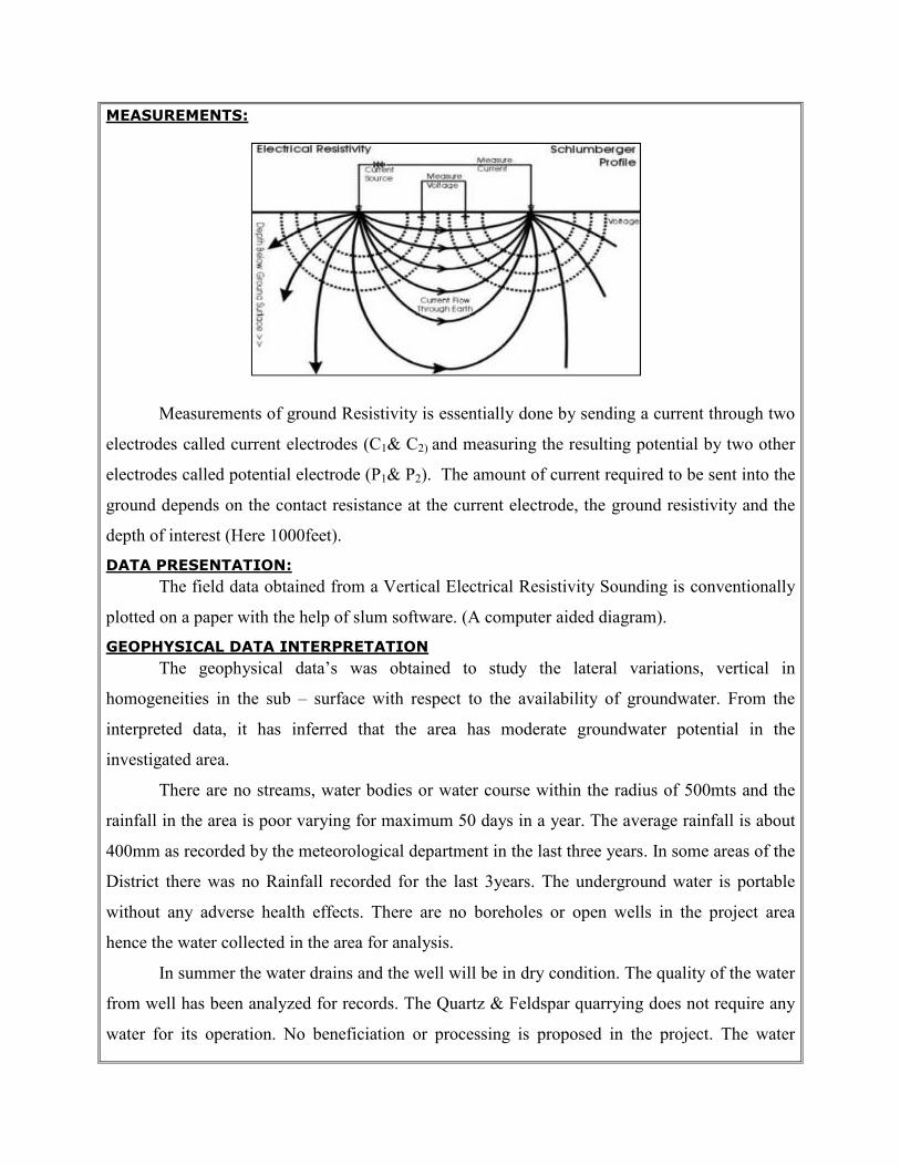
MEASUREMENTS:
Measurements of ground Resistivity is essentially done by sending a current through two
electrodes called current electrodes (C1& C2) and measuring the resulting potential by two other
electrodes called potential electrode (P1& P2). The amount of current required to be sent into the
ground depends on the contact resistance at the current electrode, the ground resistivity and the
depth of interest (Here 1000feet).
DATA PRESENTATION:
The field data obtained from a Vertical Electrical Resistivity Sounding is conventionally
plotted on a paper with the help of slum software. (A computer aided diagram).
GEOPHYSICAL DATA INTERPRETATION
The geophysical data’s was obtained to study the lateral variations, vertical in
homogeneities in the sub – surface with respect to the availability of groundwater. From the
interpreted data, it has inferred that the area has moderate groundwater potential in the
investigated area.
There are no streams, water bodies or water course within the radius of 500mts and the
rainfall in the area is poor varying for maximum 50 days in a year. The average rainfall is about
400mm as recorded by the meteorological department in the last three years. In some areas of the
District there was no Rainfall recorded for the last 3years. The underground water is portable
without any adverse health effects. There are no boreholes or open wells in the project area
hence the water collected in the area for analysis.
In summer the water drains and the well will be in dry condition. The quality of the water
from well has been analyzed for records. The Quartz & Feldspar quarrying does not require any
water for its operation. No beneficiation or processing is proposed in the project. The water
required is only for drinking and domestic purpose for which the water will be brought out from
authorized water vendors from the nearby towns.
As water is very vital natural resource and most essential for the survival of human beings, the
same will be consumed only after carrying out scientific studies and will be allowed if it is
within the prescribed standards.
Soil Analysis
As mentioned earlier the area applied for lease is exhibits almost plain terrain. The soil is
the main unit for the eco system because of the dependence of flora and fauna. As the soil is
acidic there are no thick flora noticed except some common species which are native of the
terrain.
The mining activities may have impact on soil. The soil samples were called in 50mts
grid fashion by average and after coning and quartering the same was send to laboratory for
investigation. The following sources are obtained from Agricultural department.
The soil analysis report is as below
S.
No
Test parameters Method Results
1 PH @250C Is 2720 part 26 (Reaff:2011) 7.5
2 Conductivity @250C Is 14767 : 2000 (Reaff : 2010) 350µmhos/Cm
3 Moisture content Is 2720 part 2: 1973 (Reaff : 2010) 6.3% 4 Organic matter Is 2720 part 22: 1972 (Reaff : 2010) 0.36
Climate
The rain fall data of Namakkal region in a year is 400mm. Temperature falls between
42°C - 25°C. the wind direction is in NE-SW and vice –versa..
Flora and fauna in and around the area
The Quartz & Feldspar Quarrying projects like this which involves very limited
operations like secondary drilling and blasting, Conservation of Flora and Fauna along with
ecology do not have significant impact of the overall eco system. A detail study related to flora
and fauna was carefully observed physically by environmental engineers, Botanist and zoologist.
The following table shows the flora and Fauna available at the region.
List of Faunas
S.No Common Name Scientific name
1. Goat Capra hircus
2. rat Rattus norvegicus
3. Crow Corvus splenders
4. Squirrel Rodentia scrurus,
5. Ant Hymenopterous formicida,
6. Cat Felsis catus
7. Cow Bos taurus indicus
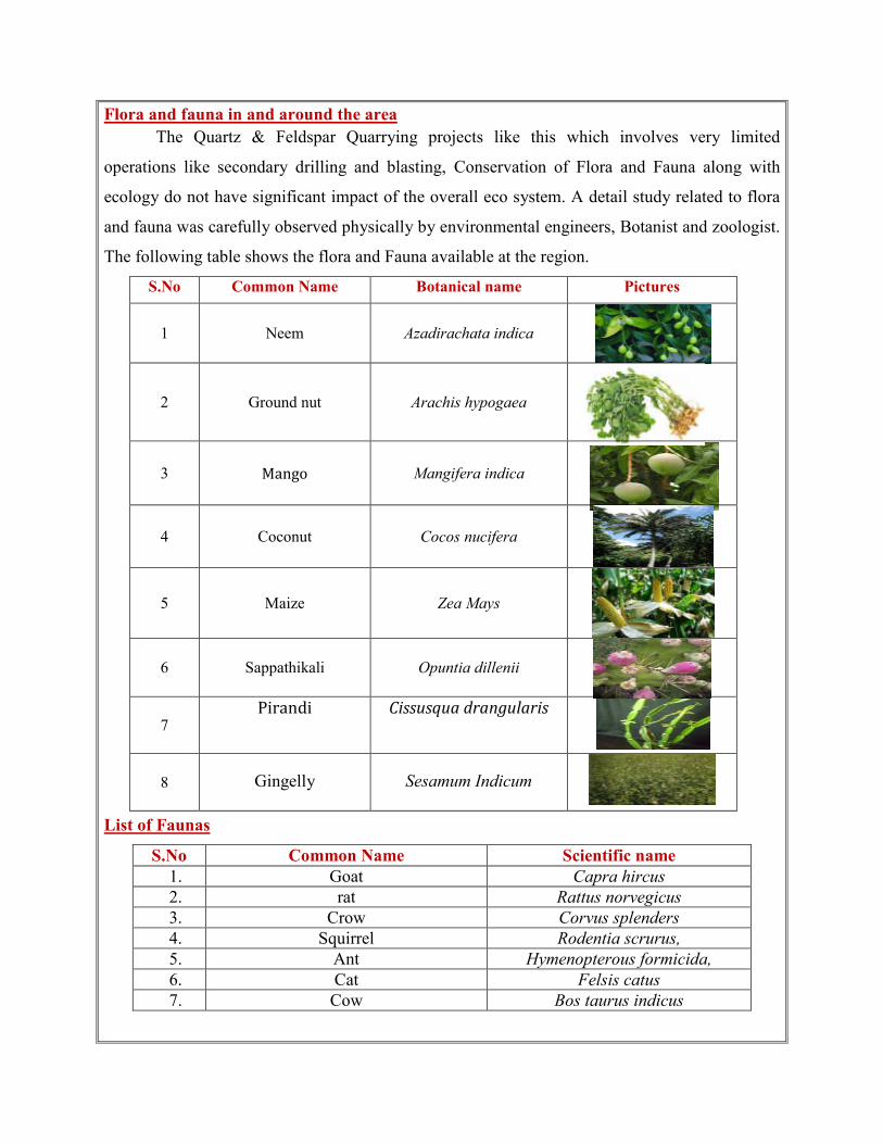
S.No Common Name Botanical name Pictures
1 Neem Azadirachata indica
2 Ground nut Arachis hypogaea
3 Mango Mangifera indica
4 Coconut Cocos nucifera
5 Maize Zea Mays
6 Sappathikali Opuntia dillenii
7 Pirandi Cissusqua drangularis
8 Gingelly Sesamum Indicum
Conclusion
The base line studies relents no hazardous levels of dust and noise and prevailing at the
project area. A well implemented environmental Management plan as discussed in the mining
plan will help in mitigation the adverse effects due to quarrying activities.
The project is a small operation were limited activities are being carried on the noise
creating device will be only jack hammer drilling which will always be mitigated in wet
condition to prevent noise and dust in the air. The movement of vehicles is very minimal. The
entire vehicle used will be periodically maintained by well experienced mechanic and kept under
TNPCB standards, emission testing will be carried out periodically and water will be sprinkled
periodically to prevent dust into air. The small quantity of non humus rich surface soil will be
removed and preserved in the boundary barrier to facilitate the Afforestation.
Blasting will be used for only losing effect and not shattering effect hence the fly rock
problem will not arise. The flora in the area is only small bushes as much of the area is exhibits
almost plain terrain. No trees are proposed to uproot for the project and Infect Trees will be
planted on boundary barrier which will act as acoustic sound barriers. Environmental care and
attitude of preventing environment is inducted to the proponent and advice to carry out and
mitigate the minor impacts due to quarrying. Appropriate persons are advice to get employed to
protect the Environment and Ecology of the area.
Date : 15.11.2018 Place : Namakkal
1. Signature of the applicant with Name and Full Address
For M/s. Sri Mahalakshmi Mines & Minerals K.Murugesan (Proprietor)
2. Signature of the Recognized qualified person
A.Jagannathan, B.E., F.C.C., M.M.E.A., RQP/MAS/019/87/A


![PRE-FEASIBILITY REPORT Of Quartz & Feldspar Mineenvironmentclearance.nic.in/.../Online/TOR/...prefeasibilityreport.pdf · Submission of SRS: File no. J-11015/05/2010-IA.II [M] Since](https://img.pdfslide.us/doc/110x75/5e75c9540d74ae699666aff0/pre-feasibility-report-of-quartz-feldspar-mine-submission-of-srs-file-no.jpg)