Embed Size (px)
Citation preview
Pre-Disaster Mitigation Plan Sumter County, Georgia Americus-Andersonville-DeSoto-Leslie-Plains 2007-2011 July, 2007
Pre-Disaster Mitigation Plan Sumter County, Georgia Americus-Andersonville-DeSoto-Leslie-Plains 2007-2011
assisted by Middle Flint Regional Development Center
228 West Lamar Street Americus, Georgia 31709
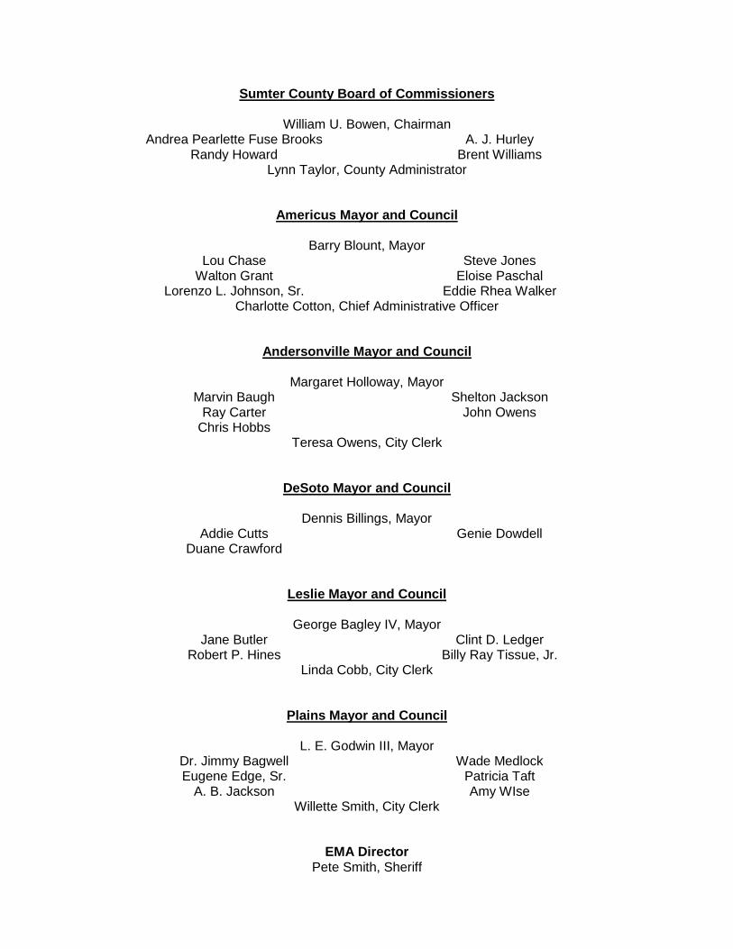
Sumter County Board of Commissioners
William U. Bowen, Chairman Andrea Pearlette Fuse Brooks A. J. Hurley
Randy Howard Brent Williams Lynn Taylor, County Administrator
Americus Mayor and Council
Barry Blount, Mayor Lou Chase Steve Jones
Walton Grant Eloise Paschal Lorenzo L. Johnson, Sr. Eddie Rhea Walker
Charlotte Cotton, Chief Administrative Officer
Andersonville Mayor and Council
Margaret Holloway, Mayor Marvin Baugh Shelton Jackson
Ray Carter John Owens Chris Hobbs
Teresa Owens, City Clerk
DeSoto Mayor and Council
Dennis Billings, Mayor Addie Cutts Genie Dowdell
Duane Crawford
Leslie Mayor and Council
George Bagley IV, Mayor
Jane Butler Clint D. Ledger Robert P. Hines Billy Ray Tissue, Jr.
Linda Cobb, City Clerk
Plains Mayor and Council
L. E. Godwin III, Mayor Dr. Jimmy Bagwell Wade Medlock Eugene Edge, Sr. Patricia Taft
A. B. Jackson Amy WIse Willette Smith, City Clerk
EMA Director Pete Smith, Sheriff
Table of Contents Chapter 1 – Introduction Section I Problem Statement and Purpose 1 Section II Methodology, Participants, Process 2 Section III Organization 3 Section IV Hazard Risk Vulnerability (HRV) Summary 4 Section V Multi-Jurisdictional Considerations 5 Section VI Adoption, Implementation, Monitoring and Evaluation 5 Section VII History of Local Mitigation Activities 8 Section VIII Community Data 8 Chapter 2 - Natural Hazard, Risk and Vulnerability (HRV) Summary I Tornado 1 II Windstorm (Thunderstorm Winds) 7 III Severe Winter Storm 14 IV Tropical Storm 20 V Flood 25 VI Extreme Heat 30 VII Drought 35 VIII Wildfire 40 IX Hailstorm 45 X Dam Failute 50 Chapter 3 - Technological Hazard, Risk and Vulnerability (HRV) Summary I Transportation Accident 1 II Hazardous Materials Release - fixed site 7 III Terrorism 12 IV Radiological Event 16 V Animal/Crop Disease 21 VI Groundwater Contamination 26 VII Civil Disturbance 31 Chapter 4 – Natural Hazard Mitigation Goals and Objectives Overall Community Mitigation Goals, Policies and Values 1 Specific Mitigation Goals, Policies and Values I Tornado 15 II Windstorm (Thunderstorm Winds) 19 III Severe Winter Storm 22 IV Drought 26 V Tropical Storm 30 VI Flood 33 VII Extreme Heat 36

VIII Wildfire 39 IX Hailstorm 42 X Dam Failure 45 Chapter 5 - Technological Hazard Mitigation Goals and Objectives
I Transportation Accident 1 II Hazardous Materials Release – fixed site 6 III Terrorism 15 IV Radiological Event 18 V Animal/Crop Disease 21 VI Groundwater Contamination 24 VII Civil Disturbance 27 Chapter 6 – Execution I Implementation Administrative Actions 1 Authority and Responsibility 1 Prioritization 1 Incorporation into other Plans/Planning Measures 3 II Evaluation Method 3 Responsibility 3
Timeframe 4 Reporting 4 III Multi- Jurisdictional Strategy and Considerations 4 IV Plan Update and Maintenance Public Involvement 4 Timeframe 5 Reporting 5 Chapter 7 – Conclusion
Summary 1 References 1
APPENDICES Appendix A
GEMA Worksheet # 1- Identify the Hazard 1
Natural Hazard Identification and Description 2 Technological Hazard Identification and Description 11 GEMA Worksheet # 2 - Profile Hazard Events 14 GEMA Worksheet #3a Inventory of Assets 16 GEMA Critical Facilities Report 19 Natural Hazards:
Dam Failure Drought, Extreme Heat, Hailstorm, Severe Winter Storm, Tornado, Tropical Storm, and Windstorm Technological Hazards: Civil Disturbance, Groundwater Contamination, Hazardous Materials Release, Animal/Crop Disease, Radiological Event, Terrorism and Transportation Accident Flood 43
Wildfire 47 Appendix B
Community Profile 1 Georgia Snapshot 2 Area Labor Profile 8
Appendix C Executive Summary – Middle Flint Regional Plan 1 Appendix D Hazard Frequency Table 1 Appendix E Agenda/Minutes 1
Pre-Disaster Mitigation Plan Sumter County
Chapter 1 – Introduction
Section I Problem Statement and Purpose 1 Section II Methodology, Participants, Process 2 Section III Organization 3 Section IV Hazard Risk Vulnerability (HRV) Summary 4 Section V Multi-Jurisdictional Considerations 5 Section VI Adoption, Implementation, Monitoring and Evaluation 5 Section VII History of Local Mitigation Activities 8 Section VIII Community Data 8
Pre-Disaster Mitigation Plan 1 - 1
Section 1 Problem Statement and Purpose In an average year, weather-related disasters in the United States cause approximately 500 deaths and approximately $14 billion in property damage.1
As the nation’s communities continue to expand, carrying with them physical development farther across the landscape, the number of lives and value of property in the path of natural hazards increases significantly. Consequently, the loss of life and property has seemingly increased annually, and survivors of these calamities turn to government for redress, increasing the financial burden placed on the nation’s taxpayers. In an effort to reduce such losses, communities are being prompted to identify how, where and why they are susceptible to disasters, and take measures to mitigate or eliminate exposure to them and the loss of life and property that so frequently occurs.
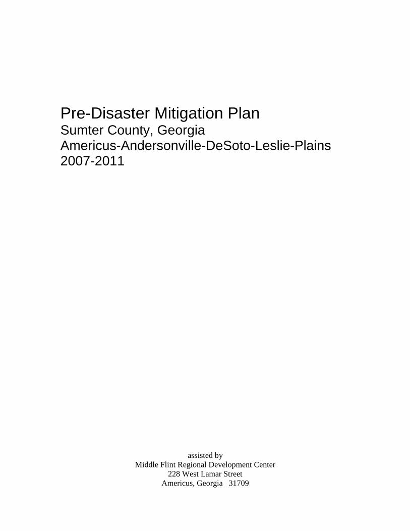
Preparation of this document is the response of Sumter County, Georgia, and the Cities of Americus, Andersonville, DeSoto, Leslie and Plains, to the Disaster Mitigation Act of 2000, an amendment to the Robert T. Stafford Disaster Relief and Emergency Assistance Act. This law authorizes release of federal financial assistance to communities that have experienced a disaster of such severity as to warrant a presidential disaster declaration. Simply stated, the referenced amendment establishes an additional eligibility requirement; after November 1, 2004, to be eligible for federal financial disaster assistance a community must not only have been declared a disaster area by the president of the United States, but must have prepared and adopted a federally approved pre-disaster mitigation plan. The reader should not infer that mitigation is novel to this community. In recent years several local mitigation activities have been implemented successfully (p.1-8). Continuation of some previously initiated mitigation projects are incorporated herein as a testament to their current relevance. The current effort expands upon those of previous years by placing an increased emphasis on reducing the losses which commonly occur as a result of disaster so the cost of response and recovery will also be less. This plan is not intended as a comprehensive identification and assessment of all potential hazards; only those considered to pose the greatest threat to the community. It is recognized the community could be assailed by a disaster not specifically addressed herein. For example, there are areas in the county where soils could be a threat to development, but those areas are not believed extensive enough to warrant inclusion here. Furthermore, the community lacks the financial resources necessary to implement most of the structural improvements identified. Neither does it specifically address the local impacts which may result from a disaster occurring elsewhere, such as the burden placed on Sumter County accommodating evacuees of distant communities. 1 National Oceanic and Atmospheric Administration
Pre-Disaster Mitigation Plan 1 - 2
Section II Methodology, Participants, Process The Sumter County Board of Commissioners directed the Emergency Management Director to oversee this planning effort. The vast majority of data collection was performed by the Local Emergency Planning Committee (LEPC), members of which were already attuned to the need for such planning. The various plan functions were as follows.
Critical Facilities – identified and compiled an exhaustive inventory of critical facilities and their characteristics; address, building size, contact information, etc.
Identifying/Profiling Hazards – identified and described the natural disasters most likely to occur in the three participating jurisdictions.
Assessing Vulnerability/Estimating Potential Losses – reviewed hazard event profiles and critical facilities information to assess community vulnerability to specific hazards and the potential loss from each.
Mitigation Goals & Objectives – identified and developed mitigation goals, objectives, tasks and related action steps.
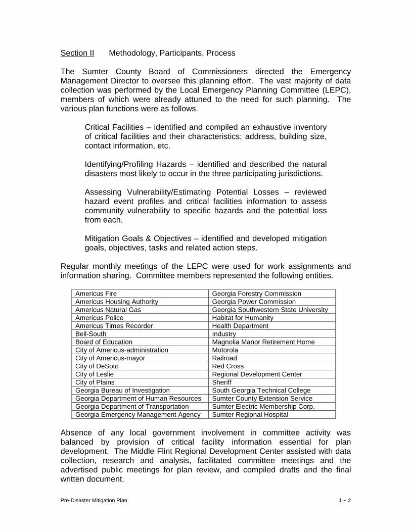
Regular monthly meetings of the LEPC were used for work assignments and information sharing. Committee members represented the following entities.
Americus Fire Georgia Forestry Commission Americus Housing Authority Georgia Power Commission Americus Natural Gas Georgia Southwestern State University Americus Police Habitat for Humanity Americus Times Recorder Health Department Bell-South Industry Board of Education Magnolia Manor Retirement Home City of Americus-administration Motorola City of Americus-mayor Railroad City of DeSoto Red Cross City of Leslie Regional Development Center City of Plains Sheriff Georgia Bureau of Investigation South Georgia Technical College Georgia Department of Human Resources Sumter County Extension Service Georgia Department of Transportation Sumter Electric Membership Corp. Georgia Emergency Management Agency Sumter Regional Hospital
Absence of any local government involvement in committee activity was balanced by provision of critical facility information essential for plan development. The Middle Flint Regional Development Center assisted with data collection, research and analysis, facilitated committee meetings and the advertised public meetings for plan review, and compiled drafts and the final written document.
Pre-Disaster Mitigation Plan 1 - 3
Because of their responsibility for providing for the general public welfare and emergency response services, there was strong local government involvement in plan development. The following existing planning documents were reviewed:
Sumter County Joint Comprehensive Plan 2004 (Americus, Andersonville, DeSoto, Leslie and Plains)
Sumter County Emergency Operations Plan 2004 Middle Flint Regional Plan 2004
As is customary, the joint comprehensive and regional plans addressed community facilities; most, if not all, of which are identified in this document as critical facilities. With rare exception, existing plans do not address pre-disaster mitigation. The strongest references that could be found were to the acquisition of equipment for the City of Americus hazardous materials unit and adoption of environmental protection ordinances for the smaller jurisdictions. The county’s emergency operations plan is, of course, the major exception to the general lack of reference to local mitigation, and portions of that plan were used in preparation of this document. The local joint comprehensive plan does not have an executive summary, and neither the county’s emergency operations plan nor regional plan have executive summaries of relevance to this document. The executive summary that does exist is inserted in Appendix C. Numerous other sources were used in plan preparation, including the Federal Emergency Management Agency, Georgia Emergency Management Agency, Georgia Department of Natural Resources, Georgia Extension Service, Georgia Forestry Commission, Georgia Department of Transportation, Georgia Tornado Database, The Tornado Project, National Climatic Data Center, National Weather Service, Americus Times-Recorder, law enforcement and local interviews. Two publicly advertised “hearings” were held during plan development. The first “hearing” was held Monday, August 15, 2005, to present a preliminary draft to the general public and invite public comment and input. The second hearing was held May 29, 2007, prior to formal adoption by the Sumter County Board of Commissioners, and the City Councils of Americus, Andersonville, DeSoto, Leslie and Plains. Notices of both meetings were published in the legal organ of all jurisdictions; a newspaper that has communitywide circulation. Attendance consisted primarily of committee members active in plan preparation. Section III Organization A detailed analysis of natural hazards is presented in Chapter 2. The analysis consists of a description of the hazard and the damage potential, historical frequency and probability of future occurrence, an inventory of assets exposed to the hazard and an estimate of potential loss, land use patterns as they relate to
Pre-Disaster Mitigation Plan 1 - 4
each hazard, and any aspects of hazards which may be unique to any of the jurisdictions. A detailed analysis of technological hazards is presented in Chapter 3. The analysis consists of a description of the hazard and the damage potential, historical frequency and probability of future occurrence, an inventory of assets exposed to the hazard and an estimate of potential loss, land use patterns as they relate to each hazard, and any aspects of hazards which may be unique to any of the jurisdictions. Presented in Chapter 4 is an itemized list of goals, objectives, tasks and action steps which are proposed for implementation to mitigate likely adverse impacts of specific natural hazard events. Presented in Chapter 5 is an itemized list of goals, objectives, tasks and action steps which are proposed for implementation to mitigate likely adverse impacts of specific technological, or man-made, hazard events. Chapter 6 describes how the plan will be implemented, monitored and maintained. Chapter 7 consists of a concluding statement, followed by appendices. Section IV Hazard Risk Vulnerability (HRV) Summary This plan identifies and assesses community exposure to certain natural and technological hazards (see below), and identifies how to reduce exposure to them. The assessment provides the factual basis for activities proposed to reduce losses, including a description of the type, location, and extent of natural and technological hazards deemed most likely to befall Sumter County. Reference was made to the historical record to compile information on previous events and for use in estimating the probability of hazard recurrence. Natural Hazards Technological Hazards Dam Failure Civil Disturbance
Drought Groundwater Contamination Extreme Heat Hazardous Materials Flood Livestock and Crop Disease Hailstorm Radiological Tornado Transportation Accident Tropical Storm Terrorism Wildfire Winter Storm Windstorm
Vulnerability includes a summary of past events and their impacts. This is quantified by describing the types and numbers of existing and future buildings, infrastructure, and critical facilities located in identified hazard prone/susceptible areas. Estimates of the potential dollar losses that could reasonably be expected to result from a specified hazard event are also presented. Land uses and development trends were reviewed for the purpose of identifying mitigation options that can be considered in future land use decisions to reduce each jurisdiction’s specific risk.
Pre-Disaster Mitigation Plan 1 - 5
Based on these assessments, a blueprint for reducing potential losses was developed, incorporating expansion and improvement on existing authorities, policies, programs and resources. The blueprint includes goals and objectives to reduce or avoid long-term vulnerabilities to hazards. Overall community goals include; (1) Protect the public health and safety, (2) Reduce, and to the extent possible eliminate, community exposure to natural and man-made hazard events, (3) Reduce loss and damage to private property and public infrastructure resulting from natural or man-made hazards, (4) Maintain continuity of public and private sector operations during and after hazard events, and (5) Respond promptly, appropriately and efficiently in the event of natural or man-made hazard. The end product is a prioritized action plan with specific steps to achieve stated goals. This, in turn, is supplemented with a maintenance process to monitor, evaluate, and update the mitigation plan over a five-year timeframe. Section V Multi-Jurisdictional Considerations
This document has been developed for unincorporated Sumter County, and the Cities of Americus, Andersonville, DeSoto, Leslie and Plains. The plan includes an identification and analysis of a comprehensive range of specific mitigation actions needed to reduce the adverse effects of specific hazards in each jurisdiction. With few exceptions, all local jurisdictions are susceptible to the same natural and technological hazards. Where applicable; however, specific mitigation actions have been identified for each jurisdiction.
Section VI Adoption, Implementation, Monitoring and Evaluation The Sumter County Pre-Disaster Mitigation Plan was formally adopted (see following page) by the Sumter County Board of Commissioners, and the elected governing bodies of all five municipalities after receiving notification from the Georgia Emergency Management Agency that the plan complied with applicable federal regulations. Presented in Chapter 6 is a description of plan implementation, monitoring, evaluation, and update activities, public participation, and the process of incorporating mitigation into other planning and administrative functions of all local jurisdictions. This section details the process that will ensure the Sumter County Pre-Disaster Mitigation Plan becomes an integral part of local governance.
Pre-Disaster Mitigation Plan 1 - 6
ENACTING RESOLUTION SUMTER COUNTY PRE-DISASTER MITIGATION PLAN
WHEREAS; to be eligible for federal disaster assistance in the event of a presidential disaster declaration made after November 1, 2004, local governments must have a Pre-Disaster Mitigation Plan prepared in accordance with federal regulations promulgated pursuant to the Disaster Mitigation Act of 2000, and WHEREAS; in 2004 the Board of Commissioners requested, and subsequently received from the Georgia Emergency Management Agency, a Hazard Mitigation Program Planning Grant award, designated project number 17PDMC03014261, to fund preparation of a Pre-Disaster Mitigation Plan in accordance with federal regulations promulgated pursuant to the Disaster Mitigation Act of 2000, and WHEREAS; the Sumter County Pre-Disaster Mitigation Plan has been prepared as a multi-jurisdictional document to satisfy pre-disaster mitigation planning requirements for unincorporated Sumter County and the Cities of Americus, Andersonville, DeSoto, Leslie and Plains, and WHEREAS; the Georgia Emergency Management Agency has notified the Sumter County Board of Commissioners that the Sumter County Pre-Disaster Mitigation Plan satisfies federal pre-disaster mitigation planning requirements. BE IT THEREFORE RESOLVED, that the Sumter County Board of Commissioners, and the Mayors and City Councils of the Cities of Americus, Andersonville, DeSoto, Leslie and Plains, each meeting in respective session, adopt the Sumter County Pre-Disaster Mitigation Plan 2007-2011. Enacted by the Sumter County Board of Commissioners in session this day of _________, 2007, __________________________ __________________ Chairman County Clerk Enacted by the Mayor and City Council of Americus in session this day of _______, 2007, ___________________________ __________________________ Mayor City Clerk
Pre-Disaster Mitigation Plan 1 - 7
ENACTING RESOLUTION SUMTER COUNTY PRE-DISASTER MITIGATION PLAN
Enacted by the Mayor and City Council of Andersonville in session this _ day of ________, 2007, ___________________________ __________________________ Mayor City Clerk Enacted by the Mayor and City Council of DeSoto in session this day of _______, 2007, ___________________________ __________________________ Mayor Attest Enacted by the Mayor and City Council of Leslie in session this _ day of _________, 2007, ___________________________ __________________________ Mayor City Clerk Enacted by the Mayor and City Council of Plains in session this _ day of _________, 2007, ___________________________ __________________________ Mayor City Clerk
Pre-Disaster Mitigation Plan 1 - 8
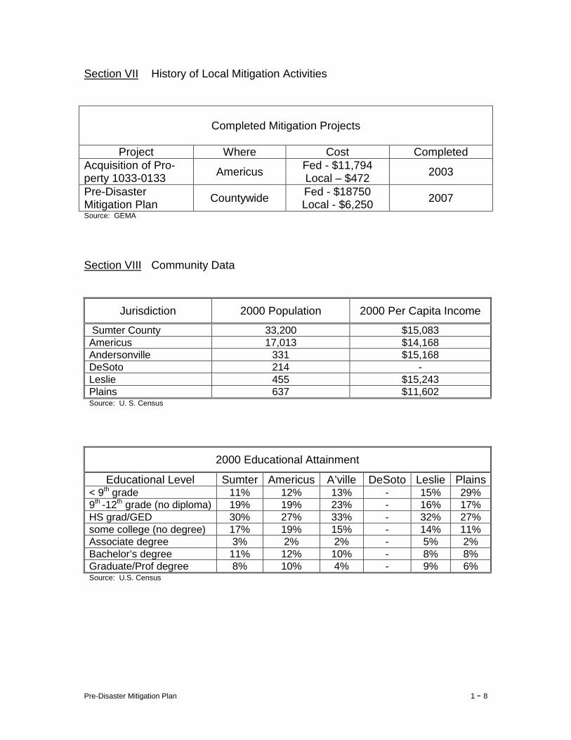
Section VII History of Local Mitigation Activities
Completed Mitigation Projects
Project Where Cost Completed
Acquisition of Pro-perty 1033-0133 Americus Fed - $11,794
Local – $472 2003
Pre-Disaster Mitigation Plan Countywide Fed - $18750
Local - $6,250 2007 Source: GEMA Section VIII Community Data
Jurisdiction 2000 Population 2000 Per Capita Income
Sumter County 33,200 $15,083 Americus 17,013 $14,168 Andersonville 331 $15,168 DeSoto 214 - Leslie 455 $15,243 Plains 637 $11,602 Source: U. S. Census
2000 Educational Attainment
Educational Level Sumter Americus A’ville DeSoto Leslie Plains < 9th grade 11% 12% 13% - 15% 29% 9th -12th grade (no diploma) 19% 19% 23% - 16% 17% HS grad/GED 30% 27% 33% - 32% 27% some college (no degree) 17% 19% 15% - 14% 11% Associate degree 3% 2% 2% - 5% 2% Bachelor’s degree 11% 12% 10% - 8% 8% Graduate/Prof degree 8% 10% 4% - 9% 6% Source: U.S. Census
Pre-Disaster Mitigation Plan 1 - 9
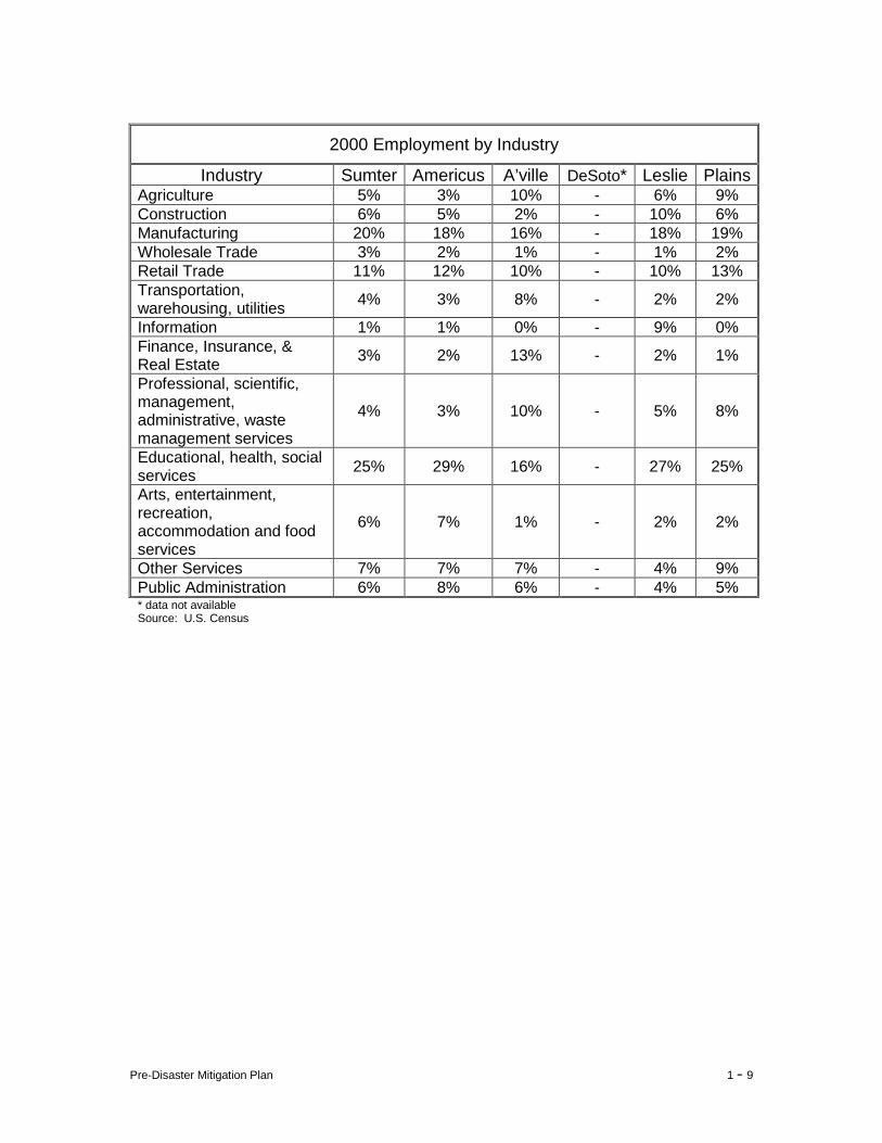
2000 Employment by Industry
Industry Sumter Americus A’ville DeSoto* Leslie Plains Agriculture 5% 3% 10% - 6% 9% Construction 6% 5% 2% - 10% 6% Manufacturing 20% 18% 16% - 18% 19% Wholesale Trade 3% 2% 1% - 1% 2% Retail Trade 11% 12% 10% - 10% 13% Transportation, warehousing, utilities 4% 3% 8% - 2% 2%
Information 1% 1% 0% - 9% 0% Finance, Insurance, & Real Estate 3% 2% 13% - 2% 1%
Professional, scientific, management, administrative, waste management services
4% 3% 10% - 5% 8%
Educational, health, social services 25% 29% 16% - 27% 25%
Arts, entertainment, recreation, accommodation and food services
6% 7% 1% - 2% 2%
Other Services 7% 7% 7% - 4% 9% Public Administration 6% 8% 6% - 4% 5% * data not available Source: U.S. Census
Pre-Disaster Mitigation Plan Sumter County
Chapter 2 - Natural Hazard, Risk and Vulnerability (HRV) Summary I Tornado 1 II Windstorm (Thunderstorm Winds) 7 III Severe Winter Storm 14 IV Tropical Storm 20 V Flood 25 VI Extreme Heat 30 VII Drought 35 VIII Wildfire 40 IX Hailstorm 45 X Dam Failure 50
Pre-Disaster Mitigation Plan 2 - 1
I. Tornado
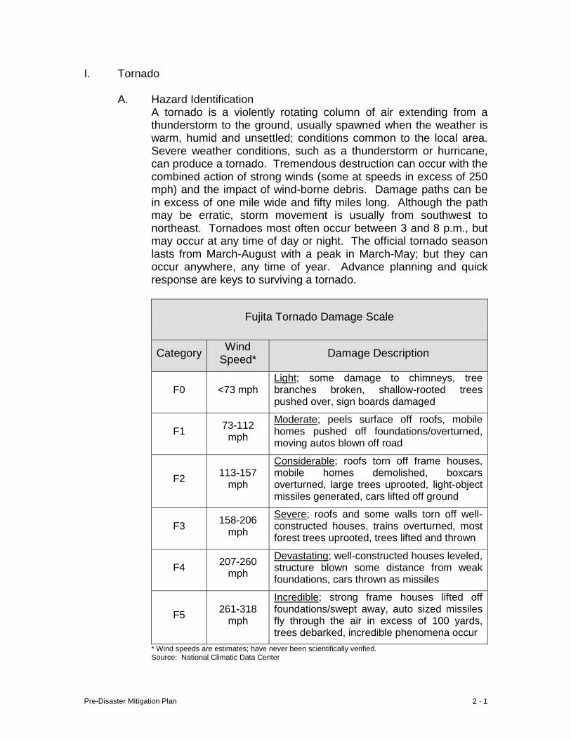
A. Hazard Identification A tornado is a violently rotating column of air extending from a thunderstorm to the ground, usually spawned when the weather is warm, humid and unsettled; conditions common to the local area. Severe weather conditions, such as a thunderstorm or hurricane, can produce a tornado. Tremendous destruction can occur with the combined action of strong winds (some at speeds in excess of 250 mph) and the impact of wind-borne debris. Damage paths can be in excess of one mile wide and fifty miles long. Although the path may be erratic, storm movement is usually from southwest to northeast. Tornadoes most often occur between 3 and 8 p.m., but may occur at any time of day or night. The official tornado season lasts from March-August with a peak in March-May; but they can occur anywhere, any time of year. Advance planning and quick response are keys to surviving a tornado.
Fujita Tornado Damage Scale
Category Wind Speed* Damage Description
F0 <73 mph Light; some damage to chimneys, tree branches broken, shallow-rooted trees pushed over, sign boards damaged
F1 73-112 mph
Moderate; peels surface off roofs, mobile homes pushed off foundations/overturned, moving autos blown off road
F2 113-157 mph
Considerable; roofs torn off frame houses, mobile homes demolished, boxcars overturned, large trees uprooted, light-object missiles generated, cars lifted off ground
F3 158-206 mph
Severe; roofs and some walls torn off well-constructed houses, trains overturned, most forest trees uprooted, trees lifted and thrown
F4 207-260 mph
Devastating; well-constructed houses leveled, structure blown some distance from weak foundations, cars thrown as missiles
F5 261-318 mph
Incredible; strong frame houses lifted off foundations/swept away, auto sized missiles fly through the air in excess of 100 yards, trees debarked, incredible phenomena occur
* Wind speeds are estimates; have never been scientifically verified. Source: National Climatic Data Center
Pre-Disaster Mitigation Plan 2 - 2
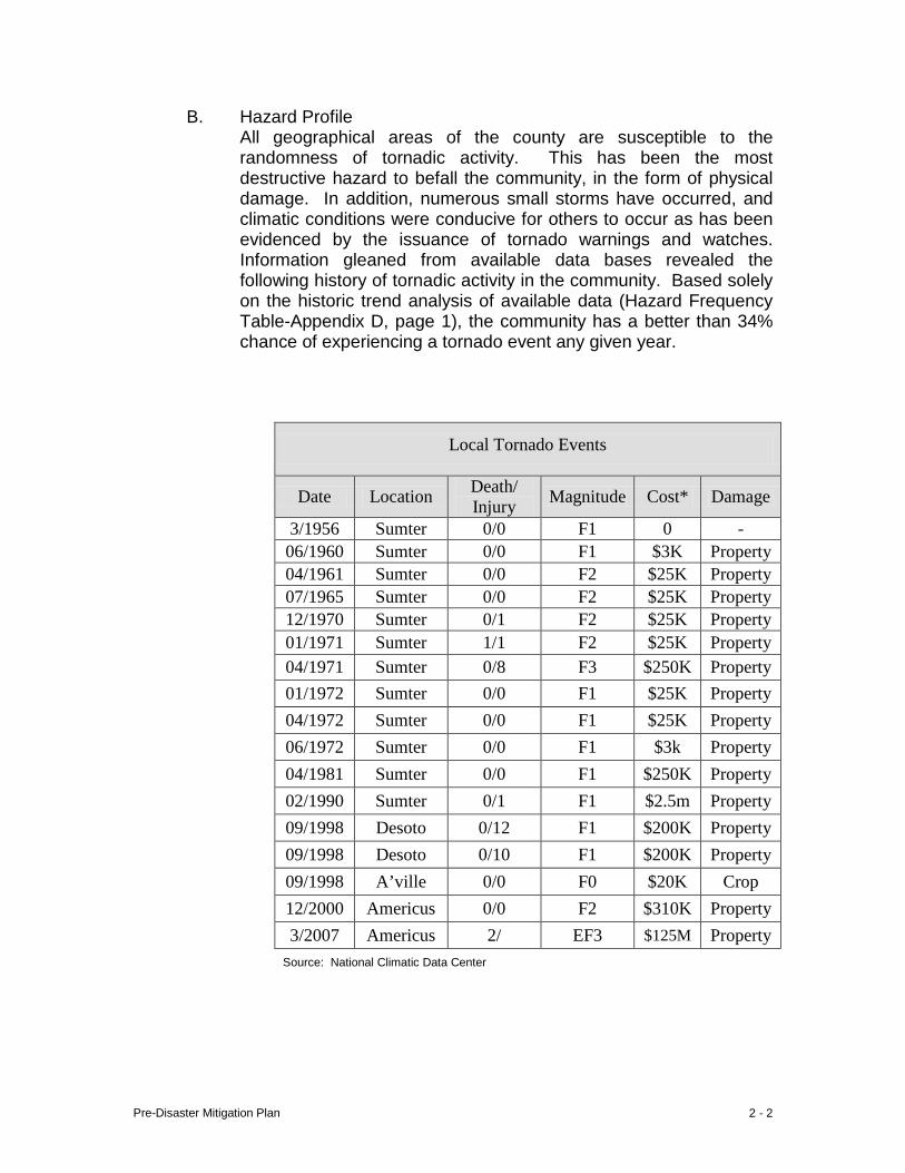
B. Hazard Profile All geographical areas of the county are susceptible to the randomness of tornadic activity. This has been the most destructive hazard to befall the community, in the form of physical damage. In addition, numerous small storms have occurred, and climatic conditions were conducive for others to occur as has been evidenced by the issuance of tornado warnings and watches. Information gleaned from available data bases revealed the following history of tornadic activity in the community. Based solely on the historic trend analysis of available data (Hazard Frequency Table-Appendix D, page 1), the community has a better than 34% chance of experiencing a tornado event any given year.
Local Tornado Events
Date Location Death/ Injury Magnitude Cost* Damage
3/1956 Sumter 0/0 F1 0 - 06/1960 Sumter 0/0 F1 $3K Property 04/1961 Sumter 0/0 F2 $25K Property 07/1965 Sumter 0/0 F2 $25K Property 12/1970 Sumter 0/1 F2 $25K Property 01/1971 Sumter 1/1 F2 $25K Property 04/1971 Sumter 0/8 F3 $250K Property 01/1972 Sumter 0/0 F1 $25K Property 04/1972 Sumter 0/0 F1 $25K Property 06/1972 Sumter 0/0 F1 $3k Property 04/1981 Sumter 0/0 F1 $250K Property 02/1990 Sumter 0/1 F1 $2.5m Property 09/1998 Desoto 0/12 F1 $200K Property 09/1998 Desoto 0/10 F1 $200K Property 09/1998 A’ville 0/0 F0 $20K Crop 12/2000 Americus 0/0 F2 $310K Property 3/2007 Americus 2/ EF3 $125M Property
Source: National Climatic Data Center
Pre-Disaster Mitigation Plan 2 - 3
C. Community Exposure The random, sudden and violent natures of the tornado place all residents and all physical development throughout the community at risk. This, of course, includes all critical infrastructure; 210 structures enumerated in Appendix A. Collective value of the community’s “non-critical” facilities has been estimated for use here; documentation is presented in Appendix A.
D. Estimate of Potential Losses Potential Losses were estimated by use of the OHS/GEMA web-based planning tool. Data input for the Assets Worksheet included the replacement value and structure content value of each critical facility identified. Because all areas of the community are exposed to the threat posed by this hazard, critical facilities distributed throughout the county are at risk. Thus, any percentage of total replacement and structure contents values is subject to loss. The combined total estimated structure replacement value ($626M) and total estimated contents value ($754M) is $1.4B. The approximate values per jurisdiction are: Americus – ($532M) ($650M) $1.2B, Andersonville – ($5M) ($7M) $12M, DeSoto – ($.4M) ($.4M) $.8M, Leslie – ($2.5M) ($2.2M) $4.7M, Plains – ($8.2M) ($4.9M) $13.1M, and the unincorporated balance – ($78M) ($89M) $167M. This information can be reviewed in detail in Appendix A page 20ff, The estimated value of the community’s “non-critical” facilities is approximately $1.1B, exclusive of content value (refer to page A-17). Approximate values per jurisdiction are: Americus $573M, Andersonville $6M, DeSoto $2M, Leslie $12M, Plains $19M and the unincorporated area balance $537M. Population and other demographic data are presented in Appendix B.

Pre-Disaster Mitigation Plan 2 - 4
Byromvill
Lil
Smithville
Ellaville
Americus
Andersonville
De Soto
Plains
Sumter County
Americus
City of Americus

Pre-Disaster Mitigation Plan 2 - 5
e Route 228
Ellaville St
Confederate Dr
Freeman Ave
Ellaville St Ellaville St
Church St
te Route 271
Freeman St
Freeman Ave
Freeman St
R
oute
49
Ogle
thor
pe S
t
Sta
te R
oute
271
R
ebel Rd
Gun
Boa
t
Church St
Johnson St
State Rout
State Route 49
City of Andersonville
States Highway 280
N B
ailey Ave
Stil l Quarte
rs St N
orth Luke St
Seaboard St United States Highway 280
Fer
guso
n St
W Wilson St Railroad StE Allen St Allen St Bagley St
Howell St Howell St
S B
ailey Ave
Fer
guso
n St
Desoto Seed Farm Rd
Sta
te R
oute
118
State Route 195
Blacksmith R
d
State Route 195
Leslie-Lamar Rd
Commerce Rd
City of Leslie City of DeSoto
Pre-Disaster Mitigation Plan 2 - 6
Cow
Pen Rd
Unit
ed S
tates
High
way 28
0
Hospital St
Woo
dlan
d D
r
es Highway 280
Rabbit B
ranch Rd
Thomas St
Walters S
t
N B
ond St
S Bond St
Bot
sfor
d Rd
Spann Dr Africana Dr
Wise Rd
Bot
sford
Rd
Spann Dr
Thrasher
Plains-Botsford
Carter S
t
Botsford
Rd
Wise
King St
Kin
g St
Brenda Pickett Cir
City of Plains
E. Land Use and Development Trends Because tornado strikes are so random, neither land use nor development trends influence the risk of exposure to this hazard. Building codes are enforced in Sumter, Americus and Plains. The 2000 Census documented that most new development had taken on the periphery of the Americus city limits. At this writing the county seat is experiencing a surge of new commercial development.
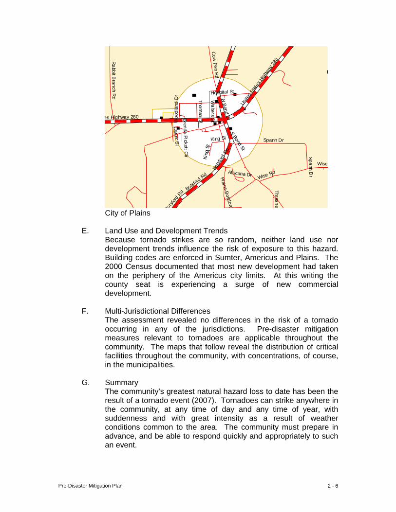
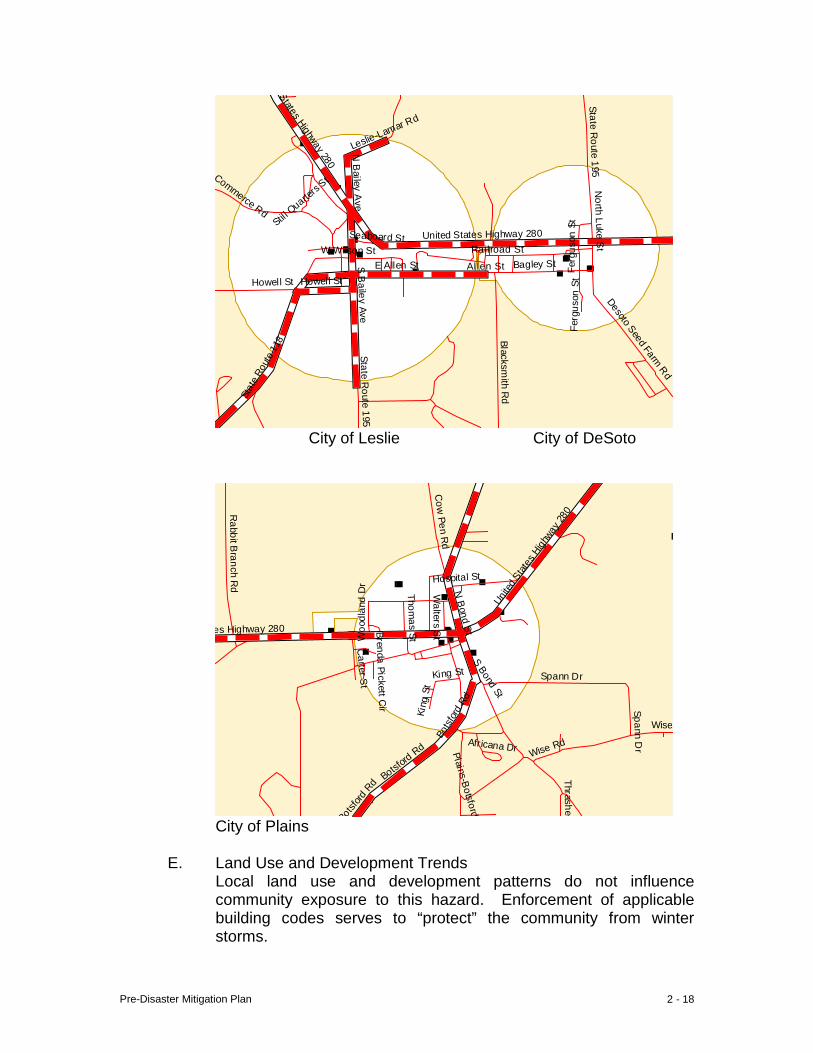
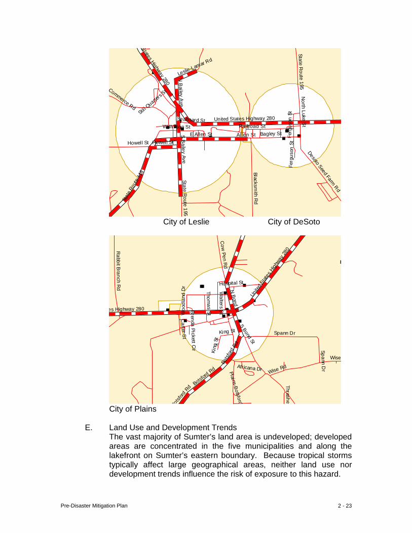
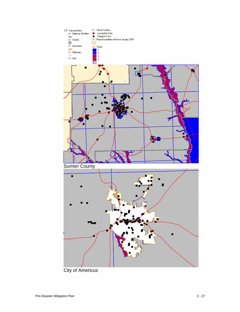
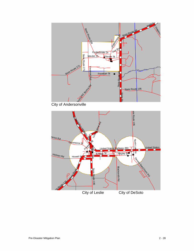
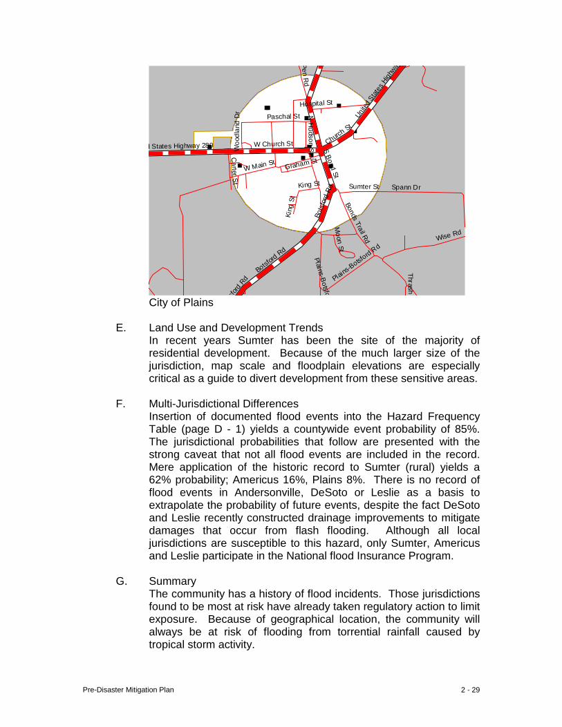
F. Multi-Jurisdictional Differences The assessment revealed no differences in the risk of a tornado occurring in any of the jurisdictions. Pre-disaster mitigation measures relevant to tornadoes are applicable throughout the community. The maps that follow reveal the distribution of critical facilities throughout the community, with concentrations, of course, in the municipalities.
G. Summary
The community’s greatest natural hazard loss to date has been the result of a tornado event (2007). Tornadoes can strike anywhere in the community, at any time of day and any time of year, with suddenness and with great intensity as a result of weather conditions common to the area. The community must prepare in advance, and be able to respond quickly and appropriately to such an event.
Pre-Disaster Mitigation Plan 2 - 7
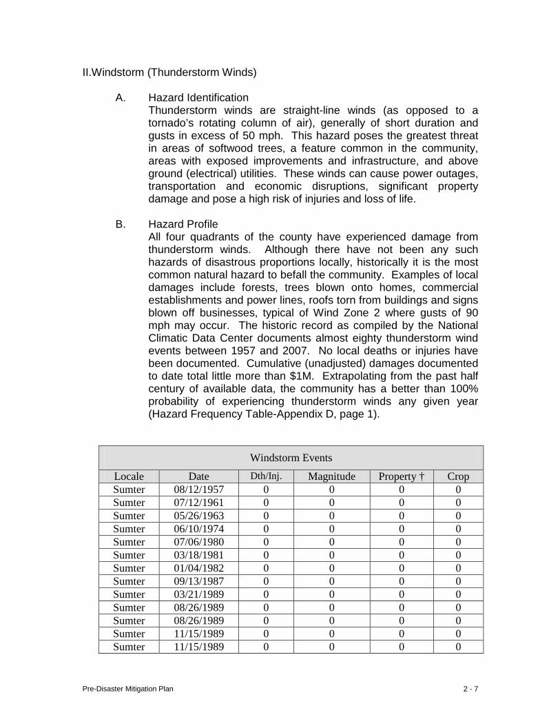
II.Windstorm (Thunderstorm Winds) A. Hazard Identification
Thunderstorm winds are straight-line winds (as opposed to a tornado’s rotating column of air), generally of short duration and gusts in excess of 50 mph. This hazard poses the greatest threat in areas of softwood trees, a feature common in the community, areas with exposed improvements and infrastructure, and above ground (electrical) utilities. These winds can cause power outages, transportation and economic disruptions, significant property damage and pose a high risk of injuries and loss of life.
B. Hazard Profile
All four quadrants of the county have experienced damage from thunderstorm winds. Although there have not been any such hazards of disastrous proportions locally, historically it is the most common natural hazard to befall the community. Examples of local damages include forests, trees blown onto homes, commercial establishments and power lines, roofs torn from buildings and signs blown off businesses, typical of Wind Zone 2 where gusts of 90 mph may occur. The historic record as compiled by the National Climatic Data Center documents almost eighty thunderstorm wind events between 1957 and 2007. No local deaths or injuries have been documented. Cumulative (unadjusted) damages documented to date total little more than $1M. Extrapolating from the past half century of available data, the community has a better than 100% probability of experiencing thunderstorm winds any given year (Hazard Frequency Table-Appendix D, page 1).
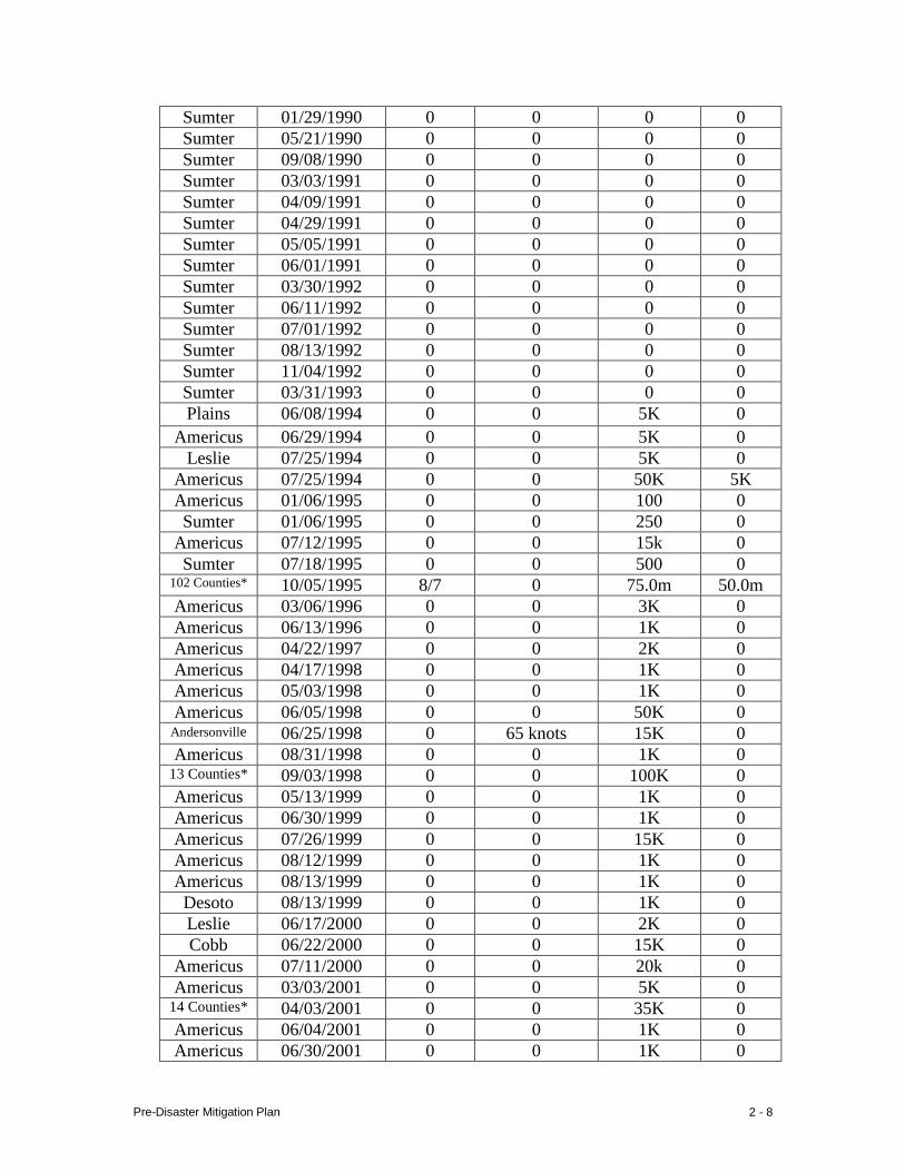
Windstorm Events
Locale Date Dth/Inj. Magnitude Property † Crop Sumter 08/12/1957 0 0 0 0 Sumter 07/12/1961 0 0 0 0 Sumter 05/26/1963 0 0 0 0 Sumter 06/10/1974 0 0 0 0 Sumter 07/06/1980 0 0 0 0 Sumter 03/18/1981 0 0 0 0 Sumter 01/04/1982 0 0 0 0 Sumter 09/13/1987 0 0 0 0 Sumter 03/21/1989 0 0 0 0 Sumter 08/26/1989 0 0 0 0 Sumter 08/26/1989 0 0 0 0 Sumter 11/15/1989 0 0 0 0 Sumter 11/15/1989 0 0 0 0
Pre-Disaster Mitigation Plan 2 - 8
Sumter 01/29/1990 0 0 0 0 Sumter 05/21/1990 0 0 0 0 Sumter 09/08/1990 0 0 0 0 Sumter 03/03/1991 0 0 0 0 Sumter 04/09/1991 0 0 0 0 Sumter 04/29/1991 0 0 0 0 Sumter 05/05/1991 0 0 0 0 Sumter 06/01/1991 0 0 0 0 Sumter 03/30/1992 0 0 0 0 Sumter 06/11/1992 0 0 0 0 Sumter 07/01/1992 0 0 0 0 Sumter 08/13/1992 0 0 0 0 Sumter 11/04/1992 0 0 0 0 Sumter 03/31/1993 0 0 0 0 Plains 06/08/1994 0 0 5K 0
Americus 06/29/1994 0 0 5K 0 Leslie 07/25/1994 0 0 5K 0
Americus 07/25/1994 0 0 50K 5K Americus 01/06/1995 0 0 100 0 Sumter 01/06/1995 0 0 250 0
Americus 07/12/1995 0 0 15k 0 Sumter 07/18/1995 0 0 500 0
102 Counties* 10/05/1995 8/7 0 75.0m 50.0m Americus 03/06/1996 0 0 3K 0 Americus 06/13/1996 0 0 1K 0 Americus 04/22/1997 0 0 2K 0 Americus 04/17/1998 0 0 1K 0 Americus 05/03/1998 0 0 1K 0 Americus 06/05/1998 0 0 50K 0
Andersonville 06/25/1998 0 65 knots 15K 0 Americus 08/31/1998 0 0 1K 0
13 Counties* 09/03/1998 0 0 100K 0 Americus 05/13/1999 0 0 1K 0 Americus 06/30/1999 0 0 1K 0 Americus 07/26/1999 0 0 15K 0 Americus 08/12/1999 0 0 1K 0 Americus 08/13/1999 0 0 1K 0
Desoto 08/13/1999 0 0 1K 0 Leslie 06/17/2000 0 0 2K 0 Cobb 06/22/2000 0 0 15K 0
Americus 07/11/2000 0 0 20k 0 Americus 03/03/2001 0 0 5K 0
14 Counties* 04/03/2001 0 0 35K 0 Americus 06/04/2001 0 0 1K 0 Americus 06/30/2001 0 0 1K 0
Pre-Disaster Mitigation Plan 2 - 9
Americus 03/31/2002 0 0 0 0 Americus 03/31/2002 0 0 K 0
Desoto 08/20/2002 0 0 3K 0 Americus 08/20/2002 0 0 25K 0 Americus 02/22/2003 0 50 knots 3K 0 Americus 05/02/2003 0 50 knots 1K 0 Americus 07/23/2003 0 39 knots 0K 0 Americus 07/29/2003 0 50 knots 1K 0 Americus 06/01/2004 0 35 knots 0K 0 Sumter 09/06/2004 0 36 knots 6.2M Sumter 09/16/2004 0 0 50K 0 Sumter 09/27/2004 0 50 knots 50K 0
Americus 01/13/2005 0 50 knots 1K 0 Plains 03/272005 0 50 knots 3K 0
Americus 04/30/2005 0 39 knots 5K 0 Sumter 07/10/2005 0 N/A 5K 0
Andersonville 08/22/2005 0 36 knots 1K 0 Sumter 05/10/2006 0 51 knots 8K 0
Americus 05/28/2006 0 39 knots 5K 0 Americus 06/22/2006 0 50 knots 25K 0 Americus 08/08/2006 0 50 knots 15K 0
† unadjusted values * includes Sumter Co. Source: National Climatic Data Center
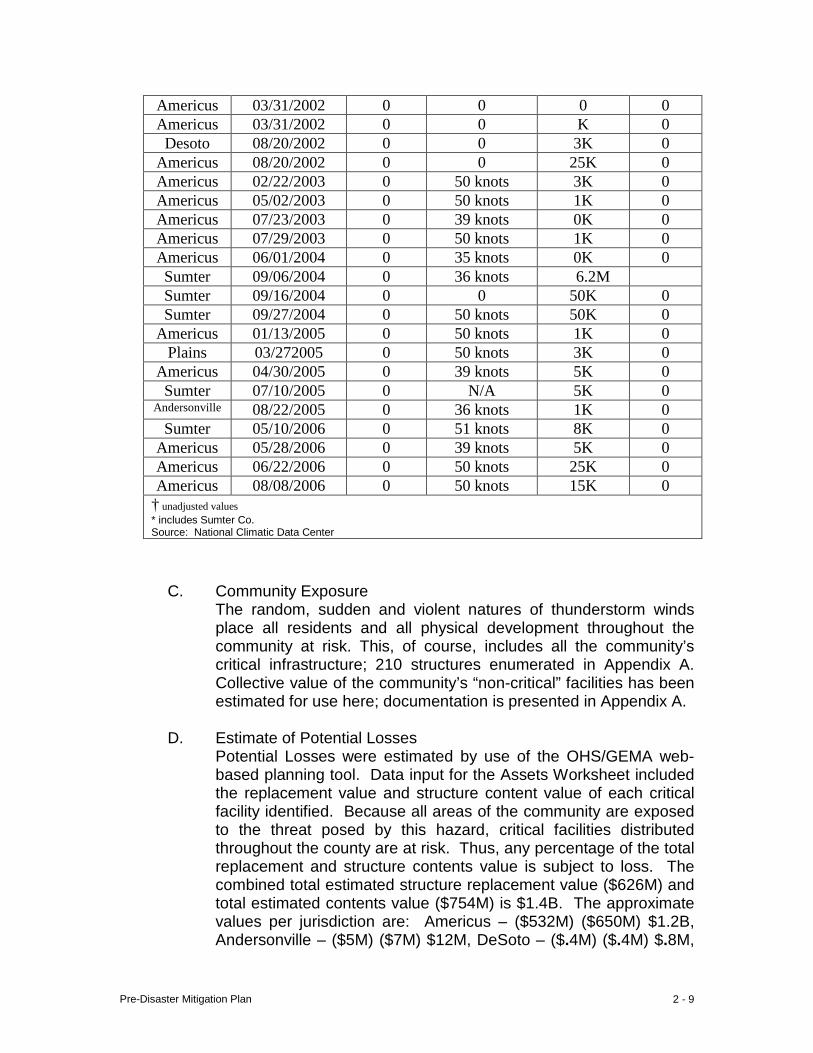
C. Community Exposure
The random, sudden and violent natures of thunderstorm winds place all residents and all physical development throughout the community at risk. This, of course, includes all the community’s critical infrastructure; 210 structures enumerated in Appendix A. Collective value of the community’s “non-critical” facilities has been estimated for use here; documentation is presented in Appendix A.
D. Estimate of Potential Losses
Potential Losses were estimated by use of the OHS/GEMA web-based planning tool. Data input for the Assets Worksheet included the replacement value and structure content value of each critical facility identified. Because all areas of the community are exposed to the threat posed by this hazard, critical facilities distributed throughout the county are at risk. Thus, any percentage of the total replacement and structure contents value is subject to loss. The combined total estimated structure replacement value ($626M) and total estimated contents value ($754M) is $1.4B. The approximate values per jurisdiction are: Americus – ($532M) ($650M) $1.2B, Andersonville – ($5M) ($7M) $12M, DeSoto – ($.4M) ($.4M) $.8M,
Pre-Disaster Mitigation Plan 2 - 10
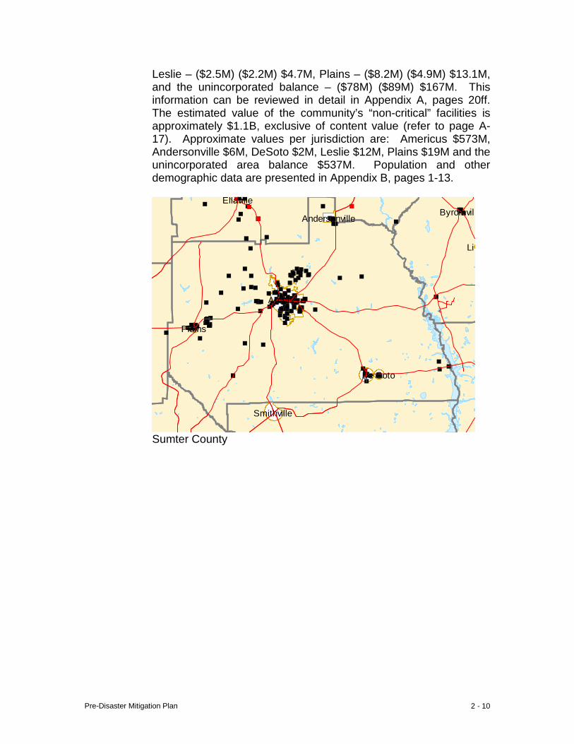
Leslie – ($2.5M) ($2.2M) $4.7M, Plains – ($8.2M) ($4.9M) $13.1M, and the unincorporated balance – ($78M) ($89M) $167M. This information can be reviewed in detail in Appendix A, pages 20ff. The estimated value of the community’s “non-critical” facilities is approximately $1.1B, exclusive of content value (refer to page A-17). Approximate values per jurisdiction are: Americus $573M, Andersonville $6M, DeSoto $2M, Leslie $12M, Plains $19M and the unincorporated area balance $537M. Population and other demographic data are presented in Appendix B, pages 1-13.
Byromvill
Lil
Smithville
Ellaville
Americus
Andersonville
De Soto
Plains
Sumter County
Pre-Disaster Mitigation Plan 2 - 11
Americus
City of Americus
e Route 228
Ellaville St
Confederate Dr
Freeman Ave
Ellaville St Ellaville St
Church St
te Route 271
Freeman St
Freeman Ave
Freeman St
R
oute
49
Ogle
thor
pe S
t
Sta
te R
oute
271
R
ebel Rd
Gun
Boa
t
Church St
Johnson St
State Rout
State Route 49
City of Andersonville
Pre-Disaster Mitigation Plan 2 - 12
States Highway 280
N B
ailey Ave
Stil l Quarte
rs St N
orth Luke St
Seaboard St United States Highway 280
Fer
guso
n St
W Wilson St Railroad StE Allen St Allen St Bagley St
Howell St Howell St
S B
ailey Ave
Fer
guso
n St
Desoto Seed Farm Rd
Sta
te R
oute
118
State Route 195
Blacksmith R
d
State Route 195
Leslie-Lamar Rd
Commerce Rd
City of Leslie City of DeSoto
Cow
Pen Rd
Unit
ed S
tates
High
way 28
0
Hospital St
Woo
dlan
d D
r
es Highway 280 R
abbit Branch R
d
Thomas St
Walters S
t
N B
ond St
S Bond St
Bot
sfor
d Rd
Spann Dr Africana Dr
Wise Rd
Bot
sford
Rd
Spann Dr
Thrasher
Plains-Botsford
Carter S
t
Botsford
Rd
Wise
King St
Kin
g St
Brenda Pickett Cir
City of Plains
E. Land Use and Development Trends
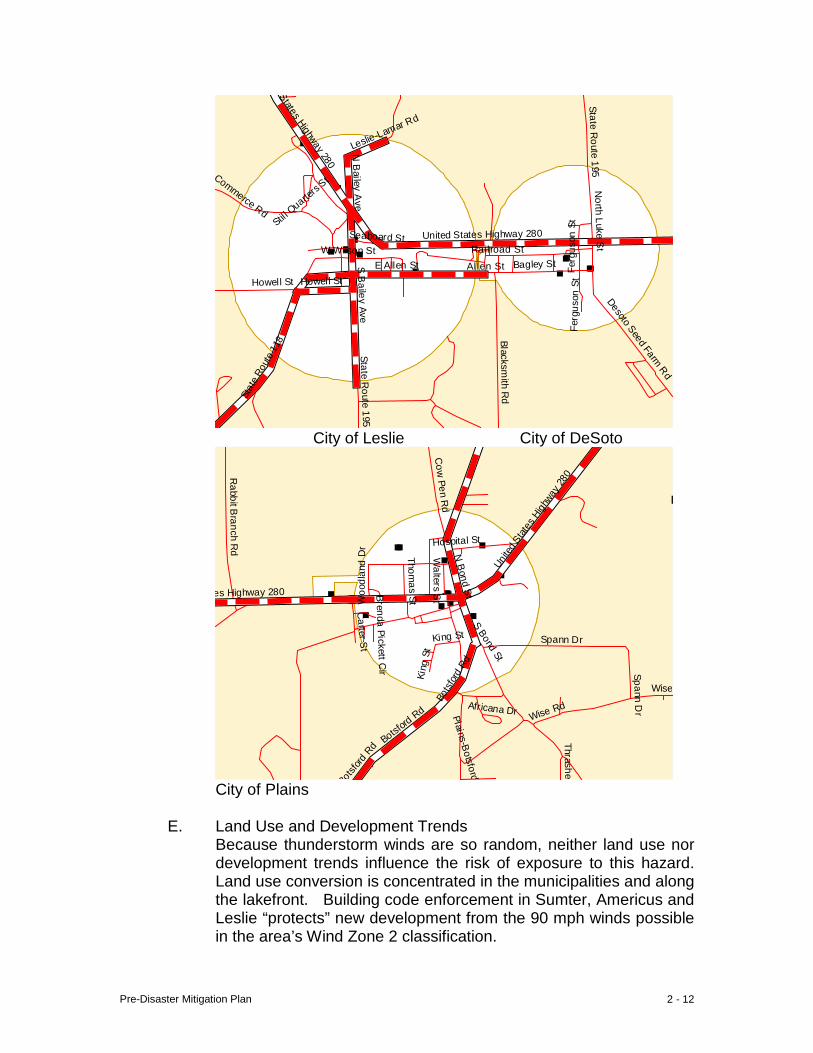
Because thunderstorm winds are so random, neither land use nor development trends influence the risk of exposure to this hazard. Land use conversion is concentrated in the municipalities and along the lakefront. Building code enforcement in Sumter, Americus and Leslie “protects” new development from the 90 mph winds possible in the area’s Wind Zone 2 classification.
Pre-Disaster Mitigation Plan 2 - 13
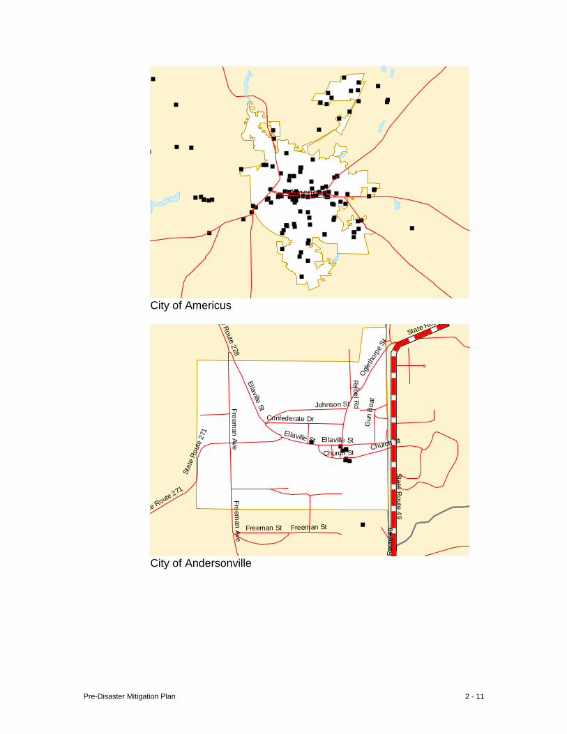
F. Multi-Jurisdictional Differences The assessment revealed no differences in the risk of a wind storm occurring in any of the six jurisdictions. Pre-disaster mitigation measures relevant to thunderstorm winds are applicable throughout the community. The map that follows reveals the distribution of critical facilities throughout the community, with concentrations, of course, in the municipalities.
G. Summary Thunderstorm winds are the community’s most common natural hazard event, and have demonstrated the ability to strike anywhere at any time. The community must prepare in advance, and be able to respond quickly and intelligently to such an event.
Pre-Disaster Mitigation Plan 2 - 14
III. Severe Winter Storm (Snow and Ice)
A. Hazard Identification A winter storm is a widespread weather pattern affecting a much larger area than any single community. These hazards take the form of freezing temperatures, ice formation and snow accumulation. Low temperatures burst unprotected water pipes, and formation of ice on roads causes slick, dangerous and hazardous driving conditions. The weight of ice formation on trees breaks limbs which in turn fall on and break suspended electric power lines disrupting service. Snow accumulation also creates unsafe driving conditions for the public unfamiliar with potential hazards. Bridges are especially susceptible to freezing because of exposure to extreme temperatures from above and below the structure. Roads may have to be closed because of freezing conditions on bridges, which can in turn lead to business closures. Generally, these hazard events are threats primarily to residents and result in economic losses resulting from business and school closures. A poorly heated house in the winter can cause hypothermia in older residents, and the potential for this occurring is exacerbated during times of extreme cold. Although it is not unusual to experience some property damage, with the exception of electrical transmission lines, critical facilities are generally not seriously threatened.
B. Hazard Profile
The community has experienced winter storm events of both snow and ice. Because these events have historically been of short duration, damage has seldom been significant, with the occasional exception of crop damage. Extreme cold does not have to be of long duration to be harmful to crops. Local property damage would be much greater if severe weather lingered for longer periods of time. Seldom does the day-time high temperature immediately following extreme cold fail to reach a temperature above freezing, offering at least a brief reprieve from severe conditions. Three-to-four consecutive days of around-the-clock freezing temperatures would pose a significant hazard to the community, and could occur in virtually any winter season. A severe winter storm will pose the greatest threat to the very young, elderly, lower-income, especially if inadequately housed, and to those traveling because of the greater likelihood of traffic accidents which result from hazardous driving conditions. The purported forty-year record documented fourteen severe winter events. Review of the information available suggests a 9% probability of the community experiencing a winter storm event any given year (Hazard Frequency Table-Appendix D, page1).
Pre-Disaster Mitigation Plan 2 - 15
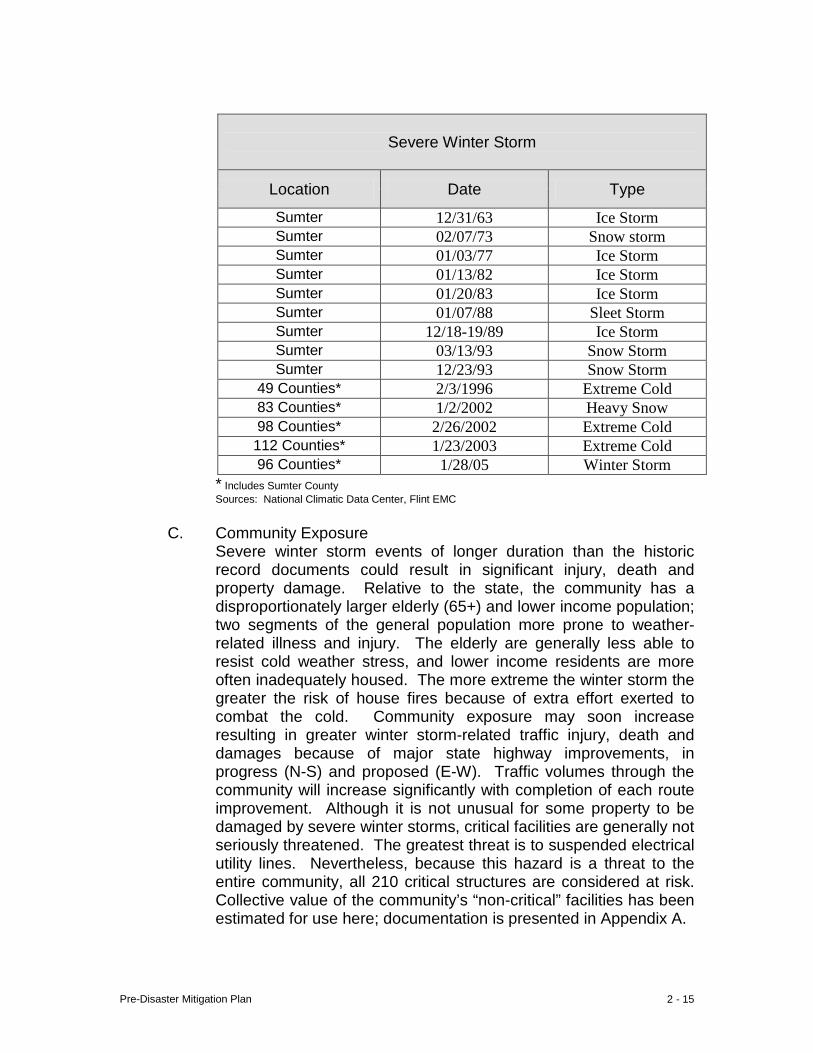
Severe Winter Storm
Location Date Type
Sumter 12/31/63 Ice Storm Sumter 02/07/73 Snow storm Sumter 01/03/77 Ice Storm Sumter 01/13/82 Ice Storm Sumter 01/20/83 Ice Storm Sumter 01/07/88 Sleet Storm Sumter 12/18-19/89 Ice Storm Sumter 03/13/93 Snow Storm Sumter 12/23/93 Snow Storm
49 Counties* 2/3/1996 Extreme Cold 83 Counties* 1/2/2002 Heavy Snow 98 Counties* 2/26/2002 Extreme Cold 112 Counties* 1/23/2003 Extreme Cold 96 Counties* 1/28/05 Winter Storm
* Includes Sumter County Sources: National Climatic Data Center, Flint EMC
C. Community Exposure
Severe winter storm events of longer duration than the historic record documents could result in significant injury, death and property damage. Relative to the state, the community has a disproportionately larger elderly (65+) and lower income population; two segments of the general population more prone to weather-related illness and injury. The elderly are generally less able to resist cold weather stress, and lower income residents are more often inadequately housed. The more extreme the winter storm the greater the risk of house fires because of extra effort exerted to combat the cold. Community exposure may soon increase resulting in greater winter storm-related traffic injury, death and damages because of major state highway improvements, in progress (N-S) and proposed (E-W). Traffic volumes through the community will increase significantly with completion of each route improvement. Although it is not unusual for some property to be damaged by severe winter storms, critical facilities are generally not seriously threatened. The greatest threat is to suspended electrical utility lines. Nevertheless, because this hazard is a threat to the entire community, all 210 critical structures are considered at risk. Collective value of the community’s “non-critical” facilities has been estimated for use here; documentation is presented in Appendix A.
Pre-Disaster Mitigation Plan 2 - 16
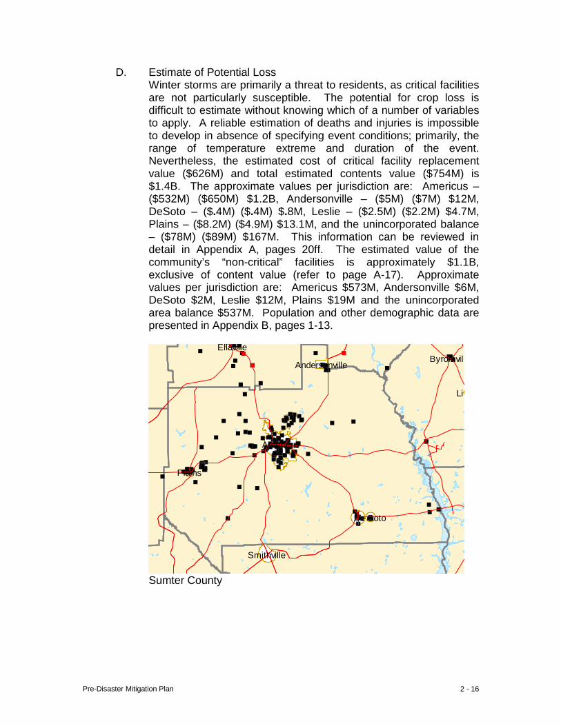
D. Estimate of Potential Loss Winter storms are primarily a threat to residents, as critical facilities are not particularly susceptible. The potential for crop loss is difficult to estimate without knowing which of a number of variables to apply. A reliable estimation of deaths and injuries is impossible to develop in absence of specifying event conditions; primarily, the range of temperature extreme and duration of the event. Nevertheless, the estimated cost of critical facility replacement value ($626M) and total estimated contents value ($754M) is $1.4B. The approximate values per jurisdiction are: Americus – ($532M) ($650M) $1.2B, Andersonville – ($5M) ($7M) $12M, DeSoto – ($.4M) ($.4M) $.8M, Leslie – ($2.5M) ($2.2M) $4.7M, Plains – ($8.2M) ($4.9M) $13.1M, and the unincorporated balance – ($78M) ($89M) $167M. This information can be reviewed in detail in Appendix A, pages 20ff. The estimated value of the community’s “non-critical” facilities is approximately $1.1B, exclusive of content value (refer to page A-17). Approximate values per jurisdiction are: Americus $573M, Andersonville $6M, DeSoto $2M, Leslie $12M, Plains $19M and the unincorporated area balance $537M. Population and other demographic data are presented in Appendix B, pages 1-13.
Byromvill
Lil
Smithville
Ellaville
Americus
Andersonville
De Soto
Plains
Sumter County

Pre-Disaster Mitigation Plan 2 - 17
Americus
City of Americus
e Route 228
Ellaville St
Confederate Dr
Freeman Ave
Ellaville St Ellaville St
Church St
te Route 271
Freeman St
Freeman Ave
Freeman St
R
oute
49
Ogle
thor
pe S
t
Sta
te R
oute
271
R
ebel Rd
Gun
Boa
t
Church St
Johnson St
State Rout
State Route 49
City of Andersonville
Pre-Disaster Mitigation Plan 2 - 18
States Highway 280
N B
ailey Ave
Stil l Quarte
rs St N
orth Luke St
Seaboard St United States Highway 280
Fer
guso
n St
W Wilson St Railroad StE Allen St Allen St Bagley St
Howell St Howell St
S B
ailey Ave
Fer
guso
n St
Desoto Seed Farm Rd
Sta
te R
oute
118
State Route 195
Blacksmith R
d
State Route 195
Leslie-Lamar Rd
Commerce Rd
City of Leslie City of DeSoto
Cow
Pen Rd
Unit
ed S
tates
High
way 28
0 Hospital St
Woo
dlan
d D
r
es Highway 280
Rabbit B
ranch Rd
Thomas St
Walters S
t
N B
ond St
S Bond St
Bot
sfor
d Rd
Spann Dr Africana Dr
Wise Rd
Bot
sford
Rd
Spann Dr
Thrasher
Plains-Botsford
Carter S
t
Botsford
Rd
Wise
King St
Kin
g St
Brenda Pickett Cir
City of Plains
E. Land Use and Development Trends
Local land use and development patterns do not influence community exposure to this hazard. Enforcement of applicable building codes serves to “protect” the community from winter storms.
Pre-Disaster Mitigation Plan 2 - 19
F. Multi-Jurisdictional Differences There are not any jurisdictional differences between exposure to, or response to, this hazard.
G. Summary
The community has a number of conditions that increase the potential for loss in a significant winter storm event; disproportionately larger elderly and low income populations, (impending) transportation hub, complacency resulting from a history of winter storm events being relatively rare and of short duration. The general rarity of such events, their generally short duration and the brief period of intensive use of storm-related recovery equipment all serve to make it difficult for elected officials to justify purchase of such equipment operating in an environment of limited financial resources. Because winter storms are typically a widespread weather pattern, surrounding communities are likely to be affected by the same event. Transportation-related hazards during such events can complicate sharing of such equipment between jurisdictions. The best protection against future events is education and preparation.
Pre-Disaster Mitigation Plan 2 - 20
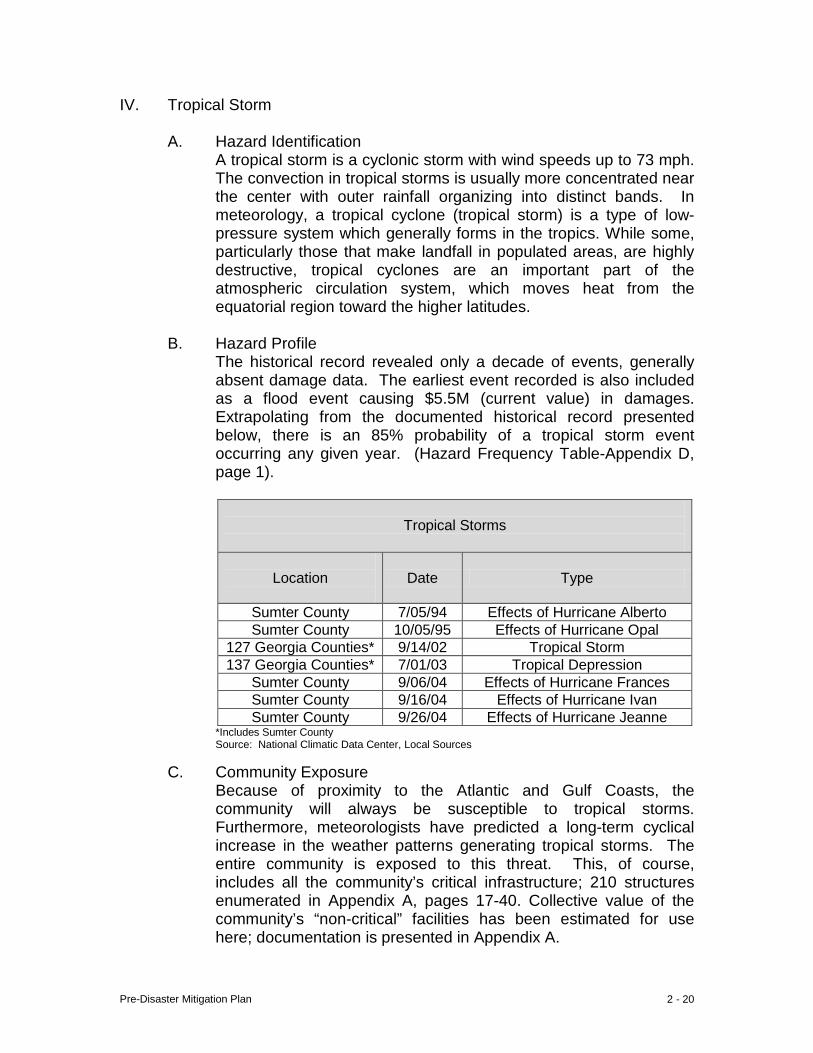
IV. Tropical Storm
A. Hazard Identification A tropical storm is a cyclonic storm with wind speeds up to 73 mph. The convection in tropical storms is usually more concentrated near the center with outer rainfall organizing into distinct bands. In meteorology, a tropical cyclone (tropical storm) is a type of low-pressure system which generally forms in the tropics. While some, particularly those that make landfall in populated areas, are highly destructive, tropical cyclones are an important part of the atmospheric circulation system, which moves heat from the equatorial region toward the higher latitudes.
B. Hazard Profile
The historical record revealed only a decade of events, generally absent damage data. The earliest event recorded is also included as a flood event causing $5.5M (current value) in damages. Extrapolating from the documented historical record presented below, there is an 85% probability of a tropical storm event occurring any given year. (Hazard Frequency Table-Appendix D, page 1).
Tropical Storms
Location
Date Type
Sumter County 7/05/94 Effects of Hurricane Alberto Sumter County 10/05/95 Effects of Hurricane Opal
127 Georgia Counties* 9/14/02 Tropical Storm 137 Georgia Counties* 7/01/03 Tropical Depression
Sumter County 9/06/04 Effects of Hurricane Frances Sumter County 9/16/04 Effects of Hurricane Ivan Sumter County 9/26/04 Effects of Hurricane Jeanne
*Includes Sumter County Source: National Climatic Data Center, Local Sources
C. Community Exposure Because of proximity to the Atlantic and Gulf Coasts, the community will always be susceptible to tropical storms. Furthermore, meteorologists have predicted a long-term cyclical increase in the weather patterns generating tropical storms. The entire community is exposed to this threat. This, of course, includes all the community’s critical infrastructure; 210 structures enumerated in Appendix A, pages 17-40. Collective value of the community’s “non-critical” facilities has been estimated for use here; documentation is presented in Appendix A.
Pre-Disaster Mitigation Plan 2 - 21
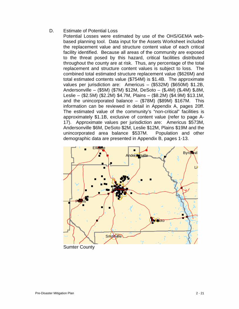
D. Estimate of Potential Loss Potential Losses were estimated by use of the OHS/GEMA web-based planning tool. Data input for the Assets Worksheet included the replacement value and structure content value of each critical facility identified. Because all areas of the community are exposed to the threat posed by this hazard, critical facilities distributed throughout the county are at risk. Thus, any percentage of the total replacement and structure content values is subject to loss. The combined total estimated structure replacement value ($626M) and total estimated contents value ($754M) is $1.4B. The approximate values per jurisdiction are: Americus – ($532M) ($650M) $1.2B, Andersonville – ($5M) ($7M) $12M, DeSoto – ($.4M) ($.4M) $.8M, Leslie – ($2.5M) ($2.2M) $4.7M, Plains – ($8.2M) ($4.9M) $13.1M, and the unincorporated balance – ($78M) ($89M) $167M. This information can be reviewed in detail in Appendix A, pages 20ff. The estimated value of the community’s “non-critical” facilities is approximately $1.1B, exclusive of content value (refer to page A-17). Approximate values per jurisdiction are: Americus $573M, Andersonville $6M, DeSoto $2M, Leslie $12M, Plains $19M and the unincorporated area balance $537M. Population and other demographic data are presented in Appendix B, pages 1-13.
Byromvill
Lil
Smithville
Ellaville
Americus
Andersonville
De Soto
Plains
Sumter County

Pre-Disaster Mitigation Plan 2 - 22
Americus
City of Americus
e Route 228
Ellaville St
Confederate Dr
Freeman Ave
Ellaville St Ellaville St
Church St
te Route 271
Freeman St
Freeman Ave
Freeman St
R
oute
49
Ogle
thor
pe S
t
Sta
te R
oute
271
R
ebel Rd
Gun
Boa
t
Church St
Johnson St
State Rout
State Route 49
City of Andersonville
Pre-Disaster Mitigation Plan 2 - 23
States Highway 280
N B
ailey Ave
Stil l Quarte
rs St N
orth Luke St
Seaboard St United States Highway 280
Fer
guso
n St
W Wilson St Railroad StE Allen St Allen St Bagley St
Howell St Howell St
S B
ailey Ave
Fer
guso
n St
Desoto Seed Farm Rd
Sta
te R
oute
118
State Route 195
Blacksmith R
d
State Route 195
Leslie-Lamar Rd
Commerce Rd
City of Leslie City of DeSoto
Cow
Pen Rd
Unit
ed S
tates
High
way 28
0 Hospital St
Woo
dlan
d D
r
es Highway 280
Rabbit B
ranch Rd
Thomas St
Walters S
t
N B
ond St
S Bond St
Bot
sfor
d Rd
Spann Dr Africana Dr
Wise Rd
Bot
sford
Rd
Spann Dr
Thrasher
Plains-Botsford
Carter S
t
Botsford
Rd
Wise
King St
Kin
g St
Brenda Pickett Cir
City of Plains
E. Land Use and Development Trends
The vast majority of Sumter’s land area is undeveloped; developed areas are concentrated in the five municipalities and along the lakefront on Sumter’s eastern boundary. Because tropical storms typically affect large geographical areas, neither land use nor development trends influence the risk of exposure to this hazard.
Pre-Disaster Mitigation Plan 2 - 24
F. Multi-Jurisdictional Differences The assessment revealed no differences in the risk of a tropical storm occurring in any of the six jurisdictions. Pre-disaster mitigation measures relevant to this hazard are applicable throughout the community. The maps that follow reveal the distribution of critical facilities throughout the community, with concentrations, of course, in the municipalities.
G. Summary Because of geographical location, the community will always be susceptible to the threat of tropical storms. The mitigation strategy included herein supplements some previously initiated efforts and completes others.
Pre-Disaster Mitigation Plan 2 - 25
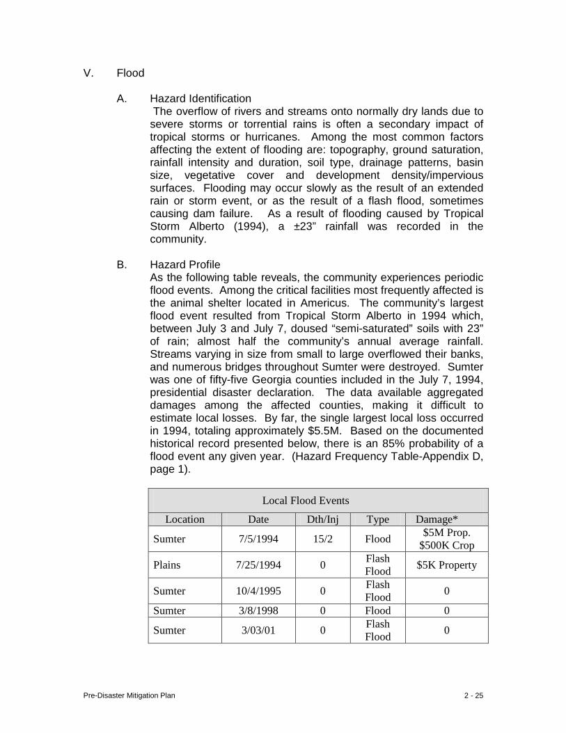
V. Flood
A. Hazard Identification The overflow of rivers and streams onto normally dry lands due to severe storms or torrential rains is often a secondary impact of tropical storms or hurricanes. Among the most common factors affecting the extent of flooding are: topography, ground saturation, rainfall intensity and duration, soil type, drainage patterns, basin size, vegetative cover and development density/impervious surfaces. Flooding may occur slowly as the result of an extended rain or storm event, or as the result of a flash flood, sometimes causing dam failure. As a result of flooding caused by Tropical Storm Alberto (1994), a ±23” rainfall was recorded in the community.
B. Hazard Profile
As the following table reveals, the community experiences periodic flood events. Among the critical facilities most frequently affected is the animal shelter located in Americus. The community’s largest flood event resulted from Tropical Storm Alberto in 1994 which, between July 3 and July 7, doused “semi-saturated” soils with 23” of rain; almost half the community’s annual average rainfall. Streams varying in size from small to large overflowed their banks, and numerous bridges throughout Sumter were destroyed. Sumter was one of fifty-five Georgia counties included in the July 7, 1994, presidential disaster declaration. The data available aggregated damages among the affected counties, making it difficult to estimate local losses. By far, the single largest local loss occurred in 1994, totaling approximately $5.5M. Based on the documented historical record presented below, there is an 85% probability of a flood event any given year. (Hazard Frequency Table-Appendix D, page 1).
Local Flood Events
Location Date Dth/Inj Type Damage*
Sumter 7/5/1994 15/2 Flood $5M Prop. $500K Crop
Plains 7/25/1994 0 Flash Flood $5K Property
Sumter 10/4/1995 0 Flash Flood 0
Sumter 3/8/1998 0 Flood 0
Sumter 3/03/01 0 Flash Flood 0
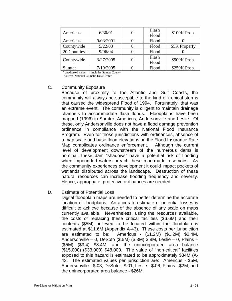
Pre-Disaster Mitigation Plan 2 - 26
Americus 6/30/01 0 Flash Flood $100K Prop.
Americus 9/03/2001 0 Flood 0 Countywide 5/22/03 0 Flood $5K Property 20 Counties† 9/06/04 0 Flood 0
Countywide 3/27/2005 0 Flash Flood $500K Prop.
Sumter 7/10/2005 0 Flood $250K Prop. * unadjusted values, † includes Sumter County Source: National Climatic Data Center
C. Community Exposure
Because of proximity to the Atlantic and Gulf Coasts, the community will always be susceptible to the kind of tropical storms that caused the widespread Flood of 1994. Fortunately, that was an extreme event. The community is diligent to maintain drainage channels to accommodate flash floods. Floodplains have been mapped (1996) in Sumter, Americus, Andersonville and Leslie. Of these, only Andersonville does not have a flood damage prevention ordinance in compliance with the National Flood Insurance Program. Even for those jurisdictions with ordinances, absence of a map scale and base flood elevations on the Flood Insurance Rate Map complicates ordinance enforcement. Although the current level of development downstream of the numerous dams is nominal, these dam “shadows” have a potential risk of flooding when impounded waters breach these man-made reservoirs. As the community experiences development it could impact pockets of wetlands distributed across the landscape. Destruction of these natural resources can increase flooding frequency and severity. Hence, appropriate, protective ordinances are needed.
D. Estimate of Potential Loss Digital floodplain maps are needed to better determine the accurate location of floodplains. An accurate estimate of potential losses is difficult to achieve because of the absence of any scale on maps currently available. Nevertheless, using the resources available, the costs of replacing these critical facilities ($6.6M) and their contents ($5M) believed to be located within the floodplain is estimated at $11.6M (Appendix A-43). These costs per jurisdiction are estimated to be: Americus - ($1.2M) ($1.2M) $2.4M, Andersonville – 0, DeSoto ($.5M) ($.3M) $.8M, Leslie – 0, Plains – ($5M) ($3.4) $8.4M, and the unincorporated area balance ($15,000) ($33,000) $48,000. The value of “non-critical” facilities exposed to this hazard is estimated to be approximately $34M (A-43. The estimated values per jurisdiction are: Americus - $5M, Andersonville - $.03, DeSoto - $.01, Leslie - $.06, Plains - $2M, and the unincorporated area balance - $26M.
Pre-Disaster Mitigation Plan 2 - 27
Sumter County
Americus
City of Americus
Pre-Disaster Mitigation Plan 2 - 28
State Route 228
Confederate Dr
Winder St Ellaville St
State Route 271
Freeman St
Freeman Ave
Sta
te R
oute
49
State Route 195
Bur
ma R
d
State R
o
Bur
ma R
d
Ogle
thor
pe S
t
Gun Boat
State Route 271
State Route 49
State Ro
W Stagecoac
City of Andersonville
United States Highway 280
Commerce St
Free
man St
North Luke S
t
United States Highway 280 United States H
N B
ailey Ave
E Allen St Bagley St Howell St Desoto Seed Farm
Rd
Sta
te R
oute
118
State Route 195
Blacksmith R
d
ate R
oute 195
State Route
118
merce Rd Les
lie-L
amar
Rd
Holman Rd
City of Leslie City of DeSoto
Pre-Disaster Mitigation Plan 2 - 29
Pen R
d
Unit
ed S
tates
High
way
Hospital St
Paschal St
Woo
dlan
d D
r
W Church St
N H
udson St
Church St
S Bond St
Bot
sfor
d Rd
Bonds Trail Rd
Moon St
Plains-B
otsford Rd
tsf
ord R
d
Spann Dr
Thrashe
Carter S
t
Plains-Botsfo
Wise Rd
Graham St
Sumter St
Botsford
Rd
King St
Kin
g St
W Main St
d States Highway 280
City of Plains
E. Land Use and Development Trends In recent years Sumter has been the site of the majority of residential development. Because of the much larger size of the jurisdiction, map scale and floodplain elevations are especially critical as a guide to divert development from these sensitive areas.
F. Multi-Jurisdictional Differences
Insertion of documented flood events into the Hazard Frequency Table (page D - 1) yields a countywide event probability of 85%. The jurisdictional probabilities that follow are presented with the strong caveat that not all flood events are included in the record. Mere application of the historic record to Sumter (rural) yields a 62% probability; Americus 16%, Plains 8%. There is no record of flood events in Andersonville, DeSoto or Leslie as a basis to extrapolate the probability of future events, despite the fact DeSoto and Leslie recently constructed drainage improvements to mitigate damages that occur from flash flooding. Although all local jurisdictions are susceptible to this hazard, only Sumter, Americus and Leslie participate in the National flood Insurance Program.
G. Summary The community has a history of flood incidents. Those jurisdictions found to be most at risk have already taken regulatory action to limit exposure. Because of geographical location, the community will always be at risk of flooding from torrential rainfall caused by tropical storm activity.
Pre-Disaster Mitigation Plan 2 - 30
VI. Extreme Heat
A. Hazard Identification High temperatures sustained over an extended period of time may cause heat-related injuries or deaths, especially to infants and young children, the elderly, persons with disabilities, and migrant and/or seasonal farm workers and other outdoor laborers. The body of an adult is over half water, and for babies the percentage is over 75%. Normal daily water loss must be replaced by what we eat (food contains a lot of water) and drink, but the average adult does not consume enough water to maintain healthy hydration. In cold weather an adult should consume two pints of water daily, and in warm weather water consumption should increase several fold. Hot weather tends to diminish appetite, reducing one source of water intake, and insufficient water consumption over a period of time leads to gradual dehydration. Vital organs like the kidneys, brain and heart can’t function without a certain minimum of water, and unless the deficit is corrected death can occur.
B. Hazard Profile
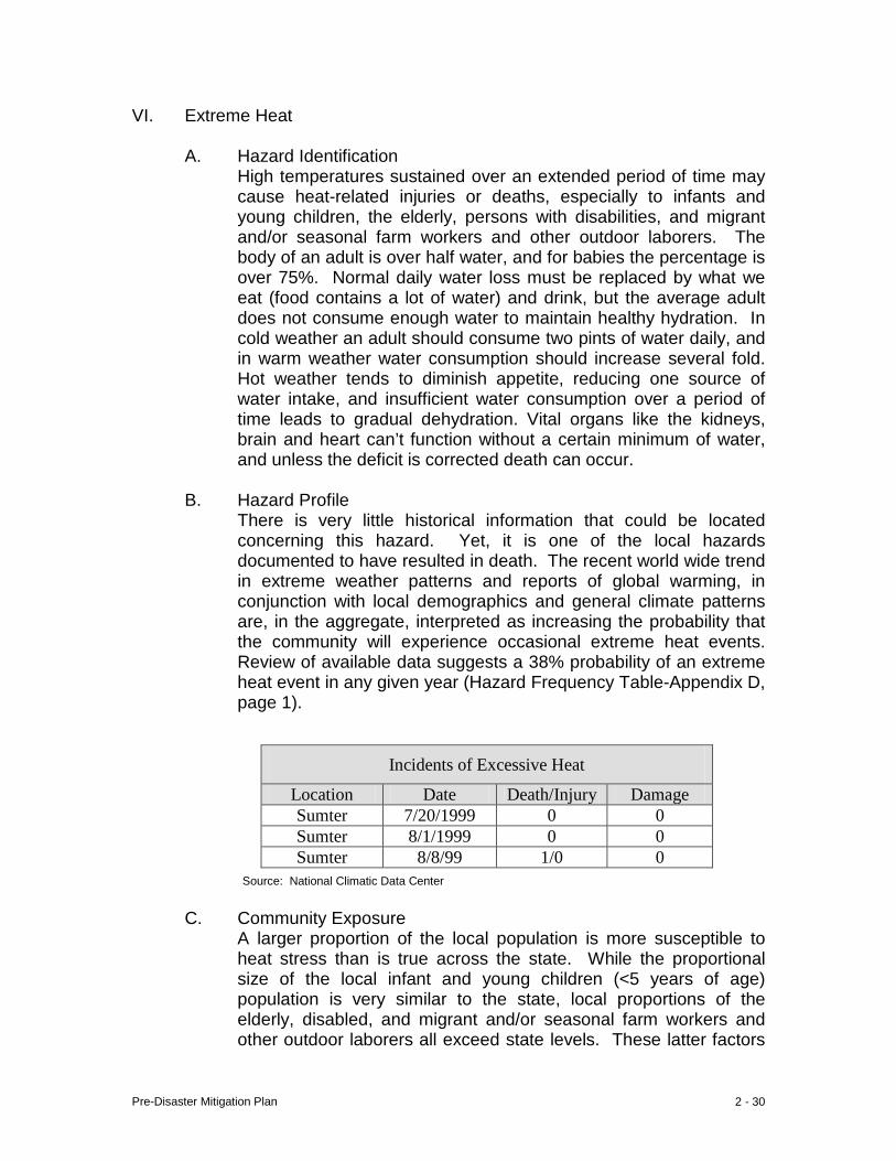
There is very little historical information that could be located concerning this hazard. Yet, it is one of the local hazards documented to have resulted in death. The recent world wide trend in extreme weather patterns and reports of global warming, in conjunction with local demographics and general climate patterns are, in the aggregate, interpreted as increasing the probability that the community will experience occasional extreme heat events. Review of available data suggests a 38% probability of an extreme heat event in any given year (Hazard Frequency Table-Appendix D, page 1).
Source: National Climatic Data Center C. Community Exposure
A larger proportion of the local population is more susceptible to heat stress than is true across the state. While the proportional size of the local infant and young children (<5 years of age) population is very similar to the state, local proportions of the elderly, disabled, and migrant and/or seasonal farm workers and other outdoor laborers all exceed state levels. These latter factors
Incidents of Excessive Heat
Location Date Death/Injury Damage Sumter 7/20/1999 0 0 Sumter 8/1/1999 0 0 Sumter 8/8/99 1/0 0
Pre-Disaster Mitigation Plan 2 - 31
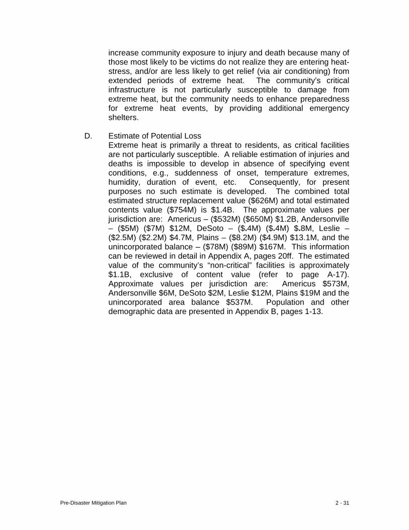
increase community exposure to injury and death because many of those most likely to be victims do not realize they are entering heat-stress, and/or are less likely to get relief (via air conditioning) from extended periods of extreme heat. The community’s critical infrastructure is not particularly susceptible to damage from extreme heat, but the community needs to enhance preparedness for extreme heat events, by providing additional emergency shelters.
D. Estimate of Potential Loss Extreme heat is primarily a threat to residents, as critical facilities are not particularly susceptible. A reliable estimation of injuries and deaths is impossible to develop in absence of specifying event conditions, e.g., suddenness of onset, temperature extremes, humidity, duration of event, etc. Consequently, for present purposes no such estimate is developed. The combined total estimated structure replacement value ($626M) and total estimated contents value ($754M) is $1.4B. The approximate values per jurisdiction are: Americus – ($532M) ($650M) $1.2B, Andersonville – ($5M) ($7M) $12M, DeSoto – ($.4M) ($.4M) $.8M, Leslie – ($2.5M) ($2.2M) $4.7M, Plains – ($8.2M) ($4.9M) $13.1M, and the unincorporated balance – ($78M) ($89M) $167M. This information can be reviewed in detail in Appendix A, pages 20ff. The estimated value of the community’s “non-critical” facilities is approximately $1.1B, exclusive of content value (refer to page A-17). Approximate values per jurisdiction are: Americus $573M, Andersonville $6M, DeSoto $2M, Leslie $12M, Plains $19M and the unincorporated area balance $537M. Population and other demographic data are presented in Appendix B, pages 1-13.

Pre-Disaster Mitigation Plan 2 - 32
Byromvill
Lil
Smithville
Ellaville
Americus
Andersonville
De Soto
Plains
Sumter County
Americus
City of Americus
Pre-Disaster Mitigation Plan 2 - 33
e Route 228
Ellaville St
Confederate Dr
Freeman Ave
Ellaville St Ellaville St
Church St
te Route 271
Freeman St
Freeman Ave
Freeman St
R
oute
49
Ogle
thor
pe S
t
Sta
te R
oute
271
R
ebel Rd
Gun
Boa
t
Church St
Johnson St
State Rout
State Route 49
City of Andersonville
States Highway 280
N B
ailey Ave
Stil l Quarte
rs St N
orth Luke St
Seaboard St United States Highway 280
Fer
guso
n St
W Wilson St Railroad StE Allen St Allen St Bagley St
Howell St Howell St
S B
ailey Ave
Fer
guso
n St
Desoto Seed Farm Rd
Sta
te R
oute
118
State Route 195
Blacksmith R
d
State Route 195
Leslie-Lamar Rd
Commerce Rd
City of Leslie City of DeSoto
Pre-Disaster Mitigation Plan 2 - 34
Cow
Pen Rd
Unit
ed S
tates
High
way 28
0
Hospital St
Woo
dlan
d D
r
es Highway 280
Rabbit B
ranch Rd
Thomas St
Walters S
t
N B
ond St
S Bond St
Bot
sfor
d Rd
Spann Dr Africana Dr
Wise Rd
Bot
sford
Rd
Spann Dr
Thrasher
Plains-Botsford
Carter S
t
Botsford
Rd
Wise
King St
Kin
g St
Brenda Pickett Cir
City of Plains
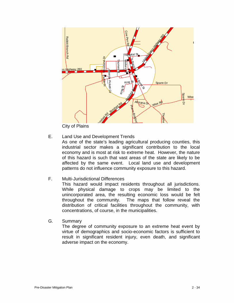
E. Land Use and Development Trends
As one of the state’s leading agricultural producing counties, this industrial sector makes a significant contribution to the local economy and is most at risk to extreme heat. However, the nature of this hazard is such that vast areas of the state are likely to be affected by the same event. Local land use and development patterns do not influence community exposure to this hazard.
F. Multi-Jurisdictional Differences
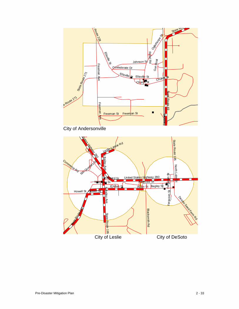
This hazard would impact residents throughout all jurisdictions. While physical damage to crops may be limited to the unincorporated area, the resulting economic loss would be felt throughout the community. The maps that follow reveal the distribution of critical facilities throughout the community, with concentrations, of course, in the municipalities.
G. Summary The degree of community exposure to an extreme heat event by virtue of demographics and socio-economic factors is sufficient to result in significant resident injury, even death, and significant adverse impact on the economy.
Pre-Disaster Mitigation Plan 2 - 35
VII. Drought
A. Hazard Identification A drought is a prolonged period without rain which progresses in stages. The first stage, meteorological drought, occurs when precipitation falls below normal levels and is usually expressed as a rainfall deficit, e.g., inches below normal. When meteorological drought occurs at a critical time of year it can result in water deficient topsoil, which may hinder germination and reduce crop yield. Stage two, agricultural drought, occurs when the amount of moisture in the soil no longer meets the needs of a particular crop. This type drought is usually measured in soil moisture levels and can be devastating to agricultural communities.
Hydrological drought is the third stage. This occurs when surface and subsurface (ground) water supplies fall below normal levels due to prolonged meteorological drought. Indicators include decreased stream flow rates, lake elevations and groundwater levels. Hydrological drought can be detrimental to the environment, upsetting the hydrologic cycle and impacting fish, wildlife and plant species. If this persists long enough, demand for water may exceed supply, leading to the fourth stage – socio-economic drought. This stage can take many months, or even years to develop, often with devastating social and economic consequences.
B. Hazard Profile
Drought is typically a widespread weather pattern affecting a much larger area than any single community. Critical facilities are not directly susceptible to adverse impacts of such an event. Generally, the population is not at risk from physical harm, except in the latter stages of a severe drought. Research into event history revealed a dozen events in only the past decade. Other events are known to have occurred; at least two years during the mid-1950s and several years from the late 1970s into the mid-1980s, but supporting documentation could not be located. No deaths or injuries were documented in the historic record. Based on straight-line extrapolation from the decade of data available, the community has a 100% chance of experiencing a drought in any given year (Hazard Frequency Table-Appendix D, page 1).
Pre-Disaster Mitigation Plan 2 - 36
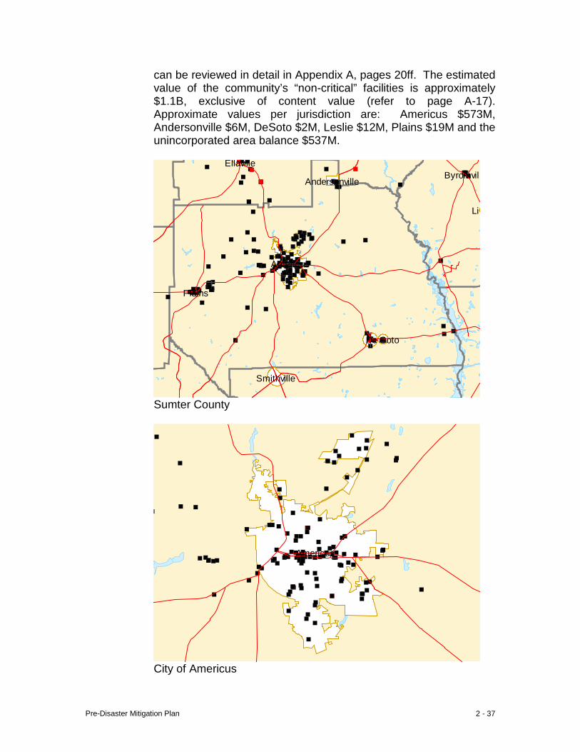
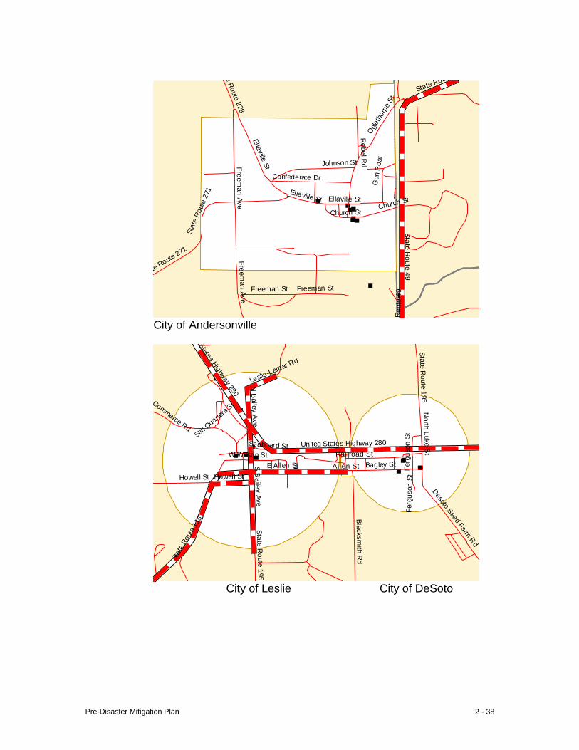
C. Community Exposure The nature of drought is such that the entire community is affected, primarily economically. Generally, neither the population nor critical facilities (210 structures-Appendix A, pages 17-40) are at risk of physical harm, except in the latter stages of a severe drought. Under such conditions available water resources may not be sufficient for human needs, or water pressure may not be sufficient to fight fire, the risk of which increases in forested areas during periods of drought.
D. Estimate of Potential Loss
Agricultural crops are most directly affected by drought, and their loss can result in a significant economic burden on the local economy. In this sense, the local economy is at significant risk. Generally, neither the population nor critical facilities are at risk of physical harm, except in the latter stages of a severe drought. Drought typically does not increase the risk of damage to critical facilities, the majority of which are concentrated in the municipalities and supplied by the deep wells of the municipal system. These deep wells are generally not affected until the later or “critical” stages of drought. Nevertheless, the combined total estimated structure replacement value ($626M) and total estimated contents value ($754M) is $1.4B. The approximate values per jurisdiction are: Americus – ($532M) ($650M) $1.2B, Andersonville – ($5M) ($7M) $12M, DeSoto – ($.4M) ($.4M) $.8M, Leslie – ($2.5M) ($2.2M) $4.7M, Plains – ($8.2M) ($4.9M) $13.1M, and the unincorporated balance – ($78M) ($89M) $167M. This information
Drought Events
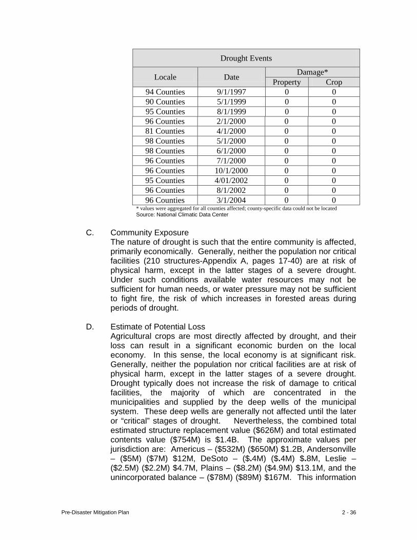
Locale Date Damage* Property Crop
94 Counties 9/1/1997 0 0 90 Counties 5/1/1999 0 0 95 Counties 8/1/1999 0 0 96 Counties 2/1/2000 0 0 81 Counties 4/1/2000 0 0 98 Counties 5/1/2000 0 0 98 Counties 6/1/2000 0 0 96 Counties 7/1/2000 0 0 96 Counties 10/1/2000 0 0 95 Counties 4/01/2002 0 0 96 Counties 8/1/2002 0 0 96 Counties 3/1/2004 0 0
* values were aggregated for all counties affected; county-specific data could not be located Source: National Climatic Data Center
Pre-Disaster Mitigation Plan 2 - 37
can be reviewed in detail in Appendix A, pages 20ff. The estimated value of the community’s “non-critical” facilities is approximately $1.1B, exclusive of content value (refer to page A-17). Approximate values per jurisdiction are: Americus $573M, Andersonville $6M, DeSoto $2M, Leslie $12M, Plains $19M and the unincorporated area balance $537M.
Byromvill
Lil
Smithville
Ellaville
Americus
Andersonville
De Soto
Plains
Sumter County
Americus
City of Americus
Pre-Disaster Mitigation Plan 2 - 38
e Route 228
Ellaville St
Confederate Dr
Freeman Ave
Ellaville St Ellaville St
Church St
te Route 271
Freeman St
Freeman Ave
Freeman St
R
oute
49
Ogle
thor
pe S
t
Sta
te R
oute
271
R
ebel Rd
Gun
Boa
t
Church St
Johnson St
State Rout
State Route 49
City of Andersonville
States Highway 280
N B
ailey Ave
Stil l Quarte
rs St N
orth Luke St
Seaboard St United States Highway 280
Fer
guso
n St
W Wilson St Railroad StE Allen St Allen St Bagley St
Howell St Howell St
S B
ailey Ave
Fer
guso
n St
Desoto Seed Farm Rd
Sta
te R
oute
118
State Route 195
Blacksmith R
d
State Route 195
Leslie-Lamar Rd
Commerce Rd
City of Leslie City of DeSoto
Pre-Disaster Mitigation Plan 2 - 39
Cow
Pen Rd
Unit
ed S
tates
High
way 28
0
Hospital St
Woo
dlan
d D
r
es Highway 280
Rabbit B
ranch Rd
Thomas St
Walters S
t
N B
ond St
S Bond St
Bot
sfor
d Rd
Spann Dr Africana Dr
Wise Rd
Bot
sford
Rd
Spann Dr
Thrasher
Plains-Botsford
Carter S
t
Botsford
Rd
Wise
King St
Kin
g St
Brenda Pickett Cir
City of Plains
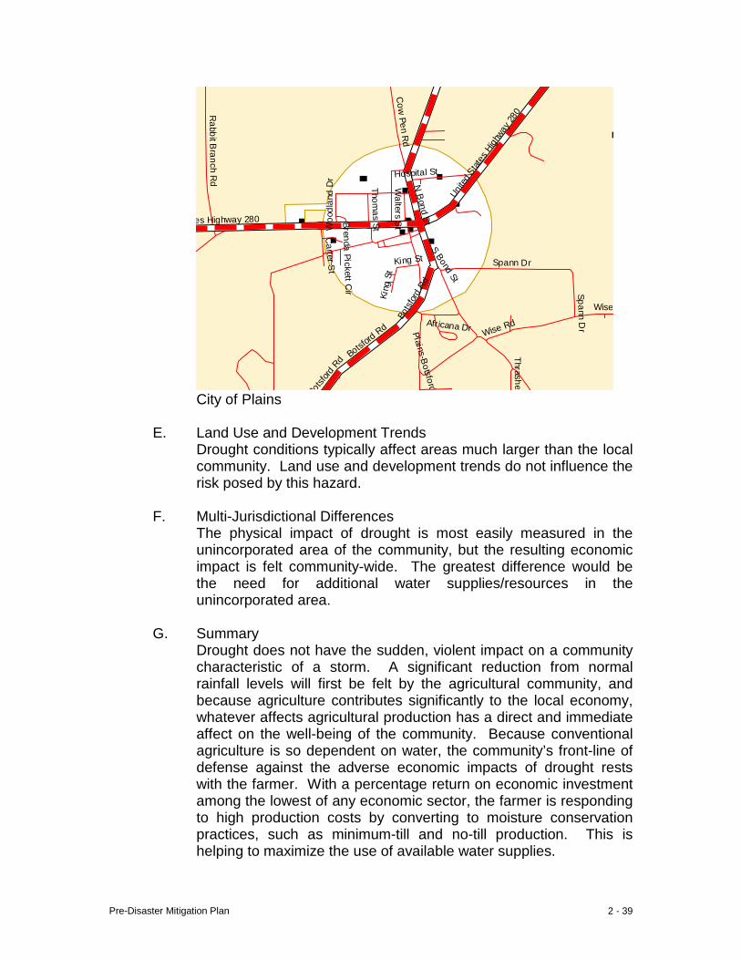
E. Land Use and Development Trends
Drought conditions typically affect areas much larger than the local community. Land use and development trends do not influence the risk posed by this hazard.
F. Multi-Jurisdictional Differences
The physical impact of drought is most easily measured in the unincorporated area of the community, but the resulting economic impact is felt community-wide. The greatest difference would be the need for additional water supplies/resources in the unincorporated area.
G. Summary
Drought does not have the sudden, violent impact on a community characteristic of a storm. A significant reduction from normal rainfall levels will first be felt by the agricultural community, and because agriculture contributes significantly to the local economy, whatever affects agricultural production has a direct and immediate affect on the well-being of the community. Because conventional agriculture is so dependent on water, the community’s front-line of defense against the adverse economic impacts of drought rests with the farmer. With a percentage return on economic investment among the lowest of any economic sector, the farmer is responding to high production costs by converting to moisture conservation practices, such as minimum-till and no-till production. This is helping to maximize the use of available water supplies.
Pre-Disaster Mitigation Plan 2 - 40
VIII. Wildfire
A. Hazard Identification A wildfire is considered to be any fire, other than a controlled or prescribed burn, occurring on forest land which can affect residential and commercial properties, or a free-burning fire unaffected by fire suppression measures.
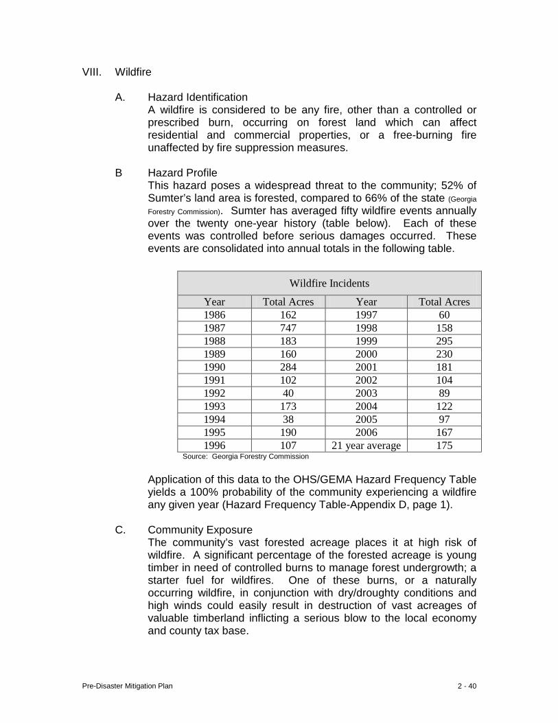
B Hazard Profile This hazard poses a widespread threat to the community; 52% of Sumter’s land area is forested, compared to 66% of the state (Georgia
Forestry Commission). Sumter has averaged fifty wildfire events annually over the twenty one-year history (table below). Each of these events was controlled before serious damages occurred. These events are consolidated into annual totals in the following table.
Application of this data to the OHS/GEMA Hazard Frequency Table yields a 100% probability of the community experiencing a wildfire any given year (Hazard Frequency Table-Appendix D, page 1).
C. Community Exposure
The community’s vast forested acreage places it at high risk of wildfire. A significant percentage of the forested acreage is young timber in need of controlled burns to manage forest undergrowth; a starter fuel for wildfires. One of these burns, or a naturally occurring wildfire, in conjunction with dry/droughty conditions and high winds could easily result in destruction of vast acreages of valuable timberland inflicting a serious blow to the local economy and county tax base.
Wildfire Incidents
Year Total Acres Year Total Acres 1986 162 1997 60 1987 747 1998 158 1988 183 1999 295 1989 160 2000 230 1990 284 2001 181 1991 102 2002 104 1992 40 2003 89 1993 173 2004 122 1994 38 2005 97 1995 190 2006 167 1996 107 21 year average 175
Source: Georgia Forestry Commission
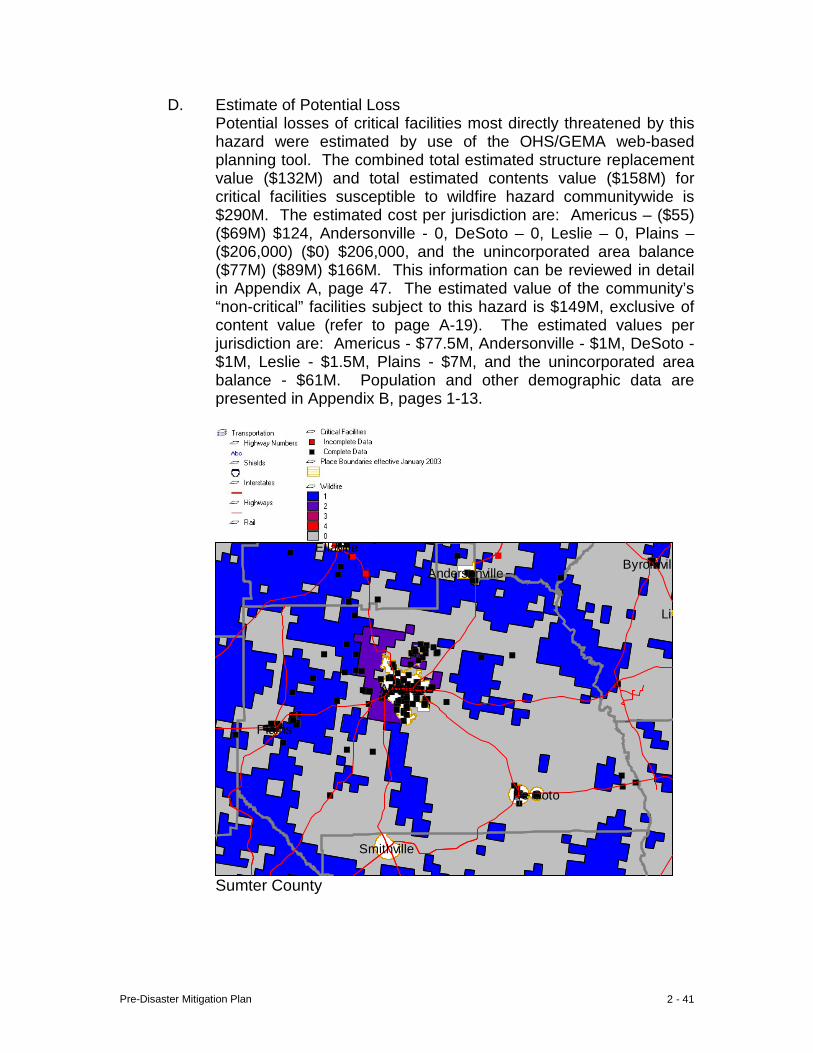
Pre-Disaster Mitigation Plan 2 - 41
D. Estimate of Potential Loss Potential losses of critical facilities most directly threatened by this hazard were estimated by use of the OHS/GEMA web-based planning tool. The combined total estimated structure replacement value ($132M) and total estimated contents value ($158M) for critical facilities susceptible to wildfire hazard communitywide is $290M. The estimated cost per jurisdiction are: Americus – ($55) ($69M) $124, Andersonville - 0, DeSoto – 0, Leslie – 0, Plains – ($206,000) ($0) $206,000, and the unincorporated area balance ($77M) ($89M) $166M. This information can be reviewed in detail in Appendix A, page 47. The estimated value of the community’s “non-critical” facilities subject to this hazard is $149M, exclusive of content value (refer to page A-19). The estimated values per jurisdiction are: Americus - $77.5M, Andersonville - $1M, DeSoto - $1M, Leslie - $1.5M, Plains - $7M, and the unincorporated area balance - $61M. Population and other demographic data are presented in Appendix B, pages 1-13.
Byromvill
Lil
Smithville
Ellaville
Americus
Andersonville
De Soto
Plains
Sumter County
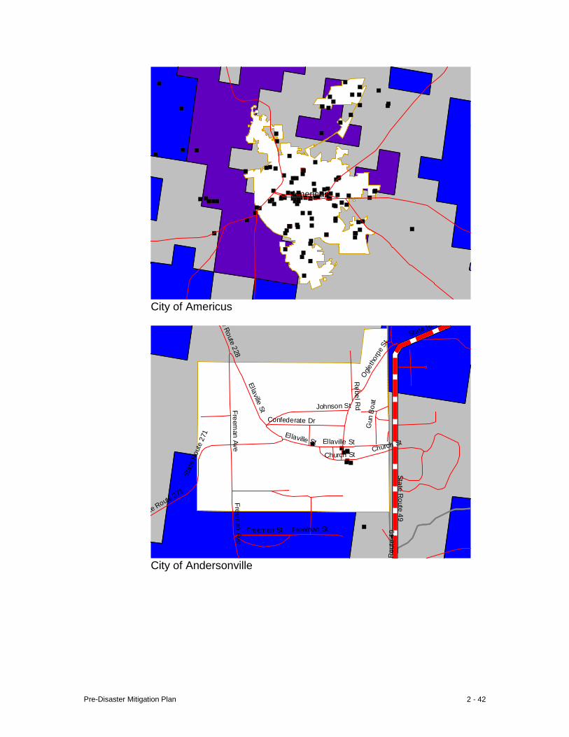
Pre-Disaster Mitigation Plan 2 - 42
Americus
City of Americus
e Route 228
Ellaville St
Confederate Dr
Freeman Ave
Ellaville St Ellaville St
Church St
te Route 271
Freeman St
Freeman Ave
Freeman St
R
oute
49
Ogle
thor
pe S
t
Sta
te R
oute
271
R
ebel Rd
Gun
Boa
t
Church St
Johnson St
State Rout
State Route 49
City of Andersonville
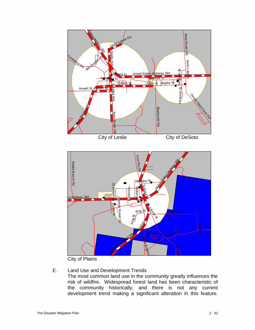
Pre-Disaster Mitigation Plan 2 - 43
States Highway 280
N B
ailey Ave
Stil l Quarte
rs St N
orth Luke St
Seaboard St United States Highway 280
Fer
guso
n St
W Wilson St Railroad StE Allen St Allen St Bagley St
Howell St Howell St
S B
ailey Ave
Fer
guso
n St
Desoto Seed Farm Rd
Sta
te R
oute
118
State Route 195
Blacksmith R
d
State Route 195
Leslie-Lamar Rd
Commerce Rd
City of Leslie City of DeSoto
Cow
Pen Rd
Unit
ed S
tates
High
way 28
0 Hospital St
Woo
dlan
d D
r
es Highway 280
Rabbit B
ranch Rd
Thomas St
Walters S
t
N B
ond St
S Bond St
Bot
sfor
d Rd
Spann Dr Africana Dr
Wise Rd
Bot
sford
Rd
Spann Dr
Thrasher
Plains-Botsford
Carter S
t
Botsford
Rd
Wise
King St
Kin
g St
Brenda Pickett Cir
City of Plains
E. Land Use and Development Trends
The most common land use in the community greatly influences the risk of wildfire. Widespread forest land has been characteristic of the community historically, and there is not any current development trend making a significant alteration in this feature.
Pre-Disaster Mitigation Plan 2 - 44
Implementation of the work plan identified herein will mitigate the potential for wildfires.
F. Multi-Jurisdictional Differences
The physical threat of wildfire is overwhelmingly concentrated in the unincorporated area, but the resulting economic impact of a large event would be felt community-wide. The Georgia Forestry Commission is equipped to be the primary responder to such fires, local fire department response will be triggered when structures are affected. These departments will also serve as backup for Forestry Commission personnel.
G. Summary
Because a large percentage of the unincorporated area is forested, wildfire poses a significant economic threat to the community. Primary responding agency is the Georgia Forestry Commission, with backup support provided by local rural fire departments. The best protection against this threat is education of forest owners, increased use and maintenance of firebreaks, and careful attention to the best management practices for controlled burns.
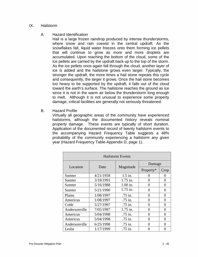
Pre-Disaster Mitigation Plan 2 - 45
IX. Hailstorm
A. Hazard Identification Hail is a large frozen raindrop produced by intense thunderstorms, where snow and rain coexist in the central updraft. As the snowflakes fall, liquid water freezes onto them forming ice pellets that will continue to grow as more and more droplets are accumulated. Upon reaching the bottom of the cloud, some of the ice pellets are carried by the updraft back up to the top of the storm. As the ice pellets once again fall through the cloud, another layer of ice is added and the hailstone grows even larger. Typically, the stronger the updraft, the more times a hail stone repeats this cycle and consequently, the larger it grows. Once the hail stone becomes too heavy to be supported by the updraft, it falls out of the cloud toward the earth’s surface. The hailstone reaches the ground as ice since it is not in the warm air below the thunderstorm long enough to melt. Although it is not unusual to experience some property damage, critical facilities are generally not seriously threatened.
B. Hazard Profile Virtually all geographic areas of the community have experienced hailstorms, although the documented history reveals nominal property damage. These events are typically of short duration. Application of the documented record of twenty hailstorm events to the accompanying Hazard Frequency Table suggests a 48% probability of the community experiencing a hailstorm any given year (Hazard Frequency Table-Appendix D, page 1).
Hailstorm Events
Location Date Magnitude Damage
Property* Crop Sumter 4/21/1958 1.5 in. 0 0 Sumter 3/18/1991 1.75 in. 0 0 Sumter 5/16/1988 1.00 in. 0 0 Sumter 5/21/1990 1.75 in. 0 0 Plains 1/08/1997 .75 in. 0 0 Americus 1/08/1997 .75 in. 0 0 Cobb 5/27/1997 .75 in. 0 0 Andersonville 7/05/1997 1.75 in. 0 0 Americus 5/04/1998 .75 in. 0 0 Americus 5/04/1998 .75 in. 0 0 Andersonville 6/25/1998 .75 in. 0 0 Leslie 1/17/1999 .75 in. 0 0
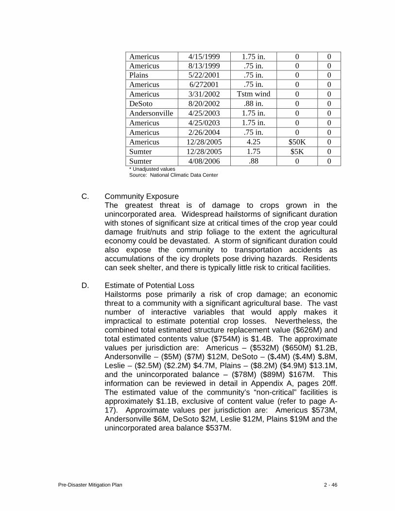
Pre-Disaster Mitigation Plan 2 - 46
C. Community Exposure
The greatest threat is of damage to crops grown in the unincorporated area. Widespread hailstorms of significant duration with stones of significant size at critical times of the crop year could damage fruit/nuts and strip foliage to the extent the agricultural economy could be devastated. A storm of significant duration could also expose the community to transportation accidents as accumulations of the icy droplets pose driving hazards. Residents can seek shelter, and there is typically little risk to critical facilities.
D. Estimate of Potential Loss
Hailstorms pose primarily a risk of crop damage; an economic threat to a community with a significant agricultural base. The vast number of interactive variables that would apply makes it impractical to estimate potential crop losses. Nevertheless, the combined total estimated structure replacement value ($626M) and total estimated contents value ($754M) is $1.4B. The approximate values per jurisdiction are: Americus – ($532M) ($650M) $1.2B, Andersonville – ($5M) ($7M) $12M, DeSoto – ($.4M) ($.4M) $.8M, Leslie – ($2.5M) ($2.2M) $4.7M, Plains – ($8.2M) ($4.9M) $13.1M, and the unincorporated balance – ($78M) ($89M) $167M. This information can be reviewed in detail in Appendix A, pages 20ff. The estimated value of the community’s “non-critical” facilities is approximately $1.1B, exclusive of content value (refer to page A-17). Approximate values per jurisdiction are: Americus $573M, Andersonville $6M, DeSoto $2M, Leslie $12M, Plains $19M and the unincorporated area balance $537M.
Americus 4/15/1999 1.75 in. 0 0 Americus 8/13/1999 .75 in. 0 0 Plains 5/22/2001 .75 in. 0 0 Americus 6/272001 .75 in. 0 0 Americus 3/31/2002 Tstm wind 0 0 DeSoto 8/20/2002 .88 in. 0 0 Andersonville 4/25/2003 1.75 in. 0 0 Americus 4/25/0203 1.75 in. 0 0 Americus 2/26/2004 .75 in. 0 0 Americus 12/28/2005 4.25 $50K 0 Sumter 12/28/2005 1.75 $5K 0 Sumter 4/08/2006 .88 0 0 * Unadjusted values Source: National Climatic Data Center
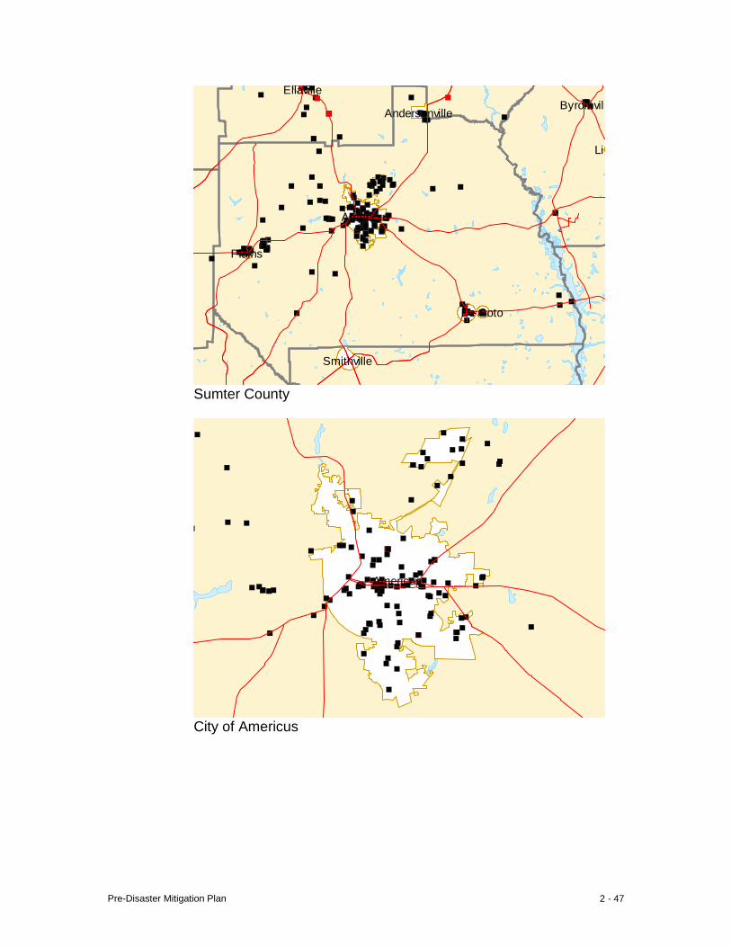
Pre-Disaster Mitigation Plan 2 - 47
Byromvill
Lil
Smithville
Ellaville
Americus
Andersonville
De Soto
Plains
Sumter County
Americus
City of Americus

Pre-Disaster Mitigation Plan 2 - 48
e Route 228
Ellaville St
Confederate Dr
Freeman Ave
Ellaville St Ellaville St
Church St
te Route 271
Freeman St
Freeman Ave
Freeman St
R
oute
49
Ogle
thor
pe S
t
Sta
te R
oute
271
R
ebel Rd
Gun
Boa
t
Church St
Johnson St
State Rout
State Route 49
City of Andersonville
States Highway 280
N B
ailey Ave
Stil l Quarte
rs St N
orth Luke St
Seaboard St United States Highway 280
Fer
guso
n St
W Wilson St Railroad StE Allen St Allen St Bagley St
Howell St Howell St
S B
ailey Ave
Fer
guso
n St
Desoto Seed Farm Rd
Sta
te R
oute
118
State Route 195
Blacksmith R
d
State Route 195
Leslie-Lamar Rd
Commerce Rd
City of Leslie City of DeSoto
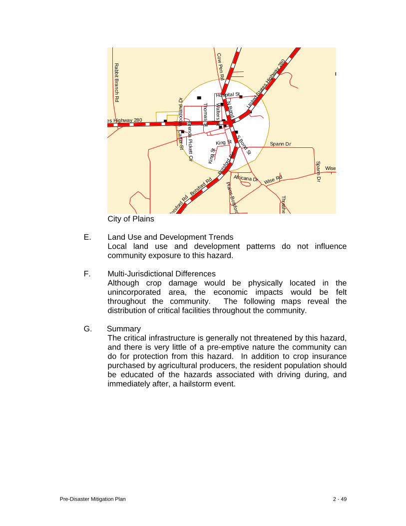
Pre-Disaster Mitigation Plan 2 - 49
Cow
Pen Rd
Unit
ed S
tates
High
way 28
0
Hospital St
Woo
dlan
d D
r
es Highway 280
Rabbit B
ranch Rd
Thomas St
Walters S
t
N B
ond St
S Bond St
Bot
sfor
d Rd
Spann Dr Africana Dr
Wise Rd
Bot
sford
Rd
Spann Dr
Thrasher
Plains-Botsford
Carter S
t
Botsford
Rd
Wise
King St
Kin
g St
Brenda Pickett Cir
City of Plains
E. Land Use and Development Trends
Local land use and development patterns do not influence community exposure to this hazard.
F. Multi-Jurisdictional Differences
Although crop damage would be physically located in the unincorporated area, the economic impacts would be felt throughout the community. The following maps reveal the distribution of critical facilities throughout the community.
G. Summary
The critical infrastructure is generally not threatened by this hazard, and there is very little of a pre-emptive nature the community can do for protection from this hazard. In addition to crop insurance purchased by agricultural producers, the resident population should be educated of the hazards associated with driving during, and immediately after, a hailstorm event.
Pre-Disaster Mitigation Plan 2 - 50
X. Dam Failure
A. Hazard Identification Dam failure is typically the result of a physical weakness in dam structure, or inundation by flood waters which wash away earthen material flanking the dam which houses flood gates used to regulate the upstream lake or pool area. The most common failure results from inundation by flood waters. Flooding which precipitates dam failure can cause damage and destruction to properties fronting the lake, and breach of the dam can destroy downstream development and create economic hardship.
B. Hazard Profile
The community’s largest flood event resulted from Tropical Storm Alberto in 1994 which, between July 3 and July 7, doused semi-saturated soils with ±23” of rain; almost half the community’s annual average rainfall. Thirty-five dams were seriously damaged or destroyed as a result of the flooding. Since these dam breaches were caused by a single weather event (tropical storm), they are treated as a single event for the purpose of projecting the probability of recurrence. Based on this historic profile, the community has an approximate 8% probability of dam failure any given year (Hazard Frequency Table-Appendix D, page 1).
C. Community Exposure
There are scores of earthen dams in the community, and the full limit of exposure cannot be determined because of the absence of mapping which could reveal the level of development in the dam “shadow”. Such mapping would be useful in revealing the degree of community exposure, land use planning and protection through zoning ordinance revision.
D. Estimate of Potential Loss
In the absence of an identifiable hazard area boundary, i.e. dam “shadow”, estimation of the potential loss would be little more than a guess. None of the 210 critical facilities are believed to be located in what is assumed to be a dam “shadow”. Nevertheless, the combined total estimated structure replacement value ($626M) and total estimated contents value ($754M) is $1.4B. The approximate values per jurisdiction are: Americus – ($532M) ($650M) $1.2B, Andersonville – ($5M) ($7M) $12M, DeSoto – ($.4M) ($.4M) $.8M, Leslie – ($2.5M) ($2.2M) $4.7M, Plains – ($8.2M) ($4.9M) $13.1M, and the unincorporated balance – ($78M) ($89M) $167M. This information can be reviewed in detail in Appendix A, pages 20ff. The estimated value of the community’s “non-critical” facilities is approximately $1.1B, exclusive of content
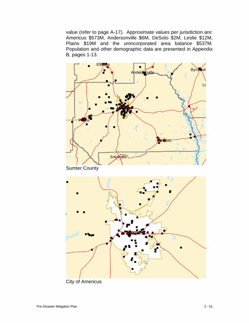
Pre-Disaster Mitigation Plan 2 - 51
value (refer to page A-17). Approximate values per jurisdiction are: Americus $573M, Andersonville $6M, DeSoto $2M, Leslie $12M, Plains $19M and the unincorporated area balance $537M. Population and other demographic data are presented in Appendix B, pages 1-13.
Byromvill
Lil
Smithville
Ellaville
Americus
Andersonville
De Soto
Plains
Sumter County
Americus
City of Americus

Pre-Disaster Mitigation Plan 2 - 52
e Route 228
Ellaville St
Confederate Dr
Freeman Ave
Ellaville St Ellaville St
Church St
te Route 271
Freeman St
Freeman Ave
Freeman St
R
oute
49
Ogle
thor
pe S
t
Sta
te R
oute
271
R
ebel Rd
Gun
Boa
t
Church St
Johnson St
State Rout
State Route 49
City of Andersonville
States Highway 280
N B
ailey Ave
Stil l Quarte
rs St N
orth Luke St
Seaboard St United States Highway 280
Fer
guso
n St
W Wilson St Railroad StE Allen St Allen St Bagley St
Howell St Howell St
S B
ailey Ave
Fer
guso
n St
Desoto Seed Farm Rd
Sta
te R
oute
118
State Route 195
Blacksmith R
d
State Route 195
Leslie-Lamar Rd
Commerce Rd
City of Leslie City of DeSoto
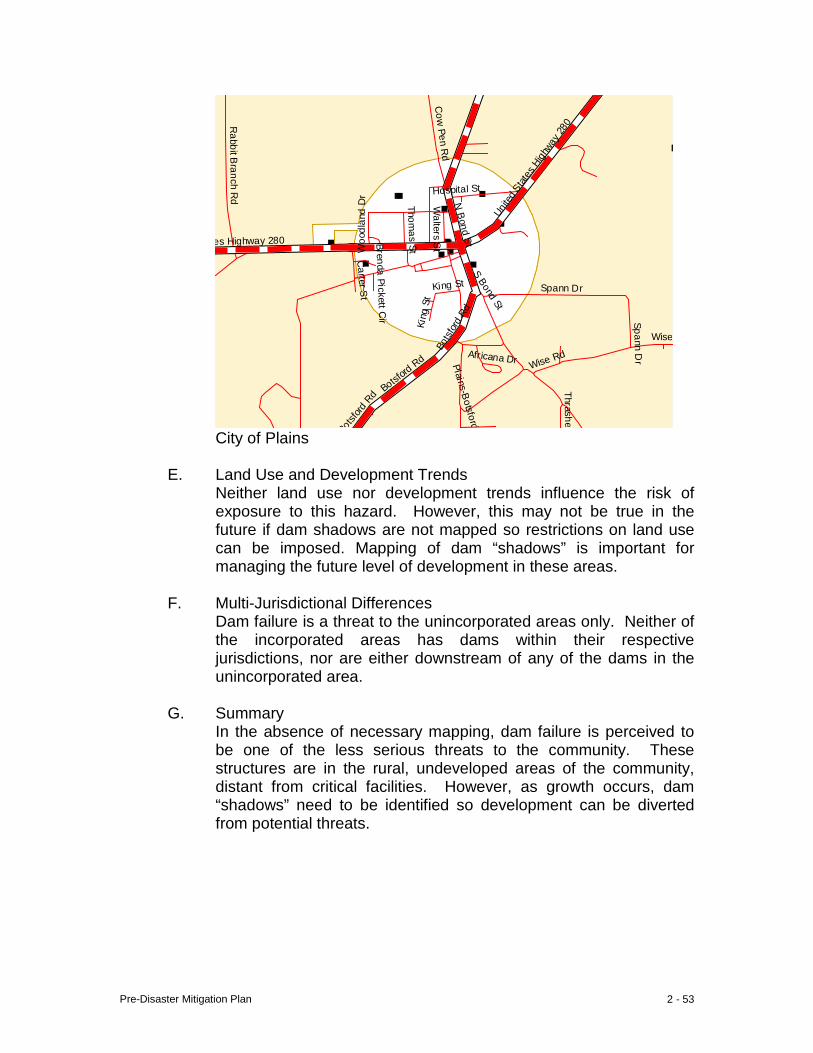
Pre-Disaster Mitigation Plan 2 - 53
Cow
Pen Rd
Unit
ed S
tates
High
way 28
0
Hospital St
Woo
dlan
d D
r
es Highway 280
Rabbit B
ranch Rd
Thomas St
Walters S
t
N B
ond St
S Bond St
Bot
sfor
d Rd
Spann Dr Africana Dr
Wise Rd
Bot
sford
Rd
Spann Dr
Thrasher
Plains-Botsford
Carter S
t
Botsford
Rd
Wise
King St
Kin
g St
Brenda Pickett Cir
City of Plains
E. Land Use and Development Trends Neither land use nor development trends influence the risk of exposure to this hazard. However, this may not be true in the future if dam shadows are not mapped so restrictions on land use can be imposed. Mapping of dam “shadows” is important for managing the future level of development in these areas.
F. Multi-Jurisdictional Differences Dam failure is a threat to the unincorporated areas only. Neither of the incorporated areas has dams within their respective jurisdictions, nor are either downstream of any of the dams in the unincorporated area.
G. Summary In the absence of necessary mapping, dam failure is perceived to be one of the less serious threats to the community. These structures are in the rural, undeveloped areas of the community, distant from critical facilities. However, as growth occurs, dam “shadows” need to be identified so development can be diverted from potential threats.
Pre-Disaster Mitigation Plan Sumter County
Chapter 3 - Technological Hazard, Risk and Vulnerability (HRV) Summary I Transportation Accident 1 II Hazardous Materials Release (fixed site) 7 III Terrorism 12 IV Radiological Event 16 V Animal/Crop Disease 21 VI Groundwater Contamination 26 VII Civil Disturbance 31
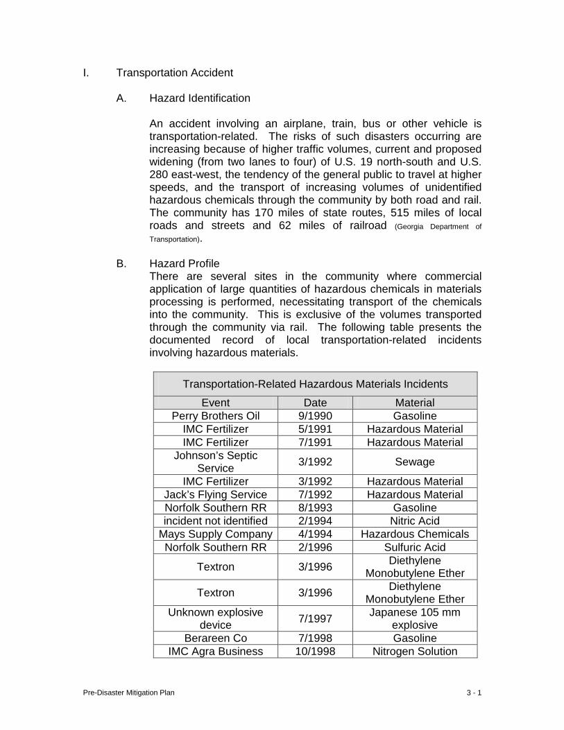
Pre-Disaster Mitigation Plan 3 - 1
I. Transportation Accident
A. Hazard Identification
An accident involving an airplane, train, bus or other vehicle is transportation-related. The risks of such disasters occurring are increasing because of higher traffic volumes, current and proposed widening (from two lanes to four) of U.S. 19 north-south and U.S. 280 east-west, the tendency of the general public to travel at higher speeds, and the transport of increasing volumes of unidentified hazardous chemicals through the community by both road and rail. The community has 170 miles of state routes, 515 miles of local roads and streets and 62 miles of railroad (Georgia Department of
Transportation).
B. Hazard Profile There are several sites in the community where commercial application of large quantities of hazardous chemicals in materials processing is performed, necessitating transport of the chemicals into the community. This is exclusive of the volumes transported through the community via rail. The following table presents the documented record of local transportation-related incidents involving hazardous materials.
Transportation-Related Hazardous Materials Incidents
Event Date Material Perry Brothers Oil 9/1990 Gasoline
IMC Fertilizer 5/1991 Hazardous Material IMC Fertilizer 7/1991 Hazardous Material
Johnson’s Septic Service 3/1992 Sewage
IMC Fertilizer 3/1992 Hazardous Material Jack’s Flying Service 7/1992 Hazardous Material Norfolk Southern RR 8/1993 Gasoline incident not identified 2/1994 Nitric Acid
Mays Supply Company 4/1994 Hazardous Chemicals Norfolk Southern RR 2/1996 Sulfuric Acid
Textron 3/1996 Diethylene Monobutylene Ether
Textron 3/1996 Diethylene Monobutylene Ether
Unknown explosive device 7/1997 Japanese 105 mm
explosive Berareen Co 7/1998 Gasoline
IMC Agra Business 10/1998 Nitrogen Solution
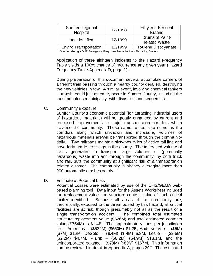
Pre-Disaster Mitigation Plan 3 - 2
Sumter Regional Hospital 12/1998 Ethylene Bensent
Butane
not identified 12/1999 Drums of Paint- related Waste
Enviro Transportation 10/1999 Toulene Disocyanate Source: Georgia DNR Emergency Response Team, Incident Reporting System
Application of these eighteen incidents to the Hazard Frequency Table yields a 100% chance of recurrence any given year (Hazard Frequency Table-Appendix D, page 1).
During preparation of this document several automobile carriers of a freight train passing through a nearby county derailed, destroying the new vehicles in tow. A similar event, involving chemical tankers in transit, could just as easily occur in Sumter County, including the most populous municipality, with disastrous consequences.
C. Community Exposure
Sumter County’s economic potential (for attracting industrial users of hazardous materials) will be greatly enhanced by current and proposed improvements to major transportation corridors which traverse the community. These same routes also serve as the corridors along which unknown and increasing volumes of hazardous materials are/will be transported through the community daily. Two railroads maintain sixty-two miles of active rail line and have forty grade crossings in the county. The increased volume of traffic generated to transport large volumes of (potentially hazardous) waste into and through the community, by both truck and rail, puts the community at significant risk of a transportation related disaster. The community is already averaging more than 900 automobile crashes yearly.
D. Estimate of Potential Loss
Potential Losses were estimated by use of the OHS/GEMA web-based planning tool. Data input for the Assets Worksheet included the replacement value and structure content value of each critical facility identified. Because all areas of the community are, theoretically, exposed to the threat posed by this hazard, all critical facilities are at risk, though presumably not all as the result of a single transportation accident. The combined total estimated structure replacement value ($626M) and total estimated contents value ($754M) is $1.4B. The approximate values per jurisdiction are: Americus – ($532M) ($650M) $1.2B, Andersonville – ($5M) ($7M) $12M, DeSoto – ($.4M) ($.4M) $.8M, Leslie – ($2.5M) ($2.2M) $4.7M, Plains – ($8.2M) ($4.9M) $13.1M, and the unincorporated balance – ($78M) ($89M) $167M. This information can be reviewed in detail in Appendix A, pages 20ff. The estimated
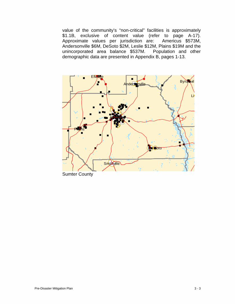
Pre-Disaster Mitigation Plan 3 - 3
value of the community’s “non-critical” facilities is approximately $1.1B, exclusive of content value (refer to page A-17). Approximate values per jurisdiction are: Americus $573M, Andersonville $6M, DeSoto $2M, Leslie $12M, Plains $19M and the unincorporated area balance $537M. Population and other demographic data are presented in Appendix B, pages 1-13.
Byromvill
Lil
Smithville
Ellaville
Americus
Andersonville
De Soto
Plains
Sumter County
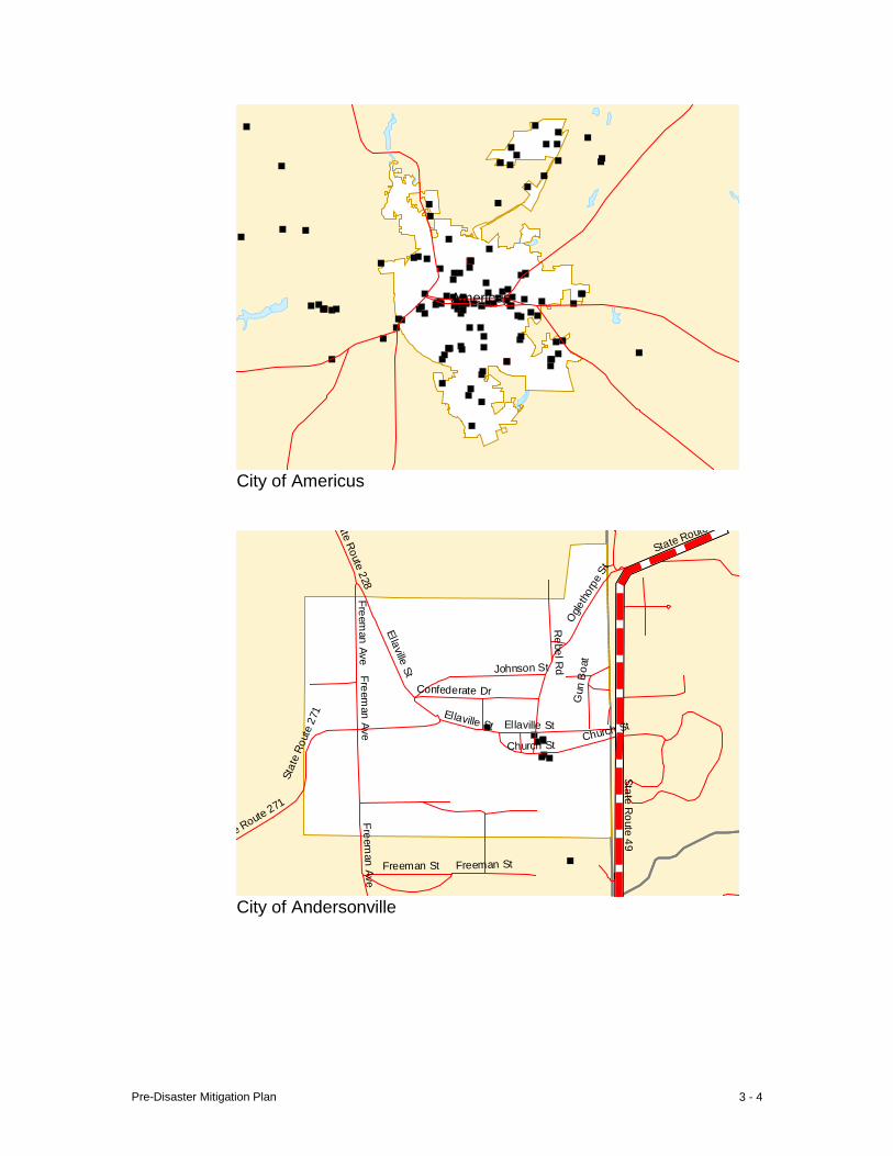
Pre-Disaster Mitigation Plan 3 - 4
Americus
City of Americus
ate Route 228
Ellaville St
Confederate Dr
Freeman Ave
Ellaville St Ellaville St
Church St
e Route 271
Freeman St
Freeman Ave
Freeman St
Ogle
thor
pe S
t
Freeman Ave
Sta
te R
oute
271
Rebel R
d
Gun
Boa
t
Church St
Johnson St
State Route
State Route 49
City of Andersonville
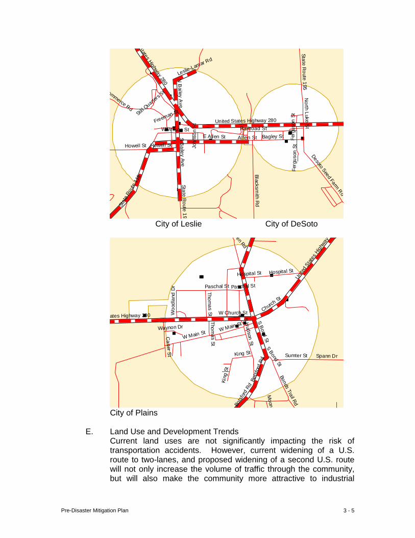
Pre-Disaster Mitigation Plan 3 - 5
States Highway 280
N B
ailey Ave
Stil l Quarte
rs St N
orth Luke St
Freeman St
United States Highway 280
Fer
guso
n St
W Wilson St Railroad St
Joh
nson
St
E Allen St Allen St Bagley St
Howell St Howell St
S B
ailey Ave
Fer
guso
n St
Desoto Seed Farm Rd
Sta
te R
oute
118
State Route 195
Blacksmith R
d
State Route 195
Leslie-Lamar Rd
Commerce Rd
City of Leslie City of DeSoto
Pen Rd
Unit
ed S
tates
High
way
Hospital St
Paschal St Paschal St
Woo
dlan
d D
r
Thomas St W Church St Churc
h St
W Main St Waynon Dr
S H
udson StS Bond St
S Bond St
Bot
sfor
d Rd
Bot
sfor
d Rd
Bonds Trail Rd
Moon
Spann Dr
Thomas St
Carter S
t Sumter St
King St
Kin
g St
W Main St
ates Highway 280
Hospital St
City of Plains
E. Land Use and Development Trends Current land uses are not significantly impacting the risk of transportation accidents. However, current widening of a U.S. route to two-lanes, and proposed widening of a second U.S. route will not only increase the volume of traffic through the community, but will also make the community more attractive to industrial
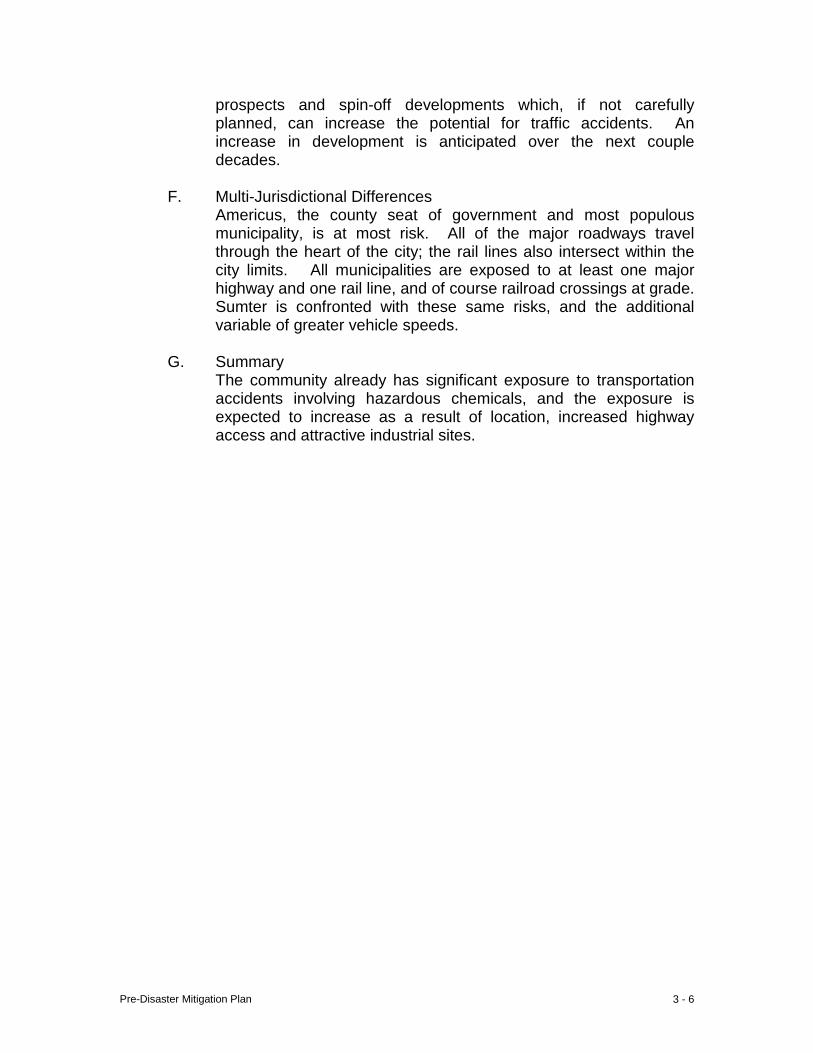
Pre-Disaster Mitigation Plan 3 - 6
prospects and spin-off developments which, if not carefully planned, can increase the potential for traffic accidents. An increase in development is anticipated over the next couple decades.
F. Multi-Jurisdictional Differences
Americus, the county seat of government and most populous municipality, is at most risk. All of the major roadways travel through the heart of the city; the rail lines also intersect within the city limits. All municipalities are exposed to at least one major highway and one rail line, and of course railroad crossings at grade. Sumter is confronted with these same risks, and the additional variable of greater vehicle speeds.
G. Summary
The community already has significant exposure to transportation accidents involving hazardous chemicals, and the exposure is expected to increase as a result of location, increased highway access and attractive industrial sites.
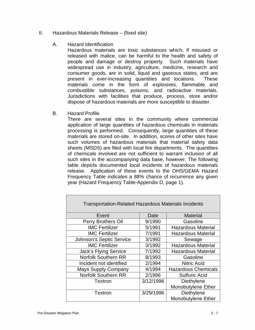
Pre-Disaster Mitigation Plan 3 - 7
II. Hazardous Materials Release – (fixed site)
A. Hazard Identification Hazardous materials are toxic substances which, if misused or released with malice, can be harmful to the health and safety of people and damage or destroy property. Such materials have widespread use in industry, agriculture, medicine, research and consumer goods, are in solid, liquid and gaseous states, and are present in ever-increasing quantities and locations. These materials come in the form of explosives, flammable and combustible substances, poisons, and radioactive materials. Jurisdictions with facilities that produce, process, store and/or dispose of hazardous materials are more susceptible to disaster.
B. Hazard Profile
There are several sites in the community where commercial application of large quantities of hazardous chemicals in materials processing is performed. Consequently, large quantities of these materials are stored on-site. In addition, scores of other sites have such volumes of hazardous materials that material safety data sheets (MSDS) are filed with local fire departments. The quantities of chemicals involved are not sufficient to warrant inclusion of all such sites in the accompanying data base, however. The following table depicts documented local incidents of hazardous materials release. Application of these events to the OHS/GEMA Hazard Frequency Table indicates a 88% chance of recurrence any given year (Hazard Frequency Table-Appendix D, page 1).
Transportation-Related Hazardous Materials Incidents
Event Date Material
Perry Brothers Oil 9/1990 Gasoline IMC Fertilizer 5/1991 Hazardous Material IMC Fertilizer 7/1991 Hazardous Material
Johnson’s Septic Service 3/1992 Sewage IMC Fertilizer 3/1992 Hazardous Material
Jack’s Flying Service 7/1992 Hazardous Material Norfolk Southern RR 8/1993 Gasoline Incident not identified 2/1994 Nitric Acid
Mays Supply Company 4/1994 Hazardous Chemicals Norfolk Southern RR 2/1996 Sulfuric Acid
Textron 3/12/1996 Diethylene Monobutylene Ether
Textron 3/29/1996 Diethylene Monobutylene Ether
Pre-Disaster Mitigation Plan 3 - 8
C. Community Exposure
Despite local industry’s adherence to stringent OSHA regulations, heavy commercial utilization of hazardous chemicals poses a significant risk to the community. Furthermore; collectively, these employers have a significant impact on strength of the local economy.
D. Estimate of Potential Loss Potential Losses were estimated by use of the OHS/GEMA web-based planning tool. Data input for the Assets Worksheet included the replacement value and structure contents value of each of 210 critical facilities identified. The Loss Estimation Table automatically computed an aggregate loss at 100% ($1.4B) of the combined total estimated structure replacement value ($626M) and total estimated contents value ($754M). The approximate values per jurisdiction are: Americus – ($532M) ($650M) $1.2B, Andersonville – ($5M) ($7M) $12M, DeSoto – ($.4M) ($.4M) $.8M, Leslie – ($2.5M) ($2.2M) $4.7M, Plains – ($8.2M) ($4.9M) $13.1M, and the unincorporated balance – ($78M) ($89M) $167M. This information can be reviewed in detail in Appendix A, pages 20ff. The estimated value of the community’s “non-critical” facilities is approximately $1.1B, exclusive of content value (refer to page A-17). Approximate values per jurisdiction are: Americus $573M, Andersonville $6M, DeSoto $2M, Leslie $12M, Plains $19M and the unincorporated area balance $537M. Population and other demographic data are presented in Appendix B, pages 1-13.
IMC Agra Business 10/1998 Nitrogen Solution Sumter Regional Hospital
(suspected) 12/1998 Ethylene Bensent
Butane Not identified 12/1998 Drums of Paint-
related Waste Source: Department of Natural Resources Emergency Response Team, Incident Reporting System
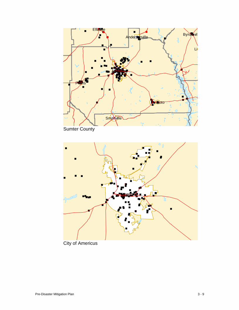
Pre-Disaster Mitigation Plan 3 - 9
Byromvill
Lil
Smithville
Ellaville
Americus
Andersonville
De Soto
Plains
Sumter County
Americus
City of Americus

Pre-Disaster Mitigation Plan 3 - 10
ate Route 228
Ellaville St
Confederate Dr
Freeman Ave
Ellaville St Ellaville St
Church St
e Route 271
Freeman St
Freeman Ave
Freeman St
Ogle
thor
pe S
t
Freeman Ave
Sta
te R
oute
271
Rebel R
d
Gun
Boa
t
Church St
Johnson St
State Route
State Route 49
City of Andersonville
States Highway 280
N B
ailey Ave
Stil l Quarte
rs St N
orth Luke St
Freeman St
United States Highway 280
Fer
guso
n St
W Wilson St Railroad St
Joh
nson
St
E Allen St Allen St Bagley St
Howell St Howell St
S B
ailey Ave
Fer
guso
n St
Desoto Seed Farm Rd
Sta
te R
oute
118
State Route 195
Blacksmith R
d
State Route 195
Leslie-Lamar Rd
Commerce Rd
City of Leslie City of DeSoto
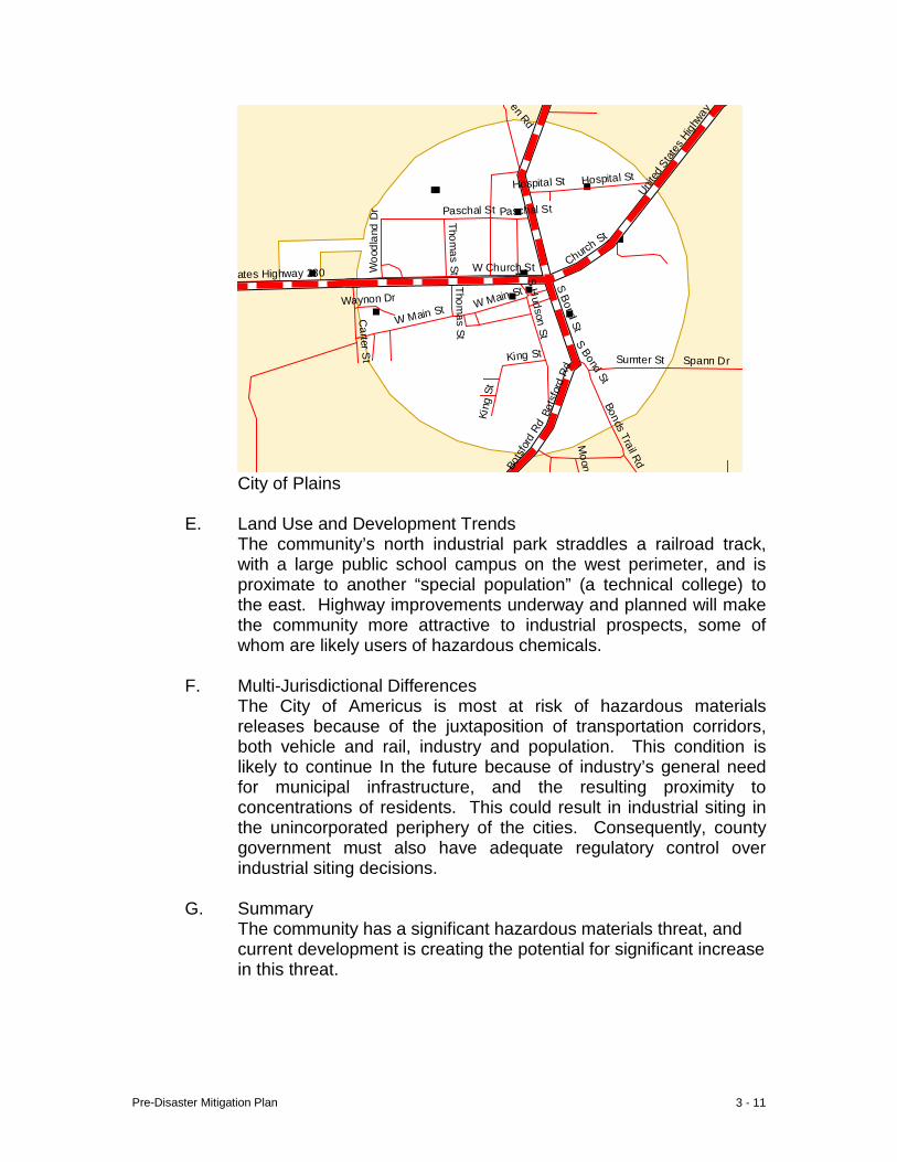
Pre-Disaster Mitigation Plan 3 - 11
Pen Rd
Unit
ed S
tates
High
way
Hospital St
Paschal St Paschal St
Woo
dlan
d D
r
Thomas St W Church St Churc
h St
W Main St Waynon Dr
S H
udson StS Bond St
S Bond St
Bot
sfor
d Rd
Bot
sfor
d Rd
Bonds Trail Rd
Moon
Spann Dr
Thomas St
Carter S
t Sumter St
King St
Kin
g St
W Main St
ates Highway 280
Hospital St
City of Plains
E. Land Use and Development Trends The community’s north industrial park straddles a railroad track, with a large public school campus on the west perimeter, and is proximate to another “special population” (a technical college) to the east. Highway improvements underway and planned will make the community more attractive to industrial prospects, some of whom are likely users of hazardous chemicals.
F. Multi-Jurisdictional Differences
The City of Americus is most at risk of hazardous materials releases because of the juxtaposition of transportation corridors, both vehicle and rail, industry and population. This condition is likely to continue In the future because of industry’s general need for municipal infrastructure, and the resulting proximity to concentrations of residents. This could result in industrial siting in the unincorporated periphery of the cities. Consequently, county government must also have adequate regulatory control over industrial siting decisions.
G. Summary The community has a significant hazardous materials threat, and current development is creating the potential for significant increase in this threat.
Pre-Disaster Mitigation Plan 3 - 12
III. Terrorism
A Hazard Identification Terrorism is the use of violence to elicit fear and effect change, and is often based on a political agenda or national cause. Terrorists’ methods and weapons are increasingly varied; taking innocent civilians hostage at gun point, plotting to assassinate prominent figures, detonation of bombs, utilization of chemical and/or biological agents in populated areas or against critical infrastructure, arson/incendiary attack or other armed attack, cyber-terrorism, agro-terrorism, radiological agents or nuclear bomb. Targets vary from the high profile to sites with little or no security.
B. Hazard Profile
The community has, to date, been spared a direct terrorist attack. While the probability of a local incident is not known, technological advancements and improved accessibility expose the community to increased risk of terrorist attack.
C. Community Exposure
Sumter County is one of the many rural communities that could be considered a low risk for terrorist attack because of the small population base and infrastructure. However, the community is becoming much more accessible, not only electronically but by highway, is proximate to Atlanta and one of the nation’s largest and increasingly important military bases (Fort Benning), and residents tend to be more trusting and less suspicious because of the small town setting. These factors, among others, increase community exposure, especially to an agro-terrorist attack.
D. Estimate of Potential Loss It is not known which local critical facility(ies) would be the likely target of a terrorist attack. It is not believed any one or a series of attacks would likely destroy the entire critical facility infrastructure. Nevertheless; potential losses of the complete inventory were estimated by use of the OHS/GEMA web-based planning tool. Data input for the Assets Worksheet included the replacement value and structure content value of each of 210 critical facilities identified. The combined total estimated structure replacement value ($626M) and total estimated contents value ($754M) is $1.4B. The approximate values per jurisdiction are: Americus – ($532M) ($650M) $1.2B, Andersonville – ($5M) ($7M) $12M, DeSoto – ($.4M) ($.4M) $.8M, Leslie – ($2.5M) ($2.2M) $4.7M, Plains – ($8.2M) ($4.9M) $13.1M, and the unincorporated balance – ($78M) ($89M) $167M. This information can be reviewed in detail in Appendix A, pages 20ff. The estimated value of the
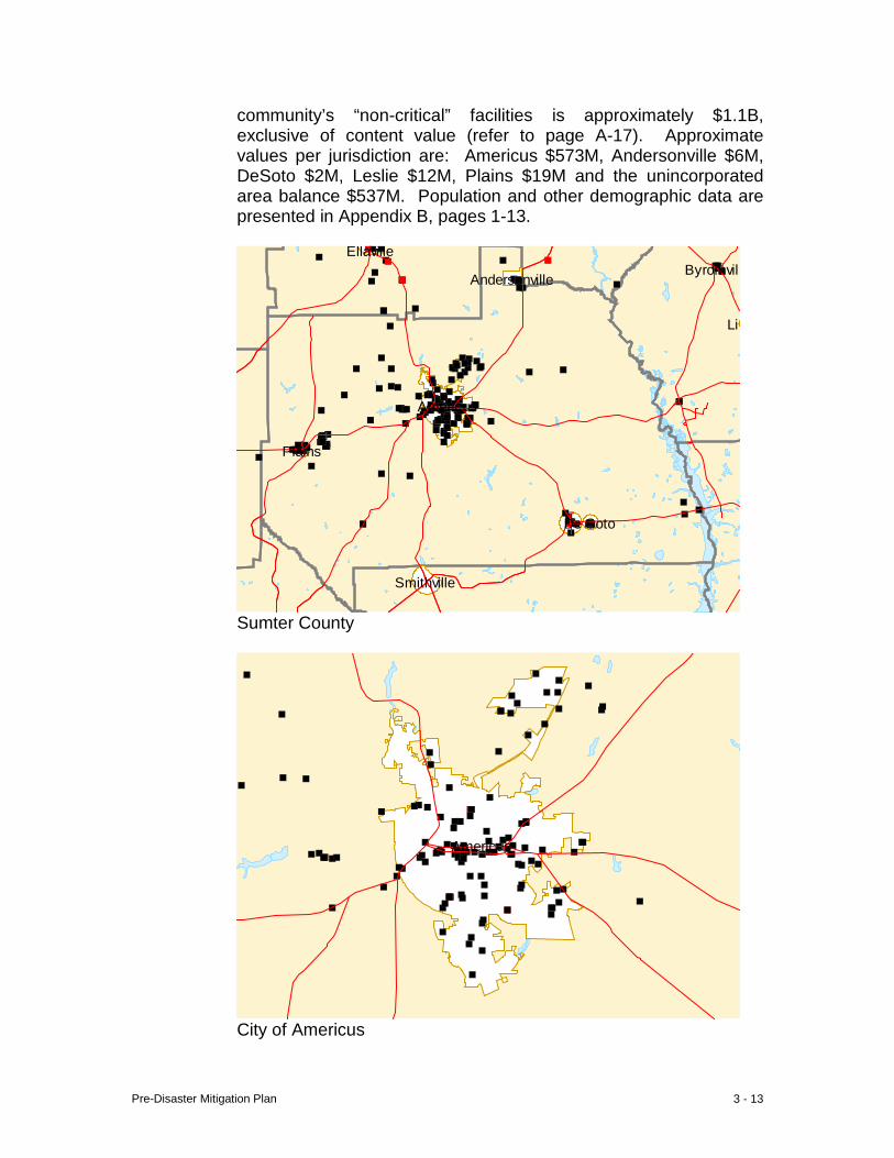
Pre-Disaster Mitigation Plan 3 - 13
community’s “non-critical” facilities is approximately $1.1B, exclusive of content value (refer to page A-17). Approximate values per jurisdiction are: Americus $573M, Andersonville $6M, DeSoto $2M, Leslie $12M, Plains $19M and the unincorporated area balance $537M. Population and other demographic data are presented in Appendix B, pages 1-13.
Byromvill
Lil
Smithville
Ellaville
Americus
Andersonville
De Soto
Plains
Sumter County
Americus
City of Americus
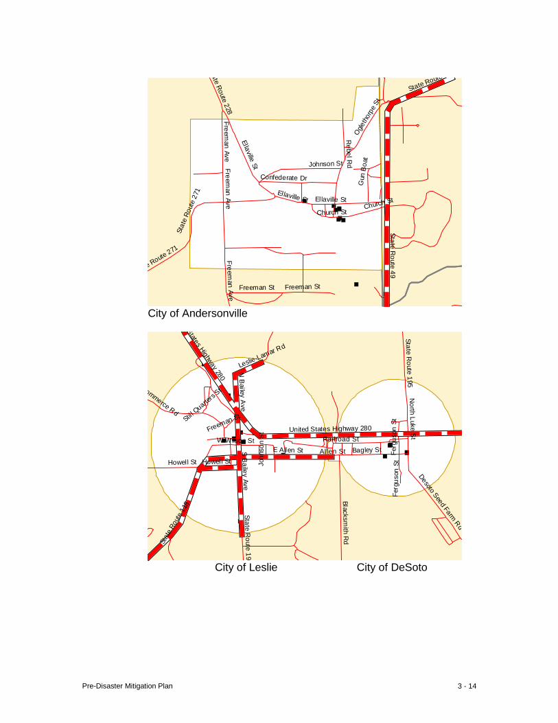
Pre-Disaster Mitigation Plan 3 - 14
ate Route 228
Ellaville St
Confederate Dr
Freeman Ave
Ellaville St Ellaville St
Church St
e Route 271
Freeman St
Freeman Ave
Freeman St
Ogle
thor
pe S
t
Freeman Ave
Sta
te R
oute
271
Rebel R
d
Gun
Boa
t
Church St
Johnson St
State Route
State Route 49
City of Andersonville
States Highway 280
N B
ailey Ave
Stil l Quarte
rs St N
orth Luke St
Freeman St
United States Highway 280
Fer
guso
n St
W Wilson St Railroad St
Joh
nson
St
E Allen St Allen St Bagley St
Howell St Howell St
S B
ailey Ave
Fer
guso
n St
Desoto Seed Farm Rd
Sta
te R
oute
118
State Route 195
Blacksmith R
d
State Route 195
Leslie-Lamar Rd
Commerce Rd
City of Leslie City of DeSoto
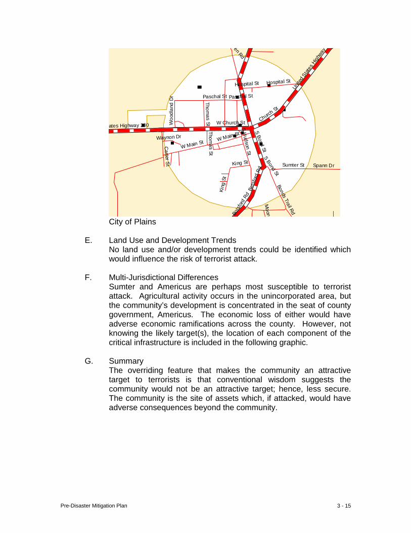
Pre-Disaster Mitigation Plan 3 - 15
Pen Rd
Unit
ed S
tates
High
way
Hospital St
Paschal St Paschal St
Woo
dlan
d D
r
Thomas St W Church St Churc
h St
W Main St Waynon Dr
S H
udson StS Bond St
S Bond St
Bot
sfor
d Rd
Bot
sfor
d Rd
Bonds Trail Rd
Moon
Spann Dr
Thomas St
Carter S
t Sumter St
King St
Kin
g St
W Main St
ates Highway 280
Hospital St
City of Plains
E. Land Use and Development Trends
No land use and/or development trends could be identified which would influence the risk of terrorist attack.
F. Multi-Jurisdictional Differences Sumter and Americus are perhaps most susceptible to terrorist attack. Agricultural activity occurs in the unincorporated area, but the community’s development is concentrated in the seat of county government, Americus. The economic loss of either would have adverse economic ramifications across the county. However, not knowing the likely target(s), the location of each component of the critical infrastructure is included in the following graphic.
G. Summary The overriding feature that makes the community an attractive target to terrorists is that conventional wisdom suggests the community would not be an attractive target; hence, less secure. The community is the site of assets which, if attacked, would have adverse consequences beyond the community.
Pre-Disaster Mitigation Plan 3 - 16
IV. Radiological
A. Hazard Identification A radiological accident is an event that involves the release of potentially dangerous radioactive materials into the environment. This release is usually in the form of a cloud or “plume” and could affect the health and safety of anyone in its path. Radiological accidents can occur anywhere that radioactive materials are used, stored, or transported. Nuclear power plants, transport of radiological materials, and disposal of radioactive waste all pose risks. However, operations of facilities and the transport and disposal of radioactive waste are closely regulated by a variety of federal and local organizations.
B. Hazard Profile
The community has not had any known exposure to radioactive material. However, it is known hazardous medical material is transported in the community because of the presence of a regional hospital.
C. Community Exposure
The nuclear industry utilizes two emergency planning zones (EPZs) around each nuclear power plant to develop a protective strategy for implementation in the event of radiological exposure from a nuclear power plant. The plume exposure pathway EPZ has a radius of about 10 miles from the reactor. Predetermined protection action plans for this EPZ are designed to avoid or reduce dose from potential exposure of radioactive materials and include sheltering, evacuation, and the use of potassium iodide where appropriate. The ingestion exposure pathway EPZ has a radius of about 50 miles from the reactor. Predetermined protection action plans for this EPZ are designed to avoid or reduce dose from potential ingestion of radioactive materials and include a ban of contaminated food and water. The community is approximately one hundred linear miles from the nearest nuclear power plant. The community is exposed to this hazard because of its location of major transportation corridors, and the presence of radioactive medical material.
D. Estimate of Potential Loss
No estimate is made here of the scale of a potential radiological event and the resulting impact on the critical facility infrastructure. Potential losses of the complete inventory were estimated by use of the OHS/GEMA web-based planning tool. Data input for the Assets Worksheet included the replacement value and structure content value of each critical facility identified. The combined total
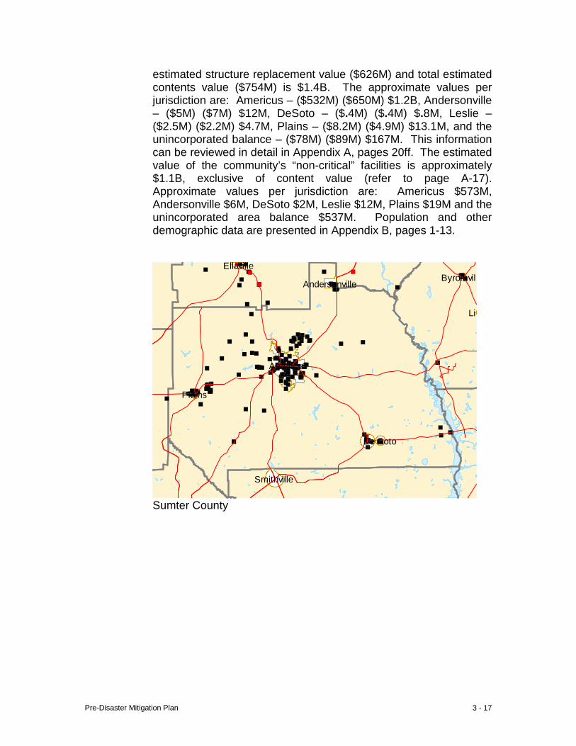
Pre-Disaster Mitigation Plan 3 - 17
estimated structure replacement value ($626M) and total estimated contents value ($754M) is $1.4B. The approximate values per jurisdiction are: Americus – ($532M) ($650M) $1.2B, Andersonville – ($5M) ($7M) $12M, DeSoto – ($.4M) ($.4M) $.8M, Leslie – ($2.5M) ($2.2M) $4.7M, Plains – ($8.2M) ($4.9M) $13.1M, and the unincorporated balance – ($78M) ($89M) $167M. This information can be reviewed in detail in Appendix A, pages 20ff. The estimated value of the community’s “non-critical” facilities is approximately $1.1B, exclusive of content value (refer to page A-17). Approximate values per jurisdiction are: Americus $573M, Andersonville $6M, DeSoto $2M, Leslie $12M, Plains $19M and the unincorporated area balance $537M. Population and other demographic data are presented in Appendix B, pages 1-13.
Byromvill
Lil
Smithville
Ellaville
Americus
Andersonville
De Soto
Plains
Sumter County

Pre-Disaster Mitigation Plan 3 - 18
Americus
City of Americus
ate Route 228
Ellaville St
Confederate Dr
Freeman Ave
Ellaville St Ellaville St
Church St
e Route 271
Freeman St
Freeman Ave
Freeman St
Ogle
thor
pe S
t
Freeman Ave
Sta
te R
oute
271
Rebel R
d
Gun
Boa
t
Church St
Johnson St
State Route
State Route 49
City of Andersonville
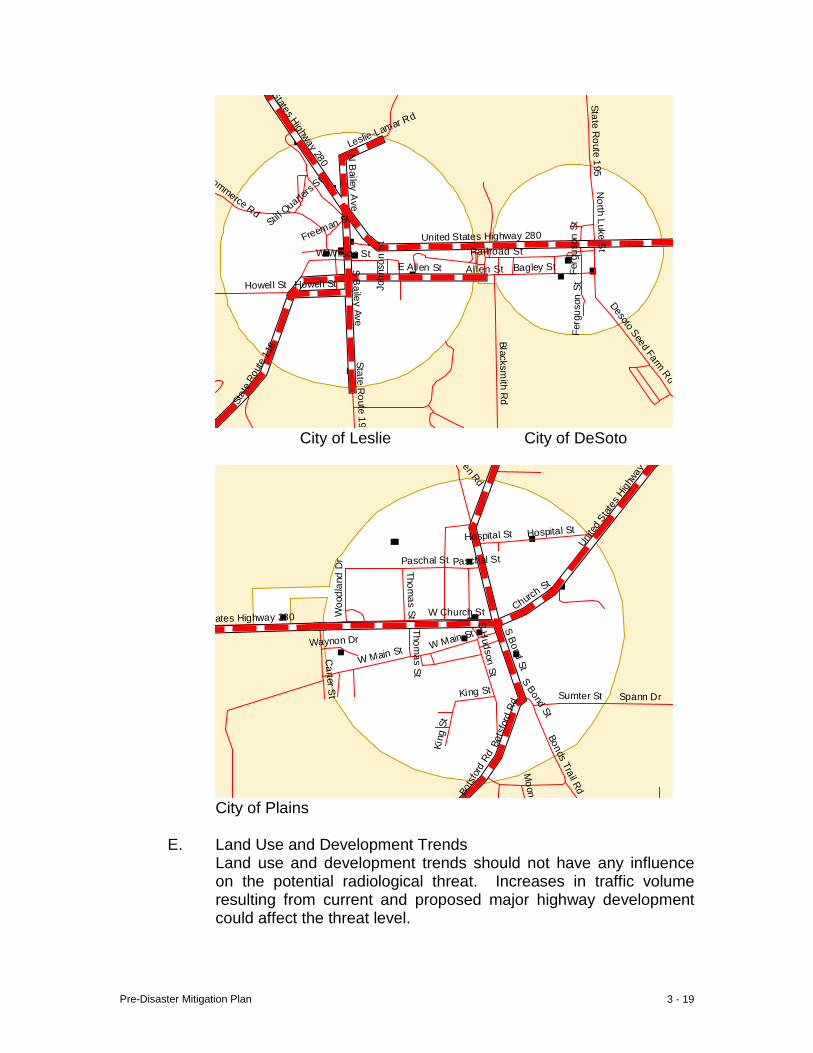
Pre-Disaster Mitigation Plan 3 - 19
States Highway 280
N B
ailey Ave
Stil l Quarte
rs St N
orth Luke St
Freeman St
United States Highway 280
Fer
guso
n St
W Wilson St Railroad St
Joh
nson
St
E Allen St Allen St Bagley St
Howell St Howell St
S B
ailey Ave
Fer
guso
n St
Desoto Seed Farm Rd
Sta
te R
oute
118
State Route 195
Blacksmith R
d
State Route 195
Leslie-Lamar Rd
Commerce Rd
City of Leslie City of DeSoto
Pen Rd
Unit
ed S
tates
High
way
Hospital St
Paschal St Paschal St
Woo
dlan
d D
r
Thomas St W Church St Churc
h St
W Main St Waynon Dr
S H
udson StS Bond St
S Bond St
Bot
sfor
d Rd
Bot
sfor
d Rd
Bonds Trail Rd
Moon
Spann Dr
Thomas St
Carter S
t Sumter St
King St
Kin
g St
W Main St
ates Highway 280
Hospital St
City of Plains
E. Land Use and Development Trends
Land use and development trends should not have any influence on the potential radiological threat. Increases in traffic volume resulting from current and proposed major highway development could affect the threat level.
Pre-Disaster Mitigation Plan 3 - 20
F. Multi-Jurisdictional Differences All jurisdictions are believed to have the same relative threat from an incident at a nuclear power plant, and all jurisdictions are located along major transportation corridors where such materials could be transported.
G. Summary The community has had very limited, if any, exposure to date. Enhancements in transportation infrastructure could increase the exposure; however.
Pre-Disaster Mitigation Plan 3 - 21
V. Animal/Crop Diseases
A. Hazard Identification An animal disease is a pathological condition resulting from infection, for example, and usually characterized by identifiable symptoms. Some diseases can lead to death of the host and, if not controlled, large-scale contagious diseases can lead to the death of infinite numbers of the species. Disposal of large numbers of carcasses can create community health risks. Some animal diseases are transmissible to humans. If allowed to spread to sufficient scale, animal diseases can cause health and economic disasters. In some cases humans can contract animal disease through mere contact; in other cases through consumption of animal products. Determining risk can be difficult with some animal diseases due to late occurring symptoms which can take months or years to appear. Entire flocks of poultry can die from infection when highly pathogenic Avian Influenza H5 or H7 viruses cause outbreaks. Animal health officials carefully monitor avian influenza outbreaks in domestic birds. Control of a 2004 Avian Influenza outbreak in Maryland required the elimination of hundreds of thousands of birds. Exotic Newcastle Disease is so virulent many birds die without showing any clinical signs of the infection. A 100% death rate can occur in unvaccinated flocks. Crop disease is a pathological condition caused by fungi, bacteria, viruses, nematodes and other microbes that, if not corrected, can result in crop (and fruit/nut) damage or loss. Crop diseases are air-borne, soil-borne, stimulated by heat and humidity.
B. Hazard Profile To date, the community has been spared the loss resulting from outbreak of an animal disease. While the probability of a local outbreak is not known, the large numbers of poultry in Sumter and surrounding communities does present significant risk.
C. Community Exposure
Sumter is in the upper quartile of Georgia counties in market value of agricultural production, with an attractive distribution among poultry/livestock-row crop- and horticultural sectors. This diversity spreads, or helps to reduce, the risk of disease outbreaks, but also exposes the community to more pathogens because of the presence of a wider variety of potential hosts. Although no local outbreaks have been documented, in 2005 there were reportedly 50 poultry houses with over 1 million chickens in Sumter County. At that same time there were ±9 million chickens in 450 poultry houses in the six counties contiguous to Sumter’s north, east and west boundaries. Poultry houses are serviced by trucks traveling
Pre-Disaster Mitigation Plan 3 - 22
between poultry houses across county boundaries. The community’s entire poultry flock and a significant proportion of the local economy is at risk. This hazard is primarily a threat to residents, as critical facilities are not particularly susceptible. Nevertheless, the combined total estimated structure replacement value ($626M) and total estimated contents value ($754M) of 210 critical facilities throughout the community is $1.4B (Appendix A). The estimated value of the community’s “non-critical” facilities is $1.1B, exclusive of content value. For details refer to page A-17. Population and other demographic data are presented in Appendix B, pages 1-13.
D. Estimate of Potential Loss The community’s 50 poultry hoses have not been included in the local inventory of critical facilities. Based on current average sales per flock, a 100% loss would amount to approximately $5M in annual gross sales. The most recent year for which sales data is available, 2005, reveals total “farm gate” sales for the county of $110M. Critical Facilities are not believed to be susceptible to an animal disease outbreak; nevertheless, the combined total estimated structure replacement value ($626M) and total estimated contents value ($754M) is $1.4B. The approximate values per jurisdiction are: Americus – ($532M) ($650M) $1.2B, Andersonville – ($5M) ($7M) $12M, DeSoto – ($.4M) ($.4M) $.8M, Leslie – ($2.5M) ($2.2M) $4.7M, Plains – ($8.2M) ($4.9M) $13.1M, and the unincorporated balance – ($78M) ($89M) $167M. This information can be reviewed in detail in Appendix A, pages 20ff. The estimated value of the community’s “non-critical” facilities is approximately $1.1B, exclusive of content value (refer to page A-17). Approximate values per jurisdiction are: Americus $573M, Andersonville $6M, DeSoto $2M, Leslie $12M, Plains $19M and the unincorporated area balance $537M. Population and other demographic data are presented in Appendix B, pages 1-13.

Pre-Disaster Mitigation Plan 3 - 23
Byromvill
Lil
Smithville
Ellaville
Americus
Andersonville
De Soto
Plains
Sumter County
Americus
City of Americus
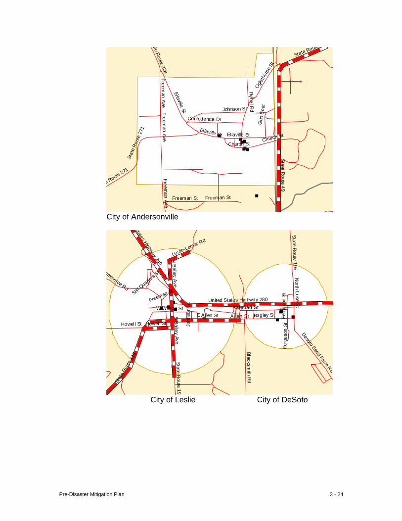
Pre-Disaster Mitigation Plan 3 - 24
ate Route 228
Ellaville St
Confederate Dr
Freeman Ave
Ellaville St Ellaville St
Church St
e Route 271
Freeman St
Freeman Ave
Freeman St
Ogle
thor
pe S
t
Freeman Ave
Sta
te R
oute
271
Rebel R
d
Gun
Boa
t
Church St
Johnson St
State Route
State Route 49
City of Andersonville
States Highway 280
N B
ailey Ave
Stil l Quarte
rs St N
orth Luke St
Freeman St
United States Highway 280
Fer
guso
n St
W Wilson St Railroad St
Joh
nson
St
E Allen St Allen St Bagley St
Howell St Howell St
S B
ailey Ave
Fer
guso
n St
Desoto Seed Farm Rd
Sta
te R
oute
118
State Route 195
Blacksmith R
d
State Route 195
Leslie-Lamar Rd
Commerce Rd
City of Leslie City of DeSoto
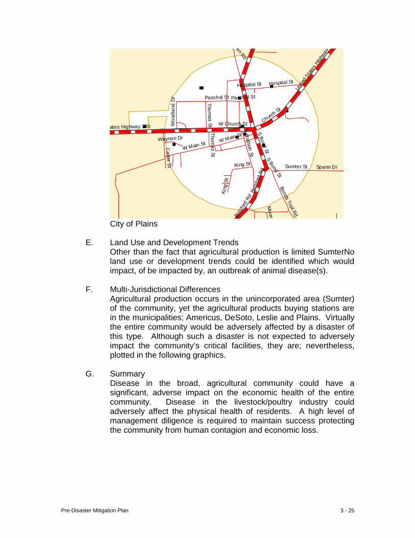
Pre-Disaster Mitigation Plan 3 - 25
Pen Rd
Unit
ed S
tates
High
way
Hospital St
Paschal St Paschal St
Woo
dlan
d D
r
Thomas St W Church St Churc
h St
W Main St Waynon Dr
S H
udson StS Bond St
S Bond St
Bot
sfor
d Rd
Bot
sfor
d Rd
Bonds Trail Rd
Moon
Spann Dr
Thomas St
Carter S
t Sumter St
King St
Kin
g St
W Main St
ates Highway 280
Hospital St
City of Plains
E. Land Use and Development Trends Other than the fact that agricultural production is limited SumterNo land use or development trends could be identified which would impact, of be impacted by, an outbreak of animal disease(s).
F. Multi-Jurisdictional Differences Agricultural production occurs in the unincorporated area (Sumter) of the community, yet the agricultural products buying stations are in the municipalities; Americus, DeSoto, Leslie and Plains. Virtually the entire community would be adversely affected by a disaster of this type. Although such a disaster is not expected to adversely impact the community’s critical facilities, they are; nevertheless, plotted in the following graphics.
G. Summary Disease in the broad, agricultural community could have a significant, adverse impact on the economic health of the entire community. Disease in the livestock/poultry industry could adversely affect the physical health of residents. A high level of management diligence is required to maintain success protecting the community from human contagion and economic loss.
Pre-Disaster Mitigation Plan 3 - 26
VI. Groundwater Contamination
A. Hazard Identification Groundwater contamination is the introduction of man-made products into subsurface soils and rocks (aquifers) that make the water stored therein naturally, and accessible via wells, unsafe for human consumption. Recharge is the process by which precipitation, primarily in the form of rain, infiltrates soil and rock (aquifers) to add to the volume of water stored in pores and other openings within them. Recharge areas are among those regions likely to have the greatest vulnerability to pollution of groundwater from the surface and near surface activities of man.
B. Hazard Profile The community is not known to have experienced a disaster of this type. Introduction of pollution into aquifers has the potential of not only polluting groundwater in the immediate vicinity of the site, but also of eventually affecting a substantial portion of the aquifer down gradient. Because water flow is relatively slow in most aquifers, the evidence and effects of pollution may not appear for years at sites distant from the recharge area.
C. Community Exposure
Recharge is the process by which precipitation, primarily in the form of rain, infiltrates soil and rock (aquifers) to add to the volume of water stored in pores and other openings within them. Recharge areas are among those regions likely to have the greatest vulnerability to pollution of groundwater from the surface and near surface activities of man. Approximately 23% of Georgia's land surface has been identified as the area where the most significant recharge to aquifers occurs. Approximately 90% of the community overlies areas of significant recharge (Claiborne, Clayton and Floridan Aquifer). The only areas generally not included are the banks along the major creeks and Flint River/Lake Blackshear, because these areas naturally drain into the nearby surface waters, and the panhandle area around Andersonville. Nevertheless, the combined total estimated structure replacement value ($626M) and total estimated contents value ($754M) is $1.4B. The approximate values per jurisdiction are: Americus – ($532M) ($650M) $1.2B, Andersonville – ($5M) ($7M) $12M, DeSoto – ($.4M) ($.4M) $.8M, Leslie – ($2.5M) ($2.2M) $4.7M, Plains – ($8.2M) ($4.9M) $13.1M, and the unincorporated balance – ($78M) ($89M) $167M. This information can be reviewed in detail in Appendix A, pages 20ff. The estimated value of the community’s “non-critical” facilities is approximately $1.1B, exclusive of content value (refer to page A-17). Approximate values per jurisdiction are: Americus $573M,

Pre-Disaster Mitigation Plan 3 - 27
Andersonville $6M, DeSoto $2M, Leslie $12M, Plains $19M and the unincorporated area balance $537M. Population and other demographic data are presented in Appendix B, pages 1-13.
D. Estimate of Potential Loss Critical Facilities are not believed to be susceptible to damage/loss from groundwater contamination. However, such an incident could have significant adverse economic impacts. Nevertheless, the estimated cost of critical facility replacement ($626M) and contents value ($754M) communitywide amounts to a total of $1.4B, (Appendix A, pages 17-40). The estimated value of the community’s “non-critical” facilities is $1.1B, exclusive of content value. For details refer to page A-17. Population and other demographic data are presented in Appendix B, pages 1-13.
Byromvill
Lil
Smithville
Ellaville
Americus
Andersonville
De Soto
Plains
Sumter County

Pre-Disaster Mitigation Plan 3 - 28
Americus
City of Americus
ate Route 228
Ellaville St
Confederate Dr
Freeman Ave
Ellaville St Ellaville St
Church St
e Route 271
Freeman St
Freeman Ave
Freeman St
Ogle
thor
pe S
t
Freeman Ave
Sta
te R
oute
271
Rebel R
d
Gun
Boa
t
Church St
Johnson St
State Route
State Route 49
City of Andersonville
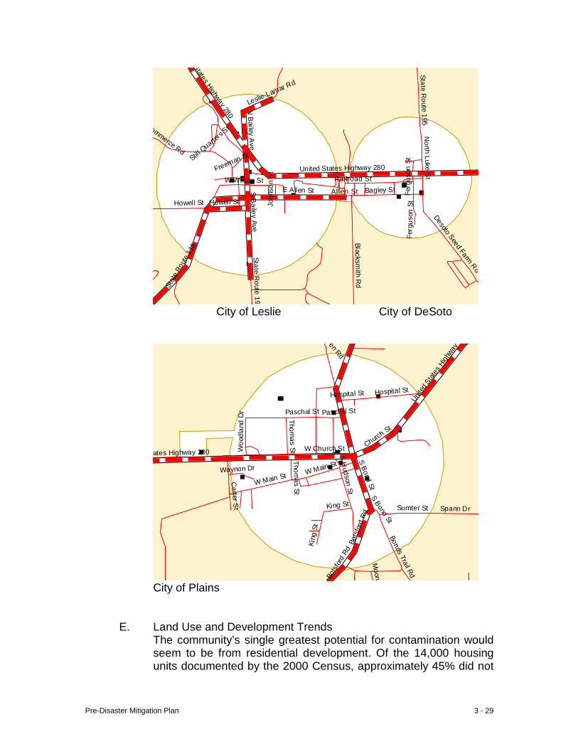
Pre-Disaster Mitigation Plan 3 - 29
States Highway 280
N B
ailey Ave
Stil l Quarte
rs St N
orth Luke St
Freeman St
United States Highway 280
Fer
guso
n St
W Wilson St Railroad St
Joh
nson
St
E Allen St Allen St Bagley St
Howell St Howell St
S B
ailey Ave
Fer
guso
n St
Desoto Seed Farm Rd
Sta
te R
oute
118
State Route 195
Blacksmith R
d
State Route 195
Leslie-Lamar Rd
Commerce Rd
City of Leslie City of DeSoto
Pen Rd
Unit
ed S
tates
High
way
Hospital St
Paschal St Paschal St
Woo
dlan
d D
r
Thomas St W Church St Churc
h St
W Main St Waynon Dr
S H
udson StS Bond St
S Bond St
Bot
sfor
d Rd
Bot
sfor
d Rd
Bonds Trail Rd
Moon
Spann Dr
Thomas St
Carter S
t Sumter St
King St
Kin
g St
W Main St
ates Highway 280
Hospital St
City of Plains
E. Land Use and Development Trends The community’s single greatest potential for contamination would seem to be from residential development. Of the 14,000 housing units documented by the 2000 Census, approximately 45% did not
Pre-Disaster Mitigation Plan 3 - 30
have access to public wastewater collection and treatment, and were reliant on individual wastewater treatment systems (septic tanks). In the years immediately before and after the 2000 Census the majority of residential development occurred in unserved areas, most heavily concentrated on the outskirts of the county seat. The vast majority of these sites not served by public wastewater treatment are complemented with a water well, the relatively few exceptions being housing units in mobile home parks and subdivisions. Hence, the vast majority of new residential developments puncture the subsurface twice, increasing the potential for groundwater contamination in areas of significant groundwater recharge.
F. Multi-Jurisdictional Differences All jurisdictions are potentially affected by this hazard. While residential development is occurring in areas without public wastewater collection and treatment, the more densely populated jurisdictions have greater traffic flows and commercial activities were spills can cause groundwater contamination. Although such a disaster is not expected to adversely impact the community’s critical facilities, they are; nevertheless, plotted in the following graphics.
G. Summary Increased growth and development can be expected to increase the potential for groundwater contamination.
Pre-Disaster Mitigation Plan 3 - 31
VII. Civil Disturbance
A. Hazard Identification These events consist of disruption of the routine and peaceful activities of a community by residents and/or non-residents. Although the disruption may itself be either peaceful, e.g., sit-in, or violent, e.g., riot, it is the latter which is most likely to have disastrous consequences in the community. Participants utilize this method to draw attention to grievance(s) resulting from cultural, social and/or political issues, or to protest/avenge perceived miscarriages of justice. Such events usually arise from public crisis and may occur with or without warning. The nation-wide trend toward fan fanaticism has caused increasing numbers of disturbances during and after large athletic events.
B. Hazard Profile The community has to date not experienced any such events. It is perceived locally to be an increasing threat because of the ease of communications world-wide and increasing cultural diversity, among other contributing reasons.
C. Community Exposure At this writing the greatest exposure would appear to be the potential for disturbances at local spectator events; high school basketball and football games. The combination of heated competition, long-standing rivalries and general lack of local recreational choices tends to intensify the significance of spectator events.
D. Estimate of Potential Loss Potential Losses were estimated by use of the OHS/GEMA web-based planning tool. Data input for the Assets Worksheet included the replacement value and structure contents value of each critical facility identified. The Loss Estimation Table automatically computed the aggregate loss for 210 critical facilities at 100% ($1.4B) of the combined total estimated structure replacement value ($626M) and total estimated contents value ($754M). The approximate values per jurisdiction are: Americus – ($532M) ($650M) $1.2B, Andersonville – ($5M) ($7M) $12M, DeSoto – ($.4M) ($.4M) $.8M, Leslie – ($2.5M) ($2.2M) $4.7M, Plains – ($8.2M) ($4.9M) $13.1M, and the unincorporated balance – ($78M) ($89M) $167M. This information can be reviewed in detail in Appendix A, pages 20ff. The estimated value of the community’s “non-critical” facilities is approximately $1.1B, exclusive of content value (refer to page A-17). Approximate values per jurisdiction are: Americus $573M, Andersonville $6M, DeSoto $2M, Leslie $12M,
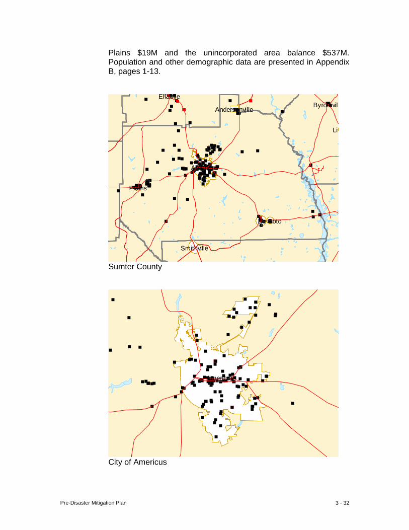
Pre-Disaster Mitigation Plan 3 - 32
Plains $19M and the unincorporated area balance $537M. Population and other demographic data are presented in Appendix B, pages 1-13.
Byromvill
Lil
Smithville
Ellaville
Americus
Andersonville
De Soto
Plains
Sumter County
Americus
City of Americus
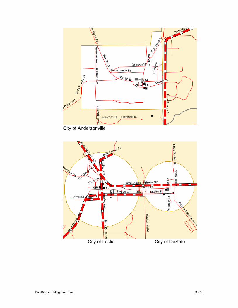
Pre-Disaster Mitigation Plan 3 - 33
ate Route 228
Ellaville St
Confederate Dr
Freeman Ave
Ellaville St Ellaville St
Church St
e Route 271
Freeman St
Freeman Ave
Freeman St
Ogle
thor
pe S
t
Freeman Ave
Sta
te R
oute
271
Rebel R
d
Gun
Boa
t
Church St
Johnson St
State Route
State Route 49
City of Andersonville
States Highway 280
N B
ailey Ave
Stil l Quarte
rs St N
orth Luke St
Freeman St
United States Highway 280
Fer
guso
n St
W Wilson St Railroad St
Joh
nson
St
E Allen St Allen St Bagley St
Howell St Howell St
S B
ailey Ave
Fer
guso
n St
Desoto Seed Farm Rd
Sta
te R
oute
118
State Route 195
Blacksmith R
d
State Route 195
Leslie-Lamar Rd
Commerce Rd
City of Leslie City of DeSoto
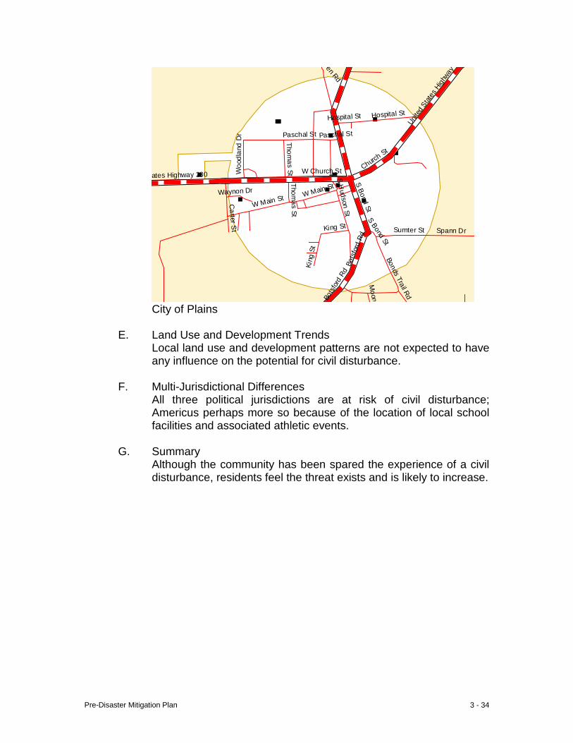
Pre-Disaster Mitigation Plan 3 - 34
Pen Rd
Unit
ed S
tates
High
way
Hospital St
Paschal St Paschal St
Woo
dlan
d D
r
Thomas St W Church St Churc
h St
W Main St Waynon Dr
S H
udson StS Bond St
S Bond St
Bot
sfor
d Rd
Bot
sfor
d Rd
Bonds Trail Rd
Moon
Spann Dr
Thomas St
Carter S
t Sumter St
King St
Kin
g St
W Main St
ates Highway 280
Hospital St
City of Plains
E. Land Use and Development Trends Local land use and development patterns are not expected to have any influence on the potential for civil disturbance.
F. Multi-Jurisdictional Differences
All three political jurisdictions are at risk of civil disturbance; Americus perhaps more so because of the location of local school facilities and associated athletic events.
G. Summary Although the community has been spared the experience of a civil disturbance, residents feel the threat exists and is likely to increase.
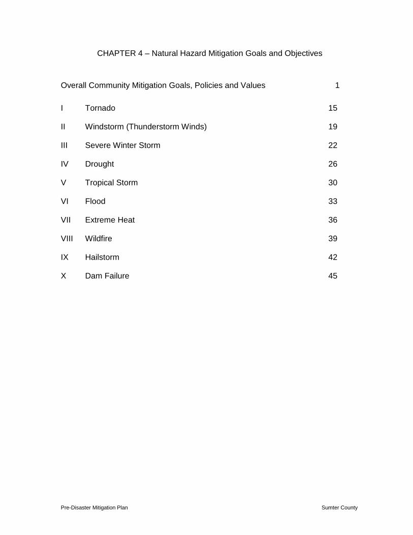
Pre-Disaster Mitigation Plan Sumter County
CHAPTER 4 – Natural Hazard Mitigation Goals and Objectives
Overall Community Mitigation Goals, Policies and Values 1 I Tornado 15 II Windstorm (Thunderstorm Winds) 19 III Severe Winter Storm 22 IV Drought 26 V Tropical Storm 30 VI Flood 33 VII Extreme Heat 36 VIII Wildfire 39 IX Hailstorm 42 X Dam Failure 45
Pre-Disaster Mitigation Plan 4 - 1
CHAPTER 4 – Natural Hazard Mitigation Goals and Objectives Overall Community Mitigation Goals, Policies and Values Narrative
Five, general, pre-disaster mitigation goals have been established. Implementation of these non-structural measures will have positive impacts on mitigation irrespective of the type hazard which may befall the community in the future. Non-structural measures have the benefits of being less expensive to implement, do not require expensive maintenance and upkeep, and are more adaptable to specific needs than structural measures. These general goals and their related objectives, tasks and action steps are as follows: GOAL 1 Protect the public health and safety GOAL 2 Reduce, and to the extent possible eliminate, community exposure to
natural and manmade hazard events GOAL 3 Reduce loss and damage to private property and public infrastructure
resulting from natural or manmade hazards GOAL 4 Maintain continuity of public and private sector operations during and
after hazard events GOAL 5 Respond promptly, appropriately and efficiently in the event of natural or manmade hazards
OBJECTIVE 1 Increase coordination between local public and private sectors in pre-disaster planning
Task 1.1 Develop computer hardware/software communication compatibility between local emergency response agencies, emergency service providers, E-911 and other appropriate public agencies; maintain radio communication compatibility
Action Step 1.1.1
Designate Emergency Management Director to serve as clearinghouse to develop and maintain compatibility between the electronic systems of essential agencies Responsible Org: EMA Coordinating Org: LEPC Timeline: annually Cost: Staff Time Funding Source: Departmental Operating Budgets Jurisdiction: All Jurisdictions Benefit: 33K residents Priority: High (1-18 months)
Pre-Disaster Mitigation Plan 4 - 2
Action Step 1.1.2 Develop countywide computer communication capability incorporating all jurisdictions and emergency response and local relief agencies Responsible Org: EMA Coordinating Org: LEPC Timeline: 2007-2009 Cost: $25K (estimated) Funding Source: Emer Svcs Capital Budget Jurisdiction: All Jurisdictions Benefit: 33K residents
Priority: Medium (19-36 months) Action Step 1.1.3 Maintain and distribute critical contact information
(hard line and cell phone numbers) on all emer-gency/key personnel, and their proxies Responsible Org: EMA Coordinating Org: LEPC/Red Cross Timeline: Annually (more often if needed) Cost: Staff Time Funding Source: Departmental Operating
Budgets Jurisdiction: All Jurisdictions Benefit: 33K residents Priority: High (1-18 months)
Task 1.2 Share information between emergency agencies concerning services, regulations, capabilities, personnel, equipment, needs, limitations, etc
Action Step 1.2.1 Maintain inventories of the kinds of vehicles, equipment
and materials needed to respond, restore services and clean up after hazard events, and replace/replenish as necessary. Share completed inventories between emergency response agencies.
Responsible Org: Law, Fire, Public Works, Public Utilities
Coordinating Org: LEPC Timeline: October 1, Annually Cost: Staff Time Funding Source: Departmental Operating Budgets Jurisdiction: All Jurisdictions Benefit: 33K residents
Priority: High (1-18 months)
Pre-Disaster Mitigation Plan 4 - 3
Action Step 1.2.2 Maintain lists of reserve personnel who can be called upon to assist/backup in time of emergency, determine capabilities and compile essential contact information
Responsible Org: Law, Fire, Public Works, Public Utilities
Coordinating Org: LEPC Timeline: Annually Cost: Staff Time Funding Source: Departmental Operating Budgets Jurisdiction: All Jurisdictions Benefit: 33K residents
Priority: High (1-18 months)
Action Step 1.2.3 Convene periodic meetings of all emergency services directors, local government chief appointed officials, and elected officials to share critical service delivery information Responsible Org: EMA Coordinating Org: Emergency Responders, Chief
Appointed Officials Timeline: Annually Cost: Staff Time
Funding Source: Departmental Operating Budget Jurisdiction: All Jurisdictions Benefit: 33K residents Priority: High (1-18 months)
Task 1.3 Incorporate pre-disaster mitigation of natural and manmade hazards into safety training programs of public and private entities
Action Step1.3.1
Develop or otherwise secure appropriate training programs for presentation to business, industry, government and institutions Responsible Org: EMA
Coordinating Org: LEPC Timeline: Annual Cost: Staff Time
Funding Source: Departmental Operating Budgets Jurisdiction: All Jurisdictions Benefit: 33K residents
Priority: High (1-18 months)
Pre-Disaster Mitigation Plan 4 - 4
OBJECTIVE 2 Increase resident awareness of the community’s greatest hazard disaster threats
Task 2.1 Develop position of emergency preparedness/training
officer in the EMA office to serve as a clearinghouse for information on all types of hazards, prevention, and how to respond
Action Step 2.1.1
Formal designation of position by EMA DIrector Responsible Org: EMA
Coordinating Org: LEPC Timeline: 2007 Cost: Staff Time Funding Source: Departmental Operating Budgets Jurisdiction: All Jurisdictions Benefit: 33K residents
Priority: High (1-18 months)
Task 2.2 Educate residents how best to respond to any of the community’s numerous hazard threats
Action Step 2.1.1
Continue to develop and provide family disaster plans and supply kits
Responsible Org: EMA Coordinating Org: LEPC Timeline: Annual Cost: $1K Funding Source: Departmental Operating Budgets Jurisdiction: All Jurisdictions Benefit: 33K residents
Priority: High (1-18 months)
OBJECTIVE 3 Adopt and enforce applicable codes
Task 3.1 Map potentially hazardous areas and incorporate into land use planning
Action Step 3.1.1
Inform local elected officials of the mitigation benefits which could accrue from implementation of a hazard-sensitive land use plan
Responsible Org: Local Governments Coordinating Org: LEPC, P&Z Timeline: 2007-2010

Pre-Disaster Mitigation Plan 4 - 5
Cost: ±$750 per jurisdiction Funding Source: City/County Operating Budget
Jurisdiction: All Jurisdictions Benefit: 33K residents
Priority: Medium (19-36 months)
Task 4.1 Adopt and enforce building codes where not already codified
Action Step 4.1.1
Inform local elected officials of the mitigation benefits which could accrue from building code enforcement
Responsible Org: Elected Bodies of Andersonville and DeSoto Coordinating Org: Sumter Code Enforcement Timeline: 2007-2008 Cost: Staff Time Funding Source: City Operating Budgets
Jurisdiction: Andersonville and DeSoto Benefit: 600
Priority: Medium (19-36 months)
Task 5.1 Adopt and enforce housing/environmental codes where not already codified
Action Step 5.1.1
Inform elected officials of the mitigation benefits which could accrue from local enforcement of said code
Responsible Org: Elected Bodies of Andersonville, DeSoto, Leslie and Plains Coordinating Org: Sumter Code Enforcement Timeline: 2007-2008 Cost: Staff Time Funding Source: City/County Operating Budget Jurisdiction: Andersonville, DeSoto, Leslie and Plains
Benefit: 1700 Priority: Medium (19-36 months) TASK 6.1 Adopt post-disaster recovery ordinances in all local
jurisdictions Action Step 6.1.1 Inform local elected officials of the mitigation benefits
which could accrue from implementation of a post-disaster ordinance
Pre-Disaster Mitigation Plan 4 - 6
Responsible Org: All Elected Bodies Coordinating Org: EMA/LEPC Timeline: 2007-2008 Cost: Staff Time Funding Source: City/County Operating Budget
Jurisdiction: All Jurisdictions Benefit: 33K residents Priority: High (1-18 months)
OBJECTIVE 4 Increase public and private sector and general public
awareness of hazard mitigation through Local Emergency Planning Committee (LEPC),
Task 4.1 Institute annual education/training for elected officials
and media Action Step 4.1.1 Establish an annual date for elected officials and
representatives from local media to witness a mock disaster drill from the EOC
Responsible Org: EMA Coordinating Org: LEPC Timeline: Annually Cost: Staff Time Funding Source: Departmental Operating Budget
Jurisdiction: All Jurisdictions Benefit: 33K residents
Priority: High (1-18 months) Task 4.2 Present education programs to the business community
through the chamber of commerce and civic organizations
Action Step 4.2.1 Designate Emergency Preparedness Officer (EPO) to
articulate the need for the general public to participate in local mitigation strategy
Responsible Org: EMA Coordination Org: LEPC Timeline: Annual Cost: Staff Time Funding Source: Departmental Operating Budget
Jurisdiction: All Jurisdictions Benefit: 33K residents Priority: Medium (19-36 months)
Pre-Disaster Mitigation Plan 4 - 7
Task 4.3 Enhance public education programs through print and broadcast media Action Step 4.3.1
Provide media with information of local mitigation efforts and emergency response preparedness Responsible Org: EMA-EPO
Coordinating Org: LEPC Timeline: Annual Cost: Staff Time Funding Source: Departmental Operating Budget
Jurisdiction: All Jurisdictions Benefit: 33K residents
Priority: High (1-18 months) Action Step 4.3.2
Secure from GEMA/FEMA examples of successful mitigation efforts elsewhere that have local application, and provide to media in a format “ready for print” Responsible Org: EMA-EPO Coordinating Org: LEPC Timeline: Annually Cost: Staff Time Funding Source: Departmental Operating Budget Jurisdiction: All Jurisdictions Benefit: 33K residents Priority: Medium (19-36 months)
Action Step 4.3.3
Implement an annual Emergency Operations Center (EOC) “Open House” Responsible Org: EMA Coordinating Org: EMA/LEPC Timeline: Annually Cost: Staff Time Funding Source: Departmental Operating Budget Jurisdiction: All Jurisdictions Benefit: 33K residents
Priority: Medium (19-36 months)
Action Step 4.3.4 Encourage all local media to cover (1) mock disaster drill used in annual elected official training/education, and (2) annual EOC “Open house” Responsible Org: EMA Coordinating Org: LEPC
Pre-Disaster Mitigation Plan 4 - 8
Timeline: Annually Cost: Staff Time Funding Source: Departmental Operating Budget Jurisdiction: All Jurisdictions Benefit: 33K residents Priority: Medium (19-36 months)
OBJECTIVE 5 Institutionalize hazard mitigation
Task 5.1 Incorporate pre-disaster mitigation into all public permitting and planning activities Action Step 5.1.1
Local government adoption and subsequent application of mitigation “standards” in permit issuance and planning functions Responsible Org: County and City Governments
Coordinating Org: P&Z/LEPC Timeline: 2006-2008 Cost: Staff Time Funding Source: Departmental Operating Budget
Jurisdiction: All Jurisdictions Benefit: 33K residents Priority: Medium (19-36 months)
Task 5.2 Incorporate pre-disaster mitigation assessment into site
inspections of critical facilities (upon request) Action Step 5.2.1
Supplement Life Safety Code inspections with pre-disaster mitigation review (countywide if possible) Responsible Org: Americus Fire Department
Coordinating Org: LEPC Timeline: Annually Cost: Staff Time Funding Source: Departmental Operating Budget
Jurisdiction: Americus Benefit: 17K Priority: High (1-18 months)
Task 5.3 Incorporate hazard mitigation into capital improvement
budgeting
Pre-Disaster Mitigation Plan 4 - 9
Action Step 5.3.1 Inform chief administrative officers and elected officials of long-term benefits of incorporating hazard mitigation into capital budgeting process Responsible Org: City and County Government Coordinating Org: EMA/LEPC Timeline: Annually Cost: Staff Time Funding Source: Departmental Operating Budget Jurisdiction: All Jurisdictions Benefit: 33K residents Priority: High (1-18 months)
Task 5.4 Educate local governments on need for duplication and
safe storage of vital public sector records off-site Action Step 5.4.1 Assist local government and constitutional officers with
adoption of policy to (1) duplicate existing, essential records, (2) duplicate essential records annually thereafter, and (3) designate a secure, off-site depository for essential public records
Responsible Org: All Local Governments Coordinating Org: LEPC Timeline: 2008-2010 Cost: $35-$40K Funding Source: Local
Jurisdiction: All Jurisdictions Benefit: 33K residents Priority: Medium (19-36 months)
Task 5.5 Educate business community on need for duplication
and safe storage of vital private sector records off-site Action Step 5.5.1 Secure information to be provided to chamber of
commerce to help educate the business community of the need to have duplicate copies of essential records securely stored off-site
Responsible Org: Property Owner Coordinating Org: EPC Timeline: Annually Cost: Unknown Funding Source: Unknown
Jurisdiction: All Jurisdictions Benefit: 33K residents
Pre-Disaster Mitigation Plan 4 - 10
Priority: Medium (19-36 months)
OBJECTIVE 6 Through LEPC, improve the comprehensive mitigation strategy
Task 6.1 Monitor plan implementation annually
Action Step 6.1.1
Establish a fall/winter date for formal, annual review of mitigation strategy implementation Responsible Org: EMA Coordinating Org: LEPC Timeline: Annually Cost: Staff Time
Funding Source: Departmental Operating Budget Jurisdiction: All Jurisdictions Benefit: 33K residents Priority: High (1-18 months)
Task 6.2 Post-disaster assessment of preparation for, and response to, hazard event Action Step 6.2.1
As soon as reasonably practicable after a disaster event, perform a detailed, post-disaster assessment of preparations and response Responsible Org: EMA Coordinating Org: LEPC, All Emergency Response
Agencies Timeline: As needed Cost: Staff Time Funding Source: Departmental Operating Budgets Jurisdiction: All Jurisdictions Benefit: 33K residents Priority: High (1-18 months)
Task 6.3 Establish cross-county peer visitation/assessment Action Step 6.3.1
Contact nearby counties of similar population and similar hazard threats to initiate annual peer review. Responsible Org: EMA
Coordinating Org: LEPC Timeline: Annual Cost: Staff Time Funding Source: Departmental Operating Budget
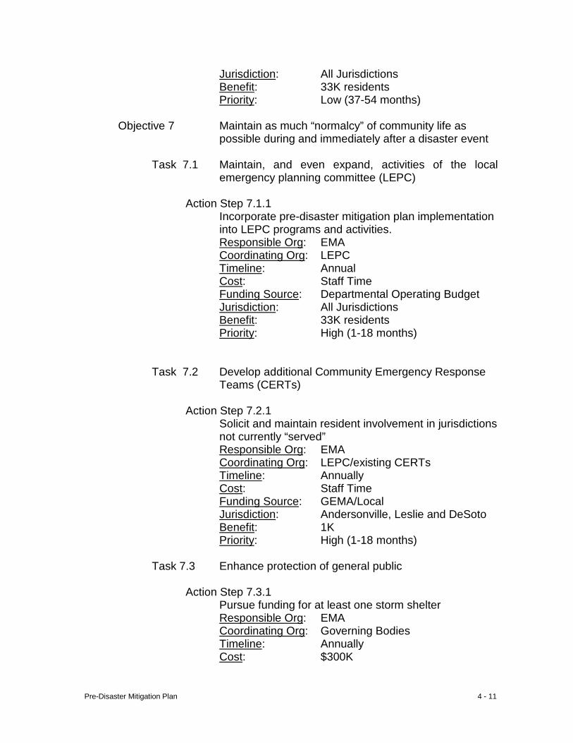
Pre-Disaster Mitigation Plan 4 - 11
Jurisdiction: All Jurisdictions Benefit: 33K residents Priority: Low (37-54 months)
Objective 7 Maintain as much “normalcy” of community life as possible during and immediately after a disaster event
Task 7.1 Maintain, and even expand, activities of the local
emergency planning committee (LEPC) Action Step 7.1.1 Incorporate pre-disaster mitigation plan implementation
into LEPC programs and activities. Responsible Org: EMA Coordinating Org: LEPC Timeline: Annual Cost: Staff Time Funding Source: Departmental Operating Budget Jurisdiction: All Jurisdictions Benefit: 33K residents Priority: High (1-18 months)
Task 7.2 Develop additional Community Emergency Response Teams (CERTs)
Action Step 7.2.1 Solicit and maintain resident involvement in jurisdictions
not currently “served” Responsible Org: EMA Coordinating Org: LEPC/existing CERTs Timeline: Annually Cost: Staff Time Funding Source: GEMA/Local Jurisdiction: Andersonville, Leslie and DeSoto Benefit: 1K Priority: High (1-18 months)
Task 7.3 Enhance protection of general public
Action Step 7.3.1 Pursue funding for at least one storm shelter
Responsible Org: EMA Coordinating Org: Governing Bodies Timeline: Annually Cost: $300K
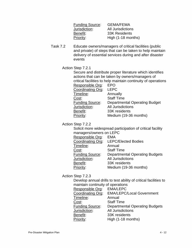
Pre-Disaster Mitigation Plan 4 - 12
Funding Source: GEMA/FEMA Jurisdiction: All Jurisdictions Benefit: 33K Residents Priority: High (1-18 months)
Task 7.2 Educate owners/managers of critical facilities (public
and private) of steps that can be taken to help maintain delivery of essential services during and after disaster events
Action Step 7.2.1 Secure and distribute proper literature which identifies
actions that can be taken by owners/managers of critical facilities to help maintain continuity of operations Responsible Org: EPO Coordinating Org: LEPC Timeline: Annually Cost: Staff Time Funding Source: Departmental Operating Budget Jurisdiction: All Jurisdictions Benefit: 33K residents Priority: Medium (19-36 months)
Action Step 7.2.2 Solicit more widespread participation of critical facility
managers/owners on LEPC Responsible Org: EMA Coordinating Org: LEPC/Elected Bodies Timeline: Annual Cost: Staff Time Funding Source: Departmental Operating Budgets Jurisdiction: All Jurisdictions Benefit: 33K residents Priority: Medium (19-36 months)
Action Step 7.2.3
Develop annual drills to test ability of critical facilities to maintain continuity of operations Responsible Org: EMA/LEPC Coordinating Org: EMA/LEPC/Local Government Timeline: Annual Cost: Staff Time Funding Source: Departmental Operating Budgets Jurisdiction: All Jurisdictions Benefit: 33K residents Priority: High (1-18 months)
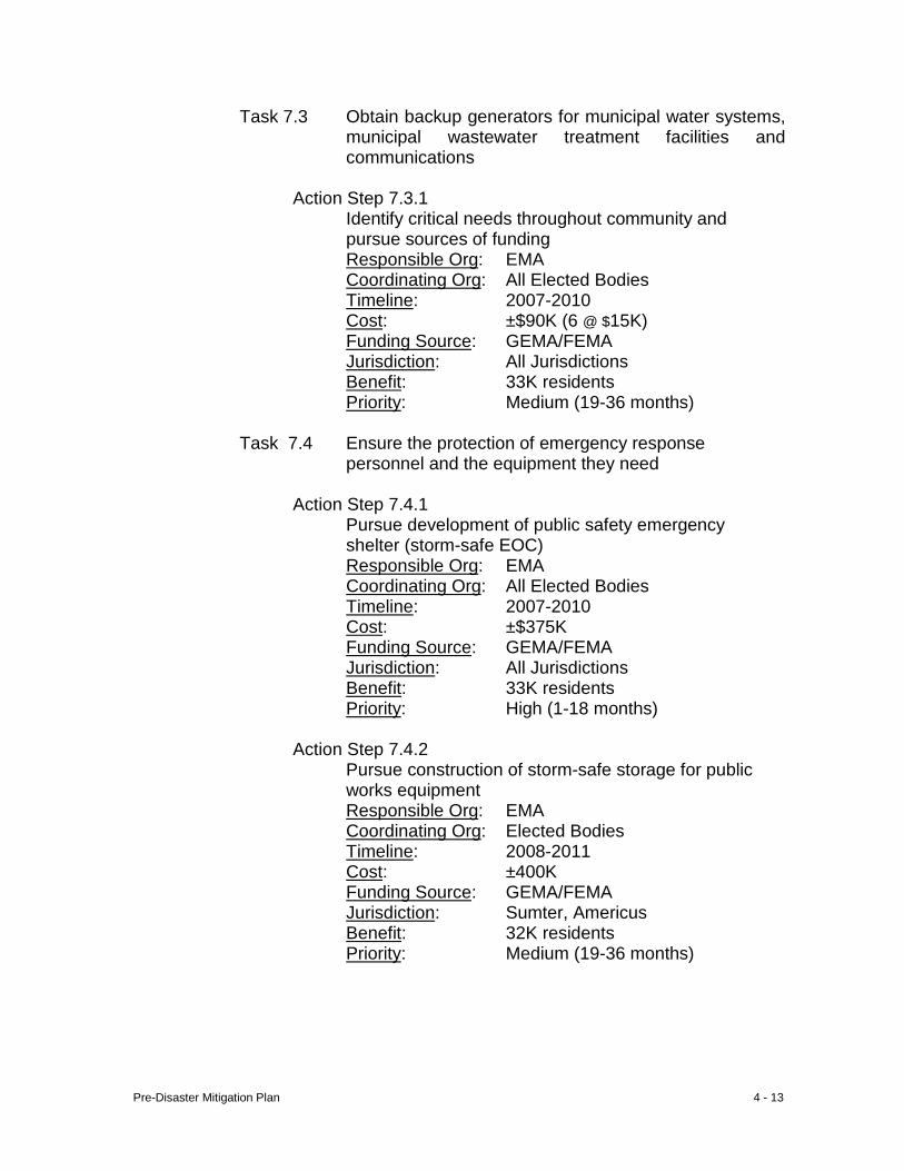
Pre-Disaster Mitigation Plan 4 - 13
Task 7.3 Obtain backup generators for municipal water systems, municipal wastewater treatment facilities and communications
Action Step 7.3.1 Identify critical needs throughout community and
pursue sources of funding Responsible Org: EMA Coordinating Org: All Elected Bodies Timeline: 2007-2010 Cost: ±$90K (6 @ $15K) Funding Source: GEMA/FEMA Jurisdiction: All Jurisdictions Benefit: 33K residents Priority: Medium (19-36 months)
Task 7.4 Ensure the protection of emergency response
personnel and the equipment they need
Action Step 7.4.1 Pursue development of public safety emergency
shelter (storm-safe EOC) Responsible Org: EMA Coordinating Org: All Elected Bodies Timeline: 2007-2010 Cost: ±$375K Funding Source: GEMA/FEMA Jurisdiction: All Jurisdictions Benefit: 33K residents Priority: High (1-18 months)
Action Step 7.4.2
Pursue construction of storm-safe storage for public works equipment Responsible Org: EMA Coordinating Org: Elected Bodies Timeline: 2008-2011 Cost: ±400K Funding Source: GEMA/FEMA Jurisdiction: Sumter, Americus Benefit: 32K residents Priority: Medium (19-36 months)
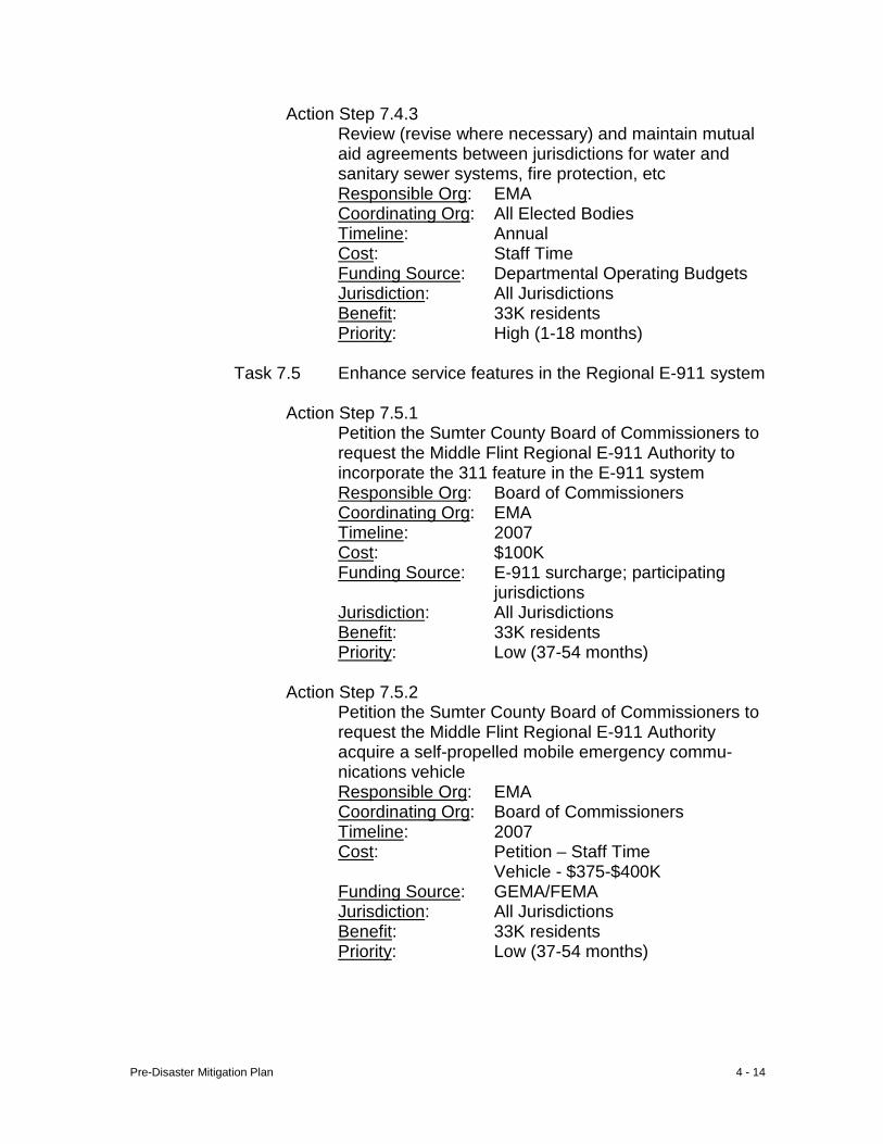
Pre-Disaster Mitigation Plan 4 - 14
Action Step 7.4.3 Review (revise where necessary) and maintain mutual aid agreements between jurisdictions for water and sanitary sewer systems, fire protection, etc Responsible Org: EMA Coordinating Org: All Elected Bodies Timeline: Annual Cost: Staff Time Funding Source: Departmental Operating Budgets Jurisdiction: All Jurisdictions Benefit: 33K residents Priority: High (1-18 months)
Task 7.5 Enhance service features in the Regional E-911 system
Action Step 7.5.1 Petition the Sumter County Board of Commissioners to
request the Middle Flint Regional E-911 Authority to incorporate the 311 feature in the E-911 system Responsible Org: Board of Commissioners Coordinating Org: EMA Timeline: 2007 Cost: $100K Funding Source: E-911 surcharge; participating
jurisdictions Jurisdiction: All Jurisdictions Benefit: 33K residents Priority: Low (37-54 months)
Action Step 7.5.2 Petition the Sumter County Board of Commissioners to
request the Middle Flint Regional E-911 Authority acquire a self-propelled mobile emergency commu-nications vehicle Responsible Org: EMA Coordinating Org: Board of Commissioners Timeline: 2007 Cost: Petition – Staff Time Vehicle - $375-$400K Funding Source: GEMA/FEMA Jurisdiction: All Jurisdictions Benefit: 33K residents Priority: Low (37-54 months)
Pre-Disaster Mitigation Plan 4 - 15
I. Natural Hazard – Tornadoes A. Mitigation Goals - A tornado inflicted greater loss on the community
than any other natural hazard. The general public fails to appreciate how little time there is to respond to a sudden tornado strike, and how important it is that all parties be prepared at all times to respond correctly. Although thunderstorm winds do not reach the speed of tornadoes, there are many similarities in the damage caused by both hazards. Consequently, virtually all goals, objectives, tasks and action steps of the two hazards are interchangeable.
B. Range of Mitigation Options 1. Structural v Non-structural – Identified goals address both
options. Residents and developers undertaking new construction or renovation will be encouraged to consider making safe-room additions to the structure. Because it is critical that emergency responders be able to respond to emergencies, Sumter County and the City of Americus are pursing facilities to protect emergency personnel, emergency vehicles and equipment. Other, non-structural options promote an expansion of code enforcement activities and public education.
2. Existing Policies, Regulations, Ordinances and Land Use – Sumter County and Americus currently enforce building codes. All jurisdictions except DeSoto have zoning ordinances
3. Community Values, Historic and Special Considerations – Project implementation will serve to protect historic districts in Americus and Plains, a potential district in Leslie, and historic resources dispersed throughout the unincorporated county. No other special considerations were identified.
4. New Buildings and Infrastructure – Developers will be informed/reminded of the applicability of building codes in the community. Adoption and enforcement of housing/environmental codes will serve to protect future development by reducing the size of the potential debris field sensitive to thunderstorm winds. In light of the improved quality of construction achieved through building code compliance, the proportion of structures which do not meet building code standards will be gradually reduced.
5. Existing Buildings and Infrastructure – Adoption and enforcement of housing/environmental codes will serve to protect existing buildings by reducing the size of the potential debris field sensitive to thunderstorm winds. After surveying “retro” needs of the critical infrastructure, the nature of each
Pre-Disaster Mitigation Plan 4 - 16
individual need must be assessed within the context of funds available for corrective action.
C. Mitigation Strategy and Recommendations Goal 1 Reduce the potential for loss of life and damage to
property which commonly results from tornados
Objective 1 Reduce the risk of personal injury during a tornado (or other hazard) event
Task 1.1 Expand current level of construction
permitting activity
Action Step 1.1.1 Adopt and enforce building codes in jurisdictions not so codified Responsible Org: Elected Bodies of Coordinating Org: LEPC Timeline: 2007-2008 Cost: Staff Time Funding Source: Operating Budget Jurisdiction: Andersonville, De-
Soto, Leslie, Plains Benefit: 1700 Priority: Medium (19-36 mos.)
Action Step 1.1.2 Promote safe-room construction in new development and renovations
Responsible Org: Governing Bodies Coordinating Org: Code Enforcement Timeline: Daily Cost: Staff Time Funding Source: Departmental
Operating Budget Jurisdiction: All Jurisdictions Benefit: 33K residents Priority: Medium (19-36 mos.)
Action Step 1.1.3 Enforce housing/environmental code to reduce size of the debris field (airborne missiles) during tornado event Responsible Org: Governing Bodies Coordinating Org: Code Enforcement Timeline: Daily Cost: Staff Time
Pre-Disaster Mitigation Plan 4 - 17
Funding Source: Departmental Operating Budget
Jurisdiction: All Jurisdictions Benefit: 33K residents Priority: Low (37-54 months)
Objective 2 Develop a citizenry well-educated on tornado
safety issues
Task 2.1 Compile a comprehensive information data base on tornado safety
Action Step 2.1.1
Continue promotion of regular tornado drills at high occupancy locations; schools, retirement facilities, daycare facilities, hospital, industries Responsible Org: EPO Coordinating Org: LEPC Timeline: Annually Cost: Staff Time Funding Source: Departmental
Operating Budget Jurisdiction: All Jurisdictions Benefit: 33K residents Priority: High (1-18 months)
Action Step 2.1.2 Provide print media with “print ready” articles on tornado safety, and provide public service announcements to all local media Responsible Org: EPO Coordinating Org: LEPC Timeline: Annually Cost: Staff Time Funding Source: Departmental
Operating Budget Jurisdiction: All Jurisdictions Benefit: 33K residents Priority: High (1-18 months)
Action Step 2.1.3 Continue promoting the purchase and utilization of weather radios to the public Responsible Org: EMA Coordinating Org: LEPC/CERT
Pre-Disaster Mitigation Plan 4 - 18
Timeline: Annually Cost: $30K Funding Source: GEMA/FEMA
Citizens Jurisdiction: All Jurisdictions Benefit: 33K residents Priority: High (1-18 months)
Task 2.2 Develop weather warning (siren) system
Action Step 2.2.1 Acquire weather radio, omni-directional sirens and public address systems sufficient to provide coverage of “dense” populations, at a minimum
Responsible Org: EMA Coordinating Org: Governing Bodies Timeline: 2007-2009 Cost: ±$750K Funding Source: GEMA/FEMA/Local Jurisdiction: All Jurisdictions Benefit: 33K residents Priority: High (1-18 months)
D. Special Multi-Jurisdictional Strategy – Code enforcement, public
education and weather warnings are applicable countywide. The County and City of Americus will pursue hardened facilities to ensure the protection of emergency response vehicles and post-disaster response equipment.
E. Public Information and Awareness – Will be accomplished through
broadcast of public service announcements, civic and business programs, promotion of tornado drills and use of weather radios.
Pre-Disaster Mitigation Plan 4 - 19
II. Windstorm (Thunderstorm Winds)
A. Mitigation Goals – Thunderstorm winds are the most common local natural hazard, and have made their presence known in all areas of the community. Although these storms do not reach the wind speed of tornadoes, there are many similarities in the damage caused by the two hazards. Consequently, virtually all goals, objectives, tasks and action steps are interchangeable.
B. Range of Mitigation Option 1. Structural v Non-structural – Structural improvements needed
for thunderstorm winds are the responsibility of the property owner. The community will utilize non-structural options; enforcing and expanding building code compliance, expand public broadcast of weather warnings, and public education to supplement property owner’s structural options.
2. Existing Policies, Regulations, Ordinances and Land Use – The only local measures which interact with this hazard are building codes enforced by Sumter and Americus.
3. Community Values, Historic and Special Considerations - Project implementation will serve to protect historic districts in Americus and Plains, and historic resources dispersed throughout the unincorporated county. No other special considerations were identified.
4. New Buildings and Infrastructure – Developers will be informed/reminded of the applicability of building codes in the community. Adoption and enforcement of housing/environmental codes will serve to protect future development by reducing the size of the potential debris field sensitive to thunderstorm winds. In light of the improved quality of construction achieved through building code compliance, the proportion of structures which do not meet building code standards will be gradually reduced.
5. Existing Buildings and Infrastructure – Adoption and enforcement of housing/environmental codes will serve to protect existing buildings by reducing the size of the potential debris field sensitive to thunderstorm winds. After surveying “retro” needs of the critical infrastructure, the nature of each individual need must be assessed within the context of funds available for corrective action.
C. Mitigation Strategy and Recommendations Goal 1: Reduce the potential for loss of life and damage to
property which commonly results from thunderstorm winds
Pre-Disaster Mitigation Plan 4 - 20
Objective 1.1 Reduce the risk of property damage
resulting from thunderstorm winds
Task 1.1 Expand current level of construction permitting activity
Action Step 1.1.1
Adopt and enforce building codes in jurisdictions not so codified Responsible Org: Governing Bodies Coordinating Org: LEPC Timeline: 2007-2008 Cost: Staff Time Funding Source: Operating Budget Jurisdiction: Andersonville, De-
Soto, Leslie, Plains Benefit: 1700 residents Priority: Medium (19-36 mos.)
Task 1.2 Determine “retro” needs of critical facilities
for protection against thunderstorm winds Action Step 1.2.1 Survey critical facilities to identify
deficiencies which need to be addressed to “harden” against the risk of damage from thunderstorm winds Responsible Org: Owners/managers
of critical facilities Coordinating Org: LEPC/Governing Bodies Timeline: Annually Cost: Staff Time Funding Source: Departmental Budgets Jurisdiction: All Jurisdictions Benefit: 33K residents Priority: High (1-18 months)
Task 1.3 Reduce the presence of debris from the community which could become lethal projectiles during a thunderstorm event
Pre-Disaster Mitigation Plan 4 - 21
Action Step 1.3.1 Adopt environmental/housing ordinances Responsible Org: Governing Bodies Coordinating Org: Code Enforcement Timeline: 2007 - 2009 Cost: Staff Time Funding Source: Local Jurisdiction: Andersonville, De-
Soto, Leslie, Plains Benefit: 1700 residents Priority: Medium (19-36 mos.)
D. Special Multi-Jurisdictional Strategy – Each of the action steps identified above is applicable communitywide; the only Action Step not currently enforced in Sumter and Americus is 1.2.1.
E. Public Information and Awareness – Implementation of these
activities will be a matter of public record because of local government involvement; hence described in the local press.
Pre-Disaster Mitigation Plan 4 - 22
III. Winter Storm A. Mitigation Goals – Residents are generally complacent about the
potential for damage which can result from a winter storm because of the historically short duration of events of freezing weather. This component stresses to residents the consequences of not being prepared for longer-duration winter storms and the importance of considering long-term benefits of certain construction plans.
B. Range of Mitigation Options 1. Structural v Non-structural – This goal addresses structural
and non-structural measures. Structural measures are needed to provide for the physical integrity of buildings, both new and existing, and to reduce the potential of power outages. Nonstructural measures address education efforts and implementation of best management practices.
2. Existing Policies, Regulations, Ordinances and Land Use – The activities proposed herein will supplement existing policies and procedures governing availability of emergency shelters with specific attention paid to cold weather stresses.
3. Community Values, Historic and Special Considerations – No specific concerns were identified.
4. New Buildings and Infrastructure – Developers will be informed/reminded of the applicability of building codes in the community. Adoption and enforcement of housing/environmental codes will serve to protect future development by reducing the size of the potential debris field sensitive to thunderstorm winds. In light of the improved quality of construction achieved through building code compliance, the proportion of structures which do not meet building code standards will be gradually reduced.
5. Existing Buildings and Infrastructure – Adoption and enforcement of housing/environmental codes will serve to protect existing buildings by reducing the size of the potential debris field sensitive to thunderstorm winds. After surveying “retro” needs of the critical infrastructure, the nature of each individual need must be assessed within the context of funds available for corrective action.
C. Mitigation Strategy and Recommendations Goal 1 Minimize, and to the extent possible prevent, the
dangers and damages caused by accumulations of snow and ice
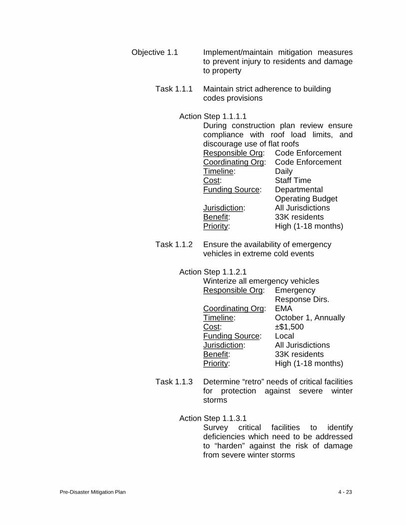
Pre-Disaster Mitigation Plan 4 - 23
Objective 1.1 Implement/maintain mitigation measures to prevent injury to residents and damage to property
Task 1.1.1 Maintain strict adherence to building
codes provisions
Action Step 1.1.1.1 During construction plan review ensure compliance with roof load limits, and discourage use of flat roofs Responsible Org: Code Enforcement Coordinating Org: Code Enforcement Timeline: Daily Cost: Staff Time Funding Source: Departmental
Operating Budget Jurisdiction: All Jurisdictions Benefit: 33K residents Priority: High (1-18 months)
Task 1.1.2 Ensure the availability of emergency
vehicles in extreme cold events
Action Step 1.1.2.1 Winterize all emergency vehicles
Responsible Org: Emergency Response Dirs.
Coordinating Org: EMA Timeline: October 1, Annually Cost: ±$1,500 Funding Source: Local Jurisdiction: All Jurisdictions Benefit: 33K residents Priority: High (1-18 months)
Task 1.1.3 Determine “retro” needs of critical facilities for protection against severe winter storms
Action Step 1.1.3.1 Survey critical facilities to identify
deficiencies which need to be addressed to “harden” against the risk of damage from severe winter storms
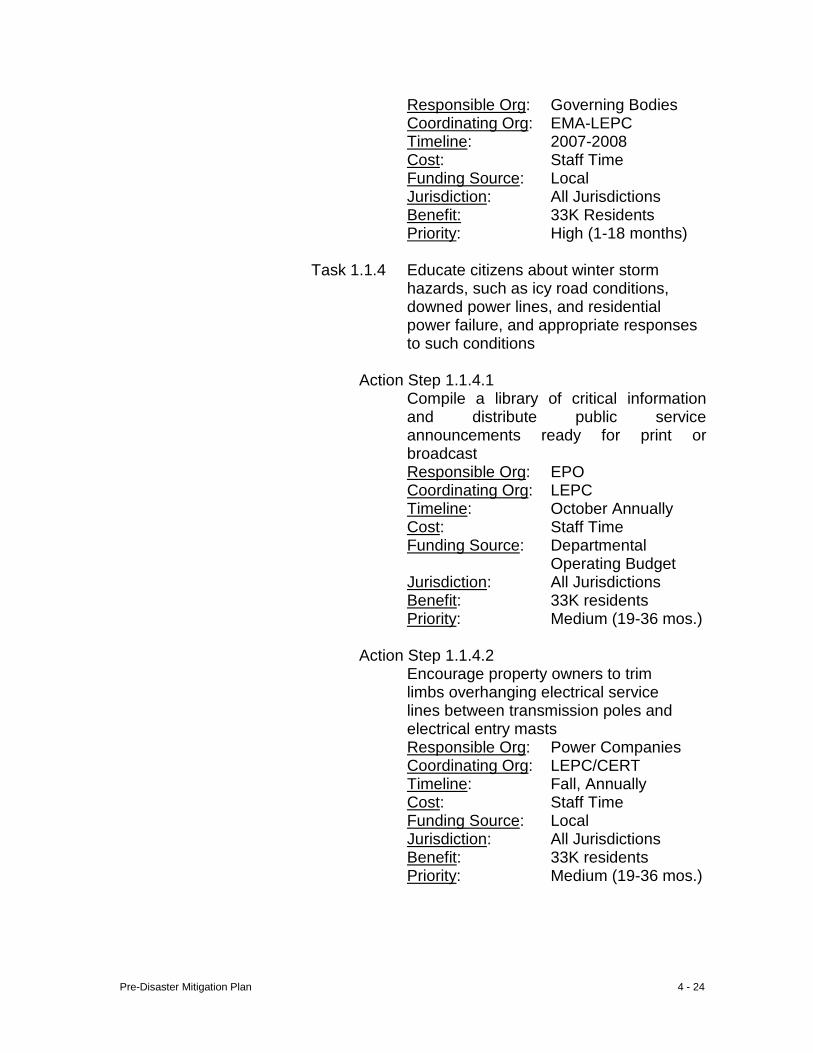
Pre-Disaster Mitigation Plan 4 - 24
Responsible Org: Governing Bodies Coordinating Org: EMA-LEPC
Timeline: 2007-2008 Cost: Staff Time Funding Source: Local Jurisdiction: All Jurisdictions Benefit: 33K Residents Priority: High (1-18 months)
Task 1.1.4 Educate citizens about winter storm hazards, such as icy road conditions, downed power lines, and residential power failure, and appropriate responses to such conditions
Action Step 1.1.4.1
Compile a library of critical information and distribute public service announcements ready for print or broadcast Responsible Org: EPO Coordinating Org: LEPC Timeline: October Annually Cost: Staff Time Funding Source: Departmental
Operating Budget Jurisdiction: All Jurisdictions Benefit: 33K residents Priority: Medium (19-36 mos.)
Action Step 1.1.4.2 Encourage property owners to trim
limbs overhanging electrical service lines between transmission poles and electrical entry masts Responsible Org: Power Companies Coordinating Org: LEPC/CERT Timeline: Fall, Annually Cost: Staff Time Funding Source: Local Jurisdiction: All Jurisdictions Benefit: 33K residents Priority: Medium (19-36 mos.)
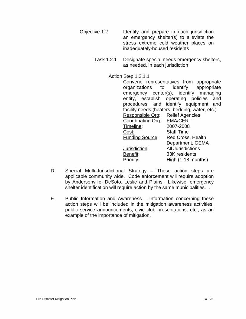
Pre-Disaster Mitigation Plan 4 - 25
Objective 1.2 Identify and prepare in each jurisdiction an emergency shelter(s) to alleviate the stress extreme cold weather places on inadequately-housed residents
Task 1.2.1 Designate special needs emergency shelters,
as needed, in each jurisdiction
Action Step 1.2.1.1 Convene representatives from appropriate
organizations to identify appropriate emergency center(s), identify managing entity, establish operating policies and procedures, and identify equipment and facility needs (heaters, bedding, water, etc.)
Responsible Org: Relief Agencies Coordinating Org: EMA/CERT Timeline: 2007-2008 Cost: Staff Time Funding Source: Red Cross, Health
Department, GEMA Jurisdiction: All Jurisdictions Benefit: 33K residents Priority: High (1-18 months)
D. Special Multi-Jurisdictional Strategy – These action steps are applicable community wide. Code enforcement will require adoption by Andersonville, DeSoto, Leslie and Plains. Likewise, emergency shelter identification will require action by the same municipalities. .
E. Public Information and Awareness – Information concerning these
action steps will be included in the mitigation awareness activities, public service announcements, civic club presentations, etc., as an example of the importance of mitigation.
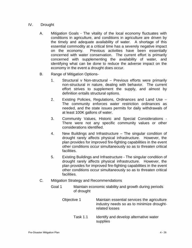
Pre-Disaster Mitigation Plan 4 - 26
IV. Drought
A. Mitigation Goals - The vitality of the local economy fluctuates with conditions in agriculture, and conditions in agriculture are driven by the timely and adequate availability of water. A shortage of this essential commodity at a critical time has a severely negative impact on the economy. Previous activities have been essentially concerned with water conservation. The current effort is primarily concerned with supplementing the availability of water, and identifying what can be done to reduce the adverse impact on the economy in the event a drought does occur.
B. Range of Mitigation Options- 1. Structural v Non-structural – Previous efforts were primarily
non-structural in nature, dealing with behavior. The current effort strives to supplement the supply, and almost by definition entails structural options.
2. Existing Policies, Regulations, Ordinances and Land Use – The community enforces water restriction ordinances as needed, and the state issues permits for daily withdrawals of at least 100K gallons of water.
3. Community Values, Historic and Special Considerations - There were not any specific community values or other considerations identified.
4. New Buildings and Infrastructure – The singular condition of drought rarely affects physical infrastructure. However, the plan provides for improved fire-fighting capabilities in the event other conditions occur simultaneously so as to threaten critical facilities.
5. Existing Buildings and Infrastructure - The singular condition of drought rarely affects physical infrastructure. However, the plan provides for improved fire-fighting capabilities in the event other conditions occur simultaneously so as to threaten critical facilities.
C. Mitigation Strategy and Recommendations Goal 1 Maintain economic stability and growth during periods
of drought
Objective 1 Maintain essential services the agriculture industry needs so as to minimize drought-related losses
Task 1.1 Identify and develop alternative water
supplies
Pre-Disaster Mitigation Plan 4 - 27
Action Step 1.1.1 Increase activity within agriculture community
to pursue additional irrigation, reservoir development, lowering of well intakes where appropriate, and low interest financing to enable such improvements
Responsible Org: NRCS Coordinating Org: NRCS Timeline: Annually Cost: Staff Time Funding Source: USDA Jurisdiction: All Jurisdictions Benefit: 33K residents Priority: High (1-18 months)
Action Step 1.1.2 Pursue funding for reservoir development
Responsible Org: County Coordinating Org: NRCS Timeline: 2007-2011 Cost: Staff Time
Funding Source: Reservoir Develop- ment-state and federal
Jurisdiction: Sumter Benefit: 15K residents Priority: Medium (19-36 mos.)
Objective 2 Maintain fire fighting capabilities in time of
drought
Task 2.1 Develop and maintain resources needed for rural fire fighting
Action Step 2.1.1 Maintain fire breaks Responsible Org: Property Owner
Coordinating Org: Georgia Forestry Commission
Timeline: Annually Cost: $65/hr Funding Source: Property Owner
Jurisdiction: Sumter Benefit: 15K residents Priority: High (1-18 months)
Pre-Disaster Mitigation Plan 4 - 28
Action Step 2.1.2 Acquire mobile water supply (tankers)
Responsible Org: Local Government Coordinating Org: Georgia Forestry
Commission Timeline: 2007-2010 Cost: $75K Funding Source: Georgia Forestry
Commission, USDA Jurisdiction: Sumter Benefit: 15K residents Priority: Medium (19-36 mos.)
Action Step 2.1.3 Place additional dry hydrants
Responsible Org: Extension Service Coordinating Org: Bd. of Commissioners
Sumter Fire Depts Timeline: 2006-2008 Cost: ±$5K Funding Source: Extension Service Sumter Jurisdiction: Sumter Benefit: 15K residents Priority: Medium (19-36 mos.)
Objective 3 Preserve more of the available water
resources
Task 3.1 Increase the installation of low-flow plumbing fixtures in the community
Action Step 3.1.1 Promote the use of low-flow plumbing fixtures with issuance of building permits
Responsible Org: Code Enforcement Coordinating Org: Code Enforcement Timeline: Daily Cost: Staff Time
Funding Source: Residents and Developers
Jurisdiction: All Jurisdictions Benefit: 33K residents Priority: High (1-18 months)
Pre-Disaster Mitigation Plan 4 - 29
Task 3.2 Improve enforcement of state-mandated, locally implemented, drought conservation plan
Action Step 3.2.1 Provide more information to residents and,
where appropriate, issue violations Responsible Org: All Governing Bodies
Coordinating Org: Code Enforcement Timeline: As needed Cost: Staff Time
Funding Source: Residents Jurisdiction: All Jurisdictions Benefit: 33K residents Priority: High (1-18 months)
D. Special Multi-Jurisdictional Strategy – Although all jurisdictions are
affected, primary emphasis of project activities is in the unincorporated area of the county.
E. Public Information and Awareness – Information concerning these
activities will be included in the information programs presented at numerous venues. Public participation will be solicited.
Pre-Disaster Mitigation Plan 4 - 30
V. (Hurricane) Tropical Storm
A. Mitigation Goals – Tropical storms are either downgraded versions of hurricanes, or winds which never get strong enough (wind speed) to be classified as a hurricane. Tropical storms lose wind speed, and destructive ability, as they make their paths across land. However, if they should linger in any location (TS Alberto-1994) significant damage can occur. Because of proximity to both the Atlantic and Gulf Coasts, Sumter County will always be at risk of experiencing such events. At this writing meteorologists are predicting a multi-year cycle of increased hurricane activity for the United States; tropical storms are a continuation of the hurricane. These events can expose the community to high winds and heavy rain, sometimes resulting in flooding beyond identified floodplains.
B. Range of Mitigation Options 1. Structural v Non-structural –The community will utilize non-
structural options; encouraging building code compliance, expand public broadcast of weather warnings, and public education to supplement property owner’s structural options. These activities will supplement structural responsibilities of property owners.
2. Existing Policies, Regulations, Ordinances and Land Use – Building codes are currently enforced in Sumter and Americus.
Flood damage prevention ordinances, which are applicable to the flooding aspects of tropical storms, have been adopted in Sumter, Americus and Leslie.
3. Community Values, Historic and Special Considerations – No
specific community concerns were identified. Few designated historic structures are believed subject to flood waters resulting from a tropical storm.
4. New Buildings and Infrastructure – Compliance with building codes will reduce adverse impacts of future occurrences of this hazard because new development will be better able to withstand tropical storm generated winds. The effort to institutionalize hazard mitigation will serve to reduce susceptibility of future public-owned infrastructure because mitigation will be included in planning and capital expenditure decisions. The flood prevention component will be enhanced by the (requested) availability of digital floodplain maps (see Flood). Merger (or overlay) of geo-referenced critical facilities and geo-referenced floodplains will enable the delineation of lands located within the environmentally sensitive area. With this information developers will be better able to determine the costs/benefits associated with building within a floodplain in
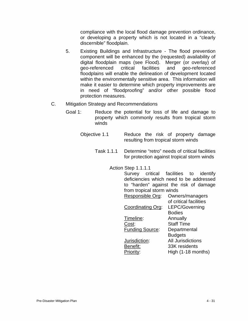
Pre-Disaster Mitigation Plan 4 - 31
compliance with the local flood damage prevention ordinance, or developing a property which is not located in a “clearly discernible” floodplain.
5. Existing Buildings and Infrastructure - The flood prevention component will be enhanced by the (requested) availability of digital floodplain maps (see Flood). Merger (or overlay) of geo-referenced critical facilities and geo-referenced floodplains will enable the delineation of development located within the environmentally sensitive area. This information will make it easier to determine which property improvements are in need of “floodproofing” and/or other possible flood protection measures.
C. Mitigation Strategy and Recommendations Goal 1: Reduce the potential for loss of life and damage to
property which commonly results from tropical storm winds
Objective 1.1 Reduce the risk of property damage
resulting from tropical storm winds Task 1.1.1 Determine “retro” needs of critical facilities
for protection against tropical storm winds Action Step 1.1.1.1 Survey critical facilities to identify
deficiencies which need to be addressed to “harden” against the risk of damage from tropical storm winds Responsible Org: Owners/managers
of critical facilities Coordinating Org: LEPC/Governing Bodies Timeline: Annually Cost: Staff Time Funding Source: Departmental Budgets Jurisdiction: All Jurisdictions Benefit: 33K residents Priority: High (1-18 months)
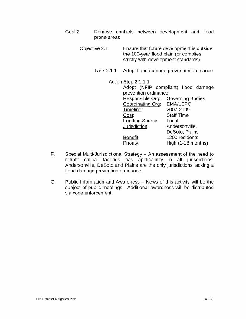
Pre-Disaster Mitigation Plan 4 - 32
Goal 2 Remove conflicts between development and flood prone areas
Objective 2.1 Ensure that future development is outside
the 100-year flood plain (or complies strictly with development standards)
Task 2.1.1 Adopt flood damage prevention ordinance
Action Step 2.1.1.1 Adopt (NFIP compliant) flood damage
prevention ordinance Responsible Org: Governing Bodies Coordinating Org: EMA/LEPC Timeline: 2007-2009 Cost: Staff Time Funding Source: Local Jurisdiction: Andersonville, DeSoto, Plains
Benefit: 1200 residents Priority: High (1-18 months)
F. Special Multi-Jurisdictional Strategy – An assessment of the need to retrofit critical facilities has applicability in all jurisdictions. Andersonville, DeSoto and Plains are the only jurisdictions lacking a flood damage prevention ordinance.
G. Public Information and Awareness – News of this activity will be the
subject of public meetings. Additional awareness will be distributed via code enforcement.
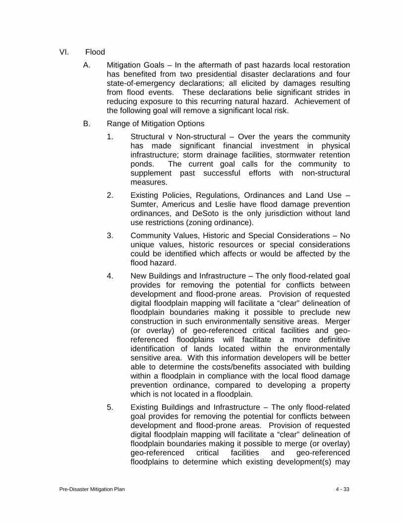
Pre-Disaster Mitigation Plan 4 - 33
VI. Flood A. Mitigation Goals – In the aftermath of past hazards local restoration
has benefited from two presidential disaster declarations and four state-of-emergency declarations; all elicited by damages resulting from flood events. These declarations belie significant strides in reducing exposure to this recurring natural hazard. Achievement of the following goal will remove a significant local risk.
B. Range of Mitigation Options 1. Structural v Non-structural – Over the years the community
has made significant financial investment in physical infrastructure; storm drainage facilities, stormwater retention ponds. The current goal calls for the community to supplement past successful efforts with non-structural measures.
2. Existing Policies, Regulations, Ordinances and Land Use – Sumter, Americus and Leslie have flood damage prevention ordinances, and DeSoto is the only jurisdiction without land use restrictions (zoning ordinance).
3. Community Values, Historic and Special Considerations – No unique values, historic resources or special considerations could be identified which affects or would be affected by the flood hazard.
4. New Buildings and Infrastructure – The only flood-related goal provides for removing the potential for conflicts between development and flood-prone areas. Provision of requested digital floodplain mapping will facilitate a “clear” delineation of floodplain boundaries making it possible to preclude new construction in such environmentally sensitive areas. Merger (or overlay) of geo-referenced critical facilities and geo-referenced floodplains will facilitate a more definitive identification of lands located within the environmentally sensitive area. With this information developers will be better able to determine the costs/benefits associated with building within a floodplain in compliance with the local flood damage prevention ordinance, compared to developing a property which is not located in a floodplain.
5. Existing Buildings and Infrastructure – The only flood-related goal provides for removing the potential for conflicts between development and flood-prone areas. Provision of requested digital floodplain mapping will facilitate a “clear” delineation of floodplain boundaries making it possible to merge (or overlay) geo-referenced critical facilities and geo-referenced floodplains to determine which existing development(s) may
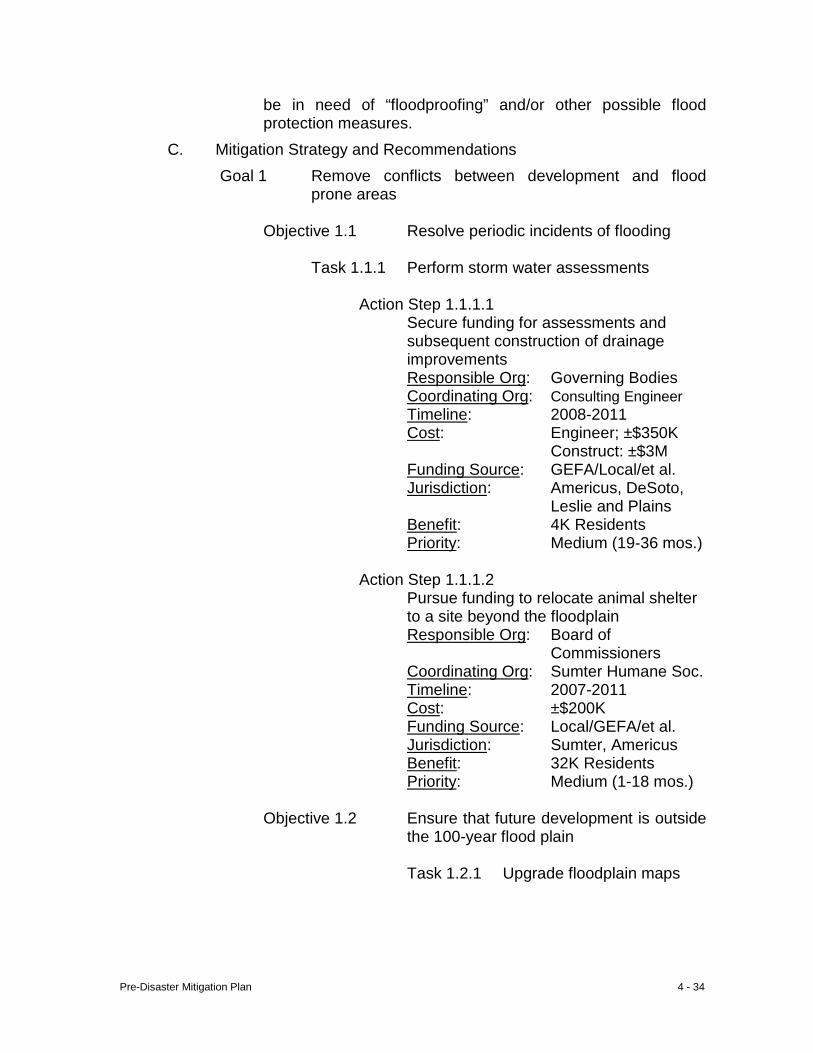
Pre-Disaster Mitigation Plan 4 - 34
be in need of “floodproofing” and/or other possible flood protection measures.
C. Mitigation Strategy and Recommendations Goal 1 Remove conflicts between development and flood
prone areas
Objective 1.1 Resolve periodic incidents of flooding Task 1.1.1 Perform storm water assessments Action Step 1.1.1.1
Secure funding for assessments and subsequent construction of drainage improvements Responsible Org: Governing Bodies
Coordinating Org: Consulting Engineer Timeline: 2008-2011 Cost: Engineer; ±$350K
Construct: ±$3M Funding Source: GEFA/Local/et al.
Jurisdiction: Americus, DeSoto, Leslie and Plains
Benefit: 4K Residents Priority: Medium (19-36 mos.)
Action Step 1.1.1.2
Pursue funding to relocate animal shelter to a site beyond the floodplain Responsible Org: Board of
Commissioners Coordinating Org: Sumter Humane Soc.
Timeline: 2007-2011 Cost: ±$200K Funding Source: Local/GEFA/et al.
Jurisdiction: Sumter, Americus Benefit: 32K Residents Priority: Medium (1-18 mos.)
Objective 1.2 Ensure that future development is outside
the 100-year flood plain Task 1.2.1 Upgrade floodplain maps
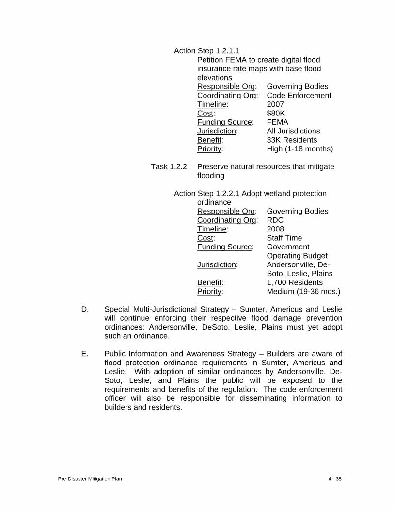
Pre-Disaster Mitigation Plan 4 - 35
Action Step 1.2.1.1 Petition FEMA to create digital flood
insurance rate maps with base flood elevations Responsible Org: Governing Bodies
Coordinating Org: Code Enforcement Timeline: 2007 Cost: $80K
Funding Source: FEMA Jurisdiction: All Jurisdictions Benefit: 33K Residents Priority: High (1-18 months)
Task 1.2.2 Preserve natural resources that mitigate
flooding
Action Step 1.2.2.1 Adopt wetland protection ordinance Responsible Org: Governing Bodies
Coordinating Org: RDC Timeline: 2008 Cost: Staff Time Funding Source: Government
Operating Budget Jurisdiction: Andersonville, De-
Soto, Leslie, Plains Benefit: 1,700 Residents Priority: Medium (19-36 mos.)
D. Special Multi-Jurisdictional Strategy – Sumter, Americus and Leslie will continue enforcing their respective flood damage prevention ordinances; Andersonville, DeSoto, Leslie, Plains must yet adopt such an ordinance.
E. Public Information and Awareness Strategy – Builders are aware of
flood protection ordinance requirements in Sumter, Americus and Leslie. With adoption of similar ordinances by Andersonville, De-Soto, Leslie, and Plains the public will be exposed to the requirements and benefits of the regulation. The code enforcement officer will also be responsible for disseminating information to builders and residents.
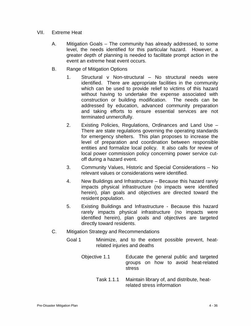
Pre-Disaster Mitigation Plan 4 - 36
VII. Extreme Heat
A. Mitigation Goals – The community has already addressed, to some level, the needs identified for this particular hazard. However, a greater depth of planning is needed to facilitate prompt action in the event an extreme heat event occurs.
B. Range of Mitigation Options 1. Structural v Non-structural – No structural needs were
identified. There are appropriate facilities in the community which can be used to provide relief to victims of this hazard without having to undertake the expense associated with construction or building modification. The needs can be addressed by education, advanced community preparation and taking efforts to ensure essential services are not terminated unmercifully.
2. Existing Policies, Regulations, Ordinances and Land Use – There are state regulations governing the operating standards for emergency shelters. This plan proposes to increase the level of preparation and coordination between responsible entities and formalize local policy. It also calls for review of local power commission policy concerning power service cut-off during a hazard event.
3. Community Values, Historic and Special Considerations – No relevant values or considerations were identified.
4. New Buildings and Infrastructure – Because this hazard rarely impacts physical infrastructure (no impacts were identified herein), plan goals and objectives are directed toward the resident population.
5. Existing Buildings and Infrastructure - Because this hazard rarely impacts physical infrastructure (no impacts were identified herein), plan goals and objectives are targeted directly toward residents.
C. Mitigation Strategy and Recommendations Goal 1 Minimize, and to the extent possible prevent, heat-
related injuries and deaths
Objective 1.1 Educate the general public and targeted groups on how to avoid heat-related stress
Task 1.1.1 Maintain library of, and distribute, heat-
related stress information
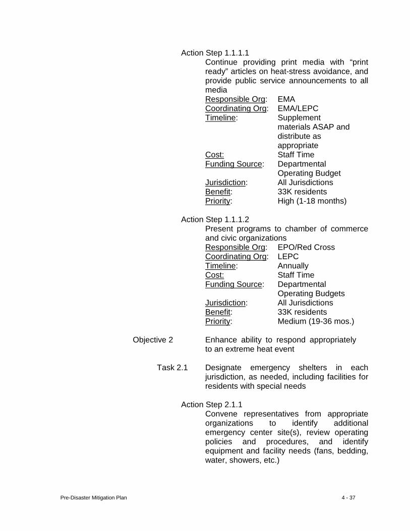
Pre-Disaster Mitigation Plan 4 - 37
Action Step 1.1.1.1 Continue providing print media with “print
ready” articles on heat-stress avoidance, and provide public service announcements to all media
Responsible Org: EMA Coordinating Org: EMA/LEPC Timeline: Supplement
materials ASAP and distribute as appropriate
Cost: Staff Time Funding Source: Departmental
Operating Budget Jurisdiction: All Jurisdictions Benefit: 33K residents Priority: High (1-18 months)
Action Step 1.1.1.2
Present programs to chamber of commerce and civic organizations
Responsible Org: EPO/Red Cross Coordinating Org: LEPC Timeline: Annually Cost: Staff Time Funding Source: Departmental
Operating Budgets Jurisdiction: All Jurisdictions Benefit: 33K residents Priority: Medium (19-36 mos.)
Objective 2 Enhance ability to respond appropriately
to an extreme heat event
Task 2.1 Designate emergency shelters in each jurisdiction, as needed, including facilities for residents with special needs
Action Step 2.1.1
Convene representatives from appropriate organizations to identify additional emergency center site(s), review operating policies and procedures, and identify equipment and facility needs (fans, bedding, water, showers, etc.)
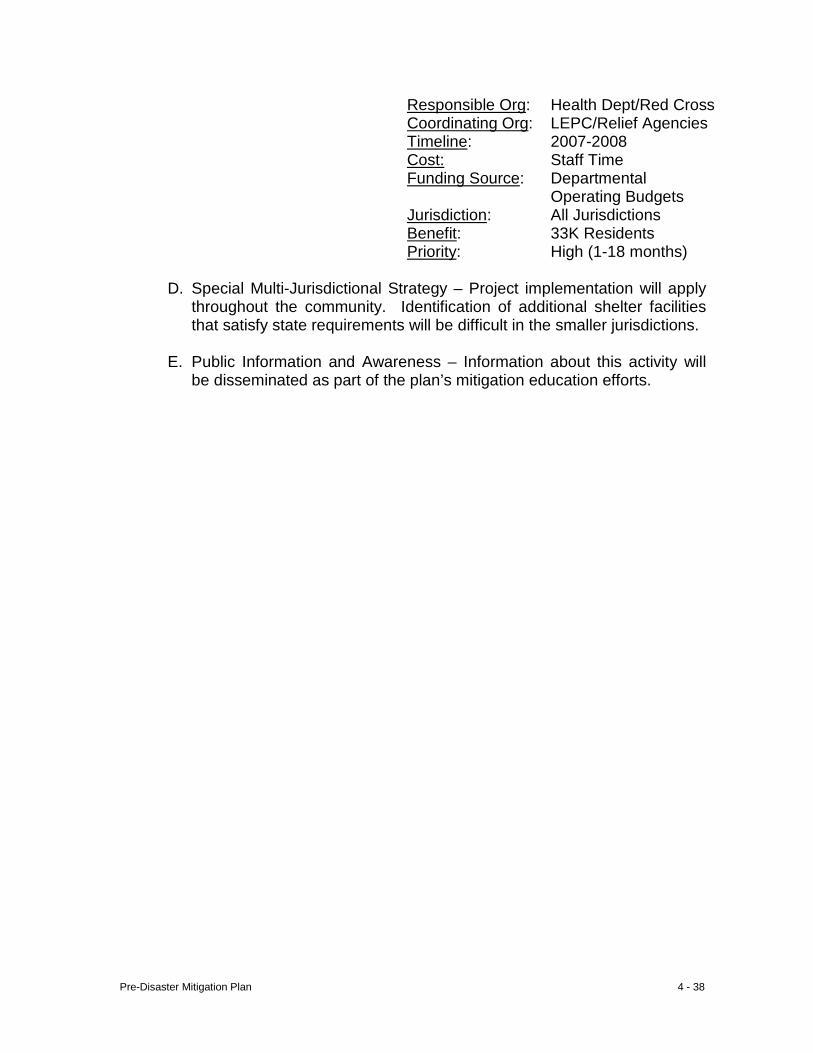
Pre-Disaster Mitigation Plan 4 - 38
Responsible Org: Health Dept/Red Cross Coordinating Org: LEPC/Relief Agencies Timeline: 2007-2008 Cost: Staff Time Funding Source: Departmental
Operating Budgets Jurisdiction: All Jurisdictions Benefit: 33K Residents Priority: High (1-18 months)
D. Special Multi-Jurisdictional Strategy – Project implementation will apply throughout the community. Identification of additional shelter facilities that satisfy state requirements will be difficult in the smaller jurisdictions.
E. Public Information and Awareness – Information about this activity will
be disseminated as part of the plan’s mitigation education efforts.
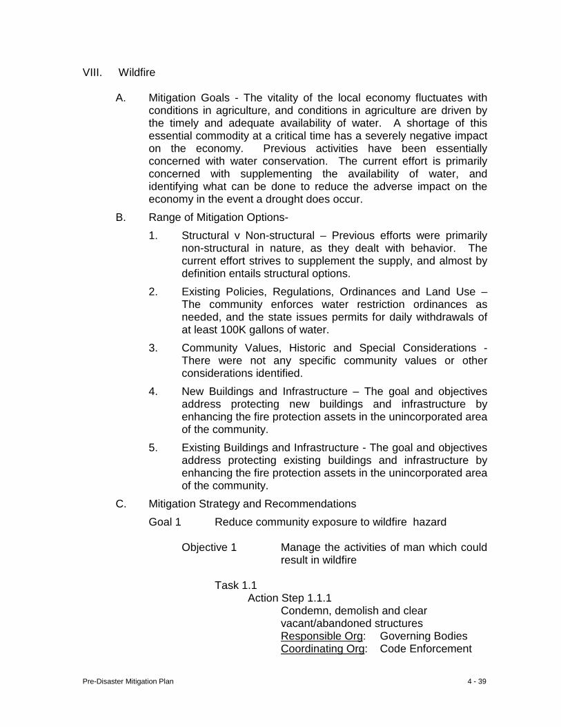
Pre-Disaster Mitigation Plan 4 - 39
VIII. Wildfire
A. Mitigation Goals - The vitality of the local economy fluctuates with conditions in agriculture, and conditions in agriculture are driven by the timely and adequate availability of water. A shortage of this essential commodity at a critical time has a severely negative impact on the economy. Previous activities have been essentially concerned with water conservation. The current effort is primarily concerned with supplementing the availability of water, and identifying what can be done to reduce the adverse impact on the economy in the event a drought does occur.
B. Range of Mitigation Options- 1. Structural v Non-structural – Previous efforts were primarily
non-structural in nature, as they dealt with behavior. The current effort strives to supplement the supply, and almost by definition entails structural options.
2. Existing Policies, Regulations, Ordinances and Land Use – The community enforces water restriction ordinances as needed, and the state issues permits for daily withdrawals of at least 100K gallons of water.
3. Community Values, Historic and Special Considerations - There were not any specific community values or other considerations identified.
4. New Buildings and Infrastructure – The goal and objectives address protecting new buildings and infrastructure by enhancing the fire protection assets in the unincorporated area of the community.
5. Existing Buildings and Infrastructure - The goal and objectives address protecting existing buildings and infrastructure by enhancing the fire protection assets in the unincorporated area of the community.
C. Mitigation Strategy and Recommendations Goal 1 Reduce community exposure to wildfire hazard
Objective 1 Manage the activities of man which could result in wildfire
Task 1.1
Action Step 1.1.1 Condemn, demolish and clear vacant/abandoned structures
Responsible Org: Governing Bodies Coordinating Org: Code Enforcement
Pre-Disaster Mitigation Plan 4 - 40
Timeline: Annually Cost: Staff Time
Funding Source: Departmental Operating Budgets
Jurisdiction: All Jurisdictions Benefit: 33K Residents Priority: High (1-18 months)
Action Step 1.1.2 Promote fire-safe construction and maintenance practices
Responsible Org: County Code Enforcement
Coordinating Org: Code Enforcement Timeline: Annually Cost: Staff Time
Funding Source: Departmental Operating Budgets
Jurisdiction: All Jurisdictions Benefit: 33K Residents Priority: High (1-18 months)
Action Step 1.1.3
Promoting inspection of chimneys Responsible Org: Code
Enforcement Coordinating Org: Code Enforcement Timeline: Annually Cost: Staff Time
Funding Source: Departmental Operating Budgets
Jurisdiction: All Jurisdictions Benefit: 33K Residents Priority: High (1-18 months)
Action Step 1.1.4
Continue promoting proper disposal of waste; discourage open burning Responsible Org: County Code
Enforcement Coordinating Org: Code Enforcement Timeline: Annually Cost: Staff Time
Funding Source: Departmental Operating Budgets
Jurisdiction: Sumter
Pre-Disaster Mitigation Plan 4 - 41
Benefit: 15K Residents Priority: High (1-18 months)
Action Step 1.1.5
Promote installation and maintenance of smoke detectors Responsible Org: Code
Enforcement Coordinating Org: Code Enforcement Timeline: Annually Cost: Staff Time
Funding Source: Departmental Operating Budgets
Jurisdiction: All Jurisdictions Benefit: 33K Residents Priority: High (1-18 months)
D. Special Multi-Jurisdictional Strategy – Although the greatest threat
from this hazard is to Sumter, all jurisdictions are affected. Hence, all jurisdictions have action steps which will contribute to plan implementation.
E. Public Information and Awareness – Information concerning these
activities will be included in the information programs presented at numerous venues. Public participation will be solicited.
Pre-Disaster Mitigation Plan 4 - 42
IX. Hail Storm
A. Mitigation Goals – The community is susceptible to hail storms any time of year. The best protection from this hazard is public education.
B. Range of Mitigation Options 1. Structural v Non-structural – This goal addresses non-
structural measures that have community-wide impact. 2. Existing Policies, Regulations, Ordinances and Land Use – No existing policies, regulations, ordinances or land uses were
found to be relevant to this hazard. 3. Community Values, Historic and Special Considerations – No
specific community concerns were identified. 4. New Buildings and Infrastructure – Historically, buildings and
other local infrastructure have been little scathed by this hazard. The focus here is placed on educating the resident population how to be prepared in the event of recurrence, including encouraging agricultural producers to purchase crop insurance.
5. Existing Buildings and Infrastructure - Historically, buildings and other local infrastructure have been little scathed by this hazard. The focus here is placed on educating the resident population how to be prepared in the event of recurrence, including encouraging agricultural producers to purchase crop insurance.
C. Mitigation Strategy and Recommendations Goal 1 Reduce the potential for injury (and possible loss of life)
and damage to property which commonly results from hail storms
Objective 1.1 Reduce the risk of personal injury during hail storm events
Task 1.1.1 Prompt proactive measures among the
general public
Action Step 1.1.1.1 Continue encouraging the general public to purchase weather radios Responsible Org: EMA Coordinating Org: LEPC Timeline: Annually
Pre-Disaster Mitigation Plan 4 - 43
Cost: Staff Time Funding Source: Departmental
Operating Budgets Jurisdiction: All Jurisdictions Benefit: 33K Residents Priority: High (1-18 months)
Action Step 1.1.1.2 Educate citizens about the importance of (1) monitoring weather information, (2) using weather radios in the home and workplace and (3) heeding public weather warnings Responsible Org: EMA Coordinating Org: LEPC Timeline: Annually Cost: Staff Time Funding Source: Departmental
Operating Budgets Jurisdiction: All Jurisdictions Benefit: 33K Residents Priority: High (1-18 months)
Objective 1.2 Protect the community’s agricultural economy
Task 1.2.1 Increase agricultural producer
participation in crop insurance programs
Action Step 1.2.1.1 Disseminate information through farm programs of the value of crop insurance participation Responsible Org: FSA Coordinating Org: County Extension Timeline: Annually Cost: Staff Time Funding Source: Departmental
Operating Budgets Jurisdiction: Sumter Benefit: 15,000 Residents Priority: High (1-18 months)
D. Special Multi-Jurisdictional Strategy – Promotion of (1) general public purchase of weather-alert radios, and (2) monitoring and heeding weather warnings apply in all jurisdictions. The latter two action
Pre-Disaster Mitigation Plan 4 - 44
steps have application in the unincorporated area of the community; areas without sirens and where crop insurance is needed.
E. Public Information and Awareness – Information concerning these
action steps will be included in the mitigation awareness activities, public service announcements, civic club presentations, etc., as an example of the importance of mitigation.
Pre-Disaster Mitigation Plan 4 - 45
X. Dam Failure
A. Mitigation Goals – The county is dotted with many, small, man-made reservoirs. The purpose of this goal is to identify which developments may be downstream of these sites, and manage future development so as to reduce the threat to life and property that can result from dam failure.
B. Range of Mitigation Options 1. Structural v Non-structural – The specific activities proposed
herein are non-structural. Appropriate follow-up to plan implementation; however, could result in structural improvements.
2. Existing Policies, Regulations, Ordinances and Land Use – At this writing there are not any local existing policies, regulations, ordinances or land use controls applicable to the proposed mitigation activities.
3. Community Values, Historic and Special Considerations – There are not any known community values, historic and/or special considerations applicable to this mitigation action.
4. New Buildings and Infrastructure – Developers will be
informed/reminded of the applicability of building codes in the community. Adoption and enforcement of housing/environmental codes will serve to protect future development by reducing the size of the potential debris field sensitive to thunderstorm winds. In light of the improved quality of construction achieved through building code compliance, the proportion of structures which do not meet building code standards will be gradually reduced.
5. Existing Buildings and Infrastructure – Adoption and enforcement of housing/environmental codes will serve to protect existing buildings by reducing the size of the potential debris field sensitive to thunderstorm winds. After surveying “retro” needs of the critical infrastructure, the nature of each individual need must be assessed within the context of funds available for corrective action.
C. Mitigation Strategy and Recommendations Goal 1 Protect property and lives downstream of local dams
Objective 1 Identify properties at risk down stream of local dams
Task 1.1 Map topography of dam “shadows”
Pre-Disaster Mitigation Plan 4 - 46
Action Step 1.1.1 Identify source of, and pursue, funding
for necessary mapping Responsible Org: Board of Commissioners
Coordinating Org: Code Enforcement Timeline: 2008-2009 Cost: $1K
Funding Source: County Operating Budget
Jurisdiction: Sumter Benefit: ±1K Residents
Priority: High (1-18 months)
Action Step 1.1.2 Identify and give notification to residents of dam “shadows”,
Responsible Org: Governing Body Coordinating Org: Code Enforcement Timeline: 2008-2009 Cost: Staff Time
Funding Source: Departmental Operating Budget
Jurisdiction: Sumter Benefit: ±1K residents Priority: Medium (19-36 mos.)
Action Step 1.1.3
Develop a zoning district overlay of dam shadows
Responsible Org: Code Enforcement Coordinating Org: Code Enforcement Timeline: 2007-2011 Cost: Undetermined
Funding Source: Departmental Operating Budget
Jurisdiction: Sumter Benefit: ±1K residents Priority: Medium (19-36 mos.)
Objective 1 Maintain physical integrity of local dams
Task 1.1 Educate dam owners regarding dam safety, inspection, repair, and routine maintenance
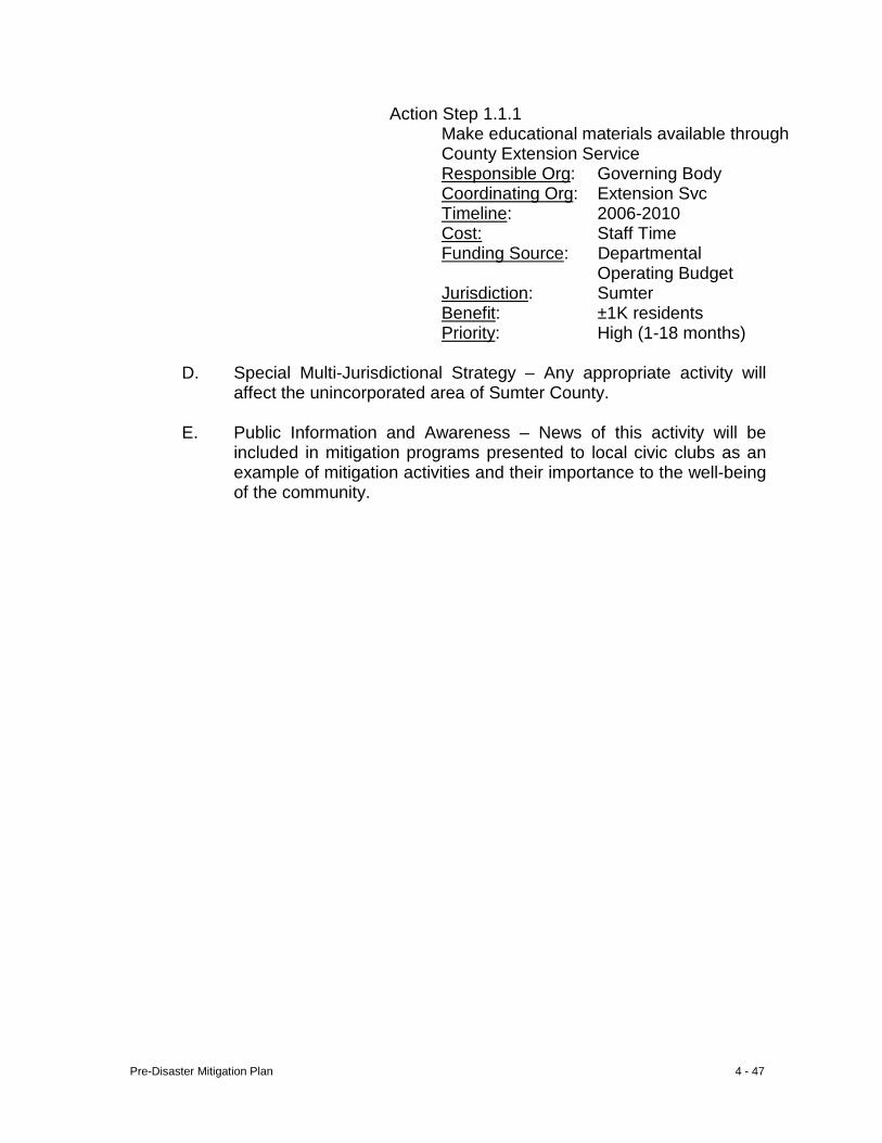
Pre-Disaster Mitigation Plan 4 - 47
Action Step 1.1.1 Make educational materials available through County Extension Service
Responsible Org: Governing Body Coordinating Org: Extension Svc Timeline: 2006-2010 Cost: Staff Time
Funding Source: Departmental Operating Budget
Jurisdiction: Sumter Benefit: ±1K residents
Priority: High (1-18 months)
D. Special Multi-Jurisdictional Strategy – Any appropriate activity will affect the unincorporated area of Sumter County.
E. Public Information and Awareness – News of this activity will be
included in mitigation programs presented to local civic clubs as an example of mitigation activities and their importance to the well-being of the community.
Pre-Disaster Mitigation Plan Sumter County
Chapter 5 - Local Technological Hazard Mitigation Goals and Objectives I Transportation Accident 1 II Hazardous Materials Release (fixed site) 6 III Terrorism 15 IV Radiological Event 18 V Animal/Crop Disease 21 VI Groundwater Contamination 24
VII Civil Disturbance 27
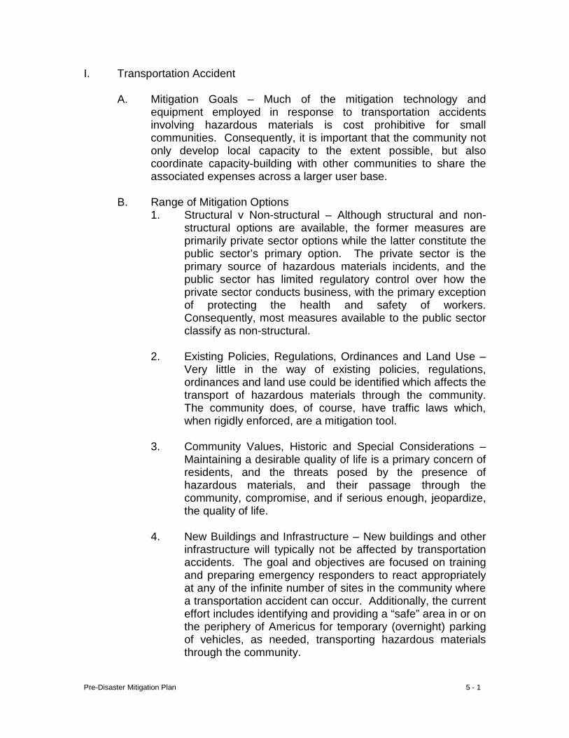
Pre-Disaster Mitigation Plan 5 - 1
I. Transportation Accident
A. Mitigation Goals – Much of the mitigation technology and equipment employed in response to transportation accidents involving hazardous materials is cost prohibitive for small communities. Consequently, it is important that the community not only develop local capacity to the extent possible, but also coordinate capacity-building with other communities to share the associated expenses across a larger user base.
B. Range of Mitigation Options
1. Structural v Non-structural – Although structural and non-structural options are available, the former measures are primarily private sector options while the latter constitute the public sector’s primary option. The private sector is the primary source of hazardous materials incidents, and the public sector has limited regulatory control over how the private sector conducts business, with the primary exception of protecting the health and safety of workers. Consequently, most measures available to the public sector classify as non-structural.
2. Existing Policies, Regulations, Ordinances and Land Use –
Very little in the way of existing policies, regulations, ordinances and land use could be identified which affects the transport of hazardous materials through the community. The community does, of course, have traffic laws which, when rigidly enforced, are a mitigation tool.
3. Community Values, Historic and Special Considerations –
Maintaining a desirable quality of life is a primary concern of residents, and the threats posed by the presence of hazardous materials, and their passage through the community, compromise, and if serious enough, jeopardize, the quality of life.
4. New Buildings and Infrastructure – New buildings and other
infrastructure will typically not be affected by transportation accidents. The goal and objectives are focused on training and preparing emergency responders to react appropriately at any of the infinite number of sites in the community where a transportation accident can occur. Additionally, the current effort includes identifying and providing a “safe” area in or on the periphery of Americus for temporary (overnight) parking of vehicles, as needed, transporting hazardous materials through the community.
Pre-Disaster Mitigation Plan 5 - 2
5. Existing Buildings and Infrastructure – Buildings and other infrastructure are typically not affected by transportation accidents. The goal and objectives are focused on training and preparing emergency responders to react appropriately at any of the infinite number of sites in the community where a transportation accident can occur. Additionally, the current effort includes identifying and providing a “safe” area in or on the periphery of Americus for temporary (overnight) parking of vehicles, as needed, transporting hazardous materials through the community.
C. Mitigation Strategy and Recommendations
Goal 1 Stay current with the risks, appropriate mitigation
measures and legal authority associated with transportation-related hazardous materials accidents
Objective 1.1 Be current with the risks and appropriate
mitigation measures associated with hazardous materials
Task 1.1.1 Secure and maintain active
membership(s) in applicable emergency response training and education associations/organizations
Action Step 1.1.1.1
Establish line item in annual EMA budget for associational and organizational membership(s) Responsible Org: Board of
Commissioners Coordinating Org: EMA Timeline: Annually Cost: Staff Time Funding Source: Local Jurisdiction: All Jurisdictions Benefit: 33K residents Priority: High (1-18 months)
Objective 1.2 Obtain outside sources of funding to finance local capacity building and necessary equipment purchases
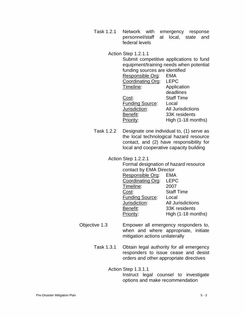
Pre-Disaster Mitigation Plan 5 - 3
Task 1.2.1 Network with emergency response personnel/staff at local, state and federal levels
Action Step 1.2.1.1
Submit competitive applications to fund equipment/training needs when potential funding sources are identified Responsible Org: EMA Coordinating Org: LEPC Timeline: Application
deadlines Cost: Staff Time Funding Source: Local Jurisdiction: All Jurisdictions Benefit: 33K residents Priority: High (1-18 months)
Task 1.2.2 Designate one individual to, (1) serve as
the local technological hazard resource contact, and (2) have responsibility for local and cooperative capacity building
Action Step 1.2.2.1
Formal designation of hazard resource contact by EMA Director Responsible Org: EMA Coordinating Org: LEPC Timeline: 2007 Cost: Staff Time Funding Source: Local Jurisdiction: All Jurisdictions Benefit: 33K residents Priority: High (1-18 months)
Objective 1.3 Empower all emergency responders to,
when and where appropriate, initiate mitigation actions unilaterally
Task 1.3.1 Obtain legal authority for all emergency
responders to issue cease and desist orders and other appropriate directives
Action Step 1.3.1.1
Instruct legal counsel to investigate options and make recommendation
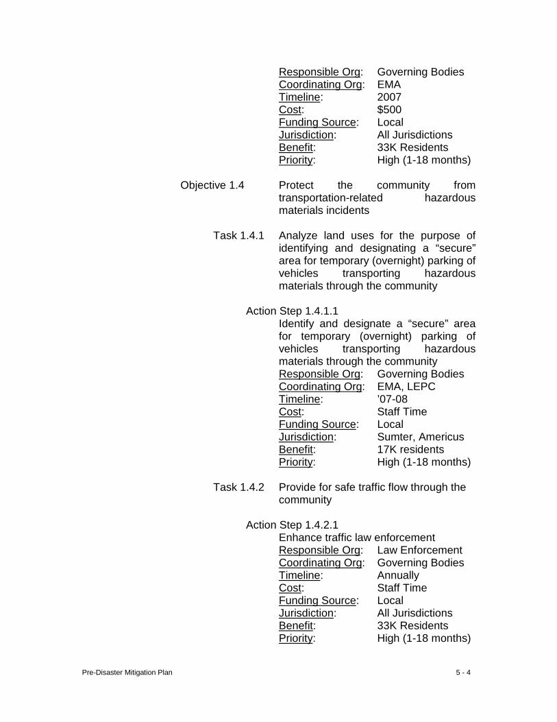
Pre-Disaster Mitigation Plan 5 - 4
Responsible Org: Governing Bodies Coordinating Org: EMA Timeline: 2007 Cost: $500 Funding Source: Local Jurisdiction: All Jurisdictions Benefit: 33K Residents Priority: High (1-18 months)
Objective 1.4 Protect the community from
transportation-related hazardous materials incidents
Task 1.4.1 Analyze land uses for the purpose of
identifying and designating a “secure” area for temporary (overnight) parking of vehicles transporting hazardous materials through the community
Action Step 1.4.1.1 Identify and designate a “secure” area
for temporary (overnight) parking of vehicles transporting hazardous materials through the community Responsible Org: Governing Bodies Coordinating Org: EMA, LEPC Timeline: ’07-08 Cost: Staff Time Funding Source: Local Jurisdiction: Sumter, Americus Benefit: 17K residents Priority: High (1-18 months)
Task 1.4.2 Provide for safe traffic flow through the
community Action Step 1.4.2.1 Enhance traffic law enforcement
Responsible Org: Law Enforcement Coordinating Org: Governing Bodies Timeline: Annually Cost: Staff Time Funding Source: Local Jurisdiction: All Jurisdictions Benefit: 33K Residents Priority: High (1-18 months)
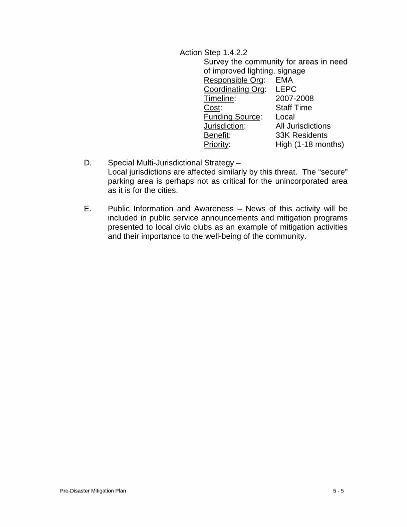
Pre-Disaster Mitigation Plan 5 - 5
Action Step 1.4.2.2 Survey the community for areas in need of improved lighting, signage Responsible Org: EMA Coordinating Org: LEPC Timeline: 2007-2008 Cost: Staff Time Funding Source: Local Jurisdiction: All Jurisdictions Benefit: 33K Residents Priority: High (1-18 months)
D. Special Multi-Jurisdictional Strategy –
Local jurisdictions are affected similarly by this threat. The “secure” parking area is perhaps not as critical for the unincorporated area as it is for the cities.
E. Public Information and Awareness – News of this activity will be
included in public service announcements and mitigation programs presented to local civic clubs as an example of mitigation activities and their importance to the well-being of the community.
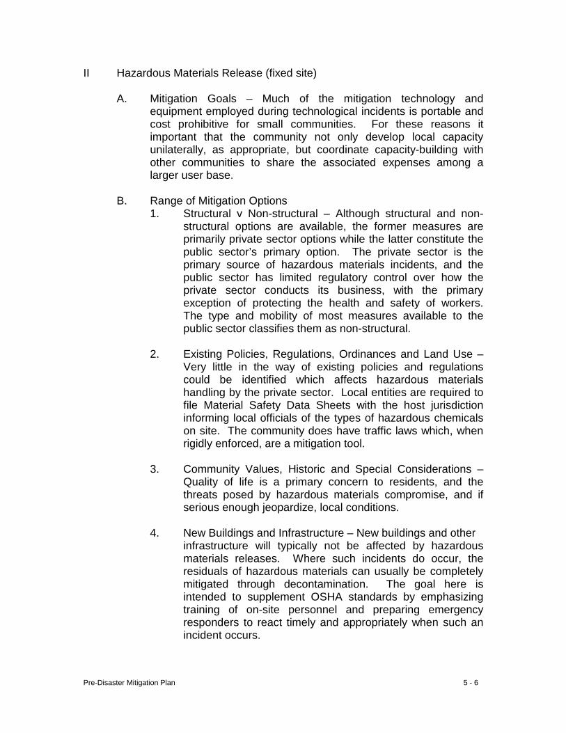
Pre-Disaster Mitigation Plan 5 - 6
II Hazardous Materials Release (fixed site) A. Mitigation Goals – Much of the mitigation technology and
equipment employed during technological incidents is portable and cost prohibitive for small communities. For these reasons it important that the community not only develop local capacity unilaterally, as appropriate, but coordinate capacity-building with other communities to share the associated expenses among a larger user base.
B. Range of Mitigation Options
1. Structural v Non-structural – Although structural and non-structural options are available, the former measures are primarily private sector options while the latter constitute the public sector’s primary option. The private sector is the primary source of hazardous materials incidents, and the public sector has limited regulatory control over how the private sector conducts its business, with the primary exception of protecting the health and safety of workers. The type and mobility of most measures available to the public sector classifies them as non-structural.
2. Existing Policies, Regulations, Ordinances and Land Use –
Very little in the way of existing policies and regulations could be identified which affects hazardous materials handling by the private sector. Local entities are required to file Material Safety Data Sheets with the host jurisdiction informing local officials of the types of hazardous chemicals on site. The community does have traffic laws which, when rigidly enforced, are a mitigation tool.
3. Community Values, Historic and Special Considerations –
Quality of life is a primary concern to residents, and the threats posed by hazardous materials compromise, and if serious enough jeopardize, local conditions.
4. New Buildings and Infrastructure – New buildings and other infrastructure will typically not be affected by hazardous
materials releases. Where such incidents do occur, the residuals of hazardous materials can usually be completely mitigated through decontamination. The goal here is intended to supplement OSHA standards by emphasizing training of on-site personnel and preparing emergency responders to react timely and appropriately when such an incident occurs.
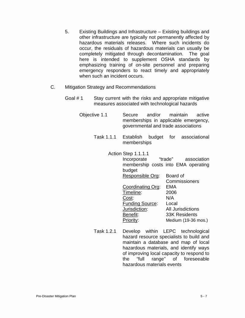
Pre-Disaster Mitigation Plan 5 - 7
5. Existing Buildings and Infrastructure – Existing buildings and other infrastructure are typically not permanently affected by hazardous materials releases. Where such incidents do occur, the residuals of hazardous materials can usually be completely mitigated through decontamination. The goal here is intended to supplement OSHA standards by emphasizing training of on-site personnel and preparing emergency responders to react timely and appropriately when such an incident occurs.
C. Mitigation Strategy and Recommendations
Goal # 1 Stay current with the risks and appropriate mitigative
measures associated with technological hazards
Objective 1.1 Secure and/or maintain active memberships in applicable emergency, governmental and trade associations
Task 1.1.1 Establish budget for associational
memberships
Action Step 1.1.1.1 Incorporate “trade” association membership costs into EMA operating budget Responsible Org: Board of
Commissioners Coordinating Org: EMA Timeline: 2006 Cost: N/A Funding Source: Local Jurisdiction: All Jurisdictions Benefit: 33K Residents Priority: Medium (19-36 mos.)
Task 1.2.1 Develop within LEPC technological
hazard resource specialists to build and maintain a database and map of local hazardous materials, and identify ways of improving local capacity to respond to the “full range” of foreseeable hazardous materials events
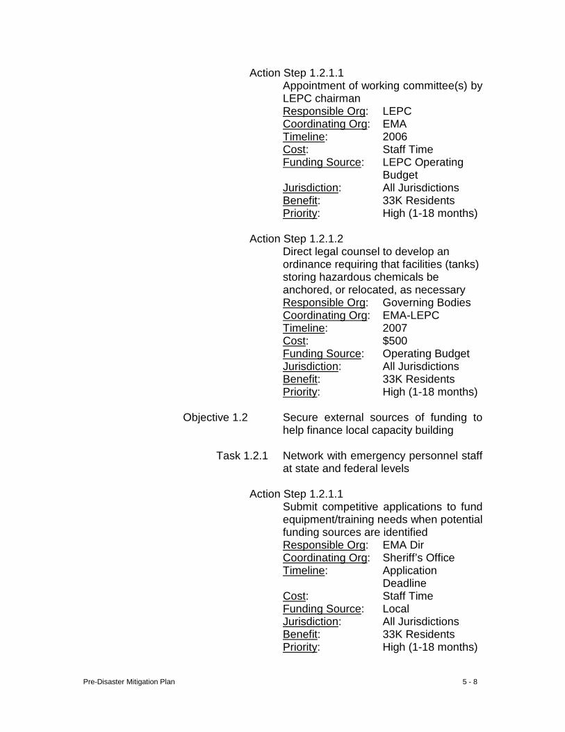
Pre-Disaster Mitigation Plan 5 - 8
Action Step 1 .2.1.1 Appointment of working committee(s) by LEPC chairman Responsible Org: LEPC Coordinating Org: EMA Timeline: 2006 Cost: Staff Time Funding Source: LEPC Operating
Budget Jurisdiction: All Jurisdictions Benefit: 33K Residents Priority: High (1-18 months)
Action Step 1.2.1.2
Direct legal counsel to develop an ordinance requiring that facilities (tanks) storing hazardous chemicals be anchored, or relocated, as necessary Responsible Org: Governing Bodies Coordinating Org: EMA-LEPC Timeline: 2007 Cost: $500 Funding Source: Operating Budget Jurisdiction: All Jurisdictions Benefit: 33K Residents Priority: High (1-18 months)
Objective 1.2 Secure external sources of funding to
help finance local capacity building
Task 1.2.1 Network with emergency personnel staff at state and federal levels
Action Step 1.2.1.1
Submit competitive applications to fund equipment/training needs when potential funding sources are identified Responsible Org: EMA Dir Coordinating Org: Sheriff’s Office Timeline: Application
Deadline Cost: Staff Time Funding Source: Local Jurisdiction: All Jurisdictions Benefit: 33K Residents Priority: High (1-18 months)
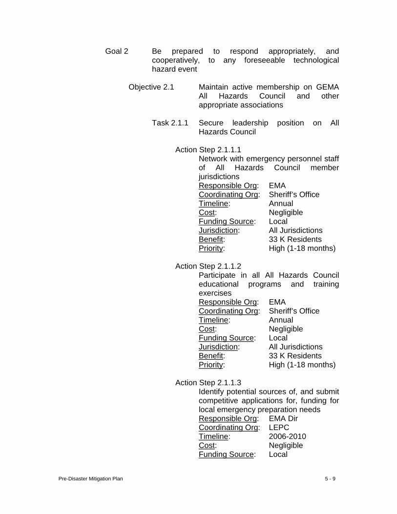
Pre-Disaster Mitigation Plan 5 - 9
Goal 2 Be prepared to respond appropriately, and cooperatively, to any foreseeable technological hazard event
Objective 2.1 Maintain active membership on GEMA
All Hazards Council and other appropriate associations
Task 2.1.1 Secure leadership position on All
Hazards Council
Action Step 2.1.1.1 Network with emergency personnel staff of All Hazards Council member jurisdictions Responsible Org: EMA Coordinating Org: Sheriff’s Office Timeline: Annual Cost: Negligible Funding Source: Local Jurisdiction: All Jurisdictions Benefit: 33 K Residents Priority: High (1-18 months)
Action Step 2.1.1.2
Participate in all All Hazards Council educational programs and training exercises Responsible Org: EMA Coordinating Org: Sheriff’s Office Timeline: Annual Cost: Negligible Funding Source: Local Jurisdiction: All Jurisdictions Benefit: 33 K Residents Priority: High (1-18 months)
Action Step 2.1.1.3
Identify potential sources of, and submit competitive applications for, funding for local emergency preparation needs Responsible Org: EMA Dir Coordinating Org: LEPC Timeline: 2006-2010 Cost: Negligible Funding Source: Local
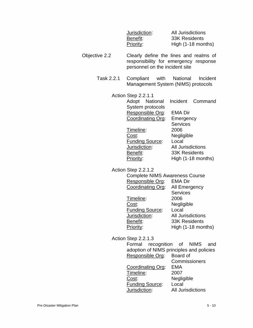
Pre-Disaster Mitigation Plan 5 - 10
Jurisdiction: All Jurisdictions Benefit: 33K Residents Priority: High (1-18 months)
Objective 2.2 Clearly define the lines and realms of
responsibility for emergency response personnel on the incident site
Task 2.2.1 Compliant with National Incident
Management System (NIMS) protocols
Action Step 2.2.1.1 Adopt National Incident Command
System protocols Responsible Org: EMA Dir Coordinating Org: Emergency
Services Timeline: 2006 Cost: Negligible Funding Source: Local Jurisdiction: All Jurisdictions Benefit: 33K Residents Priority: High (1-18 months)
Action Step 2.2.1.2
Complete NIMS Awareness Course Responsible Org: EMA Dir Coordinating Org: All Emergency
Services Timeline: 2006 Cost: Negligible Funding Source: Local Jurisdiction: All Jurisdictions Benefit: 33K Residents Priority: High (1-18 months)
Action Step 2.2.1.3
Formal recognition of NIMS and adoption of NIMS principles and policies Responsible Org: Board of
Commissioners Coordinating Org: EMA Timeline: 2007 Cost: Negligible Funding Source: Local Jurisdiction: All Jurisdictions
Pre-Disaster Mitigation Plan 5 - 11
Benefit: 33K Residents Priority: High (1-18 months)
Action Step 2.2.1.4
Establish NIMS baseline Responsible Org: EMA Dir Coordinating Org: All Emergency
Services Timeline: 2007 Cost: Negligible Funding Source: Local Jurisdiction: All Jurisdictions Benefit: 33K Residents Priority: High (1-18 months)
Action Step 2.2.1.5
Establish a timeframe and develop a strategy for full NIMS implementation Responsible Org: EMA Dir Coordinating Org: All Emergency
Services Timeline: 2007 Cost: Negligible Funding Source: Local Jurisdiction: All Jurisdictions Benefit: 33K Residents Priority: High (1-18 months)
Action Step 2.2.1.6
Institutionalize use of the national Incident Command System Responsible Org: EMA Dir Coordinating Org: All Emergency
Services Timeline: 2007 Cost: Negligible Funding Source: Local Jurisdiction: All Jurisdictions Benefit: 33K Residents Priority: High (1-18 months)
Objective 2.3 Protect the community from hazardous
chemicals
Task 2.3.1 Establish/maintain physical separation and buffers between hazardous material
Pre-Disaster Mitigation Plan 5 - 12
handling sites and large or vulnerable populations
Action Step 2.3.1.1
Review zoning ordinances and revise as appropriate Responsible Org: Sumter, Americus,
Andersonvile, Leslie, Plains.
Coordinating Org: Code Enforce-ment/EMA
Timeline: 2006 Cost: Negligible Funding Source: Local Jurisdiction: Sumter. Americus,
Andersonville, Leslie, Plains
Benefit: 32,500 Residents Priority: High (1-18 months)
Task 2.3.2 Provide emergency responders with
chemical emergency and labeling/placard system training
Action Step 2.3.2.1
Secure local training programs Responsible Org: EMA Coordinating Org: LEPC Timeline: 2006-2007 Cost: Negligible Funding Source: Local Jurisdiction: All Jurisdictions Benefit: 33K Residents Priority: High (1-18 months)
Task 2.3.3 Increase level of cooperation between emergency responders and hazardous
materials sites Action Step 2.3.3.1 Institute LEPC outreach program Responsible Org: EMA Coordinating Org: LEPC Timeline: 2006-2007 Cost: Negligible Funding Source: Local
Pre-Disaster Mitigation Plan 5 - 13
Jurisdiction: All Jurisdictions Benefit: 33K Residents Priority: High (1-18 months)
Task 2.3.4 Identify an area in each city where
hazardous material transport vehicles could be “safely” parked overnight.
Action Step 2.3.4.1 Site surveys performed by local fire departments Responsible Org: Local Fire
Departments Coordinating Org: EMA-LEPC Timeline: 2006 Cost: Negligible Funding Source: Departmental
Operating Budget Jurisdiction: All Jurisdictions Benefit: 33K Residents Priority: High (1-18 months)
Task 2.3.5 Vest emergency response agencies with
authority to have temporarily parked vehicles transporting hazardous materials relocated to a “safe” site
Action Step 2.3.5.1 Direct legal counsel to draft necessary ordinance(s) for local government action Responsible Org: County, Americus,
Andersonvile, DeSoto, Leslie and Plains.
Coordinating Org: EMA Timeline: 2006 Cost: Negligible Funding Source: Local Jurisdiction: All Jurisdictions Benefit: 33K Residents Priority: High (1-18 months)
Task 2.3.6 Elicit higher level of emergency preparedness and LEPC participation among the smaller communities in the county
Pre-Disaster Mitigation Plan 5 - 14
Action Step 2.3.6.1 Initiate outreach program to smaller communities in the county Responsible Org: LEPC Coordinating Org: LEPC Timeline: 2006-2007 Cost: Negligible Funding Source: Local Jurisdiction: Andersonville,
DeSoto, Leslie, Plains
Benefit: 1,700 Residents Priority: High (1-18 months)
Task 2.3.7 Secure funding to mitigate brownfields Action Step 2.3.7.1 Research sites of potential chemical
contamination, determine severity and pursue mitigation funding, as necessary Responsible Org: LEPC Coordinating Org: LEPC Timeline: 2008-20011 Cost: Staff Time Funding Source: Local Jurisdiction: All Jurisdictions Benefit: 33K Residents Priority: High (1-18 months)
D. Special Multi-Jurisdictional Strategy – Americus has the most exposure among the local jurisdictions. However, because all jurisdictions are located along major highways and railroads, all have significant exposure.
E. Public Information and Awareness – News of this activity will be
included in public service announcements and mitigation programs presented to local civic clubs as an example of mitigation activities and their importance to the well-being of the community.
Pre-Disaster Mitigation Plan 5 - 15
III. Terrorism
A. Mitigation Goals – The focus of this plan element is to develop greater awareness among local officials of world and state events, and possible linkage(s) to local facilities, demographics, cultures, sentiments, etc.
B. Range of Mitigation Options
1. Structural v Non-structural – At this stage of plan development, the community will dwell on non-structural options until a greater understanding of necessary and appropriate actions is achieved.
2. Existing Policies, Regulations, Ordinances and Land Use –
Until recently, the threat of terrorism has seemed so improbable that it has not been considered a local threat. Consequently, there is no such infrastructure specifically designed to prevent an incident of terrorism.
3. Community Values, Historic and Special Considerations –
No specific community values, historic and/or special considerations could be identified which affect this threat.
4. New Buildings and Infrastructure – Because this hazard is
“man-made” rather than naturally occurring, the goal and objectives are directed more toward controlling and maintaining the source of the hazard than any infrastructure housing it.
5. Existing Buildings and Infrastructure – Because this hazard
is “man-made” rather than naturally occurring, the goal and objectives are directed more toward controlling and maintaining the source of the hazard than any infrastructure housing it.
C. Mitigation Strategy and Recommendations
Goal 1 Develop and maintain local awareness of the level of
community exposure to potential terrorist attack
Objective 1.1 Educate those in positions of authority of potential terrorist targets, probable method(s) of attack and means of prevention
Pre-Disaster Mitigation Plan 5 - 16
Task 1.1.1 Identify local facilities, commodities, etc. most likely to be targets of terrorist attack
Action Step 1.1.1.1
EMA Director/LEPC develop list of such potential targets and appropriate pre-mitigation actions Responsible Org: EMA Coordinating Org: LEPC Timeline: 2007 -2008 Cost: Staff Time Funding Source: Local Jurisdiction: All Jurisdictions Benefit: 33K Residents Priority: High (1-18 months)
Goal 2 Protect local resources from acts of terrorism
Objective 2.1 Develop list of possible terrorist targets
Task 2.1.1 Secure outside sources of funding to “harden” possible terrorist targets
Action Step 2.1.1.1 Seek OHS/GEMA and/or FEMA funding
to address security/structural needs of identified facilities and commodities Responsible Org: EMA Coordinating Org: LEPC Timeline: Annually Cost: Staff Time Funding Source: Local Jurisdiction: All Jurisdictions Benefit: 33K Residents Priority: High (1-18 months)
Task 2.1.2 Enhance local response capabilities
Action Step 2.1.2.1
Increase level of hazard prevention training, response training and equipment support through the regional health district and local health department participation Responsible Org: Health Department
Pre-Disaster Mitigation Plan 5 - 17
Coordinating Org: EMA, LEPC Timeline: Annual Cost: Staff Time Funding Source: Local Jurisdiction: All Jurisdictions Benefit: 33K Residents Priority: High (1-18 months)
Action Step 2.1.2.2 Form County Agriculture Response Team (CART) Responsible Org: County Extension Coordinating Org: EMA, LEPC Timeline: ‘07 Cost: Staff Time Funding Source: Local Jurisdiction: Sumter Benefit: 15K Residents Priority: Medium (19-36 mos.)
D. Special Multi-Jurisdictional Strategy –
Sumter is the primary jurisdiction most susceptible to an incident of terrorism and there are not any differences in the mitigation strategy.
E. Public Information and Awareness – News of this activity will be included in public service announcements and mitigation programs presented to local civic clubs as an example of mitigation activities and their importance to the well-being of the community.
Pre-Disaster Mitigation Plan 5 - 18
IV. Radiological
A. Mitigation Goals – Much of the mitigation technology and equipment employed in response technological incidents is cost prohibitive for small communities. Consequently, it is important that the community not only develop local capacity to the extent possible, but also coordinate capacity-building with other communities to share the associated expenses across a larger user base.
B. Range of Mitigation Options
1. Structural v Non-structural – Although structural and non-structural options are available, the former measures are primarily private sector options while the latter constitute the public sector’s primary option. The private sector is the primary source of hazardous materials incidents, and the public sector has limited regulatory control over how the private sector conducts its business, with the primary exception of protecting the health and safety of workers. Consequently, most measures available to the public sector classify as non-structural.
2. Existing Policies, Regulations, Ordinances and Land Use –
No applicable local policies, regulations or ordinances were found to be in place.
3. Community Values, Historic and Special Considerations –
Quality of life is a primary concern to residents, and the threats posed by the presence of radiological materials compromise, and if serious enough, jeopardize, the local quality of life.
4. New Buildings and Infrastructure – Because this hazard is
“man-made” rather than naturally occurring, the goal and objectives are directed more toward controlling and maintaining the source of the hazard than any infrastructure housing it.
5. Existing Buildings and Infrastructure – Because this hazard
is “man-made” rather than naturally occurring, the goal and objectives are directed more toward controlling and maintaining the source of the hazard than any infrastructure housing it.
Pre-Disaster Mitigation Plan 5 - 19
C. Mitigation Strategy and Recommendations
Goal 1 Be prepared to respond appropriately to any radioactive incident
Objective 1.1 Be current with the risks and appropriate
mitigation measures associated with radioactive materials
Task 1.1.1 Secure and maintain active
memberships in applicable emergency response training and education associations and organizations
Action Step 1.1.1.1
Establish line item in annual EMA budget for associational memberships Responsible Org: Board of
Commissioners Coordinating Org: EMA Timeline: Annual Cost: Staff Time Funding Source: Local Jurisdiction: All Jurisdictions Benefit: 33K Residents Priority: High (1-18 months)
Action Step 1.1.1.2
EMA Director designate one individual to; (1) serve as the local technological hazard resource contact, and (2) have responsibility for local and cooperative capacity building Responsible Org: EMA Coordinating Org: LEPC Timeline: ‘07 Cost: Staff Time Funding Source: Local Jurisdiction: All Jurisdictions Benefit: 33K Residents Priority: High (1-18 months)
Objective 1.2 Secure external sources of funding to finance local capacity building and necessary equipment purchases
Pre-Disaster Mitigation Plan 5 - 20
Task 1.2.1 Network with emergency response personnel/staff at local, state and federal levels
Action Step 1.2.1.1
Submit competitive applications to fund equipment/training needs Responsible Org: EMA Coordinating Org: Board of
Commissioners Timeline: Annually Cost: Staff Time Funding Source: Local Jurisdiction: All Jurisdictions Benefit: 33K Residents Priority: High (1-18 months)
D. Special Multi-Jurisdictional Strategy – All three jurisdictions are
affected by this potential because any radioactive materials must be transported into the community. Currently, the City of Americus is most at risk of hazardous materials releases because of the juxtaposition of industry and population. In the future, the two cities would seem to be at greatest risk because of industry’s general need for municipal infrastructure, and the resulting proximity to concentration of residents. This could result in industrial siting in the unincorporated periphery of the cities. Consequently, county government must also have adequate regulatory control over industrial siting decisions.
E. Public Information and Awareness – News of capacity-building will be included in civic club programs of EMA and distributed by local print media.
Pre-Disaster Mitigation Plan 5 - 21
V. Animal and Crop Diseases
A. Mitigation Goals – A large percentage of the local economy is generated by the agricultural community; commercial animal production and field and vegetable crop production. The focus of this element of the plan is on continuing education of producers to preclude the outbreak and subsequent transmission of related diseases.
B. Range of Mitigation Options
1. Structural v Non-structural – The potential for outbreak of commercial animal and crop disease is in the private sector. Because disease outbreak would be economically devastating to the producer, the private sector has already addressed structural options. The option remaining, primarily educational, is non-structural.
2. Existing Policies, Regulations, Ordinances and Land Use –
There are numerous (primarily state) laws and statutes governing commercial farm animal management: public sale of livestock, animal mortality disposal, disease control, auction markets and sales, inspection of poultry pits and site approvals, animal feeding certification, nutrient management plans, exhibition health requirements of livestock at shows, livestock and poultry emergency management, etc.
3. Community Values, Historic and Special Considerations –
Maintaining a desirable quality of life is a major concern of residents. The potential for cross-species contamination (animal to human) threatens that quality of life. No other historic or special considerations could be identified.
4. New Buildings and Infrastructure – Efforts to address this
potential hazard are directed less toward related buildings and other infrastructure and more toward continued education needs of producers and emergency response personnel.
5. Existing Buildings and Infrastructure – Of the very few
buildings affected by this potential hazard, the only public facility is the Sumter County Livestock Barn; one of relatively few in the state. This facility serves the livestock auction and sales need of producers in Sumter and several surrounding counties. Even so, the threat posed by this potential hazard is not a threat to the continued, physical existence of the facility. The facility does need to be of sufficient size to
Pre-Disaster Mitigation Plan 5 - 22
accommodate the livestock auction and sales needs of area producers. Poultry is transported directly from the grower to a processing facility out-of-county.
C. Mitigation Strategy and Recommendations
Goal 1 Prevent the outbreak of animal diseases which could
threaten the health and well-being of residents, and the outbreak of animal and crop diseases that could inflict economic hardship on the community
Objective 1.1 Facilitate the flow of relevant information
within the agricultural and support community
Task 1.1.1 Enhance the existing agri-business-
county extension structure
Action Step 1.1.1.1 Provide County Extension with modern
facilities Responsible Org: Board of
Commissioners Coordinating Org: County Extension Timeline: 2007 Cost: ±200K Funding Source: Local Jurisdiction: All Jurisdictions Benefit: 33K Residents Priority: High (1-18 months)
Action Step 1.1.1.2 Maintain, and to the degree possible,
enhance the dissemination of producer-targeted information Responsible Org: County Extension Coordinating Org: LEPC Timeline: Annually Cost: Staff Time Funding Source: Local Jurisdiction: All Jurisdictions Benefit: 33K Residents Priority: High (1-18 months)
Pre-Disaster Mitigation Plan 5 - 23
Action Step 1.1.1.3 Establish and maintain a County Agriculture Response Team (CART) for the continued education of producers and other relevant parties of the potential for contagion (and crop disease), how to prevent any occurrences, and how to respond appropriately in the event of outbreak Responsible Org: County Extension Coordinating Org: LEPC Timeline: Annually Cost: Staff Time Funding Source: Local Jurisdiction: All Jurisdictions Benefit: 33K Residents Priority: Medium (19-36 mos.)
D. Special Multi-Jurisdictional Strategy – The physical activities related
to this potential hazard are concentrated in unincorporated Sumter County; however, the economic impact of an actual could have communitywide, economic impacts.
E. Public Information and Awareness – News of CART development and follow-up activity will be distributed at farmer production meetings and by local print media.
Pre-Disaster Mitigation Plan 5 - 24
VI. Groundwater Contamination
A. Mitigation Goals – The majority of the community’s development is occurring in unincorporated areas, without access to public wastewater collection and treatment systems. Continuation of this trend should be managed/carefully monitored to preclude the potential of such development contaminating groundwater resources. Municipal residents must also be conscious of the potential for contamination because it can occur anywhere.
B. Range of Mitigation Options
1. Structural v Non-structural – The focus of this activity is on public education and heightened environmental sensitivity to preclude the need for greater regulation of private sector development.
2. Existing Policies, Regulations, Ordinances and Land Use –
State and the local jurisdictions have numerous regulations affecting septic tank installation, groundwater storage tanks, development in groundwater recharge areas, illegal disposal sites, etc.
3. Community Values, Historic and Special Considerations –
Maintaining a desirable quality of life is a major concern of residents; preservation of the natural environment is a component of that concern. The fact that the community overlies a significant groundwater recharge area increases the importance of this activity. No historic or other special considerations could be identified.
4. New Buildings and Infrastructure – Project implementation
should increase sensitivity to the importance of complying with environmental protection standards. Efforts to address this potential hazard should not have any impact on buildings or infrastructure.
5. Existing Buildings and Infrastructure – The purpose of this
activity is to increase public sensitivity to the need to correct/resolve any related issues that may be arising as a result of faulty or aged infrastructure. Such facilities should be repaired or removed.
C. Mitigation Strategy and Recommendations
Goal 1 Reduce the chances of groundwater contamination
occurring in the community
Pre-Disaster Mitigation Plan 5 - 25
Objective 1.1 Increase environmental sensitivity of the
general public
Task 1.1.1 Enhance the knowledge and understanding of residents of the potential for groundwater contamination that can occur from everyday activities
Action Step: 1.1.1.1
Increase the flow of information to the general public of the need for:
-periodic inspection of septic systems -awareness of underground tanks/leaks
-proper disposal of hazardous wastes -proper disposal of agri-chemicals
-sealing open abandoned wells -water well testing for contamination -etc.
Responsible Org: Governing Bodies Coordinating Org: County Extension,
Health Department, LEPC
Timeline: Annually Cost: Staff Time Funding Source: Local Jurisdiction: All Jurisdictions Benefit: 16K Residents Priority: High (1-18 months)
Objective 1.2 Provide appropriate regulatory pro-tection
Task 1.2.1 Impose additional environmental pro-
tection ordinances where necessary Action Step: 1.2.1.1
Adopt groundwater protection ordinances
Responsible Org: Governing Bodies Coordinating Org: Governing Bodies Timeline: 2008 Cost: Staff Time Funding Source: Local Jurisdiction: Andersonville, De-
Soto, Leslie, Plains
Pre-Disaster Mitigation Plan 5 - 26
Benefit: 1,700 Residents Priority: High (1-18 months)
D. Special Multi-Jurisdictional Strategy – The implementation strategy
applies to all local jurisdictions, but perhaps more so to Sumter because of the higher level of development taking place.
E. Public Information and Awareness – This education activity will be carried out as part of the larger effort to educate the general public via dissemination of information of public hazard threats via civic club presentations and through the local print media.
Pre-Disaster Mitigation Plan 5 - 27
VII. Civil Disturbance
A. Mitigation Goals – The focus of this plan element is to develop greater sensitivity among local officials and authorities who interact with, or have responsibility for, large, congregate numbers of people.
B. Range of Mitigation Options
1. Structural v Non-structural – The potential sources of civil disturbance are so varied that preparation and response structures must be very flexible, and hence, non-structural.
2. Existing Policies, Regulations, Ordinances and Land Use –
There are local policies, regulations and ordinances in place which serve to maintain law and order from day-to-day. However, some of them may be somewhat insufficient in the event of unusual circumstances. Authorities should review crowd control measures considering gradual changes in demographics.
3. Community Values, Historic and Special Considerations –
No specific community values, historic and/or special considerations could be identified which affect this threat. In general terms; however, the threat of civil disturbance affects the local quality of life.
4. New Buildings and Infrastructure – Because this hazard is
“man-made” rather than naturally occurring, the goal and objectives are directed more toward controlling and maintaining the source of the hazard than any infrastructure housing it.
5. Existing Buildings and Infrastructure – Because this hazard
is “man-made” rather than naturally occurring, the goal and objectives are directed more toward controlling and maintaining the source of the hazard than any infrastructure housing it.
C. Mitigation Strategy and Recommendations
Goal 1 Maintain peace, law and order in the community
without restricting the right of orderly dissent
Objective 1.1 Maintain good communications among the diverse elements of the community
Pre-Disaster Mitigation Plan 5 - 28
Task 1.1.1 Expand community outreach Action Step 1.1.1.1
Initiate periodic town hall meetings to facilitate communications between local government, including law enforcement. and the citizens Responsible Org: Governing Bodies Coordinating Org: Elected Officials Timeline: Annually Cost: Staff Time Funding Source: Local
Jurisdiction: All Jurisdictions Benefit: 33K Residents Priority: High (1-18 months)
Action Step 1.1.1.2
Secure funding for two additional school resource officers Responsible Org: Board of Education Coordinating Org: Sheriff Timeline: 2007-2009 Cost: ±$75K Funding Source: Board of Education Jurisdiction: All Jurisdictions Benefit: ±3K Students Priority: High (1-18 months)
Action Step 1.1.1.3
Design emergency and security pro- visions into schools, factories, office buildings, hospital, correctional facilities Responsible Org: EMA Coordinating Org: LEPC Timeline: 2007-2009 Cost: Staff Time Funding Source: Local Jurisdiction: All Jurisdictions Benefit: 33K Residents Priority: High (1-18 months)
D. Special Multi-Jurisdictional Strategy – Americus is perhaps most
susceptible to this hazard because of the concentration of residents, and being the site of, or proximity to, sites where residents and non-residents most often congregate, e.g. spectator
Pre-Disaster Mitigation Plan 5 - 29
events. Sumter and Americus should be most aggressive in establishing town hall meetings.
F. Public Information and Awareness – News of capacity-building will be included in civic club programs of EMA and distributed by local print media.
Pre-Disaster Mitigation Plan Sumter County
Chapter 6 – Execution
I Implementation A Administrative Actions 1 B Authority and Responsibility 1 C Prioritization 1 D Incorporation into other Plans/Planning Measures 3 II Evaluation A Method 3 B Responsibility 3
C Timeframe 4 D Reporting 4 III Multi- Jurisdictional Strategy and Considerations 4 IV Plan Update and Maintenance A Public Involvement 4 B Timeframe 5 C Reporting 5
Pre-Disaster Mitigation Plan 6 - 1
I. Implementation
A. Administrative Actions The chief elected and/or appointed officials of the six local jurisdictions and the EMA Director will serve as a pre-disaster mitigation executive committee. These officials are responsible for day-to-day administrative personnel and operations of their respective local governments, mitigation activities proposed herein, and their respective jurisdiction’s responsibilities for plan implementation. It is these individuals who will present and recommend to the governing body policy changes, ordinance adoption, or initiate revisions in administrative procedures necessary to accomplish goals of this mitigation plan. These individuals are responsible for ensuring that action steps specific to their jurisdiction are implemented. The EMA Director is responsible for coordinating and supporting plan activities, and generally overseeing implementation of the five-year plan.
B. Authority and Responsibility
The responsibility and oversight for implementation of this plan is vested in the office of Emergency Management Director.
C. Prioritization
1. Among the strongest findings gleaned from plan preparation is the lack of information-sharing and coordination between elected and appointed officials, and between emergency responders and private sector individuals/organizations with assigned emergency responsibilities. Because information is not only fundamental but essential to success in virtually any endeavor, priority in development of this plan has been placed on compiling and disseminating pertinent information, and coordinating the activities of partners in mitigation. Sumter EMA will develop a library of mitigation materials and serve as a clearinghouse of information to be presented to the general public in numerous settings and forums, applied to local government activities and shared between local emergency response agencies. This activity is a non-structural mitigation measure; consisting of action steps less expensive to implement, with broader application irrespective of the type hazard, less expensive to maintain, and more adaptable for application to specific needs than structural measures. Since this is a non-structural measure and there is a wealth of information available on the subjects identified herein, the greatest expense associated with this activity is expected to consist of staff time. As stated in chapter 1, page 1, and documented on page 7, the
Pre-Disaster Mitigation Plan 6 - 2
community has experience implementing emergency preparedness activities. The balance of plan action steps either supplement or complete previous and current mitigation measures, or are best management practices. More specifically, priorities were established as functions of time and cost. In large part because of the lack of funds needed to implement the plan unilaterally, actions which were deemed less costly and less time-consuming to implement were given higher priority. These activities also tended generally to impact the greatest proportion of the community. Those of greater expense and requiring more time for implementation were rated lower. As previously mentioned, the vast majority of actions identified will be incorporated into the daily activities of existing (or added) staff.
2. Use of cost benefit – Of the action steps included in this
plan, the overwhelming majority involve compilation and/or dissemination of disaster-related information. A major benefit of such non-structural measures is their cost effectiveness; they are generally inexpensive to implement and maintain, have broad applicability and have a lower cost per person. The balance of activity generally either supplements or completes preparedness measures initiated previously by the community, or are best management practices. The “larger ticket” actions which generally have a lower public benefit level and require longer periods of time to implement appear later in the list of priorities
3. Use of other calculations – No other calculations were
utilized
4. Use of other review structure – No other review structure was utilized.
D. Incorporation of Pre-Disaster Mitigation into other Plans/Planning
Measures
Pursuant to Georgia law, local governments must prepare and adopt a comprehensive plan to maintain eligibility for state grants, loans and/or permits. All six local jurisdictions are diligent in maintaining their “Qualified Local Government” status. Although the chief elected official of the jurisdiction is accountable for ensuring these plans are prepared in accordance with stringent state planning and procedural standards, and formally adopted,
Pre-Disaster Mitigation Plan 6 - 3
responsibility for ensuring this is accomplished is commonly deferred to the chief administrative official. The chief elected and/or appointed officials of the six local jurisdictions and the EMA Director serve on the pre-disaster mitigation plan executive committee. Annual review and evaluation of this mitigation plan will serve to facilitate incorporation of mitigation measures into daily management functions (budgeting, permit issuance) of the local governments as well as the joint comprehensive plan of the six communities, scheduled to be updated in 2014. The Middle Flint Regional Development Center has helped not only with preparation of this pre-disaster mitigation plan, but has also assisted all six jurisdictions maintain compliance with state mandated comprehensive and other planning requirements.
II. Evaluation
A. Method An evaluation handbook will be developed using the goals, objectives, tasks and action steps of Chapters 4 and 5 as the format. This document will be used to record the name and contact information of the individual assigned responsibility for overseeing implementation of each action step included in the plan. These assignments will be made at the “organizational” meeting held after formal plan adoption. This handbook will be used by the executive committee to maintain a current, written record of progress made with plan implementation. With the record of project information recorded during the course of the year(s), it will be useful for the end-of-year evaluation (and five-year update).
B. Responsibility The chief elected and/or appointed officials of the six local
jurisdictions and the EMA Director will serve on the pre-disaster mitigation plan executive committee. Annual meetings of the executive committee will be used as the reporting mechanism. Presentations by the various responsible parties to this committee will not only update the EMA Director, but keep the executive committee abreast of plan progress and any shortcomings in plan implementation. This time will be used to adjust or supplement the plan in the event of significant problems or difficulties, and will help maintain responsibility and accountability among the participants.
C. Timeframe
Upon formal plan adoption the EMA Director will convene the executive committee to organize and assign specific responsibilities for plan implementation. The committee shall reconvene twice yearly thereafter to assess progress, and where necessary develop
Pre-Disaster Mitigation Plan 6 - 4
plan revisions or adjustments. The committee shall perform a progress evaluation of annual progress in December. Based on the results of this evaluation appropriate steps will be taken to facilitate implementation during the subsequent year.
D. Reporting Annual meetings of the executive committee will be used as the reporting mechanism. Presentations by the various responsible parties to this committee will not only update the EMA Director, but keep the executive committee abreast of plan progress and any shortcomings in plan implementation. This time will be used to adjust or supplement the plan in the event of significant problems or difficulties, and will help maintain responsibility and accountability among the participants. The chairman of the executive committee will make periodic reports to the Sumter County Board of Commissioners and the Mayors and City Councils of Americus, Andersonville, DeSoto, Leslie and Plains concerning implementation progress. As members of the executive committee, the chief elected/administrative officers of the six local governments may report progress made in plan implementation to their respective governing bodies.
III. Multi-Jurisdictional Strategy and considerations
The chief elected and/or appointed officials of the six local jurisdictions well serve as members of the executive committee. These officials are responsible for the administrative personnel and day-to-day operations of their respective local governments, mitigation activities proposed in the plan, and their respective jurisdiction’s responsibilities for plan implementation. It is these individuals who will present and recommend to the governing body policy changes, ordinance adoption, or initiate revisions in administrative procedures necessary to accomplish goals of the mitigation plan. These six individuals have responsibility for ensuring that action steps specific to their respective jurisdictions are implemented.
IV Plan update and maintenance
A. Public involvement Many of the action steps identified in this plan require direct interaction with the general public. These occasions will be used not only to share critical information needed by the public, but to inform residents of local mitigation activities and to solicit public participation throughout the year. As an official creation of the county, meetings of the executive committee will be public. Consequently, all such meetings will be posted in advance of the
Pre-Disaster Mitigation Plan 6 - 5
meeting date, and the local print media will receive notification directly. The projected 2012 update of this document is expected to bear little resemblance to the current document. For that reason, and because it is an official plan of all six local jurisdictions, a publicly advertised hearing will be held near the beginning of the update process to inform the public and to solicit public participation. A second hearing will be held near the end of the update process for public comment on the draft document.
B. Timeframe It is not presently known what planning standards will apply to the projected 2012 plan update. Consequently, it is difficult to accurately predict the specific timetable which will be needed. The comprehensive plans of all six local jurisdictions must again be prepared, go through regional and state reviews and adopted in 2014. Based on current assumptions of future mitigation planning standards, a committee structure and plan preparation process similar to that described in the introduction is proposed. The first of two publicly advertised hearings will be held in the beginning of the update process to inform the general public and solicit public participation. A second hearing will be held near the end of the update process for public comment prior to adoption by local governing bodies.
C. Reporting
The annual meetings of the executive committee will be used as the reporting mechanism. Presentations to this committee by the various responsible plan implementation participants will not only update the EMA Director, but keep the full executive committee abreast of plan progress and any shortcomings in plan implementation. This time will be used to adjust, maintain or supplement the plan in response to significant problems, difficulties and success. This reporting method will help maintain responsibility and accountability. The EMA Director will make annual reports to the Sumter County Board of Commissioners and the Mayors and City Councils of Americus, Andersonville, DeSoto, Leslie and Plains concerning implementation progress. The chief elected and/or chief administrative officer of all six local governments serves on the executive committee. These individuals will also report progress made in plan implementation to their respective elected governing bodies.
Pre-Disaster Mitigation Plan 7 - 1
Chapter 7 – Conclusion
I. Summary Local government adoption of this mitigation plan completes the third of four
important steps. Resources have been organized to address the issues associated with hazard mitigation. Residents have identified the natural hazards most likely to affect the community and assessed the level of risk associated with each hazard. Included in this document are the numerous steps which must yet be taken to reduce community exposure to the natural hazards most likely to occur. The fourth step remains to be completed. It is believed that implementation of the action steps identified herein will make the community much safer in the event a disaster should occur. The community can capitalize on past successes in emergency preparedness to continue its efforts to provide for the health, safety and general well-being of the resident population.
II. References
A. Publications: Americus Times-Recorder B. Web Sites: http://www4.ncdc.noaa.gov/cgi-win/wwcgi.dll?wwEvent~storms [email protected] http:www.esri.com/hazards http://www.epa.gov/enviro/html/em/index.html http://www.disastercenter.com/abrgoals.htm#Preparing%20for http://www.esri.com/hazards/makemap.html C. Other: Georgia Department of Natural Resources-ERT, IRS Georgia Forestry Commission Georgia Tornado Database Middle Flint Regional Plan 2004 National Climatic Data Center Database National Weather Service Newspaper articles
Joint Sumter County-Americus-Andersonville-DeSoto-Leslie-Plains Comprehensive Plan 2004
Sumter County Emergency Operations Plan 2004 1998-2000 Georgia Drought Report Interviews