Embed Size (px)
Citation preview
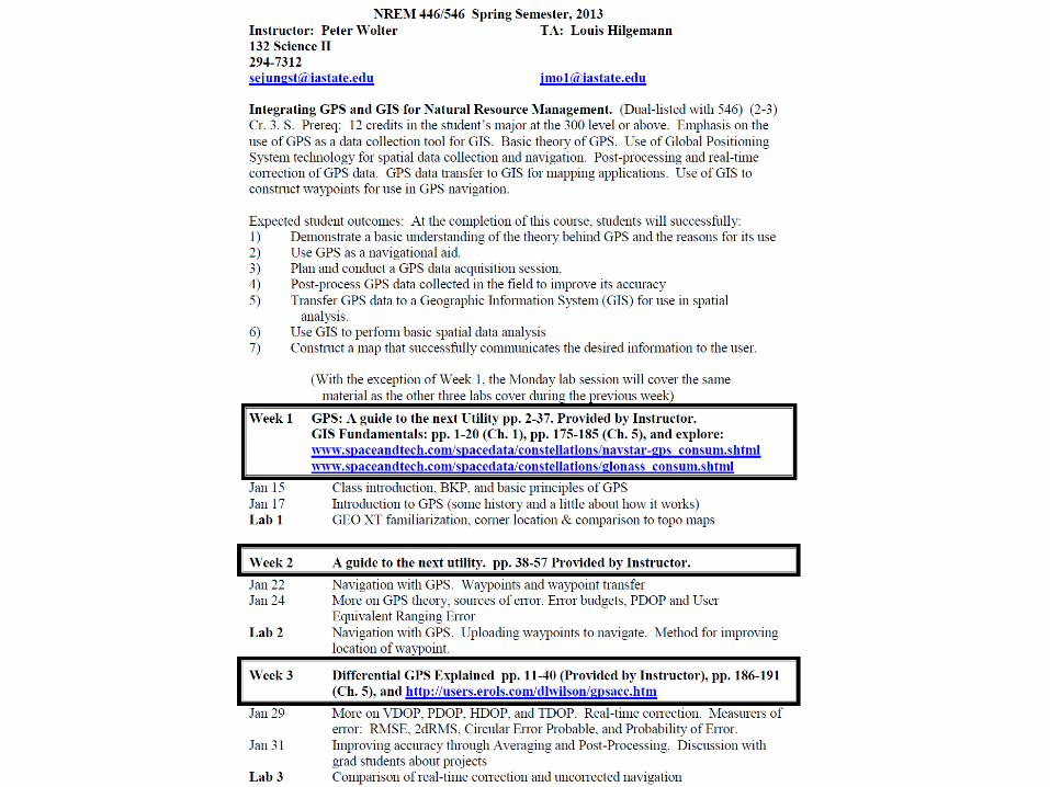

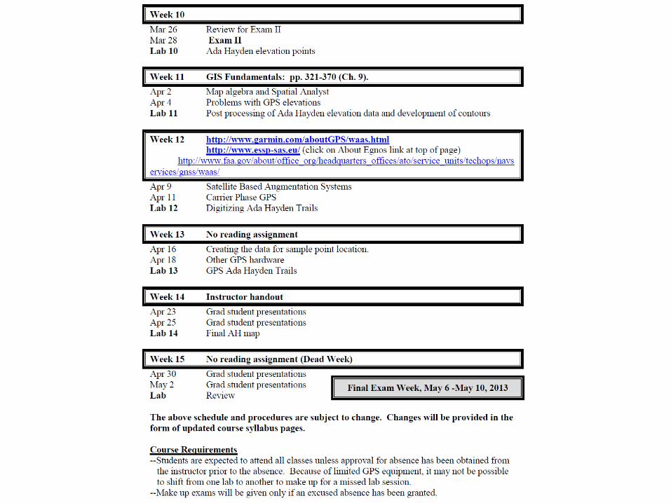
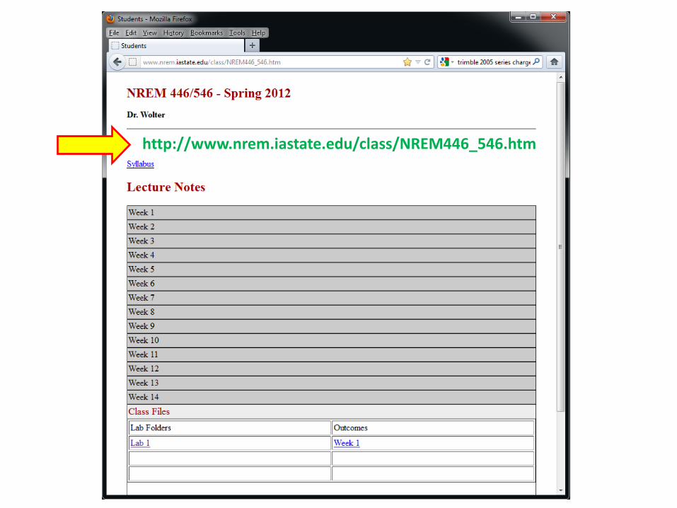
http://www.nrem.iastate.edu/class/NREM446_546.htm
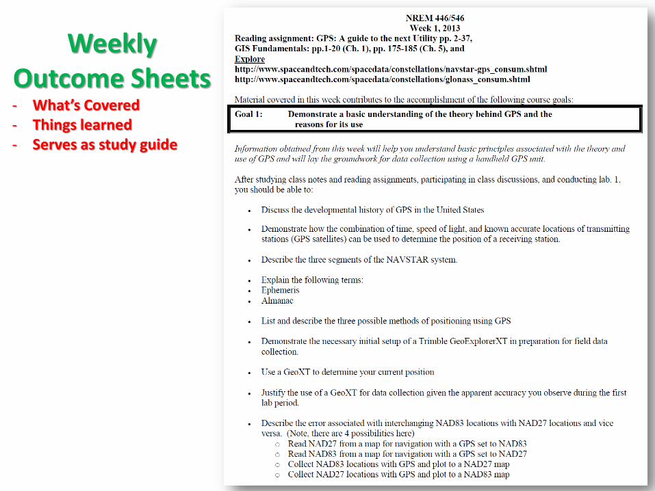
Weekly Outcome Sheets - What’s Covered - Things learned - Serves as study guide

Notebooks
• 3-Ring, hard-sided
• Organize class materials by week
• I suggest section dividers with tabs • Label tabs/dividers using that week’s “Outcome Goal”
• Include
• Weekly Outcomes sheet • Lecture handouts • Lab question sheet & your graded results
• At end of semester, number all pages and develop a “Table of Contents”
This will serve as a permanent GPS/GIS reference guide for you

BKP &
DONUT TTYP
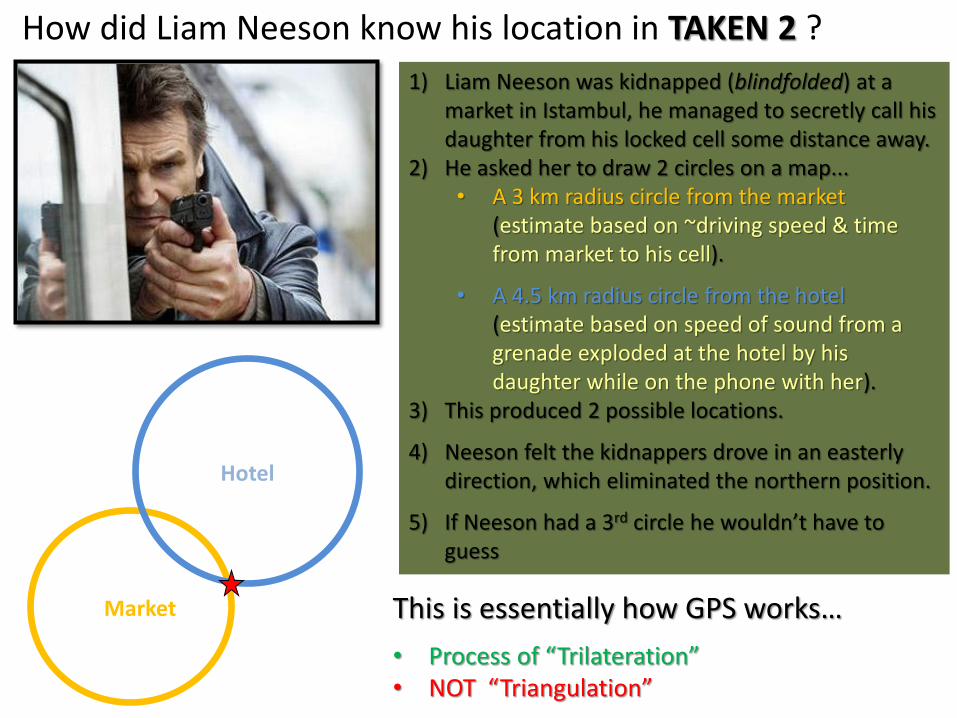
How did Liam Neeson know his location in TAKEN 2 ?
1) Liam Neeson was kidnapped (blindfolded) at a market in Istambul, he managed to secretly call his daughter from his locked cell some distance away.
2) He asked her to draw 2 circles on a map... • A 3 km radius circle from the market
(estimate based on ~driving speed & time from market to his cell).
• A 4.5 km radius circle from the hotel (estimate based on speed of sound from a grenade exploded at the hotel by his daughter while on the phone with her).
3) This produced 2 possible locations.
4) Neeson felt the kidnappers drove in an easterly direction, which eliminated the northern position.
5) If Neeson had a 3rd circle he wouldn’t have to guess
This is essentially how GPS works…
• Process of “Trilateration” • NOT “Triangulation”
Hotel
Market
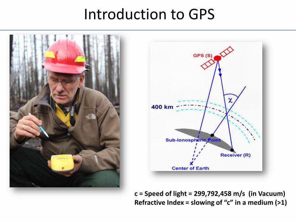
Introduction to GPS
c = Speed of light = 299,792,458 m/s (in Vacuum) Refractive Index = slowing of “c” in a medium (>1)

Global Positioning System
A military (DOD)based system designed to provide the information necessary to determine your location accurately anywhere in the world…
Why did DOD developed GPS?
- Cold war missile (ICBM) defense - Take out enemy missiles/silos with precision - To do this accurately, must know launching position
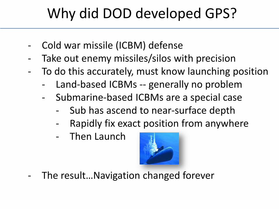
- Land-based ICBMs -- generally no problem - Submarine-based ICBMs are a special case
- Sub has ascend to near-surface depth - Rapidly fix exact position from anywhere - Then Launch
- The result…Navigation changed forever
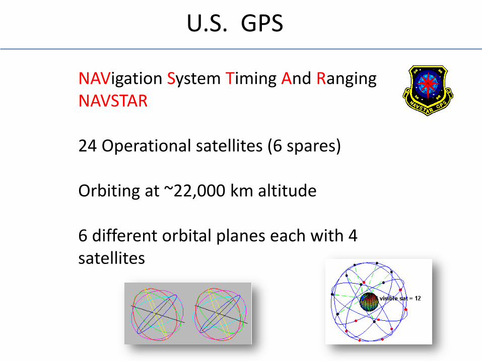
U.S. GPS
NAVigation System Timing And Ranging NAVSTAR 24 Operational satellites (6 spares) Orbiting at ~22,000 km altitude 6 different orbital planes each with 4 satellites
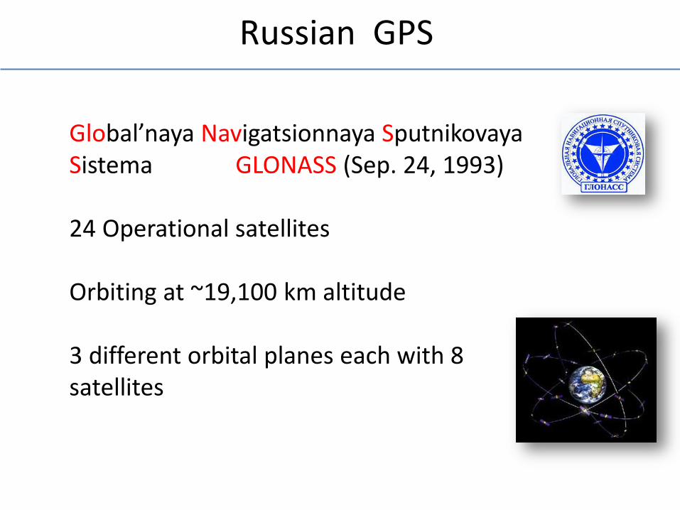
Russian GPS
Global’naya Navigatsionnaya Sputnikovaya Sistema GLONASS (Sep. 24, 1993) 24 Operational satellites Orbiting at ~19,100 km altitude 3 different orbital planes each with 8 satellites
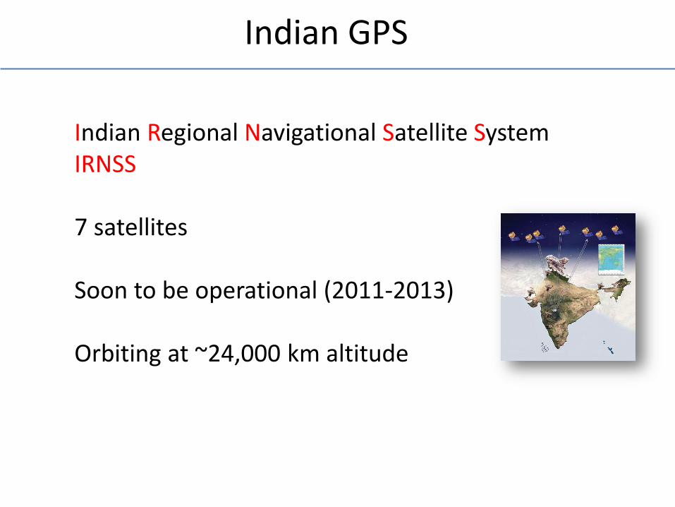
Indian GPS
Indian Regional Navigational Satellite System IRNSS 7 satellites Soon to be operational (2011-2013) Orbiting at ~24,000 km altitude
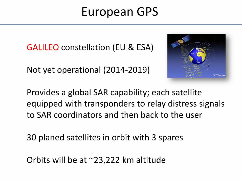
European GPS
GALILEO constellation (EU & ESA) Not yet operational (2014-2019) Provides a global SAR capability; each satellite equipped with transponders to relay distress signals to SAR coordinators and then back to the user 30 planed satellites in orbit with 3 spares Orbits will be at ~23,222 km altitude
Other Countries Developing GPS
COMPASS (a.k.a. Beidou-2, BIG DOPPLER, or BD2) Chinese GPS constellation 5 satellites operational; 30 more planned DORIS, Doppler Orbitography and Radio-positioning Integrated by Satellite French precision NAV system QZSS, Quasi-Zenith Satellite System, Japan’s proposed 3 satellite regional time transfer GPS system
GPS replaces LORAN & TRANSIT
LORAN: Ground-based radio triangulation method with continuous position fixes, accurate to ~300 meters. Limited coverage (Lat, Lon) TRANSIT: A.K.A. NAVSAT (1964-1996) for U.S. Navy. Doppler shifts ( ); 16 or less fixes per day. Sub-meter accuracy in ~3 days (central tendency). Worldwide coverage (Lat, Lon, Ht) For POLARIS ballistic missile subs and ships
LOng RAnge Navigation
Days after SPUTNIK 1
Global Positioning System (GPS)
Continuous Position Fixes Worldwide coverage Latitude/Longitude/Height Centimeter to 5-meter accuracy in seconds
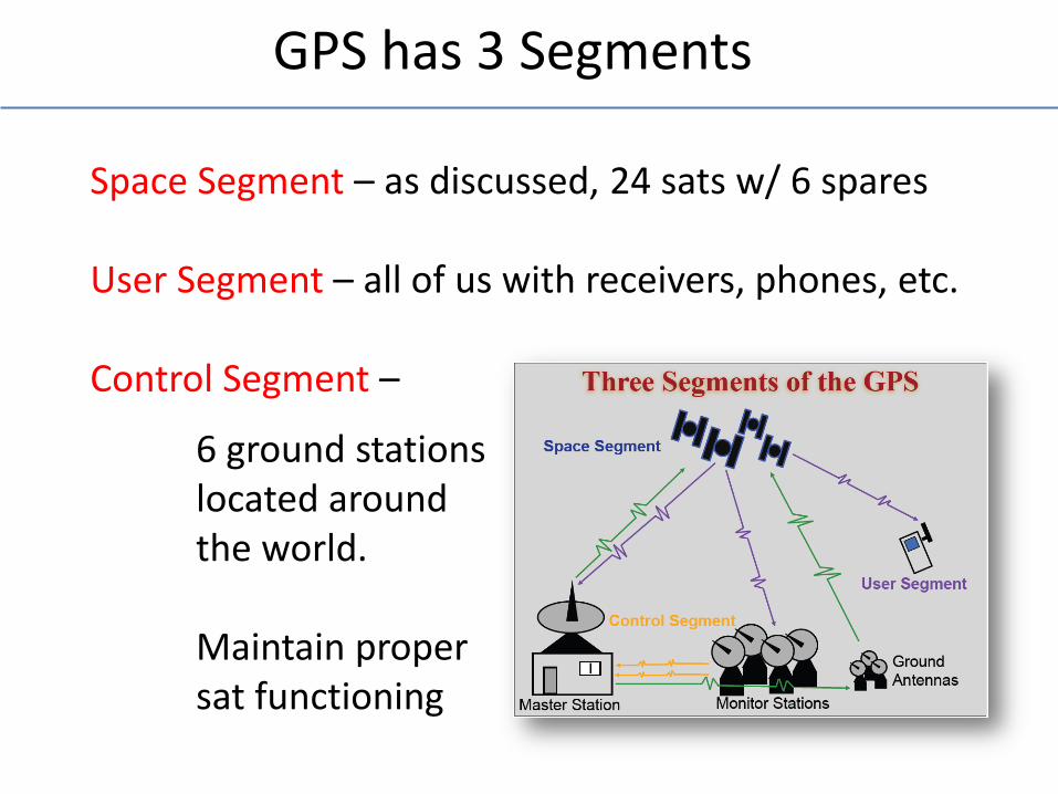
GPS has 3 Segments
Space Segment – as discussed, 24 sats w/ 6 spares User Segment – all of us with receivers, phones, etc. Control Segment –
6 ground stations located around the world. Maintain proper sat functioning
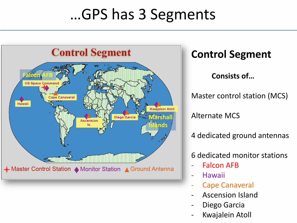
…GPS has 3 Segments
Control Segment Consists of… Master control station (MCS) Alternate MCS 4 dedicated ground antennas 6 dedicated monitor stations - Falcon AFB - Hawaii - Cape Canaveral - Ascension Island - Diego Garcia - Kwajalein Atoll
Falcon AFB
Marshall Islands
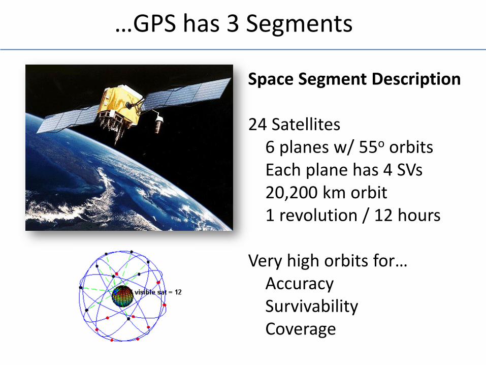
…GPS has 3 Segments
Space Segment Description 24 Satellites 6 planes w/ 55o orbits Each plane has 4 SVs 20,200 km orbit 1 revolution / 12 hours Very high orbits for… Accuracy Survivability Coverage
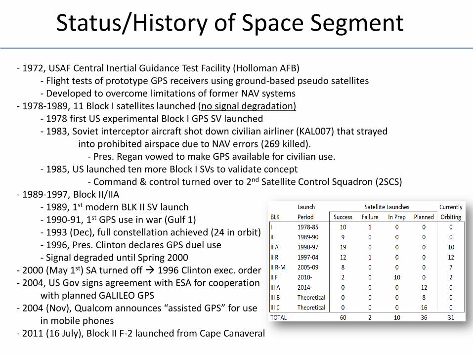
Status/History of Space Segment
- 1972, USAF Central Inertial Guidance Test Facility (Holloman AFB) - Flight tests of prototype GPS receivers using ground-based pseudo satellites - Developed to overcome limitations of former NAV systems - 1978-1989, 11 Block I satellites launched (no signal degradation) - 1978 first US experimental Block I GPS SV launched - 1983, Soviet interceptor aircraft shot down civilian airliner (KAL007) that strayed into prohibited airspace due to NAV errors (269 killed). - Pres. Regan vowed to make GPS available for civilian use. - 1985, US launched ten more Block I SVs to validate concept - Command & control turned over to 2nd Satellite Control Squadron (2SCS) - 1989-1997, Block II/IIA - 1989, 1st modern BLK II SV launch - 1990-91, 1st GPS use in war (Gulf 1) - 1993 (Dec), full constellation achieved (24 in orbit) - 1996, Pres. Clinton declares GPS duel use - Signal degraded until Spring 2000 - 2000 (May 1st) SA turned off 1996 Clinton exec. order - 2004, US Gov signs agreement with ESA for cooperation with planned GALILEO GPS - 2004 (Nov), Qualcom announces “assisted GPS” for use in mobile phones - 2011 (16 July), Block II F-2 launched from Cape Canaveral

User Segment
You, plus… pretty much everyone else
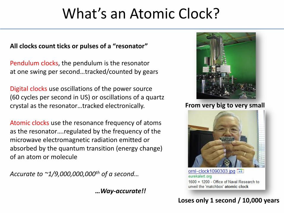
What’s an Atomic Clock?
All clocks count ticks or pulses of a “resonator” Pendulum clocks, the pendulum is the resonator at one swing per second…tracked/counted by gears Digital clocks use oscillations of the power source (60 cycles per second in US) or oscillations of a quartz crystal as the resonator…tracked electronically. Atomic clocks use the resonance frequency of atoms as the resonator….regulated by the frequency of the microwave electromagnetic radiation emitted or absorbed by the quantum transition (energy change) of an atom or molecule Accurate to ~1/9,000,000,000th of a second… …Way-accurate!!
Loses only 1 second / 10,000 years
From very big to very small
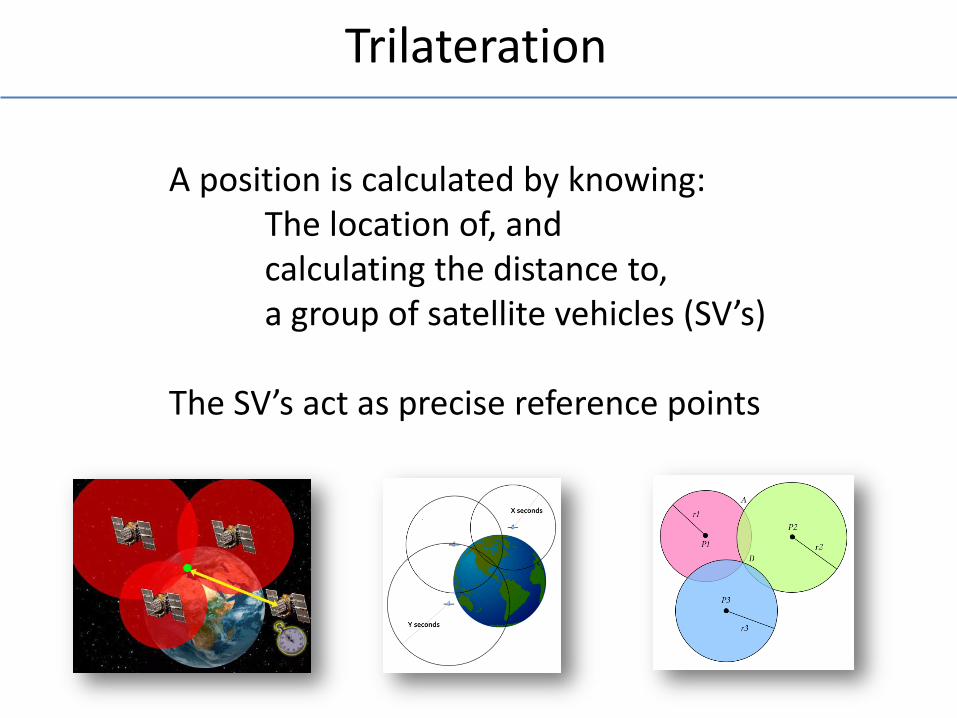
Trilateration
A position is calculated by knowing: The location of, and calculating the distance to, a group of satellite vehicles (SV’s) The SV’s act as precise reference points
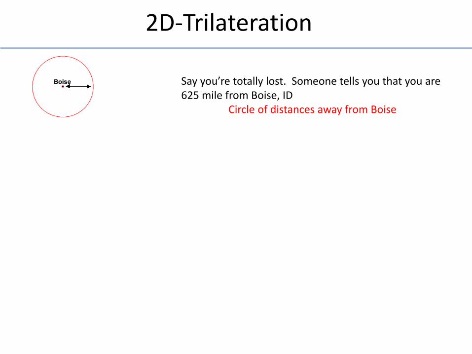
2D-Trilateration
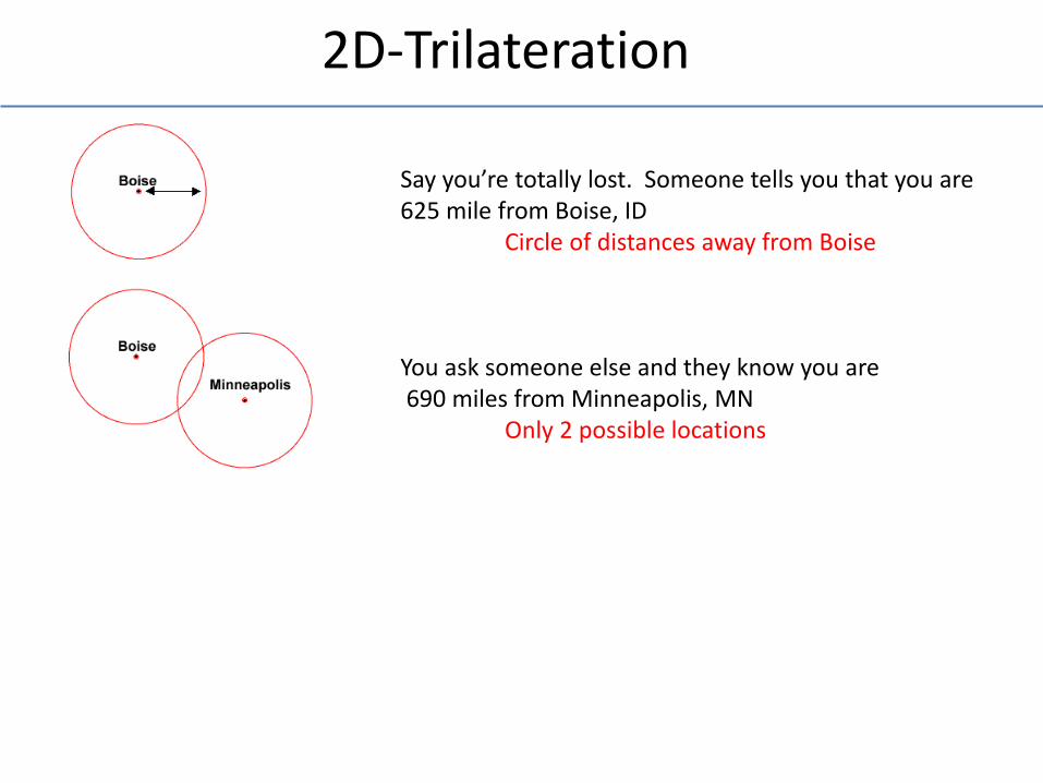
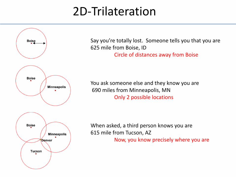
Say you’re totally lost. Someone tells you that you are 625 mile from Boise, ID Circle of distances away from Boise
2D-Trilateration
Say you’re totally lost. Someone tells you that you are 625 mile from Boise, ID Circle of distances away from Boise You ask someone else and they know you are 690 miles from Minneapolis, MN Only 2 possible locations
2D-Trilateration
Say you’re totally lost. Someone tells you that you are 625 mile from Boise, ID Circle of distances away from Boise You ask someone else and they know you are 690 miles from Minneapolis, MN Only 2 possible locations When asked, a third person knows you are 615 mile from Tucson, AZ Now, you know precisely where you are
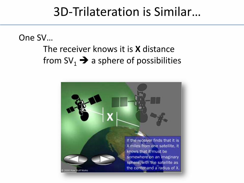
3D-Trilateration is Similar…
One SV… The receiver knows it is X distance from SV1 a sphere of possibilities
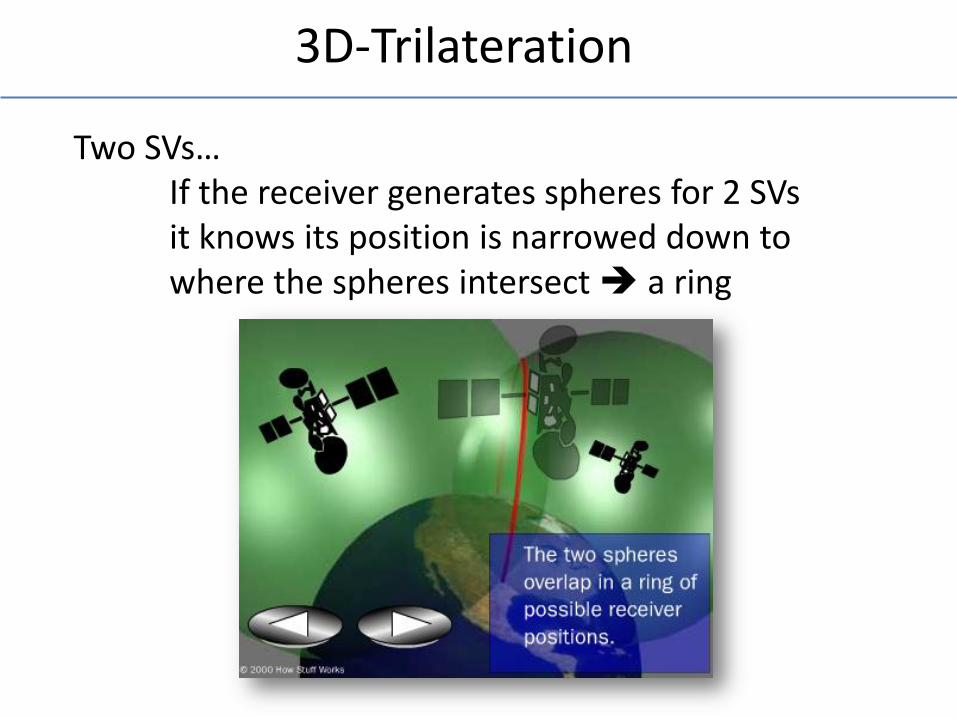
3D-Trilateration
Two SVs… If the receiver generates spheres for 2 SVs it knows its position is narrowed down to where the spheres intersect a ring
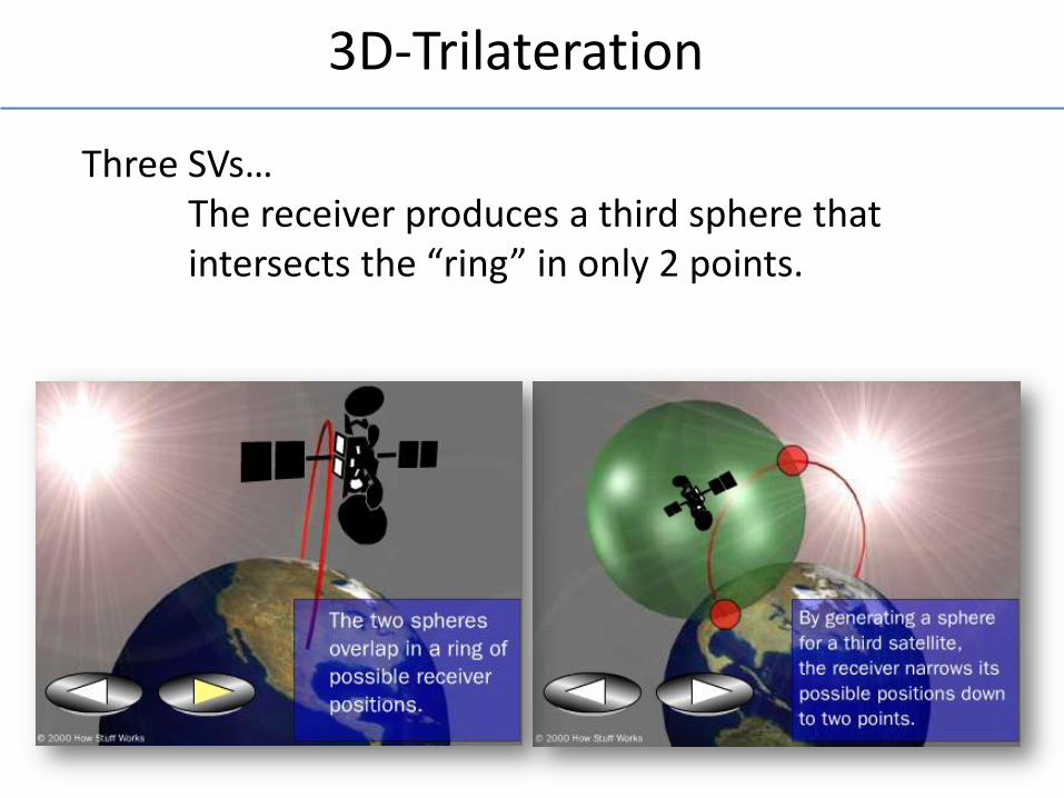
3D-Trilateration
Three SVs… The receiver produces a third sphere that intersects the “ring” in only 2 points.
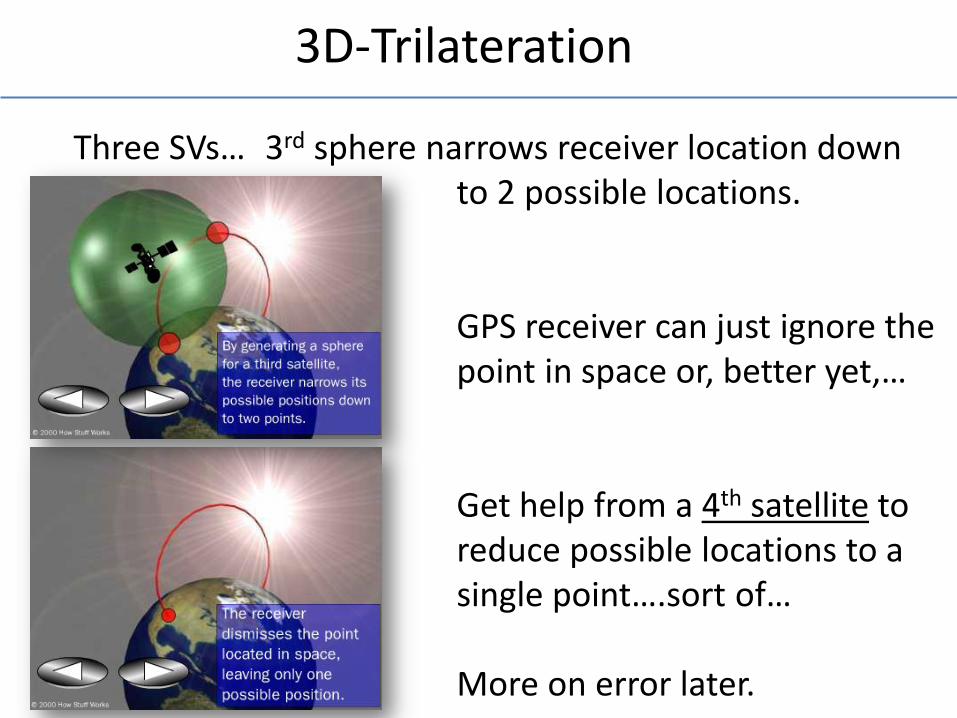
3D-Trilateration
Three SVs… 3rd sphere narrows receiver location down to 2 possible locations. GPS receiver can just ignore the point in space or, better yet,… Get help from a 4th satellite to reduce possible locations to a single point….sort of… More on error later.
Ground Example
A train leaves the station at 9:00 A.M. Traveling 5 miles per hour. How far from the station is it at 11:00 A.M.? Answer: 10 miles
GPS Example
A signal leaves a satellite at 9:00:00.000 A.M. traveling at 186,282.397 miles per second. How far is it from the satellite at 9:00:00.065 A.M.? Δt = 0.065 seconds Answer: 12,108.36 miles
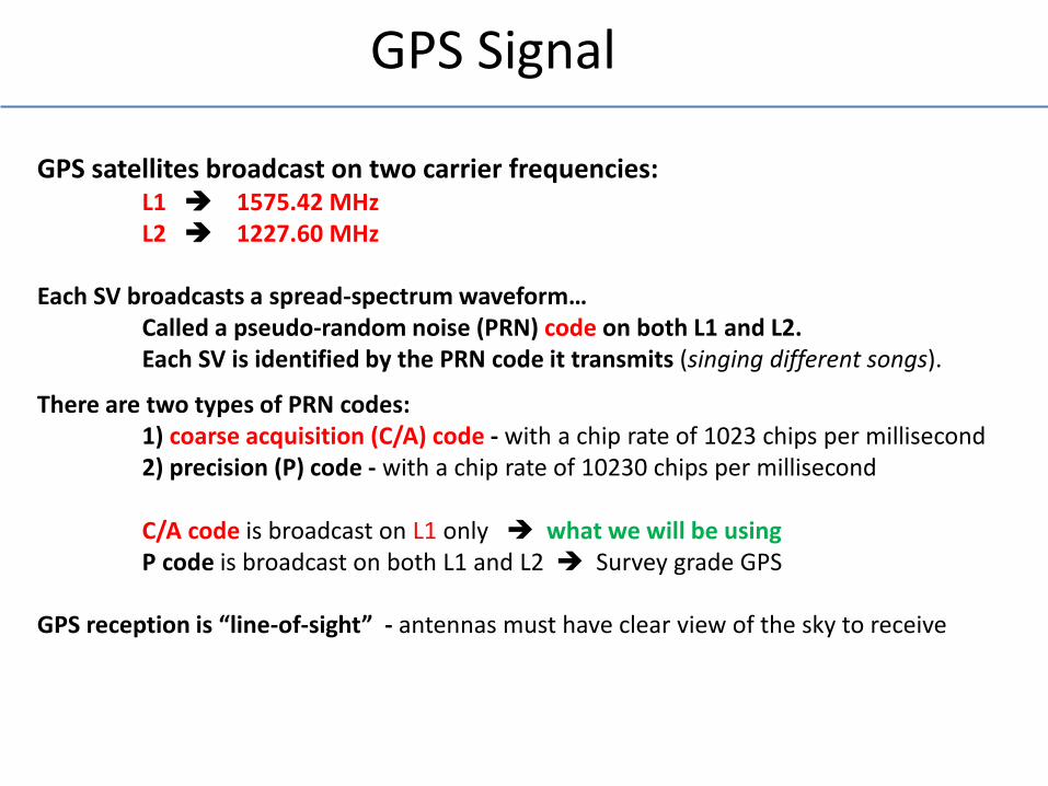
GPS Signal
GPS satellites broadcast on two carrier frequencies: L1 1575.42 MHz L2 1227.60 MHz Each SV broadcasts a spread-spectrum waveform… Called a pseudo-random noise (PRN) code on both L1 and L2. Each SV is identified by the PRN code it transmits (singing different songs).
There are two types of PRN codes: 1) coarse acquisition (C/A) code - with a chip rate of 1023 chips per millisecond 2) precision (P) code - with a chip rate of 10230 chips per millisecond C/A code is broadcast on L1 only what we will be using P code is broadcast on both L1 and L2 Survey grade GPS GPS reception is “line-of-sight” - antennas must have clear view of the sky to receive
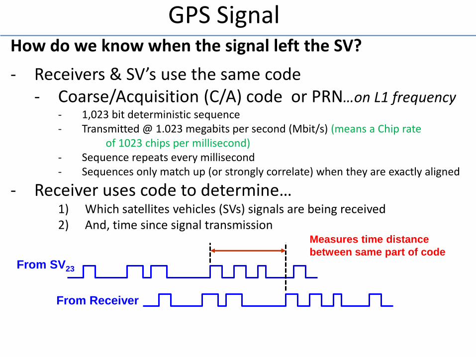
GPS Signal How do we know when the signal left the SV?
- Receivers & SV’s use the same code - Coarse/Acquisition (C/A) code or PRN…on L1 frequency
- 1,023 bit deterministic sequence - Transmitted @ 1.023 megabits per second (Mbit/s) (means a Chip rate of 1023 chips per millisecond) - Sequence repeats every millisecond - Sequences only match up (or strongly correlate) when they are exactly aligned
- Receiver uses code to determine… 1) Which satellites vehicles (SVs) signals are being received 2) And, time since signal transmission
From SV23
From Receiver
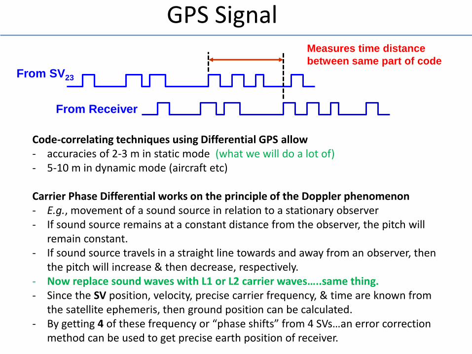
Measures time distance
between same part of code
GPS Signal
From SV23
From Receiver
Measures time distance
between same part of code
Code-correlating techniques using Differential GPS allow - accuracies of 2-3 m in static mode (what we will do a lot of) - 5-10 m in dynamic mode (aircraft etc) Carrier Phase Differential works on the principle of the Doppler phenomenon - E.g., movement of a sound source in relation to a stationary observer - If sound source remains at a constant distance from the observer, the pitch will
remain constant. - If sound source travels in a straight line towards and away from an observer, then
the pitch will increase & then decrease, respectively. - Now replace sound waves with L1 or L2 carrier waves…..same thing. - Since the SV position, velocity, precise carrier frequency, & time are known from
the satellite ephemeris, then ground position can be calculated. - By getting 4 of these frequency or “phase shifts” from 4 SVs…an error correction
method can be used to get precise earth position of receiver.
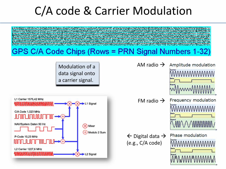
C/A code & Carrier Modulation
Modulation of a data signal onto a carrier signal.
AM radio
FM radio
Digital data (e.g., C/A code)
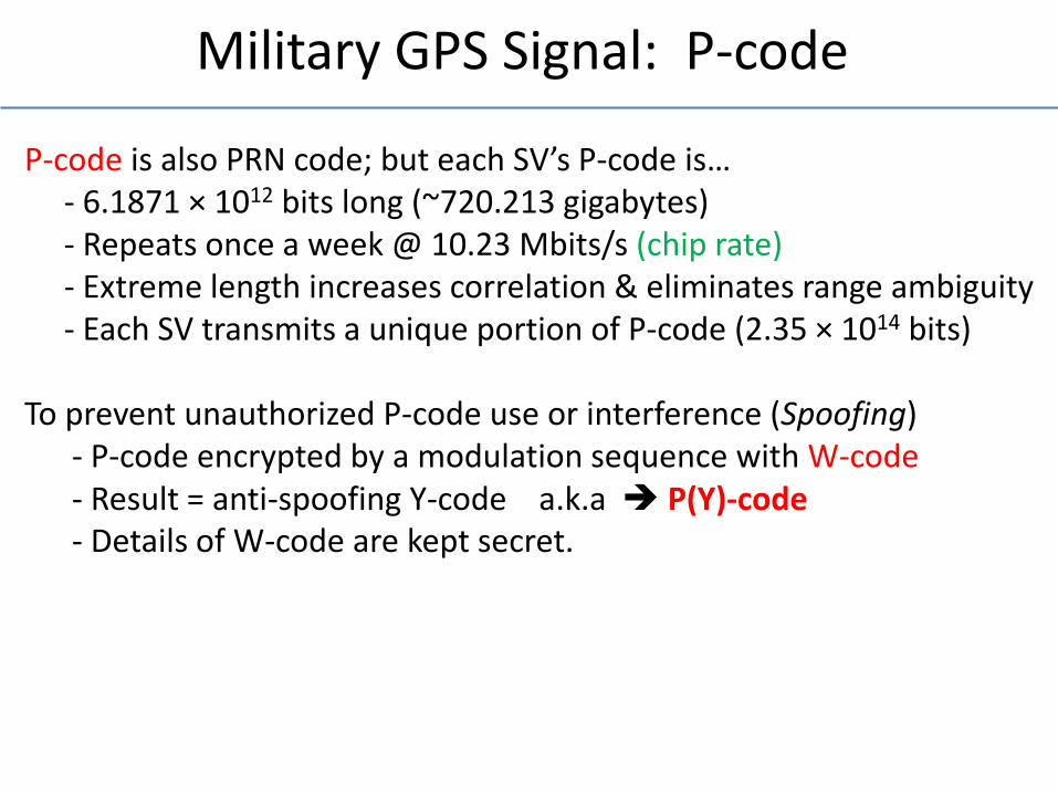
Military GPS Signal: P-code
P-code is also PRN code; but each SV’s P-code is… - 6.1871 × 1012 bits long (~720.213 gigabytes) - Repeats once a week @ 10.23 Mbits/s (chip rate) - Extreme length increases correlation & eliminates range ambiguity - Each SV transmits a unique portion of P-code (2.35 × 1014 bits) To prevent unauthorized P-code use or interference (Spoofing) - P-code encrypted by a modulation sequence with W-code - Result = anti-spoofing Y-code a.k.a P(Y)-code - Details of W-code are kept secret.
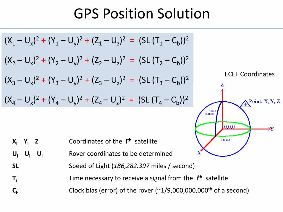
GPS Position Solution
(X1 – Ux)2 + (Y1 – Uy)
2 + (Z1 – Uz)2 = (SL (T1 – Cb))2
(X2 – Ux)2 + (Y2 – Uy)
2 + (Z2 – Uz)2 = (SL (T2 – Cb))2
(X3 – Ux)2 + (Y3 – Uy)
2 + (Z3 – Uz)2 = (SL (T3 – Cb))2
(X4 – Ux)2 + (Y4 – Uy)
2 + (Z4 – Uz)2 = (SL (T4 – Cb))2
Xi Yi Zi Coordinates of the ith satellite
Ui Ui Ui Rover coordinates to be determined
SL Speed of Light (186,282.397 miles / second)
Ti Time necessary to receive a signal from the ith satellite
Cb Clock bias (error) of the rover (~1/9,000,000,000th of a second)
ECEF Coordinates
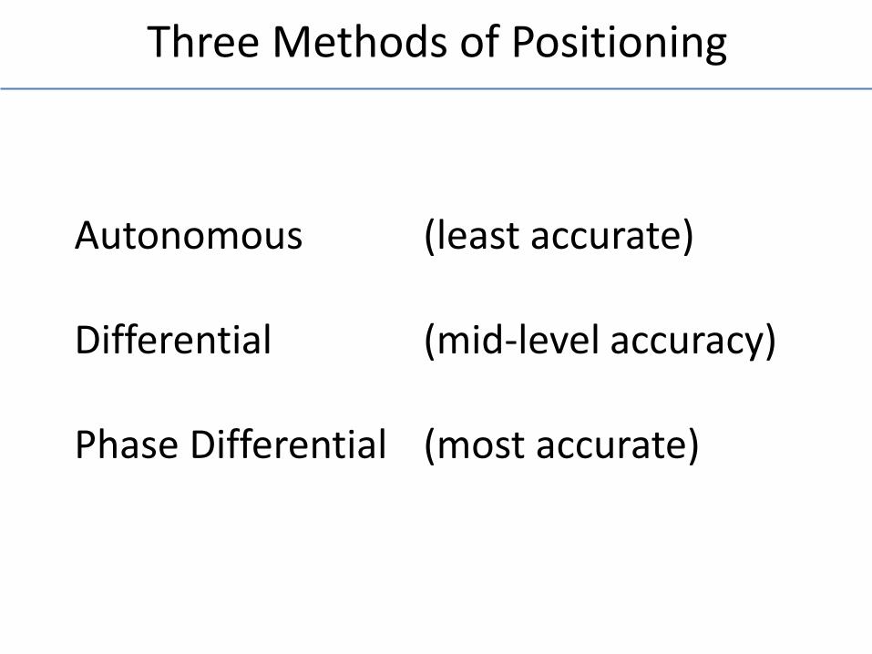
Three Methods of Positioning
Autonomous (least accurate) Differential (mid-level accuracy) Phase Differential (most accurate)
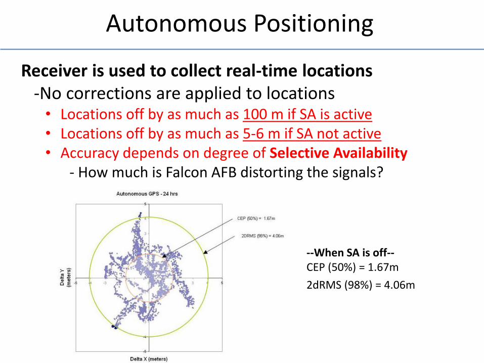
Autonomous Positioning
--When SA is off-- CEP (50%) = 1.67m
2dRMS (98%) = 4.06m
Receiver is used to collect real-time locations -No corrections are applied to locations
• Locations off by as much as 100 m if SA is active • Locations off by as much as 5-6 m if SA not active • Accuracy depends on degree of Selective Availability
- How much is Falcon AFB distorting the signals?
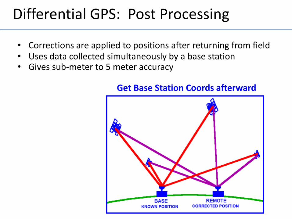
Differential GPS: Post Processing
• Corrections are applied to positions after returning from field • Uses data collected simultaneously by a base station • Gives sub-meter to 5 meter accuracy
Get Base Station Coords afterward
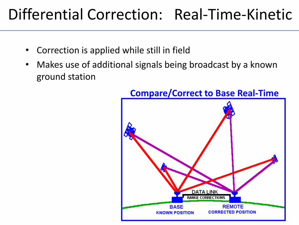
Differential Correction: Real-Time-Kinetic
• Correction is applied while still in field
• Makes use of additional signals being broadcast by a known ground station
Compare/Correct to Base Real-Time
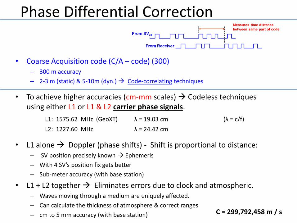
Phase Differential Correction
• Coarse Acquisition code (C/A – code) (300) – 300 m accuracy
– 2-3 m (static) & 5-10m (dyn.) Code-correlating techniques
• To achieve higher accuracies (cm-mm scales) Codeless techniques using either L1 or L1 & L2 carrier phase signals.
L1: 1575.62 MHz (GeoXT) λ = 19.03 cm (λ = c/f)
L2: 1227.60 MHz λ = 24.42 cm
• L1 alone Doppler (phase shifts) - Shift is proportional to distance: – SV position precisely known Ephemeris
– With 4 SV’s position fix gets better
– Sub-meter accuracy (with base station)
• L1 + L2 together Eliminates errors due to clock and atmospheric. – Waves moving through a medium are uniquely affected.
– Can calculate the thickness of atmosphere & correct ranges
– cm to 5 mm accuracy (with base station) C = 299,792,458 m / s
Need to Know SV Location
SV’s location is transmitted to the SV by ground control (Ephemeris).
– SV then relays it’s location to your receiver
– If a SV fails to maintain proper orbit, adjustments are uploaded
– If problem exists, control segment deems the SV unhealthy
Almanac Messages
• Almanac is a set of parameters used to calculate the rough location of each SV
– Each SV broadcasts Almanac data for all other SVs – Valid for several months
• Almanacs are used for:
– Rapid SV acquisition • Almanac data (and current time) indicates to the rover which SV’s to
“look” for ….given the rover’s roughly approximated ground position.
• With this info, the appropriate SV’s can be selected for the initial search.
– Pre-mission planning • Predict good/bad SV geometry in advance (more on this later)
Ephemeris Messages
• Ephemeris is a set of parameters (orbital & clock correction data)used to determine exact location of SV
• Each SV broadcasts only its own ephemeris… every 30 sec.
• Ephemeris only considered valid for 30min.
• Ephemeris used for – Calculating a GPS position
• When rover initially locks on a SV, the receiver display shows “hollow” signal strength. – Because ephemeris data has yet to be completely collected
• Once ephemeris is collected from all locked-on SV’s in turn – Signal strength turns “solid” black
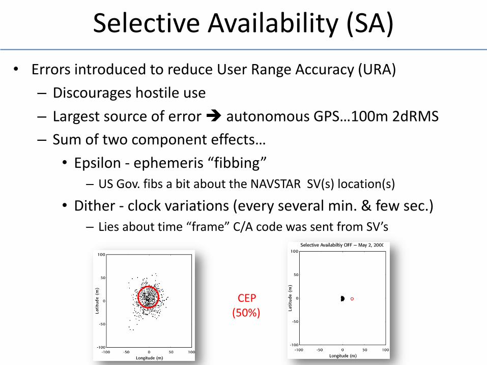
Selective Availability (SA)
• Errors introduced to reduce User Range Accuracy (URA)
– Discourages hostile use
– Largest source of error autonomous GPS…100m 2dRMS
– Sum of two component effects…
• Epsilon - ephemeris “fibbing” – US Gov. fibs a bit about the NAVSTAR SV(s) location(s)
• Dither - clock variations (every several min. & few sec.) – Lies about time “frame” C/A code was sent from SV’s
CEP (50%)
How Accurate Is GPS ?
• That Depends on some variables…
• Time spent at a geographic Location
• Design of receiver (antenna design)
• Relative position of satellites
• Rover configuration settings (sky mask, PDOP allowed
• Correction methods (none, post-process, real-time)
More on Accuracy Later
• Will discuss…
• DOP’s: Dilution of Precision Measures
• UERE: User Equivalent Range Error